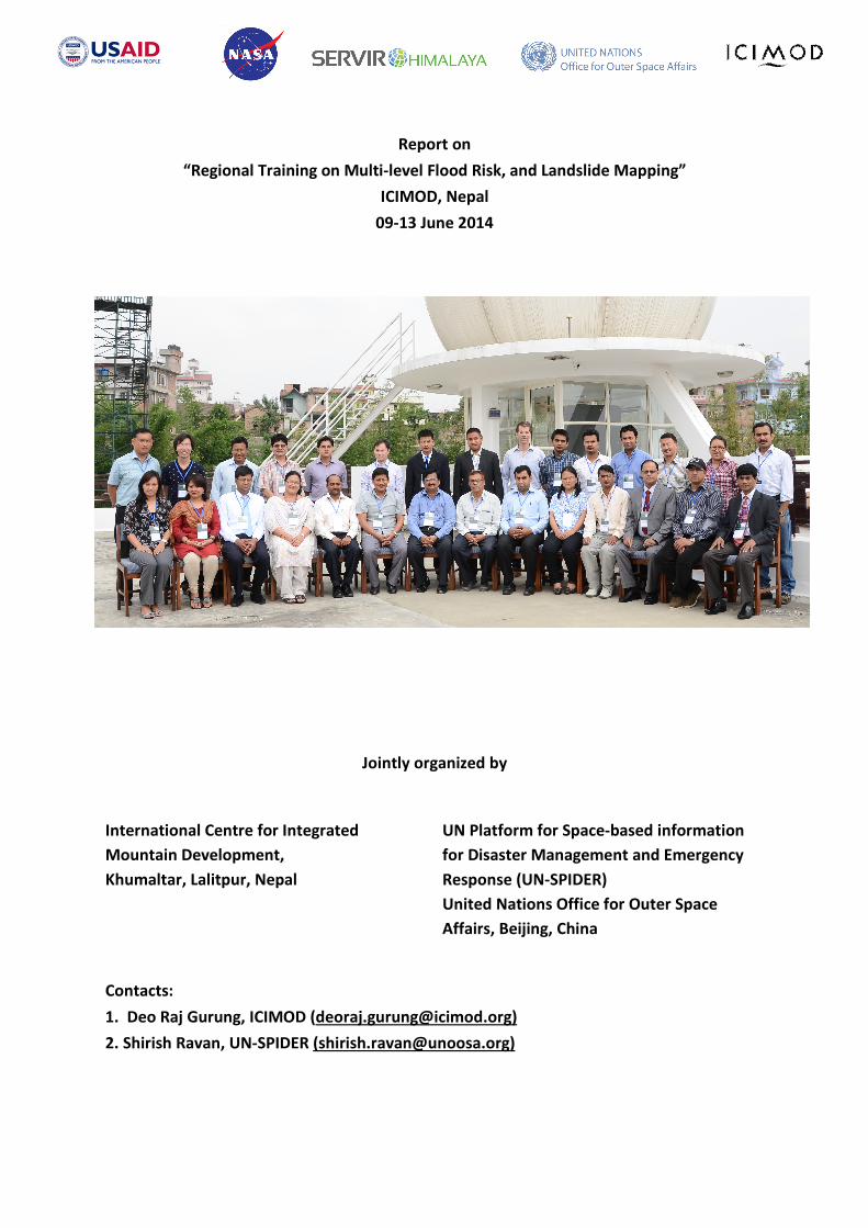
Report on “Regional Training on Multi-level Flood Risk, and Landslide Mapping” ICIMOD, Nepal 09-13 June 2014 Jointly organized by International Centre for Integrated Mountain Development, Khumaltar, Lalitpur, Nepal UN Platform for Space-based information for Disaster Management and Emergency Response (UN-SPIDER) United Nations Office for Outer Space Affairs, Beijing, China Contacts: 1. Deo Raj Gurung, ICIMOD ([email protected]) 2. Shirish Ravan, UN-SPIDER ([email protected])

Welcome message from author
This document is posted to help you gain knowledge. Please leave a comment to let me know what you think about it! Share it to your friends and learn new things together.
Transcript
Report on
“Regional Training on Multi-level Flood Risk, and Landslide Mapping”
ICIMOD, Nepal
09-13 June 2014
Jointly organized by
International Centre for Integrated
Mountain Development,
Khumaltar, Lalitpur, Nepal
UN Platform for Space-based information
for Disaster Management and Emergency
Response (UN-SPIDER)
United Nations Office for Outer Space
Affairs, Beijing, China
Contacts:
1. Deo Raj Gurung, ICIMOD ([email protected])
2. Shirish Ravan, UN-SPIDER ([email protected])

1 | P a g e
Table of Contents
Summary ................................................................................................................................................. 2
1. Context and Justification................................................................................................................. 3
2. Objectives of the Training ............................................................................................................... 3
3. Terms of Reference / Purpose of the Training Activity ................................................................... 4
4. Summary of the Training Programme ............................................................................................. 4
4.1 Opening Session ...................................................................................................................... 5
4.2 Technical Session .................................................................................................................... 5
4.3 Closing Session ........................................................................................................................ 8
5. Details on Dates and Venue ............................................................................................................ 9
6. Participants ................................................................................................................................... 10
7. Experts .......................................................................................................................................... 11
8. Programme Schedule .................................................................................................................... 11
9. Impression of Participants ............................................................................................................ 12
10. Conclusions and Recommendations ......................................................................................... 13
11. Lessons Learned ........................................................................................................................ 14
12. Contact Information .................................................................................................................. 14
ANNEXES ............................................................................................................................................... 15
1. Opening Session ............................................................................................................................ 15
2. Final Training Program .................................................................................................................. 16
3. Closing Session .............................................................................................................................. 19
4. List of Participants ......................................................................................................................... 20

2 | P a g e
Summary
The training on ‘Regional Training on Multi-level Flood Risk Mapping’ was jointly organized
by International Centre for Integrated Mountain Development (ICIMOD) and UN Platform
for Space-based information for Disaster Management and Emergency Response (UN-
SPIDER) of the UN Office for Outer Space Affairs. Part of the support for this training course
comes from “SERVIR-Himalaya”, funded by United States Agency for International
Development (USAID) through the National Aeronautics and Space Administration (NASA).
The purpose of the training programme is to improve disaster risk management using space
based and geospatial information by imparting hands-on training to the officials of member
countries supported by the ICIMOD and UN-SPIDER.
The training covered topics namely, climate change, disaster risk reduction and space
technology; developing hazard and vulnerability indicators at national and sub-national level;
flood inundation modelling using HEC-RAS methods; flood inundation mapping and
monitoring using satellite images and landslide hazard mapping using satellite remote
sensing. More than 50% time was devoted to the hands-on sessions on flood inundation
model (held by an expert of ICIMOD), on flood mapping and monitoring (held by an expert
of NDRCC) and on landslide hazard mapping (held by an expert of the National Remote
Sensing Centre of India).
A total of 20 participants from disaster management agencies and stakeholder departments
of ICIMOD Member States participated in the training programme. All but one ICIMOD
Member states (Afghanistan) attended the programme.

3 | P a g e
1. Context and Justification
Hindu Kush Himalayan (HKH) region is prone to natural hazards due to several causative
factors: fragile geology, complex topography and relief, tectonic activities, and sensitive to
climatic variability. This region is also known for high population density, wide spread
poverty, governance issues, which makes this region vulnerable to natural hazards. Member
states1
of International Centre for Integrated Mountain Development (ICIMOD) has
witnessed 1912 major hydro-meteorological disaster plus earthquake events between 1900
to 2012 (Em-DAT). The estimated economic loss from the accounted disasters is in the range
of USD 46 million, and over 19 million people killed (Em-DAT). Flood and storm constitute 40%
and 32% of the total disaster witnessed between 1900 and 2012 in this region. Both in terms
of people killed and inflicted economic loss, flood is way ahead of other types of natural
hazards. Devastation witnessed during recent flooding in Pakistan (2010) and India (2012)
are testimony to furry of natural elements and compounding impacts on vulnerable
communities. As much as pre-disaster interventions are important for DRR, post event
disaster management is equally important. Rapid response mapping as a tool for quick
assessment of the situation in the ground is gaining importance and being pursued by many
mapping agencies.
While there is urgency to mainstream disaster risk reduction (DRR) in development policy
and plans, lack of capacity to assess risk at multi-level of decision making process is critical
gap in resilience building process. Need to fill this knowledge and information gap on hazard,
vulnerability, and risk is the motivation for organizing “Multi-level flood risk mapping”
training focusing on flood. Landslide being next to floods in terms of occurrence and impact,
and highly relevant to mountain context, a day is devoted on detecting landslide through
satellite data, and susceptibility mapping.
2. Objectives of the Training
The short term objective of the training is to build understanding of national partners on use
of geospatial framework and remote sensing tools/techniques in DRR domain. While the
training focus was on deploying spatial framework for multi-level flood risk mapping,
building capacity on use of satellite data in conjunction with image processing tools for rapid
response mapping (flood), and mapping landslide for susceptibility analysis is part of the
larger objective to enable national partners to use space based resources in DRR.
1 Afghanistan, Bangladesh, Bhutan, China, India, Myanmar, Nepal and Pakistan.

4 | P a g e
Longer term objective is that mainstreaming of DRR through assimilation of multi-tier
information on risk happens in all levels of decision making process in ICIMOD’s member
states, and is contributed towards achieving sustainable development goals.
Photo 1. Mr. Basanta Shrestha, Director of Strategic Cooperation (left), Dr. MSR Murthy, Theme Leader,
Geospatial Solutions (right), of ICIMOD, and Dr. Shirish Ravan, Head of UN-SPIDER Office in China, UNOOSA
(centre), during the opening session of the training program.
3. Terms of Reference / Purpose of the Training Activity
The purpose of the training program is to provide understanding of geospatial and
modelling framework for multi-level flood risk mapping to enable mainstreaming of DRR
into national policy and plans, by assimilation of multi-tier risk information into decision
making process. A week long training is expected to enhance capacity of participants in
preparing national, sub-national and local level flood hazard, vulnerability and risk maps
relevant for policy makers and disaster managers.
In addition to focus on multi-level flood risk mapping, purpose of the training is to build
capacity on rapid response mapping, and build understanding of global and regional
protocols to access satellite data. Through this training it is also aimed to build national
capacity to use earth observation data and remote sensing tools for semi-automatic
detection of landslides, and generate susceptibility maps to support land use policy and
plans.
4. Summary of the Training Programme
The training was organized from 9-13 June 2014 at ICIMOD on the topic of “Multi-level
Flood Risk Mapping”, while touching upon rapid response mapping, and landslide detection
and susceptibility mapping. The programme was jointly organised with United Nation Office
for Outer Space Affairs (UNOOSA). This event was organised as a part of SERVIR-Himalaya
activity to train national partners on risk mapping as a starting point for DRR intervention.

5 | P a g e
The weeklong training program was designed with special focus on practical session to give
participants adequate time to work with real datasets and tools. To facilitate hands on
session, comprehensive manual and working data was made available. Training covered
flood hazard, vulnerability and risk (HVR) mapping at national level and sub-national level
using indicator based approach, and local (watershed) level using HEC series hydrodynamic
models.
4.1 Opening Session
Opening session saw Mr. Basanta Shrestha, Director of Strategic Cooperation, and Dr. MSR
Murthy, Theme Leader, Geospatial Solutions Theme, of ICIMOD, and Dr. Shirish Ravan, Head
of UN-SPIDER office in Beijing, China, highlighting the need to build knowledge on hazard,
vulnerability, and risk as a means to mainstreaming DRR into national policy and plans. They
highlighted space based information and geospatial framework as integral part DRR for
generating actionable information. Refer Annex 1 for detail opening session program.
Photo 2. Dr. Shirush Ravan, Dr. MSR Murthy, Mr. Basanta Shrestha, and Mr. Deo Raj Gurung delivering opening
remarks and program outline during the opening session.
4.2 Technical Session
Technical session began with introductory lectures on SERVIR-Himalaya activities (by Mr.
Deo Raj Gurung, ICIMOD), DRR terminology and concepts (by Hari Krishna Nebanupudi,
ICIMOD), International and regional framework for DRR (by Dr. Shirish Ravan, UNOOSA), and
Regional Flood Information System in the Hindu Kush Himalayan Region (HKH-HYCOS)
Project (by Dr. Mandira Shrestha, ICIMOD). Demonstration of disaster management
information system (DIMS) of Nepal was done by Mr. Hari Krishna Dhonju (ICIMOD).
6 | P a g e
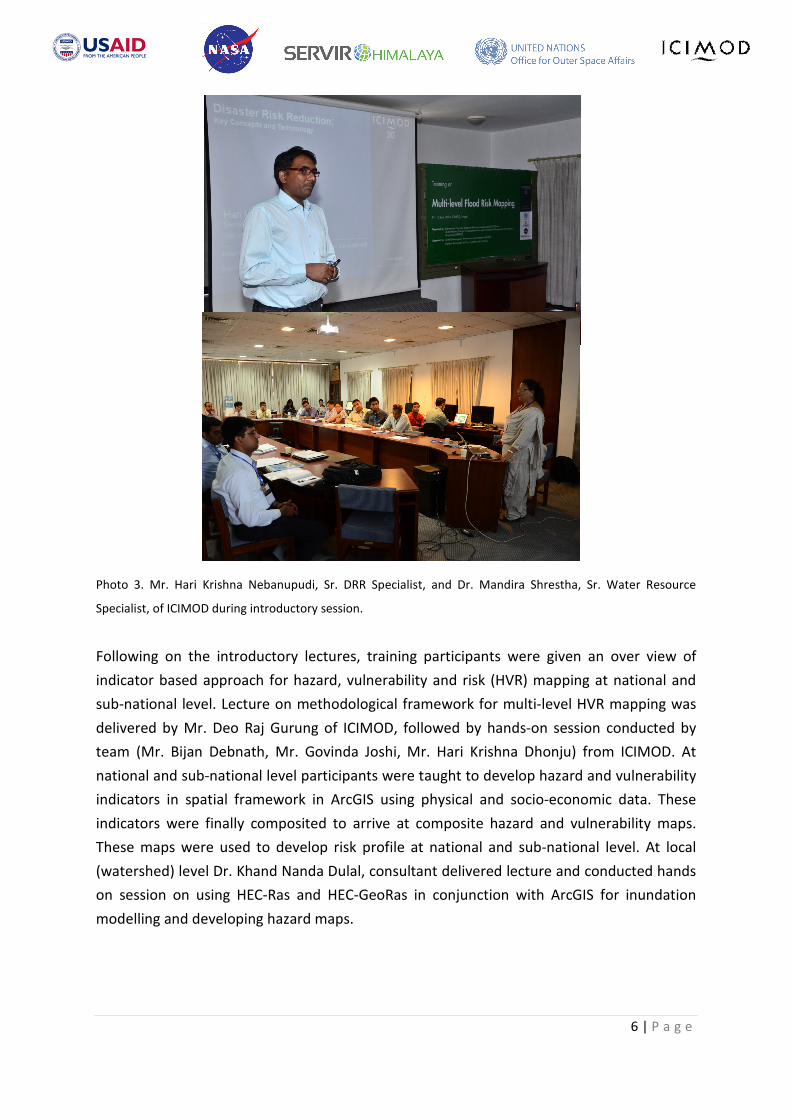
Photo 3. Mr. Hari Krishna Nebanupudi, Sr. DRR Specialist, and Dr. Mandira Shrestha, Sr. Water Resource
Specialist, of ICIMOD during introductory session.
Following on the introductory lectures, training participants were given an over view of
indicator based approach for hazard, vulnerability and risk (HVR) mapping at national and
sub-national level. Lecture on methodological framework for multi-level HVR mapping was
delivered by Mr. Deo Raj Gurung of ICIMOD, followed by hands-on session conducted by
team (Mr. Bijan Debnath, Mr. Govinda Joshi, Mr. Hari Krishna Dhonju) from ICIMOD. At
national and sub-national level participants were taught to develop hazard and vulnerability
indicators in spatial framework in ArcGIS using physical and socio-economic data. These
indicators were finally composited to arrive at composite hazard and vulnerability maps.
These maps were used to develop risk profile at national and sub-national level. At local
(watershed) level Dr. Khand Nanda Dulal, consultant delivered lecture and conducted hands
on session on using HEC-Ras and HEC-GeoRas in conjunction with ArcGIS for inundation
modelling and developing hazard maps.
7 | P a g e
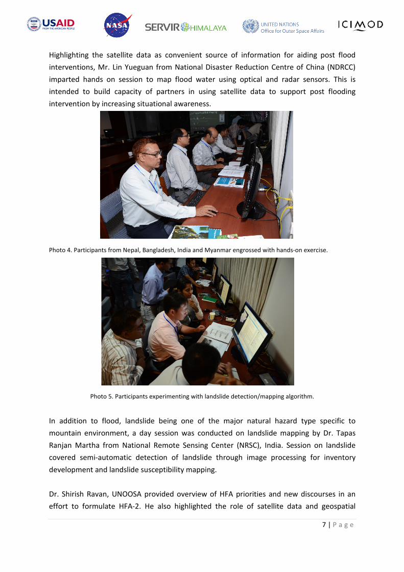
Highlighting the satellite data as convenient source of information for aiding post flood
interventions, Mr. Lin Yueguan from National Disaster Reduction Centre of China (NDRCC)
imparted hands on session to map flood water using optical and radar sensors. This is
intended to build capacity of partners in using satellite data to support post flooding
intervention by increasing situational awareness.
Photo 4. Participants from Nepal, Bangladesh, India and Myanmar engrossed with hands-on exercise.
Photo 5. Participants experimenting with landslide detection/mapping algorithm.
In addition to flood, landslide being one of the major natural hazard type specific to
mountain environment, a day session was conducted on landslide mapping by Dr. Tapas
Ranjan Martha from National Remote Sensing Center (NRSC), India. Session on landslide
covered semi-automatic detection of landslide through image processing for inventory
development and landslide susceptibility mapping.
Dr. Shirish Ravan, UNOOSA provided overview of HFA priorities and new discourses in an
effort to formulate HFA-2. He also highlighted the role of satellite data and geospatial

8 | P a g e
framework for DRR, and talked about regional and international mechanisms to access
satellite data for rapid response mapping.
Refer Annex 2 for details regarding technical session.
4.3 Closing Session
Closing session was graced by Dr. Eklabya Sharma, Director of Program Operation at ICIMOD
who highlighted the need for multi-sectoral engagement for disaster risk reduction. He
expressed hope that knowledge gained through this training will be made to use for
addressing issues in the ground, and assured ICIMOD’s support to help them implement
what they managed to learn. Mr. Birendra Bajracharya, Acting Program Manager – MENRIS
and also Technical Coordinator of SERVIR-Himalaya stressed the need to customize the
methodological framework and technological leverages to their own context. It is only when
these technological leverage can make a different in the ground that investment on
technological pursuit is justified. Dr. Shirish Ravan, UNOOSA thanked all the participants,
resource persons from NRSC and NDRCC, and ICIMOD team for successful completion of the
training. He requested participants to make best use of ICIMOD and its’ network.
Dr. Sharma also honoured the participants by distributing certificate of completion. Finally
participants were given group photo and pen-drive containing manual and training data for
learning purpose once back to their respective station.
Photo 6. Dr. Eklabya Sharma, Director of Program Operation, ICIMOD awarding certificate to the participant
from Nepal.

9 | P a g e
Photo 7. Dr. Eklabya Sharma, Director of Program Operation, ICIMOD handing token of appreciation to Dr.
Shirish Ravan and Dr. Tapas Ranjan Martha.
Please refer Annex 3 for detailed program for closing session.
5. Details on Dates and Venue
Dates: 09 -13 June, 2014
Venue: ICIMOD, Nepal

10 | P a g e
6. Participants
A total of 20 officials from seven2 regional member states of ICIMOD participated in the
programme (Figure 1). Participants were from all levels of professional career from technical
to manager. Out of 20 participants only 2 were female (Figure 2) despite our effort to
balance gender ratio. Refer Annex 4 for details of participants and affiliation.
Figure 1. Participant number by countries.
Figure 2. Participant number by gender
2 Bangladesh, Bhutan, China, India, Myanmar, Nepal and Pakistan.

11 | P a g e
7. Experts
Following experts contributed to the training course by conducting specific sessions:
Experts Organisation Topics
Dr. Shirish Ravan UN-SPIDER, China International and national DRR initiatives
Use of satellite data for DRR support
Global and regional mechanism to access satellite
data for rapid response mapping
Mr. Deo Raj Gurung
ICIMOD, Nepal
Introduction to SERVIR-Himalaya Initiatives
Indicators for flood hazard, vulnerability, and risk
assessment at national and sub-national level.
Dr. Khand Nanda
Dulal
Consultant, ICIMOD,
Nepal
Inundation modelling and hazard mapping using
hydrodynamic models – HecRAS and HecGeoRas.
Mr. Hari Krishna
Nebanupudi
ICIMOD, Nepal DRR Concepts and Terminologies
Dr. Mandira
Shrestha
ICIMOD, Nepal Regional Flood Information System in the Hindu
Kush Himalayan Region (HKH-HYCOS) Project
Mr. Hari Krishna
Dhonju
ICIMOD, Nepal Disaster Information Management System (Nepal)
Mr. Lin Yueguan NDRCC, China Flood mapping using satellite data – pre and post
disaster
Dr. Tapas Ranjan
Martha
NRSC, India Semi-automatic detection of landslide;
Landslide susceptibility mapping
Mr. Govinda Joshi,
Mr. Hari Krishna
Dhonju, Mr. Deo Raj
Gurung, Ms. Sonam
Zangmo
ICIMOD Resource persons for hands-on sessions.
8. Programme Schedule
Program was designed to start with introductory session to revisit basic concepts of DRR
and set the stage for upcoming technical deliberation and hands on session. From Day-2
focus was on hands on exercise giving participants an opportunity to work with real data
and tool. Please refer Annex 2 for detailed training program.

12 | P a g e
“The lessons I have learned about multi-risk flood mapping will enable me to facilitate
coordination between divisions and agencies within our department. With this knowledge, I
can also play a role in changing the outlook within policy and decision making processes with
regards to disaster risk reduction” Ms. Pelden Zangmo, Chief Program Officer, Department
of Disaster Management, Government of Bhutan.
9. Impression of Participants
The training program was very well appreciated by participants as it dealt with two of the
most important natural hazards experienced by this region: flood and landslide. The fact
that training had multi-level focus on risk mapping, which is the first of its kind, and touched
upon both pre- and post- disaster contents was found comprehensive by the participants.
Focus on hands-on-exercise and working with real world datasets is found to generate
interest and better engage participants. The right mix of participants – technical and policy
makers as per one of the participant provided an opportunity to interact across individual
domain and understand DRR in a holistic frame.
Figure 3. Participants’ impression on relevance and objective of the training event

13 | P a g e
Figure 4. Participants’ impression on content and resource persons
Figure 5. Overall impression of participants on the training event
Summary of detailed feedback provided by participants on the last day of the training is
presented in Figures 3, 4, 5.
10. Conclusions and Recommendations
The training program was very well appreciated by the participants for mainly three aspects
– relevant content, resource persons, and mixture of participants. It is the partnership
between ICIMOD and UN-SPIDER (UNOOSA) that made it possible to take advantage of each
other’s strength and bring the best from the region. ICIMOD’s presence in the region and
good understanding of the need, helped draw good mixture of participants and target right
group, and develop training content that is of high relevance. UN-SPIDER with global
network brought in global experience and resource persons from their network (NRSC and
NDRCC in this case) in addition to their contribution. This partnership also provided an
14 | P a g e
opportunity for cost sharing mechanism to achieve common target of building regional
capacity.
This training was also used for cross learnings among participants by allocating time for
experience sharing from each country/individual. It is recommended that such interaction as
a cross learning opportunity is built in the program in future.
11. Lessons Learned
The training conducted as joint program is found to be effective. Use of real world datasets
in the training made the participants relate the training to real situation. Good mix of
participants is seen to help understand and relate the content in holistic manner through
experience sharing.
12. Contact Information
Mr. Deo Raj Gurung,
SERVIR-Himalaya Disaster Lead,
ICIMOD, P.Box: 3226,
Khumaltar, Lalitpur, Nepal
E-mail: [email protected]
Dr. Shirish Ravan,
UN-SPIDER Beijing Office,
Beijing, China.
E-mail: [email protected]

15 | P a g e
ANNEXES
1. Opening Session
Time Program Speakers
(MC: Angeli Shrestha)
09:00–09:15 Registration Suyesh Pradhan/Sonam Zangmo
09:15-09:30 Welcome remarks
Dr. MSR Murthy, Theme Leader,
Geospatial Solution Theme, ICIMOD
09:20-09:25 Welcome remarks
Dr. Shirish Ravan, Head, UN-SPIDER
Office in Beijing, China
09:25-09:30 Program outline
Mr. Deo Raj Gurung, Training
Coordinator, ICIMOD
09:30-09:35 Self-introduction All participants
09:35-09:40 Remarks
Mr. Basanta Shrestha, Director of
Strategic Cooperation, ICIMOD
09:40-09:50 Group photo All
09:50-10:00 Tea/coffee break

16 | P a g e
2. Final Training Program
Time Program Resource Persons
Day 1 (Monday, June 09, 2014)
09 :00 -
09:15 Registration
Suyesh Pradhan, Sonam
Zangmo
09:15 –
09:40
Opening session
Basanta Shrestha, Director of
Strategic Cooperation, ICIMOD;
MSR Murthy, Theme Leader,
Geospatial Solutions Theme,
ICIMOD;
Shirish Ravan, UN-SPIDER,
UNOOSA.
09:40 –
09:50 Photo session
All participants, resource
persons
09:50 -10:00 Tea/coffee break
10:00 - 10:30 Introduction to SERVIR Himalaya and disaster
related activities
Deo Raj Gurung, ICIMOD
10:30 - 11:15 DRM Concepts and terminology Hari Krishna Nebanupudi,
ICIMOD
11:15 –
12:30
Space technology contribution in DRR –
Challenges with respect to implementation of
HFA and HFA 2
Shirish Ravan, UNOOSA
12:30-13:30 Lunch Break
13:30 - 14:15 Regional Flood Information System in the
HKH region (HKH HYCOS) Mandira Shrestha, ICIMOD
14:15 –
14:30
Disaster Information Management System -
Demo Hari Krishna Dhonju, ICIMOD
14:30 –
15:15
Integrating climate change adaptation,
sustainable development and ecosystems in
disaster risk reduction – Space Technology
Perspective
Shirish Ravan, UNOOSA
15:00 - 15:15 Tea/coffee break
15:15 - 16:00 Hazard, vulnerability indicators Deo Raj Gurung, ICIMOD
16:00 –
17:00
Hands on: Developing hazard and
vulnerability indicators at national and sub-
national level
Deo Raj Gurung, Bijan Debnath,
Govinda Joshi, Hari Krishna
Dhonju

17 | P a g e
Time Program Resource Persons
Day 2 (Tuesday, Jun 10, 2014)
09:00 - 09:45
Hands on: Developing hazard and
vulnerability indicators at national and sub-
national level
Deo Raj Gurung, Bijan Debnath,
Govinda Joshi
09:45 - 10:30 Hands-on: Hazard & vulnerability mapping at
national and sub-national level
Deo Raj Gurung, Bijan Debnath,
Govinda Joshi
10:30-10:45 Tea/coffee break
10:45 - 12:30 Hands-on: Hazard & vulnerability mapping at
national and sub-national level
Deo Raj Gurung, Bijan Debnath,
Govinda Joshi
12:30-13:30 Lunch Break
13:30 - 14:15 Lecture on: Introduction to hydrodynamic
modelling Khada Nanda Dulal
14:15 –
15:00
Hands on: Data preparation for HEC-RAS
model Khada Nanda Dulal
15:00-15:15 Tea/coffee break
15:15 - 17:00 Hands on: Data preparation for HEC-RAS
model Khada Nanda Dulal
Day 3 (Wed, June 11, 2014)
09:00 - 09:15 Experience sharing - Use of Landscan data Professor Anup Sa
09:15 - 10:30 Hands on: Inundation modelling using HEC-
RAS model Khada Nanda Dulal
10:30 - 10:45 Tea/coffee break
10:45 –
11:30
Hands on: Inundation modelling using HEC-
RAS model Khada Nanda Dulal
11:30 –
12:30
Hands on: Hazard mapping using modelled
output Khada Nanda Dulal
12:30 - 13:30 Lunch Break
13:30 - 14:15 Flood rapid response mapping Lin Yueguan
14:15 –
15:00
Hands on: Flood inundation mapping using
optical satellite data
Lin Yueguan, Deo Raj Gurung,
Govinda Joshi
15:00 - 15:15 Tea/coffee break
15:15 –
17:00
Hands on: Flood inundation mapping using
optical satellite data
Lin Yueguan, Deo Raj Gurung,
Govinda Joshi
Day 4 (Thu, Jun 12, 2014)
09:00 - 09:15 Experience sharing – community based flood
EWS in Bangladesh ATM Shamsul Alam Bakul
09:15 – Hands on: Flood inundation mapping using Lin Yueguan, Deo Raj Gurung,

18 | P a g e
Time Program Resource Persons
10:00 microwave satellite data Govinda Joshi
10:00 - 10:15 Tea/coffee break
10:15 - 11:00 Global and Free Satellite Image Dataset
Access and Avenues Shirish Ravan, UNOOSA
11:00 –
12:00
Space based information during emergency –
International Initiatives to respond to
disasters
Shirish Ravan, UNOOSA
12:00 –
12:15 Flood EWS based on JASON-2 satellite data. Deo Raj Gurung
12:15 –
12:30 Q & A All participants
12:30-13:30 Lunch Break
13:30 - 15:00 Semi-automatic landslide mapping using
satellite data Dr. Tapas Ranjan Martha
15:00 - 15:15 Tea/coffee break
15:15 - 17:00 Landslide susceptibility mapping Dr. Tapas Ranjan Martha
Day 5 (Fri, Jun 13, 2014)
09:00 - 09:15 Experience sharing – flood forecasting using
rainfall-runoff model and IFAS. Mr. Atif Irshad
09:15 - 10:00 Hands on: Semi-automatic landslide mapping
using satellite data
Dr. Tapas Ranjan Martha, Deo
Raj Gurung, Govinda Joshi
10:00 - 10:15 Tea/coffee break
10:15 –
11:00
Hands on: Semi-automatic landslide mapping
using satellite data
Dr. Tapas Ranjan Martha, Deo
Raj Gurung, Govinda Joshi
11:00 –
12:30 Hands on: Landslide susceptibility mapping
Dr. Tapas Ranjan Martha, Deo
Raj Gurung, Govinda Joshi
12:30 - 13:30 Lunch Break
13:30 - 15:00 Hands on: Landslide susceptibility mapping All Participants
15:00 - 15:15 Tea / Coffee
15:15 –
16:00 Closing session

19 | P a g e
3. Closing Session
Time Program Speaker
MC: Suyesh Pradhan
3:45 – 4:05 Participants’ impression on the
training event.
Participant(s)
4:05 – 4:10 Closing remarks Mr. Birendra Bajracharya,
Acting Regional Program,
Manager, MENRIS,
ICIMOD
4:10 – 4:15 Closing remarks Dr. Shirish Ravan,
Head,
UN-SPIDER Office in Beijing,
China
4:15 – 4:30 Certificate distribution
4:30 – 4:40
Closing comments
Dr. Eklabya Sharma,
Director of Programme
Operation,
ICIMOD
4:40 – 4:45
Vote of Thanks
Mr. Deo Raj Gurung,
Training Coordinator,
ICIMOD

20 | P a g e
4. List of Participants
No. Name Designation/Organization E-mail
01 Mr. Netai Dey
Sarker
Assistant Secretary, Department
of Disaster Management,
Ministry of Disaster
Management & Relief,
Bangladesh
02 Mr. Subrata
Kumar Mondal
Principle Specialist, Center for
Environmental and Geographic
Information Services (CEGIS),
Bangladesh.
03 Mr. ATM
Shamsul Alam
Bakul
Environmental and Geographic
Information Services (CEGIS),
Bangladesh.
04 Mr. Karma
Chophel
Engineer, Department of
Geology and Mines, Ministry of
Economic Affairs,
Thimphu, Bhutan
05 Ms. Pelden
Zangmo
Chief Program Officer,
Department of Disaster
Management, Ministry of Home
and Cultural Affairs,
Thimphu, Bhutan
06 Mr. Bikash
Pradhan
Engineer, Department of Hydro-
Met Services, Ministry of
Economic Affairs, Thimphu,
Bhutan
07 Mr. Qiang Zou Institute of Mountain Hazards &
Environment,
Chinese Academy of Sciences
08 Prof. Anup
Saikia
Department of Geography,
Gauhati University, Assam, India
09 Mr. Nay Win Staff Officer
Relief and Resettlement
Department,
Myanmar
10 Mr. Man
Bahadur Kshetri
GIS Analyst, Food Security
Monitoring and Analysis

21 | P a g e
/Vulnerability Analysis and
Mapping Unit, United Nations
World Food Programme,
Country Office, Kathmandu,
Nepal
11 Mr. Sujan Raj
Adhikari
Engineering Geologist National
Society for Earthquake
Technology-Nepal (NSET), Nepal
12
Mr. Shekhar
Paudel
Section Officer, Disaster
Management Division, Ministry
of Home Affairs, Government of
Nepal, Singha Durbar, Nepal
13
Mr. Rocky
Talchabhadel
Hydrologist Engineer
Department of Hydrology and
Meteorology, Ministry of
Science, Technology and
Environment, Nepal
14 Mr. Vijaya
Khatiwoda
Department of Water Induced
Disaster Prevention, Ministry of
Irrigation, Government of Nepal,
Nepal
15 Mr. Sabin
Adhikari
Nepal Red Cross Society,
Nepal [email protected]
16 Mr. Deepak
Poudel
Disaster Preparedness Network
(DPNET), Nepal [email protected]
17 Ms. Pramila
Adhikari
Engineer, Department of
Irrigation, Ministry of Irrigation,
Government of Nepal, Nepal
18
Mr. Atif Irshad
Meteorologist, Flood Forecasting
Division, Pakistan
Meteorological Department,
Pakistan.
19 Mr. Abdul Latif
Assistant Director, (DRR)
National Disaster Management
Authority, Pakistan
20 Dr. Jianqiang
Zhang
Geospatial Solutions,
ICIMOD [email protected]
Related Documents


![[Day 2] Center Presentation: ICIMOD (1/2)](https://static.cupdf.com/doc/110x72/5552d083b4c90581158b51f4/day-2-center-presentation-icimod-12.jpg)