Development of facilities for target rainfall Planned discharge in pump drainage areas 402m 3 /s Total 55m 3 /s Kase Kawasaki 189m 3 /s Hokubu 142m 3 /s Kouhoku 17m 3 /s Tsuzuki Yokohama Planned discharge Discharge area City Pump facilities Planned storage of major facilities 81,000m 3 Egawa rainwater storage tube 144,000m 3 Shibukawa rainwater storage tube Kawasaki 256,000m 3 Kozukue chiwaka trunk line 410,000m 3 Shin hasue trunk line Yokohama Planned Storage Storage facility City Rainwater storage tube Rainwater storage facilities Rainwater storage facilities

Welcome message from author
This document is posted to help you gain knowledge. Please leave a comment to let me know what you think about it! Share it to your friends and learn new things together.
Transcript
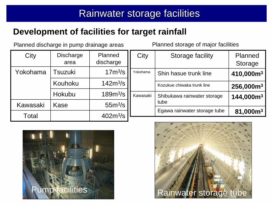
Development of facilities for target rainfallPlanned discharge in pump drainage areas
402m3/sTotal
55m3/sKaseKawasaki
189m3/sHokubu
142m3/sKouhoku
17m3/s TsuzukiYokohama
Planned discharge
Discharge area
City
Pump facilities
Planned storage of major facilities
81,000m3Egawa rainwater storage tube
144,000m3Shibukawa rainwater storage tube
Kawasaki
256,000m3Kozukue chiwaka trunk line
410,000m3Shin hasue trunk lineYokohama
Planned Storage
Storage facilityCity
Rainwater storage tube
Rainwater storage facilitiesRainwater storage facilities
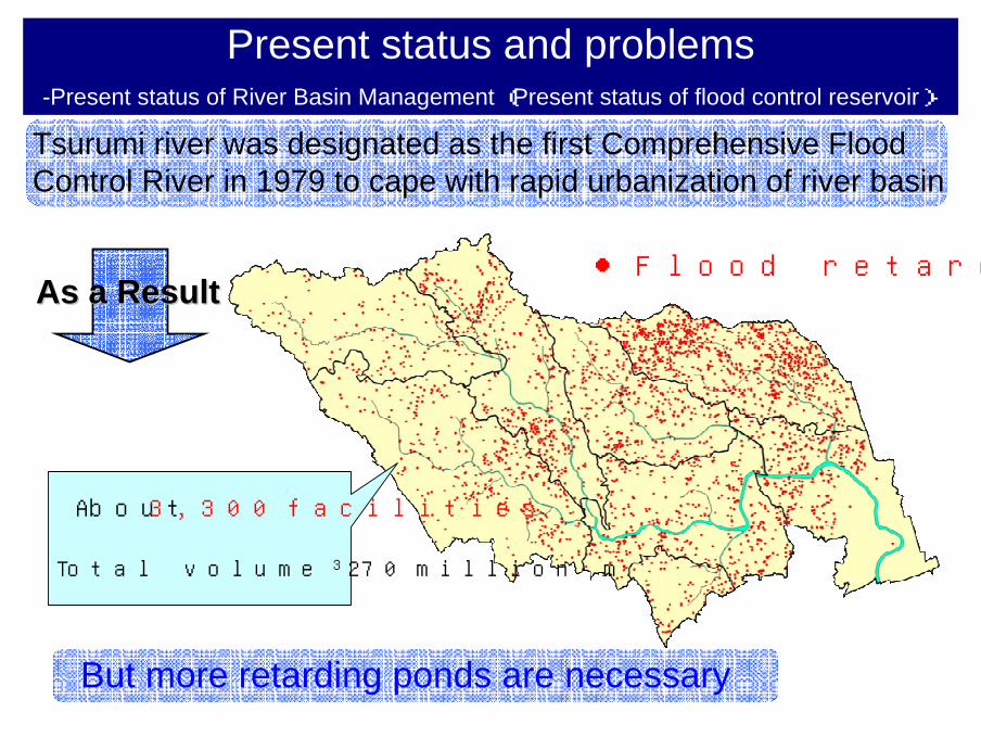
Tsurumi river was designated as the first Comprehensive FloodControl River in 1979 to cape with rapid urbanization of river basin
About 3,300 facilities
Total volume 270 million m3
But more retarding ponds are necessary
● Flood retarding pondAs a ResultAs a Result
Present status and problems-Present status of River Basin Management (Present status of flood control reservoir)-
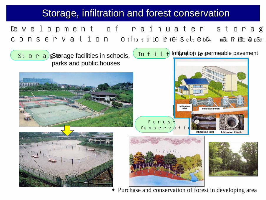
Development of rainwater storage and infiltration facilities, conservation of forested areas (Total effect by municipalities : 0.3 million m3)
InfiltrationStorage facilities in schools, parks and public houses
Storage Infiltration by permeable pavement
◆Purchase and conservation of forest in developing area
Storage, infiltration and forest conservationStorage, infiltration and forest conservation
ForestConservation
Infiltration trenchInfiltration trenchInfiltrationInfiltration
InletInlet
Infiltration trenchInfiltration trenchInfiltration InletInfiltration Inlet
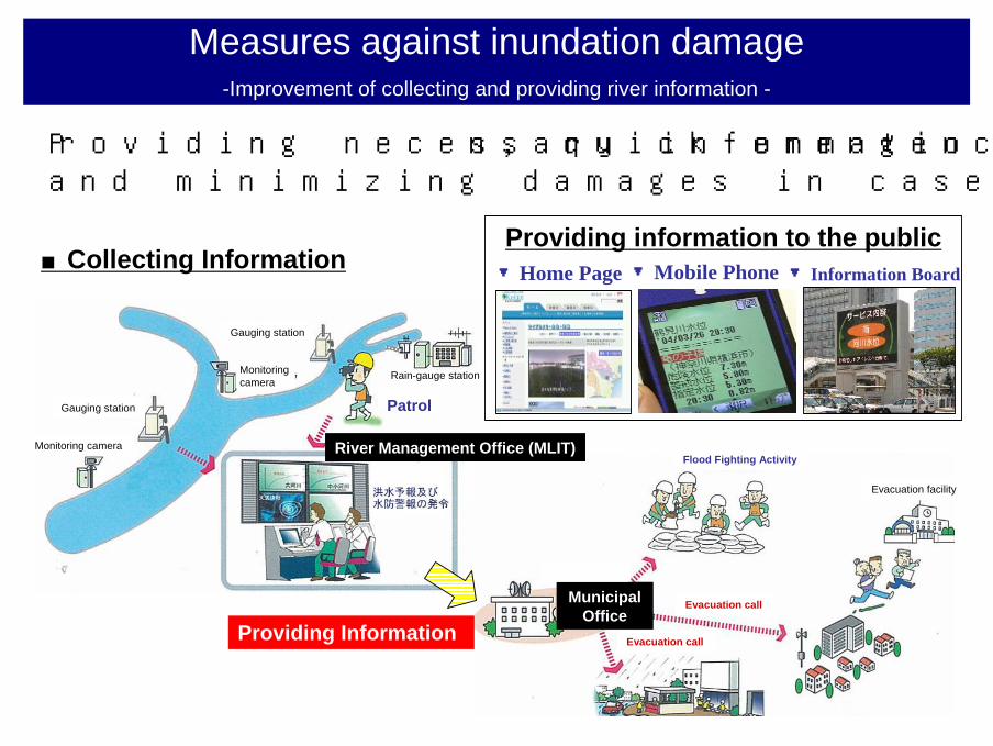
Providing necessary information, quick emergency response and minimizing damages in case of flood.
▼Home Page ▼Mobile Phone ▼Information Board
Providing information to the public■Collecting Information
Providing Information
Measures against inundation damage-Improvement of collecting and providing river information -
River Management Office (MLIT)
Municipal Office
Monitoring camera
Monitoring camera
Gauging station
Gauging station
Rain-gauge station
Patrol
Evacuation call
Evacuation call
Evacuation facility
Flood Fighting Activity
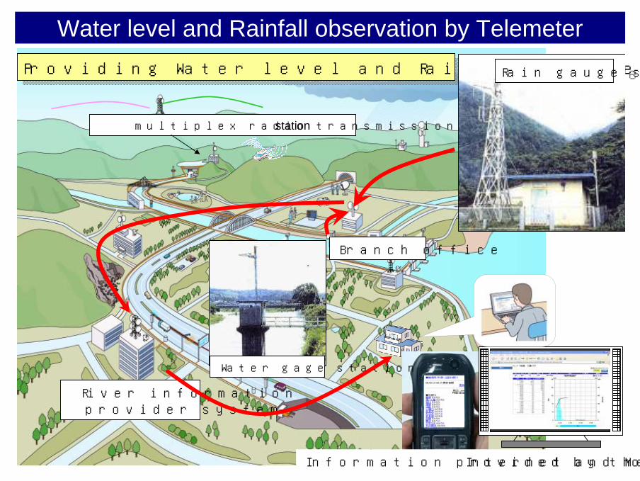
Water level and Rainfall observation by Telemeter
multiplex radio transmission station
Branch office
River information provider system
Water gage station
Providing Water level and Rainfall collected of by TelemeterProviding Water level and Rainfall collected of by Telemeter
Information provided by the Internet and Mobile phone
Rain gauge station
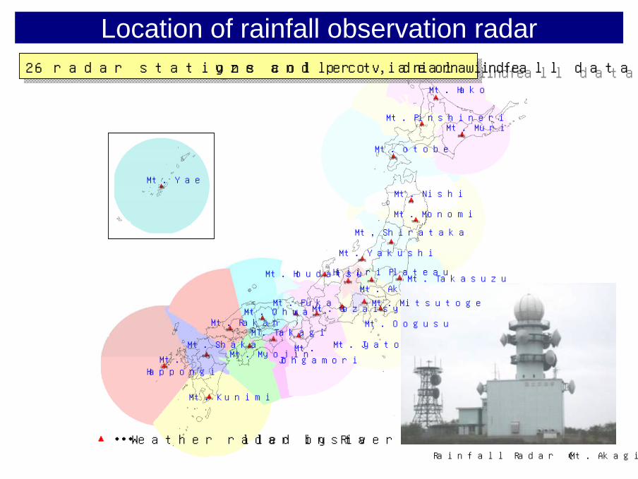
Mt. Hako
Mt. PinshineriMt. Muri
Mt. otobe
Mt. Nishi
Mt. Monomi
Mt. Shirataka
Mt. Takasuzu
Mt. Yakushi
Mt. Akagi
Hijiri Plateau
Mt. Jyatoge
Mt. Fuka
Mt. Johgamori
Mt. Ohwa
MT. TakagiMt. Rakan
Mt. MyojinMt. Shaka
Mt. Kunimi
Mt. Happongi
Mt. Gozaisyo
Mt. Yae
Location of rainfall observation radar
▲・・・Weather radar installed by River Bureau
26 radar stations collect, analyze and provide rainfall data nationwide26 radar stations collect, analyze and provide rainfall data nationwide
Rainfall Radar (Mt. Akagi radar)
Mt. Oogusu
Mt. Mitsutoge
Mt. Houdatsu
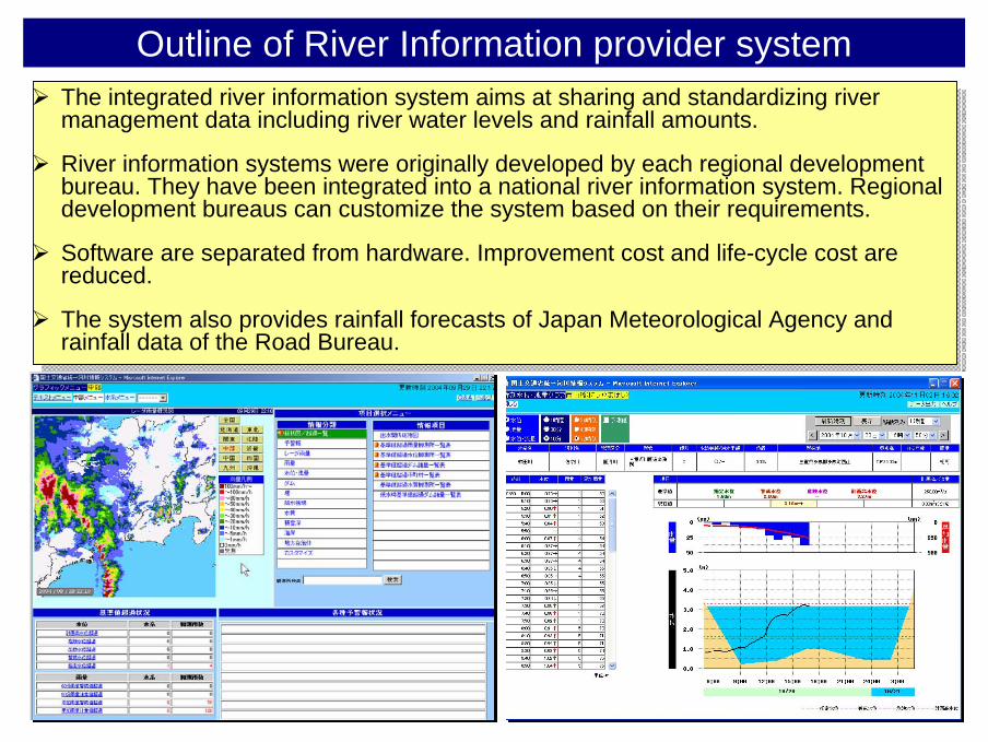
Outline of River Information provider systemThe integrated river information system aims at sharing and standardizing river management data including river water levels and rainfall amounts.
River information systems were originally developed by each regional development bureau. They have been integrated into a national river information system. Regional development bureaus can customize the system based on their requirements.
Software are separated from hardware. Improvement cost and life-cycle cost are reduced.
The system also provides rainfall forecasts of Japan Meteorological Agency and rainfall data of the Road Bureau.
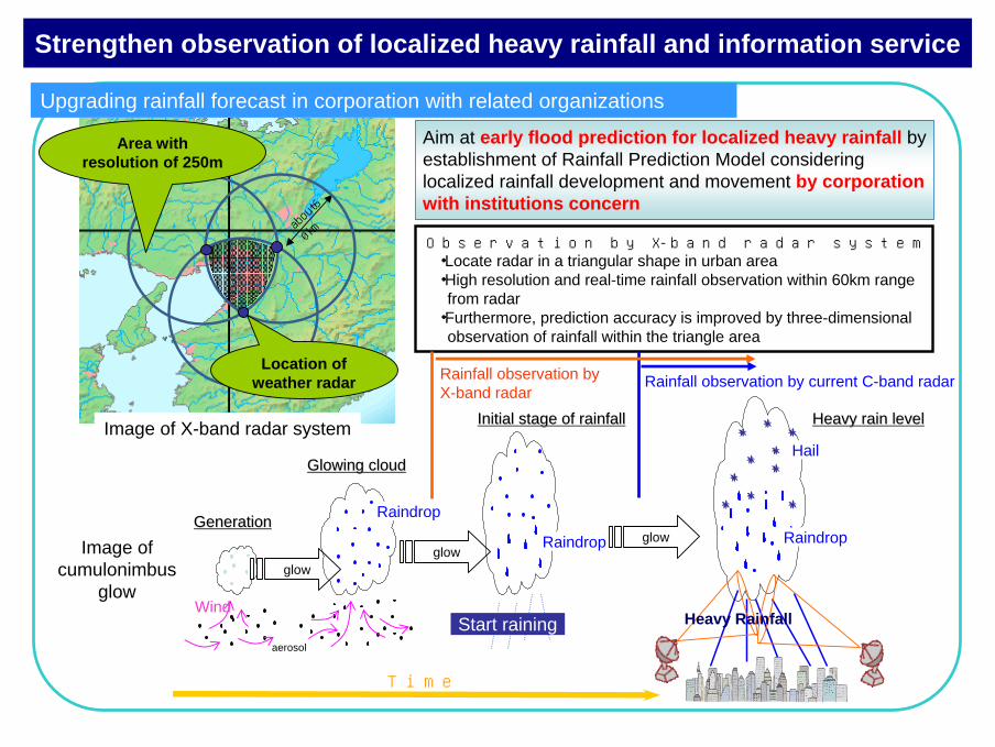
Image of cumulonimbus
glow
Image of X-band radar system
Upgrading rainfall forecast in corporation with related organizations
Observation by X-band radar system・Locate radar in a triangular shape in urban area・High resolution and real-time rainfall observation within 60km range
from radar ・Furthermore, prediction accuracy is improved by three-dimensional
observation of rainfall within the triangle area
abou
t6
0km
Aim at early flood prediction for localized heavy rainfall by establishment of Rainfall Prediction Model considering localized rainfall development and movement by corporation with institutions concern
Wind
Raindrop
aerosol
Raindrop
Hail
RaindropGenerationGeneration
Glowing cloudGlowing cloud
Initial stage of rainfallInitial stage of rainfall Heavy rain levelHeavy rain level
glow
Start raining
Rainfall observation by current C-band radar
Time
Rainfall observation byX-band radar
Location of weather radar
Strengthen observation of localized heavy rainfall and information service
glowglow
Heavy Rainfall
Area withresolution of 250m
Related Documents