Quantitative Composition and Distribution of the Macrobenthic Invertebrate Fauna of the Continental Shelf Ecosystems of the Northeastern United States ROGER B. THEROUX* ROLAND L. WIGLEY ** Woods Hole Laboratory Northeast Fisheries Science Center National Marine Fisheries Service, NOAA Woods Hole, Massachusetts 02543 ABSTRACT From the mid-1950's to the mid-1960's a series of quantitative surveys ofthe macrobenthic invertebrate fauna were conducted in the offshore New England region (Maine to Long Island, NewYork). The surveys were designed to 1) obtain measures of macrobenthic standing crop expressed in terms of density and biomass; 2) determine the taxonomic composition of the fauna (ca. 567 species); 3) map the general features of macrobenthic distribution; and 4) evaluate the fauna's relationships to water depth, bottom type, tempera- ture range, and sediment organic carbon content. A total of 1,076 samples, ranging from 3 to 3,974 m in depth, were obtained and analyzed. The aggregate macrobenthic fauna consists of 44 major taxonomic groups (phyla, classes, orders). A striking fact is that only five of those groups (belonging to four phyla) account for over 80% of both total biomass and number of individuals of the macrobenthos. The five dominant groups are Bivalvia, Annelida, Amphipoda, Echninoidea, and Holothuroidea. Other salient features pertaining to the macrobenthos of the region are the following: substantial differences in quantity exist among different geographic subareas within the region, but with a general trend that both density and biomass increase from northeast to southwest; both density and biomass decrease with increasing depth; the composition of the bottom sediments significantly influences both the kind and quantity of macrobenthic invertebrates, the largest quantities of both measures of abundance occurring in the coarser grained sediments and diminishing with decreasing particle size; areas with marked sea- sonal changes in water temperature support an abundant and diverse fauna, whereas a uniform temperature regime is associated with a sparse, less diverse fauna; and no detect- able trends are evident in the quantitative composition of the macrobenthos in relation to sediment organic carbon content. Introduction The broad continental shelf off the northeastern coast of the United States is a particularly significant topo- graphic feature of the continental margin because of its influence on the marine life of the region. Water masses overlying this large shelf, and neritic waters generally, are noted for their abundance of plankton, fishes, and associated organisms, some endangered. Noteworthy of the offshore New England waters, including Georges Bank, are the rich harvests of fish that have been taken each year since pre-Colonial days. The marine life in- habiting New England offshore waters has been the subject of studies conducted from time to time through- out the past century. This has resulted in the acquisi- tion of a considerable body of knowledge on the fishes and plankton in this region, but information about the benthic invertebrates has been rather limited, espe- * Present address: P.O. Box 306 East Flamouth , MA 02536. **Present address: 35 Wilson Road, Woods Hole, MA 02543. 1

Welcome message from author
This document is posted to help you gain knowledge. Please leave a comment to let me know what you think about it! Share it to your friends and learn new things together.
Transcript

Quantitative Composition and Distribution of theMacrobenthic Invertebrate Fauna of the Continental Shelf Ecosystems
of the Northeastern United States
ROGER B. THEROUX*ROLAND L. WIGLEY * *
Woods Hole LaboratoryNortheast Fisheries Science Center
National Marine Fisheries Service, NOAAWoods Hole, Massachusetts 02543
ABSTRACT
From the mid-1950's to the mid-1960's a series ofquantitative surveys ofthe macrobenthicinvertebrate fauna were conducted in the offshore New England region (Maine to LongIsland, NewYork). The surveys were designed to 1) obtain measures of macrobenthicstanding crop expressed in terms of density and biomass; 2) determine the taxonomiccomposition of the fauna (ca. 567 species); 3) map the general features of macrobenthicdistribution; and 4) evaluate the fauna's relationships to water depth, bottom type, temperature range, and sediment organic carbon content. A total of 1,076 samples, ranging from 3to 3,974 m in depth, were obtained and analyzed.
The aggregate macrobenthic fauna consists of 44 major taxonomic groups (phyla,classes, orders). A striking fact is that only five of those groups (belonging to four phyla)account for over 80% of both total biomass and number of individuals of the macrobenthos.The five dominant groups are Bivalvia, Annelida, Amphipoda, Echninoidea, andHolothuroidea.
Other salient features pertaining to the macrobenthos of the region are the following:substantial differences in quantity exist among different geographic subareas within theregion, but with a general trend that both density and biomass increase from northeast tosouthwest; both density and biomass decrease with increasing depth; the composition of thebottom sediments significantly influences both the kind and quantity of macrobenthicinvertebrates, the largest quantities of both measures of abundance occurring in the coarsergrained sediments and diminishing with decreasing particle size; areas with marked seasonal changes in water temperature support an abundant and diverse fauna, whereas auniform temperature regime is associated with a sparse, less diverse fauna; and no detectable trends are evident in the quantitative composition of the macrobenthos in relation tosediment organic carbon content.
Introduction
The broad continental shelf off the northeastern coastof the United States is a particularly significant topographic feature of the continental margin because of itsinfluence on the marine life of the region. Water massesoverlying this large shelf, and neritic waters generally,are noted for their abundance of plankton, fishes, andassociated organisms, some endangered. Noteworthyof the offshore New England waters, including GeorgesBank, are the rich harvests of fish that have been taken
each year since pre-Colonial days. The marine life inhabiting New England offshore waters has been thesubject of studies conducted from time to time throughout the past century. This has resulted in the acquisition of a considerable body of knowledge on the fishesand plankton in this region, but information about thebenthic invertebrates has been rather limited, espe-
* Present address: P.O. Box 306 East Flamouth , MA 02536.**Present address: 35 Wilson Road, Woods Hole, MA 02543.
1
2 NOAA Technical Report NMFS 140 _
cially regarding quantitative aspects. Because of the keyrole played by macrobenthic invertebrates in the ecological dynamics of the marine environment, their usefulness to man as a food resource, their potential asconcentrators of toxic substances that could be transmitted through the food chain, and their usefulness asindicators of environmental change, the National Marine Fisheries Service (formerly the Bureau of Commercial Fisheries) of the U.S. Department of Commerce, NOAA, in cooperation with the U.S. GeologicalSurvey and the Woods Hole Oceanographic Institutionconducted a quantitative survey of the benthos of theentire continental margin of the eastern United States.The investigation of the macrobenthic invertebrateswas an integral part of a broad program of study of theAtlantic continental margin (Emery and Schlee, 1963;Emery, 1966b).
This report is the second of two which describe thequantitative distribution of macrobenthic invertebratesof the Atlantic continental shelf and slope. The first(Wigley and Theroux, 1981) describes the quantitativedistribution ofmajor taxonomic groups ofmacrobenthicinvertebrates inhabiting the continental shelfand slopebetween Cape Cod, Massachusetts, and Cape Hatteras,North Carolina. Their distribution in relation to geographic location, water depth, bottom sediments, rangein bottom water temperature, and sediment organiccarbon content is considered.
The present report describes the quantitative distribution of the principal groups of macrobenthic invertebrates inhabiting offshore New England waters. Thearea studied extends from the mouth of the Bay ofFundy eastward to Nova Scotia (longitude 64° West)and southward to central New Jersey. The quantity ofeach major taxonomic group is considered in relationto the same environmental variables. Only the broaddistributional aspects of major groups are presentedand evaluated here. Other aspects of the benthic faunaderived from these samples, such as community composition, trophic zonation, faunal dominance and diversity, and similar topics will be the subjects of futurereports.
The large database generated by the ContinentalMargin Program contains a wealth of valuable geological, faunal, and environmental information of historical as well as current significance. In addition to providing input for a variety of descriptive studies, as described above, the potential exists for information contained in the database for ecosystem modeling tasks;paleoecological and global climate change studies; andbenthic production estimates (Cohen et ai. 1978, 1982;Cohen and Wright 1979; Warwick 1980; Rowe et ai.1986, 1988; Bourne 1987; Cohen and Grosslein 1987;Steimle 1987, 1990a, 1990b; Rowe et aI., 1991; andothers).
Order of Discussion
The first section of this report briefly describes theprincipal physical features of the region, providing ageneral background for understanding the distributionof the various faunal groups. This section is followed bythe main body of data describing the quantitative distribution of44 faunal groups in relation to the five environmental parameters: 1) geography, 2) bathymetry, 3)bottom sediments, 4) bottom water temperatures, and5) sediment organic carbon. Quantitative data for geographic distribution are presented at two different levels: a detailed evaluation based on calculations for eachof several hundred unit areas (20 min in latitude by 20min in longitude); and a less detailed evaluation basedon six large geographical subareas within the regionstudied. Faunal groups are chiefly phyla, classes, andorders ofmacrobenthos presented in phylogenetic order.The final section is a summary of the environmental relationship of the dominant taxonomic components.
Previous Studies
One of the earliest studies in marine benthic ecologydealt with populations inhabiting the Woods Hole-Vineyard Sound area off southeastern Massachusetts (Verrillet aI., 1873). This well-known study is not only the firstcomprehensive report dealing with the New Englandmarine benthos but also one of the earliest ecologicalaccounts of marine zoobenthos in all scientific literature. Included in the report are descriptions of newspecies, an annotated catalog of animals found in Vineyard Sound and vicinity, and, significantly, a large part ofthe report is devoted to descriptions of the benthic communities and the biotopes they inhabit. Although a smallnumber of published reports on New England naturalhistory observations and taxonomic studies were availableas sources ofinformation to supplement their study (Gould1841,1870; Desor 1851; Stimpson 1851, 1853; Verrill 1867;and others), by far the bulk of all information containedin the report by Verrill et ai. is based on original collections and observations.
Between 1871 and 1887 nearly 2,000 benthic faunasamples were collected in waters off the northeasternUnited States by the U.S. Fish Commission in cooperation with the U.S. Revenue Service, U.S. Coast Survey,and zoologists from American universities. Dredgingand trawling were the principal methods of collectingsamples. A large proportion of the samples were collected in coastal areas between New Haven, Connecticut, and Eastport, Maine; only a moderate number ofcollections were from offshore areas. Inshore operations were conducted from the vessels Moccasin,Mosswood, Bache, Speedwell, Blue Light, and to some ex-

_________________ Composition and Distribution of Macrobenthic Invertebrate Fauna 3
tent the Blake and Fish Hawk; however, the latter twoalso operated in offshore areas, as did the Albatross andthe chartered fishing schooner,josieReeves (Packard, 1874,1876: Agassiz, 1881; Smith and Rathbun, 1882; Tanner,1882; Smith and Rathbun, 1889; Townsend, 1901).
This early sampling was primarily exploratory in nature. The participating zoologists faced a vast unstudied fauna and a multitude of species new to science.Scientists most active in this work were chiefly systematists; consequently the results were largely taxonomicaccounts of various groups. The following are typicalexamples: Smith, 1879, 1884; Harger,1880, 1883;Rathbun, 1880; Wilson, 1880; Fewkes, 1881; Verrill ,1881,1884; Agassiz, 1883, Webster and Benedict, 1884; Bush,1885; Bigelow, 1891). Professor Addison E. Verrill ofYale College, who collaborated closely with U.S. FishCommission scientists, was undoubtedly the most productive systematist of this, or perhaps any era. He described over one thousand species representing mostmajor invertebrate groups. A very large percentage ofthese new species descriptions was based on specimenscollected off New England. Although several preliminary ecological studies of the offshore benthos werereported (Smith and Harger, 1874; Verrill, 1874a, 1874b;Agassiz 1888a, 1888b) and the reports on systematics ofvarious groups contain ecological information, no comprehensive ecological reports pertaining to the faunaof this region were published.
The second milestone in ecological research of theNew England marine benthos was a comprehensivereport by Summer et al. (1913). This report is based onthree years of intensive sampling in Vineyard Soundand Buzzards Bay by the Bureau of Fisheries in 1903,1904, and 1905. This useful publication not only liststhe species occurring in the Woods Hole region butincludes species distribution charts and discusses somephysical conditions (temperature, depth, and sediments) that influence the distribution of animals. Tothis day, this remains the most thorough ecologicalstudy of the New England marine benthos.
After the investigation by Sumner et al. (1913), therewas a 30-year hiatus during which ecological researchon New England marine benthos-particularly that concerned with offshore invertebrates-proceeded at anexceedingly slow pace. Belding (1914), Allee (1922a,1922b, 1923a, 1923b, 1923c), Pytherch (1929), Stauffer(1937), Ayers (1938), and others contributed valuableinformation on inshore populations. Rather few ecologically oriented works such as Procter (1933a, 1933b)and Bigelow and Schroeder (1939) pertaining to offshore zoobenthos appeared during this period. In addition to the foregoing, however, many studies of a taxonomic nature containing valuable ecological information were issued during this time span (Rathbun, 1905,1925; Koehler, 1914; Nutting, 1915; Pilsbry, 1916; Heath,
1918; Bartsch, 1922; Deichmann, 1930, 1936; and others). Ecological interests of marine scientists conducting field studies in this region centered on plankton andfishes. Itwas not until the 1940's that renewed activities inbenthic ecology attained a significant level. Beginning inthat decade a number of investigations were undertakenconcerning inshore populations (Dexter, 1944, 1947; Lee,1944; Phleger and Walton, 1950; Swan 1952a, 1952b;Parker, 1952; Pratt, 1953; Burbanck et aI., 1956; Parkerand Athern, 1959; Stickney, 1959; Rhoads, 1963; and others). Ecological studies pertaining to the offshore populations commenced somewhat later, for example the reports by: Parker (1948); Northrup (1951); Phleger (1952);Clarke (1954); Schroeder (1955, 1958); Tayloreta!. (1957);Wigley (1959); Wieser (1960); Wigley (1960b); Chamberlinand Stearns (1963); and Wigley and Emery (1968), arenotable examples.
Perhaps the most significant event of this period,relative to the present work, was the inauguration ofquantitative benthos investigations of the New Englandmarine fauna (Lee, 1944). Lee's work was a study of themacrobenthic invertebrate fauna of Menemsha Bight,an embayment ofVineyard Sound, Massachusetts. Yearslater, quantitative studies were made of the benthos ofLong Island Sound (Sanders, 1956; Richards and Riley,1967), Buzzards Bay (Sanders, 1958, 1960; Wieser, 1960),Barnstable Harbor (Sanders et. aI., 1962), GreenwichBay, Rhode Island (Stickney and Stringer, 1957),Sheepscot Estuary (Hanks, 1964), Narragansett Bay(Phelps, 1965), Rand's Harbor, Massachusetts(Burbanck et aI., 1956), and other locales. In recentyears, due to increased interest in potential impacts ofman's activities in outer continental shelf (OCS) development and exploitation and in understanding thedynamics of marine ecosystems, quantitative studies ofthe benthic fauna in the New England region haveundergone a marked increase, as have studies in otherassociated disciplines. Studies such as Wigley (1961 b);Sanders et. al. (1962); Wigley and McIntyre (1964);Emery et al. (1965); Nesis (1965); Sanders et al. (1965);Owen et al. (1967); Wigley and Emery (1967); Wigley(1968); Mills (1969); Wigley and Theroux (1970);Haedrich, et al. (1975); Rowe et al. (1975); Wigley et al.(1975); Uzmann et al. (1977); Pearson and Rosenberg(1978); Maurer and Leathem (1980, 1981a, 1981b);Valentine et al. (1980); Magnuson et. al. (1981); Wigleyand Theroux (1981); Maurer and Wigley (1982, 1984);Steimle (1982); Caracciolo and Steimle (1983); Learand 0 'Malley (1983); Steimle (1985); Rowe et al. (1986);Maciolek and Grassle (1987); Michael (1987); Therouxand Grosslein (1987); Langton et al. (19,88); Langtonand Uzmann (1988); Sherman eta!. (1988); Langton andUzmann 1989, Langton et. al. (1990); and Rowe et. al.(1991), and as well as others have provided much neededinsights into the complex ecosystems of the region.
4 NOAA Technical Report NMFS 140 _
Several published indexes and bibliographies includemany references to the general literature pertaining tobenthic invertebrates and allied subjects. Many of thehistorical as well as the modern reports are includedamong the citations in these bibliographies.
The interested reader may wish to consult the following:
1 Fishery Publication Index, 1920-1954. U.S. Fish &Wildlife Service Circular 36, published in 1955.
2 Publications of the United States Bureau of Fisheries 1871-1940. Compiled by Barbara B. Aller andpublished in 1958.
3 A Preliminary Bibliography with KWIC Index onthe Ecology of Estuaries and Coastal Areas of theEastern United States. Compiled by RobertLivingstonJr. and published in 1965.
4 Marine and Estuarine Environments, Organisms andGeology of the Cape Cod Region, an Indexed Bibliography, 1665-1965. Compiled by Anne E. Yentsch,M. R. Carriker, R. H. Parker, and V .A. Zullo, published in 1966.
5 Fishery Publication Index, 1955-64. U.S. Fish & Wildlife Service, Bur. Comm. Fish. Cire. 296, publishedin 1969.
6 The Effects ofWaste Disposal in the NewYork Bight.Compiled by the National Marine Fisheries Service,Middle Atlantic Coastal Fisheries Center, SandyHook, NewJersey, published in 1972.
7 Coastal and Offshore Environmental Inventory: CapeHatteras to Nantucket Shoals. Edited by Saul B.Saila and published in 1973.
8 Bibliography of the New York Bight: Part I-List ofCitations; Part 2- Indices. Compiled by the National Oceanic and Atmospheric Administration,Marine Ecosystems Analysis Program, Stony Brook,N.Y, published in 1974.
9 Fishery Public"ation Index, 1965-74. Compiled byM. E. Engett and L. C. Thorson, U.S. Dep. Commerce, NOAA Tech. Rep. NMFS Circ. 400, published in 1977.
lOA Summary and Analysis ofEnvironmental Information on the Continental Shelffrom the Bay ofFundyto Cape Hatteras (1977). Vol. II, Master Bibliography, Index, Acknowledgements. Prepared for theBureau of Land Management by Center for NaturalAreas, published in 1977.
11 The Bay Bib: Rhode Island Marine Bibliography,Revised Edition. Coordinated by C. Q. Dunn and L.Z. Hale, edited by A. Bucci, Coastal Resources Center, Northeast Regional Coastal Information Center, Marine Advisory Service, National Sea GrantDepository, Univ. of Rhode Island Mar. Tech. Rep.70, published in'1979.
12 An Ecological Characterization of Coastal Maine(North and East of Cape Elizabeth). Vol. 5, Data
Source Appendix. Compiled by S. E. Fefer and P. A.Schetting for BioI. Servo Program, Interagency Energy/Environment Res. and Dev. Program, Officeof Res. and Dev., U.S. Environmental ProtectionAgency, published in 1980.
13 Benthic Productivity and Marine Resources of theGulf of Maine. I. Babb and M. DeLuca (eds.). National Undersea Research Program, Research Report 88-3, published in 1988.
Another result of increased OCS activity is the largevolume of information relating to benthic fauna appearing in the so-called "gray" literature. Included inthis cat~gory are completion reports of field study contracts, environmental impact statements, public and private agency investigation reports, annual reports, and othersimilar special documents. Many appear in irregular series, or are one-of-a-kind reports, often in photocopied ormimeographed form and, as such, are not always listed inthe usual literature sources (e.g. Maurer, 1983; Michaelet. aI., 1983; Pratt, 1973; also see Literature Cited).
In addition to Wigley and Theroux (1981) there areseveral taxonomically or ecologically oriented reportsbased wholly or in part on the samples forming thebasis of the Northeast Fisheries Science Center (NEFC)benthic database. Such reports include Wigley (1960a,1960b, 1961a, 1961b, 1963a,1963b,1965, 1966a, 1966b,1968, 1970, and 1973); Pettibone (1961, 1962, 1963);Chamberlin and Stearns (1963); Emery and Merrill(1964); Wigley and McIntyre (1964); Emeryet al. (1965);Trumbull (1965); Merrill et al. (1965); Wigley and Shave(1966); Wigley and Emery (1967); Schopf (1968b);Haynes and Wigley (1969); Plough (1969); Hazel (1970);Merrill (1970); Wigley and Theroux (1970); Kraeuter(1971); Wigley and Burns (1971); Wigley and Theroux(1971); Bousfield (1973); Cutler (1973, 1977); Wigleyand Stinton (1973); Murray (1974); Wigleyet al.. (1975);Wigley and Messersmith (1976); Wigley et al. (1976);Williams and Wigley (1977); Kinner (1978); Merrill etal. (1978); Plough (1978); Brodeur (1979); Watling(1979a); Dickinson et al. (1980); Franz and Merrill(1980b); Dickinson and Wigley (1981); Franz et al.(1981); Maurer and Wigley (1982,1984); Maurer (1983);Shepard and Theroux (1983); Theroux l ; Theroux andWigley (1983); Rowe et al. (1986); Shepard et al. (1986);Bousfield (1987); Rowe (1987); Theroux and Grosslein(1987); Langton and Uzmann (1988); Langton et al.(1988); Rowe et al. (1988); Sherman et al. (1988);Langton and Uzmann (1989); Langton et al. (1990);
1 Theroux, R. B. 1983. Collection data for the U.S. east coastgastropod mollusks in the Northeast Fisheries Cen'ter SpecimenReference Collection, Woods Hole, Massachusetts. U.S. Dep.Commer., NOAA, NatL Mar. Fish. SelV., Northeast Fish. Cntr., WoodsHole Lab. Ref. Doc. No. 8327, 280 p. UnpubL manuscript.

Composition and Distribution of Macrobenthic Invertebrate Fauna 5
Materials and Methods
Macrofauna Samples
Table 1Research vessels, cruise numbers, date of collections,and number of sampl~ obtained.
This report is based on 1,076 quantitative samples ofmacrobenthic fauna collected during 22 cruises by 5research vessels between 1956 and 1965 (Table 1). Thegeographic locality of sampling sites is illustrated inFigure 1, and sampling density is illustrated in Figure 2in which the number of samples in each geographicunit area is indicated (dimension ofeach unit area is 20minutes latitude by 20 minutes longitude). Collectiondata (including cruise, station, and collection num-
Number ofsamplesDate
August 1956 35August 1957 165August 1959 75June 1961 75June 1962 123April 1963 7April 1963 3May 1963 38May 1963 29July 1963 1August 1963 93August-September 1963 32October 1963 9October 1963 84August 1964 72September 1964 7April 1964 8July-August 1964 62October 1964 24October-November 1964 '10August 1965 123
1,076
8010159-961-1062-71011121320222428294951
12
64-1264-1365-11
Cruisenumber
Albatross IIIAlbatross IIIDelawareDelawareDelawareGosnoldGosnoldGosnoldGosnoldGosnoldGosnoldGosnoldGosnoldGosnoldGosnoldGosnoldAstmasAstmasAlbatross IVAlbatross IVA lbatross IV
Total
Vessel
change. The results of those programs covered a broadspectrum of interdisciplinary topics which expanded ourunderstanding of the marine environment (e.g. Pearce,1971,1972,1974,1975; Pratt, 1973; Pearce et aI., 1976a,1976b, 1976c, 1976d, 1977a, 1977b, 1977c, 1978, 1981;Caracciolo et aI., 1978; Pearson and Rosenberg, 1978;Reid et aI., 1979; Steimle and Radosh, 1979; Warwick,1980; Schaffner and Boesch, 1982; Steimle, 1982; Boehm,1983; Caracciolo and Steimle, 1983; Lear and O'Malley,1983; Steimle, 1985; Steimle and Terranova, 1985; Duinkerand Beanlands, 1986; Howart,1987; Neff, 1987; Reid et aI.,1987; Steimle, 1990a, 1990b; Steimle et aI., 1990).
2 Burns, B. R., and R. L. Wigley. 1970. Collection and biologkaldata pertaining to mysids in the collection at the BCF Biologic;alLaboratory, Woods Hole. U.S. Bur. Comm. Fish. Bio!. Lab. WootisHole, Mass., Lab. Ref. 70-3, 36 p. (mimeo). Unpub!. manuscript.
3 Wigley, R. L., R. B. Theroux, and H. E. Murray. 1976. Marinemacrobenthic invertebrate fauna of the Middle Atlantic Bight region. Part 1. Collection data and environmental measurements.Northeast Fisheres Center, Woods Hole Lab. Ref. Doc. 7618, 34 p.(mimeo). Unpub!. Manuscript.
4 Theroux, R. B., and R. L. Wigley. 1979. Collection data for U.S.east coast bivalve mollusks in the Northeast Fisheries Center Specimen Reference Collection, Woods Hole, Massachusetts. NortheastFisheries Center, Woods Hole Laboratory, National Marine Fisheries Serv., NOAA, Northeast Fisheries Center.,Woods Hole Lab.Ref. Doc. 79-29, 471 p. (mimeo). Unpub!. Manuscrijn.
5 Maurer, D., and R. L. Wigley. 1981. Distribution of biomass anddensity of macrobenthic invertebrates on the continental shelf offMartha's Vineyard, Massachusetts. National Marine Fisheries Service,Northeast Fisheries Center, Woods Hole Laboratory, NOAA, WoodsHole Lab. Ref. Doc. 81-15, 97 p. (mimeo). Unpub!. manuscript.
6 Theroux, R. B., R. L. Wigley, and H. E. Murray. 1982. Marinemacrobenthic invertebrate fauna of the New England Region: Collection data and environmental measurements. Nat. Mar. Fish. Serv., NOAA,Northeast Fish. Center, Woods Hole Lab. Ref.Doc. 82-40, MARMAPContrib. MD/NEFC 82-67, 74 p. (mimeo). Unpub!. Manuscript.
7 Theroux, R. B., and]. Schmidt-Gengenbach. 1984. Collection dataand environmental measurements for U.S. east coast Cumacea (Arthropoda, Crustacea) in the Northeast Fisheries Center Specimen Reference Collection Woods Hole, Massachusetts. Nat. Mar. Fish. Serv.,Northeast Fisheries Center, Woods Hole Lab. Ref. Doc. 84-27, MARMAPContr. MED/NEFC 83-46,114 p. (mimeo). Unpub!. Manuscript.
and Rowe et ai. (1991); Burns and Wigley2; Wigley et aI.3;Theroux and Wigley4; Maurer and Wigley5; Theroux, etaI. 6; Theroux and Schmidt-Gengenback.7
Other uses to which the data have proven useful inthe past, as well as in the present, have been varied.Included have been environmental impact statementsprepared by various public agencies (Dep. Interior,Minerals Management Service; U.S. Army Corps of Engineers; NOAA, etc.) relating to OCS activities (e.g. oiland gas exploration, mining, dredging, dumping, etc.);international litigation (i.e. US/Canada BoundaryCase); marine sanctuary designation proposals (e.g.Stellwagen Bank, Norfolk Canyon); and others.
Several specially targeted programs initiated in thelatter 1970's and terminated in the mid- to late 1980'shave provided additional impetus for an increase inattention devoted to the macrobenthos of the region.During that period many studies were conducted bypublic and private agencies and academic institutions(e.g. NOAA's Northeast Monitoring and Ocean PulsePrograms; the Northeast Fisheries Center's Marine Resources Mapping, Assessment, and Prediction program(Sherman, 1980); the Marine Ecosystem Analysis Program (MESA) (see Pearce et aI., 1981); the Woods HoleOceanographic Institution's Georges Bank Study program,and many others). Those studies, in both inshore andoffshore areas, were designed to establish baselines forassessing environmental quality and to monitor the impacts of present and future activities related to oil and gasexploration and production, marine mining, ocean dumping, other waste disposal, and natural environmental

6 NOAA Technical Report NMFS 140 _
72°
NEWJERSEY
71° 70"
MAN E
69'
o 120,-'_ .......----', KM
Figure IChart of the study area showing the location of stations where quantitative samples of macrobenthic invertebrates wereobtained.
bers, number of samples, latitude, longitude, date ofsampling, and type of gear used) and environmentalmeasurements (including water depth in meters, bottom type, geographic subarea, temperature range [0C],and percent organic carbon) for each sampling site arecontained in Theroux et al.6).
Sampling stations were located in all sections of thestudy area, but somewhat more intensive coverage wasgiven to the offshore continental shelf region than tothe inshore bays and sounds or to the deep water region beyond the continental shelf. Table 2 lists thenumber of samples and occurrence frequency for eachparameter grouping. A moderate number of samples,however, were taken in the major bays and estuaries,and in deep water. Ninety-two samples were collected atdepths less than 24 m, and 93 samples from depthsgreater than 500 m. The continental rise was onlysparsely sampled because of its great depth and thecorrespondingly in~reased time required to obtainsamples. Minimum and maximum depths at whichsamples were taken were 3 and 3,975 m.
Sampling Gear
The samples consisted of bottom sediments with theconstituent fauna collected with a Smith-McIntyre springloaded grab sampler (Smith and McIntyre, 1954) ill~s
trated in Figure 3, or a Campbell grab sampler (Menzieset al., 1963) illustrated in Figure 4. The bottom areasampled by the Smith-McIntyre sampler was 0.1 m2 whichhad a capacity ofapproximately 15 liters (L). Area sampledby the Campbell sampler was 0.56 m2, which had a volumecapacity ofabout 200 L. The Campbell grab was equippedwith a 35-mm camera and electronic flash, housed withinthe buckets, to obtain photographs of the bottom immediately before impact (Emery and Merrill, 1964; Emery etal., 1965; Wigley and Emery, 1967; Theroux, 1984).
Sample Processing
Aboard ship, the material obtained at each samplingsite by each sampler was processed and preserved as a

__________________ Composition and Distribution of Macrobenthic Invertebrate Fauna 7
NUMBER OF SAMPLES
PER UNIT AREA
( 20' x 20')
• 1 - 2
• 3-5
• 6 -'0
• l' - 25
72° 71° 700 6,0
" 0 120. • KM 68°
M A 'HE. ,//+'/'
; .. .67°
Figure 2Chart showing sampling intensity within each standard unit area (20 min. latitude by 20 min. longitude). All sampleswithin each unit area have been added to indicate sampling density.
separate sample, The contents of the sampler wereemptied into a bucket or tub calibrated in liters, ordirectly into a wash-box (volume measured by means ofa calibrated rule) from which two small subsampleswere removed prior to washing. One of these subsampleswas for meiofauna, and the other for sediment analysis.Total quantity removed ranged from 0.25 to 1.0 L,depending upon the total volume of material obtained.The quantities of both samples and subsamples weremeasured and recorded on sample log sheets. Generally, the remaining material was washed through a 1-mmaperture mesh-sieving screen. Material remaining on thescreen after washing, consisting of benthic animals, tubes,shells, shell hash, and coarse sediments, was preserved in abuffered seawater solution of formaldehyde and broughtto the laboratory ashore for further processing.
Laboratory processing involved separating the preservedorganisms from the mineral debris, sorting them to majortaxonomic groups, identifying them to the lowest practicable taxonomic level, counting, and weighing. Weightsare damp formalin weight, the "rough weight" ofPetersen
(1918), herein referred to as wet weight inasmuch as thesuperficial fluid on the specimens was removed by blotting before being weighed on a Mettler precision balanceto the nearest 0.01 g. Weights include shells and skeletalmaterials that constitute an integral part of the livinganimal, i.e. shells of living mollusks, brachiopods, andskeletal structures of bryozoans, barnacles, and similarorganisms. Materials omitted in the weighing procedurewere: tubes of polychaetous worms, gastropod andscaphopod shells inhabited by pagurid crabs or sipunculidworms, and other similar nonintegral structures or nonliving animal remains. Counts of the number of specimenswere made for all groups. Colonial animals were treated asindividuals; that is, one sponge colony, or a colony ofbryozoans was each counted as an individual specimen;colonies are much more comparable in size to individualsof noncolonial animals than are the zooids making up thecolony. Also, the disparity in size from smallest. to largestcolonial organisms was only slightly greater than the sizedifferential between small and large individuals ofnoncolonial species.

8 NOAA Technical Report NMFS 140
Specimens of each taxon were bottled separately in70% ethanol and labeled. Subsequently, specimens wereassembled by taxonomic groups and sent to cooperating systematists for species determinations. There weremore than 40 specialists from the United States and fromother countries cooperating in this part of the study.
Data Treatment
Information pertaining to the location, collecting methods, physical and chemical characteristics of the envi-
Table 2Numbers of samples and occurrence frequency in eachof the various parameter groupings used in this report.
Number Frequency (%)of of
Parameter samples occurrence
Geographic areaNova Scotia 85 7.9Gulf of Maine 303 28.2Georges Bank 211 19.6Southern New England Shelf 344 32.0Georges Slope 52 4.8Southern New England Slope 81 7.5
Depth range (m)0-24 92 8.6
25-49 160 14.950-99 319 29.6
100-199 246 22.9200-499 166 15.4500-999 22 2.0
1000-1999 34 3.22000-3999 37 3.4
Sediment typeGravel 148 13.8Till 22 2.0Shell 6 0.6Sand 455 42.2Sand-silt 211 19.6Silt-clay 234 21.8
Temperature range (0C)0-3.9 335 31.14-7.9 158 14.78-11.9 336 31.2
12-15.9 157 14.616--19.9 62 5.820-23.9 28 2.6
Sediment organic carbon (%)0.00 5 0.50.01-0.49 418 38.80.50-0.99 167 15.51.00-1.49 84 7.81.50-1.99 43 4.02.00-2.99 13 1.23.00-4.99 4 0.45.00+ 1 0.1missing data 341 31.7
ronment, and the number and weight of the biologicalcomponents ofeach sample was recorded on preprinteddata forms. The coded information and quantitativedata from the records were entered on automatic dataprocessing cards. Data were summarized by computerin a form similar to that presented in the tables appearing in the body of this report.
The principal units used for expressing the quantityof benthic invertebrates (quantity per unit area) are: 1)density-number of individual specimens per squaremeter of bottom area, and 2) biomass-wet weight, ingrams, per square meter of bottom.
Faunal density values used in constructing quantitativegeographic distribution charts for the various taxonomicgroups (Figs. 12, 27, 33, 39, 45, etc.) are mean values forall samples within each unit area as shown in Figure 2.
Qualitative and quantitative differences between seasons and between years were sufficiently small to permitthe consolidation of all samples for purposes of thisreport. Some seasonal and yearly differences in taxonomic composition and quantity of animals were detected within specific geographic localities that wererepeatedly sampled. With few exceptions, however, thedissimilarities were relatively minor in comparison tothe differences from one geographic locality to another. One of the chief reasons for the temporal stability was the presence of many animals having a long(one year to a century or more) life span. The commonoccurrence of sessile forms and nonmigratory motileforms also contributed to the observed constancy inbiomass. Similar conditions were reported by Zatsepin(1968, in Steele, 1973) in reference to macrobenthossamples taken in the Barents Sea and Norwegian Seaover a 30-year period. He found that a comparison ofsamples taken in the same regions in different years"... showed no substantial changes in the quantitativedistribution of the bottom fauna." Several recent reports also allude to the temporal persistence of certaindominant components of the macrobenthos of the region (Steimle, 1990a, 1990b; Maurers; Michael et aI.9).
Geographic Areas
For purposes of detecting and reporting regional differences in faunal composition the region has been
8 Maurer, D. 1983. Review of benthic invertebrates of GeorgesBank in relation to gas and oil exploration with emphasis onmanagement implications. Nat!' Mar. Fish, Serv., Northeast Fisheries Center, Woods Hole, Massachusetts, Woods Hole Lab. Ref.Doc. 83-16, 329 p. (mimeo). Unpub!. manuscript.
9 Michael, A. D., C. D. Long, D. Maurer, and R. A. McGrath. 1983.Georges Bank benthic infauna historical study. Final report to U.S.Dep. Interior, Minerals Management Service, WashingtOIi, DC,Rep. 83-1 by Taxon Inc. Salem, MA01970, 171 p.

__________________ Composition and Distribution of Macrobenthic Invertebrate Fauna 9
Figure 3Side view of the Smith-McIntyre spring-loaded bottom sampler in the closed position. Lead weights on eachside are set vertically to impede rotation of the sampler during descent and ascent. Vertical distance fromframe base to top plate is 52 em.
divided geographically into six subareas (Fig. 5). Theseare: 1) Nova Scotia, containing 44,816 km2 (13,049mi2)-encompassing southwestern Bay of Fundy, eastern gulf of Maine, Browns Bank, and the Nova Scotiancontinental shelf; 2) Gulf of Maine-all of the Gulf ofMaine except the eastern sector encompassing an areaof 80,067 km2 (23,313 mi2); 3) Georges Bank-consisting only of Georges Bank proper with an area of 39,211km2 (11,417 mi2); 4) Southern New England Shelf occupying 73,318 km2 (21,348 mi2)-including the continental shelf from Great South Channel southwestwardto central NewJersey; 5) Georges Slope-the continental slope from Great South Channel northeasterly to offthe Scotian Banks, an area of 50,706 km2 (14,764 mi2);
6) Southern New England Slope-the continental slopefrom Great South Channel southwesterly to southwestof Hudson Canyon, occupying 62,570 km2 (18,218 mi2).
Each subarea has specific biotopic and biogeographicfaunal characteristics. These are discussed in 'the section entitled "Description of the Region" and in the"Geographic Distribution" section for each of the major taxonomic groups.
Bottom Sediments
Bottom sediments from the samples have been analyzed for particle size, composition, and color. In addition, a selected series of these samples was further analyzed for carbonate content (Hiilsemann, 1966), quantity of organic matter (Hiilsemann, 1967) andminerology (Ross, 1970b). Detailed particle size analyses of approximately 75% of the samples were made byJohn Schlee, U.S. Geological Survey (Schlee, 1973).

10 NOAA Technical Report NMFS 140 _
Figure 4Bottom view of Campbell grab sampler. Camera housing is installed in right-hand bucket and strobe light is in theleft-hand bucket. Shutter trip weight is in foreground. Width of the buckets (vertical dimension in photograph) is 57 cm.
Approximately 20% of the samples were analyzed bythe New York Soil Testing Laboratory (Wigley, 1961a).The remaining 5% were classified using field techniquesby K.G. Emery of the Woods Hole qceanographic Institution or by National Marine Fisheries Service personnel. For additional information concerning sedimentanalyses, methodology, and detailed results, see references listed by Emery (1966b) and the section of thisreport titled "Description of the Region."
Bathymetry
Water depths, in meters, were obtained by means ofecho sounders and precision depth recorders and corrected for hydrophone/transducer depth and temperature effects on the velocity of sound in water.
Temperature
Water temperature and salinity data were based· primarily on the hydrographic report prepared by John B.Colton et al. (1968), which gives detailed informationobtained on eight quarterly (March, May, September,and December) hydrographic survey cruises from 1964to 1966. Each cruise covered the entire area from NovaScotia to New York. We also used several thousandbottom temperature records obtained on seventeenbottom trawl survey cruises of the research vessels Albatross III, Albatross IV, and Delaware, conducted by theBureau of Commercial Fisheries Biological Laboratory,Woods Hole, during the years 1956 through 1965. Additional sources of reference and temperature-salinitydata are: Townsend (1901); Sumner, et al. (1913);Bigelow (1927, 1933); Edwards et al. (1962); Hathaway

_________________ Composition and Distribution of Macrobenthic Invertebrate Fauna 11
72
7'
. NEW
71"
/" .. .
M " I N £
'II'
Figure 5Chart of the study area showing the location of the six standard geographic subareas used for analyticalpurposes: Nova Scotia, Gulf of Maine, Georges Bank, Georges Slope, Southern New England Shelf, andSouthern New England Slope.
(1966); Schopf (1967); and Schopf and Colton (1966);and Mountain and Holzwarth (1989).
Sediment Organic Carbon
Organic carbon in bottom sediments was measured bygasometric method in samples after removal of CaC03by acid treatment. Data are contained in Hathaway(1971).
Description of the Region
Topography
Relief of the sea bottom off the New England regionhas been studied most recently by the U.S. GeologicalSurvey and the Woods Hole Oceanographic Institution(Austin et aI., 1980; Emery, 1965a, 1966b; Emery andRoss, 1968; Emery and Uchupi, 1972; Gibson et aI.1968; Klitgord and Behrendt, 1979; Klitgord et aI., 1982.Schlee et aI., 1976; Sheridan, 1974; Uchupi, 1965b,
1966a, 1966b, 1966c, 1968; Uchupi and Emery, 1967;UChupi et aI., 1977; UChupi and Austin, 1979; Valentine, 1981). Figure 6 is based on, and has been derivedfrom, a much larger more detailed chart by Uchupi(1965a), U.S.G.S. Map 1-451, scale 1:1,000,000.
Topographically, the New England offshore area consists of several large, grossly different geological features. The largest and most complex feature is the Gulfof Maine, an immense, nearly oval-shaped glaciallyeroded depression on the continental shelf. The topography in this depression is very irregular, resulting innumerous basins separated by ridges, swales, and banks.These topographic irregularities are due in part todeposition, gouging, erosion, and related actions during the Pleistocene period of glaciation. Greatest depthin the gulf is 377 m, in Georges Basin; shallowest offshore depth in the gulf is 9 m, at Amen Rock on CashesLedge in the west central part of the Gulf of Maine (seeBallard and Uchupi, 1975; Austin et aI., 1980; Klitgordet aI., 1982; Schlee et aI., 1976).
Georges Bank is another striking topographic feature. It is an enormous (120 km by 240 km) submarinecuestalike bank situated at the mouth of the Gulf of

12 NOAA Technical Report NMFS 140 _
NEW ..'.~/.'.".HAMPSHIRE rr M A I N E
o 120..I_-'---II KM.
Figure 6Chart of the study area showing bathymetric and geographical features. Depth contours are in meters (adapted fromUchupi 1965).
Maine. The bank slopes gently to the southeast andsouth and its surface is relatively smooth except for aseries ofsand ridges in the shallow northwest and northcentral sections. The sand ridges are formed byexceptionally strong tidal currents that prevail in this region.Tidal currents generally flow with greatest velocity inthe northwest and southeast directions. Further detailsrelating to Georges Bank are contained in Emery andUchupi (1965); Uchupi et al. (1977); Valentine (1981),Butman (1982, 1987); Butman et al. (1982, 1987);Backus (1987); Bourne (1987); Butman and Beardsley(1987); Cohen and Grosslein (1987); Cooper et al.(1987); Emery (1987); Flagg (1987); Howart (1987);Klitgord and Schlee (1987); Maciolek and Grassle(1987); Michael (1987); Neff (1987); Twichell et al.(1987); Uchupi and Austin (1987).
Nantucket Shoals is a relatively shallow and topographically uneven area southeast of Nantucket Island,Massachusetts. Principal irregularities are large swales
and ridges extending in north-south and northeastsouthwest directions.
The southern New England continental shelf is agently seaward-sloping region with rather smooth topography. Width of the shelf is approximately 100 kmand the shelf break occurs at a depth of about 120 m.See Garrison and McMaster (1966) for more details.
The continental slope is a narrow zone along theouter margin of the shelf extending from the shelfbreak to a depth of 2,000 m. This zone has a comparatively steep gradient, but less than 5°, and the relief ismoderately smooth except where it is cut by submarinecanyons. The continental rise (2,000-6,000 m) is generally similar to the slope in having only gradual changes insurficial topography. However, the overall gradient is substantially less than that for the continental slope. ConsultEmery (1965a), Emery and Ross (1968), Gibson et al.(1968) , Schlee etal. (1979), Sheridan (1974), and UChupiet al. (1977) for details of topography of this region:

__________________ Composition and Distribution of Macrobenthic Invertebrate Fauna 13
3°
42°39°38°
72° 71° 70" 69"
NEW , , 0 120JERSEY 0 ' 0 , 1 L KM
.'\ 0,\:NEW
. M A I N E
. ~GRAVEL
[::':.1 SHELL
~T1LL
~:!:1:~ SAND
Jmml SILTY SAND,....,..,
In'l SILT-CLAY
71
74
Figure 7Geographical distribution of bottom-sediment types in the study area.
Bottom Sediments
The composition of sediments blanketing the sea floorthroughout the study area is well known. Detailed studies have included sedimentological aspects of generallithology, particle size composition, calcium carbonatecontent, organic carbon content, nitrogen content,minerology, sand and gravel fractions, and other components. A representative selection of publications dealing with the bottom sediments of New England marinewaters includes: Shepard, et al. (1934); Shepard and Cohee(1936); Stetson (1936, 1938, 1949); Shepard (1939);Hough (1940, 1942); Wigley (1961a); Uchupi (1963,1965b, 1966a, 1966b, 1966c, 1968, 1969); Emery (1965a,1965b, 1966a, 1966b, 1968); Emery et al. (1965); Rvachev(1965) ;Garrison and McMaster (1966); Hiilsemann (1966,1967); McMaster and Garrison (1966); Ross (1967, 1970a,1970b); Uchupi and Emery (1967); Emery and Ross (1968);Schlee (1968, 1973); Schlee and Pratt (1970); Emery andUchupi (1972); Trumbull (1972); Milliman (1973); Wigleyand Stinton (1973); Sheridan (1974); Austin et al. (1980);Twichell et al. (1981); Butman (1982, 1987); Klitgord et.a!. (1982); and Valentine et al. (1980).
Relict glacial sediments are the major constituents covering most of the study area, particularly on the continental shelf. Quartz and feldspar sands and granite and gneissgravels are particularly common in the shallower areasand on the topographically high elevations in deeperwater. Fine-textured sediments, mainly silts and clays, thatmantle the continental slope, continental rise, and protected pockets and basins on the continental shelf arepredominantly present-day detrital sediments.
Large areas in the deeper part of the Gulf of Maineare floored with unsorted glacial till, whereas the shallow banks and ridges are commonly covered with gravelor sand of glacial origin that remained after washingaction removed the finer particles. In some deep partsof the Gulf, where water currents are minimal, the till isoverburdened with layers of silt and clay. In Long Island Sound, Buzzards Bay, and many of the smallerbays along the coast, the sediments are composed largelyof silts and clays, with sand and gravel common in thenearshore zones.
The sediment chart prepared for this report (Fig. 7)is based on sediment samples taken from the same grabhauls from which the fauna was obtained.'

14 NOAA Technical Report NMFS 140
Sediment organic carbon
The distribution of organic carbon in the bottom sediments of the region is depicted in Figure 8. Values forsediment organic carbon content from samples werelow to moderate, ranging from less than 0.5% to slightlyover 7% (7.04). The major portion of the continentalshelf contains small amounts « 0.5%) of organic carbon in sediments, with only small, discrete patches,especially in the Southern New England shelf area, ofslightly greater amounts (0.5-1.99%). Organic carboncontent ofsediments in the two slope subareas, GeorgesSlope and Southern New England Slope, was somewhathigher than on the shelf with values between 0.50 and0.99% prevailing and with small areas on the SouthernNew England slope containing from 1.00 to 1.99% organic carbon. The sediments in both the Gulf of Maineand Long Island Sound contain comparatively largeramounts of carbon, primarily in the 1.00 to 1.99%range over most of their respective areas. Highest organic carbon content (from 2.00 to 7.04%) was almostexclusively restricted to the major embayments andestuaries within the study area; only offshore excep-
tions to this were two small areas on Stellwagen Bankand in the area known as Georges Basin, where organiccarbon contents in that range were found.
Hydrography
A substantial amount of information has been amassedover the years concerning the hydrography of the offshore New England region. Some of the first hydrographic data collected were temperature measurementstaken by Benjamin Franklin's nephew in 1789. Sincethat time numerous studies have been conductedprimarily by government organizations, such as the U.S.Fish Commission (subsequently named the U.S.Bureau of Commercial Fisheries, and currently calledthe National Marine Fisheries Service), the U.S. CoastSurvey (now the National Ocean Survey), U.S. CoastGuard, Tidal Survey of Canada, Biological BoardofCanada (Fisheries Research Board ofCanada), coastalstates organizations, Bigelow Laboratory, WoodsHole Oceanographic Institution, Harvard University,Massachusetts Institute of Technology, University of
7
71
SEDIMENTORGANIC OJ.CARBON WEIGHT
II < 0.50
[illlli~m 0.50 - 0.99
~.:.:.:;::j 1.00 - 1.99
.2.00-7.04
38·
71· 7CJ"
M A I N E
69"
o 120...1 _~---,I KM.
2
Figure 8Geographic distribution of organic carbon in the bottom sediments.

__________________ Composition and Distribution of Macrobenthic Invertebrate Fauna 15
Rhode Island, and other private and governmentalorganizations.
One of the most comprehensive reports on this subject is the monograph entitled "Physical Oceanographyof the Gulf of Maine" by Henry B. Bigelow (1927). Hedescribes the essential features of water temperature,salinity, tidal and nontidal circulation, and seasonalvariation in these hydrographic features. Much detailedinformation was added in succeeding years particularlyby John B. Colton and his associates at the Bureau ofCommerical Fisheries Biological Laboratory at WoodsHole, Massachusetts, and by Dean F. Bumpus and hiscolleagues at the Woods Hole Oceanographic Institution (Stetson, 1937; Bumpus, 1960, 1961; Colton, 1964;Bumpus and Lauzier, 1965; Bumpus et aI., 1973; Butmanet aI., 1980, 1982; Dorkins, 1980; Ramp et aI., 1980,Moody et. aI., 1984, Mountain and Holzwarth, 1989,among others). Discussions of early oceanographic research in this region and references to the literatureare given by Colton (1964), Schopf (1968a), and Wright(1987).
In brief, the main features pertaining to water circulation in the study area are as follows: 1) cold water onthe Nova Scotian Shelf flows southwestwardly alongthat feature and turns northward into the Gulfof Maine;2) Gulf of Maine waters form a large nontidal counterclockwise gyre; 3) waters overlying Georges Bank forma clockwise gyre; 4) nontidal currents generally flowsouthwestwardly and westward across Nantucket Shoalsand on the Southern New England continental shelf; 5)freshwater runoff from land empties by means of largeNew England and Canadian rivers into the northernand western sections of the study area; 6) incursions ofrelatively warm high-salinity slope water enter the Guifof Maine by way of Northeast Channel; 7) tidal amplitude is exceptionally large in the Bay of Fundy region,and tidal currents are strong throughout the entireNew England continental shelf area; 8) the Gulf Streamflows northeastward in deep water south of the NewEngland continental shelf (usually the Gulf Stream'snorthern edge is more than one hundred miles southof the continental shelf in the region south of Nantucket Island); and 9) below the Gulf Stream in thevicinity of the ocean bottom, the Western BoundaryCurrent flows southwestwardly.
Oceanic waters in the vicinity of the Gulf Streammaintain a relatively constant salinity of about 35%0.Most of the waters overlying the continental shelf havea salinity range from 32 to 34%0. Salinity of inshorewaters, which are more strongly influenced by runoff,fluctuate seasonally and drop to 28%0 in late springwhen river discharge is maximum.
Temperature of water in deep oceanic areas beyondthe continental shelf is typically homostenothermaI.Waters are warm (20°C) at the surface and cold at the
bottom (2.5 to 5°C), and both surface and bottomtemperatures remain relatively stable throughout theyear. Conversely, the inshore waters along the coast arecharacteristically heteroeurythermaI. They are cold(O°C) in winter and warm in summer, and because ofthe shallowness and general turbulence of the water,the temperature differential between surface and bottom is relatively small. Also, there is considerable latitudinal effect on inshore waters; in southern areas thetemperature does not drop as low in winter and riseshigher in summer than it does in northern areas.Midshelf waters-those between the oceanic and inshore zones-are generally intermediate in their temperature regime. Temperature diversity between thesurface and bottom is moderate. Seasonal changes intemperature are greater in offshore shallow areas (suchas Nantucket Shoals and Georges Bank) than in basinsand other deep water areas, but the range is less thanthat in coastal waters. Annual fluctuation in temperature of bottom water is considerably less than that ofsurface waters. Latitudinal effect on shelf water massesis pronounced; Nova Scotian water is substantially colderthan other water masses within the study area, and thetemperature generally increases to the west and south(Bigelow, 1933; McLellan, 1954; Edwards et aI., 1962;Colton et aI., 1968; Schopf and Colton, 1966; Schopf,1967; Colton, 1968a, 1968b, 1969; Colton and Stoddard,1972,1973; Mountain and Holzwarth, 1989; Colton etaI.lO; Colton et aP!; Colton et aI.!2; Colten et aP3).
Thermal extremes, rather than means, are believedto have a marked influence on the presence or absenceof various kinds of benthic animals. In order to detectthe possible influence of thermal extremes as a limitingfactor, we have analyzed the invertebrate fauna distribution in relation to the approximate annual minimum and maximum water temperatures, and the rangein water temperature, to which the various taxa are
10 Colton,]. B.,Jr., R. R. Marak, and S. R. Nickerson. 1965a. Environmental observations on continental shelf Nova Scotia to LongIsland, March 1965, Albatross IV cruise 65-3. U.S. Bur. Commer.Fish. BioI. Lab. Woods Hole, Mass., Lab. Ref. 65-15, 3 p., 9 figs.(mimeo). Unpub!. manuscript.
11 Colton,]. B.,Jr., R. R. Marak, and S. R. Nickerson. 1965b. Environmental observations on continental shelf Nova Scotia to LongIsland, September 1965, Albatross IV cruise 65-12. U.S. Bur.Commer. Fish. Bio!. Lab. Woods Hole, Mass., Lab. Ref. 65-19, 3 p.,9 figs. (mimeo). Unpub!. manuscript.
12 Colton,]. B.,Jr., R. R. Marak, and S. R. Nickerson. 1966a. Environmental observations on continental shelf Nova Scotia to LongIsland, March 1966, Albatross IV cruise 66-2. U.S. Bur. Commer.Fish. Bio!. Lab. Woods Hole, Mass., Lab. Ref. 66-6, 3 p., 10 figs.(mimeo). Unpub!. manuscript.
13 Colton, ]. B., Jr., R. R. Marak, S. R. Nickerson, and R. R.Stoddard. 1966b. Environmental observations on continentalshelf Nova Scotia to Long Island, May-June 1966. Albatross IVcruise 66-7. U.S. Bur. Commer. Fish. Bio!. Lab., .Woods Hole,Mass., Lab. Ref. 66-7, 3 p., 10 figs. (mimeo). Unpub!. manuscript.
16 NOAA Technical Report NMFS 140 _
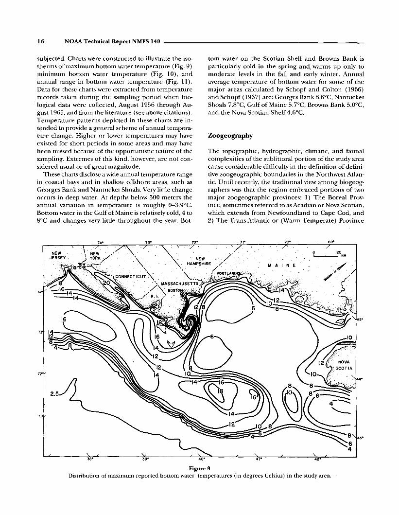
subjected. Charts were constructed to illustrate the isotherms of maximum bottom water temperature (Fig. 9)minimum bottom water temperature (Fig. 10), andannual range in bottom water temperature (Fig. 11).Data for these charts were extracted from temperaturerecords taken during the sampling period when biological data were collected, August 1956 through August 1965, and from the literature (see above citations).Temperature patterns depicted in these charts are intended to provide a general scheme of annual temperature change. Higher or lower temperatures may haveexisted for short periods in some areas and may havebeen missed because of the opportunistic nature of thesampling. Extremes of this kind, however, are not considered usual or of great magnitude.
These charts disclose a wide annual temperature rangein coastal bays and in shallow offshore areas, such asGeorges Bank and Nantucket Shoals. Very little changeoccurs in deep water. At depths below 500 meters theannual variation in temperature is roughly 0-3.9°C.Bottom water in the Gulf of Maine is relatively cold, 4 to8°C and changes very little throughout the year. Bot-
tom water on the Scotian Shelf and Browns Bank isparticularly cold in the spring and, warms up only tomoderate levels in the fall and early winter. Annualaverage temperature of bottom water for some of themajor areas calculated by Schopf and Colton (1966)and Schopf (1967) are: Georges Bank 8.6°C, NantucketShoals 7.8°C, Gulf of Maine 5.7°C, Browns Bank 5.0°C,and the Nova Scotian Shelf 4.6°C.
Zoogeography
The topographic, hydrographic, climatic, and faunalcomplexities of the sublittoral portion of the study areacause considerable difficulty in the definition of definitive zoogeographic boundaries in the Northwest Atlantic. Until recently, the traditional view among biogeographers was that the region embraced portions of twomajor zoogeographic provinces: 1) The Boreal Province, sometimes referred to as Acadian or Nova Scotian,which extends from Newfoundland to Cape Cod, and2) The Trans-Atlantic or (Warm Temperate) Province
NEWJERSEY
72
71
11°
41°
10°
M A I N E
69"
o 120I I KM.
42°
5°
4°
Figure 9Distribution of maximum reported bottom water temperatures (in degrees Celsius) in the study area.

__________________ Composition and Distribution of Macrobenthic Invertebrate Fauna 17
of which the Virginian subprovince extends from CapeCod southward to Cape Hatteras (Ekman, 1953;Hedgpeth, 1957). Although these views postulated thehighly visible physical features of Cape Cod and CapeHatteras as the boundaries between these provinces (acredible hypothesis topographically and hydrographically), no definitive consensus of opinion among biogeographers of the period prevailed as to the preciseplacement of the boundaries in the Northwest Atlantic.Indeed, the plethora of varying definitions and termsled to a rather confusing semantic problem that existsto this day. Further, these views resulted from studiesbased almost solely on biological and physical datafrom inshore or nearshore areas.
Hazel (1970) reviewed the historical development offaunal provinces for North America and Europe basedon the work of 17 authors from 1838 to 1966 and notedthat during that period essentially three biogeographicschemes evolved to characterize the Northwest Atlanticdown to Cape Hatteras: 1) Cape Cod acts as a boundarybetween the cold temperate Nova Scotian or BorealProvince to the north, and the warm temperate Virgin-
ian subprovince to the south, with Cape Hatteras forming the boundary between the Virginian and Carolinian subprovinces, which together formed the TransAtlantic Province down to present day Cape Kennedy;2) a region of overlap or transition, lacking a uniquefauna of its own (low endemism) with no provincialstatus, between the Nova Scotian and Carolinian Provinces; and 3) A cold temperate Boreal Province extending from Newfoundland to Cape Hatteras.
Although more recent biogeographic studies, basedmostly on offshore fauna within the region, such asthose of Bousfield (1960), Coomans (1962), Schopf(1968b), Franz (1970), Hazel (1970), Bousfield (1973),Franz (1975), Bowen et al. (1979), Kinner (1978),Watling (1979), Franz and Merrill (1980a, 1980b), andFranz et al. (1981) have expressed concern over theboundary's existence and have attempted to resolve thesemantic problem ofterminology through revision andsimplification, they have not, for the most part, significantly altered the three biogeographic concepts of earlier workers. These recent works, however, have provided some new insights concerning the placement of
NEWJERSEY·
_4
72
2.5
71
71°
41°
70°
M A I N E
69"
o 120I I KM
. ' ..//. ',/
>.
42°
5°
4°
3°
Figure 10Distribution of minimum reported bottom water temperatures (in degrees Celsius) in the study area.

18 NOAA Technical Report NMFS 140 _
NEW"ERSEY
1ZO
ANNUAL RANGE IN BOTTOMWATER TEMPERATURE (-C)
o 0- 3.911°
f7Zj 4- 7.9
1ZZl B- 11.9
o 12-159
• 16-19.9
• 20-23.9
38- 39°
12°
40°
11°
41°
10°
MAl N E
69"
o 120I~-,----,I KM.
Figure 11Distribution of the annual range (difference between maximum and minimum reported values) in bottom watertemperature (in degrees Celsius) in the study area.
more meaningful zoogeographic boundaries for regulating the distribution of benthic taxa within the region.
Boundaries of the geographical area considered inthis report were purposely selected so that they did notterminate at the margin of a perceived zoogeographical barrier. Cape Cod, lying roughly in the center of thestudy area, is of course the main physical featu're historically considered to mark the separation betweenthe Boreal and Trans-Atlantic Provinces. The recentwork ofSchopf (1968b), Hazel (1970), Watling (1979b),Franz et al. (1981), and other reports (Wigley andBurns, 1971; Williams and Wigley, 1977; Theroux andWigley, 1983; and Theroux and Grosslein, 1987) basedon the same data as, and including, the present reportcorroborate the fact that Cape Cod is indeed a zoogeographic boundary. However, the seaward extension ofthis boundary, at least as it pertains to benthic animals,does not traverse the continental shelf over NantucketShoals and the southwestern terminus of Great SouthChannel as previously supposed. Rather, the boundaryappears to lie along an easterly path across the north-
ern end of Great South Channel at depths of 50 to 100m and to continue along the northern margin ofGeorges Bank and thence southeasterly along the western boundary of Northeast Channel.
In bathyal and abyssal depths there are at least twoother zoogeographic provinces. Along the continentalslope, at depths between 150 and 2,000 m, is the Atlantic Transitional Province (Cutler, 1977), and at depthsbetween 2,000 and 4,000 m is the Atlantic BathyalAbyssal Province. Because of the interdigitating distributional patterns resulting from the southward submergence ofBoreal species and the ascendency ofTransitional and Bathyal-Abyssal species in their northward extension, the delineation of these provinces isimprecise and only partially aligned with topographicfeatures.
A great deal more work ofa zoogeographic nature onthe many remaining unstudied taxa of benthic invertebrates inhabiting the area needs to be performed before precise zoogeographic boundaries may be drawn,if at all possible.

Composition and Distribution of Macrobenthic Invertebrate Fauna 19
Table 3Rank order ,of major taxonomic groups according to percentagecomposition 'Of the total macrobenthic fauna in terms of biomassand number of specimens.
cussed in more detail in the following sections. Table 4lists the components of the macrobenthic invertebratefauna inhabiting the New England region, and Table 5lists the quantitative measures of abundance (meanand total weights and numbers per square meter), number of samples, and frequency of occurrence for eachtaxonomic group considered in this report. .
<1.0
43.428.110.8
82.3
2.91.91.71.51.51.2I.l1.0
12.8
0.80.50.50.40.40.30.30.30.20.20.10.10.10.14.3
<0.1
Percentage oftotal number
specimens
Total
OphiuroideaEchinoideaCumaceaZoanthariaCirripediaGastropodaAscidiaceaBryozoa
Total
IsopodaNemerteaDecapodaHydrozoaSipunculidaBrachiopodaScaphopodaHolothuroideaNematodaMysidaceaPoriferaAlcyonariaPolyplacophoraAsteroidea
Total
TurbellariaPriapulidaCephalopodaEchinoideaArachnidaPycnogonidaOstracodaCopepodaTanaidaceaCrinoideaPogonophoraHemichordataEchiura
Total
Taxa
AmphipodaAnnelidaBivalvia
<1.0
4.0
<0.1
44.120.0
9.57.0
80.6
3.52.32.21.91.81.21.21.2
15.3
0.80.70.50.40.40.30.20.20.20.10.10.1
Percentageof totalbiomass
Total
TurbellariaPriapulidaNematodaCephalopodaArachnidaPycnogonidaOstracodaCopepodaMysidaceaTanaidaceaCrinoideaPogonophoraHemichordata
Total
Taxa
BivalviaEchinoideaAnnelidaHolothuroidea
Total
ZoanthariaAmphipodaAscidiaceaCirripediaOphiuroideaGastropodaAsteroideaPorifera
Total
DecapodaBryozoaBrachiopodaNemerteaSipunculidaHydrozoaScaphopodaEchiuraIsopodaAlcyonariaPolyplacophoraCumacea
IV
III
II
Dominancecategory
The macrobenthic invertebrate fauna of theNew England region is moderate in variety.A modest number of species (567 in thepresent study), in combination with a gradedabundance of individuals composed of a variety ofdominants and codominants, is characteristic of the fauna, and is generally typi-cal of Boreal-Temperate faunal assemblages.
Taxa reported on in this study represent 13phyla and 28 lesser groups such as subphyla,classes, subclasses, and orders. The majority ofspecies are Boreal forms, followed closely inabundance by Virginian (or warm-temperate)forms. Additionally, there is a small contingent ofArctic and Subarctic species, particularly inthe Gulf of Maine. Also, a few tropical andsubtropical species occur chiefly in the South-ern New England and Georges Bank areas.
The ecological importance of thesegroups,judged primarily from their numerical abundance and biomass, ranges fromminor (components that account for lessthan 0.1 %in number of individuals and bio-mass) to dominant components that makeup 20% or more in number of individuals orbiomass. The 44 major taxonomic groups,with the percentage of total number of indi-viduals and percentage of total biomass foreach, are listed in Table 3. Also, they are classi-fied into four dominance categories, I to IV.
Over 80% of both the biomass and num-ber of individuals in the macrobenthos isformed by only five taxonomic groups. Theseare classified in dominance category I inTable 3. Bivalvia is the dominant contribu-tor (44.1 %) to the biomass and is also amajor component (10.8%) in termsofnum-bers of individuals. Amphipoda, on the otherhand, is numerically dominant (43.4%) butcontributes only 2.3% of the biomass. Con-versely, Echinoidea and Holotnuroidea areimportant components of the biomass, butare numerically sparse. Annelida is a majorcontributor in both measures of quantity.
Category II, in Table 3, consists of eighttaxa that contribute moderate biomass (1.2to 2.3% of the total fauna) and number of individuals(1.0 to 2.9% of the total fauna). Categories III and IVcontain those taxa that contribute small to very smallquantities to the total biomass and density.
The New England region macrobenthos is dominatedby members of four phyla: Annelida, Mollusca, Arthropoda, and Echinodermata. These groups will be dis-
Faunal Composition _

20 NOAA Technical Report NMFS 140
Table 4List of macrobenthic invertebrate species contained in quantitative samples obtained within the study area.
PORIFERADemospongiae
HadromeridaSuberitidae
Polymastia sp.COELENTERATA
HydrozoaHydractinia echinata Fleming, 1828Hydractinia sp.
AnthozoaAlcyonaria
AlcyonaceaAlcyonium sp.
GorgonaceaAcanella sp.Paragorgia arborea (Linnaeus, 1767)Primnoa reseda (Pallas, 1766)
PennatulaceaPennatula aculeata DanieIssen and Koren, 1858Pennatula sp.Stylatula elegans (Danielssen, 1860)
ZoanthariaZoanthidea
Epizoanthus incrustatus (Verrill, 1864)Epizoanthus sp.
ActiniariaTealina felina (Linnaeus, 1767)Edwardsia sulcata (T. Pennant, 1777)Edwardsia sp.Actinostola callosa Verrill, 1882Antholoba perdix (Verrill, 1882)
MadreporariaAstrangia sp.Flabellum goodei Verrill, 1878Flabellum sp.
CeriantheriaCerianthus borealis Verrill, 1878Cerianthus sp.Ceriantheopsis americanus Verrill, 1866
AnnelidaPolychaeta
AmphinomidaAmphinomidae
Paramphinome jefJreysii (McIntosh, 1868)Capitellida
CapitellidaeCapitella sp.
MaldanidaeAsychis biceps (Sars, 1861)Maldanesp.
CossuridaCossuridae
Cossura longicirrata Webster and Benedict, 1883Cossura sp.
EunicidaArabellidae
Arabella iricolor (Montagu, 1804)Arabella sp.Drilonereis longa Webster, 1879Drilonereis sp.Notocirrus sp.
EunicidaeEunice pennata (Muller, 1776)Eunicesp.Marphysa sp.
LumbrineridaeLumbrinerides acuta (Verrill, 1875)Lumbrineris fragilis (Muller, 1776)Lumbrineris sp.Ninoesp.
OnuphidaeDiopatra cuprea (Bose, 1802)Diopatra sp.Hyalinoecia tubicola (Muller, 1776)Hyalinoecia sp.Nothria conchylega Sars, 1835Onuphis eremitaAudoin and Milne-Edwards, 1833Onuphis opalina (Verrill, 1873)Onuphis quadricuspis Sars, 1872Onuphis sp.Paradiopatra sp.
FlabelligeridaFlabelligeridae
Bradasp.Flabelligera sp.Pherusa sp.
OpheliidaOpheliidae
Dphelia sp.Dphelina aulogaster (H. Rathke, 1843)Dphelina sp.Travisia carnea Verrill, 1873Travisia sp.
ScalibregmidaeScalibregma inflatum Rathke, 1843Scalibregma sp.
OrbiniidaOrbiniidae
Orbinia ornata (Verrill, 1873)Orbinia swani Pettibone, 1957Orbiniasp.Scoloplos robustus (Verrill, 1873)Scoloplos sp.Aricidea jefJreysii (McIntosh, 1879)Aricidea sp.
ParaonidaeParaonis sp.
OweniidaOweniidae
Owenia fusiformis delle Chiaje, 1844Oweniasp.
PhyllodocidaAphroditidae
Aphrodita hastata Moore, 1905Aphrodita sp.Laetmonice sp.
GlyceridaeGlycera americana Leidy, 1855Glycera capitata Oersted, 1843Glycera dibranchiata Ehlers, 1868Glycera sp.
continued on next page
Composition and Distribution of Macrobenthic Invertebrate Fauna 21
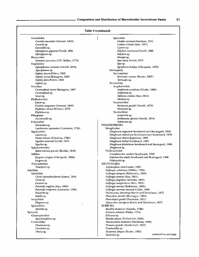
Table 4 (continued)
GoniadidaeGoniada maculata (Oersted, 1843)Goniada sp.Goniadella sp.Ophioglycera gigantea Verrill, 1885Ophioglycera sp.
HesionidaeNereimyra punctata (O.F. Muller, 1776)
NephtyidaeAglaophamus circinata (Verrill, 1874)Aglaophamus sp.Nephtys bucera Ehlers, 1869Nephtys incisa Malmgren, 1865Nephtys picta Ehlers, 1868Nephtyssp.
NereidaeCeratocephale loveni Malmgren, 1867Ceratocephale sp.Nereis sp.
PhyllodocidaeEteonesp.Eumida sanguinea (Oersted, 1843)Phyllodoce arenae Webster, 1879Phyllodoce sp.
PilargiidaeAncistrosyllis sp.
PolynoidaeHarmothoe sp.Lepidonotus squamatus (Linnaeus, 1758)
SigalionidaeLeanira sp.Pholoe minuta (Fabricius, 1780)Sigalion arenicola Verrill, 1879Sigalion sp.
SphaerodoridaeSphaerodorum gracilis (Rathke, 1843)
SyllidaeExogone verugera (Clarapede, 1868)Exogonesp.
TomopteridaeTomopteris sp.
SabellidaSabellidae
Chone infundibuliformis Kf0yer, 1856Chonesp.Euchonesp.Potamilla neglecta (Sars, 1850)Potamilla reniformis (Linnaeus, 1788)Potamilla sp.Sabella sp.
SerpulidaeFilograna sp.
SpirorbidaeSpirorbis sp.
SpionidaChaetopteridae
Spiochaetopterus sp.Cirratulidae
Chaetozone sp.Cirratulus sp.Tharyxsp.
SpionidaeDiospio uncinata Hartman, 1951Laonice cirrada (Sars, 1851)Laonice sp.Polydora concharum Verrill, 1880Polydora sp.Priospio sp.Spio setosa Verrill, 1873Spiosp.Spiophanes bombyx (Clarapede, 1870)
SternaspidaSternaspidae
Sternaspis scutata (Renier, 1807)Sternaspis sp.
TerebellidaAmpharetidae
Ampharete acutifrons (Grube, 1860)Ampharetesp.Melinna cristata (Sars, 1851)Melinnasp.
PectinariidaePectinaria gouldii (Verrill, 1873)Pectinaria sp.
TerebellidaeAmphitrite sp.Streblosoma spiralis (Verrill, 1874)Steblosoma sp.
POGONOPHORASiboglinidae
Siboglinum angustum Southward and Brattegard, 1968Siboglinum atlanticum Southward and Southward, 1958Siboglinum ekmaniJagerston, 1956Siboglinum holmei Southward ,1963Siboglinum pholidotum Southward and Brattegard, 1968Siboglinum sp.
PolybrachiidaeCrassibranchia sandersi Southward, 1968Diplobrachia similis Southward and Brattegard, 1968Polybrachia sp.
SIPUNCULIDAAspidosiphon zinni Cutler, 1969Golfingia catharinae (Muller, 1789)Golfingia elongata (Keferstein, 1869)Golfingia eremita (Sars, 1851)Golfingia flagrifera (Selenka, 1885)Golfingia margaritacea (Sars, 1851)Golfingia minuta (Keferstein, 1865)Golfingia murinae murinae Cutler, 1969Onchnesoma steenstrupi Koren and Danielssen, 1875Phascolion strombi (Montague, 1804)Phascolopsis gouldi (Pourtales, 1851)Sipunculus norvegicus Koren and Danielssen, 1875
ECHIURABonellia thomensis (Gmelin, 1788)Echiurus echiurus (Pallas, 1774)Echiurus sp.Ikedella akaeta (Zenkevitch, 1958)Maxmuelleria lankesteri (Herdman, 1898)Prometor grandis (Zenkevitch, 1957)Protobonellia sp.Sluiterina sibogae (Sluiter, 1902)Sluiterina sp. continued on .next page

22 NOAA Technical Report NMFS 140
Table 4 (continued)
MOLLUSCAPolyplacophoraGastropoda
ProsobranchiaArchaeogastropoda
FissurelidaePuncturella noachina (Linnaeus, 1771)
LepetidaeLepeta caeca (Miiller, 1776)
TrochidaeCalliostoma occidentalis (Mighels and Adams,
1842)Margarites costalis (Gould, 1841)Margarites groenlandicus (Gmelin, 1791)Margarites helicinus (Phipps, 1774)Margarites sp.Solariella lamellosa Verrill and Smith, 1880Solariella obscura (Couthouy, 1838)Solariella sp.
MesogastropodaLittorinidae
Littorina obtusata (Linnaeus, 1758)Rissoidae
Alvania brychia (Verrill, 1884)Alvania pelagica (Stimpson, 1851)Alvania areolata Stimpson, 1851Alvaniasp.
TurritellidaeTachyrhynchus erosus (Couthouy, 1838)Turritellopsis acicula (Stimpson, 1851)
CerithiidaeCerithiella sp.Diastoma alternatus (Say, 1822)
EpitoniidaeEpitonium dallianum Verrill and Smith, 1880Epitonium greenlandicum (Perry, 1811)
MelanellidaeCouthouyella striatula (Couthouy, 1839)
AclididaeAclis verrilli Bartsch, 1911
TrichotropidaeTrichotropis borealis Broderip and Sowerby, 1829
CrepidulidaeCrepidula fornicata Linnaeus, 1767Crepidula plana Say, 1822Crucibulum striatum Say, 1824
AporrhaidaeAporrhais occidentalis Beck, 1836
VelutinidaeVelutina velutina (Miiller, 1776)Velutina undata (Brown, 1839)Velutina sp.
NaticidaeLunatia heros (Say, 1822)Lunatia triseriata (Say, 1826)Lunatia pallida (Broderip, and Sowerby, 1829)Lunatiasp.Natica clausa Broderip and Sowerby, 1829Natica pusilla Say, 1822Polinices duplicatus (Say, 1822)Polinices immaculatus (Totten, 1835)Polinices sp.
NeogastropodaMuricidae
Boreotrophon clathratus (Linnaeus, 1758)Eupleura caudata (Say, 1822)
ColumbellidaeAmphissa haliaeeti (Jeffreys, 1867)Anachis laJresnayi (Fischer and Bernardi, 1856)Anachissp.Mitrella lunata (Say, 1826)Mitrella pura (Verrill, 1882)Mitrella rosacea (Gould, 1841)Mitrella sp.
BuccinidaeBuccinum undatum Linnaeus, 1758Buccinum sp.Colus caelatus (Verrill and Smith, 1880)Colus obesus (Verrill, 1884)Colus parous (Verrill and Smith, 1882)Colus pygmaeus (Gould, 1841)Colus sp.Neptunea decemcostata (Say, 1826)Neptunea despecta (Linnaeus, 1758)Neptunea sp.
MelongenidaeBusycon canaliculatus (Linnaeus, 1758)
NassariidaeIlyanassa obsoleta (Say, 1822)Nassarius trivittatus (Say, 1822)Nassarius vibex (Say, 1822)
CancellariidaeAdmete couthouyi (Jay, 1839)
TurridaeOenopota decussata (Couthouy, 1839)Oenopota harpularia (Couthouy, 1838)Oenopota incisula (Verrill, 1882)Pleurotomella agassizi agassiziVerrill and Smith,
1880Pleurotomella blakeana (Dall, 1889)Pleurotemella curta curta (Verrill: 1884)Pleurotomella packardi packardi (Verrill, 1872)Propebela elegans (Moller, 1842)Propebela exarata (Moller, 1842)Propebela turricula (Montagu, 1803)
PyramidellidaeOdostomia dealbata (Stimpson, 1851)Odostomia dux Dall and Bartsch, 1906Odostomia sp.Turbonilla bushiana Verrill, 1882Turbonilla elegantula Verrill, 1882Turbonilla nivea (Stimpson, 1851)Turbonilla polita (Verrill, 1872)Turbonilla sp.
OpisthobranchiaActeonidae
Acteon sp.Ringiculidae
Ringicula nitida Verrill, 1873Actiocinidae
Acteocina canaliculata (Say, 1822)Retusa obtusa (Montagu, 1807)
continued on next page

___________________ Composition and Distribution of Macrobenthic Invertebrate Fauna 23
Table 4 (continued)
ScaphandridaeCylichna alba (Brown, 1827)Cylichna gouldi (Couthouy, 1839)Cylichna vortex (Dall, 1881)Cylichna sp.Scaphander punctostriatus Mighels, 1841
PhilinidaePhiline lima (Brown, 1827)Philine quadrata (S. Wood, 1839)Philinesp.
AkeridaeHaminoea sp.
PleurobranchidaePleurobranchaea sp.
NudibranchiaDendronotidae
Dendronotus frondosus (Ascanius, 1774)Bivalvia
PalaeotoxodontaNuculoida
NuculidaeNucula delphinodonta Mighels and Adams, 1842Nucula proxima Say, 1822Nucula tenuis Montagu, 1808Nuculasp.
MalletiidaeMalletia obtusa G.O. Sars, 1872Saturnia subovata Verrill, and Bush, 1897
NuculanidaeNuculana acuta (Conrad, 1831)Nuculana pernula (Miiller, 1771)Nuculana tenuisulcata (Couthouy, 1838)Nuculana sp.Portlandiafraterna (Verrill and Bush, 1898)Portlandia frigida (Torrell, 1859)Portlandia inconspicua (Verrill and Bush 1898)Portlandia injlata (Verrill, and Bush, 1897)Portlandia iris (Verrill and Bush, 1897)Portlandia lenticula (Moller, 1842)Portlandia lucida (Loven, 1846)Yoldia limatula (Say, 1831)Yoldia myalis (Couthouy, 1838)Yoldia regularis Verrill, 1884Yoldia sapotilla (Gould,1841)Yoldia thraciaeformis Storer, 1838Yoldia sp.
CryptodontaSolemyoida
SolemyacidaeSolemya velum Say, 1822
PteriomorphiaArcoida
ArcidaeAnadara ovalis (Bruguiere, 1789)Anadara transversa (Say, 1822)Bathyarca anomala (Verrill and Bush, 1898)Bathyarca pectunculoides (Scacchi, 1833)Bathyarca sp.
LimopsidaeLimopsis affinis Verrill, 1885Limopsis cristataJeffreys, 1876Limopsis minuta Philippi, 1836
Limopsis sulcata Verrill and Bush, 1898Limopsis sp.
MytiloidaMytilidae
Crenella decussata (Montagu, 1808)Crenella glandula (Totten, 1834)Crenella sp.Dacrydium vitreum (Holboll in Moller, 1842)Modiolus modiolus (Linnaeus, 1758)Musculus corrugatus (Stimpson, 1851)Musculus discors (Linnaeus, 1767)Musculus niger (Gray, 1824)Musculus sp.Mytilus edulis Linnaeus, 1758Mytilussp.
PterioidaPectinidae
Chlamys islandica (Miiller, 1776)Cyclopecten pustulosus Verrill, 1873Placopecten magellanicus (Gmelin, 1791)
AnomiidaeAnommia simplex Orbigny, 1842Anomia squamula Linnaeus, 1758Anomiasp.
LimidaeLimatula subauriculata (Montagu, 1808)Limatula sp.
HeterodontaVeneroida
LucinidaeLucinoma blakeana Bush, 1883Lucinomajilosa (Stimpson, 1851)Lucinoma sp.
ThyasiridaeThyasira equalis Verrill and Bush, 1898Thyasira ferruginea Winckworth, 1932Thyasiraflexuosa (Montagu, 1803)Thyasira jlexuosa forma gouldii Philippi, 1845Thyasira pygmaea Verrill and Bush, 1898Thyasira subovataJeffreys, 1881Thyasira trisinuata Orbigny, 1842Thyasira sp.
LasaeidaeAligena elevata (Stimpson, 1851)
LeptonidaeMontacuta sp.
CarditidaeCyclocardia borealis Conrad, 1831Cyclocardia sp.
AstartidaeAstarte borealis (Schumacher, 1817)Astarte castanea (Say, 1822)Astarte crenata subequilatera Sowerby, 1854Astarte elliptica (Brown, 1827)Astarte montagui (Dillwyn, 1817)Astarte nana Dall, 1886Astarte quadrans Gould, 1841Astarte smithii Gould, 1841Astarte undata Gould, 1841Astartesp.
continued on next page

24 NOAA Technical Report NMFS 140
Table 4 (continued)
CardiidaeCerastoderma pinnulatum (Conrad, 1831)Laevicardium mortoni (Conrad, 1830)
MactridaeMulinia lateralis (Say, 1822)Spisula solidissima (Dillwyn, 1817)
MesodesmatidaeMesodesma sp.
SolenidaeEnsis directus Conrad, 1843Siliqua costata Say, 1822
TellinidaeMacoma calcarea (Gmelin, 1791)Macomasp.Tellina agilis Stimpson, 1858Tellina sp.
ArcticidaeArctica islandica (Linnaeus, 1767)
VeneridaeGemma gemma (Totten, 1834)Mercenaria mercenaria (Linnaeus, 1758)Pitar morrhuanus Linsley, 1845
MyoidaMyidae
Mya arenaria Linnaeus, 1758Corbulidae
Corbula contracta C.B. Adams, 1852Corbula sp.
HiatellidaeCyrtodaria siliqua (Spengler, 1793)Hiatella arctica (Linnaeus, 1767)Hiatella striata (Fleuriau, 1802)Hiatella sp.Panomya arctica (Lamarck, 1818)Panomyasp.
AnomalodesmataPholadomyoida
PandoridaePandora gouldiana Dall, 1886Pandora inflata Boss and Merrill, 1965Pandora inornata Verrill and Bush, 1898Pandorasp.
LyonsiidaeLyonsia arenosa Moller, 1842Lyonsia hyalina Conrad, 1830Lyonsiasp.
PeriplomatidaePeriploma fragile (Totten, 1835)Periploma leanum (Conrad, 1830)Periploma papyratium (Say, 1822)Periploma sp.
ThraciidaeThracia myopsis Moller, 1842Thracia sp.
CuspidariidaeCardiomya perrostrata (Dall, 1881)Cuspidaria glacialis (G.O. .'lars, 1878)Cuspidaria obesa (Loven, 1846)Cuspidaria parva Verrill and Bush, 1898Cuspidaria pellucida Stimpson, 1853Cuspidaria sp.
ScaphopodaDentaliidae
Bathoxiphus ensiculus (Jeffreys, 1877)Cadulus agassizii Dall, 1881Cadulus cylindratusJeffreys, 1877Cadulus pandionisVerrill and Smith, 1880Cadulus rushii Pilsbry and Sharp, 1898Cadulussp.Dentalium entale stimpsoni Henderson, 1920Dentalium meridionale Pilsbry and Sharp, 1897Dentalium occidentale Stimpson, 1851Dentalium sp.
CephalopodaOctopus sp.Rossia sp.
ARTHROPODAPycnogonida
Achelia scabra Wilson, 1880Achelia spinosa (Stimpson, 1853)Anoplodactylus lentus Wilson, 1878Nymphon brevitarse Kr0yer, 1844Nymphon grossipes (0. Fabricius?) Kr0yer, 1780Nymphon hirtipes Bell, 1853Nymphon macrum Wilson, 1880Nymphons~oemiKr0yer,1844Paranymphon spinosum Caullery, 1896Pycnogonium littorale (Strom, 1762)
CrustaceaCirripedia
Balanussp.Lepas sp.
CopepodaCalanussp.Caligussp.
CumaceaBrachydiastylis resima (Kr0yer, 1846)Campylaspis affinis .'lars, 1870Campylaspis rubicunda (Lilljeborg, 1855)Cyclaspis longicaudata G.O. .'lars, 1864.Diastylis cornuifer (Blake, 1929)Diastylis polita S.1. Smith, 1879Diastylis quadrispinosa G.O. .'lars, 1871Diastylis rathkei (Kr0yer, 1841)Diastylis sculpta G.O. .'lars, 1871Diastylis sp.Eudorella emarginata (Kr0yer, 1846)Eudorella hispida .'lars, 1871Eudorella truncatula (Bate, 1855)Eudorella sp.Eudorellopsis defarmis (Kr0yer, 1846)Eudorellopsis sp.Hemilamprops cristata (.'lars, 1870)Lamprops quadriplicata S.1. Smith, 1879Lamprops fuscata .'lars, 1865Lamprops sp.Leptostylis longimana (.'lars, 1865)Leptostylis macrura G.O. .'lars, 1869Leptostylis sp.Leucon americanus Zimmer, 1943Leucon nasicoides Lilljeborg, 1855Oxyrostylis smithi Caiman, 1912
continued on next page

Composition and Distribution of Macrobenthic Invertebrate Fauna 25
Table 4 (continued)
Cumacea, continuedPetalosarsia declivis (G.O. Sars, 1865)Pseudoleptocuma minor (Caiman, 1912)
IsopodaCalathura branchiata (Stimpson, 1853)Calathura sp.Chiridotea arenicola Wigley, 1960Chiridotea tuftsi (Stimpson, 1883)Chiridotea sp.Cirolana concharum (Stimpson, 1853)Cirolana impressa (Harger, 1818)Cirolana polita (Stimpson, 1853)Cirolana sp.Cyathura polita (Stimpson, 1855)Cyathura sp.Edotea acuta (Richardson, 1905)Edotea triloba (Say, 1818)Erichsonella flliformis (Say, 1818)Idotea phosphorea (Harger, 1873)Janira alta (Stimpson, 1853)Pseudarachna sp.Ptilanthura tenuis (Harger, 1879)Ptilanthura sp.
AmphipodaCaprellidea
CaprellidaeAeginina longicornis (Kr0yer, 1842-43)Aeginina sp.Caprella linearis (Linnaeus, 1767)Caprella penantis Leach, 1814CaprellaseptentrionaUsKr0yer, 1838Caprella unica Mayer, 1903Caprella sp.Luconacia incerta Mayer, 1903Mayerella limicola Huntsman, 1915Proaeginina norvegica (Stephensen, 1931)
HyperiideaHyperiidae
Hyperiasp.Parathemisto gaudichaudii (Milne-Edwards,
1840)Parathemisto sp.Phronima sedentaria (Forskal, 1775)Vibilia sp.
GammarideaAcanthonotozomatidae
Acanthonotozoma serratum (Fabricius, 1780)Ampeliscidae
Ampelisca abdita Mills, 1964AmpeUsca agassizi (judd, 1896)AmpeUsca declivitatus Mills, 1967A mpelisca eschrichti Kr0yer, 1842AmpeUscfl macrocephala Lilljeborg, 1852Ampelisca vadorum Mills, 1963AmpeUsca verrilli Mills, 1967AmpeUsca sp.Byblis gaimardi (Kr0yer, 1846)Byblis serrata (Smith, 1873)Byblis sp.Haploops tubicola Lilljeborg, 1856Haploops sp.
AmphilochidaeAmphilochoides odontyx (Boeck, 1871)Gitanopsis arctica G.O. Sars, 1895
AmphithoidaeAmphithoe rubricata (Montagu, 1808)
AoridaeLembos smithi Holmes, 1905Lembossp.Leptocheirus pinguis (Stimpson, 1853)Leptocheirus sp.Microdeutopis gryllotalpa Costa, 1853Pseudunciola obliqua (Shoemaker, 1949)Unciola dissimilis Shoemaker, 1945Unciola inermis Shoemaker, 1945Unciola irrorata Say, 1818Unciola leucopis (Kr0yer, 1845)Unciola serrata Shoemaker, 1945Unciola spicata Shoemaker, 1945Unciola sp.
ArgissidaeArgissa hamatipes (Norman, 1869)
BateidaeBatea catharinensis Muller, 1865
CalliopiidaeCalliopius laeviusculus (Kr0yer, 1838)Haliragesfulvocinctus (M. Sars, 1854)Haliragoides inermis (G.O. Sars, 1882)Hippomedon serratus Holmes, 1905
CorophiidaeCorophium crassicorne Bruzelius, 1859Corophium insidiosum Crawford, 1937Corophium volutator (Pallas, 1766)Corophium sp.Siphonocetes smithianus Rathbun, 1908Siphonocetes sp.
EusiridaeEusirus cuspidatus Kr0yer, 1845Rhachotropis distincta (Holmes, 1908)Rhachotropis inflata (G.O. Sars, 1882)Rhachotropis oculata (Hansen, 1887)Gammarus annulatus Smith, 1873Gammarus pallustris Bousfield, 1969Gammarus sp.
HaustoriidaeAcanthohaustorius intermedius Bousfield, 1965Acanthohaustorius millsi Bousfield, 1965Acanthohaustorius similis Frame, 1980Acanthohaustorius spinosus Bousfield, 1962Haustorius arenarius (Slabber, 1769)Haustorius sp.Parahaustorius attenuatus Bousfield, 1965Parahaustorius holmesi Bousfield, 1965Parahaustorius longimerus Bousfield, 1965Protohaustorius deichmannae Bousfield, 1965Protohaustorius wigleyi Bousfield, 1965Pseudohaustorius boreaUs Bousfield, 1965
IschyroceridaeEricthonius brasiliensis (Dana, 1853)Ericthonius rubricornis Smith, 1873Ericthonius sp.Ischyroceros anguipes Kr0yer, 1838
continued on next page

26 NOAA Technical Report NMFS 140
Table 4 (continued)
Ischyroceridae, continuedIschyroceros megacheir (Boeck, 1871)Ischyroceros sp.
LysianassidaeAnonyx debruynii Hoek, 1882Anonyx lilljeborgi Boeck, 1871Anonyx nugax (Phipps, 1774)Anonyx sarsi Steele and Brunei, 1968Anonyxsp.Hippomedon propinguus Sars, 1895Hippomedon serratus Holmes, 1905Hippomedon sp.Lysianopsis alba Holmes, 1905Orchomene groenlandica (Hansen, 1887)Qrchomene minuta Kn!lyer, 1846Orchomene pinguis Boeck, 1861Orchomene sp.Psammonyx nobilis Stimpson, 1853Tmetonyx cicada o. Fabricius, 1780Tmetonyx sp.Tryphosella nanoides Lilljeborg, 1865
MelitidaeCasco bigelowi (Blake, 1929)Eriopisa elongata (Bruzelius, 1859)Macra danae Stimpson, 1853Maero loveni (Bruzelius, 1859)Maerasp.Melita dentata Krl2lyer, 1842Melita palmata (Montagu, 1894)Melitasp.
MelphidippidaeMelphidippa goesi Stebbing, 1899Melphidippa sp.
OedicerotidaeBathymedon sausserei (Boeck, 1871)Monoculodes edwardsi Holmes, 1908Monoculodes intermedius Shoemaker, 1930Monoculodes latimanus (Goes, 1866)Monoculodes longicornis (Boeck, 1871)Paroediceros sp.Synchelidium americanum Bousfield, 1973Westwoodilla megalops (G.O. Sars, 1882)
ParamphithoidaeEpimeria loricata G.O. Sars, 1879
PardaliscidaeHalice abyssi Boeck, 1871Pardalisca cuspidata Kr0yer, 1842
PhotidaeGammaropsis maculatus (Johnson, 1827)Photis dentata Shoemaker, 1945Photis macrocoxa Shoemaker, 1945Photis reinhardi Krl2lyer, 1842Photis sp.Podoceropsis nitida (Stimpson, 1853)Protomedia fasciata Kr0yer, 1842
PleustidaeNeopleustes pulchellus Krl2lyer, 1846Parapleustes sp.Pleustes panoplus Krl2lyer, 1838Pleustes glaber Boeck, 1861Stenopleustes gracilis Holmes, 1905
Stenopleustes inermis Shoemaker, 1949Stenopleustes latipes (M. Sars, 1895)
PodoceridaeDyopedus articus (Murdoch, 1884)Dyopedus monacantha (Metzger, 1875)Dulichia porrecta (Bate, 1857)Dulichia tuberculata Boeck, 1870Dulichia sp.Paradulichia typica Boeck, 1870Paradulichia sp.
PontogeneidaePontogeneia inermis (Krl2lyer, 1842)Pontogeneia sp.
PontoporeiidaeAmphiporea gigantea Bousfield, 1973Amphiporea lawrenciana Shoemaker, 1929Amphiporea virginiana Shoemaker, 1933Bathyporeia quoddyensisShoemaker, 1949
StegocephalidaeAnadaniopsis nordlandica (Boeck, 1871)Stegocephalus injlatus Krl2lyer, 1842
StenothoidaeStenothoe minuta Holmes, 1905Stenula peltata (Smith, 1873)
SynopiidaeSyrrhoe crenulata Goes, 1866Syrrhoe spiniferum (Stimpson, 1853)
MysidaceaErythrops erythrophthalma (Goes, 1864)Erythrops sp.Mysidopsis bigelowi Tattersall, 1926Neomysis americana (S.1. Smith, 1873)Neomysis sp.
DecapodaCaridea
Crangon septemspinosa Say, 1818Dichelopandalus leptocerus (Smith, 1881)Eualus pusiolus (Krl2lyer, 1841)Pandalus montagui Leach, 1813 or 1814Pandalus propinquus G.O. Sars, 1869Pandalus sp.Pontophilus brevirostris Smith, 1881Spirontocaris lilljeborgii (Danielssen, 1859)Spirontocaris sp.
AstacideaHomarus americanus H. Milne-Edwards, 1837
AnomuraAxius serratus Stimpson, 1852Callianassa atlantica Rathbun, 1926Callianassa bifarmis Biffar, 1971Calocaris templemani (Squires, 1965)Catapagurus gracilis (Smith, 1881)Munida iris A. Milne-Edwards, 1880Munida valida Smith, 1883Pagurus acadianus Benedict, 1901Pagurus annulipes Stimpson, 1860Pagurus arcuatus Squires, 1964Pagurus longicarpus Say, 1817Pagurus politus (Smith, 1882)Pagurus pollicaris Say, 1817Pagurus pubescens Kr0yer, 1838
continued on next page

Composition and Distribution of Macrobenthic Invertebrate Fauna 27
Table 4 (continued)
Anomura, continuedUpogebia affinis (Say, 1817)
BrachyuraCancer borealis Stimpson, 1859Cancer irroratus Say, 1817Euprognatha rastellifera Stimpson, 1871Geryon quinquedens Smith, 1897Hexapanopeus angustifrons (Benedict and
Rathbun, 1891)Hyas coarctatus Leach, 1815Hyassp.Libinia dubia H. Milne-Edwards, 1834Libiniasp.Neopanope texana sayi (Smith, 1869)Ocypodesp.Pelia mutica (Gibbes, 1850)Pinnixa chaetopterana Stimpson, 1860Pinnixa sayana Stimpson, 1860Pinnixasp.
BRYOZOACtenostomata
AlcyonidiidaeAlcyonidium mamillatum Alder, 1857Alcyonidium sp.
FlustrellidaeFlustrellidra sp.
CyclostomataCrisiidae
Crisia cribraria Stimpson, 1853Crisia denticulata (Lamarck, 1816)
OncousoeciidaeOncousoecia canadensis Osburn, 1933Oncousoecia diastoporoides (Norman, 1868)Oncousoecia sp.
TubuliporidaeIdmonea atlanticaJohnston, 1847Idmoneasp.Tubulipora liliacea (Pallas, 1766)Tubulipora lobulata Hassall, 1841Tubulipora sp.
DiaperoeciidaeDiaperoecia harmeri Osburn, 1933Diplosolen obelium (Johnston, 1838)Entalophora sp.
FrondiporidaeDefrancia sp.
CheilostomataAlderinidae
Amphiblestrum flemingii (Busk, 1854)Amphiblestrum trifolium (Searles Wood, 1850)Cauloramphus cymbaeformis (Hincks, 1887)
BugulidaeBugula elong{fta Nordgaard, 1906Bugula turrita (Desor, 1848)Bugulasp.Dendrobeania murrayana (Johnston, 1847)'Dendrobeania sp.
CalloporidaeCallopora aurita (Hincks, 1877)Callopora craticula (Alder, 1857)Callopora lineata (Linnaeus, 1767)
Callopora whiteavesi Norman, 1903Callopora sp.
CellariidaeCellaria sp.
CelliporidaeCellepora canaliculata Busk, 1884Cellepora sp.
CheiloporinidaeCryptosula pallasiana (Moll, 1803)
CribrilinidaeCribrilina punctata (Hassall, 1842)Cribrilina sp.
ElectridaeElectra hastingsae Marcus, 1938Electra pilosa (Linnaeus, 1767)Pyripora catenularia (Jameson, 1814)
EucrateidaeEucratea loricata (Linnaeus, 1758)
HippoporinidaeHippodiplosia americana (Verrill, 1875)Hippodiplosia pertusa (Esper, 1794-97)Hippoponella hippopus (Smitt, 1867)
HippothoidaeHippothoa hyalina (Linnaeus, 1767)
MembraniporidaeConopeum reticulum (Linnaeus, 1767)Membranipora sp.
MicroporellidaeMicroporella ciliata (Pallas, 1766)
MucronellidaeMucronella immersa (Fleming, 1847)Mucronella ventricosa (Hassall, 1842)Palmicellaria skenei (Ellis and Solander, 1786)Porella plana (Dawson, 1859)Porella proboscidea Hincks, 1888Porella propinqua (Smitt, 1867)Pseudoflustra sp.Rhamphostomella bilaminata (Hincks, 1877)Rhamphostomella ovata (Smitt, 1867)Rhamphostomella sp.Smittina bella (Busk, 1860)Smittina reduplicata Osburn, 1933Smittina rigida Lorenz, 1886Smittina trispinosa (Johnston, 1838)Smittina sp.
SchizoporellidaeSchizomavella auriculata (Hassall, 1842)Schizoporella biaperta (Michelin, 1841-42)Schizoporella unicornis (Johnston, 1847)
ScrupariinidaeHaplota clavata (Hincks, 1857)
ScrupocellariidaeCaberea ellisii (Fleming, 1828)Scrupocellaria scabra (Fabricius, 1780)Tricellaria gracilis (Van Beneden, 1848)Tricellaria sp.
GigantoporidaeTessaradomagracile (M. Sars, 1851)
StomachetosellidaeEscharopsis sarsi (Smitt, 1868)Stomachetosella sp.
continued on next page

28 NOAA Technical Report NMFS 140
Table 4 (continued)
BRACHIOPODATerebratulina sp.
ECHINODERMATAHolothuroidea
ApodidaChirodota sp.Labidoplax buskii (McIntosh, 1866)Myritrochus sp.Synapta sp.Trochoderma sp.
AspidochirotidaAstichopus sp.
DendrochirotidaCucumaria planci Marenzeller, 1893Cucumaria sp.Havelockia scabra (Verrill, 1873)Psolus fabricii Duben and Koren, 1846Psolus phantapus (Strussenfeldt, 1765)Psolus valvatus 0stergren in Grieg, 1913Psolus sp.Stereoderma unisemita (Stimpson, 1851)Thyone fusus (Muller, 1788)Thyonesp.Thyonidium pellucidum Duben and Koren, 1844
MolpadiidaCaudina arenata (Gould, 1841)Molpadia oolitica (Pourtales, 185I)Molpadia sp.
DactylochirotidaEchinocucumis sp.
EchinoideaCamarodonta
Strongylocentrotus droebachiensis (Muller, 1776)Clypeastroidea
Echinarachnius parma (Lamarck, 1816)Echinocyamus grandiporus Mortensen, 1907
SpatangoidaAceste bellidifera Wyville Thompson, 1877Aeropsis rostrata Norman, 1876Brisasterfragilis (Duben and Koren, 1844)Brissopsis atlantica Mortensen, 1907Schizaster orbignyanus A. Agassiz, 1883Schizaster sp.
OphiuroideaAmphilepididae
Amphilepis ingolfiana Mortensen, 1933Amphiuridae
Amphilimna olivacea (Lyman, 1869)
Total Macrobenthos - All TaxonomicGroups Combined _
Geographic Distribution
Macrobenthic invertebrates showed clear geographictrends in abundance (Fig. 12). Both density and biomass of organisms exhibited similar patterns. Density wasgenerally highest (1,000 to 15,000/m2) in the coastalregions of the Gulf of Maine, on Georges Bank, and on
Amphilimna sp.Amphioplus abditus (Verrill, 1872)Amphioplus macilentus (Verrill, 1882)Amphioplus sp.Amphiura oueri Ljungman, 1871Amphiura fragilis (Verrill, 1885)Amphiura grandisquama Lyman, 1869Amphiura sp.Axiognathus squamatus (delle Chiaje, 1828)Axiognathus sp.
OphiacanthidaeOphiacantha abyssicola (E. Forbes, 1843)Ophiacantha bidentata (Retzius, 1805)Ophiacantha sp.Ophiochiton tenuispinus (Verrill, 1884)Ophiocten scutatum Koehler, 1896Ophiocten sericeum (Forbes, 1852)Ophiomusium lymani Thompson, 1873Ophiura ljungmani (Lyman, 1878)Ophiura robusta (Ayres, 1852)Ophiura sarsi Liitken, 1858Ophiurasp.
AsteroideaAsteriidae
Asterias forbesi (Desor, 1848)Asterias vulgaris (Verrill, 1866)Asterias sp.Leptasterias sp.
AstropectinidaeAstropecten americana (Verrill, 1880)Astropecten sp.
GoniopectinidaeCtenodiscus crispatus (Retzius, 1805)Ctenodiscus sp.
EchinasteridaeHenricia sanguinolenta (Sars, 1844)Henricia sp.
SolasteridaeSolaster sp.
HEMICHORDATAEnteropneusta
Balanoglossus sp.CHORDATA
AscidiaceaAmaroucium sp.Bostrichobranchus sp.Molgulasp.
most of the continental shelf region off Southern NewEngland. Density was generally low (less than 100 individuals/m2) over most of the continental rise, and moderately low (100 to 1,000/m2) in the central Gulf ofMaine, on the southeastern Scotian Shelf area, andalong the continental slope. The distribution of biomass was similar to that for density. High biomass (100 to3,400 g/m2) was distributed around the periphery ofthe Gulf of Maine, on Georges Bank, on most of thecontinental shelf off Southern New England, and in

Composition and Distribution of Macrobenthic Invertebrate Fauna 29
Table 5Mean number and weight per square meter, total number and weight, number of samples, and percent frequency ofoccurrence of each taxonomic group, based on 1,076 samples.
Mean Total Number Frequency ofof occurrence
Taxon No./m2 Wt./m2 No. Wt. samples %
PORIFERA 1.5 2.24 1,566 2,415.82 71 6.6
COELENTERATA 32.1 7.33 34,513 7,884.63 449 41.7Hydrozoa 6.4 0.52 6,878 560.32 126 11.7Anthozoa 25.7 6.81 27,635 7,324.31 323 30.0
Alcyonaria 0.8 0.20 902 219.89 63 5.9Zoantharia 22.6 6.39 24,322 6,871.85 265 24.6Unidentified 2.2 0.22 2,411 232.57 100 9.3
PLAlYHELMINTHES 0.4 0.01 381 6.44 16 1.5Turbellaria 0.4 O.oI 381 6.44 16 1.5
NEMERTEA 8.2 0.71 8,806 765.70 405 37.6
ASCHELMINTHES 2.8 O.oI 3,047 8.19 98 9.1Nematoda 2.8 O.oI 3,047 8.19 98 9.1
ANNELIDA 425.0 17.41 457,283 18,727.37 1,034 96.1
POGONOPHORA 0.6 <0.01 618 3.22 56 5.2
SIPUNCULIDA 5.9 0.75 6,358 802.87 249 23.1
ECHIURA 0.1 0.30 105 327.78 17 1.6
PRIAPULIDA <0.1 <0.01 10 4.60 4 0.4MOLLUSCA 188.0 83.64 202,250 89,998.88 946 87.9
Polyplacophora 1.5 0.14 1,608 148.66 84 7.8Gastropoda 17.8 2.23 19,165 2,396.85 470 43.7Bivalvia 163.1 80.95 175,535 87,105.74 893 83.0Scaphopoda 5.1 0.32 5,458 339.69 218 20.3Cephalopoda 0.4 O.oI 376 7.34 5 0.5Unidentified 0.1 <0.01 108 0.60 2 0.2
ARTHROPODA 726.2 9.41 781,348 10,125.53 936 87.0Pycnogonida 0.3 0.01 369 8.45 25 2.3Arachnida <0.1 <0.01 3 0.03 1 0.1Crustacea 725.8 9.40 780,976 10,117.05 910 84.6
Ostracoda <0.1 <0.01 19 0.19 5 0.5Cirripedia 21.8 3.39 23,511 3,648.00 41 3.8Copepoda <0.1 <0.01 26 0.18 4 0.4Cumacea 25.8 0.11 27,758 120.97 390 36.3Tanaidacea <0.1 <0.01 50 0.66 15 1.4Isopoda 12.1 0.29 12,966 1,313,24 390 36.3Amphipoda 655.8 4.16 705,612 4,478.71 862 80.1Mysidacea 2.5 0.01 2,642 12.33 41 3.8Decapoda 7.5 1.43 8,039 1,540.72 246 22.9Unidentified 0.3 <0.01 353 2.07 18 1.7
BRYOZOA 15.7 1.29 16,915 1,391.00 119 11.1
BRACHIOPODA 4.5 0.89 4,793 955.31 54 5.0
ECHINODERMATA 79.3 55.00 85,331 59,182.14 772 71.8. Crinoidea <0.1 <0.01 13 0.18 2 0.2
Holothuroidea 4.3 12.87 4,633 13,849.69 202 18.8Echinoidea 29.3 36.75 31,512 39,540.94 293 27.2Ophiuroidea 44.2 3.26 47,565 3,504.18 487 45.3Asteroidea 1.5 2.13 1,608 2,287.15 144 13.4
HEMICHORDATA 0.1 0.02 101 18.67 4 0.4
CHORDATA 16.3 4.10 17,520 4,415.19 181 16.8Ascidiacea 16.3 4.10 17,520 4,415.19 181 16.8
UNIDENTIFIED 5.8 0.27 6,199 294.42 261 24.3
Total 1,512.2 183.39 1,627,144 197,327.78

30 NOAA Technical Report NMFS 140
NEWJERSEY
EXPLANATION
El 1- 99
III 100- 999111000- 499II5000-15,337
INDIVIDUALSPER SQUARE METER
EXPLANAT ION
[ill 1.0-49.9
[I 50.0- 99.9
II 100.0-499.
II 500.0- 3444.2GRAMS
PER SQUARE METER
72°
ALL TAXA COMBINED
'20~~_~, KM
5°
Figure 12Geographic distribution of the density (A) and biomass (B) of all taxonomic groups combined. Density is expressed as number of individuals per square meter of bottom area;biomass is expressed as wet (damp) weight per square meter of bottom area.
coastal areas south of New York. Low biomass (less than50 g/m2) was prevalent in the central Gulf of Maine, onthe southeastern Scotian Shelf, and along the continental slope and continental rise.
A few areas were characterized by a very high density(5,000/m2 or greater) and an unusually high biomass(500 g/m2 or more). One of these exceedingly richareas was located at the mouth of the Bay of Fundy;

__________________ Composition and Distribution of Macrobenthic Invertebrate Fauna 31
72
NEW
EXPLANATIONMEAN NUMIER OF ANIMALSPER SQUARE METER OF IOTTOM,ALL TAXA COMBINED,
A
• 12.~.M
',M A I N E ,
B
72·
EXPLANATION
D CRUSTACEA • ECHINODERMATA
~ ANNELIDA LiOTHER
71
Figure 13Quantitative composition of the total macrobenthic invertebrate fauna inrelation to the six standard geographic subareas. A.-Mean number ofindividuals per square meter of bottom area; B.-Percentage composition,by density, of the major taxonomic groups.
another was located in the vicinity of the southern endof Great South Channel and southwestern GeorgesBank. Several smaller rich areas were encountered inthe coastal region of Rhode Island and New York. Generally, they occurred around the periphery of the Gulfof Maine and off southern New England.
Substantial differences in both biomass and densityexisted among the six geographic areas (Tables 6, 7; Fig.13A). Average density was highest (2,382 and 1,961/m2)
on the Southern New England Shelf and on GeorgesBank, intermediate in Nova Scotia and the Gulf ofMaine, and lowest (about 300/m2) on Georges Slope.

32 NOAA Technical Report NMFS 140
Table 6Mean number of specimens of each taxon per square meter in relation to geographic area.
Geographic areas
Southern SouthernNew England New England
Taxon Nova Scotia Gulf of Maine Georges Bank Shelf Georges Slope Slope All areas
PORIFERA 4.8 2.7 0.6 0.5 0.3 0.2 1.5
COELENTERATA 22.2 9.2 99.7 22.6 6.7 8.5 32.1Hydrozoa 11.5 3.3 6.8 9.9 0.1 0.8 6.4Anthozoa 10.7 5.9 92.9 12.7 6.6 7.7 25.7
Alcyonaria 0.7 0.9 1.2 1.0 1.5 0.8Zoantharia 8.2 3.6 92.5 7.3 3.0 4.3 22.6Unidentified 1.8 1.4 0.4 4.2 2.6 1.9 2.2
PLAlYHELMINTHES 0.2 <0.1 0.2 0.9 0.4 0.4Turbellaria 0.2 <0.1 0.2 0.9 0.4 0.4
NEMERTEA 3.0 4.1 22.7 6.8 1.2 1.6 8.2
ASCHELMINTHES 0.9 3.1 1.7 4.0 2.3 . 2.3 2.8Nematoda 0.9 3.1 1.7 4.0 2.3 2.3 2.8
ANNELIDA 648.4 291.3 545.6 530.8 79.9 148.6 425.0
POGONOPHORA 0.3 <0.1 3.1 5.3 0.6
SIPUNCULIDA 9.3 4.6 4.4 7.2 1.2 8.7 5.9
ECHIURA 0.1 0.1 0.4 0.2 0.1
PRIAPULIDA 0.1 0.1 <0.1
MOLLUSCA 77.2 306.2 46.8 244.2 83.1 57.9 188.0Polyplacophora 1.9 3.6 0.1 0.9 0.6 0.2 1.5Gastropoda 15.0 15.2 11.2 28.8 8.4 6.9 17.8Bivalvia 50.6 276.0 34.4 212.3 69.5 45.8 163.1Scaphopoda 9.6 11.4 1.2 1.0 4.5 4.8 5.1Cephalopoda <0.1 <0.1 1.0 0.1 0.1 0.4Unidentified 0.3 <0.1 0.1
ARTHROPODA 329.8 150.4 1,052.4 1,386.0 137.6 21.5 726.2Pycnogonida 0.8 0.1 0.3 0.6 0.1 0.3Arachnida <0.1 <0.1Crustacea 329.0 150.3 1,052.1 1,385.4 137.5 21.5 725.9
Ostracoda 0.1 <0.1 <0.1 <0.1 <0.1Cirripedia 35.7 6.4 2.7 52.2 21.8Copepoda <0.1 0.2 <0.1Cumacea 7.3 15.0 45.0 37.0 2.5 3.0 25.8Tanaidacea 0.4 0.4 <0.1Isopoda 3.9 9.5 18.0 17.0 1.3 1.0 12.1Amphipoda 280.0 118.2 952.9 1,269.3 133.7 17.1 655.8Mysidacea <0.1 0.2 10.6 1.0 <0.1 2.5Decapoda 2.1 0.5 22.3 8.7 0.1 7.5Unidentified 0.5 0.5 0.2 <0.1 0.3
BRYOZOA 16.3 6.9 27.9 21.9 0.4 15.7
BRACHIOPODA 22.4 9.5 <0.1 4.5
ECHINODERMATA 23.6 43.3 121.0 122.7 18.8 18.7 79.3Crinoidea <0.1 <0.1 <0.1Holothuroidea 2.5 7.8 0.2 4.7 2.2 3.4 4.3Echinoidea 3.6 4.6 105.6 21.8 0.2 0.3 29.3Ophiuroidea 17.0 29.5 14.0 93.7 15.8 14.8 44.2Asteroidea 0.4 1.5 1.1 2.5 0.6 0.2 1.5
HEMICHORDATA 0.3 0.1 0.1
CHORDATA 2.8 2.3 33.8 26.8 2.6 1.3 16.3Ascidiacea 2.8 2.3 33.8 26.8 2.6 1.3 16.3
UNIDENTIFIED 1.7 4.9 4.3 7.6 9.4 7.2 5.8
Total 1,162.6 838.7 1,961.0 2,382.4 347.4 281.9 1,512.2

Composition and Distribution of Macrobenthic Invertebrate Fauna 33
Table 7The number of specimens of each taxon, expressed as a percentage of the total benthic invertebrate fauna, in relation togeographic area.
Geographic areas
Southern SouthernNew England New England
Taxon Nova Scotia Gulf of Maine Georges Bank Shelf Georges Slope Slope All areas
PORIFERA 0.4 0.3 <0.1 0.1 0.1 0.1 0.1COELENTERATA 1.9 1.1 5.1 1.0 1.9 3.0 2.1
Hydrozoa 1.0 0.4 0.4 0.4. <0.1 0.3 0.4Anthozoa 0.9 0.7 4.7 0.6 1.9 2.7 1.7
A1cyonaria 0.1 0.1 <0.1 0.3 0.5 0.1Zoantharia 0.7 0.4 4.7 0.3 0.9 1.5 1.5Unidentified 0.2 0.2 <0.1 0.2 0.8 0.7 0.2
PLAlYHELMINTHES <0.1 <0.1 <0.1 <0.1 0.1 <0.1Turbellaria <0.1 <0.1 <0.1 <0.1 0.1 <0.1
NEMERTEA 0.3 0.5 1.2 0.3 0.3 0.6 0.5ASCHELMINTHES 0.1 0.4 0.1 0.2 0.7 0.8 0.2
Nematoda 0.1 0.4 0.1 0.2 0.7 0.8 0.2
ANNELIDA 55.8 34.7 27.8 22.3 23.0 52.7 28.1POGONOPHORA <0.1 <0.1 0.9 1.9 <0.1SIPUNCULIDA 0.8 0.6 0.2 0.3 0.3 3.1 0.4ECHIURA <0.1 <0.1 0.1 0.1 <0.1PRIAPULIDA <0.1 <0.1 <0.1MOLLUSCA 6.6 36.5 2.4 10.2 23.9 20.5 12.4
Polyplacophora 0.2 0.4 <0.1 <0.1 0.2 0.1 0.1Gastropoda 1.3 1.8 0.6 1.2 2.4 2.5 1.2Bivalvia 4.4 32.9 1.8 8.9 20.0 16.3 10.8Scaphopoda 0.8 1.4 0.1 <0.1 1.3 1.7 0.3Cephalopoda <0.1 <0.1 <0.1 <0.1 <0.1 <0.1Unidentified <0.1 <0.1 <0.1
ARTHROPODA 28.4 17.9 53.7 58.2 39.6 7.6 48.0Pycnogonida 0.1 <0.1 <0.1 <0.1 <0.1 <0.1Arachnida <0.1 <0.1Crustacea 28.3 17.9 53.7 58.2 39.6 7.6 48.0
Ostracoda <0.1 <0.1 <0.1 <0.1 <0.1Cirripedia 3.1 0.8 0.1 2.2 1.4Copepoda <0.1 0.1 <0.1Cumacea 0.6 1.8 2.3 1.6 0.7 1.1 1.7Tanaidacea 0.1 0.1 <0.1Isopoda 0.3 1.1 0.9 0.7 0.4 0.4 0.8Amphipoda 24.1 14.1 48.6 53.3 38.5 6.0 43.4Mysidacea <0.1 <0.1 0.5 <0.1 <0.1 0.2Decapoda 0.2 0.1 1.1 0.4 <0.1 0.5Unidentified 0.1 <0.1 <0.1 <0.1 <0.1
BRYOZOA 1.4 0.8 1.4 0.9 0.1 1.0BRACHIOPODA 1.9 1.1 <0.1 0.3ECHINODERMATA 2.0 5.2 6.2 5.2 5.4 6.6 5.2
Crinoidea <0.1 <0.1 <0.1Holothuroidea 0.2 0.9 <0.1 0.2 0.6 1.2 0.3Echinoidea 0.3 0.5 5.4 0.9 <0.1 0.1 1.9Ophiuroidea 1.5 3.5 0.7 3.9 4.6 5.2 2.9Asteroidea <0.1 0.2 <0.1 0.1 0.2 0.1 0.1
HEMICHORDATA <0.1 <0.1 <0.1CHORDATA 0.2 0.3. 1.7 1.1 0.7 0.5 1.1
Ascidiacea 0.2 0.3 1.7 1.1 0.7 0.5 1.1UNIDENTIFIED 0.1 0.6 0.2 0.3 2.7 2.5 0.4
Total 100.0 100.0 100.0 100.0 100.0 100.0 100.0

34 NOAA Technical Report NMFS 140
Table 8Mean wet weight of specimens of each taxon (grams per square meter) in relation to geographic area.
Geographic areas
Southern SouthernNew England New England
Taxon Nova Scotia Gulf of Maine Georges Bank Shelf Georges Slope Slope All areas
PORIFERA 15.49 3.15 0.47 0.09 0.24 0.03 2.24
COELENTERATA 20.23 11.87 3.68 4.62 2.42 0.99 7.33Hydrozoa 0.49 0.12 1.61 0.41 <0.01 0.03 0.52Anthozoa 19.74 11.75 2.07 4.21 2.42 0.96 6.81
Alcyonaria 0.03 0.43 0.21 0.14 0.07 0.20Zoantharia 19.54 10.90 2.04 3.84 1.90 0.70 6.39Unidentified 0.16 0.41 0.03 0.15 0.38 0.19 0.22
PLAlYHELMINTHES <0.01 O.oI <0.01 0.01 O.oI O.oITurbellaria <0.01 0.01 <0.01 0.01 O.oI O.oI
NEMERTEA 0.56 0.54 0.83 1.04 0.11 0.20 0.71
ASCHELMINTHES <0.01 O.oI O.oI O.oI 0.01 O.oI 0.01Nematoda <0.01 O.oI O.oI 0.01 O.oI O.oI O.oI
ANNELIDA 18.50 15.51 7.93 29.60 4.86 4.32 17.41
POGONOPHORA <0.01 <0.01 O.oI 0.03 <0.01
SIPUNCULIDA 1.65 0.37 0.46 0.74 1.01 1.83 0.75
ECHIURA O.oI 0.07 5.18 0.40 0.03
PRIAPULIDA 0.01 0.05 <0.01
MOLLUSCA 54.40 31.59 79.54 170.90 2.65 1.18 83.64Polyplacophora 0.10 0.19 <0.01 0.24 O.oI O.oI 0.14Gastropoda 2.47 0.90 1.98 4.29 0.32 0.05 2.23Bivalvia 50.81 29.84 77.40 166.34 2.11 1.04 80.95Scaphopoda 1.03 0.66 0.15 0.02 0.20 0.08 0.32Cephalopoda <0.01 O.oI O.oI <0.01 <0.01 O.oIUnidentified <0.01 <0.01 <0.01
ARTHROPODA 16.49 2.43 9.75 17.11 0.64 0.13 9.41Pycnogonida 0.02 0.02 <0.01 <0.01 <0.01 0.01Arachnida <0.01 <0.01Crustacea 16.49 2.41 9.75 17.11 0.64 0.13 9.40
Ostracoda <0.01 <0.01 <0.01 <0.01 <0.01Cirripedia 12.71 0.47 0.35 6.84 3.39Copepoda <0.01 <0.01 <0.01Cumacea 0.03 0.05 0.20 0.17 0.04 0.02 0.11Tanaidacea O.oI <0.01 <0.01Isopoda 0.09 0.34 0.30 0.40 0.02 0.02 0.29Amphipoda 1.36 0.94 5.55 8.34 0.57 0.08 4.16Mysidacea <0.01 <0.01 0.05 0.01 <0.01 O.oIDecapoda 2.27 0.61 3.29 1.36 0.02 1.43Unidentified <0.01 <0.01 <0.01 <0.01 <0.01
BRYOZOA 6.32 0.17 2.64 0.71 0.02 1.29
BRACHIOPODA 3.68 2.12 <0.01 0.89
ECHINODERMATA 39.44 56.42 119.99 36.06 3.89 10.01 55.00Crinoidea <0.01 <0.01 <0.01Holothuroidea 0.77 27.55 0.50 14.65 1.28 2.75 12.87Echinoidea 32.75 23.54 117.19 12.89 1.77 4.62 36.75Ophiuroidea 1.46 3.30 1.26 5.41 0.79 2.62 3.26Asteroidea 4.45 2.03 1.04 3.11 0.05 0.02 2.13
HEMICHORDATA 0.05 <0.01 0.02
CHORDATA 0.79 2.62 8.41 5.13 0.17 0.11 4.10
Ascidiacea 0.79 2.62 8.41 5.13 0.17 0.11 4.10
UNIDENTIFIED 0.12 0.23 0.08 0.52 0.12 0.17 0.27
Total 177.64 127.03 233.79 266.64 21.34 19.46 183.39

Composition and Distribution of Macrobenthic Invertebrate Fauna 35
Table 9The wet weight of specimens of each taxon, expressed as a percentage of the total benthic invertebrate fauna, in relationto geographic area.
Geographic areas
Southern SouthernNew England New England
Taxon Nova Scotia Gulf of Maine Georges Bank Shelf Geprges Slope Slope All areas
PORIFERA 8.7 2.5 0.2 0.1 l.l 0.2 1.2
COELENTERATA 11.4 904 1.6 1.7 11.3 5.1 4.0Hydrozoa 0.3 0.1 0.7 0.2 <0.1 0.2 0.3Anthozoa 11.1 9.3 0.9 1.5 11.3 4.9 3.7
Alcyonaria <0.1 0.3 0.1 0.7 004 0.1Zoantharia 11.0 8.6 0.9 104 8.9 3.6 3.5Unidentified 0.1 0.3 <0.1 0.1 1.8 1.0 0.1
PLAlYHELM1NTHES <0.1 <0.1 <0.1 <0.1 0.1 <0.1Turbellaria <0.1 <0.1 <0.1 <0.1 0.1 <0.1
NEMERTEA 0.3 004 004 004 0.5 1.0 004ASCHELMINTHES <0.1 <0.1 <0.1 <0.1 <0.1 <0.1 <0.1
Nematoda <0.1 <0.1 <0.1 <0.1 <0.1 <0.1 <0.1ANNELIDA lOA 12.2 304 11.1 22.8 22.2 9.5
POGONOPHORA <0.1 <0.1 <0.1 0.2 <0.1SIPUNCULIDA 0.9 0.3 0.2 0.3 4.7 904 004ECHIURA <0.1 <0.1 24.3 2.0 0.2
PRIAPULIDA 0.1 0.2 <0.1MOLLUSCA 30.6 24.9 34.0 64.1 1204 6.0 45.6
Polyplacophora 0.1 0.2 <0.1 0.1 0.1 <0.1 0.1Gastropoda 104 0.7 0.8 1.6 1.5 0.3 1.2Bivalvia 28.6 23.5 33.1 6204 9.9 5.3 44.1Scaphopoda 0.6 0.5 0.1 <0.1 0.9 004 0.2Cephalopoda <0.1 <0.1 <0.1 <0.1 <0.1 <0.1Unidentified <0.1 <0.1 <0.1
ARTHROPODA 9.3 1.9 4.2 604 3.0 0.6 5.1Pycnogonida <0.1 <0.1 <0.1 <0.1 <0.1 <0.1Arachnida <0.1 <0.1Crustacea 9.3 1.9 4.2 604 3.0 0.6 5.1
Ostracoda <0.1 <0.1 <0.1 <0.1 <0.1Cirripedia 7.2 004 0.2 2.6 1.8Copepoda <0.1 <0.1 <0.1Cumacea <0.1 <0.1 0.1 0.1 0.2 0.1 0.1Tanaidacea <0.1 <0.1 <0.1Isopoda <0.1 0.3 0.1 0.2 0.1 0.1 0.2Amphipoda 0.8 0.7 204 3.1 2.7 004 2.3Mysidacea <0.1 <0.1 <0.1 <0.1 <0.1 <0.1Decapoda 1.3 0.5 104 0.5 0.1 0.8Unidentified <0.1 <0.1 <0.1 <0.1 <0.1
BRYOZOA 3.6 0.1 l.l 0.3 0.1 0.7
BRACHIOPODA 2.1 1.7 <0.1 0.5
ECHINODERMATA 22.2 4404 51.3 13.5 18.2 51.5 30.0Crinoidea <0.1 <0.1 <0.1Holothuroidea 004 21.7 0.2 5.5 6.0 14.2 7.0Echinoidea 18.4 18.5 50.1 4.8 8.3 23.7 20.0Ophiuroidea 0.8 2.6 0.5 2.0 3.7 13.5 1.8Asteroidea 2.5 1.6 004 1.2 0.2 0.1 1.2
HEMICHORDATA <0.1 <0.1 <0.1CHORDATA 004 2.1 3.6 1.9 0.8 0.6 2.2
Ascidiacea 004 2.1 3.6 1.9 0.8 0.6 2.2UNIDENTIFIED 0.1 0.2 <0.1 0.2 0.6 0.9 0.2
Total 100.0 100.0 100.0 100.0 100.0 100.0 100.0
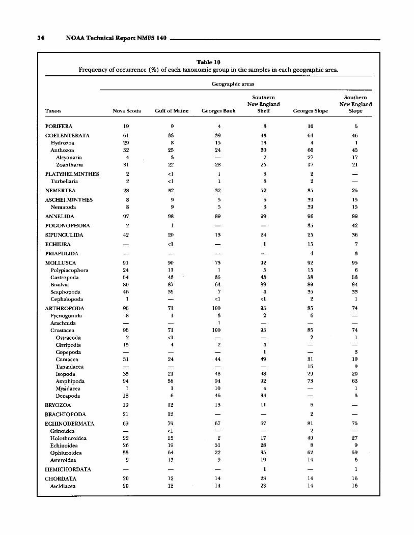
36 NOAA Technical Report NMFS 140
Table 10Frequency of occurrence (%) of each taxonomic group in the samples in each geographic area.
Geographic areas
Southern SouthernNew England New England
Taxon Nova Scotia Gulf of Maine Georges Bank Shelf Georges Slope Slope
PORIFERA 19 9 4 3 10 5
COELENTERATA 61 33 39 43 64 46Hydrozoa 29 8 15 13 4 1Anthozoa 32 25 24 30 60 45
Alcyonaria 4 3 7 27 17Zoantharia 31 22 28 25 17 21
PLAlYHELMINTHES 2 <1 1 3 2Turbellaria 2 <1 1 3 2
NEMERTEA 28 32 32 52 35 25
ASCHELMINTHES 8 9 5 6 39 15Nematoda 8 9 5 6 39 15
ANNELIDA 97 98 89 99 96 99
POGONOPHORA 2 1 35 42
SIPUNCULIDA 42 20 13 24 25 36
ECHIURA <1 1 15 7
PRIAPULIDA 4 3
MOLLUSCA 91 90 73 92 92 95Polyplacophora 24 11 1 5 15 6Gastropoda 54 43 35 43 58 53Bivalvia 80 87 64 89 89 94Scaphopoda 46 35 7 4 35 33Cephalopoda 1 <1 <1 2 1
ARTHROPODA 95 71 100 95 85 74Pycnogonida 8 1 3 2 6Arachnida 1Crustacea 95 71 100 95 85 74
Ostracoda 2 <1 2 1Cirripedia 15 4 2 4Copepoda 1 3Cumacea 31 24 44 49 31 19Tanaidacea 15 9Isopoda 35 21 48 48 29 20Amphipoda 94 58 94 92 73 63Mysidacea 1 1 10 4 1Decapoda 18 6 46 33 3
BRYOZOA 19 12 13 11 6
BRACHIOPODA 21 12 2
ECHINODERMATA 69 79 67 67 81 75Crinoidea <1 2Holothuroidea 22 25 2 17 40 27Echinoidea 26 19 51 28 8 9Ophiuroidea 55 64 22 35 62 59Asteroidea 9 13 9 19 14 6
HEMICHORDATA 1 1
CHORDATA 20 12 14 23 14 16Ascidiacea 20 12 14 23 14 16

Composition and Distribution of Macrobenthic Invertebrate Fauna 37
GEORGESBANK
234
GULF OF
MAINE
127
...o 120'-------' ...
M A IN E
".".NEW .- • NEW"
\ YORK/ "'\. \\ HAMPSHIRE ./~.~ . ~ , /'
. CONNECTICUT \ ~..'PO"'A'O.'.> MASSACHUSETT
••/"105TO~
EXPLANATIONMEAN WEIGHT OF ANIMALSPER SQUARE METER OF BOTTOM,
ALL TAXA COMBINED.
NEWJERSEY
"
A
"EXPLANATION
D CRUSTACEA • ECHINODERMATA
~ ANNELIDA mOTHER
~ MOLLUSCA~
PERCENTAGE COMPOSITIONB
40
71·
',M A I N E
...
Figure 14Quantitative composition of the total macrobenthic- invertebrate fauna inrelation to the six standard geographic subareas. A.-Mean wet weight ofanimals per square meter of bottom area; B.-Percentage composition, bybiomass, of the major taxonomic groups.
A gradient was evident in the density distribution. Inthe three shallow water areas-Nova Scotia, GeorgesBank, and Southern New England Shelf-average density increased in the order listed from the northeast tothe southwest. The Southern New England Shelf area(2,382/m2) had about twice the density of the Nova
Scotian area (1,163/m2). The Gulf of Maine averaged839/m2, and the two slope areas had average densitiesof about 300/m2.
Biomass distribution followed precisely the same rankorder as density, and the magnitudes of differences inbiomass from one area to another were roughly the
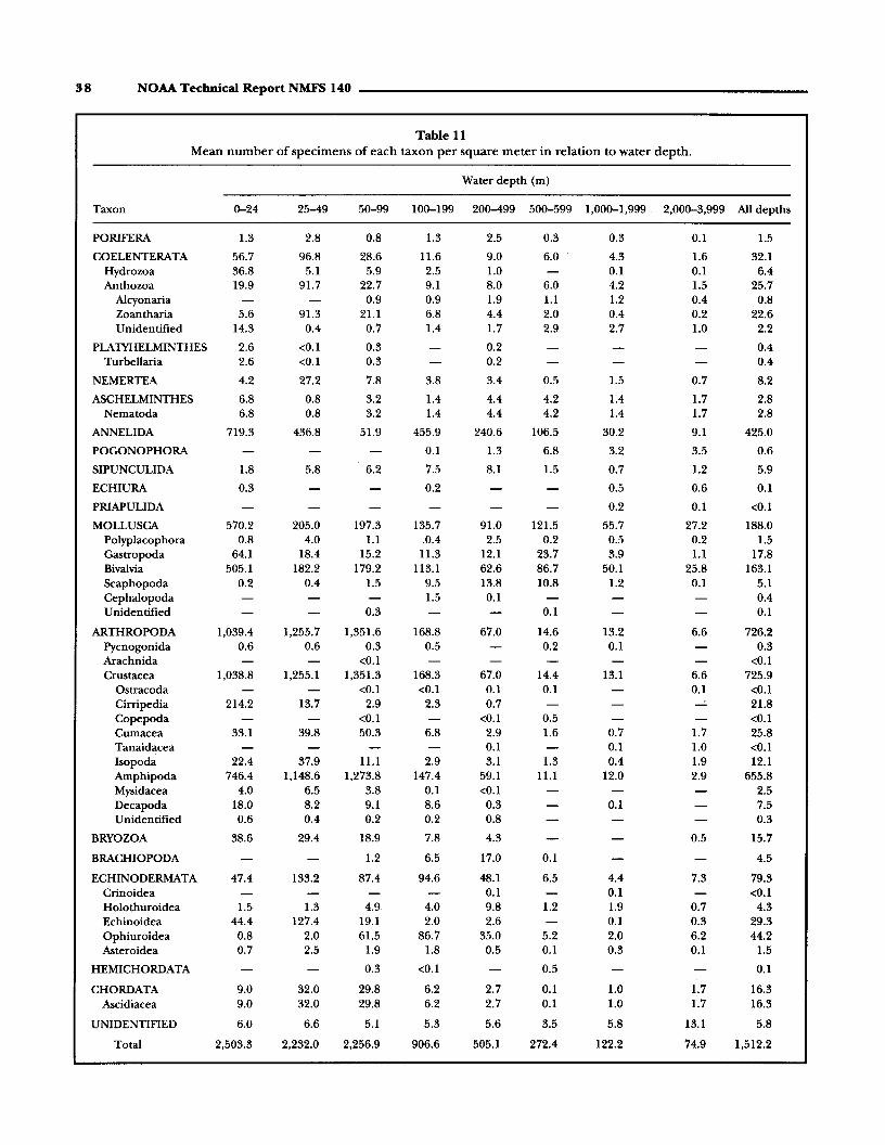
38 NOAA Technical Report NMFS 140
Table 11Mean numher of specimens of each taxon per square meter in relation to water depth.
Water depth (m)
Taxon 0-24 25-49 50-99 100-199 200-499 500-599 1,000-1,999 2,000-3,999 All depths
PORIFERA 1.3 2.8 0.8 1.3 2.5 0.3 0.3 0.1 1.5
COELENTERATA 56.7 96.8 28.6 11.6 9.0 6.0 4.3 1.6 32.1Hydrozoa 36.8 5.1 5.9 2.5 1.0 0.1 0.1 6.4Anthozoa 19.9 91.7 22.7 9.1 8.0 6.0 4.2 1.5 25.7
Alcyonaria 0.9 0.9 1.9 1.1 1.2 0.4 0.8Zoantharia 5.6 91.3 21.1 6.8 4.4 2.0 0.4 0.2 22.6Unidentified 14.3 0.4 0.7 1.4 1.7 2.9 2.7 1.0 2.2
PLAlYHELMINTHES 2.6 <0.1 0.3 0.2 0.4Turbellaria 2.6 <0.1 0.3 0.2 0.4
NEMERTEA 4.2 27.2 7.8 3.8 3.4 0.5 1.5 0.7 8.2
ASCHELMINTHES 6.8 0.8 3.2 1.4 4.4 4.2 1.4 1.7 2.8Nematoda 6.8 0.8 3.2 1.4 4.4 4.2 1.4 1.7 2.8
ANNELIDA 719.3 436.8 51.9 455.9 240.6 106.5 30.2 9.1 425.0
POGONOPHORA 0.1 1.3 6.8 3.2 3.5 0.6
SIPUNCULIDA 1.8 5.8 6.2 7.5 8.1 1.5 0.7 1.2 5.9
ECHIURA 0.3 0.2 0.5 0.6 0.1
PRlAPULIDA 0.2 0.1 <0.1
MOLLUSCA 570.2 205.0 197.3 135.7 91.0 121.5 55.7 27.2 188.0Polyplacophora 0.8 4.0 1.1 .0.4 2.5 0.2 0.5 0.2 1.5Gastropoda 64.1 18.4 15.2 11.3 12.1 23.7 3.9 1.1 17.8Bivalvia 505.1 182.2 179.2 113.1 62.6 86.7 50.1 25.8 163.1&aphopoda 0.2 0.4 1.5 9.5 13.8 10.8 1.2 0.1 5.1Cephalopoda 1.5 0.1 0.4Unidentified 0.3 0.1 0.1
ARTHROPODA 1,039.4 1,255.7 1,351.6 168.8 67.0 14.6 13.2 6.6 726.2Pycnogonida 0.6 0.6 0.3 0.5 0.2 0.1 0.3Arachnida <0.1 <0.1Crustacea 1,038.8 1,255.1 1,351.3 168.3 67.0 14.4 13.1 6.6 725.9
Ostracoda <0.1 <0.1 0.1 0.1 0.1 <0.1Cirripedia 214.2 13.7 2.9 2.3 0.7 - 21.8Copepoda <0.1 <0.1 0.5 <0.1Cumacea 33.1 39.8 50.3 6.8 2.9 1.6 0.7 1.7 25.8Tanaidacea 0.1 0.1 1.0 <0.1Isopod~ 22.4 37.9 11.1 2.9 3.1 1.3 0.4 1.9 12.1Amphipoda 746.4 1,148.6 1,273.8 147.4 59.1 11.1 12.0 2.9 655.8Mysidacea 4.0 6.5 3.8 0.1 <0.1 2.5Decapoda 18.0 8.2 9.1 8.6 0.3 0.1 7.5Unidentified 0.6 0.4 0.2 0.2 0.8 0.3
BRYOZOA 38.6 29.4 18.9 7.8 4.3 0.5 15.7
BRACHIOPODA 1.2 6.5 17.0 0.1 4.5
ECHINODERMATA 47.4 133.2 87.4 94.6 48.1 6.5 4.4 7.3 79.3Crinoidea 0.1 0.1 <0.1Holothuroidea 1.5 1.3 4.9. 4.0 9.8 1.2 1.9 0.7 4.3Echinoidea 44.4 127.4 19.1 2.0 2.6 0.1 0.3 29.3Ophiuroidea 0.8 2.0 61.5 86.7 35.0 5.2 2.0 6.2 44.2Asteroidea 0.7 2.5 1.9 1.8 0.5 0.1 0.3 0.1 1.5
HEMICHORDATA 0.3 <0.1 0.5 0.1
CHORDATA 9.0 32.0 29.8 6.2 2.7 0.1 1.0 1.7 16.3Ascidiacea 9.0 32.0 29.8 6.2 2.7 0.1 1.0 1.7 16.3
UNIDENTIFIED 6.0 6.6 5.1 5.3 5.6 3.5 5.8 13.1 5.8
Total 2,503.3 2,232.0 2,256.9 906.6 505.1 272.4 122.2 74.9 1,512.2

Composition and Distribution of Macrobenthic Invertebrate Fauna 39
Table 12The number of specimens of each taxon, expressed as a percentage of the total benthic invertebrate fauna, in relation towater depth.
Depth zones (m)
Taxon 0-24 25-49 50-99 100-199 200-499 500-599 1,000-1,999 2,000-3,999 All depths
PORIFERA 0.1 0.1 <0.1 0.2 0.5 0.1 0.2 0.1 0.1
COELENTERATA 2.3 4.3 1.3 1.3 1.8 2.2 3.5 2.1 2.1Hydrozoa 1.5 0.2 0.3 0.3 0.2 <0.1 0.1 004Anthozoa 0.8 4.1 1.0 1.0 1.6 2.2 3.5 2.0 1.7
Alcyonaria <0.1 0.1 004 004 1.0 0.6 0.1Zoantharia 0.2 4.1 0.9 0.8 0.9 0.7 0.3 0.2 1.5Unidentified 0.6 <0.1 <0.1 0.2 0.3 1.0 2.2 1.3 0.2
PLAlYHELMINTHES 0.1 <0.1 <0.1 <0.1 <0.1Turbellaria 0.1 <0.1 <0.1 <0.1 <0.1
NEMERTEA 0.2 1.2 004 004 0.7 0.2 1.2 0.9 0.5
ASCHELMINTHES 0.3 <0.1 0.1 0.2 0.9 1.5 1.1 2.3 0.2Nematoda 0.3 <0.1 0.1 0.2 0.9 1.5 1.1 2.3 0.2
ANNELIDA 28.7 19.6 23.0 50.3 47.6 39.1 24.7 12.2 28.1
POGONOPHORA <0.1 0.2 2.5 2.6 4.6 <0.1
SIPUNCULIDA 0.1 0.3 0.3 0.8 1.6 0.5 0.6 1.6 004
ECHIURA <0.1 <0.1 004 0.8 <0.1
PRIAPULIDA 0.2 0.1 <0.1
MOLLUSCA 22.8 9.2 8.7 15.0 18.0 44.6 45.6 36.3 1204Polyplacophora <0.1 0.2 <0.1 <0.1 0.5 0.1 004 0.3 0.1Gastropoda 2.6 0.8 0.7 1.2 204 8.7 3.2 1.5 1.2Bivalvia 20.2 8.2 7.9 12.5 1204 31.8 41.0 3404 10.8Scaphopoda <0.1 <0.1 0.1 1.0 2.7 4.0 1.0 0.1 0.3Cephalopoda 0.2 <0.1 <0.1Unidentified <0.1 <0.1 <0.1
ARTHROPODA 41.5 56.3 59.9 18.6 13.3 504 10.8 8.8 48.0Pycnogonida <0.1 <0.1 <0.1 <0.1 0.1 <0.1 <0.1Arachnida <0.1 <0.1Crustacea 41.5 56.2 59.9 18.6 13.3 5.3 10.8 8.8 48.0
Ostracoda <0.1 <0.1 <0.1 <0.1 0.1 <0.1Cirripedia 8.6 0.6 0.1 0.2 0.1 104Copepoda <0.1 <0.1 0.2 <0.1Cumacea 1.3 1.8 2.2 0.8 0.6 0.6 0.6 2.3 1.7Tanaidacea <0.1 <0.1 1.4 <0.1Isopoda 0.9 1.7 0.5 0.3 0.6 0.5 0.3 2.5 0.8Amphipoda 29.8 51.5 5604 16.3 11.7 4.1 9.8 3.9 4304Mysidacea 0.2 0.3 .0.2 <0.1 <0.1 0.2Decapoda 0.7 004 004 1.0 0.1 <0.1 0.5Unidentified <0.1 <0.1 <0.1 <0.1 0.2 0.1 <0.1
BRYOZOA 1.5 1.3 0.8 0.9 0.8 0.7 1.0
BRACHIOPODA <0.1 0.7 304 <0.1 0.3
ECHINODERMATA 1.9 6.0 3.9 lOA 9.5 204 3.6 9.8 5.2Crinoidea <0.1 <0.1 <0.1Holothuroidea 0.1 0.1 0.2 004 1.9 004 1.5 0.9 0.3Echinoidea 1.8 5.7 0.8 0.2 0.5 0.1 004 1.9Ophiuroidea <0.1 0.1 2.7 9.6 6.9 1.9 1.6 8.3 2.9Asteroidea <0.1 0.1 0.1 0.2 0.1 <0.1 0.3 0.1 0.1
HEMICHORDATA <0.1 <0.1 0.2 <0.1
CHORDATA 004 104 1.3 0.7 0.5 <0.1 0.8 2.2 1.1Ascidiacea 004 1.4 1.3 0.7 0.5 <0.1 0.8 2.2 1.1
UNIDENTIFIED 0.2 0.3 0.2 0.6 1.1 1.3 4.7 1704 004Total 100.0 100.0 100.0 100.0 100.0 100.0 100.0 100.0 100.0

40 NOAA Technical Report NMFS 140 _
75
122
272
505
907
2,257
2,2322,503
l00-..-----..::::::..V::c--2001-+-------"'1\
1000
'"•III~III
~
Z-:z: 2000~A.IIIa
• EXPLANATIONIII
i D CRUSTACEA
~ ANNELIDA
~.~!-:.: MOLLUSCA
II ECHINODERMATA
OTHER
.cooo
MEANNUMBER
PERCENTAGECOMPOSITION
Figure 15Quantitative composition of the total macrobenthic invertebrate fauna in relationto water depth. Mean number of individuals per square meter of bottom area, andpercentage composition, by density, of the m,yor taxonomic groups are shown.
same as the changes in density (Tables 8, 9; Fig. 14A).Southern New England Shelf and Georges Bank hadthe highest average biomasses (267 and 234 g/m2);
biomass was intermediate (178 and 127 g/m2) in NovaScotia and the GulfofMaine, and low (21 and 20 g/m2)
on Georges Slope and Southern New England Slope.The percentage occurrence ofeach taxonomic group
in the samples in each geographic area is presented inTable 10.
Bathymetric Distribution
One ofthe most striking relationships in the New Englandregion was the pronounced diminution in quantity ofmacrobenthic invertebrates from shallow to deep water(Tables 11, 12; Fig. 15). In the shallowest waters sampled(0-24 m) the average density was 2,503/m2, whereas inthe deepest water (2,000-3,999 m) the density averagedonly 751m2, The decrease from one depth range to an-

Composition and Distribution of Macrobenthic Invertebrate Fauna 41
Table 13Mean wet weight of specimens of each taxon (grams per square meter) in relation to water depth.
Water depth (m)
Taxon 0-24 25-49 50-99 100-199 200-499 500-599 1,000-1,999 2,000-3,999 All depths
PORIFERA 0.06 1.23 2.90 3.08 3.12 0.54 0.02 0.03 2.24
COELENTERATA 3.63 1.49 3.38 18.95 9.13 0.36 0.72 0.69 7.33Hydrozoa 1.21 0.22 1.17 0.16 0.02 <0.01 <0.01 0.52Anthozoa 2.42 1.27 2.21 18.79 9.11 0.36 0.72 0.69 6.81
Alcyonaria 0.16 0.33 0.47 0.04 0.25 0.01 0.20Zoantharia 2.08 1.22 1.99 18.28 8.05 0.19 0.18 0.19 6.39Unidentified 0.35 0.05 0.06 0.18 0.59 0.13 0.29 0.49 0.22
PLAlYHELMINTHES 0.02 <0.01 O.oI <0.01 O.oITurbellaria 0.02 <0.01 O.oI <0.01 0.01
NEMERTEA 1.00 1.44 0.99 0.23 0.40 O.oI 0.06 0.12 0.71
ASCHELM1NTHES <0.01 O.oI O.oI O.oI O.oI 0.01 O.oI O.oI O.oINematoda <0.01 0.01 O.oI O.oI O.oI O.oI O.oI 0.01 O.oI
ANNELIDA 27.22 16.24 25.20 14.76 10.70 4.76 1.41 0.76 17.41
POGONOPHORA <0.01 O.oI 0.03 0.02 0.01 <0.01
SIPUNCULIDA 0.22 0.57 0.82 0.77 0.54 3.93 1.38 0.53 0.75
ECHIURA 0.22 O.oI 5.04 3.52 0.30
PRlAPULIDA 0.12 0.01 <0.01
MOLLUSCA 257.88 106.89 132.14 20.67 10.80 3.26 1.44 0.58 83.64Polyplacophora 0.84 0.07 0.02 0.02 0.29 O.oI O.oI <0.01 0.14Gastropoda 4.85 1.82 4.23 1.07 0.18 0.29 0.15 0.17 2.23Bivalvia 252.18 104.94 127.80 18.56 10.04 2.79 1.07 0.41 80.95Scaphopoda <0.01 0.07 0.09 0.98 0.29 0.17 0.22 <0.01 0.32Cephalopoda 0.03 <0.01 O.oIUnidentified <0.01 O.oI <0.01
ARTHROPODA 37.04 15.64 9.31 2.40 3.89 0.09 0.08 0.10 9.41Pycnogonida O.oI <0.01 <0.01 0.03 <0.01 <0.01 O.oIArachnida <0.01 <0.01Crustacea 37.03 15.64 9.31 2.37 3.89 0.09 0.08 0.10 9.40
Ostracoda <0.01 <0.01 <0.01 <0.01 <0.01 <0.01Cirripedia 27.08 3.89 0.29 0.10 2.53 3.39Copepoda <0.01 <0.01 0.10 <0.01Cumacea 0.08 0.11 0.26 0.04 0.02 O.oI 0.01 0.05 0.11Tanaidacea <0.01 <0.01 O.oI <0.011sopoda 0.15 0.66 0.27 0.15 0.42 0.02 O.oI 0.02 0.29Amphipoda 6.39 9.77 6.38 0.97 0.31 0.06 0.03 0.02 4.16Mysidacea 0.03 0.02 0.02 <0.01 <0.01 0.01Decapoda 3.32 1.19 2.10 1.12 0.61 0.03 1.43Unidentified O.oI <0.01 <0.01 <0.01 <0.01 <0.01 <0.01
BRYOZOA 0.96 0.92 2.88 0.87 0.14 0.02 1.29
BRACHIOPODA 0.11 1.05 3.98 0.01 0.89
ECHINODERMATA 105.93 166.80 33.95 34.23 19.18 1.72 3.16 4.62 55.00Crinoidea <0.01 <0.01 <0.01Holothuroidea 36.59 12.76 19.23 6.47 3.57 0.24 1.24 2.15 12.87Echinoidea 65.74 153.88 9.24 16.16 11.11 1.13 1.78 36.75Ophiuroidea 0.29 0.06 2.49 7.50 4.49 1.48 0.75 0.66 3.26Asteroidea 3.30 0.11 2.99 ·4.10 O.oI <0.01 0.04 0.04 2.13
HEMICHORDATA 0.05 O.oI O.oI 0.02
CHORDATA 3.85 5.20 8.93 1.03 0.72 <0.01 <0.01 0.21 4.10Ascidiacea 3.85 5.20 8.93 1.03 0.72 <0.01 <0.01 0.21 4.10
UNIDENTIFIED 0.19 0.58 0.28 0.23 0.12 0.19 0.23 0.15 0.27
Total 438.26 317.01 220.95 98.30 62.72 14.91 13.66 11.36 183.39

42 NOAA Technical Report NMFS 140
Table 14The wet weight of specimens of each taxon, expressed as a percentage of the total benthic invertebrate fauna, in relationto water depth.
Depth zones (m)
Taxon 0-24 25-49 50-99 100-199 200-499 500-599 1,000-1,999 2,000-3,999 All depths
PORIFERA <0.1 0.4 1.3 3.1 5.0 3.6 0.1 0.3 1.2
COELENTERATA 0.8 0.5 1.5 19.3 14.6 2.4 5.3 6.1 4.0Hydrozoa 0.3 0.1 0.5 0.2 <0.1 <0.1 <0.1 0.3Anthozoa 0.5 0.4 1.0 19.1 14.6 2.4 5.3 6.1 3.7
Alcyonaria 0.1 0.3 0.8 0.3 1.8 0.1 0.1Zoantharia 0.5 0.4 0.9 18.6 12.8 1.2 1.3 1.7 3.5Unidentified 0.1 <0.1 <0.1 0.2 0.9 0.9 2.1 4.3 0.1
PLATYHELMINTHES <0.1 <0.1 <0.1 <0.1 <0.1Turbellaria <0.1 <0.1 <0.1 <0.1 <0.1
NEMERTEA 0.2 0.5 0.4 0.2 0.6 0.1 0.4 1.0 0.4
ASCHELMINTHES <0.1 <0.1 <0.1 <0.1 <0.1 0.1 0.1 0.1 <0.1Nematoda <0.1 <0.1 <0.1 <0.1 <0.1 0.1 0.1 0.1 <0.1
ANNELIDA 6.2 5.1 11.4 15.0 7.0 32.0 10.3 6.7 9.5
POGONOPHORA <0.1 <0.1 0.2 0.1 0.1 <0.1
SIPUNCULIDA <0.1 0.2 0.4 0.8 0.8 26.3 10.1 4.7 0.4
ECHIURA 0.1 <0.1 36.9 31.0 0.2
PRIAPULIDA 0.9 0.1 <0.1
MOLLUSCA 58.8 33.7 59.8 21.0 17.2 21.9 10.6 5.1 45.6Polyplacophora 0.2 <0.1 <0.1 <0.1 0.5 <0.1 <0.1 <0.1 0.1·Gastropoda 1.1 0.6 1.9 1.1 0.3 1.9 1.1 1.5 1.2Bivalvia 57.5 33.1 57.8 18.9 16.0 18.7 7.8 3.6 44.1Scaphopoda <0.1 <0.1 <0.1 1.0 0.5 1.2 1.6 <0.1 0.2Cephalopoda <0.1 <0.1 <0.1Unidentified <0.1 0.1 <0.1
ARTHROPODA 8.4 4.9 4.2 2.4 6.2· 0.6 0.6 0.9 5.1Pycnogonida <0.1 <0.1 <0.1 <0.1 <0.1 <0.1 <0.1Arachnida <0.1 <0.1Crustacea 8.4 4.9 4.2 2.4 6.2 0.6 0.6 0.9 5.1
Ostracoda <0.1 <0.1 <0.1 <0.1 <0.1 <0.1Cirripedia 6.2 1.2 0.1 0.1 4.0 1.8Copepoda <0.1 <0.1 <0.1 <0.1Cumacea <0.1 <0.1 0.1 <0.1 <0.1 0.1 0.1 0.4 0.1Tanaidacea <0.1 <0.1 0.1 <0.1Isopoda <0.1 0.2 0.1 0.2 0.7 0.1 <0.1 0.2 0.2Amphipoda 1.5 3.1 2.9 1.0 0.5 0.4 0.2 0.2 2.3Mysidacea <0.1 <0.1 <0.1 <0.1 <0.1 <0.1Decapoda 0.8 0.4 1.0 1.1 1.0 0.2 0.8Unidentified <0.1 <0.1 <0.1 <0.1 <0.1 <0.1 <0.1
BRYOZOA 0.2 0.3 1.3 0.9 0.2 0.2 0.7
BRACHIOPODA <0.1 1.1 6.3 <0.1 0.5
ECHINODERMATA 24.2 52.6 15.4 34.8 30.6 11.5 23.0 40.7 30.0Crinoidea <0.1 <0.1 <0.1Holothuroidea 8.4 4.0 8.7 6.6 5.7 1.6 9.0 18.9 7.0Echinoidea 15.0 48.5 4.2 16.4 17.7 8.2 15.7 20.0Ophiuroidea 0.1 <0.1 1.1 7.6 7.2 9.9 5.5 5.8 1.8Asteroidea 0.8 <0.1 1.4 4.2 <0.1 <0.1 0.3 0.3 1.2
HEMICHORDATA <0.1 1.0 <0.1 <0.1
CHORDATA 0.9 1.6 4.0 1.0 1.2 <0.1 <0.1 1.8 2.2Ascidiacea 0.9 1.6 4.0 1.0 1.2 <0.1 <0.1 1.8 2.2
UNIDENTIFIED <0.1 0.2 0.1 0.2 0.2 1.3 1.6 1.3 0.2
Total 100.0 100.0 100.0 100.0 100.0 100.0 100.0 100.0 100.0

__________________ Composition and Distribution of Macrobenthic Invertebrate Fauna 43
11
14
15
63
98
221
317438
EXPLANATION
D CRUSTACEA
~ ANNEliDA
~ MOLLUSCA~
• ECHINODERMATA
D OTHER
d~~~~l00'+----.....;::~,~---
200-f---------'l-,
enIIll:IIItIII
~
Z
~ 2000+--------¥\AliioIIll:IIIt-;
MEANWET WEIGHT
PERCENTAGECOMPOSITION
4000--'---------------'"
Figure 16Quantitative composition of the total macrobenthic invertebrate fauna inrelation to water depth. Mean wet weight per square meter of bottom area,and percentage composition, by biomass, of the major taxonomic groupsare shown.
other was not unifonn over the entire depth spectrum.There was a 60% drop in density from 50-99 m to 100199 m and the largest drop in density occurred between100 and 200 m depth.. Another way of expressing thischange is to say there was a decrease in density per meterincrease in depth. In the vicinity of 100 m the averagedensity decreased by 18 specimens with each I-m increasein water depth. In shallower water the rate ofdecrease wasas high as 10 specimens per I m of water depth increase,but the percentage change was substantially lower. Indeep water (below 200 m) the diminution rate was lessthan one specimen per meter change in water depth.
Differences in density in depth ranges between 1,000 and1,999 m and between 2,000 and 3,999 m decreased anaverage of 0.05 per meter increase in depth.
Biomass diminished with depth from an average of438 g/m2 in shallow water to 11 g/m2 on the continental rise (Tables 13, 14; Fig. 16). The biomass remainedrather high (221 g or more) in shallow water out to 100meters. In the vicinity of 100 m the biomass was 56%lower than in the shallowest water, and 76% lower inthe vicinity of 500 m depth.
The relatively high biomass, averaging 11 g/m2, atwater depths between 2,000 and 3,999 m was due in

44 NOAA Technical Report NMFS 140
Table 15Frequency of occurrence (%) of each taxonomic group in the samples in each depth range class.
Water depth (m)
Taxon 0-24 25-49 50-99 100-199 200-499 500-599 1,000-1,999 2,000-3,999
PORIFERA 5 3 5 8 12 9 12 3
COELENTERATA 36 36 50 40 33 46 65 41Hydrozoa 21 16 15 10 4 3 3Anthozoa 15 20 35 30 29 46 62 38
Alcyonaria 5 5 8 23 29 22Zoantharia 16 21 33 29 19 9 18 8
PLAlYHELMINTHES 2 4 1Turbellaria 2 4 1
NEMERTEA 35 51 47 30 28 18 33 24
ASCHELMINTHES 2 6 8 5 15 32 18 35Nematoda 2 6 8 5 15 32 18 35
ANNELIDA 96 93 96 98 97 100 97 95
POGONOPHORA 5 50 53 43
SIPUNCULIDA 3 13 26 32 25 32 21 22
ECHIURA 2 <1 21 19
PRIAPULIDA 9 3
MOLLUSCA 92 82 85 91 89 100 97 87Polyplacophora 1 4 10 7 11 9 18 8Gastropoda 52 42 43 37 44 77 74 30Bivalvia 88 76 81 85 84 100 97 81Scaphopoda 1 1 9 35 43 59 35 3Cephalopoda 1 1
ARTHROPODA 88 99 100 80 71 82 53 78Pycnogonida 2 2 2 4 9 3Arachnida <1
Crustacea 88 99 100 80 71 82 53 78Ostracoda <1 <1 1 5 3Cirripedia 13 4 3 3 4Copepoda 1 1 5Cumacea 27 41 56 30 15 36 15 22Tanaidacea 1 3 35Isopoda 29 69 46 20 20 18 12 43Amphipoda 80 95 98 72 58 77 44 54Mysidacea 13 11 3 <1 1Decapoda 37 39 35 13 4 3
BRYOZOA 19 13 11 10 12 5
BRACHIOPODA 2 10 14 5
ECHINODERMATA 39 68 71 78 84 64 65 92Crinoidea 1 3Holothuroidea 9 8 20 17 33 14 29 27Echinoidea 21 57 31 16 22 6 16Ophiuroidea 10 9 40 66 72 59 44 76Asteroidea 9 9 20 16 6 5 12 5
HEMICHORDATA <1 5
CHORDATA 14 24 19 14 12 5 15 24Ascidiacea 14 24 19 14 12 5 15 24

Composition and Distribution of Macrobenthic Invertebrate Fauna 45
Table 16Mean number of specimens of each taxon per square meter in relation to bottom sediments.
Bottom sediments
Taxon Gravel Till Shell Sand Sand-silt Silt-clay All types
PORIFERA 3.9 4.5 0.3 0.4 2.5 0.7 1.5
COELENTERATA 45.0 16.0 7.8 50.0 15.4 6.3 32.1Hydrozoa 20.3 6.9 5.2 6.0 2.9 1.5 6.4Anthozoa 24.7 10.9 2.6 44.0 12.5 4.8 25.7
A1cyonaria 1.6 0.2 0.9 1.6 0.8Zoantharia 13.7 3.4 2.3 43.1 9.3 2.7 22.6Unidentified 9.3 5.6 0.3 0.7 2.3 0.4 2.2
PLAlYHELMINTHES 1.7 0.2 0.1 0.4Turbellaria 1.7 0.2 0.1 0.4
NEMERTEA 4.9 0.9 27.5 13.3 5.1 3.4 8.2
ASCHELMINTHES 8.7 1.0 1.2 2.4 3.0 2.8Nematoda 8.7 1.0 1.2 2.4 3.0 2.8
ANNELIDA 504.8 289.5 442.5 558.1 309.7 231.9 425.0
POGONOPHORA <0.1 0.8 1.9 0.6
SIPUNCULIDA 4.0 4.4 6.0 7.1 5.3 5.5 5.9
ECHIURA 0.2 0.3 0.1
PRIAPULIDA <0.1 <0.1 <0.1
MOLLUSCA 83.7 103.0 228.5 98.6 276.0 353.8 188.0Polyplacophora 2.0 2.5 0.3 3.8 1.3 1.5Gastropoda 40.3 9.1 82.7 11.2 22.0 11.9 17.8Bivalvia 39.4 78.3 180.3 85.0 242.1 329.6 163.1Scaphopoda 2.0 13.1 25.5 1.8 6.4 10.9 5.1Cephalopoda <0.1 <0.1 1.7 0.4Unidentified 0.2 <0.1 0.1
ARTHROPODA 712.0 58.8 124.2 1,336.0 275.5 33.9 726.2Pycnogonida 2.1 0.1 0.1 0.1 0.1 0.3Arachnida <0.1 <0.1Crustacea 709.9 58.7 124.2 1,335.9 275.4 33.8 725.9
Ostracoda <0.1 0.1 <0.1 <0.1Cirripedia 28.7 1.0 5.0 16.4 55.5 0.2 21.8Copepoda 0.1 0.1 0.1 0.1Cumacea 10.5 1.2 7.5 45.3 18.3 7.0 25.8Tanaidacea 0.1 0.1 <0.1Isopoda 5.8 7.1 4.2 22.4 5.2 3.0 12.1Amphipoda 639.7 49.5 98:8 1,237.6 193.0 23.1 655.8Mysidacea 0.9 5.0 0.9 0.1 2.5Decapoda 24.0 8.7 8.7 1.9 0.2 7.5Unidentified 0.3 0.4 0.6 0.3
BRYOZOA 75.1 5.6 331.0 4.9 5.4 1.5 15.7
BRACHIOPODA 13.6 48.2 37.0 1.2 2.3 2.0 4.5
ECHINODERMATA 23.0 67.0 27.8 94.9 103.7 65.0 79.3Crinoidea 0.1 <0.1 <0.1Holothuroidea 3.7 25.4 2.0 2.2 7.4 4.1 4.3Echinoidea 2.8 3.4 0.3 67.2 0.6 1.5 29.3Ophiuroidea 15.8 38.0 25.5 23.8 94.3 57.8 44.2Asteroidea 0.8 0.2 1.8 1.3 1.7 1.5
HEMICHORDATA 0.1 0.2 <0.1 0.1
CHORDATA 29.3 5.1 4.3 22.4 11.4 1.9 16.3Ascidiacea 29.3 5.1 4.3 22.4 11.4 1.9 16.3
UNIDENTIFIED 2.9 5.6 5.8 6.4 7.0 5.8
Total 1,512.5 609.6 1,236.9 2,243.5 1,002.4 718.2 1,512.2

46 NOAA Technical Report NMFS 140
Table 17The number of specimens of each taxon, expressed as a percentage of the total benthic invertebrate fauna, in relation tobottom sediments.
Bottom sediments
Taxon Gravel Till Shell Sand Sand-silt Silt-elay All types
PORIFERA 0.3 0.7 <0.1 <0.1 0.2 0.1 0.1
COELENTERATA 3.0 2.6 0.6 2.3 1.5 0.9 2.1Hydrozoa 1.3 1.1 0.4 0.3 0.3 0.2 0.4Anthozoa 1.7 1.5 0.2 2.0 1.2 0.7 1.7
Alcyonaria 0.1 <0.1 0.1 0.2 0.1Zoantharia 0.9 0.6 0.2 2.0 0.9 0.4 1.5Unidentified 0.6 0.9 <0.1 <0.1 0.2 0.1 0.2
PLAlYHELMINTHES 0.1 <0.1 <0.1 <0.1Turbellaria 0.1 <0.1 <0.1 <0.1
NEMERTEA 0.3 0.2 2.1 0.6 0.5 0.5 0.5
ASCHELMINTHES 0.6 0.2 <0.1 0.2 0.4 0.2Nematoda 0.6 0.2 <0.1 0.2 0.4 0.2
ANNELIDA 33.4 47.5 34.1 25.4 30.3 32.3 28.1
POGONOPHORA <0.1 0.1 0.3 <0.1
SIPUNCULIDA 0.3 0.7 0.5 0.3 0.5 0.8 0.4
ECHIURA <0.1 <0.1 <0.1
PRIAPULIDA <0.1 <0.1 <0.1
MOLLUSCA 5.5 16.9 22.2 4.5 27.0 49.3 12.4Polyplacophora 0.1 0.4 <0.1 0.4 0.2 0.1Gastropoda 2.7 1.5 6.4 0.5 2.2 1.6 1.2Bivalvia 2.6 12.8 13.9 3.9 23.7 45.9 10.8Scaphopoda 0.1 2.2 2.0 0.1 0.6 1.5 0.3Cephalopoda <0.1 <0.1 0.2 <0.1Unidentified <0.1 <0.1 <0.1
ARTHROPODA 47.1 9.6 9.6 60.9 27.0 4.7 48.0Pycnogonida 0.1 <0.1 <0.1 <0.1 <0.1 <0.1Arachnida <0.1 <0.1Crustacea 46.9 9.6 9.6 60.9 27.0 4.7 48.0
Ostracoda <0.1 <0.1 <0.1 <0.1Cirripedia 1.9 0.2 0.4 0.8 5.4 <0.1 1.4Copepoda <0.1 <0.1 <0.1 <0.1Cumacea 0.7 0.2 0.6 2.1 1.8 1.0 1.7Tanaidacea <0.1 <0.1 <0.1Isopoda 0.4 1.2 0.3 1.0 0.5 0.4 0.8Amphipoda 42.3 8.1 7.6 56.4 18.9 3.2 43.4Mysidacea 0.1 0.2 0.1 <0.1 0.2Decapoda 1.6 0.7 0.4 0.2 <0.1 0.5Unidentified <0.1 <0.1 0.1 <0.1
BRYOZOA 5.0 0.9 25.5 0.2 0.5 0.2 1.0
BRACHIOPODA 0.9 7.9 2.8 <0.1 0.2 0.3 0.3
ECHINODERMATA 1.5 11.0 2.2 4.3 10.2 9.0 5.2Crinoidea <0.1 <0.1 <0.1Holothuroidea 0.2 4.2 0.2 0.1 0.7 0.6 0.3Echinoidea 0.2 0.6 <0.1 3.1 0.1 0.2 1.9Ophhiroidea 1.0 6.2 2.0 1.1 9.2 8.0 2.9Asteroidea <0.1 <0.1 0.1 0.1 0.2 0.1
HEMICHORDATA <0.1 <0.1 <0.1 <0.1
CHORDATA 1.9 0.8 0.3 1.0 1.1 0.3 1.1Ascidiacea 1.9 0.8 0.3 1.0 1.1 0.3 1.1
UNIDENTIFIED 0.2 0.9 0.3 0.6 1.0 0.4
Total 100.0 100.0 100.0 100.0 100.0 100.0 100.0

_________________ Composition and Distribution of Macrobenthic Invertebrate Fauna 47
NUMBERMEAN PERCENTAGE
ALL TAXA COMPOSITION
1,513 ~
WEIGHTBOTTOM PERCENTAGE MEAN
TYPE COMPOSITION ALL TAXA
~av.1 181
Til' • 67610
1,237
2,244
1,022
718
Shell
Sand
Sand-silt
Slit-clay
EXPLANATION
223
246
170
86
D CRUSTACEA
~ ANNELIDA • ECHINODERMATA
OTHER
Figure 17Quantitative composition of the total macrobenthic invertebrate fauna inrelation to bottom type. Mean number of individuals and mean wet weight,per square meter of bottom area, and percentage composition, by densityand biomass, of the major taxonomic groups are shown.
large part to occasional large animals. Those groupsthat contributed large specimens at those depths wereSipunculida, Echiura, Echinoidea, and Holothuroidea.
The percentage occurrence ofeach taxonomic groupin samples in each depth range class is presented inTable 15.
Relation to Bottom Sediments
A marked disparity in the average density and biomassof benthic invertebrates was found among the variouskinds of bottom sediments in the New England Region
(Tables 16, 17; Fig. 17). Sand ranked far above theother sediment types in density, with an average of2,244 individuals/m2• Three sediment types-gravel,shell, and sand-silt-supported a moderate number ofanimals; their average densities ranged from 1,022 to1,513/m2• Lower densities (610 and 718/m2 ) were foundin till and silt-elay sediments.
Distribution of biomass (Tables 18, 19; Fig. 17) wassimilar to that of density. Sand and shell supportedhigh (246 and 223 g/m2) biomasses. Moderate quantities (170 and 181 g/m2) occurred in gravel and sandsilt. Relatively low quantities were encountered in siltclay and till sediments.

48 NOAA Technical Report NMFS 140
Table 18Mean wet weight of specimens of each taxon (grams per square meter) in relation to bottom sediments.
Bottom sediments
Taxon Gravel Till Shell Sand Sand-silt Silt-clay All types
PORIFERA 8.62 12.69 5.77 0.34 3.05 0.12 2.24
COELENTERATA 15.29 1.81 0.93 2.00 18.22 3.52 7.33Hydrozoa 2.60 0.32 0.14 0.34 0.05 0.01 0.52Anthozoa 12.69 1.49 0.79 1.66 18.17 3.51 6.81
Alcyonaria 0.09 0.22 0.29 0.20 0.20Zoantharia 12.36 1.09 0.68 1.37 17.25 3.22 6.39Unidentified 0.24 0.39 0.12 0.07 0.62 0.10 0.22
PLAlYHELMINTHES 0.01 0.01 0.01 0.01Turbellaria 0.01 0.01 0.01 0.01
NEMERTEA 0.52 0.06 6.09 0.81 0.83 0.46 0.71
ASCHELMINTHES 0.01 0.01 <0.01 0.01 0.01 0.01Nematoda 0.01 0.01 <0.01 0.01 0.01 0.01
ANNELIDA 15.52 10.67 15.30 15.00 25.96 16.25 17.41
POGONOPHORA <0.01 0.01 0.01 <0.01
SIPUNCULIDA 0.58 0.29 0.16 0.89 0.81 0.57 0.75
ECHIURA 0.79 0.69 0.30
PRIAPULIDA <0.01 0.02 <0.01
MOLLUSCA 94.44 5.96 167.76 120.99 73.56 18.43 83.64Polyplacophora 0.72 0.29 0.01 0.06 0.07 0.14Gastropoda 3.25 0.21 2.13 3.32 1.60 0.22 2.23Bivalvia 90.22 4.66 165.13 117.44 71.62 17.58 80.95Scaphopoda 0.25 0.80 0.50 0.22 0.26 0.56 0.32Cephalopoda <0.01 0.01 0.02 0.01Unidentified <0.01 <0.01 <0.01
ARTHROPODA 20.32 1.93 6.26 11.92 6.95 0.62 9.41Pycnogonida 0.05 <0.01 <0.01 <0.01 0.01 0.01Arachnida <0.01 <0.01Crustacea 20.27 1.93 6.26 11.92 6.95 0.61 9.40
Ostracoda <0.01 <0.01 <0.01 <0.01Cirripedia 11.06 0.02 0.45 2.36 4.41 0.01 3.39Copepoda <0.01 <0.01 <0.01 <0.01Cumac.ea 0.06 0.01 0.08 0.20 0.06 0.03 0.11Tanaidacea <0.01 <0.01 <0.01Isopoda 0.21 1.36 0.04 0.44 0.14 0.09 0.29Amphipoda 3.39 0.54 0.92 7.73 1.91 0.18 4.16Mysidacea 0.01 0.02 0.01 <0.01 0.01Decapoda 5.56 4.78 1.16 0.41 0.32 1.43Unidentified <0.01 <0.01 <0.01 <0.01
BRYOZOA 7.39 0.25 16.78 0.37 0.05 0.05 1.29
BRACHIOPODA 2.44 15.87 0.22 0.24 0.33 0.28 0.89
ECHINODERMATA 5.66 15.24 3.39 88.43 36.59 42.87 55.00Crinoidea <0.01 <0.01 <0.01Holothuroidea 2.10 4.73 0.40 3.11 25.00 28.74 12.87Echinoidea 1.98 4.73 2.25 80.68 3.43 7.26 36.75Ophiuroidea 1.23 5.27 0.74 2.67 5.80 3.26 3.26Asteroidea 0.34 0.50 1.98 2.27 3.61 2.13
HEMICHORDATA 0.02 0.04 <0.01 0.02
CHORDATA 9.70 1.98 0.09 4.35 2.36 1.95 4.10Ascidiacea 9.70 1.98 0.09 4.35 2.36 1.95 4.10
UNIDENTIFIED 0.45 0.21 0.23 0.31 0.24 0.27
Total 180.94 66.97 222.75 245.60 169.88 86.10 183.39

Composition and Distribution of Macrobenthic Invertebrate Fauna 49
Table 19The wet weight of specimens of each taxon, ex:pressed as a percentage of the total benthic invertebrate fauna, in relation
to bottom sediments.
Bottom sediments
Taxon Gravel Till Shell Sand Sand-silt Silt-clay All types
PORIFERA 4.8 19.0 2.6 0.1 \.8 0.1 \.2
COELENTERATA 8.5 2.7 0.4 0.8 10.7 4.1 4.0Hydrozoa 1.4 0.5 0.1 0.1 <0.1 <0.1 0.3Anthozoa 7.1 2.2 0.3 0.7 10.7 4.1 3.7
Alcyonaria <0.1 0.1 0.2 0.2 0.1Zoantharia 6.8 \.6 0.3 0.6 10.2 3.7 3.5Unidentified 0.1 0.6 <0.1 <0.1 0.4 0.1 0.1
PLAlYHELMINTHES <0.1 <0.1 <0.1 <0.1Turbellaria <0.1 <0.1 <0.1 <0.1
NEMERTEA 0.3 0.1 2.7 0.3 0.5 0.5 0.4
ASCHELMINTHES <0.1 <0.1 <0.1 <0.1 <0.1 <0.1Nematoda <0.1 <0.1 <0.1 <0.1 <0.1 <0.1
ANNELIDA 8.6 15.9 6.9 6.1 15.3 18.9 9.5
POGONOPHORA <0.1 <0.1 <0.1 <0.1
SIPUNCULIDA 0.3 0.4 0.1 0.4 0.5 0.7 0.4
ECHIURA 0.5 0.8 0.2
PRIAPULIDA <0.1 <0.1 <0.1
MOLLUSCA 52.2 8.9 75.3 49.3 43.3 2\.4 45.6Polyplacophora 0.4 0.4 <0.1 <0.1 0.1 0.1Gastropoda \.8 0.3 \.0 1.4 0.9 0.3 \.2Bivalvia 49.9 7.0 74.1 47.8 42.2 20.4 44.1Scaphopoda 0.1 \.2 0.2 0.1 0.2 0.6 0.2Cephalopoda <0.1 <0.1 <0.1 <0.1Unidentified <0.1 <0.1 <0.1
ARTHROPODA I\.2 2.9 2.8 4.8 4.1 0.7 5.1Pycnogonida <0.1 <0.1 <0.1 <0.1 <0.1 <0.1Arachnida <0.1 <0.1Crustacea I\.2 2.9 2.8 4.8 4.1 0.7 5.1
Ostracoda <0.1 <0.1 <0.1 <0.1Cirripedia 6.1 <0.1 0.2 \.0 2.6 <0.1 \.8Copepoda <0.1 <0.1 <0.1 <0.1Cumacea <0.1 <0.1 <0.1 0.1 <0.1 <0.1 0.1Tanaidacea <0.1 <0.1 <0.1Isopoda 0.1 2.0 <0.1 0.2 0.1 0.1 0.2Amphipoda \.9 0.8 0.4 . 3.2 1.1 0.2 2.3Mysidacea <0.1 <0.1 <0.1 <0.1 <0.1Decapoda 3.1 2.2 0.5 0.2 0.4 0.8,Unidentified <0.1 <0.1 <0.1 <0.1
BRYOZOA 4.1 0.4 7.5 0.2 <0.1 0.1 0.7
BRACHIOPODA 1.4 23.7 0.1 0.1 0.2 0.3 0.5
ECHINODERMATA 3.1 22.8 \.5 36.0 2\.6 49.8 30.0Crinoidea <0.1 <0.1 <0.1Holothuroidea \.2 7.1 0.2 1.3 14.8 33.4 7.0Echinoidea 1.1 7.1 \.0 32.8 2.0 8.4 20.0Ophiuroidea 0.7 7.9 0.3 1.1 3.4 3.8 \.8Asteroidea 0.2 0.8 0.8 1.3 4.2 \.2
HEMICHORDATA <0.1 <0.1 <0.1 <0.1
CHORDATA 5.4 3.0 <0.1 \.8 \.4 2.3 2.2Ascidiacea 5.4 3.0 <0.1 \.8 1.4 2.3 2.2
UNIDENTIFIED 0.2 0.3 0.1 0.2 0.3 0.2
Total 100.0 100.0 100.0 100.0 100.0 100.0 100.0

50 NOAA Technical Report NMFS 140
Table 20Frequency of occurrence (%) of each taxonomic group in the samples in each sediment type.
Bottom sediments
Taxon Gravel Till Shell Sand Sand-silt Silt-clay
PORIFERA 16 41 17 3 8 3
COELENTERATA 47 59 50 38 53 35Hydrozoa 23 27 33 14 6 4Anthozoa 24 32 17 24 47 31
Alcyonaria 4 1 10 12Zoantharia 29 27 33 22 35 17
PLAlYHELMINTHES 2 2 1Turbellaria 2 2 1
NEMERTEA 28 14 50 42 47 29
ASCHELMINTHES 12 5 4 13 13Nematoda 12 5 4 13 13
ANNELIDA 97 100 100 94 100 97
POGONOPHORA <1 8 16
SIPUNCULIDA 20 23 17 25 28 18
ECHIURA 3 5
PRIAPULIDA
MOLLUSCA 75 96 100 86 94 93
Polyplacophora 14 27 3 11 9Gastropoda 43 50 83 44 45 42
Bivalvia 68 96 100 79 92 91
Scaphopoda 17 46 33 10 30 31
Cephalopoda 1 1 1
ARTHROPODA 95 91 100 96 82 68
Pycnogonida 11 5 1 1 1
Arachnida <1
Crustacea 95 91 100 96 82 68
Ostracoda 1 1 <1
Cirripedia 13 9 17 2 3 1
Copepoda <1 1 <1
Cumacea 26 14 17 50 34 22
Tanaidacea 2 5
Isopoda 32 50 17 51 28 16
Amphipoda 93 77 100 94 74 51
Mysidacea 4 6 3 1
Decapoda 35 33 37 7 4
BRYOZOA 27 32 50 8 10 4
BRACHIOPODA 14 41 17 2 3 3
ECHINODERMATA 51 86 50 72 78 78
Crinoidea 1 <1
Holothuroidea 16 50 17 8 36 23
Echinoidea 14 32 17 47 8 15
Ophiuroidea 40 68 33 29 64 62
Asteroidea 8 9 14 16 14
HEMICHORDATA <1 <1
CHORDATA 22 32 17 19 15 11
Ascidiacea 22 32 17 19 15 11
Related Documents