* | Punjab State Road Sector Project Consultancy Services for Project Preparatory Studies for Package III (Phase I) 0 * Final Design Report ANMD El 370 0 ~~KASHP,MIRVO . * wVOL. 8 0 * VmA K I S T A N A 07 * July 2006 -- ? * BCEO I,I ,,SRt PRIVTALMT DFadSDCN SLAT A~~~~,. .> '* *-1 P AnKcIShe TPAk Ne\rn@w Deh - 101 * ~~~~RAJASTHAN , u, 0& 0 * Environment Impact Assessment * Volume V (Part A) 0 *July 2006 * BC EOM BCEOM SOCIETE FRANCAISE D'INGENIERIE JV AARVEE ASSOCIATES ~In association with BCO INI PRVT LIIE-n D OSLAT S.1 acselPr,NwDli-101 Public Disclosure Authorized Public Disclosure Authorized Public Disclosure Authorized Public Disclosure Authorized Public Disclosure Authorized Public Disclosure Authorized Public Disclosure Authorized Public Disclosure Authorized

Welcome message from author
This document is posted to help you gain knowledge. Please leave a comment to let me know what you think about it! Share it to your friends and learn new things together.
Transcript

*
| Punjab State Road Sector Project
Consultancy Services for Project Preparatory Studiesfor Package III (Phase I)
0
* Final Design Report
ANMD El 3700 ~~KASHP,MIRVO .
* wVOL. 8
0
* VmA K I S T A N A
07
* July 2006 -- ?
* BCEO I,I ,,SRt PRIVTALMT DFadSDCN SLAT
A~~~~,. .> '*
*-1 P AnKcIShe TPAk Ne\rn@w Deh - 101
* ~~~~RAJASTHAN , u,
0&
0
* Environment Impact Assessment* Volume V (Part A)
0
*July 2006
* BC EOM BCEOM SOCIETE FRANCAISE D'INGENIERIE JV AARVEE ASSOCIATES
~In association with
BCO INI PRVT LIIE-n D OSLAT
S.1 acselPr,NwDli-101
Pub
lic D
iscl
osur
e A
utho
rized
Pub
lic D
iscl
osur
e A
utho
rized
Pub
lic D
iscl
osur
e A
utho
rized
Pub
lic D
iscl
osur
e A
utho
rized
Pub
lic D
iscl
osur
e A
utho
rized
Pub
lic D
iscl
osur
e A
utho
rized
Pub
lic D
iscl
osur
e A
utho
rized
Pub
lic D
iscl
osur
e A
utho
rized

00
10
0 0
0
l v
II
0
0
000
0
, 0
000000000000
00
I000
00_ _ _ _ _ _ _ _ _

BCEOMin J withAARVEE ENVIRONMENTAL IMPACTASSESSMENT (VOLUME V-A). EXECUTIVE SUMMRY July 2006
EXECUTIVE SUMMARY
A.1 PROJECT BACKGROUND
The Government of India has requested the assistance of the World Bank for theimprovement and rehabilitation of State Highways, Major District Roads and Other DistrictRoads in the State of Punjab. A Strategic Option Study (SOS), carried out for the PublicWorks Department (PWD), has prioritised road sections for improvement from the 1698km of State Highways (SH), Major District Roads (MDR) and Other District Roads (ODR).The major criteria used for selection in SOS are restricted carriageway width and /orpavement conditions which result in capacity constraints for the high volumes of trafficcarried by the roads, and also consider the connectivity of the roads.
The upgrading works will consist mainly of (a) raising the formation level (b) widening totwo lane from the existing intermediate-lane width, (c ) providing paved shoulders in thecase of two lane roads and (d) pavement strengthening. Certain road stretches may alsorequire upgrading to four-lane, and provision of drains, service roads, sidewalks, andpedestrian crossings and parking where required. At a few locations, new alignment (by-passes) and/or re-alignment may also be necessary.
A.2 PROJECT ROADS
The project roads are mainly in the South-East districts of Punjab State connecting majorcities Patiala, Malerkotla and Ludhiana. The project roads comprise four different sectionsnamely; 1) Patiala-Sirhind, MDR-31, 2) Kharar-Landran-Banur-Tepla, ODR-4 & 18)Phillaur-Nagar, ODR-5 and 4) Ludhiana-Malerkotla, SH- 11.
The project roads total 115 km of priority sections as listed in Table A.1 and shown on theproject location map in Figure 1.1 (next page).
Table A.1: List of Project Roads
S No. Name of the Road Section District Length
1 Patiala - Sirhind, MDR-31 Fategarh Sahib/Patiala 30 km
2 Kharar - Landran - NH-64 (Banur) , ODR 4 Ropar 39 kmNH-64 (Banur) -Tepla/Rajgarh, ODR 18 Patiala
3 Phillaur - Nagar (Crossing of Mukundpur-Apra Jalandh 6 kmRoad), ODR 5 Jalandhar 6 km
4 Ludhiana- Ahmedgarh - Malerkotla, SH-I I Ludhiana/Sangrur 40 km
*Total 115 km
A.3 PROJECT DESCRIPTION
Package III of phase I of Punjab State Road Sector Project involves upgrading of 115 kmof road with 4 road sections. Patiala-Sirhind section of (30 km) is proposed for pavementrehabilitation. Ludhiana-Malerkotla section (40 km) is proposed to be upgraded from
Consultancy Services for Project Preparatory Studies Package 3 Phase I Page I of 15Punjab State Road Sector Project Final Design Report

BCEOI in JPVirjith AARVEE ENVIRONMENTAL IMPACTASSESSMEVT(VOLUME V-A). EXECUTIVE SUMMARY July 2006
existing two lane carriageway to four lane carriageway. Kharar-Landran section (9.3 kin) isproposed to be upgraded from two lane carriageway to four lane and Landran-Banur-Tepla(30.6km) from the narrow 5.5m intermediate carriageway to full 2 lane with 2.5m widepaved shoulders for 30.6 km. Phillaur- Nagar section (6 km) will be upgraded from 5.5/ 7mcarriageway to 7 in carriageway with paved shoulders.
All the Project roads, pass through small and large village areas. The project roads fall inPatiala, Fatehgarh Sahib, Jalandhar, Rupnagar, Ludhiana, and Sangrur districts of PunjabState.
The envisaged land acquisition for the project is about 30.00 hectares, of which the majorarea of the land is required for the Gill and Pohir bypasses of the Ludhiana- Malerkotlasection.
A.4 ENVIRONMENTAL ASSESSMENT OF THE PROJECT
The detailed design of the project has been closely coordinated with the preparation of thisEnvironmental Impact Assessment Report and the Environmental Management Plans. TheEA preparation led to identification of potential negative environmental impacts and theirfeasible remedial measures (including avoidance, mitigation and enhancements). Based on
* these findings Environmental Management Plans (EMPs) have been prepared for theimplementation for each construction package. The EMPs detail the potential negativeimpacts and list specific mitigation measures that are required to be included and will formnthe part of the Contract documents between the Contractor and the Client.
A.5 THE STUDY METHODOLOGY
Environmental Screening and Scoping
Environmental screening exercise of the projects roads were undertaken to determine themajor environmental issues and define the scope of work for conducting environmentalassessment. As per the recommendation of the Environmental Screening report, detailedEnvironmental Assessment has been carried out for the project roads. GeographicalBoundaries for the project roads were defined as Direct Impact ZoneI and project influencearea2 to assess the impacts due to project activities.
Roadside features like roadside religious structures, educational institutions, medical amenities, water bodies, etc. on which impacts of roadimprovement are generally confined up-to ROW, whereas, Direct impact zone especially for roadside trees is limited upto toe line of theproposed road cross section.
2 For identification of impacts of road improvement on the sensitive & nationally/ regionally important environmental features like eco-sensitive areas (reserve forests, national parks, sanctuaries, bio-sphere reserves, sacred groves, protected areas, wetlands, major rivers etc.),cultural heritage & archaeological sites, as well as for defining general environmental setup like topography, climate, air, water & noise qualityetc. the project influence area (or the study corridor) has been defined as the area falling within 7 km on either side of the project roads.However, for the roadside features like roadside religious structures, educational institutions, medical amenities, water bodies, roadside treesetc. on which impacts of road improvement are generally confined within few meters of the ROW, the project influence area has been taken as100 m on either side ofthe project road.
Consuiltancy Servicesfor Project Preparatory Studies Package 3 Phase I Page 2 of 15Puinjab Slate Road Sector Project Final Design Report

BCEOVI in JV wiith AARVEE ENVIRONMENTAL IAfPACTASSESSMEN'T (VOLUMfE V-A): EXECUTIVE SUMMARY July 2006
Adopted methodologies for the project pointed out below:
* Review Policy, Legal and Administrative Framework
* Defining Geographical Boundaries
* Surveys for Collection of Baseline Data
* Testing and Monitoring
* Assembly and Analysis of Data
* Environmental Assessment of the Project
* Community Consultations
* Analysis of Alternatives
* Assessment of Potential Impacts
* Mitigation and Enhancement Measures
Consultancy Services for Project Preparatory Studies Paci-age 3 Phase I Page 3 of 15Punjab State Road Sector Project Final Design Report

0
BCEO,t in JVwi'izh AARVEE ENVIRONMENTAL IMPACTASSESSMENT (VOLUME V-A): EXECUTIVE SUMMARY July 2006
Punjab State Road Sector ProjectConsultancy Services for Project Preparatory Studies for Package 3 (Phiase I)
ANDNKASHMIR -_J
*~C .,
PAKISTAN
* -5- 0'tGUISUR
G - GURDASS5
UR HIMACHAL/ ' ts PRADESH
0 * s ( Umlla~J i |I-
0 PAKISTAN -H r -
* II Ii' '-
* P A0c KAIDO I S T A *;FeR% /j
-i -l - LU;I , I -1, *,-" RKPI3
\r'FtROZPURuM BCaao 'h. -; , N GRKI R X-s'
i -:1 3> ; ' -~~~- MUKTSAR *;, l TIlI N l )e -@h
*Y L l ; .' ..-... , >^ .- r-
LegendHARYANA
- (t3National Highw.ay
Sbtle Highn^ay
*Olhser Roads _ _
- - - Inlerolational Boulndary Project Roads -under Upgradation for Phase-I (115 kmn)*Stale Boundary Roads under Rehabilitation for Phase-I (254 kmn)
--- ___ District Boundary. Railv,ay Line
* i River
* Project Location Map
.Z 00
. Consultuncy Servicest for Project Preparatory Studies Package 3 Phase I Page 4 of'15Punjab State Road Sector Project Final Design Report
01L iIP0
I0I GR

BCEOM in JVwz'zthAARVEE ENV'IRONMENTAL IMPACTASSESSAIEVT(VOLUME Vm-A): EXECUTIVESUMMARY July 2006
A.6 POLICY, LEGAL AND ADMINISTRATIVE FRAMEWORK
Review of the existing legislation, institutions and policies relevant to the EnvironmentalImpact Assessment for Puiijab State Road Sector Project at the National and State levelsare reviewed and identified the clearance requirement for the project at various stages ofthe project. The requirement obtaining the clearances for the project at project preparationstages are summarise in below table:
Table A2: Clearance Requirement for the Project at Project Preparation Stage
Si. Type of Required Applicability to theNo. Clearance Description ProjectGovt. of India1 EIA Clearance The EIA notification of MoEF (1994, 1997 & 2002) Not Applicable as No
From MoEF, states: marginal landGovt of India Environmental Clearance from the MoEF is not Acquisition, no road is
required for Highway project relating to improvement passing through ec-work including widening and strengthening of roads if sensitive area and bypassmarginal land acquisition along the existing alignment cost is not exceeding 100does not exceed a total width of 20 metres on either crores.side of the existing alignment put together. Highwaysdo not pass through ecologically sensitive areas suchas National Parks, Sanctuaries, Tiger Reserve, andReserve Forests etc. Further, it is also clarified thatbypasses would be treated as standalone projects andwould require environmental clearance if the cost ofprojects exceed Rs.100 crores each.
2 Forest Clearance Roadside trees are declared as Protected forest in Applicable as roadsidePunjab. Cutting of these trees require Forest trees to be cut due to theClearance from MoEF Regional Office, Chandigarh up gradation of theas per the Forest Conservation Act, 1980. Net Present project road.Value of the diverted forest land and two timescompensatory plantation cost to paid to the PunjabState Forest Department for the Forests Clearance.
State Level3 NOC From No Objection Certificate (NOC) from Punjab Applicable, To ensure
Punjab Pollution Pollution Control Board in pursuant to the Water the applicability, PRBDBControl Board (Prevention and Control of Pollution) Act of 1974, will apply for the NOC
and the Air (prevention and Control of Pollution) Act from Punjab Pollutionof 1981. Generally at project preparation stage this Control Board.NOC is needed if project requires EIA clearance fromMoEF, GOI.
A.7 BASELINE ENVIRONMENTAL STATUS
Baseline data has been collected including meteorological data, water quality, air quality, soilquality, noise levels, flora, fauna, land used and socio-economic status for the Projectinfluence area during the project preparation stage, which is summarised as below:
Consultancy Services for Project Preparatory Studies Package 3 Phase I Page 5 of 15Putjab State Road Sector Project Final Design Report

BCEOMi In JV 'ath AARVEE ENVIRONMEA'TAL LMPACTASSESSMENT (VOLUME V-A): EXECUTIPE SUMMARY July 2006
Table A3: Baseline Environmental Scenario in the Project Area
Environmental Kharar-Tepla Ludhiana- 1 Phillaur - Nagar [ Patiala - SirhindParameters |alerkotla
Physical EnvironmentalTerrain Flat terrain Flat terrain Flat terrain Flat terrain
Gelogy Quaternary Quaternary Quaternary QuaternaryAlluvium Alluvium Alluvium Alluvium
Soil Type Seriozem, loamy Seriozem, loamy Seriozem, loamy Seriozem, loamy
Surface water bodies 4 Streams 2 Canals 1 Canal 1 Streamcrossing/ along theroad:Canal/Stream/PondsGround Water 94 HP / 52 TW / 13 217 HP /62 TW /39 82 HP / 38 TW / 19 25 HP /4 TW / I WBodies along the W W Wroad: HP/TW/WellSurface and ground Within permissible Within permissible Within permissible Within permissibleWater Quality limit limit limit limitAir Quality Only SPM- Higher Only SPM- Higher Within permissible Only SPM- Higher
than permissible than permissible limit than permissiblelimit limit limit
Noise Level Higher than Higher than Higher than Higher than* permissible limit permissible limit permissible limit permissible limit
Natural EnvironmentalForest Along the Road side trees Road side trees Road side trees Road side treesRoad declared as declared as declared as declared as
Protected Forest in Protected Forest in Protected Forest in Protected Forest inPunjab Punjab Punjab Punjab
Eco-sensitive area Nil Nil Nil Nilwith 7 kin ImI_IAvenue Trees along 11200 Nos. 14190 Nos. 1250 Nos. 7500 Nos.the roadSocio-cultural Environment
Settlements Along 15 Nos. 15 Nos. 02 Nos. 10 Nos.the roadReligious Properties Temple-12 Nos., Temple-16 Nos., Gurudwara-4 Nos. Temple-6 Nos.,along the road Dargah-2 Nos. Gurudwara-8 Nos., Gurudwara-l Nos.
Mosque-3 Nos.,Dargah-4 Nos.
Educational 7 Nos. 17 Nos. 11 Nos. I1 Nos.Institutes Along theroad
A.8 PUBLIC CONSULTATIONS
Discussions were held with most of the stake holders with different type of consultations
such as formal, informal and group discussions. All of the concerns were considered at the
feasibility stage and design stage. One concern that could not be addressed in the project is
the possible grade separation at junctions with National Highways and a bypass for Kharar
as this will be considered as part of a separate National Highway program.
Consultancy Servicesfor Project Preparatory Studies Package 3 Phase I Page 6 of 15
Punjab State Road Sector Project Final Design Report

BCEOM in JV*rith AARVEE ENVIRONMEArTAL IMPACTASSESSMENT (VOL UhJE V-A): EXECUTIVE SUMMARY July 2006
Public consultations have been carried out foridentification for need of bypass, to raise public Key Stakeholdersawareness and to identify stakeholder concerns. The * Affected Communities;Central point of discussion in the public consultations * Selected Govt. agencies; andwas to ascertain what alternatives were possible and * Other stakeholders.for bypasses which option was considered preferable.For other alignment, drainage problem, cutting of roadside trees, enhancement of the busstops and road safety issues consultations were held at many villages along the roadside.Most of the concerns are taken care in the design and provided bypasses, lined and covereddrains, bus stops etc. public consultations details are summarised as below:
Table A.4: Summary of details of Stakeholders Local level Consultations
Project Number of Number of Typical issues RemarksCorridor consultations participants
Kharar-Tepla 6 135 * Relocations of the structures Issues considered* Drainage problem in design* Road Safety* Bus stop
Ludhiana- 5 125 * Bypasses and Realignments Issues consideredMalerkotla * Relocations of the structures in design
* Drainage problem* Road Safety* Bus stop* Land
Phillaur - Nagar 2 40 * Junction improvement Issues considered* Drainage problem in design* Road Safety* Bus stop
Patiala - Sirhind 3 40 * Road Safety Issues considered* Bus stop in design
CONTINUED PARTICIPATION MECHANISM
Regarding alignment issues, the follow up consultations for three times held at Dehlon and
one time at Ahmedgarh. At Dehlon, the effort was made in minimising the acquisition of
Gurudwara land and to avoid temple. The alignment has been revised thrice and discussed
with the local public with different alignments and come to one conclusion with most
preferred option. The bypass alignment proposed at Pohir village was discussed at withAhmedgarh municipality chairman and other representatives. Effort was made in
convincing about the alignment proposed for Pohir in terms of techno-feasible option.
INFORMATION DISCLOSURE
As required by World Bank Policy on involuntary disclosure, the R&R Policy of Punjab
State Road Sector project (PSRSP) was disclosed at Ludhiana on 12th May, 2006 at the an
auditorium in Guru Nanak Dev Engineering College and at Mohali on 15th May, 2006 in a
Community Hall, Phase 3B-1.
Consultancy Services for Project Preparatory Studies Package 3 Phase I Page 7 of 15Punjab State Road Sector Project Final Design Report

BCEQAI in JV witth AARVEE ENVIRONMENTAL IMPACTASSESSMENT (VOLUME V-A). EXECUTIVE SUMMARY Juily 2006
A.9 ANALYSIS OF ALTERNATIVES
Analysis for alternatives was carried out for different parameters as given below:
With and Without Project Alternatives
Development of transport infrastructure facilities in the project area will result in increasedrevenue generation from the agricultural industry, which will lead to enhanced economicgrowth. The project area has a high incidence of road accidents. With the widening of theroad, provision of a median and adoption of traffic calming and road safety measures, theaccident rate may reduce. Keeping in view the site conditions and the scope ofdevelopment of the area, the 'With' and 'Without' project scenarios have been comparedand detailed out in this section.
Analysis of Alternative Options for Widening of Existing Roads
The choice of widening options depend to large extents on site constraint and constructionmethodology. It has been endeavour of consultant to propose widening option keeping inview minimising interference with religious structures such as temples, mosques, churches,crematories, mazar etc., minimum impact on residential and commercial property abuttingthe corridor, Land use and availability of land, optimum utilisation of existing pavementand ROW at location of curve improvement, drainage consideration, constructionproblems, least disturbance to traffic during construction and minimum impact on theenvironment.
Based on the above factors, the following cross sections have been adopted:
0 Provision of four lanes as a divided dual carriageway, each 7.0 m, with 1.5 mMedian (plus kerb shying of 0.25 m) and 2.5 m shoulders (1.5 m paved and 1.0 mgranular material), in rural areas;
* Widening and rehabilitation of narrow 2 lane carriageways to 7.0 m and theconstruction of 3.5 m shoulders (2.5 m paved and 1.0 m granular material), in ruralareas;
Provision of a four lane cross-section in densely settled areas with sidewalks (footpaths),covered drainage channels and median.
Analysis of Alignments for Bypasses
The project road passes through the congested towns of Gill and Pohir, where the optionsof providing bypasses were studied in details by the Consultants. The various alternativealignments were studied keeping in view of the avoidance marshy ground, steep terrain,unsuitable hill features and areas subject to flooding and inundation, shorter route length,minimum impact on existing settlements, businesses and public utilities, improvement ingeometrics, avoid conflict with future planned developments, integrate with existing roadsto important towns and villages, optimization of traffic capacity and road safety, minimumimpact to the environment.
Consultancy Servicesfor Project Preparatorv Studies Package 3 Phase I Page 8 of 15Punjab State Road Sector Project Final Design Report

BCEOMl in JAi,with AARVEE ENVIRONMENTAL IMPACTASSESSAIEANT (VOLUME V-A): EXECUTIVE SUMMARY July 2006
Technology and Engineering Alternatives
There are no real major alternatives to following the existing road Right of Way (ROW) asany completely new alignment would mean extensive land acquisition of valuableagricultural land and the consequent redundancy of the old road alignment.
There are some minor design alternatives that have been considered. The basic road crosssection is dictated by the traffic projections and the necessary road capacity. The verticalalignment is dictated by the standards for minimum sight distances (road safety) and therequirements to raise the road where flooding is a problem that cannot be solved by widerbridges at the same level or increased cross culverts. The horizontal alignment is dictatedby the design speed and maximum super-elevation.
Pavement alternatives include the choice of rigid or flexible pavement. Both use the sameaggregate sources and similar quantities so this environmental impact is very similar foreach. However rigid pavements generate considerably more traffic noise and any defectscan be very expensive in terms of repair and maintenance costs. For the 15 year design lifethe flexible alternative is the most economic and with the noise considerations is thepreferred option.
All the project roads show a high incidence of accidents due to excessive speed in busy /confined stretches and reckless driving like overtaking on undivided roads. In all majorvillages with high approach speeds traffic calming measures have been proposed. It is alsoproposed to implement a high standard of road signs and road markings placed atappropriate locations and bridge approaches will be provided with proper safety barriers. Inaddition pedestrian crossings and well-located bus bays will be provided, and segregationof traffic and pedestrians will be encouraged through design details.
A.10 PREDICTION OF IMPACTS
Key Environmental Issues along the Project Road:
Major issues in the project area are given below:* Roadside Tree Cutting and diversion of roadside protected forest areas* Existing drainage is not adequate* Relocation of Religious structures* Diversion of fertile agricultural land* Need for minimise traffic noise impacts
Due to activities of proposed improvements there will be some potential in the surroundingimprovements. The assessment of impacts on various environmental components from the projectroads is summarised below:
Consultancy Services for Project Preparatory Studies Package 3 Phase I Page 9 of.15Punjab State Road Sector Project Final Design Report

BCEOAlI in JVuwith AARVEE ENVIRONMENTAL IMPACTASSESSMENT (VOL UME V-A): EXECUTiVE SUMMARY July 2006
Table A.5: Environmental Impact Summary
S. I Parametcr Kharar- Ludhiana- Phillaur- Patiala- TotalNo ITepa Malerkotla Nagar Sirhind
Negative Impacts
1 Hand Pumps/Tube wells Relocation (Nos.) 50 90 11 0 151
2 Pond Area (sq.m) 425 2,190 190 0 2,805
3 Relocation of Relegeous properties 4 2 0 0 6
4 Transfer of Agricultural land (ha.) 4.91 25.57 0 0 30
5 Borrow Earth (Cum) 456,000 630,000 61,000 39,000 1,186,000
6 Quarry Material (Cum) 515,000 621,000 70,000 21,000 1,227,000
7 Water (cu.m) 103,680 123,120 14,850 10,000 251,650
8 Nos oftrees to be felled 7,055 9,365 803 0 17,223
Positive Impacts
1 Enhancement sites
A Cultural/Religious Properties 2 3 1 1 7
B Surface water body 5 7 1 1 14
C Educational Institute 2 2 1 2 7
D Safe Access to educational institution 7 17 1 1 36
E Enhancement of Bus bays 20 18 5 8 51
F Rotory Junctions 0 4 0 0 4
G Village gates 2 2 1 1 6
H Sitting Arrangement 4 6 2 3 15
I Vegetative / Wall Noise Barrier I & 3 4 & 5 0&2 1 & 1 6& 11
J Tree Saving (Nos.) 4,145 4,825 447 0 9,417
K Waste Reuse (cum) 159,000 262,035 23,450 35,750 480,235
2 Proposed Plantation 14,110 18,730 1,606 0 34,446
3 Road safety Measures
A Major junction improvement (nos.) 3 I1 1 6
B Proposal for Rotary Junctions (nos.) 0 4 0 0 4
C Intersections / Access improvement (nos.) 50 59 10 57 176
D Bus Bays (nos.) 20 18 5 8 51
E Pedestrian Crossing (locations) 29 29 4 0 62
F Street lighting (locations) 9 12 4 0 25
G Signage boards (nos.) 136 229 57 187 609
H Side walk (locations) 4 14 2 0 20
I Traffic calming measures (locations) 8 7 3 5 23
J Lined Drain (length in Krn) 4.5 6.9 1.5 0.0 12.9
K Four lane sections (length in Km) 9.2 40.0 0.0 8.0 57.2
L Crash Barriers / Gaurdrail(locations) 8 10 3 6 27
M Crash Barriers / Gaurdrail(length in m) 4,790 3,725 910 1,220 10,645
A.11 AVOIDANCE, MITIGATION AND ENHANCEMENT MEASURES
As far as possible avoidance and reduction of adverse impacts approaches were adopted
during the design stage with consideration of the views of local communities and the
design team including engineers, environmental and social experts. This is reflected in the
Consultancy Services for Project Preparatory Studies Package 3 Phase I Page 10 of 15Punjab State Road Sector Project Final Design Report

BCEO.A in JiV; ,ith AARVEE ENVIRONMENTAL IMPACTASSESSMENT (VOLUME V-A): EXECUTIV'E SUMMARY July 2006
finalization of the cross sections, construction methods, construction materials andalignment. Avoidance measures are summarised in Table A6.
Table A.6: Avoidance measure Adopted in the Design
Kharar- Banur-Tepla Ludhiana- Malerkotla Phillaur- Nagar
Environmental ~ ~ c - ~ '-;~
Parameters c -' > @ a < Ea
Trees (nos.) 8100 7055 1050 11345 9365 1980 980 803 177
Forest Area (ha.) 45.3 37.1 8.2 63.2 51.4 11.8 6.8 5.4 1.4
Ponds (nos.) 5 3 2 4 2 2 1 1 Nil
Tube wells / Hand 116 50 66 124 90 34 29 11 18pumps (nos.)Open wells (nos.) 8 5 3 7 2 Nil I 0 1
Religious Properties 7 4 3 6 2 4 1 0 1
Land Acquisition (ha.) 6.2 4.91 1.29 31.0 25.57 5.3 0 0 Nil
The widening of the existing road and construction of new bypasses will have certainnegative impacts on environmental components, during all stages of the Projectimplementation. Cognizant efforts have been made to minimize adverse impacts andenhance the positive impacts to reduce overall negative impacts on the environmental andsocial components, however certain limited negative impacts are inevitable.
Based on their applicability, both general and case specific measures were incorporated asfollows:
Standard: The 'Standard design' of various sections of existing road and bypasses, werearrived at after detailed deliberations between the highway design engineers, road safetyand environmental experts.
General measures: To avoid or mitigate impacts on environmental components, generalmitigation measures were identified.
Specific: Appropriate Specific designs have been prepared to mitigate theenvironmental impacts and enhancement & management measures are provided indetails in respective Environmental Management Plan for the project road. The
following sub sections outline the mitigation measures adopted to minimize the adverseimpacts envisaged from the proposed Project.
Consultancy Services for Project Preparatory Studies Package 3 Phase I Page 11 of(15Punjab State Road Sector Project Final Design Report

BCEOl min J)' 'ith AARVEE ENV'IRONMENTAL IAIPACTASSESSMENT (VOLUME V-A): EXECUTIVE SUMMARY Jilly 2006
Table A.7: Key Environmental Impacts and Management Measures
Area Impacts Management Measures* Construction Phase
Topography & Disfiguration & change in existing Borrow pits will be restricted to I m depth fol]owed by* geology profile of the land due to borrow pits & resurfacing of pits.
construction of new bypass. Road building materials will be procured from approved and* *Disturbance on geological setting due to licensed quarries only.
quarrying. Suitable seismic design of the bridge structures will be adopted* Uncontrolled digging of borrow pits to mitigate the earthquake impacts.
resulting in water accumulation &breeding of vector disease.
Soil Disruption & loss of productive top soil Adequate measures like adequate drainage, embankmentfrom agricultural fields due to borrow consolidation & slope stabilization will be taken along the roadpits which may reduce crop yield. to avoid soil erosion.
9 Loosening of top soil & loss of vegetative Top soils (15 cm) of borrow pit sites will be conserved andcover along the road due to excavation & restored after excavation is over.
* back filling which will lead to enhanced Accidental spillage of lubricants/oil and molten asphalt will besoil erosion. avoided by adherence to good practices.
* Land use * Loss of agricultural landresources due to * Earth material generated from excavation of roadways &land acquisition for the road. drainage will be reused during site development.
* Generation of solid waste in the form of * Construction debris will be disposed of in suitable pre-construction spoils from construction identified dumping areas.sites. - Dumping areas will be biologically reclaimed.
* Changes in existing land use pattern of * Construction camp will be provided to avoid indiscriminate* the ROW for construction of the road. settlement of construction workers.
* Generation of bituminous waste due to Staging of the debris on / along the road will not be allowed.scarifying of damaged pavement Regular inspection of construction site will be carried out to
ensure for this.Scarified bitumen will be recycled for use below Subgradeunder pavement or below GSB under shoulder.
* Drainage - Change in drainage pattern of the land. Adequate lined and covered drains are provided for the project* Increased incidence and duration of to facilitate its long life, and to avoid soil erosion & land
floods due to obstruction of natural degradation.drainage courses by the road Adequate cross drainage works & structures will be providedembankment. for smooth passage of runoff to avoid flooding.
* Chances of filling of existing drainage Steps at the bridge sites will be provided to inspect, regularcourses during earth tilling. cleaning and inspection of these sites.
* Filling of existing drainage courses will be strictly avoided.* Suitable drainage at construction site & camp will be provided to
avoid water stagnation, soil erosion & mosquito breeding.Water bodies * Loss of water resources due to complete Filling of water bodies along the road alignment will be
* or partial filling up of few ponds/water minimized by providing retaining walls.bodies along the road.
Water use * Impact on the local water sources due to * Minimum use of existing water sources for construction will beuse of construction water. ensured to minimize likely impacts on other users.
Water quality * Increase of sediment load in the run off * Sediment traps will be provided to reduce sediment load infrom construction sites and increase in construction wastewater.
* turbidity in receiving streams/water *Proper sanitation facilities will be provided in constructionbodies. camp to prevent health related problems.
* Water pollution due to sewage from All the construction activities will be carried out during dryconstruction camps. seasons only.
* Air quality - Deterioration of air quality due to Construction materials will be stored in enclosed spaces tofugitive dusts emission from construction prevent fugitive emissions.activities like excavation, backfilling & Truck carrying soil, sand and stone will be duly covered toconcreting, and hauling & dumping of avoid spilling.earth materials & construction spoils, and Adequate dust suppression measures such as regular watervehicular movement along unpaved sprinkling on haul & unpaved roads particularly near habitation
* roads. will be undertaken to control fugitive dust.* Deterioration of air quality due to Stringent construction material handling/overhauling procedures
* gaseous emissions from construction will be followed.
0 Consultancy Services for Project Preparatory Studies Package 3 Phase I Page 12 of 15Punjab State Road Sector Project Final Design Report

BCEOM in JiVirith AARVEE ENVIRONMENTAL IMPACTASSESSMENT (VOLUME V-A): EXECUTIV[E SUMMARY July 2006
Area Impacts MIanagement Measuresequipment & vehicular traffic. Low emission construction equipment & vehicles will be used.Deterioration of air quality due to * It will be ensured that all construction equipment & vehicles areemission from asphalt and hot mix in good working condition, properly tuned & maintained toplants. keep emissions within permissible limits.
Asphalt and hot mix plants will be located at least 500 m awayfrom inhabited areas and 300 m from the road.
Noise level Increase in noise level due to Construction camp and temporary labour sheds will be locatedconstruction activities like operation of away from the immediate vicinity of the construction sites andconstruction equipment & vehicular major road traffic.traffic. * Protective gears such as ear plugs etc. will be provided to
construction personnel exposed to high noise levels as preventivemeasure.
* Low noise construction equipment will be used.* It will be ensured that all construction equipment & vehicles are
in good working condition, properly lubricated & maintained tokeep noise within permissible limits.
* Stationary construction equipment will be placed sufficientlyaway from inhabited areas and silence zones.
* Construction activities carried out near residential area will bescheduled to the day time only so that minimum disturbancesare caused to people.
* Vegetative and wall barrier provided to minimise the noiselevel at identified locations (Total 6 vegetative & 11 wall barrierNos.).
Floral & fauna * Loss of flora & loss of habitat of avian No tree shall be felled beyond the toe line of proposed crossfauna due to felling of trees along the section.ROW. * Tvo times of area of diverted forest land will be afforested as
* Short term disturbance to avian fauna. per direction of forest department. PRBDB will deposit therequired amount for afforested as forest department will specifyfor compensatory plantation. In addition to this NET presentvalue for the diverted forest land will be paid to forestdepartment
* Median hedge will be developed to enhance the aesthetic look& reduce headlight glare on the four lane roads.
* Cooking fuel should be provided to construction workers to avoidcutting/felling of trees for fuel wood.
Amenities & cultural * Partial or total effect on roadside * Affected tube wells, temples & mosques will be suitablyproperties educational, medical & other amenities, relocated.
and religious & cultural properties like Compensation will be given for other affected amenities liketemples & mosques due to additional schools, colleges, hospitals, banks, post-offices & markets.land acquisition.
Rehabilitation & Acquisition of agricultural land which is Adequate & equitable compensation, rehabilitation &resettlement the source of sustenance of those resettlement measures for PAPs are provided in RAP prepared
families. for the project.* Demolition of houses & other structures
within ROW resulting in displacement ofpeople.
Construction camp * Influx of construction work-force & Temporary construction camps with adequate potable watersupplier who are likely to construct supply, sanitation & primary health facilities and fuel for cookingtemporary tents in the vicinity. will be provided to accommodate construction workers.
* Likely sanitation & health hazards & * It will be ensured that the construction workers are providedother impacts on the surrounding fuel for cooking to avoid cutting of trees from the adjoiningenvironment due to inflow of areas.construction labourers. * Domestic as well as the sanitary wastes from construction
camps will be cleared regularly and disposed as per localpractice stipulated by local administration (Municipalities,Panchayats etc.).
Occupational health Health & safety related problems to Adequate safety measures complying to the occupational safety& safety construction workers due to inadequate manuals will be adopted to prevent accidents/hazards to the
health & safety measures. construction workers
Consultancy Services for Project Preparatory Studies Package 3 Phase I Page 13 of 15Punjab State Road Sector Project Final Design Report

BCEOVl in Jfwrith AARVEE ENVIRONMENTAL IMPACTASSESSMEAT ('OLUVE V-A): EXECUTIVE SUMAMARY July 2006
Area Impacts Management Measures
Periodic health check-up of construction workers will be done.Road safety Increase on incidence of road accidents Proper traffic diversion and management will be ensured during
due to disruptions caused in existing construction at the interactions and construction areas.traffic movements. Traffic calming measures are provided at 23 locations.
Operation Phase:
Land use & Change of land use by squatter/ Planning agencies and Collector/ Revenue Officer will be madeEncroachment encroachment within ROW and induced involved for controlled development and prohibiting squatter/
development outside the ROW. encroachment within ROW.Drainage Filthy environment due to improper Drainage system will be properly maintained.
maintenance of drainage.Water quality Chances of contamination of water * Oil interceptor will be provided at construction yard.
bodies from road surface run off . Contingent actions will be taken for speedy cleaning up of oilcontaining oil spills due to traffic spills, fuel and toxic chemicals in the event of accidents.movement & accidents.
Air quality Air pollution due to vehicular emission Vehicular emission will be controlled through enforcement offrom road traffic. laws and public awareness.
* Truck parking lay-byes and bus bays will be provided atrequired locations to facilitate smooth traffic flow.
* Regular monitoring of air quality at specified locations will beconducted.
Noise level Noise pollution due to traffic noise. Vehicular noise & use of horns will be controlled throughenforcement of laws and public awareness.
* Road signs prohibiting the use of horns will be placed atresidential areas, sensitive locations & silence zones.
* Regular monitoring of noise level at specified locations will beconducted by PRBDB.
Flora & fauna Illegal felling ofroad side plantation. Plantation along the ROW will be maintained properly andEffect on aquatic fauna in case of protected from illegal felling.accidental spill of oil, fuel & toxic Contingent actions will be taken in the event accidental spill ofchemicals into wvater bodies. oil, fuel & toxic chemicals.
Access Significant severance problem on Intersection & approach of existing major cross roads will bepedestrian & cattle crossing and cross upgraded.traffic due to widening, partially access * Cattle/animal crossings to facilitate smooth traffic & pedestriancontrol & increase in traffic speed. movement to avoid accidents.
* Access of primary schools will be modified in S shaped to slowdown the speed of the primary school children, when they comeout. It will avoid chances for accidents of school children.Bus bays will be provided at suggested suitable locations.
Road safety Impacts on human health due to Adequate traffic safety measures e.g. crash barriers & pedestrianaccidents. railings will be provided wherever required.Damage of road due to wear & tear. Proper & adequate road signs, road markings, kerb paintings
and road furniture like overhead gantry signs, roadwaydelineators etc. will be provided.
*Adequate illumination will be provided at interchange locationsfor safe and efficient traffic operations especially during nightand inclement weather.
* Periodical inspection of the road will be conducted to detectanomalies in pavement.
* Emergency telephone communication system, highwaypatrolling, crane and ambulance facilities will be provided.
Environmental Enhancement Measure
To improve the aesthetic beauty of the corridor enhancement measures are provided for the
project summarised below:
Consultan cy Services for Project Preparatory Studies Package 3 Phase I Page 14 of15Punjab State Road Sector Pr oject Final Design Report

BCEOAMin JVii'ulzAAARVEE ENVIRONMENTALIMPACTASSESSMEA'T(VOLUME V-A):EXECUTIVE SUMMARY July 2006
Table A.8: Enhancement Measures Provided for the Project
Corridor Name Religious School Waste Water PondStructure Enhancement Enhancement (Nos.)
Enhancement (Nos.)(Nos.)
Ludhiana- Malerkotla 3 2 7Kharar - Tepla Section 2 2 5
0Phillaur- Nagar 1 1 1Patiala-Sirhind 1 2 1
Environmental Budget
An indicative estimate of the cost component involved in mitigation of impacts,enhancements (through landscaping or specific enhancement measures for culturalproperties and typical enhancements such as ponds) monitoring and evaluation of variouscomponents in pre-construction, construction and operation period has been estimated. Atotal of Rs. 118.402 million has been allocated for the environmental management for theProject roads of Package III.
A.12 INSTITUTIONAL ARRANGEMENTS
PRBDB is headed by the Chief Engineer who will be responsible for the successfulimplementation of the Project. The Chief Engineer will be assisted by the Project Director,Contract Management Unit, Project Management Information System and theEnvironmental and Social Expert at the head office. Executive Engineers and hissupporting staff as Employers representatives nominated for the Project will be responsiblefor the implementation of the Projects under his division. The Environmental and SocialExpert of PRBDB will look after the environmental issues during the Project preparationand implementation with the assistance of the Environmental Specialist of the Design andSupervision Consultant. Training will also be conducted at pre-construction stage,construction stage, on site at construction stage, before de-mobilisation of the constructionand after completion of the construction.
Consultancy Services for Project Preparatory Studies Package 3 Phase I Page 15 of 15Punjab State Road Sector Project Final Design Repert

I-
S
0
0
S
a
SS
0
SS
0
SS
0SS0SS0
00S
* TABLE OF CONTENTSSSSS
0
-

BCEOM,1 in JI witi AARVEE ENVIRONMIENTAL IMPACTASSESSMENT(VOL UME V-A): CONTENTS July2006
TABLE OF CONTENTS
EXECUTIVE SUMMARY
TABLE OF CONTENTS
LIST OF ABBREVIATIONS
SECTION 1 INTRODUCTION
1.1 BACKGROUND ................................................................. I1.1.1 General .................................................................1.1.2 Present Study .............................................................
1.2 PROJECT ROADS ............................................................. 11.3 OUTCOMES OF ENVIRONMENTAL SCREENING .................................... 41.4 CATEGORIZATION OF THE PROJECT ............................................. 41.5 ENVIRONMENTAL ASSESSMENT OF THE PROJECT ................................ 41.6 SCOPE OF THE STUDY ............................................................................. 41.7 THE STUDY METHODOLOGY ................................................... 5
1.7.1 Environmental Screening and Scoping ........................................... 51.7.2 Review Policy, Legal and Administrative Framework ................................ 51.7.3 Defining Geographical Boundaries ............................................. 61.7.4 Surveys for Collection of Baseline Data .......................................... 61.7.5 Testing and Monitoring ....................................................................... 61.7.6 Environmental Assessment of the Project ......................................... 61.7.7 Assembly and Analysis of Data ................................................ 71.7.8 Community Consultations .................................................... 71.7.9 Analysis of Altematives ...................................................................... 71.7.10 Assessment of Potential Impacts ............................................... 71.7.11 Mitigation and Enhancement Measures .......................................... 71.7.12 Preparation of the Environmental Management Plan ................................. 7
1.8 STRUCTURE OF THE OF REPORT ................................................ 8
SECTION 2 DESCRIPTION OF THE PROJECT
2.1 GENERAL ..................................................................... 92.2 RIGHT OF WAY ............................................................... 92.3 CROSS SECTION ............................................................................. 102.4 PAVEMENT ................................................................. 102.5 CROSS DRAINAGE STRUCTURES ............................................... 12.6 CONSTRUCTION MATERIALS .................................................. 122.7 FLY ASH .................................................................... 122.8 INTERSECTIONS ............................................................. 132.9 SETTLEMENTS .............................................................. 142.10 BYPASSES .................................................................. 152.11 TRAFFIC .................................................................... 15
2.1 1.1 Traffic Projections ......................................................... 152.12 ROADSAFETY ............................................................... 162.13 TYPICAL ROAD SECTIONS ..................................................... 17
SECTION 3 POLICY, LEGAL AND INSTITUTIONAL FRAMEWORK
3.1 ENVIRONMENTAL POLICY FRAMEWORK ......................................... 19
Consultancy Services for Project Preparatory Studies Package 3 Phase I Page I of6Punjab State Road Sector Project Final Design Report

BCEO/M in JVwit/ AARVEE EAVIRONMlENTAL IMPA CTASSESSMENT (VOLUME V-A): CONTENTS July 2006
3.1.1 International Treaties and Conventions binding upon GOI ............................ 193.1.2 National Environmental Policy Framework ...................................... 21
3.2 LEGAL FRAMEWORK ............................................................................... 243.3 INSTITUTIONAL FRAMEWORK ................................................ 29
3.3.1 Institutional Framework for the Project .......................................... 293.3.2 Institutional Setting in the Environmental Context ................................. 29
3.4 ENVIRONMENTAL CLEARANCE REQUIREMENTS ................................. 303.4.1 GOI Requirements ................................................................................ 303.4.2 State Level Clearance Requirements ............................................ 313.4.3 World Bank Requirements ................................................... 313.4.4 Clearance Requirements for the Project ......................................... 32
SECTION 4 BASELINE ENVIRONMENTAL STATUS
4.1 GENERAL .................................................................... 354.2 METEOROLOGY ............................................................. 35
4.2.1 Climatic Conditions ....................................................... 354.2.2 Temperature ............................................................. 364.2.3 Rainfall ................................................................ 364.2.4 Humidity ............................................................... 374.2.5 Cloud Cover ............................................................. 374.2.6 Wind Speed and Direction ................................................... 38
4.3 PHYSICAL ENVIRONMENT .................................................... 394.3.1 Air Environment .......................................................... 394.3.2 Noise Environment ........................................................ 454.3.3 Water Environ ent ........................................................ 484.3.4 Land Environment ........................................................ 534.3.5 Natural Resources Consumption .............................................. 59
4.4 ECOLOGICAL RESOURCES 1....................................................614.4.1 Flora .................................................................. 614.4.2 Fauna .................................................................. 62
4.5 SOCIO-CULTURAL ENVIRONMENT ............................................ 624.5.1 Demographic Features ............................................... ...... 624.5.2 Socio-economic Profile of Project Affected People ................................. 634.5.3 Human Use And Cultural Values ....................................... ...... 634.5.4 Places of Historical and Cultural Significance .................................... 634.5.2 Educational Institutions and Health Care Facilities ................................. 64
SECTION 5 PUBLIC CONSULTATIONS
5.1 INTRODUCTION .................................................................................... 655.2 OBJECTIVES ....................................................................................... 665.3 METHODOLOGY ADOPTED FOR PUBLIC CONSULTATIONS ......................... 66
5.3.1 Levels of Public Consultations and Profile of Stakeholders ........................... 665.3.2 Tools for Consultations .............................................................................. 685.3.3 Selection of Locations for Consultations ......................................... 68
5.4 CONSULTATION PROGRAMME ................................................ 695.5 ISSUES RAISED BY STAKEHOLDERS ............................................ 695.6 MITIGATION MEASURES PROPOSED BY STAKEHOLDERS .......................... 705.7 CONTINUED PARTICIPATION MECHANISM ...................................... 715.8 INFORMATION DISCLOSURE .................................................. 725.9 REDRESS OF ISSUES ................................................................................. 725.10 PHOTOGRAPHS .............................................................. 74
Consultancy Services for Project Preparatory Studies Package 3 Phase I Page 2 of 6Punjab State Road Sector Project Final Design Report

BCEOll in JI' with AAR VEE ENVIRONMIENTAL IAMPACTASSESSMENT (VOL UAfE V-A): CONTENTS July 2006
SECTION 6 IMPACT PREDICTIONS
6.1 GENERAL ....................................................................................... 756.2 WITH AND WITHOUT PROJECT ALTERNATIVES .................................. 756.3 ANALYSIS OF ALTERNATIVE ALIGNMENTS ..................................... 76
6.3.1 Analysis of Alternative Options for Widening of Existing Roads ....................... 766.3.2 Analysis of Alignments for Bypasses ........................................... 786.3.3 Bypass for Gill Town ............................................................................. 786.3.4 Bypass for Pohir Village ........................................................................... 816.3.5 Bypass for Dehlon Village ................................................... 82
6.4 TECHNOLOGY AND ENGINEERING ALTERNATIVES ............................... 84
SECTION 7 ENVIRONMENTAL IMPACTS
7.1 GENERAL .................................................................... 897.2 IMPACTS ON PHYSICAL ENVIRONMENT ....................................... 91
7.2.1 Impact on Meteorology ..................................................... 917.2.2 Impact on Physiography .................................................... 917.2.3 Impact on Topography ..................................................... 917.2.4 Impact on Geology ........................................................ 927.2.5 Impact on Soil ........................................................... 927.2.6 Impact on Water Resources .................................................. 967.2.7 Impact on Air Environment ........................................... 1017.2.8 Noise Environent ................................................. 106
7.3 NATURAL ENVIRONMENT .................................................. 1107.4 IMPACT ON SOCIO-CULTURAL ENVIRONMENT .................................. 1127.5 Impact on Safety and Public Health ............................................... 115
7.5.1 Impact on Safety ......................................................... 1157.5.2 Impact on Public Health .................................................... 116
SECTION 8 AVOIDANCE, MITIGATION AND ENHANCEMENT MEASURES
8.1 OVERVIEW .................................................................. 1188.2 METEOROLOGICAL PARAMETERS ........................................ 1218.3 PHYSICAL ENVIRONMENT .............................................. 121
8.3.1 Topography ............................................................. 1218.3.2 Soil ................................................................... 1228.3.3 Water Environment ....................................................... 1298.3.4 Air Environment ......................................................... 1348.3.5 Noise Environment ....................................................... 1358.3.6 Construction Camp ....................................................... 138
8.4 NATURAL ENVIRONMENT ............................................ ...... 1398.4.1 Landscaping Strategy for Project Corridor ...................................... 1408.4.2 Nursery Plan ............................................................................. 1428.4.3 Fauna ................................................................. 142
8.5 SOCIO-CULTURAL ENVIRONMENT ........................................... 1438.6 ENHANCEMENT MEASURES ........................................... ...... 1438.7 SAFETY MEASURES ........................................................ 145
8.7.1 Health/Safety Measures for Labors ........................................... 1458.7.2 Traffic Safety Plans ........................................................................ 1458.7.3 Handling of Petroleum Products ....................................... ...... 1478.7.4 Accidents involving Hazardous Materials ....................................... 147
8.8 ENVIRONMENTAL MANAGEMENT PLANS ...................................... 147
Consultancy Servicesfor Project Preparatory Studies Package 3 Phase I Page 3 of6Punjab State Road Sector Project Final Design Report

BCEOM in JVwitJIAARVEE ENVIRONMIENTAL IMPACTASSESSMENT (VOLUME V-A): CONTENTS Julv 2006
8.8.1 Monitoring Plans ........................................................................... 1478.8.2 Reporting System ........................................................................... 1518.8.3 Environmental Budget ....................................................................... 151
SECTION 9 INSTITUTIONAL ARRANGEMENTS
9.1 GENERAL .................................................................................. 1539.2 EXISTING INSTITUTIONAL ARRANGEMENTS .................................... 153
9.2.1 Existing Institutional Capacity in PRBDB ....................................... 1539.2.2 Other Stake Holders ....................................................... 153
9.3 NEED FOR FURTHER STRENGTHENING ......................................... 1549.4 PROPOSED INSTITUTIONAL CAPACITY ......................................... 154
9.4.1 Proposed Setup for PRBDB ................................................ 1549.4.2 Other Stakeholders ....................................................................... 155
9.5 ENVIRONMENTAL REPORTING SYSTEM ........................................ 1569.6 OPERATIONALIZATION ..................................................... 156
9.6.1 Appointment of Staff ...................................................... 1579.6.2 Construction Supervision Consultant (CSC) ..................................... 1579.6.3 Contractors ............................................................ 157
9.7 TRAINING .................................................................................. 157
LIST OF TABLES
Table 1.1: List of Project Roads 2Table 2.1 Details of Present and Proposed Carriageway Widths including paved shoulders 10Table 2.2 Details of the Reconstruction Stretches and Use of Scarified Materials 11Table 2.3 Composition of existing and proposed pavements I ITable 2.4: Details ofthe Cross Drainage Structures ofthe Package III 12Table 2.5: Traffic Details of the major Intersections 13Table 2.6: List of villages & towns on the project corridors on the project corridors 14Table 2.7: Details of Bypasses 15Table 2.8: Traffic in base year (2005) 15Table 2.9: Projected Traffic details along the project corridors of Package III of Phase I 16Table 2.8: Reported Personal Injury Accidents (PIA), 2001-03 16Table 3.1: Summary of Key Legislations Relevant to the Project 25Table 3.2: Clearances Required for the Project 33Table 4.1: Monthly Average Range in Dry Bulb Temperatures (°C) 36Table 4.2: Monthly Total Rainfall in mm 36Table 4.3: Monthly Average Range of Relative Humidity in %age 37Table 4.4: Monthly Average Range of Cloud Cover in Oktas 38Table 4.5: Monthly Average Wind Speed in kmph 38Table 4.6: Details of Ambient Air Quality Monitoring Locations 40Table 4.7: National Ambient Air Quality Standards (CPCB, 1997) 43Table 4.8: Onsite 24-Hourly Ambient Air Quality along the Project Roads 43Table 4.9: National Ambient Noise Levels Standards (as per CPCB) 45Table 4.10: Recorded Noise Levels At Various 46Table 4.11: Surface and Groundwater Sources in the Project Area 48Table 4.12: Details ofthe Cross Drainage Structures 49Table 4.13: Details of the Sampling Locations of the Surface and Ground Water 49Table 4.14: Characteristics of Surface Water 52Table 4.15: Characteristics of Ground Water 52Table 4.16: Location Details of Soil Samples 54Table 4.17: Soil Characteristics of along the Project Roads 56Table 4.18: Locations use Pattern along the Project Road 58
Consultancy Servicesfor Project Preparatory Studies Package 3 Phase I Page 4 of 6Punjab State Road Sector Project Final Design Report

BCEa,11in JVwitl AARVEE ENVIRONAMENTAL 1IPACTASSESSMENT (VOL UME V-A): CONTENTS Julv 2006
Table 4.19: Locations of Soil Borrow Areas for Earth Works 59Table 4.20: Details of the Source of Aggregates and Lead Distances from Project Roads 60Table 4.20a: Details of Roadside Protected Forest Area and Trees within RoW 62Table 4.21: Details of the Cultural Properties 64Table 4.22: Number of Educational Institutions and Hospitals 64Table 5.1: Summary of details of Stakeholders Local level Consultations 69Table 5.2: Address of General Issues and Concerns Under the Project 72Table 6.1: 'With and 'Without' Project Scenario 76Table 6.2: Evaluation of Options for Gill Bypass 80Table 6.3: Evaluation of Options for Pohir Bypass 82Table 6.4: Comparison of options for Dehlon Bypass 84Table 7.1: Environmental Impact Summary 89Table 7.2: Impact Matrix 90Table 7.3: Land to be acquired for the Project 92Table 7.4: Details of the Quantities of materials Required for Construction 94Table 7.5: Details of the Quantities of Fill and Spoil 94Table 7.6: Impact on Water Resources and Indicator 96Table 7.7: Impacted Wastewater Ponds along the Project Road 97Table 7.8: Affected Hand pumps and Wells 97Table 7.9: Details of Raised Portions of Project Roads 98Table 7.10: Requirement of Water for Proposed Construction Works 100Table 7.11: Speed Corrected Emission factors (in gm/km/vehicle) 104Table 7.12: Details of the Predicted Air Pollution Levels 105Table 7.13: Typical noise levels of principal construction equipments (Noise Level in dB (A)
at 50 Feet) 108Table 7.14: Protected Noise Levels 109Table 7.15: Sensitive Receptors with respect to Noise Pollution 110Table 7.16: Details of Diverted Protected Forest Area and Trees to be cut within RoW 111Table 7.17: Project Affected Persons (PAPs) 113Table 7.18: Affected Cultural Properties along the Project road 114Table 8.1: Avoidance measure Adopted in the Design 118Table 8.2: Reason for Not Avoided the Impacts on Religious Properties 118Table 8.3: Key Environmental Impacts and Management in the Project 120Table 8.4: Details of the Retaining Walls 122Table 8.5: Erosion Control Measures 126Table 8.6: Number of Silt Fencing proposed 129Table 8.7: Details of proposed Lined drains in urban locations 132Table 8.8: Recommended Pollution Resistant Species to be Planted at Congested Areas 135Table 8.9: Details of Locations of Noise Barrier Proposed 137Table 8.10: Trees along the Project Roads 140Table 8.11: Underpasses for Cattle/other Domestic Animals 142Table 8.12: Locations of Enhancement Sites 145Table 8.13: List of Personal Protective Equipment 145Table 8.14: Locations of Traffic Calming Measures Proposed 146Table 8.15: Environmental Monitoring Plan 149Table 8.16: Environmental Monitoring Locations 150Table 8.17: Environmental Budget for the Package III Roads 152
LIST OF FIGURES
Figure 1.1: Project Location Map 3Figure 2.1: Typical Section (Banur-Tepla) 17Figure 2.2: Section of Sirhind-Patiala Section 17Figure 4.1: Location Map for Ambient Air Quality Stations 42Figure 4.2: Location of Noise Samples 47Figure 4.3: Location Map for Ground and Surface Water Samples 51
Consultancy Services for Project Preparatory Studies Package 3 Phase I Page 5 of 6Punjab State Road Sector Project Final Design Report

BCEOM in JVwitll AAR VEE ENVIRONMIENTAL IMPACTASSESSMENT (VOL UlME V-A): CONTENTS JulY 2006
Figure 4.4: Soil Sample Locations 55Figure 5.1: Public Consultation at Village Dehlon 74Figure 5.2: Public Consultation at Village Dehlon 74Figure 5.3: Public Consultation at Village Ahmedgarh 74Figure 5.4: Public Consultation at Village Bhagu Mazra 74Figure 5.5: Public Consultation at Village Bhagu Mazra 74Figure 5.6: Public Consultation at Village Soneta 74Figure 6.1: Congestion at Gill Village 78Figure 6.2: Location Map of Alternative Options for Gill Bypass 86Figure 6.3 Congestion at Pohir Village 81Figure 6.4: Location Map of Alternative Options for Pohir Bypass 87Figure 6.5: Proposed Alignment at Dehlon 88Figure 8.1 Oil Interceptor 130
LIST OF ANNEXURE
Annex 4.1: Wind Rose DiagramAnnex 4.2: Location of Streams and CanalsAnnex 4.3: List of Ground Water SourcesAnnex 4.4: Location of Borrow AreasAnnex 4.5: Location of Sources for MaterialAnnex 4.6: Detail of Flora PresenceAnnex 4.7: Detail of Fauna PresenceAnnex 4.8: Detail of Cultural Properties along the project corridorAnnex 4.9: Detail of Educational Institutions and Hospitals along the project roadsAnnex 5.1: Detail of Stakeholders Local level consultationsAnnex 7.1: List of Cross Drainage StructuresAnnex 7.2: Details of Trees affectedAnnex 7.3: Species wise Trees affectedAnnex 8.1: Silt FencingAnnex 8.2: Locations of Silt Fencing proposedAnnex 8.3: Typical Design of Noise BarriersAnnex 8.4: Typical Layout of Construction CampAnnex 8.5: Typical Design of Enhancement of Wastewater pondAnnex 8.6: List of Enhancement sitesAnnex 8.7: Budget
Consultancy Services for Project Preparatory Studies Package 3 Phase I Page 6 of6Punjab State Road Sector Project Final Design Report

BCEOAl in JVwitl AARVEE ENVIRONMENTAL IMPACTASSESSMENT ('OLUME V-A) July 2006
ABBREVIATIONS
SOS Strategic Option StudyPWD Public Works DepartmentSH State HighwayMDR Major District RoadIMD India Meteorological DepartmentSPM Suspended Particulate MatterRPM Respirable Particulate MatterCPCB Central Pollution Control BoardEMP Environmental Management PlanMoEF Ministry of Environment and ForestFHWA Federal Highways AuthorityEA Environmental AssessmentODR Other District RoadCOI Corridor of ImpactROW Right of WayAADT Annual Average Daily TrafficDoE Department of EnvironmentalEIA Environmental Impact AssessmentPUC Pollution Under Control CertificateASI Archaeological Survey of India.NOC No Objection CertificatesPIA Project Impact AreaRH Relative HumidityAAQ Ambient Air QualityPAP Project Affected PersonRAP Resettlement Action PlanOMC optimum Moisture ContentCSC Construction Supervision ConsultantIER Independent Environmental ReviewCMU Central Monitoring Unit
Consultancy Services for Project Preparatory Studies Pacl-age3 Phase I Page 1 of IPunjab State Road Sector Project Final Design Report

9I
a
ISS
SS
SS
S9
S00S
0S0,0
SSSS
00
SETO .ITOUTOSSS1S
SS,SCIN1 IT DUTOS

BCEOMhin JVwit/ AARVEE ENVIRONMENTAL IMPACTASSESSMENT (VOLUME V-A) July 2006
INTRODUCTION
1.1 BACKGROUND
1.1.1 General
The Government of India has requested the assistance of the World Bank for theimprovement and rehabilitation of State Highways, Major District Roads and OtherDistrict Roads in the State of Punjab. A Strategic Option Study (SOS), carried out for thePPublic Works Department (PWD), has prioritised road sections for improvement from the1698 km of State Highways (SH), Major District Roads (MDR) and Other District Roads(ODR). The major criteria used for selection in SOS are restricted carriageway width and/or pavement conditions, which result in capacity constraints for the high volumes of trafficcarried by the roads, and also consider the connectivity of the roads.
Technical and Economic feasibility studies for the Punjab State Road Project are beingundertaken separately. The Government of Punjab has pre-selected approximately 367 kmof roads for Phase-I (comprising approx 252 km roads for rehabilitation and another 115km for up-grading works). The detailed engineering study is now required as part of thepreparation for the upgrading works on 115 km roads.
The upgrading works will consist mainly of (a) raising the formation level (b) widening totwo lane from the existing intermediate-lane width, (c) providing paved shoulders in thecase of two lane roads and (d) pavement strengthening. Certain road stretches may alsorequire upgrading to four-lane, and provision of drains, service roads, sidewalks, andpedestrian crossings and parking where required. At a few locations, new alignment (by-passes) and/or re-alignment may also be necessary.
1.1.2 Present Study
This report relates to the present contract for Package 3 Phase 1 of the Punjab State RoadSector Project and the services will be undertaken in two stages:
* Part A Services (Project Preparation - 8 months), which will include the detaileddesign including environmental and social assessments and preparation of biddocuments for roads proposed under the Project (estimated to be around 115 kin).
* Part B Services (Construction Supervision - 30 months). Carry out constructionsupervision services for upgrading works of about 115 km of roads.
This report is part of consultancy Part A services.
1.2 PROJECT ROADS
The project roads are mainly in the South-East districts of Punjab State connecting majorcities Patiala, Maler Kotla and Ludhiana. The project roads comprise four different
Consultancy Services for Project Preparatory Studies Package 3 Phase I Page I of 158Punjab State Road Sector Project Final Design Report

BCEOMin JVwith AARVEE ENVIRONMENTAL IMPACTASSESSMENT (VOLUME V-A) July 2006
sections namely; 1) Patiala-Sirhind, MDR-31, 2) Kharar-Landran-Banur-Tepla, ODR-4& 18 3) Phillaur-Nagar, ODR-5 and 4) Ludhiana-Ahmedgarh-Maler Kotla, SH- 11.
The project roads total 115 km of priority sections as listed in Table 1.1 and shown on theproject location map in Figure 1.1.
Table 1.1: Details of Project Roads
S Name of the Road Section District Length AverageNo. ROWI Patiala - Sirhind, MDR-31 Fategarh Sahib 30 km 23.0 m
____ ____ ____ ____ ____ ____ ____ ____ ____ /P atia la_ _ _ _ _
2 Kharar - Landran - NH-64 (Banur) , ODR 4 Ropar 39 km 28.8 mNH-64 (Banur) - Tepla/Rajgarh, ODR 18 PatialaPhillaur - Nagar (Crossing of Mukundpur- Jalandhar 6 km 23.5 mApra Road), ODR 5 _
4 Ludhiana - Ahmedgarh - Malerkotla, SH-11 I Ludhiana/Sangrur 40 km 29.5 mTotal 115 km I
The section Patiala-Sirhind, MDR-31 (29.48km) starts in an urban area of Patiala atGurudwara (kml .27) and runs northward out of Patiala and ends in Sirhind on the Delhi-Chandigarh section of NH-1. This section falls within two districts, namely Patiala (km1.27 to km 15.5) and Fategargsahib (km 15.5 to km 29.48). The project road passesthrough 10 small villages and no major towns.
The section Kharar-Landran-Banur-Tepla, ODR 4 & ODR 18 (39.6km) starts at ajunction on NH-21 at km 0 in Kharar town and runs southwards ending at Tepla, at thejunction of NH-1. The section crosses NH-64, Rajpura-Chandigarh road at km 22.2 andfalls within two districts Ropar (km 0 to km 22.2) and Patiala (km 22.2 to km 39.6). Theproject road passes through 8 small villages and no major towns.
The section Phillaur-Nagar, ODR 5 (6 km) starts at a junction on NH-1 at km 0 inPhillaur town and runs eastwards ending in Nagar at the Mukundpur-Apra road junction.This road is in Jalandhar district and passes through 4 small villages and no major towns,except Nagar where the road passes through a congested narrow stretch of built-up area.
The section Ludhiana-Maler Kotla, SH-11 (40km) starts at km 6.0 in the southernsuburbs of Ludhiana at Guru Nanak Dev Polytechnic, and runs southwards ending at thebypass just north of Maler Kotla at km 45. This section falls within two districts, namelyLudhiana (km 6.0 to km 28) and Sangrur (km 28 to km 45.0). The project road passesthrough 15 villages; of which Gill and Pohir are the most important and where the built-uparea is narrow and congested.
Consultancy Services for Project Preparatory Studies Package 3 Phase I Page 2 of] 58Punijab State Road Sector Project Final Design Report

BCEOMin JVwitl/AARVEE ENVIRONMENTALIMPACTASSESSMENT(VOLUMEV-A) July 2006
Punjab State Road Sector ProjectConsultancy Services for Project Preparatory Studies for Package 3 (Phase 1)
* NJAMMU
* ANDKASHMIR
* , 'IlSU*P A K I S T A N , 4
CtlRDASP, HIMACHAL* [ GtA,PU' ,, ,,)PRADESH
U A LN J AIA"h
( u N J A RH -
*IOGA t., ND-GAR!FARIDKOT S
* ' n- -. ' ' PA A- Un
0 r Ion Tn & ' *C ,*
L ,S II,FA-H ) \ \ -- \ ~ 4
* i- J * a _ -.- 0-4
* P A K l ~~~~~~~S TA N .r -.--. L ^~D1 \hS'
i , M
RAJASTAAA
Legend HARYAN
National Highway,,Stte Highswsay
Otlher Roads* - - International Bo-ndary Project Roads underUpgradationforPhase-I(115k)
State Bo.ndary Roads under Rehabilitation for Phase-I (254 kin)- * 'District lBo.dar-y
* RAilway LineRiver
Project Location Map
L _
40
* Consultancy Servicesfor Project Preparatory Studies Package 3 Phase I Page 3 of.158Punjab Srate Road Sector Project Final Design Report
...

BCEOI in JlVwit/ AARJVEE ENVIRONMENTAL IMPACTASSESSMENT (VOL UME V-A) July 2006
1.3 OUTCOMES OF ENVIRONMENTAL SCREENING
Environmental Screening exercise was carried out by Consulting Engineering Services (I)Pvt. Ltd.. Findings of environmental screening ensured that the project road is not passingthrough any sensitive zone like reserve forests, national park and sanctuaries. Roadside treeplantation is declared as Protected Forest in Punjab and cutting of these roadside treeplantations due to the road up-gradation work is one of the main issue in this project. Otherenvironmental issues in this project includes: improvement of junctions, higher air andnoise pollution due to poor road condition, relocation of religious structures etc..
1.4 CATEGORIZATION OF THE PROJECT
The present project has been categorized as Category A project according to the WorldBank Policy i.e. OP 4.01 due to cumulative impacts from the Project. The impacts are lossof trees, the project affected people and loss of household and business structures, and lossof agricultural land. Accordingly, Environmental Impact Assessment has been carried outand stand alone Environmental Management Plans have prepared for each contractpackage.
1.5 ENVIRONMENTAL ASSESSMENT OF THE PROJECT
The detailed design of the project has been closely coordinated with the preparation of anEnvironmental Assessment Report and Environmental Management Plan. The EApreparation led to identification of potential environmental hazards and their feasibleremedial measures (including avoidance, mitigation and enhancements), based on thesefindings Environmental Management Plans (EMP) have been prepared for theimplementation for each construction package. These EMPs will form the part of theContract documents between the Contractor and the Client.
1.6 SCOPE OF THE STUDY
The Environmental Impact Assessment (EIA) study was undertaken to incorporate theenvironmental and social considerations into the project planning and design process inorder to ensure that the road improvement options under consideration are environmentallysound and sustainable. The EIA report is based on data collected from primary andsecondary sources that include:
* Collection of information on existing baseline conditions in order to identify theenvironmental issues in the area.
* Identification of environmentally sensitive locations i.e. water bodies, roadsideutilities/facflities, sites of cultural/ historical/ archaeological importance.
Consultancy Servicesfor Project Preparatory Studies Package 3 Phase I Page 4 of.158Punjab State Road Sector Project Final Design Report

BCEOMI in JVwith AARVEE ENVIRONMENTAL IMPACTASSESSMENT (VOLUME V-A) July 2006
* Detailed Tree Inventory with details of the girth size of trees and location
* Ambient air, water and soil quality and noise level monitoring
* Conduct Public Consultation with Project Affected Persons (PAPs), Stakeholdersand to incorporate their views on the local environmental issues.
* Assess the adverse impacts on the environment and to avoidance the impacts,suggest cost effective mitigation and management measures to mitigate thenegative impacts.
* Preparation of Environmental Management Plan, which will includeimplementation schedule and associated costs for execution of mitigation andenhancement, works; development of an environmental monitoring program forconstruction and operational phases; detailing of the requirements for institutionalstrengthening and training.
1.7 THE STUDY METHODOLOGY
Methodology adopted for the Environmental Impact Assessment was in accordance withthe requirements of the term of reference (TOR), EIA Notifications of Ministry ofEnvironmental and Forests (MOEF) (1994 and 1997), Indian Roads Congress Guidelinesfor EIA for Highway Projects (1983) and other Govt of India (Gol) guidelines. The WorldBank Operational Policies on Environmental Assessment (OP 4.01, BP 4.01, GP 4.01),Natural Habitats (OP 4.04, BP 4.04, GP 4.04), Forestry (OP 4.36, GP 4.36), CulturalProperty (OP 11.1), Indigenous People (OD 4.20) and Involuntary Resettlement (OD 4.20)were followed during the data collection and EIA Report preparation.
The environmental impact assessment was undertaken simultaneously with detailed designof the project. The important findings of the assessment gave important feedback to thedesign team, especially in terms of the sensitive receptors, utility /facilities to be impacted.It helped modify the designs at locations where impacts had to be avoided and incorporatemitigation measures wherever the impacts were unavoidable due to other constraints. Themethodology adopted for the EIA is as follows:
1.7.1 Environmental Screening and Scoping
Environmental screening exercise of the projects roads were undertaken to determine themajor environmental issues and define the scope of work for conducting environmentalassessment. As per the recommendation of the Environmental Screening report, detailedEnvironmental Assessment has been carried out for the project roads.
1.7.2 Review Policy, Legal and Administrative Framework
This step discusses the policy, legal framework with in which the Environmental ImpactAssessment (EIA) is prepared and also reviewed the existing institutions and legislationsrelevant to the project corridor, at the national and state level.
Consultancy Servicesfor Project Preparatory Studies Pack-age 3 Phase I Page 5 of 158Punjab State Road Sector Project Final Design Report

BCEOMl in JV with AAR VEE ENVIRONMENTAL LMPA CT ASSESSMENT (VOL UME V-A) July 2006
1.7.3 Defining Geographical Boundaries
Geographical Boundaries for the project roads were defined as Direct Impact Zone' andproject influence area' to assess the impacts due to project activities.
1.7.4 Surveys for Collection of Baseline Data
The study team of design engineers along with the environmental and social team visitedthe selected alignment and information on each kilometre was collected. Detailed stripmapping carried out as part of the detailed design data collection, which has also beenprovided valuable information regarding area adjacent to the alignment. Data was collectedon the various environmental components of soil, climate, geology, hydrology, waterquality, flora and fauna, habitat, demography, land use, cultural properties etc, to establishthe baseline environmental setup. Secondary data on environment for the project corridorwas collected from published and other relevant sources e.g., the Departments of Forest,the State Pollution Control Board, etc. The data collection from the field was completedwith the help of enumerators/ investigators who were trained on site under the supervisionof the environmental specialist and with the help of the design team.
1.7.5 Testing and Monitoring
In order to assess the situation in different sections of the project corridor, differentlocations were identified for testing & monitoring the noise level, ambient air, soil andwater quality. Monitoring has been carried out at various rural/residential, commercial andsensitive locations to establish the baseline conditions of the project area according to thestandard procedure laid down by the CPCB/MoEF in consultation with the officials of thePunjab Pollution Control Board.
1.7.6 Environmental Assessment of the Project
The detailed design of the project has been closely coordinated with the preparation of anEnvironmental Assessment Report and Environmental Management Plan. The EApreparation led to identification of potential environmental hazards and their feasibleremedial measures (including avoidance, mitigation and enhancements), based on thesefindings Environmental Management Plans (EMP) have been prepared for theimplementation for each construction package. These EMPs will form the part of theContract documents between the Contractor and the Client.
Roadside features like roadside religious structures, educational institutions, medical amenities, water bodies, etc. on which impacts of roadimprovement are generally confined up-to ROW, whereas, Direct impact zone especially for roadside trees is limited upto toe line of theproposed road cross section.
2 For identification of impacts of road improvement on the sensitive & nationally/ regionally important environmental features like eco-sensitive areas (reserve forests, national parks, sanctuaries, bio-sphere reserves, sacred groves, protected areas, wetlands, major rivers etc.),cultural heritage & archaeological sites, as well as for defining general environmental setup like topography, climate, air, water & noisequality etc. the project influence area (or the study corridor) has been defined as the area falling within 7 km on either side of the projectroads. However, for the roadside features like roadside religious structures, educational institutions, medical amenities, water bodies, roadsidetrees etc. on which impacts of road improvement are generally confined within few meters of the ROW, the project influence area has beentaken as 100 m on either side of the project road.
Consultancy Servicesfor Project Preparatory Studies Package 3 Phase I Page 6 of 158Punjab State Road Sector Project Final Design Report

BCEOAI in JV witih AAR VEE ENVIRONMENTAL IMPACT ASSESSMENT (VOLUME V-A) July 2006
1.7.7 Assembly and Analysis of Data
The data from surveys was fed to customised spreadsheets for ease of analysis.Supplementary information was collected from Survey of India toposheets, censushandbooks and other government publications as well as reports prepared for other projectsin Punjab. Standard statistical techniques were used for analysis of the socio-economicdata. Qualitative analysis was done for more descriptive data. The documentation of thebaseline conditions was completed for a 7 km wide strip on both sides of the roadalignment as Project Influence Area (PIA) as per the MOEF guidelines.
1.7.8 Community Consultations
Consultation with likely affected groups along the project road and government bodies,Punjab State Pollution Control Board, Forest Departments of the various districts has beenundertaken and information at different levels was collected to determine public opinionregarding the proposed project and associated impacts.
1.7.9 Analysis of Alternatives
Alternative alignments are assessed considering environmental, resettlement andrehabilitation issues for selection of bypass and widening options.
1.7.10 Assessment of Potential Impacts
Potential and significant impacts were identified on the basis of analytical review ofbaseline data; review of land use and environmental factors; analytical review of the socio-economic conditions within the Project Influence Area (PIA); and review of assessment ofpotential impacts as identified for other similar highway projects.
1.7.11 Mitigation and Enhancenient Measures
Positive and suitable actions have been determined, not only to avoid adverse impacts, butalso to capitalize on opportunities and to correct environmental degradation or improveenvironmental conditions. In view of the presence of sensitive receptors along the proposedalignment, appropriate mitigation measures have been specified where adverse impactscould not be avoided. Enhancement measures including roadside plantation andenhancement for the roadside amenities and for cultural properties identified along thealignment have been identified for the sensitive receptors and community resources alongthe highway. Details are provided in the Environmental Management Plan and in thedrawings and specifications.
1.7.12 Preparation of the Environmental Management Plan
The Environmental Management Plan (EMP) is a stand-alone document and has beenprepared separately for each contract as part of the Environmental Assessment. The EMPincludes responsibilities assigned for the various actions identified to limit the adverseimpacts of the project and budget allocations made for the funds required for mitigation aswell as enhancement measures. The environmental management plans cover the threephases namely pre-construction, construction and operation (Post Construction).
Consultancy Servicesfor Project Preparatory Studies Package 3 Phase I Page 7of158Punjab State Road Sector Project Final Design Report

.
0 BCEOMin JVwith AARVEE ENVIRONMENTAL IMPACTASSESSMENT(VOLUME V-A) July 2006
* 1.8 STRUCTURE OF THE OF REPORT
The report has been divided into 9 chapters including this Introduction as follows:
* Chapter 2 Project Description. In this section Project road details are described from anenvironmental perspective with salient features such as ROW, roadway improvements
* proposed, cross sections, cross drainage structures, community facilities, traffic projections* etc.
* Chapter 3 details the Policy, Legal and Institutional Framework within which theproject is set. The major stakeholder departments of the State and Central Governments
* with their specific roles along with applicable Acts and Laws are described. At the end ofthis chapter clearance requirements are presented.
* Chapter 4 describes the Existing Baseline Environmental situation in detail. Details ofthe Meteorological baseline, components of the biophysical and natural environments,cultural properties along the corridor and quality of life add up to give a comprehensive
0 picture of the existing environment along the project road and its area of influence. Thedata presented in the chapter is gathered from primary and secondary sources.
v Chapter 5 details the overview of the Public Consultation carried out during the projectpreparation stage and people's perceptions of the project benefits and the potential impacts.
Chapter 6 provided the Analysis of Alternatives considered during the project design.* The minimisation of environmental impacts by considering design alternatives determinesv the extent of mainstreaming of the environmental component.
v Chapter 7 identifies and quantifies the Potential Impacts on each of the environrnentalcomponents due to the proposed project.
0 Chapter 8 provides details of Mitigation, Avoidance and Enhancement Measures for* the adverse impacts identified in earlier section. This section forms the basis for the* comprehensive Environmental Management Plans prepared for each project road. In
addition to the avoidance and mitigation measures for the biophysical and natural* environmental components and discusses various environmental enhancements suggested* by the project including the enhancement of common property resources such as0 community wastewater bodies and cultural resources along the project.
Chapter 9 reviews the existing Implementation Arrangements for the implementation of0 the environmental component of the project. It provides recommendations on reporting* system and training needs to ensure that the expertise required for effective implementation0 of EA provisions is established in PRBDB.
0
0000 Consuftancy Servicesfor Project Preparatory Studies Package 3 Phase I Page 8 of.158Puinjab State Road Sector Project Final Design Report
.

0
0SS
0S
0
00SSS
SS0
S00S
0
0S
0* SECTION 2: DESCRIPTION OF THE
PROJECT
SSSSSS

* BCEOMinJVwithARVEE ENVIRONMENTAL IMPACTASSESSMENT(VOLUME V-A) July2006
* 2 DESCRIPTION OF THE PROJECT
* 2.1 GENERAL
.The present project roads are divided into four road sections (see Figure 1.1 previous
* section) as follows:
0* Patiala- Sirhind (30 km) is proposed for rehabilitation with a simple overlay. Road
* passes through 10 villages and predominantly agricultural land.
.* Ludhiana - Malerkotla (40 kin) is proposed to be upgraded from existing two lane
* road to four lane divided carriageway with paved and unpaved shoulders. Road* passes through 18 villages and predominantly agricultural land.
* * Kharar- Landran- Banur- Tepla (39 km) is proposed to be upgraded from two lane* to four lane for 9.3 km and from 5.5m road to full 2 lane with paved and unpaved
shoulders for 30.6 km. Road passes through 15 villages and predominantly* agricultural land..
* Phillaur- Nagar section (6 km) will be upgraded from 5.5/ 7m carriageway to 7 mcarriageway with paved and unpaved shoulders. Road passes through 4 villages and
* predominantly agricultural land.
* The following sections of this chapter provide details of the present characteristics and* proposed improvements of the corridors covered in Package III of the Project.
.
2.2 RIGHT OF WAY0
The existing right of way along the project corridors varies from 12.8 m to 39 m.Encroachment is evident along the existing carriageway with shops and residences in theurban areas. The proposed improvements require a Corridor of Impact (COI) of between10 m to 34 m. Most of the cross sections fit within the existing Right of Way (ROW),however some stretches falling in the Ludhiana- Malerkotla and Kharar-Banur-Teplasections need additional land for improvement of horizontal and vertical alignment and for
* bridge approaches on 4 lane sections and where raising the road is required. The total landto be acquired is about 23.50 hectares of which 9.72 hectares is required for the Gillbypass, 6.3 hectares for the Pohir bypass and 3.23 hectares for the remaining sections of
* Ludhiana- Malerkotla Section. Only 2.8 hectares of land is to be acquired in Kharar-Banur-Tepla section and land acquisition is not envisaged for Phillaur - Nagar and Patiala-Sirhind sections, as the designed cross sections fit within the existing ROW. PRBDB will
* Consultancv Services for Project Preparatory Studies Package 3 Phase I Page 9 of 158Punjab State Road Sector Project Final Design Report
0

BCEOMin JVwithARVEE ENVIRONMENTAL IMPACTASSESSMENT (VOLUME V-A) Jutly 2006
acquire the land required for the Project. Refer table 1.1 of earlier chapter for details ofexisting ROW.
.
2.3 CROSS SECTION
Existing carriageway widths (including paved shoulder) of roads varies from 5.5 m to 14.0* m along various stretches. All roads identified for the Project are bituminous surfaced.
Earthen shoulders exist for rural stretches of all roads. The pavement width of all projectcorridors will be widened except for Patiala-Sirhind section, where only strengthening willbe carried out. Details of the present and proposed road pavement widths including pavedshoulder are presented in Table 2.1 and principal typical cross sections are presented inAnnex 2.1.
The lane requirements are finalised based on traffic studies and traffic projections. Theproposed carriageway width including paved shoulders varies from 12.00 m to 17.00 m.
* Both concentric and eccentric widening is proposed to accommodate the proposed* improvements within the available ROW. This will accommodate the future traffic,
minimum displacement of people and minimum land acquisition.
Table 2.1: Details of Present and Proposed Carriageway Widths including paved shoulderSi. No Name of the road Present (m) Proposed (m)
* Kharar - Banur - Tepla 9 /7 /5.5 17 / 12*2 Ludhiana - Malerkotla 7 17* 3 Phillaur - Nagar 7 /5.5 10
4 Patiala-Sirhind 14 /10 No change
* 2.4 PAVEMENT
* During the pavement study it was noted that the project roads have been overlaid or* strengthened on previous occasions. The proposed pavement construction involves
construction of new lanes, concentric widening and eccentric widening. The proposedpavement layers provided for in the design are earthen embankment, subgrade, granular
* sub base (GSB), wet mix macadam (WMM), bituminous macadam (BM), densebituminous macadam (DBM), semi-dense bituminous concrete (SDBC) and bituminousconcrete (BC). New alignment construction involves all the pavement layers and
* rehabilitation/ strengthening involves only surface bituminous layers. Details of the*pavement compositions are presented in Table 2.3.
* Reconstruction is envisaged for 11.3km of which 8.3 km is on Kharar- Banur-Tepla49 section and 3 km on Phillaur-Nagar section. Reconstruction of 8.25 km will not generate
bituminous waste materials as the process of construction involves scarification and re0Consultancy Servicesfor Project Preparatory Studies Package 3 Phase I Page IO of 158Punjab State Road Sector Project
Final Design Report0
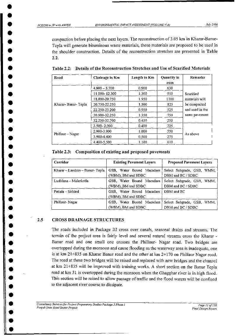
BCEOM in JVwith ARVEE EJNVIRONMENTAL IMPACTASSESSMENT (VOLUME V-A) July 2006
compaction before placing the next layers. The reconstruction of 3.05 km in Kharar-Banur-Tepla will generate bituminous waste materials, these materials are proposed to be used in
* the shoulder construction. Details of the reconstruction stretches are presented in TableE 2.2.
* Table 2.2: Details of the Reconstruction Stretches and Use of Scarified Materials
* Road Chainage in Km Length in Km Quantity in Remarkscum
4.900-5.700 0.900 630* 11.000- 12.300 1.300 910 Scarified
18.800-20.750 1.950 1100 materials will* Kharar- Banur- Tepla 20.750-22.250 1.500 825 be compacted* 22.250-23.200 0.950 525 and used in the
30.900-32.250 1.350 750 same pavement* 32.250-32.700 0.450 250
2.500- 2.900 0.400 225* . 2.900-3.900 1.000 550Phillaur -Nagar As above* 3.900-4.400 0.500 275
* 4.400-5.500 1.100 610
Table 2.3: Composition of existing and proposed pavements
Corridor Existing Pavement Layers Proposed Pavement Layers
Kharar - Landran - Banur- Tepla GSB, Water Bound Macadam Select Subgrade, GSB, WMM,(WBM), BM and SDBC DBM and BC / SDBC
* Ludhiana - Malerkotla GSB, Water Bound Macadam Select Subgrade, GSB, WMM,(WBM), BM and SDBC DBM and BC / SDBC
* Patiala - Sirhind GSB, Water Bound Macadam DBM and BC* (WBM), BM and SDBC
Phillaur- Nagar GSB, Water Bound Macadam Select Subgrade, GSB, WMM,* (WBM), BM and SDBC DBM and BC / SDBC
* 2.5 CROSS DRAINAGE STRUCTURES
The roads included in Package III cross over canals, seasonal drains and streams. The* -terrain of the project area is fairly level and several natural streams cross the Kharar -
Banur road and one small one crosses the Phillaur- Nagar road. Two bridges areovertopped during the monsoon and cause flooding as the waterway area is inadequate, one
* is at km 21+835 on Kharar Banur road and the other at km 2+170 on Phillaur Nagar road.* The road at these two bridges will be raised and replaced with new bridges and the channel
at km 21+835 will be improved with training works. A short section on the Banur Teplaroad at km 31 is overtopped during the monsoon when the Ghagghar river is in high flood.
* This section will be raised to allow passage of traffic and the flood waters will be confined0 to the adjacent river course to dissipate.
* Consultancy Servicesfor Project Preparatory Studies Package 3 Phase I Page 11 of 158Punjab State Road Sector Project Final Design Repor t
SS

BCEOMinJVwith ARVEE ENVIRONMENTAL IMPACTASSESSMENT (VOLUME V-A) July7 2006
The bridges and culverts are important from the environmental point of view since theywill minimize disturbance of the natural drainage pattern which would otherwise lead tostagnation and water logging especially near settlements. Details of the existing andproposed cross drainage structures of the Project corridors are presented in Table 2.4.
Table 2.4: Details of the existing and proposed Cross Drainage Structures of thePackage III
Project Culverts BridgesCorridor - Existing New
Total Widenn Replaced IBypZsded Total Widenin Replaced I BpssedSlab Pipe Slab Pipe Slob Pipe Slab Pipe Slab Pipe Major Minor Major I Minor Major l Minor IMlajor Mtinor
KBT 36 15 33 4 3 l 0 0 2 0 2 6 1 3 1 3 0 0LM 29 12 26 2 1 7 3 1 5 0 2 2 2 1 0 I 0 0PN 2 1 2 0 0 10 0 0 0 0 1 0 0PS 21 21 00 0 0 0 0 0
The details of the proposed improvement for the cross drainage structures are:
* Replacement of existing structures which are observed as non functional or seriousstructural faults with new structures.
* Widening of existing structures to the fit the proposed widening of the road.* Reconstruction or repairing of parapet walls* Pitching of slopes for the control of erosion in seasonal water channels.
2.6 CONSTRUCTION MATERIALS
The major construction materials required for the Project are soil, sand, aggregates,bitumen, steel and cement. Selected soil required for the project will be procured fromlocal borrow areas, which are located mainly in agricultural fields where topsoil has beenremoved. The gravel material excavated from the riverbed of rivers/streams originating inthe hills and deposited at the foot hills will be used as Granular Sub Base. The boulderstransported by the river get deposited on the riverbed as the river enters into the plains.These boulders are being collected at various locations and crushed to required sizes forWet Mix Macadam and Bituminous courses as well as structural concrete works which isnormal practice in Punjab. Cement, bitumen and steel will be procured from the authorizedsuppliers of reputed manufacturers.
2.7 FLY ASH
The embankments design should provide for maximum utilization of locally availablematerials consistent with economy. Use of fly ash wherever available with in economical
Consultancy Servicesfor Project Preparatory Studies Package 3 Phase I Page 12 of 158Ptinjab State Road Sector Project Final Design Report

BCEOMinJVwithARVEE ENVIRONMENTAL IMPACTASSESSMENT(VOLUME V-A) Juljy2006
leads must be considered. In accordance with Government norms, use of flyash withinlOOkms from Thermal Power Stations is mandatory.
As the improvement of the project roads involves overlay on existing and widening on sideportions and roads are not in high embankments, the roadway excavation material will inhigher side comparative to fill. the excavated martial in Kharar-Tepla and Ludhiana-Malerkotla road is more comparative to Embankment fill and in Phillaur-Nagar and Patiala-Sirhind, it is slightly less. The excavated material is sufficient for embankment fill for allthe four roads and no additional soil material or fly ash is required.
As the extra excavated material (spoil) is not qualifying the properties of sub-grade, Thesub-grade material is borrowed from the borrow areas. The borrowed pits for the sub-gradecan be filled with this excess material left from excavation. Hence the provision of flyash isnot anticipated.
2.8 INTERSECTIONS
Six major intersections are located along the Project roads, of which five intersections arewith national highways and one with a state highway. Another four minor intersectionswith other district roads are also located on the project roads. The Consultant has carriedout detailed traffic surveys for the major intersections. The hourly peak traffic flowthrough the major intersections ranges from 6000 PCUs to 2500 PCUS. Details of the flowof the traffic of the intersections are presented in the Table 2.5. In addition to theseintersections there are many small access roads from the villages and settlements locatedalong the project roads.
Table 2.5: Traffic Details of the major Intersections
Intersection Intersection Corridor Peak Hour Flow Year ofID (PCU's) warranting* FlyoversInt-I Sirhind (Junction with Sirhind- Patiala 09:00 to 10:00 2451 2028
Int Kharar (Junction with Kharar-Banur- Tepla 17:00 to 18:00 6086 2013
Int-3 Banur (Junction with Kharar-Banur- Tepla 17:00 to 18:00 3133 2022NH-64)
Int-4 Tepla (Junction with Kharar-Banur- Tepla 15:00 to 16:00 3862 2021_______NH-I)
Int-5 Phillaur (Junction with Phillaur- Nagar 18:00 to 19:00 5717 2015* ~ ~ ~~~~NH -1) _ _ _ _ _ _ _ _ _ _ _
For the present traffic volume grade separation is not envisaged as part of this project, butwill be required in the future. The Police have confirmed that some of these junctions havea bad accident records. In the absence of any firm proposals from the National HighwayAuthority of India (NHAI) it is recommended that these junctions be signalised (the
Consultancy Services for Project Preparatory Studies Package 3 Phase I Page 13 of 158Pzunjab State Road Sector Project Final Design Report

* BCEOMin JVwitlhARVEE ENVIRONMENTAL IMPACTASSESSMENT (VOLUME V-A) July 2006
v Sirhind junction with NH-I is already signalised, but some further improvements areneeded). This is the simplest and most cost-effective way to improve the safety of the
* junctions. The proposal for Phillaur would require closing a road and this has been rejecteda in public consultations so the existing arrangements will be retained pending development
of the junction by National Highways. The Phillaur and Kharar junctions will need* extensive upgrading towards the end of the planning period, but a decision on this can onlya be taken within the context of NHAI's plans for upgrading these junctions.
0
* 2.9 SETTLEMENTS0
The roads of the Package-III pass through rural settlements, agricultural areas and twotowns. The details of the settlements along the project corridor are presented in the Table
* 2.6. The proposed Gill and Pohir bypasses avoid traffic through the settlement.
* Table 2.6: List of villages & towns with chainage on the project corridors
* |Chaina eS. No Location Type Stretch District
From To1 I Kharar 0 2.6 Town Kharar-Landran Roopnagar2 Sante Majra 2.6 5.5 Small Village Kharar-Landran Roopnagar
* 3 Landran 5.5 8.25 Large Village Kharar-Landran Roopnagar4 Bhago Majra 9.15 9.85 Small Village Landran-Tepla Patiala
* 5 Saneta 12.29 14.47 Small Village Landran-Tepla Patiala* 6 Darri 14.47 15.45 Hamlet Landran-Tepla Patiala
7 Tangori 15.45 20 Small Village Landran-Tepla Patiala* 8 Banur 20 27 Small Village Landran-Tepla Patiala* 9 Basma 31.5 34.6 Small Village Landran-Tepla Patiala
10 Tepla 34.6 36.25 Small Village Landran-Tepla Patiala* 11 Rajgarh 36.25 39.1 Small Village Landran-Tepla Patiala
12 Phillaur 0 4.8 Large Village Phillaur-Nagar Jalandhar* 13 Nagar 4.8 7.5 Large Village Phillaur-Nagar Jalandhar* 14 Gill 5.9 10 Large Village Ludhiana-Malerkotla Ludhiana
15 Sarinh 10 14 Small Village Ludhiana-Malerkotla Ludhiana* 16 Kaind 14 15.2 Small Village Ludhiana-Malerkotla Ludhiana* 17 Dehlon 15.2 20.5 Large Village Ludhiana-Malerkotla Ludhiana
18 Gopalpur 20.5 22.5 Small Village Ludhiana-Malerkotla Ludhiana* 19 Pohir 23.7 27 Large Village Ludhiana-Malerkotla Ludhiana
20 Ahmadgarh 25 25 Town Ludhiana-Malerkotla Ludhiana* 21 Akbarpur Channa 27 29.5 Small Village Ludhiana-Malerkotla Sangroor
22 Kup Kalan 34.50 36.23 Large Village Ludhiana-Malerkotla Sangroor23 Bhogiwal 36.23 39.65 Large Village Ludhiana-Malerkotla Sangroor
* 24 fMalerkotla 40.975 45 Town Ludhiana-Malerkotla Sangroor
.
Consultancy Servicesfor Project Preparatory Studies Package 3 Phase I Page 14 of 158Punjab State Road Sector Project Final Design Report..
.

BCEOMinJVwithARVEE ENVIRONMENTAL IMPACTASSESSMENT(VOLUME V-A) July 2006
2.10 BYPASSES
The project envisaged two bypasses at the towns of Gill and Pohir due to poor existingalignment, limited ROW and congestion due to heavy settlements. These bypasses arelocated on the Ludhiana- Malerkotla section. Public consultations were carried out forthree bypasses including a proposal for bypass at Dehlon and the opinion of the public wasconsidered in finalizing these bypasses. During the public consultations at the threevillages, consensus was reached for bypasses at Gill and Pohir, however since there wassufficient ROW for a substantial length of the road at Dehlon, widening of road along thepresent alignment is considered feasible and has been agreed with the local community.Accordingly it is decided to construct two new bypasses at Gill and Pohir. The details oflength of bypasses are given in Table 2.7
Table 2.7: Details of Bypasses
Chaina Je (km) LengthName of the Bypass Start End (m) Side to existing roadGill 6+800 8+700 2400 RightPohir 24+600 27+200 1400 Left
2.11 TRAFFIC
The improvements of the identified roads are proposed based on the existing and projectedtraffic as it is the most important criterion of determination of the level of improvement tobe carried out. The traffic along the corridors selected in Package III is a mix of slow andfast moving traffic. The proportion of slow moving to fast moving traffic is given in Table2.8 below:
Table 2.8: Traffic in base year (2005) along the corridors
Corridor Section AADT AADT Total(all) (fast) (PCUs)
Karar-Landran 11961 9923 16655Kharar-Landran-Banur-Tepla Landran-Banur 7814 7002 9429
Banur-Tepla 3756 3421 5987Ludhiana- Malerkotla 12717 11536 17852Patiala- Sirhind 8757 8312 11005Phillaur- Nagar 7439 5478 8685
2.11.1 Traffic Projections
The classified traffic volumes obtained during the traffic surveys were analysed both interms of the vehicles and PCUs. Annual Average Daily Traffic(AADT) on the study stretchwas estimated from the 3- days observed counts including diverted and generated traffic
Consultancy Servicesfor Project Preparatory Studies Package 3 Phase I Page 15 of 158Punjab State Road Sector Project Final Design Repor-t

BCEOMinJVwithARVEE ENVIRONMENTAL IMPACTASSESSMENT(VOLUME V-A) July 2006
and compared with the traffic data of the Feasibility study Consultant. Traffic on differentsections of the project corridor is forecast to 2033 using growth rates furnished by the
* feasibility consultants and given for vehicle type in Table 2.9.
Table 2.9: Projected Traffic Details along the project corridors of Package III of Phase I
From To Traffic Volumes* Two wheelers Three Wheelers Cars v Buses and Goods
Kharar 1vehicles2005 1 20101 20201 2033 20051 2010 2020 12033 20051 20,1d 2020 2033 2005 2010 2020 2033Patiala Sirhind 2052|3109|8034|22355 44|67 | 1 74 1 485 4346|16161 13478131830 1869 2483|4209|7327Kharar-Landran-Banur-T pla
* Kharar Landran 3342 5025 12803 35273 95 143 365 1003 2760 4087 9192 16183 3727 5151 9036 15803Landran Banur 3054 4594 11708 32258 87 130 334 840 2065 3059 6880 16183 1795 2480 4344 7599Banur Tepla 969 1456 3709 10219 46 69 179 493 843 1248 2805 6599 1562 2140 3703 6410Ludhiana 1 Malerkotla 3461 5206 13268 36556 54 81 203 560 3498 4925 10653 24948 4523 6151 10778 19030FPhillur JNagar 12367 _3366, 7703,201351 161 227 ,518 1l352 ,1532, 20571 4065 ,9106 ,1418, 1795 2825,4702
2.12 ROAD SAFETY0a Accident records were compiled from Police Stations for the years 2001 to 2003. This
covered three of the four project roads. Table 2.10 below summarises the accident situation* on the three project roads.
0 Table 2-10: Reported Personal Injury Accidents (PIA), 2001-03.
a) Kharar-Tepla Road
Accident Number of Reported Accidents Total Casualties* Severity Type of CollisionHit Hit and Side Head- Rear Other0 pedestrian run swipe on end
Fatal injury 3 7 10 10 4 0 34 killed* Serious injury 1 3 7 2 1 1 23 serious injured
Minor injury 2 5 3 3 3 0 27 minor injured* Total 6 15 20 1 15 8 1 l
D b) Ludhiana-Malerkotla Road
* Accident Severity Number of Reported Accidents Total CasualtiesH l 9 Type of Collision l |
| Hit |Hit and Side Head- Rear Otherpedestrian run swipe on end | l _l* Fatal injury 14 5 j 5 38 14 3 87 killed
Serious injury I 0 4 19 4 2 51 serious injured0 Minor injury | 2 2 | 1 10 | 5 | 2 194 minor injured lTotal 1 7 7 _ 10 67 23 7 _ _00
Consultancy Services for Project Preparatory Studies Package 3 Phase I Page 16 of 15SPunjab State Road Sector Project Final Design Report000

BCEOMinJVwithARVEE ENVIRONMENTAL IMPACTASSESSMENT (VOLUME V-A) July2006
c) Patiala-Sirhind Road
Accident Number of Reported Accidents Total CasualtiesSeverity Type of Collision
Hit - Hit and Side Head- Rear Otherpedestrian run swipe on end
Fatal injury 10 5 3 12 15 3 51 killedSerious injury 3 1 3 6 3 1 25 serious injuredMinor injury 0 3 0 4 8 1 63 minor injuredTotal 13 9 6 22 26 5
Our consultation exercise with Police and local residents revealed the following views:
* Excessive speed is the biggest cause of accidents on these roads.
* Many accidents happen when it is foggy.
* Many accidents involve speeding vehicles running into the back of stopped (oftenbroken-down) vehicles - this is especially a problem at night.
* Some accidents occur because vehicles carry loads that overhang too far over theback or sides of the vehicle.
* Problems arise due to the mix of slow-moving agricultural tractors and fastervehicles.
2.13 TYPICAL ROAD SECTIONS
The following photos illustrate the existing road environment.
P."I
Figure 2.1: Typical Section (Banur-Tepla) Figure 2.2: Section of Sirhind- Patiala Section
Consultancy Services for Project Preparatory Stuidies Package 3 Phase I Page 17 ofJ58Puinjah State Road Sector Project
Final Design Report
I -- 30o~/^- . -:..SlL v f,

BCEOMinJVwithARVEE ENVIRONMENTAL IMPACTASSESSMENT(VOLUME V-A) July 2006
Flooding on Kharar to Banur Road
Inadequate Waterway Area Km 21+850 Outlet Channel
Accident on existing narrow road Bridge to be replaced(Kharar Banur) (Displaced Central Pier Foundation)
SA
AciE ntoxisting narrow roadl Bridge tnc oahr be roneplaed Dbo*(LuhianarMaler)Kta (DislcdCentngRal Pidefr Founatine)
0a v Pj A -d h
Punjab S
S--- Bw* F -o
Existing 2 lane Canal Bridge Encroachers in congested Dehion*(Ludhiana Maler Kotla) (Widening RH side for 4 lane)
* _
5 Consultancy Ser-vices for Project Preparatory Stuxdies Package 3 Phase I Page 18 of 158Punjab State Road Sector Project Final Design Report

0S
aSS
S
S
0SSSS
00S
0
* SECTION 3: POLICY, LEGAL AND INSTITUTIONAL
* FRAME WORK
SSSbSSS

BCEOM in JV iith ARVEE ENVIRONMENTAL IMPA CTASSESSMENT (VOLUME V-A) July 2006
3 POLICY, LEGAL AND INSTITUTIONAL FRAMEWORK
3.1 ENVIRONMENTAL POLICY FRAMEWORK
The chapter presents a review of the existing institutions and legislations relevant to theproject at the International, National and State levels. The various statutory clearances fromvarious state and central government authorities and the institutional framework arediscussed below.
3.1.1 International Treaties and Conventions binding upon GOI
There are various international treaties and conventions to which India is a party and theseare binding upon the country. Though, most of these treaties and environmentalagreements are not directly applicable to the Project, some of the treaties andenvironmental agreements are discussed briefly below.
(i) Ramsar Convention on Wetlands:
The Convention on Wetlands was signed in Iran in 1971 and came into force in 1975. It isan intergovernmental treaty, which provides the framework for national action andinternational cooperation for the conservation and wise use of wetlands and their resources.The broad aim of the Convention is to halt the worldwide loss of wetlands and to conservethe existing ones through wise use and management. There are presently 152 ContractingParties to the Convention, with 1608 wetland sites, totaling 140 million hectares,designated for inclusion in the Ramsar List of Wetlands of International Importance. Indiais a Party to Ramsar Convention.
(ii) Convention concerning the Protection of the World Cultural and NaturalHeritage
The Convention concerning the Protection of the World Cultural and Natural Heritage wasadopted in the general conference of United Nations Educational, Scientific and CulturalOrganization (UNESCO) in Paris in 1972. The Convention was adopted to establish aneffective system of collective protection of the cultural and natural heritage of outstandinguniversal value, organized on a permanent basis and in accordance with modem scientificmethods. The Convention promotes an international perspective on cultural heritage byinviting member states to submit an inventory of properties forming its national culturaland natural heritage to be included in a list of World Heritage sites. India is a member stateand there are 26 World Heritage Properties in India, out of which 21 are Cultural Propertiesand 5 are Natural Properties.
Consultancy Servicesfor Project Preparatory Studies Package 3 Phase I Page 19 of.158Punjab State Road Sector Project Final Design Report

BCEOMinJViiithARVEE ENVIRONMENTAL IMPACTASSESSMENT (VOLUME V-A) Juily 2006
(iii) Convention on Biological Diversity
The Convention on Biological Diversity was adopted at Rio de Janeiro Earth Summit in1992 with 150 signatories. The Convention on Biological Diversity is dedicated topromoting sustainable development with the aim of conservation of biodiversity throughsustainable use of components of biodiversity and sharing the benefits arising from thecommercial and other utilization of genetic resources in a fair and equitable manner. TheCartagena Protocol on Biosafety is a supplementary agreement that seeks to protectbiological diversity from potential risks posed by Living Modified Organisms (LMOs)resulting out of modern biotechnology. The Convention on Biological Diversity is legallybinding on the signatory parties. India is a party and has ratified to the Convention onBiological Diversity on 18th 1994 and the Cartagena Protocol on 1 1th September 2003.
(iv) Convention on International Trade in Endangered Species of Wild Flora andFauna (CITES)
The Convention on International Trade in Endangered Species of Wild Flora and Fauna(CITES) is an international agreement between governments to safeguard certain speciesfrom over exploitation. The aim is to ensure that international trade in specimens of wildanimals and plants does not threaten their survival. The text of the Convention was adoptedin 1973 and it entered into force on I" July, 1975 in Washington, DC. At present, there are169 parties to the agreement. India is also a party to the Convention.
(v) Millennium Development Goals
The Millennium Development Goals (MDGs) were adopted in the General Assembly of theUnited Nations in the year 2000 by all the countries of the world and the world's leadingdevelopment institutions. The target date for achieving the MGDs by all the countries hasbeen fixed as 2015. The MGDs are as follows:
* Eradicate extreme hunger and poverty
* Achieve universal primary education
* Promote gender equality and empower women
* Reduce child mortality
* Improve maternal health
* Combat HIV / AIDS malaria and other diseases
* Ensure environmental sustainability
* Develop a global partnership for development
Consultancy Servicesfor Project Preparatory Studies Package 3 Phase I Page 20 of 158Pzmnjab State Road Sector Project Final Design Report
BCEOMinJVithARVEE ENVIRONMENTAL IMPACTASSESSMENT (VOLUME V-A) July 2006
Applicability of International Treaties and Conventions; There are no wetlands, worldcultural or heritage sites, or endangered species in the greater area of the project roads.Though the MGDs do not directly apply to the project, the mitigation measures whilepreparing the Environmental Management Plan and Resettlement Action Plan will makethe project sustainable and can help achieve some of the goals in the regional context.
3.1.2 National Environmental Policy Framework
In the constitutional provision, Govt. of India (Gol) has the responsibility for protectionand improvement of the environment. As per the constitutional provision:
The state shall endeavor to protect and to improve the environment and safeguardforestsand wildlife of the country (Article 48A) and
Every citizen is bound to protect and improve the natural environment and to havecompassion for living creatures (Articles 51A(g)).
The various national environmental policies prevalent in India is described briefly asfollows:
The National Forest Policy, 1988
The National Forest Policy, 1988 envisages that 1/3rd of the total geographical area of thecountry should be brought under forest/tree cover. Its one of the basic goals is tosubstantially increase the forest/tree cover on all denuded and degraded lands.
The salient features of the national forest policy, 1988 are:
* Maintenance of environmental stability through preservation and restoration ofecological balance,
Conservation of the natural heritage of the country by preserving the remainingnatural forests and protecting the vast genetic resource for the benefit of theposterity,
Meeting the basic needs of the people, especially fuel wood, fodder and smalltimber for the rural and the tribal people and
Maintaining the intrinsic relationship between forests and the tribal and other poorpeople living in and around forests by protecting their customary rights andconcessions on the forests.
The main approach outlined is as follows:
Protection of the existing forest land and forests, improvement of their productivityand emphasis on enhancement of forest cover on hill slopes and catchment areas ofrivers,
Consultancy Servicesfor Project Preparatory Studies Package 3 Phase I Page 21 of158Punjab State Road Sectoi Project Final Design Report

BCEOMinJV,,ithARVEE EAN'VIRONVMENTAL IMPACTASSESSMENT (VOLUME V-A) Ju/v 2006
* In order to conserve biological diversity, a network of sanctuaries, national parks,biosphere reserves and other protected areas will be extended and better managed,
* Non-forest land should be selected for compensatory afforestation projects and
* Involvement of the people actively in environment programmes such as protection,conservation and management of forests.
National Water Policy, 2002
The National Water Policy was initially adopted in September 1987 and since then anumber of issues and challenges have emerged in the development and management ofwater resources, hence the water policy was reviewed and updated in 2002. The main focusareas of the National Water Policy are:
A wvell developed information system for water related data.
> Planning and the management of water resources.
* Review and strengthening of the institutional mechanism.
> Planning of water development projects.
> Development of groundwater resources.
> Provision of safe drinking water
> Irrigation
> Participatory approach to water resource management
> Private Sector Participation
> Monitoring of water quality
> Water Zoning
> Conservation of water
* Flood Control and Management
* Drought prone Area Development Programme
* Water Sharing and Distribution among states
National Environment Policy, 2004
The National Environment Policy has been formulated to integrate environmental concernsof all developmental activities. The NEP, 2004 is intended to be a guide to action: inregulatory reform, programmes and projects for environmental conservation; and reviewand enactment of legislation, by agencies of the Central, State, and Local Governments. It
Consultancy Services for Project Preparatory Studies Package 3 Phase I Page 22 of 158Punjab State Road Sector Project Final Design Report

BCEOMVin JVwiwthARVEE EANVIRONVMVENTAL IMPACTASSESSMENT(VOLUME V-A) Julv 2006
also seeks to stimulate partnerships of different stakeholders, i.e. public agencies, localcommunities, the investment community, and international development partners, inharnessing their respective resources and strengths for environmental management. On thewhole, it is expected to do better than fiscal neutrality, and likely raise substantial resourcesfrom outside the fiscal regime to realize its objectives.
National Conservation Strategy
The National Conservation Strategy has been formulated for laying down the guidelines tointegrate environmental considerations into the fabric of our life and of our developmentprocess. The key sectors of development activities where steps for environmentalconservation and sustainable development are being taken are:
Agriculture and Irrigation
Animal Husbandry
> Energy Generation and Use
> Industrial Development
> Mining and Quarrying
Tourism
Transportation
* Human Settlements
Wildlife Conservation Strategy, 2002 and Policy Statement on Environment andDevelopment
The Wildlife Conservation Strategy of 2002 and Policy Statement on Environment andDevelopment has the following salient features with respect to wildlife conservation inIndia.
Wildlife to be declared priority sector at the national level for which funds shouldbe earmarked.
> Fully tap the wildlife tourism potential and at the same time ensure it does not haveadverse impact on the wildlife and protected areas.
> Protecting the interests of the poor and tribals living around protected areas and toensure maximum participation of affected people.
> Respond to newer threats such as toxic chemicals and pesticide use.
> Governmental and societal recognition for the NGOs involved in wildlife
Consultancy Services for Project Preparatory Studies Package 3 Phase I Page 23 of 158Punjab State Road Sector Project Final Design Report

BCEOM in JV w ith AR VEE ENVIRONMENTAL IMPACTASSESSMENT (YOL UME V-A) July 2006
conservation.
* ~No diversion of forestland for non-forest purposes from critically and ecologicallyfragile wildlife habitat.
Lands falling within 7 km. of the boundaries of National Parks and Sanctuariesshould be notified as eco-fragile zones under section 3(v) of the Environment(Protection) Act and Rule 5 Sub-rule 5(viii) & (x) of the Environment (Protection)Rules.
Removal of encroachments and illegal activities from within forestlands andprotected areas.
National Policy on Resettlement and Rehabilitation for Project Affected Families,2003
The National Policy on Resettlement and Rehabilitation for Project Affected Families,2003 addresses the need to provide succour to the assetless rural poor, support therehabilitation efforts of the resource poor sections, namely, small and marginal farmers,SCs/STs and women who have been displaced. Besides, it seeks to provide a broad canvasfor an effective dialogue between the Project Affected Families and the Administration forResettlement & Rehabilitation. The National Policy on the Resettlement and Rehabilitationof Project Affected Families will be in the form of broad guidelines and executiveinstructions for guidance of all concerned and will be applicable to Projects displacing 500families or more en masse in plain areas and 250 families en masse in hilly areas, DesertDevelopment Programme (DDP) blocks, areas mentioned in Schedule V and Schedule VIof the Constitution of India. The rehabilitation grants and other monetary benefits proposedin the Policy would be the minimum and applicable to all project affected families whetherbelonging to BPL or non-BPL families. The objectives of the policy are as follows:
To minimize displacement and to identify non-displacing or least-displacingalternatives;
> To plan the resettlement and rehabilitation of Project Affected Families, (PAFs)including special needs of Tribals and vulnerable sections;
> To provide better standard of living to PAFs; and
> To facilitate harmonious relationship between the Requiring Body and PAFsthrough mutual cooperation.
3.2 LEGAL FRAMEWORK
The Government of India has laid out various policy guidelines, acts and regulationspertaining to sustenance of environment. The Environment (Protection) Act, 1986 provides
Consultancy Services for Project Preparatory Studies Package 3 Phase I Page 24 of.158Pznjab State Road Sector Project Final Design Report

BCEO,M in JV It itih ARVEE ENVIRONVMENTAL IMPACTASSESS,lENT (VOLUME V-A) Jzl/v 2006
umbrella legislation for the protection of environment. As per this Act, the responsibility toadminister the legislation has been jointly entrusted to the Central Ministry of Environmentand Forests (MOEF) and the Central Pollution Control Board (CPCB) / State PollutionControl Board (SPCB).
The legislations/acts followed for present study has been summarized in Table 3.1.
Table 3-1: Summary of Key Legislations Relevant to the Project
Act or Notification Year Objective Responsible Agency
The Environment 1986 To protect and to improve the MoEF, CPCB, SPCB(Protection) Act. quality of the environment andThe Environment to prevent, control and abate(Protection) Rules environmental pollution.The Forest (Conservation) 1980 To check deforestation by MoEF, State Deptt. OfAct restricting conversion of ForestsThe Forest (Conservation) forested areas into non-Rules as amended in 2003 forested areas.and 2004The Wildlife (Protection) 1972 To protect wildlife through Chief Conservator,Act as amended in 2002 creation of National Parks and Chief Wildlife
Sanctuaries Warden, WildlifeWing, F.
The Air (Prevention and 1972 To prevent, control and reduce SPCB & CPCBControl of Pollution) Act amend air pollution including noise
ed in pollution as per the prescribed1981 standards.
The Water (Prevention & 1974 To control water pollution and SPCB & CPCBControl of Pollution) Act restoration of water quality as
per the prescribed standards.The Water (Prevention & 1977 To levy and collect Cess fromControl of Pollution) Cess industries based on waterAct consumption.The EIA Notification and 1994 To issue environmental MOEF, SPCBits subsequent amendments clearance to development
projects based on EIA report.Ancient Monuments and 1938 Conservation of Cultural and ArchaeologicalArchaeological Sites and historical remains found in Survey of India andRemains Act. India State Department of
I__IArchaeology
The legal framework for the project is summarized in following sections.
The Environment (Protection) Act, 1986 and the Environmental Impact AssessmentNotification, 1994
The Environment (Protection) Act, 1986 is the fundamental legislation providing for theprotection of environment in the country. This act provides the Environment (Protection)Rules, which were formulated in 1986. The principal environmental regulatory Authorityin India is the Ministry of Environment and Forests (MoEF) of the Government of India.
Consultancy Services for Project Preparatory Studies Package 3 Phase I Page 25 of 158Punjab State Road Sector Project Final Design Report

BCEOMinJVw'ithARVEE ENVIRONMENTAL IMPACTASSESSMENT (VOLUME V-A) July 2006
MoEF formulates environmental policies and accords environmental clearances under theEIA notification. The Environmental Impact Assessment Notification, 1994 and the variousamendments thereto have been notified under this act.
As per the EIA notification dated 27 th January 1994, Item No. 21 of Schedule I (highwayprojects) require Environmental Clearance from the Central Government in form ofapproved EIA. The project authority has to apply to the MOEF for environmental clearancewith an environmental impact statement (EIS), which is accompanied by a feasibilityreport, a completely filled environmental questionnaire, an application form, a NoObjection Certificate (NOC) from the concerned state govt., and an EIA and EMP report.
As per subsequent amendments, environmental clearance from the ministry is required forhighway widening and strengthening projects if they involve land acquisition of more than20 m, on either side put together and/or cut across or pass through environmentallysensitive areas as reserved forests, wildlife sanctuaries, biosphere reserves etc. Also, thebypasses are to be treated as stand alone projects and require Environmental Clearance ifthe costs exceeds Rs. 100 crore.
The Forest (Conservation) Act 1980 (Central Act No. 69 of 1980) and The Forest(Conservation) Rules, 2003
The act empowers the government to take following action:
> To declare reserved and protected forests and to acquire land for extension andpreservation of forests,
> To enforce non-conversion of forest land for non-forest activity like setting up ofindustry, cultivation or any purpose other than reafforestation,
> To constitute a committee consisting of number of persons to advise theGovernment with regard to (i) the grant of approval for Forest Clearance (ii)conservation of forests and (iii) penalization and
> To grant clearance for all proposals involving clearing of naturally grown trees inforest land or portion thereof.
Land acquired by the government for laying of roads, railway lines, canals and the unusedvacant area that are not yet notified as protected forest areas will not come under theprovisions of the Forest (Conservation) Act, 1980 for the purpose of widening or expansionor re-alignment. If already notified, then it needs approval from the central governmentunder this act.
Applicability of the provision of the Forest (Conservation) Act, 1980 to the linear (road orcanal side) plantations has been modified by a notification from the GOI, MOEF, dated 18February 1998. The new notification recognized that the spirit behind the Forest
Consultancy Servicesfor Project Preparatory Studies Package 3 Phase I Page 26 of.158Pu njab State Road Sector Project Final Design Report

BCEOMinJV,i'ith ARVEE ENVIRONMENTAL IMPACTASSESSMAENT (VOLUME V-A) Ju1ly 2006
(Conservation) Act, 1980, was conservation of natural forests not strip plantations. In caseof roadside plantations as "notified to be protected", the clearance now may be given by theconcerned regional offices of the MOEF, irrespective of the area of plantation lost.
According to the Forest (Conservation) Rules, 2003, proposals involving forestland ofmore than forty hectares shall be sent Central Government and proposals involving lessthan forty hectares of forest hectare shall be sent to Chief Conservator of Forests orConservator of Forests of the concerned Regional Office of the Ministry of Environmentand Forests.
The Wild Life (Protection) Act, 1972 (as amended in 2002)
The Wildlife (Protection) Act, 1972 as amended in 2002 has allowed the government toestablish a number of National Parks and Sanctuaries over the past 25 years, to protect andconserve the flora and fauna of the state and prohibit surveys, investigations andexplorations in sanctuaries, national parks and biosphere reserves.
The act will not be applicable, as the proposed alignment does not pass through anyNational Park or Sanctuary.
The Water and Air (Prevention and Control of Pollution) Acts
The Water (Prevention and Control of Pollution) Act, 1974 resulted in the establishment ofthe Central and State level Pollution Control Boards (CPCB and SPCB), whoseresponsibilities include managing water quality and effluent standards, as well asmonitoring water quality, prosecuting offenders and issuing licenses for construction andoperation of certain facilities similarly. The Air (Prevention and Control of Pollution) Act,1981, empowers the SPCBs to enforce air quality standards set by the CPCB.
The Motor Vehicles Act, 1988
In 1988, the Indian Motor Vehicles Act empowered the State Transport Authority (usuallythe Road Transport Office) to enforce standards for vehicular pollution and preventioncontrol. The authority also checks emission standards of registered vehicles, collects roadtaxes, and issues licenses. In August 1997, the Pollution Under Control Certificate (PUC)programme was launched in an attempt to crackdown on the vehicular emissions in theStates. Since this act is applicable for all states, this will be applicable for this project also.
The Ancient Monuments and Archaeological Sites and Remains Act, 1958
According to this Act, area within the radii of 100m and 300m from the "protectedproperty" are designated as "protected area" and "controlled area" respectively. Nodevelopment activity (including building, mining, excavating, blasting) is permitted in the*"protected area" and development activities likely to damage the protected property are notpermitted in the "controlled area" without prior permission of the Archaeological Survey of
Consultancy Services for Project Preparatory Studies Package 3 Phase I Page 27 of 158Punjab State Road Sector Project Final Design Report

BCEOMin JVwithARVEE ENVIRONMENTAL IMPACTASSESSMENT (VOLUME V-A) July 2006
India (ASI), if the site/remains/ monuments are protected by ASI. The Act will not beapplicable as there is no declared protected archaeological monument near the projectcorridor.
The Building and other Construction Workers (Regulation of Employment andConditions of Service) Act 1996
All the establishments who carry on any building or other construction work and employ10 or more workers are covered under this Act. All such establishments are required to paycess at rate not exceeding 2% of the cost of construction as may be notified by theGovernment. The employer of the establishment is required to provide safety measures atthe Building or Construction work and other welfare measures, such as Canteens, First-aidfacilities, Ambulance, Housing accommodation for workers near the workplace etc. Theemployer to whom the Act applies has to obtain a registration certificate from theRegistering Officer appointed by the Government.
State Level Legislations and Other Acts
Applicability of the provision of the Forest (Conservation) Act, 1980 to the linear (road orcanal side) plantations has been modified by a notification from the Gol, MOEF, dated 18February 1998. The new notification recognized that the spirit behind the Forest(Conservation) Act, 1980, was conservation of natural forests not strip plantations. In caseof roadside plantations as "notified to be protected", the clearance now may be given by theconcerned regional offices of the MoEF, irrespective of the area of plantation lost. In theproject area, the roadside plantations are declared as protected forests and forest clearancefrom the regional office of MoEF is mandatory.
Consent of the SPCB will be required for setting up hot-mix plants, batching plants, etc.,under the Air (Prevention and Control of Pollution) Act of 1981 and the Water (Preventionand Control of Pollution) Act of 1974. Clearance from the State Department of Mining isrequired for establishing new quarries. Clearance from the State Ground WaterBoards/Authorities is required for establishment of new tube-wells/bore-holes, etc.
In addition, with respect to hygiene and health, during the construction period, theprovisions as laid down in the Factories Act, 1948 and the Building and Other ConstructionWorkers (Regulation of Employment and Conditions of Service) Act, 1996 would apply.
With limited possibility, the provisions of the Hazardous Wastes (Management andHandling) Rules, 1989 and the Chemical Accidents (Emergency Planning, Preparednessand Response) Rules, 1996 would also apply during the construction and the operationperiods.
Consultancy Services for Project Preparatory Studies Package 3 Phase I Page 28 of 158Punjab State Road Sector Project Final Design Report

BCEO, in JVl rithARVEE ENVIRONMENTAL IMPACTASSESSMENT (VOLUME V-A) July 2006
* 3.3 INSTITUTIONAL FRAMEWORK
* 3.3.1 Institutional Framework for the Project
* The Punjab Roads & Bridges Development Board (PRBDB) was constituted by the* Government of Punjab (vide Punjab Act No. 22 of 1998) as an undertaking of the State
Government to act as a catalyst for infrastructure development in the road sector in theState of Punjab. The Project will be implemented by PRBDB. It is staffed from the PWD
* with the mandate to develop and maintain the state highway network. The management ofthe PRBDB views their role primarily as planning and management of the road sector, withthe implementation of the works contracted out to the private sector. PRBDB has appointedConsultants for the project preparation and supervision of implementation and the capacity
* of PRBDB and the Super vision Consultant is discussed in Section 9.
* 3.3.2 Institutional Setting in the Environmental Context
Ministry of Environment and Forests: The primary responsibility for administration and* implementation of the Government of India's policy with respect to environmental* management, conservation, ecologically sustainable development and pollution control
rests with the Ministry of Environment and Forests (MOEF). Established in 1983, MOEF is* the agency primarily responsible for the review and approval of EIA pursuant to GOI* legislation.
* MoEF Regional Offices: The Ministry of Environment and Forests has set up regionaloffices, in the four regions of the country. The regional office for the present project islocated at Chandigarh. This office is responsible for collection and furnishing of state
* information relating to EIA of projects, pollution control measures, status of compliance ofvarious conditions in projects cleared by MOEF, legal and enforcement measures andenvironmental protection in special conservation areas such as wetlands, and otlherbiological reserves.
Central Pollution Control Board (CPCB): CPCB is a statutory authority attached to thel* MOEF and located in New Delhi. The main responsibilities of CPCB include inter-alia thel* following
0 Plan and implement water and air pollution monitoring programs
Advise the Central Government on water and air pollution monitoring programs
Set air and water standards, and
* > Co-ordinate with the State Pollution Control Boards.
* State Pollution Control Board (SPCB): The Punjab Pollution Control Board (PPCB) will-
Consultancy Services for Project Preparatory Studies Package 3 Phase I Page 29 of158Punjab State Road Sector Project Final Design Report
a

0 *BCEOMIinJV,i'ith ARVEE ENVIRONMENTAL IMPACTASSESSMVENT (VOL UME V-A) July 2006
be the government agency responsible for ensuring the compliance with the relevantstandards related to discharge of pollutant into the environment. The following activities of
* the PPCB will be relevant to the project.
0 Planning and executing state level air and water quality initiatives0
0 Advising state government on air, water and industry issues
0 > Establishing standards based on National Minimum standards
0 > Enforcing monitoring of all activities within the state under the Air Act, the WaterAct and the Cess Act etc., and
* > Issuing No Objection Certificate (NOC) for various developmental projects.
Punjab State Forest Department: The Punjab State Forest Department is responsible for* the protection and managing the notified forests within the state. The road side plantation* in the state of Punjab has been designated as Protected Forests. Permission has to be taken0 from the Forest Department for cutting of the roadside trees under the Forest
(Conservation) Act, 1980. Compensatory afforestation work will be under taken to mitigate* tree cutting from the designated protected forests area under the project at various0 locations. Forest clearance is required for private tree cutting in the proposed Gill and Pohir
bypasses.00* 3.4 ENVIRONMENTAL CLEARANCE REQUIREMENTS
* 3.4.1 GOI Requirements
* The primary responsibility for administration and implementation of the Govt. Policy with* respect to conservation, ecologically sustainable development and pollution control rests0 with the MOEF. The MOEF is responsible to enforce the regulations established pursuant
to the National Conservation Strategy, National Forest Policy, and the Policy for* Abatement of Pollution (1992) and the Indian Environmental (Protection) Act 1986.
0 The Environmental Impact Assessment Notification, 1994 identified highways (item 21 of* Schedule-1) as one of the projects requiring prior clearance from the MOEF. Therefore, the
environmental impact assessment (EIA) is a statutory requirement for obtaining clearance.
* In April 1997, MOEF amending Schedule-I of the EIA Notification, 1994, which lists0 projects requiring Environmental Clearance, issued a circular.
'... As per the provisions of the EIA Notification of 27th January 94 and as amended on I o1hApril, 97, environmental clearance is required for highway projects except projects relating
* to improvement work including widening and strengthening of roads with marginal land0* Consultancy Services for Project Preparatory Studies Package 3 Phase I Page 30 of158Punjab State Road Sector Project
Final Design Report
0

BCEOMinJVYWUthARVEE ENVIRONMENTAL IMPACTASSESSMENT ('OLUME V-A) Jzlv 2006
acquisition along the existing alignments provided they do not pass through ecologicallysensitive areas such as national parks, sanctuaries, tiger reserves, reserve forests. It is
* hereby clarified that marginal land acquisition means land acquisition not exceeding a total* width of 20 meters on either side of the existing alignment put together. Further, it is also
clarified that bypasses would be treated as stand-alone projects and would require* environmental clearance only if the cost of the projects exceed Rs.100 crores each'.
Source. MOEF Circular No. 2101Z126-99-/A-M dated 13 October 1999Source: Gazette* Notification, Government of India, dated April 19, 97
* MOEF Circular No. Z-12013/4/89-IA. I (Part) dated 13 June, 2002.
The proposed Project corridors will not be required to take Environmental Clearance from* the MoEF, Govt. of India as;
a) Land Acquisition is not required in two roads, 4.91 hectares for one road and 25.57* hectares of land acquisition are requiredfor one road includingfor tivo bypasses.
* b) No link pass through ecologically sensitive areas, and
* c) Cost of the two new bypasses is less than Rs. 100 crores.
3.4.2 State Level Clearance Requirements0
Besides, the GOI environmental clearance requirements, the project also requires clearance* from some of the state level agencies as discussed below.
Forest Clearances: Permission has to be taken from the Forest Department for cutting of* the road side trees under the Forest (Conservation) Act, 1980 as the road side plantation in0 the state of Punjab has been designated as Protected Forests. Forest clearance has also to be
taken for cutting of private tree in the proposed Gill and Pohir bypasses.
a State Pollution Control Board: The Project also requires obtaining 'No ObjectionCertificate' (NOC) from PPCB in pursuant of the Water (Prevention and 'Control ofPollution) Act of 1974, The Cess Act of 1977 and the Air (Prevention and Control of
a Pollution) Act of 1981. Consent for the Establishment and Operation has to be takenduring the Construction stage of the Project for the operation of all Construction Plants.
* 3.4.3 World Bank Requirements
The World Bank environmental assessment (EA) requirements are based on a three-* category classification system (Category A, B and C) as defined by the World Bank OP
4.01. A project designated as Category A, requires a full environmental assessment (EA),l* Category B projects require a lesser level of environmental investigation. Category C
projects require no environmental analysis beyond that determination. This project hasbeen classified as Category 'A' project due to the cumulative impacts from the project on
Consultancy Servicesfor Project Preparatory Studies Package 3 Phase I Page 31 of 158Puinjab State Road Sector Project Final Design Report
-
1-*0 -

BCEOMinJVw'ithARVEE ENVIRONMENTAL IMPACTASSESSMENT (VOLUME V-A) Julv 2006
the environmental and social components. In accordance with the requirements of theCategory A projects of the World Bank, full Environmental Analysis and EnvironmentalManagement Plan for the project has been carried out. In this project much emphasis hasbeen given in the integration of mitigation measures into the project design andmainstreaming environment in all stages of project. The World Bank's Operational PolicyOP-4.01, its associate procedures and guidelines have been considered for the preparationof the EIA. World Bank policies/guidelines (1999) such as Environmental assessment, OP4.01, Environment Action Plans, OP/BP/GP 4.02, Natural habitats, OP 4.04, Forestry,OP/GP 4.36 and guidelines on Occupational Health and Safety, Ports and HarborsDevelopment, Coastal and Marine Sources Management, etc. relevant to the project, havebeen referred to carry out EA.
3.4.4 Clearance Requirements for the Project
The following environmental, labour and other departmental permissions are required forimplementation of the construction stage of the project:
* No Objection Certificate / Consent to Establish under the Water (Prevention andControl) Act, 1974 and Air (Prevention and Control) Act, 1981 from PunjabPollution Control Board.
No Objection Certificate (NOC) from Punjab Pollution Control Board for theEstablishment and Operation of all Construction Plants.
** Forestry Clearance from the State Forest Department, Punjab.
* Permission from the Central Ground Water Board/Authority for withdrawal ofground water from the regulated areas.
* Permission from the Irrigation Department for taking water from the irrigationcanals.
* Permission from the Labour Department for engaging Labour in the Constructionworks.
0 License from Explosives Department for setting up of diesel pump.
* Registration of Workers under Building and Other Construction Workers Act, 1996.
* Permission from the local body and local health department for setting up theconstruction camp.
* Pollution Under Control Certificate for all machinery and vehicles under MotorVehicles Act, 1988.
The various clearance required for highway project and their applicability viz this project isgiven in Table 3.2.
Consultancy Services for Project Preparatory Studies Package 3 Phase I Page 32 of 158Pzinjab State Road Sector Project Final Design Report

BCEOM in JV with AR VEE ENVIRONMENTAL IMPACTASSESSMIENT (VOL UAIE V-A) Jlulv 2006
Table 3.2: Clearances Required for the Project
Sl rances Act Approving Agency Applicability Time { ResponsibilityNo. to the Project Required Execution SupervisionPROJECT PREPARATION STAGE
I No Objection Certificate Water (Prevention and Punjab Pollution ControlControl of Pollution) Act Board1974,
/ 3 months "EO PRBDB" Project DirectorAir (Prevention and PRBDBControl of Pollution) Act
_____1981
2 Environment Clearance Environment Protection Ministry of Environment andAct 1986 Forest New Delhi X3 Wild Life Clearance Wild Life Act 1972 Hon'ble Supreme Court x
4 Diversion of forest land and Forest Conservation Act Regional Office MoEF / 6 months "EO PRBDB" Project DirectorPermission for felling of trees (1980) Chandigarh PRBDBPROJECT IMPLEMENTATION STAGE
5 Permission for Withdrawl of Environment Protection Central Ground Water Board I month CONTRACTOR CMU (PRBDB)Ground Water Act 19866 Permission for Withdrawl of Irrigation Authorities for use To the ExtentSurface Water from River/ of water from Irrigation PossibleIrrigation Canals Canal. Ground Water
River Board / Authorities for will be used,withdrawal of water from HoweverRivers where
unavoidable month CONTRACTOR CMU (PRBDB)after takingconsent fromCMU(PRBDB)Surface watermay be used7 NOC from Archaeological The Ancient Monument Department of ArchaeologySurvey of India and Archaeological sites Govt. of Punjab x 2 months
and Remains Act 1958.8 Permission for Sand Mining Punjab Mines and Minerals River Board Authorities/from river bed Concession Rules 1969 Department of Mining Govt. / CONTRACTOR CMU (PRBDB)____ of Punjab
Consultancy Services for Project Preparatory Studies Package 3 Phase I Page 33 of 158
Punjab Slate Road Sector Project
Final Design Report

BCEOMinJVwith ARVEE ENVIRONMENTAL IMPACTASSESSMENT (VOLUME V-A)
Jlyv 2006
SN. Clearances Acts Approving Agency Applicability Time ResponsibilityNo. to the Project Required Execution Supervision9 Permission for Opening of Punjab Mines and Minerals Department of Mining Govt.New Quarry Concession Rules 1969 of Punjab / Punjab Pollution V/ CONTRACTOR CMU (PRBDB)Control Board1 0 Hot mix plant, Crushers, Air (Prevention and Punjab Pollution ControlCement Batching Plant Control of Pollution) Act Board V 3 months CONTRACTOR CMU (PRBDB)1981
11 Storage of Hazardous Hazardous Waste Punjab Pollution ControlChemicals (Management and BoardHandling) Rules 1989 andManufacturing Storage and V 3 months CONTRACTOR CMU (PRBDB)Import of HazardousChemicalsRules 1989
12 Disposal of Hazardous Waste Hazardous Waste Punjab Pollution Control(Management and Board V 2 months CONTRACTOR CMU (PRBDB)Handling) Rules 1989
13 Disposal of Construction Water (Prevention and Punjab Pollution ControlWaste and liquid effluent Control of Pollution) Board V/ 2 months CONTRACTOR CMU (PRBDB)from Labor camps Act 197415 Pollution Under Control Central Motor and Vehicle Department of Transport, 1 week CONTRACTOR CMU (PRBDB)- Certificate Act 1988 Govt. of Punjab16 Employing Labour Executing Agency of District Labour Commissioner I week CONTRACTOR CMU (PRBDB)17 Registration of Workers Building and other
I week - CONTRACTOR CMU (PRBDB)construction act, 1996
Consultancy Servicesfor Project Preparatory Studies Package 3 Phase I Page 34 of 158
Punjab State Road Sector Project
Final Design Report

je0000
0
000000
jo
0
000* SECTION 4: BASELINE ENVIRONMENTAL
STATUS0
000

BCEOM ini JlVwith AARVEE ENVIRONMENTAL JMPACTASSESSMENT (VOLUME I-A) Ju/l 2006
4 BASELINE ENVIRONMENTAL STATUS
4.1 GENERAL
As a precursor for the prediction of various types of environmental impacts likely to arise dueto implementation of this Project, it is essential to establish the base line environmental statusof the physical, natural and socio-cultural environmental parameters along the project roadsand within the project influence area.. Details of the baseline environmental parameters arerequired for decision making for the Project design, implementation and operation from theenvironmental point of views. The data has been collected from the primary surveys andsecondary sources.
4.2 METEOROLOGY
4.2.1 Climatic Conditions
Regional meteorological conditions and the project corridor air basin is of high significancein road development projects because the transportation and diffusion of all ambient airpollutants generated during project implementation and/or operational phase once they areair borne are governed by local by meteorological conditions.
The data is used for measuring the capacity for dispersion and diffusion of pollutants duringthe construction and operation stages of the Project. This data also plays a vital role inlocating the construction plants to avoid or reduce the pollution concentrations on thesettlements during the construction stage of the Project. The meteorological data is alsouseful for the modelling of the air pollutant levels during the operation of the project. Sincethe meteorological data show wide variations with time, meaningful interpretation can onlybe drawn from the long term and reliable data.
In order to study the meteorology of the Project area the meteorological data from IndianMeteorological Department (IMD) observatories located at Ludhiana, Chandigarh andAmbala were collected. These observatories are located near the Project roads. The datacollected represents the average of 25 years i.e., 1955 to 1980.
The greater project zone lies in the sub tropical region with four distinct seasons.
Winter - December to February
Summer - March to May
Monsoon - June to September
Consultancy Servicesfor Project Preparatory Studies Pack-age 3 Phase I Page 35 of 158Punjab State Road Sector Project Final Design Report

BCEOM in Jlwith AARVEE ENVIRONMENTAL IMPACTASSESSAMENT (VOLUMAE V-A) Julr 2006
Post Monsoon - October to November
4.2.2 Temperature
Because of the sub-tropical latitudinal nature of the Punjab State, temperature variesconsiderably from month to month. Though the minimum air temperature rarely dropsbelow 0°C and it can go down to -2 to -30C. Ground frost is a common phenomenon duringmid winter. The rise in temperature is gradual when the air has high moisture content withthe sky remaining overcast; the rise is however steep when the sky is clear and there is lessmoisture content in the air. The maximum air temperature goes up to 470 C.
The mean of daily maximum and minimum temperatures of three IMD observatorylocations are presented in Table 4.1. It can be observed from Table 4.1 that the daily meanminimum temperature is 8.50 C, the daily mean maximum temperature 38.60 C anddifference in maximum and minimum daily temperatures remain, in general, less than I 0°Cfor the whole year but can be as much as 20 ° C.
Table 4.1: Monthly Average Range in Dry Bulb Temperatures (°C)*
Month Ludhiana Chandi arh Ambala0830 hours 1730 hours 0830 hours 1730 hours 0830 hours 1730 hours
January 8.5 17.30 11.0 17.2 9.5 17.3February 11.9 20.9 14.6 20.6 12.4 20.7March 17.8 26.4 20.4 25.9 18.1 26.2April 25.2 33.4 27.2 32.3 25.3 33.7May 30.2 38.0 30.7 36.2 29.6 37.7June 31.9 38.6 31.4 36.7 31.0 37.3July 29.4 33.4 28.6 32.1 28.4 32.6August 28.3 31.6 27.8 30.5 27.6 31.3September 27.1 32.2 27.1 30.5 26.5 31.3October 23.1 29.9 24.3 28.4 22.5 29.2November 15.5 23.2 18.4 23.2 15.6 23.5December 9.8 18.2 12.4 18.3 10.3 18.7
SOURCES: C IMA TOLOGICAL TABLE, IMD
4.2.3 Rainfall
The details of monthly total rainfall of the three IMD observatories located near to theProject roads are presented in Table 4.2. In the project area the maximum rainfall occurs inthe months of July and August, however the rainfall extends from June to September. Theminimum rainfall occurs in the post monsoon season (November and December).
Table 4.2: Monthly Total Rainfall in mm
Month Ludhiana Chandigarh ArmbalaJanuary 26.5 33.1 38.5February 28.5 38.9 28.4March 31.7 30.4 29.5April 9.7 8.5 6.1May 16.0 28.4 19.3
Consultancy Servicesfor Project Preparatory Studies Package 3 Phase I Page 36 of 158Punjab State Road Sector Project Final Design Report

BCEOMin JVwitbl AARVEE ENVIRONMENTAL IMPACTASSESSAMENT ('OLU UIE V .-A) Julr 2006
Month Ludhiana Chandigarh AmbalaJune 61.8 145.2 73.2July 209.3 280.4 267.2August 191.2 307.5 267.2September 103.8 133.0 161.3October 34.2 21.9 32.9November 7.0 9.4 9.3December 14.4 21.9 13.2
SOURCES: CLIMATOLOGICAL TABLE, IMD
4.2.4 Humidity
The nature and characteristics of the pollutants will vary with change of the humidity in theatmosphere. Fog provides possibility for suspended particles to coalesce and also enhanceschemical reaction of the gaseous pollutants.
The details of the relative humidity (RH) of monthly variations recorded at 8.30 AM and5.30 PM of three IMD meteorological observatory stations is presented in Table 4.3. It canbe noted that high humidity occurs in the month of December, January, July, August andSeptember and low humidity occurs in the month of April and May
Table 4.3: Monthly Average Range of Relative Humidity in %age
Month Ludhiana Chandigarh Ambala0830 hours 1730 hours 0830 hours 1730 hours 0830 hours 1730 hours
January 84 57 72 50 80 55February 76 48 63 43 72 48March 67 42 50 35 64 41April 51 31 37 24 47 28May 41 26 35 22 41 26June 53 35 51 36 55 38July 76 61 76 63 80 64August 82 68 80 70 84 70September 76 57 74 60 79 61October 60 49 58 43 69 46November 71 50 56 40 70 45December 82 60 67 48 79 52
SOURCES: CLIMA TOLOGICAL TABLE, IMD
4.2.5 Cloud Cover
The details of monthly average variations of the cloud cover in Oktas during the morningand evening at three IMD observatories are presented in Table 4.4. It can be observed thatclear sky will prevail during the months of October and November and more cloud coverwill prevail during the month of July and August.
Consultancy Servicesfor Project Preparatory Studies Package 3 Phase I Page 3 7 of 158Punjab State Road Sector Project Final Design Report

BCEOM in JVwith AAR VEE ENVIRONAfENTAL DIPA CTASSESSA MENT (YOLUME V-A) Julr 2006
Table 4.4: Monthly Average Range of Cloud Cover in Oktas*
Month Ludhiana Chandigarh Ambala083OHours 1730 Hours 0830 Hours 1730 Hours 0830 Hours 1730 Hours
January 2.3 2.6 2.2 2.4 1.9 1.7February 2.2 2.3 2.0 2.2 1.8 1.6March 2.0 2.5 1.8 2.4 1.6 1.7April 1.6 2.2 1.5 2.2 1.1 1.2May 1.3 1.5 1.2 1.8 1.1 1.0June 1.6 1.6 2.4 2.3 1.8 1.5July 4.0 3.9 4.4 3.8 3.9 3.3August 4.1 4.1 4.3 4.0 3.9 3.2September 2.0 2.2 2.5 2.7 1.7 1.7October 0.7 0.7 0.9 0.9 0.6 0.5November 1.0 1.1 0.7 1.0 0.7 0.7December 1.6 1.9 1.7 2.0 1.4 1.3
SOURCES: CLIMATOLOGICAL TABLE, IMD
4.2.6 Wind Speed and Direction
Wind speed and wind directions have a significant role on the dispersion of atmosphericpollutants and therefore, the air quality of the area. Ground level concentrations for thepollutants are inversely proportional to the wind speed in the down wind direction, while inupwind direction no effect will be observed and in cross wind directions partial effect due tothe emission sources is observed.
Mean wind speeds are observed to be highest in the months of March, April, May, June andJuly (7.4-8.6 kmph) at Ambala IMD observatory and lowest in the month of October,November and December (2.0 -2.4 kmph). Monthly mean wind speeds are presented inTable 4.5.
Table 4.5: Monthly Average Wind Speed in kmph
Month Ludhiana AmbalaJanuary 2.8 5.9
February ._3.6 6.8March 4.2 7.9April 4.2 7.4May 4.6 7.9June 5.0 8.6July 4.3 7.9
August 3.3 6.2September 2.8 5.4October 2.4 5.2
November 2.0 5.5December 2.3 5.1
S SOURCES: CLIMA TOLOGICAL TABLE, IMD
Annual wind rose diagrams depicting mean wind speeds and directions for the period from1955 - 1980, are presented in Annexure 4.1 for Ludhiana and Ambala respectively.
Consultancy Services for Project Preparatory Studies Pack-age 3 Phase I Page 38 of 158Punjab State Road Sector Project Final Design Report

BCEOMh1n JVwit/l AARVEE ENVIRONMENTAL IMPA CTASSESSM\ENT (YOLf UE V-A) July 2006
The following observations can be made from the wind rose diagrams and wind data of theentire project road
* March to May months are the windiest months.
* October - November months are the calmest months with low wind speedconditions.
* Most predominant wind direction is "North - West" and the corresponding monthsare from March to May.
* The least predominant wind direction is "South" and the corresponding months arefrom December- February.
4.3 PHYSICAL ENVIRONMENT
4.3.1 Air Environment
The ambient air quality status within the project influence area forms the basis for predictionof the impacts due to the proposed project.
The data required for the assessment of air quality impacts in and around an area is achievedby designing such a network that encompasses micro meteorological conditions, quantityand quality of emissions, locations, duration, resources/monitoring technology andoperational criteria. The optimal scheme for air quality monitoring should consider all theabove factors.
Degradation of ambient air quality is the most commonly identified adverse impact on thenatural and bio-physical environment during the construction and operation of thle roadprojects.
4.3.1.1 Metlhodology
High volume ambient air samplers in conjunction with Mylar bags were used for thecollection of samples in ambient air for 10 locations. The selection of the receptors wasbased on the following considerations:
* Covering the ROW;
* Covering land use characteristics and socio-economic conditions observed along theroute.
Samples were collected on 24 hourly basis for SPM, RSPM, NO,, and SO 2 Samples for COwere collected for one-hour duration. CO samples were taken in Mylar bags and these wereanalyzed in gas chromatograph. The samples were analysed for pollutants of interest (CO,NO,, and SO2, SPM and RPM) using the appropriate method prescribed by Bureau of Indian
Consultancy Servicesfor Project Preparatory Studies Package 3 Phase I Page 39 of 158Punjab Stote Road Sector Project Final Design Report

BCEO, bin JV with AAR VEE ENVVIRONMENTAL lMPA CTASSESSA lENT ('OL UtME l'-A) Jull 2006
Standards and compared with the National Standards prescribed by Central PollutionControl Board.
The monitoring locations along the project roads were selected based on the sensitivity ofthe receptors to vehicular traffic and to obtain baseline concentrations of the variousrepresentative land uses. The locations of ambient air quality monitoring stations along theproject roads were also selected contingent on the meteorological status of the area. Table4.6 presents details of the ambient air quality stations located along the project roads andFigure 4.1 shows locations of ambient air quality stations.
4.3.1.2 Ambient Air Quality In Study Area
At each location 5 samples were collected for all the parameters and at station AAQ-9 andAAQ-1O, seven samples were collected for RPM, SPM, SO2 , and NOx The national airquality standards (NAAQS) for particulate and gaseous pollutants are presented in Table 4.7as lay down by CPCB.
The Details of minimum, maximum and mean values of the ambient air quality parametersmonitored along the project roads are presented in Table 4.8.
Table 4.6: Details of Ambient Air Quality Monitoring Locations
Station Location Chainage Land Offset from Description of Sampling LocationCode Name (Kin) Use pavement
edge
NH-1 to PatialaAAQ-1 Near Junction 29.4 Reside 35 m Located on first floor of house at a height
of Project ntialVC of about 3.0m. This location xvillRoad with ommer characterize ambient air quality of busyNH-I cial intersection of the Project road with NH-I.
AAQ-2 Jhikwali 16.5 Reside 10 m Located on first floor of a house. TheVillage (km ntial/C location was selected to characterize16.500) ommer baseline scenario in rural area of project
cial road.AAQ-3 Barna 8.8 Reside 10 m The location is at outskirts of Patiala
ntial/C Town. This location represents ambient airommer quality of sub urban area. Located on thecial roof of house at about 5.0 m height.
Ludhiana - Maler Kotla
AAQ-4 Maler Kotla 42.5 Reside 10 m This location depicts the air quality of theTown ntial/C settlement area with small industrial
ommer installations (oil refining units)._____ ____ ____cial
* AAQ-5 Dehlon 19.0 Comm 10 m Located on the on rooftop of a house at(km 19.000) ercial about 4.0 m height. This depicts the rural
AAQ-6 Gill Town 10.0 Reside 15 m Gill village is located close to municipalntiaUC limits of Ludhiana town.ommercial
Phillaur- Nagar
Consultancy Servicesfor Project Preparatory Studies Pack-age 3 Phase I Page 40 of 158Punjab State Road Sector Project Final Design Report

BCEOMhin JVwitllAARVEE ENVIROVMENTAL IMPACTASSESSMENT (VOL TJAE V-A) July 2006
Station Location Chainage Land Offset from Description of Sampling LocationCode Name (Km) Use pavement
edge
AAQ-7 Gadha Road 1.5 Reside 20 m The location monitored depicts air qualityntiaUC of rural area. The monitoring instrumentsommer were placed at about 4.0 m height.cial
Kharar -Banur - TeplaAAQ-8 Kharar Town 0.4 Reside 15 m The characterization of baseline air quality
ntial/C scenario depicts the urban air qualityommer characteristics. The monitoringcial instruments were located at about 3.5 m on
1 the rooftop.AAQ-9 Banur 22.0 Reside 10 m This location is of significance because of
(Intersection ntial/C intersection of Project road with NH-64.with NH-04) ommer The baseline air quality will be a good
cial indication of air quality in mixed land usealong project road. The monitoringinstruments were installed on rooftop atabout 4.0 in height.
AAQ- Tepla (Near 39.0 Reside 15 m The instruments are placed on rooftop of a10 End of Project ntial/C shop at about 3.0 m. The ambient airroad) ommer quality of this location characterizes base
cial line in Rural area.
Consultancy Services for Project Preparatory Studies Packv-age 3 Phase I Page 41 of I58Punjab State Road Sector Project Final Design Report

BCEOM in JV with AAR VEE EIVVIRONMENTAL IMPACTASSESSMENT (VOLUME V-A) Julv 2006
r . ' G ,NagarPhillaur - r1' -
Rupnagar
Ludhiana
AAG
__'9 rill Samrala
Kh am aan
AA5hKoale Kharar i Chandigarn
Kharna
Ah edgarh Falengirh SaheD
Raikot brnIOfl SirhindNrJUtlhAAI
, \ ^4 I A, -AA4 ..M,N-I- Keti.
| AA3M oa
JhIkw.II Ralpura
-- AAZMatl
Tai r- s..nhA1T
Tepla EI`J3D:-ra
Am balaDhuri llH+,. .......... ..
Patiala LEGEND:-
RAILWAY TRACK I+FH+H HI- H
_ _ _ _ ;MAIN CANALPROJECT: TTL-PUNJAB STATE ROAD SECTOR PROJECT SAMPLING LOCATON MAP FOR AMBIENT AIR MONITORING. BRANCH CANALFIGURE 4.1 AMBIENT AIR AAI
Figure 4.1: Location Map for Ambient Air Quality Stations
Consultancy Services for Project Preparatory Stu dies Package 3 Plhase I Page 42 of 158Punjab State Road Sector Project
Final Design Report

BCEO,Iiin JVl'with AARVEE ENVIRONAENTAL IMPA CTASSESSMENT (VOL UME V-A) Juliv 2006
Table 4.7: National Ambient Air Quality Standards (CPCB, 1997)Pollutant Time Sensitive Industrial Residential, Method of Measurement
Weighted Area Area Rural & OtherAverage Areas
Sulphur Annual* 15 pg/m3 80 pg/r 3 60 gg/m3 Improved West andGaeke MethodDioxide (SO2 ) 24 hours** 30 pg/rn 3 120 pg/M3 80 pg/M3 Ultraviolet Fluorescence
Jacob & HochheiserOxides of Annual* 15 pg/m3 80 pg/m3 60 pg/m3 Modified methodNitrogen 24 hours** 30 pg/m3 120 pg/m3 80 pg/m3 Gas phase
IN )ChemiluminescenceSuspended Annual* 70 pg/m 3 360 pig/m3 140 pg/m3 High Volume SamplerParticulate (Average flow rate not*Matter (SPM) 24 hours"* 100 pig/rn 3 500 pg/rn3 200 pig/mn3 less than 1.1 rn/rninute)Respirable Respirable ParticulateParticulate Annual* 50 pig/M3 120 pig/M3 60 lpg/M3 Matter SamplerMatter (RPM) 24 hours** 75 pg/M3 150 pg/rm3 100 pig/M3
Size < 10[imI
AAS Method afterLead Annual* 0.50 pg/rn3 1.0 pg/rn3 0.75 pg/rn3 sampling using(Pb) 24 hours** 0.75 pg/m3 1.5 pig/M3 1.00 pig/m3 EPM 2000 or equivalent
_ _filter paperCarbon 8 hours** 1.0 mg/m3 5.0 mg/m3 2.0 mg/m3 Non-dispersive infraredMAnlimet 1 hour 2.0 mg/m3 10.0 mg/m3 4.0 mg/m3 Spectroscopy
*Annual Arihmetic mean of minimum 104 measurements in a year taken for a week 24 hourly at uniform interval.** 24 hourly/8 hourly vakues should meet 98 percent of time in ayearSource: Central Pollution Control Board (1997) National Ambient Air Quality Monitoring Series, NAQMS/a/1996-97
Table 4.8: Onsite 24-Hourly Ambient Air Quality along the Project Roads*Station Land Use Description SPM I RPM SO2 Nox CO (ppm)
Code I I I (Fg/m)| (tg/M)3 (jg/m 3) | (Fg/r )3)Ni-1 to PatialaAAQ - 1 Commercial Minimum 209 42 9 16 1.10
Maximum 238 67 13 20 1.20Mean 224 55 11 17 1.14
AAQ - 2 Commercial Minimum 160 45 9 14 0.50Maximum 203 58 13 19 0.69Mean 177 52 11 17 0.61
AAQ-3 Commercial Minimum 186 46 11 19 0.89Maximum 250 61 15 21 1.29Mean 216 53 14 20 1.07
Ludhiana- MalerkotlaAAQ -4 Commercial Minimum 184 46 11 16 0.20
Maximum 216 68 12 18 0.40Mean 198 54 9 17 0.32
AAQ-5 Commercial Minimum 147 35 10 15 0.30Maximum 170 63 12 17 0.40Mean 160 47 11 16 0.36
AAQ -6 Commercial Minimum 194 48 12 18 1.10. Maximum 224 75 13 25 1.30
Philaur_N_rMean 206 61 13 22 1.22* ~~~~~Phillaur- N agar_ _ _ _ _ _ _ _ _ __ _ _ _ _ _ _ _ _ __ _ _ _ _ _ _ _ _ _ _
AAQ -7 Commercial Minimum 152 46 ] 10 l 18] 0.20Maximum 198 56L 12 | 20 | 0.40Mean 178 52] 11 19 0.28
Consultancy Servicesfor Project Preparatory Studies Package 3 Phase I Page 43 of 158Punjab State Road Sector Project Final Design Report

BCEOI ,in JVwitl AARVEE ENVIRONMENTAL IMPACTASSESSAIENT (VOL UAIE V-A) July 2006
Station Land Use Description SPMI RPM so2 Nox CO (ppm)Code (Kg/rnm) (jg/Mr) (ig/M3) (jig/Mr)Kharar-Banur- TeplaAAQ-8 Commercial Minimum 180 50 12 18 1.00
Maximum 222 64 16 21 1.29Mean 202 59 13 19 1.17
AAQ-9 Commercial Minimum 158 43 5 17 0.59Maximum 207 62 14 22 0.89Mean 179 54 12 19 0.73
AAQ - 10 Commercial Minimum 153 42 01 16 0.40_ _ Maximum 192 54 13 19 0.59
* Mean 178 48 12 18 0.50*Samples were collected in November-December 2005.Note: Conversion Factor for Carbon Monoxide lppm CO = 1157 ,g/m 3
The observations of the air quality monitoring results are briefly discussed below.
Suspended Particulate Matter
The suspended particulate matter (SPM) levels, varies from 147 pg/mr3 to 250 p,g/m 3 incomparison with the standard 200 pg/M3. The highest levels of SPM were observed at Baranlocated in Patiala- Sirhind section, the highest concentrations were due to damagedshoulders, agricultural activities and high traffic plying on the earthen shoulders. SPM levelsat the NH-1 junction near Sirhind were observed to be between 209 pg/M3 and 238 pg/M3.
Respirable Particulate Matter
The Respirable Particulate Matter (RPM) levels, varies from 42 Pg/M3 to 75 gg/m3 incomparison with the standard 100 pg/M3. The highest levels of RPM were observed at Gillvillage located in Ludhiana- Malerkotla section, the highest concentrations were due to badconditions of the road and agricultural activities during the monitoring period. All the valuesare observed to be within the standard limits specified by MoEF for Residential and RuralAreas.
Sulphur Dioxide
The Sulphur Dioxide concentration in the ambient air of the project road varies from 5pg/m3 to 16 pg/M3 in comparison with the standard 80 pg/M3. The highest levels of SulphurDioxide were observed at Kharar town in Kharar- Banur- Tepla section. All theconcentrations of Sulphur Dioxide are observed to be within the standard limits specified byMoEF for Residential and Rural Areas.
Oxides of Nitrogen as NOx
The Oxides of Nitrogen as NOx concentration in the ambient air of the project roads variesfrom 14 pLg/mr3 to 25 pg/M3 in comparison with the standard 80 pg/m3.The highest levels ofOxides of Nitrogen as NOx were observed at Gill village in Ludhiana- Malerkotla section.All the concentration of the Oxides of Nitrogen as NOx along the project roads are observedto be within the standard limits specified by MoEF for Residential and Rural Areas.
Consultancy Servicesfor Project Preparatory Studies Pack-age 3 Phase I Page 44 of 158Punjab State Road Sector Project Final Design Report

aBCEOMin JVwit .AARVEE ENVIRONMIENTAL IMPACTASSESSMENT (VOL UME V-A) July 2006
Carbon Monoxide
The Carbon Monoxide concentration in the ambient air of the project road varies from 0.20* ppm to 1.30 ppm. The highest levels of Carbon Monoxide were observed at Gill village in* Ludhiana - Malerkotla link. All the concentration of the Carbon Monoxide along the project
roads are observed to be within the standard limits specified by MoEF for Residential and* Rural Areas..
4.3.2 Noise Environment
Noise attributed to roads depends on factors such as traffic intensity, the type and condition* of the vehicles plying on the road, acceleration/deceleration/gear changes by the vehicles* depending on the level of congestion and smoothness of road surface (IRC: 104-1988).
Excessively high noise levels are a concern for sensitive receptors, i.e., hospitals,educational institutions and courts.
d 4.3.2.1 Sampling Criteria
Locations for noise monitoring stations along the route are identified based on the samecriteria used for air monitoring but the relative importance of each criteria carries a
* weighting in arriving at the final set of locations. In case of noise monitoring locations,sensitive land use such as schools, hospitals and religious places are considered to be morecritical.
d Hourly noise levels were recorded at 15 locations identified along project roads. The noiselevel standards as prescribed by CPCB are given in Table 4.9. Details of the locations arepresented in Table 4.10 and depicted in Figure 4.2. The hourly noise values were used to
* calculate daytime and night time equivalent noise levels. In order to arrive at daytime noiselevels the logarithmic average of hourly values was taken from 6:00 AM to 10:00 PM. Thenight time noise levels were derived by taking logarithmic average of hourly values from
* 10:00 PM to 06:00 AM. The hours of day and night were considered as specified durationsd for 'day' and 'night' in Noise Rules Published by the MoEF. Details of the recorded noise
levels are given in Table 4.10.
Table 4.9: National Ambient Noise Levels Standards (as per CPCB)
Limits in Decibels (dBA)* Area Code Category Day Time Night Time
* A Industrial 75 70B Commercial 65 55C Residential 55 45D Silence 50 400 Note: (f) Daytime: 6 AM to 10 PM, Night Time: 10 PM to 6 AM: (2) Silence zone is an area up to 100 m
around premises as hospitals, educational institutions and courts.Source: Central pollution Control Board, New Delhi
0
Consultancy Servicesfor Project Preparatory Studies Pack-age 3 Phase I Page 45 of 158Punjab State Road Sector Project Final Design Report0
*

BCEOM in JVwitl AARVEE ENVIRONMENTAL IMPACTASSESSMENT(VOLUME V-A) Ju0 r 2006
Table 4.10: Recorded Noise Levels At Various*Location Description of Location Distance from Classification Noise LevelsCode Existing of Location dB(A)Leq
I __ __ __ __ __ __ __ __ __ _ Ca rr'way (in) J_ _ _ _ __ Day time | NightPatiala- Sirhind(NH-1 Junction) Carr.way__m _ Daytime NightNL I Project road Junction with NH-I 20 Commercial 72.40 56.21NL 2 Jhikwali Village at Ch 16.500 10 Residential 70.98 52.31NL 3 Baran at Ch 8.800 15 Commercial 72.80 54.89NL 4 Educational Institute at Ch 24.200 20 Sensitive 69.95 51.11Ludhiana- Malerkotla
NL 5 MalerKotlaTownatCh42.00 10 | Commercial 71.25 56.59NL 6 Dehlon Village at Ch 19.00 15 Commercial 74.21 58.80NL 7 Gill Village at Ch 10.00 15 Commercial 78.21 66.92NL 8 Educational Institute on LHS at Ch 34.00 15 Sensitive 72.91 57.75NL 9 Educational Institute on LHS at Ch 14.100 15 Sensitive 73.45 55.92Phillaur- NagerNL 10 Phillaur Town 0/000 10 Commercial 70.78 43.85NL 11 Nagar Ch 6.000 20 Commercial 68.82 43.73Kharar-Banur- Tepla
NL 12 Kharar Town at Start of Project Road 15 Commercial 68-14 58.24NL 13 Banur Town at Intersection with NH-64 10 Commercial 75.76 67.29NL 14 Tepla at End of Project Road 15 Commercial 55.82 47.16NL 15 Saheed Udham Singh College of Engineering 15 Sensitive 62.73 52.22
*Noise levels recorded in November-December 2005.
4.3.2.2 Results and Analysis
The results of day and night noise levels indicate that current daytime and night time noiselevels exceed specified limits at most of the locations for the specified category of receptorsmonitored. In the opinion of consultants the higher noise levels are not solely due tovehicular traffic but a significant contribution to these levels is from community activities.To segregate and predict community and vehicular noise is very difficult. Since improvedroads will provide better surface but with higher vehicular speed, noise levels may increaseslightly in future years.
Consultancy Servicesfor Project Preparatory Studies Pack-age 3 Phase I Page 46 of 158Punjab State Road Sector Project Final Design Report

S
0S
00SSSSSSSSSSSSSSSSS0SSSSSSSSSSSSS

BCEOM in JV with AAR VEE ENVIRONMENTAL IMPACTASSESSMENT (VOLUME V-A) Julv 2006
Phipr <) Nur 1;'~~-pII--r
' II ..-
Pupragar
LudhianaS 3
GM
> . . . ,. -S am raila3rJNa9 Khamoan "
DehIon Kalan krd
Pay'i /3
Khanna Ka. NSIS
N> Fatenigirrn Saneri LAhmedgarh Tuagra j- NSB E\ Col. 9 . -Raikot Idw..ti..l Amloh Sirhind \
Ch 34 .000 NSI 2'-rBoa J...tio..
NHN n N513.J
Maier KoIa 'N53nNSS MlrKlaKMSRairura
UIIIo.rk,1ta Taw. . .52at C h 42 00 -
\ rN NS14
< \ 7, Tepia-N54
4Nabha *- -i i Ambala
Ih 24.2100,-Dhuri -
Patiala LEGEND:-
RAILWAY TRACK - H-PROJECT. __
TILE - - - -MAIN CANALPUNJAB STATE ROAD SECTOR PROJECT LOCATION OF NOISE SAMPLE BRANCH CANAL
FIGURE: 4.2 AMBIENT AIR - S14 Mlf3
Figure 4.2: Location of Noise Samples
Consultancy Servicesfor Project Preparatory Studies Package 3 Phase I Page 47 of 158Punjab State Road Sector Project
Final Design Report

BCEOMiin Jl'wit/hA.4RVEE ENVIRONMIENTAL IMPACTASSESSMENT(VOLUME V-A) July 2006
4.3.3 Water Environment
The development of any region is contingent on the availability of sufficient waterresources, as developmental activities require water for industrial, domestic and otherpurposes. The water resources in the area broadly fall into following categories:
1. Surface Water resources: Streams and Canals.2. Ground Water resources: Accumulation in deeper strata.In the project area, availability of water is not a serious concern as the water table is quitehigh and drainage of Punjab consists of various rivers and their tributaries of the Indus
* valley system.
The Major rivers in the State are Satluj in the Central Punjab, Beas and Ravi in the Northern* Punjab and Ghagghar in the Southern Punjab.
* There are 3 Number of canals and 5 of streams and 13 wastewater ponds, which comprisesthe surface water resources of the Project area. The groundwater resources consist of 418hand pumps and 156 tube wells. The water resources of the Project Area is summarised inTable 4.11.
.Table 4.11: Surface and Groundwater Sources in the Project Area
S.No Name of Project Water sources Water sources in direct influencecorridor interce ting road area of road.
Canals Streams Wells Tube Hand Ponds/* wells pumps Tanks1 Kharar- Banar- Tepla - 4 13 52 94 32 Ludhiana- 2 39 62 217 62 Malerkotla 23 Phillaur- Nagar I- 19 38 82 14 Patiala- Sirhind(NH- O 1 4 25 1
*_ . 1 Junction)
4.3.3.1 Surface Water
The Project roads of Package III do not crossing any perennial rivers. The project roads arecrossing canals, seasonal drains, streams and wastewater drains. Some wastewater ponds arealso located along the project corridors, of which few are affected by the proposed
* improvements. The locations of streams and canals and ponds are given in Annexure 4.2.
There are a number of cross drainage structures located across the existing alignment forfacilitating the movement of the water. Details of the cross drainage structures of the Projectcorridors are presented in Table 4.12.
0
00
0 Consultancy Servicesfor Project Preparatory Studies Package 3 Phase I Page 48 of 158Punjab State Road Sector Project Final Design Report
00
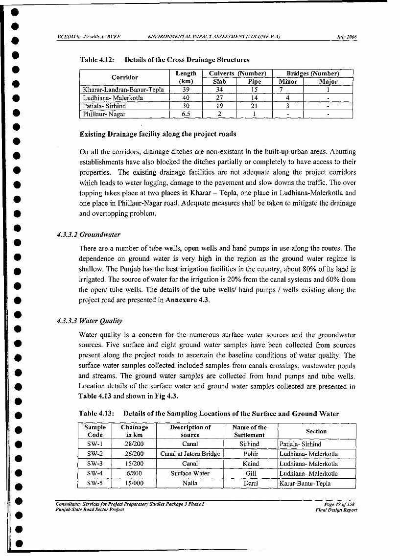
BCEOH in JV witl AAR l'EE ENVIRONMENTAL IAJPACTASSESSMENT (VOL UME V-A) July 2006
Table 4.12: Details of the Cross Drainage Structures
Corridor Length Culverts (Number) Brid es (Number)(km) Slab Pipe Minor Major
Kharar-Landran-Banur-Tepla 39 34 15 7I1Ludhiana- Malerkotla 40 27 14 4Patiala- Sirhind 30 19 21 3Phillaur- Nagar 6.5 2 1 _
Existing Drainage facility along the project roads
On all the corridors, drainage ditches are non-existant in the built-up urban areas. Abuttingestablishments have also blocked the ditches partially or completely to have access to theirproperties. The existing drainage facilities are not adequate along the project corridorswhich leads to water logging, damage to the pavement and slow downs the traffic. The overtopping takes place at two places in Kharar - Tepla, one place in Ludhiana-Malerkotla andone place in Phillaur-Nagar road. Adequate measures shall be taken to mitigate the drainageand overtopping problem.
4.3.3.2 Groundwater
There are a number of tube wells, open wells and hand pumps in use along the routes. Thedependence on ground water is very high in the region as the ground water regime isshallow. The Punjab has the best irrigation facilities in the country, about 80% of its land isirrigated. The source of water for the irrigation is 20% from the canal systems and 60% fromthe open/ tube wells. The details of the tube wells/ hand pumps / wells existing along theproject road are presented in Annexure 4.3.
4.3.3.3 Water Quality
Water quality is a concern for the numerous surface water sources and the groundwatersources. Five surface and eight ground water samples have been collected from sourcespresent along the project roads to ascertain the baseline conditions of water quality. Thesurface water samples collected included samples from canals crossings, wastewater pondsand streams. The ground water samples are collected from hand pumps and tube wells.Location details of the surface water and ground water samples collected are presented inTable 4.13 and shown in Fig 4.3.
Table 4.13: Details of the Sampling Locations of the Surface and Ground WaterSample Chainage Description of Name of the Section
Code in km source SettlementSW-i 28/200 Canal Sirhind Patiala- SirhindSW-2 26/200 Canal at Jatora Bridge Pohir Ludhiana- MalerkotlaSW-3 15/200 Canal Kaind Ludhiana- MalerkotlaSW-4 6/800 Surface Water Gill Ludhiana- MalerkotlaSW-5 15/000 Nalla Darri Karar-Banur-Tepla
Consultancy Servicesfor Project Preparatory Studies Packa-ge 3 Phase I Page 49 of 158Punjab State Road Sector Project Final Design Report

0BCEOhlin JVwitl AARVEE EAVIRONMENTAL IMPACTASSESSMIENT(VOLUME V-A) Julr 2006
Sample Chainage Description of Name of theCode in km source Settlement SectionGW-1 20/600 Hand Pump Rurkee Patiala-Sirhind
* GW-2 8/800 Tupe Well Hardaspur Patiala-Sirhind* GW-3 42/800 Hand Pump Malerkotla Ludiana- Malerkotla
GW-4 19/000 Hand Pump Dehlon Ludhiana- Malerkotla* GW-5 4/200 Hand Pump Nagar Phillaur- Nagar* GW-6 6/200 Hand Pump Landran Kharar-Banur-Tepla
GW-7 0/600 Hand Pump Kharar Kharar-Banur-TeplaGW-8 38/500 Hand Pump Rajgarh Kharar-Banur- Tepla
.0
.
.
0
*Consu(anecy Servicesfor Project PreparaJory Studies Packeage 3 Phase I Page 50 qf l58Punjab State Road Sector Project Final Design Report
0

BCEOM in JVwitl AARVEE ENVIRONMENTAL IMPACTASSESSMENT(VOLUME V-A) July 2006
Nagar- H..d P..p at Ch4.200 I
Rupnagar
Ludhiana
GW4HadP.. anaCW4d P- 3mra la iat Ch.19.000 Khamoan
SW2 Kalan KhararCanal at Ch 26.200
H..d P.mp t Ws Chandigarh> > J^ot- BHIse Pis alCh C Z00 i iI Khanna saa Wat., SW4
AhmedFarr SgWS Ch15200 'heb Ch\6.00,C.nal *{ 1, SW5
Raikot Amloh S,rhind Ch 15
\ SW .C1 .1Ch.28.200 H;nd P mt
Ch :30 .600 GVEIGW3X\ Maler Kotla cW2Hand P._p Rajpuraat Ch:42.500 CTl 8.60 |Ra a
GWIHand pump *, .Tepla
Ch:2H.60O
Ch so iCC WawN3ar =r Ambala
- 1LEGEND:-Patiala RAILWAYTRACK
MAIN CANAL
_ _BRANCH CANAL
PROJECT: -TITLE:PUNJAB STATE ROAD SECTOR PROJECT LOCATION OF SURFACE WATER & GROUND WATER SURFACEWATER OWl 1
4FIGURE 4.3 GROUND WATER oWl 0
Figure 4.3: Location Map for Ground and Surface Water Samples
Consultancy Services for Project Preparatory Studies Package 3 Plhase I Page 51 of 158Punjab State Road Sector Project Final Design Report

BCEOMhin JVwithMAARVEE ENVIRONMENTAL IMPACTASSESSMENT (VOLUME V-A) July 2006
* The water quality of the surface water and ground water samples collected along project* roads are presented in Table 4.14 and Table 4.15 respectively. These samples were
analyzed for all essential characteristics and for most of the desirable characteristicsspecified in IS 10500: 1991, and are analyzed in accordance with the standard methlodsspecified by IS codes.
Table 4.14: Characteristics of Surface Water
S. Parameters SWi SW2 SW3 SW4 SW5 Limits IS:* No. 10500
I Colour (Hazen) Colour Colour Colour Muddy Muddy 10* less less less
2 Turbidity (NTU') 06 8.0 12.0 - - 10* 3 PH 7.2 7.5 7.6 8.2 7.8 6.5 to8.5
4 Total dissolved solids (mg/l) 152 196 210 280 280 5005 Total Suspended solids (mg/I) 16 26 29 205 156 -6 Oil and grease (mg/l) Nil Nil Nil Nil <1 Absent
* 7 Total residual Chlorine as Cl2 Nil Nil Nil Nil Nil 0.27 Ammonical nitrogen (mg/I) Nil Nil Nil Nil <0.1 -
* 9 Dissolved oxygen (mg/I) 8.1 7.2 7.9 Nil 5.6 -10 BOD for 3 days at 27 °C (mg/1) 1.6 2.0 1.9 15 56 -
* 11 COD (mg/l) 5.8 8 6 52 138 -
12 Chloride as Cl (mg/l) 10 19 16 224 106 25013 CynideasCN (mg/I) Nil Nil Nil Nil Nil 0.05
* 14 Fluoride as F (mg/1) <0.1 Nil Nil Nil 0.34 1.515 Total Iron as Fe (mg/I) 0.1 0.10 0.10 0.06 0.10 0.3
* 16 Dissolved phosphates as P Nil Nil Nil Nil 1.8 -17 Sulphates as SO4 (mg/I) 4 18 22 35 34 200
* 18 Phenolic compounds asC 6 H5 OH Nil Nil Nil Nil Nil 0.001(mg/l)
* 19 Calcium as Ca (mg/1) 12 16 19 13 22 7520 Magnesium as Mg (mg/1) 15 28.2 31.6 29.2 38 30
* 21 Sodium as Na (mg/I) 29 36 44 58 68 -
22 Potassium as K (mg/1) 3 1 1 12 2 -* 23 Total hardness CaCO 3 (mg/1) 92 157.5 179 154 213 300
24 Manganese as Mn (mg/I) <0.01 <0.01 <0.01 <0.01 <0.01 0.3* 25 Nitrate as NO3 (mg/I) 1.24 1.4 1.3 1.9 10 45
*Samples were collected in November-December 2005.
Table 4.15: Characteristics of Ground Water*
* S. Parameters GW2 GW2 GW3 GW4 GW5 GW6 GW7 GW8 Limits* No IS: 10500
1 Colour (Hazen) Colourless Colourless Colourless Colourless Colourless Colourless Colourless Colourless 10* 2 Turbidity (NTU) I 1 1 <1 1 I I <1 10
3 PH 7.4 7.6 7.5 7.8 7.9 7.40 7.56 7.40 6.5 to8.5* 4 Total dissolved solids 380 395 470 418 386 386 411 415 500
(mg/l)
5 Total Suspended solids <1 <1 <1 <1 <1 1 <1 <1 -* (mg/I)
6 Oil and grease (mg/I) Nil Nil Nil Nil Nil Nil Nil Nil Absent* 7 Total residual Chlorine as Nil Nil Nil Nil Nil Nil Nil Nil 0.2
* ' Nephelometric Turbidity Units
Consultancy Services for Project Preparatory Studies Package 3 Phase I Page 52 of 158Punjab State Rood Sector Project Fin al Design Report
0

BCEOMin JVwithAARVEE ENVIRONMENTAL IMPACTASSESSMENT(VOLUME V-A) Julpi 2006
* S. Parameters GW2 GW2 GW3 GW4 GW5 GW6 GW7 GW8 LimitsNo IS: 10500
* 8 Ammonical nitrogen Nil Nil Nil Nil Nil Nil Nil Nil -*_ (mg/l)
9 Dissolved oxygen (mg/I) 5.0 5.2 6.6 5.5 4.5 5.0 5.2 6.0 -* 10 BOD for 3 days at 27 °C 0.4 0.2 0.4 0.1 <0. 2 0.1 <0.1 0.2 -
(mg/I)* 11 COD (mgA) 2.0 1.0 1.5 1.3 <1 1 <I 2 -
12 Chloride as Cl (mg/l) 116 158 95 102 178 120 136 133 250* 13 Cynide as CN (mg/l) Nil Nil Nil Nil Nil Nil Nil Nil 0.05
14 Fluoride as F (mg/I) 0.6 0.5 0.61 0.72 0.7 0.6 0.5 0.6 1.5* 15 Total Iron as Fe (mg/I) 0.03 0.06 0.1 0.07 0.1 0.3 0.25 0.1 0.3* 16 Dissolved phosphates as Nil Nil Nil Nil Nil Nil Nil Nil -
P* 17 Sulphates as S04 (mg/l) 40 56 29 18 19 33 31 28 200
1 8 Phenolic compounds Nil Nil Nil Nil Nil Nil Nil Nil 0.001* asC 6 H5 OH (mgAi)
19 Calcium as Ca (mg/l) 19 26 28.0 36.0 30 16 21 28 75* 20 Magnesium as Mg (mg/I) 33 45 51.0 69 46 36 39 44 30
21 Sodium as Na (mg/l) 78 91 71 82 62 37 49 54 -* 22 Potassium as K (mg/l) 2 I I I 1.6 2 1 1 -* 23 Total hardness CaCO3 136 109 282.5 287.5 266 190 215 252 300
(mg/I)
* 24 Manganese as Mn (mg/I) <0.01 <0.01 <0.01 <0.01 <0.01 <0.01 <0.01 <0.01 0.325 Nitrate as N0 3 (mg/I) 1.19 1.28 1.0 1.1 4.2 06 04 03 45
* *Samples were collected in November-December 2005.
0 The characteristics of the ground water and surface water samples were found to be wellwithin the standard limits specified for the water quality characteristic for the desirable
* limits as specified in BIS10500: 1991 except a few deviations for the surface water. The* deviations are, turbidity of SW -3 found to be more that the standard and turbidity of the
SW-4 and SW-5 could not be analyzed due to muddy nature of the samples. BOD and CODvalues in drain water and wastewater ponds have been found to be high due to flow of
* domestic wastewater into the stagnant ponds. The surface water sources are not being used* for drinking water.
* 4.3.4 Land Environment
* Land and soil constitute the basic components of the physical environment. The alignment* of a road may cause changes in land, land use, soil and denudation processes in different0 intensities.
* 4.3.4.1 Geology and Soils
* Topography: All the project roads pass through flat terrain. The mean elevation of the study* area varies from 253 to 270 m above the Mean Sea Level and the general slope direction isl south west. The rivers in the state of Punjab have steep slopes in upper reaches and traverses
plains for varying length before spreading out and disappeared by infiltration or joining* other water courses.
S* -_ - _ -_ - - -Consultancy Servicesfor Project Preparatory Studies Package 3 Phase I Page 53 of 158Punjab State Road Sector Project Final Design Report
0

BCEOMin JVwithAARVEE ENVIRONMENTAL IMPACTASSESSMENT(VOLUME V-A) July 2006
Geology and Soil Types of the Area: Punjab has five land form regions, three major riversystems, three climatic regions with varied temperatures, moisture regimes and type ofvegetation. Punjab lies on the alluvial plains of the tributaries of Indus river, namely Sutlejand Beas. The state is bounded on the north and north-east by the Shivalik Ranges of thelower Himalayas. The alluvial deposits of the rivers can run very deep and are very fertile.Based on the interdependence of all these factors, spreading over time resulted in theformation of various types of the soils. The land use along the road sections under study ispredominantly agricultural.
Hilly areas are in the eastern districts of the state, which border the state of HimachalPradesh. These districts also fall along the foothills of the Shivalik range and are the sourceof the hard rock and fine aggregates.
The soils along the project roads can be broadly classified into two categories, viz.:
* "Khadar" or "Bet" soils found along the flood banks of rivers.
* "Sierozem" Soils -are grey coloured soils found in semi-arid parts of Punjab with anaverage annual rainfall between 500 mm to 700 mm. These soils are found in mostparts of Malwa plains of Punjab and consist of sandy silts in most areas.
4.3.4.2 SoilAnalysis
For the assessment of the base line soil quality, soil samples were collected at 7 locationsfrom agricultural fields along the project roads. Details of the soil sampling locations arepresented in Table 4.16 and shown in Figure 4.4. Soil samples were collected up to a depthof 60 cm. The soil samples consist of representative samples of all corridors.
Table 4.16: Location Details of Soil Samples
Sample Code Location of Sample Project Chainage in km Land UseSirhind - Patiala
SQ| Nandpur Keso Village 13.500 | Agricultural FieldSQ2 Lattour Village 22.400 Agricultural FieldLudhiana- MalerkotlaSQ3 Kubkalan Village 33.500 1 Agricultural FieldSQ4 Kaind Village 14.000 | Agricultural FieldPhillaur - Nagar
SQ5 I Garha Village | 4.200 ] Agricultural FieldKharar- Banur- TeplaSQ6 Landran Village 6.500 1 Agricultural FieldSQ7 Tepla Village 38.500 Agricultural Field
All these soil samples collected along the proposed project roads were analysed for thephysical, chemical properties and heavy metal concentrations. They were assessed foragricultural and afforestation potential. The characteristics of the soil along the projectroads are presented in Table 4.17.
Consultancy Servicesfor Project Preparatory Studies Package 3 Phase I Page 54 of 158Punjab State Road Sector Project FinPag esign ofportatDsgnRpr

BCEOMin JVwitlhAARVEE ENVIRONMENTAL IMPACTASSESSMENT (VOLUME V-A) July 2006
- ah = - Nagar,
Phhl1113rr
; u : Pupnaqar
Ludhiana<; X
;-4 -:'arwalai rKa,nd .Khamoan
.. ';Kalan aanKbarar Chandigarh
Payal - Khanna
Ahmedgarh i \ b b \ .draa
Raikot Amloh S.rhind
Ku p ka I.
P1aler K<olIa Rajura_ ,
Na.dp.. K...
S5 2 .. T.T pi 7 SB r
/ \ . ' Tepla-JNabha - Amnala
Dhuri = -l _ _
JE C T -e - _ _ _ _ _ _ _- Patiala LEGEND:-
RAILWAY TRACK f
TIL- - r ------MAIN CANALPROJECT: TfA TLE_ - - -PUNJABSTATE ROAD SECTOR PROJECT SAMPLING LOCATON MAP FOR SOIL SAMPLE COLLECTION BRANCH CANAL
FIGURE: 4 [4 SOIL SAMPLE = SS.1IJ
Figure 4.4: Soil Sample Locations
Consultancy Servicesfor Project Preparatory Studies Package 3 Pliase I Page 55 of 158Punjab State Road Sector Project Final Design Report
* *0 * * * 0 000

BCEOMin JVwithAARVEE ENVIRONMENTAL IMPACTASSESSMENT(VOLUME V-A) Julg 2006
Table 4.17: Soil Characteristics of along the Project Roads*
S. No. Parameter Unit SQ-I SQ-2 SQ-3 SQ-4 SQ-5 SQ-5 SQ-6
1 pH of(10% Extract) 7.45 7.8 7.45 8.1 7.6 7.7 7.8
2 Water Holding (%) 48.9 46.0 53.9 56.0 38 41 46
Capacity
3 Bulk Density (gm/cm3) 1.46 1.51 1.56 1.62 1.49 1.53 1.58
4 Sand (%) 46.84 49.46 50.76 61.46 55.46 52.26 46.29
5 Silt (%) 18.60 20.42 24.40 19.42 21.34 24.74 26.74
6 Clay (%) 34.56 30.12 24.84 19.12 23.20 23.00 26.92
7 Cation Exchange (meq/100 16.20 15.20 18.20 21.20 17.60 18.60 18.0
Capacity * gm)
8 Porosity (%) 43.05 43.50 46.05 43.50 48.30 51.60 49
9 Total kjeldal Nitrogen (%) 0.08 0.10 0.06 0.10 0.03 0.04 0.02
(TKN)
10 Phosphorus (mg/kg) 12.96 21.0 11.96 21.46 8.90 14.6 11.9
11 Potassium (mg/kg) 350 450 300 456 276 314 274
12 Carbonates (meq/l00 NIL NIL NIL NIL NIL NIL NIL
gm)in
13 Bicarbonates (meq/100 510 550 500 431 476 179 89
gm)
14 Sulphates (meq/100 580 602 601 802 491 247 169
gm) I_II_
15 Iron (mg/kg) 55 60 52 57 41 56 70
16 Chlorides (mg/kg) 493 564 493 534 501 384 418
17 Lead NIL NIL NIL NIL NIL NIL NIL
18 Cadmium (mg/kg) BDL BDL BDL BDL BDL BDL BDL
19 Chromium (mg/kg) BDL BDL BDL BDL BDL BDL BDL
20 Zinc (mg/kg) 0.3 0.8 0.40 0.6 0.9 0.6 0.57
*Samples were collected in November-December 2005.Note:BDL - Below Detection LimitMeq - milli Equivalent* - Cation and anion are determined in 10% Extract Solution
From the results it can be observed that the soil type varies from sandy loam to clayeyloam, grey in colour and deficient organic matter. pH value ranges between 7.6-8.1.Phosphorus content is high in all samples. From the results it can be observed that the soilin the project area is fertile with high agricultural productivity with appropriate use offertiliser.
4.3.4.3 Soil Erosion
The improvement works of the Project roads involves new earth work formations and newslope construction for the protection of the embankments. A detailed survey was carriedout for analyzing the erosion control measures required to be taken up as part of theimprovements. Details of present slopes of the project roads are presented below;
Consultancy Servicesfor Project Preparatory Studies Package 3 Phase I Page 56 of 158Punjab State Rood Sector Project Final Design Report

BCEOMin JVwithAARVEE ENVIRONMENTAL IMPACTASSESSMENT(VOLUME V-A) July 2006
Kharar-Landran: On this road stretch, damage from erosion was minimal, except in km5.8-6.4, where embankment slopes along the bridge abutment fills suffered severe erosionfrom water flowing along the drains. The outfall slope also was moderately damaged. Thesoils in this corridor are silty clay to clayey silts and are susceptible to erosion. The slopeheights are mostly less than 2 m, which is responsible for low incidence of slope erosionproblems in this stretch.
Landran-Banur: Also on this road stretch, damage from erosion was minimal, except atkm 15 where embankment slopes along the bridge abutment fills suffered severe erosionfrom water flowing along the drain into the river. The outfall slopes were moderatelydamaged. The soils in this corridor are silty clay to clayey silts and are susceptible toerosion. The slope heights are mostly less than 2 m, which is responsible for low incidenceof slope erosion in this stretch.
Banur-Tepla: On this road stretch, slope distress was common. The distress ranges fromsurface erosion of slopes to formation of gullies. At few locations slope experienced slumptype movements. At locations where water from the stream or other side drain was flowinginto natural streams or other outlets, and the level difference between the drain and theoutlet was more than 1-1.5 m, the outfall drain had severe erosion. This was also observedat locations where the height of embankment was of the order of 3 m.
The high frequency of erosion related distress in this section may be attributed to thefrequent floods and relatively high slopes.
Ludhiana - Malerkotla: Embankment heights are moderate to low, mostly from 1.5m andless over most of the stretch. The soil almost entirely consists of clays of high tointermediate plasticity that offers resistance to surface erosion. In this stretch, highwayslopes are relatively free of surface erosion problems.
Patiala - Sirhind: No damage from surface erosion to slopes was observed in thiscorridor. The height of embankment is low, and rarely exceeds 2 m. Although the soil typeis susceptible to erosion, the low embankment height has the effect of reducing thedamaging impact.
Phillaur- Nagar: The road is mostly on low embankments. Although soils are susceptibleto erosion, no erosion related distress was observed due to the low embankment heights.This stretch is relatively free of erosion problems.
4.3.4.4 Land use
The project roads traverse through rich agricultural land on either side which primarily isused for cultivation of wheat, rice and pulses. Important urban settlements located alongthe project stretches on the outskirts of which residential layouts are being constructed.Industrial areas also align along the project stretches particularly in the stretch of Ludhiana-
Consultancy Servicesfor Project Preparatory Studies Package 3 Phase I Page 57 of 158Punjab State Road Sector Project Final Design Report

BCEOMin JVwith AARVEE ENVIRONMENTAL IMPACTASSESSMENT (VOLUME V-A) July 2006
Malerkotla and partially on the outskirts of Kharar town on the Kharar-Banur-Teplastretch. Other commercial, residential, religious and other structures are found at locationsalong the road where there is a village or ajunction.
Land use on Klharar-Banur-Tepla road comprise primarily of agricultural land used forcultivation of wheat and rice. Residential and commercial land use is found only alongtown / village locations and major junctions. Semi industrial areas are found along theoutskirts of Kharar town. Fallow/ barren land covers a small portion of this stretch betweenkm 15+000 and km 19+000 in scattered patterns.
The Ludhiana-Malerkotla road covers two important industrial locations, namelyLudhiana and Malerkotla. Commercial / industrial establishments are located all along thisroad from Km 6+000 to 12+000. Increasing industrial demand from Ludhiana has croppedup various metal related industries on this road. Both Ludhiana and Gill, a congestedvillage, has necessitated the need for residential colonies along the project stretch until km12+000. Malerkotla, also a very congested town accounts for commercial/industrialestablishments from km 41+000 to 45+000. Other places which account for significantresidential and commercial land use are the villages of Dehlon and Pohir with densesettlements. The rest of the project stretch runs along rich agricultural fields whereprimarily wheat and rice is cultivated.
The Phillaur-Nagar road falls in Jalandhar district and connects Ludhiana with the city ofNawanshahr. Phillaur consists of dense commercial and industial settlements as it is animportant station both via road and rail. Proximity to both Ludhiana and Jalandhar makesPhillaur a significant place. For a stretch of 500m, there is forest land on both sides fromkm 0+700 to km 1+300. Mainly the rest of the stretch consists of fertile agricultural land.The village of Nagar also accounts for residential and commercial land use for a stretch of800m.
The Patiala-Sirhind road connects the important city of Patiala to the NH-I. Thickresidential/ commercial establishments exist from Patiala (1+270) to km 8+000. The rest ofthe stretch barring a few villages mostly passes through agricultural land cultivating wheatand rice.
Table 4.18: Land use Pattern along the Project Roads
Name of the corridor Land useKahara-Banur-Tepla Predominantly agricultural with the settlements namely
Kharar, Santemajra, Landran, Bairampur, Bhagomajra, Raipur kalan,Saneta, Darri, Tangori, Banur, Kheda, Basma, Tepla, Rajgarh andkherigurna
Ludhiana-Malerkotla Predominantly agricultural with the settlements namelyGill, Ranian, Sarinh, Kaind, Saya, Dehlon, Gopalpur, Lehra, Pohir,Akbarpur Channa, Rohira, Phalewal, Kupkhurd, Kupkalan, Bhogiwal.Ghouspura and Malerkotla
Phillar-Nagar Predominantly agricultural with the settlements namely
Consultancy Services for Project Preparatory Studies Package 3 Phase I Page 58 of 158Punjab State Rood Sector Project Final Design Report

BCEOM in JVwithAARVEE ENVIRONMENTAL IMPACTASSESSMENT (VOLUME V-A) July 2006
Name of the corridor Land use
Phillaur, Garha and NagarPatiala-Sirhind Predominantly agricultural with the settlements namely
Patiala, Hardaspur, Kashyana, Faggan Majra, Bhagadiyar, GuniyaMajra, Jagwali, Rurkee, Kharori and Adampur
4.3.5 Natural Resources Consumption
Detailed analysis of the availability of construction material such as selected soil, hardrock, fine aggregates and coarse aggregates was carried out as part of detailed engineeringdesign. During the investigations soil borrow areas and quarries for fine and coarseaggregates were identified. For this purpose local enquiries were made and discussionswere held with local PWD officials and the data available was assessed to identify theexisting and new sources for soil borrow areas, fine and coarse aggregates. Details of theeach type of material source is detailed in the following section
4.3.5.1 Borrow Areas
A Total of twenty one soil borrow areas for subgrade construction were located for theproject, of which 5 are in Ludhiana- Malerkotla link, 2 are in Phillaur- Nagar link, 6 are inPatiala - Sirhind link and 8 are in Kharar- Tepla Link. Location details of borrow areasidentified for the project roads are presented in Table 4.19 and shown in Annexure 4.4.
The land on both the sides of the project road have intensive cultivation and soil borrowareas are hard to come by. Due to this the haulage distance for borrow area material can behigh (up to 15 km).
Table 4.19: Locations of Soil Borrow Areas for Earth Works
N Nearest Project Lead From Side of Type ofS. No. Village Name road Chainage in Project Road Material
km in kmLudhiana - MalerkotlaLM - BI Bula | 12.00 3.00 LHS Selected FillLM -B2 Mommanabad | 29.00 4.0 LHS Selected FillLM - B3] Mommanabad 29.00 4.0 LHS Selected FillLM-1B4 Baliwal - 40.00 2.0 LHS Selected FillLM - B5 Malerkotla | 43.00 2.0 RHS Selected FillPhillacur - NVagarPN-Bl Nagar 6.30_ 0.50 RHS Selected FillPN - B2 Kadiana 6.304.00 RHS Selected FillPatiala - NH I Jccnction (Near Sirhind)SP-B I Reet Kheri 9.50 4.00 RHS Selected FillSP - B2 Saifalpur/ Sankar 15.00 4.00 RHS Selected FillSP-1B3 Nalina Kalan 21.00 3.00 RHS Selected FillSP - B4 Jalan* 0.00 10.00 Selected FillSP-1B5 Birpur* 0.00 10.00 Selected FillSP-1B6 Mandaur* 0.00 16.00 Selected FillKharar- TeplaKT-BI Tirpadi 0.00 3.00 RHS Selected FillKT - B2 Daurali 14.00 1.0 LHS Selected FillKT- B3 Daurali 14.50 1.0 LHS SelectedFill
Consultancy Servicesfor Project Preparatory Studies Package 3 Phase I Page 59 of 158Punjab State Road Sector Project Final Design Report

BCEOMlin JVwithAARVEE ENVIRONMENTAL IMPACTASSESSMENT (VOLUME V-A) Julv 2006
* Nearest Project Lead From Side of Type ofS. No. Village Name road Chainage in Project Road Sid Material
km in kmRodMtraKT-1B4 Mota Majra 19.30 1.0 RHS Selected Fill
* KT - B5 Chat 22.40 6.0 LHS Selected FillKT - B6 Shak Majra 23.00 3.0 LHS Selected FillKT - B7 Dharam Garh 26.25 0. 200 LHS Selected Fill
i KT-1B8 Basma 33.05 1.0 LHS Selected Fill
* Patiala Nabha Road
0i 4.3.5.2 Stone Quarries
* At present, river boulders along with gravels transported from the hills by the Ghaggar,a Sutlej and Sirsa Rivers are deposited at the foothills, as the rivers enter the plains. The river
boulders and gravel are being washed and crushed, at various locations for use in* construction.
For the project two sources of boulder material are recommended based on the availability* of sufficient quantity of the materials. Details of the sources identified are presented ina Table 4.20 and show in Annexure 4.5.
* Local enquiry at the crusher locations indicates that there are about 42 Crushers and wash0 gravel plants at Burj Kotian. A smaller number of crushers and wash plants operate at
Mubarakpur and Bharatgarh. The quantity of river boulder supply at Bharatgarh is reported* to be insufficient to meet the demand of the crushers, whereas the supply of raw material at* Burj Kotian and Mubarakpur is sufficient. The source of raw material for both Mubarakpur0 and Burj Kotian crushers is in the same area and of similar nature.
* Table 4.20: Details of the Source of Aggregates and Lead Distances from Projectroads
Source Project Distance from Burj Kotian Distance from Bharatgarh* Road Crusher Location in km Crusher Location in km* Ludhtiana Malerkotla
Ludhiana | 135 km 95 km* Malerkotla 135 km 135 km
Pltillaur Nagar
* Phillaur 152 km 112 kmNagar 158 km 118 km
l Patiala - NH I Junction (Near Sirhind)Patiala 75 km 95 km
l NH I Junction (near Sirhind) 75 km 65 kmKlharar- Banur - Tepla
* Kharar 40 km 75 km- Banur 40 km 50 kmS Tepla 60 km 90 km
* Reconnaissance was carried out in the areas around Ropar and Nawanshahr districts of* Punjab, in view of proximity to site. Though no commercial extraction of gravel material0 was found at any location, sources of materials are available in the bed of "Nallas" or
Consultancy Servicesfor Project Preparatory Studies Package 3 Phase I Page 60 of 158Punjab State Road Sector Project Final Design Report
0S

BCEOMin JVwithAARVEE ENVIRONMENTAL IMPACTASSESSMENT (VOLUME V-A) Julv 2006
streams at Mianpur (Rupanagar District) near Kurali and Garhshankar. A number of otherlimited sources may be available along the foothills in these districts and the Contractormay investigate these to assess suitability and economic lead/ viability for project roads.
4.3.5.3 Sand
In the State of Punjab sand is available in two forms from two types of sources i.e., fromriver bed and washed river sand from crushers. Based on the quality criteria wash riversand from the crushers is recommended as sand from river beds is very fine and does notpass the fineness modulus requirements for sand to be used in concrete. Sources Identifiedfor the procurement of the sand are as follows;
l1. Ghaggar River near Tepla
2. Sutlej River bed near Nagar
3. Crusher at Bharatgarh
4. Crusher at Burj Kotian
4.4 ECOLOGICAL RESOURCES
Ecological resources are among the most important resources impacted by the road projects.The detailed baseline study of the ecological resources is essential to estimate the magnitudeof potential impacts and to avoid or mitigate any loss caused by the proposed project. In thissection baseline details of the flora and fauna are presented.
There are no endangered species of flora and fauna present within the project influence area.No eco sensitive receptors such as wild life park, national parks, wet lands, bird sanctuaries,reserve forest, etc. are located within the project influence area.
4.4.1 Flora
There is no natural/reserve forest area in theproject region. Roadside plantation is seen allalong the project corridor and theseplantations have been declared as "Protected -Forests", under the Forest (Conservation) -
Act, 1980. The photo shows a view of -.
roadside plantation. The existing trees alongthe proposed project roads vary from denseto sparse. Green tunnel is not observed along 'ie% or ihe Road%ide Plantation
any project roads. Most of the trees presentwithin the ROW are Arjun, Sishu, Babul, Eucalyptus, Kikar, Neem and Dek. There are atotal number of 26,640 trees existing in the ROW. The majority of trees are of girth size 30-
Consultancy Servicesfor Project Preparatory Studies Package 3 Phase I Page 61 of 158Punjab State Rood Sector Project Final Design Report

BCEOMin JVwithAARVEE ENVIRONMENTAL IMPACTASSESSMENT(VOLUME V-A) July2006
60 cm, 60-90 cm and 90-180 cm. The Protected Forest area and number of trees found in theexisting ROW.n in Table 4.20a The details of species of trees, shrubs and groundcoverpresent in the project area are given in Annexure 4.6.
Table 4.20a: Details of Roadside Protected Forest Area and Trees within ROW
Roadside Protected Forest Number of Roadside treesName of the Corridor area with in ROW (Ha.) with in ROW Nos.
LHS RHS Total LHS RHS TotalKharar-Banur-Tepla 32.76 33.19 65.95 5,980 5,220 11,200Ludhiana-Malerkotla 36.36 36.36 72.72 7,500 6,690 14,190Phillaur-Nagar 4.85 4.85 9.68 645 605 1,250
4.4.2 Fauna
There is no reported wild life along the project except for domesticated animals and birds.The area harbours grainivorous avian fauna because agricultural grains in the field providefood for such birds. The mammalian fauna mainly constitutes domesticated animals androdents. Toads, lizards and snakes represent amphibian and reptilian fauna. The major faunain the study area is given in Annexure 4.7.
4.5 SOCIO-CULTURAL ENVIRONMENT
4.5.1 Demographic Features
Kharar Banur Tepla: The project road passes through the districts of Roopnagar andPatiala. From the 2001 census Roopnagar district comprises of 7 blocks, 11 towns and 867in habited villages and Patiala district comprises of 9 blocks, 14 towns and 1069 inhabitedvillages. According to 2001, census the total population of Roopnagar and Patiala is111,000 and 1,839,056 respectively. The literacy rate for Roopnagar is greater (78.49%) incomparison to Patiala (70%). The work participation rate for the project districts is almostsame Roopnagar (39.3%) and Patiala (37.2%).
Ludhiana Maler Kotla: The project stretch passes through the districts of Ludhiana andSangroor. The total population of Ludhiana and Sangroor is 3,030,352 and 1,998,464respectively, which is about 12.48 and 8.23 percent of the total population of the entirePunjab State. The literacy rate for Ludhiana is greater (76.54%) in comparison to Sangroor(60.04%). The work participation rate for the project districts is almost equal in Ludhiana(37.8%) and Patiala(40.6%).
Phillaur- Nagar: The project stretch passes through the district of Jalandhar. From the2001 census Jalandhar district comprises of 10 blocks, 14 towns and 945 inhabited villages.The total population of Jalandhar is 1,953,508, which is about 8.04 percent of the totalpopulation of the entire Punjab State. The percentage of urban population is about 47.45.
Consultancy Services for Project Preparatory Studies Package 3 Phase I Page 62 of 158Punjab State Road Sector Project Final Design Report

BCEOMin JVwith AARVEE ENVIRONMENTAL IMPACTASSESSMENT(VOLUME V-A) Julv 2006
As per the 2001 census the literacy rate for Jalandhar is 77.91 and the sex ratio is 882. Thework participation rate for the project district is very low about 34.5.
Patiala Sirhind: The project stretch passes through the districts of Patiala and FatehgarhSaheb. From the 2001, census the total population of Patiala and Fatehgarh Saheb is1,839,056 and 539,751 respectively, which is about 7.57 and 2.22 percent of the totalpopulation of the entire Punjab State. The percentage of urban population for these districtsis low and stands at 35 percent for Patiala and 28 for Fatehgarh Saheb. The literacy rate forFatehgarh Saheb is greater (74%) in comparison to Patiala (70%). The work participationrate for the project districts is almost same Fatehgarh Saheb (38%) and Patiala (37.2%).
4.5.2 Socio-economic Profile of Project Affected People
The analysis of socio-economic survey carried out during the social assessment indicatesthat the majority of the PAPs belong to the higher income groups and few of them belongto the lower income groups. The majority of them belong to the higher castes followed byScheduled Castes and Other Backward Classes. Religion wise, majority of them representSikh Community followed by Hindus.
4.5.3 Human Use And Cultural Values
The archaeological and cultural properties in the vicinity and in the regional context in theproject corridors share mutual interest with highway travellers. The baseline data for thecultural screening exercise identifies and assesses the impact on culturally, historically andreligiously valued properties and proposes feasible avoidance/mitigation measures aftereffectively assessing the sensitivities and impact potentials.
4.5.4 Places of Historical and Cultural Significance
There are no specific heritage monuments orcultural heritage or protected monuments andarchaeological sites within 300m of the Project ,Road. However, Temples, Gurudwaras andMosques are present along the project roads. There
are a total number of 15 temples, 3 Gurudwarasand 3 Mosques existing along the project road.. Gurudwara along the Project Road
The summary of the cultural properties which are present along the project roads arepresented in Table 4.21. The details are presented in Annexure 4.8.
Consultancy Servicesfor Project Preparatory Studies Package 3 Phase I Page 63 of 158Punjab State Rood Sector Project Final Design Report

BCEOM in JVwith AARVEE ENVIRONMENTAL IMPACTASSESSMENT (VOLUME V-A) Julv 2006
Table 4.21: Details of Cultural Properties
Name of the Corridor Type of cultural property Nos.
Temples 12Kharar- Banur -Tepla Gurdwaras
Mosques* Dargahs 2
Temples 16Ludhiana- MalerkotIa Gurdwaras 8L Mosques 3
Dargahs 4* Temples 6
Patiala- Sirhind Gurdwaras* Mosques
DargahsTemples
- Gurdwaras 4* Phillaur- Nagar Mosques* Dargahs
4.5.2 Educational Institutions and Health Care Facilities
* There are a total number of 19 educational institutes and 7 health care facilities existingalong the pro ject road. The summary details of these facilities are given in Table 4.22. Thedetails are given in Annexure 4.9.
Table 4.22: Details of Educational Institutions and Hospitals
Name of the Corridor Type Nos.* Educational Institutes 7
Kharar- Banur -Tepla Hospitals 4Healthcare Facilities I
* Educational Institutes 17Ludhiana- Malerkotla Hospitals 6
* Healthcare Facilities IEducational Institutes 11
* Patiala- Sirhind HospitalsHealthcare Facilities
* Educational Institutes I* Phillaur- Nagar Hospitals I
Healthcare Facilities l__ I
0
Consultancy Servicesfor Project Preparatory Studies Package 3 Phase I Page 64 of 158Punjab State Road Sector Project Final Design Report

I S1SSSSSSSSSSaSSSSSSSSS* ETO :PBI OSLT IN
SSSSSS
i

BCEOMin JVwitriAARVEE ENVIRONMENTAL IMPACTASSESSMENT (VOLUME V-A) July 2006
5 PUBLIC CONSULTATION
5.1 INTRODUCTION
The main focus of all infrastructure development projects is to enhance and increasefacilities for the society and improve their living conditions. The road projects will bringoverall benefits to the people in the area as well as to those living close to the corridor.However, a few are likely to experience negative impacts, which can be overcome throughproper mitigation measures. Consultations with the community on social and naturalenvironmental concerns form an integral part of an Environmental Assessment of roadprojects. To ensure that the community support is obtained as well as the goodwill of thepeople, public consultations were carried out in villages along the project corridors. Peopleaffected by the project are those living and working along the corridor and includedbusinessmen, residents, farmers, agricultural workers, squatters and encroachers. Somereligious and cultural properties within the area of impact, may need relocation. Throughoutthe process of consultation, the focus was on understanding community impacts and toobtain their feedback to effectively establish appropriate road design and implementation.
Stakeholder consultation is a two-way process involving the interaction of variousstakeholders and the Project proponents. It is highly desirable for all key stakeholders toarrive at a consensus on sensitive features, impacts and remedial actions. The stakeholderconsultation is useful in gathering basic information
* On baseline environmental data
* Understanding likely potential impacts,
* Understanding the perspectives/concerns & preferences of stakeholders,
* Selecting Project alternatives, and
* Designing mitigation & enhancement measures to suite the local requirements.
Consultation with the concerned stakeholders requires information dissemination andsolicitation. In the course of public consultation, information regarding proposed Projectroads quickly reaches the public. Also the local community, residents and interested groupsmay provide valuable inputs into the Environmental Assessment (EA). Such stakeholderparticipation during initial screening of a Project helps to start the EnvironmentalAssessment on a constructive footing with the public.
To address the issues in the Project, systematic stakeholder assessment has been carried outas per the World Bank policy. For screening purposes, a representative set of consultationswere carried out by the feasibility consultants. The Design Engineering Consultant has
Consultnecy Servicesfor Project Preparatory Studies Package 3 Phase I Page 65 of 158Puinjab State Road Sector Project Final Design Report

BCEOMin JVwithAARVEE ENVIRONMENTAL IMPACTASSESSMENT (VOL UME I'-A) July 2006
carried out Consultations based on the recommendations of the feasibility Consultants andneed based additional consultations in all Project roads. Further consultations will becarried out during the Resettlement Action Plan and the pre construction stage, as required.
5.2 OBJECTIVES
The main objective of the consultation process is to identify and minimise negative impactsof the Project and to maximise the benefits of the project. Other objectives of theconsultation process are given below:
* To promote public awareness about the proposed Project especially amongst thepotentially impacted communities/individuals.
* To educate the potentially impacted communities/individuals about the proposedcourse of action and the Project alternatives.
* To solicit the views of affected communities/individuals on environmental andsocial problems.
* To gather inputs from the affected communities/individuals in crucial decisionsregarding mitigation of the identified environmental and social issues.
* To stimulate community self evaluation and analysis
* To inform Project Affected Persons (PAPs) about the entitlement framework andResettlement Action Plan (RAP), and to settle their problems with mutual consentand to assist them during relocation and resettlement.
* To ensure lessening of public resistance to change by providing them a platform inthe decision making process.
5.3 METHODOLOGY ADOPTED FOR PUBLIC CONSULTATIONS
5.3.1 Levels of Public Consultations and Profile of Stakeholders
Public consultation was conducted both at screening stage as well as project preparationstage. Consultations conducted at screening stage played an important role in scoping thelevel and extent of consultation to be taken in the project preparation stage. Publicconsultations have been held at three levels as follows:
Local level:
Public consultations in the project area were held at local level. The following steps havebeen adopted for carrying out public consultations in this project:
Consultoancy Services for Project Preparatory Studies Package 3 Phase I Page 66 of 158P,tnjab State Road Sector Project Final Design Report

BCEOMin JVwith AARVEE ENVIRONMENTAL IMPACTASSESSMENT(I OL UME V-A) July 2006
A Disseminating information and requesting villagers to attend the public consultationmeetings
* Sharing the opinions and identify the local environmental issues
A Involving the PAPs to avoide/mitigate the impacts
District level:
The disclosure of policy about the project and R&R policy provision were disclosed toworkshops and meetings at district levels. During the month of May and June 2006, fourdistrict level meetings were held at Ludhiana, Mohali, Taran Taran and Ferozpur. Similarlyfour workshops wee also held at Landran, Chunni, Chabal Main Market aand Rajatal.During the disclosure process the following information were disseminated:
* Objectives of PSRSP
* Implementing Agency
* Funding and Total estimated cost of the Project
* Objectives of proposed "Resettlement and Rehabilitation Policy"
* Entitlement matrix for Project Affected Persons
* A detailed presentation was made enlisting all entitlements as proposed in R&RPolicy.
* A presentation on Environmental issues was also made in order to generateawareness among the people and capture their perception on issues relating toenvironment.
Institutional level:
Institutional level consultations were held with State Forest Department and State PollutionControl Board.
* Forest Department: Discussed about the up-gradation proposal of the project roads,road side trees to be cut and requirement of forest clearance for felling of road sidetrees and compensatory plantation. It has been discussed about the diversion ofprotected forest land along the project roads, although ownership of this land vestswith Punjab PWD.
* Pollution Control Board: Discussed about the up-gradation proposal of the projectroads, source of quarries, borrow areas, disposal of solid waste (scarified materials)and source of water for construction.
Consultancy Servicesfor Project Preparatory Studies Package 3 Plhase I Page 67 of 158Punjab State Road Sector Project Final Design Report

BCEOM in JV withl AAR VEE ENVIRONMENTAL IMPACTASSESSMENT (I 'OL UME V-A) Julv 2006
5.3.2 Tools for Consultations
Public Consultation was done using various tools including interviews with governmentofficials, questionnaire based information with stakeholders, discussions with thestakeholders and project affected people;
Structured Interviews: Individual household level surveys were carried out usingstructured formats as part of census and socio-economic surveys
Informal discussion: A reconnaissance survey was carried out at the initiation of theproject, informally drawing project affected people (PAP) into dialogue to obtain anoverview of likely impacts and concerns of the community. The key informants during theproject preparation phase included both individuals and groups namely:
* Head and members of the households likely to be affected
* Groups/clusters of PAPs
* Village Panchayats: Sarpanch and members
* Government agencies and departments
* Other project stakeholders with special focus on women and people belonging to thevulnerable group.
A checklist of questions was kept ready and responses were elicited from people andguidelines were issued to field assistants for the purpose. The questions were kept simplefor people to comprehend. Notes were made for the responses and viewpoints presented bypeople.
Focus Group Discussions: Focus Group Discussions (FGDs) were held at selectedlocations along the four sections of the Project Roads. During the FGD,interaction/discussion was held with the general public and the village sarpanchs. Thepublic consultations in the project area were mainly conducted at the local level i.e. atvillage level.
5.3.3 Selection of Locations for Consultations
Public Consultations were conducted by the consultant through Group Discussions (GDs)and mass meetings with the PAPs as well as the general public in the villages and townsalong the project roads. Group discussions were conducted primarily in settlements withproblems of traffic congestion, intense squatting, major road intersections, places nearsensitive community property resources and religious places and with high concentration ofPAPs.
Consultancy Services for Project Preporatory Studies Package 3 Phase I Page 68 of 158Punjab State Road Sector Project Final Design Report

BCEOM in JVwith AARVEE ENVIRONMENTAL IMPACTASSESSMENT (VOLUME I-A) JulV2006
5.4 CONSULTATION PROGRAMME
The details of the stakeholder consultations including the date, location, participants, theissues discussed and the outcome / mitigation measures (design) is summarised in Table 5.1Details of these consultations are presented in Annexure 5.1.
Plate 5.1 to 5.6 at the end of this section give the photographs of some Public Consultationsbeing carried out.
Table 5.1: Summary of details of Stakeholders Local level Consultations
Project Number of Number of Typical issues RemarksCorridor consultations participants
. Relocations of the Issues consideredstructures in design
Kharar-Tepla 6 135 0 Drainage problem* Road Safety0 Bus stop
* Bypasses and Issues consideredRealignments in design
* Relocations of theLudhiana- structuresMalerkotla 5 125 * Drainage problem
* Road Safety* Bus stop* Land
* Junction improvement Issues considered* Drainage problem in design* Road Safety
Phillaur - Nagar 2 40 * Bus stop
* Road Safety Issues consideredPatiala- Sirhind 40 * Bus stop in design
5.5 ISSUES RAISED BY STAKEHOLDERS
Some of the general issues raised during the different consultation sessions can be summedup as follows.
Loss of Livelihood and Income Restoration Options
This issue was raised by most villagers as loss of fertile land will deteriorate their incomesources. Instead of lump sum money they were more interested in limited regular income.
Particularly squatters/encroachers were concerned about loss of livelihood. Most of thepeople reported that their business depends more on the settlements than the highway users.Hence, in case of displacement, they should be relocated within the village. People alsosuggested that shops should not be removed altogether, rather shifted back.
Consultancy Servicesfor Project Preparatory Studies Package 3 Phase I Page 69 of 158Punjab State Road Sector Project Final Design Report

BCEOMin JVwithAARVEE ENVIRONMENTAL IMPACTASSESSMENT (VOL UME '-A) July 2006
Road Safety
Safety issues were paramount in all the consultation sessions i.e. curve improvement,Traffic calming measures etc.. Woman participants raised the issue of their children'ssafety.
Drainage
Water logging and improper drainage system in settlement areas is one of the importantconcern of public. Drainage issue is very much concern due to flood prone area in theKharar Banur Tepla road section.
Trees Cutting Due to Road Widening
Respondents were of the opinion that tree cutting should be avoided or else minimised. Fortrees to be cut, compensatory afforestation should be done. Some villagers expectedadditional trees to be planted along the road. People recommended Seesham, Tamarind,Bottle Brush, Jamun Mango, Neem, Babool and other local varieties of fruit bearing treesfor plantation were. Social forestry with involvement of local people was also suggested.
Higher Level of Pollutants due to Increase in Traffic
People were concerned about pollution levels in the area after construction of the widenedroad. Some of the participants were also concerned about noise pollution after construction.Vegetative or solid noise barrier is proposed to minimise the noise pollution at severallocation as specified in above table.
Bus Stop
Provision / enhancement of bus stop are also major issue in the public consultation. Localpeople demanded for bus stops at their settlement areas with sitting and shade facilities.
5.6 MITIGATION MEASURES PROPOSED BY STAKEHOLDERS
In general, the public appreciated the road improvements it will reduce the incidence ofaccidents and will bring about economic development in their region. They themselvessuggested the following mitigation measures to address the impacts which will result due tothe widening activities:
* People suggested that adequate safety measures should be provided such as speedbreaks, signage's etc. near inhabited areas.
* People consented to cooperate if adequate compensation is given.
Consultancy Services for Project Preparatory Studies Package 3 Phase I Page 70 of 158Puinjab State Road Sector Project Final Design Report

0
BCEOM in JV with AARVEE ENVIRONMENTAL IMPACTASSESSMENT (1'1 UAIE '-A) Julv 2006
* Most people preferred to resettle near their previous place of business and residence* and preferred self-resettlement.
* Cultivators prefer cash compensation at market rate. Land for land option was least* preferred.
** Requests for facilities and amenities like bypasses, bus stands and safer accessibility* at points of congestion and intersections.
** On site relocation for small business enterprise (SBE) within the ROW at the edges0 of the carriageway were suggested. SBEs are not interested to relocate to remoteA locations. They perceive low business growth at such locations.
** PAPs requested local representation in the Grievance Redress Committee.
* Proper Drainage design should be given to minimise the drainage problems0 especially in Kharar Banur Tepla road section.
*.5.7 CONTINUED PARTICIPATION MECHANISM
.A Continued participation of the various stakeholders, especially the project affected people
has been envisaged to ensure time bound and effective achievements of the implementation* of the various EA measures proposed. It has been fully realized that, to redress theA environmental issues likely to surface during construction and operational phases, aA constant communication needs to be established with the affected communities, the road
users and the project implementation team. This will be ensured by regular progress* monitoring of the construction. Meetings will be organized with the project affected peopleA and the various stakeholders at regular intervals at the potential hotspots/sensitive locations
before and during the construction period. Several additional rounds of PAP and host0 community consultations with regard to formation of self help groups in management ofA community assets and roadside plantation will form part of the future consultationA exercises. Regarding alignment issues, the follow up consultations for three times held at
Dehlon and one time at Ahmedgarh. At Dehlon, the effort was made in minimising theacquisition of Gurudwara land and to avoid temple. The alignment has been revised thrice
A and discussed with the local public with different alignments and come to one conclusionwith most preferred option. The bypass alignment proposed at Pohir village was discussedat with Ahemedgarh municipality chairman and other representatives. Effort was made in
* convincing about the alignment proposed for Pohir in terms of techno-feasible option.
0
00
Consultancy Servicesfor Project Preparatory Studies Package 3 Plhase I Page 71 of 158a Punjab State Road Sector Project Final Design Repor t
0

BCEOM in JVwith AARVEE ENVIRONMENTAL IMPACT ASSESSMENT ('OL UME 1'-4) July 2006
5.8 INFORMATION DISCLOSURE
As required by World Bank Policy on involuntary disclosure, the R&R Policy of PunjabState Road Sector project (PSRSP) was disclosed at Ludhiana on 12th May, 2006 at the anauditorium in Guru Nanak Dev Engineering College and at Mohali on 15th May, 2006 in aCommunity Hall, Phase 31B-I.
A presentation on Environmental issues was made in order to generate awareness among thepeople and capture their perception on issues relating to environment. The summary ofimportant Environmental issues that were raised during the disclosure meetings is as under:
* The concern for proper cross drainage works was highlighted which affects thevillages along the roads during monsoons. The drainage problem is furtheraggravated by encroachment on ponds in government land which earlier use to bethe final discharge point
* Traffic safety is one of the major issues that have been constantly brought forward ineach workshop. There are suggestions for providing speed breakers in residentialareas, proper access roads to the main road, segregated lanes for pedestrians andjunction improvement for reducing the rate of accidents
Most of the mitigation measures are already covered in the detailed design. The details ofthe questions and responses are included in the Volume-VII, Resettlement Action Plan.
5.9 REDRESS OF ISSUES
The project has tried to address all the issues raised during consultations under theconstraints of suitability from engineering point of view. A table of general issues that aroseduring public consultations and their redress has been presented in Table 5.2.
Table 5.2: Address of General Issues and Concerns Under the Project
Issue/Concern Redress Under the Project
Loss of Livelihood And Income People will be compensated as per R&R frameworkRestoration Option approved by PRBDB.Road Safety Traffic calming measures (near to settlements), crossing
points and bus bays have been proposed for the safety oflocal people.
Drainage Closed lined drain are provided at all major urban centres.Land Acquisition and Mode of Road widening has been proposed to left/right /concentricCompensation to avoid the existing structures as far as possible thereby
minimizes the damages to them. Compensation will bemade as per RAP
Consultancy Servicesfor Project Preparatory Studies Package 3 Phase I Page 72 of 158Ponjab State Road Sector Project Final Design Report

BCEOM in JVwith AARVEE ENVIRONMENTAL IMPACTASSESSMENT (IOLUME 1-A4) July 2006
Issue/Concern Redress Under the Project
Loss of Idols/Shrines Efforts have been made in design to avoid the impact onreligious structures in the alignment to the maximum extentpossible. For those to be impacted, relocation would bedone under the project cost as agreed at consultations withthe community. Provisions have been made to work withthe community in developing relocation sites.
Loss of Trees Compensatory forestation would be done at the ratio of twotrees for each tree to be cut. Landscape plan has beenprepared and local species of trees have been selected forplantation.
Impact on Health Further study has been suggested to study the impact ofroads on community's health. Roadside plantation has beenproposed to screen emissions from the traffic reaching thesettlement areas.
Increased Noise Levels Noise barriers are planned at sensitive receptors.Assistance To Vulnerable Special provisions have been made in the entitlementGroups framework for assisting vulnerable groups to improve their
quality of life.
Utilities And Basic All the utilities to be impacted will be relocated under theInfrastructure project cost.
Enhancement of Community Typical designs have been prepared to enhance theResources community resources such as water bodies, religious
structures etc. Budgetary provisions are also made underthe project.
Employment During The locals will be given preference for employment duringConstruction construction provided they meet job requirements.
Consultancy Servicesfor Project Preparatory Studies Package 3 Phase I Page 73 of 158Punjab State Road Sector Project Final Design Report

BCEOMin JVwithAARVEE ENVIRONMENTAL IMPACTASSESSMENT (VOLUME V-A) July 2006
5.10 PHOTOGRAPHS
Plate 5.1: Public Consultation at Village Dehlon Plate 5.2: Public Consultation at Village Dehlon
4I* -Ptw i 2
Plate 5.3: Public Consultation at Village Ahmedgarh Plate 5.4: Public Consuiltation at Village Bhagu NMazra
Plate 5.5: Public Consultation at Village Bhagu Mazra Plate 5.6: Public Consultation at Village Saneta
Consultancy Servicesfor Project Preparatory Studies Package 3 Phase I Page 74 of 158PzmMjab .State Road Sector Project Final Design Report

Ia
SSSSS
aSaa
SSSSS* ETO :AA SI FA EN IE
SSSS
Sa

BCEOM in Jl'withAARlVEE ENI'IRONMENTAL IMPACTASSESSMENT (VOLUME V-A) Jl/v 2006
6 ANALYSIS OF ALTERNATIVES
6.1 GENERAL
Analysis of alternatives involves a thorough study of the possible future conditions in theproject study of the possible future conditions in the project area in response to a set ofalignment alternatives without the project or status quo condition.
6.2 WITH AND WITHOUT PROJECT ALTERNATIVES
Development of transport infrastructural facilities in the project area will result in increasedrevenue generation from the agricultural industry, which will lead to enhanced economicgrowth. The project area has a high incidence of road accidents. With the widening of theroad, provision of a median and adoption of traffic calming and road safety measures, theaccident rate may reduce. Keeping in view the site conditions and the scope of developmentof the area, the 'With' and 'Without' project scenarios have been compared as shown inTable 6.1. By looking at the table it can be concluded that "With" project scenario withpositive/beneficial impacts will vastly improve the environment and enhance social andeconomic development of the region compared to the "Without" project scenario, which willfurther deteriorate the present environmental setup and quality of life. Hence the "With"project scenario with minor reversible impacts is an acceptable option than the "Without"project scenario. The implementation of the project therefore will be definitely advantageousto achieve the all - round development of the economy and progress of the region.
Impacts on vegetation are expected during construction. Little increase in the pollutionlevels of the air is possible. Dust and particulate matter during construction will affect the airquality on a short-term basis. However, an important benefit which is not represented in thisassessment will be major reduction in the SPM levels from vehicles using a surfaced road(with project scenario) in the build condition, compared to a continued use of dustyunsurfaced/tracks (without project scenarios).
The minor impacts due to air, noise, vegetative cover and soil erosion will be remuneratedby adopting appropriate mitigative measures such as roadside plantation, arboriculture &landscaping, compensatory afforestation, and providing underpasses and noise barriers.
Consultancy Services for Project Preparatory Studies Package 3 Phase I Page 75 of 158Punjab State Road Sector Project Final Design Report

BCEOM in JU'ivith AAR V'EE ENVIRONMENTAL IMPACTASSESSMENT (VOLUME V-A) J11 l' 2006
Table 6.1: 'With' and 'Without' Project Scenario
Component "With" Project Scenario "Without" Project Scenario
Carriageway The width of the carriageway of all the sections Two-lane existing highway with poorexcept for Patiala- Sirhind section will be geometricsincreased to four-lane divided carriageway.
Traffic The widening of existing highway and Congestion in, Gill and Pohir town dueCongestion construction of new bypasses at Gill and Pohir to mixing of local, pedestrian and
will greatly relieve congestion within town as through traffic.through traffic will not enter. Hence, localtraffic will get greater speed within the towns.
Road Safety Footways will be built on both sides of all There is high incidence of accidents inthe urban sections. Traffic calming all of the Project Roads due tomeasures have been proposed in major excessive speeds in congested areas andvillages and towns. Road signs and road overtaking on undivided road sections.markings to be provided at appropriatelocations. Zebra crossings will be markedat busy crossing points.
Environmental The widening of existing highway and the Poor due to congestion and highQuality proposed bypass will improve environmental emission levels because of slow
quality within the villages and towns due to movement of traffic. A furtherlowered pollution levels and relieving of deterioration is expected due to increasecongestion. in traffic volumes and furtherShort term increase in dust and noise levels congestion within the towns.during construction activities.
Better Lesser time and fuel consumption for easy and Increased vehicle operating costs due toTransportatio fast movement through the major towns and reduced speedsn Facilities villages. Better Access to markets.Economic There will be increased access to markets. The economy will remain static.Development Local people will be employed during
construction of the project road. Bettertransport facilities will lead to access to newemployment centres.
Development Higher potential for development in this region Development activities will be greatlypotentials due to improvement in access and consequent hampered by the inadequacy of
increase in connectivity connectivity.
6.3 ANALYSIS OF ALTERNATIVE ALIGNMENTS
6.3.1 Analysis of Alternative Options for Widening of Existing Roads
The choice of widening options depend to large extents on site constraint and construction
methodology. It has been endeavour of consultant to propose widening option keeping in
view the following key factors:
0* Minimising interference with religious structures such as temples, Mosques,
churches, Crematories, mazar etc.
* Minimum impact on residential and commercial property abutting the corridor
* Land use and availability of land.
Consultancy Servicesfor Project Preparatory Studies Package 3 Phase I Page 76 of 158Punjab State Road Sector Project Final Design Report

BCEOMin JI'withAARV'EE ENVIRONMENTAL IMPACTASSESSMENT (VOLUME V-A) Jily 2006
* Optimum utilisation of existing pavement and ROW at location of curveimprovement
* Drainage consideration
* Construction problems
* Least disturbance to traffic during construction
* Minimum impact on the environment.
Based on the above factors, the following cross sections have been adopted:
* Provision of four lanes as a divided dual carriageway, each 7.0 m, with 1.5 m Median(plus kerb shying of 0.25 m) and 2.5 m shoulders (1.5 m paved and 1.0 m granularmaterial), in rural areas;
0 Widening and rehabilitation of narrow 2 lane carriageways to 7.0 m and theconstruction of 3.5 m shoulders (2.5 m paved and 1.0 m granular material), in ruralareas;
* Provision of a four lane cross-section in densely settled areas with sidewalks(footpaths), covered drainage channels and median.
The section wise proposed widening are as follows:
Kharar Banur Tepla: The first section Kharar Landran starts with a major junction with
National Highway NH 21 at Kharar and a restricted right of way through Kharar town. Here
the cross section will be 4 lane road with closed side drains and, although a grade separated
junction is required, an at grade improvement is proposed pending a planned and prioritised
junction improvement scheme for the national highways. The proposed cross section from
the end of Khrarar to km 9.2 is the full 4 lane rural section. The predicted traffic levels fromLanran reduce and at km 12.3 there is a two lane railway underbridge so the cross section isreduced to a two lane road with 2.5m paved shoulders and this is continued to the end of the
section at Tepla.
Ludhiana Malerkotla: This road section is being widened to the full 4 lane cross section.There are two proposed new by-passes at Gill and Pohir and a short realignment in thecentre of Dehlon is proposed. Various alternative alignments were initially proposed for theroadway through Dehlon with desirable to absolute minimum design considerations.Representatives from the Gurudwara, Temple (Shiv Mandir) and the commercialestablishments participated in various consultation meetings with the consultants andPRBDB officials. The alignment finalised in public consultation is attached shown in Fig 6.5and accepted as the preferred option.
Phillaur Nagar: This section is a short section passing through the restricted right of way ofthe two main towns and includes a major junction with National Highway NHI. It is
Consultancv Services for Project Preparatorv Studies Package 3 Phase I Page 77 of 158Piinjab State Road Sector Project Final Design Report

BCEOMin JVwithAARl'EE ENV'IRONMENTAL IMPACTASSESSMENT (VOLUME V-A) July 2006
proposed to upgrade to full 2 lane width with paved shoulders limited to 1.5m width and a
significant length needs raising to avoid the current flooding and sub-grade saturation
conditions. Whilst the junction at NHI requires grade separation, at grade improvement isproposed pending a National Highways planned junction improvement scheme.
Patiala Sirhind: This section has recently been improved and does not yet warrant widening
to 4 lane. It is therefore proposed that this is included in the rehabilitation programme with a
proposed overlay, new shoulders and rehabilitated drainage.
6.3.2 Analysis of Alignments for Bypasses
The project road passes through the congested towns of Gill and Pohir, where the options of
providing bypasses were studied by the Consultants. The various alternative alignments
were studied keeping in view of the following considerations:
* Avoidance marshy ground, steep terrain, unsuitable hill features and areas subject toflooding and inundation.
* Shorter route length
* Minimum impact on existing settlements, businesses and public utilities
* Improvement in geometrics
* Avoid conflict with future planned developments
* Integrate with existing roads to important towns and villages
* Optimization of traffic capacity and road safety
* Minimum impact to the environment
The description of the alternative alignment studied for different bypasses are described
below.
6.3.3 Bypass for Gill Town
Gill is situated from Km 6+000 to Km
9+000 on the Ludhiana - Malerkotla -e-
road and is adjacent to the urbanized
extension of Ludhiana city(Fig 6.1).
Right of Way (ROW) available L f1i*according to the records at this village
is 30 m from 6 km to 7 km, an average
of 12m from 7km to 8km and 33m
from 8km to 9km which is same as the*available ROW observed on the Fig 6.1: Congestion at Gill Village
Consultancy Services for Project Preparatory Studies Package 3 Phase I Page 78 of 158Puinjab State Road Sector Project Final Design Report

BCEOMin J'ivithAARVEE ENVIRONMENTAL IMPACTASSESSMENT (VOL UME V-A) Jutly 2006
ground, except at very few locations where encroachment has taken place. The existing
residential / commercial belt very close to the project road is from Km.7+000 to 8+000,
where the distance from the foot of the structure wall to the road varies from I to 3m,
leaving a clear passageway of I Om leading to traffic congestion. In addition to the restricted
ROW of lOm there are two 90 degree bends and one "S" curve in the town. Widening isonly possible in this stretch with a lot of demolition of commercial as well as residentialstructures with the resulting resettlement costs. The consultants have identified three
alternative options (two options on East side and one on West side of project road as well as
the option of widening the existing road) have been studied in detail. The alternative
alignments have been depicted in Fig 6.2.
6.3.3.1 Option 1 - Widening of the Existing Road
Developments of residential and commercial structures, both permanent and temporary in
nature, were located along the road. The clear passageway available inside the Gill
settlements is only 9 to 15m for a stretch of 900m in addition to deficiencies in the road
geometry. To retain the existing alignment it is necessary to widen on both sides and would
involve acquisition of a large number of built-up commercial and residential properties,
resulting in resettlement and rehabilitation of displaced persons, as well as incurring large
costs to move overhead and underground utilities.
6.3.3.2 Option 2 - Bypass West of the Existing Road
There are dense commercial / residential developments along the existing road from km
6+000 to 6+800 as Gill town is situated adjacent to urbanized extension of Ludhiana city.
The option- II alignment departure from the existing road at km 6+800 passes across the
edge of the pond westwards and traverses into agricultural land and intersects a cart track
leading to agricultural fields. Thereafter, it traverses through agricultural land and intersects
a bituminous road leading to Gill railway station, then traverses eastwards through
agricultural land and crosses a cart track leading agricultural lands. Further on it traverses
through more agricultural land and merges with the project road at km 8+600. This option is
almost entirely on agricultural lands and does not pass through any planned residential areas.
At take off point 0.8ha of pond will be affected which is 40% of its full capacity. The length
of the new bypass alignment is 2.2 Km.
6.3.3.3 Option 3 - Bypass East of the Existing Road
As Gill town is an urbanized extensions of Ludhiana city, there are developments in the
form of settlements on both sides of Gill town but the major developments have taken place
on the eastern side of the main road. However there is an option of following an existingroad south east (4m wide Bitumen) along Gill minor (Irrigation canal) which is no longerfunctional at Gill village, starting at km 6+000 near the Engineering College. This route runs
along the existing road parallel to Gill minor to the eastern end of Bulara village for a length
Consultancy Services for Project Preparatory Studies Package 3 Phase I Page 79 of 158Punjab State Road Sector Project Final Design Report

BCEOMf in JVivithAARVIEE ENVIRONMENTAL IMPACTASSESSMENT (VOL UME V-A) July 2006
of 2km. Afterwards it deviates from the existing road of Gill minor and traverses south westthrough agricultural land and rejoins the project road at km 9+100. There are majordevelopments between the main road and the Gill minor road and it therefore would requirewidening on the other (north east) side. The length of the bypass is 3.6km. The existingROW, about 10m, of Gill minor road can be utilised in this option for a length of 2km. Thisalignmnent passes through agricultural lands for 2.6km and the remaining l.lkm through
residential areas. This option affects one school in addition to nine permanent residential
structures.
6.3.3.4 Option 4- Bypass East of the Existing Road and East of Ranian Village
The alignment in this option takes off at km 6+000 and follows option-III alignment for 2km (i.e., runs along existing road of Gill minor east of the project road). It then continues
along Gill minor road passing east of Ranian village and leaves the existing road and passes
through agricultural land, crossing a bitumen road joining Ranian and Dangora villages. It
continues through agricultural land and intersects a cart track connecting Ranian and Jarkhar
villages, then passes through agricultural land and rejoins the project road at km 12+100.
The length of the bypass is 7.0km. The existing ROW about 1Om of Gill minor road can be
utilised in this option for a length of 4km. This option is passes through agricultural lands for
5.5km and the remaining 1.5km through built up areas and affects one school in addition to
nine permanent residential structures, but no other planned future developments.
6.3.3.5 Evaluation of Options
The above four options were evaluated and Option 2 has been recommended, based onmulti-criterion analysis. The comparisons of the different options are given in Table 6.2.
Table 6.2: Evaluation of Options for Gill Bypass
S.No. Description Option 1 Option 2 Option 3 Option 4]. Route Length (m) 1500 2200 3600 70002. Agricultural Land Affected (ha) 0 6.6 7.8 16.53. Barren Land Affected (ha) 0 0 0 0.64. Residential Land Affected (ha) 2.1 0 3.0 3.35. Commercial Land Affected (ha) 2.4 0 0 0.66 Permanent Structures Affected (Nos) 120 0 9 97. Telephone Poles to be shifted (Nos) 62 0 0 38. Electric Poles to be shifted (Nos) 270 15 50 959. Transformer 55 0 2 1110. No. of Trees Affected (Nos) 525 11 154 27511. Total Cost (in Rs. Crore) 31 28 32 42Qualitative Analysis() Land Acquisition LD D D D(1L) Residential /Commercial Structures Affected LD MD D D(iii) Ponds/ water bodies Affected D D MD MD(iv) Flora and Fauna Affected D D D LD(v) Religious Structures Affected LD D(vi) Social Issues LD D LD LD(Vll) Low lying area MD MD MD MDLegend:LD - Less Desirable; D - Desirable and MD - More Desirable
0-Consultancy Servicesfor Project Preparatory Studies Package 3 Phase I Page 80 of 158Punjab State Road Sector Project Final Design Report

BCEOMin JViwithAARVEE ENVIRONMENTAL IMPACTASSESSMENT (VOLUME V-A) July 2006
6.3.4 Bypass for Pohir Village
Pohir is a village situated from Km 24+500 to Km 25+500 on Ludhiana - Malerkotla road(Fig. 6.3). Right of Way (ROW) available according to the records at this village is 30mexcept for a stretch of 400m from km 24.8 to km 25.2, where ROW is recorded as 26m.However due to encroachment of 4m on either side ROW is effectively reduced to 15 to20m leading to traffic congestion. Wideningand geometric improvement of the existingtwo sharp curves inside the village willrequire demolition of residential / lcommercial structures fover the above stretchof 400m. The consultants have identified twoalternative options (one option on the East - -
side and another on the West side, as well asthe option for widening the existing road
through the town) and these options have FiL 6.3 Congestion at Pohir Villagebeen studied in detail. The alternative alignments for Pohir bypass have been depicted inFigure 6.4.
6.3.4.1 Option 1- Widening thle Existing Road
Developments including residential and commercial structures both permanent andtemporary in nature exist along the road reducing the clear passageway available in Pohirtown to 15 to 20m for a stretch of 400m. There are two substandard horizontal curves at km25+000 and 25+100 in the centre which require improvement. If the existing route isretained it will have to be widened on both sides and this would involve acquisition of built-up commercial and residential properties (approximately 55 permanent and 5 temporarystructures) resulting in resettlement and rehabilitation of displaced persons as well asincurring the costs in shifting overhead and underground utilities.
6.3.4.2 Option 2- Bypass East of the Existing Road
This proposed alignment runs along the east side of the project road and leaves it at km24+400 where it crosses agriculture land and intersects a minor bitumen road for farmaccess. Thereafter, it continues through agricultural land and intersects a cart track (toagricultural fields and Sirhind canal) and then further south through agricultural land tomerge with the project road at km 25+700. This option does not pass through any potentialresidential areas and the length is 1.4 km.
6.3.4.3 Option 3- Bypass West of the Existing Road
The alignment in this option runs along the west side of the project road, leaving it at km24+200 and crosses agriculture land, intersecting a cart track leading to Khera village. It
Consultancy Servicesfor Project Preparatory Studies Package 3 Phase I Page 81 of 158Ptunjab State Road Sector Project Final Design Report

BCEOMin JV'withAARVEE ENVIRONMENTAL IMPACTASSESSMENT (VOLUME V-A) July 2006
continues through agricultural land and intersects a bituminous road from Pohir toAhmedgarh, where is potential residential and commercial development along this road.Two structures will be affected at the point of crossing of this road. The alignment thencrosses more agricultural land and a minor bitumen road and then continues through
agricultural land and merges with the project road at km 25+900. This option does not passthrough any potential residential areas except at the Pohir to Ahmedgarh road. The length of
bypass is 2.2 km.
6.3.4.4 Evaluation of tIe Alternative Options
A summary of the evaluation is given in Table 6.3. Based on the comparison, Option II ismost recommended option using the Multi Criterion Analysis
Table 6.3: Evaluation of Options for Pohir Bypass
S.No. Description Option 1 Option 2 Option 31. RouteLength(m) 1100 1400 21002. Agricultural Land Affected (ha) 0 4.2 5.73. Barren Land Affected (ha) 0 0 04. Residential Land Affected (ha) 2.7 0 05. Commercial Land Affected (ha) 0.6 0 0.66. Permanent Structures Affected (Nos) 58 0 37. Telephone Poles to be shifted (Nos) 9 2 18. Electric Poles to be shifted (Nos) 45 13 79. Transformer 7 0 010. No. of Trees Affected (Nos) 273 30 2911. Total Cost (in Rs. Crore)Qualitative Analysis(i) Land Acquisition LD D D(ii) Residential /Commercial Structures LD MD D
Affected(iii) Ponds/ water bodies Affected MD MD MD(iv) Flora and Fauna Affected D D D( Religious Structures Affected D MD MD(vi) Social Issues LD D D(vii) Low lying area MD MD MDLegend:LD - Less Desirable: D - Desirable and MD - More Desirable
6.3.5 Bypass for Dehlon Village
Dehlon is a village situated from Km 19+000 to Km 20+000 on the Ludhiana - Malerkotlaroad. The Right of Way (ROW) available according to the records at this village is 33mexcept for a stretch of 300m from kml9.5 to kml9.8, where ROW is 10m and a stretch of200m from kml9.8 to km 20, where an encroachment of 5m on either side has taken place.Both commercial and residential properties along the carriageway have developed leaving arestricted width of 10 to 20m for this stretch of 500m. The consultants have identified twoalternative alignment options (one option on the east side and another on the west side, aswell as the option of widening the existing road) and these have been studied in detail.
0.
Consultancy Services for Project Preparatory Studies Package 3 Phase I Page 82 of 158Puinjab State Road Sector Project Final Design Report

BCEOMin JVwithAARV'EE ENVIRONMENTAL IMPACTASSESSMENT (VOL UME V-A) July 2006
6.3.5.1 Option 1- Widening the Existing Road
Developments of residential and commercial structures, both permanent and temporary innature, have taken place along the road. The clear width available in Dehlon town centre is
* 10 to 20m for a stretch of 400m. If the existing route is retained, it will need to be widenedon both sides and would involve acquisition of properties (approximately 49 permanent and
a 11 temporary structures) resulting in resettlement and rehabilitation of displaced persons aswell as incurring the cost of shifting of utilities.
a 6.3.5.2 Option 2 - Bypass East of the Existing Road
* The alignment in this option runs along the east side of the project road and starts at kma 18+300 and crosses agricultural land and intersects a bitumen road (leading to Shankar
village). It then traverses agricultural land and intersects another bitumen road (leading to* Rurka village). It continues south westwards through agricultural land and crosses a carta track leading to Nangal village and continues through agricultural land to merge with the
project road at km 20+800. This option does not pass through any potential residential areasand is away from future development. As the adjacent village Ruraka is very near to Dehlon,
* developments have taken place along the road connecting these two villages, however therea is enough free space at the crossing of this road. The length of bypass is 3.0 km.
* 6.3.5.3 Option 3- Bypass West of Existing Road
* The alignment in this option runs along the west side of the project road and starts at kma 18+300 and traverses through agriculture land and intersects a bitumen road leading toa Raipur village. Thereafter, it traverses through agricultural land and intersects a cart track
leading agricultural fields and then crosses another cart track leading to Jartaur village. It* continues through agricultural land, crosses a road leading to Majri village, turns to the south* east through agricultural land and crosses a bitumen road leading to Rangian village. Then it
crosses more agricultural land and merges with the project road at km 21+300 near Gopalpurvillage. This option does not pass through any potential residential areas and is away from
* future development. The length of bypass is 3.6 km.
* 6.3.5.4 Evaluation of the Alternative OptionsS
The comparison of options for the Dehlon Bypass is given in Table 6.4. It was found the* Option I i.e. widening of the existing alignment is the recommended option as the RoW anda existing alignment can be developed and in the other options there is a large involvement ofa agricultural land.
0
S0
a Consultancv Services for Project Preparatorv Studies Package 3 Phase I Page 83 of 158Puinjab State Road Sector Project Final Design Report
.
S

BCEOMin JI'wvithAARVEE ENVIRONMENTAL IMPACTASSESSMENT (VOL UME V-A) July 2006
i Table 6.4: Comparison of options for Dehlon Bypass
* S.No. Description Option 1 Option 2 Option 31. Route Length (m) 1500 3000 3600
* 2. Agricultural Land Affected (ha) 0.9 9.0 10.83. Barren Land Affected (ha) 0 0 0
* 4. Residential Land Affected (ha) 2.7 0 05. Commercial Land Affected (ha) 0.9 0 06. No. of river / canal crossing 0 2 2
* 7. Permanent Structures Affected (Nos) 49 3 08. Telephone Poles to be shifted (Nos) 38 0 2
* 9. Electric Poles to be shifted (Nos) 99 9 710. Transformers to be Shifted 6 1 0
* 11. No. of Trees Affected (Nos) 283 38 5212. Total Cost (in Rs. Crore) 13 21 23Qualit tive Analysis
* (i) Land Acquisition D D D(ii) Residential /Commercial Structures Affected LD D MD
* (iii) Ponds/ water bodies Affected MD MD MD(iv) Flora and Fauna Affected MD D D
* (v) Religious Structures Affected MD MD MD(vi) Social Issues D D D(vii) Environmental Quality D D D
* (viii) Flood Prone Area MD MD MDLegend:
* LD - Less Desirable; D - Desirable and MD - More Desirable
.
6.4 TECHNOLOGY AND ENGINEERING ALTERNATIVES
* There are no real major alternatives to following the existing road Right of Way (ROW) asany completely new alignment would mean extensive land acquisition of valuableagricultural land and the consequent redundancy of the old road alignment.
There are some minor design alternatives that have been considered. The basic road crosssection is dictated by the traffic projections and the necessary road capacity. The vertical
* alignment is dictated by the standards for minimum sight distances (road safety) and therequirements to raise the road where flooding is a problem that cannot be solved by widerbridges at the same level or increased cross culverts. The horizontal alignment is dictated by
* the design speed and maximum super-elevation. However, we can consider eccentric orconcentric widening, minor modifications of the cross section, selecting absolute minimumstandards rather than desirable standards, and reducing the design speed locally. Workingwithin the existing ROW as much as possible all these measures have been adopted to
* minimise adverse social and environmental impacts (section 8). In some cases improvementof sharp horizontal curves, road safety at traffic junctions and raising the road for bridgesover existing confined channels has necessitated land acquisition, limited to small strips
* along the ROW.
.Consultancy Senicesfor Project Preparatory Studies Package 3 Phase I Page 84 of 158Puinjab State Road Sector Project Final Design Report
.

BCEOMin JVwivthAARVEE ENVIRONMENTAL IMPACTASSESSMENT (VOLUME V-A) July 2006
Pavement alternatives include the choice of rigid or flexible pavement. Both use the sameaggregate sources and similar quantities so this environmental impact is very similar foreach. However rigid pavements generate considerably more traffic noise and any defects canbe very expensive in terms of repair and maintenance costs. For the 15 year design life theflexible alternative is the most economic and with the noise considerations is the preferredoption
All the project roads show a high incidence of accidents due to excessive speed in busy /confined stretches and reckless driving like overtaking on undivided roads. In all majorvillages with high approach speeds traffic calming measures have been proposed. It is alsoproposed to implement a high standard of road signs and road markings placed atappropriate locations and bridge approaches will be provided with proper safety barriers. Inaddition pedestrian crossings and well-located bus bays will be provided, and segregation oftraffic and pedestrians will be encouraged through design details.
Consultancy Services for Project Preparatory Studies Package 3 Phase I Page 85 of 158Punjab State Road Sector Project Final D)esign Report

BCEOMin JV withAARVEE ENVIRONMENTAL IMPACTASSESSMENT (VOLUME V-A) July 2006
~~ t- ~U-rl ~--- ---
X :.
I.Ap,, -'-.nK; .
, S........'- - ' .. *.OO '-''- 4,............-'s----,,
.j ;, R S P Final Deig Report
S, ,* .' ,,;.........'., e^\*'v *
IS \ . i... " '" -sX% i ~- -V . <. ::,' .. . .\
- . ,; I* -- ';
. -g'.*;9 --- ,' S, ,
-4 ., C I4 ;.L...A ,^ -'-'
. t'' ~~~~~~................................... .... .--- t,r
* 'Nn - "c-zr. 'OJ. .', 0~'.,
= SM'--- Il -. .. E.-. ... *-- ................ ... F
Puja Stt Roa SetoPojc
Fma DeinRpr

BCEOM in JVwith AARVEE ENVIRONMENTAL IMPACTASSESSMENT (VOL UME V-A) July 2006
'START POINT. . lZ~~~~!m 24#200 1''Km 4.20 ISTAFRT POINTI
Km 244400 -
Oplinn-flf-cconimcnded|
! ~ ~~ h t0r 1 \t, h-- -,, 41 41.
- t- - *===-- - --- *- -- .
. - . . - - - . --. ~ ,
.,,>- i I'ulhar aI TI ,'r^4= - ..-
-f. - - -K
EN P T END POINT.. paionrK 2549 Km 250700
.uijt Stt Road BY'S FO l0I
Figure 6.4: Location Map of Alternative Options for Pohir Bypass
Consultancy Servicesfor Project Preparatory Studies Package 3 Phase I Page 87 of 158Punjab State Road Sector Project
Final Design Report

BCEOM in JVwith AARVEE ENVIRONMENTAL IMPACTASSESSMENT (VOL UME V-A) July 2006
LTJDHIANA MALERKOTLA--
IZOII
r i'': 20+100 2-0- ~z+p , '
-,-
Figure 6.5: Proposed Alignment at DehlonConsultancy Services fir Project Prepartttoty S(tudes Package 3 Phanse I
Page 88 of 158Punjab State Road Sector Projeca Final Design Report

BCEOMmn JV,i'ithAARVEE ENVIRONMENTAL IMPACT ASSESSMENT (VOLUME V-A) July 2006
7 ENVIRONMENTAL IMPACTS
7.1 GENERAL
Due to the activities of the proposed improvement there will be some potential impacts onthe surrounding environment of varying magnitude. Most of the impacts are likely to occurduring the pre construction and construction stages and few impacts occur during theoperation stage of the Project. The subsequent sections deal with the prediction of impactsdue to the project on the natural, biological and social environment. Impacts have beenassessed based on the information collected from the screening and feasibility study reports,field surveys and additional secondary data collected as part of the study.
The impacts on the natural, biological and social environment can be direct or indirect.Areas of pollution generated include the Corridor of Impact and Operational Facilities of theContractor. Environmental Impacts due to the project are summarised in Table 7.1.
Table 7.1: Environmental Impact Summary
S. Parameter Kharar- I Ludhiana- Phillaur- Patiala- Total-No Tepla Malerkotla Nagar SirhindI. Negative Impacts
1 Hand Pumps/Tube wells Relocation 50 90 11 0 151(Nos.)2 Pond Area (sq.m) 425 2,190 190 0 2,8053 Relocation of Relegeous properties 4 2 0 0 64 Transfer of Agricultural land (ha.) 4.91 25.57 0 0 305 Borrow Earth (Cum) 456,000 630,000 61,000 39,000 1,186,0006 Quarry Material (Cum) 515,000 621,000 70,000 21,000 1,227,0007 Water (cu.m) 103,680 123,120 14,850 10,000 251,6508 Nos of trees to be felled 7,055 9,365 803 0 17,223
II. Positive Impacts
I Enhancement sitesA Cultural/Religious Properties 2 3 1 1 7B Surface water body 5 7 1 1 14C Educational Institute 2 2 1 2 7D Safe Access to educational institution 7 17 11 1 36E Enhancement of Bus bays 20 18 5 8 51F Rotory Junctions 0 4 0 0 4G Village gates 2 2 1 1 6H Sitting Arrangement 4 6 2 3 15I Vegetative Screen Barrier 1 4 0 1 6J Tree Saving (Nos.) 4,145 4,825 447 0 9,417K Waste Reuse (cum) 159,000 262,035 23,450 35,750 480,2352 Proposed Plantation 14,110 18,730 1,606 0 34,4463 Road safety MeasuresA Major junction improvement (nos.) 3 1 1 1 6
Consultancy Services for Project Preparatory Studies Package 3 Phase I Page 89 of 158Punjab State Road Sector Project Final Design Report

BCEOM in JV uith AARVEE ENVIRONMENTAL IMAPACT ASSESSMENT (VOLUME V-A) July 2006
S. Parameter Kharar- Ludhiana- Phillaur- Patiala- TotalNo Tepla Malerkotla Nagar SirhindB Proposal for Rotary Junctions (nos.) 0 4 0 0 4C Intersections / Access improvement 50 59 10 57 1760 ~~~(nos.)__
_ _ _D Bus Bays (nos.) 20 18 5 8 51E Pedestrian Crossing (locations) 29 29 4 0 62F Street lighting (locations) 9 12 4 0 25G Signage boards (nos.) 136 229 57 187 609H Side walk (locations) 4 14 2 0 20I Traffic calming measures (locations) 8 7 3 5 23J Lined Drain (length in Ktn) 4.5 6.9 1.5 0.0 12.9K Four lane sections (length in Kin) 9.2 40.0 0.0 8.0 57.2L Crash Barriers / Gaurdrail(locations) 8 10 3 6 27M Crash Barriers / Gaurdrail(length in m) 4,790 3,725 910 1,220 10,645
The qualitative and quantitative assessment of impacts on various environmentalcomponents from the proposed Project roads is presented in Table 7.2.
Table 7.2: Impacts Matrix
Magnitude _ INatureSI.
7 22No. Activity Karar Ludhiana Phillaur- Patiala- o - E |Malarkotla Nagar Sirbind X
-
PRE CONSTRUCTION
I Land Acquisition Medium High Low Low 4 4 - - 4 - 4Relocation of Common Utilities l l l2 and Common Property Resources Medium Medium Low Low - - ' .4
3 Construction Camps and Storage Medium Medium Medium Medium 4 - -AreasMeim Mdu MeimMdu '444 44 Disposal Locations Medium Medium Medium Medium 4 4 4 45 Borrow Areas Medium Medium Medium Low 4 4 - 4 46 Quarries Medium Medium Medium Low 4 4 4 47 Hot Mix / Cement Batching Plant Medium Medium Medium Medium 4 4 '48 Temporary arrangement of land for Low Low Low Low 4 4 4 4 4 '4contstruction purpose
I_I__9 Arrangement for Construction Low Low Low Low 4 4 4 4 4Water I
10 Arrangement of Labor Medium Medium Medium Medium 4 4 - 4 4CONSTRUCTION PRASE
I Clearing of Site Low Low Low Low 4 | | 4 4 '4 | '4 -
2 Felling of Trees High High High Nil | 4 | 4 43 Disposal of Debris Low Low Low Low 4 4 | 44 Stripping Stacking and
4 Preservation of Top Soil Low Low Low Low 4 4 45 Borrow Areas operation Medium Medium Medium Medium 4 4 '4 | |6 QuarryAreaOperation Medium Medium Medium Medium 4 4 47 Traffic Management During Medium Medium Medium Medium 4 ' '4Construction
8 Operation of Hot Mix Plant/ Medium Medium Medium Medium |4 4 | |sCement Batching Plant9 Labor Camp Low Low Low Low 4 '4 - ' '4
Consultancy Servicesfor Project Preparatory Studies Package 3 Phase I Page 90 of 158Punjab State Road Sector Project Final Design Report

BCEOMin JVwI,th AARVEE ENVIRONMENTAL IMPACT ASSESSMENT(VOLUME V-A) July 2006
Magnitude - Naturez 2 E E tNSo Activity .harnr- Ludhilana Phillaur- Patidla- -:No. Banua- Malarkotla Nagar Sirhind
Tepla 0-
10 Construction of Road Low Low Low Low i -I Maintenance of Cross Drainage and Low Low Low Low ' ' '4Longitudinal Drains12 Use of Construction Water Low Low Low Low '413 Rehabilitation of Borrow Areas/ Medium Medium Medium Medium - - - '
Quarny/ Disposal location
14 Clean up Operation, Restoration Medium Medium Medium Medium - - - -and Rehabilitation of SitesII
15 Plantation Medium Medium Medium Low '4 '4 4 '4Note: Categration of Low Medium High has been done onrecommendation of CES Screening Report
-_.
7.2 IMPACTS ON PHYSICAL ENVIRONMENT
7.2.1 Impact on Meteorology
There will be slight temporary change in the micrometeorology, particularly in temperature,of Project area due to tree cutting and increased paved surface. Temporary loss of shadefrom the roadside trees may cause minor discomfort to slow moving traffic and pedestrians.As the width of the clear zone will be increased, this will provide greater safety for roadusers. The new embankments slopes will be provided with turf and compensatoryafforestation, which will increase the green cover in the project influence area. The overallImpacts on the meteorology of the region is not going to change significantly and thereforethe impacts on the micro- meteorology due to the project are low.
7.2.2 Impact on Physiography
All the project roads are passing through almost plain terrain; there will not be anysubstantial cut-and-fill operations planned. The surplus soil from cut operations, which isunsuitable for selected subgrade, will be used to reinstate the borrow areas. The overallimpact on the physiography of the area will be limited therefore the impacts are categorizedas low.
7.2.3 Impact on Topography
The design has not suggested any substantial change in the height of the embankments ofthe road except to raise in flood prone areas. These are where the bridges have to be raisedin Kharar - Tepla section and in Phillaur- Nagar section, and one flood prone area betweenBanur and Tepla. The overall topography of the area is not going to alter due to these minorchanges which will relieve the flooding situation, providing positive impacts.
Consultancy Services for Project Preparatory Studies Package 3 Phase I Page 91 of 158Punjab State Road Sector Project
Final Design Report

BCEOMin JV with AARVEE ENVIRONMENTAL IMPACT ASSESSMENT (VOLUME V-A) Jully 2006
7.2.4 Impact on Geology
Likely impact on the geological resources will occur from the extraction of materials(borrow of earth, granular sub base and aggregates for base courses and bridges). Theboulders will be procured from the authorized suppliers and prevalent rules will be followedfor borrowing of soil, sand and aggregates. Hence, the impact on general geology of theregion is insignificant. At the construction sites, no blasting is envisaged. Therefore, therewill no impact on the geology of the area.
7.2.5 Impact on Soil
Loss of Productive Soil
As part of the proposed improvements two bypasses with a total length of 3.6 km areproposed. These two bypasses are passing through productive agricultural lands, Top soilwill not be used in the road construction work. In addition to these fresh land requirementsthere are stretches along the corridors where acquisition of agricultural land has beenunavoidable due to non-availability of sufficient right of way to accommodate the proposedcross-sections. Details of the land to be acquired for the project are presented in the Table7.3.
Table 7.3: Land to be acquired for the Project
Project Road Land to be Acquired (Ha)*Ludhiana- Malerkotla 25.57Kharar- Banur- Tepla 4.91
* Phillaur- Nagar NilPatiala- Sirhind Nil
Some temporary loss of soil may also be envisaged during construction stage, ifconstruction plant, offices, workers camps, stockyards, borrow areas etc are located onfertile areas and if haul roads and traffic detours during construction etc are routed throughagricultural lands.
Soil Erosion
Construction Stage
Slopes of the project roads are relatively stable as the embankments of the roads are not highcompared to the adjacent lands. However, there are some distressed slopes observed alongBanur- Tepla road, this is caused by surface erosion of the slopes due to formation ofgullies. Elevated sections of all project roads, particularly high embankments near bridgeapproaches will be vulnerable to erosion.
Consultancy Services for Project Preparatory Studies Package 3 Phase I Page 92 of 158Punjab State Road Sector Project Final Design Report

BCEOMmin .Vivith AARVEE ENVIRONMENTAL IMPACT ASSESSMENT (VOLUME V-A) July 2006
Construction of new bridges involves open/well foundations and pile foundations. Theseactivities will generate spoil materials and if these spoils are not disposed off properly, thereis a probability that sedimentation downstream of the bridge will be increased.
Operation Stage
There will not be any soil erosion during the operation stage as slope of embankmentswill be protected with appropriate slope protection measures. Slope stabilization hasbeen addressed well in the design with slope of IV:2H, to ensure stability of theembankment.
Compaction of soil
Compaction of soil may occur, particularly on haul roads during site clearance due tomovement of heavy machinery and vehicles and during setting up of construction camps andstockyards. During construction, there is a possibility of compaction beyond the COI, due tothe movement of vehicles and heavy machinery.
Contamination of Soil during the Construction and Operation Stage
Construction Stage
In this project contamination of the soil may take place, from the following activities at theconstruction zones, construction labour camps, construction plant sites and other auxiliaryfacilities required for the construction. Details of the activities from which thecontamination can occur are presented below;
* Scarified bitumen wastes
* Maintenance of the machinery and operation of the diesel generator sets on site
* Oil Spill from the operation of the mechanical work shops, diesel pumps and dieselstorage, during transportation and transfer, parking places, and diesel generator sets
* Operation of the emulsion sprayer and laying of hot mix
* Operation of the residential facilities for the labour and officers
* Storage and stock yards of bitumen and emulsion
* Excess production of hot mix and rejected materials
Operation Stage
During the operation stage, soil may get contaminated with spills from accidents or leaks ofvehicles carrying hazardous chemicals; the probability is very low but potentially disastrousto the surrounding environment. The nature and duration of the impacts depends on the
Consultancy Services for Project Preparatory Studies Package 3 Phase I Page 93 of 158Punjab State Road Sector Project
Final Design Report

- I
S -
aaSaaaSaaSaSaaaSaSSaSSaSS
a SECTION 7:- ENVIRONMENTAL IMPA CTS
SS6SbS1Sbad&

BCEOM in JV with AARVEE ENVIRONMENTAL IMPACT ASSESSMENT (VOLUME V-A) July 2006
handling of the spills and this risk exists now and will not be significantly increased by theproject.
Impact of Soil Borrow Areas and Quarry Sites
Due to the extraction of the materials from the soil borrow areas and boulders/ aggregates/granular sub base from the river beds can result in some direct and indirect impacts on thelocal and regional environment. Impacts may be positive or negative and vary from case tocase. The proposed upgrading works envisage use of significant quantities of soil, fineaggregates, coarse aggregates, natural granular sub base, bitumen, cement and steel. As partof the detailed project design, sources of the materials for the use in the permanent workshave been identified, however during the construction stage the Contractor may choosedifferent sources based on the haulage, availability of the material and convenience. Detailsof the distances of the quarries and borrow areas are presented in Chapter 4.
Table 7.4 indicates the quantities of materials required for construction & Table 7.5 givesthe details of quantities of materials required for construction. . From the table it can beobserved that very little quantity of soil is required for embankment fill compared to theroadway excavation. The project road envisages widening, resulting in significantexcavation and fill is limited as the existing pavement will be overlaid. The borrow pits forsub-grade can be filled with this excess material and reinstated with topsoil.
Table 7.4: Details of the Quantities of Materials Required for ConstructionProject Road Soil in m3 Coarse Aggregates Fine aggregates in
in__ _ _ _ _ _ _ _ _ _ _ _ _M m 3
in3
Ludhiana- Malerkotla 630,000 556,000 65,000Phillaur- Nagar 61,000 60,000 10,000Kharar-Banur- Tepla 456,000 455,000 60,000*Patiala-Sirhind 39,000 11,000 10,000Table 7.5: Details of the Quantities of Fill and Spoil
Project Road/Earthworks Roadway Embankment Spoil % Used(cu m) Excavation FillLudhiana - Maler kotla 541,905 262,035 279,870 48%Phillaur - Nagar 19,850 23,450 (3,600) 100%Kharar - Banur - Tepla 339,000 159,000 180,000 47%Patiala- Sirhind (NH-I) 33,625 35,750 (2,125) 100%
Quarries and Crushers
Boulders/ aggregates will be procured from the existing renewable sources only for theProject and no new quarries are proposed. These quarries are already in operation with therequisite environmental clearances, therefore no major impacts, which arise from opening ofgreen field quarries.
Consultancy Services for Project Preparatory Studies Package 3 Phase I Page 94 of 158Punjab State Road Sector Project Final Design Report

BCEOMin JVuvithAARVEE ENVIRONMENTAL IMPACT ASSESSMENT (VOLUME V-A) July 2006
Sand
Sand will be procured from existing renewable and licensed sand sources only. Details ofthe sand sources identified for the project are given in Section 4.3.5.3 in Chapter 4. It isenvisaged that the quantity of sand extraction will be increased due to the project, asconsiderable quantity of sand is required for structural works such as bridges, culverts,kerbs, relocation of community property resources, enhancement works and construction ofresidential structures affected due to resettlement activities.
Summary of Slope Defects
Kharar-Landran: On this road stretch, damage from erosion was minimal, except in km5.8-6.4, where embankment slopes along the bridge abutment suffered severe erosion fromwater flowing along the drain into the river. The outfall slope also was moderatelydamaged. The soils in this corridor are silty clay to clayey silts and are susceptible toerosion. The slope heights are mostly less than 2 m, which is responsible for low incidenceof slope erosion in this stretch.
Landran-Banur: Also on this road stretch, damage from erosion was minimal, except at km15 where embankment slopes along the bridge abutment suffered severe erosion from waterflowing along the drain into the river. The outfall slope also was moderately damaged. Thesoils in this corridor are silty clay to clayey silts and are susceptible to erosion. The slopeheights are mostly less than 2 m, which is responsible for low incidence of slope erosion inthis stretch.
Banur-Tepla: On this road stretch, slope distress was common. The distress ranges fromsurface erosion of slopes to formation of gullies. At a few locations slopes experiencedslump type movements. At locations where water from the stream or other side drain wasflowing into natural streams or other outlets, and the level difference between the drain andthe outlet was more than 1-1.5 m, the outfall drain had severe erosion. This was alsoobserved that at locations where the height of embankment was of the order of 3 m.
The high frequency of erosion related distress in this section may be attributed to thefrequent floods and relatively high slopes.
Ludhiana-Malerkotla: In project corridors, the embankment heights are moderate to low,ranging from 1.5m and less over most of the stretch. The soil almost entirely consists ofclays of high to intermediate plasticity that offers resistance to surface erosion. In thisstretch, highway slopes are relatively free of surface erosion problems.
Phillaur-Nagar: The road is mostly on low embankments. Although soils are susceptible toerosion, no erosion related distress was observed due to the low embankment heights. Thisstretch is relatively free of erosion problems.
Consultancy Servicesfor Project Preparatory Studies Package 3 Phase I Page 95 of 158Punjab State Road Sector Project Final Design Report

BCEOAlin JVwithAARVEE ENVIRONMENTAL IMPACT ASSESSMENT (VOLUME V-A,) Juily2006
Patiala-Sirhind: No damage from surface erosion to slopes was observed in this corridor.The height of embankment is low, and rarely exceeds 2 m. Although the soil type issusceptible to erosion, the low embankment height has the effect of reducing the damagingimpact.
7.2.6 Impact on Water Resources
Due to the proposed project there will be some impacts on the water resources. The impactsare due to relocation of hand pumps, irrigation tube wells, open wells, filling of small partsof water ponds, use of water for the construction and construction facility operations andaccident spills during operation stage.
The typical impacts on water resources and the indicators of the impacts during theconstruction and operation stage of the project are presented in Table 7.6.
Table 7.6: Impacts on Water Resources and Indicator
Water Resource Impact IndicatorWater bodies Filling of part of the of water pondWater supply Number of wells, hand pumps, tube well affectedAlteration of drainage, run off, flooding Construction of cross drainage channelsDepletion of Ground Water Decrease of ground water levelContamination from fuel and lubricants Surface oil tracesContamination from improper sanitation Proximity to water bodies, channels andand waste disposal from Construction arrangements for disposal.CampsWater for Construction Quantity of water usedChemical Spills into Water Bodies Death of aquatic life
Impact on Water Bodies
Six wastewater ponds are partially affected dueto the project as these ponds are located adjacentto the road. All these ponds are wastewater ,ponds only and water from some of these pondsis being used for agricultural purposes. No pondis being used by the local community forwashing/bathing purposes. Due to the proposedimprovements of the project only a small part ofthe water bodies are affected. The details of theaffected wastewater ponds are given in Table7.7.
Consultancy Services for Project Preparatory Studies Package 3 Phase I Page 96 of 158Punjab State Road Sector Project
Final Design Report

BCEOMin JVwiuthAARVEE ENVIRONMENTAL IMPACT ASSESSMENT(VOLUME V-A) July 2006
Table 7.7: Impacted Wastewater Ponds Along the Project RoadS. No Chainage in km Side Distance from Total Area [ % of
Existing CL in m Area in affected in Affectedsq.m sq.m area
Kharar- Banur-Tepla1 [ 6/350 to 6/400 | LHS | 12 [ 4550 425 | 9%Ludhiana- Malerkot- a1 6/800 RHS 9 to 29 19950 1150 6%2 20/000 to 20/055 LHS 5.5 1700 3853 21/400 to 21/445 LHS 6 8000 205*4 27/100 to 27/150 LHS 8 16000 450Phillaur- Nagar1 2/975 LHS 6.30 3550 190 5%
At the Gill village the waste water pond located at right side (chainage 7.600) will beaffected by the proposed new bypass alignment. The starting point of the by pass alignmentis passes through the water pond and cover the area of 1150 m out of total area 19,950 m ofthe pond. The affected area is 6% of total area.
The pond water quality will be impacted directly because of the construction activities.During the construction it will be taken care to minimize the affect from the oil and greasespillages, although all the ponds except Gill village are waste water ponds.Ground Water Sources
Apart from these surface water bodies, a total of 132 hand pumps and 11 wells are affecteddue to proposed improvements. The loss of these community ground water supplies wouldbe a direct negative impact. However the project envisages replacement of these sourcesprior to removing the old source. Therefore, the eventual impact of the proposed wideningwill be fully mitigated. Details of the water resources affected due to the project arepresented in Table 7.8.
Table 7.8: Affected Hand Pumps and Wells
Project Road Hand Pumps WellsLudhiana- Malerkotla 76 6Kharar- Banur- Tepla 42 5Phillaur- Nagar 14 0Alteration of Cross Drainage
Impacts due to the proposed improvements of road on the alteration of drainage aregenerally due to new construction of bridges and cross drainage. The project roads arecrossing canals, streams, and wastewater drains of urban areas. In this project, no newconstruction of major bridges is involved, however reconstruction/ replacement of fiveminor bridges are envisaged. The existing slab/ pipe culverts will be widened and repairedas required. Details of the cross drainage structures are already presented in Table 2.4 of
Consultancy Servicesfor Project Preparatory Studies Package 3 Phase I Page 97 of 158Punjab State Road Sector Project Final Design Report

BCEOMin fV'withAARVEE ENVIRONMENTAL IjMPACT ASSESSMENT (VOLUME V-A) July 2006
Chapter 2. Refer to drawing nos. PSRSP/KT/SCU-01, PSRSP/P-N/SCUO1 &PSRSP/LM/SCUO1 for proposed alteration in cross drainage structures and new crossdrainage structures in Annexure 7.1.
The foundations of two bridges will be pilefoundations and three bridges will be open/wellfoundation. The construction across the water*J course will be carried out during the low flow
* period. When unavoidable, temporary diversions. ~.. will be constructed for the diversion of the steams/
canals similarly temporary traffic diversions willanr - = be required at some locations. Extension and
repairs to the existing cross drainage structuresinvolve minor and temporary diversion of channels, which may impact the existing aquatichabitat, if any. There will be minor local impacts on the micro flora as the diversionsenvisaged are on narrow water crossings.
Drainage Issues along Flood Prone Sections
Details of the raised bridges and portions of the roads are presented in Table 7.9. Floodingwill be prevented on up stream side of the bridges and road overtopping will be avoided.
Table 7.9: Details of Raised Portions of Project RoadsS. Project Road Chainage in km Length of Height of RemarksNo. Raising in km Raising in mI Kharar- Tepla 20/700 to 22/000 1.3 km 2.70 Bridge2 Kharar- Tepla 30/900 to 32/100 1.2 km 1.25 Road
3 Phillaur- Nagar 1/900 to 2/150 0.250 1.25 Bridge4 Phillaur- Nagar 2/150 to 5/500 3.350 0.60 Road5 Ludhiana- Malerkotla 26/800 to 27/1 00 300 2.30 Bridge
Increased surface run-off
Due to the construction of new pavement and widening of the existing pavement andconstruction of the paved shoulder, the surface runoff will be marginally increased along theroad sides as the increased paved surface area reduces the infiltration of water into theground. There will not be a significant impact on the ground water levels due to the projectas the ground water table is shallow and the increased paved area is insignificant.
Impacts due to surface runoff include increased soil erosion and local flooding or waterlogging. The proposed upgrading includes provisions of lateral and collector drains to takerunoff to the nearest cross drainage structure. The engineering design of cross drainagestructures includes any increased runoff and outlet improvements.
Increased Sedimentation and Water Quality
Consultancy Services for Project Preparatory Stuidies Package 3 Phase I Page 98 of 158Punjab State Road Sector Project
Final Design Report

BCEOM in JV with AAR VEE ENVIRONMENTAL IMPACT ASSESSMENT (VOL UME V-A) July 2006
Construction Stage: Degradation of water quality due to sediment transport may occur fromactivities like removal of trees, removal of grass cover, excavation, stock piling of materialsas part of the pre construction and construction activities. The soil type present along theproject corridor consists of the sandy loam to clay loam. The degradation of the surface andto a much less extent ground water quality can occur from pavement construction works,bridge construction works, construction plants, machinery and accommodations of workers.The sources of water pollution from the construction activities are as follows;
* Water flow from scarified bitumen materials
* From the foundation works of the bridges and culverts such as piling and excavationfor open/ well foundations
* Oil spills from the Maintenance of the machinery and operation of the dieselgenerator sets on site.
* Oil Spill from the operation of the mechanical work shops, diesel pumps and dieselstorage, transportation and transfer, parking places, and diesel generators.
* Operation of the emulsion sprayer and laying of hot mix.
* Operation of the residential facilities for the labour and officers and offices
* Storage and stock yards of bitumen and emulsion
The impacts due to increased sediment laden run-off will make the water more turbid. Thisis a significant negative impact on the water bodies supporting aquatic life. Heaviersediment may smother the algae growing in the lower strata and could completely alter thenature of the watercourse. Excessive sediment loads may also mean disruption to areas offish breeding.
Degradation of water quality is also possible due to accidental discharges into watercoursesfrom drainage of workers camps and from spillages from vehicle parking and/or fuel andlubricant storage areas.
Operation Stage: During the operation stage, there is very little chance of degradation ofwater quality due to increased sedimentation during normal operations. The implications ofaccidental discharge are potentially disastrous. But, it must be emphasized that theprobability of such an accident is quite low, as one of the objectives of the design is theenhancement of road safety.
Water requirements for construction
The water requirement for construction depends on the climatic conditions, type ofequipment, type of material available, mix design, type of construction plant and number of
Consultancy Services for Project Preparatory Studies Package 3 Phase I Page 99 of 158Punjab State Road Sector Project
Final Design Report

BCEOMin JVivithAARVEE ENVIRONMENTAL IMPACT ASSESSMENT (VOLUME V-A) July 2006
people working on the project. With the following assumptions the approximate waterquantity required for the Project has been calculated.
1. 8-10% of weight of soil for the embankment construction
2. 7-8% of weight of soil for sub grade construction
3. 5-6% of weight of GSB materials for GSB and WMM
4. 150 litres/ cum for concrete
The water requirement has been assumed based on past project experiences and on the strictquality control basis. Domestic requirement of 100 litres per worker has been assumed. Forthis project about 150 resident workers for Kharar - Tepla section, 200 workers forLudhiana-Malerkota section and 50 workers for the Phillaur- Nagar section have beenconsidered. Details of the water requirement assessed for the project is presented in Table7.10.
Table 7.10: Requirement of Water for Proposed Construction WorksS. Purpose Kharar- Ludhiana- Phillaur-No. Tepla Malerkotla Nagar* Permanent works (Total quantity in cum) 58000 69000 92002 Dust Suppression at work zone in (cum/day) 25 25 53 Curing (cum/day) 8 10 24 Laboratory (cum/day) 5 5 25 Haul Roads (cum/day) 15 20 56 Crusher (cum/day) 10 10 --7 Plant Cleaning and workshop washing in 8 10 2(cum/day) I8 Domestic Purpose in (cum/day) 15 20 5Total Requirement(cum/day) 192 228 55
Daily water requirement for the permanent works has been calculated based on thefollowing assumptions
1. For Kharar- Tepla 540 work days
2. For Ludhiana-Malerkotla 540 work days
3. For Phillaur Nager 270 work days
From the table 7.8 it is can be observed that the approximate quantity of the water requiredfor the Kharar- Tepla section is 192 cum/day, Ludhiana- Malerkotla section is 228 cum/dayand for Phillaur-Nager section is 55 cum/day. The total quantity required for the project isabout 476 cum/day.
Consultancy Services for Project Preparatory Studies Package 3 Phase I Page 100 of 158Punjab State Road Sector Project Final Design Report

BCEOM in JVwvithAARVEE ENVIRONMENTAL IMPACT ASSESSMENT (VOLUME V-A) July 2006
The water required for the project can be sourced from ground water as well as surfacewater sources, provided the extraction of water is monitored and taken from variouslocations and sources there will not be significant impacts on the ground and surface watersources as the ground water table is shallow along project roads and enough quantity ofsurface water is available. The total water requirement is not from one source, but it isspread over the project roads, construction camps and construction plant sites.
7.2.7 Impact on Air Environment
In addition to the direct impacts during the preconstruction, construction and operationphases there will be other impacts from the growth of villages and towns along the projectroads. The ribbon development adds to the pollution load along the roads and will increasethe closeness of the receptors.
Motor vehicles have emerged as one of the major sources of air pollution especially inurban areas. Due to the proposed road improvements aimed at enhancing the efficiency ofroad transport system the number of vehicles on these roads will be increased over time, soimpacts on ambient air environment may be significant, which needs detailed analysis.
Some impacts like dust generation will be more significant during construction stage thanthe operational phase. The impacts from the oxides of nitrogen, carbon monoxide andrespirable particulate matter will be increased during the operational stage over time due tothe increase of number of the vehicles. The impacts during this phase will be of a long termnature and the intensity will be confined to the width of 75 m to 100 m from the edge ofCorridor of Impact on the both sides of the corridor, depending on wind direction. Both theconstruction and operational stage impacts can be effectively mitigated if the impacts arecorrectly assessed at the design stage and adequate mitigation measures are designed andproperly implemented.
Nature and Characteristics of Air Pollution Sources
Preconstruction Stage: The preconstruction stage activities include site clearance, shiftingof utilities, removal of trees present in the corridor of impact, transportation of man andmaterial, construction of accommodations, construction of stock yards, installation ofconstruction plants and construction of office buildings. Dust generation during suchactivities would be the predominant polluting activity during pre-construction stage andparticularly so if pre-construction tasks are performed during dry weather.
The impacts due to the pre construction activity are temporary and location specific and thewidth of the impacts is limited. Quantification of impacts at the pre construction stage isvery difficult as these are very temporary and localized.
Construction Stage: During the construction stage the most predominant air pollutantwould be particulate matter along with various other gaseous pollutants like oxides of
Consultancy Services for Project Preparatory Studies Package 3 Phase I Page 101 of 158Punjab State Road Sector Project Final Design Report

BCEOMin JVw,d thAARVEE ENVIRONMENTAL IMPACT ASSESSMENT (VOL UME V-A) July 2006
nitrogen, carbon monoxide, sulphur dioxide and carbon based emissions from the hot mixplants
The air pollution during the construction phase may be considerable locally, particularlynear the working zones, construction plant sites, quarries and from construction machineryand construction vehicles. The list of activities which generate air pollutants are:
1. Dust generation from the construction zone during different stages of theconstruction such as clearing and grubbing, materials dumping, drying of materials,brushing of the surface etc.,
2. Dust generation from the access roads to the soil borrow areas, aggregate quarriesconstruction plants and construction camp sites.
3. Operation of the construction plants such as hot mix plants, Crushers, WMM plantsand Concrete Batching Plants
4. Material storage, transportation and handling (loading/unloading) of differentconstruction materials such as sand, earth from borrow pits and aggregates.
The impacts from the construction of bypasses may be significant as the bypasses arepassing through agricultural fields. Without proper precautions there will be some negativeimpacts on the surrounding agricultural lands.
Operational Stage: During the operational stage dust generation from vehicular movementson roads is primarily confined to diesel powered vehicles and dust emission from tyres.
The dust emission from diesel vehicles (though the emission shall decline progressivelyafter adopting emission Bharat State III and Bharat Stage IV) as well as due to abrasiveaction of tyres on roads shall continue to pollute the project roads. With better road surfaceduring operational stage of this project the dust emissions from vehicular tyres shall be less.The severity of impact of gaseous pollutants due to vehicles plying on the highway at anygiven time will depend upon the traffic volume emission rates of auto exhausted pollutantsand prevailing metrological condition within the project corridor. Emissions are part andparcel of overall infrastructural development process and efficiency augmentation oftransport system. However, compliance with future statuary regulatory requirements andpolicy plan with respect to emission limits, auto-technology, vehicular fuel quality(including adulteration etc.) which is a dynamic process and changes with economicdevelopment along with implementation of preventive/mitigative measures for control ofpollution exposure should be adequate to prevent any negative public health impacts of thisproject.
Impact Predictions -Air Quality
Consultancy Services for Project Preparatory Studies Package 3 Phase I Page 102 of 158Punjab State Road Sector Project
Final Design Report

BCEOAMin JVwvithAARVEE ENVIRONMENTAL IMPACT ASSESSMENT (VOLUME V-A) July2006
As discussed earlier, the impact assessment is required for construction stage as well as for* operational stage of the project road for the whole design life of the project.
Impact Predictions during Operational Phase: To asses the likely impacts for operational* stage on ambient air quality, the prediction of the pollutant concentration has been carrieda out using CALINE-4 model, which is based on Gaussian dispersion algorithms and used amixing zone concept to characterize pollutant dispersion over the highway. The model can* be used to predict the pollutant concentrations for receptors located up to 500 m from theroadway for the various pollutants with reasonable accuracy.
Composite Emission factors: Composite Emission factors have been calculated for variousIJ types of vehicles likely to ply on the project routes. The basic information on the emissionfactors has been derived from Indian Institute of Petroleum's publication (IIP): "Vehicle* Emissions and Control Perspective in India". These have been adopted by the CPCB as* emission norms for vehicles from 2000 A.D. onwards. The following information obtained0 from various secondary sources has provided important inputs in calculation of theemission factors:
0i) A combined standard for HC and NO, is prescribed for all petrol driven vehicles in
CPCB standards. In order to facilitate comparison with ambient air quality* standards, NO, levels are required to be predicted separately. Based on datax available in the report "Vehicle Emissions and Control Perspective in India"prepared by IIP, a HC- NO, split of 97-3% and 60-40% has been considered for 2/3* wheelers and passenger cars respectively.
* ii) In order to account for variation in emission factor with speed, the guidelines* presented by WHO in their 1993 publication on Assessment of source of Air, WaterX and Land Pollution was used. For vehicles fitted with catalytic converter, theemissions are constant and independent of speed and are presented in Table 7.9.
X iii) For diesel operated vehicles, the standards for trucks are given as a function of theengine capacity. Accordingly, these are converted to mass per unit km by assumingX typical engine capacity of 1 12 HP.
0 iv) For other category diesel vehicles of gross weight below 3.5 tonnes i.e. LCVs and* MAVs, the proposed emission are taken to be 50% and 200% respectivelyX (considering half and twice the engine capacity for light commercial and multipleaxle vehicles respectively).
| v) The vehicles speed varies in the range of 10-80 kph for diesel vehicles, the speedcorrected emissions factors based on their engine capacity for trucks are presented in*the Table 7.11.
0
Consultancy Services for Project Preparatory Studies Package 3 Phase I Page 103 of 158* Punjab State Road Sector Project Final Design Report
01-

BCEOMin JVivithAARVEE ENVIRONIMENTAL IMPACT ASSESSMENT (VOLUME V-A) July 2006
Table 7.11: Speed Corrected Emission Factors (in gm/km/ vehicle)Diesel Vehicle Trucks
Speed (kmph)Pollutant 10 20 30 40 50 60 70 80CO 37.80 18.80 12.53 9.40 7.52 6.27 5.37 4.70NO, 66.83 33.42 22.28 16.71 13.37 11.14 9.55 8.36Petrol Vehicles (independent of speed)Pollutant Cars Two Wheelers Three WheelersCO 2.72 2.0 4.0NO, 0.58 0.05 0.05
The vehicle speed assumed for this project is 80 km/hr.
Meteorological Conditions
The data regarding the conditions prevailing on the site such as wind speed, direction,mixing height, stability class, etc. were obtained from the India Meteorological Department.For calculating the emissions, worst-case scenario is assumed and concentrations areobtained for worst wind direction, an option in-built into the programme itself The worstwind direction obtained is with respect to the assumed north. A stability class of F and windspeed of 2.2 m/s used for all runs of the model.
Traffic Volumes
Traffic volumes used for the model were from the data collected by the Design consultants.However, the traffic was suitably reclassified so that the emission factors calculated abovecould be used in the model directly.
Receptors
Receptors are the specific locations, which are likely to be potentially impacted by vehicleemission in project road air basin. For the purpose of assessing exposure of impacts,potential receptors have been identified located within the immediate vicinity up to 100meters on either side of the project corridor where educational institutions and hospitals arelocated within this zone. The coordinates of the receptors are relative to the link.Predicted Pollutant Levels
With the inputs from the traffic data, meteorological data, emission factors and assumptionsall pollutants were predicted with the aid of CALINE - 4 for the years 2010, 2020, and2033. The predicted concentrations with background concentrations for CO, NO, and SPMare presented in the Table 7.12 below.
Consultancy Services for Project Preparatory Studies Package 3 Phase I Page 104 of 158Punjab State Road Sector Project
Final Design Report

BCEOMin JVivithAARVEE ENVIRONMENTAL IMPACT ASSESSMENT (VOLUME V-A) July 2006
Table 7.12: Details of the Predicted Air Pollution LevelsLocation Chainage Offset Side 2010 2020 2033in km in m CO NOX SPM CO NOX SPM CO NOX SPM(PPM) (yg/_ 3) (tg/M 3 ) (PPM) |(g/M3) (pg/M3) (PPM) (pg/M3) (yg/n 3)Ludhiana - MalerkotlaGill town 6000 25 L 1.42 40.81 256 1.52 40.81 289 1.62 59.62 337Dehlon 19500 50 R 0.46 16 192.7 0.56 16 213.2 0.66 34.81 240Lehra 23550 100 R 0.36 16 185.7 0.46 16 202 0.56 34.81 222College at 34950 40 L 0.42 17 236.2 0.52 35.81 261 0.62 54.62 292Kupkalan
Malerkotla 42350 100 R 0.32 0.17 223.2 0.42 17 239 0.52 35.81 258Phillaur NaparPhillaur 300 25 i L 0.28 1 9 200.5 0.28 19 |213.6 0.48 | 37.81 237.8Nagar 5900 15 R 0.28 205.1 0.38 19 |221.6 | 0.48 J 37.8 250Kharar-TeplaKharar Town 100 1 5 L 0.69 1 7 201.9 0.79 35.81 234.6 0.99 54.62 289.6Landran Junction 6400 50 L 0.59 17 181.2 0.69 17 196.8 0.79 17 219.2Banur 22500 50 R 0.83 19 223 0.93 37.81 252.1 1.03 56.62 287.6College 16000 25 R 0.73 19 204.8 0.83 19 212 0.93 19 243.4Tepla 39500 15 L 0.7 36.81 222 0.9 55.62 246 1.1 74.3 286.6Patiala SirhindNHI Junction 11300 J 30 L |1.14 | 17 254.4 11.34 | 17 | 274.9 11.34 35.81 239.4Bama 1 8800 1 20 ] R 1.17 20 252.4 1.27 38 1 278.2 1 1.37 [ 76 307.7Jhikwali Village | 16500 | 30] L [ 0.61 | 17 | 207.4 | 0.81 | 17 J 227.9 0.81 | 35.81 J 252.4
Prediction Results and Discussions
For the prediction of the ambient air quality, hourly traffic levels derived from the annualaverage daily traffic predicted from the traffic surveys has been used and the details of theannual average daily traffic has been presented in Chapter 2.
The background concentrations were taken from the air quality data collected during theNovember, 2005 and December, 2005. The measured background concentrations arerepresenting near to the worst conditions as the wind speed and temperature are low duringsample collection period. The background concentrations were added to the predicted levelsfor calculating the total predicted concentrations for 2010, 2020 and 2033.
From Table 7.9 it is evident that the Carbon Monoxide (CO) levels will increase with timedue to increase of traffic levels between 2005 and 2033. The total predicted concentrationsare below the standard stipulated for I hour levels for rural and residential areas. Theincrease in number of vehicles will offset, to a large extent, the positive impact of reductionof emission due to stringent emission norms.
For NO, between 2005 and 2033, the ground level concentrations are increasing over thetime, but the rate of emission is decreasing because of the speed of the vehicles and changein the growth rates of the vehicle categories and stringent norms on the vehicular exhausts.The predicted NOx levels for 2010, 2020 and 2033 are higher than 2005 estimated levels,but of course well within the permissible limit i.e., 80 .tg/m3 for the residential and ruralarea.
Consultancy Servicesfor Project Preparatory Studies Package 3 Phase I Page 105 of 158Punjab State Road Sector Project Final Design Report

BCEOMin J'wiiithAARVEE ENVIRONMEANTAL IMPACT ASSESSMENT (VOLUME V-A) Jtly 2006
For Suspended Particulate Matter (SPM) between 2005 and 2033, the ground levelconcentrations are increasing over the time. The predicted SPM levels are above thestipulated limits for residential and rural areas for 2020 and 2033. However due to increaseof width of the pavement and shoulders the SPM levels should reduce.
From the above discussion it can be inferred that the air quality impacts directly attributableto this project are not likely to alter drastically from the present situation. Monitoring of theambient air quality at various locations along the roads has revealed a relatively unpollutedscenario. At all locations the concentrations of various air pollutant parameters were foundto be lower than the National Ambient Air Quality Standards stipulated by the CentralPollution Control Board for rural and residential areas except for SPM. Implementation ofthe project will cause a certain increase in the pollutants' concentrations due to theincremental traffic volume as shown in Chapter 2. But on the other hand improved roadsurface conditions and traffic capacity of the corridor will remove the local congestion andfacilitate smooth traffic flow, which would reduce significantly the pollutant levelsespecially in the inhabited areas.
Additional measures being implemented by the Central Government could further reduce airpollution related to vehicle emissions (MoEF, 1997). These measures include:
* Introduction of catalytic converters
* Unleaded petrol available throughout the country
* More stringent emission norms for vehicles at the manufacturing stage
* Notification of emission standards for 2-stroke engines.
7.2.8 Noise Environment
Environmental noise particularly highway traffic - -- -
noise, is a complex phenomenon because itsintensity and characteristics vary with time -depending upon the frequency as well as type ofvehicles on the road. Large numbers of vehicles -on the road will increase the level of the - -exposure situation of the road side. Few
-1 i
exposure events with high noise levels will havethe same Leq of large number of exposure eventswith low noise levels. From biological point of view, it is unlikely that these two noisescenario's sharing same Leq but different exposure character will cause an equal effects onthe exposed pollution. In road side traffic noise exposure, the question is to what extent isthe number of different exposure events related to the human perception of environmentaldiscomforts. The health effects that are experienced in the exposed population may be
Consultancy Services for Project Preparatory Studies Package 3 Phase I Page 106 of 158Punjab State Road Sector Project
Final Design Report

BCEOM in JPi'ui/hAARVEE ENVIRONMENTAL IMPACT ASSESSMENT (VOLUME V-A) July 2006
discrete physiological reactions particularly of certain complex human responses, such assleep disturbance or an effect on work performance efficiency.
The baseline day time noise levels monitored at various locations along the project roadsare above permissible limits specified by the MoEF for residential and rural areas and nighttime levels are within the limits for the most of the locations as specified by the MoEF forresidential and rural areas during night time. Thus, noise is a major area of concern,especially since sensitive receptors (schools, colleges and hospitals) have been located quiteclose to the road along the route but present high noise levels are tolerated.
The impacts of noise due to the project will be of temporary significance locally in theconstruction phase and slight increase may occur during the operation stages. However asthe present noise levels are already high the impact will be relatively low.
Pre-construction Phase: The typical on site pre construction stage activates include manand material movements, clearing of encumbrances in the corridor of impact, andestablishment of labour camps, onsite offices, stock yards and construction plants. Amongall these activities perhaps clearing of encumbrances from the COI involves use of heavymachinery and equipment otherwise all activities will last for a short duration and also shallbe localized in nature; they are not likely to generate high noise. The impacts of even such-noise generating activities can be reduced by locating the construction plant, equipment,machinery and offices/ camps away from the local residential or commercial activities.Other activities during this stage will last only for a short duration during thepreconstruction stage and therefore are not likely to be of significances.
Construction Phase: The impacts of noise exposure on the community residing near to thework zones will be quite significant and intensity of the exposure to different receptors willalso very widely. But all such impacts again will be of temporary nature as the constructionsite will go on changing with the progress of the works along different road stretches. Dueto modern construction activities, most of the activities are being carried out by machinery.For these operations the noise levels will be increased during the construction period. Themachinery involved in the construction operation are; dozer, roller, grader, paver, tractors,brooms/rotary brushing, tippers, generators, excavators etc.
Besides such construction site-specific activities, other types of construction activities,which generate noise, include stone crushing, asphalt production plant and batching plants,diesel generators etc. The activities of such plant operations shall last relatively longer thanother on-site activities and shall produce significantly high noise levels. The typical noiselevels associated with various construction activities and equipments are presented in Table7.13.
Consultancy Services for Project Preparatory Studies Package 3 Phase I Page 107 of 158PPunjab State Road Sector Project
Final Design Report

BCEOMgn JVwvithAARVEE ENVIRONMENVTAL IMPACT ASSESSMENT (VOLUME V-A) July 2006
Table 7.13: Typical noise levels of principal construction equipments(Noise Level in dB (A) at 50 Feet)
CLEARING STRUCTURE CONSTRUCTIONBulldozer 80 Crane 75-77Front end loader 72-84 Welding generator 71-82Jack hammer 81-98 Concrete mixer 74-88Crane with ball 75-87 Concrete pump 81-84- I Concrete vibrator 76EXCAVATION & EARTH MOVING Air compressor 74-87Bulldozer 80 Pneumatic tools 81-98Backhoe 72-93 Bulldozer 80Front end loader 72-84 Cement and dump trucks 83-94-Dump truck 83-94 Front end loader 72-84Jack hammer 81-98 Dump truck 83-94Scraper 80-93 Paver 86-88GRADING AND COMPACTING LANDSCAPING AND CLEAN-UPGrader 80-93 Bulldozer 80Roller 73-75 Backhoe 72-93
Truck 83-94PAVING Front end loader 72-84Paver 86-88 Dump truck 83-94Truck 83-94 Paver 86-88Tamper 74-77 Dump truck 83-94Source: U.S. Environmental Protection Agency. Noise From Construction Equipment and Operations. Building Equipmentand Home Appliances. NJID. 300.1. December 31. 1971
Operation Phase: Uninterrupted movement of heavy and light vehicles at high speeds willgive rise to a slight increase in the presently high ambient noise levels along the roadway.This may have negative environmental impacts on the sensitive receptors located along theproject roads. During the operational stage of the road the residential areas on either side ofthe highway are likely to experience high day as well as night time noise levels. Noisepropagation is influenced by distance, ground surface meteorological conditions andreflecting obstacles. The influence of the meteorological condition is mainly significantover long distances.
To assess the noise levels at the various sensitive receptors located along the roads, theprediction of noise levels has been made for the years 2010, 2020 and 2033, using theFederal Highways Authority (FHWA's) Noise Model for some of the receptors locatedalong the project roads. The predicted noise levels are presented in Table 7.14. It isobserved that the predicted noise levels (Leq day and night values) are exceeding the limitsstipulated by MoEF for residential and sensitive areas.
Consultancy Servicesfor Project Preparatory Studies Package 3 Phase I Page 108 of 158Punjab State Road Sector Project Final Design Report

BCEOMin JVPwithAARVEE ENVIRONMENTAL IMPACT ASSESSMEANT (VOLUME V-A) July 2006
Table 7.14: Predicted Noise Levels
Location Chainage Lad Use Distance Noise level in Noise in db(A) Noise in db(A)in km from CL db(A) for 2010 for 2020 for 2033
Day Night Day Night Day NightLudhiana - Malerkotla
Gill Town 5/900 Commercial 30 77.90 68.60 80.0 70.0 83.0 72.50School 14/000 Residential 25 79.1 69.9 81.20 71.50 84.2 74.10School 34/900 Residential 30 77.9 68.7 80.40 70.30 83.0 72.90Malerkotla 45/000 Commercial 50 72.0 62.3 74.30 64.60 77.20 67.10Phillaur- Nagar
Court 0/300 Sensitive 25 69.70 57.3 [ 77.80 1 60.00 1 74.30 62.60School 5/618 Sensitive 120 70.00 58.10 72.00 60.80 1 74.60 63.50Kharar- Banur - Tepla
Town Area 0/400 Commercial 25 74.3 63.60 77.0 65.2 179.60 167.7NH-64 Junction 22/400 Commercial 25 73.80 62.9 76.4 64.6 79.0 67.1Tepla 39/500 Commercial 25 75.0 67.1 77.6 68.9 | 80.2 | 71.40Patiala - Sirhind
NHI Junction 0/200 Commercial 30 | 71.1 | 63.30 | 74.2 66.20 | 76.70 68.90Bama 8/800 Residential 1 25 1 72.60 64.60 1 75.10 i 67.10 i 77.60 69.60School 24/200 [ Sensitive 1 25 1 72.60 j 64.60 J 75.10 1 67.10 77.60 69.60From the above table it can be observed that the noise levels at the most of the locations areabove the standard limits for the residential and rural areas along all project roads.However, a comparison with the base line indicates that the increase in the values is notuniform with respect to the observed concentration.
Overall impacts on the noise environment during the operation stage can be summarized asfollows:
Impact on existing urban noise pollution will be insignificant because of the high existingurban noise levels generated by traffic and other urban activities and the small incrementalnoise produced by increased traffic. In addition 2 of the urban areas along the route arebeing bypassed.
The impact on the existing rural acoustic environment will be negligible because of the highdispersion of noise in open rural areas and the improved road and traffic conditions that tendto reduce noise.
The impact on village noise pollution may be significant caused by through traffic and anyincrease in traffic will exacerbate this situation. Therefore, measures are required to reducenoise from traffic passing through villages.
It is necessary to identify the noise sensitive zones. So based on the field monitoring andother reconnaissance surveys a list of sensitive locations have been prepared which arelikely to be impacted a result of the implementation of the project. List of the sensitivereceptors located along the project road are presented in Table 7.15.
Consultancy Servicesfor Project Preparatory Studies Package 3 Phase I Page 109 of158Punjab State Road Sector Project Final Design Report

BCEOM in JVwivthAARVEE ENVIRONMENTAL IMPACT ASSESSMENT(VOLUME V-A) July 2006
Table 7.15: Sensitive Receptors with respect to Noise PollutionS. No. Location Chainage in Side Distance Remarks
| km fromExisting
l C/L (m)LUDHIANA - MALERKOTLA
1 Gill Village 6+300 LHS 20 Nankana Sahib Public School (Gill)2 Sarinh 13+250 RHS 18 Government School3 Kaind 14+200 LHS 16 Dashmesh Public High School4 Dehlon 19+250 RHS 12 Neel Kanth Nursing Home5 Dehlon 19+400 LHS 15 Government Hospital6 Dehlon 19+925 LHS 10 Naib Thsildar /Executive Magistrate7 Dehlon 20+000 RHS 12.5 Government School8 Gopalpur 21+300 LHS 12.5 Government Primary School9 Gopalpur 21+400 RHS 17 Government Hospital10 Lehera 23+600 LHS 12 Government School11 Ahmedgarh 28+075 LHS 13 Shanti Tara College12 Rugida 31+350 LHS 13 Government School13 Phallewal 32+300 LHS 16 Guru Harkrishan School14 Bhogiwala 37+750 RHS 14 Government School15 Malerkotla 43+150 LHS 12 Gulzar Bone Joint Hospital16 Malerkotla 45+050 RHS 10.5 Grewal hospitalPHILLAUR- NAGAR28 |Philllaur 10/3000 [LHS [10.50 |Civil Court29 |Nagar |5/618 [RHS [11 |Government SchoolKHARAR-TEPLA
17 [Kharar 0+400 RHS 13 Khalsa Senior Scondary School18 Kharar 0+500 LHS 12.5 Sharma Hospital19 Kharar 0+600 LHS 16 Dr. Ambedkar Hospital
Government Senior Secondary20 Kharar 3+300 LHS 18 School21 Landran 6+400 LHS 6.3 Government School22 Bhago Mazra 9+100 LHS 12.5 Government School23 Bhago Mazra 10/600 RHS Goveriinent SchoolPATIALA-SHRHIND
24 Patiala 1+600 RHS 6.5 B. N. Khalsa School25 Patiala 1+750 LHS 8 Sri Guruhar Paisahib Public School26 Jakhwali 17+050 LHS 9.6 Shri Hargobind Public School27 Kharaura 25+100 LHS 8.2 Govt. School
7.3 NATURAL ENVIRONMENT
Roadside Trees
The major impact in this project on flora involves the removal of trees to permitconstruction and to provide clear zone for safety of the road users.
Trees located within the clear zone need to be removed to prevent collision with the trees, incase of accident. Roadside trees with strong and rigid stems can pose safety hazards. Some
Consultancy Services for Project Preparatory Studies Package 3 Phase'I Page 110 of 158Punjab State Road Sector Project
Final Design Report

BCEOMin JVPivithAARVEE ENVIRONMENTAL IMPACT ASSESSMENT (VOLUME V-A) uily 2006
trees obstruct clear sight distances. Others have a propensity to overturn when old and arepotential safety hazards depending upon age and decay condition. All such trees that aresafety hazards need to be cleared.
Pre Construction Stage
There will be a significant, direct impact oncutting of the roadside trees during the pre g -
construction stage. Most visible impact is the lossof shade, but also includes loss of tree products.Removal of roadside trees will also reducecomfort levels for slow moving traffic andpedestrians. The removal of trees will facilitateerosion and contribute to the loss of the micro-ecosystems developed on the roadside.
A total of about 17,325 trees are required to be cut for the proposed project. About 8,859trees on the left side and 8466 trees on the right side are being affected due to the proposedwidening. The major trees affected are Kikar, Shisham, Toot, Eucalyptus etc. No tree wouldbe cut due to proposed bypasses. The girth wise and species wise trees that are going to beaffected are given in Annexure 7.2 and 7.3 respectively.
Table 7.16: Details of Diverted Protected Forest Area and Trees to be cut withinROW
Protected Forest Area (within ROW) to Number of trees to be cut along theName of the Corridor be Diverted (ha.) road upto proposed toe lineLIIS RHS Total LHS RHS TotalKharar-Banur-Tepla 20.76 16.3106 - 37.0737 3,711 3,344 7,055
Ludhiana-Malerkotla 25.1947 26.2359 51.4306 4,603 4,762 9,365Phillaur-Nagar 2.6302 2.8165 5.4467 452 348 803
No tree will be cut beyond the proposed toe line. Cutting of trees for fuel by workers,especially near their camps is of major concern. Therefore adequate training of the workers,and availability of their fuel requirements are to be ensured by the Contractor.
Operation Stage
Trees and shrubs will be planted along the project corridor, aesthetic view of the corridorwill be improve.
VISUAL AND AESTHETIC IMPACTS
Under the proposed project the road aesthetics will be improved by the way of treeplantation, landscaping of embankment slopes, improving the road cross sections providing
Consultancy Servicesfor Project Preparatory Studies Package 3 Phase I Page 111 of158Punjab State Road Sector Project
Final Design Report

BCEOM in JVwithAARVEE ENVIRONMENTAL IMPACT ASSESSMENT (VOLUME V-A) July 2006
more bus bays, foot paths, medians and drains. The aesthetics may be reduced during the preconstruction and construction stage and will be improved during the operation phase.
Construction Stage
During construction, the initial visual impacts will be associated with the removal ofencroachments from Corridor of Impact and structures from the acquired land, removal ofcultural properties, clearing of mature trees and vegetation for the construction activities.These activities create significant differences in the local aesthetics of which some arenegative and some are positive. Some activities pose positive impacts such as creation ofclearer views along roads or from roadside houses and other buildings that were previouslyblocked by encroachments. Changes in the aesthetics during the construction stage aregenerally temporary negative impacts.
Operation stage
The visual and aesthetics of and from improved roads will be changed by the end of theconstruction stage and will be improved during the operation stage as the trees and grasswill be established. The aesthetics will be improved due to the enhancements carried for thewastewater ponds and cultural properties.
7.4 IM1PACT ON SOCIO-CULTURAL ENVIRONMENT
7.4.1 Social Impact
Due to the proposed project there will be some negative and positive impacts on the socioeconomics of the project areas and region as a whole. The impacts can be classified as;
* Resettlement of People
* Relocation of Community Structures
* * Acquisition of Land and Structures
* * Influx of Construction Workers
Economic Impacts
The overall local and regional impacts on the socio-economics will be positive because ofthe policies of the project on the improvement of the roads. Such strengthenedinfrastructure is expected to contribute to the economic growth of the State and socio-economic well being of the people.
Consultancy Services for Project Preparatory Studies Package 3 Phase I Page 112 of 158Punjab State Road Sector Project Final Design Report

.
BCEOM in JVithiAARVEE ENVIRONMENTAL IMPACT ASSESSMENT (VOLUME V-A) Jutly 2006
Road improvements require relocation of people and structures that are within the Corridor* of Impact. The Resettlement Action Plan (RAP), see Volume VI, specifies:
* > Resettlement and Rehabilitation of the project-affected-people (PAP)> Process of land acquisition along with the compensation to be paid> Measures to be taken to minimize the adverse impacts on the disruption and* Resettlement of people living within the corridor-of-impact
* > Process of monitoring the rehabilitation and resettlement of each PAP
* > Process of relocation of affected community assets
> Process of monitoring the treatment of each project affected community assets> Mechanism for keeping the PRBDB accountable for the right implementation of the* RAP
* > Resettlement of people
* > Relocation of community structures
> Acquisition of land and structures
> > Influx of construction workers
> > Economic impacts
* In this section impacts due to the influx of construction workers and economic impacts havebeen described. Details of the Resettlement of people, relocation of community structures* and acquisition of land and structures have been separately documented in Resettlement* Action Plan.
* Influx of Construction Workers
* Due to the proposed project there will be some changes in the demographic structure in boththe short and longer terms.
* As far as possible the unskilled labour required for the project will be drawn from the localcommunities. Semi skilled and skilled labour required for the project may not be available inthe local community for the operation of machinery, plant and equipment. Due to the influx* and relatively short-lived nature of the construction workers, there will be some temporary* change in the demographic variables of the locality such as the ratio of males to females.Total no. of PAPs are given in Table 7.17.
0 Table 7.17: Project Affected Persons (PAPs)* Project Roads | PAPs (Nos.)
Kharar - Landran- Tepla 1627
Consultancy Servicesfor Project Preparatory Studies Package 3 Phase I Page 113 of 158- Punjab State Road Sector Project
Final Design Report
*-

BCEOMin JV withAARVEE ENVIRONMENTAL IMPACT ASSESSMENT (VOLUME V-A) July 2006
Ludhiana - Malerkotla 2143* Phillaur - Nagar 161* Patiala-Sirhind
46Total
3977* Economic Impacts
The direct economic benefits from the strengthening of the state road transport infrastructure* include:
* Reduction of Vehicle Operating Cost
* Lower transport costs by reducing road roughness and improved alignment
* Improving financial sustainability for road development and maintenance
* Increased vehicle speeds
* Reduced passenger time costs
d The relatively short-lived economic impacts of the construction stage are likely to beexperienced in local communities for the duration of construction as workers make everydaypurchases from local market. This is likely to give a short-lived stimulus to these vendorsthat will disappear as soon as the construction is complete. Wider, follow-on economicd impacts will be experienced in other sectors of the State.
7.4.2 Impact on Religious and Historic Sites
* Along the proposed project roads of package III no cultural, heritage and religiousstructures of National and State importance are present, however there are some religious* structures of regional and local importance present.
0Pre Construction and Construction stage
Potential impacts on cultural properties may occur during pre construction and constructionstage owing to physical damage to structures located close to the road works. However, it is* required to relocate some cultural properties that are within the Col. In this project about 9cultural properties are affected. The relocations have been accepted in consultation with thecommunity of the area and the new structure will better or equal to the existing structure.The proposed structure details will be finalized with the local community and Client as* necessary. The details of the affected cultural properties are given in Table 7.18.
* Table 7.18: Affected Cultural Properties along the Project Road* S.No. I Chainage (km) Type Side Type of AffectKharar- Banur- Tepla
1. 1.031 Temple LHS Fully affected2. 19.362 Temple RHS Fully affected3. 22.400 Dargah On NH Fully affected0Consultancy Servicesfor Project Preparatory Studies Package 3 Phase I
Page 114 of 158Punjab State Road Sector Project Final Design Report
a

BCEOMin JVwvithAARVEE ENVIRONMENTAL IMPACT ASSESSMENT (VOLUME V-A) July 2006
4 | 27.646 Dargah | LHS | Fully affectedLudhiana - Maler- Kotla
l. 21.400 Dargah RHS Partially affected (Compound Wall)2. 27.500 Temple LHS Partially affected (Compound Wall)
Operation Stage
There will not be any significant negative impacts on the cultural properties during theoperation but in the event of accidents the cultural properties may get damaged, with verylow probability.
The overall impacts on the cultural properties are not significant therefore the impacts havebeen categorized as low.
7.5 IMPACT ON SAFETY AND PUBLIC HEALTH
7.5.1 Impact on Safety
Construction stage
During the road construction operations therewill be some discomfort, even after providingproper safety measures, to the pedestrians,community residing near the construction
-
zone, slow moving traffic and motorized road *' -uses passing through the construction zones. t-The levels of discomfort can be reduced withproper planning of construction works andproviding required construction zone safetymeasures, special attention must be given while working in urbanized work zones.
Operation stage
After completion of the proposed improvements there will be some negative and positiveimpacts. The positive impacts include increased width of the pavement and roadway,increase of effectiveness of cross and lateral drainage, increase of safety measures aturbanized areas with traffic calming measures, and reduction of head on collision in the fourlane section of the roads, increase of availability of clear zone and improvement of trafficsafety signs and markings. There may be negative impacts especially near primary school,where accidents probability will more due to direct school access on the road and heightspeed of the vehicles. The negative impacts are due to increase of traffic volumes andspeeds, which would have a direct bearing on the risk exposure to accidents. There will bepotential for increased collisions between vehicular traffic travelling at higher speeds thanpreviously and lower speed vehicles as well as pedestrians using the roads. Although the
Consultancy Servicesfor Project Preparatory Studies Package 3 Phase I Page 115 of 158Punjab State Road Sector Project
Final Design Report

BCEOMin JJ' with AARVEE ENVIRONMENTAL IMPACT ASSESSMENT(VOLUME V-A) July 2006
traffic calming measures are proposed at the major settlement areas, some amount ofincreased speed is expected in the rural areas. Road safety was a major concern in thevarious community consultation sessions carried out along the corridor.
The improved roads on the other hand will increase accessibility to local and regionalhealth centres and other community support facilities. The project will be implemented withdue considerations for safety of pedestrians, school children and domestic animals. For therural and urban settlements traffic calming measures have been proposed in the design, themeasures include rumble strips/ speed humps, speed limiting signs, side walks, and crosswalks at all desired locations especially near habitations and sensitive locations such asschools and hospitals. All the positive factors will cumulatively help to beneficially impactthe safety aspects of the road users and the local people.
7.5.2 Impact on Public Health
Pre Construction and Construction Stage
Pre construction and initial stages of the construction activities include in dismantling of theprivate, public and community structures present in the Corridor of Impact to provideencumbrance free work zone for the Construction Contractor. The following health hazardswill result due to the dismantling of the structures.
* There will be some psychological impacts on the owners of the building, tenants andothers due to breaking and dismantling of these properties. There will be somenegative impacts if the debris generated on account of these activities is not disposedoff properly. Some of the waste materials will be usable and the remaining wastesalso can be used for general fill in the urban areas.
* Due to the influx of the workers for the construction works there will be somediscomfort to the local environmental system if the proper sanitation facilities arenot constructed and operated. These include setting up of labour camps near theroad alignment, at construction plant sites. There will also be some increaseddemands on the local infrastructure such as electricity, water supply and medicalfacilities.
* Due to migration of the workers from other places there is possibility oftransmission of the communicable diseases. During the construction stage work,crews and their dependents may bring with them a multitude of communicablediseases including sexually transmitted diseases (STDs) like AIDS. This is likely, asthe project requires more male-workers, who have migrated from other parts of thestate or country.
* During road construction and its allied activities dust will be generated, which willcreate discomfort to the local people.
* Noise generated during the construction activities may cause temporary localnuisance to nearby communities.
Consultancy Services for Project Preparatory Studies Package 3 Phase I Page 116 of 158Punjab State Road Sector Project
Final Design Report

BCEOM in JVwvith AARVEE ENVIRONMENTAL IMPACT ASSESSMEANT (VOLUME V-A) July 2006
Operation stage
After the completion of the project there will be both positive and negative impacts on thepublic health. The positive impacts include increased speed of accessibility to local andregional health centres and other community support facilities. The adverse impacts onpublic health that can result if adequate safeguards are not met, will include:
Health impacts due to vehicular pollution: Health impacts associated with road projects inoperation stage are long-term impacts. General health impacts will be respiratory infectionsand lung infections. Respirable Particulate Matter (RPM) i.e., particulates of size less than*101m are a major cause of the infections and allergies. They enter human body throughinhalation. These particulates are more in the emissions of heavy diesel vehicles. Hence,higher volumes of heavy vehicles increase the pollution load and consequent health impacts.
Hydrocarbons from exhaust emissions are carcinogenic at high concentrations. Thoughimpacts due to higher emissions exist, such severe impacts shall be at concentrations higherthan those generated by the project. However, there will be the potential for adverse impactson public health related to increases in noise, especially as traffic volumes increase. Impactsassociated with noise are also long term and restricted to the direct area of influence.
Consultancy Servicesfor Project Preparatory Studies Package 3 Phase I Page 11 7 of 158Punjab State Road Sector Project
Final Design Report

SECTION 8: A VOIDANCE, MITIGA TION ANDENHANCEMENT MEASURES
S
.
.
.

BCEOM in JVwith AARVEE ENVIRONMENTAL IMPACT ASSESSMENT (VOLUME V-A) Julv 2006
8 AVOIDANCE, MITIGATION AND ENHANCEMENT MEASURES
8.1 OVERVIEW
The best way of impact mitigation is prevention but this would stop all development. Asfar as possible avoidance and reduction of adverse impacts approaches were adopted duringthe design stage with consideration of the views of environmental and social experts. Thisis reflected in the designs of the cross sections, construction methods, constructionmaterials and alignment. In-depth on site investigations have been carried out so thatsensitive environmental resources are effectively avoided and leading to theenvironmentally best-fit alignment option. Avoidance measures adopted in the design stageis presented in Table 8.1.
Table 8.1: Avoidance measure Adopted in the DesignEnvironmental Kharar- Landran Tepla Ludhiana- Phillaur- NagarParameters
Malerkotla
Foes ese (ha. 453 3. . 32 514 1. . . .0--
Ponds (nos.) 5 3 2 4 2 2 I I NilTube wells / Hand 116 50 66 124 90 34 29 11 ispumps (nos.) 8Open wells (nos.) 8 5 3 7 2 Nil I 0 1
Religious 7 4 3 6 2 4 1 0 1Properties
Land Acquisition 6.2 4.91 1.29 31.0 25.57 5.3 0 0 Nil* ~~~~~~~~(ha.) _ _ _ _ _ _ _ _ _ _ _ _ _ _
As far as possible avoidance measures are adopted in the design particularly for religiousproperties, although few religious properties are affected due to the project. Reason for notavoiding these properties are gine in Table 8.2.
Table 8.2: Reason for Not Avoided the Impacts on Religious Properties
S. I Chainage f Type Side Avoidance measureNo. (km) I_I_IKHARAR-BANUR-TEPLA
1 0.031 Temple LHS The small shrine on a 9 sqm platform is situated in an urban area atthe junction 3m from the road edge. The junction is proposed toimprovement with 4-lane divided carriageway and channelisingislands for safe turning movements. There was no alternative* "with" project to avoid impact to the shrine.2. 19.362 Temple RHS The temple is located 9m from the existing centreline near thebridge approach. The bridge is proposed to widen on right hand__ _ _ _ _ _ side to eliminate land acquisition and filling-up of large fish pond
Consultancy Servicesfor Project Preparatory Studies Package 3 Phase I Page 118 of 158Punjab State Road Sector Project Final Design Report
BCEOMin JVwith AARVEE ENVIRONMENTALIMPACT ASSESSMENT(VOLUMEV-A) Julv 2006
S. Chainage Type Side Avoidance measureNo. (kin)_______________ ____
on the left hand side. There is no land acquisition at this locationwith the adopted design. Any alternative to avoid the propertywould necessitate the land requirement.3. 22.400 Dargah on NH The small shrine is situated on NH-64 junction at a distance of2.5m from the carriageway edge. A standard junction with at-grade improvement has been proposed under the project, whichrequired slip roads and channelising island for safe turningmovements. Any attempt to avoid the shrine would necessitate theland requirement on National Highway. The NH authorities havealready served the notice to relocate the shrine under NHimprovements
4. 27.646 Dargah LHS The shrine is located at a distance of 4m from the existingcarriageway. The geometry of the roadway is straight over a2.5km section. The widening is proposed towards left hand sidefor the uniformity in the geometry. Any attempt to avoidimpacting the shrine, will de-grade the geometric standard byintroducing the reverse curves and less utilization of the existingpavement by swapping left and right side widening.LUDHIANA-MALERKOTLA1. 21.400 Dargah RHS Dargha exists towards right hand side at Gopalpur village at adistance of I Im from the existing road centreline. The project isproposed to up-grade to develop 4-lane divided carriageway withminimizing the land acquisition. Hence the concentric widening isproposed at this location to eliminate the land acquisition. Anyshift in centerline to save any structure will required land
acquisition.2. 27.500 Temple LHS The temple is situated at a distance of 9.5m from the centreline.
The project is proposed to up-grade to develop 4-lane dividedcarriageway with minimizing the land acquisition. Hence theconcentric widening is proposed at this location to eliminate theland acquisition. Any shift in centerline to save any structure willrequired land acquisition.
The main impacts identified have been addressed during design wherever possible and willbe further mitigated by the construction procedures and specific measures provided in thecontract drawings and specifications. These are summarized in Table 8.3.In the proposed Project as far as possible wastes generated from the excavation will be usedin the permanent works. The best available process technologies will be used to reduce theemission or discharge of the pollutants. Wherever the abatement or reduction of pollutionat source is not feasible mitigation measures will be implemented to reduce the pollutionload on the environment. In this Project efforts will be made to locate the construction plantsites and labour camps in areas away from agricultural lands, human settlements andnatural scenic beauty.
It has already been discussed in the previous section that the widening of the existing roadand construction of new bypasses will have certain negative impacts on environmentalcomponents, during all stages of the Project implementation. Cognizant efforts have beenmade to minimize adverse impacts and enhance the positive impacts to reduce overallnegative impacts on the environmental and social components, however certain limitednegative impacts are inevitable.
0.Consultancy Servicesfor Project Preparatory Studies Package 3 Phase I
Page 119 of 158Punjab State Road Sector Project Final Design Report

BCEOMin JVwith AARVEE ENVIRONMENTAL IMPACT ASSESSMENT (VOL UME V-A) July 2006
Based on their applicability, both general and case specific measures were incorporated asfollows:
Standard: The 'Standard design' of various sections of existing road and bypasses, werearrived at after detailed deliberations between the highway design engineers, road safetyand environmental experts.
General measures: To avoid or mitigate impacts on environmental components, generalmitigation measures were identified.
Specific : Appropriate Specific designs have been prepared to mitigate theenvironmental impacts and enhancement & management measures are provided indetails in respective Environmental Management Plan for the project road. Thefollowing sub sections outline the mitigation measures adopted to minimize the adverseimpacts envisaged from the proposed Project.
Table 8.3: Key Environmental Impacts and Management in the ProjectIssue Addressed in design Addressed in Operation
ImplementationFlooding/ Detailed assessment of bridge and Keep channels clear during Maintain bridgeDrainage culvert capacities. Replace undersize monsoon period. and culvertbridges and culverts. Provide additional Provide adequate road and channelsculverts. Improve outlet channels. channel diversions where--- ____ -necessary.Tree Tree cutting largely unavoidable. Control tree cutting Monitorremoval Minimise by alignment selection within operations. plantationROW Implement afforestation programme and
programme in 1:2 ratio check survivalratesErosion Identification of erodible soils. Close control of timing of Monitor andTreatment of embankment slopes and embankment treatment after maintenance.stream inlet and outlet. bridge and earthwork
operations.Borrow Minimise borrow requirements Reinstate with suitable surplus No actionAreas Select suitable sites with land owners excavation materials and requiredand cultivators topsoil.Road Provide median for 4 lane sections. Provide safe diversion traffic MonitorSafety Provide traffic calming measures in management methods as accidentsvillages with high approach speed and specified in documents.
accident prone areas.Provide pedestrian crossings.Provide high standard of road signs andmarkings.Provide safety barriers at bridgeapproaches
Air Wider roads with paved shoulders will Siting of work areas away National MotorPollution reduce use of unpaved shoulders. from sensitive receptors. Vehicle emissionReduced slow traffic queuing Modem well maintained controls.construction equipment. Regular airDust suppression measures on samplingplant, diversions and haulroads
Noise Impossible for project to lower existing Siting of work areas away Monitor futurePollution high noise levels. from sensitive receptors. noise levelsL _ Select flexible pavement. Temporary local impacts periodically
Consultancy Services for Project Preparatory Studies Package 3 Phase I Page 120 of 158Punjab State Road Sector Project Final Design Report

BCEOMin JVwith AARVEE ENVIRONMENTAL IMPACT ASSESSMENT(VOLUME V-A) Julv2006
* Issue Addressed in design Addressed in OperationImplementation
Provide noise barriers for sensitive along the road unavoidable.receptors0 Aggregate Use only controlled renewable Conform to regulations No action/ Sand resources requiredDebris Balance cut, fill, borrow and spoil Use scarified material in No actiondisposal materials. Shoulders. Use surplus required
excavated material to reinstateborrow areas. Encourage reuseof demolished buildingmaterialsReligious Minimise impact by alignment and Provide enhancement No actionSites cross section selection and agree with measures as designed. requiredlocal community.
Land Design within existing ROW where Reinstate site working areas No actionpossible. Provide shortest bypasses on completion of works requiredwhere social disruption outweighs lossof agricultural land.
* 8.2 METEOROLOGICAL PARAMETERS* No change in the micro-climatic parameters is envisaged due to the Project, but themicroclimate is likely to be temporarily modified by vegetation removal and increase of thesurface of the pavement. There will be slight change in the temperatures within the* corridor of impact as the trees will be cut reducing the shaded areas and pavement width* will be increased. Trees will be planted as compensatory afforestation plan, mitigate theimpacts on micro meteorology.
8.3 PHYSICAL ENVIRONMENT
8.3.1 Topography
Topography of the area will not be alter due to the rpojec. Pavement height will be raised* only to accommodate structural layers over the existing pavement in most of the cases.0 There are four cases where raising of the embankment is significant, of which two cases areraising of bridge levels to reduce the flooding on the upstream side and also on the road. In* two cases raising of pavement is to avoid subgrade saturation for strengthening of the* pavement and in one case to prevent an adjacent river flood area extending across the road.0 The raised sections are located away from habitations. The flooding of the road and theupstream sections of the bridges will be reduced, which is a positive impact on the local0 environment.
* Environmental Management at Quarries* As part of the Project preparation, the sources of quarries for the fine and coarse aggregates0 have been identified for use in road works and structural works, details of the quarries havebeen presented in Chapter 4. No new quarry has been proposed for the Project* requirements. Only licensed quarries will be used as sources of coarse and fine aggregates.0
Consullancy Services for Project Preparatory Studies Pack-age 3 Ph/se I Page 121 of 158
* Punjab State Road Sector Project Final Design Report
00

BCEOM in JVwith AAR VEE ENVIRONMENTAL IMPACT ASSESSMENT (VOLUME V-A) July 2006
The Contractor will ensure that the quarries have all appropriate licenses and an approved* quarry development plan before taking the materials.* The boulders transported by river from the hills are being collected at various locationswhen these materials enter and are deposited on the plain areas. These boulders are crushedand used in the construction works.
For the Project two sources of boulder are recommended based on the availability of* sufficient quantity of the materials. Details of the sources identified in Chapter 4.* It will be ensured the boulders and fine aggregates will be procured from the authorized orv licensed suppliers only.
v 8.3.2 Soil0 Erosion Control
For control of the soil erosion from the embankments the slopes have been restricted to 10 vertical: 2 horizontal for most of the sections; however for few sections embankment slopes* are steeper where right of way is restricted. Retaining walls have been designed for sections0 where the land is not available for construction of the required slopes. The details of thesections of the roads where retaining walls are proposed are presented in Table 8.4.0 Table 8.4: Details of the Retaining Walls* S. No Chainage in kmn Side Length in m Type Height in mFrom To* Kharar -Tepla
1 6340 6425 RHS 1085 Concrete 22 15480 15490 LHS 10 Concrete 2* 3 15532 15610 LHS 82 Concrete 24 15532 15540 RHS 8 Concrete 2* 5 15920 15940 RHS 20 Concrete 2Surface erosion is prevented and controlled by adopting one of the following methods:
* * covering the slope surface with grass and bushes, by simple planting of grass rootsand saplings;
* In conditions where simple planting and seeding is not effective, the slopes are* covered with open mesh of natural fibres such as coir or jute, or of geosythetics,* followed by planting of grass and bushes. This is often termed slope reinforcementmethod of vegetation; and,
* Where slopes are of highly erodible materials or other adverse conditions prevail,the vulnerable slope surface is covered with protective surfacings. Stone or brick* pitching are most commonly used in India for this purpose.
The installation/construction procedures for all are very simple and are briefly describedbelow.
Grassing of Slopes: The slope surface must be even and free of any gullies or depressions.If these are present, they must be filled by adding and tamping soil. Selected grasses may
Consultanc' Servicesfor Project Preparatory Studies Package 3 Phase I Page 122 of 158Punjab State Road Sector Project Final Design Report

BCEOMlMin JVwifllAARVEE ENVIRONMENTAL IMPACT ASSESSMIENT (VOL UME V-A) Julv 2006
be dibbled and saplings planted. Grasses may be dibbled at 100 to 250 mm in a gridpattern. Bushes/saplings may be planted at 500 to 700 mm spacing. For this purpose it isbest to use locally growing grasses and bushes, as these are best adapted to the local soil,temperature and rainfall conditions. Plantation is best done just after the first pre-monsoonshowers, which gives a time of 2-3 weeks for the grass to take root before the onset ofmonsoon. Normally, no watering of the grassed slopes is done following the planting.However, watering of the slopes may be provided if the planting is done in the non-monsoon season, or to respond to dry conditions following planting.Use of mesh/grids for planting slopes: If sharp showers occur, roots of grass or smallsaplings planted on totally unprotected slopes are exposed to the risk of being washed awaybefore germination and initial growth, thus leaving the slope exposed to the danger oferosion. The ability of seeds, saplings and bushes to survive beyond the initial difficultperiod is helped to a great extent by covering the slope with erosion control meshes orgrids. Meshes of natural fibres such as jute and coir have been found successful incountries such as USA and Germany, as well as India. Meshes or grids made up ofgeosynthetic materials are available in a wide range. Jute or coir meshes consist of yarnwoven to form mesh with an opening size of 25 mm2. The thickness of the mesh is 5-6mm, in the woven condition. When the mesh is laid on the slope, it provides restrictions tothe flow of rain water down the slope, reducing its velocity significantly. This, in turn,helps seeds, roots and saplings to remain in place, and have better chances of germinationand growth.
The procedure for installation of the meshes is simple. Meshes are generally supplied inrolls of 1 m width. The slope is made even by filling depressions and removing projections.Stumps of plants and other sharp protruding objects are also removed. The mesh in thenrolled down the slope, to the required length. The excess length of roll may be cut off. Theends of the roll are anchored into the slope at the top and bottom, by burying in shallowtrenches of 150 mm depth. Adjacent rolls are given an overlap of 15 mm minimum. Therolls wvhen spread on the slope should follow the ground contours closely without gaps.The rolls are anchored into the slope by driving U shaped steel wire staples. The staples arespaced at I m in a grid pattern. The overlaps shall also be anchored into the slope by wirestaples. If soil conditions permit, the meshes may be anchored using twigs, instead of wirestaples. Grasses are now dibbled and saplings and bushes planted on the slope, as describedearlier. All other factors remain the same as in the previous method.
The above methods of providing vegetation cover on embankment slopes follow provisionsin IRC-56-1974, "Recommended Practice for Treatment of Embankment Slopes forErosion Control". Natural fibres used in these meshes are biodegradable. The jute fibredecomposes in 1-2 years and the decomposed material gets covered by grass in this period.Typical specifications for jute meshes are given below.
Typical specifications ofjute meshes for erosion control:Material 100% natural jute fibre.
Consultancy Servicesfor Project Preparatory Studies Package 3 Phase I Page 123 of 158Punjab State Road Sector Project
Final Design Report

BCEOM in JV with AAR VEE ENVIRONMENTAL IMPACT ASSESSMENT (VOLUME V-A) Julv 2006
Length 50 - 70 m rolls or longer lengths in rolls and bales as required.Width 1000 -1200 mm
Thickness 5 - 6 mm
Open Area 655 mm2
Construction Plain open weave, single yarn.0 5 - 8 warp threads/ IQO mm* 4 - 6 weft threads/100 mm
*Weight 500g/m 2 (Minimum)* 600g per linear metre (full width)
*Anchoring No. I11 gauge, U-shaped wire staples, 150 mm long, or wooden stakes as soilconditions require.
Use of pitching to control erosion: Where slopes are made up of highly erodible materials0 or a combination of adverse factors prevail, it is desirable to provide a protective coveringover the slope surface. Slopes may be covered with stones, bricks or precast surfacing ofdifferent types. In India, stone and brick pitching are most commonly adopted for thispurpose. The slope surface is prepared as described earlier. Stones or bricks are hand laid* on the surface and lightly tamped. The interstices between the stones are filled up with soil.Grasses may be dibbled into the soil filled spaces. As the grass grows, it develops a goodbinding effect on the pitching. It is suggested that wherever pitching is used, the shoulders0 may also be of covered surface. This helps in even flow of surface water over the slope, as* well as reduces the chances of ponding and localized channels forming below the shoulderin heavy rainfall.
Design of Erosion Control MeasuresIn places where the highway corridors are being widened to two/four lanes, the formationwill initially have unprotected slopes, which require protection from surface erosion.
* Embankment soils range from highly erodible to erodible in the corridors:* Accordingly, the following erosion control measures are proposed in these corridors:* slopes of embankments whose height is 3.0 m and above shall be pitched with stone* or bricks;
* since hard paved shoulders are being provided the shoulders need not be coveredwith pitching;
on slopes of embankments whose height is from 3.0 m to 2.5 m, growth ofS vegetation and grass cover shall be promoted. Jute mesh may be laid on these* surfaces to help with vegetation growth. The slopes shall be planted with localshrubs and grasses; and,
Consultancy Services for Project Preparatory Studies Pack-age 3 Phase I Page 124 of,158Punjab State Road Sector Project Final Design Report

BCEOM in JV with AAR VEE EIVVIRONMENTAL IMPACT ASSESSMENT (VOL UME V-A) July 2006
* slopes whose height is less than 2.5 m shall be planted with locally growing shrubsand grasses.
Protection of embankment slopes: Embankment soils in the corridors are clays of high tointernediate plasticity. These soils are relatively resistant to surface erosion. Accordingly itis proposed that to control surface erosion, newly formed slopes should be planted withlocally growing shrubs and grasses.
Protection of Outfall Slopes: Surface run off water collected in side drains is dischargedinto natural outlets, wherever possible. Large level differences between the side drain andoutfall have caused erosion of the soils at these out fall locations. Wherever such leveldifference exceeds one metre, the outlet shall be lined or an outfall chute provided.Flatter slopes have been adopted where possible to ensure stability and reduce possibilitiesof slope failures. The selected appropriate type of treatments of slopes will reduce thepotential for erosion of high embankments and fills of bridge approaches. Slopes of thePhillaur- Nagar road are less than 1V:2H.
It is advisable to avoid any major excavation works during monsoon season. If the worksare carried out during the rainy season, required precautionary measures will beimplemented to ensure that the run off of rain water will not carry excessive sedimentsfrom the construction activities.
Care will be taken to prevent the sediment laden runoff from the construction sites andstock piles of construction materials and excavated materials. The cost of the erosioncontrol measures has been included in the earthwork BOQ item and will be reflected in therates. Erosion control measures shall include the following works.
* Control measures will be in place for prevention of sedimentation from runoffbefore earthworks are started during the monsoon period.
* Identifying the storage yards for the temporary storage of usable excavatedmaterials
To check soil erosion on critical stretches some special measures need to be employed.They include grassing turf on critical road embankment slopes, in accordance with therecommended practice for treatment of embankment slopes for erosion control as specifiedin IRC: 56-1974. The slope protection work shall be carried out prior to the significant rainon the completion of the work. Apron and approaches of bridges and cross drainagestructures will be paved with suitable paving materials for the prevention of erosion duringheavy rains in the catchment area. Adequate provisions have been made in the Engineeringbudget for implementation of such measures. Summary of erosion control measures aregiven in Table 8.5. Locations where such measures are to be implemented are provided inAnnexure 8.1.
Consultancy Servicesfor Project Preparatory Studies Package 3 Phase I Page 125 of 158Punjab State Road Sector Project Final Design Report

BCEOM in JV with AAR VEE ENVIRONMENTAL IMPACT ASSESSMENT (VOL UMlfE V-A) Julv 2006
Table 8.5: Erosion Control Measures
Type Unit BoQ Kharar- Ludhiana- Phiallur- Patiala-Item Landran- Malerkotla Nagar SirhindNo Tepla
Turfing on Slopes 7.01 85,210 43,500 15,300 3,700Stone Pitching m 7.01 6,150 5,840 810 1,150-Source: Bill of Quantities.
Soil Contamination
Soil contamination may occur due to the possible leakage of fuel, lubricants, waste oils,bitumen, emulsion, and chemical used for the construction and allied activities during theconstruction stage of the Project and due to accident spills during the operation stage.These impacts will be largely localized.
Construction Stage
For the prevention of the soil contamination during the construction stage the followingcontrol measures shall be implemented effectively.
* Impervious concrete base and a sump will be constructed at all the fuel, waste oiland bitumen, emission and chemical storage yards. A berm will also be constructedalong the periphery of the concrete platforms. An oil interceptor will be constructedfor providing for treating the oil wastes collected in the sumps
* All non-toxic wastes generated from the construction sites shall be usedappropriately in the Project construction.
* Some of the wastes can be reused for the development of the access roads to theconstruction plants sites, labour camps, internal roads, access roads to the soilborrow areas, granular sub base quarries and quarries and for any other auxiliarysites.
* Land fills of contaminated soils with the bitumen, oil and chemicals shall beavoided as far as possible, these materials shall be buried in the construction ofslopes or shoulders.
* Measures for minimization of wastes and use of surplus materials by localcommunities should be encouraged
* Proper collection, storage and disposal mechanism shall be in place for the solidand liquid wastes generated from site facilities during the construction stage.
* All petroleum products and chemicals meant for construction shall be stored inaccordance with guidelines provided in Materials Safety Data Sheet
* Procedures and Plans shall be in place for cleaning up of any accidental spills* Checks for ensuring erosion control structures are in place before earthworks are
started
Consultancy Servicesfor Project Preparatory Studies Package 3 Phase I Page 126 of158Punjab State Road Sector Project Final Design Report

BCEOMin JVwithAARVEE ENVIRONMENTAL IMPACT ASSESSMENT (VOLUME V-A) July 2006
* Concrete platforms will be constructed for the parking bays
* Washing bay with oil interceptor will be constructed for the effective collection ofoil spills generated during washing.
* Platforms of the workshop shall be paved for the effective collection of oil spills
* Oil trays shall be used for the collection of oil spills during emergency repairs of the* machinery on site.
The effectiveness of the measures provided and any further improvement in designs toM reduce the contamination shall be recorded by regular observation of the soil quality, both
during the construction as well as the operation stages. A monitoring plan has beenprepared for all the roads and presented in the monitoring plan. In the construction stage,
* soil quality of productive agricultural lands abutting major traffic intersections, near trafficM detours and traffic diversions shall be assessed.
M Operation Stage
a During the operation stage, the probability of contamination of soil is only from spillageand road runoff. Provisions have been made in the design for the collection and discharge
* of the runoff from the Project road into nearest water bodies through well-designed laterala drains. Impacts are anticipated only in case of accidents involving large spills of hazardous
materials or petroleum products. Monitoring shall be done at the locations where accidents* have occurred and further course of action to reduce the pollution shall be established ona case-to-case basis. No contamination of the soil during operation stage except in case ofa accidents is anticipated.
Loss of Productive Top SoilEfforts have been made for the minimization of the use of the soil from good agricultural
* soil areas. As far as possible the soil excavated from the roadside will be used for thea construction of embankments and sub grade construction. The borrow areas; construction
camp locations; traffic detours during the construction and other construction sites shall be* selected to minimize loss of the agricultural land. To conserve the productive topsoil ina affected areas, the following mitigation measures will be adopted:
a* The topsoil from all areas to be restored as agricultural areas shall be strippeda to a specified depth and stored in stockpiles. At least 10% of the temporarily
acquired area shall be earmarked for storing topsoil.** The stockpile shall be designed such that the slope does not exceed 1:2 (vertical* to horizontal), and the height of the pile will be restricted to 2m.
* * Stockpiles will not be surcharged or otherwise loaded and multiple handlinga will be kept to a minimum and stock pile shall be covered with gunny bags or
tarpaulin.
0Consultancy Servicesfor Project Preparatory Studies Pack-age 3 Phase I Page 12 7 of 158Punjab State Road Sector Project
Final Design Report00

BCEOMfin JVwithAARVEE ENVIRONMENTAL IMPACT ASSESSMENT (VOLUME V-A) JUIV2006
* It shall be ensured that the topsoil will not be trafficked either before strippingor when in stockpiles.
* To prevent any compaction of soil in the adjoining productive lands, themovement of construction vehicles, machinery and equipment will be restrictedto Col as far as possible.
* The stored topsoil will be utilized for; covering all disturbed areas including forthe redevelopment of borrow areas after filling and dressing of the slopes ofroad embankment.
Management of Soil Borrow Areas
Selected soil borrow areas have been identified during the design stage of the Project. Mostof these borrow areas are local borrow areas, and agricultural fields not in productive use,and where farmers want to lower the level of the land (reduction of energy requirement forthe watering and reduce loss of water, nutrients, and fertilizer through the seepage). Thedetailed list of the borrow areas is given in Chapter 4. The usage of identified soil borrowareas is at the discretion of the Contractor who may use these areas or entirely new set ofborrow areas based on the haulage and suitability of materials. Location of source of supplyof material for embankment or sub-grade and the procedure for excavation or transport ofmaterial shall be in compliance with the environmental requirements of the MoRTHspecifications and as specified in IRC: 10-1961.
The borrow and spoil volumes are fairly balanced and it is envisaged that the spoil will beused to help reinstate the borrow areas. All requisite precautions will be taken to ensurethat productive agricultural lands will not be converted to water ponds except in caseswhere the land owner so wishes. In this case it will be ensured that land owner obtainspermission from the local revenue department for conversion of land use from agriculturalto non agricultural purpose.
For the effective monitoring of all soil borrow areas approval mechanisms before theopening of the borrow areas, will be made part of the Environmental Management Plan ofthe construction Contract.
Precautionary measures such as covering of vehicles and sprinkling water on haul roadswill be taken to avoid dust spillage during transport of borrow materials. The unpavedsurfaces used for the haulage of borrow materials will be maintained properly. Since dustgeneration is the only impact from the operation of the haul roads, regular water sprinklingwill be carried for the effective dust suppression.
The contractor shall evolve site-specific redevelopment plans for each borrow arealocation, which shall be implemented after the approval of the Supervision Consultant.
Consultan cy Services for Project Preparatory Studies Pack-age 3 Phase I Page 128 of158Punjab State Road Sector Project Final Design Report

BCEOM in JV with AARVEE ENVIRONMENTAL IMPACT ASSESSMENT (VOLUME V-A) Julv 2006
8.3.3 Water Environment
Impacts on Surface Water bodies
At some locations encroachment into wastewater ponds is unavoidable and mitigationmeasures in the form of protected embankments or retaining walls are specified. Generalenhancement designs have been provided for ponds that offer scope for enhancement. Allthe water ponds located along the Project roads are wastewater ponds only. Due to thisProject none of the water bodies will be significantly reduced. There is very little chance ofpolluting these wastewater ponds; however care will be taken to avoid spillage of wastematerials into these ponds.
To avoid contamination of the various surface water bodies and drainage channels in thevicinity of the construction, close to the streams or other water bodies, constructionactivities will be avoided during monsoon period. Construction of temporary or permanentdevices to prevent water pollution due to increased siltation and turbidity shall be providedin case the works are carried out during the monsoon season. It will be ensured that sanitarywastes will be treated before disposing appropriately. Adequate sanitary measures in labourcamps are essential.
Various measures that have been proposed for the protection of water quality along theroad have been detailed in the following sections.
Silt Fencing: Silt fencing will be provided to prevent sediments from the construction siteentering into the nearby watercourses. The silt fencing consists of geotextile (MIRAFI140N or equal) with extremely small openings supported by a wire-mesh mounted on apanel made up of angle frame (Annexure 8.2). Modules of 625 mm each are designed toallow ease of handling and construction. The frame will be installed around stockpilesclose to water bodies. The wire-mesh will provide structural stability and the 25x25x3 mmangle section will act as posts for the silt fencing. Length of the silt fencing to be used hasbeen estimated keeping in mind the tentative number of construction sites in each packageand the number of roadside water bodies that are likely to be impacted.
Length of silt fencing required for each package is presented in Table 8.5. The silt fencingwill have to be provided for the canals, streams and irrigation channels where there ispossibility of entry of silt into water channels. The probable locations where such structuresneed to be installed along each road are given in Table 8.6. (For details refer Annexure8.2)
Table 8.6: Number of Silt fencing proposed
S. Package Nos. of Silt Proposed Length of Silt Fencing in mNo. fencing1 Kharar- Landran- Tepla 3 2002 Ludhiana- Malerkotla 6 2503 Phiallur- Nagar 2 504 Patiala- Sirhind 0 0
TOTAL 11 500
Consultancy Services for Project Preparatory Studies Package 3 Phase I Page 129 of 158Punjab State Road Sector Project Final Design Report

BCEOM in JV with AAR VEE ENVIRONMENTAL IMPACT ASSESSMENT (VOLUME V-A) Julv 2006
Oil Interceptor: Oil and grease from polluting run-off is another major concern. Duringconstruction, discharge of Oil and Grease is most likely from work shops, oil and waste oilstorage areas, diesel oil pumps, vehicle parking areas from the construction camps.The source is well defined and restricted. Gravity separation technique will be used for theseparation of oil and water. Enough detention time is provided to allow oil to float to thesurface.
For each construction camp one oil interceptor will be constructed. Wastewatercontaminated with oils and waste oils and grease will be treated in the oil interceptor toremove all oil and grease spills before discharging appropriately. As far as possible theground will be leveled in such manner that the wastewater will flow in one direction. Thewastewater channels will be constructed with a slope of 1: 150 to ensure that wastewaterflows into the interceptor before discharge. Oil and grease of the oil interceptors will becleaned once in a fortnight from outside by skimming of oil film over the surface. Figure8.1 provides the details of the arrangement for the oil interceptor for the removal of oil andgrease.
AIR INTERCEPTORINlAKE _ VEP
INLET v OLUTLET
* ~..SAMPLE
REGULAT-R- &DEVICE A 'CCUMULATION
L ------- ,
& GACCUMLILATI ON
Figure 8.1: Oil Interceptor
The location of all fuel storage and vehicle cleaning areas will be at least 300 m from thenearest drain/ water body. In addition, the maintenance and repairs of vehicles will becarried out in such a way that contamination of water bodies and drainage channels can beavoided. The slopes of embankments leading to water bodies will be modified and rechanneled to prevent entry of contaminants into the water body.
Disruption to the other Water usersThe water required for construction will be extracted from ground water sources in such amanner that there will be very little disruption to the local community. The total quantityrequired for the Project is about 475 cum/day, of which 192 cum/day for Kharar- Teplasection, 228 cum/day for Ludhiana- Malerkotla section and 55 cum/day for Phillaur-Nagar.Both the ground water and surface water will be used for the Project requirements based onthe quality of the water available and required for the Project works. Water from the
Consultancy Servicesfor Project Preparatory Studies Package 3 Phase I Page 130 of 158Punjab State Road Sector Project Final Design Report

BCEOMin JVwith AARVEE ENVIRONMENTAL IMPACT ASSESSMENT (VOLUME V-A) July 2006
surface water sources will be drawn for sprinkling on haul roads and along the Projectroads for dust suppression, for adding water to OMC for embankment, subgrade andgranular sub base construction. The water will be drawn with the requisite permissions.Ground water will only be drawn after obtaining the consent from the Ground WaterBoard/ Authority if the water source is located in the regulatory zone and from IrrigationDepartment for the surface water from the Irrigation channels.
No major threat to other water users is expected due to extraction of water from the surfacewater bodies and the ground water sources as the ground water levels are shallow andsurface water availability is good in terms of project requirements.
Relocation of Ground Water Supply SourcesDue to the proposed Project water supply sources such as tube wells, water taps, handpumps and wells will be affected (nos. 158), which are located at the edge of the corridor ofimpact have been saved. Both private and government water supply sources, which arelocated within the corridor of impact will be relocated before the commencement of thephysical construction works. The relocation site will be identified with the consent of thelocal community for whom the water source is intended.
DRAINAGE RELATED ISSUES
Summary of Drainage Conditions
* Side ditches of full width shall be made available for flow of water, in the urban andbuilt-up areas. Access to the abutting property shall be by means slabs covering thedrains, where such drains are not fully covered, for example, in sparsely built-upareas, along abutting establishments etc.
* In flat terrain, ditches serve as storage ponds for the run-off water, which iseventually lost by seepage into the ground and evaporation. The soils are silts andsands, permeability conditions are therefore favourable for speedy infiltration ofwater.
* On all the corridors, drainage ditches are non-existent in the built-up urban areas.Abutting establishments have also blocked the ditches partially or completely tohave access to their property.
Kharar-Banur-Tepla
There are 2 areas of surface flooding that affect the road. At km 21+850 the existing oldbridge soffit causes the channel flow to be impeded and consequent overtopping of the roadand flow into Banur town. The approach and outfall channels are restricted in width and itis therefore necessary to raise the bridge and approach roads, improve the upstream anddownstream channel and provide an additional relief culvert to the north of the bridge. Thesecond area of flooding occurs at a low section from Km 30+900. Here the adjacentGhaggar river floods and overtops the road by up to 40cm. A simple raising of the road has
Consultancy Servicesfor Project Preparatory Studies Pac/age 3 Phase I Page 131 of,158Punjab State Road Sector Project Final Design Report

BCEOMin JV with AARVEE ENVIRONMENTAL IMPACT ASSESSMENT (VOLUME V-A) Julv 2006
been proposed and will divert the flow back into the river course without endangering theembankment stability and reduce flooding to the west of the road at this location.
Ludhiana-Malerkotla
At one place i.s, km 26+600, the surface flooding that affects the road. Reconstruction withrising of embankment proposed. The existing cross drainage structures are sufficient forcross flow of water.
Phillaur-Nagar
At one place i.e, km 2+170, the surface flooding that affects the road. Reconstruction withrising of embankment proposed. The existing cross drainage structures (causeway) isproposed to be replaced with minor bridge.
Drainage Design
The principal recommendations that have been applied are:
Side ditches of full width shall be made available for flow of water, in the urban and built-up areas. Access to the abutting property shall be by means slabs covering the drains,where such drains are not fully covered, for example, in sparsely built-up areas, alongabutting establishments etc. The Details of Lined drains proposed at urban locations aregiven in Table 8.7.
Table 8.7: Details of proposed Lined drains in urban locations
Name of the place |TFrom To Length (m)Kharar-Banur-TeplaKharar 0.000 2.220 2220Santemajra 3.150 3.500 350Landran 6.400 7.200 800Bhagomajra 8.565 9.185 620Banur Junction 22.200 22.500 300Tepla Junction 39.400 39.530 130Ludhiana-MalerkotlaGill 5.900 6.800 900Sarinh 13.000 13.750 750Dehlon 19.300 20.600 1300Kupkalan 34.750 35.800 1050Bhogiwal 37.900 38.400 500Malerkotla 43.100 45.500 2400Phillaur - NagarPhillaur I 0.000 i 0.660 I 660Nagar 5.500 6.313 813
* Total length of covered concrete lined drains in urban areas of Kharar-Tepla is4.42km, Ludhiana-Malerkotla 6.9km and Phillaur-Nagar is 1.5km
Detailed drainage surveys and hydrological investigations have been undertaken, based onthese surveys design of bridges and culverts have been proposed to ensure that the Projectroad will not obstruct the flow of surface water courses and alter the hydrological setting.
Consultancy Servicesfor Project Preparatory Studies Package 3 Phase I Page 132 of 158Punjab State Road Sector Project Final Design Report

BCEOM in JVwiflz AARVEE ENVIRONMENTAL IMPACT ASSESSMENT (VOL UME V-A) July 2006
Some of the existing cross drainage structures will be widened, some will be reconstructedand provisions have been made in the design for additional culverts. Additional culvertswill be provided where the cross drainage structures are required for providing the effectivedraining of the water across the road as determined from the hydrological survey. Thedetails of the cross drainage structures are provided in Annexure 7.1.
Construction Stage
During construction, all obstructions that may increase flooding or from the constructionactivities will be removed to ensure free flow of the water in the canals, channels orstreams. In sections along water courses, and close to cross-drainage channels, earth, stoneor any other construction materials must be properly disposed of so as not to block the flowof water. All necessary measures will be taken to prevent obstruction to cross-drainage atstreams, water canals and existing irrigation and drainage systems due to the proposedconstruction works. Covered drains will be provided in urban areas. For village areas opendrains will be constructed and directed to suitable outlets. Provisions for lateral crossdrainage structures and lateral drains have been included in the engineering cost.
Operation Stage
The roadside drains will be cleaned regularly, especially before the monsoon season duringthe operation stage of the Project to maintain the efficient functioning of the road drainagesystem.
Working within Water courses
While working in watercourses all precautions will be taken for preventing blockage ofwater channels due to excavation for foundation, piling works, diversion construction.Details of the precautions required for the watercourses are as follows;
* Works will be planned in such a manner that the foundations will not startedduring the monsoon and work will be finished within the scheduled time
* Cross drainage works for the irrigation canals will be carried out after dueconsultation with the Local Irrigation Department and local farmers.
* Structures will not be removed before the construction of a new structure unlessunavoidable and in such cases diversion for the water courses will beconstructed.
* No debris will be dumped in water channel.
* After completion of cross drainage works, diversions and wastes near andwithin the water course will be disposed of away from the water course.
* Bentonite slurry pits if used will be located away from the water course andchannels made of impervious materials will be used.
* After completion of the piling works, bentonite will be disposed of away fromthe water course.
Consultancy Servicesfor Project Preparatory Studies Package 3 Phase I Page 133 of 158Punjab State Road Sector Project Final Design Report

BCEOMin JVwithAARVEE ENVIRONMENTAL IMPACT ASSESSMENT (VOLUME V-A) July 2006
8.3.4 Air Environment
From the impact analysis it was observed that the expected levels of pollutants emittedfrom different sources over and above the contribution from back ground sources reflectedthat major air pollutants of concern are dust and gaseous pollutants. During theconstruction stage these are generated from construction equipment and from constructionplant such as hot mix and stone crushers. The predictions on ambient air quality also reflectthat pollutants emitted from vehicles after adopting the required emission standards shallnot be of major concern, but the levels of the concentrations will be increased due tosubstantial increase in the traffic volume over time. For the prevention and mitigation ofthe pollution from the construction and operation of the proposed Project roads variouspreventive and mitigation measures have been adopted. Details of the mitigation measuresproposed are detailed below.
Pre-construction Stage
Some of the pollution control measures have been incorporated in the design stage of theProject itself such as new bypass alignments, relieving of congestion in built-up stretches atcritical sections, improving road geometry, widening of road to smooth the traffic flow.Construction Stage
During the construction stage as mentioned above, there are two major sources: the firstone is construction activities at working zones, which cause primarily dust emission andsecond are from operation of the construction plant, which emit dust and gaseouspollutants. The mitigation measures for the second category shall include control measureslike exhaust control and dispersion systems and locating them at a significant distance fromnearest human settlement in the predominant down wind direction.
The specific measures include:
* Vehicles delivering fine materials like soil and fine aggregates shall be covered toreduce spills on existing roads.
* Water will be sprayed on earthworks, temporary haulage and detours on a regularbasis.
* Batch type hot mix plants fitted with the bag filter / cyclone and scrubber will beinstalled for the reduction of the air pollution.
* Pollution control systems like water sprinkling and dust extractors and cover onconveyors will be installed for the crushers.
* All vehicles, equipment and machinery used for construction will be regularlymaintained to ensure that the emission levels conform to the SPCB/CPCB norms.
* Air pollution monitoring plan has been delineated for construction phase separatelyfor checking the effectiveness of the mitigation measures adopted during theconstruction phase of the Contract.
Consultancy Servicesfor Project Preparatory Studies Package 3 Phase I Page 134 of 158Punjab State Road Sector Project Final Design Report

BCEOMin JVwithAARVEE ENVIRONMENTAL IMPACT ASSESSMENT (VOLUME V-A) Julv 2006
Operation Stage
The prediction of ambient air quality levels obtained using CALINE - 4 indicate that alongthe all roads predicted concentrations of NOx and CO are within the permissible limitsspecified for residential and rural areas located within 15 to 100 m of the centre line of theroad but the SPM levels exceed the permissible limits. Here it may be pertinent to mentionthat predictions have been made for the worst-case scenario except for wind speed (windspeed of 2.2 m/ s has been used).
Additional measures/proposed are below:
* Pollution resistant species, which can grow in high pollutant concentrations or evenabsorb pollutants, can be planted along the roadside.
* Other measures such as the reduction of vehicular emissions, ensuring vehicularmaintenance and up-keep, educating drivers about driving behavior / methods thatwill reduce emissions are beyond the scope of the Project but will be far moreeffective in reducing the pollutant levels.
* Monitoring of air pollution levels at sensitive locations shall be carried out allthrough the operation stage to check that the pollution levels are within standardsprescribed by CPCB. A monitoring plan to this effect has been prepared for allroads separately and is presented in the individual EMPs.
The pollution resistant species which are proposed to be planted are given in Table 8.8.Table 8.8: Recommended Pollution Resistant Species to be Planted at Congested
Areas
S. No Common / English Name Botanical Name Locations1. Bargad Ficus bengalhensis * Gill Town2. Neem Azaradichta indica * Maler Kotla Town3. Imli Tamarindus indica * Kharar Town4. Siris Albizzia lebeck * B5. Eucalyptus Eucalyptus globules * Near Junction of Project6. Mango Mangifera indica Road with NHI7. Ashok Polyalthia lonigfolia8. Sisoo Dalbergia sissoo arna
8.3.5 Noise Environment
An integrated strategy is proposed for the prevention and control at different stages for thereduction of noise propagation from sources to receptors. The first step is to controlemission of noise at the source itself, followed by noise control within the soundtransmission path and lastly is the option of protection at the receiving end likeconstruction of the masonry walls. Ideally, one should separate the residential areas frommajor road links and heavy industries. Noise levels measured during base line studies andpredicted noise levels for the operation phase of the Project shall exceed the CPCBstandards for some sensitive and rural and residential category of the receptors. At suchlocations the distance between the roadside receptor(s) and the edge of ROW is too small
Consultancy Servicesfor Project Preparatory Studies Package 3 Phase I Page 135 of 158Punjab State Road Sector Project Final Design Report

BCEOM in JVwith AARVEE ENVIRONMENTAL IMPACT ASSESSMENT (VOLUME V-A) July 2006
for any significant noise reduction during propagation of noise. Details of noise preventionand control measures for the proposed Project are described in the following sub sections.Construction Stage
* The impacts due to noise and vibration will be significant during construction stage wherethe settlements are located near the road alignment. For the reduction of the noise levels
v during the construction stage the following mitigation measures will be implemented.* Noise standards will be strictly enforced for all site vehicles, plants, equipment, and
construction machinery.
* Machinery and vehicles will be maintained regularly, with particular attention tosilencers and mufflers, to keep construction noise levels to minimum. Workers in* the vicinity of high noise levels must wear earplugs/ earmuffs and be engaged indiversified activities to prevent prolonged exposure to noise levels of more than9OdB(A) per 8-hour shift.
** Construction camps shall be located at about 1000 m from settlement areas. No hot* mix, batching and aggregate crushing plants shall be located within 1000 m on thedown wind direction of sensitive land uses such as schools, hospitals etc. Inunavoidable circumstances, the time of the operation of the plant shall be limited.* All the diesel generator sets to be used for the Project shall be fitted with the noise* control systems such as acoustic enclosures.
v Operation Stage
a Noise levels were monitored at various locations along the road covering different land usepattern. Existing noise levels in some of the congested areas were found to be in excess ofthe relevant standards. Based on the field monitoring and other reconnaissance surveys, a
* list of critical locations has been prepared which are likely to be adversely affected as aresult of the implementation of the Project.
At such locations necessity of providing certain mitigation measures for the attenuation ofnoise levels is called for. Reduction of noise levels during the operation of the Project can* be effected by the following options: (i) Modifications of the characteristics of the sourcesof noise generation or (ii) Introduction of an obstruction between source and receptor.As the modification of the characteristics of the vehicles / vehicle components etc, does notfall under the purview of this Project, the second option of the introduction of anobstruction in the form of a noise barrier between the source of noise and the receptor
* along the road will be adopted. Different types of noise barriers and applicability isdescribed in this section.
Noise barriers: The impacts due to current high noise levels may be critical at the various* urban locations, due to the larger number of receptors and their continuous exposure to* }high noise levels from the traffic. Since safety of vehicles using the road is of paramountimportance, a specific clear distance needs to be maintained from the pavement. Hence, the
* Consultnncy Servicesfor Project Preparatory Studies Package 3 Phase I Page 136 of 158Punjab State Road Sector Project Final Design Report
I.1

BCEOMin JVwifltAARVEE ENVIRONMENTAL IMPACT ASSESSMENT (VOLUME V-A) Julv 2006
only viable option is to provide a shield around the receptor. The noise attenuation can beeffected by the adoption of the following types of noise barriers:
* Physical barriers in the form of walls, screens etc.
* Structural modifications at receptor locations, in form of provision of double-glazing etc.
* Rearrangement of the sensitive locations, through changes in internal planning
* Earthern berms between the road and the receptor
* Vegetative barriers in the form of thick screen of vegetation etc.
Selection of an appropriate barrier for a location is based on the following factors:
* Length and height of barrier for obtaining the required attenuation at the receptorlocation.
* Availability of land for location of barrier without obstruction to cross roads.
* Minimum disturbance to ventilation for the adjacent structures.
* Structural stability and cost of construction of the proposed barrier.
Provisions have been made in the environmental budget for construction of masonry wallsfor all the sensitive receptors identified along the roads. Number and locations identifiedfor the construction of noise barriers is given in Table 8.9. The design drawing of the noisebarrier is given in Annexure 8.3
Table 8.9: Details of Locations of Noise Barrier ProposedS. No Chainage (Krn) Type of Type of Barrier Length Remark
l I Receptor (m)Ludhiana - Malerkotla
1 6.300 School Vegetative barrier 50 Three nos. of tree rows asvegetative barrier
2 14.200 School Vegetative barrier 30 Three nos. of tree rows as
vegetative barrier3 19.400 Hospital Wall barrier 20 Wall barrier of 3.0 m height4 20.000 School Wall barrier 15 3.0 m height of wall5 21.400 School Vegetative barrier 15 Three nos. of tree rows as
vegetative barrier6 23.600 School Wall barrier 40 3.5 m height of wall7 31.350 School Wall barrier 40 3.5 m height of wall8 32.300 Hospital Vegetative barrier 25 Three nos. of tree rows as
vegetative barrier*9 37.500 School Wall barrier 50 3.5 m height of wallKharar- Banur -Tepla1. 3.250 School Wall barrier 25 2.5 m height of wall2. 3.300 School Wall barrier 40 3.5 m height of wall
*3. 6.400 School Wall barrier 40 2.5 m height of wall4. 9.100 School Vegetative barrier 30 Three nos. of tree rows as
. _vegetative barrierPhillaur- Nagar1 0.200 Civil Court Wall barrier | 70 12.5 m height of wall
2. 1 5.600 School Wall barrier | 30 12.5 m height of wall
Consultancy Servicesfor Project Preparatory Studies Pack-age 3 Phase I Page 13 7 of 158Punjab State Road Sector Project Final Design Report

BCEOMin JVwith AARVEE ENVIRONMENTAL IMPACT ASSESSMENT (VOLUME V-A) July 2006
S. No Chainage (Ki) Type of | Type of Barrier |Length| RemarkReceptor (m)
Patiala - Sirhind
1 17.050 School Vegetative barrier 40 Three nos. of tree rows asvegetative barrier
2 25.050 School Wall barrier barrier 30 3.5 m height of wall
Apart from provision of the mitigation measures, their effectiveness and furtherimprovement in designs to reduce the noise levels with increase in traffic shall bemonitored. A monitoring plan to this affect has been prepared for all the roads andpresented in the individual EMPs. The monitoring shall be functional in both constructionas well as operation stages.
8.3.6 Construction Camp
8.3.6.1 Layout of Construction Camp
The construction camps for labour accommodation, offices and construction plant sitesshall be identified based on the following guidelines. The construction site shall be located
* At a minimum distance of I km away from any major settlement or village
* At a minimum distance of 300m of any major surface water course or body
If this is not possible the base camps should be located away from the settlements with thefollowing precautions
l. The base camp should be enclosed with boundary wall.
2. Movement of the workers should be registered during the night time.
3. There should not be any disturbance to the local community.
4. Operation of the plant and machinery should be restricted to 6 am to 10 pm
5. Care should be taken while starting and moving the heavy vehicles, there is apossibility that children of near settlement may be playing with the machineryparked outside the camps.
Typical layout of construction camp is given in Annexure 8.4.
8.3.6.2 Facilities at Workers Camps
During the construction stage of the Project the construction Contractor will construct andmaintain necessary (temporary) living accommodation and ancillary facilities for labour. Itwill be ensured that all the temporary accommodation will be provided withuncontaminated water for drinking, cooking and washing. Adequate washing and bathingplaces shall be provided, and kept in clean and drained condition. Construction camps willbe sited away from vulnerable people and adequate health care will be provided for thework force.
Sanitation Facilities: Construction camps shall be provided with sanitary latrines andurinals. Closed drainage systems and the proper treatment systems according to the localconditions should be constructed for the proper flow and effective treatment. The sewage
Consultancy Servicesfor Project Preparatory Studies Package 3 Phase I Page 138 of.158Punjab State Road Sector Project Final Design Report

BCEOM in JV with AAR VEE ENVIRONMENTAL IMPACT ASSESSMENT (VOLUME V-A) July 2006
system built for the camp will be operated properly to avoid health hazard, ground waterand soil pollution. Compost pits will be constructed for the disposal of the garbage andother biodegradable wastes generated from the camps. Proper collection, transportation anddisposal of the wastes will be ensured.
Slhelter at Workplace: At such workplaces where the duration of the works will prevail formore than one month some form of shelters will be provided for meals, resting, change ofclothes and for keeping the tools of the work and personal protective equipment. The heightof shelter shall not be less than 3m from floor level to lowest part of the roof. Sheds shallbe kept clean and the space provided shall be on the basis of at least 1m2 per head.Canteen Facilities: A cooked food canteen on a moderate scale shall be provided for thebenefit of workers wherever it is considered necessary. All the wastes generated from thecanteen will be treated/ disposed of as detailed in the other sections of waste disposal.Health Care Facilities: Health problems of the workers should be taken care of byproviding basic health care facilities through a health centre set up at the constructioncamps. The health centre will have at least a doctor (part time), nurses, duty staff,medicines and minimum medical facilities to tackle first-aid requirements for minoraccidental cases. Some arrangements will be made with the nearest hospital to referpatients of major illnesses or critical cases.
Day Creche Facilities: At construction sites where women with very young children areemployed, provision of a day creche shall be provided. At construction sites where 20 ormore women are ordinarily employed, a hut for children under the age of 6 years shall beprovided.
The design layout of construction camp will be provided in the EMP For ensuring theimplementation of effective pollution control measures at the construction base camps andconstruction plant sites, redevelopment/ closure plans for the closure of these sites will bemade part of the Environmental Management Plan of the construction Contract.
8.4 NATURAL ENVIRONMENT
The environment along the proposed roads shall be enhanced, principally throughplantation of various types of shade and ornamental trees along with shrubs and grasses.Landscape strategy has been developed to enhance the visual quality of Project roads. Treeplantations have manifold benefits; they may help in reducing the air pollution levels,especially particulate matter in the surrounding area, marginal decrease of 3 to 4 dB(A) innoise levels may also be expected due to the plantation. The tree plantation will be carriedout by the State Forest Department and the progress of the tree plantation will be monitoredby the PRBDB.
Consultancy Servicesfor Project Preparatory Studies Pack-age 3 Phase I Page 139 of.158Punjab State Road Sector Project Final Design Report

BCEOM in JVwith AAR VEE ENVIRONMENTAL IMPACT ASSESSMENT (VOLUME V-A) July 2006
8.4.1 Landscaping Strategy for Project Corridor
To minimize the felling of trees, the design has been modified at some locations to reducethe corridor of impact by adding concrete drains. The trees that have been saved byalignment selection is shown in Table 8.10. During the construction stage, all precautionswill be taken to ensure that the trees outside the Col or those not marked will not beremoved. To compensate for the tree cutting, two times of the diverted protected forest areawill be afforested in accordance with the Forest (Conservation) Act, 1980. Also additionaltree planting along bypasses has also been proposed. Plantation along the right of way willbe carried out wherever land is available. Details of the tree plantation are presented inTable 8.10.
Table 8.10: Trees along the Project Roads
Description/Project Road Kharar-Tepla Ludhiana-Malerkotla Phillaur-NagarTotal number of trees within Right 11,200 14,190 1,250-of WayTotal number of trees to be cut 7,055 9,365 803Number of trees saved 4,145 4,825 447Afforestation to be done 1:2 times 74.2 102.8 10.9in area (ha.) 7
The following improvements are suggested as part of the Project for roadside landscapeand to increase green cover as compensatory measure for the trees cut for the Project.i) Avenue plantations
The roadside landscaping suggested aims at not only providing shade but also improvingthe aesthetic quality of the road. Avenue plantations at a safe distance from the carriagewayare suggested all along the rural stretches of the upgraded roads. A concept has beenevolved to maintain visual characteristics and uniformity in terms of landscape along thestretch. Various aspects of tree plantation including the plantation scheme, selection ofspecies, implementation arrangements and the plantation schedule will be provided by theForest Department in due course. The crucial aspects of the Plantation Strategy have beendiscussed in the following subsections.
a) Plantation Scheme
One or two rows of tree plantation is suggested on either side of the proposed carriagewaybased on the availability of land. At some locations no tree plantation will be done as thespace is not available within the corridor of impact. The first row is proposed to be a shade-giving tree with a broader crown of 7 to l Om. These will be planted at a distance of 2 to 5mfrom the edge of the proposed shoulder based on the requirement of the clear distance forthe safety. The subsequent row of trees, if planted these will be interspersed at 7m c/c withrespect to the first row of trees. Tree species with a smaller crown, either fruit giving orornamental are suggested for the second row. To avoid monotony the species is to bevaried after 200m. A spacing of 10m will be maintained for the broader crown species
Consultancy Servicesfor Project Preparatory Studies Package 3 Phase I Page 140 of.158Punjab State Road Sector Project Final Design Report

BCEOM in JVwitl AARVEE ENVIRONMENTAL IMPACT ASSESSMENT (VOLUME V-A) Julv 2006
while a minimum of 7 m will be maintained for moderate crown trees, to avoid any shootcompetition and enable healthy survival of the trees planted.b) Selection of Species
A study of the local flora and vegetative cover native to these sections has been carried outas part of the field surveys to enable a choice of the suitable species for the particularsection. The criteria for selection of species:
* Indigenous and suited to the soil and rainfall of the area* Hardy and needs no attention after the maintenance period.Pipal and gulmohar are highly recommended species for avenue plantation. Other treesrecommended for avenue plantation are Shisam, Neem, Kikar, Arjun, Jamun, BottleBrush and Amla and will grow well in the State of Punjab, and these trees will providegood shade and some of the trees are fruit bearing trees. There will be some encouragementfrom the local community in growing the tress.
The incidental spaces created from the proposed new alignment may be developed aslandscaped green areas. Ornamental and exotic species are recommended for such spaces.These include Cassia marginata - a flowering tree, Acacia auricuriformis - a graceful treefor gardens, Cassiafistula- yellow flowering tree. Shrubs can be planted on the median.The grasses like Khabbal, Dhaulu, Palwan, Sariala and Kahi or any other grass turfsuitable to the local conditions will be planted on the embankment slopes, within the rightof way and beyond the Corridor of Impact wherever the space is available, enhancementsites and in the round abouts. With the grass plantation the asthetic values of the road willbe improved.
c) Tree Plantation along Bypasses
Shrubs / Trees/ will be planted at median / along the 2 new proposed bypasses in Ludhiana-Malerkotla road as part of the compensatory afforestation. One row of the trees will beplanted and wherever the space is available. shrubs will be planted at median as antiglaresfor the road users and increase the aesthetic value of the roads. With due importance toaesthetic value and comfort along a new road, 25 % of the species selected should beflowering species and the rest will be shade providing and fruit bearing species. Theselection of species for plantation along bypasses will be same as that of the selected foravenue plantation.
ii) Plantations at enhancement sites
The plantation of flowering trees near Religious properties especially enhancement siteswill further enhance the site and contribute to vista. Trees like Cassia marginata, neriumspecies and Delonex regia may be planted in such places. Tall growing varieties withstraight stem such Arjuna myrabalam may be planted at selected spots to serve as effectivelandmarks. General Landscape designs have been provided for the enhancement sitesidentified in the Project.
Consultancy Servicesfor Project Preparatory Studies Package 3 Phase I Page 141 of/158Punjab State Road Sector Project Final Design Report

BCEOM in JV with AAR VEE ENVIRONMENTAL IMPACT ASSESSMENT (VOLUME V-A) Julv 2006
iii) Plantations at junctionsl intersections
No trees are planted up to 50m before the intersections so as to achieve clear sightdistances. For the intersections, shrubs wi,l be planted at 1.5 m c/c- 2.0 m c/c based on thenature of the shrubs to be planted. Beyond this point only dwarf shrubs are planted. Theheight of these shrubs will be such that they do not obstruct the view of traffic coming fromthe intersecting road. The plants recommended for intersections are Celodendron inerme,Antirhinnum, Browallia. Landscaping details of the intersections are presented in EMPs.
8.4.2 Nursery Plan
Saplings for landscaping and other plantations shall be raised by the State ForestDepartment nurseries. More than adequate number of sapling will be raised such thatsaplings of 1.5 to 2 years old will be available at the time of plantation. The number ofshrubs to be raised for planting at intersections, enhancement sites and for any other siteswhere shrubs can be planted for providing light barrier, reduction of air pollutants, noise inthe ambient air and for planting on slopes of the embankments and at bridge approaches.Details of the requirements of the shrubs will be established during the implementationstage of the Project and provisions shall be made in the client budget for the tree plantation.Nursery stock will be provided by the Forest Department and details will be furnished afterfinalization of the interdepartmental agreement.
8.4.3 Fauna
No endangered species of wild animals are present within the Project influence area. Onlydomestic animals are observed along the proposed Project roads. In general the crossing ofthe cattle are not observed on the project corridor during the survey. Some provision willbe made for removal of the dead animals from the carriageway during the operation stage.New culverts designed in the bypasses are having vertical clearance of about 2m due toproposed road embankment of 2-2.5m. These culverts may be utilized as under passes forcattle / other domestic animals. In addition to these new culverts in bypasses, culverts atheigh embankment places may also be utilized as cattle/other animal's underpasses. Detailsof these culverts are given below:
Table 8.11: Underpasses for Cattle/other Domestic Animals
Si. No. Road Name Chainage Type
t Ludhiana- Malerkotla 7.450 Underpass for Cattle / Domestic*8.20 Animal
8.80* 25.26
25.652 26.1
2 Kharar - Tepla Section 20.250 Underpass for Cattle / Domestic21.33 Animal21.59
Consultancy Services for Project Preparatory Studies Package 3 Phase I Page 142 of 158Punjab State Road Sector Project Final Design Report

BCEOMin JVwith AARVEE ENVIRONMENTAL IMPACT ASSESSMENT (VOLUME V-A) July 2006
The construction workers will be educated to inform the higher officer in charge, if theyfind any wild animals during construction work. The officer in-charge of respectiveContractor will report to the forest range office/divisional forest office and will takeappropriate steps/measures.
8.5 SOCIO-CULTURAL ENVIRONMENT
Relocation of the Religious properties affected by the Project is detailed in theResettlement Action Plan. Relocation process will be monitored to ensure that all thestructures totally affected will be relocated and partially affected will be re constructed asdesired by the local community requirements. Enhancements for the relocation sites and atexisting sites where part of the structures are affected will be taken up as part of theconstruction works.
One religious structure is affected in full and 10 structures are affected partially due to theproposed Project.
8.6 ENHANCEMENT MEASURES
In accordance with World Bank Operative Directives, additional positive actions areencouraged to be taken up as part of the EA process apart from the remedial /mitigationmeasures that are being proposed to address the negative impacts due to the Project. Thesepositive actions are in addition to several other enhancements that occur inherently becauseof the very nature of the Project such as improved drainage, pedestrian facilities, preventionof erosion, overtopping and flooding etc.,
Environmental Enhancements specifically refer to the positive actions to be taken upduring the implementation of the Project for the benefit of the road users and thecommunities living close to Project road. The enhancements will be carried out with thefollowing objectives:
* To enhance the appeal and aesthetics of the Project Road
* To generate goodwill amongst the local community towards the Project, by theenhancement of common property resources.
Enhancement measures have been suggested for the following environmentalcomponents:
* Enhancement of wastewater ponds
* Enhancement of Religious properties
* Enhancement of Educational institutions
Consultancy Services for Project Preparatory Studies Package 3 Phase I Page 143 of 158Punjab State Road Sector Project Final Design Report

v BCEOMin JVwithAARVEE ENVIRONMENTAL IMPACT ASSESSMENT (VOLUME V-A) July 2006
Enhancement of Wastewater Ponds
All the water ponds along the road are waste water ponds. The only criteria to enhancethese water bodies are to improve visual view or improved scenic beauty of these waste0 water ponds.
* Enhancements are aimed at improving the present status of wastewater bodies, which canbe of more use to the local community. The enhancement includes general landscaping.There will not be much impact on the wastewater bodies present along the road as thesewastewater ponds are being used for treating the wastewater of the nearby settlement. ForC such community ponds proper edge protection will be given in the form of brick pitching orstone pitching or concrete retaining walls. The typical design of enhancement ofwastewater pond is given in Annexure 8.5.
Enhancement of Religious Properties
The impact on the Religious properties has been minimized while fixing the alignment.* However, the Religious properties, which are being affected will be relocated in* consultation with the villagers. The details of the relocation of the Religious properties
have been presented in the Resettlement Action Plan.
The scope for enhancement includes the possibility of any further improvement,availability of space for enhancements and the likely benefits for the local community aswell as the road users.
* The sites having good scenic beauty and ample space for parking and sitting are conceivedas potential stopovers. Shading and pleasant views are considered important in such places.The presence of ponds near stopover is considered preferable as it gives pleasant view. The* incidental spaces resulting due to change in alignment of the road are proposed to bedeveloped as landscaped green areas to improve the visual quality of the road. Treeplantations are suggested only at those places where the local people are willing to take0 care of the trees, as maintenance of trees is a major issue.
* Enhancement of Educational Institutes
Special safety provisions have been taken into account while planning for such sensitive|* areas. Boundary walls demarcating the site extents of these properties have also beenincorporated separating it from other areas, thereby providing proper ambience foreducation of children. The site is dominated by soft landscape and character has been* retained. Further informal seating under existing trees have also been planned for tocontinue with the concept of open air schools.
Enhancements considered under the Project
A total of 14 sites are selected for which generic enhancements will be applicable duringthe implementation time. 8 sites are in Ludhiana- Malerkotla section, 5 are in Kharar-Tepla section and I in Phillaur- Nagar Section. The locations where the enhancement has
e been proposed are given in Table 8.12 and details are presented in Annexure 8.6. The
Consultancy Servicesfor Project Preparatory Studies Package 3 Phase I Page 144 of 158Punjab State Road Sector Project Final Design Report
1.

BCEOMin JVwithAARVEE ENVIRONMENTAL IMPACT ASSESSMENT (VOLUME V-A) July 2006
enhancement drawings are given in the EMP of each contract package and costs areincluded in the BOQ.
Table 8.12: Locations of Enhancement Sites
Corridor Name Religious Structure School Waste Water Pond* Enhancement (Nos.) Enhancement (Nos.) Enhancement (Nos.)Ludhiana- Malerkotla 3 2 7Kharar - Tepla Section 2 2 5Phillaur- Nagar 1 I* Patiala-Sirhind I 2 1
0 8.7 SAFETY MEASURES
0 8.7.1 Health/Safety Measures for Labors
Fist Aid Boxes with first Aid leaflets will be placed at all work places and at least four setsin the each Construction Camp. Some of the workers will be given First Aid training to
* treat some of the emergencies at the working zones and at auxiliary sites. Arrangementswith nearby health centers and local doctors will be made for treating injuries, which needsattention of specialist doctors. During the construction phase, workers will be provided
* personal protective equipments based on the nature of the work. Details of the personal* protective equipment which are to be given to the workers are presented in Table 8.13.* Table 8.13: List of Personal Protective Equipment
S. Part of the Body Personal Protective EquipmentNo
* I Eye Safety Glasses, Goggles2 Face Face Shields
* 3 Nose Nose Masks4 Head Helmets
* 5 Feet Safety Shoes6 Hands and arms Gloves7 Bodies Vests8 Hearing Earplugs, Earmuffs
X 8.7.2 Trafric Safety Plans
Design Stage
Safety of pedestrians as well as vehicles on the road will be of highest importance andl *adequate measures have been incorporated in the design of the Project. For the safety andl* convenience of the local people, traffic calming measures, reduction of the height of the
medians at the pedestrian crossings, traffic control systems and unpaved shoulders forpedestrians in the village areas have been incorporated. The details of traffic calmingmeasures adopted along the project corridors are presented in Table 8.14.
0a
Consultancy Services for Project Preparatory Studies Pack-age 3 Phase I Page 145 of 158Punjab State Road Sector Project Final Design Report
0

BCEOMin JY/with AARVIEE ENVIRONMENTAL IMPACT ASSESSMENT (VOL UME V-A) July 2006
Table 8.14: Locations of Traffic Calming Measures ProposedName Chainage DirectionKharar-Tepla
Kharar 2+100 SOUTH END*Santemajra 3+200 BOTH ENDSBhagomajra 8+700 BOTH ENDSLandran 6+400 NORTH ENDSaneta 12+600 BOTH ENDS
*Darri 15+200 NORTH ENDBanur 23+400 BOTH ENDSRajgarh 38+250 BOTH ENDSLudhiana-Malerkotla
Sarinh 13+500 BOTH ENDSKaind 15+000 BOTH ENDSSaya 17+300 BOTH ENDSDehlon 20+000 BOTH ENDSLehra 24+000 BOTH ENDSKupkalan 35+500 BOTH ENDSMalerkotla 43+000 NORTH ENDMalerkotla 43+000 SOUTH ENDPhillaur-NagarGarha 1+350 BOTH ENDSBurjpukhta 2+800 BOTH ENDSNagar 5+500 BOTH ENDSPatiala-Sirhind
Fagganmaira 12+100 BOTH ENDSJakhwali 17+000 BOTH ENDSRurkee 21+000 BOTH ENDSKharura 25+000 BOTH ENDSAdampur 27+000 BOTH ENDS
In addition to above entry/exit gate of the primary schools would be modified. EO, PRBDBwill consult with the primary school management and after their consent, main entry willbe restricted for vehicles only. Entry/gate of the school for children will be of S shape toavoid accidents. This type of the gate will slow down the speed of school children whenthey exit form the school and avoid the possibility of accidents due to high speed vehiclesplying on the road especially for primary school children. Design of this type of the gate isprovided in the EMP.
Construction Stage
Safety during the construction will be considered as an integral part and high priorityelement of the road Project. All precautions required will be taken to ensure closure of theroad is for minimum period and traffic delay is as limited as possible. It will also beensured that inconvenience to the road users, community residing near the work site andthe work crew and machinery will be minimized.
All safety precautions will be ensured during temporary and permanent works for the roadconstruction.
For providing all required safety precautions specific traffic management plans will beprepared and implemented during construction in accordance with the IRC: SP: 55(
Consultancy Servicesfor Project Preparatory Studies Package 3 Phase I Page 146 of 158Punjab State Road Sector Project Final Design Report

BCEOMin JVwitltAARVEE ENVIRONMENTAL IMPACT ASSESSMENT (VOLUME V-A) July 2006
Guidelines on Safety in Road Construction Zones). Some guiding drawings for the generalsafety measures are provided in the Contract drawings, based on these, site specific trafficmanagement plans will be prepared and implemented during construction stage.
8.7.3 Handling of Petroleum Products
Petroleum products such as petrol, diesel, light diesel oil, bitumen and emulsion will behandled, stored and used in accordance with the relevant rules, acts and guidelines to avoidany damage to the environment and reduce the probability of the occurrence accidents.Wastes generated from the use of the petroleum products will also disposed of safely asdetailed in the relevant rules, regulations and guidelines. The rules and regulationsapplicable for the handling of these products are listed below;
* Environmental Protection Act, 1986
* Petroleum Act, 1934
* Petroleum Rules, 2002
8.7.4 Accidents involving Hazardous Materials
Operation Stage
Accidents involving hazardous chemicals will generally be catastrophic to the environment,though the probability of occurrence is very low. Prevention of an accident involvinghazardous material is the best way of avoiding negative impacts. The provisions mandatedby 'The Hazardous Wastes (Management and Handling) rules, 1989' and "ManufactureStorage and import of Hazardous Chemicals Rules" 1989 under the Environmental(Protection) Act, 1986 will be complied with. Vehicles delivering hazardous substanceswill be marked with appropriate warning signs. In case of spillage, the vehicle operatorswill follow the emergency response plan provided in the vehicles
8.8 ENVIRONMENTAL MANAGEMENT PLANS
Environmental Management Plans (EMPs) have been prepared for each constructionpackage and will be part of the contract document between the Contractor and PRBDB. Itis expected that implementation of all the environmental measures proposed in the EMP areadopted. The implementation actions, responsibilities and timeframes have been specifiedfor each component and adverse impact anticipated. The following sections details themonitoring plan, a comprehensive monitoring system and budgetary estimates for eachroad.
8.8.1 Monitoring Plans
The purpose of the monitoring program is to ensure that the envisaged objectives of theProject are achieved through the mitigation measures and result in desired benefits toenvironment and population of the local and region, To ensure the effective implementation
Consultancy Services for Project Preparatory Studies Pack-age 3 Phase I Page 147 of.158Punjab State Road Sector Project Final Design Report

BCEOMin JVwithAARVEE ENVIRONMENTAL IMPACT ASSESSMENT ('OL UME V-A) July2006
of the EMP, it is essential that an effective monitoring program be designed and carriedout. The broad objectives are
* To evaluate the performance of mitigation measures proposed in the EMP;
* To enhance environmental quality; and
* To satisfy the legal and community obligations.
Various physical, biological and social components identified as of particular significance* in affecting the environment at critical locations in various stages of the Project have been* suggested as Performance Indicators (PIs). These are listed below and shall be the focus for0 monitoring.
* Air quality (SPM, RSPM, NOx, S02 and CO;
* Water quality (Physical, chemical and Biological parameters))
* Noise levels around sensitive locationsS* Plantation success / survival rate.
The monitoring plans during construction and operation stages have been described in* detail in the respective EMP documents for each of the Project roads and summary of* monitoring plan is presented in Table 8.15 & Table 8.16. For each of the environmental
components, the monitoring plan specifies the parameters to be monitored; location ofmonitoring sites; frequency and duration of monitoring. The monitoring plan also specifies
* the applicable standards, implementation and supervising responsibilities.
S0
0
S
0000S0
| Consultancy Services for Project Preparatory Studies Package 3 Phase I Page 148 of 158Punjab State Road Sector Project Final Design Reporta
SS

BCEOMin JVwith AARVEE ENVIRONMENTAL IMPACT ASSESSMENT (VOL UME V-A) Julv 2006
Table 8.15: Environmental Monitoring Plan
Attribute Project Parameter Special Guidance Standards Frequency Duration Location Implementation- StageAir Construction CO, NOx, SPM, RPM, and High volume sampler to be Air (prevention and Three seasons 24 hours Along the road (refer table noS02 located 50 m from the plant in Control of Pollution) per year Sampling 8.16) PRBDBthe downwind direction. Use Rules, CPCB, 1994 Hot mix / batching plantmethod specified by CPCB for
analysisOperation
Two seasons Along the road (refer table noin a year for 8.16) PRBDBthree yearsWater Construction All essential characteristics Grab sample collected from Indian Standards for Four seasons Grab Along the road (refer table no PRBDBand some of desirable source and analyse as per Inland Surface Waters per year Sampling 8.16)characteristics as decided Standard Methods for (IS: 2296, 1982) and
by the Environmental Examination of Water and for Drinking Water (ISSpecialist ofthe CSC and Wastewater :10500 - 1991)PRBDB
Operation four seasons Surface water sourcesfor three years
PRBDBConstruction Noise levels on dB (A) Equivalent noise levels using MoEF Noise Rules, Three seasons Leq in Along the road (refer table no PRBDBNoise scale an integrated noise level meter 2000 per year dB(A) of 8.16)kept at a distance of 15 from day time Hot mix / batching plantedge of pavement and nightEquivalent noise levels using timean integrated noise level meterkept at a distance of 15 fromedge of pavement
Operation Three seasons Along the road (refer table noper year for 8.16) PRBDBthree years.Soil Construction Monitoring of Pb, SAR and Sample of soil collected to Threshold for each Four seasons Grab Along the road (refer table noOil & Grease acidified and analysed using contaminant set by per year Sampling 8.16) PRBDBabsorption spectrophotometer IRIS database of Hot mix / batching plant
USEPA until nationalstandards arepromulgated
Operation four seasons Along the road (refer table nofor three years 8.16) PRBDB
Borrow area Construction As per Guidelines Visual Observation Once in a Borrow area location ContractorTree Operation As per Rehabilitation Plan Quarterly Areas where plantation is PRBDBplantation stage __ _ _ _ _ _ _ _ _ _ _ _ _ _ _ _ _ _ _ _ _ _ _ _ _ _ _ _ _ _ _ _ _being done
Consultancy Servicesfor Project Preparatory Studies Package 3 Phase I Page 149 of 158Punjab State Road Sector Project
Final Design Repolrt

*.** **.*....)* -O@*@@ @@@-* -*@
BCEOMin JVwithAARVEE ENVIRONMENTALIMPACTASSESSMENT(VOL UMEV-A) Julv2006
Table 8.16: Environmental Monitoring LocationsEnvironmental Component Project Corridor Si No. Chainage (Near by) Location RemarksKharar-Tepla 1 0.400 Kharar town Residential/Commercial
2 22.400 Banur Junction Residential/Commercial3 39.400 Tepla Residential/CommercialLudhiana-Malerkotla 1 8.000 Gill Residential/CommercialAir quality 2 19.000 Dehlon Residential/Commercial3 42.5 Malerkotla Residential/CommercialPhillaur - Nagar 1 1.500 Garha Residential/CommercialPatiala - Sirhind 1 16.500 Jakhwali Residential/Commercial2 29.400 Sirhind Junction Residential/CommercialKharar-Tepla 1 6.800 Landran Surface water / Ground water2 38.500 Rajgarh Surface water / Ground waterLudhiana-Malerkotla 1 6.800 Gill Surface water / Ground waterWater quality 2 15.600 Kaind Surface water / Ground water3 42.800 Malerkotal Surface water / Ground waterPhillaur -Nagar I 4.200 Nagar Surface water / Ground waterPatiala-Sirhind I 20.600 Rurkee Surface water / Ground waterNoise monitoring Kharar-Tepla 1 0.400 Kharar Residential/Commercial
2 19.400 Engineering College Sensitive3 22.400 Banur junction Residential/Commercial4 39.400 Tepla Residential/CommercialLudhiana-Malerkotla I 8.000 Gill Residential/Commercial2 14.000 Kaind Residential/Commercial3 19.000 Dehlon Residential/Commercial4 34.000 Bhogiwal Residential/Commercial5 42.000 Malerkotla Residential/CommercialPhillaur - Nagar I 0.100 Phillaur Residential/Commercial2 6.000 Nagar Residential/CommercialPatiala - Sirhind 1 16.500 Jakhwali Residential/Commercial2 24.200 Educational Institute Sensitive3 29.400 Sirhind CommercialSoil quality Khara - Tepla 1 6.500 Landran Agricultural2 38.500 Tepla AgriculturalLudhiana-Malerkotal 1 14.000 Kaind Agricultural2 33.500 Kupkalan AgriculturalPhillaur-Nagar 1 1.800 Garha AgriculturalPatiala - Sirhind 1 13.500 Nanadpur kesho Agricultural2 22.400 Lattur Agricultural
Consultancy Services for Project Preparatory Studies Package 3 Phase I Page 150 of 158Punjab State Road Sector Project
Final Design Report

.
BCEOMin JVwithAARVEE ENVIRONMENTAL IMPACT ASSESSMENT (VOLUME V-A) Julv 2006
8.8.2 Reporting SystemThe Monitoring and Evaluation of the management measures envisaged are critical
* activities in implementation of the Project. The rationale for a reporting system is based on* accountability to ensure that the measures proposed as part of the Environmental
Management Plan get implemented in the Project. The reporting system envisaged as partof the Project is dealt with in detail in Chapter 9.
0 8.8.3 Environmental Budget* An indicative estimate of the cost component involved in mitigation of impacts,0 enhancements (through landscaping or specific enhancement measures for Religious
properties and typical enhancements such as ponds) monitoring and evaluation of variouscomponents in pre-construction, construction and operation period has been estimated. A* total of Rs. 118.402 million has been allocated for the environmental management for the* Project roads of Package III. A summary of the environmental budget is presented inTable 8.17. (for details refer Annexure 8.7). Environmental budget for each construction* package is also included in BOQ of the construction contract.
0
S
0
0
00
0S
Consultance Services for Project Preparatory Stu dies Pacl;age 3 Phanse I Page 151 of 158Punjab State Road Sector Project
Final Design Report
S
0

BCEOMin JVwith AARVEE ENVIRONMENTAL IMPA CTASSESSMENT (VOLUME V-A) Julv 2006
Table 8.17: Environmental Budget for the Package III Roads
Project Road / Forest Mitigation Monitoring Enhancement Sub Total Contingency Total Cost Total Vehicle Hiriring Grand TotalEnv. Componant Clearance cost Costs Total ( 5% Training charges for Env.Cost Officer (For all
the Roads) for 24
Months
KBT 40,810,000 430,800 723,000 946,510 42,910,310 2,145,516 45,055,826LM 56,540,000 628,100 775,000 1,551,060 59,494,160 2,974,708 62,468,868PN 5,995,000 213,500 431,000 383,255 7,022,755 351,138 7,373,893 1,510,000 720,000 118,402,614PS 0 101,400 582,000 529,960 1,213,360 60,668 1,274,028
Grand Total 103,345,000 1,373,800 2,511,000 3,410,785 110,640,585 5,532,029 116,172,614
Consultancy Services for Project Preparatory Stildies Package 3 Phase I Page 152 of 158Punjab State Road Sector Project
Final Design Report

00
0
00
0
0
000
00
0I.
I.
I.0
0000
SECTION 9: INSTITUTIONAL ARRANGEMENTS
hoI.
0

SCEOMin JVYvithAARVEE ENVIRONMENTAL IMPACTASSESSMENT (VOLUME V-A) July 2006
9 INSTITUTIONAL ARRANGEMENTS
9.1 GENERAL
The Monitoring and Evaluation are critical activities in implementation of the Project.Monitoring involves periodic checking to ascertain whether activities are going accordingto plan or not. It provides the necessary feedback for project management to ensure projectobjectives are met and on schedule. The reporting system is based on accountability toensure that the Environmental Management Plan is implemented.This chapter summarizes the institutional arrangements, reporting system arrangements andtraining details for the implementation of the environmental management plan.
9.2 EXISTING INSTITUTIONAL ARRANGEMENTS9.2.1 Existing Institutional Capacity in PRBDB
The Punjab Roads and Bridges Development Board (PRBDB) has been entrusted theresponsibility of successful implementation of the Punjab State Road Sector Project fundedby the World Bank
The PRBDB comes under the Secretary Public Works. Presently, PRBDB is headed by theChief Engineer. The Chief Engineer is assisted by the Joint Secretary, who is on deputationfrom the Public Works Department (PWD). Under the Joint Secretary, there are twoExecutive Engineers and five Assistant Engineers. The Executive Engineers and theAssistant Engineers are also on deputation from the PWD. The existing administrativesetup of the PWD and PRBDB is depicted in.The Chief Engineer who is responsible for the successful implementation of the Project.Executive Engineers and his supporting staff as Employers representatives nominated forthe project are responsible for the implementation of the Projects under his division.
9.2.2 Other Stake Holders
The other stakeholders, who assist PRBDB, include the Design and ConstructionSupervision Consultant, Contractors and NGOs.
9.2.2.1 Design and Supervision Consultant
The Design and Construction Supervision Consultants (CSC) have been appointed to assistthe PRBDB for the Project preparation and Construction Supervision of the selected roadsduring the construction stage. The Environmental Specialist in the Design stage isresponsible for the preparation of EA as per the ToR specified in the Contract between theConsultant and Client.
The Supervision Consultant will assume the duty of the Engineer during the Constructionstage of the project. The Environmental Engineer will be responsible for monitoring of the
Consultancy Servicesfor Project Preparatory Studies Package 3 Phase I Page 153 of 158Punjab State Road Sector Project Final Design Report

BCEOMin JVivithAARVEE ENVIRONMENTAL IMPACTASSESSMENT('OLUME V-A) July 2006
implementation of the environmental management aspects. The CSC will monitor theenvironmental mitigation measures specified in the Environmental Management Planspecified in Contracts with the assistance of the Environmental Specialist. Responsibilitiesof the CSC's Environmental Specialist are given in Box 9.1.
Box 9.1: Major Responsibilities for Environmental Specialist of Supervision ConsultantsThe PSRSP financed by the World Bank, integrates environmental and social issues in theplanning and design of the Roads. An Environmental Management Plan (EMP) has been preparedfor each construction package and is integrated in the Technical Specification and ContractDocuments. The prime duty of the Environmental Specialist is to monitor the implementation ofthe EMP by the Contractors and to ensure that the day-to-day construction activities are carriedout in an environmentally sound and sustainable basis.
Principal Duties
* Supervise the implementation of the EMP by the Contractors.. Hold regular consultation meetings with the environmental engineers of PRBDB andContractor* Organize periodic environmental training programs and workshops for the staff of theContractors, Construction Supervision Consultants and the PRBDB.* Develop guidelines of good practices to assist the Contractors in implementing the EMP.* Monitor the periodic environmental monitoring (air, noise, water, etc.) programs to ensurecompliance with the statutory requirements.* Prepare and submit regular environmental monitoring and implementation progress reports
9.3 NEED FOR FURTHER STRENGTHENING
There is a need to strengthen the PRBDB unit by inducting manpower, as there are threepackages with many contract packages going on simultaneously. It has been estimated thatthe present resources of the PRBDB will be extremely stretched due to overlap ofconstruction activities. It is therefore, recommended that one deputy project director foreach construction package should be appointed. Additionally, social and environmentalmanagers need to be inducted to assist Project Director.
9.4 PROPOSED INSTITUTIONAL CAPACITY
9.4.1 Proposed Setup for PRBDB
It is proposed to strengthen the PRBDB for effective implementation of the Project. ThePRBDB will be headed by the Project Director who will have the overall responsibility forthe implementation of the entire project. A Deputy Director will be appointed who willreport to the Project Director and assist him.
A Project Monitoring Cell will be set up in the PRBDB, which will act as the ContractManagement Unit (CMU) and will be responsible for execution of the Projects. ProjectExecution Units will be set up under the supervision of the Contract Management Unit foreach Contract Package. It is suggested that three Project Execution Units (PEUs) will be set
Consultancy Servicesfor Project Preparatory Studies Package 3 Phase I Page 154 of 158Punjab State Road Sector Project Final Design Report

.
BCEOM in JVit-iihAARVEE ENVIRONMENTAL IMPACTASSESSMENT (VOLUME V-A) July 2006
up for Package III. Each PEU will be headed by an Executive Engineer (EEs) and* supported by two Sub Divisional Engineers (SDEs).* It is proposed that an Environmental Management Plan Implementation Unit (EMPIU) and* a Social Development and Resettlement Cell and will be set up within each PEU.v The EMPIU will have an Environmental Expert who will be responsible for monitoring the
implementation of the EMP with the assistance of the Environmental Specialist of theConstruction Supervision Consultants (CSC) and the Contractor. The Environmental Expert* will be assisted by two Environmental Engineers. The EMPUI of PEU will assist the CMU
v and the Project Director and will interact with State Pollution Control Board (SPCB), StateForest Dept., NGO & various Committees for addressable of environmental issues. In the* PRBDB Head Office, there will be an Environmental Officer within the Project
v Management Information System Unit who will assist the Project Director on theenvironmental matters and also interact with the CMU, PEUs and its EMPIUs. Theproposed set up for implementation of PSRSP is given in Figure 9.1.
PRBDB* | Project Director
* ESDRCDeputy Project Director NODALOFFICERS
Project NManager (Coordination) | * Revenue Dept., etc./ Figue Projec stitanager (Environment) A
9 h Projec tanager(Social)iEn% ironment -: >G
*Excuiv Enginee*r
* The supervision con~~Sultnt wiinl asm tEnLpowersadrpoiblteofheEgnrfr| * Figure 9.1: Institutional / Implementation Arrangements
| * 9.4.2 Other Stakeholders
| * 9.4.2.1 Construction Supervision Consultants
* The supervision consultants will assume the powers and responsibilities of the Engineer foreach of the Package and assist the PRBDB in implementation. It is recommended that CSCshould have the following capacities/ capabilities.
0
Consultancy Servicesfor Project Preparatory Studies Package 3 Phase I Page 155 of 158Punjab State Road Sector Project
Final Design Report0

BCEOM in JVwii'th AARVEE ENVIRONMENTAL IMPACTASSESSMENT (VOLUME V-A) JUly 2006
It is expected that the supervision consultants will have the necessary capability tosupervise the implementation of the environmental measures proposed in the EMP
* The CSC to be selected through International Contract Bidding (ICB)/ NationalContract Bidding (NCB) are expected to have the in-house capacity to advise onand supervise the implementation of the EMP
* The CSC should have capacity for making decisions regarding applicability ofenhancement design options and any modifications, if needed.
CSC will appoint a full time Environmental Specialist for this package.9.4.2.2 Contractor
For the construction of the roads the Construction Contractors will be appointed under theICB/ NCB system based on the cost of the project and required technical expertise. TheConstruction Contractor is responsible for the physical implementation of the mitigationmeasures proposed in the Environmental Management Plans (EMP). To ensure theeffective implementation of the EMP, the EMP will be made as part of the ContractDocument between the Construction Contractor and Client. It follows that the Contractorhas environmental/social expertise to incorporate environmentally sound constructionmethods. Though each Contractor will have a set-up for executing works specified in theEMP, it is expected that a certain portion of its staff will have enough environmentalawareness necessary for the successful completion of the works entrusted.
9.4.2.3 NGOs
For the implementation of Resettlement Action Plan (RAP), NGOs will be appointed.NGOs shall be appointed immediately after the finalization of the RAP to complete allResettlement and Rehabilitation activities before starting the physical implementation ofthe Project. It is advisable to appoint the NGOs who has local working knowledge andacquainted with the Word Bank procedures.
9.5 ENVIRONMENTAL REPORTING SYSTEM
Environmental monitoring will involve regular checking of the environmental managementissues detailed in the EMP and to ascertain whether the mitigation measures are goingaccording to the EMP along with the progress of the works. It provides the necessaryfeedback for Project management to keep the program on schedule. The Details of theenvironmental reporting system are in EMP for this package.
9.6 OPERATIONALIZATION
Operationalization of the environmental setup for this project would involve identificationand appointment of staff for the project from the Department and procurement of design
S-Consultancy Services for Project Preparatory Studies Package 3 Phase I
Page 156 of158Punjab State Road Sector Project Final Design Report

BCEOMin JVwvithAARVEE ENVIROVMENTAL IMPACTASSESSMENT(VOLUME V-A) Jluly 2006
and supervision consultants, NGOs, Contractors and other agencies responsible for* implementation. These aspects are detailed below;* 9.6.1 Appointment of Staff
* Staff including one Environmental and Social Specialist has been appointed for the* successful implementation of the project.
* 9.6.2 Construction Supervision Consultant (CSC)
The PRBDB has awarded the design and construction supervision consultancy to the sameConsultancy firm.
9.6.3 Contractors
One Contractor for each package of the works will be appointed through the ICB/ NCB* contracting systems based on the cost and technical capabilities required for the projectexecution.
* 9.7 TRAINING
* The basic objective of giving training to different Stakeholder is to enhance theircapabilities for implementation of Environment Management and Monitoring Plan. It is* recommended that training be given at least 4 times both offsite and on site
* > Before Start of Construction Work* > During Construction* During Construction* .During construction at site
Before de-mobilization of Contractor|> After Construction before Start of Monitoring
* The training modules have been developed.* Si. No. Training Recipients Mode of Environmental Aspects to Training
Training be covered in training ConductingI modules AgencySESSION-I (BEFORE START OF CONSTRUCTION WORKModule-I Staff of PRBDB (Nodal Level), Lecture Overview. Need and Value CSCstaff of CSC, PWD/ CMU Sessions, of Environmentengineers, Engineering Staff of Presentation and Assessment
contractor and collaborating discussion- Government agenciesModule-II Staff of PRBDB (Nodal Level), Lecture Institutional Set Up CSCstaff of CSC, PWD/ CMU Sessions, Role and Responsibility ofengineers, Engineering Staff of Workshops & Stake Holders and* contractor and collaborating Presentation Contractual obligationsGovernment agencies.
* Module-Ill Staff of PRBDB (Nodal Level) Lecture Overall generic CSCinvolved in the project, staff of Sessions, Environment Issues,* CSC, PWD engineers involved in Workshops & Regulations & Statuaryconstruction, contractor, and Presentation requirements and
Consultancy Services for Project Preparatory Studies Package 3 Phase I Page 157 of 158Punjab State Road Sector Project Final Design Report
I.

BCEOMin J'with AARVEE ENV'IRONMENTAL IMPACTASSESSMENT(VOLUME V-A) July 2006
Si. No. Training Recipients Mode of Environmental Aspects to TrainingTraining be covered in training Conducting
modules Agencycollaborating Government Mitigation Measuresagencies
SESSION -4 [IModule-IV Staff of PRBDB (Nodal Level), Lectures; Project related Project CSCstaff of CSC, PWD / CMU Demonstration related environmentalengineers, Engineering Staff of sessions issues and mitigationcontractor and other concerned measures
agencies.Module-V Staff of PRBDB (Nodal Level), Group Environmentally Sound CSCstaff of CSC, PWD / CMU Discussions and Construction Managementengineers, Engineering Staff of action plan for & Environmentally,contractor. the project Sustainable operations of
HighwaysModule-VI Staff of PRBDB (Nodal Level), Lectures; Group Supervision and CSCstaff of CSC, PWD / CMU Discussions Monitoring, Reportingengineers, Engineering Staff of Formats
contractor.Module for Training during Construction
Module-I Staff of PRBDB (Nodal Level) Lecture Implementation of CSCinvolved in the project, staff of Sessions, Environment ManagementCSC, PWD engineers involved in Presentation & Plan, Environmentalconstruction, contractor Workshops Friendly ConstructionMethodology and WorkersSafety during ConstructionModule-Il Staff of PRBDB (Nodal Level) Lecture Interactive discussion, CSCinvolved in the project, staff of Sessions, Monitoring and ReportingCSC, PWD engineers involved in Workshops & System
construction, contractor Presentation I_IModule for Traini g during Construction at SiteModule-I PWD / CMU engineers, Staff of Lecture Environmental Friendly CSCCSC, All Staff of contractor Sessions, Construction Methodology
Workshops & and Workers SafetyPresentation
Module-Il PWD / CMU engineers, Staff of Practical on Site Safety Practices CSC1 CSC, All Staff of contractor. I_IModule for Training before Contractor Demobilization
Module-I PRBDB Staff, PWD/ CMU Lecture, Restoration of Site CSCengineers, Staff of CSC, PresentationEngineering Staff of Contractor. Sessions
Module-1l PRBDB Staff, PWD/ CMU Lecture Reporting Formats for CSCengineers, Staff of CSC, Sessions, RestorationEngineering Staff of Contractor Presentation,
Workshop andlesson learned
After Construction before Start of MonitoringModule-I PRBDB Staff, PWD/ CMU Lecture Environment Monitoring CSCengineers Sessions,
Presentation andWorkshop
Module-l1 PRBDB Staff, PWD/ CMU Lecture Reporting Formats CSCengineers Sessions,Presentation,
Workshop
0.
Consultancy Servicesfor Project Preparatory Studies Package 3 Phase I Page 158 of 158Punjab State Road Sector Project
Final Design Report

ANNEXURE
Annex 4.1: Wind Rose DiagramAnnex 4.2: Location of Streams and CanalsAnnex 4.3: List of Ground Water SourcesAnnex 4.4: Location of Borrow AreasAnnex 4.5: Location of Sources for MaterialAnnex 4.6: Detail of Flora PresenceAnnex 4.7: Detail of Fauna PresenceAnnex 4.8: Detail of Cultural Properties along the project corridorAnnex 4.9: Detail of Educational Institutions and Hospitals along the project
roadsAnnex 5.1: Detail of Stakeholders Local level consultationsAnnex 7.1: List of Cross Drainage StructuresAnnex 7.2: Details of Trees affectedAnnex 7.3: Species wise Trees affectedAnnex 8.1: Silt FencingAnnex 8.2: Locations of Silt Fencing proposedAnnex 8.3: Typical Design of Noise BarriersAnnex 8.4: Typical Layout of Construction CampAnnex 8.5: Typical Design of Enhancement of Wastewater pondAnnex 8.6: List of Enhancement sitesAnnex 8.7: Budget

* -
V PROPOSED CENTRE LINE
28000 (MINIMUM)-50 -
0211500 VARIES 1000 1500
7250 1ns 7250 1500 1000 VARIES
TOE ; N PAVED PROPOSED NEdLW PROPOSED
Df NSHOUJLDER
SHOULDER ROPSE
DRAIN CARRlAGEWAY
CARRIAGEWAYD
SDBC FINISHr 'PROFILE CORRECTIVESHOULDE ROA | ORE (PCC) WITH 8MWM
G.L /
-----'EXISTING Ct RLAGEWAYI-\
7DEam - -
OF EXISTING
-8M
CARRIAGEWAY
WGSBM
\TYPE - IA (R4Lov)SUBGRADE
FOUR-LANE DIVIDED CARRIAGEWAY ON RURAL STRETCHES OVERLAY DESIGN
SCALE.
PROJCT L ATE : TYPICAL CROSS SECTION
KUA PUNJAB STATE ROAD SECTOR PROJECT oSWN SC TI 006.00 KKR-IANURTEPLA
NOTTOSC4E
DESIGNED - 50.06.04 TYPE -1CUEIST: UJBRAS&BIGS/.60PUNJAB ROADS & BRIDGES CHECKED ( P 10,.06 ONTRACT PSRSPIU/01 ICB)
- - ASd -rE gCE CADEL Tk
r P6C 0Xa s DEVELOPMENT BOARD APPROVDA Dt - 10.4.0 DRGN0 PSRSP/KSTITC -01

PROPOSED CENTRE LINE
- - - - - -21000 IMINIMUMI -
TOEDDANPAVED
P2SSD AESHOULDER SEDA HUDR~ZnCARRIArEA
PROFILE CORRECTIVEOURSE (PCC) WITH EM
SHOULDER WMM ROAD STUD L gm C/C EXISTING Ci SDBC EWA
T WOER A% I L E CA O S T S : O D I
EXISTINGSCARRIAGEWAYGEWAY
G Y P C L C R O S S S E C T I O N~ X
BMMGSB -------- --
SUBGRADE
TYPE-5A (R2Lov)TWO LANE CARRIAGEWAY ON RURAL STRETCHES: OVERLAY DESIGN
EXISTING CARRIAGEWAY 5.5m
|SCALE: (oas RJC| N O TTO=KE PUNJAB STATE ROAD SECTOR PROJECT DRAWN TEPICALRAE/TnPLAOSNOT TOSCL
CUN ESGE 1 10.60 TYRA PNU-E PLA
0 0 0 A 5 0 C S ES | tB E E T -P I 6 TI~ - - - | TD E V E L O P M E N T B O A R D CH E C K E D F 1 0 . 6 C T ~ P S R S P / U o ( I C E)PSRSP/KBT/rC - O

V- PROPOSED CENTRE UNE
28000 (MINIMUM)
2110015D0 VARIES 1000 1500 7250 1 7250 1500 1000 VARIESDOREN SHD PROPOSED MEA00J PROPOSEO VARi)S
SHOULDER SAD jURSE (PCC) WITH OM WMM
/7/XE ~ ~ BCS-1
D9M=8LV1IL CORREFCTXIVEN
BMGL E N - CARRIAGEWAY
WMMSI2500,- TYPE .1A (R4Lev)
SUEBGRADE-n- FOUR-LANE DIVIDED CARRIAGEWAY ON RURAL STRETCHES: OVERLAY DESIGN
Ol SCAE. 10TThPI'JECT. INAMEICI INIIAS TE 110
PUNJAB STATE ROAD SECTOR PROJECT IA - | LE TYPICAL CROSS SECTIONNOT TO SCALE
L-T-W DI f I- - 1 h UDIPIANA-MALERKOTLACUERT: PUNJAB ROADS & BRIDGES DEIND A 066cosxx v"F " w AMCHECKED
PK Pr. .o6.0e TYPE -I1 rasfR CI- ~ -q DEVELOPMENT BOARD TE 4NIO,D RG10 PSRSP/L/TC -01

.P1900CMOMS) CENTRE LINE
75. A0000 o .1
5LUJ w PROPOSED LUa tLU ffi i |L CARRUIAGEWAY i1X t
PROFILE CORRECTIVE
MAEIL\WMM| COURSE (PCC) WITH BM SDBC
GL >= | EISTING Ci RRIAGLGGL
GL
BCDBM E OF EXISTING
WMM CARRIAGEWAY
GSBSUBGRADE
TYPE IA (R 2 Ov)
TWO LANE CARRIAGEWAY ON RURAL STRETCHES
SORE. O).MTh0T BCEOM PROJECT:5 BASE TfLE TYPICAL CROSS SECTIONIa PUNJAB STATE ROAD SECTOR PROJECT | K - PHUR-NACAR
RERrlEm* in,k .TYPE4IAaa ll CuEIITI PUNJAB ROADS & BRIDGES EcECE D - C57100Ct PSRP/RfI3(NCB)
BRBRsUB- .1)RWC .. BR B DEVELOPMENT BOARD APPRDV T - PSRP / PN / TC-01IB *At ( .-IISREPS*PN TC-I

K EXISTING CENTRE LINE
VARIES VARIES VARIES 7000-7500 7000-7500 VARIES VARIES VARIESEXISTING ME IAN EXCARRIAGEWAY
wCARRIAGEWAY CARIAITGEWAY
Si R
iuI I
SHOULDER |PROFILE CORRECTIVEALER URSE (PCC) WITH DBM
EXISITNG DRAIN EXISITNG DRAIN
TYPE - IFOUR-LANE DIVIDED CARRIAGEWAY UNDER REHABILITATION
FOR PATIALA-SIRHIND ROAD
MTlSCALE: cSMA PROJECT:TCL
BC"NAMEC INITIALS DATE [IL.TYPICAL CROSS SECTION- TO - PUNJAB STATE ROAD SECTOR PROJECT DRAW- N- | I T PATIALA-SIRHIIND
DSGE .. 1 TYPE - IPUNJAB ROADS & BRIDGES CHCKDCONTRACT R!6(NIA sPIs ORPX"- ,S-)DEVELOPMENT BOARD PROVE61RG N SSOP/C

EXISITNG CENTRE LINE
VARIABLE 1000 1S00 EXI 1500 1000 VARIABLE
r-CARRIAGEWA z C
P: z sFXI PROFILE CORRECTIVE
/ ORE (PCC) WITH BM3.0% -2.5S L 25S 3.0S
GL - BCGL
- W ------- DBM - - ---------
OF EXISTINGCARRIAGEWAY
TYPE - IfTWO LANE CARRIAGEWAY UNDER REHABILITATION
FOR PATIALA-SIRHIND ROAD
SCALE: caT PROJECT: NAMEIINITIALS DATE TITLE: TYPICAL CROSS SECTIONN T SCAL PUNJAB STATE ROAD SECTOR PROJECT DRAWN - I- "- PATIALA-SIRHIND
NTSI CUEMT: PUNJAB ROADS & BRIDGES CESIGNED -CONRACT: PSRSP/R/06(NCE)
-son rwfcra O - FE- )anoa c- DEVELOPMENT BOARD ORGNO FSRSF/FS/TC-02

BCEOM in JVwith AARVEE ENVIRONMENTAL IMPACTASSESSMENT (VOLUME V-A): ANNEX 4.1 July 2006
Annexure: 4.1
I1 70 --- H-r --1 1 I 4 I HlL:;' i-.X i. r- %el.E
,,= I; r d--^X*s>
S - EK. .A AE -T .
A9L ul WirirLus DMugr yr¶i
Figure 1: Wind Rose Diagram for Ludhiana IMD Observatory
S0630
II\UI
.CALK tomn - 3%
Annual Wiid roso Diagram
Figure 2: Wind Rose Diagram for Ambala IMD Observatory
Consultancy Servicesfor Project Preparatory Studies Package 3 PbhnseI Page I of 2
Punjab State Road Sector Project Final Design Report

0r
BCEOMin JVwithAARVEE ENVIRONMENTALIMPACTASSESSMENT(VOLUMEV-A):ANNEX4.1 July 2006
0X
, 173 Hur.i
5NLS~ ~ ' "-5F
| Annual Windrose Diagram
Figure 3: Wind Rose Diagram for Ambala (5.30 PM) IMD Observatory
ConsulIttmncy Services for Project Preparatory Studies Pnckage 3 Ph aselI Page 2 of 2
Punjab State Road Sector Project Fin at D esign R epo rt

ECEOM in JV with AARVEE ENVIRONMENTAL IMPACT ASSESSMENT (VOLUME V-A): ANNEX 4.2 July 2006
ANNEXURE 4.2
Table 1: Locations of Streams and Canals
Name of the Project road Chainage Remark
6+100 StreamKharar-Tela 7+600 StreamK a p 15+500 Stream
21+850 Stream12+433 Minor Canal15+614 Major Canal16+286 Minor Canal18+317 Minor CanalLudhiana-Maler Kotla 20+796 Minor Canal21+790 Minor Canal26+395 Major Canal29+793 Minor Canal31+5781+342 Minor Canal6+479 Minor CanalPatiala-Sirhind 17+462 Minor Canal
28+174 Major CanalPhillaur-Nagar 2+080 Stream
Table 2: Details of Wastewater Ponds along the Project Roads
Name of the Project road Location (Km) Side
6+800 RHS14+600 RHS19+500 RHSLudhiana- Malerkotla 20+000 LHS21+350 LHS* 23+400 RHS27+500 LHSl 2+000 LHS6+400 RHSKharar - Tepla Section 9+000 LHS* 14+400 RHS23+100 LHSPhillaur- Nagar 2+950 LHS*Patiala-Sirhin 24.725 LHS
S Consultancy Services for Project Preparatory Studies Package 3 Phase I Page 1 of IPunjab State Road Sector Project
Final Design Report

BCEOM in JV with AARVEE ENVIRONMENTAL IMPACT ASSESSMENT (VOLUME V-A): ANNEX 4.3 July 2006
Annexure 4.3List of Ground Water Sources along with Project Roads Kharar-Banur-Tepla
Tubewells HandpumpsCbainage Side Distance from ECL ChRinage Side Distance from ECL1+006 RHS 8.91 0+423 RHS 10.31+138 RHS 15.50 0+453 RHS 11.41+150 RHS 15.42 0+582 RHS 9.01+187 RHS 13.38 - 0+708 RItS 6.82+821 RHS 10.50 1+081 RHS 9.72+823 RHS 8.19 1+148 RI-iS 14.32+862 RHS 20.26 1+152 RHS 13.12+866 RHS 19.18 1+254 RHS 20.23+626 RIS 14.95 1+899 RHS 14.45+435 RHS 13.13 1+979 RHS 11.45+480 RHS 23.78 2+036 R-H S 32.07+221 RHS 14.16 2+054 RHS 7.27+466 RHS 9.05 2+086 RHS 8.57+821 RHS 13.92 2+824 RHS 8.88+571 RHS 16.14 3+235 RHS 12.09+132 RHS 10.84 3+282 RHS 12.09+217 RHS 17.39 3+365 RHS 9.79+404 RHS 17.87 3+442 RHS 10.19+573 RH-S 18.90 4+565 RHS 21.89+576 RHS 15.56 4+788 RHS 8.99+603 RHS 12.33 5+332 RHS 20.19+779 RHS 19.52 5+348 RIS 15.210+150 RHS 26.78 5+359 RHS 15.510+729 RHS 15.12 5+479 RHS 12.512+331 RHS 21.84 5+490 RHS 13.312+332 RHS 17.59 6+301 RHS 8.813+719 RHS 20.77 6+318 RHS 16.014+118 RHS 16.23 6+461 RHS 8.814+119 RHS 16.53 6+582 RHS 10.214+748 RHS 13.91 6+649 RHS 10.914+912 RHS 18.41 6+651 RHS 10.514+913 RHS 13.70 6+657 RHS 11.515+145 RHS 19.75 6+827 RHS 33.815+218 RHS 18.88 6+946 RHS 8.621+485 RHS 28.90 7+221 RIS 10.322+242 RHS 17.90 7+278 RHS 14.922+308 RHS 8.17 8+553 RHS 18.722+811 RHS 14.88 8+689 RHS 13.225+406 RHS 20.12 8+711 RHS 6,928+187 RHS 23.81 8+911 -RHS 9.628+585 RHS 17.99 9+000 RHS 7.632+842 RHS 21.41 9+106 RHS 10.933+073 RHS 14.61 9+574 RHS 16.833+076 RHS 14.15 10+089 RHS 20.233+076 RHS 15.83 10+735 RHS 5.833+078 RHS 18.32 12+337 RHS 10.633+293 RHS 13.69 12+692 RHS 13.035+821 RHS 14.75 12+766 RHS 9.437+750 RHS 13.81 12+861 RHS 12.237+750 RHS 12.37 13+581 RHS 15.837+753 RHS 12.79 13+805 RHS 21.439+034 RHS 9.66 14+115 RHS 15.4ECL: Existing road centre line
Contd....
Consultancy Services for Project Preparatory Studies Package 3 Phase I I of 2
Punjab State Road Sector Project
Final Design Report

SCEOM in JV with AARVEE ENVIRONMENTAL IMPACT ASSESSMENT (VOLUME V-A): ANNEX 4.3 July 2006
Hand u ps WellsChainage Side Distance from ECL Chainage Side Distance from ECL14+315 RHS 12.98 0+264 RHS 12.8314+749 RHS 17.45 3+483 RHS 113215+258 RHS 14.53 6+853 RHS 15.6315+266 RHS 12.70 13+144 RHS 4.4515+281 RHS 18.06 13+438 RHS 16.1115+336 RHS 16.49 15+140 RHS 18.6715+387 RHS 19.83 15+571 RHS 17.2715+988 RHS 7.39 20+465 RHS 14.7616+931 RHS 15.64 20+467 RHS 12.7819+062 RHS 15.49 20+468 RHS 14.6219+347 RHS 10.74 33+347 RHS 13.8919+354 RHS 7.31 35+565 RHS 16.1321+445 RHS 8.02 37+752 RHS 14.5721+875 RHS 13.7522+214 RHS 23.0522+235 RHS 13.7922+351 RHS 15.3522+433 RHS 6.9822+880 RHS 14.1823+389 RHS 12.2123+501 RHS 14.3323+510 RHS . 8.7923+590 RHS 11.6723+602 RHS 9.0724+188 RHS 18.3124+341 RHS 18.2124+716 RHS 19.9027+652 RHS 11.7428+841 RHS 8.8830+630 RHS 18.9533+015 RHS 14.3133+508 RHS 18.8735+301 RHS 16.8735+333 RHS 16.5835+564 RHS 9.3337+476 RHS 12.2537+703 RHS 9.3138+202 RHS 6.9138+262 RHS 13.8238+470 RHS 14.2938+572 RHS 13.5339+487 RHS 8.51
ECL : Existing road centre line
I
Consultancy Services forPrnfect Preparatory Studies Package 3 Phase 1 2 of 2
Punjab State Road Sector Project Final Design Report

BCEOM in JV with AARVEE ENVIRONMENTAL IMPACTASSESSMENT(VOLUME V-A): ANNEX 4.3 July 2006
List of Ground Water Sources along with Project Roads Ludhiana-MNalerkotla
0pen Wells Hand PumpsExisting Chainage Distance from ECL Side Existing Chainage Offset from ECL Side8+491 20.89 RHS 6+062 17.04 RHS14+554 21.50 RHS 6+418 14.66 RHS15+433 9.74 RHS 6+512 12.32 RHS15+852 25.53 RHS 6+543 15.48 RHS15+876 18.24 RHS 6+976 9.74 RHS16+056 16.56 RHS 7+490 4.49 RHS16+263 22.82 RHS 7+816 26.63 RHS16+545 20.83 RHS 7+920 13.77 RHS17+259 22.04 RHS 8+215 14.64 RHS17+612 19.35 RHS 8+318 29.68 RHS18+218 19.01 RHS 8+493 15.55 RHS18+654 15.94 RHS 8+659 14.08 RHS18+871 18.80 RHS 9+299 12.52 RHS19+917 16.28 RHS 9+303 15.46 RHS22+403 27.56 RHS 9+320 9.75 RHS23+124 20.37 RHS 9+330 12.92 RHS23+309 18.62 RHS 10+058 12.03 RHS23+380 17.16 RHS 10+466 22.31 RHS25+127 14.55 RHS 10+791 15.25 RHS26+736 19.96 RHS 10+800 13.50 RHS26+748 15.98 RHS 10+807 14.38 RHS27+179 17.79 RHS 10+842 9.65 RHS27+301 17.46 RHS 10+843 11.42 RHS27+804 20.08 RHS 10+846 15.52 RHS28+980 15.71 RHS 10+967 12.55 RHS29+126 22.76 RHS 10+988 13.11 RHS30+804 17.61 RHS 11+007 13.72 RHS31+790 18.10 RHS 11+145 14.80 RHS32+601 16.30 RHS 11+565 16.01 RHS32+614 18.27 RHS 11+598 13.45 RHS32+800 15.64 RHS 12+105 21.01 RHS33+069 15.76 RHS 12+141 16.62 RHS34+533 20.71 RHS 12+446 8.98 RHS35+187 13.42 RHS 12+622 15.68 RHS41+097 14.14 RHS 12+716 15.39 RHS41+773 21.41 RHS 12+732 16.31 RHS43+463 14.20 RHS 12+747 15.96 RHS43+474 14,06 RHS 12+842 11.04 RHS
12+870 17.98 RHSTube Wells 12+894 18.01 RHSExisting Chainage Offsetfrom ECL Side 12+944 12.56 RHS7+385 4.99 RHS 12+981 15.85 RHS17+687 18.93 RHS 13+002 11.20 RHS27+272 22.61 RHS 13+024 12.36 RHS32+352 22.57 RHS 13+035 13.44 RHS32+756 9.10 RHS 13+042 10.14 RHS41+768 19.35 RHS 13+097 10.12 RHS42+817 9.71 RHS 13+138 18.18 RHS43+022 21.08 RHS 13+141 8.71 RHS44+998 132,43 RHS 13+156 16.11 RHSECL: Existing Road Centre line
Contd....
!Consuhuncy Seivices foProPed Pmparetary Studies Package 3 PhaseI
I olaPunjab State Road Sector Pmojet
Final Design Report

BCEOM in JV with AARVEE ENVIRONMENTAL IMPACTASSESSMENT (VOLUME V-A): ANNEX 4.3 July 2006
Hand Pumps Hand PumpsExisting Chainage Distancefrom ECL Side Existing Chainage Distancefront ECL Side13+202 11.37 RHS 22+576 15.40 RHS13+264 13.89 RHS 23+195 17.31 RHS13+268 12.51 RHS 23+455 16.96 RHS13+592 10.29 RHS 23+497 14.34 RHS13+598 9.54 RHS 23+603 14.69 RHS14+500 16.24 RHS 23+609 15.25 RHS14+650 11.89 RHS 23+660 15.10 RHS14+695 18.24 RHS 23+733 15.45 RHS14+776 8.42 RHS 23+804 16.11 RHS14+783 7.43 R.HS 23+871 8.49 RHS14+851 6.81 RHS 23+902 22.01 RHS14+856 13.38 RHS 24+132 10.49 RHS15+227 21.81 RHS 24+282 7.92 RHS15+660 31.55 RHS 24+423 12.35 RHS15+870 10.09 RHS 24+674 11.85 RHS16+103 21.18 RHS 24+755 10.30 RHS16+242 9.27 RHS 24+855 9.81 RHS16+266 11,11 RHS 24+887 8.38 RHS16+476 15.61 RHS 24+900 57.43 RHS16+816 13.60 RHS 24+939 8.69 RHS16+831 12.20 RHS 24+956 6.67 RHS16+842 12.25 RHS 25+060 123.75 RHS16+880 10.28 RHS 25+070 114.47 RHS17+748 9.17 RHS 25+104 13.24 RHS18+025 15.08 RHS 25+144 16.79 RHS18+178 17.26 RHS 25+472 12.13 RHS18+653 13.07 RHS 26+095 20.98 RHS18+681 13.89 RHS 26+139 19.06 RHS18+923 9.25 RHS 26+442 16.40 RHS18+995 15.84 RHS 26+786 10.25 RHS19+001 12.09 RHS 27+003 9.37 RHS19+116 16.08 RHS . 27+539 8.88 RHS19+176 15.89 RHS 28+089 9.56 RHS19+199 15.13 RHS 28+150 12.45 RHS19+257 16.57 RHS 28+460 12.16 RHS19+294 12.65 RHS 28+661 9.58 RHS19+375 42.08 RHS 29+329 8.65 RHS19+397 9.68 RHS 29+339 12.15 RHS19+459 12.11 RHS 29+363 9.79 RHS19+595 10.74 RHS 29+750 9.23 RHS19+794 8.36 RHS 29+847 10.70 RHS19+809 9.37 RHS 29+912 9.31 RHS19+827 12.48 RHS 29+956 9.74 RHS20+117 13.00 RiHS 29+961 19.28 RHS21+028 7.93 RHS 30+052 8.92 RHS21+342 17.64 RHS 31+401 8.60 RHS21+409 8.19 RHS 31+886 12.16 RHS21+624 16.91 RHS 32+292 18.61 RHS21+793 13.40 RHS 32+681 11.45 RHS22+467 17.04 RHS 32+773 7.64 RHSECL: Existing Road Centre line
I
Contd....
Consultency Services for PrJed Preparatory Studies Package 3 Phase 1 2 ot`3
0 Punjab State Road Sector Projeac Final Design Report
9

8CEOM in JV with AARVEE ENVIRONMENTAL IMPACTASSESSMENT(VOLUME V-A): ANNEX 4.3 July 2006
Itand Pumps Hand PumpsExisting Chainage Distancefrom ECL Side Existing Chainage Distancefrom ECL Side33+950 10.21 RHS 43+089 13.32 RHS34+473 8.53 RHS 43+135 8.13 RHS34+480 10.21 RHS 43+742 8.78 RHS34+632 1418 RHS 43+845 8.40 RHS34+699 13.89 RHS 44+182 9.72 RHS34+719 13.50 RHS 44+333 56.78 RHS34+747 16.76 RHS 44+342 12.83 RHS34+781 6.44 RHS 44+374 33.45 RHS34+789 5.19 RHS 44+529 12.49 RHS34+797 49.07 RHS 44+529 9.60 RHS34+847 8.86 RHS 44+697 10.74 RHS34+883 8.63 RHS 44+971 11.27 RHS34+892 10.78 RHS 45+001 135.27 RHS35+020 9.54 RHS 45+013 17.05 RHS35+132 13.62 RHS 45+139 9.57 RHS35+828 8.00 RHS
35+831 10.13 RHS36+256 12.00 RHS36+502 10.92 RHS36+594 11.53 RHS36+833 9.35 RHS37+305 12.15 RHS37+670 14.75 RHS37+846 3.52 RHS38+750 13.00 RHS39+290 13.92 RHS39+385 12.75 RHS39+451 11.97 RHS39+768 11.28 RHS39+965 13.21 RHS40+377 8.20 RHS40+494 11.17 RHS40+643 5.20 RHS40+822 7.96 RHS41+169 14.61 RHS41+481 10.59 RHS41+553 11.05 RHS41+576 10.70 RHS41+760 11.57 RHS41+824 17.05 RHS42+380 9.94 RHS42+518 10.26 RHS42+596 11.61 RHS42+604 11.76 RHS42+833 9.36 RHS42+867 16.87 RHS42+891 17.50 RHS42+917 22.22 RHS43+002 7.73 RHS43+009 19.82 RHS
ECL: Existing Road Centre line
Consultancy Services (hr Project Prepartory Sdies Package 3 Phase i
30r35 Punjab State Road Sector Project
Final Design Report

BCEOM in JV with AARVEE ENVIRONMENTAL IMPACT ASSESSMENT (VOLUME V-A): ANNEX 4.3 July 2006
List of Ground Water Sources along with Project Roads Phillaur-Nagar
Chainage Side Distance from ECL Chainage Side Distance from ECL2+299 'tH3 - 33.53 0+004 RHS 10.772+528 LHS 12.05 0+038 RHS 9.783+911 RHS 6.81 0+563 RHS 16.126+115 LHS 6.95 1+382 RHS 9.801+503 RHS 11.151+510 RHS 10.451+543 RHS 10.26List of wells along Phillaur-Nagar Road 1+559 RHS 10.73IChainage | Side | Distance from ECL | 1+577 RHS 13.053+213 RHS 13.33 1+623 RHS 9.851+988 RHS 8.982+145 RHS 11.492+216 RHS 9.702+952 RHS 10.684+391 RHS 7.884+409 RHS 7.925+161 RHS 15.025+416 RHS 9.815+568 RHS 6.915+694 RHS 8.075+993 RHS 5.136+019 RHS 5.936+089 RHS 5.256+213 RHS 6.776+311 RHS 16.26
Consultancy Services for Project Preparatory Studies Package 3 Phase I I of IPunjab State Road Sector Project
Final Design Report
0-

BCEOM in JV with AARVEE ENVIRONMENTAL IMPACrASSESSMENT (VOLUME V-A): ANNEX 4.3 July 2006
List of Ground Water Sources along with Project Roads l'atiala-Sirhind
Tube Wells HandpumpsChainage S i-dei DistancefromECL Chainage Side Distance rornECL1+882 RHS 15.29 1+334 RHS 25.932+039 RHS 9.80 1+337 RHS 13.892+712 RHS 12.59 1+374 RHS 12.644+344 RHS 22.75 1+712 RHS 9.564+344 RHS 21.06 1+930 RHS 11.204+346 RHS 23.07 1+993 RHS 11.295+076 RHS 15.00 2+046 RHS 16.705+084 RHS 11.75 2+089 RHS 13.875+195 RHS 12.79 2+118 RHS 14.315+204 RHS 15.90 2+318 RHS 12.089+176 RHS 29.95 2+494 RHS 11.5912+614 RHS 23.68 3+057 RHS 9.1212+615 RHS 20.75 3+804 RHS 13.6212+615 RHS 21.88 4+202 RHS 37.9112+839 RHS 9.46 4+399 RHS 24.4916+191 RHS 11.35 4+460 RHS 11.7216+539 RHS 20.44 4+980 RHS 9.4616+717 RHS 13.74 6+511 RHS 9.8116+978 RHS 17.99 7+371 RHS 11.9117+346 RHS 15.73 7+488 RHS 56.3118+391 RHS 15.86 7+592 RHS 12.7318+393 RHS 16.83 8+759 RHS 15.1718+934 RHS 9.56 8+913 RHS 7.7919+136 RHS 14.43 9+179 RHS 8.5619+138 RHS 12.35 10+172 RHS 10.5719+141 RHS 11.37 10+675 RHS 10.8120+267 RHS 16.57 11+319 RHS 11.2520+269 RHS 16.82 11+396 RHS 11.1820+594 RHS 15.70 11+959 RHS 8.9121+212 RHS 14.55 11+967 RHS 12.0021+216 RHS 13.06 12+008 RHS 11.1422+103 RHS 9.16 12+221 RHS 13.0623+407 RHS 10.16 12+512 RHS 19.5125+313 RHS 15.90 12+634 RHS 13.4327+036 RHS 15.79 12+668 RHS 17.23J_27+090 RHS 14.86 12+840 RHS 11.21
13+109 RHS 7.84ECL: Existing Centre line 13+852 RHS 57.4013+887 RHS 11.5814+740 RHS 8.5716+734 RHS 7.97
I
*
Contd
Consuttancy Services for Pnroect Preperatory Studies Package 3 Phase I I of 2
Punjab Stale Road Sector Projscti
Final Design Report

BCEOM in JV with AARVEE ENVIRONMENTAL IMPACTASSESSMENT (VOLUME V-A): ANNEX 4.3 July 2006
_ Hand Pumps WellsChainage Side Distancefrom Chainage Side Distanicefrom ECL16+739 RHS 9.91 1+404 RHS 24.0016+786 RHS 10.75 3+725 RHS 15.6017+031 RHS 10.18 3+738 RHS 15.4719+080 RHS 9.33 9+189 RHS 14.3619+938 RHS 8.19 9+596 RHS 13.6620+000 RHS 14.70 12+529 RHS 15.0020+563 RHS 7.96 12+615 RHS 19.6920+570 RHS 12.85 13+789 RHS 24.0620+655 RHS 13.13 16+542 RHS 16.8020+676 RHS 11.55 16+977 RHS 16.7520+702 RHS 11.72 17+040 RHS 15.8220+714 RHS 7.69 17+343 RHS 15.2220+720 RHS 8.72 17+755 RHS 13.0520+731 RHS _8.29 18+003 RHS 14.8720+741 RHS 56.29 19+636 RHS 16.3720+744 RHS 7.85 19+639 RHS 15.9320+755 RHS 8.11 20+271 RHS 14.0920+777 RHS 9.55 20+587 RHS J 16.1120+830 RHS 9.98 27+091 RHS 14.4621+212 RHS 11.67
23+186 RHS 13.0723+741 RHS 19.9824+805 RHS 7.7124+873 RHS 14.7524+984 RHS 10.67.25+059 RHS 11.9825+069 RHS 31.4325+086 RHS 9.0625+145 RHS 10.6825+178 RHS 11.6525+179 RHS 10.9325+205 RHS 10.5526+814 RHS 21.3726+844 RHS 7.3527+024 RHS 14.9827+286 RHS 8.1428+098 RHS 16.08
* 28+459 RHS 23.22
ECL: Existing Centre line
Consuhtncy Services or Project Preparatory Studies Package 3 Phase 1 2 of2
Punjab Stale Road Sector Project Final Design Report

BCEOMin JVwithAARVEE ENVIRONMENTALIMPACTASSESSMENT(VOLUME V-A):ANNEX4.4 July 2006
ANNEXURE 4.4: Locations of Borrow areas
te'wlZlf t:LLU.S<'S;,L
' -r'" _LI- 7'V T . 4. f
I , A,b --=T*
Pm, -
LkAL
LNI.61 LA, LLILi
Fge:uFigure D: - Ahiedu -iagar Ma
Fn Dge
*Figure 2: PH-1 llaurhid - Nagiara
Cons/ .1cC Sevieso Prjc -rearaoySuisPnkg' hspunnb St t Ro d S c o Pr j cPn
eI f2Fmn Deigaepr

BCEOM in JV with AAR VEE ENVIRONMENTAL IMPACTASSESSMENT (VOLUME V-A): ANNEX 4.4 July 2006
' * 'IO\
ns 4 14LF
-
0\0v
Figure 4: Kharar - Landarn - Banur - Tepla
Consultnncy Servicesfor Project Preparatory Studies Package 3 Plhnse I Page 2 of 2Punjab State Road/ Sector Project
Final Design Report

BCEOMin JVwithAARVEE ENVIRONMEiNTAL IMPACTASSESSMENT (VOLUME V-A): ANNEX 4.5 July 2006
Annexure 4.5: Project Roads and Locations of Sources for Material
Jal3ndh1ar
Garhshankar
B3haddiBharapind 0 ; Aduva'n* 1 Nawanshahr J:tdla Bhartgarh
BalachaurPhi "' ir Bhaiat, Rahon I, Phi,lau;.;;' .Aran h,naull
Asran
Rupnagapihawha Sahib°Be'la*LiL h,an 1Alachhiwara
- Dhandarl Kalan Burj Kotian! .nt 9; .hamko) 21>
Sanehwal .,Kur3llMSamrala orinda Mulanpur2, -
Khamoan,- Jasawal -D76ra'a Kalan SAS
K h ardtICQhand iga rhSarabah jDehlon ,,aa*Ahm'idgtarh , . Khanna, , ,Sohana*' -'Halwara ; , '"; o Fatehgarh Sahe. j;i,aS a;M r0 Ra;kot Saharan Majra Gobindgar - '
Amloh . \ir-hind Jham°urKuj--
Manakpur
.. Upalkherl ,ulpur
J Bargan Ku Shambu Ca Besaull* ParanPharpur Lakhanil 8> 1 iplil
-< i-* Daunlkan ,ArnbalaK - -- i ; ,, , ;Kaskrala . ' '.-, '/ ;
SBrnala Dhurl NribhabbanrGhanurkh RaJgarh- Patiala
- Singhwaila ' (." S A
BaSangrur
h LLegend:Project Road aSand Quarry
:.#=- Nalional Highway~ A Cravel QuarryRailway Line .Aggregate Quarry
-r Ra
River / Canal
Consultancy Services for Project Preparatory Studies Package 3 Phase!I Page 1 of]IPunjab State Road Sector Project
Final Design Report
NainlHgwyAG I

BCEOMin JVwith AARVEE ENVIRONMENTAL IMPACTASSESSMENT(VOLUME V-A):ANNEX4.6 July 2006
Annexure 4.6: Details of Flora Present along the Project Roads* Common Name Species* Trees
Kikar Acacia nilotica* Shisham Dalberhgia sisoo* Eucalyptus Eucalyptus hybridisAm Mangifera indica* Jamun Syzygiun communi
Pipal Ficus religiosa* Guava GuajavaGarna Caroissa spinarum
Gandhala Murra yakoenigil* Akk Jpomea gossypiolidesKikar Prosopisjulifera* Siris Albizzia lebbek* Jaman Syzygium communiTun Cedrela toona* Neem Azadirachta indica
Amaltas CassiafistulaJacranda Jacranda ovalifolia* Kachnar Bauhinia variegata
Bottle Brush Callistemon vimnalis* Gulmohar Delonix rigiaAmla Emblica officinalisBohar Ficus bengalensis
Jhingan Lanea grandis moharukhArjun Terminalia arjuna* Khajoor Phoenix sylvestrisSemal Salamalia malbarcia
Sagwan Tectona grandis* ShrubsGarna Caroissa spinarum* Karir Caparis deciduaHins Capris zeylanica
Gandhala Murra yakoenigil* Malla Zizypuhs nummulariaJhau Artemesia spp* Bhang Cannabis sativa* Jindu Xanthium stumarium
Panwar Cassia tora* Jangli Mirch CapsicumfruitscensAkk Ipomea gossypiolides
Grasses* Khabbal Cynondon dactylon
Dhaulu ChrysopogonfulvusPalwan Dicanthium annulatusSariala Heteropogon contortusKahi Saccharum spontaneum* Dib Typha elephantiana
Consultancy Servicesfor Project Preparatory Studies Package 3 Phlase I Page I of IPunjab State Road Sector Project
Final Design Report0

BCEOMin JVwithAARVEE ENVIRONMENTAL IMPACTASSESSMENT(VOLUME-V-A): ANNEX 4.7 July 2006
Annexure 4.7: Details of the Fauna Present along the Project Roads
S.No Common Name Scientific NameBIRDS
1 Brahminy Myna Sturnus pagodarum2 Cattle egret Bubulcus ibis3 Ceylon Hoopoe Upupa eppops4 Common Sandpiper Tringa hyoleucos5 Cooton Teal Nettapus coromandelianus6 Crimsonbreasted Barbet Mgliaheamacephala7 Deccan Black Robin Saxicoloides fulicata8 Grey Heron Ardea cinerea9 Grey Wagtail Motacilla cinerea10 Indian Golden oriole Oriolus orilus11 Indian Grey Shrike Lanius excubitor12 Indian House Crow Corvus spiendens13 Indian House Sparrow Passer domesticus14 Indian Large Cuckoo Shrike Coracina novaehollandiae15 Indian Little Brown Dove Stre ptopelia senegalensis16 Indian Magpie-Robin Copsychus saularis17 Indian Myna Acridotheres tristis18 Indian Peafowl Pavo cristatus19 Marsh Harrier Circusaeruginosus aeruginosus20 Pariah Kite Milvus maigrans21 Pied Crested Cuckoo Clamator jacobinus22 Rain Quail Coturnix coromandelica23 Scavanger Vulture Neophron percnopterus24 Southern Crow Pheasant Centropus sinensis25 Southern Spotted Owlet Athene brama26 Southern Tree Pie Dendrocilta vagabunda27 White Browed Bulbul Pycononolus luteolus28 White Thoated Munia Lonchura malabarica29 Indian Spotted munia Lonchura punctulataMa mmals1 Bandicoot Rat Bandicotaic2 Black napped Hare Lepus nigricollis3 Common Mongoose Herpestes edwardsi4 Five stripped Palm Squirrel Funambulhs Pennanti5 Grey Musk Shrew Sunsuc murinus6 Indian Field Mouse Mus booduga7 Indian Porcupine Hystrix indica8 Scaly Ant Eater Manis crassicaudata9 Short Nosed Fruit Bat Cynopterus sphinxReptiles1 Common Garden Lizard Calotes versicolor2 Common Indian Monitor Varanus bengalensis3 Tree Snake Dhndrelaphis tristis4 Indian Chameleon Chameleon zeylanicus5 Indian Cobra Naja naja6 Snake Skink Ripoa punctatc7 Trinket Snake Elapha Helena
Consultancy Servicesfor Project Preparatory Studies Package 3 Pi ase I Page I of IPunjab State Road Sector Project
Final Design Report

BCEOMin JVwithIAARVEE ENVIRONMENTAL IMPACTASSESSMENT (VOLUME V-A): ANVEX 4.8 July 2006
Annexure 4.8: Details of the Cultural Properties along the project Corridor
Project Road Type Chainage Side from C/L m AreaTemples 0+031 LHS 7.61 9
0+508 LHS 12.12 1481+060 RHS 8.98 595-13+311 LHS 18.46 517+556 RHS 15.21 982* 18+297 LHS 18.85 56819+362 RHS 8.99 20Kh Banur -Tepla 20+558 RHS 14.69 54arar- 22+422 RHS 50.00 1923+275 RHS 23.00 15* 24+394 LHS 17.00 1 737+036 RHS 9.44 19Gurdwaras - - -Mosques - - -Dargahs 3+395 RHS 12.95 4* 27+645 LHS -7.59 18
* Temples 13+593 RHS 15.14 2514+829 LHS -10.25 150*
16+949 RHS 15.38 10* . 18+638 RHS 16.88 2519+700 LHS 10.1 100* 20+080 RHS 16.11 5021+032 RHS 11.32 758* 21+338 LHS -12.19 5021+348 LHS -19.84 4000* 21+3.76 LHS -10.38 10000* 21+405 RHS 13.86 2523+182 LHS -22.60 150* 23+505 RHS 15.49 10024+159 LHS -12.24 50* 40+476 RHS 11.16 100Ludhiana- Malerkotla 44+562 LHS -12.00 1000Gurdwaras 6+630 RHS 16.13 750* 16+249 LHS -15.22 282019+549 LHS -13.60 1325* 21+096 LHS -16.66 120721+113 LHS -16.45 4000* 27+139 LHS -9.73 1088* 28+618 LHS -10.63 4035+837 RHS 12.92 600*
Mosques 41+553 RHS 15.63 60043+667 RHS 10.12 25* 44+909 LHS -12.68 25Dargahs 21+418 LHS -14.98 2528+089 RHS 12.46 150* 42+591 LHS -14.21 50042+904_ LHS -21.58 50
Consultancy Servicesfor Project Preparatory Studies Package 3 Ptase I Page I of 2
Punjab State Road Sector Project
Final Design Report

BCEOMin JVwith AARVEE ENVIRONMENTAL IMPACTASSESSMENT (VOLUME V-A): ANNEX 4.8 July 2006
Distance AreaProject Road Type Chainage Side from C/L (m)Temples 6+826 LHS 15.00 225
8+626 RHS 15.00 2012+595 LHS 13.00 3015+815 RHS 12.00 500
Patiala- Sirhind 27+017 LHS 21.00 1027+017 LHS 25.00 20
Gurdwaras 1+300 LHS 15.00 22000Mosques - - -Dargahs
Temples - - -Gurdwaras 3+000 LHS 18.00 1000
5+555 RHS 10.00 1250Phillaur- Nagar 5+915 RHS 10.00 4006+000 RHS 6.00 200
Mosques - - -Dargahs
Consultancy Servicesfor Project Preparatory Studies Package 3 Plhnse I Page 2 of 2Punjab State Road Sector Project Final Design Report

BCEOMin JVwithAARVEE ENVIRONMENTAL IMPACTASSESSMENT(VOLUMEV-A):ANNIEX4.9 July 2006
Annexure 4.9: Details of Educational Institutions and Hospitals along project roads
Project Road Type Chainage Side Distance Area(m2)Educational Institutes 0+400 RHS 11 .00 1600
3+239 RHS 9.60 3003+311 LHS 18.00 7506+423 LHS 6.30 22007+204 RHS 45.00' 32000Kharar- Banur - 9+113 LHS 12.00 1500Tepla 19+000 RHS 13.70 40000
Hospitals 0+478 LHS 12.00 5820+482 RHS 18.00 3000+623 LHS 13.00 4006+806 LHS 18.30 80
Healthcare Facilities 0+315 LHS 20.00 250
Educational Institutes 6+000 LHS 15.00 300006+400 LHS 20.00 75008+080 RHS 16.00 2000013+210 RHS 17.00 150014+200 LHS 17.00 750019+900 RHS 12.00 60020+000 RHS 11.00 200021+275 LHS 12.00 200022+300 RHS 18.00 200023+586 LHS 15.00 200028+000 LHS 12.00 5000Ludhiana- 28+620 LHS 11.00 4000Malerkotla 31+315 LHS 14.00 500032+300 LHS 14.00 500037+513 RHS 12.00 200037+800 RHS 13.00 500042+300 LHS 16.00 7500Hospitals 14+200 RHS 17.00 60019+250 RHS 19.00 30019+300 RHS 20.00 130019+400 LHS 15.00 400043+320 LHS 13.00 45045+000 RHS 15.00 14000Healthcare Facilities 43+030 LHS 22.00 50
Patiala- Sirhind Educational Institutes 1+556 LHS 10.00 15001+680 RHS 11.00 20003+356 LHS 22.00 10008+780 RHS 12.00 320015+851 RHS 13.00 150016+640 LHS 13.00 300017+037 LHS 14.00 150024+176 LHS 13.00 45024+810 LHS 13.00 75025+006 LHS 13.00 200026+926 LHS 15.00 2000
Consultancy Servicesfor Project Preparatory Studies Package 3 Phase I Page 1 of 2Punjab State Road Sector Project
Final Design Report

BCEOMin JVwithAARVEE ENVIRONMENTAL IMPACT ASSESSMENT(VOLUME V-A): ANNEX 4.9 July 2006
Project Road Type Chainage Side f stanceLm Area(m2)Hospitals 16+603 RHS 13.00 500Healthcare Facilities
Educational Institutes 5+588 RHS 11.00 1500Phillaur- Nagar Hospitals 5+969 LHS 6.00 250Healthcare Facilities 5+3 60 RHS 11.00 200
Consultancy Servicesfor Project Preparatory Studies Package 3 Phase I Page 2 of 2Punjab State Roadl Sector Project Final Design Report

BCEOM in JV with AAR VEE ENVIRONVMENTAL IMPACT ASSESSMENT (VOL UME V-A): ANNEX5 .1 July 2006
Annexure 5.1: Details of Stakeholders Local level ConsultationsDate Name of the Issues discussed Outcome Mitigation Measureand no of village and (Designs)participants Ch.
Kharar-Banur-TeplaJanuary 10, 2006 Kharar * Widening options l Widening should * Restricted concentric(Participants - 25 Km 0.0 * Shifting of Shrine take place in wideningnos.) * Traffic existing available * The local people have
Congestion space only and on agreed to relocate the* Road Safety both sides shrine* Drainage * Assistance for * Traffic congestion will
problem relocation of shrine reduced due to* Noise pollution . Safety should be widening the section
considered * Traffic calming* Mentioned about measures adopted for
non functional of the safety andexisting drains and provision forrequired proper pedestrian crossingsdrainage system * Provision for linedProvision for concrete drains on bothminimising sound sides at Khararparticularly near settlement (about 2 kmschools length).
Noise barrier (Brickwall) proposed at Km0.500 near along theschool.January 12, 2006 Santemajra * Widening options m Widening should * Concentric widening fr(Participants- 15 Km 3.0 * Road Safety take place in existing a length of 700m withnos.) * Drainage available space only no land acquisition in
problem and on both sides Santemajra settlements* Noise pollution * Safety should be area
considered * Traffic calming* Drainage should be measures adopted for
provided the safety* Provision for * Provision for lined
minimnising sound concrete drains on bothparticularly near sides in Santemajraschools settlements area.
a Noise barrier (Brickwall) proposed alongprimary school at Km3.300.
Conisultancy Servicesfor Project Preparatory Studies Package 3 Phase I Page I of 6Puwijab State Road Sector Project Final Design Report

BCEOMin JVwith AARVEE ENVIRONMENTAL IMPA,CT ASSESSMENT (VOLUME V-A): ANNEX 5.1 July 2006
Date Name of the Issues discussed Outcome Mitigation Measureand no of village and (Designs)participants Ch.
January 22, 2006 Landran * Widening options * People are in favour a Concentric widening for(Participants - 35 Km 6.5 * Enhancement of of widening of the avoiding congestionsnos.) bus bay existing road as it a Bus bay provided to. Road safety will ease congestion. meet the demand at Km* Drainage * Demands additional 6.400* Noise pollution space for the bus stop a Traffic calming
as existing is not measures adopted forsufficient the safety
* Concerned about * Provision for a length ofsafety issues and 1km lined concretedrainage. drains on both sides in
Landran settlement toovercome drainageproblem.
* Noise barrier (Brickwall) proposed near toschool to avoid noisepollution which affectedthe school children.
2 3 rd January, Saneta * Widening options m People welcomed the * Concentric widening2006 Km 12.6 * Provision of Bus idea of widening of n Bus bay provided at(Participants - 15 bays the existing road as it Saneta to meet thenos.) * Road safety will ease congestion. demandDemands for road * Traffic calmingsafety and bus stop measures adopted for
the safety
2 4 h January, Banur * Traffic * People expressed - Junction improvement2006 Km. 22.4 congestion about accident prone at km. 22.400 to reduce(Participants -25 * Road safety area near to junction. the congestion and freenos.) measures flow of traffic.* Junction
* Traffic calmingimprovement measures adopted to
- cover the safety issues.24th January, Rajgarh * Widening options * People are agreed for a Traffic calming2006 Km.38.25 * Road Safety widening. measures adopted to(Participants - 20 * Dust pollution * Concerned about cover the safety issues.nos.) accidents. * After widening / Road
* Villages raised the condition improvement,problem of dust air pollution will begeneration due to bad minimised in the project* condition of the road. area.
Ludhiana - Malerkotla
Consultancy Servicesfor Project Preparatory Studies Package 3 Phase I Page 2 of 6Punjab State Road Sector Project Final Design Report

BCEOM zn JV with AARVEE ENVIRONMENTAL IMPACT ASSESSMENT (VOL UME V-A): ANNEX 5.1 July 2006
Date Name of the Issues discussed Outcome Mitigation Measureand no of village and (Designs)participants Ch.
25t January,2006 Gill L Traffic congestion * Different alignment * Bypass proposed in Gill(Participants - 40 Km 8.0 L Issue of Bypass options were settlementnos) X Drainage problem discussed. People are * Adequate nos. of
. Pond affected in favour to bypass culverts and Siphonsthis stretch due to provided at regularcongested road and intervals especially intraffic problems. bypass section to avoidPeople demanded any problem foradequate numbers of irrigationCD structure to for Proposed enhancementconnection of water for pond in the startingchannel for irrigation section of Gill bypass.purpose on bypassalignment
25 tJanuary, Sarinh * Curve * The villagers agreed * Traffic calming2006 Km 13 improvement for widening if they measures adopted for(Participants - 15 * Compensation got proper the safetynos.) issues compensation for Provision for 500 m* Road Safety land and properties long lined concrete* Drainage * Concerned about drains on both sides in* Busbay drainage and safety Sarinh settlement to* Need for improve drainage.
improvement of * Bus bay proposed atcurve Km 12/900 for Sarinh
settlement* Provision for curveI improvement
Consultancy Servicesfor Project Preparatory Studies Package 3 Phase I Page 3 ol 6Punjab State Road Sector Project Final Design Report

BCEOM in JV with AAR VEE ENVIRONMENTAL IMPACT ASSESSMENT (VOLUME V-A): ANNEX 5.1 July 2006
Date Name of the Issues discussed Outcome Mitigation Measureand no of village and (Designs)participants Ch.
27t January, Dehlon * Traffic congestion * People are against * Short realignment2006 Km 20 * Issue of bypass and agreed proposed with minimum(Participants - 15 realignment widening the existing acquisition ofnos.) * Gurudwara Land road Gurudwara land to* Traffic safety * Minimum land of mitigate the traffic* Drainage Gurudwara shall be congestion and reduce* Bus bay taken environmental* Noise pollution * Concerned about pollution.
Safety, drainage. * Traffic calmingmeasures adopted forthe safetyProvision for 1.5 kmlong lined concretedrains on both sides toovercome drainageproblem.
* Busbay proposed forDehlon settlement
* Noise barrier (Brickwall) of 15m long and3m height is proposedalong the hospital toavoid noise pollution
27rd January, Pohir * Widening options * Need of Bypass as * 1.4 km long Bypass2006 Km 25 and Bypass the road passes Proposed to avoid(Participants - 15 * Irrigation for through the congestion and improvenos.) agricultural lands congested village and road geometry to avoidespecially in sharp curve (S shape) accidents due to sharpproposed bypasses exits in the curve (S shape) in PohirBypass settlement section Adequate nos. of cross
* Replacement value prone to accidents drainage structures havefor the irrigation In the case of bypass been providedassets affected adequate nos. of Improved existing road
* Improvement of cross drainage in Pohir settlement alsovillage road structures should be village road and* Approach roads to provided to maintain drainagethe Bypass irrigation facilities
for agriculturalpurpose.
* Improvement ofexisting road and
., drainage in Pohirsettlement
Consultancy Servicesfor Project Preparatory Studies Package 3 Phase I Page 4 of 6Punjab State Road Sector Project Final Design Report

BCEOM in JV with AAR VEE ENVIRONMENTAL lMfPACT ASSESSMENT (VOL UME V-A): A/NNEXS5.1 July 2006
Date Name of the Issues discussed Outcome Mitigation Measureand no of village and (Designs)participants Ch.
2 8tIh January, Maler Kotla * Widening option * People feel that a Both side widening2006 Km 45 * Traffic congestion upgradation of road proposed to minimise(Participants - 30 * Provision of road would be beneficial the social impactsnos.) safety measures for better business a Junction improvement* Drainage opportunities. proposed
* Accident rate will be * Traffic calmingreduced measures adopted to
* travel time will also address some of thebe reduced. safety issuesConcerned about - 3 km long concretesafety and drainage cover drains are
proposed on both sidesin Malerkotla townPhillaur - Nagar
13tlh January, Phillaur * Widening option * People are in favour * Both side widening,2006 Km.0.3 * Junction of widening and o Junction improvement(Participants - 20 improvement junction and busbay proposed.nos.) * By bay improvement. * Concrete cover drains* Drainage * Demanded for are proposed on both**Noise pollution improvement in sides* Tree cutting busbay, drainage a Noise barrier (Bricksystem wall) of 70m long and
* Provision for 3.5m height is proposedreduction in noise along the civil court tolevel near court area. minimise noise
* Afforestaion against pollutiontree cutting * As per the Forest
Conservation Act, 1980,Net present value fordiversion of forest landand amount forcompensatoryafforestation will bepaid to Punjab Forestth _ Dept.
13th January, Nagar * Widening options * Concerned about * Traffic calming2006 Km 6.0 * Provision of road drainage and safety. measures adopted to(Participants - 20 safety measures address some of thenos.) * Drainage safety issues* Concrete cover drains
are proposed on bothsides along the Nagarsettlement
Patiala - Sirhind
Consultancy Servicesfor Project Preparatory Studies Package 3 Phase I Page 5 of 6Punjab State Road Sector Project Final Design Report

BCEOM in JV with AAR VEE ENVIRONMENTAL IMPA CT ASSESSMENT (VOL UME V-A): ANNEX 5.1 July 2006
Date Name of the Issues discussed Outcome Mitigation Measureand no of village and (Designs)participants Ch.
17' January, Gunimajra * Widening options * People are very much * The project road is2006 Km.15.9 * Road safety in favour of Road proposed for(Participants - improvement due to rehabilitation, hence15nos.) concern of economic there is no wideningdevelopment and recommendedreduction in accidentrate
175' January, Jakhwali * Widening options * People are in favour * Traffic calming2006 km.17.1 * Road safety of Road measures adopted to(Participants - 10 improvement cover the safety issues.nos.) * People are concernfor road safetyv
18r January, Rurkee * Traffic congestion * Villagers are in 0 Traffic calming2006 Km. 20.8 * Road safety favour for the road measures adopted to(Participants - 15 improvement cover the safety issues.nos.) proposal.a People are concern
for road safety
Consultancy Services for Project Preparatory Stud ies Package 3 Phase I Page 6 of 6Punjab State Road Sector Project Final Design Report

t t t . . .... .C
II I I ! % 1.0. z
------- - --- - -w
IZ -- - - - -- ----
- --- - - - - - - - - - - --- ----
-0
-- - - - --- -- - .- - - - - -
II
Z Z Z0II '
- - - -FF -
0 0 I
6- O 9. 0 X '0F0 - - 0 0 0 0
Z Z Z .o .lo .0 00 00 0 00 00 0 00 00 0
- -------------- - - --
C ,,, C - -CO C Cm0C 0 0 C*
00< < <
0. I 660 Z
A, 000TF00 0 C CIO 0C 1 1C 0>" 0 ~ o o o 0 0 0 0 0 0
0-0 0 0 - - -C
- - -
000 0 0 C 6 0 6 0 0 00 0 0 00 0 0 6~ 6 6 6 6 0 63 3 C-_
-_ - - - 0-
--- - - - - - - - --0

- ~ ~ ~ ~ ~ ~ ~ - - - -, - - - - -, - - - - -' ; - - - - - -; } j| ;
0E
k~~~~~~~~~~ - 4- - - - - - - - - - - - >- - - - - - - - - -.t4P|t>si
- -. - - -l W -- - - - - - - - - - -l -1
- ---- - - -
00 0 0 0 0 00 0 0 u 0 0 0 080 0o .
o a at [ a a a a a a n = E a an a: a: : a! aa a a: a; X t |
K E
* ~AA
.2 ~
* 2 2
-- - - - 4
- - - - - - -D - - - - -~
-*-Ic- - -- -- - -~
.Oaae0a O c oa 0.
-*- - -- -- -- - - - -------
* . . . . . .
lO- --- - - - - - - ----- - - - - - - -* < 2
o8
Z & D| |o8|O , j + 18- jn I ! j8 8 J° 9¢ 9° I S SN S jA
s~~~~~ 0 ::00 <S8KL BX9 1X
* 2 S 4 # i s |8 |5|;; |;;| l ; ;;
N 3,|;^0 | ~0 0 0o 6|- 5 0-cO&O¢-|¢ 2 0XjNJNJNgX& :Ngj5
0 <i|]l!zNj)i80L W l tEi E3^j
0;11

BCEOM in JVwitIi AAR VEE ENVIRONMENTAL IMPACTASSESSMENT (VOLUM'E V-A): ANNEX 7.1 July 2006
PHILLAUR- NAGAR ROAD
- Chooge t0D lo0 Levrelo n Eitg Vent Dertoo W fdeong from E0't,,ng Rood Edqe |Prposed Rood | * -oe Porope |o t-,rg Ptopooeo Propooed Proposed Lo-ot-o CD Type ISpoo h He gh. Proposed Roodeoy Tolol W,denmg Lt Rot Lt o Ro 1 Opp o L o R d-h ....
- O 5+228 5/' 242 G S 2; 9 893 S D C | 1t | 25D I-0D0 2590 I 537 1413 2 600 C2 KW2 Weo hIL OIL RC 10 0 m to5+9 Ct6 OR+909 | 5/2 245 10 244042 679 IC tI6 070D 321D 696 1 4 0 0 Cl RWI No NL L er8or 76 t Jo
Consultancy Services for Project Preparatory Studies Package 3 Plhase I PsgeportPunjab State Road Sector Project
Dign ort

BCEOM in JVwith AARVEE ENVIRONMENTAL IMPACTASSESSMENT (VOLUME V-A): ANNEX 7.2 July 2006
Annexure 7.2: Details of the Trees to be cut along project roads
* LHS RHSChainage Girth* (km) 30-60 60-90 90-180 180-270 >270 30-60 | 60-90 90-180 180-270 >270Ludiana - Mater Kotla6.000 1 4 4 7 0 11 7 6 1 09.000 62 38 27 4 2 68 31 15 3 2* 10.000 124 92 33 9 . 1 67 41 17 5 111.000 113 65 24 5 1 146 64 25 9 0* 12.000 38 18 35 4 4 63 66 46 9 413.000 17 48 63 10 o 4 47 110 2 0* 14.000 12 18 47 10 4 20 28 28 4 215.000 1- 0 7 16 3 2 23 21 24 3 3* 16.000 65 31 28 1 2 94 94 31 3 117.000 loo 90 28 5 0 107 93 46 10 0* 18.000 70 45 35 23 2 45 37 35 17 119.000 1 5 9 6 o 5 18 25 6 7* 20.000 5 7 44 10 0 16 17 39 7 021.000 59 26 31 11 3 52 42 31 4 2- 22.000 127 32 18 19 6 113 77 37 21 1* 23.000 63 10 23 11 6 13 19 36 16 324.000 2 10 29 5 0 7 8 45 7 026.000 9 11 10 8 1 0 7 35 5 227.000 32 15 57 6 o 3 20 92 14 1C) 28.000 123 13 33 2 1 42 14 46 4 129.000 70 11 19 0 0 12 17 29 0 1* 30.000 112 88 83 4 0 60 59 47 4 031.000 100 53 102 10 0 60 32 81 15 0* 32.000 112 32 62 6 0 65 43 51 7 033.000 152 46 36 5 o 80 66 69 6 0* 34.000 66 32 39 7 1 77 47 41 7 135.000 99 25 12 0 0 69 81 21 2 0* 36.000 157 61 11 1 0 103 74 17 1 037.000 55 5 16 2 0 61 54 21 7 0* 38.000 143 17 28 12 2 67 29 22 5 139.000 85 12 30 5 2 45 14 23 5 10 40.000 42 10 26 5 1 46 25 39 - 0 041.000 39 17 36 10 3 39 23 31 7 142.000 8 5 8 17 3 26 16 14 13 1* 43.000 5 7 19 3 1 9 0 37 8 044.000 7 6 4 3 0 18 12 10 1 0* 45.200 o 2 17 5 0 0 0 15 5 0Total 2285 1014 1142 254 48 1736 1343 1337 243 37* Phillaur-Na ar . .0 10 22 25 0 0 12 7 22 8 I* 1 [ 9 8 17 3 3 5 5 18 5 02 1 28 28 45 11 0 15 34 27 7 0* 32 124 33 42 7 1 9 42 19 7 64 58 28 20 s 2 44 21 18 3(
0 Consultancy Servicesfor Project Preparatory Studies Package 3 Pbase I Page I of 2Punjab State Road Sector Project
Final Design Report

BCEOM in JVwithAARVEE ENVIRONMENTAL IMPACTASSESSMENT(VOLUME V-A): ANNEX 7.2 July 2006
LHS RHSChainage
Girth(km) 30-60 60-90 90-180 180-270 >270 30-60 60-90 90-180 180-270 >2705 2 3 8 8 2 0 6 6 1 06 0 0 0 0 0 0 0 2 1 0Total 131 122 157 34 8 85 115 112 32 7Kharar - Tepla
0 11 6 9 7 1 3 6 7 21 5 1 16 5 1 10 12 22 5 I2 4 24 17 2 9 7 29 17 23 17 12 18 16 27 8 20 6 24 87 27 25 13 1 56 25 23 12 45 94 22 17 2 1 77 18 17 136 75 37 36 3 60 27 14 17 59 19 21 8 85 15 24 17 18 84 20 14 19 1 55 12 15 13 29 63 20 18 18 1 76 17 19 13 310 50 16 18 29 3 65 32 17 17 111 38 18 44 25 4 34 15 27 1212 14 10 12 10 2 20 22 19 4 113 31 41 61 10 50 76 85 4 114 19 14 61 12 9 23 86 715 16 25 20 2 1 17 23 36 816 11 28 34 1 12 30 23 317 11 23 30 10 11 23 50 418 18 18 18 3 6 12 21 3 119 53 26 20 1 28 37 29 520 86 28 20 2 75 32 27 421 93 36 28 10 85 25 29 322 73 8 5 2 7 1 8.23 58 60 70 1 18 10 6 124 107 24 26 - 66 18 425 60 25 1 1 4 65 23 526 56 14 15 15 4 627 22 9 12 - 3 2 328 17 6 10 4 1 1029 17 2 16 2 2130 43 14 30 10 6 1431 7 8 35 7 3 2332 45 20 17 1 77 24 1533 61 37 8 124 57 29 134 30 10 1 95 39 17 435 53 11 21 2 67 41 27 636 43 31 25 1 22 1 1 937 51 11 5 1 4 3 238 40 15 5 25 26 4 139 57 51 23 25
Total 1775 807 876 235 18 1504 791 842 187 20
Consultancy Services for Project Preparatory Studies Package 3 Phase I Page 2 of 2Punjab State Road Sector Project
Final Design Report

BCEOM in JV with AARVEE ENVIRONMENTAL IMPACTASSESSMENT (VOLUME V-A) ANNEX 7.3 July 2006
Annexure 7.3: Kharar to Tepla - Specieswise trees to be cut___LHS
RHSChainage Dek Eucalyptus Sisham Toot IKikkar Arjun ISrihin Nee Pipal Others' Total Dek Eucalyptus Sisham Toot Kikkar Arjun Srihin Neeml Pipal Others' Total0 9 4 10 6 1 4 34 5 1 3 4 1 2 2 21 1 4 11 3 3 1 5 28 14 19 5 5 _____ 1 6 502 29 2 2 1 13 47 1 27 4 7 ___ 3 1 21 643 5 29 7 8 1 5 8 63 6 1 11 4 7 2 12 6 14 634 20 45 20 1415 8 2 29 153 4 2 29 34 16 1 5 13 2 14 1205 48 4 30 18 27 4 1 4 136 44 2 22 17 22 __ 9 2 7 1256 50 10 41 29- 4 4 1 6 8 153 49 25 8 3 4 3 3 7 1027 11 6 35 27 9 1 13 5 107 7 _____ 25 30 33 ____ 1 26 1 19 1428 4 7 26 50 5 1 1 44 138 17 21 32 10 __ 3 1 13 979 17 57 18 4 6 1 17 120 22 2 49 15 9 2 13 7 3 6 12810 28 46 22 3 2 4 _ 11 116 27 44 39. 1 3 5 13 13211 5 32 59 9 116 1 ___ 7 129 5 12 32 27 12 _____ 0 8812 9 12 4 11 2 2 8 48 13 9 20 14 3 ___7 6613 12 16 16 4 14 __ ___81 143 15 124 9 3 7 __ 56 2_ - 21614 33 43 30 106 83 21 11 4 ___6 12515 20 35 __ 1 3 5 64 4 27 1 42 __ 3 2 5 8416 9 1 64 0 74 __ _ 9 59 _ _0 6817 2 72 0 74 8 76 2 2 0 8818 1 2 1 35 6 3 1 8 57 4 3 20 3 5 6 2 4319 3 1 1 50 28 1 16 100 62 33 2 __2 9920 9 23 14 26 44 6 2 12 136 9 43 8 23 39 11 4 1 13821 3 65 4 12 52 18 13 167 5 36 2 26 68 3 __2 14222 6 1 81 88 __ _ _ _ _ _ _ 9 7 1623 1 11 8 22 147 189 3 1 2 9 1.19 3524 78 14 13 31 21 157 63 1 6 19 - -0 8925 44 43 12 1 100 8 69 10 6 __ 0 9.326 4 52 13 15 __ 1 85 1 16 1 7 0 2527 ___11 10 13 6 3 43 2 4 3 928 1 6 6 15 __1 29 __10 __ 1 4 1529 1 16 17 __ 35 _ _ _ _ __20 3 0 2.330 _____32 52 __3 87 14 13 3 3031 ___38 10 2 50 __ ____ 28 5 - - - 0 3332 22 42 __19 83 ___21 90 131 11633 5 8 6 6 63 __ T 106 12 _ __ 3 43 11 126 6 1 1 8 21134 3 4 2 29 ___3 41 4 ____ 1 11 17 116 2 2 2 15535 27 5 24 28 1 2 87 19 _ _____ 28 86 1 5 2 14136 4 12 29 47 3 6 101 6 3 ____ 10 23 0 4237 ___11 8 10 18 19 ___3 69 ___ __ 2 2 5 938 2 __ _ 2 5 6 34 10 __1 60 ___ _ 86 30 1 1 5639 __ _ _ _ _ _ 56 2 48 2 108 _ _ _ _ _ _ 161 27 2 2 48Total 282 91 868 39 77 594 81 59 1763 3711 29 27 669 32 67 695 136 94 30 208 3328
I [LHS I RStTtaIDead _0 12 5[Date Palm 229 10 2 *Amaltas, Bargad, Kassod, Pilkhan, Papri, etc.)
Consultancy Services for Project Preparatory Studies Package 3Phase I l oflPunjab State Road Sector Project
Final Design Report

BCEOM in JV with AARVEE ENVIRONMENTAL IMPACT ASSESSMENT (VOLUME V): ANNEX 7.3 July 2006
Annexure 7.3: Ludhiana to Maler Kotla: Species wise trees to be cutLHS
- RHSChainage Dek Eucalyptus Sisham Toot Kikkar Arjun Srihin Neem Pipal Others* Total Dek Eucalyptus Sisham Toot Kikkar Arjun Srihin Neem PipaI Others* Total6 3 0 3 9 4 0 0 4 0 2 25 2 0 6 4 2 0 0 0 2 0 169 44 0 14 9 2 1 0 8 2 39 119 27 1 12 25 17 0 2 6 2 41 13310 70 0 6 30 6 0 0 0 2 17 131 173 0 17 27 12 0 1 0 2 27 25911 98 0 15 49 8 0 0 0 1 73 244 87 0 16 59 13 0 0 0 0 33 20812 8 22 14 22 16 0 0 0 4 102 188 19 13 4 39 6 0 0 0 3 15 9913 3 135 9 10 2 0 0 0 1 3 163 10 70 16 17 3 0 0 8 2 12 13814 33 26 8 5 5 0 1 2 0 2 82 18 43 11 3 5 0 0 2 1 8 9115 8 9 10 15 11 0 5 2 9 5 74 5 9 3 3 7 0 2 3 0 6 3816 154 5 23 7 11 2 17 1 0 3 223 68 0 22 9 5 7 12 3 1 0 12717 147 0 37 34 8 0 13 9 1 7 256 152 0 23 8 12 9 13 6 0 0 22318 37 0 43 19 14 2 5 11 0 4 135 66 0 41 25 19 0 18 2 2 2 17519 10 5 5 6 10 0 0 0 15 10 61 1 0 6 3 6 1 0 1 3 0 2120 2 0 35 11 26 0 1 2 1 1 79 0 0 24 4 34 0 1 3 0 0 6621 57 2 14 27 17 0 1 3 1 9 131 45 2 25 22 16 2 1 0 5 12 13022 74 16 47 67 6 0 3 2 1 33 249 65 7 40 50 5 1 0 0 8 26 20223 11 11 26 13 9 1 0 1 6 9 87 19 7 20 25 8 1 0 2 12 19 11324 4 48 1 0 0 0 0 0 1 2 56 1 39 2 2 0 0 0 0 1 1 4625 0 0 6 3 0 0 0 0 0 2 11 0 0 2 16 4 0 1 0 0 5 2826 0 0 11 9 19 0 0 2 5 3 49 3 0 14 14 2 0 0 1 3 2 3927 4 118 1 1 1 0 0 0 2 3 130 22 33 15 1 5 0 1 2 1 30 11028 44 40 12 3 0 0 1 1 4 2 107 109 27 23 0 2 0 0 0 3 8 17229 22 18 .15 0 2 0 0 1 1 0 59 53 7 24 4 1 0 0 0 0 11 10030 135 16 12 1 0 0 5 0 0 1 170 197 63 7 15 0 0 2 0 1 2 28731 82 50 21 11 0 0 15 1 0 8 188 108 62 28 30 0 0 1 0 1 35 26532 66 2 32 4 5 1 42 11 0 3 166 85 24 34 6 0 2 0 15 0 46 21233 81 0 27 25 4 0 63 8 0 13 221 95 0 27 24 0 0 0 6 0 87 23934 32 0 30 60 3 0 15 3 3 27 173 43 0 17 24 8 1 24 16 7 5 14535 46 0 4 25 2 66 1 12 2 15 173 34 1 2 24 7 0 0 27 1 40 13636 61 0 3 11 6 97 0 10 0 7 195 39 0 5 7 5 48 0 15 0 111 23037 40 0 11 11 6 58 0 7 0 10 143 14 0 9 7 2 4 0 7 3 32 7838 73 0 22 5 5 0 11 6 0 2 124 118 9 34 15 3 0 2 16 0 5 20239 50 0 24 2 3 0 5 1 1 2 88 83 3 32 7 4 0 0 1 3 1 13440 51 28 6 4 4 0 3 9 1 4 110 35 11 9 7 8 0 5 6 0 3 8441 35 19 15 18 5 0 0 0 4 5 101 39 21 23 4 4 0 3 6 1 4 10542 20 0 9 7 8 0 0 16 0 10 70 7 0 4 0 0 0 1 24 0 5 4143 2 42 0 0 5 0 0 0 4 1 54 4 20 1 5 0 0 0 0 2 3 3544 8 3 0 3 12 0 0 1 2 12 41 8 2 0 0 5 0 0 0 2 3 2045 0 19 1 0 0 0 0 0 0 0 20 2 18 3 0 1 0 0 0 0 0 24Total 1615 634 572 536 245 228 207 134 74 451 4696 1856 492 601 535 231 76 90 178 72 640 4771| LHS| RHS [ Total 4696
Dead 779 36 1 115Date Palrri 169 1 3 1 172 *Amaltas, Bargad, Kassod, Pilkhan, Papri, etc.)
Consultancy Services for Project Preparatory Studies Package 3 Phase I 1 of lPunjab State Road Sector Project
Final Design Report

g~~~~~~ * 0 * * - - * * * * 0 * 0 e 0 0 0 0 4 9BCEOM in JV with AARVEE ENVIRONMENTAL IMPACT ASSESSMENT (VOLUME V-A): ANNEX 7.3 July 2006
Annexure 7.3: Phillaur to Nagar Specieswise trees to be cut- _-_-_LHS
RHS
Chainage Dek Eucalyptus Sisham Toot Kikkar Arjun Srihin Neem Kanchan other Total Dek Eucalyptus Sisham Toot Kikkar Arjun Srihin Neem Kanchan Other Total0 4 12 7 5 3 0 9 1 0 16 57 20 2 4 6 18 501 13 0 16 2 1 0 3 2 0 3 40 6 17 1 8 - 1 0 33
2 1 7 54 10 3 0 0 0 30 7 112 11 10 23 8 2 24 5 833 0 14 37 2 3 0 0 1 49 1 107 3 20 8 5 7 -_ ._ 30 10 834 11 0 11 6 5 23 0 1 47 9 113 3 1 9 11 14 - 1 27 20 865 0 0 12 0 1 0 2 1 0 7 23 3 2 3 2 3 136 0 0 0 0 0 0 0 0 0 0 0 3 0 3
Total 29 33 137 25 16 23 14 6 126 43 452 26 31 74 22 32 21 7 1 81 56 351LHS RHS
Dead 4 6
Consultancy SeMces for Project Preparatory Studies Package 3 Phase I I of lPunjab State Road Sector Project
Final Design Report

BCEOMin JVwithAARVEE ENVIRONMENTALIMPACTASSESSMENT(VOLUMEV-A):ANNEX8I July 2006
Annexure 8.1: Silt Fencing
SLOTS 100MM C/C
SUPPORTING MESHI - ANGLE FRAME A
GEOTEXTILE MIRAFI L1140 N OR SIMILAR j -APPROVED MAKE - M.S. ANGLE
(25MM X 25MM x 3MM)
I L . - G L s I -
TELEVATIONSETO A-F TO L AND I SECTIONS WITH BINDING WIPE
A GEOTEXTILE MIRAFI -275 27 ~ 140 N OR SIMILAR M.S. ANGLEAPPROVED MAKE(2M X25MXM)ANGLE (25mm X 25MM X 3mm) SUPPORTED ON MESH 2mx25 X3M
.. ... . ...
-- BINDING WIRE62L 5 THROUGH SLOTS
AG E DETAIL AT APLAN
Consultancy Services for Project Preparatory Studies Package 3 Phase I Pg fPininah State Rood Sector Project
Finl gesIg Reort
Fina DETAgn Repor

BCEOMin JVwitli AARVEE ENVIRONMENTAL IMPACTAS.ESSMENT(VOLUME V-A): ANNEX8$2 JuIly 2006
Annexure 8.2: Locations of Silt Fencing proposed
S. Package Chainage (Km) LengthNo.
1. 6/350 to 6/400 752. Kharar- Landran- Tepla 8/975 753. 19/475 504. 6/800 1005. 10/200 30
*6. 14/600 406. Ludhiana- Malerkotla14600
7. 20/000 to 20/055 208. 21/400 to 21/445 209. 27/100 to 27/150 4010. Phillaur- Nagar 2/975 5011. Patiala- Sirhind 24/710 to 24/790 50
0-
Consultancy Servicesfor Project Preparatory Studties Package 3 Phase I Page I of]IPunjab State Road Sector Project
Final Design Report

BCEOMin JVwithAARVEE ENVIRONMENTALIMPACTASSESSMENT(VOLUMEV-A):ANNEX8.3 July 2006
Annexure 8.3: Typical Design of Noise Barriers
D~~~I -,, I -1.-. ,.. X
It -TrrmT'H I I I
~~LJ In T
-f --
EXtst0 t^uz (LL.L%AlL I(Yn z
tfzT- PR 51 aO pE OF [ia t k r1. rsr OF "ICK- .r. Ro, IVAI'DUNIJ 1' P T r MI.. ioz L{ {w|1- TT C'SLD COU RSE OPr AUTOXLVL Ir
IST1 WALU CELULAR LOCK TI 2 NEW IIRI# I 1. WITI[ rY
TY'PI -I. L XTIINl}lStCi lST1.i -WALL ASANOIS E.iLTiER
Consultancy Servicesfor Project Preparatory Studies Package 3 Phase I Page I of IPunjab State Road Sector Project Final Design Report

BCEOMin JVwithMAARVEE ENVIRONMENTAL IMPACTASSESSMENT (VOLUME V-A): ANNEX&4 July 2006
SKILLED CLINIC
WINSECT PPK
S ~LCFF rIC( P' '
3M. WIDE _ _ _ _ _ _ _ _ _ _ _
BER IC KEPAVING III1 .6 [FEM~ALER CHAIwl LINKCEMENT WORKERS FENCINGcPLASTER
___ ___PARKINGCONSTRUCTION PLANTS
EHICLE WASHING
OFFICE FAMILIES
0
c ONE BRICK THICK 3M HIGH BRICK WALL TO GENTSPARKING LiJ SEPERET THE SPACES TOILET
Li
I \IMALE WORKERS
0 \ : 2AREA
ENTRY T
Annexure 8.4: Typical Layout of Construction Camp
Consultancy Servicesfor Project Preparatory Studies Package 3 Plhase I Page I of IPun jab State Road Sector Project Final Design Report

BCEOMIn JVwith AARVEE ENVIRONMENTAL IMPACTASSESSMENT(VOLUME V-A): ANNEX 8 5 July 2006
Annexure 8.5: Typical Design of Enhancement of Pond
7
.. . ... . -
.I -.
Consullancy Services/or Project Preparatory Studies Pack-age 3 Phase I Page I oflIPunjab, State Rood Sector Project
Final Design Report

B CEOM in JV with AA R VEE ENVIRONMENTAL IMPA CTASSESSMENT (VOL UME V-A): ANNEX 8.6 July 2006
Annexure 8.6: List of Enhancement sites
SNo- Type Location Ch(Kinage Side Distance from Enhancement Photograph(KomTpe Loaio) aiaeSd CJ(n) proposed T
Ludhiana-Malerkotla
Pondv~ce GI I 6.80 RI-S 10.1 Land scaping
Pod Kaind 14.600 RH-S 15.- Land sc-ping
Pounndr
%%all. Brickpa' enlnel.
3 Temple Mosque 16.949 RH S I15.8 Sitiingarrange mentC
n Pond ;~~~~~~aind 1f6) MSIsnLond ering ^,
Consultanicy Services for Project Preparatoty Studies Pack-age 3 Phiase I Page I of 9Punjab State Road Sector Project
FinadDesign Report

BCEOMin JVwith AARVEE ENVIRONMENTAL IMPACTASSESSMENT (VOLUME V-A): ANNEX 8.6 July 2006
S.No. Type Location Chainage Side Distance from Enhancement PhotographS K/L (m) pro osed
\4aste%% aIer Dehion 19.5(111 RHS 17.0 Land scapingPond o
5 Wastewater Dehlon 20.000 LHS 16.0 Land scapingPond
, B°~~%alUl. Tarre 5e6 School Gopalpur 21.275 LHS 14.5 planiauion and *
Consultancy Servicesfor Project Preparatory Studies Package 3 Plhase I Page 2 of 9Punjab State Road Sector Project Final Design Report

BCEOMin JVwithAARVEE ENVIRONMENTAL IMPACTASSESSMENT(VOLUME V-A):ANNEX86 July 2006
S.No. Type Location Chainage Distance from Enhancement(Kin) C/L (m) proposed Photograph
7 \Va.stev3ter Gopaipur 2 350 LHS 15.' and sapingPond Ln cpn
Wastewater
8 Wastewater Lebra 23.400 RHS 16.2 Land scapingPond
Bound a r
pa%~ernent,9 Gurudwara Nanakpur 271.000( LHS 25Sinling
arra rig ementond llo verintree plantation
Conisultancy Services for Project Preparatory Studiies Pack-age 3 Plhase I Page 3 of 9Punjab State Road Sector Project Final Design Report

BCEOMin JVwithAARVEE ENVIRONMENTAL IMPA CTASSESSMENT (VOL UME V-A): ANNEX 8&6 July 2006
S.No. Type Location Chainage Side Distance from Enhancement Photograph(Kmn) CIL in) proposed
Boundarx-%%all, Brickpa% enierii,
10 Temple Nanakpur 27.139 LHS 9.7 Sitting
a rra ngcermen Iandi nto ering :tree plantat ion
11 Wastewater Nanakpur 27.500 LHS 14.3 Land scapingPond
%%all. Tree12 School Bhogi%%al 37.S00 R-IS I I plinialion and
Sitting
Consultaney Servicesfor Project Preparatory Studies Package 3 Phase I Pages 4ofr9Punjab State Road Sector Project Final Design Report

BCEOMin JVwithAARVEE ENVIRONMENTAL IMPACTASSESSMENT (VOLUME V-A): ANNEX 8.6 July 2006
S.No. Type Location Chainage Side Distance from Enhancement PhotographKhara r Tepla (Km) C/L (m) proposed PKharar - TeplaB
I Temple Kharar 0.5)00 LHS 12.12 Siaitigarrangemnent
and flo%%~ering
Bo un darv%%all, Brickpavement.
2 Temple Kharar 1.060 RIHS 8.98 Sittingarrangenmenland 110!%eringtree plainiaioin
Vastev~aierPond K harar 2.000 LI-S I2.A Land scaping
Conisultancy Services for Project Preparatory Studiies Pack-age 3 Plhase I Page 5 of 9Punjab State Road Sector Project Final Design Report

BCEOMin JVwith AARVEE ENVIRONMENTAL IMPACTASSESSMENT(VOLUME V-A): ANNEX& 6 July 2006
S.No. Type Location C hainage Side Distance from Enhancement Photograph______ (Kin) CIL (in) proposed Poorp
Boundar%%all. Tree
4 School Sanieniaira 3.31 | LHS 18.0 plianaionind a d
arra ii e iien I
5 Waste%%ater Landran 6.400 RHS I 5.8Ponid
Boundar'
6 School Landran 6.423 LHS 6.3 planialion and
--
Consultancy Servicesfor Project Preparatory Studlies Package 3 Plhase I Page 6 of 9Punjab State Road Sector Project
final Design Report

BCEOMin JVwithAARVEE ENVIRONMENTAL IMPACTASSESSMENT (VOLUME V-A): ANNEX 8.6 July 2006
T ChainageS Distance from Enhancement hS.No. Type Location (Km) Side C/L (m) proposed Photograph7-*nd qpilp [-I
7 Wastewater Bhagoniajra 9.u0O LHS 1 3.6Pond
8 Wastewater Darri 14.400 RHS 16.7 Land scapingPondWastewater Ln cpn9 Pond Banur 23.100 LHS 15.4 Land scaping
Phillaur - Nagar
1 WastewaterP Burj Kurtha 2.950 LHS 12.5
Consultancy Services for Project Preparatory Studies Pack-age 3 Plh ase I Page 7 of 9Punjab State Road Sector Project Final Design Report

BCEOMin JVwithAARVEE ENVIRONMENTAL IMPACTASSESSMENT(VOLUME V-A): ANNEX 86 July 2006
S.No. Type Location C hainage Side Distance from EnhanceMent Poorp(Km) C/L (m) proposed Photograph
2 Gurudwara Burj Kurtha 3.000 LHS 18.0
3 School Nagar 5.588 RHS 11.0Patiala - Sirhind
Temple GuniamaIra 1I.81 .. S 1.00
- o-
2 School Guniamajra 15.851 RHS 12.34
Consultancy Servicesfor Project Preparatory Studies Pack-age 3 Plhase I Page 8 of 9Punjab State Road Sector Project
Final Design Report

BCEOMin JVwith AARVEE ENVIRONMENTAL IMPACTASSESSMENT(VOLUME V-A): ANNEX 8.6 July 2006
S.No. Type Location Chainage Side c/L (frm Enhancement Photograph(Km) Dit nc ) PPr aem3 School Jakhwali 16.640 LHS 13.0
4 Wastewater Kharori 24.725 LHS 13.0
Consultancy Services for Project Preparatory Studies Package 3 Phase I Page 9 of 9Punjab State Road Sector Project
Final Design Report

BCEOMin JV with AARVEE ENVIRONMENTAL IMPACTASSESSMENT(VOLUME V-A): ANNEX 8.7 June 2006
Annexure 8.7: Budget
Kharar-Banur-Tepla
SI. No. COMPONENT STAGE ITEM UNIT UNIT COST (Rs.) QUANTITY Total Cost(A) FOREST CLEARANCE
1 Forest Clearance Pre-Coistruction Compensatary afforestation 1:2 land afforestation Ha. 90,000 74.2 6,678,0002 Net Present Value Ha 920,000 37.1 34,132,000
(A) Forest Clearance 40,810,000(B) MIT GATION
3 Relocation of Hand Pumps (Included in RAP) No. Cost covered in RAP 504 Water Pre-Construction Silt Fencing M 1250 200 250,0005 Combined oil & Sedimentation chambers No. 43,200 1 43,2006 Oil Interceptors at Vehicle parking areas No. 2,200 2 4,400Vegitative Noise Barier (I location) Nos. 400 25 10,0007 Noise_Construction_Wall Barrier (3 locations) Cum 1760 70 123,200
(B) Mitigation cost 430,800(C) MONITORING
Monitoring along the road No. of Samples 5,000 At 3 locations, three seasons in a year for a period of 120,00010 Contrutio ______________________years (Total 3x8 =24 Samples) _________Air Quality Monitoring at Hot mix plant and batch plant No. of Samples 5,000 At 2 locations, three seasons in a year for 2.5 years (Tota 80,0001 1
2x8 =1 6 Sample)Monitoring along the road at locations where At 2 locations, two seasons in a year for a period of three 60,00012 Operation monitoring was done during constructions No. of Samples 5,000 years (Total 2x2x3 = 12 samples) 60_000Drinking water quality monitoring ot labour campg No. of Samples 4,000 At 2 location, four seasons in a year for 2.5 years (Total 80,0001 4 works site 2x1IO0 20 samples)
Water Quality Monitoring along the road No. of Samples 4,000 At 2 locations, four season in a year for 2.5 years(Total 80,00015e ult oiorn ln h odNo fSmls400 2x10 =20 Samples) 8,0Operation Monitoring along the road at locations where Ad 4,000 At I locations four seasons in a year for three years 48,00016 monitoring was done during constructions (Total Ix4x3 = 12 samples)
Monitoring along the road No. of Samples 1,500 At 4 locations, three seasons in a year for 2.5 years (Total 48,00019 Construction 4x8 =32 Samples)
Noise Monitoring at construction yard No. of Samples 1,500 At 2 location, three seasons in a year for 2.5 years (Total 24,00020 2x8 =16 Samples)
Operation Monitoring along the road at locations where No, of Samples 1,500 At 3 locations, three seasons in a year for 2 years (Total 27,00021 monitoring was done during constructions 3x3x2 =18 Samples)
Monitoring along the road No of Samples 3,000 At 2 location, four seasons in a year for 2.5 years (Total 60,00024 Construction xlO =20 Samiples)Soil Monitoring along hot mix plant and batch plant No of Samples 3000 At 2 locations, four seasons in a year for 2.5 years (Total 60,00025 2x IO = 20 samples)
Operation Monitoring along the Road No. ofSamples 3,000 At I locations four seasons in a year for 3 years (Total 36,00026 OprtoIoioigaogte odN.o ape ,0 x4x3 =12 samples)(C)- Monitoring Costs 723,000(D) ENHANCEMENT
27 | Enhancement Sites (1) Construction |Enhancement ofPrimary School No. 113,705 2 227,410
Consultancy Services for Project Preparatory Studies Package 3 Phase I Page I of 2Punjab State Road Sector Project
Final Design Report

BCEOM in JV with AARVEE ENVIRONMENTAL IMPACTASSESSMENT(VOLUME V-A): ANNEX 8.7
June 2006
Kharar-Banur-TeplaSi. No. COMPONENT STAGE ITEM UNIT UNIT COST (Rs.) QUANTITY Total Cost28 Enhancement Sites (2) Construction Enhancement of Temple No. 158,550 2 317,10029 Enhancement Sites (3) Construction Access to Educational Institutes No. 20,000 7 140,00030 Enhancement Sites (4) Construction Bus Bays (Included in Engineering design) No. 5,000 20 100,00031 Enhancement Sites (5) Construction Sitting Arrangement No. 18,000 4 72,00032 Enhancement Sites (6) Construction Waste Water Pond No. 10,000 5 50,00033 Enhancement Sites (7) Construction Village gates No. 20,000 2 40,000
. (D- Enhancement 946,510Summary of Cost
_(A) Forest Clearance 40,810,000
(B) Mitigation cost 430,800(C)- Monitoring Costs 723,000
(D)- Enhancement 946,510Total 42,910,310
Contingency= 2,145,516Total Cost 45,056,826
Consultancy Services for Project Preparatory Studies Package 3 Phase Iinal
Design RepoftPunjab State Road Sector Project

BCEOM in JV with AARVEE ENVIRONMENTAL IMPACTASSESSMENT(VOLUME V-A) ANNEX 8 7 July 2006
Ludhiana-MalerkotlaSI. No. COAIPONENT STAGE ITEM UNIT UNIT COST (Rs.) QUANTITY Total Cost(A) FOREST CLEARANCE
1 Compensatary afforestation 1:2 land Ha 90I000Forest Clearance Pre-Construction afforestation Ha.90,0002 Net Present Value Ha 920,000 51.4 47,288,000.__MITIGAT IO.
(A) Forest Clearanjce 56,540,000(B) MITIGATION3 Relocation of Hand Pumps (Included in Covered in RAP 90RAP) Budget4 Water Pre-Construction Silt Fencing M 1250 250 312,5005 Combined oil & Sedimentation chambers No. 43,200 1 43,2006 Oil Interceptors at Vehicle parking areas No. 2,200 2 4,4007 Noise Construction Vegitative Noise Barier (4 locations) Nos. 400 98 39,2007 Wall Barrier (5locations) Cum 1760 130 228,800
_C__MO_ITORIN_(B) Mitigation cost 628,100(C) MONITORING
10 Monitoringalongthe road No. of Samples 5,000 At 3 locations, three seasons in a year for a period of 2.5 120,000Construction years (Total 3x8 = 24 Samples)1A y Monitoring at Hot mix plant and batch plant No. of Samples 5,000 At 2 locations, three seasons in a year for 2.5 years (Total 80,000Air Quality Moioiga o i ln n ac ln o fSmls500 2x8 =16 Sample)Monitoring along the road at locations At 2 locations, two seasons in a year for a period ofthree12 Operation where monitoring was done during No. of Samples 5,000 years (Total 2x2x3 = 12 samples) 60,000constructions
14 Drinking water quality monitoring ot labour No. of Samples 4000 At 2 location, four seasons in a year for 2.5 years (Total 80,000camps/ works site No. of Samples 4,000 2xl0 0 samples) 120,000Construction15 ontoin aon te oadNo o Smpes 4,00 At 3 location, four season in a year for 2.5 years(Total 120,000Water Quality Moioigaogtera o fSmls400 3x1 0 =30 Samples)
Monitoring along the road at locations At 1 locations four seasons in a year for three years (Total16 Operation where monitoring was done during -do- 4,000 Ix4x3 = 12 samples) 48,000constructions
19 Monitoring along the road No. of Samples 1,500 At 5 locations, three seasons in a year for 2.5 years (Total 60,000Construction 5x8 '=40 Samples)_________20 M at construction yard No. ofSamples 1,500 At 2 location, three seasons in a year for 2.5 years (Total 24,000Noise Monitoring 2x8 =16 Samples)
Monitoring along the road at locations At 3 locations, three seasons in a year for 2 years (Total21 Operation where monitoring was done during No, of Samples 1,500 3x3x2 =1 8 Samples) 27,000constructions
24 Monitoring along the road No of Samples 3,000 At 2 location, four seasons in a year for 2.5 years (Total 2 60,000Construction x 0 =20 Samples)25 Soil Monitoring along hot mix plant and batch No of Samples 3000 At 2 locations, four seasons in a year for 2.5 years (Total 60,000plant _ _ _ _ _ _ _ _ _ _ _ _ _ _ __ 2xl10 20 samples)
26 Operation Monitoring along the Road No. of Samples 3,000 At I locations four seasons in a year for 3 years (Total 36,000_____1 x4x3 = 12 samples).
(C)- Monitoring Costs 775,000(D) ENHANCEMENT 227_41027 Enhancement Sites (I) Construction Enhancement of Primary School No. 113,705 2 227,41028 Enhancement Sites (2) Construction Enhancement of Temple No. 158,550 3 475,650
Consultancy seMces for Project Preparatory Studies Package 3 Phase I Page 1 of 2Punjab State Road Sector Project
Final Design Repor

BCEOM in JV with AARVEE ENVIRONMENTAL IMPACTASSESSMENT (VOLUME V-A): ANNEX 8 7 July 2006
Ludhiana-MalerkotlaSI. No. COMPONENT STAGE ITEM UNIT UNIT COST (Rs.) QUANTITY Total Cost29 Enhancement Sites (3) Construction Access to Educational Institutes No. 20,000 17 340,00030 Enhancement Sites (4) Construction Bus Bays No. 5 000 18 90,00031 Enhancement Sites (5) Construction Sitting Arrangement No. 18,000 6 108,00032 Enhancement Sites (6) Construction Waste Water Pond No. 10,000 7 70,00033 Enhancement Sites (7) Construction Village gates No. 20,000 2 40,00034 Enhancement Sites (8) Construction Rotory No 50 000 4 200,000I Summary of Cost_(D)- Enhancement 1,551,060Summary of Coat
(A) Forest Clearance] 56,540,000(B) Mitigation cost 628,100
(C)- Monitoring Costs 775,000(D)- Enhancement 1,551,060
Total] 59,494,160Contignc c, 1 2,974,708
Total Cost 62,468,868
Consultancy Services for Project Preparatory Studies Package 3 Phaset Page 2 of 2Punjab State Road Sector Project
Final Design Repont

in JVth AAREE ENVIRONMENTAL IMPACTASSESSMENT (VOLUME V-A): ANNEX8.7 June 2006
Phillaur-NagarSi. No. COMPONENT STAGE | ITEM | UNIT UNIT COST (Rs.) QUANTITY Total Cost(A) FOR EST CLEARANCE
1 Compensatary afforestation 1:2 landHa90001998,01 Forest Clearance Pre-Construction oesat afforestationHa 90000 109 9810002 Net Present Value Ha 920,000 5.45 5,014,000__ Ml_ (A) Forest Clearance 5,995,000(B) MITIGATION
3 Relocation of Hand Pumps (Included in No. I1RAP)
4 Silt Fencing M 1250 50 62,500Water Pre-Construction5 Combined oil & Sedimentation chambers No. 43,200 1 43,2006 Oil Interceptors at Vehicle parking areas No. 2,200 1 2,2007 Noise Construction Wall Barier (2 nos.) cum 1760 60 105,600
_C__MO_ITORIN_(B)
Mitigation cost 213,500(C) IMONITORING
Monitoring along the road No. of Samples 5,000 At I locations, three seasons in a year for a period of 2.5 40,00010 Consrutio years (Total I x8 =8 Samples)Monitoring at Hot mix plant and batch At 2 locations, three seasons in a year for 2.5 years (Total 80,0001 1 Air Quality plant No. of Samples 5,000 2x8 =1 6 Sample) 8,0
Monitoring along the road at locations At I locations, two seasons in a year for a period ofthreeOperation where monitoring was done during No. of Samples 5,000 years (Total I x2x3 = 6 samples) 30,00012 constructionsDrinking water quality monitoring ot No. of Samples 4,000 At I location, four seasons in a year for 2.5 years (Total 40,0001 4 labour camps/ works site NoIfSmle,0 xlO = 10 samples) 4,0ConstructionMonitoring along the road No. of Samples 4,000 At I location, four season in a year for 2 5 years(Total I xl 0 40,00015 Water Quality Moioigaogtera o fSmls400 =10 Samples)
Monitoring along the road at locations At I locations four seasons in a year for three years (TotalOperation where monitoring was done during -do- 4,000 IAx4x3 = 12 samples) 48,00016 constructions 43 12sml)At 2 locations, three seasons in a year for 2.5 years (Total 24,00019 Monitoring along the road No. of Samples 1,500 2x8 =16 Samples)Construction At 2 location, three seasons in a year for 2.5 years (Total 2x8 24,00020 Noise Monitoring at construction yard No. of Samples 1,500 =16 Samples)
Monitoring along the road at locations At I locations, three seasons in a year for 2 years (Total 9,000Operation where monitoring was done during No, of Samples 1,500 Ix3x2 =6 Samples)2 1 constructions21Mconitoruinong At I location, four seasons in a year for 2.5 years (Total 1 30,00024 Monitoring along the road No of Samples 3,000 x1O =10 Samples)
Soil Construction Monitoring along hot mix plant and batch No of Samples 3000 At I locations, four seasons in a year for 2.5 years (Total 30,00025 patlxlO = 10 samples)
Operation Monitoring along the Road No. of Samples 3,000 At I locations four seasons in a year for 3 years (Total I x4x 36,00026 Oprto oioig12 samples)
-_ANCEMENT_. (C)- Monitoring Costs 431,000raD) ENHANCEMENT
Consultancy Services for Project Preparatory Studies Package 3 Phase I Page t of 2Punjab State Road Sector Project
Final Design Report

6c * 0 0-* *--* 0 0e-00*-------- 0 0 00 00 00SCEOM in JV with AARVEE ENVIRONMENTAL IMPACTASSESSMENT (VOLUME V-A): ANNEX 8.7 June 2006
Phillaur-NagarSI. No. COMPONENT STAGE ITEM UNIT UNIT COST (Rs.) QUANTITY Total Cost27 Enhancement Sites (1) Construction Enhancement of Primary School No. 113,70528 Enhancement Sites (2) Construction Enhancement of Temple No. 158,550 158,55029 Enhancement Sites (3) Construction Access to Educational Institutes Nos. 20,000 20,00030 Enhancement Sites (4) Construction Bus Bays No. 5,00031 Enhancement Sites (5) Construction Sitting Arrangement No. 18,000 2 36,00032 Enhancement Sites (6) Construction Waste Water Pond No. 10,000 I 10 00033 Enhancement Sites (7) Construction Village gates No. 20,000 l 20,000
___(D)- Enhancement 383,255Summary of Cost _
(A) Forest Clearance 5,995,000(B) Mitigation cost 213,500
(C)- Monitoring Costs3 431,000(0- Enhancement ~ 383,255
Total 7,022,755Conttngency toll 351,138
Total Cost 7,373,893
Consultancy SeMces for Project Preparatory Studies Package 3 Phase I Page 2 of 2
Punjab State Road Sector Project
inal Design Report

in ih VEENVIRONMENTALIMPACTASSESSMENT(VOLUMEV-A):ANNEX8.7
June 2006Patiala-Sirhind
Sil N COMPONENT STAGE ITEM UNIT UNIT cosr (Rs.) QUANI'ITY Total Cost(A) FOREST CLEARANCE -
orest Clearance PC trt Comensatar afforestation 1:2 land afforestation Ha. 90000 0 02s CNet Present Value Ha 920000 0 0(B) MITI TION (A) Forest Clearance 03 Relocation of Hand Pumps (Included in RAP) No. 04 Water Pre-Construction Silt Fencing M 1250 0 0
5 Combined oil & Sedimentation chambers No. 43,200 1 43,2006 Oil Interceptors at Vehicle parking areas No. 2,200 1 2,2007 Noise Construction Vegitative Noise Barier (I location) Nos. 400 30 12,000Wall Barrier (I location) cum 1760 25 44,000_ I
(B) Mitigation cost 101,400(C) MONI ORING
Monitoring along the road No. of Samples 5,000 At 2 p ocations t y eas(Ttal 2x8 a16 Samples) 80,00010 Construction
I Air Quality Monitoring at Hot mix plant and batch plant No. of Samples 5,000 At 2 locations, three seasons in a year for 2.5 80,000ii _ ___ ____ ___ __ ____ ___ ____ ___ ___ ____ ___ ___years (Total 2x8 =16 Sample). Monitoring along the road at locations where At 2 locations, two seasons in a year for aOperation monitoring waonge .roa atlcations No. of Samples 5,000 period of three years (Total 2x2x3 = 12 60,00012 motong was done durg constructionssamples)
14 Drinking water quality monitoring ot labour camps/ No. of Samples 4,000 At I location, four seasons in a year for 2.5 40,000Construction works site
15 Water Quality Monitoring along the road No. of Samples 4,000 At 1 location, four season in a year for 2.5 40,00015 years(Total txIO =10 Samples)
Operation Monitoring along the road at locations where -do- 4,000 At I locations four seasons in a year for three 48,00016 monitoring was done during constructions years (Total Ix4x3 = 12 samples)19 Monitoring along the road No. of Samples 1,500 At 3 locations, three seasons in a year for 2.5 36,00019Construction Moioigaogtera o fSmls150 years (Total 3x8 ='24 Samnples)Noise Monitoring at construction yard No. of Samples 1,500 At 2 location, three seasons in a year for 2.5 24,000
20 Nyears (Total 2x8 =16 Samples)
Operation Monitoring along the road at locations where No, of Samples 1,500 At 2 locations, three seasons in a year for 2 18,00021 pe monitoring was done during constructions
years (Total 2x3x2 =12 Samples)24 ontoingalngth rod o f ampes3,00 At 2 location, four seasons in a year for 2.5 60,00024Construction Monitoring along the road No of Samples 3,000 years (Total 2 xlO =20 Samples)Soil Monitoring along hot mix plant and batch plant No of Samples 3000 At 2 locations, four seasons in year for 2.560,00025 _ ___ ____ ___ ___ ___ ____ ___ ___ ____ ___ ____ __ ____ ___ ___years (Total 2x1 0 = 20 sam ples) 6 , 026 Operation Monitoring along the Road No. of Samples 3,000 years (Total Ix4x3 = 12 samples) ayearfo3 36,000
. (C)- Monitoring Costs 582,000(D) ENHANCEMENT -
27 Enhancement Sites (1) Construction Enhancement of Primary School No. 113,705 2 227,41028 Enhancement Sites (2) Construction Enhancement of Temple No. 158,550 1 158,55029 Enhancement Sites (3) Construction Access to Educational Institutes No. 20,000 1 20,00030 Enhancement Sites (4) Construction Bus Bays (Included in Engineering design) No. 5,000 8 40,00031 Enhancement Sites (5) Construction Sitting Arrangement No. 18,000 3 54,00032 Enhancement Sites (6) Construction Waste Water Pond No. 10,000 I 10,00033 Enhancement Sites (7) Construction Village gates No. 20,000 I 20,000Consultancy Services for Project Preparatory Studies Package 3 Phase I
Page I of 2Punjab State Road Sector Project
Final Design Report

w CMi wt sVEENVIRONMEN TAL I MPACT ASSESSMENT (VOLUME V-A): ANNEX S 7 June 2006Patiala-Sirhind
SI, No. | COMPONENT | STAGE |ITEM | NUNIT NI OT(R. UANT-ITY | oal Costl(D)- Enhancement 529,960Summary of Cost
(A) Forest Clearance 0(B) Mitigation cost 101,400
(C)- Monitoring Costs 582,000(D)- Enhancement 529,960
Total 1,213,360Contingency , 5°X X 60,668
Total Cost 1,274,028
Consultancy Services for Project Preparatory Studies Package 3 Phase I Page 2 of 2Punjab State Road Sector Project
Final Design Report

Ct M i'JVw AAV EE* ENVIRONMENTAL IMPACTASSESSMENT(VOLUME V-A): ANNEX87 June 2006Annexure 8.7: BudgetDetails of Training Budget
Training at HO Training Before Construction Training during construction at Training during construction Training Before Demobilisation of Training during operation stage atComponent at CMU (2 nos.) CMU (2nos.) at site (2nos.) site at CMU (2nos.) CMU (2nos.)
Rate No. Total Rate No. Total Rate No. Total Rate No. Total Rate No. Total Rate No. Total3 person 3 person 3 person 3 personKey Person 15000 for two 900 1500C for two 9000g 15000 for two 90000 15000 for two 90000 1500 3 person tor 90000 1500 2 person for 6000d y __ _ _ ___days ay0001__ _ __days as_ _ __days days ast odysDocumentation 500 5( 2500C 50 50 2500C 500 5C 25000 500 50 25000 50 50 25000 500 5t 2500Fooding 300 5( 15000 300 50 15000 300 5C 15000 300 50 15000 300 5C 1500C 300 5t 1500Training Hall 1000 1 1000 10000 1 10000 1000 1 1000 1000 1 10000 1000 1 1000C 1000 1 1000Misc. 10000 10000 1000 .Total 150,000 300,000 280,000 280,000 280,000 220,000
Consultancy Services for Project Preparatory Studies Package 3 Phase I Page 1 of IPunjab State Road Sector Project
Final Design Report
Related Documents