² Answer all the questions. ² Write the correct answer on the given space by selecting from brackets for question no. 1 to 5. 01 Sri Lanka is located to the ............................................................... of India. (North / South / West) 02 ................................................... are imaginary lines that extend from North to South of the geographical globe. (Latitudes / Longitudes /Poles) 03 Majority of the surface of the Earth covered with ........................................... (water / land / slopes) 04 ................................................ ocean is the smallest Ocean in the world. (Indian / Atlantic / Arctic) 05 Prominent relief features can be seen in ................................................ landscape of Sri Lanka. (mountainous / Dry zone / West zone) ² If the following statements are correct put (ü ) if not (ß ) for question No. 06 to 10. 06 Sri Lanka receives heavy rain from November to January from the North East monsoon winds. ^ & 07 Koneshowaram Kovil is located in the Jaffna district. ^ & 08 The Literacy of Sri Lanka is 92% in year 2010. ^ & 09 Sri Lanka belongs to the temperate climatic zone. ^ & 10 Kaits is located near Jaffna peninsular. ^ & 01 Grade 7 Time : 2 hours Name / Index No. GEOGRAPHY Second Term Test 2018 ish¨u ysñlï weúßKs All Rights Reserved PROVINCIAL DEPARTMENT OF EDUCATION - NORTH WESTERN PROVINCE Part I

Welcome message from author
This document is posted to help you gain knowledge. Please leave a comment to let me know what you think about it! Share it to your friends and learn new things together.
Transcript

² Answer all the questions.
² Write the correct answer on the given space by selecting from brackets for question no. 1 to 5.
01 Sri Lanka is located to the ............................................................... of India. (North / South / West)
02 ................................................... are imaginary lines that extend from North to South of the
geographical globe. (Latitudes / Longitudes /Poles)
03 Majority of the surface of the Earth covered with ........................................... (water / land / slopes)
04 ................................................ ocean is the smallest Ocean in the world. (Indian / Atlantic / Arctic)
05 Prominent relief features can be seen in ................................................ landscape of Sri Lanka.
(mountainous / Dry zone / West zone)
² If the following statements are correct put (ü) if not (û) for question No. 06 to 10.
06 Sri Lanka receives heavy rain from November to January from
the North East monsoon winds. ^ &
07 Koneshowaram Kovil is located in the Jaffna district. ^ &
08 The Literacy of Sri Lanka is 92% in year 2010. ^ &
09 Sri Lanka belongs to the temperate climatic zone. ^ &
10 Kaits is located near Jaffna peninsular. ^ &
01
Grade 7 Time : 2 hours
Name / Index No.
GEOGRAPHY Second Term Test 2018
ish¨u ysñlï weúßKsAll Rights Reserved
PROVINCIAL DEPARTMENT OF EDUCATION - NORTH WESTERN PROVINCE
Part I

² Write the correct answer on the given space for question no 11 to 15.
11 The territorial sea limit extends ......................................................... nautical miles from the coast.
12 Caspian sea and Aral sea are located in the continent of ..................................................................
13 The total land area of Sri Lanka is ...................................................................... square kilometers.
14 The Earth is ....................................................................................................... in the Polar region.
15 ..................... forest which is considered as a world heritage is located in the wet zone of Sri Lanka.
² Underline the most suitable answer for questions no. 16 to 20.
16 The smallest continent of the world is,
^1& Continent of Europe. ^2& Continent of Antarctic.
^3& Continent of Australia. ^4& Continent of North America.
17 Select the correct answer regarding the shape of the Earth.
^1& It is a full sphere.
^2& Equatorial circumference is more than polar circumference.
^3& Shown as a hemisphere.
^4& Polar circumference is more than equatorial circumference.
18 A residual hill in the dry zone is,
^1& Namunukula ^2& Samanala
^3& Ritigala ^4& Kirigalpoththa
19 The mountainous landscape belongs from the sea level to,
^1& high lands over 500m ^2& high lands over 100m
^3& high lands over 300m ^4& high lands over 1000m
20 The irrigation method that use abundantly for agriculture in the Jaffna Penisular in Sri Lanka is,
^1& river water ^2& sweep wells
^3& rain water ^4& irrigation technology
02

² Answer 05 questions including the first question.
01 ^i& Answer the following questions using the given map of the world. ^06m.&
^1& The letter that shows the equator is ..................................................................................
^2& The letter that shows the Atlantic ocean is .......................................................................
^3& The letter that shows the largest island in the world is ......................................................
^4& The continent that is shown by letter D is ........................................................................
^5& The letter that shows Madagascar island is ......................................................................
^6& The islands that are shown by letter G are ..................................................................
^06m.&
^ii& Answer the following questions using the given map of Sri
Lanka. ^06m.&
^1& The letter that shows the South West monsoon is .........
^2& The harbour that is shown by letter A is...........................
^3& The letter that shows the river Mahaweli is ..................
^4& The city that is shown by letter E is ..............................
^5& The letter that shows Mannar island is ..........................
^6& The city that is shown by letter G is. ...............................
03
^06m.&
GEOGRAPHY Grade 7 Second Term Test 2018 Part II
C
A A
B
D
F
E
D
B
G
F
E
C H
G}
H
A

^iii& According to the nature of the Vegetation which are grown in a Various areas in Sri Lanka help to divide various environmental systems. Following pictures shows the kinds of trees that are grown in those systems. Identify them and name the environmental systems. ^04m.&
02 ^i& There are two kinds of Cultural heritages in Sri Lanka. Write them separately under No. 1 & 2. ^08m.&
^ii& There are various ethnic groups live in Sri Lanka. Sinhala, Tamil, Muslims are main ethnic groups. Write respectively 3 cultural festivals that they celebrate. ^03m.&
04
03 Following is a sketch of the geographical globe. Answer following questions using it.
^1& Name the main longitude shown by A B in this globe. ^02m.&
^2& What is the name for the line shown by 0º in this globe? ^02m.&0 ^3& The main latitude 0 divides the Earth into two parts. Name them. ^02m.&
^4& Name the latitude shown by E F letters. ^02m.&
^5& There are 2 ways to show the location of a country. Write those 2 ways. ^03m.&
A
B
F
D
0ºC
E
0º
1. Tangible heritages
2. Intangible heritages
1.
2.
3.
4.
5.
6.
7.
8.
Hikkaduwa beach
Waterfalls
Customs
Literature
Sri Maha Bidhiya
Hospitality
Namal uyana
respecting elders
A B C D

05 ^i& Match the following landscape of Sri Lanka and the specific features of them. ^06m.&
^ii& A Name 3 major mountain ranges in the hill country of Sri Lanka. ^03m.&
B Name 2 waterfalls in the hill country of Sri Lanka. ^02m.&
05
^a&
^b&
^c&
^d&
^e&
Landscape of the Hilly region
Landscape of the dry zone
Landscape of the wet zone
Landscape of the Jaffna Penisular
Landscape of the Coastal belt
^1&
^2&
^3&
^4&
^5&
^6&
abundance with limestone soil
There is a high population
Receive heavy rainfall
There are lagoons, bays and points.
There are many tanks
There are waterfalls plateaus and
mountain ranges
04 Complete the puzzle.
^11m.&
Down ^1& The highest mountain in Sri Lanka. ^2& These are create through condensed
of water vapours in the sky. ^4& The line that divide the globe into two
parts. ^5& A district in Southern province. ^6& An important latitude in the Southern
hemisphere. ^10& Water in rivers, streams flows in to
this.
Across
^3& A main river in the North Western province.
^6& The belt that is below 30 meters to mean sea level.
^7& A season that cultivates paddy.
^8& These are used as fuel.
^9& The highest mountain range in the world.
D
P
o
u
M
C
a
O
a
Y
W
H
s
a
1
2
3 4
5
6
7
8
9
10

06 ^i& Following is a map of the South Asian country. Select the country from the brackets and write
it infront of the letter. ^06m.&
(Nepal / Bhutan / Maldives / Sri Lanka /
Bangladesh / Pakistan)
^ii& Complete the blanks of the following paragraph using the given words. The Earth consists of Oceans and Continents. A large land area surrounded by water
is called ^1&'''''''''''''''''''''''''''''''' The largest Ocean in the world is ^2&''''''''''''''''''''''''''''''''''' Ocean.
Although ^3&''''''''''''''''''''''''''''''''''' peak is the highest peak in the world and the
^4&''''''''''''''''''''''''''''''''''' trench is the deepest place in the world. Sri Lanka is an
^5&''''''''''''''''''''''''''''''''''' in the Indian ocean. (Everest / Island / Mariyana / Atlantic / Pacific / Continent) ^05m.&
07 ^i& Sri Lanka is a developing country, it has aquired a higher level of Social development.
Following are some factors contributed towards this achievement. Classify them under the
given headings.
06
Ability to obtain a
nutritious meal
eg.:- Increase of energy to resist diseases
1' '''''''''''''''''''''''''''''''''''''''''''
2' '''''''''''''''''''''''''''''''''''''''''''
000000
000000
Development of
educational facilities
Increase in life expectancy
3' '''''''''''''''''''''''''''''''''''''''''''
4' '''''''''''''''''''''''''''''''''''''''''''
000000
000000
Development of educational facilities.
5' '''''''''''''''''''''''''''''''''''''''''''
6' '''''''''''''''''''''''''''''''''''''''''''
7' '''''''''''''''''''''''''''''''''''''''''''
8' '''''''''''''''''''''''''''''''''''''''''''
000000
000000
000000
000000
² Increase of energy to resist diseases ² Increase of life expectancy ² Increase of living standards ² Acquiring good attitudes
² Increase in physical mental wellbeing ² Increase in life expectancy ² Decrease in infront mortality rate ² Emergence in better employment opportunities.
² Decrease in maternal mortality rate ² Motivation to spend a healthy life ² Development of the literacy level
A
B
C
D
E
F
G
..............................
..............................
..............................
..............................
..............................
Sri Lanka
..............................
Development of the facilities in
the field of medicine and health
(ii) Write three facts that are affected to the higher level of literacy in Sri Lanka. (03 m.)
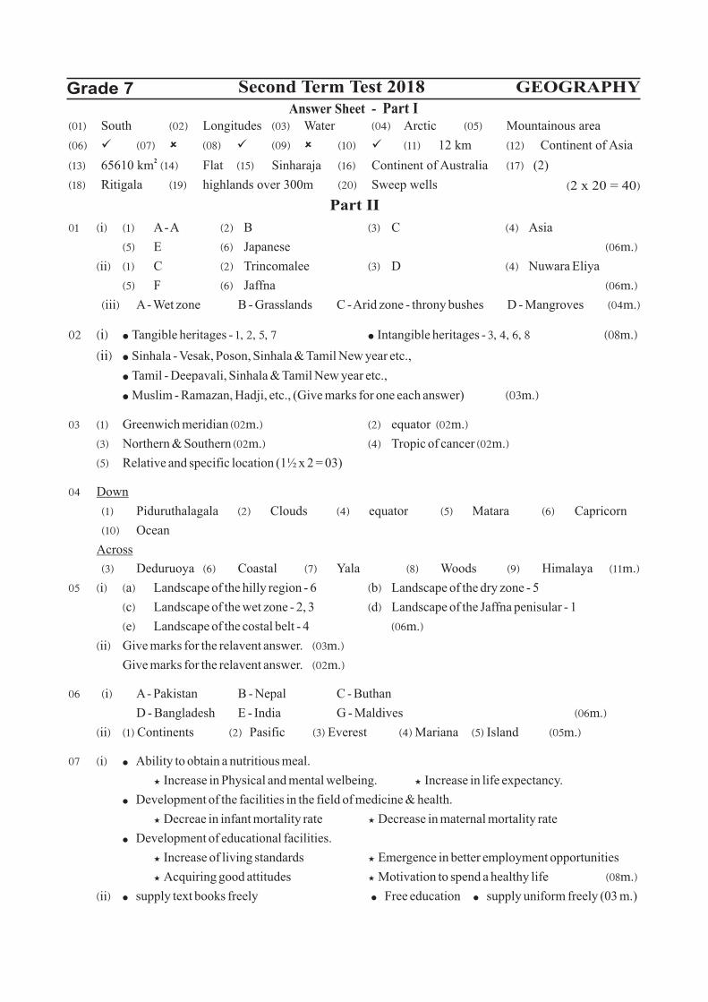
01 ^i& ^1& A - A ^2& B ^3& C ^4& Asia
^5& E ^6& Japanese ^06m.&
^ii& ^1& C ^2& Trincomalee ^3& D ^4& Nuwara Eliya
^5& F ^6& Jaffna ^06m.&
^iii& A - Wet zone B - Grasslands C - Arid zone - throny bushes D - Mangroves ^04m.&
02 ^i& ² Tangible heritages - 1" 2" 5" 7 ² Intangible heritages - 3" 4" 6" 8 ^08m.&
^ii& ² Sinhala - Vesak, Poson, Sinhala & Tamil New year etc.,
² Tamil - Deepavali, Sinhala & Tamil New year etc.,
² Muslim - Ramazan, Hadji, etc., (Give marks for one each answer) ^03m.&
03 ^1& Greenwich meridian ̂ 02m.& ^2& equator ̂ 02m.&
^3& Northern & Southern ̂ 02m.& ^4& Tropic of cancer ̂ 02m.&
^5& Relative and specific location (1½ x 2 = 03)
04 Down
^1& Piduruthalagala ^2& Clouds ^4& equator ^5& Matara ^6& Capricorn
^10& Ocean
Across
^3& Deduruoya ^6& Coastal ^7& Yala ^8& Woods ^9& Himalaya ̂ 11m.&
05 ^i& ^a& Landscape of the hilly region - 6 ^b& Landscape of the dry zone - 5
^c& Landscape of the wet zone - 2, 3 ^d& Landscape of the Jaffna penisular - 1
^e& Landscape of the costal belt - 4 ^06m.&
^ii& Give marks for the relavent answer. ̂ 03m.&
Give marks for the relavent answer. ̂ 02m.&
06 ^i& A - Pakistan B - Nepal C - Buthan
D - Bangladesh E - India G - Maldives ^06m.&
^ii& ^1& Continents ^2& Pasific ^3& Everest ^4& Mariana ^5& Island ^05m.&
07 ^i& ² Ability to obtain a nutritious meal.
³ Increase in Physical and mental welbeing. ³ Increase in life expectancy.
² Development of the facilities in the field of medicine & health.
³ Decreae in infant mortality rate ³ Decrease in maternal mortality rate
² Development of educational facilities.
³ Increase of living standards ³ Emergence in better employment opportunities
³ Acquiring good attitudes ³ Motivation to spend a healthy life ^08m.&
^ii& ² supply text books freely ² Free education ² supply uniform freely (03 m.)
^01& South ^02& Longitudes ^03& Water ^04& Arctic ^05& Mountainous area
^06& ü̂07& û̂08& ü̂09& û̂10& ü̂11& 12 km ^12& Continent of Asia 2
^13& 65610 km ^14& Flat ^15& Sinharaja ^16& Continent of Australia ^17& (2)
^18& Ritigala ^19& highlands over 300m ^20& Sweep wells ^2 x 20 = 40&
Answer Sheet - Part IGrade 7 Second Term Test 2018
Part II
GEOGRAPHY
Related Documents