Answer all the questions. ² Select the most suitable answer and write it on the given space for question No. 01 to 05. 01 Out of main rivers, 34 rivers starting from hill country, flow in an .................................................... pattern. (Aerial / Dendritic / Trellis) 02 Dubai mall is the largest ................................ centrer in the world. (communication / trade / sports ) 03 Drinage and soil are .................................................... factors the affect to the distribution of population. (physical / cultural / human) 04 Agricultural activities like paddy cultivation and chena cultivation can be seen in the .................................................... zone of Sri Lanka. (dry / wet / intermediate) 05 Animal species like snow dog, sable and mink can be seen in .................................................... forests. (Deciduous / tropical rain / coniferous) If the following sentences are correct put ^& if not put ^& for question No. 06 to 10. 06 Physical landscape of Sri Lanka caused for the human activities. ( ) 07 In the rurban settlements, rural features can be seen than the urban features. ( ) 08 Rivers, Amudaria and Serderia flow in to capsian sea. ( ) 09 Gampaha is the district that has the highest density of population. ( ) 10 The motherland of main religions like Buddhism, Hinduism, Islam and Catholic is the Asia.( ) Grade 09 Two hours Name / Index No. : GEOGRAPHY SECOND TERM TEST 2019 ish¨u ysñlï weúßKs All Rights Reserved PROVINCIAL DEPARTMENT OF EDUCATION - NORTH WESTERN PROVINCE PART - A 01

Welcome message from author
This document is posted to help you gain knowledge. Please leave a comment to let me know what you think about it! Share it to your friends and learn new things together.
Transcript
Answer all the questions.
² Select the most suitable answer and write it on the given space for question No. 01 to 05.
01 Out of main rivers, 34 rivers starting from hill country, flow in an ....................................................
pattern. (Aerial / Dendritic / Trellis)
02 Dubai mall is the largest ................................ centrer in the world. (communication / trade / sports )
03 Drinage and soil are .................................................... factors the affect to the distribution of
population. (physical / cultural / human)
04 Agricultural activities like paddy cultivation and chena cultivation can be seen in the
.................................................... zone of Sri Lanka. (dry / wet / intermediate)
05 Animal species like snow dog, sable and mink can be seen in ....................................................
forests. (Deciduous / tropical rain / coniferous)
If the following sentences are correct put ̂& if not put ̂& for question No. 06 to 10.
06 Physical landscape of Sri Lanka caused for the human activities. ( )
07 In the rurban settlements, rural features can be seen than the urban features. ( )
08 Rivers, Amudaria and Serderia flow in to capsian sea. ( )
09 Gampaha is the district that has the highest density of population. ( )
10 The motherland of main religions like Buddhism, Hinduism, Islam and Catholic is the Asia. ( )
Grade 09 Two hours
Name / Index No. :
GEOGRAPHYSECOND TERM TEST 2019
ish¨u ysñlï weúßKsAll Rights Reserved
PROVINCIAL DEPARTMENT OF EDUCATION - NORTH WESTERN PROVINCE
PART - A
01
² Underline the most suitable answer for question No. 11 to 15.
11 The area that receives the lowest rainfall in the world is,
^1& Gobi desert ^2& Atacama desert
^3& Thar desert ^4& Sahara desert
12 The islands that are located in the continent of Asia are,
^1& Sumathra, Thasmenia ^2& Bornio, Madagascar
^3& Taiwan, Java ^4& Hawai, Sri Lanka
13 'Jacobabad' city is located in,
^1& Afghanistan ^2& Pakistan
^3& India ^4& Bangladesh
14 An Asian country that conducts the industries based an raw materials and mineral oil is,
^1& Philippine ^2& Singapore
^3& Sri Lanka ^4& Japan
15 The district that has the third largest population in Sri Lanka is,
^1& Kandy ^2& Kurunegala
^3& Gampaha ^4& Kalutara
² Match 'A' with 'B' and write the letter in front of it.
"A" "B"
16 Ritigala, Sigiriya, Mihintale ^''''''''''''& A areas spreaded mangroves
17 Haputale, Galagedara, Ginigathhena ^''''''''''''& B Residual hills
18 Bundala, Kalametiya, Anawilundawa ^''''''''''''& C high peaks
19 Thotupola, Kirigalpotta, Namunukula ^''''''''''''& D Plateaus
20 Kandy, Hatton, Welimada ^''''''''''''& E Gaps
F Plains
02
² Answer five questions including the first question.
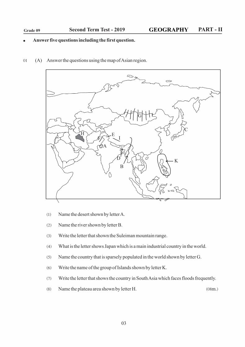
01 (A) Answer the questions using the map of Asian region.
^1& Name the desert shown by letter A.
^2& Name the river shown by letter B.
^3& Write the letter that shown the Suleiman mountain range.
^4& What is the letter shows Japan which is a main industrial country in the world.
^5& Name the country that is sparsely populated in the world shown by letter G.
^6& Write the name of the group of Islands shown by letter K.
^7& Write the letter that shows the country in South Asia which faces floods frequently.
^8& Name the plateau area shown by letter H. ^08m.&
GEOGRAPHY
03
Grade 09 Second Term Test - 2019 PART - II
HF
A
D
B
IE
K
G
C
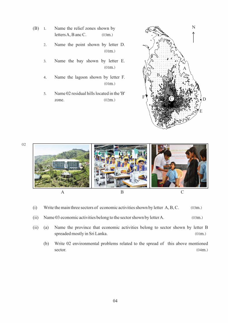
(B) 1' Name the relief zones shown by
letters A, B anc C. ̂ 03m.&
2' Name the point shown by letter D.
^01m.&
3' Name the bay shown by letter E.
^01m.&
4' Name the lagoon shown by letter F.
^01m.&
5' Name 02 residual hills located in the 'B'
zone. ^02m.&
02
(i) Write the main three sectors of economic activities shown by letter A, B, C. ^03m.&
(ii) Name 03 economic activities belong to the sector shown by letter A. ^03m.&
(ii) (a) Name the province that economic activities belong to sector shown by letter B
spreaded mostly in Sri Lanka. ^01m.&
(b) Write 02 environmental problems related to the spread of this above mentioned
sector. ^04m.&
04
C
B
A
D
E
F
N
A B C
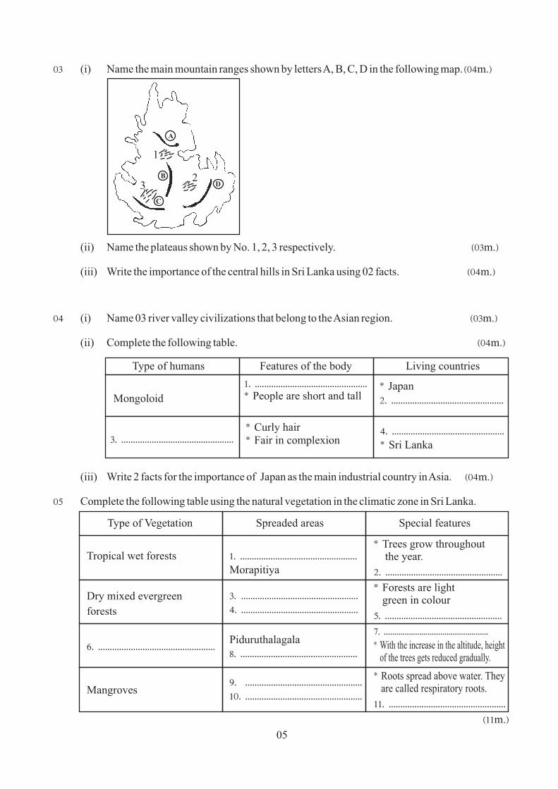
03 (i) Name the main mountain ranges shown by letters A, B, C, D in the following map. ̂04m.&
(ii) Name the plateaus shown by No. 1, 2, 3 respectively. ^03m.&
(iii) Write the importance of the central hills in Sri Lanka using 02 facts. ^04m.&
04 (i) Name 03 river valley civilizations that belong to the Asian region. ^03m.&
(ii) Complete the following table. ^04m.&
(iii) Write 2 facts for the importance of Japan as the main industrial country in Asia. ^04m.&
05 Complete the following table using the natural vegetation in the climatic zone in Sri Lanka.
05
H
B
B
A
C
DB 2
1
3
Type of humans Features of the body Living countries
Mongoloid
1' '''''''''''''''''''''''''''''''''''''''''''''''') People are short and tall
) Japan 2' ''''''''''''''''''''''''''''''''''''''''''''''''
3' '''''''''''''''''''''''''''''''''''''''''''''''') Curly hair ) Fair in complexion
4' '''''''''''''''''''''''''''''''''''''''''''''''') Sri Lanka
^11m.&
Type of Vegetation Spreaded areas Special features
Tropical wet forests
Dry mixed evergreen
forests
6' ''''''''''''''''''''''''''''''''''''''''''''''''''
Mangroves
1' ''''''''''''''''''''''''''''''''''''''''''''''''''Morapitiya
3' ''''''''''''''''''''''''''''''''''''''''''''''''''4' ''''''''''''''''''''''''''''''''''''''''''''''''''
Piduruthalagala 8' ''''''''''''''''''''''''''''''''''''''''''''''''''
9' ''''''''''''''''''''''''''''''''''''''''''''''''''10' ''''''''''''''''''''''''''''''''''''''''''''''''''
) Trees grow throughout the year.
2' ''''''''''''''''''''''''''''''''''''''''''''''''''
) Forests are light green in colour
5' ''''''''''''''''''''''''''''''''''''''''''''''''''
7' '''''''''''''''''''''''''''''''''''''''''''''''''') With the increase in the altitude, height of the trees gets reduced gradually.
) Roots spread above water. They are called respiratory roots.
11' ''''''''''''''''''''''''''''''''''''''''''''''''''
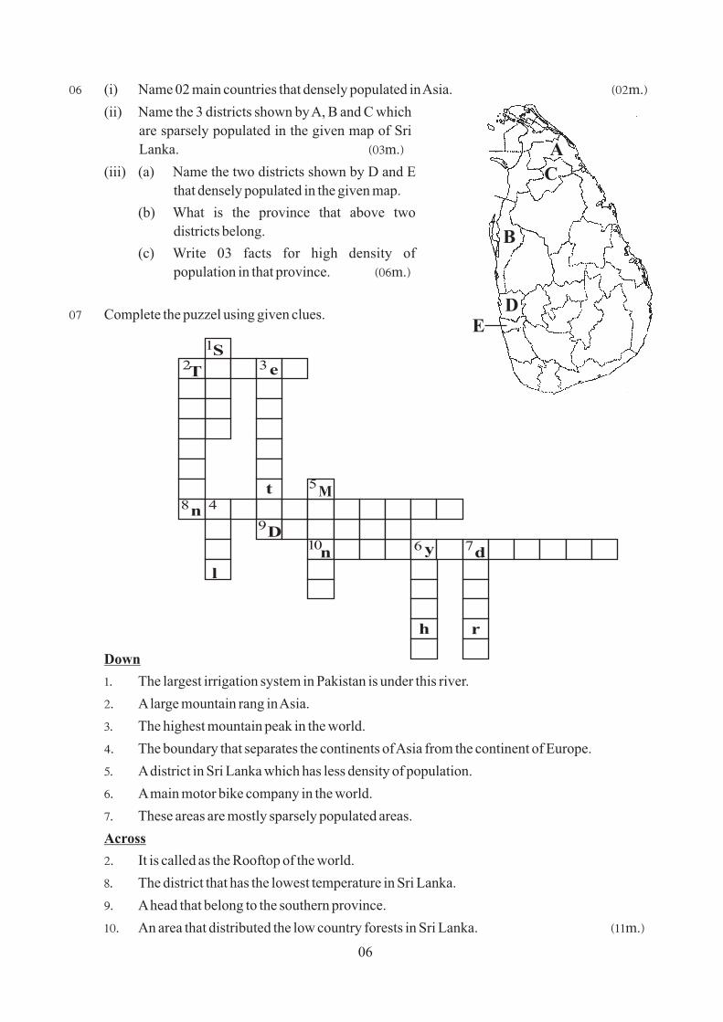
06 (i) Name 02 main countries that densely populated in Asia. ^02m.&
(ii) Name the 3 districts shown by A, B and C which
are sparsely populated in the given map of Sri
Lanka. ^03m.&
(iii) (a) Name the two districts shown by D and E
that densely populated in the given map.
(b) What is the province that above two
districts belong.
(c) Write 03 facts for high density of
population in that province. ^06m.&
07 Complete the puzzel using given clues.
Down
1' The largest irrigation system in Pakistan is under this river.
2' A large mountain rang in Asia.
3' The highest mountain peak in the world.
4' The boundary that separates the continents of Asia from the continent of Europe.
5' A district in Sri Lanka which has less density of population.
6' A main motor bike company in the world.
7' These areas are mostly sparsely populated areas.
Across
2' It is called as the Rooftop of the world.
8' The district that has the lowest temperature in Sri Lanka.
9' A head that belong to the southern province.
10' An area that distributed the low country forests in Sri Lanka. ^11m.&
06
A
B
C
DE
S
T e
n
M
l
n y d
rh
1
2 3
4
5
6 7
8
9
10D
t
01 ^A& (i) Thar (ii) Irawadi (iii) F (iv) C (v) Mongolia
(vi) Philippine (vii) Bangladesh (viii) Tibet plateau
^B& (i) A Coastal plain B Intermediate plain C Central hills
(ii) Sangamankanda Point (iii) Arugambay
(iv) Govinda hela / Kataragama / Sigiriya / Ritigala
(v) Negambo
02 (i) A Agricultural B Industrial C Services
(ii) raring animals / cultivated crops / fishing industry / Tea, Rubber plantation
(iii) (a) Western
(b) Water pollution / Air pollution / Gather waste / Scarcity of lands
03 (i) A Knuckles B Piduruthalagala C Samanala D Namunukula
(ii) 1' Kandy plateau 2' Welimada plateau 3' Hatton plateau
(iii) for tourist industry / bio diversity / for tea plantation / for growing ornamental flowers / for raring
animals / for producing milk / for growing fruits / for cultivating vegetables / Give marks for the
correct answer.
04 (i) Howang Ho / Indus Valley / Mosapothemia (Upratese, Taigrees)
(ii) 1' Hair is black and brown / body is yellow colour / Flat face / eye brows are grown
2' China / Malaysia / Korea / Singapore etc.,
3' Cocasoid
4' India / Afghanistan / Pakistan / Arab countries
(iii) * Produce auto mobils
* Produce electric appliances
* Produce machines, iron and steel, ship building, chemical, computer, Robot technology etc.,
* 27.5% of GNP is from industrial sector.
* 26.2% of labour force in industrial sector.
* Conduct industries by importing raw-materials and mineral oil.
05 Use page from 43 to 49 in the text book.
06 (i) China / India
(ii) A Mulativ B Mannar C Vavunia
(iii) (a) D Gampaha E Colombo (b) Western
(c) Favourable Climate / Infrastructure facilities / Educational facilities / Health facilities / More
job opportunities / Urbanization / more industries / more service centers / Capital cities /
Commercial cities / Harbour / Airport
07 Down
1' Sindu 2' Tienshan 3' Everest 4' Ural 5' Mannar
6' Yamaha 7' desert
Across
2' Tibet 8' Nuwara Eliya 9' Dondra 10' Nakiyadeniya
^01& Aerial ^02& Trade ̂ 03& Physical ^04& dry ^05& coniferous
^06& ^07& ^08& ^09& ^10& ^11& 1 ^12& 3 ^13& 2
^14& 4 ^15& 2 ^16& B ^12& E ^18& A ^19& C ^20& D
PART - II ^2 x 20 = 40 m.&
ANSWER PAPER / PART - IGrade 09
Second Term Test - 2019GEOGRAPHY
PROVINCIAL DEPARTMENT OF EDUCATION NORTH WESTERN PROVINCE
2019 06 11
Related Documents
![Saskatchewan Second Reading Debates Athletics Commission Act · [mixed martial arts] events have provincial commissions. From speaking with provinces across Canada, we know provincial](https://static.cupdf.com/doc/110x72/5ecfb0a66dbf2704cf333b5d/saskatchewan-second-reading-debates-athletics-commission-act-mixed-martial-arts.jpg)