Welcome message from author
This document is posted to help you gain knowledge. Please leave a comment to let me know what you think about it! Share it to your friends and learn new things together.
Transcript


Olancha-Cartago Expressway 09-Iny-395 PM 29.2/41.8 Project Report June, 2017
TABLE OF CONTENTS 1. INTRODUCTION
2. RECOMMENDATION
3. BACKGROUND A. Project History B. Community Interaction C. Existing Facility
4. PURPOSE and NEED A. Problem, Deficiencies, Justification B. Regional & System Planning C. Traffic
5. ALTERNATIVES A. Common Features B. Viable Alternatives C. Rejected Alternatives
6. CONSIDERATIONS REQUIRING DISCUSSION A. Hazardous Waste B. Value Analysis C. Resource Conservation D. Right of Way Issues E. Environmental Issues F. Water Quality Considerations G. Air Quality Conformity H. Title VI Considerations
7. OTHER CONSIDERATIONS AS APPROPRIATE A. Public Hearing Process B. Route Matters C. Permits D. Cooperative Agreements E. Transportation Management Plan F. Stage Construction G. Accommodation of Oversize Loads
8. PROGRAMMING
9. SCHEDULE
10. RISKS
11. FHWA COORDINATION
12. REVIEWS
13. PROJECT PERSONNEL
14. LIST OF ATTACHMENTS
Olancha-Cartago Expressway 09-Iny-395 PM 29.2/41.8 Project Report June, 2017
1
1. INTRODUCTION The State of California, Department of Transportation, is proposing to upgrade U.S. Highway 395 (US 395) from two-lane conventional highway to four-lane divided expressway, or a combination of four-lane conventional highway and divided expressway. The proposed project begins at PM 29.2, south of the community of Olancha, and ends near PM 41.8, north of the community of Cartago. The primary purpose of the project is to improve safety for the traveling public by separating opposing traffic, reducing access points, and widening existing shoulders. The project would also provide increased capacity, improve Level of Service by easing peak traffic congestion and reducing time spent following, improve drainage, and provide facility continuity between existing sections of four-lane divided expressway on either end of the proposed project. Six viable Build Alternatives and a No-Build Alternative are being considered. The Preferred Alternative is being used as the basis of programming for this document. The estimated capital cost for the Preferred Alternative (escalated to FY 2020) is $108,100,000, which includes $16,200,000 for right of way, $5,000,000 for archaeological mitigation, and $86,900,000 for construction. The project is proposed for funds in the 2018 State Transportation Improvement Program (STIP) through the Regional Improvement Program (20.10.075.600) and the Interregional Improvement Program (20.10.025.700), and is proposed to begin construction in FY 2020/2021. The project falls under Project Development Category 1 because it requires access control, substantial new right of way, a Controlled Access Highway Agreement, and a Route Adoption by the CTC for the new route location. The Preferred Alternative is a combination of Alternatives 3 and 4, and will construct 12.14 miles of new controlled access, four-lane divided expressway. The expressway will begin at the existing expressway south of Olancha near the crossing of Summit Creek and will travel west of the Los Angeles Aqueduct and Olancha (Alternative 4). After crossing Olancha Creek, the expressway will turn north to cross the Los Angeles Aqueduct and then continue through Cartago to join the existing expressway just south of the crossing of Ash Creek (Alternative 3). The northbound and southbound lanes will be separated by an unpaved median at least 100 feet wide. Several at-grade intersections will be constructed to provide access between the new expressway and the surrounding communities.
2. RECOMMENDATION
The Preferred Alternative is recommended for approval and authorization is requested to proceed with development of the Plans, Specifications, and Estimate (PS&E) for the project. Approval is also recommended to authorize Caltrans to enter into a Cooperative Agreement with the County of Inyo for relinquishment of a portion of the existing highway. The affected local agencies have been consulted and their views have been considered in the selection of the Preferred Alternative, and they are in general agreement with the Preferred Alternative.
3. BACKGROUND
A. Project History
The Olancha-Cartago Four-Lane Expressway project was initiated by the District 9 Transportation Planning Branch in 1998 with the support of the Inyo County Local Transportation Commission. A Project Study Report - Environmental Only (PSR-EO) was prepared for the project and was approved on January 22, 1999. The project was approved in the 1998 STIP Augmentation as a jointly funded RIP/IIP project and Project Approval and Environmental Document (PA&ED) activities began in FY 1999/2000. PA&ED activities were suspended in April, 2004, when the project was deprogrammed to provide funding for the Independence Four-Lane project. PA&ED activities resumed in August, 2007, after a
Olancha-Cartago Expressway 09-Iny-395 PM 29.2/41.8 Project Report June, 2017
2
Supplemental Project Study Report (SPSR) was approved to restore programming for the project in the 2006 STIP Augmentation. In addition to restoring funding for the PA&ED component, funding for the PS&E component and the R/W Capital and R/W Support components were also included in the 2006 STIP Augmentation. As a result, the development components for the project are fully funded. The PSR-EO contained three original alternatives: converting the existing two lane highway to four-lane all-paved highway (Alternative 1), constructing new four-lane expressway next to the existing alignment (Alternative 2), and constructing new four-lane expressway to the west of Olancha (Alternative 3). A Value Analysis Study was performed in November, 1999, that developed two additional alternatives. Alternative 2A was a variation of Alternative 2 that avoided development in the community of Cartago by moving the route to the west of Cartago. Alternative 3A was a variation of Alternative 3 that also avoided development in Cartago by relocating the route to the west of Cartago. The results of the VA Study were summarized in a Value Analysis Report that was issued in February, 2000. Other than Alternative 2, each of these alternatives was presented in the 2007 SPSR. The original alignment for Alternative 2 was developed in a 1967 bypass study and traveled through the pasture area on the east side of Olancha. The current route denomination is based upon this alignment. The alignment was confirmed in a 1988 Value Engineering study, which concluded that it would be the least damaging to the Olancha community because it stayed east of the residences and businesses in the community. Due to this prior consideration, the original alignment was used for Alternative 2 in the approved PSR-EO. However, the 1999 VA Study recommended that the alignment be constructed west of the existing alignment to avoid impacts to wetlands and the existing cottonwood trees. As a result, the alignment was changed so that it crossed over to the west of the existing alignment near the junction with SR 190. This revised alignment for Alternative 2 was described in the 2007 SPSR. The easterly alignment around Olancha was reevaluated in the 2009 Wetland Delineation Report. The report determined that the pasture area to the east of the existing highway is wetlands that are contiguous to a historic navigable water body (the Owens Dry Lake) and are fed by a protected water of the U.S. (Olancha Creek). In May, 2010, the U.S. Army Corps of Engineers issued a Jurisdictional Determination accepting jurisdiction over the wetlands as they were mapped in the 2009 Wetland Delineation Report. Since jurisdictional wetlands must be avoided whenever possible, the easterly alignment was officially abandoned by the Project Development Team in the Draft Project Report. An additional alternative was developed in 2007 (Alternative 4) that would construct a new four-lane expressway generally along the existing railroad alignment on the west side of the Los Angeles Aqueduct. Alternative 4 was similar to Alternative 3A in that it bypassed both Olancha and Cartago, but it was expected to have less environmental impact and lower right of way costs due to its location farther west on the alluvial fans. As a result, Alternative 3A was removed from consideration by the PDT in the summer of 2007 and replaced with Alternative 4. Alternative 4 was incorporated into the project alternatives in a Supplemental Project Study Report that was approved on November 17, 2008. The five alternatives identified in the 2008 SPSR were evaluated in a Draft Project Report that was approved on September 1, 2010. Their environmental impacts were identified in an Initial Study / Environmental Assessment (IS/EA) that was circulated in September and October, 2010. A public hearing was held on September 22, 2010 to present the findings of the IS/EA and to solicit public input on the final alternatives. An extensive Project Development Team (PDT) was assembled for the purpose of recommending an alternative to the District 9 Director. The PDT was comprised of Caltrans staff and members of several local agencies, including the Inyo County Local Transportation Commission, Mono County Local

Olancha-Cartago Expressway 09-Iny-395 PM 29.2/41.8 Project Report June, 2017
3
Transportation Commission, California Highway Patrol, U.S. Bureau of Land Management, and the Los Angeles Department of Water and Power. Inyo County and the Kern Council of Governments were also invited to participate, but chose not to attend. Due to the complexity and variety of considerations for each alternative, a criteria-based selection process was used to evaluate the alternatives. Over the course of three meetings between February and April, 2011, the PDT considered the alternatives and ultimately selected Alternative 3. In order to achieve consensus amongst the PDT members, the recommendation included two conditions: 1) that SR 190 not be extended to meet the new alignment, but to instead redesignate the existing portion of US 395 south of the intersection with SR 190 as SR 190; and 2) that appropriate signage be included in the final project to direct travelers to the businesses and services available along the existing highway.
The PDT recommendation to the District Director was finalized on April 11, 2011. After reviewing the recommendation, the IS/EA, project documents, comments received, survey results, and public meeting results, the District 9 Director selected a combination of Alternative 3 and Alternative 4. The combined alternative reduced the environmental impacts and cost associated with Alternative 4 and eliminated the impacts to existing homes and businesses associated with Alternative 3, but still maximized the safety to be achieved, and thus best met the purpose and need of the project. The Caltrans Preferred Alternative was announced to the public in a press release dated June 29, 2011. Following the Director’s decision, additional studies were performed to further identify the impacts of the Caltrans Preferred Alternative. Based on the results of those studies, and review of public and agency comments received during circulation of the IS/EA, it was decided that it may not be possible to mitigate the impacts to cultural resources to a point where they were not significant. As a result, a Section 4(f) Evaluation was prepared to address the potential adverse effects on cultural resources. In order to present the findings of the Section 4(f) Evaluation and discuss the impacts of the Caltrans Preferred Alternative, a Draft Environmental Impact Report/Environmental Assessment (DEIR/EA) was prepared. The DEIR/EA was circulated for public review in August and September, 2015, and a public hearing was held on September 23, 2015. A Supplemental Draft Project Report was prepared to authorize recirculation of the DEIR/EA and to adopt the Caltrans Preferred Alternative as a project alternative and was approved on April 14, 2015. B. Community Interaction There have been three public information meetings held for this project since its inception in 1999. The first meeting occurred on April 10, 2000, and a total of 57 visitors attended the meeting. The second meeting took place on July 25, 2002, with a total of 52 visitors. A third meeting was held on December 3, 2008, which 81 people attended. All of the meetings were presented in an open-house format, with displays depicting project information for public review. Caltrans staff were present to answer questions and provide additional information and comment cards were provided to allow the attendees to comment on the alternatives. The third meeting also provided community surveys that the residents could complete to express any concerns about the perceived impacts to their communities. The comments received at these meetings were generally consistent. Many meeting participants preferred improving the existing alignment (Alternative 1) because they felt that would provide the greatest benefit to the communities of Olancha and Cartago. They felt that alternatives that bypassed the communities would be a detriment to the communities because they would negatively affect the existing businesses along US 395. Other common requests included reducing vehicle speeds, providing turn lanes or other improvements that would improve access along the highway to ensure that the businesses along the highway remained in operation, and not restricting access to the west.
Olancha-Cartago Expressway 09-Iny-395 PM 29.2/41.8 Project Report June, 2017
4
Due primarily to its increased safety benefits, the Caltrans Preferred Alternative was selected instead of Alternative 1. The Caltrans Preferred Alternative will bypass Olancha, but may not be detrimental to the communities, as it will not directly impact the businesses within the existing corridor and the reduced traffic volumes and speeds will increase the accessibility along the existing corridor for local residents and businesses. As recommended by the PDT, the Preferred Alternative will redesignate the portion of the existing highway south of the intersection with SR 190 as SR 190, which will maintain some of the highway traffic through the existing corridor; and it will include signage to inform motorists of services available along the existing highway. The Preferred Alternative also includes two large box culverts, which will serve as an undercrossing to maintain access to the west for animal/cattle passage and for recreational users. Caltrans has entered into a Memorandum of Understanding with the Inyo County Local Transportation Commission, the Mono County Local Transportation Commission, and the Kern Council of Governments for funding projects along the US 395 corridor. This project is identified in the MOU and development of this project has been jointly funded by the four agencies. Caltrans has been in regular contact with each agency as this project has been developed and each agency has recognized the value and importance of the project and has been supportive of the project. As noted above, all of the MOU partners were invited to participate in the PDT meetings held for selection of the recommended alternative. Caltrans has also coordinated with the Inyo County Board of Supervisors and Inyo County staff during the development of the project. In order to provide more accurate information about project status and to discuss critical issues and develop potential solutions for the project, Caltrans formed a working group with Inyo County officials and staff. Two meetings of the group were held in June, 2009, and February, 2010, and significant issues such as design speed, right of way impacts, and relinquishment concerns were discussed. Caltrans also participated in several meetings of the Inyo County Board of Supervisors in September, 2010, and October, 2010, to present the project alternatives and solicit input from the Board of Supervisors. Additional meetings with the working group are anticipated to resolve any issues related to approval of the Controlled Access Highway Agreement. Caltrans developed a survey pamphlet to solicit input from regional and interregional travelers on the proposed project. During the spring and summer of 2010, the surveys were advertised in the local media and pamphlets were distributed to a variety of local establishments, such as visitor centers, chambers of commerce, and local businesses. Pamphlets were also distributed at several significant regional events, such as the 2010 Sierra Fishing Opener and the 2010 Mule Days Celebration. Caltrans was also able to distribute the pamphlets to nearly 25,000 members of the Mammoth Mountain Ski Resort e-mail contact list. Because of the wide distribution, Caltrans received over 7,000 responses to the survey and gained valuable input on the project, especially from interregional travelers. As part of the circulation of the IS/EA, a public hearing was held in Olancha on September 22, 2010, to present the project to the community and solicit input on the alternatives. The public comment period for the IS/EA was also extended by a month to allow the community additional time to review the IS/EA and provide comments. Another public hearing was held in Olancha on September 23, 2015, to present the DEIR/EA and to solicit additional public input into the project. As a result of the multiple public information meetings, meetings with the MOU partners and Inyo County, distribution of survey pamphlets, and public hearings required for the environmental documents, there has been significant public comment and input into the project. The resulting comments and concerns were considered by Caltrans in the selection of the Preferred Alternative.
Olancha-Cartago Expressway 09-Iny-395 PM 29.2/41.8 Project Report June, 2017
5
C. Existing Facility US 395 is the major element in a transportation corridor connecting the Eastern Sierra region (Inyo and Mono Counties) and western central Nevada to the Southern California region. The corridor has been identified as a Strategic Interregional Corridor in the 2015 Interregional Strategic Transportation Plan and is vital to the economy of the Eastern Sierra region, which imports nearly all of its goods and materials. It is also a major recreational corridor serving Southern California and experiences heavy recreational use, as evidenced by over ten million annual visitor-days of recreation. An Origination and Destination Study conducted in 2011 found that 61% of the traffic on US 395 was recreationally oriented and that recreational vehicles comprised 1.7% of the vehicle mix. Goods movement accounted for 9% of the total traffic. It also found that 47% of the vehicles originated in Southern California. Within the project limits, US 395 is a two-lane undivided conventional highway. It traverses gently sloping terrain along the foothills of the Sierra Nevada Mountains as it passes through the communities of Olancha and Cartago. There are a number of isolated businesses and residences along the highway, but in general, the highway corridor is rural with limited development. There is four-lane divided expressway on both the north (Ash Creek Four-Lane) and south (Sage Flat Four-Lane) ends of the project that will be connected by the proposed project. Olancha and Cartago are relatively small communities with less than 300 residents in total. Olancha is sparsely developed with several businesses, a post office, and one service station/mini-mart. Cartago is located about three miles north of Olancha and is primarily a residential community. The bottling plant for Crystal Geyser Water and a couple of livestock ranches are located between the two communities. A second water bottling plant and a solar farm are currently being constructed. Most of the residential development in the communities is away from the highway, but the residents rely upon US 395 as their main street to travel within the communities and access their properties. The highway generally consists of two 12 foot lanes and 8 foot paved shoulders within 100 feet of right of way. There are no shoulder improvements such as curb, gutter or sidewalk throughout this section of the highway. There is no median and approximately 50% of the highway is barrier striped to prevent passing. There are undivided passing lanes for both northbound and southbound traffic between postmile 39.7 and postmile 40.5. The posted speed limits vary from 65 mph outside of the communities to 55 mph within the communities. In addition to the intersection with SR 190, there are six other public road connections and numerous other private roads and access points to the highway within the project limits. The Annual Average Daily Traffic (AADT) on US 395 within the project limits is 5,500 vehicles per day (2014 Traffic Data Report). Goods movement along the corridor is also significant, with the percentage of truck traffic at 12.0%. A pavement deflection study was performed in April, 2007, and the roadway was analyzed for structural adequacy, reflective crack retardation and ride quality. A shoulder widening and overlay project was constructed in 2006, so the overall deflections were tolerable and the roadway was determined to be structurally adequate. The condition of the roadway has degraded since that time, but an updated pavement deflection study was not required for this report. A new pavement deflection study will be performed during the PS&E phase to assess the condition of the pavement and determine any improvements that may be required for the portions of existing highway that would remain.
Olancha-Cartago Expressway 09-Iny-395 PM 29.2/41.8 Project Report June, 2017
6
4. PURPOSE AND NEED A. Problem, Deficiencies, Justification
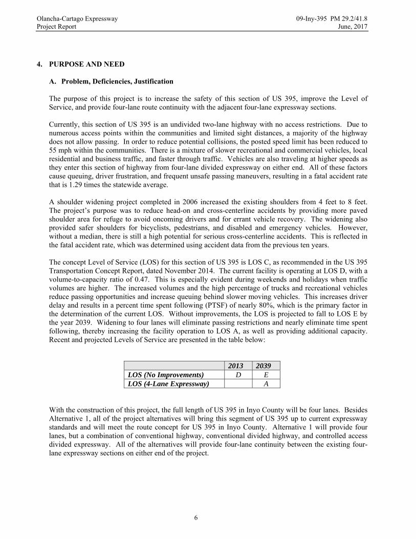
The purpose of this project is to increase the safety of this section of US 395, improve the Level of Service, and provide four-lane route continuity with the adjacent four-lane expressway sections. Currently, this section of US 395 is an undivided two-lane highway with no access restrictions. Due to numerous access points within the communities and limited sight distances, a majority of the highway does not allow passing. In order to reduce potential collisions, the posted speed limit has been reduced to 55 mph within the communities. There is a mixture of slower recreational and commercial vehicles, local residential and business traffic, and faster through traffic. Vehicles are also traveling at higher speeds as they enter this section of highway from four-lane divided expressway on either end. All of these factors cause queuing, driver frustration, and frequent unsafe passing maneuvers, resulting in a fatal accident rate that is 1.29 times the statewide average. A shoulder widening project completed in 2006 increased the existing shoulders from 4 feet to 8 feet. The project’s purpose was to reduce head-on and cross-centerline accidents by providing more paved shoulder area for refuge to avoid oncoming drivers and for errant vehicle recovery. The widening also provided safer shoulders for bicyclists, pedestrians, and disabled and emergency vehicles. However, without a median, there is still a high potential for serious cross-centerline accidents. This is reflected in the fatal accident rate, which was determined using accident data from the previous ten years. The concept Level of Service (LOS) for this section of US 395 is LOS C, as recommended in the US 395 Transportation Concept Report, dated November 2014. The current facility is operating at LOS D, with a volume-to-capacity ratio of 0.47. This is especially evident during weekends and holidays when traffic volumes are higher. The increased volumes and the high percentage of trucks and recreational vehicles reduce passing opportunities and increase queuing behind slower moving vehicles. This increases driver delay and results in a percent time spent following (PTSF) of nearly 80%, which is the primary factor in the determination of the current LOS. Without improvements, the LOS is projected to fall to LOS E by the year 2039. Widening to four lanes will eliminate passing restrictions and nearly eliminate time spent following, thereby increasing the facility operation to LOS A, as well as providing additional capacity. Recent and projected Levels of Service are presented in the table below:
2013 2039 LOS (No Improvements) D E LOS (4-Lane Expressway) A
With the construction of this project, the full length of US 395 in Inyo County will be four lanes. Besides Alternative 1, all of the project alternatives will bring this segment of US 395 up to current expressway standards and will meet the route concept for US 395 in Inyo County. Alternative 1 will provide four lanes, but a combination of conventional highway, conventional divided highway, and controlled access divided expressway. All of the alternatives will provide four-lane continuity between the existing four-lane expressway sections on either end of the project.

Olancha-Cartago Expressway 09-Iny-395 PM 29.2/41.8 Project Report June, 2017
7
The proposed project will increase safety for the traveling public by separating opposing traffic, removing passing restrictions, controlling access points, and providing adequate shoulder widths for bicycle traffic, pedestrian traffic, disabled vehicles, and emergency vehicles. It will also provide increased capacity to meet present and future traffic demands and ease peak traffic congestion and time spent following in Olancha and Cartago, thereby improving the Level of Service of the facility to LOS A for the 20 year planning period. Finally, the proposed project will provide facility continuity and will complete the four-laning of US 395 in Inyo County. B. Regional and System Planning US 395 is functionally classified as an Other Principal Arterial and is part of the Federal Aid Primary Highway System and the State Freeway and Expressway System. It is included in the National Surface Transportation Assistance Act (STAA) network that authorizes use by larger trucks and is also part of the Subsystem of Highways for the Movement of Extra Legal Permits Loads. It is identified as a Priority Interregional Highway in the 2015 Interregional Transportation Strategic Plan and as an important non-interstate route in the Strategic Highway Network (STRAHNET). It is also a High Emphasis Focus Route in the Interregional Road System that connects transportation systems across four states. In Inyo County, US 395 is a route of statewide significance. It is included in the State Scenic Highway Master Plan and this portion is eligible for designation as a State Scenic Highway. As recommended in the 2014 US 395 Transportation Concept Report, the concept facility for US 395 in Inyo County is a four-lane expressway operating at LOS C. The 2015 District System Management Plan recognizes US 395 as one of two major transportation corridors in the District and lists four-laning of US 395 as one of the top priorities in the District. With the completion of this project, US 395 will have four lanes from the junction of US 395 and SR 14 in Kern County to north of Lee Vining in Mono County. US 395 is the primary transportation route in Inyo County and is discussed extensively in the 2015 Inyo County Regional Transportation Plan (RTP). The RTP includes stated objectives to widen US 395 to 4 lanes (Objective 3.1) and to maintain and improve roadway level of service (Objective 2.1) and the project is consistent with those objectives. The RTP acknowledges the deficient level of service and the need to increase capacity in this segment of US 395. The project is also specifically identified as a Top Priority Project in the list of Currently Programmed Projects in the Action Element of the RTP. The importance of this project to the region is reflected in the MOU between Caltrans, the Inyo County Local Transportation Commission, the Mono County Local Transportation Commission, and the Kern Council of Governments that is jointly funding this project. Each agency recognizes the importance of the project and has made this project a top priority MOU project. Inyo County, Mono County, the City of Bishop, and the Town of Mammoth Lakes all recognize the significance US 395 has to the region and support this project as well. Policy GOV-3.1 of the Inyo County General Plan requires Inyo County to work with federal and state agencies, local districts, utilities, and Native American tribes to encourage that land exchanges have a net positive impact on the County. The Olancha and Cartago areas have perhaps the largest concentration of undeveloped private land in the Owens Valley. Caltrans recognized the value of these private lands for development and developed alternatives specifically to minimize impact to these lands. In particular, the Caltrans Preferred Alternative impacts only 13 private parcels and was developed specifically to avoid the impacts to private parcels that would have been required for Alternative 3. Caltrans has also participated in the local planning process and coordinated directly with the developer to ensure that the planned expansion of the Crystal Geyser water bottling facilities is consistent with the proposed highway improvements.

Olancha-Cartago Expressway 09-Iny-395 PM 29.2/41.8 Project Report June, 2017
8
US 395 is identified as a Class II or Class III bicycle facility in the 2011 Inyo County Collaborative Bikeway Plan. The new shoulders will not be delineated as Class II bicycle lanes, but the paved 10 foot shoulders are suitable for a Class III facility. Consistent with Goal 2 of the Collaborative Bikeways Plan, the new shoulders will also provide a safe and convenient bikeway that will establish a link between Inyo County communities. The wider four-lane cross-section proposed for the project will impact pedestrian, recreational, and agricultural uses that occur along and that cross the existing highway. As a result, an undercrossing is proposed with most of the project alternatives to provide safe agricultural and recreational access under the facility. The proposed relinquishment and redesignation of the existing highway will also maintain the uses along the existing facility. C. Traffic U.S. Highway 395 The table below provides a summary of current and projected traffic data for US 395 in the design and construction years. The current traffic data is based on 2014 traffic volumes. The Design Designation is based upon construction beginning in 2020 and an estimated annual growth rate of 0.5%. A copy of the Traffic Report has been included as Attachment G.
Olancha-Cartago Four-Lane Project Iny-395-PM 29.2/41.8
2014 2020 2030 2040
Average Annual Daily Traffic (AADT) 5500 5670 5960 6260 Design Hourly Volume (DHV) 980 1030 1080 Directional Split (D) 80.1 % % Trucks 20.5 % 10 Year Traffic Index (TI 10) 10.5 20 Year Traffic Index (TI 20) 11.5 Design Speed (All-Pave) = 65 mph Design Speed (Expressway) = 75 mph
There are three defined speed zones within the project limits. The posted speeds for each zone are shown in the following table.
Olancha-Cartago Four-Lane Project Iny-395-PM 29.2/41.8
Posted Speed Post Miles Direction
65 MPH 29.2 – 33.8 N/B and S/B
55 MPH 33.8 – 37.9 N/B and S/B
65 MPH 37.9 – 41.8 N/B and S/B
Olancha-Cartago Expressway 09-Iny-395 PM 29.2/41.8 Project Report June, 2017
9
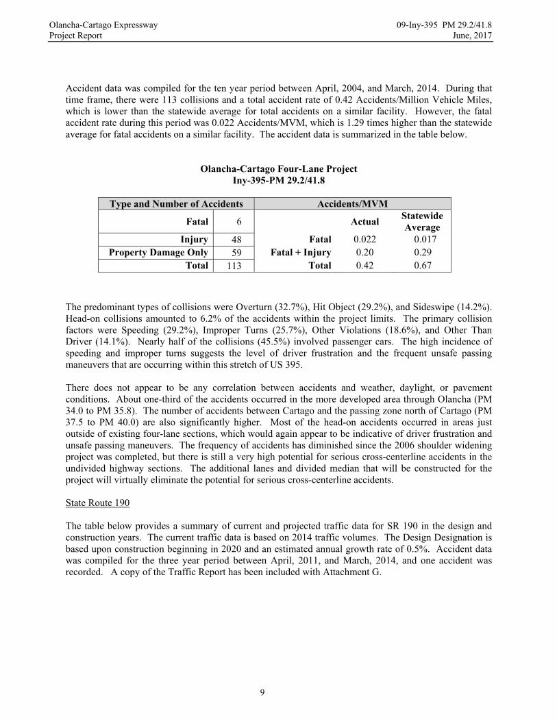
Accident data was compiled for the ten year period between April, 2004, and March, 2014. During that time frame, there were 113 collisions and a total accident rate of 0.42 Accidents/Million Vehicle Miles, which is lower than the statewide average for total accidents on a similar facility. However, the fatal accident rate during this period was 0.022 Accidents/MVM, which is 1.29 times higher than the statewide average for fatal accidents on a similar facility. The accident data is summarized in the table below.
Olancha-Cartago Four-Lane Project Iny-395-PM 29.2/41.8
Type and Number of Accidents Accidents/MVM
Fatal 6
Actual Statewide Average
Injury 48 Fatal 0.022 0.017 Property Damage Only 59 Fatal + Injury 0.20 0.29
Total 113 Total 0.42 0.67
The predominant types of collisions were Overturn (32.7%), Hit Object (29.2%), and Sideswipe (14.2%). Head-on collisions amounted to 6.2% of the accidents within the project limits. The primary collision factors were Speeding (29.2%), Improper Turns (25.7%), Other Violations (18.6%), and Other Than Driver (14.1%). Nearly half of the collisions (45.5%) involved passenger cars. The high incidence of speeding and improper turns suggests the level of driver frustration and the frequent unsafe passing maneuvers that are occurring within this stretch of US 395. There does not appear to be any correlation between accidents and weather, daylight, or pavement conditions. About one-third of the accidents occurred in the more developed area through Olancha (PM 34.0 to PM 35.8). The number of accidents between Cartago and the passing zone north of Cartago (PM 37.5 to PM 40.0) are also significantly higher. Most of the head-on accidents occurred in areas just outside of existing four-lane sections, which would again appear to be indicative of driver frustration and unsafe passing maneuvers. The frequency of accidents has diminished since the 2006 shoulder widening project was completed, but there is still a very high potential for serious cross-centerline accidents in the undivided highway sections. The additional lanes and divided median that will be constructed for the project will virtually eliminate the potential for serious cross-centerline accidents. State Route 190 The table below provides a summary of current and projected traffic data for SR 190 in the design and construction years. The current traffic data is based on 2014 traffic volumes. The Design Designation is based upon construction beginning in 2020 and an estimated annual growth rate of 0.5%. Accident data was compiled for the three year period between April, 2011, and March, 2014, and one accident was recorded. A copy of the Traffic Report has been included with Attachment G.

Olancha-Cartago Expressway 09-Iny-395 PM 29.2/41.8 Project Report June, 2017
10
Olancha-Cartago Four-Lane Project Iny-190-PM 9.85/10.35
2014 2020 2030 2040
Average Annual Daily Traffic (AADT) 240 250 260 270 Design Hourly Volume (DHV) 50 50 60 Directional Split (D) 80.4 % % Trucks 14.6 % 10 Year Traffic Index (TI 10) 7.0 20 Year Traffic Index (TI 20) 8.0 Design Speed = 70 mph
5. ALTERNATIVES Six Build Alternatives and a No-Build Alternative were considered. The Build Alternatives include: Alternative 1 – Combination of controlled access divided expressway and all-paved conventional
highway following the existing highway alignment. Alternative 2 – Controlled access divided expressway constructed adjacent to the existing highway
through Olancha and then following the existing highway alignment through Cartago.
Alternative 2A – Controlled access divided expressway constructed adjacent to the existing highway through Olancha and then passing west of Cartago.
Alternative 3 – Controlled access divided expressway passing west of Olancha and then following the
existing highway alignment through Cartago.
Alternative 4 – Controlled access divided expressway passing west of both Olancha and Cartago.
Caltrans Preferred Alternative – Controlled access divided expressway passing west of Olancha and the Los Angeles Aqueduct and then adjacent to the existing highway through Cartago.
A. Common Features Features common to each alternative are discussed in the paragraphs below. Specific details relevant to each alternative are provided in the descriptions of alternatives that follow in Section B. Geometrics Each alternative would construct a facility consisting of four 12-foot lanes separated by a median, but the median width varies by alternative. The outside shoulders would be 10 feet wide and would be sloped at five percent. Whenever possible, side slopes would be sloped at 4:1 or flatter and would extend out at least 18 feet to a uniform catch point. The Clear Recovery Zone for all of the alternatives would be at least 30 feet, measured from the edge of travelled way to any fixed object. Standard cross-sections have been prepared for the new facilities and have been attached to this report (Attachment D).
Olancha-Cartago Expressway 09-Iny-395 PM 29.2/41.8 Project Report June, 2017
11
Wherever possible, new lanes would be constructed to provide a divided expressway facility. Portions of the existing two-lane highway that can be reused would be incorporated into the new expressway. Those portions of existing highway that are not reused would be modified for use as frontage roads and would be relinquished to Inyo County as local roads, or would be obliterated. For Alternative 3, Alternative 4, and the Caltrans Preferred Alternative, the existing portion of US 395 south of the intersection with SR 190 would be redesignated as SR 190. The existing intersections with SR 190 and some local roads may be preserved and would remain at-grade intersections. The intersections would be reconstructed and realigned to provide adequate sight distance and a suitable angle of intersection with the new alignment of US 395. Additional at-grade intersections would be provided at other significant locations, such as the access point for the Crystal Geyser bottling plant. Acceleration and deceleration lanes would be provided to facilitate access onto and off of US 395. At-grade median cross-overs would be provided at other appropriate locations to maintain access across US 395 for emergency response and maintenance vehicles. Design Speed Controlled access and divided expressway lanes are expected to result in higher traveling speeds, so the new facilities would be designed for a 75 mph design speed. However, they would be posted for 65 mph, the maximum speed allowed by California statute for an expressway facility. Due to their uncontrolled access, the all-paved segments would be designated as conventional highway and would be designed for a 65 mph design speed. The all-pave segments would be posted for 55 mph. Structural Section The proposed structural section for the traveled way of new roadway would consist of 0.6 feet of asphalt concrete on 0.35 feet of Class 2 aggregate base. (A jointed concrete pavement structural section was also considered, but was eliminated by the Life Cycle Cost Analysis because the equivalent uniform annual cost was higher.) New shoulders and median cross-overs would be constructed with the same structural section. Portions of existing roadway that would be incorporated into the new facility would receive an asphalt concrete overlay. The depth of the overlay would be determined with a pavement deflection study performed during the PS&E phase. Typical Sections have been prepared for both new and rehabilitated roadway sections and have been included with this report (Attachment D). Structures Other than Alternative 4 and the Caltrans Preferred Alternative, each alternative will require a new bridge to carry the new southbound lanes across the Los Angeles Aqueduct. No work is proposed for the existing bridge that would carry the northbound lanes over the Los Angeles Aqueduct. Alternative 4 and the Caltrans Preferred Alternative will require two new bridges to cross the Los Angeles Aqueduct. The new bridges would be relatively short (less than 70 feet long) and would be reinforced concrete structures on pile foundations. An Advanced Planning Study (Attachment M) evaluated the preliminary designs and costs for the new structures. Reinforced concrete box culverts are anticipated for the stream crossings of Olancha Creek and the North Fork of Cartago Creek. Additional box culverts may be required for other large washes. Two reinforced concrete box culverts would also be required to provide an undercrossing for the proposed expressway lanes. The undercrossing culverts are anticipated to be relatively large (10 feet high by 12 feet wide) and each culvert would span one set of lanes. Potential locations of the undercrossings will be discussed with each alternative.
Olancha-Cartago Expressway 09-Iny-395 PM 29.2/41.8 Project Report June, 2017
12
Material Area During the development of the project, a potential material area was identified west of the Los Angeles Aqueduct near the end of Fall Road. The material area is included in the environmental document for the project and would be obtained as expanded right of way. The material area would be available to the contractor as an optional source of materials for production of aggregate base, asphalt concrete, rock slope protection, and embankment. Use of the material area could result in significant savings due to reduced material production costs, trucking costs, and sales tax, when compared to using materials from existing commercial sources. In addition to cost savings, the material area would provide several other positive benefits. It is located near the center of the project, so it would minimize haul distances and maximize roadway production. It would minimize aggregate related truck traffic that might be required through the communities and could significantly reduce hauling on existing highways, as aggregates and road materials would otherwise need to be trucked to the project from outside of the project area. Due to the amount of materials required for this project, use of the material area would also prevent nearby State and commercial material sites from being exhausted, thereby preserving them for future projects and maintenance activities. A Material Area Fact Sheet was prepared to outline the requirements and benefits of the material area and has been attached to this report (Attachment P). Drainage Improvements The drainage improvements would consist of installing small concrete box culverts or pipe culverts, along with appropriate inlet and outlet structures and erosion control treatment. The culverts would be designed to maintain existing flow patterns, although some channels may be realigned to reduce the crossing length under the new facility. Where necessary, culverts under the existing highway would either be extended or replaced to accommodate the wider construction. New culverts may also be installed to improve cross-drainage in the areas of existing highway that would remain. Because of their location on the alluvial fan west of the aqueduct, Alternative 4 and the Caltrans Preferred Alternative may require additional protective measures, such as entrainment dikes or collection basins, to prevent damage from upstream storm water runoff. If necessary, the required right of way for the project would be adjusted accordingly. Nonstandard Features Each alternative would be designed to meet or exceed minimum design standards and no mandatory or advisory design exceptions are anticipated. Park and Ride Facilities The total population of Olancha and Cartago is less than 300 people and there are very few commuter trips that originate from the communities, so park and ride facilities are not applicable to this project. Utility Involvement Existing underground utilities in the project area include fiber optic, telephone, and water lines. Existing overhead utilities in the project area include electric transmission and distribution lines, and telephone lines. In general, the amount of relocation varies with the amount of existing highway alignment that any alignment follows. The amounts of relocation have been estimated in the Right of Way Data Sheets. It is anticipated that all relocation will occur within the environmental study area for the project and that the impacts will be mitigated in accordance with the approved environmental document. If any relocation will occur outside of the environmental study area, additional environmental studies will be required. In particular, there are overhead high voltage transmission lines north of Cartago that run along the west side of the existing highway. They cross the proposed northbound lanes near PM 38.60 and the proposed southbound lanes near PM 39.80 and are carried on either steel transmission towers or wooden H-poles.

Olancha-Cartago Expressway 09-Iny-395 PM 29.2/41.8 Project Report June, 2017
13
As a minimum, several wooden H-poles would need to be relocated. Due to the expense and difficulty of relocating steel transmission towers, they are proposed to remain in place. A longitudinal encroachment exception has been discussed with the HQ Division of Design and would most likely be granted due to the acute crossing angle (about 22 degrees) of the lines. The vertical profile of the final lanes would also be coordinated with the utility owners so that the required minimum vertical clearance per CPUC General Order 95 could be maintained. The alternatives will also cross an existing underground fiber optic line in several locations. Relocation of the line is not anticipated, but temporary construction easements are anticipated for the construction of access boxes at the points that the line crosses the new right of way. Railroad Involvement The proposed alternatives cross or are contiguous with the historic railroad route of the Union Pacific Railroad Company. The route was abandoned and the tracks and ties have been removed, but the earthen berm and many of the crossing structures are still present. The amount of berm that may be impacted varies with each alternative. Removing portions of the berm was not determined to be an environmental impact. The easement rights for the route are still held by Union Pacific and a Quit-Claim Deed is anticipated to acquire the easement directly from Union Pacific. Highway Planting The native vegetation is high desert scrub-brush terrain that will be preserved wherever possible. Special provisions for duff, local topsoil, seeding, and other appropriate erosion control measures will be included to promote revegetation of new side slopes and disturbed areas. Three of the alternatives would pass through ranching pastures on the west side of the highway and north of the SR 190 intersection (PM 34.7 – PM 35.6) and would remove a significant number of cottonwood trees. These trees have aesthetic value, provide nesting habitat for migratory birds, and are the primary plant in the Fremont Cottonwood series, a natural community of concern. Replacement planting would be required to minimize the impacts to the visual resources, migratory birds, and the natural community. Willow plantings would also be required to mitigate impacts to existing vegetation and nesting habitat in riparian areas. Any revegetation or replacement planting would be done by the construction contractor. Erosion Control As noted previously, duff, local topsoil, seeding, and other erosion control measures would be provided to prevent erosion of completed slopes. Standard temporary BMPs would be used during construction to prevent erosion and storm water impacts during construction. Permanent BMPs, such as contour grading and slope rounding would be included in the project to prevent long-term erosion. Rock slope protection, velocity dissipators, and other erosion control measures would be constructed at the outlets of drainage structures to prevent potential storm water damages and long term erosion. Non-motorized facilities All of the divided expressway alternatives include an undercrossing, which would maintain access under the new lanes for recreational and agricultural purposes. The undercrossing would consist of two large concrete box culverts (one under each pair of lanes). In order to minimize excavation and the potential area required for approaches, the undercrossing would most likely be located in an area of fill or near existing incised channels. It would also be constructed as close as possible to an existing aqueduct crossing so that impacts to existing recreational routes could be minimized. Some additional grading may still be required, though, to restore access to existing dirt roadways or paths. Potential locations for the proposed undercrossing will be discussed with each alternative.
Olancha-Cartago Expressway 09-Iny-395 PM 29.2/41.8 Project Report June, 2017
14
The California Complete Streets Act of 2008 requires the Department to consider complete street policies during the planning, design, and construction of projects so that roadways safely accommodate all users, including bicyclists, pedestrians, transit riders, children, the elderly, and disabled people. Currently, there is minimal pedestrian and bicycle use on the highway, so there are no non-motorized facilities that require replacement or upgrading. In addition, the existing highway would remain as a local route, which will provide a reasonable, safe, and convenient alternative route. As a result, no new non-motorized facilities are proposed for the project. As noted earlier, US 395 is identified as a Class III Bike Route in the 2011 Inyo County Collaborative Bikeways Plan and the 10-foot wide shoulders proposed with this project are suitable for that designation. Since the project would be constructing new lanes, there would be minimal impact on existing bicycle and pedestrian use. The project will include provisions to maintain existing non-motorized access throughout the project area during construction.
Roadway Rehabilitation Each of the alternatives will incorporate portions of the existing highway into the completed facility. As part of the 2006 shoulder widening project, a rubberized asphalt concrete overlay was placed on the existing highway between PM 31.2 and PM 41.35. Since this overlay is beyond its normal service life, another surface treatment will most likely be necessary for any portions of the existing highway that would remain. A pavement deflection study will be performed during the PS&E phase to determine the thickness of asphalt concrete overlay that may be required. The alternatives also propose to relinquish unused portions of existing highway to Inyo County for use as a local frontage road. A surface treatment will most likely be required to improve surface quality and ride in these relinquished areas and bring the roadway to a state of good repair, as defined in the California Streets and Highway Code. The type and thickness of surface treatment would be based upon a deflection study that would be performed during the Design phase. Phasing Each alternative could be constructed in phased projects having both logical termini and independent utility. Because of its use of the existing highway, Alternative 1 would be the easiest to phase and could be dissected into whatever segment lengths are appropriate for budgetary constraints. The remaining alternatives could also be phased using the transition points from the existing highway as the termini for the phases. Alternative 4 and the Caltrans Preferred Alternative would be most difficult to phase because of the length of their independent alignments. The requirements for phasing will be considered when the project is proposed for funding in the 2018 STIP.
B. Viable Alternatives Caltrans Preferred Alternative The Caltrans Preferred Alternative is a combination of Alternatives 3 and 4, and will construct 12.14 miles of new controlled access, four-lane divided expressway. The expressway will begin in the existing expressway south of Olancha near the crossing of Summit Creek and will travel west of the Los Angeles Aqueduct and Olancha (Alternative 4). After crossing Olancha Creek, it will turn to the north to cross the Los Angeles Aqueduct and then continue through Cartago to join the existing expressway at the crossing of Ash Creek (Alternative 3). This alternative will construct new northbound and southbound lanes for 11.45 miles and will construct new northbound lanes and rehabilitate the existing lanes for use as the southbound lanes for 0.69 miles. A preliminary layout and typical sections showing the proposed alternative are included as attachments to this report (Attachments C and D).
Olancha-Cartago Expressway 09-Iny-395 PM 29.2/41.8 Project Report June, 2017
15
The proposed segments of the Caltrans Preferred Alternative are as follows:
o Begin Work – 1.4 miles south of L.A. Aqueduct Bridge, #48-010 (PM 29.9) New northbound and southbound lanes will be constructed on the existing highway alignment.
o 1.2 miles south of L.A. Aqueduct Bridge, #48-010 (PM 30.1) New northbound and southbound lanes will be constructed west of the existing highway and west of Olancha.
o 0.3 miles south of Lake Street (PM 37.3) New northbound and southbound lanes will be constructed west of the existing highway and will pass through Cartago.
o 1.2 miles north of Whitney Street (PM 39.0) New northbound lanes will be constructed on the existing highway alignment and new southbound lanes will be constructed to the west.
o 1.9 miles south of Ash Creek Bridge, #48-068R (PM 40.1) New northbound lanes will be constructed to the east and new southbound lanes will be constructed on the existing alignment.
o 0.8 miles south of Ash Creek Bridge, #48-068R (PM 41.2) New northbound lanes will be constructed to the east and the existing lanes will be rehabilitated for the southbound lanes.
o End Work – 0.2 miles south of Ash Creek Bridge, #48-068R (PM 41.8) The new expressway will consist of four 12-foot lanes, with 5-foot inside shoulders and 10-foot outside shoulders, separated by an unpaved median at least 100 feet wide. North of Cartago, the median area will widen to over 600 feet as the lanes diverge around an existing utility corridor. The new alignment will be about 0.2 miles longer than the existing alignment. Due to the topographic relief on the alluvial fan above Olancha, there will be a considerable amount of earthwork. In particular, there will be two deep cuts, a 75 foot deep through cut near an existing railroad cut (STA 200+00 NB) and a 35 foot deep through cut near Willow Dip (STA 630+00 NB). There will be several areas of significant fill as well, with some embankments as high as 25 feet. The side slopes for cut slopes and embankments are proposed to be 1:4 (v:h) minimum. However, the side slopes in the deep cuts and fills may be reduced to 1:3 (v:h) to reduce the overall earthwork quantities and the potential area of disturbance. The earthwork calculations using a preliminary profile indicate that the earthwork for the project will be balanced. There are several creeks and many minor drainage channels within the project limits. The preliminary hydraulic study determined that over 80 new box culverts or pipe culverts will be required. Additional culverts or replacement culverts may also be required under the existing highway to maintain existing drainage patterns. Since the proposed alignment will cross the alluvial fan west of the Los Angeles Aqueduct, there will be a higher risk of flash flooding. It may be necessary to construct entrainment dikes or collection channels along the western boundary of the project to intercept and collect major storm flows. The locations and types of protection facilities will be determined during the PS&E phase and the right of way limits will be adjusted accordingly. As recommended by the PDT, the Caltans Preferred Alternative will include redesignating the existing highway as SR 190 from the existing intersection with SR 190 (PM 34.7) to the connection with the new expressway (PM 30.5). The portion of existing highway from the existing intersection with SR 190 (PM 34.7) to the utility corridor north of Cartago (PM 38.6) will be relinquished to Inyo County. In order to allow the existing highway through Cartago to remain as a local road, the expressway will be centered between the existing highway and Pine Street. Besides the segment that will be rehabilitated for use as southbound lanes, all other portions of remaining highway will be removed.

Olancha-Cartago Expressway 09-Iny-395 PM 29.2/41.8 Project Report June, 2017
16
All new intersections with the expressway will be constructed at-grade. In addition to the new terminus for SR 190, intersections are anticipated at Walker Creek Road, Lake Street, Inyo Street, and an existing road near PM 41.5. New connector roads and intersections will also be constructed for the Crystal Geyser Bottling Plant and U.S. Borax. Median cross-overs will be provided at all proposed intersections. Access openings will be provided to restore access to existing dirt roads and utility facilities, as necessary. The portions of existing highway that will be relinquished or redesignated will serve as local routes that will support circulation between the communities and will maintain the current access within the communities. A new frontage road will also be constructed along the west side of the new expressway in Cartago to restore access to the west side of Cartago and to an existing dirt road across the Los Angeles Aqueduct. After the final alternative has been approved, Caltrans will meet with the communities, local agencies, and local utility providers to discuss the proposed access points and additional access points that may be appropriate to include. The Caltrans Preferred Alternative will require two bridges to carry the northbound and southbound lanes over the Los Angeles Aqueduct west of Olancha. Large box culverts are also anticipated for the crossings of Olancha Creek and the North Fork of Cartago Creek, and several large washes west of the Los Angeles Aqueduct. An undercrossing will be constructed south of the proposed material area and will consist of two 10’ x 12’ reinforced concrete box culverts. The size and location of the box culverts may be adjusted after further discussions with the communities and local ranchers. US 395 is part of the State Scenic Highway Master Plan and is eligible for designation as a State Scenic Highway. In the past, District 9 has included viewpoints with projects on US 395 to accentuate the scenic attributes of the highway. A viewpoint is proposed for this project as well and will be located at the apex of the northbound lanes, near the crossing of Olancha Creek. Another viewpoint may also be constructed for the southbound lanes near the same location. The viewpoints will provide views of the Sierra Nevada Mountains to the north and west and the Owens Dry Lake and the Inyo Mountains to the east. The estimated total capital cost of the Caltrans Preferred Alternative is provided below. The cost has not been escalated and includes Right of Way Capital and Construction Capital, but does not include Right of Way Support or Construction Support. The estimated relinquishment cost for bringing the existing roadway up to a state of good repair is also included. The Caltrans Preferred Alternative has been used as the basis of proposed programming in this report and the escalated costs for the programmed year of construction are provided in the Programming Section of this report. A copy of the preliminary estimate is included with this report (Attachment E).
Caltrans Preferred Alternative – Estimated Cost
Roadway * $ 62,100,000
Structures * $ 2,800,000
Archaeological Mitigation ** $5,000,000
R/W Acquisition ** $ 9,100,000
Utility Relocation ** $ 3,800,000
TOTAL $ 82,800,000 * (Amounts in FY 2014 dollars) ** (Total estimated cost for FY 2016)

Olancha-Cartago Expressway 09-Iny-395 PM 29.2/41.8 Project Report June, 2017
17
Alternative 1 This alternative would construct segments of all-paved conventional highway and controlled access four-lane expressway. The new facility would follow the existing highway alignment and the existing lanes would be incorporated into the new facility. While this alternative would not bring the entire project up to expressway standards, it would provide a four-lane facility meeting the purpose and need of the project. A preliminary layout and typical sections showing the proposed alternative are included with this report (Attachments C and D). The proposed segments of this alternative are as follows:
o Begin Work – 0.45 miles south of L.A. Aqueduct Bridge, #48-10 (PM 30.8) Divided expressway. The existing lanes will be rehabilitated for northbound lanes and new southbound lanes would be constructed to the west.
o 0.5 miles south of Cactus Flat Road (PM 32.1) All-paved highway. The existing highway would be widened asymmetrically to the east.
o 0.1 miles south of SR 190 junction (PM 34.6) All-paved highway. The existing highway would be widened asymmetrically to the west.
o 0.9 miles north of SR 190 junction (PM 35.6) Divided expressway. The existing highway would be rehabilitated for northbound lanes and new southbound lanes would be constructed to the west.
o 0.3 miles south of Lake Street (PM 37.3) All-paved highway. The existing highway would be widened asymmetrically to the west.
o 0.6 miles north of Whitney Street (PM 38.4) Divided expressway. The existing lanes would be rehabilitated for northbound lanes and new southbound lanes would be constructed to the west.
o 2.3 miles north of Whitney Street (PM 40.1) Divided expressway. The existing lanes would be rehabilitated for southbound lanes and new northbound lanes would be constructed to the east.
o End Work – 0.2 miles south of Ash Creek Bridge, #48-068R (PM 41.8)
The all-paved highway segments would consist of four 12-foot lanes and 10-foot outside shoulders, with a 14-foot paved median. The existing highway would be widened asymmetrically to avoid environmental and right of way constraints. In particular, the segment north of the intersection with SR 190 would be widened to the west to avoid the irrigated pastures to the east, which are jurisdictional wetlands. Access would not be controlled and the paved median would allow turning movements, which would maintain the existing access through these segments. Due to the potential conflicts arising from a median turn lane, the facility would be designed for a 65 mph design speed, but would be posted for a 55 mph speed limit. The divided expressway segments would consist of four 12-foot lanes, with 5-foot inside shoulders and 10-foot outside shoulders, separated by at least a 100-foot unpaved median. Access would be controlled and would be limited to existing intersections and other significant access points. At-grade median cross-overs would be included to provide access across the expressway. The facility would be designed for a 75 mph design speed, but would be posted for a 65 mph speed limit.
Olancha-Cartago Expressway 09-Iny-395 PM 29.2/41.8 Project Report June, 2017
18
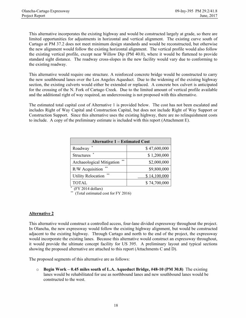
This alternative incorporates the existing highway and would be constructed largely at grade, so there are limited opportunities for adjustments in horizontal and vertical alignment. The existing curve south of Cartago at PM 37.2 does not meet minimum design standards and would be reconstructed, but otherwise the new alignment would follow the existing horizontal alignment. The vertical profile would also follow the existing vertical profile, except near Willow Dip (PM 40.0), where it would be flattened to provide standard sight distance. The roadway cross-slopes in the new facility would vary due to conforming to the existing roadway. This alternative would require one structure. A reinforced concrete bridge would be constructed to carry the new southbound lanes over the Los Angeles Aqueduct. Due to the widening of the existing highway section, the existing culverts would either be extended or replaced. A concrete box culvert is anticipated for the crossing of the N. Fork of Cartago Creek. Due to the limited amount of vertical profile available and the additional right of way required, an undercrossing is not proposed with this alternative. The estimated total capital cost of Alternative 1 is provided below. The cost has not been escalated and includes Right of Way Capital and Construction Capital, but does not include Right of Way Support or Construction Support. Since this alternative uses the existing highway, there are no relinquishment costs to include. A copy of the preliminary estimate is included with this report (Attachment E).
Alternative 1 – Estimated Cost
Roadway * $ 47,600,000
Structures * $ 1,200,000
Archaeological Mitigation ** $2,000,000
R/W Acquisition ** $9,800,000
Utility Relocation ** $ 14,100,000
TOTAL $ 74,700,000 * (FY 2014 dollars) ** (Total estimated cost for FY 2016)
Alternative 2 This alternative would construct a controlled access, four-lane divided expressway throughout the project. In Olancha, the new expressway would follow the existing highway alignment, but would be constructed adjacent to the existing highway. Through Cartago and north to the end of the project, the expressway would incorporate the existing lanes. Because this alternative would construct an expressway throughout, it would provide the ultimate concept facility for US 395. A preliminary layout and typical sections showing the proposed alternative are attached to this report (Attachments C and D).
The proposed segments of this alternative are as follows:
o Begin Work – 0.45 miles south of L.A. Aqueduct Bridge, #48-10 (PM 30.8) The existing lanes would be rehabilitated for use as northbound lanes and new southbound lanes would be constructed to the west.
Olancha-Cartago Expressway 09-Iny-395 PM 29.2/41.8 Project Report June, 2017
19
o 1.1 miles south of Cactus Flat Road (PM 31.5) New northbound and southbound lanes would be constructed to the east of the existing highway.
o 0.3 miles south of SR 190 junction (PM 34.4) New northbound and southbound lanes would be constructed to the west of the existing highway.
o 0.3 miles south of Lake Street (PM 37.3) The existing lanes would be rehabilitated for use as northbound lanes and new southbound lanes would be constructed to the west.
o 2.3 miles north of Whitney Street (PM 40.1) The existing lanes would be rehabilitated for use as southbound lanes and new northbound lanes would be constructed to the east.
o End Work – 0.2 miles south of Ash Creek Bridge, #48-068R (PM 41.8) The new expressway lanes would consist of two 12-foot lanes, with 5-foot inside and 10-foot outside shoulders, separated by at least a 100-foot unpaved median. Access would be controlled to existing intersections and other significant access points. At-grade median cross-overs would be included to provide access across the expressway. This alternative would parallel the existing highway alignment. However, the independent alignment through Olancha would allow the improvement of the existing horizontal alignment with larger radius curves to meet minimum standards. Because of the proximity to and use of the existing highway, the expressway would again be constructed largely at grade, except that the vertical profile would be adjusted near Willow Dip (PM 40.0) to provide standard sight distance. Due to segments of rehabilitation of the existing highway, the roadway cross-slopes would vary. The existing highway would be converted to frontage road between PM 31.9 and PM 37.1, which would preserve the existing uses and access through Olancha. With connections at major intersections and at either end, the frontage road would also serve as a collector road to the new expressway. After the project was completed, the frontage road would be relinquished to Inyo County. Access to the expressway would be provided at the existing intersection with SR 190 and also at several Inyo County roads: Cactus Flats Road, Walker Creek Road, Fall Road, School Street, Lake Street, and Whitney Street. The intersections would be realigned to conform to at-grade intersection standards, if required. New intersections and median cross-overs would also be constructed for the Crystal Geyser Bottling Plant and U.S. Borax. Access to parcels abutting the existing highway would be provided from the proposed frontage road and other existing roads. Two large concrete box culverts are proposed near PM 38.30 to provide an undercrossing under the new expressway. Minor grading would be required to connect the undercrossing to nearby dirt roads. This alternative would require a reinforced concrete bridge to carry the new southbound lanes over the Los Angeles Aqueduct. Culverts would be required under the new expressway lanes to maintain existing drainage patterns and culverts under the existing highway would also be replaced, as necessary. Concrete box culverts may be required to carry the N. Fork of Cartago Creek under the new expressway. The estimated total cost for Alternative 2 is provided below. The cost includes Right of Way Capital and Construction Capital, but does not include Right of Way Support or Construction Support. The estimated cost to bring the relinquished portions of the existing roadway up to a state of good repair is included as well. A copy of the preliminary estimate is included with this Report (Attachment E).
Olancha-Cartago Expressway 09-Iny-395 PM 29.2/41.8 Project Report June, 2017
20
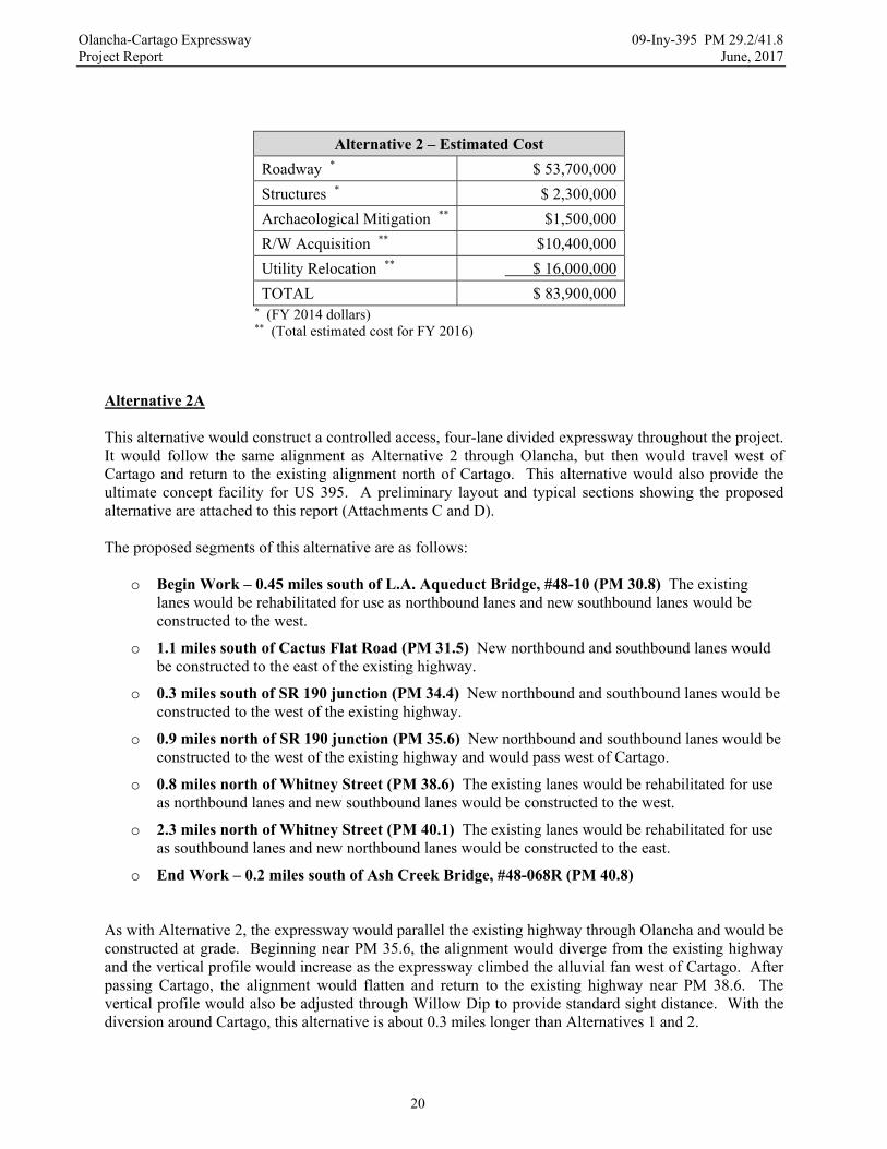
Alternative 2 – Estimated Cost
Roadway * $ 53,700,000
Structures * $ 2,300,000
Archaeological Mitigation ** $1,500,000
R/W Acquisition ** $10,400,000
Utility Relocation ** $ 16,000,000
TOTAL $ 83,900,000 * (FY 2014 dollars) ** (Total estimated cost for FY 2016)
Alternative 2A This alternative would construct a controlled access, four-lane divided expressway throughout the project. It would follow the same alignment as Alternative 2 through Olancha, but then would travel west of Cartago and return to the existing alignment north of Cartago. This alternative would also provide the ultimate concept facility for US 395. A preliminary layout and typical sections showing the proposed alternative are attached to this report (Attachments C and D).
The proposed segments of this alternative are as follows:
o Begin Work – 0.45 miles south of L.A. Aqueduct Bridge, #48-10 (PM 30.8) The existing lanes would be rehabilitated for use as northbound lanes and new southbound lanes would be constructed to the west.
o 1.1 miles south of Cactus Flat Road (PM 31.5) New northbound and southbound lanes would be constructed to the east of the existing highway.
o 0.3 miles south of SR 190 junction (PM 34.4) New northbound and southbound lanes would be constructed to the west of the existing highway.
o 0.9 miles north of SR 190 junction (PM 35.6) New northbound and southbound lanes would be constructed to the west of the existing highway and would pass west of Cartago.
o 0.8 miles north of Whitney Street (PM 38.6) The existing lanes would be rehabilitated for use as northbound lanes and new southbound lanes would be constructed to the west.
o 2.3 miles north of Whitney Street (PM 40.1) The existing lanes would be rehabilitated for use as southbound lanes and new northbound lanes would be constructed to the east.
o End Work – 0.2 miles south of Ash Creek Bridge, #48-068R (PM 40.8)
As with Alternative 2, the expressway would parallel the existing highway through Olancha and would be constructed at grade. Beginning near PM 35.6, the alignment would diverge from the existing highway and the vertical profile would increase as the expressway climbed the alluvial fan west of Cartago. After passing Cartago, the alignment would flatten and return to the existing highway near PM 38.6. The vertical profile would also be adjusted through Willow Dip to provide standard sight distance. With the diversion around Cartago, this alternative is about 0.3 miles longer than Alternatives 1 and 2.

Olancha-Cartago Expressway 09-Iny-395 PM 29.2/41.8 Project Report June, 2017
21
The existing highway would again be converted to a frontage road, but the frontage road would continue through Cartago, which would maintain the existing uses and access in Cartago as well. As a result, the length of existing highway to be relinquished to Inyo County would increase to 6.2 miles. The number of access points to the expressway would be reduced by one as the intersections at Lake Street and Whitney Street would now connect to the frontage road, but a new connector would be constructed near the bottling plant for Crystal Geyser Water to restore their access to the expressway. Due to the westerly alignment, the proposed undercrossing could be moved closer to Cartago and would be more consistent with an existing crossing over the aqueduct. An alternative location for the undercrossing would also be available on the southwest side of Cartago. This alternative would require a reinforced concrete bridge to carry the new southbound lanes over the Los Angeles Aqueduct. The number of culverts required under the new expressway lanes would increase due to the alignment through the alluvial fan west of Cartago. Culverts under the existing highway would also be replaced, as necessary, and concrete box culverts would still be anticipated for the crossing of the N. Fork of Cartago Creek. The estimated cost for Alternative 2A is provided below. The cost includes Right of Way Capital and Construction Capital, but does not include Right of Way Support or Construction Support. The estimated cost to bring relinquished portions of the existing roadway up to a state of good repair is also included. A copy of the preliminary estimate is included with this Report (Attachment E).
Alternative 2A – Estimated Cost
Roadway * $ 57,900,000
Structures * $ 2,300,000
Archaeological Mitigation ** $1,200,000
R/W Acquisition ** $11,200,000
Utility Relocation ** $ 6,900,000
TOTAL $ 79,500,000 * (FY 2014 dollars) ** (Total estimated cost for FY 2016)
Alternative 3
This alternative would construct a controlled access four-lane divided expressway throughout the project. Rather than paralleling the existing highway through Olancha, the proposed alignment would pass to the west of Olancha and then return to the existing alignment south of Cartago. It would then follow the existing alignment through Cartago and north to the end of the project. This alternative would also provide the ultimate concept facility for US 395. A preliminary layout and typical sections showing the proposed alternative are included with this report (Attachments C and D).

Olancha-Cartago Expressway 09-Iny-395 PM 29.2/41.8 Project Report June, 2017
22
The proposed segments of this alternative are as follows:
o Begin Work – 0.45 miles south of L.A. Aqueduct Bridge, #48-10 (PM 30.8) The existing lanes would be rehabilitated for use as northbound lanes and new southbound lanes would be constructed to the west.
o 0.5 miles south of Cactus Flat Road (PM 32.1) New northbound and southbound lanes would be constructed to the west of the existing highway and would pass west of Olancha.
o 0.3 miles south of Lake Street (PM 37.3) The existing lanes would be rehabilitated for use as northbound lanes and new southbound lanes would be constructed to the west.
o 2.3 miles north of Whitney Street (PM 40.1) The existing lanes would be rehabilitated for use as southbound lanes and new northbound lanes would be constructed to the east.
o End Work – 0.2 miles south of Ash Creek Bridge, #48-068R (PM 41.8)
Beginning at PM 32.1, the alignment for this alternative diverges from the existing highway as it passes along the west side of Olancha and then returns to the existing highway near PM 37.3. There would be a significant change in vertical profile as the alignment traverses the alluvial fan west of Olancha. It would be necessary to either extend SR 190 approximately 0.7 miles to the proposed alignment or to retain a portion of US 395 and redesignate it as SR 190. Due to the diversion around Olancha, this alternative is about 0.2 miles longer than Alternatives 1 and 2. The existing highway would be converted to a frontage road that would begin near PM 32.4 and extend north through Olancha to PM 37.3. The length of highway that would be relinquished to Inyo County would be reduced to 4.8 miles. The number of access points to the new expressway would be reduced by five as all of the access points in the Olancha area would now connect to the frontage road. Access would still be provided at the existing intersections with Lake Street and Whitney Street in Cartago. The north end of the frontage road would be near the bottling plant for Crystal Geyser Water, so a connector would not be necessary. In order to maintain westerly access for the current cattle drive route, the proposed undercrossing would be relocated near Olancha Creek. Along the west side of Olancha, the alignment would travel near the Los Angeles Aqueduct, which would help to protect the expressway from major storm flows. In general, though, the braided channels on the alluvial fan would require more cross drainage. In addition, the proximity to the aqueduct could require larger drainage culverts to handle the concentrated flows that would occur at the overchute structures that pass storm water flows over the aqueduct. It could also expose the expressway to risk of washout in the event that there was a breach or overtopping of the aqueduct. This alternative would still require a reinforced concrete bridge to carry the southbound lanes across the Los Angeles Aqueduct. Concrete box culverts are also anticipated for the crossing of Olancha Creek and the N. Fork of Cartago Creek. The estimated total cost for Alternative 3 is provided below. The cost includes Right of Way Capital and Construction Capital, but does not include Right of Way Support or Construction Support. The estimated costs to bring the relinquished portions of the existing roadway up to a state of good repair and to extend SR 190 to the new alignment are also included. In the event the existing highway is redesignated as SR 190, the total cost would be reduced by about $1.5 million dollars. A copy of the preliminary estimate is included with this Report (Attachment E).
Olancha-Cartago Expressway 09-Iny-395 PM 29.2/41.8 Project Report June, 2017
23
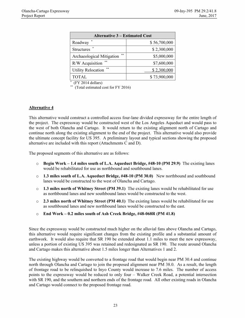
Alternative 3 – Estimated Cost
Roadway * $ 56,700,000
Structures * $ 2,300,000
Archaeological Mitigation ** $5,000,000
R/W Acquisition ** $7,600,000
Utility Relocation ** $ 2,300,000
TOTAL $ 73,900,000 * (FY 2014 dollars) ** (Total estimated cost for FY 2016)
Alternative 4
This alternative would construct a controlled access four-lane divided expressway for the entire length of the project. The expressway would be constructed west of the Los Angeles Aqueduct and would pass to the west of both Olancha and Cartago. It would return to the existing alignment north of Cartago and continue north along the existing alignment to the end of the project. This alternative would also provide the ultimate concept facility for US 395. A preliminary layout and typical sections showing the proposed alternative are included with this report (Attachments C and D).
The proposed segments of this alternative are as follows:
o Begin Work – 1.4 miles south of L.A. Aqueduct Bridge, #48-10 (PM 29.9) The existing lanes would be rehabilitated for use as northbound and southbound lanes.
o 1.3 miles south of L.A. Aqueduct Bridge, #48-10 (PM 30.0) New northbound and southbound lanes would be constructed to the west of Olancha and Cartago.
o 1.3 miles north of Whitney Street (PM 39.1) The existing lanes would be rehabilitated for use as northbound lanes and new southbound lanes would be constructed to the west.
o 2.3 miles north of Whitney Street (PM 40.1) The existing lanes would be rehabilitated for use as southbound lanes and new northbound lanes would be constructed to the east.
o End Work – 0.2 miles south of Ash Creek Bridge, #48-068R (PM 41.8) Since the expressway would be constructed much higher on the alluvial fans above Olancha and Cartago, this alternative would require significant changes from the existing profile and a substantial amount of earthwork. It would also require that SR 190 be extended about 1.1 miles to meet the new expressway, unless a portion of existing US 395 was retained and redesignated as SR 190. The route around Olancha and Cartago makes this alternative about 1.5 miles longer than Alternatives 1 and 2. The existing highway would be converted to a frontage road that would begin near PM 30.4 and continue north through Olancha and Cartago to join the proposed alignment near PM 38.0. As a result, the length of frontage road to be relinquished to Inyo County would increase to 7.6 miles. The number of access points to the expressway would be reduced to only four – Walker Creek Road, a potential intersection with SR 190, and the southern and northern ends of the frontage road. All other existing roads in Olancha and Cartago would connect to the proposed frontage road.

Olancha-Cartago Expressway 09-Iny-395 PM 29.2/41.8 Project Report June, 2017
24
This alternative would be west of the Los Angeles Aqueduct, so the potential for flash flooding from the numerous braided channels on the alluvial fan would be much higher. As a result, there would be a significant increase in the amount of cross-drainage that would be required to protect the roadway from flooding. Entrainment dikes or collection channels would also be required along the western boundary of the roadway to intercept major storm flows. Besides the crossings of Olancha Creek and the N. Fork of Cartago Creek, the alignment on the west side of the aqueduct would cross several large washes that may also require concrete box culverts. This alternative would require the most structures of any alternative. Two bridges would be required to carry the southbound and northbound lanes across the Los Angeles Aqueduct. An additional bridge would also be required for the extension of SR 190 across the Los Angeles Aqueduct, unless the portion of the existing highway south of the intersection with SR 190 is redesignated as SR 190. The proposed undercrossing would be constructed south of Olancha Creek near the end of Fall Road, which would be consistent with the traditional cattle drive route between Olancha and the Sierra Mountains. The estimated total cost of Alternative 4 is provided below. The total cost includes Right of Way Capital and Construction Capital, but does not include Right of Way Support or Construction Support. It also includes the estimated cost to bring the relinquished portions of the existing highway up to a state of good repair and to extend SR 190 to the new alignment. In the event the existing highway is redesignated as SR 190, the total cost would be reduced by about $3.5 million dollars. Due to the higher earthwork and structures costs, this alternative is the most expensive alternative. A copy of the preliminary estimate is included with this Report (Attachment E).
Alternative 4 – Estimated Cost
Roadway * $ 68,300,000
Structures * $ 2,800,000
Archaeological Mitigation ** $5,000,000
R/W Acquisition ** $7,400,000
Utility Relocation ** $ 2,800,000
TOTAL $ 86,300,000 * (FY 2014 dollars) ** (Total estimated cost for FY 2016)
No Build Alternative The “No Build” Alternative would leave this segment of US 395 in its current configuration as a two-lane conventional highway. This would not address the need to increase safety, improve level of service, and provide four-lane route continuity. As traffic volumes increase, the level of service will deteriorate and the number of accidents will most likely increase. Without a median, the percentage of severe accidents will remain high as well. As a result, this alternative is not recommended.

Olancha-Cartago Expressway 09-Iny-395 PM 29.2/41.8 Project Report June, 2017
25
Selection of Preferred Alternative Due to the complexity and variety of considerations for each alternative, a criteria based selection process was developed to evaluate the alternatives. The PDT agreed on a list of criteria and sub-criteria to rate each alternative against and then assigned weighting factors to the criteria so that they could be combined into an overall score for each alternative. The criteria and sub-criteria are listed below.
Safety (weighting factor = 3)
o Median type/width o Shoulder width/recovery area o Frequency/type of access points o Multi-modal access/use
Local Public Concerns (weighting factor = 2.5)
o Economic impacts o Displacement of residents and businesses o Local road user preference o Access o Agricultural/Ranching concerns o Private/Public lands o Relinquishment concerns
Cost (weighting factor = 2)
o Construction and Right of Way costs o Long-term maintenance costs o Potential cost increases o Ability to phase
Interregional/Regional Public Concerns (weighting factor = 1.5)
o Interregional/Regional road user preference o Level of service o 4-lane continuity
Natural and Physical Environment (weighting factor = 1)
o Visual landscape o Biological resources o Cultural resources o Hazardous waste o Noise levels
Project data, public comments, and any other information related to the alternatives was assembled. Over the course of two meetings, the PDT reviewed the information and agreed on how well each alternative satisfied each sub-criterion, on a scale from 1 point (minimally met the sub-criterion) to 3 points (best met the sub-criterion). Then, the scores for each sub-criterion were totaled and multiplied by the criterion weighting factor to establish an overall criterion score for each alternative. For comparison purposes, a similar process was performed internally to evaluate the Caltrans Preferred Alternative. The resulting scores for each alternative are summarized in the table below.
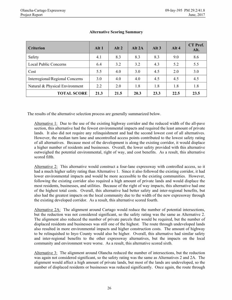
Olancha-Cartago Expressway 09-Iny-395 PM 29.2/41.8 Project Report June, 2017
26
Alternative Scoring Summary
Criterion Alt 1 Alt 2 Alt 2A Alt 3 Alt 4 CT Pref.
Alt.
Safety 4.1 8.3 8.3 8.3 9.0 8.6
Local Public Concerns 6.4 3.2 3.2 4.3 5.2 5.5
Cost 5.5 4.0 3.0 4.5 2.0 3.0
Interregional/Regional Concerns 3.0 4.0 4.0 4.5 4.5 4.5
Natural & Physical Environment 2.2 2.0 1.8 1.8 1.8 1.8
TOTAL SCORE 21.3 21.5 20.3 23.3 22.5 23.5
The results of the alternative selection process are generally summarized below.
Alternative 1: Due to the use of the existing highway corridor and the reduced width of the all-pave section, this alternative had the fewest environmental impacts and required the least amount of private lands. It also did not require any relinquishment and had the second lowest cost of all alternatives. However, the median turn lane and uncontrolled access points contributed to the lowest safety rating of all alternatives. Because most of the development is along the existing corridor, it would displace a higher number of residents and businesses. Overall, the lower safety provided with this alternative outweighed the potential environmental, right of way, and cost benefits. As a result, this alternative scored fifth.
Alternative 2: This alternative would construct a four-lane expressway with controlled access, so it had a much higher safety rating than Alternative 1. Since it also followed the existing corridor, it had lower environmental impacts and would be more accessible to the existing communities. However, following the existing corridor also required a high amount of private lands and would displace the most residents, businesses, and utilities. Because of the right of way impacts, this alternative had one of the highest total costs. Overall, this alternative had better safety and inter-regional benefits, but also had the greatest impacts on the local community due to the width of the new expressway through the existing developed corridor. As a result, this alternative scored fourth.
Alternative 2A: The alignment around Cartago would reduce the number of potential intersections, but the reduction was not considered significant, so the safety rating was the same as Alternative 2. The alignment also reduced the number of private parcels that would be required, but the number of displaced residents and businesses was still one of the highest. The route through undeveloped lands also resulted in more environmental impacts and higher construction costs. The amount of highway to be relinquished to Inyo County would also be higher. Overall, this alternative had similar safety and inter-regional benefits to the other expressway alternatives, but the impacts on the local community and environment were worse. As a result, this alternative scored sixth. Alternative 3: The alignment around Olancha reduced the number of intersections, but the reduction was again not considered significant, so the safety rating was the same as Alternatives 2 and 2A. The alignment would affect a high amount of private lands, but most of the lands are undeveloped, so the number of displaced residents or businesses was reduced significantly. Once again, the route through

Olancha-Cartago Expressway 09-Iny-395 PM 29.2/41.8 Project Report June, 2017
27
undeveloped lands had more environmental impacts and a higher construction cost. However, it also significantly reduced the right of way and utility costs, so this alternative had the lowest overall cost. It also required the least amount of relinquishment. Overall, this alternative had similar safety and inter-regional benefits to the other expressway alternatives, but it also significantly reduced right of way impacts and overall cost. As a result, this alternative scored second. Alternative 4: The alignment around both Olancha and Cartago minimized the number of potential intersections. As a result, this alternative had the highest safety rating of all alternatives. Since the route goes through mostly public lands, it also affected the fewest private parcels and would displace only one resident (assuming an extension of SR 190 would be constructed near Olancha Creek). It also significantly reduced right of way and utility relocation costs. However, crossing undeveloped public lands also caused the most environmental impact. The location on the alluvial fans also required substantially more earthwork and drainage facilities, so this alternative had the highest cost of all alternatives. It also would have required the most relinquishment. Overall, this alternative had the highest safety benefits and the fewest direct impacts on the communities, but it also had the most environmental impact and a significantly higher cost than the other alternatives. As a result, this alternative scored third.
Caltrans Preferred Alternative: The alignment goes around Olancha, but still goes through Cartago, so this alternative had a lower safety rating than Alternative 4. However, the offset of the alignment through Cartago allows the existing highway to remain as a frontage road, which gave this alternative a higher safety rating than the other expressway alternatives. This alternative would affect the fewest parcels and would not displace any residents because of the redesignation of the existing highway as SR 190. The route through undeveloped public lands again significantly reduces the right of way and utility relocation costs, but causes more environmental impact. The amount of earthwork would still be substantial, but the route through Cartago significantly reduces the amount of earthwork. With the redesignation of SR 190, the amount of existing highway to be relinquished would be significantly reduced as well. Overall, this alternative had one of the highest safety ratings and very low right of way and community impacts. The environmental impacts and cost were higher, but were outweighed by the safety, right of way, and community benefits. As a result, this alternative scored first.
C. Rejected Alternatives Alternative 3A As noted in the Project History Section, Alternative 3A was developed as a result of the Value Analysis Report that was prepared for this project. The alignment went around both Olancha and Cartago, but stayed on the east side of the Los Angeles Aqueduct. However, private development had occurred along the proposed alignment since it was developed in 2000. Alternative 4 went around both communities as well, but traveled through undeveloped public lands further to the west, so there wree fewer right of way impacts. Alternative 3A also would have caused higher noise and traffic impacts than Alternative 4 due to its proximity to the communities. As a result, Alternative 3A was rejected by the Project Development Team in the summer of 2007 in favor of Alternative 4.
Olancha-Cartago Expressway 09-Iny-395 PM 29.2/41.8 Project Report June, 2017
28
Alternative 2R As discussed in the Project History Section, this alternative was the original alignment for Alternative 2 that was developed for early bypass studies and was included in the 1999 PSR-EO. It followed the same alignment as Alternative 2, except that the alignment continued past SR 190 (PM 34.6) on the east side of the existing highway up to about PM 35.6, where it crossed back over to the west of the existing highway. The alignment was changed to avoid the wetlands and cottonwood trees on the east side of the existing highway. Since this alignment could have significantly reduced the right of way impacts and the cost of construction in Olancha, it was reevaluated during the consideration of alternatives for this project. After further environmental study, though, the pasture lands north of SR 190 and east of the existing highway were determined to be jurisdictional wetlands that had to be avoided. As a result, this alternative was removed from consideration.
6. CONSIDERATIONS REQUIRING DISCUSSION
A. Hazardous Waste An Initial Site Assessment (ISA) was completed for the project in January, 2007. The ISA was updated in June, 2009 and was updated again in March, 2010. With the subsequent updates, a total of 266 parcels within the Area of Potential Effect have been investigated for hazardous waste issues and eight parcels have been identified that have the potential for hazardous waste problems. Four of these parcels have histories of hazardous waste problems and the others could potentially have hazardous waste problems. Preliminary Site Investigations (PSIs) have not been performed for the sites, but would be performed in the event that the sites would be affected by the selected alternative. There were at least six former gas stations within the project limits that were either abandoned or have been removed. One of these stations was removed ten years ago and is an active clean-up site with an ongoing remediation operation. The site would not be acquired for this project, but the pollutants from the site extend under the adjacent highway. Under agreement with the Regional Water Quality Control Board, only the polluted soils encountered during construction would need to be removed and Caltrans would not be required to remediate all of the contaminated soils within the proposed right of way. The presence of underground tanks or extent of potential contamination at the remaining stations is not known at this time. However, the stations have been out of operation for many years. Historically, sites of this age in the Owens Valley have only required underground fuel tank removals and have not required site remediation due to the non-caustic nature of the soils as well as the dispersal of the pollutants over time. As a result, the additional costs for removal and cleanup at each site are anticipated to be minimal. The Caltrans Preferred Alternative passes through a large parcel that contains the former Adamson Landing Field (also known as the Grant Airstrip). The landing strip was abandoned, but records indicate that there may be sodium sulfide barrels buried near the north end of the airstrip. Since the airstrip is over one-half mile away from the proposed right of way and is located on the other side of the Los Angeles Aqueduct, it is unlikely that the Caltrans Preferred Alternative would affect the hazardous materials. However, in the event that the entire parcel must be cleared, a PSI would be required.
Olancha-Cartago Expressway 09-Iny-395 PM 29.2/41.8 Project Report June, 2017
29
B. Value Analysis A Value Analysis study was performed for the project in February, 2000. The VA study developed six potential alternatives:
o Alternative 1.1 – This alternative would have constructed northbound lanes around the eastern side and southbound lanes around the western side of the towns, with the existing highway being used as a “business route”. This alternative was not implemented.
o Alternative 1.2 – This alternative would have realigned the new expressway lanes to the west of Cartago, following the existing railroad alignment. This alternative was implemented and resulted in Alternative 2A and Alternative 3A, both of which are discussed in Section 5.
o Alternative 1.3 – This alternative would have realigned Alternative 2 farther to the east of the existing highway and would have transitioned back to the west near the Ranch House Café. This alternative was not implemented.
o Alternative 2.1 – This alternative would have reduced the median width for Alternative 2 to 60 feet and would have realigned Alternative 2 to the west of the existing highway from Fall Road to the north. The median width reduction was not implemented, but the realignment to the west was implemented in Alternative 2, which is discussed in Section 5.
o Alternative 2.2 – This alternative would have reduced the median width for Alternative 2 and Alternative 3 to 60 feet. This alternative was not implemented.
o Alternative 3.0 – This alternative would have incorporated a rest stop area into the project near the intersection of U.S. 395 and S.R. 190. This alternative was not implemented.
C. Resource Conservation Each alternative incorporates varying amounts of the existing highway into the completed facility. The Caltrans Preferred Alternative would only rehabilitate 0.7 miles of existing highway, whereas Alternative 1 would rehabilitate the entire existing highway. Using the existing highway reduces the amount of work required to construct a suitable structural section and would reduce the amount of materials needed to complete the project. The reduction in materials also reduces the amount of trucking that would be required to deliver those materials to the project. Wherever possible, the new roadway would conform to the existing roadway, which reduces the amount of trim and replacement materials that may be required. Those portions of existing highway that may need to be reshaped could also be cold-foam recycled, which would allow reshaping of the roadway cross-section with the existing roadway materials. The portions of existing highway that are not rehabilitated would be obliterated. The resulting pulverized materials could potentially be used in fills or as shoulder backing material. They could also be recycled for use as aggregates in the asphalt concrete and aggregate base materials that would be produced for the project. If there are no suitable uses for the pulverized materials on the project, they could be stockpiled for use in future projects or maintenance activities. The material borrow area that has been identified near the end of Fall Road could also conserve resources by significantly reducing the amount of materials that would need to be delivered to the project and the distance that materials would need to be hauled within the project limits. Since the supply of aggregates is limited at existing State and commercial sources, use of the material borrow area would also preserve those materials for other projects and uses.
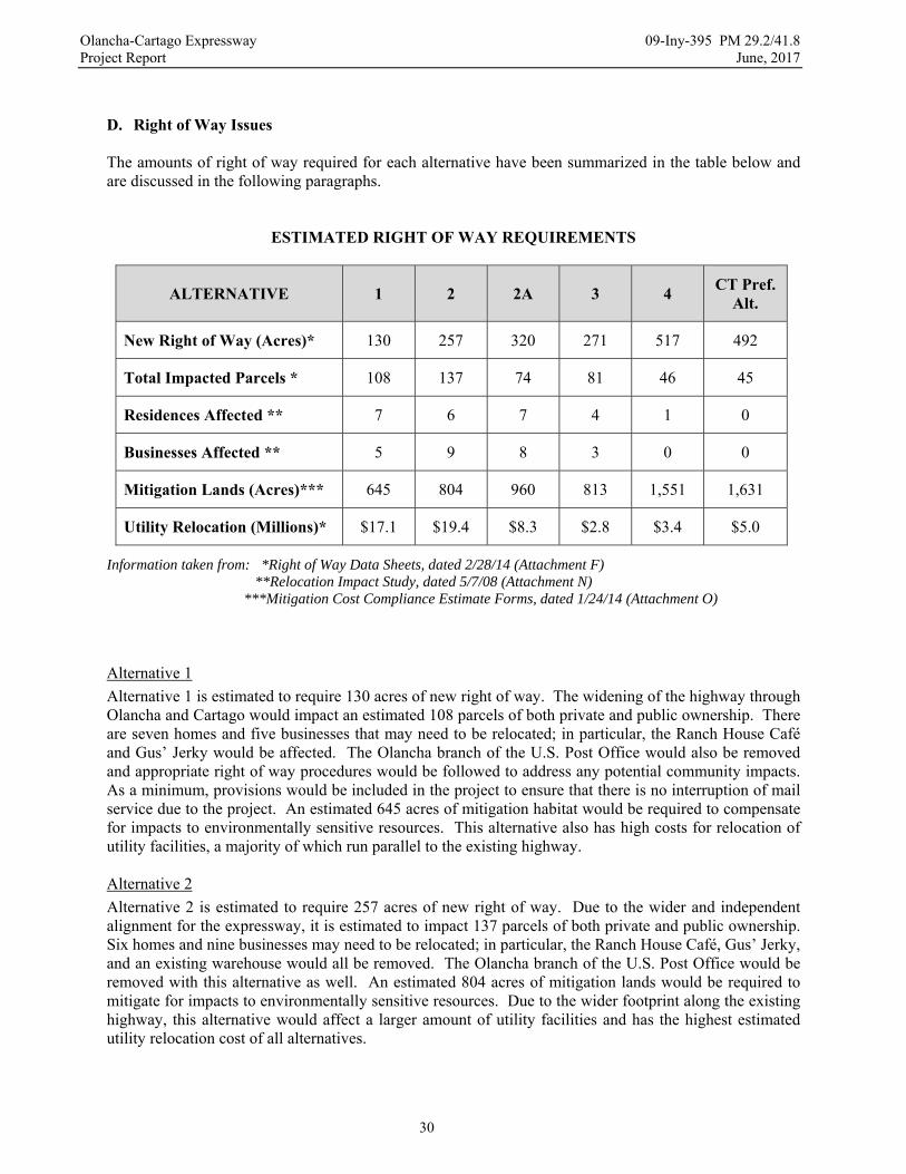
Olancha-Cartago Expressway 09-Iny-395 PM 29.2/41.8 Project Report June, 2017
30
D. Right of Way Issues The amounts of right of way required for each alternative have been summarized in the table below and are discussed in the following paragraphs.
ESTIMATED RIGHT OF WAY REQUIREMENTS
ALTERNATIVE 1 2 2A 3 4 CT Pref.
Alt.
New Right of Way (Acres)* 130 257 320 271 517 492
Total Impacted Parcels * 108 137 74 81 46 45
Residences Affected ** 7 6 7 4 1 0
Businesses Affected ** 5 9 8 3 0 0
Mitigation Lands (Acres)*** 645 804 960 813 1,551 1,631
Utility Relocation (Millions)* $17.1 $19.4 $8.3 $2.8 $3.4 $5.0
Information taken from: *Right of Way Data Sheets, dated 2/28/14 (Attachment F) **Relocation Impact Study, dated 5/7/08 (Attachment N) ***Mitigation Cost Compliance Estimate Forms, dated 1/24/14 (Attachment O)
Alternative 1
Alternative 1 is estimated to require 130 acres of new right of way. The widening of the highway through Olancha and Cartago would impact an estimated 108 parcels of both private and public ownership. There are seven homes and five businesses that may need to be relocated; in particular, the Ranch House Café and Gus’ Jerky would be affected. The Olancha branch of the U.S. Post Office would also be removed and appropriate right of way procedures would be followed to address any potential community impacts. As a minimum, provisions would be included in the project to ensure that there is no interruption of mail service due to the project. An estimated 645 acres of mitigation habitat would be required to compensate for impacts to environmentally sensitive resources. This alternative also has high costs for relocation of utility facilities, a majority of which run parallel to the existing highway. Alternative 2
Alternative 2 is estimated to require 257 acres of new right of way. Due to the wider and independent alignment for the expressway, it is estimated to impact 137 parcels of both private and public ownership. Six homes and nine businesses may need to be relocated; in particular, the Ranch House Café, Gus’ Jerky, and an existing warehouse would all be removed. The Olancha branch of the U.S. Post Office would be removed with this alternative as well. An estimated 804 acres of mitigation lands would be required to mitigate for impacts to environmentally sensitive resources. Due to the wider footprint along the existing highway, this alternative would affect a larger amount of utility facilities and has the highest estimated utility relocation cost of all alternatives.

Olancha-Cartago Expressway 09-Iny-395 PM 29.2/41.8 Project Report June, 2017
31
Alternative 2A
Alternative 2A is estimated to require 320 acres of new right of way. The additional right of way is due to the construction of new lanes to the west of Cartago. However, since the lanes pass through larger undeveloped parcels, the estimated number of parcels that would be impacted by this alternative would be significantly reduced to 74 parcels. An additional home on the west side of Cartago may be impacted and a total of seven homes and eight businesses may be relocated. The Olancha branch of the U.S. Post Office would also be removed with this alternative. An estimated 960 acres of mitigation lands would be required to mitigate for impacts to environmentally sensitive resources. The alignment around Cartago avoids the utility facilities along US 395, so the utility relocation costs for this alternative would be lower. Alternative 3
The estimated new right of way required for Alternative 3 is 271 acres. Since the west side of Olancha is less developed than the existing highway corridor, this alternative would have fewer right of way impacts. The alignment passes through a small subdivision, but also passes through several large undeveloped parcels owned by public agencies. As a result, this alternative would only affect four homes and three businesses and would impact a total of 81 parcels. The estimated amount of mitigation lands required to mitigate for environmental impacts is 813 acres. The alignment around Olancha again avoids the utility facilities along US 395, so the utility relocation costs for this alternative are much lower. Alternative 4
Alternative 4 is estimated to require 517 acres of new right of way. The route primarily passes through large undeveloped parcels owned by the Bureau of Land Management and the State of California. As a result, this alternative would impact only 46 parcels and would require the relocation of only one home (if the extension of SR 190 occurred). However, because the alignment goes through undeveloped public lands, would be much longer, and would require a lot more disturbance, this alternative is estimated to require 1,551 acres of mitigation lands. This alternative avoids the utility facilities along US 395 in both Olancha and Cartago, so it requires minimal utility relocation. Caltrans Preferred Alternative
The Caltrans Preferred Alternative is estimated to require 492 acres of new right of way. Besides several private parcels in the Cartago area, the alignment primarily passes through large undeveloped parcels owned by the Bureau of Land Management, the City of Los Angeles, and the State of California. As a result, it will impact the fewest parcels and will not directly affect any existing residences or businesses. However, this alternative is also estimated to require the most mitigation lands of any of the alternatives. In addition to the utility corridor north of Cartago, this alternative affects the utility facilities along the existing highway through Cartago, so it has higher utility relocation costs than Alternatives 3 and 4. E. Environmental Issues The environmental document prepared for this project is an Environmental Impact Report/ Environmental Assessment (EIR/EA). A Draft EIR/EA was prepared and describes the project information and findings that support the Final EIR/EA. The Draft EIR/EA and Final EIR/EA were prepared in accordance with Caltrans’ standard environmental procedures, as well as State and federal environmental regulations, and are appropriate documents for the project. Based upon the findings in the Final EIR/EA, the project has the potential to significantly affect environmental resources. Avoidance, minimization, and mitigation measures will be incorporated into the project to reduce nearly all of the significant impacts to less than significant effects. However, the impacts to cultural resources cannot be reduced to less than significant effects. The measures that would be included to minimize or mitigate for significant effects are discussed in the following paragraphs.
Olancha-Cartago Expressway 09-Iny-395 PM 29.2/41.8 Project Report June, 2017
32
Cultural Resources
Due to the natural resources that existed around the historic Owens Lake, it was a significant area of Native American habitation. As a result, there are extensive cultural resources present throughout the project limits. Some of the cultural sites have been evaluated and eight sites have been determined to be eligible for listing on the Register of Historic Places. Many more sites are known, but have not been evaluated to avoid unnecessary disturbance of the sites. Some eligible sites may be adversely affected, so a Finding of Adverse Effect was prepared for the project and the State Historic Preservation Officer has concurred with the Adverse Effect finding. Cultural resources that are not affected would be designated and fenced as Environmentally Sensitive Areas to protect them during construction. Most of the sites are on lands managed by the BLM and, in coordination with the BLM, Caltrans has developed a project specific Programmatic Agreement between the FHWA and the SHPO that governs the evaluation of the sites. The Programmatic Agreement requires Caltrans to develop and implement a Historic Properties Treatment Plan to complete the identification of affected sites, evaluate their potential eligibility for listing on the Register of Historic Places, and provide a resolution for adverse effects to historic properties. The Historic Properties Treatment Plan has been completed and has been approved by the State Historic Preservation Officer. All archaeological mitigation work for the project would be performed in accordance with the Historic Properties Treatment Plan. The project will incorporate historic sites into the completed facility, so a Section 4(f) Evaluation was required for this project. Under Section 4(f), the FHWA cannot approve a project that uses land from a historic property unless there is no feasible and prudent avoidance alternative and all possible planning is done to minimize harm to the property. Typically, only sites that are eligible for listing and that warrant preservation in place are addressed in a Section 4(f) Evaluation, but because there are many unevaluated sites that may be potentially eligible for listing, all of the sites were considered as potential historic properties in the Section 4(f) Evaluation. After evaluating the potential impacts from each alternative to known sites, the Section 4(f) Evaluation concluded that there are no feasible and prudent alternatives that would avoid impacts to Section 4(f) resources. Since there are no feasible and prudent alternatives, the Section 4(f) Evaluation then compared the proposed build alternatives to determine which alternative had the least overall harm to Section 4(f) resources. Each alternative was scored for seven factors and the Caltrans Preferred Alternative was determined to cause the least overall harm. Due to the amount and sensitivity of cultural resources present, the work required to evaluate and resolve impacts to affected sites is expected to be extensive. In order to prevent this work from impacting the proposed construction schedule, mitigation funds were programmed separately so that the archaeological mitigation work could begin well in advance of construction. As a result, the funding for archaeological mitigation is currently programmed in the 2016 STIP in the 2018/2019 fiscal year. Wetlands and Waters of the U.S.
A Jurisdictional Delineation Report was prepared in July, 2009 and a Jurisdictional Determination was issued by the U.S. Army Corps of Engineers for the wetlands and Waters of the U.S. delineated in the report. There are three jurisdictional wetland areas within the project limits: the large pasture area east of the existing highway in Olancha and two smaller areas near Willow Dip (STA 620+00 NB). There are also four named streams and numerous ephemeral streams that are considered jurisdictional Waters of the U.S. The wetland area in Olancha would not be affected, but both the wetland areas in Willow Dip and the Waters of the U.S. that would pass under the new facility would be affected. Early in the alternative development stage, the PDT recognized that a continuous parallel alignment with a 100 foot median would significantly impact the wetlands in Willow Dip, so it was decided to split the northbound and southbound alignments to avoid impacts to the wetlands. The northbound lanes followed
Olancha-Cartago Expressway 09-Iny-395 PM 29.2/41.8 Project Report June, 2017
33
the existing alignment and the southbound lanes were moved to the west above the wetland areas. The split alignment caused higher roadway and utility relocation costs, but all of the alternatives include the split in order to avoid the wetlands. The Caltrans Preferred Alternative would also adjust the vertical profile and cross-section of the northbound lanes as they pass through Willow Dip to minimize work outside of the existing limits of disturbance. Retaining walls or other structures would also be considered to possibly expand the area of the existing wetlands. Seasonal restrictions, designation of Environmentally Sensitive Areas, and water quality measures would be implemented to minimize impacts to wetlands and Waters of the U.S. Whenever possible, areas of impact will be minimized and will be restored to their pre-construction conditions. Areas of permanent impact would be mitigated either by purchasing replacement habitat or by providing fees to an approved mitigation bank. Visual Impacts
Visual impacts from the project were considered from the perspective of both highway users and the local residents. For highway users, the visual quality of the Caltrans Preferred Alternative would be improved, especially with the inclusion of scenic vista points. For local residents, the views of the mountains to the west would not be affected, as the new roadway would be constructed largely at grade and the portions in fill would mimic the existing Los Angeles Aqueduct. The removal of vegetation and the creation of cut and fill slopes could create visual impacts, but these would be temporary and would be mitigated by revegetating medians and side slopes, planting replacement plants, contour grading and slope rounding of new slopes, and preserving existing vegetation. Potential impacts to residents in Cartago caused by headlight glare from southbound vehicles would be mitigated with the construction of raised berms along the west edge of the new right of way.
Paleontological Resources
A Paleontological Evaluation Report was prepared for the project. The alluvial fans along the base of the Sierra Mountains consist of Quaternary sediment deposits that are not likely to hold fossils. However, the portion of the project near Owens Lake has Lacustrine deposits that are much more likely to hold fossils, and the presence of fossils in these deposits was confirmed in field surveys. In general, the probability of finding fossils increases with the depth of excavation. As a result, a paleontological resource mitigation plan will be required for the project. The plan would include coordination with the contractor during grading and excavation operations to inspect excavations and recover any fossils that are discovered. In particular, a paleontological monitor will be required during deep excavations and during any excavation work adjacent to Owens Lake. Noise
A Noise Study was performed and evaluated 45 representative locations for potential noise impacts. The projected future noise levels were determined for each alternative and, in general, the project would not result in significant noise impacts. In particular, though, Alternative 3 would create substantial noise increases at five receptors. Noise abatement was considered for these receptors, but was not found to be feasible or reasonable, so noise abatement was not required for the project. A Noise Abatement Decision Report was prepared to document these findings. Temporary noise impacts are also anticipated from construction activities. The impacts will be short term and intermittent, and will be minimized by following Section 14-8, Noise and Vibration, of the Standard Specifications. In addition to requiring mufflers on all equipment, other noise mitigation measures may be implemented such as relocating equipment, turning off idling equipment, rescheduling construction activities, notifying adjacent residents in advance, and installing temporary noise barriers.
Olancha-Cartago Expressway 09-Iny-395 PM 29.2/41.8 Project Report June, 2017
34
Biological Resources
There are numerous biological species of concern that may be affected by the project:
o Natural Plant Communities. There are a number of natural habitat communities that would be affected; in particular, the Fremont Cottonwood series habitat. Seasonal work windows and Environmentally Sensitive Areas are proposed to minimize impact to the trees within these communities and the nesting habitat that they provide. Any trees that are removed will be replaced at an appropriate replacement ratio.
o Plant species. The Caltrans Preferred Alternative and Alternative 3 would directly affect the White Pygmy Poppy, a special-status plant. There is also a population of an endangered plant, Owens Valley Checkerbloom, near the project area. There are a number of other special-status and endangered plants that could potentially be present, but were not observed during botanical surveys for the project. Additional surveys will be performed prior to construction to verify if any other special-status or endangered species are present. If they are, ESA fencing and other mitigation measures would be required to minimize potential impacts to the plants.
o Bats. A number of species of bats were detected during project surveys. There is potential foraging and roosting habitat in the trees that may be removed for the project. Pre-construction surveys will be required prior to disturbing any potential roosting habitat. If bats are found roosting, protective exclusionary measures would be implemented.
o Migratory Birds. All of the alternatives could temporarily remove nesting and foraging habitat for migratory birds (including the endangered Swainson's hawk, southwestern willow flycatcher, and yellow-billed cuckoo). Seasonal restrictions for clearing will be required and surveys will be performed prior to construction to verify the presence of any nesting birds. Additional mitigation measures would be implemented if necessary to avoid potential impacts to nesting birds. ESAs would be established to prevent impacts to riparian areas that may serve as nesting or foraging habitat and any riparian areas affected by the project would be restored or replaced to avoid potential long term impacts. Off-site lands woud also be purchased as compensatory mitigation for impacts to migratory habitat for the southwestern willow flycatcher and western yellow-billed cuckoo. These off-site lands would provide replacement habitat for other migratory birds as well.
o Owens Valley Vole. All of the alternatives would remove wetlands that could provide habitat for the Owens Valley vole. The replacement habitat that would be provided to mitigate for impacts to wetlands would provide replacement habitat for the Owens Valley vole as well.
o Burrowing Owl. Burrowing owl habitat was observed in the proposed material borrow area and within the limits of Alternative 4 and the Caltrans Preferred Alternative. Pre-construction surveys will be performed to verify the presence of burrowing owls. If owls are present, additional measures to protect owls would be implemented. These may include passive relocation, providing an ESA around burrows, providing worker training, and monitoring.
o Golden Eagle. No nests or specific foraging areas were observed within the project limits, but pre-construction surveys will be performed to verify their presence, and protective ESAs and buffer zones would be established if nests are present. Seasonal restrictions for tree and vegetation removal are also proposed. In addition, the mitigation habitat provided for desert tortoise impacts would mitigate for impacts to eagle foraging habitat.
o Desert Tortoise. Each alternative would affect the threatened desert tortoise either by potentially harming the animals or by destroying their habitat. The impacts would be mitigated both through on-site mitigation and off-site mitigation. On-site mitigation measures would include installing permanent exclusionary tortoise fencing, enlarging culverts to serve as tortoise undercrossings, and constructing tortoise-safe cattle guards. In addition to the permanent measures, a biological
Olancha-Cartago Expressway 09-Iny-395 PM 29.2/41.8 Project Report June, 2017
35
monitor(s) would also be required to conduct clearance surveys, relocate affected animals, collapse existing burrows, provide worker education training, and monitor ongoing construction activities. Off-site compensatory mitigation would be provided either by purchasing mitigation bank credits or preserving suitable replacement habitat.
o Mohave Ground Squirrel. Each alternative would affect the threatened Mohave ground squirrel primarily by potentially destroying their habitat. A biological monitor will be required to monitor ongoing construction activities and to provide worker education training. Seasonal restrictions for earthwork operations may also be required. The mitigation habitat provided for desert tortoise impacts would also provide replacement habitat for the Mohave ground squirrel.
o Desert Kit Fox. Each alternative would affect the desert kit fox primarily by potentially removing their habitat. Pre-construction surveys will be performed to verify the presence of desert kit fox. If foxes are present, passive relocation measures would be implemented. The mitigation habitat provided for desert tortoise impacts would also provide replacement habitat for desert kit fox.
F. Water Quality Considerations A Storm Water Data Report has been prepared for the project (Attachment H). The Owens Dry Lake, Olancha Creek, and Cartago Creek are significant water bodies within the project limits. There are no 303(d) listed water bodies and no Total Maximum Daily Load (TMDL) requirements within the project limits. In addition, drainage swales and retention areas would be included to retain storm water and allow it to infiltrate. As a result, the project is not required to consider permanent storm water treatment. A Storm Water Pollution Prevention Plan (SWPPP) will be required to minimize short term impacts from storm water runoff during construction. Since the project is Risk Level 1, only temporary Construction BMPs would be required and no seasonal construction restrictions are anticipated. Storm runoff in the project area generally travels from west to east and is carried under the existing highway via culverts. The completed project will continue to direct storm runoff to the east in its historic channels whenever possible. The project will double the amount of impervious surface and the volume of storm water runoff from the roadway will increase accordingly. However, the additional runoff will be captured onsite and allowed to infiltrate into roadside swales and retention areas, so downstream impacts are not anticipated. Design pollution prevention measures will be incorporated into the project to prevent long term storm water impacts. Duff, local topsoil, and dry seed will be placed on new slopes to promote revegetation and encourage infiltration. Entrainment dikes, collection channels, and other erosion control measures would also be considered to minimize potential damages from peak flow events. G. Air Quality Conformity Air quality regulations in Inyo County are administered by the Great Basin Unified Air Pollution Control District (GBUAPCD). Inyo County is an attainment area for carbon monoxide (CO) and fine particulate matter (PM2.5) under both State and federal standards. It is also an attainment area for ozone (O3) under federal standards, but is a non-attainment area under state standards. Both the EPA and the FHWA have agreed that the project will not create air quality concerns, though, so no action will be required to address potential ozone emissions from the project. The project is also in a non-attainment area for suspended particulate matter less than 10 microns (PM10), primarily because of windblown dust from the Owens Dry Lake. The GBUAPCD has prepared a State Implementation Plan that addresses the windblown dust from the lake. It does not include measures to reduce PM10 from unpaved or paved roads, because roads are not considered a substantial contributor to the PM10 problem. However, there have been significant dust events in the past that were related to

Olancha-Cartago Expressway 09-Iny-395 PM 29.2/41.8 Project Report June, 2017
36
fugitive dust from construction activities along US 395. As a result, the project will be subject to district rules for controlling fugitive dust during construction. A dust control plan will be required to minimize potential air quality impacts from blowing dust. In addition to the dust control measures required in the Standard Specifications, soil binder and dust palliative may also be required on unpaved roads, parking areas, and other disturbed surfaces. Additional measures that would be required by the project SWPPP, such as slope stabilization and stabilized construction entrances, would further minimize dust emissions and other sources of air pollution. As a result, construction of the project is not anticipated to cause short term air quality impacts. Since paved roads are not considered a substantial contributor to the PM10
problem, there are no long-term impacts to air quality that would result from the completed project. The project alternatives are fully compatible with the design concept and scope as described in the 2015 Inyo County Regional Transportation Plan, which the Inyo County Local Transportation Commission has determined is consistent with the State Implementation Plan for air quality. H. Title VI Considerations In accordance with Caltrans’ Title VI Policy, no person will be excluded from participation in, be denied the benefits of, or otherwise be subjected to discrimination during the development and construction of this project on the grounds of race, color, sex, national origin, disability, religion, sexual orientation, or age. The project will not discriminate against any private landowners within or adjacent to the project limits and will benefit all people regardless of race, color, sex, national origin, disability, religion, sexual orientation, or age. The Preferred Alternative will not pass through minority or low income populations and will not require the relocation of any residences or businesses. In addition, relinquishment or redesignation of the existing highway will significantly reduce traffic on that facility, allowing it to serve as a local route providing much safer and convenient access in and between the communities of Olancha and Cartago. Several at-grade intersections have been included to maintain reasonable access to the new expressway and prevent any isolation of the communities. As a result, the Preferred Alternative would not have any adverse effects on any existing minority or low-income populations.
7. OTHER CONSIDERATIONS AS APPROPRIATE
A. Public Hearing Process A public hearing was held in Olancha in September, 2010 to present the findings of the Draft IS/EA and to solicit public input on the final alternatives. Comment cards were distributed at the hearing and were either collected at the hearing or received by mail afterward. A court reporter was also present to receive oral testimony. Comments received from the public hearing were generally divided. Some commenters preferred a bypass alternative because of the safety and access improvements that it could provide. Many commenters, though, were concerned about the impacts that an expressway alternative, either through or around the towns, could have on residents and businesses and the communities in general. Many were also concerned about their access both to existing homes and businesses and to the new expressway. As a result, many of the commenters supported Alternative 1. During the IS/EA circulation period, Caltrans attended meetings of the Inyo County Board of Supervisors and the Inyo County Local Transportation Commission to discuss the project and obtain their input. The Inyo County Board of Supervisors echoed the concerns of the local residents and, in particular, was concerned with the potential socio-economic impacts of the project. They also expressed support for

Olancha-Cartago Expressway 09-Iny-395 PM 29.2/41.8 Project Report June, 2017
37
Alternative 1. While cognizant of the local concerns, the Inyo County Local Transportation Commission did not support a particular alternative, but rather was more supportive of the project as a whole. As discussed previously, the PDT went through an extensive decision process to select a recommended alternative. In order to ensure that local concerns factored into the alternative selection, the Local Public Concerns criterion was developed. After discussing the criteria, the PDT gave the Local Public Concerns criterion the second highest weight factor of the five criteria, just below safety. The Inyo County Local Transportation Commission and Inyo County were also invited to participate in the alternative selection process so that they could represent the local concerns as well. Ultimately, the PDT did not recommend Alternative 1, but the measures taken above ensured that the concerns of the local residents and agencies were considered and weighed heavily in the selection process. The PDT also included two conditions in their recommended alternative: 1) eliminate the extension of SR 190 and redesignate the southern portion of the existing highway as SR 190; and 2) include signage on the new expressway directing travelers to the businesses along the existing highway. Both conditions were specifically intended to alleviate local concerns about the potential impacts to businesses and are included in the Preferred Alternative. Another public hearing was held in Olancha in September, 2015 to present the findings of the DEIR/EA and to solicit additional public input on the project alternatives. The Caltrans Preferred Alternative was included in the alternatives that were presented at the hearing. Comment cards and a court reporter were provided at the second hearing as well. The comments were again divided. Some commenters liked the Caltrans Preferred Alternative because of its safety benefits, and other commenters liked Alternative 1, primarily because of concerns about the impacts that a bypass alternative could have on residents and businesses. The comments from both public hearings are included in Appendix P and Appendix Q of the Final EIR/EA. B. Route Matters US Highway 395
Within the project limits, US 395 was adopted as a freeway on December 12, 1967. Portions of the freeway route were later denominated as controlled access highway. The expressway to be constructed with this project is consistent with the current controlled access highway denomination. As a result, a Controlled Access Highway Agreement with Inyo County will be required for the project. The route matters for US 395 are graphically depicted below and discussed in the following paragraphs.
Olancha-Cartago Expressway 09-Iny-395 PM 29.2/41.8 Project Report June, 2017
38
Previous Adoptions - US 395
12/12/1967 – 0.5 miles north of Cinder Road to 1.6 miles south of State Route 136, Freeway Adoption, 42 miles.
6/17/1970 – 2.3 miles south of existing State Route 190 to 1.6 miles north of existing State Route 190, Freeway Adoption, 3.6 miles.
6/10/1975 – 2.7 miles south of State Route 190 to 1.6 miles south of State Route 136, denominated as Controlled Access Highway by the Director of Transportation, 22.0 miles.
3/27/1990 – 3.6 miles south of Sage Flat Road to 1.8 miles north of Sage Flat Road, denominated as Controlled Access Highway by the Director of Transportation, 5.4 miles.
Previous Freeway Agreements – US 395
12/16/1968 – 0.5 miles north of Cinder Road to 2.7 miles south of State Route 190, Freeway Agreement, 18.5 miles.
9/12/1989 – 3.6 miles south of Sage Flat Road to 1.8 miles north of Sage Flat Road, Superseding Controlled Access Highway Agreement, 5.4 miles.
1/28/1997 – 2.4 miles south of Ash Creek road to 0.6 miles south of Cottonwood Road, Controlled Access Highway Agreement, 4.3 miles.
The current alignment of US 395 was constructed in 1928 and 1929, but the route was never adopted. On December 12, 1967, a Freeway Adoption was approved for US 395 that delineated the freeway alignment generally in the location of the current highway. However, the adopted freeway alignment differed from the existing alignment through Olancha and Cartago. The adopted alignment left the existing alignment near PM 32.0, passed to the east of Olancha, crossed the existing alignment near PM 35.9, passed to the west of Cartago, and then returned to the existing alignment near PM 38.0. A second Freeway Adoption was approved on June 17, 1970, confirming the previously adopted freeway alignment through Olancha and Cartago from PM 32.4 to PM 36.3. The adopted freeway alignment was never constructed. Within the project limits, US 395 was redenominated as a Controlled Access Highway in two separate actions on June 10, 1975, and on March 27, 1990. The denominations removed the freeway designation, but did not rescind the adopted freeway alignment. As a result, a Route Adoption will be required for the new alignment of US 395. The Route Adoption will supersede any existing adoptions or denominations within the project limits. The project will also require a Controlled Access Highway Agreement, which will establish agreement between the State and Inyo County on the changes in access between the new expressway and local roads. Relinquishments
This project will require two forms of relinquishment: relinquishment by superseded location, where new expressway would be constructed in a different location than the existing highway; and relinquishment of collateral facilities, where new roads or portions of existing local facilities that would be constructed for the project would be relinquished back to Inyo County. In areas where new expressway would be constructed in a different location, the existing highway would be relinquished to Inyo County. In accordance with State policy, this eliminates a parallel and redundant State facility. The relinquished highway would also provide a local frontage road that would preserve the access and uses along the existing corridor. The portions of existing highway to be relinquished will be
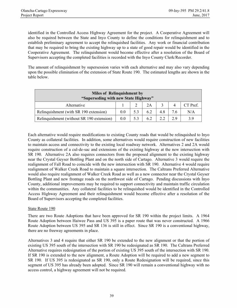
Olancha-Cartago Expressway 09-Iny-395 PM 29.2/41.8 Project Report June, 2017
39
identified in the Controlled Access Highway Agreement for the project. A Cooperative Agreement will also be required between the State and Inyo County to define the conditions for relinquishment and to establish preliminary agreement to accept the relinquished facilities. Any work or financial contribution that may be required to bring the existing highway up to a state of good repair would be identified in the Cooperative Agreement. The relinquishment would become effective after a resolution of the Board of Supervisors accepting the completed facilities is recorded with the Inyo County Clerk/Recorder. The amount of relinquishment by supersession varies with each alternative and may also vary depending upon the possible elimination of the extension of State Route 190. The estimated lengths are shown in the table below.
Miles of Relinquishment by “Superseding with new State Highway”
Alternative 1 2 2A 3 4 CT Pref.
Relinquishment (with SR 190 extension) 0.0 5.3 6.2 4.8 7.6 N/A
Relinquishment (without SR 190 extension) 0.0 5.3 6.2 2.2 2.9 3.9
Each alternative would require modifications to existing County roads that would be relinquished to Inyo County as collateral facilities. In addition, some alternatives would require construction of new facilities to maintain access and connectivity to the existing local roadway network. Alternatives 2 and 2A would require construction of a cul-de-sac and extensions of the existing highway at the new intersection with SR 190. Alternative 2A also requires connectors from the proposed alignment to the existing highway near the Crystal Geyser Bottling Plant and on the north side of Cartago. Alternative 3 would require the realignment of Fall Road to coincide with the new intersection with SR 190. Alternative 4 would require realignment of Walker Creek Road to maintain a square intersection. The Caltrans Preferred Alternative would also require realignment of Walker Creek Road as well as a new connector near the Crystal Geyser Bottling Plant and new frontage roads on the northwest side of Cartago. Pending discussions with Inyo County, additional improvements may be required to support connectivity and maintain traffic circulation within the communities. Any collateral facilities to be relinquished would be identified in the Controlled Access Highway Agreement and their relinquishment would become effective after a resolution of the Board of Supervisors accepting the completed facilities. State Route 190
There are two Route Adoptions that have been approved for SR 190 within the project limits. A 1964 Route Adoption between Haiwee Pass and US 395 is a paper route that was never constructed. A 1966 Route Adoption between US 395 and SR 136 is still in effect. Since SR 190 is a conventional highway, there are no freeway agreements in place. Alternatives 3 and 4 require that either SR 190 be extended to the new alignment or that the portion of existing US 395 south of the intersection with SR 190 be redesignated as SR 190. The Caltrans Preferred Alternative requires redesignation of the portion of existing US 395 south of the intersection with SR 190. If SR 190 is extended to the new alignment, a Route Adoption will be required to add a new segment to SR 190. If US 395 is redesignated as SR 190, only a Route Redesignation will be required, since this segment of US 395 has already been adopted. Since SR 190 will remain a conventional highway with no access control, a highway agreement will not be required.
Olancha-Cartago Expressway 09-Iny-395 PM 29.2/41.8 Project Report June, 2017
40
C. Permits The proposed material borrow area would be acquired as expanded right of way, so it would be exempt from the requirements of the Surface Mining and Reclamation Act (SMARA). However, it would still be subject to restoration requirements that would be determined in consultation with the BLM. Other permits that are required include:
o U.S. Fish & Wildlife Service, Section 7 Consultation: formal consultation will be required for adverse impacts to threatened and endangered species.
o State of California, Department of Fish & Wildlife, Section 1602, Streambed Alteration Permit: required for any work within existing streams and riparian channels.
o State of California, Department of Fish & Wildlife, Section 2081, Incidental Take Permit: required to mitigate impacts to threatened and endangered species.
o U.S. Army Corps of Engineers, Section 404: a Nationwide Permit will be required for the discharge of dredged and fill materials into Waters of the United States.
o Lahontan Regional Water Quality Control Board, Section 401, Clean Water Permit: required for construction activities in and adjacent to waterways.
o State Historic Preservation Officer, Section 106 Finding of Adverse Effect and Programmatic Agreement: required to document anticipated impacts to historical resources and corresponding mitigation measures.
o U.S. Bureau of Land Management, Use Permits: various use permits required for activities on BLM lands.
o Inyo County, Encroachment Permit: required from Inyo County for any improvements to existing County roadways.
As noted in Section 5A, there are overhead transmission lines that cross the proposed alignment north of Cartago at an acute angle. In addition, a steel tower for the transmission lines encroaches within the proposed right of way. The tower is located on the west side of the southbound lanes at the top of a cut slope about 76 feet from the edge of traveled way. Due to the expense and difficulty of relocating the transmission lines and their steel towers, a longitudinal encroachment exception has been discussed with HQ Division of Design to allow the transmission lines and towers to remain in place. The vertical profile of the new lanes will be coordinated with the utility owners to ensure that the required minimum vertical clearances are provided per CPUC General Order 95. An underground fiber optic line also crosses the proposed alignment in several locations. Since the line is a buried feature that should not affect the ultimate operation of the facility, a longitudinal encroachment exception is expected to allow the fiber optic line to remain in place. However, temporary construction easements will be required to allow access boxes to be installed at the points that the line crosses the new right of way.
D. Cooperative Agreements
As noted in Section 6B, the State will be required to enter a Cooperative Agreement with Inyo County to define the conditions for relinquishment of the existing highway and to establish agreement that they will accept the relinquished facilities. Negotiations to establish the terms for the Cooperative Agreement will begin shortly after project approval, so that an agreement can be reached as soon as possible.
Olancha-Cartago Expressway 09-Iny-395 PM 29.2/41.8 Project Report June, 2017
41
E. Transportation Management Plan A Traffic Management Plan Checklist was prepared for the project (Attachment K). Brochures, media releases, public meetings, and the Department project website would all be used to inform the public on construction progress and to provide information about delays, closures, and major changes in traffic patterns. The District Public Information Officer will coordinate any media releases and update relevant project information. The Caltrans Preferred Alternative would be constructed independently of the existing highway, so use of the Construction Zone Enhanced Enforcement Program (COZEEP) will be minimal. It may be required during certain construction operations, such as one-way reversible traffic control and lane change-overs. COZEEP provides for continuous presence of California Highway Patrol officers in the construction zone to remind travelers to use caution while traveling through the work zone. Standard construction area signs and devices and standard traffic control procedures should be sufficient to ensure safe passage of traffic through the construction work zone. Standard special provisions, lane closure plans, and other appropriate provisions will be included in the project documents to ensure traffic safety throughout the project. Since the existing highway would remain available during construction, the use of detours is not anticipated. One-way reversing traffic control will be required for staging change-overs and for any rehabilitation work that may be required on the existing highway. Access to existing homes and businesses would be maintained or alternative access would be provided and bicycles and pedestrians would be accommodated during construction. Additional measures that may be required for unusual or unplanned circumstances will be determined on an individual basis. Walker Creek Road, Lake Street, and the access road to U.S. Borax will remain open during construction. Temporary stop signs would be installed on either side of the new lanes to control through traffic. In addition, barricades would be placed in the new lanes under construction to prevent public traffic from entering the construction work zone. Traffic conditions at these intersections would be monitored during construction and additional traffic controls would be implemented when necessary. F. Stage Construction
Staging will be required for construction of the project. The specific staging requirements will depend upon the selected alternative and will be developed during the design phase. In general, new facilities would be constructed first so that traffic can be shifted onto the new lanes and then the existing lanes would either be rehabilitated or removed. Once work on the existing lanes was complete, traffic could be shifted onto the final alignments. Consideration would be provided at all times for local streets and access so that disruption to residences and businesses would be kept to a minimum.
G. Accommodation of Oversize Loads
Since US 395 has very few height restrictions and is constructed at grade, it is commonly used for moving oversize loads, especially loads of unrestricted height. The new lanes will be designed to accommodate the continued use of US 395 by oversize loads. In particular, the profile of the new lanes will be adjusted at the transmission line crossings as necessary to provide the minimum vertical clearance required under CPUC General Order 95.
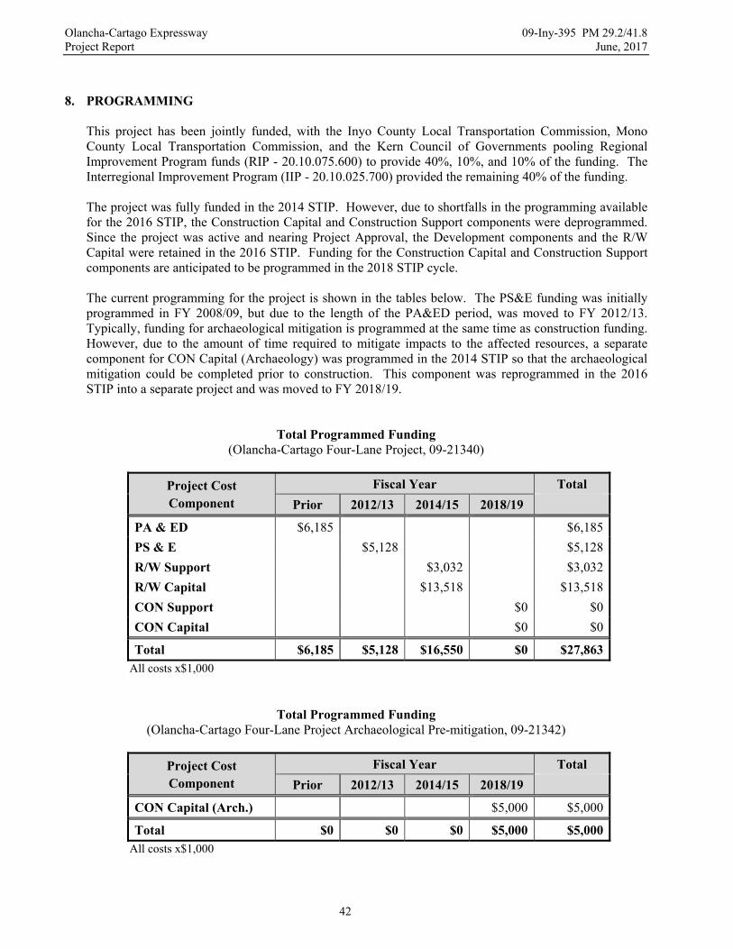
Olancha-Cartago Expressway 09-Iny-395 PM 29.2/41.8 Project Report June, 2017
42
8. PROGRAMMING
This project has been jointly funded, with the Inyo County Local Transportation Commission, Mono County Local Transportation Commission, and the Kern Council of Governments pooling Regional Improvement Program funds (RIP - 20.10.075.600) to provide 40%, 10%, and 10% of the funding. The Interregional Improvement Program (IIP - 20.10.025.700) provided the remaining 40% of the funding. The project was fully funded in the 2014 STIP. However, due to shortfalls in the programming available for the 2016 STIP, the Construction Capital and Construction Support components were deprogrammed. Since the project was active and nearing Project Approval, the Development components and the R/W Capital were retained in the 2016 STIP. Funding for the Construction Capital and Construction Support components are anticipated to be programmed in the 2018 STIP cycle.
The current programming for the project is shown in the tables below. The PS&E funding was initially programmed in FY 2008/09, but due to the length of the PA&ED period, was moved to FY 2012/13. Typically, funding for archaeological mitigation is programmed at the same time as construction funding. However, due to the amount of time required to mitigate impacts to the affected resources, a separate component for CON Capital (Archaeology) was programmed in the 2014 STIP so that the archaeological mitigation could be completed prior to construction. This component was reprogrammed in the 2016 STIP into a separate project and was moved to FY 2018/19.
Total Programmed Funding (Olancha-Cartago Four-Lane Project, 09-21340)
Project Cost Component
Fiscal Year Total
Prior 2012/13 2014/15 2018/19
PA & ED $6,185 $6,185
PS & E $5,128 $5,128
R/W Support $3,032 $3,032
R/W Capital $13,518 $13,518
CON Support $0 $0
CON Capital $0 $0
Total $6,185 $5,128 $16,550 $0 $27,863 All costs x$1,000
Total Programmed Funding (Olancha-Cartago Four-Lane Project Archaeological Pre-mitigation, 09-21342)
Project Cost Component
Fiscal Year Total
Prior 2012/13 2014/15 2018/19
CON Capital (Arch.) $5,000 $5,000
Total $0 $0 $0 $5,000 $5,000 All costs x$1,000
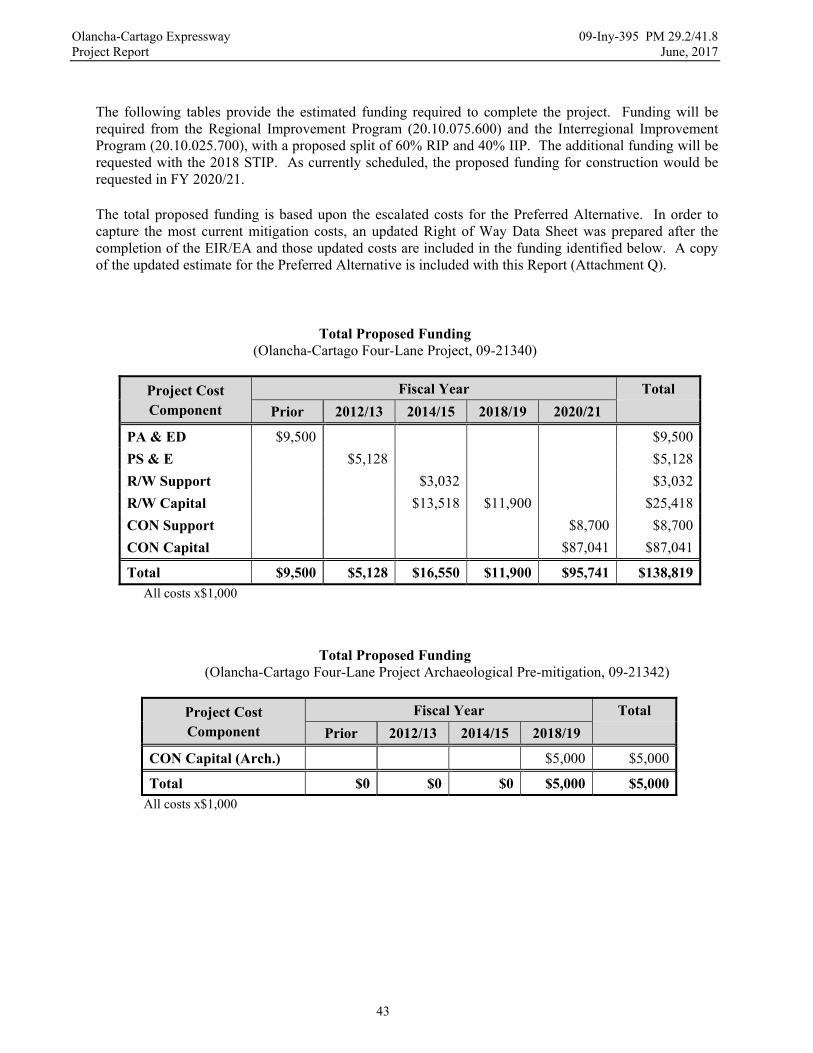
Olancha-Cartago Expressway 09-Iny-395 PM 29.2/41.8 Project Report June, 2017
43
The following tables provide the estimated funding required to complete the project. Funding will be required from the Regional Improvement Program (20.10.075.600) and the Interregional Improvement Program (20.10.025.700), with a proposed split of 60% RIP and 40% IIP. The additional funding will be requested with the 2018 STIP. As currently scheduled, the proposed funding for construction would be requested in FY 2020/21.
The total proposed funding is based upon the escalated costs for the Preferred Alternative. In order to capture the most current mitigation costs, an updated Right of Way Data Sheet was prepared after the completion of the EIR/EA and those updated costs are included in the funding identified below. A copy of the updated estimate for the Preferred Alternative is included with this Report (Attachment Q).
Total Proposed Funding (Olancha-Cartago Four-Lane Project, 09-21340)
Project Cost Component
Fiscal Year Total
Prior 2012/13 2014/15 2018/19 2020/21
PA & ED $9,500 $9,500
PS & E $5,128 $5,128
R/W Support $3,032 $3,032
R/W Capital $13,518 $11,900 $25,418
CON Support $8,700 $8,700
CON Capital $87,041 $87,041
Total $9,500 $5,128 $16,550 $11,900 $95,741 $138,819 All costs x$1,000
Total Proposed Funding (Olancha-Cartago Four-Lane Project Archaeological Pre-mitigation, 09-21342)
Project Cost Component
Fiscal Year Total
Prior 2012/13 2014/15 2018/19
CON Capital (Arch.) $5,000 $5,000
Total $0 $0 $0 $5,000 $5,000 All costs x$1,000

Olancha-Cartago Expressway 09-Iny-395 PM 29.2/41.8 Project Report June, 2017
44
9. SCHEDULE The proposed schedule is shown below:
Project Milestones Month/Day/Year
PA & ED M200 06/30/2017
R/W Maps M224 08/28/2013
Reg R/W M225 08/15/2017
PS&E to DOE M377 09/01/2019
Draft Structures PS&E M378 02/01/2019
Project PS&E M380 01/01/2020
R/W Certification M410 02/01/2020
Ready to List M460 05/01/2020
HQ Advertise M480 06/01/2020
Approve Contract M500 08/01/2020
Contract Acceptance M600 06/01/2022
End Project M800 03/01/2023
10. RISKS The potential risks for this project have been identified in the project Risk Register (Attachment L). Some of the more significant risks include:
- Los Angeles Department of Water and Power (LADWP). Close coordination will be required with LADWP to identify any potential issues with the aqueduct, wells, power lines, other water and power facilities, and right of way acquisition and their resolution as early as possible.
- Archaeology. A multi-agency Programmatic Agreement (PA) between the Federal Highway Administration, the U.S. Bureau of Land Management, the California State Historic Preservation Officer, and the Advisory Council on Historic Preservation has been developed to specify the methods and measures to be used for identification, evaluation, and mitigation of any historic resources affected by the Preferred Alternative. However, the extent and significance of the cultural resources and their mitigation is still unknown and could impact project progress.
- EIR/EA. The Preferred Alternative could result in public controversy with local residents and
Inyo County and a challenge of the EIR/EA. Considerable public involvement has occurred to minimize the likelihood of any challenges, but if a challenge occurs, it would be resolved through the standard environmental process.
- Railroad Right of Way. Acquisition of the existing railroad easements is expected to take
considerable time and effort. The State has been coordinating with the BLM to identify appropriate strategies to extinguish the existing easements as expeditiously as possible.

Olancha-Cartago Expressway 09-Iny-395 PM 29.2/41.8 Project Report June, 2017
45
- Inyo County Agreements. Early coordination will be required with Inyo County to identify appropriate conditions for relinquishment and to enter a Cooperative Agreement to formalize agreement to accept the relinquished highway. Early coordination will also be required to establish the required points of access to the expressway facility and approve the Controlled Access Highway Agreement for the project.
- Hazardous Materials. The Preferred Alternative could potentially affect two known sites with
minimal hazardous wastes. Any newly identified sites will be evaluated as quickly as possible and appropriate remediation measures will be developed, if necessary.
- Material Borrow Area. The size of existing materials in the proposed borrow area may not prove
suitable for development of an aggregate production site. A Materials Report will be prepared as early as possible during the design phase to identify any potential issues with existing materials in the proposed material area.
- Utility Relocation. The proposed locations for relocated utilities have not been identified, but
could be outside of currently identified areas of disturbance. The environmental study limits extend well beyond the proposed area of disturbance to support potential utility relocation. Any relocated facilities will be coordinated with the Environmental Branch to ensure proposed locations are consistent with approved environmental clearances.
11. FHWA COORDINATION
This project is an Assigned Project in accordance with the current Federal Highway Administration (FHWA) and Department of Transportation (Caltrans) Joint Stewardship and Oversight Agreement. The FHWA is the lead agency for the project under the National Environmental Policy Act. Caltrans has consulted with the FHWA during the development of the environmental document to ensure that it meets FHWA requirements. In particular, Caltrans has coordinated with the FHWA to develop a project specific Programmatic Agreement and pursuant Historic Properties Treatment Plan to govern activities impacting adversely affected cultural resources. Caltrans has also coordinated with the FHWA during the development of the Section 4(f) Evaluation, which must be approved by the FHWA.
12. REVIEWS
The Project Study Report – Environmental Only (PSR-EO) for this project was approved on January 22, 1999. The PSR-EO provided the basis for initial programming of the PA&ED phase of the project. A subsequent Supplemental Project Study Report (SPSR) was approved on June 29, 2007, which restored funding for the project and also provided the basis for programming of the PS&E, R/W Capital, and R/W Support phases. A third Supplemental Project Study Report was approved on November 17, 2008, which revised the range of alternatives for the project to remove Alternative 3A and include Alternative 4. The SPSR also revised the programmed development components for the project. A Draft Project Report was signed by the District 9 Director on September 1, 2010. It described the reasonable alternatives for the project and the potential effects of those alternatives. A corresponding Initial Study/Environmental Assessment was also prepared to describe the potential environmental effects

Olancha-Cartago Expressway 09-Iny-395 PM 29.2/41.8 Project Report June, 2017
46
of the alternatives. The IS/EA was reviewed by the FHWA regional engineer and was approved on August 24, 2010. Both documents were made available for public review during the circulation period for the IS/EA. A Supplemental Draft Project Report was signed by the District 9 Director on April 14, 2015. It added the Caltrans Preferred Alternative to the project alternatives and described its potential effects. It also approved public circulation of the Draft EIR/EA, which was prepared to describe the potential environmental effects of the alternatives. The DEIR/EA was reviewed and approved by the FHWA regional engineer on July 9, 2015. Both documents were made available for public review during the circulation period for the DEIR/EA. A PA&ED Constructability Review was held on January 22, 2014, and several significant concerns were raised. Suggested restoration requirements for the proposed borrow area were discussed and will be considered when the restoration plan is prepared for the borrow area. Improvements were suggested for the portion of the existing highway that would be redesignated as S.R. 190. Since the purpose of the project is to upgrade U.S. 395 and the funding for the project is not appropriate for maintenance related activities, improvements to the redesignated portion of the existing highway could not be included in the project. Maintenance concerns with cattle guards and tortoise fencing proposed for environmental mitigation were discussed as well. The number and design of cattle guards and tortoise fencing will be coordinated with Maintenance and Environmental to minimize potential long-term maintenance concerns. A Safety Review was performed with the District Traffic Operations Engineer on January 22, 2014. All of the concerns raised from the Safety Review have either been addressed or will be addressed during the Design phase of the project. Appropriate measures will be included in the construction documents to ensure that maximum safety is provided both during construction and in the completed facility. District 9 has coordinated with the HQ Design Reviewer throughout the development of this project to discuss significant design concerns and develop appropriate strategies or solutions to address them. The Design Reviewer has reviewed this Project Report and the other project reports to date. This Project Report has been reviewed by all pertinent functional units within Caltrans and all comments and concerns have been addressed.
13. PROJECT PERSONNEL
Title Name Telephone
Project Manager Dennee Alcala (760) 872-0767
Design Manager Brian Wesling (760) 872-0630
Project Engineer Ron Chegwidden (760) 872-0764
Environmental Unit Supervisor Richard Putler (559) 445-5286
Environmental Generalist John Thomas (559) 445-6451
Right of Way Branch Chief Nancy Escallier (760) 872-0641

Olancha-Cartago Expressway 09-Iny-395 PM 29.2/41.8 Project Report June, 2017
47
14. LIST OF ATTACHMENTS
ATTACHMENT TITLE
A Initial Study / Environmental Assessment
B Title Sheet
C Alternative Layout Sheets
D Typical Cross Sections
E Cost Estimates
F Right of Way Data Sheets
G Traffic Report
H Storm Water Data Report
I Pavement Life Cycle Cost Analysis
J SB45 Report
K Traffic Management Plan Checklist
L Risk Register
M Structures Advanced Planning Study
N Relocation Impact Statement
O Mitigation Cost Compliance Estimate Form
P Material Area Fact Sheet
Q Updated Estimate – Preferred Alternative
Related Documents