1 Project completion report on International Training Workshop on Borehole Geophysics for Groundwater By Dr. Abhijit Mukherjee Dr. Probal Sengupta Department of Geology & Geophysics INDIAN INSTITUTE OF TECHNOLOGY KHARAGPUR 721302 Submitted to WEST BENGAL ACCERATED DEVELOPMENT OF MINOR IRRIGATION PROJECT (WBADMIP) November, 2014

Welcome message from author
This document is posted to help you gain knowledge. Please leave a comment to let me know what you think about it! Share it to your friends and learn new things together.
Transcript

1
Project completion report on
International Training Workshop on Borehole Geophysics for Groundwater
By
Dr. Abhijit Mukherjee Dr. Probal Sengupta
Department of Geology & Geophysics
INDIAN INSTITUTE OF TECHNOLOGY
KHARAGPUR 721302
Submitted to
WEST BENGAL ACCERATED DEVELOPMENT OF MINOR IRRIGATION PROJECT (WBADMIP)
November, 2014

2
INTRODUCTION
Groundwater provides the largest repository of fresh water in this planet, and our country, India, is the largest user of groundwater, globally, abstracting about 240 billion cubic meter of groundwater, every year. Hence the study of the science of groundwater from an applied perspective is the need of the day. However, unfortunately, in this country, groundwater science or hydrogeoscience, has not yet received the importance that it deserves among the geoscience community. Even the techniques of groundwater exploration, throughout the country (both government and private initiatives), have been mostly done through age‐old, experienced‐based “feeling” methods, rather than using modern, scientific, digital techniques. Thus states across India have limited hydrogeophysical potentiality, and for up‐scaling the aquifer mapping programme country‐wide it is essential to build the hydrogeophysical capacity of all the States. With this aim and objective, the World Bank initiated the formulation of International standard training programme on surface and borehole geophysics for groundwater with DFID funding. The Ministry Water Resources, River Development and Ganga Rejuvenation, Govt. of India and WBADMIP, Govt. of West Bengal also came forward to bridge the gap of knowledge by training the Govt. Scientists and Engineers throughout our country with the most modern groundwater exploration and study techniques, such as the application of borehole geophysics. Accordingly, the training on borehole geophysics was conducted at IIT, Kharagpur during Nov 11‐21, 2014. The selection of IIT, Kharagpur in West Bengal was important in several aspects. It has a Geology and Geophysics department with a strong group of eminent academicians, it has a large campus, international standard class‐rooms with a large number of computers and the internet facility, a standard guest house and the two boreholes drilled within the campus, represents the hydrogeological conditions in the eastern part of India. The invitation to USGS professional geophysicists and experts for the training‐workshop was obvious as they are the most experienced experts, rather best in the field, with eminence in the field of modern geophysical logging of water wells, tackling a variety of exploration, contamination and rehabilitation issues in varied hydrogeological conditions similar to those found in India. The borehole geophysics training workshop provided the participants (28 Government scientists and engineers from Central and State Government agencies and 5 IIT Kharagpur students) with training on the use of digital borehole geophysical logging methods useful for groundwater‐resources exploration, aquifer assessment and borehole integrity testing. Instruction on modern geophysical logging methods and tools were hired from professional hydrocarbon wirelog farm (Mitchel India) and also imported from the USA. These tools are used for advanced techniques in groundwater exploration to delineate geologic formations, estimate water quality, and optimize well completion and screen placement are being provided. The instruments include, caliper logs, gamma logs, elelctro‐magnetic induction logs, acoustic tele‐viewer etc. The hands‐on, practical training was done in the two exploratory bore wells that were constructed up to a depth of 200 m in the barren land in front of VSRC ground. It was done by the USGS teachers, in association with the Mitchell India technical staffs and IIT Kharagpur organizing faculties. Instructor‐led case studies and participant‐collected data sets was used to illustrate the uses and limitations of different borehole geophysical methods and gain hands‐on experience in the use of logging equipment and the performance of data analysis. Classroom exercises was conducted using PC‐based well‐log plotting and analysis software. The participants analyzed and interpreted the data collected during the field exercises. At the conclusion of the workshop, participants developed practical skills and the knowledge required to operate digital logging systems and

3
tools, and analyzed log data to solve a range of groundwater‐resources exploration, aquifer assessment and borehole site selection and testing problem.
Trainers from U.S. Geological Survey
The program was led by an expert team with world‐wide experience in hydrogeophysics and borehole geophysical logging: Dr. John W. Lane, John H. Williams, Dr. Fred Paillet, and J. Alton Anderson, Office of Groundwater, Branch of Geophysics, U.S. Geological Survey, USA; Consultants to the World Bank.
Organizers:
The program was being supervised and coordinated by Prof. Abhijit Mukherjee (Hydrogeologist) and Prof. Probal Sengupta (Geophysicist), both faculty at the Department of Geology and Geophysics at Indian Institute of Technology (IIT) Kharagpur.
In addition, the following personnel of IIT Kharagpur also provided support for the preparation and execution of the workshop:
1) Dr. D.K. Nanda, System Manager, Computer Informatics Centre. 2) Bankim Mondal, Junior Technical Superintendent 3) Biloy Jana, Technical Coordinator 4) P. Gangadhar, Job Assistant 5) Anindya Pradhan, Job Assistant 6) Joy Ram, Job Assistant 7) Palash Debnath, Research Scholar 8) Soumendra Bhanja. Research Scholar 9) Madhumita Chakraborty, Research Scholar 10) Mrinal Layek, Research Scholar 11 ) Shahab Anwar, Research Scholar 12) Ashok Shaw, Research Scholar
SPONSORS
World Bank Group
UKAID
Ministry of Water Resources, Government of India
United States Geological Survey
WBADMIP, Government of West Bengal
VENUE
The class room teaching took place at the Computer and Informatics Center (CIC), Takshashila Building, Indian Institute of Technology, Kharagpur, West Bengal 721302. The course involved training of geophysical logging equipment in a field setting in a nearby field site, within the campus.

4
LOCAL HOSPITALITY
IIT Kharagpur has a self‐contained residential campus. Lodging and sustenance (breakfast, lunch and dinner) for the participants were arranged in the IIT Technology Guest House. The IIT Kharagpur is situated about 120 km southwest of Kolkata. Kharagpur can be reached in about 2 hours by train from Howrah railway station of Kolkata or 3 hours by car from Kolkata Airport. Kharagpur is also connected by direct train services to most major cities of the country. The Institute is about 10 minutes drive from the Kharagpur railway station. Private taxi, auto‐rickshaw, or cycle‐rickshaw, can be hired to reach the Institute from the Railway Station. The participants had to reach the campus themselves.
TARGET GROUP AND SELECTED APPLICANTS
Such trainings are essential for hydrogeologist, hydrogeophysicists and water well drilling engineers in India to improve decision making, modernize the well assembly designing and construction procedure, reduce water well failures and maximize well yield economically. Thus, the training was designed to raise the skill of officers of Central and State Govt. agencies engaged in groundwater exploration related projects that involve aquifer assessment, well‐siting, and drilling. In particular the training was intended for those who are engaged in the planning and implementation of borehole geophysical logging and data analysis programs. The registration was conducted by a web based portal that is hosted by the consultant:
http://usgsworkshop.abhijitmukherjee.info
There were 34 applicants from all over India been selected and invited to attend the course. Out of which 28 participants were finally successfully attended the course. In addition to that, 5 research students from the Department of Geology & Geophysics, IIT Kharagpur, had also attended the course.
The following personnel had selected and invited for the course:
No Name State Organization Position 1 NBV Reddy Andhra
Pradesh Andhra Pradesh State Ground Water Department,
Assistant Geophysicist
2 Rajasekhra Reddy A
Andhra Pradesh
Ground Water Department TAH
3 Sateesh Chandrapuri
Andhra Pradesh
National Geophysical Research Institute Hyderabad
Scientist
4 N.S.Dewangan Chhattisgarh Ground Water Survey, Water Resources Deptt. Chhattisgarh
Assistant Geohydrologist
5 Navinchandra Gujarat GWRDC Ltd., Gandhinagar (Gujarat Junior

5
Narsangbhai Chaudhari
Ground Water Agency) Geologist
6 Shah Nikhil M. Gujarat GWRDC Gandhinagar (Gujarat Ground Water)
Jr. Geologist
7 Kuldeep Singh Mandhotra
Himachal Pradesh
Ground Water Organisation, I&PH Department Himachal Pradesh
Senior Hydrogeologist
No Name State Organization Position 8 Pawan Thakur Himachal
Pradesh Ground Water Organisation, I&PH Department Himachal Pradesh
Senior Technical Assistant (Hydrogeology)
9 Rajesh Kumar Jharkhand Ground Water Directorate ,Water Resources Department, Govt. of Jharkhand
Deputy Director, Ground Water Directorate, Ranchi
10 Suganthi S Tamil Nadu Public Works Department, State Ground & Surface Water Resources Data Centre, Tharamani
Assistant Geologist
11 P. Srikanth Telengana Groundwater Dept
TAGP
12 Subash Chandra Telengana CSIR‐National Geophysical Research Institute
Senior Scientist
13 Amuda Arjun Telengana Ground Water Department, Telangana State
Assistant Geophysicist
14 Virendra Kumar Upadhyay
Uttar Pradesh U..P. Ground Water Department Senior Geophysicist
15 Asish Tantubay West Bengal The State Water Investigation Directorate (SWID) Under The Water Resources Investigation & Development Department, Govt. Of West Bengal
Geologist
16 Dr. Malay Kanti Ghosh
West Bengal State Water Investigation Directorate (SWID) Govt. Of West Bengal
Executive Engineer(Ai)
17 Rhitwik Chatterjee
West Bengal State Water Investigation Directorate, Government Of West Bengal.
Geologist, Murshidabad.
18 Sunandan Sanyal West Bengal Water Resources Investigation & Development Department
Assistant Engineer

6
No Name State Organization Position 19 Chinmoyi Roy West Bengal State Water Investigation
Directorate Geologist
20 Anindita Lahiri West Bengal State Water Investigation Directorate
Geologist
21 Salil Bhattacharya
West Bengal Water Resources Investigation & Development Department, Govt Of W.B
Executive Engineer(Agri‐Irrigation)
22 Dr. Satyajit Biswas
West Bengal State Water Investigation Directorate, WRI&DD, Govt. Of West Bengal
Senior Geophysicist
23 Soumyadip Das West Bengal State Water Investigation Directorate
Geological Assistant
24 Pratul Raychaudhuri
West Bengal State Water Investigation Directorate,Water Resources Investigation & Development Department.
Superintending Engineer
25 Gopinath V S T Tamil Nadu Central Ground Water Board Junior Geophysicist
26 B Venkateswarlu Odisha Central Ground Water Board
Scientist‐B
27 Ajay Kumar Sinha
Chhattisgarh Central Ground Water Board
Geophysicist
28 Basant Kumar Oraon
Chandigarh Central Ground Water Board, NWR, Min. Of Water Resources ,
Scientist C (Senior Geophysicist)
29 Dr. Shyamal Kumar Adhikari
Bihar Central Ground Water Board, Mer, Patna
Jr. Geophysicist
30 Smt. Mousumi Neogi Adhikari
West Bengal State Water Investigation Directorate, WRI&DD
Geologist

7
Photo of the participants and students at the field
Photo of some of the participants and students at the workshop

8
PROGRAM CONTENTS AND SCHEDULE
The program is designed to develop an expertise in the acquisition and analysis of digital borehole logs. The modules that formed the content of the program include:
Module 1: Review of conventional geophysical logging methods (l/s/n resistivity, EM induction, natural gamma, SP, SPR, fluid resistivity, fluid temperature)
Module 2 : Introduction to digital log analysis using PC‐based software Module 3 : Digital log acquisition and system operation Module 4 : Advanced logging methods (acoustic/optical televiewer, EM flowmeter) Module 5 : Image‐log analysis using PC‐based software Module 6 : Flowmeter logging and well‐integrity testing Module 7 : Flowmeter log analysis using PC‐based software
The following schedule had been fixed for the program:
Duration Date Week day Schedule Topics Day 1 Nov‐11‐
2014 Tuesday 10:30‐11:30
13:00‐17:00 Inauguration Intro to class, earth properties, geophysical logs, and caliper log lectures and WellCAD intro exercise
Day 2 Nov‐12‐
2014 Wednesday 9:00‐12:00 Nuclear, electric, and EM log lecture
and exercises 13:00‐16:00 Nuclear, electric, and EM exercises
cont. 16:00‐17:00 Field craft and site safety lecture and
field demo day logistics and logging tools
Day 3 Nov‐13‐
2014 Thursday 9:00‐12:00 Group A & B field demo/Group C & D
class project 13:00‐16:00 Group C & D field demo/Group A & B
class project 16:00‐17:00 Field day wrap‐up Day 4 Nov‐14‐
2014 Friday 9:00‐12:00 Group A & B Display demo log /Group
C & D field demo 13:00‐16:00 Group C & D Display demo log /Group
A & B field demo Day 5 Nov‐15‐
2014 Saturday 9:00‐10:00 Review class project
10:00‐12:00 Demo log header and analysis in WellCAD
13:00‐15:00 Neutron and gamma‐gamma log lecture and exercises
15:00‐17:00 Sonic log lecture and exercises

9
Duration Date Week day Schedule Topics Day 6 Nov‐16‐
2014 Sunday No class
Day 7 Nov‐17‐
2014 Monday 9:00‐12:00 Image log lecture and exercises
13:00‐17:00 Flow and fluid‐property log lectures and exercises
Day 8 Nov‐18‐2014
Tuesday 9:00‐12:00 Group A & B field demo/Group C& D class project
13:00‐16:00 Group C & D field demo/Group A & B demo data analysis
16:00‐17:00 Review/planning Day 9 Nov‐19‐
2014 Wednesday 9:00‐12:00 Group A & B class project /Group C &
D field demo 13:00‐14:00 Review/planning 14:00‐17:00 Group A & B field demo /Group C & D
demo data analysis Day 10 Nov‐20‐
2014 Thursday 9:00‐10:00 Review class project
10:00‐12:00 Field demo data processing and analysis
13:00‐17:00 Field demo data processing and analysis cont.
Day 11 Nov‐21‐
2014 Friday 9:00‐11:00 Final class project/examination
11:00‐12:00 Wrap‐up and Valedictory Ceremony

10
Inaugural ceremony at Gargi Hall on 11 November 2014
Speeches of our esteemed guests at the inaugural ceremony.

11
Participants at the inaugural ceremony.
ARRANGEMENTS MADE:
o The organizers have coordinated and supported the training programme in collaboration with United States Geological Survey, USA and WBADMI Project at the campus of IIT Kharagpur
o The organizers have provided the space, training facilities, stationeries and other requisite support for successful completion of the course.
o The organizers have arranged the lodging and food for the participants, faculty and
support members at the campus of IIT Kharagpur on twin sharing and single occupancy basis.
o The organizers have provided the local transport arrangement to the participants
and trainers for the field work within the campus of the Institute.
o The organizers have supervised the drilling at two ̴200 m deep boreholes with PVC casing drilled 60m apart in IIT, Kharagpur campus exclusively for the training.
o The organizers hall provide Instruments which are available to them as and when required for the demonstration purpose during the training course.
o All class work and field teaching during the course have been executed under the
general technical observation and supervision of the organizers.
o According to the basic requirement of the course the organisers provided Class‐room with pc for each trainee.

12
o The trainers provided soft copy of relevant books and lectures for individual trainee.
o Two modern digital logging machine were hired for the training in small groups of
trainees.
o EM induction and EM flowmeter probes was also brought from USGS for the trainning.
o Arrangements were made for logging machine operation by each trainee.
o Arrangements were also made for field demonstration of logging by tools : electrical resistivity, electromagnetic induction, natural gamma radioactivity, neutron (porosity), gamma‐gamma (density), temperature‐fluid conductivity, electromagnetic flowmeter, sonic, magnetic susceptibility.
o The trainers also provided software on data processing and interpretation.
o The participants were also made to work on processing and interpretation of data collected from two boreholes in IIT campus.
o The organisers had arrangements for the evaluation of trainees and certificate on completion.
THE TWO BOREHOLES:
Location of the Site ( IIT Khargapur Campus)
GPS & Geospatial data
LOCATION
Latitude : 22.30961º North
Longitude : 87.30804º East
Height from MSL : 53 m
POSITIONAL DIAGRAM OF TUBEWELL POINT

13
Toposheet of Kharagpur Block Area
Lithologs for 175mts. borehole (TW1):
0’‐‐10’ Surface Sand & Moraine ( Brown )
10’‐ 20’ Moraine Sand ( Red Brown )
20’‐ 30’ Fine Sand ( Yellow )
30’ – 80’ Medium Sand ( Yellow )
80’ – 90’ Sandy Clay ( Yellow )
90’ – 120’ Clay ( Yellow Red )
120’ ‐ 130’ Fine Sand ( Yellow )
130’ – 135’ Clay ( Yellow )
Drilling depth: Upto 175mts. Drilling depth: Upto 200mts.

14
135’ ‐ 150’ Medium Sand ( Yellow )
150’ ‐ 220’ Clay ( Grey )
220’ – 255’ Fine Sand ( Grey )
255’ ‐ 275’ Clay (Yellow )
275’ ‐ 290’ Coarse Sand ( Grey white )
290’ ‐ 300’ Fine Sand ( Grey White )
300’ – 310’ Medium Sand ( Grey White )
310’ ‐ 320’ Clay (Grey )
320’ ‐ 335’ Medium Sand (Grey White )
335’ ‐ 380’ Clay ( Grey )
380’ – 390’ Fine Sand ( Grey Yellow )
390’ ‐ 430’ Clay ( Grey Yellow )
430’ ‐ 460’ Fine Sand ( Grey )
460’ ‐ 480’ Clay ( Grey )
480’ – 490’ Fine Sand ( Grey )
490’ ‐ 560’ Clay (Grey )
15
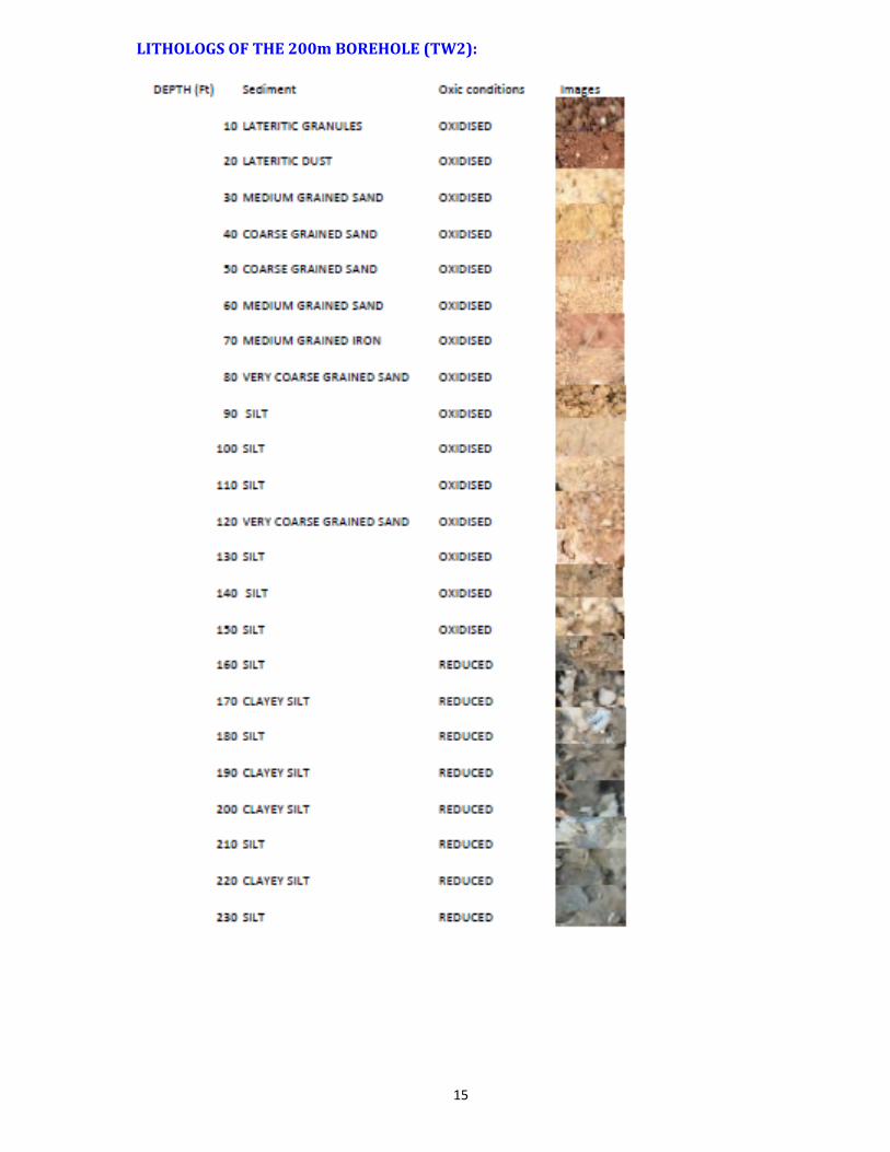
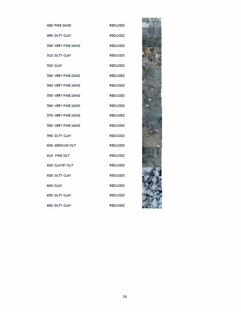
LITHOLOGS OF THE 200m BOREHOLE (TW2):
16

17
DATA GENARATED AT THE BOREHOLES DURING TRAINING:

18
Different types of log data generated by the trainees on BOREHOLE 1 (IIT, Kharagpur Campus)
Different types of log data generated by the trainees on BOREHOLE 2 (IIT, Kharagpur Campus)
Dr F Paillet from USGS making preparations for calibration of EM induction tool brought from USGS
19
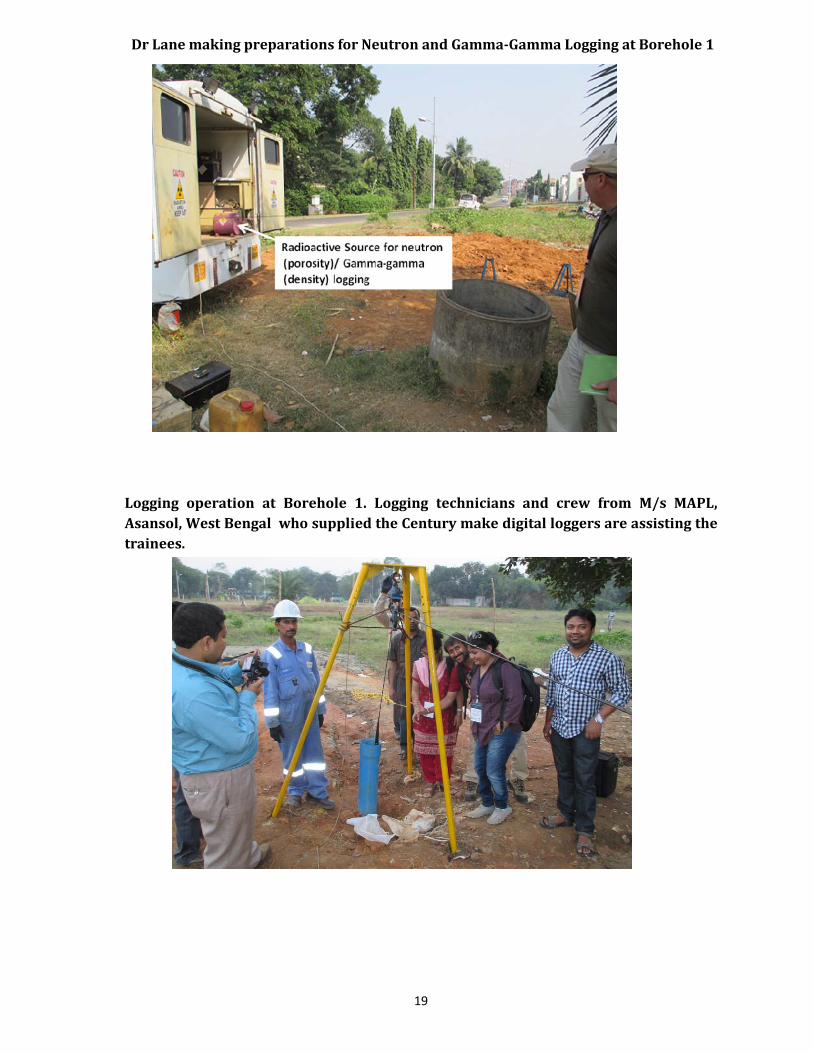
Dr Lane making preparations for Neutron and GammaGamma Logging at Borehole 1
Logging operation at Borehole 1. Logging technicians and crew from M/s MAPL, Asansol, West Bengal who supplied the Century make digital loggers are assisting the trainees.

20
Wirelogging at the field training site:
Some more photographs of the field work.

21

22

23

24

25
DATA ANALYSIS ANS INTERPRETATION USING SOFTWARE:
During the training extensive field demonstration of various geophysical logging tool operation was done. It was followed by the operation of the logging by individual trainee. The tools used and the parameters analyzed are given in the following table
Tools Parameter Remarks Natural gamma radioactivity
Sand and clay content Very useful in sedimentary area particularly coastal tracts for identifying aquifer zones
Neutron ( active nuclear source)
Porosity For quantitative analysis
EM induction Formation resistivity in PVC cased well
Very useful in sedimentary area identifying fresh water aquifer zones in combination with natural gamma. Can be used in PVC cased wells and also for quality monitoring
Normal resistivity Formation resistivity Very useful for identifying sand and clay layers and fresh water aquifers in combination with natural gamma. In PVC cased wells slot position can be checked
Gamma‐gamma density Density/porosity For quantitative analysis Borehole fluid resistivity‐temperature
Borehole fluid quality/temperature variations
Useful for aquifer water quality and monitoring
EM flow meter Flow from aquifers tapped hydrostatic head and aquifer hydraulic parameter
Useful for individual aquifer yield and quantitative analysis
Magnetic susceptibility Magnetic mineral content
Not essential
Sonic Porosity/fractures For quantitative analysis The Acoustic Televiewer (ATV) could not be run due to its break down reported by the logging company

26
Feedback of the students:
A student's feedback programme has been conducted by a web based portal that is hosted by the consultant. The results of the same, are shared below:
Excellent Good Average Below Average
How was your experience about the lodging and food logistics
19 8 3 0
How was your experience about the class room environment
21 9 2 0
How was your experience about the quality of the teachers
28 4 0 0
How was your experience about the field logistics 21 11 0 0
How was your experience about the organizer 22 8 2 0
How would you rate the overall experience
21 10 1 0

27

28

29
VALEDICTORY FUNCTION:

30

31

32
CONCLUSION:
The training‐workshop on “Borehole Geophysics for Groundwater” is a timely, maiden, successful attempt by The Word Bank towards hydrogeophysical capacity building of the States essentially required for sustainable development and management of groundwater in India and particularly for the active participation of the States in country‐wide upscaling of aquifer mapping. It has given a rigorous and unique exposure to international standard borehole logging of water wells and bench‐marking practices to be emulated and initiated a thought process amongst the geologists, geophysicists and engineers for a modern scientific outlook to the water well drilling and construction process. It has provided a vision to look ahead of the routine programme and get the maximum hydrogeological information out of a borehole drilled required to develop, exploit and manage the aquifers effectively. It has to be followed by the strengthening of hydrogeophysical infrastructure of the States in terms of professional resource and the technology to derive the best from the training course.
Related Documents