Final Report Preliminary Assessment Former Galena Forward Operating Location, Alaska Prepared for Air Force Center for Engineering and the Environment September 2011 949 E. 36th Avenue Suite 500 Anchorage Alaska 99508

Welcome message from author
This document is posted to help you gain knowledge. Please leave a comment to let me know what you think about it! Share it to your friends and learn new things together.
Transcript

F i n a l R e p o r t
Preliminary Assessment Former Galena Forward
Operating Location, Alaska
Prepared for
Air Force Center for Engineering and the Environment
September 2011
949 E. 36th Avenue Suite 500
Anchorage Alaska 99508


FINAL: PRELIMINARY ASSESSMENT REPORT FORMER GALENA FORWARD OPERATING LOCATION, ALASKA
AFCEE CONTRACT FA8903-08-D-8769, TASK ORDER 0184 SEPTEMBER 2011
ES121009055544PDX i
Contents
Acronyms and Abbreviations ........................................................................................................... v
1.0 Introduction ............................................................................................................................. 1-1
1.1 Purpose of Preliminary Assessment ............................................................................ 1-1 1.2 Identification of Preliminary Assessment Sites ......................................................... 1-1 1.3 Lease Agreements with State of Alaska ...................................................................... 1-2 1.4 Document Organization ................................................................................................ 1-3
2.0 Operational Setting ................................................................................................................ 2-1
2.1 Historical Site Use .......................................................................................................... 2-1 2.1.1 Early History...................................................................................................... 2-1 2.1.2 Construction of Civilian Field ......................................................................... 2-1 2.1.3 Assumption of Military Responsibility, 1942-1945 ...................................... 2-1 2.1.4 Assumption of Military Responsibility, 1951-1993 ...................................... 2-2 2.1.5 Caretaker Status Military Responsibility, 1993-2008 ................................... 2-3
2.2 Current Site Use ............................................................................................................. 2-3 2.2.1 Population .......................................................................................................... 2-3 2.2.2 Resident Users ................................................................................................... 2-4
2.3 Contaminant Source Types ........................................................................................... 2-4 2.3.1 Petroleum, Oil, and Lubricants ....................................................................... 2-4 2.3.2 Solvents .............................................................................................................. 2-5 2.3.3 Pesticides ............................................................................................................ 2-6 2.3.4 PCBs .................................................................................................................... 2-7 2.3.5 Metals ................................................................................................................. 2-7 2.3.6 Radiological Materials ...................................................................................... 2-7
3.0 Environmental Setting ........................................................................................................... 3-1
3.1 Soil .................................................................................................................................... 3-1 3.1.1 Geology .............................................................................................................. 3-1
3.2 Groundwater .................................................................................................................. 3-3 3.2.1 Hydrogeology .................................................................................................... 3-3 3.2.2 Wells ................................................................................................................... 3-5
3.3 Surface Water .................................................................................................................. 3-6 3.3.1 Flood Frequency ................................................................................................ 3-6 3.3.2 Surface Water Types ......................................................................................... 3-6 3.3.3 Fish, Amphibians, and Reptiles ...................................................................... 3-7 3.3.4 Sensitive Areas/Wetlands ............................................................................... 3-7 3.3.5 Habitat and Wildlife ......................................................................................... 3-8
3.4 Climate .......................................................................................................................... 3-10
4.0 Evaluation Process .................................................................................................................. 4-1
4.1 Information Gathering .................................................................................................. 4-1 4.1.1 Army Records .................................................................................................... 4-1

FINAL: PRELIMINARY ASSESSMENT REPORT FORMER GALENA FORWARD OPERATING LOCATION, ALASKA AFCEE CONTRACT FA8903-08-D-8769, TASK ORDER 0184 SEPTEMBER 2011
ii ES121009055544PDX
4.1.2 USAF Records .................................................................................................... 4-2 4.1.3 ADEC Records ................................................................................................... 4-4 4.1.4 Site Visit .............................................................................................................. 4-4 4.1.5 Interviews/Personal Communications .......................................................... 4-4
4.2 Screening Process ........................................................................................................... 4-4 4.2.1 Data Collection and Evaluation Flowchart ................................................... 4-5 4.2.2 Decision Documents ......................................................................................... 4-7
5.0 Preliminary Assessment Evaluations .................................................................................. 5-1
6.0 Summary of Conclusions and Recommendations ........................................................... 6-1
7.0 References ................................................................................................................................ 7-1
Figures
1-1 Galena Vicinity 1-2 Site Assessment Locations 3-1 Physiographic Provinces and Major Watersheds, Central Alaska 3-2 Hydrograph Map 2002 - 2005 3-3 Groundwater and Yukon River Elevations, May 1993-February 1994 3-4 Yukon River Streamflow Hydrograph, Ruby, Alaska 3-5 Potentiometric Surface Map, October 2003 3-6 Potentiometric Surface Map, May 2004 3-7 Flowmeter Velocity Plot and Direction Rose for Ambient-May and Ambient-August
Flowmeter Tests 3-8 Hydrograph Comparison of Water Levels in the Shallow Aquifer (10-MW-01), Deep
Aquifer (BWS-02), and the Yukon River 3-9 Location of Galena Airport Water Supply Wells 3-10 Galena Airport Wildlife Habitat Map 4-1 Flowchart for Data Collection, Evaluation, and Decision 6-1 Recommended Pathways for SC and RI Sites 6-2 Recommended Pathways for PA Sites
Tables
1-1 Sites at the Former Galena FOL 1-2 Sites Evaluated in this PA 1-3 Comparison of Sites Listed in the 2010 Environmental Baseline Survey (February
2010) and the Draft Preliminary Assessment (April 2010) 1-4 Comparison of Sites Listed in the 2009 Galena Matrix (May 2009) and the Draft
Preliminary Assessment (April 2010) 3-1 Summary of Transmissivity (T), Hydraulic Conductivity (K), and Storativity (S) for
Pumping Test, Site ST05, Former Galena Forward Operation Location, Alaska 3-2 Former Air Force, City of Galena-Owned Water-supply Wells 4-1 Personnel Contacted during the Preliminary Assessment 5-1 Summary of Results of Evaluation Steps for Sites Evaluated in this PA 5-2 Appendix A Site Groupings

FINAL: PRELIMINARY ASSESSMENT REPORT FORMER GALENA FORWARD OPERATING LOCATION, ALASKA
AFCEE CONTRACT FA8903-08-D-8769, TASK ORDER 0184 SEPTEMBER 2011
ES121009055544PDX iii
Appendices
A Site Evaluations B Ecoscoping Forms C Correspondence about Sensitive Areas and Wetlands D Spill Summary Report


FINAL: PRELIMINARY ASSESSMENT REPORT FORMER GALENA FORWARD OPERATING LOCATION, ALASKA
AFCEE CONTRACT FA8903-08-D-8769, TASK ORDER 0184 SEPTEMBER 2011
ES121009055544PDX v
Acronyms and Abbreviations °F degrees Fahrenheit
11 AF HO 11th Air Force History Office
611 CES 611th Civil Engineer Squadron
AAC Alaska Administrative Code
AAC Alaskan Air Command
ACM asbestos-containing material
ADEC Alaska Department of Environmental Conservation
ADFG Alaska Department of Fish and Game
AFB Air Force Base
AFCEE Air Force Center for Engineering and the Environment
AFCEE Air Force Center for Engineering and the Environment
AKDOT&PF Alaska Department of Transportation and Public Facilities
AKNHP Alaska Natural Heritage Program
AS Air Station
AST aboveground storage tank
AVGAS aviation gasoline
bgs below ground surface
BLA barge loading area
BLM Bureau of Land Management
BOS Base Operation and Support
BRAC Base Realignment and Closure
CAA Civil Aeronautics Authority
CAC Combat Alert Cell
CERCLA Comprehensive Environmental Response, Compensation, and Liability Act
CFR Code of Federal Regulations
cm/sec centimeter(s) per second
COI chemical of interest

FINAL: PRELIMINARY ASSESSMENT REPORT FORMER GALENA FORWARD OPERATING LOCATION, ALASKA AFCEE CONTRACT FA8903-08-D-8769, TASK ORDER 0184 SEPTEMBER 2011
vi ES121009055544PDX
DDD dichlorodiphenyldichloroethane
DDE dichlorodiphenyldichloroethylene
DDT dichlorodiphenyltrichlorethane
DFA Arctic diesel fuel
DoD Department of Defense
DRMO Defense Reutilization and Marketing Service
EA environmental assessment
EBS environmental baseline survey
EPA U.S. Environmental Protection Agency
ERP Environmental Restoration Program
ERPIMS Environmental Restoration Program Information Management System
FAA Federal Aviation Administration
ft/day feet per day
ft/ft feet per foot
FOB Forward Operating Base
FOL Forward Operating Location
FS feasibility study
GILA Galena Interior Learning Academy
GIS geographic information system
gpm gallons per minute
IC Institutional Control
INRMP Integrated Natural Resources Management Plan
JP-4 jet-propulsion fuel, grade 4
JP-8 jet-propulsion fuel, grade 8
LBP lead-based paint
LUST leaking underground storage tank
FINAL: PRELIMINARY ASSESSMENT REPORT FORMER GALENA FORWARD OPERATING LOCATION, ALASKA
AFCEE CONTRACT FA8903-08-D-8769, TASK ORDER 0184 SEPTEMBER 2011
ES121009055544PDX vii
MMRP Military Munitions Response Program
MOGAS motor gasoline
ODPCP Oil Discharge Prevention and Contingency Plan
OWS oil-water separator
PA Preliminary Assessment
PCB polychlorinated biphenyl
PCE tetrachloroethene
POL petroleum, oil, and lubricants
RAPCON Radar Approach Control
RCRA Resource Conservation and Recovery Act
RI remedial investigation
SC site characterization
SI site inspection
SPCC Spill Prevention, Control, and Countermeasure
TCE trichloroethene
TSDF treatment, storage, and disposal facility
USACE U.S. Army Corps of Engineers
USAF United States Air Force
U.S.C. United States Code
USFWS United States Fish and Wildlife Service
UST underground storage tank
VSI visual site inspection
WWII World War II


FINAL: PRELIMINARY ASSESSMENT REPORT FORMER GALENA FORWARD OPERATING LOCATION, ALASKA
AFCEE CONTRACT FA8903-08-D-8769, TASK ORDER 0184 SEPTEMBER 2011
ES121009055544PDX 1-1
1.0 Introduction This document presents the findings and conclusions for the Preliminary Assessment (PA) conducted for the Former Galena Forward Operation Location (FOL) located in Galena, Alaska. A regional location map of the Former Galena FOL and its surrounding area is provided as Figure 1-1. Study areas are shown in Figure 1-2.
1.1 Purpose of Preliminary Assessment The purpose of this PA is to distinguish among sites at the Former Galena FOL with documented evidence of contamination, sites with evidence of potential contamination, and sites with no evidence of contamination. The PA will be used to identify sites that require further investigation, cleanup, or closure actions per regulatory requirements of the Alaska Department of Environmental Conservation (ADEC) under Title 18, Chapter 75, of the Alaska Administrative Code (18 AAC 75) for contaminated sites, and 18 AAC 78 for underground storage tank (UST) sites. The PA will also identify sites with contamination regulated under the Comprehensive Environmental Response, Compensation, and Liability Act (CERCLA) per regulatory requirements for the United States Environmental Protection Agency (EPA).
As part of the PA, a screening process was developed using ADEC and EPA guidance to sort each site into categories for non-site, no further action, site inspection, or investigation under ADEC or CERCLA regulations. A summary of conclusions of the screening process and recommendations are provided in Section 6. It is the intent that this PA will be used to achieve consensus with stakeholders on the remaining actions required to reach closure for site environmental issues.
1.2 Identification of Preliminary Assessment Sites In this document, a PA “site” is a unique location under evaluation. Facilities and leased areas where United States Air Force (USAF) use was documented provided the starting point for evaluating the types of activities undertaken and the types of hazardous substances used by the USAF at the Former Galena FOL that could have caused releases of hazardous substances or petroleum products to the environment. Table 1-1 lists Environmental Restoration Program (ERP) sites and the buildings, aboveground storage tanks (ASTs), and USTs that comprise these features. These ERP sites and their features were excluded from this PA because prior USAF investigations have already confirmed the presence of contamination at these sites and investigations have been completed or are currently ongoing. Military Munitions Response Program (MMRP) sites identified at the Former Galena FOL are also identified in Table 1-1. These sites were also excluded from this PA because, following USAF guidance, they are being evaluated under a separate USAF program (USAF, October 2006a; USAF, October 2006b). Table 1-2 lists the sites included in the PA.

FINAL: PRELIMINARY ASSESSMENT REPORT FORMER GALENA FORWARD OPERATING LOCATION, ALASKA AFCEE CONTRACT FA8903-08-D-8769, TASK ORDER 0184 SEPTEMBER 2011
1-2 ES121009055544PDX
The 2010 Final Environmental Baseline Survey (EBS) (USAF, February 2010) and 2009 Galena Matrix (USAF, May 2009) were reviewed and compared to this PA site list to ensure that all potential sites listed in these documents were evaluated. Table 1-3 is a comparison of sites listed in the EBS and sites in this PA. Table 1-4 is a comparison of sites listed in the 2009 Galena Matrix and this PA.
1.3 Lease Agreements with State of Alaska Unique to the Former Galena FOL is the fact that the USAF operated facilities on land leased from the State of Alaska. From the initial construction by the Civil Aeronautics Authority (CAA, later the Federal Aviation Administration [FAA]) in 1941, through use by the Army from 1942 until the end of World War II (WWII), and at the beginning of the USAF build-up at Galena in the 1950s, Alaska was still a U.S. territory and the land in Alaska was federally owned. In 1959, Alaska became the 49th state and the federal government granted the new state 28 percent ownership of its total area (ADNR, March 2000). In the 1966 Omnibus Deed, as part of the land selection process, all lands within the Galena Airport boundary were deeded to the State of Alaska. The Deed reserved uses of certain lands on Galena Airport to specific federal entities: USAF, FAA, Bureau of Land Management (BLM), and U.S. Fish and Wildlife (USFWS) (USA and the State of Alaska, January 17, 1966). The 1966 deed references the State of Alaska Division of Aviation drawing “Galena Land Occupancy,” dated December 22, 1965. The Galena Land Occupancy Drawing, maintained by Alaska Department of Transportation and Public Facilities (AKDOT&PF), is still used to identify land occupancy and lease owners at Galena Airport. The Galena Airport Land Occupancy Drawing, dated May 19, 2004, was referenced in the 2008 Agreement between the USAF and the City of Galena (USAF and AKDOT&PF, October 1, 2008) and was used as reference in the preparation of this PA.
The USAF was required to permanently close all USAF facilities by September 30, 2008, as part of the 2005 Base Realignment and Closure (BRAC) act. Former USAF facilities not scheduled for re-use by the state or the City of Galena were demolished by the USAF with the exception of the Combat Alert Cell (CAC) hangar (Building 1428) and the Radar Approach Control (RAPCON) facility (Building 1568), including its associated generator building (Building 1569). These two facilities were retained by the USAF pending completion of environmental investigations and final decisions on the future use of the CAC hangar.
The USAF has terminated the majority of leases and transferred all except two facilities to the City of Galena, Galena school district, or AKDOT&PF. However, USAF retains interest in the formerly leased properties because it has not completed an agreement with ADEC to address applicable 18 AAC 75, 18 AAC 78, and CERCLA requirements such as selection and implementation of remedies, including any applicable Land Use Controls/Institutional Controls (ICs). Future site inspection (SI), ADEC site characterization (SC), and CERCLA remedial investigation (RI) activities will assess the nature and extent of any contamination to facilitate potential cleanup actions and eventual release by the USAF of its interest in the formerly leased properties.

FINAL: PRELIMINARY ASSESSMENT REPORT FORMER GALENA FORWARD OPERATING LOCATION, ALASKA
AFCEE CONTRACT FA8903-08-D-8769, TASK ORDER 0184 SEPTEMBER 2011
ES121009055544PDX 1-3
1.4 Document Organization This remainder of the PA is organized into the following sections and appendices:
Section 2.0 presents the history of the Former Galena FOL, the current site use, and summarizes the contaminant source types.
Section 3.0 provides a description of the geology, hydrogeology, surface water, and climate at the site.
Section 4.0 summarizes the process used to gather information and evaluate data.
Section 5.0 presents a summary of the PA site evaluations.
Section 6.0 summarizes the conclusions and recommendations.
Section 7.0 provides the list of references used to support this report.
Appendix A contains the individual site evaluations.
Appendix B provides ecoscoping forms for the sites included in Appendix A.
Appendix C contains correspondence about sensitive areas and wetlands at the FOL.
Appendix D provides historical spill report information.


\\BALDUR\PROJ\GALENATO184_394439\MAPFILES\PA_2010\FIGURE_1-1_VICINITY_PA.MXD SEARLY 4/22/2010 13:43:04
Note:1. Orthorectified Ikonos Imagery. July 5, 2005. Pixel size1 meter.
Old GalenaTownsite
New Galena
Former Galena ForwardOperating Location (FOL)
Y U K O N R I V
E R
0 1,700850
Feet
LEGEND
Approximate Boundary of FOL
$ FIGURE 1-1Galena VicinityPreliminary Assessment ReportFormer Galena Forward Operating Location, Alaska
[A L A S K A
Galena
VICINITY MAP


V:\GALENATO184_394439\MAPFILES\PA_REPORT\FIGURE_1-2_STUDY_AREAS_PA.MXD CVONFREE 6/28/2011 4:46:56 PM
AST1552
B1812B1879
UST1552
AST1552
UST1429
AST2000
UST1859
UST1404
AST1428
UST1400
AST1569
AAS3
PADS
AAS3
UST1401
TACAN1
B1403
UST1854
S1850
UST15783
AST1573
ILS8B408
AST44
AAS3
AAS3PIPE
BLA
AAS3
B1558
AAS3OAP
AST1572
AST1850
OWS1573UST1428
UST1428
AST1854
AST1568AST1568
AST1858
AST1578
B3005
B3205
OWS1833AST1875
DSNW
DSWD
DSWD
TAR
AOC023AST1768S1769
B1770
OWS1845
UST1769
AST1772
SWQ
BERM
B400
VP09AST77506
UST1770
DS1769
BLM Pesticides
AST1859
B1859Grease
Trap
Y U K O N R I V E R
0 740370
Feet
LEGENDSite Assessment Location
Building or Shed
Building
Airfield Surface, Road, or Driveway Area
Surface Water FIGURE 1-2Site Assessment LocationsPreliminary Assessment ReportFormer Galena Forward Operating Location, Alaska
A L A S K A
Galena
VICINITY MAP


TABLE 1-1
Sites at the Former Galena FOLERP Site ID Site ID Site Name
Environmental Restoration Program (ERP) Sitesa
CB001 CB001 Galena Aviation Vocational Technical Center (GAVTC)
CG001 CG001 Million Gallon Hill (MGH)
CG001 UST and ASTs 1719 Million Gallon Hill UST/AST
CG001 UST1713 Million Gallon Hill UST
CG002 CG002 Missile Storage Area (MSA)
CS001 CS001 Contaminated Sediments/DDT Soils
FT001 FT001 Fire Protection Training Area
LF008 LF008 Main Landfill
LF011 LF011 Alternate Landfill
LF012 LF012 Southwest Dump
OT099 OT099 Building Demolition/Drum Removal
SS002 SS002 Control Tower Drum Storage Area
SS013 SS013 Control Tower Drum Storage Area South
SS004 SS004 4,000-Gallon JP-4 Fuel Spill
SS005 SS005 Wilderness Hall, Building 1872
SS006 SS006 TCE Area
SS007 SS007 Drum Removal
SS009 SS009 Road Oiling
SS014 SS014 Birchwood Hangar
SS014 UST1551 1551 Birchwood Hangar UST
SS014 OWS1551 1551 Birchwood Hangar OWS
SS014 UST1558 1558 - Old CAA Power House UST
SS015 SS015South Apron Maintenance Area – TCE Area Discovered in September 2008
SS016 SS016 2541 POL Fuels Laboratory
SS016 UST2451 2541 POL Fuels Laboratory UST
SS017 SS017 Truck Fill Stands
SS017 OWS1556 1556 Fire Station OWS
SS017 UST1556 1556 Fire Station UST
SS017 UST1556-2 1556 Fire Station UST 2
SS019 SS019 Building 1700 – Former Incinerator TCE Area
SS019 OWS1700 1700 Refueler Vehicle Maintenance Shop OWS
SS019 UST1700-2 1700 Refueler Vehicle Maintenance UST
SS021 SS021 Building 1549 – Old Fire Station
SS021 B1548 Building 1548- Old POL Office
ST003 ST003 POL Fuel Line Leak
ST005 ST005 POL Tank Farm
ST005 AST1880 1880 Former Tank Farm AST
ST005 AST1881 1881 Vehicle Fueling Station AST
ST005 B1836 Former Liquid Fuel Pump House and Fill Stands

TABLE 1-1
Sites at the Former Galena FOLERP Site ID Site ID Site Name
ST005 UST1837 Petroleum Operations Facility
ST005 OWS1837 Petroleum Operations Facility
ST009 UST1572 1572 Liquid Fuel Pump Station, 3000 gallon UST
ST009 UST15722 1572 Liquid Fuel Pump Station 2000 gallon UST
ST009 ST009 West Unit JP-4 Fillstands
ST010 ST010 Southeast Runway Fuel Spill
ST020 ST020 Building 1837 Petroleum Operations Facility
ST020 UST1837 Building 1837 UST
TU001 TU001 Power Plant Tank 49
TU001 UST1499 1499 Power Plant UST
TU001 OWS1499 1499 Power Plant OWS
TU001 AST1499 1499 Power Plant AST, active
Military Munitions Response Program (MMRP) Sitesb
ED001 ED001 EOD Range
Former Missile Storage Building 1488
Former Ammunition Storage Building 1400
Rocket Container Site
Small Arms Range
Suspected Ordnance Burial Site
Southwest Landfill
Notes:a: For most ERP sites, the ERP Site ID and Site ID are the same. For ERP sites with multiple features (possible sources of contamination with the geographic area of the site) separate site IDs are assigned to features.
b. MMRP sites were also excluded from this PA because they are being evaluated under a separate USAF program which follows USAF guidance (USAF, October 2006a; USAF, October 2006b).
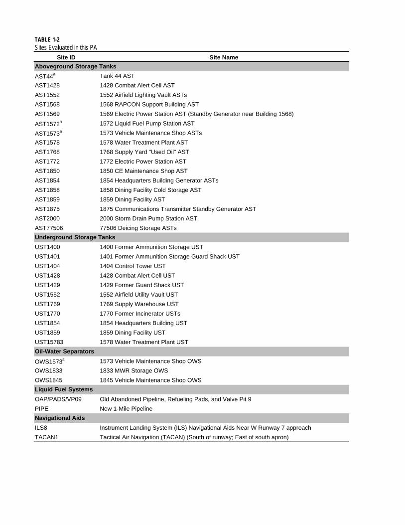
TABLE 1-2Sites Evaluated in this PA
Site ID Site Name
Aboveground Storage Tanks
AST44a Tank 44 AST
AST1428 1428 Combat Alert Cell AST
AST1552 1552 Airfield Lighting Vault ASTs
AST1568 1568 RAPCON Support Building AST
AST1569 1569 Electric Power Station AST (Standby Generator near Building 1568)
AST1572a 1572 Liquid Fuel Pump Station AST
AST1573a 1573 Vehicle Maintenance Shop ASTs
AST1578 1578 Water Treatment Plant AST
AST1768 1768 Supply Yard "Used Oil" AST
AST1772 1772 Electric Power Station AST
AST1850 1850 CE Maintenance Shop AST
AST1854 1854 Headquarters Building Generator ASTs
AST1858 1858 Dining Facility Cold Storage AST
AST1859 1859 Dining Facility AST
AST1875 1875 Communications Transmitter Standby Generator AST
AST2000 2000 Storm Drain Pump Station AST
AST77506 77506 Deicing Storage ASTs
UST1400 1400 Former Ammunition Storage UST
UST1401 1401 Former Ammunition Storage Guard Shack UST
UST1404 1404 Control Tower UST
UST1428 1428 Combat Alert Cell UST
UST1429 1429 Former Guard Shack UST
UST1552 1552 Airfield Utility Vault UST
UST1769 1769 Supply Warehouse UST
UST1770 1770 Former Incinerator USTs
UST1854 1854 Headquarters Building UST
UST1859 1859 Dining Facility UST
UST15783 1578 Water Treatment Plant UST
OWS1573a 1573 Vehicle Maintenance Shop OWS
OWS1833 1833 MWR Storage OWS
OWS1845 1845 Vehicle Maintenance Shop OWS
OAP/PADS/VP09 Old Abandoned Pipeline, Refueling Pads, and Valve Pit 9
PIPE New 1-Mile Pipeline
ILS8 Instrument Landing System (ILS) Navigational Aids Near W Runway 7 approach
TACAN1 Tactical Air Navigation (TACAN) (South of runway; East of south apron)
Navigational Aids
Underground Storage Tanks
Oil-Water Separators
Liquid Fuel Systems

TABLE 1-2Sites Evaluated in this PA
Site ID Site Name
DS1769 Potential Drum Storage and Disposal a Building 1769
DSNW Potential Former Disposal Site North West of the Former Galena FOL
DSWD Potential Former Disposal Site West of the Dike
SWQ Potential Solid Waste Disposal Area (Grant: ADA-02195 W of Radome, East of Dike Road)
B400Building 400 Former CAA Facility - Air Force Weather Observation Station (South of apron and Building 1573; North of runway)
B408 Building 408 Strobe Shack
B1403 Building 1403 Former LOX plant
B1558 Building 1558 Former Power Plant Transformers
S1769 Building 1769 Supply Warehouse Storage Yard
B1770 Building 1770 Incinerator
B1812 Building 1812 Former Satellite Hazardous Waste Accumulation Point
S1850 Building 1850 Storage Yard
B1879 Building 1879 Pump Station
B3005 Precision Approach Radar (PAR) Electric Power Station
B3205 Airport Surveillance Radar (ASR) Electric Power Station
Other
AAS3 Aircraft Arresting System (AAS) (locations north and south of runway)
AOC023 Waste Accumulation Area
B1859 Grease Trap Building 1859 Grease Trap
BERM Unknown Soil Berm (north of Former Birchwood Hangar)
BLA Barge Loading Area (Air Force lease area only)
BLM Pesticides Pesticide Area North of BLM Housing
Radiological Materials Radiological Materials (Sitewide)
TAR Possible Tar Pit Construction Area
Notesa: This site is located geographically in an ERP site but was evaluated because it is a feature available for inspection and therefore a determination could be made to excluded it as a potential contributing source in the ERP site.
Disposal Areas
Buildings: ASTs and USTs associated with these buildings are included in site evaluation
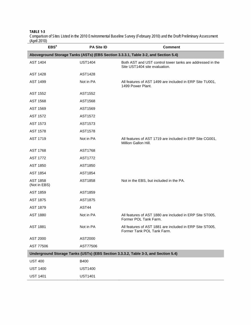
TABLE 1-3 Comparison of Sites Listed in the 2010 Environmental Baseline Survey (February 2010) and the Draft Preliminary Assessment (April 2010)
EBSa PA Site ID Comment
Aboveground Storage Tanks (ASTs) (EBS Section 3.3.3.1, Table 3-2, and Section 5.4)
AST 1404 UST1404 Both AST and UST control tower tanks are addressed in the Site UST1404 site evaluation.
AST 1428 AST1428
AST 1499 Not in PA All features of AST 1499 are included in ERP Site TU001, 1499 Power Plant.
AST 1552 AST1552
AST 1568 AST1568
AST 1569 AST1569
AST 1572 AST1572
AST 1573 AST1573
AST 1578 AST1578
AST 1719 Not in PA All features of AST 1719 are included in ERP Site CG001, Million Gallon Hill.
AST 1768 AST1768
AST 1772 AST1772
AST 1850 AST1850
AST 1854 AST1854
AST 1858 (Not in EBS)
AST1858 Not in the EBS, but included in the PA.
AST 1859 AST1859
AST 1875 AST1875
AST 1879 AST44
AST 1880 Not in PA All features of AST 1880 are included in ERP Site ST005, Former POL Tank Farm.
AST 1881 Not in PA All features of AST 1881 are included in ERP Site ST005, Former Tank POL Tank Farm.
AST 2000 AST2000
AST 77506 AST77506
Underground Storage Tanks (USTs) (EBS Section 3.3.3.2, Table 3-3, and Section 5.4)
UST 400 B400
UST 1400 UST1400
UST 1401 UST1401

TABLE 1-3 Comparison of Sites Listed in the 2010 Environmental Baseline Survey (February 2010) and the Draft Preliminary Assessment (April 2010)
EBSa PA Site ID Comment
UST 1404 UST1404 Both AST and UST control tower tanks are addressed in the Site UST1404 site evaluation.
UST 1428 UST1428
UST 1429 UST1429
UST 1499 Not in PA All features of UST 1499 are included in ERP Site TU001, 1499 Power Plant.
UST 1551 Not in PA All features of UST 1551 are included in ERP Site SS014, Birchwood Hangar.
UST 1552 UST1552
UST1556 (Not in EBS)
Not in PA UST 1556 is not in the EBS, but is included in ERP Site SS017, Former Truck Fillstands.
UST 1558 Not in PA UST 1558 is included in ERP Site SS014, Birchwood Hangar.
UST 1572 Not in PA UST 1572 is included in ERP Site ST009, JP-4 Fillstands.
UST 1578-3 UST15783
UST 1700-2 (Not in EBS)
Not in PA UST 1700-2 is included in ERP Site SS019, Building 1700.
UST 1713 Not in PA All features of UST 1713 are included in ERP Site CG001, Million Gallon Hill.
UST1719 (Not in EBS)
Not in PA UST 1719 is not in the EBS, but is included in ERP Site CG001, Million Gallon Hill.
UST 1769 UST1769
UST 1770 UST1770
UST 1837 Not in PA UST 1837 is included in ERP Site ST020, Building 1837 Petroleum Operations Facility.
UST 1854 UST1854
UST 1858 UST1859 This is a typographical error in the EBS (Section 5.4 Data Gaps). It should refer to UST 1859.
UST 1859 UST1859
UST 2541 Not in PA All features of UST 2541 are included in ERP Site SS016, 2541 POL Fuels Laboratory.
Oil-Water Separators (OWSs) (EBS Section 3.3.4.1, Table 3-3, and Section 5.4)
OWS 1499 Not in PA All features of OWS 1499 are included in ERP Site TU001, 1499 Power Plant.
OWS 1551 Not in PA All features of OWS 1551 are included in ERP Site SS014, Birchwood Hangar.
OWS 1556 Not in PA All features of 1556 are included in ERP Site SS017, Truck Fill Stands.
OWS 1573 OWS1573

TABLE 1-3 Comparison of Sites Listed in the 2010 Environmental Baseline Survey (February 2010) and the Draft Preliminary Assessment (April 2010)
EBSa PA Site ID Comment
OWS 1700 Not in PA All features of OWS 1700 are included in ERP Site SS019, Building 1700.
OWS1833 (Not in EBS)
OWS1833 Not in EBS, but included in PA.
OWS 1837 Not in PA OWS 1837 is included in ERP Site ST005, POL Tank Farm.
OWS 1845 OWS1845
Wastewater (EBS Section 3.2.2.3)
Sewage Lagoon Not in PA An active sanitary sewage treatment lagoon (constructed in 1973 and relined in 2006) operated by the City of Galena and managed under wastewater treatment regulations. Not a PA site.
Imhoff Tank Not in PA Not a PA site because potential environmental impact is associated with the sludge disposal at the landfills (ERP Sites LF008, LF011, or LF012).
Former Control Tower Septic Tank
UST1404
Former Guard Shack for Munitions Storage Septic Tank
Not In PA Historical photo review and review of building facility records from Building 1488 do not support that Building 1488 had a guard shack. Building 1488 was connected to the sanitary sewer system and did not have a septic tank.
Former Ammunition Storage Area Septic Tank (Not in EBS)
UST1400 Not in EBS, but included in PA.
Former Ammunition Storage Area Guard Shack Septic Tank (Not in EBS)
UST1401 Not in EBS, but included in PA.
Weather Station Cesspool B400
Fuel Pipeline Systems (EBS Section 3.3.3.3)
Barge Area BLA
Pipeline PIPE
47-gallon Spill PIPE
Observed Abandoned Pipelines
OAP
Notes: a ERP and Military Munitions Response Program (MMRP) sites are not included in this list. ASTs, USTs, and OWSs not included in the EBS have been added to this list so as to present a complete summary of all ASTs, USTs, and OWSs. EBS = environmental baseline survey ERP = Environmental Restoration Program PA = Preliminary Assessment POL = petroleum, oil, and lubricants


TABLE 1-4 Comparison of Sites Listed in the 2009 Galena Matrix (May 2009) and the Draft Preliminary Assessment (April 2010)
2009 Galena Matrix PA Site ID Comments
SS014 Not in PA ERP Site SS014
CB001 Not in PA ERP Site CB001 (refers to GAVTC depressurization system only; contamination under site associated with ERP Site ST005)
CG001 Not in PA ERP Site CG001
CG002 Not in PA ERP Site CG002
CS001 Not in PA ERP Site CS001 (administratively closed; to be included in decision documents for ERP Sites CG002 and ST009)
FT001 Not in PA ERP Site FT001
LF008 Not in PA ERP Site LF008 (closed per USAF records)
LF011 Not in PA ERP Site LF011 (closed per USAF records)
LF012 Not in PA ERP Site LF012 (closed per USAF records)
OT099 Not in PA ERP Site OT099
SS002 Not in PA ERP Site SS002 (administratively closed; site entirely included within ERP Site SS013)
SS004 Not in PA ERP Site SS004 (closed; no further action)
SS005 Not in PA ERP Site SS005
SS006 Not in PA ERP Site SS006
SS007 Not in PA ERP Site SS007
SS009 Not in PA ERP Site SS009
SS013 Not in PA ERP Site SS013
ST003 Not in PA ERP Site ST003 (closed; LUC/ICs required per ADEC)
ST005 Not in PA ERP Site ST005
ST009 Not in PA ERP Site ST009
ST010 Not in PA ERP Site ST010
TU001 Not in PA ERP Site TU001
WAA AOC23
LF0XX Not in PA There is no indication of a disposal area northeast of ERP Site LF011, Alternate Landfill, based on review of aerial photographs.
GUN Not in PA The active shooting range (GUN) is evaluated in the MMRP.
BLA BLA
XSOIL Not in PA Campion Soil Treatment Facility is part of the Campion Air Station ERP.
SS015 Not in PA ERP Site SS015

TABLE 1-4 Comparison of Sites Listed in the 2009 Galena Matrix (May 2009) and the Draft Preliminary Assessment (April 2010)
2009 Galena Matrix PA Site ID Comments
B9L4 BERM
OAP OAP Combined OAP/PADs/VP09 in PA.
VP09 VP09 Combined OAP/PADs/VP09 in PA.
Pipeline PIPE
Item12 Not in PA Twenty foot ROW on Galena Airport Land Occupancy Drawing (2/19/08). A road ROW is not a potential source of contamination. No sampling uncertainties identified in Galena Matrix.
Item15 Not in PA Twenty foot underground power ROW on Galena Airport Land Occupancy Drawing (2/19/08). The ROW is not a potential source of contamination. No sampling uncertainties identified in Galena Matrix.
Parcel Q SWQ
Item18 AST77506 Item 18 is the 5-foot pipeline ROW associated with Site AST77506.
ASR3200 B3205
PAR3000 B3005
ILS8 ILS8
AAS3 AAS3 Also called “Item 3” on Galena Airport Land Occupancy Drawings (2/19/08).
TACAN TACAN1
TACAN Building 654 Not in PA Available records indicate that TACAN Building 654 was jointly used and operated by the FAA and USAF and located on FAA-owned land. The site is also known as the FAA VORTAC. The FAA VORTAC facility was investigated previously by the FAA and no further action was recommended.
463 Not in PA This transmitter site was used by the USAF between 1971 and 1974, disposed of in 1982, and subsequently relinquished to BLM in 1988. The USAF provided BLM with signed certifications that no PCBs were present in 1982 and documentation of site inspections that showed no evidence of contamination or stressed vegetation in 1987 (USAF April 5, 1982; USAF, August 1987).
955 Not in PA This transmitter site was used by the USAF between 1971 and 1974, disposed of in 1982, and subsequently relinquished to BLM in 1988. The USAF provided BLM with signed certifications that no PCBs were present in 1982 and documentation of site inspections that show no evidence of contamination or stressed vegetation in 1987 (USAF April 5, 1982; USAF, August 1987).
In 1984, BLM granted Alascom, Inc. a ROW at Site B955 to construct and operate communication equipment including a 10-meter dish, a 20-foot-by-48-foot communications building, and a 20-foot-by-24-foot backup generator building (BLM, August 1984) at the location of the former USAF transmitter.
AWOS Not in PA This is not a USAF site. Parcel A was leased by the FAA in 1985 for the installation and operation of an AWOS.

TABLE 1-4 Comparison of Sites Listed in the 2009 Galena Matrix (May 2009) and the Draft Preliminary Assessment (April 2010)
2009 Galena Matrix PA Site ID Comments
FSS B400
EOD Not in PA EOD is included in the MMRP.
B9L9 B1558
1400 UST1400
1401 UST1401
1403 B1403
1404 UST1404
1427 Not in PA The LOX storage shed outside of Building 1428 (CAC) is not a potential source of contamination. The LOX plant, B1403, is included in the PA.
1428 UST1428
1429 UST1429
1548 Not in PA Former location of Building 1548 is a feature of ERP Site SS021.
1549 Not in PA ERP Site SS021
1552 UST1552
1556 Not in PA ERP Site SS017
1558 B1558/SS014 Possible petroleum contamination at Building 1558 was investigated as part of ERP Site SS014. In 2010, PA Site B1558 was created to address possible PCB contamination from the former transformer pad.
1569-1 AST1569
1578 - 3 UST15783
1700 Not in PA ERP Site SS019
1768 AST1768 The used oil tank listed in the Galena Matrix as part of Building 1768 is PA Site AST1768. The Hazardous Waste Storage Shed itself is not an individual PA site, but it is addressed in Section 3 of the PA.
1769 UST1769
1770 B1770/UST1770
1772 AST1772
1812 B1812
1833 OWS1833
1836 Not in PA Feature evaluated as part of ERP Site ST005.
1837 Not in PA ERP Site ST020
1845 OWS1845
1850 S1850/AST1850
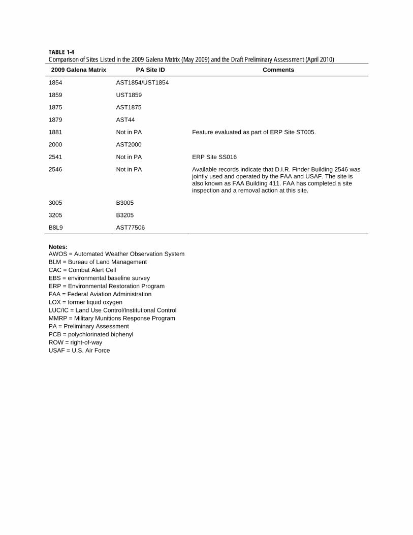
TABLE 1-4 Comparison of Sites Listed in the 2009 Galena Matrix (May 2009) and the Draft Preliminary Assessment (April 2010)
2009 Galena Matrix PA Site ID Comments
1854 AST1854/UST1854
1859 UST1859
1875 AST1875
1879 AST44
1881 Not in PA Feature evaluated as part of ERP Site ST005.
2000 AST2000
2541 Not in PA ERP Site SS016
2546 Not in PA Available records indicate that D.I.R. Finder Building 2546 was jointly used and operated by the FAA and USAF. The site is also known as FAA Building 411. FAA has completed a site inspection and a removal action at this site.
3005 B3005
3205 B3205
B8L9 AST77506
Notes: AWOS = Automated Weather Observation System BLM = Bureau of Land Management CAC = Combat Alert Cell EBS = environmental baseline survey ERP = Environmental Restoration Program FAA = Federal Aviation Administration LOX = former liquid oxygen LUC/IC = Land Use Control/Institutional Control MMRP = Military Munitions Response Program PA = Preliminary Assessment PCB = polychlorinated biphenyl ROW = right-of-way USAF = U.S. Air Force

FINAL: PRELIMINARY ASSESSMENT REPORT FORMER GALENA FORWARD OPERATING LOCATION, ALASKA
AFCEE CONTRACT FA8903-08-D-8769, TASK ORDER 0184 SEPTEMBER 2011
ES121009055544PDX 2-1
2.0 Operational Setting
2.1 Historical Site Use
2.1.1 Early History The City of Galena, Alaska is located in traditional Koyukon Athabaskan Indian territory. It was established in 1919 as a supply and transshipment point for the lead ore (galena) mining prospects south of the Yukon River. The location was on the site of a former Athabaskan fish camp recorded in the 1880 Census map as Natulaten. A school was established in the mid-1920s and a post office opened in 1932. The population of Galena in 1940, the year the CAA (now FAA) military began the first buildup in Alaska, was 30 people. Most residents were Athabaskan Indians who moved there from nearby villages on the Yukon River (Earth Tech, May 2007).
2.1.2 Construction of Civilian Field In 1941, Air Navigational Site Withdrawal No. 172, through Public Land Order 255, set aside 5,282 acres for the CAA to establish an air navigation facility as part of an overall civilian airport construction program in Alaska. The CAA selected Galena because of its central location in interior, western Alaska. The project was completed in spring 1942. Since 1941, the FAA has continually maintained and operated facilities at Galena Airport. The FAA currently leases some portions of the station to other entities.
2.1.3 Assumption of Military Responsibility, 1942-1945 Galena and 11 other mostly interior air fields were initially intended to serve civilian needs. The military had no presence in Galena until WWII. Negotiations with the Soviet Union for the lend-lease transfer of American aircraft to the Soviet Union led to the establishment of the Alaska-Siberia route which ran from Great Falls, Montana, north through northwestern Canada, then west across Alaska to Nome and finally across Siberia to the Eastern Front. Galena supported the Alaska-Siberia route from August 1942 until September 1945 when the last aircraft were delivered to the Soviet Union. All together, 7,926 fighters, medium bombers, and attack and transport aircraft were delivered to the Soviet Union over the Alaska-Siberia route. Many stopped at Galena to be refueled and serviced before going on to Nome (Earth Tech, May 2007).
Facilities for military use (separate from the joint-use airfield and support facilities already established by the CAA) were constructed through the Alaskan Defense Command. An Army post was established on June 24, 1942. A platoon from Company C, 176th Engineer Regiment, began constructing military support facilities at Galena on September 17, 1942. The remainder of the company was moved to Galena following approval of the expansion program on June 17, 1943. The CAA officially turned operation of the airfield over to the military on July 1, 1943.

FINAL: PRELIMINARY ASSESSMENT REPORT FORMER GALENA FORWARD OPERATING LOCATION, ALASKA AFCEE CONTRACT FA8903-08-D-8769, TASK ORDER 0184 SEPTEMBER 2011
2-2 ES121009055544PDX
The runway, located in a bend of the Yukon River, was extended in 1944 to 6,250 paved feet with a 1,000-foot, pierced-steel plank overrun at the eastern end. At the end of February 1944, the Galena airfield and facilities were rated 55 percent complete. In 1944, Quonset and Pacific Huts and temporary wooden-framed buildings were erected in a triangular area at the northwestern corner of the east-west runway. The structures were built to accommodate a 340-man Army garrison and consisted of personnel, administrative, and maintenance facilities, and a 12-bed hospital. The largest structure, a 200-by-202-foot, wood-truss birchwood hangar, was completed in 1945 to house aircraft and maintenance facilities (Earth Tech, May 2007).
The Army declared the airfield surplus at the end of WWII and the CAA resumed control of the airfield and facilities (USAF, April 2001).
2.1.4 Assumption of Military Responsibility, 1951-1993 The newly created USAF was the next military service to use the Galena Airfield. By 1945, the 11th Air Force was designated the Alaskan Air Command (AAC) and its headquarters were moved to Elmendorf Air Force Base (AFB) in Anchorage. The AAC mission was to provide “Top Cover for America,” and defend against the Soviet bomber threat. The key to Alaskan defense was perceived as preventing bombing attacks against the main military complexes at Fort Richardson and Elmendorf Field, both in Anchorage, and at Ladd Field (now Fort Wainwright) near Fairbanks, using information provided by multiple radar sites to scramble and direct fighter interceptors (USAF, May 2008).
The AAC negotiated an agreement with the CAA in early 1951 for joint use of Galena Airport. Between 1954 and 1959, the AAC upgraded the runway to 7,250 feet; improved the runway lighting system, fuel storage, and delivery systems; and constructed some new modern facilities to support additional personnel, including the CAC hanger (Building 1428) (USAF, April 2001). The next major construction effort occurred between 1979 and 1989 when several buildings were renovated and 17 new facilities were constructed (USAF, April 2001). The establishment of the Galena Air Station and Galena II/Campion Radar Site in the 1950s brought growth and change to Galena.
A progression of increasingly capable aircraft was assigned to Galena starting with the F-94s in 1951 and culminating with the F-15A Eagle in 1993. Of the 314 intercepts of Soviet flights made between 1961 and 1993, 200 were deployed from Galena (Earth Tech, May 2007).
The USAF and CAA joint-use agreement was modified when the federal government transferred the airport to the state of Alaska in 1966, in compliance with provisions of the 1958 Statehood Act. The USAF retained ownership of the facilities built by the military and entered into lease agreements with the State of Alaska (through AKDOT&PF) for the land on which the military facilities were located and where military operations were conducted (USA and State of Alaska, January 17, 1966). Other federal entities that maintained offices on the Base, such as the BLM and the FAA, were identified in the 1966 deed as federal entities that would maintain rights to operate on State of Alaska land until such time as their mission was no longer required.

FINAL: PRELIMINARY ASSESSMENT REPORT FORMER GALENA FORWARD OPERATING LOCATION, ALASKA
AFCEE CONTRACT FA8903-08-D-8769, TASK ORDER 0184 SEPTEMBER 2011
ES121009055544PDX 2-3
2.1.5 Caretaker Status Military Responsibility, 1993-2008 In 1993, the USAF mission had changed and the USAF withdrew all permanent military personnel and aircraft from Galena. Many of the previous USAF facilities were transferred to federal, state, and local entities for their exclusive uses. The Base chapel was donated to the City of Galena and moved offsite, and the Birchwood Hangar was demolished. The remaining facilities reverted to caretaker status and a contractor was hired to maintain the USAF properties. An EBS was completed in 1996 which detailed the condition of USAF facilities with regard to elements such as environmental contamination, asbestos, lead-based paint, and hazardous substance use. On August 25, 2005, the BRAC Commission voted unanimously to recommend closing the Former Galena FOL (Earth Tech, May 2007). The turnover of the majority of facilities (the USAF still retains ownership of two facilities as discussed in Section 1.3) and land to the State of Alaska and City of Galena occurred on October 1, 2008.
2.2 Current Site Use Galena Airport is owned and operated by the AKDOT&PF. All former USAF buildings and infrastructure (for example, power plant/steam heating plant, water treatment plant, sewage treatment plant, sewage treatment system, lodging, supply, offices, school, dining facilities, building and grounds maintenance, fuel maintenance and storage, and vehicle maintenance) were transferred through a Bill of Sale to the State of Alaska (USAF and AKDOT&PF, October 1, 2008) and the City of Galena (USAF and the City of Galena, September 30, 2008) with the exception of Building 1428, the CAC, and Building 1568, the RAPCON facility. The majority of the former USAF buildings at the airport are currently used by either the City of Galena, Galena Interior Learning Academy (GILA) (education, dormitory, storage, utilities), AKDOT&PF (administrative, storage, maintenance), or Alaska State Troopers (administrative, storage). The BLM (lodging, administrative, and storage), FAA (storage and administrative), Alaska Department of Fish and Game (ADFG) (storage), and USFWS (administrative and storage) continue to maintain their facilities and operations unaffected by the removal of the USAF from the Former Galena FOL area (USAF, May 2008).
2.2.1 Population
2.2.1.1 City of Galena
As of the 2000 census, 675 people resided in Galena. The population of the community consisted of 67.4 percent Alaska Native or part Native. The population is mixed Athabascan and non-Native, and traditional festivals attract visitors from other river villages.
Data from the Alaska Community Database shows there were 4 schools in the community which were attended by 3,721 students in 2000. The unemployment rate was 8.74 percent, although 32.53 percent of all adults were not in the work force. The median household income was $61,125. Per capita income was $22,143, and 10.16 percent of residents were living below the poverty level (Alaska Community Database, 2009).

FINAL: PRELIMINARY ASSESSMENT REPORT FORMER GALENA FORWARD OPERATING LOCATION, ALASKA AFCEE CONTRACT FA8903-08-D-8769, TASK ORDER 0184 SEPTEMBER 2011
2-4 ES121009055544PDX
2.2.1.2 Former Galena FOL While the Former Galena FOL was in caretaker status from 1993 to 2008, a contract work force of approximately 40 personnel maintained the facilities. The personnel included a mixture of Galena residents and workers who lived in Building 1876, Iditarod Inn.
Building 1872, Wilderness Hall, and Building 1874, Ptarmigan Hall were both dormitories within the Former Galena FOL that supported GILA students and facility. Building 1872 has since been demolished, but Building 1874 remains a dormitory.
North of the Former Galena FOL and east of the main cantonment “triangle” is residential housing for State Troopers, BLM, and others.
2.2.2 Resident Users Resident users at the Former Galena FOL facilities include the GILA and the BLM. GILA is a statewide boarding school for Grade 9 to 12 students. GILA student enrollment grew from 110 to 180 in the 2009-10 school year. Students reside at the Former Galena FOL during the GILA school year from late August through late May (GILA, 2009).
Several Former Galena FOL facilities were used to support residential activities and are still used in this capacity. These include dormitory facilities and the dining hall. The dormitory for the GILA school is Building 1874, Ptarmigan Hall, located on the eastern side of the cantonment “triangle.”
The BLM owns facilities and operates a seasonal base camp for firefighters inside the dike at the Former Galena FOL, on the northern side of the runway (USAF, January 2004).
2.3 Contaminant Source Types
2.3.1 Petroleum, Oil, and Lubricants Energy and power needs at the Former Galena FOL, including facility heating and aircraft refueling, were met using petroleum-based fuels that arrived via barge. The primary routing of the fuels was from barge to storage tanks to fill stands via underground and aboveground pipeline. Some fuels were trucked from the barge to tanks. Historically, fuel was stored in aboveground saddle tanks and belowground tanks. Most of the USTs have now been removed from service. The main fuels used at the Former Galena FOL are Arctic diesel fuel (DFA); aviation gasoline (AVGAS); jet-propulsion fuel, grade 4 (JP-4); jet-propulsion fuel, grade 8 (JP-8); and lesser quantities of motor gasoline (MOGAS) (USAF, 1992). Previous reports and historical documents (USAF, February 2010; Earth Tech, May 2007; USAF, October 2004; USAF, June 1996) were reviewed to determine sites that warrant investigation for POL contamination. A comparison of sites listed in the EBS and sites in this PA is provided in Table 1-3.
Various oils, lubricants, and antifreeze were used for maintaining aircraft and vehicles. Waste oil and contaminated fuel were among the industrial wastes generated at the Former Galena FOL. Before 1984, waste oil was accumulated during winter months and provided to

FINAL: PRELIMINARY ASSESSMENT REPORT FORMER GALENA FORWARD OPERATING LOCATION, ALASKA
AFCEE CONTRACT FA8903-08-D-8769, TASK ORDER 0184 SEPTEMBER 2011
ES121009055544PDX 2-5
the State of Alaska for road oiling. After 1985, these wastes were shipped to Elmendorf AFB (Engineering Science, September 1985).
A historical records search (Engineering Science, September 1985) documented storage of waste oil at the Waste Accumulation Area near the power plant. The following major leaks and spills are also documented in this report:
Spill/Leak No. 1: Spills and leaks from drummed fuel products in the unpaved area between the runway and apron (1940s to 1960s ; Investigated in ERP Site SS013, Control Tower Drum Storage Area South)
Spill/Leak No. 2: Underground fuel transfer line from the barge loading area (BLA) leaked in the vicinity of Facility 1403 (mid 1950s; Investigated in ERP Site ST003, Petroleum, Oil, and Lubricants [POL] Fuel Line Leak)
Spill/Leak No. 3: A POL tank truck spilled 4,000 gallons of JP-4 off the dike road near the BLA (1984; Investigated in ERP Site SS004, 4,000 Gallon JP-4 Fuel Spill)
Spill/Leak No. 4: A grader hit a MOGAS fill stand at the POL Tank Farm resulting in a 200- to 500-gallon spill (1985; Investigated in ERP Site SS005, POL Tank Farm)
Spill/Leak No. 5: Leaks from Valve Pit No. 2 (1980s; Investigated in ERP Site ST005, POL Tank Farm)
Five spills are included in the appendix to the 2010 EBS report. All five sites are listed as ”case closed.” Spill reports for these closed cases are included as Appendix D. No further investigation of these spills is required. These spills and associated case information are shown below.
50-gallon diesel fuel spill—Case Closed: 2/28/2007, spill date 9/19/2001, Facility ID: 01309926201, spill ID: 16585
40-gallon diesel fuel spill—Case Closed: 9/6/2003, spill date 8/12/2003, Facility ID: 03309922402, spill ID: 22234
1-gallon diesel fuel spill—Case Closed: 7/1/2004, spill date 6/23/2004, Facility ID: 04309917502, spill ID:22521
2-gallon diesel fuel spill—Case Closed: 7/1/2004; spill date 6/28/2004, Facility ID: 04309918002, spill ID: 22554
5-gallon spill of waste oil —Case Closed: 5/31/2002, spill date: 5/22/2002; Facility ID: 02309914202, spill ID: 17085
Clean and contaminated JP-4 was also used at the fire training area (investigated in ERP Site FT001), with several hundred gallons used at each session at approximately 25 training sessions a year.
2.3.2 Solvents Solvents were used at the Former Galena FOL for maintaining aircraft, vehicles, and electronics, and included tetrachloroethene (PCE) and trichloroethene (TCE). Dry cleaning

FINAL: PRELIMINARY ASSESSMENT REPORT FORMER GALENA FORWARD OPERATING LOCATION, ALASKA AFCEE CONTRACT FA8903-08-D-8769, TASK ORDER 0184 SEPTEMBER 2011
2-6 ES121009055544PDX
service was not available to USAF personnel at the Former Galena FOL (Blair, January 5, 2010; Lurk, December 4, 2009). However, a 1944 U.S. Army Corps of Engineers (USACE) Plan for construction of the Galena Staging Field identified a building as “dry cleaning” in the northern part of the cantonment area. The 1944 plan references a 1945 “as-built “that was not available for review. Review of aerial photos and drawings could not corroborate whether this facility was ever built. Secondary sources of solvents include drums of spent solvents that were among the waste drums stored at the unpaved area between the runway and apron (ERP Site SS013, Control Tower Drum Storage Area South) from the 1940s to 1960s. Storage of spent solvents with waste oil was also reported at the Waste Accumulation Area (Site AOC023) near the power plant. Rags with solvent were reportedly disposed of at Galena landfills. Spent solvents were most likely applied to the Former Galena FOL area roads along with waste oils until 1984 when wastes were shipped back to the Defense Property Disposal Office at Elmendorf AFB.
2.3.3 Pesticides No drawings were located that definitively identified entomology shops or dedicated pesticide storage areas. Pesticides, along with other supplies and wastes, were stored at the Civil Engineering Shop, Building 1850, the Supply Warehouse, Building 1769, and a trailer near the sewage lagoon (Burgett, 2010).
Although no records have been located to document specific application of pesticides, investigations conducted from 1992 to 1994 identified low levels of pesticides including dichlorodiphenyldichloroethane (DDD), dichlorodiphenyldichloroethylene (DDE), dichlorodiphenyltrichlorethane (DDT), aldrin, dieldrin, and possible detections of heptachlor epoxide (Radian, March 1996, Volume I, p. 3-151 to 3-168) at the Former Galena FOL. The widespread, low-level occurrence of these pesticides suggests an area-wide application for insect or mosquito control (Radian, March 1996, Volume I, p. 3-147). The 1985 Phase 1 Records Search, which included a review of eight Air Force locations, did not specifically address pesticides at any location and generally stated that “pesticides usage had been limited to occasional spraying of malathion to control mosquitoes and/or spraying to control insects inside of buildings”(Engineering Science, September 1985, p. 4-36). The Agency for Toxic Substances and Disease Registry concluded that pesticides detected at the Former Galena FOL in soil and sediment are not a human health concern for children or adults (ATSDR, May 2007, p. 2).
Pesticide sampling was conducted at the Former Galena FOL as part of a Base-wide sampling effort as described in the 1996 RI report (Radian, March 1996). Pesticides at Air Force sites were detected at varying levels in surface soil, subsurface soil, and groundwater. Pesticides were addressed on a site-by-site basis in the Baseline Risk Assessment (USAF, March 1996).
Pesticides are considered to be a chemical of potential concern only at those sites where there is evidence that pesticides were stored or mixed, or where elevated concentrations indicate the likelihood of a spill or release beyond what would be expected during normal application. Frequent, low-concentration detections of pesticides in shallow soils are expected because of past practices of general application and pesticide use across the Base.
FINAL: PRELIMINARY ASSESSMENT REPORT FORMER GALENA FORWARD OPERATING LOCATION, ALASKA
AFCEE CONTRACT FA8903-08-D-8769, TASK ORDER 0184 SEPTEMBER 2011
ES121009055544PDX 2-7
Sites where pesticides are considered target analytes are ERP Sites ST009, CG001, and S1769. In addition, because the EBS describes an area of potential pesticide release area north of BLM, which was not owned, leased, or operated by the Air Force, (USAF, February 2010), a historical review was conducted for this site (Site BLM Pesticides). This site evaluation is included in Appendix A.
2.3.4 PCBs Similar to other industrial facilities, the Former Galena FOL used electrical transformers which contained polychlorinated biphenyl (PCB) oil. Records identified several power plant and electrical power station facilities. No records were located that identified dedicated PCB storage areas but transformers were likely stored in the Building 1769 Supply Warehouse and adjacent storage yard as well as the Building 1850 Civil Engineering Shop storage yard. PCB-containing transformers were suspected of being disposed of at the Galena Alternate Landfill (ERP Site LF011), however, during the RI only two empty transformers were observed and analytical results indicated no PCB contamination (Radian, March 1996, Volume 1, p. 3-133). Archived Defense Reutilization and Marketing Service (DRMO) records from 1984 to 1989 (1984 was the earliest available) at Elmendorf AFB were searched for documentation of the removal of PCB transformers from the Former Galena FOL. During the 1980s, the 5099th Squadron removed PCB transformers from Forward Operating Bases (FOBs) and radar sites and delivered them to the former treatment, storage, and disposal facility (TSDF) (managed by DRMO) at Elmendorf AFB.
The PA site investigations will incorporate PCBs into the list of target analytes where evidence of their use is found or suspected and there is the potential for a release to the environment to have occurred.
2.3.5 Metals There were no known metal plating or metal sandblasting facilities at the Former Galena FOL. The primary possible metal concern is lead from leaded gasoline, aviation gasoline, and waste oils.
The Former Galena FOL area is known to contain significant heavy metal deposits of antimony, bismuth, chromium, copper, iron, lead, manganese, molybdenum, nickel, platinum, silver, thorium, tungsten, uranium, and zinc (Earth Tech, May 2007, p. 2-11).
2.3.6 Radiological Materials Site Radiological Materials addresses the Base-wide possibility of nuclear weapons storage or use and associated releases at the Former Galena FOL. The entire FOL was considered under this evaluation.
Radiological materials has been added to the PA as a site (Site Radiological Materials) included in Appendix A.


FINAL: PRELIMINARY ASSESSMENT REPORT FORMER GALENA FORWARD OPERATING LOCATION, ALASKA
AFCEE CONTRACT FA8903-08-D-8769, TASK ORDER 0184 SEPTEMBER 2011
ES121009055544PDX 3-1
3.0 Environmental Setting
3.1 Soil 3.1.1 Geology 3.1.1.1 Regional Geology The following discussion of the regional and site-specific geology of the Former Galena FOL area was originally published in the 1996 Final Remedial Investigation Report, Galena Airport and Campion Air Station (USAF, March 1996).
The Former Galena FOL is located in west-central Alaska in the Central Subregion of the Yukon River Physiographic Region as shown on Figure 3-1. The Central Subregion is composed of the lowlands, plains, and interior highlands drained by the Yukon River and its tributaries between the Koyukuk and Tanana River watersheds. Regionally, exposed bedrock consists of predominantly Mesozoic and Cenozoic volcanic rocks, Lower Paleozoic metamorphic rocks, and Cretaceous and Lower Cretaceous sedimentary rocks. Also present in the region, but to a lesser extent, are numerous exposed Mesozoic and Cenozoic intrusive and ultramafic rocks.
The area is defined by the Yukon-Koyukuk Basin, which extends from the Bering Sea to the Canadian border, and occupies an extensive structural trough formed by subsidence during the Cenozoic period. The Kaltag Fault, a major east-west tracing fault, also extends across the region. The Yukon River follows the trace of the fault from Tanana to the meander south of Campion Air Station (AS) where the river course becomes more northerly.
The entire Yukon Valley area is characterized by meandering and braided streams. Oxbow lakes, point-bar accretionary ridges, and river chutes combine to create a ridges-and-trough topography that reflects the constant readjustment of the meandering Yukon River system to changes initiated by seasonal flooding events. In general, large quantities of sediment are deposited along the inside of meander loops, whereas the opposite banks experience extensive erosion. Large accumulations of wind-blown sediments, called loess, are also common across the floodplain.
3.1.1.2 Former Galena Forward Operating Location Site Geology The Former Galena FOL is located within the floodplain of the Yukon River, a typical coarse grained, meandering bed-load river characterized by highly variable discharge, flow velocities and gradients, and typically high width:depth channel ratios. Suspended sediment content varies seasonally, and is highest in the spring and summer. Bedload sediment transport varies with flow velocity and consists of sand, gravel, and cobbles. Chute cutoffs are common features and, during high seasonal flow, rapid thalweg (the deepest portion of the channel) and meander shifts occur, which results in extensive bank erosion, flow alignment modification, and bar deposition. Spring flooding is common on the river because of high surface runoff associated with seasonal snow melt and the local formation of river ice dams during breakup.
The Yukon River deposits broad laterally and vertically amalgamated sand bodies from the rapid lateral migration of bed-load channels. Erosion is common on the river's banks during

FINAL: PRELIMINARY ASSESSMENT REPORT FORMER GALENA FORWARD OPERATING LOCATION, ALASKA AFCEE CONTRACT FA8903-08-D-8769, TASK ORDER 0184 SEPTEMBER 2011
3-2 ES121009055544PDX
high-flow conditions, and previously deposited floodplain sediments are often transported further downstream. This results in the limited preservation of normally extensive floodplain deposits. The meandering Yukon River has also resulted in the erosion of the banks just upstream of Old Town Galena, prompting the construction of a sheet piling wall in 1960 to minimize further erosion.
The geology of the Former Galena FOL is dominated by undifferentiated fluvial Quaternary sediments deposited by the Yukon River to a depth greater than 200 feet. These sediments consist of unconsolidated stratified layers of silt and sand near the top of the sequence, underlain by gravel, sandy gravel, silty sand, and sand. Four main units are defined in the subsurface. These units include the following:
Construction fill material Floodplain silty sand and sandy silt Channel fill sand Channel fill sandy gravel and gravel
Logs of test borings and test wells indicate that much of the northern portion of the Former Galena FOL has been covered with fill material consisting of silty gravel and poorly graded gravel that generally ranges in thickness from 0 to 6.5 feet. This material was "mined" from the large transverse bar in the Yukon River that is exposed during periods of low flow, generally late summer. Fill material is abnormally thick (20 feet) in the area of Million Gallon Hill, where a substantial amount of material was brought in during the construction of USTs 37 and 38.
The uppermost naturally occurring unit consists of floodplain deposits composed of 3 to 25 feet of dark olive gray to brown, mostly poorly graded silt to silty sand. This unit contains abundant wood chips, rootlets, and other organic fragments and appears to be thickest in the northern portion of the main installation and at the Fire Protection Training Area.
The complex scour and fill processes that occur during channel migration result in the deposition of stacked and amalgamated channel complexes that are difficult to interpret. The lowest units observed during the drilling exercises are believed to represent this type of deposit. Olive gray/black to yellowish-brown, fine- to medium-grained, poorly graded sands and gravelly sands are found immediately below the floodplain deposits. Discontinuous lenses of poorly to well graded, well-rounded sandy gravel and gravel are representative of historic channel lag deposits.
Many of the test borings, test pits, and wells completed at the Former Galena FOL in the 1950s and 1960s encountered areas of permanently frozen ground, or permafrost, either as near-surface isolated lenses or as continuous layers beginning 20 feet or more below grade. In undisturbed vegetated terrain, the permafrost is usually present within 10 feet of the ground surface, and may also be present at depth, depending on the porosity and permeability of the alluvium. However, the distribution of permafrost beneath the airport facility is increasingly sporadic closer to thaw zones created by the Yukon River and recently abandoned meander loops.
During development of the facilities at the site, gravel pads were constructed to minimize thawing of permafrost and subsidence of the compressible alluvial soils. In addition, some heavy structures (for example, a power plant) were built on pilings both to minimize settlement

FINAL: PRELIMINARY ASSESSMENT REPORT FORMER GALENA FORWARD OPERATING LOCATION, ALASKA
AFCEE CONTRACT FA8903-08-D-8769, TASK ORDER 0184 SEPTEMBER 2011
ES121009055544PDX 3-3
and to reduce the effects of permafrost thaw on buildings. Nevertheless, in much of the area near the main installation, permafrost zones are now absent as deep as 60 feet (based on observations from boreholes), and may be absent to over 200 feet (based on a USAF water supply well log). The removal of insulating vegetative cover and the absorption of radiant heat from installation buildings and utilities likely thawed most of the permafrost once present at the site. On the basis of the recent borehole logs, the presence of permafrost in the area is now believed to be very sporadic and limited to thin isolated lenses. Discontinuous permafrost lenses were encountered while drilling soil borings and wells immediately south of the POL Tank Farm and under the tarmac at Monitoring Well 05-MW-15. Continuous permafrost was observed only at the eastern edge of the Fire Protection Training Area.
3.2 Groundwater 3.2.1 Hydrogeology Groundwater at the Former Galena FOL exists in an unconfined alluvial aquifer consisting of interbedded sequences of sand and gravelly sand, with minor silt fractions. An extensive hydrological investigation of the main Former Galena FOL installation was conducted during summer 1993. The results of these tests are reported separately in the Final Aquifer Test Report, Galena Airport, Alaska (USAF, October 1994) and are summarized here.
Hydraulic communication between the unconfined aquifer and the Yukon River was firmly established in previous investigations. The depth to water table varies from approximately 5 to 25 feet below ground surface (bgs) on a seasonal cycle in response to changes in stage of the Yukon River. The hydrographs on Figure 3-2 show seasonal fluctuations in water levels throughout the Former Galena FOL during recent years. The groundwater and Yukon River elevations taken from May 1993 through February 1994, as shown on Figure 3-3 clearly demonstrate the changes in river stage and corresponding changes in groundwater levels in monitoring wells (Earth Tech, May 2007). The streamflow hydrograph in Figure 3-4 shows the rapid increase in river stage because of the arriving flood wave. During this time, the Yukon River becomes a losing river, meaning that flow is induced into the river banks and recharges the local, unconfined groundwater aquifer. This condition, referred to as bank storage, continues for a short period until the river crests and begins its gradual decline. At that point, the river becomes a gaining stream, meaning that groundwater flow is reversed and groundwater discharges into the Yukon River. When the Yukon River floods in the spring and early summer, the resulting groundwater rise saturates the upper silty sand zone of the aquifer. During the remainder of the year, as regional precipitation, recharge rate, and the Yukon River level decreases, the groundwater level also declines, and the water table retreats to the deeper, coarser grained portion of the aquifer. During the winter months, the aquifer level continues to subside after the Yukon River freezes (USAF, March 1996).
During the 9 to 10 months that the Yukon River is a gaining river, groundwater generally flows southwest. A short-term reversal in groundwater flow to the north occurs during spring breakup (May to June). This reversal is attributed to the abrupt rate at which the Yukon River rises in elevation to flood stage during breakup, causing the water table to slope away from the river. After the Yukon River reaches peak stage and resumes gaining river conditions, the direction of groundwater flow returns to the south/southwest. Figure 3-5 and Figure 3-6 show the Former Galena FOL potentiometric surface maps for October 2003 and May 2004,
FINAL: PRELIMINARY ASSESSMENT REPORT FORMER GALENA FORWARD OPERATING LOCATION, ALASKA AFCEE CONTRACT FA8903-08-D-8769, TASK ORDER 0184 SEPTEMBER 2011
3-4 ES121009055544PDX
respectively (Earth Tech, May 2007). Figure 3-5 reflects the configuration of the potentiometric surface under a gaining river condition, while Figure 3-6 depicts the configuration of the potentiometric surface under a losing river condition.
Changes in groundwater flow direction and velocity as a result of changes in river stage were also measured directly using a down-hole flowmeter in a group of wells installed for pump test observations near Monitoring Well 05-MW-06. The results of these flow meter tests are presented in detail in the Final Aquifer Test Report, Galena Airport, Alaska (USAF, October 1994). A Geoflow flowmeter was used to collect groundwater flow velocity data during ambient conditions in May and August 1993.
The velocities recorded during the May and August tests are graphed along with groundwater direction diagrams in Figure 3-7. The direction roses show the frequency of the velocity vector measurements with respect to compass direction within 10-degree azimuth increments. Stable, repeatable data from 43 to 67 feet bgs were only collected during the August test. The velocities for the May test ranged from 0.8 to 5.4 feet per day (ft/day). One distinct high-velocity zone is apparent at the 16 and 18 feet depths. The predominant flow direction in May is northward.
During the August test, overall groundwater velocities were slightly greater, ranging from 1.0 to 10.8 ft/day, likely because of a higher groundwater gradient in response to lowering river levels. High-velocity zones (greater than 4.0 ft/day) were present at 16, 27, 36, 56, and 65 feet bgs. However, some of these zones do not correspond to high-velocity zones during the May test, notably at 27 and 36 feet bgs. Also, at 18 feet bgs, a much lower velocity was recorded during the August test. The predominant flow direction measured by the flowmeter in August is south-southwestward, similar to the flow direction derived by the August 15, 1993, water level survey (USAF, October 1994).
Observation of water levels in deep (Base water supply well) and shallow (Monitoring Well 10-MW-01) wells indicated that vertical gradients are in a downward direction. Continuous water-level data (Figure 3-8) were collected between May and November 1993 for Monitoring Well 10-MW01 and the Base Water Supply Well #2, screened from 5 to 45 feet bgs and 200 to 210 feet, respectively. There is consistently approximately 2 feet of head difference between the deep zone and the shallow zone. This head difference provides a vertical gradient of approximately 2 feet per 180 feet, or 0.01 feet per foot (ft/ft) (USAF, October 1994).
Aquifer properties at the Former Galena FOL site were evaluated during two hydraulic testing efforts in the early 1990s. In 1992, slug tests were performed on 13 wells screened in the top 10 feet of the shallow saturated silty sand material. The hydraulic conductivity calculated from these tests ranged from 0.000014 to 0.00009 centimeter per second (cm/sec), or 0.04 to 0.26 ft/day (USAF, October 1994).
In August 1993, an aquifer testing program was conducted at POL Tank Farm (ERP Site ST005). This site was chosen because of hydrogeologic sites in the cantonment “triangle,” allowing test results to be applied to other areas. This aquifer testing program consisted of a step-drawdown test followed by a longer-term (9.5 hour) constant rate discharge test. The step-drawdown test was run with steps of 25, 42, 60 and 75 gallons per minute (gpm), each of 30-minute duration. The constant rate discharge test was run at 75 gpm with a 9.5-hour pumping phase. Aquifer recovery was also monitored until recovery of groundwater levels in the pumped well was near 95 percent.
FINAL: PRELIMINARY ASSESSMENT REPORT FORMER GALENA FORWARD OPERATING LOCATION, ALASKA
AFCEE CONTRACT FA8903-08-D-8769, TASK ORDER 0184 SEPTEMBER 2011
ES121009055544PDX 3-5
The results of the aquifer testing program are summarized in Table 3-1. The drawdown and recovery data collected during the constant rate discharge test were evaluated using both the Neuman Method and the Cooper-Jacob Methods. These methods are both commonly used aquifer test analysis methods appropriate to evaluate data from tests performed on unconfined alluvial aquifers such as that present at the site. A detailed description of these analysis methods is included in the Final Aquifer Test Report, Galena Airport, Alaska (USAF, October 1994). As shown in Table 3-1, aquifer transmissivity values estimated from drawdown data using the Neuman Method ranged from 2,200 to 19,800 ft/day. These values suggest a corresponding hydraulic conductivity range between 22 and 198 ft/day bgs. Transmissivity estimates obtained using recovery data were somewhat higher, ranging from 24,000 to 120,000 ft/day, and showed an overall increase with depth. These values suggest a corresponding hydraulic conductivity range between 241 and 1,200 ft/day. Transmissivity estimates obtained using the Cooper-Jacob method ranged from approximately 15,000 to 64,000 ft/day, with corresponding K ranges of 149 to 644 ft/day. In summary, both methods provide similar estimates of hydraulic conductivity (between 100 and 1000 ft/day), and suggest an increasing permeability trend with depth. This is consistent with the lithology observed in boring logs across the site.
3.2.2 Wells 3.2.2.1 Galena Airport Water-supply Wells The Former Galena FOL has historically obtained water from seven water-supply wells within the airport boundaries. Three of these wells have supplied water for consumption. Table 3-2 shows the status of all seven wells. Former well locations are shown on Figure 3-9.
In 1963, the USACE conducted an assessment of water quality within the Former Galena FOL area to select the best location and overall strategy for drinking water production. This effort included installing shallow test wells (W345 to W348) and comparing water quality and yield from shallow (for example, less than 80 feet bgs) to existing deep water supply wells (USAF, May 10, 1963). Interestingly, this 1963 study drew conclusions similar to current ADEC guidelines that recommend against developing shallow groundwater resources in close proximity to sewer lines, fuel storage tanks/lines, and other industrial activities. In addition, this study documented that shallow groundwater was of a poor quality (for example, elevated iron or manganese) and yield for year-round production compared to existing deeper wells. These recommendations were used to guide the operation and long-term management of the drinking-water supply at the Former Galena FOL. The following conclusions were presented in the 1963 USACE study:
The thin, uppermost layer of relatively iron-free water which occurs in three of the test wells would provide water lower in iron, but higher in total dissolved solids than the water presently treated. From this standpoint, there does not, therefore, appear to be any advantage in the near surface water over the present Well No. 2 water. In addition, the large seasonal fluctuation in the water table would make practical utilization of the uppermost iron-free water difficult or impossible. Furthermore, a shallow water source such as this would be subject to contamination by sewage, aviation fuels and oil. Such contamination appears likely to occur in the very near future. The treatment of such a shallow water to reduce the content of total solids and contaminants to a level conforming to health standards and practicability would probably

FINAL: PRELIMINARY ASSESSMENT REPORT FORMER GALENA FORWARD OPERATING LOCATION, ALASKA AFCEE CONTRACT FA8903-08-D-8769, TASK ORDER 0184 SEPTEMBER 2011
3-6 ES121009055544PDX
be more complicated and expensive than the present water treatment facilities and would produce water of little, if any, better quality.
Currently, the Former Galena FOL obtains its potable water from two main wells which are screened in alluvial sediments at approximately 200 feet bgs. Wells No. 1 and No. 7 (renamed Well No. 2 by water plant operators) pump at a rate of approximately 55 gpm and are switched off when the 100,000-gallon holding tank reaches capacity. Well No. 2, which was used for potable water supply until it was replaced by Well No. 7 in September 1992, is now abandoned (Earth Tech, May 2007).
3.2.2.2 Community of Galena Water-supply Many residents of the community of Old Town Galena have drinking water trucked in from the city well located at the new Galena town site, upgradient of the Former Galena FOL. However, interviews with community members and a review of City Hall records showed that at least seven private wells are still in use in Old Town Galena. These wells, which are all less than 60 feet deep, supply water for cooking, cleaning, and drinking. Three separate wells located on a sandbar of the Yukon River supply water to several private residences and businesses in Old Town Galena.
3.3 Surface Water 3.3.1 Flood Frequency The Former Galena FOL lies within the floodplain of the Yukon River. The Yukon River at Galena peaks each spring in late May or early June because of high surface runoff associated with snowmelt. When ice dams form on the Yukon River during breakup, severe flooding occurs. Nine major historic floods have occurred at Galena, including during 1944, 1945, 1962, and 1971 (Waterhouse, July 1996; Earth Tech, May 2007). The highest flood on record happened on May 21, 1971, when Old Town Galena was inundated with approximately 8 feet of water and floating ice blocks — causing extensive damage (Waterhouse, July 1996). An earthen dike was constructed around the airfield and cantonment to an elevation 10 feet above average flood level in 1945. A perimeter road circles the airfield on top of the dike. During severe flooding, areas outside the dike, including Old Town Galena, are completely inundated. For the last 40 years, severe flooding in Galena has been controlled by the active destruction or prevention of ice dams during breakup. The perimeter dike has prevented flooding inside the airfield since 1945.
3.3.2 Surface Water Types Natural drainage patterns have been altered by the construction of the airfield and numerous buildings on the Former Galena FOL site. Water may pool within the containment berms for tanks, but there are no significant surface water bodies on the property. Surface flow is generally to the south by overland flow into sloughs. Surface water within the diked area around the airfield collects in the southwestern corner at Building 2000, the storm drain pump station, where it is pumped over the dike to the Yukon River.
The EPA granted the USAF an exclusion from permitting (No Exposure Certification) under the terms and conditions imposed by the EPA’s Stormwater Multi-Sector General Permit for USAF

FINAL: PRELIMINARY ASSESSMENT REPORT FORMER GALENA FORWARD OPERATING LOCATION, ALASKA
AFCEE CONTRACT FA8903-08-D-8769, TASK ORDER 0184 SEPTEMBER 2011
ES121009055544PDX 3-7
activities at Galena Airport. The No Exposure Certification for the USAF at Galena began in February 2006 (EPA, 2006).
Old Town Galena and the Former Galena FOL are located adjacent to the Yukon River, which generally flows from east to west. The maximum low-water river stage on the Yukon River is generally observed in early May, before the spring breakup. With the onset of spring breakup, the river stage abruptly rises to peak water-level elevations, which generally occur in late May or June. The river stage steadily declines throughout the early summer months following breakup. The river stage typically rises again during the late summer months in response to precipitation events and eventually returns to low-water conditions with the onset of river freeze-up in October (Radian, October 2002).
3.3.3 Fish, Amphibians, and Reptiles Fish are absent within the Former Galena FOL site, but approximately 20 species of fish inhabit a wide variety of wetlands and river systems on the nearby Koyukuk National Wildlife Refuge and the adjacent Yukon River (ADEC, June 1999). Both anadromous and resident fishes are common. Anadromous species include dolly varden; inconnu (sheefish); and chinook, coho, and chum salmon that may spawn in the Bottomlands Subregion (but are unlikely adjacent to Galena) or migrate farther upstream. Resident species are northern pike, grayling, whitefish, sucker, burbot, and stickleback. Wood frogs are relatively common amphibian inhabitants of the Interior Subregion. No reptiles are found in the subregion.
The USAF (March, 2008) also determined that there is no fish habitat and likely little to no amphibian habitat in the cantonment “triangle” and airfield of the Former Galena FOL. However, ABR Inc. found wood frogs to be abundant in most moist and aquatic habitats around the Former Galena FOL during the late June 2005 site visit conducted toward preparation of the Integrated Natural Resources Management Plan (INRMP). A list of fish and amphibian species present in the area is provided in Table B2, Appendix B, in the INRMP.
3.3.4 Sensitive Areas/Wetlands No threatened, endangered, or sensitive species have been reported within boundaries of the Former Galena FOL Airport (USFWS, April 8, 2010). Appendix C includes copies of letters from USFWS and Alaska Natural Heritage Program (AKNHP).
No critical habitat or other sensitive areas such as spawning grounds, nursery habitat, rookeries, or marine mammal haul-out areas are present at the Former Galena FOL. In addition, no significant wetlands exist within the portion of the property where potentially contaminated sites and areas of concern are found.
Offsite, but potentially affected by groundwater seeps from onsite, the Yukon River is among the many streams in Alaska that have been identified in the Fish Distribution Database as important for spawning, rearing, or migration of anadromous fish (ADFG, 2009a). Kuyukuk National Wildlife Refuge is located approximately 6 miles north of the Former Galena FOL, and the Northern Unit of Innoko National Wildlife Refuge is just across the Yukon River, about 1 mile south of the site. Although nearby, those refuges should not be affected by site-related contamination, and no other parks, preserves, or refuges were identified in the project vicinity.
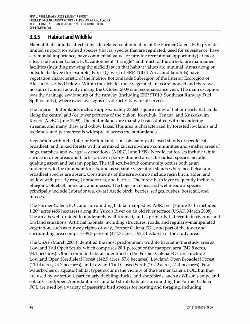
FINAL: PRELIMINARY ASSESSMENT REPORT FORMER GALENA FORWARD OPERATING LOCATION, ALASKA AFCEE CONTRACT FA8903-08-D-8769, TASK ORDER 0184 SEPTEMBER 2011
3-8 ES121009055544PDX
3.3.5 Habitat and Wildlife Habitat that could be affected by site-related contamination at the Former Galena FOL provides limited support for valued species (that is, species that are regulated, used for subsistence, have ceremonial importance, have commercial value, or provide recreational opportunity) at most sites. The Former Galena FOL cantonment “triangle” and much of the airfield are maintained facilities (including mowing the airfield) such that habitat values are minimal. Areas along or outside the levee (for example, Parcel Q, west of ERP TU001 Area, and landfills) have vegetation characteristic of the Interior Bottomlands Subregion of the Interior Ecoregion of Alaska (described below). Within the airfield, most vegetated areas are mowed and there was no sign of animal activity during the October 2009 site reconnaissance visit. The main exception was the drainage swale south of the runway (including ERP ST010, Southeast Runway Fuel Spill vicinity), where extensive signs of vole activity were observed.
The Interior Bottomlands include approximately 38,600 square miles of flat or nearly flat lands along the central and/or lower portions of the Yukon, Koyukuk, Tanana, and Kuskokwim Rivers (ADEC, June 1999). The bottomlands are marshy basins dotted with meandering streams, and many thaw and oxbow lakes. This area is characterized by forested lowlands and wetlands, and permafrost is widespread across the bottomlands.
Vegetation within the Interior Bottomlands consists mainly of closed stands of needleleaf, broadleaf, and mixed forests with intermixed tall scrub-shrub communities and smaller areas of bogs, marshes, and wet grassy meadows (ADEC, June 1999). Needleleaf forests include white spruce in drier areas and black spruce in poorly drained areas. Broadleaf species include quaking aspen and balsam poplar. The tall scrub-shrub community occurs both as an understory to the dominant forests, and as separate vegetation stands where needleleaf and broadleaf species are absent. Constituents of the scrub-shrub include resin birch, alder, and willow with prickly rose, Labrador tea, and berries. The forest herb layer frequently includes bluejoint, bluebell, horsetail, and mosses. The bogs, marshes, and wet meadow species principally include Labrador tea, dwarf Arctic birch, berries, sedges, rushes, horsetail, and mosses.
The Former Galena FOL and surrounding habitat mapped by ABR, Inc. (Figure 3-10) included 1,209 acres (489 hectares) along the Yukon River on an old river terrace (USAF, March 2008). The area is well-drained to moderately well-drained, and is primarily flat terrain in riverine and lowland situations. Artificial habitats, including structures, roads, and regularly-manipulated vegetation, such as runway rights-of-way, Former Galena FOL, and part of the town and surrounding area comprise 39.3 percent (474.7 acres, 192.1 hectares) of the study area.
The USAF (March 2008) identified the most predominant wildlife habitat in the study area as Lowland Tall Open Scrub, which comprises 20.1 percent of the mapped area (242.5 acres, 98.1 hectares). Other common habitats identified in the Former Galena FOL area include Lowland Open Needleleaf Forest (142.9 acres, 57.8 hectares), Lowland Open Broadleaf Forest (110.4 acres, 44.7 hectares), and Lowland Tall Closed Scrub (102.2 acres, 41.4 hectares). Few waterbodies or aquatic habitat types occur in the vicinity of the Former Galena FOL, but they are used by waterfowl, particularly dabbling ducks, and shorebirds, such as Wilson’s snipe and solitary sandpiper. Abundant forest and tall shrub habitats surrounding the Former Galena FOL are used by a variety of passerine bird species for nesting and foraging, including

FINAL: PRELIMINARY ASSESSMENT REPORT FORMER GALENA FORWARD OPERATING LOCATION, ALASKA
AFCEE CONTRACT FA8903-08-D-8769, TASK ORDER 0184 SEPTEMBER 2011
ES121009055544PDX 3-9
chickadees, and several thrushes, warblers, and sparrows. Three swallow species use many artificial structures at the Former Galena FOL for nesting, and swallows forage in open habitats surrounding these areas.
Wetlands around the Former Galena FOL are patchy in occurrence, often in low-lying portions of abandoned floodplain channels (USAF, March 2008). Most of the Former Galena FOL has been modified (filled) by development. The cantonment area is mostly not vegetated, except for a Lowland Tall Closed Scrub and a Lowland Tall Open Scrub that averages about 150 feet wide on the western edge. There is also a strip of Lowland Tall Open Scrub outside the eastern installation boundary of the cantonment area. The airfield area is primarily upland grasses in non-paved areas with remnant wetlands in ditch drainage ways and Lowland Tall Open Scrub east of the airport ramp. Wetlands are scattered throughout the area adjacent to the Former Galena FOL, outside of the dyke, and consist predominately of scrub shrub or combined emergent and scrub shrub (seasonally flooded types). Dominant emergent plant species include sedges, equisetum, and grasses (for example, Carex aquatilis, C.utriculata, Equisetum fluviatile, and Calamagrostis canadensis). The most common shrub occurring in wetlands throughout the area is thinleaf alder (Alnus tenuifolia).
Invertebrates are expected to be numerous in the Interior Bottomlands because of the large amounts of surface water and relatively warm summers (ADEC, June 1999). Mosquitoes are abundant, and other species of Diptera, Trichoptera, Coleoptera, Hemiptera, and arachnids are also likely to be present. Freshwater aquatic/benthic invertebrates might include species of Plecoptera, Ephemeroptera, Diptera, Trichoptera, Hymenoptera, Lepidoptera, Collembola, Oligochaeta, copepods, rotifers, and cladocerans.
Numerous bird species stop to feed and rest on the Yukon River and nearby Innoko and Koyukuk National Wildlife Refuges, which provide nesting habitat and migration resting areas for waterfowl and shorebirds (USAF, March 2008). Forty bird species were observed at the Former Galena FOL during the 2005 survey associated with the preparation of the INRMP. Observations included species such as the American wigeon, common goldeneye, spruce and ruffed grouse, sandhill crane, Wilson’s snipe, olive-sided and alder flycatchers, and orange crowned, yellow, yellow-rumped, and blackpoll warblers. Several raptors, notably the bald eagle, osprey, red-tailed hawk, great grey owl, short-eared owl, and peregrine falcon, are also found in the area. Passerine species include the American robin, yellow warbler, yellow-rumped warbler, hermit thrush, cliff swallow, and white-crowned sparrow, and aquatic birds include mew, herring, and glaucous gulls. Bird species observed or potentially occurring in the Former Galena FOL area are provided in Table B4, Appendix B, of the INRMP.
The Interior Bottomlands provide waterfowl resting, staging, and breeding habitat (ADEC, June 1999). The principal species include scaup, pintail, scoters, wigeon, mallards, shovelers, green-winged teal, and canvasbacks. Swans, geese, loons, grebes, and sandhill cranes also are common. Birds of prey such as the rough-legged hawk, sharp-shinned hawk, red-tailed hawk, kestrel, raven, great-horned owl, and short-eared owl are all common to the area. The protected peregrine falcon also inhabits the area. The spruce grouse, ruffed grouse, and ptarmigan may be found in drier areas. Passerines and other small birds are also common in the subregion and include gray jay, chickadees, robins, thrushes, warblers, redpoll, pipits, and sparrows, among many others. Nesting and rearing are likely to occur in June and July, respectively. Migratory birds depart for warmer climates by late September and early October.
FINAL: PRELIMINARY ASSESSMENT REPORT FORMER GALENA FORWARD OPERATING LOCATION, ALASKA AFCEE CONTRACT FA8903-08-D-8769, TASK ORDER 0184 SEPTEMBER 2011
3-10 ES121009055544PDX
The Former Galena FOL area supports terrestrial wildlife species typical for interior Alaska (USAF, March 2008). Representative mammals include beaver, black bear and the less common brown/grizzly bear, caribou, North American lynx, marten, mink, moose, muskrat, red fox, snowshoe hare, wolf, wolverine, and several small rodent species. Table B3, Appendix B, of the INRMP identifies mammals found in and around the Former Galena FOL.
Mammals inhabiting the Interior Bottomlands include brown and black bears, caribou, wolves, weasels, marten, hares, squirrels, voles, and shrews (ADEC, June 1999). Moose are abundant in the subregion. Caribou may be common in localized areas. Many of these species are resident, but may hibernate or migrate locally to optimum foraging grounds. Semi-aquatic mammals such as muskrat, mink, and beaver are common in the myriad of water bodies in the subregion.
Further information about habitats of the region and species lists for birds and mammals are available at the Web sites for the Koyukuk and Innoko National Wildlife Refuges (http://alaska.fws.gov/nwr/koyukuk/index.htm and http://alaska.fws.gov/nwr/innoko/index.htm). It is unlikely that species identified by ADFG, USFWS, or National Marine Fisheries Service as threatened or endangered, under consideration for protection, or Alaska species of special concern (ADFG, 2009b) are present on the Former Galena FOL site other than as transients (for example, peregrine falcon). However, some species that are used for subsistence, have ceremonial importance, have commercial value, or provide recreational opportunity (such as moose and snowshoe hare) are found in wooded areas around the site.
3.4 Climate The area experiences a cold, continental climate with extreme temperature differences. The average daily high temperature during July is in the low 70s degrees Fahrenheit (°F); the average daily low temperature during January ranges from 10°F to below 0°F. Sustained temperatures of -40°F are common during winter. Extreme temperatures have been measured from -64 to 92°F. Annual precipitation is 12.7 inches, with 60 inches of snowfall annually. The river is ice free from mid-May through mid-October (Alaska Community Database, 2009).

C H U K C H I S E A B E U F O R T S E A
B E R I N G S E A
G U L F O F A L A S K AU
.S.
Can
ada
CENTRALSUBREGION
KOYUKUKSUBREGION
TANANASUBREGION
UPPER YUKONSUBREGION
NomeGalena
Campion
Ruby
Yuko
n R
iver
Yukon River
Tanana River
Porcupine River
Koyukuk River
Kuskokwim River
Fairbanks
Anchorage
ES121009055544PDX PA 020210 amh
FIGURE 3-1Physiographic Provinces and Major Watersheds, Central AlaskaPreliminary Assessment ReportFormer Galena Forward Operating Location, Alaska

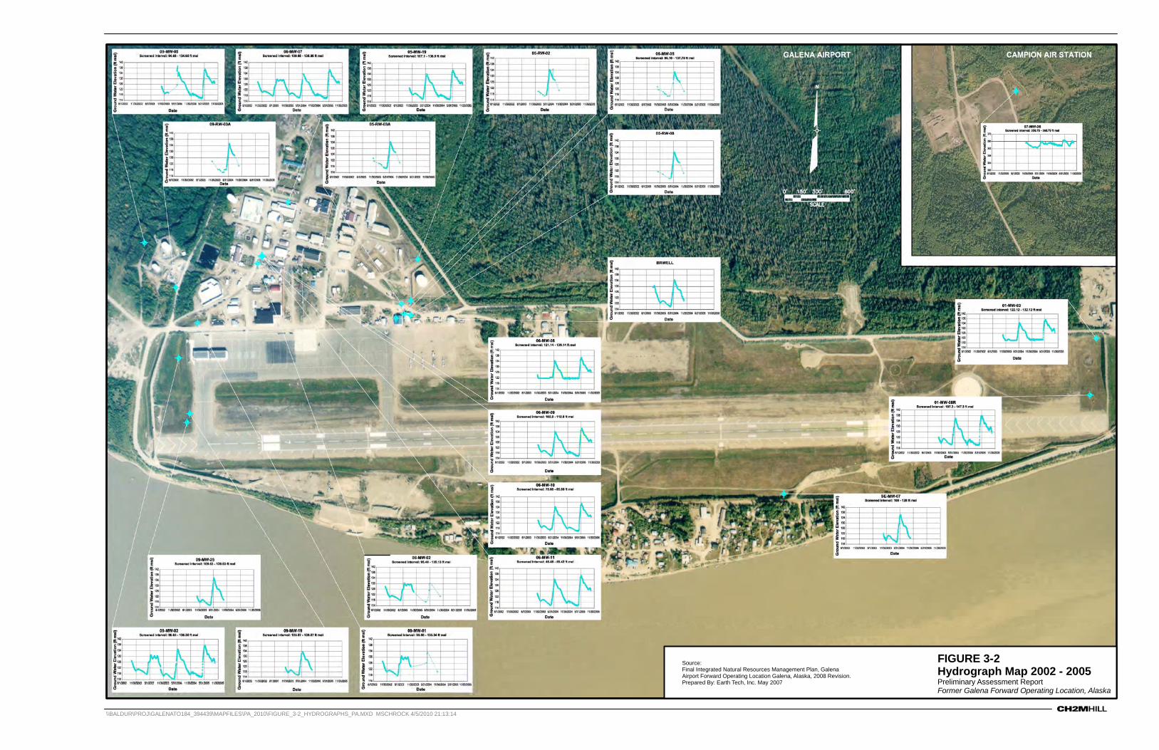
\\BALDUR\PROJ\GALENATO184_394439\MAPFILES\PA_2010\FIGURE_3-2_HYDROGRAPHS_PA.MXD MSCHROCK 4/5/2010 21:13:14
FIGURE 3-2Hydrograph Map 2002 - 2005Preliminary Assessment ReportFormer Galena Forward Operating Location, Alaska
Source:Final Integrated Natural Resources Management Plan, GalenaAirport Forward Operating Location Galena, Alaska, 2008 Revision.Prepared By: Earth Tech, Inc. May 2007


120May 93 Jul 93 Sep 93 Nov 93
05-MW-06
10-MW-01
Well No. 2
Yukon River
Reproduced from 1996 RI (USAF, 1996b)
Jan 94
125
130
135
140
Wat
er E
leva
tion
(fee
t abo
ve M
SL)
DateLegend
River Break-up
Water Level Hydrographs, May 1993 to February 1994
River Freeze-up
ES121009055544PDX PA 020210 amh
FIGURE 3-3Groundwater and Yukon River Elevations, May 1993-February 1994Preliminary Assessment ReportFormer Galena Forward Operating Location, Alaska

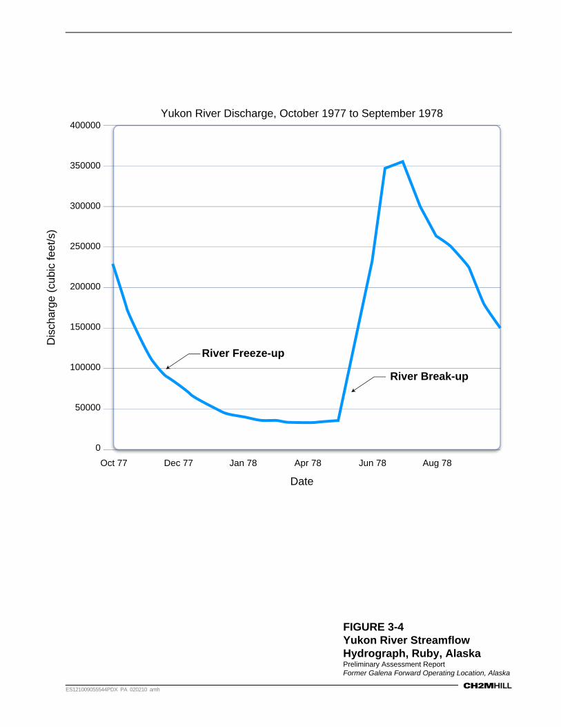
50000
0
Dec 77Oct 77 Jan 78 Apr 78 Jun 78 Aug 78
100000
150000
200000
400000
250000
300000
350000
Dis
char
ge (
cubi
c fe
et/s
)
Date
River Break-up
Yukon River Discharge, October 1977 to September 1978
River Freeze-up
ES121009055544PDX PA 020210 amh
FIGURE 3-4Yukon River Streamflow Hydrograph, Ruby, AlaskaPreliminary Assessment ReportFormer Galena Forward Operating Location, Alaska


\\BALDUR\PROJ\GALENATO184_394439\MAPFILES\PA_2010\FIGURE_3-5_POTSURF_OCT03_PA.MXD MSCHROCK 4/5/2010 18:16:41
FIGURE 3-5Potentiometric Surface MapOctober 2003Preliminary Assessment ReportFormer Galena Forward Operating Location, Alaska
Source:Final Remedial Investigation/Feasibility Study Report forUnited States Air Force Sites at Galena Airport andCampion Air Station, Alaska.Prepared By: Earth Tech, Inc. May 2007
Feet
0 650325
LEGEND
Groundwater Monitoring Well
Groundwater Contour (Interval 1-ft)Dashed Indicates Inferred
Groundwater Flow Direction

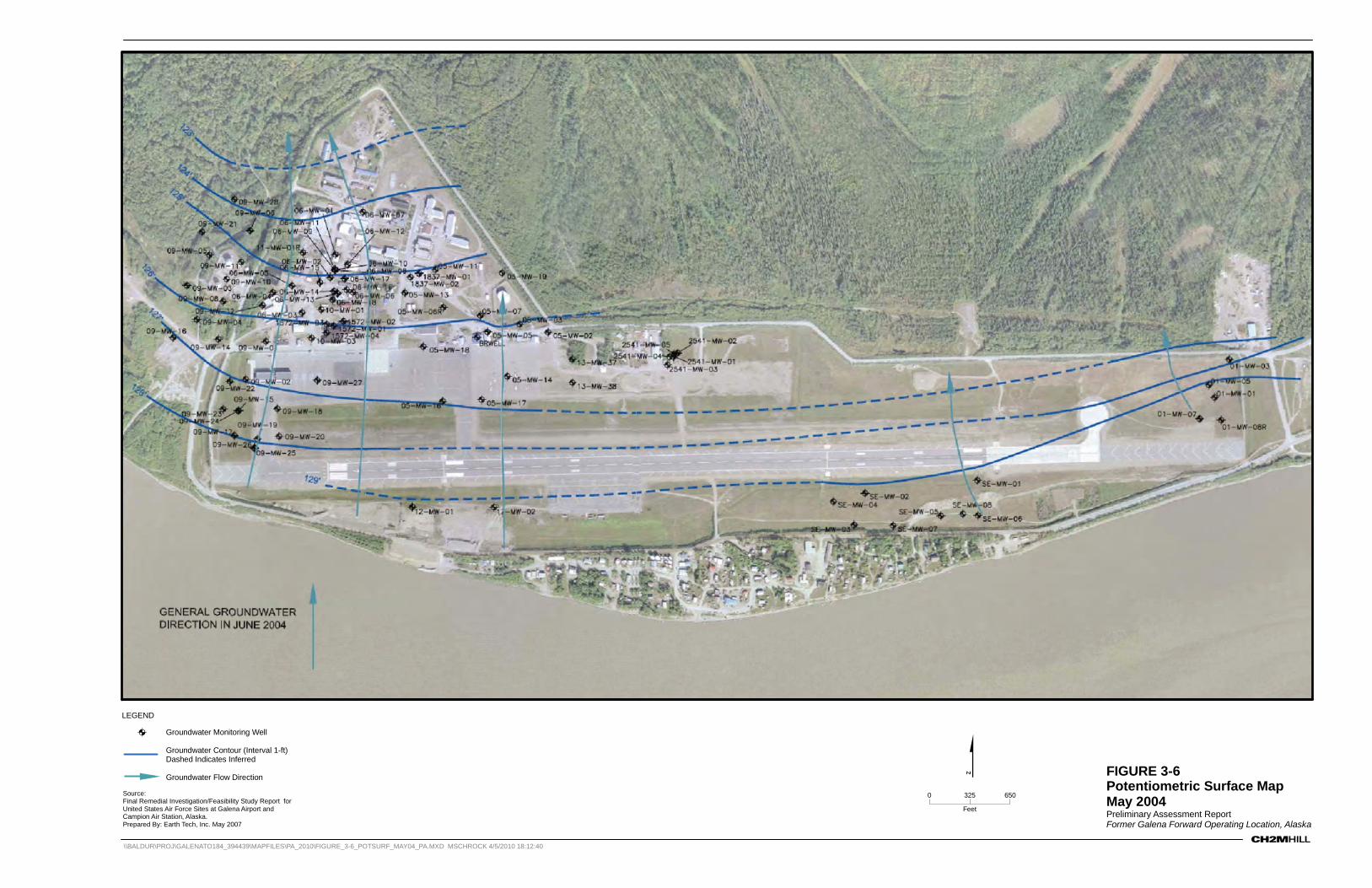
\\BALDUR\PROJ\GALENATO184_394439\MAPFILES\PA_2010\FIGURE_3-6_POTSURF_MAY04_PA.MXD MSCHROCK 4/5/2010 18:12:40
FIGURE 3-6Potentiometric Surface MapMay 2004Preliminary Assessment ReportFormer Galena Forward Operating Location, Alaska
Source:Final Remedial Investigation/Feasibility Study Report forUnited States Air Force Sites at Galena Airport andCampion Air Station, Alaska.Prepared By: Earth Tech, Inc. May 2007
Feet
0 650325
LEGEND
Groundwater Monitoring Well
Groundwater Contour (Interval 1-ft)Dashed Indicates Inferred
Groundwater Flow Direction


014 16 18 23 25 27 32 34 36 43 45 47 54 56 58
3
34
2
2
1
1
63 65 67
2
4
6
8
10
12
Mea
sure
d V
eloc
ity (
feet
/day
)
Depth (feet, bgl)
N
S
EW
N
S
EW
Ambient May Flowmeter Velocities
Valid Data Not Collected0
14 16 18 23 25 27 32 34 36 43 45 47 54 56 58 63 65 67
2
4
6
8
10
12
Mea
sure
d V
eloc
ity (
feet
/day
)
Depth (feet, bgl)
Ambient August Flowmeter Velocities
ES121009055544PDX PA 020210 amh
FIGURE 3-7Flowmeter Velocity Plot and Direction Rose for Ambient-May and Ambient-August Flowmeter TestsPreliminary Assessment ReportFormer Galena Forward Operating Location, Alaska

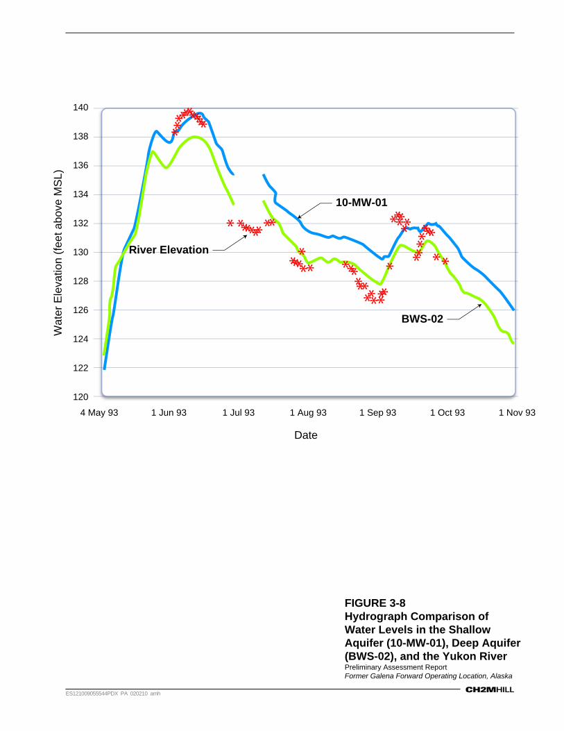
120
4 May 93 1 Jun 93 1 Jul 93 1 Aug 93 1 Sep 93 1 Oct 93 1 Nov 93
122
124
126
128
130
140
132
134
136
138
Wat
er E
leva
tion
(fee
t abo
ve M
SL)
Date
River Elevation
10-MW-01
BWS-02
ES121009055544PDX PA 020210 amh
FIGURE 3-8Hydrograph Comparison of Water Levels in the Shallow Aquifer (10-MW-01), Deep Aquifer (BWS-02), and the Yukon RiverPreliminary Assessment ReportFormer Galena Forward Operating Location, Alaska


VICINITY MAP
Well #1
Well #2Well #7
Well #3
Well #5
Well #6
Well Unknown
Well Unknown Well Unknown
Well #4
Building 1578(Water Treatment
Plant)
Sta
teTr
ail
Igloo Circle
Cha
lleng
er R
oad
Birc
hwoo
d D
rive
State
Tra
il
Eag
le R
oad
Levy Road
South Dyke Road
Birchwood Drive
State TrailState Trail
Eng
inee
rs W
ay
Per
imet
er R
oad
State Trail State Trail
Airport Road
LEGENDProduction Well
Abandoned Production Well
Yukon River
Notes:1. Imagery September 4, 2009. Pixel size 0.25 meters2. Well locations are approximate.3. Water wells have been transferred to the City of Galena. Well #1 and Well #7 are potable wells; Well #3 is a nonpotable well.
RDD \\BALDUR\PROJ\GALENATO184_394439\MAPFILES\PA_2010\FIGURE_3-9_WATER_SUPPLY_WELLS_PA.MXD CVONFREE 3/7/2011 09:02:05
0 480240
Feet
FIGURE 3-9Location of Galena AirportWater Supply WellsPreliminary Assessment ReportFormer Galena Forward Operating Location, Alaska


FIGURE 3-10Galena Airport Wildlife Habitat MapPreliminary Assessment ReportFormer Galena Forward Operating Location, Alaska
Source:
Final Integrated Natural Resources Management Plan, Galena Airport Forward Operating Location Galena, Alaska, 2008 Revision. Prepared by ABR for 611th Air Support Civil Engineer Squadron, Environmental Flight.
ES102709093509ANC GAL_AirportWildlife_01 04/01/10 cts

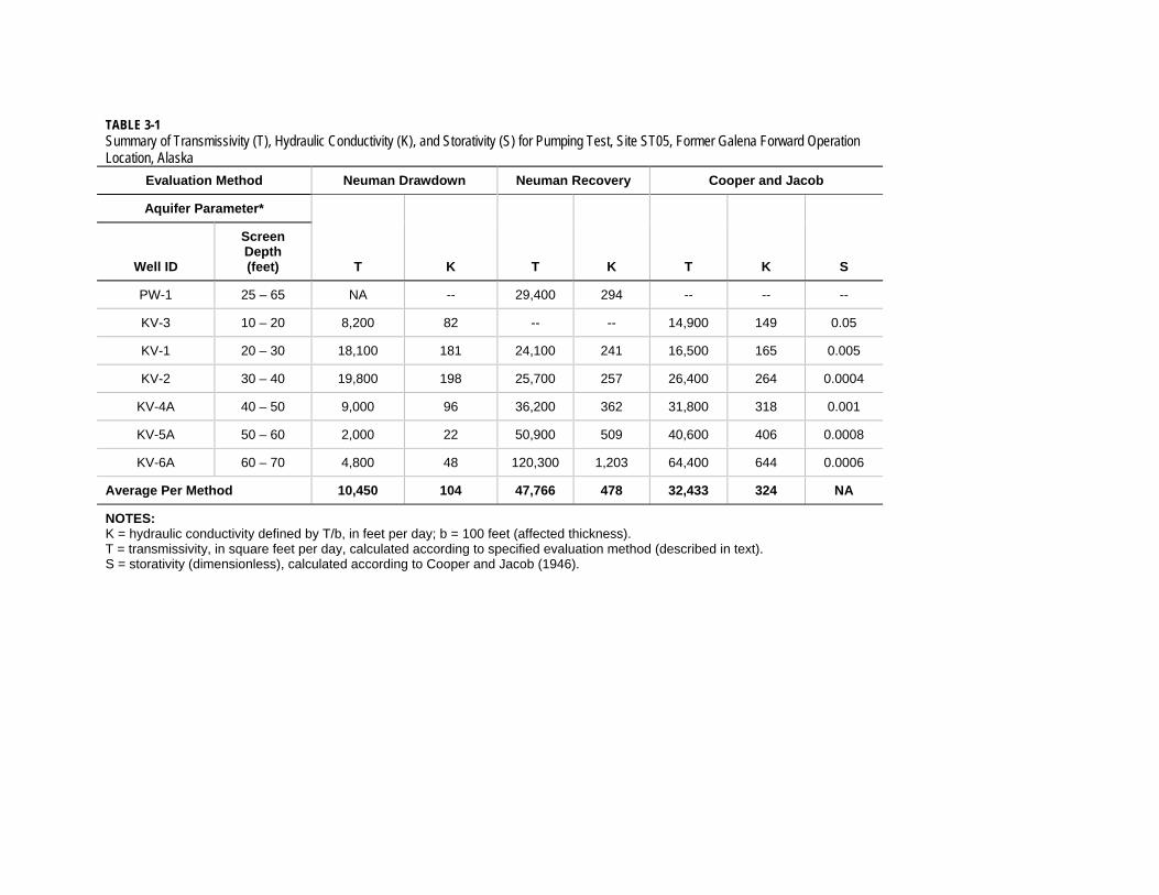
TABLE 3-1 Summary of Transmissivity (T), Hydraulic Conductivity (K), and Storativity (S) for Pumping Test, Site ST05, Former Galena Forward Operation Location, Alaska
Evaluation Method Neuman Drawdown Neuman Recovery Cooper and Jacob
Aquifer Parameter*
T K T K T K S Well ID
Screen Depth (feet)
PW-1 25 – 65 NA -- 29,400 294 -- -- --
KV-3 10 – 20 8,200 82 -- -- 14,900 149 0.05
KV-1 20 – 30 18,100 181 24,100 241 16,500 165 0.005
KV-2 30 – 40 19,800 198 25,700 257 26,400 264 0.0004
KV-4A 40 – 50 9,000 96 36,200 362 31,800 318 0.001
KV-5A 50 – 60 2,000 22 50,900 509 40,600 406 0.0008
KV-6A 60 – 70 4,800 48 120,300 1,203 64,400 644 0.0006
Average Per Method 10,450 104 47,766 478 32,433 324 NA
NOTES: K = hydraulic conductivity defined by T/b, in feet per day; b = 100 feet (affected thickness). T = transmissivity, in square feet per day, calculated according to specified evaluation method (described in text). S = storativity (dimensionless), calculated according to Cooper and Jacob (1946).
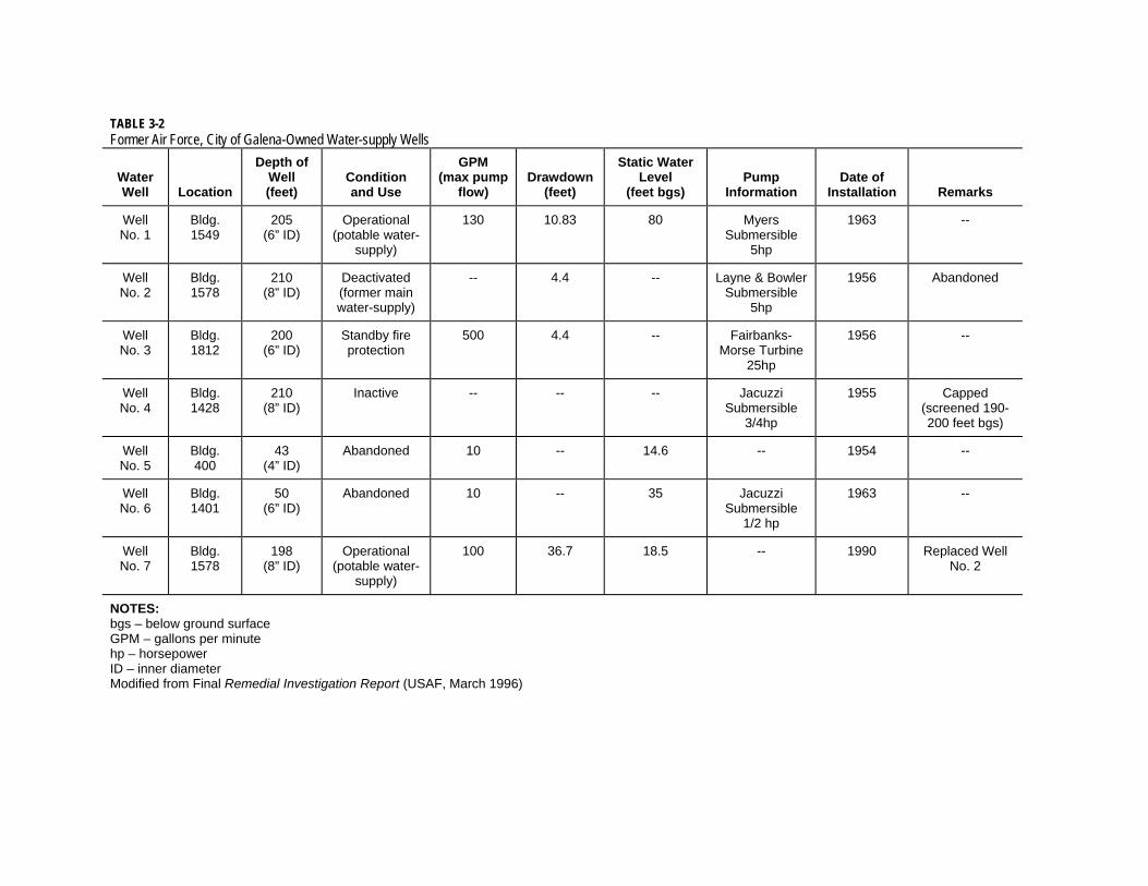
TABLE 3-2 Former Air Force, City of Galena-Owned Water-supply Wells
Water Well Location
Depth of Well (feet)
Condition and Use
GPM (max pump
flow) Drawdown
(feet)
Static Water Level
(feet bgs) Pump
Information Date of
Installation Remarks
Well No. 1
Bldg. 1549
205 (6” ID)
Operational (potable water-
supply)
130 10.83 80 Myers Submersible
5hp
1963 --
Well No. 2
Bldg. 1578
210 (8” ID)
Deactivated (former main water-supply)
-- 4.4 -- Layne & Bowler Submersible
5hp
1956 Abandoned
Well No. 3
Bldg. 1812
200 (6” ID)
Standby fire protection
500 4.4 -- Fairbanks-Morse Turbine
25hp
1956 --
Well No. 4
Bldg. 1428
210 (8” ID)
Inactive -- -- -- Jacuzzi Submersible
3/4hp
1955 Capped (screened 190- 200 feet bgs)
Well No. 5
Bldg. 400
43 (4” ID)
Abandoned 10 -- 14.6 -- 1954 --
Well No. 6
Bldg. 1401
50 (6” ID)
Abandoned 10 -- 35 Jacuzzi Submersible
1/2 hp
1963 --
Well No. 7
Bldg. 1578
198 (8” ID)
Operational (potable water-
supply)
100 36.7 18.5 -- 1990 Replaced Well No. 2
NOTES: bgs – below ground surface GPM – gallons per minute hp – horsepower ID – inner diameter Modified from Final Remedial Investigation Report (USAF, March 1996)

FINAL: PRELIMINARY ASSESSMENT REPORT FORMER GALENA FORWARD OPERATING LOCATION, ALASKA
AFCEE CONTRACT FA8903-08-D-8769, TASK ORDER 0184 SEPTEMBER 2011
ES121009055544PDX 4-1
4.0 Evaluation Process This section describes the process used during the PA to gather and evaluate information on individual sites. Section 4.1 describes the type of information and sources, and Section 4.2 describes the process used to screen the information to develop recommendations about further site investigation or closure pathways.
The PA screening began with information gathering to identify USAF activities and facilities where chemicals or fuel were stored or handled and where there was a potential for a release to the environment that could have affected soil, groundwater, sediment, or air. The information gathering focused on waste-handling practices, waste containment, inspection reports, aerial photographs, permit applications, hazardous-waste notification handling forms, waste-hauling manifests, analytical-sampling results, records of citizen complaints, and previous SC reports.
The historical characterization information for each site, including site history and existing SC data, is presented in Appendix A and is intended to support decisions on what additional assessment is required to adequately characterize each site. The historical characterization information was used in the screening process to support recommendations for either no further action or additional assessment to adequately characterize a site, and/or to provide documentation to address a specific data gap from the analysis of existing data, regulatory requirement, or gap in the conceptual site model.
4.1 Information Gathering This section describes the type and source of information gathered and reviewed between October 2009 and March 2010. As discussed in Section 2.1, Historical Site Use, the military use of the Former Galena FOL began with the U.S. Army (from 1942 to 1945) and continued with the joint-use agreement between the CAA and USAF in 1951. The majority of available records were maintained by USAF.
4.1.1 Army Records Information about the Army use of the Former Galena FOL is limited to historical drawings and the description of the mission. A 1944 USACE Plan for construction of the Galena Staging Field identified the building within the cantonment “triangle”. The 1944 plan references a 1945 “as-built “that was not available for review. The 1952 aerial photos available for review corroborate that facilities such as the Birchwood Hangar on the southern edge of the cantonment triangle, living quarters on the eastern edge near the POL storage yard, and maintenance and storage facilities include building 1769, were constructed. The 1952 aerial photos confirmed that the dining hall (Building 1859) is approximately the northern boundary of the actual constructed area. It appears facilities planned for the northern portion of the cantonment “triangle” such as a hospital, dry cleaning, laundry, power plant, and communication facilities were not constructed. USAF continued to use facilities initially constructed by the Army for similar purposes. For

FINAL: PRELIMINARY ASSESSMENT REPORT FORMER GALENA FORWARD OPERATING LOCATION, ALASKA AFCEE CONTRACT FA8903-08-D-8769, TASK ORDER 0184 SEPTEMBER 2011
4-2 ES121009055544PDX
example, POL storage continued in the POL tank yard, military dormitories continued to be located in the same area, and industrial-use facilities continued to be used as USAF shops.
4.1.2 USAF Records USAF records are the main source of documents for this PA. The following resources were reviewed.
4.1.2.1 Environmental Baseline Surveys
The 1996 EBS (USAF, June 1996), 2008 EBS (USAF, May 2008), and the 2010 EBS (USAF, February 2010) were reviewed and provided the main sources of information about the facilities used by USAF and the type of operations that occurred. This PA is not intended to duplicate an EBS; however where information in the EBS was indicative of a potential release to the environment that warrants evaluation under CERCLA or the State UST program, it was included in the PA. Facilities in the following categories were excluded from further evaluation in this PA based on the following:
Documentation in the EBS that a facility or area was already part of an ERP site subject to studies and field investigations based on CERCLA and the Resource Conservation and Recovery Act (RCRA) (42 United States Code [U.S.C.] Section 6901,29 et seq)
The EBS documents facilities impacted by lead-based paint [LBP] and/or asbestos-containing materials [ACM]. LBP and ACM are disclosure factors. Disclosure factors are substances that are not regulated under CERCLA but may cause environmental concerns. Notification of the presence of disclosure factors is not required under CERCLA Section 120(h)(1); such notification is provided to satisfy real estate transaction requirements and is routinely included in EBS documents. Accordingly, LBP and ACM will not be addressed in the PA unless the facility also included chemical or fuel storage or handling with a potential for a release to the environment.
MMRP sites are identified in the EBS and Table 1-1 of this PA, but are not evaluated under the PA.
4.1.2.2 Administrative Record
The Administrative Record (40 Code of Federal Regulations [CFR] 300.800-300.825) is the complete body of documents that forms the basis for selecting a CERCLA response action (that is, documents considered or relied upon in selecting a remedy). Public access to the Former Galena FOL Administrative Record can be found at http://www.adminrec.com (the documents are accessible in the Department of Defense (DoD), Galena Airport section of the Web site). Over 350 documents, ranging in date from 1996 to 2009, are available for the public to review. Documents in the Administrative Record include site assessment reports, correspondence from regulators, and correspondence from interested parties such as the Louden Tribal Council.
4.1.2.3 Other USAF Records
The available Administrative Record information is limited to documents related to ERP sites and, therefore, does not include reports associated with environmental compliance

FINAL: PRELIMINARY ASSESSMENT REPORT FORMER GALENA FORWARD OPERATING LOCATION, ALASKA
AFCEE CONTRACT FA8903-08-D-8769, TASK ORDER 0184 SEPTEMBER 2011
ES121009055544PDX 4-3
response actions, documents related to the operational activities, and real estate records. For further information on those, the following documents were provided by USAF:
Galena Air Station Oil Discharge Prevention and Contingency Plan (ODPCP) (USAF, October 2004) (also referred to as the “Spill Plan”) which included the requirements from a Spill Prevention, Control, and Countermeasures (SPCC) Plan at the Former Galena FOL, which were used to identify POL storage locations
Characterization reports and draft reports provided by the Air Force Center for Engineering and the Environment (AFCEE) that were not available in the Administrative Record including the following:
o Draft site reviews completed for the ERP in 2003 and 2004 which describe historical site uses and sampling
o Site Characterization technical memorandum which documented the 2007 field investigation sampling results
o Real Estate and Real Property Accounting Records including the following:
Active and retired facility cards (USAF Forms 1430, 1431, and 1433) documenting real property assets
Land occupancy drawing identifying land use as specified in the 1966 Omnibus Deed
Individual lease documents between USAF and AKDOT&PF
Lease agreements between USAF and the City of Galena and Galena School District
Records of correspondence on real estate actions
Cultural resources management plans and historical building inventories
Historical accounts of activities at the Former Galena FOL
Environmental assessments (EAs) completed for real estate actions
Ms. Karlene Leeper, 611th Civil Engineer Squadron (611 CES) Cultural Resource Manager, and Mr. Joe Orr, 11th Air Force History Office (11 AF HO) office, confirmed that all known existing USAF aerial photos were collected and reviewed. These include the following dates:
o 1952
o 1962
o 1963
o 1965
o 1969
o 1970
o 1971
o 1972
o 1978
o 1980
o 1985
o 1987
o 1992
o 2002
o 2009
The available hazardous materials inventory records from the Base Operation and Support (BOS) contractor, Chugach Support Services, from April through June 2006

FINAL: PRELIMINARY ASSESSMENT REPORT FORMER GALENA FORWARD OPERATING LOCATION, ALASKA AFCEE CONTRACT FA8903-08-D-8769, TASK ORDER 0184 SEPTEMBER 2011
4-4 ES121009055544PDX
and the pad and pole-mounted transformer inventory, dated 2003, maintained by the BOS contractor
4.1.2.4 FAA Records
The FAA performed PAs and SCs at facilities they owned and operated at the Former Galena FOL. Because USAF and FAA had joint-use and operation agreements at some facilities, these records were reviewed for historical use and sampling information that could be applied to sites evaluated in this PA.
4.1.3 ADEC Records In October 2009, CH2M HILL accessed the ADEC Contaminated Sites Records, located in the Fairbanks ADEC office at 610 University Avenue, Fairbanks, AK 99709. Files in Contaminated Sites Record folders 860.38.001 through 860.38.035 were copied for review, as well as leaking underground storage tank (LUST) files 860.26.002 and 860.26.003. In cases where the ADEC online LUST database conflicted with primary documents in the LUST files, the hard-copy tank registration forms, and associated correspondence with USAF from the LUST file, were given priority and used in the site evaluations (Appendix A).
4.1.4 Site Visit CH2M HILL performed a site visit from October 6 to October 8, 2009. The purpose of the site visit was to familiarize the project team with the Former Galena FOL area, identify any visual evidence of site contamination, and complete ADEC eco scoping forms to identify potential habitat at the individual sites evaluated in this PA. CH2M HILL entered facilities to confirm the presence or absence of oil-water separators (OWSs), ASTs, and USTs where possible.
During the site visit, the drawing vault located in the former Headquarters Building 1854 was accessed and copies were made of historical utility drawings.
4.1.5 Interviews/Personal Communications During the October 2009 site visit, members of the Galena community assisted with visual site inspections (VSIs) and answered questions regarding current use and historical use of facilities. Current and former USAF military members and civilian employees were subsequently contacted and answered questions regarding historic facility use and operational practices. A list of personnel and the assistance they provided is in included in Table 4-1.
4.2 Screening Process The USAF and ADEC identified a process to evaluate the Former Galena FOL that would lead to final decision documents. The flowchart outlining the process for data collection, evaluation, and the anticipated closure pathway and decision documents is shown in Figure 4-1. The PA is one part of the overall process which includes 14 steps. The PA includes Steps 1, 2, 3, 4, and 5. The Work Plan for Site Inspection, Remedial Investigation, and Site Characterization, Former Galena FOL, Alaska (Work Plan) (CH2M HILL, 2010) includes

FINAL: PRELIMINARY ASSESSMENT REPORT FORMER GALENA FORWARD OPERATING LOCATION, ALASKA
AFCEE CONTRACT FA8903-08-D-8769, TASK ORDER 0184 SEPTEMBER 2011
ES121009055544PDX 4-5
Steps 6 to 14. These steps are shown in Figure 4-1 and are described in Section 4.2.1. The PA screening process was used to identify an anticipated closure pathway to decision documents, as described in Section 4.2.2.
4.2.1 Data Collection and Evaluation Flowchart The sites in this PA were evaluated using Steps 1 through 5 as identified in Figure 4-1. This section describes these steps.
4.2.1.1 Step 1—Select Site
The sites evaluated in this PA include facilities and leased areas where former USAF activities may have caused releases of hazardous substances or petroleum products to the environment. As described in Section 1, ERP sites and MMRP sites were not evaluated in this PA.
4.2.1.2 Step 2—Are There Documented Spills or Releases? This step in the process relied heavily upon ADEC records. A documented spill or release was defined as a location or structure with at least one of the following:
Spill report sent to ADEC
UST closure document submitted to ADEC indicating the presence of soil or groundwater contamination
Analytical data exhibiting a detection of a hazardous substance, or petroleum or field-screening data indicating a potential spill, collected from potential source areas located within the site boundary, with consideration of potential source areas located within 500 feet of the site boundary
4.2.1.3 Step 3—Is There Historical or Visible Evidence Indicating Possible Site Contamination?
This step relied on extensive review of historical documents to identify operations within facilities, waste handling, and storage.
Interviews with former installation personnel (listed in Table 4-1) were conducted and findings from the October 2009 site visit and records from the 2009 VSI performed in support of the EBS were reviewed in this step.
Where appropriate, ADEC ecoscoping forms (Appendix B) were filled out for each site to identify potential ecological habit.
UST sites without removal documentation, sites with surface staining, and sites with historical evidence of a spill or contamination were recommended for limited SI sampling to confirm the presence or absence of site contamination. In addition, if there was no secondary containment for an AST this site was recommended for limited SI sampling. If there was no historical or visible evidence indicating possible site contamination, the site was recommended for a “Non-Site” designation.

FINAL: PRELIMINARY ASSESSMENT REPORT FORMER GALENA FORWARD OPERATING LOCATION, ALASKA AFCEE CONTRACT FA8903-08-D-8769, TASK ORDER 0184 SEPTEMBER 2011
4-6 ES121009055544PDX
4.2.1.4 Step 4—Are There Adequate Existing Data to Confirm the Presence or Absence of Site Contamination?
In this step, existing field screening and analytical data for potential source areas located within the site boundary, with consideration of potential source areas located within 500 feet of the site boundary were reviewed. At the PA stage, “adequate data” is defined as follows:
UST Sites: “Yes” indicated all required sampling data were available to complete the release investigation in accordance with 18 AAC 78.235 and the UST Procedures Manual (ADEC, 2002). “No” indicated that either no data was available or existing data was incomplete.
Other Petroleum Sites: “Yes” indicated all analytical data were available for the chemicals of interest (COIs) as identified in the UST Procedures Manual Tables 2A and 2B (ADEC, November 7, 2002) and the site contamination is delineated “No” indicated that either no data was available or there was no data for a COI.
Non-petroleum Sites: “Yes” indicated the analytical data exists for a CERCLA hazardous substance and the site contamination is delineated. “No” indicated that either no data are available or there are no data for a COI.
Sites without Adequate Existing Data: Recommended for limited SI sampling.
Sites with Adequate Existing Data: Proceed to Step 5 for data screening.
4.2.1.5 Step 5—Evaluate for Potential Method 2 Closure
For sites with documented spills and adequate existing data, the data were reviewed to determine whether the site could be closed under ADEC Method 2 requirements. This review addressed the following questions:
Human Health Risks: Do any of the detected contamination levels exceed ADEC Method 2 cleanup levels (direct contact, inhalation, or migration to groundwater) listed in Tables B1, B2, and C for the “Under 40 inch Zone” in 18 AAC 75?
Ecological Risks: Are there potential ecological receptor pathway interactions? If so, is the habitat for valued species present and do chemical concentrations exceed ecological benchmarks or include bioaccumulatives?
If the answer to both the human health and ecological risk screening questions was “no,” the site was recommended for “no further action” or for designation as a “non-qualifying site,” as appropriate.
“No further action” is applicable to sites that had a documented spill or leaking UST and concentration levels currently on the site are below clean up levels, or a removal action in the past removed the contaminated media from the site. A “non-qualifying site” designation is for areas where analytical data indicated there is no contamination above cleanup levels. Non-qualifying designation cannot be applied to USTs.
If the answer to one or both of the human health and ecological risk screening questions was “yes,” the site was recommended for further investigation following either the ADEC
FINAL: PRELIMINARY ASSESSMENT REPORT FORMER GALENA FORWARD OPERATING LOCATION, ALASKA
AFCEE CONTRACT FA8903-08-D-8769, TASK ORDER 0184 SEPTEMBER 2011
ES121009055544PDX 4-7
regulatory pathway for POL-only sites or the CERCLA-regulatory pathway for sites with chlorinated compounds or other CERCLA- regulated contaminants. Sites with both POL and CERCLA-regulated contaminates will progress through the CERCLA pathway.
4.2.1.6 Steps 6 through 14
The remaining steps in Figure 4-1 are addressed through the SI, RI, and SC activities described in the Work Plan (CH2M HILL, 2010). The SI, RI, and SC activities are designed to meet all 18 AAC 75, 18 AAC 78, and CERCLA requirements.
4.2.2 Decision Documents The Decision Documents section of Figure 4-1 identifies the documents that are anticipated to be required to close sites (Blocks A through G) and the reports that will support the decision. This section describes the rationale behind the identification of the decision documents.
4.2.2.1 Block A
Sites with no documented spills or releases and no historic or visible evidence indicating possible site contamination are recommended for a “Non-Site” designation. This designation is used to distinguish those sites that are not regulated by 18 AAC 75 or 18 AAC 78 from those sites that are regulated because of a documented spill or release.
USTs that have been removed or closed in place in accordance with 18 AAC 78 and did not have a documented spill or release will require a “cleanup completed” determination from ADEC.
Non-Sites will be removed from future consideration for additional investigation and no additional decision documents will be required for those sites upon ADEC acceptance of the Final PA report.
4.2.2.2 Block B Sites with documented spills or releases with adequate existing data to confirm the absence of contamination, such as spills that have been subject to a removal action with confirmation sampling, will require a Cleanup Complete Determination letter in addition to ADEC acceptance of the PA report recommendation for “no further action.” Sites where the data indicated there is not contamination above cleanup levels may also be designated as a “non-qualifying site” at the discretion of ADEC.
For sites with adequate existing data that confirms the existence of contamination, analytical data were evaluated for potential Method 2 closure as shown in Step 5 in Figure 4-1. If the answer to both human health and ecological risk screening is “no,” the site is recommended for “no further action.” A Cleanup Complete Determination letter in addition to the ADEC acceptance of the PA report is required to document site closure in accordance with 18 AAC 75. Sites may also be designated as a “non-qualifying site” at the discretion of ADEC.
USTs with documented spills or releases that have been removed or closed in place in accordance with 18 AAC 78 will require a “Cleanup Completed” determination from

FINAL: PRELIMINARY ASSESSMENT REPORT FORMER GALENA FORWARD OPERATING LOCATION, ALASKA AFCEE CONTRACT FA8903-08-D-8769, TASK ORDER 0184 SEPTEMBER 2011
4-8 ES121009055544PDX
ADEC. If all 18 AAC 78 requirements have not been met, the UST site will continue to Step 8 for evaluation and preparation of a Work Plan to meet remaining 18 AAC 78 requirements.
4.2.2.3 Block C
For sites without adequate data to confirm the presence or absence of site contamination, limited SI sampling is recommended. The results from SI sampling will be evaluated for potential Method 2 closure in accordance with the Work Plan (CH2M HILL, 2010) as shown in Step 7. An SI report will be prepared to document the results of the SI.
If data confirms the absence of contamination, the site will be recommended for “no further action.” A “cleanup complete” determination letter in addition to the ADEC acceptance of the SI report is required to document site closure in accordance with 18 AAC 75. Sites where the data indicates there is not contamination above cleanup levels may also be designated as a “non-qualifying site” at the discretion of ADEC.
4.2.2.4 Block D and Block E
These blocks identify the decision documents required to close sites under ADEC regulations. The CERCLA petroleum exclusion applies at these sites. Block D is the result of a SC for sites that meet the criteria for a “Cleanup Complete” determination. Block E is the result of a site that requires remedial action before a “cleanup complete” or “cleanup complete with institutional controls” determination can be made (Bainbridge, July 24, 2009).
4.2.2.5 Block F and Block G
These blocks identify the decision documents that will be required to close sites which fall under CERCLA regulations. Block F is the result of an RI that documents a site as having no unacceptable human health or ecological risk and that therefore does not require the evaluation and selection of remedial action. A Record of Decision documenting a “No Further Action” decision and an ADEC “cleanup complete” determination will be required to close the site. Block G is for sites that will require a feasibility study (FS) and the identification of a preferred remedy.
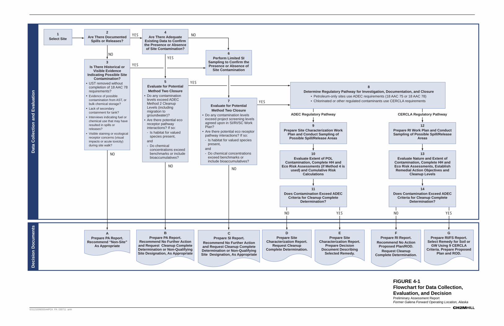
Dat
a C
olle
ctio
n a
nd
Eva
luat
ion
Dec
isio
n D
ocu
men
ts
CPrepare SI Report.
Recommend No Further Action and Request Cleanup Complete Determination or Non-Qualifying Site Designation, As Appropriate
APrepare PA Report.
Recommend “Non-Site” As Appropriate
2Are There Documented
Spills or Releases?
1Select Site
BPrepare PA Report.
Recommend No Further Action and Request Cleanup Complete Determination or Non-Qualifying Site Designation, As Appropriate
FPrepare RI Report.
Recommend No Action Proposed Plan/ROD.
Request Cleanup Complete Determination.
GPrepare RI/FS Report.
Select Remedy for Soil or GW Using 9 CERCLA
Criteria. Prepare Proposed Plan and ROD.
DPrepare Site
Characterization Report. Request Cleanup
Complete Determination.
EPrepare Site
Characterization Report. Prepare Decision
Document Describing Selected Remedy.
4Are There Adequate
Existing Data to Confirm the Presence or Absence of Site Contamination?
6Perform Limited SI
Sampling to Confirm the Presence or Absence of
Site Contamination
9Prepare Site Characterization Work
Plan and Conduct Sampling of Possible Spill/Release Areas
11Does Contamination Exceed ADEC
Criteria for Cleanup Complete Determination?
10Evaluate Extent of POL
Contamination, Complete HH and Eco Risk Assessments (if Method 4 is
used) and Cumulative Risk Calculations
12Prepare RI Work Plan and Conduct Sampling of Possible Spill/Release
Areas
14Does Contamination Exceed ADEC
Criteria for Cleanup Complete Determination?
13Evaluate Nature and Extent of
Contamination, Complete HH and Eco Risk Assessments, Establish Remedial Action Objectives and
Cleanup Levels
3Is There Historical or
Visible Evidence Indicating Possible Site
Contamination?• UST removed without
completion of 18 AAC 78 requirements?
• Evidence of possible contamination from AST, or bulk chemical storage?
• Lack of secondary containment for tank?
• Interviews indicating fuel or chemical use that may have resulted in spills or releases?
• Visible staining or ecological receptor concerns (visual impacts or acute toxicity) during site walk?
5Evaluate for Potential Method Two Closure
• Do any contamination levels exceed ADEC Method 2 Cleanup Levels (including migration to groundwater)?
• Are there potential eco receptor pathway interactions? If so:- Is habitat for valued
species present, and- Do chemical
concentrations exceed benchmarks or include bioaccumulatives?
7Evaluate for PotentialMethod Two Closure
• Do any contamination levels exceed project screening levels agreed upon in SI/RI/SC Work Plan?
• Are there potential eco receptor pathway interactions? If so:- Is habitat for valued species
present, and- Do chemical concentrations
exceed benchmarks or include bioaccumulatives?
8Determine Regulatory Pathway for Investigation, Documentation, and Closure
• Petroleum-only sites use ADEC requirements (18 AAC 75 or 18 AAC 78)• Chlorinated or other regulated contaminants use CERCLA requirements
YES
YES
YES
YES
YES
NO
NO
NO
NONO
NO YESNO YES
ADEC Regulatory Pathway CERCLA Regulatory Pathway
ES121009055544PDX PA 030711 amh
FIGURE 4-1Flowchart for Data Collection, Evaluation, and DecisionPreliminary Assessment ReportFormer Galena Forward Operating Location, Alaska


TABLE 4-1
Personnel Contacted during the Preliminary Assessment
Name Date Contacted Organization Assistance Provided
Personnel who provided facility access during site visit
Gary Thurmond October 2009 Site Visit City of Galena Facility access, multiple facilities
Joe Demoski October 2009 Site Visit School District Access to drawing vault in former Headquarters Building
Phil Koontz October 2009 Site Visit Louden Tribal Council Facility access to current soil vapor extraction (SVE) and bioventing systems.
Colette Foster October 2009 Site Visit Alaska Department of Transportation and Public Facilities (AKDOT&PF)
Approved airfield access
Richard Miller October 2009 Site Visit City of Galena Provided access to water plant, and former petroleum, oil, and lubricants (POL) tank farm
Marvin Thurmond October 2009 Site Visit City of Galena Facility access, multiple facilities
Virgil ( no last name given)
October 2009 Site Visit City of Galena Facility access, multiple facilities
Scott Smith October 2009 Site Visit School District Provided facility access and confirmed Building 1873 current use as a Galena Interior Learning Academy (GILA) student recreational center
Personnel interviewed or who provided other historical documentation
March Runner October 2009 Site Visit Louden Tribal Council Interviewed regarding community environmental concerns
Scott Berglund November 2009 Federal Aviation Administration (FAA)
Provided CD of FAA historical photos and environmental investigations completed at for Galena
Fred Vreeman October 2009 Alaska Department of Environmental Conservation (ADEC)
Provided access to ADEC Contaminated Sites Galena files
Ron Lurk December 2009, January 2010
611th Civil Engineer Squadron (611 CES) Operations Flight Chief
Described operation of aircraft arresting system (AAS) confirmed no dry cleaning facility during his association with Former Galena Forward Operating Location (FOL) (1980s-current)

TABLE 4-1
Personnel Contacted during the Preliminary Assessment
Name Date Contacted Organization Assistance Provided
Wayne Benson December 2009, January 2010
611 CES Operations, Managed Base Realignment and Closure (BRAC) demolition at Galena
Answered questions regarding demolished facilities
Wayne Huges January 2010 Defense Reutilization and Marketing Service (DRMO)
Provided access to waste manifests from 1980s (limit of historical files available for review at Elmendorf Air Force Base [AFB])
Joe Williamson January 2010 Former 5099 Operations and 3rd Civil Engineer Squadron (3 CES) Environmental Restoration Flight Chief
Phone interview regarding waste and polychlorinated biphenyl (PCB) transformer oil handling procedures at Galena
Mike Blair January 2010 Former Commander Stationed at Galena
Former U.S. Air Force (USAF) Officer, confirmed no dry cleaning facility at Galena during his Command period
Joe Orr December 2009 History Office Provided copies of USAF History Office at Elmendorf AFB historical photos
John Rose January 2010 611 CES Operations (former head of Galena FOL electrical shop prior to drawdown in the 1980s)
Interviewed regarding electrical and power supply operational procedures at Galena.
Randy Warnke November 2009 611th Air Support Squadron (611 ASUS), Managed Base Operation and Support (BOS) contract for Galena
Provided Chugach Support Services contract information
Randy Barker October 2009 11 Air Force, BRAC point-of-contact (POC)
Provided a list of facility transferred to City of Galena and State of Alaska
Jim Hostman October 2009 611 CES Environmental Compliance
Provided copies of previous environmental assessment (EA), environmental baseline survey (EBS) records for Galena

TABLE 4-1
Personnel Contacted during the Preliminary Assessment
Name Date Contacted Organization Assistance Provided
Gene Augustine January 2010 611 CES Natural Resource Manager
Provided copy of Integrated Natural Resource Management Plan for Former Galena FOL.
Karlene Leeper December 2009 611 CES Cultural Resources Manager
Provided copies of historical photos
Norman Burgett April 2010 Former Deputy Civil Engineer at Former Galena FOL, Galena Resident
Interviewed for historical site use information


FINAL: PRELIMINARY ASSESSMENT REPORT FORMER GALENA FORWARD OPERATING LOCATION, ALASKA
AFCEE CONTRACT FA8903-08-D-8769, TASK ORDER 0184 SEPTEMBER 2011
ES121009055544PDX 5-1
5.0 Preliminary Assessment Evaluations Preliminary site assessment evaluations were conducted using information gathered from historical reports and correspondence found in the Administrative Record; USAF files, ADEC files, FAA files, and other sources; historical photographs; historical USAF site maps; sampling data gathered from existing USAF databases; personal communications with USAF personnel, contractors, and ADEC; and notes from a site visit conducted at the Former Galena FOL in October 2009. Sites were then screened and grouped into different closure pathways based on evidence and type of contaminant using the process described in Section 4. A summary of the results of the steps presented in Section 4 for each site evaluated in this PA is shown in Table 5-1. This table describes in more detail the results of data review and evaluation conducted in Steps 2, 3, and 4 in Figure 4-1. Full site evaluations are provided in Appendix A. Each site evaluation includes the following sections:
Site Location Site Characteristics Site Description and History Summary of Previous Investigations October 2009 Site Visit Observation Target Analytes Potential Exposure Pathways and Receptors Regulatory Status (included only for AST and UST sites) Conclusions Recommendation References Figures, Photographs, and Supporting Documentation
For each site, a geographic information system (GIS)-generated figure is provided to show the site layout. The GIS figure uses 2009 imagery of the Former Galena FOL. Historical aerial photographs are also provided for each site. Current site photos are included where available.
For each site where previous sampling was conducted, analytical sample locations and sample matrix information are provided on the site’s GIS figure. Data for these figures was obtained from a sample database assembled from the following sources:
USAF Environmental Restoration Program Information Management System (ERPIMS) data (accessed October 2009) which includes ERP program investigations and generally includes data from the early 1990s onward
Data provided by AFCEE and USAF which includes 2007, 2008, and 2009 investigation results
Investigations completed by FAA, USACE, and USAF for purposes of UST removals and follow-on evaluations were not included in the ERPIMS database. For UST and other sites where additional sample locations were identified, but are not in readily accessible database
FINAL: PRELIMINARY ASSESSMENT REPORT FORMER GALENA FORWARD OPERATING LOCATION, ALASKA AFCEE CONTRACT FA8903-08-D-8769, TASK ORDER 0184 SEPTEMBER 2011
5-2 ES121009055544PDX
format for GIS use, the applicable figures from previous reports were extracted and included as “supporting documentation” for each site evaluation.
Supporting documentation includes copies of facility records and correspondence that may not be readily available to the reviewing agencies and the public. Major reports are not provided in their entirety because they are available from such sources as adminrec.com and the USAF BRAC Web site.
The sites within Appendix A are grouped by source type and then alphabetically as shown in Table 5-2.
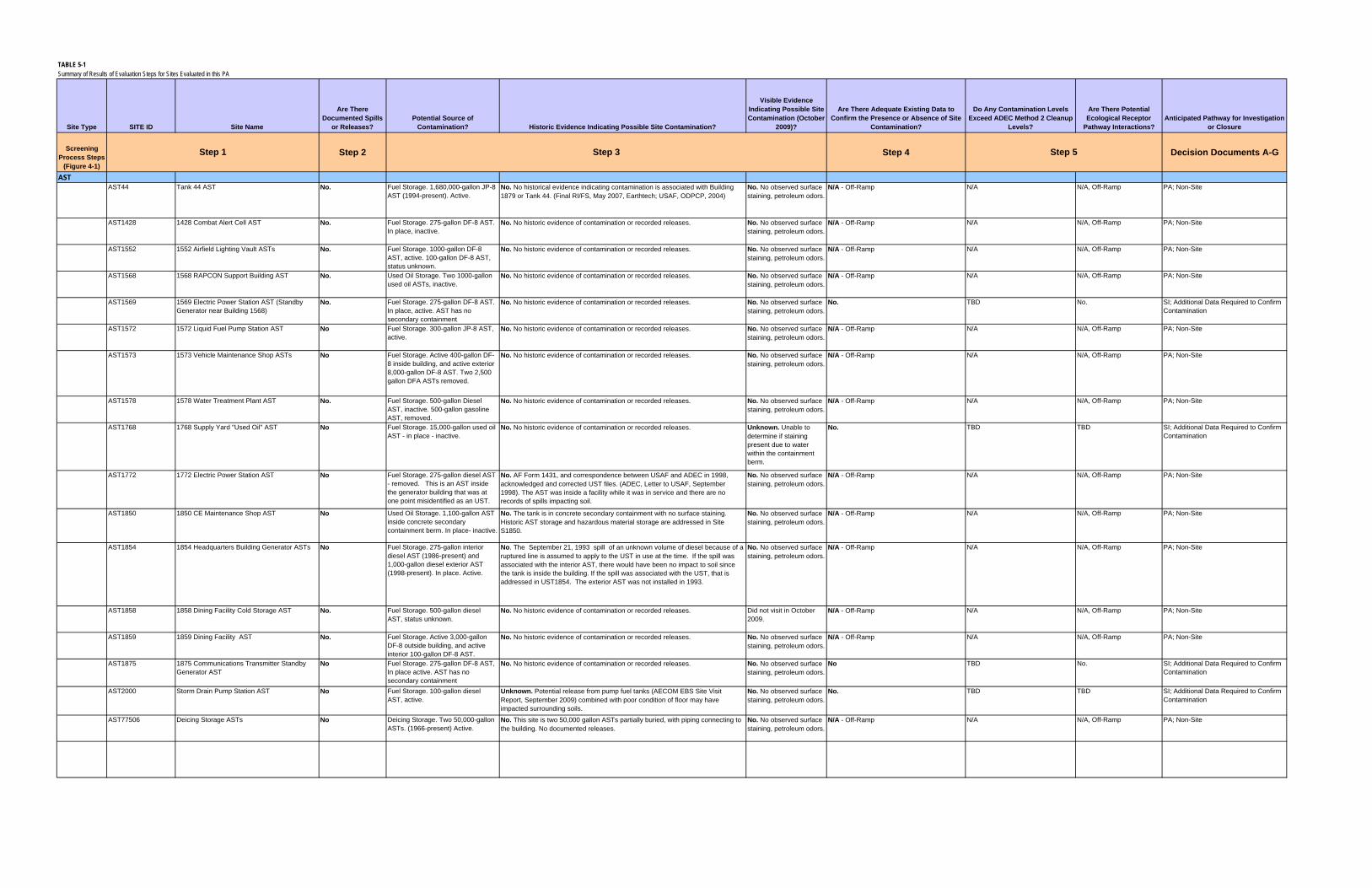
TABLE 5-1Summary of Results of Evaluation Steps for Sites Evaluated in this PA
Site Type SITE ID Site Name
Are There Documented Spills
or Releases?Potential Source of
Contamination? Historic Evidence Indicating Possible Site Contamination?
Visible Evidence Indicating Possible Site Contamination (October
2009)?
Are There Adequate Existing Data to Confirm the Presence or Absence of Site
Contamination?
Do Any Contamination Levels Exceed ADEC Method 2 Cleanup
Levels?
Are There Potential Ecological Receptor
Pathway Interactions?Anticipated Pathway for Investigation
or Closure
Screening Process Steps
(Figure 4-1)
Step 2 Step 4 Decision Documents A-G
ASTAST44 Tank 44 AST No. Fuel Storage. 1,680,000-gallon JP-8
AST (1994-present). Active.No. No historical evidence indicating contamination is associated with Building 1879 or Tank 44. (Final RI/FS, May 2007, Earthtech; USAF, ODPCP, 2004)
No. No observed surface staining, petroleum odors.
N/A - Off-Ramp N/A N/A, Off-Ramp PA; Non-Site
AST1428 1428 Combat Alert Cell AST No. Fuel Storage. 275-gallon DF-8 AST. In place, inactive.
No. No historic evidence of contamination or recorded releases. No. No observed surface staining, petroleum odors.
N/A - Off-Ramp N/A N/A, Off-Ramp PA; Non-Site
AST1552 1552 Airfield Lighting Vault ASTs No. Fuel Storage. 1000-gallon DF-8 AST, active. 100-gallon DF-8 AST, status unknown.
No. No historic evidence of contamination or recorded releases. No. No observed surface staining, petroleum odors.
N/A - Off-Ramp N/A N/A, Off-Ramp PA; Non-Site
AST1568 1568 RAPCON Support Building AST No. Used Oil Storage. Two 1000-gallon used oil ASTs, inactive.
No. No historic evidence of contamination or recorded releases. No. No observed surface staining, petroleum odors.
N/A - Off-Ramp N/A N/A, Off-Ramp PA; Non-Site
AST1569 1569 Electric Power Station AST (Standby Generator near Building 1568)
No. Fuel Storage. 275-gallon DF-8 AST. In place, active. AST has no secondary containment
No. No historic evidence of contamination or recorded releases. No. No observed surface staining, petroleum odors.
No. TBD No. SI; Additional Data Required to Confirm Contamination
AST1572 1572 Liquid Fuel Pump Station AST No Fuel Storage. 300-gallon JP-8 AST, active.
No. No historic evidence of contamination or recorded releases. No. No observed surface staining, petroleum odors.
N/A - Off-Ramp N/A N/A, Off-Ramp PA; Non-Site
AST1573 1573 Vehicle Maintenance Shop ASTs No Fuel Storage. Active 400-gallon DF-8 inside building, and active exterior 8,000-gallon DF-8 AST. Two 2,500 gallon DFA ASTs removed.
No. No historic evidence of contamination or recorded releases. No. No observed surface staining, petroleum odors.
N/A - Off-Ramp N/A N/A, Off-Ramp PA; Non-Site
AST1578 1578 Water Treatment Plant AST No. Fuel Storage. 500-gallon Diesel AST, inactive. 500-gallon gasoline AST, removed.
No. No historic evidence of contamination or recorded releases. No. No observed surface staining, petroleum odors.
N/A - Off-Ramp N/A N/A, Off-Ramp PA; Non-Site
AST1768 1768 Supply Yard "Used Oil" AST No Fuel Storage. 15,000-gallon used oil AST - in place - inactive.
No. No historic evidence of contamination or recorded releases. Unknown. Unable to determine if staining present due to water within the containment berm.
No. TBD TBD SI; Additional Data Required to Confirm Contamination
AST1772 1772 Electric Power Station AST No Fuel Storage. 275-gallon diesel AST - removed. This is an AST inside the generator building that was at one point misidentified as an UST.
No. AF Form 1431, and correspondence between USAF and ADEC in 1998, acknowledged and corrected UST files. (ADEC, Letter to USAF, September 1998). The AST was inside a facility while it was in service and there are no records of spills impacting soil.
No. No observed surface staining, petroleum odors.
N/A - Off-Ramp N/A N/A, Off-Ramp PA; Non-Site
AST1850 1850 CE Maintenance Shop AST No Used Oil Storage. 1,100-gallon AST inside concrete secondary containment berm. In place- inactive.
No. The tank is in concrete secondary containment with no surface staining. Historic AST storage and hazardous material storage are addressed in Site S1850.
No. No observed surface staining, petroleum odors.
N/A - Off-Ramp N/A N/A, Off-Ramp PA; Non-Site
AST1854 1854 Headquarters Building Generator ASTs No Fuel Storage. 275-gallon interior diesel AST (1986-present) and 1,000-gallon diesel exterior AST (1998-present). In place. Active.
No. The September 21, 1993 spill of an unknown volume of diesel because of a ruptured line is assumed to apply to the UST in use at the time. If the spill was associated with the interior AST, there would have been no impact to soil since the tank is inside the building. If the spill was associated with the UST, that is addressed in UST1854. The exterior AST was not installed in 1993.
No. No observed surface staining, petroleum odors.
N/A - Off-Ramp N/A N/A, Off-Ramp PA; Non-Site
AST1858 1858 Dining Facility Cold Storage AST No. Fuel Storage. 500-gallon diesel AST, status unknown.
No. No historic evidence of contamination or recorded releases. Did not visit in October 2009.
N/A - Off-Ramp N/A N/A, Off-Ramp PA; Non-Site
AST1859 1859 Dining Facility AST No. Fuel Storage. Active 3,000-gallon DF-8 outside building, and active interior 100-gallon DF-8 AST.
No. No historic evidence of contamination or recorded releases. No. No observed surface staining, petroleum odors.
N/A - Off-Ramp N/A N/A, Off-Ramp PA; Non-Site
AST1875 1875 Communications Transmitter Standby Generator AST
No Fuel Storage. 275-gallon DF-8 AST, In place active. AST has no secondary containment
No. No historic evidence of contamination or recorded releases. No. No observed surface staining, petroleum odors.
No TBD No. SI; Additional Data Required to Confirm Contamination
AST2000 Storm Drain Pump Station AST No Fuel Storage. 100-gallon diesel AST, active.
Unknown. Potential release from pump fuel tanks (AECOM EBS Site Visit Report, September 2009) combined with poor condition of floor may have impacted surrounding soils.
No. No observed surface staining, petroleum odors.
No. TBD TBD SI; Additional Data Required to Confirm Contamination
AST77506 Deicing Storage ASTs No Deicing Storage. Two 50,000-gallon ASTs. (1966-present) Active.
No. This site is two 50,000 gallon ASTs partially buried, with piping connecting to the building. No documented releases.
No. No observed surface staining, petroleum odors.
N/A - Off-Ramp N/A N/A, Off-Ramp PA; Non-Site
Step 5Step 1 Step 3

TABLE 5-1Summary of Results of Evaluation Steps for Sites Evaluated in this PA
Site Type SITE ID Site Name
Are There Documented Spills
or Releases?Potential Source of
Contamination? Historic Evidence Indicating Possible Site Contamination?
Visible Evidence Indicating Possible Site Contamination (October
2009)?
Are There Adequate Existing Data to Confirm the Presence or Absence of Site
Contamination?
Do Any Contamination Levels Exceed ADEC Method 2 Cleanup
Levels?
Are There Potential Ecological Receptor
Pathway Interactions?Anticipated Pathway for Investigation
or Closure
Screening Process Steps
(Figure 4-1)
Step 2 Step 4 Decision Documents A-GStep 5Step 1 Step 3
USTUST1400 1400 Former Ammunition Storage UST Yes. Known release
from UST.Fuel storage. 1,700-gallon heating-oil UST was removed on August 30, 1993. Potential contamination from ethylene glycol tanks and septic system.
Yes. Soil and PID sampling data was presented in a March 16, 1994, letter report to ADEC. DRO was detected during tank excavation ranging from 945 to 6,300 mg/kg.
No. Yes. 1993 UST removal indicated contaminated soil.
Yes. DRO in soil exceeds Method 2 levels.
TBD SC; ADEC Site Characterization; POL Site with Additional Data Needs
UST1401 1401 Former Ammunition Storage Guard Shack UST
Yes. Reference USAF Letter to ADEC, March 16, 1994.
Removed UST N/A. Known release, this step does not apply. No. Yes. Analytical data from UST removal confirm the presence of site contamination.
Yes, DRO above 250 mg/kg TBD SC ADEC Site Characterization; POL Site with Additional Data Needs
UST1404 1404 Control Tower UST No Removed UST. 500-gallon UST removed in 1990.
Unknown. UST removed in 1990. No documentation. No. No. No records available regarding removal details.
TBD TBD SI; Additional Data Required to Confirm Contamination
UST1428 1428 Combat Alert Cell UST No Three abandoned in place 10,000 gallon USTs.
Unknown. (3) 10,000-gallon USTs are listed in ADEC database, 1428B (5), 1428-1 (8), 1428-2 (9) with status "abandoned."
No. No. Tanks abandoned in place without confirmation that no leaks to soil or groundwater occurred.
TBD TBD SI; Additional Data Required to Confirm Contamination
UST1429 1429 Former Guard Shack UST No Suspected UST Unknown. Noted linear cuts in asphalt and circular grout holes during October 2009 site visit suggesting piping was removed and tank may have been abandoned in place.
No. No. TBD TBD SI; Additional Data Required to Confirm Contamination
UST1552 1552 Airfield Utility Vault UST Yes. Known release from UST.
Removed UST. 2,000-gallon diesel UST removed in 1997.
N/A. Known release, this step does not apply. No. Yes. Samples collected in 1999 (RSE, August 1999) and 2001 (USAF, December 2002). Samples analyzed for GRO, DRO, RRO, BTEX, PAHs, VOCs, and metals.
Yes. One soil sample 10 to 11 ft bgs. DRO above 250 mg/kg, but all other soil samples were below Method 2 cleanup levels.
No. PA; Recommend No Further Action
UST1769 1769 Supply Warehouse UST No. Suspected UST. Diesel UST in service from approximately 1956 to 1970.
Unknown. No documentation of tank removal activities. Building 1769 is an original facility; AF Form 1430 indicates "oil" used for heating but no AF Form 1431 listing fuel storage tanks found.
No. Evidence of a UST; was not observed during the Oct 2009 site visit
No. No documentation of tank removal activities.
TBD TBD SI; Additional Data Required to Confirm Contamination
UST1770 1770 Former Incinerator USTs No. Removed UST. Two 1,000 gallon tanks: 1770-1 (diesel) and 1770-2 (waste oil). The tanks were active until 1993 and removed in 1997.
Yes. Soil sample results detected DRO up to 42,800 mg/kg, GRO up to 760 mg/kg, and BTEX up to 33.9 mg/kg suggesting that contaminated soil is still present. (Harding Lawson/Wilder JV, RA Rpt Galena Tank Removal and Soil Remediation, February 1999)
No. Yes. Analytical data from UST removal confirm the presence of site contamination.
Yes. DRO, GRO, BTEX in soil. TBD SC; ADEC Site Characterization; POL Site with Additional Data Needs
UST1854 1854 Headquarters Building UST Yes. September 21, 1993, an unknown volume of diesel spilled because of a ruptured line (2004 ODPCP)
Removed UST. 2,000-gallon diesel UST removed in 1998.
N/A. Known release, this step does not apply. No. Yes. Samples collected in 1999 (RSE, August 1999) and 2001 (USAF, December 2002). Samples analyzed for GRO, DRO, RRO, BTEX, PAHs, VOCs, and metals.
No. No. PA; Recommend No Further Action
UST1859 1859 Dining Facility UST No Removed UST Unknown. Mr. Burgett removed UST in 1995 and did not perform any sampling. Building 1859 is one of the earliest facilities and AF Form 1430 indicates "oil" used for heating but most likely diesel fuel used.
No. Evidence of a UST was not observed during the October 2009 site visit
No. TBD TBD SI; Additional Data Required to Confirm Contamination
UST15783 1578 Water Treatment Plant UST Yes Removed UST N/A. Known release, this step does not apply. No. Yes. Analytical data from UST removal confirm the presence of site contamination.
Yes. 1997 UST removal indicated contaminated soil, DRO up to 1,180 mg/kg.
TBD SC; ADEC Site Characterization; POL Site with Additional Data Needs
OWS OWS1573 1573 Vehicle Maintenance Shop OWS No Active OWS. No. Mr. Randy Warnke, former 611 ASUS contract manager, indicated there was
a compliance issue with the OWS having an "unpermitted connection to domestic sewer" and oily wastes from floor drain may have been discharged to sanitary sewer. This misuse of the system does not indicate the tank was leaking.
No. No observed surface staining, petroleum odors.
N/A - Off-Ramp N/A N/A, Off-Ramp PA; Non-Site
OWS1833 1833 MWR Storage OWS No. Suspected OWS or dry well. Yes. The facility photos clearly show a drain line leading out of the facility into a buried 55-gallon drum that may be of a dry well. The disposal practices at Building 1833 are not documented in such a way to rule out disposal of solvents or POLs.
No. No. TBD No. SI; Additional Data Required to Confirm Contamination
OWS1845 1845 Vehicle Maintenance Shop OWS No Closed OWS. Facility built 1959. No OWS removal or closure documents available.
Unknown. Building 1845 has been included in previous TCE investigations and ruled out as a source of TCE in groundwater (2007 RI/FS). However, the OWS and potential dry well may still be a source of POL contamination. Site was included in SS006/TCE Area.
No. No. TBD TBD SI; Additional Data Required to Confirm Contamination

TABLE 5-1Summary of Results of Evaluation Steps for Sites Evaluated in this PA
Site Type SITE ID Site Name
Are There Documented Spills
or Releases?Potential Source of
Contamination? Historic Evidence Indicating Possible Site Contamination?
Visible Evidence Indicating Possible Site Contamination (October
2009)?
Are There Adequate Existing Data to Confirm the Presence or Absence of Site
Contamination?
Do Any Contamination Levels Exceed ADEC Method 2 Cleanup
Levels?
Are There Potential Ecological Receptor
Pathway Interactions?Anticipated Pathway for Investigation
or Closure
Screening Process Steps
(Figure 4-1)
Step 2 Step 4 Decision Documents A-GStep 5Step 1 Step 3
Liquid Fuel System
OAP/PADS/VP09 No Abandoned Fuel Pipeline, valve pit, and refueling pads.
Unknown. Sampling has not been conducted along the OAP, or in the locations of VP09 and PADS.
No. No. TBD TBD SI; Additional Data Required to Confirm Contamination
PIPE New 1-Mile Pipeline No Fuel Pipeline No. The pipeline was pressure tested in 2008; no signs of leakage were identified.
No. No observed surface staining, petroleum odors.
N/A - Off-Ramp N/A N/A, Off-Ramp PA; Non-Site
NavAidsILS8 Instrument Landing System (ILS) Navigational
Aids Near W Runway 7 approachNo Suspected fuel storage and PCB
components. No. The ILS was the one airfield navigation aid inside the perimeter dike that was supplied power by a pole mounted transformer (Communication with Mr. John Rose, 611 CES). No AF Form 1431 indicates that a standby power generator or fuel storage was associated with ILS8
No. No known tank or other sources of contamination were present.
N/A - Off-Ramp N/A N/A, Off-Ramp PA; Non-Site
TACAN1 Tactical Air Navigation (TACAN) (South of runway; East of South Apron)
No Suspected fuel storage and PCB components.
No. TACAN is older technology and would not have been needed after 1960's when FAA operated the VORTAC facility. No photo documenting a TACAN in use in this area. 2002 photo shows equipment, possibly a backup generator. In this area electrical power was provided by overhead power line with a pole-mounted transformer that ran along dike road.
No. No. TBD TBD SI; Additional Data Required to Confirm Contamination
Disposal Areas
DS1769 Disposal Site 1769 (North of the Dike Road ) No. Disposal Area No. The site was identified as a new potential area of interest from 1963 historical aerial photographs shown in the Final EBS report (USAF, February 2010). No investigations have been conducted.
No. No. TBD TBD SI; Additional Data Required to Confirm Contamination
DSNW Northwest Disposal Area (West of Building 1769, outside the dike
No. Disposal Area No. During the October 2009 site visit, an area of potentially disturbed terrain (that is, hummocky topography with mounds approximately 6 feet high and 30 feet long) was observed in the area of Site DSNW, suggesting a potential disposal site. No investigations have been conducted.
No. No. TBD TBD SI; Additional Data Required to Confirm Contamination
DSWD Disposal Site West of Dike (South and southwest of the base of Million Gallon Hill)
No. Disposal Area No. The surface debris area was identified from a 1969 historical drawing (USAF, 1969) that labeled the area as “Disposal Area Non-Burnable”. No investigations have been conducted.
No. No. TBD TBD SI; Additional Data Required to Confirm Contamination
SWQ Potential Solid Waste Disposal Area (Grant: ADA-02195 West of Radome, East of Dike Road)
No. Disposal Area No. A 1969 installation drawing for contracted work indicated the area is for "Disposal Area Excess and/or Waste Excavation Only," which is inferred to be disposal of clean fill only. The AF leased the land for construction of a "solid-waste disposal facility", and the AF built Building 1770, the solid waste incinerator, south of this location.
No. N/A - Off-Ramp NA N/A, Off-Ramp PA; Non-Site
BuildingsB400 Building 400 Former CAA – Air Force Weather
Station (South of apron and Building 1573; North of runway)
No Suspected fuel storage and PCB components
Unknown. Transformer used here and remained on site after demolition. Due to age of facility it may have contained PCB oil. Although previous visual survey and interviews conducted by FAA (CH2M HILL, Site Cleanup and Investigation Report, March 1998) documented that the building was demolished and no stained areas or storage tanks were observed. Interview with FAA maintenance subcontractor did not recall any spills or leaks between 1977 and 1995. The facility was turned over to USAF prior to demolition.
No. No. TBD No. SI; Additional Data Required to Confirm Contamination
B408 Building 408 Strobe Shack No Transformer removed with PCB concentration of 680 ppm.
No. The transformer was removed prior to demolition of the building. It is not evident that spills of the oil occurred.
Did not visit in October 2009. Site added to list in January 2010.
No. TBD TBD SI; Additional Data Required to Confirm Contamination
B1403 Building 1403 Former LOX plant No Potential solvent use Yes. The facility operated for at least 1 year as a LOX plant and may have used solvents to clean equipment generating oxygen. Diesel storage tanks were also associated with the facility; however, test pits were sampled and found no GRO, DRO, RRO, or BTEX above ADEC levels.
No. No. Solvents were not part of analytical suite collected for the August 2002 Phase III Environmental Site Assessment (ESA) report (Phukan, August 2002) . Adequate data was collected to confirm the absence of fuel contamination.
TBD No. SI; Additional Data Required to Confirm Contamination
B1558 Building 1558 Former Power Plant No Potential PCBs from transformers Yes. This building was the primary power generation facility from 1947-1970s and transformers located inside and/or adjacent to the facility are most likely to be a source of PCB oil leaks or spills
No. No. TBD No. SI; Additional Data Required to Confirm Contamination

TABLE 5-1Summary of Results of Evaluation Steps for Sites Evaluated in this PA
Site Type SITE ID Site Name
Are There Documented Spills
or Releases?Potential Source of
Contamination? Historic Evidence Indicating Possible Site Contamination?
Visible Evidence Indicating Possible Site Contamination (October
2009)?
Are There Adequate Existing Data to Confirm the Presence or Absence of Site
Contamination?
Do Any Contamination Levels Exceed ADEC Method 2 Cleanup
Levels?
Are There Potential Ecological Receptor
Pathway Interactions?Anticipated Pathway for Investigation
or Closure
Screening Process Steps
(Figure 4-1)
Step 2 Step 4 Decision Documents A-GStep 5Step 1 Step 3
S1769 Building 1769 Supply Warehouse Storage Yard
No Hazardous material storage, transformer staging,
Yes. Previous investigation indicates petroleum hydrocarbon contamination. Transformers were staged here.
No. No. TBD TBD SI; Additional Data Required to Confirm Contamination
B1770 Building 1770 Incinerator No Potential impact from incinerator activities.
Yes. Incinerator was used to burn solid waste. No. Site has been re-graded and not visible evidence of ash on ground surface
N/A. Closure of this site was suggested by the U.S. Air Force (USAF) at a Technical Project Team (TPT) meeting in December 2007 (USAF, December 5-6, 2007, p.2). It is not likely that deposition of dioxin in the vicinity of B1770 would yield detectable concentrations attributable to the former incinerator even if the original ground was still exposed.
N/A N/A, Off-Ramp PA; Non-Site
B1812 Building 1812 Former Satellite Hazardous Waste Accumulation Point
No Hazardous waste storage, possible fuel pipeline
Yes, Building 1812 was a Former CE Composite Shop (USAF, April 2007). Possible fuel line from Old Power Plant USTs impacting soil in area. Pipeline shown on June 25, 1962, MOGAS Bulk Storage Relocation Drawing.
No. No surface staining or odors observed during October 2009 site visit
No. Yes, lead in surface soil (1996 RI) No. SI; Additional Data Required to Confirm Contamination
S1850 Building 1850 Storage Yard No Waste oil storage, transformer staging,
Yes. Previous investigation indicates petroleum hydrocarbon contamination. Transformers were staged here.
No. No. TBD No. SI; Additional Data Required to Confirm Contamination
B1879 Building 1879 Pump Station No. Liquid Fuel Facility . No. No historical evidence indicating contamination associated with Building 1879 (Earthtech, Final RI/FS, May 2007)
No. N/A - Off-Ramp N/A N/A, Off-Ramp PA; Non-Site
B3005 Precision Approach Radar (PAR) Electric Power Station
No. Fuel storage Unknown. Fuel storage for generator; unknown if spills or leaks impacted surface soil.
No. No TBD No. SI; Additional Data Required to Confirm Contamination
B3205 Airport Surveillance Radar (ASR) Electric Power Station
No. Fuel storage Unknown. Fuel storage for generator; unknown if spills or leaks impacted surface soil.
No. No TBD No. SI; Additional Data Required to Confirm Contamination
OtherAAS3 Aircraft Arresting System (AAS) (locations
North and South of runway)No. Suspected fuel storage No. A visual reconnaissance was conducted in 2007 during AAS removal and did
not observe evidence of contamination . Based on research of historical USAF AAS systems, AAS3 was most probably an electro-mechanical system housed in aboveground sheds. A 5-gallon gasoline tank was carried to the site when barriers were needed and not stored in shed (personal communication with Mr. Ron Lurk, 611 Ops Chief, December 4, 2009) The design suggests unlikely potential for historical site contamination.
No. The October 2009 site visit inspected the vaults for the aircraft arresting system and did not find any tanks, fuel, etc.
N/A - Off-Ramp N/A N/A, Off-Ramp PA; Non-Site
AOC023 Waste Accumulation Area No. Spills from waste storage. Yes. Historic activities at Site AOC023 associated with the former waste storage resulted in contamination of fuel related compounds, chlorinated hydrocarbons, and metals in site surface and subsurface soil and petroleum hydrocarbons and chlorinated hydrocarbons in the groundwater above the corresponding ADEC Method 2 cleanup levels. The full nature and extent of contamination at the site has not been adequately determined.
No. Yes. Previous investigations indicate contamination at the site.
Yes. Petroleum hydrocarbons, chlorinated hydrocarbons, and metals in site surface and subsurface soil and petroleum hydrocarbons and chlorinated hydrocarbons in the groundwater were detected above the corresponding ADEC Method 2
No. RI-CERCLA
B1859 Grease Trap Building 1859 Grease Trap No. Grease Trap No. Site B1859 Grease Trap consists of the grease trap used for the dining facility at Building 1859, Two Seasons Dining Hall. The grease trap is west of the dining facility and adjacent to Building 1858, a cold storage facility. No documented release or disposal of hazardous substances or petroleum products exists for Site B1859 Grease Trap. An investigation of these facilities was conducted in 2007 before property transfer and these facilities were concluded to be uncontaminated properties.
No. N/A - Off-Ramp N/A N/A, Off-Ramp PA; Non-Site
BERM Unknown Soil Berm (north of Former Birchwood Hangar)
No Suspected fuel tank location Unknown. Mr. Burgett stated that a diesel fuel tank was located in that area temporarily. This statement was corroborated by interview with Mr. Joe Williamson, former 5099th personnel.
No. N/A - Off-Ramp N/A N/A, Off-Ramp PA; Non-Site
BLM Pesticides Pesticide Area North of BLM Housing No Suspected release of DDT No. Although one of the two samples collected in 1993 indicated pesticides in concentrations in excess of EPA Region III risk-based concentrations (RBCs), samples collected in 1994 did not indicate pesticides in excess of Region III RBCs (Radian, March 1996).
No. N/A - Off-Ramp N/A N/A, Off-Ramp PA; Non-Site
Radiological Materials
Radiological Materials (Sitewide) No Radiological materials No. Site Radiological Materials consists of public concerns related to the Base-wide possibility of releases associated with possible nuclear weapons storage or use at the Former Galena FOL. No documented release or disposal of nuclear or radiological material exists for the Galena FOL and an expert records review and analysis concluded that there are no radiological human health or safety concerns connected with operations at the Former Galena FOL.
No. N/A - Off-Ramp N/A N/A, Off-Ramp PA; Non-Site
BLA Barge Loading Area (AF lease area only) No Fuel System Connection Unknown. Reports have mistakenly reported soil gas, surface water, sediment, groundwater sampling conducted 1993 USAF for the Barge Landing Area at Campion AS indicating contamination at the Former Galena FOL barge landing area. The BLA is still in use for offloading fuel.
No. No. Visible tar substance in soil adjacent to barge loading area.
TBD TBD SI; Additional Data Required to Confirm Contamination
TAR Possible Tar Pit Construction Area No Road or runway maintenance Yes. Site photos show the tar pit. Did not visit in October 2009.
No. TBD TBD SI; Additional Data Required to Confirm Contamination

TABLE 5-1Summary of Results of Evaluation Steps for Sites Evaluated in this PA
Site Type SITE ID Site Name
Are There Documented Spills
or Releases?Potential Source of
Contamination? Historic Evidence Indicating Possible Site Contamination?
Visible Evidence Indicating Possible Site Contamination (October
2009)?
Are There Adequate Existing Data to Confirm the Presence or Absence of Site
Contamination?
Do Any Contamination Levels Exceed ADEC Method 2 Cleanup
Levels?
Are There Potential Ecological Receptor
Pathway Interactions?Anticipated Pathway for Investigation
or Closure
Screening Process Steps
(Figure 4-1)
Step 2 Step 4 Decision Documents A-GStep 5Step 1 Step 3
NOTES:
DRO = diesel‐range organics ODPCP = Oil Discharge Prevention and Contingency PlanEA = Environmental Assessment OWS = oil‐water separatorEBS = Environmental Baseline Survey PA = preliminary assessment
ESA = Environmental Site Assessment PAR = Precision Approach Radar
ADOT = Alaska Department of Transportation GRO = gasoline‐range organics PCB = polychlorinated biphenylILS = instrument landing system PID = photoionization detector
AFDOT&FP = State of Alaska Department of Transportation and Public Facilities JP‐8 = jet‐propulsion fuel, grade 8 POL = petroleum, oil, and lubricantskW = kilowatt RI = Remedial InvestigationLOX = liquid oxygen ROW = right of way
AWOS = Automated Weather Observation System mg/kg = milligrams per kilogram RSE = Remediation System EvaluationMOGAS = motor gasoline SC = Site CharacterizationMWR = Morale, Welfare, and Recreation SI = Site InvestigationN/A = Not Applicable TBD = To Be DeterminedNavAids = Navigation Aid TCE = trichloroethene
CES = Civil Engineer Squadron OAP = old abandoned pipeline USAF = U.S. Air ForceUST = underground storage TankDF‐8 = jet‐propulsion fuel, grade 8 used as ground fuel
bgs = below ground surface
AST = aboveground storage tank
CAA = Civil Aeronautics Authority
ADEC = Alaska Department of Environmental Conservation
DF‐A = diesel fuel
AF = Air Force
611 ASUS = 611th Air Support Squadron
AAS = Aircraft Arresting SystemAAC = Alaska Administrative Code
CE = Civil Engineering
BTEX = benzene, toluene, ethylbenzene, and xylenes
AOC = area or concern

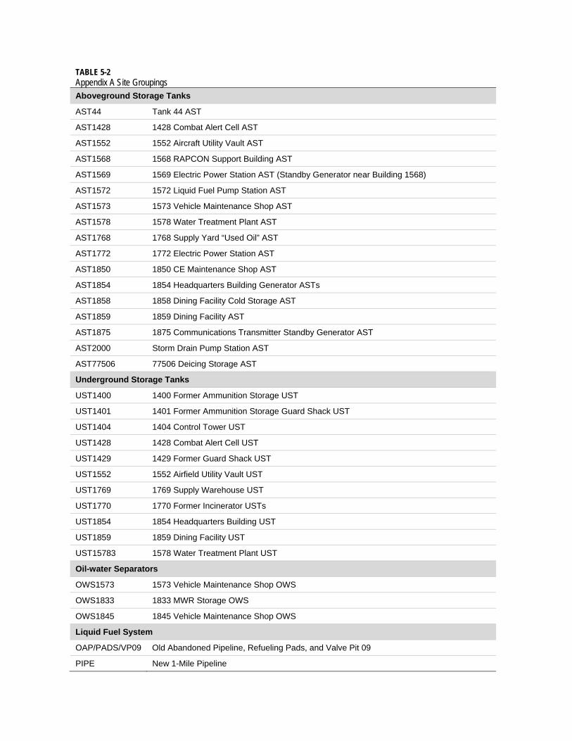
TABLE 5-2 Appendix A Site Groupings Aboveground Storage Tanks
AST44 Tank 44 AST
AST1428 1428 Combat Alert Cell AST
AST1552 1552 Aircraft Utility Vault AST
AST1568 1568 RAPCON Support Building AST
AST1569 1569 Electric Power Station AST (Standby Generator near Building 1568)
AST1572 1572 Liquid Fuel Pump Station AST
AST1573 1573 Vehicle Maintenance Shop AST
AST1578 1578 Water Treatment Plant AST
AST1768 1768 Supply Yard “Used Oil” AST
AST1772 1772 Electric Power Station AST
AST1850 1850 CE Maintenance Shop AST
AST1854 1854 Headquarters Building Generator ASTs
AST1858 1858 Dining Facility Cold Storage AST
AST1859 1859 Dining Facility AST
AST1875 1875 Communications Transmitter Standby Generator AST
AST2000 Storm Drain Pump Station AST
AST77506 77506 Deicing Storage AST
Underground Storage Tanks
UST1400 1400 Former Ammunition Storage UST
UST1401 1401 Former Ammunition Storage Guard Shack UST
UST1404 1404 Control Tower UST
UST1428 1428 Combat Alert Cell UST
UST1429 1429 Former Guard Shack UST
UST1552 1552 Airfield Utility Vault UST
UST1769 1769 Supply Warehouse UST
UST1770 1770 Former Incinerator USTs
UST1854 1854 Headquarters Building UST
UST1859 1859 Dining Facility UST
UST15783 1578 Water Treatment Plant UST
Oil-water Separators
OWS1573 1573 Vehicle Maintenance Shop OWS
OWS1833 1833 MWR Storage OWS
OWS1845 1845 Vehicle Maintenance Shop OWS
Liquid Fuel System
OAP/PADS/VP09 Old Abandoned Pipeline, Refueling Pads, and Valve Pit 09
PIPE New 1-Mile Pipeline

TABLE 5-2 Appendix A Site Groupings Navigational Aids
ILS8 Instrument Landing System (ILS) Navigational Aids Near W Runway 7 approach
TACAN 1 Tactical Air Navigation (TACAN) (South of Runway; East of South Apron)
Disposal Areas
DS1769 Potential Drum Storage/Disposal at Building 1769
DSNW Potential Disposal Site North West of the Former Galena FOL
DSWD Potential Disposal Site West of the Dike
SWQ Potential Solid Waste Disposal Area (Grant: ADA-02195 West of Radome, East of Dike Road)
Buildings
B400 Building 400 Former CAA – Air Force Weather Observation Station (South of apron and Building 1573; North of runway)
B408 Building 408 Strobe Shack
B1403 Building 1403 Former LOX plant
B1558 Building 1558 Former Power Plant Transformers
S1769 Building 1769 Supply Warehouse/ Storage Yard
B1770 Building 1770 Incinerator
B1812 Building 1812 Former Satellite Hazardous Waste Accumulation Point
S1850 Building 1850 Storage Yard
B1879 Building 1879 Pump Station
B3005 Precision Approach Radar (PAR) Electric Power Station
B3205 Airport Surveillance Radar (ASR) Electric Power Station
Other
AAS3 Aircraft Arresting System (AAS) (locations north and south of runway)
AOC023 Waste Accumulation Area
B1859 Grease Trap
Building 1859 Grease Trap
BERM Unknown Soil Berm (North of Former Birchwood Hangar)
BLA Barge Loading Area (Air Force lease area only)
BLM Pesticides Pesticide Area North of BLM Housing
Radiological Materials
Radiological Materials (Sitewide)
TAR Possible Tar Pit Construction Area

FINAL: PRELIMINARY ASSESSMENT REPORT FORMER GALENA FORWARD OPERATING LOCATION, ALASKA
AFCEE CONTRACT FA8903-08-D-8769, TASK ORDER 0184 SEPTEMBER 2011
ES121009055544PDX 6-1
6.0 Summary of Conclusions and Recommendations
A total of 58 non-ERP sites were evaluated in this PA. The following is a summary of the results of the site screening process.
24 sites were recommended for a “Non-Site” designation, as listed below:
AST44, AST1428, AST1552, AST1568, AST1572, AST1573, AST1578, AST1772, AST1850, AST1854, AST1858, AST1859, AST77506, OWS1573, PIPE, ILS8, SWQ, B1770, B1879, AAS3, B1859 Grease Trap, BERM, BLM Pesticides, and Radiological Materials 2 sites (UST1552 and UST1854) were recommended for No Further Action
27 sites were recommended for SI, as listed below:
AST1569, AST1768, AST1875, AST2000, UST1404, UST1428, UST1429, UST1769, UST1859, OWS1833, OWS1845, OAP/PADS/VP09, TACAN1, DS1769, DSNW, DSWD, B400, B408, B1403, B1558, S1769, B1812, S1850, B3005, B3205, BLA, and TAR
4 sites (UST1400, UST1401, UST1770, and UST15783) with known POL contamination were recommended for SC under ADEC regulations
Site AOC023, which has known solvent contamination, was the only PA site recommended for RI under CERCLA regulations
The 24 sites recommended for a “Non-Site” designation had no documented releases or evidence of contamination. The two sites recommended for No Further Action had documented releases, but contamination levels were below screening levels with no potential ecological receptor interactions. The majority of the remaining sites were recommended either for SI to confirm the presence or absence of contamination, for further SC to address known POL releases under ADEC requirements, or for RI to address known releases under CERCLA requirements. Figure 6-1 graphically summarizes the recommendation for SC and RI evaluations for the PA sites and Figure 6-2 graphically summarizes the SI, “Non-Site,” and No Further Action recommendations for PA sites.


\\BALDUR\PROJ\GALENATO184_394439\MAPFILES\PA_2010\FIGURE_6-1_ANTICIPATED_PATH_PA.MXD SEARLY 10/20/2010 13:42:38
Y U K O N R I V E R
CB001
ST020TU001
SS014 SS016
ST010
FT001
SS015
ST005
SS017SS021
ST009
SS006
CG002
SS005
OT099
CG001ST005
UST1400
UST1401
UST15783
UST1770
AOC023
0 750375
Feet
LEGENDBuilding
Surface WaterRecommendation
RI: CERCLA Remedial Investigation SC/SI: ADEC Site Characterization/Site InspectionSC: ADEC Site Characterization
SC or RI: Not in PA Report
$ FIGURE 6-1Recommended Pathways for SC and RI SitesPreliminary Assessment ReportFormer Galena Forward Operating Location, Alaska
[A L A S K A
Galena
VICINITY MAP


V:\GALENATO184_394439\MAPFILES\PA_REPORT\FIGURE_6-2_ANTICIPATED_PATH_PA.MXD CVONFREE 7/14/2011 10:36:08 AM
Y U K O N R I V E R
AST1552
OWS1833
B1812
B1879
AST1772
OWS1845
UST1552
UST1429
AST2000
UST1859
UST1404AST1428
AST1569
B1770
AST77506
AAS3
AAS3
DSWDDSWD
TACAN1
B1403
BERM
UST1854
S1850
SWQ
AST1573
B400
ILS8
B408PADS
AST44
AAS3AAS3 PIPE
BLA
AAS3
AST1768
AST1572
AST1850
DSNW
OWS1573
UST1428UST1428
S1769 AST1854
AST1568
AST1568
AST1858
AST1859
AST1578
B3005
B3205
B1558
AAS3OAP
VP09
UST1769
TAR
AST1875
DS1769
BLM Pesticides
AST1858B1859 Grease Trap
0 750375
Feet
LEGENDBuilding
Surface Water
RecommendationSite Inspection Recommended
Site Inspection Not Recommended "non-site"
No Further Action Recommended
FIGURE 6-2Recommended Pathways for PA SitesPreliminary Assessment ReportFormer Galena Forward Operating Location, Alaska
A L A S K A
Galena
VICINITY MAP
Note: 1. Site Radiological Materials is a FOL-wide siteand is not shown on the figure. The site is recommended as a non-site


FINAL: PRELIMINARY ASSESSMENT REPORT FORMER GALENA FORWARD OPERATING LOCATION, ALASKA
AFCEE CONTRACT FA8903-08-D-8769, TASK ORDER 0184 SEPTEMBER 2011
ES121009055544PDX 7-1
7.0 References
Agency for Toxic Substances and Disease Registry (ATSDR). May 2007. Public Health Assessment for Galena Airport.
Alaska Community Database. 2009. Community Information Summary for Galena. http://www.commerce.state.ak.us/dca/commdb/CIS.cfm?Comm_Boro_Name=Galena). Accessed January 5, 2010.
Alaska Department of Environmental Conservation (ADEC). July 2009.
Bainbridge, Steve. Steve Bainbridge, Contaminates Sites Program Manager, Alaska Department of Environmental Conservation (ADEC). July 24, 2009. “Identifying how the Contaminates Sites Program (CSP) will make closure determinations for sites regulated under Title 18 AAC 78 Articles 2 and 6 and 18 AAC 76, Article 3.” Memorandum to Contaminated Sites Staff.
Alaska Department of Environmental Conservation (ADEC). November 7, 2002. Underground Storage Tank Procedures Manual. Guidance for Treatment of Petroleum-Contaminated Soil and Water and Standard Sampling Procedures. Division of Spill Prevention and Response, Contaminated Sites Program.
Alaska Department of Environmental Conservation (ADEC). June 1999. Technical Background Document for Selection and Application of Default Assessment Endpoints and Indicator Species in Alaskan Ecoregions. EcoRegions/Assessment Endpoint Project. http://alaska.fws.gov/nwr/koyukuk/index.htm. Accessed December 10, 2009.
Alaska Department of Fish and Game (ADFG). 2009a. Anadromous Waters Catalog. http://www.sf.adfg.state.ak.us/SARR/FishDistrib/anadcat.cfm. Accessed December 10, 2009.
Alaska Department of Fish and Game (ADFG). 2009b. Endangered Species in Alaska. http://www.adfg.state.ak.us/special/esa/esa_home.php. Accessed December 10, 2009.
Alaska Department of Natural Resources (ADNR). March 2000. Fact Sheet Title: Land Ownership In Alaska.
Blair, Mike. January 5, 2010. Mike Blair, former officer stationed at Galena. Personal Communication with Cory Hinds/CH2M HILL.
Burgett. April 2010. Mr. Burgett, Galena resident and UST removal contractor. Personal communication with Win Westervelt/CH2M HILL.
CH2M HILL. August 2010. Work Plan for Site Inspection, Remedial Investigation, and Site Characterization, Former Galena Forward Operating Location, Alaska. Final. Prepared for the Air Force Center for Engineering and the Environmental (AFCEE)
FINAL: PRELIMINARY ASSESSMENT REPORT FORMER GALENA FORWARD OPERATING LOCATION, ALASKA AFCEE CONTRACT FA8903-08-D-8769, TASK ORDER 0184 SEPTEMBER 2011
7-2 ES121009055544PDX
Earth Tech, Inc. May 2007. Final Remedial Investigation/Feasibility Study Report for United States Air Force Sites at Galena Airport and Campion Air Station, Alaska. Prepared for the United States Air Force, 611th Civil Engineer Squadron/Environmental Restoration Element (CES/CEVR), Elmendorf Air Force Base, Alaska.
Engineering Science. September 1985. Phase 1 Records Search, AAC Northern Region.
Galena Interior Learning Academy (GILA). 2009. Website. http://gila.galenaalaska.org/public/index.html. Accessed on January 5, 2010.
Lurk, Ron. December 4, 2009. Ron Lurk, 611th CES Operations Flight Chief formerly stationed at Galena. Personal communication with Vivian Tokar/CH2M HILL.
Radian Corporation (Radian). October 2002. Environmental Monitoring Report #7, Volume 1, Galena Airport, Alaska, Revised Draft.
Radian Corporation (Radian). March 1996. Final Remedial Investigation Report, Galena Airport and Campion Air Station, Volume 1 – Text.
U.S. Air Force (USAF). February 2010. Final Environmental Baseline Survey, Air Force Property at Galena Airport, Alaska.
U.S. Air Force (USAF). May 2009. Galena Site Matrix.
U.S. Air Force (USAF). May 2008. Environmental Baseline Survey, Galena Airport, Alaska.
U.S. Air Force (USAF). March 2008. Integrated Natural Resources Management Plan, Galena Airport Forward Operating Location Galena, Alaska. 2008 Revision. Prepared by 611th Air Support Civil Engineer Squadron, Environmental Flight.
U.S. Air Force (USAF). October 2006a. Air Force Guide for Conducting the CSE Phase I at Air Force Munitions Response Areas (Version 10.0).
U.S. Air Force (USAF). October 2006b. Air Force Guide for Conducting the CSE Phase II at Air Force Munitions Response Areas (Version 4.0).
U.S. Air Force (USAF). October 2004. Galena Air Station Oil Discharge Prevention and Contingency Plan. Revision 5. Prepared for 611th Air Support Group, 611th Civil Engineer Squadron, Elmendorf AFB, Alaska.
U.S. Air Force (USAF). January 2004. Permit issued to Department of the Interior Bureau of Land Management Alaska Fire Services for Property Located on Galena Airport.
U.S. Air Force (USAF). April 2001. History of Alaska’s Forward Operating Bases: The Soviet Bomber Threat and North American Air Defenses during the Cold War.
U.S. Air Force (USAF). June 1996. Final Installation-Wide Environmental Baseline Survey Galena Air Force Station, Alaska. Prepared for 611 Civil Engineer Squadron, Elmendorf AFB.
U.S. Air Force (USAF). March 1996. Final Remedial Investigation Report, Galena Airport and Campion Air Station.
U.S. Air Force (USAF). October 1994. Final Aquifer Test Report, Galena Airport, Alaska.

FINAL: PRELIMINARY ASSESSMENT REPORT FORMER GALENA FORWARD OPERATING LOCATION, ALASKA
AFCEE CONTRACT FA8903-08-D-8769, TASK ORDER 0184 SEPTEMBER 2011
ES121009055544PDX 7-3
U.S. Air Force (USAF). 1992. Alaskan Air Command, Comprehensive Plan, Liquid Fuel, Galena Airport, Alaska, Drawing G-8.
U.S. Air Force (USAF). May 10, 1963. Report on Galena Airport Observation Wells, Galena Alaska. Foundations and Materials Branch. U.S. Army Engineer District, Anchorage, Alaska.
U.S. Air Force (USAF) and the City of Galena. September 30, 2008. Bill of Sale for Buildings and Facilities at Galena, Alaska.
U.S. Air Force (USAF) and the Alaska Department of Transportation and Public Facilities (AKDOT&PF). October 1, 2008. Agreement on Property Conditions at Galena Airport, Alaska.
U.S. Environmental Protection Agency (EPA). 2006. Galena No Exposure Certification for Exclusion from NPDES Permitting.
U.S. Fish and Wildlife Service. April 8, 2010. Ted Swem, Branch Chief. Letter to Al Weilbacher, BRAC Remedial Project Manager/Air Force Center for Engineering and the Environment.
United States of America (USA) and the State of Alaska. January 17, 1966. Deed for Galena Airport Lands, Alaska.
Waterhouse, J. July 1996. Galena, the Military and the Environment, 1920-1996.
Related Documents