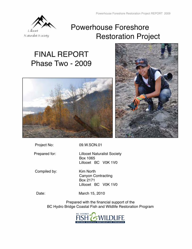
Powerhouse Foreshore Restoration Project FINAL REPORT Phase Two - 2009 Project No: 09.W.SON.01 Prepared for: Lillooet Naturalist Society Box 1065 Lillooet BC V0K 1V0 Compiled by: Kim North Canyon Contracting Box 2171 Lillooet BC V0K 1V0 Date: March 15, 2010 Prepared with the financial support of the BC Hydro Bridge Coastal Fish and Wildlife Restoration Program Powerhouse Foreshore Restoration Project REPORT 2009

Welcome message from author
This document is posted to help you gain knowledge. Please leave a comment to let me know what you think about it! Share it to your friends and learn new things together.
Transcript
Powerhouse Foreshore Restoration Project
FINAL REPORT Phase Two - 2009
� Project No:� � � 09.W.SON.01
� Prepared for:�� � Lillooet Naturalist Society� � � � � Box 1065� � � � � Lillooet BC V0K 1V0 � Compiled by: Kim North� � � � � Canyon Contracting� � � � � Box 2171� � � � � Lillooet BC V0K 1V0 � � � � � Date: March 15, 2010
Prepared with the financial support of theBC Hydro Bridge Coastal Fish and Wildlife Restoration Program
Powerhouse Foreshore Restoration Project REPORT 2009
Executive Summary
The Lillooet Naturalist Society has successfully implemented Phase Two of the Restoration Plan for the Powerhouse Foreshore Restoration site. The Society initiated a Feasibility Study in 2006, carried out research to develop a long-term restoration plan during 2007, and have now completed two years of on-the-ground work (2008 and 2009).
The aim of the restoration project is to create a more diverse and healthy habitat for wildlife, with a special focus on species-at-risk, at the confluence of the Seton and Fraser Rivers. Public education promoting the beauty of our area and the need for healthy wildlife habitat, leading to stewardship opportunities, are also important components of the Powerhouse Foreshore Restoration Project.
The Powerhouse Foreshore Restoration project will mitigate site damage caused by the construction and operations of the BC Hydro Seton Dam and Cayoosh Creek Canal complex.
The Lillooet Naturalist Society is working in close partnership with the Cayoose Creek St'at'imc. The Department of Fisheries and Oceans, Ministry of Environment, BC Nature, Rivershed Society of BC and the District of Lillooet are supporting the project by providing both expertise and in-kind support. The Lillooet Naturalist Society has also been successful in generating local community interest, in-kind support, volunteer hours and donations throughout this project.
The focus of 2009 Phase Two work was to build on the work carried out in 2008. Various roads within the site were decommissioned during 2008, redirecting traffic to one roadbed. During 2009 we continued deactivating old roadbeds on the upland bench above the Fraser River, complexing the site by mounding, placing coarse woody debris and standing snags. As during 2008, we have continued to remove invasive plant species and restock with native trees, shrubs, herbs and grasses that have been propagated in the nursery established for the restoration project. We have continued with ponderosa pine protection, flora and fauna studies and related monitoring. Extension activities have been explored with the community, including the idea of a nature centre and a wildlife corridor from the Fraser River to the Lower Seton Spawning Channels.
The restoration crew have held numerous public outreach activities including presentations, information booths, field walks, volunteer opportunities and the 4th Annual Salmon in the Canyon Festival. The restoration project has been featured in the Bridge River-Lillooet News, the Stʼatʼimc Runner and on Radio Lillooet broadcasts. As well we have been honoured by various organizations with requests for presentations on our project, and assistance in their own work.
The Lillooet Naturalist Society has developed a Restoration Plan for Phase Three (2010) based on the successes of the past two years.
The Lillooet Naturalist Society is eager for Spring 2010 to see the impact of the plantings on the site. This is a large project with some challenges. However, with community support, and the expertise of the Department of Fisheries and Oceans and the Ministry of Environment, and with guidance from a qualified restoration specialist, the Powerhouse site could provide enhanced habitat for wildlife, in particular species-at-risk with a focus on the Western Screech-owl and Racer. It will also provide a community “commons” for the citizens of Lillooet and surrounding areas, where education on the importance of healthy and diverse habitats will be showcased.
Powerhouse Foreshore Restoration Project REPORT 2009 � 2
Table of Contents
1. INTRODUCTION 1.1 Proponent Information� ........................................�05 � 1.2 Hydroelectric Impact ..........................................� 05� � � �
2. GOALS AND OBJECTIVES ......................................� 07
3. STUDY AREA � 3.1 Site Location ..........................................� 07 � 3.2 Site Map ................................................� 08 � 3.3 Biophysical Description .......................... � 09 � 3.4 Site Sketch .............................................. �10
4. � PARTNERSHIPS ...................................................... 11
5. � RESTORATION METHODS AND RESULTS ........... 13 � 5.1 � Road Designations ......................................... 18 �5.2� Soil Remediation ............................................. 29� 5.3 Site Complexing ............................................. 36 � 5.4� Ponderosa Pine Protection ............................. 42� 5.5� Weed Management ........................................ 43� 5.6� Propagation of Native Plant Species .............. 54� 5.7 �Native Plant Revegetation .............................. 64
6.� WILDLIFE STUDIES ................................................. 75 � 6.1 � Breeding Bird Survey ..................................... 78� 6.2 � Autumn Migration Monitoring ........................... 80� 6.3 � Western Screech-owl Survey .......................... 80 � 6.4 � Reptile Monitoring ........................................... 83� 6.5� Bat Survey ...................................................... 86� 6.6 � Other Wildlife Monitoring ................................ 93� 7.� RESTORATION MONITORING ................................. 97 6.1 Reference Ecosystem ........................................ 97 6.2 Photo Point Monitoring ....................................... 98
8. COMMUNITY OUTREACH ........................................ 106
9. DISCUSSION .............................................................. 113
10. RECOMMENDATIONS ............................................... 122 �
11. ACKNOWLEDGEMENTS �........................................... 124
12. REFERENCES ............................................................ 125 �
Powerhouse Foreshore Restoration Project REPORT 2009 � 3
MAPS1 Seton Project Facilities 05 2 Aerial Photographic Site Map �� � 083 Site Sketch� � � � � � 104 Ecosystem Polygons� � � � 145 Road and Beach Access Information� 15� � �6 2009 Machine Work Polygons � � 16�7 Restoration Work 2008 - 2009� � 178 Sites of Vehicle Access Reinforcement 24� � �9 Restoration Structural Features 2009 32� � �10 Exotic Species Distribution� � 47�11 Toadflax Distribution 2008-09� 48� �12 Field Bindweed Distribution 2009� 4913 Native Plant Plantings 2009� � 64�14 Seeded and Lichen Plots 2009� � � 6815 Western Screech-owl WHA� 77�16 Bird Monitoring Map 7917 Reptile Monitoring 2008-09 8418 Permanent Photo Points 9919 2010 Restoration Work Planned 123� � �
LIST OF TABLESTable 1 Restoration Polygons 2009� � � 31Table 2 Exotic Weed Species� � � � � 43Table 3 Summary of Weed Management Plan� � 44Table 4 Results of Survey of New Weeds� � � 45Table 5 Native Plant Species Propagation Methods� 60Table 6 Information on Seeded Plots�� � � 69Table 7 Wildlife Recommendations 2007� � � 75� � � �Table 8 Western Screech-owl May Survey Results�� 80Table 10 Reptile Monitoring Information� � � 85Table 11 Wildlife Observations by Crew� � � 94Table 12 2010 Restoration Summary�� � 122
� � � � � � � �LIST OF FIGURESFigures 1 to 162 Pictures showing restoration progress�
APPENDIXI Breeding Bird & Autumn Migration Monitoring ReportII Financial SummaryIII Performance Measures IV Confirmation of BCRP recognitionV Letters of Support� � � � �
Powerhouse Foreshore Restoration Project REPORT 2009 � 4
1. INTRODUCTION
1.1� Proponent Information
The Lillooet Naturalist Society (Society # S-44937)) is a non-profit organization, which has been active since 2001.
The goals of the Society are to:⇒ promote the enjoyment and understanding of nature⇒ to encourage the establishment of protected natural areas⇒ defend the integrity of existing sanctuaries ⇒ engage in the funding and research needed for protecting the integrity of natural ecosystems;
and ⇒ to encourage and engage in the protection and restoration of threatened and endangered
species with special attention to the preservation of essential habitats.
The Societyʼs commitment to this project will assist us in meeting all five goals that we have set. This project was chosen as a showcase community project which would generate an interest in restoration and foster a greater appreciation of the river and its foreshore ecosystems.
1.2� Hydroelectric Impact
In the late 1950ʼs the Seton watershed was subject to major alterations from hydroelectric development. The Powerhouse Project relates directly to the historical loss of habitat due to construction of the BC Hydro Cayoosh Canal mega-project. This project was in service in 1956.
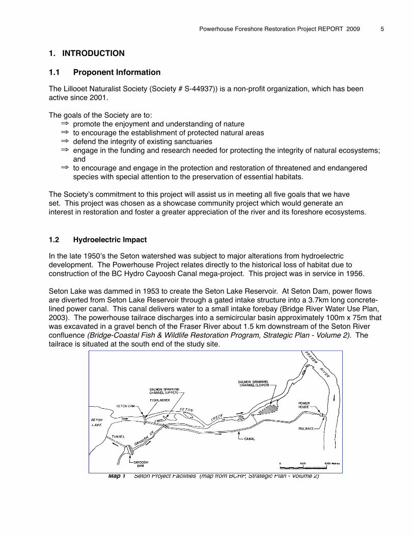
Seton Lake was dammed in 1953 to create the Seton Lake Reservoir. At Seton Dam, power flows are diverted from Seton Lake Reservoir through a gated intake structure into a 3.7km long concrete-lined power canal. This canal delivers water to a small intake forebay (Bridge River Water Use Plan, 2003). The powerhouse tailrace discharges into a semicircular basin approximately 100m x 75m that was excavated in a gravel bench of the Fraser River about 1.5 km downstream of the Seton River confluence (Bridge-Coastal Fish & Wildlife Restoration Program, Strategic Plan - Volume 2). The tailrace is situated at the south end of the study site.
�
Map 1 Seton Project Facilities (map from BCRP, Strategic Plan - Volume 2)
Powerhouse Foreshore Restoration Project REPORT 2009 � 5
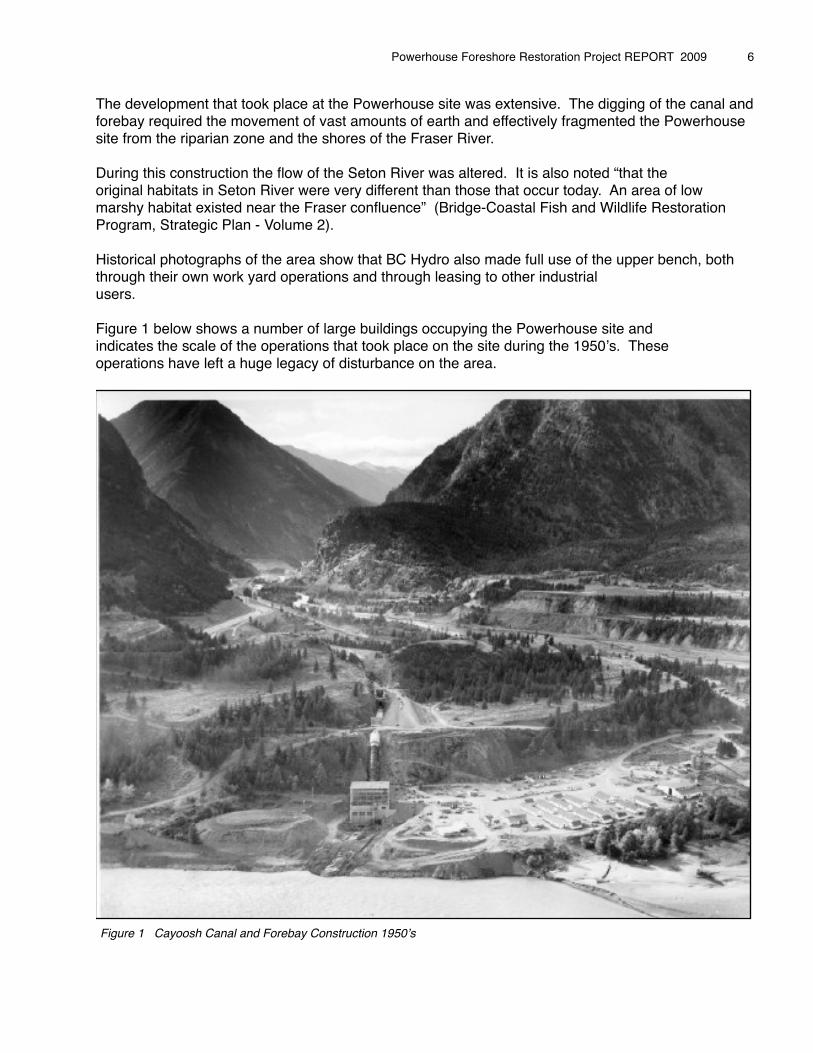
The development that took place at the Powerhouse site was extensive. The digging of the canal and forebay required the movement of vast amounts of earth and effectively fragmented the Powerhouse site from the riparian zone and the shores of the Fraser River.
During this construction the flow of the Seton River was altered. It is also noted “that theoriginal habitats in Seton River were very different than those that occur today. An area of low marshy habitat existed near the Fraser confluence” (Bridge-Coastal Fish and Wildlife Restoration Program, Strategic Plan - Volume 2). �Historical photographs of the area show that BC Hydro also made full use of the upper bench, both through their own work yard operations and through leasing to other industrial users.
Figure 1 below shows a number of large buildings occupying the Powerhouse site and indicates the scale of the operations that took place on the site during the 1950ʼs. These operations have left a huge legacy of disturbance on the area.
Figure 1 Cayoosh Canal and Forebay Construction 1950ʼs
Powerhouse Foreshore Restoration Project REPORT 2009 � 6
2. GOALS AND OBJECTIVIES
The Powerhouse Foreshore Restoration Feasibility Study of 2006 and the continuing research undertaken during 2007, looked at how the Society could address and develop a plan to mitigate the footprint impacts on wildlife habitat at the work yard site, within the surrounding riparian zone and along the shores of the Fraser River. During 2008 and 2009 we carried out the first two phases of that plan.
The Goals of this restoration project are to:⇒ create a more diverse and healthy habitat for wildlife; and ⇒ provide an educational resource for the community of Lillooet with a focus on stewardship.
The Objectives during Phase Two (2009) were to:⇒ involve partners and work with an Advisory Committee who provide direction and support;⇒ continue deactivation of all roads within the site, with a focus on two large portions of the
upper bench;⇒ remove invasive plant species in selected areas;⇒ protect the existing ponderosa pine stand;⇒ propagate native plant species from local stock;⇒ replant with native plant species in selected areas;⇒ carry out wildlife studies and continue monitoring protocols;⇒ provide educational and volunteer stewardship opportunities; ⇒ research extension activities: nature centre and Seton River wildlife corridor; and ⇒ monitor progress.
We believe the Society has met the goals and objectives set out in Application 09.W.SON.01.
3. STUDY AREA
3.1 Site Location
The Seton River basin is located in the rainshadow of the southern coastal mountains about 200 km northeast of Vancouver, and drains into the Fraser River at Lillooet (Bridge-Coastal Fish & Wildlife Restoration Program, Strategic Plan – Volume 2).
The study area is located within the traditional territories of the Stʼatʼimc and within the District of Lillooet boundaries. The site is also within the Cascades Forest District. The Powerhouse site lies along the west bank of the Fraser River, 240 kms northeast of Vancouver.
The study area boundaries run along the foreshore of the Fraser River, from the mouth of Seton River to the Cayoosh Canal Outlet. It is here that the Seton basin and Fraser River valleys meet. The site is bordered by Powerhouse Road to the west and Cayoose Creek Reserve Lands to the north. Map 2 provides an aerial photograph map of the site. The project site is currently zoned ʻIndustrialʼ and ʻUnsurveyed Crown Landʼ. Designation of a Wildlife Habitat Area for the Western Screech-owl has now been approved within the riparian zone.
Powerhouse Foreshore Restoration Project REPORT 2009 � 7
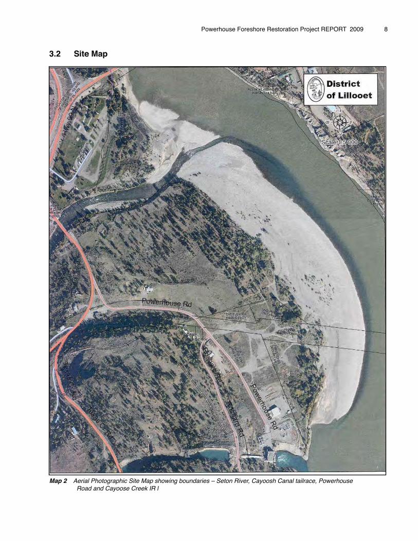
3.2� Site Map
Map 2 Aerial Photographic Site Map showing boundaries – Seton River, Cayoosh Canal tailrace, Powerhouse Road and Cayoose Creek IR l
Powerhouse Foreshore Restoration Project REPORT 2009 � 8
3.3� Biophysical Description
The site (50.67393oN, 121.92429oW) ranges in altitude from 190m to 205m above sea level. “The town of Lillooet falls into the Ponderosa Pine (PP) biogeoclimatic zone (Meidinger and Pojar 1991). The PP zone occurs in the dry valley bottoms along major river valleys of the southern interior and is the driest forested zone in British Columbia with very hot summers and annual rainfall between 280-500mm. The Lillooet area falls into the Ponderosa Pine very dry hot sub zone (PPxh) of the biogeoclimatic zone classification. Many micro climates exist in the area due to the localized weather patterns dictated by the converging mountains and valleys at this location” (Preliminary Restoration Study of the Powerhouse Site, Odin Scholz, 2006).
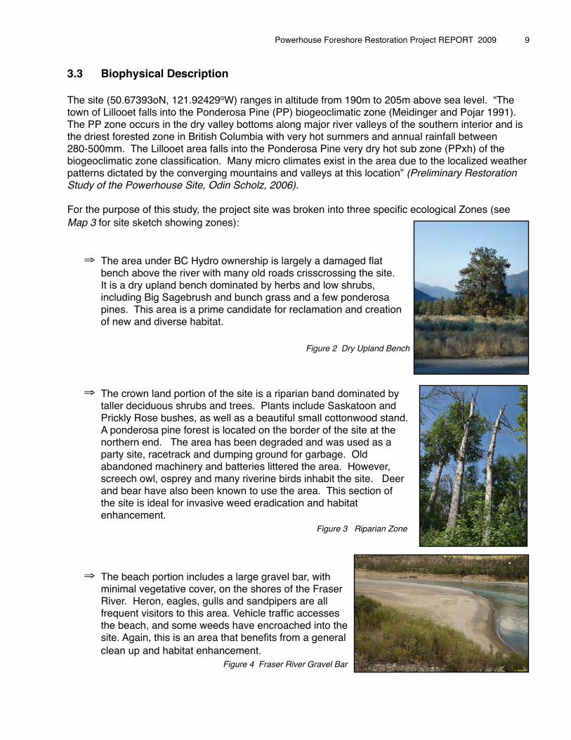
For the purpose of this study, the project site was broken into three specific ecological Zones (see Map 3 for site sketch showing zones):
⇒ The area under BC Hydro ownership is largely a damaged flat � bench above the river with many old roads crisscrossing the site. � It is a dry upland bench dominated by herbs and low shrubs, � including Big Sagebrush and bunch grass and a few ponderosa � pines. This area is a prime candidate for reclamation and creation � of new and diverse habitat. � � � � � � � Figure 2 Dry Upland Bench
⇒ The crown land portion of the site is a riparian band dominated by � taller deciduous shrubs and trees. Plants include Saskatoon and � Prickly Rose bushes, as well as a beautiful small cottonwood stand. � A ponderosa pine forest is located on the border of the site at the � northern end. The area has been degraded and was used as a � party site, racetrack and dumping ground for garbage. Old � abandoned machinery and batteries littered the area. However, � screech owl, osprey and many riverine birds inhabit the site. Deer � and bear have also been known to use the area. This section of � the site is ideal for invasive weed eradication and habitat � enhancement. Figure 3 Riparian Zone
⇒ The beach portion includes a large gravel bar, with � minimal vegetative cover, on the shores of the Fraser � River. Heron, eagles, gulls and sandpipers are all � frequent visitors to this area. Vehicle traffic accesses � the beach, and some weeds have encroached into the � site. Again, this is an area that benefits from a general � clean up and habitat enhancement. Figure 4 Fraser River Gravel Bar
Powerhouse Foreshore Restoration Project REPORT 2009 � 9
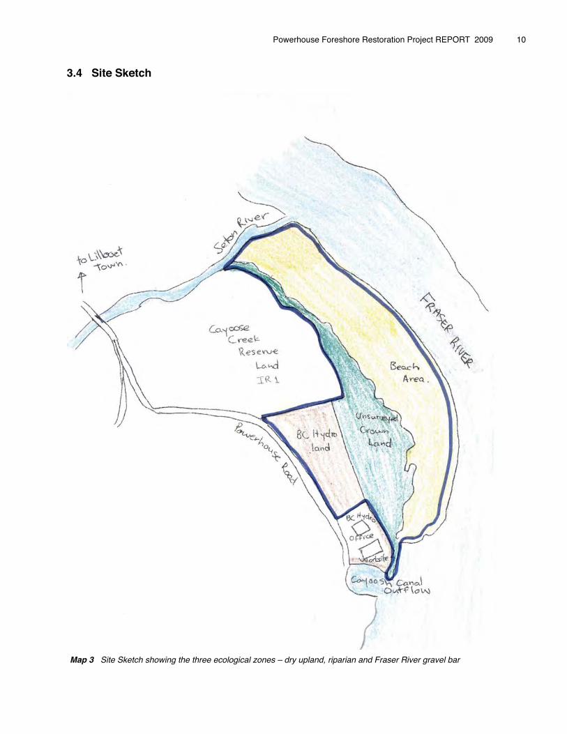
3.4 Site Sketch
Map 3 Site Sketch showing the three ecological zones – dry upland, riparian and Fraser River gravel bar
Powerhouse Foreshore Restoration Project REPORT 2009 � 10

4. PARTNERSHIPS
The Lillooet Naturalist Society felt it was very important to ensure we had the support of the Stʼatʼimc, the traditional owners of the land, and the local community as a whole. We worked hard to ensure this became a reality.
The Lillooet Naturalist Society and Cayoose Creek Stʼatʼimc have been working in partnership on this restoration project since 2006 when preliminary planning began. We have also involved all levels of government – First Nations, Federal, Provincial and Local.
A Restoration Advisory Committee was set up in early March 2008 to guide the restoration work and provide advice to the restoration crew. The Advisory Committee meets once a month during the restoration season to discuss progress at the site and provide direction for the coming month. The expertise provided by the Advisory Committee has been invaluable and assisted the restoration crew to implement groundwork. Members of the Advisory Committee during 2009:
⇒ Michelle Edwards, Councillor, Aboriginal Land Steward, Cayoose Creek Stʼatʼimc⇒ Wayne Redan, Councillor, Cayoose Creek Stʼatʼimc⇒ Charmaine John, Band Project Administrator, Cayoose Creek Stʼatʼimc⇒ Sean Bennett, MSc, RPBio, Senior Restoration Biologist, Fisheries and Oceans⇒ Francis Iredale, B.Sc.. BIT, Wildlife Biologist, Ministry of Environment⇒ Pat St. Dennis, Councillor, District of Lillooet⇒ Jeff OʼKelly, Secretary, Lillooet Naturalist Society⇒ Scott Bodaly, Director, Lillooet Naturalist Society⇒ Marg Lampman, Community representative⇒ Gillian Smith, BSc., Community representative
�The Lillooet Naturalist Society was also supported in this project by BC Nature, who assisted us in leveraging additional funds for summer students and provided assistance in bookkeeping, as well as promotion and volunteer labour. The Rivershed Society of BC also assisted by providing advice, encouragement and participation in events.
We have worked hard over the last three years to include the local community in this project and have been rewarded with donations and/or discounts from local businesses and organizations. Volunteers have also contributed over 896 hours of work to the project during 2009, including cleanup of the site, seed collection, salvage work, nursery work, trailer upkeep, and assisting at field walks and community events.
In addition to the funding secured from the BCRP, the Lillooet Naturalist Society and Cayoose Creek Stʼatʼimc were able to leverage funding from the following organizations:
⇒ District of Lillooet - mapping, use of equipment, outreach and event funding⇒ Service Canada – Summer student placement wages ⇒ Fraser Salmon and Watershed Program - outreach supplies and facilitator wages⇒ Public Conservation Assistance Fund – tools and outreach supplies⇒ TD Friends of the Environment - outreach supplies⇒ Local Fundraising efforts
Powerhouse Foreshore Restoration Project REPORT 2009 � 11
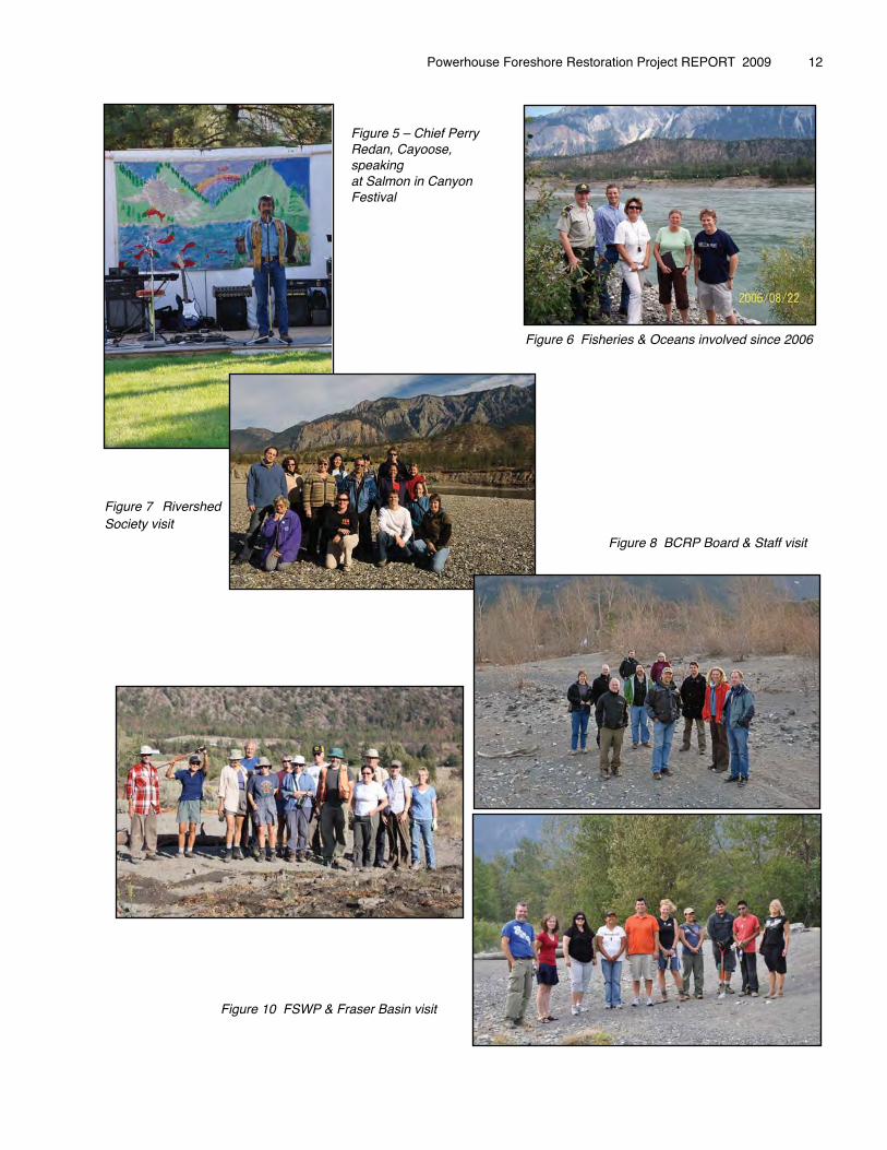
Figure 5 – Chief Perry Redan, Cayoose, speakingat Salmon in Canyon Festival
Figure 7 RivershedSociety visit � � � � � � � � � Figure 8 BCRP Board & Staff visit
Figure 9 BC Nature visit
Figure 10 FSWP & Fraser Basin visit
Powerhouse Foreshore Restoration Project REPORT 2009 � 12
Figure 6 Fisheries & Oceans involved since 2006
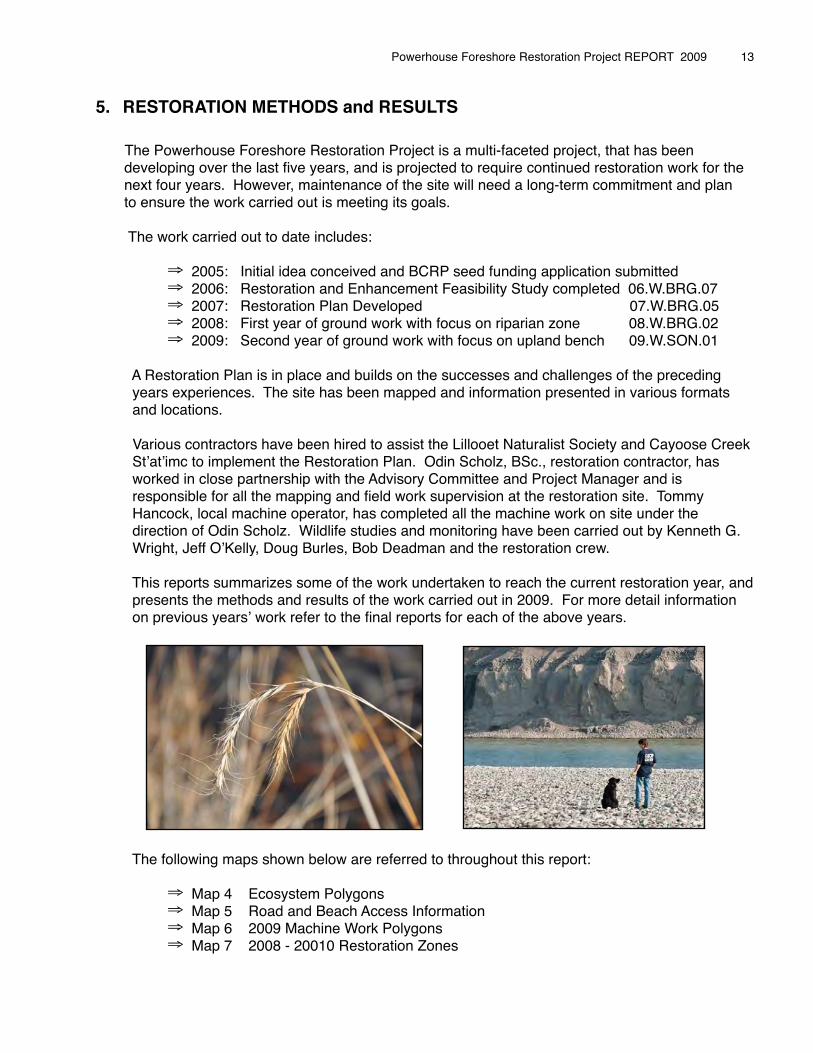
5. RESTORATION METHODS and RESULTS
The Powerhouse Foreshore Restoration Project is a multi-faceted project, that has been developing over the last five years, and is projected to require continued restoration work for the next four years. However, maintenance of the site will need a long-term commitment and plan to ensure the work carried out is meeting its goals.
The work carried out to date includes:�
⇒ 2005: Initial idea conceived and BCRP seed funding application submitted⇒ 2006: Restoration and Enhancement Feasibility Study completed 06.W.BRG.07⇒ 2007: Restoration Plan Developed 07.W.BRG.05⇒ 2008: First year of ground work with focus on riparian zone 08.W.BRG.02⇒ 2009: Second year of ground work with focus on upland bench 09.W.SON.01
A Restoration Plan is in place and builds on the successes and challenges of the preceding years experiences. The site has been mapped and information presented in various formats and locations.
Various contractors have been hired to assist the Lillooet Naturalist Society and Cayoose Creek Stʼatʼimc to implement the Restoration Plan. Odin Scholz, BSc., restoration contractor, has worked in close partnership with the Advisory Committee and Project Manager and is responsible for all the mapping and field work supervision at the restoration site. Tommy Hancock, local machine operator, has completed all the machine work on site under the direction of Odin Scholz. Wildlife studies and monitoring have been carried out by Kenneth G. Wright, Jeff OʼKelly, Doug Burles, Bob Deadman and the restoration crew.
This reports summarizes some of the work undertaken to reach the current restoration year, and presents the methods and results of the work carried out in 2009. For more detail information on previous yearsʼ work refer to the final reports for each of the above years.
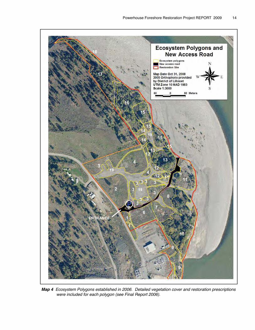
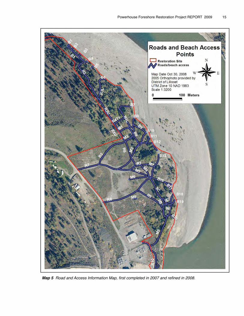
The following maps shown below are referred to throughout this report:
⇒ Map 4 Ecosystem Polygons⇒ Map 5 Road and Beach Access Information⇒ Map 6 2009 Machine Work Polygons⇒ Map 7 2008 - 20010 Restoration Zones
Powerhouse Foreshore Restoration Project REPORT 2009 � 13
Powerhouse Foreshore Restoration Project REPORT 2009 � 14
Map 4 Ecosystem Polygons established in 2006. Detailed vegetation cover and restoration prescriptions were included for each polygon (see Final Report 2006).
Powerhouse Foreshore Restoration Project REPORT 2009 � 15
Map 5 Road and Access Information Map, first completed in 2007 and refined in 2008.
Powerhouse Foreshore Restoration Project REPORT 2009 � 16
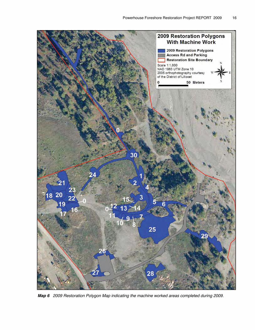
Map 6 2009 Restoration Polygon Map indicating the machine worked areas completed during 2009.
Powerhouse Foreshore Restoration Project REPORT 2009 � 17
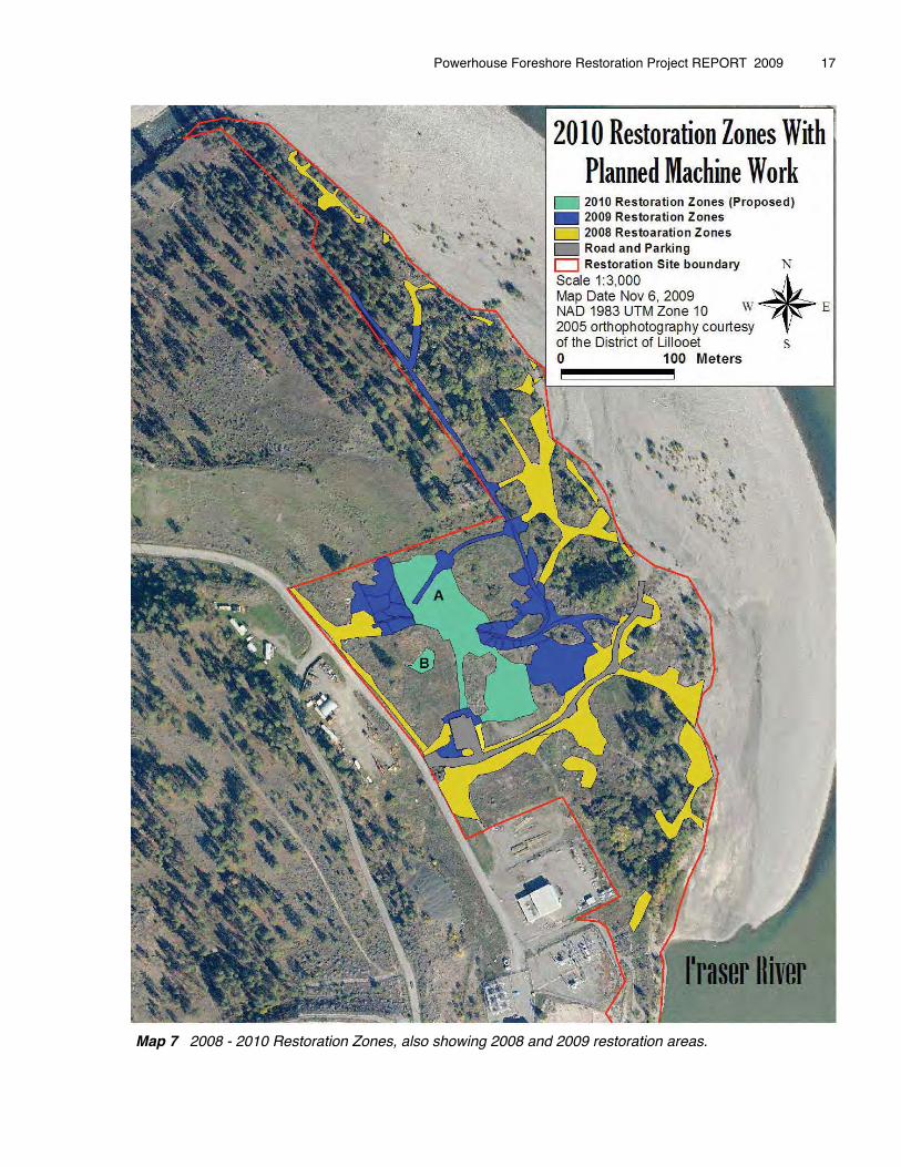
Map 7 2008 - 2010 Restoration Zones, also showing 2008 and 2009 restoration areas.
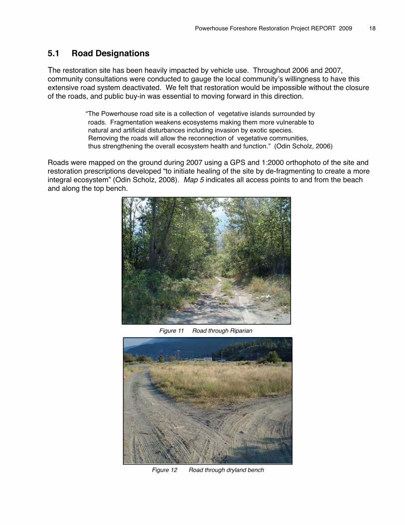
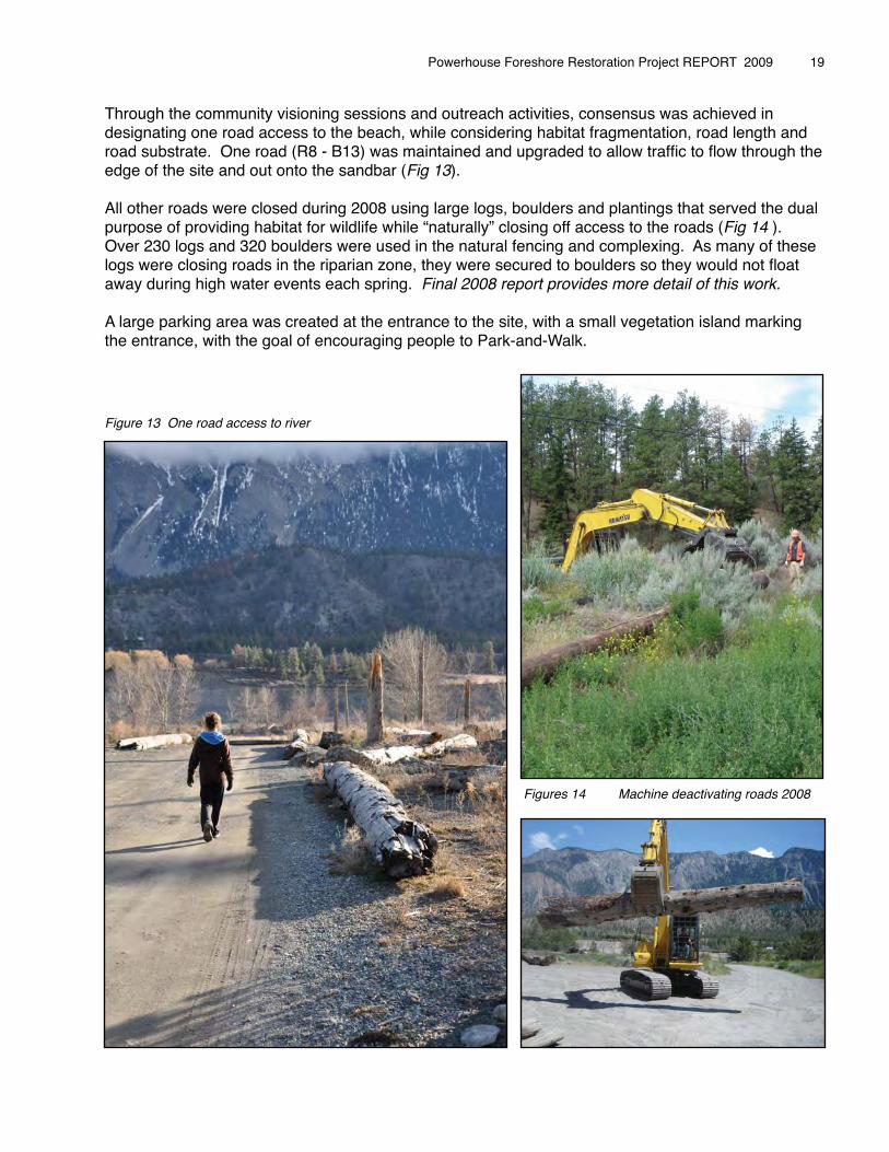
5.1� Road Designations
The restoration site has been heavily impacted by vehicle use. Throughout 2006 and 2007, community consultations were conducted to gauge the local communityʼs willingness to have this extensive road system deactivated. We felt that restoration would be impossible without the closure of the roads, and public buy-in was essential to moving forward in this direction.
� “The Powerhouse road site is a collection of vegetative islands surrounded by � roads. Fragmentation weakens ecosystems making them more vulnerable to� natural and artificial disturbances including invasion by exotic species. Removing the roads will allow the reconnection of vegetative communities, thus strengthening the overall ecosystem health and function.” (Odin Scholz, 2006)
Roads were mapped on the ground during 2007 using a GPS and 1:2000 orthophoto of the site and restoration prescriptions developed “to initiate healing of the site by de-fragmenting to create a more integral ecosystem” (Odin Scholz, 2008). Map 5 indicates all access points to and from the beach and along the top bench.
Powerhouse Foreshore Restoration Project REPORT 2009 � 18
Figure 11 Road through Riparian
Figure 12 Road through dryland bench
Through the community visioning sessions and outreach activities, consensus was achieved in designating one road access to the beach, while considering habitat fragmentation, road length and road substrate. One road (R8 - B13) was maintained and upgraded to allow traffic to flow through the edge of the site and out onto the sandbar (Fig 13).
All other roads were closed during 2008 using large logs, boulders and plantings that served the dual purpose of providing habitat for wildlife while “naturally” closing off access to the roads (Fig 14 ). Over 230 logs and 320 boulders were used in the natural fencing and complexing. As many of these logs were closing roads in the riparian zone, they were secured to boulders so they would not float away during high water events each spring. Final 2008 report provides more detail of this work.
A large parking area was created at the entrance to the site, with a small vegetation island marking the entrance, with the goal of encouraging people to Park-and-Walk.
Figure 13 One road access to river
Powerhouse Foreshore Restoration Project REPORT 2009 � 19
Figures 14 Machine deactivating roads 2008
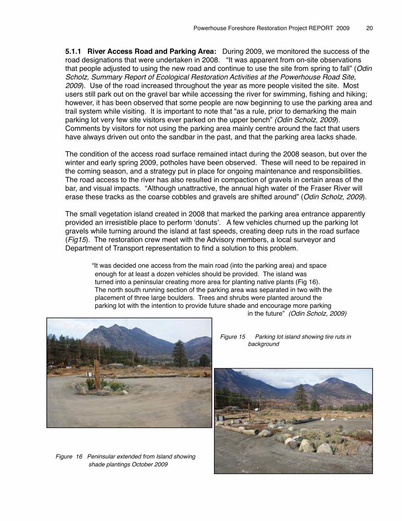
5.1.1 River Access Road and Parking Area: During 2009, we monitored the success of the road designations that were undertaken in 2008. “It was apparent from on-site observations that people adjusted to using the new road and continue to use the site from spring to fall” (Odin Scholz, Summary Report of Ecological Restoration Activities at the Powerhouse Road Site, 2009). Use of the road increased throughout the year as more people visited the site. Most users still park out on the gravel bar while accessing the river for swimming, fishing and hiking; however, it has been observed that some people are now beginning to use the parking area and trail system while visiting. It is important to note that “as a rule, prior to demarking the main parking lot very few site visitors ever parked on the upper bench” (Odin Scholz, 2009). Comments by visitors for not using the parking area mainly centre around the fact that users have always driven out onto the sandbar in the past, and that the parking area lacks shade.
The condition of the access road surface remained intact during the 2008 season, but over the winter and early spring 2009, potholes have been observed. These will need to be repaired in the coming season, and a strategy put in place for ongoing maintenance and responsibilities. The road access to the river has also resulted in compaction of gravels in certain areas of the bar, and visual impacts. “Although unattractive, the annual high water of the Fraser River will erase these tracks as the coarse cobbles and gravels are shifted around” (Odin Scholz, 2009).
The small vegetation island created in 2008 that marked the parking area entrance apparently provided an irresistible place to perform ʻdonutsʼ. A few vehicles churned up the parking lot gravels while turning around the island at fast speeds, creating deep ruts in the road surface (Fig15). The restoration crew meet with the Advisory members, a local surveyor and Department of Transport representation to find a solution to this problem.
� “It was decided one access from the main road (into the parking area) and space � enough for at least a dozen vehicles should be provided. The island was � turned into a peninsular creating more area for planting native plants (Fig 16). � The north south running section of the parking area was separated in two with the � placement of three large boulders. Trees and shrubs were planted around the � parking lot with the intention to provide future shade and encourage more parking
� in the future” (Odin Scholz, 2009)
Figure 15 Parking lot island showing tire ruts in background
Figure 16 Peninsular extended from Island showing shade plantings October 2009
Powerhouse Foreshore Restoration Project REPORT 2009 � 20
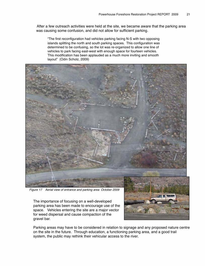
After a few outreach activities were held at the site, we became aware that the parking area � was causing some confusion, and did not allow for sufficient parking.
� � “The first reconfiguration had vehicles parking facing N-S with two opposing � � islands splitting the north and south parking spaces. This configuration was � � determined to be confusing, so the lot was re-organized to allow one line of � � vehicles to park facing east-west with enough space for fourteen vehicles. � � This modification has been applauded as a much more inviting and smooth � � layout” (Odin Scholz, 2009)
Figure 17 Aerial view of entrance and parking area October 2009
The importance of focusing on a well-developed parking area has been made to encourage use of the space. Vehicles entering the site are a major vector for weed dispersal and cause compaction of the gravel bar.
Parking areas may have to be considered in relation to signage and any proposed nature centre on the site in the future. Through education, a functioning parking area, and a good trail system, the public may rethink their vehicular access to the river.
Powerhouse Foreshore Restoration Project REPORT 2009 � 21
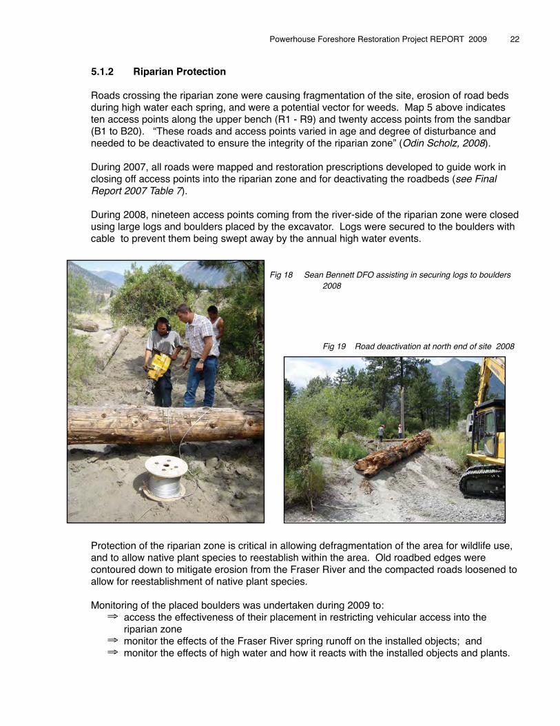
5.1.2 Riparian Protection
Roads crossing the riparian zone were causing fragmentation of the site, erosion of road beds during high water each spring, and were a potential vector for weeds. Map 5 above indicates ten access points along the upper bench (R1 - R9) and twenty access points from the sandbar (B1 to B20). “These roads and access points varied in age and degree of disturbance and needed to be deactivated to ensure the integrity of the riparian zone” (Odin Scholz, 2008).
During 2007, all roads were mapped and restoration prescriptions developed to guide work in closing off access points into the riparian zone and for deactivating the roadbeds (see Final Report 2007 Table 7).
During 2008, nineteen access points coming from the river-side of the riparian zone were closed using large logs and boulders placed by the excavator. Logs were secured to the boulders with cable to prevent them being swept away by the annual high water events.
� � � � � � Fig 18 Sean Bennett DFO assisting in securing logs to boulders 2008
Fig 19 Road deactivation at north end of site 2008
Protection of the riparian zone is critical in allowing defragmentation of the area for wildlife use, and to allow native plant species to reestablish within the area. Old roadbed edges were contoured down to mitigate erosion from the Fraser River and the compacted roads loosened to allow for reestablishment of native plant species.
Monitoring of the placed boulders was undertaken during 2009 to:⇒ access the effectiveness of their placement in restricting vehicular access into the
riparian zone⇒ monitor the effects of the Fraser River spring runoff on the installed objects; and⇒ monitor the effects of high water and how it reacts with the installed objects and plants.
Powerhouse Foreshore Restoration Project REPORT 2009 � 22
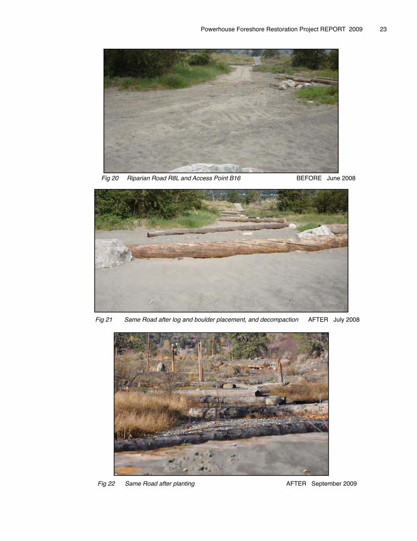
Fig 20 Riparian Road R8L and Access Point B16 BEFORE June 2008
Fig 21 Same Road after log and boulder placement, and decompaction AFTER July 2008
Powerhouse Foreshore Restoration Project REPORT 2009 � 23
Fig 22 Same Road after planting AFTER September 2009
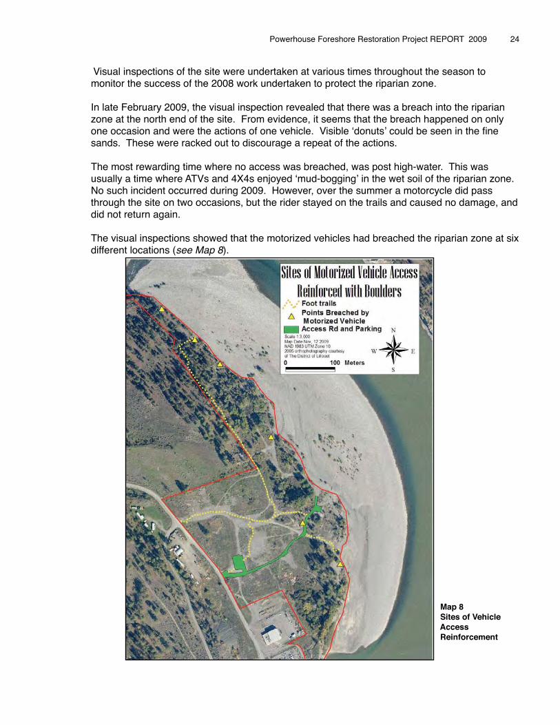
Visual inspections of the site were undertaken at various times throughout the season to monitor the success of the 2008 work undertaken to protect the riparian zone.
In late February 2009, the visual inspection revealed that there was a breach into the riparian zone at the north end of the site. From evidence, it seems that the breach happened on only one occasion and were the actions of one vehicle. Visible ʻdonutsʼ could be seen in the fine sands. These were racked out to discourage a repeat of the actions.
The most rewarding time where no access was breached, was post high-water. This was usually a time where ATVs and 4X4s enjoyed ʻmud-boggingʼ in the wet soil of the riparian zone. No such incident occurred during 2009. However, over the summer a motorcycle did pass through the site on two occasions, but the rider stayed on the trails and caused no damage, and did not return again.
The visual inspections showed that the motorized vehicles had breached the riparian zone at six different locations (see Map 8).
� � � � � � � � � � � Map 8� � � � � � � � � � � Sites of Vehicle � � � � � � � � � � � Access � � � � � � � � � � � Reinforcement
Powerhouse Foreshore Restoration Project REPORT 2009 � 24
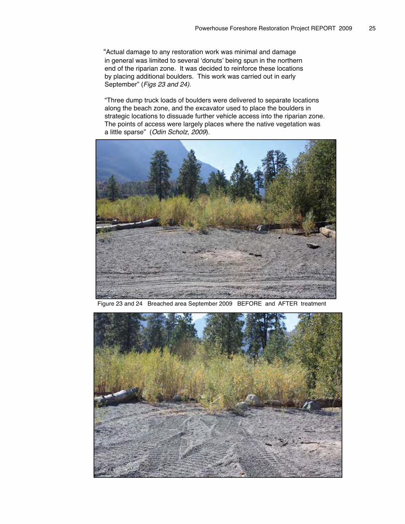
� � “Actual damage to any restoration work was minimal and damage � � in general was limited to several ʻdonutsʼ being spun in the northern � � end of the riparian zone. It was decided to reinforce these locations � � by placing additional boulders. This work was carried out in early � � September” (Figs 23 and 24). � � � � “Three dump truck loads of boulders were delivered to separate locations � � along the beach zone, and the excavator used to place the boulders in � � strategic locations to dissuade further vehicle access into the riparian zone. � � The points of access were largely places where the native vegetation was � � a little sparse” (Odin Scholz, 2009).
�
� � Figure 23 and 24 Breached area September 2009 BEFORE and AFTER treatment
Powerhouse Foreshore Restoration Project REPORT 2009 � 25
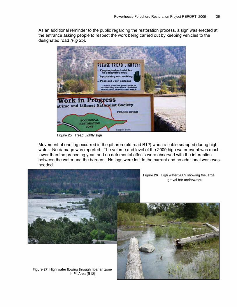
As an additional reminder to the public regarding the restoration process, a sign was erected at the entrance asking people to respect the work being carried out by keeping vehicles to the designated road (Fig 25).
Figure 25 Tread Lightly sign
Movement of one log occurred in the pit area (old road B12) when a cable snapped during high water. No damage was reported. The volume and level of the 2009 high water event was much lower than the preceding year, and no detrimental effects were observed with the interaction between the water and the barriers. No logs were lost to the current and no additional work was needed.� � � � � � � �
� � � � � � � � Figure 26 High water 2009 showing the large � � � � � � � � � � gravel bar underwater.
Figure 27 High water flowing through riparian zone � � � in Pit Area (B12)
Powerhouse Foreshore Restoration Project REPORT 2009 � 26
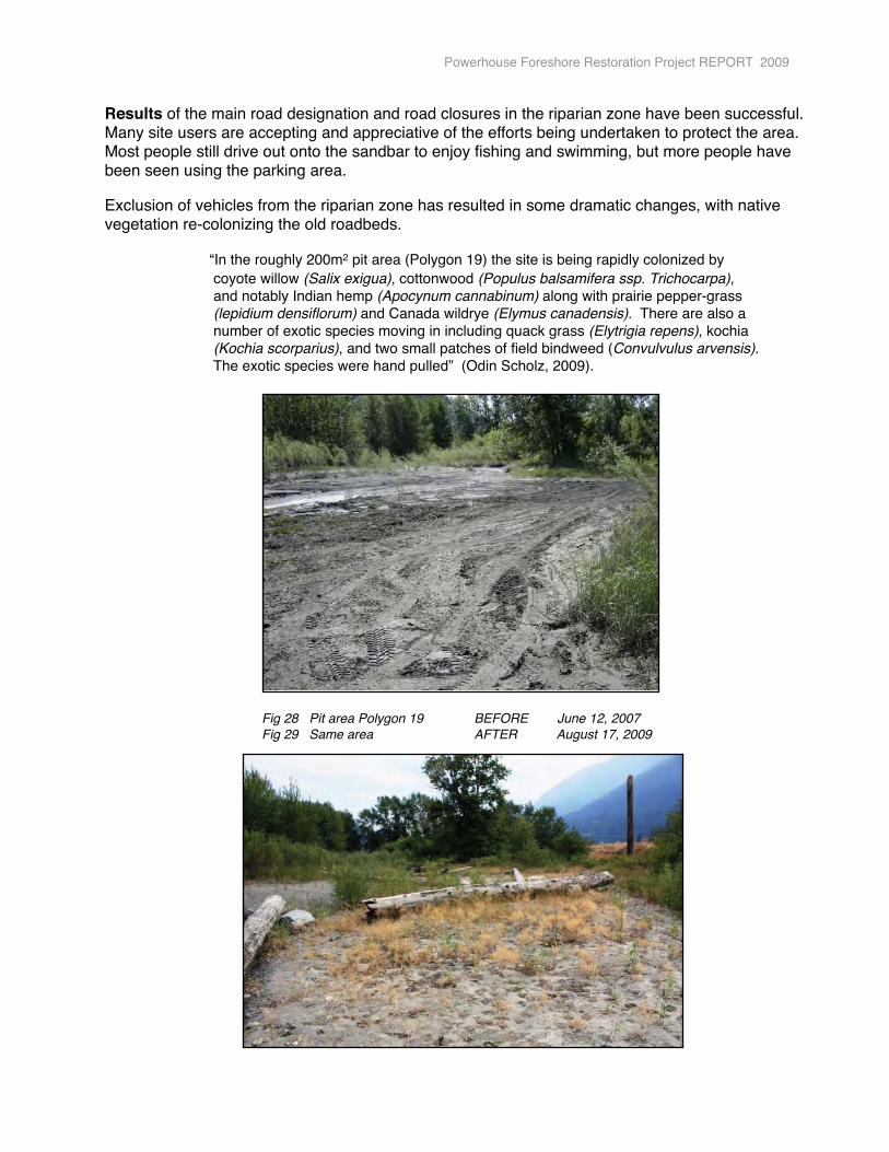
Results of the main road designation and road closures in the riparian zone have been successful. Many site users are accepting and appreciative of the efforts being undertaken to protect the area. Most people still drive out onto the sandbar to enjoy fishing and swimming, but more people have been seen using the parking area.
Exclusion of vehicles from the riparian zone has resulted in some dramatic changes, with native vegetation re-colonizing the old roadbeds.
� � “In the roughly 200m2 pit area (Polygon 19) the site is being rapidly colonized by � � coyote willow (Salix exigua), cottonwood (Populus balsamifera ssp. Trichocarpa), � � and notably Indian hemp (Apocynum cannabinum) along with prairie pepper-grass � � (lepidium densiflorum) and Canada wildrye (Elymus canadensis). There are also a � � number of exotic species moving in including quack grass (Elytrigia repens), kochia � � (Kochia scorparius), and two small patches of field bindweed (Convulvulus arvensis). � � The exotic species were hand pulled” (Odin Scholz, 2009).
� �
Powerhouse Foreshore Restoration Project REPORT 2009
Fig 28 Pit area Polygon 19 BEFORE June 12, 2007Fig 29 Same area AFTER August 17, 2009
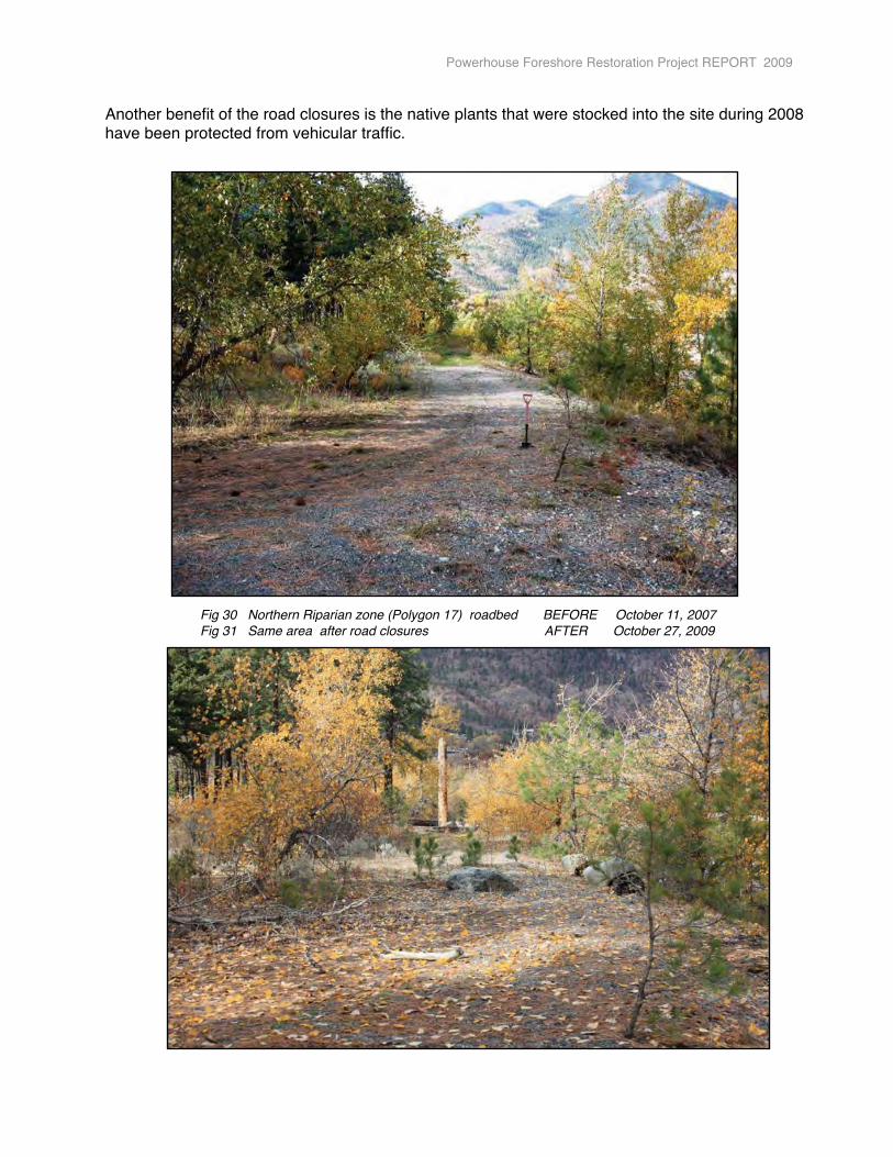
Another benefit of the road closures is the native plants that were stocked into the site during 2008 have been protected from vehicular traffic.
Powerhouse Foreshore Restoration Project REPORT 2009
Fig 30 Northern Riparian zone (Polygon 17) roadbed BEFORE October 11, 2007Fig 31 Same area after road closures AFTER October 27, 2009
5.2 Soil Remediation
Highly disturbed soils are widespread throughout the Powerhouse site, especially on the upland bench. Through years of disturbance much of the topsoil on the various roads that fragment the site were � � � “either removed or buried under a six inch to two � � � foot deep layer of coarse fill ..... Below the fill lies � � � a layer of finer sandy soil, and original soil horizon” � � � (Odin Scholz, 2008).
While machine work to designate site boundaries and close off road access into the riparian zone during 2008 was undertaken, site complexing was also taking place with a focus on the riparian zone and the edges of the access road (see 2008 Final Report).
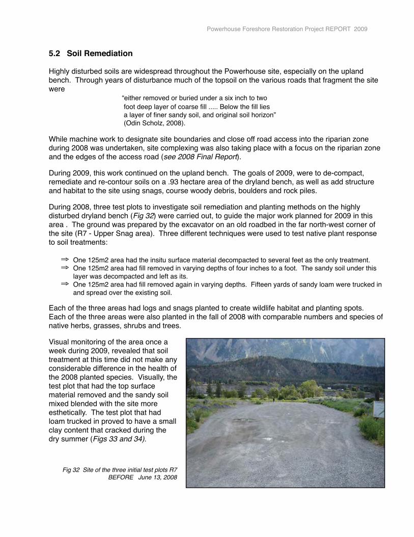
During 2009, this work continued on the upland bench. The goals of 2009, were to de-compact, remediate and re-contour soils on a .93 hectare area of the dryland bench, as well as add structure and habitat to the site using snags, course woody debris, boulders and rock piles.
During 2008, three test plots to investigate soil remediation and planting methods on the highly disturbed dryland bench (Fig 32) were carried out, to guide the major work planned for 2009 in this area . The ground was prepared by the excavator on an old roadbed in the far north-west corner of the site (R7 - Upper Snag area). Three different techniques were used to test native plant response to soil treatments:
⇒ One 125m2 area had the insitu surface material decompacted to several feet as the only treatment.⇒ One 125m2 area had fill removed in varying depths of four inches to a foot. The sandy soil under this
layer was decompacted and left as its.⇒ One 125m2 area had fill removed again in varying depths. Fifteen yards of sandy loam were trucked in
and spread over the existing soil.
Each of the three areas had logs and snags planted to create wildlife habitat and planting spots. Each of the three areas were also planted in the fall of 2008 with comparable numbers and species of native herbs, grasses, shrubs and trees.
Visual monitoring of the area once a week during 2009, revealed that soil treatment at this time did not make any considerable difference in the health of the 2008 planted species. Visually, the test plot that had the top surface material removed and the sandy soil mixed blended with the site more esthetically. The test plot that had loam trucked in proved to have a small clay content that cracked during the dry summer (Figs 33 and 34).
Fig 32 Site of the three initial test plots R7 BEFORE June 13, 2008
Powerhouse Foreshore Restoration Project REPORT 2009
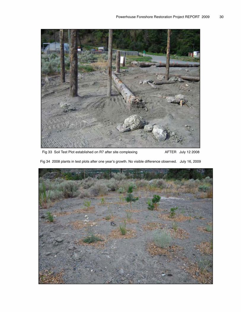
Fig 33 Soil Test Plot established on R7 after site complexing AFTER July 12 2008
Fig 34 2008 plants in test plots after one yearʼs growth. No visible difference observed. July 16, 2009
Powerhouse Foreshore Restoration Project REPORT 2009 � 30
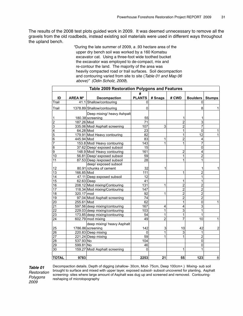
The results of the 2008 test plots guided work in 2009. It was deemed unnecessary to remove all the gravels from the old roadbeds, instead existing soil materials were used in different ways throughout the upland bench.� � � “During the late summer of 2009, a .93 hectare area of the� � � upper dry bench soil was worked by a 160 Komatsu � � � excavator cat. Using a three-foot wide toothed bucket� � � the excavator was employed to de-compact, mix and� � � re-contour the land. The majority of the area was� � � heavily compacted road or trail surfaces. Soil decompaction� � � and contouring varied from site to site (Table 01 and Map 06 � � � above)” (Odin Scholz, 2009).
Table 01RestorationPolygons2009
Powerhouse Foreshore Restoration Project REPORT 2009 � 31
ID AREA M� Decompaction
#
PLANTS # Snags # CWD Boulders Stumps
Trail 41.1 Shallow/contouring 0 0
Trail 1378.89 Shallow/contouring 0 8 1
1 180.38
Deep mixing/ heavy Ashpalt
screening 55 1 1
2 187.26 Mod 71 2 3
3 335.06 Mod/ Asphalt screening 107 3 2 7
4 64.28 Mod 23 1 0 1
5 179.91 Mod Heavy contouring 82 1 12 1
6 445.94 Mod 83 1 2 4
7 153.8 Mod/ Heavy contouring 143 1 1 7
8 37.62 Deep/ exposed subsoil 15 0
9 148.9 Mod/ Heavy contouring 161 2 4
10 56.81 Deep/ exposed subsoil 59 1 2
11 87.53 Deep /exposed subsoil 28 1 1
12 80.91
deep/ exposed subsoil
/chunks of cement 32 1 1 1
13 166.85 Mod 111 1 2
14 47.11 Deep exposed subsoil 12 1
15 62.63 Deep 41 1 1
16 208.12 Mod mixing/Contouring 131 1 2 2
17 118.34 Mod mixing/Contouring 147 2 2
18 320.17 mod 92 1 2 2
19 97.04 Mod/ Asphalt screening 74 2 2
20 255.61 Mod 62 1 0 1
21 597.56 deep mixing/contouring 167 4 4 3
22 229.03 deep mixing/contouring 103 1 3 1
23 173.85 deep mixing/contouring 54 1 1 1
24 602.79 mod mixing 49 2 7 10 1
25 1786.86
deep mixing/ heavy Asphalt
screening 142 3 10 42 2
26 220.83 Deep mixing 0 1 3 1
27 221.24 Deep mixing 59 1 1 2
28 537.93 No 104 0
29 599.81 No 46 0
30 159.27 Mod/ Asphalt screening 0 1 1
TOTAL 9783 2253 21 55 123 8
Table 2009 Restoration Polygons and Features
Decompaction details. Depth of digging (shallow- 30cm, Mod- 75cm, Deep 100cm+.) Mixing- sub soil
brought to surface and mixed with upper layer, exposed subsoil- subsoil uncovered for planting, Asphalt
screening- sites where large amount of Asphalt was dug up and screened and removed. Contouring-
reshaping of microtopography
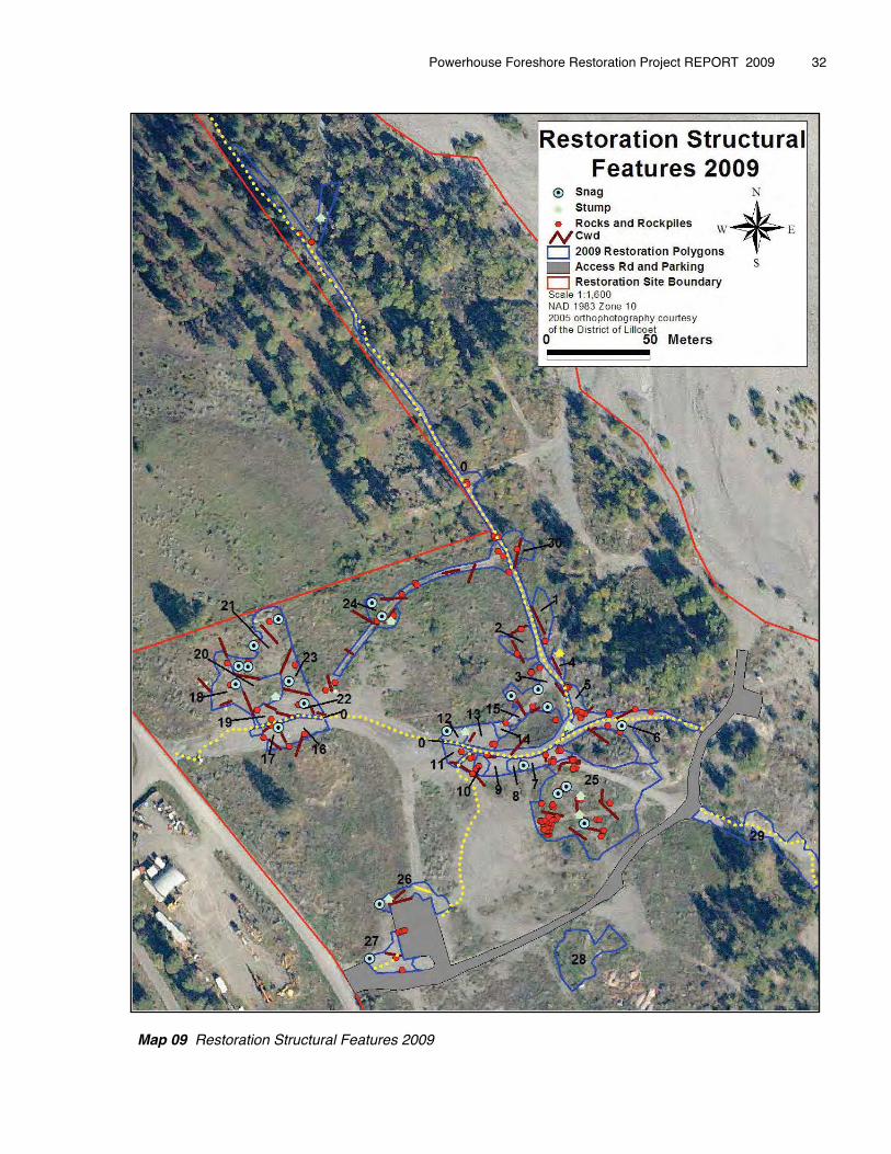
Map 09 Restoration Structural Features 2009
Powerhouse Foreshore Restoration Project REPORT 2009 � 32
As indicated on Map 06 above, the areas to be worked were mapped into polygons. Work carried out in each polygon differed depending on the condition of the soil and site impacts (see Table 01).
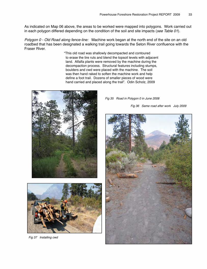
Polygon 0 - Old Road along fence-line: Machine work began at the north end of the site on an old roadbed that has been designated a walking trail going towards the Seton River confluence with the Fraser River. � � � “This old road was shallowly decompacted and contoured � � � to erase the tire ruts and blend the topsoil levels with adjacent � � � land. Alfalfa plants were removed by the machine during the � � � decompaction process. Structural features including stumps,� � � boulders and cwd were placed with the machine. The soil� � � was then hand raked to soften the machine work and help� � � define a foot trail. Dozens of smaller pieces of wood were� � � hand carried and placed along the trail”. Odin Scholz, 2009
� � � � � � Fig 35 Road in Polygon 0 in June 2008
� � � � � � Fig 36 Same road after work July 2009
Fig 37 Installing cwd
Powerhouse Foreshore Restoration Project REPORT 2009 � 33
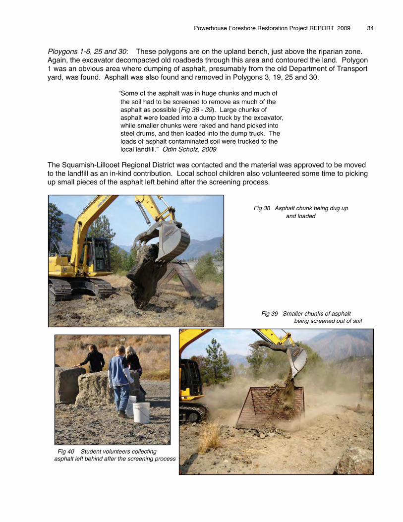
Ploygons 1-6, 25 and 30: These polygons are on the upland bench, just above the riparian zone. Again, the excavator decompacted old roadbeds through this area and contoured the land. Polygon 1 was an obvious area where dumping of asphalt, presumably from the old Department of Transport yard, was found. Asphalt was also found and removed in Polygons 3, 19, 25 and 30.
� � � “Some of the asphalt was in huge chunks and much of � � � the soil had to be screened to remove as much of the� � � asphalt as possible (Fig 38 - 39). Large chunks of � � � asphalt were loaded into a dump truck by the excavator, � � � while smaller chunks were raked and hand picked into � � � steel drums, and then loaded into the dump truck. The � � � loads of asphalt contaminated soil were trucked to the � � � local landfill.” Odin Scholz, 2009
The Squamish-Lillooet Regional District was contacted and the material was approved to be moved to the landfill as an in-kind contribution. Local school children also volunteered some time to picking up small pieces of the asphalt left behind after the screening process.
� � � � � � � � Fig 38 Asphalt chunk being dug up� � � � � � � � � and loaded
� � � � � � � � �� � � � � � � � � Fig 39 Smaller chunks of asphalt � � � � � � � � � being screened out of soil
Fig 40 Student volunteers collecting asphalt left behind after the screening process
Powerhouse Foreshore Restoration Project REPORT 2009 � 34
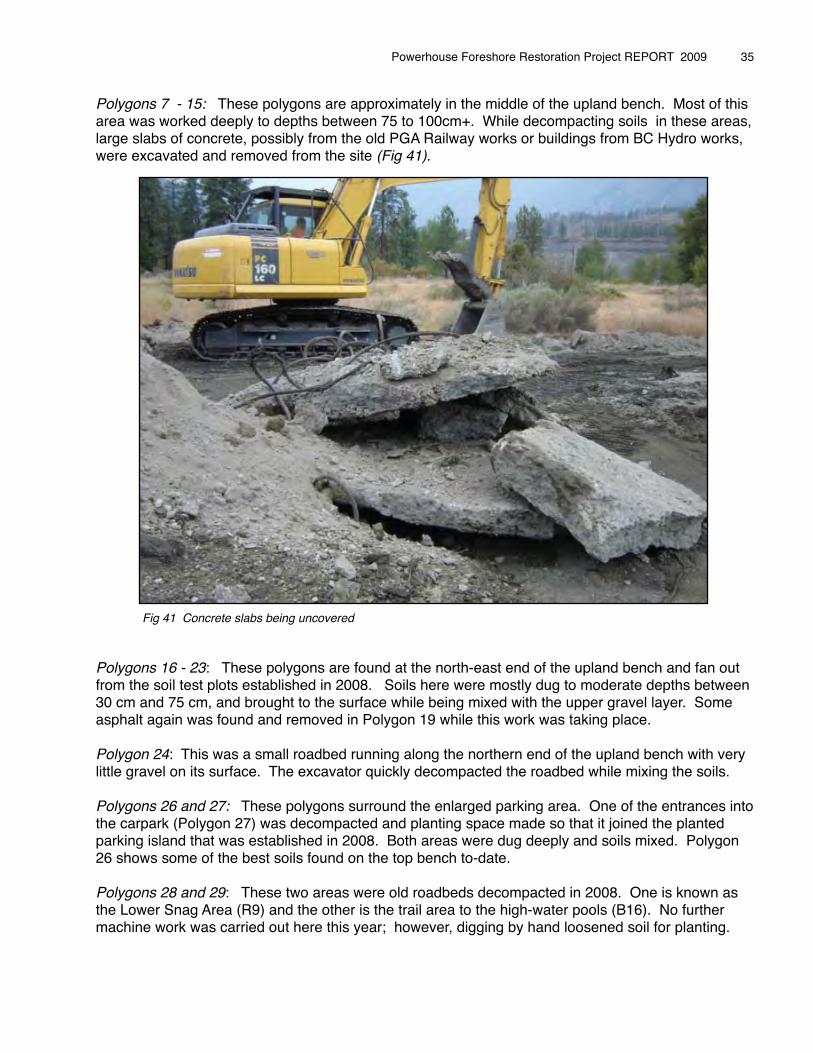
Polygons 7 - 15: These polygons are approximately in the middle of the upland bench. Most of this area was worked deeply to depths between 75 to 100cm+. While decompacting soils in these areas, large slabs of concrete, possibly from the old PGA Railway works or buildings from BC Hydro works, were excavated and removed from the site (Fig 41). � � � � �
Fig 41 Concrete slabs being uncovered
Polygons 16 - 23: These polygons are found at the north-east end of the upland bench and fan out from the soil test plots established in 2008. Soils here were mostly dug to moderate depths between 30 cm and 75 cm, and brought to the surface while being mixed with the upper gravel layer. Some asphalt again was found and removed in Polygon 19 while this work was taking place.
Polygon 24: This was a small roadbed running along the northern end of the upland bench with very little gravel on its surface. The excavator quickly decompacted the roadbed while mixing the soils.
Polygons 26 and 27: These polygons surround the enlarged parking area. One of the entrances into the carpark (Polygon 27) was decompacted and planting space made so that it joined the planted parking island that was established in 2008. Both areas were dug deeply and soils mixed. Polygon 26 shows some of the best soils found on the top bench to-date.
Polygons 28 and 29: These two areas were old roadbeds decompacted in 2008. One is known as the Lower Snag Area (R9) and the other is the trail area to the high-water pools (B16). No further machine work was carried out here this year; however, digging by hand loosened soil for planting.
Powerhouse Foreshore Restoration Project REPORT 2009 � 35
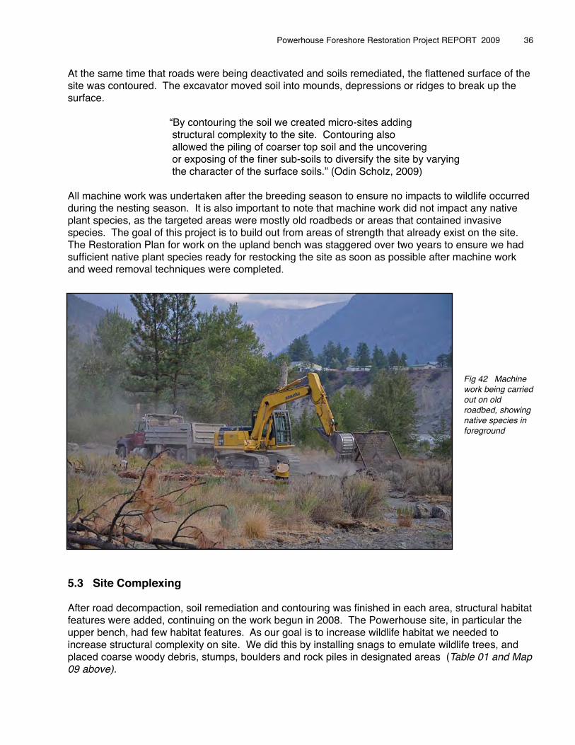
At the same time that roads were being deactivated and soils remediated, the flattened surface of the site was contoured. The excavator moved soil into mounds, depressions or ridges to break up the surface.
� � � “By contouring the soil we created micro-sites adding �� � � structural complexity to the site. Contouring also � � � allowed the piling of coarser top soil and the uncovering � � � or exposing of the finer sub-soils to diversify the site by varying � � � the character of the surface soils.” (Odin Scholz, 2009)
All machine work was undertaken after the breeding season to ensure no impacts to wildlife occurred during the nesting season. It is also important to note that machine work did not impact any native plant species, as the targeted areas were mostly old roadbeds or areas that contained invasive species. The goal of this project is to build out from areas of strength that already exist on the site. The Restoration Plan for work on the upland bench was staggered over two years to ensure we had sufficient native plant species ready for restocking the site as soon as possible after machine work and weed removal techniques were completed.
Fig 42 Machine work being carried out on old roadbed, showing native species in foreground
5.3 Site Complexing
After road decompaction, soil remediation and contouring was finished in each area, structural habitat features were added, continuing on the work begun in 2008. The Powerhouse site, in particular the upper bench, had few habitat features. As our goal is to increase wildlife habitat we needed to increase structural complexity on site. We did this by installing snags to emulate wildlife trees, and placed coarse woody debris, stumps, boulders and rock piles in designated areas (Table 01 and Map 09 above).
Powerhouse Foreshore Restoration Project REPORT 2009 � 36

Wildlife Trees: Based on the success of 2008 placement of snags and the resulting observed use by birds, twenty-one additional snags were installed over the .97 hectare area on the upland bench during 2009.
� � “Snags, also called wildlife trees, provide critical habitat features for� � seventy species of birds, mammals and amphibians in British Columbia� � (Fenger et al, 2006)”.
We were able to source trees from a pine-beetle infested property, which were provided as a donation to the project. These trees, unlike the snags planted in 2008, had bark, branches and some root wads. The tree needles were all dead on the trunk and through conversations with Ed Senger, R.P.F, it was “concluded that there was no risk of introducing the mountain pine beetles to the site from these trunks” (Odin Scholz, 2009).
The logs were brought to the site by the machine operator and unloaded into a pile on an old roadbed that is targeted for work in the coming year. The snags were on average 30 cm diameter.
The machine operator used his excavator to dig holes approximately four feet deep. Under the direction of Michelle Edwards, Councillor and Aboriginal Land Steward from Cayoose Creek Stʼatʼimc, a portion of the excavated material from each snag hole was sifted through 1/2 inch hardware cloth
screens to sample for archaeological artifacts. Again no artifacts were found during this process.
Powerhouse Foreshore Restoration Project REPORT 2009 � 37
Fig 43 Trees being delivered
Fig 44 Sifting soil for artifacts
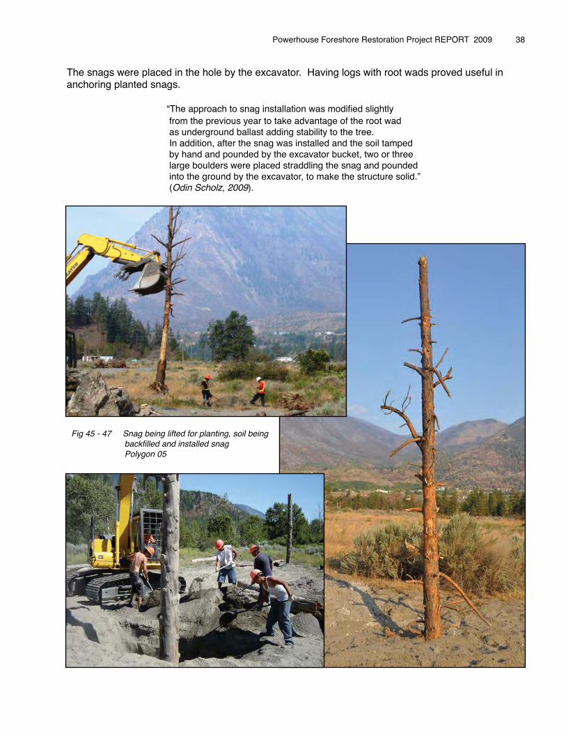
The snags were placed in the hole by the excavator. Having logs with root wads proved useful in anchoring planted snags.
� � � “The approach to snag installation was modified slightly � � � from the previous year to take advantage of the root wad � � � as underground ballast adding stability to the tree. � � � In addition, after the snag was installed and the soil tamped � � � by hand and pounded by the excavator bucket, two or three� � � large boulders were placed straddling the snag and pounded� � � into the ground by the excavator, to make the structure solid.”� � � (Odin Scholz, 2009).
Powerhouse Foreshore Restoration Project REPORT 2009 � 38
Fig 45 - 47 Snag being lifted for planting, soil being backfilled and installed snag Polygon 05
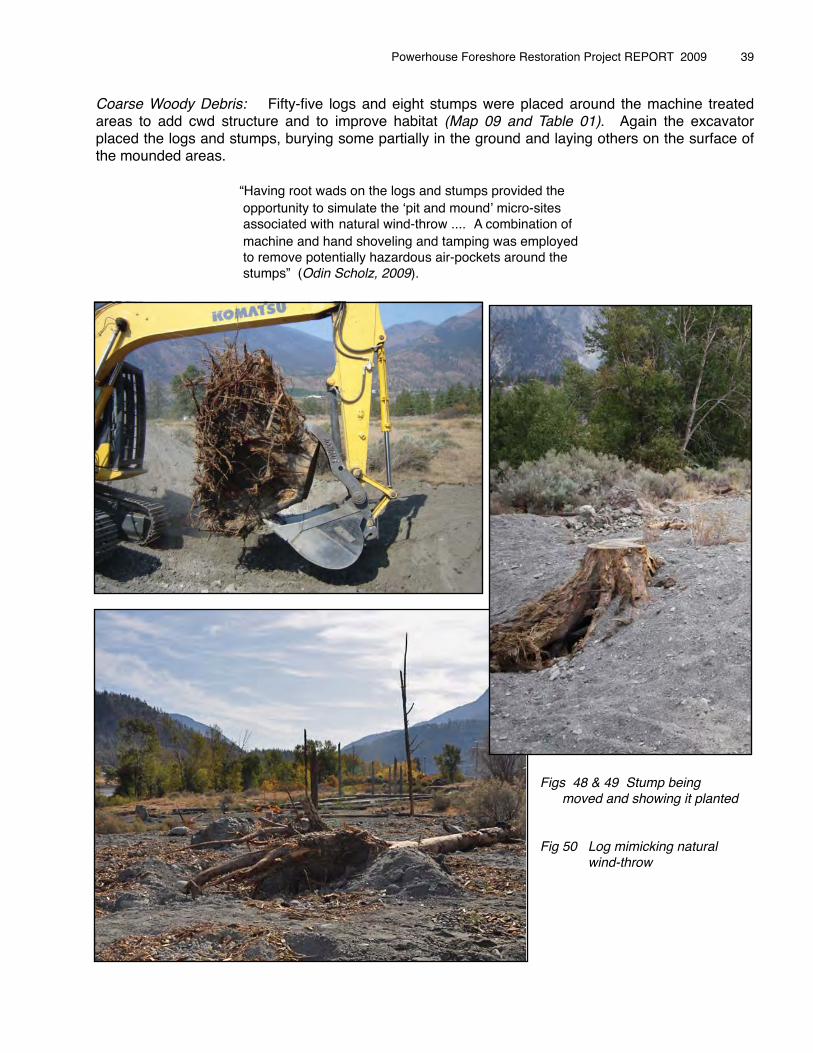
Coarse Woody Debris: Fifty-five logs and eight stumps were placed around the machine treated areas to add cwd structure and to improve habitat (Map 09 and Table 01). Again the excavator placed the logs and stumps, burying some partially in the ground and laying others on the surface of the mounded areas.
� � � “Having root wads on the logs and stumps provided the � � � opportunity to simulate the ʻpit and moundʼ micro-sites � � � associated with� natural wind-throw .... A combination of � � � machine and hand shoveling and tamping was employed � � � to remove potentially hazardous air-pockets around the � � � stumps” (Odin Scholz, 2009).� �
Powerhouse Foreshore Restoration Project REPORT 2009 � 39
Figs 48 & 49 Stump being moved and showing it planted
Fig 50 Log mimicking natural wind-throw
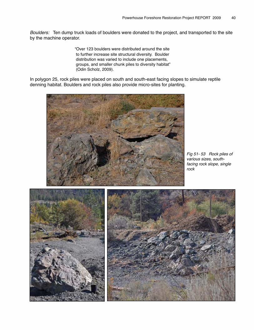
Boulders: Ten dump truck loads of boulders were donated to the project, and transported to the site by the machine operator.
� � � “Over 123 boulders were distributed around the site� � � to further increase site structural diversity. Boulder � � � distribution was varied to include one placements,� � � groups, and smaller chunk piles to diversity habitat”� � � (Odin Scholz, 2009).
In polygon 25, rock piles were placed on south and south-east facing slopes to simulate reptile denning habitat. Boulders and rock piles also provide micro-sites for planting.
Powerhouse Foreshore Restoration Project REPORT 2009 � 40
Fig 51- 53 Rock piles of various sizes, south-facing rock slope, single rock
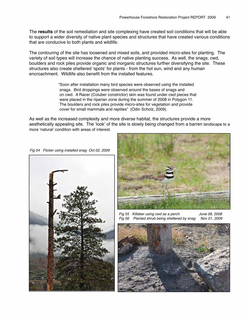
The results of the soil remediation and site complexing have created soil conditions that will be able to support a wider diversity of native plant species and structures that have created various conditions that are conducive to both plants and wildlife.
The contouring of the site has loosened and mixed soils, and provided micro-sites for planting. The variety of soil types will increase the chance of native planting success. As well, the snags, cwd, boulders and rock piles provide organic and inorganic structures further diversifying the site. These structures also create sheltered ʻspotsʼ for plants - from the hot sun, wind and any human encroachment. Wildlife also benefit from the installed features. � � “Soon after installation many bird species were observed using the installed� � snags. Bird droppings were observed around the bases of snags and� � on cwd. A Racer (Coluber constrictor) skin was found under cwd pieces that� � were placed in the riparian zone during the summer of 2008 in Polygon 11.� � The boulders and rock piles provide micro-sites for vegetation and provide � � cover for small mammals and reptiles” (Odin Scholz, 2009).
As well as the increased complexity and more diverse habitat, the structures provide a more aesthetically appealing site. The ʻlookʼ of the site is slowly being changed from a barren landscape to a more ʻnaturalʼ condition with areas of interest.
Powerhouse Foreshore Restoration Project REPORT 2009 � 41
Fig 55 Killdeer using cwd as a perch June 08, 2008 Fig 56 Planted shrub being sheltered by snag Nov 01, 2009
Fig 54 Flicker using installed snag Oct 02, 2009
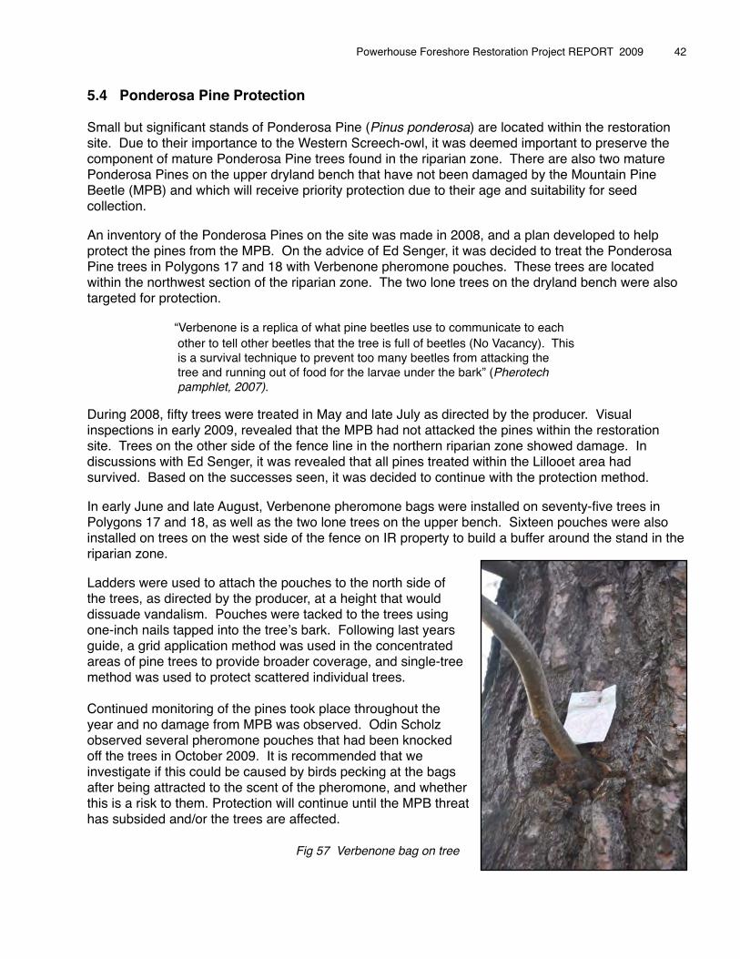
5.4 Ponderosa Pine Protection
Small but significant stands of Ponderosa Pine (Pinus ponderosa) are located within the restoration site. Due to their importance to the Western Screech-owl, it was deemed important to preserve the component of mature Ponderosa Pine trees found in the riparian zone. There are also two mature Ponderosa Pines on the upper dryland bench that have not been damaged by the Mountain Pine Beetle (MPB) and which will receive priority protection due to their age and suitability for seed collection.
An inventory of the Ponderosa Pines on the site was made in 2008, and a plan developed to help protect the pines from the MPB. On the advice of Ed Senger, it was decided to treat the Ponderosa Pine trees in Polygons 17 and 18 with Verbenone pheromone pouches. These trees are located within the northwest section of the riparian zone. The two lone trees on the dryland bench were also targeted for protection.
� � “Verbenone is a replica of what pine beetles use to communicate to each � � other to tell other beetles that the tree is full of beetles (No Vacancy). This� � is a survival technique to prevent too many beetles from attacking the� � tree and running out of food for the larvae under the bark” (Pherotech � � pamphlet, 2007).
During 2008, fifty trees were treated in May and late July as directed by the producer. Visual inspections in early 2009, revealed that the MPB had not attacked the pines within the restoration site. Trees on the other side of the fence line in the northern riparian zone showed damage. In discussions with Ed Senger, it was revealed that all pines treated within the Lillooet area had survived. Based on the successes seen, it was decided to continue with the protection method.
In early June and late August, Verbenone pheromone bags were installed on seventy-five trees in Polygons 17 and 18, as well as the two lone trees on the upper bench. Sixteen pouches were also installed on trees on the west side of the fence on IR property to build a buffer around the stand in the riparian zone.
Ladders were used to attach the pouches to the north side of the trees, as directed by the producer, at a height that would dissuade vandalism. Pouches were tacked to the trees using one-inch nails tapped into the treeʼs bark. Following last years guide, a grid application method was used in the concentrated areas of pine trees to provide broader coverage, and single-tree method was used to protect scattered individual trees. � � Continued monitoring of the pines took place throughout the year and no damage from MPB was observed. Odin Scholz observed several pheromone pouches that had been knocked off the trees in October 2009. It is recommended that we investigate if this could be caused by birds pecking at the bags after being attracted to the scent of the pheromone, and whetherthis is a risk to them. Protection will continue until the MPB threat has subsided and/or the trees are affected.
Fig 57 Verbenone bag on tree
Powerhouse Foreshore Restoration Project REPORT 2009 � 42
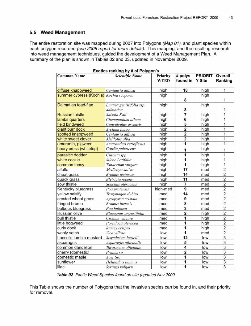
5.5 Weed Management
The entire restoration site was mapped during 2007 into Polygons (Map 01), and plant species within each polygon recorded (see 2006 report for more details). This mapping, and the resulting research into weed management techniques, guided the development of a Weed Management Plan. A summary of the plan is shown in Tables 02 and 03, updated in November 2009.
This Table shows the number of Polygons that the invasive species can be found in, and their priority for removal.
Powerhouse Foreshore Restoration Project REPORT 2009 � 43
Common Name Scientific Name Priority
WEED
# polys
found in
PRIORIT
Y Site
Overall
Ranking
diffuse knappweed Centauria diffusa high 18 high 1
summer cypress (Kochia) Kochia scoparia high
8
high
1
Dalmatian toad-flax Linaria genistifolia ssp.
dalmatica
high
8
high
1
Russian thistle Salsola Kali high 7 high 1
lambs quarters Chenopodium album high 6 high 1
field bindweed Convulvulus arvensis high 5 high 1
giant burr dock Arctium lappa high 2 high 1
spotted knappweed Centauria diffusa high 2 high 1
white sweet clover Melilotus alba high 2 high 1
amaranth, pigweed Amaranthus retroflexus high 1 high 1
hoary cress (whitetop) Cardia pubescens high 1 high 1
parasitic dodder Cuscuta spp. high 1 high 1
white cockle Silene Latifolia high 1 high 1
common tansy Tanacetum vulgare high 1 high 1
alfalfa Medicago sativa high 17 med 2
cheat grass Bromus tectorum high 14 med 2
quack grass Elytrigia repens high 11 med 2
sow thistle Sonchus oleraceus high 7 med 2
Kentucky bluegrass Poa pratensis high-med 9 med 2
yellow salsify Tragopogon dubius med 14 med 2
crested wheat grass Agropyron cristata med 9 med 2
fringed brome Bromus inermis med 8 med 2
bulbous bluegrass Poa bulbosa med 3 med 2
Russian olive Elaeagnus angustifolia med 2 high 2
bull thistle Cirsium vulgare med 1 high 2
little hogweed Portulaca oleracea med 1 high 2
curly dock Rumex crispus med 1 high 2
wooly vetch Vica villosa low 1 med 2
Loesel's tumble mustard Sisymbrium loeselii low 12 low 3
asparagus Asparagus officinalis low 5 low 3
common dandelion Taraxacom officinale low 4 low 3
cherry (domestic) Prunus sp. low 2 low 3
domestic maple Acer Sp. low 1 low 3
sunflower Helianthus annuus low 1 low 3
lilac Syringa vulgaris low 1 low 3
Exotics ranking by # of Polygon's
Table 02 Exotic Weed Species found on site (updated Nov 2009

Figure 58 - 59Diffuse Knapweed Dalmatian Toadflax
Powerhouse Foreshore Restoration Project REPORT 2009 � 44
Time for Action Action dates
High Eliminate flowering on site, reduce seed
bank
diffuse knappweed,
spotted knappweed
Hand Pulling, Visual observation June-September
High Eliminate flowering on site, reduce seed
bank
summer cypress
(Kochia)
Hand Pulling, Visual observation Late June-July
High Shrink patches within 3 years Dalmatian toad-flax Hand Pulling, Visual observation June-September
High Eliminate flowering on site, reduce seed
bank
Russian thistle Hand Pulling, Visual observation July-August
High Eliminate flowering on site, reduce seed
bank
lambs quarters Hand Pulling, Visual observation May-October
High Prevent flowering and seeding,
eliminate 10 outlying patches within 3
years, reduce vigor of large patch over
next 3 years
field bindweed Burning, Vinager treatment, Hand Pulling, mapping sites
spring and fall, density plots in large patches using
1X1m plots
Spring burning,May-
October every 2
weeks
High eliminate flowering on site, eliminate
from site within 5 years.
giant burr dock Hand pulling, Visual observation of two main patches. July-August
High Prevent establishment on site, white sweet clover Hand pulling, visual observation when in flower July-September
High Prevent further establishment on site, amaranth, pigweed Hand pull, Vigourous visual monitoring especially Pit
area
May-October
High Prevent further establishment on site, hoary cress
(whitetop)
Vigourous visual monitoring esp Poly 11, hand pull June-September
High Prevent further establishment on site, parasitic dodder Vigourous visual monitoring esp Powerhouse roadside,
hand pull (bag and destroy)
June-September
High Prevent further establishment on site, white cockle vigourous visual monitoring especially around hydro
compound.
June-September
High Prevent further establishment on site, common tansy Vigourous visual monitoring especially in the Pit are Poly
15 West of Pit area
July-September
Med Shrink patches within 3 years replace
with Native plants
alfalfa hand dig pull, work out from restoration areas and in
riparian zones, weed whack dense patches early in
spring
April-May weed eat,
May-Sept dig
Med Prevent establishment on resotration
soils,
cheat grass burning early in year before seed set, hand pulling
before seed set, visual monitorin on restoration areas
April-June
Med Reduce vigour of patches over next 3
years, replace with native species
quack grass burning in the fall where possible (spot torching),
repeated mowing to prevent seeds and depleat
rootstocks
May-October
Med Prevent further establishment on site, sow thistle Hand pull or cut lower than 20cm before flowering June-October
Med Prevent further establishment on site, Kentucky bluegrass Visually assess popluations on site measure extent June-July
Med Reduce extent of weed on site replace
with native species
yellow salsify Hand pull or cut to prevent flowering especially on Fresh
restoration soils
Late May-June
Med Slowly replace with native species over
next 3 years
crested wheat grass hand dig pull, work out from restoration areas weed
whack dense patches to prevent flowering Poly 08
June-September
Med Reduce patch vigour replace with native
specie
fringed brome Repeated mowing beginning in May (4 X at least) May-July
Med Prevent establishment on fresh
restoration soils
bulbous bluegrass Vigourous monitoring and hand pulling when found, spot
flaming in spring
May-September
High Remove from site within 3 years Russian olive repeated girdling and cutting of both trees, visual
observation of resprouting.
May-October
Med eliminate from site within 3 years bull thistle Cut plants prior to flowering June-
Med Prevent further establishment on site, little hogweed Hand pull, Pit area, not very persistent June-
Med Prevent further establishment on site, curly dock Hand pull, one site Poly 03, visual monitor June-September
Med Prevent spread on site wooly vetch Hand pull before seeding June-September
Action DatesPriority Weed Management Objectives Weed Species Planned Weed Management Monitoring Methods
Table 03 Summary of Weed Management Plan
Removal of exotic weed species was a significant proportion of the restoration work carried out in 2009. The method of weed removal most used was hand digging with shovels and pulling plants. Other methods used by the restoration crew included weed whacking, fire control and natural defoliants (pickling vinegar). The machine operator was also able to remove some plants in adjacent areas as he worked the soils.� After the plants were pulled, they were loaded onto tarps or put into large canvas bags, ready for pick-up and removal to the local landfill. During 2008, we were able to burn the pulled exotics, but this was not possible during 2009 as the Ainsworth Mill was closed down.
The eradication of invasive exotic weed species requires vigilance and repeated treatments over the coming years, due to the persistent seed banks and root reserves of certain plants.� �
It is also important to note, that weeds on the site do provide habitat for wildlife in the absence of native species. All weed management techniques are taking into account best practices to ensure we do not impact wildlife using these spaces - critical weed habitat will remain until we have sufficient native plant species to replant as soon as possible on removal of the exotics.
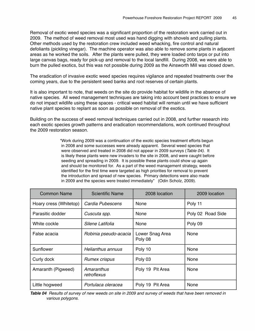
Building on the success of weed removal techniques carried out in 2008, and further research into each exotic species growth patterns and eradication recommendations, work continued throughout the 2009 restoration season.
� � “Work during 2009 was a continuation of the exotic species treatment efforts begun � � in 2008 and some successes were already apparent. Several weed species that� � were observed and treated in 2008 did not appear in 2009 surveys (Table 04). It� � is likely these plants were new invaders to the site in 2008, and were caught before� � seeding and spreading in 2009. It is possible these plants could show up again�� � and should be monitored for. As a part of the weed management strategy, weeds� � identified for the first time were targeted as high priorities for removal to prevent� � the introduction and spread of new species. Primary detections were also made� � in 2009 and the species were treated immediately” (Odin Scholz, 2009).�
Common Name Scientific Name 2008 location 2009 location
Hoary cress (Whitetop) Cardia Pubescens None Poly 11
Parasitic dodder Cuscuta spp. None Poly 02 Road Side
White cockle Silene Latifolia None Poly 09
False acacia Robinia pseudo-acacia Lower Snag Area Poly 08
None
Sunflower Helianthus annuus Poly 10 None
Curly dock Rumex crispus Poly 03 None
Amaranth (Pigweed) Amaranthus retroflexus
Poly 19 Pit Area None
Little hogweed Portulaca oleracea Poly 19 Pit Area None
Table 04 Results of survey of new weeds on site in 2009 and survey of weeds that have been removed in various polygons.
Powerhouse Foreshore Restoration Project REPORT 2009 � 45
The weed management plan guided work done on the site during 2009. The plan rates weeds in order of priority from high, medium and low.
� � “This rating was determined based on a review of several databases including � � ʻA Guide to Weeds in British Columbiaʼ and E-flora BC, as well as on-the-ground � � experience. Weed treatments were carried out based on high priority sites and� � high priority weeds” (Odin Scholz, 2009).
High Priority Sites: Small populations of exotics were targeted for removal so that the risk of their spread on the site was minimized or halted. Roadsides and trails were also targeted as these areas are vectors for new introductions and spreading of weeds. The machine restoration work carried out in 2008 is also a potential vector for weeds as the soils have been disturbed and a soil bed made available for seeds. These areas were swept throughout the spring through fall and invasive species removed.
High Priority Weeds: To prevent the spread of high priority weed species and decrease the risk of increasing the invasive weed seed-bank, these species were targeted for removal across the entire site. Efforts were focused on controlling isolated patches of high priority species, such as field bindweed, giant burdock and lambʼs quarters. As well, high priority and wide-spread annual weeds such as Russian thistle, diffuse and spotted knapweed and kochia were targeted for removal throughout the site.
� � “Obvious dense patches of these annual species were mapped and then� � the plants were hand pulled, bagged and removed from the site as they� � came into flower. These annual species did also appear sporadically throughout� � the site, mostly on edges of the access road and other disturbed gravely sites.� � They were removed from these locations as they were encountered. These� � sporadic occurrences were not mapped” (Odin Scholz, 2009).� � Map 10 below shows the distribution of exotic weed species controlled during the 2009 restoration year.
�
Powerhouse Foreshore Restoration Project REPORT 2009 � 46
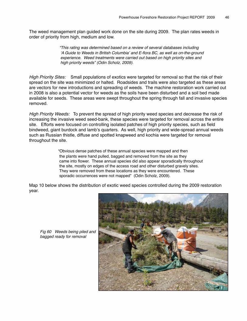
Fig 60 Weeds being piled and bagged ready for removal

Map 10 Exotic Species Distribution 2009.
Powerhouse Foreshore Restoration Project REPORT 2009 � 47
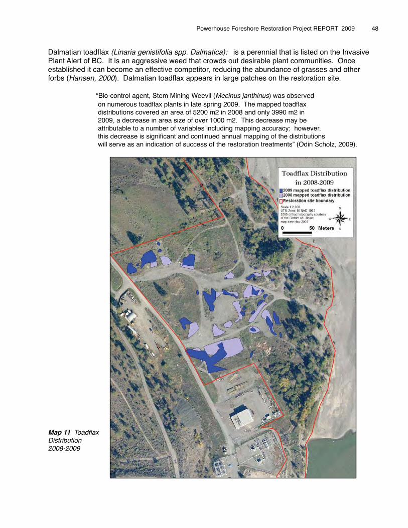
Dalmatian toadflax (Linaria genistifolia spp. Dalmatica): is a perennial that is listed on the Invasive Plant Alert of BC. It is an aggressive weed that crowds out desirable plant communities. Once established it can become an effective competitor, reducing the abundance of grasses and other forbs (Hansen, 2000). Dalmatian toadflax appears in large patches on the restoration site.
� � “Bio-control agent, Stem Mining Weevil (Mecinus janthinus) was observed� � on numerous toadflax plants in late spring 2009. The mapped toadflax� � distributions covered an area of 5200 m2 in 2008 and only 3990 m2 in� � 2009, a decrease in area size of over 1000 m2. This decrease may be�� � attributable to a number of variables including mapping accuracy; however,� � this decrease is significant and continued annual mapping of the distributions� � will serve as an indication of success of the restoration treatments” (Odin Scholz, 2009).�
Map 11 ToadflaxDistribution2008-2009
Powerhouse Foreshore Restoration Project REPORT 2009 � 48
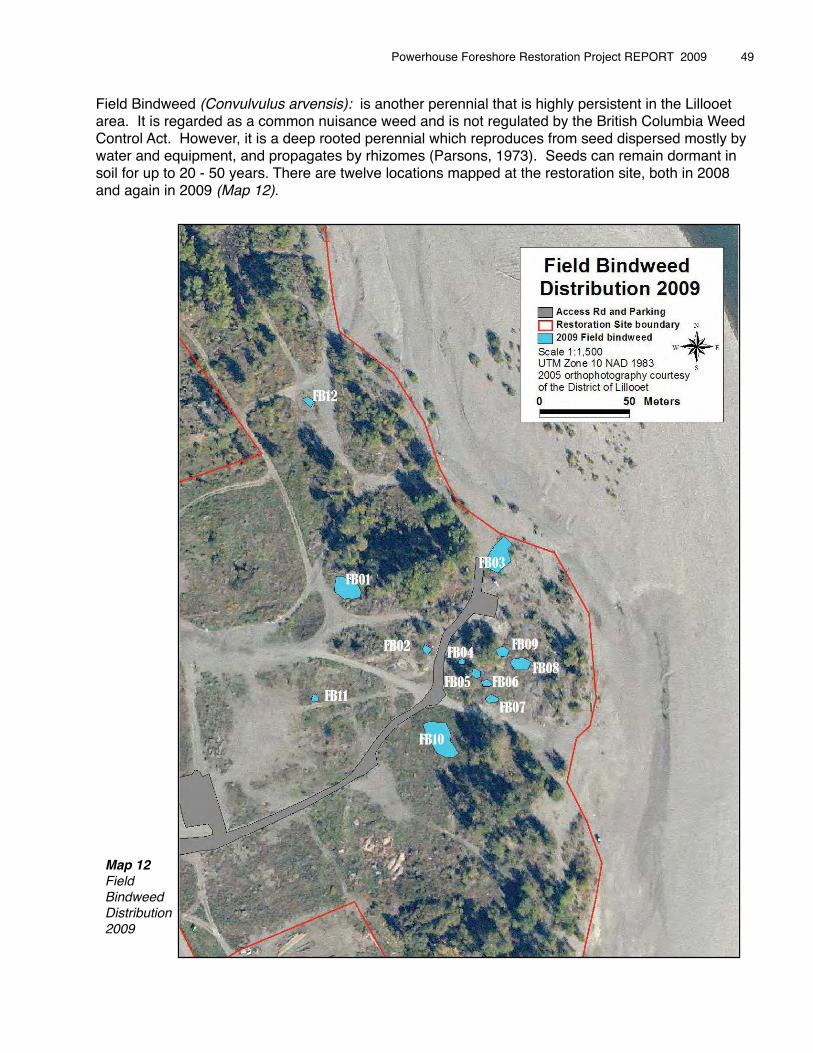
Field Bindweed (Convulvulus arvensis): is another perennial that is highly persistent in the Lillooet area. It is regarded as a common nuisance weed and is not regulated by the British Columbia Weed Control Act. However, it is a deep rooted perennial which reproduces from seed dispersed mostly by water and equipment, and propagates by rhizomes (Parsons, 1973). Seeds can remain dormant in soil for up to 20 - 50 years. There are twelve locations mapped at the restoration site, both in 2008 and again in 2009 (Map 12).
�
Powerhouse Foreshore Restoration Project REPORT 2009 � 49
Map 12Field Bindweed Distribution 2009
In our attempt to eradicate field bindweed from the site, the management plan calls for repeated pulling of the plants throughout the growing season to slowly deplete the plantʼs root energy stores.
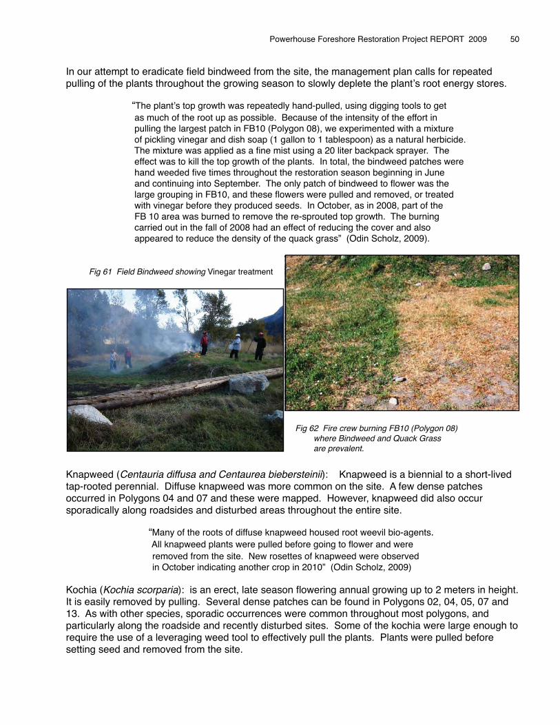
� � “The plantʼs top growth was repeatedly hand-pulled, using digging tools to get � � as much of the root up as possible. Because of the intensity of the effort in � � pulling the largest patch in FB10 (Polygon 08), we experimented with a mixture � � of pickling vinegar and dish soap (1 gallon to 1 tablespoon) as a natural herbicide. � � The mixture was applied as a fine mist using a 20 liter backpack sprayer. The � � effect was to kill the top growth of the plants. In total, the bindweed patches were � � hand weeded five times throughout the restoration season beginning in June � � and continuing into September. The only patch of bindweed to flower was the � � large grouping in FB10, and these flowers were pulled and removed, or treated � � with vinegar before they produced seeds. In October, as in 2008, part of the � � FB 10 area was burned to remove the re-sprouted top growth. The burning � � carried out in the fall of 2008 had an effect of reducing the cover and also � � appeared to reduce the density of the quack grass” (Odin Scholz, 2009).
Fig 61 Field Bindweed showing Vinegar treatment
Fig 62 Fire crew burning FB10 (Polygon 08) where Bindweed and Quack Grass are prevalent.
Knapweed (Centauria diffusa and Centaurea biebersteinii): Knapweed is a biennial to a short-lived tap-rooted perennial. Diffuse knapweed was more common on the site. A few dense patches occurred in Polygons 04 and 07 and these were mapped. However, knapweed did also occur sporadically along roadsides and disturbed areas throughout the entire site.
� � “Many of the roots of diffuse knapweed housed root weevil bio-agents. � � All knapweed plants were pulled before going to flower and were� � removed from the site. New rosettes of knapweed were observed� � in October indicating another crop in 2010” (Odin Scholz, 2009)
Kochia (Kochia scorparia): is an erect, late season flowering annual growing up to 2 meters in height. It is easily removed by pulling. Several dense patches can be found in Polygons 02, 04, 05, 07 and 13. As with other species, sporadic occurrences were common throughout most polygons, and particularly along the roadside and recently disturbed sites. Some of the kochia were large enough to require the use of a leveraging weed tool to effectively pull the plants. Plants were pulled before setting seed and removed from the site.
Powerhouse Foreshore Restoration Project REPORT 2009 � 50
Russian Thistle (Salsola Kali): is a summer annual which is considered very invasive, competing with native species and obstructing stream channels. It can also become a fire hazard. This annual can be easily removed by pulling and seed bank is not persistent, so there is a good chance of its removal from the site within three years. Two small patches were found in Polygons 14 and 16, and again sporadically within disturbed areas. They were hand pulled and removed from the site.
Giant Burdock (Arctium lappa): is a bushy biennial which is spread by wildlife and people as the burrs become entangled in fur, hair or clothing. One plant can produce up to 31,000 seeds (BC Ministry of Agriculture and Lands, 2009). There are only two patches of Giant Burdock on the restoration site in Polygons 02 and 06. During 2008, all plants were removed, but plants were found sprouting from a seed bank during 2009.
� � “ .... after each digging of the plants, more rosettes seem to form.� � Continuing to pull the plants on an annual basis will exhaust these� � two highly localized seed banks. The plants are highly visible and� � the limited distribution means this should be an easy noxious weed� � species to control and prevent spreading on the site” (Odin Scholz, 2009).
Alfalfa (Medicago solidago): is a perennial pasture crop with extremely deep taproots. The deep taproots make it very difficult to pull. It was one of the most prevalent weeds removed during 2008 in the northern riparian zone (Polygons 16 and 17). This area remained relatively free of new plants through 2009. Any re-sprouts or newly germinating plants in this area were removed by pulling. While the excavator worked on site complexing, the operator was able to pluck numerous plants out of the ground in soils adjacent to where he was working. Several thick patches of alfalfa near the entrance to the access road (Polygon 02), and beside the access road just before it enters the riparian zone (Polygon 03 and 08), were controlled throughout the summer using a weed whacker to ensure the plants did not flower.
Common Tansy (Tanacetum vulgare L ): is another perennial that when established can form dense colonies, out-competing native species. It spreads mainly by seed, but also by creeping rhizomes.A small patch was found again in 2009, just above the pit area in Polygon 15. It was dug up with a shovel and removed from the area.
Cheat Grass (Bromus tectorum): is prevalent throughout much of the site and continues to be monitored for invasion into planted areas and other disturbed soils resulting from the restoration work. This species has not been mapped due to its wide range on site. No weed management took place in 2008. During 2009, cheat grass was monitored for spread into 2008 planted areas, particularly the upper and lower snag areas (Polygons 19 and 08). When cheat grass was found colonizing these sites, it was hand pulled.
Quack Grass (Elytrigia repens): is a perennial, spreading by both seeds and rhizomes. In an attempt to exhaust the root reserve, the largest patch in FB10 (Poloygon 08) was mowed four times using a weed whacker. As stated above, quack grass in this poloygon was also burned over in the fall. No seed heads were produced in Poloygon 08. A small area of quack grass in the patch at the north end of the pit (Poloygon 19) was hand cut around an existing area of Indian hemp (Apocynum cannabinum) to encourage the spread of the hemp.
Sow Thistle (Sonchus alber): is an annual, reproducing by wind-born seeds and underground stems, and is found sporadically on site. It was hand pulled when encountered.
Powerhouse Foreshore Restoration Project REPORT 2009 � 51
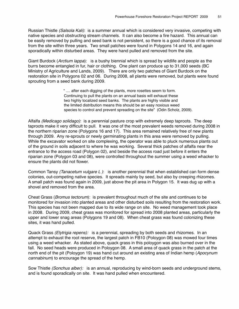
Crested wheatgrass (Agropyron cristatum): is a perennial bunch grass that has been sown in the past to prevent soil erosion on impacted sites. Crested wheatgrass can be found on the restoration site, especially in the Lower Snag Area (Poloygon 07). This patch was dug up by hand, and immediately planted with native plant species.
Lambʼs Quarters: There is a large patch growing in Polygon 07 which is being treated and monitored. This plant was also removed from old roadbeds on the top bench while machine work was being done.
Wooly Vetch (Vica villosa): is a perennial that spreads by seed dispersal. It was found sprawling in one small patch about 5m2 just north-west of the entrance sign in Polygon 02. The vetch was cut down by the weed whacker.
Common Dodder and Hoary Cress: One plant of each of these two species was observed and removed immediately. The Common Dodder was found on the edge of the Powerhouse Road in Polygon 02. Hoary Cress was found in Polygon 11 beside the old roadbed leading to the river. Both species need to be observed to ensure they do not spread into the site.
Yellow salsify (Tragopogon dubius) and Loeselʼs tumble mustard (Sisymrium loeselii) are two of the most common weed species found throughout the restoration site.
� � “These species showed up in most polygons. Both species were� � pulled when encountered, but they were not tackled as intensively� � as the noxious or high priority species. The low priority ranking of� � salsify and tumble mustard was determined through the literature� � that regarded these species as nuisance weedy species that will� � shrink from dominance as perennial native species become� � established at the site. These species do provide valuable wildlife� � resources in an otherwise barren land” (Odin Scholz, 2009).
Another vector for exotic species establishing on the restoration site, is the close proximity of neighbouring properties that are harbouring invasive weed species. BC Hydro work yards and a property to the west of the restoration site (across Powerhouse Road) have been observed to contain dense concentrations of weeds.
BC Hydro is in the process of implementing a weed removal program within their work yards. The owner of the property across the road from the restoration site was approached with an offer of removing the dense concentrations of diffuse knapweed and kochia found there. It was a perfect opportunity to remove the plants thereby preventing more weed seeds being spread onto the freshly decompacted soils of the restoration site. At the same time, the owner learned more about the weeds growing on his land, and we were able to thank him for allowing use of his property for storing our restoration trailer throughout the season.
Exotic weed species have taken advantage of the highly degraded condition of the Powerhouse site caused by industry. The use of vehicles in the site and dumping of garden refuse have all caused weeds to become established. However, “most weeds do not compete well with healthy native vegetation communities. Therefore, management by removing invasive species while encouraging the existing native species, and adding more native plants to the site, will attain the goal of shifting the sites trajectory from weedy wasteland to successive native plant communities” (Odin Scholz, 2009).
Powerhouse Foreshore Restoration Project REPORT 2009 � 52
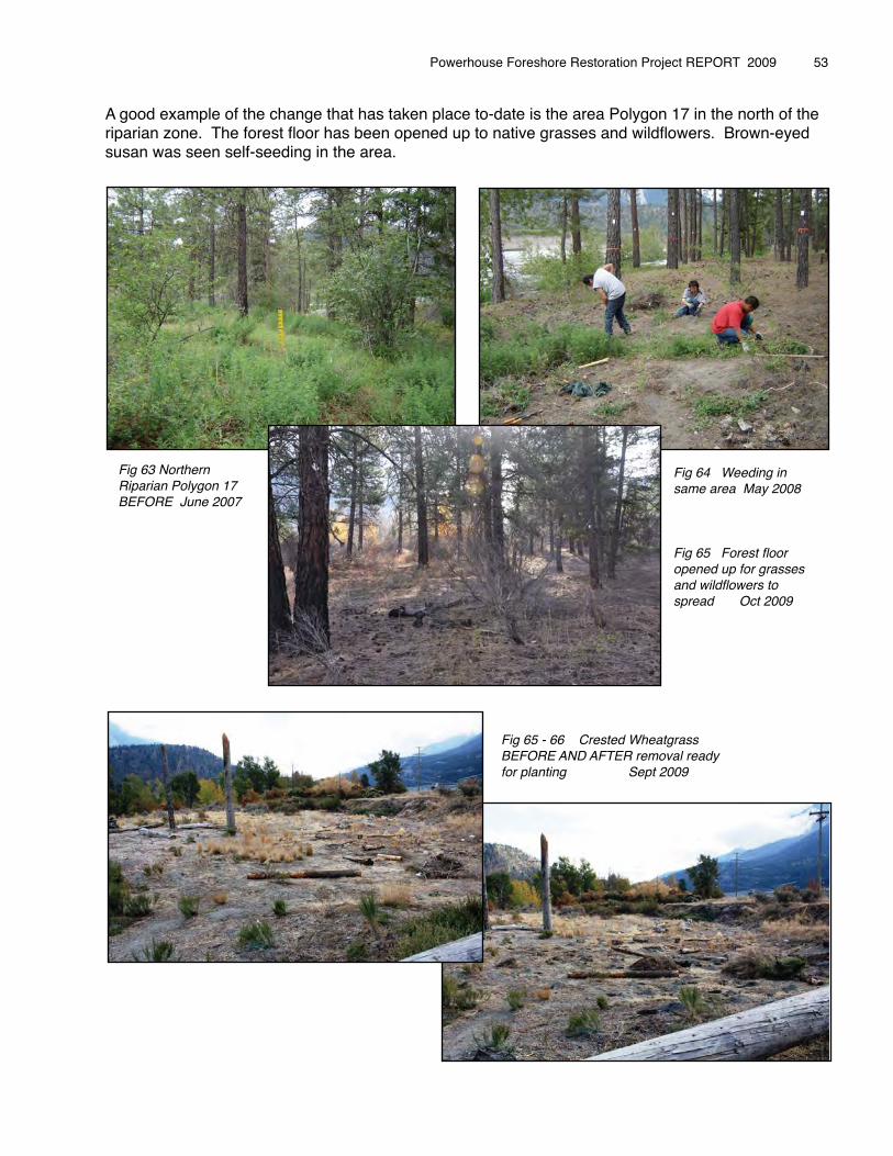
A good example of the change that has taken place to-date is the area Polygon 17 in the north of the riparian zone. The forest floor has been opened up to native grasses and wildflowers. Brown-eyed susan was seen self-seeding in the area.
Powerhouse Foreshore Restoration Project REPORT 2009 � 53
Fig 63 Northern Riparian Polygon 17BEFORE June 2007
Fig 64 Weeding in same area May 2008
Fig 65 Forest floor opened up for grasses and wildflowers to spread Oct 2009
Fig 65 - 66 Crested Wheatgrass BEFORE AND AFTER removal ready for planting Sept 2009
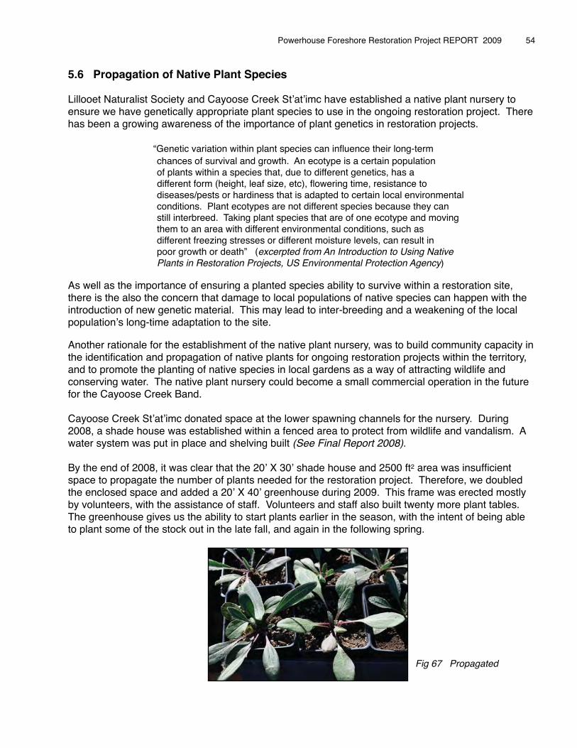
5.6 Propagation of Native Plant Species
Lillooet Naturalist Society and Cayoose Creek Stʼatʼimc have established a native plant nursery to ensure we have genetically appropriate plant species to use in the ongoing restoration project. There has been a growing awareness of the importance of plant genetics in restoration projects.
� � “Genetic variation within plant species can influence their long-term� � chances of survival and growth. An ecotype is a certain population� � of plants within a species that, due to different genetics, has a � different form (height, leaf size, etc), flowering time, resistance to� � diseases/pests or hardiness that is adapted to certain local environmental� � conditions. Plant ecotypes are not different species because they can� � still interbreed. Taking plant species that are of one ecotype and moving � � them to an area with different environmental conditions, such as � � different freezing stresses or different moisture levels, can result in� � poor growth or death” (excerpted from An Introduction to Using Native� � Plants in Restoration Projects, US Environmental Protection Agency)� � �As well as the importance of ensuring a planted species ability to survive within a restoration site, there is the also the concern that damage to local populations of native species can happen with the introduction of new genetic material. This may lead to inter-breeding and a weakening of the local populationʼs long-time adaptation to the site.
Another rationale for the establishment of the native plant nursery, was to build community capacity in the identification and propagation of native plants for ongoing restoration projects within the territory, and to promote the planting of native species in local gardens as a way of attracting wildlife and conserving water. The native plant nursery could become a small commercial operation in the future for the Cayoose Creek Band.
Cayoose Creek Stʼatʼimc donated space at the lower spawning channels for the nursery. During 2008, a shade house was established within a fenced area to protect from wildlife and vandalism. A water system was put in place and shelving built (See Final Report 2008).
By the end of 2008, it was clear that the 20ʼ X 30ʼ shade house and 2500 ft2 area was insufficient space to propagate the number of plants needed for the restoration project. Therefore, we doubled the enclosed space and added a 20ʼ X 40ʼ greenhouse during 2009. This frame was erected mostly by volunteers, with the assistance of staff. Volunteers and staff also built twenty more plant tables. The greenhouse gives us the ability to start plants earlier in the season, with the intent of being able to plant some of the stock out in the late fall, and again in the following spring.
Powerhouse Foreshore Restoration Project REPORT 2009 � 54
Fig 67 Propagated
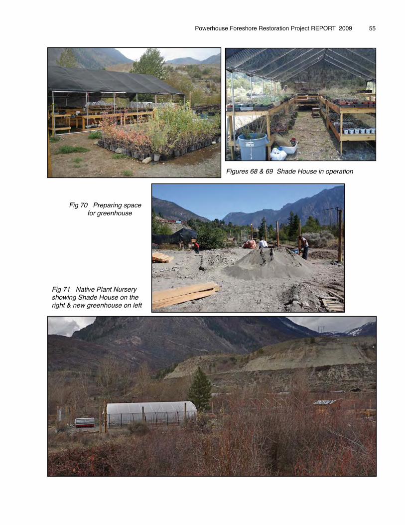
Powerhouse Foreshore Restoration Project REPORT 2009 � 55
Figures 68 & 69 Shade House in operation
Fig 70 Preparing space for greenhouse
Fig 71 Native Plant Nursery showing Shade House on the right & new greenhouse on left
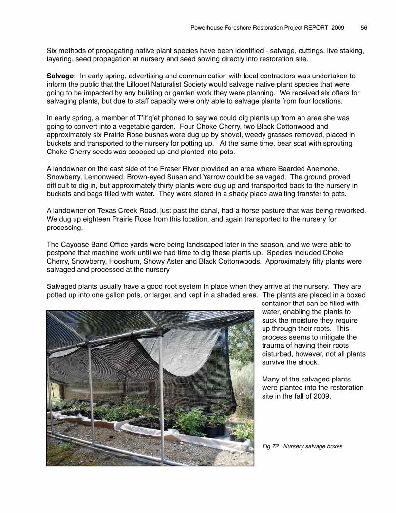
Six methods of propagating native plant species have been identified - salvage, cuttings, live staking, layering, seed propagation at nursery and seed sowing directly into restoration site.
Salvage: In early spring, advertising and communication with local contractors was undertaken to inform the public that the Lillooet Naturalist Society would salvage native plant species that were going to be impacted by any building or garden work they were planning. We received six offers for salvaging plants, but due to staff capacity were only able to salvage plants from four locations.
In early spring, a member of Tʼitʼqʼet phoned to say we could dig plants up from an area she was going to convert into a vegetable garden. Four Choke Cherry, two Black Cottonwood and approximately six Prairie Rose bushes were dug up by shovel, weedy grasses removed, placed in buckets and transported to the nursery for potting up. At the same time, bear scat with sprouting Choke Cherry seeds was scooped up and planted into pots.
A landowner on the east side of the Fraser River provided an area where Bearded Anemone, Snowberry, Lemonweed, Brown-eyed Susan and Yarrow could be salvaged. The ground proved difficult to dig in, but approximately thirty plants were dug up and transported back to the nursery in buckets and bags filled with water. They were stored in a shady place awaiting transfer to pots.
A landowner on Texas Creek Road, just past the canal, had a horse pasture that was being reworked. We dug up eighteen Prairie Rose from this location, and again transported to the nursery for processing.
The Cayoose Band Office yards were being landscaped later in the season, and we were able to postpone that machine work until we had time to dig these plants up. Species included Choke Cherry, Snowberry, Hooshum, Showy Aster and Black Cottonwoods. Approximately fifty plants were salvaged and processed at the nursery.
Salvaged plants usually have a good root system in place when they arrive at the nursery. They are potted up into one gallon pots, or larger, and kept in a shaded area. The plants are placed in a boxed
container that can be filled with water, enabling the plants to suck the moisture they require up through their roots. This process seems to mitigate the trauma of having their roots disturbed, however, not all plants survive the shock.
Many of the salvaged plants were planted into the restoration site in the fall of 2009.
Fig 72 Nursery salvage boxes
Powerhouse Foreshore Restoration Project REPORT 2009 � 56
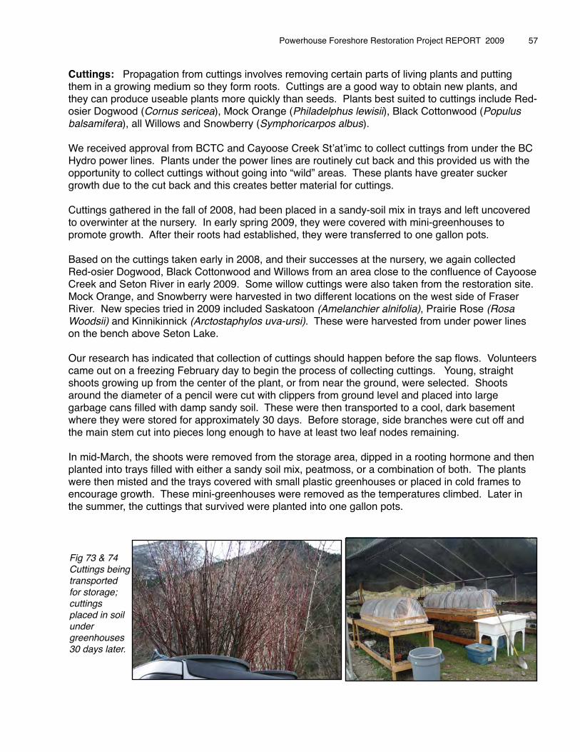
Cuttings: Propagation from cuttings involves removing certain parts of living plants and putting them in a growing medium so they form roots. Cuttings are a good way to obtain new plants, and they can produce useable plants more quickly than seeds. Plants best suited to cuttings include Red-osier Dogwood (Cornus sericea), Mock Orange (Philadelphus lewisii), Black Cottonwood (Populus balsamifera), all Willows and Snowberry (Symphoricarpos albus).
We received approval from BCTC and Cayoose Creek Stʼatʼimc to collect cuttings from under the BC Hydro power lines. Plants under the power lines are routinely cut back and this provided us with the opportunity to collect cuttings without going into “wild” areas. These plants have greater sucker growth due to the cut back and this creates better material for cuttings.
Cuttings gathered in the fall of 2008, had been placed in a sandy-soil mix in trays and left uncovered to overwinter at the nursery. In early spring 2009, they were covered with mini-greenhouses to promote growth. After their roots had established, they were transferred to one gallon pots.
Based on the cuttings taken early in 2008, and their successes at the nursery, we again collected Red-osier Dogwood, Black Cottonwood and Willows from an area close to the confluence of Cayoose Creek and Seton River in early 2009. Some willow cuttings were also taken from the restoration site. Mock Orange, and Snowberry were harvested in two different locations on the west side of Fraser River. New species tried in 2009 included Saskatoon (Amelanchier alnifolia), Prairie Rose (Rosa Woodsii) and Kinnikinnick (Arctostaphylos uva-ursi). These were harvested from under power lines on the bench above Seton Lake.
Our research has indicated that collection of cuttings should happen before the sap flows. Volunteers came out on a freezing February day to begin the process of collecting cuttings. Young, straight shoots growing up from the center of the plant, or from near the ground, were selected. Shoots around the diameter of a pencil were cut with clippers from ground level and placed into large garbage cans filled with damp sandy soil. These were then transported to a cool, dark basement where they were stored for approximately 30 days. Before storage, side branches were cut off and the main stem cut into pieces long enough to have at least two leaf nodes remaining.
In mid-March, the shoots were removed from the storage area, dipped in a rooting hormone and then planted into trays filled with either a sandy soil mix, peatmoss, or a combination of both. The plants were then misted and the trays covered with small plastic greenhouses or placed in cold frames to encourage growth. These mini-greenhouses were removed as the temperatures climbed. Later in the summer, the cuttings that survived were planted into one gallon pots.
Powerhouse Foreshore Restoration Project REPORT 2009 � 57
Fig 73 & 74 Cuttings being transported for storage; cuttings placed in soil under greenhouses 30 days later.
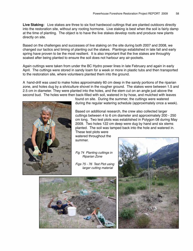
Live Staking: Live stakes are three to six foot hardwood cuttings that are planted outdoors directly into the restoration site, without any rooting hormone. Live staking is best when the soil is fairly damp at the time of planting. The object is to have the live stakes develop roots and produce new plants directly on site.
Based on the challenges and successes of live staking on the site during both 2007 and 2008, we changed our tactics and timing of planting out the stakes. Plantings established in late fall and early spring have proven to be the most resilient. It is also important that the live stakes are throughly soaked after being planted to ensure the soil does not harbour any air-pockets.
Again cuttings were taken from under the BC Hydro power lines in late February and again in early April. The cuttings were stored in sandy loam for a week or more in plastic tubs and then transported to the restoration site, where volunteers planted them into the ground.
A hand-drill was used to make holes approximately 60 cm deep in the sandy portions of the riparian zone, and holes dug by a silviculture shovel in the rougher ground. The stakes were between 1.5 and 2.5 cm in diameter. They were planted into the holes, and the stem cut on an angle just above the second bud. The holes were then back-filled with soil, watered in by hose, and mulched with leaves
found on site. During the summer, the cuttings were watered during the regular watering schedule (approximately once a week).
Based on additional research, the crew also collected larger cuttings between 4 to 6 cm diameter and approximately 200 - 250 cm long. Two test plots was established in Polygon 08 during May 2009. Two holes 122 cm deep were dug by hand and six stems planted. The soil was tamped back into the hole and watered in.These test plots were watered throughout the summer.
Fig 74 Planting cuttings in Riparian Zone
Figs 75 - 76 Test Plot using larger cutting material
Powerhouse Foreshore Restoration Project REPORT 2009 � 58
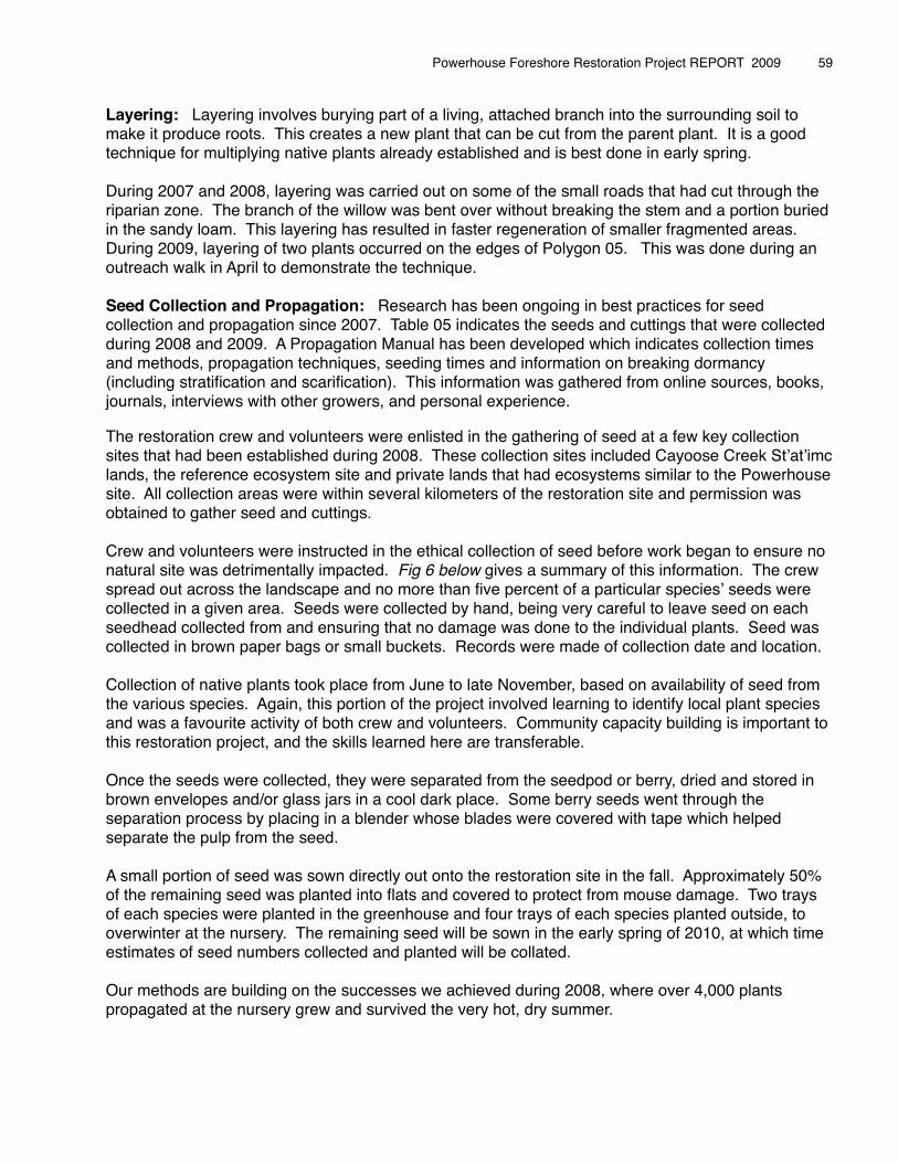
Layering: Layering involves burying part of a living, attached branch into the surrounding soil to make it produce roots. This creates a new plant that can be cut from the parent plant. It is a good technique for multiplying native plants already established and is best done in early spring.
During 2007 and 2008, layering was carried out on some of the small roads that had cut through the riparian zone. The branch of the willow was bent over without breaking the stem and a portion buried in the sandy loam. This layering has resulted in faster regeneration of smaller fragmented areas. During 2009, layering of two plants occurred on the edges of Polygon 05. This was done during an outreach walk in April to demonstrate the technique.
Seed Collection and Propagation: Research has been ongoing in best practices for seed collection and propagation since 2007. Table 05 indicates the seeds and cuttings that were collected during 2008 and 2009. A Propagation Manual has been developed which indicates collection times and methods, propagation techniques, seeding times and information on breaking dormancy (including stratification and scarification). This information was gathered from online sources, books, journals, interviews with other growers, and personal experience.
The restoration crew and volunteers were enlisted in the gathering of seed at a few key collection sites that had been established during 2008. These collection sites included Cayoose Creek Stʼatʼimc lands, the reference ecosystem site and private lands that had ecosystems similar to the Powerhouse site. All collection areas were within several kilometers of the restoration site and permission was obtained to gather seed and cuttings.
Crew and volunteers were instructed in the ethical collection of seed before work began to ensure no natural site was detrimentally impacted. Fig 6 below gives a summary of this information. The crew spread out across the landscape and no more than five percent of a particular speciesʼ seeds were collected in a given area. Seeds were collected by hand, being very careful to leave seed on each seedhead collected from and ensuring that no damage was done to the individual plants. Seed was collected in brown paper bags or small buckets. Records were made of collection date and location.
Collection of native plants took place from June to late November, based on availability of seed from the various species. Again, this portion of the project involved learning to identify local plant species and was a favourite activity of both crew and volunteers. Community capacity building is important to this restoration project, and the skills learned here are transferable.
Once the seeds were collected, they were separated from the seedpod or berry, dried and stored in brown envelopes and/or glass jars in a cool dark place. Some berry seeds went through the separation process by placing in a blender whose blades were covered with tape which helped separate the pulp from the seed.
A small portion of seed was sown directly out onto the restoration site in the fall. Approximately 50% of the remaining seed was planted into flats and covered to protect from mouse damage. Two trays of each species were planted in the greenhouse and four trays of each species planted outside, to overwinter at the nursery. The remaining seed will be sown in the early spring of 2010, at which time estimates of seed numbers collected and planted will be collated.
Our methods are building on the successes we achieved during 2008, where over 4,000 plants propagated at the nursery grew and survived the very hot, dry summer.
Powerhouse Foreshore Restoration Project REPORT 2009 � 59
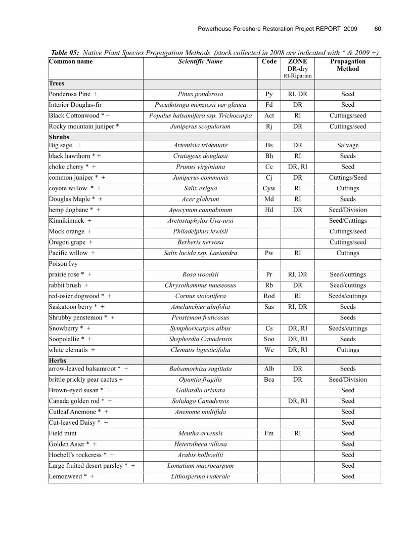
Table 05: Native Plant Species Propagation Methods (stock collected in 2008 are indicated with * & 2009 +)Common name Scientific Name Code ZONE
DR-dry RI-Riparian
Propagation Method
Trees
Ponderosa Pine + Pinus ponderosa Py RI, DR SeedInterior Douglas-fir Pseudotsuga menziesii var glauca Fd DR SeedBlack Cottonwood * + Populus balsamifera ssp. Trichocarpa Act RI Cuttings/seedRocky mountain juniper * Juniperus scopulorum Rj DR Cuttings/seedShrubs
Big sage + Artemisia tridentate Bs DR Salvageblack hawthorn * + Cratageus douglasii Bh RI Seedschoke cherry * + Prunus virginiana Cc DR, RI Seedcommon juniper * + Juniperus communis Cj DR Cuttings/Seedcoyote willow * + Salix exigua Cyw RI CuttingsDouglas Maple * + Acer glabrum Md RI Seedshemp dogbane * + Apocynum cannabinum Hd DR Seed/DivisionKinnikinnick + Arctostaphylos Uva-ursi Seed/CuttingsMock orange + Philadelphus lewisii Cuttings/seedOregon grape + Berberis nervosa Cuttings/seedPacific willow + Salix lucida ssp. Lasiandra Pw RI CuttingsPoison Ivyprairie rose * + Rosa woodsii Pr RI, DR Seed/cuttingsrabbit brush + Chrysothamnus nauseosus Rb DR Seed/cuttingsred-osier dogwood * + Cornus stolonifera Rod RI Seeds/cuttingsSaskatoon berry * + Amelanchier alnifolia Sas RI, DR SeedsShrubby penstemon * + Penstemon fruticosus SeedsSnowberry * + Symphoricarpos albus Cs DR, RI Seeds/cuttingsSoopolallie * + Shepherdia Canadensis Soo DR, RI Seedswhite clematis + Clematis ligusticifolia Wc DR, RI CuttingsHerbs
arrow-leaved balsamroot * + Balsamorhiza sagittata Alb DR Seedsbrittle prickly pear cactus + Opuntia fragilis Bca DR Seed/DivisionBrown-eyed susan * + Gailardia aristata SeedCanada golden rod * + Solidago Canadensis DR, RI SeedCutleaf Anemone * + Anenome multifida SeedCut-leaved Daisy * + SeedField mint Mentha arvensis Fm RI SeedGolden Aster * + Heterotheca villosa SeedHoebell’s rockcress * + Arabis holboellii SeedLarge fruited desert parsley * + Lomatium macrocarpum SeedLemonweed * + Lithosperma ruderale Seed
Powerhouse Foreshore Restoration Project REPORT 2009 � 60
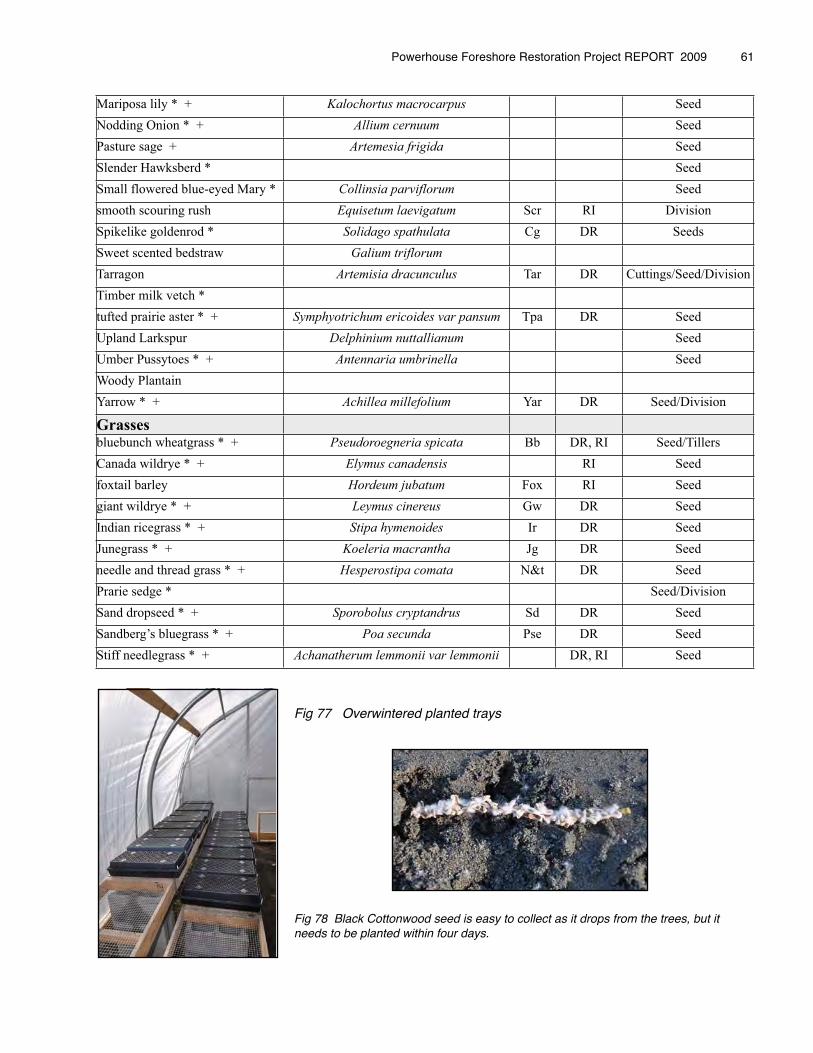
Mariposa lily * + Kalochortus macrocarpus SeedNodding Onion * + Allium cernuum SeedPasture sage + Artemesia frigida SeedSlender Hawksberd * SeedSmall flowered blue-eyed Mary * Collinsia parviflorum Seedsmooth scouring rush Equisetum laevigatum Scr RI DivisionSpikelike goldenrod * Solidago spathulata Cg DR SeedsSweet scented bedstraw Galium triflorum
Tarragon Artemisia dracunculus Tar DR Cuttings/Seed/DivisionTimber milk vetch *tufted prairie aster * + Symphyotrichum ericoides var pansum Tpa DR SeedUpland Larkspur Delphinium nuttallianum SeedUmber Pussytoes * + Antennaria umbrinella SeedWoody PlantainYarrow * + Achillea millefolium Yar DR Seed/Division
Grassesbluebunch wheatgrass * + Pseudoroegneria spicata Bb DR, RI Seed/TillersCanada wildrye * + Elymus canadensis RI Seedfoxtail barley Hordeum jubatum Fox RI Seedgiant wildrye * + Leymus cinereus Gw DR SeedIndian ricegrass * + Stipa hymenoides Ir DR SeedJunegrass * + Koeleria macrantha Jg DR Seedneedle and thread grass * + Hesperostipa comata N&t DR SeedPrarie sedge * Seed/DivisionSand dropseed * + Sporobolus cryptandrus Sd DR SeedSandberg’s bluegrass * + Poa secunda Pse DR SeedStiff needlegrass * + Achanatherum lemmonii var lemmonii DR, RI Seed
Fig 77 Overwintered planted trays
Fig 78 Black Cottonwood seed is easy to collect as it drops from the trees, but it needs to be planted within four days.
Powerhouse Foreshore Restoration Project REPORT 2009 � 61
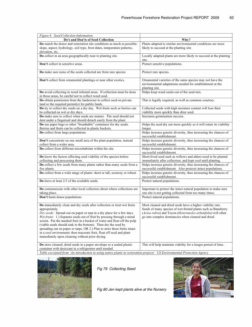
Fig 79 Collecting Seed
Fig 80 Jen kept plants alive at the Nursery
Powerhouse Foreshore Restoration Project REPORT 2009 � 62
Figure 6 Seed Collection Information
Do's and Don'ts of Seed Collection Why?
Do match the donor and restoration site conditions as much as possible: slope, aspect, hydrology, soil type, frost dates, temperature patterns, elevation, etc.
Plants adapted to similar environmental conditions are more likely to succeed at the planting site.
Do collect in an area geographically near to planting site. Locally adapted plants are more likely to succeed at the planting site.
Don’t collect in sensitive areas.
Protect sensitive populations.
Do make sure none of the seeds collected are from rare species
Protect rare species.
Don’t collect from ornamental plantings or near other exotics. Ornamental varieties of the same species may not have the environmental adaptations needed for establishment at the planting site.
Do avoid collecting in weed infested areas. If collection must be done in those areas, be careful not to collect weed seed.
Helps keep weed seeds out of the seed mix.
Do obtain permission from the landowner to collect seed on private land or the required permit(s) for public lands.
This is legally required, as well as common courtesy.
Do try to collect dry seeds on a dry day. Wet fruits such as berries can be collected on wet or dry days.
Collected seeds with high moisture content will lose their viability more quickly than drier seed.
Do make sure to collect when seeds are mature. The seed should not dent under a fingernail and should detach easily from the plant.
Increases germination success.
Do use paper bags or other “breathable” containers for dry seeds. Berries and fruits can be collected in plastic buckets.
Helps the seed dry out more quickly so it will retain its viability longer.
Do collect from large populations. Helps increase genetic diversity, thus increasing the chances of successful establishment.
Don’t concentrate on one small area of the plant population, instead collect from a wider area.
Helps increase genetic diversity, thus increasing the chances of successful establishment.
Do collect from different microhabitats within the site. Helps increase genetic diversity, thus increasing the chances of successful establishment.
Do know the factors affecting seed viability of the species before collecting and processing them.
Short-lived seed such as willows and alders need to be planted immediately after collection, and kept cool until planting.
Do collect a few seeds from many plants rather than many seeds from a few plants.
Helps increase genetic diversity, thus increasing the chances of successful establishment. Also protects intact populations.
Do collect from a wide range of plants: short or tall, scrawny or robust. Helps increase genetic diversity, thus increasing the chances of successful establishment.
Do leave at least 2/3 of the available seeds.
Protect natural populations.
Do communicate with other local collectors about where collections are taking place.
Important to protect the intact natural population to make sure one site is not getting collected from too many times.
Don’t harm donor populations.
Protect natural populations.
Do immediately clean and dry seeds after collection or treat wet fruits appropriately. Dry seeds: Spread out on paper or tarp in a dry place for a few days. Wet fruits: 1.) Separate seeds out of fruit by pressing through a metal screen. Put the mashed fruit in a bucket of water and float off the pulp (viable seeds should sink to the bottom). Then dry the seed by spreading out on paper or tarps. OR 2.) Plan to store these fruits intact in a cool environment; then macerate fruit, float off seed and plant immediately upon cleaning without prior drying.
Most cleaned and dried seeds have a higher viability rate. Seeds of many species of wet-fruited plants such as Baneberry (Actea rubra) and Toyon (Heteromeles arbutifolia) will often go into complex dormancies when cleaned and dried.
Do store cleaned, dried seeds in a paper envelope or a sealed plastic container with desiccant in a refrigerator until needed.
This will help maintain viability for a longer period of time.
Table excerpted from ‘An introduction to using native plants in restoration projects’ US Environmental Protection Agency
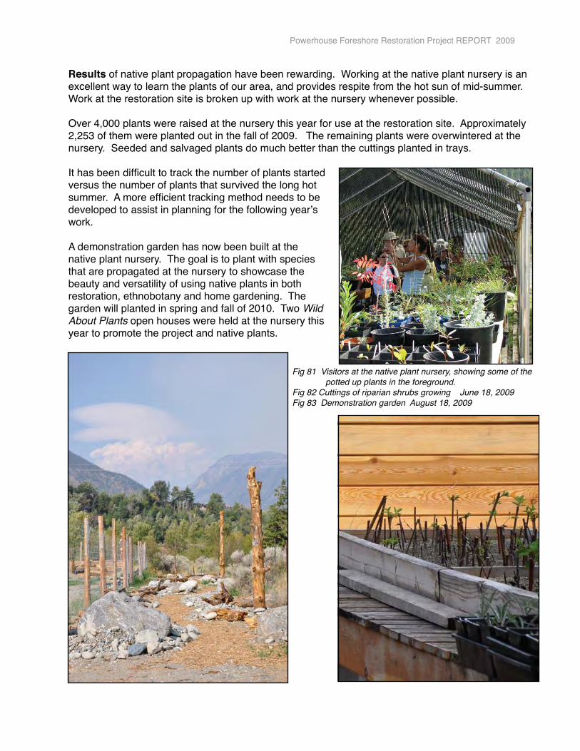
Results of native plant propagation have been rewarding. Working at the native plant nursery is an excellent way to learn the plants of our area, and provides respite from the hot sun of mid-summer. Work at the restoration site is broken up with work at the nursery whenever possible.
Over 4,000 plants were raised at the nursery this year for use at the restoration site. Approximately 2,253 of them were planted out in the fall of 2009. The remaining plants were overwintered at the nursery. Seeded and salvaged plants do much better than the cuttings planted in trays.
It has been difficult to track the number of plants started versus the number of plants that survived the long hot summer. A more efficient tracking method needs to be developed to assist in planning for the following yearʼs work.
A demonstration garden has now been built at the native plant nursery. The goal is to plant with species that are propagated at the nursery to showcase the beauty and versatility of using native plants in both restoration, ethnobotany and home gardening. The garden will planted in spring and fall of 2010. Two Wild About Plants open houses were held at the nursery this year to promote the project and native plants.
Powerhouse Foreshore Restoration Project REPORT 2009
Fig 81 Visitors at the native plant nursery, showing some of the potted up plants in the foreground.Fig 82 Cuttings of riparian shrubs growing June 18, 2009Fig 83 Demonstration garden August 18, 2009
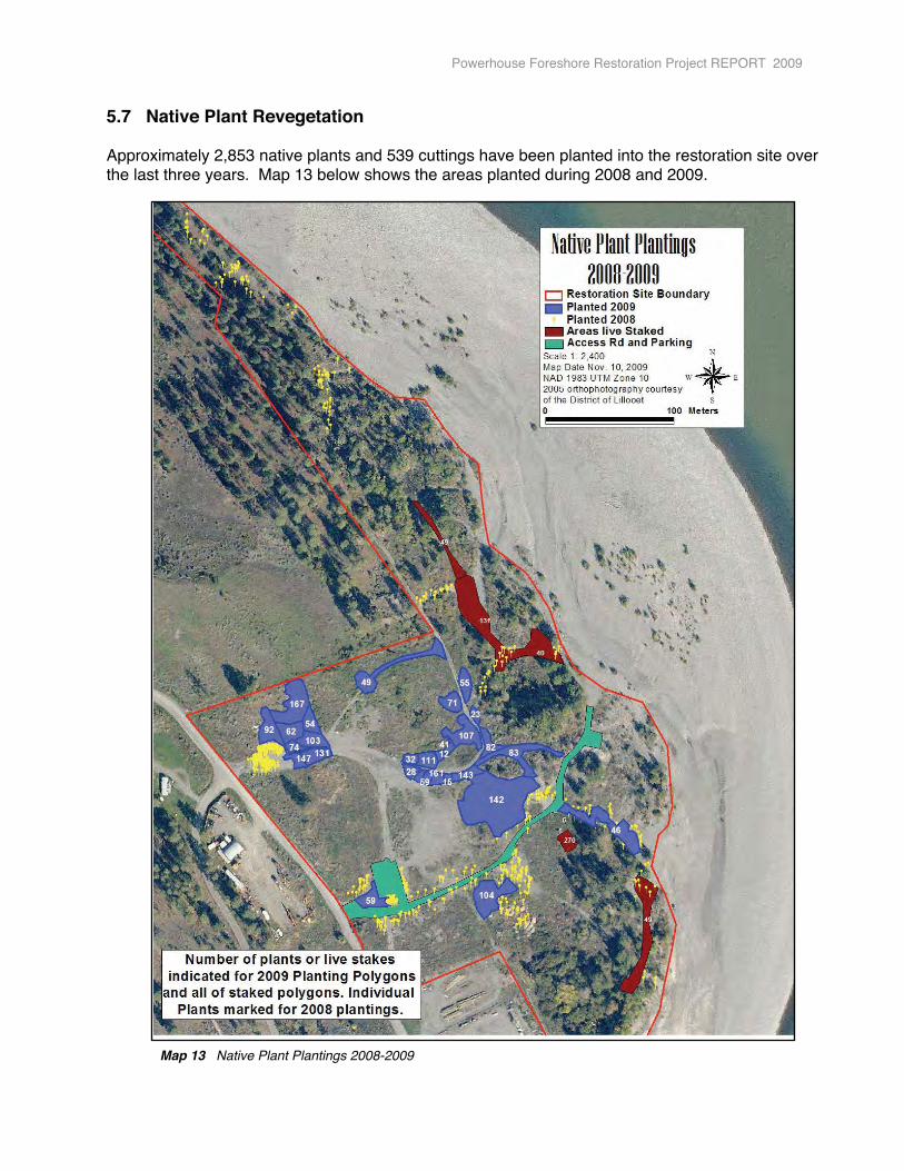
5.7 Native Plant Revegetation
Approximately 2,853 native plants and 539 cuttings have been planted into the restoration site over the last three years. Map 13 below shows the areas planted during 2008 and 2009.
Map 13 Native Plant Plantings 2008-2009
Powerhouse Foreshore Restoration Project REPORT 2009
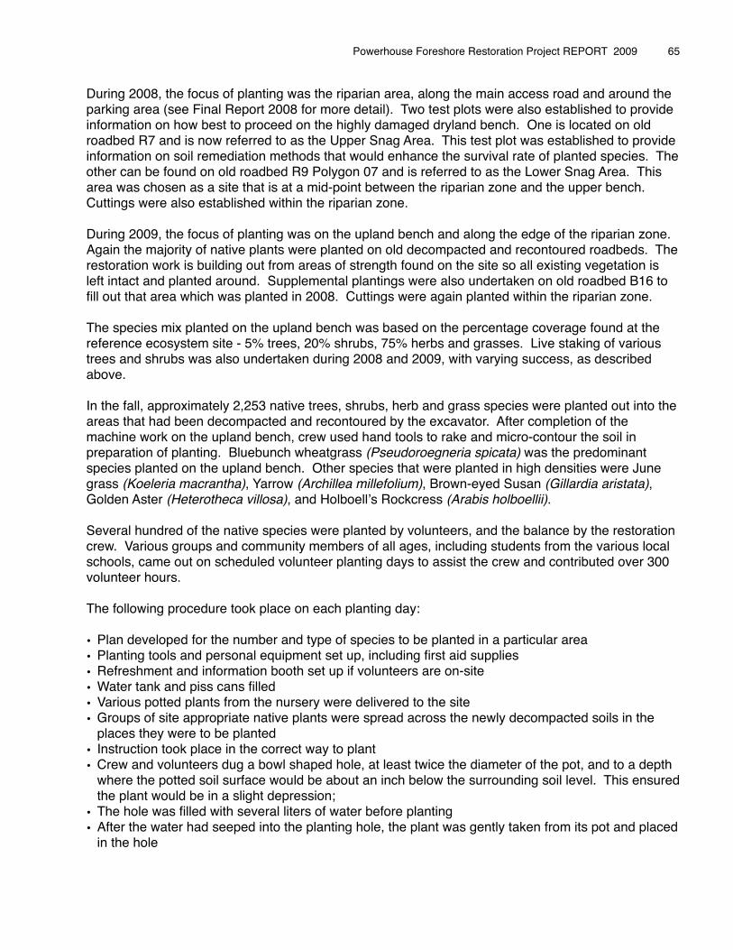
During 2008, the focus of planting was the riparian area, along the main access road and around the parking area (see Final Report 2008 for more detail). Two test plots were also established to provide information on how best to proceed on the highly damaged dryland bench. One is located on old roadbed R7 and is now referred to as the Upper Snag Area. This test plot was established to provide information on soil remediation methods that would enhance the survival rate of planted species. The other can be found on old roadbed R9 Polygon 07 and is referred to as the Lower Snag Area. This area was chosen as a site that is at a mid-point between the riparian zone and the upper bench. Cuttings were also established within the riparian zone.
During 2009, the focus of planting was on the upland bench and along the edge of the riparian zone. Again the majority of native plants were planted on old decompacted and recontoured roadbeds. The restoration work is building out from areas of strength found on the site so all existing vegetation is left intact and planted around. Supplemental plantings were also undertaken on old roadbed B16 to fill out that area which was planted in 2008. Cuttings were again planted within the riparian zone.
The species mix planted on the upland bench was based on the percentage coverage found at the reference ecosystem site - 5% trees, 20% shrubs, 75% herbs and grasses. Live staking of various trees and shrubs was also undertaken during 2008 and 2009, with varying success, as described above.
In the fall, approximately 2,253 native trees, shrubs, herb and grass species were planted out into the areas that had been decompacted and recontoured by the excavator. After completion of the machine work on the upland bench, crew used hand tools to rake and micro-contour the soil in preparation of planting. Bluebunch wheatgrass (Pseudoroegneria spicata) was the predominant species planted on the upland bench. Other species that were planted in high densities were June grass (Koeleria macrantha), Yarrow (Archillea millefolium), Brown-eyed Susan (Gillardia aristata), Golden Aster (Heterotheca villosa), and Holboellʼs Rockcress (Arabis holboellii).
Several hundred of the native species were planted by volunteers, and the balance by the restoration crew. Various groups and community members of all ages, including students from the various local schools, came out on scheduled volunteer planting days to assist the crew and contributed over 300 volunteer hours.
The following procedure took place on each planting day:
• Plan developed for the number and type of species to be planted in a particular area• Planting tools and personal equipment set up, including first aid supplies• Refreshment and information booth set up if volunteers are on-site• Water tank and piss cans filled• Various potted plants from the nursery were delivered to the site• Groups of site appropriate native plants were spread across the newly decompacted soils in the
places they were to be planted• Instruction took place in the correct way to plant• Crew and volunteers dug a bowl shaped hole, at least twice the diameter of the pot, and to a depth
where the potted soil surface would be about an inch below the surrounding soil level. This ensured the plant would be in a slight depression;
• The hole was filled with several liters of water before planting• After the water had seeped into the planting hole, the plant was gently taken from its pot and placed
in the hole
Powerhouse Foreshore Restoration Project REPORT 2009 � 65
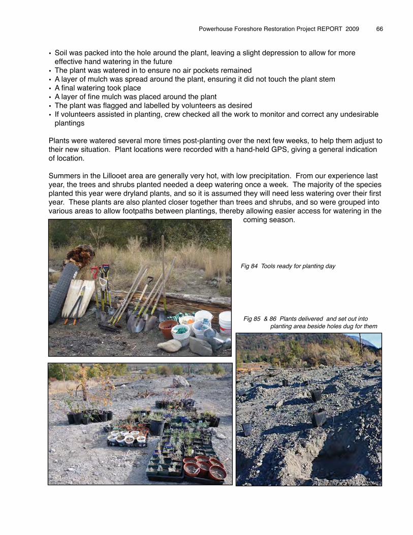
• Soil was packed into the hole around the plant, leaving a slight depression to allow for more effective hand watering in the future
• The plant was watered in to ensure no air pockets remained• A layer of mulch was spread around the plant, ensuring it did not touch the plant stem• A final watering took place• A layer of fine mulch was placed around the plant• The plant was flagged and labelled by volunteers as desired • If volunteers assisted in planting, crew checked all the work to monitor and correct any undesirable
plantings
Plants were watered several more times post-planting over the next few weeks, to help them adjust to their new situation. Plant locations were recorded with a hand-held GPS, giving a general indication of location.
Summers in the Lillooet area are generally very hot, with low precipitation. From our experience last year, the trees and shrubs planted needed a deep watering once a week. The majority of the species planted this year were dryland plants, and so it is assumed they will need less watering over their first year. These plants are also planted closer together than trees and shrubs, and so were grouped into various areas to allow footpaths between plantings, thereby allowing easier access for watering in the � � � � � � � � coming season. � � � � � �
� � � � � � � � Fig 85 & 86 Plants delivered and set out into � � � � � planting area beside holes dug for them
Fig 22 Planting Lesson
Powerhouse Foreshore Restoration Project REPORT 2009 � 66
Fig 84 Tools ready for planting day
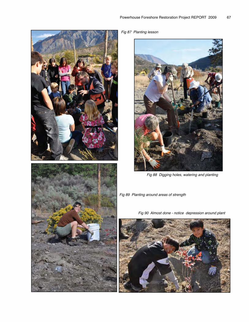
� � � � � � Fig 87 Planting lesson
� � � � � � � � Fig 88 Digging holes, watering and planting
� � � � � � � �� � � � � � Fig 89 Planting around areas of strength
� � � � � � � Fig 90 Almost done - notice depression around plant
Powerhouse Foreshore Restoration Project REPORT 2009 � 67
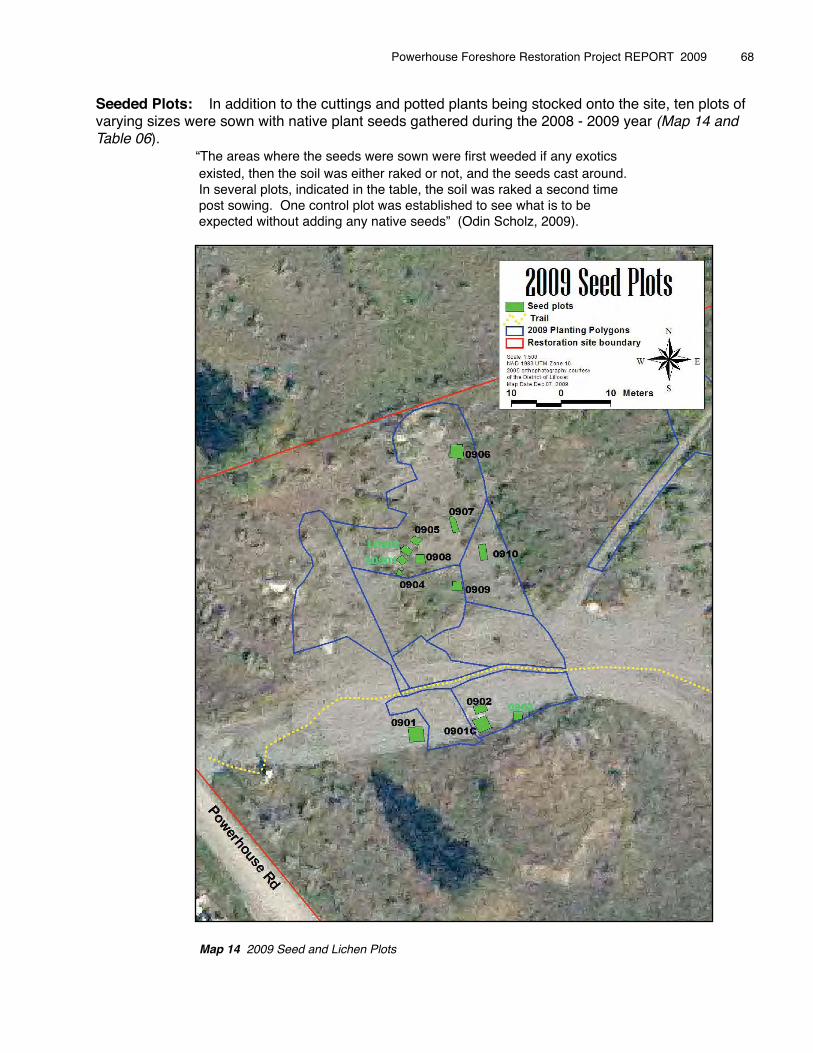
Seeded Plots: In addition to the cuttings and potted plants being stocked onto the site, ten plots of varying sizes were sown with native plant seeds gathered during the 2008 - 2009 year (Map 14 and Table 06).� � “The areas where the seeds were sown were first weeded if any exotics � � existed, then the soil was either raked or not, and the seeds cast around. � � In several plots, indicated in the table, the soil was raked a second time � � post sowing. One control plot was established to see what is to be � � expected without adding any native seeds” (Odin Scholz, 2009).
Map 14 2009 Seed and Lichen Plots
Powerhouse Foreshore Restoration Project REPORT 2009 � 68
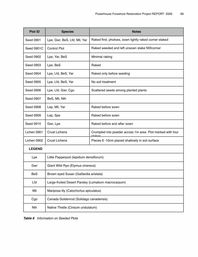
Plot ID Species Notes
Seed 0901 Lpe, Gwr, BeS, Lfd, Mli, Yar Raked first, photoes, sown lightly raked corner staked
Seed 0901C Control Plot Raked weeded and left unsown stake NWcorner
Seed 0902 Lpe, Yar, BeS Minimal raking
Seed 0903 Lpe, BeS Raked
Seed 0904 Lpe, Lfd, BeS, Yar Raked only before seeding
Seed 0905 Lpe, Lfd, BeS, Yar No soil treatment
Seed 0906 Lpe, Lfd, Gwr, Cgo Scattered seeds among planted plants
Seed 0907 BeS, Mli, Nth
Seed 0908 Lep, Mli, Yar Raked before sown
Seed 0909 Lep, Spe Raked before sown
Seed 0910 Gwr, Lpe Raked before and after sown
Lichen 0901 Crust Lichens Crumpled into powder across 1m area Plot marked with four stakes
Lichen 0902 Crust Lichens Pieces 6 -10cm placed shallowly in soil surface
LEGEND
Lpe Little Pepperpod (lepidium densiflorum)
Gwr Giant Wild Rye (Elymus cinereeus)
BeS Brown eyed Susan (Gaillardiaa aristata)
Lfd Large-fruited Desert Parsley ((Lomatium macrocarpum)
Mli Mariposa lily (Calochortus apiculatus)
Cgo Canada Goldenrod (Solidago canadensis)
Nth Native Thistle (Cirsium undulaatum)
Table 6 Information on Seeded Plots
Powerhouse Foreshore Restoration Project REPORT 2009 � 69
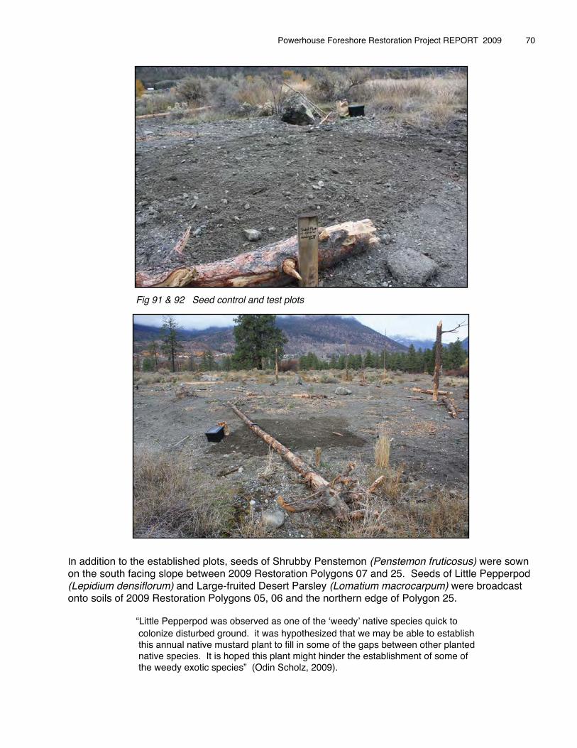
In addition to the established plots, seeds of Shrubby Penstemon (Penstemon fruticosus) were sown on the south facing slope between 2009 Restoration Polygons 07 and 25. Seeds of Little Pepperpod (Lepidium densiflorum) and Large-fruited Desert Parsley (Lomatium macrocarpum) were broadcast onto soils of 2009 Restoration Polygons 05, 06 and the northern edge of Polygon 25.
� � “Little Pepperpod was observed as one of the ʻweedyʼ native species quick to� � colonize disturbed ground. it was hypothesized that we may be able to establish� � this annual native mustard plant to fill in some of the gaps between other planted� � native species. It is hoped this plant might hinder the establishment of some of� � the weedy exotic species” (Odin Scholz, 2009).
Powerhouse Foreshore Restoration Project REPORT 2009 � 70
Fig 91 & 92 Seed control and test plots
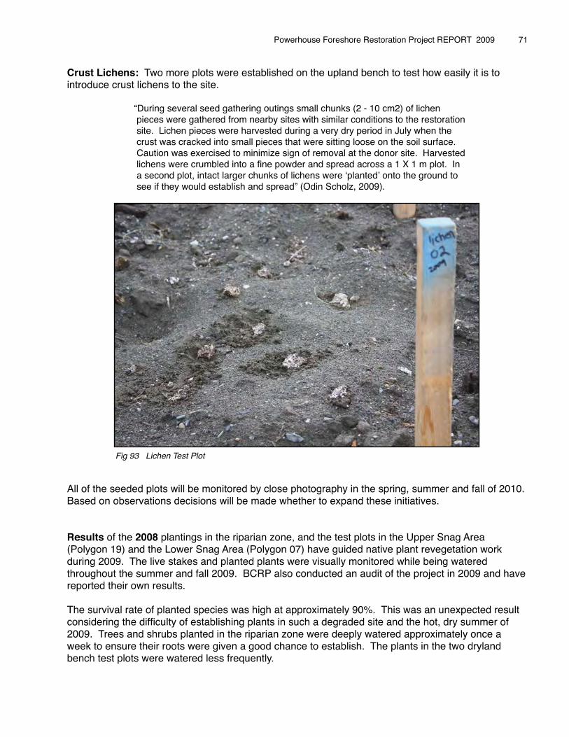
Crust Lichens: Two more plots were established on the upland bench to test how easily it is to introduce crust lichens to the site.� �� � “During several seed gathering outings small chunks (2 - 10 cm2) of lichen� � pieces were gathered from nearby sites with similar conditions to the restoration� � site. Lichen pieces were harvested during a very dry period in July when the � � crust was cracked into small pieces that were sitting loose on the soil surface.� � Caution was exercised to minimize sign of removal at the donor site. Harvested� � lichens were crumbled into a fine powder and spread across a 1 X 1 m plot. In� � a second plot, intact larger chunks of lichens were ʻplantedʼ onto the ground to� � see if they would establish and spread” (Odin Scholz, 2009). �
All of the seeded plots will be monitored by close photography in the spring, summer and fall of 2010. Based on observations decisions will be made whether to expand these initiatives.
Results of the 2008 plantings in the riparian zone, and the test plots in the Upper Snag Area (Polygon 19) and the Lower Snag Area (Polygon 07) have guided native plant revegetation work during 2009. The live stakes and planted plants were visually monitored while being watered throughout the summer and fall 2009. BCRP also conducted an audit of the project in 2009 and have reported their own results.
The survival rate of planted species was high at approximately 90%. This was an unexpected result considering the difficulty of establishing plants in such a degraded site and the hot, dry summer of 2009. Trees and shrubs planted in the riparian zone were deeply watered approximately once a week to ensure their roots were given a good chance to establish. The plants in the two dryland bench test plots were watered less frequently.
Powerhouse Foreshore Restoration Project REPORT 2009 � 71
Fig 93 Lichen Test Plot

The survival rate of the live stakes was moderate at approximately 60%. The live stakes planted in 2007 had a low survival rate. We have explored the reasons for the 40% loss during 2009, and developed a plan. Odin Scholz reports that:
⇒ The intensive live staked area in Polygon 08 where 270 live stakes were planted in 2007, has seen a low survival rate of just 3%. This contrasts to the 40 live stakes
� � planted on the B12 site at a similar date in the fall of 2008, where survival rate is over � � 95%. The big difference being the 2009 planting holes were drilled with a hydraulic � � jack-hammer, the cuttings water in and then watered at least a dozen times throughout� � the summer of 2009. The 2007 plantings were hand planted and never watered.
⇒ The live stakes planted in the summer of 2008 in Polygon 19 and on B17 just after high water also show low survival rates. Even though the stakes were planted directly after the high-water event when the ground was still damp, their survival was hampered by the sandy soil drying out too quickly.
⇒ Cuttings planted in the spring of 2009 also seemed to be doing well throughout the summer. They were watered along with the riparian plants on a weekly basis. These live stakes were much more dispersed in distribution and mixed among the dead stems from the summer of 2008 staking, so it was difficult to determine how many survived.
⇒ Additional research into best practices for live staking confirms that taking cuttings before the sap flows, storing in a dark, cool place for 30 days, and then planting out in early spring will provide better results. It is also recommended that the cuttings be planted in small dense patches (20 cuttings), using the pre-drilling method, and ensuring they are watered in. These dense patches will make it easier to water, maintain and monitor.
⇒ Cutting areas to focus on during 2010 will include the south-centre pit area and the old B16 road. Re-staking in Polygon 08 were survival rate is poor is also recommended.
Powerhouse Foreshore Restoration Project REPORT 2009 � 72
Fig 94 Cutting in Polygon 11 just after high water July 16, 2009Fig 95 Group of cuttings in Polygon 19 August 30, 2009
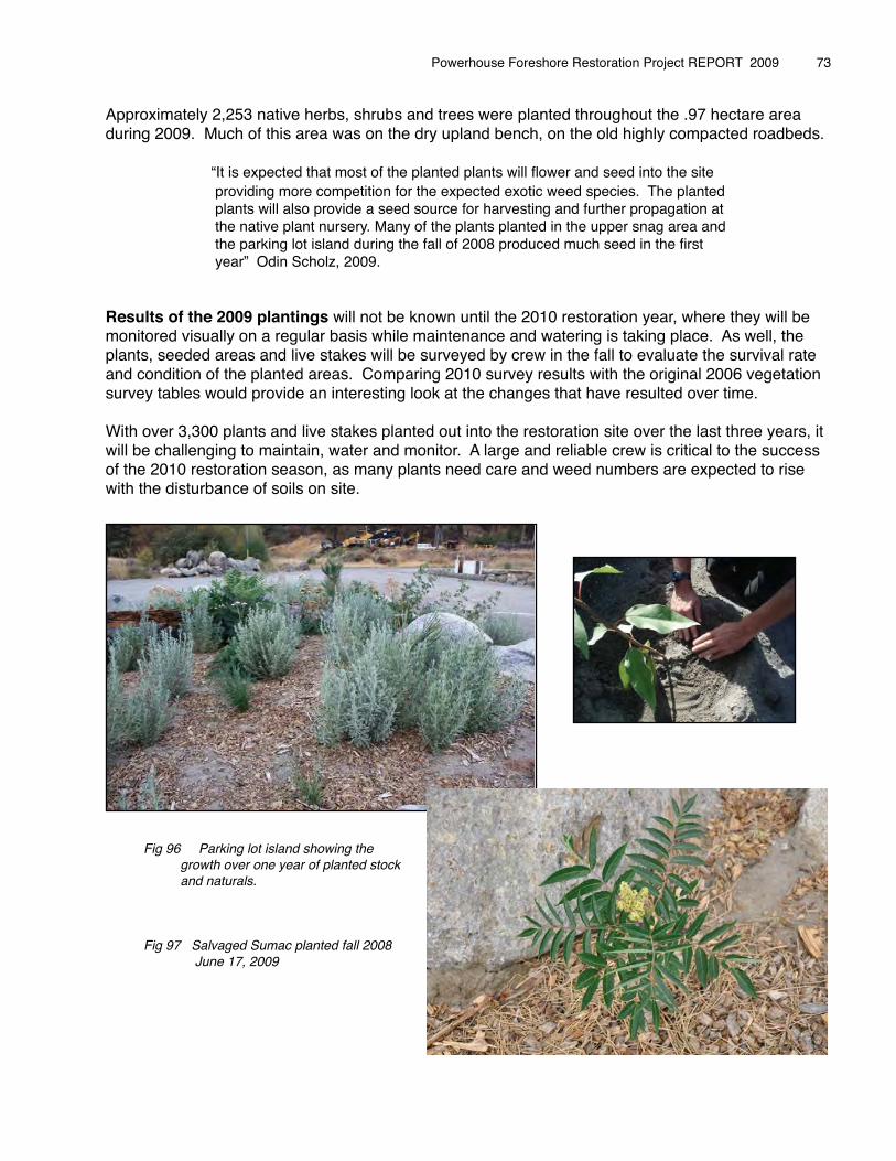
Approximately 2,253 native herbs, shrubs and trees were planted throughout the .97 hectare area during 2009. Much of this area was on the dry upland bench, on the old highly compacted roadbeds.
� � “It is expected that most of the planted plants will flower and seed into the site � � providing more competition for the expected exotic weed species. The planted� � plants will also provide a seed source for harvesting and further propagation at � � the native plant nursery. Many of the plants planted in the upper snag area and � � the parking lot island during the fall of 2008 produced much seed in the first� � year” Odin Scholz, 2009.
Results of the 2009 plantings will not be known until the 2010 restoration year, where they will be monitored visually on a regular basis while maintenance and watering is taking place. As well, the plants, seeded areas and live stakes will be surveyed by crew in the fall to evaluate the survival rate and condition of the planted areas. Comparing 2010 survey results with the original 2006 vegetation survey tables would provide an interesting look at the changes that have resulted over time.
With over 3,300 plants and live stakes planted out into the restoration site over the last three years, it will be challenging to maintain, water and monitor. A large and reliable crew is critical to the success of the 2010 restoration season, as many plants need care and weed numbers are expected to rise with the disturbance of soils on site.
Powerhouse Foreshore Restoration Project REPORT 2009 � 73
Fig 96 Parking lot island showing the growth over one year of planted stock and naturals.
Fig 97 Salvaged Sumac planted fall 2008 June 17, 2009

Powerhouse Foreshore Restoration Project REPORT 2009
Fig 98 Ponderosa pine planted fall 2008 Fig 99 Prairie Rose planted fall 2008 November 01, 2009 November 01, 2009
Fig 100 - 101 Bluebunch Wheatgrass and Yarrow started in nursery by seed in spring 2008, planted fall 2008.
Growth shown by April 21, 2009
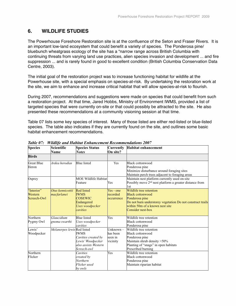
6.� WILDLIFE STUDIES
The Powerhouse Foreshore Restoration site is at the confluence of the Seton and Fraser Rivers. It is an important low-land ecosystem that could benefit a variety of species. The Ponderosa pine/bluebunch wheatgrass ecology of the site has a “narrow range across British Columbia with continuing threats from varying land use practices, alien species invasion and development ... and fire suppression ... and is rarely found in good to excellent condition (British Columbia Conservation Data Centre, 2003).
The initial goal of the restoration project was to increase functioning habitat for wildlife at the Powerhouse site, with a special emphasis on species-at-risk. By undertaking the restoration work at the site, we aim to enhance and increase critical habitat that will allow species-at-risk to flourish.
During 2007, recommendations and suggestions were made on species that could benefit from such a restoration project. At that time, Jared Hobbs, Ministry of Environment IWMS, provided a list of targeted species that were currently on-site or that could possibly be attracted to the site. He also presented these recommendations at a community visioning session at that time.
Table 07 lists some key species of interest. Many of those listed are either red-listed or blue-listed species. The table also indicates if they are currently found on the site, and outlines some basic habitat enhancement recommendations.
Table 07: Wildlife and Habitat Enhancement Recommendations 2007
Species Scientific Name
Species StatusNotes
Currently On site?
Habitat enhancement
Birds
Great Blue Heron
Ardea herodias Blue listed Yes Black cottonwoodPonderosa pineMinimize disturbance around foraging sitesMaintain perch trees adjacent to foraging areas
Osprey MOE Wildlife Habitat Feature
Yes
Maintain nest platform currently used on-sitePossibly move 2nd nest platform a greater distance from 1st
“Interior” Western Screech-Owl
Otus kennicottii macfarlanei
Red listedIWMSCOSEWIC Endangered Uses woodpecker cavities
Yes - one recorded occurrence
Wildlife tree retentionBlack cottonwoodPonderosa pineDo not burn understorey vegetation Do not construct trails within 50m of a known nest siteConsider nest-box
Northern Pygmy Owl
Glaucidium gnoma swarthi
Blue listedUses woodpecker cavities
Yes Wildlife tree retentionBlack cottonwoodPonderosa pine
Lewis’ Woodpecker
Melanerpes lewis Red listedIWMSCavities created by Lewis’ Woodpecker also assists Western Screech-owl
Unknown – has been seen in vicinity
Wildlife tree retentionBlack cottonwoodPonderosa pineMaintain shrub density >50%Planting of “snags” in open habitatsPrescribed burning
Northern Flicker
Cavities created by Northern Flicker used by owls
Yes Wildlife tree retentionBlack cottonwoodPonderosa pineMaintain riparian habitat
Powerhouse Foreshore Restoration Project REPORT 2009
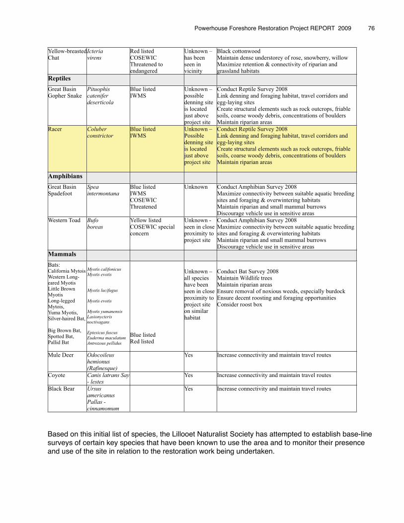
Yellow-breastedChat
Icteria virens
Red listedCOSEWIC Threatened to endangered
Unknown – has been seen in vicinity
Black cottonwoodMaintain dense understorey of rose, snowberry, willowMaximize retention & connectivity of riparian and grassland habitats
Reptiles
Great BasinGopher Snake
Pituophis catenifer deserticola
Blue listedIWMS
Unknown – possible denning site is located just above project site
Conduct Reptile Survey 2008 Link denning and foraging habitat, travel corridors and egg-laying sites Create structural elements such as rock outcrops, friable soils, coarse woody debris, concentrations of bouldersMaintain riparian areas
Racer Coluber constrictor
Blue listedIWMS
Unknown – Possible denning site is located just above project site
Conduct Reptile Survey 2008Link denning and foraging habitat, travel corridors and egg-laying sites Create structural elements such as rock outcrops, friable soils, coarse woody debris, concentrations of bouldersMaintain riparian areas
Amphibians
Great Basin Spadefoot
Spea intermontana
Blue listedIWMSCOSEWIC Threatened
Unknown Conduct Amphibian Survey 2008Maximize connectivity between suitable aquatic breeding sites and foraging & overwintering habitatsMaintain riparian and small mammal burrowsDiscourage vehicle use in sensitive areas
Western Toad Bufo boreas
Yellow listedCOSEWIC special concern
Unknown - seen in close proximity to project site
Conduct Amphibian Survey 2008Maximize connectivity between suitable aquatic breeding sites and foraging & overwintering habitatsMaintain riparian and small mammal burrowsDiscourage vehicle use in sensitive areas
Mammals
Bats:California MytoisWestern Long-eared MyotisLittle Brown MyotisLong-legged Mytois, Yuma Myotis, Silver-haired Bat,
Big Brown Bat, Spotted Bat, Pallid Bat
Myotis califonicus
Myotis evotis
Myotis lucifugus
Myotis evotis
Myotis yumanensis
Lasionycteris
noctivagans
Eptesicus fuscus
Euderma maculatum
Antrozous pellidus
Blue listedRed listed
Unknown – all species have been seen in close proximity to project site on similar habitat
Conduct Bat Survey 2008Maintain Wildlife treesMaintain riparian areasEnsure removal of noxious weeds, especially burdockEnsure decent roosting and foraging opportunitiesConsider roost box
Mule Deer Odocoileus hemionus (Rafinesque)
Yes Increase connectivity and maintain travel routes
Coyote Canis latrans Say - lestes
Yes Increase connectivity and maintain travel routes
Black Bear Ursus americanus Pallas - cinnamomum
Yes Increase connectivity and maintain travel routes
Based on this initial list of species, the Lillooet Naturalist Society has attempted to establish base-line surveys of certain key species that have been known to use the area and to monitor their presence and use of the site in relation to the restoration work being undertaken.
Powerhouse Foreshore Restoration Project REPORT 2009 � 76
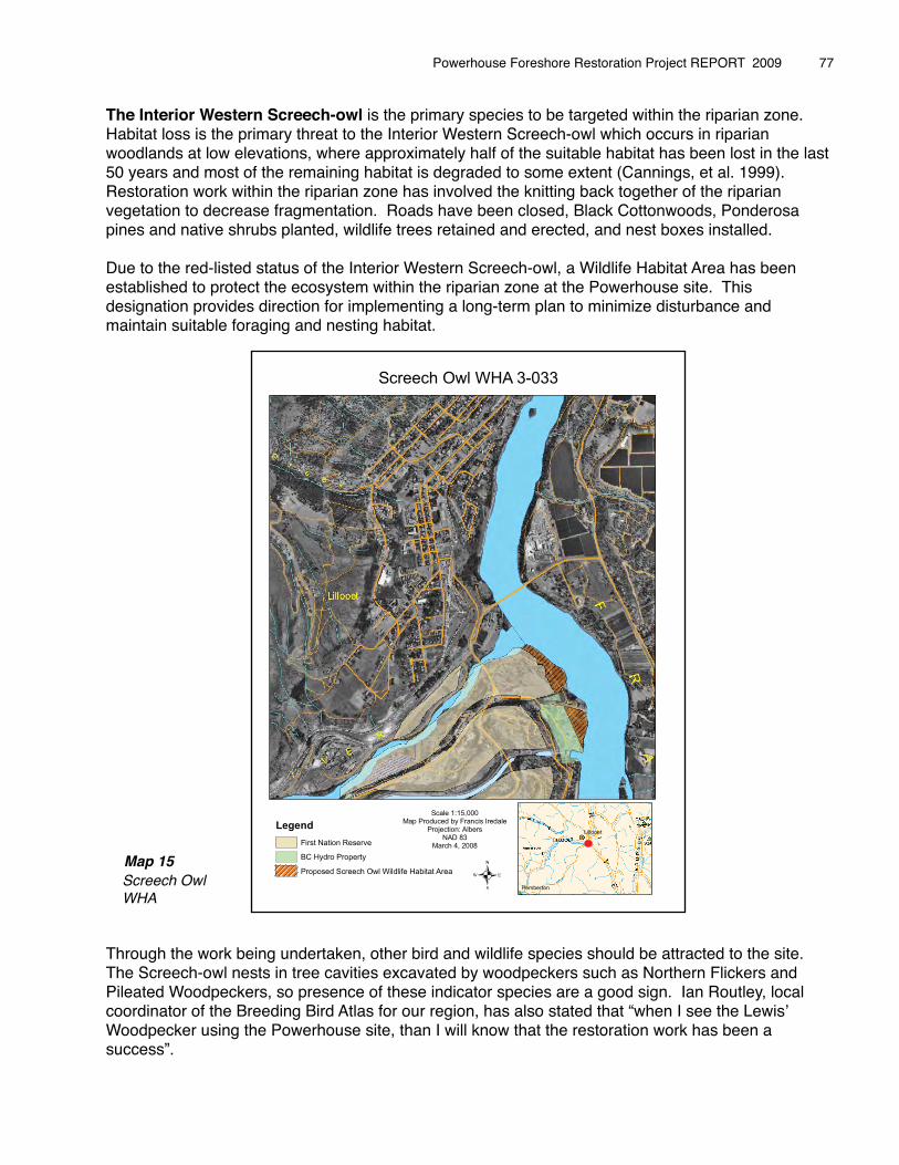
The Interior Western Screech-owl is the primary species to be targeted within the riparian zone. Habitat loss is the primary threat to the Interior Western Screech-owl which occurs in riparian woodlands at low elevations, where approximately half of the suitable habitat has been lost in the last 50 years and most of the remaining habitat is degraded to some extent (Cannings, et al. 1999). Restoration work within the riparian zone has involved the knitting back together of the riparian vegetation to decrease fragmentation. Roads have been closed, Black Cottonwoods, Ponderosa pines and native shrubs planted, wildlife trees retained and erected, and nest boxes installed.
Due to the red-listed status of the Interior Western Screech-owl, a Wildlife Habitat Area has been established to protect the ecosystem within the riparian zone at the Powerhouse site. This designation provides direction for implementing a long-term plan to minimize disturbance and maintain suitable foraging and nesting habitat.
Map 15 Screech Owl WHA
Through the work being undertaken, other bird and wildlife species should be attracted to the site. The Screech-owl nests in tree cavities excavated by woodpeckers such as Northern Flickers and Pileated Woodpeckers, so presence of these indicator species are a good sign. Ian Routley, local coordinator of the Breeding Bird Atlas for our region, has also stated that “when I see the Lewisʼ Woodpecker using the Powerhouse site, than I will know that the restoration work has been a success”.
Powerhouse Foreshore Restoration Project REPORT 2009 � 77
Legend
First Nation Reserve
BC Hydro Property
Proposed Screech Owl Wildlife Habitat Area
Lillooet
Pemberton
Screech Owl WHA 3-033
�
Scale 1:15,000Map Produced by Francis Iredale
Projection: AlbersNAD 83
March 4, 2008

Reptiles, especially the Racer, is the indicator species to be monitored on the upland bench. The Racer is a blue-listed species that forages on sandy terraces along riparian margins, hibernates on south-facing rocky slopes and nests in loose soil, beneath flat stones, in decaying wood or on stable talus slopes. Restoration work on the upland bench has focused on providing habitat for reptiles by the placement of large boulders, rock piles, building a south facing ʻtalus slopeʼ and adding coarse woody debris to the site. This work should also provide habitat for other species.
To monitor the success of our Restoration Plan, we needed to establish base-line data for wildlife using the site. Over the last five years, we have undertaken initial base-line surveying and implemented monitoring protocols for particular species.
6.1 Breeding Bird Survey� The breeding bird survey is being undertaken to monitor for increased use of the site by � breeding birds in relation to the restoration work being carried out. An initial base-line survey � was completed in 2008 and monitoring continued during 2009.
� Two distinct methods were used in monitoring breeding bird activity:
⇒ standardized variable radius point counts, and⇒ encounter transect
Three point count stations were established at the restoration site in 2008. They are situated 200 m apart along a north-south axis running parallel to the riparian zone as shown on Map 03. The majority of point counts are conducted in the early morning to take advantage of the increased bird song at that time. A few pre-dusk surveys are also undertaken to target species that tend to be more active in the evening. The process for variable radius point counts involves arriving at the point count station, waiting one minute to allow disturbances to subside, and then recording activity seen or heard over a five minute period. The different types of activity observed provide a window into the likelihood of breeding taking place.
� Encounter Transects are conducted during the same timeframe that the point counts are being completed. This method of surveying involves walking along a prescribed 1.7 km route as follows:
⇒ From the parking lot ⇒ North along the upland bench to the Upper Snag area⇒ East towards point count station 02⇒ North along the riparian trail to point count station 03⇒ East out onto the beach⇒ South along the edge of the riparian zone and sandbar⇒ Enter riparian zone again on main access road⇒ South towards screech-owl box 03⇒ North to point count station 01 and back to parking lot⇒ Back to parking lot�
� This route can be followed in the opposite direction also.
Powerhouse Foreshore Restoration Project REPORT 2009 � 78
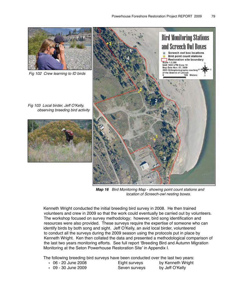
�
�
� � � � � Map 16 Bird Monitoring Map - showing point count stations and location of Screech-owl nesting boxes.
� Kenneth Wright conducted the initial breeding bird survey in 2008. He then trained volunteers and crew in 2009 so that the work could eventually be carried out by volunteers. The workshop focused on survey methodology; however, bird song identification and resources were also provided. These surveys require the expertise of someone who can � identify birds by both song and sight. Jeff OʼKelly, an avid local birder, volunteered to conduct all the surveys during the 2009 season using the protocols put in place by Kenneth Wright. Ken then collated the data and presented a methodological comparison of the last two years monitoring efforts. See full report ʻBreeding Bird and Autumn Migration� Monitoring at the Seton Powerhouse Restoration Siteʼ in Appendix I.� � The following breeding bird surveys have been conducted over the last two years:
• 06 - 20 June 2008 Eight surveys by Kenneth Wright• 09 - 30 June 2009 Seven surveys by Jeff OʼKelly
Powerhouse Foreshore Restoration Project REPORT 2009 � 79
Fig 102 Crew learning to ID birds
Fig 103 Local birder, Jeff OʼKelly, observing breeding bird activity
6.2 Autumn Migration Monitoring� An initial autumn bird migration survey was completed in September 2006 by Kenneth Wright. � During 2008 and 2009 migration monitoring was undertaken following the encounter transect � method of surveying following the same route as above. Kenneth Wright has collated this � information (shown in above report) and will provide a more detailed analysis comparing the � surveys done to-date at a later time.
� The following autumn migration surveys have been completed:• 16 August to 17 October 2008 Fourteen surveys by Kenneth Wright• 26 August to 18 October 2009 Fourteen surveys by Jeff OʼKelly
6.3 Western Screech-owl Survey
The standard call playback protocol is used to monitor for screech-owl activity. Monitoring takes place in the evenings within the Powerhouse site and along the Texas Creek Road adjacent to the site where suitable habitat exists. The survey has also been carried out along the Cayoosh Creek River opposite the Seton Lake campground.
Surveying involves playing recorded Screech-owl calls over a loudspeaker for one minute, and then waiting for three to four minutes while listening for owl responses. This is repeated three times at each location, for a total of fifteen minutes.
No Western Screech-owls were detected in 2009. Francis Iredale, MOE, provides the following information from the May 2009 survey.
Obs: Kim North, Francis Iredale, Ken Wright, Ian RoutleyDate: May 27, 2009.Temperature 17CWind: 3Cloud Cover: ClearPrecipitation: none�Station 1- Z10 576129 5614150�� Start Time: 21:23�� �������End time: 21:38� � No Owl detectionStation 2- Z10 572136 5612860� Start Time: 22:44� ��������End Time: 23:00� �� No Owl detectionStation 3- Z10 576582 5612265�� Start Time: 23:38 ���������End Time: 23:53� �� No Owl detectionStation 5- Z10 588508� 5596385�� Start Time: 01:30 ���������End�Time: 01:45 ����No Owl detection�End time Temperature: 14CCloud Cover: ClearPrecipitation: None
Table 08 Western Screech-Owl May Survey Results
The following Western Screech-owl surveys have been conducted over the last two years:• 23, 29, 30 September 2008 150 minutes by Kenneth Wright• 27 May, 2009 59 minutes by Francis Iredale• 09, 10 September 2009 (Audit) 45 minutes by Shaun Freeman
�
Powerhouse Foreshore Restoration Project REPORT 2009
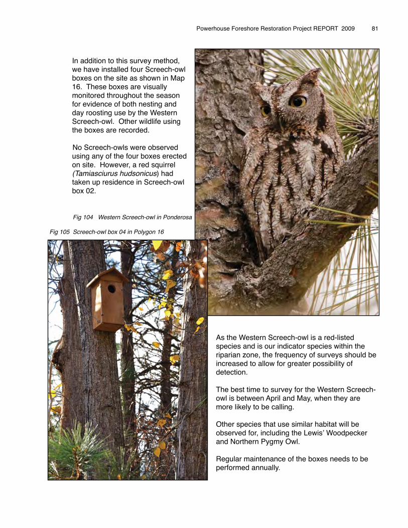
� In addition to this survey method, � we have installed four Screech-owl � boxes on the site as shown in Map � 16. These boxes are visually � monitored throughout the season � for evidence of both nesting and � day roosting use by the Western � Screech-owl. Other wildlife using � the boxes are recorded.
No Screech-owls were observed � using any of the four boxes erected � on site. However, a red squirrel � (Tamiasciurus hudsonicus) had � taken up residence in Screech-owl � box 02.
As the Western Screech-owl is a red-listed species and is our indicator species within the riparian zone, the frequency of surveys should be increased to allow for greater possibility of detection.
The best time to survey for the Western Screech-owl is between April and May, when they are more likely to be calling.
Other species that use similar habitat will be observed for, including the Lewisʼ Woodpecker and Northern Pygmy Owl.
Regular maintenance of the boxes needs to be performed annually.
Powerhouse Foreshore Restoration Project REPORT 2009 � 81
Fig 104 Western Screech-owl in Ponderosa
Fig 105 Screech-owl box 04 in Polygon 16
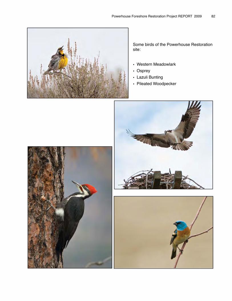
Some birds of the Powerhouse Restoration site:
• Western Meadowlark
• Osprey
• Lazuli Bunting
• Pileated Woodpecker
Powerhouse Foreshore Restoration Project REPORT 2009 � 82
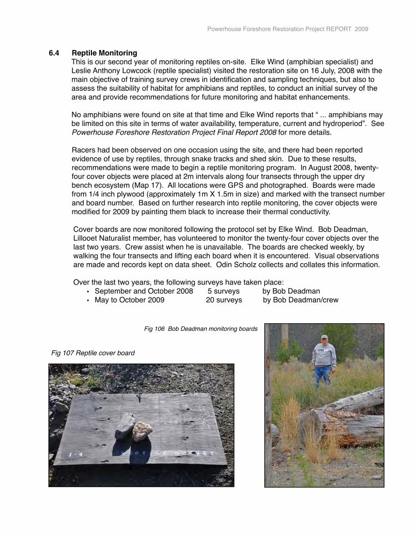
6.4 Reptile Monitoring This is our second year of monitoring reptiles on-site. Elke Wind (amphibian specialist) and Leslie Anthony Lowcock (reptile specialist) visited the restoration site on 16 July, 2008 with the main objective of training survey crews in identification and sampling techniques, but also to assess the suitability of habitat for amphibians and reptiles, to conduct an initial survey of the area and provide recommendations for future monitoring and habitat enhancements.
No amphibians were found on site at that time and Elke Wind reports that “ ... amphibians may be limited on this site in terms of water availability, temperature, current and hydroperiod”. See Powerhouse Foreshore Restoration Project Final Report 2008 for more details.
Racers had been observed on one occasion using the site, and there had been reported evidence of use by reptiles, through snake tracks and shed skin. Due to these results, recommendations were made to begin a reptile monitoring program. In August 2008, twenty- four cover objects were placed at 2m intervals along four transects through the upper dry bench ecosystem (Map 17). All locations were GPS and photographed. Boards were made from 1/4 inch plywood (approximately 1m X 1.5m in size) and marked with the transect number and board number. Based on further research into reptile monitoring, the cover objects were modified for 2009 by painting them black to increase their thermal conductivity.
� Cover boards are now monitored following the protocol set by Elke Wind. Bob Deadman, � Lillooet Naturalist member, has volunteered to monitor the twenty-four cover objects over the� last two years. Crew assist when he is unavailable. The boards are checked weekly, by � walking the four transects and lifting each board when it is encountered. Visual observations � are made and records kept on data sheet. Odin Scholz collects and collates this information.
� Over the last two years, the following surveys have taken place:• September and October 2008 5 surveys by Bob Deadman• May to October 2009 20 surveys� by Bob Deadman/crew
�
�
Powerhouse Foreshore Restoration Project REPORT 2009
Fig 107 Reptile cover board
Fig 106 Bob Deadman monitoring boards
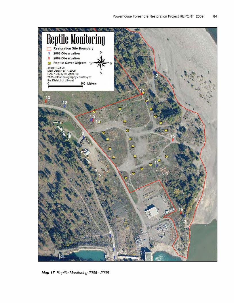
� Map 17 Reptile Monitoring 2008 - 2009
Powerhouse Foreshore Restoration Project REPORT 2009 � 84
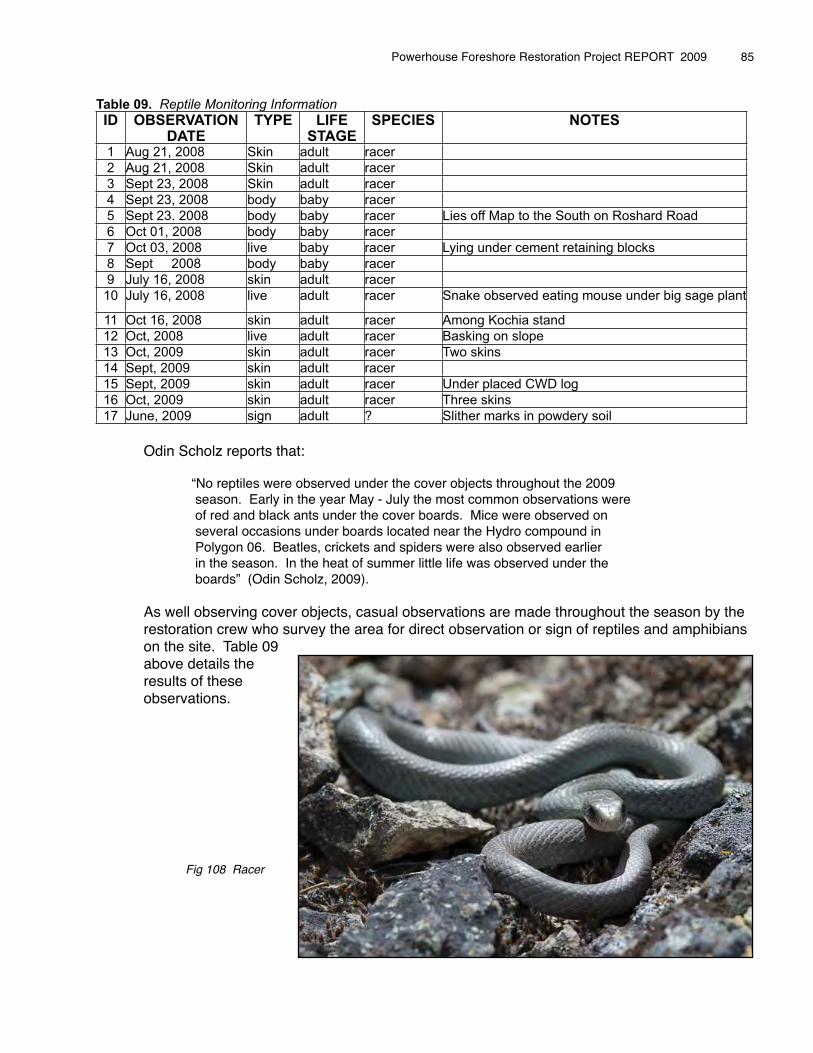
Tablee 09. Reptile Monitorring InformmationID OBSERVATION
DATETYPE LIFE
STAGESPECIES NOTES
1 Aug 21, 2008 Skin adult racer
2 Aug 21, 2008 Skin adult racer
3 Sept 23, 2008 Skin adult racer
4 Sept 23, 2008 body baby racer
5 Sept 23. 2008 body baby racer Lies off Map to the South on Roshard Road
6 Oct 01, 2008 body baby racer
7 Oct 03, 2008 live baby racer Lying under cement retaining blocks
8 Sept 2008 body baby racer
9 July 16, 2008 skin adult racer
10 July 16, 2008 live adult racer Snake observed eating mouse under big sage plant
11 Oct 16, 2008 skin adult racer Among Kochia stand
12 Oct, 2008 live adult racer Basking on slope
13 Oct, 2009 skin adult racer Two skins
14 Sept, 2009 skin adult racer
15 Sept, 2009 skin adult racer Under placed CWD log
16 Oct, 2009 skin adult racer Three skins
17 June, 2009 sign adult ? Slither marks in powdery soil
� Odin Scholz reports that:
� � “No reptiles were observed under the cover objects throughout the 2009� � season. Early in the year May - July the most common observations were� � of red and black ants under the cover boards. Mice were observed on � � several occasions under boards located near the Hydro compound in � � Polygon 06. Beatles, crickets and spiders were also observed earlier� � in the season. In the heat of summer little life was observed under the� � boards” (Odin Scholz, 2009).� � � As well observing cover objects, casual observations are made throughout the season by the � restoration crew who survey the area for direct observation or sign of reptiles and amphibians � on the site. Table 09 � above details the � results of these � observations.
Fig 108 Racer
Powerhouse Foreshore Restoration Project REPORT 2009 � 85
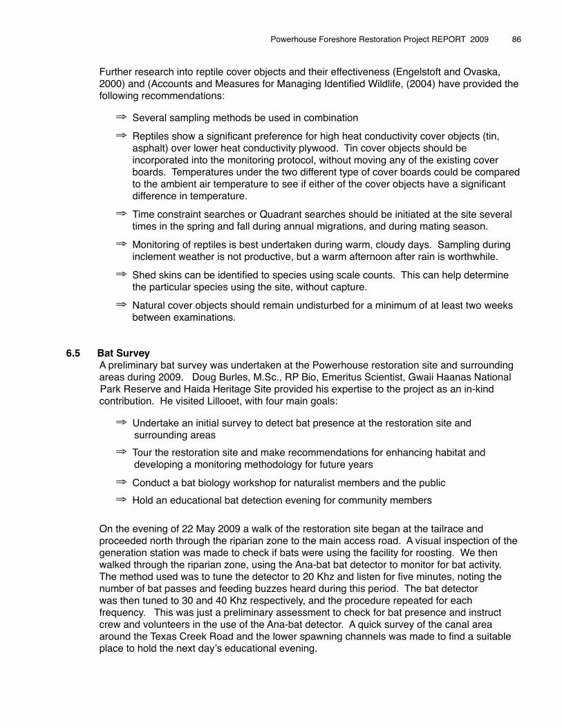
� Further research into reptile cover objects and their effectiveness (Engelstoft and Ovaska, � 2000) and (Accounts and Measures for Managing Identified Wildlife, (2004) have provided the � following recommendations:
⇒ Several sampling methods be used in combination
⇒ Reptiles show a significant preference for high heat conductivity cover objects (tin, asphalt) over lower heat conductivity plywood. Tin cover objects should be incorporated into the monitoring protocol, without moving any of the existing cover boards. Temperatures under the two different type of cover boards could be compared to the ambient air temperature to see if either of the cover objects have a significant difference in temperature.
⇒ Time constraint searches or Quadrant searches should be initiated at the site several times in the spring and fall during annual migrations, and during mating season.
⇒ Monitoring of reptiles is best undertaken during warm, cloudy days. Sampling during inclement weather is not productive, but a warm afternoon after rain is worthwhile.
⇒ Shed skins can be identified to species using scale counts. This can help determine the particular species using the site, without capture.
⇒ Natural cover objects should remain undisturbed for a minimum of at least two weeks between examinations.
6.5 Bat Survey� A preliminary bat survey was undertaken at the Powerhouse restoration site and surrounding� areas during 2009. Doug Burles, M.Sc., RP Bio, Emeritus Scientist, Gwaii Haanas National Park Reserve and Haida Heritage Site provided his expertise to the project as an in-kind � contribution. He visited Lillooet, with four main goals:
⇒ Undertake an initial survey to detect bat presence at the restoration site and � surrounding areas
⇒ Tour the restoration site and make recommendations for enhancing habitat and � developing a monitoring methodology for future years
⇒ Conduct a bat biology workshop for naturalist members and the public
⇒ Hold an educational bat detection evening for community members
�� On the evening of 22 May 2009 a walk of the restoration site began at the tailrace and � proceeded north through the riparian zone to the main access road. A visual inspection of the � generation station was made to check if bats were using the facility for roosting. We then � walked through the riparian zone, using the Ana-bat bat detector to monitor for bat activity.� The method used was to tune the detector to 20 Khz and listen for five minutes, noting the � number of bat passes and feeding buzzes heard during this period. The bat detector � was then tuned to 30 and 40 Khz respectively, and the procedure repeated for each � frequency. This was just a preliminary assessment to check for bat presence and instruct � crew and volunteers in the use of the Ana-bat detector. A quick survey of the canal area � around the Texas Creek Road and the lower spawning channels was made to find a suitable � place to hold the next dayʼs educational evening.
Powerhouse Foreshore Restoration Project REPORT 2009 � 86
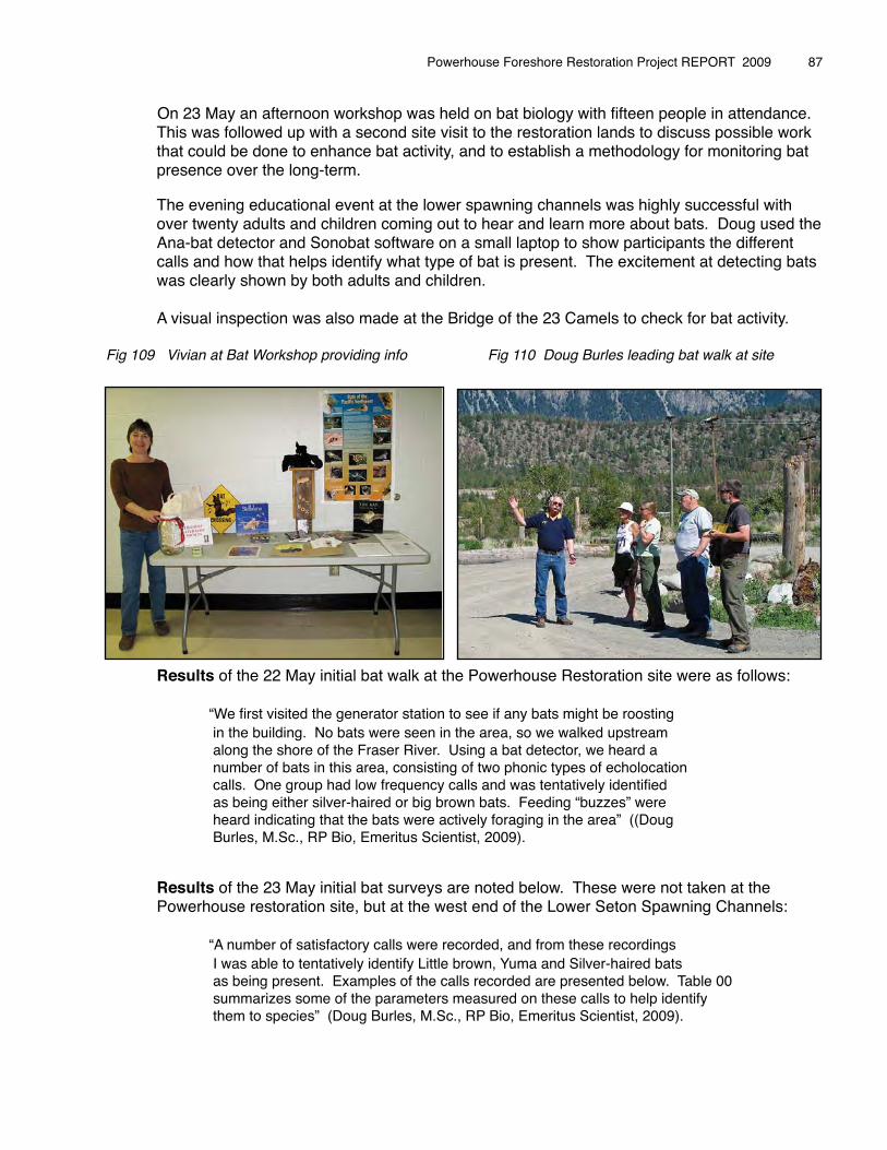
On 23 May an afternoon workshop was held on bat biology with fifteen people in attendance. � This was followed up with a second site visit to the restoration lands to discuss possible work � that could be done to enhance bat activity, and to establish a methodology for monitoring bat � presence over the long-term.
� The evening educational event at the lower spawning channels was highly successful with � over twenty adults and children coming out to hear and learn more about bats. Doug used the� Ana-bat detector and Sonobat software on a small laptop to show participants the different � calls and how that helps identify what type of bat is present. The excitement at detecting bats � was clearly shown by both adults and children. �� A visual inspection was also made at the Bridge of the 23 Camels to check for bat activity.
� Results of the 22 May initial bat walk at the Powerhouse Restoration site were as follows:
� � “We first visited the generator station to see if any bats might be roosting� � in the building. No bats were seen in the area, so we walked upstream� � along the shore of the Fraser River. Using a bat detector, we heard a � � number of bats in this area, consisting of two phonic types of echolocation� � calls. One group had low frequency calls and was tentatively identified� � as being either silver-haired or big brown bats. Feeding “buzzes” were � � heard indicating that the bats were actively foraging in the area” ((Doug � � Burles, M.Sc., RP Bio, Emeritus Scientist, 2009).
� Results of the 23 May initial bat surveys are noted below. These were not taken at the � Powerhouse restoration site, but at the west end of the Lower Seton Spawning Channels:
� � “A number of satisfactory calls were recorded, and from these recordings� � I was able to tentatively identify Little brown, Yuma and Silver-haired bats� � as being present. Examples of the calls recorded are presented below. Table 00� � summarizes some of the parameters measured on these calls to help identify� � them to species” (Doug Burles, M.Sc., RP Bio, Emeritus Scientist, 2009).
Fig 109 Vivian at Bat Workshop providing info Fig 110 Doug Burles leading bat walk at site
Powerhouse Foreshore Restoration Project REPORT 2009 � 87
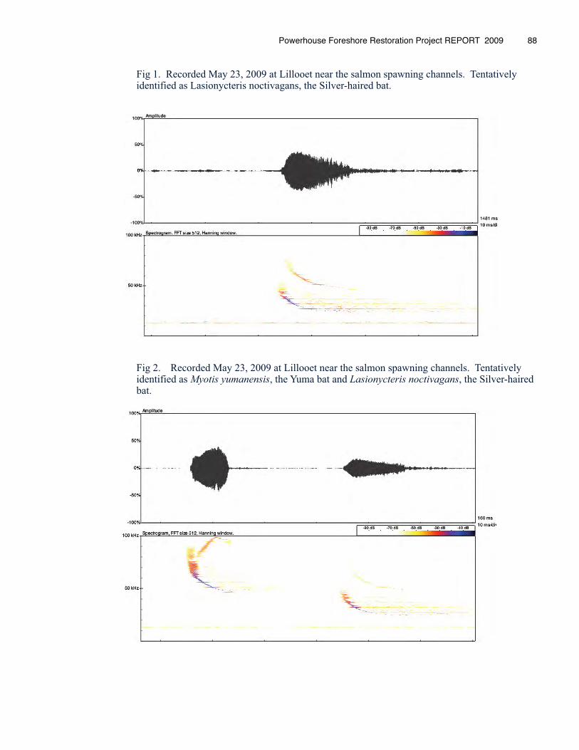
Fig 1. Recorded May 23, 2009 at Lillooet near the salmon spawning channels. Tentatively identified as Lasionycteris noctivagans, the Silver-haired bat.
Fig 2. Recorded May 23, 2009 at Lillooet near the salmon spawning channels. Tentatively identified as Myotis yumanensis, the Yuma bat and Lasionycteris noctivagans, the Silver-haired bat.
Powerhouse Foreshore Restoration Project REPORT 2009 88
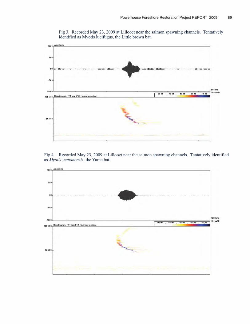
Fig 3. Recorded May 23, 2009 at Lillooet near the salmon spawning channels. Tentatively identified as Myotis lucifugus, the Little brown bat.
Fig 4. Recorded May 23, 2009 at Lillooet near the salmon spawning channels. Tentatively identified as Myotis yumanensis, the Yuma bat.
Powerhouse Foreshore Restoration Project REPORT 2009 89
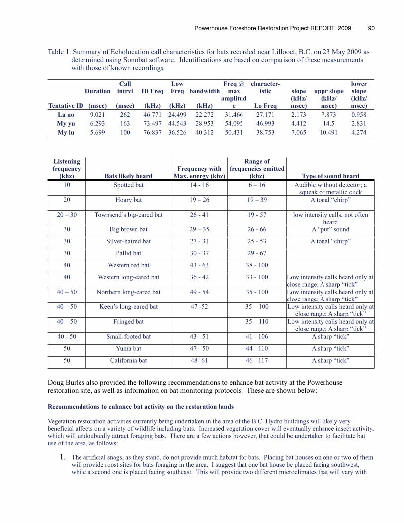
Table 1. Summary of Echolocation call characteristics for bats recorded near Lillooet, B.C. on 23 May 2009 as determined using Sonobat software. Identifications are based on comparison of these measurements with those of known recordings.
DurationCall
intrvl Hi FreqLow Freq bandwidth
Freq @ max
character-istic slope uppr slope
lower slope
Tentative ID (msec) (msec) (kHz) (kHz) (kHz)amplitud
e Lo Freq(kHz/msec)
(kHz/msec)
(kHz/msec)
La no 9.021 262 46.771 24.499 22.272 31.466 27.171 2.173 7.873 0.958My yu 6.293 163 73.497 44.543 28.953 54.095 46.993 4.412 14.5 2.831My lu 5.699 100 76.837 36.526 40.312 50.431 38.753 7.065 10.491 4.274
Listening frequency
(khz) Bats likely heardFrequency with
Max. energy (khz)
Range of frequencies emitted
(khz) Type of sound heard
10 Spotted bat 14 - 16 6 – 16 Audible without detector; a squeak or metallic click
20 Hoary bat 19 – 26 19 – 39 A tonal “chirp”
20 – 30 Townsend’s big-eared bat 26 - 41 19 - 57 low intensity calls, not often heard
30 Big brown bat 29 – 35 26 - 66 A “put” sound
30 Silver-haired bat 27 - 31 25 - 53 A tonal “chirp”
30 Pallid bat 30 - 37 29 - 67
40 Western red bat 43 - 63 38 - 100
40 Western long-eared bat 36 - 42 33 - 100 Low intensity calls heard only at close range; A sharp “tick”
40 – 50 Northern long-eared bat 49 - 54 35 - 100 Low intensity calls heard only at close range; A sharp “tick”
40 – 50 Keen’s long-eared bat 47 -52 35 – 100 Low intensity calls heard only at close range; A sharp “tick”
40 – 50 Fringed bat 35 – 110 Low intensity calls heard only at close range; A sharp “tick”
40 - 50 Small-footed bat 43 - 51 41 - 106 A sharp “tick”
50 Yuma bat 47 - 50 44 - 110 A sharp “tick”
50 California bat 48 -61 46 - 117 A sharp “tick”
Doug Burles also provided the following recommendations to enhance bat activity at the Powerhouse restoration site, as well as information on bat monitoring protocols. These are shown below:
Recommendations to enhance bat activity on the restoration lands
Vegetation restoration activities currently being undertaken in the area of the B.C. Hydro buildings will likely very beneficial affects on a variety of wildlife including bats. Increased vegetation cover will eventually enhance insect activity, which will undoubtedly attract foraging bats. There are a few actions however, that could be undertaken to facilitate bat use of the area, as follows:
1. The artificial snags, as they stand, do not provide much habitat for bats. Placing bat houses on one or two of them will provide roost sites for bats foraging in the area. I suggest that one bat house be placed facing southwest, while a second one is placed facing southeast. This will provide two different microclimates that will vary with
Powerhouse Foreshore Restoration Project REPORT 2009 � 90
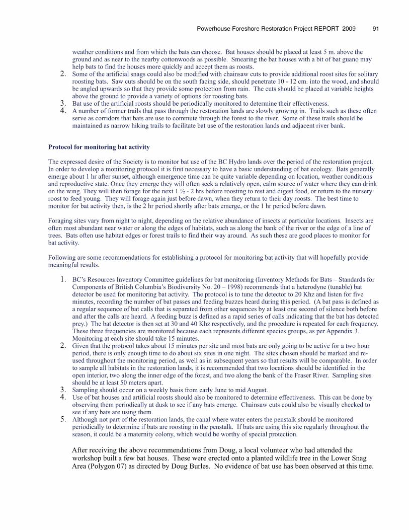
weather conditions and from which the bats can choose. Bat houses should be placed at least 5 m. above the ground and as near to the nearby cottonwoods as possible. Smearing the bat houses with a bit of bat guano may help bats to find the houses more quickly and accept them as roosts.
2. Some of the artificial snags could also be modified with chainsaw cuts to provide additional roost sites for solitary roosting bats. Saw cuts should be on the south facing side, should penetrate 10 - 12 cm. into the wood, and should be angled upwards so that they provide some protection from rain. The cuts should be placed at variable heights above the ground to provide a variety of options for roosting bats.
3. Bat use of the artificial roosts should be periodically monitored to determine their effectiveness.4. A number of former trails that pass through the restoration lands are slowly growing in. Trails such as these often
serve as corridors that bats are use to commute through the forest to the river. Some of these trails should be maintained as narrow hiking trails to facilitate bat use of the restoration lands and adjacent river bank.
Protocol for monitoring bat activity
The expressed desire of the Society is to monitor bat use of the BC Hydro lands over the period of the restoration project. In order to develop a monitoring protocol it is first necessary to have a basic understanding of bat ecology. Bats generally emerge about 1 hr after sunset, although emergence time can be quite variable depending on location, weather conditions and reproductive state. Once they emerge they will often seek a relatively open, calm source of water where they can drink on the wing. They will then forage for the next 1 ½ - 2 hrs before roosting to rest and digest food, or return to the nursery roost to feed young. They will forage again just before dawn, when they return to their day roosts. The best time to monitor for bat activity then, is the 2 hr period shortly after bats emerge, or the 1 hr period before dawn.
Foraging sites vary from night to night, depending on the relative abundance of insects at particular locations. Insects are often most abundant near water or along the edges of habitats, such as along the bank of the river or the edge of a line of trees. Bats often use habitat edges or forest trails to find their way around. As such these are good places to monitor for bat activity. Following are some recommendations for establishing a protocol for monitoring bat activity that will hopefully provide meaningful results.
1. BC’s Resources Inventory Committee guidelines for bat monitoring (Inventory Methods for Bats – Standards for Components of British Columbia’s Biodiversity No. 20 – 1998) recommends that a heterodyne (tunable) bat detector be used for monitoring bat activity. The protocol is to tune the detector to 20 Khz and listen for five minutes, recording the number of bat passes and feeding buzzes heard during this period. (A bat pass is defined as a regular sequence of bat calls that is separated from other sequences by at least one second of silence both before and after the calls are heard. A feeding buzz is defined as a rapid series of calls indicating that the bat has detected prey.) The bat detector is then set at 30 and 40 Khz respectively, and the procedure is repeated for each frequency. These three frequencies are monitored because each represents different species groups, as per Appendix 3. Monitoring at each site should take 15 minutes.
2. Given that the protocol takes about 15 minutes per site and most bats are only going to be active for a two hour period, there is only enough time to do about six sites in one night. The sites chosen should be marked and re-used throughout the monitoring period, as well as in subsequent years so that results will be comparable. In order to sample all habitats in the restoration lands, it is recommended that two locations should be identified in the open interior, two along the inner edge of the forest, and two along the bank of the Fraser River. Sampling sites should be at least 50 meters apart.
3. Sampling should occur on a weekly basis from early June to mid August.4. Use of bat houses and artificial roosts should also be monitored to determine effectiveness. This can be done by
observing them periodically at dusk to see if any bats emerge. Chainsaw cuts could also be visually checked to see if any bats are using them.
5. Although not part of the restoration lands, the canal where water enters the penstalk should be monitored periodically to determine if bats are roosting in the penstalk. If bats are using this site regularly throughout the season, it could be a maternity colony, which would be worthy of special protection.
After receiving the above recommendations from Doug, a local volunteer who had attended the workshop built a few bat houses. These were erected onto a planted wildlife tree in the Lower Snag Area (Polygon 07) as directed by Doug Burles. No evidence of bat use has been observed at this time.
Powerhouse Foreshore Restoration Project REPORT 2009 � 91
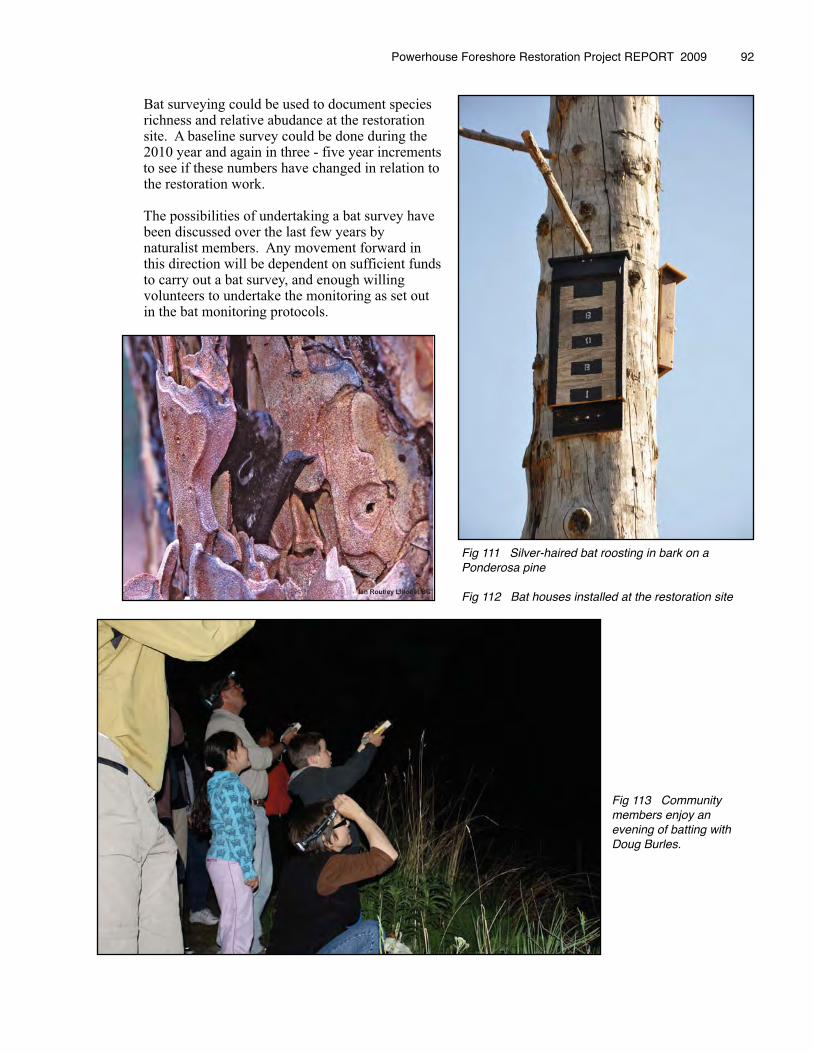
Bat surveying could be used to document species richness and relative abudance at the restoration site. A baseline survey could be done during the 2010 year and again in three - five year increments to see if these numbers have changed in relation to the restoration work.
The possibilities of undertaking a bat survey have been discussed over the last few years by naturalist members. Any movement forward in this direction will be dependent on sufficient funds to carry out a bat survey, and enough willing volunteers to undertake the monitoring as set out in the bat monitoring protocols.
Powerhouse Foreshore Restoration Project REPORT 2009 � 92
Fig 111 Silver-haired bat roosting in bark on a Ponderosa pine
Fig 112 Bat houses installed at the restoration site
Fig 113 Community members enjoy an evening of batting with Doug Burles.
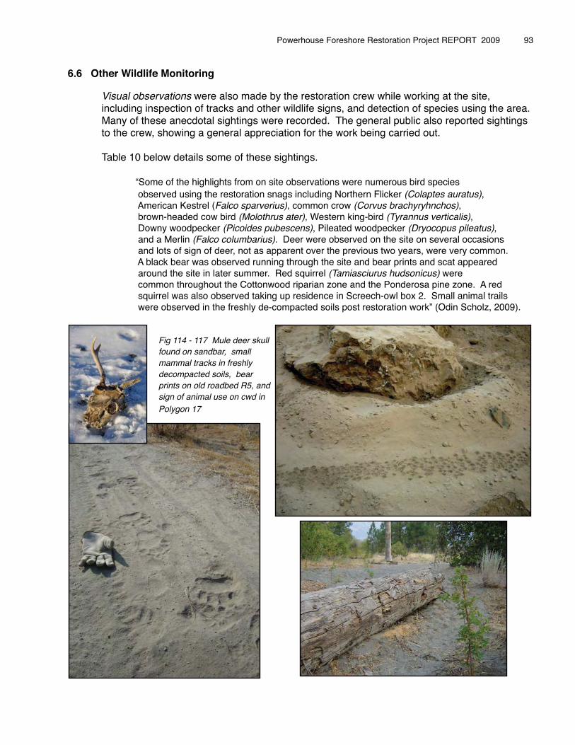
6.6 Other Wildlife Monitoring
� Visual observations were also made by the restoration crew while working at the site, � including inspection of tracks and other wildlife signs, and detection of species using the area. � Many of these anecdotal sightings were recorded. The general public also reported sightings � to the crew, showing a general appreciation for the work being carried out.
� Table 10 below details some of these sightings.
� � “Some of the highlights from on site observations were numerous bird species� � observed using the restoration snags including Northern Flicker (Colaptes auratus),� � American Kestrel (Falco sparverius), common crow (Corvus brachyryhnchos), � � brown-headed cow bird (Molothrus ater), Western king-bird (Tyrannus verticalis), � � Downy woodpecker (Picoides pubescens), Pileated woodpecker (Dryocopus pileatus), � � and a Merlin (Falco columbarius). Deer were observed on the site on several occasions � � and lots of sign of deer, not as apparent over the previous two years, were very common. � � A black bear was observed running through the site and bear prints and scat appeared � � around the site in later summer. Red squirrel (Tamiasciurus hudsonicus) were � � common throughout the Cottonwood riparian zone and the Ponderosa pine zone. A red � � squirrel was also observed taking up residence in Screech-owl box 2. Small animal trails � � were observed in the freshly de-compacted soils post restoration work” (Odin Scholz, 2009).
� �
Powerhouse Foreshore Restoration Project REPORT 2009 � 93
Fig 114 - 117 Mule deer skull found on sandbar, small mammal tracks in freshly decompacted soils, bear prints on old roadbed R5, and sign of animal use on cwd in Polygon 17
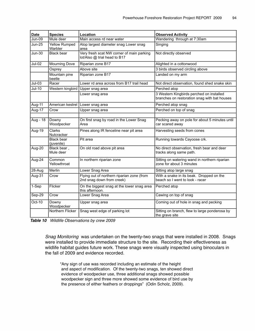
Date Species Location Observed Activity
Jun-09 Mule deer Main access rd near water Wandering through at 7:30am
Jun-25 Yellow Rumped Warbler
Atop largest diameter snag Lower snag area
Singing
Jun-30 Black bear Very fresh scat NW corner of main parking lot/Also @ trial head to B17
Not directly observed
Jul-02 Mourning Dove Riparian zone B17 Alighted in a cottonwood
Osprey Above site 3 birds observed circling above
Mountain pine beetle
Riparian zone B17 Landed on my arm
Jul-03 Racer Lower rd area across from B17 trail head Not direct observation, found shed snake skin
Jul-10 Western kingbird Upper snag area Perched atop
Lower snag area 3 Western Kingbirds perched on installed branches on restoration snag with bat houses
Aug-11 American kestrel Lower snag area Perched atop snag
Aug-17 Crow Upper snag area Perched on top of snag
Aug - 18 Downy Woodpecker
On first snag by road in the Lower Snag Area
Pecking away on pole for about 5 minutes until car scared away
Aug-19 Clarks Nutcracker
Pines along IR fenceline near pit area Harvesting seeds from cones
Black bear (juvenile)
Pit area Running towards Cayoose crk.
Aug-20 Black bear , Mule deer
On old road above pit area No direct observation, fresh bear and deer tracks along same path.
Aug-24 Common Yellowthroat
In northern riparian zone Sitting on watering wand in northern riparian zone for about 3 minutes
28-Aug Merlin Lower Snag Area Sitting atop large snag
Aug-31 Crow Flying out of northern riparian zone (from 2nd snag down from creek)
With a snake in its beak. Dropped on the beach so I went to look - racer
1-Sep Flicker On the biggest snag at the lower snag area this afternoon.
Perched atop
Sep-29 Crow Lower Snag Area Cawing on top of snag
Oct-10 Downy Woodpecker
Upper snag area Coming out of hole in snag and pecking
Northern Flicker Snag west edge of parking lot Sitting on branch, flew to large ponderosa by the grave site
Table 10 Wildlife Observations by crew 2009
� Snag Monitoring was undertaken on the twenty-two snags that were installed in 2008. Snags� were installed to provide immediate structure to the site. Recording their effectiveness as � wildlife habitat guides future work. These snags were visually inspected using binoculars in � the fall of 2009 and evidence recorded.
� � “Any sign of use was recorded including an estimate of the height� � and aspect of modification. Of the twenty-two snags, ten showed direct� � evidence of woodpecker use, three additional snags showed possible� � woodpecker sign and three more showed some evidence of bird use by� � the presence of either feathers or droppings” (Odin Scholz, 2009).
Powerhouse Foreshore Restoration Project REPORT 2009 � 94
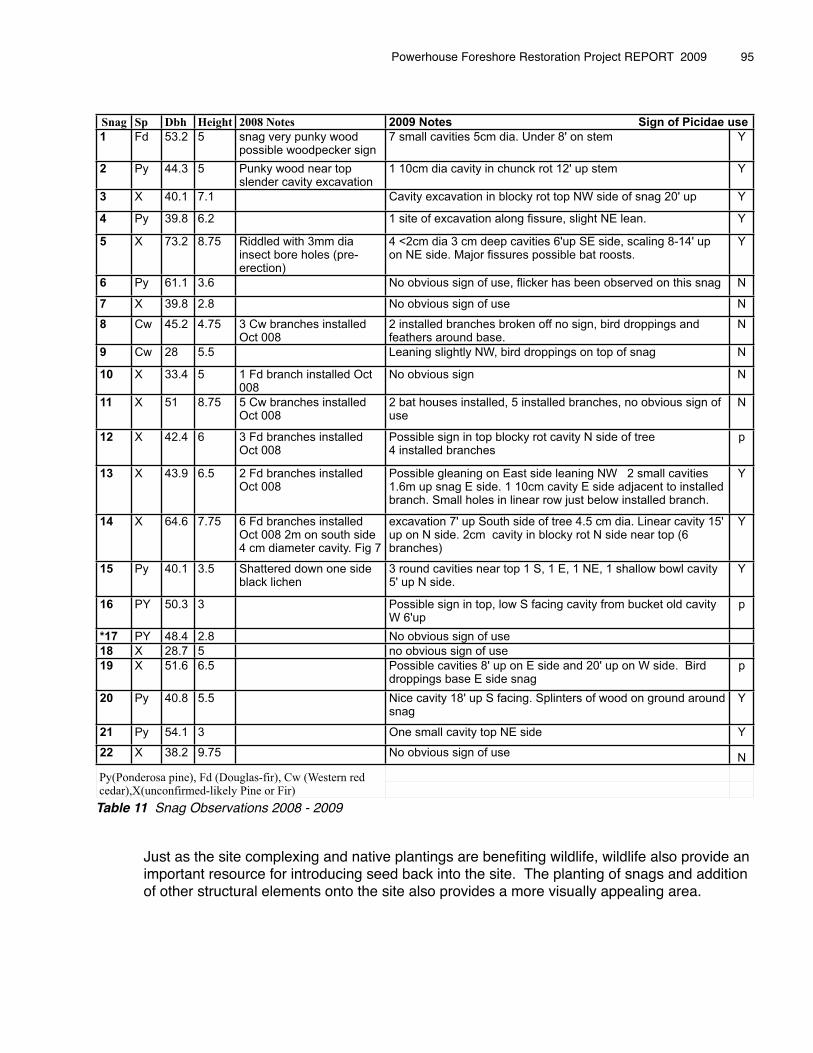
Snag Sp Dbh Height 2008 Notes 2009 Notes Sign of Picidae uuse
1 Fd 53.2 5 snag very punky wood possible woodpecker sign
7 small cavities 5cm dia. Under 8' on stem Y
2 Py 44.3 5 Punky wood near top slender cavity excavation
1 10cm dia cavity in chunck rot 12' up stem Y
3 X 40.1 7.1 Cavity excavation in blocky rot top NW side of snag 20' up Y
4 Py 39.8 6.2 1 site of excavation along fissure, slight NE lean. Y
5 X 73.2 8.75 Riddled with 3mm dia insect bore holes (pre-erection)
4 <2cm dia 3 cm deep cavities 6'up SE side, scaling 8-14' up on NE side. Major fissures possible bat roosts.
Y
6 Py 61.1 3.6 No obvious sign of use, flicker has been observed on this snag N
7 X 39.8 2.8 No obvious sign of use N
8 Cw 45.2 4.75 3 Cw branches installed Oct 008
2 installed branches broken off no sign, bird droppings and feathers around base.
N
9 Cw 28 5.5 Leaning slightly NW, bird droppings on top of snag N
10 X 33.4 5 1 Fd branch installed Oct 008
No obvious sign N
11 X 51 8.75 5 Cw branches installed Oct 008
2 bat houses installed, 5 installed branches, no obvious sign of use
N
12 X 42.4 6 3 Fd branches installed Oct 008
Possible sign in top blocky rot cavity N side of tree 4 installed branches
p
13 X 43.9 6.5 2 Fd branches installed Oct 008
Possible gleaning on East side leaning NW 2 small cavities 1.6m up snag E side. 1 10cm cavity E side adjacent to installed branch. Small holes in linear row just below installed branch.
Y
14 X 64.6 7.75 6 Fd branches installed Oct 008 2m on south side 4 cm diameter cavity. Fig 7
excavation 7' up South side of tree 4.5 cm dia. Linear cavity 15' up on N side. 2cm cavity in blocky rot N side near top (6 branches)
Y
15 Py 40.1 3.5 Shattered down one side black lichen
3 round cavities near top 1 S, 1 E, 1 NE, 1 shallow bowl cavity 5' up N side.
Y
16 PY 50.3 3 Possible sign in top, low S facing cavity from bucket old cavity W 6'up
p
*17 PY 48.4 2.8 No obvious sign of use
18 X 28.7 5 no obvious sign of use
19 X 51.6 6.5 Possible cavities 8' up on E side and 20' up on W side. Bird droppings base E side snag
p
20 Py 40.8 5.5 Nice cavity 18' up S facing. Splinters of wood on ground around snag
Y
21 Py 54.1 3 One small cavity top NE side Y
22 X 38.2 9.75 No obvious sign of use N
Py(Ponnderosaa pine),, Fd (Douuglas-fir), Cw (Western red y(cedar),X(unc
p ),confirm
, (med-likely
g ), (y Pine or Fir)
Table 11 Snag Observations 2008 - 2009
�� Just as the site complexing and native plantings are benefiting wildlife, wildlife also provide an � important resource for introducing seed back into the site. The planting of snags and addition � of other structural elements onto the site also provides a more visually appealing area.
Powerhouse Foreshore Restoration Project REPORT 2009 � 95
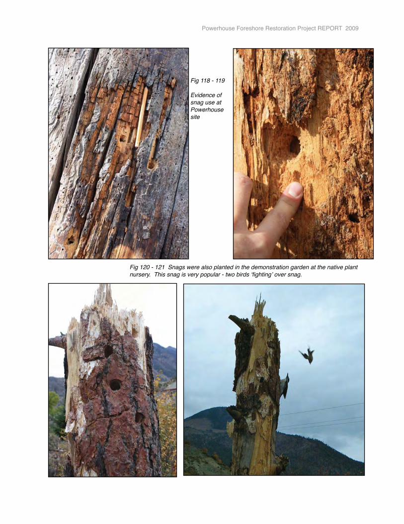
Powerhouse Foreshore Restoration Project REPORT 2009
Fig 118 - 119
Evidence of snag use at Powerhouse site
Fig 120 - 121 Snags were also planted in the demonstration garden at the native plant nursery. This snag is very popular - two birds ʻfightingʼ over snag.
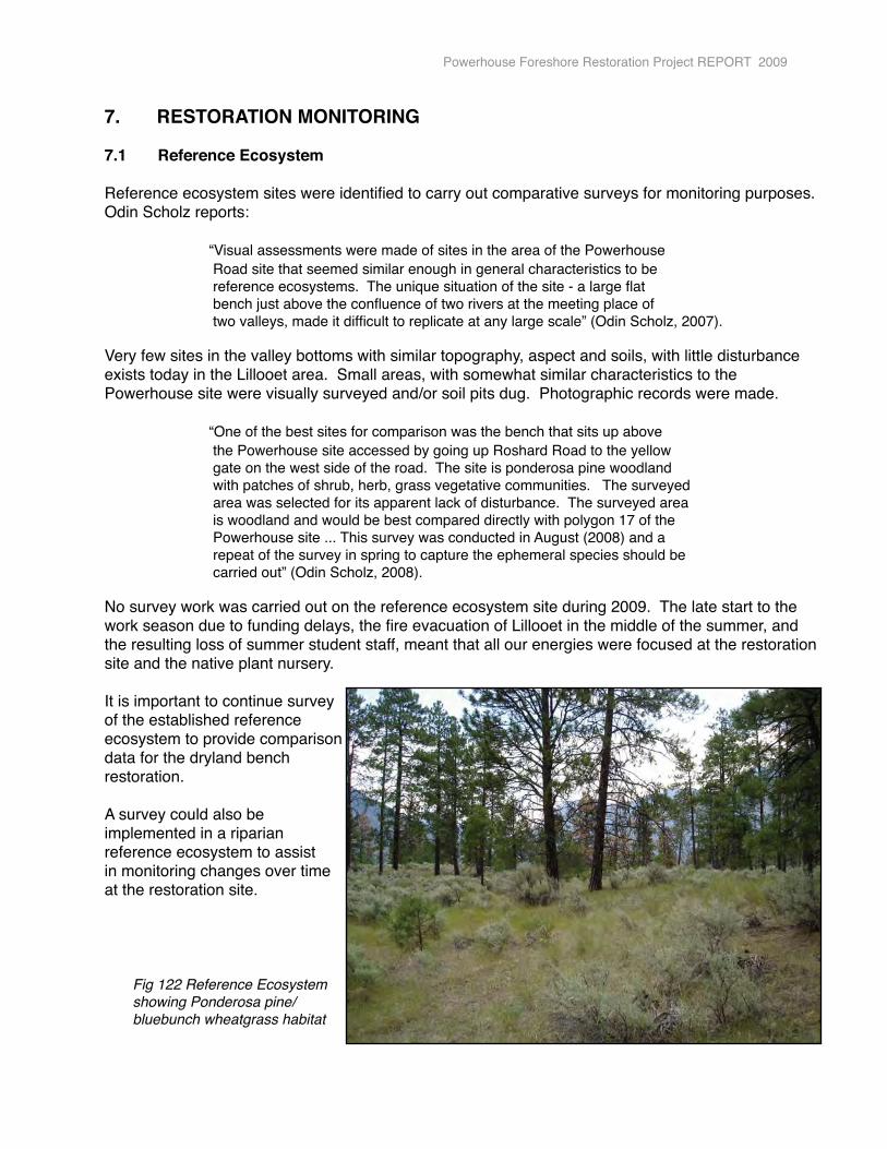
7.� RESTORATION MONITORING
7.1 Reference Ecosystem
Reference ecosystem sites were identified to carry out comparative surveys for monitoring purposes. Odin Scholz reports:
� � “Visual assessments were made of sites in the area of the Powerhouse� � Road site that seemed similar enough in general characteristics to be� � reference ecosystems. The unique situation of the site - a large flat� � bench just above the confluence of two rivers at the meeting place of� � two valleys, made it difficult to replicate at any large scale” (Odin Scholz, 2007).
Very few sites in the valley bottoms with similar topography, aspect and soils, with little disturbance exists today in the Lillooet area. Small areas, with somewhat similar characteristics to the Powerhouse site were visually surveyed and/or soil pits dug. Photographic records were made.
� � “One of the best sites for comparison was the bench that sits up above� � the Powerhouse site accessed by going up Roshard Road to the yellow � � gate on the west side of the road. The site is ponderosa pine woodland � � with patches of shrub, herb, grass vegetative communities. The surveyed�� � area was selected for its apparent lack of disturbance. The surveyed area� � is woodland and would be best compared directly with polygon 17 of the � � Powerhouse site ... This survey was conducted in August (2008) and a � � repeat of the survey in spring to capture the ephemeral species should be� � carried out” (Odin Scholz, 2008).
No survey work was carried out on the reference ecosystem site during 2009. The late start to the work season due to funding delays, the fire evacuation of Lillooet in the middle of the summer, and the resulting loss of summer student staff, meant that all our energies were focused at the restoration site and the native plant nursery.
It is important to continue survey of the established reference ecosystem to provide comparisondata for the dryland bench restoration.
A survey could also be implemented in a riparian reference ecosystem to assist in monitoring changes over time at the restoration site.
Fig 122 Reference Ecosystem showing Ponderosa pine/ bluebunch wheatgrass habitat
Powerhouse Foreshore Restoration Project REPORT 2009
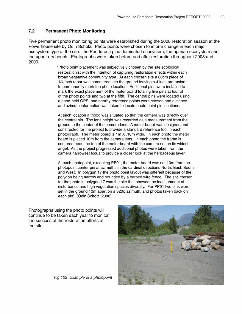
7.2 Permanent Photo Monitoring
Five permanent photo monitoring points were established during the 2008 restoration season at the Powerhouse site by Odin Scholz. Photo points were chosen to inform change in each major ecosystem type at the site: the Ponderosa pine dominated ecosystem, the riparian ecosystem and the upper dry bench. Photographs were taken before and after restoration throughout 2008 and 2009. � � “Photo point placement was subjectively chosen by the site ecological � � restorationist with the intention of capturing restoration effects within each � � broad vegetative community type. At each chosen site a 60cm piece of� � 1/4 inch rebar was hammered into the ground leaving a 4 inch protrusion� � to permanently mark the photo location. Additional pins were installed to� � mark the exact placement of the meter board totaling five pins at four of� � of the photo points and two at the fifth. The central pins were located using� � a hand-held GPS, and nearby reference points were chosen and distance� � and azimuth information was taken to locate photo point pin locations.� �� � At each location a tripod was situated so that the camera was directly over� � the central pin. The lens height was recorded as a measurement from the� � ground to the center of the camera lens. A meter board was designed and� � constructed for the project to provide a standard reference tool in each � � photograph. The meter board is 1m X .10m wide. In each photo the meter� � board is placed 10m from the camera lens. In each photo the frame is� � centered upon the top of the meter board with the camera set on its widest� � angel. As the project progressed additional photos were taken from the� � camera narrowest focus to provide a closer look at the herbaceous layer.
� � At each photopoint, excepting PP01, the meter board was set 10m from the� � photopoint center pin at azimuths in the cardinal directions North, East, South� � and West. In polygon 17 the photo point layout was different because of the� � polygon being narrow and bounded by a barbed wire fence. The site chosen� � for the photo in polygon 17 was the site that showed the least amount of � � disturbance and high vegetation species diversity. For PP01 two pins were� � set in the ground 10m apart on a 320o azimuth, and photos taken back on� � each pin” (Odin Scholz, 2008).
Photographs using the photo points will continue to be taken each year to monitor the success of the restoration efforts at the site.
Fig 123 Example of a photopoint
Powerhouse Foreshore Restoration Project REPORT 2009 � 98
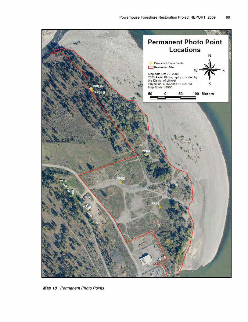
Map 18 Permanent Photo Points
Powerhouse Foreshore Restoration Project REPORT 2009 � 99
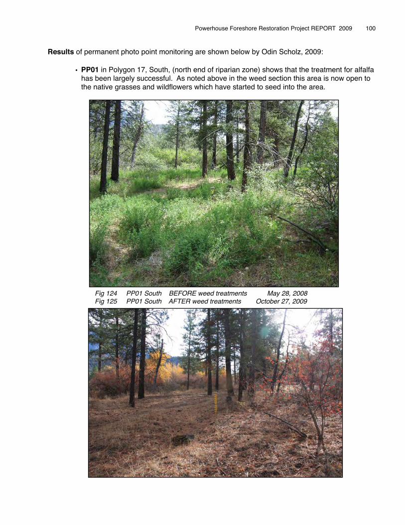
Results of permanent photo point monitoring are shown below by Odin Scholz, 2009:
• PP01 in Polygon 17, South, (north end of riparian zone) shows that the treatment for alfalfa has been largely successful. As noted above in the weed section this area is now open to the native grasses and wildflowers which have started to seed into the area.
Powerhouse Foreshore Restoration Project REPORT 2009 � 100
Fig 124 PP01 South BEFORE weed treatments May 28, 2008Fig 125 PP01 South AFTER weed treatments October 27, 2009
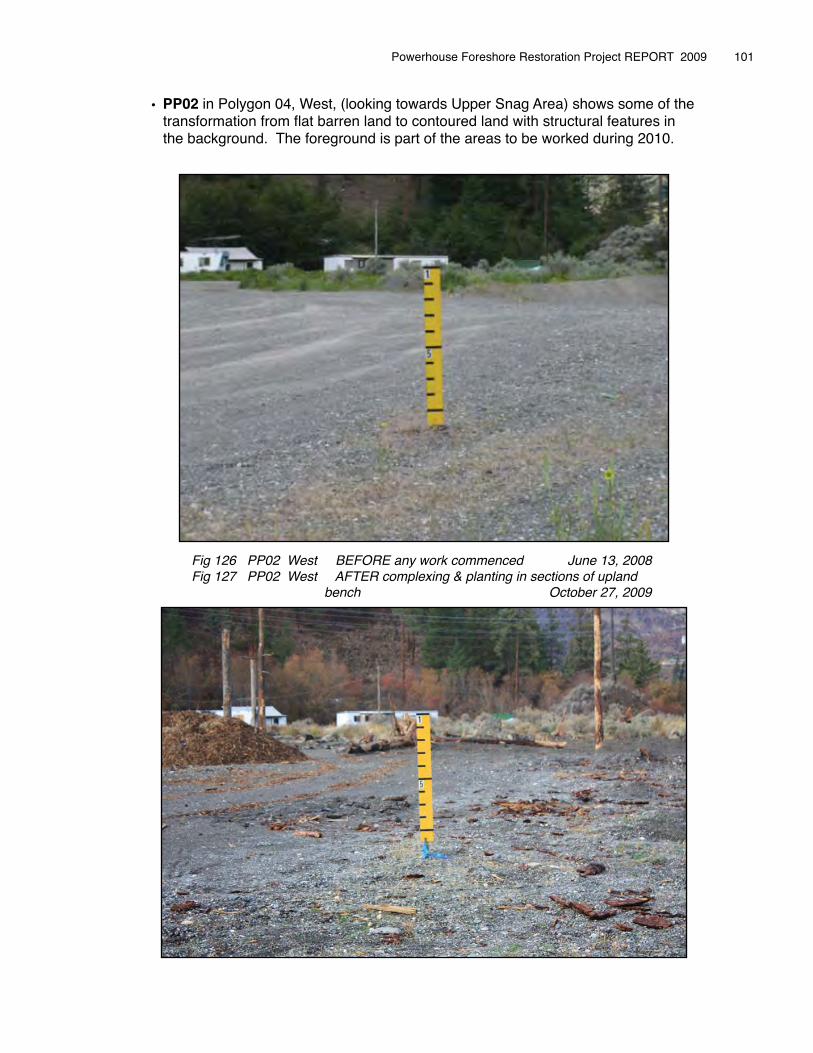
• PP02 in Polygon 04, West, (looking towards Upper Snag Area) shows some of the transformation from flat barren land to contoured land with structural features in the background. The foreground is part of the areas to be worked during 2010.
Powerhouse Foreshore Restoration Project REPORT 2009 � 101
Fig 126 PP02 West BEFORE any work commenced June 13, 2008 Fig 127 PP02 West AFTER complexing & planting in sections of upland � � bench October 27, 2009
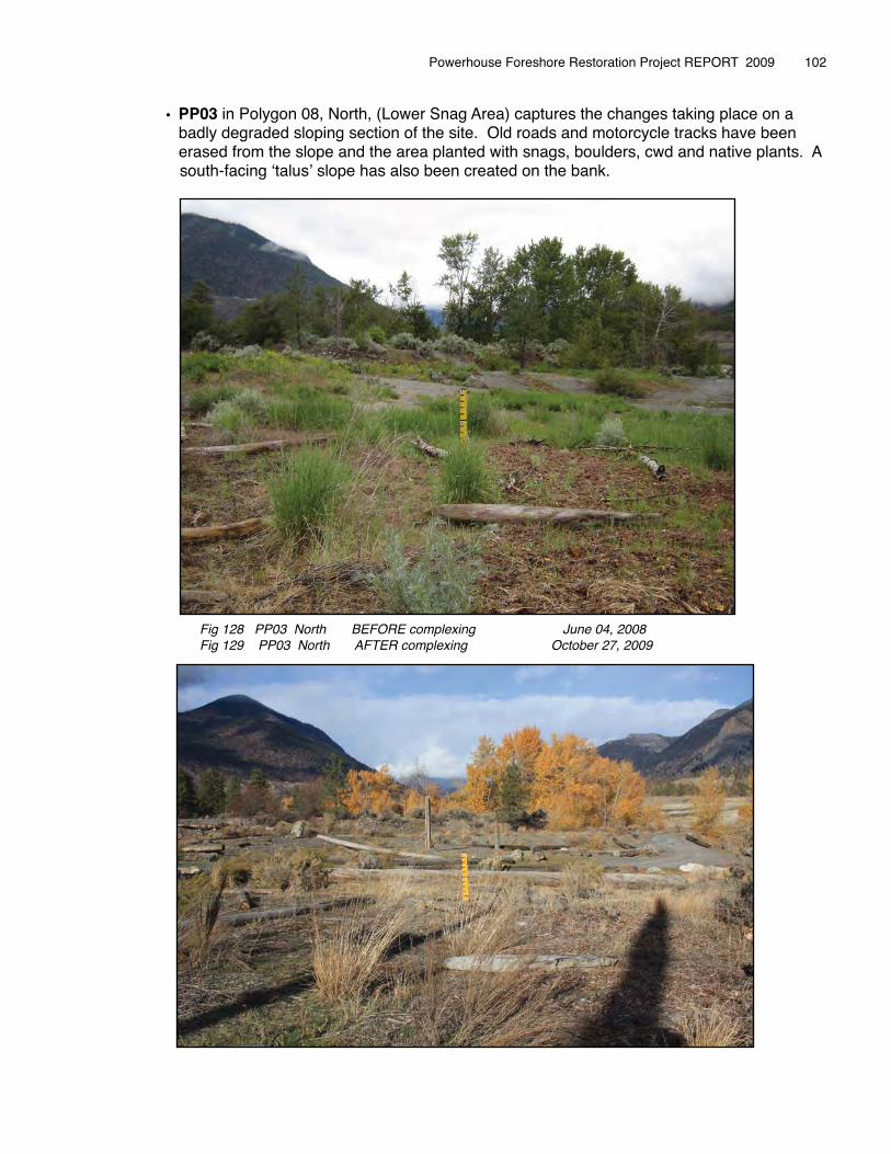
• PP03 in Polygon 08, North, (Lower Snag Area) captures the changes taking place on a badly degraded sloping section of the site. Old roads and motorcycle tracks have been erased from the slope and the area planted with snags, boulders, cwd and native plants. A
� south-facing ʻtalusʼ slope has also been created on the bank.
Powerhouse Foreshore Restoration Project REPORT 2009 � 102
Fig 128 PP03 North BEFORE complexing June 04, 2008 Fig 129 PP03 North AFTER complexing October 27, 2009
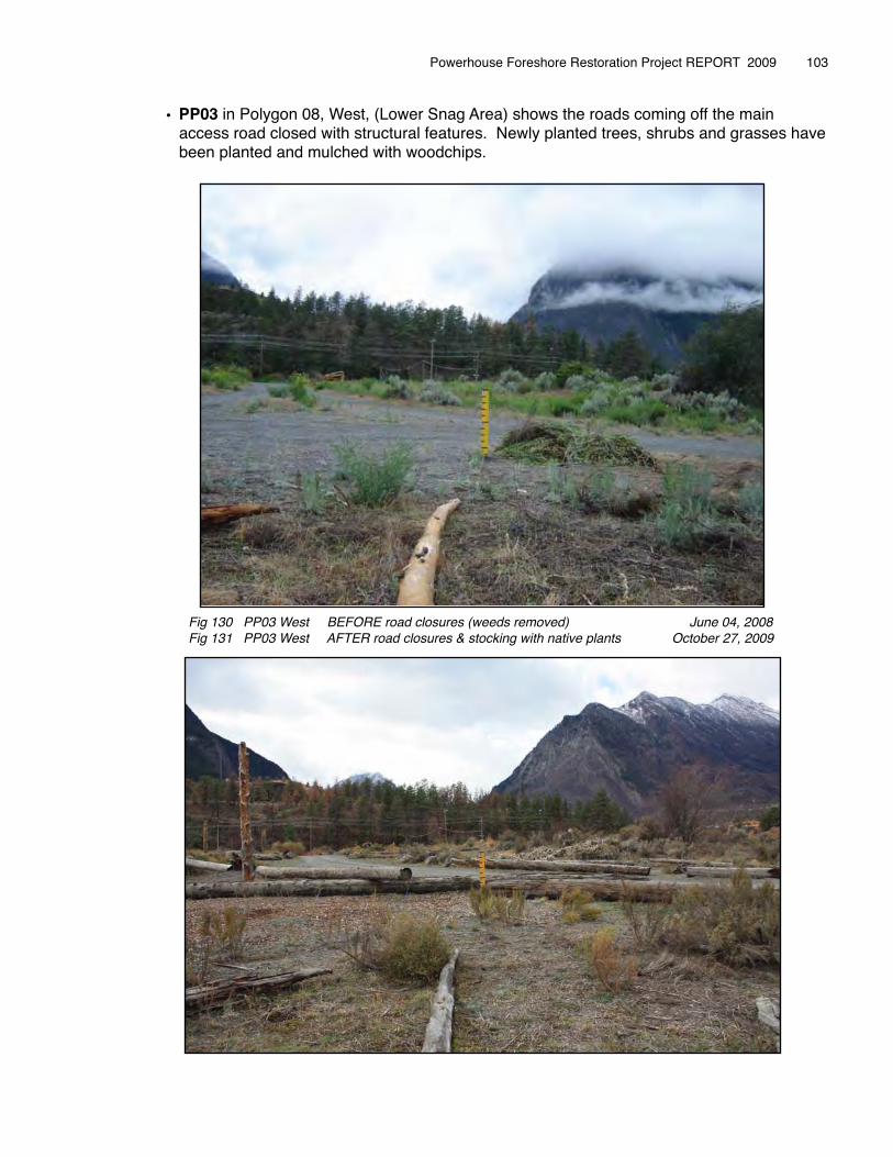
• PP03 in Polygon 08, West, (Lower Snag Area) shows the roads coming off the main access road closed with structural features. Newly planted trees, shrubs and grasses have been planted and mulched with woodchips.
Powerhouse Foreshore Restoration Project REPORT 2009 � 103
Fig 130 PP03 West BEFORE road closures (weeds removed) June 04, 2008 Fig 131 PP03 West AFTER road closures & stocking with native plants October 27, 2009
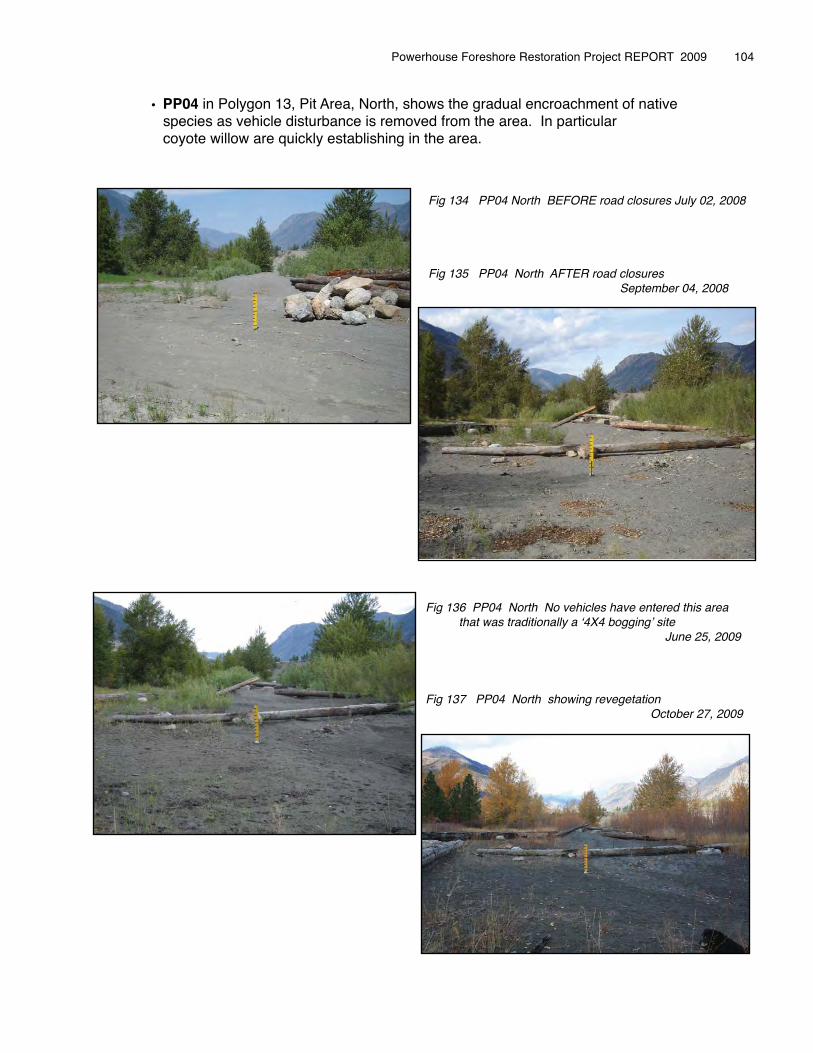
• PP04 in Polygon 13, Pit Area, North, shows the gradual encroachment of native species as vehicle disturbance is removed from the area. In particular coyote willow are quickly establishing in the area.
Powerhouse Foreshore Restoration Project REPORT 2009 � 104
Fig 134 PP04 North BEFORE road closures July 02, 2008
Fig 135 PP04 North AFTER road closures � � � � September 04, 2008
Fig 136 PP04 North No vehicles have entered this area that was traditionally a ʻ4X4 boggingʼ site � � � � � June 25, 2009
Fig 137 PP04 North showing revegetation � � � � October 27, 2009
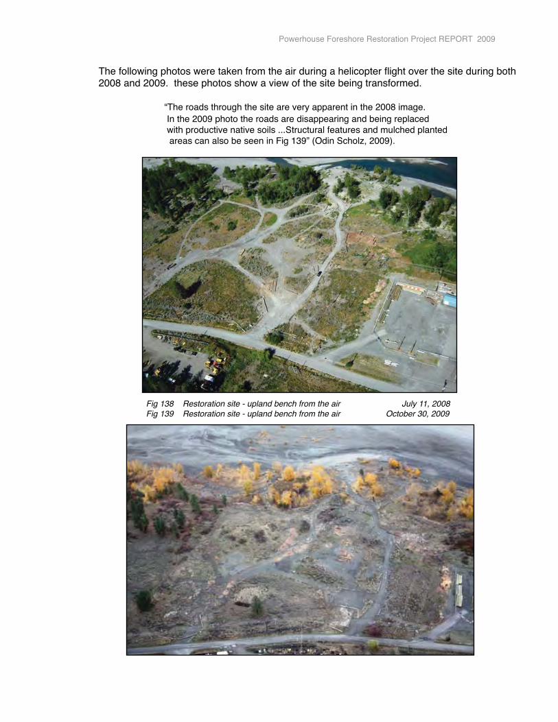
� The following photos were taken from the air during a helicopter flight over the site during both � 2008 and 2009. these photos show a view of the site being transformed.
� � � “The roads through the site are very apparent in the 2008 image.� � � In the 2009 photo the roads are disappearing and being replaced� � � with productive native soils ...Structural features and mulched planted � � � areas can also be seen in Fig 139” (Odin Scholz, 2009).
Powerhouse Foreshore Restoration Project REPORT 2009
Fig 138 Restoration site - upland bench from the air July 11, 2008 Fig 139 Restoration site - upland bench from the air October 30, 2009
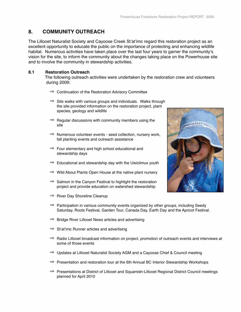
8. � COMMUNITY OUTREACH
The Lillooet Naturalist Society and Cayoose Creek Stʼatʼimc regard this restoration project as an excellent opportunity to educate the public on the importance of protecting and enhancing wildlife habitat. Numerous activities have taken place over the last four years to garner the communityʼs vision for the site, to inform the community about the changes taking place on the Powerhouse site and to involve the community in stewardship activities.
8.1 Restoration Outreach� The following outreach activities were undertaken by the restoration crew and volunteers � during 2009:
⇒ Continuation of the Restoration Advisory Committee
⇒ Site walks with various groups and individuals. Walks through the site provided information on the restoration project, plant species, geology and wildlife
⇒ Regular discussions with community members using the � � site
⇒ Numerous volunteer events - seed collection, nursery work, � � fall planting events and outreach assistance
⇒ Four elementary and high school educational and � � stewardship days
⇒ Educational and stewardship day with the Uwiclimux youth
⇒ Wild About Plants Open House at the native plant nursery
⇒ Salmon in the Canyon Festival to highlight the restoration � � project and provide education on watershed stewardship
⇒ River Day Shoreline Cleanup
⇒ Participation in various community events organized by other groups, including Seedy Saturday, Roots Festival, Garden Tour, Canada Day, Earth Day and the Apricot Festival.
⇒ Bridge River Lillooet News articles and advertising
⇒ Stʼatʼimc Runner articles and advertising
⇒ Radio Lillooet broadcast information on project, promotion of outreach events and interviews at some of those events
⇒ Updates at Lillooet Naturalist Society AGM and a Cayoose Chief & Council meeting
⇒ Presentation and restoration tour at the 6th Annual BC Interior Stewardship Workshops
⇒ Presentations at District of Lillooet and Squamish-Lillooet Regional District Council meetings planned for April 2010
Powerhouse Foreshore Restoration Project REPORT 2009
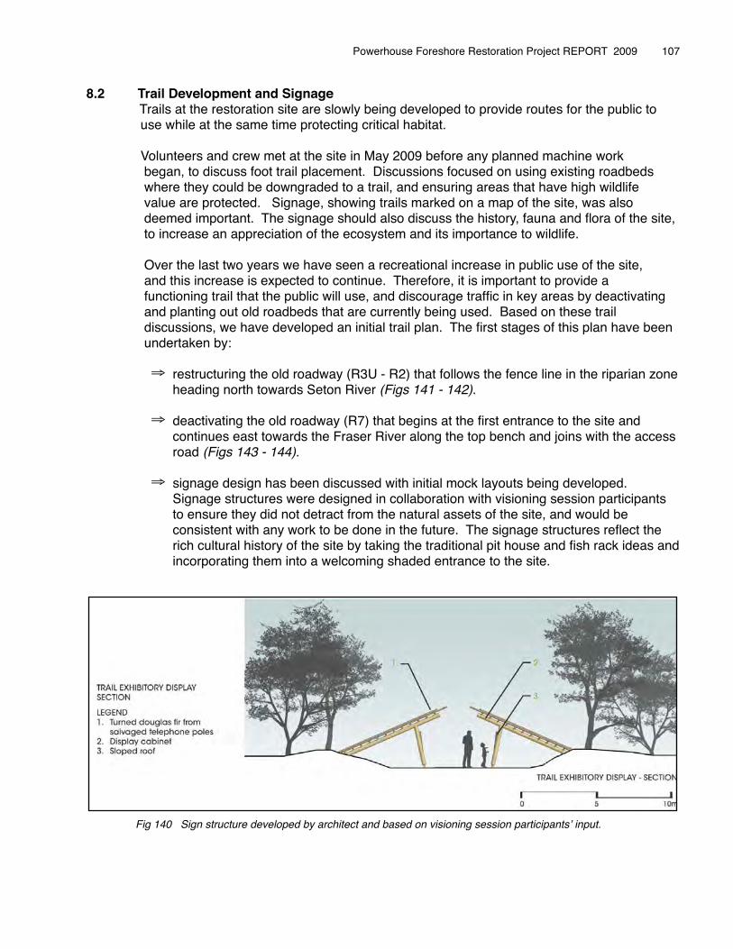
8.2 Trail Development and Signage� Trails at the restoration site are slowly being developed to provide routes for the public to � use while at the same time protecting critical habitat.
� Volunteers and crew met at the site in May 2009 before any planned machine work � began, to discuss foot trail placement. Discussions focused on using existing roadbeds � where they could be downgraded to a trail, and ensuring areas that have high wildlife � value are protected. Signage, showing trails marked on a map of the site, was also � deemed important. The signage should also discuss the history, fauna and flora of the site,� to increase an appreciation of the ecosystem and its importance to wildlife.
� Over the last two years we have seen a recreational increase in public use of the site, � and this increase is expected to continue. Therefore, it is important to provide a � functioning trail that the public will use, and discourage traffic in key areas by deactivating � and planting out old roadbeds that are currently being used. Based on these trail � discussions, we have developed an initial trail plan. The first stages of this plan have been � undertaken by:
⇒ restructuring the old roadway (R3U - R2) that follows the fence line in the riparian zone heading north towards Seton River (Figs 141 - 142).
⇒ deactivating the old roadway (R7) that begins at the first entrance to the site and continues east towards the Fraser River along the top bench and joins with the access road (Figs 143 - 144).
⇒ signage design has been discussed with initial mock layouts being developed. Signage structures were designed in collaboration with visioning session participants to ensure they did not detract from the natural assets of the site, and would be consistent with any work to be done in the future. The signage structures reflect the rich cultural history of the site by taking the traditional pit house and fish rack ideas and incorporating them into a welcoming shaded entrance to the site.
Powerhouse Foreshore Restoration Project REPORT 2009 � 107
Fig 140 Sign structure developed by architect and based on visioning session participantsʼ input.

Powerhouse Foreshore Restoration Project REPORT 2009 � 108
Fig 141- 142 Trail through riparian road replacing an old rutted
Fig 0143 - 144 New trail developed on the upland bench and leading to the river. The soils have been contoured and planted with native grassland plants.
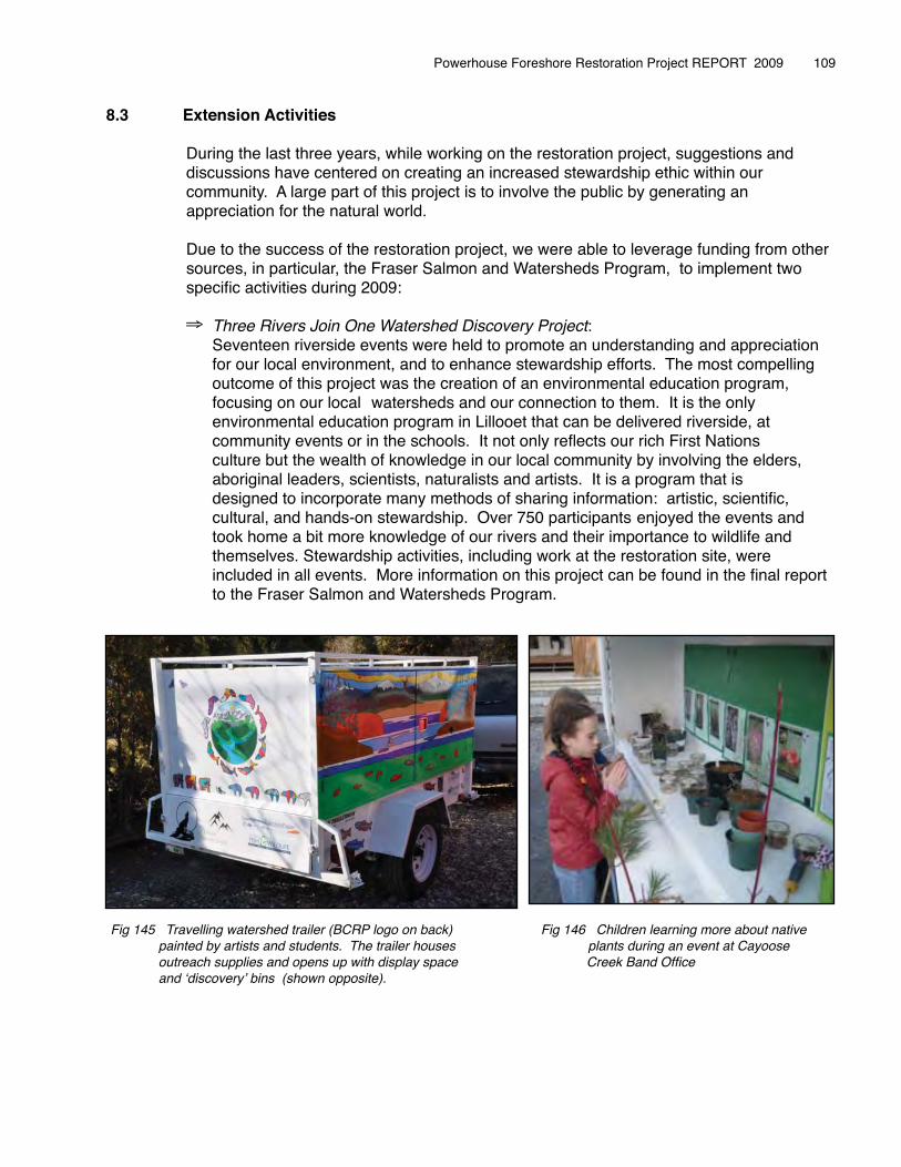
8.3 Extension Activities
� During the last three years, while working on the restoration project, suggestions and � discussions have centered on creating an increased stewardship ethic within our � community. A large part of this project is to involve the public by generating an � appreciation for the natural world.
� Due to the success of the restoration project, we were able to leverage funding from other � sources, in particular, the Fraser Salmon and Watersheds Program, to implement two � specific activities during 2009: �
⇒ Three Rivers Join One Watershed Discovery Project: � � Seventeen riverside events were held to promote an understanding and appreciation � � for our local environment, and to enhance stewardship efforts. The most compelling � � outcome of this project was the creation of an environmental education program, � � focusing on our local �watersheds and our connection to them. It is the only � � environmental education program in Lillooet that can be delivered riverside, at � � community events or in the schools. It not only reflects our rich First Nations � � culture but the wealth of knowledge in our local community by involving the elders, � � aboriginal leaders, scientists, naturalists and artists. It is a program that is � � designed to incorporate many methods of sharing information: artistic, scientific, � � cultural, and hands-on stewardship. Over 750 participants �enjoyed the events and � � took home a bit more knowledge of our rivers and their importance to wildlife and � � themselves. Stewardship activities, including work at the restoration site, were � � included in all events. More information on this project can be found in the final report � � to the Fraser Salmon and Watersheds Program.
Powerhouse Foreshore Restoration Project REPORT 2009 � 109
Fig 145 Travelling watershed trailer (BCRP logo on back) Fig 146 Children learning more about native painted by artists and students. The trailer houses plants during an event at Cayoose outreach supplies and opens up with display space � Creek Band Office and ʻdiscoveryʼ bins (shown opposite).
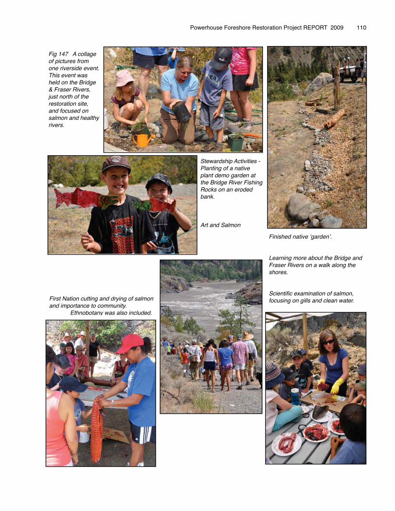
Powerhouse Foreshore Restoration Project REPORT 2009 � 110
Stewardship Activities - Planting of a native plant demo garden at the Bridge River Fishing Rocks on an eroded bank.
Art and Salmon
Fig 147 A collage of pictures from one riverside event. This event was held on the Bridge & Fraser Rivers, just north of the restoration site, and focused on salmon and healthy rivers.
Finished native ʻgardenʼ.
Learning more about the Bridge and Fraser Rivers on a walk along the shores.
Scientific examination of salmon, focusing on gills and clean water.First Nation cutting and drying of salmon
and importance to community. Ethnobotany was also included.
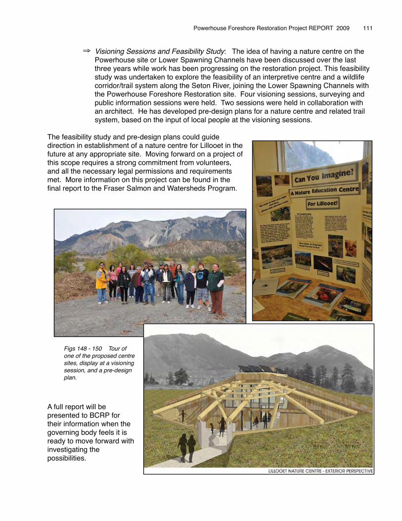
⇒ Visioning Sessions and Feasibility Study: The idea of having a nature centre on the Powerhouse site or Lower Spawning Channels have been discussed over the last three years while work has been progressing on the restoration project. This feasibility study was undertaken to explore the feasibility of an interpretive centre and a wildlife corridor/trail system along the Seton River, joining the Lower Spawning Channels with the Powerhouse Foreshore Restoration site. Four visioning sessions, surveying and public information sessions were held. Two sessions were held in collaboration with an architect. He has developed pre-design plans for a nature centre and related trail system, based on the input of local people at the visioning sessions.
The feasibility study and pre-design plans could guide direction in establishment of a nature centre for Lillooet in the future at any appropriate site. Moving forward on a project of this scope requires a strong commitment from volunteers, and all the necessary legal permissions and requirements met. More information on this project can be found in the final report to the Fraser Salmon and Watersheds Program.
A full report will be presented to BCRP for their information when the governing body feels it is ready to move forward with investigating the possibilities.
Powerhouse Foreshore Restoration Project REPORT 2009 � 111
Figs 148 - 150 Tour of one of the proposed centre sites, display at a visioning session, and a pre-design plan.
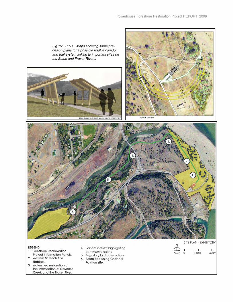
Powerhouse Foreshore Restoration Project REPORT 2009
Fig 151 - 153 Maps showing some pre-design plans for a possible wildlife corridor and trail system linking to important sites on the Seton and Fraser Rivers.
9. DISCUSSION
The Powerhouse Foreshore Restoration Project was carried out by the Lillooet Naturalist Society, in partnership with Cayoose Creek Stʼatʼimc, to implement Phase Two of the Restoration Plan.
This project has four main focus areas:
1. Increase wildlife habitat in an important and rare habitat of low-lying land within the mid-Fraser Canyon. The site is approximately 15 hectares - broken down into three distinct ecotypes: a large river sandbar at the confluence of the Seton and Fraser Rivers, a riparian zone and a dry upland bench. The site has recently been designated a Wildlife Habitat Area (WHA) for the Interior Western Screech-owl. We are working on providing habitat for a number of other threatened species including the Lewisʼ Woodpecker, Racer and Great Basin Gopher Snake.
2. Wildlife base-line surveying and on going monitoring to ensure our restoration prescriptions are meeting our goal of increasing wildlife habitat.
3. Build capacity within our community (both aboriginal and non-aboriginal) in the field of eco-based resource management and restoration so future maintenance of this site can be achieved, and future work can be carried out effectively.
4. Provide an educational resource to our community, where people can learn more about the natural world, including the importance of healthy watersheds. The aim is to instill a stewardship ethic within our community.
Currently, the restoration site has seen a high level of fragmentation, soil damage, and invasive weed dispersal, and the public perception of the area was for high-impact recreational use, partying and dumping. The Lillooet Naturalist Society, in partnership with Cayoose Creek Stʼatʼimc, carried out research, community consultations and planning during 2006 and 2007. Restoration work began on the site during 2008, in cooperation with our community, and with funding assistance from Bridge Coastal Fish & Wildlife Restoration Program.
The restoration site has significant ecological value.
� � “This is a unique diverse place where two rivers and the moisture loving � � cottonwood forests meet with the arid ponderosa pine and big-sage-bluebunch � � wheatgrass ecosystems” (Odin Scholz, 2006).
The riparian zone provides critical habitat for the red-listed Western Screech-owl (Otus kennicottii macfarlanei) and Lewis Woodpecker (Melanerpes lewis). The Screech-owl has been observed and site protected as a WHA. The twenty-two 4X4/ATV roads that fragmented this zone have now been closed and replanted with native trees and shrubs to speed habitat recovery.
Based on research and survey of reference ecosystems, we have concluded that the highly disturbed upland bench was once a Ponderosa-pine/bluebunch wheatgrass ecosystem (blue-listed). However, the bench has seen historical impacts from railway, hydro and Transport Department activities, with recent vehicular recreational damage. All these impacts have created “dead-zones” and fragmentation, habouring many invasive species. We are working on increasing habitat in this threatened ecosystem by decompacting and contouring old roadbeds, soil amendment where
Powerhouse Foreshore Restoration Project REPORT 2009
necessary, increasing structural integrity, protecting areas of strength already evident on site, and removing invasive species before replanting with indigenous species. Work being carried out will target the Racer (Coluber constrictor) and the Great Basin Gopher Snake (Pituophis catenifer deserticola), both blue-listed species.
When the Lillooet Naturalist Society and Cayoose Creek Stʼatʼimc undertook this project back in 2006, we were unaware of the large scope of the project. We have educated ourselves and called upon the expertise of many agencies and individuals to assist us in the restoration work and monitoring protocols. The Ministry of Environment, Fisheries and Oceans, BC Nature, Rivershed Society of BC, Wildeye Restoration, and many local professionals and contractors have provided their time and support to the project.
Vegetation and wildlife monitoring protocols have been establish to ensure we are meeting our goal of increasing wildlife habitat. These will continue over the course of the project, and be built upon over the coming years.
As Lillooet is a resource-based community with logging the primary industry, we had few trained people in ecological management or experience in restoration work. This project has increased our awareness of the many facets of land management in relation to restoration and has developed the capacity of our community to continue work in this area by providing training and work experience opportunities. As well, many people have volunteered on the project and this knowledge has been transferred.
The single largest component for the success of this restoration project was to ensure strong public support. As the Powerhouse site is on the outskirts of Lillooet and is used by a variety of people throughout the year for various activities it was imperative that the community “buy-in”. Many people enjoy the foreshore of the Fraser River in a low-impact way. However, as stated in the PreliminaryRestoration Study of the Powerhouse Site 2006:
� � “... changing public perception of the site is going to be crucial to� � stopping many of the ecologically damaging activities that currently � � occur on the site. The Powerhouse road land needs restoration� � and a facelift. Public perception needs to shift from the view of a� � wasteland where it is acceptable to dump garbage and waste, to � � the view of an ecologically diverse place with significant cultural � � and historical value” (Odin Scholz, 2006).
We have been successful in educating the public about the work being undertaken on site through various outreach activities. We have provided the community the opportunity to visit the site and view it through the eyes of various biologists, geologists and others with a passion for sharing the natural world. This type of outreach has been most successful to-date in strengthening the image of the site as a natural area with many exciting attributes. Many people have expressed surprise and pleasure when learning more information about the natural ecosystem on site. No further household, garden or building waste dumping has taken place since the roads have been deactivated; however, a small amount of picnic and party garbage is being removed on a fairly regular basis still.
The one-road access designation to the Fraser River, and all road deactivations undertaken in 2008, have been well received by the community. People continue to access the river and sandbar on the one access road maintained, and have, overall, respected the closures within the riparian zone and upland bench. However, on three occasions the boundaries were breached in six different locations,
Powerhouse Foreshore Restoration Project REPORT 2009 � 114
with no damage evident. Reinforcement of these breached areas has now been completed and increased education efforts continued. The parking area on the upland bench has been developed with the aim of decreasing use of the sandbar by vehicular traffic. During 2009, we did observe an increase of people parking up on the upland bench and using the initial established trails to walk throughout the site. This is a small percentage of the users, but is an indication that public perception is indeed changing. One of the most dramatic changes observed through the road closures within the riparian zone, is the speed with which native plant species are recolonizing those areas independent of any intervention by the restoration crew.
There are a few challenges to creating barricades in the riparian zone, including extreme high water levels of the Fraser River. During 2008, the logs were secured to boulders to ensure they were not swept away by the annual high water events. During spring 2009, the Fraser River high water event was average and visual inspections of the logs placed during 2008 revealed no significant changes. One log had come unsecured from a boulder at one end and moved slightly off angle, causing no damage. A visual check of the logs and boulders will be made annually before spring runoff to ensure structures remain in place and do not cause any detrimental effects.
Site complexing, soil remediation and installation of structural features have again created a lot of interest and comment from the public. Most people using the site, and those that have taken part in outreach activities, now understand the significance of the standing snags, cwd and rock piles. Stumps, woodpiles, rock mounds and the installed wildlife trees have created mini-habitats that have attracted insects, birds and small mammals already. With continued wildlife monitoring of the site we will watch the evolution of wildlife use in relation to the restoration work being undertaken. These structural features also created micro-sites, providing shade and protection, where native trees, shrubs, herbs and grasses have now been planted. Over the last three years, approximately 2,853 plants and 539 cuttings have been planted out into the newly decompacted and weeded soils. The structural changes, and plantings, have already quickly changed the aesthetic of the place, creating the look and feel of a regenerating site. In some areas the old road access points and roadbeds are hard to find.
The northern end of the riparian zone has a significant Ponderosa pine stand and we have undertaken preventative measures over the last two year to protect them, due to the fact that they create important habitat for the Western Screech-owl, and other wildlife. No mountain pine-beetle attack has been observed to-date.
With our focus on the upland bench during 2009, removal of exotic weed species was a significant proportion of the restoration work carried out this year. Exotic plant species are a dominant component of the dry bench shrub/herb zone and are a part of the legacy of disturbance on the site. An exotic plant species inventory has been completed and mapped within the site, and a weed management plan is in place to guide a systematic approach to eradication. The Advisory Committee has decided that no chemical treatment of weeds will take place at this time. The restoration crew worked hard through the long hot summer mechanically removing weeds. Techniques used to remove invasive species during 2009 included labour intensive methods - hand pulling, digging and mulching. Fire control management again took place in two areas and biological controls are already evident on site for knapweed and toadflax. An experiment with a pickling vinegar mixture was undertaking this year on bindweed in an effort to weaken the plant over the long-term. Photopoint monitoring has been established and ongoing surveying will continue. Eradication of exotic plant species is a long-term commitment. Work will need to continue in this area until native species have a strong enough foothold to provide competition to the weed species.
Powerhouse Foreshore Restoration Project REPORT 2009 � 115
As noted above, when exotics are taken out of the ecosystem it is important to replace them with native species as soon as possible, to fill the gap being left behind. This ensures that weedy species have some competition, making it more difficult for them to establish, and, importantly, it provides habitat for wildlife as quickly as possible after the weedy species have been removed. A large number of native plants are going to be required to restore the Powerhouse site to ensure productive habitat is achieved.
To ensure genetic adaptability of the planted species to the restoration site, a native plant nursery was established in 2008. Over 4,000 plants were successfully raised at the nursery throughout 2009. Various methods were used - salvage, cuttings, live staking, seeding - all generated from local stock. The native plant nursery provides an opportunity for community capacity building in the identification and propagation of native plants for ongoing restoration projects within the territory. The demonstration garden developed at the nursery will also provide an excellent educational resource for our community in dryland gardening that benefits wildlife.
In the fall of 2009, approximately 52% of the plants raised at the nursery were planted into the restoration site. The majority of the planting was done on the deactivated roadbeds on the upland bench. Based on the 2008 test plots established on the upland bench, a similar species mix was planted during 2009 - 5% trees, 20% shrubs, 75% herbs and grasses. The predominate species were blue-bunch wheatgrass and other dryland herbaceous species as noted above. Site contouring and mounding provided favourable micro-sites that optimized the potential for water recruitment and conservation. Providing depressions and shade forming features increases the likelihood of achieving good planting spots and should assist in the survival rate of new seedlings. This has proved true based on the monitoring of the 2008 planted species where there was an approximate 90% survival rate - a much higher rate of success then we had hoped for, especially considering the long hot dry summer of 2009. Plants were watered deeply on a weekly basis during 2009. This is a time-consuming task, and considering we now have approximately 3,300 plants and cuttings on-site, increased monitoring of the upland plants will guide the amount of moisture required to see them through their first year. It is hoped that the riparian plants established in 2008 will require little maintenance this coming restoration season, and that the dryland plants, being more adapted to the harsh conditions, will require less watering in.
We have had some challenges with live staking into the restoration site, with a 60% success rate. Ongoing research and method changes were implemented in 2009, and monitoring during 2010 will see if these measures have been successful. We also implemented direct-seeded plots for the first time this year in an effort to hasten the revegetation at the site. Monitoring of these test plots will be done and guide future work in this direction.
Wildlife studies have taken place over the last two years to provide on-going monitoring of species using the site. Monitoring protocols have been established to provide information on the success of the restoration project in attracting greater wildlife use of the site. The wildlife studies undertaken this year include a breeding bird survey, autumn migration survey, Western Screech-owl survey, reptile monitoring and a preliminary bat survey. A small mammal survey was not completed due to funding and timeline constraints.
We have received recommendations from all the biologists who have undertaken work on the site, as well as the initial recommendations of Jared Hobbs, MOE. We have begun to implement all of these recommendations with the goal of increasing and enhancing the habitat at the Powerhouse site. The work carried out in 2010 will continue to build on these changes. Through our on-site observations it
Powerhouse Foreshore Restoration Project REPORT 2009 � 116
is clear that the features we have installed on the site are meeting the target of providing wildlife ʻspotsʼ that can be used by a variety of species, including the targeted species-at-risk. The ongoing wildlife monitoring efforts will be interesting to follow over the years to see if the restoration work does eventually provide productive habitat across the entire site.
A vegetation and wildlife monitoring audit of the restoration work was also completed by BCRP during the 2009 season. The audit was carried out by Rescan to report on the effectiveness of the work that the Lillooet Naturalist Society had undertaken during 2008. The information provided in that report was interesting and, overall, confirmed the work being carried out is proceeding successfully. Recommendations to assist us in fine-tuning our reporting and monitoring protocols were provided. Based on successful funding, volunteer expertise and commitments, we will attempt to incorporate these recommendations into our plans for 2010.
Community surveying and visioning sessions during 2007 - 2008 revealed that the community was interested in looking at additional extension activities that could develop from this restoration project. The Lillooet Naturalist Society and Cayoose Creek Stʼatʼimc see the restoration project as a great learning tool and community capacity building exercise. Based on the desire expressed during the visioning sessions, the partners implemented two extension activities, both focusing on providing educational programs to increase the sense of wonder and appreciation for the natural environment, with the intent to instill a stewardship ethic within our community. We were able to leverage funding for these two projects from the Fraser Salmon and Watershed Program.
The Three Rivers Join One One Discovery Project attracted a wide range of people to riverside events where watershed information, stewardship activities, cultural information and fun, hands-on activities were implemented. Over 750 people attended the seventeen events held during 2009 and early 2010. This program will be continued during 2010 focusing on visiting the various schools, aboriginal communities and different organizations in the community, thereby extending our educational reach. Increased stewardship activities will also be held at the restoration site, building on the programs we already have in place on-site.
The Visioning Sessions focused on the idea of having a permanent place to hold educational and stewardship activities, and in having a staffed facility where restoration maintenance, monitoring and research could be based out of. Four visioning sessions were held and a Feasibility and Pre-Design Plan were completed. These preliminary reports will guide any future work towards reaching this goal.
Another extension activity was the idea of creating a wildlife corridor between the Powerhouse Restoration site and the Lower Seton Spawning Channels. The Visioning Sessions incorporated this idea into the Pre-Design Plan. A grant submission was made to BCRP for the 2010 year to undertake a Feasibility Study to map and survey the area and research possibilities of restoration work within the Seton River corridor that could benefit both fish and wildlife. It is thought that extending a functioning link between the two sites will assist fauna in their movements within the Seton River system.
Community outreach has been a large component of the restoration work carried out to date.
� � “Any successful restoration project, especially when close to a population� � center, needs to have a strong public support for it to succeed” (Odin Scholz, 2006).
Powerhouse Foreshore Restoration Project REPORT 2009 � 117

The Lillooet Naturalist Society and Cayoose Creek Stʼatʼimc are encouraged by the goodwill shown towards this project and the lack of vandalism that has taken place on site over the last two years. We believe this is due to our efforts over the last four years to involve the community in the visioning for the site and allowing all user groups to provide input.
Regular updates in local media sources have also provided ongoing commentary on the work being carried out, and interviews on Radio Lillooet presented. All events were posted on our website at www.lillooetnaturalistsociety.org The contributions of the BCRP and our other funders have been acknowledged both in the media and at all events and presentations.
Numerous outreach activities, as indicated earlier in this report, have taken place over the 2009 restoration season and over 830 hours have been volunteered to the project by community members during Volunteer Opportunity Days, and through offers to assist in various aspects of the project. These volunteer days included a clean-up of the site, seed collection, salvage operations, nursery work, construction of the greenhouse and nursery upkeep, and the popular fall native planting days.
The combination of the unique ecology of the site, the easy access to the Fraser River and the active restoration project provides a powerful forum for ecological education. We have provided educational field walks and activities where a wide variety of the public (from seniors to young children) have been involved. A highlight of the year were the visits of two elementary school classes, and two groups of students from the high school, on different occasions. The restoration crew lead educational activities to teach students about the ecology of the site and the wildlife that use the area, including the Interior Western Screech-owl. The students then participated in stewardship activities such as planting native shrubs and mulching plants. Many of the comments expressed by the elementary students was the view that “this was the best field trip they had ever been on”. One of the elementary classes have put together a short video of their experience at the restoration site. A link can be found on our website. As well as our regular naturalist volunteers coming out to plant in the fall, members of BC Nature, the Uxwalmixw Society youth and other new community members joined us and we greatly appreciate their assistance.
A lot of people in the community are interested in native plants and we have been involved in various outreach activities speaking about native specie identification, ethnobotany and the growing of plants. We attended the first Lillooet Seedy Saturday event and participants received seed to plant at home in exchange for propagating some for the restoration project. The nursery and restoration site were also requested to be on the annual Lillooet Garden Tour and we had the opportunity to speak with avid gardeners, some who had not visited the site before. We held an open house and barbecue at the nursery, and built three small demonstration gardens, with the assistance of volunteers, over the season - one at the native plant nursery, one at the Xwistan Bridge River Fishing Rocks during a riverside event, and one in the Tʼitʼqʼet Community Gardens during the annual Roots Festival.
The 3rd Annual Salmon in the Canyon Festival was hosted by the restoration crew, in conjunction with the Rivershed Societyʼs SLLP program. The event focuses on our watersheds and how to live sustainably within them. The event provides an avenue for other BCRP projects and various organizations to present their findings and work to the community. Over 300 people were in attendance and enjoyed the information, salmon feast and entertainment.
Community capacity building in stewardship work has again taken place, with another five local youth trained as crew technicians through the Summer Works Program, and four Cayoose Creek Band members hired to assist at various times throughout the restoration season.
Powerhouse Foreshore Restoration Project REPORT 2009 � 118
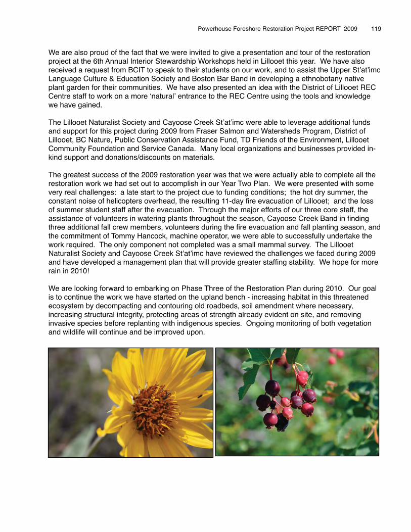
We are also proud of the fact that we were invited to give a presentation and tour of the restoration project at the 6th Annual Interior Stewardship Workshops held in Lillooet this year. We have also received a request from BCIT to speak to their students on our work, and to assist the Upper Stʼatʼimc Language Culture & Education Society and Boston Bar Band in developing a ethnobotany native plant garden for their communities. We have also presented an idea with the District of Lillooet REC Centre staff to work on a more ʻnaturalʼ entrance to the REC Centre using the tools and knowledge we have gained.
The Lillooet Naturalist Society and Cayoose Creek Stʼatʼimc were able to leverage additional funds and support for this project during 2009 from Fraser Salmon and Watersheds Program, District of Lillooet, BC Nature, Public Conservation Assistance Fund, TD Friends of the Environment, Lillooet Community Foundation and Service Canada. Many local organizations and businesses provided in-kind support and donations/discounts on materials.
The greatest success of the 2009 restoration year was that we were actually able to complete all the restoration work we had set out to accomplish in our Year Two Plan. We were presented with some very real challenges: a late start to the project due to funding conditions; the hot dry summer, the constant noise of helicopters overhead, the resulting 11-day fire evacuation of Lillooet; and the loss of summer student staff after the evacuation. Through the major efforts of our three core staff, the assistance of volunteers in watering plants throughout the season, Cayoose Creek Band in finding three additional fall crew members, volunteers during the fire evacuation and fall planting season, and the commitment of Tommy Hancock, machine operator, we were able to successfully undertake the work required. The only component not completed was a small mammal survey. The Lillooet Naturalist Society and Cayoose Creek Stʼatʼimc have reviewed the challenges we faced during 2009 and have developed a management plan that will provide greater staffing stability. We hope for more rain in 2010!
We are looking forward to embarking on Phase Three of the Restoration Plan during 2010. Our goal is to continue the work we have started on the upland bench - increasing habitat in this threatened ecosystem by decompacting and contouring old roadbeds, soil amendment where necessary, increasing structural integrity, protecting areas of strength already evident on site, and removing invasive species before replanting with indigenous species. Ongoing monitoring of both vegetation and wildlife will continue and be improved upon.
Powerhouse Foreshore Restoration Project REPORT 2009 � 119
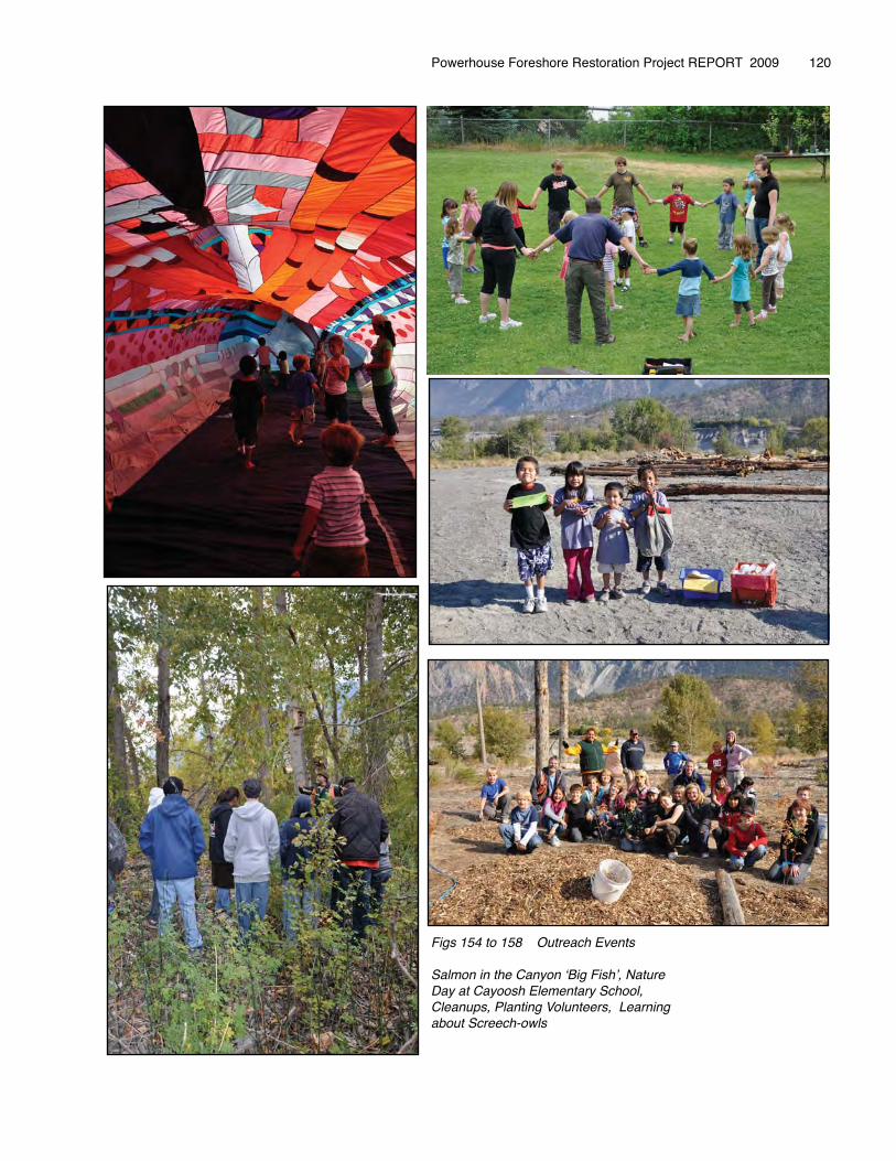
�
Powerhouse Foreshore Restoration Project REPORT 2009 � 120
Figs 154 to 158 Outreach Events
Salmon in the Canyon ʻBig Fishʼ, Nature Day at Cayoosh Elementary School, Cleanups, Planting Volunteers, Learning about Screech-owls
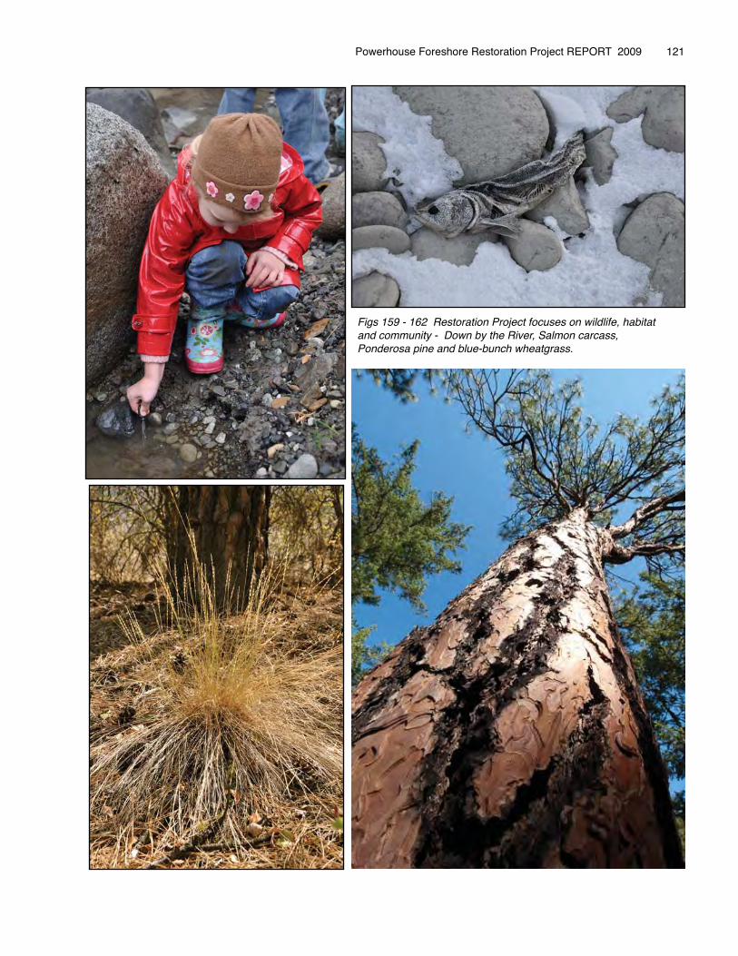
Powerhouse Foreshore Restoration Project REPORT 2009 � 121
Figs 159 - 162 Restoration Project focuses on wildlife, habitat and community - Down by the River, Salmon carcass, Ponderosa pine and blue-bunch wheatgrass.

10. � RECOMMENDATIONS
The Lillooet Naturalist Society will follow a detailed restoration plan for 2010. The plan provides a step-by-step sequential process to assist in the enhancement of the site. This plan has information on all the exotic and native plant species and their occurrences with the site, as well as prescriptions on how to eradicate and replant with natives. The plan also has information on targeted wildlife currently accessing the site and those that are to be encouraged to use the area, as well as recommendations on how to promote greater diversity for wildlife use.
Recommendations provided in the BCRP 2009 Lillooet Biological Audit Survey, and the successes/challenges of the past two years work, will be incorporated into the restoration project based on funding and volunteer commitments.
The following is a summary of the tasks to be undertaken during 2010 - Phase Three of the project. Estimated timelines have been indicated. See Map 19 below.
Task Completion DateHire of staff and set up of human resources/accounting functions/office space 15 April 2010
Produce a monitoring objectives and methods document
Start up Advisory Committee with partner representatives 15 April 2010
Sign all legal documents and secure liability insurance 15 April 2010
Provide training to new crew members – initial training and continuing on-site training 30 April and ongoing
Native Nursery and Greenhouse start-up 01 May 2010
Protect designated Ponderosa Pines with pheromone treatments 15 June & 15 August 2010
Survey and monitor Reference Ecosystem 30 September 2010
Increase structural complexity on last section of top bench – deactivate roads, decompaction, soil remediation, contouring, and log/boulder/stump placement, removal of introduced gravels/asphalt
30 September 2010
Propagation of native plant species from local stock (seed, cuttings, salvage) – ongoing from spring to fall 30 October 2010
Removal of invasive plants in selected areas, working out from areas of strength – ongoing 30 October 2010
Remove seed sources of invasive weeds in sites in close proximity to the site 30 October 2010
Replanting of native plants in selected areas, immediately upon removal of invasive species – ongoing watering and maintenance of 2009 plantings during spring, summer, fall
30 October 2010
Monitor planted vegetation 30 October 2010
Increase wildlife habitat – using professionals’ recommendations 30 October 2010
Continue wildlife monitoring on-site (birds, reptiles, bats) and implement new survey (small mammals). Implement monitoring on a control site (based on additional funding and volunteer commitment)
30 October 2010
Continue Trail Development based on input received in 2009 30 October 2010
Install additional trail-side signage 30 October 2010
Archaeological Monitoring – ongoing throughout project timeframe – and graveside work 30 October 2010
Community outreach – slide shows, field walks, newspaper & radio articles, educational and volunteer opportunities - Community capacity building in resource management and stewardship
15 December 2010
Monitoring and reporting – ongoing throughout project timeframe 15 March 2011
Table 12 2010 Restoration Plans
Application has been made for Phase Three work to the Bridge Coastal Fish & Wildlife Restoration Program. Additional funding to assist in restoration work and outreach activities has been requested from the Fraser Salmon & Watersheds Program and Habitat Conservation Trust Foundation. Staffing requirements have been requested through the Youth Eco Internship Program YWCA, Ministry of Social Development JCP and Service Canada.
Powerhouse Foreshore Restoration Project REPORT 2009 � 122
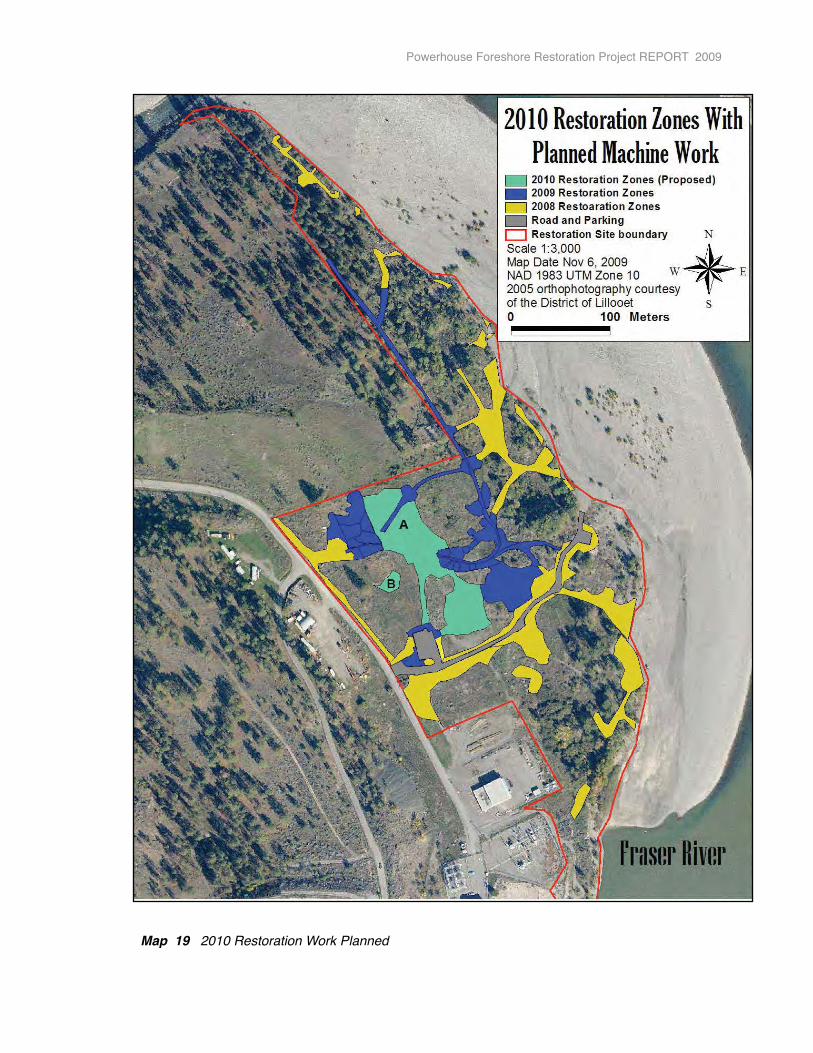
Map 19 2010 Restoration Work Planned
Powerhouse Foreshore Restoration Project REPORT 2009
11. ACKNOWLEDGEMENTS
Phase Two 2009 of the restoration project and report were completed with the financial support of BC Hydro Bridge Coastal Fish and Wildlife Restoration Program. We would like to especially thank Breanne Patterson for her support and encouragement over the last year.
We would like to thank our partners: Cayoose Creek St’at’imc, Michelle Edwards, Wayne Redan, Charmaine John and Trudy Redan for their assistance throughout this project; Sean Bennett, Department of Fisheries and Oceans, for his support of the project and in-kind commitments; Francis Iredale, Ministry of Environment for sharing his expertise with us on species-at-risk and establishing the Wildlife Habitat Area for the Western Screech-owl; Pat St-Dennis, Councillor District of Lillooet, Margaret Lampman Past-Councillor, Jeff O’Kelly, Birder, and Gillian Smith, Wildcrafter, for providing their time and advice while sitting on the Advisory Committee; Darren Oike, District of Lillooet, for all his help in mapping and legal title information; BC Nature for helping us with accessing funding, providing educational materials, and volunteering on-site; Fin Donnelly and members of the Rivershed Society of BC for providing advice and touring the site; the Lillooet Friendship Centre and Cayoose Creek Band Council for in-kind use of their facilities during outreach programs; District of Lillooet and SLRD for their in-kind contributions, and to the Bridge River-Lillooet News, St’at’imc Runner and Radio Lillooet broadcasters for their coverage of the project;
Thanks also to Ed Senger & Simon Warhurst for their time in discussing and making recommendations on how to protect trees on the site from Mountain Pine Beetle attack; Kenneth Wright and Jeff O’Kelly for birding surveys; Doug Burles for preliminary bat survey; Bob Deadman for volunteering to weekly undertake the reptile monitoring program and all his assistance at the native plant nursery and on-site; and to the local businesses and organizations who provided in-kind support and/or donations/discounts on materials, in particular CN Rail, Bob Johnson, Lillooet Feed & Garden, Lillooet Contracting, Rev-It-Up, Lillooet Tim-ba Mart, Buy-Low Foods and Pharmasave.
Members of the Lillooet Naturalist Society provided countless volunteer hours towards this project over the last four years. Thanks to the directors who have provided input into project administration - Vivian Birch-Jones, Ian Routley, Kenneth Wright, Scott Bodaly and Anne Heath. Thank you also to Ian Routley for his wonderful photographs used throughout the project, his quick response to any request for information, and his technical expertise at our open houses; and to all the volunteers who provided valuable time in assisting work at the site, in the nursery and at outreach events: Cathy Arthur-Stathers, Ursela Stephanie, Tim Malone, Judy & Scott Bodaly, Steve Hall, Candice Jack, Jan Wilson, Peter McAlister, Kim & Chris Davy and family, Nancy Humber and family, Terri & Chris Hurst, Maggie Lord, Doug Grossler, Ina Weber, Leigh McGinity, Keith, Mike Carson, Rose Adrian, Rita & Ken Dillon, Kelly DeStrake, Jacquie Moffat, Anne Heath, Marline John, Ruby Berry, Sue Senger, Janna Pike, Bob Chute, Bailey Phillips, Tim & Pam Paradis, Nancy & Lionel Leston, Sandy Horner & family, Jeff Sneep and family, Verne Rasmussen, Chris Galliazzo, Ken and MJ Oakes, Angela, Cedar and Sage Scholz, and Bill Spencer. To the Wild Onions, Willard Charlie, Faith Peters, USLCES, Uxwalmixw Society youth; and also to Ken Oakes, Jody Lane, Mindy Casselman and Lorrinda Casper for engaging their students in stewardship work.
Thanks to the crew technicians – Jennifer Calliou, Christopher Saul, Evan Narcisse, Tanner Dan, Brett Dillon, Karen Edwards, John Frank and Fred James. They were responsible for pulling weeds, digging, sifting through soil, salvaging plants, collecting and propagating seeds and assisting in outreach activities. To Tommy Hancock for his patience and good humour will undertaking all the machine work. To Alex North for his assistance in many varied ways on the project. Finally, we would like to thank Odin Scholz, who has worked with us on this project for the last four years and who is responsible for all mapping and supervision of field work. The Final Report Phase Two of the Powerhouse Restoration Project, 2009 indicated the work carried out on the site this year and provided recommendations for 2010. Many of the details and recommendations found within this report are based on his meticulous field work.
Powerhouse Foreshore Restoration Project REPORT 2009
12. REFERENCESBridge River Water Use Plan Consultative Committee. Bridge River Water Use Plan, September 2003. Vancouver: Compass Resource Management and BC Hydro, 2003.
Bridge-Coastal Fish and Wildlife Restoration Program, Strategic Plan, Volume 2. Seton River Watershed. Vancouver.
Burles, Doug. Trip Report 2009 - Bat Information. Kamloops, 2009
Dorner, Jeanette. An Introduction to Using Native Plants in Restoration Projects. Washington DC.
Hudson, Shelley. Propagation of Interior British Columbia Native Plants from Seed. BC Ministry of Forests Research Program, 1998
Ministry of Environment. The Identified Wildlife Management Strategy (IWMS). Wildlife Conservation Planning Branch, Victoria, 2004 Naturescape, 2006. Web entry on Native Plants for the Southern Interior. www.hctf.ca/nature.htm
North, Kim. Powerhouse Foreshore Restoration Project, Final Report, Phase One - 2008. Lillooet, BC. 2008
Parchoma, Gale. Guide to Weeds in British Columbia. British Columbia Department of Food, Agriculture and Fisheries, 2002.
Parish, Roberta and Coupe, Ray and Lloyd, Dennis. Plants of Southern Interior of British Columbia and the Inland Northwest. Vancouver: Lone Pine Publishing, 1996.
Ralph, David. Field Guide to Noxious and Other Selected Invasive Plants of British Columbia. Victoria, B.C: 2007
Rescan Environmental Services Ltd. 2009 Lillooet Biological Audit. Kamloops, 2009 Scholz, Odin. A Preliminary Restoration Study of the Powerhouse Road Site, Lillooet. Lillooet: 2006.
Scholz, Odin. Recommendations and Prescriptions for Year One Restoration of the Powerhouse Road Site. Lillooet B.C: 2007
Scholz, Odin. Summary Report of Ecological Restoration Activities at the Powerhouse Road Site. Lillooet B.C: 2008
Scholz, Odin. Final Report Phase Two of the Powerhouse Foreshore Restoration Project. Lillooet B.C: 2009
Sibley, David. The Sibley Guide to Birds. New York: Alfred A. Knopf, Inc., 2000.
Wind, Elke. Amphibian and Reptile Surveys on the Powerhouse Foreshore Restoration Site. Lillooet, B.C: 2008
Wright, Kenneth. Breeding Bird and Autumn Migration Monitoring at the Seton Powerhouse Restoration Site. Lillooet, B.C: 2008 and 2009.
Wright, Jim and Pryce, Paul. Seven Steps to Managing Your Weeds – A Manual for Integrated Weed Management in British Columbia. Victoria: British Columbia Ministry of Agriculture, Food and Fisheries, 2002.
Various websites were also accessed to obtain information on removal techniques for exotic plant species and planting of native species, as well as information on wildlife, their preferred habitats and monitoring techniques. This information is compiled in the Powerhouse Foreshore Restoration Plan.
Powerhouse Foreshore Restoration Project REPORT 2009 � 125

Appendix I
Breeding Bird and Autumn Migration Monitoring
at the
Seton Powerhouse Restoration Site 2009
Attached.
Powerhouse Foreshore Restoration Project REPORT 2009

Appendix II
Financial Statement
Powerhouse Foreshore Restoration Project REPORT 2009
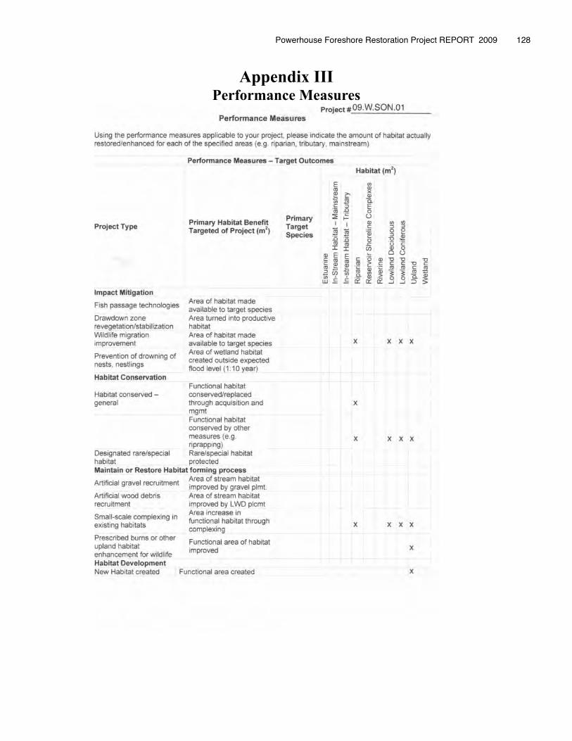
Appendix IIIPerformance Measures
Powerhouse Foreshore Restoration Project REPORT 2009 � 128
Appendix IVConfirmation of BCRP Recognition
Bridge River-Lillooet News articles
&
2 Examples of Nature Nook Articles submitted monthly to the BRLN
St’at’imc Runner news articles
Posters for Community Outreach Activities
Logo Placement on Outreach Trailer
OTHER ACKNOWLEDGMENTS
Radio Lillooet Announcements
Public Acknowledgements at the Salmon in the Canyon Festival
Slide show and Powerpoint Presentation at community events
and
at the 6th Annual Interior Stewardship Workshop
Powerhouse Foreshore Restoration Project REPORT 2009
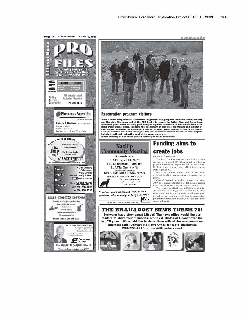
Powerhouse Foreshore Restoration Project REPORT 2009 130
Page 14 Lillooet News APRIL 1, 2009 community
Lil
loo
et
Ne
ws
To book your spot in , call the News
office at 250-256-4219
StirlingCustomContracting
All Interior andExterior Repairs
Interior•Home Renovations•Painting•Laminates
Exterior•Decks/Fences•Landscaping•Tile Setting
Fully Insured
SCC
Ph: 256-8646
Inggground Sppppprinkler Syyystems
& ServiceInstallation Free EstimatesFree Estimates
Dan & Donnna Gatzka250-256-73567356250-256
A JOINT EFFORT**Our services qualify for the Home Renovation Tax Credits qualify for the Home Renovf h
Phone 250-315-0241 Toll Free 1-800-897-9559 ext 284Email: [email protected]
“Serving Lillooet and Area Since 1999.”
“Let me craft a solution built for you.”“• Personalized Retirement Plans
• Detailed Risk Assessment• Strategic Investment Analysis
David L. Brown, CFP, CSAExecutive Financial Consultant
Local Com• LLocal Commpanys•Fully Inssured
•Fully Cert••Fully Certtifiedoo Big or S•No Job Tooo Big or SSmall
•FREE Local Estim LLocal Estimmates
Office: 250-256-2118Cell: 50-256-82550-256-88805
or 50-256-92550-256-99295
Tree
Removal
Interior
Central
Ltd.
DATE: April 18, 2009TIME: 10:00 am – 2:00 pm
PLACE: Nuk’way’lh
Xaxli’pCommunity Meeting
Rescheduled to
Lunch will be providedDEADLINE FOR AGENDA ITEMS
APRIL 15, 2009 at 12:00 NOONFor more informationcontact Susan Saul at
250-256-4800
THE BR-LILLOOET NEWS TURNS 75!Everyone has a story about Lillooet! The news office would like our
readers to share your memories, stories & photos of Lillooet over the last 75 years. We would like to share them with all the newcomersand
oldtimers alike. Contact the News Office for more information 250-256-4219 or [email protected]
Restoration program visitorsThe B.C. Hydro Bridge Coastal Restoration Program (BCRP) group was in Lillooet last Wednesday and Thursday. The group met at the REC Centre to update the Bridge River and Seton Lakewatershed plans. There was very good local participation from the St’at’imc and the local natu-ralist group among others, including the Department of Fisheries and Oceans and Ministry of Environment. Following the meetings, a few of the BCRP group enjoyed a tour of the power-house restoration site. BCRP funding for this year has been approved for various local projects including continued restoration work at the powerhouse site.(Photo courtesy of Kim North; caption courtesy of Vivian Birch-Jones)
(Continued from page 6)
The Towns for Tomorrow and LocalMotion projects are part of an overall $14-billion capital infrastructure program supported by the province that will create up to88,000 jobs and help build vital public infrastructure inevery region of B.C.
Beyond this funding announcement, the government of Canada is taking important steps to support economic growth.
Canada’s Economic Action Plan, announced in budget 2009, is a balanced stimulus plan that includes massiveinvestments in infrastructure, tax relief and transfers.
This plan will provide close to $12 billion in new infra-structure stimulus funding over two years that will addressneeds in communities across Canada, as well as contribut-ing to long-term economic growth through investments inpublic infrastructure, such as roads, water treatment, greenenergy and transit.
Funding aims tocreate jobs
Literacy Foundation
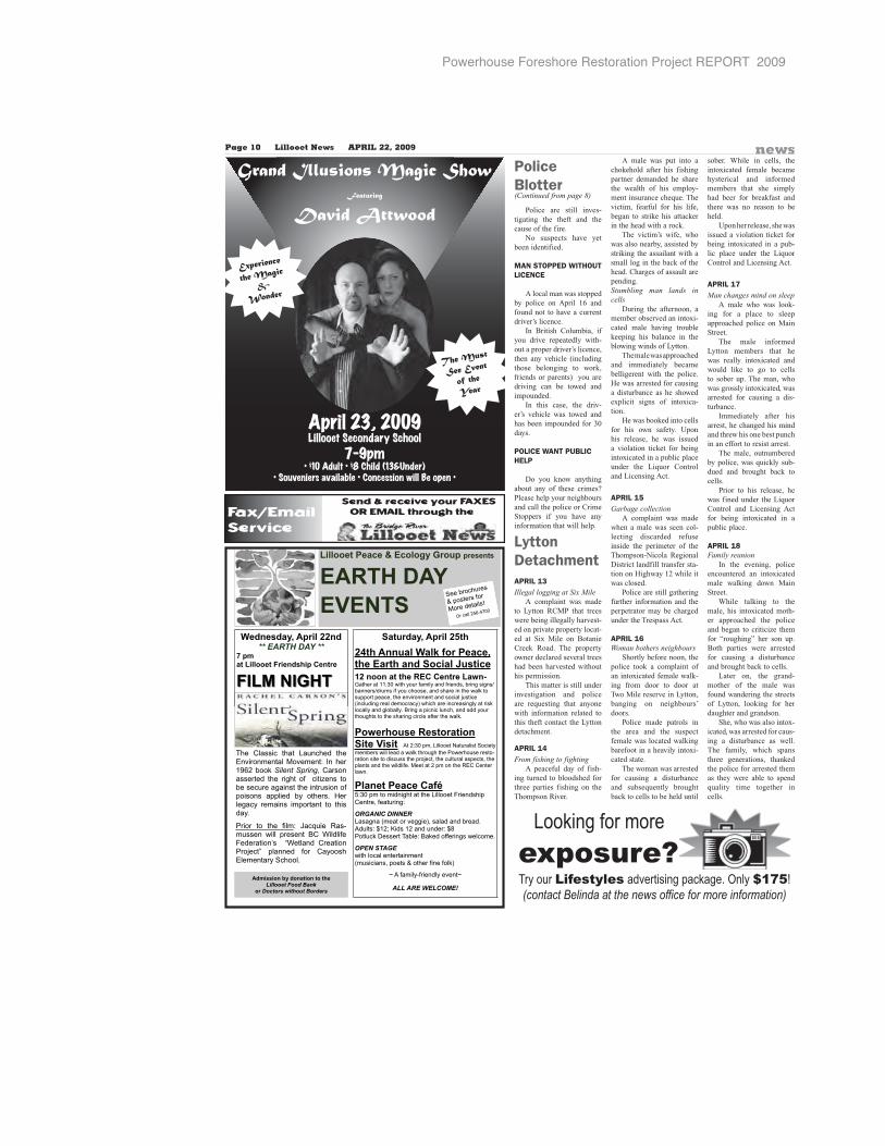
Powerhouse Foreshore Restoration Project REPORT 2009
Page 10 Lillooet News APRIL 22, 2009 news
��������������� ���������������������
��������� � ���
�� �������!��������������"����������������� �
�������������������������
#�������$�������%%�������������������
&�� ������������'������"���(������
')�*��)���')�*��)���
���� ����� ����� �������� ��������������������������� ��� ����������������������������������������� ���� � ��� �!� � ��"��� ������������� ����������������!�#���� �##���� �$� �����%� &����� ��$� ������ �#������� ��� �����$%�
'���� ��� ���� !���� (��)��� *�+����� ,��� #������ -�� .���!��/���01��23�4� � 56��713�� 80�1��23�902����:� 7133��� ;20� 81224<����������$�=�����%��
������$�������%+�"��%,�"�������#�-�.������$��"�� ��"����������/������0%���������"��� (�(�������1�2>���������������,���$����!���$�����!��������� � � ������ �����!�$�������������������������,��������##����#������������������������������?������������ ��������������$��,�������������� �$�������������$����� ������$%�-�� ���#�������������������$�������� �������������� ��������!��������,���%�
�1��"�������������������������� ��������#��� �������@��������=����$��������,����������,��������� ������'�,�����������+��������������������#��?�������������������#���������#�������������,���!�%�����������#���������*������������,�%�
���������(.3�����#�������� ���������� �������A�����#���������!������ ��
����� !�� ���� �� �������������� ������������������%��������������B��������������������'�������C������������-������!!��� �,������%��
�"���#����,�������������������������������#����������������!����
D���!���$+!�����$������D��
��������$��!�%�&��
=�� ��������
� #���� !��
���� ������
E� ���� ���+����
Grand Illusions Magic Show
Featuring
David Attwood
Experience
the Magic
&
Wonder
The Must
See Event
of the
Year
(Continued from page 8)
Police are still inves-tigating the theft and the cause of the fire.
No suspects have yet been identified.
MAN STOPPED WITHOUT LICENCE
A local man was stopped by police on April 16 and found not to have a current driver’s licence.
In British Columbia, if you drive repeatedly with-out a proper driver’s licence, then any vehicle (including those belonging to work, friends or parents) you are driving can be towed and impounded.
In this case, the driv-er’s vehicle was towed and has been impounded for 30 days.
POLICE WANT PUBLIC HELP
Do you know anything about any of these crimes? Please help your neighbours and call the police or Crime Stoppers if you have any information that will help.
Lytton DetachmentAPRIL 13Illegal logging at Six Mile A complaint was made to Lytton RCMP that trees were being illegally harvest-ed on private property locat-ed at Six Mile on Botanie Creek Road. The property owner declared several trees had been harvested without his permission. This matter is still under investigation and police are requesting that anyone with information related to this theft contact the Lytton detachment.
APRIL 14From fishing to fighting A peaceful day of fish-ing turned to bloodshed for three parties fishing on the Thompson River.
A male was put into a chokehold after his fishing partner demanded he share the wealth of his employ-ment insurance cheque. The victim, fearful for his life, began to strike his attacker in the head with a rock. The victim’s wife, who was also nearby, assisted by striking the assailant with a small log in the back of the head. Charges of assault are pending.Stumbling man lands in cells During the afternoon, a member observed an intoxi-cated male having trouble keeping his balance in the blowing winds of Lytton. The male was approached and immediately became belligerent with the police. He was arrested for causing a disturbance as he showed explicit signs of intoxica-tion. He was booked into cells for his own safety. Upon his release, he was issued a violation ticket for being intoxicated in a public place under the Liquor Control and Licensing Act.
APRIL 15Garbage collection A complaint was made when a male was seen col-lecting discarded refuse inside the perimeter of the Thompson-Nicola Regional District landfill transfer sta-tion on Highway 12 while it was closed. Police are still gathering further information and the perpetrator may be charged under the Trespass Act.
APRIL 16Woman bothers neighbours Shortly before noon, the police took a complaint of an intoxicated female walk-ing from door to door at Two Mile reserve in Lytton, banging on neighbours’ doors. Police made patrols in the area and the suspect female was located walking barefoot in a heavily intoxi-cated state. The woman was arrested for causing a disturbance and subsequently brought back to cells to be held until
sober. While in cells, the intoxicated female became hysterical and informed members that she simply had beer for breakfast and there was no reason to beheld. Upon her release, she wasissued a violation ticket for being intoxicated in a pub-lic place under the Liquor Control and Licensing Act.
APRIL 17Man changes mind on sleep A male who was look-ing for a place to sleepapproached police on Main Street. The male informedLytton members that he was really intoxicated andwould like to go to cells to sober up. The man, who was grossly intoxicated, was arrested for causing a dis-turbance. Immediately after his arrest, he changed his mindand threw his one best punch in an effort to resist arrest. The male, outnumberedby police, was quickly sub-dued and brought back tocells. Prior to his release, he was fined under the Liquor Control and Licensing Actfor being intoxicated in a public place.
APRIL 18Family reunion In the evening, police encountered an intoxicated male walking down MainStreet. While talking to themale, his intoxicated moth-er approached the police and began to criticize them for “roughing” her son up.Both parties were arrestedfor causing a disturbance and brought back to cells. Later on, the grand-mother of the male was found wandering the streets of Lytton, looking for her daughter and grandson. She, who was also intox-icated, was arrested for caus-ing a disturbance as well. The family, which spansthree generations, thanked the police for arrested them as they were able to spendquality time together incells.
Police Blotter
Looking for more
exposure?Try our Lifestyles advertising package. Only $175!(contact Belinda at the news office for more information)
Powerhouse Foreshore Restoration Project REPORT 2009
CRIMINAL RECORD? Ca-nadian pardon seals record.American waiver allows le-gal entry. Why risk employ-ment, business, travel, li-censing, deportation? All CANADIAN / AMERICAN Work & Travel Visa’s. 604-282-6668 or 1-800-347-2540Donations to the Lillooet District Hospital Foundation can be made at Created by Design or Lillooet District Hospital or mailed to Box 1642 Lillooet British Colum-bia V0K 1V0REMOVE YOUR RECORD:A CRIMINAL RECORD can follow you for life. Only PARDON SERVICES CANADA has 20 years ex-perience GUARANTEEING RECORD REMOVAL.Call 1-8-NOW-PARDON
(1-866-972-7366)www.RemoveYourRecord.com
1010 AnnouncementsFree scrap car + truck re-moval Call Geoff cell 1-604-206-0266
Lillooet District HospitalFoundations
2009-2010 MembershipsAre now due. Cost $5.00
Available atCreated By Design
Flower Shop or through Foundation Members
1060 Community NoticesARE YOU losing a loved one to substance abuse? Our program has the high-est success rate. Help is only one phone call away! 1-877-782-7409; www.nar-conon.caARE YOU LOSING a loved one to substance abuse? Our program has the high-est success rate. Help is only one phone call away! 1-877-782-7409; www.nar-conon.caDATING SERVICE. Long-Term/Short-Term Relation-ships, Free Calls. 1-877-297-9883. Exchange voice messages, voice mailbox-es.1-888-534-6984. Live adult casual conversa-tions-1on1, 1-866-311-9640, Meet on chat-lines.Local Single Ladies.1-877-804-5381(18+).
* LOVE! MONEY! LIFE! *#1 Psychics! *
1-877-478-4410 *Credit Cards /Deposit
$3.19/min. 18+ * 1-900-783-3800 *
www.mysticalconnections.ca
1145 Psychics
1135 Personal Messages100+ NURSING positionsavailable. RNs & LPNs canhave it all...back in the Mari-times. Shannex has imme-diate openings for 100+ full-time nurses for 12 new fa-cilities opening in the nexttwo years. New, state-of-the-art continuing care fa-cilities throughout NovaScotia and New Brunswick.For more information, con-tact Wayne White, NurseRecruiter, Shannex 118Fairfax Drive, Halifax, NS,B3S 1J3, [email protected], Toll free at 1-877-564-6749.ASSISTANT GROCERYManager, Dawson City,Yukon. Ordering, maintainInventory, receiving, ware-housing, merchandise, pro-duce experience an asset.Assist at check-out, com-puter experience. Fax 1-867-993-5813 or [email protected] FOR municipaland highway paving Super-intendents and Foremen.For details see www.knel-sen.com. Send resume to:[email protected] or fax 1-780-928-3656
1205 Career Opportunities
1215 General Employment 1215 General Employment
1215 General Employment 1215 General Employment
Page 22 Lillooet News MAY 6, 2009
Employment OpportunityRugged Edge Holdings Ltd. is currently seeking individuals with mining exploration camp and core cutting experience for a summer program to be held in the Lillooet area. Level l First Aid and general maintenance knowledge are requirements. This is a temporary full-time position for a 2-3
month duration. References are required.Please apply with resume to [email protected]
SCHOOL DISTRICT 74 - (GOLD TRAIL)REQUIRES AN
EXECUTIVE ASSISTANT (EDUCATION DEPT)DISTRICT ADMINISTRATION OFFICE, ASHCROFT
Reporting to the Superintendent of Schools, the Executive Assistant provides administrative and secretarial support to the Superintendent of Schools, the Director of Instruction, and the Board of Education. The successful candidate will possess:• Excellent communication (verbal and written), organiza-tion, human relations skills.• Flexibility, initiative, and ability to work under pressure with minimum supervision.• A service-oriented approach, including ability to maintain a positive relationship with employees and employee groups, senior administration, the Board of Education and members of the public.• Extensive experience with Microsoft Office Suite including Word, Power Point, Access, Excel and FrontPage.• Qualities of a self-directed team player.• Thorough understanding of the BC Public Education sys-tem.• An ability to maintain information of a highly confidential nature.For full details of this position, please refer to the school district website at www.sd74.bc.ca. The successful candidate will commence employment effective 01st June 2009. A detailed résumé, including references, must be received not later than 4:00 p.m., 15th May 2009, and directed to the attention of:
Lynda Minnabarriet, Secretary-TreasurerP.O. Bag 250, Ashcroft, B.C. V0K 1A0Fax: 250-453-2425Email: [email protected]
SUMMER EMPLOYMENTPOWERHOUSE FORESHORE
RESTORATION PROJECTA joint project with Cayoose Creek St’at’imc
& Lillooet Naturalist Society
FIVE POSITIONS CREW TECHNICIANSDuties:•Native plant propagation•Planting trees, shrubs, cuttings and seeds•Invasive weed removal•Building•Mountain Pine Beetle mitigation work•Restoration test plotting, mapping and monitoring•GPS work•Assistance in wildlife surveys and monitoring•Event planning and implementation����������� ������������������ � ��������������� •Students aged 18 to 30•Good physical condition•Willing to work outdoors in all weather conditions•Good communication skills•Knowledge of St’at’imc culture an asset, but not essential•Students must currently be enrolled, and planning to return, to a post-secondary program in natural resource sciences, environmental studies, horticulture or similar programs.•Aboriginal students, women and people of visibleminorities are encouraged to apply.Date of Employment:15 weeks: 19 May to 27 August 200935 hours per weekSalary: $12.00 per hour
Positions subject to funding from Service Canada. On the job training and experience.
Deadline for Applications: 11 May 2009 NOONTo: Charmaine John Project Coordinator Cayoose Creek Band Box 484 Lillooet BC V0K 1V0OR Email to: [email protected] North Lillooet Naturalist Society
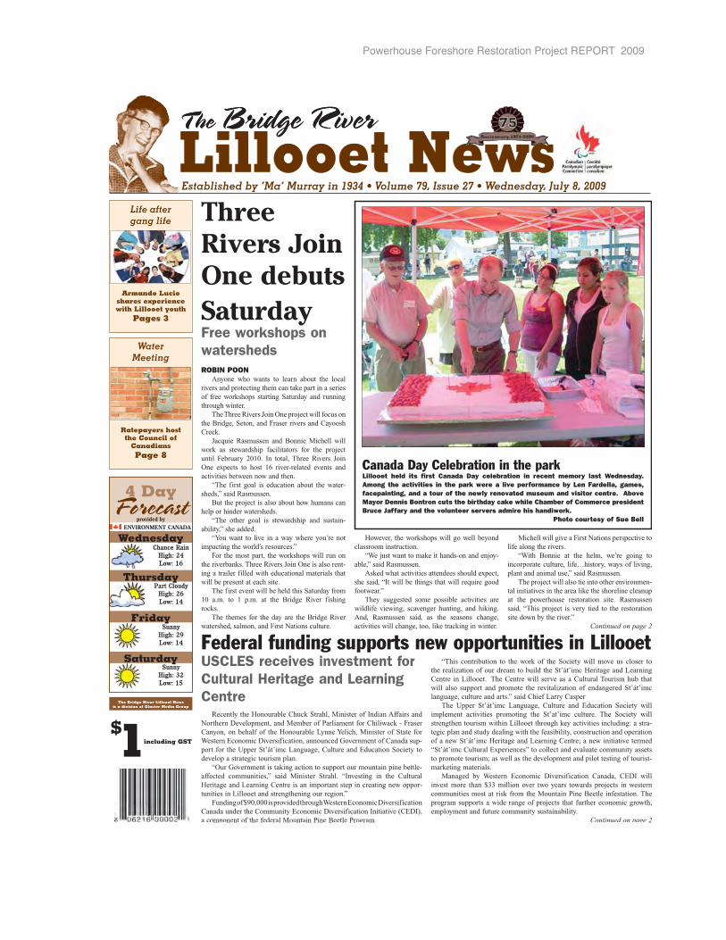
Powerhouse Foreshore Restoration Project REPORT 2009
Three Rivers Join One debuts SaturdayFree workshops on watershedsROBIN POON
Anyone who wants to learn about the local rivers and protecting them can take part in a series of free workshops starting Saturday and running through winter.
The Three Rivers Join One project will focus on the Bridge, Seton, and Fraser rivers and Cayoosh Creek.
Jacquie Rasmussen and Bonnie Michell will work as stewardship facilitators for the project until February 2010. In total, Three Rivers Join One expects to host 16 river-related events and activities between now and then.
“The first goal is education about the water-sheds,” said Rasmussen.
But the project is also about how humans can help or hinder watersheds.
“The other goal is stewardship and sustain-ability,” she added.
“You want to live in a way where you’re not impacting the world’s resources.”
For the most part, the workshops will run on the riverbanks. Three Rivers Join One is also rent-ing a trailer filled with educational materials that will be present at each site.
The first event will be held this Saturday from 10 a.m. to 1 p.m. at the Bridge River fishing rocks.
The themes for the day are the Bridge River watershed, salmon, and First Nations culture.
However, the workshops will go well beyond classroom instruction.
“We just want to make it hands-on and enjoy-able,” said Rasmussen.
Asked what activities attendees should expect, she said, “It will be things that will require good footwear.”
They suggested some possible activities are wildlife viewing, scavenger hunting, and hiking. And, Rasmussen said, as the seasons change, activities will change, too, like tracking in winter.
Michell will give a First Nations perspective to life along the rivers.
“With Bonnie at the helm, we’re going to incorporate culture, life…history, ways of living,plant and animal use,” said Rasmussen.
The project will also tie into other environmen-tal initiatives in the area like the shoreline cleanup at the powerhouse restoration site. Rasmussen said, “This project is very tied to the restoration site down by the river.”
Continued on page 2
T he Bridge River
Established by ‘Ma’ Murray in 1934 • Volume 79, Issue 27 • Wednesday, July 8, 2009
Lillooet NewsLillooet NewsT he Bridge River
Saturday
Friday
Thursday
WednesdayChance Rain
High: 24Low: 16
Part CloudyHigh: 26Low: 14
SunnyHigh: 29Low: 14
SunnyHigh: 32Low: 15
4 DayForecast
provided byENVIRONMENT CANADA
The Bridge River Lillooet News is a division of Glacier Media Group
including GST
$1
Life after gang life
Armando Lucio shares experience with Lillooet youth
Pages 3
Water Meeting
Ratepayers host the Council of
Canadians Page 8
Canada Day Celebration in the parkLillooet held its first Canada Day celebration in recent memory last Wednesday. Among the activities in the park were a live performance by Len Fardella, games, facepainting, and a tour of the newly renovated museum and visitor centre. Above Mayor Dennis Bontron cuts the birthday cake while Chamber of Commerce president Bruce Jaffary and the volunteer servers admire his handiwork.
Photo courtesy of Sue Bell
USCLES receives investment for Cultural Heritage and Learning Centre
Recently the Honourable Chuck Strahl, Minister of Indian Affairs and Northern Development, and Member of Parliament for Chiliwack - Fraser Canyon, on behalf of the Honourable Lynne Yelich, Minister of State for Western Economic Diversification, announced Government of Canada sup-port for the Upper St’át’imc Language, Culture and Education Society to develop a strategic tourism plan.
“Our Government is taking action to support our mountain pine bettle-affected communities,” said Minister Strahl. “Investing in the Cultural Heritage and Learning Centre is an important step in creating new oppor-tunities in Lillooet and strengthening our region.”
Funding of $90,000 is provided through Western Economic Diversification Canada under the Community Economic Diversification Initiative (CEDI), a component of the federal Mountain Pine Beetle Program.
“This contribution to the work of the Society will move us closer to the realization of our dream to build the St’át’imc Heritage and Learning Centre in Lillooet. The Centre will serve as a Cultural Tourism hub thatwill also support and promote the revitalization of endangered St’át’imc language, culture and arts.” said Chief Larry Casper
The Upper St’át’imc Language, Culture and Education Society will implement activities promoting the St’at’imc culture. The Society will strengthen tourism within Lillooet through key activities including: a stra-tegic plan and study dealing with the feasibility, construction and operation of a new St’át’imc Heritage and Learning Centre; a new initiative termed“St’át’imc Cultural Experiences” to collect and evaluate community assetsto promote tourism; as well as the development and pilot testing of tourist-marketing materials.
Managed by Western Economic Diversification Canada, CEDI will invest more than $33 million over two years towards projects in western communities most at risk from the Mountain Pine Beetle infestation. The program supports a wide range of projects that further economic growth,employment and future community sustainability.
Continued on page 2
Federal funding supports new opportunities in Lillooet
Powerhouse Foreshore Restoration Project REPORT 2009
Upcoming Events & Volunteer Opportunities
off the front
Community Events GuideListings are free for not for profit events and service
groups. AGM Notices are not accepted and will be asked toparticipate in a paid adverting. Send your listings to: [email protected] prior to Friday at 12 noon.
Space is limited please have information submitted atpleast two weeks prior to event date.
BPO Elks #467��������� �������!-�"#� �% ��� &�!������� '� "� ��� ()*�+"))�����"/��4�6&�&;���6�)-<�&��=�!�"<�>���?�@�"!�C�!%��&����!%���� �� ���
Lillooet Legion Branch 66+"))����"�!D����"�J�"6�(O��#@���"#����Q&
Lillooet Gospel Chapel D��O�<� +�U���DU!�"# D<���) ��� D��O�<� ���������"�!���666�?�<�"Q�)�<"
Lillooet Quilters Guild ���� )"��V��!���"# �% ��� ��!�� �Q& "� ���@���!����Q=�!���D�Q��&;�����UXU!�
Order of the Royal Purple������<�!�� %�U��� ��!�"#� �% ��� &�!��� ����'�"����()*�+"))�����"/��4�6��&;��� V�)<�&�� =�!�"<� �"U���!@�"!�C�!%��&����!%���� �� ���
Buddhist Meditation Group��!�"#�"�����'�!�"�Y#���!�@��&����!%��&"���!<�!�"<�Z�<���D��Q"!"���� �� ����
Lillooet Shambhala Meditation GroupDU!�"#�"���� D�U��=�!��")+�")��[!���="))\!"��� �� ��
Lillooet Native Christian FellowshipDU!�"#D��O�<�"����Y�))����@���!����Q=�!����'�%��&����!%���� �� ����
Lillooet Food Matters ��� ��!�"#� �%��� ��!�� ���� '� "� O"�#�!? O�!U���')�"�� <�!�"<�D"�"���/�?���"����� "���� �� ����%��&����!?���"�)��
LA to Legion /�?U)"������!?��'����]�U���"#��% ���&�!�� D�Q��&;�����"#��^<�Q�J�<�&;��
Seeds of Hope Soup Kitchen"����[!����=�U�<�� lunch is served on Monday’s at noon� @�� &��� �!%� �� �� O�)U!����<�!�"<���)�"V�)%�"���� �� ��
Lillooet Farmer’s Market @���"#�U!��)_<��;���"�!D���<����%��&'���_%�<�
Lillooet Tim-BR Mart129 Moran Pllace250-256-41441
Come and Visit Our new
Showroom
Lillooet Lions Meeting �����������]U���"#��% ���&�!����'��! ���Y�-?��!+"))�"��&�!������"�!D��
2nd Annual Apricot Tsaqwem FestivalX��!U�%��"6��*�!��%%U!�XU)#� ��@"�&���� �"�*��� D����� J"!<�� Y�O�Q��%��&"!<��� D�U�?��! ����!? "!� "6��)�)��&����D�"#�U!����#�U<"!?���666�)�))����;<�<"%��&����!%��&"���!�
Three Rivers Join One Project @���<�&&U!��# �O�!�� �� �!<��"�� "6"��!����%���D���!�="#���������?�"!�@�"���/�O����D!"<*��?"&���"<��O�����"!�%U!�@���� �O�!� 6�)) ;� XU)# ��� ���� %��&��"&���Q&�����?�/�O��@����!?/�<*� <�!%)U�!<��%����?�"!�@�"���/�O���=�!�"<��X"<`U��/"�&U���!�� �������!!����<��))�� ��� Experience Aikido with a Master
Aikido is a non-violent art of self-defence.Friday July 24, 11:30 am to 12:30 pm at the Ucwalmicw Centre Ki Development Class by instructor Joseph Crotty Senseifrom Los Angeles: Chief instructor,Aikido Institute of America Everyonewelcome; Admission by donation For more information on Seidokan AikidoRetreat from July 23-26 or Ongoing class-es with Lillooet Seidokan Aikido, please call Mariko at 250-256- 0686
Water Meeting with Guests from theCouncil of Canadians who will be speak-ing to several other towns which are hav-ing issues similar to ours: unwanted resi-dential metering initiatives, local govern-ments avoiding public approval processes,and grant-driven development projects overriding local community vision.July 17th at 7pm at the Seniors Centre,hosted by the Lillooet RatepayersAssociation.
Rivershed Discovery and Open Houseat the Lower Spawning Channels Saturday 25 July =�&� ��� ��� 4"��O�')"!�4U����#�)�"�!&���";�U���# )"!�-�<"Q�!? �� "���"<� 6�)�)�%�� ���!�;��"!#�6�)�Q)"!�U����6��&<�&Q����!?�!"�U-�")6���<�!���)"!�&U<�&����V�6�));�Q��O���!?"��j�=�&���)QU��"������!�6?���!��U��"!� �"*�Q"�� �! %U!?"&��"!�"<��O������Nature Centre Visioning SessionV��!���"# XU)# �� J��Q �! "!#��&�;��6��!����z����Q&Y�))����@���!����Q=�!��� '��O��� #�U� �!QU� �!�� 6������6� 6"!��<"! �U! " @�"��� /�O�� 4"�U��=�!��� �! Y�))����� 6�"� #�U 6�U)� )�*��� ��� �! �U<�" <�!��� "!�?���!����?!���"�� =�))��! X"<�; "!� ]�;# �U�))��"��%"<�)��"��!?�����O�!�
PagePage 22 Lillooet News Lillooet News JUJULLY 8, Y 8,LLLL 22009009 off the frontWatershed,salmon, and First NationscultureContinued from page 1
She pointed out that hab-itat conservation and restora-tion are strongly related tothe concepts of stewardshipand sustainability.
Perhaps most interest-ingly, Three Rivers Join One is pushing the first phase of a community-mappingproject, in which artists areinvited to go beyond stan-dard cartography.
Instead, they are beinginvited to draw maps of places and include elements of personal significance, like favourite fishing holes, and flourishes that reflect theland portrayed.
But, Rasmussen said,“We need more artists to be part of the project.”
If the community map-ping is successful, that proj-ect may be expanded into more phases.
The Three Rivers JoinOne project is funded withgrants from the Fraser Salmon and WatershedsProgram and Bridge River Coastal Restoration Program (itself funded by B.C.
Hydro).The Lillooet Naturalist
Society and CayooseSt’at’imc secured the grants on the project’s behalf.
Although some of theactivities will be aimed pri-marily at students, the facili-tators stressed that everyoneis welcome to the free work-shops.
“We want to attract as many different people,” said Rasmussen.
Michell agreed. “The more people know about us, the better.”
For more information onthe Three Rivers Join Oneprogram, call Rasmussen at250-256-4292 or Michell at250-256-2361.
Elaine James gives a demonstration of salmondrying out at Bridge River last summer.
USCLES fundingContinued from page 1
The CEDI program is part of the Government of Canada’s $200 millioncomprehensive response to mitigate theshort and long-term effects of the Mountain
Pine Beetle infestationon B.C.’s forestry sector. This federal MountainPine Beetle Program isled by Natural ResourcesCanada, in collaboration
with Western Economic Diversification(WD) and Transport Canada.
Western Economic DiversificationCanada works with the provinces, industry associations and communities to promote the development and diversification of the western economy, coordinates federaleconomic activities in the West and repre-sents the interests of western Canadians in national decision-making.
For more information on the federalMountain Pine Beetle Program, please visit: http://mpb.cfs.nrcan.gc.ca
Kim Inglis, BCom, CIMInvestment Advisor
Tel: 604-643-7753 Toll Free: 1-800-663-1899 (Ext. 7753)[email protected]
www.kiminglis.ca
Committed to making a positive differenceMember CIPFMember CIPF
Be In the Loop
Keep your knowledge current. Receive a weekly overviewof the top economic and market news, delivered to yourinbox every Friday. Sign-up at:
Commenton this
storyonline:
www.lillooetnews.net
Click us: www.lillooetnews.netCCCClCCCCClCClCl
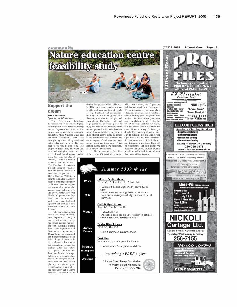
Powerhouse Foreshore Restoration Project REPORT 2009 135
• Excavations – Limited & Regular Access• Small Rubber Tracked Deere 50C Excavator• Large Hitachi EX-200-5 Excavator• Bobcat Skid-Steer Wheel Loader• Small 4x4 Dump Truck• Waterlines – Drainage – Ditching• Roadbuilding – Land Clearing/Site Prep.• Septic Systmes (ROWP available)
*A-Frames, Banners**Windows, Magnets, etc*
*VINYL *
Mona•Vie: All Natural-OrganicLiquid Vitamin Functional Health Drink
Contact:Amos Bob 250-256-7307 Dave Pollock 250-318-0237
PresentationSat: June 20 July 4 & 18Place: 4 Pines MotelTime: 1:00pm
NICKOLICartage Ltd.General Freight, Kamloops-LillooetTuesday, Wednesday & Friday
256-7155
LILLOOET CLEAN TECHSpecialty Cleaning Services
• Carpets and Upholstery• Auto Interior Detailing • Furnace Duct Cleaning• Tile and Grout Cleaning Randy & Marlene Lucking
250-256-4678www.lillooetcleantech.ca
ME-TOO TOWING
Lil
loo
et
Ne
ws
To book your spot in , call the News
office at 250-256-4219
Support the dreamTOBY MUELLERSpecial to the Lillooet News
The Powerhouse Foreshore Restoration Project is a community proj-ect led by the Lillooet Naturalist Society and the Cayoose Creek St’at’imc. The project has undertaken an ecological restoration where Cayoose Creek and the Fraser River meet. People have been planting trees, pulling weeds and doing other work to bring this place back to the way it used to be. This project engages many important cul-tural and ecological values and has received widespread support. While doing this work this idea of building a Nature Education Centre on this site took seed. The Foreshore Restoration Project received funding from the Fraser Salmon and Watersheds Program and B.C. Hydro Fish and Wildlife in order to complete a feasibility study to see if the community of Lillooet wants to support this dream of a Nature edu-cation centre. Colleen Jacob and Toby Mueller have been hired to ask people what they think, study the way other centres have been built and operated and produce a plan which can help the idea move forward.
Nature education centres offer a wide range of educa-tional experiences. Being in nature awakens our curiosity and makes learning fun, giv-ing people the chance to learn from direct experience and hands on activities. A Nature Centre helps us understand the interconnectedness of all living things. It gives visi-tors a chance to learn about the connections between the ecology, history and culture of a place. The Cayoose/ Fraser confluence is a unique habitat, a very beautiful place that will be changing dramat-ically over the years, as the plantings take root and grow. The restoration is an exciting and hopeful project; a Centre increases the possibility of
sharing this process with a wide pub-lic. This centre would provide a home to offer a diverse selection of locally developed cultural and environmen-tal programs. The building itself will showcase alternative technologies and green design. The Nature Centre and its programs will encourage people to enjoy and care for this particular place and take personal action toward conser-vation. It could eventually be part of a chain of small centres along the length of the Fraser River that showcase the unique aspects of each area, and teach people about the importance of the salmon and the need to live sustainably in all parts of the watershed.
The purpose of a feasibility study is to see if it is actually possible,
which means asking lots of questions and listening carefully to the answers. We are interested in your ideas about education, environmental stewardship, cultural sharing, green design and eco-tourism. We want to hear your ideas about the challenges and benefits this project presents. Look for our display at events around town this summer, and come fill out a survey. Or better yet drop by the Friendship Centre on Wed. July 15 between 1pm and 7pm for our Open House. We will provide informa-tion about what this could look like and ask visitors some questions. There will be refreshments and door prizes. We hope you will join us, this is an exciting possibility and it needs input and ideas from many different people.
����
���
����
���� ���
�������
������
�������
�
���������������� ����������������������������������� ���
���������������������
����������������� � �!"��#���$�'�!�"�<<��=�?��'�@���<<���
������������� �������������������
�������������������������� ��������������������!���������� �������"�������������#"�������
��������$��
������ �������� � �Q���<��=�!�"�<��=�@���<<�<�
��%*�����;�����
��=������� ����>���������"����� ��� ����>���������!�Q������Z��������������Z����
� ��������� ���� � ���$����=�!�"�<����
����!�Q������Z��������������Z����
�������Z�[��"\\������$"���]����$������������
��[�������"���Q�����������"����;������
���������������������������� ����������������������
����� � � � � �� �
Nature education centre feasibility study
JULY 8, 2009 Lillooet News Page 13community

Powerhouse Foreshore Restoration Project REPORT 2009
Apricot Tsaqwem FestivalJuly 24-26 2009
Welcome to the 2009 Apricot Tsaqwem
Festival
Pancake Breakfast – Saturday & SundayFarmer's Market – Friday & Saturday
Lunch at Ti't'q'et •Kids gamesGuided Jade Walk Tour
Lunch at the Lions BoothCheck out the brochures
around townWe welcome everyone to Lillooet and please enjoy
the festivities...
Featuring...
Retasket Lodge Lodge& RV Park
Welcome to the 2nd Annual
Apricot Tsaqwem Festival
Need a place to stay this weekend...
Clean newly renovated roomsat an affordable price...
Proudly owned and operated by theT'it'q'et of the St'at'imc Nation
1264 Bouvette Rd
250-256-2091
Don't Drink & Drive
Call us...
Mile 0 Taxi
250-256-7706
Face Painting
Friday1:30-4:30pm
Lillooet News979 Main St
SummerBBQ & Wild
About Plants DaySaturday 4 pm–7pmLower Spawning Channels
Meet at Cayoose Creek Band Office... bring
chair, cup, plate& utensils
Open9am-8pm
Just for the Festival
Friday & [email protected]
355 Reynolds Road N.
Watkins250-256-4660
Hike on the Fraser River at
the Powerhouse Restoration Site
Saturday 10 am–11:30 amCarpooling – Meet at
Farmer’s Market,across from the
Post Office
Liloooet Quilter's Guild
AnnualQuilt Show & Tea
Friday 10am–7pm
Saturday 10am–4pm
St Andrew's
United Church
Main St
BurgersHot Dogs
Coffee • Cold Drinks Friday 10am-2pm:Farmer's MarketSaturday 4-11pm:
Legion at the Street DanceBrought to you by the
Lillooet Lions ClubConcession
Apricot & Tsaqwem
Tasting FairSaturday
KC Health 250-256-7711Try our apricot tea,
Tsaqwem jam & jellyPrizes drawn
all day...
Apricot... Pedicures or Reflexology
$28–Call for appt.
Energy Plus250-256-1547
SalmonBBQ &
EntertainmentFriday 5:00-8:00pm
Friendship Centre357 Main Street
Adults–$1210 & Under–$6
Page 12 Lillooet News JULY 22, 2009
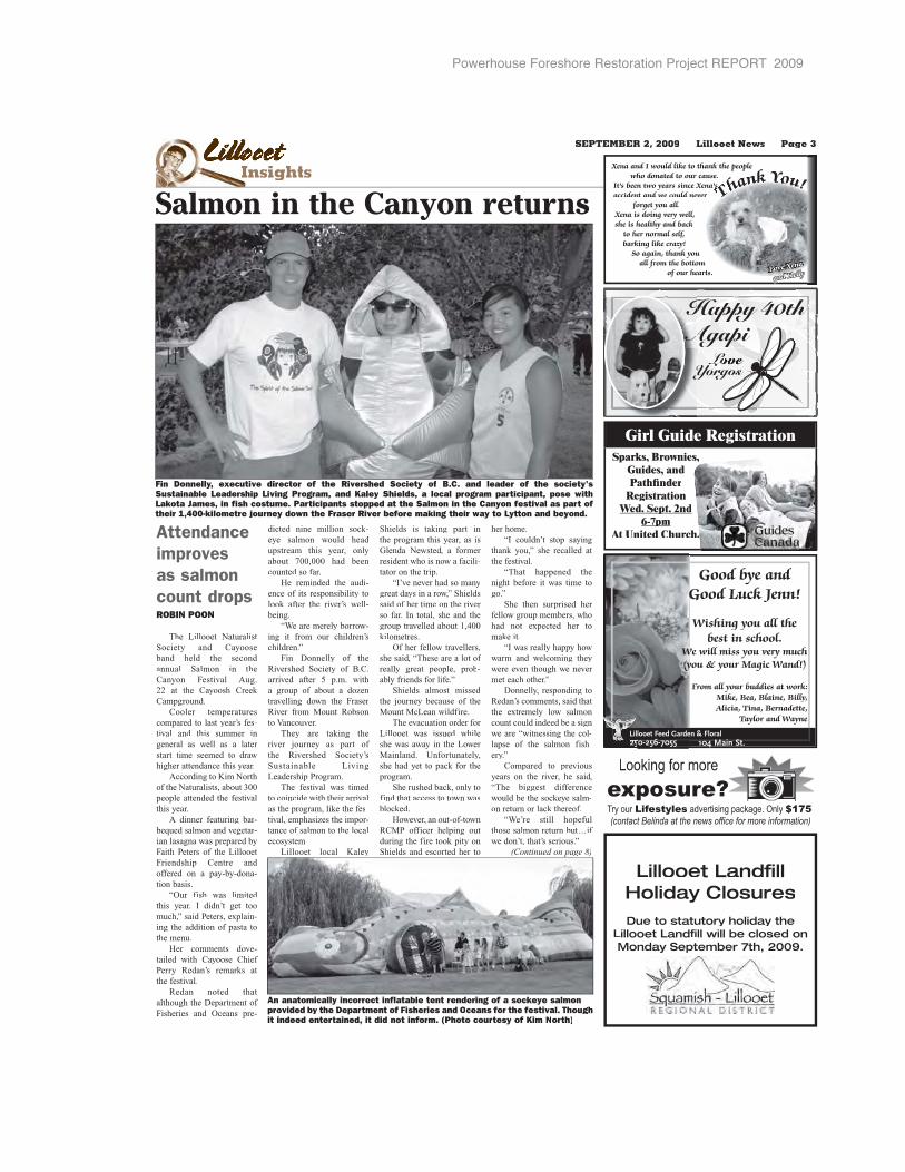
Powerhouse Foreshore Restoration Project REPORT 2009
LLLLLLLLLiLLililiililiiiliiiillllllllllllllllllllll oloooolllloolloollolloollll ooeeteteeteeteeeteeteeeeInsightsI
Good bye andGood Luck Jenn!GG
Wishing you all the best in school.
We will miss you very much WWWyou & your Magic Wand!)(yyy
From all your buddies at work:Mike, Bea, Blaine, Billy, Alicia, Tina, Bernadette,
Taylor and Wayne
LoYYorgosorg
LLL
40th0thHappy 404 hppy 4Happy 4Happy 40thHHAAA apAgapapiapAgapiAgapi
Girl Guide RegistrationSparks, Brownies,
Guides, andPathfinder
RegistrationWed. Sept. 2ndp
6-7pmpAt United Church.
SEPTEMBER 2, 2009 Lillooet News Page 3
Attendance improves as salmon count dropsROBIN POON
The Lillooet NaturalistSociety and Cayooseband held the second annual Salmon in theCanyon Festival Aug.22 at the Cayoosh Creek Campground.
Cooler temperaturescompared to last year’s fes-tival and this summer ingeneral as well as a later start time seemed to drawhigher attendance this year.
According to Kim Northof the Naturalists, about 300people attended the festivalthis year.
A dinner featuring bar-bequed salmon and vegetar-ian lasagna was prepared byFaith Peters of the LillooetFriendship Centre and offered on a pay-by-dona-tion basis.
“Our fish was limited this year. I didn’t get toomuch,” said Peters, explain-ing the addition of pasta tothe menu.
Her comments dove-tailed with Cayoose Chief Perry Redan’s remarks at the festival.
Redan noted thatalthough the Department of Fisheries and Oceans pre-
dicted nine million sock-eye salmon would head upstream this year, onlyabout 700,000 had beencounted so far.
He reminded the audi-ence of its responsibility tolook after the river’s well-being.
“We are merely borrow-ing it from our children’schildren.”
Fin Donnelly of theRivershed Society of B.C.arrived after 5 p.m. witha group of about a dozentravelling down the Fraser River from Mount Robsonto Vancouver.
They are taking the river journey as part of the Rivershed Society’s Sustainable LivingLeadership Program.
The festival was timed to coincide with their arrivalas the program, like the fes-tival, emphasizes the impor-tance of salmon to the localecosystem.
Lillooet local Kaley
Shields is taking part inthe program this year, as is Glenda Newsted, a former resident who is now a facili-tator on the trip.
“I’ve never had so manygreat days in a row,” Shieldssaid of her time on the river so far. In total, she and thegroup travelled about 1,400kilometres.
Of her fellow travellers,she said, “These are a lot of really great people, prob-ably friends for life.”
Shields almost missed the journey because of theMount McLean wildfire.
The evacuation order for Lillooet was issued while she was away in the Lower Mainland. Unfortunately, she had yet to pack for theprogram.
She rushed back, only to find that access to town was blocked.
However, an out-of-townRCMP officer helping out during the fire took pity onShields and escorted her to
her home.“I couldn’t stop saying
thank you,” she recalled atthe festival.
“That happened thenight before it was time togo.”
She then surprised her fellow group members, whohad not expected her to make it.
“I was really happy howwarm and welcoming theywere even though we never met each other.”
Donnelly, responding toRedan’s comments, said thatthe extremely low salmoncount could indeed be a signwe are “witnessing the col-lapse of the salmon fish-ery.”
Compared to previousyears on the river, he said,“The biggest differencewould be the sockeye salm-on return or lack thereof.
“We’re still hopefulfthose salmon return but…if
we don’t, that’s serious.”(Continued on page 8)
Lillooet Landfill Holiday ClosuresDue to statutory holiday the
Lillooet Landfill will be closed on Monday September 7th, 2009.
Looking for more
exposure?Try our Lifestyles advertising package. Only $175!(contact Belinda at the news office for more information)
Salmon in the Canyon returns
An anatomically incorrect inflatable tent rendering of a sockeye salmonprovided by the Department of Fisheries and O ceans for the festival. Thoughit indeed entertained, it did not inform. (Photo courtesy of Kim North)
Fin Donnelly, executive director of the Rivershed Society of B.C. and leader of the society'sSustainable Leadership Living Program, and Kaley Shields, a local program participant, pose withLakota James, in fish costume. Participants stopped at the Salmon in the Canyon festival as part of their 1,400-kilometre journey down the Fraser River before making their way to Lytton and beyond.
Xena and I would like to thank the peoplewho donated to our cause.
It’s been two years since Xena’s accident and we could never
forget you all.Xena is doing very well, she is healthy and back
to her normal self,barking like crazy!
So again, thank youall from the bottom
of our hearts. Love Xena
and Kelly
Ts s hhaahh nnaaa kknnnn YYooYY uu!!!
Powerhouse Foreshore Restoration Project REPORT 2009
“FREE”Employment & Training Related
Services for the Entire Community!
Funded in whole or part through the Canada-British Columbia Labour Market Development Agreement.
Sponsored by the LillooetFriendship Centre Society
Funded by Interior Salish Employment & Training Society
LILLOOET EMPLOYMENT CENTREou with all your Career, Employment and Training NeAssisting yo h all your Caree loyment and Tra Needs
639B Main Street, Lillooet639B Main Street, et, BC V0K 1V0256-0606 • Fx: (250) 256-0644 •Ph: (250) 2 06 • Fx: (250) 256 • endshipcelec@lillooetfrie centre.orgp g
Hours: Monday - Friday 8:30 a.m. - 4:30 p.m.ours: Monday - F 8:30 a.m. - 4:30
One-to-one Counselling with Employment Counsellone-to-one Counse with Employment C lors:ed, Greg Wright & John LaRueJack Ned Wright & John La
mployment Counsellor: Penny McInDisabilities Emp nt Counsellor: Pen Intyre
Working with you to meet your Individual Needs:W g with you to me r Individual Needs Career Decision Making Proceeer Decision Maki cess ve Job SeaActive earch Strategies Employment Maintenancemployment Mainte l EnhanceSkill ement Referral to Self-employmeReferral to Self-em ment t Access Sponsorship for TrainingAc ponsorship for Tra
ume service, interview techniques, fax machine and photocopier.Easy access resum ce, interview techn ax machine and ph
Drop by & talk with Shirley, Kathy, Jack, Greg, Pennyp by & talk with y, Kathy, Jack, G ny & John.
EEaarrrrrllyyyyyyyyyyyyyyy DDDDDDDeeeeaadddlliinneeee NNNNNNNNoootttttttiicccccceeee
ThTThT e e e e e rrrrrrrrrr dddddddiddddddddddddge RRRRRRRRR vvvvv rrerrrrrer - ooet NeNeNewswswswswswwww wwwwwwwwwwww TThehe BBrrididgdgege R L ooooooooooooe NNNRiviveveer - LLillolooooeet NeNewewsws wwill bebebebeeeeeeee c c cccc ccc ccccc ooooooooseseseeeedddddbbe ccloloosseded
Mondayyyy S SS Seeepppepeptte bbbbbbbeeerrrrrrrrrrrrrr 7 7 77thtt 2000202009099MoMoondndadayay SS peppptttttt mb 0000000SeSeeppteteembbeer 77tth, 202000090009in honoooooooorrrrooooroooooooooooo o ooooooooooooofffffffffffff f f tththththththththtththhhheeeee ee e eeeeeee sstsstststststststststststststsstststsstststststttttts atatatatatatata uauaaaaaatttttttotototttttotttttttttttttttoryryryryr h h hhololloolo ididididididdayaayayayay
We will oppppppppppppppppppppppppppppppppppppppppppppppeeeeeeeeeneneneeeeeneneen ttt t t tttthehheheheheheheheheheheheeheheeeeeeeehe o o oooooooo o oooooo fffffffffficicici e e eee ee dododododdoooooooororororoooooooooooooo ss s s s 8:8:8:8:88 30303003000 aa a a aa ammmmmmmmmmmmmmmmmmmmmmmmmmmmmmmmmmmmmmm
Tuesdadaddadaayyyyyyyy SeSeSeSeSeSeeSeSeeSeSeeSeSeSeSeeSeeSeeSeSeSeSeeeeeeSeeeeptptpptptptptpttptptptptptptptppppppppppppppppppppptppp emeeemememememememmemmmemeeeeeeee bebeeb r r 8t888888t8t8t8t8tt8t8 h h h hhh hhh hhhh hh h h h h h h hh 220222000202020220200202202220222222222000909090990909
Pleaeaeaeaaaaaaaeaaaaaaeaaeaeaeaaeeaeaeaaee sssesesesesss n nnnototototototototoototottotototototootootototootottottotoottto eeeeeeeeeeeee eeeeeeeeeeeee tthththhthttththtthththththththhhhhttt eeeeeeeeee eee eeePleasse nototete the Deadli ee fffffororor SSepeppeppttttt beerrer 9 9 99 DeDeaeadadldlilininene fofoor Sepppp embbmbSepeppteteembmbe 99999ttttbeer 9t9thhhhhhth isis
WWWWeWWWeWeeedd SSSSepepepeppepttt mberr 22ndnd 220200000909090009090 a atttt 555 ppppWeWeed. SeSeeppteteembbeer 2n2ndnd, 20200009 atat 5555555 pp5 ppm
SenSenSenSenSeSenSenSenSenSenSeSeSeSeSSSenSSSSS d yd yd yyd y yyyyyourouroourourourourouroour ad ad addddad ad ad adad adveveveveerveveeeereereerereee tistististist menmenmenmenm ts ts ts ts oneoneon ofofofoof th th th thhhhhhhhhhhrrrerererereeeeeeeeeeeererrr wwawawwwwawawaw waways:ys:ysysys:syss:::PPPhoPhoPhoPhoPhoPPhoPhoP one ne nene ne nne ne ne ne 250250250502502502502502502502250 222-25-252-252252555-2522525552-256-46-46-46-46-46-46-46-46-46-46-46 219219219219212192121212 & & & & askaskaskasasaskskskkkkaskasksksk fo fo fo f for Nr Nr Nr Nicoicoicole le e e e youyyouyouyouyour r lr lr lr lr lr lr lr lr lr r llr locaocacaaocacaococ l sll slll sl ssssssssalealealealealalealeleeeeeeeeeaa s as as as as s as as s as as as as aaass aas ssossossossssossssosoososoossossosociacciaciaaate.te.tet .
FaxFaFaxaxFaxFaxFaxaxFaxFaxaxxFaxFaFaaxFaFaaaxxFFF y y y y yyoyoyoy yoyoyoy ur ur ur u ad ad ad detdetdetetetetailailailailaillllailailails &s &s &s &s &s &s &s &&s &s &s & co c c co cocococcococococococconntantantatnnntanntnnnnnntn ctctct ct inininfinformoro mmatatatiatiatiatiatiatitititatttatatatat oon nnonn to to o 2502502500000000502500050-25-252522-252525-25-2555666-46-446-46-46-46-42102122101010100 OOOOOr Or Or OrOOOO emememememaemaemaemaemamaemaailil ilililliil youyouyouyouy r ir ir ir iinfonfonfonfon mmmmmatmatmatmatmmatioioioionioononiooooonoiooo toto sasasasass leslesleslesesesesessesssleeseseeesese @li@li@lilii@l llollollollollollooooetoetoetttnnnewnewwn ws ns.ns.nns.ns.nns.ns.n.nnn.n.nnneetet et ttetetete
Fall Bulbs. Bulk stock now available. Daffodils. Tuplis. Crocus.And More.
Hardy Mumsnow in stock.Available while supplies last.
FFFALLALALLALLLLFFFF AAAARRIVALSRRRRRRRRIVRIVAVVALLSLSALSALLSLSAAAAAfor your Home & Garden needs!r y r & G r eefofofor yoyoourur r HoHoHomeme me & Garaardarrderddendeen en neneneeeeeedseddsdsds!dsds!FFFAAFFFFALALLALFFALLLLLLLLLLLLL AAAARRRAAAAARRRRRRRRAARRARRIRIRIRIRRRRIVIVIVIVIIVAVAVAIVIIVIVIVALVALLLALALSLSLSLSLSLSLLSSSSSSSFALL ARRIVALS
&&\
Protection begins on a personal level,says Donnelly (Continued from page 3)
He added that hot weather, lightning strikes and risk of fire, the effect of pine beetles on erosion, and higher water tem-peratures could all work together to makethe Fraser inhospitable to salmon.
“Everything has an impact. Whether it’ssmall or large, I wouldn’t be able to say.”
However, he said, the warm welcome hereceived in Lillooet and other communitieswas a sign that people were willing to work together to increase awareness of the role regular people must play in protecting theriver.
“What I try to reinforce is we have to
start small, we have to start with our ownactions.”
But he admitted that what happens onjust one part of the Fraser can have a mush-room effect on other areas of the watershedand beyond.
“Pretty soon you get into the big globalcommunity discussion.”
Donnelly said that while some residentsin other towns had greeted the program par-ticipants, there was “nothing like a commu-nity event, like (Salmon in the Canyon).”
“This is unique and great.”He added, “We definitely want to thank
Kim (North) and Cayoose Creek band forputting on this event and continuing build-ing this relationship.”
Following the meal, The Wild Onionstook the stage. The local group also played at last year’s festival.
Salmon at risk in many ways
Page 8 Lillooet News SEPTEMBER 2, 2009 news
(Continued from page 1)Water from the wells,
which has been shown inthe past to contain arsenic beyond the level allowed by health regulations, was for-merly blended with water from the creeks to stay under the limit.
After the evacuation order was lifted, the Red Cross handed out free bot-tled water to any residents in need. It later placed a largeself-serve tank of water,filled from Cache Creek, inthe parking lot of the RECCentre.
Although it closed its wildfire recovery centre inthe REC Centre arena, theRed Cross kept the tank inthe parking lot. However, it signed a contract only to provide the tank until the end of August.
District chief adminis-trative officer Grant Loyer
said in an interview Monday,“Interior Health doesn’tthink there’s an issue withthe water” from Town Creek in the short run.
“They think as long as you boil the water, it’s fine.”At an Aug. 17 council meet-ing, Loyer said only turbiditywas an issue for Town Creek water, not arsenic.
However, he admitted the creek would likely beunusable in the future.
The district alsoannounced on Aug. 17 thatthe pump for the REC Centrewells had stopped working.
Since then, Loyer said, Dickey Creek has been themain source of water for thedistrict.
As for the wells, he said, “Right at the moment, we’renot drawing anything fromthe REC Centre wells.” TheConwayville well is still inuse, but the district is draw-
ing less water from it thanusual, he added.
“We’re just getting by.”Loyer said the dis-
trict hopes to complete theVictoria Street booster sta-tion sometime in September so water from Dickey Creekand Conwayville can be usedin the Heights.
He also noted, “By andlarge, I think most of thepublic has been very co-operative about conserving water.
“Lots of people’s lawnsare dying.
“It’s made our jobs eas-ier.”
The district council was scheduled to hold an in-cam-era meeting Sept. 1 as ofpress time to consider pos-sible solutions.
The next regular coun-cil meeting is scheduledfor Sept. 8 at 7 p.m. at the municipal hall.
Dickey supplies most water
Enjoying the PNEVera Edmonds (left) and Ashiel Edmonds of Pemberton enjoy a ride on the Twin Flip at the 2009 fair at the PNE. The annual summer fair, an end of summer tradition for generations of British Columbians,features over 700 shows, exhibits and attractions that are free with admission. The fair runs daily through Labour Day, Sept. 7.
Powerhouse Foreshore Restoration Project REPORT 2009 139
Located in AshcroftOUR FAMILY HELPING YOUR FAMILY
Here to serve your every need.Burial & Cremation Services, Bronze & Granite Memorials
Prearrangements and Prepayments available through Family Side. We will honour all Memorial Society Contracts & Memberships.
For more information please call us.
BILL PERRY(250) 453-9802 Toll-Free 1-800-295-5138
Phone 250-315-0241 Toll Free 1-800-897-9559 ext 284Email: [email protected]
“Serving Lillooet and Area Since 1999.”
“Let me craft a solution built for you.”• Personalized Retirement Plans
• Detailed Risk Assessment• Strategic Investment Analysis
David L. Brown, CFP, CSAExecutive Financial Consultant
NICKOLICartage Ltd.General Freight, Kamloops-LillooetTuesday, Wednesday & Friday
256-7155
LILLOOET CLEAN TECHSpecialty Cleaning Services
• Carpets and Upholstery• Auto Interior Detailing • Furnace Duct Cleaning• Tile and Grout Cleaning Randy & Marlene Lucking
250-256-4678www.lillooetcleantech.ca
Lil
loo
et
Ne
ws
To book your spot in , call the News
office at 250-256-4219
This Week’s CrosswordSponsored by:
LillooetGlass
&Tire
•Passenger & Light Truck Tires
•WindshieldReplacement •ICBC Claims •Stone Chips
Repaired •Safety Glass•House Glass
•Mirrors
561 Main St.256-4111
CLUES ACROSS 1. Married woman 4. Converged 7. Point one point S of due E10. Table condiment12. Trade14. Indian frock15. Bombast16. Blighia tree (var.)17. Pre-college school18. Give clear expression to20. ______ Tomei, actress22. Tall hardwood tree23. Actress Ryan24. Not true26. Organic compounds29. Hill (Celtic)30. Apprehension35. They ___36. 1st state abbr. (var.)37. Chicken ___ King38. “Me & Bobby McGee” singer
44. Horny jaws of a bird45. Beheaded queen Antoinette46. Goatlike Eurasian antelope48. Wrath49. Container cover50. Also-rans53. So. Spanish port city56. Brood of pheasant57. Coal tar product59. Retained61. Sagu____: treelike cacti62. Challenged63. Clods64. Pinna65. Cotter or straight66. Tell on
CLUES DOWN 1. Mutual savings bank 2. Abnormal breathing 3. E. European people 4. Nutmeg covering spice
5. Large northern deer 6. Spill over 7. Auricles 8. La ____ Tar Pits in L.A. 9. A way to take in liquids11. Mercaptan12. One who fires13. Sewed together14. Water tap19. Vogue publisher Conde21. ____l: of the kidneys24. Nummulite25. Space for public entertainments27. Chinese dynasty 502-55728. Genus of the Soleidae29. ___ Mahal31. Tokyo32. High spirits33. Not in good health34. Seize suddenly39. Bearded plants40. Beget41. Shouted derisively42. No man is one43. A hammered fastener47. N.W. state50. Old Italian money51. Aroma52. Detergent53. Demeanor54. Sports paraphernalia55. ____ Romeo, car56. No (Scottish)58. ___ Lanka60. Fall back time
Crossword Solution - 08/26
Old Bridge bat showThirty adults and 20 children attended the Three Rivers Join One event on bats last Thursday at the Old Bridge. They enjoyed learning about the Fraser River watershed, smudging for spiritual purposes and all about bats. The kids had fun trying to locate bats with the echolocators and made moth sugar. The Old Bridge is a great place to visit in the evening to watch the sun set and the bats come out. (Photo and caption courtesy of Kim North)
Page 16 Lillooet News SEPTEMBER 2, 2009 community
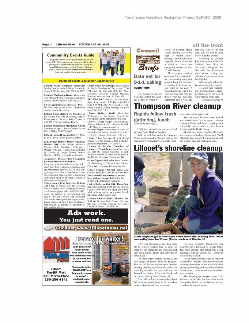
Powerhouse Foreshore Restoration Project REPORT 2009
Upcoming Events & Volunteer Opportunities
Page 2 Lillooet News SEPTEMBER 30, 2009 off the front
Community Events GuideListings are free for not for profit events and service
groups. AGM Notices are not accepted and will be asked to participate in a paid adverting. Send your listings to: [email protected] prior to Friday at 12 noon.
Space is limited please have information submitted atpleast two weeks prior to event date.
BPO Elks #467��������� ������-��� � ������������� �� ������ ���������������� ���!�� ��-"���#��"�$��%�&���'��������()�*()�*�)(�
Lillooet Legion Branch 66����������+������,�� ��-���&�����)���.�
Lillooet Gospel Chapel +��-�"��/� �+/���+"�� 01� *+��-�"� 221��22����� �� �%"��.���"�
Lillooet Quilters Guild ���� �� �3��� ��� � ��� ��� �.� �� ���&���� ��.#����+�.���!�����/4/�
Order of the Royal Purple���� �"�� �/��� ���� � ��� ���� �������������� ���������������� ���!�� 3��"��� #��"� ��/���&���'��������()�*()�*�)(�Buddhist Meditation Group���� ��
���������5����&�����������"��"�6�"��+��.���()�*�))*((�(
Lillooet Shambhala Meditation Group���� ���.� *+/��#�����������7���#���8�()�*()�*����
Lillooet Native Christian Fellowship+/���+��-�"������5�����&���� ��.#����2���������()�*()�*���0
Lillooet Food Matters ������� ������� )��� �� �� -����% -�/� ����� �"��"�+������%��9��������()�*()�*�))��������%������ �
LA to Legion��%/��������% ������:�/� ��� � ������*+�.���!��������;"�.�,�"��!��
Lillooet Farmer’s Market&����� /���<"�!�����+��1"� ���� �<�="�
LillooetLLillolooeoooettetTim-BR MartTTim-m-BR Marrtartrt
129 Moran Place129 Moran Poraraan PlacePlalacaceeece250-256-41412550-256-4142550-0-2-25256-6--41411
Prepare for winter!Enjoy the warm, cozy heat from a wood stove.Come and see our
Pacific Energywood stoves or visit
www.northweststoves.cato see the full lineof stoves available.
The friendly staff atTIM-BR-MART can help you to prepare
for winter! –weatherstripping,
insulation etc.
Lillooet Lions Meeting����2 �����:/� ��� � ���������� � ���5�-%�����9� �����������+��
Karaoke Night... "��� � � ���/������ ��� ����������� ����� 2 �����&����� �����5�%�>���.��
Lillooet & District Chamber of Commerce Monthly meetings • Meetings are held the second Thursday of each month at NOON in council chambers at the District of Lillooet Municipal Hall.
13th Annual Harvest Dinner Saturday,October 24th at the Lillooet MemorialCurling Club. Cocktails: 6:00 pm •Dinner: 7:00 pm Tickets: $20 Availableat: Created by Design Lillooet DistrictHospital, BRLN or Foundation Members
Games Night at the Legion+���� <"�!�����3��� ��� ��� �0���#��"�#���3���'�������������20?
Alzheimer’s Disease: The Connection Between Brain and BehaviourCaring for someone with Alzheimer’s dis-ease? This free telephone workshop fromthe Alzheimer Society of B.C. allows fam-ily caregivers to learn from home! Learnthe connection between what is happeningin the brain and how this leads to specificbehaviours of dementia.This session will be held Oct. 29 from7 to 8 pm. To register visit the Care-ringVoice website www.careringvoice.com/tele-learning.php or call 1-866-396-2433.After you register, a representative willcall a few days before the workshopwith details about participating by phone.Please register at least 5 days in advance. Participation is limited to residents of B.C. and the Yukon.
Cadets Barbecue Oct 10th: 12pm–5pm Benefit/Fundraiser BBQ for the Lillooet Cadets Come down and enjoy great food while helping out the local group. It will take place at Buy-Low Foods
Catholic Church Dinner, October 2nd 5:30 pm German Style Dinner. Eat in or take-out, everyone welcome. St. John's Catholic Church 1116 Main St.
Ads work.You just read one.
Click us: www.lillooetnews.netClCCCCCCCClCCCCCCCCCCClCl
The Annual Fountainview AcademyInternational Supper is<"�!�������).���&/���-�� 1"�����
Date set for 9-1-1 callingROBIN POON
The Squamish-Lillooet Regional District has again set a date to begin 9-1-1
service in Lillooet, Mayor Dennis Bontron said in the Sept. 21 regular councilmeeting. “They have chosen a specific date in November in which to convert the emergency numbers to 9-1-1,” said Bontron.
He expressed cautious optimism. The regional dis-trict has already pushed back plans to bring the emergen-cy number to Lillooet sev-eral times in the past. “I would like to say ’yay’ but ayear ago they said July and then a year ago they said September and a year ago
they said May, so I’ll waituntil they say they’re donebefore I get too excited.”
According to LillooetFire Department Chief PatSullivan, “Nov. 24 is thedate they’re telling me.” Healso said the departmentplans to start testing newcall-reception equipment inlate October.
Sullivan reported on thefire department to council.
He noted that firefight-ing in East Lillooet is great-ly hampered by the lack of water service in the area.
(Continued on page 6)
Council
BBrBrBrBrBB irrirrirrirrrirrirrrrieieiiiieiieiieiiii feefeefeefeeeffeefee sffsffsfsfsffsff
Thirty-one participants, from four years old to seniors, worked hard to clean upsome of our shorelines last weekend and then have lunch, games and activities atSeton Lake.
The Pathfinders cleaned up the Lions trail along the Fraser River on Saturday.The rest of the participants spent Sundaymorning cleaning up Seton Lake beach, thespawning channels, the canal walkway, theFraser River south of Cayoosh Creek and the stream flowing down Station Hill.
They collected seven large garbage bags full of mostly picnic items in all, includingdrink containers and food wrappers.
The most frequently found item wascigarette butts, followed by plastic forks. The most unusual item found was a fullmarijuana joint up Station Hill - someone was ditching it quick!
Two dead snakes were found on the road squashed by vehicles - you may see snakes warming themselves on the roads this timeof year and heading back towards their densfor the winter; some area snakes are endan-gered species.
After cleaning up, everyone enjoyed theafternoon at the lake, learning about wormcomposting thanks to Jan Wilson, playing recycling games and eating.
Lillooet’s shoreline cleanup
Ursela Stephane got to take some worms home after learning about wormcomposting from Jan Wilson. (Photo courtesy of Kim North)
Rapids follow trash gathering, lunch(Continued from page 1)
“Definitely the outhouse is a special find this year,” said Meghan Fandrich.
Haller agreed. She said of her students,“They really wanted to stay and pick up theport-a-potty.” Kumsheen’s own staff volun-
teers collected the prize find.After the meal, the rafters were soaked
and soaked again in the rapids betweenNicomen House and Lytton, passing such colourfully named sites as the Devil’sKitchen and the Fluffy Bunny.
All told, the volunteers collected a trailer and truck bed of garbage. Chang said, “We’ddefinitely love to have the same response if not bigger” from the public next year.
Thompson River cleanup
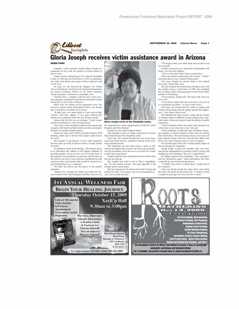
Powerhouse Foreshore Restoration Project REPORT 2009
GATHERINGOCT 1–3, 2009
T’IT’Q’ET, LILLOOET
Cob Oven Baking, Horsemanship, Earthworm Farming, Flint Knapping,
Smokehouse Construction, Organic Grain Growing,
Herbal Medicine Making, St’at’imc Ethnobotany,
Horseback Archery, Basket Making, Food Preservation, Native Plant Garden,
Raising and Butchering Chickens, and More. The Ucwalmicw Centre & Lillooet Food Matters present 3 days of sustainable
community workshops and demonstrations.For a schedule, see posters around town or email [email protected]
1st Annual Wellness Fair
For information Call Mike Gunn 250-256-4800
Begin Your Healing Journey
Xaxli’p
Hall
11:00 am
Thursday October 15, 2009Xaxli’p Hall
9:30am to 3:00pm
Great SpeakersTopics include:Self EsteemAbandonmentOvercoming AnxietyDepression We will Provide:
Valuable Information, A Healthy Lunch & Featured Act
Victoria Maxwell. You can improve! Discover Yourself! Win Door Prizes
Hand DrumMassages & Manicures
��������������Hair Cuts
& lots more!
LLLLLLLLLiLLililiiliiliiiiliiiilllllllllllllllllllllll olloooolllloolloollllolloollll ooeeteeteeteeteeeteeteeeeInsightsI
SEPTEMBER 30, 2009 Lillooet News Page 3
ROBIN POON
Longtime victim assistance worker Gloria Joseph was recognized for her work last month in Arizona thanks to fans at home.
Joseph started volunteering at the Lillooet Friendship Centre in 1986 and was hired there in 1992. In particular, she works with female and young victims of physical and sexual abuse.
On Aug. 25, she received the Margery Fry Victim Service Practitioner Award from the National Organization for Victim Assistance (NOVA) at the North American Victim Assistance Conference in Scottsdale, Ariz.
Christine Jack, a volunteer with the local victim assis-tance program, nominated Joseph for the award after Joseph invited her to come to the conference.
While Jack was filling out the registration form, she noticed a section asking participants if there was anyone they would like to nominate for an award.
“It didn’t give very much detail so I just went to their website,” said Jack, adding, “I was quite shocked thatnobody ever nominated Gloria for any of these awards.”
Seeing what she felt was an oversight, “I took it upon myself to nominate her, with four days notice.”
Jack wrote a letter detailing Joseph’s achievements and struggles with help from Babe Smith and other community members to compile Joseph’s history.
About two weeks later, NOVA’s executive director, WillMarling, called Jack to tell her that Joseph would receive the award.
She recalled, “I was pleased. I wasn’t really surprised, because when you look at Gloria’s history, it really speaks for itself.”
According to a letter from Marling, “The award is givento an individual who adheres to the highest standards in providing quality victim services on an everyday basis. It has typically been awarded to an innovator who has been in the field for ten years or more and has contributed time and resources above and beyond what would be expected in a paid staff position or as a volunteer.”
The letter also delves into the history of the award’snamesake.
“Margery Fry founded the shelter movement for bat-tered women in the United Kingdom and then went on to be
the inspiration for victim compensation in both the United Kingdom and New Zealand.”
Joseph, too, has clearly inspired others.Jack attended a series of weekly workshops for women
that Joseph hosted at the friendship centre.Over time, she worked through her own issues stem-
ming from abuse and now volunteers with the victim assis-tance program herself.
The workshops not only help restore a sense of self-esteem and support (the sessions end with a spa and make-over day and dinner), they also serve as a forum for victims to share their experiences.
Joseph suffered sexual and physical abuse herself whenshe was growing up.
She recalled how hard it was to find a sympatheticear. “No one wanted to listen,” she said, especially if she brought up her sexual abuse.
She was consumed with shame and turned to drugs and alcohol for relief. At one point, she even contemplated sui-cide “just to numb the pain.”
“You begin to hate your whole body and you don’t evenlove yourself.”
Joseph’s emotional scars stunted her relationships withothers, even her own children.
“I felt so dirty that I didn’t want to touch them.”When she started volunteering with victims, “I think I
was going there to save a bunch of these girls.”Over time, though, her naiveté faded as she realized
how many victims there were.She also realized she needed more training to deal with
the complex issues a victim faces. In 1989, she completed the sex abuse worker training program at the Nicola Valley Institute of Technology.
At the program, Joseph said, “We had to talk about our own issues.
“If you haven’t dealt with your own issues, you can’t goto a courthouse and listen…to your victim’s story.”
Over time, she learned that she could not simply push victims into pursuing criminal charges against their aggres-sors. “I give them a choice now.”
She admitted the legal system’s setup and the burden of evidence makes it difficult to make charges stick, espe-cially when victims are trying to forget the details of painful experiences.
“I don’t remember what I wore and I wasn’t going to run to the clock to see what time it was,” she said.
At the workshops, Joseph and other facilitators encour-age attendees to disclose details of their abuse by sharing about themselves. She said keeping things secret does nothelp someone forget. However, knowing that others have been in the same situation creates a sense of support.
Her favourite part of the job is seeing people change as they go through the workshops.
Joseph fondly recalled one attendee who, over time,asserted her independence by earning a driver’s licence and standing up to her husband. “She was so timid before.”
By finding support at the workshops, “They can respect and love themselves again.” Some participants, like Jack, eventually become facilitators themselves.
“I couldn’t have done it without them,” Joseph said of the volunteers.
And even though Joseph has spent many years doingthis work, she seems far from burnt out. “I could’ve retired a couple of years ago, but I love my job so much.”
Gloria Joseph receives victim assistance award in Arizona
Gloria Joseph works at the friendship centre.
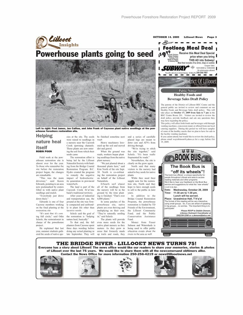
Powerhouse Foreshore Restoration Project REPORT 2009
LLLLLLLLLiLLililiililiiiliiiilllllllllllllllllllllll oloooolllloolloollllolloollll ooeeteteeteeteeeteeteeeeInsightsI
OCTOBER 14, 2009 Lillooet News Page 3
Helping nature heal itselfROBIN POON
Field work at the pow-erhouse restoration site isalmost over for the year.To those who remember the site before the restorationproject began, the changesare remarkable.
“This was the main driveway,” said KarenEdwards, pointing to an area now pockmarked by craters filled in with native plantseedlings and mulch.
“Everybody just drove down there.”
Edwards is one of four Cayoose members workingon the final planting at therestoration site.
“It’s neat that it’s com-ing full circle,” said OdinScholz, the restorationist incharge of the powerhouseproject.
He explained that last year, summer students gath-ered the seeds of native spe-
cies at the site. The seeds were raised to seedlings in a nursery near the Cayoosh Creek spawning channels. Those plants are now enter-ing the soil from which their seeds came.
The restoration effort isbeing led by the Lillooet Naturalist Society with fund-ing from the Bridge Coastal Restoration Program. B.C. Hydro created the programto remedy the negative impact of hydroelectric-ity generation in provincial watersheds.
The land is part of theCayoosh Creek St’at’imc band’s traditional territory.
After years of industrialand transportation use, the ground at the site was firm-ly compacted and unfriend-ly to plant life other than invasive weeds.
Scholz said the goal of the restoration is “helping nature heal, basically.”
To that end, the fallplanters from Cayoose spent three days weeding before doing any actual planting in late September. They will
be finished sometime nextweek.
Heavy machinery loos-ened up the soil and moved dirt and gravel.
When the ground wasready, workers began plant-ing seedlings from the nativeplant nursery.
“We just planted about athousand plants here,” said Kim North of the site Sept. 30. North is co-ordinat-ing the restoration project on behalf of the LillooetNaturalists.
Edwards said almostall of the seedlings fromthe nursery will be in theground by the time plant-ing is finished. “That’s over 4,000 plants.”
In some patches of thepowerhouse site, nativeplants are even thriving and multiplying on their own.“They’re naturally seeding in,” said Scholz.
The plants will provideeven more seeds for the native plant nursery as theymature. As they grow inareas that formerly madeup trails and roads, they
and a series of carefullyplaced logs are meant todeter cars and ATVs fromdriving through.
“We’re trying to stitch the site together,” said Scholz. “It’s been reallyfragmented by roads.”
Nevertheless, the site is clearly on the grow again.
North said that manyvisitors to the nursery had asked to buy seeds for nativeplants.
While they need their supply now for the restora-tion site, North said theyhope to have enough seedsto sell to the public in later years.
In addition to the Bridge Coastal RestorationProgram, the powerhouserestoration is funded by TDFriends of the Environment,the Lillooet CommunityFund, and the PublicConservation AssistanceFund.
Money from Fraser Salmon and Watersheds isbeing used to offer publiceducation events about therivers in the area as well.
The Book Bus is
“off its wheels”!The book bus offered a unique opportunity for
people throughout Lillooet and area to access
reading materials and other programs.
We’d like to hear your feedback on the Book Bus
service and suggestions for what the “new wheels”
could look like.
Date: Wednesday, October 28, 2009
Time: 11:30 am to 1:30 pm.
Lunch will be served.
Place: Ucwalmícw Hall, T’ít’q’etThe format of this meeting will be very interactive,
using small groups. So, if you are afraid of speaking
in big groups... no worries. The important thing is to
participate!
Please RSVP to Debbie Demare,Literacy Outreach Coordinator at
250)238-2248 or [email protected].
BOOK BUSBOOK BUSUS
www.lillooetbc.ca250-256-4289
Public NoticeHealthy Foods and
Beverage Sales Draft Policy
The patrons of the District of Lillooet REC Centre and thegeneral public are invited to review and comment on our Healthy Foods and Beverage Sales draft policy. This will take place on October 17, 2009 from 5pm to 7 pm in theREC Centre Room 201. Visitors are invited to review thedraft policy, provide feedback and ask any questions theymay have regarding the policy. This policy will affect both foods and beverages sold throughvending machines, concession stand, or offered from our local catering suppliers. During this period we will have samplesof some of the healthy snacks that we plan to have for sale inthe facility vending machines.If you cannot attend, but would like to review the draft policy,please email [email protected] for a copy before Oct 19, 2009.
Footlong Meal Deal
Coupon Valid: 10/01/2009 to 10/06/2009
No photocopies allowedThis offer valid only at Lillooet Subway - 55 Moha Rd 250-256-7807
Receive this Meal Deal Special price when you bring
THIS AD into Subway!Meal Deal includes 21oz drink, chips or cookies
$999Teriyaki Chicken
Roast Chicken Subway Club
Steak & Cheese & Subway Melt
Powerhouse plants going to seed
Left to right: Fred James, Jen Calliou, and John Frank of Cayoose plant native seedlings at the pow-erhouse foreshore restoration site.
THE BRIDGE RIVER - LILLOOET NEWS TURNS 75!Everyone has a story about Lillooet! The news office would like our readers to share your memories, stories & photos
of Lillooet over the last 75 years. We would like to share them with all the newcomersand oldtimers alike.Contact the News Office for more information 250-256-4219 or [email protected]

Powerhouse Foreshore Restoration Project REPORT 2009 � 143
Three Rivers Join One hosts dayKIM NORTHLillooet Naturalist Society
A very interesting Three Rivers Join One event was held at the Bridge River fishing rocks Saturday.
The fall colours were beautiful and the light rain welcome.
To start the event, chil-dren were engaged in cre-ating a watershed nature map with plasticine under the watchful eye of Brittany Spankie.
Laura John then entranced the audience when she told the story of Qwalimak: the Long-Nosed Monster.
Jacquie Rasmussen then showed everyone how to make more watershed-friendly cleaning products and talked about the impor-tance of not using toxic cleaning products that go down our drains and into our sewage treatment sys-tem where they can kill ben-eficial bacteria that break down waste.
The most fascinating
part of the day was when Jeff Sneep showed three aquatic invertebrate moni-toring baskets that had been sitting in the Bridge and Seton Rivers over the prior two weeks.
The baskets were filled
with rocks and placed in buckets of water for the event. Kids were shown how to clean off the rocks so the bugs clinging to the rocks would drop into the water.
With magnifying glass-es and an electronic micro-
scope, we all got a close-up look at these bugs and learned more about their importance to many species of fish and other wildlife, and their role in showing which creeks are healthy and which are not.
A little rainbow troutwas caught in the baskets also, but after a short climb down to the Bridge River,the fish was released.
Everyone stayed warm and well fed with a big pot of tswan soup and bannock.
Question period gets uglyROBIN POON
Conflict returned to council chambers Monday evening in the first regular meeting since the death of former councillor Greg Kamenka.
During question period, Ernie Anderson said Mayor Dennis Bontron had made misleading state-ments about the provincial govern-ment’s water conservation goals.
According to Anderson, Bontron had said the province aims to reduce water use by 50 per cent by 2020. However, Anderson said, the goal was in fact a 30 per cent reduction and the 50 per cent reduction only applied to new water infrastructure.
Bontron agreed that the 50 per cent reduction target applied to new
infrastructure only but maintained that he had stated as such whenever he quoted the figure.
Soon after, Anderson asked if the mayor was aware of a draft report for the district prepared by True Consulting. Bontron said that he had not and then told Anderson curtly, “Sit down.”
Anderson took offence at Bontron’s tone and said that although his questions had been answered, the mayor could have asked him to sit respectfully.
“You could say it in a polite way, Your Worship.”
Bontron replied, “Whatever,” prompting Anderson to call him an obscene name.
“If you can’t abstain from profan-ity, you should leave,” said Bontron. Anderson chose instead to stay, remaining silent until he left near the end of question period.
Council unanimously adopted a policy to stop the use of recording devices by private citizens at meet-ings.
Under the policy, the district would only allow the use of its own audio recorder during council meet-ings. Recordings would be destroyed after the minutes for the recorded meetings were adopted.
(Bontron said recordings by the Lillooet News and Radio Lillooet, currently considering broadcasting council meetings, would not be sub-ject to the restrictions since they would not be for private use.)
In a report, chief administrative officer Grant Loyer said the policy was meant to avoid liability for pri-vacy issues if members of the pub-lic were recorded without giving permission. It was further meant to avoid council’s spoken comments being taken out of context.
Kate Kempfle, vice-chair of theLillooet Ratepayers, said forbiddingprivate recordings would not reduce the possibility of misinterpretedwords and disagreement. “It’s justthe nature of people.”
Coun. Kevin Anderson supported the motion but felt it would be diffi-cult to enforce given the current sizeof recording devices.
Kevin Anderson brought forwardKamenka’s motion to reconsiderthe installation of water meters inLillooet. Coun. Carmen Pallot sec-onded the motion.
Kamenka had given notice thathe would make the motion at the planned Oct. 5 meeting, but suc-cumbed to a heart attack that day.
Mayor and council restated their support for metering and unanimous-ly opposed the motion.
Look for more meeting highlightsand a fuller account next week.
Learning at the fishing rocks
District council bans private recording at meetings
Children build a watershed nature map using plasticine at the Bridge River fishing rocks. Other activi-ties included storytelling and tips on keeping watersheds pollution-free. (Photo: Kim North)
T he Bridge River
Established by ‘Ma’ Murray in 1934 • Volume 79, Issue 42 • Wednesday, October 21, 2009
Lillooet NewsLillooet NewsT he Bridge River
Saturday
Friday
Thursday
WednesdayRain
High: 12Low: 8
Part CloudyHigh: 11Low: 8
RainHigh: 12Low: 8
CloudyHigh: 10Low: 6
4 DayForecast
provided byENVIRONMENT CANADA
The Bridge River Lillooet News is a division of Glacier Media Group
including GST
$1
ChillaxinAnniversary
Celebrating six (or seven?) years in robin's-egg blue
Page 20
Xaxli'p Health
Band hosts first mental health and
wellness fair Page 3
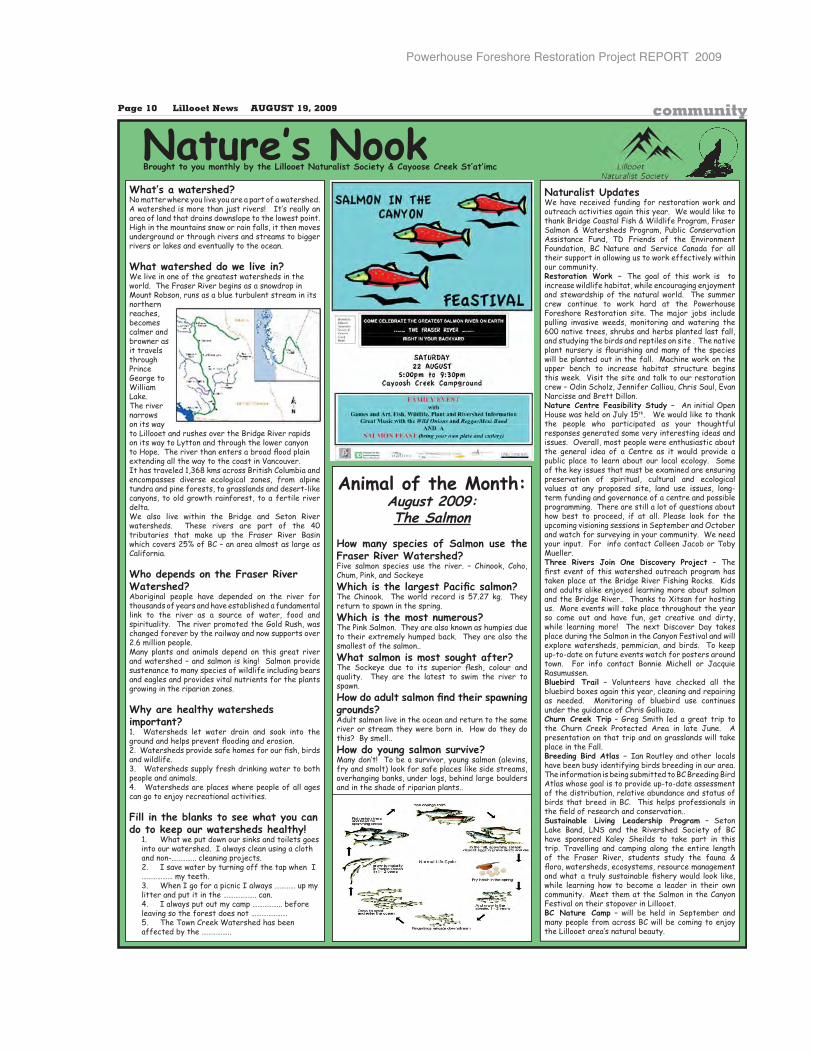
Powerhouse Foreshore Restoration Project REPORT 2009
Page 10 Lillooet News AUGUST 19, 2009 newsPage 10 Lillooet News AUGUST 19, 2009 community
Naturalist UpdatesWe have received funding for restoration work and outreach activities again this year. We would like to thank Bridge Coastal Fish & Wildlife Program, Fraser Salmon & Watersheds Program, Public Conservation Assistance Fund, TD Friends of the Environment Foundation, BC Nature and Service Canada for all their support in allowing us to work effectively within our community. Restoration Work – The goal of this work is to increase wildlife habitat, while encouraging enjoyment and stewardship of the natural world. The summer crew continue to work hard at the Powerhouse Foreshore Restoration site. The major jobs include pulling invasive weeds, monitoring and watering the 600 native trees, shrubs and herbs planted last fall, and studying the birds and reptiles on site . The native ����������� ���� � ���������������������� ��will be planted out in the fall. Machine work on the upper bench to increase habitat structure begins this week. Visit the site and talk to our restoration crew – Odin Scholz, Jennifer Calliou, Chris Saul, Evan Narcisse and Brett Dillon.Nature Centre Feasibility Study – An initial Open House was held on July 15th. We would like to thank the people who participated as your thoughtful responses generated some very interesting ideas and issues. Overall, most people were enthusiastic about the general idea of a Centre as it would provide a public place to learn about our local ecology. Some of the key issues that must be examined are ensuring preservation of spiritual, cultural and ecological values at any proposed site, land use issues, long-term funding and governance of a centre and possible programming. There are still a lot of questions about how best to proceed, if at all. Please look for the upcoming visioning sessions in September and October and watch for surveying in your community. We need your input. For info contact Colleen Jacob or Toby Mueller.Three Rivers Join One Discovery Project – The�������������� ��������������������������taken place at the Bridge River Fishing Rocks. Kids and adults alike enjoyed learning more about salmon and the Bridge River.. Thanks to Xitsan for hosting us. More events will take place throughout the year so come out and have fun, get creative and dirty, while learning more! The next Discover Day takes place during the Salmon in the Canyon Festival and will explore watersheds, pemmician, and birds. To keep up-to-date on future events watch for posters around town. For info contact Bonnie Michell or Jacquie Rasumussen.Bluebird Trail – Volunteers have checked all the bluebird boxes again this year, cleaning and repairing as needed. Monitoring of bluebird use continues under the guidance of Chris Galliazo.Churn Creek Trip – Greg Smith led a great trip to the Churn Creek Protected Area in late June. A presentation on that trip and on grasslands will take place in the Fall.Breeding Bird Atlas – Ian Routley and other localshave been busy identifying birds breeding in our area. The information is being submitted to BC Breeding Bird Atlas whose goal is to provide up-to-date assessment of the distribution, relative abundance and status of birds that breed in BC. This helps professionals in ����������������������������� ����Sustainable Living Leadership Program – Seton Lake Band, LNS and the Rivershed Society of BC have sponsored Kaley Sheilds to take part in this trip. Travelling and camping along the entire length of the Fraser River, students study the fauna & ����������������������������������������and what ���������� ����������������� ����� � ����while learning how to become a leader in their own community. Meet them at the Salmon in the Canyon Festival on their stopover in Lillooet.BC Nature Camp – will be held in September and many people from across BC will be coming to enjoy the Lillooet area’s natural beauty.
What’s a watershed?No matter where you live you are a part of a watershed. A watershed is more than just rivers! It’s really an area of land that drains downslope to the lowest point. High in the mountains snow or rain falls, it then moves underground or through rivers and streams to bigger rivers or lakes and eventually to the ocean.
What watershed do we live in?We live in one of the greatest watersheds in the world. The Fraser River begins as a snowdrop in Mount Robson, runs as a blue turbulent stream in its northernreaches,becomescalmer and browner as it travels throughPrinceGeorge to WilliamLake.The river narrowson its way to Lillooet and rushes over the Bridge River rapids on its way to Lytton and through the lower canyon �������������� ���������������������������� ��extending all the way to the coast in Vancouver.It has traveled 1,368 kms across British Columbia and encompasses diverse ecological zones, from alpine tundra and pine forests, to grasslands and desert-like canyons, to old growth rainforest, to a fertile river delta.We also live within the Bridge and Seton River watersheds. These rivers are part of the 40 tributaries that make up the Fraser River Basin which covers 25% of BC – an area almost as large as California.
Who depends on the Fraser River Watershed?Aboriginal people have depended on the river for thousands of years and have established a fundamental link to the river as a source of water, food and spirituality. The river promoted the Gold Rush, was changed forever by the railway and now supports over 2.6 million people.Many plants and animals depend on this great river and watershed – and salmon is king! Salmon provide sustenance to many species of wildlife including bears and eagles and provides vital nutrients for the plants growing in the riparian zones.
Why are healthy watersheds important?1. Watersheds let water drain and soak into the �������������������������� ��������� �������"���������� ����������������������� ��and wildlife.3. Watersheds supply fresh drinking water to both people and animals.4. Watersheds are places where people of all ages can go to enjoy recreational activities.
Fill in the blanks to see what you can do to keep our watersheds healthy!
1. What we put down our sinks and toilets goes into our watershed. I always clean using a cloth and non-………….. cleaning projects.2. I save water by turning off the tap when I ……………… my teeth.3. When I go for a picnic I always ………… up my litter and put it in the ………………. can. 4. I always put out my camp …………….. before leaving so the forest does not …………………5. The Town Creek Watershed has beenaffected by the ……………..
Animal of the Month:August 2009:The Salmon
How many species of Salmon use the Fraser River Watershed?Five salmon species use the river. – Chinook, Coho, Chum, Pink, and Sockeye�������������� ����������������The Chinook. The world record is 57.27 kg. They return to spawn in the spring.Which is the most numerous?The Pink Salmon. They are also known as humpies due to their extremely humped back. They are also the smallest of the salmon..What salmon is most sought after?���� #������� ���� ��� �� ��� �� ����� ������ ����quality. They are the latest to swim the river to spawn.���������������������������������� �grounds?Adult salmon live in the ocean and return to the same river or stream they were born in. How do they do this? By smell..How do young salmon survive?Many don’t! To be a survivor, young salmon (alevins, fry and smolt) look for safe places like side streams, overhanging banks, under logs, behind large boulders and in the shade of riparian plants..
Nature’s Nook Brought to you monthly by the Lillooet Naturalist Society & Cayoose Creek St’at’imc
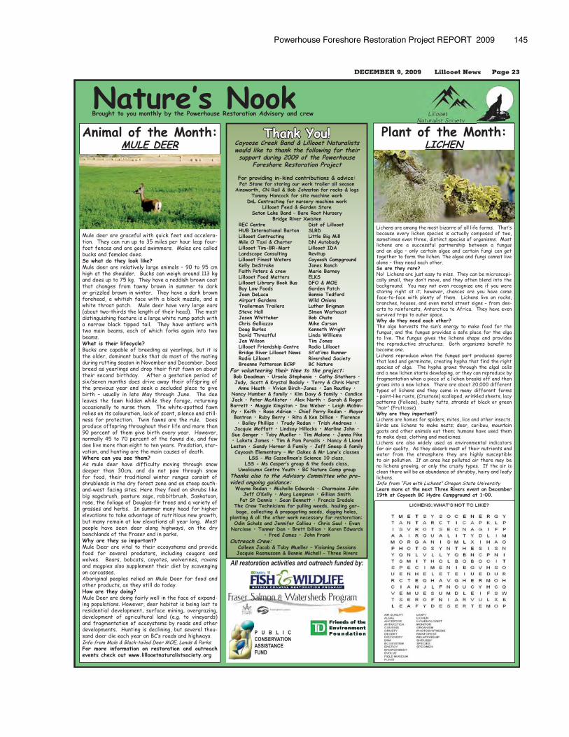
Powerhouse Foreshore Restoration Project REPORT 2009 145
DECEMBER 9, 2009 Lillooet News Page 23
Plant of the Month:LICHEN
Lichens are among the most bizarre of all life forms. That’s because every lichen species is actually composed of two, sometimes even three, distinct species of organisms. Most lichens are a successful partnership between a fungus and an alga – only certain algae and certain fungi can get together to form the lichen. The algae and fungi cannot live alone – they need each other.So are they rare? No! Lichens are just easy to miss. They can be microscopi-cally small, they don’t move, and they often blend into the background. You may not even recognize one if you were staring right at it; however, chances are you have come face-to-face with plenty of them. Lichens live on rocks, branches, houses, and even metal street signs – from des-erts to rainforests, Antarctica to Africa. They have even survived trips to outer space.Why do they need each other? The alga harvests the sun’s energy to make food for the fungus, and the fungus provides a safe place for the alga to live. The fungus gives the lichens shape and provides the reproductive structures. Both organisms benefit to become one. Lichens reproduce when the fungus part produces spores that land and germinate, creating hypha that find the right species of alga. The hypha grows through the algal cells and a new lichen starts developing, or they can reproduce by fragmentation when a piece of a lichen breaks off and then grows into a new lichen. There are about 20,000 different types of lichens and they come in many different forms – paint-like rusts, (Crustose) scalloped, wrinkled sheets, lacy patterns (Foliose), bushy tufts, strands of black or green “hair” (Fruticose). Why are they important? Lichens are homes for spiders, mites, lice and other insects. Birds use lichens to make nests; deer, caribou, mountain goats and other animals eat them; humans have used them to make dyes, clothing and medicines. Lichens are also widely used as environmental indicators for air quality. As they absorb most of their nutrients and water from the atmosphere they are highly susceptible to air pollution. If an area has polluted air there may be no lichens growing, or only the crusty types. If the air is clean there will be an abundance of shrubby, hairy and leafy lichens.Info from “Fun with Lichens” Oregon State UniversityLearn more at the next Three Rivers event on December 19th at Cayoosh BC Hydro Campground at 1:00.
Animal of the Month:MULE DEER
Mule deer are graceful with quick feet and accelera-tion. They can run up to 35 miles per hour leap four-foot fences and are good swimmers. Males are called bucks and females does.So what do they look like?Mule deer are relatively large animals – 90 to 95 cm high at the shoulder. Bucks can weigh around 113 kg and does up to 75 kg. They have a reddish brown coat that changes from tawny brown in summer to dark or grizzled brown in winter. They have a dark brown forehead, a whitish face with a black muzzle, and a white throat patch. Mule deer have very large ears (about two-thirds the length of their head). The most distinguishing feature is a large white rump patch with a narrow black tipped tail. They have antlers with two main beams, each of which forks again into two beams.What is their lifecycle?Bucks are capable of breeding as yearlings, but it is the older, dominant bucks that do most of the mating during rutting season in November and December. Does breed as yearlings and drop their first fawn on about their second birthday. After a gestation period of six/seven months does drive away their offspring of the previous year and seek a secluded place to give birth – usually in late May through June. The doe leaves the fawn hidden while they forage, returning occasionally to nurse them. The white-spotted fawn relies on its colouration, lack of scent, silence and still-ness for protection. Twin fawns are the rule. Does produce offspring throughout their life and more than 90 percent of them give birth every year. However, normally 45 to 70 percent of the fawns die, and few dee live more than eight to ten years. Predation, star-vation, and hunting are the main causes of death.Where can you see them?As mule deer have difficulty moving through snow deeper than 30cm, and do not paw through snow for food, their traditional winter ranges consist of shrublands in the dry forest zone and on steep south-and-west facing sites. Here they feed on shrubs like big sagebrush, pasture sage, rabbitbrush, Saskatoon, rose, the foliage of Douglas-fir trees and a variety of grasses and herbs. In summer many head for higher elevations to take advantage of nutritious new growth, but many remain at low elevations all year long. Most people have seen deer along highways, on the dry benchlands of the Fraser and in parks. Why are they so important?Mule Deer are vital to their ecosystems and provide food for several predators, including cougars and wolves. Bears, bobcats, coyotes, wolverines, ravens and magpies also supplement their diet by scavenging on carcasses.Aboriginal peoples relied on Mule Deer for food and other products, as they still do today. How are they doing?Mule Deer are doing fairly well in the face of expand-ing populations. However, deer habitat is being lost to residential development, surface mining, overgrazing, development of agricultural land (e.g. to vineyards) and fragmentation of ecosystems by roads and other developments. Hunting is declining, but several thou-sand deer die each year on BC’s roads and highways.Info from Mule & Black-tailed Deer MOE, Lands & Parks.For more information on restoration and outreach events check out www.lillooetnaturalistsociety.org
Nature’s Nook Brought to you monthly by the Powerhouse Restoration Advisory and crew
Thank You!Cayoose Creek Band & Lillooet Naturalists would like to thank the following for their support during 2009 of the Powerhouse
Foreshore Restoration Project
For providing in-kind contributions & advice:Pat Stone for storing our work trailer all season
Ainsworth, CN Rail & Bob Johnston for rocks & logsTommy Hancock for site machine work
DnL Contracting for nursery machine workLillooet Feed & Garden Store
Seton Lake Band – Bare Root NurseryBridge River Xwisten
REC Centre Dist of Lillooet HUB International Barton SLRD Lillooet Contracting Little Big Mill Mile O Taxi & Charter DN Autobody Lillooet Tim-BR-Mart Lillooet IDA Landscope Consulting Revitup Lillooet Finest Waters Cayoosh Campground Kelly DeStrake Jones Ranch Faith Peters & crew Marie Barney Lillooet Food Matters ELKS Lillooet Library Book Bus DFO & MOE Buy Low Foods Garden Patch Joan DeLuca Bonnie Tedford Airport Gardens Wild Onions Trailerman Trailers Luther Brigman Steve Hall Simon Warhaust Jason Whittaker Bob Chute Chris Galliazzo Mike Carson Doug Burles Kenneth Wright David Threatful Linda Williams Jan Wilson Tim Jones Lillooet Friendship Centre Radio Lillooet Bridge River Lillooet News St’at’imc Runner Radio Lillooet Rivershed Society Breanne Patterson BCRP BC NatureFor volunteering their time to the project: Bob Deadman • Ursela Stephanie • Cathy Stathers • Judy, Scott & Krystal Bodaly • Terry & Chris Hurst Anne Heath • Vivian Birch-Jones • Ian Routley •
Nancy Humber & family • Kim Davy & family • Candice Jack • Peter McAlister • Alex North • Sarah & Roger Barrett • Maggie Kingston • Ina Weber • Leigh McGin-ity • Keith • Rose Adrian • Chief Perry Redan • Mayor Bontron • Ruby Berry • Rita & Ken Dillion • Florence • Bailey Phillips • Trudy Redan • Trish Andrews •
Jacquie Moffatt • Lindsay Hillocks • Marline John • Sue Senger • Toby Mueller • Tim Malone • Janna Pike • Lakota James • Tim & Pam Paradis • Nancy & Lionel Leston • Sandy Horner & Family • Jeff Sneep & familyCayoosh Elementary – Mr Oakes & Mr Lane’s classes
LSS – Ms Cassellman’s Science 10 class, LSS - Ms Casper’s group & the foods class,
Uwalicumx Centre Youth • BC Nature Camp groupThanks also to the Advisory Committee who pro-vided ongoing guidance:
Wayne Redan • Michelle Edwards • Charmaine JohnJeff O’Kelly • Marg Lampman • Gillian Smith
Pat St Dennis • Sean Bennett • Francis IredaleThe Crew Technicians for pulling weeds, hauling gar-bage, collecting & propagating seeds, digging holes,
planting & all the other work necessary for restoration: Odin Scholz and Jennifer Calliou • Chris Saul • Evan
Narcisse • Tanner Dan • Brett Dillion • Karen Edwards • Fred James • John Frank
Outreach Crew: Colleen Jacob & Toby Mueller – Visioning SessionsJacquie Rasmussen & Bonnie Michell – Three Rivers
All restoration activities and outreach funded by:
P U B L I C CONSERVATION ASSISTANCEFUND
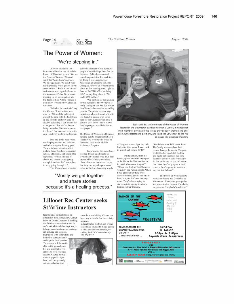
Powerhouse Foreshore Restoration Project REPORT 2009 � 146
Síxa SíxaPage 14
The Power of Women:
A recent murder in the
Downtown Eastside has stirred the
Power of Women to action. “We are
the Power of Women. We don’t
want this “hush, hush” anymore.
We’re stepping in. We don’t want
this happening to our people in our
communities.” Stella is one of sev-
eral women who signed a letter to
the Vancouver Police Department
insisting on an investigation into
the death of Lisa Arlene Francis, a
non-native woman who worked on
the street.
“It had to be homicide,” say
the Women. “I had a sister who
died in 1997, and the police just
pushed the case onto the back burn-
er and said she probably died of
alcohol poisoning. I don’t want that
to happen to Lisa, she’s a human
being, a mother. She was a volun-
teer here.” Bea does not believe the
case is actively under investigation.
Bea and Stella both volun-
teer helping women and children
and advocating for the very poor.
They both have histories which
include foster families, residential
school, addictions, and abuse. Bea
explained, “We are victims of
abuse, and we see others going
through it and we don’t want them
to keep going through it.”
The Women have protested
police harassment of the homeless
people who sell things they find on
the street. Police have arrested
homeless people for this, and start-
ed doing it more regularly as
Vancouver get closer to the 2010
Olympics. “Power of Women held a
black market vending stand right in
front of the VPD office, and they
didn’t do anything about it. We
made $250 dollars.”
“We petition for the housing
for the homeless. The Olympics is
really cutting us out. We don’t want
the Olympics because it’s spreading
poverty. The prices here are sky-
rocketing and people can’t afford to
live here, but people who come
here for the Olympics will have a
place to stay. I don’t know where
they’re going to put all the home-
less people.”
The Power of Women is addressing
funding cuts to programs that are a
“lifeline” to women who work on
the street, such as the Mobile
Assistance Program.
Each woman has something
to offer, Bea is an advocate for
women and children who have been
separated by Ministry decisions.
“Lots of women don’t even know
that they can appeal a permanent
order for the kids becoming wards
of the government. I got my kids
back after four years. I went back
to school and got my GED.”
Phillipa Ryan, from the
Power, spoke about the Olympics
at the Under the Volcano festival
in North Vancouver, August 7.
“When you think of the Olympics,
you don’t see Native people. When
I was growing up there were
always friendly games, lots of ath-
letes, but you don’t see that any-
more. They’re been trying to
starve us into signing treaties to
legitimize their thievery.
Lillooet Rec Center seeks
St’át’imc Instructors
“We did not want DIA in our lives.
That’s why we started our land
claims through the courts. The pow-
ers that be have polluted the land
and made us beggars in our own
countries and now they’re trying to
do that to the rest of you. It’s extor-
tion. Now they’ve got you in their
powers, they’re going to start treat-
ing you like Indians.”
The Power of Women meets
weekly at Pender and Columbia in
Vancouver. “Mostly we get together
and share stories, because it’s a heal-
ing process. Everybody’s welcome.”
Recreational instructors are in
demand at the Lillooet REC Center.
Director Duane Laurence is seeking
out St'át'imc course instructors in
saq'ota (traditional dancing), story-
telling, basket making, net making,
art, carving and lacrosse.
Instructors with other skills are
invited to contact Duane
and explain their passion.
The classes will be avail-
able to the general pub-
lic, at a cost that is typi-
cally $60 for a ten-class
session. Course instruc-
tors are payed $18 per
hour, and can generally
set up a schedule that
suits their availability. Classes can
be at any schedule that the activity
requires.
Instructors for the Fall and Winter
seasons are invited to plan a course
at their earliest convenience, by
calling the REC Center directly:
250 256 7527.
The St’át’imc Runner August 2009
Stella and Bea are members of the Power of Women, located in the Downtown Eastside Women’s Center, in Vancouver.
Their members protest on the street, they support women and chil-dren, write letters and petitions, and keep the VPD’s feet to the fire
on issues like unsolved murders.
“Mostly we get together and share stories,
because it’s a healing process.”
“We’re stepping in.”
Hosted by:LillooetNaturalistSociety &CayooseCreekBand
FAMILY EVENT
with
Games and Art, Fish, Wildlife, Plant and Rivershed Information
Great Music with the Wild Onions and Reggae Band
AND A
SALMON FEAST (bring your own plate and cutlery)
maG
F
W,hsiFt,rAdansme
thiwcisuMtaerG
ENEVLYIMAFthiw
dant anlP,feildlWi
ethh soninOd lldiilWWi
ADNA
T
mrfonIdehsreviRd
dna dBangaegggReeg
ontima
SEAFNOLMAS
TS nworouyg niin(br
)yy)rryellettlucd aneattepllan
)
COME CELEBRATE THEGREATEST SALMON RIVERON EARTH… THE FRASER RIVER ...
SALMON IN THE CANYON
FEaSTIVAL
MLAS
NINOM
EHT
MLAS
N IN OMONYCA
E HTNO
EF
VTIEaS
LAV
SATURDAY 22 AUGUST
5:30pm to 9:00pm Cayoosh Creek Campground
3:5hsooyaC
YADURTASTSUUGA2200:9otmp0pmaCkeerCh
mpdnourgp
hsooyaC
pmaCkeerCh
dnourgp
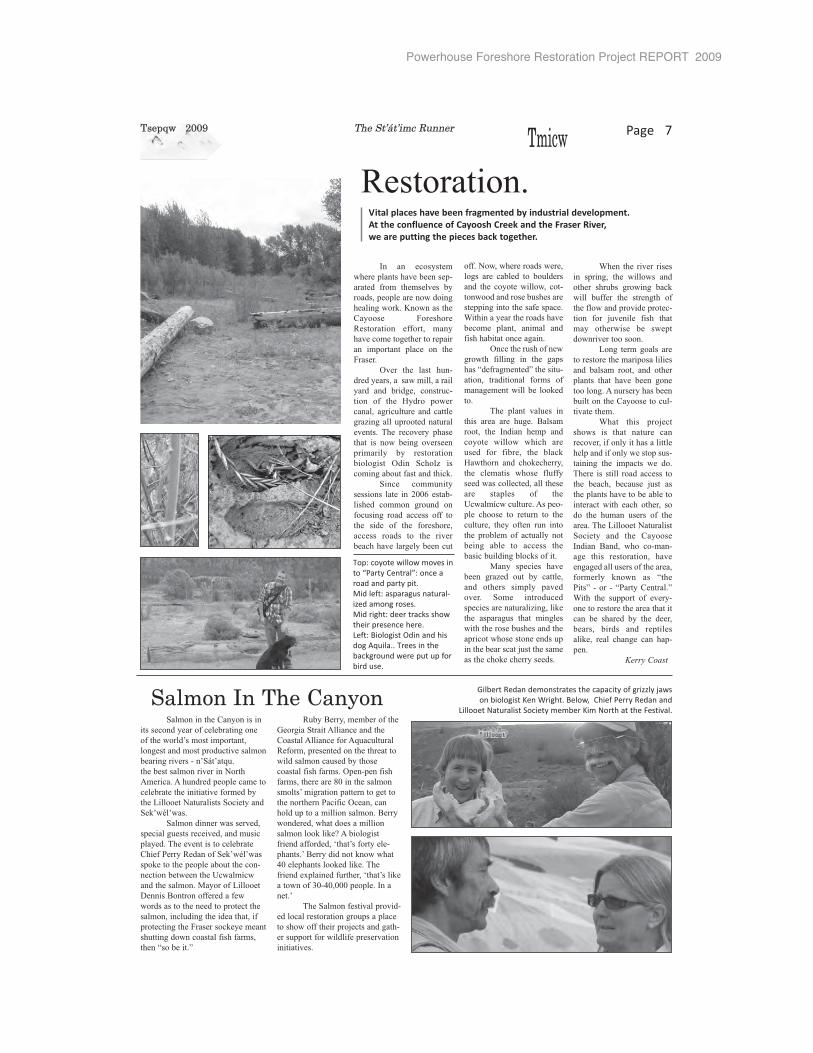
Powerhouse Foreshore Restoration Project REPORT 2009
TTmicw Page 7
Salmon in the Canyon is in
its second year of celebrating one
of the world’s most important,
longest and most productive salmon
bearing rivers - n’Sát’atqu.
the best salmon river in North
America. A hundred people came to
celebrate the initiative formed by
the Lillooet Naturalists Society and
Sek’wél’was.
Salmon dinner was served,
special guests received, and music
played. The event is to celebrate
Chief Perry Redan of Sek’wél’was
spoke to the people about the con-
nection between the Ucwalmícw
and the salmon. Mayor of Lillooet
Dennis Bontron offered a few
words as to the need to protect the
salmon, including the idea that, if
protecting the Fraser sockeye meant
shutting down coastal fish farms,
then “so be it.”
Ruby Berry, member of the
Georgia Strait Alliance and the
Coastal Alliance for Aquacultural
Reform, presented on the threat to
wild salmon caused by those
coastal fish farms. Open-pen fish
farms, there are 80 in the salmon
smolts’ migration pattern to get to
the northern Pacific Ocean, can
hold up to a million salmon. Berry
wondered, what does a million
salmon look like? A biologist
friend afforded, ‘that’s forty ele-
phants.’ Berry did not know what
40 elephants looked like. The
friend explained further, ‘that’s like
a town of 30-40,000 people. In a
net.’
The Salmon festival provid-
ed local restoration groups a place
to show off their projects and gath-
er support for wildlife preservation
initiatives.
In an ecosystem
where plants have been sep-
arated from themselves by
roads, people are now doing
healing work. Known as the
Cayoose Foreshore
Restoration effort, many
have come together to repair
an important place on the
Fraser.
Over the last hun-
dred years, a saw mill, a rail
yard and bridge, construc-
tion of the Hydro power
canal, agriculture and cattle
grazing all uprooted natural
events. The recovery phase
that is now being overseen
primarily by restoration
biologist Odin Scholz is
coming about fast and thick.
Since community
sessions late in 2006 estab-
lished common ground on
focusing road access off to
the side of the foreshore,
access roads to the river
beach have largely been cut
off. Now, where roads were,
logs are cabled to boulders
and the coyote willow, cot-
tonwood and rose bushes are
stepping into the safe space.
Within a year the roads have
become plant, animal and
fish habitat once again.
Once the rush of new
growth filling in the gaps
has “defragmented” the situ-
ation, traditional forms of
management will be looked
to.
The plant values in
this area are huge. Balsam
root, the Indian hemp and
coyote willow which are
used for fibre, the black
Hawthorn and chokecherry,
the clematis whose fluffy
seed was collected, all these
are staples of the
Ucwalmícw culture. As peo-
ple choose to return to the
culture, they often run into
the problem of actually not
being able to access the
basic building blocks of it.
Many species have
been grazed out by cattle,
and others simply paved
over. Some introduced
species are naturalizing, like
the asparagus that mingles
with the rose bushes and the
apricot whose stone ends up
in the bear scat just the same
as the choke cherry seeds.
When the river rises
in spring, the willows and
other shrubs growing back
will buffer the strength of
the flow and provide protec-
tion for juvenile fish that
may otherwise be swept
downriver too soon.
Long term goals are
to restore the mariposa lilies
and balsam root, and other
plants that have been gone
too long. A nursery has been
built on the Cayoose to cul-
tivate them.
What this project
shows is that nature can
recover, if only it has a little
help and if only we stop sus-
taining the impacts we do.
There is still road access to
the beach, because just as
the plants have to be able to
interact with each other, so
do the human users of the
area. The Lillooet Naturalist
Society and the Cayoose
Indian Band, who co-man-
age this restoration, have
engaged all users of the area,
formerly known as “the
Pits” - or - “Party Central.”
With the support of every-
one to restore the area that it
can be shared by the deer,
bears, birds and reptiles
alike, real change can hap-
pen.
Kerry Coast
Restoration.Vital places have been fragmented by industrial development. At the confluence of Cayoosh Creek and the Fraser River, we are putting the pieces back together.
Salmon In The Canyon
Tsepqw 2009 The St’át’imc Runner
Gilbert Redan demonstrates the capacity of grizzly jaws on biologist Ken Wright. Below, Chief Perry Redan and
Lillooet Naturalist Society member Kim North at the Festival.
Top: coyote willow moves into “Party Central”: once aroad and party pit.Mid left: asparagus natural-ized among roses.Mid right: deer tracks showtheir presence here.Left: Biologist Odin and hisdog Aquila.. Trees in thebackground were put up forbird use.
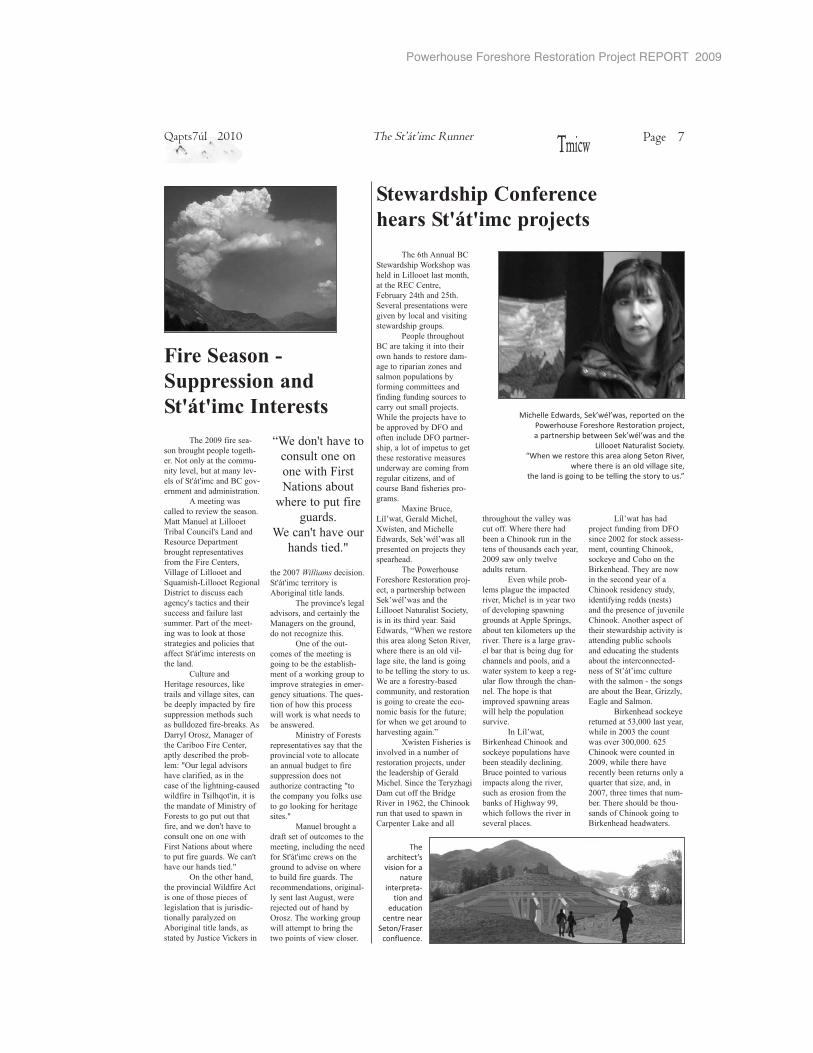
Powerhouse Foreshore Restoration Project REPORT 2009
������������ �������������������������������������������������������������������������� �!"������!#��$��%���������������������&�%��� ���'������%�����&������������&����$�
(����������&��� ����������&�����������������������������������)�&�������������*����������������������� +����&�'������������+���&�+��&����'�����'��� �������������,�'��$�������������,�'�����%������������%���� �-�.����+����'����-�.�������)�������������+�����������&�����������������%�������������� �����'���&�+�����&����'���*��������+'����� ���+������������)&����$�
/�0��� �'���1�2�����3������/�'����4�1��������/�'�����������������2�5�2���������������������,�'������ ���������$�
����(��������������������������������,)�'�������������������������2�5�2�������������������6�����������'��� ���������������� ���$��������������7���������������������������&��������%������������������������%��)��&�������������������&��&�����������&��������� �����$���������+������ )�����'����� ������������������&��&����'�����������'�)���'�������+�������+���8+����������&�������������%����&��&��$9
4�1�����������������%��%�������������+��������������,�'�����������������������+�3�����/�'���$���'��������� *��&�-���'���++����� ���&���%�����:;�!����������������������������������������������������
����&��������%���� ����'���++$�����������������������������������������+�����������'�� ����!<<;������� �����%�����������$�
�%������������)��������&����������'�����%����/�'��������� ��������+���%�����&������&&������������������&����������������������������%��$���������������&��&��%)������������������&��&�+��'��������������������������� �����������������&)����+��������&������'��)��$����������������������%��������&������������������������������%�%�$
=��1�2���� ��������������������'�� ��������������%������������ ���'���&$ �'������������%���������'������&�������%����'������������+�������������+�>�&��� �;;����'��+�������������%������%��������'��$�
������ ������
��������� ���������� ��� ��������� �������
���� ����� � ��������� ��� ��������� �������
�1�2��������������,�'��+��&�+����-�.��'��!<<!�+������'��������)�����'���&����������'�� ��������������� ��������$���� ���������������'��� �����+���������������' ���� ������+ �&�������?����@������������'���+�,%����������$������������'���+�������������������'��%�� ���������&�����'��'����������'���&������������������������'��'���)�����+���2A�2��'�'�������������������)�������&�������������� �����3��**� ���&�����������$�
�����������'�� �����������#B�<<<������ ������������!<<B�����'�������%���B<<�<<<$��!#������������'������!<<;����������������%���'��� ������������� ��C�������������*��������!<<D��������������������)���$�������������������)������+��������&��&��� �������������������$�
����������� ���������������� ��� ������������� �������� ���� ������� ������� ����������� ��� �������������������������������
������������� ������������ !�"#������� ���� �������� �������$���������%� �
��� ����� �����������%����$�������������������$���$�������������$�������� ������!&�
����������������������������������������������������������������������
����!<<;�+�������)������&������������&���)��$�6����� ��������'���)�� ���%������������ ���%)�����+���EA�E��'���� ��&�%)���������������������$
� �����&����'�����������%�������������$/����/������������������������'��E�������������'��-�����������&��������������%��+��������������������F����&���+�������������C�����)�����������&����-�����'��������'�����'��&�' E����'��'�����������''�������+���������������$�(�����+���������)�&���������������������������&�����������'���������++�'����EA�E��'������������������$
��������>�����&�������'������������������%����&���������'��������� �����'����� �+����������������������'���������*���+���)������$���-��� ��.���*��/��&����+��������������������������� ����'��������������)���G�H.����&�����%�������%��'����+�������������'�����+�������&���&)'��������+�����������C��E��������������������+�/����� ��+�����������&������������+�������������E����%����'�����������������������6����������������������+����&����$����'�E���%��������������$H�
.����������������������%�'��������+�����'��������+����������'����+��&����������������,�����')������ ������ *���������&�������������������������� �I���'��F�'������
����!<<D��������� ��'����$��EA�E��'��������� ��������&��������������$
�������%�'�E����&����%����������'������ ����/��&����������&������������'�&�*������$�
.���+�������)'������+����������&���&��&��������������������)�����+��������&�&�����������%��������&����������)&�' ���������$�����C��)�����+�������������'��������������������������������������$�
/����� ��+�������������������%����� ������������%�'����%�����������'�����������&������+��������������������������*��'����'��&�H������'���� � ��+����������&�������&�+���������&������$H
/�������&�������+�������+���'����������������&���'���&��������+�����EA�E��'�'����������&���������%�������������������+����&����$������'���������������&���)� �����������&����������,�'��������+������ .���*$����������&�&����������������������&���������������+�%����'�����$
7�����E����%����'����������������������6����������
������������+���&����$�
���'�E����%�������������$H
'���� ���������%������(� ��
���� ������ � ���)
���������������
���� ����� �����*� ��� ���(������!
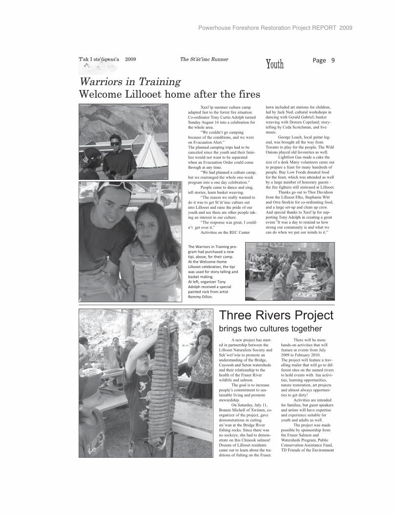
Powerhouse Foreshore Restoration Project REPORT 2009
YYouth Page 9
Xaxl’íp summer culture camp
adapted fast to the forest fire situation.
Co-ordinator Tony Curtis Adolph turned
Sunday August 16 into a celebration for
the whole area.
“We couldn’t go camping
because of the conditions, and we were
on Evacuation Alert.”
The planned camping trips had to be
canceled since the youth and their fami-
lies would not want to be separated
when an Evacuation Order could come
through at any time.
“We had planned a culture camp,
but we rearranged the whole one-week
program into a one day celebration.”
People came to dance and sing,
tell stories, learn basket weaving.
“The reason we really wanted to
do it was to get St’át’imc culture out
into Lillooet and raise the pride of our
youth and see there are other people tak-
ing an interest in our culture.
“The response was great, I could-
n’t get over it.”
Activities on the REC Center
lawn included art stations for children,
led by Jack Ned; cultural workshops in
dancing with Gerald Gabriel; basket
weaving with Doreen Copeland; story-
telling by Ceda Scotchman, and live
music.
George Leach, local guitar leg-
end, was brought all the way from
Toronto to play for the people. The Wild
Onions played old favourites as well.
Lightfoot Gas made a cake the
size of a desk Many volunteers came out
to prepare a feast for many hundreds of
people. Buy Low Foods donated food
for the feast, which was attended as well
by a large number of honorary guests -
the fire fighters still stationed at Lillooet.
Thanks go out to Thor Davidson
from the Lillooet Elks, Stephanie Witt
and Orra Storkin for co-ordinating food,
and a large set-up and clean up crew.
And special thanks to Xaxl’íp for sup-
porting Tony Adolph in creating a great
event.”It was a day to remind us how
strong our community is and what we
can do when we put our minds to it.”
Warriors in TrainingWelcome Lillooet home after the fires
T’ak I sts’úqwaz’a 2009 The St’át’imc Runner
Three Rivers Projectbrings two cultures together
A new project has start-
ed in partnership between the
Lillooet Naturalists Society and
Sek’wel’wás to promote an
understanding of the Bridge,
Cayoosh and Seton watersheds
and their relationship to the
health of the Fraser River
wildlife and salmon.
The goal is to increase
people’s commitment to sus-
tainable living and promote
stewardship.
On Saturday, July 11,
Bonnie Michell of Xwísten, co-
organizer of the project, gave
demonstrations in cutting
sts’wan at the Bridge River
fishing rocks. Since there was
no sockeye, she had to demon-
strate on this Chinook salmon!
Dozens of Lillooet residents
came out to learn about the tra-
ditions of fishing on the Fraser.
There will be more
hands-on activities that will
feature at events from July
2009 to February 2010.
The project will feature a trav-
elling trailer that will go to dif-
ferent sites on the named rivers
to hold events with fun activi-
ties, learning opportunities,
nature restoration, art projects
and almost always opportuni-
ties to get dirty!
Activities are intended
for families, but guest speakers
and artists will have expertise
and experience suitable for
youth and adults as well.
The project was made
possible by sponsorship from
the Fraser Salmon and
Watersheds Program, Public
Conservation Assistance Fund,
TD Friends of the Environment
The Warriors in Training pro-gram had purchased a newtipi, above, for their camp. At the Welcome HomeLillooet celebration, the tipiwas used for story telling andbasket making.At left, organizer TonyAdolph received a specialpainted rock from artistRemmy Dillon.
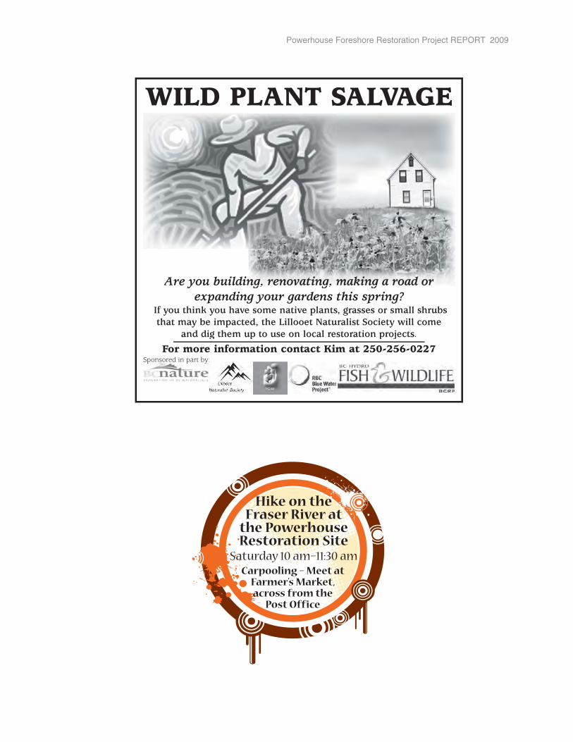
Powerhouse Foreshore Restoration Project REPORT 2009
For more information contact Kim at 250-256-0227Sponsored in part by:p p y
WILD PLANT SALVAGE
If you think you have some native plants, grasses or small shrubs that may be impacted, the Lillooet Naturalist Society will come
and dig them up to use on local restoration projects.
Are you building, renovating, making a road orng, renovating, making a road orexpanding your gardens this spring?
Hike on the Fraser River at
the Powerhouse Restoration Site
Saturday 10 am–11:30 amCarpooling – Meet at
Farmer’s Market,across from the
Post Office
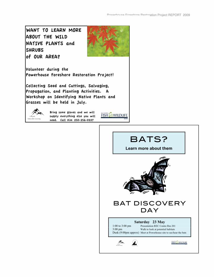
Powerhouse Foreshore Restoration Project REPORT 2009
WANT TO LEARN MORE ABOUT THE WILD NATIVE PLANTS and SHRUBSof OUR AREA?
Volunteer during thePowerhouse Foreshore Restoration Project!
Collecting Seed and Cuttings, Salvaging, Propagation, and Planting Activities. A Workshop on Identifying Native Plants and Grasses will be held in July.
Bring some gloves and we will supply everything else you will need. Call Kim 250-256-0227
Lillooet Naturalist Society
BATS?
Learn more about them
BAT DISCOVERY
DAY
Saturday 23 May 1:00 to 3:00 pm Presentation REC Centre Rm 201 3:00 pm Walk to look at potential habitats Dusk (9:00pm approx) Meet at Powerhouse site to see/hear the bats
Cayoose Creek
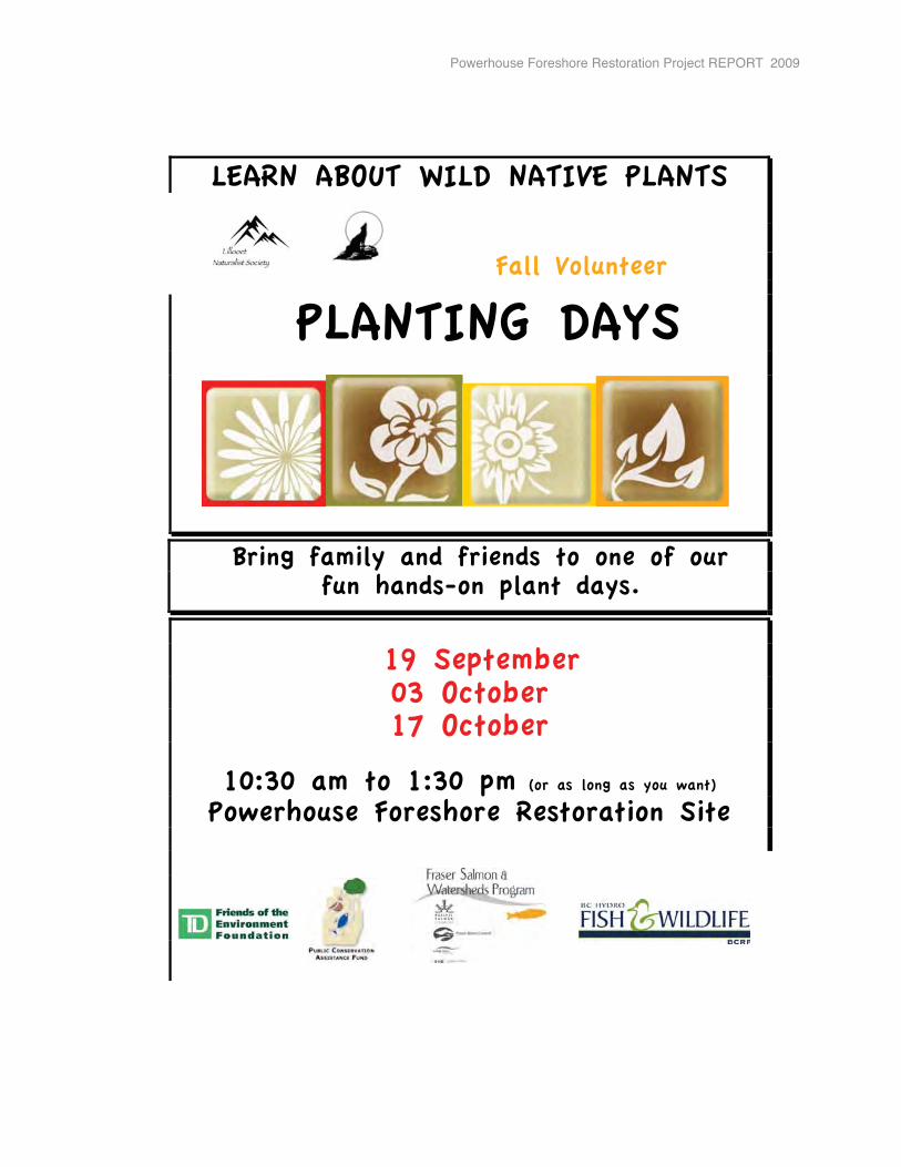
Powerhouse Foreshore Restoration Project REPORT 2009
LEARN ABOUT WILD NATIVE PLANTS
Fall Volunteer
PLANTING DAYS
Bring family and friends to one of our fun hands-on plant days.
19 September 03 October 17 October
10:30 am to 1:30 pm (or as long as you want) Powerhouse Foreshore Restoration Site
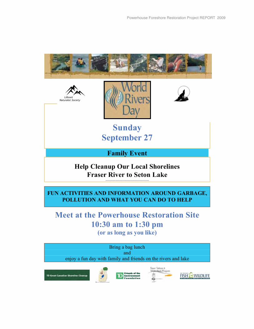
Powerhouse Foreshore Restoration Project REPORT 2009
Sunday
September 27
Family Event
Help Cleanup Our Local Shorelines Fraser River to Seton Lake
…………………………………………….
FUN ACTIVITIES AND INFORMATION AROUND GARBAGE, POLLUTION AND WHAT YOU CAN DO TO HELP
Meet at the Powerhouse Restoration Site 10:30 am to 1:30 pm
(or as long as you like)
Bring a bag lunch and
enjoy a fun day with family and friends on the rivers and lake
Lillooet Naturalist Society
Powerhouse Foreshore Restoration Project REPORT 2009

Appendix V
Letters of Support Received(These are attached to the 2009 Application submitted to BCRP)
1. Cayoose Creek St’at’imc2. Lillooet Tribal Council 3. Upper St’at’imc Language, Culture and Education Society4. District of Lillooet 5. BC Rail Properties6. Department of Fisheries and Oceans 7. Ministry of Environment – Kamloops8. Ministry of Environment – Victoria9. BC Nature - Federation of BC Naturalists10. Lillooet & District Chamber of Commerce11. Uxwalmixw Centre Society12. Lillooet Food Matters13. Yalakom Ecological Society14. Teacher, Cayoosh Elementary School15. Principal, George M. Murray Elementary School16. The Bag Ladies, Lillooet17. Lillooet Employment Centre - Friendship Society18. Fraser Salmon and Watersheds Program 19. Bridge River Lillooet News20. St’at’imc Runner21. Radio Lillooet
22. Lillooet Naturalist Society
Powerhouse Foreshore Restoration Project REPORT 2009
Related Documents