1 23 International Journal of Historical Archaeology ISSN 1092-7697 Int J Histor Archaeol DOI 10.1007/s10761-012-0183-0 Poromoi Tamu and the Case of the Drowning Village: History, Lost Places and the Stories We Tell Bruno David, Lara Lamb, Jean-Jacques Delannoy, Frank Pivoru, Cassandra Rowe, Max Pivoru, Tony Frank, Nick Frank, Andrew Fairbairn & Ruth Pivoru

Welcome message from author
This document is posted to help you gain knowledge. Please leave a comment to let me know what you think about it! Share it to your friends and learn new things together.
Transcript
1 23
International Journal of HistoricalArchaeology ISSN 1092-7697 Int J Histor ArchaeolDOI 10.1007/s10761-012-0183-0
Poromoi Tamu and the Case of theDrowning Village: History, Lost Places andthe Stories We Tell
Bruno David, Lara Lamb, Jean-JacquesDelannoy, Frank Pivoru, CassandraRowe, Max Pivoru, Tony Frank, NickFrank, Andrew Fairbairn & Ruth Pivoru

1 23
Your article is protected by copyright and
all rights are held exclusively by Springer
Science+Business Media, LLC. This e-offprint
is for personal use only and shall not be self-
archived in electronic repositories. If you
wish to self-archive your work, please use the
accepted author’s version for posting to your
own website or your institution’s repository.
You may further deposit the accepted author’s
version on a funder’s repository at a funder’s
request, provided it is not made publicly
available until 12 months after publication.
Poromoi Tamu and the Case of the Drowning Village:
History, Lost Places and the Stories We Tell
Bruno David & Lara Lamb & Jean-Jacques Delannoy & Frank Pivoru &
Cassandra Rowe & Max Pivoru & Tony Frank & Nick Frank & Andrew Fairbairn &
Ruth Pivoru
# Springer Science+Business Media, LLC 2012
Abstract Archaeological excavations at an ancestral village site within rainforest in
Papua New Guinea has revealed buried cultural evidence that can be explained in a
number of ways. While interpretations based on Western archaeological methods
suggest regional landscape dynamics informed by geomorphological processes,
Indigenous Rumu oral traditions suggest an interpretation of the site’s stratigraphy
based on the workings of spiritual forces. The role of story-telling and new informa-
tion in site interpretation and understanding is explored in light of these different yet
complementary accounts.
Int J Histor Archaeol
DOI 10.1007/s10761-012-0183-0
B. David (*) : C. Rowe
School of Geography and Environmental Science, Monash University,
Clayton, Victoria 3800, Australia
e-mail: [email protected]
C. Rowe
e-mail: [email protected]
L. Lamb
School of Humanities and Communication, Public Memory Research Centre,
University of Southern Queensland, Toowomba, Australia
e-mail: [email protected]
J.-J. Delannoy
Laboratoire EDYTEM (Environnements, Dynamiques et Territoires de la Montagne),
Université de Savoie, CNRS, Chambéry, France
e-mail: [email protected]
F. Pivoru :M. Pivoru : T. Frank :N. Frank : R. Pivoru
Kopi village, Gulf Province, Papua New Guinea
A. Fairbairn
School of Social Science, The University of Queensland, Brisbane, Australia
e-mail: [email protected]
Author's personal copy
Keywords Archaeology . Oral traditions . Story-telling . Papua NewGuinea .
Worldviews
Introduction
The anthropologist Marcia Langton (2002) invites us to look at the night sky. What
we see, she tells us, are not only planets and stars, but something much grander: a
confirmation of what we already know about how the world itself operates—time,
life, our place in the universe. These are understandings re-affirmed not in debates or
explicit statements about the ways of the world, but rather through more subtle
readings of observations that are consistent with what we already know, or with what
we think we know. These understandings explain well our everyday and ongoing
observations, those things that we do, that we see, that we experience. And we come
to explain along the way those mysteries that we don’t really know too well but that
feature in how we interpret reality, such as the spirit other-world, which, as otherness,
we know only at its edges. But still we can talk about it, and we try to make sense of it
by fitting it into the stories we tell about our world. We negotiate these under-
standings through our observations and experiences, and we socialize them all in
the stories we tell.
In this case of the night sky what we see as tiny bright dots on a black, blank
canvas are gigantic balls of fire whose light emanates through time and space literally
at the speed of light, reaching us as the night sky that we gaze upon. It is not simply
that seeing is believing, but rather believing is seeing—not just seeing abstract visual
space but rather cultural places already rich in meaning (cf. Casey 1997), in this case
through cosmological understandings informed by astronomy and all those related
specialist studies that come to subtly infiltrate general knowledge and that are
explicitly distilled to us non-professional onlookers as popular science. This is a
popular rendition distilled into everything else we understand about the world,
understandings that imbue, and that we come to communicate through, the stories
we tell each other about what we see and hear and experience through all of our
senses, stringing bits of information into narratives that make sense of our world, and
of ourselves in that world.
But ours is not the only story to tell. And it is when we venture beyond the comfort
of our own landscapes that we most realize how much our assumptions—our very
particular worldviews—taint all that we know, along with how we interpret what we
don’t know. In the process we also come to recognize that what we do know could be
known in other ways. Thus, just as we subliminally receive from the night sky an
emanation of Western astronomical knowledge, in Aboriginal Australia, Marcia
Langton reminds us, the trees and hills and fauna, and the stars, are emanations not
of Western botanical or geological or zoological, or astronomical, knowledge but of
the numinous ancestral forces that gave and continue to give shape to the landscape as
country, the meaningful homeland into which all things were given their defining
characteristics in the creative events of the Dreaming and that is as much kin as it is
“environment.” These are different renditions of how things are, that are told and
retold in our stories, and they differ by the cultural perspectives that we hold. Our
stories socialize, and make sense of, a world otherwise unknown. Without stories we
Int J Histor Archaeol
Author's personal copy
would be lost: how would we make sense of our experiences and observations if we
could not locate them into broader narratives of existence? Through stories, atomized
observations are oriented into meaningful universes, and in doing so set foundations
that continue to trigger our imaginations, as knowledge, by which we can understand
the world in which we live.
In archaeology as in other things, knowledge, like stories, is constructed in
meaningful, social practice. Following Strathern (2004) generally, and Yarrow
(2006) for archaeology specifically, such praxis “is composed of relationships”
(Strathern 1988). And as Strathern (2004) further notes, such connections are always
multiply enacted. In this multiply connected, relational process, knowledge is always
negotiated at the cultural interface (Nakata 2007). Individuals and groups come to
understand history in places by the way pre-understanding (the subliminal cultural,
prejudicial notions that embed our actions and understandings) articulates with new
findings and new ideas that initially present themselves as an otherness that we
nevertheless instantly try to make sense of through our existing pre-understandings
(e.g., Gadamer 1987; also see David 2002). This connectivity of self with other
expresses itself in our stories that reflect the changing meaningfulness of those
relationships. Time is of the essence in this process, as it is through time that
understandings of history are formed through social and observational negotiations
that internalize otherness, and in the process familiarize it into the self and pre-
understanding.
In this paper we construct two stories about one cultural place. In doing so we
reflect on how we have come to understand the history of a particular place and
people in such a meeting of parties, when one Indigenous group in Papua New
Guinea, and archaeologists from Australia, examined a culturally significant histor-
ical location. In doing so, two very different cultural perspectives meet, a meeting that
causes us to reflect on our own constructions. As Edgeworth (2006, p. xiv) has noted,
“The privileged viewpoint of the observer over the observed is maintained precisely
through looking outward at some cultural Other—whether back through time into the
past or across distances in space—rarely or never turning that outward-looking gaze
back onto itself.” While contact between the self and others generates influence, it
also leads us to question our place in the broader scheme of things.
In the example we present here, archaeologists were asked by Rumu clan leaders
to investigate the history of a cultural place, Poromoi Tamu, on their own ancestral
clan lands. They wanted to know more about their own history in the understanding
that this is what archaeologists do—investigate the past through what is held in
places. Among the Rumu of the Gulf Province in lowland Papua New Guinea,
Himaiyu clanspeople recount a story of their legendary ancestral twin villages at
Poromoi. Poromoi is a <100 m-high limestone rise some 100 m east of Utiti Creek, a
tributary of the Kikori River roughly a third of the way from the coast to the Papua
New Guinea highlands (Figs. 1 and 2). As elsewhere in Rumu lands, Poromoi and its
surrounding terrain are covered in thick tropical rainforest broken only by waterways
and highly localized patches of open ground and secondary growth where villages
and gardens have recently been established. Once abandoned, these open spaces are
quickly overtaken by the jungle, losing all obvious traces of previous activity except
for those that remain in social memory; told, retold and transformed over the ages in
local story-telling. Archaeological evidence of such past occupation is neither
Int J Histor Archaeol
Author's personal copy
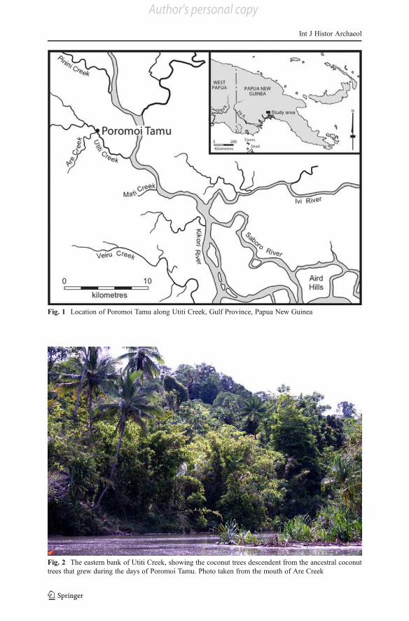
Fig. 1 Location of Poromoi Tamu along Utiti Creek, Gulf Province, Papua New Guinea
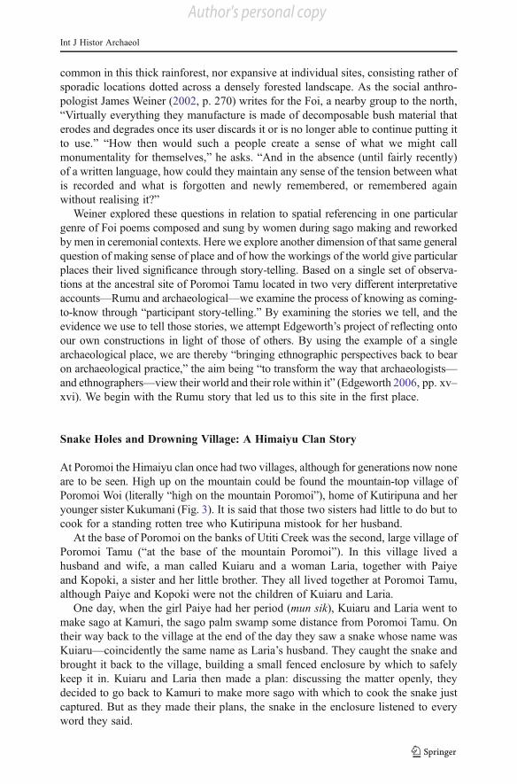
Fig. 2 The eastern bank of Utiti Creek, showing the coconut trees descendent from the ancestral coconut
trees that grew during the days of Poromoi Tamu. Photo taken from the mouth of Are Creek
Int J Histor Archaeol
Author's personal copy
common in this thick rainforest, nor expansive at individual sites, consisting rather of
sporadic locations dotted across a densely forested landscape. As the social anthro-
pologist James Weiner (2002, p. 270) writes for the Foi, a nearby group to the north,
“Virtually everything they manufacture is made of decomposable bush material that
erodes and degrades once its user discards it or is no longer able to continue putting it
to use.” “How then would such a people create a sense of what we might call
monumentality for themselves,” he asks. “And in the absence (until fairly recently)
of a written language, how could they maintain any sense of the tension between what
is recorded and what is forgotten and newly remembered, or remembered again
without realising it?”
Weiner explored these questions in relation to spatial referencing in one particular
genre of Foi poems composed and sung by women during sago making and reworked
bymen in ceremonial contexts. Here we explore another dimension of that same general
question of making sense of place and of how the workings of the world give particular
places their lived significance through story-telling. Based on a single set of observa-
tions at the ancestral site of Poromoi Tamu located in two very different interpretative
accounts—Rumu and archaeological—we examine the process of knowing as coming-
to-know through “participant story-telling.” By examining the stories we tell, and the
evidence we use to tell those stories, we attempt Edgeworth’s project of reflecting onto
our own constructions in light of those of others. By using the example of a single
archaeological place, we are thereby “bringing ethnographic perspectives back to bear
on archaeological practice,” the aim being “to transform the way that archaeologists—
and ethnographers—view their world and their role within it” (Edgeworth 2006, pp. xv–
xvi). We begin with the Rumu story that led us to this site in the first place.
Snake Holes and Drowning Village: A Himaiyu Clan Story
At Poromoi the Himaiyu clan once had two villages, although for generations now none
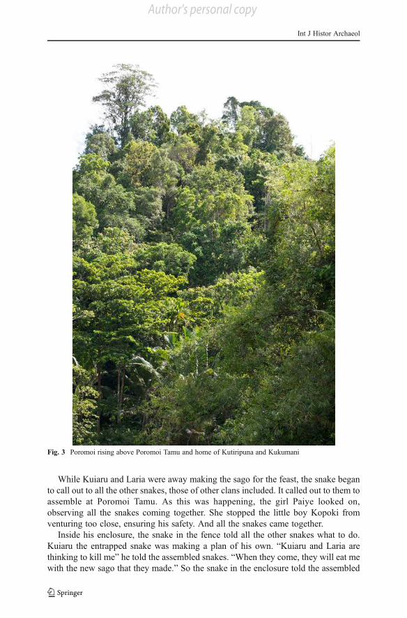
are to be seen. High up on the mountain could be found the mountain-top village of
Poromoi Woi (literally “high on the mountain Poromoi”), home of Kutiripuna and her
younger sister Kukumani (Fig. 3). It is said that those two sisters had little to do but to
cook for a standing rotten tree who Kutiripuna mistook for her husband.
At the base of Poromoi on the banks of Utiti Creek was the second, large village of
Poromoi Tamu (“at the base of the mountain Poromoi”). In this village lived a
husband and wife, a man called Kuiaru and a woman Laria, together with Paiye
and Kopoki, a sister and her little brother. They all lived together at Poromoi Tamu,
although Paiye and Kopoki were not the children of Kuiaru and Laria.
One day, when the girl Paiye had her period (mun sik), Kuiaru and Laria went to
make sago at Kamuri, the sago palm swamp some distance from Poromoi Tamu. On
their way back to the village at the end of the day they saw a snake whose name was
Kuiaru—coincidently the same name as Laria’s husband. They caught the snake and
brought it back to the village, building a small fenced enclosure by which to safely
keep it in. Kuiaru and Laria then made a plan: discussing the matter openly, they
decided to go back to Kamuri to make more sago with which to cook the snake just
captured. But as they made their plans, the snake in the enclosure listened to every
word they said.
Int J Histor Archaeol
Author's personal copy
While Kuiaru and Laria were away making the sago for the feast, the snake began
to call out to all the other snakes, those of other clans included. It called out to them to
assemble at Poromoi Tamu. As this was happening, the girl Paiye looked on,
observing all the snakes coming together. She stopped the little boy Kopoki from
venturing too close, ensuring his safety. And all the snakes came together.
Inside his enclosure, the snake in the fence told all the other snakes what to do.
Kuiaru the entrapped snake was making a plan of his own. “Kuiaru and Laria are
thinking to kill me” he told the assembled snakes. “When they come, they will eat me
with the new sago that they made.” So the snake in the enclosure told the assembled
Fig. 3 Poromoi rising above Poromoi Tamu and home of Kutiripuna and Kukumani
Int J Histor Archaeol
Author's personal copy
snakes to make holes all around the house so as to make the waters rise, thereby
causing the house and the whole village to drown in the rising waters.
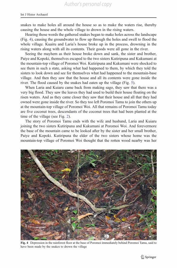
Hearing those words the gathered snakes began to make holes across the landscape
(Fig. 4), causing the groundwater to flow up through the holes and swell to flood the
whole village. Kuairu and Laria’s house broke up in the process, drowning in the
rising waters along with all its contents. Their goods were all gone in the river.
Seeing the mayhem as their house broke down and sank, the sister and brother,
Paiye and Kopoki, themselves escaped to the two sisters Kutiripuna and Kukumani at
the mountain-top village of Poromoi Woi. Kutiripuna and Kukumani were shocked to
see them in such a state, asking what had happened to them, by which they told the
sisters to look down and see for themselves what had happened to the mountain-base
village. And then they saw that the house and all its contents were gone inside the
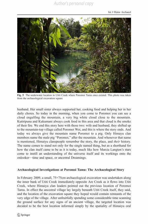
river. The flood caused by the snakes had eaten up the village (Fig. 5).
When Laria and Kuiaru came back from making sago, they saw that there was a
very big flood. They saw the leaves they had used to build their house floating on the
risen waters. And as they came closer they saw that their house and all that they had
owned were gone inside the river. So they too left Poromoi Tamu to join the others up
at the mountain-top village of Poromoi Woi. All that remains of Poromoi Tamu today
are five coconut trees, descendants of the coconut trees that had been planted at the
time of the village (see Fig. 2).
The story of Poromoi Tamu ends with the wife and husband, Laria and Kuiaru
joining the two sisters Kutiripuna and Kukumani at Poromoi Woi. And forevermore
the base of the mountain came to be looked after by the sister and her small brother,
Paiye and Kopoki. Kutiripuna the elder of the two sisters whose home was the
mountain-top village of Poromoi Woi thought that the rotten wood nearby was her
Fig. 4 Depression in the rainforest floor at the base of Poromoi immediately behind Poromoi Tamu, said to
have been made by the snakes to drown the village
Int J Histor Archaeol
Author's personal copy
husband. Her small sister always supported her, cooking food and helping her in her
daily chores. So today in the morning, when you come to Poromoi you can see a
cloud engulfing the mountain, a very big white cloud close to the mountain.
Kutiripuna and Kukumani always cook food in this area and that cloud is the smoke
of their fire. We end this story here with those two: wife and husband, they shifted up
to the mountain-top village called Poromoi Woi, and this is where the story ends. And
today we always give the mountain name Poromoi to a pig. Only Himayu clan
members name the male pig “Poromoi,” after the mountain. And whenever that name
is mentioned, Himaiyu clanspeople remember the story, the place, and their history.
The name comes to stand not only for the single named thing, but as a shorthand for
how the clan itself came to be as it is today, much like how Marcia Langton’s stars
come to instill an understanding of the universe itself and its workings onto the
onlooker—time and space, or ancestral Dreamings.
Archaeological Investigations at Poromoi Tamu: The Archaeological Story
In February 2009, a small, 75×75cm archaeological excavation was undertaken along
the inner bank of Utiti Creek immediately opposite Are Creek as it flows into Utiti
Creek, where Himaiyu clan leaders pointed out the previous location of Poromoi
Tamu. In effect the ancestral village lay largely beneath Utiti Creek itself, they said,
and the location of the excavation square they hoped would contain remnants of the
very edge of the village. After unfruitfully spending some considerable time scanning
the ground surface for any signs of an ancient village, the targeted location was
decided to be the best location informed simply by the spatiality of Himaiyu oral
Fig. 5 The underwater location in Utiti Creek where Poromoi Tamu once existed. This photo was taken
from the archaeological excavation square
Int J Histor Archaeol
Author's personal copy
traditions. Five tall coconut trees nearby, known to have been offspring of earlier
coconut trees from the days of the legendary village, were further testimony to this
location as the rightful site of Poromoi Tamu.
The immediate vicinity of the excavation square had only recently been cleared by
Himaiyu clanspeople for a garden, offering good ground visibility in the process. No
physical evidence of a past village had been unearthed through this gardening
activity. The excavation square was located 8 m in from the edge of Utiti Creek in
an area devoid of garden planting and soil disturbance (see Fig. 3). Excavation
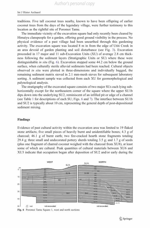
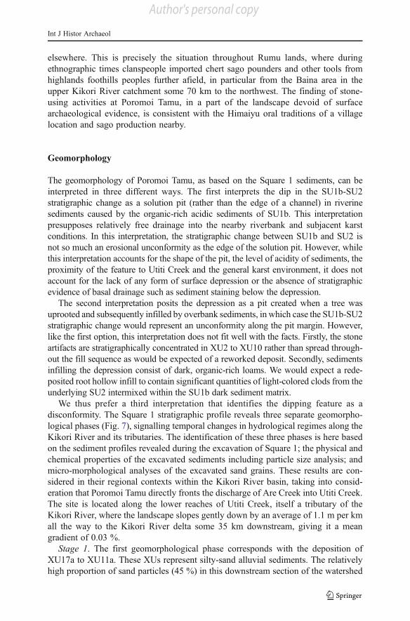
proceeded in 17 major and 11 sub-Excavation Units (XU) of average 2.8 cm thick-
ness following the sediment layers (Stratigraphic Units or SU) where these were
distinguishable in situ (Fig. 6). Excavation stopped some 44.2 cm below the ground
surface, when culturally sterile alluvial sediments had been reached. Cultural objects
observed in situ were plotted in three-dimensions and individually bagged, the
remaining sediment matrix sieved in 2.1 mm-mesh sieves for subsequent laboratory
sorting. A sediment sample was collected from each XU for geomorphological and
palynological analysis.
The stratigraphy of the excavated square consists of two major SUs each lying sub-
horizontally except for the northeastern corner of the square where the upper SU1b
dips down into the underlying SU2, reminiscent of an infilled pit or edge of a channel
(see Table 1 for descriptions of each SU; Figs. 6 and 7). The interface between SU1b
and SU2 is typically about 10 cm, representing the general depth of post-depositional
sediment mixing.
Findings
Evidence of past cultural activity within the excavation area was limited to 19 flaked
stone artifacts; five small pieces of heavily burnt and unidentifiable bones; 4.3 g of
charcoal; 46.1 g of burnt earth; two fire-cracked hearth stone fragments totaling
29.4 g; three small and undecorated pottery sherds totaling 3.5 g; and 1.7 g of seeds
(plus one fragment of charred coconut weighed with the charcoal from XU8), at least
some of which are cultural. Peak quantities of cultural materials between XU6 and
XU3 indicate that occupation began after deposition of SU2 and/or early during the
Fig. 6 Poromoi Tamu Square 1, west and north sections
Int J Histor Archaeol
Author's personal copy
deposition of SU1b (see Table 2). In this tropical rainforest environment where
rainfall reaches between 5,000–8,000 mm annually, natural bushfires are entirely
unknown, and any charcoal can be taken as evidence of anthropogenic fires. A
radiocarbon determination on charcoal from XU6 near the base of SU1b but at the
very upper surface of the “pit,” and at a depth with the greatest number of stone
artifacts, reveals an age of 562±30 BP (Wk-25289). This calibrates to sometime
between 523–643 cal BP at two sigma (on Calib 6.0; Stuiver and Reimer 1993),
shorthanded here to “around 600 years ago” (Table 3). Five other radiocarbon
determinations from SU1b, including one from the upper parts of SU2 where it meets
the interface with SU1b, reveal calibrated ages between ca. 100 and ca. 300 years ago
Table 1 Poromoi Tamu Square 1, sediment descriptions by SU
SU Description
1a Very thin (1–5 mm thick), loose surface sediments consisting of the leaf litter layer. SU1a is virtually
devoid of soil. Very fine rootlets abundant in the leaf litter itself, although there is virtually no plant
growth in the area of the excavated square itself. SU1a rapidly gives way to SU1b sediments below;
interface between SU1a and SU1b is marked. No in situ cultural materials were noticed in this SU.
1b Dark sediments. Homogeneous in texture and color throughout the square and with depth. Numerous
rootlets around 1.5 cm in diameter are present. Roots tend to grow horizontally. Very easy to dig;
moderately consolidated and slightly compact sediments. Generally humid at time of excavation.
Interface with underlying SU2 is gradual, taking place over a vertical distance of 10–15 cm. The
interface sometimes consists of clods of SU2 mixed within SU1b sediments, sometimes of clods of
SU1b mixed within SU2 sediments. In situ cultural materials were noticed in this SU.
2 Light-colored sediments, homogeneous in color and texture. Fairly compact and consolidated. Humid
at time of excavation. Rootlets up to 1.5 cm in diameter are present, but less commonly than in
SU1b. No in situ cultural materials seen in this SU.
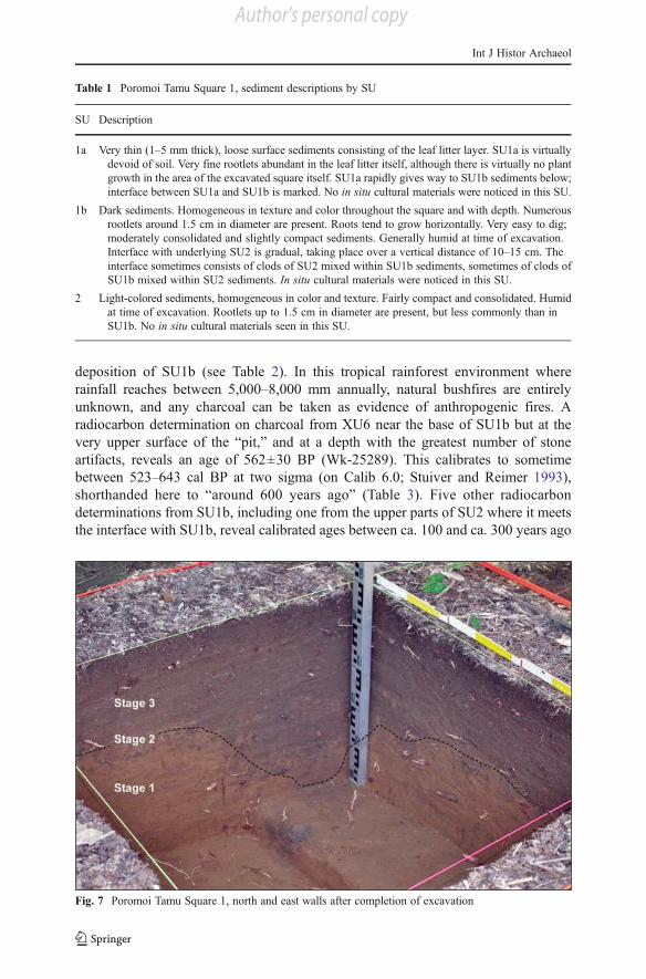
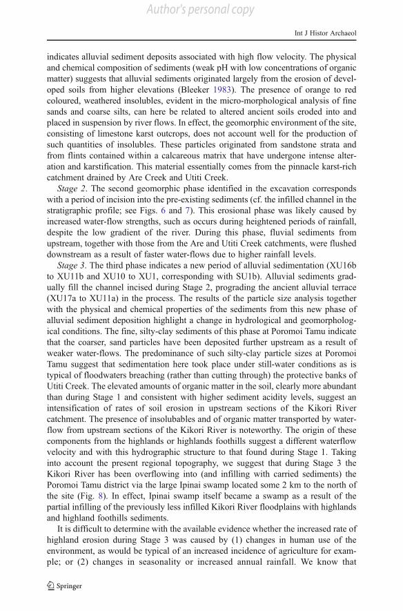
Fig. 7 Poromoi Tamu Square 1, north and east walls after completion of excavation
Int J Histor Archaeol
Author's personal copy
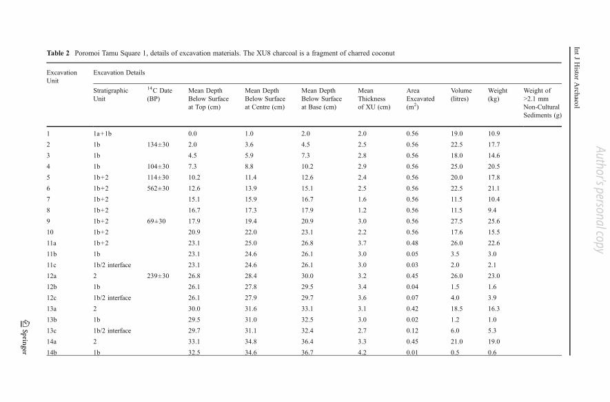
Table 2 Poromoi Tamu Square 1, details of excavation materials. The XU8 charcoal is a fragment of charred coconut
Excavation
Unit
Excavation Details
Stratigraphic
Unit
14C Date
(BP)
Mean Depth
Below Surface
at Top (cm)
Mean Depth
Below Surface
at Centre (cm)
Mean Depth
Below Surface
at Base (cm)
Mean
Thickness
of XU (cm)
Area
Excavated
(m2)
Volume
(litres)
Weight
(kg)
Weight of
>2.1 mm
Non-Cultural
Sediments (g)
1 1a+1b 0.0 1.0 2.0 2.0 0.56 19.0 10.9
2 1b 134±30 2.0 3.6 4.5 2.5 0.56 22.5 17.7
3 1b 4.5 5.9 7.3 2.8 0.56 18.0 14.6
4 1b 104±30 7.3 8.8 10.2 2.9 0.56 25.0 20.5
5 1b+2 114±30 10.2 11.4 12.6 2.4 0.56 20.0 17.8
6 1b+2 562±30 12.6 13.9 15.1 2.5 0.56 22.5 21.1
7 1b+2 15.1 15.9 16.7 1.6 0.56 11.5 10.4
8 1b+2 16.7 17.3 17.9 1.2 0.56 11.5 9.4
9 1b+2 69±30 17.9 19.4 20.9 3.0 0.56 27.5 25.6
10 1b+2 20.9 22.0 23.1 2.2 0.56 17.6 15.5
11a 1b+2 23.1 25.0 26.8 3.7 0.48 26.0 22.6
11b 1b 23.1 24.6 26.1 3.0 0.05 3.5 3.0
11c 1b/2 interface 23.1 24.6 26.1 3.0 0.03 2.0 2.1
12a 2 239±30 26.8 28.4 30.0 3.2 0.45 26.0 23.0
12b 1b 26.1 27.8 29.5 3.4 0.04 1.5 1.6
12c 1b/2 interface 26.1 27.9 29.7 3.6 0.07 4.0 3.9
13a 2 30.0 31.6 33.1 3.1 0.42 18.5 16.3
13b 1b 29.5 31.0 32.5 3.0 0.02 1.2 1.0
13c 1b/2 interface 29.7 31.1 32.4 2.7 0.12 6.0 5.3
14a 2 33.1 34.8 36.4 3.3 0.45 21.0 19.0
14b 1b 32.5 34.6 36.7 4.2 0.01 0.5 0.6
IntJHisto
rArch
aeol
Author's personal copy
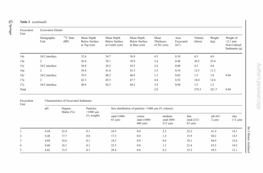
Table 2 (continued)
Excavation
Unit
Excavation Details
Stratigraphic
Unit
14C Date
(BP)
Mean Depth
Below Surface
at Top (cm)
Mean Depth
Below Surface
at Centre (cm)
Mean Depth
Below Surface
at Base (cm)
Mean
Thickness
of XU (cm)
Area
Excavated
(m2)
Volume
(litres)
Weight
(kg)
Weight of
>2.1 mm
Non-Cultural
Sediments (g)
14c 1b/2 interface 32.4 34.7 36.9 4.5 0.10 4.5 4.0
15a 2 36.4 38.1 39.8 3.4 0.48 30.5 25.4
15c 1b/2 interface 36.9 38.2 39.5 2.6 0.08 4.5 4.0
16a 2 39.8 41.6 43.3 3.5 0.54 12.5 11.3
16c 1b/2 interface 39.5 40.2 40.8 1.3 0.02 1.5 1.0 0.04
17a 2 43.3 45.5 47.7 4.4 0.52 14.0 12.6
17c 1b/2 interface 40.8 42.5 44.2 3.4 0.04 1.5 1.5
Total 2.8 374.3 321.7 0.04
Excavation
Unit
Characteristics of Excavated Sediments
pH Organic
Matter (%)
Particles
>1000 μm
(% weight)
Size distribution of particles <1000 μm (% volume)
sand (1000-
63 μm)
coarse
sand (1000-
600 μm)
medium
sand (600-
212 μm)
fine
sand (212-
63 μm)
silt (63-
2 μm)
clay
(<2 μm)
1 4.44 22.4 0.1 24.5 0.0 2.3 22.2 61.4 14.1
2 4.48 17.7 0.0 17.3 0.0 1.4 15.9 68.2 14.5
3 4.64 16.6 0.1 18.5 0.0 0.4 18.1 68.9 12.6
4 4.60 16.1 0.1 22.5 0.0 1.1 21.4 63.3 14.2
5 4.62 15.5 0.1 29.4 0.0 6.2 23.2 58.5 12.1
IntJHisto
rArch
aeol
Author's personal copy
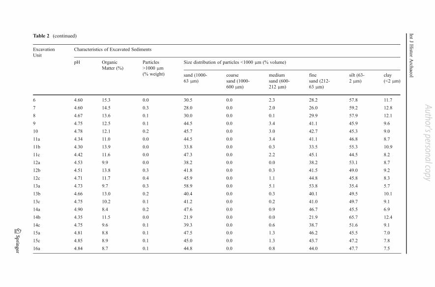
Table 2 (continued)
Excavation
Unit
Characteristics of Excavated Sediments
pH Organic
Matter (%)
Particles
>1000 μm
(% weight)
Size distribution of particles <1000 μm (% volume)
sand (1000-
63 μm)
coarse
sand (1000-
600 μm)
medium
sand (600-
212 μm)
fine
sand (212-
63 μm)
silt (63-
2 μm)
clay
(<2 μm)
6 4.60 15.3 0.0 30.5 0.0 2.3 28.2 57.8 11.7
7 4.60 14.5 0.3 28.0 0.0 2.0 26.0 59.2 12.8
8 4.67 13.6 0.1 30.0 0.0 0.1 29.9 57.9 12.1
9 4.75 12.5 0.1 44.5 0.0 3.4 41.1 45.9 9.6
10 4.78 12.1 0.2 45.7 0.0 3.0 42.7 45.3 9.0
11a 4.34 11.0 0.0 44.5 0.0 3.4 41.1 46.8 8.7
11b 4.30 13.9 0.0 33.8 0.0 0.3 33.5 55.3 10.9
11c 4.42 11.6 0.0 47.3 0.0 2.2 45.1 44.5 8.2
12a 4.53 9.9 0.0 38.2 0.0 0.0 38.2 53.1 8.7
12b 4.51 13.8 0.3 41.8 0.0 0.3 41.5 49.0 9.2
12c 4.71 11.7 0.4 45.9 0.0 1.1 44.8 45.8 8.3
13a 4.73 9.7 0.3 58.9 0.0 5.1 53.8 35.4 5.7
13b 4.66 13.0 0.2 40.4 0.0 0.3 40.1 49.5 10.1
13c 4.75 10.2 0.1 41.2 0.0 0.2 41.0 49.7 9.1
14a 4.90 8.4 0.2 47.6 0.0 0.9 46.7 45.5 6.9
14b 4.35 11.5 0.0 21.9 0.0 0.0 21.9 65.7 12.4
14c 4.75 9.6 0.1 39.3 0.0 0.6 38.7 51.6 9.1
15a 4.81 8.8 0.1 47.5 0.0 1.3 46.2 45.5 7.0
15c 4.85 8.9 0.1 45.0 0.0 1.3 43.7 47.2 7.8
16a 4.84 8.7 0.1 44.8 0.0 0.8 44.0 47.7 7.5
IntJHisto
rArch
aeol
Author's personal copy
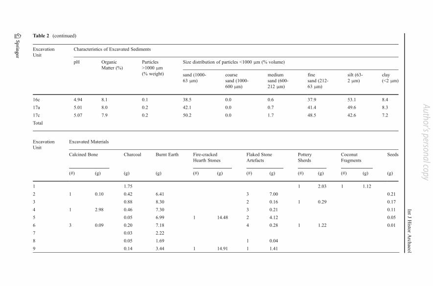
Table 2 (continued)
Excavation
Unit
Characteristics of Excavated Sediments
pH Organic
Matter (%)
Particles
>1000 μm
(% weight)
Size distribution of particles <1000 μm (% volume)
sand (1000-
63 μm)
coarse
sand (1000-
600 μm)
medium
sand (600-
212 μm)
fine
sand (212-
63 μm)
silt (63-
2 μm)
clay
(<2 μm)
16c 4.94 8.1 0.1 38.5 0.0 0.6 37.9 53.1 8.4
17a 5.01 8.0 0.2 42.1 0.0 0.7 41.4 49.6 8.3
17c 5.07 7.9 0.2 50.2 0.0 1.7 48.5 42.6 7.2
Total
Excavation
Unit
Excavated Materials
Calcined Bone Charcoal Burnt Earth Fire-cracked
Hearth Stones
Flaked Stone
Artefacts
Pottery
Sherds
Coconut
Fragments
Seeds
(#) (g) (g) (g) (#) (g) (#) (g) (#) (g) (#) (g) (g)
1 1.75 1 2.03 1 1.12
2 1 0.10 0.42 6.41 3 7.00 0.21
3 0.88 8.30 2 0.16 1 0.29 0.17
4 1 2.98 0.46 7.30 3 0.21 0.11
5 0.05 6.99 1 14.48 2 4.12 0.05
6 3 0.09 0.20 7.18 4 0.28 1 1.22 0.01
7 0.03 2.22
8 0.05 1.69 1 0.04
9 0.14 3.44 1 14.91 1 1.41
IntJHisto
rArch
aeol
Author's personal copy
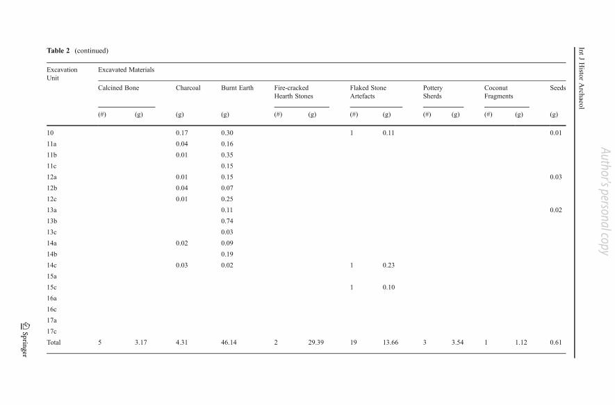
Table 2 (continued)
Excavation
Unit
Excavated Materials
Calcined Bone Charcoal Burnt Earth Fire-cracked
Hearth Stones
Flaked Stone
Artefacts
Pottery
Sherds
Coconut
Fragments
Seeds
(#) (g) (g) (g) (#) (g) (#) (g) (#) (g) (#) (g) (g)
10 0.17 0.30 1 0.11 0.01
11a 0.04 0.16
11b 0.01 0.35
11c 0.15
12a 0.01 0.15 0.03
12b 0.04 0.07
12c 0.01 0.25
13a 0.11 0.02
13b 0.74
13c 0.03
14a 0.02 0.09
14b 0.19
14c 0.03 0.02 1 0.23
15a
15c 1 0.10
16a
16c
17a
17c
Total 5 3.17 4.31 46.14 2 29.39 19 13.66 3 3.54 1 1.12 0.61
IntJHisto
rArch
aeol
Author's personal copy
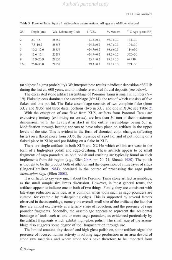
(at highest 2 sigma probability). We interpret these results to indicate deposition of SU1b
during the last ca. 600 years, and to include re-worked fluvial deposits (see below).
The excavated stone artifact assemblage of Poromoi Tamu is small in number (N0
19). Flaked pieces dominate the assemblage (N014), the rest of which consists of five
flakes and one pot lid. The flake assemblage consists of two complete flake (from
XU2 and XU5) and three distal portions (two in XU3 and one in XU6; see Table 2).
With the exception of one flake from XU5, artifacts from Poromoi Tamu are
exclusively tertiary (exhibiting no cortex), are less than 30 mm in their maximum
dimension, with the heaviest artifact in the entire assemblage being 5.1 g.
Modification through heating appears to have taken place on artifacts in the upper
levels of the site. This is evident in the form of chemical color changes (affecting
luster) on a flaked piece from XU5; the presence of a pot lid, and of pot lidding on a
flaked piece in XU4; and pot lidding on a flake in XU3.
There are single artifacts in both XU6 and XU14c which exhibit use-wear in the
form of a high-gloss polish and edge-crushing. These artifacts appear to be small
fragments of sago pounders, as both polish and crushing are typically found on such
implements from this region (e.g., Ellen 2008, pp. 70–71; Rhoads 1980). The polish
is thought to be the product both of attrition and the deposition of a fine layer of silica
(Unger-Hamilton 1984), obtained in the course of processing the sago palm
Metroxylon sagu (Ellen 2008).
It is difficult to say very much about the Poromoi Tamu stone artifact assemblage,
as the small sample size limits discussion. However, in most general terms, the
artifacts appear to indicate one or both of two things. Firstly, they are consistent with
late-stage reduction activities, as is common when tools such as sago pounders are
curated, for example by resharpening edges. This is supported by several factors
observed in the assemblage, namely the overall small size of the artifacts; the fact that
they are almost exclusively at a tertiary stage of reduction; and the presence of sago
pounder fragments. Secondly, the assemblage appears to represent the accidental
breakage of tools such as one or more sago pounders, as evidenced particularly by
the artifact fragments which exhibit high-gloss polish. The small size of the assem-
blage also suggests some degree of tool fragmentation through use.
The limited amount, tiny size of, and high-gloss polish on, stone artifacts signal the
presence of focused human activity involving sago production in an area devoid of
stone raw materials and where stone tools have therefore to be imported from
Table 3 Poromoi Tamu Square 1, radiocarbon determinations. All ages are AMS, on charcoal
XU Depth (cm) Wk- Laboratory Code δ13C‰ % Modern 14C Age (years BP)
2 2.0–4.5 28652 −23.3±0.2 98.3±0.3 134±30
4 7.3–10.2 28653 −24.2±0.2 98.7±0.3 104±30
5 10.2–12.6 28654 −24.7±0.2 98.6±0.3 114±30
6 12.6–15.1 25289 −24.9±0.2 93.2±0.2 562±30
9 17.9–20.9 28655 −23.5±0.2 99.1±0.3 69±30
12a 26.8–30.0 28657 −29.3±0.2 97.1±0.3 239±30
Int J Histor Archaeol
Author's personal copy
elsewhere. This is precisely the situation throughout Rumu lands, where during
ethnographic times clanspeople imported chert sago pounders and other tools from
highlands foothills peoples further afield, in particular from the Baina area in the
upper Kikori River catchment some 70 km to the northwest. The finding of stone-
using activities at Poromoi Tamu, in a part of the landscape devoid of surface
archaeological evidence, is consistent with the Himaiyu oral traditions of a village
location and sago production nearby.
Geomorphology
The geomorphology of Poromoi Tamu, as based on the Square 1 sediments, can be
interpreted in three different ways. The first interprets the dip in the SU1b-SU2
stratigraphic change as a solution pit (rather than the edge of a channel) in riverine
sediments caused by the organic-rich acidic sediments of SU1b. This interpretation
presupposes relatively free drainage into the nearby riverbank and subjacent karst
conditions. In this interpretation, the stratigraphic change between SU1b and SU2 is
not so much an erosional unconformity as the edge of the solution pit. However, while
this interpretation accounts for the shape of the pit, the level of acidity of sediments, the
proximity of the feature to Utiti Creek and the general karst environment, it does not
account for the lack of any form of surface depression or the absence of stratigraphic
evidence of basal drainage such as sediment staining below the depression.
The second interpretation posits the depression as a pit created when a tree was
uprooted and subsequently infilled by overbank sediments, in which case the SU1b-SU2
stratigraphic change would represent an unconformity along the pit margin. However,
like the first option, this interpretation does not fit well with the facts. Firstly, the stone
artifacts are stratigraphically concentrated in XU2 to XU10 rather than spread through-
out the fill sequence as would be expected of a reworked deposit. Secondly, sediments
infilling the depression consist of dark, organic-rich loams. We would expect a rede-
posited root hollow infill to contain significant quantities of light-colored clods from the
underlying SU2 intermixed within the SU1b dark sediment matrix.
We thus prefer a third interpretation that identifies the dipping feature as a
disconformity. The Square 1 stratigraphic profile reveals three separate geomorpho-
logical phases (Fig. 7), signalling temporal changes in hydrological regimes along the
Kikori River and its tributaries. The identification of these three phases is here based
on the sediment profiles revealed during the excavation of Square 1; the physical and
chemical properties of the excavated sediments including particle size analysis; and
micro-morphological analyses of the excavated sand grains. These results are con-
sidered in their regional contexts within the Kikori River basin, taking into consid-
eration that Poromoi Tamu directly fronts the discharge of Are Creek into Utiti Creek.
The site is located along the lower reaches of Utiti Creek, itself a tributary of the
Kikori River, where the landscape slopes gently down by an average of 1.1 m per km
all the way to the Kikori River delta some 35 km downstream, giving it a mean
gradient of 0.03 %.
Stage 1. The first geomorphological phase corresponds with the deposition of
XU17a to XU11a. These XUs represent silty-sand alluvial sediments. The relatively
high proportion of sand particles (45 %) in this downstream section of the watershed
Int J Histor Archaeol
Author's personal copy
indicates alluvial sediment deposits associated with high flow velocity. The physical
and chemical composition of sediments (weak pH with low concentrations of organic
matter) suggests that alluvial sediments originated largely from the erosion of devel-
oped soils from higher elevations (Bleeker 1983). The presence of orange to red
coloured, weathered insolubles, evident in the micro-morphological analysis of fine
sands and coarse silts, can here be related to altered ancient soils eroded into and
placed in suspension by river flows. In effect, the geomorphic environment of the site,
consisting of limestone karst outcrops, does not account well for the production of
such quantities of insolubles. These particles originated from sandstone strata and
from flints contained within a calcareous matrix that have undergone intense alter-
ation and karstification. This material essentially comes from the pinnacle karst-rich
catchment drained by Are Creek and Utiti Creek.
Stage 2. The second geomorphic phase identified in the excavation corresponds
with a period of incision into the pre-existing sediments (cf. the infilled channel in the
stratigraphic profile; see Figs. 6 and 7). This erosional phase was likely caused by
increased water-flow strengths, such as occurs during heightened periods of rainfall,
despite the low gradient of the river. During this phase, fluvial sediments from
upstream, together with those from the Are and Utiti Creek catchments, were flushed
downstream as a result of faster water-flows due to higher rainfall levels.
Stage 3. The third phase indicates a new period of alluvial sedimentation (XU16b
to XU11b and XU10 to XU1, corresponding with SU1b). Alluvial sediments grad-
ually fill the channel incised during Stage 2, prograding the ancient alluvial terrace
(XU17a to XU11a) in the process. The results of the particle size analysis together
with the physical and chemical properties of the sediments from this new phase of
alluvial sediment deposition highlight a change in hydrological and geomorpholog-
ical conditions. The fine, silty-clay sediments of this phase at Poromoi Tamu indicate
that the coarser, sand particles have been deposited further upstream as a result of
weaker water-flows. The predominance of such silty-clay particle sizes at Poromoi
Tamu suggest that sedimentation here took place under still-water conditions as is
typical of floodwaters breaching (rather than cutting through) the protective banks of
Utiti Creek. The elevated amounts of organic matter in the soil, clearly more abundant
than during Stage 1 and consistent with higher sediment acidity levels, suggest an
intensification of rates of soil erosion in upstream sections of the Kikori River
catchment. The presence of insolubables and of organic matter transported by water-
flow from upstream sections of the Kikori River is noteworthy. The origin of these
components from the highlands or highlands foothills suggest a different waterflow
velocity and with this hydrographic structure to that found during Stage 1. Taking
into account the present regional topography, we suggest that during Stage 3 the
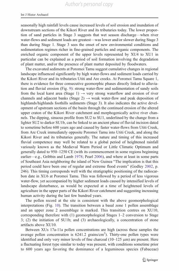
Kikori River has been overflowing into (and infilling with carried sediments) the
Poromoi Tamu district via the large Ipinai swamp located some 2 km to the north of
the site (Fig. 8). In effect, Ipinai swamp itself became a swamp as a result of the
partial infilling of the previously less infilled Kikori River floodplains with highlands
and highland foothills sediments.
It is difficult to determine with the available evidence whether the increased rate of
highland erosion during Stage 3 was caused by (1) changes in human use of the
environment, as would be typical of an increased incidence of agriculture for exam-
ple; or (2) changes in seasonality or increased annual rainfall. We know that
Int J Histor Archaeol
Author's personal copy
seasonally high rainfall levels cause increased levels of soil erosion and inundation of
downstream sections of the Kikori River and its tributaries today. The lower propor-
tion of sand particles in Stage 3 suggests that wet season discharge—when river
water-flows and sediment loads are greatest—was lower and/or slower during Stage 3
than during Stage 1. Stage 3 sees the onset of new environmental conditions and
sedimentation regimes richer in fine-grained particles and organic components. The
enriched organic component of the upper levels represented by XU4 to XU1 in
particular can be explained as a period of soil formation involving the degradation
of plant matter, and/or the presence of plant matter deposited by floodwaters.
The excavated sediments at Poromoi Tamu suggest cumulative changes in regional
landscape influenced significantly by high water-flows and sediment loads carried by
the Kikori River and its tributaries Utiti and Are creeks. At Poromoi Tamu Square 1,
there is evidence for three consecutive geomorphic phases directly linked to alluvia-
tion and fluvial erosion (Fig. 9): strong water-flow and sedimentation of sandy soils
from the local karst area (Stage 1) → very strong waterflow and erosion of river
channels and adjacent banks (Stage 2) → weak water-flow and peak deposition of
highlands/highlands foothills sediments (Stage 3). It also indicates the active devel-
opment of upstream sections of the basin through the continued erosion of the altered
upper craton of the Kikori River catchment and morphogenically active river chan-
nels. The dipping, sinuous profile from SU2 to SU1, underlined by the change from a
lighter SU2 to darker SU1b, can be linked to an ancient phase of fluvial incision dated
to sometime before 600 years ago and caused by faster water-flows from Utiti Creek,
from Are Creek immediately opposite Poromoi Tamu into Utiti Creek, and along the
Kikori River and its tributaries generally. The nature and timing of this increased
fluvial competence may well be related to a global period of heightened rainfall
variously known as the Medieval Warm Period or Little Climatic Optimum and
generally dated to 950–1250 CE (with its commencement in some regions beginning
earlier—e.g., Gribbin and Lamb 1978; Pearl 2006), and where at least in some parts
of Southeast Asia neighboring the island of New Guinea “The implication is that this
period could have been one of regular and extreme flood events” (Godley 2002, p.
246). This timing corresponds well with the stratigraphic positioning of the radiocar-
bon date in XU6 at Poromoi Tamu. This was followed by a period of less vigorous
water-flow, yet accompanied by higher sediment loads caused by intensified levels of
landscape disturbance, as would be expected at a time of heightened levels of
agriculture in the upper parts of the Kikori River catchment and suggesting increasing
human activity during the last few hundred years.
The pollen record at the site is consistent with the above geomorphological
interpretations (Fig. 10). The transition between a basal zone 1 pollen assemblage
and an upper zone 2 assemblage is marked. This transition centres on XU10,
corresponding therefore with (1) geomorphological Stages 1–2 conversion to Stage
3; (2) the initiation of SU1b; and (3) archaeologically, a concentration of stone
artifacts above XU10.
Between XUs 17a-11a pollen concentrations are high (across these samples the
average pollen concentration is 6241.2 grains/cm2). Thirty-one pollen types were
identified and only very minor levels of fine charcoal (10–125 μm) are present. Here
a fluctuating forest type similar to today was present, with conditions sometime prior
to 600 years ago favoring the dominance of a leguminous species (Fabaceae)
Int J Histor Archaeol
Author's personal copy
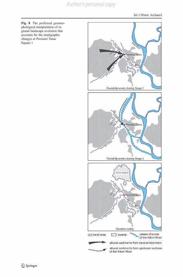
Fig. 8 The preferred geomor-
phological interpretation of re-
gional landscape evolution that
accounts for the stratigraphic
changes at Poromoi Tamu
Square 1
Int J Histor Archaeol
Author's personal copy
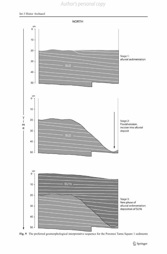
Fig. 9 The preferred geomorphological interpretative sequence for the Poromoi Tamu Square 1 sediments
Int J Histor Archaeol
Author's personal copy
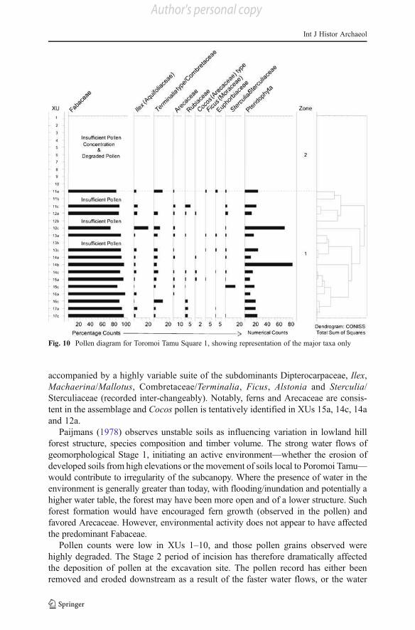
accompanied by a highly variable suite of the subdominants Dipterocarpaceae, Ilex,
Machaerina/Mallotus, Combretaceae/Terminalia, Ficus, Alstonia and Sterculia/
Sterculiaceae (recorded inter-changeably). Notably, ferns and Arecaceae are consis-
tent in the assemblage and Cocos pollen is tentatively identified in XUs 15a, 14c, 14a
and 12a.
Paijmans (1978) observes unstable soils as influencing variation in lowland hill
forest structure, species composition and timber volume. The strong water flows of
geomorphological Stage 1, initiating an active environment—whether the erosion of
developed soils from high elevations or the movement of soils local to Poromoi Tamu—
would contribute to irregularity of the subcanopy. Where the presence of water in the
environment is generally greater than today, with flooding/inundation and potentially a
higher water table, the forest may have been more open and of a lower structure. Such
forest formation would have encouraged fern growth (observed in the pollen) and
favored Arecaceae. However, environmental activity does not appear to have affected
the predominant Fabaceae.
Pollen counts were low in XUs 1–10, and those pollen grains observed were
highly degraded. The Stage 2 period of incision has therefore dramatically affected
the deposition of pollen at the excavation site. The pollen record has either been
removed and eroded downstream as a result of the faster water flows, or the water
Fig. 10 Pollen diagram for Toromoi Tamu Square 1, showing representation of the major taxa only
Int J Histor Archaeol
Author's personal copy
activity has carried with it such insolubles and/or coarse particles as to degrade or
disintegrate the pollen altogether.
The pollen record does not improve in upper zone 1, where sediments correspond
to geomorphology stage 3 and date to 600 years in age or more recent. Despite stage 3
being a period of gradual alluvial infill under comparatively still-water conditions,
pollen preservation has not occurred. The organic richness of the upper level sedi-
ments involving the presence of plant material (in a state of decomposition or
otherwise) has created a dynamic, oxidative, biologically active environment in
which the pollen has not survived or has become unrecognizable. Upstream erosion
is maintained, contributing to the dynamic soil status as well as the turn-over of such
soil (and in greater volume).
Discussion
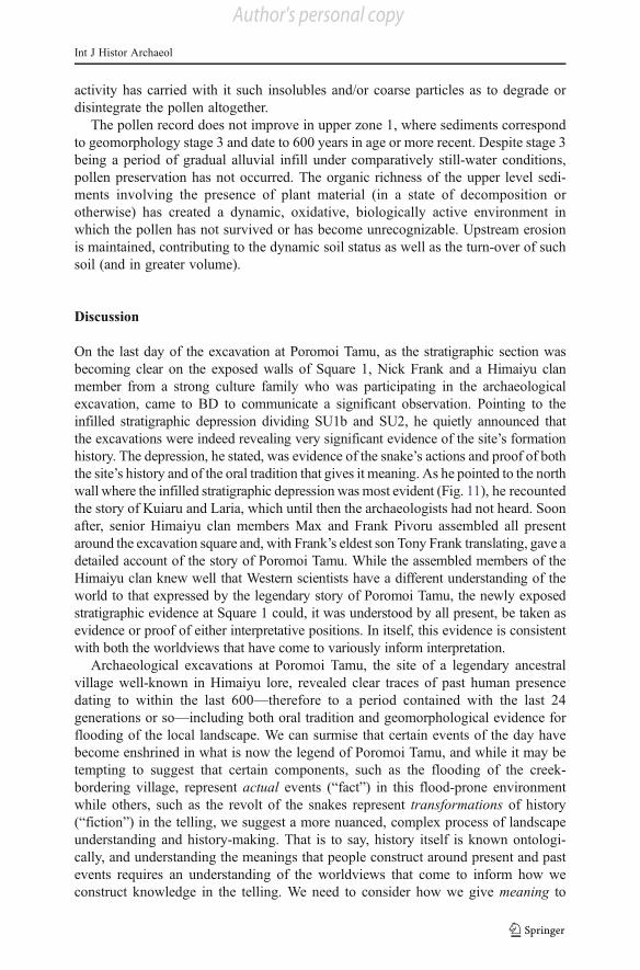
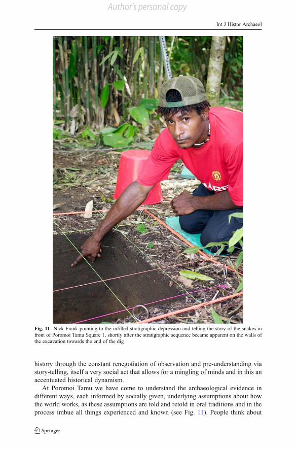
On the last day of the excavation at Poromoi Tamu, as the stratigraphic section was
becoming clear on the exposed walls of Square 1, Nick Frank and a Himaiyu clan
member from a strong culture family who was participating in the archaeological
excavation, came to BD to communicate a significant observation. Pointing to the
infilled stratigraphic depression dividing SU1b and SU2, he quietly announced that
the excavations were indeed revealing very significant evidence of the site’s formation
history. The depression, he stated, was evidence of the snake’s actions and proof of both
the site’s history and of the oral tradition that gives it meaning. As he pointed to the north
wall where the infilled stratigraphic depression was most evident (Fig. 11), he recounted
the story of Kuiaru and Laria, which until then the archaeologists had not heard. Soon
after, senior Himaiyu clan members Max and Frank Pivoru assembled all present
around the excavation square and, with Frank’s eldest son Tony Frank translating, gave a
detailed account of the story of Poromoi Tamu. While the assembled members of the
Himaiyu clan knew well that Western scientists have a different understanding of the
world to that expressed by the legendary story of Poromoi Tamu, the newly exposed
stratigraphic evidence at Square 1 could, it was understood by all present, be taken as
evidence or proof of either interpretative positions. In itself, this evidence is consistent
with both the worldviews that have come to variously inform interpretation.
Archaeological excavations at Poromoi Tamu, the site of a legendary ancestral
village well-known in Himaiyu lore, revealed clear traces of past human presence
dating to within the last 600—therefore to a period contained with the last 24
generations or so—including both oral tradition and geomorphological evidence for
flooding of the local landscape. We can surmise that certain events of the day have
become enshrined in what is now the legend of Poromoi Tamu, and while it may be
tempting to suggest that certain components, such as the flooding of the creek-
bordering village, represent actual events (“fact”) in this flood-prone environment
while others, such as the revolt of the snakes represent transformations of history
(“fiction”) in the telling, we suggest a more nuanced, complex process of landscape
understanding and history-making. That is to say, history itself is known ontologi-
cally, and understanding the meanings that people construct around present and past
events requires an understanding of the worldviews that come to inform how we
construct knowledge in the telling. We need to consider how we give meaning to
Int J Histor Archaeol
Author's personal copy
history through the constant renegotiation of observation and pre-understanding via
story-telling, itself a very social act that allows for a mingling of minds and in this an
accentuated historical dynamism.
At Poromoi Tamu we have come to understand the archaeological evidence in
different ways, each informed by socially given, underlying assumptions about how
the world works, as these assumptions are told and retold in oral traditions and in the
process imbue all things experienced and known (see Fig. 11). People think about
Fig. 11 Nick Frank pointing to the infilled stratigraphic depression and telling the story of the snakes in
front of Poromoi Tamu Square 1, shortly after the stratigraphic sequence became apparent on the walls of
the excavation towards the end of the dig
Int J Histor Archaeol
Author's personal copy
their world according to a particular set of culturally specific impressions (Degh
1994, p. 243). Those impressions are not merely random views but rather systemat-
ically derived conclusions based on generations of observation, problem solving and
interpretation. This process of giving meaning to things through prior social meaning
unendingly renegotiated through observation, experience and reinterpretation applies
equally to the Rumu as to Western scientists (each of whom has used detailed
evidence and cultural knowledge to construct understandings of Poromoi Tamu, for
example). Both Rumu and Western knowledge involve observations interpreted inter-
textually: how we come to understand the stratigraphy of Poromoi Tamu Square 1 has
as much to do with what we know about other worldly things as it does with what we
know about snakes, holes in the ground, archaeology or geomorphology.
Understanding such specific occurrences as the infilled stratigraphic depression at
Poromoi Tamu Square 1 is intimately based on how we generally understand
environmental forces to operate, including what we in the West have come to
differentiate between knowable and thus legitimate explanatory physical processes,
and unknowable and therefore unconjurable spiritual forces. In Rumu understanding,
however, all things are deeply connected and human experience itself incorporates
spirit forces as part of world processes. Spirit essences are actively embedded in the
landscape as a spiritually charged “natural” world that includes snakes that talk and
animals that can, under the right conditions and on a routine daily basis, communicate
with people (see David et al. 2008 for a discussion of Rumu spirit beliefs and
practices). Rumu landscapes, and Rumu landscape-forming processes, are rich in
what we would call intangible, even unknowable spiritual dimensions that give
logical, culturally meaningful shape to interpretations of particular observances such
as the Poromoi Tamu Square 1 stratigraphic depression. In Western understanding,
however, those forces at work in the landscape are more compartmentalized, so that
the physical environment can essentially only be understood in relation to measurable
physical forces long-defined by the earth sciences. Ours is a purely materially charged
landscape and landscape process. But these are differences in ontological starting
points, not in epistemological processes. In effect, both Rumu and Western interpre-
tations of the Poromoi Tamu Square 1 sediment sequence are scientific in approach,
rather than operating from distinctly different epistemological approaches. That is, on
both counts observations are related to pre-expectations based on contemporary (and
in this equally “modern,” although not equally “modernist”) understandings of the
world, partly allowing pre-understandings to change according to the degree of non-
fit, and partly requiring the observer to search through the inter-textual sum of
knowledge to find a process-match by which to explain the new observation. The
finding of such a match amounts to support for the original pre-understanding,
thereby strengthening the explanatory power of the ontological framework, which
orients the new observation. What gives power to how the new observation is
understood, the pre-understanding which enables its interpretation, and its ontological
universe is the spatially far-reaching and psychologically deep social communicative
process of story-telling. Story-telling creates a rapport, a personal absorption, of
understanding in social communication. It is an act of giving meaning that mediates
observation as data-retrieval and worldview through epistemological processes that
bound how knowledge is to be generated. And in this, story-telling both communi-
cates and generates bounded rationality (cf. Gigerenzer and Selten 2002) as an
Int J Histor Archaeol
Author's personal copy
unending interplay of new evidence and pre-understanding: story-telling is a Möbius
strip that combines two faces, new observation and old knowledge, into a dynamic yet
unified process of working out and socially communicating understanding and mean-
ingfulness. These two stories—the archaeological and the oral tradition—are told in
similar ways: both reference the evidence systematically; both stories are told and
debated in social interaction. Here we have presented the evidence for the archaeological
story in greater detail than the oral tradition, simply because the Rumu clan leaders asked
us to investigate this site’s archaeological evidence. Today the archaeology forms part of
the evidence that local people amass in thinking about their past, their sites, and their
living landscapes, just as previously all available lines of evidence were used to think
about these same issues. These processes are no different to the scientific ones that
archaeologists use when addressing the past through disciplinary procedures; what is
different is access and reference to a broader range of ontological concerns by Rumu
clanspeople.
Conclusion
In one sense Poromoi Tamu is a lost place. There is no physical evidence of
the village. Himaiyu clanspeople know the place because they were told of its
presence by their parents and other relatives, who themselves only knew it
through the stories that their kin had told them and so on into the deeper past,
although the coconut trees on the river’s edge themselves demand explanation as
evidence of a past human presence. Thus, the village of Poromoi Tamu and its story is
only known as it is remembered in oral traditions. Here remembering is an act of
locating, not just on the ground, but in pre-understanding. We have shown how each
story-teller is well-versed and deeply implicated in their story’s underlying ontolog-
ical perspective. Furthermore, by negotiating one’s understanding of new things
through story-telling, the story-teller participates in ontological reproduction. Both
Rumu and archaeological interpretative traditions are scientifically based, in the sense
that both involve making grounded observations through which the truisms of one’s
own pre-understandings are assessed. In these sensual observations, specific under-
standings and, with this, general worldviews, are either corroborated and in time
reproduced, or modified through lack of fit. It is the stories we tell that give voice to
our worldviews and hereby set up the initial propositions upon which to guide
epistemological questions of corroboration and processes of ontological reproduc-
tion. Epistemologically, both Rumu and geomorphological-archaeological investiga-
tive logics only become meaningful to the degree by which they enable us to assess
and re-assess what we already know about the world. Story-telling connects episte-
mology and ontology in that by relating the degree of fit between particular obser-
vations and specific understandings, the stories we tell enable us to negotiate how we
come to understand a world that has already obtained ontological meaning in pre-
understanding. And in doing so, stories enable us to (re)negotiate how we understand
all things, ourselves included, to be in a meaningful world. Whether we wish to
understand the site’s sediments through Rumu or Western scientific eyes, the process
is the same: we make sense of things through the meaningful process of ontologically
informed story-telling in a constant process of social mediation.
Int J Histor Archaeol
Author's personal copy
Acknowledgments First and foremost, we extend our warm thanks to the Pivoru family and Himaiyu
clan of Kopi. It is with deep gratitude that we offer our thanks for the gracious welcome that we have
experienced, and invitation to undertake clan history research in Himaiyu country over the last five years.
Many thanks also to Toby Wood at Monash University for drafting Figures 6, 7 and 9; Bernard Sanderre
and Robert Skelly for their kind support; Cathy Alex and the staff at Community Development Initiative
(CDI) at Kikori for their support and wonderful assistance in the field; and Jacinta John, Kongel Pombreol
and the staff at CDI Port Moresby. BD also thanks Monash University for the wonderful support and
collegiate environment; Ian McNiven for comments on an early draft; and the Australian Research Council
for funding this project under Discovery grant and QEII Fellowship DP0877782.
References
Bleeker, P. (1983). Soils of Papua New Guinea, Australian National University Press, Canberra.
Casey, E. S. (1997). The Fate of Place: A Philosophical History, University of California Press, Berkeley.
David, B. (2002). Landscapes, Rock-art and the Dreaming: An Archaeology of Preunderstanding, Leices-
ter University Press, London.
David, B., Pivoru, M., Pivoru, W., Green, M., Barker, B., Weiner, J. F., Simala, D., Kokents, T., Araho, L.,
and Dop, J. (2008). Living landscapes of the dead: Archaeology of the afterworld among the Rumu of
Papua New Guinea. In Thomas, J., and David, B. (eds.), Handbook of Landscape Archaeology, Left
Coast Press, Walnut Creek, CA, pp. 158–166.
Degh, L. (1994). The approach to worldview in folk narrative study. Western Folklore (July): 243–252.
Edgeworth, M. (2006). Preface. In Edgeworth, M. (ed.), Ethnographies of Archaeological Practice:
Cultural Encounters, Material Transformations, AltaMira, Lanham, MD, pp. xi–xvi.
Ellen, R. (2008). Distribution and variation in sago extraction equipment: Convergent and secondary
technologies in island Southeast Asia. Archaeology in Oceania 43: 62–74.
Gadamer, H.-G. (1987). The problem of historical consciousness. In Rabinow, P., and Sullivan, W. M.
(eds.), Interpretive Social Science: A Second Look, University of California Press, Berkeley, pp. 82–
140.
Gigerenzer, G., and Selten, R. (2002). Bounded Rationality, MIT Press, Cambridge.
Godley, D. (2002). The reconstruction of flood regimes in SE Asia from El Niño-Southern Oscillation
(ENSO) related records. In Kershaw, P., David, B., Tapper, N., Penny, D., and Brown, J. (eds.),
Bridging Wallace’s Line: The Environmental and Cultural History and Dynamics of the SE Asian-
Australian Region, Catena Verlag, Reiskirchen, pp. 229–254.
Gribbin, J., and Lamb, H. H. (1978). Climate change in historical times. In Gribbin, J. (ed.), Climate
change, Cambridge University Press, Cambridge, pp. 68–82.
Langton, M. (2002). The edge of the sacred, the edge of death: Sensual inscriptions. In David, B., and
Wilson, M. (eds.), Inscribed Landscapes: Marking and Making Place, University of Hawai’i Press,
Honolulu, pp. 253–269.
Nakata, M. (2007). Disciplining the Savages, Savaging the Disciplines, Aboriginal Studies Press, Canberra.
Paijmans, K. (1978). Vegetation. In Paijmans, K. (ed.), New Guinea Vegetation, Australian National
University Press, Canberra, pp. 23–104.
Pearl, F. B. (2006). Late Holocene landscape evolution and land-use expansion in Tutuila, American
Samoa. Asian Perspectives 45(1): 48–68.
Rhoads, J. W. (1980). Through A Glass Darkly: Present and Past Land-Use Systems of Papuan Sagopalm
Users. Unpublished PhD dissertation, Australian National University, Canberra.
Strathern, M. (1988). The Gender of the Gift, University of California Press, Berkeley.
Strathern, M. (2004). Partial Connections, AltaMira, Walnut Creek, CA.
Stuiver, M., and Reimer, P. J. (1993). Radiocarbon 35: 215–230.
Unger-Hamilton, R. (1984). The formation of use-wear polish on flint: Beyond the “deposit versus
abrasion” controversy. Journal of Archaeological Science 11: 91–98.
Weiner, J. F. (2002). The work of inscription in Foi poetry. In David, B., and Wilson, M. (eds.), Inscribed
Landscapes: Marking and Making Place, University of Hawai’i Press, Honolulu, pp. 270–283.
Yarrow, T. (2006). Sites of knowledge: Different ways of knowing an archaeological excavation. In
Edgeworth, M. (ed.), Ethnographies of Archaeological Practice: Cultural Encounters, Material
Transformations, AltaMira, Lanham, MD, pp. 20–32.
Int J Histor Archaeol
Author's personal copy
Related Documents