1 PONDS IN KODAKARA PANCHAYATH THRISSUR DISTRICT, KERALA: PRE-PROJECT STUDY Inventory of Ponds in Kodakara GP Detailed studies on five selected ponds Project Proposal for restoration of five selected ponds APOLLO TYRE FOUNDATION & TROPICAL INSTITUTE OF ECOLOGICAL SCIENCES (TIES) Study Report

Welcome message from author
This document is posted to help you gain knowledge. Please leave a comment to let me know what you think about it! Share it to your friends and learn new things together.
Transcript

1
PONDS IN KODAKARA PANCHAYATH THRISSUR DISTRICT, KERALA:
PRE-PROJECT STUDY
Inventory of Ponds in Kodakara GP Detailed studies on five selected ponds
Project Proposal for restoration of five selected ponds
APOLLO TYRE FOUNDATION &
TROPICAL INSTITUTE OF ECOLOGICAL SCIENCES (TIES)
Study
Report

2
3
PONDS IN KODAKARA PANCHAYATH THRISSUR DISTRICT, KERALA:
PRE-PROJECT STUDY
Inventory of Ponds in Kodakara GP Detailed study on five selected ponds
Project Proposal for restoration of five selected ponds
Study conducted by:
TROPICAL INSTITUTE OF ECOLOGICAL SCIENCES (TIES) Ecological Research Campus, Velloor P.O., Pampady, Kottayam, Kerala. Pin. 686 501.
www.ties.org.in; [email protected]
Supported by:
APOLLO TYRE FOUNDATION
4
Research Team
Dr. Punnen Kurian
Aswani VR
Ansa Thomas
Support Team
Darma K. Sebastian
Sini Joshy
Roshni Susan Elias
Tina Anna Thomas
Cover Photo:
Clockwise: Kothakulam, Puliparakulam,
Kurichikulam, Mothakulam & Marthampally pond
TROPICAL INSTITUTE OF ECOLOGICAL SCIENCES (TIES)
Ecological Research Campus, K.K.Road, Velloor P.O.,
Kottayam, 686 501. Kerala, India.
Tel- +91 481 2503988; 09497290339.
Email: [email protected]
www.ties.org.in
5
Preface
India is facing acute water shortage due to a variety reasons including climate
change, drought, ground water depletion and over exploitation and pollution resulted
due to the rising population. At this point, conserving water bodies is most important
owing to increase in water demand. Rivers, lakes, ponds, streams and wells are the
cpventional sources of surface water. Among them, pond-ecosystem is distinct as they
support wide varieties of flora and fauna including rare and even threatened species
and also meet rising demand of water for local community. They are playing
important role in supporting and maintaining ground water table. However, many of
the small water bodies in our surrounding have already disappeared leading to water
shortage and biodiversity loss in the region. Ponds are becoming dumping points for
wastes and filling with soil is very common. Therefore, it is utmost important to
protect ponds to safeguard our environment as well as human wellbeing.
Apollo Tyre Plant is located at Perambra, Thrissur and coming under Kodakar GP. It
was typically a village but with the construction of National Highway an urbanization
trend evolved. As a result agriculture has been decreased and shift in life culture led
to the abandonment of paddy field and ponds. As the major industry in the area,
Apollo Tyre Ltd. has keen interest in the well being of the local community as well as
the environment. Apollo Tyre Foundation (ATF), fully understands the significance of
water and biodiversity conservation in their operating area too. In this context, ATF
approached Tropical Institute of Ecological Sciences (TIES), Kottayam, a leading eco-
research organization and technical partner for ATF in many environment based
projects, to perform a pre-study on five ponds from Kodakara Panchayat and to
propose specific pond management activities that will ensure sustainable
conservation of them, as an initial step. As upon the request, a three month research
study has been conducted, and this report contains detailed information on history,
geography, biodiversity and environmental issues of five ponds in Kodakara
Panchayath. The present report includes the findings of the study along wth valid
recommendations and also specific proposals for the conservation five selected
ponds.

6

7
Acknowledgement
This short term study would not have been possible without the kind support and help of
many individuals and organizations. We would like to express our deepest gratitude to
Corporate Social Responsibility (CSR) team of Apollo Tyres Limited, for entrusting Tropical
Institute of Ecological Sciences (TIES) with the responsibility of conducting the Pre-Project
study of five ponds in Kodakara Panchayath. Special gratitude goes to CSR Group Manager, Mr.
Viswabandhu Bhattacharya; CSR Specialist, Mrs. Smitha R., and Unit Head, Mr. George Ommen
for regular support and constant involvement in the programme.
Additionally, we convey our sincere gratitude to Kodakara Grama Panchayath officials
especially Panchayat President, Mr. T.R. Prasad (Ward Member of Ward 15 as well);
Panchayath Secretary, Mr. NK Suresh; the driver, Mr. Soman; MNREGS Assistant Engineer, Mrs.
Jalaja VM; and the Panchayath Members of other four ponds, Mrs. Vilasiny (Ward 13), Mrs.
Narayani Ward 17), Mrs. Shiny (Ward 16), and Mrs. Ancy (Ward 6), and also Block Panchayath
President, Mrs. Ambily Soman. It would not have possible to select the five ponds without the
help of all Panchayath Members of Kodakara Panchayath. All 19 Ward Members helped us to
find 54 ponds of Kodakara Grama Panchayath and make inventory of all these ponds.
Further, we greatly appreciate the cooperation shown by Kodakara Village Officer, Mr. Antony
and other officials. They have given all support to provide the survey sketches of five ponds.
We are also thankful to Ayyanthol Survey Superintend Office officials who provided survey
sketches and Town planning Office, Thrissur for all the support provided for the study.
The Project team gratefully acknowledges the generous support of the villagers in Kodakara
Panchayath. They were very cooperative throughout the study and shared the most important
details about the pond with us in spite of their busy schedules. PRA meetings were also very
successful since the stake holders shared their information about the ponds and valuable time.
And most importantly, we are highly indebted to TIES team for their guidance and constant
supervision as well as for providing technical and office support through out the tenure of the
project.

8
9
CHAPTER I
GENERAL INTRODUCTION
1. BACKGROUND
Ponds are the most important surface water resources which greatly support biodiversity,
serve as sites of rainwater harvesting, ground water recharging, and support livelihood of
many communities directly as drinking water or indirectly as in irrigation.
The benefit of pond is not just the beauty it brings but also water conservation, irrigation,
habitation of different varieties of creatures etc. Ponds are very much helpful in maintaining
the ecological equilibrium of an area. Collectively, they support more species, and more scarce
species, than any other freshwater habitat.
Ponds were a part of our culture. They conserve and preserve a history of the region. Through
the conservation of ponds, the habitats and biodiversity will be protected, thereby a large
varieties of biological treasures. Moreover, it is helpful to make awareness among people
about the importance in the protection of our environment. The project aims at igniting
people’s interest in the better future of our planet and conserve ponds. Renovating the ponds
help the people continue their interest in the environment and sustainable practices.
1.1. Why should the ponds be conserved?
Conservation of ponds is by now an acknowledged solution to the water scarcity and ground
water depletion. In the past, ponds were a part of everyone’s daily lives because uses of ponds
are many. It conserves water, supports agriculture and other water needs, provides a viable
condition for local wildlife such as birds, butterflies, dragonflies, damselflies, frogs, crabs etc..
Ponds are ideal habitat for lots of organisms. Ponds also support their breeding.
Water scarcity has emerged as one of the most prominent issues faced in the world. Though
Kerala is known for its water bodies, there are many people struggling to meet their water
needs and left agriculture due to water scarcity. On one hand, a large number of people are
thriving for water; on the other hand a large number of water resources are ruined. Conserving
the ponds can defenitely help us with the rise in water demand.
Ponds are also able to provide sustainable solution to pollution and water management issues.
Ponds are identified as good sources for denitrification, sedimentation, removal of
phosphorous, nitrogen and sediments from surface water. Besides, ponds support the ground
water table too, which may benefit the community and nature especially during summer
seasons. It is found that a pond of 500 m2 is able to sequester 1000 kg of carbon which is equal
to the amount of carbon produced by a car at the same time (Cereghino et al. 2). Pollution is a
major threat to most of the ponds, especially while they are in an abandoned condition. Many
of the ponds are left uncleaned mainly due to management issues.

10
Studies conducted by Non-Governmental Organizations shows that nearly 40% of village
ponds in India have been filled up for residential or office purposes in last 100 years (Dubey
148). Though ponds are small in size, but large in numbers are the main source of water
harvesting. Their unique biodiversity and specific ecosystem functions make them most
important.
Many efforts have been taken by the government as well as the local community to renovate
many of the ponds to meet the community needs. However, many of them did not meet the
expectations and within short time, these ponds went back to the previous situation.
Kodakara Panchyath in Thrissur district is a typical semi urban locality, where still a number of
ponds are existing, though almost all are in a dilapidated condition. Apollo Tyre Foundation
entrusted Tropical Institute of Ecological Sciences (TIES) a study on Ponds of Kodakara
Panchayath, in this background.
1.2 Objectives
This pre-project study aims at preparation of an inventory on public ponds in Kodakara Grama
Panchayath and conduct detailed study on selected five ponds regarding its geographical
details, history, cultural heritage, biodiversity and major environmental threats to propose a
sustainable conservation of the ponds. The study objectives are specified as follows:
• To prepare an inventory of public ponds in Kodakara Grama Panchayath
• To conduct a land survey of the selected five ponds and its surrounding area (only
public land) and to generate geographical data of the pond
• To assess the quantity of clay and silt in the pond
• To study the quantity and quality of water in the pond and also of the fauna and flora
(summer season alone- rainy season data will be collected from local residents through
historical survey)
• To conduct a community survey to explore various stakeholders of the pond
• To study the history, past and present usage pattern of the pond
• To study the nature of pollution of the pond and its sources
• To propose a detailed project for the retrieval and maintenance of the selected ponds
with a sustainable management and governance plan
1.3. Location and extent
Kodakara Grama Panchayath (GP) is located in the southern part of Thrissur district and
belongs to Mukundapuram Taluk, Kerala. The Panchayath lies between 100201511 and
1002214811 north latitude and 7601211811 and 7602111811 east longitude. The Panchayath
extents over an area of 21.29 KM2 with a population of 30123, according to 2001 census.
Kodakara Panchaya consists of 19 wards which are shown in the figure 1.1 below.

11
Fig.1.1 Administrative map of Kodakara Grama Panchayath
2. METHODOLOGY
2.1 Study period
The present study was carried out in five ponds of Kodakara Panchayath, which comes under
Mukundapuram Taluk, Thrissur District, Kerala. The study was undertaken from January 1st,
2016 to March 31st, 2016.
2.2 Materials & Methods
The methods adopted for carrying out Pond Study at Kodakara Panchayath is given below.
2.2.1 Inventory
To determine the five potential ponds of the study, the public ponds in all 19 wards of
Kodakara Panchayath were visited with the help of Panchayath Members and local residents
12
between January 01, 2016 and March 31, 2016. Baseline data included area of the ponds,
origin and history of the ponds, main uses of the ponds in past and present, beneficiaries of the
pond, flora & fauna – rich/medium, poor, nature of pollution, availability of water during
different seasons, and general suggestions regarding pond renovation. Both inventory and
information collected from local government officials and local community were utilized to
find the five potential ponds for the study. The inventory was analyzed in detail to find the
most potential ponds.
2.2.2 Land survey
Using Total station, contours, depth and size of the pond, nature of the bottom of the pond and
relevant maps were generated. Manual excavation was also done to validate the data. Depth
was measured by inserting graduated steel stumps at sequential positions of 1x1 m squares.
2.2.3 Quantity of clay and silt
Equipments such as total station and auto level measurer were used to estimate the quantity of
the clay and silt. The data on quantity of clay was estimated using the graduated steel stump
inserted at 1x1 m square points covering the entire breadth and length of the pond. Manual
excavation was also done to validate the data.
2.2.4 Water quality studies
The quantity of water in the pond was estimated using data from the Total station and manual
measurements of depth. The water samples from all five ponds were collected by TIES team on
24th Februray, 2016. The complete analysis (physico-chemical and biological characteristics)
was conducted at TIES’ Water quality Analysis Laboratory, at Velloor, Kottayam. The following
parameters were tested for four samples collected in two schedules within a period of two
months; Chemical: pH, alkalinity, Total Dissolved Solids (TDS), salinity, acidity, alkalinity,
chlorinity, iron, conductivity, total hardness, Ca+ ions, Mg+ ions, total ions, Chloride, Fluoride,
Nitrate, sulfate, DO, BOD; Physical: color, odor, turbidity; Microbiological: Total Bacterial
count); FC (faecal coliforms); TC (Total coliforms), E coli etc. using standard procedures.
Procedures used are as prescribed by American Public Health Association – APHA standards
(APHA, 2000).
2.2.5 Biodiversity studies
The pond area and its adjoining areas (10m radius) were thoroughly explored for floral
diversity and recorded. Regular and repeated observations did in this area for a period of 3
weeks continuously – from Feb 01, 2016 to Feb 20, 2016 for the faunal diversity studies.
Observations and studies conducted three hours a day (7.30-8.30 AM; 9.30-11.30 Noon; and
5.00-6.00 PM); three days in a week and for a period of 3 weeks. A 50 m. radius to all the four
sides keeping the pond as the centre was also sampled for the biodiversity estimations.

13
2.2.6 Community survey and PRA meeting
A survey was conducted among the local residents and other stakeholders in order to explore
the history, usage pattern, other interests etc. using a structured interview sheet (Appendix –
I). 30 respondents were used for community survey in each pond. Based on the information
gathered through this survey, PRA (Participatory Rural Appraisal) meetings of selected
stakeholders also were conducted on Feb 14, 2016. The meeting included Mr Punnen Kurian
and other project officers from TIES, Panchayath Members (As Kothakulam includes
beneficiaries from Aloor Panchayath, Aloor Panchayath – 4th Ward Member also attendend the
PRA meeting) and different stakeholders from the community. Different of stakeholders of five
ponds are given below:
1. Marathampilly: Local Residents, farmers, Kudumpasree Members, MGNRW workers,
Karshaka Samidhi Members, and the previous owner of the pond, Mr. Unnikrishnan.
2. Kurichikulam: Local Residents, farmers, Ayalsabha Members, Sheera Karshaka
Samidhi Members, and Social Workers
3. Pulipara Kulam: Local Residents, Ayalsabha Members, and Social Workers
4. Kothakulam: Local Residents, farmers, Karshaka Seva Samithi Members, Kadhalichira
Lift Irrigation Committee Members, and Kudumbaree Members.
5. Mothakulam: Local Residents, farmers, Karshaka Samidhi Members, and Social
Workers
2.2.7 Pollution studies
Detailed field survey was conducted to find out the major pollutants of the pond, their source
and circumstances that leads to the deposition of such wastes in the pond. The details collected
through direct observations were also used to analyze status of pollution in the ponds.
Photo: Introductory class for PRA exercise among stakeholders of Kothakulam
14
CHAPTER II
PONDS OF KODAKARA PANCHAYATH:
AN INVENTORY
1. INTRODUCTION
Historically ponds are significant part of hydrogeological environemt of Kodakara Panchayath,
as anywhere in Kerala. Before implementation of Athirappally Canal Project in 1953, people of
Kodakara Grama Panchayath depended solely on natural water resources like ponds, bunds,
rivulets etc. for agriculture. Mixed crop cultivation and rice cultivation are mostly seen in
Kodakara. According to a survey conducted by Krishi Bhavan in 1987, 84.55% of Kodakara
Panchayath’s land is used for cultivation. Among the agricultural lands, 81.33% is supported
by rice cultivation. However, the agricultural lands have been reduced from 84.55% to 35%
according to Thrissur District Plan Development Report, 2010-2011. During this time, many of
the rice cultivation have been converted to mixed cropping. At the same time, some of these
lands have been converted to residential and industrial lands. When ponds and natural water
bodies were the soul sources of agriculture, these ponds were maintained through traditional
practices. Lack of water resources is one of the reasons of the reduction in agriculture in
Kodakara Panchayath.
According to the community, majority of the agricultural lands in Kodakara Panchayath used
to have their own ponds to support the cultivation. However, many of them are destroyed or
utilized the land for other purpose. The ponds in Kodakara Panchayath were used for water
storage as well as daily lives’ needs. Majority of the ponds were neglected once the canal
project was established across Kodakara Panchayath and basic amenities at home have
increased. Therefore, direct uses of the ponds gradually declined. Currently, some of the areas
in Kodakara Panchayath face acute water shortage during summer season despite having a
large number of ponds and Canal. Many of ponds have started vanishing because of lack of
water during summer, being abandoned serves as a waste dump and developmental pressure
led to the final filling of the pond. When these ponds were ignored, that led to algal blooming
and eutrophication. Considering the fact that ponds in Kodakara Panchayath will be able to
support the water needs of the Panchayath, community led initiatives must be undertaken
with extreme importance and urgency which will save these water resources. Wells with
sufficient water will support the needs of the interacting community too.
By renovating the ponds, it can be expected that ground water recharge will occur and thus,
become a solution for water needs of the society. Though Kodakara Panchayath families
mostly depend on canal water, the ponds can be a good alternative source of water.
As per records collected from Traffic-transportation survey, Environmental survey, and
Heritage Survey, 2008-2009, Kodakara Grama Panchayat, Thrissur (Published in 2009), 41
ponds are in Kodakara GP. But the present survey found 54 ponds in public lands. However,
private ponds were excluded since the primary target of the study is only public ponds. There

15
could be more private ponds in various private properties. Therefore, at present there are 45
public ponds in the Kodakara Grama Panchayath. The table 2.1. given below (Page 17)
illustrates the details of public ponds of Kodakara GP.
Photo: Ponds of Kodakara GP
Kothakulam Nedungatte Kulam
Mothakulam Kavanattu Chira
Njarakulam Blachi Kulam

16
Karayamkulam Velathiparambante Thazhathe Kulam Kurumkulam
Thuppanchirakulam
Padanna Kulam Pothu Kulam
Kurishu Kulam Cheruvathoor Chira
Padanna Kulam
Kytha Kulam
Karappilly Kulam
Kadumkutti Kulam

17
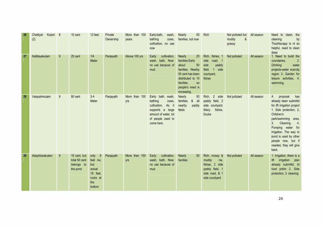
SL
No.
Name Ward Area Depth Ownership Origin &
History of the
Pond
Uses Beneficiaries Flora & Fauna Nature of
Pollution
Availability
of Water
Immediate needs of
the community
1 Karippamkulam 19 70 feet
length & 40
feet width
15 feet -
center
10 feet -
side,
bottom
is not
plane,
there
are
rocks
Temple Above 200
years, exact
time not known.
Bath, cultivation
(nearby paddy
fields). When water
overflows, the water
moves to paddy
field. Do not use for
laundery. Water for
poojas are taken
from well.
Mainly by the
priest, only by
people who visits
the temple,
Shabarimala
pilgrims
Rich-paddy
field & road-
front, two sides-
trees, one
side-temple.
banana &
coconut-main
cultivation,
courtyard of
nearby houses,
Not polluted,
Last clean was
10 yrs back
All season Retaining wall on
northen side has fallen
apart due to rich water
flow to the pond during
rainy season. If a wall
is made to avoid
connection from
nearby fields, the
water could be used
for drinking purpose
as well.
2 Palakuzhi
Irrigation Pond
19 80 feet
length & 40
feet
20 feet
deep
Water
Authority
Nearly 20 years To pump the water
to two wards:
Nearly 100 families
depend on this
pond, only to
irrigate fields
18 & 19 Ward
Members
2 sides-paddy
field, 1 side-
road, 1 side-
rivulet
Not polluted All season Boundary should be
build to have a
significant separation
from rivulet. Water
from the rivulet get
mixed with the pond,
otherwise the water
could have used for
drinking.
3 Manakkulangara
Temple Pond
19 1 acre 9
cents
40 feet
deep,
bottom
sandy +
muddy
Temple Above 200
years
Bath & cultivation,
there is an ovelet to
nearby paddy fields
Nearly 100
families,
Sabarimala
Pilgrims, priests
Rich, 1 side
temple, 3 sides
courtyard
Not polluted All season 1 side need to be built,
already used 25 lacks
last year, more budget
is needed to build the
retaining walls
4 PHED FWSS
Pumping Station
(Water Authority
Pond)
19 70 feet
length & 40
feet width
30 feet
(ring at
the
center-9
ring)
Water
Authority
Made in 1971 Drinking &
Irrigation-Pumps
water
To Pulpara &
Karur Region
(16th+17th
Ward)
Rich, 1 side
road, 1 side
irrigation
pumping, 1 side
shop, 1 side
courtyard
Polluted, only
uses the ring
water, birds
dump fish
wastes in the
pond. Algae
present. Plastic
found.
All season The pond should be
cleaned & mud should
be cleared. Make net
covering to avoid birds
from dropping fishes
to it. Though it is
polluted, people still
uses it.

18
5 Puthuvaalu
Madam Kulam
13 4 feet * 4
feet
18 feet Pvt Above 100 yrs Only bath, wash Nearby few
families, but
when the
ownership was
changed, only
used by the
family, now no
one uses it
Rich Started
degradation
All season During water shortage,
the pond could have
been used by
everyone, but the
owners might not like
it
6 Thatthaamkulam 13 Not known,
big-now
reduced
6 feet Pvt Above 150 yrs Not using, early-
bath, wash, bathing
cows, cultivation etc
All nearby
families use
Rich Nt polluted All season People need this
pond, but not able to
use as another party
bought it. No use in
last 10 years
7 Kolu Kulam 13 Not known,
half portion
of the pond
was already
covered 60
years back
for
cultivation
12 feet Pvt More than 100
years, now only
quarter part of
pond exists, it
was with temple
before, but now
with a family
Now only during
summer, Early:
bath, wash, bathing
cows, cultivation etc
All nearby
families use
Rich Nt polluted All season Nothing to do due to
private party
ownership
8 Pazhedath
Pisharath Kulam
13 5 cent 6 feet Pvt Above 100
years, the top
was covered
Early-bath, wash,
cultivation
Mainly family,
but all nearby
people
Rich, fishes-All
sides are
courtyard
Polluted-waste
from a nearby
hotel
All season The family is ready to
give to different parties
for fish production
9 Shaarath
Ambalam Kulam
13 4 cent Nearly
10 feet,
bottom
is plane
Pvt Very Old, nearly
1000 years
Not using, Early:
Used for temple
and paddy
cultivation
Only the family Rich, fishes-All
sides are
courtyard
Not polluted,
but mossy &
grassy
All season Cleaning, building
boundaries, gate etc

19
10 Marathumpilly
Manakkulam
13 Nearly 1
acre, few
sides are
decayed
12 feet
deep,
bottam
is
muddy
Panjayath 100 years, it
was with a
MANA & was
passed to
Panjayath about
20 years back, it
was not this
deep then
Not using now,
Early-mainly for
cultivation, bath,
washing etc.
More than 40
families, pilgrims,
tourists, people
who travel by..
Rich, small
fishes, ducks
Polluted &
mossy-plastics
seen. A hotel
effluent & runoff
water from
paddy field get
mixed with the
pond & got
smelly
All season-
but once got
dried in 1983
There should be clear
separation from paddy
field & pond. The
boundaries should be
built talller.
Kudumbasree will
make a partial
cleaning every year,
but only removing mud
does not help in
keeping the water
clean.
11 Pothukulam 17 55 cent,
early 1 acre
6 feet Panjayath 150 years Not using for last 5
years- polluted.
Early-Washing,
shower, fish culture
(but as water gets
polluted by fishes &
its food, stopped), it
was never used for
cultivation, There
are small rivulets
nearby.
Nearly 70 nearby
families used to
depend on this
pond.
3 sides-
courtyard & 1
side - road.
Rich in flora,
fauna-small
fishes & birds
Polluted- both
rivulet and
water flowing
from road
during rainy
season get
mixed with the
pond, & got
polluted. Algal
growth
recorded.
All season The pond is never
cleaned since 8 years,
should be cleaned &
remove mud & algae
to clean. Moreover,
building a tall
separation from the
surroundings could
keep the water clean
& even use for
drinking purposes.
12 Kurichikulam 17 Nearly 1
acre
Above 9
feet,
bottom
has
rocks on
sides,
but
mostly
mud-
plane
area
Panjayath Nearly 100
years
Not using because
its polluted and
body starts itching
while get wet.
Early-Washing,
bath, cultivation, to
bath animals
Nearly 70 nearby
families used to
depend on this
pond.
3 sides-
courtyard & 1
side - road.
Rich in flora-
pond is rich
with lotus,
fauna-small
fishes & birds
Polluted-All the
sides are
clearly built, but
runoff water
from road gets
mixed with the
pond & gets
polluted. Algal
growth has
almost covered
the pond
All season The pond should be
cleaned and the
boundaries should be
made taller to have
clear separation from
surroundngs. Also the
streamlet of road
should be built with
walls to avoid mixing
of water.

20
13 Panjithichaal,
Karur
17 500 meter
lenth & 3
meter width
Nearly 6
feet &
gets
deeper
as it
goes.
Panjayath- Nearly 100
years
Not using since an
engineering college
came nearby.
Early-used to wet
the paddy field, now
the paddy fields
gone due to
college, only
cultivation, no bath
& washing
Early-people
who own the
paddy fields,
now panjayath
has plans ofr
drinking water
All sides are
courtyard-rich
flora & fauna
Not polluted,
but mossy
All season Panjayath already
aproved a plan for its
renovation
14 Naaratti Kulam 17 50 cent Nearly 9
feet at
the
center
Private, but
there are
chances to
give to
Panjayath,
nt sure
More than 60
years
Not using, polluted,
Early-bath & wash
Only the family &
few neighboring
people.
All sides are
courtyard-rich
flora & fauna
Polluted, the
water from the
courtyard gets
mixed wth
pond, no clear
separation.
All season The boundaries
should be made taller
to have clear
separation from
surroundngs. Nearby
people can use it
15 Karur Temple
Pond
17 Not feasible
- only used
by priest
and
Sabarimala
Pilgrims
Temple
21
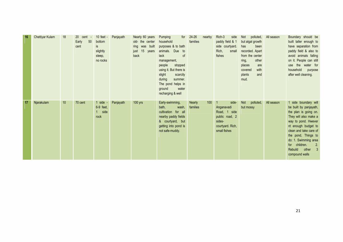
16 Chettiyar Kulam 18 20 cent -
Early 50
cent
10 feet -
bottom
is
slightly
steep,
no rocks
Panjayath Nearly 60 years
old- the center
ring was built
just 15 years
back
Pumping for
household
purposes & to bath
animals. Due to
lack of
management,
people stopped
using it. But there is
slight scarcity
during summer.
The pond helps in
ground water
recharging & well
24-26 nearby
families
Rich-3 side
paddy field & 1
side courtyard.
Rich, small
fishes
Not polluted,
but algal growth
has been
recorded. Apart
from the center
ring, other
places are
covered with
plants and
mud.
All season Boundary should be
built taller enough to
have separation from
paddy field & also to
avoid animals falling
on it. People can still
use the water for
household purpose
after well cleaning.
17 Njarakulam 10 70 cent 1 side -
6-9 feet,
1 side
rock
Panjayath 100 yrs Early-swimming,
bath, wash,
cultivation for all
nearby paddy fields
& courtyard, but
getting into pond is
not safe-muddy.
Nearly 100
families
1 side-
Anganavadi
Road, 1 side
public road, 2
sides-
courtyard. Rich,
small fishes
Not polluted,
but mossy
All season 1 side boundary will
be built by panjayath,
the plan is going on.
They will also make a
way to pond. Hwever
nt enough budget to
clean and take care of
the pond, Things to
do: 1. Swimming area
for children. 2.
Rebuild other 3
compound walls

22
18 Kallamkulam 11 25 cent,
another 50
cent is
intruded by
private
parties
15 feet-
slopy,
steep
steps
Panjayath More than 170
years. It was
made when
Perambra
church was
built, the
construction of
rocks were
taken from here,
pumping started
just 3 years
back by
Panjayath
Pumping to nearly
140 families-
household chores.
Also uses for
cultivation. People
even use to drink
when there is
extreme scarcity for
water
140 families All sides are
courtyard-rich
flora & fauna,
fishes
Not polluted,
but mossy
All season Need to be cleaned, &
make an outlet to
cultivation fields to
make it useful for
maximum people.
19 Cheruvathoor
Chira
12 2.5 acre 12 feet
deep,
bottom
is plane,
but
muddy
Panjayath Above 100
years
Use to irrigate
fields, Early-bath,
wash, to bath cows,
but everyone at
home itself.
Sometimes, men
use to take bath.
People use to fish
here.
Nearly 80
families,
Laborers etc
Rich, 1 side
road, other 3
sides are
courtyard,
fishes
Not polluted,
but mossy &
muddy, difficult
to get in
All season Need to be cleaned, &
make it as a place fr
swimming as well-
there are many people
interested. One side
boundary should be
maintained,
20 Ramankulam 5 5 cent 10 feet-
bottom
is rocky
Panjayath Was made in
1980, but
started irrigation
in 1990
No wash, bath,
household chores,
only water supply
for irrigation, for
theses uses, thr is a
rivulet just nearby
Pump water to
nearby 60 acre
1 side-road, 1
side-rivulet, 1
side-paddy
field, 1 side-
courtyard
Not polluted,
but muddy at
the bottom
All season,
but Aqueduct
should have
water
The mud should be
removed as pumping
became difficult due to
it.
21 Kavanattu Chira 7 length-70
m, width-1
side-40 m, 1
side-55 m
3 m
deep
Panjayath,
early temple
More than 120
years, made
with the temple
Now: only
cultivation. Early-
bath, wash, bathing
cows, now there
are leeches
All nearby
people uses
Rich, fishes, 1
side road, 3
sides courtyard
Not polluted-
mossy &
muddy, people
are not able to
use at all as its
muddy & also
due to leeches
All season 1 side boundary shld
be built, and few
maintainance work
23
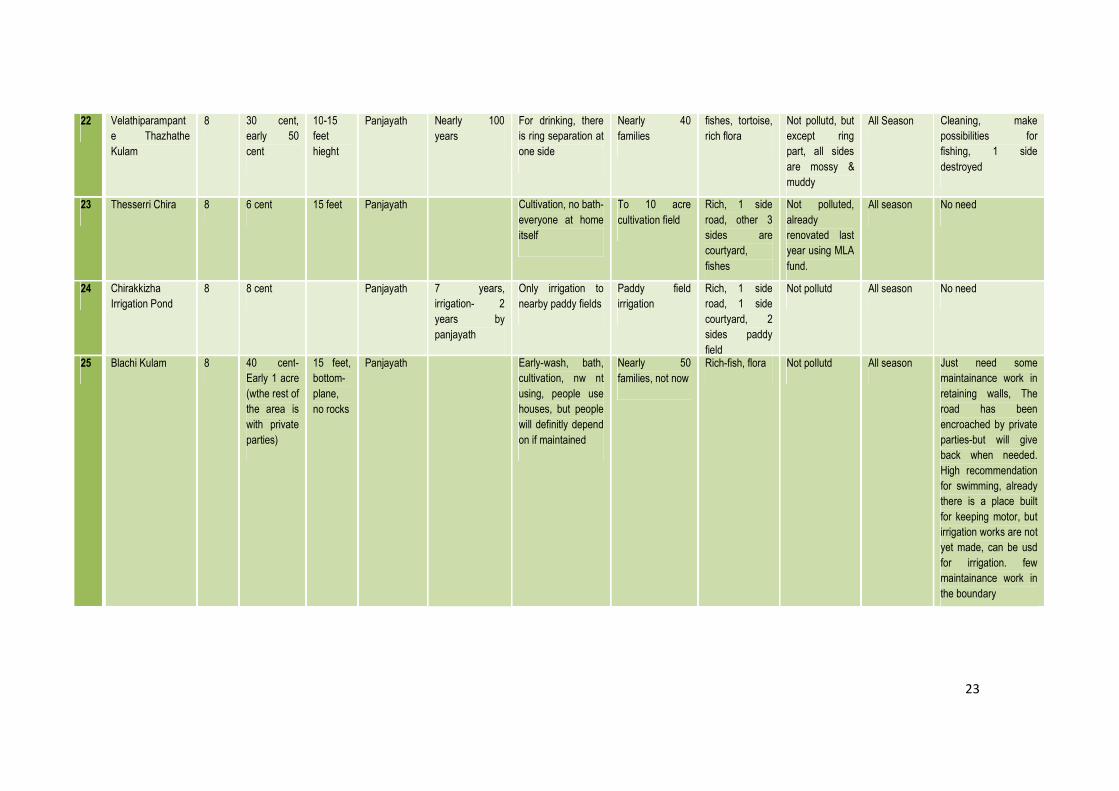
22 Velathiparampant
e Thazhathe
Kulam
8 30 cent,
early 50
cent
10-15
feet
hieght
Panjayath Nearly 100
years
For drinking, there
is ring separation at
one side
Nearly 40
families
fishes, tortoise,
rich flora
Not pollutd, but
except ring
part, all sides
are mossy &
muddy
All Season Cleaning, make
possibilities for
fishing, 1 side
destroyed
23 Thesserri Chira 8 6 cent 15 feet Panjayath Cultivation, no bath-
everyone at home
itself
To 10 acre
cultivation field
Rich, 1 side
road, other 3
sides are
courtyard,
fishes
Not polluted,
already
renovated last
year using MLA
fund.
All season No need
24 Chirakkizha
Irrigation Pond
8 8 cent Panjayath 7 years,
irrigation- 2
years by
panjayath
Only irrigation to
nearby paddy fields
Paddy field
irrigation
Rich, 1 side
road, 1 side
courtyard, 2
sides paddy
field
Not pollutd All season No need
25 Blachi Kulam 8 40 cent-
Early 1 acre
(wthe rest of
the area is
with private
parties)
15 feet,
bottom-
plane,
no rocks
Panjayath Early-wash, bath,
cultivation, nw nt
using, people use
houses, but people
will definitly depend
on if maintained
Nearly 50
families, not now
Rich-fish, flora Not pollutd All season Just need some
maintainance work in
retaining walls, The
road has been
encroached by private
parties-but will give
back when needed.
High recommendation
for swimming, already
there is a place built
for keeping motor, but
irrigation works are not
yet made, can be usd
for irrigation. few
maintainance work in
the boundary
24
26 Chettiyar Kulam
(2)
8 10 cent 12 feet Private
Ownership
More than 100
years
Early:bath, wash,
bathing cows,
cultivation, no use
now
Nearly 50
families, not now
Rich Not polluted but
muddy &
grassy
All season Need to clean, the
cleaning by
Thozhilurapp is nt so
helpful, need to clean
deep 27 Kattilayakulam 9 25 cent 1/4
Meter
Panjayath Above 100 yrs Early: cultivation,
wash, bath, Now:
no use because of
mud.
Nearly 25
families-Early
about 50
families, Nearby
50 cent has been
distributed to 10
families, so
people's need is
increasing.
Rich, fishes, 1
side road, 1
side paddy
field, 1 side
courtyard,
fishes
Not polluted All season 1. Need to build the
coundaries, 2.
Drinking water
projects-water scarcity
region 3. Garden for
leisure activities, 4,
swimming.
28 Valayalmkulam 9 80 cent 3-4
Meter
Panjayath More than 150
yrs
Early: bath, wash,
bathing cows,
cultivation. As it
supports a large
amount of water, lot
of people used to
come here.
Nearly 50
families & all
nearby paddy
fields
Rich, 2 side
paddy field, 2
side courtyard.
Many fishes.
Ducks
Not polluted All season A proposal has
already been submittd
for lift irrigation project
1. Side protection, 2.
Children’s
park/swimming area,
3. Cleaning, 4.
Pumping water for
irrigation. The way to
pond is used by other
people now, but if
needed, they will give
back.
29 Adaykkarakulam 9 15 cent, but
total 50 cent
belongs to
the pond
only 6
feet nw,
but
actual
18 feet,
rocks at
the
bottom
Panjayath More than 150
yrs
Early: cultivation,
wash, bath, Now:
no use because of
mud.
Nearly 50
families
Rich, mossy &
muddy nw,
fishes, 2 side
paddy field, 1
side road, & 1
side courtyard
Not polluted All season 1. Irrigation, there is a
lift irrigation plan
already submittd, bt
fund prblm 2. Side
protection, 3. cleaning
25
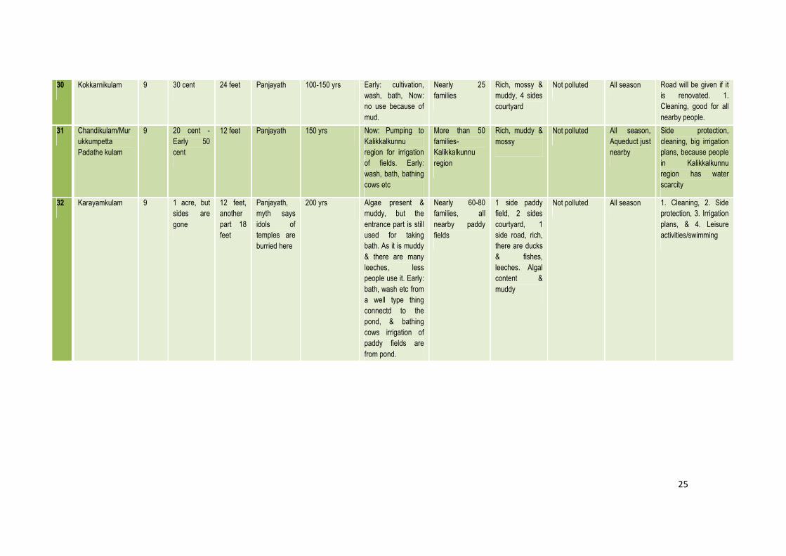
30 Kokkarnikulam 9 30 cent 24 feet Panjayath 100-150 yrs Early: cultivation,
wash, bath, Now:
no use because of
mud.
Nearly 25
families
Rich, mossy &
muddy, 4 sides
courtyard
Not polluted All season Road will be given if it
is renovated. 1.
Cleaning, good for all
nearby people.
31 Chandikulam/Mur
ukkumpetta
Padathe kulam
9 20 cent -
Early 50
cent
12 feet Panjayath 150 yrs Now: Pumping to
Kalikkalkunnu
region for irrigation
of fields. Early:
wash, bath, bathing
cows etc
More than 50
families-
Kalikkalkunnu
region
Rich, muddy &
mossy
Not polluted All season,
Aqueduct just
nearby
Side protection,
cleaning, big irrigation
plans, because people
in Kalikkalkunnu
region has water
scarcity
32 Karayamkulam 9 1 acre, but
sides are
gone
12 feet,
another
part 18
feet
Panjayath,
myth says
idols of
temples are
burried here
200 yrs Algae present &
muddy, but the
entrance part is still
used for taking
bath. As it is muddy
& there are many
leeches, less
people use it. Early:
bath, wash etc from
a well type thing
connectd to the
pond, & bathing
cows irrigation of
paddy fields are
from pond.
Nearly 60-80
families, all
nearby paddy
fields
1 side paddy
field, 2 sides
courtyard, 1
side road, rich,
there are ducks
& fishes,
leeches. Algal
content &
muddy
Not polluted All season 1. Cleaning, 2. Side
protection, 3. Irrigation
plans, & 4. Leisure
activities/swimming

26
33 Nedungattekulam 9 90 cent 12 feet,
Early 18
feet
Panjayath 150 yrs Bath, wash, bathing
cows, cultivation-
ovulet to nearby
paddy fields. The
nearby region has
water scarcity
issue, so during
summer all people
use to come here.
100 families All 4 sides have
screw pine
(Kaitha), rich. 2
sides-paddy, 1
side road, 1
side courtyard
Not polluted All season There was an
irrigation plan to
Kanakamala region,
but the people hr
protestd as there are
chances for pond to
get dried. If the mud is
remvd, it won’t get
dried. So remove mud
& clean. 1 side has
been built by
panjayath, other 3
sides. If the Canal
water is pumped, the
water level will
increase
34 Kadamkutti 9 50 cent, bt
nt now
12 feet Panjayath 150 yrs Now: wash, bath,
cultivation etc
50 families 2 sides-paddy
field, 1 side-
road, 1 side-
courtyard
Nt polluted All season 1. Drinking water -
during summer, the
wells get dried, 2.
Cleaning
35 Ulinjery Pond 12 15 cent only 5
feet nw
Panjayath 200 yrs Early: to irrigate
paddy field mainly,
bath cows, bath,
wash etc, and no
one uses it now.
Nearly 100
families used to
use it
1 side paddy
field, 3 sides
courtyard, rich,
fishes
Not polluted,
but muddy,
mossy, grasses
seen
All season,
but once got
dried, 4 years
back
1. Water needs to be
stored in the pond
itself, but nw it flows
out through the rivulet

27
36 Annanchira 12 65 cent 12 feet Panjayath Above 200
years
Early: cultivation,
wash, bath, bathing
cows. All nearby
paddy fields were
irrigated. People
use only to irrigate
courtyards using
pumpng system.
Above 50
families
Almost coverd
with grasses, 3
sides paddy
field, 1 side
courtyard
Not polluted,
but not usable
All season,
but once got
dried, 4 years
back
1. Thozhilurapp wasn't
able to clean 2 Years
back because of
leeches, so need to
remove all mud &
grasses using JCB.
2. 4 sides need to
build in such a way
that the water doesn’t
overflow 3. There is no
proper way to it, need
sthng to do, 4. good
for swimmng, once all
nearby people used to
come
37 Azhakam Lift
Irrigation
4 less than 15
cent
Above
10 feet
The place
belongs to
temple, but
irrigation by
Panjayath
Nearly 150
years
Only irrigation to
keep the ground
water level steady.
For other personal
uses, there is a
rivulet nearby.
Between 400-
450 (complete
4th ward)
1 side road, 1
side paddy
field, 2 sides
courtyard
Not polluted,
clean
All season,
during
summer
season,
pumps water
from Canal.
1. Cleaning, 2. Make
the pond larger, 3,
fence, 4, boundaries
are made, but some
maintainance work
need to be done.
38 Kurumkulam 7 More than 1
acre
4 meter Panjayath Above 100
years
Bath, wash, to bath
cows, to irrigate
paddy field.
Now only 30
families. Early
above 50 family
1 side paddy
field, 3 side
courtyard
started
degradation,
not polluted
All season, 1. Some maintainance
work, 2. Mechanism to
store the water inside
the pond 3. pump
water from canal 4.
People do not get
canal water here
39 Allukulam 7 10 cent 6 feet Panjayath Above 100
years
Bath, wash, to bath
cows, to irrigate
paddy field. Now:
bath, but very less,
mossy
Nearly 25 family 4 sides
courtyard
Not polluted,
but mossy &
muddy, started
degradation
All season Cleaning, side
protection
28
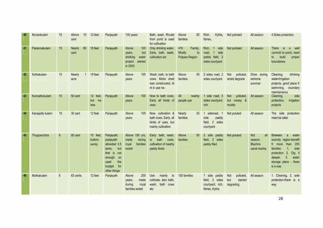
40 Muriankulam 15 Above 10
cent
12 feet Panjayath 100 years Bath, wash. Rivulet
from pond is used
for cultivation
Above 50
families
Rich, Kytha,
fishes..
Not polluted All season 4 Sides protection,
41 Padannakulam 15 Nearly 80
cent
18 feet Panjayath Above 100
years, but
drinking water
project started
in 2003
Only drinking water,
Early, bath, wash,
cultivation etc
416 Family,
Mostly to
Pulpara Region
Rich, 1 side
road, 1 side
paddy field, 2
sides courtyard
Not polluted All season There is a well
connctd to pond, need
to build proper
boundaries.
42 Kothakulam 15 Nearly 1
acre
19 feet Panjayath Above 100
years
Wash, bath, to bath
cows. Motor shed
was constructed, bt
nt in use nw.
Above 50
families
2 sides road, 2
sides courtyard
Not polluted,
stratd degrade
Dries during
extreme
summer
Cleaning, drinking
water/irrigation
projects, good place fr
swimming, coundary
maintainance 43 Kunnathukulam 15 50 cent 12 feet,
but nw
less
Panjayath Above 100
years
Now to bath cows,
Early all kinds of
uses
All nearby
people use
1 side road, 3
sides courtyard,
rich
Not polluted,
but mossy &
muddy
All season Cleaning, side
protection, irrigation
projects
44 Karappilly kulam 15 30 cent 12 feet Panjayath Above 100
years
Now, cultivation &
bath cows, Early, all
kinds of uses, but
mainly cultivation
Nearly 25
families
1 sideroad, 1
side paddy
field, 2 sides
courtyard
Not poluted All season The side protection
need be taller
45 Thuppanchira 6 80 cent 10 feet,
bottom
sandy
Panjayath,
panjayath
allowded 3.5
lacks, but
that is not
enough, so
used the
budget for
other things
Above 150 yrs,
made during
royal families
existd
Early: bath, wash,
to bath cows,
cultivation of nearby
paddy fields
Above 50
families
2 side paddy
field, 2 sides
paddy filed
Not poluted Not all
season,
Blachira
canal nearby
Between a water
scarcity region-benefit
fr more than 200
families. 1, side
protection 2. Dig it
deeper, 3. water
storage plans - there
is a way
46 Mothakulam 6 63 cents 12 feet Panjayath Above 200
years, made
during royal
families existd
Use: mainly to
cultivate, also bath,
wash, bath cows
etc
150 families 1 side paddy
field, 3 sides
courtyard, rich,
fishes, Kytha
Not polluted,
but started
degrading
All season 1. Cleaning, 2. side
protection-there is a
way

29
47 Kythakulam 6 80 cent 12 feet Panjayath Above 200
years
cultivation:
viruthipadam paddy
field, also all other
uses
Nearly 50
families
3 sides paddy
field, rivulet to
paddy field,
rich, fishes
Not poluted All season 5 lack already given,
side protection,
cleaning
48 Panthallookarante
Thazhathe kulam
6 40 cent 12 feet Panjayath Above 150
years
Early: used by
Kalari Temple
priests, & pilgrims,
then stratd using by
all people nearby fr
all kinds of uses,
mainly cultivation.
No way now, less
uses.
Above 150
families
3 sides paddy
field, 1 side
courtyard
Not poluted All season Side protection,
cleaning
49 Thavalakulam 6 29 cent 13 feet Panjayath Above 150
years
Now: only
cultivation. Early:
cultivation, bath,
wash, to bath cows
etc
Above 50
families
4 sides
courtyard
Not poluted, but
grassy, started
degradation
All season 1. Rivulet from pond
needs to be protectd
2. Cleaning
50 Pulpara Kulam 16 Above 40
cent
6 feet Panjayath Above 50 years Now not in use,
algae and muddy,
early: bath, wash,
bath cows
All people in
Pulpara
2 sides road, 2
sides courtyard,
rich, mossy &
grassy
Not polluted All season Scarcity region,
people now depends
on water authority, but
even that water is not
good. Drinking water/
irrigation projects
51 Parakulam 16 15 cent Less
than 10
feet
Panjayath Above 35 years All kinds of uses.
nw nt in use,
polluted
Only 5-8 families
nearby
Rich, 1 side
road, 3 sides
houses. Rocks
Polluted:
plastics, waste
water from
nearby houses
All season,
but water
level
decreases
during
summer
1. Cleaning, and side
protection
30
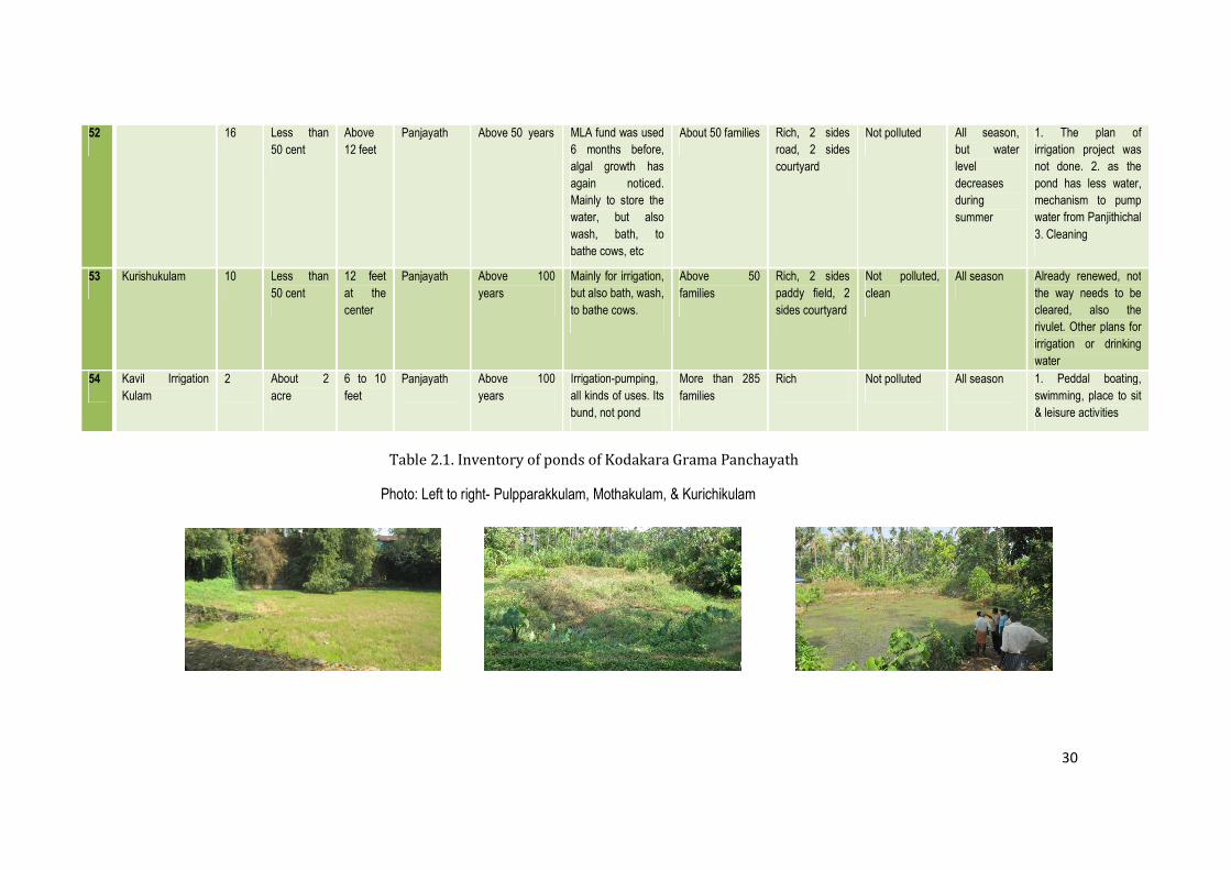
Table 2.1. Inventory of ponds of Kodakara Grama Panchayath
Photo: Left to right- Pulpparakkulam, Mothakulam, & Kurichikulam
52 16 Less than
50 cent
Above
12 feet
Panjayath Above 50 years MLA fund was used
6 months before,
algal growth has
again noticed.
Mainly to store the
water, but also
wash, bath, to
bathe cows, etc
About 50 families Rich, 2 sides
road, 2 sides
courtyard
Not polluted All season,
but water
level
decreases
during
summer
1. The plan of
irrigation project was
not done. 2. as the
pond has less water,
mechanism to pump
water from Panjithichal
3. Cleaning
53 Kurishukulam 10 Less than
50 cent
12 feet
at the
center
Panjayath Above 100
years
Mainly for irrigation,
but also bath, wash,
to bathe cows.
Above 50
families
Rich, 2 sides
paddy field, 2
sides courtyard
Not polluted,
clean
All season Already renewed, not
the way needs to be
cleared, also the
rivulet. Other plans for
irrigation or drinking
water
54 Kavil Irrigation
Kulam
2 About 2
acre
6 to 10
feet
Panjayath Above 100
years
Irrigation-pumping,
all kinds of uses. Its
bund, not pond
More than 285
families
Rich Not polluted All season 1. Peddal boating,
swimming, place to sit
& leisure activities
31
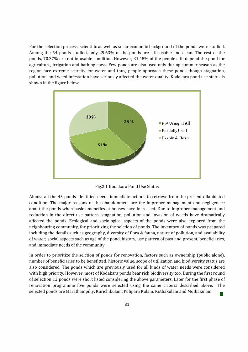
For the selection process, scientific as well as socio-economic background of the ponds were studied.
Among the 54 ponds studied, only 29.63% of the ponds are still usable and clean. The rest of the
ponds, 70.37% are not in usable condition. However, 31.48% of the people still depend the pond for
agriculture, irrigation and bathing cows. Few ponds are also used only during summer season as the
region face extreme scarcity for water and thus, people approach these ponds though stagnation,
pollution, and weed infestation have seriously affected the water quality. Kodakara pond use status is
shown in the figure below.
Fig.2.1 Kodakara Pond Use Status
Almost all the 45 ponds identified needs immediate actions to retrieve from the present dilapidated
condition. The major reasons of the abandonment are the improper management and negligenece
about the ponds when basic ameneties at houses have increased. Due to improper management and
reduction in the direct use pattern, stagnation, pollution and invasion of weeds have dramatically
affected the ponds. Ecological and sociological aspects of the ponds were also explored from the
neighbouring community, for prioritizing the selction of ponds. The inventory of ponds was prepared
including the details such as geography, diversity of flora & fauna, nature of pollution, and availability
of water; social aspects such as age of the pond, history, use pattern of past and present, beneficiaries,
and immediate needs of the community.
In order to prioritize the selction of ponds for renovation, factors such as ownership (public alone),
number of beneficiaries to be benefitted, historic value, scope of utilization and biodiversity status are
also considered. The ponds which are previously used for all kinds of water needs were considered
with high priority. However, most of Kodakara ponds bear rich biodiversity too. During the first round
of selection 12 ponds were short listed considering the above parameters. Later for the first phase of
renovation programme five ponds were selected using the same criteria described above. The
selected ponds are Marathampilly, Kurichikulam, Pulipara Kulam, Kothakulam and Mothakulam.
32
CHAPTER III
MARATHAMPILLY POND
1. INTRODUCTION
Marathampilly Pond is owned by Kodakara Panchayath, but the ownership belonged to a family called,
Marathampilly Mana 12 years back. The pond located 300 m. away from National Highway, accessible
through a pocket road and shares boundary to paddy fields and 2-3 residential lands.
2. METHODOLOGY
The study was begun with conducting community survey of 30 respondents who live around the pond.
A survey among the community was conducted in order to expose the past and present status of the
pond in terms of biological, social and economical. Land survey, quatity of clay and silt, water quality
studies, biodiversity estimation, community survey, and pollution studies were conducted as part of
the study (see chapter I).
2.1 Study Area
The pond situates in the heart of Kodakara Panchayath, in ward 13. The pond is located near Kodakara
town and 100 meter away from National Highway. The pond is surrounded by paddy fields and human
settlement. The pond lies between N 10022’08.97” AND E 076018’26.61”.
3. RESULTS AND DISCUSSION
3.1 Community Survey Respondents’ Details
Table. 3.1. Demographic data on the surveyed community
Survey Respondents Categories Percentage (%)
Gender Male 17
Female 13
Age
20-40 1
41-60 16
61-80 9
81-100 4
Occupation
Local Community 16
Prominent Socio-Religious Workers 1
Farmers 5
Thozhilurapp 2
Local Government & Non-
Governmental Officials
6
33
3.2 History
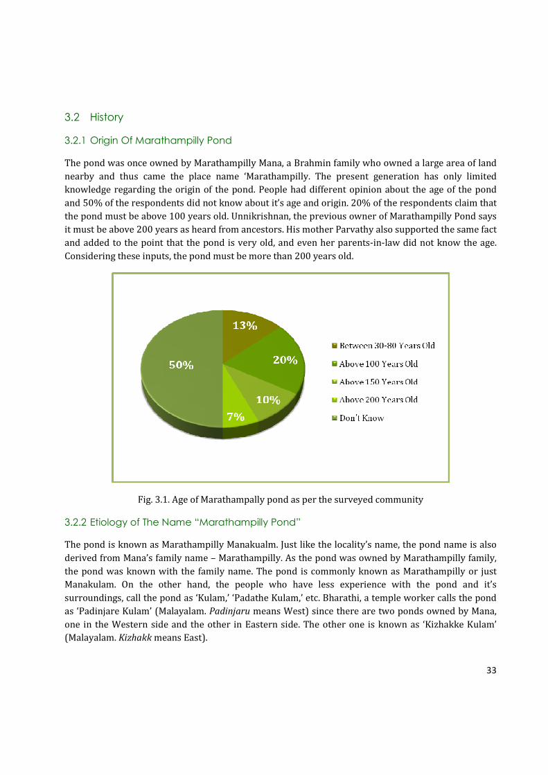
3.2.1 Origin Of Marathampilly Pond
The pond was once owned by Marathampilly Mana, a Brahmin family who owned a large area of land
nearby and thus came the place name ‘Marathampilly. The present generation has only limited
knowledge regarding the origin of the pond. People had different opinion about the age of the pond
and 50% of the respondents did not know about it’s age and origin. 20% of the respondents claim that
the pond must be above 100 years old. Unnikrishnan, the previous owner of Marathampilly Pond says
it must be above 200 years as heard from ancestors. His mother Parvathy also supported the same fact
and added to the point that the pond is very old, and even her parents-in-law did not know the age.
Considering these inputs, the pond must be more than 200 years old.
Fig. 3.1. Age of Marathampally pond as per the surveyed community
3.2.2 Etiology of The Name “Marathampilly Pond”
The pond is known as Marathampilly Manakualm. Just like the locality’s name, the pond name is also
derived from Mana’s family name – Marathampilly. As the pond was owned by Marathampilly family,
the pond was known with the family name. The pond is commonly known as Marathampilly or just
Manakulam. On the other hand, the people who have less experience with the pond and it’s
surroundings, call the pond as ‘Kulam,’ ‘Padathe Kulam,’ etc. Bharathi, a temple worker calls the pond
as ‘Padinjare Kulam’ (Malayalam. Padinjaru means West) since there are two ponds owned by Mana,
one in the Western side and the other in Eastern side. The other one is known as ‘Kizhakke Kulam’
(Malayalam. Kizhakk means East).

34
Photo: Explaining the PRA process to the stakeholders of Marathampally pond
3.3 Physical Features Of The Pond In The Past
Aged people recollects that the pond lost it’s diverse biodiversity. The surroundings were very
beautiful with rice cultivation on one side and different plants and trees on the other side of the pond.
A large banyan tree was grown on the South-East side of the pond. However, this banyan tree was
destroyed naturally when it was very old. Mr. Unnikrishnan Namboothiri, the current owner of Mana,
says there were different bathing ghuts separately for Brahmins, Nairs, and one as elephant bathing
ghut. However, when temples were open to all, the situation made difference in the way the pond was
used. It was opened for all people. Gradually, the bathing ghut separations were changed as one for
men, women, and one for Mana.
3.4 Main Uses Of The Pond In Past And Present
Due to the degradation of the water quality of the pond, the pond usage has dropped significantly. As
the pond belonged to Marathampilly Mana once, the pond was often used for performing Hindu rituals
as well as taking bath by Savarnar (those belong to superior caste). Mana family and other Savarnar
used to take bath in the pond. As the pond is closer to paddy fields, the water was also taken for
agriculture. There is an outlet to the paddy fields. When temples were opened to all people, other
people also started visiting the pond for bathing, washing, and showering animals. As discussed
before, there was one ghat for temple elephants as well. Over the years, this bathing ghat had been
changed to showering cows. No one visits the pond in the last two years as the pond polluted and with
35
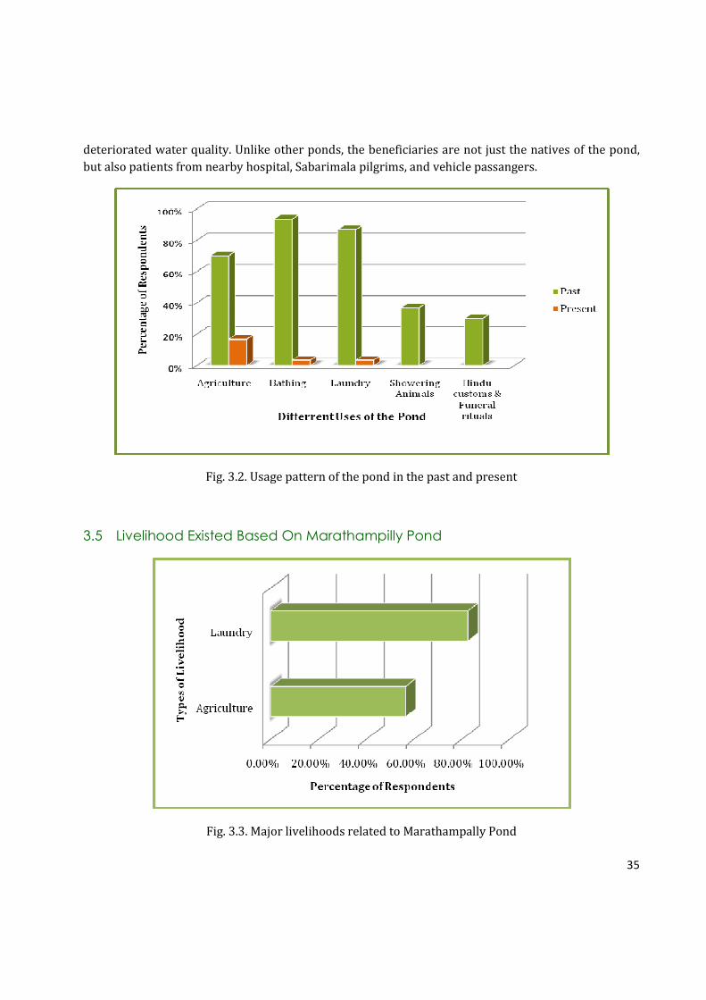
deteriorated water quality. Unlike other ponds, the beneficiaries are not just the natives of the pond,
but also patients from nearby hospital, Sabarimala pilgrims, and vehicle passangers.
Fig. 3.2. Usage pattern of the pond in the past and present
3.5 Livelihood Existed Based On Marathampilly Pond
Fig. 3.3. Major livelihoods related to Marathampally Pond

36
The major livelihood activities associated with the pond were laundry and agriculture in the past.
There are no livelihood activities at present. Fig.3.3 shows the major livelihood activities of
Marathampilly Pond. 80% of the respondents assert that major livelihood activity was laundry by
Velan families (a tradional washer community). The present generations of Velan families do not
follow laundry as livelihood, instead they have shifted to other jobs. Moreover, aged generations of
Velan families live nearby Cheruvathoor Chira and do not come here after the pond was eutrophicated.
The other livelihood activity based in Marathampilly Pond was agriculture. 60% of the respondents
said that the rice cultivation and vegetable cropping in nearby fields are depended on the pond. As the
pond deos not support enough water due to eutrophication, the regular outflow to agricultural fields
has been disturbed. Currently direct use of pond water for agriculture is not reported.
3.6 Linked Waterbodies Of Marathampally Pond
There are many other water bodies in this region. Just like Marathampally Manakulam, these ponds
are also not usable at the moment. Cheruvathoor Chira is a large pond with an area of approximately 2
acres. Cheruvathoor Chira was used immensely for Agriculture, bathing, laundry, showering animals,
and fishing. However, due to improper management and lack of adequate erosion control methods, the
pond turned unusable. Fortunately, the Panchayath is renovating the pond with a concept of tourism
in this area. Puthukavu thodu comes from Cheruvathoor Chira which flows besides the paddy fields
near by Marathampilly Pond. In the past, the Puthukavu thodu helped in ground water recharging, so
that the paddy fields kept irrigated. Consequently, the Marathampilly Pond also get recharged as
Marathampilly Pond is an immediate water body which gets benefitted.
People say that there were many private and Panchayath ponds in this area which were maintained
through tradional practices. However, at present, no one takes care about water bodies and many of
them are covered and disappeared for construction activities. The table 3.2. shows the different
waterbodies in this area and their use pattern.
Waterbody Type of Current Usage Water Quality
Cheruvathoor Chira Not usable Panchayath Renovation is going
on
Kolu Kulam Not usable Algal Bloom
Vallappady Temple Pond Bathing Usable
Puthukkavu Temple Pond Bathing, Laundry Usable
Poornilarkavu Chira Bathing, Laundry, Agriculture Usable
Puthukavu Thodu Agriculture, Bathing, Laundry,
Showering Animals
Usable
Peringamkulam Agriculture, Bathing, Laundry Usable
Kizhakke Kulam (Owned by
Marathampilly Mana)
Bathing and rituals of temples Usable
Table 3.2. Neighbouring ponds/bunds of Marathampally pond
37
3.7 Issues Faced By Marathampilly Pond
The pond was handed over to Panchayath 12 years back
upon Panchayath’s request by the then owners,
Marathampally Mana. The pond was not taken care of
well since the ownership has changed, say the natives.
The bathing ghts were rebuilt, but was not beneficial to
people because the way it was constructed. The number
of people coming to the pond decreased gradually. Slow
water movement made favorable conditions for algae
and phytoplankton growth. Therefore, people stopped
coming to the pond when the pond was dominated by
different types of algae. However, the water was
continued to be taken for agriculture. As the time
passed, the irrigation using pond water was also not
possible since the outlets were almost closed by
sediments.
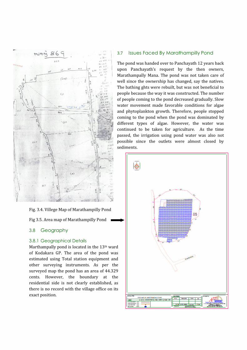
Fig. 3.4. Villege Map of Marathampilly Pond
Fig 3.5. Area map of Marathampilly Pond
3.8 Geography
3.8.1 Geographical Details
Marthampally pond is located in the 13th ward
of Kodakara GP. The area of the pond was
estimated using Total station equipment and
other surveying instruments. As per the
surveyed map the pond has an area of 44.329
cents. However, the boundary at the
residential side is not clearly established, as
there is no record with the village office on its
exact position.

38
3.8.2 Clay And Sand Quantity Analysis

39
Fig 3.6. Cross section maps of Marathampally pond showing the water and sediment levels
The cross section maps of the pond showed that on an average 0.95 meter deep water column exists in
the pond during the survey period. But, further up to a depth of 1.5 meter sediment is deposited,
including silt and clay.
Photo: TIES’ team surveying the land area of Marathampally pond

40
3.9 Water Quantity and Quality
3.9.1 Water Quantity
70% among the 30 respondents claim that water level fluctuation occurs during summer season. 30%
of the respondents do not know about water level fluctuations or did not respond to the question.
Parvathi, an aged lady from Marathampilly Mana who owned the pond in the past, recollects that the
water level fluctuation occurs only now a days. Nevertheless, this phenomenon never used to occur in
the past. The water level was always steady despite of change in climate. Her son, Unnikrishnan,
retired Bank Officer also have the same opinion. He adds, if the paddy fields have cultivation in all
three season, the pond will not show any fluctuation in the water level. Therefore, it is concluded that
if the quantity of water available in the pond is directly linked to the water availability in the
neighbouring paddy fields and rivulets.
Fig.3.7. Water column existing during summer season, as per the surveyed community
3.9.2 Water Quality
The families in Marathampilly face extreme shortage in drinking water. Though the pond is unfit for
drinking water purpose due to growth of water hyacinth and algae, the pond helps in ground water
recharging and thereby recharging of the wells in this region.
41
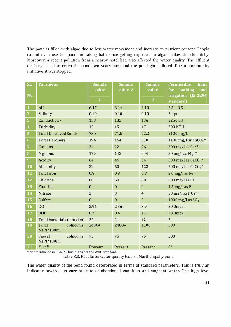
The pond is filled with algae due to less water movement and increase in nutrient content. People
cannot even use the pond for taking bath since getting exposure to algae makes the skin itchy.
Moreover, a recent pollution from a nearby hotel had also affected the water quality. The effluent
discharge used to reach the pond two years back and the pond got polluted. Due to community
initiative, it was stopped.
* Not mentioned in IS 2296, but it is as per the WHO standard.
Table 3.3. Results on water quality tests of Marthampally pond
The water quality of the pond found deterorated in terms of standard parameters. This is truly an
indicator towards its current state of abandoned condition and stagnant water. The high level
SL.
No.
Parameter Sample
value
1
Sample
value 2
Sample
value
3
Permissible limit
for bathing and
irrigation (IS 2296
standard)
1 pH 6.47 6.14 6.10 6.5 – 8.5
2 Salinity 0.10 0.10 0.10 3 ppt
3 Conductivity 138 133 136 2250 µS
4 Turbidity 15 15 17 300 NTU
5 Total Dissolved Solids 73.3 71.5 72.2 2100 mg/L
6 Total Hardness 194 164 370 1100 mg/l as CaCO3 *
7 Ca+ ions 24 22 26 500 mg/l as Ca+ *
8 Mg+ ions 170 142 344 30 mg/l as Mg+*
9 Acidity 64 46 54 200 mg/l as CaCO3*
10 Alkalinity 32 60 122 200 mg/l as CaCO3*
11 Total iron 0.8 0.8 0.8 2.0 mg/l as Fe*
12 Chloride 60 60 60 600 mg/l as Cl
13 Fluoride 0 0 0 1.5 mg/l as F
14 Nitrate 3 3 4 30 mg/l as NO3*
15 Sulfate 0 0 0 1000 mg/l as SO4
16 DO 3.94 2.36 3.9 50.0mg/l
17 BOD 0.7 0.4 1.3 30.0mg/l
18 Total bacterial count/1ml 22 21 12 5
19 Total coliforms
MPN/100ml
2400+ 2400+ 1100 500
20 Faecal coliforms
MPN/100ml
75 75 75 200
21 E. coli Present Present Present 0*
42
coliforms may be due to the inflow of sewage into the pond from the nearby houses. Open defecation is
also reported on the banks of the pond.
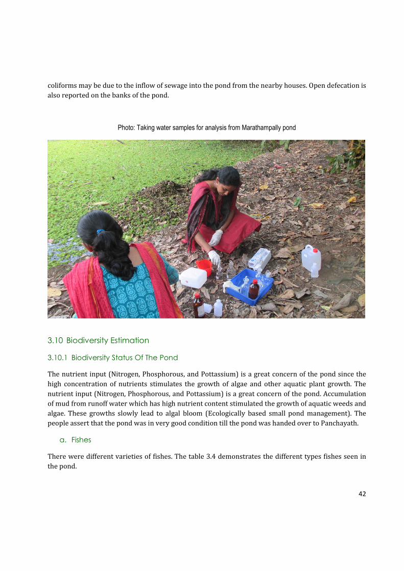
Photo: Taking water samples for analysis from Marathampally pond
3.10 Biodiversity Estimation
3.10.1 Biodiversity Status Of The Pond
The nutrient input (Nitrogen, Phosphorous, and Pottassium) is a great concern of the pond since the
high concentration of nutrients stimulates the growth of algae and other aquatic plant growth. The
nutrient input (Nitrogen, Phosphorous, and Pottassium) is a great concern of the pond. Accumulation
of mud from runoff water which has high nutrient content stimulated the growth of aquatic weeds and
algae. These growths slowly lead to algal bloom (Ecologically based small pond management). The
people assert that the pond was in very good condition till the pond was handed over to Panchayath.
a. Fishes
There were different varieties of fishes. The table 3.4 demonstrates the different types fishes seen in
the pond.

43
Malayalam Name Common Name Scientific Name
Varal Striped Snake head Channa striata
Malineen or Mananjil Indian Mottled Eel Anguilla bengalensis
bengalensis
Mushi Walking Catfish Clarias batrachus
Kadu / Kaari Stinging catfish Heteropneustes fossilis
Karippidi Malabar Leaf Fish, Common
catopra
Pristolepis marginata
African Mushi African Catfish Clarias gariepinus
Paral Giant Danio Danio malabaricus
Kolan Freshwater Garfish Xenentodon cancila
Table 3.4. List of major fishes found in the pond
People used to fish in the pond as a leisure activity. However, when algae started dominating the
pond, the number of fishes has decreased. Majority of the survey respondents claimed that the fish
diversity in Marathampilly Pond has reduced significantly compared to the past. People assert that it is
due to unfavorable conditions of the pond for the growth of fishes.
b. Aquatic Plants
Malayalam Name Common Name Scientific Name
Afican Payal Salvinia Salvinia molesta
Mullan Payal Paddy field water nymph Najas graminea
Table 3.5 List of aquatic macrophytes in the pond
3.8.1 Biodiversity Status Around The Pond
Ownership Type Position
House plot North Balan Maash Coconut clumps West
Santha House plot East
Dileep Ponnath Rice field South
Table 3.6. Status of the land surrounding the pond
a. Floral Diversity around The Pond
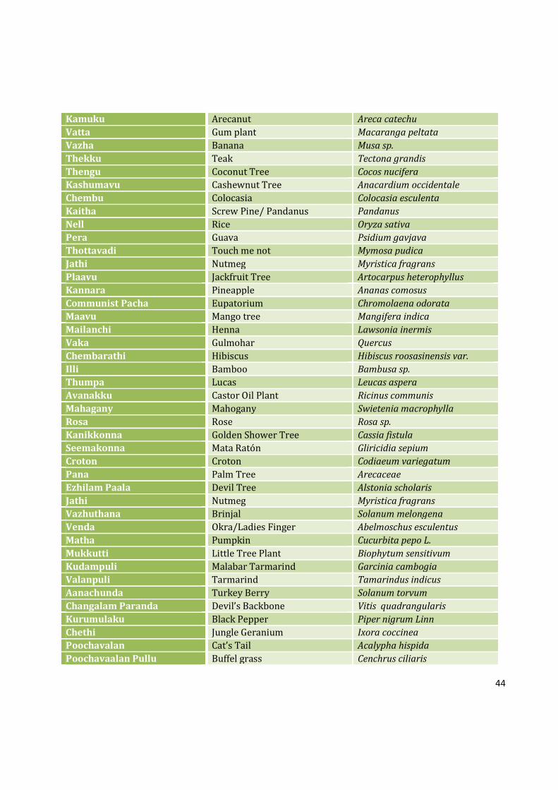
The floral diversity around the pond is moderately rich with wide variety of plants. In the past, the
three sides of pond were paddy fields. However, due to lack of profit and water shortage, farmers have
changed the crops to coconut, banana, tapioca etc. Some paddy fields are left uncultivated in the
Southern side. Only few areas of current paddy field actually continue the cultivation.
Malayalam Name Common Name Scientific Name
Kappa Tapioca Manihot esculenta Kappalam Papaya Carica papaya
44
Kamuku Arecanut Areca catechu
Vatta Gum plant Macaranga peltata
Vazha Banana Musa sp.
Thekku Teak Tectona grandis
Thengu Coconut Tree Cocos nucifera
Kashumavu Cashewnut Tree Anacardium occidentale
Chembu Colocasia Colocasia esculenta
Kaitha Screw Pine/ Pandanus Pandanus
Nell Rice Oryza sativa
Pera Guava Psidium gavjava
Thottavadi Touch me not Mymosa pudica
Jathi Nutmeg Myristica fragrans
Plaavu Jackfruit Tree Artocarpus heterophyllus
Kannara Pineapple Ananas comosus
Communist Pacha Eupatorium Chromolaena odorata
Maavu Mango tree Mangifera indica
Mailanchi Henna Lawsonia inermis
Vaka Gulmohar Quercus
Chembarathi Hibiscus Hibiscus roosasinensis var.
Illi Bamboo Bambusa sp.
Thumpa Lucas Leucas aspera
Avanakku Castor Oil Plant Ricinus communis
Mahagany Mahogany Swietenia macrophylla
Rosa Rose Rosa sp.
Kanikkonna Golden Shower Tree Cassia fistula
Seemakonna Mata Ratón Gliricidia sepium
Croton Croton Codiaeum variegatum
Pana Palm Tree Arecaceae
Ezhilam Paala Devil Tree Alstonia scholaris
Jathi Nutmeg Myristica fragrans
Vazhuthana Brinjal Solanum melongena
Venda Okra/Ladies Finger Abelmoschus esculentus
Matha Pumpkin Cucurbita pepo L.
Mukkutti Little Tree Plant Biophytum sensitivum
Kudampuli Malabar Tarmarind Garcinia cambogia
Valanpuli Tarmarind Tamarindus indicus
Aanachunda Turkey Berry Solanum torvum
Changalam Paranda Devil’s Backbone Vitis quadrangularis
Kurumulaku Black Pepper Piper nigrum Linn
Chethi Jungle Geranium Ixora coccinea
Poochavalan Cat’s Tail Acalypha hispida
Poochavaalan Pullu Buffel grass Cenchrus ciliaris

45
Cheeni Chilli Capsicum annum
Kongini Lantana Lantana camera
Nanthyarvattam East Indian Rosebay Ervatamia coronaria
Cheera Chikurmanis Sauropus androgynus
Chuvanna Cheera Velvet Curtain Amaranthus sp.
Pacha Cheera Green Spinach Amaranthus hybridus
Kadalassu Rosa Bougainvillea Bougainvillea glabra
Mantharam White Orchid Tree Bauhinia tomentosa
Mussanda Mussanda Mussaenda erythrophylla
Kariveppu Curry Leaves Murraya koenigii
Cheru Narakam Bitter Ornage Citrus aurantifolia
Kolambi Yellow Bell Flower Tecoma stans
Money Plant Devil’s Eye Epipremnum aureum
Muyal Cheviyan Cupid’s Shaving Brush Emilia sonchifolia
Murian Pacha Goat Weed Ageratum conyzoides
Thulasi Sacred Basil Ocimum tenuiiflorum
Vayara Bitter Vine Micania micrantha
Parapadakapullu Oldenlandia Oldenlandia corymbosa
Chithirappala Semi-erect Euphorbia Euphorbia Hirta
Table 3.7. Major flora around the pond (50 m radius)
b. BIRDS
White-Breasted Waterhen, White-throated Kingfisher, Cattle Egret, Black Drongo, and Common Myna
are the most sighted birds found around the pond. They are visible almost all the time in the day.
Intermediate egret is also common in this area, but they are most visible in the paddy field which is
situated in southern side of the pond. These birds are most common birds found in India. The local
community claims that the number of birds visiting the pond has reduced over time. When the pond
was in a good condition, many other varieties of birds also used to visit the pond as well as the paddy
field situated nearby the pond. Since both pond and paddy fields have lost their quality, birds’ visit has
reduced significantly.
Though the water quality of the pond is eutrophic condition, a large variety of birds are still found
around the pond rich bank vegetation attracts birds.
Malayalam Name Common Name Scientific Name
Kalimundi Cattle Egret Bubulcus ibis coromandus
Cherumundi Intermediate Egret Mesophoyx intermedia
Kulakozhi White-Breasted Waterhen Amaurornis phoenicurs
Ponman White-throated Kingfisher Halcynon smyrnensis
Kaaka Thampuratti Black Drongo Dricrurus macrocercus
Irattavalan Kili Greater Racket-Tailed Drongo Dricrurus paradiseus
Kaavathi Kakka House Crow Corvus splendens protegatus
46
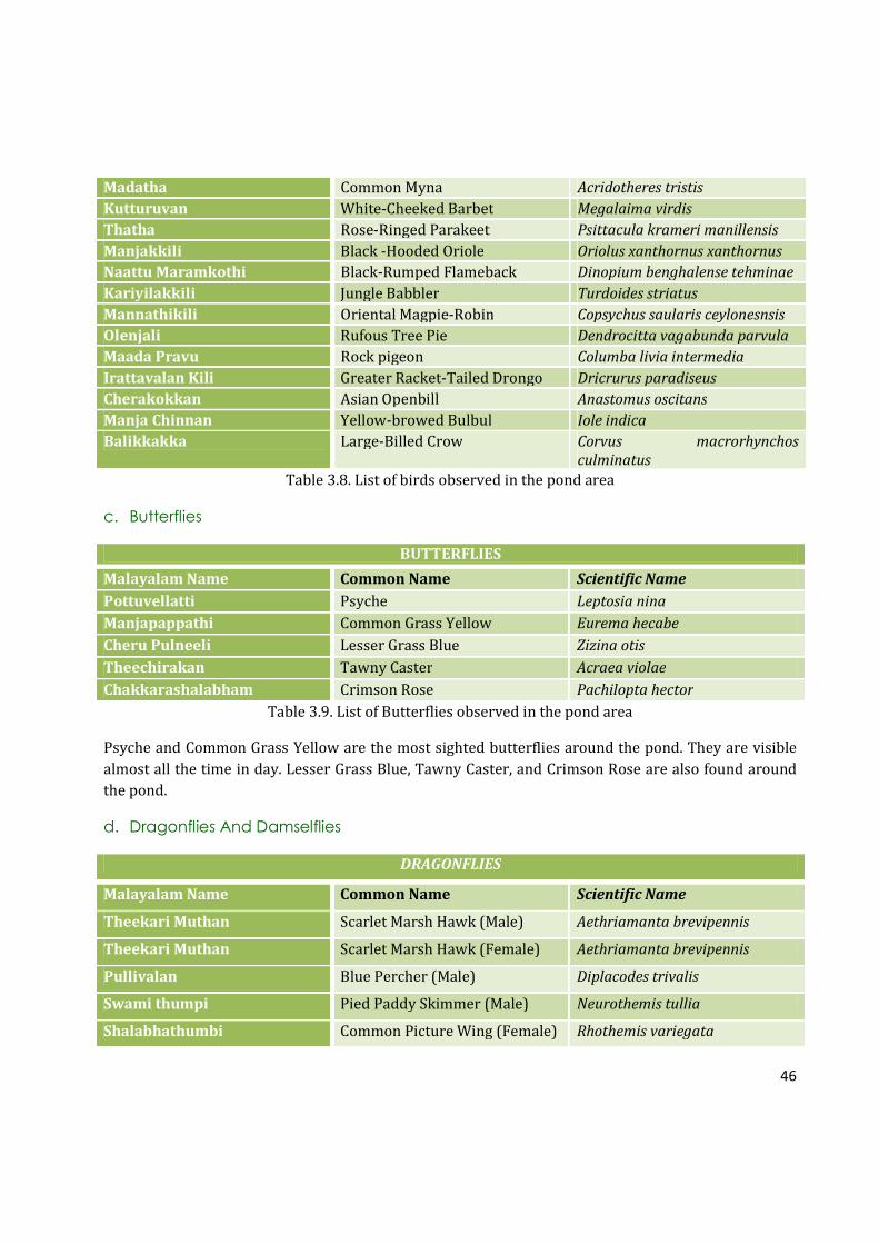
Madatha Common Myna Acridotheres tristis
Kutturuvan White-Cheeked Barbet Megalaima virdis
Thatha Rose-Ringed Parakeet Psittacula krameri manillensis
Manjakkili Black -Hooded Oriole Oriolus xanthornus xanthornus
Naattu Maramkothi Black-Rumped Flameback Dinopium benghalense tehminae
Kariyilakkili Jungle Babbler Turdoides striatus
Mannathikili Oriental Magpie-Robin Copsychus saularis ceylonesnsis
Olenjali Rufous Tree Pie Dendrocitta vagabunda parvula
Maada Pravu Rock pigeon Columba livia intermedia
Irattavalan Kili Greater Racket-Tailed Drongo Dricrurus paradiseus
Cherakokkan Asian Openbill Anastomus oscitans
Manja Chinnan Yellow-browed Bulbul Iole indica
Balikkakka Large-Billed Crow Corvus macrorhynchos
culminatus
Table 3.8. List of birds observed in the pond area
c. Butterflies
BUTTERFLIES
Malayalam Name Common Name Scientific Name
Pottuvellatti Psyche Leptosia nina
Manjapappathi Common Grass Yellow Eurema hecabe
Cheru Pulneeli Lesser Grass Blue Zizina otis
Theechirakan Tawny Caster Acraea violae
Chakkarashalabham Crimson Rose Pachilopta hector
Table 3.9. List of Butterflies observed in the pond area
Psyche and Common Grass Yellow are the most sighted butterflies around the pond. They are visible
almost all the time in day. Lesser Grass Blue, Tawny Caster, and Crimson Rose are also found around
the pond.
d. Dragonflies And Damselflies
DRAGONFLIES
Malayalam Name Common Name Scientific Name
Theekari Muthan Scarlet Marsh Hawk (Male) Aethriamanta brevipennis
Theekari Muthan Scarlet Marsh Hawk (Female) Aethriamanta brevipennis
Pullivalan Blue Percher (Male) Diplacodes trivalis
Swami thumpi Pied Paddy Skimmer (Male) Neurothemis tullia
Shalabhathumbi Common Picture Wing (Female) Rhothemis variegata

47
Pandan Vayaltheyyan Scarlet Baskar (Male) Urothemis signata
Onathumpi Wandering Glider Pantala flavescens
Anathumbi Green Marsh Hawk Orthetrum sabina
Cheru venneran Somber Lieutenant Brachydiplax sobrina
DAMSELFLIES
Naattu Poothali Blue Grass Dartlet Pseudagrion microcephalum
Pathi Pulchinnan Kerala dartlet Agriocnemis keralensis
Nattu Chathuppan Coromondel Marsh Dart Ceriagrion coromandelianum
Kanal Vaalan Chathuppan Orange-tailed Marsh Dart Rivers Ceriagrion cerinorubellum
Table 3.10. Odonates of the pond area
Dragonflies and Damselflies are often found around the pond especially between 09.30 AM to 12:30
PM and 4:30 PM to 05:30 PM. Scarlet Marsh Hawk (Male), Scarlet Basker, Pied Paddy Skimmer are
very common around the pond. They can be seen flying just above pond’s surface.
3.11 Environmental Threats
In the past, the ponds were maintained through traditional practices. However, due to increase in
population and urbanization, many of the ponds in rural areas are neglected. The same case has
affected Marathampilly as well. Continuous traditional practices of maintenance always ensured good
quality of water. When public water supply became accessible and basic amenities at houses
increased, people stopped visiting the pond gradually. The main issue faced by the pond now is algal
blooming.
According to the survey respondents, the major environmental threats associated with the pond are
eutrophication, pollution, water quality degradation, biodiversity loss, water stagnation and mud
accumulation. In case of pollution, the major pollutants are plastics, beverage bottles, sewage
discharge, and algal growth. These entire pollutants make the pond unfit for use. Few years before, the
pond got polluted due to the discharge of a hotel nearby. Due to lack of water movement, the polluted
discharges remained in the pond and made foul smell in the surrounding. This also another reason for
why people are reluctant to use the pond.
According to the community, environmental threats are not the only reasons why the pond was
abandoned. On the other hand, it is also due to lack of management and maintenance problem. The
compound wall on the southern side of the pond blocked the visibility of the pond and bathing ghuts
were not made with enough raw materials. Due to lack of strength of bathing ghuts and steps, both
bathing ghuts and steps were demolished in short time.

48
Fig. 3.8. Major threats faced by Marathampally pond as per respondents
3.12 Stakeholder And Community Response To The Proposed Project
PRA (Participatory Rural Appraisal) with a total number of 20 members was conducted on 14th
February, 2016 at a Mahatma Gandhi Natioanl Rural Worker’s (MGNRW) house hold at Marathampilly.
The details about it’s origin, history, management, the reasosn for destruction of the pond were
discussed during the PRA meeting. Both eutrophication and pollution have affected the pond. Unlike
other ponds, the beneficiaries are not just the natives of the pond, but also patients from nearby
hospital, Sabarimala pilgrims, and vehicle passangers. They all agreed to the fact that when the pond
was under the previous owners, the pond was well taken care of by everyone. However, after handing
over to Panchayath, proper management was not undertaken to conserve the pond which led to the
abandonment of the pond. An overwhelming positive response was observed in all meetings and
everybody offered full support to the implementation of the project.
Suggestions:
Cleaning, Sediment removal etc.
Beautification of pond premises
Front side – Iron fencing or grill
Retaining walls in the residence side
Bathing ghuts separately for men and women
Two solar street light
Check dam at Puthukavu rivulet
Net covering to avoid accumulation of leaves and plant debris
Water outlet clearing
Tree plantation
Seat arrangements
Waste baskets

49
MARATHAMPALLY POND- SUMMARY
♣ Marathampilly Pond has a history of more than 200 years.
♣ Marathampilly Pond is also known as Mana Kulam since about the pond was owned by a Brahmin
family named ‘Marathampilly’ 20 years ago. They handed over the ownership to Kodakara
Panchayathu.
♣ Before changing the ownership, the pond was a beautiful spot with a large Banyan tree on eastern
side and pristine water. The importance and pristinity decreased in the recent times. There were
separate bathing ghuts for different castes made of strong granite rocks.
♣ There were eight major types of uses for the pond in the past such as agriculture, bathing, laundry,
showering animals, fishing, washing, Hindu Temle rituals and funeral rituals. The pond was used
for many Hindu practices related with the ‘marathampilly temple’.
♣ Marathampilly Pond supported livelihood of local community in many ways such as laundry, and
agriculture, but only agriculture exists as a livelihood now, but very less indeed.
♣ The main beneficiaries of the pond in the past were local community, pilgrims and tourists
whereas currently a few of local community alone.
♣ There are nearly of 8 ponds near Marathampilly Pond. However, only 40% of such water bodies
are in good condition and very few are protected. Marathampilly Pond was recorded as polluted
and abandoned.
♣ Pond has an area of 44.32 cents as per the survey done by the study team on 11.3.2016. The area
faces encroachment.
♣ The average depth of the pond is 0.95 m. and maximum depth is 2.5 m. The height of the summer
water column is 1 m.
♣ The community members pointed out that the pond has water level during both summer and
rainy seasons. Majority of surveyed community members argued that even in extreme summer, at
least one foot depth of water will be there.
♣ Community survey showed that the water quality of the pond was excellent, even potable. Due to
the stagnation, weed infestation and pollution, water quality has been significantly reduced. The
water quality of the pond found deterorated in terms of standard parameters.
♣ Biodiversity status of the surrounding area (50 m radius) of the pond showed that small holder
ecosystems with typical crop diversity of Kerala is the predominant land use pattern exist. This
has created a typical village atmosphere all around the region.
♣ A total of 64 plants, 20 birds, 5 butterflies, 9 dragonflies and 4 damselflies are recorded from this
area through taxonomic survey. Further, Biodiversity status of the pond and its bank showed that
the area has 2 species of aquatic plants and 8 species of fishes.
♣ Survey respondents commented problems such as eutrophication and weed infestation, and
related stagnation as the major issues. The pollution due to stagnation is evident from the water
quality studies as well.
♣ An overwhelming positive response was observed in the meeting and everybody offered full
support to the implementation of the project.
50
4. PROPOSAL
4.1 Aim: To conserve the Marathampally pond and ensure sustainable utilization for the
community.
4.2 Objectives:
• Restore the pond from eutrophication and pollution: Retain its ecological importance to
provide sustainable use pattern.
Pond’s ecological importance can be retained to provide sustainable use pattern. The water quality
has been detoriated over the years due to pollution and eutrophication. When the pond was
maintained through traditional practices, the water quality was very good and safe to use.
Moreover, the pond had rich biodiversity of fishes. Over the years, pond and it’s surroundings lost
its pristine and reduced the biodiversity. The project aims at restoring the ecological importance it
had in the past and provide a sustainable environment ahead.
• Taller retaining wall to prevent runoff water entering into the pond thus promises better
water quality for safe use pattern.
Just like other ponds in Kodakara, Marathampilly pond and it’s surroundings lack proper drainage
facilities, and thus the runoff water from the agricultural and residential lands directly enter into
the pond. It deposits a large amount of mud in the pond. Thus, the pond’s depth decreases and
stimulates the growth of aquatic weeds and algae since the muddy runoff water is rich with
nutrient contents.
• Increase the ground water level in Marathampilly region through rain water harvestation in
the pond.
In the past, the pond used to support ground water table by holding water in the pond.
Underground water is one of the most important sources of water in Marathampilly. However,
Marathampilly face water shortage during summer season. Water harvestation in Marathampilly
pond promise recharging of nearby wells once in the past. However, when the pond got
eutrophicated, water recharging also got diminished. Therefore, the natural process of ground
water recharging has been affected significantly. By increasing the water storage capacity of
Marathampilly Pond, the natural process ground water recharging can be retained and provide a
sustainable solution for water shortage in Marathampilly.
• Avoid water stagnation through by providing outlet and keep regular water flow.
The water from the pond used to outflow regularly to Marathampilly paddy fields. However, due
to improper maintenance, these outlets are almost closed and thus, lag water flow of the pond.
Providing proper outflow of water will promise better quality of water.

51
• Attract more birds, butterflies, damselflies, amphibians, etc.
According to the community, Marathmpilly Pond and its rich surroundings used to attract a large
diversity of birds, butterflies, and damselflies, in the past. When water quality degradation and
eutrophication affected the pond, pond is not able support a large variety of fauna. Renovating the
pond will offer more diverse habitat of birds, butterflies, damselflies, and amphibians by providing
constant source of water for them.
• Make provisions for bathing, irrigation (manual) and meet the common water needs of the
society.
As the region face water shortage, especially in summer, a large number of people from different
economic group use them for bathing, washing clothes, and domestic purposes. As the pond is very
close to Kodakara town and and National Highway, an increase in number of beneficiaries is
expected.
• Most importantly, provide enough water for agriculture.
Water is the most important component of rice cultivation. Rice cultivation has almost declined in
Marathampilly due to water scarcity. People in Marathampilly have changed the crops from rice to
coconut, tapioca, banana etc which needs less water than paddies. Therefore, the rice cultivation
has witenessed steady decline since recent times. The project aims at ensuring the restoration of
rice cultivation by providing water support. The project also aims at ensuring natural resource
conservation and sustainable management which can guarantee that natural resources are made
available for present generations without compromising the needs of future generations.
• Beautification of Pond Premises
Marathampilly pond has a historic value. It has vitnessed many generations and changes in society.
The pond was open to public only when the temples where open to all castes in Hindus. While
people are trying to conserve and maintain historical monuments, the ponds which have historic
values are always not recognized or considered. Through sustainable maintainence of Marampilly
pond, it’s beauty and value can be restored.
4.3 Requirements
Major requirements for the renovation of the pond are cleaning and remova of sediments, demolishing
front retaining wall, except its foundation and construction of new grill type fence, construction of the
retaining wall on the residential side and construction of bathing ghat separately for men and women.
A chekdam at Puthukavu thodu will augment the water storage of the Marathampally pond. The single
and lone outlet from the pond also should be cleared for smooth outlets.
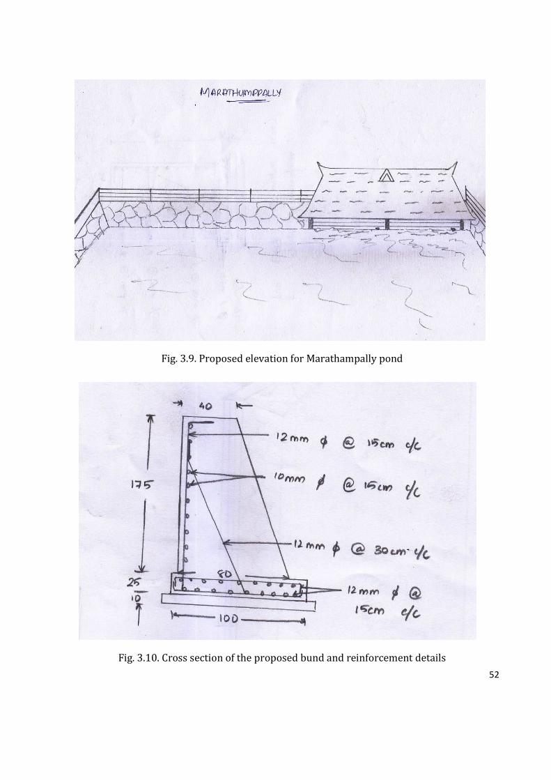
52
Fig. 3.9. Proposed elevation for Marathampally pond
Fig. 3.10. Cross section of the proposed bund and reinforcement details
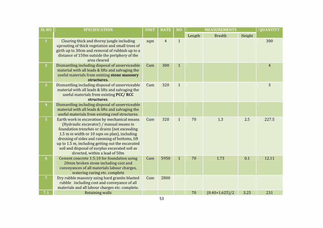
53
SL NO SPECIFICATION UNIT RATE NO MEASUREMENTS QUANTITY
Length Bredth Height
1 Clearing thick and thorny jungle including
uprooting of thick vegetation and small trees of
girth up to 30cm and removal of rubbish up to a
distance of 150m outside the periphery of the
area cleared
sqm 4 1 300
2 Dismantling including disposal of unserviceable
material with all leads & lifts and salvaging the
useful materials from existing stone masonry
structures.
Cum 300 1 4
3 Dismantling including disposal of unserviceable
material with all leads & lifts and salvaging the
useful materials from existing PCC/ RCC
structures.
Cum 320 1 3
4 Dismantling including disposal of unserviceable
material with all leads & lifts and salvaging the
useful materials from existing roof structures.
5 Earth work in excavation by mechanical means
(Hydraulic excavator) / manual means in
foundation trenches or drains (not exceeding
1.5 m in width or 10 sqm on plan), including
dressing of sides and ramming of bottoms, lift
up to 1.5 m, including getting out the excavated
soil and disposal of surplus excavated soil as
directed, within a lead of 50m
Cum 320 1 70 1.3 2.5 227.5
6 Cement concrete 1:5:10 for foundation using
20mm broken stone including cost and
conveyances of all materials labour charges,
watering curing etc. complete
Cum 5950 1 70 1.73 0.1 12.11
7 Dry rubble masonry using hard granite blasted
rubble including cost and conveyance of all
materials and all labour charges etc. complete.
Cum 2800
7.1 Retaining walls 70 (0.40+1.625)/2 3.25 231

54
7.2 For raising the existing retaining walls 33 0.4 0.5 6.6
TOTAL 237.6
8 Random Rubble Masonry in Cement Mortar 1:6
for foundation and basement including the cost
and conveyance of all materials, labour charges
etc., complete.
Cum 3918
8.1 For raising the existing retaining walls of the
road side
1 38 0.4 0.3 4.56
8.2 For steps of the bathing area (16nos of steps
with 20cm raise and 30cm treads)
1 70
TOTAL 74.56
9 Cement concrete 1:2:4 for flooring using 20mm
broken stone including cost and conveyances of
all materials labour charges, watering curing
etc. complete
Cum 6450
9.1 At the top of retaining walls 1 141 0.4 0.1 5.64
10 Brick work in CM 1:4, including cost and
conveyance of all materials, hire and labour
charges, watering, curing etc.complete.
Cum 4918
10.1 for fensing over retainig wall 1 71 0.2 1 14.2
10.2 For bathing area 1 10 0.2 2.1 4.2
1 3.2 0.2 2.1 1.344
1 3 0.2 1 0.6
3 0.4 0.4 2.1 1.008
10.3 exclude -2 1 0.2 2.1 -0.84
TOTAL 21
11 Plastering with CM 1:3, 12mm thick one coat
floated hard and trowelled smooth including
cost and conveyance of all materials, hire and
labour charges, watering, curing etc.complete.
sqm 200
11.1 For the bathing area 2 10 2.1 42
2 3.2 2.1 13.44
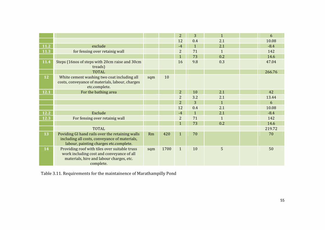
55
2 3 1 6
12 0.4 2.1 10.08
11.2 exclude -4 1 2.1 -8.4
11.3 for fensing over retainig wall 2 71 1 142
1 73 0.2 14.6
11.4 Steps (16nos of steps with 20cm raise and 30cm
treads)
16 9.8 0.3 47.04
TOTAL 266.76
12 White cement washing two coat including all
costs, conveyance of materials, labour, charges
etc.complete.
sqm 10
12.1 For the bathing area 2 10 2.1 42
2 3.2 2.1 13.44
2 3 1 6
12 0.4 2.1 10.08
12.2 Exclude -4 1 2.1 -8.4
12.3 For fensing over retainig wall 2 71 1 142
1 73 0.2 14.6
TOTAL 219.72
13 Poviding GI hand rails over the retaining walls
including all costs, conveyance of materials,
labour, painting charges etc.complete.
Rm 420 1 70 70
14 Providing roof with tiles over suitable truss
work including cost and conveyance of all
materials, hire and labour charges, etc.
complete.
sqm 1700 1 10 5 50
Table 3.11. Requirements for the maintainence of Marathampilly Pond
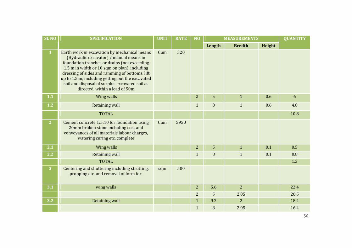
56
SL NO SPECIFICATION UNIT RATE NO MEASUREMENTS QUANTITY
Length Bredth Height
1 Earth work in excavation by mechanical means
(Hydraulic excavator) / manual means in
foundation trenches or drains (not exceeding
1.5 m in width or 10 sqm on plan), including
dressing of sides and ramming of bottoms, lift
up to 1.5 m, including getting out the excavated
soil and disposal of surplus excavated soil as
directed, within a lead of 50m
Cum 320
1.1 Wing walls 2 5 1 0.6 6
1.2 Retaining wall 1 8 1 0.6 4.8
TOTAL 10.8
2 Cement concrete 1:5:10 for foundation using
20mm broken stone including cost and
conveyances of all materials labour charges,
watering curing etc. complete
Cum 5950
2.1 Wing walls 2 5 1 0.1 0.5
2.2 Retaining wall 1 8 1 0.1 0.8
TOTAL 1.3
3 Centering and shuttering including strutting,
propping etc. and removal of form for.
sqm 500
3.1 wing walls 2 5.6 2 22.4
2 5 2.05 20.5
3.2 Retaining wall 1 9.2 2 18.4
1 8 2.05 16.4

57
TOTAL 77.7
4 Cement concrete 1:2:4 for using 20mm broken
stone including cost and conveyances of all
materials labour charges, watering curing etc.
complete
Cum 6450
4.1 Wing walls 2 5 (.4+.8)/2 2 12
5 Reinforced Cement concrete 1:2:4 using 20mm
broken stone including cost and conveyances
of all materials labour charges, watering curing
etc. complete
Cum 6450
5.1 Retaining wall raft foundation 1 8 1 0.25 2
5.2 Retaining wall 1 8 (.4+.8)/2 1.75 8.4
Deduction (3nos of 50cm wide 1.5cm deep
rectangular notch)
3 0.5 (.4+.75)/2 1.5 -1.29
TOTAL 9.11
6 Steel reinforcement for R.C.C. work including
straightening, cutting, bending, placing in
position and binding all complete.
ton 67000 0.36
7 Providing metallic arrangements for controling
water flow including cost and conveyances of
all materials, labour charges,etc. complete
kg 207 18
Table 3.12. Requirements for Check dam near the paddy fields.

58
4.4 Budget
Budget for Marathampally Pond
No. Particulars Amount
1 Cleaning, Sediment removal etc. 10,0000.00
2 Front side – Iron fencing or grill
12,50,000.00* 3 Retaining walls in the residence side
4 Bathing ghats separately for men and women
5 Water outlet clearing
6 Two solar street light 70000.00
7 Check dam at Puthukavu rivulet ( a nearby rivulet which will
augment the water storage of the pond) 2,14,046.00*
8 Net covering to avoid accumulation of leaves and plant debris 85000.00*
9 Tree plantation 5000.00
10 Seat arrangements 12000.00
TOTAL 17,36,046.00
Rupees Seventeen lakh thirty six thousand and forty six only
Fig. 3.13. The budget required for the maintainence of Marathampilly Pond and Check Dam
4.5 Conclusion:
By providing the above mentioned requirements, Marathampilly Pond can be restored as well as
conserved. In addition to this, sustainable development of the pond can be ensured with help of active
participation of residents around Marathampilly Pond.
Photo: Marathampally pond
59
CHAPTER IV
KURICHIKULAM
1. INTRODUCTION
Kurichi kulam is a pond situated in 17th ward of Kodakara Grama Panchayathu. The pond is also
known as ‘Thamara Kulam,’ because it is rich with sacred lotus (Nelumbo nucifera) plants. It is a
pond which has great importance related with people’s life of the area. Younger generation is also
interested in the rejuvenation of the pond which is a factor that stands Kurichikulam apart from
other four ponds. Consequently, the youngsters are so much interested in this project as well. They
cooperated with the study and gave all support to us because of their interest in this pond. The
people around this area do not deposit wastes and at the same time, the people will not allow
people to abandon this pond. The pond locates in a very visible location, on the way to ‘Sahrudaya
College.’
2. METHODOLOGY
The study was begun with conducting community survey of 30 respondents who live around the
pond. A survey among the community was conducted in order to expose the past and present status
of the pond in terms of biological, social and economical status. Land survey, quatity of clay and silt,
water quality studies, biodiversity estimation, community survey, and pollution studies were
conducted as part of the study.
2.1 Study Area
Kurichikulam is a pond in Kodakara Grama Panchayathu situated in the place ‘Koprakalam’ and
belongs to the ward 17 of Kodakara Panchayath. The pond is located at a distance of 4 KM from
Kodakara town and 1 KM from State Highway. The pond is _ meter long, _ meter wide, _ meter deep.
The pond lies between N 10021’34.10” and E 076017’29.82”.
Photo: Kurichikulam

60
3. RESULTS AND DISCUSSION
3.1 Community Survey Respondents’ Details
According to the methodology of collection of datas, 30 families were surveyed. The demography of
surveyed community is given below.
Categories Percentage (%)
Gender Male 43 Female 57
Age
20-40 6
41-60 34
61-80 50
81-100 10
Occupation
Local community 73
Prominent socio religious members 6
Local govt and non govt officials 6
Farmers 10
Laundry community 0
Kudumbasree 5
Table 4.1 Demographic details of surveyed community
3.2 History
3.2.1 Origin Of Kurichikulam
The purpose of pond creation may be agriculture/irrigation because the land is very suitable for
cultivation, especially rice. In the past, majority of men in this region were farmers. Even now, there
are families who are interested in agriculture. The geographical features around the pond also
support agriculture. During the survey, some old people near the pond said that the pond should be
100 years old. According to them, the pond was dug by local people under leadership of panchaythu
for irrigation of nearby agricultural lands. The bar graph illustrates people’s idea about the origin of
the pond.
Photo: PRA exercise of stakeholders of Kurichikulam

61
Fig.4.1. The age of the pond as opined by stakeholder communities
As per the respondents (Fig.4.1) that most of the people have the opinion that the pond was
originated 100 years ago. Twelve among the thirty respondents supported its origin dates back to
100 years. The people of that time are not alive and the people got this idea from their parents and
grandparents. The present community do not know enough details about it’s origin.
3.2.2 Etiology of the name “Kurichikulam”
There are several stories on how the name “Kurichikulam” came into existence. Most of the people
around the pond don’t know how this name ‘Kurichi’ came to the pond. In the beggning of the
survey, a man guessed that there was a rock called kurichi in the pond, that’s the reason why it is
called as Kurichikulam. Another one said that one goddess named kurichi came to take bathe in this
pond years ago. But by the end of the survey, significant information was received from some
people that there was a Nair family with family, named ‘Kurichiyathu’ stayed nearby the pond years
back. The land of pond was once owned by ‘Kurichiyathu’ family. That’s how the pond got the name
Kurichi Kulam.
However, there is a tendency to change the name of the pond at present. Therefore, the youngsters
like to call this pond as ‘Thamara Kulam’ because the pond now is now known for the presence of
lotus plants in the pond.
3.3 Physical features of the pond in the past
There were paddy fields on northen and southern sides of the pond. There was only a pavement
made of mud between the paddy field on western side and the pond. Now, this mud way has been
developed into a tarred road. This development took place because of the Sahrudaya College which
is only 1 km apart from the pond. There are patches of lands on eastern and southern sides of the

62
pond. There are coconut tree cultivation and banana tree cultivation are present in those lands. On
northern side, there was one acre paddy field with ‘3 poovu’ (3 times in an year) rice cultivation.
Now it reduced because of less profit and lack of water. Some lands are also converted as house
plots and constructed the houses. Now the road infront of the pond is a bus root. This made the area
busy with human interactions. Therefore now it is difficult to take bathe in the pond for women.
The people planted a combination of banyan tree and mango tree near the pond (a spirirtual
concept called Aatmavu (Aaal + Mavu- in Malayalam means the combination of two trees is equilant
to heavenly spirit). The mango tree dried and destroyed, but the banyan tree existing now.
On the southern side of the paddy field, large rocks can be seen. There is some rocky area in the
pond. Also people suggested that there is a chance of increased amount of water if depth increased
by breaking rocks. The rocks also act as steps to the pond. The main water source of this pond is its
own beck. But there is an ovulet in front of the pond which can link with the pond through a spout
near the banyan tree. But now the ovulet is blocked by mud wastes. There are 2 outlets to the farm
lands.
The pond has retaining wall, compound wall, ovulet with shutter, ramp and steps which were
constructed by Block Panchayathu fund. But the construction was not successful. The retaining wall
have leakage and pond can’t store water. There is a cattle ramp on one side and steps for manual
use. There were screw pines around the pond which act as ptrotection wall against soil erosion. It
removed during renewation of pond some years ago.
There is a small mud way on southern side which includes in pond area. Also there is encroachment
in small scale by people on northern and eastern sides.
3.4 Main uses of the pond in past and present
The main uses of the pond in the past were agriculture, bathing, laundry, showering animals and
fishing. Unfortunately, it has limited to agriculture and cattle raising now. The local people used the
water for many domestic activities, funeral rituals and for some Hindu practices like Thiruvathira.
At that time, the quality of the water in the pond was very good. Fig. 4.2 clearly shows that the use
of the pond has decreased significantly compared to the past. Currently, the pond is used only for
agriculture and cattle raising by local people as the quality of water in the pond is not same as the
past.
Fig.4.2. Livelihood usages of Kurichikulam in the present and past

63
Due to water quality degradation of the pond, the use of the pond has decreased significantly
compared to the past as impure water cannot be used for bathing, washing and Hindu rituals.
However, water in pond is used in small scale for agriculture, fishing as a hobby and showering
animals.
The local community is the main beneficiaries of the pond in both past and present. About 250
families around the pond will get benefitted through the renovation of the pond.
3.5 Livelihood Existed Based On Kurichikulam
The major livelihood activities associated with Kurichikulam were agriculture, fishing, laundry and
cattle raising. To irrigate the paddy fields near to the pond, the pond was the major source of water.
Earlier, there were three Poovu cultivation (poovu in Malayalam means three flowerings a year
namely Puncha, Virippu and Mundakan) to cultivate paddy but now it has reduced to only one
season (Puncha alone). Also, majority of the paddy fields are filled now. Therefore, drastic reduction
in cropping area occurred in recent years. Consequently, water usage for agriculture has also
declined compared to the past. Fishing was also a livelihood activity based in the pond. Fishing was
also done for domestic purposes. Angling fishes in the pond was the main activity happened in the
pond almost every day, but now it has also decreased considerably. Currently, only few people are
doing angling as a time-pass or hobby but not for livelihood. In addition, individuals used to
undertake the ownership of pond for fishing during a period of one year through auction to carry
out fishing from the panchayath. However, it has stopped some years ago. Laundry and cattle
raising were the other activities related to the pond. In past, some families were used to wash
clothes as livelihood activity. They were ‘Velans’ (traditional washer community). Moreover, many
people used the pond to shower the cattle and that was also a drinking water source for those
animals.
Fig. 4.3. Major livelihoods related to Kurichikulam in the past
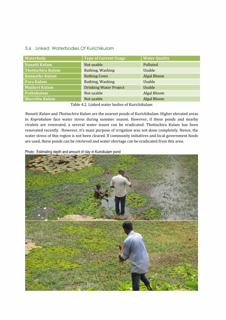
64
3.6 Linked Waterbodies Of Kurichikulam
Waterbody Type of Current Usage Water Quality
Nanatti Kulam Not usable Polluted
Thottachira Kulam Bathing, Washing Usable
Kunnathe Kulam Bathing Cows Algal Bloom
Para Kulam Bathing, Washing Usable
Mutheri Kulam Drinking Water Project Usable
Pothukulam Not usable Algal Bloom
Sharathu Kulam Not usable Algal Bloom
Table 4.2. Linked water bodies of Kurichikulam
Nanatti Kulam and Thottachira Kulam are the nearest ponds of Kurichikulam. Higher elevated areas
in Koprakalam face water stress during summer season. However, if these ponds and nearby
rivulets are renovated, a several water issues can be eradicated. Thottachira Kulam has been
renovated recently. However, it’s main purpose of irrigation was not done completely. Hence, the
water stress of this region is not been cleared. If community initiatives and local government funds
are used, these ponds can be retrieved and water shortage can be eradicated from this area.
Photo: Estimating depth and amount of clay in Kuricikulam pond

65
3.7 Geography
3.7.1 Geographical Details
The information about the pond were collected from Village Office, Panchayathu etc. Kurichikulam
situates in 17th ward of Kodakara Grama Panchayathu. The pond area includes in the survey
number 1530. An approximate sketch of this area was collected from Village Office, Kodakara. The
area is rocky. Rocks are visible in and around the pond. Pond situates at adistance of 4 km from
Kodakara town.
Fig. 4.4 Area map of Kurichikulam Fig 4.5. Village map of Kurichikulam
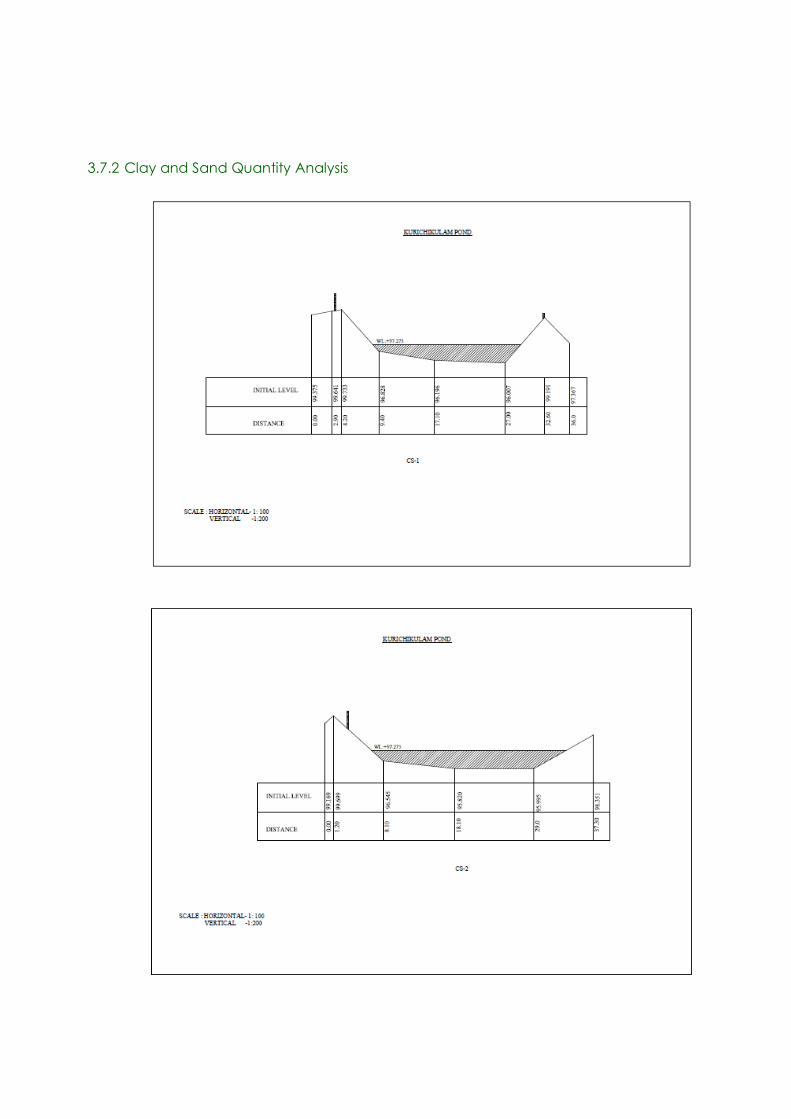
66
3.7.2 Clay and Sand Quantity Analysis

67
Fig. 4.6. Cross section of the pond
The average depth of the water column is 0.95 metre, however sediments are found for about 2
metre deep. The substratum is laterite rock.
3.8. Water Quality and quantity
3.8.1 Water Quantity
Kurichikulam is an all seasonal pond. It never wilts. There is a possibility of incoming water from
the ovulet infront of the pond. Pond have good beck. The pond has great significance in this area.
The people said that their well‘s water level is influenced by he water in the pond. There are two
outlets for pond to the farmland. At the present condition, the pond cannot store water due to
leakage found in the retaining walls. There is reduction of water quantity in summer season.
Fig. 4.7 shows that 37% of the survey respondents said that drawdown height during summer is
above 5 foot. 30% of people have the opinion that water level goes down by 3 foot. About 10%
people claim that water level gows below 1 feet only. All the respondents are sure about the fact
that the pond have seasonal water fluctuations. However, 17% of people didn’t have clear idea
about the drawdown height.

68
Fig.4.7. Opinion of stakeholders on the summer water level of Kurichikulam
3.8.2 Water Quality
Water quality of the pond was pure as potable until one decade back. The people used the water for
religious practices due to the purity of water. But now, the pond is filled with weeds and mud. The
mud coming with runoff water flows into the pond. Improper erosion control management, lack of
drainage system, and discharge of domestic sewage have higher amounts of nutrient content. In
case of Kurichikulam, the drainage system and erosion control management was not undertaken
properly. Hence, the runoff water from the nearby roads and farmfileds come directly to the pond.
A large amount of sediment is accumulated in the pond over time. The presence of mud could be the
major reason for the fast growth of lotus in the pond. Eutrofication is the main environmental
threat of the pond. The water became itchy due to high concentration of mud in the pond water.
Sr.
No.
Parameter Sample
value
1
Sample
value 2
Sample
value
3
Permissible limit
for bathing and
irrigation (IS2296
standard)
1 pH 5.68 5.9 6.55 6.5 – 8.5
2 Salinity 0.05 0.07 0.07 3 ppt
3 Conductivity 72.8 101 91.0 2250 µS
4 Turbidity 75 70 75 300 NTU
5 Total Dissolved Solids 38.2 54.3 47.9 2100 mg/L
6 Total Hardness 42.0 88.0 66.0 1100 mg/l as CaCO3 *

69
7 Ca+ ions 26.0 10.0 22.0 500 mg/l as Ca+ *
8 Mg+ ions 16.0 78.0 44.0 30 mg/l as Mg+*
9 Acidity 64 68 40 200 mg/l as CaCO3*
10 Alkalinity 8 20 16 200 mg/l as CaCO3*
11 Total iron 0.2 0.3 0.2 2.0 mg/l as Fe*
12 Chloride 20 40 20 600 mg/l as Cl
13 Fluoride 0 0 0 1.5 mg/l as F
14 Nitrate 1 1 1 30 mg/l as NO3*
15 Sulfate 0 0 0 1000 mg/l as SO4
16 DO 14.9 24.43 13.39 50.0mg/l
17 BOD 2.8 4.6 2.1 30.0mg/l
18 Total bacterial count /
1ml
13 22 21 5
19 Total coliforms MPN /
100ml
1100 2400+ 2400+ 500
20 Faecal coliforms MPN /
100ml
75 75 75 200
21 E. coli Present Present Present 0* * Not mentioned in IS2296, but it is as per the WHO standard.
Table 4.3 Data on water quality tests for Kurichikulam Pond
As per the data on water quality tests for the pond water it is highly polluted. This is mainly
because of the stagnation and due to the sewage that flows into the pond from the main road
through rain water.
Photo: Collecting water samples for analysis from Kurichikulam

70
3.9 Biodiversity Estimation
3.9.1 Biodiversity Status Of The Pond
Malayalam name Common name Scientific name
Varal Striped snake head Channa striata
Mushi Valencienne’c clariid Clarias dussumieri
Philoppi Mozambique Tilapia Oreochromis mossambica
Kallada Climbing Perch Anabas testudines
Paral Common rasbora Rasbora dandia
Karippidi Malabar Leaf Fish, Common
catopra
Pristolepis marginata
Pallathi Orange chromid Etroplus maculatus
Kadu Stinging catfish Clarias batrachus
Koori
Vaala Fresh water eel Wallago attu
Vattudi
Neermeen
Vaaga
Table 4.4. List of fishes found in the pond
The list of fishes found in the pond is given in Table 4.4. Majority of survey respondents said that
fish diversity has decreased in great amount from the past. Some people mentioned that some years
ago, a disease affected the fishes which are the reason for reduction in the fish diversity.
Fig. 4. 8. Changing pattern of fish diversity in Kurichikulam

71
Most of the respondents, about 80% said that fish diversity in the pond reduced in greater amount.
13% have the opinion that no change in fish diversity has occurred in the pond. 7% of respondents
were not aware about the fishes in the pond.
3.9.2 Flora of the pond
There are sacred lotus and different types of weeds in pond. Small black color fishes are very
common in pond. Variety of birds, animals, butterflies and dragonflies can be seen in and around
the pond. The pond area is also rich with flora.
Malayalam Name Common Name Scientific Name
Afican Payal Salvinia Salvinia molesta
Thamara Lotus Nelumbo nucifera
Table 4.5 List of flora in the pond
3.9.2 Biodiversity Around The Pond
The people in this region are very interested in agriculture. There are rice cultivation, coconut tree
and vegetables around the pond. The cultivation was also depended on the pond.
Area Ownership Type Position
1 Acres Kapliyathu bhaskaran Rice (Past) North 1.2 Acres Cheramparamban Rice South
30 Cent Mangalan Banana, Coconut Tree West
41.5
Cent
Vadakkedathu Gopi Nair Mixed cropping (Jaathi,
coconut tree,banana)
East
Table 4.6 Land use pattern of neighboring areas of the Kurichikulam pond
a. Floral diversity
Malayalam name Common name Scientific name
Aal maram Banyan tree
Vaazha Banana Musa sp.
Nellu Rice
Thengu Coconut tree Cocos nucifera
Vatta Gum Plant Macaranga peltata
Kamuku Arecanut Areca catechu
Maavu Mango Tree Mangifera indica
Kaitha Screw Pine/ Pendanus
Thekku Teak Tectona grandis
Muringa Drumstick Plant Moringa oleifera
Irumpan Puli Bilimbi Averrhoa bilimbi
Pana Palm Arecaceae
Kappa Tapioca Manihot esculenta

72
Plavu Jackfruit Tree Artocarpus heterophyllus
Kappalam Carica papaya Carica papaya
Aryaveppu Neem Tree Azadirachta inaica
Thottavadi Touch me not Mymosa pudica
Jaathi Nut meg Myristica fragrans
Kurumulaku Black Pepper Piper nigrum Linn
Kannalipullu
Manjal Tumeric Curcuma longa
Inchi Garden Ginger Zingiber officinale
Chembu Colocasia Colocasia esculenta
Kaithachakka Pineapple Ananas comosus
Kashumaavu Cashew nut Anacardium occidentale
Karishu
Madhuran chembu
Raja koova
Naarakam
Kanthhari Mulaku Bird’s eye chilli Capsicum annum
Mahagani Mahigani Swietenia macrophylla
Peru
Rajamalli Peacock Flower Caesalpinia pulcherrima
Kurunthotti
Vishukonna Golden shower tree Cassia fistula
Communist pacha Eupatorium Chromolaena odorata
Paala Devil tree Alstonia scholaris
Neeroli
Sheemakonna Mata raton Gliricidia sepium
Kudavan
Brahmi
Mullatha Graviola Anona muricata
Pana Palm arecaceae
Uzhunnundi
Thondi Indian gum tragacanth Sterculia urens
Kalluruthi
Keezhaar nelli
Lakshmi tharu Paradise tree Simarouba glauca
Vaalan puli
Devadaru Bastard Sandal Erythroxylum monogynum
Thakkalli
Nanthyar vattam East Indian rosebay Ervatamia coronaria
Mulla Jasmine
Thumba Lucas Leucas aspera
Venal pacha
Panji Cotton tree Gossypium hirsutum
Payaru
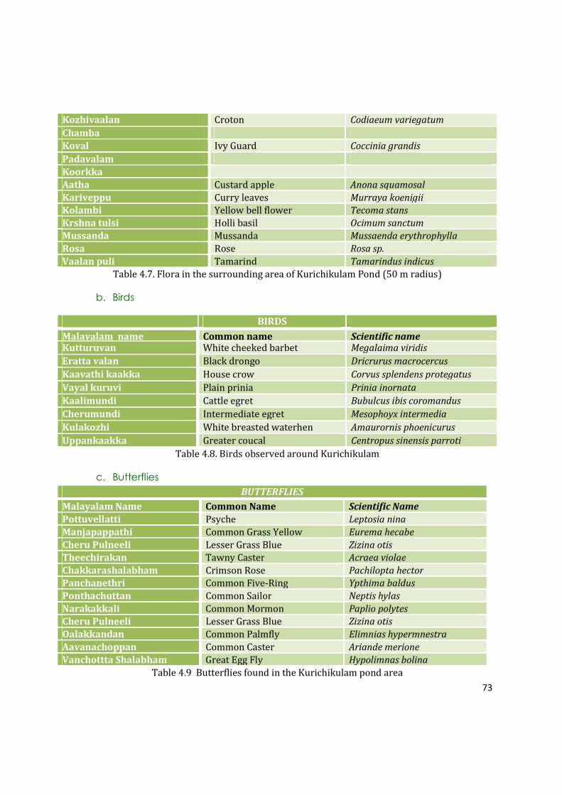
73
Kozhivaalan Croton Codiaeum variegatum
Chamba
Koval Ivy Guard Coccinia grandis
Padavalam
Koorkka
Aatha Custard apple Anona squamosal
Kariveppu Curry leaves Murraya koenigii
Kolambi Yellow bell flower Tecoma stans
Krshna tulsi Holli basil Ocimum sanctum
Mussanda Mussanda Mussaenda erythrophylla
Rosa Rose Rosa sp.
Vaalan puli Tamarind Tamarindus indicus
Table 4.7. Flora in the surrounding area of Kurichikulam Pond (50 m radius)
b. Birds
BIRDS
Malayalam name Common name Scientific name Kutturuvan White cheeked barbet Megalaima viridis
Eratta valan Black drongo Dricrurus macrocercus
Kaavathi kaakka House crow Corvus splendens protegatus
Vayal kuruvi Plain prinia Prinia inornata
Kaalimundi Cattle egret Bubulcus ibis coromandus
Cherumundi Intermediate egret Mesophoyx intermedia
Kulakozhi White breasted waterhen Amaurornis phoenicurus
Uppankaakka Greater coucal Centropus sinensis parroti
Table 4.8. Birds observed around Kurichikulam
c. Butterflies
BUTTERFLIES
Malayalam Name Common Name Scientific Name
Pottuvellatti Psyche Leptosia nina
Manjapappathi Common Grass Yellow Eurema hecabe
Cheru Pulneeli Lesser Grass Blue Zizina otis
Theechirakan Tawny Caster Acraea violae
Chakkarashalabham Crimson Rose Pachilopta hector
Panchanethri Common Five-Ring Ypthima baldus
Ponthachuttan Common Sailor Neptis hylas
Narakakkali Common Mormon Paplio polytes
Cheru Pulneeli Lesser Grass Blue Zizina otis
Oalakkandan Common Palmfly Elimnias hypermnestra
Aavanachoppan Common Caster Ariande merione
Vanchottta Shalabham Great Egg Fly Hypolimnas bolina
Table 4.9 Butterflies found in the Kurichikulam pond area

74
d. Dragonflies and Damselflies
DRAGONFLIES
Malayalam Name Common Name Scientific Name
Theekari Muthan Scarlet Marsh Hawk (Male) Aethriamanta brevipennis
Onathumpi Wandering Glider Pantala flavescens
Shalabha Thumpi Common Picture Wing
(Female)
Rhothemis variegata
Pandan Vayaltheyyan Scarlet Baskar (Male) Urothemis signata
Pullivalan Blue Percher (Male) Diplacodes trivalis
Swami thumpi Pied Paddy Skimmer (Male) Neurothemis tullia
DAMSELFLIES
Malayalam Name Common Name Scientific Name
Pathi Pulchinnan Kerala dartlet Agriocnemis keralensis
Naattu Poothali Blue Grass Dartlet Pseudagrion microcephalum
Kanalvaalan Chathuppan Orange-tailed Marsh Dart Ceriagrion cerinorubellum
Table 4.10 Odonates found in the Kurichikulam pond area
3.10 Environmental Threats And Reasons For The Destruction Of The Pond
The eutrophication and mud deposition are the major threats of pond. When comparing with other
ponds, sewage deposition is very less. This reveals the approach of local community towards the
conservation of natural resources. Due to the accumulated growth of weeds and mud deposition,
water quality degraded in greater amount and water is itchy also.
Deposition of sewage is very less in pond. Plastic bottles are observed very rarely in the pond.
Respondents said that some vehicular passengers deposited wastes in large bags on road sides, not
in the pond.
Some people also mention that destruction of water resources is a consequence of agricultural loss.
When farmers and community are benefitted from the pond for irrigation and water storage,
people take initiative to protect them. It was a natural give and take process; however, the process
is destructed with the lack of agricultural activities. On the other hand, the facilities at the home
have increased. Hence, people stopped using the pond which has resulted in increased weed
growth in the pond. Apart from this, a disease has affected the fishes in the pond in 2005, so most of
the people stopped using the pond water.
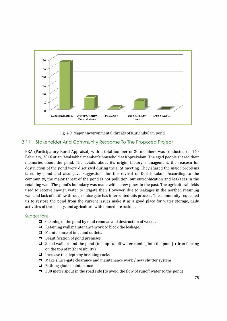
75
Fig. 4.9. Major enevironmental threats of Kurichikulam pond
3.11 Stakeholder And Community Response To The Proposed Project
PRA (Participatory Rural Appraisal) with a total number of 20 members was conducted on 14th
February, 2016 at an ‘Ayalsabha’ member’s household at Koprakalam. The aged people shared their
memories about the pond. The details about it’s origin, history, management, the reasosn for
destruction of the pond were discussed during the PRA meeting. They shared the major problems
faced by pond and also gave suggestions for the revival of Kurichikulam. According to the
community, the major threat of the pond is not pollution, but eutrophication and leakages in the
retaining wall. The pond’s boundary was made with screw pines in the past. The agricultural fields
used to receive enough water to irrigate then. However, due to leakages in the northen retaining
wall and lack of outflow through sluice gate has interrupted this process. The community requested
us to restore the pond from the current issues make it as a good place for water storage, daily
activities of the society, and agriculture with immediate actions.
Suggestions
Cleaning of the pond by mud removal and destruction of weeds.
Retaining wall maintenance work to block the leakage.
Maintenance of inlet and outlets.
Beautification of pond premises.
Small wall around the pond (to stop runoff water coming into the pond) + iron fencing
on the top of it (for visibility)
Increase the depth by breaking rocks
Make sluice-gate clearance and maintenance work / new shutter system
Bathing ghuts maintenance
300 meter spout in the road side (to avoid the flow of runoff water to the pond)

76
Kurichikulam Pond-Summary
� Kurichikulam has a history of nearly 100 years. Though exact origin is not known, it is believed
that the pond was constructed for agricultural purposes by the local people.
� Etiology of its name ‘Kurichikulam’ came from a family name ‘Kurichiyathu’ who owned the land
of Kurichikulam in the past.
� Kurichikulam supported livelihood of local community in many ways such as cattle rearing,
laundry, fishing and agriculture.
� There were many types of uses for the pond in the past such as agriculture, bathing, laundry,
showering animals, fishing, washing, performing funeral rituals and some other Hindu practices.
However, the livelihood has been reduced to just agriculture and cattle raising.
� The main beneficiaries of the pond in the past were local community, whereas only a few of local
community use the pond at present.
� There are few other ponds in this area, but most of them are in polluted and abandoned
condition.
� Originally pond has an area of 40.15 cents according to the survey done by the study team on
11.03.2016. The exact position and area are not marked in village office records.
� The average depth of the water column is 0.95 metre, however sediments are found for about 2
metre deep. The substratum is laterite rock.
� There is water level fluctuation in pond. During summer season the level goes down. But the
pond is all seasonal and it never wilts.
� Community survey showed that the water quality of the pond was excellent, till some years ago.
Due to the weed infestation, mud deposition water quality has been significantly reduced. As per
the data on water quality tests for the pond water it is highly polluted. This is mainly because of
the stagnation and due to the sewage that flows into the pond from the main road through rain
water.
� Biodiversity status of the pond and its bank showed that the area has 2 species of aquatic plants
and 13 species of fishes.
� Biodiversity status of the surrounding area (50 m radius) of the pond showed that small holder
ecosystems with typical crop diversity of Kerala is the predominant land use pattern existing.
This has created a typical village atmosphere all around the region.
� A total of 69 plants, 8 birds, 12 butterflies, 6 dragonflies and 3 damselflies are recorded from this
area through taxonomic survey.
� Community survey showed that relatively less pollution exists due to the care of local
community. Survey respondents commented problems such as eutrophication and weed
infestation, and related stagnation as the major issues.
� The local community and all stakeholder groups welcomed the project.

77
4 PROPOSAL
4.1 Aim: To conserve Kurichikulam pond as a surface water body and make it sustainable
4.2 Objectives:
• Restore the pond from eutrophication - retain its ecological importance to provide
sustainable use pattern
• Eutrophication has completely changed Kurichikulam pond ecosystem.
Once, Kurichikulam was the main spot where all people in Koprakalam used to visist for
bathing, laundry and leisure activities. However, people are afraid to get into the pond due
to mud deposit and algal content. The people in this community are well acknownledged
about the problems of pollution. Therefore, they always ensured that the pond is not
affected by the pond. Eutrophication is the main reason which stopped people coming to the
pond. If the pond is restored from eutrophication, it’s ecological value can be restored.
Moreover, the population of this area has increased after the college was established. It has
lead to increase in demand of water, especially during summer season. The need of increase
in water demand can be met by renovating the pond. Therefore, the water holding capacity
will increase.
• Make sluce-gate to provide better outflow of the water and thus, provide a solution for
water stagnation
The sluice-gate was made with the intention of water flow to the paddy fields and keeps the
pond water from stagnation. However, due to leakage in Kurichikulam Pond, the water
holding capacity has reduced and proper outflow does not work. It has affected all nearby
lands and ground water recharging. Moreover, the pond water becomes stagnant and
polluted.
• Avoid leakages
Avoid leakages in the retaining wall to maximize the amount of water stored in the pond
and thus support the ground water table of the area by holding the water in the pond,
especially in summer season. It will also help to retain water in the nearby paddy fields and
provide a solution for water scarcity in agricultural sectors.
• Make provisions for bathing, irrigation (manual) and meet the common water needs of the
society.
Bathing and laundry were the main purposes of the pond. However, people are even afraid
to get into the pond due to mud deposit and eutrophication. As discussed before, the water

78
demand is increasing day by day. Renovating the pond will save water from Water
Authority Connections.
• To provide a space for the local people to spend time leisurely (roadside leisure point)
Majority of the people in Koprakalam are daily workers and farmers. They used to visit the
pond frequently for spenting some time with friends. Moreover, the pond is situated on the
way to Sahrudaya College. Therefore, the number of passangers traveling through that road
is very high. Considering these facts, the pond’s surrounding is a right place for leisure zone
for local community and passangers.
Photo: TIES study team with local people on the banks of Kurichikulam

79
4.3 Requirements
SL NO SPECIFICATION UNIT RATE NO MEASUREMENTS QUANTITY
Length Bredth Height
1 Clearing thick and thorny jungle including
uprooting of thick vegetation and small
trees of girth up to 30cm and removal of
rubbish up to a distance of 150m outside
the periphery of the area cleared
sqm 4 1 500
2 Dismantling including disposal of
unserviceable material with all leads & lifts
and salvaging the useful materials from
existing masonry structures.
Cum 300 1 10
3 Earth work in excavation by mechanical
means (Hydraulic excavator) / manual
means in foundation trenches or drains
(not exceeding 1.5 m in width or 10 sqm on
plan), including dressing of sides and
ramming of bottoms, lift up to 1.5 m,
including getting out the excavated soil and
disposal of surplus excavated soil as
directed, within a lead of 50m
Cum 320 1 35 1.2 1 42
4 Earth filling with suitable soil and forming
embankment by spreading in layers of
uniform thickness over the full width,
drying or watering as the case may be,
scarifying to get uniform opimum moisture
content and compacting in layers not less
than 25cm(loose thickness) using power
roller satisfying compaction tests including
trimming slopes to lines and levels.
Cum 350 1 35 3 2 210
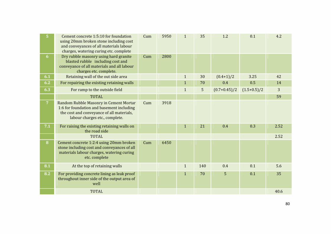
80
5 Cement concrete 1:5:10 for foundation
using 20mm broken stone including cost
and conveyances of all materials labour
charges, watering curing etc. complete
Cum 5950 1 35 1.2 0.1 4.2
6 Dry rubble masonry using hard granite
blasted rubble including cost and
conveyance of all materials and all labour
charges etc. complete.
Cum 2800
6.1 Retaining wall of the out side area 1 30 (0.4+1)/2 3.25 42
6.2 For repairing the existing retaining walls 1 70 0.4 0.5 14
6.3 For ramp to the outside field 1 5 (0.7+0.45)/2 (1.5+0.5)/2 3
TOTAL 59
7 Random Rubble Masonry in Cement Mortar
1:6 for foundation and basement including
the cost and conveyance of all materials,
labour charges etc., complete.
Cum 3918
7.1 For raising the existing retaining walls on
the road side
1 21 0.4 0.3 2.52
TOTAL 2.52
8 Cement concrete 1:2:4 using 20mm broken
stone including cost and conveyances of all
materials labour charges, watering curing
etc. complete
Cum 6450
8.1 At the top of retaining walls 1 140 0.4 0.1 5.6
8.2 For providing concrete lining as leak proof
throughout inner side of the output area of
well
1 70 5 0.1 35
TOTAL 40.6

81
9 Poviding GI hand rails over the retaining
walls including all costs, conveyance of
materials, labour,painting charges
etc.complete.
Rm 420 1 60 60
10 Providing metallic arrangements for
controling water flow including cost and
conveyances of all materials, labour
charges,etc. complete
kg 207 10
Table 4.11. Requirements for the maintainence of Kurichikulam
SL NO SPECIFICATION UNIT RATE NO MEASUREMENTS QUANTITY
Length Bredth Height
11.1 Earth work excavation Cum 320 1 6 1 0.5 3
11.2 Cement concrete 1:5:10 Cum 5950 1 6 1 0.1 0.6
11.3 Cement concrete 1:2:4 Cum 6450
1 6 1 0.1 0.6
2 6 0.2 0.6 1.44
Table 4.12. Requirements for the overflow of lined drain
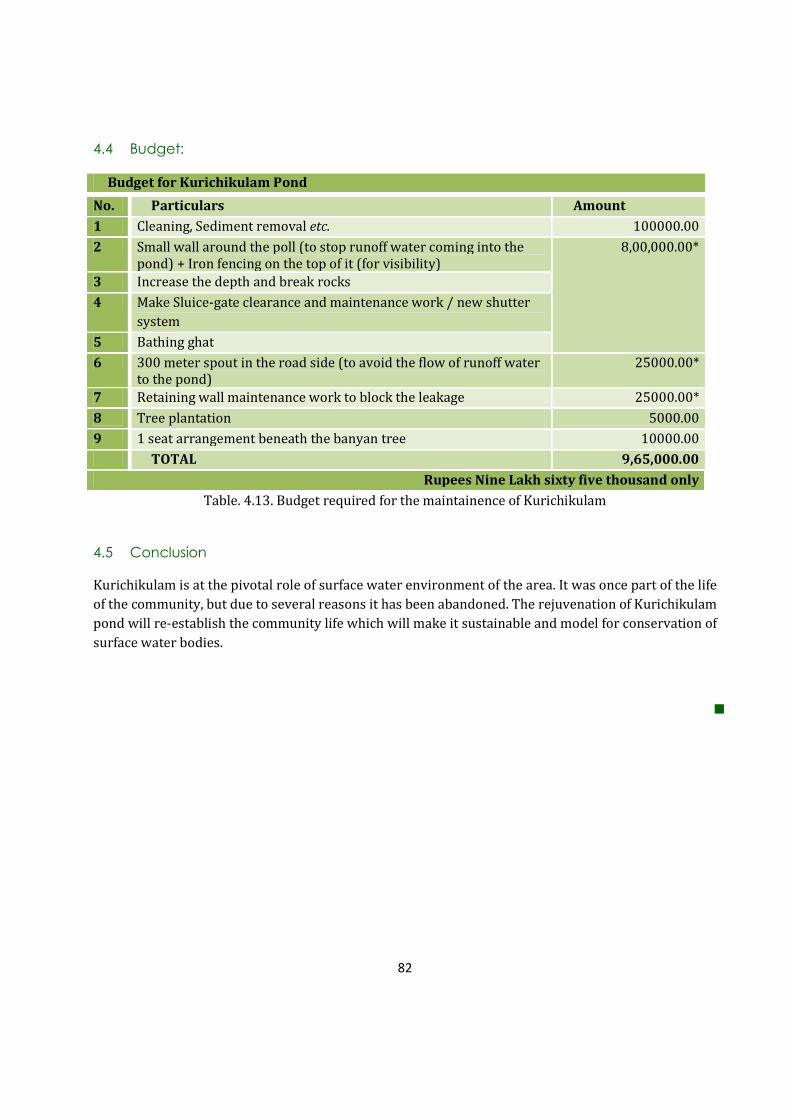
82
4.4 Budget:
Budget for Kurichikulam Pond
No. Particulars Amount
1 Cleaning, Sediment removal etc. 100000.00
2 Small wall around the poll (to stop runoff water coming into the
pond) + Iron fencing on the top of it (for visibility)
8,00,000.00*
3 Increase the depth and break rocks
4 Make Sluice-gate clearance and maintenance work / new shutter
system
5 Bathing ghat
6 300 meter spout in the road side (to avoid the flow of runoff water
to the pond)
25000.00*
7 Retaining wall maintenance work to block the leakage 25000.00*
8 Tree plantation 5000.00
9 1 seat arrangement beneath the banyan tree 10000.00
TOTAL 9,65,000.00
Rupees Nine Lakh sixty five thousand only
Table. 4.13. Budget required for the maintainence of Kurichikulam
4.5 Conclusion
Kurichikulam is at the pivotal role of surface water environment of the area. It was once part of the life
of the community, but due to several reasons it has been abandoned. The rejuvenation of Kurichikulam
pond will re-establish the community life which will make it sustainable and model for conservation of
surface water bodies.
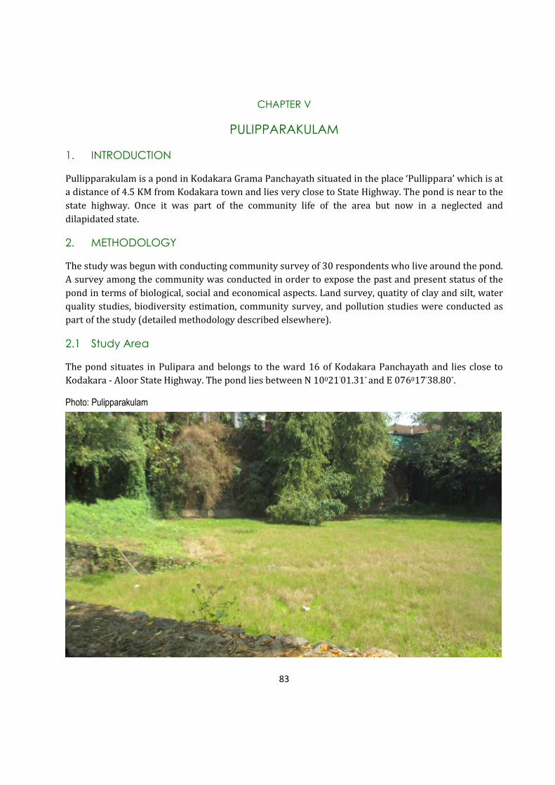
83
CHAPTER V
PULIPPARAKULAM
1. INTRODUCTION
Pullipparakulam is a pond in Kodakara Grama Panchayath situated in the place ‘Pullippara’ which is at
a distance of 4.5 KM from Kodakara town and lies very close to State Highway. The pond is near to the
state highway. Once it was part of the community life of the area but now in a neglected and
dilapidated state.
2. METHODOLOGY
The study was begun with conducting community survey of 30 respondents who live around the pond.
A survey among the community was conducted in order to expose the past and present status of the
pond in terms of biological, social and economical aspects. Land survey, quatity of clay and silt, water
quality studies, biodiversity estimation, community survey, and pollution studies were conducted as
part of the study (detailed methodology described elsewhere).
2.1 Study Area
The pond situates in Pulipara and belongs to the ward 16 of Kodakara Panchayath and lies close to
Kodakara - Aloor State Highway. The pond lies between N 10021’01.31” and E 076017’38.80”.
Photo: Pulipparakulam
84
3. RESULTS AND DISCUSSION
3.1 Community Survey Respondents’ Details
Categories Percentage (%)
Survey Respondents Male 8
Female 22
Age
20-40 5
41-60 13
61-80 12
81-100 0
Occupation
Local Community 25
Prominent Socio-Religious
Workers
1
Kudumbasree & Thozhilurappu 2
Local Government & Non-
Governmental Officials
2
Table 5.1 Demography of respondent community
From the Table 5.1, it is clear that out of 30 survey respondents, no one is included in the age group of
81 – 100. Most of the people in that area are doing Koolie Jobs. Due to the geographical nature of the
place, nobody have agriculture as their livelihood activity. Also, no laundry activity has been noticed in
the pond.
3.2 History
3.2.1 Origin of Pulipparakulam
As per the opinion of the majority of survey respondents, the pond was originated more than 75 years
back. But the generations who knew about its age has already deceased. The present generation has
only limited knowledge regarding the origin of Pullipparakulam. The importance of pond related with
geographical nature of the place named “Pullippara”. As it’s name indicates, the place is with full of
rocks and hence, it is a water scarce area. Years back, the pond area was only a quarry. Eventually, rain
water got filled in. Because of the water scarcity problems, local residents decided to convert it into a
pond. Then, it was developed into a deep pit by breaking rocks.
The man who residing near this pond Mr. Gopi said that the land in which quarry situated was owned
by his grand parents and they handed over the land to Panchayath for conserving it as a public pond.
Years back, the area was about 23 acres, including pond land and a meadow which used for grazing
cattles. The government distributed this land to several people. According to Village Office records and
other Panchayath records, no demarcation of this land as pond was found. The size and depth of the

85
pond has changed many times with community participation programmes. From the data availed
during community survey and PRA meetings, the pond must be more than 70 years old.
As per the survey, 50% of the survey respondents commented that pond must be more than 60 years
old. Some people specifically claimed that the pond is 70 years old. But 17% of people did not know
the actual age of the pond. 13% of members said that the pond was originated about 40 years ago.
10% of people have the opinion that pond aged 100 years. 6% of respondents also guessed the age as
above 75 years.
Fig. 5.1. The age of the pond opined by stakeholder communities
3.2.2 Etiology of the name “Pulipparakulam”
Most of the people have same opinion about the origin and the name of the pond. The pond’s name
came from the location’s name, “Pullippara”. The pond in Pullippara is called as Pullippara Kulam.
Some aged people said that the place got this name because years back, the region was a forest area
and leopards (Malayalam- Puli) used to come down to Pulippara. As leopards take rest on rocks which
are abundant in that area, the place name was evolved as Pulipara. In the records collected from
Panchayath, the pond is named as Pullippara Kulam because it is very close to Pullippara Junction.
However, the people who are residing there commonly call the pond as ‘Parakulam’. (Para, the
Malayalam word means rock, because actually it was rocky area). Pond was formed by breaking
granite rocks.
3.3 Physical Features of the Pond in the Past
In past, the area was a meadow which was rich with rocks. When the pond was made as a quarry,
there were only few houses existed in this area. The quarry was developed into a pond later on. People
started residing in this area due to the availability of water in the pond. The area around the pond was
waste lands and slowly it was converted into patches of human habitations. In the Eastern side of
pond, there was only a mud way which was converted into a road now. State highway locates in

86
Northen side of the pond. Few teashops and houses are present beside State Highway which borders
with the Pond. Due to the widening of State Highway, the land of the people who were residing on the
sides of the road took by the govrnment. It affected the naturality of the pond. The houses and shops
came very closer to the pond. Western side of the pond covers residential lands and Southern side
covers community hall owned by Panchayath. The community hall was constructed in 2007 by
Panchayath.
As a part of the rennovation of the pond, a 3 feet height wall was constructed on the Southern side of
the pond. Stairs were also constructed to step into the pond. Few aged people assert that there were
four ponds seperated each other. Later, two ponds were filled by mud and constructed community
hall. At present, only two ponds exist in this location; one large pond and a small pond. In rainy season,
large pond overflows to small pond and then to a rivulet.
There were many trees around the pond. However, many of them were destroyed due to the
developmental procedures such as construction of shops, houses, community hall etc. Therefore, the
structure and physical features of Pullippara Kulam drastically changed. Most of the area on the sides
of pond has been filled for house construction. Agriculture in this area is very rare because of scarcity
of water. However, in the past there was cashew nut cultivation which needed less water. The cashew
nut cultivation also has reduced.
3.4 Main uses of the Pond in Past and Present
The past uses of the pond were washing clothes and bathing. Due to the degradation of quality of
water, people are not using the pond now. Some people depend on the pond for showering of animals.
As people also used to take bath, showering of animals were restricted. Some people also used the
pond for seasoning coconut leaves for roofing their huts. They used the small pond to avoid polluting
the main pond. Nowadays, the people near the pond pump water from the pond for their house
construction and domestric purposes.
Fig. 5.2 Uses of pond in the past and present as opined by the community
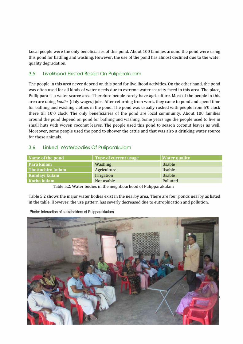
87
Local people were the only beneficiaries of this pond. About 100 families around the pond were using
this pond for bathing and washing. However, the use of the pond has almost declined due to the water
quality degradation.
3.5 Livelihood Existed Based On Puliparakulam
The people in this area never depend on this pond for livelihood activities. On the other hand, the pond
was often used for all kinds of water needs due to extreme water scarcity faced in this area. The place,
Pullippara is a water scarce area. Therefore people rarely have agriculture. Most of the people in this
area are doing koolie (daly wages) jobs. After returning from work, they came to pond and spend time
for bathing and washing clothes in the pond. The pond was usually rushed with people from 5’0 clock
there till 10’0 clock. The only beneficiaries of the pond are local community. About 100 families
around the pond depend on pond for bathing and washing. Some years ago the people used to live in
small huts with woven coconut leaves. The people used this pond to season coconut leaves as well.
Moreover, some people used the pond to shower the cattle and that was also a drinking water source
for those animals.
3.6 Linked Waterbodies Of Puliparakulam
Name of the pond Type of current usage Water quality
Para kulam Washing Usable
Thottachira kulam Agriculture Usable
Kundayi kulam Irrigation Usable
Kotha kulam Not usable Polluted
Table 5.2. Water bodies in the neighbourhood of Pulipparakulam
Table 5.2 shows the major water bodies exist in the nearby area. There are four ponds nearby as listed
in the table. However, the use pattern has severly decreased due to eutrophication and pollution.
Photo: Interaction of stakeholders of Pulpparakkulam

88
3.7 Geography
3.7.2 Geographical Details
Fig.5.3 Area map of the Pulipparakulam
All available information on past and present maps, data, photos, contour levels, photos etc. were
collected from village Office, Panchayat Office, Thrissur Survey Superindent Office, Thrissur Town
Planning Office, Puthukadd Block Panchayath Office. The Pullipparakulam situates in the 16th ward of
Kodakara Grama Panchayathu. The detailed sketch of the pond is not available anywhere, but Town
Planning Office, Thrissur has a digital map of Kodakara Panchayathu Ponds with roads and important
land marks. In that map, this pond is marked as a Parakulam. The maintenance and renewation of this
pond was done few years back. However, even Block Panchayathu Office does not have the data about
the pond. They gave the explanation that there is no such documents of this pond because the
renewation took place before 2007 and Block Panchayathu Office holds the records of the pond after
2007.

89
It is a rocky area. The pond is surrounded by rocks on two sides. As per the records of the Village
Office, the pond and adjoining property owned by Kodakara Panchayath has an area of 50 cent,
Thrissur District; Mukundapuram Taluk, Survey No. 1588; the area is recorded as Purampokku Land).
No demarcation of the land was made till now. The survey number 1588 includes 23 acres of land and
the pond is included within the 23 acre land. However, the exact position of the pond and it’s area are
not marked in any reocords. The present land survey showed that Pulipparakkulam now occupies only
an area of 39.01 cent.
The pond has a water column of above 20 foot in rainy season and about 8 foot in summer season. Also
the depth varies in different parts of the pond. People said that it have water in depth in ‘L’ shape from
the old steps. On the highway side of this pond there are houses, bakery and a tea shop. This situates
on pond’s land and encroachment has recorded.
3.7.3 Clay And Sand Quantity Analysis

90
Fig. 5.4. Cross section maps of the pond

91
3.8 Water Quantity And Quality
3.8.2 Water Quantity
Pullipparakulam is mainly a rain water harvesting source in the region. No inlets are there in the pond.
Pond gets filled with its on beck and rain water. Large pond (among the existing two ponds) overflows
in rainy season to the small pond. On the sides of small pond there is an ovulet as outlet. But now the
ovulet has been abandoned. The water in the pond is in a stagnant state and hence, pond is totally
abandoned. The pond gets filled completely with water in rainy season, but water level decreases in
summer season. The people in this area also claim that the pond never gets wilted. The pond’s depth
varies in different part of the pond. When discussed with the former Panchayath member Mr.
Manidhan about their future plans of the pond, he said that they are interested in constructing one
more room adjuscent to the community hall. Further, they are not interested in maintaining the small
pond there. They plan to fill that and keeps only a rivulet adjoining the main pond as an outlet of the
pond.
Photo: Left: Estimating the area of the Pulipparakulam;
Above: Collecting water samples

92
Pullipparakulam is a perennial source of water in that area. Most of the respondents said that water
level fluctuation occurs in the pond, mainly during the summer season. Almost 30 % of the
respondents did not respond to that question. According to the people mentioned about the water
level fluctuation, majority claimed that almost above 5 feet of water decreases during the summer
season. Only 3 % of respondents said that the water level decline to one feet and 10 % said that it is
above three feet. However, everybody underlines the fact that due to the existence of the pond, the
local community has enough drinking water in their wells throughout the year. Pond recharges
neighboring open wells significantly.
Fig.5.5 Opinion of stakeholders on the summer water level of Puliparakulam
3.8.3 Water Quality
No.
No.
Parameter Sample
value
1
Sample
value 2
Sample
value
3
Permissible limit
for bathing and
irrigation (IS2296
standard)
1 pH 6.90 6.64 6.28 6.5 – 8.5
2 Salinity 0.20 0.18 0.16 3 ppt
3 Conductivity 274 252 226 2250 µS
4 Turbidity 60 62 62 300 NTU
5 Total Dissolved Solids 144 133 120 2100 mg/L
6 Total Hardness 290 254 170 1100 mg/l as CaCO3
7 Ca+ ions 8 20 22 500 mg/l as Ca+ *
8 Mg+ ions 282 234 148 30 mg/l as Mg+*
9 Acidity 40 58 112 200 mg/l as CaCO3*
10 Alkalinity 62 62 46 200 mg/l as CaCO3*
11 Total iron 0.2 0.3 0.3 2.0 mg/l as Fe*
93
*Not mentioned in IS 2296, but it is as per the WHO standard.
Table 5.3. Results of water quality anlaysis of Pulipparakulam
Pullipparakulam was known for its pristine environment and pure water, till recent times. Local
people used the pond for bathing, swimming and washing. Majority of the aed people have good
memories of their childhood that they were used to take bath and swim in the pond. Now, the pond is
filled with mosses and other aquatic weeds. Moss and alage almost clogged the water body and it has
lost its transparency. This has prevented the penetration of sunlight into deeper layers of the pond,
hence the aeration and photosynthetic activities of the bottom layers of the pond has been heavily
blocked. Thus, the water quality has been deteriorated. The pond has been in an abandoned condition
and water body became almost stagnant. This has resulted in the accumulated growth of rooted,
emerging, submerged and floating types of aquatic plants, mainly weeds.
Waste disposal is also taking place in the pond by local residents. It includes sewage from
neighbourhood shops and houses, human excreta, plastic bottles etc. Some people pointed out that the
pond has the presence of E coli bacteria in water (as opined by some studies). That is the main reason
why the use of pond has decreased.
3.9 Biodiversity Estimation 3.9.1 Biodiversity Status Of The Pond Malayalam Name Common Name Scientific Name
Varal Striped Snake head Channa striata
Mushi Valencienne’c clariid Clarias dussumieri
Kadu / Kaari Stinging catfish Clarias batrachus
Karippidi Malabar Leaf Fish Pristolepis marginata
African Mushi African Catfish Clarias gariepinus
Paral Common Rasbora Rasbora dandia
Thiloppia Mozambique Tilapia Oreochromis mossambica Kallada Climbing Perch Anabas Testudineus
Vaala Fresh Water Eel Wallago attu
Pallathi Orange Chromid Etroplus maculatus
Table 5.4 List of fishes in the pond
12 Chloride 60 60 60 600 mg/l as Cl
13 Fluoride 0 0 0 1.5 mg/l as F
14 Nitrate 2 1 2 30 mg/l as NO3*
15 Sulfate 0 0 0 1000 mg/l as SO4
16 DO 21.28 10.2 6.3 50.0mg/l
17 BOD 6.55 3.15 3.9 30.0mg/l
18 Total bacterial
count/1ml
21 20 13 5
19 Total coliforms
MPN/100ml
2400+ 2400+ 1100 500
20 Faecal coliforms
MPN/100ml
110 110 75 200
21 E. coli Present Present Present 0*
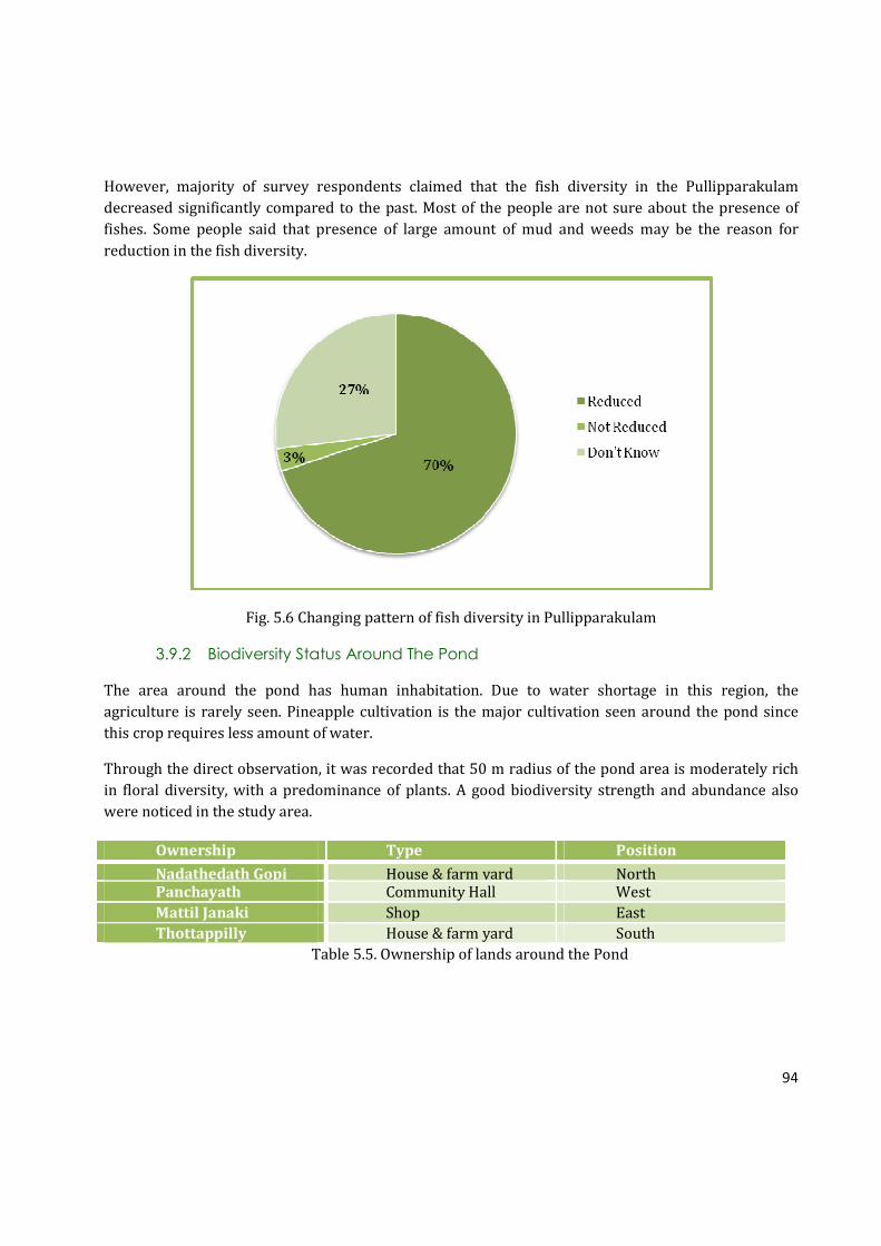
94
However, majority of survey respondents claimed that the fish diversity in the Pullipparakulam
decreased significantly compared to the past. Most of the people are not sure about the presence of
fishes. Some people said that presence of large amount of mud and weeds may be the reason for
reduction in the fish diversity.
Fig. 5.6 Changing pattern of fish diversity in Pullipparakulam
3.9.2 Biodiversity Status Around The Pond
The area around the pond has human inhabitation. Due to water shortage in this region, the
agriculture is rarely seen. Pineapple cultivation is the major cultivation seen around the pond since
this crop requires less amount of water.
Through the direct observation, it was recorded that 50 m radius of the pond area is moderately rich
in floral diversity, with a predominance of plants. A good biodiversity strength and abundance also
were noticed in the study area.
Table 5.5. Ownership of lands around the Pond
Ownership Type Position
Nadathedath Gopi House & farm yard North Panchayath Community Hall West
Mattil Janaki Shop East
Thottappilly House & farm yard South

95
a. Floral Diversity Around The Pond
Malayalam Name Common Name Scientific Name
Sheema Konna Mata Ratón Gliricidia sepium Neeroli --- Phyllanthus reticulates
Malayalam Name Common Name Scientific Name
Thengu Coconut Tree Cocos nucifera
Vatta Gum Plant Macaranga peltata
Vazha Banana Tree Musa sp.
Kamuku Arecanut Areca catechu
Maavu Mango Tree Mangifera indica
Kaitha Screw Pine/ Pendanus
Thekku Teak Tectona grandis
Muringa Drumstick Plant Moringa oleifera
Plavu Jackfruit Tree Artocarpus heterophyllus
Kappalam Carica papaya Carica papaya
Communist Pacha Eupatorium Chromolaena odorata
Thottavadi Touch me not Mymosa pudica
Pera Gouva Psidium gavjava
Jaathi Nutmeg Myristica fragrans
Kaithachakka Pineapple Ananas comosus
Kanikkonna Golden Shower Tree Cassia fistula
Chemparathi Hibiscus Hibiscus roosasinensis
Arayal Peepal Tree Ficus religiosa
Peral Banyan Tree Ficus benghalensis
Kongini Lantana Lantana camera
Pishina Payar Mucuna bracteata
Panjimaram Cotton Tree Gossypium hirsutum
Kurumulak Kodi Black Pepper Piper nigrum Linn
Chithirappala Semi-erect Euphorbia Euphorbia Hirta
Kayyonni False Daisy Eclipta prostrate
Thakara Chamaecrista absus
Chuvanna Cheera Velvet Curtain Amaranthus sp.
Pacha Cheera Green Spinach Amaranthus hybridus
Chembu Colocasia Colocasia esculenta
Croton Croton Codiaeum variegatum
Vallimulla Jasmine Jasminum officinale
Kadalassu Rosa Bougainvillea Bougainvillea glabra
Valanpuli Tarmarind Tamarindus indicus
Muringa Drum Stick Plant Moringa oleifera
Mahagany Mahagony Swietenia macrophylla
Murian Pacha Goat Weed Ageratum conyzoides
Mantharam White Orchid Tree Bauhinia tomentosa

96
Money Plant Devil’s Eye Epipremnum aureum
Kariveppu Curry Leaves Murraya koenigii
Cheeni Chilli Capsicum annum
Irumpanpuli Bilimbi Averrhoa bilimbi
Cheeni Chilli Capsicum annum
Koval Ivy Guard Coccinia grandis
Chena Elephant Foor Yam Amorphophallus paeniifolius
Cheru Naarakam Bitter Ornage Citrus aurantifolia
Aryaveppu Neem Tree Azadirachta inaica Juss
Aami
Kottom
Kadaladi Prickly Chaff Flower Aristolochla indica
Kanakambaram Tropic Flame Crossandra infundibuliformis
Chethi Jungle Geranium Ixora coccinea
Pana Palm Arecaceae
Shavamnari Madagaskar periwinkle Vinca rosea
Inchi Garden Ginger Zingiber officinale
Aanachunda Turkey Berry Solanum torvum
Panal Ban Nimbu Glycosmis mauritiana
Cherula Mountain knotgrass Aerva lanata
Lilly River Crinum Lily Crinum viviparum
Njerinjil --- Acanthospermum hispidum
Cheera Chikurmanis Sauropus androgynus
Charakonna Copper Pod Tree Peltophorum pterocarpum
Vayara Bitter Vine Micania micrantha
Table 5.6. Floral diversity around the pond (50 m radius)
B. Birds Around The Pond
Malayalam Name Common Name Scientific Name
Cheriya neerkakka Little cormorant Phalacrocorax niger Kalimundi Cattle egret Bubulcus ibis
Cherumundi Intermediate egret Mesophoyx intermedia
Kulakozhi White breasted waterhen Amaurornis phoenicurus
Kuyil Asian koel Eudenamys scolopacea
Chempothu Greater coucal Centropus sinensis parroti
Cheriya meenkothi Common kingfisher Alcedo atthis
Manja kili Black hooded oriole Oriolus xanthornus
Vayal kuruvi Plain prinia Prinia inornata
Kutturuvan White cheeked barbet Megalaima viridis
Eratta valan Black drongo Dicrurus macrocercus
Kavathi Kakka House crow Corvus splendens
Table 5.7. Bird diversity around the pond (50 m radius)

97
c. Butterflies
BUTTERFLIES
Malayalam Name Common Name Scientific Name
Thakaramuthi Mottled Emigrant Catopsilia pyranthe
Pottuvellatti Psyche Leptosia nina
Common Leopard Phalanta Phalantha
Aavanachoppan Common Caster Ariande merione
Vazhana Poombatta Common Mime Papilio clytia
Manjapappathi Common Grass Yellow Eurema hecabe
Theechirakan Tawny Caster Acraea violae
Table 5.8. Butterflies seen around the pond (50 m radius)
d. Dragon flies and Damselflies
DRAGONFLIES
Malayalam Name Common Name Scientific Name
Theekari Muthan Scarlet Marsh Hawk (Male) Aethriamanta brevipennis
Theekari Muthan Scarlet Marsh Hawk (Female) Aethriamanta brevipennis
Onathumpi Wandering Glider Pantala flavescens
Shalabha Thumpi Common Picture Wing (Female) Rhothemis variegata
Pandan Vayaltheyyan Scarlet Baskar (Male) Urothemis signata
Swami thumpi Pied Paddy Skimmer (Male) Neurothemis tullia
DAMSELFLIES
Malayalam Name Common Name Scientific Name
Pathi Pulchinnan Kerala dartlet Agriocnemis keralensis
Table 5.9. Odonate diversity around the pond (50 m radius)
3.10 Environmental Threats
In Kerala, unfortunately water bodies are nowadays considered as the best place to release sewage
and dump solid wastes. The abandonment of water bodies and development as a waste dumping site
happens simultaneously. If the water body is on the sides of a road, people will make it as a habit to
throw their household wastes into it. There are lots of reports available on such types of waste
dumping including that of slaughter house wastes. Pulipparakkulam is one of the best examples of this
prevailing trend in Kerala. Pond is situated very close to the Main road and a pocket road is on the side
too. Pond premises occupies Panchayath community hall. People, who come for functions in the hall,
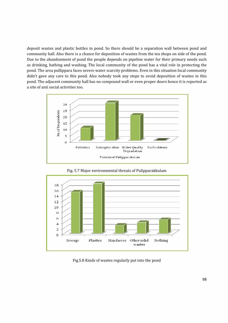
98
deposit wastes and plastic bottles in pond. So there should be a separation wall between pond and
community hall. Also there is a chance for deposition of wastes from the tea shops on side of the pond.
Due to the abandonment of pond the people depends on pipeline water for their primary needs such
as drinking, bathing and washing. The local community of the pond has a vital role in protecting the
pond. The area pullippara faces severe water scarcity problems. Even in this situation local community
didn’t gave any care to this pond. Also nobody took any steps to avoid deposition of wastes in this
pond. The adjacent community hall has no compound wall or even proper doors hence it is reported as
a site of anti social activities too.
Fig. 5.7 Major environmental threats of Pulipparakkulam
Fig.5.8 Kinds of wastes regularly put into the pond
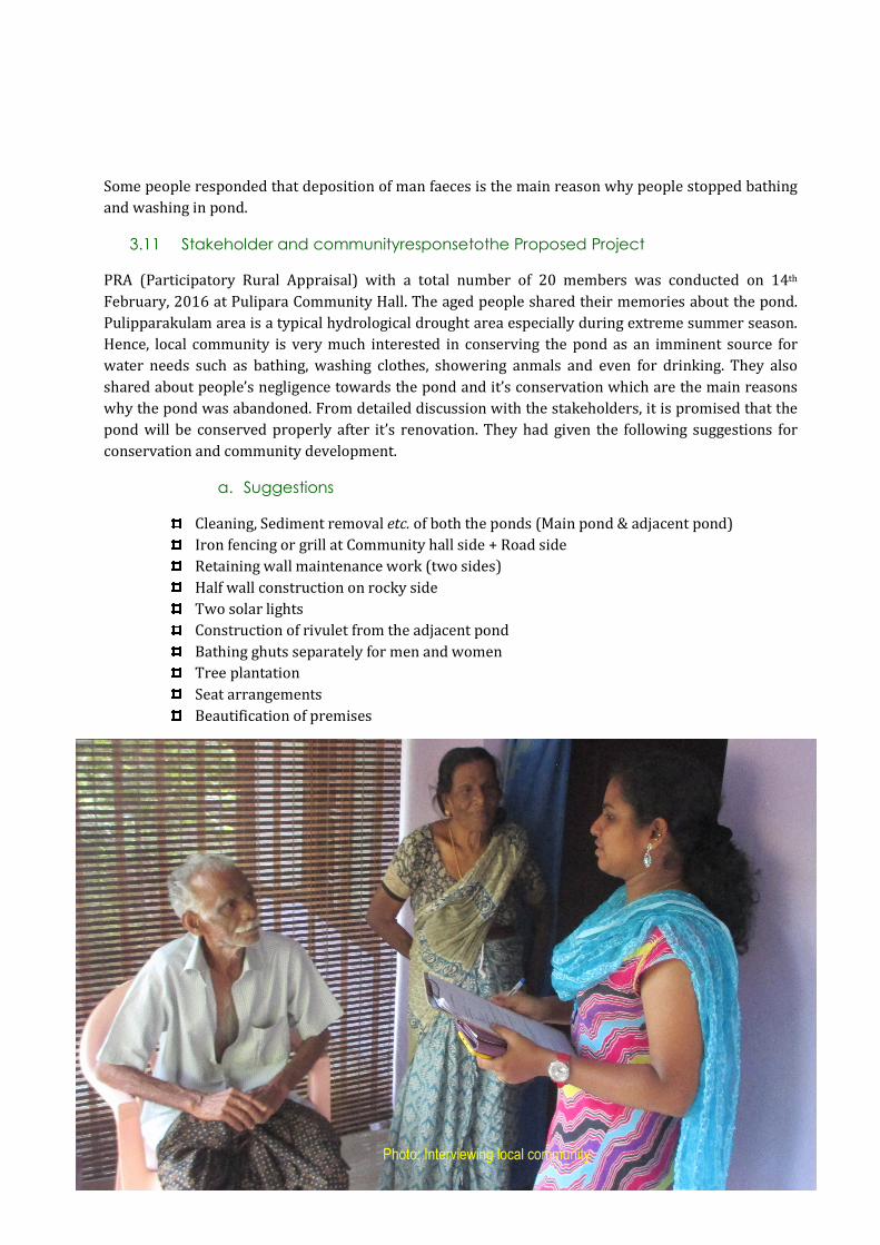
99
Some people responded that deposition of man faeces is the main reason why people stopped bathing
and washing in pond.
3.11 Stakeholder and communityresponsetothe Proposed Project
PRA (Participatory Rural Appraisal) with a total number of 20 members was conducted on 14th
February, 2016 at Pulipara Community Hall. The aged people shared their memories about the pond.
Pulipparakulam area is a typical hydrological drought area especially during extreme summer season.
Hence, local community is very much interested in conserving the pond as an imminent source for
water needs such as bathing, washing clothes, showering anmals and even for drinking. They also
shared about people’s negligence towards the pond and it’s conservation which are the main reasons
why the pond was abandoned. From detailed discussion with the stakeholders, it is promised that the
pond will be conserved properly after it’s renovation. They had given the following suggestions for
conservation and community development.
a. Suggestions
Cleaning, Sediment removal etc. of both the ponds (Main pond & adjacent pond)
Iron fencing or grill at Community hall side + Road side
Retaining wall maintenance work (two sides)
Half wall construction on rocky side
Two solar lights
Construction of rivulet from the adjacent pond
Bathing ghuts separately for men and women
Tree plantation
Seat arrangements
Beautification of premises
Photo: Interviewing local community

100
PULIPPARAKKULAM- SUMMARY
� Pullipparakulam has a history of more than 70 years. Exact origin of the pond is not known. It was a
quarry which is converted into pond due to water scarcity problems of the place Pullippara.
� The etiology of the pond name is related with the place name ‘Pullippara.’ The place got that name
because it was a forest area, where leopards came to rest on rocks of the place.
� 15 years back, it was a beautiful spot with 4 adjacent ponds separated each other. The pond was
known for it’s pristine water. However, two ponds were filled and constructed a community hall by
Panchayth. The construction has destroyed naturality of the pond and it became a place for waste
deposition.
� Pullipparakulam supported local community in bathing and washing mainly. The livelihood activities
were less here. Agriculture is less because of water scarcity.
� The people depend on pipeline water for drinking purposes these days. Pond water was considered as
pure till a decade back and all people in Pulippara used the pond for even funeral rituals.
� The main beneficiaries of the pond in the past were local community.
� The survey done by the study team on 11.3.2016 showed that 46.89 cents of land is there now. The
water filled area of the pond occupies 28.99 cents. The exact area and sketch of pond are not available
in Village Office or other Government Offices, because no demarcation of 23 acres of land occurred
there.
� The average depth of the pond is 1.2 m. and maximum depth is 3 m. The height of the summer water
column is 1 m. Pond depth varies in different parts of the pond.
� There is water level fluctuation in different seasons, but it is an all seasonal pond. There will be 10 foot
water in some parts of the pond even in summer seasons.
� Community survey showed that the water quality of the pond was excellent till some years ago. Due to
the stagnation, weed infestation and pollution, water quality has been significantly reduced. However,
the current testing of water quality showed biological pollution alone (high coliform content).
� A total of 65 plants, 12 birds, 7 butterflies, 6 dragonflies and 1 damselfly are recorded from this area
through taxonomic survey. 10 types of fishes were recorded through community survey.
� The analysis of environmental threats of Pullipparakulam showed that pollution exists here. Survey
respondents commented problems such as eutrophication and weed infestation related stagnation and
deposition of wastes such as plastics, sewage, man faeces etc. The pollution due to stagnation is
evident from the water quality studies too.
� The local community and all stakeholder groups welcomed the proposal for renovation of pond.

101
5. PROJECT PROPOSAL
5.1 Aim: To conserve Pulipparakkulam as a community pond
5.2 Objectives:
• To clean the pond and provide provisions for stopping sewage and other types of pollution
• Restore the pond from eutrophication - retain its ecological importance to provide sustainable
use pattern
• Pulipara is one of the places in Kodakara Panchayath which face extreme water scarcity in
summer season.
The pond was formed from a quarry. Nonetheless, the pond was used for all kinds of water needs
for Pulipara region since Pulipara face extreme scarcity of water during summer season. Majority
of the people depend on Water Authority for water since there are only few wells in this region.
The pond was consolatory factor for Pulipara community when the pond was in good condition.
Conserving the pond will support the ground water table of the area by holding the water in the
pond. Therefore,
• As the pond is nearby a road, keep the pond from further pollution and make awareness about
the conservation of the pond to the community.
Pulipara Pond, the major source of water for Pulipara, was polluted due to lack of understanding
about the effects of pollution. The pond is more likely to get polluted as the pond is near to a bus
stop on Kodakara – Aloor State Highway and various shops, there are more chances of pollution.
By renovating the pond, the awareness about the need of conservation and problems of pollution
can be expanded.
• Make provisions for bathing, irrigation (manual) and meet the common water needs of the
society.
Bathing and laundry was the major uses of the pond. The pond was always used to rush with
people till late night as people used to take bath in the pond after coming from work. Majority of
people here are daily workers. Through this way, they are able save water spent from Water
Authority Connection. The same trend can be resumed by renovating the pond.
• To create a children’s park & leisure zone at the pond premises as the pond is more closure to
community hall.
People frequently visit community hall for conducting various events. Leisure zone is an obvious
need at this situation. Moreover, the pond is very close to Kodakara – Aloor State Highway.
Therefore, the local community, pedestrians, and passangers are benefitted through this leisure
zone.
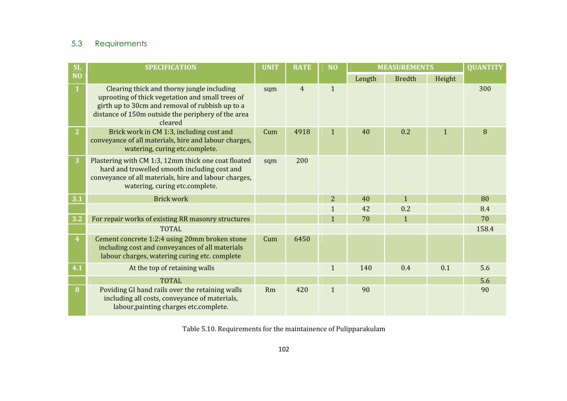
102
5.3 Requirements
Table 5.10. Requirements for the maintainence of Pulipparakulam
SL
NO
SPECIFICATION UNIT RATE NO MEASUREMENTS QUANTITY
Length Bredth Height
1 Clearing thick and thorny jungle including
uprooting of thick vegetation and small trees of
girth up to 30cm and removal of rubbish up to a
distance of 150m outside the periphery of the area
cleared
sqm 4 1 300
2 Brick work in CM 1:3, including cost and
conveyance of all materials, hire and labour charges,
watering, curing etc.complete.
Cum 4918 1 40 0.2 1 8
3 Plastering with CM 1:3, 12mm thick one coat floated
hard and trowelled smooth including cost and
conveyance of all materials, hire and labour charges,
watering, curing etc.complete.
sqm 200
3.1 Brick work 2 40 1 80
1 42 0.2 8.4
3.2 For repair works of existing RR masonry structures 1 70 1 70
TOTAL 158.4
4 Cement concrete 1:2:4 using 20mm broken stone
including cost and conveyances of all materials
labour charges, watering curing etc. complete
Cum 6450
4.1 At the top of retaining walls 1 140 0.4 0.1 5.6
TOTAL 5.6
8 Poviding GI hand rails over the retaining walls
including all costs, conveyance of materials,
labour,painting charges etc.complete.
Rm 420 1 90 90

103
SL
NO
SPECIFICATION UNIT RATE NO MEASUREMENTS QUANTITY
Length Bredth Height
1 Earth work excavation Cum 320 1 25 1 0.3 7.5
2 Cement concrete 1:5:10 Cum 5950 1 25 1 0.1 2.5
3 Cement concrete 1:2:4 Cum 6450
1 6 1 0.1 0.6
2 6 0.2 0.6 1.44
TOTAL 2.04
Table 5.11. Requirements for the overflow of lined drain
Photo: PRA exercise of stakeholders of Pulipparakkulam; A view of Pulipparakkulam

104
5.4 Budjet:
Budget for Pulpara kulam Pond
No. Particulars Amount
1 Cleaning, Sediment removal etc of both the ponds (Main pond &
adjacent pond)
100000.00
2 Iron fencing or grill at Community hall side + Road side 4,75,000.00*
3 Retaining wall maintenance work (two sides)
4 Construction of rivulet from the adjacent pond
5 Bathing ghats separately for men & women
6 Two solar lights 70000.00*
7 Provision of a merry boy and circular swing (children’s play
equipments)
50000.00*
8 Tree plantation 5000.00
9 2 seat arrangement beneath the banyan tree 20000.00
TOTAL 7,20,000.00
Summer Rupees Seven Lakh and twenty thousand only
Table 5.12. Budget required for the maintainence of Pulipparakulam
5.5 Conclusion
Pulipparakkulam is not a natural pond, but a quarry converted rain water harvesting tank. As the area
is one of the hydrological drought affected locations in the Panchayath, avaialability of water during
summer season is a vulnerable issue and Pulipparakkulam offers a sustainable solution for this issue.
The conservation of the pond is of great importance in this regard.

105
CHAPTER VI
KOTHAKULAM
1. INTRODUCTION
Kothakulam has a great importance in the daily lives of Anathadam natives, in Kodakara GP of Thrissur
district. Kothakulam is the only pond in Anathadam village which is able to provide water for a large
area of agricultural and residential lands through ground water recharging. As the pond gets dry up in
every summer, water is pumped from an outside source, Kadhalichira Lift Irrigation Project.
2. METHODOLOGY
The study was begun with conducting community survey of 30 respondents who live around the pond.
A survey among the community was conducted in order to expose the past and present current status
of the pond in terms of biological, social and economical. Land survey, quatity of clay and silt, water
quality studies, biodiversity estimation, community survey, and pollution studies were conducted as
part of the study (detailed methods described elsewhere).
2.1 Study Area
The pond, Kothakulam situates on the Southern part of Kodakara Panchayath and in Anathadam
village bordered by Aloor Panchayath. Unlike the other ponds in Kodakara Panchayath, the pond
situates in an upland tract of the Panchayath. Because of its geographically elevated and unique
position, this pond is able to support water an extensive area of both Kodakara Panchayath and Aloor
Panchayath. The pond is located near agricultural fields and human habitation. The pond lies between
N 10020’52.59’’ and E 076017’51.28’’.
Photo: Kothakkulam

106
3. RESULTS AND DISCUSSION
3.1 Community Survey Respondents’ Details
Categories Percentage (%)
Survey Respondents Male 14 Female 16
Age
20-40 4
41-60 16
61-80 8
81-100 2
Occupation
Local Community 20
Farmers 6
Kudumbasree & Thozhilurapp 1
Local Government & Non-
Governmental Officials
3
Table 6.1. Demographic data on survey respondents
3.2 Study Area
The pond, Kothakulam situates on the southern side of Kodakara Panchayath and in Anathadam
Locality bordered by Aloor Panchayath. Unlike the other ponds in Kodakara Panchayath, the pond
situates in an upland tract of the Panchayath. Therefore, this pond is able to support water in an
extensive area of both Kodakara Panchayath and Aloor Panchayath. The pond is located near
agricultural fields and human habitation.
Photo: Discussion of stakeholders of Kothakulam. Presidents of Kodakara & Alur GPs attended
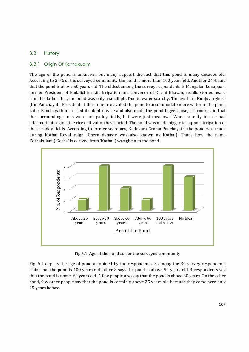
107
3.3 History
3.3.1 Origin Of Kothakualm
The age of the pond is unknown, but many support the fact that this pond is many decades old.
According to 24% of the surveyed community the pond is more than 100 years old. Another 24% said
that the pond is above 50 years old. The oldest among the survey respondents is Mangalan Lonappan,
former President of Kadalichira Lift Irrigation and convenor of Krishi Bhavan, recalls stories heard
from his father that, the pond was only a small pit. Due to water scarcity, Thenguthara Kunjuvarghese
(the Panchayath President at that time) excavated the pond to accommodate more water in the pond.
Later Panchayath increased it’s depth twice and also made the pond bigger. Jose, a farmer, said that
the surrounding lands were not paddy fields, but were just meadows. When scarcity in rice had
affected that region, the rice cultivation has started. The pond was made bigger to support irrigation of
these paddy fields. According to former secretary, Kodakara Grama Panchayath, the pond was made
during Kothai Royal reign (Chera dynasty was also known as Kothai). That’s how the name
Kothakulam (‘Kotha’ is derived from ‘Kothai’) was given to the pond.
Fig.6.1. Age of the pond as per the surveyed community
Fig. 6.1 depicts the age of pond as opined by the respondents. 8 among the 30 survey respondents
claim that the pond is 100 years old, other 8 says the pond is above 50 years old. 4 respondents say
that the pond is above 60 years old. A few people also say that the pond is above 80 years. On the other
hand, few other people say that the pond is certainly above 25 years old because they came here only
25 years before.

108
3.3.2 Etiology Of The Name “Kothakualm”
There are serveral stories on how the name “Kothakulam” came into existence. Though 70% of the
respondents did not have any idea about the etiology of Kothakulam, the rest of the respondents
shared different stories they have heard from their parents or grandparents. 26.67% respondents
claim that the name is associated with a girl named “Kotha.” Some say that the lady was died here in
the pond. Thus her name was given to the pond in her commemoration. On the other hand, other
respondents assert that she was not died in the pond, but she used to take bath in the pond regularly.
In addition to these stories about ‘Kotha,’ a few people also say that the pond was only a small pit in
the past which belonged to ‘Kotha.’ When the pond was turned to be a public property, her name was
given to express gratitude for her.
According to the former Secretary, Kodakara Grama Panchayath, the name Kotha-kulam is derived
from ‘Kothai’ – the dynasty’s name. On the other hand, many natives say that the name came from a
lady called “Kotha.” Few people states that she was taken bath in the pond; some states she was died in
the pond. Yet, the history of its name is a mystery.
Fig.6.2. Etiology of the Pond name-as per respondents
3.4 Physical Features Of The Pond In The Past
The aged people in Anathadam recall that the pond was not a large one, rather it was made from a
small pit, mainly to support agriculture because the economy of theirs is dominated by agriculture.
Varghese, a farmer says that the rice cultivation was the main source of income of people in this region
and used to harvest in two seasons an year (Irippoo Krishi). However, the harvesting has been reduced
to only one season due to water shortage faced in Anathadam region. The present generation
remembers that the surroundings of the pond were paddy fields. Unlike the present, there was no road
bordering the paddy fields and the pond. There was only a small pavement for farmers and

109
pedestrians to walk. Mohini, a CDS worker says that the road was made into 8 meter wider from 4
meter road for passing vehicles. A few people also add that the pond size has reduced after the road
was built. Everyone support the fact that the number of houses in the surroundings has increased. A
large amount of areas were filled up for residential purposes.
People also complain that there are several small pits in the pond which was created during
Thozhilurapp cleaning. These small pits are dangerous since people get trapped in the mud while
stepping into the pond. One person was died two years back in the pond due to the mud accumulated
in the pits. In the past, the pond’s bottom was plane and people knew the exact depth of the pond.
Improper cleaning and mud removal made the pond dangerous at the moment.
3.5 Main Uses Of The Pond In Past And Present
Kothakulam was used for agriculture, bathing, laundry, showering animals, fishing, and weaving
coconut leaves. The fig. 6.3 depicts the use pattern of Kothakulam as opined by the respondents in that
area. Significant changes in the use pattern can be identified from the figure.
Fig. 6.3 Uses of pond in the past and present as opined by the community
It is apparent that the pond (Fig. 6.3) was mainly used for agriculture, bathing, laundry and showering
animals since the percentage of respondents are 93.33%, 96.67%, 96.67%, and 73.33% respectively.
The pond was also used for seasoning coconut leaves, says 13.33% of the respondents. Unlike the
present, there were many huts and small houses in the past which used plated woven coconut leaves
for roofing their houses. Mohini, a CDS worker and Usha Davis, a house wife highlights the fact that
seasoning of coconut leaves were done only in summer season since there is no water flow from the
110
pond. Therefore, people will avoid visiting the pond for bathing and laundry as the quality of water
might not be good due to lack of water movement. As seasoning of coconut leaves pollutes the water,
people do this task only in summer to avoid polluting the water when people use the pond. When the
rainy season and water movement start, the pond becomes normal naturally. Therefore, people will be
able to continue their uses.
As the pond does not hold water in the summer, the direct uses occurred only during rainy season in
the past. However, people stopped visiting the pond for bathing, laundry and showering animals since
a person was died in the pond two years before. People say that the pond has turned as a dangerous
spot because of dangerous muddy pits in the bottom of the pond.
It is also visible from the Fig. 6.3 that in few decades, bathing, laundry, fishing and weaving coconut
leaves are declined. People rarely use the pond for agriculture and showering animals like cows at
present. In conclusion, the uses of the pond has almost declined and the pond became a source for only
ground water recharging. The typical georgraphical position of the pond supports the recharging four
more ponds in the surroundings, according to the local residents. However, as the pond wilts in the
summer, ground water recharging is also not done.
Among the five ponds chosen for the study, Kothakulam shares most benefits. According to the local
residents, all households in 15th and 16th ward of Kodakara Panchayath and 4th and 5th ward of Aloor
Panchayath will be benefitted through ground water recharging of Kothakulam. Kothakulam not only
recharge the wells in this region, but also fill up few ponds such as Kundayi Kulam, Thoprakalam,
Attakulam, and Nambyar Kulam. Moreover, the paddy fields such as Kundayi Padam, Aryan Padam,
Kallu Padam, Cheriyaryan Padam, and Nambyar Padam will be benefitted through the renovation of
Kothakulam. Moreover, the water demand has increased after the establishment of St. Anne’s School,
Anathadam. The renovation of the pond will definitely find a solution for water shortage.
3.6 Livelihood Existed Based On Kothakualm
The major livelihood activities associated with Kothakulam is agriculture. Fig.6.4 brings out the major
livelihood activities of Kothakulam in the past. 70% of the survey respondents said that the rice
cultivation and vegetable cropping in nearby fields are depend on the pond for irrigation. In the past,
the rice was cultivated mainly in two harvesting seasons, Puncha and Virippu and in rest of the
months, mixed cropping of vegetables are carried out. However, now the rice cultivation has reduced
to just one season (Puncha alone). However, a drastic reduction in cropping area has occurred and
many of crop lands have turned as residential area. 26.67% accounts for laundry and 16.67% accounts
for cattle raising. 3.33% of the respondents also supported fishing since individuals used to undertake
the ownership of pond for fishing during a period of one year through auction to carry out fishing by
paying the Panchayath. Velan families used to collect dresses from nearby families and wash in the
pond. 16.67% claimed that there were no livelihood activities associated with the pond.

111
Fig.6.4 Livelihood based on Kothakulam in the past
The use of the pond has dropped dramatically since Kadalichira Lift Irrigation Project is not carried
out properly. Usually, the water is pumped from Kadalichira from the middle of December. However,
in past few years, pumping was not performed due to Aloor and Kodakara border issues.
3.7 Linked Waterbodies Of Kothakulam
There are few water bodies in this region. Among them, Kundayi Kulam and Paramada Kulam are the
nearest ponds. Kundayi Kulam was renovated 2 years back. This pond also gets dry up in the summer
season like Kothakulam. Some pople emphasized the importance of Kothakulam while asking about
different water bodies in this region. If Kothakulam is filled with water, this pond will be able to
support ponds like Attakulam, Thoppadakulam and Kundayi Kulam. However, this pond is still been
unnoticed of its significant role. Though there are few ponds nearby, many of these ponds get dry up in
the summer season like Kothakulam due to water stress faced in this region. Kadhalichira Lift
Irrigation is used to pump water to this pond to avoid drying. However, this irrigation does not work
perfectly always. These improper Pond management and Irrigation affects none other than the nature
and people who live nearby.
Waterbody Type of Current Usage Water Quality
Paramada Kulam Bathing, Washing Usable
Kunnathe Kulam Bathing, Washing, Agriculture Usable
Kadhalichira Irrigation Usable
Kundayi Kulam Bathing, Washing, Agriculture Usable
Thoppadakulam Bathing, Washing Polluted
Attakulam Bathing, Washing Almost dried up
Pulipara Kulam No use Polluted
Table 6.2. Ponds around the Kothakkulam
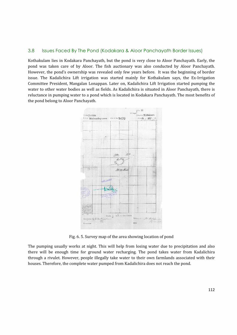
112
3.8 Issues Faced By The Pond (Kodakara & Aloor Panchayath Border Issues)
Kothakulam lies in Kodakara Panchayath, but the pond is very close to Aloor Panchayath. Early, the
pond was taken care of by Aloor. The fish auctionary was also conducted by Aloor Panchayath.
However, the pond’s ownership was revealed only few years before. It was the beginning of border
issue. The Kadalichira Lift irrigation was started mainly for Kothakulam says, the Ex-Irrigation
Committee President, Mangalan Lonappan. Later on, Kadalichira Lift Irrigation started pumping the
water to other water bodies as well as fields. As Kadalichira is situated in Aloor Panchayath, there is
reluctance in pumping water to a pond which is located in Kodakara Panchayath. The most benefits of
the pond belong to Aloor Panchayath.
Fig. 6. 5. Survey map of the area showing location of pond
The pumping usually works at night. This will help from losing water due to precipitation and also
there will be enough time for ground water recharging. The pond takes water from Kadalichira
through a rivulet. However, people illegally take water to their own farmlands associated with their
houses. Therefore, the complete water pumped from Kadalichira does not reach the pond.

113
3.9 Geography
3.9.1 Geographical Details
Fig. 6.6. Map of the Kothakkulam pond showing the area
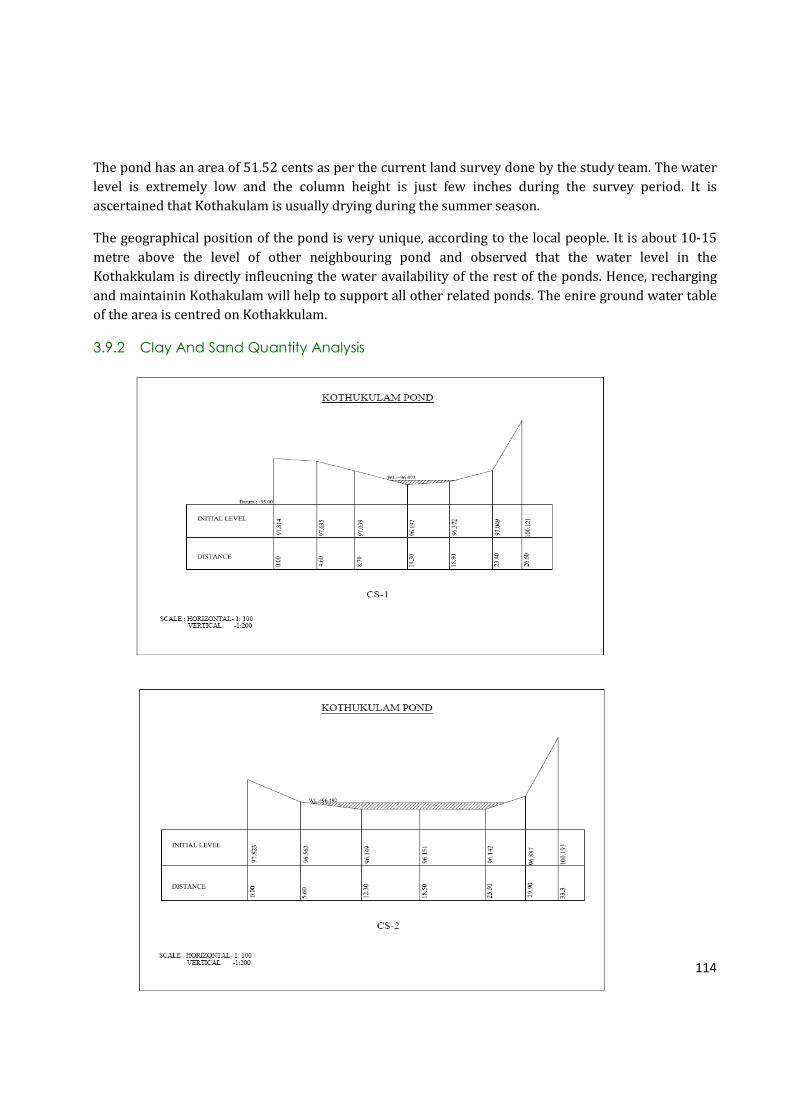
114
The pond has an area of 51.52 cents as per the current land survey done by the study team. The water
level is extremely low and the column height is just few inches during the survey period. It is
ascertained that Kothakulam is usually drying during the summer season.
The geographical position of the pond is very unique, according to the local people. It is about 10-15
metre above the level of other neighbouring pond and observed that the water level in the
Kothakkulam is directly infleucning the water availability of the rest of the ponds. Hence, recharging
and maintainin Kothakulam will help to support all other related ponds. The enire ground water table
of the area is centred on Kothakkulam.
3.9.2 Clay And Sand Quantity Analysis

115
Fig. 6.7. (CS-1-4). Cross section maps of Kothakulam showing the depth and water column
3.10 Water Quantity And Quality
3.10.1 Water Quantity
The water quality of the pond was very good when the pond was regularly used according to the local
community. However, when summer comes, the water quality degrades as there is no water
movement occurs in the pond. Therefore, people avoid direct using during the summer season. During
summer season, people used to dip coconut leaves in the pond to weave. In the past, the roofs of low

116
class families were made of woven coconut leaves. In addition to this, the pond ecosystem becomes
favorable for weed growth. This has resulted in the accumulated growth of rooted, emerging,
submerged and floating types of aquatic plants, mainly weeds. This has prevented the penetration of
sunlight into deeper layers of the pond, hence the aeration and photosynthetic activities of the bottom
layers of the pond has been heavily blocked. Thus currently the water quality has been deteriorated.
* Not mentioned in IS2296, but it is as per the WHO standard.
Table 6.3. Data on water quality tests of the samples of Kothakkulam pond
The water quality of pond is found highly deteriorated. This is especially due to the extremely low
quantity of water available during the study period. This shows that whenever water quantity
becomes low the quality also get deteriorated, either due to stagnation and pollution or through
excessive exploitation.
Sr.
No.
Parameter Sample
value 1
Sample
value 2
Sample
value
3
Permissible limit
for bathing and
irrigation (IS2296)
1 pH 5.75 5.74 5.59 6.5 – 8.5
2 Salinity 0.06 0.06 0.05 3 ppt
3 Conductivity 76.7 83.1 71.3 2250 µS
4 Turbidity 21 20 20 300 NTU
5 Total Dissolved Solids 40.5 44.2 37.6 2100 mg/L
6 Total Hardness 44 30 32 1100 mg/l as CaCO3 *
7 Ca+ ions 4 24 8 500 mg/l as Ca+ *
8 Mg+ ions 4 6 24 30 mg/l as Mg+*
9 Acidity 96 76 156 200 mg/l as CaCO3*
10 Alkalinity 20 14 14 200 mg/l as CaCO3*
11 Total iron 0.5 0.7 0.5 2.0 mg/l as Fe*
12 Chloride 40 40 40 600 mg/l as Cl
13 Fluoride 0 0 0 1.5 mg/l as F
14 Nitrate 0 0 0 30 mg/l as NO3*
15 Sulfate 0 0 0 1000 mg/l as SO4
16 DO 12.6 9.36 10.92 50.0mg/l
17 BOD 7.02 2.34 2.34 30.0mg/l
18 Total bacterial
count/1ml
13 21 14 5
19 Total coliforms
MPN/100ml
1100 2400+ 1100 500
20 Faecal coliforms
MPN/100ml
75 75 75 200
21 E. coli Present Present Present 0*
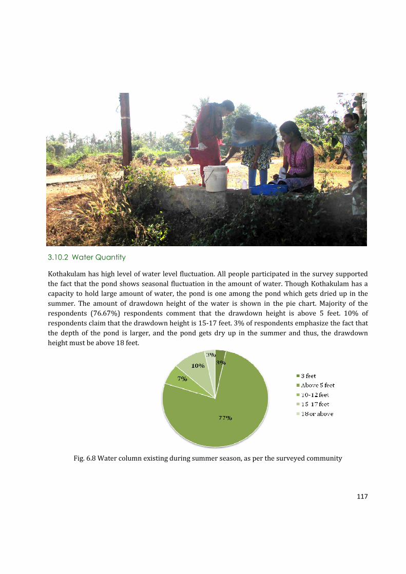
117
3.10.2 Water Quantity
Kothakulam has high level of water level fluctuation. All people participated in the survey supported
the fact that the pond shows seasonal fluctuation in the amount of water. Though Kothakulam has a
capacity to hold large amount of water, the pond is one among the pond which gets dried up in the
summer. The amount of drawdown height of the water is shown in the pie chart. Majority of the
respondents (76.67%) respondents comment that the drawdown height is above 5 feet. 10% of
respondents claim that the drawdown height is 15-17 feet. 3% of respondents emphasize the fact that
the depth of the pond is larger, and the pond gets dry up in the summer and thus, the drawdown
height must be above 18 feet.
Fig. 6.8 Water column existing during summer season, as per the surveyed community

118
3.11 Biodiversity Estimation
3.11.1 Biodiversity Status Of The Pond
a. Fishes In The Pond
Majority of the respondents support the fact that the pond was rich with fishes. Varal and Mushi are
the most common among the fishes found in Kothakulam. Due to the richness of fish diversity,
individuals used to individuals used to undertake the ownership of pond for fishing during a period of
one year through auction to carry out fishing.
Malayalam Name Common Name Scientific Name
Varal Striped Snake head Channa striata
Mushi Valencienne’c clariid Clarias dussumieri
Kadu / Kaari Stinging catfish Clarias batrachus
Karippidi Malabar Leaf Fish, Common
catopra
Pristolepis marginata
Paral Common Rasbora Rasbora dandia
Thiloppia Mozambique Tilapia Oreochromis mossambica
Kundothi
Vaala Fresh water eel Wallago attu
Table 6.4. Common fishes of Kothakkulam Pond
Though the pond is rich with diverse fishes, people doubt whether the pond still holds the same
number of fishes like the past. The pond holds only a little amount of water at the moment as pumping
has not taken place this year. Moreover, in the area where the pond holds a little amount of water, the
water is filled with different types of weeds and algae. Due to lack of oxygen and water, fish diversity
must have dropped dramatically, say 80% of the respondents.
Fig. 6.9 Chaning fish diversity of the Kothakkulam pond
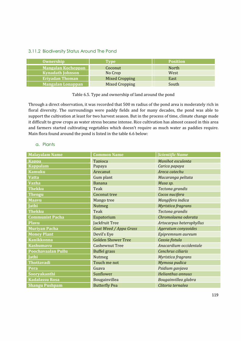
119
3.11.2 Biodiversity Status Around The Pond
Ownership Type Position
Mangalan Kocheppan Coconut North Kynadath Johnson No Crop West
Eriyadan Thoman Mixed Cropping East
Mangalan Lonappan Mixed Cropping South
Table 6.5. Type and ownership of land around the pond
Through a direct observation, it was recorded that 500 m radius of the pond area is moderately rich in
floral diversity. The surroundings were paddy fields and for many decades, the pond was able to
support the cultivation at least for two harvest season. But in the process of time, climate change made
it difficult to grow crops as water stress became intense. Rice cultivation has almost ceased in this area
and farmers started cultivating vegetables which doesn’t require as much water as paddies require.
Main flora found around the pond is listed in the table 6.6 below:
a. Plants
Malayalam Name Common Name Scientific Name
Kappa Tapioca Manihot esculenta Kappalam Papaya Carica papaya
Kamuku Arecanut Areca catechu
Vatta Gum plant Macaranga peltata
Vazha Banana Musa sp.
Thekku Teak Tectona grandis
Thengu Coconut tree Cocos nucifera
Maavu Mango tree Mangifera indica
Jathi Nutmeg Myristica fragrans
Thekku Teak Tectona grandis
Communist Pacha Eupatorium Chromolaena odorata
Plavu Jackfruit Tree Artocarpus heterophyllus
Muriyan Pacha Goat Weed / Appa Grass Ageratum conyzoides
Money Plant Devil’s Eye Epipremnum aureum
Kanikkonna Golden Shower Tree Cassia fistula
Kashumavu Cashewnut Tree Anacardium occidentale
Poochavaalan Pullu Buffel grass Cenchrus ciliaris
Jathi Nutmeg Myristica fragrans
Thottavadi Touch me not Mymosa pudica
Pera Guava Psidium gavjava
Sooryakanthi Sunflower Helianthus annuus
Kadalassu Rosa Bougainvillea Bougainvillea glabra
Shangu Pushpam Butterfly Pea Clitoria ternalea

120
Chembarathi Hibiscus Hibiscus roosasinensis
Kanakambaram Firecracker Flower Crossandra infundibuliformis
Shavamnaari Madagaskar periwinkle Vinca rosea
Irumpan Puli Bilimbi Averrhoa bilimbi
Mantharam White Orchid Tree Bauhinia tomentosa
Chuvanna Cheera Velvet curtain Amaranthus sp.
Vallimulla Jasmine Jasminum officinale
Nanthyarvattam East Indian Rosebay Ervatamia coronaria
Badam Badam Terminalia catappa
Orchid Orchid Orchidaceae
Sheema Konna Mata Ratón Gliricidia sepium
Kolambi Yellow Bell Flower Tecoma stans
Panji Maram Cotton Tree Gossypium hirsutum
Illi Bamboo Bambusa sp.
Rosa Rose Rosa sp.
Croton Croton Codiaeum variegatum
Mahagany Mahagony Swietenia macrophylla
Muringa Drumstick Plant Moringa oleifera
Mussanda Mussanda Mussaenda erythrophylla
Aryavepp Neem Tree Azadirachta inaica Juss
Neeroli --- Phyllanthus reticulates
Daliya Dahlia Dahlia hortensis
Senia
Kanakambaram Tropic Flame Crossandra infundibuliformis
Rajamalli Peacock Flower Caesalpinia pulcherrima
Aami
Bush
Mulla Jasmine Jasmine multiflorum
Anthooriyam Anthurium Anthurium
Keezharnelli Hurricane Weed Phyllanthus amarus
Chethi Jungle Geranium Ixora coccinea
Vayara Bitter Vine Micania micrantha
Canna Canna Canna indica
Vadamalli Globe Amaranth Gomphrena globosa
Venthi Tagetus erecta
Jamanthi Chrysanthemum sp
Poinsettia pulcherrima
Table 6.6. Floral diversity around the pond (50 m radius)

121
b. Birds
The birds observed around the pond are listed in the Table 6.7. Kothakulam and nearby paddy fields
support a wide variety of birds. Among the five ponds studied, most number of birds are seen in
Kothakulam. Common Myna, Black Drongo, Spotted Dove and Yellow-browed Bulbul are the most
sighted birds around the pond. As the surrounding of the pond has different varieties of trees and
plants, a surprising array of birds visit the pond and it’s surroundings.
Malayalam Name Common Name Scientific Name
Madatha Common Myna Acridotheres tristis
Kariyilakkili Jungle Babbler Turdoides striatus
Meenkothi Chaathan White-throated Kingfisher Halcynon smyrnensis
Kakka Thampuratti Black Drongo Dricrurus macrocercus
Kaavathi Kaakka House Crow Corvus splendens protegatus
Kaalimundi Cattle Egret Bubulcus ibis coromandus
Cherumundi Intermediate Egret Mesophoyx intermedia
Uppankakka Greater Coucal Centropus sinensis parroti
Aripraavu Spotted Dove Streptopelia chinensis suratensis
Manjakili Black -Hooded Oriole Oriolus xanthornus xanthornus
Kulakozhi White-Breasted Waterhen Amaurornis phoenicurs
Thatha Rose-Ringed Parakeet Psittacula krameri manillensis
Angaadi Kurivi House Sparrow Passar domesticus
Manja Chinnan Yellow-browed Bulbul Iole indica
Vayal Kuruvi Plain Prinia Prinia inornata
Irattathalachi Red-Whiskered Bulbul Pycnonotus jocous fuscicaudatus
Olenjali Rufous Tree Pie Dendrocitta vagabunda parvula
Mannathi Oriental Magpie-Robin Copsychus saularis ceylonesnsis
Valiya Velithatha Blue-Tailed Bee-eater Merops philipppinus
Chenkanni Thithiri Red-Wattled Lapwing Vanellus indicus indicus
Panamkakka Indian Roller Coracias benghalensis indica
Table 6.7. Bird diversity around the pond
c. Butterflies
Kothakulam supports a large number of butterflies, dragonflies and damselflies. Psyche, Common
Grass Yellow, and Tawny Caster are the most sighted butterflies found in and around the pond. Other
types of butterflies are also recorded during the study period. The table shows the different varieties
of butterflies seen in the pond.

122
BUTTERFLIES
Malayalam Name Common Name Scientific Name
Pottuvellatti Psyche Leptosia nina
Manjapappathi Common Grass Yellow Eurema hecabe
Ponthachuttan Common Sailor Neptis hylas
Panchanethri Common Five-Ring Ypthima baldus
Narakakkali Common Mormon Paplio polytes
Theechirakan Tawny Caster Acraea violae
Chakkarashalabham Crimson Rose Pachilopta hector
Cheru Pulneeli Lesser Grass Blue Zizina otis
Table 6.8. Butterflies of Kothakkulam pond area (50 m radius)
d. Dragonflies and Damselflies
Dragonflies and Damselflies are also very common around the pond. Common Picture Wing (Female),
Pied Paddy Skimmer (Male) and Blue Percher (Male) are the most common dragonflies found in the
pond. Damselflies like Kerala Dartlet and Coromandel Marsh Dart are also recorded in this area.
DRAGONFLIES
Malayalam Name Common Name Scientific Name
Shalabha Thumpi Common Picture Wing (Female) Rhothemis variegata
Theekari Muthan Scarlet Marsh Hawk (Male) Aethriamanta brevipennis
Pullivalan Blue Percher (Male) Diplacodes trivalis
Swami thumpi Pied Paddy Skimmer (Male) Neurothemis tullia
Pandan Vayaltheyyan Scarlet baskar (Male) Urothemis signata
DAMSELFLIES
Malayalam Name Common Name Scientific Name
Pathi Pulchinnan Kerala dartlet Agriocnemis keralensis
Naattu Chathuppan Coromandel Marsh Dart Ceriagrion coromandelianum
Table 6.9. Odonates of Kothakkulam Pond area
3.12 Environmental Threats
The pond is in an abandoned condition without much water during the period of study. The pond goes
dry between December to May. Kothakulam is one of the ponds in Kodakara Panchayath with high
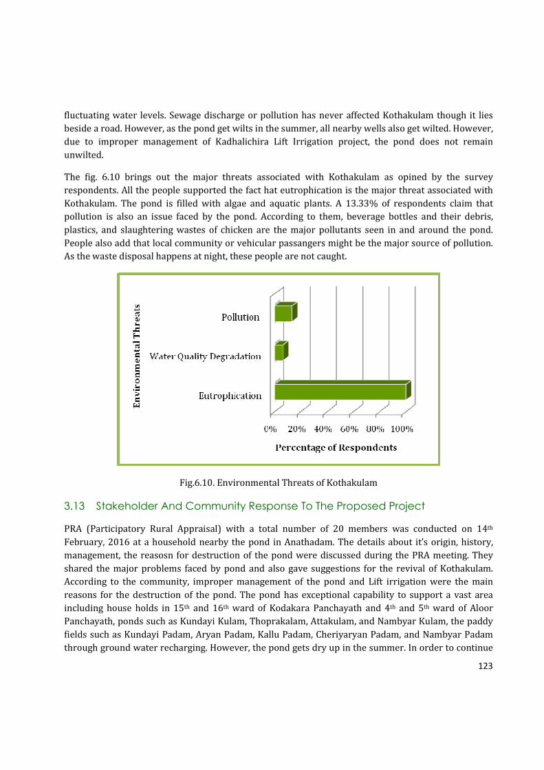
123
fluctuating water levels. Sewage discharge or pollution has never affected Kothakulam though it lies
beside a road. However, as the pond get wilts in the summer, all nearby wells also get wilted. However,
due to improper management of Kadhalichira Lift Irrigation project, the pond does not remain
unwilted.
The fig. 6.10 brings out the major threats associated with Kothakulam as opined by the survey
respondents. All the people supported the fact hat eutrophication is the major threat associated with
Kothakulam. The pond is filled with algae and aquatic plants. A 13.33% of respondents claim that
pollution is also an issue faced by the pond. According to them, beverage bottles and their debris,
plastics, and slaughtering wastes of chicken are the major pollutants seen in and around the pond.
People also add that local community or vehicular passangers might be the major source of pollution.
As the waste disposal happens at night, these people are not caught.
Fig.6.10. Environmental Threats of Kothakulam
3.13 Stakeholder And Community Response To The Proposed Project
PRA (Participatory Rural Appraisal) with a total number of 20 members was conducted on 14th
February, 2016 at a household nearby the pond in Anathadam. The details about it’s origin, history,
management, the reasosn for destruction of the pond were discussed during the PRA meeting. They
shared the major problems faced by pond and also gave suggestions for the revival of Kothakulam.
According to the community, improper management of the pond and Lift irrigation were the main
reasons for the destruction of the pond. The pond has exceptional capability to support a vast area
including house holds in 15th and 16th ward of Kodakara Panchayath and 4th and 5th ward of Aloor
Panchayath, ponds such as Kundayi Kulam, Thoprakalam, Attakulam, and Nambyar Kulam, the paddy
fields such as Kundayi Padam, Aryan Padam, Kallu Padam, Cheriyaryan Padam, and Nambyar Padam
through ground water recharging. However, the pond gets dry up in the summer. In order to continue
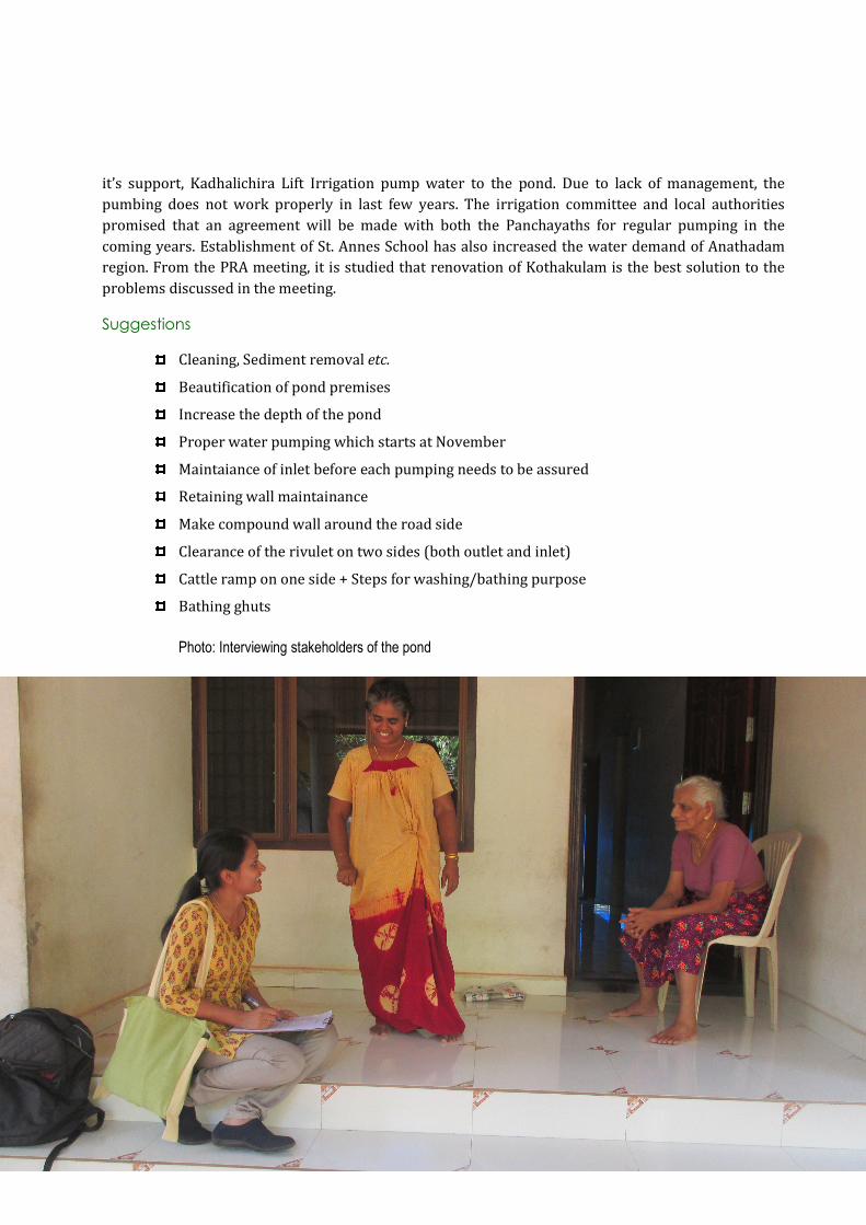
124
it’s support, Kadhalichira Lift Irrigation pump water to the pond. Due to lack of management, the
pumbing does not work properly in last few years. The irrigation committee and local authorities
promised that an agreement will be made with both the Panchayaths for regular pumping in the
coming years. Establishment of St. Annes School has also increased the water demand of Anathadam
region. From the PRA meeting, it is studied that renovation of Kothakulam is the best solution to the
problems discussed in the meeting.
Suggestions
Cleaning, Sediment removal etc.
Beautification of pond premises
Increase the depth of the pond
Proper water pumping which starts at November
Maintaiance of inlet before each pumping needs to be assured
Retaining wall maintainance
Make compound wall around the road side
Clearance of the rivulet on two sides (both outlet and inlet)
Cattle ramp on one side + Steps for washing/bathing purpose
Bathing ghuts
Photo: Interviewing stakeholders of the pond

125
KOTHAKULAM - SUMMARY
♣ Kothakulam has a history of more than a century as opined by the oldest respondents.
♣ There are lot of stories regarding the origin of the pond and etiology of its name ‘Kothakulam.’
But anything is not conclusive.
♣ The pond was made from a small pit, mainly for agricultural purposes because the surroundings
were paddy fields and Kothakulam is the only water body nearby to serve water. At present,
many paddy fields are turned into residential lands or crop type has changed to vegetables or
tapioca.
♣ There are four major types uses occurred in the pond such as Agriculture, bathing, laundry, and
showering animals. Fishing and weaving of coconut leaves were also taken place occasionally.
However, due to water scarcity and increased algal growth, people stopped visiting the pond.
♣ Kothakulam supported livelihood of local community in many ways such as agriculture,
laundry, cattle rearing, and fishing. Among them, agriculture is the major livelihood associated
with the pond since Kothakulam was the only water resource for irrigation.
♣ There are major 7 water bodies around this reagion. Among them, Kadhalichira provides water
through Kadhalichira Lift irrigation during summer season.
♣ The pond situates within an area of 83.33 cents.
♣ Kothakulam has a capacity to hold large amount of water, but the pond is one among the ponds
which gets dry up in summer.
♣ The community survey shows that the water quality of the pond was very good when the pond
was regularly used in the past. However, the water quality degradation happens in the summer
due to the stagnation. When people reduced using the pond, it became a favorable condition for
weed growth. Therefore, the water quality has been significantly reduced.
♣ Biodiversity status of the pond and its bank showed that the area has 8 species of fishes.
♣ Biodiversity status of the surrounding area (50 m radius) of the pond showed the biodiversity is
rich with diverse flora and fauna. A total of 13 types of flora, 21 birds, 8 butterflies, 5
dragonflies, and 2 damselflies are recorded from this area through taxonomic survey.
♣ Through the community analysis of environmental threats of Kothakulam showed that
relatively less pollution exists due to direct anthropogenic activities. Survey respondents
commented problems such as eutrophication and weed infestation, and related stagnation in
summer due to water scarcity are the major issues. The water quality of pond is found highly
deteriorated. This is especially due to the extremely low quantity of water available during the
study period.
♣ Overwhelming reponses were received from different stakeholders during PRA meeting. They
promised that Lift Irrigation will work properly ahead and will make an agreement between
Kodakara and Aloor Panchayath in this regard.
126
4. PROPOSAL
4.1 Aim: The project aims at surface water body conservation of Kodakara Panchayath Ponds.
4.2 Objectives:
An environment-friendly approach is adopted to recreate the natural and healthy habitat that
Kothakulam had once. The proposed features are enlisted below (see the sketches Fig 6.11, Fig
6.12 and Fig 6.13).
• Restore the pond from eutrophication - retain its ecological importance to provide sustainable
use pattern
Even after eutrophication, the pond was regularly used every year to store water for ground water
recharging. After getting eutrophicated, the direct use pattern has reduced significantly. If the
pond is restored from the present conditions, the pond will be able to store much more water to
meet the water needs. Moreover, it will also promote direct use pattern. It is evident from
biodiversity estimation that unlike other ponds, the pond is able to attract more birds than other
ponds. Therefore, the pond is beneficial not only for humanbeing, but also for the existence of
birds. Eutrophication and mud deposit have made the pond as a dangerous spot. There are cases
where people have died in the pond due to it’s worst conditions. Therefore, it is very important to
restore the pond and retain it’s ecological importance to provide sustainable use pattern.
• Conservation of Kothakulam for ground water recharging and agriculture
Anathadam is one of the places in Kodakara Panchayath which face extreme water scarcity in
summer season. Conserving the pond will support the ground water table of the area by holding
the water in the pond. As the pond is very large, it is able to hold to a huge amount of water.
Moreover, making sure of proper irrigation project of Kadhalichira will support more water to the
pond. Most significantly, this will also help to improve the the cultivation in paddy fields such as
Kundayi Padam, Aryan Padam, Cheriya Aryan Padam, and Kallu Padam. Majority of the men in
Anathadam region are farmers. However, as the scope of productive cultivation was not available
in Anathadam due to water scarcity, the farmers left their cultivation or changed the crop pattern
which maximize the benefits.
• Attract more birds, butterflies, dragonflies, damselflies, amphibians, etc
Surprising array of birds can be often seen in Kothakulam and it’s surroundings. According to the
community, butterflies, dragonflies, and damselflies were also very common in and around
Kothakulam. However, after the pond was eutrophicated, the number has reduced immensily.
Therefore, it’s very important to restore the pond for their shelter and water needs.
• Make provisions for bathing, irrigation (manual) and meet the common water needs of the
society.
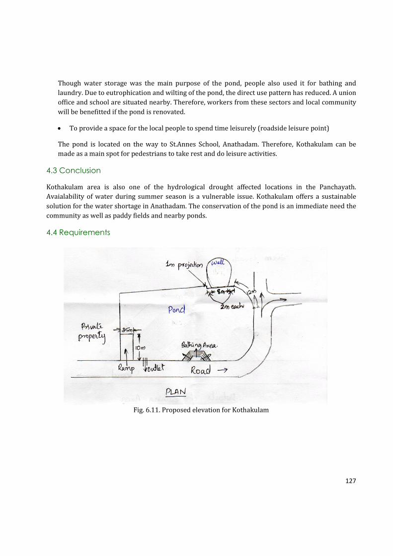
127
Though water storage was the main purpose of the pond, people also used it for bathing and
laundry. Due to eutrophication and wilting of the pond, the direct use pattern has reduced. A union
office and school are situated nearby. Therefore, workers from these sectors and local community
will be benefitted if the pond is renovated.
• To provide a space for the local people to spend time leisurely (roadside leisure point)
The pond is located on the way to St.Annes School, Anathadam. Therefore, Kothakulam can be
made as a main spot for pedestrians to take rest and do leisure activities.
4.3 Conclusion
Kothakulam area is also one of the hydrological drought affected locations in the Panchayath.
Avaialability of water during summer season is a vulnerable issue. Kothakulam offers a sustainable
solution for the water shortage in Anathadam. The conservation of the pond is an immediate need the
community as well as paddy fields and nearby ponds.
4.4 Requirements
Fig. 6.11. Proposed elevation for Kothakulam

128
Fig. 6.12. The elevation of Kothakulam
Fig. 6.13. Cross section of the proposed
bund and reinforcement details
Fig. 6.14. Cross section of cattle ramp

129
SL
NO
SPECIFICATION UNIT RATE NO MEASUREMENTS QUANTITY
Length Bredth Height
1 Clearing thick and thorny jungle including uprooting
of thick vegetation and small trees of girth up to 30cm
and removal of rubbish up to a distance of 150m
outside the periphery of the area cleared
sqm 4 1 200
2 Earth work in excavation by mechanical means
(Hydraulic excavator) / manual means in foundation
trenches or drains (not exceeding 1.5 m in width or
10 sqm on plan), including dressing of sides and
ramming of bottoms, lift up to 1.5 m, including getting
out the excavated soil and disposal of surplus
excavated soil as directed, within a lead of 50m
Cum 320
2.1 DR works 1 14 1.5 4.5 94.5
2.2 Ramp 1 7.5 (1.5+.5)/2 0.5 3.75
1 2.5 0.5 0.5 0.625
1 3.5 0.5 0.5 0.875
2.3 Bathing area 2 5.95 4.5 0.7 37.485
1 4.1 4.5 0.4 7.38
2.4 Pond area 1 5 2.25 1 11.25
Total 155.865
3 Earth filling with suitable soil and forming
embankment by spreading in layers of uniform
thickness over the full width, drying or watering as
the case may be, scarifying to get uniform opimum
moisture content and compacting in layers not less
than 25cm(loose thickness) using power roller
satisfying compaction tests including trimming slopes
to lines and levels.
Cum 350
3.1 DR works 1 14 0.5 4.5 31.5
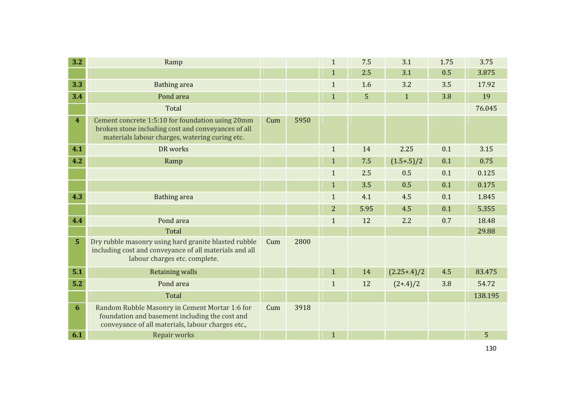
130
3.2 Ramp 1 7.5 3.1 1.75 3.75
1 2.5 3.1 0.5 3.875
3.3 Bathing area 1 1.6 3.2 3.5 17.92
3.4 Pond area 1 5 1 3.8 19
Total 76.045
4 Cement concrete 1:5:10 for foundation using 20mm
broken stone including cost and conveyances of all
materials labour charges, watering curing etc.
Cum 5950
4.1 DR works 1 14 2.25 0.1 3.15
4.2 Ramp 1 7.5 (1.5+.5)/2 0.1 0.75
1 2.5 0.5 0.1 0.125
1 3.5 0.5 0.1 0.175
4.3 Bathing area 1 4.1 4.5 0.1 1.845
2 5.95 4.5 0.1 5.355
4.4 Pond area 1 12 2.2 0.7 18.48
Total 29.88
5 Dry rubble masonry using hard granite blasted rubble
including cost and conveyance of all materials and all
labour charges etc. complete.
Cum 2800
5.1 Retaining walls 1 14 (2.25+.4)/2 4.5 83.475
5.2 Pond area 1 12 (2+.4)/2 3.8 54.72
Total 138.195
6 Random Rubble Masonry in Cement Mortar 1:6 for
foundation and basement including the cost and
conveyance of all materials, labour charges etc.,
Cum 3918
6.1 Repair works 1 5

131
6.2 Ramp 1 7.5 (.95+.5)/2 (3+.5)/2 9.52
1 2.5 0.5 0.5 0.625
1 3 0.5 0.5 0.75
6.3 bathing area 2 2.8 0.4 3.5 7.84
1 2 0.4 3.5 2.8
15Nos of 25cm raise 30cm tread step in one side 2 5.95 0.3 28.5 101.745
1 4.1 0.3 28.5 35.055
Total 163.335
7 Cement concrete 1:2:4 for flooring using 20 mm
broken stone including cost and conveyances of all
materials labour charges, watering curing etc.
complete
Cum 6450
7.1 Over DR works 1 26 0.4 0.1 1.04
1 26 1.37 0.1 3.562
7.2 Ramp 1 10 3.5 0.1 3.5
7.3 Bathing area 1 4 2 0.1 0.8
1 30 0.3 0.1 0.9
Total 9.802
8 Poviding GI hand rails over the retaining walls
including all costs, conveyance of materials,
labour,painting charges etc.complete.
Rm 420 1 120 120
9 Providing roof with tiles over suitable truss work
including cost and conveyance of all materials, hire
and labour charges, etc.complete.
sqm 1700 1 5 3 15
Table 6.10. Requirements for the maintainence of Kothakulam

132
CHAPTER VII
MOTHAKULAM
1. INTRODUCTION
Mothakulam belongs to Kodakara Panchayath, Thrissur District, Kerala. The pond is located in
Perambra Locality and is 4 KM away from Kodakara Town. This pond is away from urbanizations like
factories and national highways. As a result, the pond has never been a victim of urbanization.
However, there are other factors affected the pond which slowly destroyed the pond. In order to get a
better understanding about the pond, 30 respondents who live nearby the pond were surveyed.
2. METHODOLOGY
The study was begun with conducting community survey of 30 respondents who live around the pond.
A survey among the community was conducted in order to expose the past and present current status
of the pond in terms of biological, social and economical. Land survey, quatity of clay and silt, water
quality studies, biodiversity estimation, community survey, and pollution studies were conducted as
part of the study.
2.1 Study Area
The pond situates in 6th ward of Kodakara Panchayath. The pond is located near agricultural fields. The
pond is located near agricultural fields and the immediate neighborhoods come after agricultural
lands. Though there is human settlement nearby, the immediate neighborhoods come after
agricultural lands. Thus, the pond is believed to be made for agriculture. The pond lies between N
10021’21.24’’ and E 076019114.82’’.
Photo: Mothakulam
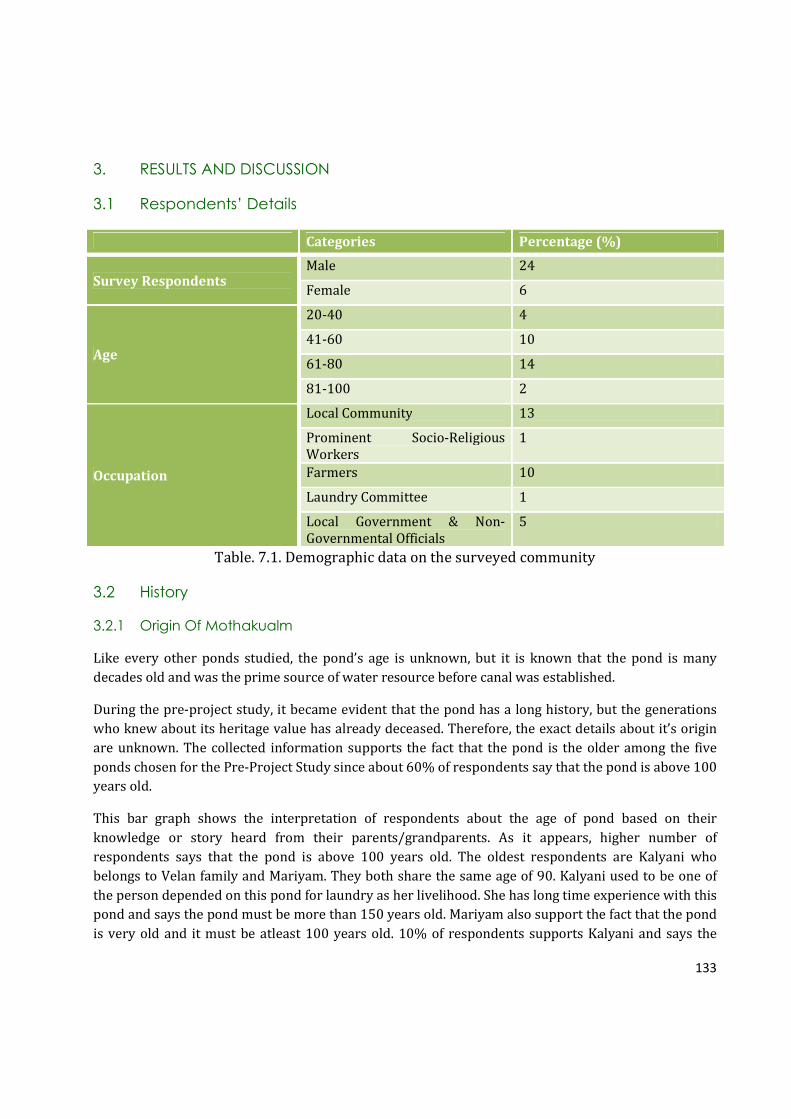
133
3. RESULTS AND DISCUSSION
3.1 Respondents’ Details
Categories Percentage (%)
Survey Respondents Male 24
Female 6
Age
20-40 4
41-60 10
61-80 14
81-100 2
Occupation
Local Community 13
Prominent Socio-Religious
Workers
1
Farmers 10
Laundry Committee 1
Local Government & Non-
Governmental Officials
5
Table. 7.1. Demographic data on the surveyed community
3.2 History
3.2.1 Origin Of Mothakualm
Like every other ponds studied, the pond’s age is unknown, but it is known that the pond is many
decades old and was the prime source of water resource before canal was established.
During the pre-project study, it became evident that the pond has a long history, but the generations
who knew about its heritage value has already deceased. Therefore, the exact details about it’s origin
are unknown. The collected information supports the fact that the pond is the older among the five
ponds chosen for the Pre-Project Study since about 60% of respondents say that the pond is above 100
years old.
This bar graph shows the interpretation of respondents about the age of pond based on their
knowledge or story heard from their parents/grandparents. As it appears, higher number of
respondents says that the pond is above 100 years old. The oldest respondents are Kalyani who
belongs to Velan family and Mariyam. They both share the same age of 90. Kalyani used to be one of
the person depended on this pond for laundry as her livelihood. She has long time experience with this
pond and says the pond must be more than 150 years old. Mariyam also support the fact that the pond
is very old and it must be atleast 100 years old. 10% of respondents supports Kalyani and says the
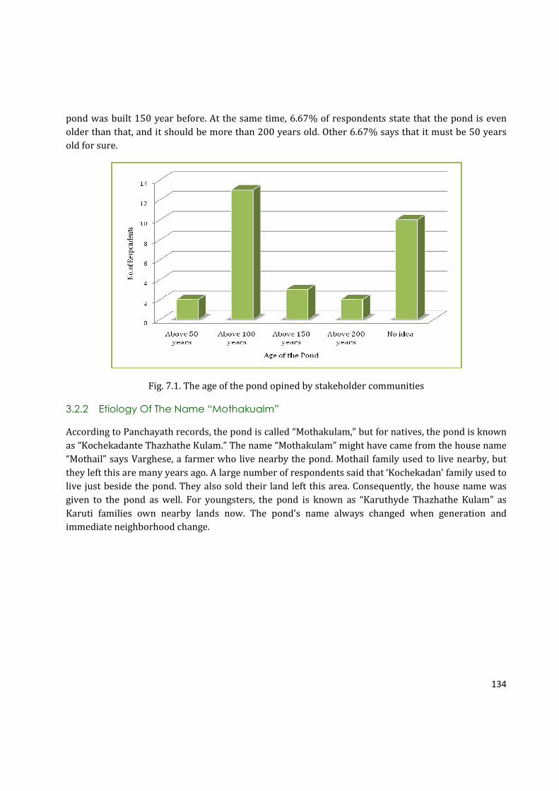
134
pond was built 150 year before. At the same time, 6.67% of respondents state that the pond is even
older than that, and it should be more than 200 years old. Other 6.67% says that it must be 50 years
old for sure.
Fig. 7.1. The age of the pond opined by stakeholder communities
3.2.2 Etiology Of The Name “Mothakualm”
According to Panchayath records, the pond is called “Mothakulam,” but for natives, the pond is known
as “Kochekadante Thazhathe Kulam.” The name “Mothakulam” might have came from the house name
“Mothail” says Varghese, a farmer who live nearby the pond. Mothail family used to live nearby, but
they left this are many years ago. A large number of respondents said that ‘Kochekadan’ family used to
live just beside the pond. They also sold their land left this area. Consequently, the house name was
given to the pond as well. For youngsters, the pond is known as “Karuthyde Thazhathe Kulam” as
Karuti families own nearby lands now. The pond’s name always changed when generation and
immediate neighborhood change.

135
Fig. 7.2. Different names given to the pond by local Community
The fig.7.2 tries to picturize different names associated with the pond. 53.33% of respondents call the
pond as “Kochekadante Thazhathe Kulam/ Kochekadante Kulam.” At the same time, people also call
multiple names for the pond. 16.67% of respondents name the pond as both “Kochekadante Thazhathe
Kulam” and “Karuthide Thazhathe Kulam.” Another 6.67% of respondents call the pond as “Karuthide
Thazhathe Kulam” and a same percentage of people all the pond both as “Mothakulam” and
“Kochekadante Thazhathe Kulam.” Only one person (3.33%) noted the pond’s name as only
“Mothakulam.”
3.3 Physical Features Of The Pond In The Past
Many people supported the fact that the surroundings were paddy fields and the pond was used to
irrigate the paddy field. Many of the paddy fields have been changed to other kinds of farmlands.
Farmers changed their crops to more profitable ones. Disappearance of paddy fields also has affected
Mothakulam. When regular visit of people has decreased, the water movement also has decreased.
Hence, it stimulated the growth of phytoplankton and algae.
43.33% of respondents recollected from their memory about the pond that the pond size has
decreased from the past. The pond was bigger and accommodated much more water. The pond never
dries up even in extreme summer. Over time, a significant area of pond has been encroached by
different private parties who own the immediate surrounding lands the pond. Moreover, due to run off
water and improper management of the pond, a large amount of sediments have been accumulated in
the pond. Eutrophication is the major threat faced by the pond. The pond has almost disappeared and
people hardly recognize it as a pond.
136
People recall that the pond’s water was transparent and could see the bottom. The bottom was sandy.
However, the pond has almost covered at present. People can hardly see the water in the pond
because different varieties of grasses and mosses dominated the pond. Three edges of pond are
bordered with screw pines. People say that the screw pines were not planted by anyone, rather they
were grown naturally. The pond was never maintained with retaining wall. People made bund
surrounding the pond using mud. These bunds have been destroyed already over time.
Old people recollect that there was only a few number of houses around the pond. However, there are
many houses at present in this area. People also say that when basic amenities at home have increased
and agriculture practice reduced, people gradually ignored the pond and pond was considered only for
water storage. However, the pond could not keep the same trend of serving the nature as it used to do
in the past. Ultimately, the pond was almost eutrophicated. Immediate actions must be taken to
recover the pond for better serve.
3.4 Main Uses Of The Pond In Past And Present
The pond was used for all kind of water needs by the nearby people once in the past. However, the
pond is almost degraded at the moment. Even farmers are not able to take water for agriculture since
people can hardly see water on the pond. The pond is not used for any purpose at present. However, it
is found during the study that the pond still holds some water which will definitely help with ground
water recharge, but apparently not like how it could have done in the past.
The pond was used for agriculture, bathing, laundry, and showering animals. The pond made the main
uses of agriculture, bathing and laundry. Since the pond was surrounded by farmlands, the pond was
largely used for irrigation. Old people remember that the pond water was very good and clean, so
people liked to come for bathing and swimming.
The use of pond was reduced when agriculture was slowly abandoned in this area. When water
movement was reduced, it supported the growth of aquatic plants and algae, thereby reduced the
quality of water as well. Thus, people were reluctant to use the pond for bathing and washing.
Gradually, people stopped visiting the pond.
The bar graph brings out the variation in the use patter of the pond over time. Over the years, the
number of people visiting the pond for dropped dramatically. 100% people supported that the pond
was used mainly for agriculture. Bathing and laundry accounted for 90% and 93.33% respectively.
66.67% of respondents also supported the use of showering animals. To sum up, the pond was largely
used in the past for all kinds of water needs. However, the use pattern has dropped significantly and
the pond is in verge of degradation. More than 100 families and paddy fields such as Viruthipadam and
Kodakara Padam will be benefitted through the renovation of the pond.
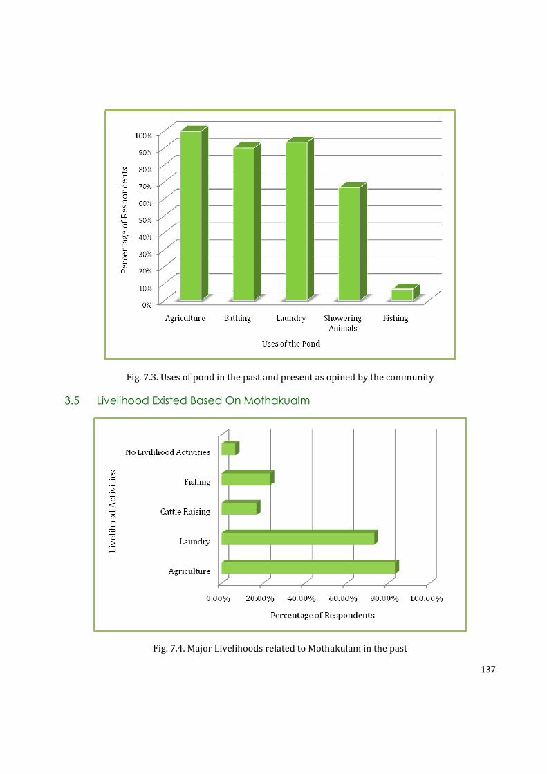
137
Fig. 7.3. Uses of pond in the past and present as opined by the community
3.5 Livelihood Existed Based On Mothakualm
Fig. 7.4. Major Livelihoods related to Mothakulam in the past
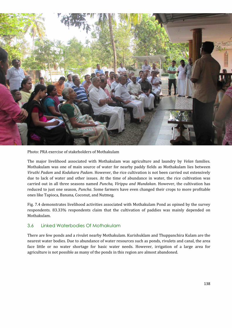
138
Photo: PRA exercise of stakeholders of Mothakulam
The major livelihood associated with Mothakulam was agriculture and laundry by Velan families.
Mothakulam was one of main source of water for nearby paddy fields as Mothakulam lies between
Viruthi Padam and Kodakara Padam. However, the rice cultivation is not been carried out extensively
due to lack of water and other issues. At the time of abundance in water, the rice cultivation was
carried out in all three seasons named Puncha, Virippu and Mundakan. However, the cultivation has
reduced to just one season, Puncha. Some farmers have even changed their crops to more profitable
ones like Tapioca, Banana, Coconut, and Nutmeg.
Fig. 7.4 demonstrates livelihood activities associated with Mothakulam Pond as opined by the survey
respondents. 83.33% respondents claim that the cultivation of paddies was mainly depended on
Mothakulam.
3.6 Linked Waterbodies Of Mothakulam
There are few ponds and a rivulet nearby Mothakulam. Kurishuklam and Thuppanchira Kulam are the
nearest water bodies. Due to abundance of water resources such as ponds, rivulets and canal, the area
face little or no water shortage for basic water needs. However, irrigation of a large area for
agriculture is not possible as many of the ponds in this region are almost abandoned.
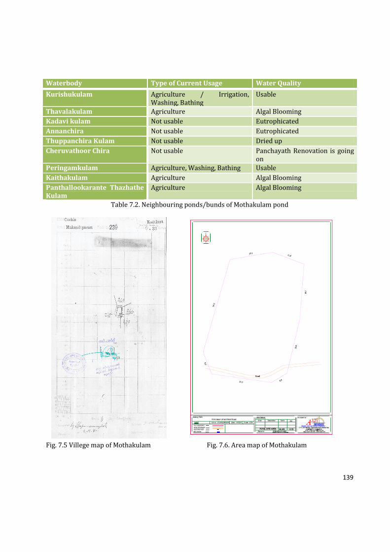
139
Waterbody Type of Current Usage Water Quality
Kurishukulam Agriculture / Irrigation,
Washing, Bathing
Usable
Thavalakulam Agriculture Algal Blooming
Kadavi kulam Not usable Eutrophicated
Annanchira Not usable Eutrophicated
Thuppanchira Kulam Not usable Dried up
Cheruvathoor Chira Not usable Panchayath Renovation is going
on
Peringamkulam Agriculture, Washing, Bathing Usable
Kaithakulam Agriculture Algal Blooming
Panthallookarante Thazhathe
Kulam
Agriculture Algal Blooming
Table 7.2. Neighbouring ponds/bunds of Mothakulam pond
Fig. 7.5 Villege map of Mothakulam Fig. 7.6. Area map of Mothakulam

140
3.7 Issues Faced By The Pond (Canal Project)
A large area of paddy field was irrigated solely by this pond in the past. However, after canal
establishment and declined paddy cultivation, the pond was gradually ignored. Canal recharges much
more water than the pond could do to the nearby houses as the pond lies in low land. Algal blooming
started when there was less movement of water. The pond was almost going vanished when the pond
was visited for the study.
No recent attempts were made to manage ponds and retrieve from the present condition. Nearby
people say that it has been reported to Local Authority, but no progress was made.
3.7 Geography
3.7.1 Geographical Details
3.7.2 Clay And Sand Quantity Analysis
Photo: Above: Measuring the depth of the pond
Right: Collecting water samples

141
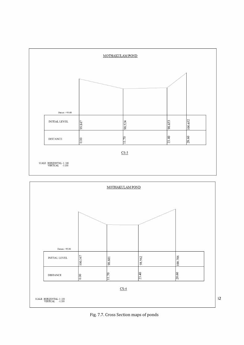
142
Fig. 7.7. Cross Section maps of ponds
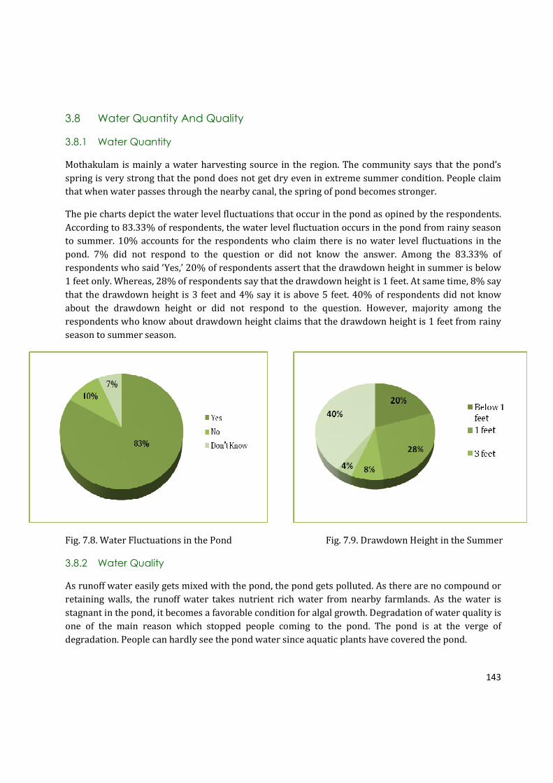
143
3.8 Water Quantity And Quality
3.8.1 Water Quantity
Mothakulam is mainly a water harvesting source in the region. The community says that the pond’s
spring is very strong that the pond does not get dry even in extreme summer condition. People claim
that when water passes through the nearby canal, the spring of pond becomes stronger.
The pie charts depict the water level fluctuations that occur in the pond as opined by the respondents.
According to 83.33% of respondents, the water level fluctuation occurs in the pond from rainy season
to summer. 10% accounts for the respondents who claim there is no water level fluctuations in the
pond. 7% did not respond to the question or did not know the answer. Among the 83.33% of
respondents who said ‘Yes,’ 20% of respondents assert that the drawdown height in summer is below
1 feet only. Whereas, 28% of respondents say that the drawdown height is 1 feet. At same time, 8% say
that the drawdown height is 3 feet and 4% say it is above 5 feet. 40% of respondents did not know
about the drawdown height or did not respond to the question. However, majority among the
respondents who know about drawdown height claims that the drawdown height is 1 feet from rainy
season to summer season.
Fig. 7.8. Water Fluctuations in the Pond Fig. 7.9. Drawdown Height in the Summer
3.8.2 Water Quality
As runoff water easily gets mixed with the pond, the pond gets polluted. As there are no compound or
retaining walls, the runoff water takes nutrient rich water from nearby farmlands. As the water is
stagnant in the pond, it becomes a favorable condition for algal growth. Degradation of water quality is
one of the main reason which stopped people coming to the pond. The pond is at the verge of
degradation. People can hardly see the pond water since aquatic plants have covered the pond.
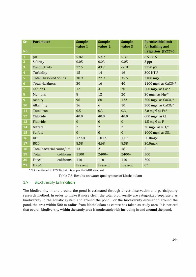
144
Sr.
No.
Parameter Sample
value 1
Sample
value 2
Sample
value 3
Permissible limit
for bathing and
irrigation (IS2296
standard) 1 pH 5.82 5.49 5.37 6.5 – 8.5
2 Salinity 0.05 0.03 0.05 3 ppt
3 Conductivity 72.5 43.7 66.8 2250 µS
4 Turbidity 15 14 16 300 NTU
5 Total Dissolved Solids 38.9 22.9 35.5 2100 mg/L
6 Total Hardness 30 16 40 1100 mg/l as CaCO3 *
7 Ca+ ions 12 4 20 500 mg/l as Ca+ *
8 Mg+ ions 8 12 20 30 mg/l as Mg+*
9 Acidity 96 60 122 200 mg/l as CaCO3*
10 Alkalinity 16 6 10 200 mg/l as CaCO3*
11 Total iron 0.5 0.3 0.3 2.0 mg/l as Fe*
12 Chloride 40.0 40.0 40.0 600 mg/l as Cl
13 Fluoride 0 0 0 1.5 mg/l as F
14 Nitrate 2 2 2 30 mg/l as NO3*
15 Sulfate 0 0 0 1000 mg/l as SO4
16 DO 12.48 10.14 11.7 50.0mg/l
17 BOD 8.58 4.68 8.58 30.0mg/l
18 Total bacterial count/1ml 13 21 18 5
19 Total coliforms 1100 2400+ 2400+ 500
20 Faecal coliforms 110 110 110 200
21 E. coli Present Present Present 0*
* Not mentioned in IS2296, but it is as per the WHO standard.
Table 7.3. Results on water quality tests of Mothakulam
3.9 Biodiversity Estimation
The biodiversity in and around the pond is estimated through direct observation and participatory
research method. In order to make it more clear, the total biodiversity are categorized separately as
biodiversity in the aquatic system and around the pond. For the biodiversity estimation around the
pond, the area within 500 m radius from Mothakulam as centre has taken as study area. It is noticed
that overall biodiversity within the study area is moderately rich including in and around the pond.
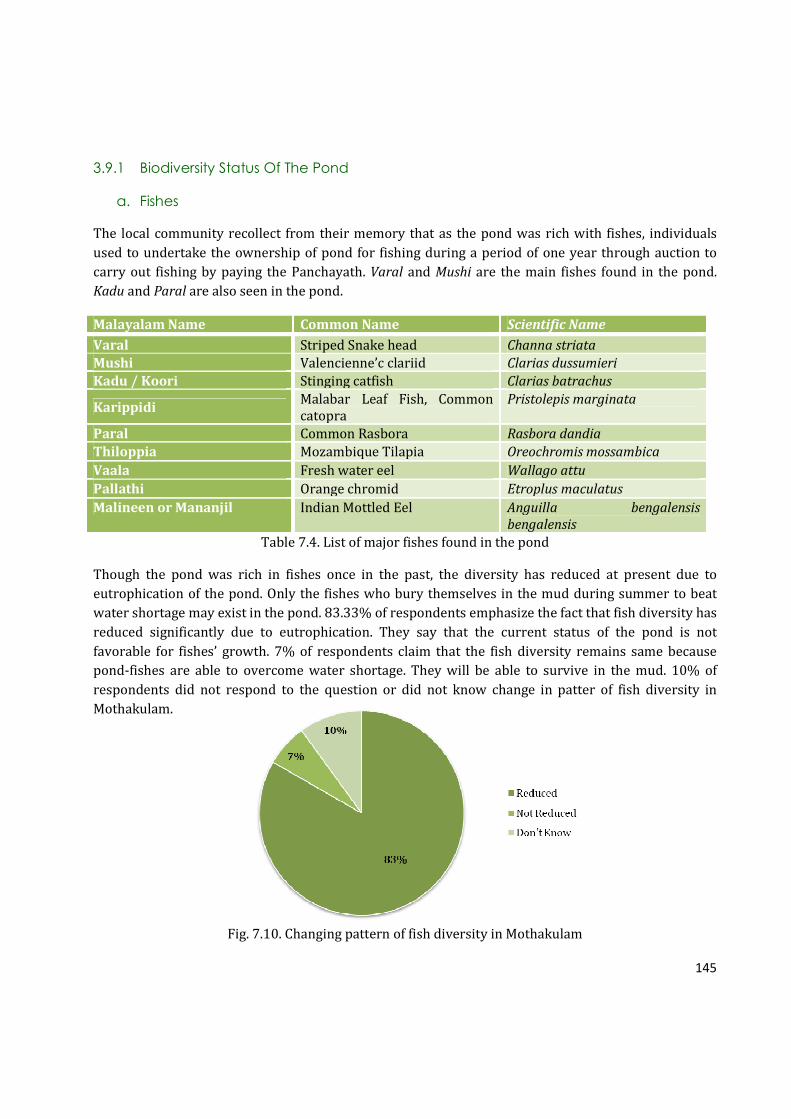
145
3.9.1 Biodiversity Status Of The Pond
a. Fishes
The local community recollect from their memory that as the pond was rich with fishes, individuals
used to undertake the ownership of pond for fishing during a period of one year through auction to
carry out fishing by paying the Panchayath. Varal and Mushi are the main fishes found in the pond.
Kadu and Paral are also seen in the pond.
Malayalam Name Common Name Scientific Name
Varal Striped Snake head Channa striata
Mushi Valencienne’c clariid Clarias dussumieri
Kadu / Koori Stinging catfish Clarias batrachus
Karippidi Malabar Leaf Fish, Common
catopra
Pristolepis marginata
Paral Common Rasbora Rasbora dandia
Thiloppia Mozambique Tilapia Oreochromis mossambica
Vaala Fresh water eel Wallago attu
Pallathi Orange chromid Etroplus maculatus
Malineen or Mananjil Indian Mottled Eel Anguilla bengalensis
bengalensis
Table 7.4. List of major fishes found in the pond
Though the pond was rich in fishes once in the past, the diversity has reduced at present due to
eutrophication of the pond. Only the fishes who bury themselves in the mud during summer to beat
water shortage may exist in the pond. 83.33% of respondents emphasize the fact that fish diversity has
reduced significantly due to eutrophication. They say that the current status of the pond is not
favorable for fishes’ growth. 7% of respondents claim that the fish diversity remains same because
pond-fishes are able to overcome water shortage. They will be able to survive in the mud. 10% of
respondents did not respond to the question or did not know change in patter of fish diversity in
Mothakulam.
Fig. 7.10. Changing pattern of fish diversity in Mothakulam

146
a. Aquatic Plants
Malayalam Name Common Name Scientific Name
Afican Payal Salvinia Salvinia molesta
Pada thali Water spinach Ipomea aquatic
Mullan Payal Paddy field water nymph Najas graminea
Table 7.5 List of aquatic macrophytes in the pond
3.10.2 Biodiversity Status Around The Pond
Ownership Type Position
Rinto - Karuthi Coconut North Rinto – Karuthi Jathi, Banana West
Rinto – Karuthi Rice, Banana, Tapioca, Coconut East
Varghese – Panthallookaran Arecanut, Coconut South
Table 7.6. Status of the land surrounding the pond
a. Floral Diversity
Through the direct observation, it was recorded that 500 m radius of the pond area is moderately rich
in floral diversity.
Malayalam Name Common Name Scientific Name
Thengu Coconut Tree Cocos nucifera
Vatta Gum Plant Macaranga peltata
Vazha Banana Tree Musa sp.
Kamuku Arecanut Areca catechu
Maavu Mango Tree Mangifera indica
Kaitha Screw Pine/ Pendanus
Thekku Teak Tectona grandis
Muringa Drumstick Plant Moringa oleifera
Plavu Jackfruit Tree Artocarpus heterophyllus
Kappalam Carica papaya Carica papaya
Communist Pacha Eupatorium Chromolaena odorata
Thottavadi Touch me not Mymosa pudica
Pera Gouva Psidium gavjava
Jaathi Nutmeg Myristica fragrans
Kaithachakka Pineapple Ananas comosus
Croton Croton Codiaeum variegatum
Rosa Rose Rosa sp.
Cheru Narakam Bitter Ornage Citrus aurantifolia
Cheeni Chilli Capsicum annum
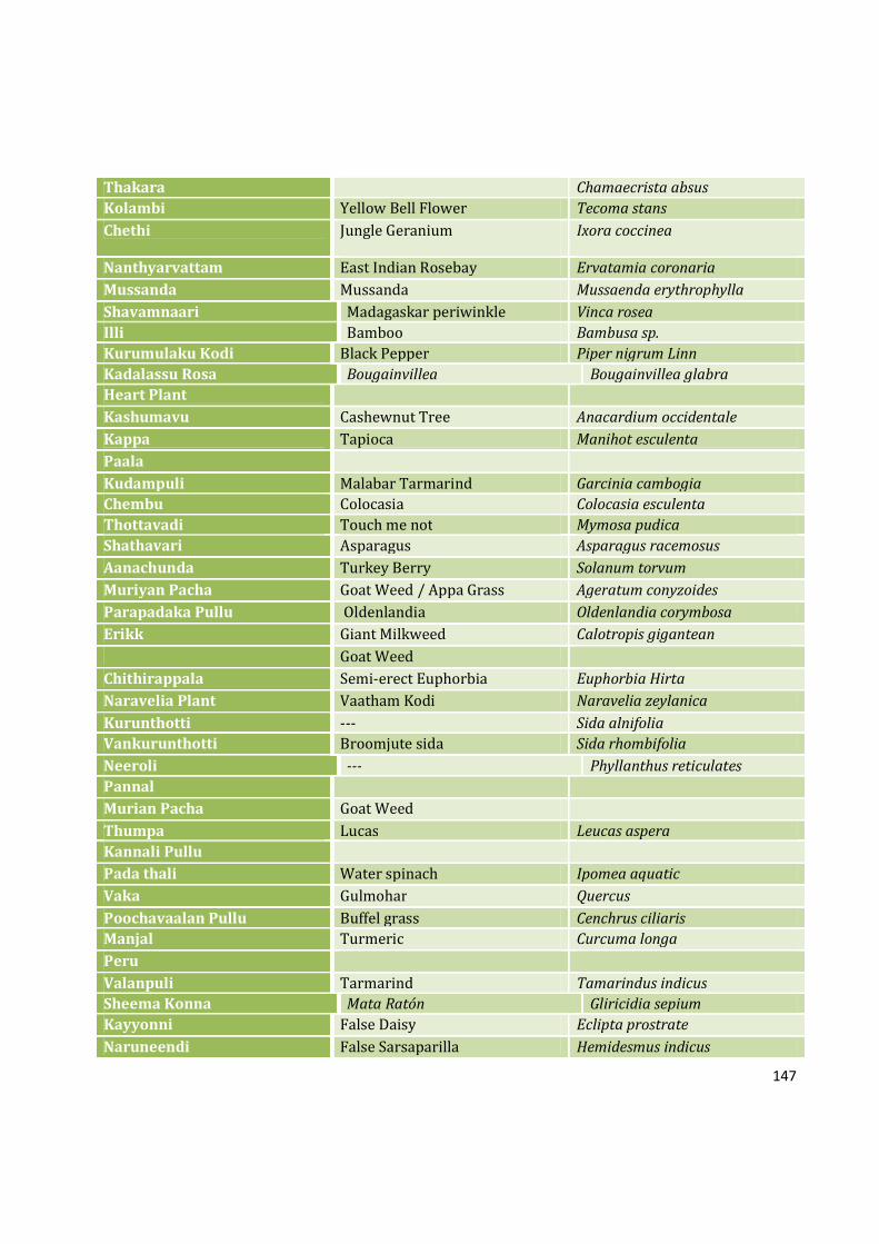
147
Thakara Chamaecrista absus
Kolambi Yellow Bell Flower Tecoma stans
Chethi Jungle Geranium Ixora coccinea
Nanthyarvattam East Indian Rosebay Ervatamia coronaria
Mussanda Mussanda Mussaenda erythrophylla
Shavamnaari Madagaskar periwinkle Vinca rosea
Illi Bamboo Bambusa sp.
Kurumulaku Kodi Black Pepper Piper nigrum Linn
Kadalassu Rosa Bougainvillea Bougainvillea glabra
Heart Plant
Kashumavu Cashewnut Tree Anacardium occidentale
Kappa Tapioca Manihot esculenta
Paala
Kudampuli Malabar Tarmarind Garcinia cambogia
Chembu Colocasia Colocasia esculenta
Thottavadi Touch me not Mymosa pudica
Shathavari Asparagus Asparagus racemosus
Aanachunda Turkey Berry Solanum torvum
Muriyan Pacha Goat Weed / Appa Grass Ageratum conyzoides
Parapadaka Pullu Oldenlandia Oldenlandia corymbosa
Erikk Giant Milkweed Calotropis gigantean
Goat Weed
Chithirappala Semi-erect Euphorbia Euphorbia Hirta
Naravelia Plant Vaatham Kodi Naravelia zeylanica
Kurunthotti --- Sida alnifolia
Vankurunthotti Broomjute sida Sida rhombifolia
Neeroli --- Phyllanthus reticulates
Pannal
Murian Pacha Goat Weed
Thumpa Lucas Leucas aspera
Kannali Pullu
Pada thali Water spinach Ipomea aquatic
Vaka Gulmohar Quercus
Poochavaalan Pullu Buffel grass Cenchrus ciliaris
Manjal Turmeric Curcuma longa
Peru
Valanpuli Tarmarind Tamarindus indicus
Sheema Konna Mata Ratón Gliricidia sepium
Kayyonni False Daisy Eclipta prostrate
Naruneendi False Sarsaparilla Hemidesmus indicus

148
Mahagany Mahogany Swietenia macrophylla
Bush
Rajamalli Peacock Flower Caesalpinia pulcherrima
Kadalassu Rosa Bougainvillea Bougainvillea glabra
Aami
Kongini Lantana Lantana camera
Pulippara Thanalmaram
Mulla Jasmine Jasmine multiflorum
Thulasi Sacred Basil Ocimum tenuiiflorum
Koonan Pala Nag Kuda Tabernaemontana dichotona
Chuvanna Cheera Velvet Curtain Amaranthus sp.
Sooryakanthi Sunflower Helianthus annuus
Pishina Payar
Ezhilam Pala Devil Tree Alstonia scholaris
Chembarathi Hibiscus Hibiscus roosasinensis var.
Mailanchi Henna Lawsonia inermis
Lilly Crinum viviparum
Akashamalli
Senia Zinnia elegans
Veppu Neem Tree Azadirachta inaica Juss
Evergreen
Inchi Garden Ginger Zingiber officinale
Peringalam Clerodendrum Clerodendrum viscosum Vent
Kammalu Chedi --- Pentanema indicum
Peruku Clerodendrum infortunatum
Ithiilkanni
Kadaladi Prickly Chaff Flower Achyranthes aspera
Vayara Bitter Vine Micania micrantha
Nalu Manichedi Marvel of Peru / Four O’ Clock
Flower
Mirabillis jalapa
Koova Wild Arrow Root Curcuma neilgherrensis
Puliyarila Creeping oxalis Oxalis corniculata
Kattikkara
Moorpanachan
Marotti Leathery leaved tree Hydnocarpus wightiana
Koonan Pala Nag Kuda Tabernaemontana dichotona
Pushkaaramoolam Pasilanthus travancorensis
Table 7.7. Major flora around the pond (50 m radius)
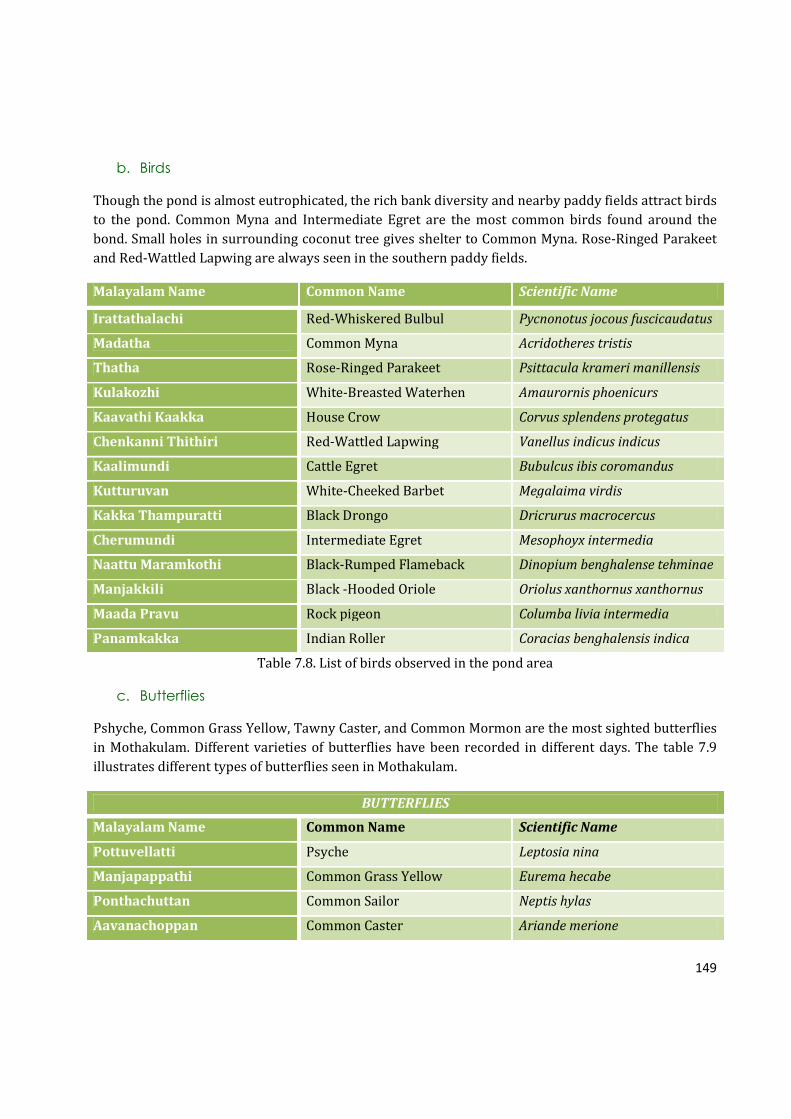
149
b. Birds
Though the pond is almost eutrophicated, the rich bank diversity and nearby paddy fields attract birds
to the pond. Common Myna and Intermediate Egret are the most common birds found around the
bond. Small holes in surrounding coconut tree gives shelter to Common Myna. Rose-Ringed Parakeet
and Red-Wattled Lapwing are always seen in the southern paddy fields.
Malayalam Name Common Name Scientific Name
Irattathalachi Red-Whiskered Bulbul Pycnonotus jocous fuscicaudatus
Madatha Common Myna Acridotheres tristis
Thatha Rose-Ringed Parakeet Psittacula krameri manillensis
Kulakozhi White-Breasted Waterhen Amaurornis phoenicurs
Kaavathi Kaakka House Crow Corvus splendens protegatus
Chenkanni Thithiri Red-Wattled Lapwing Vanellus indicus indicus
Kaalimundi Cattle Egret Bubulcus ibis coromandus
Kutturuvan White-Cheeked Barbet Megalaima virdis
Kakka Thampuratti Black Drongo Dricrurus macrocercus
Cherumundi Intermediate Egret Mesophoyx intermedia
Naattu Maramkothi Black-Rumped Flameback Dinopium benghalense tehminae
Manjakkili Black -Hooded Oriole Oriolus xanthornus xanthornus
Maada Pravu Rock pigeon Columba livia intermedia
Panamkakka Indian Roller Coracias benghalensis indica
Table 7.8. List of birds observed in the pond area
c. Butterflies
Pshyche, Common Grass Yellow, Tawny Caster, and Common Mormon are the most sighted butterflies
in Mothakulam. Different varieties of butterflies have been recorded in different days. The table 7.9
illustrates different types of butterflies seen in Mothakulam.
BUTTERFLIES
Malayalam Name Common Name Scientific Name
Pottuvellatti Psyche Leptosia nina
Manjapappathi Common Grass Yellow Eurema hecabe
Ponthachuttan Common Sailor Neptis hylas
Aavanachoppan Common Caster Ariande merione
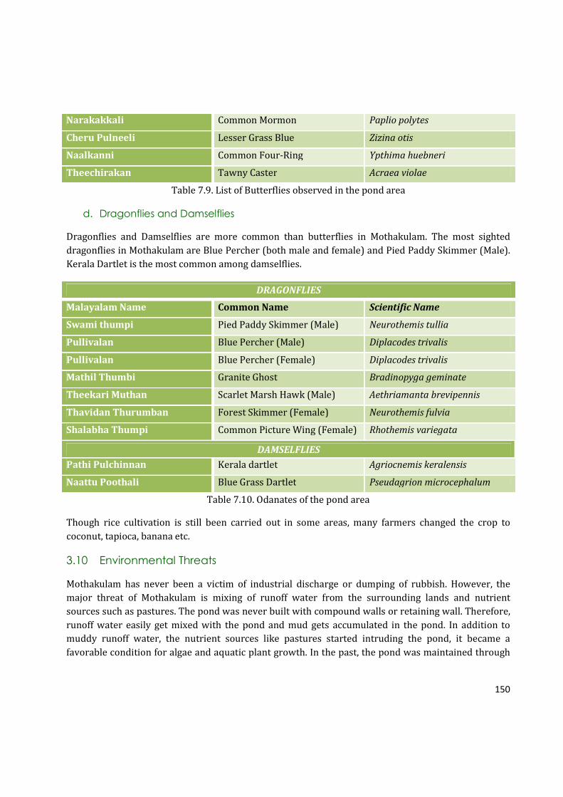
150
Narakakkali Common Mormon Paplio polytes
Cheru Pulneeli Lesser Grass Blue Zizina otis
Naalkanni Common Four-Ring Ypthima huebneri
Theechirakan Tawny Caster Acraea violae
Table 7.9. List of Butterflies observed in the pond area
d. Dragonflies and Damselflies
Dragonflies and Damselflies are more common than butterflies in Mothakulam. The most sighted
dragonflies in Mothakulam are Blue Percher (both male and female) and Pied Paddy Skimmer (Male).
Kerala Dartlet is the most common among damselflies.
DRAGONFLIES
Malayalam Name Common Name Scientific Name
Swami thumpi Pied Paddy Skimmer (Male) Neurothemis tullia
Pullivalan Blue Percher (Male) Diplacodes trivalis
Pullivalan Blue Percher (Female) Diplacodes trivalis
Mathil Thumbi Granite Ghost Bradinopyga geminate
Theekari Muthan Scarlet Marsh Hawk (Male) Aethriamanta brevipennis
Thavidan Thurumban Forest Skimmer (Female) Neurothemis fulvia
Shalabha Thumpi Common Picture Wing (Female) Rhothemis variegata
DAMSELFLIES
Pathi Pulchinnan Kerala dartlet Agriocnemis keralensis
Naattu Poothali Blue Grass Dartlet Pseudagrion microcephalum
Table 7.10. Odanates of the pond area
Though rice cultivation is still been carried out in some areas, many farmers changed the crop to
coconut, tapioca, banana etc.
3.10 Environmental Threats
Mothakulam has never been a victim of industrial discharge or dumping of rubbish. However, the
major threat of Mothakulam is mixing of runoff water from the surrounding lands and nutrient
sources such as pastures. The pond was never built with compound walls or retaining wall. Therefore,
runoff water easily get mixed with the pond and mud gets accumulated in the pond. In addition to
muddy runoff water, the nutrient sources like pastures started intruding the pond, it became a
favorable condition for algae and aquatic plant growth. In the past, the pond was maintained through

151
traditional practices. The pond boundary was made with mud. However, due to runoff water flow and
other interruptions, these boundaries were destroyed. Algal growth stopped people’s visit to the pond.
Fig. 7.11. Environmental Problems of Mothakulam
The picture depicts the major enviromental threats which affect Mothakulam as opined by the survey
respondents. It is evident from the picture that eutrophication is the major threat of the pond.
Interestingly, 100% of respondents supported the fact that eutrophication is the major issue which
need to be taken care of. A 10% percentage of the respondents also added the point that muddy runoff
water is also a major issue. There is no walls for the pond which protects runoff water coming into the
pond. The muddy runoff water carry sediments which are then accumulated on the pond which
reduces the pond’s height as well as the water starage capacity. The pond used to hold much more
water than present, say the community during the survey.
3.11 Stakeholder And Community Response To The Proposed Project
PRA (Participatory Rural Appraisal) with a total number of 60 members was conducted on 14th
February, 2016 at a local community member – Mr. Rinto’s household. Mr Rinto also share adjascent
lands of Mothakulam. The old people as well as Krishi Bhavan Members shared their memories about
the pond. The details about it’s origin, history, management, the reasosn for destruction of the pond
were discussed during the PRA meeting. They shared the major problems faced by pond and also gave
suggestions for the revival of Mothakulam. Man-made pollution has never affected the pond, according
to the community; rather eutrophication is the main issue which led to the abandonment of
Mothakulam. Lack of retaining wall caused the accumulation of mud through the run off water. Krishi
Bhavan members shared that all nearby agricultural fields were supported by the pond. However,
when the pond turned to eutrophic condition, the pond could not support agriculture neither ground
water recharge. Therefore, it is very important to restore the pond back to previous condition. The

152
community also requested to start an Irrigation project from the pond since the pond has good beck.
They suggested 5 to 6 KM long pipe to irrigate the nearby fields. According to the community, the pond
is capable of supporting water for irrigation of 5 to 6 KM distance. Moreover, when canal water is not
sufficient for the community, the pond is a good support for the community. More than 100 families
and paddy fields such as Viruthipadam and Kodakara Padam will be benefitted through the renovation
of the pond. Therefore, immediate actions need to be taken to recover the pond.
Suggestions:
Iron fencing or grill around the pond
Retaining wall around the pond
Bathing ghuts
Construction of outlet
Increase the depth of the pond
Cattle ramp
Lift irrigation (4-5 KM pipe needed)
Source of water to the pond
Cleaning of 250 meter rivulet
Photo: Interviewing stakeholders of the pond

153
4. PROPOSAL
4.3 Aim: The project aims at surface water body conservation of Kodakara Panchayath Ponds.
MOTHAKULAM - SUMMARY
♣ Mothakulam has a history of more than a century based on the community survey. However, the
exact history of it’s origin is unknown.
♣ According to Panchayath records, the pond is called “Mothakulam,” but for natives, the pond is
known as “Kochekadante Thazhathe Kulam.” For some others, the pond is “Karuthyde
Thazhathe Kulam” as Karuti families own nearby lands now. Though anything is not conclusive,
it is found that the pond’s name changes when generation and immediate neighborhood change.
♣ Few decades back, the pond was surrounded with paddy fields. The main source of it’s irrigation
was Mothakulam. However, due to lack of profit in rice cultivation, farmers have changed the
crop types. Although changes have happened, the surrounding is rich with floral diversity.
♣ There are major five types uses for the pond such as in the past such as agriculture, bathing,
laundry, showering animals, and fishing. However, over the years, the water quality of the pond
has degraded and the pond is only a source of water storage at the moment. Nearly 100 families
will get benefitted if the pond is renovated.
♣ Mothakulam supported livelihood of local community in agriculture and laundry. And also,
fishing and cattle raising to some extent.
♣ There are 9 major water bodies nearby Mothakulam. Among them, only 5 of them are usable,
but they are also not good for all kinds of water needs.
♣ Originally the pond has an area of 33 cents, but due to encroachment and sediment
accumulation, the pond size has decreased.
♣ Over dependency over canal and declined in agriculture are the main reasons why the pond got
ignored.
♣ Community survey showed that the water quality of the pond was excellent. However, due to
due to the stagnation and weed infestation, the water quality has been reduced significantly.
♣ Biodiversity status of the pond and it’s bank shows that there varieties of 3 aquatic plants and 9
species of fishes.
♣ A total of 22 plants, 13 birds, 9 butterflies, 7 dragonflies, and 2 damselflies are recorded from
this area through taxonomic survey.
♣ The analysis of environmental threats of Mothakulam showed that relatively less pollution
exists due to direct anthropogenic activities. Survey respondents commented problems such as
eutrophication and muddy runoff water are the major issues faced by Mothakulam.

154
4. PROPOSAL
4.1 Aim: To conserve the Marathampally pond and ensure sustainable utilization for the
community.
4.2 Objectives:
According to the matters discussed in the PRA meeting, a feasible proposal has been developed. The
picture portraits a plan of Mothakulam in artist’s imagination. An environment-friendly approach is
adopted to recreate the natural and healthy habitat that Mothakulam had once. The proposed features
are enlisted below (see the sketches Fig. 7.12 and Fig. 7.13).
• Restore the pond from eutrophication - retain its ecological importance to provide sustainable
use pattern
The pond was almost died due to eutrophication. Water can be barely seen in the pond due to it’s
present condition. The pond was the main source of water for agriculture, bathing, and laundry in the
past. However, both direct and indirect uses of the pond have almost declined at present. From
community survey, it is studied that the population has almost doubled in past few decades, and thus,
the water demand as well. Renovating the pond will help us to reduce the rise in water demand.
• Providing retaining wall and separations from surroundings will promise better water quality
for safe use pattern.
The runoff water from all nearby agricultural lands carry a large amount of mud to the pond as the
pond situates in a lowland tract. The pond easily gets eutrophicated within short time due to this
problem. Therefore, it is very important to make retaining walls to protect the pond as well as keep
the pond from runoff water.
• Improve and restore agricultural activities in Perambra, especially rice cultivation which has
almost declined due to water scarcity.
The pond is surrounded with Perambra Paddy Fileds. There is huge reduction in rice cultivation. Rice
in water demand is the main reason in the reduction of rice cultivation. Therefore, restoring the water
bodies is the major sustainable solution to water shortage. Mothakulam is the potential pond which
holds more water and recharges the surrounding lands. Therefore, Perambra rice cultivation can be
improved through the conservation of Mothakulam.
• Avoid water stagnation by providing outlet and keep regular water flow
The pond never had retaining walls or constructed outlets. The pond was maintained through only
traditional practices. However, immense load of mud have destroyed both ponds and its outlets. If the
outlets are constructed, the pond will be able to supply water to the agricultural fields year long since
the pond is an all-season pond.
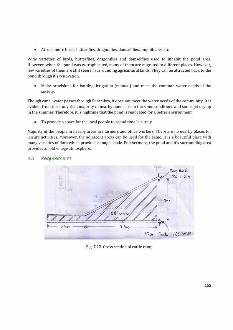
155
• Attract more birds, butterflies, dragonflies, damselflies, amphibians, etc
Wide varieties of birds, butterflies, dragonflies and damselflies used to inhabit the pond area.
However, when the pond was eutrophicated, many of them are migrated to different places. However,
few varieties of them are still seen in surrounding agricultural lands. They can be attracted back to the
pond through it’s renovation.
• Make provisions for bathing, irrigation (manual) and meet the common water needs of the
society.
Though canal water passes through Perambra, it does not meet the water needs of the community. It is
evident from the study that, majority of nearby ponds are in the same conditions and some get dry up
in the summer. Therefore, it is hightime that the pond is renovated for a better environment.
• To provide a space for the local people to spend time leisurely
Majority of the people in nearby areas are farmers and office workers. There are no nearby places for
leisure activities. Moreover, the adjascent areas can be used for the same. It is a beautiful place with
many varieties of flora which provides enough shade. Furthermore, the pond and it’s surrounding area
provides an old villege atmosphere.
4.3 Requirements
Fig. 7.12. Cross section of cattle ramp

156
Fig. 7.13. Proposed elevation for Mothakulam

157
SL NO SPECIFICATION UNIT RATE NO MEASUREMENTS QUANTITY
Length Bredth Height
1 Clearing thick and thorny jungle including
uprooting of thick vegetation and small trees of
girth up to 30cm and removal of rubbish up to a
distance of 150m outside the periphery of the area
cleared
sqm 4 1 38 25 950
2 Earth work in excavation by mechanical means
(Hydraulic excavator) / manual means from inside
the pond area, lift up to 1.5 m, including getting out
the excavated soil and disposal of surplus
excavated soil as directed, within a lead of 50m
Cum 350 1 35 24 2.5 2100
3 Earth work in excavation by mechanical means
(Hydraulic excavator) / manual means in
foundation trenches or drains (not exceeding 1.5 m
in width or 10 sqm on plan), including dressing of
sides and ramming of bottoms, lift up to 1.5 m,
including getting out the excavated soil and
disposal of surplus excavated soil as directed,
within a lead of 50m
Cum 320
3.1 DR works 1 117 1.5 0.5 87.75
3.2 Ramp 1 7.5 (1.5+.5)/2 0.5 3.75
1 2.5 0.5 0.5 0.625
1 3.5 0.5 0.5 0.875
3.3 Bathing area 1 5 1.5 0.5 3.75
2 4 5 0.5 20
Total 116.75

158
4 Earth filling with suitable soil and forming
embankment by spreading in layers of uniform
thickness over the full width, drying or watering as
the case may be, scarifying to get uniform opimum
moisture content and compacting in layers not less
than 25cm(loose thickness) using power roller
satisfying compaction tests including trimming
slopes to lines and levels.
Cum 350
4.1 DR works 1 117 0.5 3 175.5
4.2 Ramp 1 7.5 3.1 1.75 3.75
1 2.5 3.1 0.5 3.875
4.3 Bathing area 1 4.6 4.4 3 60.72
Total 243.845
5 Cement concrete 1:5:10 for foundation using
20mm broken stone including cost and
conveyances of all materials labour charges,
watering curing etc. complete
Cum 5950
5.1 DR works 1 117 1.5 0.1 17.55
5.2 Ramp 1 7.5 (1.5+.5)/2 0.1 0.75
1 2.5 0.5 0.1 0.125
1 3.5 0.5 0.1 0.175
5.3 Bathing area 1 5 1.5 0.1 0.75
2 4 5 0.1 4
Total 23.35
6 Dry rubble masonry using hard granite blasted
rubble including cost and conveyance of all
materials and all labour charges etc. complete.
Cum 2800
6.1 Retaining walls 1 117 (0.40+1.5)/2 3.25 361.24
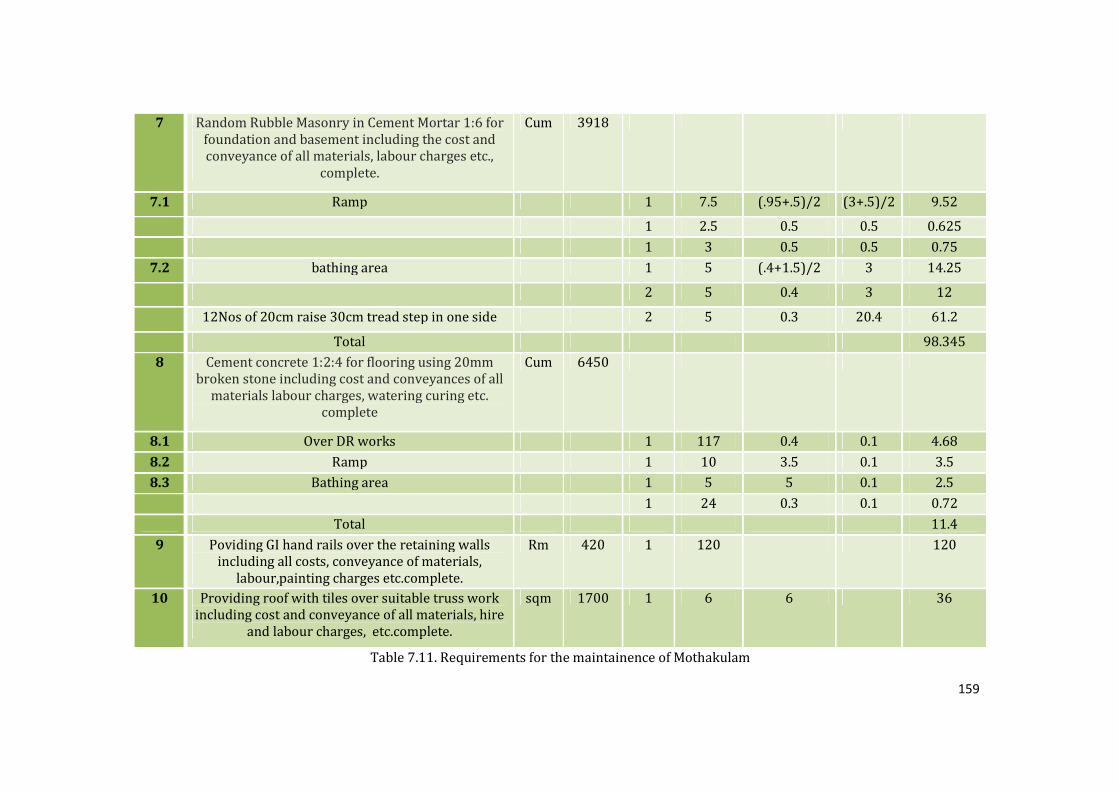
159
7 Random Rubble Masonry in Cement Mortar 1:6 for
foundation and basement including the cost and
conveyance of all materials, labour charges etc.,
complete.
Cum 3918
7.1 Ramp 1 7.5 (.95+.5)/2 (3+.5)/2 9.52
1 2.5 0.5 0.5 0.625
1 3 0.5 0.5 0.75
7.2 bathing area 1 5 (.4+1.5)/2 3 14.25
2 5 0.4 3 12
12Nos of 20cm raise 30cm tread step in one side 2 5 0.3 20.4 61.2
Total 98.345
8 Cement concrete 1:2:4 for flooring using 20mm
broken stone including cost and conveyances of all
materials labour charges, watering curing etc.
complete
Cum 6450
8.1 Over DR works 1 117 0.4 0.1 4.68
8.2 Ramp 1 10 3.5 0.1 3.5
8.3 Bathing area 1 5 5 0.1 2.5
1 24 0.3 0.1 0.72
Total 11.4
9 Poviding GI hand rails over the retaining walls
including all costs, conveyance of materials,
labour,painting charges etc.complete.
Rm 420 1 120 120
10 Providing roof with tiles over suitable truss work
including cost and conveyance of all materials, hire
and labour charges, etc.complete.
sqm 1700 1 6 6 36
Table 7.11. Requirements for the maintainence of Mothakulam

160
4.4 Conclusion
Perambra natives depend on Canal water during water shortage. Mothakulam offers a sustainable
solution for the water shortage in the nearby areas. The conservation of the pond is an immediate
need for the community and progress of agriculture.

161
Bibliography
Céréghino, Régis, Dani Boix, Henry-Michel Cauchie, Koen Martens, and Beat Oertli. "The Ecological
Role of Ponds in a Changing World."Hydrobiologia 723.1 (2014): 1-6. Web.
India. Uttar Pradesh State Biodiversity Board. The Biological Diversity of Village Ponds and Its Crucial
Role in Sustainable Development. By T. P. Dubey. N.p.: n.p., 2015. Web.
Secondary Data Sources
� BTR copies of ponds from Kodakara Village Office, Kodakara and Survey Suprindent Office,
Thrissur
� Development Plan from Kodakara Panchayath
� List of ponds from from Kodakara Panchayath
� Historical Data on Peringamkulam from Kodakara Public Library

162
APPENDIX I
Ponds Historical Survey
Field Record Sheet
Date of the survey: ______________________
Personal Details of the Interviewee:
1. Name :
2. Age:
3. Female/Male:
4. Contact Details:
5. Employment:
Pond Historical Survey:
6. What do you know about the origin of the pond, especially regarding its age, history
and management (when, why, and who made it)?
7. Have you heard of any stories regarding the origin of the name of the pond?
8. Are there any differences in the physical features and surrounding of the pond from
the past (such as pond size, depth etc.), and why?
9. What are the main inlets and outlets of the pond?
10. i) What were the main uses of the pond in the past?
a) Agriculture/Irrigation
b) Bathing
c) Laundry
d) Showering Animals
e) Others (specify):
ii) What are the present uses of the pond?
a) Agriculture/Irrigation
b) Bathing
c) Laundry
d) Showering Animals
e) Others (specify):
163
11. i) Does the pond experience seasonal water level fluctuation, especially between rainy
and summer season?
a) Yes
b) No
ii) If yes, the drawdown height (in summer season)?
a) Below 1 foot
b) 1 foot
c) 3 foot
d) 5 foot
e) Above 5 foot
12. Have you heard of any other stories, poems, myths, beliefs, rituals, and customs
associated with the pond or other nearby ponds?
13. Who owns the pond and the surrounding land? In your knowledge, does the ownership
have changed at any time in the past?
14. Do you think the pond experiences any of the mentioned environmental threats?
a) Pollution
b) Eutrophication /covered with plants and weeds
c) Water Quality Degradatio
d) Biodiversity Loss
e) Others (specify):
15. Have you noticed any of these pollutants in or around the pond?
a) Sewage
b) Plastics
c) Slaughtering Wastes
d) Other Solid Wastes (specify):
16. What are the major pollution sources?
a) Local Community
b) Vehicular Passengers
c) Sewage Pollution
d) Others (specify):
17. i) Did any livelihood exist in the region based on the pond?
a) Yes
b) No
ii) If yes, specify:
a) Agriculture
b) Fishing
c) Laundry

164
d) Cattle Raising (a source for drinking water and showering of animals)
e) Others (specify):
18. Fish species in the pond (past and present):
19. Does the fish diversity in the pond has reduced or changed?
a) Yes
b) No
20. Whether any establishments existed nearby Peringamkulam, eg: agricultural market?
If yes, specify:
21. History of any development projects occurred in the region, if any. Was the project
successful? If not, why?
22. Other Water Bodies: Are there any other ponds in the region near to this pond? What
is it’s size? What are their conditions?
23. What is the significance of this pond in the region?
24. What do you think as the main reason which led to the pollution and abandonment of
the pond?
25. How do you want to see the pond in future?

165
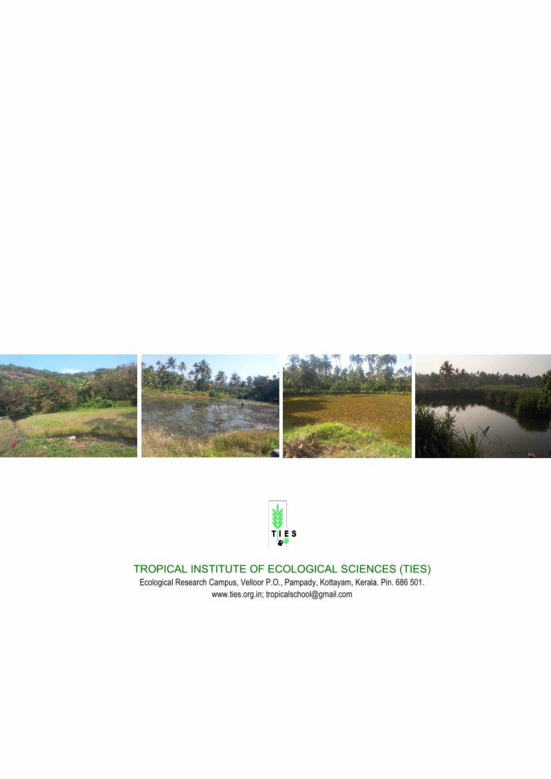
166
TROPICAL INSTITUTE OF ECOLOGICAL SCIENCES (TIES) Ecological Research Campus, Velloor P.O., Pampady, Kottayam, Kerala. Pin. 686 501.
www.ties.org.in; [email protected]
Related Documents