Version: July 2008 Planning Scheme for Belyando Shire

Welcome message from author
This document is posted to help you gain knowledge. Please leave a comment to let me know what you think about it! Share it to your friends and learn new things together.
Transcript
Version: July 2008
Planning Scheme for
Belyando Shire

ii
CONTENTS Page No.
PART 1 INTRODUCTION......................................................................................................1.1 1.1 PURPOSE OF THE PLANNING SCHEME ..................................................................................................... 1.1 1.2 PLANNING SCHEME FUNCTIONS AS PART OF IDAS................................................................................... 1.1 1.3 STRUCTURE OF THE PLANNING SCHEME.................................................................................................. 1.1 1.4 GENERAL ASSESSMENT PROVISIONS ...................................................................................................... 1.2
PART 2 DEFINITIONS...........................................................................................................2.1
PART 3 STRATEGIC DIRECTION........................................................................................3.1 3.1 THE NATURAL ENVIRONMENT AND CULTURAL HERITAGE........................................................................... 3.1 3.2 ECONOMIC DEVELOPMENT..................................................................................................................... 3.1 3.3 COMMUNITY WELLBEING........................................................................................................................ 3.2
PART 4 ZONES .....................................................................................................................4.1 4.1 RURAL “ZONE”................................................................................................................................... 4.1.1
4.1.1 Rural “Zone” Table of Assessment .......................................................................................... 4.1.1 4.1.2 Rural “Zone” Code ................................................................................................................... 4.1.2
4.1.2.1 Self-assessable Development - Applicable Provisions ....................................................... 4.1.2 4.1.2.2 Code Purpose..................................................................................................................... 4.1.3 4.1.2.3 Performance Criteria and Acceptable Solutions – “Material change of Use” ...................... 4.1.4 4.1.2.4 Performance Criteria, Acceptable Solutions and Self Assessable Applicability – “Building
work” where not associated with a “material change of use” ............................................ 4.1.11 4.1.2.5 Performance Criteria, Acceptable Solutions and Self Assessable Applicability – “Operational
work” where not associated with a “material change of use” ............................................ 4.1.13 4.2 URBAN “ZONE” .................................................................................................................................. 4.2.1
4.2.1 Urban “Zone” Table of Assessment ........................................................................................ 4.2.1 4.2.2 Urban “Zone” Code .................................................................................................................. 4.2.2
4.2.2.1 Self-assessable Development - Applicable Provisions ....................................................... 4.2.2 4.2.2.2 Code Purpose ........................................................................................................................... 4.2.3 4.2.2.3 Performance Criteria, Acceptable Solutions and Self Assessable Applicability – “Material
change of Use” ................................................................................................................... 4.2.4 4.2.2.4 Performance Criteria, Acceptable Solutions and Self Assessable Applicability – “Building
work” where not associated with a “material change of use” ............................................ 4.2.13 4.2.2.5 Performance Criteria, Acceptable Solutions and Self Assessable Applicability – “Operational
work” where not associated with a “material change of use” ............................................ 4.2.14 4.3 COMMERCIAL “ZONE” ......................................................................................................................... 4.3.1
4.3.1 Commercial “Zone” Table of Assessment .............................................................................. 4.3.1 4.3.2 Commercial “Zone” Code......................................................................................................... 4.3.2
4.3.2.1 Self-assessable Development - Applicable Provisions ....................................................... 4.3.2 4.3.2.2 Code Purpose..................................................................................................................... 4.3.2 4.3.2.3 Performance Criteria, Acceptable Solutions and Self Assessable Applicability – “Material
change of Use” ................................................................................................................... 4.3.4 4.3.2.4 Performance Criteria, Acceptable Solutions and Self Assessable Applicability – “Building
work” where not associated with a “material change of use” .............................................. 4.3.9 4.3.2.5 Performance Criteria, Acceptable Solutions and Self Assessable Applicability – “Operational
work” where not associated with a “material change of use” .............................................. 4.3.9 4.4 INDUSTRIAL “ZONE” ............................................................................................................................ 4.4.1
4.4.1 Industrial “Zone” Table of Assessment ................................................................................... 4.4.1 4.4.2 Industrial “Zone” Code ............................................................................................................. 4.4.1
4.4.2.1 Self-assessable Development - Applicable Provisions ....................................................... 4.4.1 4.4.2.2 Code Purpose..................................................................................................................... 4.4.2 4.4.2.3 Performance Criteria, Acceptable Solutions and Self Assessable Applicability – “Material
change of Use” ................................................................................................................... 4.4.3 4.4.2.4 Performance Criteria, Acceptable Solutions and Self Assessable Applicability – “Building
work” where not associated with a “material change of use” .............................................. 4.4.7 4.4.2.5 Performance Criteria, Acceptable Solutions and Self Assessable Applicability – Operational
work” where not associated with a “material change of use” .............................................. 4.4.8 4.5 OPEN SPACE AND RECREATION “ZONE” ............................................................................................... 4.5.1
4.5.1 Open Space and Recreation “Zone” Table of Assessment .................................................... 4.5.1 4.5.2 Open Space and Recreation “Zone” Code............................................................................... 4.5.1
4.5.2.1 Self Assessable Development – Applicable Provisions ...................................................... 4.5.1
Planning Scheme for Belyando Shire
iii
4.5.2.2 Code Purpose..................................................................................................................... 4.5.1 4.5.2.3 Performance Criteria, Acceptable Solutions and Self Assessable Applicability – “Material
Change of Use”................................................................................................................... 4.5.2 4.5.3.4 Performance Criteria, Acceptable Solutions and Self Assessable Applicability – “Building
work” where not associated with a “material change of use”. ............................................. 4.5.7 4.5.3.5 Performance Criteria, Acceptable Solutions and Self Assessable Applicability – “Operational
Work” where not associated with a “material change of use”. .............................................. 4.5.
PART 5 RECONFIGURING A LOT CODE............................................................................5.1 5.1 CODE PURPOSE.................................................................................................................................... 5.1 5.2 PERFORMANCE CRITERIA AND ACCEPTABLE SOLUTIONS – “RECONFIGURING A LOT”.................................... 5.1
SCHEDULE 1 – DESIGN AND CONSTRUCTION STANDARDS.............................................. Sch. 1.l
SCHEDULE 2 – SEPARATION DISTANCES............................................................................ Sch. 2.1
SCHEDULE 3 – DEFINING BANK DIAGRAM .......................................................................... Sch. 3.1
PLANNING SCHEME POLICY 1 – INFORMATION COUNCIL MAY REQUEST......................PSP 1.1
PLANNING SCHEME POLICY 2 – THIRD PARTY ADVICE OR COMMENT ...........................PSP 2.1
PLANNING SCHEME POLICY 3 – STRUCTURE PLANNING GUIDELINES...........................PSP 3.1
LIST OF MAPS ZONING MAPS Sheet 1 Belyando Shire Sheet 2 Town of Clermont Sheet 3 Town of Moranbah and Environs LAND CHARACTERISTICS MAPS Sheet 1 Features Map Sheet 2 Good Quality Agricultural Land Sheet 3 Aviation Facilities
Planning Scheme for Belyando Shire
1.1
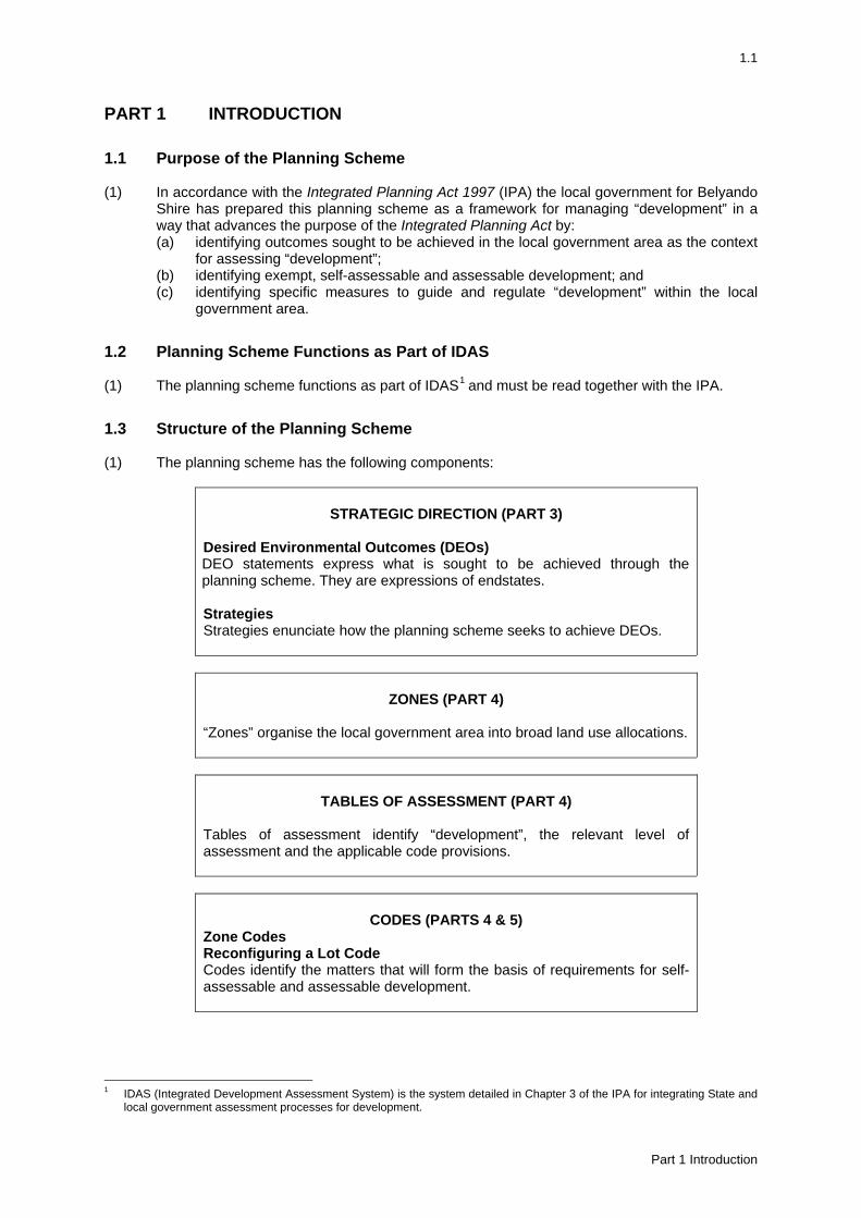
PART 1 INTRODUCTION
1.1 Purpose of the Planning Scheme (1) In accordance with the Integrated Planning Act 1997 (IPA) the local government for Belyando
Shire has prepared this planning scheme as a framework for managing “development” in a way that advances the purpose of the Integrated Planning Act by: (a) identifying outcomes sought to be achieved in the local government area as the context
for assessing “development”; (b) identifying exempt, self-assessable and assessable development; and (c) identifying specific measures to guide and regulate “development” within the local
government area.
1.2 Planning Scheme Functions as Part of IDAS (1) The planning scheme functions as part of IDAS1
and must be read together with the IPA.
1.3 Structure of the Planning Scheme (1) The planning scheme has the following components:
STRATEGIC DIRECTION (PART 3) Desired Environmental Outcomes (DEOs) DEO statements express what is sought to be achieved through the planning scheme. They are expressions of endstates. Strategies Strategies enunciate how the planning scheme seeks to achieve DEOs.
ZONES (PART 4) “Zones” organise the local government area into broad land use allocations.
TABLES OF ASSESSMENT (PART 4) Tables of assessment identify “development”, the relevant level of assessment and the applicable code provisions.
CODES (PARTS 4 & 5) Zone Codes Reconfiguring a Lot Code Codes identify the matters that will form the basis of requirements for self-assessable and assessable development.
1 IDAS (Integrated Development Assessment System) is the system detailed in Chapter 3 of the IPA for integrating State and
local government assessment processes for development.
Part 1 Introduction
1.2
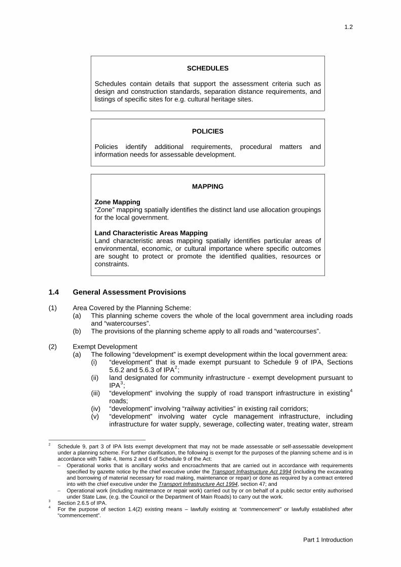
SCHEDULES Schedules contain details that support the assessment criteria such as design and construction standards, separation distance requirements, and listings of specific sites for e.g. cultural heritage sites.
POLICIES Policies identify additional requirements, procedural matters and information needs for assessable development.
MAPPING Zone Mapping “Zone” mapping spatially identifies the distinct land use allocation groupings for the local government. Land Characteristic Areas Mapping Land characteristic areas mapping spatially identifies particular areas of environmental, economic, or cultural importance where specific outcomes are sought to protect or promote the identified qualities, resources or constraints.
1.4 General Assessment Provisions (1) Area Covered by the Planning Scheme:
(a) This planning scheme covers the whole of the local government area including roads and “watercourses”.
(b) The provisions of the planning scheme apply to all roads and “watercourses”. (2) Exempt Development
(a) The following “development” is exempt development within the local government area: (i) “development” that is made exempt pursuant to Schedule 9 of IPA, Sections
5.6.2 and 5.6.3 of IPA2; (ii) land designated for community infrastructure - exempt development pursuant to
IPA3; (iii) “development” involving the supply of road transport infrastructure in existing4
roads; (iv) “development” involving “railway activities” in existing rail corridors; (v) “development” involving water cycle management infrastructure, including
infrastructure for water supply, sewerage, collecting water, treating water, stream
2 Schedule 9, part 3 of IPA lists exempt development that may not be made assessable or self-assessable development
under a planning scheme. For further clarification, the following is exempt for the purposes of the planning scheme and is in accordance with Table 4, Items 2 and 6 of Schedule 9 of the Act: − Operational works that is ancillary works and encroachments that are carried out in accordance with requirements
specified by gazette notice by the chief executive under the Transport Infrastructure Act 1994 (including the excavating and borrowing of material necessary for road making, maintenance or repair) or done as required by a contract entered into with the chief executive under the Transport Infrastructure Act 1994, section 47; and
− Operational work (including maintenance or repair work) carried out by or on behalf of a public sector entity authorised under State Law, (e.g. the Council or the Department of Main Roads) to carry out the work.
3 Section 2.6.5 of IPA. 4 For the purpose of section 1.4(2) existing means – lawfully existing at “commencement” or lawfully established after
“commencement”.
Part 1 Introduction
1.3
managing, disposing of waters and flood mitigation, but excluding water supply or sewage treatment plants;
(vi) “development” involving the reticulation and distribution of electricity in existing electricity easements or existing electricity corridors or roads;
(vii) “development” involving the reticulation and distribution of gas in existing gas easements or existing gas corridors or roads;
(viii) “development” involving the reticulation and distribution of telecommunications, where collocated with existing telecommunications facilities;
(ix) “development” involving the reticulation and distribution of mobile telecommunications, other than by way of cables, where co-located with existing mobile telecommunications facilities;
(x) “development” for the purpose of a “park”; (xi) “building work” being demolition; and (xii) “operational work” other than excavation or filling.
(3) Self-Assessable Development
(a) The following “development” is self-assessable development within the local government area: (i) “development” identified as self-assessable in Schedule 8 of IPA; and (ii) “development” identified as self-assessable in the table of assessment for each
“zone”. (b) Where “development” is identified as self-assessable it:
(i) requires no development application; and (ii) must comply with applicable code provisions whilst the “development”, including
the “use” component thereof, continues. (c) For self-assessable development5:
(i) the relevant assessment criteria are the applicable code; and (ii) compliance with the code is achieved only where all applicable acceptable
solutions have been met; and (iii) non-compliance with any applicable acceptable solution will result in the need for
a code assessment development application. (4) Assessable Development
(a) The following “development” is assessable “development” within the local government area: (i) “development” identified as assessable in Schedule 8 of IPA; and (ii) “development” identified as requiring either code or impact assessment in the
table of assessment for each “zone”.
(b) Code assessment: The following “development” is assessable “development” requiring code assessment within the local government area: (i) “development” identified as code assessment in the table of assessment for each
“zone”; and (ii) self-assessable “development” that does not comply with any applicable
acceptable solution/s. Where “development” is identified as assessable development - code assessment it: (i) requires a development application and development permit before
“development” can start; and (ii) is assessed against applicable codes. For assessable development - code assessment: (i) the code is the purpose, performance criteria and the acceptable solutions; and
5 Compliance with the applicable acceptable solutions for self-assessable development does not remove the need to obtain
other development approvals such as a development permit authorising “Building work” assessed against the Building Act 1975 and other statutory, licensing or “local law” requirements.
Part 1 Introduction
1.4
(ii) acceptable solutions are probable solutions and are one way of achieving compliance with the performance criteria; and
(iii) an acceptable solution for a performance criterion provides a guide for achieving that criterion in whole or in part and does not limit the assessment manager’s discretion under the IPA to impose conditions on a development approval.
(c) Impact assessment:
The following “development” is assessable “development” requiring impact assessment within the local government area: (i) “development” identified as impact assessment in the table of assessment for
each “zone”. Where “development” is identified as assessable development - impact assessment it: (i) requires a development application and development permit before
“development” can start; and (ii) is assessed against the whole “scheme” including any relevant codes6. For assessable development - impact assessment: (i) the code is a relevant code; and (ii) the code is the purpose, performance criteria and the acceptable solutions; and (iii) acceptable solutions are probable solutions and are one way of achieving
compliance with the performance criteria; and (iv) an acceptable solution for a performance criterion provides a guide for achieving
that criterion in whole or in part and does not limit the assessment manager’s discretion under the IPA to impose conditions on a development approval.
6 For impact assessable development, applicable codes are provided to assist the preparation of an application and in no
way affect the regard given to the planning scheme as a whole in accordance with section 3.5.5 of the IPA.
Part 1 Introduction
2.1
PART 2 DEFINITIONS7
“Accommodation building” – means “premises” comprising primarily of “accommodation units” such as motels, boarding-houses, guest-houses, accommodation centres or villages, hostels, unlicensed hotels, nursing homes, serviced rooms, or residential clubs. The term includes dining, laundry and recreation facilities which cater exclusively for the residents of the accommodation building and a manager’s office and residence. The term does not include a “shop” or “hotel” as herein defined. “Accommodation unit” – means any separate residential use area that is not “self contained”. “Act” – means the Integrated Planning Act 1997. “Agriculture” – means the use of “premises” for commercial or other non-domestic activities involving the cultivation or harvesting of plants and includes forestry. “Airport” – means all site facilities and any building, installation and equipment used for the control of aircraft operations and any facility provided at such premises for the housing, servicing, maintenance and repair of aircraft, and for the assembly of passengers or goods. “Bed and breakfast premises” – means “premises” used for small scale accommodation purposes contained within the curtilage of a “detached house”. “Building” – has the meaning given in the Building Act 1975. “Building work” – has the meaning given in the Integrated Planning Act 1997. “Caravan or relocatable home park” – means premises used for temporary or longer term accommodation in caravans, relocatable homes, tents or campervans and the like. The term includes amenities and recreation facilities which cater exclusively for the residents of the caravan park and camping grounds and a manager’s office and residence. The term does not include a “shop” as herein defined. “Caretaker’s residence” – means “premises” used for a “dwelling unit” for accommodation for a person/s having the care of “premises” lawfully used for rural, commercial, charitable or sporting purposes where those “premises” are on the same allotment as the “dwelling unit”. “Catering premises” – means “premises” used for the sale of food and refreshments to the general public. The term includes restaurants, take-away food shops, cafes, kiosks and reception lounges but does not include “hotel” or “indoor recreation”. “Cattery or kennel” – means “premises” used for boarding, breeding, keeping, or training of cats or dogs for business purposes or for their impoundment. “Child care centre” – means “premises” used for the care, protection or supervision of children and includes a crèche, kindergarten and pre-school. “Child oriented uses” includes the following uses: (1) “Child care centre”; (2) “Home business” providing home-based child care service; (3) “Educational establishment” providing for preschool, primary and high school students. “Commencement” – the day the “scheme” took effect. “Commercial activities” – means “premises” used for activities involving the provision of goods, food, services or entertainment, including: (1) “Catering premises”;
7 Part 2 Definitions contains, Use definitions and Administrative definitions. Uses are further clustered into activity definitions.
Part 2 Definitions
2.2
(2) “Commercial premises”; (3) “Hotel”; and (4) “Shop”. “Commercial premises” – means “premises” used for business offices or for other commercial purposes, such as a surgery, real estate office, betting agency, salon, laundromat and the like. “Community oriented activities” – means “premises” used for activities involving the provision of social, cultural, educational, community, infrastructure, hospital, cemeteries, crematorium, and government services, including: (1) “Child care centre”; (2) “Educational establishment”; (3) “Place of worship”; and (4) “Public utility”. “Council” – means the Council of the Shire of Belyando. “Detached house” – means “premises” used for residential accommodation which comprises one “dwelling unit” on one lot. “Defining bank” – the terrace or bank or, if no bank is present, the point on the active zone, which confines the average 2 year ARI flows, as illustrated in Schedule 3. “Development” – has the meaning given in the Integrated Planning Act 1997. “Dwelling unit” – means any “building” or part thereof comprising a self-contained unit principally for residential use and includes the curtilage thereof. “Educational establishment” – means “premises” used for a school, college, university, technical institute, academy, educational centre, public library, lecture hall, art gallery or museum. “Electricity transmission line easement” – means an existing easement over land in favour of an entity responsible for the carriage or supply of electricity, which is intended to be used or used for the transmission of electricity. “Extractive industry” – means “premises” used for mining or an industrial activity involving: (1) the extraction of sand, gravel, clay, soil, rock, stone or any similar substance from land, whether
or not any overburden is also extracted; (2) the rehabilitation of the land; and (3) the treatment including crushing or screening of that substance on, or on land abutting, the land
from which that substance is extracted. “Grazing” – means the use of “premises” for commercial or other non-domestic activities involving the breeding, keeping or depasturing of animals, but does not include “intensive animal industries”. “Habitable buildings” – means any “building”, part of “building” or “structure” able to be lawfully used for “residential activities”. “Home business” – means “premises” used for a commercial activity undertaken within the curtilage of a “detached house” or “dwelling unit”, excluding the use of “premises” as a shop selling goods not produced on the “premises” or for any “industrial activities”. The term includes home-based child care service, caring for up to 6 children. “Hotel” – means “premises” used for the sale of liquor for consumption on the “premises”, or on and off the “premises”, and may include the provision of meals and accommodation. “Indoor recreation” - means “premises” used for any sporting or recreational activities where such “use” is primarily indoors and includes the sale of food or refreshment. “Industrial activities” – means “premises” used for activities involving the manufacture, production,
Part 2 Definitions
2.3
servicing, storage and distribution of goods, articles, equipment or vehicles, including: (1) “Extractive industry”; (2) “Industry”; (3) “Noxious industry”; (4) “Service station”; (5) “Storage facility”; and (6) “Transport terminal”. “Industry” – means “premises” used for: (1) an industrial activity such as:
(a) a manufacturing process whether or not such process results in the production of a finished article;
(b) the breaking up or dismantling of any goods or article for trade, sale, or gain, or ancillary to any business;
(c) repairing, servicing and cleaning of articles, including vehicles, machinery; or (d) an operation connected with the installation of equipment and services but not including
on-site work on “premises”; and (2) the following activities when carried out in connection with an industrial activity:
(a) the storage of goods used in connection with or resulting from an industrial activity; (b) the provision of amenities for persons engaged in an industrial activity; (c) the sale of goods resulting from but ancillary to an industrial activity; and (d) any work of administration or accounting.
“Intensive animal industry” – means the use of “premises”, including buildings, structures, pens, storage areas and effluent treatment areas, for commercial or other non-domestic activities involving the breeding, keeping, or depasturing of animals where the animals: (1) are reliant on prepared or manufactured feed for production purposes;8 and/or (2) are temporarily held pending transportation or marketing. The term includes the use of premises for purposes such as: (1) Aquaculture; (2) Dairy; (3) Commercial livestock dip; (4) Lot feeding; (5) Piggery; (6) Poultry farm; (7) “Stable”; (8) “Cattery”; (9) “Kennel”; (10) Commercial stockyard. “Lake” – has the meaning given in the Water Act 2000. “Local law” – means a “local law” of the “Council” made under the authority of the Local Government Act 1993. “Material change of use” – has the meaning given in the Integrated Planning Act 1997. “Minor building work” – means “building work” that increases the gross floor area of an existing building by less than 10% of the gross floor area or by 25m2 whichever is the lesser. “Multiple dwelling” – means “premises” used for longer term residential accommodation for several discrete households, domestic groups or individuals which involves more than one “dwelling unit”. It includes, but is not limited to:
(a) two or more dwelling units on a single lot, whether or not attached; (b) duplex; (c) flats; (d) townhouses; and
8 Excluding supplemental feeding for weaning purposes or for emergency purposes.
Part 2 Definitions
2.4
(e) retirement villages. “Natural ground level” - means: (1) the ground level of the lot on the day the first plan of survey showing the lot was registered; or
(2) if the ground level on the day mentioned above is not known, the natural ground level as determined by the local government.
“Noxious industry” – means an industry where: (1) the use of “premises” causes detriment to the amenity of the area by reason of the emission of
noise or vibration; and (2) the process involved, or the method of manufacture, or the nature of the materials or goods
which are used, produced or stored: (a) causes fumes, vapours or gases, or discharges dust, foul liquid, blood or other impurities;
or (b) constitutes a danger to persons or “premises”.
“Operational work” – has the meaning given in the Integrated Planning Act 1997. “Open space and recreation activities” – means “premises” used for activities involving sport, active or passive recreation, including: (1) “Indoor recreation”; and (2) “Outdoor recreation”. “Outdoor activity area” – includes storage areas, car parking, vehicle manoeuvring and loading/ unloading areas and recreation areas associated with the “use”. The term does not include passive areas, such as landscaping areas, cropping areas associated with “agriculture” or pasture areas associated with “grazing”. “Outdoor recreation” – means “premises” used for any sporting or recreational activities where such “use” is primarily outdoors and includes the sale of food or refreshment, but does not include a “park”. “Park” – means an area of land and associated “buildings” or “structures” used solely for passive recreation, picnic areas or gardens, which are open without charge to the public. “Place of worship” – means “premises” used for the public religious and associated social and recreational activities of a religious organisation whether or not those “premises” are also used for religious instruction but does not include a “child care centre” or “educational establishment”. “Plan area” – has the meaning given to the planning scheme area in the Integrated Planning Act 1997. “Plan of survey” – means an accurate plan prepared by an authorised or qualified surveyor which divides or subdivides any land into allotments or otherwise, whether or not such division or subdivision includes any new road, pathway, lane or reserve. “Plumbing or drainage work” – has the meaning given in the Integrated Planning Act 1997. “Premises”9 – has the meaning given in the Integrated Planning Act 1997. “Prescribed fee” – means the fee determined by “Council” from time to time as payable to “Council” in respect of a development application under the “Act”. “Public utility” – means “premises” used for a waste landfill or transfer site, the supply of water, hydraulic power, electricity or gas, or provision of telephone, sewerage, postal or drainage services or the provision or maintenance of roads or traffic controls or railways or railway controls.
9 Existing premises – means “Premises”: used for an existing use; or lawfully established after the “Commencement”.
Part 2 Definitions

2.5
“Railway activities” – means “premises” used for the purposes of planning, construction, maintaining and operating rail infrastructure, facilities and rolling stock, including: (1) rail maintenance depots; (2) rail workshops; and (3) rail freight centres. “Reconfiguring a lot” – has the meaning given in the Integrated Planning Act 1997. “Relocatable home” – means any “dwelling unit” that is designed and constructed to be moved in one or more prefabricated sections from one position to another and is not permanently attached to a site other than for the provision of services. The term does not include a caravan. “Residential activities” – means “premises” used for activities involving the accommodation of persons, including: (1) “Accommodation building”; (2) “Bed and breakfast premises”; (3) “Caravan or relocatable home park”; (4) “Caretaker’s residence”; (5) “Detached house”; (6) “Home business”; and (7) “Multiple dwelling”. “Rural activities” – means “premises” used for activities involving: horticulture or the growing of crops; and/or the keeping of livestock, including: (1) “Agriculture”; (2) “Grazing”; and (3) “Intensive animal industry”. “Scheme” – means the Planning Scheme for the Shire of Belyando. “Sensitive land use” – means “premises” used for: (1) “accommodation building”; (2) “bed and breakfast premises”; (3) “caravan or relocatable home park”; (4) “child care centre”; (5) “detached house”; (6) “educational establishment”; (7) “home business” providing home-based child care service; (8) “multiple dwelling”; and (9) “tourist facility”; and includes any land in the Urban “zone”. “Service station” – means “premises” used for: (1) the fuelling of motor vehicles involving the sale by retail of motor fuel; and (2) the following activities when carried out in connection with the fuelling of motor vehicles:
(a) the sale by retail of petroleum products, automotive parts and accessories and convenience goods and fast food;
(b) the servicing and minor repairs of motor vehicles; (c) hire of a limited range of motor vehicles and trailers; and (d) clearing of motor vehicles.
The term does not include “shop” or “industry”. “Shop” – means “premises” (not elsewhere defined in this section) used for the displaying or offering of goods for sale by retail or hire. The term includes an integrated “premises” commonly referred to as shopping centre involving “shops” and other “uses” such as “catering premises” and “commercial premises”, as well as a showroom, retail warehouse, liquor store or market. “Stable” – means “premises” used for boarding, breeding, keeping, or training of horses for business purposes or for their impoundment, other than where associated with “grazing”.
Part 2 Definitions
2.6
“State controlled road” – has the meaning given in the Transport Infrastructure Act 1994. “Storage facility” – means “premises” used for the storage of goods, and may include the selling of those goods by wholesale. The term includes storage activities such as a builder’s yard or construction contractor’s yard, a truck, vehicle or plant parking depot. The term also includes the following activities when carried out in connection with a storage activity: (1) the work of administration or accounting; and (2) the garaging and routine servicing of vehicles associated with the conduct of the storage
activity. “Structure” – has the meaning given in the Building Act 1975. “Structure plan” – a plan showing generally the form, type and density of future development. “Total use area” – means the sum of all parts of the lot used for that particular “use”, including any ancillary use, but does not include areas used for: (1) car parking; (2) landscaping; and (3) vehicle manoeuvring. For the purpose of calculating car parking requirements the term includes the total floor area of all “buildings”. “Tourist facility” – means “premises” providing entertainment, recreation or similar facilities for use mainly by the general tourist or holidaying public. “Transport terminal” – means “premises” used for the transport of goods and people, including the loading, unloading and temporary storage of goods. The term also includes the garaging and routine servicing of vehicles engaged in the transport of such goods and people. “Use” 10 ,11 – has the meaning given in the Integrated Planning Act 1997. “Watercourse” – has the meaning given in the Water Act 2000. “Zone” – means the divisions into which the “plan area” is divided by the “scheme”.
10 Ancillary use – means a “Use” associated with and directly related to, but incidental and subordinate to the predominant
“Use”. 11 Existing use – means “Development” which lawfully existed at “Commencement”.
Part 2 Definitions
3.1
PART 3 STRATEGIC DIRECTION Desired environmental outcomes are based on ecological sustainability established by the Integrated Planning Act 1997 and are the basis for the measures of the planning scheme. Each desired environmental outcome is sought to be achieved to the extent practicable having regard to each of the other desired environmental outcomes. The desired environmental outcomes for Belyando Shire, and strategies by which the desired environmental outcomes will be sought to be achieved are as follows:
3.1 The Natural Environment and Cultural Heritage (1) Desired Environmental Outcome
In Belyando Shire, ecological systems, the natural environment (including natural features and unique habitats such as Peak Range National Park, Mazeppa National Park, Narrien Range National Park, Epping Forest National Park, Wilandspey Conservation Park, Doongmabulla Springs Important Wetland and the declared catchment), and items and places of cultural and heritage significance are protected such that biodiversity, cultural heritage values and existing or intended landscape character are maintained.
(2) Strategies
(a) Development is regulated to minimise any adverse impacts on air and water quality, to prevent land degradation, loss of unique habitat and biodiversity and to maintain the integrity of riparian areas, ridgelines and escarpments.
(b) Development is regulated to be compatible with the environmental, habitat, biodiversity and landscape values and historic significance of protected areas (including Peak Range National Park, Mazeppa National Park, Narrien Range National Park, Epping Forest National Park, Wilandspey Conservation Park, Doongmabulla Springs Important Wetland and the declared catchment) and areas, local items and places of cultural significance (including areas along water courses).
3.2 Economic Development (1) Desired Environmental Outcome
The viability of the mining industry is protected, while the economy of Belyando Shire is diversified in a manner that supports the intended land use structure and character of the urban centres of Clermont and Moranbah and the rural parts of the Shire. Activities that do not require a rural location are consolidated within the towns of Clermont and Moranbah, so that investment in the towns is maximised. Moranbah’s role as the primary service centre for the northern Bowen Basin mining industry is enhanced. Town centres in each of the Shire’s urban communities form vibrant and compact commercial and community cores. Industrial nodes in Clermont and Moranbah are consolidated. Natural resources (including land, water and mineral resources) are used sustainably.
(2) Strategies (a) The planning scheme reinforces the roles of Clermont and Moranbah as the principal
places for administrative services, business, industry, retail, education and community services and transport services within the Shire.
(b) Sufficient and suitable areas are identified for urban development, and key transport infrastructure are identified and protected.
(c) Residential activities (with minor exceptions) are required to be located within the towns of Moranbah and Clermont.
Part 3 Strategic Direction
3.2
(d) Commercial activities are limited (with minor exceptions) to identified centres in the towns of Clermont and Moranbah.
(e) Confidence in investment in the Shire’s towns and in its major industries is maintained by identifying clear development intentions.
(f) Urban and other sensitive forms of development are regulated to avoid or minimise potential conflicts with existing or future mining operations.
(g) Productive rural land, rural industries and unique natural features (including mineral and extractive resources and tourist resources such as national parks, conservation parks and wetlands) are protected to preserve their continued economic potential and viability.
(h) Industrial activities are directed to identifiable industrial nodes in the towns of Moranbah and Clermont.
3.3 Community Wellbeing (1) Desired Environmental Outcome
Moranbah and Clermont provide a wide range of government and community services and employment opportunities. Moranbah continues to have a significant role as the primary service centre for the northern Bowen Basin mining industry. The towns of Moranbah and Clermont accommodate strong, connected and vibrant communities, well supported by recreational and other community facilities, highly accessible by walking and cycling. Town centres provide a clear community focal point. Moranbah and Clermont are characterised by a strong and growing permanent resident population. A wide range of affordable housing types is available and all housing is designed to contribute to the quality of the urban environment. Dwelling units providing for permanent accommodation are predominant, with a significantly smaller proportion of other forms of accommodation intended for temporary residents. The rural amenity and productive capacity of other parts of the Shire is maintained.
(2) Strategies
(a) The planning scheme seeks to ensure that people are connected to public spaces (including recreational areas) and community services through an appropriate land use structure and the provision of infrastructure within the towns of Clermont and Moranbah.
(b) Increased opportunities are created for a larger proportion of the mining (and related) workforce and their families to permanently reside in the Shire’s towns through: − the designation of sufficient urban land to accommodate expected population
growth; − the encouragement of medium density, small lot and other forms of permanent
housing to increase housing choices available within the Shire’s towns; and − limitations on the size of accommodation facilities for non resident workers.
(c) The planning scheme seeks to ensure all residential activities (with minor exceptions) are located within the towns of Clermont and Moranbah.
(d) All forms of “residential activities” (including accommodation intended for visitors and temporary residents) are required to be designed to integrate with the surrounding urban environment and be of a high quality urban design.
(e) Development is regulated to protect the health and safety of people. (f) Infrastructure reflects community expectations and needs, meets appropriate
engineering and environmental standards and is provided in an orderly and logical sequence to ensure cost effectiveness.
(g) Rural communities are protected from incompatible forms of development, and rural residential development is not supported by the planning scheme.
Part 3 Strategic Direction
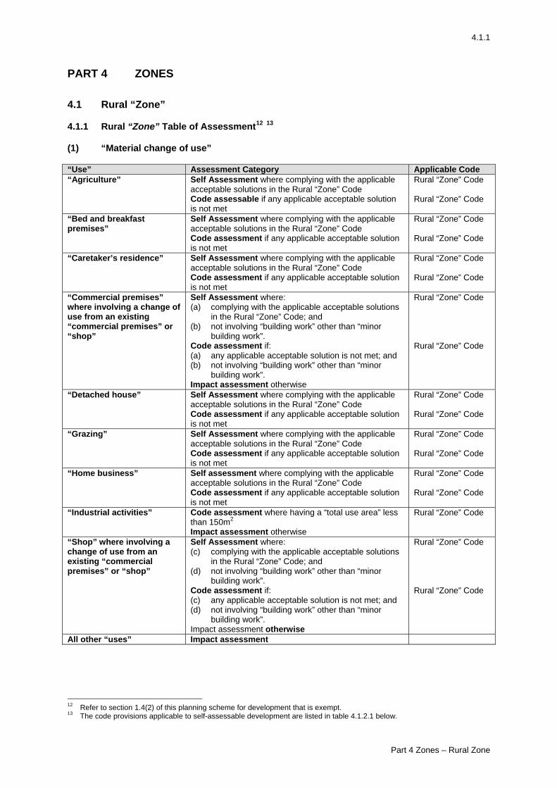
4.1.1
PART 4 ZONES 4.1 Rural “Zone” 4.1.1 Rural “Zone” Table of Assessment12 13 (1) “Material change of use” “Use” Assessment Category Applicable Code “Agriculture” Self Assessment where complying with the applicable
acceptable solutions in the Rural “Zone” Code Code assessable if any applicable acceptable solution is not met
Rural “Zone” Code Rural “Zone” Code
“Bed and breakfast premises”
Self Assessment where complying with the applicable acceptable solutions in the Rural “Zone” Code Code assessment if any applicable acceptable solution is not met
Rural “Zone” Code Rural “Zone” Code
“Caretaker’s residence” Self Assessment where complying with the applicable acceptable solutions in the Rural “Zone” Code Code assessment if any applicable acceptable solution is not met
Rural “Zone” Code Rural “Zone” Code
“Commercial premises” where involving a change of use from an existing “commercial premises” or “shop”
Self Assessment where: (a) complying with the applicable acceptable solutions
in the Rural “Zone” Code; and (b) not involving “building work” other than “minor
building work”. Code assessment if: (a) any applicable acceptable solution is not met; and (b) not involving “building work” other than “minor
building work”. Impact assessment otherwise
Rural “Zone” Code Rural “Zone” Code
“Detached house” Self Assessment where complying with the applicable acceptable solutions in the Rural “Zone” Code Code assessment if any applicable acceptable solution is not met
Rural “Zone” Code Rural “Zone” Code
“Grazing” Self Assessment where complying with the applicable acceptable solutions in the Rural “Zone” Code Code assessment if any applicable acceptable solution is not met
Rural “Zone” Code Rural “Zone” Code
“Home business” Self assessment where complying with the applicable acceptable solutions in the Rural “Zone” Code Code assessment if any applicable acceptable solution is not met
Rural “Zone” Code Rural “Zone” Code
“Industrial activities” Code assessment where having a “total use area” less than 150m2
Impact assessment otherwise
Rural “Zone” Code
“Shop” where involving a change of use from an existing “commercial premises” or “shop”
Self Assessment where: (c) complying with the applicable acceptable solutions
in the Rural “Zone” Code; and (d) not involving “building work” other than “minor
building work”. Code assessment if: (c) any applicable acceptable solution is not met; and (d) not involving “building work” other than “minor
building work”. Impact assessment otherwise
Rural “Zone” Code Rural “Zone” Code
All other “uses” Impact assessment
12 Refer to section 1.4(2) of this planning scheme for development that is exempt. 13 The code provisions applicable to self-assessable development are listed in table 4.1.2.1 below.
Part 4 Zones – Rural Zone
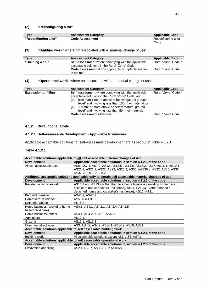
4.1.2
(2) “Reconfiguring a lot” Type Assessment Category Applicable Code “Reconfiguring a lot” Code Assessment Reconfiguring a lot
Code (3) “Building work” where not associated with a “material change of use” Type Assessment Category Applicable Code “Building work” Self-assessment where complying with the applicable
acceptable solutions in the Rural “Zone” Code Code assessment if any applicable acceptable solution is not met
Rural “Zone” Code * Rural “Zone” Code
(4) “Operational work” where not associated with a “material change of use” Type Assessment Category Applicable Code Excavation or filling Self-assessment where complying with the applicable
acceptable solutions in the Rural “Zone” Code, and: (a) less than 1 metre above or below “natural ground
level” and involving less than 100m3 of material; or (b) 1 metre or more above or below “natural ground
level” and involving less than 50m3 of material. Code assessment otherwise
Rural “Zone” Code * Rural “Zone” Code
4.1.2 Rural “Zone” Code 4.1.2.1 Self-assessable Development - Applicable Provisions Applicable acceptable solutions for self-assessable development are as set out in Table 4.1.2.1: Table 4.1.2.1 Acceptable solutions applicable to all self assessable material changes of use Development Applicable acceptable solutions in section 4.1.2.3 of the code All self assessable uses AS6, AS7.1, AS7.2, AS12, AS13.5, AS13.6, AS15.2, AS17, AS18.1, AS19.1,
AS21.1, AS21.2, AS22, AS23, AS26.2, AS30.1-AS30.8, AS32, AS35, AS36, AS37, AS38.1, AS38.2
Additional acceptable solutions applicable only to certain self assessable material changes of use Development Applicable acceptable solutions in section 4.1.2.3 of the code Residential activities (all) AS13.1 and AS13.2 (other than to a home business providing home based
child care and caretakers’ residence), AS14.1-AS14.3 (other than to a detached house and caretaker’s residence), AS16, AS31
Bed and breakfast AS40.1, AS40.2 Caretakers’ residence AS5, AS14.3 Detached house AS14.3 Home business (providing home based child care)
AS4.1, AS4.2, AS42.1, AS42.4, AS42.5
Home business (other) AS4.1, AS4.2, AS42.1-AS42.5 Agriculture AS13.1, Grazing AS13.1, AS13.3 Commercial activities AS3, AS4.1, AS4.2, AS14.1, AS14.2, AS16, AS31 Acceptable solutions applicable to self assessable building work Development Applicable acceptable solutions in section 4.1.2.4 of the code Building work All acceptable solutions except AS3, AS6, AS7.1 Acceptable solutions applicable to self assessable operational work Development Applicable acceptable solutions in section 4.1.2.5 of the code Excavation and filling AS2.1-AS2.7, AS3, AS6.2 AS8-AS10
Part 4 Zones – Rural Zone
4.1.3
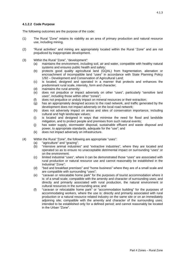
4.1.2.2 Code Purpose The following outcomes are the purpose of the code: (1) The Rural “Zone” retains its viability as an area of primary production and natural resource
use, including mining. (2) “Rural activities” and mining are appropriately located within the Rural “Zone” and are not
prejudiced by inappropriate development. (3) Within the Rural “Zone”, “development”:
(a) maintains the environment, including soil, air and water, compatible with healthy natural systems and ensures public health and safety;
(b) protects good quality agricultural land (GQAL) from fragmentation, alienation or encroachment of incompatible land “uses” in accordance with State Planning Policy 1/92 – Development and Conservation of Agricultural Land;
(c) is located, designed and operated in a manner that protects and enhances the predominant rural scale, intensity, form and character;
(d) maintains the rural amenity; (e) does not prejudice or impact adversely on other “uses”, particularly “sensitive land
uses”, including those within other “zones”; (f) does not prejudice or unduly impact on mineral resources or their extraction; (g) has an appropriately designed access to the road network, and traffic generated by the
development does not impact adversely on the local road network; (h) does not adversely impact on areas and sites of conservation importance, including
cultural and high landscape values; (i) is located and designed in ways that minimise the need for flood and landslide
mitigation, and to protect people and premises from such natural events; (j) has water supply, stormwater disposal, sustainable effluent and waste disposal and
power, to appropriate standards, adequate for the “use”; and (k) does not impact adversely on infrastructure.
(4) Within the Rural “Zone”, the following are appropriate “uses”:
(a) “agriculture” and “grazing”; (b) “intensive animal industries” and “extractive industries”, where they are located and
operated so as to ensure no unacceptable detrimental impact on surrounding “uses” or on the environment;
(c) limited industrial “uses”, where it can be demonstrated those “uses” are associated with rural production or natural resource use and cannot reasonably be established in the Industrial “Zone”;
(d) “bed and breakfast premises” and “home business” where they are of a small scale and are compatible with surrounding “uses”;
(e) “caravan or relocatable home park” for the purposes of tourist accommodation where it is: of a small scale; compatible with the amenity and character of surrounding uses; and directly and primarily associated with rural production, the natural environment or cultural resources in the surrounding area; and
(f) “caravan or relocatable home park” or “accommodation building” for the purposes of accommodating workers, where the use is: directly and primarily associated with rural production or a natural resource related industry on the same site or on an immediately adjoining site; compatible with the amenity and character of the surrounding uses; intended to be established only for a defined period; and cannot reasonably be located in the Urban “Zone”.
Part 4 Zones – Rural Zone
4.1.4
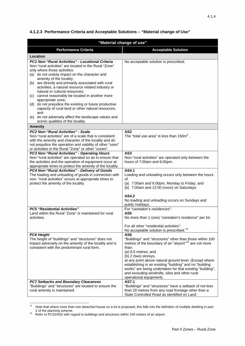
4.1.2.3 Performance Criteria and Acceptable Solutions – “Material change of Use”
“Material change of use” Performance Criteria Acceptable Solution
Location PC1 Non-“Rural Activities” - Locational Criteria Non-“rural activities” are located in the Rural “Zone” only where those activities: (a) do not unduly impact on the character and
amenity of the locality; (b) are directly and primarily associated with rural
activities, a natural resource related industry or natural or cultural resources;
(c) cannot reasonably be located in another more appropriate zone;
(d) do not prejudice the existing or future productive capacity of rural land or other natural resources; and
(e) do not adversely affect the landscape values and scenic qualities of the locality.
No acceptable solution is prescribed.
Amenity PC2 Non-“Rural Activities” - Scale Non-“rural activities” are of a scale that is consistent with the amenity and character of the locality and do not prejudice the operation and viability of other “uses” or activities in the Rural “Zone” or other “zones”.
AS2 The “total use area” is less than 150m2 .
PC3 Non-“Rural Activities” - Operating Hours Non-“rural activities” are operated so as to ensure that the activities and the operation of equipment occur at appropriate times to protect the amenity of the locality.
AS3 Non-”rural activities” are operated only between the hours of 7:00am and 6:00pm.
PC4 Non-“Rural Activities” - Delivery of Goods The loading and unloading of goods in connection with non- “rural activities” occurs at appropriate times to protect the amenity of the locality.
AS4.1 Loading and unloading occurs only between the hours of: (a) 7:00am and 6:00pm, Monday to Friday; and (b) 7:00am and 12:00 (noon) on Saturdays. AS4.2 No loading and unloading occurs on Sundays and public holidays.
PC5 “Residential Activities” Land within the Rural “Zone” is maintained for rural activities.
For “caretaker’s residences”: AS5 No more than 1 (one) “caretaker's residence” per lot. For all other “residential activities”: No acceptable solution is prescribed.14
PC6 Height The height of “buildings” and “structures” does not impact adversely on the amenity of the locality and is consistent with the predominant rural form.
AS6 “Buildings” and “structures” other than those within 100 metres of the boundary of an “airport”15 are not more than: (a) 8.5 metres; and (b) 2 (two) storeys, at any point above natural ground level. (Except where establishing in an existing “building” and no “building works” are being undertaken for that existing “building”, and excluding windmills, silos and other rural operational equipment).
PC7 Setbacks and Boundary Clearances “Buildings” and “structures” are located to ensure the rural amenity is maintained.
AS7.1 “Buildings” and “structures” have a setback of not less than 20 metres from any road frontage other than a State Controlled Road as identified on Land
14 Note that where more than one detached house on a lot is proposed, this falls into the definition of multiple dwelling in part
2 of the planning scheme. 15 Refer to PC32/A32 with regard to buildings and structures within 100 metres of an airport.
Part 4 Zones – Rural Zone
4.1.5
“Material change of use” Performance Criteria Acceptable Solution
Characteristics Map – Features Map. AS7.2 “Buildings” and “structures” have side and rear boundary clearances of not less than 15 metres from property boundaries (except where establishing in an existing “building” and no “building works” are being undertaken for that existing “building”).
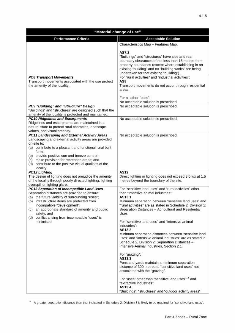
PC8 Transport Movements Transport movements associated with the use protect the amenity of the locality.
For “rural activities” and “industrial activities”: AS8 Transport movements do not occur through residential areas. For all other “uses”: No acceptable solution is prescribed.
PC9 “Building” and “Structure” Design “Buildings” and “structures” are designed such that the amenity of the locality is protected and maintained.
No acceptable solution is prescribed.
PC10 Ridgelines and Escarpments Ridgelines and escarpments are maintained in a natural state to protect rural character, landscape values, and visual amenity.
No acceptable solution is prescribed.
PC11 Landscaping and External Activity Areas Landscaping and external activity areas are provided on-site to: (a) contribute to a pleasant and functional rural built
form; (b) provide positive sun and breeze control; (c) make provision for recreation areas; and (d) contribute to the positive visual qualities of the
locality.
No acceptable solution is prescribed.
PC12 Lighting The design of lighting does not prejudice the amenity of the locality through poorly directed lighting, lighting overspill or lighting glare.
AS12 Direct lighting or lighting does not exceed 8.0 lux at 1.5 metres beyond the boundary of the site.
PC13 Separation of Incompatible Land Uses Separation distances are provided to ensure: (a) the future viability of surrounding “uses”; (b) infrastructure items are protected from
incompatible “development”; (c) an appropriate standard of amenity and public
safety; and (d) conflict arising from incompatible “uses” is
minimised.
For “sensitive land uses” and “rural activities” other than “intensive animal industries”: AS13.1 Minimum separation between “sensitive land uses” and “rural activities” are as stated in Schedule 2, Division 1: Separation Distances – Agricultural and Residential Uses For “sensitive land uses” and “intensive animal industries”: AS13.2 Minimum separation distances between “sensitive land uses” and “intensive animal industries” are as stated in Schedule 2, Division 2: Separation Distances – Intensive Animal Industries, Section 2.1. For “grazing”: AS13.3 Pens and yards maintain a minimum separation distance of 300 metres to “sensitive land uses” not associated with the “grazing”. For “uses” other than “sensitive land uses”16 and “extractive industries”: AS13.4 “Buildings”, “structures” and “outdoor activity areas”
16 A greater separation distance than that indicated in Schedule 2, Division 3 is likely to be required for “sensitive land uses”.
Part 4 Zones – Rural Zone
4.1.6
“Material change of use” Performance Criteria Acceptable Solution
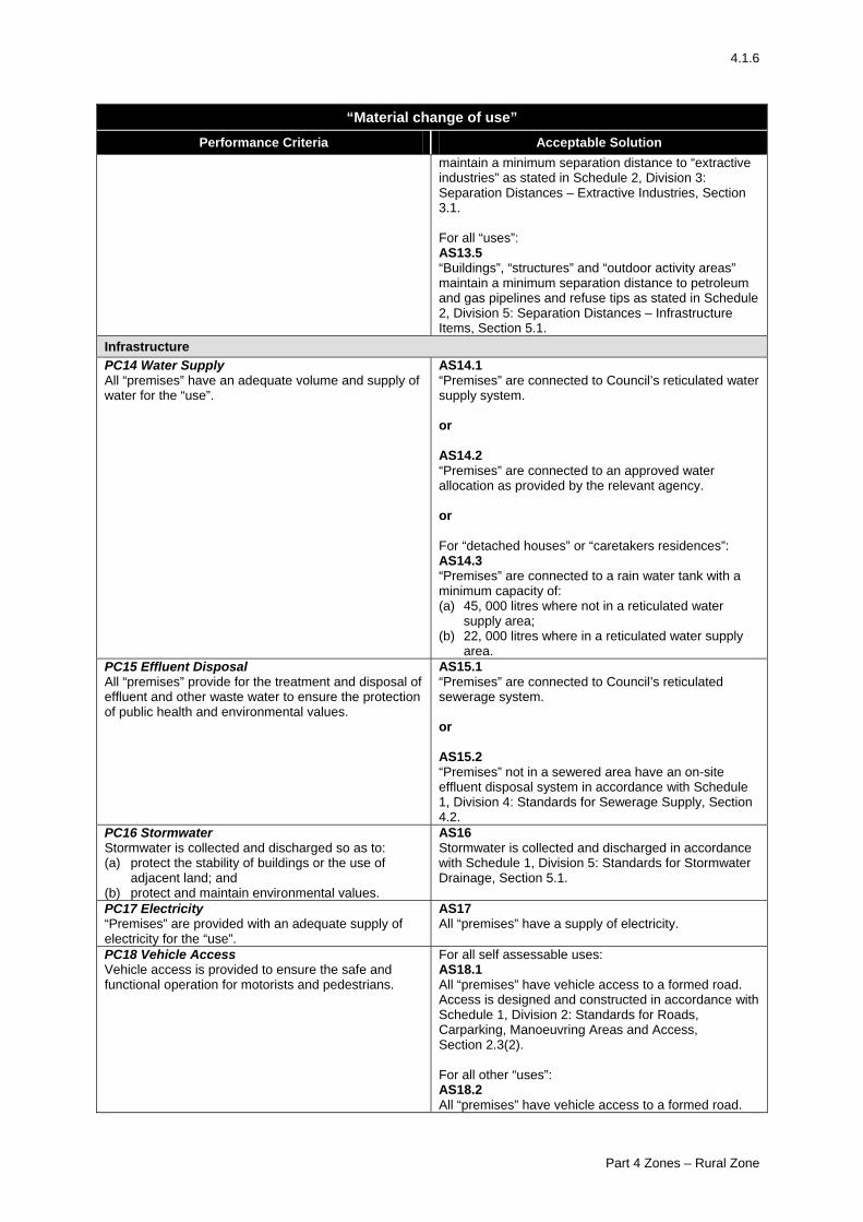
maintain a minimum separation distance to “extractive industries” as stated in Schedule 2, Division 3: Separation Distances – Extractive Industries, Section 3.1. For all “uses”: AS13.5 “Buildings”, “structures” and “outdoor activity areas” maintain a minimum separation distance to petroleum and gas pipelines and refuse tips as stated in Schedule 2, Division 5: Separation Distances – Infrastructure Items, Section 5.1.
Infrastructure PC14 Water Supply All “premises” have an adequate volume and supply of water for the “use”.
AS14.1 “Premises” are connected to Council’s reticulated water supply system. or AS14.2 “Premises” are connected to an approved water allocation as provided by the relevant agency. or For “detached houses” or “caretakers residences”: AS14.3 “Premises” are connected to a rain water tank with a minimum capacity of: (a) 45, 000 litres where not in a reticulated water
supply area; (b) 22, 000 litres where in a reticulated water supply
area. PC15 Effluent Disposal All “premises” provide for the treatment and disposal of effluent and other waste water to ensure the protection of public health and environmental values.
AS15.1 “Premises” are connected to Council’s reticulated sewerage system. or AS15.2 “Premises” not in a sewered area have an on-site effluent disposal system in accordance with Schedule 1, Division 4: Standards for Sewerage Supply, Section 4.2.
PC16 Stormwater Stormwater is collected and discharged so as to: (a) protect the stability of buildings or the use of
adjacent land; and (b) protect and maintain environmental values.
AS16 Stormwater is collected and discharged in accordance with Schedule 1, Division 5: Standards for Stormwater Drainage, Section 5.1.
PC17 Electricity “Premises” are provided with an adequate supply of electricity for the “use”.
AS17 All “premises” have a supply of electricity.
PC18 Vehicle Access Vehicle access is provided to ensure the safe and functional operation for motorists and pedestrians.
For all self assessable uses: AS18.1 All “premises” have vehicle access to a formed road. Access is designed and constructed in accordance with Schedule 1, Division 2: Standards for Roads, Carparking, Manoeuvring Areas and Access, Section 2.3(2). For all other “uses”: AS18.2 All “premises” have vehicle access to a formed road.
Part 4 Zones – Rural Zone
4.1.7
“Material change of use” Performance Criteria Acceptable Solution
Access is designed and constructed in accordance with Schedule 1, Division 2: Standards for Roads, Carparking, Manoeuvring Areas and Access, Section 2.3(1).
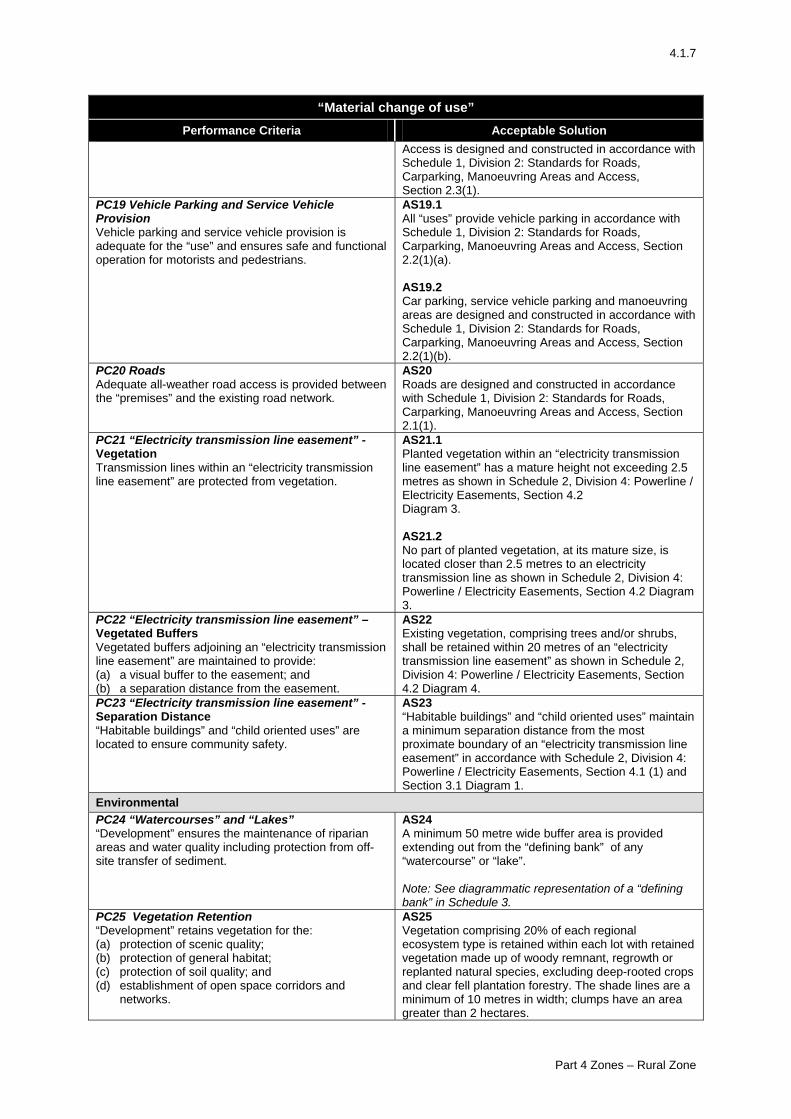
PC19 Vehicle Parking and Service Vehicle Provision Vehicle parking and service vehicle provision is adequate for the “use” and ensures safe and functional operation for motorists and pedestrians.
AS19.1 All “uses” provide vehicle parking in accordance with Schedule 1, Division 2: Standards for Roads, Carparking, Manoeuvring Areas and Access, Section 2.2(1)(a). AS19.2 Car parking, service vehicle parking and manoeuvring areas are designed and constructed in accordance with Schedule 1, Division 2: Standards for Roads, Carparking, Manoeuvring Areas and Access, Section 2.2(1)(b).
PC20 Roads Adequate all-weather road access is provided between the “premises” and the existing road network.
AS20 Roads are designed and constructed in accordance with Schedule 1, Division 2: Standards for Roads, Carparking, Manoeuvring Areas and Access, Section 2.1(1).
PC21 “Electricity transmission line easement” - Vegetation Transmission lines within an “electricity transmission line easement” are protected from vegetation.
AS21.1 Planted vegetation within an “electricity transmission line easement” has a mature height not exceeding 2.5 metres as shown in Schedule 2, Division 4: Powerline / Electricity Easements, Section 4.2 Diagram 3. AS21.2 No part of planted vegetation, at its mature size, is located closer than 2.5 metres to an electricity transmission line as shown in Schedule 2, Division 4: Powerline / Electricity Easements, Section 4.2 Diagram 3.
PC22 “Electricity transmission line easement” – Vegetated Buffers Vegetated buffers adjoining an “electricity transmission line easement” are maintained to provide: (a) a visual buffer to the easement; and (b) a separation distance from the easement.
AS22 Existing vegetation, comprising trees and/or shrubs, shall be retained within 20 metres of an “electricity transmission line easement” as shown in Schedule 2, Division 4: Powerline / Electricity Easements, Section 4.2 Diagram 4.
PC23 “Electricity transmission line easement” - Separation Distance “Habitable buildings” and “child oriented uses” are located to ensure community safety.
AS23 “Habitable buildings” and “child oriented uses” maintain a minimum separation distance from the most proximate boundary of an “electricity transmission line easement” in accordance with Schedule 2, Division 4: Powerline / Electricity Easements, Section 4.1 (1) and Section 3.1 Diagram 1.
Environmental PC24 “Watercourses” and “Lakes” “Development” ensures the maintenance of riparian areas and water quality including protection from off-site transfer of sediment.
AS24 A minimum 50 metre wide buffer area is provided extending out from the “defining bank” of any “watercourse” or “lake”. Note: See diagrammatic representation of a “defining bank” in Schedule 3.
PC25 Vegetation Retention “Development” retains vegetation for the: (a) protection of scenic quality; (b) protection of general habitat; (c) protection of soil quality; and (d) establishment of open space corridors and
networks.
AS25 Vegetation comprising 20% of each regional ecosystem type is retained within each lot with retained vegetation made up of woody remnant, regrowth or replanted natural species, excluding deep-rooted crops and clear fell plantation forestry. The shade lines are a minimum of 10 metres in width; clumps have an area greater than 2 hectares.
Part 4 Zones – Rural Zone
4.1.8
“Material change of use” Performance Criteria Acceptable Solution
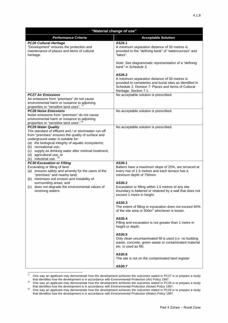
PC26 Cultural Heritage “Development” ensures the protection and maintenance of places and items of cultural heritage.
AS26.1 A minimum separation distance of 50 metres is provided to the “defining bank” of “watercourses” and “lakes”. Note: See diagrammatic representation of a “defining bank” in Schedule 3. AS26.2 A minimum separation distance of 50 metres is provided to cemeteries and burial sites as identified in Schedule 2, Division 7: Places and Items of Cultural Heritage, Section 7.1.
PC27 Air Emissions Air emissions from “premises” do not cause environmental harm or nuisance to adjoining properties or “sensitive land uses”. 17
No acceptable solution is prescribed.
PC28 Noise Emissions Noise emissions from “premises” do not cause environmental harm or nuisance to adjoining properties or “sensitive land uses”.18
No acceptable solution is prescribed.
PC29 Water Quality The standard of effluent and / or stormwater run-off from “premises” ensures the quality of surface and underground water is suitable for: (a) the biological integrity of aquatic ecosystems; (b) recreational use; (c) supply as drinking water after minimal treatment; (d) agricultural use; or (e) industrial use. 19
No acceptable solution is prescribed.
PC30 Excavation or Filling Excavating or filling of land: (a) ensures safety and amenity for the users of the
“premises” and nearby land; (b) minimises soil erosion and instability of
surrounding areas; and (c) does not degrade the environmental values of
receiving waters.
AS30.1 Batters have a maximum slope of 25%, are terraced at every rise of 1.5 metres and each terrace has a minimum depth of 750mm. AS30.2 Excavation or filling within 1.5 metres of any site boundary is battered or retained by a wall that does not exceed 1 metre in height. AS30.3 The extent of filling or excavation does not exceed 40% of the site area or 500m2 whichever is lesser. AS30.4 Filling and excavation is not greater than 1 metre in height or depth. AS30.5 Only clean uncontaminated fill is used (i.e. no building waste, concrete, green waste or contaminated material etc. is used as fill). AS30.6 The site is not on the contaminated land register AS30.7
17 One way an applicant may demonstrate how the development achieves the outcomes stated in PC27 is to prepare a study
that identifies how the development is in accordance with Environmental Protection (Air) Policy 1997. 18 One way an applicant may demonstrate how the development achieves the outcomes stated in PC28 is to prepare a study
that identifies how the development is in accordance with Environmental Protection (Noise) Policy 1997. 19 One way an applicant may demonstrate how the development achieves the outcomes stated in PC29 is to prepare a study
that identifies how the development is in accordance with Environmental Protection (Water) Policy 1997.
Part 4 Zones – Rural Zone
4.1.9
“Material change of use” Performance Criteria Acceptable Solution
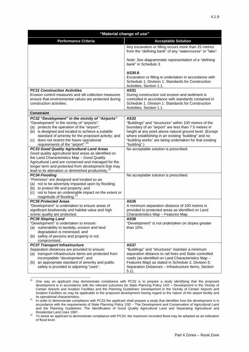
Any excavation or filling occurs more than 25 metres from the “defining bank” of any “watercourse” or “lake”. Note: See diagrammatic representation of a “defining bank” in Schedule 3. AS30.8 Excavation or filling is undertaken in accordance with Schedule 1, Division 1: Standards for Construction Activities, Section 1.1.
PC31 Construction Activities Erosion control measures and silt collection measures ensure that environmental values are protected during construction activities.
AS31 During construction soil erosion and sediment is controlled in accordance with standards contained in Schedule 1, Division 1: Standards for Construction Activities, Section 1.1.
Constraint PC32 “Development” in the vicinity of “Airports” “Development” in the vicinity of “airports”: (a) protects the operation of the “airport”; (b) is designed and located to achieve a suitable
standard of amenity for the proposed activity; and (c) does not restrict the future operational
requirements of the “airport”.20
AS32 “Buildings” and “structures” within 100 metres of the boundary of an “airport” are less than 7.5 metres in height at any point above natural ground level. (Except where establishing in an existing “building” and no “building works” are being undertaken for that existing “building”.)
PC33 Good Quality Agricultural Land Areas Good quality agricultural land areas as identified on the Land Characteristics Map – Good Quality Agricultural Land are conserved and managed for the longer term and protected from development that may lead to its alienation or diminished productivity.21
No acceptable solution is prescribed.
PC34 Flooding “Premises” are designed and located so as: (a) not to be adversely impacted upon by flooding; (b) to protect life and property; and (c) not to have an undesirable impact on the extent or
magnitude of flooding.22
No acceptable solution is prescribed.
PC35 Protected Areas “Development” is undertaken to ensure areas of significant biodiversity and habitat value and high scenic quality are protected.
AS35 A minimum separation distance of 100 metres is provided to protected areas as identified on Land Characteristics Map – Features Map.
PC36 Sloping Land “Development” is undertaken to ensure: (a) vulnerability to landslip, erosion and land
degradation is minimised; and (b) safety of persons and property is not
compromised.
AS36 “Development” is not undertaken on slopes greater than 15%.
PC37 Transport Infrastructure Separation distances are provided to ensure: (a) transport infrastructure items are protected from
incompatible “development”; and (b) an appropriate standard of amenity and public
safety is provided to adjoining “uses”.
AS37 “Buildings” and “structures” maintain a minimum separation distance to rail lines and State controlled roads (as identified on Land Characteristics Map – Features Map) as stated in Schedule 2, Division 5: Separation Distances – Infrastructure Items, Section 5.1).
20 One way an applicant may demonstrate compliance with PC32 is to prepare a study identifying that the proposed
development is in accordance with the relevant outcomes for State Planning Policy 1/02 – Development in the Vicinity of Certain Airports and Aviation Facilities and the Planning Guidelines: Development in the Vicinity of Certain Airports and Aviation Facilities as may be applicable to the proposed development having regard to the nature of the airport facility and its operational characteristics.
21 In order to demonstrate compliance with PC33 the applicant shall prepare a study that identifies how the development is in accordance with the requirements of State Planning Policy 1/92 – The Development and Conservation of Agricultural Land and the Planning Guidelines: The Identification of Good Quality Agricultural Land and Separating Agricultural and Residential Land Uses 1997.
22 To assist an applicant to demonstrate compliance with PC34, the maximum recorded flood may be adopted as an indication of flood level.
Part 4 Zones – Rural Zone
4.1.10
“Material change of use” Performance Criteria Acceptable Solution
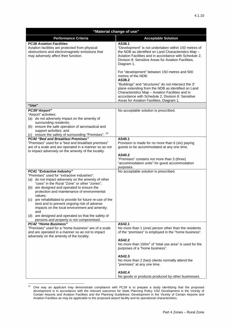
PC38 Aviation Facilities Aviation facilities are protected from physical obstructions and electromagnetic emissions that may adversely affect their function.
AS38.1 “Development” is not undertaken within 150 metres of the NDB as identified on Land Characteristics Map – Aviation Facilities and in accordance with Schedule 2, Division 8: Sensitive Areas for Aviation Facilities, Diagram 1. For “development” between 150 metres and 500 metres of the NDB: AS38.2 “Buildings” and “structures” do not intersect the 3° plane extending from the NDB as identified on Land Characteristics Map – Aviation Facilities and in accordance with Schedule 2, Division 8: Sensitive Areas for Aviation Facilities, Diagram 1.
“Use” PC39“Airport” “Airport” activities: (a) do not adversely impact on the amenity of
surrounding residents; (b) ensure the safe operation of aeronautical and
support activities; and (c) ensure the safety of surrounding “Premises”. 23
No acceptable solution is prescribed.
PC40 “Bed and Breakfast Premises” “Premises” used for a “bed and breakfast premises” are of a scale and are operated in a manner so as not to impact adversely on the amenity of the locality.
AS40.1 Provision is made for no more than 6 (six) paying guests to be accommodated at any one time. AS40.2 “Premises” contains not more than 3 (three) “accommodation units” for guest accommodation purposes.
PC41 “Extractive Industry” “Premises” used for “extractive industries”: (a) do not impact adversely on the amenity of other
“uses” in the Rural “Zone” or other “zones”; (b) are designed and operated to ensure the
protection and maintenance of environmental values;
(c) are rehabilitated to provide for future re-use of the land and to prevent ongoing risk of adverse impacts on the local environment and amenity; and
(d) are designed and operated so that the safety of persons and property is not compromised.
No acceptable solution is prescribed.
PC42 “Home Business” “Premises” used for a “home business” are of a scale and are operated in a manner so as not to impact adversely on the amenity of the locality.
AS42.1 No more than 1 (one) person other than the residents of the “premises” is employed in the “home business”. AS42.2 No more than 150m2 of “total use area” is used for the purposes of a “home business”. AS42.3 No more than 2 (two) clients normally attend the “premises” at any one time. AS42.4 No goods or products produced by other businesses
23 One way an applicant may demonstrate compliance with PC39 is to prepare a study identifying that the proposed
development is in accordance with the relevant outcomes for State Planning Policy 1/02 Development in the Vicinity of Certain Airports and Aviation Facilities and the Planning Guidelines: Development in the Vicinity of Certain Airports and Aviation Facilities as may be applicable to the proposed airport facility and its operational characteristics.
Part 4 Zones – Rural Zone
4.1.11
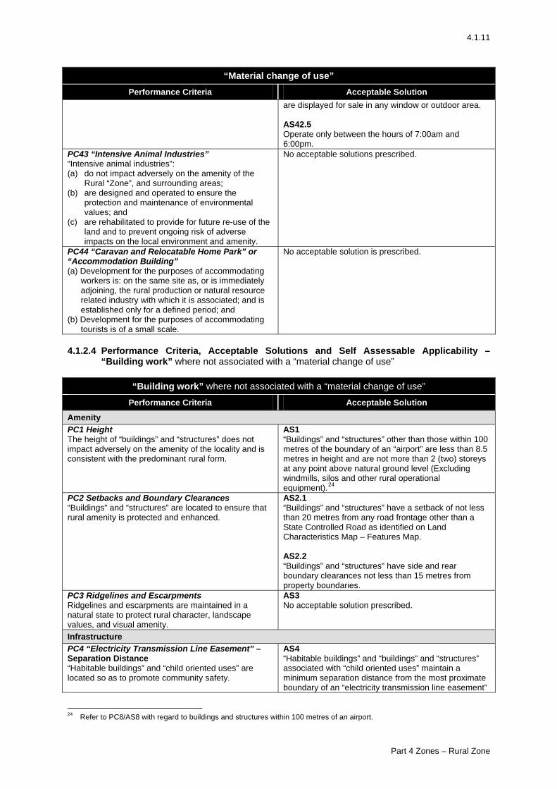
“Material change of use” Performance Criteria Acceptable Solution
are displayed for sale in any window or outdoor area. AS42.5 Operate only between the hours of 7:00am and 6:00pm.
PC43 “Intensive Animal Industries” “Intensive animal industries”: (a) do not impact adversely on the amenity of the
Rural “Zone”, and surrounding areas; (b) are designed and operated to ensure the
protection and maintenance of environmental values; and
(c) are rehabilitated to provide for future re-use of the land and to prevent ongoing risk of adverse impacts on the local environment and amenity.
No acceptable solutions prescribed.
PC44 “Caravan and Relocatable Home Park” or “Accommodation Building” (a) Development for the purposes of accommodating
workers is: on the same site as, or is immediately adjoining, the rural production or natural resource related industry with which it is associated; and is established only for a defined period; and
(b) Development for the purposes of accommodating tourists is of a small scale.
No acceptable solution is prescribed.
4.1.2.4 Performance Criteria, Acceptable Solutions and Self Assessable Applicability –
“Building work” where not associated with a “material change of use”
“Building work” where not associated with a “material change of use” Performance Criteria Acceptable Solution
Amenity PC1 Height The height of “buildings” and “structures” does not impact adversely on the amenity of the locality and is consistent with the predominant rural form.
AS1 “Buildings” and “structures” other than those within 100 metres of the boundary of an “airport” are less than 8.5 metres in height and are not more than 2 (two) storeys at any point above natural ground level (Excluding windmills, silos and other rural operational equipment).24
PC2 Setbacks and Boundary Clearances “Buildings” and “structures” are located to ensure that rural amenity is protected and enhanced.
AS2.1 “Buildings” and “structures” have a setback of not less than 20 metres from any road frontage other than a State Controlled Road as identified on Land Characteristics Map – Features Map. AS2.2 “Buildings” and “structures” have side and rear boundary clearances not less than 15 metres from property boundaries.
PC3 Ridgelines and Escarpments Ridgelines and escarpments are maintained in a natural state to protect rural character, landscape values, and visual amenity.
AS3 No acceptable solution prescribed.
Infrastructure PC4 “Electricity Transmission Line Easement” – Separation Distance “Habitable buildings” and “child oriented uses” are located so as to promote community safety.
AS4 “Habitable buildings” and “buildings” and “structures” associated with “child oriented uses” maintain a minimum separation distance from the most proximate boundary of an “electricity transmission line easement”
24 Refer to PC8/AS8 with regard to buildings and structures within 100 metres of an airport.
Part 4 Zones – Rural Zone
4.1.12
“Building work” where not associated with a “material change of use” Performance Criteria Acceptable Solution
in accordance with Schedule 2, Division 4: Powerline / Electricity Easements, Section 4.1(1) and Section 3.1 Diagram 1.
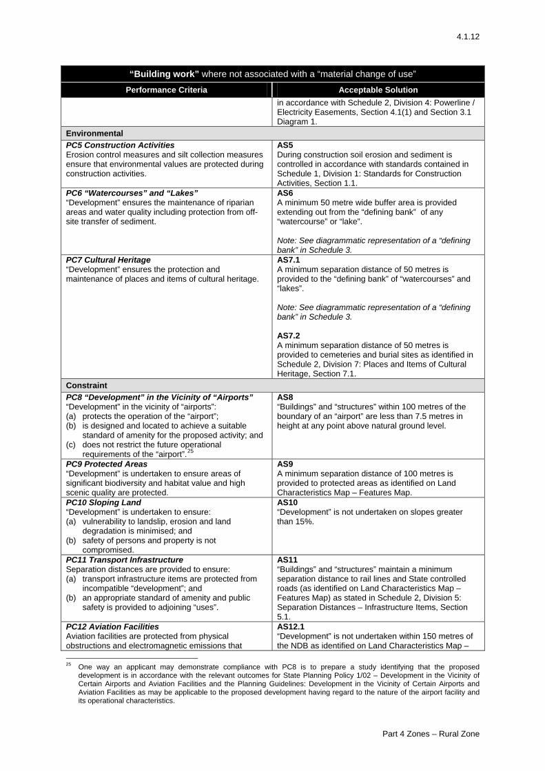
Environmental PC5 Construction Activities Erosion control measures and silt collection measures ensure that environmental values are protected during construction activities.
AS5 During construction soil erosion and sediment is controlled in accordance with standards contained in Schedule 1, Division 1: Standards for Construction Activities, Section 1.1.
PC6 “Watercourses” and “Lakes” “Development” ensures the maintenance of riparian areas and water quality including protection from off-site transfer of sediment.
AS6 A minimum 50 metre wide buffer area is provided extending out from the “defining bank” of any “watercourse” or “lake”. Note: See diagrammatic representation of a “defining bank” in Schedule 3.
PC7 Cultural Heritage “Development” ensures the protection and maintenance of places and items of cultural heritage.
AS7.1 A minimum separation distance of 50 metres is provided to the “defining bank” of “watercourses” and “lakes”. Note: See diagrammatic representation of a “defining bank” in Schedule 3. AS7.2 A minimum separation distance of 50 metres is provided to cemeteries and burial sites as identified in Schedule 2, Division 7: Places and Items of Cultural Heritage, Section 7.1.
Constraint PC8 “Development” in the Vicinity of “Airports” “Development” in the vicinity of “airports”: (a) protects the operation of the “airport”; (b) is designed and located to achieve a suitable
standard of amenity for the proposed activity; and (c) does not restrict the future operational
requirements of the “airport”.25
AS8 “Buildings” and “structures” within 100 metres of the boundary of an “airport” are less than 7.5 metres in height at any point above natural ground level.
PC9 Protected Areas “Development” is undertaken to ensure areas of significant biodiversity and habitat value and high scenic quality are protected.
AS9 A minimum separation distance of 100 metres is provided to protected areas as identified on Land Characteristics Map – Features Map.
PC10 Sloping Land “Development” is undertaken to ensure: (a) vulnerability to landslip, erosion and land
degradation is minimised; and (b) safety of persons and property is not
compromised.
AS10 “Development” is not undertaken on slopes greater than 15%.
PC11 Transport Infrastructure Separation distances are provided to ensure: (a) transport infrastructure items are protected from
incompatible “development”; and (b) an appropriate standard of amenity and public
safety is provided to adjoining “uses”.
AS11 “Buildings” and “structures” maintain a minimum separation distance to rail lines and State controlled roads (as identified on Land Characteristics Map – Features Map) as stated in Schedule 2, Division 5: Separation Distances – Infrastructure Items, Section 5.1.
PC12 Aviation Facilities Aviation facilities are protected from physical obstructions and electromagnetic emissions that
AS12.1 “Development” is not undertaken within 150 metres of the NDB as identified on Land Characteristics Map –
25 One way an applicant may demonstrate compliance with PC8 is to prepare a study identifying that the proposed
development is in accordance with the relevant outcomes for State Planning Policy 1/02 – Development in the Vicinity of Certain Airports and Aviation Facilities and the Planning Guidelines: Development in the Vicinity of Certain Airports and Aviation Facilities as may be applicable to the proposed development having regard to the nature of the airport facility and its operational characteristics.
Part 4 Zones – Rural Zone
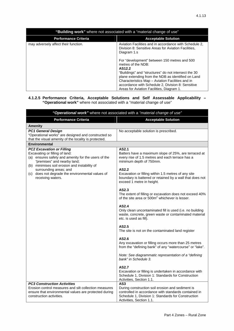
4.1.13
“Building work” where not associated with a “material change of use” Performance Criteria Acceptable Solution
may adversely affect their function.
Aviation Facilities and in accordance with Schedule 2, Division 8: Sensitive Areas for Aviation Facilities, Diagram 1.s For “development” between 150 metres and 500 metres of the NDB: AS12.2 “Buildings” and “structures” do not intersect the 30 plane extending from the NDB as identified on Land Characteristics Map – Aviation Facilities and in accordance with Schedule 2, Division 8: Sensitive Areas for Aviation Facilities, Diagram 1.
4.1.2.5 Performance Criteria, Acceptable Solutions and Self Assessable Applicability –
“Operational work” where not associated with a “material change of use”
“Operational work” where not associated with a “material change of use” Performance Criteria Acceptable Solution
Amenity PC1 General Design “Operational works” are designed and constructed so that the visual amenity of the locality is protected.
No acceptable solution is prescribed.
Environmental PC2 Excavation or Filling Excavating or filling of land: (a) ensures safety and amenity for the users of the
“premises” and nearby land; (b) minimises soil erosion and instability of
surrounding areas; and (c) does not degrade the environmental values of
receiving waters.
AS2.1 Batters have a maximum slope of 25%, are terraced at every rise of 1.5 metres and each terrace has a minimum depth of 750mm. AS2.2 Excavation or filling within 1.5 metres of any site boundary is battered or retained by a wall that does not exceed 1 metre in height. AS2.3 The extent of filling or excavation does not exceed 40% of the site area or 500m2 whichever is lesser. AS2.4 Only clean uncontaminated fill is used (i.e. no building waste, concrete, green waste or contaminated material etc. is used as fill). AS2.5 The site is not on the contaminated land register AS2.6 Any excavation or filling occurs more than 25 metres from the “defining bank” of any “watercourse” or “lake”. Note: See diagrammatic representation of a “defining bank” in Schedule 3. AS2.7 Excavation or filling is undertaken in accordance with Schedule 1, Division 1: Standards for Construction Activities, Section 1.1.
PC3 Construction Activities Erosion control measures and silt collection measures ensure that environmental values are protected during construction activities.
AS3 During construction soil erosion and sediment is controlled in accordance with standards contained in Schedule 1, Division 1: Standards for Construction Activities, Section 1.1.
Part 4 Zones – Rural Zone
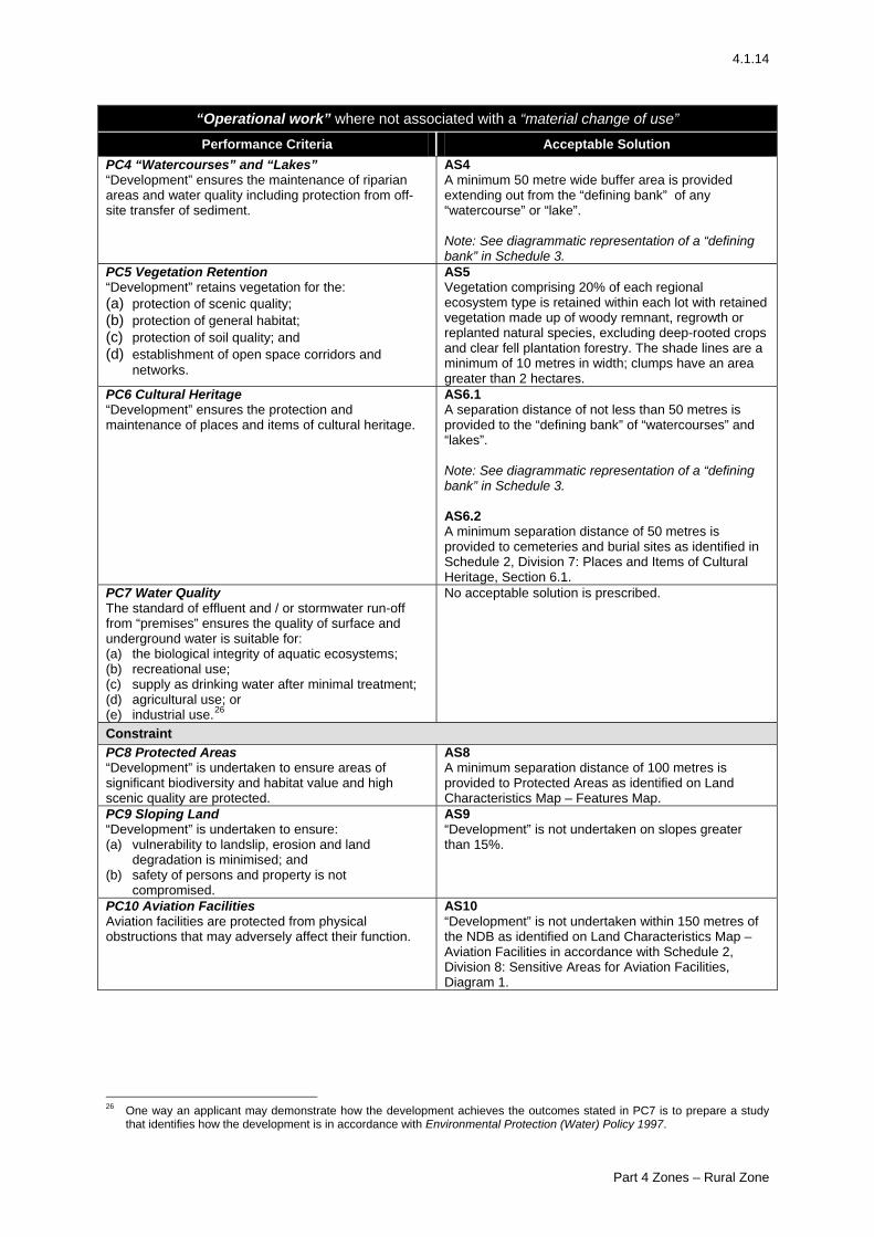
4.1.14
“Operational work” where not associated with a “material change of use” Performance Criteria Acceptable Solution
PC4 “Watercourses” and “Lakes” “Development” ensures the maintenance of riparian areas and water quality including protection from off-site transfer of sediment.
AS4 A minimum 50 metre wide buffer area is provided extending out from the “defining bank” of any “watercourse” or “lake”. Note: See diagrammatic representation of a “defining bank” in Schedule 3.
PC5 Vegetation Retention “Development” retains vegetation for the: (a) protection of scenic quality; (b) protection of general habitat; (c) protection of soil quality; and (d) establishment of open space corridors and
networks.
AS5 Vegetation comprising 20% of each regional ecosystem type is retained within each lot with retained vegetation made up of woody remnant, regrowth or replanted natural species, excluding deep-rooted crops and clear fell plantation forestry. The shade lines are a minimum of 10 metres in width; clumps have an area greater than 2 hectares.
PC6 Cultural Heritage “Development” ensures the protection and maintenance of places and items of cultural heritage.
AS6.1 A separation distance of not less than 50 metres is provided to the “defining bank” of “watercourses” and “lakes”. Note: See diagrammatic representation of a “defining bank” in Schedule 3. AS6.2 A minimum separation distance of 50 metres is provided to cemeteries and burial sites as identified in Schedule 2, Division 7: Places and Items of Cultural Heritage, Section 6.1.
PC7 Water Quality The standard of effluent and / or stormwater run-off from “premises” ensures the quality of surface and underground water is suitable for: (a) the biological integrity of aquatic ecosystems; (b) recreational use; (c) supply as drinking water after minimal treatment; (d) agricultural use; or (e) industrial use.26
No acceptable solution is prescribed.
Constraint PC8 Protected Areas “Development” is undertaken to ensure areas of significant biodiversity and habitat value and high scenic quality are protected.
AS8 A minimum separation distance of 100 metres is provided to Protected Areas as identified on Land Characteristics Map – Features Map.
PC9 Sloping Land “Development” is undertaken to ensure: (a) vulnerability to landslip, erosion and land
degradation is minimised; and (b) safety of persons and property is not
compromised.
AS9 “Development” is not undertaken on slopes greater than 15%.
PC10 Aviation Facilities Aviation facilities are protected from physical obstructions that may adversely affect their function.
AS10 “Development” is not undertaken within 150 metres of the NDB as identified on Land Characteristics Map – Aviation Facilities in accordance with Schedule 2, Division 8: Sensitive Areas for Aviation Facilities, Diagram 1.
26 One way an applicant may demonstrate how the development achieves the outcomes stated in PC7 is to prepare a study
that identifies how the development is in accordance with Environmental Protection (Water) Policy 1997.
Part 4 Zones – Rural Zone
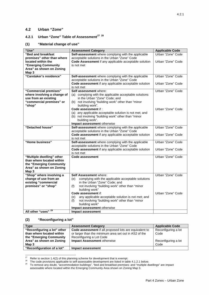
4.2.1
4.2 Urban “Zone” 4.2.1 Urban “Zone” Table of Assessment27 28 (1) “Material change of use”
“Use” Assessment Category Applicable Code “Bed and breakfast premises” other than where located within the “Emerging Community Area” as shown on Zoning Map 3
Self-assessment where complying with the applicable acceptable solutions in the Urban “Zone” Code Code Assessment if any applicable acceptable solution is not met
Urban “Zone” Code Urban “Zone” Code
“Caretaker’s residence” Self-assessment where complying with the applicable acceptable solutions in the Urban “Zone” Code Code assessment if any applicable acceptable solution is not met
Urban “Zone” Code Urban “Zone” Code
“Commercial premises” where involving a change of use from an existing “commercial premises” or “shop”
Self assessment where: (a) complying with the applicable acceptable solutions
in the Urban “Zone” Code; and (b) not involving “building work” other than “minor
building work”. Code assessment if : (a) any applicable acceptable solution is not met; and (b) not involving “building work” other than “minor
building work”. Impact assessment otherwise
Urban “Zone” Code Urban “Zone” Code
“Detached house” Self-assessment where complying with the applicable acceptable solutions in the Urban “Zone” Code Code assessment if any applicable acceptable solution is not met
Urban “Zone” Code Urban “Zone” Code
“Home business” Self-assessment where complying with the applicable acceptable solutions in the Urban “Zone” Code Code assessment if any applicable acceptable solution is not met
Urban “Zone” Code Urban “Zone” Code
“Multiple dwelling” other than where located within the “Emerging Community Area” as shown on Zoning Map 3
Code assessment Urban “Zone” Code
“Shop” where involving a change of use from an existing “commercial premises” or “shop”
Self Assessment where: (e) complying with the applicable acceptable solutions
in the Urban “Zone” Code; and (f) not involving “building work” other than “minor
building work” Code assessment if: (e) any applicable acceptable solution is not met; and (f) not involving “building work” other than “minor
building work” Impact assessment otherwise
Urban “Zone” Code Urban “Zone” Code
All other “uses” 29 Impact assessment (2) “Reconfiguring a lot” Type Assessment Category Applicable Code “Reconfiguring a lot” other than where located within the “Emerging Community Area” as shown on Zoning Map 3
Code assessment if all proposed lots are equivalent to or larger than the minimum area set out in AS2 of the Reconfiguring a Lot Code Impact Assessment otherwise
Reconfiguring a lot Code Reconfiguring a lot Code
“Reconfiguration of a lot” Impact assessment
27 Refer to section 1.4(2) of this planning scheme for development that is exempt. 28 The code provisions applicable to self-assessable development are listed in table 4.1.2.1 below. 29 To remove any doubt, “accommodation buildings”, “bed and breakfast premises: and “multiple dwellings” are impact
assessable where located within the Emerging Community Area shown on Zoning Map 3.
Part 4 Zones – Urban Zone
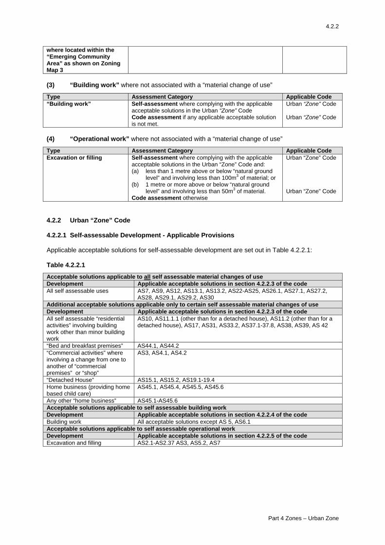
4.2.2
where located within the “Emerging Community Area” as shown on Zoning Map 3 (3) “Building work” where not associated with a “material change of use”
Type Assessment Category Applicable Code “Building work” Self-assessment where complying with the applicable
acceptable solutions in the Urban “Zone” Code Code assessment if any applicable acceptable solution is not met.
Urban “Zone” Code Urban “Zone” Code
(4) “Operational work” where not associated with a “material change of use”
Type Assessment Category Applicable Code Excavation or filling Self-assessment where complying with the applicable
acceptable solutions in the Urban “Zone” Code and: (a) less than 1 metre above or below “natural ground
level” and involving less than 100m3 of material; or (b) 1 metre or more above or below “natural ground
level” and involving less than 50m3 of material. Code assessment otherwise
Urban “Zone” Code Urban “Zone” Code
4.2.2 Urban “Zone” Code 4.2.2.1 Self-assessable Development - Applicable Provisions Applicable acceptable solutions for self-assessable development are set out in Table 4.2.2.1: Table 4.2.2.1
Acceptable solutions applicable to all self assessable material changes of use Development Applicable acceptable solutions in section 4.2.2.3 of the code All self assessable uses AS7, AS9, AS12, AS13.1, AS13.2, AS22-AS25, AS26.1, AS27.1, AS27.2,
AS28, AS29.1, AS29.2, AS30 Additional acceptable solutions applicable only to certain self assessable material changes of use Development Applicable acceptable solutions in section 4.2.2.3 of the code All self assessable “residential activities” involving building work other than minor building work
AS10, AS11.1.1 (other than for a detached house), AS11.2 (other than for a detached house), AS17, AS31, AS33.2, AS37.1-37.8, AS38, AS39, AS 42
“Bed and breakfast premises” AS44.1, AS44.2 “Commercial activities” where involving a change from one to another of “commercial premises” or “shop”
AS3, AS4.1, AS4.2
“Detached House” AS15.1, AS15.2, AS19.1-19.4 Home business (providing home based child care)
AS45.1, AS45.4, AS45.5, AS45.6
Any other “home business” AS45.1-AS45.6 Acceptable solutions applicable to self assessable building work Development Applicable acceptable solutions in section 4.2.2.4 of the code Building work All acceptable solutions except AS 5, AS6.1 Acceptable solutions applicable to self assessable operational work Development Applicable acceptable solutions in section 4.2.2.5 of the code Excavation and filling AS2.1-AS2.37 AS3, AS5.2, AS7
Part 4 Zones – Urban Zone
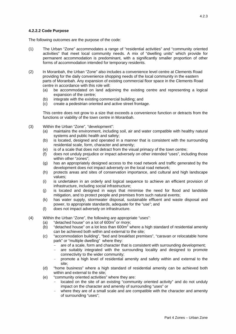
4.2.3
4.2.2.2 Code Purpose The following outcomes are the purpose of the code: (1) The Urban “Zone” accommodates a range of “residential activities” and “community oriented
activities” that meet local community needs. A mix of “dwelling units” which provide for permanent accommodation is predominant, with a significantly smaller proportion of other forms of accommodation intended for temporary residents.
(2) In Moranbah, the Urban “Zone” also includes a convenience level centre at Clements Road
providing for the daily convenience shopping needs of the local community in the eastern parts of Moranbah. Any expansion of existing commercial floor space in the Clements Road centre in accordance with this role will: (a) be accommodated on land adjoining the existing centre and representing a logical
expansion of the centre; (b) integrate with the existing commercial building; and (c) create a pedestrian oriented and active street frontage. This centre does not grow to a size that exceeds a convenience function or detracts from the functions or viability of the town centre in Moranbah.
(3) Within the Urban “Zone”, “development”:
(a) maintains the environment, including soil, air and water compatible with healthy natural systems and public health and safety;
(b) is located, designed and operated in a manner that is consistent with the surrounding residential scale, form, character and amenity;
(e) is of a scale that does not detract from the visual primacy of the town centre; (f) does not unduly prejudice or impact adversely on other intended “uses”, including those
within other “zones”; (g) has an appropriately designed access to the road network and traffic generated by the
development does not impact adversely on the local road network; (h) protects areas and sites of conservation importance, and cultural and high landscape
values; (i) is undertaken in an orderly and logical sequence to achieve an efficient provision of
infrastructure, including social infrastructure; (j) is located and designed in ways that minimise the need for flood and landslide
mitigation, and to protect people and premises from such natural events; (k) has water supply, stormwater disposal, sustainable effluent and waste disposal and
power, to appropriate standards, adequate for the “use”; and (l) does not impact adversely on infrastructure.
(4) Within the Urban “Zone”, the following are appropriate “uses”:
(a) “detached house” on a lot of 600m2 or more; (b) “detached house” on a lot less than 600m2 where a high standard of residential amenity
can be achieved both within and external to the site; (c) “accommodation building”, “bed and breakfast premises”, “caravan or relocatable home
park” or “multiple dwelling” where they: - are of a scale, form and character that is consistent with surrounding development; - are suitably integrated with the surrounding locality and designed to promote
connectivity to the wider community; - promote a high level of residential amenity and safety within and external to the
site; (d) “home business” where a high standard of residential amenity can be achieved both
within and external to the site; (e) “community oriented activities” where they are:
- located on the site of an existing “community oriented activity” and do not unduly impact on the character and amenity of surrounding “uses” or
- where they are of a small scale and are compatible with the character and amenity of surrounding “uses”;
Part 4 Zones – Urban Zone
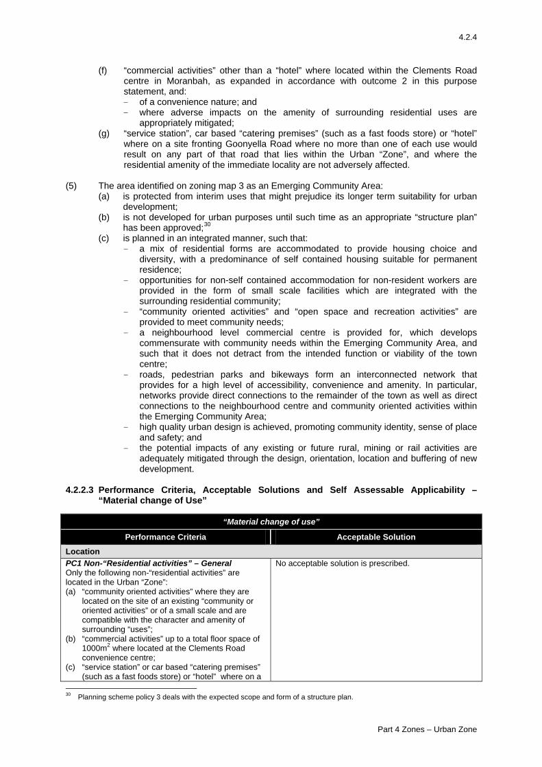
4.2.4
(f) “commercial activities” other than a “hotel” where located within the Clements Road centre in Moranbah, as expanded in accordance with outcome 2 in this purpose statement, and: - of a convenience nature; and - where adverse impacts on the amenity of surrounding residential uses are
appropriately mitigated; (g) “service station”, car based “catering premises” (such as a fast foods store) or “hotel”
where on a site fronting Goonyella Road where no more than one of each use would result on any part of that road that lies within the Urban “Zone”, and where the residential amenity of the immediate locality are not adversely affected.
(5) The area identified on zoning map 3 as an Emerging Community Area:
(a) is protected from interim uses that might prejudice its longer term suitability for urban development;
(b) is not developed for urban purposes until such time as an appropriate “structure plan” has been approved;30
(c) is planned in an integrated manner, such that: - a mix of residential forms are accommodated to provide housing choice and
diversity, with a predominance of self contained housing suitable for permanent residence;
- opportunities for non-self contained accommodation for non-resident workers are provided in the form of small scale facilities which are integrated with the surrounding residential community;
- “community oriented activities” and “open space and recreation activities” are provided to meet community needs;
- a neighbourhood level commercial centre is provided for, which develops commensurate with community needs within the Emerging Community Area, and such that it does not detract from the intended function or viability of the town centre;
- roads, pedestrian parks and bikeways form an interconnected network that provides for a high level of accessibility, convenience and amenity. In particular, networks provide direct connections to the remainder of the town as well as direct connections to the neighbourhood centre and community oriented activities within the Emerging Community Area;
- high quality urban design is achieved, promoting community identity, sense of place and safety; and
- the potential impacts of any existing or future rural, mining or rail activities are adequately mitigated through the design, orientation, location and buffering of new development.
4.2.2.3 Performance Criteria, Acceptable Solutions and Self Assessable Applicability –
“Material change of Use”
“Material change of use”
Performance Criteria Acceptable Solution
Location PC1 Non-“Residential activities” – General Only the following non-“residential activities” are located in the Urban “Zone”: (a) “community oriented activities” where they are
located on the site of an existing “community or oriented activities” or of a small scale and are compatible with the character and amenity of surrounding “uses”;
(b) “commercial activities” up to a total floor space of 1000m2 where located at the Clements Road convenience centre;
(c) “service station” or car based “catering premises” (such as a fast foods store) or “hotel” where on a
No acceptable solution is prescribed.
30 Planning scheme policy 3 deals with the expected scope and form of a structure plan.
Part 4 Zones – Urban Zone
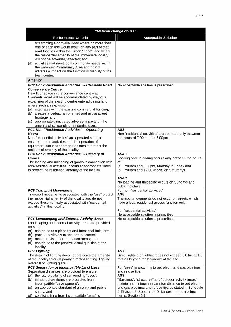
4.2.5
“Material change of use”
Performance Criteria Acceptable Solution site fronting Goonyella Road where no more than one of each use would result on any part of that road that lies within the Urban “Zone”, and where the residential amenity of the immediate locality will not be adversely affected; and
(d) activities that meet local community needs within the Emerging Community Area and do not adversely impact on the function or viability of the town centre.
Amenity PC2 Non-“Residential Activities” – Clements Road Convenience Centre New floor space in the convenience centre at Clements Road will be accommodated by way of a expansion of the existing centre onto adjoining land, where such an expansion: (a) integrates with the existing commercial building; (b) creates a pedestrian oriented and active street
frontage; and (c) appropriately mitigates adverse impacts on the
amenity of surrounding residential uses.
No acceptable solution is prescribed.
PC3 Non-“Residential Activities” – Operating Hours Non-“residential activities” are operated so as to ensure that the activities and the operation of equipment occur at appropriate times to protect the residential amenity of the locality.
AS3 Non-”residential activities” are operated only between the hours of 7:00am and 6:00pm.
PC4 Non-“Residential Activities” – Delivery of Goods The loading and unloading of goods in connection with non-“residential activities” occurs at appropriate times to protect the residential amenity of the locality.
AS4.1 Loading and unloading occurs only between the hours of: (a) 7:00am and 6:00pm, Monday to Friday and (b) 7:00am and 12:00 (noon) on Saturdays. AS4.2 No loading and unloading occurs on Sundays and public holidays.
PC5 Transport Movements Transport movements associated with the “use” protect the residential amenity of the locality and do not exceed those normally associated with “residential activities” in this locality.
For non-“residential activities”: AS5 Transport movements do not occur on streets which have a local residential access function only. For “residential activities”: No acceptable solution is prescribed.
PC6 Landscaping and External Activity Areas Landscaping and external activity areas are provided on-site to: (a) contribute to a pleasant and functional built form; (b) provide positive sun and breeze control; (c) make provision for recreation areas; and (d) contribute to the positive visual qualities of the
locality.
No acceptable solution is prescribed.
PC7 Lighting The design of lighting does not prejudice the amenity of the locality through poorly directed lighting, lighting overspill or lighting glare.
AS7 Direct lighting or lighting does not exceed 8.0 lux at 1.5 metres beyond the boundary of the site.
PC8 Separation of Incompatible Land Uses Separation distances are provided to ensure: (a) the future viability of surrounding “uses”; (b) infrastructure items are protected from
incompatible “development”; (c) an appropriate standard of amenity and public
safety; and (d) conflict arising from incompatible “uses” is
For “uses” in proximity to petroleum and gas pipelines and refuse tips: AS8 “Buildings”, “structures” and “outdoor activity areas” maintain a minimum separation distance to petroleum and gas pipelines and refuse tips as stated in Schedule 2, Division 5: Separation Distances – Infrastructure Items, Section 5.1.
Part 4 Zones – Urban Zone
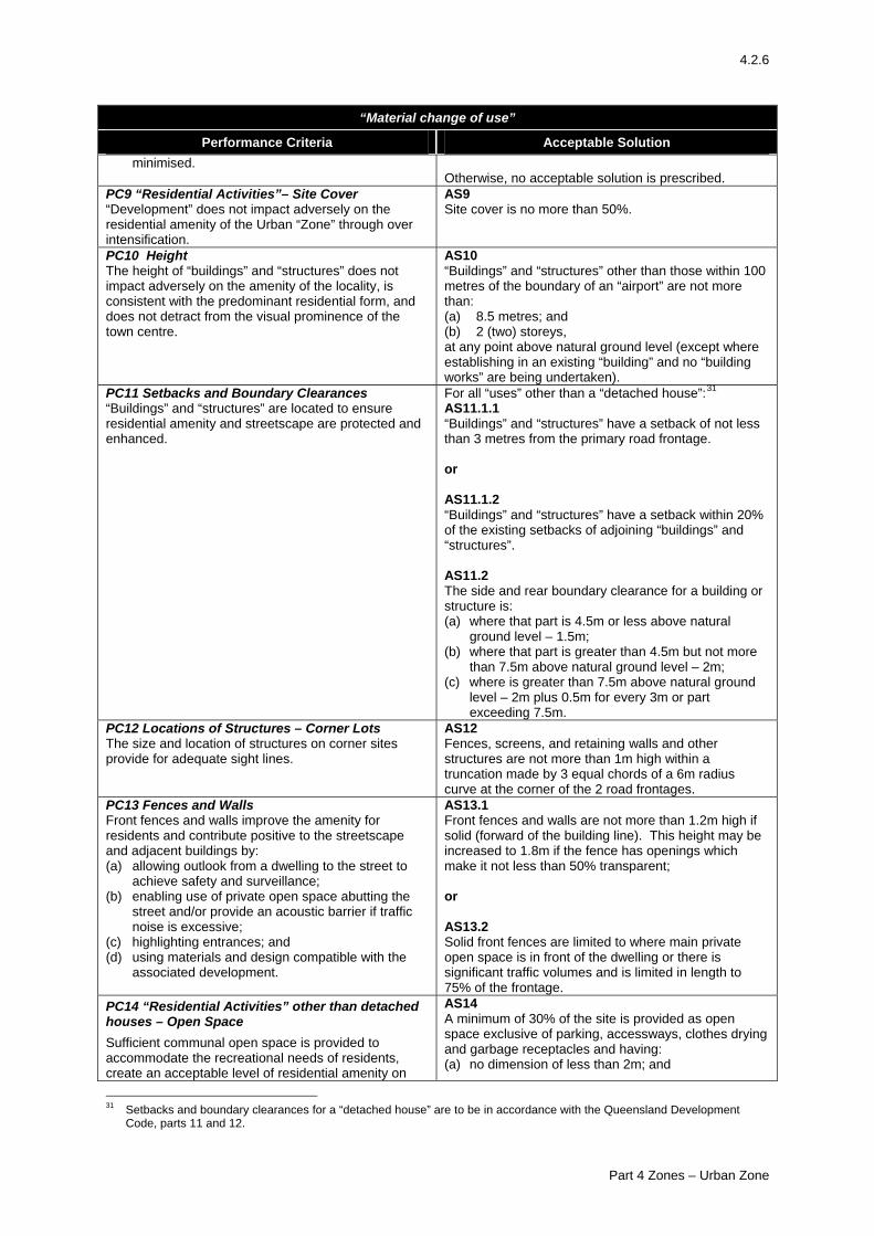
4.2.6
“Material change of use”
Performance Criteria Acceptable Solution minimised.
Otherwise, no acceptable solution is prescribed. PC9 “Residential Activities”– Site Cover “Development” does not impact adversely on the residential amenity of the Urban “Zone” through over intensification.
AS9 Site cover is no more than 50%.
PC10 Height The height of “buildings” and “structures” does not impact adversely on the amenity of the locality, is consistent with the predominant residential form, and does not detract from the visual prominence of the town centre.
AS10 “Buildings” and “structures” other than those within 100 metres of the boundary of an “airport” are not more than: (a) 8.5 metres; and (b) 2 (two) storeys, at any point above natural ground level (except where establishing in an existing “building” and no “building works” are being undertaken).
PC11 Setbacks and Boundary Clearances “Buildings” and “structures” are located to ensure residential amenity and streetscape are protected and enhanced.
For all “uses” other than a “detached house”:31 AS11.1.1 “Buildings” and “structures” have a setback of not less than 3 metres from the primary road frontage. or AS11.1.2 “Buildings” and “structures” have a setback within 20% of the existing setbacks of adjoining “buildings” and “structures”. AS11.2 The side and rear boundary clearance for a building or structure is: (a) where that part is 4.5m or less above natural
ground level – 1.5m; (b) where that part is greater than 4.5m but not more
than 7.5m above natural ground level – 2m; (c) where is greater than 7.5m above natural ground
level – 2m plus 0.5m for every 3m or part exceeding 7.5m.
PC12 Locations of Structures – Corner Lots The size and location of structures on corner sites provide for adequate sight lines.
AS12 Fences, screens, and retaining walls and other structures are not more than 1m high within a truncation made by 3 equal chords of a 6m radius curve at the corner of the 2 road frontages.
PC13 Fences and Walls Front fences and walls improve the amenity for residents and contribute positive to the streetscape and adjacent buildings by: (a) allowing outlook from a dwelling to the street to
achieve safety and surveillance; (b) enabling use of private open space abutting the
street and/or provide an acoustic barrier if traffic noise is excessive;
(c) highlighting entrances; and (d) using materials and design compatible with the
associated development.
AS13.1 Front fences and walls are not more than 1.2m high if solid (forward of the building line). This height may be increased to 1.8m if the fence has openings which make it not less than 50% transparent; or AS13.2 Solid front fences are limited to where main private open space is in front of the dwelling or there is significant traffic volumes and is limited in length to 75% of the frontage.
PC14 “Residential Activities” other than detached houses – Open Space Sufficient communal open space is provided to accommodate the recreational needs of residents, create an acceptable level of residential amenity on
AS14 A minimum of 30% of the site is provided as open space exclusive of parking, accessways, clothes drying and garbage receptacles and having: (a) no dimension of less than 2m; and
31 Setbacks and boundary clearances for a “detached house” are to be in accordance with the Queensland Development
Code, parts 11 and 12.
Part 4 Zones – Urban Zone
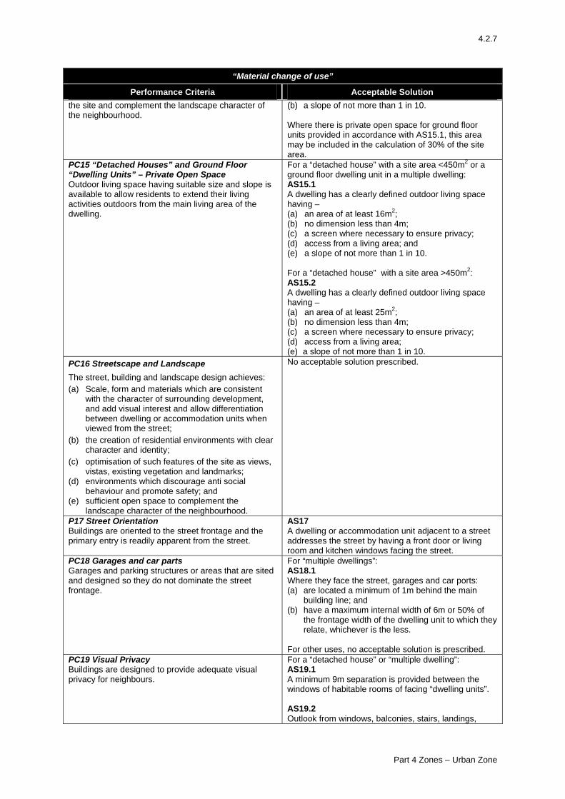
4.2.7
“Material change of use”
Performance Criteria Acceptable Solution the site and complement the landscape character of the neighbourhood.
(b) a slope of not more than 1 in 10. Where there is private open space for ground floor units provided in accordance with AS15.1, this area may be included in the calculation of 30% of the site area.
PC15 “Detached Houses” and Ground Floor “Dwelling Units” – Private Open Space Outdoor living space having suitable size and slope is available to allow residents to extend their living activities outdoors from the main living area of the dwelling.
For a “detached house” with a site area <450m2 or a ground floor dwelling unit in a multiple dwelling: AS15.1 A dwelling has a clearly defined outdoor living space having – (a) an area of at least 16m2; (b) no dimension less than 4m; (c) a screen where necessary to ensure privacy; (d) access from a living area; and (e) a slope of not more than 1 in 10. For a “detached house” with a site area >450m2: AS15.2 A dwelling has a clearly defined outdoor living space having – (a) an area of at least 25m2; (b) no dimension less than 4m; (c) a screen where necessary to ensure privacy; (d) access from a living area; (e) a slope of not more than 1 in 10.
PC16 Streetscape and Landscape The street, building and landscape design achieves: (a) Scale, form and materials which are consistent
with the character of surrounding development, and add visual interest and allow differentiation between dwelling or accommodation units when viewed from the street;
(b) the creation of residential environments with clear character and identity;
(c) optimisation of such features of the site as views, vistas, existing vegetation and landmarks;
(d) environments which discourage anti social behaviour and promote safety; and
(e) sufficient open space to complement the landscape character of the neighbourhood.
No acceptable solution prescribed.
P17 Street Orientation Buildings are oriented to the street frontage and the primary entry is readily apparent from the street.
AS17 A dwelling or accommodation unit adjacent to a street addresses the street by having a front door or living room and kitchen windows facing the street.
PC18 Garages and car parts Garages and parking structures or areas that are sited and designed so they do not dominate the street frontage.
For “multiple dwellings”: AS18.1 Where they face the street, garages and car ports: (a) are located a minimum of 1m behind the main
building line; and (b) have a maximum internal width of 6m or 50% of
the frontage width of the dwelling unit to which they relate, whichever is the less.
For other uses, no acceptable solution is prescribed.
PC19 Visual Privacy Buildings are designed to provide adequate visual privacy for neighbours.
For a “detached house” or “multiple dwelling”: AS19.1 A minimum 9m separation is provided between the windows of habitable rooms of facing “dwelling units”. AS19.2 Outlook from windows, balconies, stairs, landings,
Part 4 Zones – Urban Zone
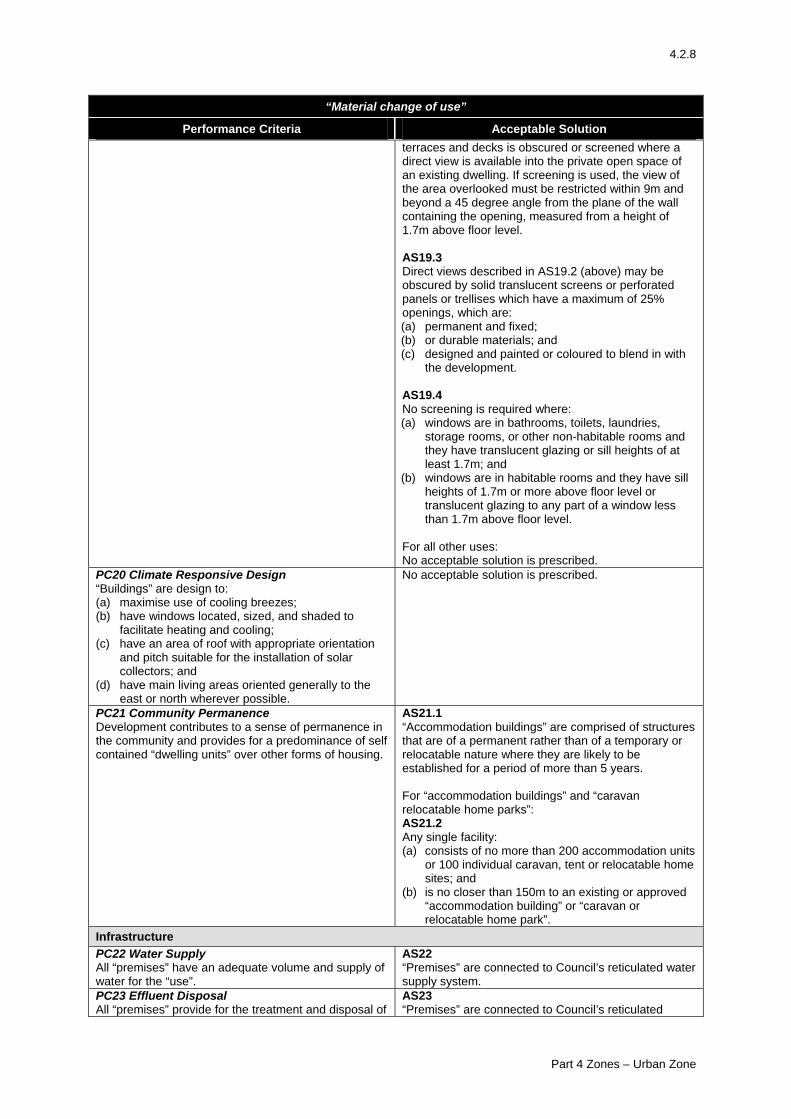
4.2.8
“Material change of use”
Performance Criteria Acceptable Solution terraces and decks is obscured or screened where a direct view is available into the private open space of an existing dwelling. If screening is used, the view of the area overlooked must be restricted within 9m and beyond a 45 degree angle from the plane of the wall containing the opening, measured from a height of 1.7m above floor level. AS19.3 Direct views described in AS19.2 (above) may be obscured by solid translucent screens or perforated panels or trellises which have a maximum of 25% openings, which are: (a) permanent and fixed; (b) or durable materials; and (c) designed and painted or coloured to blend in with
the development. AS19.4 No screening is required where: (a) windows are in bathrooms, toilets, laundries,
storage rooms, or other non-habitable rooms and they have translucent glazing or sill heights of at least 1.7m; and
(b) windows are in habitable rooms and they have sill heights of 1.7m or more above floor level or translucent glazing to any part of a window less than 1.7m above floor level.
For all other uses: No acceptable solution is prescribed.
PC20 Climate Responsive Design “Buildings” are design to: (a) maximise use of cooling breezes; (b) have windows located, sized, and shaded to
facilitate heating and cooling; (c) have an area of roof with appropriate orientation
and pitch suitable for the installation of solar collectors; and
(d) have main living areas oriented generally to the east or north wherever possible.
No acceptable solution is prescribed.
PC21 Community Permanence Development contributes to a sense of permanence in the community and provides for a predominance of self contained “dwelling units” over other forms of housing.
AS21.1 “Accommodation buildings” are comprised of structures that are of a permanent rather than of a temporary or relocatable nature where they are likely to be established for a period of more than 5 years. For “accommodation buildings” and “caravan relocatable home parks”: AS21.2 Any single facility: (a) consists of no more than 200 accommodation units
or 100 individual caravan, tent or relocatable home sites; and
(b) is no closer than 150m to an existing or approved “accommodation building” or “caravan or relocatable home park”.
Infrastructure PC22 Water Supply All “premises” have an adequate volume and supply of water for the “use”.
AS22 “Premises” are connected to Council’s reticulated water supply system.
PC23 Effluent Disposal All “premises” provide for the treatment and disposal of
AS23 “Premises” are connected to Council’s reticulated
Part 4 Zones – Urban Zone
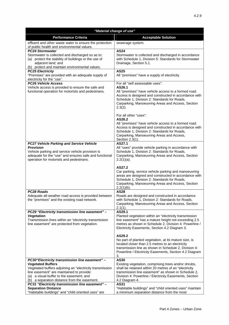
4.2.9
“Material change of use”
Performance Criteria Acceptable Solution effluent and other waste water to ensure the protection of public health and environmental values.
sewerage system.
PC24 Stormwater Stormwater is collected and discharged so as to: (a) protect the stability of buildings or the use of
adjacent land; and (b) protect and maintain environmental values.
AS24 Stormwater is collected and discharged in accordance with Schedule 1, Division 5: Standards for Stormwater Drainage, Section 5.1.
PC25 Electricity “Premises” are provided with an adequate supply of electricity for the “use”.
AS25 All “premises” have a supply of electricity.
PC26 Vehicle Access Vehicle access is provided to ensure the safe and functional operation for motorists and pedestrians.
For all “self assessable uses”: AS26.1 All “premises” have vehicle access to a formed road. Access is designed and constructed in accordance with Schedule 1, Division 2: Standards for Roads, Carparking, Manoeuvring Areas and Access, Section 2.3(2). For all other “uses”: AS26.2 All “premises” have vehicle access to a formed road. Access is designed and constructed in accordance with Schedule 1, Division 2: Standards for Roads, Carparking, Manoeuvring Areas and Access, Section 2.3(1).
PC27 Vehicle Parking and Service Vehicle Provision Vehicle parking and service vehicle provision is adequate for the “use” and ensures safe and functional operation for motorists and pedestrians.
AS27.1 All “uses” provide vehicle parking in accordance with Schedule 1, Division 2: Standards for Roads, Carparking, Manoeuvring Areas and Access, Section 2.2(1)(a). AS27.2 Car parking, service vehicle parking and manoeuvring areas are designed and constructed in accordance with Schedule 1, Division 2: Standards for Roads, Carparking, Manoeuvring Areas and Access, Section 2.2(1)(b).
PC28 Roads Adequate all-weather road access is provided between the “premises” and the existing road network.
AS28 Roads are designed and constructed in accordance with Schedule 1, Division 2: Standards for Roads, Carparking, Manoeuvring Areas and Access, Section 2.1(1).
PC29 “Electricity transmission line easement” – Vegetation Transmission lines within an “electricity transmission line easement” are protected from vegetation.
AS29.1 Planted vegetation within an “electricity transmission line easement” has a mature height not exceeding 2.5 metres as shown in Schedule 2, Division 4: Powerline / Electricity Easements, Section 4.2 Diagram 3. AS29.2 No part of planted vegetation, at its mature size, is located closer than 2.5 metres to an electricity transmission line as shown in Schedule 2, Division 4: Powerline / Electricity Easements, Section 4.2 Diagram 3.
PC30“Electricity transmission line easement” – Vegetated Buffers Vegetated buffers adjoining an “electricity transmission line easement” are maintained to provide: (a) a visual buffer to the easement; and (b) a separation distance from the easement.
AS30 Existing vegetation, comprising trees and/or shrubs, shall be retained within 20 metres of an “electricity transmission line easement” as shown in Schedule 2, Division 4: Powerline / Electricity Easements, Section 4.2 Diagram 4.
PC31 “Electricity transmission line easement” – Separation Distance “Habitable buildings” and “child oriented uses” are
AS31 “Habitable buildings” and “child oriented uses” maintain a minimum separation distance from the most
Part 4 Zones – Urban Zone
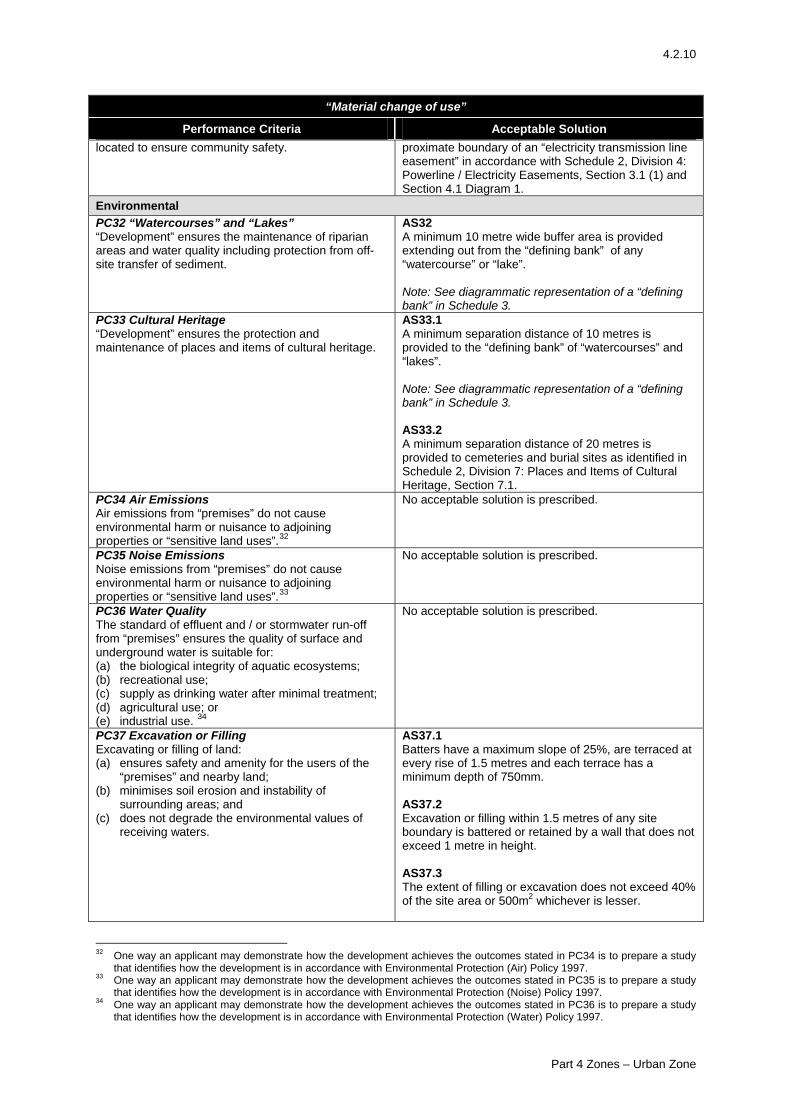
4.2.10
“Material change of use”
Performance Criteria Acceptable Solution located to ensure community safety. proximate boundary of an “electricity transmission line
easement” in accordance with Schedule 2, Division 4: Powerline / Electricity Easements, Section 3.1 (1) and Section 4.1 Diagram 1.
Environmental PC32 “Watercourses” and “Lakes” “Development” ensures the maintenance of riparian areas and water quality including protection from off-site transfer of sediment.
AS32 A minimum 10 metre wide buffer area is provided extending out from the “defining bank” of any “watercourse” or “lake”. Note: See diagrammatic representation of a “defining bank” in Schedule 3.
PC33 Cultural Heritage “Development” ensures the protection and maintenance of places and items of cultural heritage.
AS33.1 A minimum separation distance of 10 metres is provided to the “defining bank” of “watercourses” and “lakes”. Note: See diagrammatic representation of a “defining bank” in Schedule 3. AS33.2 A minimum separation distance of 20 metres is provided to cemeteries and burial sites as identified in Schedule 2, Division 7: Places and Items of Cultural Heritage, Section 7.1.
PC34 Air Emissions Air emissions from “premises” do not cause environmental harm or nuisance to adjoining properties or “sensitive land uses”.32
No acceptable solution is prescribed.
PC35 Noise Emissions Noise emissions from “premises” do not cause environmental harm or nuisance to adjoining properties or “sensitive land uses”.33
No acceptable solution is prescribed.
PC36 Water Quality The standard of effluent and / or stormwater run-off from “premises” ensures the quality of surface and underground water is suitable for: (a) the biological integrity of aquatic ecosystems; (b) recreational use; (c) supply as drinking water after minimal treatment; (d) agricultural use; or (e) industrial use. 34
No acceptable solution is prescribed.
PC37 Excavation or Filling Excavating or filling of land: (a) ensures safety and amenity for the users of the
“premises” and nearby land; (b) minimises soil erosion and instability of
surrounding areas; and (c) does not degrade the environmental values of
receiving waters.
AS37.1 Batters have a maximum slope of 25%, are terraced at every rise of 1.5 metres and each terrace has a minimum depth of 750mm. AS37.2 Excavation or filling within 1.5 metres of any site boundary is battered or retained by a wall that does not exceed 1 metre in height. AS37.3 The extent of filling or excavation does not exceed 40% of the site area or 500m2 whichever is lesser.
32 One way an applicant may demonstrate how the development achieves the outcomes stated in PC34 is to prepare a study
that identifies how the development is in accordance with Environmental Protection (Air) Policy 1997. 33 One way an applicant may demonstrate how the development achieves the outcomes stated in PC35 is to prepare a study
that identifies how the development is in accordance with Environmental Protection (Noise) Policy 1997. 34 One way an applicant may demonstrate how the development achieves the outcomes stated in PC36 is to prepare a study
that identifies how the development is in accordance with Environmental Protection (Water) Policy 1997.
Part 4 Zones – Urban Zone
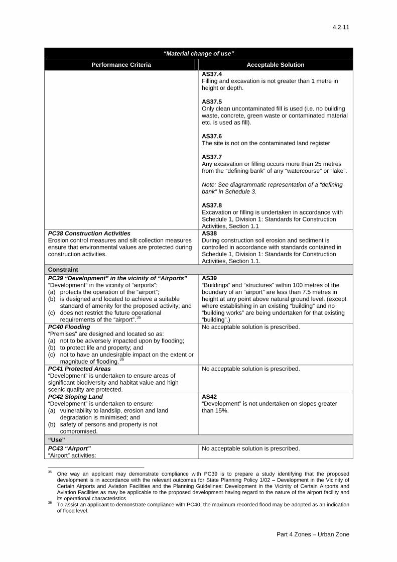
4.2.11
“Material change of use”
Performance Criteria Acceptable Solution AS37.4 Filling and excavation is not greater than 1 metre in height or depth. AS37.5 Only clean uncontaminated fill is used (i.e. no building waste, concrete, green waste or contaminated material etc. is used as fill). AS37.6 The site is not on the contaminated land register AS37.7 Any excavation or filling occurs more than 25 metres from the “defining bank” of any “watercourse” or “lake”. Note: See diagrammatic representation of a “defining bank” in Schedule 3. AS37.8 Excavation or filling is undertaken in accordance with Schedule 1, Division 1: Standards for Construction Activities, Section 1.1
PC38 Construction Activities Erosion control measures and silt collection measures ensure that environmental values are protected during construction activities.
AS38 During construction soil erosion and sediment is controlled in accordance with standards contained in Schedule 1, Division 1: Standards for Construction Activities, Section 1.1.
Constraint PC39 “Development” in the vicinity of “Airports” “Development” in the vicinity of “airports”: (a) protects the operation of the “airport”; (b) is designed and located to achieve a suitable
standard of amenity for the proposed activity; and (c) does not restrict the future operational
requirements of the “airport”.35
AS39 “Buildings” and “structures” within 100 metres of the boundary of an “airport” are less than 7.5 metres in height at any point above natural ground level. (except where establishing in an existing “building” and no “building works” are being undertaken for that existing “building”.)
PC40 Flooding “Premises” are designed and located so as: (a) not to be adversely impacted upon by flooding; (b) to protect life and property; and (c) not to have an undesirable impact on the extent or
magnitude of flooding.36
No acceptable solution is prescribed.
PC41 Protected Areas “Development” is undertaken to ensure areas of significant biodiversity and habitat value and high scenic quality are protected.
No acceptable solution is prescribed.
PC42 Sloping Land “Development” is undertaken to ensure: (a) vulnerability to landslip, erosion and land
degradation is minimised; and (b) safety of persons and property is not
compromised.
AS42 “Development” is not undertaken on slopes greater than 15%.
“Use” PC43 “Airport” “Airport” activities:
No acceptable solution is prescribed.
35 One way an applicant may demonstrate compliance with PC39 is to prepare a study identifying that the proposed
development is in accordance with the relevant outcomes for State Planning Policy 1/02 – Development in the Vicinity of Certain Airports and Aviation Facilities and the Planning Guidelines: Development in the Vicinity of Certain Airports and Aviation Facilities as may be applicable to the proposed development having regard to the nature of the airport facility and its operational characteristics
36 To assist an applicant to demonstrate compliance with PC40, the maximum recorded flood may be adopted as an indication of flood level.
Part 4 Zones – Urban Zone
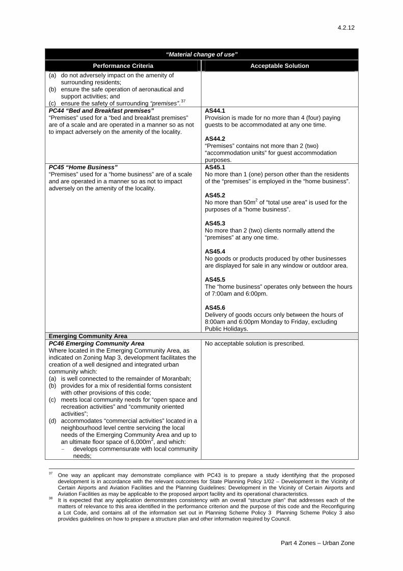
4.2.12
“Material change of use”
Performance Criteria Acceptable Solution (a) do not adversely impact on the amenity of
surrounding residents; (b) ensure the safe operation of aeronautical and
support activities; and (c) ensure the safety of surrounding “premises”.37
PC44 “Bed and Breakfast premises” “Premises” used for a “bed and breakfast premises” are of a scale and are operated in a manner so as not to impact adversely on the amenity of the locality.
AS44.1 Provision is made for no more than 4 (four) paying guests to be accommodated at any one time. AS44.2 “Premises” contains not more than 2 (two) “accommodation units” for guest accommodation purposes.
PC45 “Home Business” “Premises” used for a “home business” are of a scale and are operated in a manner so as not to impact adversely on the amenity of the locality.
AS45.1 No more than 1 (one) person other than the residents of the “premises” is employed in the “home business”. AS45.2 No more than 50m2 of “total use area” is used for the purposes of a “home business”. AS45.3 No more than 2 (two) clients normally attend the “premises” at any one time. AS45.4 No goods or products produced by other businesses are displayed for sale in any window or outdoor area. AS45.5 The “home business” operates only between the hours of 7:00am and 6:00pm. AS45.6 Delivery of goods occurs only between the hours of 8:00am and 6:00pm Monday to Friday, excluding Public Holidays.
Emerging Community Area PC46 Emerging Community Area Where located in the Emerging Community Area, as indicated on Zoning Map 3, development facilitates the creation of a well designed and integrated urban community which: (a) is well connected to the remainder of Moranbah; (b) provides for a mix of residential forms consistent
with other provisions of this code; (c) meets local community needs for “open space and
recreation activities” and “community oriented activities”;
(d) accommodates “commercial activities” located in a neighbourhood level centre servicing the local needs of the Emerging Community Area and up to an ultimate floor space of 6,000m2, and which: - develops commensurate with local community
needs;
No acceptable solution is prescribed.
37 One way an applicant may demonstrate compliance with PC43 is to prepare a study identifying that the proposed
development is in accordance with the relevant outcomes for State Planning Policy 1/02 – Development in the Vicinity of Certain Airports and Aviation Facilities and the Planning Guidelines: Development in the Vicinity of Certain Airports and Aviation Facilities as may be applicable to the proposed airport facility and its operational characteristics.
38 It is expected that any application demonstrates consistency with an overall “structure plan” that addresses each of the matters of relevance to this area identified in the performance criterion and the purpose of this code and the Reconfiguring a Lot Code, and contains all of the information set out in Planning Scheme Policy 3 Planning Scheme Policy 3 also provides guidelines on how to prepare a structure plan and other information required by Council.
Part 4 Zones – Urban Zone
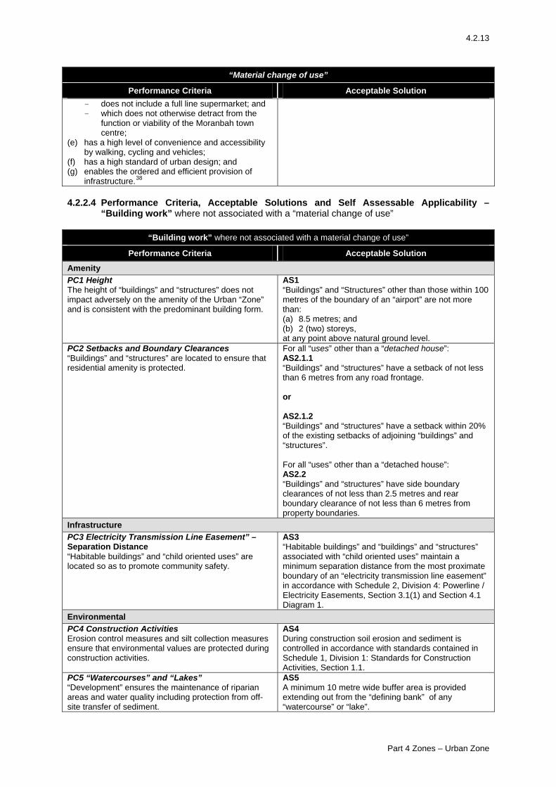
4.2.13
“Material change of use”
Performance Criteria Acceptable Solution - does not include a full line supermarket; and - which does not otherwise detract from the
function or viability of the Moranbah town centre;
(e) has a high level of convenience and accessibility by walking, cycling and vehicles;
(f) has a high standard of urban design; and (g) enables the ordered and efficient provision of
infrastructure.38
4.2.2.4 Performance Criteria, Acceptable Solutions and Self Assessable Applicability –
“Building work” where not associated with a “material change of use”
“Building work” where not associated with a material change of use”
Performance Criteria Acceptable Solution
Amenity PC1 Height The height of “buildings” and “structures” does not impact adversely on the amenity of the Urban “Zone” and is consistent with the predominant building form.
AS1 “Buildings” and “Structures” other than those within 100 metres of the boundary of an “airport” are not more than: (a) 8.5 metres; and (b) 2 (two) storeys, at any point above natural ground level.
PC2 Setbacks and Boundary Clearances “Buildings” and “structures” are located to ensure that residential amenity is protected.
For all “uses” other than a “detached house”: AS2.1.1 “Buildings” and “structures” have a setback of not less than 6 metres from any road frontage. or AS2.1.2 “Buildings” and “structures” have a setback within 20% of the existing setbacks of adjoining “buildings” and “structures”. For all “uses” other than a “detached house”: AS2.2 “Buildings” and “structures” have side boundary clearances of not less than 2.5 metres and rear boundary clearance of not less than 6 metres from property boundaries.
Infrastructure PC3 Electricity Transmission Line Easement” – Separation Distance “Habitable buildings” and “child oriented uses” are located so as to promote community safety.
AS3 “Habitable buildings” and “buildings” and “structures” associated with “child oriented uses” maintain a minimum separation distance from the most proximate boundary of an “electricity transmission line easement” in accordance with Schedule 2, Division 4: Powerline / Electricity Easements, Section 3.1(1) and Section 4.1 Diagram 1.
Environmental PC4 Construction Activities Erosion control measures and silt collection measures ensure that environmental values are protected during construction activities.
AS4 During construction soil erosion and sediment is controlled in accordance with standards contained in Schedule 1, Division 1: Standards for Construction Activities, Section 1.1.
PC5 “Watercourses” and “Lakes” “Development” ensures the maintenance of riparian areas and water quality including protection from off-site transfer of sediment.
AS5 A minimum 10 metre wide buffer area is provided extending out from the “defining bank” of any “watercourse” or “lake”.
Part 4 Zones – Urban Zone
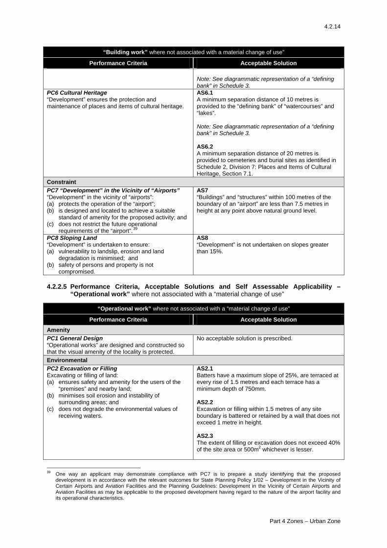
4.2.14
“Building work” where not associated with a material change of use”
Performance Criteria Acceptable Solution Note: See diagrammatic representation of a “defining bank” in Schedule 3.
PC6 Cultural Heritage “Development” ensures the protection and maintenance of places and items of cultural heritage.
AS6.1 A minimum separation distance of 10 metres is provided to the “defining bank” of “watercourses” and “lakes”. Note: See diagrammatic representation of a “defining bank” in Schedule 3. AS6.2 A minimum separation distance of 20 metres is provided to cemeteries and burial sites as identified in Schedule 2, Division 7: Places and Items of Cultural Heritage, Section 7.1.
Constraint PC7 “Development” in the Vicinity of “Airports” “Development” in the vicinity of “airports”: (a) protects the operation of the “airport”; (b) is designed and located to achieve a suitable
standard of amenity for the proposed activity; and (c) does not restrict the future operational
requirements of the “airport”.39
AS7 “Buildings” and “structures” within 100 metres of the boundary of an “airport” are less than 7.5 metres in height at any point above natural ground level.
PC8 Sloping Land “Development” is undertaken to ensure: (a) vulnerability to landslip, erosion and land
degradation is minimised; and (b) safety of persons and property is not
compromised.
AS8 “Development” is not undertaken on slopes greater than 15%.
4.2.2.5 Performance Criteria, Acceptable Solutions and Self Assessable Applicability –
“Operational work” where not associated with a “material change of use”
“Operational work” where not associated with a “material change of use”
Performance Criteria Acceptable Solution
Amenity PC1 General Design “Operational works” are designed and constructed so that the visual amenity of the locality is protected.
No acceptable solution is prescribed.
Environmental PC2 Excavation or Filling Excavating or filling of land: (a) ensures safety and amenity for the users of the
“premises” and nearby land; (b) minimises soil erosion and instability of
surrounding areas; and (c) does not degrade the environmental values of
receiving waters.
AS2.1 Batters have a maximum slope of 25%, are terraced at every rise of 1.5 metres and each terrace has a minimum depth of 750mm. AS2.2 Excavation or filling within 1.5 metres of any site boundary is battered or retained by a wall that does not exceed 1 metre in height. AS2.3 The extent of filling or excavation does not exceed 40% of the site area or 500m2 whichever is lesser.
39 One way an applicant may demonstrate compliance with PC7 is to prepare a study identifying that the proposed
development is in accordance with the relevant outcomes for State Planning Policy 1/02 – Development in the Vicinity of Certain Airports and Aviation Facilities and the Planning Guidelines: Development in the Vicinity of Certain Airports and Aviation Facilities as may be applicable to the proposed development having regard to the nature of the airport facility and its operational characteristics.
Part 4 Zones – Urban Zone
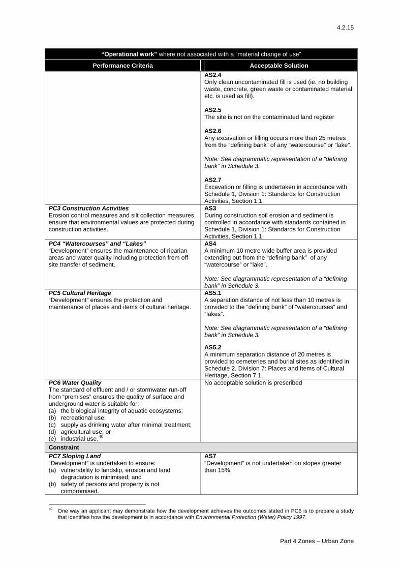
4.2.15
“Operational work” where not associated with a “material change of use”
Performance Criteria Acceptable Solution AS2.4 Only clean uncontaminated fill is used (ie. no building waste, concrete, green waste or contaminated material etc. is used as fill). AS2.5 The site is not on the contaminated land register AS2.6 Any excavation or filling occurs more than 25 metres from the “defining bank” of any “watercourse” or “lake”. Note: See diagrammatic representation of a “defining bank” in Schedule 3. AS2.7 Excavation or filling is undertaken in accordance with Schedule 1, Division 1: Standards for Construction Activities, Section 1.1.
PC3 Construction Activities Erosion control measures and silt collection measures ensure that environmental values are protected during construction activities.
AS3 During construction soil erosion and sediment is controlled in accordance with standards contained in Schedule 1, Division 1: Standards for Construction Activities, Section 1.1.
PC4 “Watercourses” and “Lakes” “Development” ensures the maintenance of riparian areas and water quality including protection from off-site transfer of sediment.
AS4 A minimum 10 metre wide buffer area is provided extending out from the “defining bank” of any “watercourse” or “lake”. Note: See diagrammatic representation of a “defining bank” in Schedule 3.
PC5 Cultural Heritage “Development” ensures the protection and maintenance of places and items of cultural heritage.
AS5.1 A separation distance of not less than 10 metres is provided to the “defining bank” of “watercourses” and “lakes”. Note: See diagrammatic representation of a “defining bank” in Schedule 3. AS5.2 A minimum separation distance of 20 metres is provided to cemeteries and burial sites as identified in Schedule 2, Division 7: Places and Items of Cultural Heritage, Section 7.1.
PC6 Water Quality The standard of effluent and / or stormwater run-off from “premises” ensures the quality of surface and underground water is suitable for: (a) the biological integrity of aquatic ecosystems; (b) recreational use; (c) supply as drinking water after minimal treatment; (d) agricultural use; or (e) industrial use.40
No acceptable solution is prescribed
Constraint PC7 Sloping Land “Development” is undertaken to ensure: (a) vulnerability to landslip, erosion and land
degradation is minimised; and (b) safety of persons and property is not
compromised.
AS7 “Development” is not undertaken on slopes greater than 15%.
40 One way an applicant may demonstrate how the development achieves the outcomes stated in PC6 is to prepare a study
that identifies how the development is in accordance with Environmental Protection (Water) Policy 1997.
Part 4 Zones – Urban Zone
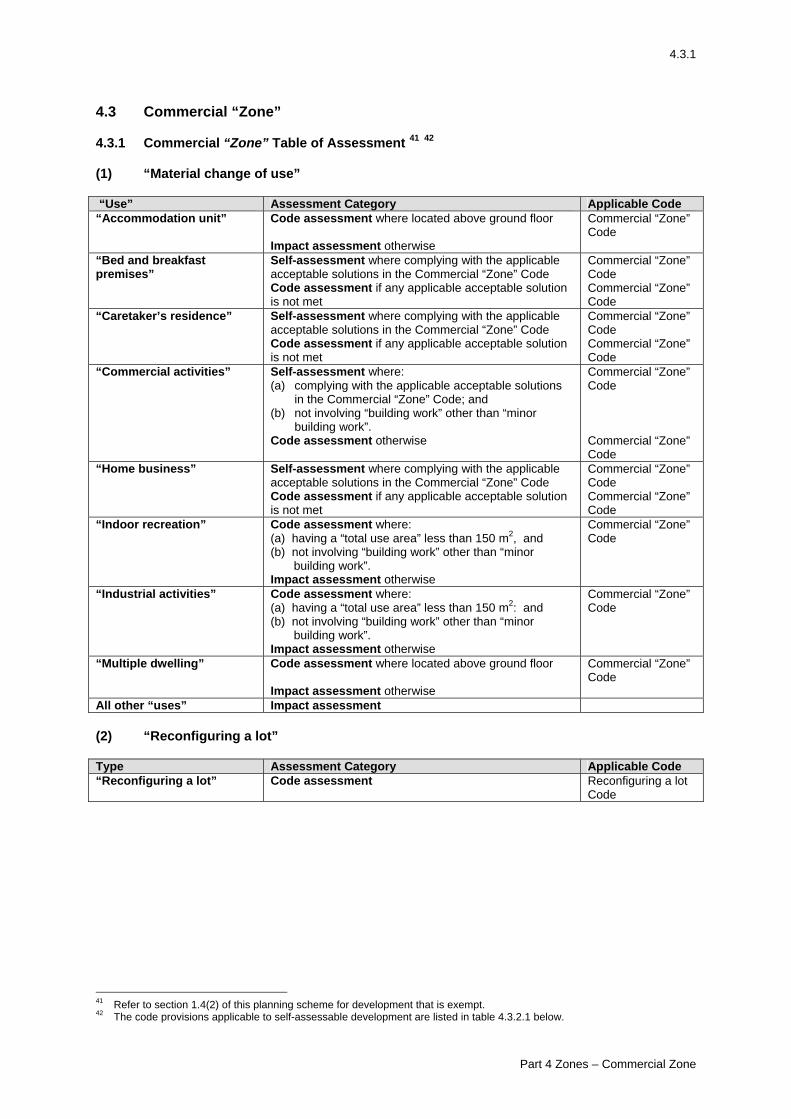
4.3.1
4.3 Commercial “Zone” 4.3.1 Commercial “Zone” Table of Assessment 41 42 (1) “Material change of use” “Use” Assessment Category Applicable Code “Accommodation unit” Code assessment where located above ground floor
Impact assessment otherwise
Commercial “Zone” Code
“Bed and breakfast premises”
Self-assessment where complying with the applicable acceptable solutions in the Commercial “Zone” Code Code assessment if any applicable acceptable solution is not met
Commercial “Zone” Code Commercial “Zone” Code
“Caretaker’s residence”
Self-assessment where complying with the applicable acceptable solutions in the Commercial “Zone” Code Code assessment if any applicable acceptable solution is not met
Commercial “Zone” Code Commercial “Zone” Code
“Commercial activities”
Self-assessment where: (a) complying with the applicable acceptable solutions
in the Commercial “Zone” Code; and (b) not involving “building work” other than “minor
building work”. Code assessment otherwise
Commercial “Zone” Code Commercial “Zone” Code
“Home business”
Self-assessment where complying with the applicable acceptable solutions in the Commercial “Zone” Code Code assessment if any applicable acceptable solution is not met
Commercial “Zone” Code Commercial “Zone” Code
“Indoor recreation” Code assessment where: (a) having a “total use area” less than 150 m2, and (b) not involving “building work” other than “minor
building work”. Impact assessment otherwise
Commercial “Zone” Code
“Industrial activities”
Code assessment where: (a) having a “total use area” less than 150 m2: and (b) not involving “building work” other than “minor
building work”. Impact assessment otherwise
Commercial “Zone” Code
“Multiple dwelling” Code assessment where located above ground floor Impact assessment otherwise
Commercial “Zone” Code
All other “uses” Impact assessment (2) “Reconfiguring a lot” Type Assessment Category Applicable Code “Reconfiguring a lot”
Code assessment Reconfiguring a lot Code
41 Refer to section 1.4(2) of this planning scheme for development that is exempt. 42 The code provisions applicable to self-assessable development are listed in table 4.3.2.1 below.
Part 4 Zones – Commercial Zone
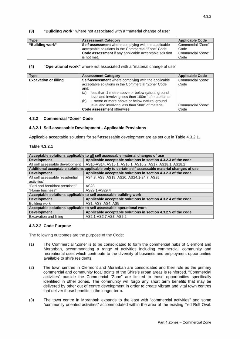
4.3.2
(3) “Building work” where not associated with a “material change of use” Type Assessment Category Applicable Code “Building work”
Self-assessment where complying with the applicable acceptable solutions in the Commercial “Zone” Code Code assessment if any applicable acceptable solution is not met.
Commercial “Zone” Code Commercial “Zone” Code
(4) “Operational work” where not associated with a “material change of use” Type Assessment Category Applicable Code Excavation or filling
Self-assessment where complying with the applicable acceptable solutions in the Commercial “Zone” Code and: (a) less than 1 metre above or below natural ground
level and involving less than 100m3 of material; or (b) 1 metre or more above or below natural ground
level and involving less than 50m3 of material. Code assessment otherwise
Commercial “Zone” Code Commercial “Zone” Code
4.3.2 Commercial “Zone” Code 4.3.2.1 Self-assessable Development - Applicable Provisions Applicable acceptable solutions for self-assessable development are as set out in Table 4.3.2.1. Table 4.3.2.1 Acceptable solutions applicable to all self assessable material changes of use Development Applicable acceptable solutions in section 4.3.2.3 of the code All self assessable development AS10-AS14, AS15.1, AS16.1, AS16.2, AS17, AS18.1, AS18.2 Additional acceptable solutions applicable only to certain self assessable material changes of use Development Applicable acceptable solutions in section 4.3.2.3 of the code All self assessable “residential activities”
AS4.3, AS8, AS19, AS20, AS24.1-24.7. AS25
“Bed and breakfast premises” AS28 “Home business” AS29.1-AS29.4 Acceptable solutions applicable to self assessable building work Development Applicable acceptable solutions in section 4.3.2.4 of the code Building work AS1, AS3, AS4, AS5 Acceptable solutions applicable to self assessable operational work Development Applicable acceptable solutions in section 4.3.2.5 of the code Excavation and filling AS2.1-AS2.7,AS3, AS5.2 4.3.2.2 Code Purpose The following outcomes are the purpose of the Code: (1) The Commercial “Zone” is to be consolidated to form the commercial hubs of Clermont and
Moranbah, accommodating a range of activities including commercial, community and recreational uses which contribute to the diversity of business and employment opportunities available to shire residents.
(2) The town centres in Clermont and Moranbah are consolidated and their role as the primary
commercial and community focal points of the Shire’s urban areas is reinforced. “Commercial activities” outside the Commercial “Zone” are limited to those opportunities specifically identified in other zones. The community will forgo any short term benefits that may be delivered by other out of centre development in order to create vibrant and vital town centres that deliver those benefits in the longer term.
(3) The town centre in Moranbah expands to the east with “commercial activities” and some
“community oriented activities” accommodated within the area of the existing Ted Rolf Oval.
Part 4 Zones – Commercial Zone
4.3.3
However, commercial and retail floorspace only increases at a rate commensurate with population growth and community needs. Oversupply of retail or other commercial space which creates undue economic or social impacts is avoided.
(4) Within the Commercial “Zone”, “development”:
(a) contributes to identifiable, vibrant, compact commercial and community cores in Moranbah and Clermont;
(b) is located, designed and operated in a manner that protects and enhances commercial scale, intensity, form and character;
(c) reinforces the walkability of the centre and contributes to a pedestrian friendly environment;
(d) in Moranbah, promotes vehicular circulation around the perimeter of the centre rather than through the central parts of the centre;
(e) in Moranbah, contributes to the desired structure of the town centre, consisting of major retail anchors at the Ted Rolf Oval site and at (or integrated with) the Moranbah Fair site, linked by active frontages and pedestrian friendly environments along St Francis Drive, Griffin Street, Town Square Avenue and Batchelor Parade;
(f) in Moranbah, development on the Ted Rolf Oval site: - has its primary pedestrian entrance and main building areas oriented towards and
located close to the Council building and the town square precinct, in a way that creates a public space which contributes to the activity and coherence of that precinct;
- effectively engages with the nearby community centre to the west and community recreational facilities to the north;
- has car parking, vehicular access and servicing areas located in the southern and eastern parts of the site, with appropriate screening from nearby residential areas, and providing flexibility to accommodate future commercial or mixed use activities along the external street frontages;
(g) in Moranbah, development on the Moranbah Fair site and land surrounding it provides active street frontages and orientate building, car parking and servicing create a visual and physical connection to the balance of the town centre, particularly those areas to the east;
(h) maintains the environment, including soil, air and water compatible with healthy natural systems and public health and safety;
(i) has an appropriately designed access to the road network and traffic generated by the development does not impact adversely on the local road network;
(j) protects areas and sites of cultural and high landscape values; (k) is undertaken in an orderly and logical sequence to achieve an efficient provision of
infrastructure, including social infrastructure; (l) is located and designed in ways that minimise the need for flood and landslide
mitigation, and to protect people and premises from such natural events; (m) has water supply, stormwater disposal, sustainable effluent and waste disposal and
power, to appropriate standards, adequate for the “use”; and (n) does not impact adversely on infrastructure.
(5) Within the Commercial “Zone”, the following are appropriate “uses”:
(a) “commercial activities”, “community oriented activities”, and “indoor recreation”; (b) “residential activities”, other than “caravan or relocatable home parks” and “detached
houses” where they are located above ground floor “commercial activities” (c) “tourist facilities”, where they are compatible with the urban form of the town centre and
will contribute to the vitality of the centre; and (d) “industrial activities”, where they are of a small scale and provide a direct service to the
general public and are compatible with the amenity and urban form of the town centre.
Part 4 Zones – Commercial Zone
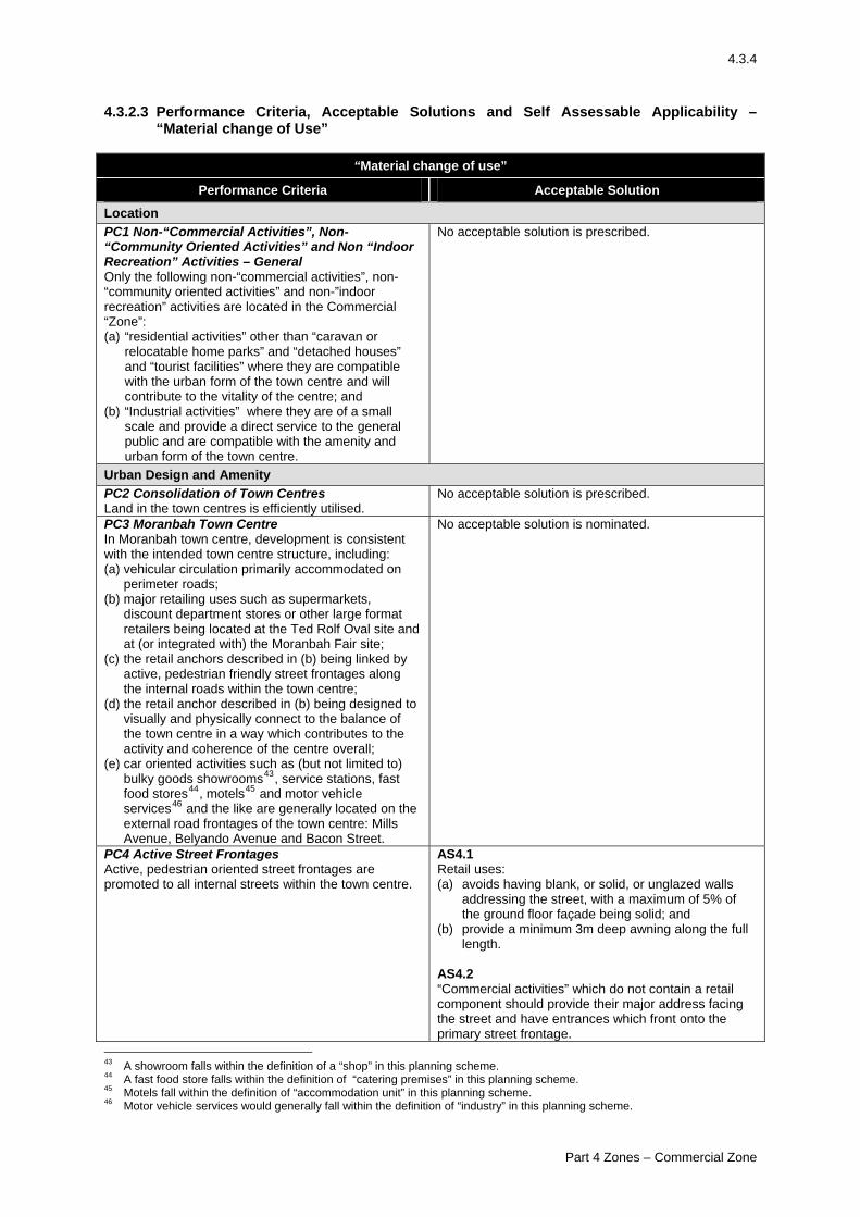
4.3.4
4.3.2.3 Performance Criteria, Acceptable Solutions and Self Assessable Applicability – “Material change of Use”
“Material change of use”
Performance Criteria Acceptable Solution
Location PC1 Non-“Commercial Activities”, Non-“Community Oriented Activities” and Non “Indoor Recreation” Activities – General Only the following non-“commercial activities”, non- “community oriented activities” and non-”indoor recreation” activities are located in the Commercial “Zone”: (a) “residential activities” other than “caravan or
relocatable home parks” and “detached houses” and “tourist facilities” where they are compatible with the urban form of the town centre and will contribute to the vitality of the centre; and
(b) “Industrial activities” where they are of a small scale and provide a direct service to the general public and are compatible with the amenity and urban form of the town centre.
No acceptable solution is prescribed.
Urban Design and Amenity PC2 Consolidation of Town Centres Land in the town centres is efficiently utilised.
No acceptable solution is prescribed.
PC3 Moranbah Town Centre In Moranbah town centre, development is consistent with the intended town centre structure, including: (a) vehicular circulation primarily accommodated on
perimeter roads; (b) major retailing uses such as supermarkets,
discount department stores or other large format retailers being located at the Ted Rolf Oval site and at (or integrated with) the Moranbah Fair site;
(c) the retail anchors described in (b) being linked by active, pedestrian friendly street frontages along the internal roads within the town centre;
(d) the retail anchor described in (b) being designed to visually and physically connect to the balance of the town centre in a way which contributes to the activity and coherence of the centre overall;
(e) car oriented activities such as (but not limited to) bulky goods showrooms43, service stations, fast food stores44, motels45 and motor vehicle services46 and the like are generally located on theexternal road frontages of the town centre: Mills Avenue, Belyando Avenue and Bacon
Street.
No acceptable solution is nominated.
PC4 Active Street Frontages Active, pedestrian oriented street frontages are promoted to all internal streets within the town centre.
AS4.1 Retail uses: (a) avoids having blank, or solid, or unglazed walls
addressing the street, with a maximum of 5% of the ground floor façade being solid; and
(b) provide a minimum 3m deep awning along the full length.
AS4.2 “Commercial activities” which do not contain a retail component should provide their major address facing the street and have entrances which front onto the primary street frontage.
43 A showroom falls within the definition of a “shop” in this planning scheme. 44 A fast food store falls within the definition of “catering premises” in this planning scheme. 45 Motels fall within the definition of “accommodation unit” in this planning scheme. 46 Motor vehicle services would generally fall within the definition of “industry” in this planning scheme.
Part 4 Zones – Commercial Zone
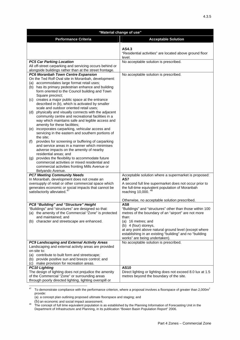
4.3.5
“Material change of use”
Performance Criteria Acceptable Solution AS4.3 “Residential activities” are located above ground floor level.
PC5 Car Parking Location All off-street carparking and servicing occurs behind or alongside buildings rather than at the street frontage.
No acceptable solution is prescribed.
PC6 Moranbah Town Centre Expansion On the Ted Rolf Oval site in Moranbah, development: (a) accommodates large format retail uses; (b) has its primary pedestrian enhance and building
form oriented to the Council building and Town Square precinct;
(c) creates a major public space at the entrance described in (b), which is activated by smaller scale and outdoor oriented retail uses;
(d) physically and visually connects with the adjacent community centre and recreational facilities in a way which maintains safe and legible access and amenity for these facilities;
(e) incorporates carparking, vehicular access and servicing in the eastern and southern portions of the site;
(f) provides for screening or buffering of carparking and service areas in a manner which minimises adverse impacts on the amenity of nearby residential areas; and
(g) provides the flexibility to accommodate future commercial activities or mixed residential and commercial activities fronting Mills Avenue or Belyando Avenue.
No acceptable solution is prescribed.
PC7 Meeting Community Needs In Moranbah, development does not create an oversupply of retail or other commercial space which generates economic or social impacts that cannot be satisfactorily alleviated.47
Acceptable solution where a supermarket is proposed: AS7 A second full line supermarket does not occur prior to the full-time equivalent population of Moranbah reaching 10,000. 48 Otherwise, no acceptable solution prescribed.
PC8 “Building” and “Structure” Height “Buildings” and “structures” are designed so that: (a) the amenity of the Commercial “Zone” is protected
and maintained; and (b) character and streetscape are enhanced.
AS8 “Buildings” and “structures” other than those within 100 metres of the boundary of an “airport” are not more than: (a) 16 metres; and (b) 4 (four) storeys, at any point above natural ground level (except where establishing in an existing “building” and no “building works” are being undertaken).
PC9 Landscaping and External Activity Areas Landscaping and external activity areas are provided on-site to: (a) contribute to built form and streetscape; (b) provide positive sun and breeze control; and (c) make provision for recreation areas.
No acceptable solution is prescribed.
PC10 Lighting The design of lighting does not prejudice the amenity of the Commercial “Zone” or surrounding areas through poorly directed lighting, lighting overspill or
AS10 Direct lighting or lighting does not exceed 8.0 lux at 1.5 metres beyond the boundary of the site.
47 To demonstrate compliance with the performance criterion, where a proposal involves a floorspace of greater than 2,000m2
provide: (a) a concept plan outlining proposed ultimate floorspace and staging; and (b) an economic and social impact assessment.
48 The concept of full time equivalent population is as established by the Planning Information of Forecasting Unit in the Department of Infrastructure and Planning, in its publication “Bowen Basin Population Report” 2006.
Part 4 Zones – Commercial Zone
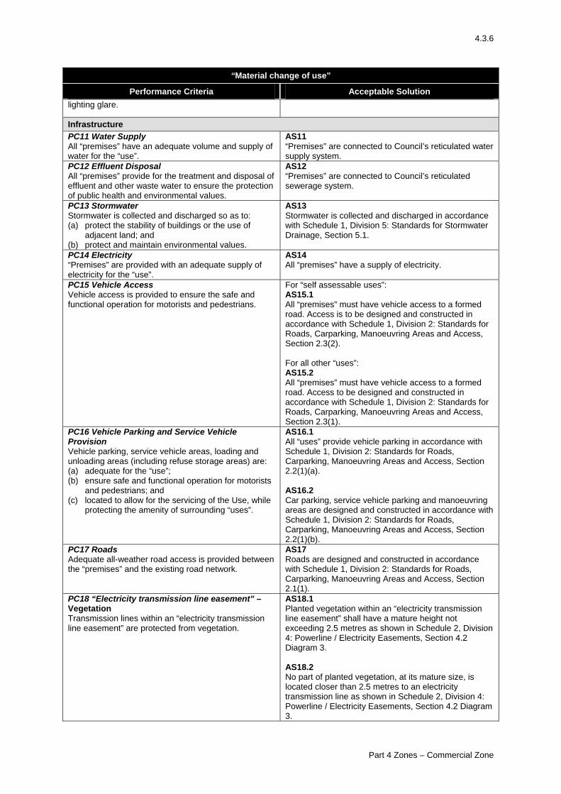
4.3.6
“Material change of use”
Performance Criteria Acceptable Solution lighting glare.
Infrastructure PC11 Water Supply All “premises” have an adequate volume and supply of water for the “use”.
AS11 “Premises” are connected to Council’s reticulated water supply system.
PC12 Effluent Disposal All “premises” provide for the treatment and disposal of effluent and other waste water to ensure the protection of public health and environmental values.
AS12 “Premises” are connected to Council’s reticulated sewerage system.
PC13 Stormwater Stormwater is collected and discharged so as to: (a) protect the stability of buildings or the use of
adjacent land; and (b) protect and maintain environmental values.
AS13 Stormwater is collected and discharged in accordance with Schedule 1, Division 5: Standards for Stormwater Drainage, Section 5.1.
PC14 Electricity “Premises” are provided with an adequate supply of electricity for the “use”.
AS14 All “premises” have a supply of electricity.
PC15 Vehicle Access Vehicle access is provided to ensure the safe and functional operation for motorists and pedestrians.
For “self assessable uses”: AS15.1 All “premises” must have vehicle access to a formed road. Access is to be designed and constructed in accordance with Schedule 1, Division 2: Standards for Roads, Carparking, Manoeuvring Areas and Access, Section 2.3(2). For all other “uses”: AS15.2 All “premises” must have vehicle access to a formed road. Access to be designed and constructed in accordance with Schedule 1, Division 2: Standards for Roads, Carparking, Manoeuvring Areas and Access, Section 2.3(1).
PC16 Vehicle Parking and Service Vehicle Provision Vehicle parking, service vehicle areas, loading and unloading areas (including refuse storage areas) are: (a) adequate for the “use”; (b) ensure safe and functional operation for motorists
and pedestrians; and (c) located to allow for the servicing of the Use, while
protecting the amenity of surrounding “uses”.
AS16.1 All “uses” provide vehicle parking in accordance with Schedule 1, Division 2: Standards for Roads, Carparking, Manoeuvring Areas and Access, Section 2.2(1)(a). AS16.2 Car parking, service vehicle parking and manoeuvring areas are designed and constructed in accordance with Schedule 1, Division 2: Standards for Roads, Carparking, Manoeuvring Areas and Access, Section 2.2(1)(b).
PC17 Roads Adequate all-weather road access is provided between the “premises” and the existing road network.
AS17 Roads are designed and constructed in accordance with Schedule 1, Division 2: Standards for Roads, Carparking, Manoeuvring Areas and Access, Section 2.1(1).
PC18 “Electricity transmission line easement” – Vegetation Transmission lines within an “electricity transmission line easement” are protected from vegetation.
AS18.1 Planted vegetation within an “electricity transmission line easement” shall have a mature height not exceeding 2.5 metres as shown in Schedule 2, Division 4: Powerline / Electricity Easements, Section 4.2 Diagram 3. AS18.2 No part of planted vegetation, at its mature size, is located closer than 2.5 metres to an electricity transmission line as shown in Schedule 2, Division 4: Powerline / Electricity Easements, Section 4.2 Diagram 3.
Part 4 Zones – Commercial Zone
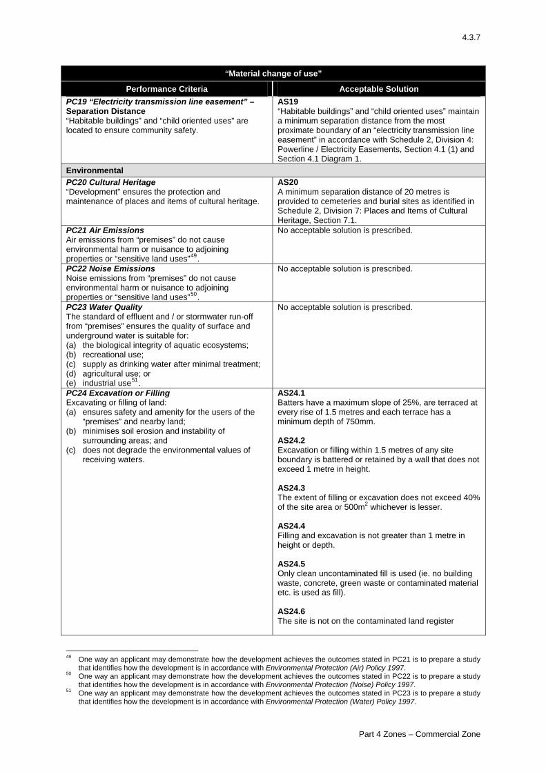
4.3.7
“Material change of use”
Performance Criteria Acceptable Solution PC19 “Electricity transmission line easement” – Separation Distance “Habitable buildings” and “child oriented uses” are located to ensure community safety.
AS19 “Habitable buildings” and “child oriented uses” maintain a minimum separation distance from the most proximate boundary of an “electricity transmission line easement” in accordance with Schedule 2, Division 4: Powerline / Electricity Easements, Section 4.1 (1) and Section 4.1 Diagram 1.
Environmental PC20 Cultural Heritage “Development” ensures the protection and maintenance of places and items of cultural heritage.
AS20 A minimum separation distance of 20 metres is provided to cemeteries and burial sites as identified in Schedule 2, Division 7: Places and Items of Cultural Heritage, Section 7.1.
PC21 Air Emissions Air emissions from “premises” do not cause environmental harm or nuisance to adjoining properties or “sensitive land uses”49.
No acceptable solution is prescribed.
PC22 Noise Emissions Noise emissions from “premises” do not cause environmental harm or nuisance to adjoining properties or “sensitive land uses”50.
No acceptable solution is prescribed.
PC23 Water Quality The standard of effluent and / or stormwater run-off from “premises” ensures the quality of surface and underground water is suitable for: (a) the biological integrity of aquatic ecosystems; (b) recreational use; (c) supply as drinking water after minimal treatment; (d) agricultural use; or (e) industrial use51.
No acceptable solution is prescribed.
PC24 Excavation or Filling Excavating or filling of land: (a) ensures safety and amenity for the users of the
“premises” and nearby land; (b) minimises soil erosion and instability of
surrounding areas; and (c) does not degrade the environmental values of
receiving waters.
AS24.1 Batters have a maximum slope of 25%, are terraced at every rise of 1.5 metres and each terrace has a minimum depth of 750mm. AS24.2 Excavation or filling within 1.5 metres of any site boundary is battered or retained by a wall that does not exceed 1 metre in height. AS24.3 The extent of filling or excavation does not exceed 40% of the site area or 500m2 whichever is lesser. AS24.4 Filling and excavation is not greater than 1 metre in height or depth. AS24.5 Only clean uncontaminated fill is used (ie. no building waste, concrete, green waste or contaminated material etc. is used as fill). AS24.6 The site is not on the contaminated land register
49 One way an applicant may demonstrate how the development achieves the outcomes stated in PC21 is to prepare a study
that identifies how the development is in accordance with Environmental Protection (Air) Policy 1997. 50 One way an applicant may demonstrate how the development achieves the outcomes stated in PC22 is to prepare a study
that identifies how the development is in accordance with Environmental Protection (Noise) Policy 1997. 51 One way an applicant may demonstrate how the development achieves the outcomes stated in PC23 is to prepare a study
that identifies how the development is in accordance with Environmental Protection (Water) Policy 1997.
Part 4 Zones – Commercial Zone
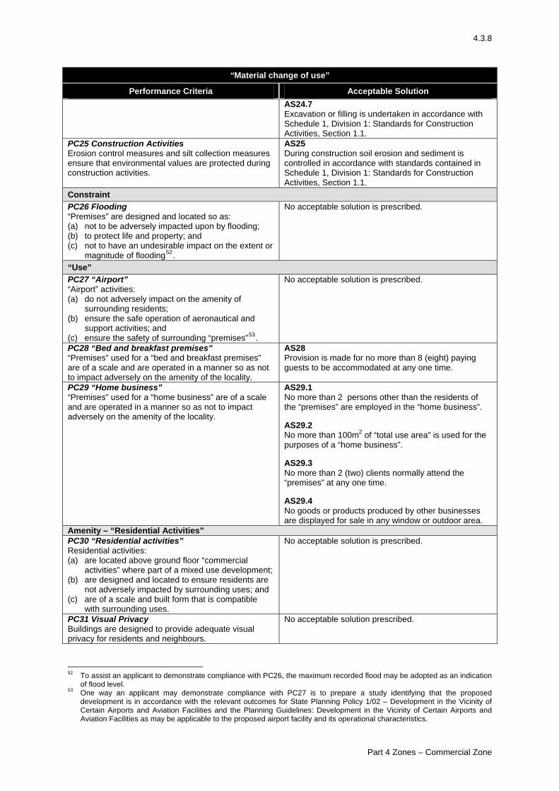
4.3.8
“Material change of use”
Performance Criteria Acceptable Solution AS24.7 Excavation or filling is undertaken in accordance with Schedule 1, Division 1: Standards for Construction Activities, Section 1.1.
PC25 Construction Activities Erosion control measures and silt collection measures ensure that environmental values are protected during construction activities.
AS25 During construction soil erosion and sediment is controlled in accordance with standards contained in Schedule 1, Division 1: Standards for Construction Activities, Section 1.1.
Constraint PC26 Flooding “Premises” are designed and located so as: (a) not to be adversely impacted upon by flooding; (b) to protect life and property; and (c) not to have an undesirable impact on the extent or
magnitude of flooding52.
No acceptable solution is prescribed.
“Use” PC27 “Airport” “Airport” activities: (a) do not adversely impact on the amenity of
surrounding residents; (b) ensure the safe operation of aeronautical and
support activities; and (c) ensure the safety of surrounding “premises”53.
No acceptable solution is prescribed.
PC28 “Bed and breakfast premises” “Premises” used for a “bed and breakfast premises” are of a scale and are operated in a manner so as not to impact adversely on the amenity of the locality.
AS28 Provision is made for no more than 8 (eight) paying guests to be accommodated at any one time.
PC29 “Home business” “Premises” used for a “home business” are of a scale and are operated in a manner so as not to impact adversely on the amenity of the locality.
AS29.1 No more than 2 persons other than the residents of the “premises” are employed in the “home business”. AS29.2 No more than 100m2 of “total use area” is used for the purposes of a “home business”. AS29.3 No more than 2 (two) clients normally attend the “premises” at any one time. AS29.4 No goods or products produced by other businesses are displayed for sale in any window or outdoor area.
Amenity – “Residential Activities” PC30 “Residential activities” Residential activities: (a) are located above ground floor “commercial
activities” where part of a mixed use development; (b) are designed and located to ensure residents are
not adversely impacted by surrounding uses; and (c) are of a scale and built form that is compatible
with surrounding uses.
No acceptable solution is prescribed.
PC31 Visual Privacy Buildings are designed to provide adequate visual privacy for residents and neighbours.
No acceptable solution prescribed.
52 To assist an applicant to demonstrate compliance with PC26, the maximum recorded flood may be adopted as an indication
of flood level. 53 One way an applicant may demonstrate compliance with PC27 is to prepare a study identifying that the proposed
development is in accordance with the relevant outcomes for State Planning Policy 1/02 – Development in the Vicinity of Certain Airports and Aviation Facilities and the Planning Guidelines: Development in the Vicinity of Certain Airports and Aviation Facilities as may be applicable to the proposed airport facility and its operational characteristics.
Part 4 Zones – Commercial Zone
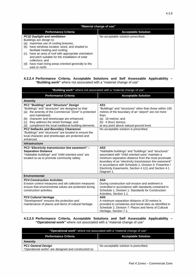
4.3.9
“Material change of use”
Performance Criteria Acceptable Solution PC32 Daylight and ventilation Buildings are design to: (a) maximise use of cooling breezes; (b) have windows located, sized, and shaded to
facilitate heating and cooling; (c) have an area of roof with appropriate orientation
and pitch suitable for the installation of solar collectors; and
(d) have main living areas oriented generally to the east or north.
No acceptable solution prescribed.
4.3.2.4 Performance Criteria, Acceptable Solutions and Self Assessable Applicability –
“Building work” where not associated with a “material change of use”
“Building work” where not associated with a “material change of use”
Performance Criteria Acceptable Solution
Amenity PC1 “Building” and “Structure” Design “Buildings” and “structures” are designed so that: (a) the amenity of the Commercial “Zone” is protected
and maintained; (b) character and streetscape are enhanced; (c) they address the street frontage; and (d) compliment the local traditional building elements.
AS1 “Buildings” and “structures” other than those within 100 metres of the boundary of an “airport” are not more than: (a) 16 metres; and (b) 4 (four) storeys, at any point above natural ground level.
PC2 Setbacks and Boundary Clearances “Buildings” and “structures” are located to ensure the local character and streetscape are protected and enhanced.
No acceptable solution is prescribed.
Infrastructure PC3 “Electricity transmission line easement” – Separation Distance “Habitable buildings” and “child oriented uses” are located so as to promote community safety.
AS3 “Habitable buildings” and “buildings” and “structures” associated with “child oriented uses” maintain a minimum separation distance from the most proximate boundary of an “electricity transmission line easement” in accordance with Schedule 2, Division 4: Powerline / Electricity Easements, Section 4.1(1) and Section 4.1 Diagram 1.
Environmental PC4 Construction Activities Erosion control measures and silt collection measures ensure that environmental values are protected during construction activities.
AS4 During construction soil erosion and sediment is controlled in accordance with standards contained in Schedule 1, Division 1: Standards for Construction Activities, Section 1.1.
PC5 Cultural Heritage “Development” ensures the protection and maintenance of places and items of cultural heritage.
AS5 A minimum separation distance of 20 metres is provided to cemeteries and burial sites as identified in Schedule 2, Division 7: Places and Items of Cultural Heritage, Section 7.1.
4.3.2.5 Performance Criteria, Acceptable Solutions and Self Assessable Applicability –
“Operational work” where not associated with a “material change of use”
“Operational work” where not associated with a “material change of use”
Performance Criteria Acceptable Solution
Amenity PC1 General Design “Operational works” are designed and constructed so
No acceptable solution is prescribed.
Part 4 Zones – Commercial Zone
4.3.10
“Operational work” where not associated with a “material change of use”
Performance Criteria Acceptable Solution that the visual amenity and streetscape of the Commercial “Zone” is protected. Environmental PC2 Excavation or Filling Excavating or filling of land: (a) ensures safety and amenity for the users of the
“premises” and nearby land; (b) minimises soil erosion and instability of
surrounding areas; and (c) does not degrade the environmental values of
receiving waters.
AS2.1 Batters have a maximum slope of 25%, are terraced at every rise of 1.5 metres and each terrace has a minimum depth of 750mm. AS2.2 Excavation or filling within 1.5 metres of any site boundary is battered or retained by a wall that does not exceed 1 metre in height. AS2.3 The extent of filling or excavation does not exceed 40% of the site area or 500m2 whichever is lesser. AS2.4 Only clean uncontaminated fill is used (i.e. no building waste, concrete, green waste or contaminated material etc. is used as fill). AS2.5 The site is not on the contaminated land register. AS2.6 Any excavation or filling occurs more than 25 metres from the “defining bank” of any “watercourse” or “lake”. Note: See diagrammatic representation of a “defining bank” in Schedule 3. AS2.7 Excavation or filling is undertaken in accordance with Schedule 1, Division 1: Standards for Construction Activities, Section 1.1.The site is not on the contaminated land register.
PC3 Construction Activities Erosion control measures and silt collection measures ensure that environmental values are protected during construction activities.
AS3 During construction soil erosion and sediment is controlled in accordance with standards contained in Schedule 1, Division 1: Standards for Construction Activities, Section 1.1.
PC4 Cultural Heritage “Development” ensures the protection and maintenance of places and items of cultural heritage.
AS4 A minimum separation distance of 20 metres is provided to cemeteries and burial sites as identified in Schedule 2, Division 7: Places and Items of Cultural Heritage, Section 7.1.
PC6 Water Quality The standard of effluent and / or stormwater run-off from “premises” ensures the quality of surface and underground water is suitable for: (a) the biological integrity of aquatic ecosystems; (b) recreational use; (c) supply as drinking water after minimal treatment; (d) agricultural use; or (e) industrial use54.
No acceptable solution is prescribed.
54 One way an applicant may demonstrate how the development achieves the outcomes stated in PC6 is to prepare a study
that identifies how the development is in accordance with Environmental Protection (Water) Policy 1997.
Part 4 Zones – Commercial Zone
4.4.1
4.4 Industrial “Zone” 4.4.1 Industrial “Zone” Table of Assessment 55 56 (1) “Material change of use” “Use” Assessment Category Applicable Code “Caretaker’s residence”
Self-assessment where complying with the applicable acceptable solutions in the Industrial “Zone” Code Code assessment if any applicable acceptable solution is not met
Industrial “Zone” Code Industrial “Zone” Code
“Commercial premises” where involving a change of use from an existing commercial premises or shop
Code assessment if not involving “building work” other than “minor building work” Impact assessment otherwise
Industrial “Zone” Code
“Industrial activities” Code assessment Industrial “Zone” Code
“Public utility” Code assessment Industrial “Zone” Code
“Shop” where involving a change of use from an existing commercial premises or shop
Code assessment if not involving “building work” other than “minor building work” Impact assessment otherwise
Industrial “Zone” Code
All other “uses” Impact assessment (2) “Reconfiguring a lot” Type Assessment Category Applicable Code “Reconfiguring a lot”
Code assessment Reconfiguring a lot Code
(3) “Building work” where not associated with a “Material Change of use” Type Assessment Category Applicable Code “Building work” 57
Self-assessment where complying with the applicable acceptable solutions in the Industrial “Zone” Code Code assessment if any applicable acceptable solution is not met.
Industrial “Zone” Code Industrial “Zone” Code
(4) “Operational work” where not associated with a “Material Change of use” Type Assessment Category Applicable Code Excavation or filling
Self-assessment where complying with the applicable acceptable solutions in the Industrial “Zone” Code and: (a) less than 1 metre above or below natural ground
level and involving less than 100m3 of material; or (b) 1 metre or more above or below natural ground
level and involving less than 50m3 of material. Code assessment otherwise
Industrial “Zone” Code Industrial “Zone” Code
4.4.2 Industrial “Zone” Code 4.4.2.1 Self-assessable Development - Applicable Provisions Applicable acceptable solutions for self-assessable development are as follows in Table 4.4.2.1: Table 4.4.2.1 55 Refer to section 1.4(2) of this planning scheme for building work that is exempt development 56 The code provisions applicable to self-assessable development are listed in table 4.4.2.1 below.
Part 4 Zones – Industrial Zone
4.4.2
Acceptable solutions applicable to self assessable material changes of use Development Applicable acceptable solutions in section 4.2.2.3 of the code “Caretaker’s residence” AS4, AS5.1, AS5.2, AS9, AS10, AS11, AS12, AS13, AS14, AS15.1, AS16,
AS17.1,AS17.2, AS18, AS20.2, AS24.1-AS24.8, AS25, AS26, AS28, AS30 Acceptable solutions applicable to self assessable building work Development Applicable acceptable solutions in section 4.2.2.4 of the code Building work All acceptable solutions except AS5, AS6.1 Acceptable solutions applicable to self assessable operational work Development Applicable acceptable solutions in section 4.2.2.5 of the code Excavation and filling AS2.1-AS2.8, AS3, AS5.2, AS7 4.4.2.2 Code Purpose The following outcomes are the purpose of the Code: (1) The Industrial “Zone” accommodates a wide range of “industrial activities” and “public
utilities”. (2) Within the Industrial “Zone” “industrial activities”:
(a) are consolidated within an identifiable area, so as to ensure other “uses” in the locality are protected from any adverse impacts associated with “industrial activities”; and
(b) are not prejudiced by the intrusion of incompatible “uses”. (3) Within the Industrial “Zone”, “development”:
(a) is located, designed and operated in a manner that maintains the industrial scale, intensity, form and character;
(b) maintains the environment, including soil, air and water compatible with healthy natural systems and public health and safety;
(c) does not prejudice or impact adversely on other “uses” including those within other “zones”;
(d) has an appropriately designed access to the road network, and traffic generated by the development does not impact adversely on the local road network;
(e) protects areas and sites of conservation importance, including cultural and high landscape values;
(f) is undertaken in an orderly and logical sequence to achieve an efficient provision of infrastructure;
(g) is located and designed in ways that minimise the need for flood and landslide mitigation, and to protect people and premises from such natural events;
(h) has water supply, stormwater disposal, sustainable effluent and waste disposal and power, to appropriate standards, adequate for the “use”; and
(i) does not impact adversely on infrastructure. (4) Within the Industrial “Zone”, “commercial premises” or “shop” are appropriate uses where
providing a direct service to industrial activities located within the Industrial “Zone”.
Part 4 Zones – Industrial Zone
4.4.3
4.4.2.3 Performance Criteria, Acceptable Solutions and Self Assessable Applicability – “Material change of Use”
“Material change of use”
Performance Criteria Acceptable Solution
Location PC1 Non-“Industrial activities” – Locational Criteria Uses other than “industrial activities” and “public utilities” are located in the Industrial “Zone” only where: (a) it can be demonstrated those activities are directly
associated with industrial activities and cannot reasonably be established in other more appropriate “zones”; and
(b) those activities do not prejudice the operation of “industrial activities”.
No acceptable solution is prescribed.
Amenity PC2 Protection of Surrounding Areas “Uses” are operated to ensure the amenity of the surrounding areas is protected.
AS2.1 “Uses” are operated only between the hours of 7:00am and 6:00pm. AS2.2 A 1.8 metre high solid screen fence is erected along the full length of any boundary common with land in an Urban, Commercial or Open Space and Recreation “zone”. For “industrial activities” located adjacent to a “sensitive land use”: AS2.3 “Buildings” and “structures” are located not less than 50 metres from the lot boundary which adjoins the use.
PC3 “Total use area” “Development” is of a scale that contributes to the amenity of the Industrial “Zone” and surrounding areas by providing adequate area for landscaping and separation between buildings.
AS3 “Total use area” is no more than 75% of site area.
PC4 Height The height of “buildings” and “structures” does not impact adversely on the amenity of the Industrial “Zone” and surrounding areas.
AS4 “Buildings” and “structures” other than those within 100 metres of the boundary of an “airport” are less than 12 metres in height at any point above natural ground level. (Except where establishing in an existing “building” and no “building works” are being undertaken).
PC5 Setbacks and Boundary Clearances “Buildings” and “structures” are located to ensure the local character and streetscape are protected and enhanced.
AS5.1 “Buildings” and “structures” have a setback of not less than 6 metres from any road frontage. AS5.2 “Buildings” and “structures” have side boundary clearances of not less than 2.5 metres and rear boundary clearance of not less than 6 metres from property boundaries. (Except where establishing in an existing building” and no “building works” are being undertaken for that existing “building”).
PC6 Transport Movements Transport movements associated with the use protect the amenity of surrounding residential areas.
AS6 Transport movements do not occur through residential areas.
PC7 “Building” and “Structure” Design “Buildings” and “structures” are designed so that the amenity of the Industrial “Zone” is maintained and the amenity of surrounding areas is protected.
No acceptable solution is prescribed.
PC8 Landscaping and External Activity Areas Landscaping and external activity areas are provided
No acceptable solution is prescribed.
Part 4 Zones – Industrial Zone
4.4.4
“Material change of use”
Performance Criteria Acceptable Solution on-site to: (a) contribute to built form and streetscape; (b) provide positive sun and breeze control; and (c) make provision for recreation areas. PC9 Lighting The design of lighting does not prejudice the local amenity.
AS9 Direct lighting or lighting does not exceed 8.0 lux at 1.5 metres beyond the boundary of the site.
Infrastructure PC10 Water Supply All “premises” have an adequate volume and supply of water for the “use”.
AS10 “Premises” are connected to Council’s reticulated water supply system.
PC11 Effluent Disposal All “premises” provide for the treatment and disposal of effluent and other waste water to ensure the protection of public health and environmental values.
AS11 “Premises” are connected to Council’s reticulated sewerage system.
PC12 Stormwater Stormwater is collected and discharged so as to: (a) protect the stability of buildings or the use of
adjacent land; and (b) protect and maintain environmental values.
AS12 Stormwater is collected and discharged in accordance with Schedule 1, Division 5: Standards for Stormwater Drainage, Section 5.1.
PC13 Electricity “Premises” are provided with an adequate supply of electricity for the “use”.
AS13 All “premises” have a supply of electricity.
PC14 Vehicle Access Vehicle access is provided to ensure the safe and functional operation for motorists and pedestrians.
AS14 All “premises” must have vehicle access to a formed road. Access to be designed and constructed in accordance with Schedule 1, Division 2: Standards for Roads, Carparking, Manoeuvring Areas and Access, Section 2.3(1).
PC15 Vehicle Parking and Service Vehicle Provision Vehicle parking, service vehicle areas, loading and unloading areas (including refuse storage areas) are: (a) adequate for the “use”; (b) ensure safe and functional operation for motorists
and pedestrians; and (c) located to allow for the servicing of the “use”, while
protecting the amenity of surrounding “uses”.
AS15.1 All “uses” provide vehicle parking in accordance with Schedule 1, Division 2: Standards for Roads, Carparking, Manoeuvring Areas and Access, Section 2.2(1)(a). AS15.2 Car parking, service vehicle parking and manoeuvring areas are designed and constructed in accordance with Schedule 1, Division 2: Standards for Roads, Carparking, Manoeuvring Areas and Access, Section 2.2(1)(b).
PC16 Roads Adequate all-weather road access is provided between the “premises” and the existing road network.
AS16 Roads are designed and constructed in accordance with Schedule 1, Division 2: Standards for Roads, Carparking, Manoeuvring Areas and Access, Section 2.1(1).
PC17 “Electricity Transmission Line Easement” – Vegetation Transmission lines within an “electricity transmission line easement” are protected from vegetation.
AS17.1 Planted vegetation within an “electricity transmission line easement” shall have a mature height not exceeding 2.5 metres as shown in Schedule 2, Division 4: Powerline / Electricity Easements, Section 4.2 Diagram 3. AS17.2 No part of planted vegetation, at its mature size, is located closer than 2.5 metres to an electricity transmission line as shown in Schedule 2, Division 4: Powerline / Electricity Easements, Section 4.2 Diagram 3.
PC18 “Electricity Transmission Line Easement” – Separation Distance “Habitable buildings” and “child oriented uses” are located to ensure community safety.
AS18 “Habitable buildings” and “child oriented uses” maintain a minimum separation distance from the most proximate boundary of an “electricity transmission line
Part 4 Zones – Industrial Zone
4.4.5
“Material change of use”
Performance Criteria Acceptable Solution easement” in accordance with Schedule 2, Division 4: Powerline / Electricity Easements, Section 4.1(1) and Section 4.1 Diagram 1.
Environmental PC19 “Watercourses” and “Lakes” “Development” ensures the maintenance of riparian areas and water quality including protection from off-site transfer of sediment.
AS19 A minimum 10 metre wide buffer area is provided extending out from the “defining bank” of any “watercourse” or “lake”. Note: See diagrammatic representation of a “defining bank” in Schedule 3.
PC20 Cultural Heritage “Development” ensures the protection and maintenance of places and items of cultural heritage.
AS20.1 A minimum separation distance of 10 metres is provided to the “defining bank” of “watercourses” and “lakes”. Note: See diagrammatic representation of a “defining bank” in Schedule 3. AS20.2 A minimum separation distance of 20 metres is provided to cemeteries and burial sites as identified in Schedule 2, Division 7: Places and Items of Cultural Heritage, Section 7.1.
PC21 Air Emissions Air emissions from “premises” do not cause environmental harm or nuisance to adjoining properties or “sensitive land uses”58.
No acceptable solution is prescribed.
PC22 Noise Emissions Noise emissions from “premises” do not cause environmental harm or nuisance to adjoining properties or “sensitive land uses”59.
No acceptable solution is prescribed.
PC23 Water Quality The standard of effluent and / or stormwater run-off from “premises” ensures the quality of surface and underground water is suitable for: (a) the biological integrity of aquatic ecosystems; (b) recreational use; (c) supply as drinking water after minimal treatment; (d) agricultural use; or (e) industrial use 60.
No acceptable solution is prescribed.
PC24 Excavation or Filling Excavating or filling of land: (a) ensures safety and amenity for the users of the
“premises” and nearby land; (b) minimises soil erosion and instability of
surrounding areas; and (c) does not degrade the environmental values of
receiving waters.
AS24.1 Batters have a maximum slope of 25%, are terraced at every rise of 1.5 metres and each terrace has a minimum depth of 750mm. AS24.2 Excavation or filling within 1.5 metres of any site boundary is battered or retained by a wall that does not exceed 1 metre in height. AS24.3 The extent of filling or excavation does not exceed 40% of the site area or 500m2 whichever is lesser. AS24.4
58 One way an applicant may demonstrate how the development achieves the outcomes stated in PC21 is to prepare a study
that identifies how the development is in accordance with Environmental Protection (Air) Policy 1997. 59 One way an applicant may demonstrate how the development achieves the outcomes stated in PC22 is to prepare a study
that identifies how the development is in accordance with Environmental Protection (Noise) Policy 1997. 60 One way an applicant may demonstrate how the development achieves the outcomes stated in PC23 is to prepare a study
that identifies how the development is in accordance with Environmental Protection (Water) Policy 1997.
Part 4 Zones – Industrial Zone
4.4.6
“Material change of use”
Performance Criteria Acceptable Solution Filling and excavation is not greater than 1 metre in height or depth. AS24.5 Only clean uncontaminated fill is used (ie. no building waste, concrete, green waste or contaminated material etc. is used as fill). AS24.6 The site is not on the contaminated land register AS24.7 Any excavation or filling occurs more than 25 metres from the “defining bank” of any “watercourse” or “lake”. Note: See diagrammatic representation of a “defining bank” in Schedule 3. AS24.8 Excavation or filling is undertaken in accordance with Schedule 1, Division 1: Standards for Construction Activities, Section 1.1.
PC25 Construction Activities Erosion control measures and silt collection measures ensure that environmental values are protected during construction activities.
AS25 During construction soil erosion and sediment is controlled in accordance with standards contained in Schedule 1, Division 1: Standards for Construction Activities, Section 1.1.
Constraint PC26 “Development” in the vicinity of “Airports” “Development” in the vicinity of “airports”: (a) protects the operation of the “airport”; (b) is designed and located to achieve a suitable
standard of amenity for the proposed activity; and (c) does not restrict the future operational
requirements of the “airport” 61.
AS26 “Buildings” and “structures” within 100 metres of the boundary of an “airport” are less than 7.5 metres in height at any point above natural ground level. (except where establishing in an existing “building” and no “building works” are being undertaken for that existing “building”.)
PC27 Flooding “Premises” are designed and located so as: (a) not to be adversely impacted upon by flooding; (b) to protect life and property; and (c) not to have an undesirable impact on the extent or
magnitude of flooding62.
No acceptable solution is prescribed.
PC28 Sloping Land “Development” is undertaken to ensure: (a) vulnerability to landslip, erosion and land
degradation is minimised; and (b) safety of persons and property is not
compromised.
AS28 “Development” is not undertaken on slopes greater than 15%.
“Use” PC29 “Airport” “Airport” activities: (a) do not adversely impact on the amenity of
surrounding residents; (b) ensure the safe operation of aeronautical and
support activities; and (c) ensure the safety of surrounding “premises” 63.
No acceptable solution is prescribed.
61 One way an applicant may demonstrate compliance with PC26 is to prepare a study identifying that the proposed
development is in accordance with the relevant outcomes for State Planning Policy 1/02 – Development in the Vicinity of Certain Airports and Aviation Facilities and the Planning Guidelines: Development in the Vicinity of Certain Airports and Aviation Facilities as may be applicable to the proposed development having regard to the nature of the airport facility and its operational characteristics.
62 To assist an applicant to demonstrate compliance with PC27, the maximum recorded flood may be adopted as an indication of flood level.
Part 4 Zones – Industrial Zone
4.4.7
“Material change of use”
Performance Criteria Acceptable Solution PC30 “Caretaker’s Residences” “Caretaker’s residences” are directly associated with the use on the premises and do not compromise the operation of “industrial activities” within the Industrial “Zone”.
AS30 No more than 1 (one) “caretaker's residence” per lot.
4.4.2.4 Performance Criteria, Acceptable Solutions and Self Assessable Applicability –
“Building work” where not associated with a “material change of use”
“Building work” where not associated with a “material change of use”
Performance Criteria Acceptable Solution
Amenity PC1 Height The height of “buildings” and “structures” does not impact adversely on the amenity of the Industrial “Zone” and is consistent with the predominant industrial form.
AS1 “Buildings” and “structures” other than those within 100 metres of the boundary of an “airport” are less than 12 metres in height at any point above natural ground level.
PC2 Setbacks and Boundary Clearances “Buildings” and “structures” are located to ensure the local character and streetscape are protected and enhanced.
AS2.1 “Buildings” and “structures” have a setback of not less than 6 metres from any road frontage. AS2.2 “Buildings” and “structures” have side boundary clearances of not less than 2.5 metres and rear boundary clearance of not less than 6 metres from property boundaries (except where establishing in an existing “building” and no “building works” are being undertaken for that existing “building”).
Infrastructure PC3 “Electricity Transmission Line Easement” – Separation Distance “Habitable buildings” and “child oriented uses” are located so as to promote community safety.
AS3 “Habitable buildings” and “buildings” and “structures” associated with “child oriented uses” maintain a minimum separation distance from the most proximate boundary of an “electricity transmission line easement” in accordance with Schedule 2, Division 4: Powerline / Electricity Easements, Section 4.1(1) and Section 4.1 Diagram 1.
Environmental PC4 Construction Activities Erosion control measures and silt collection measures ensure that environmental values are protected during construction activities.
AS4 During construction soil erosion and sediment is controlled in accordance with standards contained in Schedule 1, Division 1: Standards for Construction Activities, Section 1.1.
PC5 “Watercourses” and “Lakes” “Development” ensures the maintenance of riparian areas and water quality including protection from off-site transfer of sediment.
AS5 A minimum 10 metre wide buffer area is provided extending out from the “defining bank” of any “watercourse” or “lake”. Note: See diagrammatic representation of a “defining bank” in Schedule 3.
PC6 Cultural Heritage “Development” ensures the protection and maintenance of places and items of cultural heritage.
AS6.1 A minimum separation distance of 10 metres is provided to the “defining bank” of “watercourses” and “lakes”. Note: See diagrammatic representation of a “defining
63 One way an applicant may demonstrate compliance with PC29 is to prepare a study identifying that the proposed
development is in accordance with the relevant outcomes for State Planning Policy 1/02 – Development in the Vicinity of Certain Airports and Aviation Facilities and the Planning Guidelines: Planning Development in the Vicinity of Certain Airports and Aviation Facilities as may be applicable to the proposed airport facility and its operational characteristics.
Part 4 Zones – Industrial Zone

4.4.8
“Building work” where not associated with a “material change of use”
Performance Criteria Acceptable Solution bank” in Schedule 3. AS6.2 A minimum separation distance of 20 metres is provided to cemeteries and burial sites as identified in Schedule 2, Division 7: Places and Items of Cultural Heritage, Section 7.1.
Constraint PC7 “Development” in the Vicinity of “Airports” “Development” in the vicinity of “airports”: (a) protects the operation of the “airport”; (b) is designed and located to achieve a suitable
standard of amenity for the proposed activity; and (c) does not restrict the future operational
requirements of the “airport” 64.
AS7 “Buildings” and “structures” within 100 metres of the boundary of an “airport” are less than 7.5 metres in height at any point above natural ground level.
PC8 Sloping Land “Development” is undertaken to ensure: (a) vulnerability to landslip, erosion and land
degradation is minimised; and (b) safety of persons and property is not
compromised.
AS8 “Development” is not undertaken on slopes greater than 15%.
4.4.2.5 Performance Criteria, Acceptable Solutions and Self Assessable Applicability –
Operational work” where not associated with a “material change of use”
“Operational work” where not associated with a “material change of use”
Performance Criteria Acceptable Solution
Amenity PC1 General Design “Operational works” are designed and constructed so that the visual amenity and streetscape of the Industrial “Zone” and surrounding areas are protected.
No acceptable solution is prescribed.
Environmental PC2 Excavation or Filling Excavating or filling of land: (a) ensures safety and amenity for the users of the
“premises” and nearby land; (b) minimises soil erosion and instability of
surrounding areas; and (c) does not degrade the environmental values of
receiving waters.
AS2.1 Batters have a maximum slope of 25%, are terraced at every rise of 1.5 metres and each terrace has a minimum depth of 750mm. AS2.2 Excavation or filling within 1.5 metres of any site boundary is battered or retained by a wall that does not exceed 1 metre in height. AS2.3 The extent of filling or excavation does not exceed 40% of the site area or 500m2 whichever is lesser. AS2.4 Only clean uncontaminated fill is used (ie. no building waste, concrete, green waste or contaminated material etc. is used as fill). AS2.5 The site is not on the contaminated land register
64 One way an applicant may demonstrate compliance with PC7 is to prepare a study identifying that the proposed
development is in accordance with the relevant outcomes for State Planning Policy 1/02 – Development in the Vicinity of Certain Airports and Aviation Facilities and the Planning Guidelines: Development in the Vicinity of Certain Airports and Aviation Facilities as may be applicable to the proposed development having regard to the nature of the airport facility and its operational characteristics.
Part 4 Zones – Industrial Zone
4.4.9
“Operational work” where not associated with a “material change of use”
Performance Criteria Acceptable Solution AS2.6 Any excavation or filling occurs more than 25 metres from the “defining bank” of any “watercourse” or “lake”. Note: See diagrammatic representation of a “defining bank” in Schedule 3. AS2.7 Excavation or filling is undertaken in accordance with Schedule 1, Division 1: Standards for Construction Activities, Section 1.1.
PC3 Construction Activities Erosion control measures and silt collection measures ensure that environmental values are protected during construction activities.
AS3 During construction soil erosion and sediment is controlled in accordance with standards contained in Schedule 1, Division 1: Standards for Construction Activities, Section 1.1.
PC4 “Watercourses” and “Lakes” “Development” ensures the maintenance of riparian areas and water quality including protection from off-site transfer of sediment.
AS4 A minimum 10 metre wide buffer area is provided extending out from the “defining bank” of any “watercourse” or “lake”. Note: See diagrammatic representation of a “defining bank” in Schedule 3.
PC5 Cultural Heritage “Development” ensures the protection and maintenance of places and items of cultural heritage.
AS5.1 A separation distance of not less than 10 metres is provided to the “defining bank” of “watercourses” and “lakes”. Note: See diagrammatic representation of a “defining bank” in Schedule 3. AS5.2 A minimum separation distance of 20 metres is provided to cemeteries and burial sites as identified in Schedule 2, Division 7: Places and Items of Cultural Heritage, Section 7.1.
PC6 Water Quality The standard of effluent and / or stormwater run-off from “premises” ensures the quality of surface and underground water is suitable for: (a) the biological integrity of aquatic ecosystems; (b) recreational use; (c) supply as drinking water after minimal treatment; (d) agricultural use; or (e) industrial use65.
No acceptable solution is prescribed.
Constraint PC7 Sloping Land “Development” is undertaken to ensure: (a) vulnerability to landslip, erosion and land
degradation is minimised; and (b) safety of persons and property is not
compromised.
AS7 “Development” is not undertaken on slopes greater than 15%.
65 One way an applicant may demonstrate how the development achieves the outcomes stated in PC6 is to prepare a study
that identifies how the development is in accordance with Environmental Protection (Water) Policy 1997.
Part 4 Zones – Industrial Zone
4.5.1
4.5 Open Space and Recreation “Zone” 4.5.1 Open Space and Recreation “Zone” Table of Assessment 66 67 (1) “Material change of use” “Use” Assessment Category Applicable Code All “uses”
Impact assessment
(2) “Reconfiguring a lot” Type Assessment Category Applicable Code “Reconfiguring a lot”
Code assessment Reconfiguring a lot Code
(3) “Building work” where not associated with a “material change of use” Type Assessment Category Applicable Code “Building work”
Self-assessment where complying with the applicable acceptable solutions in the Open Space and Recreation “Zone” Code. Code assessment if any applicable acceptable solution is not met.
Open Space and Recreation “Zone” Code Open Space and Recreation “Zone” Code
(4) “Operational Work” where not associated with a “material change of use” Type Assessment Category Applicable Code Excavation or filling Self assessment where complying with the applicable
acceptable solutions in the Open Space and Recreation “Zone” Code and: (a) less than 1 metre above or below natural ground
level and involving less than 100m3 of material: or (b) 1 metre or more above or below natural ground level
and involving less than 50m3 of material. Code assessment otherwise
Open Space and Recreation “Zone” Code Open Space and Recreation “Zone” Code
4.5.2 Open Space and Recreation “Zone” Code 4.5.2.1 Self Assessable Development – Applicable Provisions Applicable acceptable solutions for self-assessable development are set out in Table 4.5.2.1.
Table 4.5.2.1 Acceptable solutions applicable to self assessable building work Development Applicable acceptable solutions in section 4.5.2.4 of the code Building work AS1, AS2.1, AS2.2, AS4, AS6, AS8.2, AS9, AS10 Acceptable solutions applicable to self assessable operational work Development Applicable acceptable solutions in section 4.5.2.5 of the code Excavation and filling AS2.1-AS2.7, AS3, AS6.2, AS8 4.5.2.2 Code Purpose The following outcomes are the purpose of the code:
66 Refer to section 1.4(2) of this planning scheme for development that is exempt 67 The code provisions applicable to self-assessable development are listed in table 4.5.2.1 below.
Part 4 Zones – Open Space and Recreation Zone
4.5.2
(1) The Open Space and Recreation “Zone” ensures:
(a) the continued conservation of protected areas; and (b) areas remain for the provision of recreational facilities.
(2) “Development” in protected areas:
(a) results in minimal impacts on the natural environment: and (b) maintains conservation, biodiversity and habitat values.
(3) “Development” in areas other than protected areas:
(a) is located, designed and operated in a manner that protects local amenity, and environmental values;
(b) does not prejudice or impact adversely on other uses including those within other “zones”;
(c) has an appropriately designed access to the road network,and traffic generated by the development does not impact adversely on the local road network and local amenity;
(d) has water supply, stormwater disposal, sustainable effluent and waste disposal and power, to appropriate standards, adequate for the “use”;
(e) maintains the environment, including soil, air and water, compatible with healthy provision of infrastructure;
(f) is undertaken in an orderly and logical sequence to achieve an efficient provision of infrastructure;
(g) protects areas and sites of conservation importance, including cultural and high landscape values;
(h) is located and designed in ways that minimise the need for flood and landslide mitigation, and to protect people and premises from such natural events; and
(i) does not impact adversely on infrastructure. 4.5.2.3 Performance Criteria, Acceptable Solutions and Self Assessable Applicability –
“Material Change of Use”
“Material change of use”
Performance Criteria Acceptable Solution
Location PC1 Protected Areas “Development” in protected areas as identified on Land Characteristics Map – Features Map: (a) provides activities and/or facilities having a direct
relationship with the role of protected areas; (b) is located, designed and operated with minimal
impacts on the natural environment; and (c) maintains the conservation, biodiversity and
habitat values.
No acceptable solution is prescribed.
PC2 Areas other than protected areas “Development” in areas other than protected areas as identified on Land Characteristics Map – Features Map, provides areas for, or facilities for sporting and/or recreational activities for the community.
No acceptable solution is prescribed.
Amenity PC3 Scale “Development” is of an appropriate scale to protect local amenity.
No acceptable solution is prescribed.
PC4 Operating Hours “Development” is operated so as to protect local amenity.
No acceptable solution is prescribed.
PC5 Delivery of Goods The loading and unloading of goods occurs at appropriate times to protect the local amenity.
No acceptable solution is prescribed.
PC6 Total Use Area “Development” is of a scale that maintains the local amenity.
AS6 “Total use area” is no more than 75% of site area.
Part 4 Zones – Open Space and Recreation Zone
4.5.3
“Material change of use”
Performance Criteria Acceptable Solution PC7 Height The height of “buildings” and “structures” does not impact adversely on the character and amenity of land within the zone as well as land in nearby zones.
AS7 “Buildings” and “structures” other than those within 100 metres of the boundary of an “airport” are not more than: (a) 8.5 metres; and (b) 2 (two) storeys, at any point above natural ground level (except where establishing in an existing “building” and no “building works” are being undertaken for that existing building”).
PC8 Setbacks and Boundary Clearances The location of “buildings” and “structures” does not impact adversely on the character and amenity of land within the zone as well as land in nearby zones.
AS8.1 “Buildings” and “structures” have a setback of not less than 6 metres from any road frontage. AS8.2 “Buildings” and “structures” have side boundary clearances of not less than 2.5 metres and rear boundary clearances of not less than 6 metres from property boundaries (except where establishing in an existing “building” and no “building works” are being undertaken for that existing “building).
PC9 Transport Movements Transport movements associated with the use protect the amenity of surrounding residential areas.
AS9 Transport movements do not occur through residential areas.
PC10 “Building” and “Structure” Design “Buildings” and “structures” are designed to ensure the amenity of land within the zone as well as land in nearby zones is protected and to ensure minimal impact on any environmental values of the site.
No acceptable solution is prescribed.
PC11 Ridgelines and Escarpments Ridgelines and escarpments are maintained in a natural state to protect rural character, landscape values, and visual amenity.
No acceptable solution is prescribed
PC12 Landscaping and External Activity Areas Landscaping is provided on site to: (a) contribute to a pleasant and functional built form;
and (b) contribute to the local visual qualities.
No acceptable solution is prescribed.
PC13 Lighting The design of lighting does not impact adversely on the local amenity through poorly directed lighting, lighting overspill or lighting glare.
AS13 Direct lighting or lighting does not exceed 8.0 lux at 1.5 meres beyond the boundary of the site.
PC14 Separation of Incompatible Land Uses Separation distances are provided to ensure: (a) the future viability of surrounding uses; (b) infrastructure items are protected from
incompatible “development”; (c) an appropriate standard of amenity and public
safety: and (d) conflict arising from incompatible “uses” is
minimised.
No acceptable solution is prescribed.
Infrastructure PC15 Water Supply All “premises” have an adequate volume and supply of water for the “use”.
For land within or adjacent to the the towns of Moranbah or Clermont (as shown on zoning maps 2 and 3): AS15.1 “Premises” are connected to Council’s reticulated water supply system. or For all other land: AS15.2 “Premises” are connected to an approved water allocation as provided by the relevant agency.
Part 4 Zones – Open Space and Recreation Zone
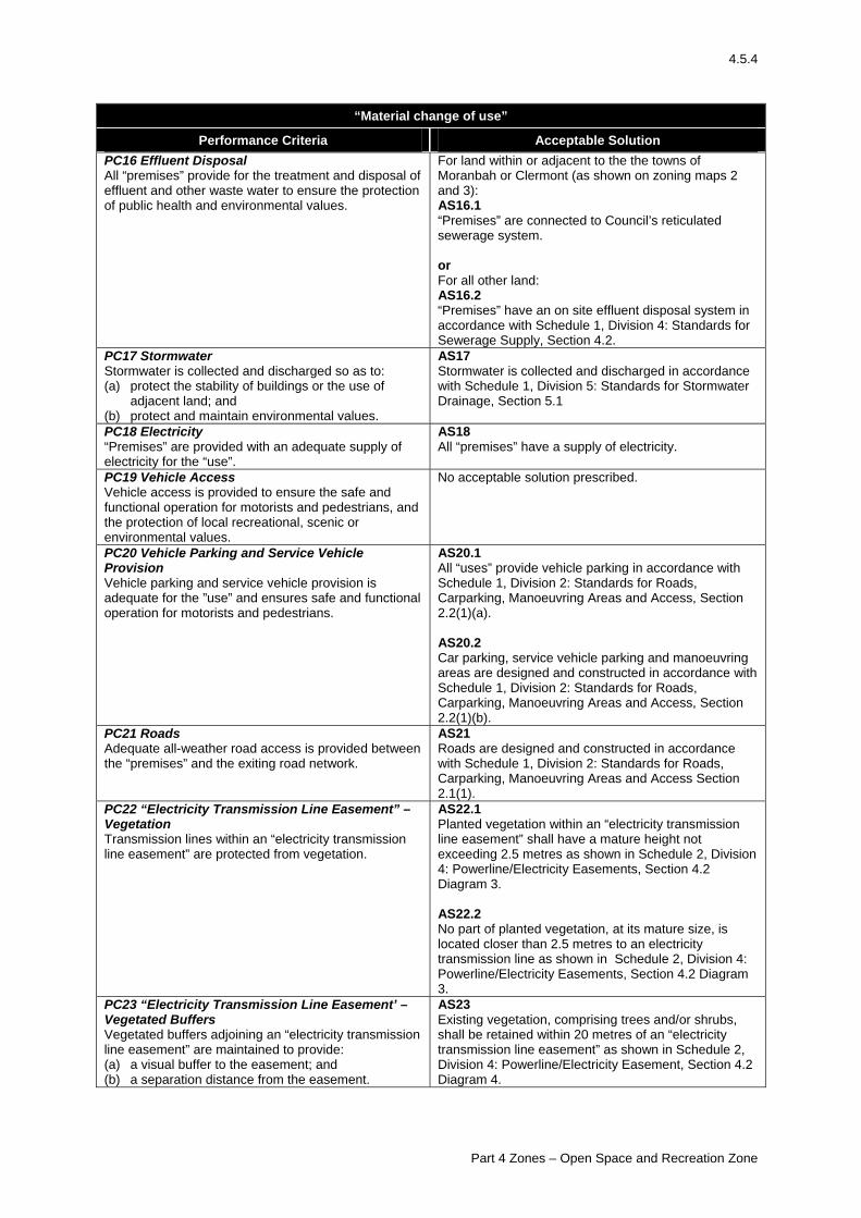
4.5.4
“Material change of use”
Performance Criteria Acceptable Solution PC16 Effluent Disposal All “premises” provide for the treatment and disposal of effluent and other waste water to ensure the protection of public health and environmental values.
For land within or adjacent to the the towns of Moranbah or Clermont (as shown on zoning maps 2 and 3): AS16.1 “Premises” are connected to Council’s reticulated sewerage system. or For all other land: AS16.2 “Premises” have an on site effluent disposal system in accordance with Schedule 1, Division 4: Standards for Sewerage Supply, Section 4.2.
PC17 Stormwater Stormwater is collected and discharged so as to: (a) protect the stability of buildings or the use of
adjacent land; and (b) protect and maintain environmental values.
AS17 Stormwater is collected and discharged in accordance with Schedule 1, Division 5: Standards for Stormwater Drainage, Section 5.1
PC18 Electricity “Premises” are provided with an adequate supply of electricity for the “use”.
AS18 All “premises” have a supply of electricity.
PC19 Vehicle Access Vehicle access is provided to ensure the safe and functional operation for motorists and pedestrians, and the protection of local recreational, scenic or environmental values.
No acceptable solution prescribed.
PC20 Vehicle Parking and Service Vehicle Provision Vehicle parking and service vehicle provision is adequate for the ”use” and ensures safe and functional operation for motorists and pedestrians.
AS20.1 All “uses” provide vehicle parking in accordance with Schedule 1, Division 2: Standards for Roads, Carparking, Manoeuvring Areas and Access, Section 2.2(1)(a). AS20.2 Car parking, service vehicle parking and manoeuvring areas are designed and constructed in accordance with Schedule 1, Division 2: Standards for Roads, Carparking, Manoeuvring Areas and Access, Section 2.2(1)(b).
PC21 Roads Adequate all-weather road access is provided between the “premises” and the exiting road network.
AS21 Roads are designed and constructed in accordance with Schedule 1, Division 2: Standards for Roads, Carparking, Manoeuvring Areas and Access Section 2.1(1).
PC22 “Electricity Transmission Line Easement” – Vegetation Transmission lines within an “electricity transmission line easement” are protected from vegetation.
AS22.1 Planted vegetation within an “electricity transmission line easement” shall have a mature height not exceeding 2.5 metres as shown in Schedule 2, Division 4: Powerline/Electricity Easements, Section 4.2 Diagram 3. AS22.2 No part of planted vegetation, at its mature size, is located closer than 2.5 metres to an electricity transmission line as shown in Schedule 2, Division 4: Powerline/Electricity Easements, Section 4.2 Diagram 3.
PC23 “Electricity Transmission Line Easement’ – Vegetated Buffers Vegetated buffers adjoining an “electricity transmission line easement” are maintained to provide: (a) a visual buffer to the easement; and (b) a separation distance from the easement.
AS23 Existing vegetation, comprising trees and/or shrubs, shall be retained within 20 metres of an “electricity transmission line easement” as shown in Schedule 2, Division 4: Powerline/Electricity Easement, Section 4.2 Diagram 4.
Part 4 Zones – Open Space and Recreation Zone
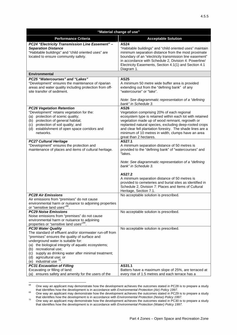
4.5.5
“Material change of use”
Performance Criteria Acceptable Solution PC24 “Electricity Transmission Line Easement” – Separation Distance “Habitable buildings” and “child oriented uses” are located to ensure community safety.
AS24 “Habitable buildings” and “child oriented uses” maintain minimum separation distance from the most proximate boundary of an “electricity transmission line easement” in accordance with Schedule 2, Division 4: Powerline/ Electricity Easements, Section 4.1(1) and Section 4.1 Diagram 1.
Environmental PC25 “Watercourses” and “Lakes” “Development” ensures the maintenance of riparian areas and water quality including protection from off-site transfer of sediment.
AS25 A minimum 50 metre wide buffer area is provided extending out from the “defining bank” of any “watercourse” or “lake”. Note: See diagrammatic representation of a “defining bank” in Schedule 3.
PC26 Vegetation Retention “Development” retains vegetation for the: (a) protection of scenic quality; (b) protection of general habitat; (c) protection of soil quality; and (d) establishment of open space corridors and
networks.
AS26 Vegetation comprising 20% of each regional ecosystem type is retained within each lot with retained vegetation made up of wood remnant, regrowth or replanted natural species, excluding deep-rooted crops and clear fell plantation forestry. The shade lines are a minimum of 10 metres in width, clumps have an area great than 2 hectares.
PC27 Cultural Heritage “Development” ensures the protection and maintenance of places and items of cultural heritage.
AS27.1 A minimum separation distance of 50 metres is provided to the “defining bank” of ”watercourses” and “lakes. Note: See diagrammatic representation of a “defining bank” in Schedule 3. AS27.2 A minimum separation distance of 50 metres is provided to cemeteries and burial sites as identified in Schedule 2, Division 7: Places and Items of Cultural Heritage, Section 7.1.
PC28 Air Emissions Air emissions from “premises” do not cause environmental harm or nuisance to adjoining properties or “sensitive land uses”68.
No acceptable solution is prescribed.
PC29 Noise Emissions Noise emissions from “premises” do not cause environmental harm or nuisance to adjoining properties or “sensitive land uses”69.
No acceptable solution is prescribed.
PC30 Water Quality The standard of effluent and/or stormwater run-off from “premises” ensures the quality of surface and underground water is suitable for: (a) the biological integrity of aquatic ecosystems; (b) recreational use; (c) supply as drinking water after minimal treatment; (d) agricultural use; or (e) industrial use 70.
No acceptable solution is prescribed.
PC31 Excavation of Filling Excavating or filling of land: (a) ensures safety and amenity for the users of the
AS31.1Batters have a maximum slope of 25%, are terraced at every rise of 1.5 metres and each terrace has a
68 One way an applicant may demonstrate how the development achieves the outcomes stated in PC28 is to prepare a study
that identifies how the development is in accordance with Environmental Protection (Air) Policy 1997. 69 One way an applicant may demonstrate how the development achieves the outcomes stated in PC29 is to prepare a study
that identifies how the development is in accordance with Environmental Protection (Noise) Policy 1997. 70 One way an applicant may demonstrate how the development achieves the outcomes stated in PC30 is to prepare a study
that identifies how the development is in accordance with Environmental Protection (Water) Policy 1997.
Part 4 Zones – Open Space and Recreation Zone
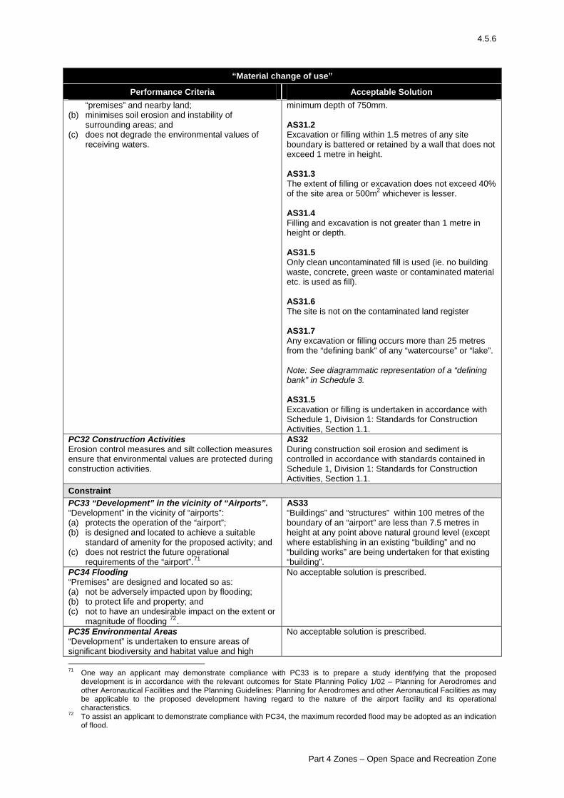
4.5.6
“Material change of use”
Performance Criteria Acceptable Solution “premises” and nearby land;
(b) minimises soil erosion and instability of surrounding areas; and
(c) does not degrade the environmental values of receiving waters.
minimum depth of 750mm. AS31.2 Excavation or filling within 1.5 metres of any site boundary is battered or retained by a wall that does not exceed 1 metre in height. AS31.3 The extent of filling or excavation does not exceed 40% of the site area or 500m2 whichever is lesser. AS31.4 Filling and excavation is not greater than 1 metre in height or depth. AS31.5 Only clean uncontaminated fill is used (ie. no building waste, concrete, green waste or contaminated material etc. is used as fill). AS31.6 The site is not on the contaminated land register AS31.7 Any excavation or filling occurs more than 25 metres from the “defining bank” of any “watercourse” or “lake”. Note: See diagrammatic representation of a “defining bank” in Schedule 3. AS31.5 Excavation or filling is undertaken in accordance with Schedule 1, Division 1: Standards for Construction Activities, Section 1.1.
PC32 Construction Activities Erosion control measures and silt collection measures ensure that environmental values are protected during construction activities.
AS32 During construction soil erosion and sediment is controlled in accordance with standards contained in Schedule 1, Division 1: Standards for Construction Activities, Section 1.1.
Constraint PC33 “Development” in the vicinity of “Airports”. “Development” in the vicinity of “airports”: (a) protects the operation of the “airport”; (b) is designed and located to achieve a suitable
standard of amenity for the proposed activity; and (c) does not restrict the future operational
requirements of the “airport”.71
AS33 “Buildings” and “structures” within 100 metres of the boundary of an “airport” are less than 7.5 metres in height at any point above natural ground level (except where establishing in an existing “building” and no “building works” are being undertaken for that existing “building”.
PC34 Flooding “Premises” are designed and located so as: (a) not be adversely impacted upon by flooding; (b) to protect life and property; and (c) not to have an undesirable impact on the extent or
magnitude of flooding 72.
No acceptable solution is prescribed.
PC35 Environmental Areas “Development” is undertaken to ensure areas of significant biodiversity and habitat value and high
No acceptable solution is prescribed.
71 One way an applicant may demonstrate compliance with PC33 is to prepare a study identifying that the proposed
development is in accordance with the relevant outcomes for State Planning Policy 1/02 – Planning for Aerodromes and other Aeronautical Facilities and the Planning Guidelines: Planning for Aerodromes and other Aeronautical Facilities as may be applicable to the proposed development having regard to the nature of the airport facility and its operational characteristics.
72 To assist an applicant to demonstrate compliance with PC34, the maximum recorded flood may be adopted as an indication of flood.
Part 4 Zones – Open Space and Recreation Zone
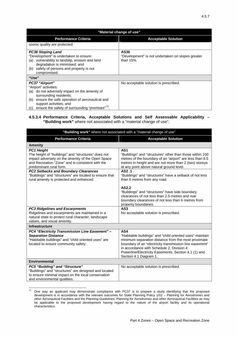
4.5.7
“Material change of use”
Performance Criteria Acceptable Solution scenic quality are protected.
PC36 Sloping Land “Development” is undertaken to ensure: (a) vulnerability to landslip, erosion and land
degradation is minimised; and (b) safety of persons and property is not
compromised.
AS36 “Development” is not undertaken on slopes greater than 15%.
“Use” PC37 “Airport” “Airport” activities: (a) do not adversely impact on the amenity of
surrounding residents; (b) ensure the safe operation of aeronautical and
support activities; and (c) ensure the safety of surrounding “premises”73.
No acceptable solution is prescribed.
4.5.3.4 Performance Criteria, Acceptable Solutions and Self Assessable Applicability –
“Building work” where not associated with a “material change of use”.
“Building work” where not associated with a “material change of use”
Performance Criteria Acceptable Solution
Amenity PC1 Height The height of “buildings” and “structures” does not impact adversely on the amenity of the Open Space and Recreation “Zone” and is consistent with the predominant rural form.
AS1 “Buildings” and “structures” other than those within 100 metres of the boundary of an “airport” are less than 8.5 metres in height and are not more than 2 (two) storeys at any point above natural ground level.
PC2 Setbacks and Boundary Clearances “Buildings” and “structures” are located to ensure that rural amenity is protected and enhanced.
AS2 .1 “Buildings” and “structures” have a setback of not less than 6 metres from any road. AS2.2 “Buildings” and “structures” have side boundary clearances of not less than 2.5 metres and rear boundary clearances of not less than 6 metres from property boundaries.
PC3 Ridgelines and Escarpments Ridgelines and escarpments are maintained in a natural state to protect rural character, landscape values, and visual amenity.
AS3 No acceptable solution is prescribed.
Infrastructure PC4 “Electricity Transmission Line Easement” – Separation Distance “Habitable buildings” and “child oriented uses” are located to ensure community safety.
AS4 “Habitable buildings” and “child oriented uses” maintain minimum separation distance from the most proximate boundary of an “electricity transmission line easement” in accordance with Schedule 2, Division 4: Powerline/Electricity Easements, Section 4.1 (1) and Section 4.1 Diagram 1.
Environmental PC5 “Building” and “Structure” “Buildings” and “structures” are designed and located to ensure minimal impact on the local conservation and environmental qualities.
No acceptable solution is prescribed.
73 One way an applicant may demonstrate compliance with PC37 is to prepare a study identifying that the proposed
development is in accordance with the relevant outcomes for State Planning Policy 1/02 – Planning for Aerodromes and other Aeronautical Facilities and the Planning Guidelines: Planning for Aerodromes and other Aeronautical Facilities as may be applicable to the proposed development having regard to the nature of the airport facility and its operational characteristics.
Part 4 Zones – Open Space and Recreation Zone
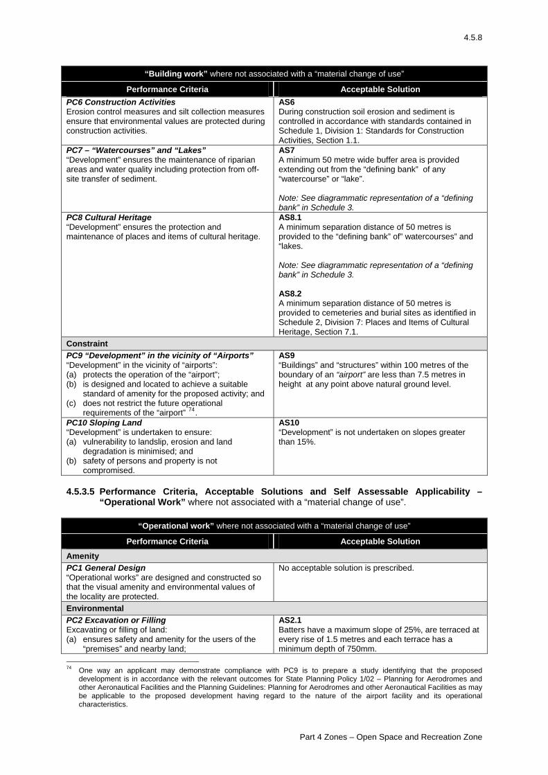
4.5.8
“Building work” where not associated with a “material change of use”
Performance Criteria Acceptable Solution PC6 Construction Activities Erosion control measures and silt collection measures ensure that environmental values are protected during construction activities.
AS6 During construction soil erosion and sediment is controlled in accordance with standards contained in Schedule 1, Division 1: Standards for Construction Activities, Section 1.1.
PC7 – “Watercourses” and “Lakes” “Development” ensures the maintenance of riparian areas and water quality including protection from off-site transfer of sediment.
AS7 A minimum 50 metre wide buffer area is provided extending out from the “defining bank” of any “watercourse” or “lake”. Note: See diagrammatic representation of a “defining bank” in Schedule 3.
PC8 Cultural Heritage “Development” ensures the protection and maintenance of places and items of cultural heritage.
AS8.1 A minimum separation distance of 50 metres is provided to the “defining bank” of” watercourses” and “lakes. Note: See diagrammatic representation of a “defining bank” in Schedule 3. AS8.2 A minimum separation distance of 50 metres is provided to cemeteries and burial sites as identified in Schedule 2, Division 7: Places and Items of Cultural Heritage, Section 7.1.
Constraint PC9 “Development” in the vicinity of “Airports” “Development” in the vicinity of “airports”: (a) protects the operation of the “airport”; (b) is designed and located to achieve a suitable
standard of amenity for the proposed activity; and (c) does not restrict the future operational
requirements of the “airport” 74.
AS9 “Buildings” and “structures” within 100 metres of the boundary of an “airport” are less than 7.5 metres in height at any point above natural ground level.
PC10 Sloping Land “Development” is undertaken to ensure: (a) vulnerability to landslip, erosion and land
degradation is minimised; and (b) safety of persons and property is not
compromised.
AS10 “Development” is not undertaken on slopes greater than 15%.
4.5.3.5 Performance Criteria, Acceptable Solutions and Self Assessable Applicability –
“Operational Work” where not associated with a “material change of use”.
“Operational work” where not associated with a “material change of use”
Performance Criteria Acceptable Solution
Amenity PC1 General Design “Operational works” are designed and constructed so that the visual amenity and environmental values of the locality are protected.
No acceptable solution is prescribed.
Environmental PC2 Excavation or Filling Excavating or filling of land: (a) ensures safety and amenity for the users of the
“premises” and nearby land;
AS2.1 Batters have a maximum slope of 25%, are terraced at every rise of 1.5 metres and each terrace has a minimum depth of 750mm.
74 One way an applicant may demonstrate compliance with PC9 is to prepare a study identifying that the proposed
development is in accordance with the relevant outcomes for State Planning Policy 1/02 – Planning for Aerodromes and other Aeronautical Facilities and the Planning Guidelines: Planning for Aerodromes and other Aeronautical Facilities as may be applicable to the proposed development having regard to the nature of the airport facility and its operational characteristics.
Part 4 Zones – Open Space and Recreation Zone
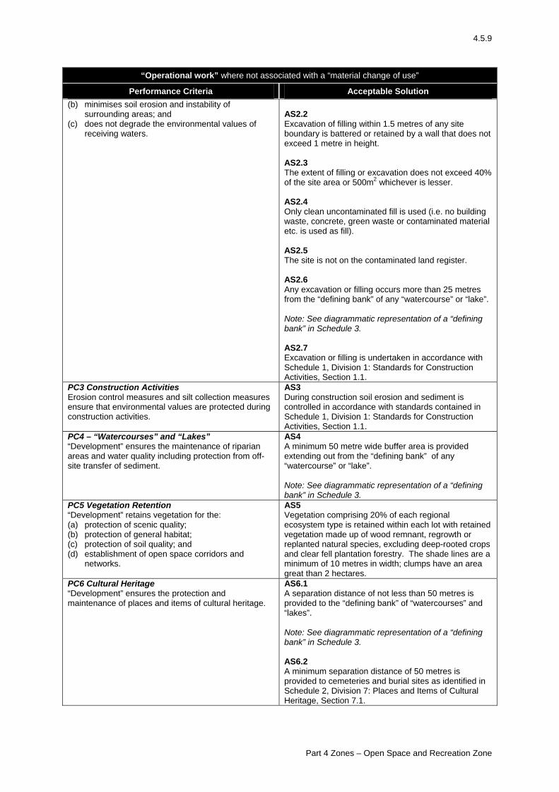
4.5.9
“Operational work” where not associated with a “material change of use”
Performance Criteria Acceptable Solution (b) minimises soil erosion and instability of
surrounding areas; and (c) does not degrade the environmental values of
receiving waters.
AS2.2 Excavation of filling within 1.5 metres of any site boundary is battered or retained by a wall that does not exceed 1 metre in height. AS2.3 The extent of filling or excavation does not exceed 40% of the site area or 500m2 whichever is lesser. AS2.4 Only clean uncontaminated fill is used (i.e. no building waste, concrete, green waste or contaminated material etc. is used as fill). AS2.5 The site is not on the contaminated land register. AS2.6 Any excavation or filling occurs more than 25 metres from the “defining bank” of any “watercourse” or “lake”. Note: See diagrammatic representation of a “defining bank” in Schedule 3. AS2.7 Excavation or filling is undertaken in accordance with Schedule 1, Division 1: Standards for Construction Activities, Section 1.1.
PC3 Construction Activities Erosion control measures and silt collection measures ensure that environmental values are protected during construction activities.
AS3 During construction soil erosion and sediment is controlled in accordance with standards contained in Schedule 1, Division 1: Standards for Construction Activities, Section 1.1.
PC4 – “Watercourses” and “Lakes” “Development” ensures the maintenance of riparian areas and water quality including protection from off-site transfer of sediment.
AS4 A minimum 50 metre wide buffer area is provided extending out from the “defining bank” of any “watercourse” or “lake”. Note: See diagrammatic representation of a “defining bank” in Schedule 3.
PC5 Vegetation Retention “Development” retains vegetation for the: (a) protection of scenic quality; (b) protection of general habitat; (c) protection of soil quality; and (d) establishment of open space corridors and
networks.
AS5 Vegetation comprising 20% of each regional ecosystem type is retained within each lot with retained vegetation made up of wood remnant, regrowth or replanted natural species, excluding deep-rooted crops and clear fell plantation forestry. The shade lines are a minimum of 10 metres in width; clumps have an area great than 2 hectares.
PC6 Cultural Heritage “Development” ensures the protection and maintenance of places and items of cultural heritage.
AS6.1 A separation distance of not less than 50 metres is provided to the “defining bank” of “watercourses” and “lakes”. Note: See diagrammatic representation of a “defining bank” in Schedule 3. AS6.2 A minimum separation distance of 50 metres is provided to cemeteries and burial sites as identified in Schedule 2, Division 7: Places and Items of Cultural Heritage, Section 7.1.
Part 4 Zones – Open Space and Recreation Zone
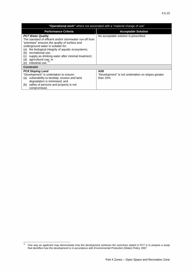
4.5.10
“Operational work” where not associated with a “material change of use”
Performance Criteria Acceptable Solution PC7 Water Quality The standard of effluent and/or stormwater run-off from “premises” ensures the quality of surface and underground water is suitable for: (a) the biological integrity of aquatic ecosystems; (b) recreational use: (c) supply as drinking water after minimal treatment; (d) agricultural use; or (e) industrial use.75
No acceptable solution is prescribed.
Constraint PC8 Sloping Land “Development” is undertaken to ensure: (a) vulnerability to landslip, erosion and land
degradation is minimised; and (b) safety of persons and property is not
compromised.
AS8 “Development” is not undertaken on slopes greater than 15%.
75 One way an applicant may demonstrate how the development achieves the outcomes stated in PC7 is to prepare a study
that identifies how the development is in accordance with Environmental Protection (Water) Policy 1997.
Part 4 Zones – Open Space and Recreation Zone
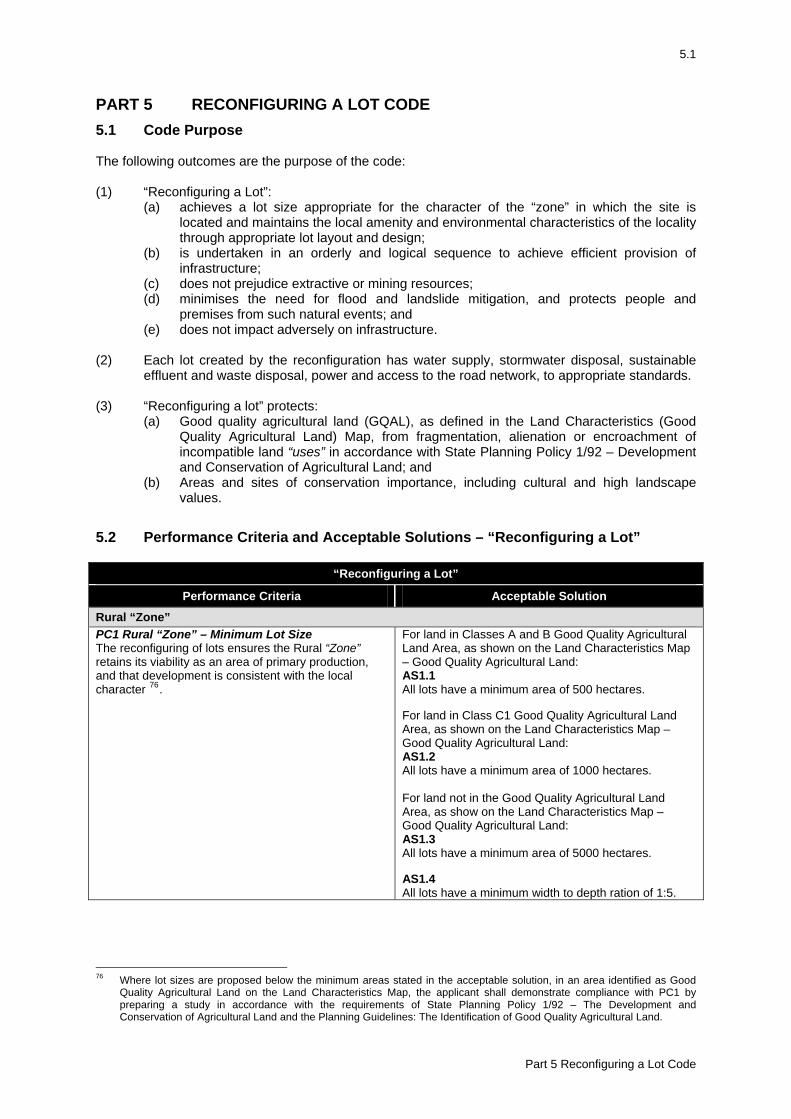
5.1
PART 5 RECONFIGURING A LOT CODE 5.1 Code Purpose The following outcomes are the purpose of the code: (1) “Reconfiguring a Lot”:
(a) achieves a lot size appropriate for the character of the “zone” in which the site is located and maintains the local amenity and environmental characteristics of the locality through appropriate lot layout and design;
(b) is undertaken in an orderly and logical sequence to achieve efficient provision of infrastructure;
(c) does not prejudice extractive or mining resources; (d) minimises the need for flood and landslide mitigation, and protects people and
premises from such natural events; and (e) does not impact adversely on infrastructure.
(2) Each lot created by the reconfiguration has water supply, stormwater disposal, sustainable
effluent and waste disposal, power and access to the road network, to appropriate standards. (3) “Reconfiguring a lot” protects:
(a) Good quality agricultural land (GQAL), as defined in the Land Characteristics (Good Quality Agricultural Land) Map, from fragmentation, alienation or encroachment of incompatible land “uses” in accordance with State Planning Policy 1/92 – Development and Conservation of Agricultural Land; and
(b) Areas and sites of conservation importance, including cultural and high landscape values.
5.2 Performance Criteria and Acceptable Solutions – “Reconfiguring a Lot”
“Reconfiguring a Lot”
Performance Criteria Acceptable Solution
Rural “Zone” PC1 Rural “Zone” – Minimum Lot Size The reconfiguring of lots ensures the Rural “Zone” retains its viability as an area of primary production, and that development is consistent with the local character 76.
For land in Classes A and B Good Quality Agricultural Land Area, as shown on the Land Characteristics Map – Good Quality Agricultural Land: AS1.1 All lots have a minimum area of 500 hectares. For land in Class C1 Good Quality Agricultural Land Area, as shown on the Land Characteristics Map – Good Quality Agricultural Land: AS1.2 All lots have a minimum area of 1000 hectares. For land not in the Good Quality Agricultural Land Area, as show on the Land Characteristics Map – Good Quality Agricultural Land: AS1.3 All lots have a minimum area of 5000 hectares. AS1.4 All lots have a minimum width to depth ration of 1:5.
76 Where lot sizes are proposed below the minimum areas stated in the acceptable solution, in an area identified as Good
Quality Agricultural Land on the Land Characteristics Map, the applicant shall demonstrate compliance with PC1 by preparing a study in accordance with the requirements of State Planning Policy 1/92 – The Development and Conservation of Agricultural Land and the Planning Guidelines: The Identification of Good Quality Agricultural Land.
Part 5 Reconfiguring a Lot Code
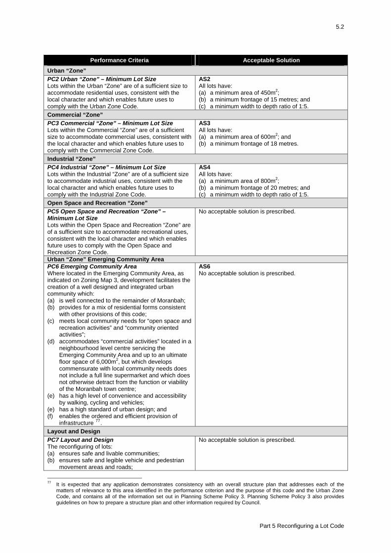
5.2
Performance Criteria Acceptable Solution
Urban “Zone” PC2 Urban “Zone” – Minimum Lot Size Lots within the Urban “Zone” are of a sufficient size to accommodate residential uses, consistent with the local character and which enables future uses to comply with the Urban Zone Code.
AS2 All lots have: (a) a minimum area of 450m2; (b) a minimum frontage of 15 metres; and (c) a minimum width to depth ratio of 1:5.
Commercial “Zone” PC3 Commercial “Zone” – Minimum Lot Size Lots within the Commercial “Zone” are of a sufficient size to accommodate commercial uses, consistent with the local character and which enables future uses to comply with the Commercial Zone Code.
AS3 All lots have: (a) a minimum area of 600m2; and (b) a minimum frontage of 18 metres.
Industrial “Zone” PC4 Industrial “Zone” – Minimum Lot Size Lots within the Industrial “Zone” are of a sufficient size to accommodate industrial uses, consistent with the local character and which enables future uses to comply with the Industrial Zone Code.
AS4 All lots have: (a) a minimum area of 800m2; (b) a minimum frontage of 20 metres; and (c) a minimum width to depth ratio of 1:5.
Open Space and Recreation “Zone” PC5 Open Space and Recreation “Zone” – Minimum Lot Size Lots within the Open Space and Recreation “Zone” are of a sufficient size to accommodate recreational uses, consistent with the local character and which enables future uses to comply with the Open Space and Recreation Zone Code.
No acceptable solution is prescribed.
Urban “Zone” Emerging Community Area PC6 Emerging Community Area Where located in the Emerging Community Area, as indicated on Zoning Map 3, development facilitates the creation of a well designed and integrated urban community which: (a) is well connected to the remainder of Moranbah; (b) provides for a mix of residential forms consistent
with other provisions of this code; (c) meets local community needs for “open space and
recreation activities” and “community oriented activities”;
(d) accommodates “commercial activities” located in a neighbourhood level centre servicing the Emerging Community Area and up to an ultimate floor space of 6,000m2, but which develops commensurate with local community needs does not include a full line supermarket and which does not otherwise detract from the function or viability of the Moranbah town centre;
(e) has a high level of convenience and accessibility by walking, cycling and vehicles;
(e) has a high standard of urban design; and (f) enables the ordered and efficient provision of
infrastructure 77.
AS6 No acceptable solution is prescribed.
Layout and Design PC7 Layout and Design The reconfiguring of lots: (a) ensures safe and livable communities; (b) ensures safe and legible vehicle and pedestrian
movement areas and roads;
No acceptable solution is prescribed.
77 It is expected that any application demonstrates consistency with an overall structure plan that addresses each of the
matters of relevance to this area identified in the performance criterion and the purpose of this code and the Urban Zone Code, and contains all of the information set out in Planning Scheme Policy 3. Planning Scheme Policy 3 also provides guidelines on how to prepare a structure plan and other information required by Council.
Part 5 Reconfiguring a Lot Code
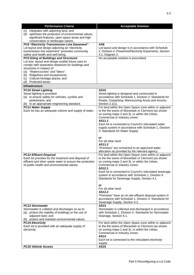
5.3
Performance Criteria Acceptable Solution (c) integrates with adjoining land; and (d) optimises the protection of environmental values,
significant features, open space areas and high conservation or landscape values.
PC8 “Electricity Transmission Line Easement” Lot layout and design adjoining an “electricity transmission line easement” promotes community safety and health and well being.
AS8 Lot layout and design is in accordance with Schedule 2, Division 4: Powerline/Electricity Easements, Section 4.1, Diagram 2.
PC9 Siting of Buildings and Structures Lot size, layout and design enable future uses to comply with separation distances for buildings and structures in respect of: (a) “Watercourses” and “lakes”; (b) Ridgelines and escarpments; (c) Cultural heritage places; and (d) Protected areas.
No acceptable solution is prescribed.
Infrastructure PC10 Street Lighting Street lighting is provided: (a) to ensure safety for vehicles, cyclists and
pedestrians; and (b) to an appropriate engineering standard.
AS10 Street lighting is designed and constructed in accordance with Schedule 1, Division 2: Standards for Roads, Carparking, Manoeuvring Areas and Access, Section 2.1(1).
PC11 Water Supply Each lot has an adequate volume and supply of water.
For land within the Open Space zone within or adjacent to the the towns of Moranbah or Clermont (as shown on zoning maps 2 and 3), or within the Urban, Commercial or Industry zones: AS11.1 Each lot is connected to Council’s reticulated water supply system in accordance with Schedule 1, Division 3: Standards for Water Supply. or For all other land: AS11.2 “Premises” are connected to an approved water allocation as provided by the relevant agency.
PC12 Effluent Disposal Each lot provides for the treatment and disposal of effluent and other waste water to ensure the protection of public health and environmental values.
For land within the Open Space zone within or adjacent to the the towns of Moranbah or Clermont (as shown on zoning maps 2 and 3), or within the Urban, Commercial or Industry zones: AS12.1 Each lot is connected to Council’s reticulated sewerage system in accordance with Schedule 1, Division 4: Standards for Sewerage Supply, Section 4.1. or For all other land: AS12.2 “Premises” have an on site effluent disposal system in accordance with Schedule 1, Division 4: Standards for Sewerage Supply, Section 4.2.
PC13 Stormwater Stormwater is colleted and discharges so as to: (a) protect the stability of buildings or the use of
adjacent land; and (b) protect and maintain environmental values.
AS13 Stormwater is collected and discharged in accordance with Schedule 1, Division 5: Standards for Stormwater Drainage, Section 5.1.
PC14 Electricity Each lot is provided with an adequate supply of electricity.
For land within the Open Space zone within or adjacent to the the towns of Moranbah or Clermont (as shown on zoning maps 2 and 3), or within the Urban, Commercial or Industry zones: AS14 Each lot is connected to the reticulated electricity supply.
PC15 Vehicle Access AS15
Part 5 Reconfiguring a Lot Code
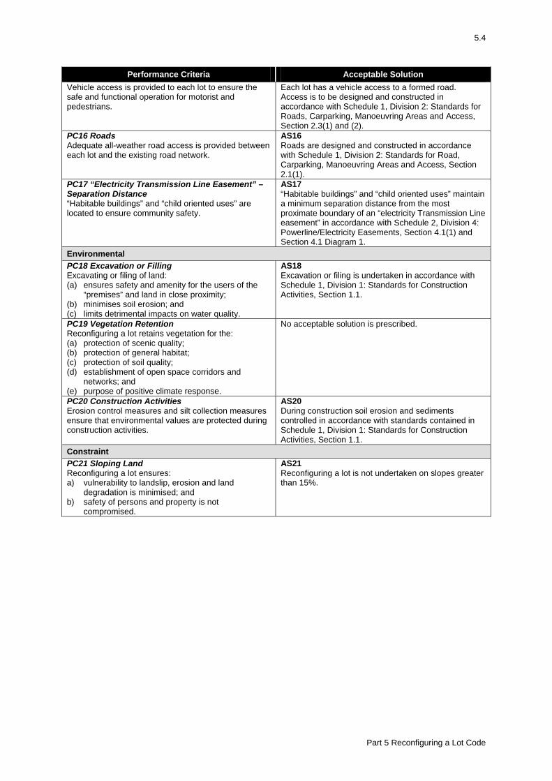
5.4
Performance Criteria Acceptable Solution Vehicle access is provided to each lot to ensure the safe and functional operation for motorist and pedestrians.
Each lot has a vehicle access to a formed road. Access is to be designed and constructed in accordance with Schedule 1, Division 2: Standards for Roads, Carparking, Manoeuvring Areas and Access, Section 2.3(1) and (2).
PC16 Roads Adequate all-weather road access is provided between each lot and the existing road network.
AS16 Roads are designed and constructed in accordance with Schedule 1, Division 2: Standards for Road, Carparking, Manoeuvring Areas and Access, Section 2.1(1).
PC17 “Electricity Transmission Line Easement” – Separation Distance “Habitable buildings” and “child oriented uses” are located to ensure community safety.
AS17 “Habitable buildings” and “child oriented uses” maintain a minimum separation distance from the most proximate boundary of an “electricity Transmission Line easement” in accordance with Schedule 2, Division 4: Powerline/Electricity Easements, Section 4.1(1) and Section 4.1 Diagram 1.
Environmental PC18 Excavation or Filling Excavating or filing of land: (a) ensures safety and amenity for the users of the
“premises” and land in close proximity; (b) minimises soil erosion; and (c) limits detrimental impacts on water quality.
AS18 Excavation or filing is undertaken in accordance with Schedule 1, Division 1: Standards for Construction Activities, Section 1.1.
PC19 Vegetation Retention Reconfiguring a lot retains vegetation for the: (a) protection of scenic quality; (b) protection of general habitat; (c) protection of soil quality; (d) establishment of open space corridors and
networks; and (e) purpose of positive climate response.
No acceptable solution is prescribed.
PC20 Construction Activities Erosion control measures and silt collection measures ensure that environmental values are protected during construction activities.
AS20 During construction soil erosion and sediments controlled in accordance with standards contained in Schedule 1, Division 1: Standards for Construction Activities, Section 1.1.
Constraint PC21 Sloping Land Reconfiguring a lot ensures: a) vulnerability to landslip, erosion and land
degradation is minimised; and b) safety of persons and property is not
compromised.
AS21 Reconfiguring a lot is not undertaken on slopes greater than 15%.
Part 5 Reconfiguring a Lot Code
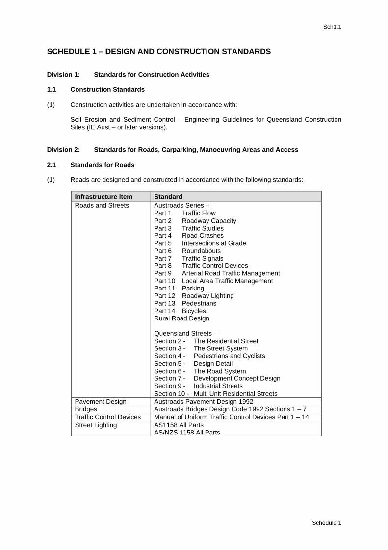
Sch1.1
SCHEDULE 1 – DESIGN AND CONSTRUCTION STANDARDS Division 1: Standards for Construction Activities 1.1 Construction Standards (1) Construction activities are undertaken in accordance with:
Soil Erosion and Sediment Control – Engineering Guidelines for Queensland Construction Sites (IE Aust – or later versions).
Division 2: Standards for Roads, Carparking, Manoeuvring Areas and Access 2.1 Standards for Roads (1) Roads are designed and constructed in accordance with the following standards:
Infrastructure Item Standard Roads and Streets Austroads Series –
Part 1 Traffic Flow Part 2 Roadway Capacity Part 3 Traffic Studies Part 4 Road Crashes Part 5 Intersections at Grade Part 6 Roundabouts Part 7 Traffic Signals Part 8 Traffic Control Devices Part 9 Arterial Road Traffic Management Part 10 Local Area Traffic Management Part 11 Parking Part 12 Roadway Lighting Part 13 Pedestrians Part 14 Bicycles Rural Road Design Queensland Streets – Section 2 - The Residential Street Section 3 - The Street System Section 4 - Pedestrians and Cyclists Section 5 - Design Detail Section 6 - The Road System Section 7 - Development Concept Design Section 9 - Industrial Streets Section 10 - Multi Unit Residential Streets
Pavement Design Austroads Pavement Design 1992 Bridges Austroads Bridges Design Code 1992 Sections 1 – 7 Traffic Control Devices Manual of Uniform Traffic Control Devices Part 1 – 14 Street Lighting AS1158 All Parts
AS/NZS 1158 All Parts
Schedule 1
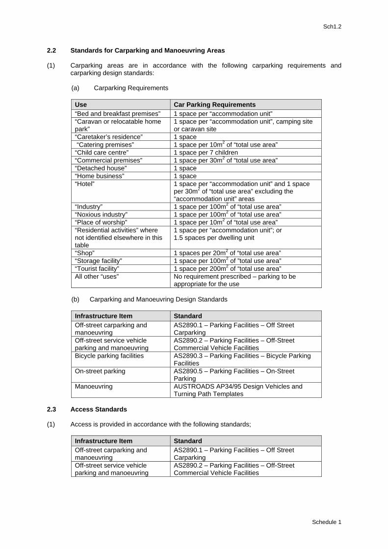
Sch1.2
2.2 Standards for Carparking and Manoeuvring Areas (1) Carparking areas are in accordance with the following carparking requirements and
carparking design standards:
(a) Carparking Requirements
Use Car Parking Requirements “Bed and breakfast premises” 1 space per “accommodation unit” “Caravan or relocatable home park”
1 space per “accommodation unit”, camping site or caravan site
“Caretaker’s residence” 1 space “Catering premises” 1 space per 10m2 of “total use area” “Child care centre” 1 space per 7 children “Commercial premises” 1 space per 30m2 of “total use area” “Detached house” 1 space “Home business” 1 space “Hotel” 1 space per “accommodation unit” and 1 space
per 30m2 of “total use area” excluding the “accommodation unit” areas
“Industry” 1 space per 100m2 of “total use area” “Noxious industry” 1 space per 100m2 of “total use area” “Place of worship” 1 space per 10m2 of “total use area” “Residential activities” where not identified elsewhere in this table
1 space per “accommodation unit”; or 1.5 spaces per dwelling unit
“Shop” 1 spaces per 20m2 of “total use area” “Storage facility” 1 space per 100m2 of ”total use area” “Tourist facility” 1 space per 200m2 of “total use area” All other “uses” No requirement prescribed – parking to be
appropriate for the use
(b) Carparking and Manoeuvring Design Standards
Infrastructure Item Standard Off-street carparking and manoeuvring
AS2890.1 – Parking Facilities – Off Street Carparking
Off-street service vehicle parking and manoeuvring
AS2890.2 – Parking Facilities – Off-Street Commercial Vehicle Facilities
Bicycle parking facilities AS2890.3 – Parking Facilities – Bicycle Parking Facilities
On-street parking AS2890.5 – Parking Facilities – On-Street Parking
Manoeuvring AUSTROADS AP34/95 Design Vehicles and Turning Path Templates
2.3 Access Standards (1) Access is provided in accordance with the following standards;
Infrastructure Item Standard Off-street carparking and manoeuvring
AS2890.1 – Parking Facilities – Off Street Carparking
Off-street service vehicle parking and manoeuvring
AS2890.2 – Parking Facilities – Off-Street Commercial Vehicle Facilities
Schedule 1
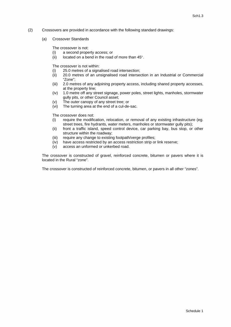
Sch1.3
(2) Crossovers are provided in accordance with the following standard drawings: (a) Crossover Standards The crossover is not:
(i) a second property access; or (ii) located on a bend in the road of more than 45°.
The crossover is not within: (i) 25.0 metres of a signalised road intersection; (ii) 20.0 metres of an unsignalised road intersection in an Industrial or Commercial
“Zone”; (iii) 2.0 metres of any adjoining property access, including shared property accesses,
at the property line; (iv) 1.0 metre off any street signage, power poles, street lights, manholes, stormwater
gully pits, or other Council asset; (v) The outer canopy of any street tree; or (vi) The turning area at the end of a cul-de-sac.
The crossover does not:
(i) require the modification, relocation, or removal of any existing infrastructure (eg. street trees, fire hydrants, water meters, manholes or stormwater gully pits);
(ii) front a traffic island, speed control device, car parking bay, bus stop, or other structure within the roadway;
(iii) require any change to existing footpath/verge profiles; (iv) have access restricted by an access restriction strip or link reserve; (v) access an unformed or unkerbed road.
The crossover is constructed of gravel, reinforced concrete, bitumen or pavers where it is located in the Rural “zone”. The crossover is constructed of reinforced concrete, bitumen, or pavers in all other “zones”.
Schedule 1
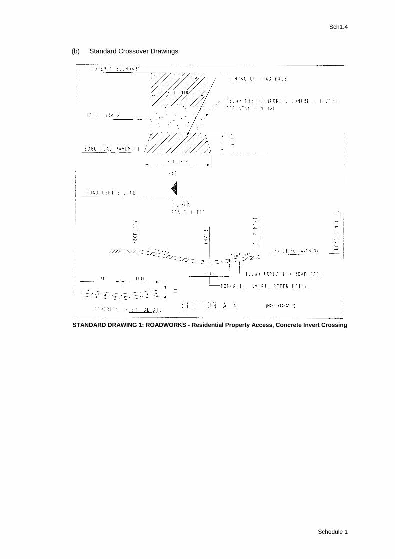
Sch1.4
(b) Standard Crossover Drawings
STANDARD DRAWING 1: ROADWORKS - Residential Property Access, Concrete Invert Crossing
Schedule 1
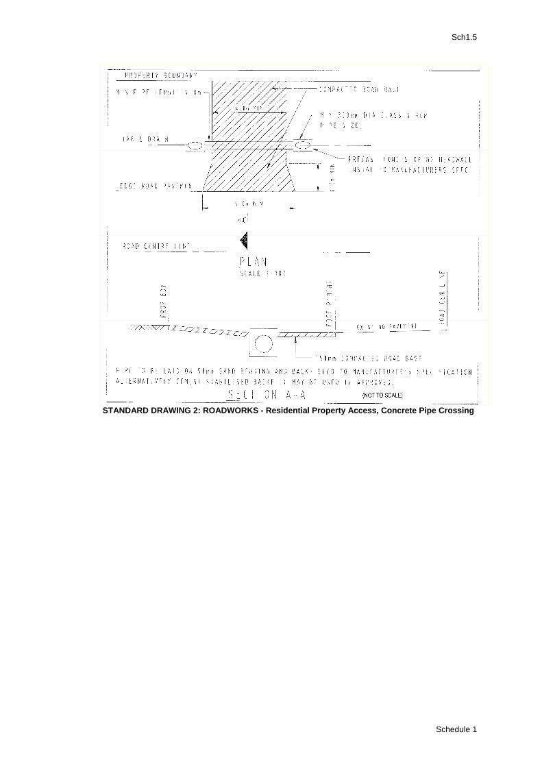
Sch1.5
STANDARD DRAWING 2: ROADWORKS - Residential Property Access, Concrete Pipe Crossing
Schedule 1
Sch1.6
Division 3: Standards for Water Supply 3.1 Standards for Reticulated Water Supply (1) Reticulated water supply is in accordance with:
WSA03 Water Reticulation Code of Australia DNRM 2002 Guidelines for Planning and Design of Urban Water Supply Schemes DNRM
Division 4: Standards for Sewerage Supply 4.1 Standards for Reticulated Sewerage (1) Reticulated sewerage is in accordance with: WSA02 Sewerage Code of Australia DNRM 2002 WSA04 Pumping Station Code of Australia DNRM 2001 Guidelines for Planning and Design of Sewerage Supply Schemes Volume 1 and Volume 2
DNRM 4.2 Standards for On-Site Sewerage (1) On-site sewerage is in accordance with:
On Site Sewerage Code DNRM AS1547.2000 On Site Sewerage Facilities Guidelines for Effluent Quality DNRM
Division 5: Standards for Stormwater Drainage 5.1 Standards for Stormwater Drainage (1) Stormwater drainage is in accordance with:
Queensland Urban Drainage Design Manual (Volume 1 Text, Volume 2 Design Charts) Australian Rainfall and Run-off (Volume 1 A Guide to Flood Estimation)
Schedule 1
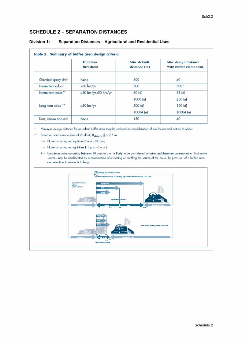
Sch2.2
SCHEDULE 2 – SEPARATION DISTANCES Division 1: Separation Distances – Agricultural and Residential Uses
Schedule 2
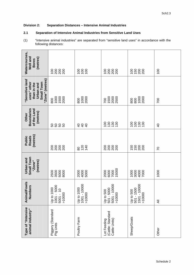
Sch2.3
Division 2: Separation Distances – Intensive Animal Industries 2.1 Separation of Intensive Animal Industries from Sensitive Land Uses (1) “Intensive animal industries” are separated from “sensitive land uses” in accordance with the
following distances:
Wat
erco
urse
s,
Wel
l and
B
ores
(m
etre
s)
100
200
200
200
100
100
100
100
200
200
200
100
150
200
200
100
“Sen
sitiv
e la
nd
uses
” ot
her
than
in th
e U
rban
and
Sm
all T
own
“Zon
e” (m
etre
s)
800
1000
15
00
2000
800
1000
20
00
700
1500
20
00
2500
800
800
1000
20
00
700
Oth
er
Bou
ndar
ies
of th
e La
nd
(met
res)
50
50
50
50
40
40
40
100
130
130
130
100
100
130
130
40
Publ
ic
Roa
ds
(met
res)
200
200
200
200
80
120
140
200
200
200
200
150
150
200
200
70
Urb
an a
nd
Smal
l Tow
n “Z
one”
(m
etre
s)
2500
35
00
5000
80
00
2000
40
00
5000
2000
60
00
7000
15
000
1000
30
00
4000
70
00
1000
Ani
mal
/Fow
ls
Num
bers
Up
to 1
000
1001
- 5
000
5001
- 1
0
>100
00
Up
to 1
000
1001
- 10
000
>100
00
Up
to 5
00
501
- 500
0 50
01 -
1000
0 >1
0000
Up
to 5
00
501
- 150
0 15
01 -
1000
0 >1
0000
All
Type
of “
Inte
nsiv
e an
imal
indu
stry
”
Pig
gery
(Sta
ndar
d P
ig U
nits
Pou
ltry
Farm
Lot F
eedi
ng
(Cat
tle: S
tand
ard
Cat
tle U
nits
)
She
ep/G
oats
Oth
er
Schedule 2
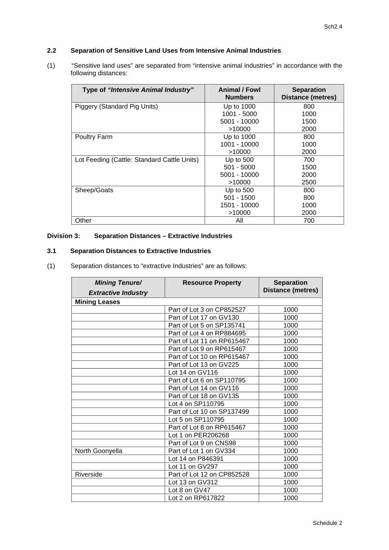
Sch2.4
2.2 Separation of Sensitive Land Uses from Intensive Animal Industries (1) “Sensitive land uses” are separated from “intensive animal industries” in accordance with the
following distances:
Type of “Intensive Animal Industry” Animal / Fowl Numbers
Separation Distance (metres)
Piggery (Standard Pig Units) Up to 1000 1001 - 5000 5001 - 10000
>10000
800 1000 1500 2000
Poultry Farm Up to 1000 1001 - 10000
>10000
800 1000 2000
Lot Feeding (Cattle: Standard Cattle Units) Up to 500 501 - 5000
5001 - 10000 >10000
700 1500 2000 2500
Sheep/Goats Up to 500 501 - 1500
1501 - 10000 >10000
800 800 1000 2000
Other All 700 Division 3: Separation Distances – Extractive Industries 3.1 Separation Distances to Extractive Industries (1) Separation distances to “extractive Industries” are as follows:
Mining Tenure/ Extractive Industry
Resource Property Separation Distance (metres)
Mining Leases Part of Lot 3 on CP852527 1000 Part of Lot 17 on GV130 1000 Part of Lot 5 on SP135741 1000 Part of Lot 4 on RP884695 1000 Part of Lot 11 on RP615467 1000 Part of Lot 9 on RP615467 1000 Part of Lot 10 on RP615467 1000 Part of Lot 13 on GV225 1000 Lot 14 on GV116 1000 Part of Lot 6 on SP110795 1000 Part of Lot 14 on GV116 1000 Part of Lot 18 on GV135 1000 Lot 4 on SP110795 1000 Part of Lot 10 on SP137499 1000 Lot 5 on SP110795 1000 Part of Lot 8 on RP615467 1000 Lot 1 on PER206268 1000 Part of Lot 9 on CNS98 1000 North Goonyella Part of Lot 1 on GV334 1000 Lot 14 on P846391 1000 Lot 11 on GV297 1000 Riverside Part of Lot 12 on CP852528 1000 Lot 13 on GV312 1000 Lot 8 on GV47 1000 Lot 2 on RP617822 1000
Schedule 2
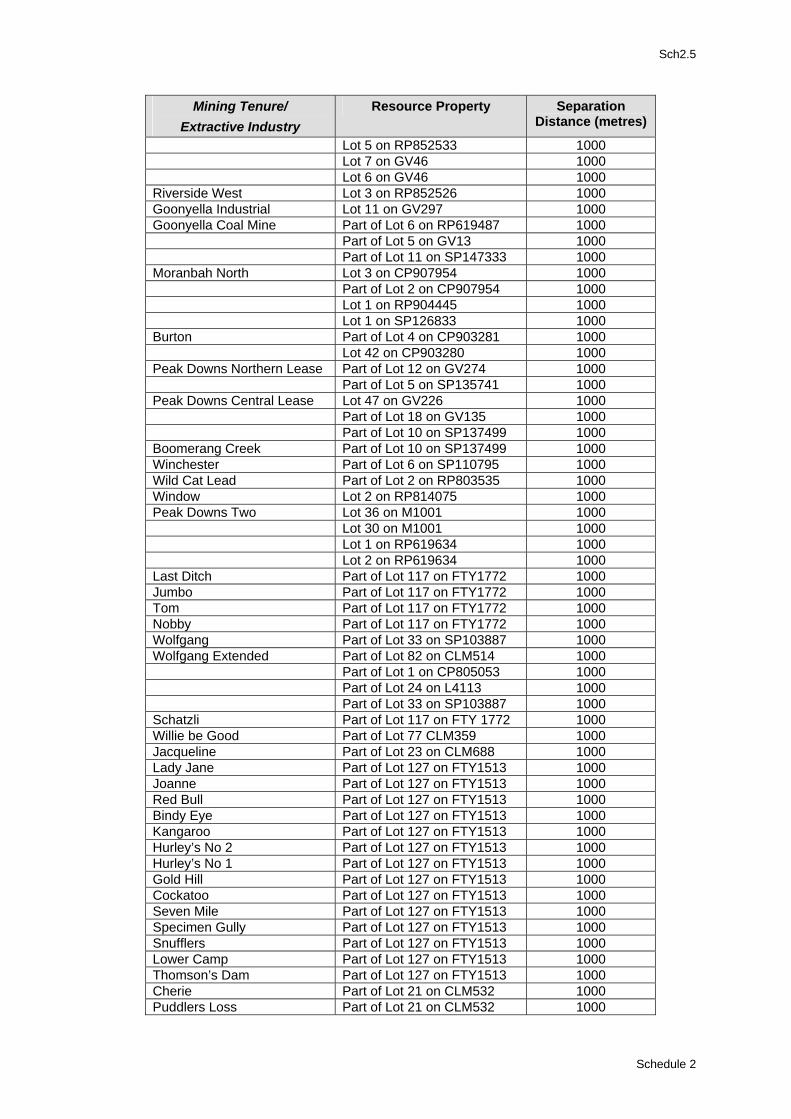
Sch2.5
Separation Resource Property Mining Tenure/ Distance (metres) Extractive Industry
Lot 5 on RP852533 1000 Lot 7 on GV46 1000 Lot 6 on GV46 1000 Riverside West Lot 3 on RP852526 1000 Goonyella Industrial Lot 11 on GV297 1000 Goonyella Coal Mine Part of Lot 6 on RP619487 1000 Part of Lot 5 on GV13 1000 Part of Lot 11 on SP147333 1000 Moranbah North Lot 3 on CP907954 1000 Part of Lot 2 on CP907954 1000 Lot 1 on RP904445 1000 Lot 1 on SP126833 1000 Burton Part of Lot 4 on CP903281 1000 Lot 42 on CP903280 1000 Peak Downs Northern Lease Part of Lot 12 on GV274 1000 Part of Lot 5 on SP135741 1000 Peak Downs Central Lease Lot 47 on GV226 1000 Part of Lot 18 on GV135 1000 Part of Lot 10 on SP137499 1000 Boomerang Creek Part of Lot 10 on SP137499 1000 Winchester Part of Lot 6 on SP110795 1000 Wild Cat Lead Part of Lot 2 on RP803535 1000 Window Lot 2 on RP814075 1000 Peak Downs Two Lot 36 on M1001 1000 Lot 30 on M1001 1000 Lot 1 on RP619634 1000 Lot 2 on RP619634 1000 Last Ditch Part of Lot 117 on FTY1772 1000 Jumbo Part of Lot 117 on FTY1772 1000 Tom Part of Lot 117 on FTY1772 1000 Nobby Part of Lot 117 on FTY1772 1000 Wolfgang Part of Lot 33 on SP103887 1000 Wolfgang Extended Part of Lot 82 on CLM514 1000 Part of Lot 1 on CP805053 1000 Part of Lot 24 on L4113 1000 Part of Lot 33 on SP103887 1000 Schatzli Part of Lot 117 on FTY 1772 1000 Willie be Good Part of Lot 77 CLM359 1000 Jacqueline Part of Lot 23 on CLM688 1000 Lady Jane Part of Lot 127 on FTY1513 1000 Joanne Part of Lot 127 on FTY1513 1000 Red Bull Part of Lot 127 on FTY1513 1000 Bindy Eye Part of Lot 127 on FTY1513 1000 Kangaroo Part of Lot 127 on FTY1513 1000 Hurley’s No 2 Part of Lot 127 on FTY1513 1000 Hurley’s No 1 Part of Lot 127 on FTY1513 1000 Gold Hill Part of Lot 127 on FTY1513 1000 Cockatoo Part of Lot 127 on FTY1513 1000 Seven Mile Part of Lot 127 on FTY1513 1000 Specimen Gully Part of Lot 127 on FTY1513 1000 Snufflers Part of Lot 127 on FTY1513 1000 Lower Camp Part of Lot 127 on FTY1513 1000 Thomson’s Dam Part of Lot 127 on FTY1513 1000 Cherie Part of Lot 21 on CLM532 1000 Puddlers Loss Part of Lot 21 on CLM532 1000
Schedule 2
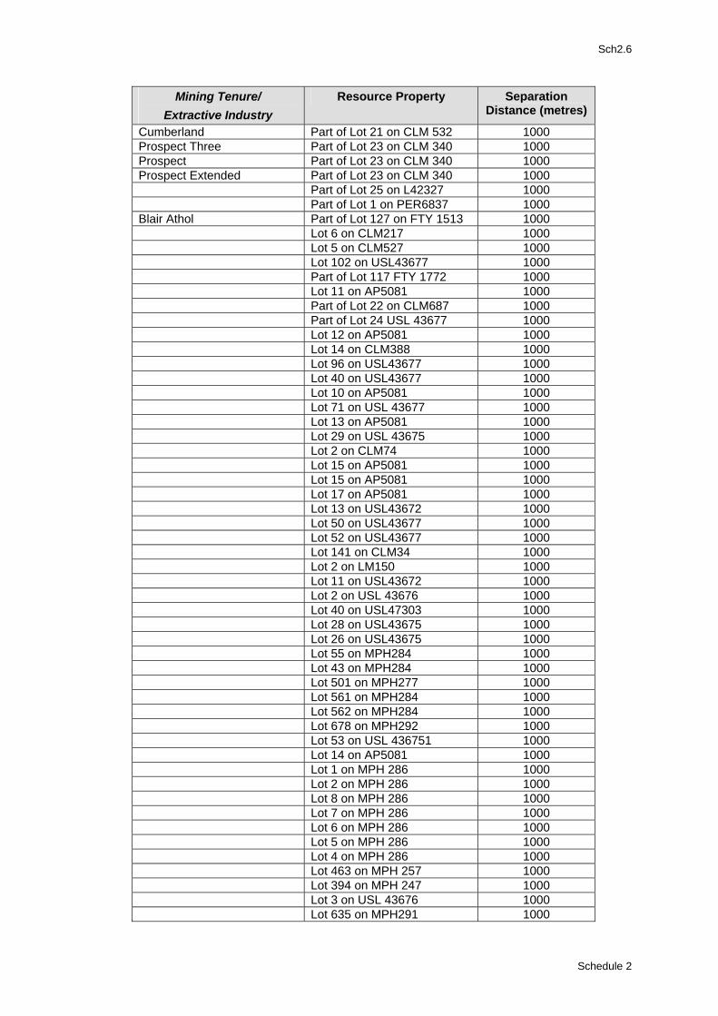
Sch2.6
Separation Resource Property Mining Tenure/ Distance (metres) Extractive Industry
Cumberland Part of Lot 21 on CLM 532 1000 Prospect Three Part of Lot 23 on CLM 340 1000 Prospect Part of Lot 23 on CLM 340 1000 Prospect Extended Part of Lot 23 on CLM 340 1000 Part of Lot 25 on L42327 1000 Part of Lot 1 on PER6837 1000 Blair Athol Part of Lot 127 on FTY 1513 1000 Lot 6 on CLM217 1000 Lot 5 on CLM527 1000 Lot 102 on USL43677 1000 Part of Lot 117 FTY 1772 1000 Lot 11 on AP5081 1000 Part of Lot 22 on CLM687 1000 Part of Lot 24 USL 43677 1000 Lot 12 on AP5081 1000 Lot 14 on CLM388 1000 Lot 96 on USL43677 1000 Lot 40 on USL43677 1000 Lot 10 on AP5081 1000 Lot 71 on USL 43677 1000 Lot 13 on AP5081 1000 Lot 29 on USL 43675 1000 Lot 2 on CLM74 1000 Lot 15 on AP5081 1000 Lot 15 on AP5081 1000 Lot 17 on AP5081 1000 Lot 13 on USL43672 1000 Lot 50 on USL43677 1000 Lot 52 on USL43677 1000 Lot 141 on CLM34 1000 Lot 2 on LM150 1000 Lot 11 on USL43672 1000 Lot 2 on USL 43676 1000 Lot 40 on USL47303 1000 Lot 28 on USL43675 1000 Lot 26 on USL43675 1000 Lot 55 on MPH284 1000 Lot 43 on MPH284 1000 Lot 501 on MPH277 1000 Lot 561 on MPH284 1000 Lot 562 on MPH284 1000 Lot 678 on MPH292 1000 Lot 53 on USL 436751 1000 Lot 14 on AP5081 1000 Lot 1 on MPH 286 1000 Lot 2 on MPH 286 1000 Lot 8 on MPH 286 1000 Lot 7 on MPH 286 1000 Lot 6 on MPH 286 1000 Lot 5 on MPH 286 1000 Lot 4 on MPH 286 1000 Lot 463 on MPH 257 1000 Lot 394 on MPH 247 1000 Lot 3 on USL 43676 1000 Lot 635 on MPH291 1000
Schedule 2
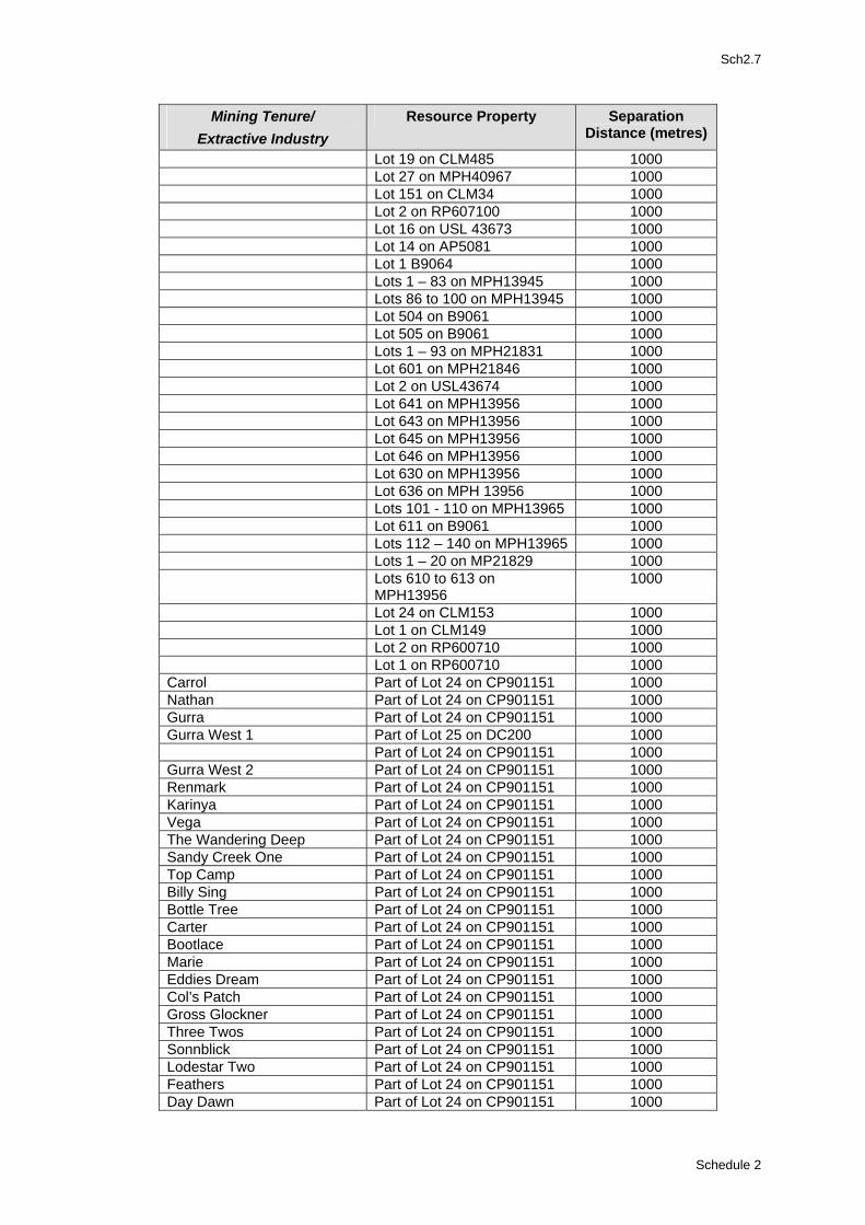
Sch2.7
Separation Resource Property Mining Tenure/ Distance (metres) Extractive Industry
Lot 19 on CLM485 1000 Lot 27 on MPH40967 1000 Lot 151 on CLM34 1000 Lot 2 on RP607100 1000 Lot 16 on USL 43673 1000 Lot 14 on AP5081 1000 Lot 1 B9064 1000 Lots 1 – 83 on MPH13945 1000 Lots 86 to 100 on MPH13945 1000 Lot 504 on B9061 1000 Lot 505 on B9061 1000 Lots 1 – 93 on MPH21831 1000 Lot 601 on MPH21846 1000 Lot 2 on USL43674 1000 Lot 641 on MPH13956 1000 Lot 643 on MPH13956 1000 Lot 645 on MPH13956 1000 Lot 646 on MPH13956 1000 Lot 630 on MPH13956 1000 Lot 636 on MPH 13956 1000 Lots 101 - 110 on MPH13965 1000 Lot 611 on B9061 1000 Lots 112 – 140 on MPH13965 1000 Lots 1 – 20 on MP21829 1000 Lots 610 to 613 on
MPH13956 1000
Lot 24 on CLM153 1000 Lot 1 on CLM149 1000 Lot 2 on RP600710 1000 Lot 1 on RP600710 1000 Carrol Part of Lot 24 on CP901151 1000 Nathan Part of Lot 24 on CP901151 1000 Gurra Part of Lot 24 on CP901151 1000 Gurra West 1 Part of Lot 25 on DC200 1000 Part of Lot 24 on CP901151 1000 Gurra West 2 Part of Lot 24 on CP901151 1000 Renmark Part of Lot 24 on CP901151 1000 Karinya Part of Lot 24 on CP901151 1000 Vega Part of Lot 24 on CP901151 1000 The Wandering Deep Part of Lot 24 on CP901151 1000 Sandy Creek One Part of Lot 24 on CP901151 1000 Top Camp Part of Lot 24 on CP901151 1000 Billy Sing Part of Lot 24 on CP901151 1000 Bottle Tree Part of Lot 24 on CP901151 1000 Carter Part of Lot 24 on CP901151 1000 Bootlace Part of Lot 24 on CP901151 1000 Marie Part of Lot 24 on CP901151 1000 Eddies Dream Part of Lot 24 on CP901151 1000 Col’s Patch Part of Lot 24 on CP901151 1000 Gross Glockner Part of Lot 24 on CP901151 1000 Three Twos Part of Lot 24 on CP901151 1000 Sonnblick Part of Lot 24 on CP901151 1000 Lodestar Two Part of Lot 24 on CP901151 1000 Feathers Part of Lot 24 on CP901151 1000 Day Dawn Part of Lot 24 on CP901151 1000
Schedule 2
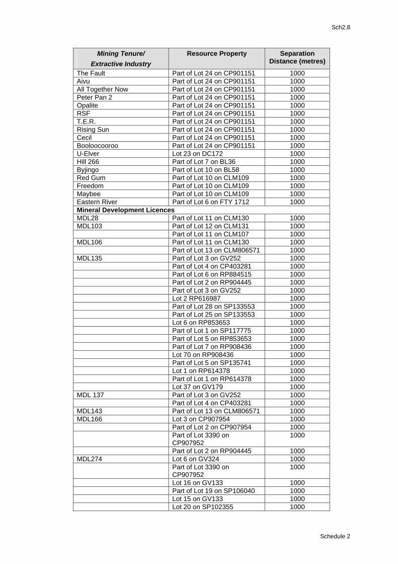
Sch2.8
Separation Resource Property Mining Tenure/ Distance (metres) Extractive Industry
The Fault Part of Lot 24 on CP901151 1000 Aivu Part of Lot 24 on CP901151 1000 All Together Now Part of Lot 24 on CP901151 1000 Peter Pan 2 Part of Lot 24 on CP901151 1000 Opalite Part of Lot 24 on CP901151 1000 RSF Part of Lot 24 on CP901151 1000 T.E.R. Part of Lot 24 on CP901151 1000 Rising Sun Part of Lot 24 on CP901151 1000 Cecil Part of Lot 24 on CP901151 1000 Booloocooroo Part of Lot 24 on CP901151 1000 U-Elver Lot 23 on DC172 1000 Hill 266 Part of Lot 7 on BL36 1000 Byjingo Part of Lot 10 on BL58 1000 Red Gum Part of Lot 10 on CLM109 1000 Freedom Part of Lot 10 on CLM109 1000 Maybee Part of Lot 10 on CLM109 1000 Eastern River Part of Lot 6 on FTY 1712 1000 Mineral Development Licences MDL28 Part of Lot 11 on CLM130 1000 MDL103 Part of Lot 12 on CLM131 1000 Part of Lot 11 on CLM107 1000 MDL106 Part of Lot 11 on CLM130 1000 Part of Lot 13 on CLM806571 1000 MDL135 Part of Lot 3 on GV252 1000 Part of Lot 4 on CP403281 1000 Part of Lot 6 on RP884515 1000 Part of Lot 2 on RP904445 1000 Part of Lot 3 on GV252 1000 Lot 2 RP616987 1000 Part of Lot 28 on SP133553 1000 Part of Lot 25 on SP133553 1000 Lot 6 on RP853653 1000 Part of Lot 1 on SP117775 1000 Part of Lot 5 on RP853653 1000 Part of Lot 7 on RP908436 1000 Lot 70 on RP908436 1000 Part of Lot 5 on SP135741 1000 Lot 1 on RP614378 1000 Part of Lot 1 on RP614378 1000 Lot 37 on GV179 1000 MDL 137 Part of Lot 3 on GV252 1000 Part of Lot 4 on CP403281 1000 MDL143 Part of Lot 13 on CLM806571 1000 MDL166 Lot 3 on CP907954 1000 Part of Lot 2 on CP907954 1000 Part of Lot 3390 on
CP907952 1000
Part of Lot 2 on RP904445 1000 MDL274 Lot 6 on GV324 1000 Part of Lot 3390 on
CP907952 1000
Lot 16 on GV133 1000 Part of Lot 19 on SP106040 1000 Lot 15 on GV133 1000 Lot 20 on SP102355 1000
Schedule 2
Sch2.9
Separation Resource Property Mining Tenure/ Distance (metres) Extractive Industry
MDL183 Part of Lot 6 on SP110795 1000 MDL277 Part of Lot 6 on RP884515 1000 Part of Lot 17 on GV130 1000 Part of Lot 4 on RP884695 1000 Lot 1 on RP818135 1000 Lot 11 on SP135741 1000 Lot 6 on RP615647 1000 Part of Lot 7 on RP615647 1000 Part of Lot 8 on RP615647 1000 Part of Lot 9 on RP615647 1000 Part of Lot 10 on RP615647 1000 Lot 23 on GV148 1000 Lot 5 on GV148 1000 Lot 13 on GV225 1000 Part of Lot 14 on GV116 1000 Part of Lot 6 on SP110795 1000 MDL307 Part of Lot 1 on GV334 1000 Part of Lot 6 on RP619487 1000 Part of Lot 5 on GV13 1000 Part of Lot 11 on SP147333 1000 MDL321 Part of Lot 6 on SP110795 1000
Division 4: Powerline/Electricity Easements 4.1 Separation from Powerline/Electricity Easements (1) Separation to powerline/electricity easements in accordance with the following distances:
Separation or Buffer Distance Transmission Line Size 20.0 metres Up to 132kV 30.0 metres 33kV – 275kV 40.0 metres Greater than 275kV
Schedule 2
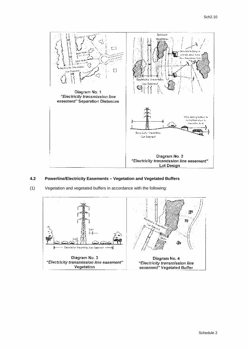
Sch2.10
4.2 Powerline/Electricity Easements – Vegetation and Vegetated Buffers (1) Vegetation and vegetated buffers in accordance with the following:
Schedule 2
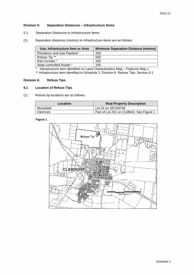
Sch2.11
Division 5: Separation Distances – Infrastructure Items 5.1 Separation Distances to Infrastructure Items (1) Separation distances (metres) to infrastructure items are as follows:
Use, Infrastructure Item or Area Minimum Separation Distance (metres) Petroleum and Gas Pipeline* 200 Refuse Tip ** 500 Rail Corridor * 100 State-controlled Roads * 100
* Infrastructure item identified on Land Characteristics Map – Features Map 1 ** Infrastructure item identified in Schedule 2, Division 6: Refuse Tips, Section 6.1
Division 6: Refuse Tips
6.1 Location of Refuse Tips (1) Refuse tip locations are as follows:
Location Real Property Description Moranbah Lot 24 on SP158749 Clermont Part of Lot 201 on CLM643. See Figure 1
Figure 1
Schedule 2
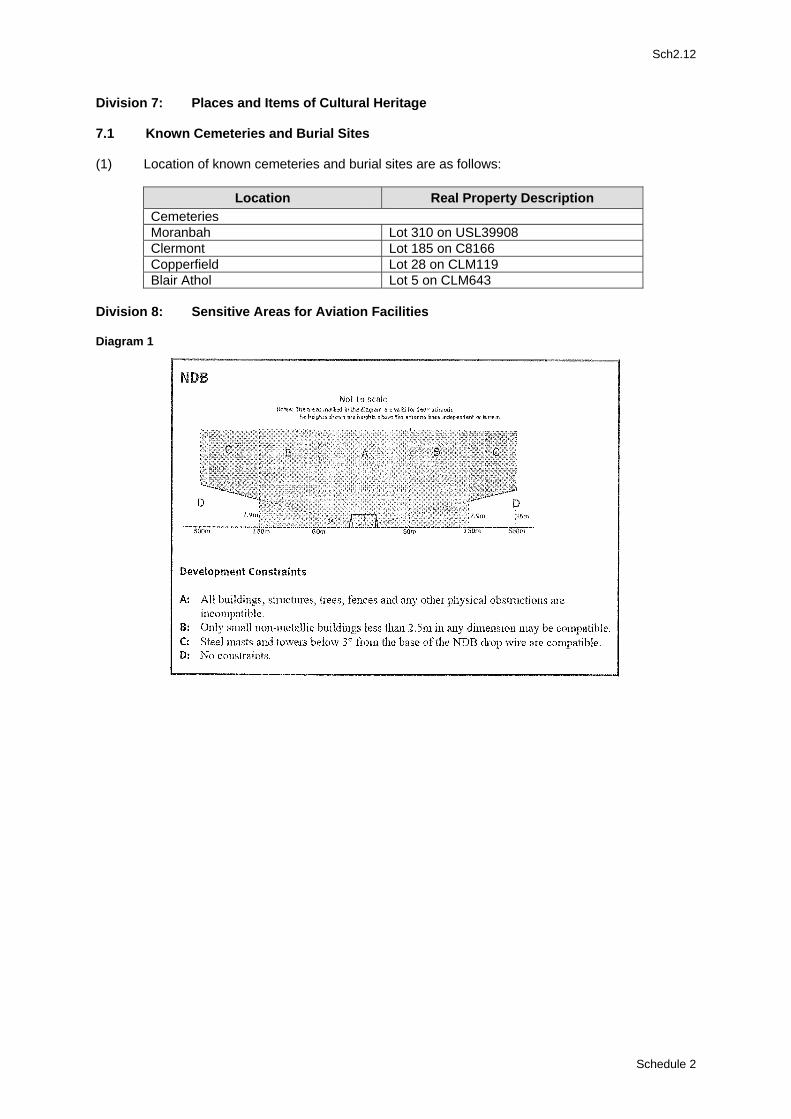
Sch2.12
Division 7: Places and Items of Cultural Heritage 7.1 Known Cemeteries and Burial Sites (1) Location of known cemeteries and burial sites are as follows:
Location Real Property Description Cemeteries Moranbah Lot 310 on USL39908 Clermont Lot 185 on C8166 Copperfield Lot 28 on CLM119 Blair Athol Lot 5 on CLM643
Division 8: Sensitive Areas for Aviation Facilities Diagram 1
Schedule 2
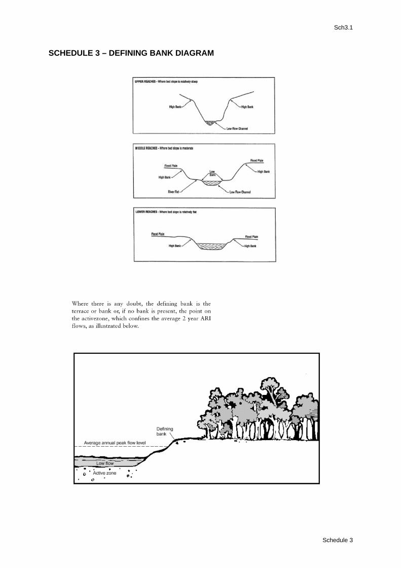
Sch3.1
SCHEDULE 3 – DEFINING BANK DIAGRAM
Schedule 3
PSP1.1
PLANNING SCHEME POLICY 1 – INFORMATION COUNCIL MAY REQUEST 1.0 Purpose (1) To ensure “Council” has appropriate information to assist with development assessment. (2) To ensure applicants are aware of the information “Council” may request during the
development application process 78. 2.0 Information Requirements 2.1 Plans (1) Plans should contain sufficient information to enable an accurate assessment of the proposal.
Appropriate plans include: (a) a site analysis plan identifying and describing all existing site features, such as the
cadastral boundaries of the site, “buildings”, structures”, Roads, vehicle and pedestrian access, car parking, servicing areas, vegetation, topographic, hydraulic and geological features;
(b) a proposal plan identifying and describing the extent of modification of site features, such as, the cadastral boundaries of the site, “buildings”, “structures” , roads, vehicle and pedestrian access, car parking, servicing areas, vegetation, topographic, hydraulic and geological features; and
(c) a landscaping plan detailing the location, extent, densities and species of proposed plantings and other external treatments.
(2) Plans should be drawn to scale and observe recognised drafting conventions. 2.2 Existing “Use” and Site Details (1) Sufficient detail should be provided to enable “Council” to accurately determine the nature
and extent of the current “use” of the site as well as the extent of built and natural features on the site. The following details should be provided: (a) existing and previous “use” of the site; (b) existing and previous “use” of adjoining or adjacent sites; (c) floor areas of “buildings” and other external activity areas, including car parking, storage
areas and the like; (d) site characteristics eg. levels and contours; (e) descriptions of surrounding land uses, including the height and appearance of
“buildings”; and (f) the nature and location of all services and infrastructure, including easement details.
2.3 Proposed “Use” and Site Details (1) Sufficient detail should be provided to enable “Council” to accurately determine the nature of
the proposed “development”. The following details should be provided: (a) details of the proposed “use”, including floor area of “buildings”, external materials,
treatments and colours of “buildings” and “structures” ; and (b) details of external activity areas, including car parking, storage areas and the like.
2.4 Amenity (1) Sufficient detail should be provided to enable “Council” to accurately determine the likely
impact of the proposal on the amenity of the locality. The following details should be provided: (a) hours of operation; (b) deliver times of goods;
78 An information request may be made pursuant to section 3.3.6 of IPA.
Planning Scheme Policy 1
PSP1.2
(c) heights of “buildings” and structures”’; (d) setbacks and boundary clearances of all “buildings” and structures”; and (e) external lighting arrangements.
2.5 Infrastructure (1) Sufficient detail should be provided to enable “Council” to accurately assess infrastructure
requirements. The following information should be provided: (a) known or determined flood levels; (b) proposed water supply; (c) proposed effluent disposal; (d) proposed stormwater disposal; (e) proposed method of liquid and solid waste disposal; (f) proposed electricity supply; and (g) proposed telecommunication.
2.6 Traffic and Servicing (1) Sufficient information should be provided to enable “Council” to accurately assess traffic
related matters. The following information should be provided: (a) traffic likely to be generated by the proposal; (b) the number, type and frequency of vehicles likely to service the proposal; (c) the times and arrangements for servicing of the “premises”; (d) anticipated carparking requirements; and (e) the extent of car parking, vehicle manoeuvring areas, crossover/access details,
loading/unloading areas, service areas. 2.7 Emissions (1) Sufficient details should be provided to enable “Council” to accurately determine the extent
and nature of likely impacts arising from emissions. The following information should be provided: (a) the nature of any anticipated emissions (including odour, noise, dust, run-off and the
like); (b) measures proposed for the control of emissions; (c) the location and methods of containment and control of waste disposal and waste
storage areas; (d) types, quantities, storage methods, and protection measures relating to storage and
use of chemicals; and (e) emergency equipment and procedures to be utilised.
2.8 Environmental (1) Sufficient details should be provided to enable “Council” to accurately determine the likely
environmental impact of the proposal. The following information should be provided: (a) location of ridgelines and escarpments; (b) location of “watercourses” and “lakes” and the extent of associated riparian buffers; (c) location of effluent disposal areas; (d) location and extent of existing vegetation; (e) location and extent of vegetation to be retained; and (f) location of any known sites of indigenous, cultural or natural heritage.
2.9 Constraint Areas (1) Sufficient detail should be provided to enable “Council” to accurately determine the likely
impact of the proposal on constraint areas, as identified in the Planning Scheme.
Planning Scheme Policy 1
PSP1.3
2.10 Reconfiguring a Lot (1) Sufficient details should be provided to enable “Council” to accurately assess proposed
reconfiguration of a lot. The following information should be provided: (a) existing “use” of the land; (b) proposed “use” of the land after the subdivision; (c) details of all proposed lots and of areas proposed for roads, parks or other public
spaces; (d) details of any proposed filling or excavation; (e) details of any encumbrances (for example, easements, leases and the like); (f) contours and levels of the land; (g) location of all services and infrastructure on or adjacent to the land; (h) details of any areas of land subject to subsidence, slip or erosion; (i) location of any “watercourse” or waterhole; (j) details of any known flood levels; (k) location and size of existing “buildings” and structures” ; (l) location of existing parking and vehicle manoeuvring areas; (m) preliminary design details of proposed infrastructure, including water supply, sewerage,
and stormwater drainage; (n) preliminary design details of proposed site access and of proposed new roads or
upgrading of existing roads; and (o) details of any proposed easements for access or other purposes.
(2) Details of the suitability of the proposed reconfiguration (subdivision) should be provided.
Appropriate information would include: (a) existing subdivision pattern in the locality; (b) the nature of the proposed subdivision within the context of that existing subdivision
pattern; (c) anticipated effect of the proposed subdivision on the future use and “development” of
land in the locality; (d) potential for the creation of ribbon “development”; and (e) potential for the need to upgrade infrastructure and services.
(3) For reconfiguration (subdivision) within the Rural “Zone” additional information should be
provided in relation to: (a) details of existing or likely future rural “development” in the locality involving “intensive
animal industry” or activities such as aerial spraying the like. (b) potential for the subdivision to detrimental affect the preservation of good quality
agricultural land; (c) economic viability of proposed lots for “agriculture” or “grazing”; (d) availability of water and the capacity of the soils to support crops or grow pasture; and (e) sustainability of the new lots in relation to land degradation, including issues of
slope/landslip, soil erosion and the like.
Planning Scheme Policy 1
PSP2.1
PLANNING SCHEME POLICY 2 – THIRD PARTY ADVICE OR COMMENT
1.0 Purpose (1) To describe the methods that may be used by “Council” to obtain third party advice or
comment on a development application.
2.0 Requirements 2.1 Consultation (1) Council may seek third party advice or comment on any development proposal.
(a) advice may be sought from any individual, stakeholder or interest group. (b) advice or comment may be sought in any appropriate way, including:
(i) public notification in a newspaper; (ii) placing a notice on the premises; (iii) placing a notice at a public place; (iv) personal notification or contact; (v) public meetings; and (vi) meeting with a person having special interest.
2.2 Information (1) When seeking third party advice or comment, ”Council” will provide appropriate information on
the proposal including: (a) a description of the proposal; (b) details of where the development application may be inspected; (c) details of where comments may be lodge; and (d) the last day upon which “Council” will accept advice or comment.
Planning Scheme Policy 2
PSP3.1
PLANNING SCHEME POLICY 3 – STRUCTURE PLANNING GUIDELINES 1 Planning Framework Council may adopt a structure plan by:
− preparing on its own initiative or in partnership with others, a structure plan that is incorporated into the planning scheme, or
− granting a preliminary approval to a development application that incorporates a structure plan.
1.3 When a Structure Plan is required: A structure plan or demonstration of consistency with an adopted structure plan, will be requested to accompany all applications in the Emerging Community Area within the Urban “Zone”. 1.2 A preliminary approval incorporates a structure plan Section 3.1.6 of the Integrated Planning Act 1997 allows for preliminary approvals to override a planning scheme on the subject land. This process allows for the alteration of a local planning instrument for the assessment of development applications subsequent to the preliminary approval. Specifically it allows for the following:
− alteration of the level of assessment; and − the identification of applicable codes (derived from the planning scheme).
A structure plan will be an integral part of a preliminary approval for development, as it is Council’s formal mechanism for facilitating the process under Section 3.1.6 of the Act. A structure plan should indicate the following:
− type, scale and density of development; − transport networks for vehicles, pedestrians and cyclists; − balance achieved between development, buffering, floodways, conservation and other open
space; − servicing of the development; and − connection to the development from the remainder of Moranbah.
To obtain a preliminary approval, the structure plan will need to contain the information outlined in Section 2 of this policy and address the relevant matters identified in the desired environment outcomes and Urban “Zone” code within the planning scheme. Where it is intended that the preliminary approval will enable a less onerous level of assessment for particular development in subsequent applications, sufficient information to enable the future assessment of self assessment of such development will be required. 2 The Structure Plan A structure plan must identify the major elements of the locality surrounding a development that can impact on the planning and design of the site. It does not constitute an approval for land outside the development site, but ensures the continuation of buffering, corridors, networks and linkages and allows for these to occur on the adjoining sites. The major components of the development are to be designed with consideration of this broader context. It must be clear how the proposed development will integrate with the surrounding community and with the existing parks, service and infrastructure networks and the movement system (road network, public transport facilities and pedestrian and cyclist paths) in the area. 2.1 Preparing a Structure Plan The steps that should be followed and information provided when preparing a structure plan are outlined below. Separate map/s and report/s should be provided demonstrating the assessment undertaken for each step. When in map form the information is to be provided at an appropriate scale. 2.1.1 Step 1—Site and context assessment Prior to preparing the structure plan an assessment of the site and its context should be undertaken and a site description of the land prepared, supported by a map containing the following features (as a minimum): topography and flood liability – contours and levels;
Planning Scheme Policy 3
PSP3.2
the existing road network and intersections, and their treatments; any existing residences and structures, land uses and approvals within the development area or
on surrounding sites; and location of existing and proposed park network and pedestrian and cyclist paths, in the locality.
2.1.2 Step 2—Identification of constraints Land in an the Emerging Community Area is generally suitable for development. However some land may have environmental, scenic or other constraints that will influence the location, form and density of development. As a minimum, land with the following constraints must be identified, mapped and considered in the design of the overall development. views and vistas internal and external to the area that should be retained; buffer zones around any “watercourses” or “lakes” to ensure environmental and cultural values
are protected; existing vegetation that is to be retained for conservation and amenity purposes; details of local water quality from possible acid sulfate soil run–off and contamination; flood affected land; major stormwater flow paths; the location of any gas or oil pipelines; land with the potential for acid sulphate soil, dispersive or erosion prone soil; any contaminated land; and desirable buffering to existing or future mining or rail operations.
2.1.3 Step 3—Structure plan development The structure plan design, including land use allocation, movement system design, and open space and park network provision, must actively promote achievement of the purpose and performance criteria/acceptable solutions of the Reconfiguring a Lot Code and the Urban “Zone” Code. The structure plan should demonstrate: residential mix and approximate lot or dwelling yield for each part of the site (density); location and size of each proposed land use, including the extent of facilities proposed such as
“commercial activities” and “community oriented activities”; how and where broad physical infrastructure is to be provided e.g. water, sewerage and
stormwater; general location and size of parks including corridor linkages and networks; proposed pedestrian and cyclist paths; existing and proposed road network, including level in the hierarchy; and proposed staging of the development.
Where the structure plan, in association with a preliminary approval application, proposes to alter the level of assessment for subsequent development, a schedule or table must be provided to clearly indicate the proposed land use, the proposed precinct on the structure plan map, the proposed level of assessment, and the proposed criteria for use in future assessment, in a form consistent with the planning scheme.
Planning Scheme Policy 3
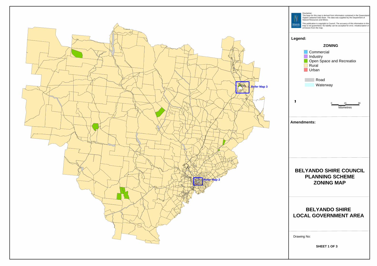
300 15
kilometres
ZONING
CommercialIndustryOpen Space and RecreationRuralUrban
RoadWaterway
Disclaimer:The base for this map is derived from information contained in the QueenslandDigital Cadastral Data Base. The data was supplied by the Department of Natural Resources and Mines.
This publication is copyright to Council. The accuarcy of this information in thismap is not guarenteed. No liability can be accepted for error, misdescription orormission from the map.
Legend:
hAmendments:
BELYANDO SHIRE COUNCILPLANNING SCHEME
ZONING MAP
BELYANDO SHIRELOCAL GOVERNMENT AREA
Drawing No:
SHEET 1 OF 3
Refer Map 2
Refer Map 3
30
kilometres
0 15
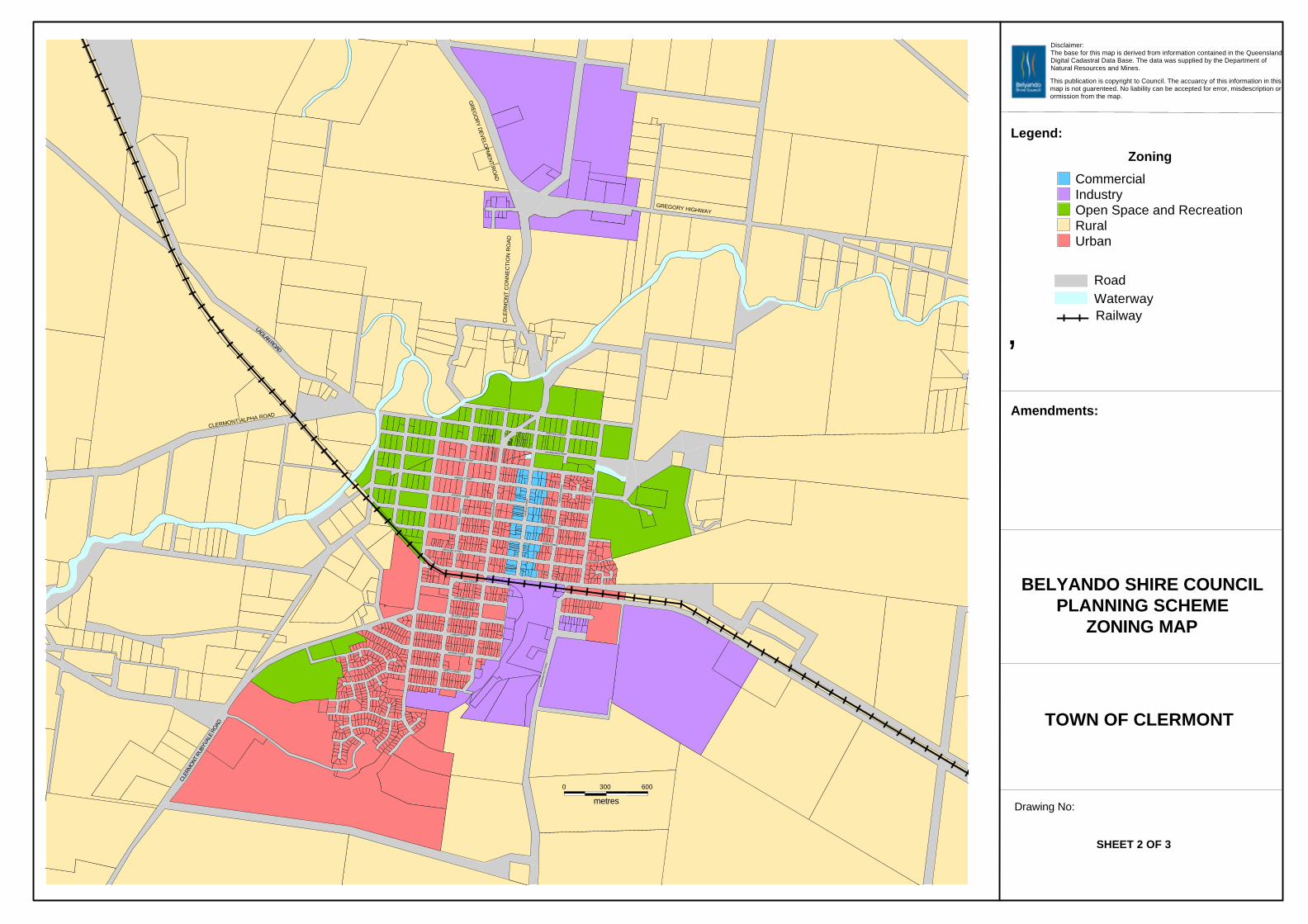
600
GREGORY HIGHWAY
3000
metres
MA
CD
ON
ALD
FLA
T R
OA
D
EA
ST
STR
EE
T
KA
RM
OO
ST
RE
ET
DRUMMOND STREET
WOLFANG STREET
BOX STREET
SIRIUS STREET
GR
EGO
RY D
EVELOPM
ENT R
OAD
HERSCHEL STREET
JELLICOE STREET
CLER
MON
T RU
BYVA
LE R
OAD
KITCHENER STREET
LIME STREET
CA
PR
ICO
RN
ST
RE
ET
FRENCH STREET
MIMOSA STREET
DOUGLAS STREET
CA
PE
LLA
STR
EE
T
CLERMONT ALPHA ROAD
MONASH STREET
CLE
RM
ON
T C
ON
NE
CT
ION
RO
AD
LAGLAN ROAD
CHARLES STREET
BEATTY STREET
TRO
PIC
STR
EE
T
HAIG STREET
Zoning
CommercialIndustryOpen Space and RecreationRuralUrban
RoadWaterway
Disclaimer:The base for this map is derived from information contained in the QueenslandDigital Cadastral Data Base. The data was supplied by the Department of Natural Resources and Mines.
This publication is copyright to Council. The accuarcy of this information in thismap is not guarenteed. No liability can be accepted for error, misdescription orormission from the map.
Legend:
hAmendments:
BELYANDO SHIRE COUNCILPLANNING SCHEME
ZONING MAP
TOWN OF CLERMONT
Drawing No:
SHEET 2 OF 3
Railway
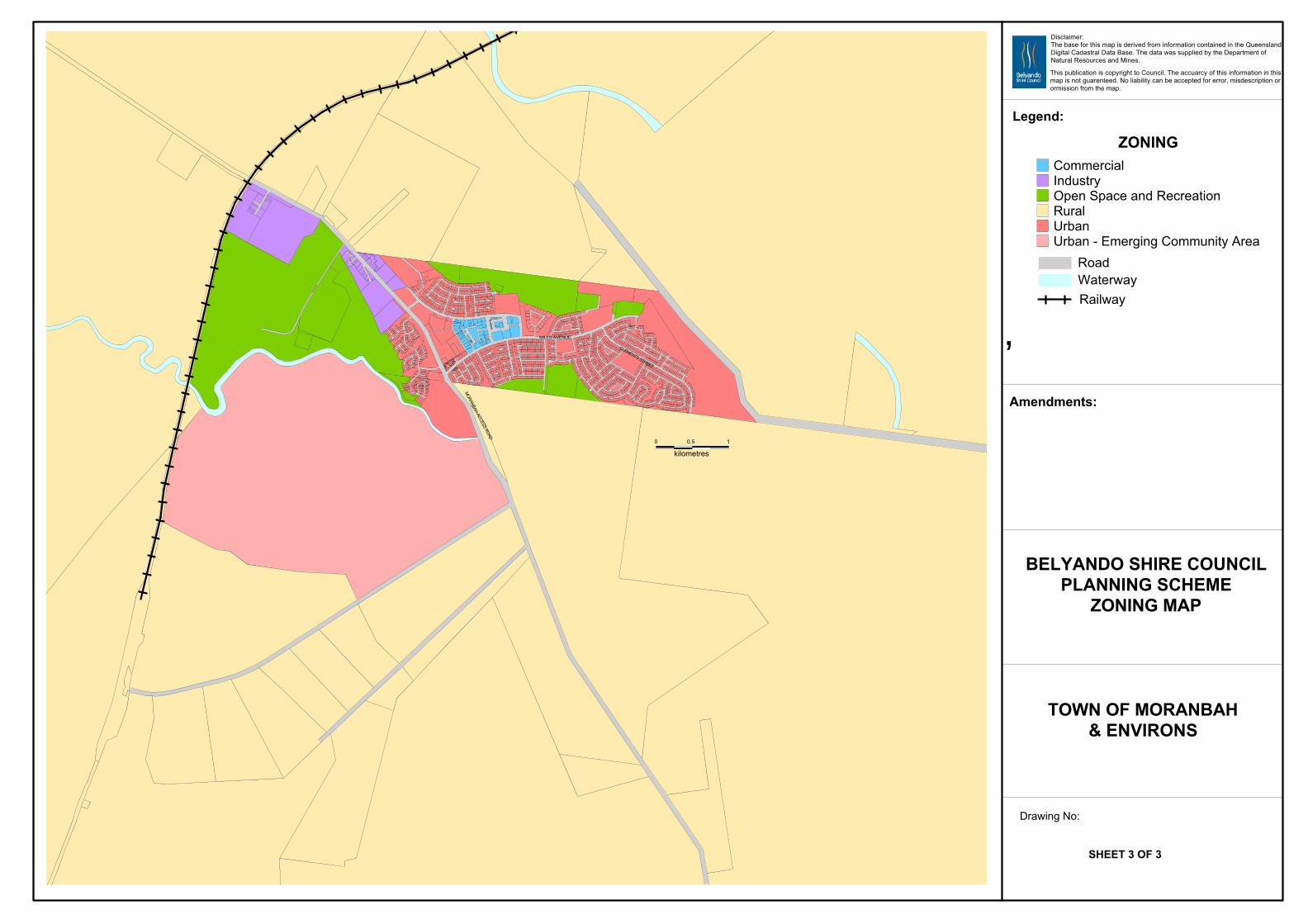
1
kilometres
0.50
CLEMENTS STREET
MILLS AVENUE
SARC
HEDO
N DR
IVE
MO
RANBAH ACCESS ROAD
ZONINGCommercialIndustryOpen Space and RecreationRuralUrbanUrban - Emerging Community Area
RoadWaterway
Disclaimer:The base for this map is derived from information contained in the QueenslandDigital Cadastral Data Base. The data was supplied by the Department of Natural Resources and Mines.
This publication is copyright to Council. The accuarcy of this information in thismap is not guarenteed. No liability can be accepted for error, misdescription orormission from the map.
Legend:
hAmendments:
BELYANDO SHIRE COUNCILPLANNING SCHEME
ZONING MAP
TOWN OF MORANBAH& ENVIRONS
Drawing No:
SHEET 3 OF 3
Railway
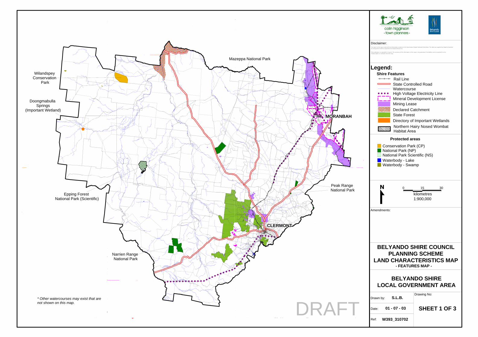
BELYANDO SHIRE COUNCILPLANNING SCHEME
LAND CHARACTERISTICS MAP
BELYANDO SHIRELOCAL GOVERNMENT AREA
Legend:
Drawing No:
Ref:
Date:
Drawn by:
Amendments:
Disclaimer:
S.L.B.
SHEET 1 OF 3
W393_310702
01 - 07 - 03
The base for this map is derived from information contained in the Queensland Digital Cadastral Data Base. The data was supplied by MapInfo Australiaby arrangement with the Department of Natural Resources.
This publication is copyright to Council. The accuracy of this information in this map is not guaranteed. No liability can be accepted for error,misdescription or omission from the map.
���������������������������������������������������������������
������
������
CLERMONTCLERMONTCLERMONTCLERMONTCLERMONTCLERMONTCLERMONTCLERMONTCLERMONT
MORANBAHMORANBAHMORANBAHMORANBAHMORANBAHMORANBAHMORANBAHMORANBAHMORANBAH
Wilandspey Conservation
Park
Epping Forest National Park (Scientific)
Mazeppa National Park
Narrien Range National Park
Peak Range National Park
Doongmabulla Springs
(Important Wetland)
DRAFT
0 15 30
kilometres
����
����
Waterbody - LakeWaterbody - Swamp
Protected areas
Conservation Park (CP)National Park (NP)National Park Scientific (NS)
Northern Hairy Nosed WombatHabitat Area
Directory of Important WetlandsState ForestDeclared CatchmentMining LeaseMineral Development LicenseHigh Voltage Electricity LineWatercourseState Controlled RoadRail Line
1:900,000
- FEATURES MAP -
Shire Features
* Other watercourses may exist that are not shown on this map.
keveena
keveena
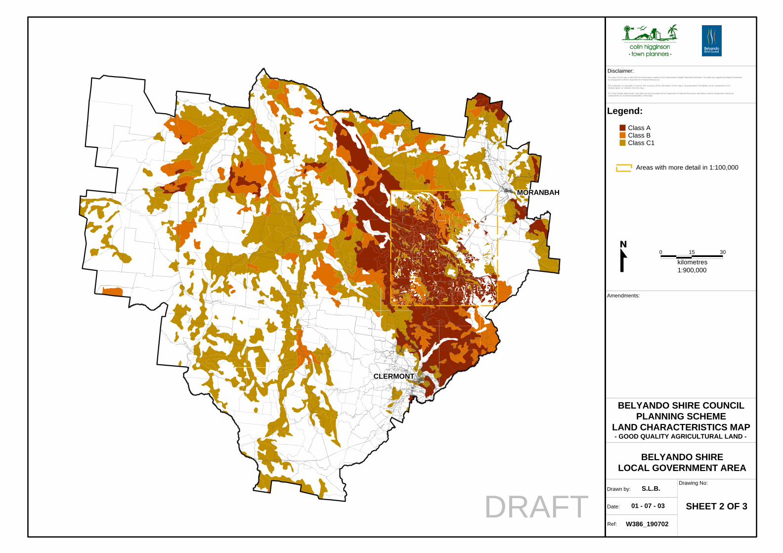
BELYANDO SHIRE COUNCILPLANNING SCHEME
LAND CHARACTERISTICS MAP
BELYANDO SHIRELOCAL GOVERNMENT AREA
Legend:
Drawing No:
Ref:
Date:
Drawn by:
Amendments:
Disclaimer:
S.L.B.
SHEET 2 OF 3
W386_190702
01 - 07 - 03
The base for this map is derived from information contained in the Queensland Digital Cadastral Data Base. The data was supplied by MapInfo Australiaby arrangement with the Department of Natural Resources.
This publication is copyright to Council. The accuracy of this information in this map is not guaranteed. No liability can be accepted for error,misdescription or omission from the map.
MORANBAHMORANBAHMORANBAHMORANBAHMORANBAHMORANBAHMORANBAHMORANBAHMORANBAH
CLERMONTCLERMONTCLERMONTCLERMONTCLERMONTCLERMONTCLERMONTCLERMONTCLERMONT
DRAFT
0 15 30
kilometres
Class AClass BClass C1
1:900,000
- GOOD QUALITY AGRICULTURAL LAND -
The Good Quality Agricultural Land data has been provided by the Department of Natural Resources and Mines and this Department should becontacted for an accurate interpretation of the data.
Areas with more detail in 1:100,000
keveena
DRAFT
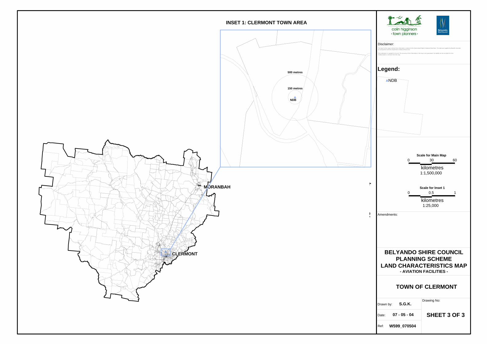
BELYANDO SHIRE COUNCILPLANNING SCHEME
LAND CHARACTERISTICS MAP
TOWN OF CLERMONT
Legend:
Drawing No:
Ref:
Date:
Drawn by:
Amendments:
Disclaimer:
S.G.K.
SHEET 3 OF 3
W599_070504
07 - 05 - 04
The base for this map is derived from information contained in the Queensland Digital Cadastral Data Base. The data was supplied by MapInfo Australiaby arrangement with the Department of Natural Resources.
This publication is copyright to Council. The accuracy of this information in this map is not guaranteed. No liability can be accepted for error,misdescription or omission from the map.
CLERMONTCLERMONTCLERMONTCLERMONTCLERMONTCLERMONTCLERMONTCLERMONTCLERMONT
MORANBAHMORANBAHMORANBAHMORANBAHMORANBAHMORANBAHMORANBAHMORANBAHMORANBAH0 0.5 1
kilometres
NDB
1:25,000
- AVIATION FACILITIES -
500 metres
NDB
150 metres
INSET 1: CLERMONT TOWN AREA
Scale for Inset 1
0 30 60
kilometres1:1,500,000
Scale for Main Map
keveena
DRAFT
keveena
DRAFT
keveena
DRAFT
Related Documents