Piloting Course (Inland Navigation) Chapter 8 Review SEO – Dave West [email protected] - 651-429-3840 Instructor – Art Mollica [email protected] - 651-777-0277 United States Power Squadrons ®

Piloting Course (Inland Navigation) Chapter 8 Review SEO – Dave West [email protected] - 651-429-3840 Instructor – Art Mollica [email protected].
Jan 02, 2016
Welcome message from author
This document is posted to help you gain knowledge. Please leave a comment to let me know what you think about it! Share it to your friends and learn new things together.
Transcript
Piloting Course (Inland Navigation)
Chapter 8
Review
SEO – Dave [email protected] - 651-429-3840
Instructor – Art [email protected] - 651-777-0277
United States Power Squadrons ®
Slide 2
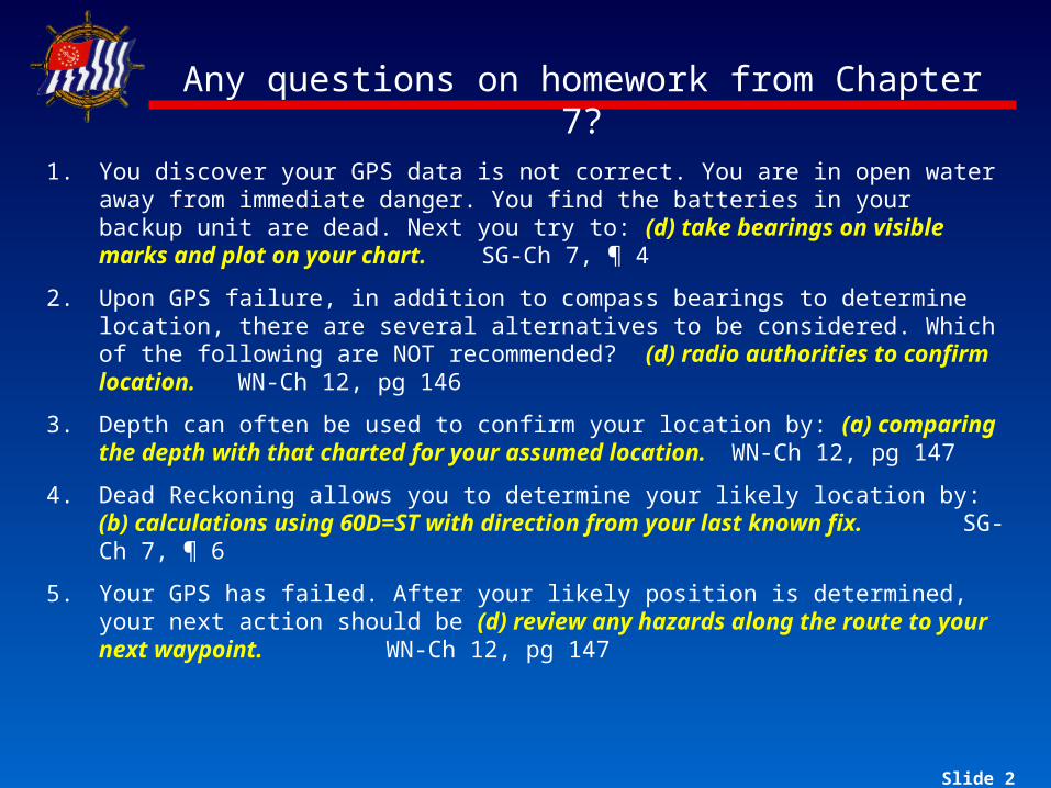
Any questions on homework from Chapter 7?
1. You discover your GPS data is not correct. You are in open water away from immediate danger. You find the batteries in your backup unit are dead. Next you try to: (d) take bearings on visible marks and plot on your chart. SG-Ch 7, ¶ 4
2. Upon GPS failure, in addition to compass bearings to determine location, there are several alternatives to be considered. Which of the following are NOT recommended? (d) radio authorities to confirm location. WN-Ch 12, pg 146
3. Depth can often be used to confirm your location by: (a) comparing the depth with that charted for your assumed location. WN-Ch 12, pg 147
4. Dead Reckoning allows you to determine your likely location by: (b) calculations using 60D=ST with direction from your last known fix. SG-Ch 7, ¶ 6
5. Your GPS has failed. After your likely position is determined, your next action should be (d) review any hazards along the route to your next waypoint. WN-Ch 12, pg 147
Slide 3
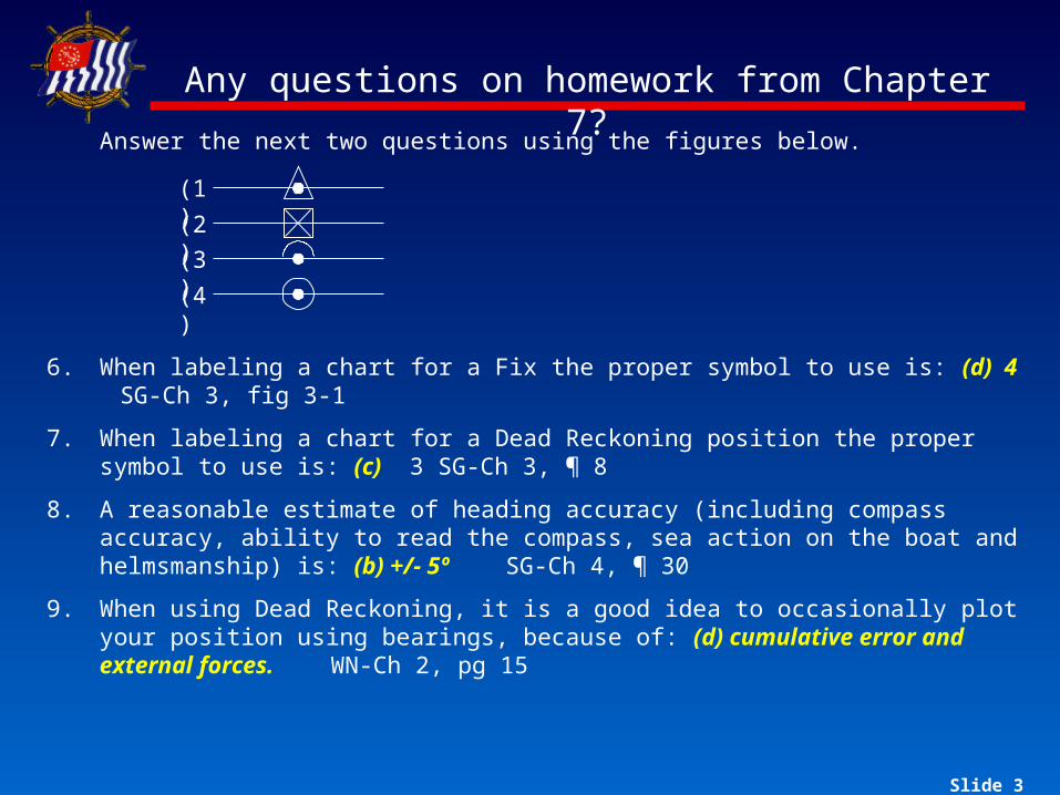
Any questions on homework from Chapter 7?
Answer the next two questions using the figures below.
6. When labeling a chart for a Fix the proper symbol to use is: (d) 4 SG-Ch 3, fig 3-1
7. When labeling a chart for a Dead Reckoning position the proper symbol to use is: (c) 3 SG-Ch 3, ¶ 8
8. A reasonable estimate of heading accuracy (including compass accuracy, ability to read the compass, sea action on the boat and helmsmanship) is: (b) +/- 5º SG-Ch 4, ¶ 30
9. When using Dead Reckoning, it is a good idea to occasionally plot your position using bearings, because of: (d) cumulative error and external forces. WN-Ch 2, pg 15
(1)(2)(3)(4)
Slide 4
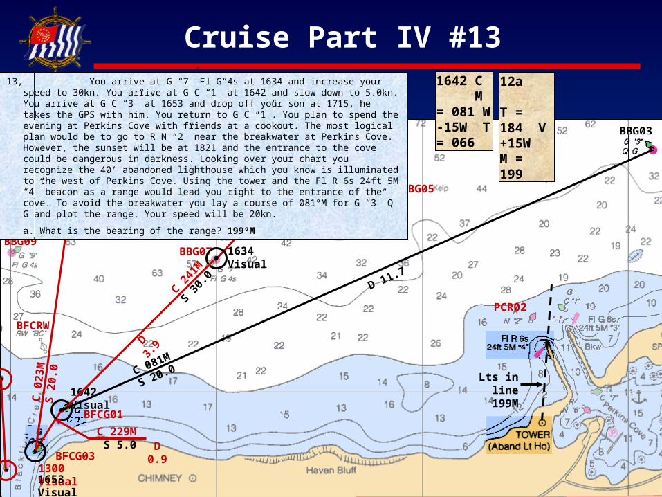
Cruise Part IV #13
PCR02
PCFLR6
BBG07
BBG05
BBG09
BFCRW
C 24
1M
S 30
.0
BBG03
1634 Visual
Lts in line
199M
1642 C M = 081 W -15W T = 066
12a T = 184 V +15W M = 199
C
081M
S 20.0
D 11.7
D
3.9
D 0.9BFCG0
3
BFCG01 C
229M S 5.0
1300 Visual
C
023M
S
20.0
1642 Visual
1653 Visual
13, You arrive at G “7” Fl G 4s at 1634 and increase your speed to 30kn. You arrive at G C “1” at 1642 and slow down to 5.0kn. You arrive at G C “3” at 1653 and drop off your son at 1715, he takes the GPS with him. You return to G C “1”. You plan to spend the evening at Perkins Cove with friends at a cookout. The most logical plan would be to go to R N “2” near the breakwater at Perkins Cove. However, the sunset will be at 1821 and the entrance to the cove could be dangerous in darkness. Looking over your chart you recognize the 40’ abandoned lighthouse which you know is illuminated to the west of Perkins Cove. Using the tower and the Fl R 6s 24ft 5M “4” beacon as a range would lead you right to the entrance of the cove. To avoid the breakwater you lay a course of 081ºM for G “3” Q G and plot the range. Your speed will be 20kn.
a. What is the bearing of the range? 199ºM
Slide 5
Cruise Part IV #14
PCR02
PCFLR6
1316
C 070M S 25.0
BBG05
BBG09
BFCRW
BFCG03
BFCG01
XTE
0.4
L
C 24
1M
S 30
.0
C 229M S 5.0
1300 Visual
C
023M
S
20.0
BBG03
1642 Visual
1653 Visual
Lts in line
199M
C
081M
S 20.0
1816 Brg M = 312 227 V -15W T = 297 212
1816 DR 1816 – 1802 = 14 D = TS / 60 D = 14 x 20 / 60 D = 280 / 60 D = 4.67 = 4.7nm
1816 312M
1816
22
7M1816
1816
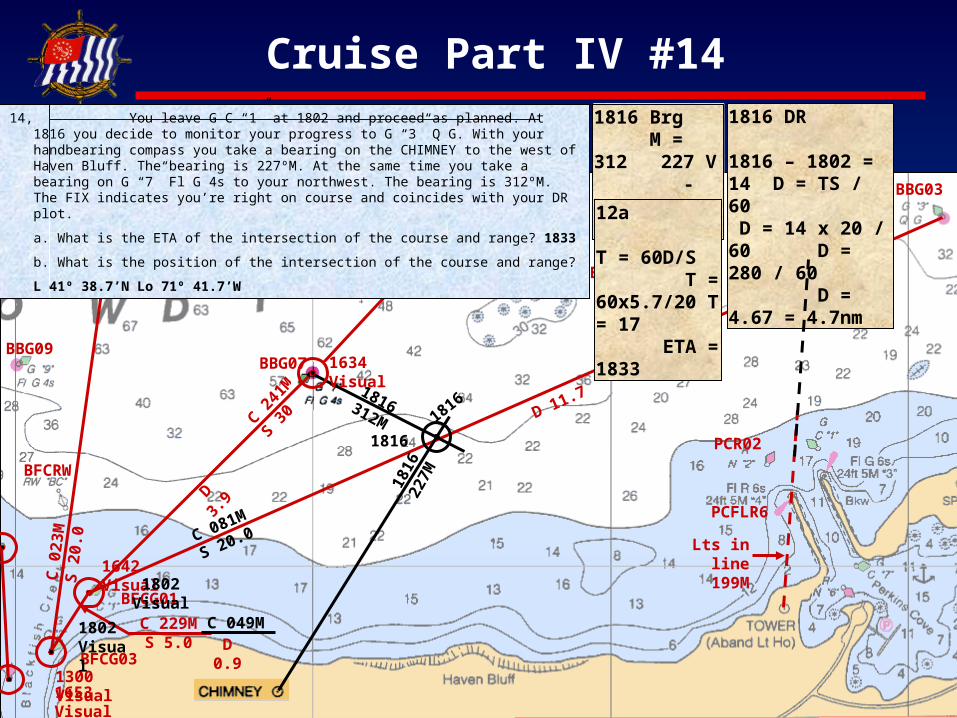
14, You leave G C “1” at 1802 and proceed as planned. At 1816 you decide to monitor your progress to G “3” Q G. With your handbearing compass you take a bearing on the CHIMNEY to the west of Haven Bluff. The bearing is 227ºM. At the same time you take a bearing on G “7” Fl G 4s to your northwest. The bearing is 312ºM. The FIX indicates you’re right on course and coincides with your DR plot.
a. What is the ETA of the intersection of the course and range? 1833
b. What is the position of the intersection of the course and range?
L 41º 38.7’N Lo 71º 41.7’W
D 11.7
D
3.9
D 0.9
1802 Visual
12a T = 60D/S T = 60x5.7/20 T = 17 ETA = 18331634
Visual BBG07
C 049M
1802 Visual
Slide 6
Cruise Part IV #15
1845 C M = 168 V -15W T = 153
1903 C M = 140 V -15W T = 125
1914 Distance 1914 – 1903 = 11 D = TS / 60 D = 11 x 5 / 60 D = 55 / 60 D = 0.91 = 0.9nm
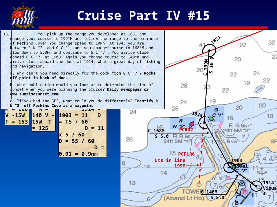
15, You pick up the range you developed at 1831 and change your course to 199ºM and follow the range to the entrance of Perkins Cove. You change speed to 10kn. At 1845 you are between R N “2” and G C “1” and you change course to 168ºM and slow down to 5.0kn and continue to G C “7”. You arrive close aboard G C “7” at 1903. Again you change course to 140ºM and arrive close aboard the dock at 1914. What a great day of fishing and navigation.
a. Why can’t you head directly for the dock from G C “7”? Rocks off point in back of dock
b. What publication would you look at to determine the time of sunset when you were planning the cruise? Daily newspaper or www.sunrisesunset.com
c. If you had the GPS, what could you do differently? Identify R N “2” off Perkins Cove as a waypoint
PCR02
PCFLR6Lts in line
199M
C 1
99M
S 1
0.0
1845
C 168M S 5.0
1903 Visual
1914 Visual
C 140M S 5.0
1831
Slide 7
Piloting Review
What areas/topics do you want reviewed?
Slide 8Slide 8
Common reasons for low scores
Not showing work
Not showing TVM calculations
Lack of knowledge of how to plot
Not plotting DRs, especially when bearings are taken
Slide 9
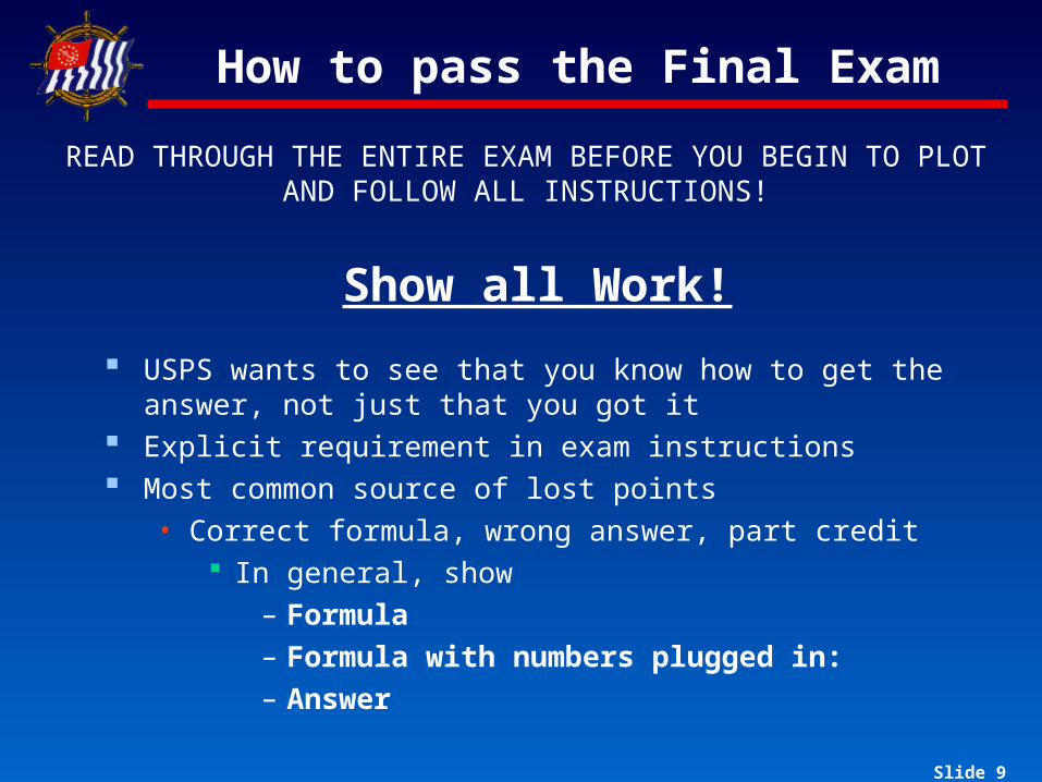
How to pass the Final Exam
READ THROUGH THE ENTIRE EXAM BEFORE YOU BEGIN TO PLOT AND FOLLOW ALL INSTRUCTIONS!
Show all Work!
USPS wants to see that you know how to get the answer, not just that you got it
Explicit requirement in exam instructions Most common source of lost points
• Correct formula, wrong answer, part credit In general, show
– Formula– Formula with numbers plugged in:– Answer
Slide 10Slide 10
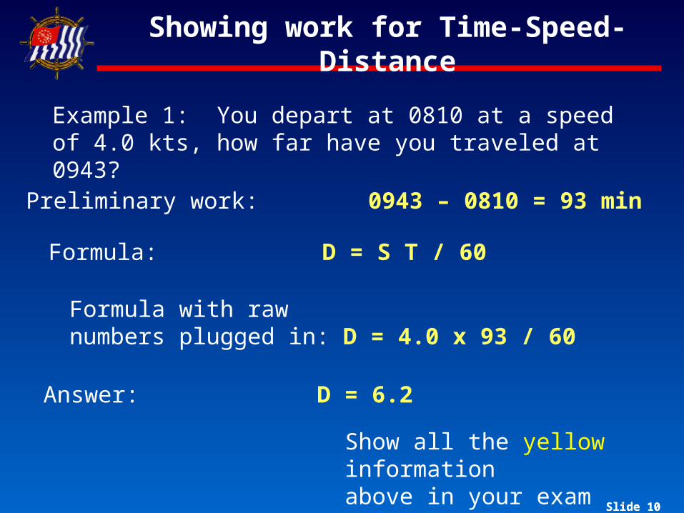
Showing work for Time-Speed-Distance
Preliminary work: 0943 – 0810 = 93 min
Example 1: You depart at 0810 at a speed of 4.0 kts, how far have you traveled at 0943?
Formula: D = S T / 60
Formula with rawnumbers plugged in: D = 4.0 x 93 / 60
Answer: D = 6.2
Show all the yellow informationabove in your exam booklet
Slide 11Slide 11
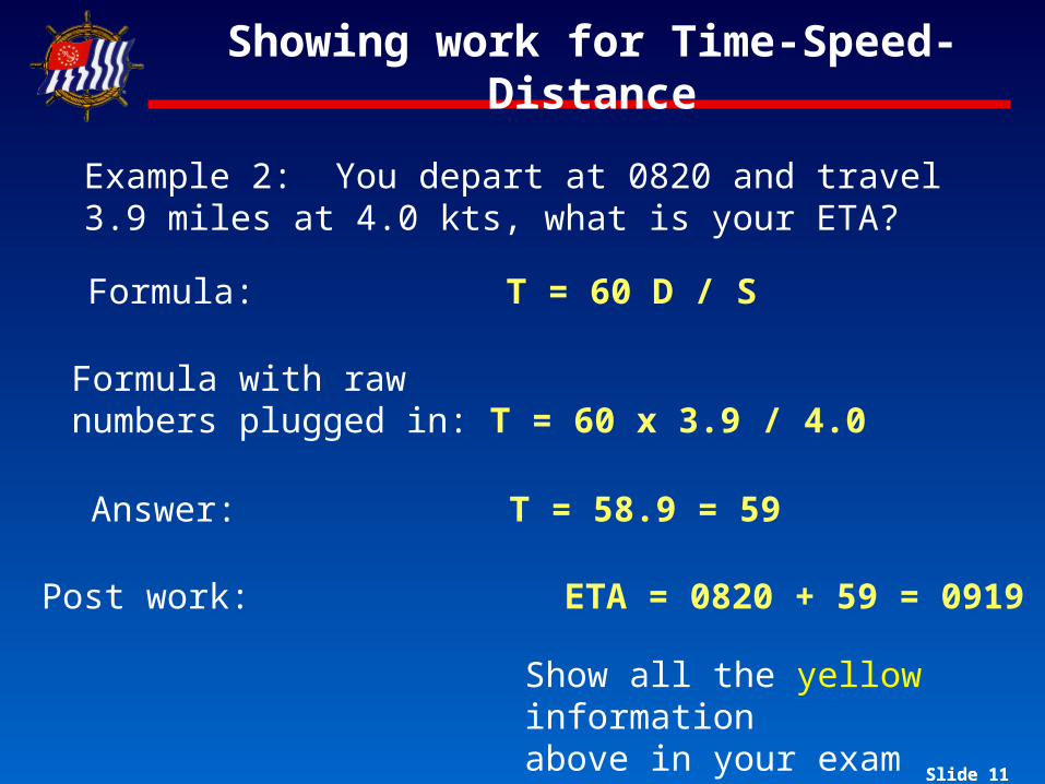
Showing work for Time-Speed-Distance
Example 2: You depart at 0820 and travel 3.9 miles at 4.0 kts, what is your ETA?
Formula: T = 60 D / S
Formula with rawnumbers plugged in: T = 60 x 3.9 / 4.0
Answer: T = 58.9 = 59
Post work: ETA = 0820 + 59 = 0919
Show all the yellow informationabove in your exam booklet
Slide 12Slide 12
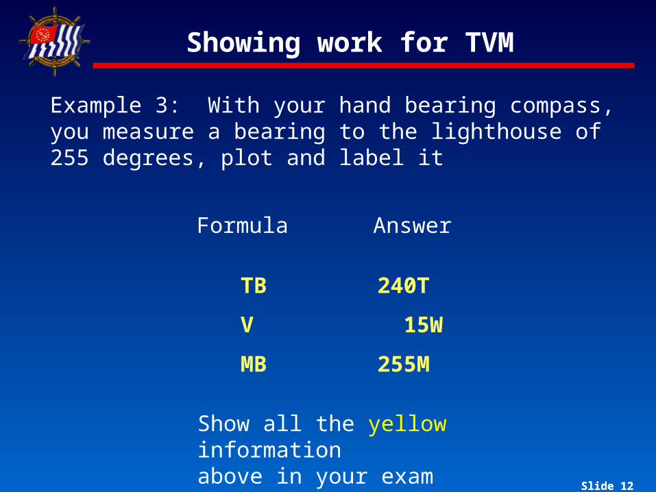
Showing work for TVM
Formula Answer
TB
V
MB
240T
15W
255M
Example 3: With your hand bearing compass, you measure a bearing to the lighthouse of 255 degrees, plot and label it
Show all the yellow informationabove in your exam booklet
Slide 13Slide 13
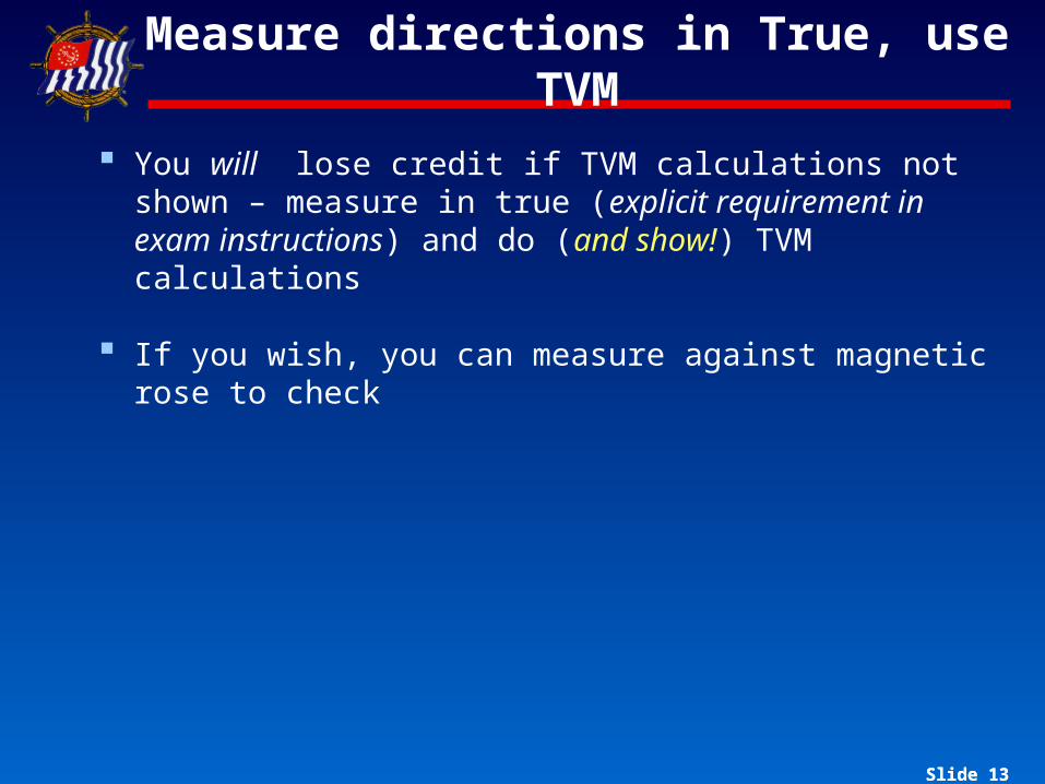
Measure directions in True, use TVM
You will lose credit if TVM calculations not shown – measure in true (explicit requirement in exam instructions) and do (and show!) TVM calculations
If you wish, you can measure against magnetic rose to check
Slide 14Slide 14
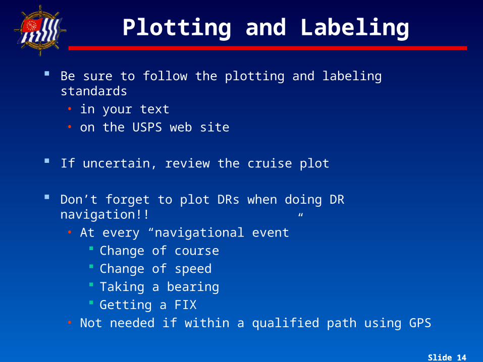
Plotting and Labeling
Be sure to follow the plotting and labeling standards• in your text • on the USPS web site
If uncertain, review the cruise plot
Don’t forget to plot DRs when doing DR navigation!!• At every “navigational event”
Change of course Change of speed Taking a bearing Getting a FIX
• Not needed if within a qualified path using GPS

Slide 15Slide 15
Plotting and Labeling (con’t)
Remember• Fix times are horizontal
• DR times are • If fix is not by bearings, you must show source
For example, 1018 GPS
When measuring longitude, don’t forget that it increases from right to left in the western hemisphere (ie, Bowditch Bay)
Don’t show ETAs on plot • Not part of the Plotting and Labeling Standard• Just put required ETAs (and supporting calculations!) in
answer book
on a diagonal

Slide 16Slide 16
Miscellaneous
THINK – does your answer make sense??
Try to use alternate methods to check your work. For example, use the magnetic rose to check your TVM calculations.
Use the Coastal Explorer Viewer to check your course.
Be careful, be neat. If an exam grader can’t figure out your work (especially your plot) he/she can’t give it an accurate grade!
Slide 17Slide 17
Sample Questions
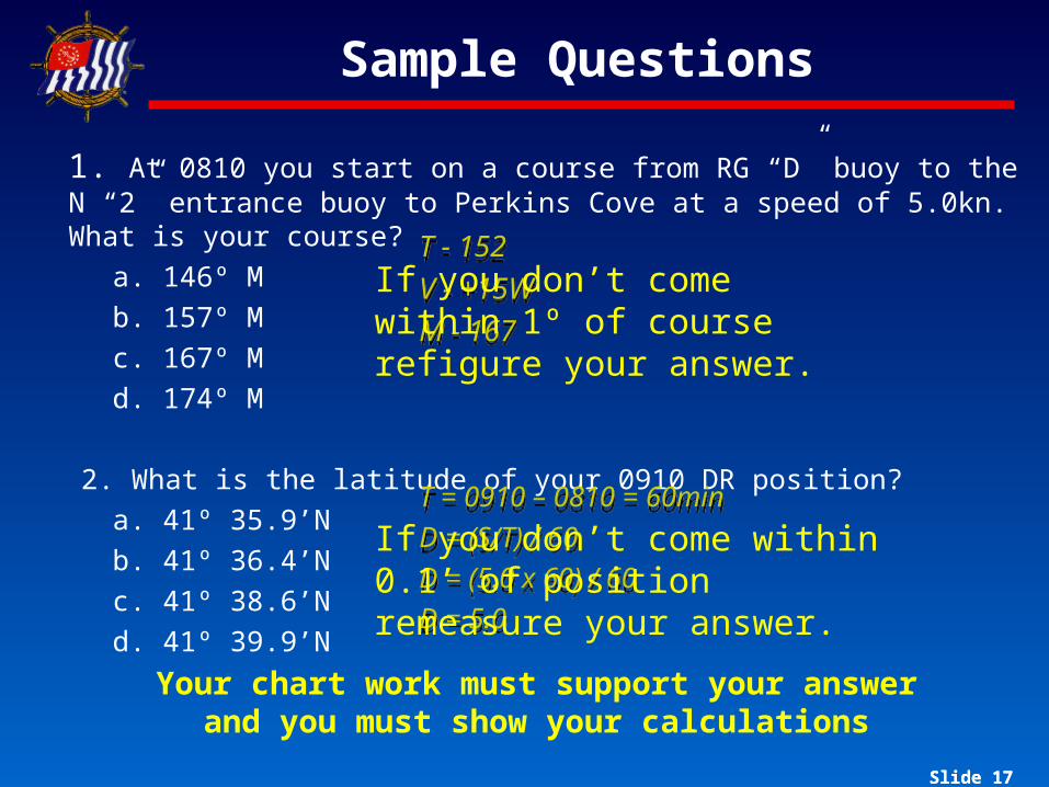
1. At 0810 you start on a course from RG “D” buoy to the N “2” entrance buoy to Perkins Cove at a speed of 5.0kn. What is your course?
a. 146º Mb. 157º Mc. 167º Md. 174º M
2. What is the latitude of your 0910 DR position?a. 41º 35.9’Nb. 41º 36.4’Nc. 41º 38.6’Nd. 41º 39.9’N
Your chart work must support your answer and you must show your calculations
T - 152V - +15WM - 167
T - 152V - +15WM - 167
T = 0910 – 0810 = 60minD = (S/T) / 60D = (5.0 x 60) / 60D = 5.0
T = 0910 – 0810 = 60minD = (S/T) / 60D = (5.0 x 60) / 60D = 5.0
If you don’t come within 1º of course refigure your answer.
If you don’t come within 0.1’ of position remeasure your answer.

Slide 18
Give yourself enough time
Final exam takes most students eight to twelve
hours to complete
Don’t start the night before it’s due!
Pilo
tin
g
Slide 19
Good Luck!
“Luck can be defined as the intersection of preparation and opportunity”
You are prepared…You now have opportunity
Exams must be returned to Dave West by Friday, 23 March
Related Documents


