PETROLEUM GEOLOGY OF THE MONTEREY FORMATION IN THE SANTA MARIA AND SANTA BARBARA COASTAL AND OFFSHORE AREAS by T. C. MacKinnon Chevron U.S.A., San Ramon, California INTRODUCTION STRATIGRAPHIC AND STRUCTURAL SETTING Prior to Oligocene times, the Santa Barbara and Santa Maria area was part of a subduction-forearc basin system that had been in place along California, albeit with some interruptions, since late Jurassic time. The Santa Maria area was the site of subduction as represented by the basement rock there - the highly deformed and in-part metamorphosed sedimentary and volcanic rocks of the Franciscan Complex. The Santa Barbara area was the site of forearc basin sedimentation as represented by a thick (6100 m; 20;000 ft) nearly uninterrupted sequence of sedimentary rocks of Late Jurassic to Oligocene age, well exposed in the Santa Ynez Mountains (Figures 1 and 2). A change from subduction to a transform margin occurred during the Oligocene-Early Miocene and resulted in extension of the borderland and formation of new marine basins. In the Santa Barbara area, the last phase of forearc sedimentation, as represented mainly by non-marine deposition (Sespe Fm), was replaced by shallow marine (Vaqueros Fm.) then deep marine (Rincon Fm.) sedimentation in the newly formed basins. In the Santa Maria area, the Franciscan was overlain by the non-marine and shallow- marine(?) Lospe Formation during this period. Monterey Formation deposition began in the Late Early Miocene and continued into the Late Miocene. As Monterey deposition structural studies by Belfield and others (1983) and Snyder (1987); and petroleum geology studies by Ogle and other (1987), Crain and others (1987) and Isaacs and Petersen (1987). Classic early reports on regional geology include Woodring and Bramlette (1950) on the Santa Maria area, and Dibblee (1950, 1966) on the Santa Barbara coastline and Santa Ynez Range. In this paper, Monterey Formation geology as gleaned mainly from coastal outcrops is summarized and related to nearby oilfields. This includes correlation of outcrops to wells and discussion of reservoir characteristics and models. SANTA BARBARA AI CHANNEL 20 I o Miles o Km 20 OFFSHORE '" " " , SANTA MARIA Santa- ............. , .............. -.,.", BASIN I Maria ....... , PI. Sal ONSHORE"" "9..<' " "9 SANTA MARIA" " Lompoc, BASIN " \ Pt.. \ 'Z \ Arguello __ - _ _ J U) ,., --_./ \ -9- / A SANTA YNEZ MTNS \ COST 311:'"J/ • Sanla Barbara \ Gaviola _ WELL /' Pt. ',_ / Conception Figure 1. Location map of the Santa Barbara-Santa Maria area. See Figure 4 for cross section A-A'. Spectacular outcrops of the Monterey Formation are exposed along the coast between Santa Barbara and Santa Maria (Figure 1). These exposures are direct analogues to reservoir and source rocks in nearby oil fields both on and offshore. Excellent exposure, easy access, and association with petroleum have attracted a great deal of geologic study of the coastal outcrops. In particular, the work of Isaacs (1981a, 1981b, 1982, 1983, 1984, 1985, 1987) along the Santa Barbara coast has helped clarify some long standing questions on rock composition, sedimentation rates, and stratigraphy. Other recent work including references to important earlier work includes: studies of the Santa Maria area by Pisciotto (1981) and Grivetti (1982); a field guide to the Santa Maria coastal outcrops by Dunham and Blake (1987); T311: 11

Welcome message from author
This document is posted to help you gain knowledge. Please leave a comment to let me know what you think about it! Share it to your friends and learn new things together.
Transcript

PETROLEUM GEOLOGY OF THE MONTEREY FORMATION IN THESANTA MARIA AND SANTA BARBARA COASTAL AND OFFSHORE AREAS
by T. C. MacKinnonChevron U.S.A., San Ramon, California
INTRODUCTION
STRATIGRAPHIC AND STRUCTURAL SETTING
Prior to Oligocene times, the SantaBarbara and Santa Maria area was part of asubduction-forearc basin system that hadbeen in place along California, albeit withsome interruptions, since late Jurassictime. The Santa Maria area was the site ofsubduction as represented by the basementrock there - the highly deformed and in-partmetamorphosed sedimentary and volcanic rocksof the Franciscan Complex. The SantaBarbara area was the site of forearc basinsedimentation as represented by a thick(6100 m; 20;000 ft) nearly uninterruptedsequence of sedimentary rocks of LateJurassic to Oligocene age, well exposed inthe Santa Ynez Mountains (Figures 1 and 2).
A change from subduction to a transformmargin occurred during the Oligocene-EarlyMiocene and resulted in extension of theborderland and formation of new marinebasins. In the Santa Barbara area, the lastphase of forearc sedimentation, asrepresented mainly by non-marine deposition(Sespe Fm), was replaced by shallow marine(Vaqueros Fm.) then deep marine (Rincon Fm.)sedimentation in the newly formed basins.In the Santa Maria area, the Franciscan wasoverlain by the non-marine and shallowmarine(?) Lospe Formation during thisperiod.
Monterey Formation deposition began inthe Late Early Miocene and continued intothe Late Miocene. As Monterey deposition
structural studies by Belfield and others(1983) and Snyder (1987); and petroleumgeology studies by Ogle and other (1987),Crain and others (1987) and Isaacs andPetersen (1987). Classic early reports onregional geology include Woodring andBramlette (1950) on the Santa Maria area,and Dibblee (1950, 1966) on the SantaBarbara coastline and Santa Ynez Range.
In this paper, Monterey Formation geologyas gleaned mainly from coastal outcrops issummarized and related to nearby oilfields.This includes correlation of outcrops towells and discussion of reservoircharacteristics and models.
SANTA BARBARAAI CHANNEL
20I
o Miles
~o Km 20
OFFSHORE '"" " ,SANTA MARIA Santa- ............. , ~...,
.............. -.,.",BASIN I Maria ....... , ~
PI. Sal ONSHORE"" "9..<'
" "9SANTA MARIA" ~<
"Lompoc, BASIN " ~\ Pt.. \ 'Z
\Arguello __ - _ _ J U)
,., --_./\ -9- / A SANTA YNEZ MTNS
\ COST 311:'"J/ • Sanla Barbara\ ~ Gaviola _
WELL /' Pt.',_ / Conception
Figure 1. Location map of the SantaBarbara-Santa Maria area. See Figure 4 forcross section A-A'.
Spectacular outcrops of the MontereyFormation are exposed along the coastbetween Santa Barbara and Santa Maria(Figure 1). These exposures are directanalogues to reservoir and source rocks innearby oil fields both on and offshore.
Excellent exposure, easy access, andassociation with petroleum have attracted agreat deal of geologic study of the coastaloutcrops. In particular, the work of Isaacs(1981a, 1981b, 1982, 1983, 1984, 1985, 1987)along the Santa Barbara coast has helpedclarify some long standing questions on rockcomposition, sedimentation rates, andstratigraphy. Other recent work includingreferences to important earlier workincludes: studies of the Santa Maria areaby Pisciotto (1981) and Grivetti (1982); afield guide to the Santa Maria coastaloutcrops by Dunham and Blake (1987);
T311: 11

proceeded, the Transverse Ranges wereapparently rotated clockwise as shown bypaleomagnetic studies (Luyendyk and others,
Miles
~o Km 50
D Forearc Basin Basement
(S3 Subduction Basement
16 M.Y.A.
....~ ,..... Malibu
'-~~---:
1 '~\,PRESENT
"
tN
1987). The rotation apparently beganapproximately 16 to 18 Ma and resulted inthe present east-west orientation of theTransverse Ranges. This changed theoriginal parallel arrangement of forearcbelts to the present arrangement wheresubduction basement in the Santa Maria areais now wedged between belts of forearc basinrocks (Figure 3).
Monterey deposition ceased approximately6.0 Ma when a major tectonic disturbanceuplifted parts of the margins of both theSanta Barbara and Santa Maria areas,resulting in an increase in detritus anddeposition of the Sisquoc Formation. Theuplift is marked by an unconformity betweenthe Monterey and Sisquoc Formations in manyareas (Woodring and Bramlette, 1950:Dibb1ee, 1966). Tectonism continued throughthe Pliocene and Early Pleistocene and both~wo
i
~w""~__ 0
Q~Q.
CENTRALSANTA YNEZ
RANGE
ADAPTEDFROM
AAPG 1952
wZw
CD 0Q. 0en CJ~ :::J
0
...!II~'0'00
MAINLYiFOREARC c
BASIN >-SEQUENCE N
00
SUBDUCTION ca::-=COMPLEX I; w:E z
w00
'ii w~~.,&Q.~
0 0
1000
500Meter 2000
FeetCONTINUES
~
....><.:..:.::>'.;.;j~;,
\.~"~' ':':~t:
SANTA MARIA AREA(Excluding Pt. Sal Ridge)
Q ".:':":':;~:'; ADAPTED FROMo . o··.·.·.o.·.~·:. WOODRING &~ ~ ,; 0.0 : .0,>.0 BRAMLETT 1950
~; ~ J~;~~:) AM> DeBLEE 1950
i .~.( .~~··0.0.. ··,
CONTINUES
Figure 2. Typical geologic columns from theSanta Barbara and Santa Maria areas.
Figure 3. Model for clockwise rotation ofthe Transverse Ranges, after Hornafius andothers (1986).
T311: 12
A' SOUTH NORTH AIIONlEREY FORII~ON EXPOSED ONCHANNB.ISLANDS - 13~ TO South
PESCADOFIELD
SACATEFIELD
CUARTAFIELD
SANTA YNEZIITN.
Figure 4. Cross section through the western Santa Barbara Channel; drawn by J. C. Phelps.Location shown in Figure 1. Trep = Repetto; Tp = Pica; Tsq= Sisquoc Fm.; Tm = MontereyEm---+ Tr1-Y1-_s ::::RincQo-J- Ses-P~----J and .Vaq!!et"Qs fros.;Te = Eocene Fms.; K = Cretaceous.
the Santa Barbara Channel area and the SantaMaria basin remained as deep basins andcontinued to fill with sediment while basinmargins were uplifted. In Mid and LatePleistocene times, roughly north-southcompression accelerated, and resulted in theformation or enhancement of most of thestructures we see today, such as the SantaYnez Mountains and many of the anticlinaltraps that form present-day oil fields(Figure 4) (Woodring and Bramlette, 1950;Dibblee, 1966; Yeats, 1987). Rapid upliftstill continues in some areas, ranging up to7 mm (.3 in)/yr in the Santa Barbara-Venturaarea based on studies of marine terraces(LaJoie and others, 1982).
The intense tectonism that hascharacterized the Santa Barbara-Santa Mariaarea since the deposition of the MontereyFormation provided the elements necessaryfor oil field formation. First, rapidsubsidence and basin margin uplift resultedin extremely rapid deposition in some areas,burying the Monterey Formation tohydrocarbon generating depths (Figure 4).As rapid sedimentation proceeded, foldingaccompanied by reverse faulting formed trapsand helped create fractured reservoir rocks,particularly along the edges of basins, intowhich deep generated hydrocarbons couldeasily migrate.
MONTEREY FORMATION STRATIGRAPHY
Various stratigraphic subdivisions of theMonterey Formation have been recognized inthe Santa Maria and Santa Barbara Basin assummarized by Pisciotto (1981). At Chevronand in this guidebook, we use foursubdivisions following features of the
Issacs (1981a) and Pisciotto (1981) schemes.These are, from youngest to oldest, theclayey-siliceous, the upper calcareoussiliceous, phosphatic, and lower calcareoussiliceous members.
The four members can be recognized alongboth the Santa Barbara and Santa Mariacoastlines. Along the Santa Maria coastlinethe complete sequence averages approximately1100 m (3400 ft) thick (Figure 5). Alongthe Santa Barbara coastline near Gaviota thesequence is much thinner, averagingapproximately 400 m (1300 ft) in thickness(Isaacs, 1981a).
The siliceous rocks in most exposureshave been diagenetically altered to opal CTor quartz phase. Generally it is notpossible to determine between opal CT andquartz phase in outcrop and thereforeoutcrop descriptions of diageneticallyaltered siliceous rocks, as given below,apply equally to both phases.
The LOWER CALCAREOUS-SILICEOUS MEMBER iscomposed of dolostone and dolomitic orcalcareous porcelanite and mudstone (Figure6). Phosphatic beds are present locally,particularly in the upper part of thismember. Chert is rare. Bedding thicknessis variable but most beds are less than 20cm (8 in) thick. The thickest' beds aregenerally 2 to 3 m (6 to 10 ft) thick andare typically dolostone. Some dolostonenodules are present locally. Th~ lowercalcareous-siliceous member restsconformably on the Tranquillon volcanics inthe Point Arguello area. There is someintermixing of volcanic material andbiogenic material at the contact. Furthereast along the Santa Barbara coastline, thethe Monterey Formation rests ~onformably onthe Rincon Formation. Locally a tuff
T311: 13

-100
-400
-500
-300
-200
-800
-900
-1100
-1000
-0Meters
-1200Meters(3937')
~-700
. -
A A i A A. A A Chert
~ Folded Chert
s s s s s s" Dolostone< s s s Sj Nodule
6,6.6 6 6.6.0.6.0 6 6.6 6 6 0 I
- --- -
vvvvvvvvvvvivvvvvvvvvvvvvvvvvvvvvvvvvvvvvvvvvvvvvvvvvvvvvvvvvvvvvvv
~~ ~ ,~
60AOA66606066660A•• a •••••••.•••••••
..c::s::""-,,, ~ /[
6 6.6.6.6 6 6.0 6.6.6 6 6 666666666666666
g 0 g~66666666666666
- ~ ~ ~I66666666666666_ /I: c=
~ - -
. .
.6.0,0.0 0,6 0 A A 6 6 666
66600606 0O~06666606666666
60- 6600666
66AAAAAAAAOA6AA
666AAA6A66666.n
6666666666666666666666066606
............- -
~. ../'.,,-.....,.-................-~ ..6 A 6 6 0 6 A 6 6 6 A. 6 6.6 0: - 600
..la. "~ _ _::) ".A.
A 6 A A A 6 6,6 6.6.6.6.6 6..CD
tCD~u~CI.ca.(I)o.c0.
C (I)o uiii·C~ CIa'"UC-CI.2I!= ......
u C I--_L"-..~~__-=-__':"'""'I
o .s! ....._O=----~O-----0=_t&.I--~~___::: .....-___:::r_..._..ot.!! ~ 1-- 0_--1
(I) L2~~- ...............----_t~
cCI;=CoE"'ic
cCI·c.co~
CD..CI..J
~ -
~ -~W(Joiwti..J
--
~-
cCI·c.co~
>1:CI
W WZW(JQ.~
W14 5 ~
ci
CDMPDSITE CDLUMN
8.5 - ~ -
8m.y.a.
7-
17.5 m.y.a.
15.5 -
ca <> Diatomaceous mudst.Mudstone
::::::&:=:::L:::::::::i:= Carbonate Mudstone, ., • , Phosphatic Mudstone
6 6 6 6 6 6 6 Porcelanlte
Figure s. Composite geologic column of theMonterey Formation in the Pt. Arguello-Pt.Conception-Lompoc area. Lower contact maybe younger locally. Biostratigraphic datafrom Grivetti (1982), Dumont (1986, andpers. comm.), Finger (pers. Comm) , andunpublished Chevron reports. Absolute ageof stage boundaries from Barron (1986).
bed(s), probably of Tranquillon origin, ispresent at or just above the Monterey-Rinconcontact. North of Point Conception near PtSal, the Monterey Formation restsconformably on the Pt Sal Formation, a deepmarine clastic sequence of mudstone andsubordinate sandstone that is coeval withpart of the lower calcareous-siliceousmember.
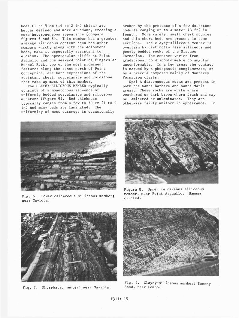
The PHOSPHATIC MEMBER, where bestdeveloped, is composed primarily ofcarbonate-rich phosphatic mudstone (Figure7). Dolostone nodules and beds make upapproximately 10% of typical sections.Phosphatic mudstone is dark brown when freshand is usually laminated. Phosphaticmaterial most commonly occurs as small,isolated, pea-sized blebs or as finelydispersed material along laminations. Insome places, phosphatic material occurs asthumb-sized nodules, concentrated alongbedding planes. In many areas thephosphatic member contains abundantporcelanite, dolostone and chert interbeddedwith phosphatic mudstone. This is typicallythe case for the upper part of thephosphatic member, and in such cases thetransition to the upper calcareous-siliceousmember is gradational. The contact with thelower calcareous-siliceous member is notwell exposed along the Santa Mariacoastline. Along the Santa Barbara coast,the lower contact is marked by an abruptdown-section increase in resistance toerosion due to a higher biogenic silicacontent in the underlying lower calcareoussiliceous member.
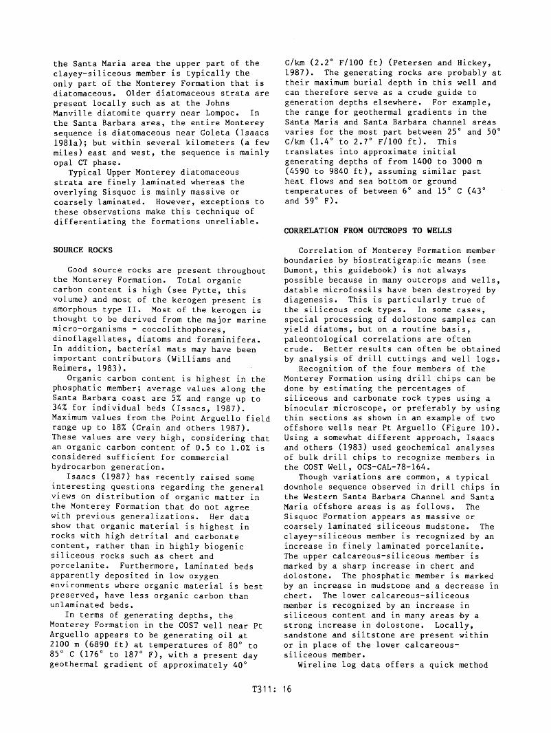
The UPPER CALCAREOUS-SILICEOUS MEMBERcontains a greater proportion of porcelaniteand chert versus mudstone than the othermembers (Figure 8). Dolostone beds andnodules are also conspicuous and phosphaticmudstone is present locally, particularlynear the base. Many of the beds are finelylaminated. Thick-bedded, highly contortedchert beds are a conspicuous component inthe Santa Maria coastal outcrops. The rangein bed thickness is similar to that for thelower calcareous-siliceous member but thin
T311 : 14
beds (1 to 5 cm (.4 to 2 in) thick) arebetter defined and more abundant, creating amore heterogeneous appearance (comparefigures 6 and 8). This member has a greateraverage siliceous content than the othermembers which, along with the dolostonebeds, make it especially resistant toerosion. The spectacular cliffs at PointArguello and the seaward-pointing fingers atMussel Rock, two of the most prominentfeatures along the coast north of PointConception, are both expressions of theresistant chert, porcelanite and dolostonethat make up most of this member.
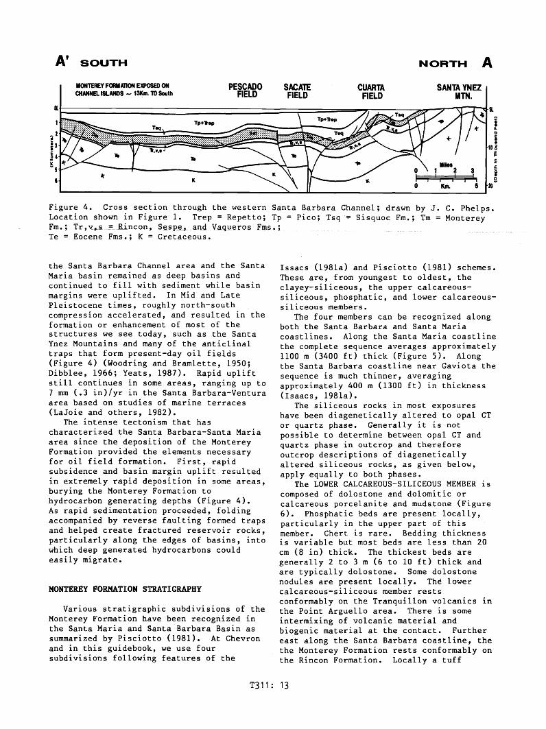
The CLAYEY-SILICEOUS MEMBER typicallyconsists of a monotonous sequence ofuniformly bedded porcelanite and siliceousmudstone (Figure 9). Bed thicknesstypically ranges from a few to 30 cm (1 to 9in) and many beds are laminated. Theuniformity of most outcrops is occasionally
Fig. 6. Lower calcareous-siliceous member;near Gaviota.
Fig. 7. Phosphatic member; near Gaviota.
broken by the presence of a few dolostonenodules ranging up to a meter (3 ft) inlength. More rarely, small chert nodulesand thin chert beds are present in somesections. The clayey-siliceous member isoverlain by distinctly less siliceous andpoorly bedded rocks of the SisquocFormation. The contact varies fromgradational to disconformable to angularunconformable. In a few areas the contactis marked by a phosphatic conglomerate, orby a breccia composed mainly of MontereyFormation clasts.
Opal A diatomaceous rocks are present Inboth the Santa Barbara and Santa Mariaareas. These rocks are white whereweathered or dark brown where fresh and maybe laminated or unlaminated. They areotherwise fairly uniform in appearance. In
Figure 8. Upper calcareous-siliceousmember, near Point Arguello. Hammercircled.
Fig. 9. Clayey-siliceous member; SweenyRoad, near Lompoc.
T311: 15
the Santa Maria area the upper part of theclayey-siliceous member is typically theonly part of the Monterey Formation that isdiatomaceous. Older diatomaceous strata arepresent locally such as at the JohnsManville diatomite quarry near Lompoc. Inthe Santa Barbara area, the entire Montereysequence is diatomaceous near Goleta (Isaacs1981a); but within several kilometers (a fewmiles) east and west, the sequence is mainlyopal CT phase.
Typical Upper Monterey diatomaceousstrata are finely laminated whereas theoverlying Sisquoc is mainly massive orcoarsely laminated. However, exceptions tothese observations make this technique ofdifferentiating the formations unreliable.
SOURCE ROCKS
Good source rocks are present throughoutthe Monterey Formation. Total organiccarbon content is high (see Pytte, thisvolume) and most of the kerogen present isamorphous type II. Most of the kerogen isthought to be derived from the major marinemicro-organisms - coccolithophores,dinoflagellates, diatoms and foraminifera.In addition, bacterial mats may have beenimportant contributors (Williams andReimers, 1983).
Organic carbon content is highest in thephosphatic member; average values along theSanta Barbara coast are 5% and range up to34% for individual beds (Issacs, 1987).Maximum values from the Point Arguello fieldrange up to 18% (Crain and others 1987).These values are very high, considering thatan organic carbon content of 0.5 to 1.0% isconsidered sufficient for commercialhydrocarbon generation.
Isaacs (1987) has recently raised someinteresting questions regarding the generalviews on distribution of organic matter inthe Monterey Formation that do not agreewith previous generalizations. Her datashow that organic material is highest inrocks with high detrital and carbonatecontent, rather than in highly biogenicsiliceous rocks such as chert andporcelanite. Furthermore, laminated bedsapparently deposited in low oxygenenvironments where organic material is bestpreserved, have less organic carbon thanunlaminated beds.
In terms of generating depths, theMonterey Formation in the COST well near PtArguello appears to be generating oil at2100 m (6890 ft) at temperatures of 80° to85° C (176° to 187° F), with a present daygeothermal gradient of approximately 40°
C/km (2.2° F/100 ft) (Petersen and Hickey,1987). The generating rocks are probably attheir maximum burial depth in this well andcan therefore serve as a crude guide togeneration depths elsewhere. For example,the range for geothermal gradients in theSanta Maria and Santa Barbara channel areasvaries for the most part between 25° and 50°C/km (1.4° to 2.7° F/100 ft). Thistranslates into approximate initialgenerating depths of from 1400 to 3000 m(4590 to 9840 ft), assuming similar pastheat flows and sea bottom or groundtemperatures of between 6° and 15° C (43°and 59° F).
CORRELATION FROM OUTCROPS TO WELLS
Correlation of Monterey Formation memberboundaries by biostratigraphic means (seeDumont, this guidebook) is not alwayspossible because in many outcrops and wells,datable microfossils have been destroyed bydiagenesis. This is particularly true ofthe siliceous rock types. In some cases,special processing of dolostone samples canyield diatoms, but on a routine basis,paleontological correlations are oftencrude. Better results can often be obtainedby analysis of drill cuttings and well logs.
Recognition of the four members of theMonterey Formation using drill chips can bedone by estimating the percentages ofsiliceous and carbonate rock types using abinocular microscope, or preferably by usingthin sections as shown in an example of twooffshore wells near Pt Arguello (Figure 10).Using a somewhat different approach, Isaacsand others (1983) used geochemical analysesof bulk drill chips to recognize .members inthe COST Well, OCS-CAL-78-164.
Though variations are common, a typicaldownhole sequence observed in drill chips inthe Western Santa Barbara Channel and SantaMaria offshore areas is as follows. TheSisquoc Formation appears as massive orcoarsely laminated siliceous mudstone. Theclayey-siliceous member is recognized by anincrease in finely laminated porcelanite.The upper calcareous-siliceous member ismarked by a sharp increase in chert anddolostone. The phosphatic member is markedby an increase in mudstone and a decrease inchert. The lower calcareous-siliceousmember is recognized by an increase insiliceous content and in many areas ~y astrong increase in dolostone. Locally,sandstone and siltstone are present withinor in place of the lower calcareoussiliceous member.
Wireline log data offers a quick method
T311: 16

Figure 10. Correlation of members fromoutcrop to wells based on rock typeabundance as determined from thin section.
400HOPD21° API
1650HOPO200 AP~
]2130DOPO21° API
]
2400HOPD
_ 1SO API
7500
1000 rY...-~~__
Feet(182QnI)
- f- - t-
~
Jr.: ~. - .- - .-
1500~T800
lMQ=D
fti~
-~;ISCAlE Ii
OiANGE I-I-I--FP~~ I
7000' -=:
= .r::.~
-n --..t.---8~0
(259Om)
GAMMA M 120 0 DEEP RESIS1MT;Y 40
o DEEP RESISlMTY 5CX)
Figure 11. Resistivity (right column) andgamma ray (left column) logs from the OCS316-1 well, Pt. Arguello Field. Responsesare described in text. Flow rates fromdrill stem tests are shown on right. Notethat all members of the Monterey tested oil.
~~
111::.~. lr~
~I.. ~
SISQUOCFM .- f"'.~
Low Gamma ~~. -
,(p-Low Resistivity
•- ,.,~
I .. ",,~
'" to-
~-- -------------~=
~Q.AYEY ~tiSILICEOUS f-- ..~High Gamma ~~Moderate
-~~
Resistivity -- ;;;;; .....:J~
~. -----,.------ ~I;"
IL I•• ~~ -~t- f-.
IE
>UPPER 'll~
CALCAREOUS f";1-~.
W SILICEOUSLow Gamma -s=~a: High Resistivity - - ...
W1$,
I-j...II~I: Iii .... - .-
t- ~
~~~------------Z I-""':=:~~
PHOSPHAllC ~
0 High Gamma ~
!=--=Moderate to~
~ High Resistivity1--
-~~. -
-- - -- -- .. ------. .IIII~~ii....
LONER ~
CALCAREOUS~SIUCEOUS
-I~Low Gamma~- -
Highest Resistivity ~t:-
~ - --.....PI SALFM =jiia
~;
- ~~~
l- I- - ~- -i
i
CRETACEOOS ~FM
I~(.111...1)~
- - . t _._
~~c~
~"-- - - -'-
r..h.. - -
F:~
p
i~p
100\
2000m(6562')
3000m 3000m(9843') ""- (9843')
"'-
2000m(6562')
OFFSHORE WELLS
100\
III Chert
P - Phosphatic Material
_1100m-(3~')
~~~~I-~
UpperCalcareousSiliceous
Phosphatic
SiliC~~~/8.-Om
~ Mudstone/Porcelanlte
D Dolostone
Sisquoc Fm
Pt•. ArguelloOnshoreComposite
of recognizing and correlating the fourmembers. The gamma ray, and to a lesserextent resistivity, are the simplest andeasiest tools to use at present.
In the Santa Maria and western SantaBarbara Channel areas, gamma ray responsevaries dramatically and appears to be adirect response to changing lithology. Ananalysis of several offshore wells(Bertucci, pers. comm.) showed that theSisquoc Formation and the upper and lowercalcareous-siliceous members have a lowgamma response, averaging from 30 to 80 APIunits whereas the clayey-siliceous andphosphatic members have a high response,averaging 75 to 200 API units (Figure 11).The difference in response appears to be duemainly to differences in uranium content,which in turn appears to correlate todifferences in organic content and to alesser extent, phosphatic content. Ingeneral, the member boundaries as outlinedby the gamma ray appear to correlate wellwith boundaries determined from drill chipsand resistivity. No comparative study ofgamma ray response of outcrop samples hasyet been done.
Resistivity appears to be mainly relatedto porosity and clay content in Montereyrocks rather than to pore fluid type andcontent (see Fish, this volume). The OCS
T311: 17

316-1 well (Figure 11) serves as a goodexample of how resistivity varies downhole.Resistivity is very low in the SisquocFormation~ typically reading 1 to 2 ohms.Resistivity increases slightly at what webelieve is the Sisquoc-Monterey contactbased on drill chip and gamma ray response.The increase may be due to a downholedecrease in clay content across thisboundary. A further modest increase inresistivity and spikyness generally occurswithin the clayey-siliceous member, 30 to100 m (98 to 328 ft) below the inferredSisquoc-Monterey contact. Resistivityincreases greatly within the uppercalcareous-siliceous member probably inresponse to the presence of tight chert anddolostone beds. In some wells a decrease inresistivity is seen in the phosphaticmember. Resistivity increases in the lowercalcareous-siliceous member, probably inresponse to the presence of abundant "tight"dolostone beds.
RESERVOIR PROPERTIES OF CT AND QUARTZ PHASEROCKS
The Monterey Formation is a fracturedreservoir - the name implying that withoutfractures, commercial production ofhydrocarbons would be impossible. Fracturedreservoirs are usually found in rocks withreasonable porosity, typically 10 to 30%,but very low matrix permeability (Arguilera,1980). These fractured reservoirs have a"dual porosity system", in whichhydrocarbons are largely stored in thematrix but transported to the wellbore VIafractures.
Oil company estimates for fractureporosity in the Monterey Formation rangefrom less than 1% to up to 10%. Fractureporosity of individual beds may be higher.However, most workers argue that totalfracture porosity in most fracturedreservoirs averages less than than onepercent (e.g., Reiss, 1980).
Matrix porosity of Monterey rock types iscontrolled by rock type and diagenetic grade(Table 1). Results vary greatly but ageneral pattern in which porosity decreasesfrom opal CT to quartz is clear (Isaacs1981b; Chevron unpublished data).Porosities of opal CT rocks generally rangefrom 15 to 35 percent, whereas quartz-phaserocks generally range from 2 to 25 percent.In terms of rock type, porcelanites andsiliceous mudstones have the highestporosities and dolostones and some chertshave the lowest.
Though matrix permeability is negligible
POROSITY PERMEA-ROCK TYPE BILITY
CT aTZ
Mudstone(Siliceous) 20 - 30% 15 - 25% <1 md
Porcelanite 25 - 35% 10 - 25% <1 md
Chert 15 - 25% 2 - 15% <1 md
Dolostone 2 - 10% 2 - 10% <1 md
Table 1. Porosity and permeability valuesfor unfractured opal CT and quartz phaserocks. Data from Isaacs (1981b) and Chevron(unpublished data).
in Monterey rock types (Table 1), fracturepermeability can be very high. Flow ratesin many wells have exceeded 5000 bbls/dayand permeabilities of up to several darcyshave been calculated from drill stem tests;(Regan and Hughes 1949; Crain and others,1987; Ogle and others, 1987). In the PointArguello Field, permeability determined fromdrill stem tests averages from less than oneto over 3000 millidarcies (Crain and others,1987). Production data suggest that thispermeability is not evenly distributed butis concentrated in thin, widely spacedzones.
It has long been known that fractureabundance varies with rock type (Grivetti,1982; Belfield and others, 1983; Snyder,1987). In general, the more siliceous arock is, the more likely it will befractured (Figures 12 thru 15). Results offracture spacing measurements from severalwells and onshore outcrop areas show thatthe order of fracturability from most toleast fractured is: chert-porcelanitemudstone-dolostone. Average fracturespacing for each rock type is: brecciatedchert - 0.4 em (.16 in); unbrecciated chert- 2 em (.8 in); porcelanite - 3.6 em (1.4in); mudstone - 6.5 em (2.6 in); anddolostone - 8.6 cm (3.4 in) (Table 2).These results generally agree with theobservations of other workers. However,some workers report that dolostone has morefractures than mudstone and, in some cases,more fractures than porcelanite. This istrue locally, particularly where dolostonebreccia is present; however, the most commontype of dolostone present along the coast ismassive and relatively unfractured.
In addition to rock type, the main factorcontrolling fracture density in most areasappears to be local deformation. As a
T311: 18

Fig. 12. Small fractures in porcelanite;interbedded mudstone is relativelyunfractured.
Figure 13. Bedding plane view of smallfractures in porcelanite. Note theunusually regular fracture sets. Hammerheadis parallel to strike.
general observation, fractures appear to bemore common near faults and fold hinges thanin less deformed areas (Grivetti, 1982).
Our data suggest that there is noapparent difference in fracture spacingbetween opal CT and quartz phase rocks.This observation goes against that of mostprevious workers. To add to the confusion,Grivetti (1982) concluded that fractureintensity was greater in opal CT rocks nearPt Arguello than in the quartz phase rocksat Lions Head. Since in many areasfracturing depends in large part on local
Figure 14. Brecciated and highly contortedchert bed; such beds are generallyrestricted to the upper calcareous-siliceousmember.
Figure 15. Fracture breccia; note how thebreccia cross-cuts bedding.
structure, it may be difficult to prove ifone phase is consistently more fracturedthan the other.
Fracture Types and Models
Three major types of fractures can bedistinguished in outcrop: (1) smallfractures usually contained withinindividual beds; (2) brecciated beds,usually chert; and (3) large fractures,faults and associated breccia. Thesefracture types are somewhat idealized andintergradational, but they serve as
T311: 19

Location Chert Porcelanite Mudstone Dolostone
Brec- Unbrec- 1.5 2.7 9.7ciated ciated
Offshore 0.3 1 2Cores
Brec- Unbrec-ciated ciated 8 15 15
0.3 3
JalamaBeach 0.5 3.5 5.5 7.5
LionsHead 0.6 3.2 5.5 6.6
VariousCoastal 0.5 1.1 3.8
Outcrops 4.4
Average 0.3** I 2** 3.6 6.5 8.6
** From Core Only
Table 2. Average fracture spacing values(in cm; 1 in = 2.5 cm) from core andoutcrop. Fracture spacing represents thedistance between fractures measured in astraight line running parallel to bedding.Data from unpublished Chevron reports.
convenient end members from which importantgeneralizations can be made.
Small fractures are by far the mostcommon fracture type (Figure 12). In mostcases they are spaced a few centimeters (1to 4 in) apart and are restricted toindividual beds - that is, they do notextent across bed boundaries. Thesefractures are usually oriented perpendicularto bedding or nearly so. Two dominantfracture sets are recognized - one roughlyparallel and one roughly perpendicular tothe strike of bedding (Figure 13) (Grivetti,1982; Belfield and others, 1983).Additional fracture sets may also bepresent.
Brecciated beds are almost alwayscomposed of chert (Figure 14). These bedscontain closely spaced fractures that cut inevery direction. The fractures cut thechert into tiny fragments, usually only afew millimeters across. The individualpieces have generally moved only slightlywith respect to each other so thatlaminations and other bedding features canstill be recognized.
Large fractures and associated brecciaare differentiated from small fractures inthat they cross-cut beds. Generally theycross-cut many beds and have exposed lengthsof from a few to tens of meters (tens offeet +). Where large fractures are present,they are generally spaced from several totens of meters (tens of feet +) apart.However, in some localized areas, usuallyassociated with fold hinges or fault zones,
these fractures can be abundant withfracture spacing down to a few centimeters(inches). In such situations, fracturebreccias are commonly developed. Theseappear as bed cross-cutting zones of brokenrock, from a few centimeters (1 in) or lessto over a meter (3.3 ft) wide (Figure 15).They are most common in chert andporcelanite sequences. Orientation of largefractures and fracture breccia is similar tosmall fractures; most are roughlyperpendicular to bedding and the predominantfracture sets are roughly parallel andperpendicular to strike.
Another type of fracture breccia includesdolostone breccia; it consists of brecciateddolostone, often mixed with other rocktypes, formed by repeated precipitation fromfracture-filling solutions (Roehl, 1981;Redwine, 1981). Dolostone breccia typicallyoccurs along the coast in zones severalmeters to ten's of meters (tens of feet +)wide. In most cases, dolostone brecciacross-cuts bedding in an orientation similarto large fractures and other breccia types.
Crude calculations of the permeability ofthe three fracture types can be made usingfracture spacing and width measurements(Table 3). For example, based on a fracturewidth of 10 to 20 microns (typical widthsfrom core material as seen in thin sectionand with the scanning electron microscope),the permeability of brecciated chert beds isseveral hundred millidarcies whereas bedswith small fractures average approximately 2to 50 millidarcies. For large fractures andassociated breccia, permeabilities ofseveral darcies seem likely based on thewidth of large fractures as measured in coreand outcrop.
A simple fracture model for the clayey-
FRACTURE
ROCK SPACING CALCULATED K FOR
TYPE (CM) VARIOUS FRACTURE WIDTH
(TABLE 2) 10 Jl 15Jl 20Jl 30Jl
Brecciated 0.3 56 187 445 1503Chert **
Chert * 2 4 14 33 112
Porcelanite * 4 2 7 17 56
Mudstone * 7 1 4 9 32
Dolostone * 9 1 3 7 25
** Cubic Model; * Matchstick Model
Table 3. Fracture permeability ascalculated from fracture spacing and widthmeasurements using the formulas given byReiss (1980).
T311: 20

LFPER CALCAREOUSSILICEOUS IEIBER
300Md
KEY:
...............-..-...1Om(33')
CLAYEY-SILICEOUSIIEIBER
30Md0...-,....--,.--
SMALL FRACTURES30Md
BRECIATED CHERT250-500 Md
LARGE FRACTURES aASSOCIATED BRECCIA1000'. Md PER METER ...........-.--........a---'...IPENETFiATED BYWELL BORE•
10m(33')........................
in wells. Alternatively, small fracturesand fractures in brecciated chert beds maybe held open to greater widths than we seein core material.
Fracture orientation is another factorthat must be considered in reserVOlrmodeling. It appears that fracturesoriented perpendicular to the strike ofbedding are held open in the subsurfacewhereas those oriented in other directionsare relatively closed. Experiments withclay models show this clearly; undercompression, clay will buckle into a doublyplunging anticline with two sets offractures as we see in outcrop - the openones trend perpendicular to the fold axis,or bedding strike, and the closed fracturestrend parallel to it (Figure 17). Outcrop
Figure 16. Fracture model for Monterey oilfields.
siliceous and upper calcareous-siliceousmembers is shown in Figure 16. In thismodel, the clayey-siliceous member is shownto have small fractures only, as ittypically does in outcrop, and is assignedan average permeability of 30 millidariesbased on drill stem tests and fracturespacing and width calculations (Table 3).The upper calcareous-siliceous member isshown to contain small fractures, brecciatedchert, and large fractures with associatedbreccia; this interval is assigned anaverage permeability of 300 md as aconservative estimate based on drill stemtest-determined permeabilities reported byOgle ~nd others (1987) and Crain and others(1987).
To model the upper calcareous siliceousmember, one third of the section isdesignated as brecciated chert with anaverage permeability of 400 millidarcies andthe remaining rock is assigned an averagepermeability of 30 millidarcies for smallfractures; this gives an averagepermeability of approximately 150millidarcies. In order to account for the300 millidarcies suggested by drill stemtests, several large fractures andassociated breccia with 1000's ofmillidarcies per meter (.33 ft) penetratedby the wellbore are included.
The usefulness of such calculations aredebatable on many counts, the most importantbeing the uncertainty of fracture widths inthe subsurface. But if our estimates areroughly correct, they indicate that largefractures and associated breccia may be themost important contributors to permeability
SANh4 BARBARA CHANNEL COASTLINE
~I
-------COMPRESSIONAL FAULT
+- COMPRESSICl'4
"BEST-WELL COURSESSANTA BARBARA CHANNEL OIL FIELD
Figure 17. Most Santa Barbara Channel oilfields have elongated oval shapes thatformed under roughly north-southcompression. Clay models show that undersuch conditions two main sets of fractureswill form; one set of "closed" fractures orfaults perpendicular to compressional forcesand one set of extensional or "open" .fractures or faults parallel to compression.Since permeability should be much higher inthe "open" fractures, well courses designedto intersect them may maximize production.
T311: 21

evidence for this was given by Belfield andothers (1983) who showed that along theSanta Barbara coastline, fractures orientedsubperpendicular to the strike of beddingcontain more tar than those oriented inother directions. Furthermore, Belfield andothers (1983) made a case, though withlimited data, that productivity in wells inthe Elwood field is higher in wells drilledsubparallel to the axial trace of theanticline than in wells drilled normal to it(Figure 17).
HISTORY OF PETROLEUM EXPLORATION
The Santa Barbara-Santa Maria area hasbeen an active oil province for nearly 100years (Figure 18). Production andexploration summaries are given in Woodringand Bramlette (1950), Dibblee (1966), Yerkesand others (1969), Taylor (1976), Williams(1985), California Division of Oil and Gas(1974 and 1986) and Crain and Thurston(1987).
Petroleum resources in the Santa BarbaraChannel and Santa Maria area were firstrecognized and utilized by the nativeChumash Indians who lived in the region for
many thousands of years before the arrivalof the first European explorers in the1500s. The natives used the tar from seepsand tar sands to chaulk their canoes,waterproof their baskets, and as a generaladhesive. An indian village was locatednext to a large natural seep in Carpinteria,20 km (12 mi) east of Santa Barbara.Another well known seep is present offshore,12 km (7 mi) west of Santa Barbara, where anoil slick is nearly always visible. Otheroffshore seeps are common, as attested bytar that is present on the beaches betweenSanta Maria and Ventura.
Oil was discovered around the turn of thecentury in both the Channel region and inthe Santa Maria area. In Summerland, justeast of Santa Barbara, oil and gas seeps ledto drilling and production of oil in the1890's from Plio-Pleistocene strata probablysourced from the Monterey Formation. In theSanta Maria area, drilling near an outcropof tar sand led to the discovery of theOrcutt field in 1902, with the MontereyFormation as both the source and thereservoir.
In the Santa Maria area, the initialdiscovery of the Orcutt Field led to anexploration program based on drilling
EXPLANATION
24
21~
•Ventura
2017C)
~~918
~2
0 10 20MiI
,i
0 10 20 30Km
tN
Santa Barbara•
Gaviota•
cq:s:>14
.i. ...-_ 13
A
• Lompoc
Fo
•San Luis Obispo
,C,12~
® Government Pt.
@Sacate
@ Coal Oil Pt.
(DSanta Rosa
Mainly Pliocenereservoirs sourcedfrom Monterey Fm.
Mainly MontereyFm. Reservoir
Mainly Pre-Montereyor Pre-Luisian clasticreservoirs
® San MiguellLion Rock
@Bonito
@RoCkypt.
@Sword
g Mainly gas field
PRODUCING FIELDS
G)Guadalupe @ Molino
@Santa Maria @ Elwood
®cat Canyon @ S. Elwood
0casma'ia @ Summerland
@Orcutt @ Dos Cuadros
@Four Deer @ Carpinteria
0Jesus Maria iO Rincon
® Lompoc 21 Ventura
® Barham Ranch 22 Pitas Pt.
@ Zaca @ Santa Clara
@ Pt. Pedernales @ W. Montalvo
@ Pt. Arguello @ Sockeye
@ Hondo @ Hueneme
PRODUCTION IMMINENT
o Pescado
FUTURE DEVELOPMENT?
Figure 18. Location of major oil fields in the Santa Maria-Santa Barbara area. Abandonedfields not shown
T311: 22
anticlines that showed well developedsurface expression. Subsequent discoveriesincluded the Lompoc (1903), West and EastCat Canyon (1908 and 1909), Casmalia (1917),and Gato Ridge (1931) fields. In 1934, thegiant Santa Maria field was discoveredfollowing an exploration strategy based onfield observations that suggested thepresence of a stratigraphic trap. Later,much smaller discoveries were made at FourDeer (1947) and Guadalupe (1948). As of1986 the Santa Maria onshore area hadproduced 783 million barrels with reserveestimates of 149 million barrels.
In the eastern Santa Barbara Channelarea, big early discoveries were made In theearly 1900's along an 35+ km (22 mi)anticlinal trend running from Ventura to theoffshore area near Rincon Point. Thisincluded the Ventura, San Miguelito andRincon Oil Fields. Later, in the 1960's asa result of improved offshore drillingcapabilities, the Carpinteria and DosCuadros offshore fields were discoveredalong this trend. Other fields in the areainclude the relatively small West Montalvofield discovered in 1949. Production frommost of these fields is mainly from Pliocenesandstones ,with the Monterey immediatelybelow as the source of most of the oil. Asof 1986, 1.4 billion barrels of oil had beenproduced, with over 800 million from theVentura field alone. Reserves are estimatedat 265 million barrels.
Early exploration in the western SantaBarbara Channel concentrated on pre-Montereysandstones, mainly in the Sespe/Alegria andVaqueros Formations (Figure 2). Oil and gaswere found in several fields located on thecoast between Carpinteria and PointConception, including Elwood (1928), Mesa(1929), La Goleta (1929) Capitan (1929), andRefugio (1946). Offshore fields werediscovered and developed starting in the1950's. These were mainly gas fields withsubsea completions and like the earlierdiscoveries were mainly in Sespe\Alegria andVaqueros sandstones. These included theGaviota (1958), Conception (1959), Cuarta(1959), Caliente (1962), Molino (1962), andNaples (1960) fields. In addition, oil wasdiscovered in pre-Monterey rocks offshore atCoal Oil Point (1961), Summerland (1958),South Elwood (1966) and Point Conception(1965).
The Monterey Formation in the SantaBarbara area was virtually ignored duringearly exploration despite the successes inthe Santa Maria Valley. There were severalreasons for this. For one, the Montereyonshore was mainly located on a homoclinewith no trap possibilities or if folded, was
exposed at the surface. Offshore however,it did offer potential but was not takenadvantage of. Monterey oil was consideredheavy and uneconomic for offshore productionand furthermore, well logs in the Montereywere not reliable indicators of oil.
In the Santa Barbara Channel, offshorediscovery of oil in the Monterey Formationdid not come until 1969 when the Hondo fieldand South Elwood pools were discovered.Together these fields contained reserves of250 to 300 million barrels. These findsrevealed the potential of the offshoreMonterey, and within two years the Sacate,Pescado, Santa Clara, and Sockeye fieldswere discovered all with substantialMonterey Formation reserves. In 1982, theCoal Oil Point field was discovered withestimated reserves in the Monterey Formationof 100 million barrels. At present, oil isproduced from platforms at Hondo, SouthElwood, Sockeye, and Santa Clara. The Hondofield is the largest producer with anaverage daily production of approximately40,000 barrels. Platform installation andproduction appear imminent at Pescado.Sacate awaits better economic conditions andCoal Oil Point development has stalled dueto environmental concerns.
In 1981 a federal lease sale was heldthat opened the offshore Santa Maria area toexploration. Discoveries soon followed andincluded the following fields: Pt Arguello;Pt. Pedernales; San Miguel/Lion Rock; RockyPoint; Bonito; and Sword. These fields havepotential reserve estimates of nearly onebillion barrels. At Pt. Pedernales and Pt.Arguello, platform installation is completeand production has begun or is imminent.Development of the other fields will dependon future oil prices.
In summary, The Monterey Formation is thesource and reservoir for much of the oil inthe Santa Maria and Santa Barbara channelareas (Figure 18). In the Santa Maria area,virtually all of the oil is Monterey sourcedand most is Monterey reservoired. In theeastern Santa Barbara Channel, oil is foundmainly in Pliocene sandstone reservoirs butis probably sourced mainly from the MontereyFormation. In the western Santa BarbaraChannel, the Monterey Formation is thereservoir and probable source of most of theoil in the newly discovered offshorefields.
Acknowledgements
I thank M. P. Dumont, R. E. Garrison, E.H. Phillips, and D. R. Waterman for reviewsor comments on drafts of this paper.
T311: 23

REFERENCES
Addicott, W. 0., 1968, Mid-Tertiaryzoogeographic and paleogeographicdiscontinuities across the San Andreasfault, California. Stanford UniversityPublications Geological Sciences, v. 11,pp. 144-165.
American Association of PetroleumGeologists, 1952, Cenozoic correlationsections paralleling north and southmargins, Western Ventura Basin from PointConception to Ventura California. PacificSection, American Assocation of PetroleumGeologists, Special Publication.
Arguilera, R., 1980, Naturally FracturedReservoirs, Penn Well Books, Tulsa, 703pp.
Atwater, T., 1970, Implications of platetectonics for the Cenozoic tectonicevolution of western North America.Geological Society of America Bulletin,v. 81, pp. 3513-3536.
Bachman, S. B., 1988, Early, Middle, andLate Miocene basin development,California. American Association ofPetroleum Geologists, abstracts for thePacific Section meeting, pp. 373.
Barron, J. A., 1986, Paleoceanographic andtectonic controls on deposition of theMonterey Formation and related siliceousrocks in California. Palaeogeography,Palaeoclimatology, Palaeoecology, v. 53,pp. 27-45.
Belfield, W. C., J. Helwig, P. R. La Pointe,and W. K. Dahleen, 1983, South Ellwood oilfield, Santa Barbara Channel, California,a Monterey Formation fractured reservoir.In Isaacs, C. M., and R. E. Garrison,eds., Petroleum Generation and Occurrencein the Miocene Monterey Formation,California, Pacific Section, Society ofEconomic Paleontologists and MineralogistsPublication 33, pp. 213-221.
Bramlette, M. N., 1946, The MontereyFormation of California and the origin ofits siliceous rocks. United StatesGeological Survey Professional Paper 212,57 pp.
California Division of Oil and Gas, 1974California Oil and Gas Fields, South,Central, Coastal, and Offshore California.California Divisoin of Oil and Gas ReportNo. TR12, vol. 2.
California Division of Oil and Gas, 1986,72nd Annual Report of the State Oil andGas Supervisor. California Division ofOil and Gas Publication No. PR06, 167 pp.
Casey, R. K., and J. A. Barron, (eds.),1986, Siliceous Microfossils andMicroplankton of the Monterey Formationand Modern Analogs. Pacific Section,
Society of Economic Paleontologists andMineralogists, book 45, 197 pp.
Crain, W. E., W. E. Mero, and D. Patterson,1987, Geology of the Point Arguello Field.In Ingersoll, R. V., and W. G. Ernst,eds., Cenozoic Basin Development ofCoastal California, Prentice Hall, NewJersey~ pp. 407-426.
Crain, W. E., and S. P. Thurston, 1987,Geology and oil and gas exploration inCalifornia's offshore basins. In Horn, M.K., ed., Transactions of the FourthCircum-Pacific Energy and MineralResources Conference, Singapore, 1986,American Association of PetroleumGeologists, Chapter 7, pp. 43-61.
Crowell, J. C., 1987, Late Cenozoic basinsof onshore Southern California:Complexity is the hallmark of theirtectonic history: In Ingersoll, R. V.,and W. E. Ernest, eds., Cenozoic BasinDevelopment of Coast California, PrenticeHall, New Jersey, pp. 207-241.
Dibblee, T. W. Jr., 1950, Geology of thesouthwestern Santa Barbara County,California. California Division of Minesand Geology Bulletin 150, 95 pp.
_____ , 1966, Geology of the central SantaYnez Mountains, Santa Barbara County,California. California Divison of Minesand Geology Bulletin 186, 99 pp.
Donegan, D., and H. Schrader, 1981, Modernanalogues of the Miocene Monterey Shale ofCalifornia: evidence from sedimentologicand micropaleotologic study. In Garrison,R. E., and R. G. Douglas, eds., TheMonterey Formation and Related SiliceousRocks of California, Pacific Section,Society of Economic Paleotologists andMineralogists Special Publication, pp.149-157.
Dumont, M. P., 1986, The Miocene/Plioceneepoch boundary as determined by diatombiostratigraphy in the California coastalregion. Masters thesis, University ofCalifornia, Berkeley, 115 pp.
Dumont, M. P., J. G. Baldalf, and J. A.Barron, 1986, Thalassiosira praeoestrupiinew diatom species for recognizing theMiocene/Pliocene epoch boundary in coastalCalifornia. Micropaleontology, v. 32, no.4, pp. 372-377.
Dunham, J. B., and Blake, G. H., Guide tocoastal outcrops of the Monterey Formationof western Santa Barbara County,California, Pacific Section, Society ofEconomic Paleontologists andMineralogists, 36 p., 1987.
Durham, D. L., and R. F. Yerkes, 1964,Geology and oil resources of the easternPuente Hills area, Southern California.
T311: 24

u.s. Geological Survey Prof. paper 4520B,62 pp.
Garrison, R. E., 1981, Pelagic andhemipelagic sedimentation in active marginbasins. In Douglas, R. G., I. P. Colburn,and D. S. Gorsline, Depositional Systemsof Active Continental Margin Basins.Society of Economic Paleontologists andMineralogists Pacific Section, pp. 15-38.
Garrison, R. E., and R. G. Douglas, eds.,1981, The Monterey Formation and RelatedSiliceous Rocks of California, PacificSection, Society of EconomicPaleotologists and MineralogistsPublication, 327 pp.
Garrison, R. E., M. Kastner, and Y.Kolodny, 1987, Phosphorites and phosphaticrocks in the Monterey Formation andrelated Miocene coastal units. InIngersoll, R. V., and W. G. Ernst, eds.,Cenozoic Basin Development of CoastalCalifornia, Prentice Hall, New Jersey, pp.348-382.
Garrison, R. E., M. Kastner, and C. E.Reimers, in press, Miocene phosphogenesisin California. In Burnett, W. C. and S.R. Riggs, eds., Genesis of Neogene toModern Phosphorites, Cambridge UniversityPress.
Garrison, R. E., M. Kastner, and D. H.Zenger, eds., 1984, Dolomites of theMonterey Formation and Other Organic-richUnits. Pacific Section, Society ofEconomic Paleontologists and MineralogistsPublication 41, 215 pp.
Gorsline, D. S., and R. G. Douglas, 1987,Analysis of sedimentary systems in activemargin basins: California continentalborderland. In Ingersoll, R. V., and W.G. Ernst, eds., Cenozoic Basin Developmentof Coastal California. Prentice Hall, NewJersey, pp. 64-80.
Graham, S. A., and L. A. Williams, 1985,Tectonic, depositional, and diagenetichistory of Monterey Formation (Miocene),central San Joaquin basin, California.American Association of PetroleumGeologists Bulletin, v. 69, p. 385-411.
Grivetti, M. C., 1982, Aspects of stratigraphy, diagenesis, and deformation in theMonterey Formation near Santa Maria Lompoc, California. M.A. Thesis,University of California, Santa Barbara,California.
Haq, B. V., J. Hardenbol, and P. R. Vail,1988, Chronology of fluctuating sea levelssince the Triassic. Science, v. 235, pp.1156-1157.
Hoots, H. W., 1930, Geology and oilresources along the southern border of SanJoaquin Valley, California. United States
Geological Survey Bulletin 812-D, pp. 243332.
Hornafius, J. S., B. P. Luyendyk, R. R.Terres, and M. J. Kamerling, 1986, Timingand extent of Neogene tectonic rotation inthe western Transverse Ranges, California.Geological Society of American Bulletin97, pp. 1475-1487.
Ingle, J. C., Jr., 1981, Origin of Neogenediatomites around ~he North Pacific rim.In Garrison, R. E., and R. G. Douglas,eds., The Monterey Formation and RelatedSiliceous Rocks of California. PacificSection, Society of EconomicPaleontologists and MineralogistsPublication 15, pp. 159-179.
Isaacs, C. M., 1981a, Guide to the MontereyFormation in the California coastal area,Ventura to San Luis Obispo. PacificSection AAPG v. 52, 91 pp.
Isaacs, C. M., 1981b, Porosity reductionduring diagenesis of the MontereyFormation, Santa Barbara coastal area,California. In Garrision, R. E., and R.G. Douglas, eds., The Monterey Formationand Related Siliceous Rocks of California.Pacific Section SEPM pp. 257-271.
Isaacs, C. M., 1982, Influence of rockcomposition on kinetics of silica phasechanges in the Monterey Formation, SantaBarbara area, California. Geology, v. 10,pp. 304-308.
Isaacs, C. M., 1983, Compositional variationand sequence in the Miocene MontereyFormation, Santa Barbara coastal area,California. In Larue, D. K., and R. J.Steel, eds., Cenozoic MarineSedimentation, Pacific Margin, U.S.A.Pacific Section, SEPM, pp. 117-132.
Isaacs, C. M., 1984, Disseminated dolomitein the Monterey Formation, Santa Maria,and Santa Barbara areas, California. InGarrison, R. E., M. Kastner, and D. H.Zenger, eds., Dolomites of the MontereyFormation and Other Organic-rich Units.Pacific Section, Society of EconomicPaleontologists and MineralogistsPublication 41, pp. 155-170.
Isaacs, C. M., 1985, Abundance versus ratesof accumulation in fine-grained strata ofthe Miocene Santa Barbara Basin,California, Geo-Marine Letters, v. 5, pp.25-30.
Isaacs, C. M., 1987, Sources and depositionof organic matter in the MontereyFormation, south-central coastal basins ofCalifornia, U.S.A. In Meyer, R. F., ed.,Exploration for Heavy Crude Oil andBitumen. American Association ofPetroleum Geologists, Studies in Geology23, Tulsa, Oklahoma.
T311: 25

Isaacs, C. M., and R. E. Garrison, eds.,1983, Petroleum Generation and Occurrencein the Miocene Monterey Formation,California. Pacific Section, Society ofEconomic Paleontologists and MineralogistsPublication 33, 228 pp.
Isaacs, C. M., M. A. Keller, V. A. Gennai,K. C. Steward, and J. E. Taggart, Jr.,1983, Preliminary evaluation of Miocenelithostratigraphy in the Point ConceptionCOST well OCS-Cal 78-164 No.1, offsouthern California. In Isaacs, C. M.,and R. E. Garrision, eds., PetroleumGeneration and Occurrence in the MioceneMonterey Formation, California. PacificSection, Society of EconomicPaleontologists and MineralogistsPublication 33, pp. 99-110.
Isaacs, C. M., and N. F. Petersen, 1987,Petroleum in the Miocene MontereyFormation, California. In Hein, J. R.,ed., Siliceous Sedimentary Rock-HostedOres and Petroleum. Van NostrandReinhold, Florence, Kentucky, pp. 83-116.
Keller, G., and J. A. Barron, 1983,Paleoceanographic implications of Miocenedeep-sea hiatuses. Geological Society ofAmerica Bulletin, v. 94, pp. 590-613.
Keller, M.A., 1984, Silica diagenesis andlithostratigraphy of the Monterey Formatinof the Northwestern Ventura Basin,California, including biostratigraphy,pyrolysis results, chemical analysis, anda preliminary temperature zonation of theopal CT zone. u.S. Geological Survey OpenFile Report 84-363, 85 pp.
Keller, M. A., and C. M. Isaacs, 1985, Anevaluation of temperature scales forsilica diagenesis in diatomaceoussequences including a new approach basedon the Miocene Monterey Formation,California. Geo-Marine Letters, v. 5, pp.31-35.
Kennett, J. P., 1982, Marine geology.Prentice Hall, Englewood Cliffs, 813 pp.
Lajoie, K. R., A. M. Sarna-Wojcicki, andR. F. Yerkes, 1982, Quaternary chronologyand rates of crustal deformation in theVentura area, California. In J. D. Cooper(compiler), Neotectonics in southernCalifornia. Cordilleran Section,Geological Society of America Guidebook,pp. 433-52.
Luyendyk, B. P., and J. S. Hornafius, 1987,Neogene crustal rotations, fault slip, andbasin development in Southern California.in Ingersoll, R. V., and W. G. Ernst,eds., Cenozoic Basin Development ofCoastal California. Prentice Hall, NewJersey, pp. 259-283.
Murata, K. J., and R. R. Larson, 1975,Diagenesis of Miocene siliceous shales,
Temblor Range, California. u.S. Geol.Survey Jour. Research 3, pp. 553-566.
Ogle, B. A., W. S. Wallis, R. G. Heck, andE. B. Edwards, 1987, Petroleum geology ofthe Monterey Formation in the offshoreSanta Maria/Santa Barbara areas. InIngersoll, R. V., and W. G. Ernst, eds.,Cenozoic Basin Development of CoastalCalifornia. Prentice Hall, New Jersey,pp. 382-406.
Petersen, N. F., and P. J. Hickey, 1987,California Plio-Miocene oils. In Meyer,R. F., ed., Evidence of early generation,in Exploration for Heavy Crude Oil andBitumen. American Association ofPetroleum Geologists, Studies in Geology23, Tulsa, Oklahoma, pp. 351-359.
Pisciotto, K. A., 1981, Notes on Montereyrocks near Santa Maria, California. InIsaacs, C. M., ed., Guide to the MontereyFormation in the California coastal area.Ventura to San Luis Obispo. PacificSection AAPG, v. 52, pp. 73-81.
Pisciotto, K. A., and R. E. Garrison, 1981,Lithofacies and depositional environmentsof the Monterey Formation, California. InGarrision, R. E., R. G. Douglas, K. E.Pisciotto, C. M. Isaacs, and J. C. Ingle,eds., The Monterey Formation and relatedsiliceous rocks of California. PacificSection, Society of EconomicPaleontologists and Mineralogists, specialpublication, pp. 97-122.
Redwine, L. E., 1981, Hypothesis combiningdilation, natural hydraulic fracturing,and dolomitization to explain petroleumreservoirs in Monterey Shale, Santa Mariaarea, California. In Garrison, R. E., andR. G. Douglas, eds., The MontereyFormation and Related Siliceous Rocks ofCalifornia. Pacific Section, Society ofEconomic Paleontologists and MineralogistsPublication 15, pp. 221-248.
Reed, R. D., 1933, Geology of California.American Association of Petroleum
Geologists, Tulsa, 355 p.Regan, L. J., Jr., and A. W. Hughes, 1949,
Fractured reservoirs of Santa Mariadistrict, California. AmericanAssociation Petroleum Geologists Bulletin33, pp. 32-51.
Reiss, L. H., 1980, The ReservoirEngineering Aspects of FracturedFormations. Gulf Publishing, Houston, 108pp.
Roehl, P.O., 1981, Dilation brecciation Proposed mechanism of fracturing,petroleum expulsion, and dolomitization inMonterey Formation, California. InGarrision, R. E., and R. G. Douglas, eds.,Monterey Formation and Related SiliceousRocks of California. Pacific Section,
T311: 26

Society of Economic Paleontologists andMineralogists Publication 15, pp. 285-315.
Rullkotter, J., 1983, Potential Deep-seaPetroleum Source Beds Related to CoastalUpwelling. In Thiede, J., and Suess, E.,eds., Coastal Upwelling, Its SedimentRecord. Part B, Plenum Press, New York,pp. 467-483.
Snyder, W. S., 1987, Structure of theMonterey Formation: stratigraphic,diagenetic, and tectonic influences onstyle and timing. In Ingersoll, R. V.,and W. G. Ernst, eds., Cenozoic BasinDevelopment of Coastal California.Prentice Hall, New Jersey, pp. 321-347.
Taylor, J. C., 1976, Geologic Appraisal ofthe Petroleum Potential of OffshoreSouthern California. The BorderlandCompared to Onshore Coastal Basins, U.S.Geological Survey Circular 730, 43 pp.
Tennyson, M. E., 1986, Reinterpretedchronology for place boundary transitionsgoverning Miocene tectonics of California.Geological Society of America anuualMeeting, abstracts with programs, pp. 771.
Turner, D. L., 1970, Potassium-argon datingof Pacific Coast Miocene foraminiferalstages. In Bandy, O. L., ed., RadiometricDating and Paleontologic Zonation.Geological Society of America SpecialPaper 124, pp. 91-129.
Williams, B., 1985, Access problems coolexploration off California. Oil and GasJournal v. 83 No.2, pp. 65-69.
Williams, L. A., and Graham, S. A., eds.1982, Monterey Formation Bnd associatedcoarse clastic rocks, Central San JoaquinBasin, California, Pacific Section,Society of Economic Paleontologists andMineralogists.
Williams, L. A., and C. Reimers, 1983, roleof bacterial mats in oxygen-deficientmarine basins and coastal upwellingregimes: preliminary report. Geology,v. 11, pp. 267-269.
Woodring, W. P., and M. N. Bramlette, 1950,Geology and paleontology of the SantaMaria district, California. United StatesGeological Survey Professional Paper 222,185 pp.
Woodruff, F., S. M. Savin, and R. G.Douglas, 1981, Miocene stable isotoperecord: a detailed deep Pacific Oceanstudy and its paleoclimatic implications.Science, v. 212, pp. 665-668.
Yeats, R. S., 1983, Large-scale Quaternarydetachments in Ventura basin, SouthernCalifornia. Journal of GeophysicalResearch, v. 88, pp. 569-583.
Yeats, R. S., 1987, Changing tectonic stylesin Cenozoic basins of Southern California.In Ingersoll, R. V., and W. G. Ernst,eds., Cenozoic Basin Development ofCoastal California. Prentice Hall, NewJersey, pp. 284-289.
Yerkes, R. F., H. C. Wagner, and K. A.Yenne, 1969, Petroleum development in theregion of the Santa Barbara Channel, inGeology, Petroleum Development, andSeismicity of the Santa Barbara ChannelRegion. U.S. Geological Survey Prof.Paper 679, pp. 13-28.
T311: 27
Related Documents