Permanent Scatterers for landslide investigations: outcomes from the ESA-SLAM project Paolo Farina a, ⁎ , Davide Colombo b , Alfio Fumagalli b , Florian Marks a , Sandro Moretti a a Earth Sciences Department, University of Firenze, Italy b Tele-Rilevamento Europa, T.R.E. s.r.l., a POLIMI spin-off company, Milano, Italy Accepted 11 September 2006 Available online 31 October 2006 Abstract Within the SLAM project (Service for Landslide Monitoring), launched in 2003 by the European Space Agency (ESA) the Permanent Scatterers (PS) technique, a multi-image interferometric approach, coupled with the interpretation of aerial-photos and optical satellite images, was carried out for landslide investigations. The PS analysis was applied at a regional scale as support for landslide inventory mapping and at local scale for the monitoring of single well-known slope movements. For the integration of the PS measurements within a landslide inventory the Arno river basin (Italy) was chosen as test site for the presence of a high number of mass movements (to date about 300 areas at high landslide risk and more than 27,000 individual landslides mapped by the institutional authorities). About 350 SAR images have been interferometrically processed by means of the PS technique, with the detection of about 600,000 PS. The use of optical images contributed spatial meaning to the point-wise information provided by the PS, making it easier to identify terrain features related to slope instability and the landslide boundaries. Here we describe the employed methodology and its impact in the updating of a preexisting landslide inventory. 6.8% of the total number of landslides were characterized by ground displacement measurements from the PS: 6.1% of already mapped landslides and 0.8% of new unstable areas detected through the PS analysis. Moreover, most of the PS are located in urban areas, showing that the proposed methodology is suitable for landslide mapping in areas with a quite high density of urbanization, but that over vegetated areas it still suffers from the limitations induced by the current space-borne SAR missions (e.g. temporal de-correlation). On the other hand, the use of InSAR for the monitoring of single slow landslides threatening built-up areas has provided satisfactory results, allowing the measurement of superficial deformations with high accuracy on the landslide sectors characterized by a good radar reflectivity and coherence. © 2006 Elsevier B.V. All rights reserved. Keywords: Space-borne SAR interferometry; Permanent Scatterers; High resolution satellite imagery; Landslides; Monitoring 1. Introduction Landslides represent one of the most diffuse and problematic natural hazards in many parts of the world, threatening urban areas, human activities and cultural heritage, thus influencing the socio-economic condi- tions of many countries (Schuster, 1996). Economic consequences related to landslides are difficult to estimate given the widespread occurrence of relatively small but damaging events. Landslide impact for the Italian territory has been well addressed by the statistical analysis of the data collected in recent years by the GNDCI (National Group for Geo-hydrological Disaster Engineering Geology 88 (2006) 200 – 217 www.elsevier.com/locate/enggeo ⁎ Corresponding author. Fax: +39 055 275 6221. E-mail address: [email protected] (P. Farina). 0013-7952/$ - see front matter © 2006 Elsevier B.V. All rights reserved. doi:10.1016/j.enggeo.2006.09.007

Welcome message from author
This document is posted to help you gain knowledge. Please leave a comment to let me know what you think about it! Share it to your friends and learn new things together.
Transcript

(2006) 200ndash217wwwelseviercomlocateenggeo
Engineering Geology 88
Permanent Scatterers for landslide investigationsoutcomes from the ESA-SLAM project
Paolo Farina a Davide Colombo b Alfio Fumagalli b Florian Marks a Sandro Moretti a
a Earth Sciences Department University of Firenze Italyb Tele-Rilevamento Europa TRE srl a POLIMI spin-off company Milano Italy
Accepted 11 September 2006Available online 31 October 2006
Abstract
Within the SLAM project (Service for Landslide Monitoring) launched in 2003 by the European Space Agency (ESA) thePermanent Scatterers (PS) technique a multi-image interferometric approach coupled with the interpretation of aerial-photos andoptical satellite images was carried out for landslide investigations The PS analysis was applied at a regional scale as support forlandslide inventory mapping and at local scale for the monitoring of single well-known slope movements For the integration of thePS measurements within a landslide inventory the Arno river basin (Italy) was chosen as test site for the presence of a high numberof mass movements (to date about 300 areas at high landslide risk and more than 27000 individual landslides mapped by theinstitutional authorities) About 350 SAR images have been interferometrically processed by means of the PS technique withthe detection of about 600000 PS The use of optical images contributed spatial meaning to the point-wise information provided bythe PS making it easier to identify terrain features related to slope instability and the landslide boundaries Here we describe theemployed methodology and its impact in the updating of a preexisting landslide inventory 68 of the total number of landslideswere characterized by ground displacement measurements from the PS 61 of already mapped landslides and 08 of newunstable areas detected through the PS analysis Moreover most of the PS are located in urban areas showing that the proposedmethodology is suitable for landslide mapping in areas with a quite high density of urbanization but that over vegetated areas itstill suffers from the limitations induced by the current space-borne SAR missions (eg temporal de-correlation) On the otherhand the use of InSAR for the monitoring of single slow landslides threatening built-up areas has provided satisfactory resultsallowing the measurement of superficial deformations with high accuracy on the landslide sectors characterized by a good radarreflectivity and coherencecopy 2006 Elsevier BV All rights reserved
Keywords Space-borne SAR interferometry Permanent Scatterers High resolution satellite imagery Landslides Monitoring
1 Introduction
Landslides represent one of the most diffuse andproblematic natural hazards in many parts of the worldthreatening urban areas human activities and cultural
Corresponding author Fax +39 055 275 6221E-mail address paolofarinageounifiit (P Farina)
0013-7952$ - see front matter copy 2006 Elsevier BV All rights reserveddoi101016jenggeo200609007
heritage thus influencing the socio-economic condi-tions of many countries (Schuster 1996) Economicconsequences related to landslides are difficult toestimate given the widespread occurrence of relativelysmall but damaging events Landslide impact for theItalian territory has been well addressed by the statisticalanalysis of the data collected in recent years by theGNDCI (National Group for Geo-hydrological Disaster
201P Farina et al Engineering Geology 88 (2006) 200ndash217
Prevention) of the CNR (National Research Council)(Guzzetti 2000) The total amount of damage caused bylandslides in Italy in the last century has been evaluatedat euro1ndash2 billionyear corresponding to about 015 ofthe national gross domestic product In the same periodthere have been 59 deathsyear due to mass movements
In order to keep an adequate safety level especiallyin those situations where relevant property and infra-structure are exposed a thorough understanding oflandslide distribution and state of activity is mandatoryConventional methods used for mapping and monitor-ing slope instabilities could benefit from the use ofremote sensing systems which allow rapid and easilyupdatable acquisitions of data over wide areas reducingfield work and costs Although several attempts atemploying space-borne remote sensing techniques forthis purpose have been carried out in recent yearsespecially in the optical region of the electromagneticspectrum (Mantovani et al 1996 Hervas et al 2003Metternicht et al 2005) the use of such data has rarelybeen successful This is because most space-bornesensors provided insufficient spatial resolution untilvery recently Several examples of applications ofsatellite SAR interferometry (InSAR) to landslide inves-tigations are also available in the scientific literature(Achache et al 1995 Fruneau et al 1996 Carnec et al1996 Singhroy et al 1998 Rott and Siegel 1999 Rottet al 1999 Kimura and Yamaguchi 2000 Refice et al2000 Singhroy and Mattar 2000 Berardino et al2003 Singhroy and Molch 2004 Catani et al 2005Strozzi et al 2005 Corsini et al 2006) but the resultshave been conditioned by strong limitations for a sys-tematic and generalized use The main drawbacks relateto the acquisition parameters of the current space-borneSAR missions (eg incidence angle revisiting timeinterval and spatial resolution) not properly suited forslope movement detection and monitoring
As a result to date the most widespread remotesensing technique used for landslide mapping seems tobe the visual interpretation of stereo aerial photographsuseful for recognition classification and geomorphiccharacterization of mass movements (Soeters and VanWesten 1996)
Recent advances in optical and radar satellite capa-bilities (eg high spatial resolution stereoscopic viewand high temporal frequency acquisitions) the devel-opment of new robust techniques based on the inter-ferometric analysis of large datasets of radar images(multi-interferogram approach) such as the PermanentScatterers (PS) (Ferretti et al 2001) or the small base-line (SBAS) Differential SAR Interferometry (DInSAR)approach (Berardino et al 2002) and the possibility of
integrating these data within Geographical InformationSystem (GIS) have dramatically increased the potentialof remote sensing for landslide investigations
As part of the SLAM project (Service for LandslideMonitoring) of the European Space Agency (ESA)funded within the framework of the Data User Programa methodological approach has been developed tointegrate interferometric information coming from thePermanent Scatterers analysis with the interpretation ofoptical images (Colombo et al 2003ab Farina et al2004) The method relies on the possibility of assigninga spatial meaning to the point-wise ground displacementmeasurements provided by the PS technique throughthe interpretation aerial-photos and optical satelliteimagery topographic maps and ancillary data Due tothe remote sensing character of the above approachwhich allows the acquisition of data over wide areasand the extremely high precision of the radar measure-ments (Colesanti et al 2003) this method can beapplied at different scales Over large areas it is suitableto complement and integrate information derived fromwell-established techniques for landslide mapping andat local scale it can be used for monitoring the super-ficial displacements of specific landslides
This paper presents the results obtained in the appli-cation of the proposed method to the Arno river drainagebasin Central Italy This test site covering a spatialextension of about 9000 km2 and containing more than27000 landslides has been selected due to its sig-nificance with respect to the Italian Apennines in termsof landslide typologies geological setting and climaticconditions By working at a regional scale the wholeterritory of the Arno drainage basin has been analyzed inorder to update an existing landslide inventory map Inaddition detailed monitoring of superficial displace-ments of a few well-known mass movements has beenperformed aimed at evaluating variations over time ofthe deformation rates and spatial extents of the unstableareas The results required strong multi-disciplinaryexpertise During the project a regional institution incharge of landslide risk management activities wasengaged to assess the results and the impact of theproposed methodology on their current practices
2 Study area
This study describes results from the Arno riverdrainage basin This area with a spatial extension of9131 km2 and a mean elevation of 353 m asl is locatedin Central Italy along the Central-Northern Apennine(Fig 1) 55 of the territory has an elevation lower than300 m asl 30 between 300 and 600 m asl 10
Fig 1 Location map of the Arno River basin Italy (inset)
202 P Farina et al Engineering Geology 88 (2006) 200ndash217
between 600 and 900 m and less than 5 is higherthan 900 m asl Forest covers 3500 km2 whilefarmland covers 4315 km2 From a geological andclimatic point of view the area can be considered quitehomogeneous being located within the Apenninemountain belt The outcropping terrains belong mainlyto arenaceous and calcareous turbitidic sequences andargillaceous units characterized by a chaotic setting ofsedimentary and tectonic origin Such a geologicalsetting combined with the high relief of the area andwith the meteorological conditions typically charac-terized by intense rainfall periods concentrated duringfall and spring has made the Apennines susceptible tolandslides The Arno river Basin Authority (Autoritagravedi bacino del Fiume Arno AdBA) the publicinstitution remitted by the Italian law to overseehydro-geological risk management within the Arnoriver territory mapped more than 27000 landslidesThese directly affect more than 16000 civil buildings460 industrial areas and 350 km of roads The
landslide inventory map produced by the AdBA forthe hydro-geological risk management plan (Piano perlAssetto Idrogelogico PAI http1592136382sitopaicarteportale_paihtmlpaihtml) indicates thatthe rotational and planar slides represent 74 of thetotal mass movements solifluction and creep accountfor 19 about 5 are represented by flows and theremaining 2 of mass movements result from deep-seated gravitational slope deformations Most of theslope movements especially the slides are reactiva-tions of pre-existing phenomena that originallyoccurred in periods characterized by different climaticconditions Intense rainfall and snowmelt as well asanthropogenic activities in particular agriculturalpractices are identified as the main triggering factorsfor the reactivation of these dormant landslides(Canuti et al 1979)
From a kinematic point of view the majority of thelandslides are slow and intermittent with accelerations incorrespondence of prolonged and intense rainfall (Canuti
203P Farina et al Engineering Geology 88 (2006) 200ndash217
and Focardi 1986) With reference to the classificationscheme proposed by Cruden and Varnes (1996) re-corded deformation rates range between extremely slowto moderate
Such a dense spatial distribution of mass movementscombined with a high population density (2581369residents distributed over 166 municipalities) createhigh risk conditions related to landslide occurrence Infact more than 300 areas are considered at high riskfrom landslides in the PAI maps due to the com-bination of high values of landslide hazard elements atrisk and vulnerability A few of these sites have beenselected in collaboration with the AdBA as test areasfor the satellite-based monitoring The choice was basedon the exposure to the satellite line of sight (LOS) ofthe sites their average deformation rates compatiblewith InSAR capabilities and the availability of in-situdata for validation activities
3 Datasets and methods
The proposed methodology relies on the combinationof ground displacement measurements provided by SARinterferometry with the visual interpretation of aerialphotos and optical satellite images Optical imagery isnecessary for the detection of diagnostic morphologycreated by mass movements in order to distinguishlandslides from deformation related to subsidence struc-
Table 1Summary of the remote sensing data employed for the study
Type of data Source Temporalacquisition
Spatialcoverage
Groundresolutionor pixelsize (m)
Radarimages
ERS1-ERS2 From1992 to2002
Wholebasin
25
Opticalimages
Foto AIMAB and Worthophotos(digital)
1996 Wholebasin
Approx1
Volo ITALIAcolor orthophotos(digital)
2000 Wholebasin
Approx1
StereoscopicB and W aerialphotos (printed)
1993ndash1995
Wholebasin
1ndash3
SPOT5 032003 3600 km2 5Topographic
mapsCTR(110000 scale)
2002 Wholebasin
ndash
Digitalelevationmodels(DEM)
Derivedfrom CTR
2002 Wholebasin
10
tural settlement of buildings and the swelling of clayeyterrains
Typologies and main characteristics of the remotesensing data employed in this study are briefly sum-marized in Table 1
31 SAR dataset and interferometric processing
A dataset of SAR images acquired by the ERS1 andERS2 satellites was collected from the ESA archive Tolimit the effects of geometrical distortions induced bythe side-looking view of SAR sensors data acquiredboth from ascending and descending orbits wereselected over the whole territory of the Arno riverdrainage basin More than 350 scenes were acquiredspanning from 1992 to 2002 Such a large amount ofSAR data was necessary to perform the PermanentScatterers processing (PSInSAR) (Ferretti et al 20002001) This interferometric configuration developed atthe Politecnico di Milano (POLIMI) and based on theanalysis of a large dataset of SAR images (at least 20ndash25scenes) overcomes the main drawbacks of conventionaldifferential SAR interferometry (DInSAR) for grounddisplacement retrieval Temporal decorrelation due tovegetation coverage dramatically affects interferometriccoherence with the effect of obtaining good results onlyfor urban areas or bare rock In addition atmosphericcomponents of the interferometric phase which cannotbe estimated when using only two SAR scenes onlypermit a centimetric precision of the ground displace-ment measurements For these reasons with conven-tional DInSAR reliable results can be obtained only inthe case of large landslides that occur on gentle slopes(generally less than 20ndash30deg) and in sparsely vegetatedenvironments Permanent Scatterers processing over thewhole dataset of SAR images only takes into accountpixels with high quality signal levels in terms ofamplitude and coherence values and identifies individ-ual radar benchmarks called Permanent Scatterers (PS)where accurate deformation measurements can becarried out PS usually correspond to man-madestructures as well as natural reflectors such as exposedrock that can be identified with a georeferencingaccuracy related to the original spatial resolution ofthe employed SAR images (for ERS1 and ERS2 data theaccuracy is about plusmn4 m in azimuth and plusmn8 m in slantrange) The use of a large dataset of SAR scenes alsopermits the statistical evaluation and removal of theatmospheric component of the phase This allowsmillimetric precision to be obtained in the displacementmeasurement Two different approaches can be adoptedin PS processing The first termed ldquostandardrdquo allows
204 P Farina et al Engineering Geology 88 (2006) 200ndash217
the detection of radar benchmarks and estimation oftheir average velocity during the monitored periodthrough an automatic procedure A linear motion modelis searched for and information about linear velocity isextracted This approach is suitable for processing largenumbers of scenes related to wide areas in a limitedperiod of time The results of this analysis consist of theyearly average velocity of a series of points mainlycorresponding to man-made structures
The second type of PS analysis called ldquoadvancedrdquodoes not assume any linearity in the displacement trendand can provide the time series of displacements for eachPS The advanced analysis is a more sophisticated andtime-consuming procedure (approximately three timeslonger than the standard one) and requires skilled per-sonnel Indeed such processing limits phase unwrappingerrors allows the evaluation of the atmospheric compo-nent of the phase on a denser grid and the optimization ofthe dataset by removing SAR acquisitions that coulddecrease the PS density (eg acquisitions with presence ofsnow acquisitions characterized by anomalous values ofsoil moisture etc) For these reasons it is suitable forsmall areas such as specific landslides where the phe-nomenon has to be investigated in detail In fact timeseries of displacements enable the deformation evolutionof each PS over time to be followed and the absence of ana-priori linear model results in a denser network of PS
The PS technique has been applied to the monitoringof ground deformations induced by different natural andanthropogenic phenomena such as tectonic motionsvolcanic uplifts land subsidence (Ferretti et al 2000Musson et al 2004 Salvi et al 2004) and in a fewcases also to landslides (Colesanti et al 2003 Colesantiand Wasowski 2004 Hilley et al 2004 Ferretti et al2005)
The standard PS analysis was employed for thewhole Arno basin with the aim of mapping landslides ata regional scale The analysis was carried out with SARdata both from ascending and descending orbits withthe processing of two different datasets one spanningthe time period from 1992 to 2002 and the other relatedonly to a subset from 1999 to 2002 On the other handthe monitoring of a few selected slope movements inbuilt-up areas was carried out through the advanced PSanalysis
32 Optical dataset and ancillary data
As support to the ground displacements provided bythe PS analysis optical images both from airborne andspace-borne sensors were acquired To perform a multi-temporal analysis aimed at identifying existing land-
slides based on their topographic features as well asvegetation related indicators two sets of aerial ortho-photos acquired at 110000 scale respectively during1996 and 1999 were collected By overlaying the twosets within a GIS environment the visual interpretationof differences in vegetation coverage in soil moisture(moist bare soils decrease the pixel spectral reflectanceespecially in the visible-red part of the electromagneticspectrum resulting in darker areas on the image) and inthe drainage network was employed as a complement todisplacement measurements provided by the PS analy-sis Moreover a set of stereoscopic aerial-photos at133000 scale acquired over the mountain sectors of theArno river basin was used to analyze areas of particularinterest where the monoscopic approach was not able toidentify diagnostic landslide features A panchromaticSPOT5 image covering a portion of the basin of about3500 km2 was also acquired and ortho-rectifiedSPOT5 data were selected to test their applicabilitycompared to the acquired conventional aerial imageryfor landslide identification and classification Althoughthe spatial resolution of the image (5 m) is still notcomparable with that of aerial photos the larger spectralband and the 11-bit digital format can provide goodresults in mass movement detection if the size of thephenomena and the texture contrast with respect to thesurrounding areas are sufficiently large
As additional inputs for the study a recent (10 m cell-size) Digital Elevation Model (DEM) with a nominalvertical accuracy of 5 m and topographic maps at110000 scale were obtained for the whole Arno basinTerrain slope and aspect maps were derived from theDEM for the interpretation of directions of ground move-ments measured by InSAR In fact PS technology pro-vides only the component of the real displacement vectormeasured along the satellites line of sight (LOS) Inorder to estimate the movement direction compatiblewith the PS measurements it is necessary to combine theLOS information (different for ascending and descend-ing orbits) with the topographic features (eg slope andaspect) In Fig 2 a sketch of the satellite viewing ge-ometry with respect to the measurement of slope move-ments is displayed The satellite orbit (approximately NndashS) limits the techniques capabilities for monitoringlandslides with NndashS direction of movements In additionthe sign of the measured displacements (positive valuesindicate movement towards the satellite along its LOSwhile negative values indicate movement away from thesensor) has to be interpreted considering the terrain slopeThe example of Fig 2b explains how the samemovementcan be measured with different sign and magnitude byascending and descending data
205P Farina et al Engineering Geology 88 (2006) 200ndash217
4 Integrating landslide inventory and InSAR data
Present day landslide inventory maps have not beenstandardized around the world and are published atdifferent scales with various levels of details The mostcommon methodologies for compiling them are based onaerial-photos interpretation field surveys and collection oflocal databases (Crozier 1984 Soeters and Van Westen1996)While the spatial pattern of landslides can easily bemapped using the above mentioned methods with theexception of rugged and forested areas where the forestcanopy often hides small-size failures (Brardinoni et al2003) the assessment of landslide state of activity is moreproblematic Several attempts for the discriminationbetween active and dormant landslides through aerial-photo interpretation have been made (Wieczorek 1984Gonzalez-Diez et al 1999) also on the basis of multi-temporal aerial-photo interpretation (Canuti and Focardi1986)However the state of activity of dormant landslidesmostly covered by vegetation and characterized by topo-graphic features not clearly related to slope instabilitiescan be difficult to recognize even through multi-temporalaerial-photo interpretation Space-borne SAR interferom-etry can make a valuable contribution to this issue at leastwhere a few strong reflectors are available within thelandslide body Here we propose the integration within apre-existing landslide inventory map produced withconventional geomorphologic tools of ground displace-ment measurements over a sparse grid of points providedby the PS analysis
Fig 2 Sketch of ERS1-ERS2 viewing geometry (a) planimetric view of the spossibilities of measuring movements along the NndashS direction are highlightslope movements Due to the satellite line of sight (LOS) which is not verdescending acquisitions as a PS moving away from the sensor while by ascenlower component of the real displacement vector is measured)
The main benefits of this analysis relate to a betterdefinition of boundaries of already detected mass move-ments or of their state of activity and to the detection ofpreviously unknown unstable areas However althoughthis methodology represents a promising tool forlandslide investigations many challenges may limit itsapplicability The main controlling factors that hamperthe reliability of the methodology are represented by theneed of the presence of buildings or man-made structureswithin the unstable area which limits reliable results tourban or peri-urban areas and the possibility of mea-suring only displacements of up to 4ndash5 cmyear with C-band data (eg ERS12 and Radarsat data) due toproblems induced by the intrinsic ambiguity of theinterferometric phase (related to its 2π module)
41 Application of the method to the Arno drainagebasin
The AdBA produced an inventory map of activedormant and inactive landslides at a reference mappingscale of 110000 dating back to 2003 (Fig 3) The mapfollows the landslide classification and the terminologyproposed by Cruden and Varnes (1996) with a fewslight changes due to the scope and to the extent of theanalyzed basin In particular active landslides (movingat the time of the investigation) and suspended ones(active within the last annual cycle of seasons but werenot moving at the time of the investigation) weregrouped and defined as ldquoactiverdquo because of difficulties
ensor acquisition geometry From this scheme limitations regarding theed (b) vertical view of the acquisition geometry with respect to EndashWtical the same down-slope translational movement can be recorded byding orbits as a PS moving towards the sensor with a lower modulus (a
Fig 3 Landslide inventory map of the Arno basin (2003) Landslides are displayed in red The map produced by the Arno Basin Authority wascompiled through aerial-photo interpretation and field surveys
206 P Farina et al Engineering Geology 88 (2006) 200ndash217
in distinguishing the two states of activity The in-ventory was compiled through the analysis of availablereferences and previous investigations carried out bylocal municipalities for urban planning purposes aerialphoto interpretation at different scales and field surveysfor the final validation of the produced map The re-sulting product consists of a digital map showing severalattributes related to landslides (landslide typology stateof activity presence of in-situ investigations and sourcesof information photo-interpretation field checks pre-existing investigations etc
In total over the area covered by the landslideinventory map 350 ERS1 and ERS2 images were pro-cessed through a standard Permanent Scatterers analysisThe results of this analysis are summarized in Table 2and shown in Fig 4 Although the density of PS issignificantly lower in the hilly and mountainous areas(37 as opposed to 65 PSkm2 for the overall basin area) itseems to be high enough with respect to the landslidedensity (38 landslideskm2 in the hilly and mountainousportions corresponding to an areal frequency of 112)
InSAR data were integrated within the inventory mapin a GIS environment For each municipality the PS
were overlaid upon the pre-existing landslide inventoryin order to evaluate main differences in terms of spatialdistribution and state of activity of landslides with re-spect to InSAR measurements The first effort wasdevoted to the detection of the presence of PS within orclose to mapped mass movements Where the inventoryinformation was in agreement with the PS data (bothboundaries and state of activity) the average velocitiesof Permanent Scatterers located within the landslidecomputed on the two different time intervals (1992ndash2002 and 1999ndash2002) were added as new fields in theattributes table In case of differences in the spatialdistribution eg PS in movement close to the landslideboundaries or in the state of activity eg PS stablewithin an active landslide the support of multi-temporalaerial-photos or SPOT5 image was employed Theinterpretation of these data was aimed at detectingmorphological or vegetation features indicative of avariation of the landslide boundaries or a change of itsstate of activity In Fig 5 an example of such a case isdisplayed The figure shows changes related both toboundaries and state of activity The majority ofbuildings located in the upper part of the landslide
Table 2Summary of the PS analysis on the whole Arno basin territory and onthe mountainous and hilly areas of the basin (above slope values of 3)
Area of Arno river basin (km2) 9131Mountainous and hilly area (km2) 7190
PS in the whole Arno river basinNo of PS 591263No of PS ascending orbits 263321No of PS descending orbits 327942PS density tot (PSkm2) 6475PS asc orbits density (PSkm2) 2884PS desc orbits density (PSkm2) 3591
PS in hilly and mountainous areasNo of PS 265177 on whole No of PS 448No of PS ascending orbits 82607No of PS descending orbits 182570PS density tot (PSkm2) 3688PS asc orbits density (PSkm2) 1149PS desc orbits density (PSkm2) 2539
207P Farina et al Engineering Geology 88 (2006) 200ndash217
mapped by the AdBA records a stable behavior duringthe monitored period (displacement rates around minus1 and1 mmyear along the LOS) Only in correspondence ofa few buildings located in the detachment zone radar
Fig 4 Spatial distribution of the Permanent Scatt
benchmarks show higher displacement rates withvalues of up to 5 mmyear which can be correlated tothe slope movement As a consequence the boundarieshave been slightly modified and the phenomenoninitially classified as dormant by the AdBA was reclas-sified as active assuming that displacements in theupper part of the landslide are significative of the state ofactivity of the entire landslide A field check allowed theidentification of several cracks in the buildingscorresponding to PS in movement
Furthermore a strong effort was spent on the inter-pretation of moving PS located far from any mappedlandslide To limit possible misinterpretations attentionwas focused only on groups of PS characterized bydisplacement rates (over 3ndash4 mmyear) that are sig-nificant with respect to the technique precision Sparseradar benchmarks showing lower rates were neglectedThe support of photo-interpretation and contour linesanalysis for detecting diagnostic morphologies inducedby slope instabilities was fundamental at this phase aswere field surveys for particularly problematic areas
For this type of analysis the use of SPOT5 data pro-vided good results only in a few cases over large land-slides having a spatial extension at least of 01ndash02 km2
erers (gray dots) over the Arno river basin
Fig 5 Example of landslide inventory map modification with the PS-based methodology (a) the pink polygon represents the originally mappedlandslide while the red outline indicates the updated boundary from the PS method (b) the aerial-photo (1996) of the mapped landslide (c) cracks ona building located within the unstable area where the PS record velocities up to 5 mmyear
208 P Farina et al Engineering Geology 88 (2006) 200ndash217
The average detectable size of mass movements was alsolinked to the level of contrast between the landslide bodyand the surrounding area
The main problems with the analysis were related todifficulties in discriminating ground deformations dueto other processes such as natural soil compactionsettlement of man-made structures or swell of clayeyterrains For this reason only cases characterized bysuperficial evidence of slope movements linked to theirtopography (scarps bulges steps etc) and vegetationrelated indicators (disrupted texture of vegetation benttrees etc) were taken into account
In order to highlight the percentage of informationcoming from the proposed methodology and to alsoevaluate its effectiveness a simple statistical analysis ofthe final landslide inventory map was performed whoseresults are summarized in Table 3 In the hilly and
mountainous portions of the basin 61 of the originallymapped landslides (the ones from the AdBA inventory)have PS information while the number of new mappedlandslides is 223 corresponding to 08 of the total Theend users which were involved in the validationactivities mainly consisting of field surveys to checkthe ground evidence of movements measured fromsatellite expressed favorable remarks on the contribu-tion of the method to limiting uncertainties in theinterpretation of slope movements over urban areasUrban fabric usually hampers the detection of landslideindicators and the sole presence of damaged buildingsdoes not represent univocal proof of landslide activityespecially in seismic regions such as the Apennineterritory Moreover PS data were helpful to managerequests of modification of landslide hazard zonationfrom local authorities (Menduni and Sulli 2005)
Table 3Statistical data about the results of PS-methodology applied on theArno basin landslide inventory map (AdBA is the acronym of Autoritagravedi Bacino del F Arno)
Landslides in the whole Arno river basinNumber of landslides mapped by AdBA 27270Number of landslides mapped by AdBA
with PS information1664
for number of landslides mapped byAdBA with PS information
61
Area of AdBA landslides (km2) 8029Area of landslides mapped by AdBA with
PS information (km2)1513
of area of landslides mapped by AdBAwith PS information
189
Landslide density (km2km2 as percentageof whole river basin)
88
Landslides in hilly and mountainous areasNumber of landslides mapped by AdBA 27232Number of landslides mapped by
AdBA with PS information1660
for number of landslides mapped byAdBA with PS information
61
Area of AdBA landslides in mountainousand hilly areas (km2)
8027
Area of landslides mapped by AdBA withPS information (km2)
1513
of area of landslides mapped byAdBA with PS information
221
Landslide density (km2km2 aspercentage of mountainous and hilly area)
112
Number of new landslides mappedby the PS-methodology
223
on number of landslides in hilly andmountainous areas
08
Total number of landslides with informationfrom PS-methodology
1883
on total number of landslides in finalinventory map
68
209P Farina et al Engineering Geology 88 (2006) 200ndash217
Further work still in progress has the aim ofanalyzing the updated landslide inventory over subsetsof the Arno river basin with homogeneous physio-graphic features It will analyze the results of the meth-odology on different land uses and lithologies assessingthe impact of the main parameters which control the PSdensity
5 Landslide displacement monitoring
The measurement of superficial displacements in-duced by a slope movement often represents the mosteffective method for defining its behavior allowing theobservation of response to triggering factors and theassessment of effectiveness of corrective measures As aconsequence this type of information can be useful in
predicting the phenomenons future evolution especial-ly for those cases that involve high value elements atrisk Different techniques for the measurement over timeof superficial ground displacements are available fromtraditional extensometers and topographic surveys up tomore recent applications such as GPS aerial photo-grammetry and LIDAR measurements (Angeli et al2000 Gili et al 2000 Kaab 2000 Hervas et al 2003McKean and Roering 2004) SAR interferometry hasalso been applied for the retrieval of the grounddisplacement field of several slope instabilities bothfrom satellite as reported in the introduction andground-based systems (Tarchi et al 2003ab Antonelloet al 2004)
The InSAR technique by providing an accuratemeasurement of ground displacements without thenecessity of positioning any targets on the ground andwithout any physical contact with the slope is bestsuited for assessing the temporal evolution of slowlandslides (up to a few centimeters per year) Unfortu-nately incidence angle spatial resolution wavelengthand revisiting time interval of the operational sensors arenot optimal compared to the particular spatial andtemporal pattern of all the types of movement we aredealing with Moreover the great variability of slopeinstabilities in terms of mechanisms of movement ma-terial involved vegetation cover and size of the unstablearea hampers the applicability and quality of InSARground displacement measurements (Colesanti andWasowski 2004)
Within the present study the technique was appliedto four well known landslides threatening built-up areasin the Arno river basin Casalino Chianciano TermeSan Gennaro-Matraia and Carbonile (Fig 1) The siteswere selected according to AdBA interest in assessingthe effectiveness of the adopted mitigation countermea-sures or to compare the PS measurements with dataacquired by in-situ instrumentation The methodologywas successfully applied to 3 of the 4 selected sitesproviding us with detailed information about the land-slide distribution of activity and displacement ratesconsistent with the ones inferred from in-situ measure-ments For Casalino Chianciano Terme and Carbonilespatial PS densities respectively of 975 476 and114 PSkm2 and displacement rates of up to 15 mmyalong the satellite LOS were recorded On the otherhand the low number of PS over the San Gennaro-Matraia area (14 PSkm2) resulted in too few grounddisplacement measurements hampering a reliable geo-logical interpretation of the slope movements Theresults for the Carbonile landslide are described in thenext paragraph
210 P Farina et al Engineering Geology 88 (2006) 200ndash217
51 The Carbonile test area
Carbonile a small village close to Pelago (Firenze)(Fig 1) has been affected by different slope instabilityproblems since 1984 These movements have seriouslyendangered the village and its 200 residents Carbonileis located on the accumulation of a relict slide whichprobably caused the deviation of the Arno river channelDamage to cultivated areas buildings and infrastruc-tures have been recorded since 1984 For these reasonsthe whole zone was mapped as exposed to the highestlandslide hazard level within the PAI document by theAdBA
The first activation of the instability problems oc-curred in the middle of the village during 1984 at the endof intense and prolonged rainfall and caused theevacuation of several buildings After the eventmitigation works were carried out mainly consistingof retaining structures drainage systems and slopereinforcements In addition a monitoring system withabout 30 inclinometric tubes some of which were
Fig 6 Aerial-photo of the Carbonile landslide rendered on a Digital ElevationPS are related to the average annual velocity along the satellite line of sight etowards the satellite while positive values indicate movement away from th
equipped with piezometers was set-up The dataacquisition was carried out from 1987 to 1996
The landslides correspond to complex movementsdominated by earth-slides with translational and rota-tional components occurring on multiple shear surfacesand with non-uniform distribution of velocities Theinclinometric readings show displacement rates rangingfrom slow to very slow (IUGSWGL 1995) Besidesthese phenomena within the body of the relict landslideother instability processes are present such as acceler-ated erosion quite widespread especially to the SW ofthe Carbonile village
The landslides take place in the Sillano Formation(Upper CretaceousndashLower Eocene) which consists ofshales with calcareous and marl layers sandstones andmarls characterized by a chaotic stratigraphic setting andthe Pietraforte Formation (TuronianndashSenonian) Thelatter is composed of alternating calcareous andquartzose sandstones The presence at the top of theslope of the Pietraforte terrains highly permeable due totheir intense jointing has been indicated as one of the
Model with the location of the Permanent Scatterers The colors of thestimated between 1992 and 2002 Negative values indicate movemente satellite
211P Farina et al Engineering Geology 88 (2006) 200ndash217
main landslide predisposing causes In fact this for-mation acts as water reservoir and during prolongedperiods of rainfall drains a great amount of watertowards the clayey materials in the lower portion of thelandslide body rising the water table and reducingmaterial shear strength In addition anthropogenicactivities related to agricultural practices have modifiedthe superficial drainage network causing anomalouswater accumulations in the ground
The advanced PS processing performed on theERS1-ERS2 descending dataset has allowed the detec-tion of 310 radar benchmarks within the study site(27 km2) resulting in a PS spatial density of 114 PSkm2 The PS spatial distribution as displayed in Fig 6where PS are visualized on the aerial photo rendered onthe DEM is clearly correlated to the presence ofbuildings train rails and the road guard-rails The PSvelocities indicate that the central part of the ancientlandslide is stable while three zones two on the sides ofCarbonile and one in the upper part of the slope arecharacterized by significant movements with deforma-tion rates up to 12 mmyear
The main benefit from the interferometric analysiswas the possibility to check the effectiveness of theremedial measures adopted in the last 20 years A mapproduced by the geological consultants of the munici-pality reporting the main mass movements classified onthe basis of their state of activity and the remedialmeasures carried out was compared with the PS dis-tribution (Fig 7) The stability conditions of the centralportion of the village as reported by the map areconfirmed by the PS monitoring This area benefitedfrom the drainage works put in place at the end of the1980s upslope of the village consisting of a network of5 m deep trench drains each one 1200 mm in diameterfilled with free-draining materials (coarse-grained fillsand geotextiles) and connected by collecting ditches Onthe other hand radar measurements acquired over thesouthern part of the village known as ldquoFrantoiordquodetected ground displacements in areas not consideredunstable by the AdBA technicians In particular morethan 10 PS recorded movements with an averagevelocity of 45 mmyear which can be interpreted as adownslope movement or as a ground settlement inducedby the landslide activity PS data allowed us to alsoconfirm the effectiveness of the adopted remedialmeasures In fact 4 parallel lines of sheet piles rangingfrom 50 to 150 m in length and with piles 15 m longwere built at the beginning of the 1990s Apart from asection of the slope constrained between two sheet pilestructures where the remedial works are not entirelyeffective as confirmed by inclinometric and radar
measurements and by the presence of recent cracks ona building (Fig 7b) mitigation works made the areasafer
Another interesting site is represented by the ldquoLaCavardquo area a complex instability phenomenon mainlyconnected to quarrying activities An open pit quarry ofclayey materials and ground excavation induced slopeinstability leading to the closure of the quarryingactivity in 1964 Twenty years later in 1984 a rotationalslide with a detachment zone approximately 100 m widesuddenly occurred producing damage to several build-ings and a factory Civil protection authorities evacuatedall the houses due to the danger of continued landslideevolution Between 1987 and 1988 mitigation worksaimed at stabilizing the area were undertaken Theyconsist of slope regrading a 100 m long line of sheetpiles each one 15 m deep and with a 1000 mm diameterconnected by a reinforced concrete beam A set of deeptrench drains was also constructed The PS analysisrevealed that the lower part of the slope below theretaining structures was moving at a rate of up to 9 mmyear along the satellite LOS during the monitoringperiod (1992ndash2002) Furthermore a few tens of metersto the N of this area a group of radar benchmarksrecorded LOS velocities ranging from 4 to 8 mmyearsuggesting the persistence of instability conditions Thiswas confirmed by the construction between 2003ndash2004a few tens of meters to the N of the described area of aretaining structure The structure was composed by twoparallel reinforced concrete walls (Fig 7c) built tostructurally stabilize the sector of the slope where newbuildings were under construction
In order to assist the geological interpretation of themain landslides present in the Carbonile area an inte-gration of PS data with inclinometric readings andborehole samplings was attempted The analysis wasperformed along different profiles (Fig 8) The mainrupture surfaces placed at depths ranging from 3 to13 m were interpreted from the inclinometric readingswhile boreholes provided the stratigraphic informationSuperficial deformations are displayed along the sat-ellite line of sight
Profile BB (Fig 8a) represents an example of thecombined use of underground and superficial data for abetter understanding of the slope instability geometryDown-slope movements with velocities of up to 15 mmyear were recorded by the inclinometers between 1987and 1992 (tubes 4 and 22) along a main failure surfaceThe PS located in the lower part of the slope also indicateground displacements compatible with the movementmeasured by the inclinometer in terms of both line ofsight velocity (about 7ndash10 mmyear) and direction of
Fig 7 a) Map produced by the Arno Basin Authority with the main unstable sectors of the Carbonile area classified on the basis of their state ofactivity Also shown are the PS the remedial measures and the location of three profiles (brown arrows) b) a damaged building in the Frantoio areac) construction of a reinforced concrete wall in the La Cava area
212 P Farina et al Engineering Geology 88 (2006) 200ndash217
movement The PS have negative velocities meaningthat they are moving away from the satellite sensorwhich is compatible with the SW down-slope directionof movement recorded by the inclinometric tubes Alongthe profile at a distance of 700 m two PS recordedpositive velocities along the satellite LOS corre-sponding to movements towards the satellite thatindicate ground uplift This was interpreted as the effectof a rotational component in the slide movement of that
portion of the slope as also suggested by the localtopography characterized by an evident slope rupture atthe PS location
A quantitative comparison of PS and inclinometricmeasurements was performed using inclinometric tube27 (by considering the average deformations along thetube) located along profile 5 (Fig 8b) and the threeclosest PS For the comparison the all the data wereprojected along the EndashW movement direction recorded
Fig 8 Cross-sections of the Carbonile area showing both subsurface information from inclinometric readings and borehole samplings and superficialmovement from the PS analysis Dashed lines indicate the main sliding surfaces as inferred from the inclinometric measurements Continuous arrowsrepresent the PSdisplacement vectors asmeasured along the satellite line of sight (LOS) Arrowrsquos length is proportional to the averagePSvelocity (computedover the period 1992ndash2002) and the vector versus indicates the velocity sign Fig 8a shows profileBndashBandFig 8b profile 5ndash5 see Fig 7a for profile location
213P Farina et al Engineering Geology 88 (2006) 200ndash217
214 P Farina et al Engineering Geology 88 (2006) 200ndash217
by the inclinometer with a 10deg gradient equal to localslope of the terrain Even though the overlap in the timeinterval covered by the two datasets was not complete(the PS analysis ranges from 1992 up to 2002 whileinclinometric readings were acquired from 1990 to1996) the radar measurements are of the same order ofmagnitude as the inclinometric readings (Fig 9) Theprojected average velocity (obtained from the linearfitting of the displacement measurements) recorded bythe inclinometric tube between 1992 and 1996 is34 mmyear while velocities measured by the PSrange from 70 to 137 mmyear with an average valueof 95 mmyear The difference between the two sets ofmeasurements was ascribed to the different types ofmovement measured by the two techniques (superficialvs deep deformations) and to the low sensitivity of PSmeasurements to horizontal movements
Field surveys aimed at the identification ofsuperficial evidence of movements such as cracks onbuildings hummocky topography near the built-upareas disrupted asphalt pavement along the roads andinterviews of residents were carried out together withthe AdBA geologists to assess the reliability of the PSanalysis This activity allowed the AdBA to produce arevised version of the landslide hazard zonation (Fig10) With respect to the previous map which coveredonly part of the slope and where the entire urban areawas classified as exposed to the maximum level oflandslide hazard (PF4) the new map splits the entire
Fig 9 Graphs displaying the displacement trends measured by inclinometricorange and AP979 red) spanning from 1990 to 2002 A 6 sample-moving a
slope into 3 classes (from PF2 to PF4) based on theradar measurements evidence obtained from geomor-phologic surveys and the most recently adoptedremedial measures
6 Conclusions
This research focused on a feasibility study aimed atintegrating remote sensing techniques in the mainphases related to landslide investigations A methodol-ogy which takes into account the point-like grounddisplacement measurements coming from the Perma-nent Scatterers analysis and the information provided bythe visual interpretation of optical images has beenproposed and applied at different spatial scales Theresults obtained on different test cases have been shown
The application of this method at the regional scaleas a support for the production of a landslide inventorymap was performed on the Arno river basin inCentral Italy and shown an impact of the methodologyin terms of information regarding mass movements on68 of the total number of landslides The percentageof already mapped landslides containing PS informa-tion is 61 while new unstable areas cover 08These results can be associated with different factorsFirst of all the density of the radar benchmarks whichin hilly and mountainous areas reached the value of36 PSkm2 clearly influenced the analysis PS densityis related to land use in particular to the density of
tube 27 and the nearby PS (referring to Fig 8b AP979 green AP972verage has been applied for the fitting of PS data
Fig 10 Updated landslide hazard zonation of the Carbonile area (PF increases from low (2) to high value (4)) produced by the AdBA through thecombination of PS measurements and field surveys
215P Farina et al Engineering Geology 88 (2006) 200ndash217
buildings or other man-made structures and to theaverage relief of the area (very steep slopes and narrowvalleys induce geometrical distortions such as layoverand shadow hampering the InSAR analysis) Further-more another factor to be taken into account is thetypology of landslides and the related kinematics ThePS technique applied to C-band data such as ERS1ERS2 images can measure displacement rates of up toa few centimeters per year Moreover intermittentbehavior such as that of mass movements triggered byrainfall are difficult to detect using a linear model asused in the standard PS analysis
The level of acceptance of the results expressed bythe end user (AdBA) has been remarkable especially forurbanized areas where risk conditions are usuallyhigher Moreover the AdBA geologists declared tomake use of the PS dataset during their fieldwork overareas where reliable conventional investigations do notexist Thanks to the imminent launch of space-borneSARmissions with acquisition parameters more suitablefor landslide investigations within the next years the
methodology could become an operational tool forlandslide mapping Indeed future SAR missions byproviding acquisitions with a short revisiting time suchas the X-band CosmoSkyMed mission (2008) or data inL-band such as the Japanese ALOS satellite recentlylaunched (2006) should reduce the effect of the currentlimitations The ItalianndashFrench joint initiative Cosmo-SkyMed even if it will acquire data in a frequency bandstrongly affected by temporal decorrelation (X-band)thanks to the short revisiting time (1ndash2 days) and theconsequent small variations of the scenes dielectricproperties will ensure very accurate displacementmeasurements On the other hand InSAR processingof L-band data despite a lower accuracy in the provideddisplacement measurements has already demonstratedits capabilities in measuring deformation rates of up tofew meters per year even over vegetated areas (Cataniet al 2005 Strozzi et al 2005)
The Carbonile results illustrated how it is possible touse Permanent Scatterers for the monitoring of singlelandslides inducing high risk scenarios Superficial
216 P Farina et al Engineering Geology 88 (2006) 200ndash217
displacements provided by the technique are suitable foran accurate analysis of temporal and spatial displace-ment fields for the creation of activity maps andcombined with other information for interpreting themovement geometry Moreover the availability ofimages acquired since 1992 allows us to apply thesedata for assessing through a non-invasive method theeffectiveness of remedial works in the monitored areaThis represents a fundamental step for planning andmanaging mitigation activities
Acknowledgements
This research on is funded by the European SpaceAgency (ESA) within the framework of the SLAM(Service for Landslides Monitoring) project The authorswish to acknowledge M Paganini and F Palazzo of theESA for the support to the project along with Prof GMenduni and his group at the Arno River BasinAuthority for the support in the collection of ancillarydata and in the validation activities L Guerri MKukavicic F Bidini and A Benedetti of the GIS andRemote Sensing Laboratory of the Earth SciencesDepartment of the University of Firenze are acknowl-edged for the data processing and the fieldwork per-formed G Falorni is acknowledged for the carefulrevision of the text The authors are also grateful toJanusz Wasowski John Dehls and an anonymousreviewer for criticisms that strongly improved the qualityof the final manuscript
References
Achache J Fruneau B Delacourt C 1995 Applicability of SARinterferometry for operational monitoring of landslides Proc 2ndERS Applications Workshop London pp 165ndash168
Angeli M Pasuto A Silvano S 2000 A critical review of landslidemonitoring experiences Engineering Geology 55 133ndash147
Antonello G Casagli N Farina P Leva D Nico G Sieber AJTarchi D 2004 Ground-based SAR interferometry for monitor-ing mass movements Landslides 1 21ndash28
Berardino P Fornaro G Lanari R Sansosti E 2002 A newalgorithm for surface deformation monitoring based on SmallBaseline Differential SAR Interferograms Transactions of Geo-science and Remote Sensing 40 (11) 2375ndash2383
Berardino P CostantiniM Franceschetti G Iodice A Pietranera LRizzoV 2003Use of differential SAR interferometry inmonitoringand modelling large slope instability at Maratea (Basilicata Italy)Engineering Geology 68 (1ndash2) 31ndash51
Brardinoni F Slaymaker O Hassan MA 2003 Landslideinventory in a rugged forested watershed a comparison betweenair-photo and field survey data Geomorphology 54 179ndash196
Canuti P Focardi P 1986 Slope instability and landslides investiga-tions in Tuscany Memorie della Societa Geologica Italiana 31307ndash315
Canuti P Garzonio CA Rodolfi G 1979 The influence ofagricultural activity on slope stability an example from Montesper-toli (Tuscany Italy) representative area Proc of the Symposium ofthe IAEG pp 195ndash203 AA Balkema Warsavia
Carnec C Massonnet D King C 1996 Two examples of theapplication of SAR interferometry to sites of small extentGeophysical Research Letters 23 3579ndash3582
Catani F Farina P Moretti S Nico G Strozzi T 2005 On theapplication of SAR interferometry to geomorphological studiesestimation of landform attributes and mass movements Geomor-phology 66 119ndash131
Colesanti C Wasowski J 2004 Satellite SAR interferometry forwide-area slope hazard detection and site-specificmonitoring of slowlandslides Proceedings ninth Intern Symposium onLandslides June28ndashJuly 2 2004 pp 795ndash802 AA Balkema Rio de Janeiro
Colesanti C Ferretti A Prati C Rocca F 2003 Monitoringlandslides and tectonic motions with the Permanent ScatterersTechnique Engineering Geology 68 3ndash14
Colombo D Deflorio AM Farina P Ferretti A Gontier EManunta P Moretti S Paganini M Palazzo F Strozzi TWegmuller U Graf K Casagli N Spina D Brugioni MCapasso G Lateltin O Haeberle J Mayoraz R 2003a SLAMa service for landslide monitoring based on EO-data Proc ofFRINGE 2003 Workshop Advances in SAR interferometry fromERS and ENVISAT missions ESA-ESRIN Frascati Italy CD-Rom Publication European Space Agency ISBN 92-9092-861-1Available online at httpearthesaintworkshopsfringe03(accessed 25 July 2006)
Colombo D Farina P Gontier E Fumagalli A Moretti S 2003bIntegration of Permanent Scatterers analysis and high resolutionoptical images within landslide risk analysis Proc of FRINGE 2003Workshop Advances in SAR interferometry from ERS andENVISAT missions ESA-ESRIN Frascati Italy CD-Rom Publica-tionEuropean SpaceAgency ISBN 92-9092-861-1Available onlineat httpearthesaintworkshopsfringe03 (accessed 25 July 2006)
Corsini A Farina P Antonello G Barbieri M Casagli N CorenF Guerri L Ronchetti F Sterzai P Tarchi D 2006 Space-borne and ground-based SAR interferometry as tools for landslidehazard management in civil protection International Journal ofRemote Sensing 27 (12) 2351ndash2369
Crozier MJ 1984 Field assessment of slope instability InBrundsen D Prior D (Eds) Slope Instability John Wiley andSons Chichester pp 103ndash140
Cruden DM Varnes DJ 1996 Landslide types and processes InTurner AK and Schuster RL (Eds) Landslides Investigation anMitigation Sp Rep 247 Transportation Research Board Nationalresearch Council NationalAcademy PressWashington DC 36ndash75
Farina P Colombo D Fumagalli A Manunta P Moretti S 2004Landslide risk analysis by means of remote sensing techniquesresults from the ESASLAM Project Proc of IGARSS 2004 mdashInternational Geoscience and Remote Sensing SymposiumAnchorage Alaska pp 62ndash65
Ferretti A Prati C Rocca F 2000 Non-linear subsidence rateestimation using Permanent Scatterers in Differential SARinterferometry Transactions of Geoscience and Remote Sensing38 (5) 2202ndash2212
Ferretti A Prati C Rocca F 2001 Permanent Scatterers in SARinterferometry Transactions of Geoscience and Remote Sensing39 (1) 8ndash20
Ferretti A Prati C Rocca F Casagli N Farina P Young B 2005Permanent Scatterers technology a powerful state of the art tool forhistoric and future monitoring of landslides and other terrain
217P Farina et al Engineering Geology 88 (2006) 200ndash217
instability phenomena Proc of 2005 International Conference onLandslide Risk Management AA Balkema Vancouver CanadaCD-Rom
Fruneau B Achache J Delacourt C 1996 Observation andmodeling of the Saint-Etienne-de-Tinee landslide using SARinterferometry Tectonophysics 265 181ndash190
Gili JA Corominas J Rius J 2000 Using Global PositioningSystem techniques in landslide monitoring Engineering Geology55 167ndash192
Gonzalez-Diez A Remondo J Diaz de Teragraven R Cendrero A1999 A methodological approach for the analysis of the temporaloccurrence and triggering factors of landslides Geomorphology30 95ndash113
Guzzetti F 2000 Landslide fatalities and the evaluation of landsliderisk in Italy Engineering Geology 58 89ndash107
Hervas J Barredo J Rosin PL Pasuto A Mantovani F SilvanoS 2003 Monitoring landslides from optical remotely sensedimagery the case history of Tessina landslide Italy Geomorphol-ogy 54 63ndash75
Hilley GE Burgmann R Ferretti A Novali F Rocca F 2004Dynamics of slow-moving landslides from Permanent Scattereranalysis Science 304 (5679) 1952ndash1955
IUGSWGL mdash International Union of Geological Sciences WorkingGroup on Landslides 1995 A suggested method for describing therate of movement of a landslide IAEG Bulletin 52 75ndash78
Kaab A 2000 Photogrammetry for early recognition of high mountainhazards new techniques and applications Physics and Chemistry ofthe Earth 25 (9) 765ndash770
Kimura H Yamaguchi Y 2000 Detection of landslide areas usingradar interferometry Photographic Engineering and RemoteSensing 66 (3) 337ndash344
Mantovani F Soeters R Van Westen CJ 1996 Remote sensingtechniques for landslide studies and hazard zonation in EuropeGeomorphology 15 213ndash225
McKean J Roering J 2004 Objective landslide detection andsurface morphology mapping using high-resolution airborne laseraltimetry Geomorphology 57 331ndash351
Menduni G Sulli L 2005 Valutazione tecnica dei prodotti Esempidi applicazione dei prodotti SLAM nelle procedure correnti dimappatura e controllo del rischio idrogeologico Proc of SLAMWorkshop 5 May 2005 ESA-ESRIN Frascati Italy CD-Rom
Metternicht G Hurni L Gogu R 2005Remote sensing of landslidesan analysis of the potential contribution to geo-spatial systems forhazard assessment inmountainous environments Remote Sensing ofEnvironment 98 284ndash303
Musson RMW Haynes M Ferretti A 2004 Space-basedtectoning modelling in subduction areas using PSInSAR Seismo-logical Research Letters 75 (5) 598ndash606
Refice A Bovenga F Wasowski J Guerriero L 2000 Use ofInSAR data for landslide monitoring a case study from southernItaly Proc IGARSS 2000 Hawaii pp 2504ndash2505
Rott H Siegel A 1999 Analysis of mass movements in Alpineterrain by means of SAR interferometry Proc IGARSS99Hamburg pp 1933ndash1936
Rott H Scheuchel B Siegel A 1999 Monitoring very slow slopemovements by means of SAR interferometry A case study frommass waste above a reservior in the Otztal Alps AustriaGeophysical Research Letters 26 (11) 1629ndash1632
Salvi S Atzori S Tolomei C Allievi J Ferretti A Rocca FPrati C Stramondo S Feuillet N 2004 Inflation rate of theColli Albani volcanic complex retrieved by the permanentscatterers SAR interferometry technique Geophysical ResearchLetters 31 1ndash4
Schuster RL 1996 Socio-economic significance of landslidesTurner AK and Schuster RL (Editors) Landslides Investiga-tion an Mitigation Sp Rep 247 Transportation Research BoardNational research Council National Academy Press WashingtonDC 12ndash35
Singhroy V Mattar K 2000 SAR image techniques for mapping areasof landslides Proc ISPRS 2000 Amsterdam pp 1395ndash1402
Singhroy V Molch K 2004 Characterizing and monitoringrockslides from SAR techniques Advances in Space Research33 290ndash295
Singhroy V Mattar K Gray L 1998 Landslide characterization inCanada using interferometric SAR and combined SAR and TMimages Advances in Space Research 2 (3) 465ndash476
Soeters R and Van Westen CJ 1996 slope instability recognitionanalysis and zonation In Turner AK and Schuster RL (Eds)Landslides Investigation an Mitigation Sp Rep 247 Transpor-tation Research Board National research Council NationalAcademy Press Washington DC 129ndash177
Strozzi T Farina P Corsini A Ambrosi C Thuumlring M Zilger JWiesmann A Wegmuumlller U Werner C 2005 Survey andmonitoring of landslide displacements by means of L-band satelliteSAR interferometry Landslides 2 (3) 193ndash201
Tarchi D Casagli N Leva D Moretti S Sieber AJ 2003aMonitoring landslide displacements by using ground-based SARinterferometry application to the Ruinon landslide in the ItalianAlps Journal of Geophysical Research 108 2387ndash2401
Tarchi D Casagli N Fanti R Leva D Luzi G Pasuto APieraccini M Silvano S 2003b Landslide monitoring by usingground-based SAR interferometry an example of application tothe Tessina landslide in Italy Engineering Geology 68 15ndash30
Wieczorek GF 1984 Preparing a detailed landslide-inventory mapfor hazard evaluation and reduction IAEG Bulletin 21 (3)337ndash342
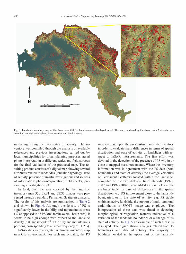
Related Documents