PERIODIC REPORT No.6 Contract NAS5-98046 Period covered" 12 May 2000 - 21 December 2000- Prepared for NASA/Goddard Space Flight Center JB Kumer Principal Investigator Lockheed Martin Advanced technical center (LMATC) LOCKHEED MARTIN MISSILES & SPACE COMPANY Palo Alto, California, 94304-1191 https://ntrs.nasa.gov/search.jsp?R=20020074771 2019-02-09T13:06:10+00:00Z

Welcome message from author
This document is posted to help you gain knowledge. Please leave a comment to let me know what you think about it! Share it to your friends and learn new things together.
Transcript
PERIODIC REPORT No.6
Contract NAS5-98046
Period covered" 12 May 2000 - 21 December 2000-
Prepared forNASA/Goddard Space Flight Center
JB Kumer
Principal Investigator
Lockheed Martin Advanced technical center (LMATC)LOCKHEED MARTIN MISSILES & SPACE COMPANY
Palo Alto, California, 94304-1191
https://ntrs.nasa.gov/search.jsp?R=20020074771 2019-02-09T13:06:10+00:00Z

During the current reporting period we continued work on the task T1 described in section E.2.1 on page 2of our UARS NRA proposal 'CLAES product improvement by use of the GSFC Data Assimilation
System (DAS) '. This 1st task is to plug line of sight gradients derived from the CTM for 2/20/92 into the
forward model of our retrieval software (RSW) in order to assess the impact on the retrieved quantities.We are currently nearly finished with this task as we will describe in the present report #6.
In the next reporting period we can work in parallel on completing task T1, and in beginning our secondtask T2, namely"
• Demonstrate the improvement in retrieval of CH 4 and N20 over the time period 18 to 25 February1992 that is achieved by coupling the GEOS-DAS and the CLAES RSW.
Review of report #5:
In review, during the previous reporting period we had focussed on
1. Integrating the CTM data reader that was provided by the DAS personnel into our retrieval SW, and
2. including the CTM gradients in the retrieval of CLAES temperature, which is input for CH 4 retrieval
Regarding item 1" During this period the DAS personnel developed and delivered a CTM data reader to thespecifications described above. Then we made 2 modifications in the CTM data reader. The first to
account for the differences in our vms system vs the DAS unix system. The second to make it run fast.
While implementing the second modification, we found and corrected a mistake in our 4th period work.
Regarding item 2: The EMAF 46914540 CTM temperature gradients and the baseline NMC gradients
are compared on figure 1. In this figure a positive gradient increase along the direction from the tangent
6O
5O
E40
30m
<
2O
10
'°'''''1''1''''''''' '''''''''l'''''''''
\_" CTM Grads
,,,/ _ NMC Grads
....... ,,I,,,,,,,,,I,,,,,,,,,I,,Itll,,,
-2 -1 0 1 2
NMC Temp. Gradients [K/deg]
Figure 1 CTM vs NMC temperature gradients for EMAF 46914540
point to the UARS spacecraft, and the units are
6O
5Or=-.-I
E-_ 40
"O:3
30<
2O
10
' ' /I ' ' ' I ' ' ' I ' '
\_ -CTM
, * i I , , , I , , , I , , ,
-0.2 0.0 0.2 0.4 0.6Temperature [K]
Figure 2 difference in temperature retrieval due to using CTM
vs NMC temperature gradients for EMAF 46914540
K/degree of great circle arc. The major difference in the two sets of temperature gradients is the altitudewhere the sign changes. The difference in temperature when using CTM gradients in its retrieval vs NMCis shown on figure 2.

('*3
60-
50-
40
30
20-
10-
0.0
BASELINE
- CTMTONLYGRADS
- CTMTANDXGRADS
- CTMTONLYG RADS/BASELI NE
TI ME=46914540 msec
II
//
I/
l
S
S
- CTMTANDXG RADS/BASELINE
l
I
0.3I I I
0.6 0.9
CH4 Mixing RatioRatio to Baseline
u'h
kO
<
r.y3
Or.¢3
°I,-i
©
c_>o
o_,i(
o
.,::f.
CJ
©

6O ' ' ' i , , , i , , , i , , ,
50
20 /__
10 ..., ...........-0.02 0.00 0.02 0.04 0.06
,CH4 fractionalcnange/deg, or arc
Figure 4 CTM CH 4 gradients
E._. 40(9
"O
30<
Next, the retrieval for CH 4 for the EMAF at 46914540 is
shown on figure 3. This is similar to figure 1 in the report #4,but with corrections as were described in report #5. The black
curve is the baseline temperature used in the retrieval. The
baseline CH 4 forward model uses NMC temperature gradientsand zero CH4 gradients. The red curve CTMONLYGRADS is
computed with the CLAES baseline temperature modified as in
figure 2 by use of CTM gradients, and the CTM temperaturegradients also used in the CH4 retrieval forward model. But
zero CH 4 gradients are used in the CH 4 model. The green curve
CTMTANDXGRADS is computed with CTM input as is
CTMONLYGRADS, but also include the CTM CH 4 gradients.• These are shown in figure 4.The broken red curve shows the
ratio of CTMONLYGRADS to the baseline, and the brokenblue curve is the ratio of CTMTANDXGRADS to the baseline.
It is seen here that the CH 4 gradients make some difference atlow altitudes.
The current reporting period work:
During the current reporting period we have implemented the retrieval using the CTM temperature, CH 4and N20 gradients for the entire day 162 and will discuss the results here.
Zonal mean comparisons:
Zonal means of baseline retrieved CH4 and retrieved by use of forward model that includes CTM
temperature and species (CH 4, N20) horizontal gradients are compared on figures 5 and 6. These are
labeled CTMTANDXGRADS and BASELINE, respectively. Two obvious things we learn from these are
1 there is little difference in a zonal mean sense in the retrieved product
2 The CTMTANDXGRADS is spiky at the high altitudes. So before we commence with a joint retrieval
that couples the GEOS-DAS and the CLAES RSW, we need to fix the 'spikiness problem'. It probably
can be traced to a few EMAFS. There may also be some 'spike' problems at the lower altitudes.
Next on figures 7 & 8 are shown comparisons of CTMTANDXGRADS and CTMONLYGRADS which
again show there is some small difference on including the CH 4 gradients, even in the highly averagedcase of the zonal mean. Finally on figures 9 and 10 the N20 CTMTANDXGRADS and BASELINE zonal
mean comparison is shown. There are differences reminiscent of the CH 4 case as discussed above.
Surface maps"
The CH 4 CTMTANDXGRADS and BASELINE 6.8 mb maps are shown on figures 11 through 14, and
CTM that we have mapped (first into 3A file format) on 6.8 mb on figures 15 and 16. Major points are:
1 The CLAES retrievals show much more ascending to descending difference than does the CTM
2 the CLAES products show an enhanced band going from zero longitude & 50N, to about 100 longitude
and 70N that is not present in the CTM, the CLAES north projecting enhancement at about 260 longitudeis displaced towards about 220 longitude in the CTM, and more enhanced. There is a small common
northward projecting enhancement common to CLAES and CTM at -- 130 longitude. In CLAES this
latter seems more to be part of the major enhancement emanating from zero longitude towards thenortheast.
Points 1 and 2 are supported by maps of N20 on the 6.8 mb surface that, for brevity, are not shown here.
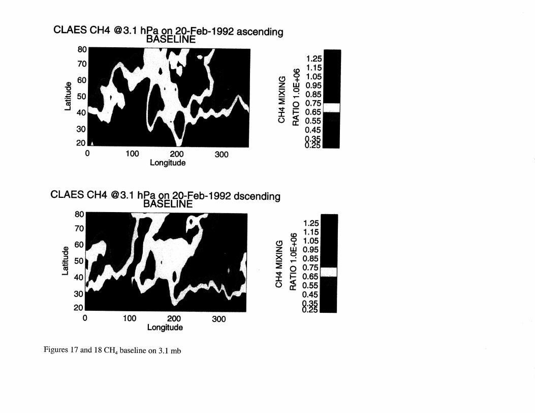
Next the CH 4 CTMTANDxGRADS and BASELINE 3.1 mb maps are shown on figures 17 through
20, and CTM (as above) on 3.1 mb on figures 21 and 22. Major points are"
1generallytheCTM hassmallervaluesnow thantheCLAESproducts2 theCTM & CLAESmorphologylookmorealikeat 3.1mbthanat 6.8mb
3 therelativeenhancementof thefeatureprotrudingto thenortheastfrom aboutzerolong& 40N(callitF1), andof thefeatureprotrudingalmostduenorthatabout100long (call it F2) hasreversed.Thefeaturecenteredatabout200longand70N(call it F3)nowclearlyappearsto beanextensionof thefeatureF2 thatgoesonacrossthepolarregion.
4 TheCTMTANDXGRADShasnoticeablylessascendingto descendingdifferencethandoestheBASELINE
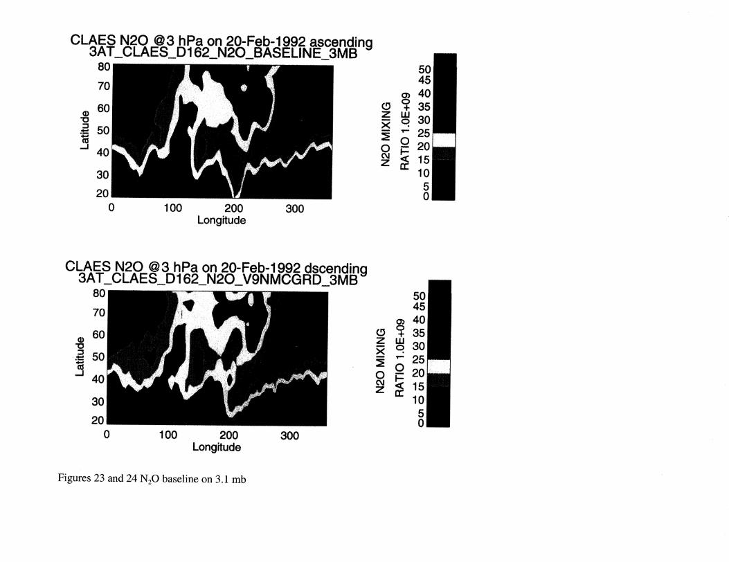
Next theN20 CTMTANDXGRADSandBASELINE 3.1mbmapsareshownon figures23 through26,andCTM (asabove)on3.1mbon figures27and28.Theseareveryconsistentwith theconclusionsdrawnwith regardto CH4asdiscussedabove.
Continuing study"
There are several areas of further study that would prove very productive
We are now at the point where we can set and mn the DAS and the CLAES retrieval SW together (as in
figure 1 from the original proposal, below) so the gradients will be based on the morphology of theCLAES data, and not on the CTM.
_' tNll)|Z ..............l\ ..............
.................................E_: ""mim--Itwill)
............. ii JL_
Day n
• da_
IllJJ] _ _J_.
d.tul Io_,_e,_._ IL__L..._. _.... ,.... t% ...........
1Otc.
EE_
t_
......i
Day n+l
Prior to running with the DAS & CLAES RSW we need to study will focus on• clean up the high altitude 'spikiness' in the CTMTANDXGRADS
• identify candidate mechanisms for producing the ascending to descending differences in CLAES data
Considering the latter, we know that there are portions of the CLAES retrieved H20 where this is a
pathological case. A solution for the condition as with CH 4 & N20 might also help to solve that problemfor H20.

It wouldbeinterestingto exercisethecapabilityto usetheCTM gradientsthatwehavedevelopedsofarfor H20, to assesshow gradientsmight influencethatproblem.
Also,weplanto discussresultsto datewith ourDAS Co-Is,andwith ourcontractmonitorAnneDouglassto sharpenour focusontheworkwewill doin finishingthiseffort.

O'Q
r,/3
L/I
N <©
0
0
Procure AliRude (km)
.'L........... _ ....
>,i .......
Procure Aititucle(kin)
>M t..........
Xo
>Pressure Attitude (kin)
og g g g g
=°°I................................a. t. ,/-__ g
_ \_ o<.-_ , .....
)--4
_a_ _______a_ i ...... l ,.
o
k_
o
k_
_<_
i.
0
Pressure Altilude (kin)
,_,,,,,,,_ ,,,,,,.,.,,, ,._,._,,,,, ,,,,,.,,,,
--=:
8
Pressure Altitude (kin)
og g _ _
_g .......<
Pressure Altitude (km)
og g g g
!'o .... . .............0
At_de(_n)
g g g g g
Pressure Altitude (kin)
og g g g g
?,.. __ o 03
g m
................................. 111 Z
° m
Pressure Altitude (kin)
<
_ _l_
%Z
. g:
o
Pressure Altitude (kin)
o_
0 -
ro
{3
Pressure Altitude (kin}
.... ._._._,,,
mr-"
Zm

> ....................................l/ ,f_".........................I L/I :::........._ ................................................t :_i_,_ ...................................._ ."......................../7ji_:,_io _/' .... I_!I/lI __ _!__;'....... ....................................."_
.............. _.... II/ / . L 'm

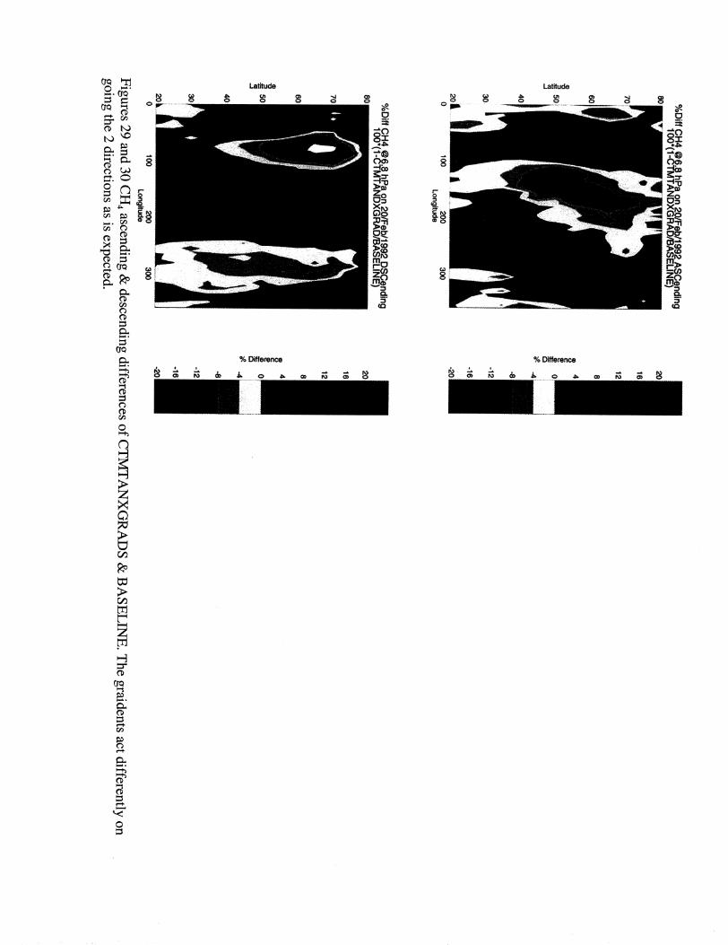
CTMTAN DXG RAD IENTS_ASC_D 162
....40
20 Y .
10-40 -20 0 2o 4o 6,o 8o
20 so (BLK/GR-1) %
1612
8 4o40
-40 -20 0 20 40 60 80
',oI _.., -- ,o_ ! _.,.._._..._3o: ....... ........ " 30 .....
e i <_|_o _o;
10 ........................ 10i .........0 50 '100 150 200 250 300 0 50 100 150 200 250 300
PPBV PPBV
so _1_ _T.......................= _2.00 sor_. [J_T.....= ,_8.00,"......................
g 40 _ ,,o.. -- '
10 ...................... 10 ......................0 50 100 150 200 250 300 0 50 100 i50 200 250 300
PPBV PPBV
BASELINE
,o_',:r:.-:,'32:00_.................._40 . ,,
i:liI L20, _...,!0 50 100 150 200 250 300
PPBV
_',,o_°_ %_.__._._,.[:r._-i_,:&...............
",ol................0 50, 100 150 200 250 3o0
PPBV
_,_40 ...............
L... L,_
0 5o lOO 150 o00 25o 3ooPPBV
CTMTAN DXG RADI ENTS_DSC_D 162, 2O
50 _ ........................... i i.6 50
30 ....
10, - .
(BLK/GR-1) %
-40 '2'0 0 20 40 60 80Latitude
t0 ...................... 10i .................... I... :] .... i0 SO _00 _50 2O0 2S0 3OO 0 SO _00 _50 2O0 2S0 3OO
PPBV PPBV
BASELINE
_i 6'#.::;_2._ ................
!,o i
0 5o lOO 150 2oo 25O 3OOPPBV
o,,
1o ........ ' ......o 5o ioo 15o 2o0 25o 3oo
PPBV
'°_ ...................,o::........ .._.0 50 100 150 200 250 300 0 50 100 150 200 250 300 0 50 I00 150 200 250 300
PPBV PPBV PPBV
Figures 9 and 10 N20 zonal mean comparison CTMTANDxGRADS and BASELINE

CLAES CH4 @6.8hPa on 20-Feb-1992 ascendingBASELINE
8O
7O
6O
3O
Oz_x
L)
20
0 100 200 300Longitude
1.25
© 1.151.05
0.950.85O 0.75
_ 0.650.550.45
CLAES CH4 @6.8hPa on 20-Feb-1992 dscendingBASELINE
80
70
6O
= 50
"J 40
3O
Z W
0
o
20
0 i00
Long_ude
1.251.151.050.950.850.75
Figures 11 and 12 CH4 baseline on 6.8 mb
CLAES CH4 @T6.8hPa on 20-Feb-1992 ascendingC_ _TkNDXGR__iEI_IT_
80
20
0 1_ 200 300
Long_ude
1.25
CLAES CH4 @6.8hPa on 20-Feb-1992 dscendingCTMTAN DXG RADI ENTS
80
50
40
3O
20
0 100 2_ _0
Longitude
! .25
_o 1.15
z w 0.95q 0.850 0.75_ 0.65I
o _ 0.550.45
Figures 13 and 14 CH4 CTMTANDXGRADS on 6.8 mb

CLAES CH4 @6 hPa on 20-Feb-1992 ascending3AT_CTM_CH4_D162_6P8HPA
0
7O
6O"O
._ 50
40
30
20
0 100 200 300Longitude
Oz_x
Io
- H " •CLAES C 4 @6 hPa on 20-Feb-1992 dscendlng3AT_CTM_CH4_D 162_6P8H PA
80
70
Q 60
50
J 40
20
0 1_ 2oo 300Longitude
0zxm
0
1.25
Figures 15 and 16 CH4 CTM on 6.8 mb
CLAES CH4 @3.1 hPa on 20-Feb-1992 ascendingBASELINE
8O
70
60(D
"O
_= 5O
-J 40
3O
20
0 100 200 300Longffude
(9Zm
xu
Zo
1.25
© 1.151.05
LU 0.95o 0.8s'IP"
O 0.75
I_ 0.65a:: 0.55
0.45
CLAES CH4 @3.1 hPa on 20-Feb-1992 dscendingBASELINE
80
70
60"0::3= 50
._140
30
20
0 100 200Longffude
3OO
1.251.15
r,,.9 _ 1.05z m 0.95__ q 0.85
O 0.75
o.6so 0.550.45
Figures 17 and 18 CH 4 baseline on 3.1 mb

CLAES CH4 @ 3. ! hPa on 20-Feb-1992 ascendingCTMTANDXGRADI ENTS
80
7O
60"O
50
_J4O
3O
20
0 100 200 300Longitude
Oz_x
o
1.251.15
_+ 1.05
o.gs,.: 0.85O 0.75
0.65a:: 0.55
0.45
CLAES CH4 @3.1 hPa on 20-Feb-1992 dscendingCTMTANDXGRAD! ENTS
8O
70
60(D
:3._ 50
._14O
30
20
0 100 200Longitude
300
0z_x
I0
Figures 19 and 20 CH 4 CTMTANDXGRADS on 3.1 mb

CLAES CF 4 @3.'1, ,hPa on 20- Feb-1 992 asoendingCTM3A
80
7O
B0-8"-I
.__ 50
-J 40
3O
2O
o oo 300200
Longitude
03
z w
0.750.70
0.B5
0.BOo.55
CLAES CF4 @3.1 h Pa on 20- Feb-'1992 dsoendingCTM3A
80
7O
B0-8
50
..J4O
2O
0 " 00 200
Longitude
:;30O
0.750.70
_o 0-65
_ 0.B0z uJ
-- _ 0,50
0.400.35
0.300:25
Figures 21 and 22 CH 4 CTM on 3.1 mb
CLAES N20 @3 hPa on 20-Feb-1992 ascending3AT_C LAES_D 162_N20_BASE LINE_3M B
80
70
60"0
._. 50
_.140
3O
20
0 100 200 300
Longitude
5045
o_ 40L9 _ 35z LU,_, q 30
" 25oc_ 15z m'< 10
50
CLAES N20 @3 hPa on 20-Feb-1992 dscending3AT_C LA ES_D 162_N20_V9N MCG RD_3M B
80
70
60"O
-4-" 50
-.I40
30
20
o 1oo 200
Longitude
300
5045
o_ 40oZ i,U,_ 0.30
'- 250 020oJ t5Z lo
50
Figures 23 and 24 N20 baseline on 3.1 mb

CLAES N20 @3 hPa on 20-Feb-1992 ascendina3AT_C LAES_D 162_N20_CTMTANDXG R_3 M B
8O
70
60 ¸(D
"O
._- 50
-J40
30
20
0 100 200 300
Longitude
CLAES N20 @3 hPa on 20-Feb-1992 dscendina3AT_C LAES_D 162_N20_CTMTAN DXG R_3MB
80
70
• 60"0
= 50
J 4O
30
20
0 1100 200 _0Longitude
Figures 25 and 26 N20 CTMTANDXGRADS on 3.1 mb

CLAES N20 @3.1
8O
7O
B0-8
50
_d4O
3O
0 "O0
hPa on2O-Feb-'1992 ascendingCTM3A
200 300
Longitude
009O
m- 80
4- 70z w Bo
0 40
20
"0
CLAES N20 @3.1
80
7O
B0
_ 50S
-J 40
3O
2o13 " 00
hPa on 2 O-Feb-1892 dscen din gCTM3A
O_o
_ -!"z w
I'"
_ 0
20 O
Lo_itude
"0090
80
70
B0
50
40
Figures 27 and 28 N=O CTM on 3.1 mb
Latitude
0 0
% Difference
Related Documents