Performance and Application of CSPP/IMAPP in East China Yan-An Liu 1 , Wei Gao 1 , Runhe Shi 1 , Allen Huang 2 , Kathy Strabala 2 , Liam Gumley 2 1. East China Normal University 2. University of Wisconsin-Madison

Welcome message from author
This document is posted to help you gain knowledge. Please leave a comment to let me know what you think about it! Share it to your friends and learn new things together.
Transcript

Performance and Application of
CSPP/IMAPP in East China
Yan-An Liu1, Wei Gao1, Runhe Shi1, Allen Huang2, Kathy Strabala2, Liam Gumley2
1. East China Normal University 2. University of Wisconsin-Madison

Outline
PART 3 Development Plan
PART 1 System and Performance
PART 2 Research and Application

PART 1
System and Performance

System and PerformanceInstallation: Direct Broadcast (DB) Satellite Receiving and Processing System
85m
Located at ECNU Science Bld A EOS FES Commander Status
DB Receiving System: X & L dual bands for US, EU and China DB satellites
DBPS: real-time retrieval of atmosphere, ocean and land parameters

System and PerformanceTraining: Operation and Theory of IMAPP/CSPP

System and PerformanceIMAPP/CSPP Real-time Products
First Images Terra MODIS (0235 UTC, 25 May, 2010)
Infrared Visible True color
AOD Water Vapor SST
EOS FES Commander Schedule:
Configure thepriority of satellites

System and PerformanceIDEA-I
Infusing satellite Data into Environmental air quality Applications
Air Parcel Trajectories
High AOD areas (>0.4) are located and used to initialize the trajectories
MODIS Aerosol Optical Depth
(AOD)
The trajectory forecast animation displays the most important components of an aerosol forecasts
The air parcel trajectories run using the 12Z NOAA/NCEP GFS forecast data providing a 48hr forecast via trajectories
The pressure levels of the trajectories are plotted in mb and colored to a magenta-white scale. White indicates that the air parcel no longer affects the surface
The 850mb wind field vectors are plotted to show wind direction and speed.

System and PerformanceDBCRAS
Direct Broadcast CIMSS Regional Assimilation System
11μm Bright Temperature Image Relative Humidity
850mb Temperature Fields Precipitable Water
DBCRAS can assimilate directbroadcast products from MODIS,including Total Precipitable Waterand Cloud Top Pressure
DBCRAS configuration: 48kmresolution with 38 sigma levels;12hr spin-up with 5-7 MODISinserts and 72hr forecast length
DBCRAS includes 16km nest forhigh-resolution 48hr forecast
The system can generateforecast images and animations ofdifferent meteorological fields for real-time application

PART2
Research and Application
实验室在以下方面取得重要进展
CSPP/IMAPP
AirQuality
Typhoon
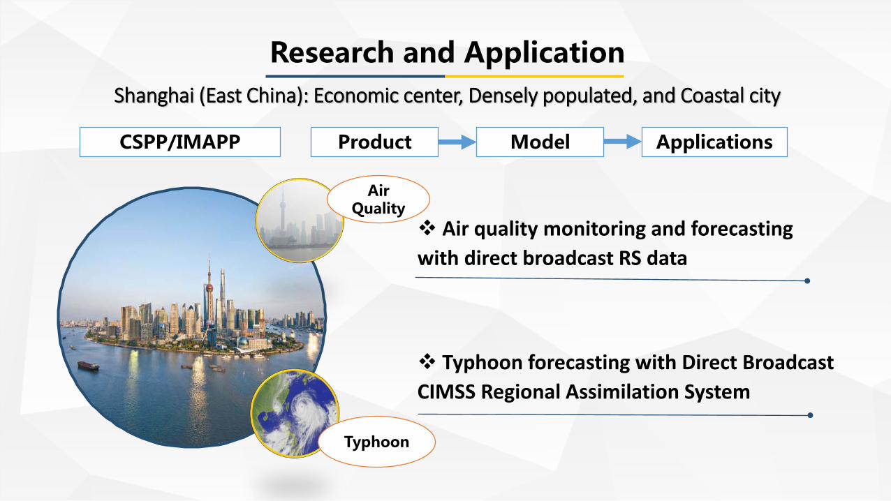
Product Model Applications
Air quality monitoring and forecasting with direct broadcast RS data
Typhoon forecasting with Direct Broadcast CIMSS Regional Assimilation System
Research and ApplicationShanghai (East China): Economic center, Densely populated, and Coastal city

Air Quality: Data Fusion of Aerosol Optical Depth
Model conversion fusionDistribution of HMV*data from observation
sites (stars)
Fusion data
Peterson Model
HMV AOD
Thin plate splines interpolation
Distribution of Aquaand Terra AOD
Research and Application
*HMV: Horizontal Meteorological Visibility

Air Quality: Real-time Application of IDEA-I
Fukushima nuclear disaster in March 2011
Research and Application
IDEA-I forecast was provided to Shanghai governmentto make decision for eliminating the panic of people
The wind blew eastward
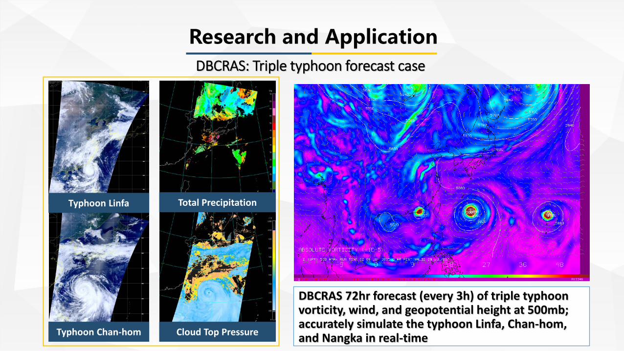
DBCRAS: Triple typhoon forecast case
Total Precipitation
Cloud Top Pressure
Typhoon Linfa
Typhoon Chan-hom
DBCRAS 72hr forecast (every 3h) of triple typhoonvorticity, wind, and geopotential height at 500mb;accurately simulate the typhoon Linfa, Chan-hom, and Nangka in real-time
Research and Application

DBCRAS: Precipitation Validation
Forecast of 24h accumulated precipitation compared with TRMM precipitationShowing location and intensity are consistent
Research and Application
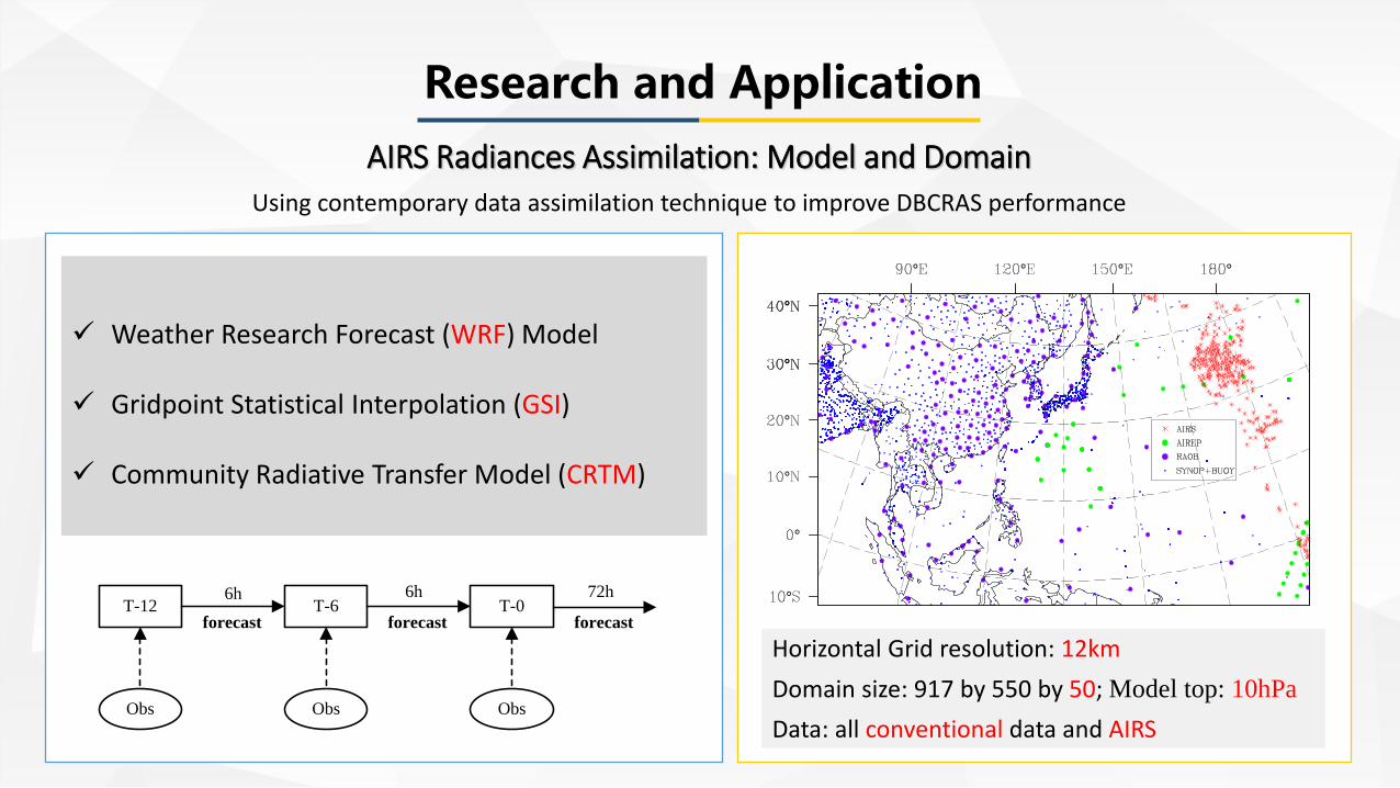
AIRS Radiances Assimilation: Model and Domain
Horizontal Grid resolution: 12kmDomain size: 917 by 550 by 50; Model top: 10hPaData: all conventional data and AIRS
Weather Research Forecast (WRF) Model
Gridpoint Statistical Interpolation (GSI)
Community Radiative Transfer Model (CRTM)
T-12 T-6 T-0
Obs Obs Obs
6h
forecast
6h
forecast
72h
forecast
Research and Application
Using contemporary data assimilation technique to improve DBCRAS performance

AIRS Radiances Assimilation: Analysis Increment
Exp Ctrl
12 UTC
18 UTC
Exp Ctrl
12 UTC
18 UTC
500hPa Temperature 850hPa Relative humidity
Control Run (Ctrl): all conventional observations Experiment Run (Exp): Control Run + AIRS
Research and Application

AIRS Radiances Assimilation: Impact on typhoon forecast
Comparisons of 72h track and intensity forecast for Ctrl and Exp experiment with the best observations from JTWCImproved track and intensity forecasts assimilating AIRS radiances
Research and Application

PART3
Development Plan

Development PlanIntegrated Data Acquisition Platform
Operational Observation Tower Ground-based Radiance Instruments
Gradient TowerAtmospheric Observation field UV sensor-Interferometer-Microwave sounder
To Establish Top-down and Bottom-up Observation Network

Development PlanCooperation Platforms
Nov. 2015
Mar. 2015 Apr. 2017
ECNU signed strategicagreement with CMA:Priority to support the development of Atmospheric Science
ECNU signed strategicagreement with SMA:Promote the conversion
of research andoperational application,
and data sharing
ECNU founded Institute ofAtmospheric and Earth
System Science:Atmospheric RS as core
research direction

Development PlanIntegrated Application Platform
Satellite
Radar
Operational
Ground-based
GSI WRFAssimilation
Typhoon Forecast
Severe Weather
Air Quality
Data Model Application
Real-timeFusionSpecial subjectDaily, Monthly, Seasonally
High Resolution RegionalAssimilation System:Horizontal, vertical, andtime resolution
Typhoon track and intensity, andrainstorm forecast; predict urban flooddisaster with Digital Elevation Model;IDEA-I with various air quality indexes;SMA, SOA, SWA, EPA and so on
Forecast

Thanks for your [email protected]
Related Documents