Canadian Water Resources Journal Vol. 34(4): 311–328 (2009) © 2009 Canadian Water Resources Association Revue canadienne des ressources hydriques W. L. Quinton 1 , M. Hayashi 2 , and L. E. Chasmer 1 1 Cold Regions Research Centre, Wilfrid Laurier University, Waterloo, ON N2L 3C5 2 Department of Geoscience, University of Calgary, Calgary, AB T2N 1N4 Submitted February 2009; accepted May 2009. Written comments on this paper will be accepted until June 2010. Peatland Hydrology of Discontinuous Permafrost in the Northwest Territories: Overview and Synthesis W. L. Quinton, M. Hayashi, and L. E. Chasmer Abstract: Field studies were initiated in 1999 at Scotty Creek in the lower Liard River basin, NWT, Canada, to improve understanding of and ability to predict the major water fluxes and storage processes within a wetland-dominated zone of the discontinuous permafrost region. is paper synthesises a decade of published and unpublished research at Scotty Creek for the purpose of presenting the major factors that should be considered by water scientists and managers as a basis for modelling and management strategies. Five main topics are covered: (1) peatlands of lower Liard River valley; (2) hydrological characteristics of permafrost plateaus, flat bogs, and channel fens; (3) runoff generation on permafrost plateaus; (4) conceptual model of peatland hydrology; and (5) climate warming and implications for basin runoff. is synthesis offers a practical understanding of the hydrology of wetland-dominated basins with discontinuous permafrost. It also offers insight into how landscape changes resulting from climate or human disturbances may influence the basin hydrograph. Résumé : Des études sur le terrain ont été entamées en 1999 au ruisseau Scotty dans le cours inférieur du bassin de la rivière Liard (T.N.-O.), au Canada, afin d’améliorer la compréhension et la capacité de prédiction des flux d’eau majeurs et des processus d’emmagasinement dans une zone dominée par les milieux humides de la région du pergélisol discontinu. Le présent article résume une décennie de recherches, publiées et non publiées, faites au ruisseau Scotty afin de présenter les principaux facteurs devant être pris en considération par les scientifiques et les gestionnaires de l’eau en tant que fondement pour les stratégies de modélisation et de gestion. Cinq principaux thèmes sont traités : (1) tourbières de la vallée du cours inférieur de la rivière Liard; (2) caractéristiques hydrologiques des plateaux de pergélisol, des tourbières oligotrophes plates et des tourbières minérotrophes de chenal; (3) écoulement de surface sur les plateaux de pergélisol; (4) modèle conceptuel de l’hydrologie des tourbières et (5) réchauffement climatique et conséquences pour le ruissellement du bassin. Cette synthèse favorise une compréhension pratique de l’hydrologie des bassins dominés par les zones humides avec pergélisol discontinu. Elle jette aussi un certain éclairage sur la façon dont les changements touchant l’écopaysage, lesquels découlent de perturbations climatiques ou humaines, peuvent influer sur l’hydrographie du bassin.

Welcome message from author
This document is posted to help you gain knowledge. Please leave a comment to let me know what you think about it! Share it to your friends and learn new things together.
Transcript

Canadian Water Resources Journal Vol. 34(4): 311–328 (2009) © 2009 Canadian Water Resources AssociationRevue canadienne des ressources hydriques
W. L. Quinton1, M. Hayashi2, and L. E. Chasmer1
1 Cold Regions Research Centre, Wilfrid Laurier University, Waterloo, ON N2L 3C52 Department of Geoscience, University of Calgary, Calgary, AB T2N 1N4
Submitted February 2009; accepted May 2009. Written comments on this paper will be accepted until June 2010.
Peatland Hydrology of Discontinuous Permafrost in the
Northwest Territories: Overview and Synthesis
W. L. Quinton, M. Hayashi, and L. E. Chasmer
Abstract: Field studies were initiated in 1999 at Scotty Creek in the lower Liard River basin, NWT, Canada, to improve understanding of and ability to predict the major water fluxes and storage processes within a wetland-dominated zone of the discontinuous permafrost region. This paper synthesises a decade of published and unpublished research at Scotty Creek for the purpose of presenting the major factors that should be considered by water scientists and managers as a basis for modelling and management strategies. Five main topics are covered: (1) peatlands of lower Liard River valley; (2) hydrological characteristics of permafrost plateaus, flat bogs, and channel fens; (3) runoff generation on permafrost plateaus; (4) conceptual model of peatland hydrology; and (5) climate warming and implications for basin runoff. This synthesis offers a practical understanding of the hydrology of wetland-dominated basins with discontinuous permafrost. It also offers insight into how landscape changes resulting from climate or human disturbances may influence the basin hydrograph.
Résumé : Des études sur le terrain ont été entamées en 1999 au ruisseau Scotty dans le cours inférieur du bassin de la rivière Liard (T.N.-O.), au Canada, afin d’améliorer la compréhension et la capacité de prédiction des flux d’eau majeurs et des processus d’emmagasinement dans une zone dominée par les milieux humides de la région du pergélisol discontinu. Le présent article résume une décennie de recherches, publiées et non publiées, faites au ruisseau Scotty afin de présenter les principaux facteurs devant être pris en considération par les scientifiques et les gestionnaires de l’eau en tant que fondement pour les stratégies de modélisation et de gestion. Cinq principaux thèmes sont traités : (1) tourbières de la vallée du cours inférieur de la rivière Liard; (2) caractéristiques hydrologiques des plateaux de pergélisol, des tourbières oligotrophes plates et des tourbières minérotrophes de chenal; (3) écoulement de surface sur les plateaux de pergélisol; (4) modèle conceptuel de l’hydrologie des tourbières et (5) réchauffement climatique et conséquences pour le ruissellement du bassin. Cette synthèse favorise une compréhension pratique de l’hydrologie des bassins dominés par les zones humides avec pergélisol discontinu. Elle jette aussi un certain éclairage sur la façon dont les changements touchant l’écopaysage, lesquels découlent de perturbations climatiques ou humaines, peuvent influer sur l’hydrographie du bassin.
312 Canadian Water Resources Journal/Revue canadienne des ressources hydriques
© 2009 Canadian Water Resources Association
Introduction
Substantial gaps in the understanding of freshwater cycling processes in northern regions severely limit our ability to accurately predict variations in flows and storages resulting from climate and human disturbances on the landscape. Climate warming has caused an increase in annual ground thaw depths and frequency of active-layer detachment slides in northern Canada (Lantz and Kokelj, 2008). Warming and melting permafrost have caused spontaneous drainage of lakes (Marsh and Neumann, 2001), flooding of low-lying areas, and disruption of surface topography (Government of the Northwest Territories, 2008). As a result, many northern ecosystems and landscapes are undergoing dramatic changes that are damaging existing infrastructure (e.g., culverts, highways, buildings) and the natural environment. Such changes are complicated by an unprecedented rate of industrial expansion in the north, particularly in the resource sector. Since warming of northern regions is expected to continue over the coming decades (IPCC, 2007), there are concerns about the future availability of northern freshwater, given its vulnerability to climatic warming and human disturbance. The net affect of the increasing precipitation in the NWT (Zhang et al., 2000) and increased evapotranspiration (due to rising air temperatures) on streamflow is not well understood. There is also insufficient knowledge of how key aspects of the hydrological cycle relate to coupled climate-anthropogenic stress on northern landscapes over a broad range of temporal and spatial scales.
The need for improved hydrological understanding of northern Canada prompted a major research network of the Mackenzie River basin in the mid-1990s, known as the Mackenzie GEWEX Study (MAGS) (Woo et al., 2008). MAGS sites included peatlands in the discontinuous permafrost region, referred to as lower Liard River Wetlands (Rouse, 2000), as one of the focussed study areas because the hydrological functions of the peatlands in this region were poorly understood. This resulted in enhanced data collection and analysis, and the establishment of field research infrastructure that continues to generate new knowledge after the completion of MAGS. The research results have been communicated within the research community through the presentations at scientific conferences and specialized workshops and through the papers published in scientific journals. However, to be useful
to the “users” of information, the scientific knowledge needs to be communicated effectively to water managers and policy makers. It is also necessary to integrate the knowledge into conceptual and numerical models representing how the water cycle works. The objective of this paper is to summarize and interpret a selection of published and unpublished research findings, and to present a conceptual model of how wetland-dominated basins in the discontinuous permafrost zone cycle and store water. Such a model will provide water resources engineers and environmental planners with valuable insights into the hydrological functioning of this system. It will also serve as the foundation of science-based numerical models for hydrograph prediction. Improved process understanding and interpretation will lead to better model prediction, which will reduce the uncertainty regarding future availability and quality of the freshwater resource in wetland-dominated, discontinuous permafrost regions of Canada.
Peatlands of Lower Liard River Valley
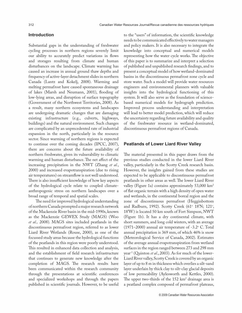
The material presented in this paper draws from the previous studies conducted in the lower Liard River valley, particularly in the Scotty Creek research basin. However, the insights gained from these studies are expected to be applicable to discontinuous permafrost peatlands in other areas as well. The lower Liard River valley (Figure 1a) contains approximately 53,000 km2 of flat organic terrain with a high density of open water and wetlands, in the continental boreal region and the zone of discontinuous permafrost (Hegginbottom and Radburn, 1992). Scotty Creek (61o 18’N; 121o, 18’W) is located 50 km south of Fort Simpson, NWT (Figure 1b). It has a dry continental climate, with short summers, and long cold winters, with an average (1971–2000) annual air temperature of -3.2o C. Total annual precipitation is 369 mm, of which 46% is snow (Meteorological Service of Canada, 2002). Estimates of the average annual evapotranspiration from wetland surfaces in the region ranged between 273 and 298 mm year-1 (Quinton et al., 2003). As for much of the lower-Liard River valley, Scotty Creek is covered by an organic layer of up to 8 m in thickness which overlies a silt-sand layer underlain by thick clay to silt-clay glacial deposits of low permeability (Aylesworth and Kettles, 2000). The upper two-thirds of the 152 km2 drainage area is a peatland complex composed of permafrost plateaus,
Quinton, Hayashi, and Chasmer 313
© 2009 Canadian Water Resources Association
Figure 1. (a) Location of study area in central Mackenzie basin. (b) The lower Liard River valley near Fort
Simpson, Northwest Territories, Canada. (c) Major ground-cover types in the 22 km2 area of interest in the
Scotty Creek basin. The area presented in Figure 10 is outlined in white in Figure 1c.
314 Canadian Water Resources Journal/Revue canadienne des ressources hydriques
© 2009 Canadian Water Resources Association
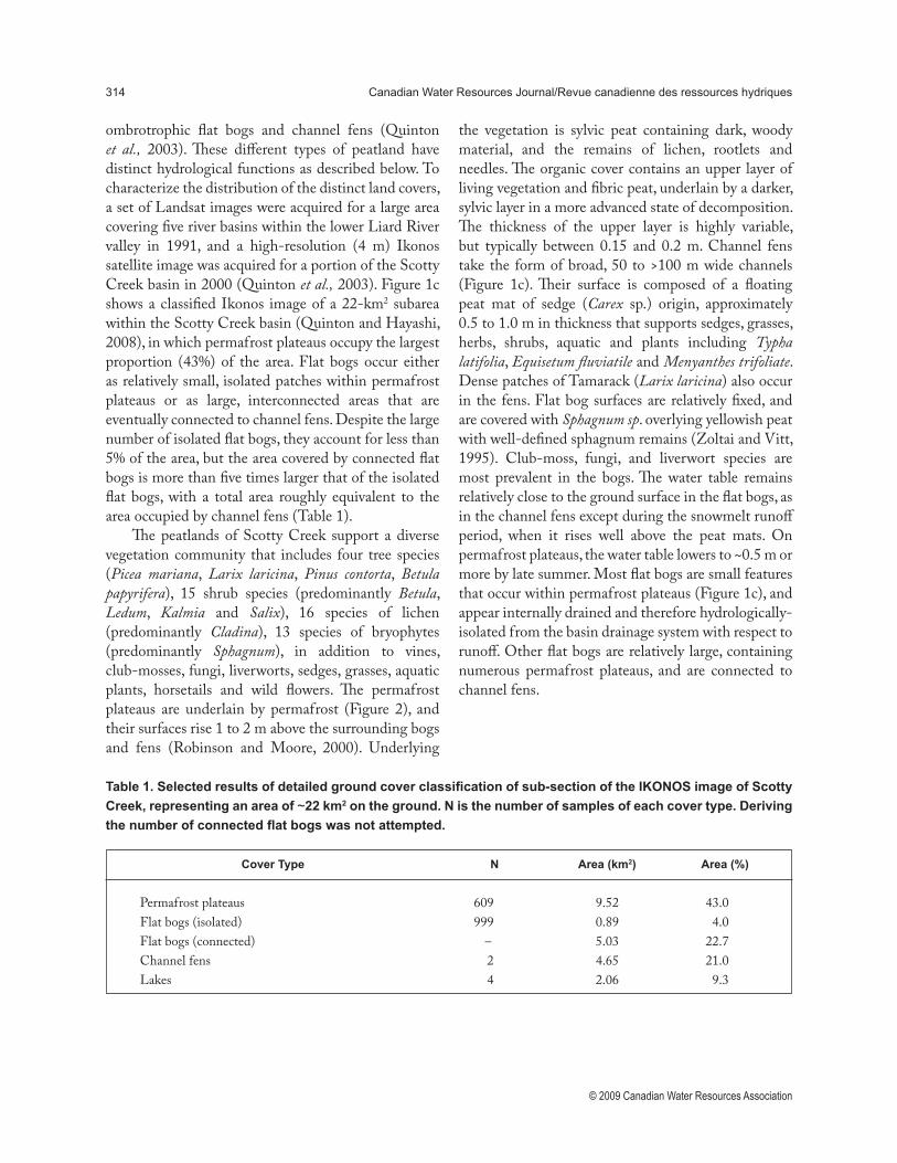
ombrotrophic flat bogs and channel fens (Quinton et al., 2003). These different types of peatland have distinct hydrological functions as described below. To characterize the distribution of the distinct land covers, a set of Landsat images were acquired for a large area covering five river basins within the lower Liard River valley in 1991, and a high-resolution (4 m) Ikonos satellite image was acquired for a portion of the Scotty Creek basin in 2000 (Quinton et al., 2003). Figure 1c shows a classified Ikonos image of a 22-km2 subarea within the Scotty Creek basin (Quinton and Hayashi, 2008), in which permafrost plateaus occupy the largest proportion (43%) of the area. Flat bogs occur either as relatively small, isolated patches within permafrost plateaus or as large, interconnected areas that are eventually connected to channel fens. Despite the large number of isolated flat bogs, they account for less than 5% of the area, but the area covered by connected flat bogs is more than five times larger that of the isolated flat bogs, with a total area roughly equivalent to the area occupied by channel fens (Table 1).
The peatlands of Scotty Creek support a diverse vegetation community that includes four tree species (Picea mariana, Larix laricina, Pinus contorta, Betula papyrifera), 15 shrub species (predominantly Betula, Ledum, Kalmia and Salix), 16 species of lichen (predominantly Cladina), 13 species of bryophytes (predominantly Sphagnum), in addition to vines, club-mosses, fungi, liverworts, sedges, grasses, aquatic plants, horsetails and wild flowers. The permafrost plateaus are underlain by permafrost (Figure 2), and their surfaces rise 1 to 2 m above the surrounding bogs and fens (Robinson and Moore, 2000). Underlying
the vegetation is sylvic peat containing dark, woody material, and the remains of lichen, rootlets and needles. The organic cover contains an upper layer of living vegetation and fibric peat, underlain by a darker, sylvic layer in a more advanced state of decomposition. The thickness of the upper layer is highly variable, but typically between 0.15 and 0.2 m. Channel fens take the form of broad, 50 to >100 m wide channels (Figure 1c). Their surface is composed of a floating peat mat of sedge (Carex sp.) origin, approximately 0.5 to 1.0 m in thickness that supports sedges, grasses, herbs, shrubs, aquatic and plants including Typha latifolia, Equisetum fluviatile and Menyanthes trifoliate. Dense patches of Tamarack (Larix laricina) also occur in the fens. Flat bog surfaces are relatively fixed, and are covered with Sphagnum sp. overlying yellowish peat with well-defined sphagnum remains (Zoltai and Vitt, 1995). Club-moss, fungi, and liverwort species are most prevalent in the bogs. The water table remains relatively close to the ground surface in the flat bogs, as in the channel fens except during the snowmelt runoff period, when it rises well above the peat mats. On permafrost plateaus, the water table lowers to ~0.5 m or more by late summer. Most flat bogs are small features that occur within permafrost plateaus (Figure 1c), and appear internally drained and therefore hydrologically-isolated from the basin drainage system with respect to runoff. Other flat bogs are relatively large, containing numerous permafrost plateaus, and are connected to channel fens.
Table 1. Selected results of detailed ground cover classification of sub-section of the IKONOS image of Scotty
Creek, representing an area of ~22 km2 on the ground. N is the number of samples of each cover type. Deriving
the number of connected flat bogs was not attempted.
Cover Type N Area (km2) Area (%)
Permafrost plateaus 609 9.52 43.0Flat bogs (isolated) 999 0.89 4.0Flat bogs (connected) – 5.03 22.7Channel fens 2 4.65 21.0Lakes 4 2.06 9.3
Quinton, Hayashi, and Chasmer 315
© 2009 Canadian Water Resources Association
Hydrological Characteristics of Permafrost Plateau, Flat Bog, and Channel Fen
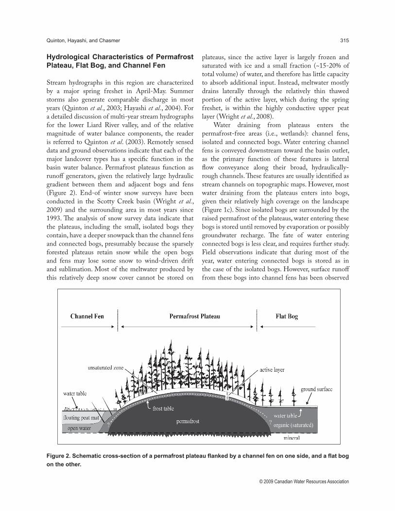
Stream hydrographs in this region are characterized by a major spring freshet in April-May. Summer storms also generate comparable discharge in most years (Quinton et al., 2003; Hayashi et al., 2004). For a detailed discussion of multi-year stream hydrographs for the lower Liard River valley, and of the relative magnitude of water balance components, the reader is referred to Quinton et al. (2003). Remotely sensed data and ground observations indicate that each of the major landcover types has a specific function in the basin water balance. Permafrost plateaus function as runoff generators, given the relatively large hydraulic gradient between them and adjacent bogs and fens (Figure 2). End-of winter snow surveys have been conducted in the Scotty Creek basin (Wright et al., 2009) and the surrounding area in most years since 1993. The analysis of snow survey data indicate that the plateaus, including the small, isolated bogs they contain, have a deeper snowpack than the channel fens and connected bogs, presumably because the sparsely forested plateaus retain snow while the open bogs and fens may lose some snow to wind-driven drift and sublimation. Most of the meltwater produced by this relatively deep snow cover cannot be stored on
plateaus, since the active layer is largely frozen and saturated with ice and a small fraction (~15-20% of total volume) of water, and therefore has little capacity to absorb additional input. Instead, meltwater mostly drains laterally through the relatively thin thawed portion of the active layer, which during the spring freshet, is within the highly conductive upper peat layer (Wright et al., 2008).
Water draining from plateaus enters the permafrost-free areas (i.e., wetlands): channel fens, isolated and connected bogs. Water entering channel fens is conveyed downstream toward the basin outlet, as the primary function of these features is lateral flow conveyance along their broad, hydraulically-rough channels. These features are usually identified as stream channels on topographic maps. However, most water draining from the plateaus enters into bogs, given their relatively high coverage on the landscape (Figure 1c). Since isolated bogs are surrounded by the raised permafrost of the plateaus, water entering these bogs is stored until removed by evaporation or possibly groundwater recharge. The fate of water entering connected bogs is less clear, and requires further study. Field observations indicate that during most of the year, water entering connected bogs is stored as in the case of the isolated bogs. However, surface runoff from these bogs into channel fens has been observed
Figure 2. Schematic cross-section of a permafrost plateau flanked by a channel fen on one side, and a flat bog
on the other.
316 Canadian Water Resources Journal/Revue canadienne des ressources hydriques
© 2009 Canadian Water Resources Association
during the annual snowmelt period and in response to large, late-summer rain events. Chemical and isotopic analysis of surface and subsurface waters in the Scotty Creek basin indicate that less than half of the water discharged during the spring freshet is snowmelt water, suggesting that a large amount of water is stored overwinter, presumably in connected bogs and channel fens (Hayashi et al., 2004). The same study also showed that channel fens receive a significant amount of groundwater discharge from the underlying glacial deposits, which increases the concentration of major ions with flow distance along the drainage system.
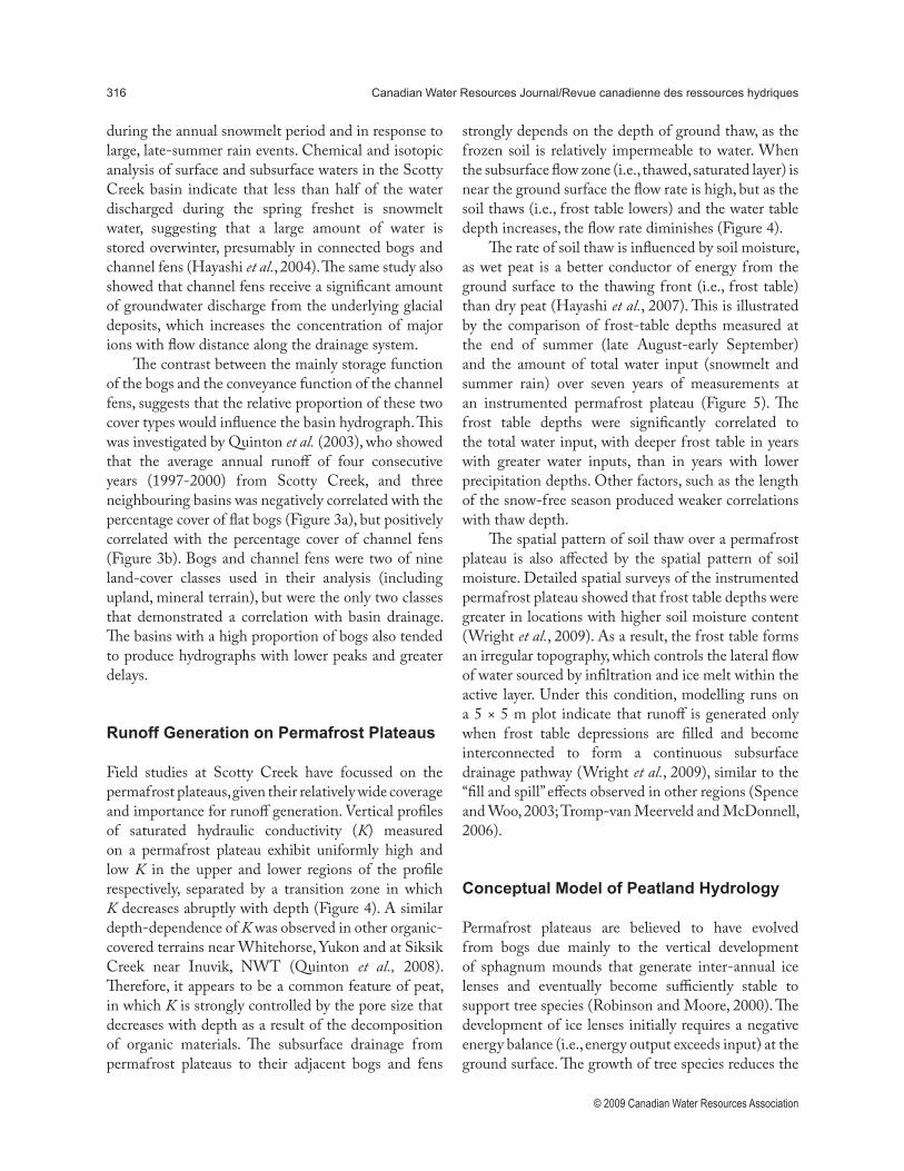
The contrast between the mainly storage function of the bogs and the conveyance function of the channel fens, suggests that the relative proportion of these two cover types would influence the basin hydrograph. This was investigated by Quinton et al. (2003), who showed that the average annual runoff of four consecutive years (1997-2000) from Scotty Creek, and three neighbouring basins was negatively correlated with the percentage cover of flat bogs (Figure 3a), but positively correlated with the percentage cover of channel fens (Figure 3b). Bogs and channel fens were two of nine land-cover classes used in their analysis (including upland, mineral terrain), but were the only two classes that demonstrated a correlation with basin drainage. The basins with a high proportion of bogs also tended to produce hydrographs with lower peaks and greater delays.
Runoff Generation on Permafrost Plateaus
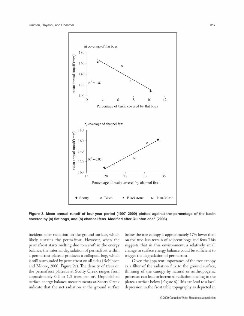
Field studies at Scotty Creek have focussed on the permafrost plateaus, given their relatively wide coverage and importance for runoff generation. Vertical profiles of saturated hydraulic conductivity (K) measured on a permafrost plateau exhibit uniformly high and low K in the upper and lower regions of the profile respectively, separated by a transition zone in which K decreases abruptly with depth (Figure 4). A similar depth-dependence of K was observed in other organic-covered terrains near Whitehorse, Yukon and at Siksik Creek near Inuvik, NWT (Quinton et al., 2008). Therefore, it appears to be a common feature of peat, in which K is strongly controlled by the pore size that decreases with depth as a result of the decomposition of organic materials. The subsurface drainage from permafrost plateaus to their adjacent bogs and fens
strongly depends on the depth of ground thaw, as the frozen soil is relatively impermeable to water. When the subsurface flow zone (i.e., thawed, saturated layer) is near the ground surface the flow rate is high, but as the soil thaws (i.e., frost table lowers) and the water table depth increases, the flow rate diminishes (Figure 4).
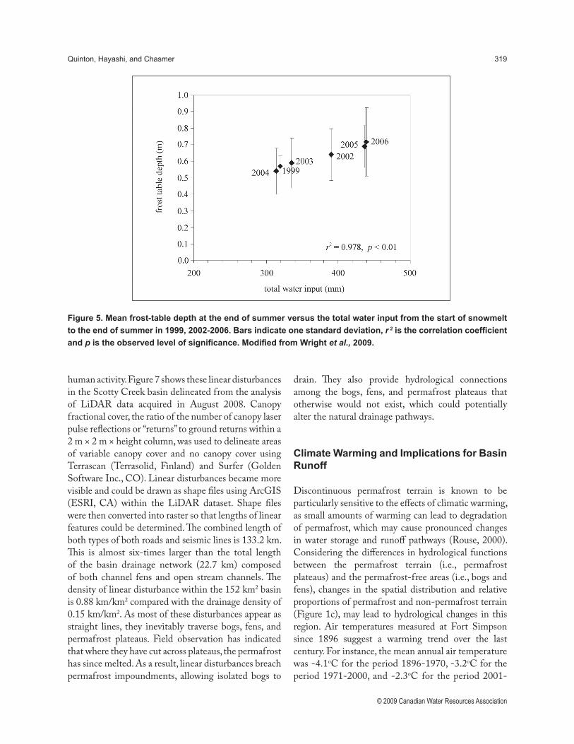
The rate of soil thaw is influenced by soil moisture, as wet peat is a better conductor of energy from the ground surface to the thawing front (i.e., frost table) than dry peat (Hayashi et al., 2007). This is illustrated by the comparison of frost-table depths measured at the end of summer (late August-early September) and the amount of total water input (snowmelt and summer rain) over seven years of measurements at an instrumented permafrost plateau (Figure 5). The frost table depths were significantly correlated to the total water input, with deeper frost table in years with greater water inputs, than in years with lower precipitation depths. Other factors, such as the length of the snow-free season produced weaker correlations with thaw depth.
The spatial pattern of soil thaw over a permafrost plateau is also affected by the spatial pattern of soil moisture. Detailed spatial surveys of the instrumented permafrost plateau showed that frost table depths were greater in locations with higher soil moisture content (Wright et al., 2009). As a result, the frost table forms an irregular topography, which controls the lateral flow of water sourced by infiltration and ice melt within the active layer. Under this condition, modelling runs on a 5 × 5 m plot indicate that runoff is generated only when frost table depressions are filled and become interconnected to form a continuous subsurface drainage pathway (Wright et al., 2009), similar to the “fill and spill” effects observed in other regions (Spence and Woo, 2003; Tromp-van Meerveld and McDonnell, 2006).
Conceptual Model of Peatland Hydrology
Permafrost plateaus are believed to have evolved from bogs due mainly to the vertical development of sphagnum mounds that generate inter-annual ice lenses and eventually become sufficiently stable to support tree species (Robinson and Moore, 2000). The development of ice lenses initially requires a negative energy balance (i.e., energy output exceeds input) at the ground surface. The growth of tree species reduces the
Quinton, Hayashi, and Chasmer 317
© 2009 Canadian Water Resources Association
Figure 3. Mean annual runoff of four-year period (1997–2000) plotted against the percentage of the basin
covered by (a) flat bogs, and (b) channel fens. Modified after Quinton et al. (2003).
incident solar radiation on the ground surface, which likely sustains the permafrost. However, when the permafrost starts melting due to a shift in the energy balance, the internal degradation of permafrost within a permafrost plateau produces a collapsed bog, which is still surrounded by permafrost on all sides (Robinson and Moore, 2000, Figure 2c). The density of trees on the permafrost plateaus at Scotty Creek ranges from approximately 0.2 to 1.3 trees per m2. Unpublished surface energy balance measurements at Scotty Creek indicate that the net radiation at the ground surface
below the tree canopy is approximately 17% lower than on the tree-less terrain of adjacent bogs and fens. This suggests that in this environment, a relatively small change in surface energy balance could be sufficient to trigger the degradation of permafrost.
Given the apparent importance of the tree canopy as a filter of the radiation flux to the ground surface, thinning of the canopy by natural or anthropogenic processes can lead to increased radiation loading to the plateau surface below (Figure 6). This can lead to a local depression in the frost table topography as depicted in
318 Canadian Water Resources Journal/Revue canadienne des ressources hydriques
© 2009 Canadian Water Resources Association
Figure 4. Depth-variation of saturated horizontal hydraulic conductivity measured from tracer (KCl-) tests
conducted at the site of the present study, as well as at other organic-covered permafrost terrains in northwestern
Canada, as reported by Quinton et al. (2008). The light and dark grey indicate the zones of uniformly high and
uniformly low hydraulic conductivity, respectively. Modified from Quinton et al., 2008.
the middle frame of Figure 6. As a result, water will drain toward the depression from surrounding areas, producing a local area of increased thickness of the thawed, saturated layer, and increased soil moisture in the unsaturated zone. This elevated soil moisture content increases the bulk thermal conductivity of the peat above the depression, and as a result, more thermal energy is transferred downward from the ground surface, further deepening the frost table depression, and further enhancing local subsurface drainage from surrounding areas. As this process continues, the remaining trees above the frost table depression may
be unable to survive due to water-logging, in which case the canopy is thinned further or removed, and radiation loading of the ground surface above the depression is increased. This sequence of events may lead to a local removal of permafrost (Figure 6, bottom frame) and creation of a new isolated flat bog, such as those identified in Figure 1c.
A similar process of permafrost loss to that depicted in Figure 6 appears also to apply to areas where the tree canopy has been removed by human disturbance. At Scotty Creek, winter roads and cut lines for seismic exploration are the major cause of canopy removal by
Quinton, Hayashi, and Chasmer 319
© 2009 Canadian Water Resources Association
Figure 5. Mean frost-table depth at the end of summer versus the total water input from the start of snowmelt
to the end of summer in 1999, 2002-2006. Bars indicate one standard deviation, r 2 is the correlation coefficient
and p is the observed level of significance. Modified from Wright et al., 2009.
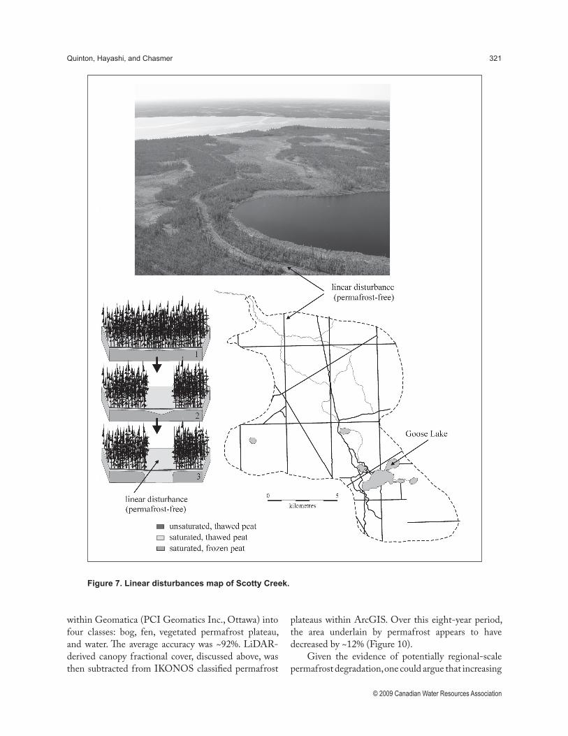
human activity. Figure 7 shows these linear disturbances in the Scotty Creek basin delineated from the analysis of LiDAR data acquired in August 2008. Canopy fractional cover, the ratio of the number of canopy laser pulse reflections or “returns” to ground returns within a 2 m × 2 m × height column, was used to delineate areas of variable canopy cover and no canopy cover using Terrascan (Terrasolid, Finland) and Surfer (Golden Software Inc., CO). Linear disturbances became more visible and could be drawn as shape files using ArcGIS (ESRI, CA) within the LiDAR dataset. Shape files were then converted into raster so that lengths of linear features could be determined. The combined length of both types of both roads and seismic lines is 133.2 km. This is almost six-times larger than the total length of the basin drainage network (22.7 km) composed of both channel fens and open stream channels. The density of linear disturbance within the 152 km2 basin is 0.88 km/km2 compared with the drainage density of 0.15 km/km2. As most of these disturbances appear as straight lines, they inevitably traverse bogs, fens, and permafrost plateaus. Field observation has indicated that where they have cut across plateaus, the permafrost has since melted. As a result, linear disturbances breach permafrost impoundments, allowing isolated bogs to
drain. They also provide hydrological connections among the bogs, fens, and permafrost plateaus that otherwise would not exist, which could potentially alter the natural drainage pathways.
Climate Warming and Implications for Basin Runoff
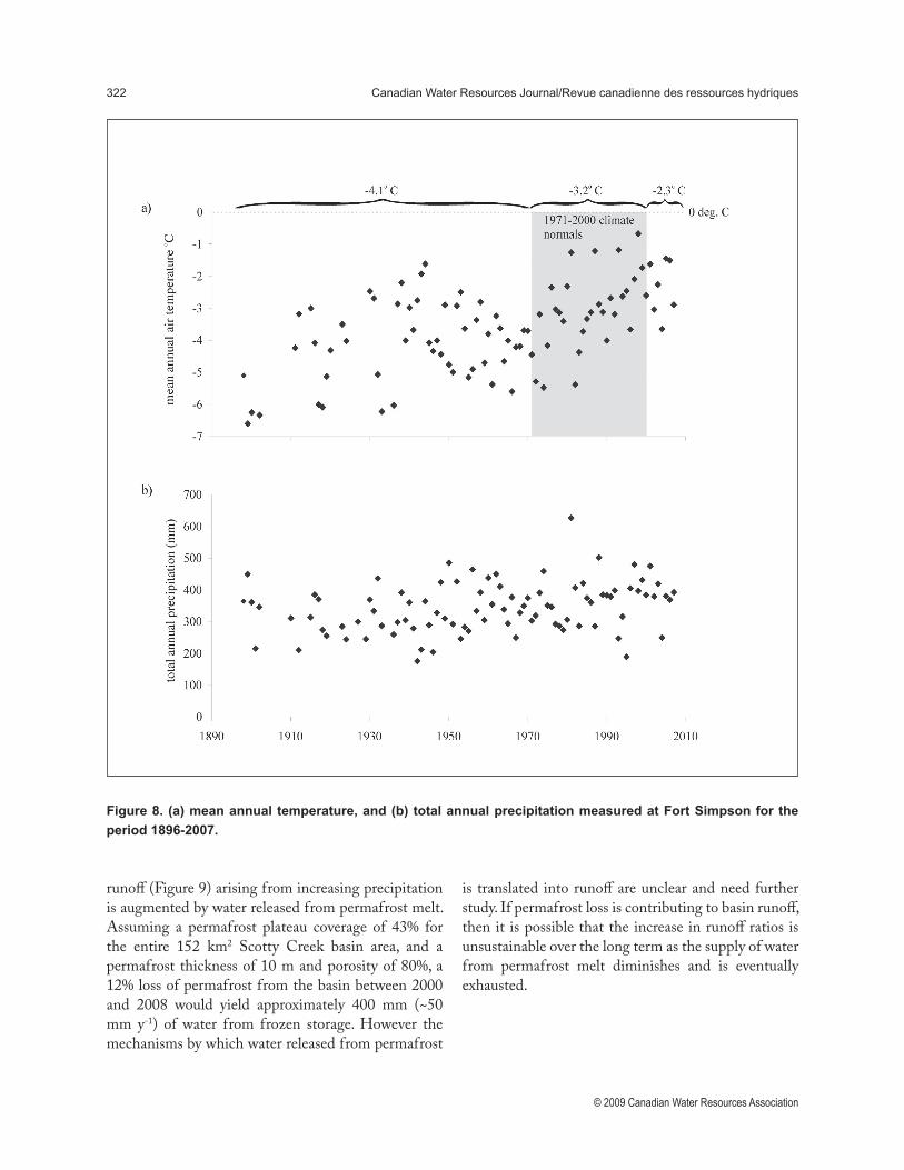
Discontinuous permafrost terrain is known to be particularly sensitive to the effects of climatic warming, as small amounts of warming can lead to degradation of permafrost, which may cause pronounced changes in water storage and runoff pathways (Rouse, 2000). Considering the differences in hydrological functions between the permafrost terrain (i.e., permafrost plateaus) and the permafrost-free areas (i.e., bogs and fens), changes in the spatial distribution and relative proportions of permafrost and non-permafrost terrain (Figure 1c), may lead to hydrological changes in this region. Air temperatures measured at Fort Simpson since 1896 suggest a warming trend over the last century. For instance, the mean annual air temperature was -4.1oC for the period 1896-1970, -3.2oC for the period 1971-2000, and -2.3oC for the period 2001-

320 Canadian Water Resources Journal/Revue canadienne des ressources hydriques
© 2009 Canadian Water Resources Association
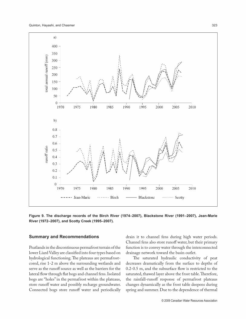
2007 (Figure 8a). At the same time, total annual precipitation over the 1896-2007 period does not appear to have increased significantly (Figure 8b). Although the stream flow record length in the Fort Simpson region is much shorter than that of climate, it does provide some insights. For instance, since approximately 1995, Scotty Creek and three other drainage basins in the lower Liard River valley, appear to have increased total annual runoff (Figure 9a) and higher average annual runoff ratios (annual runoff expressed as a percentage of the annual precipitation) (Figure 9b). However, the 1995-2007 (as well as 2001-2007) is likely too short to draw statistically meaningful conclusions. Nevertheless, similar trends were reported for other rivers in the discontinuous permafrost regions in the NWT (St. Jacques and Sauchyn, 2009).
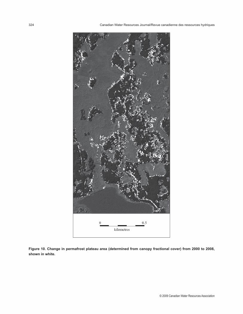
At the instrumented permafrost plateau in the Scotty Creek basin, the average soil temperature in the active layer has steadily increased and the annual net ground heat flux has been steadily increasing since site installation in 2001, indicating permafrost warming; and the annual frost-table survey at the same site indicates the deepening of the active layer (Wright et al., in review). These observations point to the local degradation of permafrost. Permafrost loss measured on the ground is supported by observations over larger areas from aircraft and satellite remote sensing. Permafrost loss from Scotty Creek is easily detected by proxy with tree-cover loss, since permafrost occurs only beneath the permafrost plateaus. A comparison of 1947 and 2000 aerial imagery indicates substantial decrease in permafrost, as evidenced by the expansion and merger of bogs, and the disappearance of plateaus. Within the 22 km2 area presented as Figure 1c, a 1.6 km2 area of interest centred over the main field measurement locations was selected for analysis of permafrost loss between 2000 and 2008 using i) high-resolution (4 m × 4 m) IKONOS satellite image acquired in 2000; and ii) a LiDAR image from 2008. IKONOS measures spectral reflectance from foliage visible to the sensor, whereas LiDAR measures the three-dimensional characteristics of the canopy, understory and ground surface. Therefore, change detection from 2000 to 2008 requires that vegetation from LiDAR (and not actual permafrost plateau area) is compared with IKONOS canopy spectral reflectance. Canopy fractional cover correlates strongly with permafrost plateau area, and may be a proxy-indicator of plateau thaw and area reduction. IKONOS data were classified
Figure 6. Conceptual schematic of permafrost removal
and isolated flat bog formation.
Quinton, Hayashi, and Chasmer 321
© 2009 Canadian Water Resources Association
Figure 7. Linear disturbances map of Scotty Creek.
within Geomatica (PCI Geomatics Inc., Ottawa) into four classes: bog, fen, vegetated permafrost plateau, and water. The average accuracy was ~92%. LiDAR-derived canopy fractional cover, discussed above, was then subtracted from IKONOS classified permafrost
plateaus within ArcGIS. Over this eight-year period, the area underlain by permafrost appears to have decreased by ~12% (Figure 10).
Given the evidence of potentially regional-scale permafrost degradation, one could argue that increasing
322 Canadian Water Resources Journal/Revue canadienne des ressources hydriques
© 2009 Canadian Water Resources Association
Figure 8. (a) mean annual temperature, and (b) total annual precipitation measured at Fort Simpson for the
period 1896-2007.
runoff (Figure 9) arising from increasing precipitation is augmented by water released from permafrost melt. Assuming a permafrost plateau coverage of 43% for the entire 152 km2 Scotty Creek basin area, and a permafrost thickness of 10 m and porosity of 80%, a 12% loss of permafrost from the basin between 2000 and 2008 would yield approximately 400 mm (~50 mm y-1) of water from frozen storage. However the mechanisms by which water released from permafrost
is translated into runoff are unclear and need further study. If permafrost loss is contributing to basin runoff, then it is possible that the increase in runoff ratios is unsustainable over the long term as the supply of water from permafrost melt diminishes and is eventually exhausted.
Quinton, Hayashi, and Chasmer 323
© 2009 Canadian Water Resources Association
Figure 9. The discharge records of the Birch River (1974–2007), Blackstone River (1991–2007), Jean-Marie
River (1972–2007), and Scotty Creek (1995–2007).
Summary and Recommendations
Peatlands in the discontinuous permafrost terrain of the lower Liard Valley are classified into four types based on hydrological functioning. The plateaus are permafrost-cored, rise 1-2 m above the surrounding wetlands and serve as the runoff source as well as the barriers for the lateral flow through flat bogs and channel fens. Isolated bogs are “holes” in the permafrost within the plateaus, store runoff water and possibly recharge groundwater. Connected bogs store runoff water and periodically
drain it to channel fens during high water periods. Channel fens also store runoff water, but their primary function is to convey water through the interconnected drainage network toward the basin outlet.
The saturated hydraulic conductivity of peat decreases dramatically from the surface to depths of 0.2-0.5 m, and the subsurface flow is restricted to the saturated, thawed layer above the frost table. Therefore, the rainfall-runoff response of permafrost plateaus changes dynamically as the frost table deepens during spring and summer. Due to the dependence of thermal
324 Canadian Water Resources Journal/Revue canadienne des ressources hydriques
© 2009 Canadian Water Resources Association
Figure 10. Change in permafrost plateau area (determined from canopy fractional cover) from 2000 to 2008,
shown in white.
Quinton, Hayashi, and Chasmer 325
© 2009 Canadian Water Resources Association
conductivity on the wetness of peat, the frost table deepens faster in wet areas, which enhances the lateral hydraulic gradient and the flow of water toward wet areas. As a result, there are complex feedback processes governing the runoff response of permafrost plateaus, which present significant challenges in the modelling of runoff generation. It is clear that the hydraulic connectivity among the numerous patches of different landcover types has a major influence on basin-scale runoff, and that the connectivity increases as the water level in wetlands increases with water inputs (Bowling et al., 2003). This process is poorly understood at the moment and presents a major challenge in basin runoff modelling.
Since the development and maintenance of permafrost is dependent on the delicate balance between the input and output of energy at the ground surface, a relatively small change in the energy balance may trigger the degradation of permafrost under plateaus. Such effects are currently observed mainly around the edges of permafrost plateaus but also occur in the interior. The flat bogs and channel fens occurring along linear disturbances likely result from local permafrost degradation due to the alternation of energy balance by natural or human-induced thinning or removal of the tree canopy that filters solar radiation. Long-term climate records indicate an increase in mean annual air temperature between 1896 and 2007. Annual total runoff from four river basins within the lower Liard River valley appears to have changed since the mid-1990s. These changes may indicate that climate warming is causing a regional-scale change in river flow, which may be linked to the degradation of permafrost, and possibly changes in precipitation. However, such linkages remain speculative at the moment without further understanding of hydrological processes in this environment.
Increasing runoff from the discontinuous permafrost terrain may affect engineering and environmental planning, such as culvert design for road construction and the prediction of future water supply. Shrinkage and fragmentation of permafrost plateaus may also influence wildlife habitats. To provide scientifically sound guidance and practical tools for engineers, planners, and policy makers, the aforementioned challenges must be overcome and reliable models of hydrological processes and basin runoff must be developed. To this end, focussed studies
at small watersheds are effective, combined with remote sensing and long-term monitoring of major rivers draining the discontinuous permafrost region. To document climate-change effects on the water cycle, anecdotal evidence gathered from local communities will serve a useful purpose, but the sound methodology for gathering and synthesizing local knowledge may have to be established before such knowledge can be used for hydrological research.
For researchers to effectively gather and respond to local knowledge and the needs of water managers and users (e.g., government agencies and local water boards), a new framework is needed that will enable researchers and users to address issues pertaining to northern water resources, as a single coherent and interactive community. Researchers should focus on the development of a new suite of innovative, science-based predictive tools for users, to facilitate sustainable decision-making for water use and environmental protection. Collaboration must extend beyond the production and delivery of new predictive tools, to include interactive training with user groups during focussed workshops, where users provide feedback and express their needs. Such a framework facilitates high-quality training for the next generation of water scientists and managers.
Acknowledgements
The authors acknowledge the financial support of the Natural Sciences and Engineering Research Council, the Canadian Foundation for Climate and Atmospheric Sciences, and Environment Canada Science Horizons Program. The authors also acknowledge the logistical support provided by the National Water Research Institute (Saskatoon) and by Mr. Gerry Wright and Mr. Roger Pilling of the Water Survey of Canada (Fort Simpson). We acknowledge the Aurora Research Institute for their assistance in obtaining a research license, and thank the Denedeh Resources Committee, Deh Cho First Nation, Fort Simpson Métis Local #52, Liidlii Kue First Nation and the Village of Fort Simpson for their support of this project. We also thank Nicole Wright, Andrea Kenward, Pete Whittington, Trevor Myers, Cuyler Onclin and Mike Toews for their assistance in the field and laboratory.
326 Canadian Water Resources Journal/Revue canadienne des ressources hydriques
© 2009 Canadian Water Resources Association
References
Aylesworth, J. M. and I. M. Kettles. 2000. Distribution of fen and bog in the Mackenzie Valley, 60ºN - 68ºN. Natural Resources Canada, Geological Survey of Canada Bulletin 547.
Bowling, L. C., D. L. Kane, R. E. Gieck, L. D. Hinzman, and D. P. Lettenmaier. 2003. The role of surface storage in a low-gradient Arctic watershed. Water Resources Research 39, 1087.
Government of the Northwest Territories. 2008. NWT Climate Change Impacts and Adaptation Report, 2008. Environment and Natural Resources, NWT, Yellowknife, Canada, 36 pp.
Hayashi, M., W. L. Quinton, A. Pietroniro, and J. J. Gibson. 2004. Hydrologic functions of wetlands in a discontinuous permafrost basin indicated by isotopic and chemical signatures. Journal of Hydrology 216: 81-97.
Hayashi, M., N. T. Goeller, W. L. Quinton, and N. Wright. 2007. A simple heat-conduction method for simulating the frost-table depth in hydrological models. Hydrological Processes 21: 2610-2622.
Hegginbottom, J. A. and L. K. Radburn. 1992. Permafrost and ground ice conditions of northwestern Canada. Geological Survey of Canada, Map 1691A, scale 1:1 000 000.
IPCC. 2007. Climate Change, 2007. Synthesis Report: A report of the inter-governmental panel on climate change. Cambridge University Press, 52 pp.
Lantz, T. C. and S. V. Kokelj. 2008. Increasing rates of retrogressive thaw slump activity in the Mackenzie Delta region, N.W.T., Canada. Geophysical Research Letters, 35: L06502, doi:10.1029/2007GL032433.
Marsh, P. and N. Neumann. 2001. Processes controlling the rapid drainage of two ice-rich permafrost-dammed lakes in NW Canada. Hydrological Processes 15 (18), pp. 3433-3446.
Meteorological Service of Canada. 2002. National climate data archive of Canada. Environment Canada: Dorval, Quebec, Canada.
Quinton, W. L., M. Hayashi, and S. K. Carey. 2008. Peat hydraulic conductivity in cold regions and its relation to pore size and geometry. Hydrological Processes, 22: 2829–2837.
Quinton, W. L. and M. Hayashi. 2008. Recent advances toward physically-based runoff modelling of the wetland-dominated, central Mackenzie River basin. Cold Region Atmospheric and Hydrologic Studies. The Mackenzie GEWEX Experience, Vol-2: Hydrological Processes, Woo, M.-K. (Ed.). Springer, pp 257-279.
Quinton, W. L., M. Hayashi, and A. Pietroniro. 2003. Connectivity and storage functions of channel fens and flat bogs in northern basins. Hydrological Processes 17: 3665-3684.
Robinson, S. D. and T. R. Moore. 2000. The influence of permafrost and fire upon carbon accumulation in high boreal peatlands, Northwest Territories, Canada. Arctic, Antarctic and Alpine Research 32: 155-166.
Rouse, W. R. 2000. Progress in hydrological research in the Mackenzie GEWEX study. Hydrological Processes 14: 1667-1685.
Spence, C. and M.-K. Woo. 2003. Hydrology of subarctic Canadian shield: Soil-filled valleys. Journal of Hydrology 279: 151-166.
St. Jacques, J.-M. and D. J. Sauchyn. 2009. Increasing winter baseflow and mean annual streamflow from possible permafrost thawing in the Northwest Territories, Canada. Geophysical Research Letters, 36: L01401, doi:10.1029/2008GL035822.
Tromp-van Meerveld, H. J. and J. J. McDonnell. 2006. Threshold relations in subsurface stormflow: 2. The fill and spill hypothesis, Water Resources Research 42, W02411, doi:10.1029/2004WR003800.
Quinton, Hayashi, and Chasmer 327
© 2009 Canadian Water Resources Association
Wright, N., L. Chasmer, W. Quinton, and M. Hayashi. In review. Ground surface energetics and subsurface thermal regime of a perennially frozen permafrost plateau and a seasonally frozen peat bog. Hydrology Research, in review.
Wright, N., M. Hayashi, and W. L. Quinton. 2009.Spatial and temporal variations in active layer thawing and their implication on runoff generation in peat-covered permafrost terrain, Water Resources Research 45, W05414, doi:10.1029/2008WR006880.
Wright, N., W. L. Quinton, and M. Hayashi. 2008. Hillslope runoff from an ice-cored permafrost plateau in a discontinuous permafrost basin, Northwest Territories, Canada. Hydrological Processes 22: 2816-2828.
Woo, M.-K., W. R. Rouse, R. E. Stewart, and J. M. R. Stone. 2008. The Mackenzie GEWEX study: A contribution to cold region atmospheric and hydrologic sciences. In The Mackenzie GEWEX Experience: Vol. 1, Cold Region Atmospheric and Hydrologic Studies. Springer, Berlin, p. 1-22.
Zhang, X., L. A. Vincent, W. D. Hogg, and A. Niitsoo. 2000. Temperature and precipitation trends in Canada during the 20th century, Atmosphere-Ocean 38, 395–429.
Zoltai, S. C. and D. Vitt. 1995. Canadian wetlands — environmental gradients and classification. Vegetation, 118: 131-137.

Related Documents