Integrated Water System Development Exemplified by PanHlaing River Rehabilitation Project Prepared by Dr. Zaw Lwin Tun, Director Hla Oo Nwe, Deputy Director Irrigation Department Ministry of Agriculture and Irrigation

Pan hlaing river (wwd 2015)final
Aug 17, 2015
Welcome message from author
This document is posted to help you gain knowledge. Please leave a comment to let me know what you think about it! Share it to your friends and learn new things together.
Transcript

Integrated Water System Development Exemplified
by
PanHlaing River Rehabilitation Project
Prepared by
Dr. Zaw Lwin Tun, Director
Hla Oo Nwe, Deputy Director
Irrigation Department
Ministry of Agriculture and Irrigation

Yangon Region
Area : 10,170 Sq-Km
Population : 7,355,075
Ayeyarwady Region
Area : 35,032 Sq-Km
Population : 6,175,123
Country Myanmar
Area : 676,577 Sq-Km
Population : 51,419,420

Background Information
- PanHlaing River is one of the main tributaries of Ayeyarwady
River and flows into Hlaing River near the Yangon City.
- The main function of PanHlaing River is contributed as
drainage channel in flood season and also used for navigation
all year round.
- In the past decades, functions of PanHlaing River is deviated
due to siltation in the main course.
- The length of PanHlaing River from junction with Kokkowa
River to the mouth is about 34 miles (54.7 km) and it can
use only 10 miles (16.1 km) for navigation at present.
- Rehabilitation (Re-excavation) Project will be initiated and
setup the plan for development of PanHlaing River including
its surrounding.
- PanHlaing Sluice Gates construction is one of the
infrastructures development.

Total length of PanHlaing River to be rehabilitated (re-excavated): 54.7 km

Rehabilitation of PanHlaing River Project
Location of PanHlaing River (Kokkowa River -Hlaing River)
Total length of PanHlaing River to be rehabilitated (re-excavated):
34 miles (54.7 km) [7.5 miles in Ayeyarwady; 26.5 miles in Yangon]
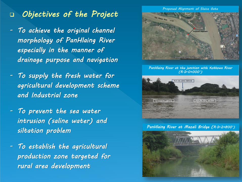
Objectives of the Project
- To achieve the original channel
morphology of PanHlaing River
especially in the manner of
drainage purpose and navigation
- To supply the fresh water for
agricultural development scheme
and Industrial zone
- To prevent the sea water
intrusion (saline water) and
siltation problem
- To establish the agricultural
production zone targeted for
rural area development
Proposed Alignment of Sluice Gate
PanHlaing River at the junction with Kokkowa River
(R.D-0+000’)
PanHlaing River at Mazali Bridge (R.D-2+800’)
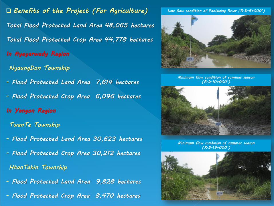
Benefits of the Project (For Agriculture)
Total Flood Protected Land Area 48,065 hectares
Total Flood Protected Crop Area 44,778 hectares
In Ayeyarwady Region
NyaungDon Township
- Flood Protected Land Area 7,614 hectares
- Flood Protected Crop Area 6,096 hectares
In Yangon Region
TwanTe Township
- Flood Protected Land Area 30,623 hectares
- Flood Protected Crop Area 30,212 hectares
HtanTabin Township
- Flood Protected Land Area 9,828 hectares
- Flood Protected Crop Area 8,470 hectares
Low flow condition of PanHlaing River (R.D-5+000’)
Minimum flow condition of summer season
(R.D-10+000’)
Minimum flow condition of summer season
(R.D-19+000’)

Investigation Works Undertaken
Topographic Area Survey
Hydrological Investigation & Analysis
Geological Investigation
Socio-economic Survey
Rehabilitation Works Undertaken
Construction (9) - RD 0+000 to RD 46+000
Construction (1) - RD 46+000 to RD 90+000
Construction (9) - RD 90+000 to RD 120+000
Construction (1) - RD 120+000 to RD 145+000
Yangon Region O&M Branch - RD 145+000 to
RD 181+500
View of PanHlaing River in dry season (R.D-25+000’)
Highway bridge crossing PanHlaing River (R.D-
150+600’)
Silt deposition in PanHlaing River at U/S of highway
bridge (Low tide)

PanHlaing River at 2003,
near Khat thi ya sluice
gate, RD 35+000
Mya ge
Sluice Gate
Khat Thi Ya
Sluice Gate
PanHlaing River at 2014,
near Khat thi ya sluice gate
Khat Thi Ya
Sluice Gate
Mya ge
Sluice Gate
Mya Ge sluice gate,
RD 46+000

PanHlaing River at 2003
Sandayaw sluice gate
Drain out water to PanHlaing River
PanHlaing River at 2014
Sandayaw sluice gate
Drain out water to PanHlaing River
Sandayaw
Sluice Gate
Sandayaw
Sluice Gate

PanHlaing River at RD 0+000
Before During Construction After
PanHlaing River at RD 26+000

Before During Construction After
PanHlaing River at RD 139+000 To RD 140+000
PanHlaing River at RD 145+000 To RD 160+695

PanHlaing River, Temporary Dyke at RD 174+750
Before During Construction After
PanHlaing River, Temporary Dyke at RD 158+000

RD 8+000 to RD 10+000
Embankment / Gangar Road way
RD 10+000
Than payar creek sluice
RD 56+000
Mingalar sluice gate
RD 58+000
Kha Naung Paw and Lay Ein Su
Village Bridge
RD 67+000
Outlet RD 78+150
Culvert

PanHlaing River Rehabilitation Work at
Confluence of Kokkowa River and PanHlaing River (RD 0+000)
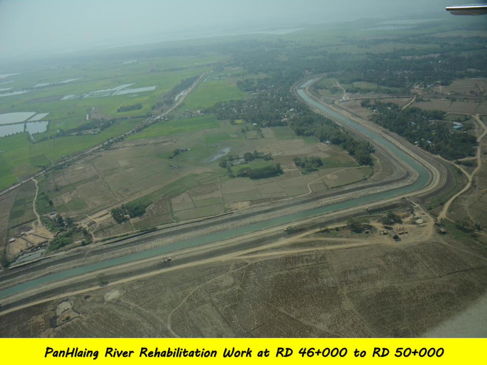
PanHlaing River Rehabilitation Work at RD 46+000 to RD 50+000

PanHlaing River Rehabilitation Work at RD 145+000

Temporary Dyke Construction at RD 175+000

Conclusions
- Irrigation Water Supply,
Drainage and Flood Protection
for Land and Crop Areas
- Fresh Water Supply for
Possible Expansion of the
Urbanized Area of Yangon City
- Navigation
- Better Socio-economic,
Trading and Transportation
Conditions for Local Rural
Communities

Related Documents


![ZASTOSOWANIETEORIIZBIORÓW ...Wielokryterialne Wspomaganie Decyzji (WWD). Dziedzina Wielokryterialnego Wspomagania Decyzji (WWD) [5,25,88] adresuje różne typy problemów decyzyjnych](https://static.cupdf.com/doc/110x72/6010c0a396b2914390498c79/zastosowanieteoriizbiorw-wielokryterialne-wspomaganie-decyzji-wwd-dziedzina.jpg)