Origins and development of the China Historical GIS Pelagios Gazetteer Meeting NYC, Sep 12 th 2013 Merrick Lex Berman CGA, Harvard University

Welcome message from author
This document is posted to help you gain knowledge. Please leave a comment to let me know what you think about it! Share it to your friends and learn new things together.
Transcript

Origins and development of the China Historical GIS
Pelagios Gazetteer MeetingNYC, Sep 12th 2013
Merrick Lex BermanCGA, Harvard University
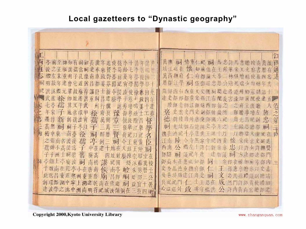
Local gazetteers to “Dynastic geography”

Edited and Revised over centuries, at all scales

Resulting in the 8 volume “Historical Atlas of China” (published 1980s)

Center for Historical Geography - Fudan University
Editor, Tan Qixiang
CHGIS Research Team & Advisors

Robert M. Hartwell (1932-1996)
Chinese Historical Software, Ltd
Biographies Database
20,000 entries
GIS Database
Years 742, 1080, 1200, 1280, 1391
Time Slices for Tang, Yuan, Song, Ming
GIS = co-locations of 1990 county areas
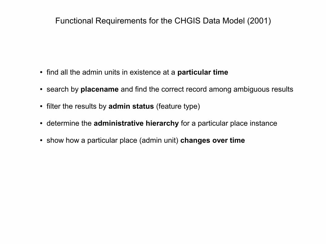
Functional Requirements for the CHGIS Data Model (2001)
● find all the admin units in existence at a particular time
● search by placename and find the correct record among ambiguous results
● filter the results by admin status (feature type)
● determine the administrative hierarchy for a particular place instance
● show how a particular place (admin unit) changes over time
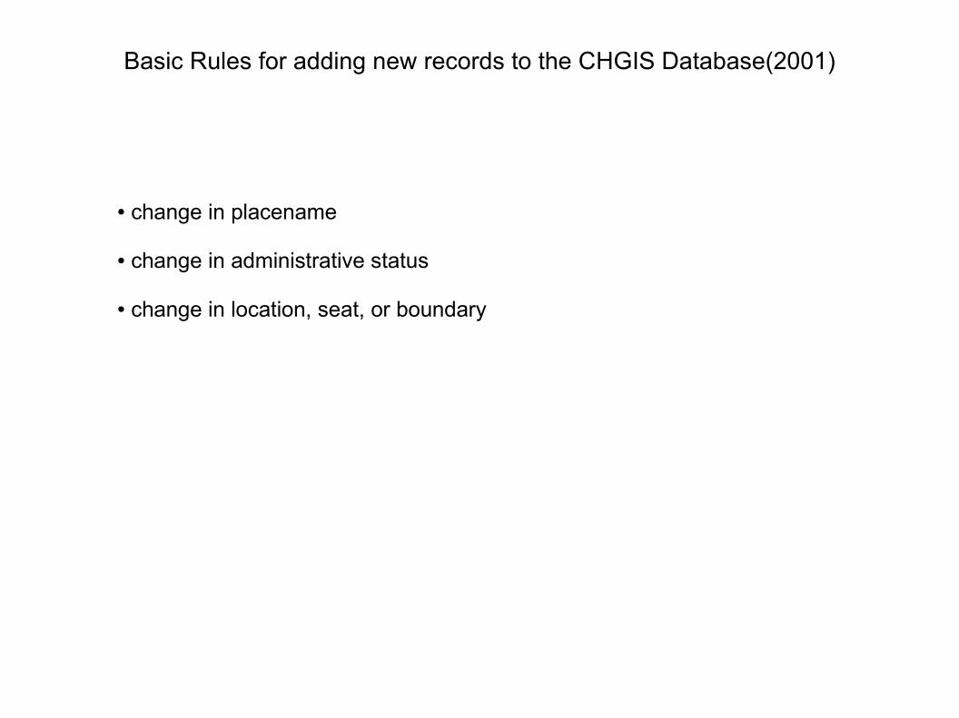
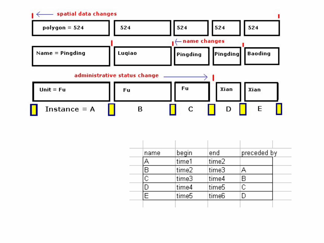
Basic Rules for adding new records to the CHGIS Database(2001)
● change in placename
● change in administrative status
● change in location, seat, or boundary

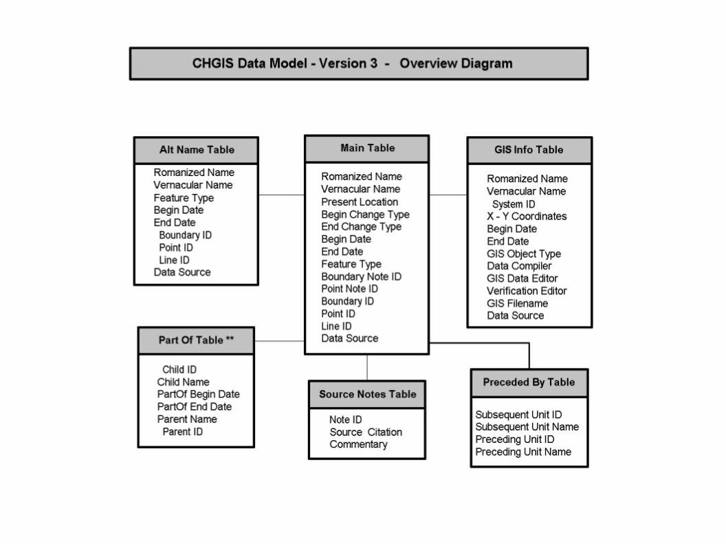
Proposed Data Model with hierarchical codes (Larry Crissman)

Normalized Data Model with PrecededBy and PartOf relationships
Part-Of Table
Temporal Sequence Table
Historical Instances Table
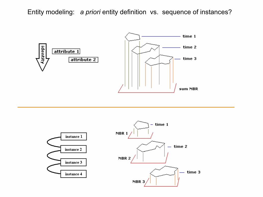
Entity modeling: a priori entity definition vs. sequence of instances?

Entity modeling: splits and merges defy the continuity of “entity”

Asychronous changes forced us to disaggregate the instances

GIS boundaries digitized for CHGIS Version 1 (2002)

GIS boundaries digitized for CHGIS Version 2 (2003)

GIS boundaries digitized for CHGIS Version 3 (2005)

GIS boundaries digitized for CHGIS Version 4 (2007)

1911 boundaries and seats digitized for CHGIS Version 5 (2012)
~40,000 towns & villages
~ 4,000 county and higher units

Time Series boundaries and seats digitized for CHGIS Version 5 (2012)
~10,000 county seats
~3,500 prefecture capitals
~3,000 prefecture polygons

Generic Gazetteer Entity Model
Gillies - Pleiadesplacename(s) entity footprint(s)
Southall - GBHGIS - AUO
Hill - ADL

Gazetteer Entity Model - CHGIS & Song Gazetteer
CHGIS
Mostern & Meeks - Song Gaz

<item id="9536"> <placename> <name_romanized>Lanzhou Fu</name_romanized> <name_vernacular>兰州府 </name_vernacular> <name_alternate>蘭州府 </name_alternate> </placename> <feature_type> <type_english>prefecture</type_english> <type_romanized>Fu</type_romanized> <type_vernacular>府 </type_vernacular> <type_id>84</type_id> </feature_type> <temporal> <begin_year>1820</begin_year> <begin_year_rule>9</begin_year_rule> <end_year>1820</end_year> <end_year_rule>9</end_year_rule> </temporal> <spatial> <object_type>point</object_type> <coordinate_type>point location</coordinate_type> <degrees_latitude>36.047031</degrees_latitude> <latitude_direction>N</latitude_direction> <degrees_longitude>103.847137</degrees_longitude> <longitude_direction>E</longitude_direction> <present_location> 肃 兰 州 市甘 州市</present_location> </spatial> <evidenced_by> <source_note> <note_type>administrative seat</note_type> <note_id>25000</note_id> </source_note> </evidenced_by> <links> <webpage source="CHGIS">http://chgis.hmdc.harvard.edu/query_details.php?ptid=9536</webpage> <webpage source="google_map">http://maps.google.com/maps?q=36.047031,103.847137(lanzhou)&spn=0.1,0.1&t=m&hl=e&z=9</webpage> </links> </item>
CHGIS - Sample Webservice Result
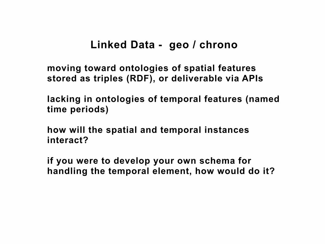
Linked Data - geo / chrono
moving toward ontologies of spatial features stored as triples (RDF), or deliverable via APIs
lacking in ontologies of temporal features (named time periods)
how will the spatial and temporal instances interact?
if you were to develop your own schema for handling the temporal element, how would do it?

Publication – Resources
http://fas.harvard.edu/~chgis/gazetteer
we welcome your ideas and critiques on:
● How to establish entities for CHGIS instances
● Building a global historical gazetteer

Extending Gazetteers with Time and Entity Relationships
Next Generat ion Gazet teer
Place Names - Foo tp r in ts
Name Author i t i es
H is to r i ca l GIS
Aggrega to rs (geonames)
Chrono log ies
Admin is t ra t ion Per iods
Time l ines (o f events )
Named Time Per iod Index
Ent i t y De f in i t i ons
GBHGIS - AUO
P le iades - H is t P lace
CHGIS - H i s t I ns tance
EDGIS - STP
P lacenames Footpr in ts
TimePer iods
Schema to model Change Over Time
Related Documents