November 2006 ENGLISH VERSION Offshore Pipeline through the Baltic Sea

Welcome message from author
This document is posted to help you gain knowledge. Please leave a comment to let me know what you think about it! Share it to your friends and learn new things together.
Transcript

November 2006
ENGLISH VERSION
Offshore Pipeline through the Baltic Sea

Ref. 6671024/2.2E-003(I)
Nord Stream AG
Project Information Document
Offshore pipeline through the Baltic Sea November 2006
Ref 6671024 2.2E-001(I)
Date 2006-10-24 I Elaborated by: Rambøll A/S / Nord Stream AG

Ref. 6671024/2.2E-003(I)
II
Table of contents
1. Introduction 1 1.1 The Nord Stream Project 1 1.2 Present Status of Nord Stream 1 1.3 Project Information Documentation 1 1.4 Planned field investigations and special studies 2 1.5 Contact Nord Stream AG 3
2. Project Justification 4 2.1 Natural Gas for Europe 4 2.2 Supply routes 5 2.3 Trans-European Gas Networks 6 2.4 Nord Stream AG ownership structure 7
3. Project description 9 3.1 Project Definition 9 3.2 Pipeline route 10 3.3 Service platform 10 3.4 Landfalls and supply bases 13 3.5 Pipeline design and materials 14 3.6 Coating and cathodic protection 14 3.7 Installation Logistics 15 3.8 Examples of installation equipment 16 3.9 Trenching requirements 19 3.10 Seabed rectification requirements 20 3.11 Cable crossings 20 3.12 Pre-commissioning 21 3.13 Operational aspects - pipelines 22 3.14 Decommissioning 22 3.15 Relation to other infrastructure 23
4. Alternatives 24 4.1 Route alternatives studied 24 4.2 Alternative location for Service platform 27 4.3 The 0-alternative 27
5. Regulatory context 30 5.1 Permitting of the pipeline 30 5.2 Environmental Impact Assessment (EIA) 32

Ref. 6671024/2.2E-003(I)
III
5.3 EIA in a transboundary context – the Espoo Convention 32
6. Existing Situation (Baseline) inside the Project Area 34 6.1 Geology and sediment 34 6.2 Ice conditions 36 6.3 Bathymetry and Hydrography 38 6.4 Flora and fauna 40 6.5 Fish and fisheries 41 6.6 Birds 44 6.7 Marine Mammals 47 6.8 Protected Areas 48 6.9 Tourism 49 6.10 Cultural heritage 51 6.11 Military Practice Areas and Dumped Sites 51 6.12 Ship Traffic 55 6.13 Offshore Installations 57
7. Identification of impacts to be studied 60 7.1 General 60 7.2 Impacts to be studied offshore 60
8. EIA and method to be applied 67 8.1 General 67 8.2 Delimitation of impact area 67 8.3 Environmental baseline parameters 68 8.4 Environmental impact 69 8.4.1 Environmental impact of Russia, Finland, Sweden, Denmark and Germany
(parties of origin and affected parties) 70 8.4.2 Environmental impact of Estonia, Latvia, Lithuania and Poland (other affected
parties) 84 8.5 Route survey and additional field investigations 86
9. Proposals for preventing and mitigation negative impacts 89
10. Overall time schedule and preliminary table of content of the EIA 92

Ref. 6671024/2.2E-003(I)
IV
Appendices Appendix A Thematic charts Dwg. no. 3.1 Nord Stream offshore pipeline route Dwg. no. 6.1 Important Bird Areas (IBA) and other bird areas Dwg. no. 6.2 Internationally Protected Areas (Natura 2000) Dwg. no. 6.3 Baltic Sea Protected Areas (BSPA) and UNESCO biosphere areas Dwg. no. 6.4 Wrecks and cultural heritage
Dwg. no. 6.5 Military practice areas and dumping sites Dwg. no. 6.6 Offshore installations

Ref. 6671024/2.2E-003(I)
V
List of abbreviations and definitions AIS Automatic Identification System (used in Baltic Sea for registra-
tion the ship traffic) BCM Billion Cubic Meter BSPA Baltic Sea Protected Areas CH4 Methane C2H6 Ethane CO2 Carbon dioxide DNV Det Norske Veritas EEZ Exclusive Economic Zone EIA Environmental Impact Assessment Espoo Convention Convention on Environmental Impact Assessment in a Trans-
boundary Context EU European Union FBE Fusion Bounded Epoxy (anti-corrosion coating on the pipeline) FRC Fast Rescue Craft HELCOM Helsinki Commission. Convention on the protection of the marine
environment of the Baltic Sea area HVDC cables High-Voltage Direct Current cables IBSFC International Baltic Sea Fisheries Commission IBA Important Bird Areas ICES International Council for the Exploration of the Sea IMO International Maritime Organisation IUCN International Union for the Conservation of the Nature LEL Lower Explosion Limit NATO North Atlantic Treaty Organization Natura 2000 Network of areas designated to conserve natural habitats and
species of wildlife in the European Community N2 Nitrogen NDT Non-Destructive Testing. Testing to detect defects in materials
using techniques that do not damage or destroy the items being tested
NTG North Transgas Oy

OSPAR Oslo and Paris Convention on the protection of the marine envi-ronment of the North East Atlantic
PAH Polycyclic Aromatic Hydrocarbon PCB PolyClorinated Biphenyl PEC Predicted Effect Concentration Phytoplankton Plant organisms of plankton Pigging Pipeline inspection gauges for cleaning, inspection of the pipe-
line without stopping flow of gas in the pipeline. Plankton Aquatic organisms which float passively or exhibit limited loco-
motor activity PNEC Predicted No-Effect Concentration ROV Remotely Operated vehicles SBP Sub Bottom Profiler SSS Sidescan Sonor TAC Total Allowable Catch (fishery) TNT Trinitrotoluene or Trotyl (chemical explosive) UNCLOS United Nations Convention on the Law of the Sea UNESCO United Nations Educational Scientific and Cultural Organization VASAB2010 Vision And Strategies Around the Baltic Sea 2010 VLF Very Low Frequency. Electromagnetic survey at the seabed. Zooplankton Animal organisms of plankton
VI
Ref. 6671024/2.2E-003(I)

1. Introduction
1.1 The Nord Stream Project Nord Stream is a natural gas pipeline transmission system from Russia to Germany with con-nections to onshore transmission systems in Russia and Germany. It passes through the EEZ of five countries: Russia, Finland, Sweden, Denmark and Germany, and the territorial waters of Russia and Germany. It will at full capacity provide 55 bcm/yr to the North-West European con-sumers. Nord Stream is a priority project in the European Trans-European Energy Network (TEN-E).
Nord Stream is based on an agreement (September 2005) between JSC Gazprom, BASF AG and E.ON AG. Consequently, the three companies formed the Nord Stream AG with sharehold-ing by Gazprom (51%), Wintershall (100% BASF subsidiary) and E.ON Ruhrgas (100% E.ON subsidiary).
Nord Stream AG is based in Zug in Switzerland with a branch office in Moscow. The Company is responsible for the development and construction of the offshore pipeline, and will later on also be the operator of the gas transit system.
1.2 Present Status of Nord Stream The preliminary planning of Nord Stream is in the final stage, and the project concept is de-scribed in this document. Hence, the project includes two offshore transmission pipelines be-tween Russia and Germany with an offshore service platform located in Swedish EEZ. The pro-ject preparations will 1st of January 2007 enter into the detailed design phase, and start of the main construction work is scheduled to 3rd quarter of 2008, see Section 10.
Nord Stream AG is committed to environmental protection in the planning, construction and op-erational phases of the project, as well as at future decommissioning. Therefore, environmental constraints have played an important role in the overall routing of the pipelines. Similar will the environmental assessments to be conducted as described in this document be important for the final routing as well as the final design of the pipeline system.
The detailed technical design will acknowledge the environmental constraint in the Baltic Sea as described below, and a close connection between the technical design and the environmental impact assessment will be established throughout 2007 and 2008. Hence, Nord Stream AG will strive to mitigate environmental impacts as much as both in design, as in the later construction and operational phase.
1.3 Project Information Documentation This Project Information document is prepared by Nord Stream AG. All descriptions, preliminary assessments and plans in the document are therefore under the sole responsibility of Nord Stream AG.
The objective of the document is:
Nord Stream Project Information Document
1

• to present the Nord Stream project. • to identify the impacts (at an early stage) that are most likely to be significant and that re-
quire investigations during the EIA studies. • to make proposals for preventing/reduction of negative environmental impacts, during con-
struction and operation of Nord Stream. • to give input to the planned EIA programme/EIA in a transboundary context (the Espoo
Convention), including to the description of the EIA process. The identification and description of possible environmental impacts will be developed along with the detailed technical design and will be based on a description of the existing situation of the environment (the baseline situation) inside the project area. This Project Information Document includes the following chapters: Chapter 2: Project justification Chapter 3: Project description. Chapter 4: Alternatives. Chapter 5: Regulatory context. Chapter 6: Existing Situation (Baseline) inside the project area. Chapter 7: Identification of impacts to be studied. Chapter 8: EIA and method to be applied. Chapter 9: Proposals for preventing and mitigation of negative impacts. Chapter 10: Overall time schedule and preliminary table of content of the EIA
1.4 Planned field investigations and special studies Nord Stream AG plans - as described below in the document – to continue a number of field studies in order to provide the necessary baseline information for the environmental impacts assessment. The additional field investigations comprise a/o (see also Section 8): • Detailed high-resolution full route survey for chemical and conventional ammunition • Investigations of offshore sediment, marine flora and fauna and birds in identified environ-
mental sensitive areas • Investigations of terrestrial environment at land based facilities. Environmental Impact descriptions will be conducted as described in Section 8, and special em-phasis will be put on effects from sea bed disturbances (sea bed rectification, trenching, dredg-ing) and on issues related to chemical and conventional ammunition.
Nord Stream Project Information Document
2

1.5 Contact Nord Stream AG More information may be obtained from: Nord Stream AG Grafenauenweg 2 6300 Zug Switzerland www.nord-stream.com Contact person: Deputy Director Mr. Dirk von Ameln.
Nord Stream Project Information Document
3

2. Project Justification
2.1 Natural Gas for Europe The European Union has launched studies to investigate Europe’s future energy requirements. Various sources of energy, - fossil fuels, nuclear energy, hydrogen, and renewable energy as wind, solar and biomass, have been assessed. One major source of energy for the future re-mains to the natural gas. Hence, the development in demand in the 25 EU Member States (EU-25) is estimated to increase up to 682 bio m3 in 2015, see Figure 2-1.
Domestic production in EU-25 covers today (2005) approx. 43 % of the consumption. Russia is supplying additional 25% and Norway and Algeria the remaining part.
Figure -1 Expected development in Natural Gas Demand 2005-2015. 2
The production of natural gas from known fields in EU-25 is assessed to be decreasing with approx. 25 % in the period until 2015. This will together with a growing demand enlarge the need for import of natural gas from approx 57% in 2005 to approx. 75% of the consumption in 2015. Hence the import need in 2015 is assessed to approx. 512 bio.m3, and thereby an in-crease in the total import of approx. 210 bio.m3. In Germany, the domestic production is approx. 16% of the total present consumption (2005). Imports from Russia amounts to 33% and imports from Norway and the Netherlands make up 25% and 20%, respectively.
Nord Stream Project Information Document
4
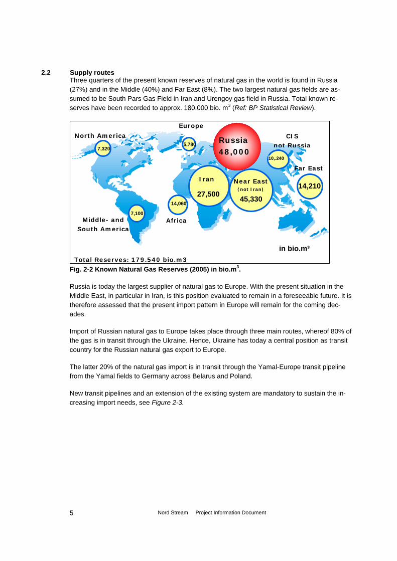
2.2 Supply routes Three quarters of the present known reserves of natural gas in the world is found in Russia (27%) and in the Middle (40%) and Far East (8%). The two largest natural gas fields are as-sumed to be South Pars Gas Field in Iran and Urengoy gas field in Russia. Total known re-serves have been recorded to approx. 180,000 bio. m3 (Ref: BP Statistical Review).
Fig. -2 Known Natural Gas Reserves (2005) in bio.m . 2 3
Russia is today the largest supplier of natural gas to Europe. With the present situation in the Middle East, in particular in Iran, is this position evaluated to remain in a foreseeable future. It is therefore assessed that the present import pattern in Europe will remain for the coming dec-ades.
Total Reserves: 179.540 bio.m3
Far East
14,210
Africa
14,060
Europe
5,780
Middle- and South America
North America
7,100
7,320 Russia 48,000
10,.240
CIS not Russia
27,500
Iran
45,330
Near East (not Iran)
in bio.m³
Import of Russian natural gas to Europe takes place through three main routes, whereof 80% of the gas is in transit through the Ukraine. Hence, Ukraine has today a central position as transit country for the Russian natural gas export to Europe.
The latter 20% of the natural gas import is in transit through the Yamal-Europe transit pipeline from the Yamal fields to Germany across Belarus and Poland.
New transit pipelines and an extension of the existing system are mandatory to sustain the in-creasing import needs, see Figure 2-3.
Nord Stream Project Information Document
5

Figure -3: Potential additional supply routes (with estimated additional amounts) for natural gas to Europe. Nord Stream has a prominent role. (Ref: Wingas GmbH)
2
Norway +20
[bio.m³/yr]
Nord Stream +55
Nabucco (Iran) +20-30
Libya +3 Algeria +31-41
LNG +90-150 (Main issue UK)
New Extented
2.3 Trans-European Gas Networks The European Community promotes the interconnection, interoperability and development of trans-European energy networks (TEN-E). The aim is among other to reinforce the security of energy supplies, for example through strengthening relations with 3rd countries in the energy sector in their mutual interest. For more information of the EU TEN Energy programme, see http://ec.europa.eu/ten/energy/index_en.htm
TEN-E operates with ‘Axes for Priority Projects’ through which the programme responds to the increased demand for natural gas import. As mentioned above is the demand rapidly increasing and there is therefore a urgent need to enlarge the transport capacity through existing as well as along new additional routes.
TEN-E has identified the so-called NG1 ‘Axis’ comprising a transmission corridor from the UK to the northern continental Europe (including the Netherlands, Denmark and Germany) and with further connections to the Baltic Sea region countries and Russia, see Figure 2-4, overleaf. Nord Stream is responding to the need for such a corridor as it is proposed by EU.
Nord Stream AG has (as North Transgas Oy) been supported by TEN-E in the feasibility phase (1997-1999). The support has taken place on equal basis with a series of parallel NG1 ‘Axis’ projects, among other: ‘Nordic Gas Grid’ (Finland, Sweden, Denmark), ‘Baltic Gas Interconnec-tor’ (Germany, Denmark, Sweden), ’Mid-Nordic gas pipeline’ (Norway, Sweden, Finland), ‘Am-ber’ (Russia, Latvia, Lithuania, Poland, Germany); ‘BalticPipe’ (Denmark, Sweden, Germany, Poland); Balgzand (Germany, Netherlands, UK);’Baltic Interconnector’ (Finland, Estonia). All mentioned projects – except the Balgzand project - are still in the pre-investment phase or tem-porary/permanently abandoned.
Nord Stream Project Information Document
6

Figure -4: TEN-E ’NG1 Axes for Priority Projects’ including NG1 comprising the Axis UK-northern continental Europe, including NL, DK and GER and with connection to Baltic Sea Region countries and Russia (Nord Stream comprises the offshore part of NG1 in the Baltic Sea).
2
Nord Stream opens a new direct connection between Russia’s natural gas reserves and Europe. The pipeline route is purposely planned to run through North Western countries to reach the growing markets in that area.
Hence, the criteria for selecting Nord Stream as a TEN-E priority project is based on the Nord Stream’s objective to develop a supply system that aims to meet the European Community’s natural gas supply demand, and ensure the diversifications of natural gas sources and supply routes. The capacity provided by Nord Stream is indispensable for the European Community to ensure the future needs of natural gas. Other projects under discussion will have a similar tar-get, but can not substitute the required capacity of Nord Stream.
2.4 Nord Stream AG ownership structure
‘AXES for Priority Projects’ Projects already agreed: NG1: UK-Northern Continental Europe (NL, DK and GER) with connections to Baltic Sea area –Russia. NG2: Algeria-Spain-Italy-France-Northern Continental Europe NG3: Caspian Sea countries-Middle East-European Union NG4: LNG terminals in Bel-gium, France, Spain, Portugal and Italy NG5: Underground storage in Spain, Portugal, Italy, Greece and the Baltic Sea Region Proposed projects: NG6: East Mediterranean Ring
Nord Stream project is founded on an agreement (September 2005) between JSC Gazprom, BASF AG and E.ON AG. Consequently, the three companies formed the Nord Stream AG with shareholding by Gazprom, Wintershall (100% BASF subsidiary) and E.ON Ruhrgas (100% E.ON subsidiary).
Nord Stream Project Information Document
7
Nord Stream AG is based in Zug in Switzerland, and with a branch office in Moscow. The Com-pany is responsible for the development and construction of the offshore pipeline, and will later on also be the operator of the offshore transit system.
The Russian onshore connecting transmission system is presently under construction (Novem-ber 2006) under the ownership of Gazprom. The onshore part in Germany comprises two transmission pipelines. One 370 km 1200 mm pipeline (NEL: Norddeutsche Erdgas Leitung) is planned to Achim near Bremen, and one 480 km 1400 mm pipeline (OPAL: Ostsee Pipeline Anschluss-Leitung) - with a compressor station near Berlin - to Olbernhau near the Czech bor-der. Both pipelines will be under the responsibility and ownership of E.ON Ruhrgas and Wingas GmbH (Joint Wintershall and Gazprom company), respectively and both are currently in the preparation phase.
The German shareholders participate in natural gas field development in Russia, like Gazprom – as mentioned above - is shareholder in the Wingas GmbH transit network in Germany.
Nord Stream Project Information Document
8

3. Project description
3.1 Project Definition The Nord Stream will run from the Portovaya Bay (near the town of Vyborg, Leningrad region) on Russia's Baltic coast to Germany's Baltic coast with landing point at Synergipark Lubmin in Greifswalder Bodden, figure 3.1 and Dwg. 3.1.
Figure 3.1 The Nord Stream through the Baltic Sea The offshore transmission system is defined as two pipelines downstream onshore compression at Vyborg until the first weld inside the meter/regulator facility at Synergiepark Lubmin. Hence the project investigation area covers an approximate 1200 km long and 2 km wide corridor (cor-ridor where route survey is carried out) on the sea bottom of the Baltic Sea. The two pipelines will be installed at the sea bottom with a distance of approx. 50 meters. The corridor on the sea bottom directly affected by the pipelines itself, including the trenching hereof, will be around 100 - 150 m. The affected corridor width on the sea bottom caused by the pipeline installation opera-tion, including impacts from anchors used by the lay vessel, will be around 1,600 m.
A service platform located approximately midway in the Swedish EEZ north-east of Gotland will be part of the transmission system. The platform with a safety zone of 500 m around it in opera-
Nord Stream Project Information Document
9

tion, where ship traffic is not allowed, will occupy approximately 0.8 km2 on the sea bottom, see Chapter 7 below.
3.2 Pipeline route The pipelines will take a most direct route from the north-Russian gas fields to central Europe passing through the Gulf of Finland and the Baltic Proper as seen in figure 3.1, and Dwg no. 3.1, where also the coordinates (in WGS84) are shown..
The offshore route will respect - or avoid when possible - adverse natural conditions, environ-mentally sensitive areas, military exclusion zones, major navigation traffic lanes and special areas commissioned to other economical or recreational interests. The pipeline route is within the EEZ of 4 EU member states, and is in EEZ and territorial waters of Russia. In Germany the pipeline route goes through the territorial waters to the coast, see also table 3.1.
Country EEZ (km) TW (km) Total (km) Russia 96 22 118 Finland 369 0 369 Sweden 482 0 482 Denmark 149 0 149 Germany 33 45 78 Total 1,196
Table 3.1 The Nord Stream through the 5 countries.
The route through the Baltic Sea is currently optimised according to technical, environmental and economic criteria, based on available information on the environmental constraints and pre-liminary investigations carried out of the seabed topography and structure.
The transmission system is planned to be commissioned in 2010, initially with one single pipe-line and an offshore service platform, together with an annual transmission capacity of approx. 27.5 bcm.
The project envisages laying a second pipeline, which will be taken into operation in 2012 and doubling the transmission capacity to approx. 55 bcm.
The total investment for the Nord Stream project exceeds €5.5 billion.
Gazprom has during the autumn of 2005 commenced building the Russian land section of the gas pipeline project, whereas the German onshore section is still in the planning phase.
3.3 Service platform A simple so-called service facility – a riser platform will be part of the pipeline system with the primarily purpose to improve the flexibility of operation and to serve as a general maintenance platform for the pipeline system – and as a safety precaution in case of any of the pipelines is damaged. At the service platform the pipelines are permanent raised from the sea bottom to the platform.
Nord Stream Project Information Document
10

Preliminary planning is conducted for two alternative locations, North-east of Gotland and East of Gotland, respectively see Dwg. 3.1 for approximate coordinates. Both of the locations are chosen because of the relatively low water depth (50 and 90 meters, respectively). Whether the service platform may normally operate un-manned or not will be closely evaluated during detailed design of the transmission system. For now Nord Stream considers it necessary to plan with living quarters for maintenance and inspection crew in the order of 8 to 10 people. Access to the platform will be by helicopter or ship. So-called intelligent pigs will be launched periodically – initially after one or two years, later pos-sibly every five years, depending on the condition of the pipelines. These pigs are fitted with high-resolution ultrasonic sensors that may detect even the smallest irregularities. Necessary measures can then be derived from such results and operational safety can be ensured. Necessary utilities such as power generation, fuel gas treatment, water treatment, and safety equipment will be located on the platform. The platform will be fitted with all necessary navigational aids, such as lights, radar reflectors and fog horn. Nord Stream will consult with relevant marine authorities; coast guards etc. the fitting of these navigational aids. A vent system will be designed to handle the operations of the platform. This will include venting for normal operations such as receipt of pigs and to provide relief when there is an upset condi-tion on the platform. It will not be used to de-pressure any of the main subsea pipelines.
The service platform is visualised in the figures 3.2-3.3.
Nord Stream Project Information Document
11

Figure 3.2 Artist’s view of a Service platform (example)
Nord Stream Project Information Document
12

Figure 3.3 Concept of a Service Platform
3.4 Landfalls and supply bases The preliminary design of the landfalls has not yet been commenced, but much care will be taken in order to construct a pipeline crossing in the beach zone that will have the least impact on people and environment. Nord Stream is well aware of the complexity of this construction work and will initiate extensive analyses before making any firm proposal for a final solution. The shallow water in the Greifswalder Bodden and the marine sand barrier at the mouth of the bay (‘Landtief’) may not allow passage of large construction vessels. Nord Stream will consider various construction methods, where welding of long pipe strings on land, and subsequently floating and welding these in position offshore could be an alternative. Both landward sections should be installed in same season and Nord Stream will carefully consider whether the pipe-lines can be located in the same pre-dredged trench in order to limit the influence of the con-struction work on the environment. Similar design considerations will be carried out at the Russian landfall. The large-scale offshore construction work necessitates considerable support from land-based supply bases. These include pipeline stores – corrosion/weight coated or non-coated pipelines –
Nord Stream Project Information Document
13

coating facilities and coating materials, and general stores for supply of consumables to the off-shore fleet, e.g. spares, fuel, tools, valves, flanges and fittings, marine supplies (e.g. ropes, wires, anchors), and managerial support from Nord Stream and Contractors. Helicopter support both for the installation phase and for the operational phases may also be required. A study on the logistics of construction works and thereby also the number and locations of the needed supporting facilities on shore will be conducted in the beginning of 2007, when the de-tailed technical design commences. Descriptions and assessments of the potential locations for support facilities will be included in the offshore environmental impact assessments. Supporting facilities will naturally be subject to national permitting. At the German landfall has the site at the former nuclear power station at Lubmin been identified as a possible supply base, but also other locations would have to be considered throughout the route.
3.5 Pipeline design and materials Nord Stream will review and recommend a well-accredited set of international codes and stan-dards to be used for the design and construction of the pipelines. The DNV Offshore Standard OS-F101 “Submarine Pipeline Systems 2000”, with associated recommendations, may possibly be used as a primary code for the design with necessary adjustments to accommodate national regulation. This will be discussed with the relevant authorities. The pipeline characteristics presently under considerations are: • Outside diameter 2 x 48 inch (~1220 mm), design pressure up to 220 bar. • Length of approx. 1.200 km. • Wall thickness of 38 mm. • Design life time of 50 years.
3.6 Coating and cathodic protection The pipelines will be protected with an anti-corrosion coating e.g. consisting of asphalt enamel with a thickness of approximately 6 mm. Alternatively, a coating consisting of Fusion Bonded Epoxy (FBE) in a combination with a ~3 mm layer of polypropylene/polyethylene may be used. Cathodic protection will be based upon sacrificial anodes e.g. of indium activated aluminium alloy. The anodes may have a size of 50 mm thick by 800 mm length and a spacing of one an-ode per 5 to 6 pipe joints (a pipe joint ~12 m long). The anti-corrosion coating will be protected by reinforced concrete coating. The concrete coating will be applied in thicknesses ranging between 40 mm and 150 mm and will give the pipelines added weight sufficiently to maintain them stable on the seabed – both during the installation phase and during the permanent operation of the transport pipelines.
Nord Stream Project Information Document
14

The effects on the environment from materials used as coating and cathodic protection will be evaluated during technical design, so that materials that are harmfully to the marine environment will be substituted with materials with no/reduced effects on the environment. Detailed pipeline stability analyses shall be carried out to determine the required minimum sub-merged weight of the pipelines in order to obtain in-place stability. The analyses will be based upon the operational pipeline conditions in combination with an extreme storm event of a 100 years return period. In order to minimise the use of concrete – which otherwise could hamper handling of the pipe sections - the concrete will be of an increased density compared to concrete for normal con-struction. The density will be approximately 3000 kg/m3, achieved by addition of iron ore aggre-gates. The pipeline will be coated internally with friction-reducing thin-film epoxy paint, either at the manufactures or in the coating yards.
3.7 Installation Logistics Pipeline installation is performed using a lay vessel either of the anchored type or of the dy-namically positioned type. The lay vessel is supported by anchor handling tugs, pipe supply vessels and a survey vessel. Individual pipe joints, typically of length 12 m, are delivered to the pipelay vessel, where they are welded into a continuous pipe string and lowered to the seabed. The process onboard the lay vessel comprise welding of pipe, non-destructive testing (NDT) of welds, field joint preparation and laying on seabed - all in a continuous cycle. As the lay vessel moves forward, the pipe string is lowered to the seabed over the rear end of the vessel. The average lay rate is typically in the order of 2-5 km per day depending of the weather conditions. To ensure minimum interference to pipe laying operations from other sea traffic, a protection zone is established around the pipelay vessel typically with a radius of 1,500 m where ship traffic, including fishery is not allowed. Over certain sections the pipeline will be lowered into the seabed to protect it from impact (ships, anchors, fishing gear) and to secure stability of the pipeline. This so-called trenching will be made close to fairways, and near shore and when crossing other pipelines or cables, typi-cally to an approximate depth giving a cover of 1 m. The trench will be made by a specialised underwater plough, a water jetting sledge riding on the pipeline, or in hard rock by cutting and/or blasting the trench before installation of the pipeline. The trench and pipeline will be covered with natural seabed sediments or rubble,- alternatively it will be left for natural backfilling. When crossing shipping lanes or fairways special care needs to be taken and the pipeline will typically be covered by trenched materials and/or graded crushed rock. A risk analyses will be made of the likelihood of damage to the pipeline and the amount of protective cover to the pipe-line will be designed to meet international standards.
Nord Stream Project Information Document
15

Depending on the availability of suitable pipe laying barges at the time of installation, the pipe-line installation would most likely be divided over more than one year, i.e. resulting in a two-year installation campaign for each pipeline. The vessels to be employed in the pipeline construction works comprise of dedicated and highly specialised pipeline laybarges. A number of vessels, although quite limited, operating worldwide would be fit to undertake the work. Examples of such vessels include: • Semi-submersible barges, e.g. Saipem’s Castoro Sei and Semac 1, Acergy Piper (former
Stolt Offshore LB200) (3rd generation), and • Dynamic positioned vessels, e.g. Allseas’ Solitare and new-built Audacia (4th generation) The 3rd and 4th generation vessels are used for the offshore pipelaying. Flat bottom barges would be more appropriate in the nearshore shallow water areas, although the known 2nd gen-eration barges would require some modification before being able to lay the largest diameter pipelines. In very sensitive shallow areas is non-conventional pipeline installation considered. In addition to the laybarges a number of other types of vessels will be employed. These include multi purpose diving support vessels (and occasional divers) for sub-sea interventions and pos-sibly trenching (pulling the plough). Nearshore working barges, anchor handlers, survey vessels, and special dredging vessels will also be required as appropriate. In this context pipe handling vessels are a particular important topic in view of the large dis-tances of pipeline transportation. Depending on the use of strategically placed temporary pipe storages e.g. in Sweden and Finland, a smaller or larger number of pipe handling vessels will be required.
3.8 Examples of installation equipment Below is shown examples of typical pipe lay vessels and construction equipment that may be used for the installation of the Nord Stream. The vessels shown are only indicative of vessel types and may differ depending on selected installation contractor as well as special require-ments identified during the planning and detailed design phases, figure 3.4 – 3.9 Dredging in the near-shore areas may be performed using a combination of a drilling and blast-ing barge, and a dredging barge on which a large but conventional backhoe is placed, figure 3.4 and 3.5. Sediment that is spilled will be monitored and controlled during dredging and backfilling operations, so that the requirement from the authorities will be met.
Nord Stream Project Information Document
16

Figure 3.4 Example of drilling and blasting barge (left) and a dredging barge (right) working in the Gulf of Finland, year 2004
Figure 3.5 Example of a large dredging barge working in the Gulf of Finland, year 2004
Nord Stream Project Information Document
17

Figure 3.6 Example of trailing suction hopper dredger (Balast Nedam’s Amsterdam) and cutter suction dredger (Castor). Can operate to water depths of 70 m and 25 m re-spectively.
Figure 3.7 Example of shallow-water and deep sea laybarges, shown with pipe-handling barges alongside
Nord Stream Project Information Document
18
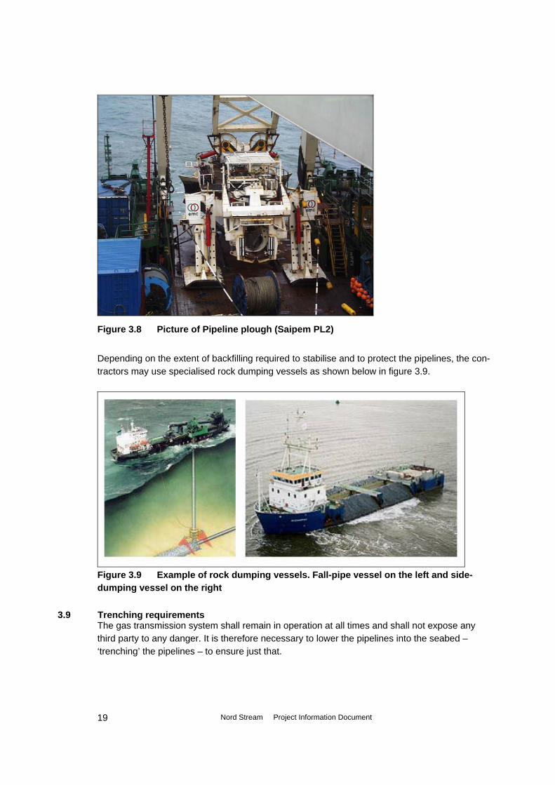
Figure 3.8 Picture of Pipeline plough (Saipem PL2)
Depending on the extent of backfilling required to stabilise and to protect the pipelines, the con-tractors may use specialised rock dumping vessels as shown below in figure 3.9.
Figure 3.9 Example of rock dumping vessels. Fall-pipe vessel on the left and side-dumping vessel on the right
3.9 Trenching requirements The gas transmission system shall remain in operation at all times and shall not expose any third party to any danger. It is therefore necessary to lower the pipelines into the seabed – ‘trenching’ the pipelines – to ensure just that.
Nord Stream Project Information Document
19

Trenching of the pipelines is basically required in the nearshore areas where there is excessive wave and current action. The pipeline will also be trenched where there is a risk of ice scouring and ship grounding etc. It is concluded that the pipelines may well withstand any anticipated impact from fishing gear, and thus do not require trenching for the majority of the offshore route. As a very general indication, the pipelines shall be trenched and backfilled at the landfall points, and at shallow water at Vyborg in Russia, and at Greifswald in Germany. If the trenches are required backfilled, Nord Stream will consider using natural materials as much as possible, e.g. reuse of the materials from the trenching.
3.10 Seabed rectification requirements Soft soils extend roughly over one third of the route and uneven seabed prevail over several sections. The limiting span lengths depend on the structural parameters of the pipelines, the soil conditions, waves and currents. Maximum allowable free span lengths during operation vary from 16 m to approximately 70 m. In soft soil conditions, the span lengths may be allowed be-yond this level, typically up to 200 m. From the geophysical surveys of the route it is estimated that the number of non-allowable free spans along the pipeline route may be more than 100. In particular in the Gulf of Finland and in parts of the Swedish section are outcrops of hard till or even crystalline bedrock with sedimen-tary deposits between the outcrops posing difficulties to pipeline installation, insofar that the pipelines may ‘ride’ from crest-to-crest of the harder outcrops and sagging in the middle. The pipelines may be stressed excessively in these sections. Common practice is to survey in detail these areas and to re-route the pipelines when possible and thereby obtain a more favourable condition. If re-routing will not be possible – due to the stiffness of the pipelines, other physical constraints or e.g. installation considerations – detailed analyses of all large free spans will be made and specification for some sort of rectification to ensure the integrity of the pipelines will be drawn up.
The following methods are considered to be technically feasible: • Re-routing of the pipelines (horizontally ‘snaking’ over the seabed). • Peak removal (dredging away hard outcrops, the ‘crests’). • Dumping of fill material (creating intermediate support). • Dredging and dumping (a combination of the above). More sophisticated solutions could be employed. These could be pile supports, plate supports, or other specially devised support types. However, these solutions will be highly costly to manu-facture, install and maintain and will in practice be avoided as much as possible.
3.11 Cable crossings Methods for cable crossings are well established and the number of cables to be crossed has been addressed during the preliminary studies. Telecommunication cables are normally lowered further into the seabed at the crossing location, backfilled and the pipeline laid on top. Others
Nord Stream Project Information Document
20
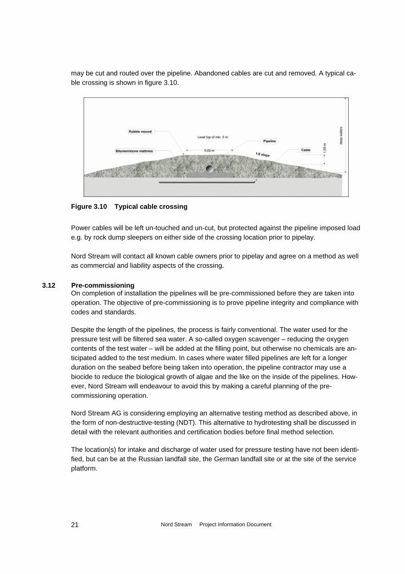
may be cut and routed over the pipeline. Abandoned cables are cut and removed. A typical ca-ble crossing is shown in figure 3.10.
Figure 3.10 Typical cable crossing
Power cables will be left un-touched and un-cut, but protected against the pipeline imposed load e.g. by rock dump sleepers on either side of the crossing location prior to pipelay. Nord Stream will contact all known cable owners prior to pipelay and agree on a method as well as commercial and liability aspects of the crossing.
3.12 Pre-commissioning On completion of installation the pipelines will be pre-commissioned before they are taken into operation. The objective of pre-commissioning is to prove pipeline integrity and compliance with codes and standards.
Despite the length of the pipelines, the process is fairly conventional. The water used for the pressure test will be filtered sea water. A so-called oxygen scavenger – reducing the oxygen contents of the test water – will be added at the filling point, but otherwise no chemicals are an-ticipated added to the test medium. In cases where water filled pipelines are left for a longer duration on the seabed before being taken into operation, the pipeline contractor may use a biocide to reduce the biological growth of algae and the like on the inside of the pipelines. How-ever, Nord Stream will endeavour to avoid this by making a careful planning of the pre-commissioning operation.
Nord Stream AG is considering employing an alternative testing method as described above, in the form of non-destructive-testing (NDT). This alternative to hydrotesting shall be discussed in detail with the relevant authorities and certification bodies before final method selection.
The location(s) for intake and discharge of water used for pressure testing have not been identi-fied, but can be at the Russian landfall site, the German landfall site or at the site of the service platform.
Nord Stream Project Information Document
21

After flooding and testing, the drying process will be a time consuming activity. Careful consid-eration should be given to the discharge of the test water, which is contaminated with solids from the installation process and possibly added chemicals. The site(s) of discharge of test wa-ter have not been identified at this stage of the project.
For an efficient execution of the pre-commissioning operation, a dedicated organisation and an environmental management system will be set up. Following the testing and drying operation, the pipelines will be filled with natural gas and pressurised.
3.13 Operational aspects - pipelines The pipelines themselves, being an inert system, can be operated in a flexible manner. The op-erator has to ensure that the pipelines are not operated outside their design envelope (maxi-mum operating pressure, design pressure and incidental maximum pressure, minimum and maximum operating temperatures, etc). The transported gas will be a dry mainly pure methane gas. The chemical composition of the gas is estimated to consist of mainly methane CH4 (96↑ mol %) and ethane C2H6 (~3 mol %). Nitrogen N2 and carbon dioxide CO2 will exist in small quantities (approximately 0.4 and 0.2 mol % respectively). The gas temperature will be ~40˚C at the inlet to the pipelines in Vyborg and will cool down on route to Germany, due to the drop in gas pressure at the downstream end of the pipelines – and the associated adiabatic expansion of the gas. The gas temperature will be affected by the gas flow (higher flow leads to lower temperatures), temperatures of the soil and water surrounding the pipelines, the depth of burial and other factors. During the pipeline lifetime, internal and external inspection programs will be carried out on a regular basis. External inspection includes surveys to monitor the pipelines’ position and condi-tion on the seabed as well as the condition of the cathodic protection system. Internal inspection will be performed by means of ‘intelligent pigs’ to monitor possible internal corrosion.
Although the pipeline system is designed to require no maintenance, inspection may indicate premature deterioration or pipeline damage, which dependent on the type of damage may re-quire rectification. Scenarios of possible rectifications will be addressed in general terms during detailed design, and Nord Stream will develop detailed repair procedures (hyperbaric welding, mechanical clamps etc.), and will design and procure specialist equipment for that purpose. During operation there will be a safety zone of 500 m around the service platform where ship traffic, including fishery is not allowed. It has not yet been decided if there should be established a safety zone, with anchoring not allowed, around the Nord Stream pipelines.
3.14 Decommissioning Once the pipelines have reached the end of their design life or economic life they may be shut down and decommissioning will take place according to standards governing at the point in time.
Nord Stream Project Information Document
22

Decommissioning methods will be taken into consideration during the technical design of the Nord Stream AG pipeline. Hence technical solutions will be reviewed not only for the operational phase but also in a decommissioning scenario.
3.15 Relation to other infrastructure Nord Stream has during the preliminary studies identified a number of telecommunication and HVDC cables on route between Vyborg and Greifswald. Gasum of Finland is presently considering installing an OD500 mm offshore pipeline between Finland and Estonia. However, Gasum has not yet settled for a time of installation.
Nord Stream Project Information Document
23

4. Alternatives
4.1 Route alternatives studied In the beginning of 1997, the company North Transgas Oy (NTG) was formed (a joint venture of Neste Oy (later Fortum Oy) and JSC Gazprom) with the primary purpose and objective to carry out a technical, environmental and economical feasibility study of a new gas transportation pipe-line from Russia to the north-western European continent via Finland. Planning activities and desk studies were initiated in order to establish preliminary pipeline route alternatives and to address environmental implications as well as requirements of the authorities in the concerned countries in relation to carrying out feasibility marine surveys and, later, construction of the pipe-line. A number of different routes met the overall objective of transporting natural gas from Russia via Finland to Western Europe (Germany). All alternatives included connections to Finland and Sweden. Also reverse flow to Sweden and Finland in back-up was studied. The concept study comprised one pipeline with onshore compression before and after the offshore part. The three main routes analysed is indicated on figure 4.1, and were: (1) Onshore pipeline from the Russian-Finnish border through Finland and Sweden to Ger-
many. (2) Onshore from Russian-Finnish border through Finland carried offshore through the Baltic
Sea to Germany with spur line to Sweden. (3) Offshore route from Russia to Germany entirely in the Baltic Sea with spur lines to Finland
and Sweden. Alternatives 1 and 2 were located entirely within the territory or economic zone of European Un-ion member countries, while alternative 3 was partly located on Russian territory. Route Alternative 1 In Alternative 1, the pipeline ran from Ylämaa on the Russian-Finnish border through the south-ern part of Finland to Edväinen on the west coast and continued offshore across the Bothnian Sea to Gävle in Sweden. In Sweden it traversed the country to Ystad in the South. Finally the pipeline continued offshore across the southern part of the Baltic Sea and entered the German coast at Greifswald (base case) or alternatively at Rostock or Lübeck. The route length from Ylämaa to Greifswald totals 1408 km, of which 1045 km is onshore and 363 km is offshore. The total length is longer than the other alternatives, but it brings gas close to the consumers, as well as through new markets in Western Finland and Central Sweden. The transit capacity is highest because of the many compressors.
Nord Stream Project Information Document
24

Figure 4.1 Pipeline route alternatives investigated during the 1997/98 feasibility study. In Finland the 391 km-long onshore route runs through a wide variety geological conditions. The most difficult areas are the crossing of the River Kymijoki and the environmentally sensitive ar-eas close to the landfall at Edväinen. In Sweden the onshore route is 654 km. Some of the main obstacles are two major lake cross-ings and the environmentally important Fyledalen valley in Skåne. The seabed conditions along the first offshore leg from Edväinen in Finland to Gävle in Sweden are complicated by extensive outcrops of bedrock and large boulders, whereas the leg from Ystad in Sweden to Greifswald is relative uncomplicated in terms of pipeline construction. Route Alternative 2 Alternative 2 was based on an onshore pipeline from Ylämaa on the Russian-Finnish border through the southeast part of Finland to the south coast at Hanko. From here the offshore pipe-line followed a route though the Baltic Sea to the east (base case) or west of Gotland and Born-holm, landing in Greifswald in Germany (base case) or alternatively in Rostock or Lübeck as in Alternative 1.
Nord Stream Project Information Document
25

Alternative 2 also included a spur line to Sweden, either from Vihti via western Finland and Ed-väinen across the Gulf of Bothnia to Gävle (Alternative 2a), or from a point offshore, north of Gotland, to a landfall point at Nyköping in Sweden (Alternative 2b). Alternative 2 brings gas to the Swedish coast but not close to the Swedish market. Alternative 2a brings gas to a new market in Western Finland, and Alternative 2b to Southern Finland. The total length of Alternative 2a is 1619 km, while Alternative 2b is 1397 km including spur lines. The pipeline length from Ylämaa to Greifswald is 1221 km of which the offshore leg from Hanko to Greifswald is 893 km. The onshore pipeline section in Finland is 328 km long. The main obstacles are the crossings of the River Kymijoki and on the Bay of Pohjanpitäjänlahti north of Hanko. More comprehensive planning is required to confirm the routings in these areas. The onshore spur line in Alternative 2a from Vihti to Edväinen is 190 km. No major obstacles occur on this section. Through the Baltic Sea, the route has been chosen to avoid, as far as practical, banks, large depths and local adverse seabed conditions. The seabed conditions are rough both at Hanko and at Nyköping (spur line Alternative 2b). The pipeline must be installed through many isles and skerries, which are likely to involve some sea-bed rectification in order to obtain sufficient support and protection of the pipeline. The same applies in the vicinity of Nyköping, where many landfall points have been investigated in order to find the least complicated route. Route Alternative 3 In Alternative 3, the pipeline runs directly from Russia to Germany passing through the Gulf of Finland and the Baltic Sea. The Russian landfalls identified are at either Vyborg (base case) or Primorsk. The route through the Baltic Sea to Germany follows the same track as in Alternative 2. Alternative 3 includes the offshore spur line to Nyköping as in Alternative 2b, but also a spur line to Finland (to Hanko), departing from the main pipeline at a point offshore - south of Hanko. Alternative 3 does not include any onshore pipelines. It brings gas to the Finnish, Swedish and German coasts only. The total pipeline length of Alternative 3 from Vyborg to Greifswald including spur lines is 1429 km, of which the offshore main pipeline is around 1,200 km. A comparison of the route alternatives showed that the total investment costs of Alternative 1 were higher that the Alternatives 2a and 2b; and both 2a and 2b had higher costs than Alterna-tive 3. Alternative 3 was then selected as the preferred pipeline route.
Nord Stream Project Information Document
26

4.2 Alternative location for Service platform The service platform is tentatively planned approx. 90 km north-east of Gotland where the water depth is approx. 50 meter.
An alternative location for the service platform is approx. 50 km east of Gotland, see Dwg 3.1 in Appendix A. The water depth is at the alternative location around 90 meters.
4.3 The 0-alternative The growing demand for natural gas in Europe is – as described in Section 2 - estimated to in-crease from 530 bcm/year in 2005 to 682 bcm/year in 2015. The domestic production will in the same period decrease from 228 bcm/yr to 170 bcm/yr. Hence, the need for import of natural gas will increase from 302 bcm/yr in 2005 to 512 bcm/year in 2015 – an additional amount of 210 bcm/yr in 2015.
The sole purpose of the Nord Stream project is to provide natural gas for Europe in response to the demand in particular in North West Europe, where e.g the UK is changing position from ex-porter to importer of natural gas. Hence, the project will with 55 bcm/yr secure approx. 25% of the increasing demand in 2015, and will furthermore provide a new transportation corridor from Western Siberia to Europe as part of the TEN diversification objectives.
The Nord Stream is regarded as mandatory to secure the future energy supply of Europe. And next to Nord Stream other projects are under consideration as described below. It must however be emphasised that all projects are regarded as necessary to meet the growing demand for natural gas.
In order to assess the situation without the Nord Stream project (the 0-alternative) the following shall be considered:
Other routes for bringing natural gas from Western Siberia The natural gas resources for Nord Stream as well as for the alternative projects in the TEN-E Priority Axes NG1 are situated in Western Siberia and on the Arctic Shelf. They comprise exist-ing and newly commissioned gas fields in Yamalo-Nenets Autonomous District, Tyumen Region, and will - at a later stage - also include resources at Yamal Peninsula, in Ob-Taz bay and at the Shtokman field in the Barents Sea.
Nord Stream Project Information Document
27

Alternative routes :
Nord Stream
Yamal-Europe
Amber
Figure 4.2 Alternative routes from Western Siberian natural gas fields to Europe.
Two supplementary projects to the Nord Stream - in terms of bringing natural gas from Western Siberia to Europe - have been investigated with support from the EU TEN programme:
• Yamal-Europe Pipeline– parallel with the existing pipeline with transit through Belarus. • Amber Pipeline from Russia via Latvia, Lithuania and Poland, hereby bypassing Belarus. Both alternative routes follow the Russian Gas Transmission System (UGSS) to Torzhok south of Gryazovets. The Yamal-Europe pipeline will after crossing Tver and Smolensk Regions in Russia, enter into Belarus and Poland and connect to the Wingas GmbH JAGAL transmission pipeline near Frankfurt on Oder in Germany. In the Amber project, natural gas pipelines will cross the territories of Tver, Novgorod and Pskov Regions in Russia, then enters to Latvia and Lithuania and then re-connect to Yamal-Europe pipeline in Poland.
The second Yamal-Europe pipeline - as was planned in the end of the 1990’s - will not material-ise, mainly because of a recognised need for diversification of the transport routes. The Amber Pipeline is still in the planning phase and tempts to provide a new onshore pipeline transmission system from Russia to central Europe. Large feasibility studies have been conducted under the leadership of Lietuvos Dujos – the Lithuanian Gas Company. However up till now no investment decision has been taken.
Nord Stream Project Information Document
28

Possibilities for import from other areas than Russia Nord Stream is with a capacity of 55 bcm/yr only a part of solution for bringing additional 210 bcm/yr of natural gas to Europe in 2015. Other potential import possibilities are: • From Caspian and Middle East Region through the Nabucco transmission pipeline (20-30
bcm/yr) • From Algeria – pipelines across the Mediterranean Sea (30-40 bcm/yr) • From Norway – pipelines through the North Sea (20 bcm/yr) • From Libya – pipelines across the Mediterranean Sea (3 bcm/yr) • LNG (Liquefied Natural Gas) by ship (90-150 bcm/yr) Nord Stream is the largest pipeline project. Neither of above already planned/implemented natu-ral gas transportation systems can increase capacity without additional investments in order to compensate for not building the Nord Stream project. Other energy sources than natural gas – renewable energy Renewable energy and other sources are of course also part of the European energy policy, and have been considered in the studies for the supply scenarios used as background for the Project Justification as described in Section 2. Hence renewable energy and possibility for en-ergy savings have already been included in the energy demand forecast.
Nord Stream Project Information Document
29

5. Regulatory context
5.1 Permitting of the pipeline The oceans have in historic times been subject to the freedom-of-the-seas doctrine, however, by the middle of the 20th century an impetus to extend national claims over offshore resources developed. Technical development had made it possible to explore the resources of the sea to a much higher extent than ever before. Especially after WW II there was growing concern over the toll taken on coastal fish stocks by long-distance fishing fleets, over the threat of pollution and wastes from transport ships and oil tankers carrying noxious cargoes that plied sea routes across the globe and over other activities developing offshore. Consequently, the UN Convention on the Law of the Sea (UNCLOS) became the result of an international agreement of regulating the exploitation of the oceans. The convention states the rights of the coastal states over the sea adjacent to its shores, but it also gives certain rights to other states. Concerning the laying of pipelines, article 79 of the con-vention states: 1. All States are entitled to lay submarine cables and pipelines on the continental shelf, in ac-cordance with the provisions of this article. 2. Subject to its rights to take reasonable measures for the exploration of the continental shelf, the exploitation of its natural resources and the prevention, reduction and control of pollution from pipelines, the coastal state may not impede the laying or maintenance of such cables and pipelines 3. The delineation of the course for the laying of such pipelines on the continental shelf is sub-ject to the consent of the coastal state. 4. Nothing in this Part affects the rights of the coastal State to establish conditions for cables and pipelines entering its territory or territorial sea, or its jurisdiction over cables and pipelines constructed or used in connection with the exploration of its continental shelf or exploitation of its resources or the operation of artificial islands, installations and structures under its jurisdic-tion. 5. When laying submarine cables or pipelines, States shall have due regard to cables and pipe-lines already in position. In particular, possibilities of repairing existing cables or pipelines shall not be prejudiced. Concerning the rights of coastal states to the waters above the continental shelf - the subsoil and the seabed - the UNCLOS states in art 58, that the same rights to lay and operate pipelines are relevant in the exclusive economic zone (EEZ).
Nord Stream Project Information Document
30

The UNCLOS also states the obligation of each coastal state to protect the marine environment. Unclos Art 192, (Part XII, Protection and preservation of the marine environment). 1) The continental shelf comprises of the seabed and the subsoil of the submarine areas , and extends throughout the natural prolongation of its land territory to the outer edge of the continen-tal margin or to a distance of 200 nautical miles from the baseline (roughly speaking the coast). See also UNCLOS art. 76. 2) The territorial sea is the seabed and the waters up to 12 nautical miles from the baseline (roughly speaking the coast). Se also UNCLOS art. 3. 3) The exclusive economic zone extends up to 200 nautical miles from the baseline (roughly from the coast) and comprises the subsoil, the seabed and the waters above. See also UN-CLOS art. 57. Finland, Sweden, Denmark, Germany and Russia have ratified the UNCLOS and have implemented the necessary legislation for the territorial sea, the continental shelf and the EEZ.
A brief overview of the identified key permitting legislation for pipeline construction is shown below, table 5.1. Please note that the design of the pipeline system will be subject to 3rd party certification for all technical and safety aspects: State Legislation in EEZ Russia Permits for construction and operation according to:
The Act for Inside Sea Areas, Territorial Sea and Nearest Sea Wa-ter of the Russian Federation (RF) The Act for the exclusive economical zone of RF The Continental Shelf Act
Finland Permit for construction according to: the Water Act.
Government Decision according to: The Law on the Finnish EEZ
Sweden Permit to construct the pipelines: Act on the Continental Shelf
Permit to construct the offshore service platform Act on the Swedish Economical Zone
Denmark Permit to construct and operate pipelines according to: Act on the Continental Shelf as specified in Administrative Order on Pipeline Installation on the Danish Continental Shelf for Trans-port of Hydrocarbons
Germany Permit for construction in territorial water: Federal Energy Trade Law
Permit for construction in EEZ: Federal Mining Law
Table 5.1 Brief overview of key legislation
Nord Stream Project Information Document
31

5.2 Environmental Impact Assessment (EIA)
An environmental impact assessment is a pre-requisite for granting permits to construct the pipeline system in all countries in question.
Comprehensive Environmental Impact Assessments will therefore be conducted in order to en-sure the protection of the marine environment during planning, construction, pre-commissioning, operation and maintenance and decommissioning of the Nord Stream pipeline system. The Im-pact Assessments will be implemented according to the Espoo Convention, see below.
All countries (except Russia) are European Community Member States and have implemented legislation aligned to the European Directive on assessment of the effects of certain public and private projects on the environment (as amended by 97/11/EC and 2003/35/EC). Russia has implemented – contents-wise – similar EIA legislation, which shall be complied with. Hence, the national environmental assessments will be conducted through very similar regulatory frame-works in the individual countries.
5.3 EIA in a transboundary context – the Espoo Convention The Espoo Convention on Environmental Impact Assessment in a Transboundary Context stipu-lates the obligations of Parties to assess the environmental impact of certain activities at an early stage of planning. It also lays down the general obligation of States to notify and consult each other on all major projects under consideration that are likely to have a significant adverse environmental impact across boundaries. The sole nature of the Nord Stream project – a 1200 km long offshore nature gas transmission pipeline system – gives rise to transboundary environmental impacts, both among the countries where the pipelines shall be built, but also transboundary environmental impacts to 3rd parties (only affected parties) may occur. The EIA authorities in Germany, Denmark, Sweden, Finland and Russia have therefore on a meeting on the 19th of April 2006 unanimously concluded that the Nord Stream project falls un-der the Art. 3 in the Espoo Conventions on Environmental Impact Assessment in a Transbound-ary Context, whereby: Ltr. 1. For a proposed activity listed in Appendix I that is likely to cause a significant adverse
transboundary impact, the Party of origin shall, for the purposes of ensuring adequate and effective consultations under Article 5, notify any Party which it considers may be an affected Party as early as possible and no later than when informing its own public about that proposed activity.
cf. Appendix I List of activities: lt. 8 Large-diameter oil and gas pipelines. For the Notification and Public participation procedure, the following definitions have been agreed, table 5.2.
Nord Stream Project Information Document
32

Party according to Espoo Convention
Country
Parties of Origin Germany, Denmark, Sweden, Finland Affected Parties Germany, Denmark, Sweden, Finland, Russia, Estonia,
Latvia, Lithuania, Poland Only Affected Parties Estonia, Latvia, Lithuania, Poland
Table 5.2 Definition of Parties for Nord Stream according to the Espoo Convention. The Espoo notification procedure will commence with the Parties of Origin and Russia simulta-neous sending notification letters to all Affected Parties. The notification letter will be accompa-nied by this Project Information Document.
The Affected Parties will circulate the notification among relevant authorities in their country and may conduct public consultations. Whether public consultations shall take place is decided by the individual country in accordance with national legislation and procedures.
The Affected Parties will respond to the Parties of Origin and Russia with a request to participate in the environmental impact assessment and/or to be kept informed of the results. The Parties of Origin and Russia will then make provisions for including the Affected Parties in the transbound-ary environmental impact assessment.
Nord Stream Project Information Document
33
6. Existing Situation (Baseline) inside the Project Area
The purpose of the description of the existing situation (baseline) is to identify key is-sues that are particularly sensitive to disturbance and/or may be subject to economic or protective value. The identification of key issues of this report will be used as back-ground information and will serve as guidelines for further investigations that need to be made in order to conduct the final Environmental Impact Assessment (EIA) regarding the proposed Nord Stream project. The description of the existing situation is and will be based on literature research, con-tact to authorities, institutions, organisations and experts of the countries around the Baltic Sea, including the results from the geophysical and environmental surveys along the pipeline route that have been carried out in 2004 – 2006, in order to update and supplement the acquired information. Additional field studies are planned inside the Russian, Finnish, Swedish, Danish and German EEZ in 2006 – 2007. The Baltic Sea is located in Northern Europe, from 53° to 66° northern latitude and from 20° to 26° eastern longitude. It is bounded by the Scandinavian Peninsula, the mainland of Northern Europe, Eastern Europe, Central Europe and the Danish Islands. It drains into the Kattegat by way of the Oresund, the Great Belt and the Little Belt. The Baltic Sea is the largest body of brackish water in the world, and the Baltic marine area encompasses 415,266 km2, whilst the associated catchments’ is about four times as large. The Baltic Sea is generally divided into five main sub-areas: Baltic Proper, Gulf of Bothnia, Gulf of Finland, Gulf of Riga and the Belt Sea - Kattegat. The Nord Stream project concerns the two sub-areas Gulf of Finland and Baltic Proper, including the Greifswalder Bodden.
6.1 Geology and sediment Geology The geology of the northern part of the Baltic Sea and the Gulf of Finland consists of numerous outcrops of crystalline bedrock. Sedimentary deposits between the outcrops typically consist of a top layer of very soft organic clay (gyttja) underlain by very soft clay. The irregularity of the seabed poses difficulties to pipeline installation, which may be mitigated through a detailed route selection survey and assessments.
South of the southern limit of crystalline bedrock the seabed appears in general more regular and favourable to pipeline construction. The typical sediments at the seabed in the deeper parts of the surveyed routes consist of very soft organic clay underlain by very soft clay with occasional outcrops of hard till. Exposed till becomes more common south of Gotland. In the more shallow parts, typically found in the German, Swedish
Nord Stream Project Information Document
34

and Danish waters of the southern Baltic, the seabed is dominated by sand deposits overlying hard till. Outcropping till is also encountered in these parts.
The seabed at the German landfall generally consists of sand deposits overlying hard till that frequently outcrops. Till deposits may contain gravel, cobbles and occasionally boulders. The surface sediments are generally 1–4 m thick, otherwise till and a complex unit of coarse sediments is common at or near the surface.
A survey performed in the bottom of the Gulf of Finland showed a seabed generally consisting of clayey mud (up to 8 m) on top of soft to stiff clay with outcrops of till or crystalline bedrock. The landfall site of Vyborg shows a similar geology, but with sand and gravel deposits in shallower parts. Boulders are fairly frequent but otherwise the nearshore section appears gently undulating. The landfall has limited outcrops of bed-rock or till. Surface sediment In the shallow areas along open coasts, currents and wave movements prevent sus-pended particles in the water mass from settling to the bottom. In these erosion zones the bedrock of the sea floor is mainly covered by coarser material such as sand, gravel, till or boulders, where it is not scoured entirely clean. At somewhat greater depths fine-grained material will settle to the bottom. Severe storms may result in such powerful wave actions, that material (down to 70 – 80 meter depths) are once again stirred up from the seabed. In such areas is sediment thus moved repeatedly from place to place, why they can be referred to as zones of trans-port. At greater depths, or at shallow water areas that are protected from powerful water movements, fine-grained material settles on the sea floor. In these accumulation zones the bottom has been covered by thick layers of clay and other fine-grained material. The upper layer in accumulation areas is soft and loose, but gradually they are com-pressed under the subsequently deposited material. In the central basins of the Baltic Sea, the sediment layer is growing roughly 1 mm per year. Figure 6.1 shows accumula-tion zones and zones where accumulation of fine-grained sediment does not occur. The concentration of pollutants, nutrients (nitrogen, phosphor) and oxygen consuming substances in the surface sediment varies markedly, depending on the local conditions, the sediment composition, the oxic-anoxic conditions etc. The highest concentration of heavy metals in the Baltic Sea can be seen in the deeper basins of Baltic Proper, and in sediment in the eastern part of the Gulf of Finland. The content of organic contaminants in the sediment of the Baltic Sea varies markedly, and is mainly associated with the organic matter in the sediment. Along the planned
Nord Stream Project Information Document
35

pipeline route you find the highest levels of polychlorinated biphenyl (PCB) measured in sediment in the eastern part of the Gulf of Finland, and in the Gotland deep.
Figure 6.1 Areas of accumulation (zone of accumulation) and areas where ac-cumulation do not occur (zones of transport and zones of erosion) in the Baltic Sea.
6.2 Ice conditions The ice conditions in the Baltic Sea show a high degree of variance in time and space and are strongly related to the severity of the winters. During the 1980s the ice cover-age varied between 13-98 %.The Baltic Sea is ice covered for 0-3 month per year. In the northern regions the ice cover usually lasts for 5-6 months.
The Bothnian Bay, the eastern part of the Gulf of Finland and some Archipelago areas are frozen over every winter. The 50% probability contour crosses the open sea in the northern Baltic proper. In the open area in the Central part of the southern Baltic proper the probability of ice occurrence is less than 10%. The ice cover is more frequent in the coastal area. Along the coast the 90% probability zone is covering the Finnish coast
Nord Stream Project Information Document
36

including the Archipelago Sea and the Swedish coast (Gävle, Stockholm, Nyköbing) as far South as Västervik. The 75% probability zone covers areas as far south as Karlskrona on the Swedish Coast and the areas around Rügen (south coast of Meck-lenburger Bucht, Greifswalder Bodden, Pommerche Bucht) on the German Coast. In the areas at the entrance to the Baltic Sea (Ystad) the probability is less than 50%.
The maximum ice extent is generally achieved in February or early March. During the extreme winter of 1986/87 the ice covered a maximum of 405,000 km2 accounting for 98% of the Baltic Sea area. The maximum ice extent is given in table 6.1 and the aver-age ice extent during mild, normal and severe winters, respectively, appears from figure 6.2.
Period Area at max. coverage (1,000 km2)
Max. area fraction covered (%)
1978/79 325 78 1979/80 260 63 1980/81 175 42 1981/82 255 61 1982/83 117 28 1983/84 187 45 1984/85 355 86 1985/86 337 81 1986/87 405 98 1987/88 149 36 1988/89 52 13 1989/90 67 16 1990/91 ~124 ~30 1991/92 ~67 ~16 1992/93 ~70 ~17 1993/94 ~207 ~50 1994/95 ~69 ~17 1995/96 ~265 ~64 1996/97 ~128 ~31 1997/98 ~130 ~31
Table 6.1 Ice conditions for the winters 1978/79 to 1997/98. “Area at max. cover-age” gives the annual maximum area covered by ice,. “Max. area fraction cov-ered” gives the percentage of the total area of the Baltic sea that is covered when the ice has its maximum extent. “~” indicates magnitudes estimated.
Nord Stream Project Information Document
37

Figure 6.2 The average ice extent during mild, normal and severe winters, respectively.
6.3 Bathymetry and Hydrography
The salinity in the Baltic Sea depends on inflows of saline water from the North Sea and Kattegat through the Danish Straits, balanced with freshwater surplus from rivers and precipitation. Consequently, the salinity is highest in the south-western parts and lowest in the northern and eastern parts. Fluctuations of hydrographic parameters are charac-teristic for the Baltic Sea ecosystem. As mentioned the two regions of Kattegat and The Belt Sea are forming the Transition Area between the saline North Sea and the brackish Baltic Sea. However, the bathym-etry sub-divides the sea naturally into several basins or deeps, figure 6.3. The natural
Nord Stream Project Information Document
38

basins are separated by shallow areas or sills, sometimes connected by undersea channels, figure 6.4 and table 6.2.
Figure 6.3 Regions and sub-basins in the Baltic Sea. Region Area
(Basin/Deep) Maximum depth Volume
(km3) Mean Depth
(m) (m) Baltic Arkona Basin 55 430 23 Proper Bornholm Basin 106 1780 46 Gdansk Basin 116 1460 57 Gotland Deep 249 3470 81 West Gotland Sea 205 1640 61 Fårö Deep 205 1270 Lansort Deep 459 780 Northern Central Basin 459 2090 72 Gulf of Riga Gulf of Riga - 410 23 Gulf of Finland Gulf of Finland - 1100 37 Bothnian Archipelago Sea 40 170 19 Sea Åland Sea 300 410 75 Baltic Sea (excl. transition area)1 459 20900 56
1: Kattegat and the Belt Sea are forming the transition area between the Baltic Sea and the North Sea and are not considered as a part of the Baltic Sea.
Table 6.2 Bathymetric key parameters for the individual basin of the Baltic Sea.
Nord Stream Project Information Document
39

The specific hydrographic, chemical and physical conditions and the geological history of the Baltic Sea determine the composition of species in the sea. Because the Baltic Sea is geologically very young, a very limited brackish-water flora and fauna has devel-oped.
Figure 6.4 Bathymetry Baltic Sea
6.4 Flora and fauna The changes in salinity determine the biodiversity of marine plants and animal species, which diminish in numbers from the marine areas in west (Kattegat) to the very brackish water in the Gulf of Finland and also in the Bothnian Bay figure 6.5. The biodiversity of the Baltic Sea is characterised by a small number of species, domi-nating the substratum. Several species living in the Baltic Sea are at the periphery of their range, and where species exist close to the limits of what they can tolerate, e.g. with respect to salinity, they may be particularly sensitive to other stress factors and disturbances.
Nord Stream Project Information Document
40

Figure 6.5 Number of marine-, brackish- and fresh water species correlated with the salinity The depth distribution of perennial plants and seaweed attached to the bottom has de-creased, and short-lived filamentous or thin-bodied epiphytic or drifting algae have be-come increasingly important in recent time. These general changes are most easily explained as a consequence of a higher input of nutrients to the Baltic Sea. The state of the benthic fauna in the basins of the Baltic Sea is highly dependent on the inflow of saline and oxygen-rich water to the near-bottom water layers. After the inflow of highly saline and oxygen-rich water in 1950/51, oxygen concentrations had dimin-ished in the near-bottom water layers. The oxygen deficit in the deep basins led to the impoverishment and disappearance of the benthic fauna. Transient periods of recoloni-sation have been observed following inflows of water, but the former state, before 1950, has never been reached again. So an impoverished polychaete community has now replaced the earlier bivalve community in the deeper parts of the basins.
6.5 Fish and fisheries Due to the brackish environment, the fish fauna is characterised by low species diver-sity with the dominant species being Cod (Gadus morhua), Herring (Clupea harengus), Sprat (Sprattus sprattus) and Salmon (Salmo salar). These four species are, at present, the only species regulated by quotas within the International Baltic Sea Fisheries Com-mission (IBSFC). Other commercially exploited species, mainly in the coastal areas are Eel (Anguilla Anguilla), Sea trout (Salmo trutta), flounder (Plathichthys flesus), Pike (Esox lucius), Pike-perch (Stizostedion lucioperca), Perch (Perca fluviatilis), Smelt (Osmerus eperlanus), Blue mussels (Mytilus edulis), Whitefish (Coregonus lavaretus)
Nord Stream Project Information Document
41
and shrimp (Crangon crangon). Some of these species are often exploited to the same, or an even higher, extent in the recreational fisheries. Denmark, Sweden, Finland, Russia, Estonia, Latvia, Lithuania, Poland and Germany have fishery interests in the Baltic Sea and combined with the fact that some of the tar-get species are so called shared stocks, the need for overall management is very es-sential. The Total Allowable Catch (TACs) is divided into national shares by different distribu-tion systems developed for the individual species. The distribution systems are mainly based on historical rights and efforts. The national TACs are managed by the countries governmental authorities who also are responsible for the fisheries control and the reporting of catches to ICES. In offshore areas of the Baltic, trawls are the main gear type. Trawls are used pelagi-cally to capture Herring and Sprat, and demersally for cod. In addition, pelagic and high-opening trawls are also used to capture Cod, e.g. when low oxygen conditions prevent Cod from living near the bottom. Pelagic trawls are used throughout the Baltic Sea area, whereas demersal trawls are used mainly in the Bothnian Bay, in the Baltic Proper and in south-western Baltic (ICES Sub-divisions 22-28), figure 6.6. High-opening trawls are used mainly in the Bornholm Basin area (ICES Sub-division 25). In figure 6.6 the ICES sub-division of fishery areas in the Baltic Sea is shown.
Large scale beam trawling for benthic fish, mainly flatfish, does not exist in the Baltic Sea for the time being, although it is not prohibited. The absence of beam trawlers is explained by the fish community structure in the Baltic Sea, which is dominated by pe-lagic species.
There are no restrictions on the size of commercial fishing vessels; however, the largest are at present about 300 BRT, with a maximum bollard pull of approximately 25 tons. The weight of the heaviest trawl boards is in the order of 2 tons; a trawl board weight of 1,200-1,400 kg is not unusual.
The salmon fishery differs a bit from other fishery in the sense that it is a mixed-gear fishery and highly regulated in time and space. Gears used include gill nets, driftnets, longlines and salmon traps deployed in coastal and offshore areas. The fishery is mainly conducted in the ICES Sub-divisions 25, 26, and 29-31.
Western Baltic Sea (Sub-division 22-24) The most important fisheries include Cod, Herring and Sprat, supplemented mainly by landings of Flounder, Dab and Turbot.
The main fisheries on Baltic Cod are with demersal trawls, high opening trawls (operat-ing both pelagically and demersally) and gillnets. The total landings of Cod in the above
Nord Stream Project Information Document
42

areas were in 2004, according to ICES statistics 20,854 tonnes. Herring is mainly ex-ploited in the open sea by trawls (pelagic single- and pairtrawls) and in coastal water during spawning time both by trap nets, pound-nets and gillnets. The total landings of herring in ICES areas 22-24 was 76,815 tonnes in 2004. Sprat catches are mainly taken by pelagic trawling. In 2004 the total catches of Sprat in these areas was 373,000 tonnes inside areas 22-32.
Baltic Proper (Sub-division 25-29) As in the Western Baltic Sea cod, Herring and Sprat are the most important species for commercial fisheries. The catch of Cod has declined in the area since the 1980s par-ticularly in the northern part of the Baltic Proper (ICES sub-division 29). The total land-ings of Cod in the above areas + the Gulf of Finland (ICES area 32) was in 2004, 67,768 tonnes, however only a very minor part of this was from area 32 (see next sec-tion).
The total landings of Herring in 1996 continued the downward trend observed during the last decade. The largest landings are recorded in the northern parts. The total land-ings of Herring in ICES areas 25-29 + 32 the Gulf of Finland was in the order of 93,000 tonnes in 2004.
The catch of Sprat has increased over four times since 1991 with the highest increase in Sub-divisions 25 and 26. However, catch trends of sprat are irregular and may fluc-tuate significantly from year to year. In the above section the total catch of Sprat is given for all of the ICES areas in 2004. There are supplemented landings of mainly Flounder and Turbot. Flounder are the most important of the two but in the order of 1,000 tonnes of Turbot is taken in a gillnet fishery in Sub-division 25, 26 and 28 every year.
Nord Stream Project Information Document
43

FINLANDFINLANDFINLANDFINLANDFINLANDFINLANDFINLANDFINLANDFINLAND
POLSKAPOLSKAPOLSKAPOLSKAPOLSKAPOLSKAPOLSKAPOLSKAPOLSKA
Finland
Poland
Bornholm
Gotland
Saaremaa
ROSROSROSROSROSROSROSROSROS
EESTIEESTIEESTIEESTIEESTIEESTIEESTIEESTIEESTI
LATVIJALATVIJALATVIJALATVIJALATVIJALATVIJALATVIJALATVIJALATVIJA
LIETUVALIETUVALIETUVALIETUVALIETUVALIETUVALIETUVALIETUVALIETUVA
ROSSIYAROSSIYAROSSIYAROSSIYAROSSIYAROSSIYAROSSIYAROSSIYAROSSIYA
DEUTSCHLANDDEUTSCHLANDDEUTSCHLANDDEUTSCHLANDDEUTSCHLANDDEUTSCHLANDDEUTSCHLANDDEUTSCHLANDDEUTSCHLAND
SVERIGESVERIGESVERIGESVERIGESVERIGESVERIGESVERIGESVERIGESVERIGE
Ru
Estonia
Latvia
Lithuania
Russia
Germany
Sweden
22o 23o 24o 25o 26o 27o 28o 29o 30o12o 13o 14o 15o 16o 17o 18o 19o 20o 21o
60o
59o
58o
57o
56o
55o
54o
53o
52o
G2 G3 G4 G5 G6 G7 G8 G9 H0 H1 H2 H3 H4 H5 H6 H7 H8 H9
29
32
27
28
26
25
24
51
50
49
48
47
46
45
44
43
42
41
40
39
38
37
36
35
W E
N
S
Figure 6.6 The ICES sub-division of fishery areas in the Baltic Sea.
Gulf of Finland (Sub-division 32) Catches of Herring and Sprat constitute the most important fisheries in the Gulf of Finland. Estonia, Finland and Russia register landings in this area. The catch of Sprat in 1996 has increased 150% compared to 1995.
Landings of Cod have decreased dramatically since the 1980s to an almost negligible level.
6.6 Birds In the Baltic Marine Area there are many highly important staging areas for sea birds, and more than 30 species breed along the shores. The sea birds comprise pelagic spe-cies such as divers, gulls and auks, as well as benthic feeding species such as dab-bling ducks, sea ducks, mergansers and coots. By numbers the Baltic Sea is more im-portant for wintering (app. 10 million) than for breeding (app. 0.5 million) sea birds and sea ducks.
Overwintering areas concentrate to the shallow and ice-free coasts of the southern and south-western Baltic. The single most important wintering area in the Baltic is located
Nord Stream Project Information Document
44

on the German coast outside the Oder delta, but other large colonies can be found in Kattegat, southern Gotland and Bay of Riga.
There is a marked difference in the breeding bird fauna of southern and northern parts of the Baltic. In the south the breeding birds gather to few densely populated locations whereas in the north the birds are more spread out, due to the more complex archipel-ago areas in the north.
The Baltic is an important migratory route especially for waterfowl, geese and waders nesting in the arctic tundra. These birds which rest in the coastal areas of the southern Baltic proper, North Sea and western Europe move every spring northwards en masse along Baltic coasts to their nesting grounds. A part of the bird rest along Baltic coasts during the migration, barnacle geese for example stop in Northern Germany, Gotland and western Estonia.
In table 6.3 an overall view of key periods of the life cycle of sea birds is illustrated. These periods can be used as a general guideline for periods and ecological zones, where sea birds may be particularly vulnerable to different kind of disturbance.
Activity Jan Feb
Mar Apr Ma
y Jun Aug
Sep Oct No
v Dec Jul
The littoral zone/Lagoons (landfall area) Breeding
Swimming mi-gration (auks)
Offshore banks/Deep basins
Moulting Littoral zone/Sub-littoral zones
Migration (flying) All zones All zones
Wintering Sub-littoral zone Sub-littoral
zone
Table 6.3 Key periods in the life cycle of sea birds
Due to the importance of the Baltic Sea for breeding birds and wintering birds, the se-lection of Important Bird Areas (IBAs) has been an effective way of identifying conser-vation priorities. These areas hold significant numbers of one or more globally threat-ened species or have exceptionally large numbers of migratory or congregatory spe-cies. IBAs are key sites for conservation – small enough to be conserved in their en-tirety and often already part of a protected area network. On Dwg. 6.1 is the Important Bird Areas (IBA), together with other bird areas, in the Baltic Sea shown.
Important Bird Areas were selected on the basis of internationally agreed standard cri-teria. In Europe, the criteria takes into account the requirements of regional conserva-tion treaties such as the Bern Convention (the Emerald Network), the Helsinki Conven-
Nord Stream Project Information Document
45

tion, the Barcelona Convention, as well as, the Wild Birds Directive of the European Union.
While most of the more important IBAs in lagoons and other coastal habitats are al-ready protected to some extent, the most important areas for sea ducks located off-shore are almost entirely unprotected.
Landfall in Germany The landfall at Greifswald in Germany holds large IBA areas that are designated as Natura 2000 sites according to the EU Birds and the EU Habitats Directive. The area is a very important bird area especially for wintering birds and particularly the common scoters, velvet scoters and long-tailed ducks, which congregate in thousands in the Pomeranian Bay, especially on the Oder Bank.
In the marine areas of the German EEZ in the Baltic Sea, seven bird species occur that are listed according to the European Birds Directive Annex I and as so requiring special conservation measures: Red-throated diver, Gavia stellata, Black-throated diver, Gavia arctica, Slavonian grebe, Podiceps auritus, Arctic tern, Sterna paradisaea, Common tern, Sterna hirundo, Sandwich tern, Sterna sandvicensis, and Little gull, Larus minutus. In addition to the Annex I species, further 19 species are relevant for the designations of the protected areas. These species comprise mostly sea ducks, gulls und auks.
Landfall in Russia The landfall at Portova Bay is a shallow water area with spruce and pine forests ashore. There are not any protected bird areas – national nor international near the landfall site, though many birds (over 50 species) inhabits the region and may be met during migra-tion time. Among nesting birds there are rare and endangered species as the White-tailed eagle, Haliaeetus albicilla, the Black-throated diver, Gavia arctica, Eurasian oystercatcher, Haematopus ostralegus longipes, Caspian tern, Hydroprogne caspia, Dunlin, Calidris alpine. At the meantime the abundance of the species mentioned is relative low. More abundant are migrating birds such as the Whooper swan, Cygnus cygnus, Bewick´s swan, Cygnus bewickii,Greater white-fronted goose, Anser albi-frons,Lesser white-fronted goose, Anser erythropus,Barnacle goose, Branta leucopsis etc.
To the East of the pipeline Route just outside Vyborg bay is IBA area no. 44 located, and immediate west of the pipeline route is IBA area no. 224 located. IBA area 44 holds huge congregations of waterbirds during migration as Common scoter, Melanitta nigra, Long-tailed duck, Clangula hyemalis, Goldeneye, Bucephala clangula, Velvet scoter, Melanitta fusca, Greater scaup, Aythya marila etc., while the birds inside IBA area 224 is dominated by Caspian tern, Sterna caspia, Cormorant, Phalacrorax carbo, Lesser black-backed gull, Larus fuscus.
Nord Stream Project Information Document
46

6.7 Marine Mammals Four species of marine mammals breed in the Baltic Area, three species of seals, Har-bour (Common) Seal, Grey Seal and Baltic Ringed Seal. Besides, one whale species, Harbour Porpoise, is found in the Baltic Sea area. In general there has been a dramatic decrease in the population size of all species of seals. The Harbour seal is found in Kattegat and in the southern parts of the Baltic Proper, mainly along the Danish and Swedish coasts. There are about 4,000 seals in the Kat-tegat, but the genetically distinct population in the Baltic Proper only numbers about 600. A century ago there may have been some 5,000 Harbour seals in the Baltic Proper. Despite recent increases, the entire Grey seal population is still listed as “endangered” by the International Union for the Conservation of Nature (IUCN). Survey indicates a total population of Grey seals approaching 10,000 in the entire Baltic, mainly in Swed-ish, Finnish and Estonian waters. The Grey seal is more common in northern water and it is estimated that the population of seals north of latitude 59˚ is about 7,000 and in-creasing, while the population of Grey seals south of latitude 59˚ is about 640 and only slightly increasing. In the beginning of this century there were more than 100.000 Grey seals. The Baltic Ringed seals are listed as vulnerable by the IUCN. Back in the 1900s there may have been as many as 200,000 Ringed seals in the Baltic. Recent surveys indicate that there are about 4,000 Ringed seals in the Gulf of Bothnia, 200-300 in the Gulf of Finland, and about 1,400 in the Gulf of Riga. The species is also found in the eastern Baltic Proper, and in small numbers in the Archipelago Sea. There are two distinct populations of Harbour Porpoises in the Baltic waters that differ significantly from those in the North Sea - with one in the transitional waters linking the Baltic Sea to the North Sea, and one in the central Baltic Proper. The number of Har-bour Porpoises in the Belt Sea, the Sound, Kattegat, Skagerrak where estimated to about 40,000, while the population in the central Baltic Proper is uncertain. However, historical records and current estimates suggest that this population has declined markedly over the past 100 years, from between 10,000 and 20,000 to perhaps about 600 today, so that the present population may be classed as vulnerable or endangered. From a flight survey from June-October 1995 the number of Harbour Porpoises was estimated to 514 in the block survey from Rostock to the German-Polish border, with a mean pod size (number of animals in the group) estimate of 1.17. It is generally as-sessed that the Harbour Porpoise are found closer to shore in the summertime than in wintertime.
Nord Stream Project Information Document
47

6.8 Protected Areas The Baltic supports far fewer species compared to the Skagerrak and Kattegat. Still the Baltic is a very important area for waterfowl and seals, especially in the shallow coastal lakes and lagoons in the south, and further north, in the archipelagos off the Finnish and Swedish coast. In the Baltic Sea region this has lead to the designation of areas protected by international conventions or directives as well as national legislation. International protected areas, the Natura 2000 areas, in the Baltic Sea region have been designated by the countries around the Baltic Sea that is member of the Euro-pean Union. The legal basis of Natura 2000 is the “Birds directive” of 1972 and the “Habitats directive” of 1992 on the conservation of habitats and species. The Natura 2000 is a network of protected areas in the European Union covering fragile and valu-able natural habitats and species of particular importance for the conservation of bio-logical diversity. The majority of the protected areas are located in coastal waters and usually form a natural seaward extension of the land site, while the number of offshore protected ar-eas is very small, as the area between Germany and Bornholm at Oder Bank and Adlergrund, the offshore area South and North of Gotland, and “offshore” areas in the archipelagos in the Gulf of Finland. On Dwg. 6.2 is Natura 2000 areas in the Baltic Sea shown. Among the largest offshore Natura 2000 areas are Hoburgs Bank and the pro-posed Natura 2000 Northern Midsjö Bank south of Gotland). The EU Commission has stated that favourable conservation status inside the Natura 2000 areas has to be secured for the species and habitats that is listed in the EF Habi-tats- and the EF Bird Directives. The effects on the conservation status of Natura 2000 Areas that the planned pipeline will pass by and pass through will be studied in more detail in the Environmental Impact Assessment (EIA). Since the beginning of the 1980s the Helsinki Commission has been working to im-prove the Baltic marine environment, largely through HELCOM Recommendations. In the auspices of HELCOM 62 Baltic Sea Protected Areas (BSPAs) were designated in 1994. In order to harmonise the approaches and the implementation processes for ma-rine protected areas HELCOM and OSPAR have jointly developed a detailed work pro-gramme on Marine Protected Areas. The declaration state that a first set of marine pro-tected areas should be identified by 2006, followed by the identification of gaps in order to complete by 2010 a joint network of marine protected areas that, together with the Natura 2000 network, is ecologically coherent. On Dwg. 6.3 is BSP Areas and UNESCO biosphere reserves shown. UNESCO biosphere reserves are sites recog-nised under UNESCO´s Man and the Biosphere Programme. In the auspices of HELCOM measures on protection of the coastal strip around the Bal-tic Sea have been suggested in order to be able to stop further degradation of coastal
Nord Stream Project Information Document
48

areas, especially in countries without protective legislation. The strip shall extend at least 100-300 m from the mean water line, both landwards and seawards. Within the protected strip, activities, which would permanently change the nature and landscape, should not be allowed, and intensive forestry and intensive farming are to be restricted. A zone of at least 3 km from the mean water line shall be established as a coastal planning zone, where major constructions must be preceded by a land-use plan, includ-ing an environmental impact assessment. Beyond the internationally protected areas, and the BSPAs designated areas by HEL-COM, there are a large number of nationally protected areas (national parks, national monuments etc.) that is located close to the coast.
6.9 Tourism Along the Baltic coast tourism is one of the most important economic factors.
The tourism in the Baltic Sea Region has expanded rapidly since the opening of the borders between east and west and especially since May 2004 where the Baltic Sea became almost completely a European Union internal sea, when the Baltic states and Poland became part of the European Union, uniting the Baltic bordering states closely. The desire to experience nature and the cultural heritage means that tourism will ex-perience further growth in the years to come.
Most of the tourists in the region are domestic or from neighbouring countries. There are no mass tourism sites in the region, as in the Mediterranean area, but the concen-tration of tourism is very high e.g. on the German coast. Also, all capitals attract large numbers of tourists.
Leisure tourism is highly seasonal, concentrated to the holiday season during summer and comprises sailing, bathing, visiting historical and archaeological sites etc. In sum-mer, the islands and archipelagos attract many sailing boats. The islands of Gotland and Rügen contribute a mix of history (from iron age and onwards), culture and a unique countryside.
In recent years, most countries around the Baltic Sea have reported a significant im-provement in the hygienic conditions along their coasts. According to a recent compila-tion, the number of beaches with doubtful water quality, or those which had to be closed for bathing, has decreased. There are, however, still many problem areas left - one main area being the coastal zone directly affected by the river Oder. In addition to the sanitary conditions, in many sheltered, nutrient-enriched coastal waters which are plen-tiful in the Baltic Sea, intensive phytoplankton blooms and floating algae mats decom-posing at the beaches might affect the bathing water quality.
As a consequence of improved water quality in the coastal areas, the beaches around the Baltic Sea have become more attractive and several beaches have obtained the “blue flag” indicating that they comply with EU regulations concerning the environment
Nord Stream Project Information Document
49
and service facilities and that no industrial- or sewage-related discharges affect the beach area.
Winter tourism is undeveloped in the coastal areas in the region due to the cold condi-tions and rough winter storms. Excepted is the shopping tourism between pairs of coun-tries such as Sweden-Denmark and Denmark-Germany and to Tallinn where Finnish and Swedish tourists make day visits because of low priced ferry tickets and a lower price level. Overnight cruises between Finland and Sweden are popular all year.
Sustainable Tourism Tourism co-operation in the Baltic Sea Region started already in the early 1980s and attention to the importance of protecting the environment was drawn at several Baltic Sea tourism conferences. Attempts to introduce joint principles were not made until the mid-1990s, by a corporation between all countries around the Baltic Sea. This co-operation developed new strategies to attract tourists to the Baltic Sea area in 1994 as outlined in the Vision and Strategies around the Baltic Sea 2010 (VASAB2010). The vision and strategies were updated in 2002 and named VASAB2010 Plus, to reflect on experiences gained after 8 years of cooperation.
Baltic Islands and Coastal Zones The Vision and Strategies around the Baltic Sea, VASAB2010 Plus, presents the fol-lowing goals concerning islands: • Islands shall function as a tourist core in the Baltic Sea Region. • Coastal zones shall be planned and developed with careful balance between de-
velopment and protection. • A Baltic Network of nature areas is designated and protected. Furthermore, VASAB has set up the following recommendations concerning tourism on guidance for the process of spatial planning and management in the coastal zone: • Planning for new activities concerning urban development, construction, infrastruc-
ture, vacation centres and leisure facilities in the coastal zone outside existing ur-ban settlements should be based on a planning-related or functional justification for a coastal location.
• Vacation centres and leisure facilities should be located in accordance with local land use plans and coherent considerations arising from national or regional tour-ism policy taking into account the preservation of landscapes, nature, cultural heri-tage and the carrying capacity of the landscapes.
VASAB2010 Plus recognises that it is of great importance to tourism that development and protection are closely linked together. Coastal areas play an important role in the Baltic Sea Region, with a concentration of human activities – cities, ports, industry, ag-riculture, tourism – and of sensitive nature – wetlands, erosive shores, archipelagos. Seaside activities have an influence on coastal zones, including shipping, mining, bath-ing, fishing and military use.
Nord Stream Project Information Document
50

However, an integrated development of these different demands is largely missing due to sectoral thinking and insufficient coordination across administrative borders.
6.10 Cultural heritage Cultural heritage is defined as anthropogenic activities at present and from the past, with focus on marine archaeology and shipwrecks. Generally areas with shipwrecks are confined to the shipping lanes, and to the areas around harbours, while sites of ar-chaeological interest are confined to the more shallow water areas, that earlier where connected with the mainland. A large number of ship wrecks in the Baltic Sea are regis-tered in wreck databases. The results from the route survey along the pipeline (that includes side-scan sonar and magnetometer studies), will be compared with desk stud-ies of all accessible wreck databases in order to get a total overview over ship wrecks near the pipeline. Information from several databases about ship wrecks near the planned pipeline route is shown in Dwg. 6.4. Furthermore the location of the memorial of Estonia in the Northern Central Basin is marked. The occurrence of ancient settlements in the area north of latitude approximately 55.5˚ - 56˚ is unlikely, because the Litorina Sea covered this area, inclusive areas of existing land, for 7,000 years. Since then the sea level has reduced by approximately 10 m. Nord Stream will in the beginning of 2007 conduct a detailed high resolution geophysi-cal survey for mapping of ammunition, wrecks and other cultural heritage items on the sea bottom in the pipeline corridor. Before survey start-up, a preliminary survey pro-gramme will be subject to consultation among the relevant authorities in all countries in order to discuss detection and reporting requirements. Contacts will furthermore be taken to the “Under Water Heritage” working group of the Cultural Heritage co-operation in the Baltic States, in order to ensure that all available information shall be included in the survey programme. To ensure complete overview over cultural heritage south of latitude 55.5˚, and espe-cially near the landfall site of the Nord Stream pipeline in Germany, an official inquiry will be forwarded to the German authorities, Landesamt für Bodendenkmalpflege. This institution is already engaged for archaeological investigations of a ships barrier estab-lished in Greifswalder Bodden during the 18th century.
6.11 Military Practice Areas and Dumping Sites Military Practice Areas After 1945 the Baltic Sea was a border between opposing military blocks, and an impor-tant strategic area in the case of a military conflict. This meant that large areas of terri-torial waters were restricted areas of military importance. With the changes in interna-tional architecture, the Baltic Sea is still a strategic area, but the balance of power has shifted. There are no longer two opposite military blocks in the Baltic Sea region, the
Nord Stream Project Information Document
51

Warsaw Pact was officially dissolved in 1991, and four former members - Poland and the three Baltic states (Latvia, Estonia and Lithuania) are now members of NATO. Sweden and Finland are still non-aligned countries and not members of any military alliance.
These changes have led to a downsizing in national military activities in many of the Baltic Countries. There are, however, still frequent military exercises in the Baltic Sea, both NATO exercises, and among the Baltic countries.
The countries at the Baltic Sea have military practice areas at sea of various types, and they are classified according to their use:
i. Firing Danger Areas, i.e. permanent or temporary ranges, in-cluding bombing, torpedo and missile ranges
ii. Mine laying practice (and counter-measures) areas iii. Submarine Exercise Areas iv. Air Force exercise v. Other exercise areas (unclassified)
Military practice areas may be restricted with regards to navigation and other rights. Permanent restriction of access to areas used for military purposes may be applied by countries within their territorial waters. There may be varying interpretations of the valid-ity of the restrictions and possible infringement of the rights of innocent passage through territorial waters and elsewhere. Temporary practice and exercise areas are not mapped.
Areas laid out as military practice areas in the Baltic Sea can be seen in Dwg. 6.5. As can be seen on the drawing, there are conflicts between military practice areas and the planned Nord Stream pipeline route along the coast of Rügen and east of Bornholm. The planned pipeline route is also in the vicinity of military practice areas at the Finnish coast in the Gulf of Finland. These are only in conflict during the construction period, and not after pipeline installation.
Dumping Sites Chemicals and Conventional Ammunition After the Second World War, the allied forces dumped chemical munitions found in Germany in the Baltic Marine Area (and in the Skagerrak). Information on the chemical munitions dumped in the Baltic Marine Area was last reviewed by a special working group on dumped chemical munitions (HELCOM CHEMU) on the basis of national re-ports submitted to the Helsinki Commission at the end of 1993 (HELCOM, 1994). This chapter is based on information given in that review, and on the report: “References for dumping sites for chemical and conventional ammunition”. The dumping sites for chemical and conventional ammunition are shown on Dwg. 6.5.
Nord Stream Project Information Document
52

Approximately 11,000 tonnes of chemical warfare agents were dumped east of Born-holm and 1000 tonnes near Gotland in 1947 and 1948 by order of the allied forces.
The warfare agents, consisting of blister-, vomiting-, and tear agents and phosgene, were contained in medium calibre rounds (high explosive and armour-piercing shells), in 50, 250 and 500 kg aerial bombs and in "containers" or "cans".
Dumping at Bornholm Depth was primarily done inside a circular area with a radius of 3 nautical miles. The centre of this area is specified on the Danish charts with the co-ordinates 55 21'0 N and 15 37'02 E.
Regarding the dumping operation southeast of Gotland, this took place in the Gotland Basin in depths between 70 metres and 120 metres. The dumping area is restricted within the following positions: 56°16”00’N,18°39”00’E - 56°16”00’N,18°51”00’E - 56°20”00’N,18°55”00’E - 56°20”00’N,19°31”00’E - 56°07”00’N,19°15”00’E - 55°56”00’N, 19°15”00’E - 55°56”00’N,18°39”00’E. There are indications that some munitions were dumped overboard while the ships were en route to the dumping areas east of Bornholm and southeast of Gotland. More-over, some of the munitions were dumped in wooden crates and could possibly have drifted outside the dumping areas. Some boxes were actually washed ashore on Born-holm Island and on the Swedish south coast. However, it is of importance to stress that information on other “formal” dumping areas in the Baltic Marine Area has never been verified.
The investigations undertaken so far have revealed both intact munitions and com-pletely corroded casings that have lost their warfare agents. It can therefore be as-sumed that some of the chemical warfare agents are still intact within their containers, while others have dissolved, transported and diluted. Fishermen fishing in the Baltic Marine Area occasionally catch dumped munitions but compared to a peak in 1991, the number of such catches has been low ever since. Still in 2003 fishermen in the Baltic Sea reported 25 cases/incidents were chemical munitions were caught in their gears. However, precautions such as information to the crew and development of a contin-gency plan must be taken in relation to the establishment of the pipeline in the vicinity of the dumping areas.
Besides chemical warfare agents, explosives (mainly containing TNT) have also been dumped, either separately or together with chemical warfare agents. Amount dumped, exact location and the fate of the conventional munitions are facts that have never really been dealt with by HELCOM. However, information on the location of minefields established after the Second World War – and still active - has been obtained for mine-fields near the Swedish coast. Only minefields close to the planned pipeline route is shown on Dwg 6.5.
Nord Stream Project Information Document
53

In addition, information on the dumpsites for munitions in the Baltic Sea was also pre-sented at a workshop in May 2006 by representatives from The National Scientific and Research Institute of Navigation and Hydrography, Ministry of Defence of the Russian Federation. The workshop was dealing with the technological risk for the offshore sec-tions of the Nord Stream. Dwg. 6.5 shows information from the workshop of: “Mine threat sites”, and “Areas of possible appearance of large submerged objects”.
Year Area in Baltic Sea Discovered and cleared 1995 Off Estonian coast (Tallinn, Paldiski) 12 mines, 1 torpedo, 4 bombs 1996 Moodzund 6 mines, 1 explosive object 1998 Riga bay 30 mines, 1 torpedo, 1 bomb
Discovered: 5 ship wrecks, 1 aircraft, 1 submarine
1998 Off Estonian coast 52 mines, 2 torpedoes, 2 bombs, 30 explosive objects
1998 Kurshskaya spit 12 mines, 2 torpedoes, 2 bombs
1999 Off Latvian coast (Klaipeda) 12 mines, 2 torpedoes, 1 bomb
1999 Riga bay 3 mines, 6 explosive objects 1999 Riga bay, Irben strait 13 mines, 7 torpedoes 1999 Riga bay 30 mines, 1 bomb, 4 explo-
sive objects 2000 Riga bay, Irben strait 25 mines, 8 torpedoes 2005 Irben strait 26 mines, 1 torpedo, 50 ex-
plosive objects 1993-2004 Finnish bay, off Russian coast 8 mines, 3 bombs, 420 explo-
sive objects Table 6.4 Mine cleaning activities in the Baltic Sea in the period from 1993-2005. The National Scientific and Research Institute also informed about mine clearing activi-ties in the Baltic Sea from 1993-2005, see table 6.4 taken from one of the presentations at the workshop.
Mining of the Baltic Sea area was extensive during World War II. Apart from German, Russian and Finnish minefields also Swedish and British minefields were established. The locations of minefields closest to the planned pipeline route are shown on Dwg. 6.4.
According to the National Scientific and Research Institute it must be expected that mines, depth charges, artillery ammunition and chemical ammunition can be found in the Baltic Sea area during pipeline installation and precautions should therefore be
Nord Stream Project Information Document
54

taken. Separate investigations/surveys will be carried out along the pipeline route for identification, removal of conventional munitions, and/or changes of the pipeline route, see also section 8.5.
Dredged Spoils Dredging involves the removal of marine sediment in its natural condition, for example to keep waterways and harbours open for navigation (maintenance dredging) or in con-nection with the construction of new harbours or other coastal engineering projects. During the period 1994–1998, 87.1 million tonnes of dredged material were dumped in the Baltic Marine Area. The majority of this derived from maintenance dredging. The quantities of heavy metals in the dredged material are considerable. Thus the material dumped contained 150 tonnes of copper, 350 tonnes of zinc and 500 tonnes of chro-mium. Part of the heavy metals content is natural in origin, and many operations simply relocate the material rather than constitute new input to the marine environment. The amounts of heavy metals in dumped materials dredged from harbours, estuaries and open sea areas vary considerably as a result of local geology, hydrography, sediment load and human impacts. As removal and disposal of dredged sediments may negatively affect the environment, the Baltic Sea States have been obliged since 1992 to exercise control over their dredging operations and in particular to minimise re-suspension of contaminants and fine sediments.
6.12 Ship Traffic A preliminary analysis of the sailing routes is shown in figure 6.7. The figure is elabo-rated on basis of ship tracks recorded by AIS (Automatic Identification System) in two days, the 18 and 19 June 2006.
At two locations the pipeline is routed in areas with frequent ship traffic, and in some areas in the Gulf of Finland the pipeline passes below the ship traffic route for interna-tional traffic. In the area East of Gotland the pipeline route crosses several traffic routes, the most important route being the route from the Gulf of Finland to international waters passing East of Gotland.
Nord Stream Project Information Document
55

Platform
Pipeline
0 100km
Figure 6.7 Number of ship tracks (intensity) recorded in AIS during the 18 and 19 June 2006.
It is estimated that around 40,000 ships will enter or leave the Gulf of Finland and that around 30,500 ships will sail on the route east of Gotland.
The traffic in the pipeline area is dominated by cargo ships (container and bulk carriers) accounting for 65% of the traffic. Contributions to the traffic volume are:
• Cargo ships: 65% • Tanker ships 23% • Passenger ships: 7% • Other: 5%. Typical particulars for ships in the area are: • Length between 80m and 180m. • Breadth between 13m and 25m. • Draught between 5m and 10m.
Nord Stream Project Information Document
56

To get more detailed information about the ship traffic inside the planned Nord Stream Project area, further studies of the ship traffic, that includes data from the AIS network of the Baltic region, will be carried out.
6.13 Offshore Installations Existing cables and pipeline Investigations have been carried out of existing cables or pipelines crossing or in the vicinity of the planned Nord Stream pipeline route. The investigations are based on a desk study of available maps of the Baltic Sea, on information from the International Cable Protection Committee, on earlier surveys carried out by North Transgas Oy (NTG) and on the investigations of the planned pipeline route carried out in 2005-2006.
At present no pipelines, oil or gas, are crossing the planned pipeline route. Only few pipelines are to be found in the Baltic Sea from the coast to platforms, e.g. from Kalin-ingrad to the Kravtsovskoye (D-6) oil field 22.5 km off the coast of Kaliningrad, but none are so close to the planned Nord Stream pipeline route that they will interfere with the pipeline construction.
A number of telecommunication cables and high voltage power cables (HVDC) are sub-merged in the Baltic Sea. At present there are seven1 HVDC in the Baltic Sea, but only one, the SwePol link between Starnö in Sweden and Slupsk in Poland, is crossing the Nord Stream pipeline route. On Dwg. 6.6 is offshore installation, with existing and planned cables and pipelines in the Baltic Sea, shown.
The field surveys were performed in 2005 along the proposed Nord Stream pipeline route and by North Transgas Oy in the summer of 1998 along the then planned North Transgas Oy pipeline. The latter pipeline route was running close to the planned route of the proposed Nord Stream pipeline. Equipment such as side-scan-sonar and magne-tometer capable of detecting pipelines and cables were applied at the geotechnical surveys in 1998 and in 2005. Telecommunication cables and power cables not in ser-vice are difficult to detect. And several cables are thus not detected by a geotechnical survey. Planned cables and pipelines The German planning authorities2 have prepared a corridor for routing of service lines, cables and pipelines from offshore towards the Lubmin Synergie Park in the bottom of the Greifswalder Bodden, where the Nord Stream pipelines will land.
1 The seven HVDC cables are; Sweden-Finland (Fennoskan), Sweden-Gotland (Gotland 1-3, 3 cables, 1 disused), Sweden-Denmark (Konti-Skan 1-2), Denmark-Norway (Cross-Skagerak 1-2), Denmark-Germany (Kontek), Sweden-Germany (Baltic Cable) and Sweden-Poland (SwePol) 2 ”Ministerium für Arbeit und Bau, Raumordnung und Landesplanung“, Mecklenburg-Vorpommern.
Nord Stream Project Information Document
57

High voltage cables are planned in the Greifswalder Bodden for the transmission of energy produced by planned offshore windfarms north and northeast of Rügen. The cables will follow the cable corridor outside and in the Greifswalder Bodden. Plans exist to lay a gas transmission pipeline, Baltic Connector, between Finland and Estonia, and this pipeline will cross the Nord Stream pipeline route in the Gulf of Finland. The Baltic Connector is presently in planning with the engineering and the EIA to be undertaken in the period 2006-2007. Two route alternatives are considered, from Paldiski (Estonia) to Inkoo (Finland) or from Paldiski (Estonia) to Vousaari (Finland).
A power transmission link, Estlink, between Espoo in Finland and Harku in Estonia is scheduled for completion end of 2006. This link will cross the Nord Stream pipeline route in the Gulf of Finland. Oil and gas reserves might possibly exist in the Baltic Proper (Poland, Russian Kalinin-grad region, Lithuania and Latvia). Findings may give a considerable future increase in oil and gas operations as well as pipelines from platforms to the coast in the Baltic Ma-rine area.
Offshore windfarms Only a few offshore windfarms have been established in the Baltic Marine area. Swe-den has two windfarms around Gotland, two between Öland and mainland Sweden and one windfarm on the southern tip of Skåne. Poland has more than 100 turbines of vary-ing size in a windfarm in the Slupsk Shoals area.
Most of the offshore windfarms in the Baltic Marine area are located close to the coast-line. None of the other countries along the Baltic Sea have offshore windfarms at this time.
Quite a lot of research has been and is being done to utilise the wind energy in the Bal-tic Marine area. Most countries around the Baltic Sea have plans for development of future windfarms.
Germany’s main know-how in wind energy has previously been used onshore, but the country is now planning to decrease the amount of onshore windfarms. Attention has therefore turned to development of offshore windfarms. The offshore windfarms off the Baltic coast are in various stages of planning, most are located outside the 12 nautical mile border. The windfarm closest to actual construction is the Kriegers Flak Offshore windfarm, 30 km north of Rügen, expected to be ready for operation in 2010. In connec-tion with the windfarms, power cables will be constructed for transmission of the pro-duced energy to the onshore power grid. These power cables will be placed in the ca-ble corridor through the Greifswalder Bodden as mentioned above.
Sweden has a large number of planned windfarms in the Baltic marine area, with some relatively close to the planned Nord Stream Pipeline route.
Nord Stream Project Information Document
58

Finland does not posses offshore windfarms at present, but investigations of the poten-tial have been carried out for the periodic renewing of the regional plans in Finland. Nearly 10,000 MW of wind power potential offshore have been identified and a large portion of this is found in the Gulf of Finland. Areas situated 10-20 km from the shore in the Gulf of Finland have been designated for potential windfarms in regional plans.
The existing windfarm in the Slupsk Shoals area in Poland is the country’s first major offshore wind energy project. A large potential for offshore wind energy off the Baltic coast has been identified, and Poland is expected to utilise the potential within the com-ing years. Raw material extraction and exploitation of oil and gas A variety of material and resources are available in the Baltic Sea such as sand, gravel, oil and gas. Construction of a pipeline can interfere with interests related to the pres-ence of raw materials and natural resources.
There are presently only offshore production facilities for oil or gas off the coast of Ka-liningrad and two production platforms have been operating since 1994 /2/. The existing platforms are located just 20-25 km offshore and will not lead to restrictions in the con-struction of the proposed Nord Stream AG pipeline. Future oil and gas investigations will most likely have a spatial extend that will not interfere with the planned pipeline. Therefore, it is unlikely that the exploitation of any oil/gas resources in the Baltic Sea will be hindered due to the construction and presence of a pipeline. It shall be noted that private investors have a permit to establish exploration wells in Swedish waters. The permit reported to be close to expiration.
Issues related to oil and gas is not investigated further in this context, but will be studied in more detail in the Environmental Impact Assessment (EIA).
The access to resources of sand and gravel will be hindered within the track of the pipeline. For safety reasons it is assessed that dredging will not be allowed in the vicin-ity of the pipeline.
The variety of suitable dredging equipment decreases with increasing depth, and the costs of transportation increase with increasing distance to the coast. Dredging permits are usually not given to areas of less than 6 meters depth and economically feasible exportation of seabed material is roughly limited to coastal areas within the 20 m curve. The 20 m curve of dredging for raw material resources thus limits the areas of major interests with regards to constraints for the planned pipeline, to the landfall sites. As described above, there will be elaborated a detailed study of the presence of raw mate-rials and natural resources near the planned pipeline route in the Environmental Impact Assessment (EIA).
Nord Stream Project Information Document
59

7. Identification of impacts to be studied
7.1 General The impact identification is based on activities related to the different stages of the pro-ject: planning, construction, pre-commissioning, operation and decommissioning, fol-lowed by identification based on experience of the effects from those activities on the relevant environmental parameters.
7.2 Impacts to be studied offshore Planning Environmental assessment is ideally an interactive process at the beginning of the planning and design stage of a project. It should cover route selection in a dialogue with the planning and technical design staff, and environmental impact assessment related to the project stages from installation to operation.
Planning and design include the route selection studies which are essential to the opti-mal mix of technical, economic and environment feasibility. At this stage it is also es-sential to uncover all legislation, planning, or landscape or nature protection initiatives, which may be in contradiction to the project in consideration.
The contracting phase should involve considerations with respect to environmental pro-tection measures and responsibilities during construction and operation. Requirements to the contractor to exercise environmental care should be incorporated in the tender documents. Construction activities should be organised to minimise impacts. They should be subject to an environmental management system designed to the types of activities under the project, so that a frame for supervision and monitoring of environ-mental impacts is provided.
Construction – Pipeline installation During installation of the pipeline the spread of vessels will emit engine smoke and generate noise and generally disturb the environment in close vicinity of the vessels. The average lay rate of the pipeline is assumed to be in the order of 2–5 km per day. For safety reasons and to prevent ships collision there will be a safety zone around the laybarge with a radius of typically 1,500 m. During the offshore dredging and trenching, some sediment transport will occur. Spill and sediment spreading can occur in connection with pre-trenching (dredging) in the shore areas. Pre-trenching is, on the existing basis, only foreseen on route segments at near shore and shallow water areas.
Nord Stream Project Information Document
60

Lay vessel and supply vessels: Physical disturbance/noise Construction works in near shore areas can have impact on bird life. Near shore and at landfall construction (see below) activities may have an impact on flora, fauna, pro-tected areas, and on tourism and recreational areas/interest. Dredging, trenching and backfilling Dredging, trenching and backfilling activities will have an impact on the marine envi-ronment from suspended sediments and sedimentation. The risk of environmental im-pacts will be increased with activities inside areas where the sediment is contaminated with inorganic and/or organic contaminants. Activities in areas with bedrock can in par-ticular affect the marine benthic flora and fauna. The impact will depend on technical methods used. The impact on fishery and on benthic flora and fauna from construction works in near shore areas will have to be evaluated in more detail. The magnitude of impacts on the environment from construction works is depending on construction methods - especially dredging activities, duration and the season of the year where the works are performed. Contact/removal of munitions The pipeline route is planned with attempt to avoid minefields and munitions dumpsites. In case of activities near dumpsites or the transport routes to dumpsites of chemical munitions there is a risk of contact to the chemical warfare agents. By minimising con-struction activities inside these areas the risk of contact with chemical munitions and explosives will be reduced. Construction - Landfall Landfall construction will include the establishment of a landfall site where the near-shore section of the pipeline is welded and laid into location, either by pull from beach to laybarge or vice versa, or other methods. A preliminary assessment of the seabed bottom conditions in the Greifswalder Bodden shows that pipelay in the conventional manner – i.e. pipeline fabrication on a dedicated and conventional laybarge - will not be likely, see also chapter 2. The landfall construction is considered to include dredging and backfilling of relatively large amounts of materials. The main environmental concerns in relation to dredging operations are the amount of sediment spilled, and the potential effects on flora and fauna caused by this spill. At the dredging site and at the dumping ground for the sedi-ment, the flora and fauna will be temporarily affected. Simulations of spillage carried out on other projects have shown that the planned dredging activities can lead to instantaneous and temporary high concentrations of sol-ids in the water column. Visible plumes around the construction sites can therefore be expected during the most intensive dredging activities. Environmental effects on flora and fauna, and on beaches in the vicinity of the landfall location in relation to dredging
Nord Stream Project Information Document
61

activities might occur, e.g. a temporary decline in the seabed biomass as a conse-quence of the shading effect, or impact on the bathing water quality near beaches. To minimise the sediment spill, the dredging operators will be requested to ensure careful and sensitive planning of the dredging operations. During the construction period, access to the landfall site will be restricted to the public. After pipeline installation has been completed, the site will be reinstated and open again to the public. The landfall construction activities may lead to some noise disturbance for visitors and neighbours. However, noisy operations will not be continuous during the above-mentioned periods. The source of maximum noise is expected to be the sheet piling. Construction – Service platform Construction and installation of a service platform will result in physical disturbance with noise (especially if piling has to be carried out), emissions of contaminants to the air environment from fuel consumption. If dredging will be performed at the platform site, there will be disturbance of the marine environment from sediment spill. Benthic fauna, fish, marine mammals, and birds staying/living in the area will be affected by these ac-tivities. The construction and installation of the platform will affect ship traffic and fishery by occupation of area. The platform legs, and rocks on the seabed from rock dumping, are structures that will result in “artificial reef effect”, and have effects on flora and fauna, and attract species of fish. Construction – Supply bases During construction there will be need of sites onshore (supply bases) where pipelines are storied, coated etc., for transport to the lay barges offshore. The impact on the ma-rine environment from these supply bases are confined to the activity of supply vessels at the route between the lay barges and the onshore supply base. This activity will have effects on air environment by from fuel consumption, impact on marine fauna and birds from noise. Pre-commissioning activities Hydrotesting of the pipeline will be performed with filtered seawater as the test medium. In order to prevent corrosion of the pipeline during hydrotesting, oxygen will be re-moved from the water using a so-called oxygen scavenger. After completion of the hy-drotesting, the test water will be discharged offshore. The sites of discharge have not been identified, but discharge sites could either at Russian landfall, at the German land-fall or at the planned service platform. The difference in salinity of test water, and of the seawater (where test water is going to be discharged), should be taking into account, so that the impact on the marine environment from mixing of water with different salini-ties, will be reduced as much as possibly. The flooding pumps will cause some noise disturbance temporary at the sites of water intake.
Nord Stream Project Information Document
62

The oxygen scavenger will typically be sodium bisulphite, which transforms into sul-phate in reaction with oxygen. The controlled discharge of sulphate-treated water will have the effect that the oxygen level in the area close to the point of discharge will be considerably lowered temporarily. In some cases, when the test water is left in the pipeline over considerable time, a bio-cide can be added to the test water to prevent bacterial growth. This is, however, not expected to be necessary. Should it be required further evaluations of the related im-pact shall be made. Operation – Pipeline, Service platform Occupation/changes of the seabed It is assessed that the bottom flora and fauna will re-colonise the area where dredging and trenching have affected the seabed. Experience from similar construction works shows that re-colonisation will take place within relative few years. The fishing activities locally around the platform will be affected because of a safety zone of 500 m. around the platform, where ship traffic is not allowed. It has to be de-cided if there should be established a safety zone, where anchoring is not allowed, around the pipelines. A safety zone around the pipeline will, as mentioned, only affect anchoring. Sites with rock dumping, and the platform underwater structure will affect the marine flora and fauna. These structures will exert an artificial reef effect, resulting in increase in species diversity of marine flora and fauna, providing areas of food (atracting fish species), shelter, and also nurseries for many species. Otherwise no impact on the population of fish, birds or mammals is expected during operation of the pipeline. The platform when established result in visual impact, because of the physical struc-ture, and because of flaring. Further, flaring can result in attraction of birds to the plat-form. Barrier effects - Disturbance of mixing of water and sediment transport The salinity in the Baltic Sea is depending on inflows of saline oxygenated waters from the North Sea and Kattegat through the Danish Straits and further in a stratified flow through the Western Mouth of the Baltic Sea. Where the pipeline is placed directly on the seabed there will, because of changes of the bathymetry, be an influence on the delicate oxygen balance, and thereby influence on the marine flora, fauna and fishery. The exposed parts of the pipeline may also change the sediment transport, with accu-mulation of sand at the pipeline, resulting in shortage of sand in other areas. Repair
Nord Stream Project Information Document
63

(backfilling) of free spans in erosion areas may locally have impacts on the bottom flora and fauna. Corrosion protection of the pipeline It is assessed that the effects on flora and fauna from seepage of toxic substances from corrosion protection and anodes during the lifetime of the pipeline are negligible or non-existing. The mastic/bitumen used for external corrosion protection and filling of pipe joints con-tains a small concentration (a few ppm) of toxic compounds Polycyclic Aromatic Hydro-carbons (PAH). Past experience indicates that the diffusion of these substances to the marine environment is so low that an increase in the natural concentration of PAH in the seawater can not be detected. To minimise external corrosion, anodes are installed at regular intervals along the pipe-line. The anodes will be made of aluminium. Apart from aluminium, small quantities of zinc and indium might be included. Aluminium anodes will have no measurable content of other metals, e.g. mercury and cadmium. Aluminium is not regarded as toxic to the marine life, and the diffusion of the other substances from the anodes is so low that effects can not be detected. Accidents resulting in gas leakage Damage to the pipeline may results in gas leakages and emission of gas to the marine environment and to the air. Damage can be caused by ship anchors, sinking and grounding ships, and explosion of dumped ammunitions near the pipelines. If the pipeline is punctured or torn apart, it will take some time before the pressure fall is registered at the landfalls at compressors and at the service platform and the security system automatically closes the valves of the pipeline. The gas will bubble into the wa-ter and reach the sea level, see figure 6.1. From there the gas will spread in the atmos-phere depending on the meteorological conditions and the weight of the gas in relation to the surrounding air, etc. In connection with the release of gas, the gas will cool down, and may become heavier than the surrounding air. However, in connection with the rise of the gas plume in the water the gas will be heated up and it is expected that the gas when reaching the sea level will be lighter than the surrounding air. Thus, no heavy gas cloud will be formed at sea level. The gas will most probably disperse into the atmos-phere, figure 7.1.
Nord Stream Project Information Document
64
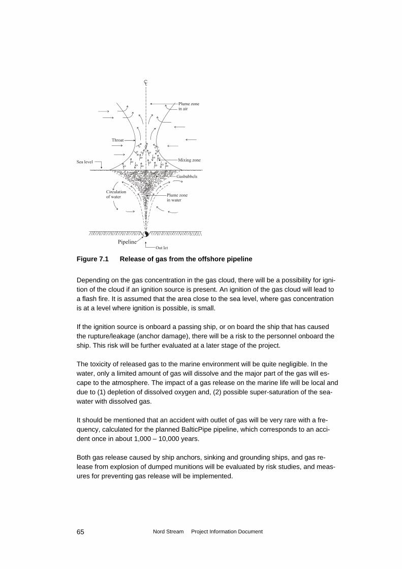
Figure 7.1 Release of gas from the offshore pipeline
Depending on the gas concentration in the gas cloud, there will be a possibility for igni-tion of the cloud if an ignition source is present. An ignition of the gas cloud will lead to a flash fire. It is assumed that the area close to the sea level, where gas concentration is at a level where ignition is possible, is small. If the ignition source is onboard a passing ship, or on board the ship that has caused the rupture/leakage (anchor damage), there will be a risk to the personnel onboard the ship. This risk will be further evaluated at a later stage of the project. The toxicity of released gas to the marine environment will be quite negligible. In the water, only a limited amount of gas will dissolve and the major part of the gas will es-cape to the atmosphere. The impact of a gas release on the marine life will be local and due to (1) depletion of dissolved oxygen and, (2) possible super-saturation of the sea-water with dissolved gas. It should be mentioned that an accident with outlet of gas will be very rare with a fre-quency, calculated for the planned BalticPipe pipeline, which corresponds to an acci-dent once in about 1,000 – 10,000 years. Both gas release caused by ship anchors, sinking and grounding ships, and gas re-lease from explosion of dumped munitions will be evaluated by risk studies, and meas-ures for preventing gas release will be implemented.
Nord Stream Project Information Document
65

De-commissioning International obligations concerning decommissioning of offshore installations have their origins in the United Nations Convention of the Law of the Sea (UNCLOS). The convention stipulates that “installations or structures which are abandoned or disused shall be removed to ensure safety of navigation.....Such removal shall have due regard to fishing, the protection of the marine environment and the rights and duties of other states.”
The competent organisation for this purpose is the International Maritime Organisation (IMO).
A regime for the decommissioning of offshore installations was established in 1998 un-der the 1992 Convention on the Protection of the Marine Environment of the North East Atlantic (the OSPAR Convention). Under this regime a decision was adopted stipulating that “The dumping, and the leaving wholly or partly in place, of disused offshore instal-lations within the maritime area is prohibited.”
There are no specific international regulations or guidelines on decommissioning of offshore pipelines. Pipeline decommissioning will have to consider individual circum-stances, assessment of comparative decommissioning options, removal or partial re-moval in a way to cause no significant adverse effects on the environment, the likely deterioration of the material involved and its present and future effect on the marine environment, and account of other uses of the sea.
Complete removal of the pipeline can be performed as a reverse lay and will have envi-ronmental impacts similar to those of installing the pipeline.
Nord Stream Project Information Document
66

8. EIA and method to be applied
8.1 General The assessment of the environmental impacts will consider the types and amounts of residues and emissions expected during the planning, construction, pre-commissio-ning, operation and de-commissioning phase, as described in section 7. All impact pa-rameters (project parameters that are likely to have an effect on the environment) are identified from the description of the project. Specific parameters are identified qualita-tively and quantitatively via the description of activities and machinery and equipment applied.
All baseline parameters (that together constitute the environmental basis), are subject to identification via desk study, including review of literature and charts, consultation of relevant authorities and institutions, including results from the geotechnical, geophysical and environmental studies/investigations along the pipeline route.
Field investigations are applied where required (where the information via desk study etc. is insufficient), to describe seabed phenomena, marine flora and fauna, marine mammals and birds.
In 2005 – 2006, during planning of the pipeline route, there has been performed both geophysical and environmental route surveys along the planned pipeline. These sur-veys have been carried out inside a survey corridor of 2 km.
In continuation of the route surveys, additional field investigations are under considera-tion or are ongoing at the following locations:
• At landfall locations. • Inside near shore and/or shallow-water areas (generally <20 meter depth). • Inside area for the planned service platform. • Other marine areas those are vulnerable. This could be areas with valuable bio-
topes, flora, fauna, or areas of special conditions (areas with dumped munitions etc.).
• Specific route survey along the pipeline for detection of conventional and chemical ammunitions on and in the seabed.
8.2 Delimitation of impact area The impact assessment is carried out within a corridor along the pipeline, where the width of this corridor (impact area) will depend on the specific environmental conditions and on the different construction works that has to be conducted along the pipe-line/platform.
Nord Stream Project Information Document
67
At locations offshore, where the pipeline is lowered and placed direct on the sea floor by the lay vessel, without dredging operations, outside shipping lanes, and far from environmental sensitive areas, will the with of the corridor for the impact assessment be relative restricted.
The impact area, and so the with of the corridor for the impact assessment, is ex-tended:
• At the landfalls. • At the location where the service platform is established. • At areas with dumped munitions. • Near shore and shallow water areas (especially areas inside German water, at
Sweden North, East and South of Gotland, the East part of Finnish water, and in-side Russian water).
• At other areas that are vulnerable, that will be identified during the EIA baseline study, and through the field investigations.
• Where the pipeline route cross/or is located close to shipping lanes. The extension of the impact areas will depend on individual circumstances in terms of sensitive environmental parameters, like protected areas, and in terms of water depth and actual activities taking place in the area, with effects in terms of sediment spillage resulting in suspended sediment, sedimentation, re-suspension etc, noise or emissions.
8.3 Environmental baseline parameters A description is made of relevant environmental parameters, which may be significantly affected by the pipeline. The baseline description will be elaborated on the basis of desk studies and results from field investigations, see also section 8.5. The baseline parameters to be considered are: • Meteorology (with special attention to ice conditions) • Bathymetry • Hydrography • Seabed geology (raw material resources) and surface sediments • Pelagic environment (water quality and plankton) • Benthic environment (benthic flora and fauna) • Fish and fishery • Birds • Marine mammals • Protected areas (international and national) • Air quality • Noise • Marine traffic • Cultural heritage (former settlements and wrecks)
Nord Stream Project Information Document
68

• Existing and planned installations (pipelines, cable, wind farms, etc.) • Tourism and recreational areas • Military areas • Dumping sites (dredged spoils, chemicals and munitions dumps). A summary of impact parameters and related environmental baseline parameters, that is assessed to be affected, in the maritime zones of each country crossed by the pipe-line, and for transboundary impacts, is presented in section 8.4. Particular attention is provisionally anticipated to be required for some parameters as:
• Desk studies/field investigations of dumping sites for chemical and conventional munitions.
• Studies of visual impact from planned platform. • Studies and risk assessment in connection with ship traffic in the area where the
Nord Stream pipeline will be established. • Studies including risk assessment of accidental gas release from ship accidents or
from explosion of dumped munitions. • Studies with modelling of the sediment dispersion during dredging operations, in-
cluding evaluation of impact from nutrients, oxygen consuming substances, or-ganic and inorganic pollutants on the marine environment.
• Specification of the fishery (catches (tonnes/value Euro) by every country inside the ICES rectangles that is crossed/affected by the Nord Stream pipeline.
Application of special analysis tools is anticipated in relation to sediment dispersion and sedimentation, via mathematical modelling, with dispersion rates based on experience with the relevant type of activity. Sediment character will be identified through sampling for environmental/geotechnical parameters, as done during the environmental route survey in 2005 – 2006, and at the additional field investigates.
8.4 Environmental impact The impact identification is, as described in chapter 7, based on activities related to the different stages of the project. In this chapter the impacts from the Nord Stream pipeline project on all the countries around the Baltic Sea have been evaluated.
In section 8.4.1 impacts have been evaluated for countries where the pipeline crosses the EEZ and/or territorial waters. These countries (Russia, Finland, Sweden, Denmark, Germany) are also mentioned as “parties of origin” and as ”affected parties” in relation to the ESPOO convention, see also chapter 5.
Nord Stream Project Information Document
69

8.4.1 Environmental impact of Russia, Finland, Sweden, Denmark and Germany (parties of origin and affected parties) General In table 8.1 are the different activities (planning, establishment, operating of the Nord Stream pipeline), impact parameters and the environmental parameters that will be affected shown. All the parameters have to be described and evaluated in detail in the EIA.
Possible environmental impacts related to the establishment of the Nord Stream Activity Impact parameter Environmental parameter
affected Country
Planning Planning pipeline route
Crossing protected areas, areas with restrictions, re-served areas
Conflict with existing or planned use of area
(R,F,S,DK), G
Construction Pipeline installation Safety zone of 1,500 m
around lay vessel/platform. Area occupied around lay vessel
Fishery Ship traffic
R,F,S,DK,G
Physical disturbance/noise from lay vessel and supply vessels
Fish, fishery, mammals, birds, tourism and recrea-tional areas
R,F,S,DK,G
Human safety, Water quality, flora, fauna, tourism and recreational areas
R,F,S,DK,G Risk of accident with ship collision and related oil spill
Contact with dumped muni-tions (chemical and con-ventional ammunition)
Human safety Fauna
(R,F),S,DK,G
Seabed rectifica-tion, dredging, trenching and backfilling
Suspended sediment, sedi-mentation, release of inor-ganic and organic contami-nants, nutrients, oxygen consuming substances
Surface sediment, water quality, plankton production, flora and fauna, fish, fishery, mammals, birds, tourism and recreational areas
R,F,S,DK,G Impact depends on the technical solution, sediment type, volume of dredg-ing, contamination of sediment.
Rock dumping Suspended sediment Occupation of seabed
Benthic flora and fauna R,F,S,DK,G
Installation of ser-vice platform
Safety zone, physical dis-turbance, noise, dredging, suspended sediment
Pelagic and benthic envi-ronment, fish, fishery, ship traffic, birds, mammals, hu-man safety
S
Nord Stream Project Information Document
70
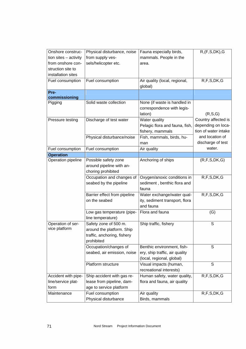
Physical disturbance, noise from supply ves-sels/helicopter etc.
Fauna especially birds, mammals. People in the area.
R,(F,S,DK),G Onshore construc-tion sites – activity from onshore con-struction site to installation sites Fuel consumption Fuel consumption Air quality (local, regional,
global) R,F,S,DK,G
Pre-commissioning
Pigging Solid waste collection
None (if waste is handled in correspondence with legis-lation)
Pressure testing Discharge of test water Water quality Pelagic flora and fauna, fish, fishery, mammals
Physical disturbance/noise Fish, mammals, birds, hu-man
Fuel consumption Air quality
(R,S,G)
Fuel consumption
Country affected is depending on loca-tion of water intake
and location of discharge of test
water. Operation Operation pipeline Possible safety zone
around pipeline with an-choring prohibited
Anchoring of ships (R,F,S,DK,G)
Occupation and changes of seabed by the pipeline
Oxygen/anoxic conditions in sediment , benthic flora and fauna
R,F,S,DK,G
Barrier effect from pipeline on the seabed
Water exchange/water qual-ity, sediment transport, flora and fauna
R,F,S,DK,G
Low gas temperature (pipe-line temperature)
Flora and fauna (G)
Operation of ser-vice platform
Safety zone of 500 m. around the platform. Ship traffic, anchoring, fishery prohibited
Ship traffic, fishery S
S Occupation/changes of seabed, air emission, noise
Benthic environment, fish-ery, ship traffic, air quality (local, regional, global)
Platform structure Visual impacts (human, recreational interests)
S
Accident with pipe-line/service plat-form
Human safety, water quality, flora and fauna, air quality
R,F,S,DK,G Ship accident with gas re-lease from pipeline, dam-age to service platform
Maintenance Fuel consumption Air quality Physical disturbance Birds, mammals
R,F,S,DK,G
Nord Stream Project Information Document
71

Anodes and pipe coating
Release of anode metal and hydrocarbons
Water quality R,F,S,DK,G Flora and fauna
Decommissioning De-commissioning Method used depend on practice/technology available at
that time R,F,S,DK,G
R, F, S, DK, G: Russia. Finland. Sweden. Denmark. Germany. (R, F, S): To be investigated in more detail for the different countries. Pre-commissioning: It is not decided where pressure testing will be carried out.
Table 8.1 Possible environmental impacts related to the construction and operation of the North European Gas Pipeline (Nord Stream). In table 8.2a- 8.2d the activities and the impact parameters (as shown in table 8.1) are shown, together with the methods that will be used to describe and evaluate the poten-tial environmental impacts from the Nord Stream project. From the table 8.2 it appears that methods used to describe and evaluate the potential impacts from the Nord Stream project will be a combination of:
• Contact to authorities in Russia (R), Finland (F), Sweden (S), Denmark (DK) and Germany (G).
• Desk study (especially HELCOM data from monitoring and scientific studies, existing data from the different countries).
• Field investigations. • Mathematical modelling and calculations.
In table 8.2a are the potential impacts during planning and construction of the Nord Stream pipeline, and the methods that will be used to describe and evaluate these im-pacts, shown.
Methods for describing and evaluation the potential environmental impacts during planning and construction of the Nord Stream pipeline
Activity Impact parameter Methods Planning Planning pipeline route
Conflict with existing or planned use of area
Contact to planning authorities in R, F, S, DK, G. Desk studies with focus on planning and regula-tion in the Baltic Sea.
Construction Pipeline installation Safety zone/area occu-
pied around lay vessel Safety zone of 1,500 m around lay vessel and platform site, where ship traffic, inclusive fishing is prohibited.
Physical disturbance/ noise from lay vessel and supply vessels
Desk study and experience from similar projects.
Nord Stream Project Information Document
72

Risk of accident with ship collision and re-lated oil spill
Desk study of oil spill in Baltic Sea. Risk assessment of ship collision resulting in oil spill. Evaluation of impact on marine environment from oil spill by modelling and toxicological evaluation.
Contact with dumped munitions (chemical and conventional am-munitions)
Specific route survey, by professional company, inside pipeline corridor for chemical ammunitions and conventional ammunitions on and in the sea-bed. Field investigations at specific sites. Removal of conventional munitions from route or changing of the pipeline route. Risk analysis of accidents related to dumped munitions for both construction and operation of pipeline. Contact and coopera-tion with authorities and experts. Model calculations with simulations of sediment transport/spreading and sedimentation. Impact on flora/fauna from suspended sediment and sedi-mentation evaluated on basis of scientific articles (toxicology), time on year of the works, and from results from similar projects (including results from other offshore projects that includes dredging ac-tivities).
Suspended sediment and sedimentation
Seabed rectifica-tion, dredging, trenching and backfilling
Suspended sediment and sedimentation: Re-lease of inorganic and organic contaminants, nutrients, oxygen con-suming substances.
Modelling sediment transport, and transport, spreading and sedimentation of pollutants, nutri-ents and oxygene consuming substances. Calcu-lation of PEC/PNEC (predicted effect concentra-tion/predicted no effect concentration) and calcu-lation/assessment of impact on environment.
Rock dumping Suspended sediment Occupation of seabed
As above. Impact also evaluated on area affected, and the effect of “artificial reef structure” by rocks dumped.
Installation of ser-vice platform
Physical disturbance, noise, dredging, sus-pended sediment
Impacts evaluated as above, and on basis on time of the year of construction, compared to fauna communities/birds using the area. Impact from physical disturbance, noise, dredging as de-scribed above.
Onshore construc-tion sites – activity from onshore con-struction sites to installation sites.
Physical disturbance, noise from supply ves-sels/helicopter etc.
See above. Especially noise from helicopters near onshore construction sites and at installation sites.
Nord Stream Project Information Document
73

Fuel consumption Fuel consumption Calculation of fuel consumption, energy used, and calculations of emission of pollutants to the air environment, including evaluation of environ-mental impacts.
Table 8.2a Methods for describing and evaluation the possible environmental impacts from planning and construction the Nord Stream pipeline. In table 8.2b are the potential impacts during pre-commissioning of the Nord Stream pipeline, and the methods that will be used to describe and evaluate these impacts, shown.
Methods for describing and evaluation the potential environmental impacts during Pre-commissioning of the Nord Stream pipeline
Activity Impact parameter Methods Pre-commissioning
Pigging Solid waste collection
-
Pressure testing Discharge of test water Calculation/evaluation of the composition of test water discharged. Status of marine flora and fauna, vulnerability of marine environment, at the dis-charge point at time (season) of discharge. Model-ling and ecotoxicological evaluation/calculation of the impact on the marine environment.
Physical distur-bance/noise
Physical disturbance from activities at the in- and outlet locations of the test water. Modelling noise distribution and localization of noise sensitive pa-rameters (as residential areas, breeding birds etc.).
Fuel consump-tion
Fuel consumption Calculation of fuel consumption, energy used, and calculations of emission of pollutants to the air envi-ronment.
Table 8.2b Methods for describing and evaluation the possible environmental impacts from pre-commissioning the Nord Stream pipeline. In table 8.2c are the potential impacts during operation of the Nord Stream pipeline, and the methods that will be used to describe and evaluate these impacts, shown.
Nord Stream Project Information Document
74
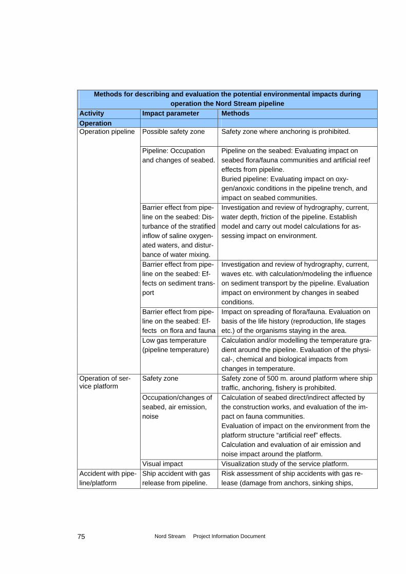
Methods for describing and evaluation the potential environmental impacts during operation the Nord Stream pipeline
Activity Impact parameter Methods Operation Operation pipeline
Possible safety zone Safety zone where anchoring is prohibited.
Pipeline: Occupation and changes of seabed.
Pipeline on the seabed: Evaluating impact on seabed flora/fauna communities and artificial reef effects from pipeline. Buried pipeline: Evaluating impact on oxy-gen/anoxic conditions in the pipeline trench, and impact on seabed communities.
Barrier effect from pipe-line on the seabed: Dis-turbance of the stratified inflow of saline oxygen-ated waters, and distur-bance of water mixing.
Investigation and review of hydrography, current, water depth, friction of the pipeline. Establish model and carry out model calculations for as-sessing impact on environment.
Barrier effect from pipe-line on the seabed: Ef-fects on sediment trans-port
Investigation and review of hydrography, current, waves etc. with calculation/modeling the influence on sediment transport by the pipeline. Evaluation impact on environment by changes in seabed conditions.
Barrier effect from pipe-line on the seabed: Ef-fects on flora and fauna
Impact on spreading of flora/fauna. Evaluation on basis of the life history (reproduction, life stages etc.) of the organisms staying in the area.
Low gas temperature (pipeline temperature)
Calculation and/or modelling the temperature gra-dient around the pipeline. Evaluation of the physi-cal-, chemical and biological impacts from changes in temperature.
Operation of ser-vice platform
Safety zone Safety zone of 500 m. around platform where ship traffic, anchoring, fishery is prohibited.
Occupation/changes of seabed, air emission, noise
Calculation of seabed direct/indirect affected by the construction works, and evaluation of the im-pact on fauna communities. Evaluation of impact on the environment from the platform structure “artificial reef” effects. Calculation and evaluation of air emission and noise impact around the platform.
Visual impact Visualization study of the service platform. Accident with pipe-line/platform
Ship accident with gas release from pipeline.
Risk assessment of ship accidents with gas re-lease (damage from anchors, sinking ships,
Nord Stream Project Information Document
75
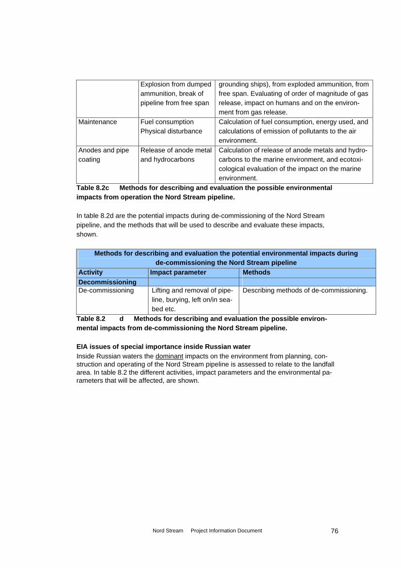
grounding ships), from exploded ammunition, from free span. Evaluating of order of magnitude of gas release, impact on humans and on the environ-ment from gas release.
Explosion from dumped ammunition, break of pipeline from free span
Maintenance Fuel consumption Calculation of fuel consumption, energy used, and calculations of emission of pollutants to the air environment.
Physical disturbance
Anodes and pipe coating
Release of anode metal and hydrocarbons
Calculation of release of anode metals and hydro-carbons to the marine environment, and ecotoxi-cological evaluation of the impact on the marine environment.
Table 8.2c Methods for describing and evaluation the possible environmental impacts from operation the Nord Stream pipeline. In table 8.2d are the potential impacts during de-commissioning of the Nord Stream pipeline, and the methods that will be used to describe and evaluate these impacts, shown.
Methods for describing and evaluation the potential environmental impacts during de-commissioning the Nord Stream pipeline
Activity Impact parameter Methods Decommissioning De-commissioning Lifting and removal of pipe-
line, burying, left on/in sea-bed etc.
Describing methods of de-commissioning.
Table 8.2 d Methods for describing and evaluation the possible environ-mental impacts from de-commissioning the Nord Stream pipeline. EIA issues of special importance inside Russian water Inside Russian waters the dominant impacts on the environment from planning, con-struction and operating of the Nord Stream pipeline is assessed to relate to the landfall area. In table 8.2 the different activities, impact parameters and the environmental pa-rameters that will be affected, are shown.
Nord Stream Project Information Document
76

Possible environmental impacts related to the establishment of the Nord Stream inside RUSSIAN waters
Activity Impact parameter Environmental parameter affected Planning Planning pipeline route
Crossing protected areas, areas with restrictions, re-served areas
Conflict with existing or planned use of area
Construction Fishery Pipeline installation Safety zone of 1,500 m
around lay vessel/platform. Area occupied around lay ves-sel
Ship traffic
Physical disturbance/noise from lay vessel and supply vessels
Fish, fishery, mammals, birds, tourism and recreational areas
Risk of accident with ship col-lision and related oil spill
Human safety, Water quality, flora, fauna, tourism and recreational areas
Human safety Fauna
Contact with dumped muni-tions (chemical and conven-tional ammunition) Suspended sediment, sedi-mentation, release of con-taminants, nutrients, oxygen consuming substances
Surface sediment, water quality, plankton production, flora and fauna, fish, fishery, mammals, birds, tourism and recreational areas
Seabed rectification, dredging, trenching and backfilling
Rock dumping Suspended sediment Occupation of seabed
Benthic flora and fauna
Physical disturbance, noise from supply vessels/helicopter etc.
Fauna especially birds, mammals. People in the area.
Onshore construc-tion sites – activity from construction to installation sites Fuel consumption Fuel consumption Air quality (local, regional, global) Pre-commissioning Pressure testing (?) Discharge of test water Water quality
Pelagic flora and fauna, fish, fishery, mam-mals
Physical disturbance/noise Fish, mammals, birds, human Operation
Possible safety zone around pipeline with anchoring prohib-ited
Anchoring of ships Operation pipeline
Occupation and changes of seabed by the pipeline
Oxygen/anoxic conditions in sediment , benthic flora and fauna
Nord Stream Project Information Document
77

Barrier effect from pipeline on the seabed
Water exchange/water quality, sediment transport, flora and fauna
Ship accident with gas release from pipeline, explosion dumped ammunition, break at free span
Human safety, water quality, flora and fauna, air quality
Accident with pipe-line
(?): To be investigated in more detail. Discharge sites of test water not decided.
Table 8.2 Possible environmental impacts related especially to the Northern European Gas Export Pipeline (NEGEP) inside Russian waters. EIA issues of special importance inside Finnish water Inside Finnish waters the dominant impacts on the environment from planning, con-struction and operating of the Nord Stream pipeline is assessed to relate to the ship traffic, to the installation of the Eastern part of the pipeline in relative shallow water, seabed rectification and dredging activities. In table 8.3 are the different activities, im-pact parameters and the environmental parameters that will be affected, shown.
Possible environmental impacts related to the establishment of the Nord Stream inside FINNISH waters
Activity Impact parameter Environmental parameter affected Planning Planning pipeline route
Crossing protected areas, areas with restrictions, re-served areas
Conflict with existing or planned use of area
Construction Pipeline installation Fishery
Ship traffic Safety zone of 1,500 m around lay vessel/platform. Area occupied around lay ves-sel
Physical disturbance/noise from lay vessel and supply vessels
Fish, fishery, mammals, birds, tourism and recreational areas
Risk of accident with ship col-lision and related oil spill
Human safety, Water quality, flora, fauna, tourism and recreational areas
Human safety Fauna
Contact with dumped muni-tions (chemical and conven-tional ammunition) Suspended sediment, sedi-mentation, release of con-taminants, nutrients, oxygen consuming substances
Surface sediment, water quality, plankton production, flora and fauna, fish, fishery, mammals, birds, tourism and recreational areas
Seabed rectification, dredging, trenching and backfilling
Rock dumping Suspended sediment Occupation of seabed
Benthic flora and fauna
Nord Stream Project Information Document
78
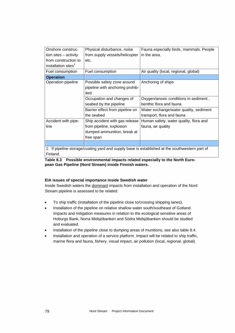
Onshore construc-tion sites – activity from construction to installation sites1
Physical disturbance, noise from supply vessels/helicopter etc.
Fauna especially birds, mammals. People in the area.
Fuel consumption Fuel consumption Air quality (local, regional, global) Operation
Anchoring of ships Operation pipeline Possible safety zone around pipeline with anchoring prohib-ited
Occupation and changes of seabed by the pipeline
Oxygen/anoxic conditions in sediment , benthic flora and fauna
Barrier effect from pipeline on the seabed
Water exchange/water quality, sediment transport, flora and fauna
Accident with pipe-line
Ship accident with gas release from pipeline, explosion dumped ammunition, break at free span
Human safety, water quality, flora and fauna, air quality
1: If pipeline storage/coating yard and supply base is established at the southwestern part of Finland.
Table 8.3 Possible environmental impacts related especially to the North Euro-pean Gas Pipeline (Nord Stream) inside Finnish waters. EIA issues of special importance inside Swedish water Inside Swedish waters the dominant impacts from installation and operation of the Nord Stream pipeline is assessed to be related: • To ship traffic (installation of the pipeline close to/crossing shipping lanes). • Installation of the pipeline on relative shallow water south/southeast of Gotland.
Impacts and mitigation measures in relation to the ecological sensitive areas of Hoburgs Bank, Norra Midsjöbanken and Södra Midsjöbanken should be studied and evaluated.
• Installation of the pipeline close to dumping areas of munitions, see also table 8.4. • Installation and operation of a service platform. Impact will be related to ship traffic,
marine flora and fauna, fishery, visual impact, air pollution (local, regional, global).
Nord Stream Project Information Document
79
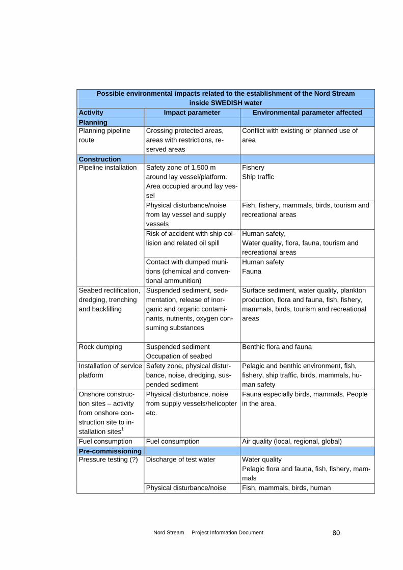
Possible environmental impacts related to the establishment of the Nord Stream inside SWEDISH water
Activity Impact parameter Environmental parameter affected Planning Planning pipeline route
Crossing protected areas, areas with restrictions, re-served areas
Conflict with existing or planned use of area
Construction Pipeline installation Safety zone of 1,500 m
around lay vessel/platform. Area occupied around lay ves-sel
Fishery Ship traffic
Physical disturbance/noise from lay vessel and supply vessels
Fish, fishery, mammals, birds, tourism and recreational areas
Risk of accident with ship col-lision and related oil spill
Human safety, Water quality, flora, fauna, tourism and recreational areas
Contact with dumped muni-tions (chemical and conven-tional ammunition)
Human safety Fauna
Seabed rectification, dredging, trenching and backfilling
Suspended sediment, sedi-mentation, release of inor-ganic and organic contami-nants, nutrients, oxygen con-suming substances
Surface sediment, water quality, plankton production, flora and fauna, fish, fishery, mammals, birds, tourism and recreational areas
Rock dumping Suspended sediment Occupation of seabed
Benthic flora and fauna
Installation of service platform
Safety zone, physical distur-bance, noise, dredging, sus-pended sediment
Pelagic and benthic environment, fish, fishery, ship traffic, birds, mammals, hu-man safety
Physical disturbance, noise from supply vessels/helicopter etc.
Fauna especially birds, mammals. People in the area.
Onshore construc-tion sites – activity from onshore con-struction site to in-stallation sites1
Fuel consumption Fuel consumption Air quality (local, regional, global) Pre-commissioning Pressure testing (?) Discharge of test water Water quality
Pelagic flora and fauna, fish, fishery, mam-mals
Physical disturbance/noise Fish, mammals, birds, human
Nord Stream Project Information Document
80

Operation Operation pipeline Possible safety zone around
pipeline with anchoring prohib-ited
Anchoring of ships
Occupation and changes of seabed by the pipeline
Oxygen/anoxic conditions in sediment , benthic flora and fauna
Barrier effect from pipeline on the seabed
Water exchange/water quality, sediment transport, flora and fauna
Operation of service platform
Safety zone of 500 m. around the platform. Ship traffic, an-choring, fishery prohibited
Ship traffic, fishery
Occupation/changes of sea-bed, air emission, noise
Benthic environment, fishery, ship traffic, air quality (local, regional, global)
Platform structure Visual impacts (human, recreational inter-ests)
Accident with pipe-line/service platform
Ship accident with gas release from pipeline, damage to ser-vice platform
Human safety, water quality, flora and fauna, air quality
1: If pipeline storage/coating yard and supply base is established in Sweden. Table 8.4 Possible environmental impacts related especially to the North European Gas Pipeline (Nord Stream) inside Swedish waters. EIA issues of special importance inside Danish waters Inside Danish waters focus in the EIA program should be on pipeline installation close to areas with dumped munitions, impact on fishery, and to installation of the western part of the pipeline in relative shallow water (between the Adlergrund and Oderbanke), table 8.5.
Possible environmental impacts related to the establishment of the Nord Stream inside DANISH water
Activity Impact parameter Environmental parameter affected Planning Planning pipeline route
Crossing protected areas, areas with restrictions, reserved areas
Conflict with existing or planned use of area
Construction Fishery Pipeline installa-
tion Safety zone of 1,500 m around lay vessel/platform. Area occu-pied around lay vessel
Ship traffic
Physical disturbance/noise from lay vessel and supply vessels
Fish, fishery, mammals, birds, tourism and recreational areas
Risk of accident with ship colli-sion and related oil spill
Human safety, Water quality, flora, fauna, tourism and recreational areas
Nord Stream Project Information Document
81

Human safety Fauna
Contact with dumped munitions (chemical and conventional am-munition) Suspended sediment, sedimenta-tion, release of contaminants, nutrients, oxygen consuming substances
Surface sediment, water quality, plankton production, flora and fauna, fish, fishery, mammals, birds, tourism and recreational areas
Seabed rectifica-tion, dredging, trenching and backfilling Rock dumping Suspended sediment Benthic flora and fauna
Occupation of seabed Fuel consumption Fuel consumption Air quality (local, regional, global) Operation Operation pipe-line
Possible safety zone around pipeline with anchoring prohibited
Benthic flora and fauna and water quality caused by pipeline damages.
Occupation and changes of sea-bed by the pipeline
Oxygen/anoxic conditions in sediment , benthic flora and fauna
Barrier effect from pipeline on the seabed
Water exchange/water quality, sediment transport, flora and fauna Human safety, water quality, flora and fauna, air quality
Accident with pipeline
Ship accident with gas release from pipeline, explosion dumped ammunition, break at free span
Table 8.5 Possible environmental impacts related especially to the North Euro-pean Gas Pipeline (Nord Stream) inside Danish waters. EIA issues of special importance inside German waters Inside German waters focus in the EIA program, should be on the issues described: • Conflicts with planning regulations. • The impact from pipeline installation inside the Greifswalder Bodden, and crossing
of the Bodden barrier, including dredging, backfilling, and temporary deposition of sediment etc.
• The impact on cultural heritage. • The impact from pipeline installation inside the international EF-bird protected area
No. DE 1552-401. • The impact/risk of impact during installation of the pipeline, close to areas with
dumped munitions/or inside the routes to the dumping areas. • The intensive ship traffic both inside and outside Grifswalder Bodden. • Fish and Fishery, inside and outside the Greifswalder Bodden.
Nord Stream Project Information Document
82

Possible environmental impacts related to the establishment of the Nord Stream inside GERMAN water
Activity Impact parameter Environmental parameter af-fected
Planning Planning pipeline route
Crossing protected areas, areas with re-strictions, reserved areas
Conflict with existing or planned use of area
Construction Fishery Pipeline installa-
tion Safety zone of 1,500 m around lay ves-sel/platform. Area occupied around lay vessel
Ship traffic
Physical disturbance/noise from lay ves-sel and supply vessels
Fish, fishery, mammals, birds, tour-ism and recreational areas
Risk of accident with ship collision and related oil spill
Human safety, Water quality, flora, fauna, tourism and recreational areas
Contact with dumped munitions (chemical and conventional ammunition)
Human safety Fauna
Seabed rectifica-tion, dredging, trenching and backfilling1
Suspended sediment, sedimentation, release of contaminants, nutrients, oxy-gen consuming substances
Surface sediment, water quality, plankton production, flora and fauna, fish, fishery, mammals, birds, tourism and recreational ar-eas
Rock dumping Suspended sediment Occupation of seabed
Benthic flora and fauna
Fuel consumption Fuel consumption Air quality (local, regional, global) Pre-commissioning
Pressure testing (?)
Discharge of test water Water quality, pelagic flora and fauna, fish, fishery, mammals
Physical disturbance/noise Fish, mammals, birds, human Operation
Possible safety zone around pipeline with anchoring prohibited
Anchoring of ships Operation pipe-line Occupation and changes of seabed by
the pipeline Oxygen/anoxic conditions in sedi-ment, benthic flora and fauna
Barrier effect from pipeline on the seabed Water exchange/water quality, sediment transport, flora and fauna
Low gas temperature (pipeline tempera-ture)
Flora and fauna
Nord Stream Project Information Document
83

Accident with pipeline
Ship accident with gas release from pipe-line, explosion dumped ammunition, break at free span
Human safety, water quality, flora and fauna, air quality
1: If pipeline storage/coating yard and supply base is established in Germany (Lubmin). (?): To be investigated in more detail. Discharge sites of test water not decided.
Table 8.6 Possible environmental impacts related especially to the North Euro-pean Gas Pipeline (Nord Stream) inside German waters.
8.4.2 Environmental impact of Estonia, Latvia, Lithuania and Poland (other affected parties) The Nord Stream pipeline will not enter territorial- or EEZ waters of Estonia, Latvia, Lithuania and Poland. If onshore construction sites for pipeline storage/coating- and supply facilities is established in one/several of the countries mentioned, these coun-tries waters (both territorial- and EEZ water) will be affected.
Possible transboundary environmental impacts related to the establishment of the Nord Stream to ESTONIA, LATVIA, LITHUANIA, POLAND
Activity Impact parameter Environmental parameter affected
Country
Construction Pipeline installa-tion
Safety zone of 1,500 m around lay vessel/platform. Area occupied around lay vessel
Fishery Ship traffic
EE, LV, LT, PL
Physical disturbance/noise from lay vessel and supply vessels
Fish, fishery, mammals, birds,
EE, LV, LT, PL
Risk of accident with ship collision and related oil spill
Human safety, Water quality, flora, fauna, tourism and recreational areas
EE, LV, LT, PL
Surface sediment, water quality, plankton production, flora and fauna, fish, fishery, mammals, birds, tourism and recreational areas
Seabed rectifica-tion, dredging, trenching and backfilling
Suspended sediment, sedimentation, release of inorganic and organic con-taminants, nutrients, oxy-gen consuming substances
EE, LV, LT, PL
Rock dumping Suspended sediment Occupation of seabed
Benthic flora and fauna EE, LV, LT, PL
Installation of service platform
Safety zone, physical dis-turbance, noise, dredging, suspended sediment
Fishery, ship traffic EE, LV, LT, PL
Nord Stream Project Information Document
84

Fauna especially birds, mammals. People living in the area.
Onshore con-struction sites – activity from on-shore construc-tion site to instal-lation sites1
Physical disturbance, noise from supply ves-sels/helicopter etc.
(EE, LV, LT, PL)1
Fuel consumption Fuel consumption Air quality (local1, regional, global)
EE, LV, LT, PL
Pre-commissioning
Pressure testing Discharge of test water Water quality Pelagic flora and fauna, fish, fishery, mammals
(EE, LV, LT, PL)2
Operation (EE, LV, LT, PL)3Anchoring of ships Possible safety zone
around pipeline with an-choring prohibited
Operation pipe-line Barrier effect from pipeline
on the seabed Water exchange/water qual-ity, sediment transport, flora and fauna
(PL)
Operation of ser-vice platform
Safety zone of 500 m. around the platform. Ship traffic, anchoring, fishery prohibited
Ship traffic, fishery EE, LV, LT, PL
Accident with pipeline/service platform
Human safety, water quality, flora and fauna, air quality
EE, LV, LT, PL Ship accident with gas release from pipeline, damage to service platform
1: If pipeline storage/coating yard and supply base is established in one-several of the countries. 2: An impact depends on where test water is discharged. 3: If 200 m protection zone (anchoring prohibited) is established. EE, LV, LT, PL: Estonia. Latvia. Lithuania. Poland
Table 8.7 Possible transboundary environmental impacts to Estonia, Lithuania, Latvia and Poland, related to the North European Gas Pipeline (Nord Stream). Transboundary environmental impacts from the NEG Pipeline on Estonia, Latvia, Lithuania and Poland are assessed primarily to relate to impacts by occupation of area during installation and operation of the pipeline and the service platform. Impact on Estonia, Latvia, Lithuania and Poland from safety zones during construction (1,500 m around lay vessel and service platform) will affect ship traffic and fishery inside the safety zone. A safety zone (if enforced) around the pipeline where anchoring is not al-lowed during operation of the pipeline will affect anchoring of ships inside the zone. A protection zone of 500 m around the service platform will affect ship traffic and fishery inside this zone.
Nord Stream Project Information Document
85

Trenching and dredging activities during construction and discharge of test water during pre-commissioning will increase the area where fishery will be affected, and can have impact on benthic flora and fauna. Depending on where trenching and dredging is car-ried out, and where test water is discharged, it can not be excluded that there may be impact on water quality, flora and fauna, inside the EEZ of some of the countries Esto-nia, Latvia, Lithuania and Poland. Installation of the Nord Stream pipeline in the Baltic Sea results in energy consumption by vessels and machines, with release of contaminants, including emission of green-house gases that is known to cause global warming, table 8.7.
8.5 Route survey and additional field investigations Geophysical and environmental route surveys The field investigations carried out in 2005 - 2006 included geophysical surveys along the planned pipeline route (inside 2 km. corridor), and comprised multibeam bathym-etry, sub bottom profiler (SBP), sidescan sonar (SSS) and magnetometer measure-ments. The results from the geophysical surveys will give information about the bathymetry, seabed conditions (inclusive information about object on and in the seabed), informa-tion about sediment layers and geology, information about metal in/on the seabed, as dumped munitions, wrecks, cables etc. The environmental surveys in 2005 – 2006 included physical and chemical measure-ments and analysis of water and sediment samples from about 90 stations along the pipeline. The chemical analysis included measurements of the content of heavy metals, organic pollutants and nutrients. The biological investigations included analysis of phyto- and zooplankton, the benthic fauna, the fish fauna, marine mammals and birds. Additional field investigations Additional field investigations have been carried out inside German, Danish and Rus-sian water in 2006, and additional field investigations inside Finnish and Swedish water have to be clarified with the Finnish and Swedish authorities. The additional investiga-tions are going to include studies of: • Surface sediments. • Benthic flora and fauna via sampling and analysis inside near shore and shallow
water areas, and inside areas for the planned service platform. • Marine mammals and birds. The additional field investigations performed/planned carried out in the maritime zones of each country on the route are presented in table 8.8, based on the preliminary de-scription of the impacts related to installation and operation of the pipeline.
Nord Stream Project Information Document
86

As shown in table 8.8 there will be conducted an additional field study along the entire pipeline for localisation and identification dumped munitions (conventional and chemical ammunitions) on and in the seabed. Country Pipeline
(km) Additional field studies
All 1,196 Specific route survey for chemical and conventional muni-tions
Russia 118 Field studies finished Finland1 369 Field studies of sediment, marine fauna1. Sweden1 482 Field studies of marine flora and fauna, birds in shallow
areas south of Gotland1. Field studies including sediment, marine fauna and birds at planned service platform location.
Denmark 149 Video survey along the Western part of the planned pipe-line. Investigations of birds and mammals along transects at Rønne Banke/Adler Grund (150 km 2 times from airplane in 2006. 135 km 3 times from vessel in 2006/2007).
Germa-ny1
78 Geophysical and video survey, along the pipeline route. Field studies of sediment, benhic fauna at 5 stations/5 km, benthic flora in Greifswalder Bodden at the landfall site, and at the Bodden barrier. Field studies of fish outside Greifswalder Bodden includ-ing fishery of benthic fish species three times in the period May-June along the pipeline route. Inside Greifswalder Bodden investigations of fish species, spawning and nursery areas, and fishery 3 times in May-June. Field studies of seabirds and marine mammals outside Greifswalder Bodden from airplane (6 times in 2006) and from vessel (10 times in the period April 2006-Februar 2007). Field studies of water birds inside Greifswalder Bodden from airplane (2 times in spring) and from ves-sel/the coastline.
- Onshore at the landfall site. Terrestrial field investigations of flora and fauna.
Nord Stream Project Information Document
87

Field studies of marine flora and fauna1Discharge location(s) for test water 1: Will be clarified further with authorities/in the ongoing scoping process in Swe-den, Finland, Germany.
Table 8.8 Additional field studies
Specific Desk Study on conventional and chemical ammunition All field investigations and risk assessments are based on an in-depth desk study of military events in the Baltic Sea since the beginning of the last century. The preliminary results from the desk studies are compiled in Dwg. 6.5. Large scale survey of the route for detecting conventional and chemical ammunition The route surveys that were carried out in 2005 – 2006 are planned to be supple-mented with surveys of the entire route in beginning of 2007. The survey in 2007 will be an acoustic survey with focus on identification of munitions. The supplementary route survey will entail measurements using technologies such as: • Side scan sonar. • Multibeam echo sounder. • Sub bottom profiler. • Magnetometers. • Induction loop cable trackers. Detailed surveys (including inspection) in areas identified On basis of the results from the survey in beginning of 2007, detailed surveys (including inspection) is planned carried out inside specific areas. The interpretation of the large scale survey performed in 2007 will identify areas with suspected ammunition. These areas will be investigated in detail with appropriate means, as dictated by circum-stances. Technologies that might be used are: • High resolution side scanner. • Gradiometer to detect ferrous materials. • VLF sensors to detect metallic objects. • Optical spectrometers for detection of indicators such as nitrogen and chlorate
containing compounds. • Visual inspection of identified targets and areas conducted by remotely operated
vehicles (ROV), drop cameras and/or divers. Even small objects (in cm-size) can be detected even if they are slightly buried in sedi-ment. Larger metal objects can be detected to 1-2 m depth below sea bottom. Chemical indicators in the water layer above the sea bottom can be detected in order to identify chemical anomalies of the water.
Nord Stream Project Information Document
88
Risk assessment and recommendations for environment protection, for pipe laying and for operation of the pipeline system The results from the detailed investigations will the used as input to a risk assessment for the environment, for pipe laying and for the operation phase. A number of risk sce-narios will be identified and assessed, and possible mitigation measures will be de-scribed. A mitigation hierarchy is tentatively planned as: • Re-routing of pipelines. • Sub-sea risk reduction on-site (e.g. moving on the sea bottom) • Removal of ammunition. Each identified area found in the large scale survey will be assessed and managed individually. It is proposed to establish a working group for following the detailed scope and results of the field investigations and assessments. National authorities will be invited to par-ticipate and will be involved according to the relevant legal requirements.
9. Proposals for preventing and mitigation negative impacts
In this section the preventing and reduction of environmental impacts during planning, construction, pre-commissioning and operation is described: The evaluation of mitigation measures to be incorporation in the Nord Stream project should be carried out in close connection to the technical study with: • Adjustment of the pipeline route, • Planning of methods for pipe lay (especially inside Greifswalder Bodden, and in
shallow water areas), • Crossings of cables, • Conventional and chemical ammunition • Installation of platform, • Planning of pre-commissioning activities. Planning • During planning it will be advantageous to optimise the pipeline routing to avoid
conflicts with protected areas and other use of the sea (shipping lines, military ar-eas intensive fishery etc.). Further optimisation before the route survey is carried out, will minimise additional route survey, see also section 3.1.3.
Nord Stream Project Information Document
89

Construction Material consumption • Selection of coating material, which cause the lowest environmental impact (inter-
nal flow-coating, external corrosion coating, external field-joint coating). Plans • Environmental Management Plan for the project during construction and operation
will secure that activities that can have impact on the environment will be localised and measures to minimise environmental impacts can be taken.
• Contingency plans for both the pipelay operation and the landfall construction. Construction works • Ensure information about construction activities and safety zones are available for
other users of the sea. • Decreasing the time period of construction works inside sensitive areas may de-
crease environmental impacts. • Minimise sediment brought in suspension by use of best available trenching tech-
nique considering the geological conditions. • Minimise noise disturbance at the landfall construction sites (working hours at day
time) and near important bird areas. • Minimise sediment spill at landfall construction sites, near internationally Natura
2000 areas, in shallow waters, and during installation of the platform, during dredg-ing, backfilling or dumping of dredged material.
• Minimise risk of contact with conventional/chemical ammunition. During survey special attention should be laid on identification of ammunition inside the dumping areas. The pipeline shall either be rerouted or identified ammunition shall be moved to avoid contact. Sediment samples taken inside ammunition areas should be han-dled with care.
• Monitoring during dredging activities, including feedback monitoring (if tolerance criteria for the construction works is exceeded work plans can be modified so that the impact on the environment will be reduced, during operation).
Pre-commissioning • Pre-commissioning should be carried out so that sensitive periods are avoided. • Minimise the environmental impact of discharge of water from pressure testing by
selecting a location with low sensitivity and good mixing in the water column, and/or by reducing toxicity of test water going to be discharged.
• The salinity difference between water at the intake point, with water at the location of discharge should be taken in account, and the environmental impact should be evaluated.
• Selection of chemicals (if chemicals are necessary) for pressures testing with low environmental impact.
• Noise reducing measures of all engines involved if necessary.
Nord Stream Project Information Document
90

• Monitoring during discharge of pressure test water. Operation During the lifetime of the pipeline system it should be subject to continuous monitoring (external inspection, internal surveillance and inspection), to assure safe operation as well as being instrument for further planning for maintenance and repairs.
Nord Stream Project Information Document
91

10. Overall time schedule and preliminary table of content of the EIA
The overall time schedule of the Nord Stream project is shown in table 10.1, where full capacity of the transmission system is foreseen to be reached in 2012. The EIA for the offshore part of the project will be part of the ESPOO-Convention procedure, and it is also assessed to be part of the national procedure for the countries that are “parties of origin”. Separate reports will be elaborated for the landfall sections of the pipeline, and for the planned service platform. Activity Year Feasibility Study (North Transgas Oy) 1997 - 1999 Conceptual Design ongoing - 07/2006 Detailed Design 01/2007 – 12/2007 Manufacturing and supply of pipeline 04/2007 – 10/2009 Installation of 1st pipeline and offshore platform 01/2008 – 12/2009 Commissioning of 1st pipeline and offshore platform 06/2009 – 02/2010 Installation of 2nd pipeline to be determined Full capacity of the transmission system is foreseen to be reached
2012
Table 10.1 Overall time schedule of the Nord Stream project. The final EIA report in a transboundary context, that will be made on basis on detailed desk studies, field investigations and environmental impact assessment, is planned to be finalised in July 2007. The preliminary outline of the content in the EIA for the offshore part of the pipeline pro-ject is shown in table 10.2.
Preliminary outline of an EIA in a transboundary context for the offshore part of the Nord Stream pipeline project
- Non-technical summary 1 Introduction 1.1 Background of the EIA 1.2 Delimitation of the EIA/project area 1.3 International, national legislation and planning procedures on EIA 2. Project description 2.1 Physical characteristics of the whole project during construction and opera-
tion 2.2 Activities during the construction period and during pre-commissioning 2.3 Activities during operation period 2.4 Risk and security aspects
Nord Stream Project Information Document
92

Preliminary outline of an EIA in a transboundary context for the offshore part of the Nord Stream pipeline project
2.5 Description of activities during de-commissioning 2.6 Time schedule for construction of the pipelines 3. Alternative solutions 3.1 Alternative layout and construction methods 3.2 The zero-alternative 4. Environmental baseline description 4.1 Bathymetry, hydrography and meteorology 4.2 The pelagic environment (water quality, phyto- and zooplankton) 4.3 The benthic environment (surface sediment, benthic flora and fauna) 4.4 Fish and fishery 4.5 Marine mammals and birds 4.6 Protected areas (Natura 2000, HELCOM, national protected areas) 4.7 Tourism and recreational areas 4.8 Cultural heritage 4.9 Dumping sites and offshore installations 4.10 Ship traffic 5. Environmental impact assessment 5.1 Environmental impacts in the construction and the pre-commissioning
phase 5.1.1 Impacts from seabed rectification 5.1.2 Impacts from pipeline installation 5.1.3 Impacts from flooding, hydro testing, dewatering and drying 5.1.4 Impacts from accidents with spill of oil and chemicals 5.2 Environmental impacts in the operation phase 5.2.1 Seabed reclamation 5.2.2 Impacts from anodes and pipe coating 5.2.3 Impacts from accidents with gas outlet 5.2.4 Visual impacts from service platform 6. Environmental mitigation measures 6.1 Methods, duration and season of the year for construction activities 6.2 Pigging 6.3 Inspection and span correction 6.4 Programmes for emergency repair 6.5 Others 7 Monitoring and management programme 8. Any lack of information
Table 10.2 Preliminary outline of an EIA for the offshore part of the Nord Stream pipeline project.
Nord Stream Project Information Document
93

Appendix A Thematic charts
Dwg. no. 3.1 Nord Stream offshore pipeline route Dwg. no. 6.1 Important Bird Areas (IBA) and other bird areas Dwg. no. 6.2 Internationally Protected Areas (Natura 2000)
Dwg. no. 6.3 Baltic Sea Protected Areas (BSPA) and UNESCO Areas
Dwg. no. 6.4 Wrecks and cultural heritage Dwg. no. 6.5 Military practise areas and dumping sites Dwg. no. 6.6 Offshore installations
Related Documents