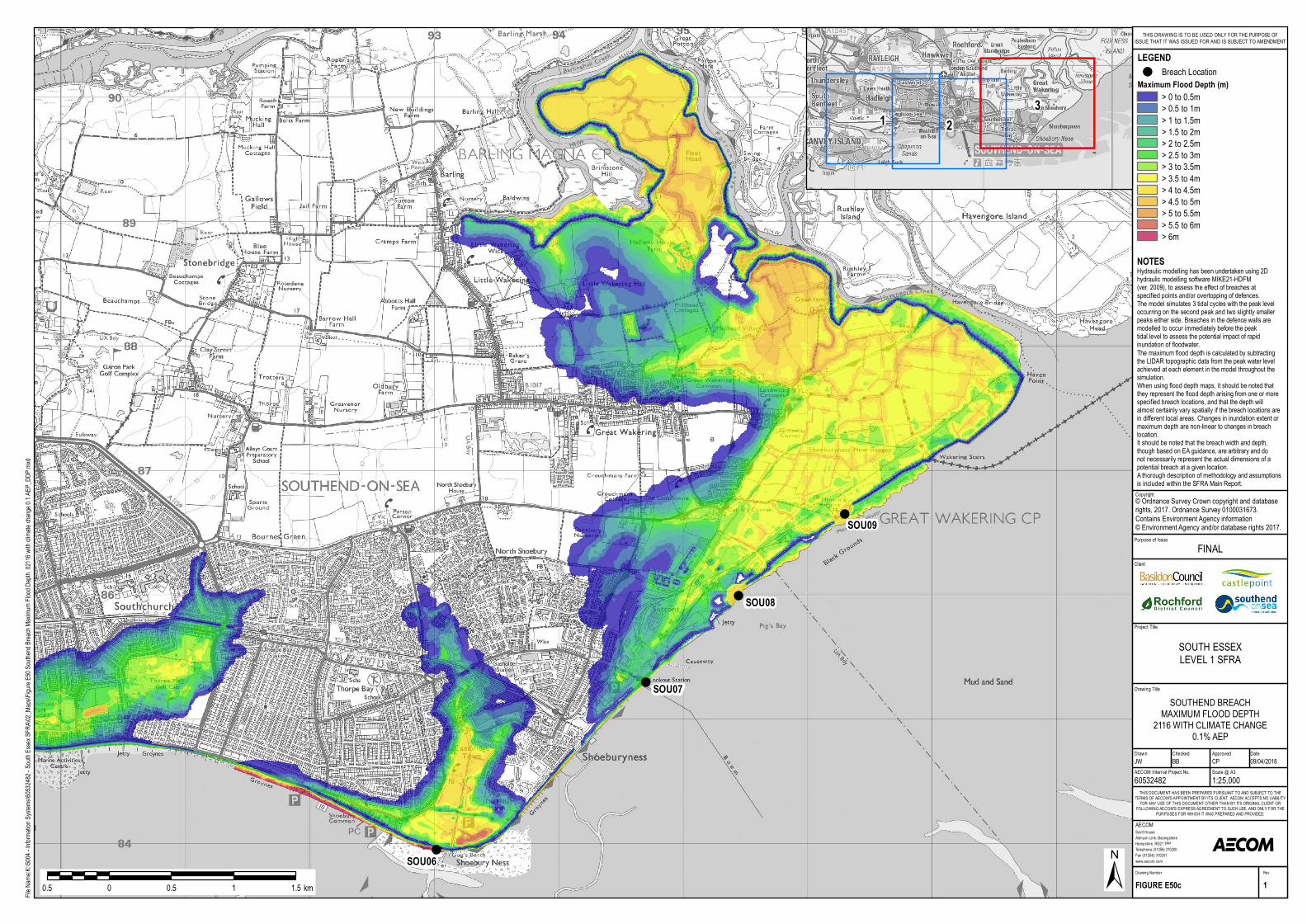
! ! ! ! SOU06 SOU07 SOU08 SOU09 Purpose of Issue Project Title Drawing Title Drawn Checked Scott House Alençon Link, Basingstoke Hampshire, RG21 7PP Telephone (01256) 310200 Fax (01256) 310201 www.aecom.com AECOM Date Approved Rev Drawing Number FIGURE E50c 1 THIS DOCUMENT HAS BEEN PREPARED PURSUANT TO AND SUBJECT TO THE TERMS OF AECOM'S APPOINTMENT BY ITS CLIENT. AECOM ACCEPTS NO LIABILITY FOR ANY USE OF THIS DOCUMENT OTHER THAN BY ITS ORIGINAL CLIENT OR FOLLOWING AECOM'S EXPRESS AGREEMENT TO SUCH USE, AND ONLY FOR THE PURPOSES FOR WHICH IT WAS PREPARED AND PROVIDED. AECOM Internal Project No. Scale @ A3 60532482 1:25,000 JW BB CP 09/04/2018 Client File Name:K:\5004 - Information Systems\60532482 - South Essex SFRA\02_Maps\Figure E50 Southend Breach Maximum Flood Depth 2116 with climate change 0.1 AEP_DDP.mxd ± 0.5 0 0.5 1 1.5 km LEGEND ! Breach Location Maximum Flood Depth (m) > 0 to 0.5m > 0.5 to 1m > 1 to 1.5m > 1.5 to 2m > 2 to 2.5m > 2.5 to 3m > 3 to 3.5m > 3.5 to 4m > 4 to 4.5m > 4.5 to 5m > 5 to 5.5m > 5.5 to 6m > 6m SOUTHEND BREACH MAXIMUM FLOOD DEPTH 2116 WITH CLIMATE CHANGE 0.1% AEP SOUTH ESSEX LEVEL 1 SFRA FINAL THIS DRAWING IS TO BE USED ONLY FOR THE PURPOSE OF ISSUE THAT IT WAS ISSUED FOR AND IS SUBJECT TO AMENDMENT Copyright © Ordnance Survey Crown copyright and database rights, 2017. Ordnance Survey 0100031673. Contains Environment Agency information © Environment Agency and/or database rights 2017. Hydraulic modelling has been undertaken using 2D hydraulic modelling software MIKE21-HDFM (ver. 2009), to assess the effect of breaches at specified points and/or overtopping of defences. The model simulates 3 tidal cycles with the peak level occurring on the second peak and two slightly smaller peaks either side. Breaches in the defence walls are modelled to occur immediately before the peak tidal level to assess the potential impact of rapid inundation of floodwater. The maximum flood depth is calculated by subtracting the LIDAR topographic data from the peak water level achieved at each element in the model throughout the simulation. When using flood depth maps, it should be noted that they represent the flood depth arising from one or more specified breach locations, and that the depth will almost certainly vary spatially if the breach locations are in different local areas. Changes in inundation extent or maximum depth are non-linear to changes in breach location. It should be noted that the breach width and depth, though based on EA guidance, are arbitrary and do not necessarily represent the actual dimensions of a potential breach at a given location. A thorough description of methodology and assumptions is included within the SFRA Main Report. NOTES 2 1 3

Welcome message from author
This document is posted to help you gain knowledge. Please leave a comment to let me know what you think about it! Share it to your friends and learn new things together.
Transcript
!
!
!
!
SOU06
SOU07
SOU08
SOU09P urpose of Issue
P roject Title
Drawing Title
Drawn Checked
S cott HouseAlençon Link, BasingstokeHam pshire, R G21 7P PTelephone (01256) 310200Fax (01256) 310201www.aecom.com
AECOM
DateApproved
R evDrawing Num ber
FIGURE E50c 1
THIS DOCUMENT HAS BEEN P R EP AR ED P UR S UANT TO AND S UBJECT TO THETER MS OF AECOM'S AP P OINTMENT BY ITS CLIENT. AECOM ACCEP TS NO LIABILITYFOR ANY US E OF THIS DOCUMENT OTHER THAN BY ITS OR IGINAL CLIENT ORFOLLOW ING AECOM'S EX P R ES S AGR EEMENT TO S UCH US E, AND ONLY FOR THE
P UR P OS ES FOR W HICH IT W AS P R EP AR ED AND P R OV IDED.
AECOM Internal P roject No. S cale @ A360532482 1:25,000JW BB CP 09/04/2018
Client
File Name:K:\5004 - Information Systems\60532482 - South Essex SFRA\02_Maps\Figure E50 Southend Breach Maximum Flood Depth – 2116 with climate change 0.1 AEP_DDP.mxd
±0.5 0 0.5 1 1.5km
LEGEND! Breach Location
Maximum Flood Depth (m)> 0 to 0.5m> 0.5 to 1m> 1 to 1.5m> 1.5 to 2m> 2 to 2.5m> 2.5 to 3m> 3 to 3.5m> 3.5 to 4m> 4 to 4.5m> 4.5 to 5m> 5 to 5.5m> 5.5 to 6m> 6m
S OUTHEND BR EACHMAX IMUM FLOOD DEP TH2116 W ITH CLIMATE CHANGE
0.1% AEP
S OUTH ES S EXLEV EL 1 S FR A
FINAL
THIS DR AW ING IS TO BE US ED ONLY FOR THE P UR P OS E OFIS S UE THAT IT W AS IS S UED FOR AND IS S UBJECT TO AMENDMENT
Copy right© Ordnance S urvey Crown copy right and databaserights, 2017. Ordnance S urvey 0100031673. Contains Environm ent Agency inform ation © Environm ent Agency and/or database rights 2017.
Hy draulic m odelling has been undertaken using 2Dhy draulic modelling software MIKE21-HDFM(ver. 2009), to assess the effect of breaches atspecified points and/or overtopping of defences.The model sim ulates 3 tidal cy cles with the peak leveloccurring on the second peak and two slightly sm allerpeaks either side. Breaches in the defence walls aremodelled to occur im m ediately before the peaktidal level to assess the potential im pact of rapidinundation of floodwater.The m axim um flood depth is calculated by subtractingthe LIDAR topographic data from the peak water levelachieved at each elem ent in the model throughout thesim ulation.W hen using flood depth m aps, it should be noted thatthey represent the flood depth arising from one or morespecified breach locations, and that the depth willalmost certainly vary spatially if the breach locations arein different local areas. Changes in inundation extent orm axim um depth are non-linear to changes in breachlocation.It should be noted that the breach width and depth,though based on EA guidance, are arbitrary and donot necessarily represent the actual dim ensions of apotential breach at a given location.A thorough description of m ethodology and assum ptionsis included within the S FR A Main R eport.
NOTES
213
Related Documents