7000 FEET 1000 1000 0 2000 3000 4000 5000 6000 .5 1 KILOMETER 1 0 SCALE 1:24 000 1/2 1 0 1 MILE MAGNETIC NORTH APPROXIMATE MEAN DECLINATION, 1998 TRUE NORTH LOCATION IN NEW JERSEY 13.5 O Geology mapped 2002-2003 Cartography by S. Stanford and M. Girard 74 o 15' 40 o 45' 17'30 ROSELLE 20' 74 o 22'30" 40 o 15' 47'30" MORRISTOWN 50' 40 o 52'30" 74 o 22'30" 20' POMPTON PLAINS 17'30" 74 o 15' 40 o 52'30" 50' ORANGE 47'30" Base map from U. S. Geological Survey, 1954 Photorevised 1981 CONTOUR INTERVAL 20 FEET NATIONAL GEODETIC VERTICAL DATUM OF 1929 E' A' B' C' D' E D B C Rockaway River Whippany River Passaic River HOOK MT. TW TW TW TW TW M3 M3 MH RIKER HILL M2 Passaic River MH SHORT HILLS GAP MILLBURN GAP MH M1 SM M2 SECOND WATCHUNG MT. FIRST WATCHUNG MT. Blue Brook Spillway 0 1 2 miles East Branch Plain CALDWELL QUADRANGLE SM SM SM West Branch Plain FIRST WATCHUNG MOUNTAIN SECOND WATCHUNG MOUNTAIN Canoe Brook Delta VE VE Caldwell Delta M3 MH MH M2 M1 pre-Illinoian fluvial valley Illinoian glacial overdeepening late Wisconsinan glacial overdeepening Chatham-stage and Illinoian deposits in subsurface gaps in Watchung Mountains late Wisconsinan recessional features: glacial lake, symbol on shoreline tunnel channel delta till ridge glaciofluvial plain glaciofluvial channel glacial-lake spillway ice margin, symbol on former glacier Figure 1.--Geomorphic and glacial features in the Caldwell quadrangle and vicinity. Abbreviations on glacial-lake shorelines are: MH=Moggy Hollow stage of Lake Passaic, TW=Totowa stage of Lake Passaic, VE=Lake Verona, SM=South Mountain lake. Ice margins are: M1=southernmost late Wisconsinan ice margin, M2=last ice margin before draining of South Mountain lake, M3=ice margin during deposition of Caldwell delta. SM aft Qal Qs Qaf Qta Qpg Qst Qic Qrw Qeb Qsm Qve Qpmf Qpmd Qpml Qr Qry Qtmr Qpc Qpcl Qsp Qisl Qis Qb Holocene late Wisconsinan Illinoian Pleistocene CORRELATION OF MAP UNITS Qrt Qryt 600 500 400 300 200 100 ELEVATION (feet) A Qst Qal Qst Qal Qpml Qr Qpc Qr Bedrock Qryt 0 VERTICAL EXAGGERATION 20X ROCKAWAY RIVER CHANGE BRIDGE ROAD HOOK MOUNTAIN ROAD SECTION EE' INTERSTATE ROUTE 80 1 3 5 6 76 Qry Qr Qpml Qst Qal 465 470 466 76 75 Qal Qr PASSAIC RIVER DEEPAVAL BROOK PASSAIC AVENUE BEND IN SECTION 74 56 64 85 81 104 101 100 Qst Qpml Qr Qpmf Bedrock Qs Qr Qpmf Qpml 105 107 136 133 134 135 BLOOMFIELD AVENUE BLOOMFIELD AVENUE BEND IN SECTION 472 Qpmd Qic Qry Qry Qry Qve Bedrock 158 159 600 500 400 300 200 100 0 A' Qs Qryt 600 500 400 300 200 100 0 VERTICAL EXAGGERATION 20X ELEVATION (feet) Qpmf Qal 258 249 251 252 253 469 254 257 255 256 Qpmf Qr Qr Qpmf Qpc Qis Qb Qpc Qb Bedrock Qs 318 317 320 319 321 Qr Qpc Qpcl Qis Qb Qal SECTION EE' 206 205 Qst WHIPPANY RIVER RIDGEDALE AVENUE HANOVER NECK ROAD PASSAIC RIVER Qal Qr Bedrock 192 190 191 Qr Qpc Qb 188 187 179 178 177 Qpmf Qpml INTERSTATE ROUTE 280 SWAMP ROAD HARRISON AVENUE HARRISON AVENUE BEND IN SECTION Qal Qic 173 175 BEND IN SECTION 176 Qal Qry Bedrock CANOE BROOK Qry Qr Qrw Qsp Qr 433 432 PLEASANT VALLEY WAY 600 500 400 300 200 100 0 B' B Qal Qryt Qpml 600 500 400 300 200 100 0 ELEVATION (feet) VERTICAL EXAGGERATION 20X D SECTION EE' BEND IN SECTION PASSAIC RIVER 363 365 364 367 368 369 370 371 376 377 378 Qpmf Qr Qpcl Qis Qb Qal Qpml Qr Qpc Qis Qb Qal Qpml Qr Qpcl Qis Qpc PASSAIC RIVER PASSAIC RIVER PASSAIC RIVER PASSAIC RIVER CANOE BROOK RESERVOIR Qb 380 385 Qr Qpc Qpcl Qis Qb Bedrock 392 396 397 Qal Qr Qpc Qis PARSONAGE HILL ROAD CANOE BROOK SOUTH ORANGE AVENUE Qpcl 409 411 410 Qr 453 Qr Bedrock Qal BEND IN SECTION OLD SHORT HILLS ROAD WEST BRANCH RAHWAY RIVER Qryt Qr Qr Qal Qst Qrw (Qal) (Qal) Qryt Qsm 600 500 400 300 200 100 0 D' 300 200 100 0 ELEVATION (feet) SECTION DD' 366 365 364 Qal Qpml Qpmf Qr Qpc Qpcl Qis Qry Qr Qpcl Qis Qal Qpmf Qpml Qr Qpcl Qis Bedrock VERTICAL EXAGGERATION 20X SOUTH ORANGE AVENUE BEND IN SECTION HOBART GAP ROAD E 352 Qpml 351 347 345 421 Qr Qpc Qpcl Qisl Qb Qb Qis Qpml Qr Qpc Qpcl Qs Qpml Qr Qpcl Qisl 342 339 SECTION CC' NJ ROUTE 10 PASSAIC RIVER Qal Qst 341 68 334 332 327 Qal Qpmf Qb Qr Qal Qpc Qpcl Qis Qis Qb Qis Qb Qpmf Qr Qr Qpmf Bedrock 309 310 305 317 324 318 319 320 328 322 323 325 326 220 221 42 41 36 Qst Qs SECTION BB' HANOVER NECK ROAD RIDGEDALE AVENUE BEND IN SECTION INTERSTATE ROUTE 280 WHIPPANY RIVER Qal Qpml Qr Qst Qpml Qpmf Qr Qst Qpml Qr Qal 34 35 15 29 28 466 470 467 ROCKAWAY RIVER SECTION AA' PASSAIC RIVER 300 200 100 0 E' aft Qal Qaf Qst Qs Qta Qpmd Qpmf Qpml Qpg Qpc Qpcl Qve Qsm Qsp Qic Qis Qisl Qrw Qeb Qr Qrt Qtmr Qry Qryt Qb Qve 47 470 180 106 80 83 125 Qpc 50 r 47 (Qal) C C' 600 500 400 300 200 100 0 ELEVATION (feet) VERTICAL EXAGGERATION 20X 283 Qpml Qpmf Qr Qpc 284 285 288 291 338 Qst Qal Qpml Qr Qpc Qis HANOVER ROAD PASSAIC RIVER Qpc Qr Qpcl Qisl Qb Qpml Qis Qb Qpc Qry Qry SECTION EE' BEND IN SECTION WALNUT STREET NORTHFIELD AVENUE 339 342 345 421 349 348 Bedrock Qr 420 419 418 417 416 55 430 BEND IN SECTION LIVINGSTON AVENUE CANOE BROOK Qpmf Qry Qry Qal Qal 474 Bedrock Qry Qal Qrt Qr Qic Qal Qrw BEAR BROOK PLEASANT VALLEY WAY WEST BRANCH RAHWAY RIVER Bedrock Qrt 444 457 458 456 Qr Qeb 600 500 400 300 200 100 0 Qryt Qryt SURFICIAL GEOLOGY OF THE CALDWELL QUADRANGLE ESSEX AND MORRIS COUNTIES, NEW JERSEY by Scott D. Stanford 2005 SURFICIAL GEOLOGY OF THE CALDWELL QUADRANGLE ESSEX AND MORRIS COUNTIES, NEW JERSEY OPEN FILE MAP OFM 66 Pamphlet containing table 1 accompanies map Prepared in cooperation with the U. S. GEOLOGICAL SURVEY NATIONAL GEOLOGIC MAPPING PROGRAM DEPARTMENT OF ENVIRONMENTAL PROTECTION LAND USE MANAGEMENT NEW JERSEY GEOLOGICAL SURVEY INTRODUCTION Surficial deposits in the Caldwell quadrangle include artificial fill, alluvial, alluvial-fan, swamp, talus, and stream-terrace deposits, all of postglacial age; glaciolacustrine and glaciofluvial deposits of late Wisconsinan and Illinoian age; and till of late Wisconsinan and Illinoian age. Postglacial deposits are generally less than 30 feet thick. Glaciofluvial sand and gravel deposits are generally less than 25 feet thick. The glaciolacustrine deposits include stratified sand, gravel, silt, and clay and are as much as 200 feet thick. Till is as much as 110 feet thick. The accompanying map and sections show the surface extent and subsurface relations of these deposits. The composition and thickness of the deposits, and the glacial and postglacial events they record, are described in the Description of Map Units. Well and boring data used to construct bedrock-surface-elevation contours and to infer the subsurface distribution of the deposits are provided in table 1 (in pamphlet). The chronologic relationships of the deposits are shown in the Correlation of Map Units. The glacial aquifers and the history of river drainage and glacial erosion in the quadrangle and adjacent areas are briefly described in the two sections below. GLACIAL AQUIFERS Surficial deposits in the quadrangle yield ground water to domestic, industrial, and public-supply wells in several areas and affect the movement of water and pollutants from the land surface into lakes, streams, and underlying bedrock and glacial aquifers. Yields and screened intervals for wells tapping glacial deposits are provided in table 1. In the Passaic River, Whippany River, and Canoe Brook valleys, in East Hanover, Livingston, Florham Park, and Millburn, about 20 public- supply wells, and numerous domestic wells in East Hanover, draw water from glaciolacustrine sand and gravel laid down either in front of advancing late Wisconsinan ice (unit Qpc) or during retreat of the Illinoian glacier (unit Qis), with yields of as much as 1670 gallons per minute. These glaciolacustrine sands occur in the subsurface only and are overlain by till (unit Qr) and, in places, glaciolacustrine silt and clay (units Qpcl, Qisl, and Qpml). These overlying sediments are less permeable than the sand and act as confining or semiconfining layers. When first drilled, some wells tapping the confined sands flowed at the surface, although pumpage has now reduced the piezometric surface significantly (Meisler, 1976; Hoffman and Quinlan, 1994). The buried lacustrine deposits are continuous within the yellow area shown in figure 1, although the Illinoian sediments are generally restricted to the buried pre-Illinoian fluvial valleys (fig. 1). The continuity of the confined sand beds, however, is interrupted where they thin, pinch out, or were eroded away and replaced by silt and clay (for example, between wells 351 and 341 on section EE’). The hydrology of this aquifer system is discussed in detail in Vermuele (1905), Thompson (1932), Vecchioli and others (1967), Nichols (1968), Meisler (1976), Hoffman and Quinlan (1994), and Hoffman and others (in review). In the Passaic River and Rockaway River valleys north of the yellow area in figure 1, the preadvance lacustrine deposits (units Qpc and Qis) were completely eroded during the late Wisconsinan advance. The water-producing beds in this area instead are glaciolacustrine sand and gravel laid down in lacustrine fans (unit Qpmf) and deltas (unit Qpmd) during the late Wisconsinan retreat. They are not as continuous as the aquifers to the south and are tapped by fewer wells. Most of the productive beds are fan deposits (Qpmf). Where the fans crop out, chiefly in a belt along the base of Second Watchung Mountain, they are unconfined. Elsewhere, they are confined or semi-confined by overlying lake-bottom silt and clay (unit Qpml). On and east of Second Watchung Mountain the glacial deposits generally are too thin, impermeable, or have insufficient saturated thickness, to be productive aquifers. A single public-supply well (well 455) taps unconfined glaciolacustrine sand and gravel of unit Qsm near Orange Reservoir in the valley of the West Branch of the Rahway River. Hydraulic conductivities of the surficial deposits may be estimated from statewide glacial aquifer-test data on file at the N. J. Geological Survey (Mennel and Canace, 2002) and published aquifer-test and laboratory data summarized by Stanford (2000). Sand and gravel deposits (units Qis, Qpc, Qpmf, Qpmd, Qsm, Qrw, Qeb, Qic, Qsp, Qve, and parts of Qal and Qst) are highly permeable, having estimated hydraulic conductivities that range from 10 1 to 10 3 feet per day (ft/d). Sandy till and silty sand till (parts of Qr and Qry) are also permeable, having estimated hydraulic conductivities from 10 -1 to 10 2 ft/d. Silt and clay lake-bottom deposits (parts of units Qpml, Qpcl, Qisl) are of low permeability, having estimated hydraulic conductivities of 10 -5 to 10 -3 ft/d. Fine sand and silt lake-bottom, alluvial, and wetland deposits (parts of units Qpml, Qpcl, Qisl, Qal, Qst, and Qs) and sandy silt till (Qb, parts of units Qr and Qry) are somewhat more permeable, having estimated hydraulic conductivities of 10 -3 to 10 -1 ft/d. Swamp deposits (Qs) and fill (af, aft) have variable hydraulic conductivities that depend on the clay and silt content of the material. Peat with little mineral soil, and fill composed of sand, cinders, gravel, demolition debris, slag, and trash, may be highly permeable. PREGLACIAL DRAINAGE AND GLACIAL EROSION The topography of the bedrock surface is contoured at an interval of 50 feet from water-well, test-boring, and geophysical-survey data, including data from Vermeule (1905), Thompson (1932), Nichols (1968), Canace and others (1993) and Hoffman and others (in review). Contours are shown where the bedrock-surface topography varies significantly from the land-surface topography. West of Second Watchung Mountain, and in the East Branch of the Rahway River valley in the southeast corner of the map, the rock surface is contoured at elevations of 200 feet and below. In the West Branch of the Rahway River valley between First and Second Watchung Mountains the rock surface is contoured at elevations of 300 feet and below. West of Second Watchung Mountain the rock surface defines a pre-Illinoian fluvial drainage system that has been significantly modified by glacial scour during both the Illinoian and late Wisconsinan advances. The fluvial system is part of a pre- Illinoian drainage network buried beneath Illinoian and late Wisconsinan glacial deposits in the central Passaic River basin (Nichols, 1968; Hoffman and Quinlan, 1994; Hoffman and others, in review). This drainage network formerly exited the basin through a notch within the Short Hills Gap in Second Watchung Mountain (fig. 1). This gap is now filled with Illinoian and late Wisconsinan glacial deposits (Stanford, 1991), and the postglacial drainage now exits the basin at Little Falls, where the rock surface is at an elevation of about 160 feet. The bedrock surface in the Short Hills notch is at an elevation of about 70 feet, based on geophysical and well data (Ghatge and Hall, 1991; Stanford, 1991). Thus, any rock surface below an elevation of 70-80 feet to the west of the Short Hills Gap has been overdeepened by glacial scour. The buried valley along the line of section EE', named the Millburn Valley by Nichols (1968), contains Illinoian till on its floor south of the Interstate 280 area and is deepened to an elevation as low as 20 feet, indicating as much as 50-60 feet of scour during the Illinoian glaciation. North of the Whippany River-Interstate 280 area, the rock surface is as low as 40 feet below sea level, Illinoian deposits are absent, and the rock is directly overlain by late Wisconsinan till. Here, the rock surface has been overdeepened at least 120 feet, chiefly during the late Wisconsinan advance, and no vestiges of the preglacial fluvial valley remain. Elsewhere in the quadrangle there is no evidence of significant scour. The rock surface beneath the lower Canoe Brook valley defines a tributary to the pre- Illinoian fluvial valley draining to the Short Hills notch, and is filled with Illinoian deposits. The southwesterly trend of the headwater reaches of Canoe Brook and Bear Brook on Second Watchung Mountain are relicts of this pre-Illinoian drainage pattern. Canoe Brook now defines a barbed pattern as it drains into the postglacial Passaic, reflecting the northward drainage rerouting due to closure of the Short Hills Gap. In the valley of the West Branch of the Rahway River, deposition of till and, south of Northfield Avenue, lacustrine sand and gravel of unit Qsm, caused the postglacial stream to shift slightly east of its preglacial alignment. The same eastward shift likely occurred in the Peckman River valley in the north end of this valley, based on rock-surface elevation in the adjacent Orange quadrangle (Stanford, 2001). DESCRIPTION OF MAP UNITS Postglacial Deposits--These include man-made fill, talus (Qta), stream deposits in fans (Qaf), terraces (Qst), and modern channels and floodplains (Qal), and wetland deposits in swamps (Qs). They were all deposited since retreat of the late Wisconsinan glacier about 18,000 yrs B. P. (years before present). ARTIFICIAL FILL--Artificially emplaced sand, gravel, silt, clay, and rock fragments, and man-made materials including cinders, ash, brick, concrete, wood, slag, asphalt, metal, glass, and trash. Color variable but generally dark brown, gray, or black. As much as 20 feet thick. Many small areas of fill are not mapped. Some areas of fill are inferred from the extent of swamps and alluvial deposits shown on Salisbury (1895) and on manuscript geologic and topographic maps (dated 1880-1900) on file at the N. J. Geological Survey. TRASH FILL--Trash mixed with and covered by sand, silt, clay, and gravel. As much as 60 feet thick. In solid-waste landfills. ALLUVIUM--Sand, silt, clay, pebble-to-cobble gravel; dark brown, brown, reddish-brown, gray; moderately to well sorted, stratified to massive. Contains variable amounts of organic matter, demolition debris, and trash. As much as 20 feet thick. Adjacent to unit Qst in Troy Meadows and Hatfield Swamp, alluvium is thin (1-3 feet) and is underlain by stream-terrace sand. ALLUVIAL FAN DEPOSITS--Pebble-to-cobble gravel, sand, minor silt; brown to yellowish-brown; moderately sorted, stratified. As much as 20 feet thick (estimated). STREAM TERRACE DEPOSITS--Fine-to-coarse sand, pebbly sand, pebble gravel, minor silt; brown, yellowish-brown, light gray; moderately to well sorted, stratified. As much as 40 feet thick in the Pine Brook area, generally less than 15 feet thick elsewhere. Forms terraces with surfaces 5-10 feet above the modern floodplain along the Passaic, Whippany, and Rockaway Rivers, and along the West Branch of the Rahway River in South Mountain Reservation. In the area of Pine Brook, Troy Meadows, and Hatfield Swamp, the stream terrace deposits form, in part, a shallow- water delta laid down in the Totowa stage of glacial Lake Passaic (see below) shortly after deglaciation. SWAMP AND MARSH DEPOSITS--Peat and organic silt, clay, and fine sand; black, dark brown, and gray. As much as 20 feet thick. TALUS--Angular chips, flagstones, and cobbles of basalt, with little or no matrix material. Forms apron at base of a cliff in South Mountain Reservation. As much as 10 feet thick (estimated). Many small talus deposits on the east slopes of Riker Hill, Hook Mountain, and the Watchung Mountains are not mapped. Glacial Deposits--These include till and stratified sediments. Till is a poorly sorted, nonstratified sediment containing gravel clasts and boulders, deposited directly from glacial ice (units Qr, Qry, Qb). The stratified sediments are generally well sorted. They include sand and gravel laid down by glacial meltwater in river plains (Qrw, Qeb) and in glacial-lake deltas and fans (Qis, Qpc, Qsp, Qpmf, Qpmd, Qsm, Qve). The stratified sediments also include silt, clay, and fine sand deposited on the bottoms of glacial lakes (Qisl, Qpcl, Qpml) and moderately to poorly sorted sand and gravel deposited in ice-walled basins and ponds (Qic). All of these deposits are of late Wisconsinan age except Qis, Qisl, and Qb, which are of probable Illinoian age. Illinoian deposits are preserved beneath late Wisconsinan deposits in the yellow area in figure 1, where they are inferred from drillers’ logs. They include till (Qb), which rests directly on the bedrock surface, and overlying sand and gravel (Qis) and silt, fine sand, and clay (Qisl). In the Short Hills Gap (fig. 1), water-well records indicate that Illinoian till fills the gap to an elevation of 150-200 feet (Stanford, 1991). Thus, during retreat of Illinoian ice, a lake filled the central Passaic basin to an elevation of about 150-200 feet. Units Qis and Qisl, which rise no higher than about 140 feet, are deltaic, lacustrine-fan, and lake-bottom sediments laid down in this lake. An alternate interpretation of these deposits is that the Short Hills notch was not filled with Illinoian deposits during the Illinoian retreat, or during the following interglacial period, or during the late Wisconsinan advance, permitting fluvial drainage through the notch at all three times (Stone and others, 2002). In this scenario, the stratified deposits above the Illinoian till and below the late Wisconsinan advance-stage lacustrine deposits (unit Qpc) are glaciofluvial and interglacial fluvial sediments (the Wharton alluvial deposits and Florham Park outwash deposits of Stone and others, 2002). However, the interbedding of sand and gravel with thick clay and silt in these deposits, and their range in elevation from 40 feet (30 feet below the rock floor of the notch) to 150 feet, favor a lacustrine depositional setting. Also, it is unlikely, given the well data in the Short Hills Gap, and the widespread distribution of Illinoian till in the subsurface west and north of the gap, that the notch was open. Thus, the “Wharton” and “Florham Park” deposits are not mapped here. The Illinoian deposits have not been dated in this region. Weathering characteristics, soil development on outcropping deposits, and correlation to tills in Long Island and southern New England, indicate that they predate the last interglacial period about 125,000 years ago (Stone and others, 2002), and likely were deposited during the late Illinoian glaciation about 150,000 years ago. Following retreat of Illinoian ice there was a long period of erosion until arrival of late Wisconsinan ice. The orientation of striations, distribution of till, and provenance of erratics in till, indicate that late Wisconsinan ice advanced toward the southwest across the Caldwell quadrangle. This ice was on the west side of an advancing lobe channeled between the Palisades Ridge to the east and the Highlands to the west (Salisbury, 1902; Stanford and Harper, 1991). The Watchung Mountains impeded ice flow, and ice to the west of First Watchung Mountain (hereafter referred to as the "Passaic lobe") did not advance as far to the south as ice to the east of First Watchung (hereafter referred to as the "Hackensack lobe"). Till was deposited discontinuously on the bedrock surface. It is thickest on the east- and northeast-facing slopes of the Watchung ridges and Riker Hill, which faced the advancing ice, and where it forms drumlins or contributes to the streamlined shape of bedrock ridges on the west slope of Second Watchung Mountain. It is also thick in the southern part of the quadrangle on and west of Second Watchung Mountain, in and adjacent to the terminal moraine. It is thin and patchy on the tops of the Watchung ridges. The late Wisconsinan till includes two varieties: a reddish-brown silty sand to sandy silt till (Rahway Till, Qr) derived from the local red sandstone bedrock, and a yellow to reddish-yellow sandy silt till (Rahway Till, yellow phase, Qry) derived from local basalt. The yellow till overlies red till in places west of First Watchung Mountain. The Passaic lobe advanced to a limit a few miles south of the southern edge of the quadrangle. The Hackensack lobe advanced about 15 miles farther south, to Perth Amboy. The ice front began to retreat from this position before 20,000 yrs B. P., and had likely retreated north of the Caldwell quadrangle by 18,000 yrs B. P. (Stanford and Harper, 1991). The retreating ice margin maintained the two-lobe form that it had during advance. Recessional ice margins are marked by ice-contact glaciolacustrine deposits and till ridges (fig. 1). The retreating ice margin dammed east- or north-draining valleys, including the central Passaic basin, to form the glacial lakes in which most of the recessional deposits were laid down. Glacial- stream deposits were laid down in two valleys after lakes drained. Details of the history of glacial lakes and glacial streams are provided in the following description of map units. Names of the lakes and lake stages (except for the Totowa stage of Lake Passaic) follow those of Stone and others (2002). Glacial-Lake Deposits--These are stratified and generally well-sorted. They include sand and gravel laid down in deltas and lacustrine fans; and clay, silt, and fine sand laid down on the lake floor and in the distal parts of deltas and margins of fans. Bedding in the deltas includes inclined foreset beds of sand, pebbly sand, and minor pebble-to-cobble gravel, overlain at the surface of some deltas by horizontal topset beds of sand and pebble-to-cobble gravel. Lacustrine fans contain gently dipping beds of sand and pebble-to-cobble gravel. Bedding in deltas and fans may be deformed locally by collapse, slumping, or shoving by glacial ice. Bedding in lake-bottom deposits is generally horizontal, laminated to thin-bedded, and undeformed. Nongravel sediment is yellowish-brown, light reddish-brown, and light gray. Sand consists chiefly of quartz, feldspar, mica, and fragments of gray and red-brown sandstone and mudstone, gray gneiss, and basalt. Gravel is chiefly white-to-gray gneiss, gray mudstone and sandstone, and reddish-brown mudstone and sandstone, with some white quartz, purple and gray quartzite, and basalt. GLACIAL LAKE PASSAIC DEPOSITS--Deltaic, lake-bottom, and lacustrine-fan deposits laid down in glacial Lake Passaic. Lake Passaic filled the central Passaic River basin between Second Watchung Mountain and the Highlands. It includes four stages: one advance-phase stage and three recessional stages. When the Hackensack lobe of the advancing late Wisconsinan glacier blocked Millburn Gap (fig. 1), the Chatham stage of Lake Passaic flooded the Passaic basin west of Second Watchung Mountain. This stage was controlled by a spillway at an elevation between 250-300 feet on a divide in the valley between First and Second mountains south of Millburn Gap. The exact elevation of this spillway is unknown because it has been buried by later deposits. This spillway drained down the Blue Brook valley ("Blue Brook spillway" in fig. 1). When Millburn Gap was blocked by the Hackensack lobe, the margin of the Passaic lobe was likely no farther south than the Pine Brook area. Chatham-stage deposits (Qpc, Qpcl) occur in the subsurface, beneath till and recessional lacustrine deposits, only south of this area. With continued advance, the Hackensack lobe moved across Blue Brook valley onto Second Watchung Mountain and blocked the Blue Brook spillway. At this time Lake Passaic rose to the Moggy Hollow stage. Deposition of the terminal moraine then filled the Short Hills Gap to an elevation of 375-380 feet, holding the lake at the Moggy Hollow stage during deglaciation. The Moggy Hollow stage (units Qpmf, Qpmd, Qpml) was controlled by a spillway at an elevation of 340 feet near Far Hills, 22 miles southwest of Caldwell. Elevation of the lake level at this stage in the Caldwell quadrangle was 370 to 390 feet. A lower lake level, the Great Notch stage (unit Qpg), was established when the retreating ice front uncovered Great Notch, a gap in First Watchung Mountain 5 miles northeast of Caldwell. The Great Notch spillway is at an elevation of about 305 feet, and the elevation of the lake level at this stage in the Caldwell quadrangle ranges from 295 to about 305 feet. The Great Notch stage lowered when the gap through First Watchung Mountain at Paterson was deglaciated. For a short time after this lowering, a lacustrine-fan deposit in Totowa, about 6 miles northeast of Caldwell, dammed the Passaic basin upstream of that point, holding in a short-lived lake (the Totowa stage) with a spillway at an initial elevation of about 190 feet. Erosion lowered this outlet and soon breached this dam. Deltaic deposits--Fine-to-coarse sand and pebble-to-cobble gravel; minor silt. As much as 100 feet thick. Includes two deltas (at Caldwell and along Canoe Brook, fig. 1) deposited in the Moggy Hollow stage of Lake Passaic. Lacustrine-fan deposits--Fine-to-coarse sand and pebble-to-cobble gravel; minor silt, very fine sand, and clay. As much as 110 feet thick. Deposited in the Moggy Hollow stage of Lake Passaic. Lake-bottom deposits--Silt, clay, fine sand. As much as 140 feet thick. Deposited chiefly during the Moggy Hollow stage. Uppermost parts may have been laid down in the Great Notch stage. In the area north of Interstate 280 and the Whippany River, the uppermost part of the deposit includes silt and fine sand laid down in the Totowa stage. Beach deposits--Fine-to-coarse sand and pebble-to-cobble gravel. As much as 10 feet thick. Formed by wave action reworking till along the shore of the Great Notch stage of Lake Passaic. One small deposit mapped in Livingston; others likely present but now obscured by urbanization. Deltaic and lacustrine-fan deposits-- Fine-to-coarse sand, pebble gravel, minor cobble gravel, silt, and clay. As much as 60 feet thick. Deposited in Chatham stage of Lake Passaic. In subsurface only. Contact with Qpcl is interfingered or gradational and is inferred from well records. Lake-bottom deposits--Silt, clay, fine sand. As much as 80 feet thick. Deposited in Chatham stage of Lake Passaic. Contact with Qpc is interfingered or gradational and is inferred from well records. GLACIAL LAKE VERONA DEPOSITS--Deltaic and lacustrine-fan deposits laid down in Lake Verona. This lake occupied the north-draining Peckman River valley and was controlled by a spillway at an elevation between 400-420 feet on the drainage divide at the head of the valley at Pleasantdale in West Orange. It lowered slightly to the Moggy Hollow stage of Lake Passaic when the north end of Second Watchung Mountain at Little Falls, just northeast of North Caldwell, was deglaciated, and then drained when the Moggy Hollow stage lowered to the Great Notch stage (see above). Fine-to-coarse sand, minor silt and pebble-to-cobble gravel. As much as 65 feet thick. SOUTH MOUNTAIN DEPOSIT--Deltaic and lacustrine-fan deposits laid down in an ice-dammed lake in the valley of the West Branch of the Rahway River. This lake formed when the Hackensack lobe retreated from the valley but continued to abut First Watchung Mountain south of Millburn (fig. 1). The spillway was at the point of abutment, at an elevation of about 340 feet. The lake drained when Millburn Gap was deglaciated. Fine-to-coarse sand, pebble-to-cobble gravel. As much as 120 feet thick. PRE-ADVANCE STRATIFIED DEPOSITS--Deltaic and lacustrine-fan sand and gravel. In subsurface only, beneath late Wisconsinan till. Laid down in small proglacial ponds that were dammed and then overrun by the advancing ice. Exposed in streambanks along Cub Brook and Bear Brook; elsewhere inferred from water-well records. Fine-to-coarse sand, pebble-to-cobble gravel. As much as 20 feet thick. ICE-CONTACT DEPOSITS-- These form hummocky ridges and knolls above the level of adjacent lakes or fluvial plains. They may have been deposited in ice- walled basins, ponds, and channels, or by glacial pushing and deformation of previously deposited sediment. Pebble-to-cobble gravel and fine-to-coarse sand, locally sandy, cobbly diamicton; moderately sorted; variably stratified. As much as 100 feet thick. ILLINOIAN LACUSTRINE DEPOSITS--Deltaic, lacustrine-fan, and lake-bottom deposits laid down in a glacial lake occupying the central Passaic basin during Illinoian retreat. This lake was controlled by a spillway across Illinoian till in the Short Hills Gap at an elevation between 150-200 feet. This spillway is now buried beneath late Wisconsinan deposits. Depending on the elevation of the spillway, this lake drained either when the gaps through the Watchungs at Little Falls and Paterson were deglaciated or when the spillway was lowered by erosion such that the lake bottom became exposed. Deltaic and lacustrine-fan deposits--Fine-to-coarse sand, pebble gravel, minor cobble gravel, silt, and clay. As much as 60 feet thick. In subsurface only. Contact with Qisl is interfingered or gradational and is inferred from well records. Contact with Qpc or Qpcl is picked at first report of coarser sand and gravel beneath fine sand, silt, or clay. Lake-bottom deposits--Silt , clay, fine sand. As much as 50 feet thick. In subsurface only. Contact with overlying unit Qpcl is picked at reported color change to redder or more yellow color (indicating surface exposure and weathering), or at reported change to coarser grain size. Glacial Stream Deposits--These are stratified and generally well-sorted. They include sand and gravel forming plains and terraces in the East Branch and West Branch of the Rahway River valleys (fig. 1). The West Branch valley was exposed after the lake it contained drained when Millburn Gap was deglaciated. The East Branch valley in this area did not contain a glacial lake. Color and sand and gravel composition similar to that of glacial-lake deposits. WEST BRANCH DEPOSIT--Pebble-to-cobble gravel, fine-to-coarse sand. As much as 25 feet thick. EAST BRANCH DEPOSIT--Pebble gravel, some fine cobble gravel, fine- to-coarse sand. As much as 25 feet thick. Till--Poorly sorted, nonstratified sediment deposited directly by glacial ice or by sediment flows from glacial ice. Sediment is matrix-supported and is generally compact below the soil zone due to consolidation by the weight of overlying ice. The matrix may show a coarse subhorizontal platy structure. Three tills are distinguished on the basis of color, grain size, and age. The terminal moraine (Qtmr) is distinguished by surface morphology and is composed of Rahway Till. The late Wisconsinan tills are in gradational contact with each other. RAHWAY TILL--Reddish-brown, light reddish-brown, reddish-yellow silty sand to sandy silt (locally clayey silt in lowlands west of Second Watchung Mountain) containing some to many (2-15% by volume) subrounded and subangular pebbles and cobbles and few (<1%) subrounded boulders. Matrix is compact, nonsticky, nonplastic to slightly plastic, nonjointed, and may have subhorizontal fissility. Gravel clasts include chiefly red and gray sandstone and siltstone, gray gneiss, and a little white quartz, purple quartzite, and basalt. Boulders are chiefly gneiss and some basalt; a very few are quartzite and gray and red sandstone. As much as 80 feet thick. Unit Qrt delineates areas where Qr is discontinuous and generally less than 15 feet thick. Small, thin deposits of clay and silt of unit Qpml overlie Rahway Till on some low flat areas in lowlands west of Second Watchung Mountain. TILL OF THE TERMINAL MORAINE--Rahway Till, as in unit Qr, forming ridge-and-basin topography of the terminal moraine. As much as 120 feet thick. RAHWAY TILL, YELLOW PHASE--Reddish-yellow, yellow, gray, very pale brown silty sand, sandy silt, and silt with some to many (2-15% by volume) subangular and subrounded pebbles and cobbles and few to some (<1-5%) subrounded boulders. Matrix is compact, nonsticky to slightly sticky, slightly plastic, nonjointed, and may have subhorizontal fissility. Gravel clasts include chiefly gray (weathering reddish-yellow) basalt and gray gneiss, and some gray and red sandstone and siltstone and purple quartzite. Boulders are chiefly gneiss and basalt; a very few are quartzite and sandstone. As much as 110 feet thick in drumlins, generally less than 40 feet thick elsewhere. Unit Qryt delineates areas where Qry is discontinuous and generally less than 15 feet thick. On steep slopes Qryt includes thin rubbles of angular basalt cobbles and flagstones with little or no till cover. These rubbles were formed by both postglacial mechanical weathering and glacial deformation of finely jointed basalt. BERGEN TILL--Reddish-brown to reddish-yellow sandy clayey silt to sandy clay. Gravel content and composition similar to Rahway till. Matrix is compact, moderately sticky and plastic, and weakly jointed. Gneiss, sandstone, and mudstone clasts have weathering rinds or are fully decomposed. As much as 25 feet thick. In subsurface only, generally on bedrock surface in yellow area in figure 1. Exposed in steep slope on south side of till ridge near Cedar Ridge Country Club; elsewhere inferred from well records. MAP SYMBOLS Contact--Long-dashed where approximately located, short-dashed where gradational or featheredged, dotted where reconstructed to the base-map topography in excavated areas. Drumlin--Line along crest, symbol on summit. Striation--Observation at dot. Till ridge--Line on crest, barbs on gentle slope. Asymmetric ridges, 10 to 60 feet high, with gentle north slopes, composed of till. Formed along active recessional ice margins. Esker--Ridges of sand and gravel deposited in ice-walled channels or subglacial tunnels. Arrows show inferred flow direction of meltwater. Meltwater channel--Line in base of channel, arrow indicates flow direction. Scarp cut by postglacial streams --Line at top, ticks on slope. Excavation perimeter--Outlines quarries and former sand and gravel pits. Topography within these areas may differ from that on the base map. Former quarry Former sand and gravel pit Spillway for glacial lake--Symbol in spillway area, arrow indicates direction of drainage. Well with log in table 1--Location accurate within 100 feet. Well with log in table 1--Location accurate within 500 feet. Elevation of bedrock surface in well or boring--From Nichols (1968). Shown only where other data are sparse. Elevation of bedrock surface in well or boring--From Thompson (1932). Elevation of bedrock surface in well or boring--From N. J. Geological Survey files Elevation of bedrock surface from seismic survey--From Hoffman and others (in review). Elevation of bedrock surface from seismic survey--From Canace and others (1993). Subsurface unit exposed--Observed in 2002-2003. Elevation of bedrock surface--Contour interval 50 feet. Shown at and below bedrock-surface elevation of 200 feet to the west of Second Watchung Mountain and east of First Watchung Mountain, and below bedrock-surface elevation of 300 feet in the valley between First and Second Watchung Mountains. Bedrock outcrop--Many small outcrops on the Watchung Mountains, Riker Hill, and Hook Mountain, within units Qrt and Qryt, are not shown. Well on sections--Most wells are projected to line of section. In these cases, depths of contacts on the section may not exactly match those reported in well logs. Body of water--Shown where underlying surficial deposit is uncertain. Alluvial lag--Silt, sand, and clay alluvium interspersed with lags of cobbles and small boulders winnowed from underlying till or bedrock. Thermokarst basin--Line on rim, pattern within basin. Chiefly on stream-terrace sand, formed from melting of ground ice. REFERENCES Canace, Robert, Stanford, S. D., Hall, D. W., 1993, Hydrogeologic framework of the middle and lower Rockaway River basin, Morris County, New Jersey: N.J. Geological Survey Geologic Report Series GSR 33, 68 p. Ghatge, S. L., and Hall, D. W., 1991, Bedrock topography map of the Millburn- Springfield area, Essex and Union counties, New Jersey: N. J. Geological Survey Geologic Map Series GMS 91-1, scale 1:24,000. Hoffman, J. L., Hall, D. W., Stanford, S. D., Ghatge, S. L., Stone, B. D., in review, Hydrogeology of the central Passaic River basin, New Jersey: N. J. Geological Survey Open-File Report. Hoffman, J. L., and Quinlan, John, 1994, Ground-water-withdrawal and water- level data for the central Passaic River basin, New Jersey, 1898-1990: N. J. Geological Survey Geologic Report Series GSR 34, 78 p. Meisler, Harold, 1976, Computer simulation model of the Pleistocene valley-fill aquifer in southwestern Essex and southeastern Morris counties, New Jersey: U. S. Geological Survey Water Resources Investigations 76-25, 76 p. Mennel, W. J., and Canace, Robert, 2002, New Jersey Geological Survey hydro database: N. J. Geological Survey Digital Geodata Series DGS 02-1, www.state.nj.us/dep/njgs/geodata/dgs02-1.zip Nichols, W. D., 1968, Bedrock topography of eastern Morris and western Essex counties, New Jersey: U. S. Geological Survey Miscellaneous Geologic Investigations Series Map I-549, scale 1:24,000. Salisbury, R. D., 1895, Surface geology, report of progress: N. J. Geological Survey Annual Report for 1894, p. 1-149 and 1:63,360 map. Salisbury, R. D., 1902, The glacial geology of New Jersey: N. J. Geological Survey Final Report v. 5, 802 p. Stanford, S. D., 1991, Surficial geology of the Roselle quadrangle, Union, Essex, and Morris counties, New Jersey: N. J. Geological Survey Open-File Map 8, scale 1:24,000. Stanford, S. D., 2000, Glacial aquifers of New Jersey, in Harper, D. P. and Goldstein, F. R., eds., Glacial geology of New Jersey: field guide and proceedings for the seventeenth annual meeting of the Geological Association of New Jersey: Trenton, N. J., Geological Association of New Jersey, p. IV-1- IV-21. Stanford, S. D., 2001, Surficial geology of the Orange quadrangle, Essex, Passaic, Hudson, and Bergen counties, New Jersey: N. J. Geological Survey Open-File Map 41, scale 1:24,000. Stanford, S. D., and Harper, D. P., 1991, Glacial lakes of the lower Passaic, Hackensack, and lower Hudson valleys, New Jersey and New York: Northeastern Geology, v. 13, no. 4, p. 271-286. Stone, B. D., Stanford, S. D., and Witte, R. W., 2002, Surficial geologic map of northern New Jersey: U. S. Geological Survey Miscellaneous Investigations Map I-2540-C, scale 1:100,000. Thompson, D. G., 1932, Ground-water supplies of the Passaic River valley near Chatham, New Jersey: N. J. Department of Conservation and Development Bulletin 38, 51 p. Vecchioli, John, Nichols, W. D., Nemickas, Bronius, 1967, Results of the second phase of the drought disaster test-drilling program near Morristown, New Jersey: N. J. Department of Conservation and Economic Development, Water Resources Circular 17, 23 p. Vermeule, C. C., 1905, East Orange wells at White Oak Ridge, Essex County: N. J. Geological Survey Annual Report for 1904, p. 255-263. 80 <70 55 25 120 120 145 115 100 100 120 132 85 95 90 10 125 130 140 34 75 110 120 108 100 <40 63 57 90 <31 90 65 40 38 46 50 55 84 101 141 285 197 306 203 224 186 180 106 77 84 137 152 141 125 127 141 113 101 35 45 60 106 120 119 77 125 -20 22 83 110 90 25 70 70 116 115 105 180 Qpc 80 <140 Qpml Qst Qal Qpml Qst Qpml Qr Qryt Qpml Qr r Qry r 1 2 3 4 5 6 7 8 9 Qs 24 25 23 18 19 20 21 471 10 39 40 Qst 12 11 56 46 47 30 29 28 Qst 465 32 27 26 Qal 467 466 470 Qal 76 75 80 79 77 78 Qst 51 49 50 73 74 56 54 52 85 81 Qpmf Qpmf 47 48 53 44 45 46 71 72 69 70 344 64 66 65 61 67 57 58 60 59 62 82 83 84 90 97 91 89 86 87 88 98 103 99 102 104 101 100 Qst Qs Qs Qst 63 Qst Qpmf 110 111 114 112 113 115 Qaf Qal Qpmf Qpmf Qal 116 117 118 119 120 122 121 123 124 r Qry Qry r r Qryt Qry Qal r Qryt 127 128 126 125 Qpmf r 130 Qs Qryt Qry Qs r Qry Qpmf (Qal) 131 133 134 135 132 106 105 107 108 Qpmd 472 Qry Qpml Qpmf 136 137 138 144 Qpml Qal 139 143 145 140 142 Qs Qr Qr 141 Qr Qst Qst Qst 95 96 92 94 93 Qst Qst Qst Qst Qal Qal Qst 14 15 33 13 34 35 Qal 36 37 38 41 22 Qst Qpml Qpml Qs Qs 43 Qst Qs Qs Qst Qst Qst Qal Qs Qst Qs Qpml Qst Qal Qst Qs Qpml 228 227 225 224 226 241 240 330 239 238 243 242 244 245 246 247 329 248 229 234 235 233 232 230 231 325 223 326 220 221 222 236 237 323 322 328 Qpmf 209 210 211 212 214 215 218 216 217 219 213 Qpmf Qr Qst Qpml Qst Qst Qst Qst Qst Qst Qal Qst Qpml Qst Qst 205 206 192 Qs 189 191 190 188 186 187 aft Qr Qr Qr Qal 150 149 146 147 148 Qst Qpml Qst Qal 151 182 183 185 184 180 179 Qpmf 152 153 181 Qpmf Qpmd Qpmd Qry Qic r r r Qic 158 159 155 154 156 157 Qry 162 r r r Qryt 160 Qve Qry Qry Qal Qic r Qryt Qve 163 164 Qs Qve Qsp 161 Qve r Qry Qryt 165 166 167 168 Qry 172 171 169 Qry 173 Qry 177 Qal (Qal) 175 170 176 476 193 178 Qpmf 428 Qal 194 Qr Qpmf 195 196 204 203 202 197 198 199 201 Qpmf Qr Qst 208 207 r 316 315 314 Qr 321 319 317 320 318 324 255 257 256 254 Qs Qpml 469 253 252 251 250 249 258 Qpmf Qal 259 260 261 Qpml 468 Qr Qpml 264 263 262 266 265 267 268 282 281 280 Qpml 269 270 271 272 278 279 Qpmf 300 299 298 295 296 297 290 289 276 273 274 277 275 292 293 Qpmf Qst Qpml 301 302 303 304 307 306 308 305 309 310 311 312 313 Qpmf Qpml Qal Qst Qst Qal Qal 327 331 332 333 334 68 346 335 Qst Qr Qr Qpml Qal Qpmf Qry r r Qryt aft Qry 424 200 Qpml 427 Qal Qpmf 68 425 423 426 Qpmd Qry r 174 429 Qry r r r Qryt Qs Qr Qrw 433 432 431 Qry Qal r Qal r Qr Qve 434 (Qal) r r r Qs r r Qrw Qr 435 437 Qrt 436 Qryt r Qal Qr r Qaf (Qal) Qal 474 r r r Qry Qal Qry Qry 430 55 416 417 418 419 420 422 Qpmf Qry r r r Qr Qryt Qr 348 Qs 341 340 Qpml Qry 337 338 339 342 421 345 349 Qpml Qal Qal 347 Qpml 343 291 287 286 288 285 284 Qpml Qal Qst Qr Qpmf Qr Qpmf Qpmf Qpml Qr Qpml Qst 283 Qpmf Qal Qpml Qpmf Qpmf Qr 355 356 Qr Qpmf 357 Qr Qr Qal Qpml Qpml 351 352 Qpmf Qry Qry Qpmf 353 Qryt Qr 414 406 Qs Qpml Qpml Qpmf Qs Qpmf Qry Qry Qpg Qryt r Qry aft r (Qal) r Qr Qryt Qrt (Qal) 413 Qr Qr r Qryt Qal Qsp Qrt Qic Qr Qr 412 450 473 Qrt Qsp 443 Qrw Qal Qrw r (Qal) 442 Qrt 438 439 r 444 440 Qrt r 441 r Qr 456 457 458 459 r Qrt Qr Qeb Qeb Qeb Qrt r 446 445 460 Qr Qr Qaf r 447 Qal Qrw Qrw (Qal) Qryt r (Qal) Qry Qsm 448 455 r Qsm Qst Qsm (Qal) Qrw Qal Qst Qta r Qryt Qryt r 449 475 Qr 453 452 454 r 454 Qr Qr Qtmr Qr Qaf Qaf 408 407 Qal Qpml Qal 404 403 402 401 397 410 411 409 Qr 398 Qr 400 405 391 392 393 389 388 387 380 385 399 Qr Qal Qr Qr 390 379 358 Qpc Qr Qry Qpmf Qpmf Qpmf Qry Qal Qal Qs Qpmf 359 360 361 362 363 364 365 366 367 368 369 370 371 Qal 373 372 374 Qr Qpml Qpmf 377 376 378 Qal 381 384 382 383 386 394 396 395 Qpmf Qry Qry Qryt Qsm Qst r Qr r Qryt Qrt Qr r Qeb 462 463 Qr 464 aft aft aft aft aft 42 31 336 294 Qst Qb 354 461 375 415 Qic 129 100 100 150 200 200 150 100 50 0 50 0 0 0 50 100 150 200 200 150 100 50 100 50 50 100 100 100 100 100 50 150 150 150 200 150 200 200 150 100 50 50 100 100 150 150 100 100 150 200 100 50 100 150 200 50 50 100 50 100 100 50 50 100 100 100 150 200 100 150 200 150 200 300 250 200 200 250 300 300 250 250 300 300 300 200 150 150 200 A Qic 36 109 100 211

Welcome message from author
This document is posted to help you gain knowledge. Please leave a comment to let me know what you think about it! Share it to your friends and learn new things together.
Transcript

7000 FEET1000 10000 2000 3000 4000 5000 6000
.5 1 KILOMETER1 0
SCALE 1:24 0001/ 21 0 1 MILE
MA
GN
ET
IC N
OR
TH
APPROXIMATE MEANDECLINATION, 1998
TR
UE
NO
RT
H
�
LOCATION IN NEW JERSEY
13.5O
Geology mapped 2002-2003Cartography by S. Stanford and M. Girard
74o15'40o45'
17'30ROSELLE20'74o22'30"40o15'
47'30"
MO
RR
ISTO
WN
50'
40o52'30"74o22'30" 20' POMPTON PLAINS 17'30" 74o15'
40o52'30"
50'
OR
AN
GE
47'30"
Base map from U. S. Geological Survey, 1954Photorevised 1981
CONTOUR INTERVAL 20 FEETNATIONAL GEODETIC VERTICAL DATUM OF 1929
E'
A'
B'
C'
D'
E
D
B
C
Rockaway
River
Whip
pany
River
PassaicRiver
HO
OK
MT.TW TW
TW
TW
TWM3
M3
MH
RIK
ER
H
ILL
M2
Pas
saic
River
MH
SHORTHILLS
GAP
MILLBURN G
AP
MH
M1 SM
M2SECO
ND
WAT
CHUNGM
T.
FIRST
WAT
CHUNGM
T.
BlueBrookSpillway 0 1 2
miles
East
Bran
chP
lain
CALDWELLQUADRANGLE
SM
SMSM
Wes
t Bra
nch
Pla
in
FIR
ST
WAT
CH
UN
G
MO
UN
TAIN
SE
CO
ND
WAT
CH
UN
G
MO
UN
TAIN
CanoeBrookDelta
VE
VE
CaldwellDelta
M3
MH
MH
M2
M1
pre-Illinoianfluvial valley
Illinoian glacialoverdeepening
late Wisconsinanglacial overdeepening
Chatham-stage andIllinoian depositsin subsurface
gaps in WatchungMountains
late Wisconsinan recessional features:
glacial lake, symbolon shoreline
tunnel channel
delta
till ridge
glaciofluvialplain
glaciofluvialchannel
glacial-lakespillway
ice margin, symbolon former glacier
Figure 1.--Geomorphic and glacial features in the Caldwell quadrangle and vicinity. Abbreviations on glacial-lake shorelines are: MH=Moggy Hollow stage of Lake Passaic, TW=Totowa stage of Lake Passaic, VE=Lake Verona, SM=South Mountain lake. Ice margins are: M1=southernmost late Wisconsinan ice margin, M2=last ice margin before draining of South Mountain lake, M3=ice margin during deposition of Caldwell delta.
SM
aftQal Qs
Qaf Qta
Qpg
Qst
Qic
Qrw Qeb
Qsm
Qve
QpmfQpmd Qpml
Qr Qry
Qtmr
QpcQpclQsp
Qisl Qis Qb
Holocene
lateWisconsinan
Illinoian
Pleistocene
CORRELATION OF MAP UNITS
Qrt Qryt
600
500
400
300
200
100
EL
EVA
TIO
N (
feet
)
A
Qst Qal
Qst
Qal
Qpml
Qr
Qpc
Qr
Bedrock
Qryt
0
VERTICAL EXAGGERATION 20X
RO
CK
AW
AY
RIV
ER
CH
AN
GE
BR
IDG
E R
OA
D
HO
OK
MO
UN
TAIN
RO
AD
SE
CT
ION
EE
'IN
TE
RS
TAT
E R
OU
TE
80
1 3 5 6 76
Qry
Qr
Qpml
Qst
Qal
465
470
466
76 75
Qal
Qr
PAS
SA
IC R
IVE
R
DE
EPA
VAL
BR
OO
K
PAS
SA
IC A
VE
NU
E
BE
ND
INS
EC
TIO
N
74 56 64 85 81 104
101
100
Qst
Qpml Qr
Qpmf
Bedrock
Qs
Qr
Qpmf
Qpml
105
107
136
133
134
135
BL
OO
MF
IEL
D A
VE
NU
E
BL
OO
MF
IEL
D A
VE
NU
E
BE
ND
INS
EC
TIO
N
472
QpmdQic
Qry
Qry Qry
Qve
Bedrock
158
159
600
500
400
300
200
100
0
A'
Qs
Qryt600
500
400
300
200
100
0VERTICAL EXAGGERATION 20X
EL
EVA
TIO
N (
feet
)
Qpmf
Qal258 24
9 251
252
253
469
254
257 25
525
6
Qpmf
QrQr
Qpmf
Qpc
Qis
Qb
Qpc
Qb
Bedrock
Qs
318
317
320
319
321
Qr
Qpc
Qpcl
Qis
Qb
Qal
SE
CT
ION
EE
'
206
205
Qst
WH
IPPA
NY
RIV
ER
RID
GE
DA
LE
AV
EN
UE
HA
NO
VE
R N
EC
K R
OA
D
PAS
SA
IC R
IVE
R
Qal
Qr
Bedrock
192
190
191
Qr
Qpc
Qb
188 18
7
179 17
8
177
QpmfQpml
INT
ER
STA
TE
RO
UT
E 2
80
SW
AM
P R
OA
D
HA
RR
ISO
N A
VE
NU
E
HA
RR
ISO
N A
VE
NU
E
BE
ND
IN
SE
CT
ION
Qal
Qic
173
175
BE
ND
INS
EC
TIO
N
176
�Qal
Qry
Bedrock
CA
NO
E B
RO
OK
Qry
Qr Qrw
Qsp
Qr
433
432
PL
EA
SA
NT
VA
LL
EY
WA
Y
600
500
400
300
200
100
0
B'B
Qal
Qryt
Qpml
600
500
400
300
200
100
0
EL
EVA
TIO
N (
feet
)
VERTICAL EXAGGERATION 20X
D
SE
CT
ION
EE
'
BE
ND
INS
EC
TIO
N
PAS
SA
IC R
IVE
R36
3
365
364
367
368
369
370
371
376
377
378
Qpmf
Qr
QpclQis
Qb
QalQpml
Qr
Qpc
Qis
Qb
QalQpml
Qr
Qpcl
Qis
Qpc
PAS
SA
IC R
IVE
R
PAS
SA
IC R
IVE
R
PAS
SA
IC R
IVE
R
PAS
SA
IC R
IVE
R
CA
NO
E B
RO
OK
RE
SE
RV
OIR
Qb
380 38
5
Qr
QpcQpcl
Qis
Qb
Bedrock
392
396
397
Qal
Qr
Qpc
Qis
PAR
SO
NA
GE
HIL
L R
OA
D
CA
NO
E B
RO
OK
SO
UT
H O
RA
NG
E A
VE
NU
E
Qpcl
409 41
141
0
Qr
453
Qr
Bedrock
Qal
BE
ND
INS
EC
TIO
N
OL
D S
HO
RT
HIL
LS
RO
AD
WE
ST
BR
AN
CH
RA
HW
AY
RIV
ER
Qryt
Qr
Qr
QalQst
Qrw
(Qal)
(Qal)
Qryt
Qsm
600
500
400
300
200
100
0
D'
300
200
100 0
ELEVATION (feet)
SECTION DD'
366
365364
Qal
Qp
ml
Qp
mf
Qr
Qp
c
Qp
cl
Qis
Qry
Qr
Qp
cl
Qis
Qal
Qp
mf
Qp
ml
Qr
Qp
cl
Qis
Bed
rock
VE
RT
ICA
L E
XA
GG
ER
AT
ION
20X
SOUTH ORANGE AVENUE
BEND INSECTION
HOBART GAP ROAD
E
352Qp
ml
351
347
345
421
Qr
Qp
c
Qp
cl
Qis
l
Qb
Qb
Qis
Qp
ml
Qr
Qp
c
Qp
cl
Qs
Qp
ml
Qr Q
pcl
Qis
l
342339
SECTION CC'
NJ ROUTE 10
PASSAIC RIVER
Qal
Qst
341
68
334
332
327
Qal
Qp
mf
Qb
Qr
Qal
Qp
c
Qp
clQ
isQ
is
Qb
Qis
Qb
Qp
mf
Qr
Qr
Qp
mf
Bed
rock
309310
305
317324318319320
328322
323
325
326220
221
4241
36
Qst
Qs
SECTION BB'
HANOVER NECK ROAD
RIDGEDALE AVENUE
BEND INSECTION
INTERSTATE ROUTE 280
WHIPPANY RIVER
Qal Q
pm
l Qr
Qst
Qp
ml
Qp
mf
Qr
Qst
Qp
ml
Qr
Qal
3435
15
2928
466
470
467
ROCKAWAY RIVER
SECTION AA'
PASSAIC RIVER
300
200
100
0
E'
aft
Qal
Qaf
Qst
Qs
Qta
Qpmd
Qpmf
Qpml
Qpg
Qpc
Qpcl
Qve
Qsm
Qsp
Qic
Qis
Qisl
Qrw
Qeb
Qr
Qrt
Qtmr
Qry
Qryt
Qb
Qve
47
470
180
106
80
83
125
Qpc
50
r
47
(Qal)
CC
'60
0
500
400
300
200
100 0
ELEVATION (feet)
VE
RT
ICA
L E
XA
GG
ER
AT
ION
20X
283 Qp
ml
Qp
mf
Qr
Qp
c
284
285
288
291
338
Qst
Qal
Qp
ml
Qr
Qp
c Qis
HANOVER ROAD
PASSAIC RIVER
Qp
c
Qr
Qp
cl
Qis
l
Qb
Qp
ml
Qis
QbQ
pc
Qry
Qry
SECTION EE'
BEND INSECTION
WALNUT STREET
NORTHFIELD AVENUE
339342
345421
349
348
Bed
rock
Qr
420
419418
417416
55
430BEND INSECTION
LIVINGSTON AVENUE
CANOE BROOK
Qp
mf
Qry
Qry
Qal
Qal
474
Bed
rock
Qry
Qal
Qrt
Qr
Qic
Qal
Qrw
BEAR BROOK
PLEASANT VALLEY WAY
WEST BRANCH RAHWAY RIVER
Bed
rock
Qrt
444
457
458
456
Qr
Qeb
600
500
400
300
200
100
0
Qry
t
Qry
t
SURFICIAL GEOLOGY OF THE CALDWELL QUADRANGLE ESSEX AND MORRIS COUNTIES, NEW JERSEY
byScott D. Stanford
2005
SURFICIAL GEOLOGY OF THE CALDWELL QUADRANGLE ESSEX AND MORRIS COUNTIES, NEW JERSEY
OPEN FILE MAP OFM 66
Pamphlet containing table 1 accompanies map
Prepared in cooperation with theU. S. GEOLOGICAL SURVEY
NATIONAL GEOLOGIC MAPPING PROGRAM
DEPARTMENT OF ENVIRONMENTAL PROTECTIONLAND USE MANAGEMENTNEW JERSEY GEOLOGICAL SURVEY
INTRODUCTION
Surficial deposits in the Caldwell quadrangle include artificial fill, alluvial, alluvial-fan, swamp, talus, and stream-terrace deposits, all of postglacial age; glaciolacustrine and glaciofluvial deposits of late Wisconsinan and Illinoian age; and till of late Wisconsinan and Illinoian age. Postglacial deposits are generally less than 30 feet thick. Glaciofluvial sand and gravel deposits are generally less than 25 feet thick. The glaciolacustrine deposits include stratified sand, gravel, silt, and clay and are as much as 200 feet thick. Till is as much as 110 feet thick.
The accompanying map and sections show the surface extent and subsurface relations of these deposits. The composition and thickness of the deposits, and the glacial and postglacial events they record, are described in the Description of Map Units. Well and boring data used to construct bedrock-surface-elevation contours and to infer the subsurface distribution of the deposits are provided in table 1 (in pamphlet). The chronologic relationships of the deposits are shown in the Correlation of Map Units. The glacial aquifers and the history of river drainage and glacial erosion in the quadrangle and adjacent areas are briefly described in the two sections below.
GLACIAL AQUIFERS
Surficial deposits in the quadrangle yield ground water to domestic, industrial, and public-supply wells in several areas and affect the movement of water and pollutants from the land surface into lakes, streams, and underlying bedrock and glacial aquifers. Yields and screened intervals for wells tapping glacial deposits are provided in table 1. In the Passaic River, Whippany River, and Canoe Brook valleys, in East Hanover, Livingston, Florham Park, and Millburn, about 20 public-supply wells, and numerous domestic wells in East Hanover, draw water from glaciolacustrine sand and gravel laid down either in front of advancing late Wisconsinan ice (unit Qpc) or during retreat of the Illinoian glacier (unit Qis), with yields of as much as 1670 gallons per minute. These glaciolacustrine sands occur in the subsurface only and are overlain by till (unit Qr) and, in places, glaciolacustrine silt and clay (units Qpcl, Qisl, and Qpml). These overlying sediments are less permeable than the sand and act as confining or semiconfining layers. When first drilled, some wells tapping the confined sands flowed at the surface, although pumpage has now reduced the piezometric surface significantly (Meisler, 1976; Hoffman and Quinlan, 1994). The buried lacustrine deposits are continuous within the yellow area shown in figure 1, although the Illinoian sediments are generally restricted to the buried pre-Illinoian fluvial valleys (fig. 1). The continuity of the confined sand beds, however, is interrupted where they thin, pinch out, or were eroded away and replaced by silt and clay (for example, between wells 351 and 341 on section EE’). The hydrology of this aquifer system is discussed in detail in Vermuele (1905), Thompson (1932), Vecchioli and others (1967), Nichols (1968), Meisler (1976), Hoffman and Quinlan (1994), and Hoffman and others (in review).
In the Passaic River and Rockaway River valleys north of the yellow area in figure 1, the preadvance lacustrine deposits (units Qpc and Qis) were completely eroded during the late Wisconsinan advance. The water-producing beds in this area instead are glaciolacustrine sand and gravel laid down in lacustrine fans (unit Qpmf) and deltas (unit Qpmd) during the late Wisconsinan retreat. They are not as continuous as the aquifers to the south and are tapped by fewer wells. Most of the productive beds are fan deposits (Qpmf). Where the fans crop out, chiefly in a belt along the base of Second Watchung Mountain, they are unconfined. Elsewhere, they are confined or semi-confined by overlying lake-bottom silt and clay (unit Qpml).
On and east of Second Watchung Mountain the glacial deposits generally are too thin, impermeable, or have insufficient saturated thickness, to be productive aquifers. A single public-supply well (well 455) taps unconfined glaciolacustrine sand and gravel of unit Qsm near Orange Reservoir in the valley of the West Branch of the Rahway River.
Hydraulic conductivities of the surficial deposits may be estimated from statewide glacial aquifer-test data on file at the N. J. Geological Survey (Mennel and Canace, 2002) and published aquifer-test and laboratory data summarized by Stanford (2000). Sand and gravel deposits (units Qis, Qpc, Qpmf, Qpmd, Qsm, Qrw, Qeb, Qic, Qsp, Qve, and parts of Qal and Qst) are highly permeable, having estimated hydraulic conductivities that range from 101 to 103 feet per day (ft/d). Sandy till and silty sand till (parts of Qr and Qry) are also permeable, having estimated hydraulic conductivities from 10-1 to 102 ft/d. Silt and clay lake-bottom deposits (parts of units Qpml, Qpcl, Qisl) are of low permeability, having estimated hydraulic conductivities of 10-5 to 10-3 ft/d. Fine sand and silt lake-bottom, alluvial, and wetland deposits (parts of units Qpml, Qpcl, Qisl, Qal, Qst, and Qs) and sandy silt till (Qb, parts of units Qr and Qry) are somewhat more permeable, having estimated hydraulic conductivities of 10-3 to 10-1 ft/d. Swamp deposits (Qs) and fill (af, aft) have variable hydraulic conductivities that depend on the clay and silt content of the material. Peat with little mineral soil, and fill composed of sand, cinders, gravel, demolition debris, slag, and trash, may be highly permeable.
PREGLACIAL DRAINAGE AND GLACIAL EROSION
The topography of the bedrock surface is contoured at an interval of 50 feet from water-well, test-boring, and geophysical-survey data, including data from Vermeule (1905), Thompson (1932), Nichols (1968), Canace and others (1993) and Hoffman and others (in review). Contours are shown where the bedrock-surface topography varies significantly from the land-surface topography. West of Second Watchung Mountain, and in the East Branch of the Rahway River valley in the southeast corner of the map, the rock surface is contoured at elevations of 200 feet and below. In the West Branch of the Rahway River valley between First and Second Watchung Mountains the rock surface is contoured at elevations of 300 feet and below.
West of Second Watchung Mountain the rock surface defines a pre-Illinoian fluvial drainage system that has been significantly modified by glacial scour during both the Illinoian and late Wisconsinan advances. The fluvial system is part of a pre-Illinoian drainage network buried beneath Illinoian and late Wisconsinan glacial deposits in the central Passaic River basin (Nichols, 1968; Hoffman and Quinlan, 1994; Hoffman and others, in review). This drainage network formerly exited the basin through a notch within the Short Hills Gap in Second Watchung Mountain (fig. 1). This gap is now filled with Illinoian and late Wisconsinan glacial deposits (Stanford, 1991), and the postglacial drainage now exits the basin at Little Falls, where the rock surface is at an elevation of about 160 feet. The bedrock surface in the Short Hills notch is at an elevation of about 70 feet, based on geophysical and well data (Ghatge and Hall, 1991; Stanford, 1991). Thus, any rock surface below an elevation of 70-80 feet to the west of the Short Hills Gap has been overdeepened by glacial scour. The buried valley along the line of section EE', named the Millburn Valley by Nichols (1968), contains Illinoian till on its floor south of the Interstate 280 area and is deepened to an elevation as low as 20 feet, indicating as much as 50-60 feet of scour during the Illinoian glaciation. North of the Whippany River-Interstate 280 area, the rock surface is as low as 40 feet below sea level, Illinoian deposits are absent, and the rock is directly overlain by late Wisconsinan till. Here, the rock surface has been overdeepened at least 120 feet, chiefly during the late Wisconsinan advance, and no vestiges of the preglacial fluvial valley remain.
Elsewhere in the quadrangle there is no evidence of significant scour. The rock surface beneath the lower Canoe Brook valley defines a tributary to the pre-Illinoian fluvial valley draining to the Short Hills notch, and is filled with Illinoian deposits. The southwesterly trend of the headwater reaches of Canoe Brook and Bear Brook on Second Watchung Mountain are relicts of this pre-Illinoian drainage pattern. Canoe Brook now defines a barbed pattern as it drains into the postglacial Passaic, reflecting the northward drainage rerouting due to closure of the Short Hills Gap.
In the valley of the West Branch of the Rahway River, deposition of till and, south of Northfield Avenue, lacustrine sand and gravel of unit Qsm, caused the postglacial stream to shift slightly east of its preglacial alignment. The same eastward shift likely occurred in the Peckman River valley in the north end of this valley, based on rock-surface elevation in the adjacent Orange quadrangle (Stanford, 2001).
DESCRIPTION OF MAP UNITS
Postglacial Deposits--These include man-made fill, talus (Qta), stream deposits in fans (Qaf), terraces (Qst), and modern channels and floodplains (Qal), and wetland deposits in swamps (Qs). They were all deposited since retreat of the late Wisconsinan glacier about 18,000 yrs B. P. (years before present).
ARTIFICIAL FILL--Artificially emplaced sand, gravel, silt, clay, and rock fragments, and man-made materials including cinders, ash, brick, concrete, wood, slag, asphalt, metal, glass, and trash. Color variable but generally dark brown, gray, or black. As much as 20 feet thick. Many small areas of fill are not mapped. Some areas of fill are inferred from the extent of swamps and alluvial deposits shown on Salisbury (1895) and on manuscript geologic and topographic maps (dated 1880-1900) on file at the N. J. Geological Survey.
TRASH FILL--Trash mixed with and covered by sand, silt, clay, and gravel. As much as 60 feet thick. In solid-waste landfills.
ALLUVIUM--Sand, silt, clay, pebble-to-cobble gravel; dark brown, brown, reddish-brown, gray; moderately to well sorted, stratified to massive. Contains variable amounts of organic matter, demolition debris, and trash. As much as 20 feet thick. Adjacent to unit Qst in Troy Meadows and Hatfield Swamp, alluvium is thin (1-3 feet) and is underlain by stream-terrace sand.
ALLUVIAL FAN DEPOSITS--Pebble-to-cobble gravel, sand, minor silt; brown to yellowish-brown; moderately sorted, stratified. As much as 20 feet thick (estimated).
STREAM TERRACE DEPOSITS--Fine-to-coarse sand, pebbly sand, pebble gravel, minor silt; brown, yellowish-brown, light gray; moderately to well sorted, stratified. As much as 40 feet thick in the Pine Brook area, generally less than 15 feet thick elsewhere. Forms terraces with surfaces 5-10 feet above the modern floodplain along the Passaic, Whippany, and Rockaway Rivers, and along the West Branch of the Rahway River in South Mountain Reservation. In the area of Pine Brook, Troy Meadows, and Hatfield Swamp, the stream terrace deposits form, in part, a shallow-water delta laid down in the Totowa stage of glacial Lake Passaic (see below) shortly after deglaciation.
SWAMP AND MARSH DEPOSITS--Peat and organic silt, clay, and fine sand; black, dark brown, and gray. As much as 20 feet thick.
TALUS--Angular chips, flagstones, and cobbles of basalt, with little or no matrix material. Forms apron at base of a cliff in South Mountain Reservation. As much as 10 feet thick (estimated). Many small talus deposits on the east slopes of Riker Hill, Hook Mountain, and the Watchung Mountains are not mapped.
Glacial Deposits--These include till and stratified sediments. Till is a poorly sorted, nonstratified sediment containing gravel clasts and boulders, deposited directly from glacial ice (units Qr, Qry, Qb). The stratified sediments are generally well sorted. They include sand and gravel laid down by glacial meltwater in river plains (Qrw, Qeb) and in glacial-lake deltas and fans (Qis, Qpc, Qsp, Qpmf, Qpmd, Qsm, Qve). The stratified sediments also include silt, clay, and fine sand deposited on the bottoms of glacial lakes (Qisl, Qpcl, Qpml) and moderately to poorly sorted sand and gravel deposited in ice-walled basins and ponds (Qic). All of these deposits are of late Wisconsinan age except Qis, Qisl, and Qb, which are of probable Illinoian age.
Illinoian deposits are preserved beneath late Wisconsinan deposits in the yellow area in figure 1, where they are inferred from drillers’ logs. They include till (Qb), which rests directly on the bedrock surface, and overlying sand and gravel (Qis) and silt, fine sand, and clay (Qisl). In the Short Hills Gap (fig. 1), water-well records indicate that Illinoian till fills the gap to an elevation of 150-200 feet (Stanford, 1991). Thus, during retreat of Illinoian ice, a lake filled the central Passaic basin to an elevation of about 150-200 feet. Units Qis and Qisl, which rise no higher than about 140 feet, are deltaic, lacustrine-fan, and lake-bottom sediments laid down in this lake. An alternate interpretation of these deposits is that the Short Hills notch was not filled with Illinoian deposits during the Illinoian retreat, or during the following interglacial period, or during the late Wisconsinan advance, permitting fluvial drainage through the notch at all three times (Stone and others, 2002). In this scenario, the stratified deposits above the Illinoian till and below the late Wisconsinan advance-stage lacustrine deposits (unit Qpc) are glaciofluvial and interglacial fluvial sediments (the Wharton alluvial deposits and Florham Park outwash deposits of Stone and others, 2002). However, the interbedding of sand and gravel with thick clay and silt in these deposits, and their range in elevation from 40 feet (30 feet below the rock floor of the notch) to 150 feet, favor a lacustrine depositional setting. Also, it is unlikely, given the well data in the Short Hills Gap, and the widespread distribution of Illinoian till in the subsurface west and north of the gap, that the notch was open. Thus, the “Wharton” and “Florham Park” deposits are not mapped here.
The Illinoian deposits have not been dated in this region. Weathering characteristics, soil development on outcropping deposits, and correlation to tills in Long Island and southern New England, indicate that they predate the last interglacial period about 125,000 years ago (Stone and others, 2002), and likely were deposited during the late Illinoian glaciation about 150,000 years ago. Following retreat of Illinoian ice there was a long period of erosion until arrival of late Wisconsinan ice.
The orientation of striations, distribution of till, and provenance of erratics in till, indicate that late Wisconsinan ice advanced toward the southwest across the Caldwell quadrangle. This ice was on the west side of an advancing lobe channeled between the Palisades Ridge to the east and the Highlands to the west (Salisbury, 1902; Stanford and Harper, 1991). The Watchung Mountains impeded ice flow, and ice to the west of First Watchung Mountain (hereafter referred to as the "Passaic lobe") did not advance as far to the south as ice to the east of First Watchung (hereafter referred to as the "Hackensack lobe").
Till was deposited discontinuously on the bedrock surface. It is thickest on the east- and northeast-facing slopes of the Watchung ridges and Riker Hill, which faced the advancing ice, and where it forms drumlins or contributes to the streamlined shape of bedrock ridges on the west slope of Second Watchung Mountain. It is also thick in the southern part of the quadrangle on and west of Second Watchung Mountain, in and adjacent to the terminal moraine. It is thin and patchy on the tops of the Watchung ridges. The late Wisconsinan till includes two varieties: a reddish-brown silty sand to sandy silt till (Rahway Till, Qr) derived from the local red sandstone bedrock, and a yellow to reddish-yellow sandy silt till (Rahway Till, yellow phase, Qry) derived from local basalt. The yellow till overlies red till in places west of First Watchung Mountain.
The Passaic lobe advanced to a limit a few miles south of the southern edge of the quadrangle. The Hackensack lobe advanced about 15 miles farther south, to Perth Amboy. The ice front began to retreat from this position before 20,000 yrs B. P., and had likely retreated north of the Caldwell quadrangle by 18,000 yrs B. P. (Stanford and Harper, 1991). The retreating ice margin maintained the two-lobe form that it had during advance. Recessional ice margins are marked by ice-contact glaciolacustrine deposits and till ridges (fig. 1). The retreating ice margin dammed east- or north-draining valleys, including the central Passaic basin, to form the glacial lakes in which most of the recessional deposits were laid down. Glacial-stream deposits were laid down in two valleys after lakes drained. Details of the history of glacial lakes and glacial streams are provided in the following description of map units. Names of the lakes and lake stages (except for the Totowa stage of Lake Passaic) follow those of Stone and others (2002).
Glacial-Lake Deposits--These are stratified and generally well-sorted. They include sand and gravel laid down in deltas and lacustrine fans; and clay, silt, and fine sand laid down on the lake floor and in the distal parts of deltas and margins of fans. Bedding in the deltas includes inclined foreset beds of sand, pebbly sand, and minor pebble-to-cobble gravel, overlain at the surface of some deltas by horizontal topset beds of sand and pebble-to-cobble gravel. Lacustrine fans contain gently dipping beds of sand and pebble-to-cobble gravel. Bedding in deltas and fans may be deformed locally by collapse, slumping, or shoving by glacial ice. Bedding in lake-bottom deposits is generally horizontal, laminated to thin-bedded, and undeformed. Nongravel sediment is yellowish-brown, light reddish-brown, and light gray. Sand consists chiefly of quartz, feldspar, mica, and fragments of gray and red-brown sandstone and mudstone, gray gneiss, and basalt. Gravel is chiefly white-to-gray gneiss, gray mudstone and sandstone, and reddish-brown mudstone and sandstone, with some white quartz, purple and gray quartzite, and basalt.
GLACIAL LAKE PASSAIC DEPOSITS--Deltaic, lake-bottom, and lacustrine-fan deposits laid down in glacial Lake Passaic. Lake Passaic filled the central Passaic River basin between Second Watchung Mountain and the Highlands. It includes four stages: one advance-phase stage and three recessional stages. When the Hackensack lobe of the advancing late Wisconsinan glacier blocked Millburn Gap (fig. 1), the Chatham stage of Lake Passaic flooded the Passaic basin west of Second Watchung Mountain. This stage was controlled by a spillway at an elevation between 250-300 feet on a divide in the valley between First and Second mountains south of Millburn Gap. The exact elevation of this spillway is unknown because it has been buried by later deposits. This spillway drained down the Blue Brook valley ("Blue Brook spillway" in fig. 1). When Millburn Gap was blocked by the Hackensack lobe, the margin of the Passaic lobe was likely no farther south than the Pine Brook area. Chatham-stage deposits (Qpc, Qpcl) occur in the subsurface, beneath till and recessional lacustrine deposits, only south of this area. With continued advance, the Hackensack lobe moved across Blue Brook valley onto Second Watchung Mountain and blocked the Blue Brook spillway. At this time Lake Passaic rose to the Moggy Hollow stage. Deposition of the terminal moraine then filled the Short Hills Gap to an elevation of 375-380 feet, holding the lake at the Moggy Hollow stage during deglaciation. The Moggy Hollow stage (units Qpmf, Qpmd, Qpml) was controlled by a spillway at an elevation of 340 feet near Far Hills, 22 miles southwest of Caldwell. Elevation of the lake level at this stage in the Caldwell quadrangle was 370 to 390 feet. A lower lake level, the Great Notch stage (unit Qpg), was established when the retreating ice front uncovered Great Notch, a gap in First Watchung Mountain 5 miles northeast of Caldwell. The Great Notch spillway is at an elevation of about 305 feet, and the elevation of the lake level at this stage in the Caldwell quadrangle ranges from 295 to about 305 feet. The Great Notch stage lowered when the gap through First Watchung Mountain at Paterson was deglaciated. For a short time after this lowering, a lacustrine-fan deposit in Totowa, about 6 miles northeast of Caldwell, dammed the Passaic basin upstream of that point, holding in a short-lived lake (the Totowa stage) with a spillway at an initial elevation of about 190 feet. Erosion lowered this outlet and soon breached this dam.
Deltaic deposits--Fine-to-coarse sand and pebble-to-cobble gravel; minor silt. As much as 100 feet thick. Includes two deltas (at Caldwell and along Canoe Brook, fig. 1) deposited in the Moggy Hollow stage of Lake Passaic.
Lacustrine-fan deposits--Fine-to-coarse sand and pebble-to-cobble gravel; minor silt, very fine sand, and clay. As much as 110 feet thick. Deposited in the Moggy Hollow stage of Lake Passaic.
Lake-bottom deposits--Silt, clay, fine sand. As much as 140 feet thick. Deposited chiefly during the Moggy Hollow stage. Uppermost parts may have been laid down in the Great Notch stage. In the area north of Interstate 280 and the Whippany River, the uppermost part of the deposit includes silt and fine sand laid down in the Totowa stage.
Beach deposits--Fine-to-coarse sand and pebble-to-cobble gravel. As much as 10 feet thick. Formed by wave action reworking till along the shore of the Great Notch stage of Lake Passaic. One small deposit
mapped in Livingston; others likely present but now obscured by urbanization.
Deltaic and lacustrine-fan deposits-- Fine-to-coarse sand, pebble gravel, minor cobble gravel, silt, and clay. As much as 60 feet thick. Deposited in Chatham stage of Lake Passaic. In subsurface only. Contact with Qpcl is interfingered or gradational and is inferred from well records.
Lake-bottom deposits--Silt, clay, fine sand. As much as 80 feet thick. Deposited in Chatham stage of Lake Passaic. Contact with Qpc is interfingered or gradational and is inferred from well records.
GLACIAL LAKE VERONA DEPOSITS--Deltaic and lacustrine-fan deposits laid down in Lake Verona. This lake occupied the north-draining Peckman River valley and was controlled by a spillway at an elevation between 400-420 feet on the drainage divide at the head of the valley at Pleasantdale in West Orange. It lowered slightly to the Moggy Hollow stage of Lake Passaic when the north end of Second Watchung Mountain at Little Falls, just northeast of North Caldwell, was deglaciated, and then drained when the Moggy Hollow stage lowered to the Great Notch stage (see above).
Fine-to-coarse sand, minor silt and pebble-to-cobble gravel. As much as 65 feet thick.
SOUTH MOUNTAIN DEPOSIT--Deltaic and lacustrine-fan deposits laid down in an ice-dammed lake in the valley of the West Branch of the Rahway River. This lake formed when the Hackensack lobe retreated from the valley but continued to abut First Watchung Mountain south of Millburn (fig. 1). The spillway was at the point of abutment, at an elevation of about 340 feet. The lake drained when Millburn Gap was deglaciated.
Fine-to-coarse sand, pebble-to-cobble gravel. As much as 120 feet thick.
PRE-ADVANCE STRATIFIED DEPOSITS--Deltaic and lacustrine-fan sand and gravel. In subsurface only, beneath late Wisconsinan till. Laid down in small proglacial ponds that were dammed and then overrun by the advancing ice. Exposed in streambanks along Cub Brook and Bear Brook; elsewhere inferred from water-well records.
Fine-to-coarse sand, pebble-to-cobble gravel. As much as 20 feet thick.
ICE-CONTACT DEPOSITS-- These form hummocky ridges and knolls above the level of adjacent lakes or fluvial plains. They may have been deposited in ice-walled basins, ponds, and channels, or by glacial pushing and deformation of previously deposited sediment.
Pebble-to-cobble gravel and fine-to-coarse sand, locally sandy, cobbly diamicton; moderately sorted; variably stratified. As much as 100 feet thick.
ILLINOIAN LACUSTRINE DEPOSITS--Deltaic, lacustrine-fan, and lake-bottom deposits laid down in a glacial lake occupying the central Passaic basin during Illinoian retreat. This lake was controlled by a spillway across Illinoian till in the Short Hills Gap at an elevation between 150-200 feet. This spillway is now buried beneath late Wisconsinan deposits. Depending on the elevation of the spillway, this lake drained either when the gaps through the Watchungs at Little Falls and Paterson were deglaciated or when the spillway was lowered by erosion such that the lake bottom became exposed.
Deltaic and lacustrine-fan deposits--Fine-to-coarse sand, pebble gravel, minor cobble gravel, silt, and clay. As much as 60 feet thick. In subsurface only. Contact with Qisl is interfingered or gradational and is inferred from well records. Contact with Qpc or Qpcl is picked at first report of coarser sand and gravel beneath fine sand, silt, or clay.
Lake-bottom deposits--Silt , clay, fine sand. As much as 50 feet thick. In subsurface only. Contact with overlying unit Qpcl is picked at reported color change to redder or more yellow color (indicating surface exposure and weathering), or at reported change to coarser grain size.
Glacial Stream Deposits--These are stratified and generally well-sorted. They include sand and gravel forming plains and terraces in the East Branch and West Branch of the Rahway River valleys (fig. 1). The West Branch valley was exposed after the lake it contained drained when Millburn Gap was deglaciated. The East Branch valley in this area did not contain a glacial lake. Color and sand and gravel composition similar to that of glacial-lake deposits.
WEST BRANCH DEPOSIT--Pebble-to-cobble gravel, fine-to-coarse sand. As much as 25 feet thick.
EAST BRANCH DEPOSIT--Pebble gravel, some fine cobble gravel, fine-to-coarse sand. As much as 25 feet thick.
Till--Poorly sorted, nonstratified sediment deposited directly by glacial ice or by sediment flows from glacial ice. Sediment is matrix-supported and is generally compact below the soil zone due to consolidation by the weight of overlying ice. The matrix may show a coarse subhorizontal platy structure. Three tills are distinguished on the basis of color, grain size, and age. The terminal moraine (Qtmr) is distinguished by surface morphology and is composed of Rahway Till. The late Wisconsinan tills are in gradational contact with each other.
RAHWAY TILL--Reddish-brown, light reddish-brown, reddish-yellow silty sand to sandy silt (locally clayey silt in lowlands west of Second Watchung Mountain) containing some to many (2-15% by volume) subrounded and subangular pebbles and cobbles and few (<1%) subrounded boulders. Matrix is compact, nonsticky, nonplastic to slightly plastic, nonjointed, and may have subhorizontal fissility. Gravel clasts include chiefly red and gray sandstone and siltstone, gray gneiss, and a little white quartz, purple quartzite, and basalt. Boulders are chiefly gneiss and some basalt; a very few are quartzite and gray and red sandstone. As much as 80 feet thick. Unit Qrt delineates areas where Qr is discontinuous and generally less than 15 feet thick. Small, thin deposits of clay and silt of unit Qpml overlie Rahway Till on some low flat areas in lowlands west of Second Watchung Mountain.
TILL OF THE TERMINAL MORAINE--Rahway Till, as in unit Qr, forming ridge-and-basin topography of the terminal moraine. As much as 120 feet thick.
RAHWAY TILL, YELLOW PHASE--Reddish-yellow, yellow, gray, very pale brown silty sand, sandy silt, and silt with some to many (2-15% by volume) subangular and subrounded pebbles and cobbles and few to some (<1-5%) subrounded boulders. Matrix is compact, nonsticky to slightly sticky, slightly plastic, nonjointed, and may have subhorizontal fissility. Gravel clasts include chiefly gray (weathering reddish-yellow) basalt and gray gneiss, and some gray and red sandstone and siltstone and purple quartzite. Boulders are chiefly gneiss and basalt; a very few are quartzite and sandstone. As much as 110 feet thick in drumlins, generally less than 40 feet thick elsewhere. Unit Qryt delineates areas where Qry is discontinuous and generally less than 15 feet thick. On steep slopes Qryt includes thin rubbles of angular basalt cobbles and flagstones with little or no till cover. These rubbles were formed by both postglacial mechanical weathering and glacial deformation of finely jointed basalt.
BERGEN TILL--Reddish-brown to reddish-yellow sandy clayey silt to sandy clay. Gravel content and composition similar to Rahway till. Matrix is compact, moderately sticky and plastic, and weakly jointed. Gneiss, sandstone, and mudstone clasts have weathering rinds or are fully decomposed. As much as 25 feet thick. In subsurface only, generally on bedrock surface in yellow area in figure 1. Exposed in steep slope on south side of till ridge near Cedar Ridge Country Club; elsewhere inferred from well records.
MAP SYMBOLS
Contact--Long-dashed where approximately located, short-dashed where gradational or featheredged, dotted where reconstructed to the base-map topography in excavated areas.
Drumlin--Line along crest, symbol on summit.
Striation--Observation at dot.
Till ridge--Line on crest, barbs on gentle slope. Asymmetric ridges, 10 to 60 feet high, with gentle north slopes, composed of till. Formed along active recessional ice margins.
Esker--Ridges of sand and gravel deposited in ice-walled channels or subglacial tunnels. Arrows show inferred flow direction of meltwater.
Meltwater channel--Line in base of channel, arrow indicates flow direction.
Scarp cut by postglacial streams --Line at top, ticks on slope.
Excavation perimeter--Outlines quarries and former sand and gravel pits. Topography within these areas may differ from that on the base map.
Former quarry
Former sand and gravel pit
Spillway for glacial lake--Symbol in spillway area, arrow indicates direction of drainage.
Well with log in table 1--Location accurate within 100 feet.
Well with log in table 1--Location accurate within 500 feet.
Elevation of bedrock surface in well or boring--From Nichols (1968). Shown only where other data are sparse.
Elevation of bedrock surface in well or boring--From Thompson (1932).
Elevation of bedrock surface in well or boring--From N. J. Geological Survey files
Elevation of bedrock surface from seismic survey--From Hoffman and others (in review).
Elevation of bedrock surface from seismic survey--From Canace and others (1993).
Subsurface unit exposed--Observed in 2002-2003.
Elevation of bedrock surface--Contour interval 50 feet. Shown at and below bedrock-surface elevation of 200 feet to the west of Second Watchung Mountain and east of First Watchung Mountain, and below bedrock-surface elevation of 300 feet in the valley between First and Second Watchung Mountains.
Bedrock outcrop--Many small outcrops on the Watchung Mountains, Riker Hill, and Hook Mountain, within units Qrt and Qryt, are not shown.
Well on sections--Most wells are projected to line of section. In these cases, depths of contacts on the section may not exactly match those reported in well logs.
Body of water--Shown where underlying surficial deposit is uncertain.
Alluvial lag--Silt, sand, and clay alluvium interspersed with lags of cobbles and small boulders winnowed from underlying till or bedrock.
Thermokarst basin--Line on rim, pattern within basin. Chiefly on stream-terrace sand, formed from melting of ground ice.
REFERENCES
Canace, Robert, Stanford, S. D., Hall, D. W., 1993, Hydrogeologic framework of the middle and lower Rockaway River basin, Morris County, New Jersey: N.J. Geological Survey Geologic Report Series GSR 33, 68 p.
Ghatge, S. L., and Hall, D. W., 1991, Bedrock topography map of the Millburn-Springfield area, Essex and Union counties, New Jersey: N. J. Geological Survey Geologic Map Series GMS 91-1, scale 1:24,000.
Hoffman, J. L., Hall, D. W., Stanford, S. D., Ghatge, S. L., Stone, B. D., in review, Hydrogeology of the central Passaic River basin, New Jersey: N. J. Geological Survey Open-File Report.
Hoffman, J. L., and Quinlan, John, 1994, Ground-water-withdrawal and water-level data for the central Passaic River basin, New Jersey, 1898-1990: N. J. Geological Survey Geologic Report Series GSR 34, 78 p.
Meisler, Harold, 1976, Computer simulation model of the Pleistocene valley-fill aquifer in southwestern Essex and southeastern Morris counties, New Jersey: U. S. Geological Survey Water Resources Investigations 76-25, 76 p.
Mennel, W. J., and Canace, Robert, 2002, New Jersey Geological Survey hydro database: N. J. Geological Survey Digital Geodata Series DGS 02-1, www.state.nj.us/dep/njgs/geodata/dgs02-1.zip
Nichols, W. D., 1968, Bedrock topography of eastern Morris and western Essex counties, New Jersey: U. S. Geological Survey Miscellaneous Geologic Investigations Series Map I-549, scale 1:24,000.
Salisbury, R. D., 1895, Surface geology, report of progress: N. J. Geological Survey Annual Report for 1894, p. 1-149 and 1:63,360 map.
Salisbury, R. D., 1902, The glacial geology of New Jersey: N. J. Geological Survey Final Report v. 5, 802 p.
Stanford, S. D., 1991, Surficial geology of the Roselle quadrangle, Union, Essex, and Morris counties, New Jersey: N. J. Geological Survey Open-File Map 8, scale 1:24,000.
Stanford, S. D., 2000, Glacial aquifers of New Jersey, in Harper, D. P. and Goldstein, F. R., eds., Glacial geology of New Jersey: field guide and proceedings for the seventeenth annual meeting of the Geological Association of New Jersey: Trenton, N. J., Geological Association of New Jersey, p. IV-1-IV-21.
Stanford, S. D., 2001, Surficial geology of the Orange quadrangle, Essex, Passaic, Hudson, and Bergen counties, New Jersey: N. J. Geological Survey Open-File Map 41, scale 1:24,000.
Stanford, S. D., and Harper, D. P., 1991, Glacial lakes of the lower Passaic, Hackensack, and lower Hudson valleys, New Jersey and New York: Northeastern Geology, v. 13, no. 4, p. 271-286.
Stone, B. D., Stanford, S. D., and Witte, R. W., 2002, Surficial geologic map of northern New Jersey: U. S. Geological Survey Miscellaneous Investigations Map I-2540-C, scale 1:100,000.
Thompson, D. G., 1932, Ground-water supplies of the Passaic River valley near Chatham, New Jersey: N. J. Department of Conservation and Development Bulletin 38, 51 p.
Vecchioli, John, Nichols, W. D., Nemickas, Bronius, 1967, Results of the second phase of the drought disaster test-drilling program near Morristown, New Jersey: N. J. Department of Conservation and Economic Development, Water Resources Circular 17, 23 p.
Vermeule, C. C., 1905, East Orange wells at White Oak Ridge, Essex County: N. J. Geological Survey Annual Report for 1904, p. 255-263.
80
<70
55
25
120
120
145
115
100
100
120
132
85 95
90
10
125
130
140
34
75
110 120
108
100
<4063
5790
<31
90
65
4038
46 50
55
84
101
141
285197
306203
224
186
180
106
77
84
137
152
141
125
127141 113 101
35
45
60
106
120119
77
125
-20
22
83
110 90
25
70
70
116
115
105
180
Qpc80
<140
Qpml
Qst
Qal
Qpml
Qst
QpmlQr
Qryt
Qpml
Qr
r
Qry
r
1
2
3 45
6
78
9
Qs
2425
23
1819
20 21 471
10
39
40Qst
1211
56 4647
30
29
28
Qst
465
3227
26
Qal
467
466470
Qal
7675
80
79
7778
Qst
5149
5073
7456 54
52
85 81
Qpmf
Qpmf
4748
53
4445
4671
72 69
70
344 6466 6561
67
57
58
60
59
62
8283 8490
9791 89
86
8788
98 10399102
104101
100
Qst
Qs
Qs
Qst63
Qst
Qpmf
110
111
114
112
113
115
Qaf
Qal
Qpmf
Qpmf
Qal
116
117118
119 120122
121
123
124 r
Qry
Qryr
r
Qryt
Qry
Qal
r
Qryt
127
128
126
125
Qpmf
r
130
Qs
Qryt
Qry
Qs
r
Qry
Qpmf
(Qal)
131
133134
135
132
106
105
107
108
Qpmd472
Qry
QpmlQpmf
136137
138144
Qpml
Qal
139
143
145
140
142
Qs
Qr
Qr
141
Qr
Qst
Qst
Qst
9596
9294
93
Qst
Qst
Qst
Qst
Qal
Qal
Qst
14
15
33
13
3435
Qal
36
37 38
41
22
Qst
Qpml
Qpml
Qs
Qs
43
Qst
Qs
Qs
Qst
Qst
Qst
Qal
Qs
Qst
Qs
Qpml
Qst
Qal
Qst
Qs
Qpml
228
227225
224
226241
240330
239238
243242244
245246
247329
248
229234
235233232
230
231325
223
326220
221222
236237
323322
328Qpmf
209
210
211212
214215
218 216
217219
213
Qpmf Qr
Qst
Qpml
Qst Qst
Qst
Qst
Qst
Qst
Qal
QstQpml
Qst
Qst
205206
192
Qs
189
191190
188
186
187
aft
Qr
Qr
Qr
Qal150
149
146147
148
Qst
Qpml
Qst
Qal
151
182183185
184
180
179
Qpmf
152
153
181
Qpmf
Qpmd
Qpmd
Qry
Qic
r
r
r
Qic
158
159
155
154
156 157
Qry
162r
r
r
Qryt
160
Qve
Qry
Qry
Qal
Qic
r
Qryt
Qve
163
164
Qs
Qve
Qsp
161
Qve
r Qry
Qryt
165
166
167
168Qry
172
171169
Qry
173Qry
177Qal
(Qal)
175170
176
476
193178
Qpmf
428
Qal
194
Qr
Qpmf
195
196
204
203
202197
198
199201
Qpmf
Qr
Qst
208207
r
316315
314
Qr
321319
317
320318
324
255257
256254
Qs
Qpml
469253
252251
250249
258
Qpmf
Qal
259
260 261
Qpml468
Qr
Qpml
264263
262
266265267
268
282281
280
Qpml
269 270
271272
278
279
Qpmf
300
299298
295
296
297290
289276
273274
277 275292
293
Qpmf
Qst
Qpml
301
302303
304
307
306308 305
309
310
311312
313
Qpmf
Qpml
Qal
QstQst
Qal
Qal
327
331
332 333334
68
346
335
Qst
Qr
Qr
Qpml
Qal
Qpmf
Qry
r
r
Qryt
aft
Qry
424
200
Qpml
427
Qal
Qpmf68
425423
426 Qpmd
Qry
r
174
429
Qryr
r
r
QrytQs
Qr
Qrw
433
432
431Qry
Qal
r
Qal
r
Qr
Qve
434 (Qal)
r
rr
Qs
r
r
Qrw
Qr435
437Qrt436
Qryt
r
QalQr
rQaf
(Qal)
Qal
474
rr
r
Qry
Qal
Qry
Qry430
55
416417
418419420
422
Qpmf
Qry
rr
r
Qr
QrytQr
348
Qs
341 340
Qpml Qry
337
338
339
342
421
345
349
Qpml
Qal
Qal347
Qpml
343
291
287286
288
285284
Qpml
Qal
Qst
Qr
QpmfQr
Qpmf
Qpmf Qpml
Qr
Qpml
Qst
283
Qpmf
Qal
Qpml
Qpmf
Qpmf
Qr
355
356
Qr
Qpmf
357
Qr
Qr
Qal Qpml
Qpml
351
352
Qpmf
Qry
Qry
Qpmf
353
QrytQr
414
406
Qs
Qpml
Qpml
Qpmf
Qs
Qpmf
Qry
Qry
Qpg
Qryt
r
Qry
aft
r
(Qal)
r
Qr
Qryt
Qrt
(Qal)
413
Qr
Qr
r
Qryt
QalQsp
Qrt
Qic
Qr
Qr
412
450473
Qrt
Qsp
443
Qrw
Qal
Qrw
r
(Qal)
442
Qrt
438
439r
444
440
Qrt
r
441
r
Qr
456457
458
459
r
Qrt
Qr
Qeb
Qeb
Qeb
Qrt
r
446 445
460
Qr
Qr
Qaf
r
447
Qal
Qrw
Qrw
(Qal)
Qryt
r
(Qal)
Qry
Qsm
448
455
rQsm
Qst
Qsm
(Qal)
Qrw
Qal
Qst
Qtar
Qryt
Qryt
r
449
475
Qr
453
452
454
r
454
Qr
Qr
Qtmr
Qr
Qaf
Qaf
408
407
Qal
Qpml
Qal
404
403
402
401
397410
411409
Qr398
Qr400
405
391
392
393
389388
387
380 385
399
Qr
Qal
Qr
Qr
390
379
358Qpc
Qr
Qry
Qpmf
Qpmf
Qpmf
Qry
QalQal
Qs
Qpmf
359
360361
362
363
364365
366367
368369370
371Qal
373372
374Qr
QpmlQpmf
377376
378Qal
381
384
382
383
386394
396
395 QpmfQryQry Qryt
QsmQst r
Qrr Qryt
Qrt
Qr
r
Qeb462
463
Qr
464
aft
aft
aft
aft
aft
42
31
336
294
Qst
Qb
354
461
375
415
Qic
129
100 100
150
200
200
150
100
50 0
50
0 0
0
50
100
150
200
200
150
100
50
100
50
50
100
100
100
100
100
50
150
150
150
200
150
200
200
150
100
50
50100
100
150
150
100
100
150
200
100
50
100
150
200
50
50
100
50
100
100 50
50
100
100
100
150
200
100
150
200
150
200
300
250
200
200
250
300
300
250
250
300
300
300
200
150
150
200
A
Qic
36
109
100
211

1
Surficial Geology of the Caldwell QuadrangleEssex and Morris Counties, New Jersey
New Jersey Geological SurveyOpen-File Map 66
2005
pamphlet to accompany map
Table 1.--Selected well and boring records.
Well Identifier Depth to bedrock or driller’s log with depth and description1 2
No.--------------------------------------------------------------------------------------------------------------------------------------1 25-11619 0-70 clay (Qst thin over Qpml)
70-100 hardpan (Qr)100-120 red shale
--------------------------------------------------------------------------------------------------------------------------------------2 25-14507 0-5 fill (af)
5-18 silty sand (Qal)18-54 clay (Qpml)54-88 hardpan and stones (Qr)88-107 silty sand and gravel (Qpc)107-125 red shale
--------------------------------------------------------------------------------------------------------------------------------------3 26-1710 0-14 sandy ground (Qst)
14-70 clay (Qpml)70-90 hardpan (Qr)90-109 sand (Qpc)109-114 quick sand (Qpc)114-196 red shale and sandstone196-203 gray shale
--------------------------------------------------------------------------------------------------------------------------------------4 25-13302 0-16 sand (Qst)
16-86 clay (Qpml)86-104 hardpan, stones (Qr)104-111 silty water-bearing sand (Qpc)111-148 red shale
--------------------------------------------------------------------------------------------------------------------------------------5 25-1430 0-5 fill
5-9 sand (Qst)9-58 clay (Qpml)58-95 hardpan, stones, and some boulders (Qr)95-106 sand and gravel (Qpc), yield 30 gpm
--------------------------------------------------------------------------------------------------------------------------------------6 25-13808 0-8 clay (Qal)
8-27 boulders, gravel (Qr)27-164 gray and red shale164-175 trap rock
--------------------------------------------------------------------------------------------------------------------------------------7 25-11532 0-6 fill (af)
9-37 clay (Qal over Qpml)37-44 hardpan and stones (Qr)44-77 red shale77-88 trap rock
--------------------------------------------------------------------------------------------------------------------------------------8 25-11345 0-4 fill
4-18 sandy (Qst)18-33 clay (Qpml)33-41 water-bearing silty sand (Qr)41-54 fractured rock

2
54-130 trap rock--------------------------------------------------------------------------------------------------------------------------------------9 25-10170 0-18 sand (Qst)
18-37 clay (Qpml)37-40 sand and gravel (Qr)40-47 porous trap rock
--------------------------------------------------------------------------------------------------------------------------------------10 25-3935 0-12 yellow clay (Qst over Qpml)
12-22 gray clay (Qpml)22-30 coarse sand (Qpmf)30-35 sand with light gravel (Qpmf)35-40 reddish clay with sand (Qpmf)40-55 sand, getting finer, with a lot of water (Qpmf)55-65 very coarse sand and light gravel (Qpmf)65-75 coarse sand and gravel, water 2 feet above ground (Qpmf)75-80 reddish brown sand, not as coarse (Qpmf or Qr)80-86 reddish brown sand with less water (Qpmf or Qr)at 86 rock (red shale)production well at site screened 54-90, yield 350 gpm
--------------------------------------------------------------------------------------------------------------------------------------11 25-22543 0-22 brown sand, gravel with some large stones (Qst)
22-38 brown silty fine sand with small layers of clay (Qst grading to Qpml)38-44 slab of gray traprock (probably Qpml)44-61 water-bearing light brown silty sand, gravel (Qr or Qpmf)61-125 red, gray, brown shale
--------------------------------------------------------------------------------------------------------------------------------------12 25-17473 0-189 trap rock--------------------------------------------------------------------------------------------------------------------------------------13 25-36977 abbreviated log
0-11 brown silt, little sand (Qst)11-15 gray clay, little silt (Qst)15-21 black-brown sand, little silt (Qst)21-40 gray clay with fine sand seams (Qpml)40-62 brown silt, some fine rock fragments (Qpml)
--------------------------------------------------------------------------------------------------------------------------------------14 25-15778 0-27 water-bearing sand (Qst)
27-72 silty fine sand (Qst grading to Qpml)72-94 clay (Qpml)94-101 silt (Qpml)101-152 clay (Qpml)152-158 hardpan and stones (Qr)158-161 silty sand and gravel (Qr)161-167 hardpan and stones (Qr)167-174 water-bearing sand and gravel containing considerable silt (Qr or Qpc)174-176 red sandstone
--------------------------------------------------------------------------------------------------------------------------------------15 25-13857 0-42 fine sand (Qst)
42-158 clay with layers of silty sand (Qpml)158-169 water-bearing silty sand, gravel (Qr)169-372 red and gray shale
--------------------------------------------------------------------------------------------------------------------------------------16 26-4072 0-3 fill
3-23 sandy (Qst)23-36 clay, hardpan, stones (Qr)36-149 traprock149-191 red shale and sandstone
--------------------------------------------------------------------------------------------------------------------------------------17 25-14782 0-7 fill
7-23 sandy (Qst)23-85 clay, hardpan and stones (Qpml over Qr)85-192 red shale with sandstone
--------------------------------------------------------------------------------------------------------------------------------------18 I-80 boring 0-3 muck (Qs)
L-16 3-8 organic silt with wood (Qs)8-18 silty gray clay with wood (Qs over Qpml)18-60 gray clay with silt (Qpml)60-63 sand, silt, clay, trace gravel (Qr)63-71 compact fine-to-medium sand, silt, gravel, trace clay (Qr)71-76 compact fine-to-medium sand, silt, gravel (Qr)

3
--------------------------------------------------------------------------------------------------------------------------------------19 I-80 boring 0-8 fine brown sand (Qst)
L-17 8-55 gray clay (Qpml)55-79 brown clay, gravel (Qr or Qpml)79-100 sandy brown clay, trace silt (Qr or Qpml)100-106 coarse brown sand, gravel (Qr or Qpc)106-106.5 shale
--------------------------------------------------------------------------------------------------------------------------------------20 I-80 boring abbreviated log
22-2 0-11 fine-to-coarse brown sand, gravel, trace silt (Qst)11-56 gray silty clay and clayey silt (Qpml)56-108 red to gray clayey silt, gravel (Qpml)108-114 brown-gray silt, sand, gravel, till (Qr)
-------------------------------------------------------------------------------------------------------------------------------------- 21 I-80 boring 0-8 medium-grained brown sand (Qst)
L-18 8-15 silt, trace fine sand (Qst)15-18 gray clay (Qpml)18-47 silty gray clay (Qpml)47-68 light brown, gray clay (Qpml)68-77 sand, gravel (Qr or Qpmf)
--------------------------------------------------------------------------------------------------------------------------------------22 25-26367 0-20 dark brown to yellow brown silty very-fine-to-medium sand (Qst)
20-50 gray silty clay, trace sand, varved, mottled, low plasticity (Qpml)50-63 dark reddish gray silty clay, sandy, sand content increases with depth (Qpml)63-76 dark reddish gray clayey sandy silt, trace gravel (Qr)
--------------------------------------------------------------------------------------------------------------------------------------23 I-80 boring abbreviated log
18-1 0-9 brown clay and peat (Qs)9-64 gray, brown silty clay, trace gravel (Qpml)64-89 brown, gray sand, silt, gravel, clay (Qr)89-94 red brown silt, varved sand (Qpc or weathered rock )
--------------------------------------------------------------------------------------------------------------------------------------24 I-80 boring abbreviated log
19-8 0-10 fine brown sand (Qst)10-85 gray clay and silt, trace gravel and sand (Qpml)at 85 rock
--------------------------------------------------------------------------------------------------------------------------------------25 I-80 boring abbreviated log
L-15 0-8 muck and organic silt with wood (Qs)8-18 silty gray clay with wood (Qs over Qpml)18-60 gray clay with silt (Qpml)60-76 compact fine-to-medium sand, silt, clay, trace gravel (Qr)
--------------------------------------------------------------------------------------------------------------------------------------26 25-12953 0-11 sand (Qst)
11-33 clay (Qpml)33-41 hardpan, stones (Qr)41-99 shale with red sandstone
--------------------------------------------------------------------------------------------------------------------------------------27 25-22195 0-29 sand with some gravel (Qst)
29-64 gray clay (Qpml)64-125 red and gray shale
--------------------------------------------------------------------------------------------------------------------------------------28 25-16366 215--------------------------------------------------------------------------------------------------------------------------------------29 NJGS files 0-11 yellow clay (Qst)
11-16 sand (Qst)16-20 clay (Qst)20-32 sand (Qst)32-75 black clay (Qpml)75-160 gray clay (Qpml)160-177 gray clay, small cobbles (Qpml over Qpmf)177-197 sand, gravel (Qpmf)197-206 black clay (Qpmf)206-224 sand, gravel (Qpmf)224-530 shale
--------------------------------------------------------------------------------------------------------------------------------------30 25-16336 0-26 coarse sand, water bearing (Qst)
26-104 silty fine sand (Qst grading to Qpml)104-196 clay (Qpml)

4
196-215 water-bearing sand, gravel (Qpmf)at 215 shale screened 201-215, yield 50 gpm
--------------------------------------------------------------------------------------------------------------------------------------31 I-80 boring 0-6 silty brown sand, gravel (Qry)
HM-1 6-12 trap rock--------------------------------------------------------------------------------------------------------------------------------------32 25-9063 0-8 sand (Qst)
8-18 hardpan and stones (Qr)18-50 red shale
--------------------------------------------------------------------------------------------------------------------------------------33 25-22518 0-43 sand and gravel (Qal over Qst)--------------------------------------------------------------------------------------------------------------------------------------34 25-34334 abbreviated log
0-52 garbage fill (aft)52-72 medium sand, some fine sand (Qst)72-77 fine sand and silt (Qst grading to Qpml)77-87 silty clay (Qpml)
--------------------------------------------------------------------------------------------------------------------------------------35 25-34331 abbreviated log
0-60 garbage fill (aft)60-62 fine-to-medium sand (Qal)62-70 fine-to-medium sand, trace clay (Qal over Qst)70-75 fine-to-medium sand, trace silt and clay (Qst)75-77 silt with trace clay (Qpml)
--------------------------------------------------------------------------------------------------------------------------------------36 25-7902 0-13 sand, gravel (Qal over Qst)
13-154 dry gray clay (Qpml)at 154 rock
--------------------------------------------------------------------------------------------------------------------------------------37 25-26376 abbreviated log
0-14 fill (aft)14-23 black silty clay and garbage (aft over Qal)23-89 brown to gray silty clay (Qpml)89-104 reddish brown medium-to-coarse sand and gravel (Qpmf)
--------------------------------------------------------------------------------------------------------------------------------------38 25-34243 0-30 silt, fine-to-medium sand, garbage (aft)
30-35 silty fine sand (Qal)35-40 silty fine sand and silty clay in bottom 2 feet (Qal over Qpml)
--------------------------------------------------------------------------------------------------------------------------------------39 I-80 boring 0-6 silt, sand (Qal)
Rr-2 6-10 medium-grained gray sand , trace gravel (Qal)10-18 silt, varved clay (Qpml)18-21 silt, clay, gravel, trace sand (Qr)21-35 compact silt, trace sand, gravel (Qr)35-40 trap rock
--------------------------------------------------------------------------------------------------------------------------------------40 I-80 boring 0-7 fine-to-coarse sand, gravel, clay (Qal)
Rr-7 7-17 silt, trace clay (Qpml)17-31 gray, brown silt with gravel, trace sand, clay (Qr)31-35 compact silt, sand, gravel, boulders (Qr)at 35 rock
--------------------------------------------------------------------------------------------------------------------------------------41 25-26388 0-15 fill (aft)
15-26 dark gray clayey silt and silty clay (Qal)26-39 dark gray silty clay, varved (Qpml)39-58 very dark grayish brown to dark reddish brown sand, silty sand with
occasional clay layers (Qpml)--------------------------------------------------------------------------------------------------------------------------------------42 25-34244 0-7 fill, wood, plastic (aft)
7-12 organic clay and peat (Qal)12-17 gray to brown silt (Qal)17-27 medium gray sand (Qst)27-32 fine gray sand (Qst)32-33.5 fine gray sand and clay (Qst grading to Qpml)
--------------------------------------------------------------------------------------------------------------------------------------43 25-19937 0-4 fill, sandy brown clay (Qpml)
4-38 gray clay (Qpml)38-41 silty red sand (Qpml or Qr)
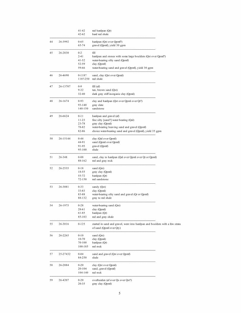
5
41-42 red hardpan (Qr)42-62 hard red shale
--------------------------------------------------------------------------------------------------------------------------------------44 26-3992 0-65 hardpan (Qst over Qpmf?)
65-74 gravel (Qpmf), yield 30 gpm--------------------------------------------------------------------------------------------------------------------------------------45 26-2830 0-2 fill
2-41 hardpan and stones with some large boulders (Qst over Qpmf?)41-52 water-bearing silty sand (Qpmf)52-59 clay (Qpmf)59-66 water-bearing sand and gravel (Qpmf), yield 30 gpm
--------------------------------------------------------------------------------------------------------------------------------------46 26-4690 0-118? sand, clay (Qst over Qpml)
118?-250 red shale--------------------------------------------------------------------------------------------------------------------------------------47 26-13707 0-9 fill (af)
9-32 tan, brown sand (Qst)32-40 dark gray stiff inorganic clay (Qpml)
--------------------------------------------------------------------------------------------------------------------------------------48 26-1674 0-93 clay and hardpan (Qst over Qpml over Qr?)
93-140 gray slate140-150 sandstone
--------------------------------------------------------------------------------------------------------------------------------------49 26-6624 0-11 hardpan and gravel (af)
11-23 fine silty [sand?] water bearing (Qal)23-78 gray clay (Qpml)78-82 water-bearing heaving sand and gravel (Qpmf)82-86 choice water-bearing sand and gravel (Qpmf), yield 35 gpm
--------------------------------------------------------------------------------------------------------------------------------------50 26-15144 0-44 clay (Qal over Qpml)
44-91 sand (Qpml over Qpmf)91-95 gravel (Qpmf)95-100 shale
--------------------------------------------------------------------------------------------------------------------------------------51 26-348 0-88 sand, clay to hardpan (Qal over Qpml over Qr or Qpmf)
88-162 red and gray rock--------------------------------------------------------------------------------------------------------------------------------------52 26-2535 0-18 sand (Qst)
18-55 gray clay (Qpml)55-72 hardpan (Qr)72-150 red sandstone
--------------------------------------------------------------------------------------------------------------------------------------53 26-3081 0-33 sandy (Qst)
33-83 clay (Qpml)83-88 water-bearing silty sand and gravel (Qr or Qpmf)88-132 gray to red shale
--------------------------------------------------------------------------------------------------------------------------------------54 26-1975 0-28 water-bearing sand (Qst)
28-61 clay (Qpml)61-85 hardpan (Qr)85-103 red and gray shale
--------------------------------------------------------------------------------------------------------------------------------------55 26-3016 0-125 started in sand and gravel, went into hardpan and boulders with a few strata
of sand (Qpmf over Qry)--------------------------------------------------------------------------------------------------------------------------------------56 26-2265 0-10 sand (Qst)
10-70 clay (Qpml)70-100 hardpan (Qr)100-185 red rock
--------------------------------------------------------------------------------------------------------------------------------------57 25-27432 0-84 sand and gravel (Qst over Qpmf)
84-250 shale--------------------------------------------------------------------------------------------------------------------------------------58 26-2884 0-20 clay (Qst over Qpml)
20-104 sand, gravel (Qpmf)104-140 red rock
--------------------------------------------------------------------------------------------------------------------------------------59 26-4207 0-20 overburden (af over Qs over Qst?)
20-35 gray clay (Qpml)

6
35-50 sand granite [gravel?] (Qpmf)50-60 sand, gravel (Qpmf)60-275 gray and red shale
--------------------------------------------------------------------------------------------------------------------------------------60 26-3008 0-22 sandy (Qst)
22-46 clay (Qpml)46-64 hardpan with some large stones (Qr or Qpmf)64-76 water-bearing sand and gravel (Qpmf)76-99 hardpan (Qr)99-112 soft shale112-212 red and gray shale
--------------------------------------------------------------------------------------------------------------------------------------61 26-2503 90--------------------------------------------------------------------------------------------------------------------------------------62 26-3025 0-2 fill (af)
2-6 black muck (Qs)6-11 sandy (Qst)11-38 clay (Qpml)38-61 hardpan and stones (Qr or Qpmf)61-66 water-bearing silty sand and gravel (Qr or Qpmf)66-101 red and gray shale
--------------------------------------------------------------------------------------------------------------------------------------63 26-1-657 0-9 sandy (Qst)
9-41 clay (Qpml)41-76 hardpan and large stones (Qr)76-285 red and gray shale
--------------------------------------------------------------------------------------------------------------------------------------64 26-2367 0-10 sand (Qst)
10-60 clay (Qpml)60-80 sand (Qpmf or Qr)80-137 shale
--------------------------------------------------------------------------------------------------------------------------------------65 26-4266 0-14 sandy (Qst)
14-54 clay (Qpml)54-87 hardpan, stones, and some boulders (Qr)87-120 red shale with sandstone
--------------------------------------------------------------------------------------------------------------------------------------66 26-4372 0-14 sandy (Qst)
14-58 clay (Qpml)58-89 hardpan and stones (Qr)89-141 red shale with sandstone beds
--------------------------------------------------------------------------------------------------------------------------------------67 26-2247 0-10 sand (Qst)
10-40 clay (Qpml)40-70 sand (Qr)70-129 shale
--------------------------------------------------------------------------------------------------------------------------------------68 U. S. Army abbreviated log
Corps of 0-7 gray and brown silt, trace sand and clay (Qs over Qst)Engineers 7-16 brown silty sand (Qst)boring 16-35 brown sandy clay (Qpml)P-10-4 35-51 brown clayey sand (Qpml)
--------------------------------------------------------------------------------------------------------------------------------------69 26-2938 0-27 sandy (Qst)
27-51 clay (Qpml)51-73 hardpan with some boulders (Qr or Qpmf)73-89 water-bearing silty sand and gravel (Qpmf)89-97 soft shale97-161 firm red shale
--------------------------------------------------------------------------------------------------------------------------------------70 26-3921 0-16 sandy (Qst)
16-31 clay (Qpml)31-62 hardpan and stones (Qr or Qmpf)62-80 water-bearing heaving sand (Qpmf)80-85 choice water-bearing sand and gravel (Qpmf), yield 30 gpm
--------------------------------------------------------------------------------------------------------------------------------------71 26-2716 0-17 sandy (Qst)
17-38 clay (Qpml)38-74 hardpan and stones (Qr or Qpmf)

7
74-93 water-bearing sand and gravel (Qpmf), yield 30 gpm--------------------------------------------------------------------------------------------------------------------------------------72 26-4731 0-20 fine gray sand (Qst)
20-30 gray clay with fine sand (Qpml)30-40 gray clay, some fine sand (Qpml)40-50 fine sand (Qpml)50-60 fine silty sand (Qpml)60-70 fine sand (Qpml grading to Qmpf)70-80 sand, gravel (Qpmf)80-90 brown fine-to-medium sand, quite silty (Qpmf or Qr)90-95 fine brown sand, quite silty (Qpmf or Qr)screened 75-95, yield 146 gpm
--------------------------------------------------------------------------------------------------------------------------------------73 26-2745 0-4 fill (af)
4-7 clay (Qal)7-32 sandy (Qst)32-79 clay (Qpml)79-89 water-bearing sand and gravel (Qpmf), yield 30 gpm
--------------------------------------------------------------------------------------------------------------------------------------74 26-1597 0-74 gray clay (Qal over Qpml)
74-84 hardpan (Qr)84-115 red rock
--------------------------------------------------------------------------------------------------------------------------------------75 26-4089 0-4 fill (af)
4-19 sandy (Qal over Qst)19-61 clay (Qpml)61-90 hardpan and stones (Qr)90-101 soft gray shale101-146 firm red and gray shale with sandstone
--------------------------------------------------------------------------------------------------------------------------------------76 26-2071 0-11 fill (af)
11-19 clayey sand (Qal)19-52 clay (Qpml)52-81 hardpan (Qr)81-89 soft shale89-191 gray and red shale
--------------------------------------------------------------------------------------------------------------------------------------77 26-4312 0-6 fill (af)
6-34 sandy (Qal over Qst)34-67 clay (Qpml)67-74 hardpan and stones (Qr or Qpmf)74-80 water-bearing sand and gravel (Qpmf), yield 15 gpm
--------------------------------------------------------------------------------------------------------------------------------------78 26-2686 0-3 fill (af)
3-19 sandy (Qal over Qst)19-47 clay (Qpml)47-71 hardpan with some large boulders (Qr)71-83 red sandstone
--------------------------------------------------------------------------------------------------------------------------------------79 26-3030 0-3 fill (af)
3-18 sand (Qal over Qst)18-52 clay (Qpml)52-74 hardpan and stones (Qr)74-130 gray and red shale
--------------------------------------------------------------------------------------------------------------------------------------80 26-2810 0-31 sandy (Qal over Qst)
31-69 clay (Qpml)69-75 water-bearing sand and gravel (Qpmf), yield 20 gpm
--------------------------------------------------------------------------------------------------------------------------------------81 26-6225 0-2 fill
2-14 gray silty water-bearing sand (Qst)14-57 gray dense clay (Qpml)57-66 water-bearing silty sand and gravel (Qr or Qpmf)66-130 red shale and sandstone
--------------------------------------------------------------------------------------------------------------------------------------82 26-2021 0-20 sand (Qst)
20-55 gray clay (Qpml)55-80 hard pan (Qr)80-100 red rock

8
--------------------------------------------------------------------------------------------------------------------------------------83 26-1383 0-88 clay and sand (Qst over Qpml)
88-98 red rock--------------------------------------------------------------------------------------------------------------------------------------84 26-4799 0-18 sandy (Qst)
18-41 gray clay (Qpml)41-56 hardpan and stones (Qr)56-130 red shale and sandstone
--------------------------------------------------------------------------------------------------------------------------------------85 26-2892 0-22 sandy (Qst)
22-72 clay (Qpml)72-74 silty sand (Qpml)74-79 hardpan with stones (Qr)79-104 gray shale104-144 red shale with some sandstone
--------------------------------------------------------------------------------------------------------------------------------------86 26-5409 0-28 sandy (Qst)
28-45 gray clay (Qpml)45-53 hardpan and stones with some large boulders (Qr)53-120 red shale and sandstone
--------------------------------------------------------------------------------------------------------------------------------------87 26-5029 0-26 sandy (Qst)
26-43 gray clay (Qpml)43-51 hardpan and stones (Qr)51-130 red shale and sandstone
--------------------------------------------------------------------------------------------------------------------------------------88 26-5562 0-13 brown clay (Qst)
13-17 gray silty fine sand (Qst)17-43 gray clay (Qpml)43-47 reddish brown hardpan and stones (Qr)47-115 red shale with sandstone beds
--------------------------------------------------------------------------------------------------------------------------------------89 26-4157 0-17 sandy (Qst)
17-45 clay (Qpml)45-54 hardpan and stones (Qr)54-61 water-bearing silty sand (Qr)61-130 red and gray shale and sandstone
--------------------------------------------------------------------------------------------------------------------------------------90 26-4155 0-21 sandy (Qst)
21-36 clay (Qpml)36-55 hardpan and stones (Qr)55-57 water-bearing silty sand and gravel (Qr)57-60 gray shale
--------------------------------------------------------------------------------------------------------------------------------------91 26-4156 0-3 fill
3-21 sandy (Qst)21-44 clay (Qpml)44-55 hardpan and stones (Qr)55-61 water-bearing sand and gravel (Qpmf or Qpc), yield 20 gpm
--------------------------------------------------------------------------------------------------------------------------------------92 26-5163 0-2 fill
2-17 brown sand (Qst)17-38 gray clay (Qpml)38-49 hardpan with some large stones (Qr)49-55 water-bearing sand and gravel (Qpmf or Qpc), yield 15 gpm
--------------------------------------------------------------------------------------------------------------------------------------93 26-1312 0-74 gray clay (Qst over Qpml)
74-147 red rock--------------------------------------------------------------------------------------------------------------------------------------94 26-2945 0-2 fill
2-18 sandy (Qst)18-31 clay (Qpml)31-44 hardpan with stones (Qr)44-53 water-bearing sand and gravel (Qpmf or Qpc)screened 48-53, yield 25 gpm
--------------------------------------------------------------------------------------------------------------------------------------95 26-4748 0-41 sandy (Qst)
41-54 gray clay (Qpml)54-59 water-bearing sand and gravel (Qpmf), yield 12 gpm

9
--------------------------------------------------------------------------------------------------------------------------------------96 26-4431 0-10 sandy soil (Qst)
10-25 sand (Qst)25-60 clay (Qpml)60-65 red hardpan (Qr)65-161 red sandstone and gray slate
--------------------------------------------------------------------------------------------------------------------------------------97 26-3725 0-19 sandy (Qst)
19-41 clay (Qpml)41-57 hardpan and stones (Qr)57-64 silty water-bearing sand and gravel (Qr or Qpmf)64-92 gray shale92-140 red shale
--------------------------------------------------------------------------------------------------------------------------------------98 26-1805 0-8 sand (Qst)
8-42 clay (Qpml)42-52 hardpan (Qr)52-131 red shale
--------------------------------------------------------------------------------------------------------------------------------------99 26-2496 0-2 fill (af)
2-17 sandy (Qst)17-39 clay (Qpml)39-44 hardpan (Qr)44-56 red shale
--------------------------------------------------------------------------------------------------------------------------------------100 26-4261 0-14 sandy (Qst)
14-31 clay (Qpml)31-49 hardpan and stones (Qr)49-105 red shale with sandstone
--------------------------------------------------------------------------------------------------------------------------------------101 26-4270A 0-17 sandy (Qst)
17-41 clay (Qpml)41-53 hardpan and stones (Qr)53-110 red shale
--------------------------------------------------------------------------------------------------------------------------------------102 26-2544 0-2 fill (af)
2-41 clay (thin Qst over Qpml)41-47 hardpan (Qr)47-110 red shale
--------------------------------------------------------------------------------------------------------------------------------------103 26-24465 0-7 red-brown clayey silt (thin Qst over Qpml)
7-40 cobble, boulders with brown fine-to-coarse sand and thin layers of brownclayey silt (Qpmf or Qr)
--------------------------------------------------------------------------------------------------------------------------------------104 26-4184 0-2 fill (af)
2-12 clay (Qpml)12-23 sandy (Qpmf or Qpml)23-46 hardpan and stones (Qr)46-56 red shale with sandstone
--------------------------------------------------------------------------------------------------------------------------------------105 26-1438 0-50 clay and cobblestones (Qr)
50-135 trap--------------------------------------------------------------------------------------------------------------------------------------106 26-3771 0-24 sand and large stones (Qry)
24-42 hardpan with large stones (Qry)42-49 water-bearing sand and gravel quite silty (Qry)49-72 trap rock
--------------------------------------------------------------------------------------------------------------------------------------107 26-1296 0-60 clay and boulders (Qr)
60-100 trap rock --------------------------------------------------------------------------------------------------------------------------------------108 26-1740 0-32 fill, then hardpan (Qpmf over Qry)
32-135 trap rock--------------------------------------------------------------------------------------------------------------------------------------109 26-22471 0-12 green-black sand and gravel (Qal over Qpmf)
12-53 clayey silt with some grayish-black gravel (Qry) --------------------------------------------------------------------------------------------------------------------------------------110 26-16830 0-17 brown fine-to-coarse gravel and silty sandy clay (Qpmf)
17-49 as above with some cobbles (Qpmf)

10
49-54 fine-to-coarse red sand, gravel, hard and dry (Qr)54-67 same as above, but with moisture (Qr)67-80 bedrock, little water
--------------------------------------------------------------------------------------------------------------------------------------111 26-2553 0-15 clay (Qpmf)
15-62 hardpan (Qry)62-205 trap rock
--------------------------------------------------------------------------------------------------------------------------------------112 26-40 0-54 earth, some boulders (Qpmf over Qry)
54-85 rock, gray shale--------------------------------------------------------------------------------------------------------------------------------------113 26-2870 0-72 stratified drift (Qaf over Qpmf), yield 12 gpm--------------------------------------------------------------------------------------------------------------------------------------114 26-1701 0-5 yellow sandy clay (Qpmf)
5-17 boulders, small cobbles, sandy hardpan (Qpmf)17-24 sandy hardpan (Qpmf)24-28 coarse gravel (Qpmf)28-30 gray hardpan (Qry)30-186 blue to black trap186-202 red to gray shale202-300 gray trap
--------------------------------------------------------------------------------------------------------------------------------------115 26-575 0-15 boulders (Qaf)
15-85 hardpan (Qpmf over Qry)85-100 hard gray rock100-142 softer gray rock
--------------------------------------------------------------------------------------------------------------------------------------116 26-1081 0-50 clay and hardpan with some sand at 30 (Qpmf over Qry)
50-200 trap rock--------------------------------------------------------------------------------------------------------------------------------------117 26-1808 0-30 hardpan (Qpmf over Qry)
30-240 trap--------------------------------------------------------------------------------------------------------------------------------------118 26-2119 0-18 dirt (Qpmf over Qry)
18-123 trap rock--------------------------------------------------------------------------------------------------------------------------------------119 26-4368 0-6 dirt and clay (Qpmf over Qry)
6-200 conglomerate (basalt)--------------------------------------------------------------------------------------------------------------------------------------120 26-1109 0-45 hardpan and boulders (Qpmf over Qry)
45-102 trap rock--------------------------------------------------------------------------------------------------------------------------------------121 26-1035 0-45 hardpan (Qpmf over Qry)
45-175 trap rock--------------------------------------------------------------------------------------------------------------------------------------122 26-3678 0-45 hardpan and boulders (Qpmf over Qry)
45-136 trap rock--------------------------------------------------------------------------------------------------------------------------------------123 26-586 0-5 dirt (Qry)
5-202 trap rock--------------------------------------------------------------------------------------------------------------------------------------124 26-1036 0-7 dirt (Qry)
7-160 trap rock--------------------------------------------------------------------------------------------------------------------------------------125 26-1130 0-4 dirt (Qry)
4-174 trap rock174-180 red rock, not sandstone
--------------------------------------------------------------------------------------------------------------------------------------126 26-4271 2--------------------------------------------------------------------------------------------------------------------------------------127 26-29459 0-28 boulders, large gravel, silts and sands, brown (Qry)--------------------------------------------------------------------------------------------------------------------------------------128 26-23132 0-40 medium-to-fine sand and coarse gravel, some cobbles and boulders (Qry)--------------------------------------------------------------------------------------------------------------------------------------129 26-842 4--------------------------------------------------------------------------------------------------------------------------------------130 26-1295 0-16 hardpan and boulders (Qry)
16-155 trap rock--------------------------------------------------------------------------------------------------------------------------------------

11
131 26-1640 0-84 topsoil, stones, boulders, hardpan (thin Qpml over Qry)--------------------------------------------------------------------------------------------------------------------------------------132 26-4270 0-15 boulders (Qry)
15-70 dirty gravel (Qry)70-82 pan (Qry)82-135 trap rock
--------------------------------------------------------------------------------------------------------------------------------------133 26-1547 abbreviated log
0-30 brownish yellow sandy clay with rock fragments (Qpml)30-49 same as above with larger fragments (Qr)49-53 fragments of brown shaly sandstone and gray diabase (Qr)53-67 brown sandy clay with some gravel, large diabase fragments (Qr)67-209 basalt209-218 sandstone218-305 basalt
--------------------------------------------------------------------------------------------------------------------------------------134 46-209 0-7 clay, brown, few pebbles (Qpml)
7-40 till, sandy and bouldery, little clay (Qr or Qpmf)40-65 sand, coarse to very coarse with fine gravel, well sorted, water bearing
(Qpmf)65-74 sand, medium to coarse, very well sorted, water bearing (Qpmf)74-80 till, sandy, yellowish brown, little clay (Qry)80-98 till, clayey, compact, reddish brown (Qr)98-104 shale, reddish brown
--------------------------------------------------------------------------------------------------------------------------------------135 46-208 0-75 clay, hardpan (Qpml over Qpmf and Qr)
75-360 trap--------------------------------------------------------------------------------------------------------------------------------------136 26-3060 0-66 hardpan, clay, stones and some large boulders (Qpmf over Qr)
66-116 mix of trap rock and gray shale --------------------------------------------------------------------------------------------------------------------------------------137 26-2961 0-49 hardpan, stones, and large boulders (thin Qpml over Qr)
49-63 sand and gravel (Qpc?)63-68 silty water-bearing sand and gravel (Qpc?)68-78 fractured trap78-131 firm trap with shale layers
--------------------------------------------------------------------------------------------------------------------------------------138 26-5868 0-21 hardpan, clay, some large stones (thin Qpml over Qr)
21-29 water-bearing silty sand (Qr)29-46 hardpan and stones (Qr)46-51 weathered trap rock
--------------------------------------------------------------------------------------------------------------------------------------139 26-22 0-40 earth and boulders (Qr)
40-58 gravel, sand (Qpc)58-204 red rock
--------------------------------------------------------------------------------------------------------------------------------------140 26-1091 0-74 clay and boulders (Qpmf over Qr)
74-305 red and gray sandstone--------------------------------------------------------------------------------------------------------------------------------------141 26-5188 0-2 fill
2-12 hardpan and stones (Qr)12-26 gray clay (Qpml)26-38 hardpan and stones (Qr)38-105 red shale with beds of red sandstone
--------------------------------------------------------------------------------------------------------------------------------------142 26-4267 0-4 fill
4-57 hardpan, stones with some large boulders (thin Qpmf over Qr)57-131 red shale with sandstone beds
--------------------------------------------------------------------------------------------------------------------------------------143 26-3928 0-56 hardpan, stones, and clay (Qr)
56-115 soft red shale with sandstone beds--------------------------------------------------------------------------------------------------------------------------------------144 26-3172 0-61 hardpan and stones (Qr)
61-68 water-bearing silty sand and stones (Qr)68-84 red and gray shale84-134 trap rock
--------------------------------------------------------------------------------------------------------------------------------------145 26-4468 0-49 hardpan and stones (Qr)
49-130 red shale with sandstone beds

12
--------------------------------------------------------------------------------------------------------------------------------------146 26-818 0-80 hardpan and boulders (Qr), yield 30 gpm--------------------------------------------------------------------------------------------------------------------------------------147 26-367 0-76 clay, boulders, hardpan (Qr)
76-172 red rock172-250 trap
--------------------------------------------------------------------------------------------------------------------------------------148 26-261 0-30 clay (Qpml)
30-50 sand (Qr or Qpmf)50-84 gravel (Qr or Qpc)84-158 red rock
--------------------------------------------------------------------------------------------------------------------------------------149 26-41 0-18 open well
18-75 red dirt and gravel (Qr)75-181 red shale
--------------------------------------------------------------------------------------------------------------------------------------150 26-2919 0-60 boulders and gravel (Qr), yield 5 gpm--------------------------------------------------------------------------------------------------------------------------------------151 26-6615 0-80 sand (Qpml over Qpmf)
80-275 trap rock--------------------------------------------------------------------------------------------------------------------------------------152 26-2964 0-70 hardpan and gravel (Qpmf)
70-180 trap rock--------------------------------------------------------------------------------------------------------------------------------------153 46-200 0-45 sand, clay, boulders (Qpmf)
45-68 water-bearing gravel (Qpmf)68-81 sand, clay, boulders (Qpmf or Qry)81-94 water-bearing gravel (Qpmf or Qpc)94-97 sand, clay, boulders (Qry)screened 43-94, yield 627 gpm
--------------------------------------------------------------------------------------------------------------------------------------154 26-276 0-39 hardpan and boulders (Qry)
39-40 red clay (Qry)40-62 yellow clay and hardpan (Qry)62-71 red to brown clay and hardpan (Qb or weathered basalt)71-240 trap rock240-244 traces of red clay or red shale244-372 trap rock
--------------------------------------------------------------------------------------------------------------------------------------155 26-2806 0-38 earth, hardpan (Qry)
38-395 trap rock --------------------------------------------------------------------------------------------------------------------------------------156 26-2290 0-39 clay and boulders (Qry)
39-285 trap rock285-320 red rock320-370 sandstone
--------------------------------------------------------------------------------------------------------------------------------------157 26-28135 abbreviated log
0-20 brown sand, gravel, boulders, some silt (Qry)--------------------------------------------------------------------------------------------------------------------------------------158 26-7978 0-10 overburden (Qry)
10-35 hardpan, broken trap35-270 trap rock270-790 red sandstone and red and gray shale
--------------------------------------------------------------------------------------------------------------------------------------159 26-17087 0-8.5 brown to reddish brown fine-to-medium sand, some gravel and some silt--till
material (Qry)8.5-9 basalt bedrock
--------------------------------------------------------------------------------------------------------------------------------------160 26-26928 0-8 brown silty fine sand (Qve)
8-15 brown coarse-to-fine sand, gravel, cobbles (Qve)15-32 brown medium-to-fine sand (Qve)
--------------------------------------------------------------------------------------------------------------------------------------161 26-2214 0-35 sand and clay (Qry)
35-165 trap rock165-300 red sandstone
--------------------------------------------------------------------------------------------------------------------------------------162 26-1673 0-3 dirt (Qry)

13
3-125 trap125-190 reddish rock190-200 sandstone
--------------------------------------------------------------------------------------------------------------------------------------163 26-13030 0-13 clay (Qve)
13-18 boulder, red rock (Qve or Qr)18-65 sand and clay, small gravel (Qve or Qr)65-500 trap rock
--------------------------------------------------------------------------------------------------------------------------------------164 26-15029 abbreviated log
0-35 brown sand and clay (Qve)35-55 brown fine-to-coarse sand (Qve)55-65 brown sand and clay (Qve or Qr)65-67 broken rock67-75 rock, well flows
--------------------------------------------------------------------------------------------------------------------------------------165 26-3260 0-90 hardpan (Qry)
90-578 trap rock578-600 unknown [no recovery]
--------------------------------------------------------------------------------------------------------------------------------------166 26-550 0-104 clay (Qry)
104-221 trap--------------------------------------------------------------------------------------------------------------------------------------167 26-3758 0-25 clay and boulders (Qry)
25-50 sand (Qps)50-75 hardpan and boulders (Qb?)75-205 trap rock
--------------------------------------------------------------------------------------------------------------------------------------168 26-5235 0-50 gravel, sand (Qry)
50-60 gravel, hardpan (Qry)60-100 sand, boulders (Qry)100-110 sand (Qps?)110-467 trap rock467-598 red shale
--------------------------------------------------------------------------------------------------------------------------------------169 26-1985 0-84 sandy clay (Qry)
84-99 broken trap rock\ 99-196 trap rock--------------------------------------------------------------------------------------------------------------------------------------170 46-20 0-19 hardpan, boulders (Qry)
19-37 coarse brown sand, heavy gravel, boulders very dense (Qry or weatheredbasalt)
37-38 decayed rockat 38 dense trap rock
--------------------------------------------------------------------------------------------------------------------------------------171 26-3058 0-90 hardpan and some boulders (Qry)
90-192 trap rock--------------------------------------------------------------------------------------------------------------------------------------172 26-4037 0-80 hardpan and cobblestones (Qry)
80-90 broken trap90-115 broken loose trap115-400 trap rock
--------------------------------------------------------------------------------------------------------------------------------------173 26-3375 0-70 hardpan and boulders (Qry)
70-240 trap rock240-303 red sandstone
--------------------------------------------------------------------------------------------------------------------------------------174 NJGS files 0-40 clay and silt, some fine sand, gray to brown (Qry)
40-44 coarse sand and gravel (weathered basalt or Qps)at 44 basalt
--------------------------------------------------------------------------------------------------------------------------------------175 26-2689 0-68 hardpan and very bad boulders (Qry)
68-195 trap rock--------------------------------------------------------------------------------------------------------------------------------------176 25-5477 0-28 overburden (Qry)
28-192 trap rock192-212 running, granulated trap212-300 trap rock
--------------------------------------------------------------------------------------------------------------------------------------

14
177 26-30246 0-5 brown medium-to-fine sand, and cobbles, and boulders (Qpmf)5-20 grayish brown medium-to-fine sand and cobbles (Qpmf)20-75 brown medium-to-fine sand and gravel and cobbles (Qpmf)
--------------------------------------------------------------------------------------------------------------------------------------178 26-4804 0-10 soil and overburden (Qpmf)
10-85 glacial drift, very clean gravel (Qpmf), yield 100 gpm--------------------------------------------------------------------------------------------------------------------------------------179 26-1421 0-60 hardpan and boulders (Qpml over Qpmf)
60-75 fine sand (Qpmf)at 75 coarse sand (Qpmf), yield 20 gpm
--------------------------------------------------------------------------------------------------------------------------------------180 26-4122 0-30 sandy hardpan and boulders (Qpmf)
30-55 sand, gravel (Qpmf)55-69 sandy hardpan (Qr)69-305 trap rock
--------------------------------------------------------------------------------------------------------------------------------------181 46-203 0-60 clay, boulders (Qpmf over Qry)
60-62 wash, partly rounded trap pebbles (Qps?)62-480 trap480-494 red sandstone and shale494-565 trap
--------------------------------------------------------------------------------------------------------------------------------------182 46-206 abbreviated log
0-31 boulders, sand, clay (Qst over Qr)31-37 broken trap, sand with water (Qr)37-60 boulders, clay (Qr)60-66 fine-to-coarse sand, boulders, clay (Qr)66-76 sand, gravel, with little clay (Qpc or weathered basalt)76-364 basalt
--------------------------------------------------------------------------------------------------------------------------------------183 26-1910 0-8 clay (Qst over Qpml)
8-10 sand, gravel (Qpmf)10-30 real fine sand (Qpmf)30-60 hardpan (Qr)60-69 hardpan, large boulders, streaks of sand, gravel (Qr over Qpc?)69-76 coarse sand, large gravel (Qpc)76-78 yellow clay (Qpc)78-82 coarse sand and gravel (Qpc)82-92 yellow clay (Qpcl)at 92 rockscreened 61-89, yield 457 gpm
--------------------------------------------------------------------------------------------------------------------------------------184 46-204 0-3 clay (Qpml)
3-5 nested boulders (Qpmf)5-13 boulders, clay, some sand (Qpmf)13-42 clay, some sand (Qpmf and Qpml)42-49 boulders, clay (Qr)49-64 loose rock, sand (Qr over Qpc)64-92 gravel and sand, water bearing (Qpc)at 92 fine brown sand (Qpc)screened 72-92, yield 410 gpm
--------------------------------------------------------------------------------------------------------------------------------------185 46-205 0-45 brown sandy clay (Qst over Qpml)
45-106 fine grained sand, small amount of clay, few pebbles (Qpml over Qpmf)106-120 red sandstone120-423 trap
--------------------------------------------------------------------------------------------------------------------------------------186 26-1082 0-100 hardpan, boulders, etc. (Qr)
100-102 coarse gravel (Qpc), yield 20 gpm--------------------------------------------------------------------------------------------------------------------------------------187 26-4484 0-41 hardpan, clay, and stones (Qr)
41-50 water-bearing sand and gravel (Qpc), yield 30 gpm --------------------------------------------------------------------------------------------------------------------------------------188 26-4743 0-9 gray clay (Qr)
9-23 sand, gravel (Qr)23-29 sand, gravel, brown clay (Qr)29-49 sand, gravel, brown clay, hard (Qr)49-51 fine brown sand (Qpc)51-66 sand, gravel (Qpc)

15
66-73 hardpan, brown (Qb?)73-93 hardpan with red clay (Qb)93-450 red sandstone
--------------------------------------------------------------------------------------------------------------------------------------189 26-2684 0-25 old well
25-100 sand in various forms (Qpc)100-115 red hardpan (Qb)115-163 red sandstone
--------------------------------------------------------------------------------------------------------------------------------------190 26-2848 0-39 hardpan with stones (Qr)
39-47 water-bearing sand (Qpc)47-53 choice water-bearing sand and gravel (Qpc), yield 8 gpm
--------------------------------------------------------------------------------------------------------------------------------------191 26-6043 0-39 hardpan, lenses of sand and gravel with some large boulders (Qr)
39-59 water-bearing silty sand with some stones, sand and gravel (Qpc)59-66 clay (Qpcl)66-83 water-bearing silty sand and gravel (Qis or Qpc)83-89 hardpan with some large stones (Qb)89-101 red sandstone
--------------------------------------------------------------------------------------------------------------------------------------192 26-2736 0-29 sandy clay, hardpan, boulders (Qr)
29-41 sandy hardpan and rocks, some layers of sand (Qr over Qpc)41-58 clay and hardpan (Qb)58-65 red sandstone with some shale
--------------------------------------------------------------------------------------------------------------------------------------193 26-2647 0-27 brownish clay, some fine sand, rocks and boulders (Qr)
27-32 sand and gravel (Qpc)32-43 clay, some sand (Qpcl)43-51 sandy clay (Qpcl)51-60 clay (Qpcl)60-61 sand, gravel (Qb or Qis)61-74 clay with some gravel (Qb)74-462 red sandstone and shale
--------------------------------------------------------------------------------------------------------------------------------------194 26-17982 0-87 sand, clay (Qr over Qpc)
87-323 shale--------------------------------------------------------------------------------------------------------------------------------------195 26-4164 0-30 sand and gravel (Qr)
30-104 gravel (Qpc?)104-107 clay, sand, and stones (Qb?)107-389 shale and sandstone, black, red, and gray
--------------------------------------------------------------------------------------------------------------------------------------196 26-5189 0-34 existing well
34-40 water-bearing sand and gravel (Qpc), yield 15 gpm --------------------------------------------------------------------------------------------------------------------------------------197 26-29818 0-65 coarse to fine sand to gravel, large cobbles to boulders (Qr over Qpc)--------------------------------------------------------------------------------------------------------------------------------------198 26-830 0-10 yellow clay and boulders (Qr)
10-13 hardpan and boulders (Qr)13-15 yellow clay, sand, and gravel (Qr)15-22 coarse sand and gravel (Qpc?)22-35 yellow hardpan (Qpcl or Qry)35-59 brown hardpan (Qpcl or Qr)59-85 red hardpan (Qr or Qb)85-242 red, brown rock and shale
--------------------------------------------------------------------------------------------------------------------------------------199 26-884 0-78 clay and boulders (Qr)
78-350 sandstone--------------------------------------------------------------------------------------------------------------------------------------200 26-841 0-97 hardpan and cobbles (Qr)
97-255 red sandstone255-275 gray shale275-405 red sandstone
--------------------------------------------------------------------------------------------------------------------------------------201 26-21892 0-35 glacial till--sand, gravel, and boulders (Qr)
35-53 boulders, gravel, sand (Qr or Qpc)53-72 glacial till--boulders, sand, lime, and clay (Qb?)
--------------------------------------------------------------------------------------------------------------------------------------202 26-462 0-17 yellow clay and boulders (Qr)

16
17-26 hardpan (Qr)26-28 blue gray and brown gravel (Qr)28-34 hardpan (Qr)34-42 sand and gravel (Qpc?)42-49 hardpan (Qb?)49-444 gray and red shale
--------------------------------------------------------------------------------------------------------------------------------------203 26-7708 0-28 red-brown clay, sand, gravel, cobbles (Qr)
28-34 brown medium coarse sand and gravel (Qpc)34-40 red shale, sandstone
--------------------------------------------------------------------------------------------------------------------------------------204 26-4942 0-6 yellowish brown clay (Qr)
6-18 grayish brown sticky clay (Qr)18-30 grayish brown clay and boulders (Qr)30-40 reddish sandy hardpan with large rocks (Qr)40-500 red and gray shale
--------------------------------------------------------------------------------------------------------------------------------------205 25-17294 0-42 hardpan, clay, stones (Qr)
42-156 red sandstone with lenses of red and gray shale--------------------------------------------------------------------------------------------------------------------------------------206 25-17295 0-12 hardpan and stones (Qr)
12-59 trap rock59-150 red sandstone
--------------------------------------------------------------------------------------------------------------------------------------207 25-30670 0-61 silty clay, clayey silt, some sand, with cobbles and small boulders (Qr)
61-79 shale --------------------------------------------------------------------------------------------------------------------------------------208 26-23446 abbreviated log
0-57 brown silty sand to silty clay with some gravel, trace cobbles (Qr)57-59 red-brown sandstone
--------------------------------------------------------------------------------------------------------------------------------------209 25-12425 0-8 sandy (Qst)
8-23 clay (Qpml)23-41 hardpan with stones (Qr)41-51 water-bearing silty sand and gravel (Qpc)51-57 fractured traprock
--------------------------------------------------------------------------------------------------------------------------------------210 25-15711 0-15 clay (Qst over Qpml)
15-50 fine sand (Qpmf)50-57 coarser sand (Qpmf), yield 20 gpm
--------------------------------------------------------------------------------------------------------------------------------------211 26-3040 0-21 clay (Qpmf)
21-36 silty sand with some gravel (Qpmf)36-51 hardpan and stones (Qr)51-55 choice water-bearing sand and gravel (Qpc), yield 10 gpm
--------------------------------------------------------------------------------------------------------------------------------------212 25-13467 0-3 fill
3-11 sand (Qpmf)11-22 clay (Qpmf)22-43 hardpan and stones (Qr)43-52 silty sand and gravel (Qr over Qpc)52-56 choice sand and gravel (Qpmf), yield 15 gpmat 56 rock
--------------------------------------------------------------------------------------------------------------------------------------213 25-13383 0-8 sandy (Qst)
8-19 clay (Qpml)19-37 hardpan, gravel, and large stones (Qr)37-42 water-bearing sand and gravel (Qpc)42-53 traprock
--------------------------------------------------------------------------------------------------------------------------------------214 25-8394 0-18 sand (Qpmf)
18-45 hardpan (Qr)45-55 fine sand (Qpc)55-58 gray hardpan (Qb or weathered basalt)58-118 trap
--------------------------------------------------------------------------------------------------------------------------------------215 25-9721 0-41 sand (Qpmf)
41-45 fractured traprock--------------------------------------------------------------------------------------------------------------------------------------

17
216 25-11555 0-30 sandy soil (Qpmf)30-50 hardpan (Qr)50-65 gray rock
--------------------------------------------------------------------------------------------------------------------------------------217 25-7919 0-45 fine sand (Qpmf)
45-52 hardpan (Qr)52-130 hard trap rock
--------------------------------------------------------------------------------------------------------------------------------------218 25-9418 0-13 sandy clay (Qpmf)
13-53 hardpan (Qr)53-73 trap rock
--------------------------------------------------------------------------------------------------------------------------------------219 25-9808 0-23 clay (Qr)
23-37 silty water-bearing sand (Qpc)37-83 trap rock
--------------------------------------------------------------------------------------------------------------------------------------220 25-10996 0-35 hardpan (Qpmf over Qr)
35-70 very fine sand (Qpc)at 70 coarse gray sand (Qpc), yield 8 gpm
--------------------------------------------------------------------------------------------------------------------------------------221 25-28441 abbreviated log
0-45 brown and white fine sand, little silt, little gravel (Qpmf)--------------------------------------------------------------------------------------------------------------------------------------222 25-39939 abbreviated log
0-30 brown fine-to-coarse sand and silty sand with gravel (Qpmf)30-36 brown fine silty sand with clay (Qr or Qpmf)
--------------------------------------------------------------------------------------------------------------------------------------223 25-12859 0-13 clay (Qpml)
13-51 silty water-bearing sand and gravel (Qpmf)51-58 choice water-bearing sand and gravel (Qpmf), 25 gpm
--------------------------------------------------------------------------------------------------------------------------------------224 25-12687 0-86 sand and gravel (Qpmf, probably over Qr and Qpc), yield 25 gpm--------------------------------------------------------------------------------------------------------------------------------------225 25-14001 0-20 hardpan (Qpmf over Qr)
20-95 sand (Qpc), yield 30 gpm--------------------------------------------------------------------------------------------------------------------------------------226 25-13973 0-15 clay and hardpan (Qpmf over Qr)
15-62 sand (Qpc), yield 20 gpm--------------------------------------------------------------------------------------------------------------------------------------227 25-13986 0-15 old well
15-91 sand (Qpc), yield 10 gpm--------------------------------------------------------------------------------------------------------------------------------------228 25-10090 0-38 hardpan and stones (Qpmf over Qr)
38-45 water-bearing sand and gravel (Qpc), yield 20 gpm--------------------------------------------------------------------------------------------------------------------------------------229 25-9410 0-19 silty sand (Qpmf)
19-36 clay (Qr)36-40 water-bearing sand and gravel (Qpc), yield 30 gpm
--------------------------------------------------------------------------------------------------------------------------------------230 25-13123 0-30 hardpan (Qpmf over Qr)
30-95 very fine sand (Qpc)at 95 coarse gray sand (Qpc), yield 20 gpm
--------------------------------------------------------------------------------------------------------------------------------------231 25-8405 0-28 sand (Qpmf)
28-57 sand and gravel with clay mixture (Qr)57-68 water-bearing silty sand and gravel (Qpc)68-72 clean water-bearing sand and gravel (Qpc), yield 15 gpm
--------------------------------------------------------------------------------------------------------------------------------------232 25-11752 0-75 clay, then sand (Qpmf over Qr over Qpc), yield 20 gpm--------------------------------------------------------------------------------------------------------------------------------------233 25-10069 0-67 sand, coarse sand (Qpmf over Qr over Qpc), yield 20 gpm--------------------------------------------------------------------------------------------------------------------------------------234 25-11727 0-26 hardpan and some clay (Qpmf over Qr)
26-49 silty water-bearing sand and gravel (Qpc)49-57 choice water-bearing sand and gravel (Qpc), yield 15 gpm
--------------------------------------------------------------------------------------------------------------------------------------235 25-11636 0-22 hardpan (Qpmf over Qr)
22-46 water-bearing silty sand (Qpc)46-52 heavy gravel with some large boulders (Qpc)

18
52-56 water-bearing choice sand (Qpc), yield 8 gpm --------------------------------------------------------------------------------------------------------------------------------------236 25-10640 0-15 hardpan (Qpmf over Qr)
15-35 sand (Qpc)35-70 trap rock (anomalous bedrock-surface elevation, not contoured)
--------------------------------------------------------------------------------------------------------------------------------------237 25-7450 0-82 sand and gravel (Qpmf over Qr over Qpc), yield 18 gpm--------------------------------------------------------------------------------------------------------------------------------------238 25-14389 0-20 clay, boulders (Qpml over Qr)
20-94 sand (Qpc), yield 75 gpm--------------------------------------------------------------------------------------------------------------------------------------239 25-18267 0-34 hardpan (Qpml over Qr)
34-49 sand, gravel (Qpc)49-132 hardpan, boulders (Qpc or Qis over Qb?)screened 65-84, yield 900 gpm
--------------------------------------------------------------------------------------------------------------------------------------240 25-11467 0-15 hand dug well
15-41 clay (Qpml)41-58 hardpan (Qr)58-91 heaving water-bearing sand (Qpc)91-106 reddish hardpan (Qis or Qb)106-111 water-bearing sand and gravel (Qis), yield 10 gpm
-------------------------------------------------------------------------------------------------------------------------------------241 25-7176 0-50 boulders, hardpan, gravel (Qpmf over Qr over Qpc), yield 15 gpm--------------------------------------------------------------------------------------------------------------------------------------242 25-12956 0-5 sandy (Qpmf)
5-17 hardpan, stones (Qr)17-41 clay (Qpcl)41-61 water-bearing silty sand and gravel (Qis)61-92 hardpan (Qis or Qb)92-97 water-bearing sand and gravel (Qis), yield 30 gpm
--------------------------------------------------------------------------------------------------------------------------------------243 25-12955 0-13 sandy (Qpmf)
13-41 clay (Qr over Qpcl)41-67 water-bearing sand and gravel (Qis)67-84 hardpan and stones mixed with red clay (Qb)84-93 red shale
--------------------------------------------------------------------------------------------------------------------------------------244 25-3857 0-15 clay (Qpmf over Qr)
15-63 sand (Qpc over Qis), yield 75 gpm--------------------------------------------------------------------------------------------------------------------------------------245 25-6798 0-50 hardpan with large stones (Qpmf over Qr)
50-98 heaving sand ( Qpc over Qis)98-100 water-bearing gravel (Qis), yield 25 gpm
--------------------------------------------------------------------------------------------------------------------------------------246 25-15-116 0-30 open well
30-125 sand (Qpc over Qis), yield 8 gpm--------------------------------------------------------------------------------------------------------------------------------------247 25-10407 0-13 clay (Qpmf over Qr)
13-80 sand and gravel, water-bearing from 46 (Qpc over Qis), yield 13 gpm --------------------------------------------------------------------------------------------------------------------------------------248 25-11378 0-25 hardpan (Qpmf over Qr)
25-50 sand gravel (Qpc), yield 20 gpm--------------------------------------------------------------------------------------------------------------------------------------249 25-23784 0-5 medium brown sand and gravel (Qpmf)
5-15 stiff gray clay (Qpml)15-55 red-brown till (Qr)55-100 medium-to-fine brown sand and gravel (Qpc)
--------------------------------------------------------------------------------------------------------------------------------------250 25-10931 0-30 hardpan with small boulders (Qpmf over Qr)
30-60 gravel (Qr over Qpc)60-114 heaving sand (Qpc)114-117 sandstone
--------------------------------------------------------------------------------------------------------------------------------------251 25-8855 0-40 hardpan and boulders (Qpmf over Qr)
40-61 sand and water (Qpc), yield 15 gpm --------------------------------------------------------------------------------------------------------------------------------------252 25-8856 0-45 hardpan and boulders (Qpmf over Qr)
45-64 sand and water (Qpc), yield 15 gpm

19
--------------------------------------------------------------------------------------------------------------------------------------253 25-4976 0-12 hardpan (Qpmf over Qr)
12-71 sand and gravel (Qpc), yield 18 gpm--------------------------------------------------------------------------------------------------------------------------------------254 25-13852 0-36 hardpan and stones (Qpmf over Qr)
36-58 silty sand (Qpc)58-69 clay (Qpcl)69-91 heaving sand (Qis)91-103 red clay to firm shale (Qb)103-157 red shale
--------------------------------------------------------------------------------------------------------------------------------------255 25-11018 0-45 hardpan (Qpmf over Qr)
45-120 sand (Qpc), yield 12 gpm--------------------------------------------------------------------------------------------------------------------------------------256 25-9444 0-70 hardpan and some boulders (Qpmf over Qr)
70-90 fine sand (Qpc)at 90 coarse gray sand, water (Qpc or Qis), yield 15 gpm
--------------------------------------------------------------------------------------------------------------------------------------257 25-11336 0-33 sand and heavy gravel (Qpmf)
33-67 hardpan with large stones (Qr)67-98 heaving sand (Qpc)98-121 red clay to rock (Qb)121-150 shale
--------------------------------------------------------------------------------------------------------------------------------------258 25-13854 0-30 hardpan, stones with some boulders (Qpmf over Qr)
30-51 choice water-bearing sand and gravel (Qpc), yield 38 gpm--------------------------------------------------------------------------------------------------------------------------------------259 25-28129 0-7 brown fine silty clay (Qpmf and Qpml)
7-60 cobbles, gravel, boulders (Qpmf over Qr)60-62 brown medium-to-coarse sand, gravel, some red clay (Qpc)62-72 brown medium-to-coarse sand, some gravel (Qpc)
--------------------------------------------------------------------------------------------------------------------------------------260 25-9752 0-109 sand, gravel, boulders (Qpmf over Qr over Qpc), yield 15 gpm--------------------------------------------------------------------------------------------------------------------------------------261 25-13436 0-15 hardpan (Qpmf)
15-20 sand (Qpmf)20-60 hardpan and boulders (Qr)60-80 sand (Qpc)80-90 red hardpan (Qb)90-150 red sandstone
--------------------------------------------------------------------------------------------------------------------------------------262 25-10748 0-80 gravel and hardpan (Qpmf over Qr over Qpc)
80-356 red sandstone with streaks of gray slate--------------------------------------------------------------------------------------------------------------------------------------263 25-28780 0-6 crushed stone, some silt, trace weathered shale (fill?)
6-11 red weathered shale (fill?)11-12 boulder (Qpmf)12-17 white medium-to-coarse sand, trace red weathered shale (Qpmf)17-19 boulder (Qpmf)19-24 medium-to-coarse gray brown sand and fine gravel, some silt (Qpmf)24-54 cobbles and boulders, very coarse sand and fine gravel (Qpmf)54-70 red dense clay (Qr)70-76 brown clay (Qpcl)76-81 yellow clay (Qpcl)81-84 gray clay (Qpcl)84-87 soft gray clay (Qpcl or weathered shale)87-128 red and gray shale
--------------------------------------------------------------------------------------------------------------------------------------264 25-27508 0-7 brown clayey sand (Qpmf)
7-17 brown medium sand, some fine gravel (Qpmf)17-36 brown silty clay, boulder at 35 (Qpml over Qr)36-45 brown clayey fine sand with some fine-to-medium gravel (Qr)45-50 brown fine-to-medium sand (Qpc)50-70 red-brown to gray-brown clay to sandy clay (Qpcl)at 70 pieces of decomposed shale
--------------------------------------------------------------------------------------------------------------------------------------265 25-26473 0-22 brown medium-to-fine sand and gravel, some cobbles (Qpmf)
22-47 brown fine-to-medium sand (Qpmf)47-58 brown silty fine sand some gravel (Qr)

20
58-73 red brown clayey silt and trace fine sand (Qpcl)73-87 brown medium-to-coarse sand and gravel (Qis)87-91 weathered shale
--------------------------------------------------------------------------------------------------------------------------------------266 25-35354 0-4 fill
4-45 coarse-to-medium sand (Qpmf)45-65 sands, medium and fine (Qpmf)65-70 sandy clay (Qr)
--------------------------------------------------------------------------------------------------------------------------------------267 25-36560 0-44 red silty clay with layers of cobbles about every 5 feet (Qpmf and Qpml)
at 44 rock (Qr?)--------------------------------------------------------------------------------------------------------------------------------------268 25-32196 0-125 sand, gravel, cobbles (Qpmf over Qr)
125-605 red shale--------------------------------------------------------------------------------------------------------------------------------------269 25-9355 0-40 dead sand (Qpmf)
40-70 hard pan (Qr)70-80 fine sand, water (Qpc)80-88 red hardpan (Qb)88-175 red sandstone
--------------------------------------------------------------------------------------------------------------------------------------270 25-9411 0-31 sandy clay and some stones (Qpmf)
31-56 hardpan (Qr)56-62 water-bearing sand and gravel (Qpc), yield 20 gpm
--------------------------------------------------------------------------------------------------------------------------------------271 25-7777 0-65 sand, hardpan, and gravel (Qpmf over Qr over Qpc), yield 10 gpm--------------------------------------------------------------------------------------------------------------------------------------272 25-10852 0-20 sandy clay (Qpmf)
20-45 sand (Qpmf)45-55 red hardpan (Qr)55-150 red sandstone
--------------------------------------------------------------------------------------------------------------------------------------273 25-9888 0-15 fine sand and clay (Qpmf)
15-50 hardpan and boulders (Qr)50-70 sandstone
--------------------------------------------------------------------------------------------------------------------------------------274 25-9900 0-40 sandy clay and boulders (Qpmf over Qr)
40-58 sand, then red hardpan (Qpc over Qb)58-107 red sandstone then gray rock
--------------------------------------------------------------------------------------------------------------------------------------275 25-11569 0-23 sandy (Qpmf)
23-36 clay (Qpml)36-62 hardpan (Qr)62-70 soft gray shale70-88 gray shale turning red
--------------------------------------------------------------------------------------------------------------------------------------276 25-9852 0-67 sand and gravel (Qpmf over Qr)
67-115 red rock--------------------------------------------------------------------------------------------------------------------------------------277 25-11423 0-50 boulders and hardpan (Qpmf over Qr)
50-100 red shale--------------------------------------------------------------------------------------------------------------------------------------278 25-13925 0-20 sand (Qpmf)
20-40 sand and gravel (Qpmf)40-65 gray hardpan (Qr)65-135 mixture of shale and slate
--------------------------------------------------------------------------------------------------------------------------------------279 25-11784 0-15 sand (Qpmf)
15-54 hardpan (Qr)54-110 red sandstone
--------------------------------------------------------------------------------------------------------------------------------------280 25-8413 0-5 earth (Qpml)
5-10 dark clay (Qpml)10-65 fine sand (Qpmf, probably over Qr )65-82 coarse sand (Qpc)82-105 red rock105-189 blue and brown rock
--------------------------------------------------------------------------------------------------------------------------------------281 NJGS files abbreviated log

21
0-34 brown clay (Qpml)34-38 brown clay mixed with boulders (Qr)
--------------------------------------------------------------------------------------------------------------------------------------282 25-11066 0-15 clay (Qpml)
15-50 fine sand (Qr over Qpc)50-65 red hardpan (Qb)65-118 red sandstone
--------------------------------------------------------------------------------------------------------------------------------------283 25-39589 0-9 brown coarse-to-fine gravel (fill?)
9-19 gray clay (Qpml)19-25 gray sandy silt with gravel (Qr)25-30 gray silt with gravel (Qr)30-44 brown fine-to-medium sand with gravel and silt (Qr)
--------------------------------------------------------------------------------------------------------------------------------------284 25-13363 0-15 topsoil then sand (Qpmf)
15-45 hardpan and boulders (Qr)45-65 sand (Qpc)65-150 red sandstone
--------------------------------------------------------------------------------------------------------------------------------------285 25-14012 0-10 overburden(Qpml)
10-24 sand (Qpmf)24-60 sand, gravel (Qr over Qpc)60-400 blue, brown, red, gray shale
--------------------------------------------------------------------------------------------------------------------------------------286 25-10677 0-15 hardpan (thin Qst-Qpml over Qr)
15-50 sand (Qpc)50-60 red hardpan (Qb)60-100 red sandstone
--------------------------------------------------------------------------------------------------------------------------------------287 25-13844 0-15 old open well
15-45 sand (Qpc)45-55 red hardpan (Qb)55-115 red sandstone
--------------------------------------------------------------------------------------------------------------------------------------288 25-11257 0-45 clay and sand, fine sand (Qpml-Qr over Qpc)
45-60 gray rock--not trap60-100 red sandstone
--------------------------------------------------------------------------------------------------------------------------------------289 25-13384 0-31 sandy (Qpmf)
31-47 hardpan and gravel (Qr)47-52 clay (Qpcl)52-66 water-bearing sand and gravel, very silty (Qpc)66-105 red shale
--------------------------------------------------------------------------------------------------------------------------------------290 21-11700 0-2 fill
2-24 clay (Qpmf)24-59 hardpan and stones (Qr)59-66 water-bearing silty sand and gravel (Qpc) 66-81 shale and sandstone
--------------------------------------------------------------------------------------------------------------------------------------291 25-12755 0-2 fill
2-6 brown clay (Qr)6-11 gray clay (Qr)11-29 brown clay with stone (Qr)29-32 dirty sand, some clay (Qpc)32-39 hard yellowish white clay with some sand layers (Qpc or weathered shale)39-301 brown and gray shale
--------------------------------------------------------------------------------------------------------------------------------------292 25-13572 0-38 original well
38-52 silty sand and gravel (Qr)52-62 hardpan and stones (Qr)62-75 water-bearing silty sand and gravel (Qpc)75-92 red shale streaked with sandstone
--------------------------------------------------------------------------------------------------------------------------------------293 25-10875 0-90 sand, gravel (Qpmf over Qr over Qpc)
90-145 red rock--------------------------------------------------------------------------------------------------------------------------------------294 25-11492 0-105 sandy soil then red hardpan and boulders (Qpmf over Qr over Qpc over Qb)
105-150 red sandstone

22
--------------------------------------------------------------------------------------------------------------------------------------295 25-13875 0-17 sandy (Qpmf)
17-21 clay (Qpml)21-52 hardpan and stones (Qr)52-59 silty water-bearing sand and gravel (Qpc)59-71 hardpan and stones (Qb)71-118 red shale
--------------------------------------------------------------------------------------------------------------------------------------296 25-9889 0-57 sand and gravel (Qpmf over Qr)
57-69 hardpan (Qb)69-116 red and gray shale
--------------------------------------------------------------------------------------------------------------------------------------297 25-9291 0-60 dead sand and clay (Qpmf over Qr)
60-72 hardpan (Qb)72-128 red sandstone
--------------------------------------------------------------------------------------------------------------------------------------298 25-13587 0-17 sandy (Qpmf)
17-61 gravel, sand, and boulders (Qpmf over Qr)61-67 hardpan (Qr)67-73 water-bearing silty sand and gravel (Qpc)73-100 red shale
--------------------------------------------------------------------------------------------------------------------------------------299 25-9126 0-66 gravel and large stones (Qpmf over Qr)
66-75 fractured shale75-90 firm red shale
--------------------------------------------------------------------------------------------------------------------------------------300 25-12175 0-87 sand and gravel (Qpmf over Qr)
87-300 red shale--------------------------------------------------------------------------------------------------------------------------------------301 25-9493 0-30 hardpan and clay (Qpmf over Qr)
30-50 sand (Qpc)50-106 hardpan (Qb)106-140 sandstone
--------------------------------------------------------------------------------------------------------------------------------------302 25-6500 0-30 gravel and boulders (Qpmf over Qr)
30-78 sand (Qpc)78-142 red rock
--------------------------------------------------------------------------------------------------------------------------------------303 25-9119 0-29 hardpan (Qpmf over Qr)
29-42 sand and large stones (Qpc)42-51 water-bearing choice sand and gravel (Qpc), yield 15 gpm
--------------------------------------------------------------------------------------------------------------------------------------304 25-8444 0-60 hardpan and boulders (Qpmf over Qr)
60-115 fine sand (Qpc)115-130 red hardpan (Qb)130-180 red sandstone
--------------------------------------------------------------------------------------------------------------------------------------305 25-12686 0-30 sandy soil (Qpmf)
30-60 hardpan and boulders (Qr)60-147 fine sand (Qpc)147-185 red sandstone
--------------------------------------------------------------------------------------------------------------------------------------306 25-11521 0-70 hardpan and boulders (Qpmf over Qr)
70-120 fine sand (Qpc)120-126 red hardpan (Qb)126-175 red sandstone
--------------------------------------------------------------------------------------------------------------------------------------307 25-11216 0-70 clay, then hardpan and boulders (Qpmf over Qr)
70-90 fine sand (Qpc)90-123 hardpan and boulders (Qb)123-170 red sandstone
--------------------------------------------------------------------------------------------------------------------------------------308 25-11098 0-60 hardpan and gravel, fine sand at 60 (Qpmf over Qr over Qpc)
60-88 coarse sand with water (Qpc), yield 15 gpm--------------------------------------------------------------------------------------------------------------------------------------309 25-30798 0-110 brown fine-to-coarse sand, gravel, cobbles, boulders, layers of clay (Qpmf
over Qr)--------------------------------------------------------------------------------------------------------------------------------------310 25-31815 0-20 clay, silt, few cobbles, little gravel (Qpmf over Qr)

23
20-48 fine-to-coarse sand, gravel, few small boulders, cobbles (Qpc)48-74 very fine sand, silt, few small boulders, trace clay (Qpcl)74-78 red-brown till (Qb)at 78 bedrock (probable boulder, not bedrock)
--------------------------------------------------------------------------------------------------------------------------------------311 25-35172 0-35 red-brown silt and clay (Qpmf over Qr)
35-62 fine sand and gravel (Qpc)62-82 gray silt and clay, trace fine sand (Qpcl)
--------------------------------------------------------------------------------------------------------------------------------------312 25-17114 0-45 hardpan and clay (Qr)
45-60 sand and gravel (Qpc)60-134 hardpan, boulders (Qb)134-170 red and brown rock170-190 gray shale190-453 black granite, white granite (basalt?)453-610 red shale
--------------------------------------------------------------------------------------------------------------------------------------313 25-14708 0-15 gumbo (Qpml)
15-35 clay (Qpml)35-45 small gravel (Qpmf)45-60 clay and gravel, some water (Qr)60-70 coarse sand, clay, and gravel (Qpc)70-80 clay and sand (Qpc)80-95 clay (Qpcl)95-111 red clay (Qb)111-115 gravel (Qis)115-120 sand (Qis)120-387 red and gray shale387-494 trap rock494-643 red shale and sandstone
--------------------------------------------------------------------------------------------------------------------------------------314 25-10046 0-30 clay (Qr)
30-58 sand and gravel (Qpc), yield 15 gpm--------------------------------------------------------------------------------------------------------------------------------------315 25-12132 0-37 clay with some large stones (Qr)
37-49 choice water-bearing sand and gravel (Qpc)49-61 hardpan with some boulders (Qb)61-67 red clay (Qb or weathered shale)67-110 trap rock
--------------------------------------------------------------------------------------------------------------------------------------316 25-12183 0-55 sand and gravel (Qr over Qpc)
55-80 water-bearing sand (Qpc)80-86 choice water-bearing sand and gravel (Qpc), yield 15 gpm
--------------------------------------------------------------------------------------------------------------------------------------317 25-14246 0-25 clay (Qpmf)
25-30 hardpan (Qpmf)30-56 sand (Qpmf)56-75 hardpan (Qr)75-130 sand (Qpc)130-160 yellow silt (Qpcl)160-175 dirty sand (Qis)175-201 hardpan (Qb)201-270 red sandstone
--------------------------------------------------------------------------------------------------------------------------------------318 25-10290 0-63 sand and gravel (Qpmf)
63-77 hardpan and stones (Qr)77-100 water-bearing sand and gravel (Qpc), yield 12 gpm
--------------------------------------------------------------------------------------------------------------------------------------319 25-9186 0-76 hardpan with large stones (Qpmf over Qr)
76-82 water-bearing sand and gravel (Qpc), yield 16 gpm--------------------------------------------------------------------------------------------------------------------------------------320 25-10027 0-79 hardpan and stones (Qpmf over Qr)
79-105 water-bearing silty sand and gravel (Qpc)105-108 water-bearing choice sand and gravel (Qpc), yield 15 gpm
--------------------------------------------------------------------------------------------------------------------------------------321 25-10678 0-50 hardpan (Qpmf over Qr)
50-78 fine sand (Qpc)at 78 coarse sand with water (Qpc), yield 4 gpm
--------------------------------------------------------------------------------------------------------------------------------------

24
322 25-10203 0-55 sand and gravel (Qpmf over Qr)55-80 water-bearing sand (Qpc)80-86 choice water-bearing sand and gravel (Qpc), yield 15 gpm
--------------------------------------------------------------------------------------------------------------------------------------323 25-10408 0-31 clay (Qpmf over Qr)
31-57 hardpan (Qr)57-82 silty water-bearing sand and gravel (Qpc)82-95 hardpan (Qb)95-148 gray and red shale
--------------------------------------------------------------------------------------------------------------------------------------324 25-15-128 0-60 sand and clay (Qpmf over Qr)
60-100 hardpan mixed with gravel (Qr)100-130 heaving sand (Qpc)130-168 clay mixed with gravel (Qpcl over Qis)168-171 water-bearing gravel (Qis), yield 20 gpm
--------------------------------------------------------------------------------------------------------------------------------------325 25-7295 0-57 hardpan (Qpmf over Qr)
57-62 sand (Qpc)62-66 water-bearing sand and gravel (Qpc), yield 20 gpm
--------------------------------------------------------------------------------------------------------------------------------------326 25-14143 0-10 silt, clayey, yellow brown, with some sand and fine gravel (Qpmf)
OEP 1 of 10-50 sand, fine-to-medium, yellow brown, well sorted, with thin layer of till at 20Vecchioli feet and layer of brown silt at 30 feet (Qpmf)and others 50-60 till, clayey, brown (Qr)(1967) 60-62 clay, grayish brown, sandy in part (Qr)
62-70 sand, clayey, poorly sorted (Qr)70-90 till, sandy, mostly very poorly sorted medium-to-coarse sand with pebbles,
little to no clay (Qr)90-100 till, clayey, dark gray, very angular rock fragments (Qr)100-112 till, clayey, yellow to light brown, highly weathered, very angular rock
fragments (Qb)112-119 shale, gray, hard
--------------------------------------------------------------------------------------------------------------------------------------327 25-9640 0-60 fine sand (Qpml over Qpmf over Qr)
60-85 coarse sand, no water (Qpc)85-131 mud, coarse sand, no water (Qpcl over Qis)131-270 red sandstone
--------------------------------------------------------------------------------------------------------------------------------------328 25-9846 0-40 clay hardpan (Qpmf over Qr)
40-110 quicksand (Qpc)110-147 sand, gravel (Qis), yield 12 gpm
--------------------------------------------------------------------------------------------------------------------------------------329 OEP 3 of 0-5 sand, medium, very poorly sorted, with gravel, brown (Qpmf)
Vecchioli 5-10 till, very clayey, brown (Qr)and others 10-16 silt, clayey, with gravel, dark brownish gray (Qr)(1967) 16-25 sand, very coarse, and fine gravel, poorly sorted, water-bearing (Qpc)
25-55 sand, coarse to very coarse, with some gravel, fair to poorly sorted, water-bearing (Qpc)
55-60 sand, medium-to-coarse, well-sorted, water-bearing (Qpc)60-70 sand, fine-to-medium, well sorted, water-bearing (Qpc)70-110 sand, coarse, well sorted, water-bearing, very coarse to granule size between
105-110 feet (Qis)110-120 till, sandy, with some clay (Qb)120-125 shale, red and gray, highly weathered screened 94-104, yield 245 gpm
--------------------------------------------------------------------------------------------------------------------------------------330 OEP 2 of 0-10 sand, medium, very clayey, brown (Qpml)
Vecchioli 10-20 clay, gray, slightly silty and sandy (Qr)and others 20-25 sand, very fine, brown, silty (Qpc)(1967) 25-50 sand, coarse, silty, some gravel, fair sorting (Qpc)
50-80 sand, medium, fair sorting, water-bearing (Qpc)80-114 till, clayey, brown to rust (Qb)114-118 sand, coarse, fair sorting, water-bearing (Qis)118-125 shale, red to brown, highly weathered at topscreened 62-72, yield 280 gpm
--------------------------------------------------------------------------------------------------------------------------------------331 25-15-183 0-8 yellow brown clay (Qal)
8-10 brown sand (Qal)10-18 fine-to-medium gray sand and gravel (Qal)

25
18-44 smooth textured gray clay--changing to brown clay with increasing depth(Qpml)
44-55 cemented sand and gravel and gray clay (Qr)55-72 soft sandy brown clay, some gravel (Qpcl)72-74 gray rock (hard clay in Qpcl?)74-106 soft sandy brown clay, some gravel, color becomes redder as depth increases
(Qpcl over Qisl)106-114 stiff red clay with gravel--hardpan (Qb)114-116 red shale
--------------------------------------------------------------------------------------------------------------------------------------332 25-2191 0-13 fine light reddish brown sand with clay binder (Qst)
13-35 soft, sticky gray sandy clay (Qpml)35-45 gray sandy clay, some gravel (Qpml)45-52 gray clay-bound silt (Qpml)52-59 cemented fine gravel and sand, angular (Qr)59-86 gray clay with sand and fine gravel, traces of red clay as depth increases
(Qpcl over Qisl)86-87 cemented sand and gravel (Qis)87-95 dirty, rounded medium sand and gravel (Qis)95-98 medium-to-fine sand, clean (Qis)98-106 dirty rounded medium sand and gravel (Qis)106-115 red-brown clay with gray (Qb over weathered shale)115-119 red-brown shale
--------------------------------------------------------------------------------------------------------------------------------------333 25-1831 0-5 fill
5-10 black muck (Qal)10-52 gray sandy clay, trace reddish clay (Qpml)52-76 gray sandy clay with some mixed gravel, small amount of water (Qr)76-110 red clay with some fine-to-medium gravel (Qpcl over Qis-Qisl)110-116 disintegrated ledge and reddish clay, some fine gravel (Qb over weathered
shale)at 116 red shale
-------------------------------------------------------------------------------------------------------------------------------------334 45-341 0-6 yellow clay (Qst)
6-43 soft gray and brown clay (Qpml)43-53 gray sandy clay, some gravel (Qr)53-57 fine angular gray gravel, sand (Qpc)57-65 gray sandy clay, some gravel (Qpcl)65-76 soft gray clay and gravel (Qpcl)76-89 shift [to] reddish gray clay (Qisl)89-94 red clay with sand and gravel (Qisl over Qis)94-96 red shale or boulders (Qis)96-106 very dirty sand and gravel, red-brown, clayey, heaves with water (Qis)106-112 soft red clay with sand and gravel (Qb)at 112 ledge--red shale
--------------------------------------------------------------------------------------------------------------------------------------335 25-25959 0-80 decomposed red shale (Qr over Qpcl over Qisl-Qb)
80-400 red shale--------------------------------------------------------------------------------------------------------------------------------------336 25-34020 0-5 fill
5-20 fine sand with some clay (Qal over Qpml)20-32 glacial till (Qr)32-60 silty sand and gravel (Qpc)60-75 fine sand (Qpc)
--------------------------------------------------------------------------------------------------------------------------------------337 25-30910 0-60 brown coarse-to-fine sand, little silt, little fine-to-medium gravel (Qr over
Qpc)60-63 brown silty clay (Qpcl)
--------------------------------------------------------------------------------------------------------------------------------------338 25-1677 0-18 sand (Qr)
18-30 sand and gravel (Qr)30-35 red sand and gravel (Qr)35-42 coarse gravel (Qpc)42-44 sand and some gravel (Qpc)44-48 sand and clay (Qpc)48-54 red sand, clay and gravel (Qis)54-59 sand and gravel (Qis)59-67 fine mucky sand (Qb or Qis)67-200 blue rock, brown, red rock

26
--------------------------------------------------------------------------------------------------------------------------------------339 25-15-422 0-10 fill with small boulders
10-21 soft sandy clay mixed with gravel (Qr)21-29 muddy coarse sand and gravel (Qpc)29-35 coarse red sand and gravel (Qpc)35-48 medium red sand (Qpc)48-50 brownish yellow clay (Qpcl)50-100 reddish brown clay (Qpcl)100-126 brown clay (Qisl)126-142 red hardpan (Qb)142-143 red sandstone
--------------------------------------------------------------------------------------------------------------------------------------340 25-2192 0-24 gray clay (Qs over Qpml)
24-30 fine sand with gray clay (Qpml)30-32 sand (Qpmf)32-38 sand and gravel with clay binder (Qr)38-40 hard clay (Qr)40-79 silty sand and brown clay (Qpcl)78-88 red hardpan (Qb)88-93 brown shale
--------------------------------------------------------------------------------------------------------------------------------------341 25-21771 0-3 fill rock
3-11 black muck (Qs)11-22 gray soft clay (Qpml)22-45 gray-brown soft clay (Qpml)45-67 soft brown clay (Qpml)67-78 brown silty clay (Qpml)78-83 brown hardpan with rocks (Qr)83-87 red silty clay (Qpcl)87-124 hard, sandy hardpan (Qisl?)124-128 red hardpan (Qb)128-506 red and gray shale
--------------------------------------------------------------------------------------------------------------------------------------342 25-4412 0-5 sand and gravel (Qr)
5-8 boulders (Qr)8-32 yellow sand (Qpc)32-135 clay (Qpcl over Qisl)135-156 clay and fine sand (Qisl)156-170 soft red rock (Qb over weathered shale)170-190 red rock (red and blue rock to 450 in adjacent well 25-4151)
--------------------------------------------------------------------------------------------------------------------------------------343 25-12454 0-24 clay and boulders (Qr)
24-37 sandy clay with rocks (Qr over Qpc)37-48 reddish soft clay (Qpcl)48-57 reddish clay, hard (Qisl)57-68 hardpan (Qb)68-75 red shale
--------------------------------------------------------------------------------------------------------------------------------------344 26-705 0-98 clay, sand, boulders (Qst over Qpml over Qr)
98-137 sandstone--------------------------------------------------------------------------------------------------------------------------------------345 25-13584 0-28 brown sandy clay (Qr)
28-36 sand, gravel (Qpc)36-48 brown clay (Qpcl)48-51 fine clay sand (Qpcl)51-66 gray-brown clay (Qpcl)66-67 medium brown sand (Qis)67-80 brown sand with clay seam (Qis)80-83 sand, gravel (Qis)83-90 red sandy clay (Qisl)90-100 sand and gravel with clay (Qis)100-102 yellowish brown clay (Qisl)
--------------------------------------------------------------------------------------------------------------------------------------346 U. S. Army abbreviated log
Corps of 0-4 dark brown organic sandy silt (Qst)Engineers 4-8 yellow brown silty medium-to-coarse sand (Qst)boring 8-10 gray lean clay (Qpml)P-10-9 10-51 gray to brown fat clay, slightly sandy (Qpml)
--------------------------------------------------------------------------------------------------------------------------------------

27
347 25-13643 0-23 yellowish brown clay, hardpan, boulders (Qpml over Qr)23-82 brown sandy clay, some boulders (Qpcl)82-89 yellow brown sandy clay (Qisl)89-103 reddish brown silty clay (Qisl)103-126 yellowish brown clay (Qisl)126-135 red hardpan (Qb)135-136 red shale
--------------------------------------------------------------------------------------------------------------------------------------348 25-39161 abbreviated log
0-35 gray-brown silty clay and medium-to-fine sand with gravel and boulders(Qry)
35-52 brown medium-to-fine sand (Qpc)--------------------------------------------------------------------------------------------------------------------------------------349 25-13620 0-9 hard clay, boulders, fill (af over Qpml)
9-15 gray clay, small boulders (Qpml over Qry)15-28 brown sandy clay, hardpan (Qr)28-35 sandy hardpan, softer (Qr)35-46 hardpan, boulders--large (Qr)46-60 soft light brown clay with small gravel (Qpcl)60-70 soft light brown clay, some water (Qpcl)70-75 dry seamy clay, streaks of fine sand (Qpcl)75-89 fine yellow sandy clay (Qisl)89-99 fine red soupy sand and gravel (Qis)95-102 red hardpan (Qb)102-105 red shale
--------------------------------------------------------------------------------------------------------------------------------------350 25-41409 0-80 overburden (Qry over Qpc)
80-285 traprock285-390 red shale390-400 gray shale
--------------------------------------------------------------------------------------------------------------------------------------351 25-13677 0-16 sandy clay, rocks (Qry)
16-36 hardpan, red sand and gravel rocks (Qr)36-41 brown sand, gravel, hardpan (Qr over Qpc?)42-44 dirty sand and gravel (Qpc)44-56 sand, gravel, hardpan (Qpc)56-71 hardpan (Qpcl?)71-82 hardpan, sand, gravel, clay (Qis?)82-95 red clay (Qisl or Qb)95-99 red shale
--------------------------------------------------------------------------------------------------------------------------------------352 25-13678 0-34 clay, boulders, stones (Qpmf thin on Qry)
34-49 reddish sandy clay with water-bearing sand layers (Qpcl)49-63 reddish fine sandy clay (Qpcl) 63-73 sand and gravel, dirty (Qis)73-81 yellowish sand and gravel, clay (Qis)81-118 reddish brown silty clay, some gray and white (Qisl)
--------------------------------------------------------------------------------------------------------------------------------------353 25-4768 0-11 clay and boulders (Qry)
11-30 hard gray rock30-85 very hard trap rock85-189 red argillite rock
--------------------------------------------------------------------------------------------------------------------------------------354 25-42909 abbreviated log
0-35? reddish brown medium-to-fine sand, little to some clayey silt, trace finegravel (Qr)
35?-64? reddish brown silty clay, trace fine sand (Qpcl)64-66 brown silty clay, trace fine sand (Qpcl)
--------------------------------------------------------------------------------------------------------------------------------------355 OEP 7 of 0-2 sand, clayey, with few pebbles (Qpml)
Vecchioli 2-10 clay, dark-gray, with some sand (Qpml)and others 10-20 clay, dark-gray, interbedded with silt, dark, reddish-gray (Qpml)(1967) 20-29 silt, dark-gray, interbedded with sand, very fine, grayish-brown, and thin
lenses of dark-gray clay (Qpml)29-37 shale, sandy, red, extremely weathered at top to moderately weathered at
base --------------------------------------------------------------------------------------------------------------------------------------356 25-14167 0-5 fill (af)
OEP 8 of 5-29 clay and silt, dark gray and dark reddish gray with few pebbles at 5-10 (Qal)

28
Vecchioli 29-40 till, reddish-brown, compact, silty and pebbly (Qr)and others 40-42 sand, medium, with little gravel, silty, reddish-brown, weathered (Qis or Qb)(1967) 42-50 till, silty, clayey, sandy, some gravel, reddish brown (Qb)
50-55 shale and sandstone--------------------------------------------------------------------------------------------------------------------------------------357 25-13088 0-89 sand, gravel, clay (Qr over Qpc-Qpcl), yield 24 gpm --------------------------------------------------------------------------------------------------------------------------------------358 25-36407 0-45 overburden (Qr over Qpc)
45-100 red sandstone--------------------------------------------------------------------------------------------------------------------------------------359 25-17364 0-20 till, clayey, yellow-brown to brown (Qal over Qr)
20-30 sand, medium, silty (Qpc)30-50 till, clayey, yellow-brown, brown, rust colored, boulders, cobbles at 38 feet,
50 feet, crystalline pebbles and shale pebbles highly to moderately weathered(Qb)
50-57 sand, all sizes, slightly clayey (Qis)57-71 till, sandy and pebbly, some clay in upper few feet, some pebbles highly
weathered (Qb or Qis)71-103 sand, medium-to-coarse, with gravel, very little silt, clay, fairly well to
poorly sorted, water-bearing (Qis)103-110 sand, medium-to-coarse, well sorted with little silt, few pebbles (Qis)110-120 sand, coarse to very coarse, gravel, water-bearing, thin lenses of clay, red
sand (Qis)120-125 shale, red, highly weatheredscreened 85-123, yield 1000 gpm
--------------------------------------------------------------------------------------------------------------------------------------360 25-31304 0-80 sand, silt (Qpmf over Qr over Qpc)
80-100 sand, gravel (Qis, Qb)100-140 sand (Qis)140-304 shale304-375 limestone (probably gray shale)
--------------------------------------------------------------------------------------------------------------------------------------361 25-7096 0-43 clay (Qal over Qpml)
43-53 gravel, boulders (Qr)53-75 sand, gravel with clay streaks (Qpc)75-123 sand, gravel (Qpc over Qis)at 123 rockscreened 81-121, yield 1080 gpm
--------------------------------------------------------------------------------------------------------------------------------------362 25-7097 0-20 clay with streaks of sand (Qal over Qpml)
20-30 clay with small stones (Qpml)30-47 sand, clay, boulders (Qr)47-128 sand, gravel, boulders (Qpc over Qis)128-130 clay, rock lenses (Qb)screened 75-130, yield 1080 gpm
--------------------------------------------------------------------------------------------------------------------------------------363 25-7098 0-24 clay with streaks of fine sand (Qal over Qpml)
24-40 sandy clay (Qpml)40-54 sand, some clay and boulders (Qr)54-74 sandy clay (Qpcl)74-119 sand with streaks of clay (Qis)119-123 red clay (Qb)at 123 rockscreened 93-123, yield 1080 gpm
--------------------------------------------------------------------------------------------------------------------------------------364 25-37062 0-3 fill (af)
3-26 brown fine-to-coarse sand (Qal)26-50 brown fine-to-coarse sand, some silty clay and cobbles (Qpml over Qpmf)50-70 silt and clay, some fine-to-medium gravel, some fine sand (Qr)70-76 silt and clay, some fine-to-medium gravel, few cobbles (Qr)76-90 clay and silt, some fine-to-medium gravel, trace fine sand (Qpcl)90-95 fine sand, trace fine-to-medium gravel (Qis)95-97 silt and fine-to-medium sand (Qis)97-100 coarse-to-medium sand, trace fine-to-coarse gravel (Qis)100-111 fine-to-medium sand, trace fine-to-medium gravel (Qis)111-117 coarse-to-medium sand, trace fine-to-coarse gravel (Qis)117-125 coarse-to-medium sand, trace silt and fine sand (Qis)125-127 fine-to-medium sand, some clay (Qis or Qb)screened 95-125, yield 1090 gpm

29
--------------------------------------------------------------------------------------------------------------------------------------365 25-34201 0-15 brown and black fine-to-coarse sand, trace silt, trace gravel (Qal)
15-25 brown silty clay and fine-to-medium gravel (Qpml over Qpmf)25-30 fine-to-coarse sand, trace gravel, trace silt and clay (Qpmf)30-35 fine-to-medium gravel and coarse sand (Qpmf)35-40 coarse sand, trace fine sand and gravel (Qpmf)40-45 brown very fine-to-fine sand, trace silty clay (Qpmf over Qr)45-55 same, with cobbles (Qr)55-65 coarse sand and fine gravel, trace silt (Qr)65-70 fine-to-medium sand, some silty clay (Qpc)70-85 clayey silt, trace fine-to-coarse sand, trace gravel (Qpcl)85-95 brown medium sand, little clay and silt (Qis)95-115 brown coarse sand, trace fine gravel, trace fine-to-medium sand (Qis)115-128 red-brown fine sand, trace coarse sand, trace fine gravel, trace silt (Qb)128-130 red-brown weathered shale
--------------------------------------------------------------------------------------------------------------------------------------366 25-37061 0-3 loam (Qal)
3-15 brown and black fine-to-coarse sand, trace silt, trace gravel (Qal)15-25 brown silty clay and fine-to-medium gravel (Qpml over Qpmf)25-30 fine-to-coarse sand, trace gravel, trace silt and clay (Qpmf)30-35 fine-to-medium gravel and coarse sand (Qpmf)35-40 coarse sand, trace fine sand and gravel (Qpmf)40-45 brown very fine-to-fine sand, trace silty clay (Qr)45-55 brown very fine-to-fine sand, trace silty clay, cobbles (Qr)55-65 coarse sand and fine gravel, trace silt (Qpc)65-70 fine-to-medium sand, some silty clay (Qpc)70-85 clayey silt, trace fine-to-coarse sand, trace gravel (Qpcl)85-95 brown medium sand, little clay and silt (Qis)95-115 brown coarse sand, trace fine gravel, trace fine-to-medium sand (Qis)115-128 red-brown fine sand, trace coarse sand, trace fine gravel, trace silt (Qis)128-130 red-brown weathered shalescreened 96-126, yield 892 gpm
--------------------------------------------------------------------------------------------------------------------------------------367 25-34200 0-15 brown silty clay and fine-to-coarse sand, some fine-to-coarse gravel (Qal)
15-60 brown silty clay, some fine-to-coarse sand, some fine-to-coarse gravel,increasing sand and decreasing silty clay with depth, cobbles throughout(Qpml over Qr)
60-65 brown fine-to-coarse sand and fine-to-coarse gravel, little silt (Qpc)65-70 brown medium-to-coarse sand and fine-to-coarse gravel, little silt (Qpc)70-115 brown fine-to-coarse sand, little to some fine-to-medium gravel, trace to little
silt (Qpc-Qpcl over Qis, all other nearby wells report silt and clay in thisinterval)
115-125 yellow-brown fine-to-medium sand, little silt (Qis)125-130 brown fine-to-coarse sand, little silt (Qis)130-132 red-brown weathered shale
--------------------------------------------------------------------------------------------------------------------------------------368 25-37060 0-3 loam (Qal)
3-15 brown silty clay, fine-to-coarse sand (Qal)15-50 brown silty clay, some fine-to-coarse sand and gravel, cobbles throughout
(Qpml over Qr)50-60 silt, some clay (Qpcl)60-75 silt and clay, trace fine sand and fine gravel (Qpcl)75-82 silt and clay, some fine gravel, fine sand (Qpcl)82-90 clay, some fine sand, some fine gravel (Qpcl)90-94 clay, some silt, trace fine sand (Qpcl)94-98 silt, some fine sand, trace fine-to-medium gravel (Qis)98-115 fine-to-medium sand, little silt, trace fine gravel (Qis)115-125 fine-to-coarse sand, trace fine-to-medium gravel, trace silt (Qis)125-130 coarse-to-medium sand, trace fine-to-medium gravel, trace silt (Qis)130-133 silt and clay, trace fine sand (Qb)screened 95-125, yield 1280 gpm
--------------------------------------------------------------------------------------------------------------------------------------369 25-24573 0-6 fill
6-17 gray clay (Qal over Qpml)17-21 gray clay with gravel (Qpml)21-46 sandy gray clay (Qpml)46-58 sandy gray clay with stones (Qr)58-66 gray silty sand (Qpc)66-76 brown sandy clay (Qpcl)
30
76-113 brown sandy clay with hard layers (Qpcl)113-117 sand and some gravel (Qis)117-121 fine-to-coarse sand with some gravel (Qis)121-132 fine-to-coarse sand with gravel and stones (Qis)132-135 coarse sand and gravel (Qis)135-138 red hardpan and shale (Qb)screened 116-140, yield 1005 gpm
--------------------------------------------------------------------------------------------------------------------------------------370 25-51419 0-5 clay, trace silt, trace sand, fine, gray-brown, soft, dry (Qal)
5-10 clay, some silty sand, fine-to-coarse, trace gravel, fine-to-medium, soft,brown, moist (Qal)
10-20 clay, trace silt, gray, medium dense, dry to moist (Qpml)20-40 clay, little silty sand, fine, trace gravel, fine-to-medium, with some broken
pieces of cobbles, gray-brown, soft to medium dense, moist to wet (Qpmlover Qr)
40-45 glacial till, clay, little silty sand, fine-to-coarse, trace silt, brown, loose, wet(Qr)
45-53 silt, some sand, fine-to-coarse, trace gravel, fine-to-coarse, brown, mediumhard, wet (Qpc)
53-60 sand, fine-to-coarse, trace gravel, fine-to-coarse, trace silt, brown, loose, wet(Qpc)
60-70 silty sand, fine-to-medium, some clay, trace gravel, fine-to-coarse, brown,medium hard, wet (Qpc over Qpcl)
70-75 silty clay, trace sand, fine-to-medium, trace gravel, fine-to-medium, loose(Qpcl)
75-90 gravel, fine-to-coarse, trace sand, fine-to-coarse, trace silt, poorly sorted,occasional cobbles, brown, loose, wet (Qis)
90-95 silty sand, fine-to-coarse, trace gravel, fine, loose (Qis)95-110 sand, fine-to-coarse, little gravel, fine-to-medium, trace silt, brown, loose,
wet (Qis)110-115 silty sand, fine-to-coarse, trace gravel, fine, loose (Qis)115-123 gravel, fine-to-medium, and sand, fine-to-coarse, little silt, brown, loose, wet
(Qis) at 123 bedrock, gray shale and sandstone
--------------------------------------------------------------------------------------------------------------------------------------371 25-23347 0-40 sandy gray clay (Qal over Qpml)
40-47 sandy gray clay with some small cobbles (Qr)47-52 gray clay with boulders and small cobbles (Qr)52-60 silty sand (Qpc)60-75 brown silty sand (Qpc)75-80 silty sand, some gravel (Qis)80-85 sand and gravel, some coarse gravel (qis)85-90 brown silty sand (Qis)90-95 silty sand (Qis)95-100 sand and gravel (Qis)100-108 sand and gravel, some fine silt (Qis)108-130 sand and gravel (Qis)130-132 red shale screened 116-132, yield 150 gpm
--------------------------------------------------------------------------------------------------------------------------------------372 Allen well of 140
Thompson(1932)
--------------------------------------------------------------------------------------------------------------------------------------
373 25-4114 0-5 large cobble stones and clay (Qr)5-25 very fine sand (Qpc)25-58 very fine dirty sand mixed with clay (Qpc)58-315 trap rock315-320 blue shale rock320-407 red shale rock
--------------------------------------------------------------------------------------------------------------------------------------374 25-17379 0-30 clay, layers of sand, gravel, with boulders (Qr)
30-75 hardpan with layers or slabs of red shale from 65-75 (Qpc or Qb over shale)75-90 tight red hardpan, chips appear to be red shale (Qb or shale)90-177 gray traprock, hard
--------------------------------------------------------------------------------------------------------------------------------------375 25-31595 0-30 sandy overburden (Qr)
30-340 shale rock

31
--------------------------------------------------------------------------------------------------------------------------------------376 25-36137 abbreviated log
0-17 clay, brown and gray (Qal over Qpml)17-22 pebble gravel (Qr)22-25 fine sand and gravel, brown (Qr)25-31 clay, sand and gravel (Qr)31-35 sand and gravel, little clay, brown (Qr)35-48 gravel, broken rock, hard, brown clay (Qr)48-67 sand and gravel (Qpc)67-72 clay, reddish brown (Qpcl)72-80 more sand, less clay (Qis)80-134 coarse-to-fine sand and gravel, little clay (Qis)screened 107-137, yield 500 gpm
--------------------------------------------------------------------------------------------------------------------------------------377 25-12852 0-10 solid clay (Qal over Qpml)
10-46 rocks, dirty sand, and clay (Qr)46-67 coarse sand and gravel (Qpc)67-71 solid clay (Qpcl)71-135 sand gravel (Qis)135-136 red shalescreened 105-135, yield 602 gpm
--------------------------------------------------------------------------------------------------------------------------------------378 45-260 0-30 gray clay (Qal over Qpml)
30-37 light brown clay, little sand (Qpml)37-48 coarse gravel, large stones, little brown clay (Qr)48-50 fine sand, some stones, little clay (Qr)50-54 coarse sand, large stones, some clay (Qpc)54-59 dark gray clay, some stones (Qpcl)59-63 coarse stone [sand?] gravel, stone, some clay (Qpc)63-68 clean coarse sand, stone, probably water (Qpc)68-70 brown clay, fine sand, now water (Qpcl)70-77 sand, coarse gravel, clay at times (Qis)77-120 sand and little gravel, fairly coarse, water (Qis)120-135 sand, gravel at times, conglomerate composed of sand, rottenstone (Qis over
bedrock?)screened 60-135, yield 1481 gpm
--------------------------------------------------------------------------------------------------------------------------------------379 East Orange 9 0-25 clay and loam (Qal over Qpml)
of Thompson 25-50 hardpan (Qr)(1932) 50-55 red clay (Qpcl)
55-75 sand and gravel (Qpc)75-85 red clay (Qpcl)85-100 sand and gravel (Qis)100-102 rock
--------------------------------------------------------------------------------------------------------------------------------------380 well 15 of 0-6 loam (Qr)
Vermeule 6-15 dark clay (Qr)(1905) 15-45 hardpan (Qr)
45-51 fine sand (Qpc)51-65 coarse sand (Qpc) 65-77 fine sand (Qpc)77-94 clay (Qpcl)94-105 soft shale (Qb or weathered rock)at 105 hard sandstone
--------------------------------------------------------------------------------------------------------------------------------------381 well T18 of 0-8 yellow clay (Qal)
Thompson 8-20 brown clay, gravel, and boulders (Qr)(1932) 20-40 sand, gravel, brown clay, boulders (Qr)
40-45 sand, gravel, boulders (Qpc)45-65 sand and clay (Qpcl)65-80 blue and red sandstone
--------------------------------------------------------------------------------------------------------------------------------------382 well 9 of 0-20 clay and loam (Qr)
Vermeule 20-50 hardpan (Qr)(1905) 50-70 sand and gravel (Qpc)
70-80 red clay (Qpcl)80-90 sand and gravel (Qis)at 90 sandstone
--------------------------------------------------------------------------------------------------------------------------------------

32
383 well 8 of 0-15 clay and loam (Qr)Vermeule 15-48 hardpan (Qr)(1905) 48-50 red clay (Qpcl)
50-68 sand and gravel (Qpc)68-85 red clay (Qpcl)85-90 sand and gravel (Qis)at 90 sandstone
--------------------------------------------------------------------------------------------------------------------------------------384 well 7 of 0-25 clay and loam (Qr)
Vermeule 25-65 sand and gravel (Qpc)(1905) 65-75 red clay (Qpcl)
85-95 sand and gravel (Qis)at 95 sandstone
--------------------------------------------------------------------------------------------------------------------------------------385 well 6 of 0-15 loam (Qr)
Vermeule 15-27 fine sand (Qr)(1905) 27-53 hardpan (Qr)
53-65 fine gravel (Qpc)65-70 fine sand (Qpc)70-74 dark clay or shale (Qb or weathered shale)74-81 red shale81-89 coarse sandstone
--------------------------------------------------------------------------------------------------------------------------------------386 well 14 of 0-10 clay and loam (Qry)
Vermeule 10-30 hardpan (Qr)(1905) 30-38 red clay (Qpcl)
38-65 sand and gravel (Qpc)65-85 red clay (Qpcl)85-98 sand and gravel (Qis)at 98 sandstone
--------------------------------------------------------------------------------------------------------------------------------------387 45-6 69--------------------------------------------------------------------------------------------------------------------------------------388 25-16313 0-5 brown silt and sand, some boulders (Qr)
5-12 brown silt and sand, some clay, small cobbles and boulders (Qr)12-30 fine-to-coarse sand and silt, some cobbles Qr)30-35 fine brown silt and sand, some clay (Qpc)35-45 brown sand to coarse gravel, some boulders and cobbles (Qpc)45-55 fine brown sand to coarse gravel, some boulders and cobbles (Qpc)55-60 fine brown silt and sand, some cobbles (Qpc)60-76 fine brown silt, some cobbles (Qpcl)76-81 red hardpan with layers of red clay (Qb)81-235 red and gray shale
--------------------------------------------------------------------------------------------------------------------------------------389 well 13 of 0-15 clay and loam (Qal over Qr)
Vermeule 15-25 sand and gravel (Qpc)(1905) 25-75 red clay (Qpcl)
at 75 sandstone--------------------------------------------------------------------------------------------------------------------------------------390 well 16 of 0-12 loam (Qr)
Vermeule 12-21 fine gravel (Qpc)(1905) 21-47 sand and gravel (Qpc)
47-60 fine sand and gravel (Qpc)60-85 fine sand (Qpc)85-89 gravel (Qis or Qb)89-101 red sandstone
--------------------------------------------------------------------------------------------------------------------------------------391 25-19136 0-10 brown silty sand with boulders (Qr)
10-30 fine-to-coarse sand, small cobbles, some boulders (Qpc or Qr)30-35 fine brown silty sand, some clay (Qpc or Qr)35-45 brown sand, coarse gravel, some small cobbles (Qpc)45-55 fine brown sand, some cobbles (Qpc)55-60 fine brownish silty sand, some small cobbles (Qpc)60-75 fine brown sand, some cobbles75-81 red hardpan with thin layers of red clay in it (Qb)81-140 red shale140-175 gray shale175-295 red shale
--------------------------------------------------------------------------------------------------------------------------------------

33
392 25-24339 0-24 hard-packed sand and gravel, no water (Qr)24-50 silty sand and gravel, very little water (Qpc)50-95 hard-packed sand and gravel, some small cobbles, very little water (Qis?)95-101 red hardpan, some clay (Qb)101-110 red shale110-114 gray shale114-137 red shale
--------------------------------------------------------------------------------------------------------------------------------------393 East Orange 0-15 muck and soil (Qr)
14 of 15-32 gravel and boulders (Qr) Thompson 32-50 fine gray sand (Qpc)(1932) 50-60 sand (Qpc)
60-85 hardpan (Qpcl?)85-95 fine gravel (Qis)95-110 fine sand (Qis)110-120 gravel (Qis)120-140 hardpan (Qb)140-220 sticky red clay (weathered shale)220-260 red shale260-280 blue shale
--------------------------------------------------------------------------------------------------------------------------------------394 25-7102 0-10 boulders (Qry)
10-21 sand and gravel with streaks of clay (Qpc)21-30 clay (Qpcl)30-84 hardpan, clay, and gravel (Qpcl over Qis?)84-105 sand and gravel with streaks of clay (Qis)105-125 sand and gravel (Qis)125-130 clay (Qb?)at 130 weathered rockscreened 80-120, yield 760 gpm
--------------------------------------------------------------------------------------------------------------------------------------395 well 4 of 0-43 hard pan and clay (Qry)
Vermeule 43-75 fine sand (Qpc)(1905) 75-76 red clay (Qpcl)
76-80 fine red sand, with water to the bottom (Qpc)80-82 gravel (Qis)
--------------------------------------------------------------------------------------------------------------------------------------396 26-1712 0-22 clay, gravel, boulders (Qr)
22-39 sand, gravel (Qpc)39-43 red sand (Qpc)43-52 fine sand (Qpc)43-63 sandy clay (Qpcl)63-81 red clay, fine sand (Qpcl)81-87 red clay (Qpcl)87-97 sand, stones, clay (Qis)97-100 stones (Qis)100-110 sand, gravel, stone (Qis)110-118 sand, gravel, clay (Qb)118-121 blue clay (weathered shale?)screened 91-112, yield 1670 gpm
--------------------------------------------------------------------------------------------------------------------------------------397 26-1713 0-21 clay, sand, gravel, stones (Qr)
21-29 sand, mud, stones (Qr)29-33 coarse sand (Qpc)33-50 fine sand (Qpc)50-75 very fine sand (Qpc)75-87 red clay (Qpcl)87-109 sand, gravel, stones, clay (Qis)109-115 sand, gravel, stones (Qis)115-119 yellow clay (Qb or weathered shale)119-121 blue clay (weathered shale)screened 30-115, yield 1110 gpm
--------------------------------------------------------------------------------------------------------------------------------------398 26-2607 0-59 hardpan and boulders (Qr)
59-76 dirty sand and gravel (Qpc)76-85 very fine sand (Qpc)85-122 hardpan (Qis over Qb)122-171 red shale
--------------------------------------------------------------------------------------------------------------------------------------

34
399 25-3053 0-127 hardpan, boulders, clay, silt (Qr over Qpc over Qpcl)127-284 sandstone
--------------------------------------------------------------------------------------------------------------------------------------400 25-16384 0-9 brown hardpan, boulders (Qr)
9-16 sand, gravel, boulders, some cobbles (Qr or Qpc)16-22 sand, gravel, boulders, small cobbles (Qr or Qpc)22-43 sand, gravel, small to large cobbles (Qpc)43-46 sand, gravel, small cobbles (Qpc)46-59 fine sand with layers of gray clay, some brown silt, small cobbles (Qpcl)59-64 fine sand, gravel, no water (Qis)64-78 fine sand, coarse gravel (Qis)78-83 fine sand, silt, no water (Qis)83-92 red hardpan, layer of clay (Qb)92-97 fine red sand, clay (Qb)97-284 red shale and sandstone, gray from 214-242
--------------------------------------------------------------------------------------------------------------------------------------401 East Orange 0-10 loam (Qr)
1 of 10-40 hardpan (Qr)Thompson 40-50 gravel and clay (Qr or Qpc)(1932) 50-80 hardpan (Qpcl or Qis)
80-90 clay and gravel (Qis)90-130 blue clay (Qisl or weathered shale)130-160 red clay (weathered shale)160-270 red and gray shale and sandstone
--------------------------------------------------------------------------------------------------------------------------------------402 26-1714 0-37 boulders, gravel, clay (Qr)
37-64 sand, gravel, boulders (Qpc)64-66 fine sand (Qpc)66-71 medium-to-coarse sand, gravel, and boulders (Qis)71-72 clay, boulders (Qis)72-89 coarse sand, gravel, and boulders (Qis)89-103 medium-to-coarse sand, gravel, and boulders (Qis)screened 71-102, yield 700 gpm
--------------------------------------------------------------------------------------------------------------------------------------403 East Orange 0-10 loam (Qr)
2 of 10-45 hardpan (Qr)Thompson 45-65 clay (Qpcl)(1932) 65-82 gravel (Qis)
82-95 gravel and clay (Qis)95-110 sandy clay (Qb?)110-120 clay (Qb or weathered shale)120-150 blue clay (weathered shale)150-205 red clay and shale, red sandstone
--------------------------------------------------------------------------------------------------------------------------------------404 26-4476 0-5 fine sand (Qal)
5-7 coarse gravel, some cobbles (Qal)7-25 hardpan with small cobbles (Qr)25-30 hard-packed sand and gravel, small cobbles (Qpc)30-50 sand and gravel, some small cobbles (Qpc)50-60 sand and gravel (Qpc)60-70 sand and gravel, fine to coarse (Qpc)70-85 gravel, fine-to-coarse (Qis?)85-94 gravel (Qis)94-100 sand, gravel, reddish brown (Qis)100-115 sand, light red (Qis)115-119 coarse gravel (Qis or Qb)119-270 red shale, quite soft 270-282 blue shale282-285 red slate285-320 basalt
--------------------------------------------------------------------------------------------------------------------------------------405 26-19124 abbreviated log
0-28 brown silt, fine sand, some clay and gravel (Qr)28-29 shale
--------------------------------------------------------------------------------------------------------------------------------------406 25-20463 0-12 yellow sand and clay (Qal over Qr)
12-35 yellow clay, sand, small stones, trap rock stones (Qry)35-55 fine sand, very hard-packed (Qpc)55-63 red clay, sand, and stones (Qb)

35
63-68 gray and red clay, sand and stones (Qb)68-457 red sandstone and shale
--------------------------------------------------------------------------------------------------------------------------------------407 East Orange 0-8 loam (Qr)
3 of 8-30 hardpan (Qr)Thompson 30-40 gravelly hardpan (Qpc)(1932) 40-50 hardpan (Qpc)
50-60 gravel (Qpc)60-85 hardpan (Qpcl or Qis)85-100 gravel and clay (Qis or Qb)100-135 red clay (weathered shale)135-145 soft shale and sandstone
--------------------------------------------------------------------------------------------------------------------------------------408 26-4700 0-10 fine sand (Qal over Qr)
10-20 fine light brown sand (Qr)20-50 sand, fine-to-coarse, light brown, some water (Qpc)50-72 gravel, gray, some small cobbles (Qpc)72-77 fine light brown sand (Qpc)77-79 gray hard-packed gravel (Qis or Qb)79-172 basalt, sandstone from 133-153
--------------------------------------------------------------------------------------------------------------------------------------409 26-5987 0-30 gravel and sand (Qr)
30-46 gravel (Qr)46-92 clay (Qpcl)92-150 trap rock
--------------------------------------------------------------------------------------------------------------------------------------410 26-30589 0-48 till--clay, trace coarse-to-fine sand and gravel, trace cobbles and boulders
(Qr) --------------------------------------------------------------------------------------------------------------------------------------411 26-2885 0-45 hardpan and boulders (Qr)
45-140 trap rock--------------------------------------------------------------------------------------------------------------------------------------412 26-164 0-42 clay, mud, boulders (Qr)
42-143 trap143-146 sandstone146-153 trap
--------------------------------------------------------------------------------------------------------------------------------------413 26-555 0-46 yellow hardpan (Qr over Qry)
46-60 clay (Qps)60-95 hard very fine sand (Qps)95-130 soft trap rock130-150 trap rock
--------------------------------------------------------------------------------------------------------------------------------------414 25-16303 0-5 yellow sticky clay (Qpml)
5-18 sand, gravel, clay (Qpmf)18-32 hardpan, reddish brown (Qr)32-456 shale
--------------------------------------------------------------------------------------------------------------------------------------415 26-1240 0-21 clay, sand, boulders (Qpmf)
21-281 red and gray argillite--------------------------------------------------------------------------------------------------------------------------------------416 26-958 0-22 hardpan, boulders (Qpmf over Qry)
22-298 brown sandstone, slate --------------------------------------------------------------------------------------------------------------------------------------417 26-29620 0-20 red-brown medium-to-fine sand, trace silt, trace coarse-to-fine gravel (Qpmf)
20-75 red-brown siltstone--------------------------------------------------------------------------------------------------------------------------------------418 26-21166 abbreviated log
0-9 fill9-18 brown clay, silt, fine sand, trace gravel (Qpmf)18-48 red sandstone
--------------------------------------------------------------------------------------------------------------------------------------419 26-22850 0-5 fill
5-21 green-gray silty fine sand (Qpmf)21-37 brown coarse-to-fine sand, gravel, boulders (Qpmf)37-41 very tight gray clay (Qr)41-52 gray shale52-70 red sandstone
--------------------------------------------------------------------------------------------------------------------------------------
36
420 26-14333 0-35 sand, some gravel (Qpmf)35-40 boulders (Qr)40-50 clay (Qr)50-90 red shale
--------------------------------------------------------------------------------------------------------------------------------------421 25-12455 0-29 clay with rocks and boulders (Qr)
29-40 reddish sandy clay (Qpc)40-43 boulders in sandy clay (Qpc)43-60 very sandy clay (Qpc)60-67 brown sand and gravel (Qpc)67-75 yellowish sand and gravel with a soft clay mixed in the formation (Qpc)75-112 yellow clay (Qpcl)112-158 reddish clay (Qisl)158-166 brown hard clay (Qisl)166-177 red hardpan (Qb)177-181 red shale with clay seams
--------------------------------------------------------------------------------------------------------------------------------------422 45-340 0-36 red clay with gravel (Qpmf)
36-50 red hardpan (Qr)50-372 sandstone
--------------------------------------------------------------------------------------------------------------------------------------423 26-1096 60--------------------------------------------------------------------------------------------------------------------------------------424 45-342 0-13 sand and clay (Qry)
13-18 boulders (Qry)18-22 clay and boulders (Qry)22-47 sandy clay (Qpcl)47-50 gravel (Qis or Qb)50-60 red clay (Qb)60-441 red and gray argillite
--------------------------------------------------------------------------------------------------------------------------------------425 26-25396 0-12 brown clay, silt, trace medium-to-fine sand (Qry)
12-44 weathered siltstone--------------------------------------------------------------------------------------------------------------------------------------426 26-1095 0-4 fill
4-63 clay and stone (Qry)63-384 red and blue sandstone and shale
--------------------------------------------------------------------------------------------------------------------------------------427 26-19459 0-49 sand and gravel (Qpmf)
49-460 basalt--------------------------------------------------------------------------------------------------------------------------------------428 26-6601 0-78 sand and gravel (Qry)
78-85 weathered brown rock85-500 green, gray, reddish brown rock
--------------------------------------------------------------------------------------------------------------------------------------429 26-14139 0-4 overburden (Qry)
4-15 sand and brown clay (Qry)15-42 brown clay, some rocks (Qry)42-55 broken rock55-420 trap420-700 sandstone
--------------------------------------------------------------------------------------------------------------------------------------430 26-21071 0-24 clayey brown sand with cobbles and boulders--till (Qry)--------------------------------------------------------------------------------------------------------------------------------------431 26-2857 0-82 clay (Qry over Qr)
82-600 trap rock600-1050 red shale
--------------------------------------------------------------------------------------------------------------------------------------432 26-4340 0-29 hardpan and stones (Qrw over Qr)
29-42 water-bearing sand and gravel (Qsp)42-51 trap rockscreened 35-50, yield 50 gpm
--------------------------------------------------------------------------------------------------------------------------------------433 26-22584 0-5 overburden sand and clay (Qrw)
5-18 sandy loam, brown (Qrw)18-54 rocks and boulders (Qr)
--------------------------------------------------------------------------------------------------------------------------------------434 26-4954 0-30 sand and gravel (Qrw over Qr)
30-200 granite (basalt)

37
--------------------------------------------------------------------------------------------------------------------------------------435 26-846 0-10 hardpan (Qr)
10-72 hard-set sand, almost a sandstone (Qr over Qsp or weathered sandstone)72-128 red sandstone
--------------------------------------------------------------------------------------------------------------------------------------436 26-11687 abbreviated log
0-4 fill4-32 brown, gray fine-to-medium sand and gravel (Qal over Qrw)32-37 gray gravel, some clayey silt, trace fine sand (Qr)
--------------------------------------------------------------------------------------------------------------------------------------437 26-15089 abbreviated log
0-11 red-brown silty sand to silty clay, trace gravel (Qr)at 11 basalt rock
--------------------------------------------------------------------------------------------------------------------------------------438 26-10885 0-30 till (Qr)
30-32 weathered diabase--------------------------------------------------------------------------------------------------------------------------------------439 26-29421 0-8 red-brown sand, some silt and clay, basalt chips (Qr)
8-17 fractured basalt--------------------------------------------------------------------------------------------------------------------------------------440 26-1787 4--------------------------------------------------------------------------------------------------------------------------------------441 26-4781 0-15 red hardpan (Qr)
15-400 red shale and red sandstone--------------------------------------------------------------------------------------------------------------------------------------442 26-990 0-8 earth (Qr)
8-115 trap--------------------------------------------------------------------------------------------------------------------------------------443 26-3045 0-14 yellow brown clay and boulders (Qr)
14-25 sandy clay with boulders (Qr)25-52 sand and gravel, some clay, drills hard (Qr)52-74 sand and gravel, cemented (Qsp?)74-85 clay with some sand and gravel (Qsp?)at 85 decayed rock
--------------------------------------------------------------------------------------------------------------------------------------444 26-6560 0-25 hardpan and stones (Qr)
25-150 trap rock--------------------------------------------------------------------------------------------------------------------------------------445 26-5158 0-3 clay (Qr)
3-350 trap rock--------------------------------------------------------------------------------------------------------------------------------------446 26-8100 0-33 red shale drift (Qr)
33-350 black trap--------------------------------------------------------------------------------------------------------------------------------------447 26-4433 0-13 dirt (Qrw)
13-68 trap rock--------------------------------------------------------------------------------------------------------------------------------------448 26-11544 0-20 red clay with gravel and sand (Qsm over Qr)
20-30 red clay, broken rocks (Qr)30-35 alyer of rock and clay, red-brown (Qr)35-50 softer sand and gravel (Qr or Qsp)50-53 rock, hard, black53-65 red clay and black rock and gravel (weathered shale)65-100 black and brown broken rock with a little clay (weathered shale)100-107 clay and rock (weathered shale)107-200 brown and black sandstone
--------------------------------------------------------------------------------------------------------------------------------------449 26-158 0-2 gravel (Qr)
2-150 trap rock--------------------------------------------------------------------------------------------------------------------------------------450 26-26131 0-2 gray silty clay and rock fragments (Qr)
2-5 fractured gray basalt5-28 hard gray basalt
--------------------------------------------------------------------------------------------------------------------------------------451 26-732 0-46 hardpan (Qr)
46-102 trap rock--------------------------------------------------------------------------------------------------------------------------------------452 26-1143 0-35 hardpan (Qr)
35-150 trap rock

38
--------------------------------------------------------------------------------------------------------------------------------------453 26-2327 0-32 trap rock
32-44 sandstone and trap rock44-79 red sandstone79-654 hard trap rock654-819 red rock
--------------------------------------------------------------------------------------------------------------------------------------454 22-8468 0-78 overburden (Qr)
78-256 hard trap rock256-503 red shale and sandstone
--------------------------------------------------------------------------------------------------------------------------------------455 26-3701 abbreviated log
0-126 fine-to-coarse sand, grit, gravel, and boulders (Qsm)126-130 blue-gray rockscreened 74-125, yield 1404 gpm
--------------------------------------------------------------------------------------------------------------------------------------456 NJGS files 0-8 red clay, sand, gravel (Qr)
8-14 red sand and coarse gravel (Qr or Qsp)14-16 soft sandstone16-21 sandstone rock
--------------------------------------------------------------------------------------------------------------------------------------457 26-1283 0-4 dirt (Qr)
4-265 trap265-406 sandstone
--------------------------------------------------------------------------------------------------------------------------------------458 26-30418 abbreviated log
0-16 reddish brown clayey medium-to-fine sand, some gravel (Qr)--------------------------------------------------------------------------------------------------------------------------------------459 26-1607 0-7 dirt (Qr)
7-165 trap rock165-750 red sandstone
--------------------------------------------------------------------------------------------------------------------------------------460 26-1080 0-11 fill (Qr)
11-172 trap--------------------------------------------------------------------------------------------------------------------------------------461 26-1048 0-8 [overburden] (Qr)
8-380 trap rock380-602 red rock
--------------------------------------------------------------------------------------------------------------------------------------462 26-2780 0-22 red clay, some sand and gravel (Qeb over Qr)
22-200 shale--------------------------------------------------------------------------------------------------------------------------------------463 26-3643 0-31 reddish hardpan (Qeb over Qr)
31-500 red shale--------------------------------------------------------------------------------------------------------------------------------------464 26-3807 0-5 topsoil and fill
5-25 red hardpan (Qr)25-174 red sandstone
--------------------------------------------------------------------------------------------------------------------------------------465 I-80 boring 0-4 fine-to-medium red-brown sand (Qst)
27 4-9 fine-to-medium brown sand and coarse gravel (Qst)9-19 fine brown sand, trace silt (Qst)19-25 fine brown sand, layers of medium-to-coarse brown sand (Qst)25-49 fine brown sand, trace silt (Qst grading to Qpml)49-51 gray silt (Qpml)51-54 gray silt and clay (Qpml)54-55 gray silt (Qpml)
--------------------------------------------------------------------------------------------------------------------------------------466 I-80 boring 0-1 water
28 1-7 soft muck and silt (Qal)7-38 fine gray silty sand (Qst)38-43 fine gray silty sand and some clay (Qst grading to Qpml)43-47 gray clay, some silt (Qpml)47-67 fine gray clayey sand and some silt (Qpml)67-176 fine gray sand, clay and silt in layers (Qpml)176-181 medium gray sand, gravel, some clay (Qr)
--------------------------------------------------------------------------------------------------------------------------------------467 I-80 boring 0-8 sand and clay (Qal)
8-25 sand and gravel (Qst)

39
25-40 sandy silt (Qst grading to Qpml)40-79 silty clay (Qpml)79-81 fine sand (Qpml)81-155 silty clay (Qpml)155-173 clay, sand, and gravel (Qr)at 173 rock fragments
--------------------------------------------------------------------------------------------------------------------------------------468 Gate of 0-8 clay (Qpml)
Heaven 8-40 till (Qr)cemetery 40-60 fine sand (Qpc)well of 60-88 sand and gravel (Qis)Vecchioli 88-130 coarse sand (Qis)and others 130-157 till (Qb)(1967) 157-162 rock
--------------------------------------------------------------------------------------------------------------------------------------469 NJGS files 0-48 sand and clay (Qpmf over Qr)
25-15-117 48-81 fine sand and a little clay (Qpc)81-100 sand and gravel (Qis)
--------------------------------------------------------------------------------------------------------------------------------------470 I-80 boring 0-2 vegetation and sandy silt (Qal)
L-19 2-45 fine gray sand (Qal over Qst)45-47 gray silt with a trace of clay (Qpml)47-55 gray clay (Qpml)55-71 gray silt (Qpml)71-75 layers of clay and silt, 2 to 4 inches thick75-83 silt83-95 clay, trace of silt (Qpml)95-100 gray silt (Qpml)100-104 silt, lenses of gray clay (Qpml)104-149 gray clay (Qpml)149-187 gray clay, some gravel (Qpml)187-195 fine-to-coarse brown sand, trace of silt and gravel (Qr)195-198 compact fine brown sand and gravel (Qr)at 198 refusal (shale)
--------------------------------------------------------------------------------------------------------------------------------------471 I-80 boring 0-3 gray and brown silty clay, trace fine sand (Qal)
22 3-8 gray sandy clay (Qst)8-13 brown clay and fine silty sand (Qst)13-25 fine silty sand, varved layer of fine sand (Qst)25-31 red clayey sand and gravel (Qst over Qpml)
--------------------------------------------------------------------------------------------------------------------------------------472 NJGS files 0-12 brown sand, gravel, and boulders (Qpmd)
12-16 very fine brown sand (Qpmd)16-40 brown sand, gravel, small boulders, and trace of clay (Qpmd)
--------------------------------------------------------------------------------------------------------------------------------------473 NJGS files 0-4 yellow and gray clay, some boulders (Qr)
4-15 red clay, sand, gravel (Qr)15-17 brown sand, clay, gravel (Qr)17-21 soft rock
--------------------------------------------------------------------------------------------------------------------------------------474 NJGS files 0-10 brown clay, sand, and gravel (Qry)
10-40 compact brown sand, clay, gravel, and boulders (Qry, note that rock is at adepth of 6 and 7 feet in borings 100 feet to south)
--------------------------------------------------------------------------------------------------------------------------------------475 NJGS files 0-3 loam, clay, gravel (Qr)
3-22 red clay, sand, gravel, and boulders (Qr)--------------------------------------------------------------------------------------------------------------------------------------476 NJGS files 0-3 gray clay, gray silty sand (Qve)
3-4 fine-to-medium brown sand (Qve)4-9 brown clay, sand, gravel (Qve)9-14 gray sand, gravel (Qve)14-20 brown and red clay, sand, gravel (Qr)20-25 compact brown sand and gravel (Qr)
--------------------------------------------------------------------------------------------------------------------------------------
Identifiers of the form 26-xxxx and 25-xxxx are well permit numbers issued by the 1
N. J. Department of Environmental Protection, Bureau of Water Allocation. Identifiersof the form xx-xx-xxx are N. J. Atlas Sheet grid coordinates of well logs in the Bureau

40
of Water Allocation files that do not have a permit number, or that have an incorrect orindecipherable permit number. Identifiers of the form “ NJGS files, xx-xx-xxx”, are entries in the N. J. Geological Survey permanent note collection. Identifiers of the form“ NJGS files” or “ I-80 boring” or “ U. S. Army Corps of Engineers boring” are wells orengineering test borings on file at the N. J. Geological Survey. Identifiers followed by areference, for example, “ East Orange 1 of Thompson (1932)” are from the citedpublication.
A number without a log is the depth, in feet below land surface, to bedrock reported for2
wells where the surficial material is either not identified or identified only as“ overburden” or “ glacial fill”. For wells and borings with logs of the surficial materials,the depth (in feet below land surface) and driller’s or logger’s description, or thedescription contained in the cited publication, is provided. Inferred map units andcomments are in parentheses. All descriptions are reproduced as they appear in theoriginal source, except for minor format, punctuation, and spelling changes. Bracketedwords and queried depths indicate inferences where information is not clearly stated onthe log. Logs identified as “ abbreviated” have been condensed for brevity. Manybedrock descriptions have been condensed; these are not identified as abbreviated. Forwells completed in surficial materials, the screened interval and yield (in gallons perminute, gpm) are reported beneath the log. If no screened interval is reported, the well isreported to be cased to the total depth drilled, with no screen. Map units are inferredfrom the known extent of materials at the surface and from known depositional settings,in addition to the drillers’ descriptions.
Related Documents