MSPGI: A Geoportal Feasibility Study MSPGI: A Geoportal Feasibility Study Planning Authority MSP Geoportal MSP Implementation Initiative November 2018

Welcome message from author
This document is posted to help you gain knowledge. Please leave a comment to let me know what you think about it! Share it to your friends and learn new things together.
Transcript

MSPGI: A Geoportal Feasibility Study
MSPGI: A Geoportal Feasibility Study
Planning Authority MSP Geoportal MSP Implementation Initiative
November 2018

MSPGI: A Geoportal Feasibility Study
1 | P a g e
Grant Agreement: EASME/EMFF/2015/1.2.1.3/02/SI2.742101
Component: 1.3
Sub-component: 1.3.3
Deliverable Partner: Planning Authority - Malta
Start Date of Project: 01/01/17
Duration: 24 Months
Version: 1.3
Dissemination Level
PU Public
PP Restricted to a group specified by the consortium (including the
Commission services)
RE Restricted to other programme participants (including the Commission
services)
CO Confidential, only for members of the consortium (Including the
Commission services)
Disclaimer: The contents and conclusions of this report, including the maps and figures, do not
imply the expression of any opinion or endorsement of the participating partners concerning the
legal status of any country, territory, area, city or area or of its authorities, or concerning the
delimitation of its frontiers or boundaries. The depiction and use of boundaries, geographic
names and related data shown on maps included in this report are not warranted to be error free
nor do they imply official endorsement or acceptance by any of the participating partners. This
report is a working document and may rely on data from sources external to the SIMWESTMED
project Consortium and, in addition to this, it may contain some information gaps. Neither the
European Commission or Executive Agency for Small and Medium-sized Enterprises nor UN
Environment/MAP Barcelona Convention Secretariat may be held responsible for any use that
may be made of the information contained in this report.

MSPGI: A Geoportal Feasibility Study
2 | P a g e
Document Information
Deliverable Title MSPGI: A Geoportal Feasibility Study
Co-ordinator Michelle Borg
Authors Professor Saviour Formosa
Mr Omar Hili
Recommended Citation Formosa, S. and Hili, O. (2018). MSPGI: A
Geoportal Feasibility Study - Planning
Authority MSP Geoportal MSP Implementation
Initiative. EU Project Grant No.:
EASME/EMFF/2015/1.2.1.3/02/SI2.742101.
Supporting Implementation of Maritime Spatial
Planning in the Western Mediterranean region
(SIMWESTMED). Planning Authority - Malta.
119 pp. DOI: 10.5281/zenodo.2603044
All rights reserved: © 2018
Published by the Planning Authority, Floriana, Malta
www.pa.org.mt
MSPGI: A Geoportal Feasibility Study
3 | P a g e
Table of Contents
Glossary ....................................................................................................................................................... 4
Introduction ................................................................................................................................................. 5
Scope ............................................................................................................................................................. 8
Disclaimer .................................................................................................................................................... 9
A Portal for the Marine Spaces ............................................................................................................... 10
Synopsis ..................................................................................................................................................... 10
The Planning Authority’s current GeoServer ....................................................................................... 11
Background .................................................................................................................................................. 11
Statement of Study Problem ........................................................................................................................ 11
Current state of play .................................................................................................................................... 12
Issues and required improvements .............................................................................................................. 13
Tools available on spatial data ................................................................................................................ 16
Spatial Description ................................................................................................................................... 22
Spatial Modelling ...................................................................................................................................... 22
Technological Way Forward ................................................................................................................... 27
Recommendations for an MSP Geoportal ............................................................................................. 29
Conclusion ................................................................................................................................................. 35
Appendix I – Outline GeoPortal Implementation Plan ....................................................................... 37
Appendix II – PA Marine and GI Teams ............................................................................................... 53
Appendix III – Assessing the data availability and review .................... Erreur ! Signet non défini.
Appendix IV – Training Manual for GI WebMaps using QGIS ........................................................ 54
AppendixV - Training Manual forCreation of File Geodatabase in Arcmap 10.5 .......................... 72
AppendixVI - Training Manual for Creation of an ArcMap Web Service ....................................... 80
AppendixVII– INSPIRE Input Form xls: Spatial data template ......................................................... 92
Appendix VIII – INSPIRE Input Form xls: Non-Spatial data template ............................................ 96
Appendix IX – Appleseed and Open-Portals paper .......................................................................... 100

MSPGI: A Geoportal Feasibility Study
4 | P a g e
Glossary
AJAX Asynchronous JavaScript and XML
CDb Common Database
COTS Commercial Off-The-Shelf applications
ELA Enterprise Licencing Agreement
ERDF European Regional Development Fund
ESF European Social Fund
EU European Union
GEO Global Earth Observation
GI Geographic Information
GIS Geographic Information Systems
ICT Information and Communications Technology
PA Planning Authority
QA Quality Assurance
QC Quality Control
RDBMS Relational Database Management Systems
SIntegraM Spatial Data Integration for the Maltese Islands ERDF Project
SOA Service Oriented Architecture
SpatialTRAIN Spatial Data SIntegraM sister ESF Project
MSPGI: A Geoportal Feasibility Study
5 | P a g e
Introduction
Directive 2014/89/EU calls for Member States to apply Maritime Spatial Planning (MSP) in their
marine waters. In applying this framework, Member States are required to adopt a process to
analyse and organise human activities to achieve ecological, economic and social objectives. The
preparation of a MSP plan is the key deliverable expected from Member States and in doing so
are expected to organise the use of the best available data, and decide how to organise the
sharing of information necessary for MSP plans. The availability of information for stakeholders
can also contribute towards effective co-ordination at a national level particularly in regulating
different maritime sectors.
The SIMWESTMED project (EASME/EMFF/2015/1.2.1.3/02/SI2.742101) component 1.3.3 was
developed specifically to consider the data requirements for MSP. As project partners and MSP
Competent Authority for Malta, the Planning Authority has sought to contribute to this
component and in doing so, identified that the current state of play does not permit effective
and efficient data sharing. This observation was confirmed further during the processes to
prepare the Country Fiche report required for the Basin Scale Analysis, and the Case Study #4 of
the same project.
As part of the SIMWESTMED project, a review of the Country Fiche submitted for the Basin
Scale Analysis (project component C.1.1.1) and the identification of data requirements, a data
trawling exercise was conducted as identified in Appendix III in conjunction with a metadata
review.
The process emanating from such an exercise identified various issues that highlighted the need
to investigate the scope for an MSP Geoportal, which issues concerned the following:
i) No central data repository for Marine Spatial Data was identified
ii) Data was distributed within different agencies and different units within the entities
iii) No formal dataflows were identified
iv) MoUs were ad hoc and not known to other parties
v) No system integration reports were available
vi) Validation of datasets was non existent
vii) The data covering MSP was fragmented across the various datasets
viii) Some information existed solely in hardcopy or in publication (journal/book) format
ix) Map projections were not always clear
x) Metadata was either inexistent or not fully completed
xi) Data was available in various formats
xii) A web service existed within the PA but had limitations on the extent of the marine zones
as it was mainly restricted to the terrestrial areas
xiii) A GIS Strategy was made available in 2018 and the geoportal aspect had yet to be realised

MSPGI: A Geoportal Feasibility Study
6 | P a g e
xiv) The SIntegraM project dissemination tool tender was still in the process of being
awarded, which tool is aimed at gathering and disseminating in a shareable and
integrated structure. The concept behind such a process is to identify the key datasets
and to make them available to government and public consumption through a geoportal.
This builds on the Cloudisle initiative that was created to disseminate LiDAR
information for both terrestrial and bathymetric areas. This WebGL system is targeted to
deliver the base 3D data for use in spatial planning and also disseminated data up to one
nautical mile from the baseline coast (as indicated in Figure 1 below).
Figure 1 Screenshot of Cloudisle data grid
Source: http://www.um.edu.mt/projects/cloudisle/DATA1/cloudisle.html
To this effect the Planning Authority considered an additional unilateral effort within the scope
of the SIMWESTMED project to investigate the matter further and evaluate options it could
consider to fulfil this particular requirement from the MSP Directive (Article 10). The proposal
for an MSP Data Portal can be considered as a component of a wider reform of the Planning
Authority geomatics functionality, which pertains to the backend support and functionality of
the GI creation process as covered at one end by the Geomatics and IR functions, whilst the
other web-related GI expertise is set within the ICT GI Technologies Unit. The latter function is
set up separately from the Geomatics Unit and develops the internal and external GI web
interfaces.

MSPGI: A Geoportal Feasibility Study
7 | P a g e
This document presents a proposal for the setting up of a Marine-related Geoportal supporting
the implementation of the MSP Directive which may serve as the basis for the implementation of
the operational functionalities required for the integration of the marine-related spatial datasets,
the facilitation of inter-agency data dissemination as well as creating a web tool that helps users
to understand the wider catchments that spread beyond the terrestrial domain within which the
current web portals reside.
The resultant approach showed that there are two options available: one that a new system is
created, one that replicates the PA’s Geoportal, or one that would add on a section to the current
Geoportal, where the latter was deemed the most feasible.

MSPGI: A Geoportal Feasibility Study
8 | P a g e
Scope
The document targets the concept of web-GI as a main dissemination function and posits
measures to enhance the current positive functional aspects whilst indicating change within a
strategic approach.
The scope of this document is to review the current web spatial information systems (web-GIS)
approach to the Planning Authority’s functionality focusing on the marine data availability for
stakeholders’ and public consumption.
A number of tasks were required to fulfil the scope of this document, including:
a review of technologies and software that could enhance web-GI;
A desk-based study on operational documentation to ascertain data management,
dissemination modes and lacunae, inclusive of INSPIRE;
Identifying a workable system;
Drafting of lineage documentation on the process, creation of walkthroughs;
Development of a series of informative walkthroughs illustrating the data creation process
and potential analytical studies that could be carried out to ensure data integration and a
wider cross-discipline data analysis leading to information and knowledge;
Drafting of a training manual for PA staff to maintain the system.
The tasks required significant input in terms of time in view of the limited resources available.
Various methodologies were attempted to review the best-practice process.
The deliverables are integrated within this document and the detailed Appendices as indicated
below:
Appendix I - Outline GeoPortal Implementation Plan
Appendix II - PA Marine and GI Teams
Appendix III - Assessing the data availability and review
Appendix IV - Training Manual for GI WebMaps using QGIS
Appendix V - Training Manual for Creation of File Geodatabase in Arcmap 10.5
Appendix VI - Training Manual for Creation of an ArcMap Web Service
Appendix VII - INSPIRE Input Form xls: Spatial data template
Appendix VIII - INSPIRE Input Form xls: Non-Spatial data template
Appendix IX - Appleseed and Open-Portals paper
MSPGI: A Geoportal Feasibility Study
9 | P a g e
Disclaimer
This report covers the structures, GI requirements for the setting up of an MSP Geoportal
through the perspective of past, current and potential Geoportal spatial remits and can be
changed as deemed necessary through changes to the systems approach or any other entity or
nation-wide remit that GI is morphing through. Whilst proposing a functional structure and
remit, the document may require changes and further review by the PA’s ongoing change
process in terms of Geoportal creation, structuring and dissemination.

MSPGI: A Geoportal Feasibility Study
10 | P a g e
A Portal for the Marine Spaces
Synopsis
Spatial entities depend on data to design, create, develop and provide services to the
community. In a scenario where a large majority of this data is location-based, computer
systems that can manage location-based information provide a unique functional and executive
advantage.
There is an understanding and acceptance within the PA and other marine-related agencies that
a Geographic Information System (GIS) and its inherent systems that enable the creation of
dissemination tools, such as web portals, are now a proven information technology that is
essential to delivering a broad spectrum of the PA’s services involving location-based
information.
Marine data exists in various formats, datasets and structures which in some instances have
been widely used for policy-making purposes and in others have been created for an isolated ad
hoc project. However, datasets have not been brought together into a coherent and single point
of reference, one that can either be structured through a geodatabase or through the eventual
web portal.
What essentially remains is a road map to guide the organisation to a successful implementation
of the MSP-related webportal. This document represents that road map in the form a review of
the current portals and existing systems, as well as potential systems that may be employed in
order to enable the PA or any other interested agency in creating a web-portal for the marine
spatial information.
MSPGI: A Geoportal Feasibility Study
11 | P a g e
The Planning Authority’s current GeoServer
Background
A web-Geographic Information System (web-GIS) is defined as the online dissemination tool of
“an information system that is used to input, store, retrieve, manipulate, analyse and output
geographically referenced data (location-based), in order to support decision making for
planning and management of land use, natural resources, environment, transportation, urban
facilities, and other administrative records.”
The PA has used GIS for mapping within its various departments and even had one of the first
webmaps on the island that had morphed from an html-based system, through a fat-server/thin-
client structure through a proprietary system to a fully-enabled web-GI.
Refer to the publication outlining the web-GI development process as detailed in Appendix IX:
Formosa S., (2014). If Appleseed had an open portal: Making sense of data, SEIS and integrated systems
for the Maltese Islands, in B., Murgante, S., Misra, A.M., Rocha, C, Torre, J.G., Rocha, M.I., Falcao, D.,
Taniar, B.O., Apduhan, and O., Gervasi, (Eds.). Computational Science and its Applications – ICCSA
2014 Lecture Notes in Computer Science, 2014, LNCS 8580, 709-722, DOI: 10.1007/978-3-319-09129-
7_51, Springer, Heidelberg, ISBN: 978-3-319-09128-0 (Peer-Reviewed)
Statement of Study Problem
The PA’s web-GIS is an information asset and valuable decision support tool for providing
efficient government service to the community and which can be extended to a wider audience
at an international scale. The PA has a veritable treasure-trove of online information that is
disseminated to the public. It is inherently important that the same datasets as the marine layers
are distributed and where restrictions due to national security are involved, the relevant access
and security levels are put in place.
This section will focus the organisation’s efforts on the understanding of the pivots that the PA
web-GIS and how it can be upgraded such that:
It reviews the current geoserver;
It identifies the issues that are hindering or offering an obstacle to the implementation of
the marine-related data layers;
Reviews similar sites;
Discusses a way forward;
Drafts a series of walkthroughs that help the entity or any other stakeholder to build
their own geodatasbase and to create a webserver should such wish to; and
To draft the relevant INSPIRE-related metadata documentation for use.

MSPGI: A Geoportal Feasibility Study
12 | P a g e
Current state of play
Currently, the Planning Authority uses the GeoServer as the first point of reference to start
assessing building applications. One fundamental role of the authority is to evaluate
development proposals in accordance with approved planning policies and existing constraints
which include location of protected areas and development criteria to ensure the applications
fall within the requested parameters before a planning permit is granted. For this purpose, the
Geoserver acts as the first visual aid to confirm that the proposed area for development falls
within all requested criteria. The existing Geoserver supports the decision making process of
the Authority and provides information for prospective project proponents.
At the same time Malta being a small island surrounded by a relatively larger maritime space
urges matters to assess marine development applications in an efficient and professional matter
particularly in view of the environmental objectives that influence the scope of maritime
development. A recent study to develop a conceptual model of a Spatial data infrastructure
covering Malta’s marine space taking into consideration the needs of Marine Spatial Planning
(MSP), the Marine Strategy Framework Directive (MSFD) and the Water Framework Directive
(WFD), was presented by Hili (2014). The relevant outcome of that study, concerning MSP,
provides further insight to the scope of this document.
The European Commission’s DG MARE website provides the key benefits for having an MSP
portal ready available to people to access which include:
Reduction of conflicts between sectors and create synergies between different activities;
Encouragement of investment by creating predictability, transparency and clearer rules;
Enhanced cross-border cooperation between EU countries to develop energy grids, shipping
lanes, pipelines, submarine cables and other activities, but also to develop coherent
networks of protected areas;
Protection of the environment through early identification of impact and opportunities for
multiple uses of space.
(https://ec.europa.eu/maritimeaffairs/policy/maritime_spatial_planning_en)
The PA has one GeoServer with a data set that is available to the public and a more detailed data
set is provided through an internal Geo Server. In both instances there are limitations when it
comes to addressing marine waters, mainly because efforts in recent years have focused on
improving the data portal to increase efficiency in relation to development proposals on land
where the greatest pressures are.

MSPGI: A Geoportal Feasibility Study
13 | P a g e
Issues and required improvements
(a) Projection
Limitations with the current Geoserver exist that do not enable efficient use of available marine
data. First and foremost, data layers on existing marine uses and environmental information is
not incorporated within the system and secondly, existing data layers with information on all
the development proposals submitted for a planning permit though incorporated with the other
data layers is difficult to access. These two factors hinder efficient processes in both plan and
policy making and assessment of development proposals.
The internal GeoServer lacks the necessary tools to identify and analyse marine applications.
The Planning Authority currently uses a “Non-Earth” projection adopted in the early 1990`s.
Having a Non-Earth (stripped coordinate system) does not allow the free dissemination and
injection of Web Map Services (WMS) (OGC n.d). WMS is one of the primary concerns that
influence data sharing at both national and international levels. Since the current basemap does
not hold a valid coordinate system no data concerning neighboring countries can be visible and
overlapped for ease of information.
The primary need is a conversion of current data to a well known coordinate system, such as
WGS84. This will ensure homogenous sharing of information and also more accurate data
collection from external devices.
(b) Data quality and availability
An issue to cater for homogeneity is to make the data INSPIRE compliant, in accordance with
the provision of Directive 2007/2/EC. The existing layers with marine data are not all compliant.
Furthermore the Geoserver does not provide a download service for retrieval of this
information. Figure 1 illustrates the optimum scenario which needs to be targeted in any effort
to create a functional Geoportal for MSP.

MSPGI: A Geoportal Feasibility Study
14 | P a g e
Figure 2 INSPIRE Directive Annexes and Data Dissemination services
At present, most of the information on the quality of the marine environment is provided by the
Environment Resource Authority (ERA) which is the Competent Authority for the
implementation of the major environment Directives at sea, including the Habitats Directive,
Birds Directive, Marine Strategy Framework Directive and Water Framework Directive. Hili
(2014) analysed the process of gathering of information for the MSFD and Water Framework
Directive with a view of developing a common data management system to service both
functions. Should such a data management system be adopted by ERA it could support
proposals for an MSP portal by providing the relevant information required to facilitate both the
process of plan making and monitoring within MSP and the assessment of proposed
development applications at sea.
Currently, the GeoServer holds environmental data dating from 2016 up until the environment
protection and spatial planning functions were under the responsibility of one authority.
Following the regulatory and institutional changes, any updates to the environmental data sets
have not been included within the current Geoportal. This affects timely action with regards to
administrative efforts for policy development and planning permit evaluations. Figure 3 shows
the table of content for the environmental information currently available on the portal. It is to
be noted that no data from environmental monitoring is included.

MSPGI: A Geoportal Feasibility Study
15 | P a g e
Figure 3 Table of content of Environmental data
(c) Development permit applications at sea
The third major issue is the amalgamation of the Marine application together with Land
applications. Currently, the Planning Authority does not differentiate Marine applications from
Land Applications. Due to the size of the islands and large number of Land based applications,
the development applications tab is only visible when zoomed at 1:2500 thus not allowing
viewing of development applications such as fish farm pens, underwater cables etc. This is
virtually impossible to carry out with a normal screen.
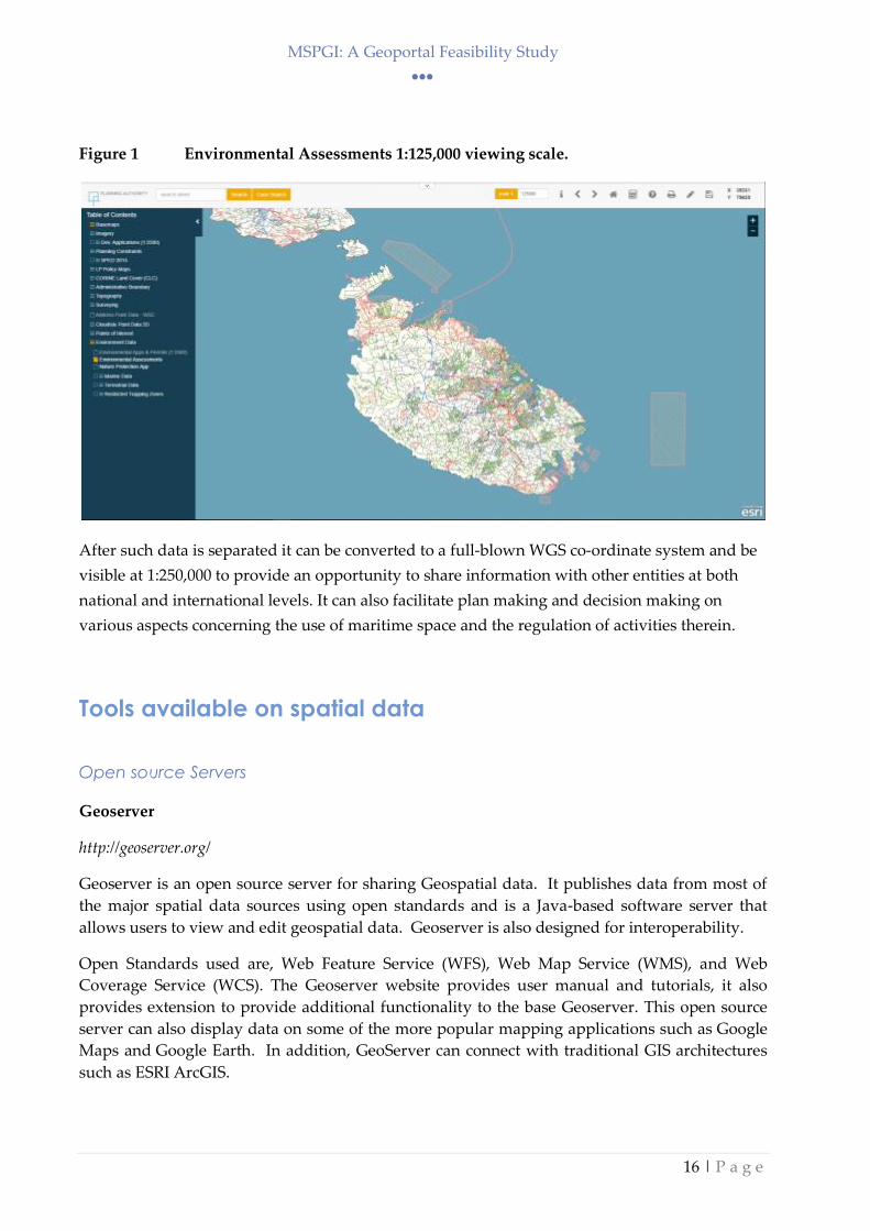
A possible option to overcome this issue is to separate planning applications at sea from those
on land. Having the data split would mean being able to display Marine data at 1:125,000 and
thus showing all marine applications around the island. An example of this is the data set on
Environmental Assessments which are visible in 1:125,000 as shown in Figure 4. Being able to
activate and view data at such a large extent provides the capability to distinguish applications
like tuna pens or current works which are offshore. This in turn also provides the officer an
opportunity to compare proposed projects with information on site history (any previous
permits submitted and whether approved or not) and over impose other environment
information at a large scale.
MSPGI: A Geoportal Feasibility Study
16 | P a g e
Figure 1 Environmental Assessments 1:125,000 viewing scale.
After such data is separated it can be converted to a full-blown WGS co-ordinate system and be
visible at 1:250,000 to provide an opportunity to share information with other entities at both
national and international levels. It can also facilitate plan making and decision making on
various aspects concerning the use of maritime space and the regulation of activities therein.
Tools available on spatial data
Open source Servers
Geoserver
http://geoserver.org/
Geoserver is an open source server for sharing Geospatial data. It publishes data from most of
the major spatial data sources using open standards and is a Java-based software server that
allows users to view and edit geospatial data. Geoserver is also designed for interoperability.
Open Standards used are, Web Feature Service (WFS), Web Map Service (WMS), and Web
Coverage Service (WCS). The Geoserver website provides user manual and tutorials, it also
provides extension to provide additional functionality to the base Geoserver. This open source
server can also display data on some of the more popular mapping applications such as Google
Maps and Google Earth. In addition, GeoServer can connect with traditional GIS architectures
such as ESRI ArcGIS.

MSPGI: A Geoportal Feasibility Study
17 | P a g e
Mapserver
http://mapserver.org/
Mapserver is yet another platform for publishing spatial data. Mapserver does not aspire to be a
full GIS suit as is declared on the company website "MapServer is not a full-featured GIS system,
nor does it aspire to be." Mapserver is sub-divided into 3 packages. MapServer Core, which is
written in C and takes care of service publishing. MapCache, which takes care of tiling
capabilities and finally TinyOWS which performs transactional requests to WFS for feature
editing.
Proprietary GIS Servers
Boundless
https://boundlessgeo.com/boundless-server/
Boundless is divided in diverse suits to accommodate required needs. As a GIS server it offers
publishing of Geospatial data as web services and to web-apps, desktop clients or mobile
devices. With Boundless one is able to edit services directly through the OGC services. The
company offers two servers, Standard for on-premises hosting and Enterprise for cloud-
optimised hosting. Boundless is a highly scalable GIS server solution for large-scale enterprises.
Boundless server Enterprise offers the following opportunities:
(i) Reduced Costs: Scale at a lower cost without vendor lock-in and with 24x7 expert
support that avoids costly in-house maintenance, with expert 24×7 support
(ii) Flexibility: where components run individually, together, or interoperate with
proprietary software; ability to customise service
(iii) Interoperability: it can connect to existing databases; it publishes services in OGC or
GeoServices REST formats
Esri ArcGIS Server
http://enterprise.arcgis.com/en/server/latest/get-started/windows/what-is-arcgis-for-server-.htm
ArcGis Server provides Geospatial data to anyone who has an internet connection. Mainly this
server system provides webservices which provide the generated GIS information to tablets,
smartphones, laptops, desktop workstations, and any other devices that can connect to web
services.
ArcGis Servers is divided into three different editions: Basic, Standard and Advanced.
(i) Basic: this edition of ArcGIS GIS Server includes geodatabase management and the ability to
publish (but not edit) feature services for map visualization and query. The geometry
service is provided as well as the ability to publish geodata services. This edition cannot be
MSPGI: A Geoportal Feasibility Study
18 | P a g e
used as a hosting server. Refer to Appendix V for a description of the Geodatabase creation
lineage.
(ii) Standard: with the Standard edition, the Basic edition is provided, plus all the GIS web
service types offered by ArcGIS GIS Server. This service prepares the generated maps for
web use, supports web-based editing using feature services, and to publish geoprocessing
services from any tool included in ArcGIS Desktop Standard. The Schematics capability is
included, with several other extensions available for purchase. Finally, maps, apps, and
other geographic information can be shared with everyone in your organization through
the ArcGIS Enterprise portal.
(iii) Advanced: with the Advanced edition, the service provides the Standard edition, plus the
ability to publish geoprocessing services from any tool included in ArcGIS Desktop
Advanced. Additional capabilities for geostatistical models and spatial analyst tools are also
included with the Advanced edition. All other extensions are optionally available for
purchase.
ArcGIS Server offers a large number of specific extensions for different business sectors as
indicated in Table 1 below.
Table 1 ArcGIS specific extensions
Capability ArcGIS GIS Server
Standard
ArcGIS GIS Server
Advanced
Serve schematics datasets Included Included
Share 3D services and embed 3D analysis
tools
Not available for purchase Included
Serve geo statistical models Not available for purchase Included
Share/embed Spatial Analyst tools and
services
Not available for purchase Included
ArcGIS Data Interoperability extension Available for purchase Available for purchase
ArcGIS Data Reviewer extension Available for purchase Available for purchase
ArcGIS for INSPIRE extension Available for purchase Available for purchase
ArcGIS for Maritime: Server extension Available for purchase Available for purchase
ArcGIS Network Analyst extension Available for purchase Included
ArcGIS Workflow Manager extension Available for purchase Available for purchase
Esri Defence Mapping extension Not available for purchase Available for purchase
Esri Production Mapping extension Available for purchase Available for purchase
Esri Roads and Highways extension Available for purchase Available for purchase
ArcGIS Pipeline Referencing extension Available for purchase Available for purchase
Esri's ArcGIS also offers the possibility to use ArcGISOnline which allows the publishing of GIS
web services to an Esri-administered cloud environment. No installation is required but a login
to Arcgis Online is needed.

MSPGI: A Geoportal Feasibility Study
19 | P a g e
There are two types of services than can be deployed:
(i) Feature services that expose the geometry, attributes, and symbol information for vector
GIS features. They are appropriate for displaying, querying, and editing ad hoc
generated data on top of web basemaps.
(ii) Tiled map services that expose a set of pre-generated map images (known as a map
cache) that can be viewed as basemaps in a web mapping application. When an ad hoc
service is published a request can be made to the server to create and store a cache of
tiles which can be accessed by the service’s URL.
Esri is focused on offering Web Services and tools to control such services, Esri can provide
authoring, sharing and editing of spatial data online.
Open source Desktop Applications
QGIS - Quantum GIS
https://qgis.org/en/site/
QGIS is a professional GIS application that is built on top of Free and Open Source Software
(FOSS). QGIS runs on Linux, Windows, Mac osx and Android. QGIS has a large active
community and forums and provides the following services:
Data viewing:
Spatially-enabled tables and views using PostGIS, SpatiaLite and MS SQL Spatial, Oracle
Spatial, vector formats supported by the installed OGR library, including Esri shapefiles,
MapInfo, SDTS, GML and many more. See section Working with Vector Data.
Raster and imagery formats supported by the installed GDAL (Geospatial Data
Abstraction Library) library, such as GeoTIFF, ERDAS IMG, ArcInfo ASCII GRID, JPEG,
PNG and many more. See section Working with Raster Data.
GRASS raster and vector data from GRASS databases (location/mapset). See
section GRASS GIS Integration.
Online spatial data served as OGC Web Services, including WMS, WMTS, WCS, WFS,
and WFS-T. See section Working with OGC Data.
Map Compositions:
QGIS browser
On-the-fly reprojection
DB Manager
Map composer
Overview panel
Spatial bookmarks
Annotation tools
Identify/select features
Edit/view/search attributes
MSPGI: A Geoportal Feasibility Study
20 | P a g e
Data-defined feature labelling
Data-defined vector and raster symbology tools
Atlas map composition with graticule layers
North arrow scale bar and copyright label for maps
Support for saving and restoring projects
Creation, editing, export and managing of Spatial data
Digitizing tools for OGR-supported formats and GRASS vector layers
Ability to create and edit shapefiles and GRASS vector layers
Georeferencer plugin to geocode images
GPS tools to import and export GPX format, and convert other GPS formats to GPX or
down/upload directly to a GPS unit (On Linux, usb: has been added to list of GPS
devices.)
Support for visualizing and editing OpenStreetMap data
Ability to create spatial database tables from shapefiles with DB Manager plugin
Improved handling of spatial database tables
Tools for managing vector attribute tables
Option to save screenshots as georeferenced images
DXF-Export tool with enhanced capabilities to export styles and plugins to perform
CAD-like functions
Extended functionality with additional Plugins
Core plugins include:
Coordinate Capture (Capture mouse coordinates in different CRSs)
DB Manager (Exchange, edit and view layers and tables from/to databases; execute SQL
queries)
Dxf2Shp Converter (Convert DXF files to shapefiles)
eVIS (Visualize events)
GDALTools (Integrate GDAL Tools into QGIS)
Georeferencer GDAL (Add projection information to rasters using GDAL)
GPS Tools (Load and import GPS data)
GRASS (Integrate GRASS GIS)
Heatmap (Generate raster heatmaps from point data)
Interpolation Plugin (Interpolate based on vertices of a vector layer)
Metasearch Catalogue Client
Offline Editing (Allow offline editing and synchronizing with databases)
Oracle Spatial GeoRaster
Processing (formerly SEXTANTE)
Raster Terrain Analysis (Analyze raster-based terrain)
Road Graph Plugin (Analyze a shortest-path network)
Spatial Query Plugin
Topology Checker (Find topological errors in vector layers)
Zonal Statistics Plugin (Calculate count, sum, and mean of a raster for each polygon of a
vector layer)

MSPGI: A Geoportal Feasibility Study
21 | P a g e
Exports a web version based on html-javascript output.
This application has already been tested in Malta. The University of Malta - PA Cloudisle
initiative is based on such an output.
Mapwindow GIS
http://www.mapwindow.org/
MapWindow GIS is an open source project which is sub divided into 5 packages for various
uses. MapWindow GIS uses an extensible plugin architecture, Active X controls and a C#
developer library DotSpatial. MapWindow GIS offers Support and also documentation on their
website.
The packages are subdivided as follows:
MapWindow v4.x
Free, ready-to-use spatial data viewer and geographic information system that can be
modified and extended using plugins. MapWindow 4 is built on the MapWinGIS
programmer tool (see below). The development of this application started in 1998 and
has stopped in favor of MapWindow5 in 2015.
MapWindow5
MapWindow5 is rewritten from scratch, starting in early 2015. It has or will have all
functionality of MapWindow v4 and is also extendable using plugins. New features of
this version, not available in previous versions, are geo-database support, WMS
support, repository browser, toolbox with restartable tasks and more.
MapWinGIS
MapWinGIS.ocx is used to provide GIS/mapping functionality to user-written
Windows Forms based applications. Code can be written in Visual Basic 6, VB .NET or
C# and can be commercial or open source. MapWinGIS is the mapping control used in
MapWindow4 and MW5.
HydroDesktop
Free hydrologic data software for data discovery, download, visualization, editing,
and integration with other modeling tools. Using the DotSpatial library.
DotSpatial
Free GIS programmer library and tools for C# and .NET based applications. The
DotSpatial library is written in C# and can be used in commercial or open source
projects.
CrimeStat
https://www.icpsr.umich.edu/CrimeStat/index.html
Crimestat is an open source software designed for Crime spatial analysis but can be adapted for
Spatial statistics. It is free to download and is being used by many police departments around
the country as well as by criminal justice and other researchers. Spatial Descriptions and
Models are provided by the author website and can be found below.

MSPGI: A Geoportal Feasibility Study
22 | P a g e
Spatial Description
Spatial distribution - statistics for describing the spatial distribution of incidents, such as
the mean center, center of minimum distance, standard deviational ellipse, the convex
hull, or directional mean.
Spatial autocorrelation - statistics for describing the amount of spatial autocorrelation
between zones, including general spatial autocorrelation indices - Moran's I , Geary's C,
and the Getis-Ord General G, and correlograms that calculate spatial autocorrelation for
different distance separations - the Moran, Geary, Getis-Ord correlograms. Several of
these routines can simulate confidence intervals with a Monte Carlo simulation.
Distance analysis I - statistics for describing properties of distances between incidents
including nearest neighbor analysis, linear nearest neighbor analysis, and Ripley's K
statistic. There is also a routine that assigns the primary points to the secondary points,
either on the basis of nearest neighbor or point-in-polygon, and then sums the results by
the secondary point values.
Distance analysis II - calculates matrices representing the distance between points for the
primary file, for the distance between the primary and secondary points, and for the
distance between either the primary or secondary file and the grid.
'Hot spot' analysis I - routines for conducting 'hot spot' analysis including the mode, the
fuzzy mode, hierarchical nearest neighbor clustering, and risk-adjusted nearest neighbor
hierarchical clustering. The hierarchical nearest neighbor hot spots can be output as
ellipses or convex hulls.
'Hot spot' analysis II - more routines for conducting hot spot analysis including the
Spatial and Temporal Analysis of Crime (STAC), K-means clustering, Anselin's local
Moran, and the Getis-Ord local G statistics. The STAC and K-means hot spots can be
output as ellipses or convex hulls. All of these routines can simulate confidence intervals
with a Monte Carlo simulation.
Spatial Modelling
Interpolation I - a single-variable kernel density estimation routine for producing a
surface or contour estimate of the density of incidents (e.g., burglaries) and a dual-
variable kernel density estimation routine for comparing the density of incidents to the
density of an underlying baseline (e.g., burglaries relative to the number of households).
Interpolation II - a Head Bang routine for smoothing zonal data that can be applied to
events (volumes), rates or can be used to create rates. In addition, there is an interpolated
Head Bang routine for interpolating the smoothed Head Bang result to grid cells.
Space-time analysis - a set of tools for analyzing clustering in time and in space. These
include the Knox and Mantel indices, which look for the relationship between time and
space, and the Correlated Walk Analysis module, which analyzes and predicts the
behavior of a serial offender and a spatial-temporal moving average.

MSPGI: A Geoportal Feasibility Study
23 | P a g e
Journey to crime analysis - a simple criminal justice method for estimating the likely
location of a serial offender given the distribution of incidents and a model of travel
distance. The routine allows the user to estimate a travel model with a calibration file
and apply it to the serial events. It can be used to identify a likely location given the
distribution of 'points' and assumptions about travel behavior. There is a routine for
drawing lines between origins and destinations (crime trips).
Bayesian journey to crime analysis - an advanced criminal justice method for estimating
the likely location of a serial offender given the distribution of incidents, a model of
travel distance, and an origin-destination matrix showing the relationship between
where crimes were committed and where offenders lived. A diagnostics routine analyzes
serial offenders for whom their residence is known and estimates which of several
journey to crime estimates is most accurate. A selected method can be applied to identify
a likely residence location of a single serial offender given the distribution of incidents,
assumptions about travel behavior, and the origin of offenders who committed crimes in
the same locations.
Regression modeling - a module for analyzing a relationship between a dependent
variable and one or more independent variables. The CrimeStat regression module
includes both Ordinary Least Squares and Poisson-based regression models, estimated
from Maximum Likelihood (MLE) or Markov Chain Monte Carlo (MCMC) algorithms.
The current version includes six different models including OLS, Poisson with Linear
Dispersion Correction, Poisson-Gamma and a Poisson-Gamma-Conditional
Autoregressive (CAR) spatial regression model. The module can handle very large
datasets through a Block Sampling approach. There is also a module for applying
estimated coefficients to a new dataset to make predictions.
GEODA
https://spatial.uchicago.edu/geoda
GeoDa is a spatial data analyst tool provided by The Center For Spatial Data Science, the
Univeristy of Chicago.
"It has one goal: To help researchers and analysts meet the data-to-value challenge. This challenge
involves translating data into insights"
The program is designed for location specific incidents, building, firm, address level, aggregated
areas, neighborhoods and districts. GeoDa differentiates from other packages because it focuses
on explicitly spatial methods for these spatial data.
Geoda provides through spatial statistical tests that supplement map visualization, real-time
exploration of data patterns, scatterplot matrix.

MSPGI: A Geoportal Feasibility Study
24 | P a g e
Proprietary Desktop Applications
Mapinfo Pro - GIS Desktop
https://www.pitneybowes.com/us/location-intelligence/geographic-information-systems/mapinfo-pro.html
Mapinfo is a powerful tool is designed to map and share maps, it easily combines data, analytics
to produce intelligent mapping. It offers a very intuitive design and has a ribbon based interface.
Mapinfo Visualize data in less time than ever and update themes, layers and legends instantly, it
also offer compatability with today’s most common PC data formats as well as relational and
spatial databases.
Features and Capabilities as per their site description are presented in the table below.
Common PC files
Relational and
spatial databases Spatial data Maps and imagery
Microsoft® Excel Oracle®
AutoCAD®
DXF/DWG WMTS (background maps)
Access
Microsoft® SQL
Server SHP WMS and WFS services
DBF PostGIS DGN Aerial images
CSV and delimited
ASCII text files SQLite GML Satellite images
ODBC compliant
databases KML Scanned paper maps
OGC
GeoPackage
Microsoft® Bing maps
Print, publish and share your
maps with ease.
Add legends and charts using
our Wizards.
Share, save or export data in
commonly used formats.
Take fast action from your
insights.
Esri ArcGIS
http://www.esri.com/arcgis/about-arcgis
Esri has its own desktop suit. It mainly comprises of Arcmap, ArcCatalog, ArcGlobe, ArcScene
and latest introduction ArcGis Pro. ArcGIS Pro, a new application available to ArcGIS Desktop
users, provides tools to visualize, analyze, compile, and share your data, in both 2D and 3D
environments.
MSPGI: A Geoportal Feasibility Study
25 | P a g e
Arcmap is the main desktop utility used to buildmaps, perform Analysis, Manage Spatial data,
control service publishing, attach to GeoDatabases and much more. It`s main role is to assist in
visualization but also the primary link to many tools and extension offered by Esri. An
interesting tool, especially for the PA is the Statistics package.
Capabilities of ArcGIS
ArcGIS offers a unique set of capabilities for applying location-based analysis to your business
practices. Gain greater insights using contextual tools to analyze and visualize your data. Then
share these insights and collaborate with others via apps, maps, and reports.
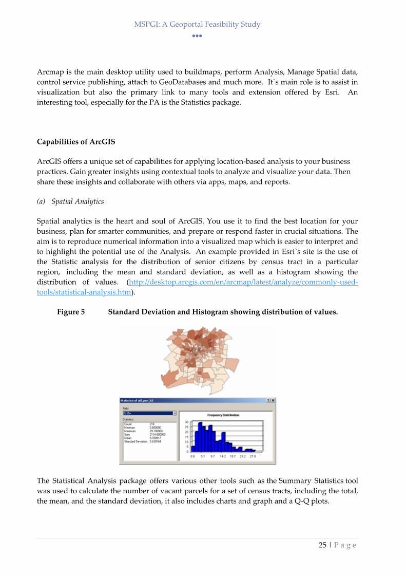
(a) Spatial Analytics
Spatial analytics is the heart and soul of ArcGIS. You use it to find the best location for your
business, plan for smarter communities, and prepare or respond faster in crucial situations. The
aim is to reproduce numerical information into a visualized map which is easier to interpret and
to highlight the potential use of the Analysis. An example provided in Esri`s site is the use of
the Statistic analysis for the distribution of senior citizens by census tract in a particular
region, including the mean and standard deviation, as well as a histogram showing the
distribution of values. (http://desktop.arcgis.com/en/arcmap/latest/analyze/commonly-used-
tools/statistical-analysis.htm).
Figure 5 Standard Deviation and Histogram showing distribution of values.
The Statistical Analysis package offers various other tools such as the Summary Statistics tool
was used to calculate the number of vacant parcels for a set of census tracts, including the total,
the mean, and the standard deviation, it also includes charts and graph and a Q-Q plots.

MSPGI: A Geoportal Feasibility Study
26 | P a g e
ArcMap fully integrates itself with ArcGIS Server and allows to communicate for service
publishing and also use various other tools. Arcmap allows to distribute WMS, WFS and
Mapping services and also exports to various other formats other then Esri Shape files.
(b) Mapping & Visualization
Maps help you spot spatial patterns in your data so you can make better decisions and take
action. Maps also break down barriers and facilitate collaboration. ArcGIS gives you the ability
to create, use, and share maps on any device.
(c) 3D GIS
3D GIS brings real-world context to your maps and data. Instantly transform your data into
smart 3D models and visualizations that help you analyze and solve problems and share ideas
and concepts with your team and customers.
(d) Real-Time GIS
Real-time GIS empowers you with location monitoring of any type of sePAr or device —
accelerating response times, optimizing safety, and improving operational awareness across all
assets and activities, whether in motion or at rest.
(e) Imagery & Remote Sensing
ArcGIS gives you everything you need to manage, process, analyze, and share imagery. Not
only do you get access to the world's largest imagery collection, you get tools like satellite,
aerial, drone and full motion video.
(f) Data Collection & Management
With ArcGIS, you can easily collect, crowdsource, store, access, and share your data efficiently
and securely. You can integrate data stored in your business systems and geo-enable any data
from any source.

MSPGI: A Geoportal Feasibility Study
27 | P a g e
Technological Way Forward
WebGIS forms part of a rapidly morphing technological upheaval as witnessed from the move
from HTML to ImageMap u GISclient to full WebGI. Some of these directions will play an
important role in easing and facilitating the introduction of a WebGI as part of an enterprise GIS
for thePA.
The different issues that must be integrated, as identified in the PA GI Strategy adopted in 2017
before such a WebGl can be created include:
(i) Improved Usability of GIS
The general trend of GIS development seems to indicate that it is becoming more usable and
dispersed in organisations, both public and private sectors. Traditionally GIS started in
individual departments and served specialised functions. GIS applications required highly
trained staff to operate. In recent years with the growth and maturity of GIS, it has become
easier to use, more intuitive, more analytical, and more embedded with a variety of
technologies, thus has become much more usable to a broader set of disciplines as well as
businesses processes.
(ii) Standardisation& Interoperability
Standardisation is the reason for the success of the Internet, the World Wide Web, e-Commerce,
and the emerging wireless revolution. The reason is simple: our world is going through a
communications revolution on top of a computing revolution. Communication means
"transmitting or exchanging through a common system of symbols, signs or behaviour."
Standardisation means agreeing on a common system (ArcNews Online).
(iii) Service Oriented Architecture
Although not specific to GIS, Service Oriented Architecture (SOA) is closely linked to much of
the explosion of interoperability and web-based GIS applications. In computing, the term SOA
expresses a business-driven approach to software architecture that supports integrating the
business as a set of linked, repeatable business tasks, or "services". Services are self-contained,
reusable software modules with well-defined interfaces and are independent of applications and
the computing platforms on which they run. SOA helps users build composite applications,
which are applications that draw upon functionality from multiple sources within and beyond
the enterprise to support horizontal business processes. SOA helps businesses innovate by
ensuring that IT systems can adapt quickly, easily and economically to support rapidly changing
business needs. SOA is largely based on a set of Web services standards (e.g., using SOAP or
REST) that have gained broad acceptance over the past several years. These standards have
resulted in greater interoperability and avoidance of vendor lock-in. One can implement SOA
using any service-based technology.
MSPGI: A Geoportal Feasibility Study
28 | P a g e
(iv) GIS on the Web
GIS will continue to become more web-based. Improvements in Internet speed, cost and
availability have brought about innovations in Web site technologies, such as the use of
Asynchronous JavaScript and XML (AJAX), image tiling for 3D visualisation, and continuous
scrolling. Such technologies are improving the usability and response times of Internet sites and
are an attempt to bring browsing more in line with the desktop experience.
(v) Mash-ups
A mash-up is a website or web application that uses content from more than one source to create
a completely new service. Content used in mash-ups is typically sourced from a third party via a
public interface or API. Mash-ups are revolutionizing web development and will influence the
way maps can publish on the web, especially involving third party vendors, such as Google
Maps.
(vi) GIS Data in Relational Database Management Systems (RDBMS)
Early GIS data was stored primarily in proprietary file formats. As the industry changes to more
open systems, the relational database management system has emerged as the preferred way to
store GIS information, primarily because of the open architecture standardisation, and ability to
integrate with other databases.
(vii) Unprecedented Access to GIS Data
GIS data availability is rapidly growing for GIS data users. In the early years of GIS, data was
available in proprietary formats and not easily shared between governments and businesses.
With the proliferation of personal computers, use of the Internet and standardisation of GIS data
formats, access to GIS data has become much easier and widespread. Many governments and
private businesses post data on web sites for download and consumption, either for free or for a
fee.
(viii) Mobile GIS
Wireless technologies combined with the previously discussed Web-enabled GIS are allowing
spatial data to be moved into the field and used in many ways, such as feature finding (e.g.,
utilities), field editing of data, and routing.
(ix) Broad Public Acceptance & Knowledge
Although an acronym not widely known or used, GIS has been a driving force behind much of
the mainstreaming of web-based mapping found today on the internet. Web sites like Map
Quest and Google Maps deliver GIS functionality (limited), but largely without the average user
knowing what GIS really is. This has been a big boost for the GIS community and has had
positive side effect in that it has raised the public’s awareness and acceptance of finding
information via a mapping interface. And not only are map interfaces becoming more accepted
for obtaining information, but collectively the public’s skill level has been raised. Simple

MSPGI: A Geoportal Feasibility Study
29 | P a g e
functions like pan and zoom and the ability to navigate in a map-based environment are
becoming part of the collective knowledge base of users, furthering to help boost GIS as a
common accepted information tool.
Recommendations for an MSP Geoportal
Some key notes can be extracted from this desk study that would need to be presented for
consideration when the Planning Authority as the MSP Competent Authority seeks to update its
data management services for the creation of an MSP portalSuch keynotes be incorporated in the
current/new Geoserver and not restricted to an independent portal:
Reproject data to well-known coordinates, such as WGS84
Separate Marine development permit applications from Land Applications
Display Marine data at a zoom level of 1:250,000
Provide Dissemination, search and download service and per INSPIRE Directive
Fill up metadata for Marine parcels to confirm with INSPIRE Directive
With the introduction of the above notes, the Geoportal will be able to cater for MSP data and
further assist spatial planners to evaluate application but can also serve as an information portal
for the general public. It is imperative that MSP data is disseminated to the public as this
contributes to greater knowledge of how maritime activities are planned, organised and
regulated.
Architecture & Application Choices
In terms of the options available for the creation of a website that would serve the PA for the
Marine data, a number of considerations were taken up: the use of a web-mapping service. Web-
based mapping has allowed for a significant advanced in the ability to deliver light-weight
mapping functionality (thin client-fat server approach) to a large audience at a relatively low
cost. Whilst the PA was one of the forerunners of such applications, there is yet a vast amount of
activities that need to be partaken to in order to allow better web-mapping management.
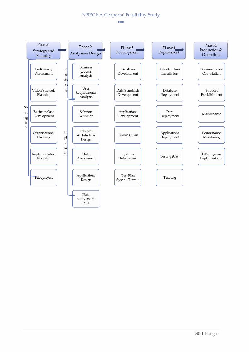
The GeoPortal implementation Plan is outlined in Appendix A as it follows the proposed Plan
identified in the GI Strategy document (2018) which identifies five different phases that include
the strategy and planning, analysis and design, development, deployment and production and
operation as identified in the Figure 6 below.
MSPGI: A Geoportal Feasibility Study
30 | P a g e
Str
at
eg
ic
Pl
an Im
pl
e
m
en
tat
N
ee
ds
As
se
ss

MSPGI: A Geoportal Feasibility Study
31 | P a g e
Employing this methodology will help identify the processes required to set up the Marine
WebGL.
With web-based mapping:
User software requirements are minimal. Users only need to have a web browser.
Networking requirements are minimal. Users only need to have a standard Internet
connection to use a web application.
Application software and settings can be maintained on a central server and published
out to users, thereby eliminating the need to install, configure, and maintain application
software and settings on each user’s computer.
The service would still need to be based on a back-end, either through stand alone or through a
geodatabase structure that sits in the back-end.
Accompanying the centralised data model is the emergence of storing and managing GIS data a
relational database management system (DBMS). While DBMS’ are not new, GIS data has only
recently started the migration towards being managed through a DBMS. This has been due to
the complexity of geospatial data, the models used to build GIS data, and the legacy of the
proprietary formats that most GIS data was built on in the last two decades. Additionally,
effective integration of GIS data with other business systems requires that data be stored in a
DBMS.
Appendix V and Appendix VI detail the processes required to create the geodatabase and the
web-service respectively.
If the PA or stakeholders opt for a simple webmap that does not include multi-functionality, the
document, through Appendix IV discusses the processes required through the use of an
opensource tool, called QGIS.

MSPGI: A Geoportal Feasibility Study
32 | P a g e
WebGIS Best Option
This chapter provides a financial analysis of costs associated with implementing an enterprise
GIS. As has been mentioned repeatedly in this plan, GIS is more than just the technology;
therefore, this cost estimate looks at the total cost of GIS over a three year forecast period,
including the software/hardware, planning, design, development, deployment, and
maintenance and support of the system. This cost estimate is based on the best available
information and has been reviewed by a consulting firm for verification and validation. Some
costs, such as hardware and software are fairly straightforward to estimate, and others such as
data conversion and application development are rough estimates. This is because the GIS
Needs Assessment phase, which will focus on data requirements, is yet to be completed. Once
the GIS Needs Assessment is completed, it will be possible to assess the magnitude of the
conversion effort and then adjust the cost estimate accordingly, if necessary.
In the evaluation of the PA’s WebGIS, costs are divided into two types:
(i) implementation and
(ii) maintenance, or program costs.
Implementation costs are those costs associated with designing, developing, and deploying the
initial enterprise GIS, essentially costs during the first year. Maintenance costs are those
associated with ongoing costs and maintenance. The table below identifies the categories within
the implementation and maintenance costs. Note that some of the components are identified in
each. Items already implemented or in progress are identified.
Following diverse reviews, the best option was deemed to create a MSP-dedicated site that ‘sits’
on the PA webserver and which can elicit and capture webservices from the other entities,
irrespective of what they chose to use: whether a standalone system within the different
stakeholders or a central system within PA which captures the webservices.
The best option should feature the following:
- the current SIMWESTMED-related data and the Marine-related data that is external to the
MSP but which can be captured through a webservice scenario or even through a service
offered by the PA;
- it show depict the current static maps (based on security and access to same);
- it should allow for the capture of stakeholders’ webservices and other online data which
conforms to capture service;
- in case of real-time data capture, the option to capture real or near-real time capture as
was the case with SEIS. However a cost-analysis can be carried out as on what the data
sources are, how they are received, which data sensors are submitting data and how such
is captured, converted and displayed. It the process is governed by the stakeholders or
international entities, then the protocols need to be assessed, reviewed and the
technological issues highlighted.
- The system should allow for online analysis and basic statistical tool availability

MSPGI: A Geoportal Feasibility Study
33 | P a g e
- It should allow for scenario-building, though one needs to discuss this with the SIntegraM
dissemination contractor to check whether the option is viable and how far can such be
deployed.
Costs
Hardware software
maintenance/upgrades
Staffing – Already installed through systems set up at the PA. Would
need further investment should a requirement be placed on the need to
create a new system as against adding a new service to the current
system as a separate Marine page.
Data maintenance Data incoming from both internal PA units or from the stakeholders
needs to comply with INSPIRE Directive requirements (Appendix VI
and VIII).
Data is to be in full WGS84 format to ensure compliance with the
SIntegraM output, which ensures less dependency on other entities to
convert from truncated ED50 to full ED)
Training/Education Technology investments need to keep abreast with the PA webserver
and relative training rendered. PA and stakeholders are to ensure that
the geoportal includes walkthroughs and help screens that serve as
training to both developers and the user base.
System Support Application Development – expertise already within the PA on
maintenance, however any new development would cost
The relative costs are based on user-friendliness for easy viewing and querying
While publishing the data, considering the awareness in the browser usage, the interfaces (web
pages) can be designed in such a way that it appears familiar to the user. User-friendliness is
ensured while viewing the GIS data. While accessing the GIS data from the central server
through Internet/Intranet, the client needs only a web browser. There is no need of installing
sophisticated GIS software or plugins at the user’s end. GIS data can be easily queried through
the Internet browser.To achieve these objectives, the PA must have the proper GIS infrastructure
in place and the following architecture is being recommended:

MSPGI: A Geoportal Feasibility Study
34 | P a g e
http://www.esri.com/esri-news/arcuser/winter-2014/portal-for-arcgis-101
To implement such a setup as based on the current ArcGIS Server Enterprise edition and
WebGIS structure at the PA, one needs to develop and implement the dissemination tool, either
through an add-on to the current structure, a new service or inclusion in the SIntegraM
dissemination service..
Estimated costs:
Current PA webGIS addon 5,000 euros (excl. VAT)
Dissemination tool including backend 65,000 euros (excl. VAT)
SIntegraM tool 0 euros
Note: the costings above assume that the human resource factor is already absorbed by the PA through the
Marine Team and ICT GI resources.
Risks
Most of the risk the PA will face will be in-house-based during development and management
of the system. These include:
Data Conversion
Data conversion is usually the most expensive component of a web-GIS implementation,
which risks were mitigated by the SIntegraM data conversion and Reprojection tool.
MSPGI: A Geoportal Feasibility Study
35 | P a g e
Department Conflicts/Scope Creep
In the enterprise GIS model, one comprehensive system will be designed to serve all
departments. In such a model, there will inevitably be varying opinions and conflicts in
how the system is designed. While this is typical in any multi-entityendeavour, during
the web- GIS implementation it will be particularly important to manage the scope of
work closely and develop change management procedures to ensure there are not
excessive delays, excessive costs, or incidences of scope creep broadening the project
beyond is original intent.
Complex Technology
While the front end of many GIS are becoming more simplified and easy to use for the
casual user, it is important to realise the technology behind the GIS is becoming
increasingly complex. The PAwill need to acknowledge that certain skill sets identified
will be required to keep the system at a certain level of operation. If these skill sets are
not available, then the benefits again are likely not to be obtained.
Conclusion
This desk study attempted to evaluate the potential for developing an MSP portal hosted by the
Planning Authority, in addition to its existing Geoportal. It provides the technical
argumentation to take forward a possible option that can be implemented by the organisation as
an initial instrument to facilitate the effective implementation of the MSP Directive. This would
constitute the first step towards improved co-operation and co-ordination at national level
which would pave the way for future options at the trans-boundary level.
MSPGI: A Geoportal Feasibility Study
36 | P a g e
References
Copernicus Marine Services. (n.d.). CHLO4MSFD: A WEB PORTAL SERVICE IN SUPPORT TO
MSFD. Retrieved August 24, 2018, from http://marine.copernicus.eu/usecases/chlo4msfd-web-
portal-service-support-msfd/
European Parliament, & Council of the European Union. (2008). Directive 2008/56/EC of the European
Parliament and of the Council. Official Journal of the European Union.
http://doi.org/10.1016/j.biocon.2008.10.006
Formosa S., (2014). If Appleseed had an open portal: Making sense of data, SEIS and integrated systems
for the Maltese Islands, in B., Murgante, S., Misra, A.M., Rocha, C, Torre, J.G., Rocha, M.I., Falcao,
D., Taniar, B.O., Apduhan, and O., Gervasi, (Eds.). Computational Science and its Applications –
ICCSA 2014 Lecture Notes in Computer Science, 2014, LNCS 8580, 709-722, DOI: 10.1007/978-3-
319-09129-7_51, Springer, Heidelberg, ISBN: 978-3-319-09128-0 (Peer-Reviewed)
Formosa, S., Borg, B. (2018). GIPSI18: GI Planning Authority Strategy 2018: Geographic Information
Systems (GIS) Three-year Strategic Plan FY2019-FY2022, Floriana, Malta, 17 April 2018
Hili, O. (2014). Conceptualisation of the Design of an Environmental GIS System in Malta. Manchester
Metropolitan.
Eu. (2007). Directive 2007/2/EC of the European Parliament and of the council of 14 March 2007
establishing an Infrastructure for Spatial Information in the European Community (INSPIRE).
Official Journal of the European Union. http://doi.org/citeulike-article-id:11622889
OGC. (n.d.). Web Map Service. Retrieved August 22, 2018, from
http://www.opengeospatial.org/standards/wms

MSPGI: A Geoportal Feasibility Study
37 | P a g e
Appendix I – Outline GeoPortal Implementation Plan
The Appendix lists the outline Plan that is being envisaged in order to implement the Marine
GeoPortal.
The Plan has been built on the guidelines emanating from the PA GIS Strategy.
Formosa, S., Borg, B. (2018). GIPSI18: GI Planning Authority Strategy 2018: Geographic Information
Systems (GIS) Three-year Strategic Plan FY2019-FY2022, Floriana, Malta, 17 April 2018
MSPGI: A Geoportal Feasibility Study
38 | P a g e
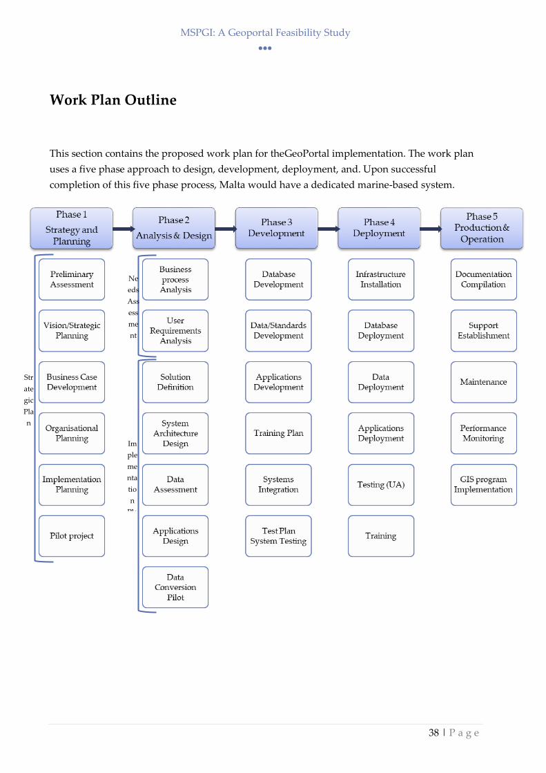
Work Plan Outline
This section contains the proposed work plan for theGeoPortal implementation. The work plan
uses a five phase approach to design, development, deployment, and. Upon successful
completion of this five phase process, Malta would have a dedicated marine-based system.
Str
ate
gic
Pla
n
Im
ple
me
nta
tio
n
Pla
Ne
eds
Ass
ess
me
nt

MSPGI: A Geoportal Feasibility Study
39 | P a g e
Phase 1 – Strategy and Planning
Phase 1 represents the strategic planning portion of the enterprise GIS implementation. This
phase establishes the overall direction for the Web GIS for thePA, including a vision, goals and
objectives, business case justification, financing plan, and a pilot project.
Phase 1 Activity Areas
1.1 GIS Scoping/Preliminary Assessment
This first activity area involves a preliminary assessment of the current environment.
Work Areas
1.1.1 Assess current environment (opportunities, constraints, challenges)
1.1.2 Research other similar authorities that have Marine Data
1.1.3 Research evolving trends and business needs
1.1.4 Evaluate architecture and application choices
1.1.5 Preliminary evaluation GIS integration capability with key business processes
1.1.6 Establish project organisational structure
1.1.7 Identify deployment timeline
1.2 Vision/Strategic Planning
Web-enabled systems require more planning, testing, than simple non-interactive solutions and
will havePA-wide and extra-PAimplications; therefore, it is recommended that an oversight
committee which can be composed of the SIMWESTMED project Group be established to help
with planning efforts. It is anticipated that the committee will help serve as the main group of GI
Web-Portal promoters. Activity in this section includes:
Work Areas
1.2.1 Development of GI Web-Portal goals and objectives
1.2.2 Identify key issues facing GI Web-Portal implementation, identify stakeholders
responsible for decision-making these issues
1.2.3 Identify priorities for inclusion in GI Web-Portal (e.g., mission critical systems, high
priority data)
1.2.4 Develop conceptual GIS Webmodel, demonstrate consistency with overall IT architecture
and the current MapServer
MSPGI: A Geoportal Feasibility Study
40 | P a g e
1.3 Business Case Development
This activity involves documenting the cost/benefits associated with aGI Web-Portal. While not
every cost and benefit can be accounted for, specific examples of current business process can be
used as examples to show how the process will benefit under the Web model. As already
identified in the PA Strategy and in the usefulness of the MapServer, there is a business case to
expand the current Web-Portal to either add on a new set of datasets onto the server such a the
expansion of the current server to cover marine areas, or as an alternative to create a new multi-
entity webserver that will serve as a dedicated marine server.
Work Areas
1.3.1 Develop appropriate cost/benefit analysis
1.3.2 Document other intangible benefits ofGI Web-Portal (e.g., improved customer service)
1.4 Organisational Planning/Communication
A variety of organisational and resource related issues will need to be addressed to ensure
webportal GIS implementation is congruent with the organisational structure, that its functions
are understood by stakeholders. These include:
Work Areas
1.4.1 Define Marine Section and ICT GI Team organisational structure of GIS within the
organisation
1.4.3 Establish roles &responsibilities of user groups
1.4.4 Create Communication Strategy for informing/sharing stakeholders and interested
parties about status of GI Web-Portal
1.5 Strategic Plan
This activity involves assembling the main planning document for GI Web-Portal as well
as budget and timeline for deployment.
Work Areas
1.5.1 Develop GI Web-Portal Technology ‘Road Map’ (implementation plan and timeline)
1.5.2 Develop GI Web-Portal implementation budget, resource requirements
1.6 Pilot Project
A pilot project, or ‘early win’, will be an important milestone in the Webimplementation by
allowing an opportunity to show decision-makers and potential userswhere the project is
heading with a real live tangible example and point out key benefits,value, and functionality of
the web portal.
MSPGI: A Geoportal Feasibility Study
41 | P a g e
This function is demonstrated through the: initial webportal pages created through
SIMWESTMED. The issues identified therein require a an established process of creating both a
dedicated geoportal as per Appendix V and to follow the process established in Appendix VI
detailing the process to create an online webmap. Work Areas
Project Initiation
1.6.1 Identify initial pilot project parameters (i.e., goals/objectives)
Needs Assessment
1.6.3 Determine end user environment for pilot project, including public access component
1.6.4 Identify and document functional requirements of pilot project
1.6.5 Identify and document technology needs with candidate project, including procedures
and requirements for deploying the web-based mapping application
Development
1.6.8 Acquire software/hardware environment for pilot
1.6.9 Integrate both solutions including new functionalities
1.6.10 Build and configure back-end environment
1.6.11 Develop reporting functionality
1.6.12 Configure pilot
1.6.13 Test pilot
Deployment
1.6.16 Create demonstration format/strategy and present to interested/identified parties,
including a strategy of how the external website component will be presented to the
public
1.6.17 Deploy pilot
1.6.18 Conduct presentations/demonstrations internally
1.6.19 Monitor usage/troubleshooting

MSPGI: A Geoportal Feasibility Study
42 | P a g e
Phase 2 – Analysis and Design
The Analysis and Design phase examines the activities that can benefit from the use of web-GIS
by analysing business processes and workflows within the organisation and document how
geographic information is part of that workflow. From this documentation, solutions are
identified and overall system blueprint with a Web focus is created.
Needs Assessment (Activity Areas 2.1 and 2.2)
The adoption of technological innovations such as a web-GIS is not always a straightforward
process.
The Needs Assessment activity itself serves as a learning tool where potential users in each
participating department learn about web-GIS.
As part of this Needs Assessment, the PAwill have all of the information needed to plan and
develop a GI Web-Portal, through looking at the workflow and processes within and between
departments, responsibility for data creation, updates and maintenance will become apparent.
The Needs Assessment informationwill be used as the basis for the Implementation Plan or
blueprint for implementing the GIS.
Phase 2 Activity Areas
2.1 Business Process & Workflow Analysis
Business process analysis and modeling is an effective tool for defining the business activities
associated with the use of GIS and when properly applied will greatly expand the organisational
benefit of the GI Web-Portal. The business process and workflow analysis outlined here will
result in providing documentation of the existing business process (“as-is”) and with the GIS
technology (“to-be”).
Work Areas
2.1.1 Review of existing documents, systems, resources, and activities as they relate to GIS
2.1.6 Compile information
2.1.7 Create draft report
2.1.8 Conduct follow up interviews as necessary
2.1.9 Review & refine final report

MSPGI: A Geoportal Feasibility Study
43 | P a g e
2.2 User Requirements Analysis
Work Areas
2.2.1 Prepare Needs Assessment approach
2.3 Solution Definition
The Solution Definition step represents the compilation, review, and synthesis of Needs
Assessment and workflow analysis to arrive at an overall solution. This is an important step as it
represents the shift from the evaluation and analysis of user requirements to resolve and the
formulation of ideas, concepts, explanations that will reach the desired solution.
Work Areas
2.3.1 Identify potential software suite solution
2.3.3 Determine additional application development needs
2.3.4 Determine overall application environment that will do the best job at collectively
addressing the identified application/workflow functions
2.4 System Architecture Design
Via the Needs Assessment, the current system architecture will be known as well as what is
needed to adequately support a proposed Web system. System Architecture Design will provide
the foundation for building a productive operational environment for GI Web-Portal.
Work Areas
2.4.1 Review current system architecture
2.4.2 Develop overall System Architecture Design with upgrade recommendations,
application specifications
2.4.3 Develop conceptual interface design
2.4.4 Develop proposed hardware/software Procurement Plan
2.5 Data Assessment
This work area will involve taking inventory of the current inventory environment and
comparing it with the Needs Assessment findings to determine data gaps and issues. This work
area also involves evaluating the condition of existing data and determining the appropriate
steps to bring it into the planned GIS environment and also look at how the data will be
managed once it is within the GI Web-Portal environment.
Work Areas
2.5.2 Develop overall map base model for classifying and grouping various data layers
2.5.3 Develop Data Conversion/Migration Plan and prioritisation scheme based on condition
of data. Identify layers that are targeted for immediate upload into the GIS geodatabase.

MSPGI: A Geoportal Feasibility Study
44 | P a g e
2.5.4 Develop Data Management Plan to address updates, uploads, transfers, replication,
replenishment, backups, archiving, etc.
2.6 Base GIS Database Design –Conceptual/Logical Data Model
Conceptual/logical database design is the first step in database design where the contents of the
intended database are identified and described allowing for a comprehensive mental framework
and organised structure to be revealed. The conceptual design captures the user’s view of the
data and will allow the opportunity to evaluate how all of the various aspects interact
(relationships), while at the same time providing the opportunity to identify major issues early
on. This step uses information developed during the Needs Assessment and typically places it a
structured format in the form of an Entity-Relationship Diagrams (ERD) or UML (Unified
Modeling Language) diagrams.
The ERD or UML diagrams show the relationships between database tables and identify
primary keys and important attributes. The purpose of the ERD or UML is to specify all tables
and relationships needed to support the GIS applications. The conceptual design process is
iterative. It will identify items that are in existing databases that may need to be geocoded and
included in the Web system. New attributes or entities will be discovered through interaction
with staff and will require changes to the entities and their relationships.
Given the various states of spatial data within the organisation, information that is currently
maintained in GIS format or is maintained by other entities, will not need to go through
database design, but can proceed toward being integrated into the GIS database. Assuming the
data meets the established standards (e.g., metadata standards, INSPIRE) and is fairly isolated
from other data, the data can be moved into the GIS database. Other layers will need to go
through database design stages. Refer to Appendices VIII and IX for the templates created as
part of this project for spatial and non-spatial data.
Work Areas
2.6.1 Organise and prepare working groups/individuals for specific model(s)
2.6.2 Conduct meetings/interviews
2.6.3 Develop logical data model(s)
2.6.4 Develop preliminary metadata requirements
2.6.5 Review and validate w/ groups and update as necessary
2.7 Application Design
Based on the Needs Assessment and Solution Definition, and in conjunction with the
goals/objectives and established topology of stakeholders of marine data, the application

MSPGI: A Geoportal Feasibility Study
45 | P a g e
environment can be identified. The GIS applications are those functions that GIS software
performs, whether ‘out-of the box’ or through customisation, using programming languages
that will make the software useful to end-users. This activity will result in conceptual
descriptions of the software applications recommended for development within Phase 3
Development.
This step should also include recommendations on priority application development given that
not all application development will be covered in the initial core implementation.
Work Areas
2.7.1 Develop Application Design document with priority application development
recommendations
2.7.2 Review and comment
2.7.3 Prepare final document
2.8 Data Conversion Pilot
Given the complexity of the web-GIS data conversion process, a data conversion pilot project
will be initiated. This will allow all participants to work through the entire conversion process
and evaluate weakness/strengths/ and learn how to improve the remaining sets of data. These
are identified in the initial processes reviewed in Appendix III as part of the process of analysing
the current marine data.
In addition, the SIntegraM Reprojection software tool should enable the completion of this
conversion process.
Work Areas
2.8.1 Identify candidate layers that can be used from the SIMWESTMED project
2.8.2 Develop scope of work
2.8.3 Implement scope of work
2.8.4 Review and refine process to improve further data conversion efforts

MSPGI: A Geoportal Feasibility Study
46 | P a g e
Phase 3 – Development
The Development phase is analogous to the construction phase of building a house. Design
documents, or ‘blueprints’, from Phase 2 are used to begin actual database development, data
conversion, and application development of the elements of the GI Web-Portal.
Phase 3 Activity Areas
3.1 GIS Database Development –Physical Data Model
The physical model is built from the conceptual/logical model and is the process of
implementing the data model schema within the geodatabase.
Work Areas
3.1.1 Develop physical database model(s)
3.1.2 Perform data conversion and migration based on Data Conversion/Migration Plan
3.1.3 Initiate database set-up and administration
3.2 Data/Standards Development
The PAwill be using data and sharing data from a variety of sources, both internal and external.
This data may be stored in different formats, have varying levels of accuracy, use different map
symbols, be produced on different schedules, be provided in different media, etc. Although
there are technological ways to deal with some of these variables, standards and procedures are
necessary to ensure thePA’s data investment is protected and continues into the future.
Standards and procedures serve as a corporate umbrella to promote data integrity and
consistency. One of the more important standards will be metadata for individual data layers.
These should be developed as the data layers are being created.
Work Areas
3.2.1 Create prioritised outline/list of standards and procedures to be developed as per
Appendices VII and VIII as based on INSPIRE Directive
3.2.2 Develop standards and procedures
3.2.3 Review and test standards/procedures with stakeholders
3.2.4 Develop single source location for easy access to standards and procedures
3.3 Priority Applications Development
ThePAs GI Web-Portal application development will be based on business requirements. Under
this approach, business functions and user needs identified through the Needs Assessment

MSPGI: A Geoportal Feasibility Study
47 | P a g e
drive the applications that are developed to support these specific functions and users. This
insures that the system developed will be useful and will be used. Additionally, application
development is the process by which the functional requirements of specific users are translated
into software tools that support those functions. This requires that the functional requirements
be transformed into detailed design specifications for application programmers.
Work Areas
3.3.1 Develop detailed design specifications for priority applications as recommended in the
Application Design document. Specifications will include, but not limited to:
Narrative description of what the application will do
What business function the application will support
A list of data inputs and outputs
A list of menus and tools with descriptions of associated functionality
Hardware and software requirements
Diagrams illustrating screen layouts and data models
Objective performance criteria that can be used to determine when the application
is “complete.”
3.3.2 Develop application prototype suitable for presenting, reviewing, test-run
3.3.3 Verify alignment of applications with the functional requirements specified in the Needs
Assessment.
3.3.5 Incorporate additional modifications to application and refine accordingly
3.4 Training Plan
Training is considered a “critical success factor” in the implementation of GI Web-Portal. It is
important to develop a process for developing a training environment within the context of the
existing structure, the topology of user groups, and tied to the goal of establishing a sufficient
knowledge base within the organisation.
The Training Plan needs to encompass all personnel levels from within the organisation and
from the Marine stakeholders, from end users, to help desk personnel, to system and database
administrators, and representatives from all levels of management, including decision-makers of
GIS. The goal of this Training Plan is establish a blueprint to develop a ‘critical mass’ of
knowledge, awareness and skills at the PA so that the GIS site is successful.
Work Areas
3.4.1 Identify users that need to be trained
3.4.2 Identify the requirements that users will need to complete their work
3.4.3 Develop objectives and timelines for specific training phases
3.4.4 Evaluate relevant training options
3.4.5 Develop training program for each of the identified users
MSPGI: A Geoportal Feasibility Study
48 | P a g e
3.4.6 Develop single source location for easy access to training and knowledge base
information.
3.4.7 Implement training necessary to complete components of Testing Plan
3.5 Systems Integration
GIS systems integration includes the work necessary to integrate spatial and non-spatial data
from disparate technologies, applications, and business units for use in GIS. TheMarine GIS will
be integrating with key business systems such as asset management system. This step involves
determining the process of integration with each of the different systems and will allow the
ability to uncover potential integration issues and resolve them prior to the Deployment Phase.
Work Areas
3.5.1 Develop systems integration document.
3.6 Testing
Adequate testing will ensure GI Web-Portal is delivered with the correct functionality and
behaviour as originally planned and designed.
Work Areas
3.6.1 Develop approach, scope, procedures, and acceptance criteria in Test Plan.
3.6.2 Conduct testing.
3.6.3 Debrief on testing, recommended actions/changes.

MSPGI: A Geoportal Feasibility Study
49 | P a g e
Phase 4 - Deployment
Deployment represents the phase in which the GI Web-Portal will be physically installed and
rolled out. Deployment will involve hardware, software applications, web-based applications,
databases, the network, and personnel, and therefore needs to be closely coordinated to ensure
an orderly deployment. To the extent possible a phased deployment should be coordinated so as
to not create a situation of a ‘single switch’ event and run the risk of multiple problems
emerging at once.
Up to this point in the GIS development process, the GIS hardware and software will have been
acquired and data conversion completed (or a substantial portion has been finished) both from
PA investment and SIntegraM investment. Different components of the hardware and software
will also have been purchased. It is now necessary to put all the pieces together, test them to
make sure they work as expected, and to initiate all procedures necessary to use the GIS.
Phase 4 Activity Areas
4.1 Infrastructure Installation
Work Areas 4.1.1 Develop infrastructure Deployment Schedule, including communication plan
4.1.2 Initiate infrastructure deployment
4.2 Database Deployment
Work Areas
4.2.1 Develop Database Deployment Schedule
4.2.2 Initiate Database Deployment
4.3 Data Deployment
Work Areas
4.3.1 Develop Data Deployment Schedule
4.3.2 Initiate data deployment
4.4 Priority Application(s) Deployment
Work Areas
4.4.1 Develop Priority Application(s) Deployment Schedule
MSPGI: A Geoportal Feasibility Study
50 | P a g e
4.4.2 Initiate priority application deployment
4.5 Testing
Work Areas
4.5.1 Using Testing Plan developed in Phase 3, conduct testing as planned.
4.6 Training
Work Areas
4.6.1 Using Training Plan, conduct additional as planned. Note: training may occur prior to
specific deployments

MSPGI: A Geoportal Feasibility Study
51 | P a g e
Phase 5 – Production and Operation
The production and Operation phase will lead to a successful maintenance, monitoring, support
and service program for the GI Web-Portal.
Phase 5 Activity Areas
5.1 Documentation Compilation
Work Areas
5.1.1 Assemble and inventory all identified required project documents
5.1.2 Complete remaining documentation.
5.1.3 Create single source resource location with easy access for relevant documents.
5.2 Support Established
Work Areas
5.2.1 As identified in Training Plan, initiate GIS support program for identified user groups.
5.3 Maintenance
Work Areas
5.3.1 Establish hardware/software maintenance program and lifecycle schedule.
5.4 Performance Monitoring
Once the system has been deployed, it will be important to determine what's working right,
what could work better, and what additional capability needs to be developed.
Work Areas
5.4.1 Conduct post-project assessment workshop with project participants
5.4.2 Review and compile report with recommendations
5.4.3 Develop plan for continue performance monitoring.
5.4.4 Determine measures for performance optimisation.
5.5 Web-GIS Program Development/Implementation
This document(s) will address establishing the overall program and associated work planfor
theweb-GIS Program implementation.
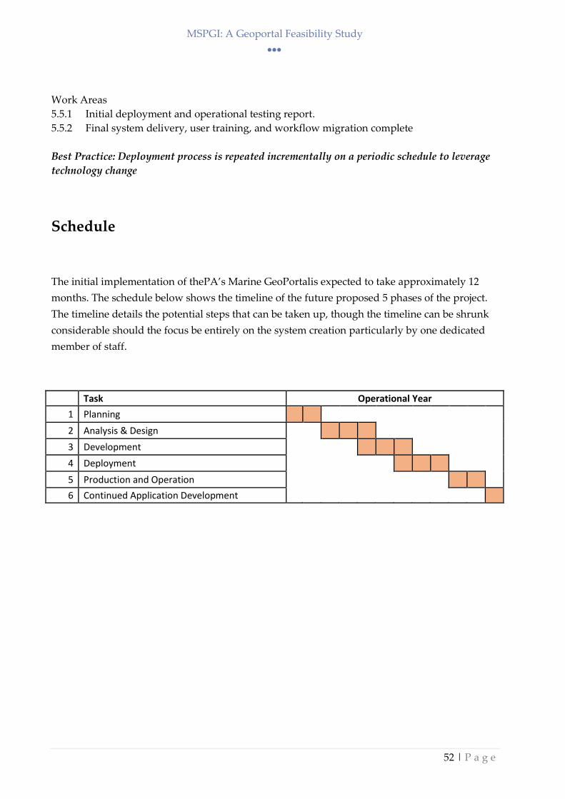
MSPGI: A Geoportal Feasibility Study
52 | P a g e
Work Areas
5.5.1 Initial deployment and operational testing report.
5.5.2 Final system delivery, user training, and workflow migration complete
Best Practice: Deployment process is repeated incrementally on a periodic schedule to leverage
technology change
Schedule
The initial implementation of thePA’s Marine GeoPortalis expected to take approximately 12
months. The schedule below shows the timeline of the future proposed 5 phases of the project.
The timeline details the potential steps that can be taken up, though the timeline can be shrunk
considerable should the focus be entirely on the system creation particularly by one dedicated
member of staff.
Task Operational Year
1 Planning
2 Analysis & Design
3 Development
4 Deployment
5 Production and Operation
6 Continued Application Development
MSPGI: A Geoportal Feasibility Study
53 | P a g e
Appendix II – PA Marine and GI Teams
1. Marine Experts
Use of GIS is available and knowledge on how to use maps and maintain the current
data layers and create new ones. On the spatial analytics, some more knowledge on
the different tools as identified in the earlier chapters would help expand the
potentialities of such a system
Data content - not owners of all the datasets and will need MoUs to amend such data
unless the guardian entity will provide updated data on an ongoing basis through in-
house changes and subsequent submission to the PA marine Team or through a
direct upload to the web portal.
Issues that may hinder the process relate to:
Changes in data capture and projection-decision procedure
Changes in database structures from source data or PA
Creation of front ends that might not allow for the non-terrestrial zones
Changes in roles and responsibilities of the different parties
2. ICT GI Team
Creation and maintenance of the geoportal
Creation of related datasets for geoportal consumption
Maintenance of the system
Uploading of the datasets
GI Issues - Integration of data and continuity and control.
Procedurally - require metadata structure for GI, ex timestamps
INSPIRE-related data structures
SIntegraM dissemination tools
Security management for portal

MSPGI: A Geoportal Feasibility Study
54 | P a g e
Appendix III – Training Manual for GI WebMaps using
QGIS
Lineage Documents
Process used in creating the GI layers for online dissemination
Project: Use of QGIS to create an online webmap
User: Saviour Formosa
Date: April 2018
Source File Name: First draft Document
Destination Directory: C:\Temp
Project Description: QGIS to webmap publishing
Document Verified By:
Abbreviations used: QGIS – Quantum GIS
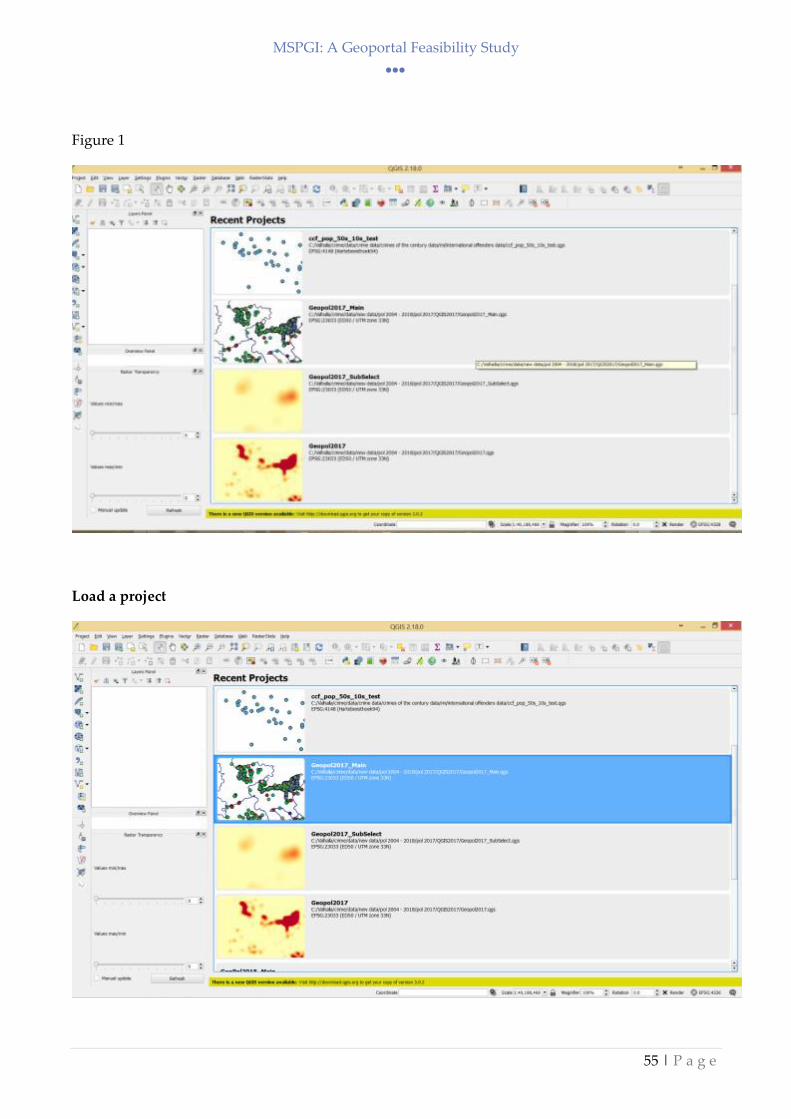
MSPGI: A Geoportal Feasibility Study
55 | P a g e
Figure 1
Load a project

MSPGI: A Geoportal Feasibility Study
56 | P a g e
Data layers are loaded in the GI map window

MSPGI: A Geoportal Feasibility Study
57 | P a g e
Under plugins load: Manage and Install Plugins
Choose OpenLayers Plugin
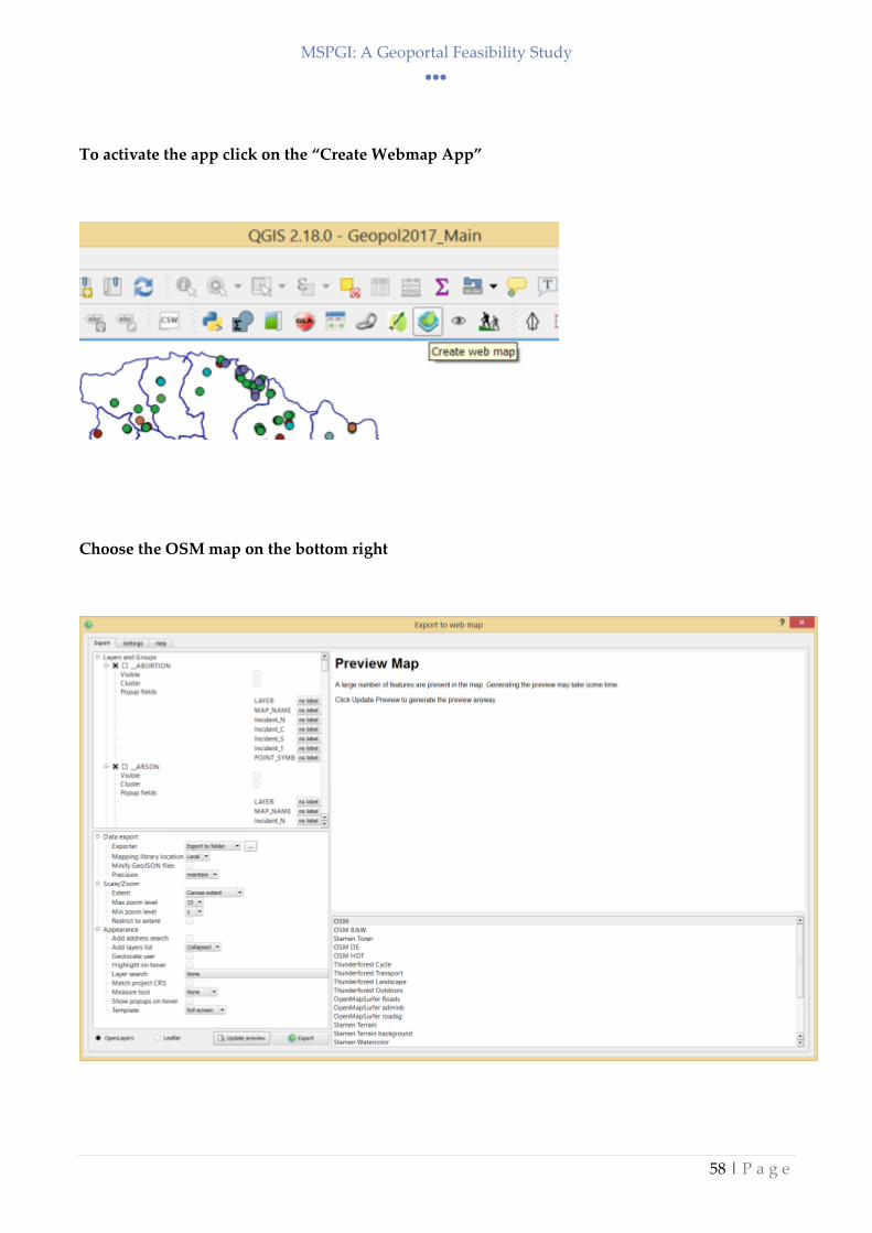
MSPGI: A Geoportal Feasibility Study
58 | P a g e
To activate the app click on the “Create Webmap App”
Choose the OSM map on the bottom right
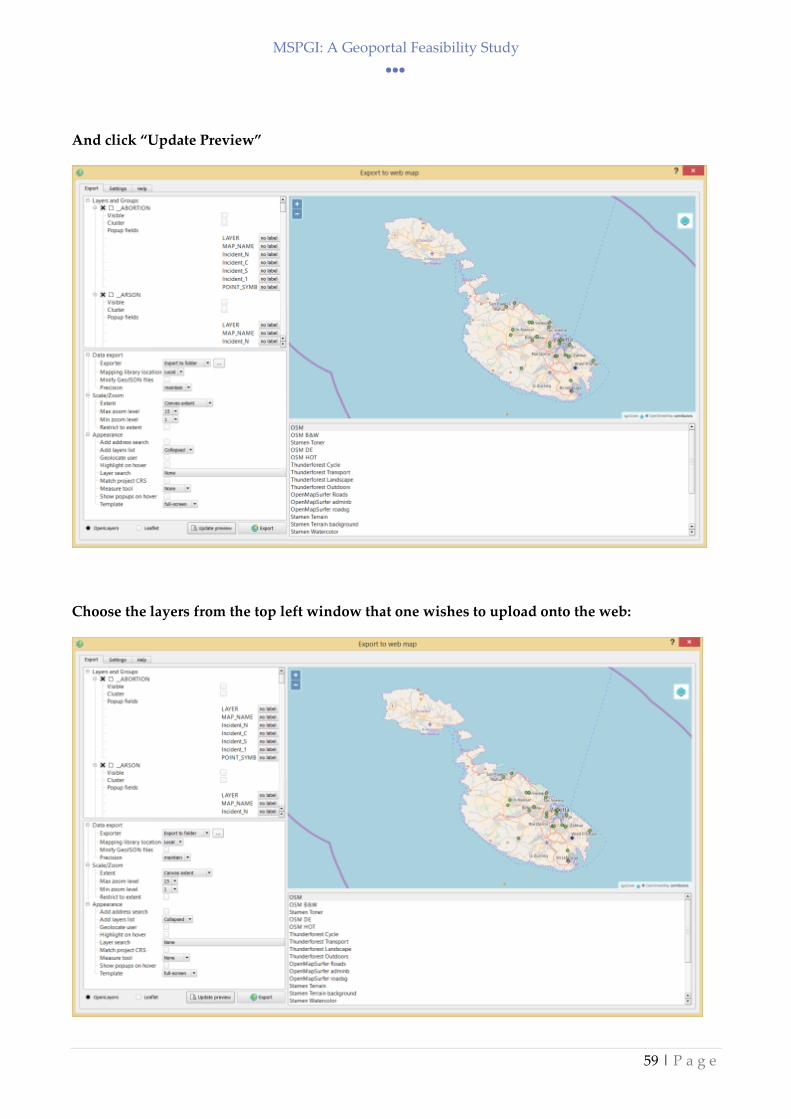
MSPGI: A Geoportal Feasibility Study
59 | P a g e
And click “Update Preview”
Choose the layers from the top left window that one wishes to upload onto the web:
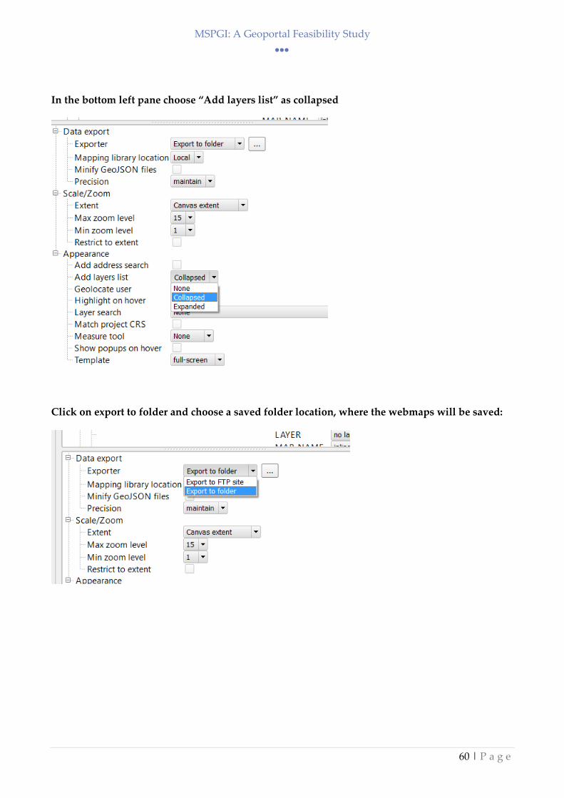
MSPGI: A Geoportal Feasibility Study
60 | P a g e
In the bottom left pane choose “Add layers list” as collapsed
Click on export to folder and choose a saved folder location, where the webmaps will be saved:

MSPGI: A Geoportal Feasibility Study
61 | P a g e
For maps that require a basemap only (such as OSM) map showing, the unclick the Visible map
tickbox.
For maps that require cluster mapping (a map that depicts clusters changing size on zooming)
click the Cluster tickbox.
Click on export to create the webmap

MSPGI: A Geoportal Feasibility Study
62 | P a g e
The tool will save and open the webmap in a web browser:

MSPGI: A Geoportal Feasibility Study
63 | P a g e
Click on the left buttons to zoom in or out (or use the mouse wheel).
Click on the right hand layers button to choose the layer that one wishes to view:
Points layer

MSPGI: A Geoportal Feasibility Study
64 | P a g e
Cluster map

MSPGI: A Geoportal Feasibility Study
65 | P a g e
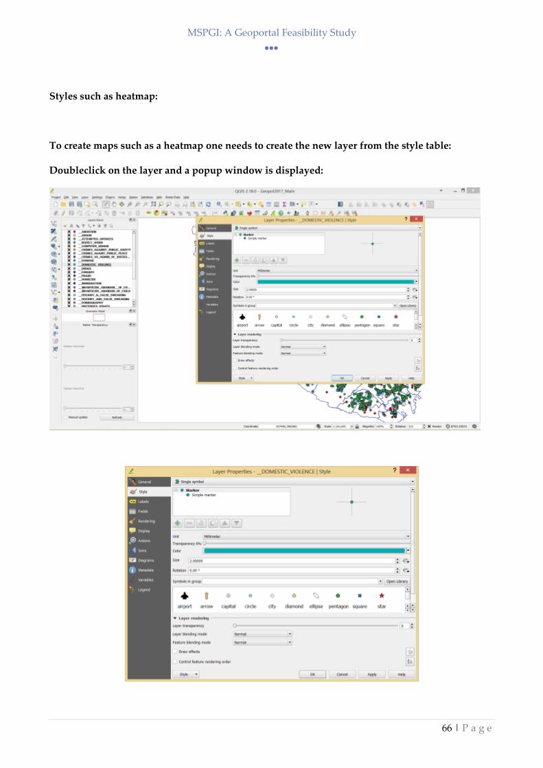
MSPGI: A Geoportal Feasibility Study
66 | P a g e
Styles such as heatmap:
To create maps such as a heatmap one needs to create the new layer from the style table:
Doubleclick on the layer and a popup window is displayed:
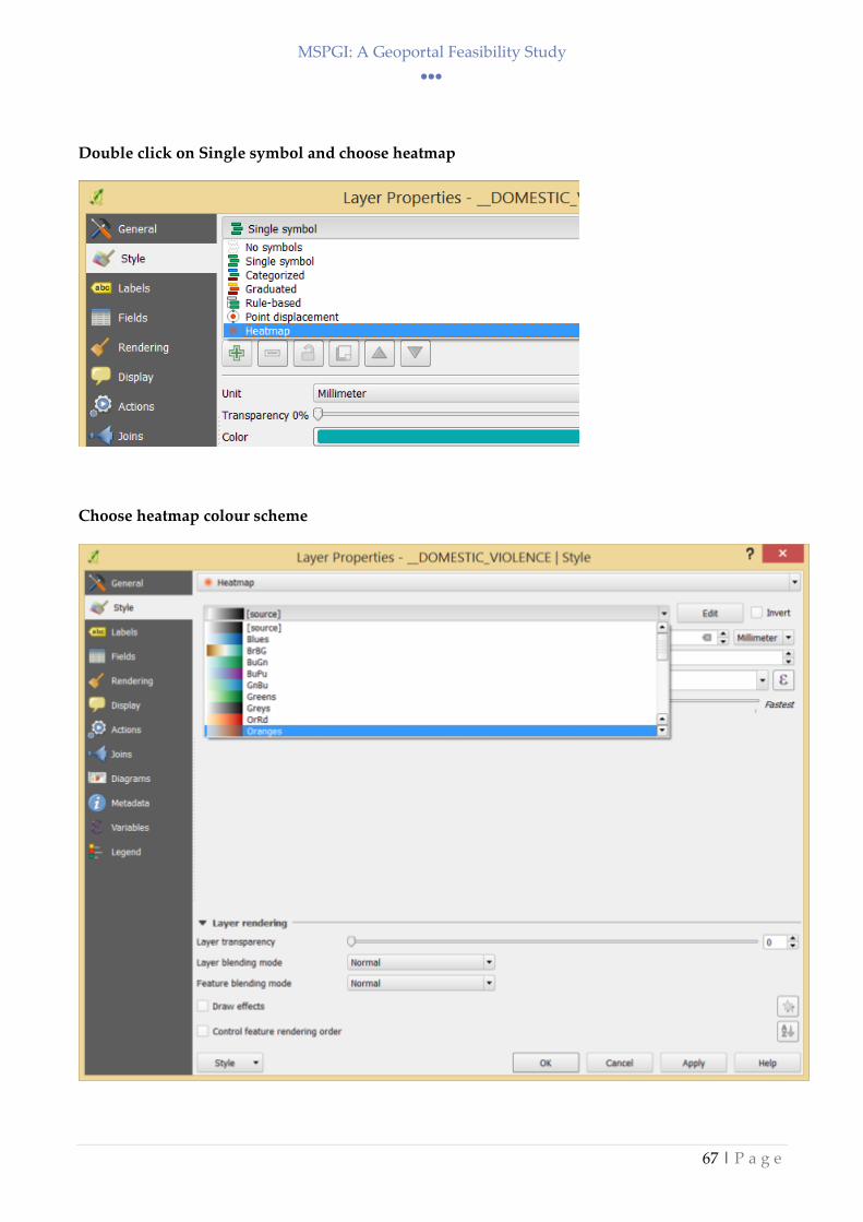
MSPGI: A Geoportal Feasibility Study
67 | P a g e
Double click on Single symbol and choose heatmap
Choose heatmap colour scheme
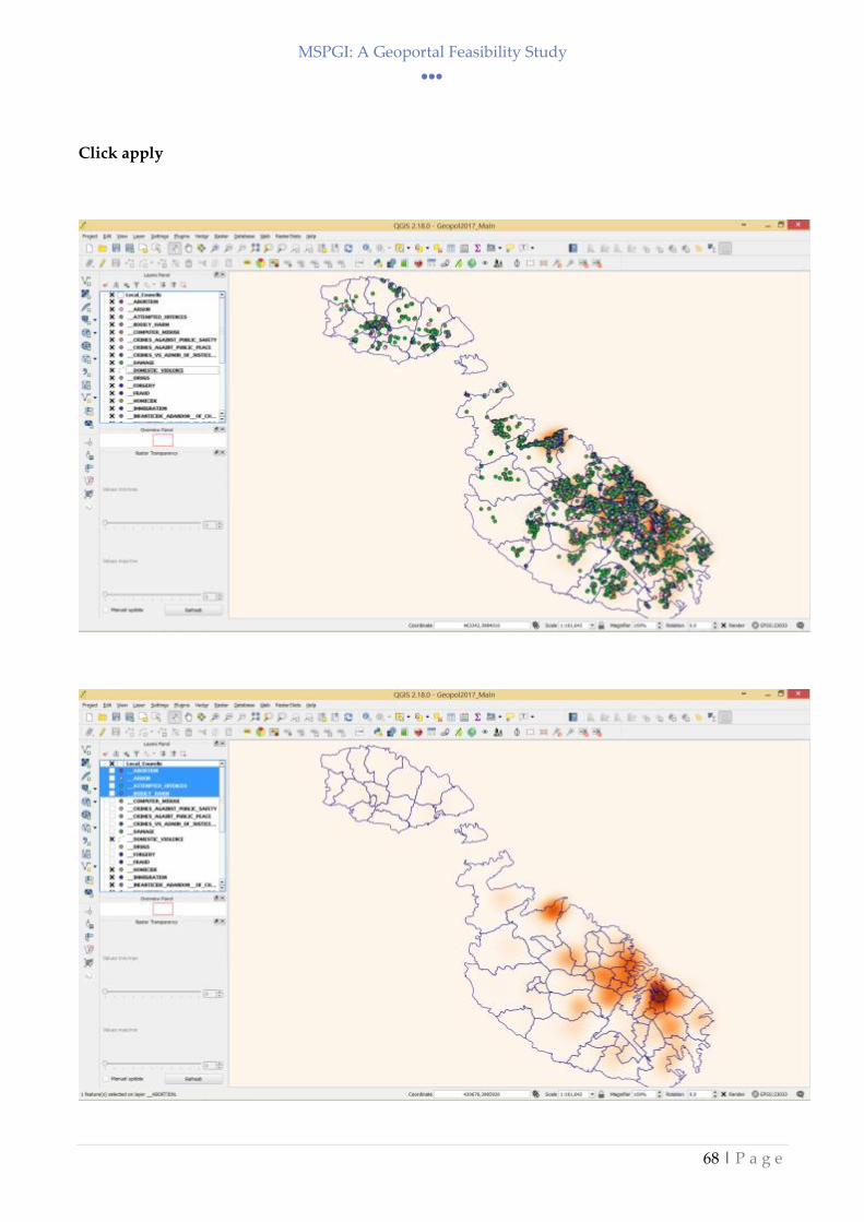
MSPGI: A Geoportal Feasibility Study
68 | P a g e
Click apply

MSPGI: A Geoportal Feasibility Study
69 | P a g e
Export to webpage
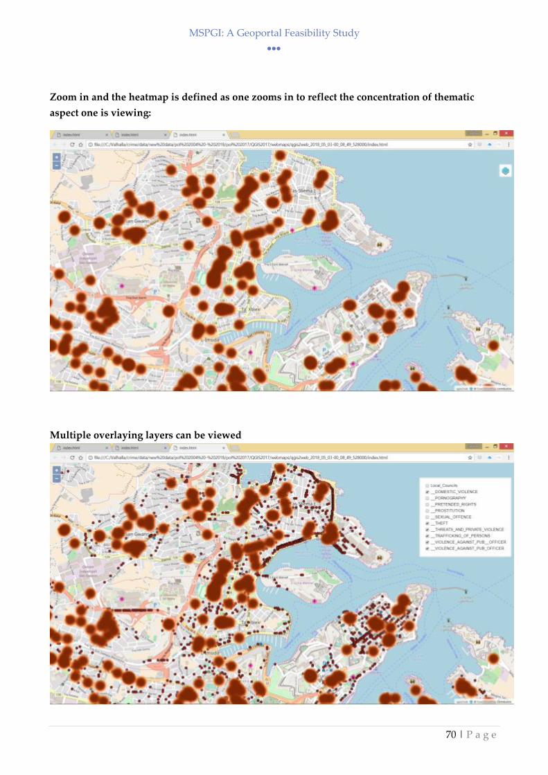
MSPGI: A Geoportal Feasibility Study
70 | P a g e
Zoom in and the heatmap is defined as one zooms in to reflect the concentration of thematic
aspect one is viewing:
Multiple overlaying layers can be viewed

MSPGI: A Geoportal Feasibility Study
71 | P a g e
To save to a website:
ii) Copy the entire saved folder to the web either through ftp or
iii) contact web domain administrator to upload file as best detailed in PA protocol
MSPGI: A Geoportal Feasibility Study
72 | P a g e
Appendix IV - Training Manual forCreation of File
Geodatabase in Arcmap 10.5
Lineage Documents
Project: Creation of File Geodatabase in Arcmap 10.5
User: Omar Hili
Date: March 2018
Source File Name: First draft Document
Destination Directory: C:\Temp
Project Description: Quick guide on how to create and import data in a File Geodatabase
Document Verified By Brian Borg:
Abbreviations used: GDB - Geo database
Lineage Steps
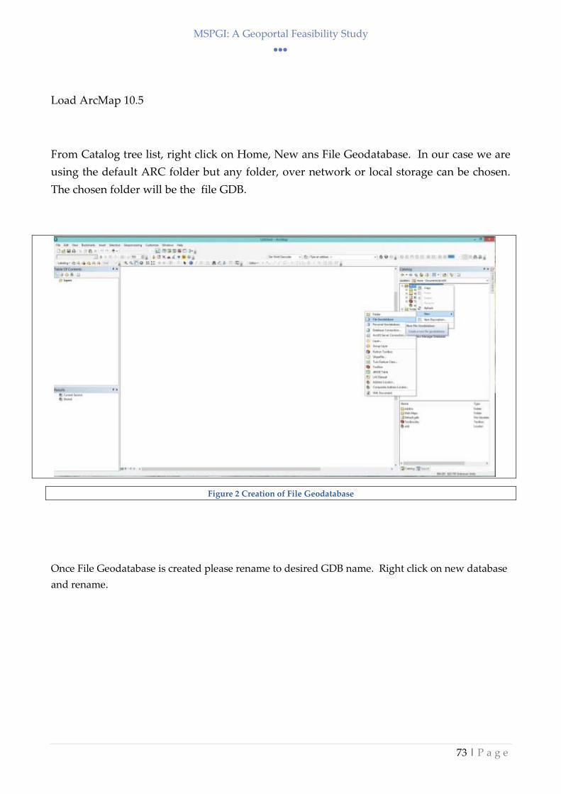
MSPGI: A Geoportal Feasibility Study
73 | P a g e
Load ArcMap 10.5
From Catalog tree list, right click on Home, New ans File Geodatabase. In our case we are
using the default ARC folder but any folder, over network or local storage can be chosen.
The chosen folder will be the file GDB.
Figure 2 Creation of File Geodatabase
Once File Geodatabase is created please rename to desired GDB name. Right click on new database
and rename.

MSPGI: A Geoportal Feasibility Study
74 | P a g e
Figure 3 Rename of Geo-Database
Once Created the File Geodatabase has all features of features of a Web database without the Multi-
user editing functionality. Different users can edit the data but not simultaneously.
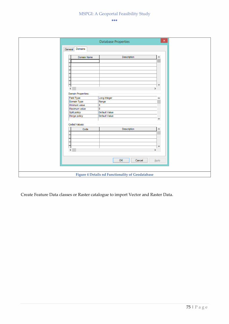
MSPGI: A Geoportal Feasibility Study
75 | P a g e
Figure 4 Details nd Functionality of Geodatabase
Create Feature Data classes or Raster catalogue to import Vector and Raster Data.

MSPGI: A Geoportal Feasibility Study
76 | P a g e
Figure 5 Creation of Feature Dataset and other options
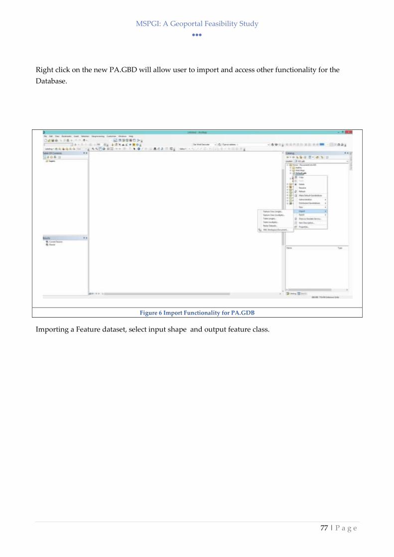
MSPGI: A Geoportal Feasibility Study
77 | P a g e
Right click on the new PA.GBD will allow user to import and access other functionality for the
Database.
Figure 6 Import Functionality for PA.GDB
Importing a Feature dataset, select input shape and output feature class.
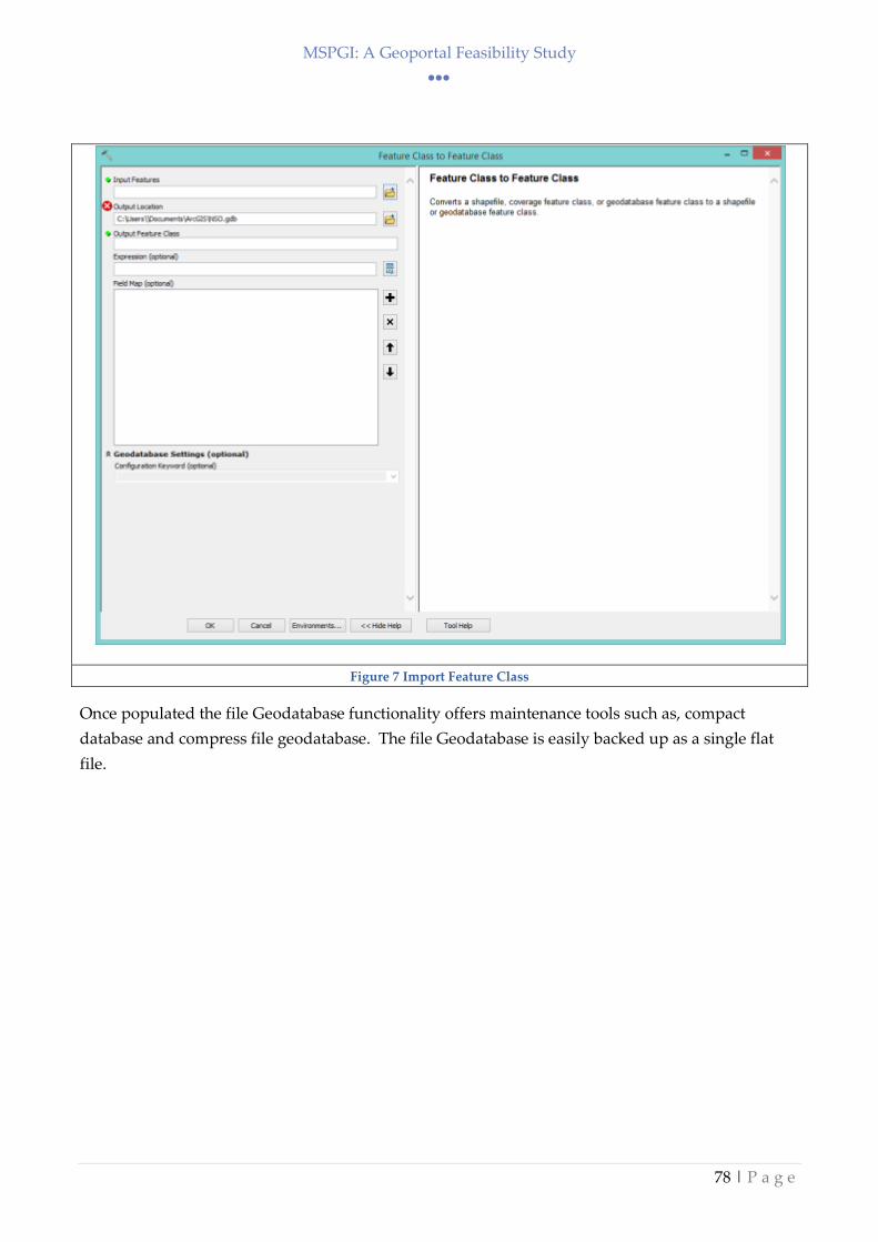
MSPGI: A Geoportal Feasibility Study
78 | P a g e
Figure 7 Import Feature Class
Once populated the file Geodatabase functionality offers maintenance tools such as, compact
database and compress file geodatabase. The file Geodatabase is easily backed up as a single flat
file.
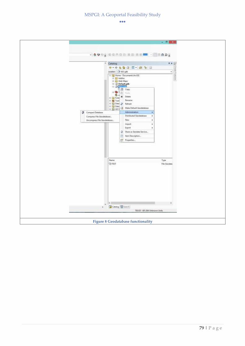
MSPGI: A Geoportal Feasibility Study
79 | P a g e
Figure 8 Geodatabase functionality
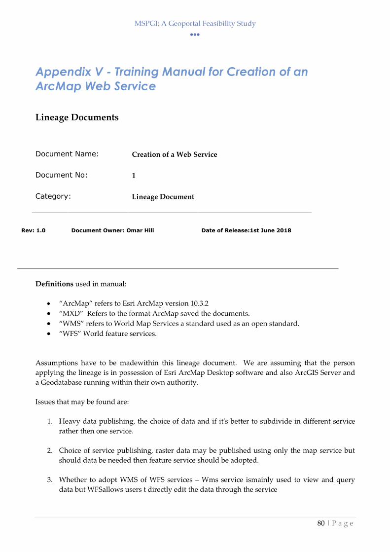
MSPGI: A Geoportal Feasibility Study
80 | P a g e
Appendix V - Training Manual for Creation of an
ArcMap Web Service
Lineage Documents
Document Name: Creation of a Web Service
Document No: 1
Category: Lineage Document
Rev: 1.0
Document Owner: Omar Hili
Date of Release:1st June 2018
Definitions used in manual:
“ArcMap” refers to Esri ArcMap version 10.3.2
“MXD” Refers to the format ArcMap saved the documents.
“WMS” refers to World Map Services a standard used as an open standard.
“WFS” World feature services.
Assumptions have to be madewithin this lineage document. We are assuming that the person
applying the lineage is in possession of Esri ArcMap Desktop software and also ArcGIS Server and
a Geodatabase running within their own authority.
Issues that may be found are:
1. Heavy data publishing, the choice of data and if it's better to subdivide in different service
rather then one service.
2. Choice of service publishing, raster data may be published using only the map service but
should data be needed then feature service should be adopted.
3. Whether to adopt WMS of WFS services – Wms service ismainly used to view and query
data but WFSallows users t directly edit the data through the service

MSPGI: A Geoportal Feasibility Study
81 | P a g e
4. Publishing a Geo-database – works exactly like publishing a shapefile and is mainly used to
replicate databases in remote locations.
Identify and Load data
Open ArcMap Software and identify the requested data to be published as a service. For this
exercise, we will be loading the Generic Coast Data. In this part, the user has to decide the amount
of data to publish in the service. Large datasets should be divided into separate services to facilitate
data query and loading.
Figure 9ArcMap software with requested Coast data.

MSPGI: A Geoportal Feasibility Study
82 | P a g e
Adjust esthetical and labeling of data
The second step is to adjust symbology, colors and other visual aspects requested by the client or as
deemed fit by the publisher. This is the esthetical aspect of the service. Providing different color
symbology and polygon labeling. The user must under that “what you see is what you get” so the
final result on the screen will reflect the published service.
Figure 10Layer properties to adjust visuals
After adjustments have been done the next step is to save the "MXD" document to be able to
publish. MXD is the format in which Arc saved the whole template of the document.

MSPGI: A Geoportal Feasibility Study
83 | P a g e
Figure 11 The MXD folder
Publishing of the Service
From the top menu Select File and choose Share as and choose Service. This will open the Publishing
Wizard. The following steps are fine tuning before publishing the service.
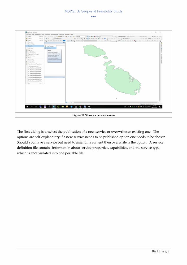
MSPGI: A Geoportal Feasibility Study
84 | P a g e
Figure 12 Share as Service screen
The first dialog is to select the publication of a new service or overwritesan existing one. The
options are self-explanatory if a new service needs to be published option one needs to be chosen.
Should you have a service but need to amend its content then overwrite is the option. A service
definition file contains information about service properties, capabilities, and the service type,
which is encapsulated into one portable file.

MSPGI: A Geoportal Feasibility Study
85 | P a g e
Figure 13 Service Dialog
Choose which ArcGIS server to publish too and also the Service Name
Figure 14 Choose Publishing Server

MSPGI: A Geoportal Feasibility Study
86 | P a g e
Choose directory were to save the service. The directory is listed on the server thus if the new
services form part of another group please choose a directory. In our case, this is a new service so
we are using a new folder. Using folders is a good way to organize yourcatalog of services. You
can look at folders as a method of organization.
Figure 15 Folder choice. Use existing or create a new one.
Service Editor
Next is the configuration of the service, this is the most important part of publishing. Most of the
times service chosen are standard but you may be requested to add new services. Below is a set of
parameters you can choose from.

MSPGI: A Geoportal Feasibility Study
87 | P a g e
Figure 16 Service Editor
In our case, we need to enable WMS and Feature Access, as previously stated we need to provide
the visual of the coast (WMS) and also allow to query its properties (Feature option). Mapping
service is enabled by default. Other services can be used, share a kml service for google earth of it
your company uses mobile applications then the Mobile accesscan be used.
WCS - The Open Geospatial CoPArtium, Inc. (OGC) Web Coverage Service (WCS) provides an
open specification for sharing raster datasets on the web. ArcGIS Server allows you to publish WCS
services from imagery collections, maps, or geodatabases that contain rasters.

MSPGI: A Geoportal Feasibility Study
88 | P a g e
Figure 17 Services Chosen
An important part of the pre-service sharing is the “item description”. This data will be visible on
the map and allow it to be discoverable in searches. It allows the use of Tags and provides the
credit or originator – a small part of inspire requirements. Options in figure 10 below.

MSPGI: A Geoportal Feasibility Study
89 | P a g e
Figure 18 Information on Service
The final step is to publish the Service. Select top right button to publish.
Figure 19 Publish Service
Confirm Service
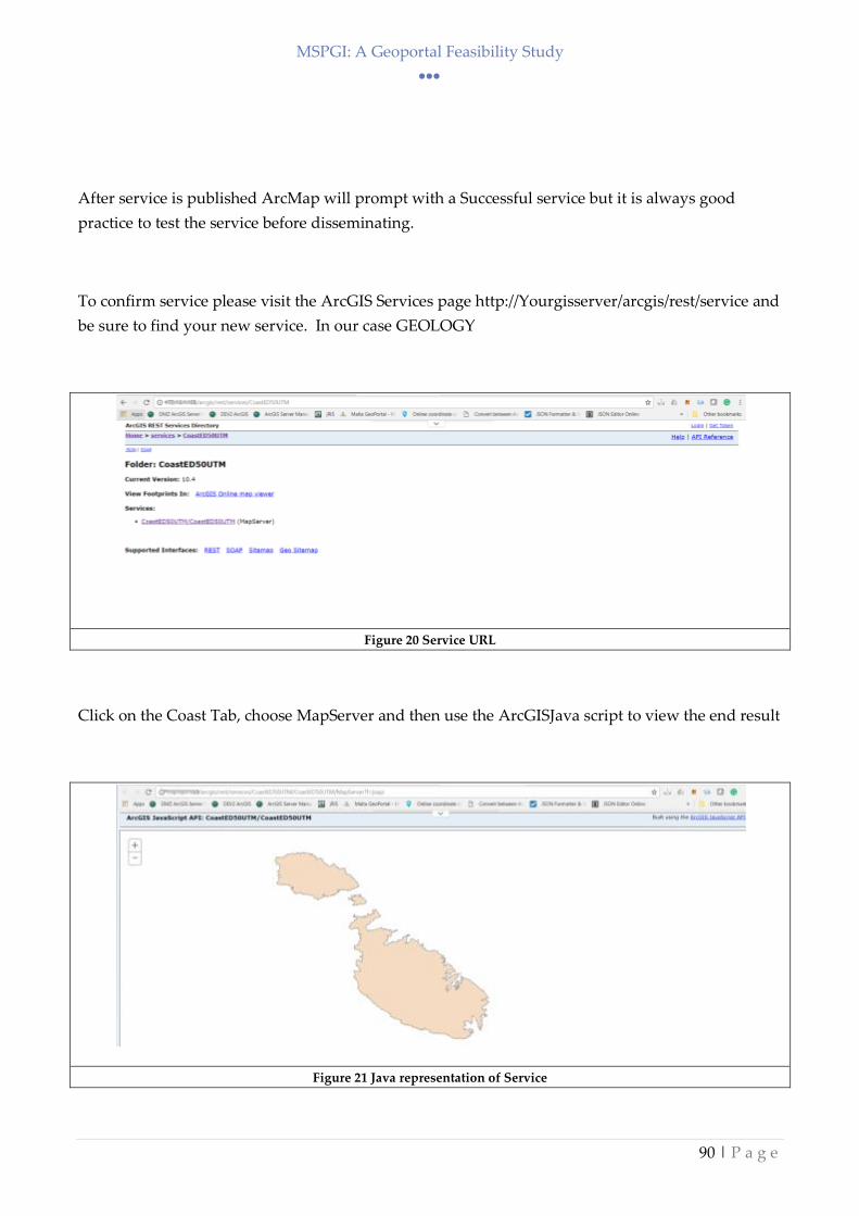
MSPGI: A Geoportal Feasibility Study
90 | P a g e
After service is published ArcMap will prompt with a Successful service but it is always good
practice to test the service before disseminating.
To confirm service please visit the ArcGIS Services page http://Yourgisserver/arcgis/rest/service and
be sure to find your new service. In our case GEOLOGY
Figure 20 Service URL
Click on the Coast Tab, choose MapServer and then use the ArcGISJava script to view the end result
Figure 21 Java representation of Service

MSPGI: A Geoportal Feasibility Study
91 | P a g e
Service can now be used for internal systems. The same procedure applies to external service with
the difference is to publish in an EXTERNAL ArcGIS server.

MSPGI: A Geoportal Feasibility Study
92 | P a g e
Appendix VI– INSPIRE Input Form xls: Spatial data
template
MSPGI: A Geoportal Feasibility Study
93 | P a g e
INSPIRE METADATA ELEMENTS
Component Description Input cells
Identification
Resource Title Geographic / thematic description Free text
Abstract Summary of resource content Free text
Resource Type Type of dataset Choose one
Resource locator URL to view Free text
Unique Resource Identifier Spatial object ID - value uniquely identifying an object within a namespace
Free text
Coupled Resource For SDS only - Name of spatial dataset targeted by spatial data service
Free text
Resource language Language used within resource Free text
Classification of spatial data and services
Topic category Grouping of spatial data Choose one
Classification of spatial data services Grouping to assist search of spatial data services Choose one
Keyword
Keyword value Keyword to describe relevant spatial data theme Choose word from GEMET Thesaurus link below
Originating controlled vocabulary Citation of controlled vocabulary used e.g. GEMET Thesaurus version 1.0
GEMET Thesaurus version 1.0
Click to access online Thesaurus
Geographic location
Geographic bounding box Bounding box extents in decimal degrees Free text
Temporal reference
Temporal extent Time period covered by the content of the resource (individual date/ date interval/ both)
YYYY-MM-DD
MSPGI: A Geoportal Feasibility Study
94 | P a g e
INSPIRE METADATA ELEMENTS
Date of creation Date of creation of resources YYYY-MM-DD
Date of publication Date when dataset became available YYYY-MM-DD
Date of last revision If resource has been revised, date of last revision of the resource
YYYY-MM-DD
Alternate references Temporal references as expressed by different thematic communities
YYYY-MM-DD
Quality and validity
Lineage Process history and overall quality of the spatial dataset. Include whether dataset has been validated, quality assured, if it is the official version, and has legal validity
Free text
Spatial resolution Scale or raster resolution / intervals Free text
Conformity Info on degree of conformity with IRs on interoperability of SD and SDS
Degree Degree of conformity of resource to related specification
Choose one
Conditions applying to access and use
Conditions for access and use of spatial datasets and services. Fees, where applicable, to access and use the resource.
Conditions Choose one
Limitations on public access Info on limitations (if they exist) on public access to SD and SDS
Limitations Reasons for such limitations Choose one
Organisations responsible for the establishment, mangement, maintenance and distribution of spatial datasets and services

MSPGI: A Geoportal Feasibility Study
95 | P a g e
INSPIRE METADATA ELEMENTS
Responsible party Name & e-mail of organisation Free text
Responsible party role Role of responsible organisation (Can choose more than one)
Choose One
Choose One
Choose One
Metadata on metadata Keeping metadata up to date
Metadata point of contact Name & e-mail of organisation responsible to create and maintain metadata
Free text
Metadata date Date specifying when the metadata record was created or updated
YYYY-MM-DD
Metadata language Language in which metadata components are expressed
Free text

MSPGI: A Geoportal Feasibility Study
96 | P a g e
Appendix VII – INSPIRE Input Form xls: Non-
Spatial data template

MSPGI: A Geoportal Feasibility Study
97 | P a g e
INSPIRE METADATA ELEMENTS
Component Description Input cells
Identification
Resource Title Unique name Free text
Resource Abstract Summary of resource content Free text
Resource Type Choose one
Resource locator URL to view
Resource language Language used within resource - ISO 639-2 English
Classification of spatial data and services
Topic category Grouping of data. Choose one
Keyword
Keyword value Keyword to describe relevant data theme Choose word from GEMET Thesaurus link below
Click to access online Thesaurus
Geographic location
Geographic location NUTS Catgories Choose one
If Other, specify Free text
Temporal reference
Temporal extent Time period covered by the content of the resource (individual date/ date interval/ both)
YYYY-MM-DD
Date of creation Date of creation of resources YYYY-MM-DD
Date of publication Date when dataset became available YYYY-MM-DD
Date of last revision If resource has been revised, date of last revision of the resource
YYYY-MM-DD
MSPGI: A Geoportal Feasibility Study
98 | P a g e
INSPIRE METADATA ELEMENTS
Quality and validity
Lineage Process history and overall quality of the dataset. Include whether dataset has been validated, quality assured, if it is the official version, and has legal validity.
Free text
Conformity
Specification Citation of specification to which resource is expected to conform. Title, reference date (date of publication, date of last revision or of creation) of the specification
Source: INSPIRE Directive, Article 7.1 - Interoperability of spatial datasets and services, EU Directive, 2007-04-25. - as amended by IRU for tabular data (2008-10-16)
Degree Degree of conformity of resource to related specification: Choose one
Conditions applying to access and use
Conditions Conditions for access and use datasets and services. Fees, where applicable, to access and use the resource.
Choose one
Limitations on public access
Limitations Info on limitations (if they exist) on public access to SD and SDS
Choose one
Organisations responsible for the establishment, mangement, maintenance and distribution of spatial datasets and services
Responsible party Name & e-mail of organisation Free text
Responsible party role Role of responsible organisation Choose one
Metadata on metadata
Metadata point of contact Name & email of organisation responsible to create and maintain metadata
Free text
MSPGI: A Geoportal Feasibility Study
99 | P a g e
INSPIRE METADATA ELEMENTS
Metadata date Date specifying when the metadata record was created or updated
YYYY-MM-DD

MSPGI: A Geoportal Feasibility Study
100 | P a g e
Appendix VIII – Appleseed and Open-Portals paper
Ref: Formosa S., (2014). If Appleseed had an open portal: Making sense of data, SEIS and integrated systems
for the Maltese Islands, in B., Murgante, S., Misra, A.M., Rocha, C, Torre, J.G., Rocha, M.I., Falcao, D.,
Taniar, B.O., Apduhan, and O., Gervasi, (Eds.). Computational Science and its Applications – ICCSA 2014
Lecture Notes in Computer Science, 2014, LNCS 8580, 709-722, DOI: 10.1007/978-3-319-09129-7_51,
Springer, Heidelberg, ISBN: 978-3-319-09128-0 (Peer-Reviewed)

MSPGI: A Geoportal Feasibility Study
101 | P a g e
If Appleseed had an open portal: Making sense of data, SEIS and
integrated systems for the Maltese Islands
Saviour Formosa1
1Department of Criminology, Faculty for Social Wellbeing, University of Malta,
Humanities B, Msida MSD 2080
Abstract. Much sought and realistically distant, an open data system can serve as the Holy Grail for many a
policy-maker and decision taker as well as the operational entities involved in the field. The steady seeding of
data-related legislative tools has aided the setting up of exploratory and active systems that serve the concept of
data-information-knowledge-action to academia, the general public and the implementing agencies. Legislation,
inclusive of Data Protection, Freedom of Information, Public Sector Information, Aarhus, INSPIRE, SEIS and
the still embryonic SENSE, have all managed to create a new reality that may be too complex for some still
caught in a jurassic analogue stage where data hoarding might still be prevalent and little effort is made to jump
to the post-modern reality. Efforts to push the process through various domains such as census, environment
protection, spatial development and crime have helped the Maltese Islands to create a scenario that is ripe for a
national data infrastructure, inter-entity data exchange, open data structuring, and free dissemination services.
This process enhances the knowledge-base and reduces redundancy, whilst creating new challenges on how to
make sense of all the data being made available, particularly in the interpretation or misinterpretation of the
outputs. The paper reviews Malta’s process to go through the birth pains of SEIS as an open data construct,
through to the dissemination of various spatial datasets and the first open portals pertaining to the various
regulatory directives.
Keywords: open data, Aarhus, SEIS, INSPIRE, Malta, data interoperability, geoportal, LIDAR, spatial data,
integration
1 The long and winding road
1.1 Johnny Appleseed’s legacy
Access to data posited many a dilemma for systems integration and dissemination. The
transitional process from data to information to knowledge to action has been tackled
from different perspectives, ranging from policymaking, through impact assessments to
decision making exercises and recently to the integration of disparate datasets within
integrated systems and eventually ported to the web for dissemination purposes. Each
sector can be taken as a research topic in isolation, however the main fulcrum of the
process revolves around the creation of a framework of policies and technologies that
enable the exchange of spatial data across the different thematic and technological
domains. This led to the establishment of a series of data-management processes aimed
at setting-up and maintaining information resources structures through Spatial Data
Infrastructures (SDIs) with early investigative work on conceptualization and
international initiatives by Masser and Craglia [1] [2] [3] [4]. The drive was enhanced
with inter-organisational studies by Nedovic-Budic and Pinto [5] as well as the work of
the individual persons who pushed the initiative [6] and the eventual creation of an
established SDI framework [7] that was also taken up at international level by the Global

MSPGI: A Geoportal Feasibility Study
102 | P a g e
Spatial Data Infrastructure Association [8] and at national level [9]. Not exclusively
anchored to the generic data management disciplines, this process nonetheless finds
broad scope in this field particularly due to availability of specialised tools employed in
environmental monitoring and reporting.
This paper reviews the mythical Appleseed one-core-at-a-time process employed in the
implementation of a shared environmental information system (SEIS) [10] for the
Maltese Islands which emulated the seeding with sequential implementation measures.
Through the implementation of an ERDF [11] project entitled “Developing National
Environmental Monitoring Infrastructure and Capacity”, Malta embarked on a process
that points towards the implementation of an open data structure, with a main output
being the delivery of a SEIS geoportal. The final output, based on a specific target to
create a SEIS, based on the environmental themes of air, water, noise, radiation, soil and
marine [12] [13] resulted in a comprehensive innovative system that serves as an initial
launching pad for open data [14]. The steps taken outline a description of the basic data
definitions, the legislative mechanisms, the international-reporting requirements, the
tools available and projects that tackle the means to reach an open data construct.
Fig. 1a. Population
Density Imagemap,
1995
Fig. 1b. Census Interactive Map,
2005
Initial attempts to provide for an open portal [15] [16] [17], albeit limited by technology
and/or lack of regulatory tools served to investigate user access and usage issues, with
some basic Imagemap/GIS-client [18] (Figure 1a) and Interactive GIS [19] (Figure 1b)
deliverables. The activities were based on the transposition of international directives,
inclusive of the Data Protection Directive [20], the Public Sector Information Directive
[21], the Aarhus Directive [22], the INSPIRE Directive [23], as well as the national
initiative pertaining to the Freedom of Information Act [24].

MSPGI: A Geoportal Feasibility Study
103 | P a g e
1.2 Fertile fields
A review of the main agencies involved in the spatial data exercise show that there exist
a wide range of disparate datasets that are either non-conformant with INSPIRE or do
not fall under the legislative tools mentioned above. The agencies involved include the
main IT agency MITA (responsible for INSPIRE), MEPA (responsible for development
planning and the environment, landuse/land cover, GMES, Copernicus, GEO, GEOSS,
Aarhus and EEA-related reporting) and other entities.
A number of government departments and entities make use of the base map owned by
MEPA although their GIS operating architecture differs from one to another, inclusive of
the Agriculture Department, Fisheries Department, Land Registry, utilities such as
Enemalta Corporation, the Water Services Corporation, cable and telephony companies
(private), the Malta Resources Authority and the Transport Malta. Other structures
include defense and civil protection, as well as a number of other departments,
corporations and authorities that own data in various structures and which still need to
conform to internationally recognized data standards. The INSPIRE Directive provides
the framework for this structure but an NSDI (National Spatial Data Infrastructure)
would ensure the integrative processing required for such a system. The Maltese Islands
have embarked and delivered on the pilot domains emanating from the ERDF project
[11] and developed a SEIS [25] in order to ensure conformity for monitoring and
reporting.
1.3 Trying to make SENSE
SEIS is not the first or only open-data conveyor for data, with such precursors including
ENPI-SEIS (environmental protection project focusing on networking and open access
through free tools) and a parallel project entitled ICT-ENSURE aimed at the
management and dissemination of environmental information within a single
informational infrastructure entitled SISE. Other initiatives include SEIS-BASIS (database
structure on environmental monitoring programmes), NESIS (EEA-related state of play
at national level), TESS (decision-making functional system), HUMBOLDT (aimed at the
implementation of a European Spatial Data Infrastructure (ESDI), LENVIS (management
systems for environment and health) and ORCHESTRA (risk-based management system
for disaster reduction).
Spatially-targeted activities have also been implemented or are in such a phase, amongst
which one can find the Copernicus Land Monitoring Services, the EEA’s systems
inclusive of the CLC runs (land-cover analysis), NATURA 2000, LUCAS and CCDA
MSPGI: A Geoportal Feasibility Study
104 | P a g e
projects (protection zones), PLAN4ALL (landuse planning), GEO (earth observation),
GMES (monitoring and environmental security), GEOSS, (system of systems), and
GENESIS (synergic exercise between INSPIRE and the previous initiatives listed above
that ensure integration of information in line with the single system envisaged in ICT-
ENSURE). A lacunae identification initiative (GIGAS) was aimed to look at the gaps
between these systems and also to point entities towards the requirements of a systems-
approach data gathering structure (SANY) where sensors on the ground can gather
information in real-time in a cohesive whole [12] [13].
SEIS established itself as a mainstay for such projects through its location-based services
that bring together spatial, social and physical domains within a place-based structure.
Such is made possible through its WMS, WFS, WCS and other services. The parallel
SEIS-development, entitled SENSE aims to enable the sharing of European and national
state of the environment and that allows for cross-country selection and support to SOE
Online, the latter targeted to create a forum for the state of the environment.
1.4 The Maltese initiative
Introducing a state to high-end information systems that encompass total national
coverage is no mean task, even for such a small state as Malta with its 316 square
kilometer area. Introducing a new paradigm in data creation and dissemination
targeting spatial analysis points to a whole new reality [26] [27]. The Maltese Islands,
through access to the European Regional Development Fund, managed to create a
process aimed at environmental research that included innovative tool creation and
scans that will help analysts to monitor the environment and related offences committed
on the environment. In a process initiated by the author in 2006 and concluded in 2014,
the SEIS-based activity resulted in the creation of fundamental datasets that also bring
Maltese terrestrial and bathymetric baseline information to the public domain [25]. These
activities have been carried out as part of a €4.6 million project, entitled Developing
National Environmental Monitoring Infrastructure and Capacity, which also entailed the
monitoring of air, water, soil, radiation, noise and marine themes [11]. This project was
co-financed by the European Regional Development Fund, which provides 85% of the
project’s funding and the Government of Malta, which finances the rest under
Operational Programme 1 - Cohesion Policy 2007-2013 - Investing in Competitiveness for
a Better Quality of Life. Involving international experts from a number of countries and
expert input from JRC, EEA, EC and other entities, whilst at a national scale,
implementing partners included MEPA as project leader, the University of Malta, MRA,
NSO and the Environmental Health Directorate.
MSPGI: A Geoportal Feasibility Study
105 | P a g e
SEIS in the Maltese Islands was based on a three-pronged approach; the alignment of its
environmental structures to the varied legislative tools, the creation of integrated
systems and the design of a reporting infrastructure. The main remit was to ensure such
through the take-up of the SEIS initiative, where in 2008, the EU Commission published
a Communication (COM (2008) 46 Final) “Towards a Shared Environmental Information
System”, which sets out an approach to modernise and simplify the collection, exchange
and use of the data and information required for the design and implementation of
environmental policy, according to which the current, mostly centralised systems for
reporting are progressively replaced by systems based on access, sharing and
interoperability. The overall aim was to maintain and improve the quality and
availability of information required for environmental policy, in line with better
regulation, while keeping the associated administrative burdens to a minimum.
Malta took part in the development of the SEIS, both at EU and national levels. The
development of the national component of this system is particularly important for
Malta, because it would streamline and simplify reporting processes to the EU – an
essential consideration for a relatively small national administration, which nonetheless
has the same reporting requirements as much larger countries. But the benefits of the
SEIS for Malta are not limited to improved reporting procedures to the EU. At the
national level, the system would simplify, reduce costs, and increase effectiveness at all
stages of environmental data cycle. This, in turn, would translate into more and better
quality information being available for a variety of purposes at a considerably lesser cost
than is the case at present.
The project aimed to develop the Malta component of the Shared Environmental
Information System at a time when MEPA’s geoportal (mapserver) was not deemed to
be a comprehensive environmental information system. This project was tasked with an
analysis of the current systems in place to process environmental monitoring data and
data flows required, the design of the SEIS for Malta, and the development of such a
web-based environmental information system. The project had to result in the creation of
a web-based environmental information system, on the basis of existing platforms, as
well as on the basis of any other additional platforms and components that may be
required, to achieve full interoperability and functionality of the Maltese component of
the SEIS, in line with the applicable guidelines and best practices in this field. The
deliveries had to include a web-based GIS dedicated to environmental monitoring data
incorporating MEPA’s aerial orthophotos and basemaps available at the start of the
project in 2010, as well as newly acquired satellite imagery, oblique aerial imagery,
LiDAR terrain datasets and bathymetric data acquired through the ERDF project, of
which the SEIS component was a part. Moreover, the SEIS had to be developed using an
ArcGIS Server platform, based on system migration from an ArcInfo database to an
MSPGI: A Geoportal Feasibility Study
106 | P a g e
ArcGIS geodatabase structure. This issue was set out due to the perceived need to fit
such a system within the organisation’s requirements at the time, which in turn could
have also resulted in its main limitation, due to cross-system incompatibility as against a
full-open structure. Also, the tendering process as such, limited the possibilities for
alternate and innovative developments. One main issue concerned the need for the SEIS
to be a modular and scalable system which is flexible to meet the varying demands of
usage and applications over time.
The deliverables [11] were structured in a phased approach that sought to actuate:
A review report on all requirements and parameters for the development and operation
of the Maltese component of the SEIS and a proposal for the design and development of
the SEIS;
A report on the proposed ArcGIS geodatabase design for the SEIS based on an ArcGIS
server architecture;
A prototype and pilot of the SEIS implemented and tested;
A final version of the customised SEIS with a dedicated geoportal implemented and put
into operation following feedback on the previous phase.
2 They came before
The ERDF project SEIS component was one in a series of initiatives that set the stage for
this encompassing system. With initiatives such as the Census web-mapping project [28],
the National Protection Inventory [29] and the SEIS-precursor Ambjent project [16], the
process entailed the move from an image-mapping system (Figure 2a) to an early
interactive prototype system. Such was based on the creation of spatial entities and
attribute designations that were integrated with digitised card material (Figure 2b),
integrated with pseudo-3d graphical interfaces (Figure 2c) and eventually to dynamic
query systems (Figure 2d).
The dissemination technologies available at the time were used as surrogates towards
this advanced system with data integration proposed through accessibility made
possible by Image-Maps and map-server options. The resultant information system was
envisaged to deliver a layered approach where users could access data that is available
in an immersive clickable scenario through direct linking to spatial entities (points, lines,
areas).

MSPGI: A Geoportal Feasibility Study
107 | P a g e
Fig. 2a. Imagemap 1996 Fig. 2b. GIS layer
Fig. 2c. 3D extrusion Fig. 2d. Query Interface
In addition, the system would incorporate links to multimedia, imagery, walkthroughs,
thematic data and access to a dynamic array of live information systems. The case was
the same for the subsequent Census mapping exercises, the MEPA mapserver (Figure
3a), the Plan4All geoserver (Figure 3b), amongst others, however few had yet to envisage
a system as proposed by SEIS, which was only made possible through the foundation
laying of the implementation rules laid out by INSPIRE, Aarhus and the SEIS initiative.
Fig. 3a. MEPA mapserver
Fig. 3b. Plan4All geoserver
3 Implementing SEIS
3.1 A 6-stepped approach
With Malta being one of the first countries to initiate SEIS implementation, the aim was
one to deliver information interoperability. It aimed to upgrade the methods employed
to gather data, to streamline the reporting processes, to introduce implementation rules
and to create a spatial data infrastructure as well as launch a visualisation and
dissemination tool. The main aim was to develop data management and ingestion
MSPGI: A Geoportal Feasibility Study
108 | P a g e
systems, allow for online data editing options, allow for data export and metadata
viewing. In addition the system had to ensure that the country did not need to reinvent
the wheel every time an information packet is requested from the EU and international
conventions but would develop a search tool for the metadata and in turn enable
automated reporting processes as required, particularly the European Environment
Agency priority dataflows, always in line with INSPIRE, Aarhus and other legislative
tools.
A 6-Step methodology was adopted [12] [13] to ensure the base setting for the SEIS:
1. Analysis of the target Data Model (INSPIRE Data Specifications and EEA reporting
schemas)
2. Analysis of the Source Data (MEPA)
3. Conceptual design of the geodatabase
a. to include all the INSPIRE elements for which a correspondence with the source data
has-been found
b. to include all the additional elements not existing in the INSPIRE data model but present
in the source data
c. to include the INSPIRE elements not existing in the source data
d. to include all the elements existing in the EEA reporting schemas
4. Preparation and filling-in of the matching table (MT)
5. Creation of the geodatabase structure, using different tools, according to the theme
concerned
6. Import of the geodatabase in SQL Server(provided also an Esri geodatabase for each
theme, as an additional resource available).
The resultant system had to deliver a SEIS portal that conformed to international
standards, conditions and technologies set out by the same legislative and working
documents described earlier. Table 1 describes the standards and technologies identified
for the SEIS-Malta portal [13].
Table 1: Standards & Technologies

MSPGI: A Geoportal Feasibility Study
109 | P a g e
Standard Description
OGC WMS A Web Map Service (WMS) is a standard protocol for serving
georeferenced map images over the Internet that are generated by
a map server using data from a GIS database. The specification
was developed and first published by the Open Geospatial
Consortium in 1999.
OGC WMS - T A WMS server can provide support to temporal requests. This is
done by providing a TIME parameter with a time value in the
request. WMS specifies that the basic format used for TIME
requests is based on the ISO 8601:1988(E) “extended” format.
OGC WFS The Open Geospatial Consortium Web Feature Service Interface
Standard (WFS) provides an interface allowing requests for
geographical features across the web using platform-independent
calls.
OGC WCS The Open Geospatial Consortium Web Coverage Service Interface
Standard (WCS) provides an interface allowing requests for
geographical coverages across the web using platform-
independent calls.
ANSI SQL The geodatabase will follow the ANSI/ISO SQL specifications
INSPIRE INSPIRE is "an EU initiative to establish an infrastructure for
spatial information in Europe that will help to make spatial or
geographical information more accessible and interoperable for a
wide range of purposes supporting sustainable development".
Z39.50 Z39.50 is a client–server protocol for searching and retrieving
information from remote computer databases. It is covered by
ANSI/NISO standard Z39.50, and ISO standard 23950. The
standard's maintenance agency is the Library of Congress. Z39.50
is widely used in library environments and is often incorporated
into integrated library systems and personal bibliographic
reference software. Interlibrary catalogue searches for interlibrary
loan are often implemented with Z39.50 queries.
CSW The OGC Catalog Service defines common interfaces to discover,
browse, and query metadata about data, services, and other
potential resources. Web Catalog Service includes several profiles

MSPGI: A Geoportal Feasibility Study
110 | P a g e
Standard Description
including Catalog Service - Web.
Source: Bonozountas, M., and Karampourniotis, I., (2013), p. 15
3.2 The resultant interface
Learning from the outcomes of the precursor exercises, particularly the Plan4All project,
which had indicated that it was sometimes difficult to bring together the different
datasets across the different thematic social and physical fields and required stringent
rules for inter-operability, the SEIS project learned from the need to ‘listen’ to the
outcomes of conceptual models that served as a veritable exercise in comprehensiveness
due to their holistic and detailed approach. The main issues in the Maltese context deal
with the fact that the conceptual models reflect their name: they are concepts that require
tweaking and need to consider different levels of conformity: local-national (NUTS
2,3,4,5 as compared to NUTS 1) and national-super-national (NUTS 1 as compared to
EU). The CLC1990-2000-2006 runs proved that this can be done if one uses a
harmonisation of the top-down (model) and bottom-up approach (users-data creation),
whilst remaining loyal to the legislative requirements.
Based on a GeoNetwork Open Source (GNOS) approach, the Malta SEIS webportal
delivered various services that went beyond the precursors of ambjent.org.mt and the
census webmaps and also beyond the development of the Plan4All geoserver. The new
seismalta.org.mt portal was resultant of the ERDF project.
Fig. 4a.
Basemapping
Fig. 4b.
Heatmaps
Fig. 4c. Data Fig. 4d. 3D
MSPGI: A Geoportal Feasibility Study
111 | P a g e
outputs viewer
SEISmalta.org.mt offers a veritable plethora of services, made possible through the ERDF
geoportal, which requires the ArcGIS Silverlight API, employing visual tools, though the
latter has served many a criticism by users who do not wish to install the tool or use
other platforms, something that needs to be rectified over the updated versions of the
portal, especially if it needs to be full open. The services cover: Download Services
(Figure 4a), Ingestion Service, a Data Quality Service, a Sensor Observation Service for
real-time data input, as well as a Feedback Service to the geoportal administering
agency. In addition, the SEIS output includes a reporting Notification Service, a Registry
Service for new databases, a Reporting Service, which service queries the database and
prepares reporting outputs for EC and national requirements’ consumption. Figure 4
depicts the Seismalta portal’s basemaps (Figure 4a), thematic heatmaps (Figure 4b), data
portal (Figure 4c) and a 3D topographic viewer (Figure 4d).
3.3 Post-SEIS
Post-SEIS project conclusion, the entities are in the process of establishing a wider national inter-
agency approach, where the main tenet is based on the underlying strategy for data management
built on a ‘gather-once / use-many’ approach. Such ensures that data is gathered once but used by
all without incurring further costs, access and implementation bottlenecks, whilst at the same time
employing one tool for dissemination services through an enhancement of the SEIS portal. This
proposal looks at the setting up of an organisation through a two-phased approach where an entity
is tasked with implementing short-term targets, such as the creation of a SEIS-base-data structure
for all entities and in the long-term tasked with the integration of all these systems into one entity
with dedicated thematic expertise across the diverse GI-enabled domains.
Phase I should ensure the migration from the current isolated-entities system to one where the
datasets are harmonised, aligned and prepared in line with the SEIS process for the eventual
integration that would be required in Phase II. The Phase I concept envisages a scenario where
the setup would be similar to the current system of individual-entity ownership where the entities
are defined as “owners of data” meaning that each department, authority, corporation or
organisation is responsible for collecting, maintaining and managing data relevant to the running
of its activities and operations. This data will be shared with other entities in an open mode and
free disseminated through the SEIS-based tools. The advantages lie in the fact that:
the data is maintained by the owner of the information;
updating of the system is done in an “informed” or more professional manner rather than straight
forward data entry;
the organisation itself and its officials maintaining the information are made responsible and
accountable for the data;
this system also allows the other entities to create their value-added data on to the same datasets
which the ‘guardian’ entity can then decide to implement as part of that dataset.
It is imperative that each dataset has to comply with legislative implementation rules, even for
those that do not fall under the diverse Directives. It is vital that the data inputted in the system,
once the necessary data collection exercise is carried out, will be almost completely error free.
Thus, it is of the utmost importance, that the project is set in the right perspective and that there
are clear guidelines and standards to which all participants within the system would have to abide

MSPGI: A Geoportal Feasibility Study
112 | P a g e
by. This at a time when another MED project entitled HOMER [30] is specifically focusing on the
Open Data theme, as based on the Public Sector Information Directive and its update. In addition,
new issues are cropping up with the emergent EU level e-Reporting systems ensconced within the
Structured Implementation and Information Framework (SIIF) concept [31]. Such a situation calls
for an interesting development that places the Islands at an advantage for takeup through the
enhancement of the SEIS geoportal into a wider thematic construct, going beyond environmental
domains into highly integrated societal systems.
3.3 Tasting the Apples
The project’s trust serves its main purpose only if its functionality is translated into tangible
outcomes and usability. The SEIS output has been both augured and criticised by users in terms of
ease of use and requirements to install additional tools due to browser constraints. The main users
were professionals in the field and students who regularly reviewed the site outputs for their
research studies. Non-governmental organisations welcomed the initiative though highlighted the
issue that now that data was being made accessible, it was difficult to interpret without expert
input. The latter issue is interesting since it posits a state of affairs that users may not be willing to
take up new technologies beyond their wow-factor, that data and especially open-data can be
overwhelming due to its large volumes, that users find themselves lost in receipt of data even
when supplied with lineages and all metadata. Interestingly, when challenged with the fact that
data is shared by all and that it is available in real or quasi-real time, users showed both disbelief
and worry, ironically due to the fact that they must now criticise themes based on scientific facts
as against opinion or second-hand comments from reports; NGOs and experts alike now have the
tools and the data to reach informed opinions on their say and offer data-backed feedback for
social-change initiatives. This process also serves to increase the number of researchers who were
previously holding back due to access issues.
Having sowed the initial SEIS portal in the Maltese Islands, it is time to compare and contrast the
system with the new developments in SEIS coming out from the EEA, the Austrian
Umweltbundesamt and similar initiatives.
4 Conclusion
In conclusion, the Malta SEIS geoportal depicts an integrated system based on a geodatabase that
includes those INSPIRE elements where source data has been found in conjunction with other
elements that were not required by INSPIRE but were available within the source dataset. The
basic requirements emanating from the ERDF project requirements were satisfied, whilst
additional services as yet not possible due to space and bandwidth restrictions have been provided
through alternative measures such as physical pickup of the data that measures at 600Gb and
counting.
In reviewing the process to establish a framework for the development of the system in Malta, the
project established various factors, mainly on the potential uses of such a system, the need for
user consideration and feedback as well as the need to ensure that there is conformity to the
regulations that guide such developments.
With limitations imposed by the same procedural process as outlined in this paper, such a project
would have overcome benefitted from more ‘openness’ on systems choice, creation of various
parallel tools for comparative analysis of the outputs and a critical approach to similar systems
under development in other countries. The latter, though entering the scene late in the day, would
have co-benefitted from the successes and pitfalls of the Malta SEIS.
MSPGI: A Geoportal Feasibility Study
113 | P a g e
However, the SDI concept and its SEIS initiate is a phenomenon that will not go away, as the
cores have been planted and the roots established.
References
1 Masser, I.: All shapes and sizes: the first generation of national spatial data infrastructures.
International Journal of Geographical Information Science, 13(1), pp.67–84, (1999)
2 Masser, I.: GIS Worlds - Creating Spatial Data Infrastructures. Urisa Journal, pp.1–3, (2005)
3 Masser, I.: Some Priorities for SDI Related Research, Proceeding of the FIG Working Week
2005 and GSDI-8: From Pharaohs to Geoinformatics, April 16-21, 2005 Cairo, Egypt, (2005)
4 Craglia, M., and Masser, I.: Geographic information and the enlargement of the European Union:
Four national case studies. URISA Journal, 14(2), pp.43–52 (2002)
5 Nedovic-Budic, Z., and Pinto, J.K.: Information sharing in an interorganizational GIS
environment. Environment and Planning B: Planning and Design, 27(3), pp.455–474, (2000)
6 Craig, W.J.: White Knights of Spatial Data Infrastructure : The Role and Motivation of Key
Individuals. Urisa Journal, 16(2), pp.5–13, (2005)
7 Janssen, K., and Dumortier, J.: Legal Framework for a European Union Spatial Data
Infrastructure: Uncrossing the Wires, In Research and Theory in Advancing Spatial Data
Infrastructure Concepts, ESRI Press, Redlands California, (2007)
8 Douglas, G., and Nebert D. (Eds): The SDI Cookbook, Version 2.0, (Technical Working Group
Chair, Global Spatial Data Infrastructure (GSDI), (2004), Available online: http://www.gsdi.org/
(accessed on 14 April 2014)
9 Farrugia, A.: Implications of EU Accession on Environmental Spatial Data: a Malta Case Study,
unpublished MSc GIS Science dissertation, Manchester Metropolitan University, Manchester,
(2006)
10 European Commission: Shared Environment Information System, Available online:
http://ec.europa.eu/environment/seis/ (accessed on 10 March 2014)
11 Malta Environment & Planning Authority: Developing National Environmental Monitoring
Infrastructure and Capacity, MEPA, Floriana, Malta, (2009)
12 Bonozountas M., and Karampourniotis I.: MALTA-SEIS: Deliverable D2.1Report of Analysis
and Detailed Proposal for SEIS, CT3067/2010 – 02, Malta, (2012)
13 Bonozountas, M., Karampourniotis, I.: MALTA-SEIS, Report of Analysis and Detailed Proposal
for SEIS, CT3067/2010 – 02 D2_31-01-2, Marousi, Greece, 2013
14 MEPA: Service Tender for the Design of the Shared Environmental Information System (SEIS)
and development of a web-based GIS interface, ERDF 156: Developing national environmental
monitoring infrastructure and capacity 3067/2010, Floriana, (2010)
15 MEPA: MEPA mapserver. Available online:
http://www.mepa.org.mt/Planning/index.htm?MapServer.htm&1 (accessed on 29 February 2014)
16 MEPA: Further Institution Building in the Environment Sector. Available online:
http:// www.ambjent.org.mt (accessed on 15 March 2014)
17 Formosa S., Magri V., Neuschmid J., and Schrenk M.: Sharing integrated spatial and thematic
data: the CRISOLA case for Malta and the European project Plan4all process, Future Internet
2011, 3(4), 344-361, (2011)
18 NSO: Census of Population and Housing 1995, Available online:
http://www.mepa.org.mt/Census/index.htm (accessed on 29 February 2014)
19 NSO: Census of Population and Housing 2005, Available online:
http://www.mepa.org.mt/index.htm?links.htm&1 (accessed on 29 February 2014)
20 Official Journal of the European Union: ”Directive 95/46/EC of the European Parliament and of
the Council of 24 October 1995 on the protection of individuals with regard to the processing of
personal data and the free movement of data,” L 281, 23/11/1995, (24 October 1995)

MSPGI: A Geoportal Feasibility Study
114 | P a g e
21 Official Journal of the European Union: ”Directive 2003/98/EC of the European Parliament and
of the Council of 17 November 2003 on the re-use of public sector information,” L 345,
31/12/2003, (17 November 2003)
22 Official Journal of the European Union: “Directive 2003/4/EC of the European Parliament and of
the Council of 28 January 2003 on Public access to environmental information and repealing
Council Directive 90/313/EEC (Aarhus) ,” L 041 , 14/02/2003 P. 0026 – 0032, (28 January 2003)
23 Official Journal of the European Union: Directive 2007/2/EC of the European Parliament and of
the Council of 14 March 2007 establishing an Infrastructure for Spatial Information in the
European Community (INSPIRE), L108, Volume 50 (25 April 2007)
24 Government of Malta: “Freedom of Information Act,” CAP496. Valletta, Malta, 01 September
2012
25 MEPA: Malta SEIS. Available online: http://www.seismalta.org.mt (accessed on 29 February
2014)
26 Formosa S., Sciberras, E., and Formosa Pace J.: Taking the Leap: From Disparate Data to a Fully
Interactive SEIS for the Maltese Islands in Murgante B., Gervasi O., Misra S., Nedjah N., Rocha
A.M., Taniar D., and Apduhan B.O., (Eds.), Computational Science and its Applications – ICCSA
2012, LNCS 7334, Springer, Heidelberg, (2012)
27 Martirano G., Bonazountas M., Formosa S., Nolle M., Sciberras E., Vinci F.: INSPIRE EF Data
Specifications to develop the SEIS-Malta Geodatabase for the Air Quality data management,
INSPIRE Conference June 2012, Istanbul, Turkey, (2012)
28 Formosa, S.: Coming of Age: Investigating the Conception of a Census Web-Mapping Service for
the Maltese Islands. Unpublished MSc thesis Geographical Information Systems. University of
Huddersfield, United Kingdom, (2000), Available online:
http://www.tcnseurope.org/census/1995/index.htm (accessed on 29 February 2012)
29 Borg M. and Formosa S.: The Malta NPI project: Developing a fully-accessible information
system, IN Wise S., and Craglia M., (eds), GIS and evidence-based policy making, Innovations
10, Taylor & Francis, Boca Raton, Florida, (2008)
30 HOMER: HOMER MED project, Available online: http://www.homerproject.eu (accessed on 15
March 2014)
31 European Commission: Communication on Implementing EU environment legislation –
Questions & Answers, Available online: http://europa.eu/rapid/press-release_MEMO-12-
159_en.htm (accessed on 15 March 2014)
Related Documents