A HAZARD RESILIENT FUTURE FOR NAVAL STATION NEWPORT A MILITARY INSTALLATION RESILIENCE REVIEW FOR SHORT-TERM PREPAREDNESS AND LONG-TERM PLANNING WWW.RICHAMP.OR G Final MIRR Report Interactive Mapping and Dashboard Platform Storm Model Simulations and Outputs Consequence Thresholds Database Visualizations Report with vulnerabilities and a roadmap for resilience enhancements Allows users to explore, filter, and display storm hazards and resulting consequences Datapoints georeferenced and associated with a specific hazard threshold Hurricane and Nor’easter coastal storm simulations that incorporate projected sea level rise scenarios Set of high-resolution 3D visualizations of storm impacts on study area P R O J E C T O V E R V I E W This Military Installation Resilience Review (MIRR), funded by the U.S. Department of Defense (DoD) Office of Local Defense Community Cooperation, will enhance military readiness and defense capabilities of Naval Station (NAVSTA) Newport and support the economic development of the Aquidneck Island community. State-of-the-art hydrodynamic storm models will illuminate threats, impacts, and consequences of storm events and sea level rise affecting NAVSTA Newport and its inter-dependencies within three host municipalities. The approach developed through this innovative 18-month project will be transferable to other U.S. military installations. This effort aligns with recent directives from the U.S. Office of Secretary of State that prioritize national security in the face of climate change and with the DoD program for Military Installation Sustainability. This project will create a roadmap for resilience enhancements for NAVSTA Newport in coordination with the island communities, who have addressed related concerns within comprehensive, hazard mitigation, and resilience plans specific to each municipality. This project functions as a partnership between NAVSTA Newport—including tenants Naval War College (NWC) and Naval Undersea Warfare Center (NUWC)—the City of Newport, the University of Rhode Island, and the Naval Postgraduate school (NPS). The Steering and Technical Committees provide direction and expertise to the research team and include representatives from all three neighboring municipalities, as well as key island and state leaders. P R O J E C T O U T C O M E S Sustainability Plan for Hazards Impact Mapping Tool For use in emergency response and/or long-term planning exercises such as island development and evacuation plans

Welcome message from author
This document is posted to help you gain knowledge. Please leave a comment to let me know what you think about it! Share it to your friends and learn new things together.
Transcript

A H A Z A R D R E S I L I E N TF U T U R E F O R N A V A LS T A T I O N N E W P O R T
A MILITARY INSTALLATION RESILIENCEREVIEW FOR SHORT-TERM
PREPAREDNESS AND LONG-TERMPLANNING
W W W . R I C H A M P . O R G
Final MIRR Report
Interactive Mapping and Dashboard Platform
Storm Model Simulationsand Outputs
Consequence ThresholdsDatabase
Visualizations
Report with vulnerabilities and a roadmap for resilienceenhancements
Allows users to explore, filter, and display storm hazards andresulting consequences
Datapoints georeferenced and associated with a specifichazard threshold
Hurricane and Nor’easter coastal storm simulations thatincorporate projected sea level rise scenarios
Set of high-resolution 3D visualizations of storm impacts onstudy area
P R O J E C T O V E R V I E W
This Military Installation Resilience Review (MIRR), funded by the U.S. Department of Defense (DoD) Office of Local Defense Community Cooperation, will enhance military readiness and defense capabilities of Naval Station (NAVSTA) Newport and support the economic development of the Aquidneck Island community. State-of-the-art hydrodynamic storm models will illuminate threats, impacts, and consequences of storm events and sea level rise affecting NAVSTA Newport and its inter-dependencies within three host municipalities. The approach developed through this innovative 18-month project will be transferable to other U.S. military installations. This effort aligns with recent directives from the U.S. Office of Secretary of State that prioritize national security in the face of climate change and with the DoD program for Military Installation Sustainability.This project will create a roadmap for resilience enhancements for NAVSTA Newport in coordination with the island communities, who have addressed related concerns within comprehensive, hazard mitigation, and resilience plans specific to each municipality. This project functions as a partnership between NAVSTA Newport—including tenants Naval War College (NWC) and Naval Undersea Warfare Center (NUWC)—the City of Newport, the University of Rhode Island, and the Naval Postgraduate school (NPS). The Steering and Technical Committees provide direction and expertise to the research team and include representatives from all three neighboring municipalities, as well as key island and state leaders.
P R O J E C T O U T C O M E S
Sustainability Plan for HazardsImpact Mapping Tool
For use in emergency response and/or long-term planningexercises such as island development and evacuation plans
Stakeholder Involvement and End UseCommittee members representingNAVSTA Newport and key tenants—NUWCand NWC—DoD, state agencies, and thesurrounding three municipalities workcollaboratively with the project team.These representatives also identify criticalfacilities and parameters of storm modelsin order to ensure that results are relevantand meet their planning needs. The endproducts of this MIRR will facilitatecollaborative resilience strategies amongthese key stakeholder groups andenhance emergency preparedness forNAVSTA Newport within its coastalcommunity.
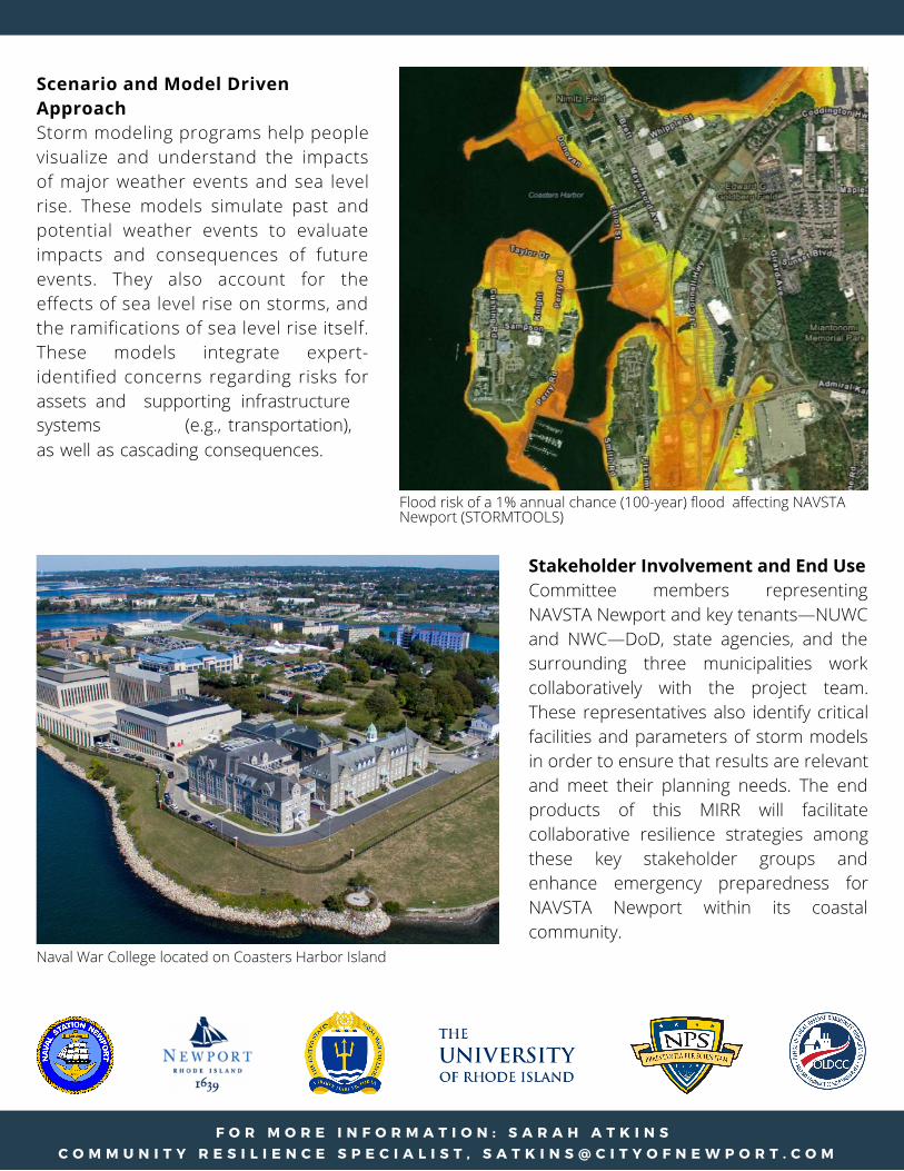
Scenario and Model Driven ApproachStorm modeling programs help people visualize and understand the impacts of major weather events and sea level rise. These models simulate past and potential weather events to evaluate impacts and consequences of future events. They also account for the effects of sea level rise on storms, and the ramifications of sea level rise itself. These models integrate expert-identified concerns regarding risks for assets and supporting infrastructure systems (e.g., transportation), as well as cascading consequences.
F O R M O R E I N F O R M A T I O N : S A R A H A T K I N S C O M M U N I T Y R E S I L I E N C E S P E C I A L I S T , S A T K I N S @ C I T Y O F N E W P O R T . C O M
Flood risk of a 1% annual chance (100-year) flood affecting NAVSTA Newport (STORMTOOLS)
Naval War College located on Coasters Harbor Island
Related Documents