NAVAL POSTGRADUATE SCHOOL MONTEREY, CALIFORNIA THESIS Approved for public release; distribution is unlimited DESIGNING FOR INTER-ORGANIZATIONAL COORDINATION IN INDONESIA’S MARITIME DOMAIN by Bagus Jatmiko Frans Joni Tandiarrang December 2014 Thesis Advisor: Nancy Roberts Second Reader: Erik Jansen

Welcome message from author
This document is posted to help you gain knowledge. Please leave a comment to let me know what you think about it! Share it to your friends and learn new things together.
Transcript
NAVAL POSTGRADUATE
SCHOOL
MONTEREY, CALIFORNIA
THESIS
Approved for public release; distribution is unlimited
DESIGNING FOR INTER-ORGANIZATIONAL COORDINATION IN INDONESIA’S MARITIME
DOMAIN
by
Bagus Jatmiko Frans Joni Tandiarrang
December 2014
Thesis Advisor: Nancy Roberts Second Reader: Erik Jansen

THIS PAGE INTENTIONALLY LEFT BLANK
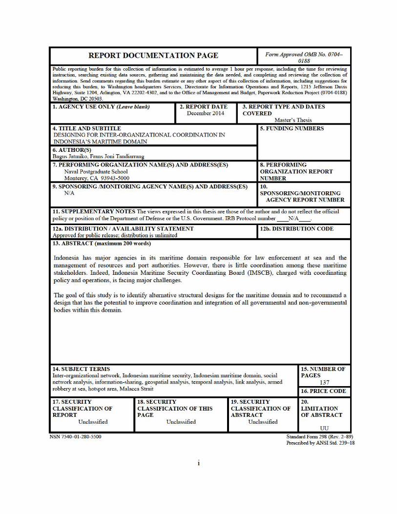
REPORT DOCUMENTATION PAGE Form Approved OMB No. 0704-0188
Public reporting burden for this collection of information is estimated to average 1 hour per response, including the time for reviewing instruction, searching existing data sources, gathering and maintaining the data needed, and completing and revie,ving the collection of information. Send comments regarding this burden estimate or any other aspect of this collection of information, including suggestions for reducing this burden, to Washington headquarters Services, Directorate for Information Operations and Reports, 1215 Jefferson Davis Highway, Suite 1204, Arlington, VA 22202-4302, and to the Office of Management and Budget, Paperwork Reduction Project (0704-0188) Washington, DC 20503.
1. AGENCY USE ONLY (Leave blank) 2. REPORT DATE December 2014
4. TITLE AND SUBTITLE DESIGNING FOR INTER-ORGANIZATIONAL COORDINATION IN INDONESIA'S MARITIME DOMAIN
6. AUTHOR(S) Bagus Jatmiko, Frans Joni Tandiarrang
7. PERFORMING ORGANIZATION NAME(S) AND ADDRESS(ES) Naval Postgraduate School Monterey, CA 93943-5000
3. REPORT TYPE AND DATES COVERED
Master's Thesis
5. FUNDING NUMBERS
8. PERFORMING ORGANIZATION REPORT NUMBER
9. SPONSORING /MONITORING AGENCY NAME(S) AND ADDRESS(ES) NIA
10. SPONSORING~ONITORING
AGENCY REPORT NUMBER
11. SUPPLEMENTARY NOTES The views expressed in this thesis are those of the author and do not reflect the official policy or position of the Department of Defense or the U.S. Govenunent. IRB Protocol munber __ N/ A __ .
12a. DISTRIBUTION I AVAILABILITY STATEMENT Approved for public release: distribution is tmlimited
13. ABSTRACT (maximum 200 words)
12b. DISTRIBUTION CODE
Indonesia has tnajor agencies in its marititne domain responsible for law enforcement at sea and the management of resoW'ces and pmt authorities. However, there is little coordination among these maritime stakeholders. Indeed, Indonesia Maritime SecW'ity Coordinating Board (IMSCB), charged with coordinating policy and operations, is facing major challenges.
The goal of this study is to identify altemative stmcttu·al designs for the maritime domain and to recormnend a design that has the potential to improve coordination and integration of all govemmental and non-govenunental bodies within this domain.
14. SUBJECT TERMS Inter-organizational network, Indonesian maritime sectu'ity, Indonesian maritime domain, social network analysis, infonnation-sharmg, geospatial analysis, temporal analysis, link analysis, armed robbery at sea, hotspot area, Malacca Strait
17. SECURITY CLASSIFICATION OF REPORT
Unclassified
18. SECURITY CLASSIFICATION OF TffiS PAGE
Unclassified
19. SECURITY CLASSIFICATION OF ABSTRACT
Unclassified
15. NUMBER OF PAGES
137 16. PRICE CODE
20. LIMITATION OF ABSTRACT
uu NSN 7540....01-280-5500 Standard Form 298 (Rev. 2- 89)
Prescribed by ANSI Std. 239-18

ii
THIS PAGE INTENTIONALLY LEFT BLANK
iii
Approved for public release;distribution is unlimited
DESIGNING FOR INTER-ORGANIZATIONAL COORDINATION IN INDONESIA’S MARITIME DOMAIN
Bagus Jatmiko Lieutenant Commander, Indonesian Navy
S.H. Hang Tuah University, 2008
Frans Joni Tandiarrang Lieutenant Commander, Indonesian Navy
S.T. Indonesian Naval College of Science and Technology, 2008
Submitted in partial fulfillment of the requirements for the degree of
MASTER OF SCIENCE IN DEFENSE ANALYSIS
from the
NAVAL POSTGRADUATE SCHOOL December 2014
Authors: Bagus Jatmiko
Frans Joni Tandiarrang
Approved by: Nancy Roberts, Ph.D. Thesis Advisor
Erik Jansen, Ph.D. Second Reader
John Arquilla, Ph.D. Chair, Department of Defense Analysis

iv
THIS PAGE INTENTIONALLY LEFT BLANK
v
ABSTRACT
Indonesia has major agencies in its maritime domain responsible for law enforcement at
sea and the management of resources and port authorities. However, there is little
coordination among these maritime stakeholders. Indeed, Indonesia Maritime Security
Coordinating Board (IMSCB), charged with coordinating policy and operations, is facing
major challenges.
The goal of this study is to identify alternative structural designs for the maritime
domain and to recommend a design that has the potential to improve coordination and
integration of all governmental and non-governmental bodies within this domain.

vi
THIS PAGE INTENTIONALLY LEFT BLANK
vii
TABLE OF CONTENTS
I. INTRODUCTION........................................................................................................1 A. BACKGROUND ..............................................................................................1 B. IMSCB’S CURRENT INTER-ORGANIZATIONAL NETWORK ...........4 C. PROBLEM STATEMENT .............................................................................7 D. RESEARCH QUESTION ...............................................................................7 E. THESIS STRUCTURE ...................................................................................8
II. LITERATURE REVIEW: INTER-ORGANIZATIONAL NETWORKS .............9 A. GENERAL NETWORK TERMS ..................................................................9
1. Network Types ...................................................................................10
2. Network Structure .............................................................................10 3. Network Evolution .............................................................................13
B. INTER-ORGANIZATIONAL NETWORKS .............................................14 C. INTER-ORGANIZATIONAL NETWORK INTERACTIONS ...............18
1. Coordination, Cooperation, Collaboration, and Integration .........18 D. CASES OF INTER-ORGANIZATIONAL NETWORKS .........................20
1. Inter-organizational (States) Networks in Peace Operations ........20 2. Inter-organizational Health and Public Services Networks...........21 3. Inter-organizational Networks in the Maritime Domain ...............22
E. SUMMARY ....................................................................................................24
III. RESEARCH METHODOLOGY .............................................................................25 A. DATA COLLECTION AND STRUCTURING ..........................................25
B. LIMITATIONS OF DATA ...........................................................................26 C. LINK ANALYSIS ..........................................................................................26 D. HOTSPOT AND GEOSPATIAL ANALYSIS ............................................26 E. TEMPORAL ANALYSIS .............................................................................27 F. SOCIAL NETWORK ANALYSIS ...............................................................27 G. SUMMARY ....................................................................................................29
IV. DATA ANALYSIS AND RESULTS ........................................................................30 A. LINK ANALYSIS ..........................................................................................31
B. GEOSPATIAL ANALYSIS ..........................................................................32 1. Accidents at Sea..................................................................................33 2. Violations at Sea .................................................................................33
a. Armed Robbery ........................................................................34 b. Asylum Seeker .........................................................................35 c. Boundary Violation .................................................................37 d. Environmental Pollution ........................................................38
e. Human Trafficking .................................................................40 f. Illegal Fishing .........................................................................42 g. Illegal Logging ........................................................................46 h. Inadequate Documents ...........................................................47 i. Smuggling................................................................................49
viii
j. Illicit Sea Treasure Exploration .............................................52
C. TEMPORAL ANALYSIS .............................................................................53 1. Accidents at Sea..................................................................................53 2. Violations at Sea .................................................................................55
a. Armed Robbery ........................................................................56 b. Asylum Seeker .........................................................................57 c. Illegal Fishing .........................................................................58 d. Illegal Logging ........................................................................60 e. Inadequate Documents ...........................................................61 f. Smuggling................................................................................62
D. SOCIAL NETWORK ANALYSIS ...............................................................63 1. Basic Topographical Metrics ............................................................64 2. Centralization .....................................................................................66
3. Centrality ............................................................................................66
V. DISCUSSION .............................................................................................................73 A. REGIONALLY CLUSTERED NETWORK ..............................................73 B. SEA-LANE CLUSTERED NETWORK......................................................79 C. COMPARISON OF THE THREE NETWORK STRUCTURES.............84 D. RESOURCES ALLOCATION IN A REGIONALLY CLUSTERED
NETWORK STRUCTURE...........................................................................89 1. Link Analysis ......................................................................................89 2. Geospatial Analysis ............................................................................91 3. Temporal Analysis .............................................................................94
VI. SUMMARY AND RECOMMENDATIONS ...........................................................97
A. SUMMARY ....................................................................................................97
APPENDIX. LIST OF INDONESIAN MARITIME AGENCIES ..................................101 A. IMSCB ..........................................................................................................101 B. NAVY ............................................................................................................101 C. MARINE POLICE.......................................................................................108 D. CUSTOM ......................................................................................................109 E. PSDKP ..........................................................................................................110
LIST OF REFERENCES ....................................................................................................113
INITIAL DISTRIBUTION LIST .......................................................................................119
ix
LIST OF FIGURES
Figure 1. IMSCB’s government network diagram. ...........................................................5 Figure 2. Centralized structure. .......................................................................................11 Figure 3. Mesh structure. .................................................................................................11 Figure 4. Hub-and-spoke structure. .................................................................................12 Figure 5. Cluster structure ...............................................................................................12 Figure 6. Core/Periphery structure (Sherman, 2008). .....................................................13 Figure 7. Growth model of a network (Anklam, 2007, p.133)........................................13 Figure 8. Modes of network governance (Provan & Kenis, 2005). ................................15 Figure 9. Relationship between effectiveness at different levels of network analysis
and influence by key stakeholders (Milward & Provan, 2001). ......................18 Figure 10. Working Together Continuum (Kloth and Applegate, 2004, p. 2). .................19 Figure 11. Link chart of the Indonesian Maritime Agencies with their authorities. .........32 Figure 12. Accident-at-sea hotspots from 2008 to 2013. ..................................................33 Figure 13. Armed robbery hotspots with authorized maritime agencies mapping. ..........34 Figure 14. Asylum-seeker hotspots with authorized maritime agencies mapping. ...........36 Figure 15. Boundary violation hotspots with authorized maritime agencies mapping. ....38 Figure 16. Environmental pollution hotspots with authorized maritime agencies
mapping............................................................................................................40 Figure 17. Human trafficking hotspots with authorized maritime agencies mapping. .....42 Figure 18. Illegal Fishing hotspots with authorized maritime agencies mapping. ............46 Figure 19. Illegal logging hotspots with authorized maritime agencies mapping. ............47 Figure 20. Inadequate documents hotspots with authorized maritime agencies
mapping............................................................................................................49 Figure 21. Smuggling hotspots with authorized maritime agencies mapping. .................52 Figure 22. Illicit sea treasure exploration with authorized maritime agencies mapping. ..53 Figure 23. Percentages of accidents on each month of the year from 2008 to 2013
(based on 1,892 accidents; percentages do not add up to 100 because of rounding). .........................................................................................................54
Figure 24. Percentages of accidents on each day of the week from 2008 to 2013 (based on 1,892 accidents; percentages do not add up to 100 because of rounding). .........................................................................................................54
Figure 25. Armed robbery month-of-year distribution. ....................................................56 Figure 26. Armed robbery day-of-week distribution. .......................................................57 Figure 27. Asylum seeker month-of-the-year distribution. ...............................................57
Figure 28. Asylum seeker day-of-the-week distribution. ..................................................58 Figure 29. Illegal fishing month-of-the-year distribution. ................................................59
Figure 30. Illegal fishing day-of-the-week distribution. ...................................................59 Figure 31. Illegal logging month-of-the-year distribution. ...............................................60 Figure 32. Illegal logging day-of-the-week distribution. ..................................................61 Figure 33. Inadequate documents month-of-the-year distribution. ...................................61 Figure 34. Inadequate document day-of-the-week distribution. .......................................62 Figure 35. Smuggling month-of-the-year distribution. .....................................................62
x
Figure 36. Smuggling day-of-the-week distribution. ........................................................63
Figure 37. Indonesian formal authority network structure. ...............................................64 Figure 38. Formal authority network degree centrality. ....................................................69 Figure 39. Formal authority network betweenness centrality. ..........................................70 Figure 40. Formal authority network closeness centrality. ...............................................71 Figure 41. Indonesian maritime regionally clustered network. .........................................74 Figure 42. Regionally clustered network degree centrality. ..............................................77 Figure 43. Regionally clustered network betweenness centrality. ....................................78 Figure 44. Regionally clustered network closeness centrality. .........................................78 Figure 45. Indonesia maritime sea-lane clustered network. ..............................................79 Figure 46. Sea-lane clustered network degree centrality. .................................................82 Figure 47. Sea-lane clustered network betweenness centrality. ........................................83 Figure 48. Sea-lane clustered network closeness centrality. .............................................83
Figure 49. Indonesian maritime agencies dispersion map. ...............................................90 Figure 50. Accidents at sea time wheel (Data from 2008–2013). .....................................94 Figure 51. Violations at sea time wheel (Data from 2008–2013). ....................................95
xi
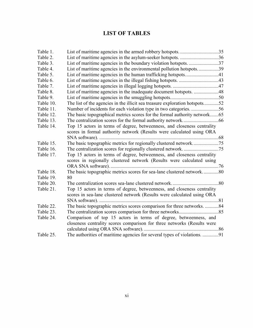
LIST OF TABLES
Table 1. List of maritime agencies in the armed robbery hotspots. ...............................35 Table 2. List of maritime agencies in the asylum-seeker hotspots. ...............................36 Table 3. List of maritime agencies in the boundary violation hotspots. ........................37 Table 4. List of maritime agencies in the environmental pollution hotspots. ................39 Table 5. List of maritime agencies in the human trafficking hotspots. ..........................41 Table 6. List of maritime agencies in the illegal fishing hotspots. ................................43 Table 7. List of maritime agencies in illegal logging hotspots. .....................................47 Table 8. List of maritime agencies in the inadequate document hotspots. ....................48 Table 9. List of maritime agencies in the smuggling hotspots.......................................50
Table 10. The list of the agencies in the illicit sea treasure exploration hotspots. ...........52 Table 11. Number of incidents for each violation type in two categories. ......................56 Table 12. The basic topographical metrics scores for the formal authority network.......65 Table 13. The centralization scores for the formal authority network. ............................66 Table 14. Top 15 actors in terms of degree, betweenness, and closeness centrality
scores in formal authority network (Results were calculated using ORA SNA software). ................................................................................................68
Table 15. The basic topographic metrics for regionally clustered network. ....................75 Table 16. The centralization scores for regionally clustered network. ............................75 Table 17. Top 15 actors in terms of degree, betweenness, and closeness centrality
scores in regionally clustered network (Results were calculated using ORA SNA software). .......................................................................................76
Table 18. The basic topographic metrics scores for sea-lane clustered network. ............80
Table 19. 80 Table 20. The centralization scores sea-lane clustered network. .....................................80 Table 21. Top 15 actors in terms of degree, betweenness, and closeness centrality
scores in sea-lane clustered network (Results were calculated using ORA SNA software). ................................................................................................81
Table 22. The basic topographic metrics scores comparison for three networks. ...........84 Table 23. The centralization scores comparison for three networks. ...............................85
Table 24. Comparison of top 15 actors in terms of degree, betweenness, and closeness centrality scores comparison for three networks (Results were calculated using ORA SNA software). ............................................................86
Table 25. The authorities of maritime agencies for several types of violations. .............91

xii
THIS PAGE INTENTIONALLY LEFT BLANK
xiii
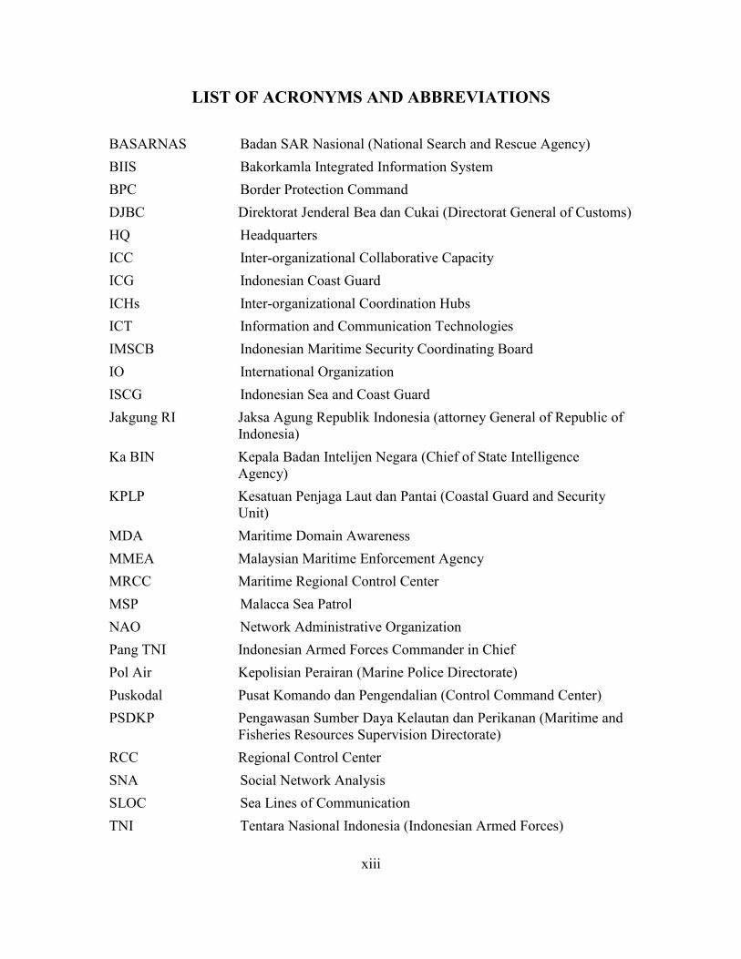
LIST OF ACRONYMS AND ABBREVIATIONS
BASARNAS Badan SAR Nasional (National Search and Rescue Agency) BIIS Bakorkamla Integrated Information System BPC Border Protection Command DJBC Direktorat Jenderal Bea dan Cukai (Directorat General of Customs) HQ Headquarters ICC Inter-organizational Collaborative Capacity ICG Indonesian Coast Guard ICHs Inter-organizational Coordination Hubs ICT Information and Communication Technologies IMSCB Indonesian Maritime Security Coordinating Board IO International Organization ISCG Indonesian Sea and Coast Guard Jakgung RI Jaksa Agung Republik Indonesia (attorney General of Republic of
Indonesia) Ka BIN Kepala Badan Intelijen Negara (Chief of State Intelligence
Agency) KPLP Kesatuan Penjaga Laut dan Pantai (Coastal Guard and Security
Unit) MDA Maritime Domain Awareness MMEA Malaysian Maritime Enforcement Agency MRCC Maritime Regional Control Center MSP Malacca Sea Patrol NAO Network Administrative Organization Pang TNI Indonesian Armed Forces Commander in Chief Pol Air Kepolisian Perairan (Marine Police Directorate) Puskodal Pusat Komando dan Pengendalian (Control Command Center) PSDKP Pengawasan Sumber Daya Kelautan dan Perikanan (Maritime and
Fisheries Resources Supervision Directorate) RCC Regional Control Center SNA Social Network Analysis SLOC Sea Lines of Communication TNI Tentara Nasional Indonesia (Indonesian Armed Forces)

xiv
THIS PAGE INTENTIONALLY LEFT BLANK
xv
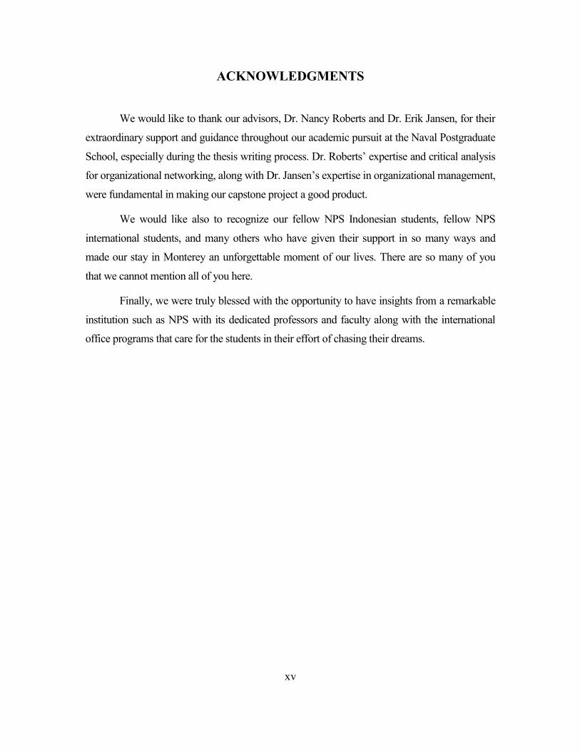
ACKNOWLEDGMENTS
We would like to thank our advisors, Dr. Nancy Roberts and Dr. Erik Jansen, for their
extraordinary support and guidance throughout our academic pursuit at the Naval Postgraduate
School, especially during the thesis writing process. Dr. Roberts’ expertise and critical analysis
for organizational networking, along with Dr. Jansen’s expertise in organizational management,
were fundamental in making our capstone project a good product.
We would like also to recognize our fellow NPS Indonesian students, fellow NPS
international students, and many others who have given their support in so many ways and
made our stay in Monterey an unforgettable moment of our lives. There are so many of you
that we cannot mention all of you here.
Finally, we were truly blessed with the opportunity to have insights from a remarkable
institution such as NPS with its dedicated professors and faculty along with the international
office programs that care for the students in their effort of chasing their dreams.

xvi
THIS PAGE INTENTIONALLY LEFT BLANK
1
I. INTRODUCTION
Indonesia is the world’s largest archipelagic country, with more than 13,466 islands
spread from west to east (Bakohumas, 2012). It consists of several important sea lines of
communication (SLOC) (Koh, 2008) that connect the Indian and the Pacific oceans, which are
vital for global maritime navigation. These SLOCs are the shipping routes for a large portion of
world trade. In addition, the abundant natural resources of the maritime domain and the
country’s strategic position have given Indonesia great economic and strategic benefits.
This geographical position, while putting Indonesia in a highly strategic location, also
exposes the nation to maritime threats, such as illegal logging and fishing, smuggling, human
trafficking, drug trafficking, and territorial breaches that affect its security policies. With three
quarters of Indonesia’s territory maritime-based, the Indonesian government is searching for
better ways to address these menaces in order to protect the country’s national security.
However, the presence of the waters between and around the islands within the archipelago
creates enormous practical difficulties in terms of maritime governance (Cribb & Ford, 2009).
A. BACKGROUND The maritime domain is, by definition, a multidimensional environment, made more
complex in Indonesia’s case due to the wide expanse of its territory and the multitude of inter-
island waterways that must be monitored and controlled to provide security for the domain.
One does not have the privilege to separate the governance based on region as one would on
the land. In contrast with land governance that can mark a clear border and build an installation
to assist with the governance, the physical fluidity of the sea contributes to the complexity of
maritime governance. Maritime governance must take into account the presence of a multi-
layered region of the sea—the air column, surface, water column, seabed, and subsoil—all at
once in a single maritime location (Cribb & Ford, 2009, p. 13). The complexity of the maritime
domain in Indonesia also involves numerous cultural groupings along with local wisdom that
are spread throughout the Indonesian archipelago. These differences affect the maritime
governance process as an integrated maritime security system.
The Indonesian government’s response to these problems initially was
organizational—to establish many different maritime agencies to govern the maritime territory
2
and provide maritime security and defense. When coordination among these agencies became
difficult, the government reestablished the Maritime Security Coordinating Board in 2005, a
board that had been dormant since 1972. The government realized that Indonesia needed a fully
functioning body to coordinate the governance of maritime security. The Presidential Decree
No.81/2005 on December 29, 2005 (Perpres, 2005) reestablished the body with the name of
Indonesian Maritime Security Coordinating Board (IMSCB) (Sumaryono, 2009, p. 135). The
main task of this body was to set up a comprehensive and integrated maritime security system
to perform maritime governance. IMSCB has five specific tasks (Sumaryono, 2009, p. 138):
1. Formulate a general policy on maritime security;
2. Coordinate maritime security operations in Indonesian waters;
3. Provide technical and administrative support for maritime security;
4. Provide assistance in maritime security institutional capacity building; and
5. Encourage stakeholder engagement in ensuring maritime security.
The Presidential Decree No.81/2005 (Perpres, 2005) acts as the legislative basis for the
operation that is carried out by IMSCB along with other government agencies that have field
resources in the maritime domain. The coordination effort is under the supervision of IMSCB.
The Indonesian Maritime Security Coordinating Board (IMSCB) has 12 actively
participating agencies, although only six of them have resources in the field in the form of
office branches, ships, surveillance equipment, and personnel. These agencies are: the
Indonesian Navy, KPLP (“Kesatuan Penjaga Laut dan Pantai” – Coastal Guard and Security
Unit); the Customs; the Fisheries Department; and the Marine Police. These agencies have
authorities that span the spectrum from law enforcement at sea to the maritime management of
resources and port authority. They also handle tasks in accordance with their specific mandates
in different sectors within the maritime domain.
Despite these efforts, progress on the integration of the domain appears to have stalled.
Contradictory mandates among agencies in the maritime domain and the overlapping
jurisdictions in the practical application of law enforcement at sea still exist. For example,
KPLP and IMSCB are competing for acknowledgement by the government and other maritime
authorities as the ‘genuine’ Coast Guard. Each agency continues to look for more authority,
3
resources, and privileges from the government (Supriyanto, 2013). The Ministry of
Transportation with its KPLP (Kesatuan Penjaga Laut dan Pantai – Coastal Guard and Security
Unit) interprets the Governmental Decree No.17/2008 (Undang-undang, 2008) as being in
favor of the Indonesian Sea and Coast Guard (ISCG) under the authority of Ministry of
Transportation. Meanwhile, the Ministry for Politics, Law, and Security (Kemkopolhukam) has
rebuffed that notion by holding that the Presidential Decree No.81/2005 means that the IMSCB
is the sole institution to hold the ISCG’s mandates.
This self-defeating competition is due in large part to contradictory legislation and
authority that cross jurisdictional lines in the field. A case in point is the question of jurisdiction
in investigating the violation of fisheries regulation based on the governmental Decree
No.31/2004 (Undang-undang, 2004). It gives investigative jurisdiction to three agencies – the
navy, the marine police, and the fisheries investigator. These overlapping authorities weaken
coordinated maritime governance in Indonesia and cause confusion for the maritime users due
to competing bureaucracy. Without clear and definitive legislative guidance, each agency has
its “own” legislation to back its respective authorities and each continues to resist coordination
for fear of giving away its authorities and privileges. Maritime agencies end up being reluctant
to share their information and instead retain it for internal consumption, further hindering inter-
agency coordination. This lack of information-sharing ends up creating different interpretations
of the same maritime security problem. So, for example, the navy, marine police, and IMSCB
all have their own information gathering centers with the ability to collect data on crime and
robbery occurrences at sea. However, information among them is not shared, making data
synchronization impossible. Unsynchronized data then produce different analyses about crime
and robbery in the maritime domain and eventually create confusion for decision-making
authorities when developing maritime policies.
The inter-agency competition and battle for preeminence overshadows the goal of
coordination and the recognition of shared purpose among the maritime stakeholders. It is
difficult for them to see what is at stake for the whole domain. They have no common ground
on which to work together in an integrated system, which further complicates the IMSCB’s
charge. Instead, the current condition of the Indonesian Maritime Domain can be likened to
anarchy—a state of disorder characterized by the absence of overarching authority to provide
communication, coordination, and mutual support among countless autonomous actors who
4
operate without formal connections or fixed boundaries (Gordon, 2008, p. 14). The efforts of
each agency remain parochial. Attempts to resolve mutual problems and issues are not
occurring because each agency only works to solve problems included within its own mandates
and responsibilities.
Even if the Indonesian government were able to eliminate the conflicting legislation
and bestow more authority on the IMSCB, given the vastness of the archipelago and the limited
funding and insufficient resources, a single agency, even with proper authority to govern the
vast domain, is unlikely to effectively and efficiently cover the whole maritime area. We
believe a plausible option is the redesign the inter-organizational network to address and
mitigate the anarchic conditions in the maritime domain. Before exploring the design options,
we offer a brief description of the current inter-organizational network. The remaining chapters
of this thesis will explore some design options for the inter-organizational network with the
goal of providing better governance and unity of effort for Indonesia’s maritime domain.
B. IMSCB’S CURRENT INTER-ORGANIZATIONAL NETWORK The Indonesian government is attempting to govern its maritime domain in the vast
archipelago. Indonesian Presidential Decree No.81/2005 established IMSCB’s roles in the
maritime domain and established a network of agencies and organizations to work together to
reach their common goal. Despite the lack of recognition on the common purpose for the
stakeholders and the difficulties in information sharing within the network, this is an initial
effort by the IMSCB to coordinate the effort of all of the agencies in the Indonesian maritime
domain.
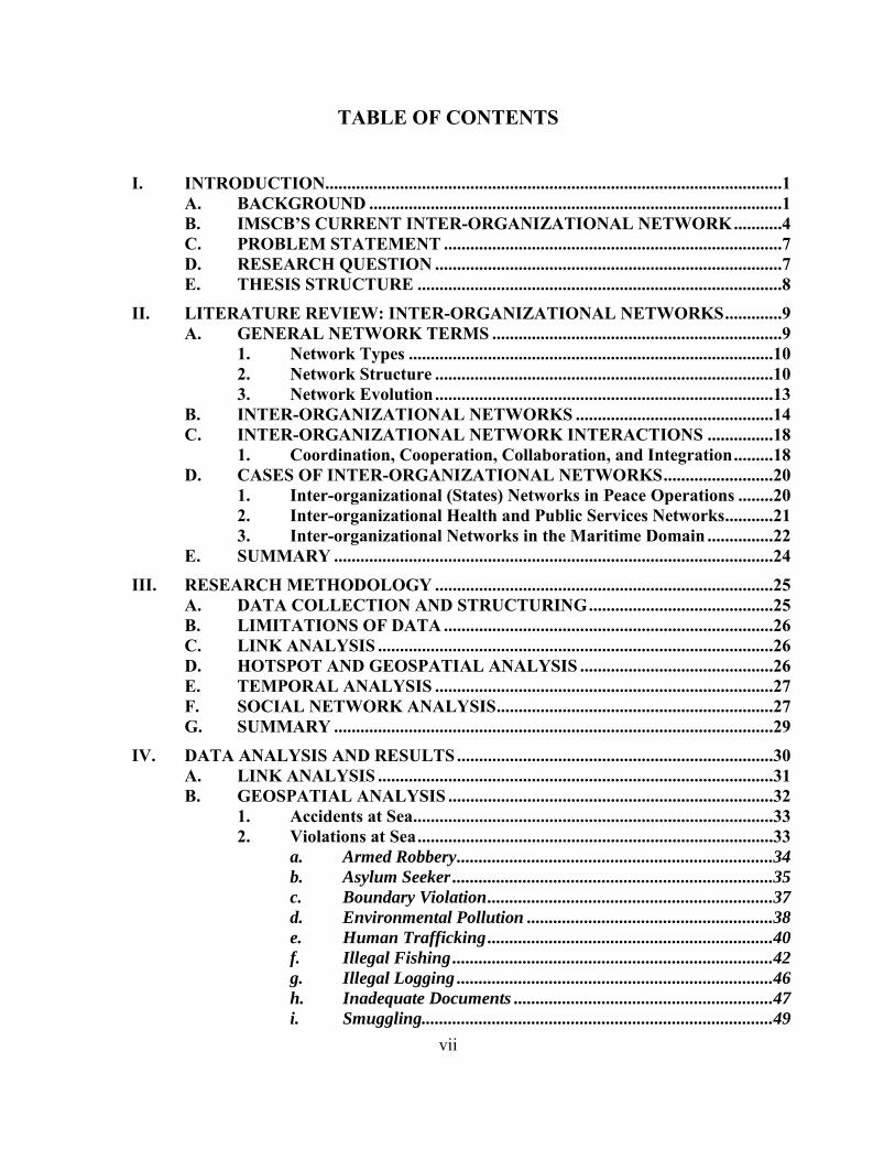
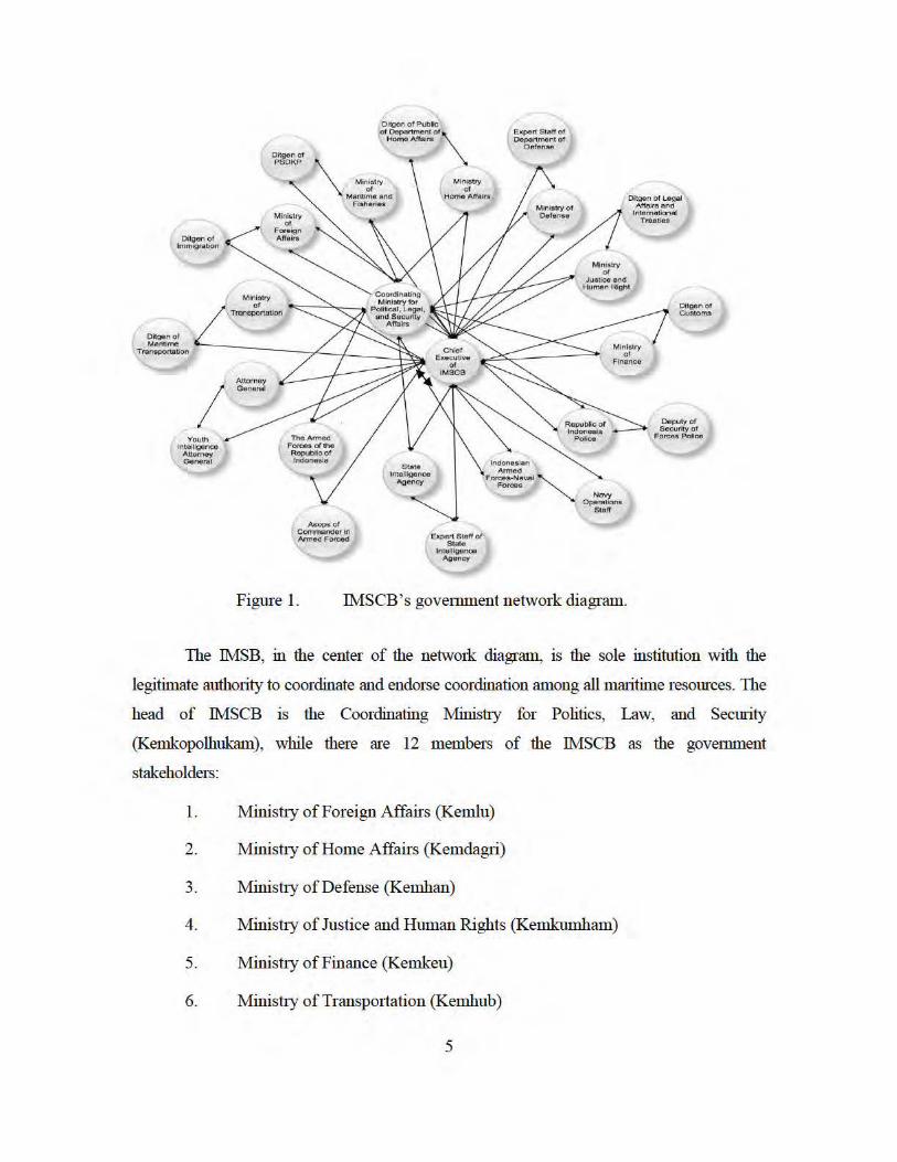
Figure 1 is the network diagram of IMSCB within the government in accordance with
the Presidential Decree No.81/2005. It illustrates the existing complex network of
governmental maritime agencies responsible for administering control over the archipelago’s
vast maritime domain.
Oitgenof ImmigratiOn
I Youth
lntoiUgooco Attornoy o•n~,..l
Oitgen of Public
Ho me Affairs
Oltgen of PSOKP
Of Oept\n men1 o t \
\ M·~r'rv Maritlmfl:eno
Fish eries
Ministry or
H ome Anol:'l lrs
M inl$b'Y
Ministry or
Foreign A,fttllln
of T ransportation
Anorooy General
The Armed Forces of the Republ oof Indonesia
Expert Stal'f o r Stat~
lnte!lloonco A9oncy
Expert Stan ot Oepart,ment of
Defen se
M!nis.lly
O;tgen of Legal AffaJrs a.nd
lntoma1iona1 Treaties
or .J<Ustfce e.nd
Human Rfghl
N ayY Operations
61•"
Ditgen o t C<J&oms
Deputy of Security of
Forces Police
Figure 1. IMSCB 's govemment network diagram.
The IMSB, in the center of the netwmk diagram, is the sole institution with the
legitimate authority to coordinate and endorse coordination among all maritime resources. The
head of IMSCB IS the Coordinating Ministry for Politics, Law, and Security
(Kemkopolhukam), while there are 12 members of the IMSCB as the govemment
stakeholders:
1. Ministly of Foreign Affairs (Kemlu)
2. Ministry of Home Affairs (Kemdagri)
3. Mini.stly of Defense (Kemhan)
4. Ministly of Justice and Human Rights (Kemkumham)
5. Ministly of Finance (Kemkeu)
6. Minis tty of Transportation (Kemhub)
5

6
7. Ministry of Sea and Fisheries
8. Attorney General of Republic of Indonesia (Kejakgung RI)
9. Indonesian Armed Forces (TNI)
10. Republic of Indonesia Police (Polri)
11. State Intelligence Agency (BIN)
12. Indonesian Navy (TNI-AL)
Besides these 12 members of IMSCB, there is also the secretary of IMSCB who serves
as the Chief Executive of IMSCB and is responsible for the implementation of IMSCB’s tasks,
administration, and technical functions on a daily basis. The chief directly reports to the
Coordinating Minister for Politics, Law, and Security.
In order to perform daily functions, the chief executive is assisted by the Sea Security
Coordination Team. This team consists of the first-echelon representatives from each of the
institutions being represented as members of IMSCB. They are:
1. Director General of Law and International Agreement, Ministry of Foreign Affairs.
2. Director General of General Government, Ministry of Home Affairs.
3. Expert Staff of the Minister of Defense on Security Affairs.
4. Director General of Immigration, Ministry of Justice and Human Rights
5. Director General of Customs, Ministry of Finance.
6. Director General of Sea Transportation, Ministry of Transportation.
7. Director General Sea and Fisheries Resources Supervision, Ministry of Sea and Fisheries.
8. Junior Attorney General for Intelligence.
9. Chief of Operational Staff of Chief of General Staff Indonesian Armed Forces.
10. Deputy Head of Police Security Agency.
11. Expert Staff on Law for the State Intelligence Agency.
7
12. Chief of Operational Staff of Navy Chief of Staff.
This team prepares the planning of general policy on the subject of maritime security
and also to plan, monitor, and evaluate the coordination execution of the maritime security
operation (Perpres, 2005).
The purpose of the current network depicted in Figure 1 is to govern the Indonesian
maritime domain by involving all government stakeholders. The network itself is a closed
system that consists only of the government institutions that have the authority over the
maritime issues. It does not include other stakeholders, such a private companies, in the
maritime domain.
In principle, the IMSCB is the administrator of the overall network activities and is
central to its coordination. The pattern of interactions of the inter-organizational network is
similar to a “Hub and Spoke” structure (Anklam, 2007). The central hub is IMSCB which
connects all the government stakeholders within the maritime domain, and all stakeholders
must go through IMSB in order to link with other stakeholders. In practice, however, the inter-
organizational network overseen by the IMSCB appears to operating more like anarchy with its
attendant challenges and limitations.
C. PROBLEM STATEMENT The Indonesian government attempted to address the maritime domain’s coordination
challenges with the reestablishment of IMSCB as a coordinating body. Yet, the IMSCB’s
subsequent coordination efforts among maritime agencies have not been successful. Although
on paper it has an overarching authority, in practice the IMSCB lacks authority to establish
common purpose, coordinate activities, and develop operational processes, such as
communication and information, to integrate the network as a whole. The current inter-
organizational network arrangement produces conditions that are closer to anarchy rather than a
system of integrated, collaborative governance.
D. RESEARCH QUESTION The research question of this thesis is how to improve inter-organization coordination
in Indonesia’s maritime domain especially as it pertains to network governance and operational
deployment patterns to ensure maritime security?

8
E. THESIS STRUCTURE This thesis consists of six chapters. Chapter I presents the background for the capstone
project by explaining the background and current situation and conditions that are present in the
Indonesian maritime domain. The chapter offers alternative inter-organizational network
designs that attempt to correct for the deficiencies in the current design. A review of all the
relevant network theories and literature is presented in Chapter II, while Chapter III describes
the research methodologies employed in this project: geospatial analysis; social network
analysis; and temporal analysis. The results from these analyses are presented in Chapter IV.
Following this analysis, Chapter V presents an alternative network design to address
the problems inherent in the current inter-organizational design of Indonesia’s maritime
domain. Finally, Chapter VI reviews the results of the research. It concludes the thesis and
offers what we believe is a reasonable and plausible solution to current problems in
administering a geographically dispersed domain in a politically and governmentally diverse
environment.
9
II. LITERATURE REVIEW: INTER-ORGANIZATIONAL NETWORKS
This chapter addresses basic questions about networks. What are they? How are they
created and designed? What purposes do they serve? How can we evaluate their performance
and effectiveness? And, how can we facilitate inter-organizational network coordination to
improve their performance? Furthermore, this chapter recognizes the implementation of inter-
organizational networks in many fields that could be the source of ideas for the Indonesian
maritime network improvement.
A. GENERAL NETWORK TERMS Networks are formed from the relationships among actors, be they individuals,
organizations, or even nations. O’Toole (1997) defines networks as the structure of
interdependence involving multiple organizations that are bonded by ties of authority bonds,
exchange relations, and form coalitions based on common interest in a single structure.
Expanding on this definition, McGuire (2003) considers networks as structures that involve
multiple nodes of agencies or organizations with multiple linkages. The structures could be
formal or informal, and are typically intersectoral or intergovernmental. Furthermore, Agranoff
(2004) describes networks in public organizations as a structure composed of governmental and
nongovernmental agencies working together to exchange information and formulate and
implement policies.
Networks can be formed out of numerous types of relationships. Borgatti et al. (2013)
explain that there can be multiple relationships in a single network. Each of relationship type
determines the corresponding network. For example, measuring friendship ties will result in a
friendship network. Likewise, measuring family ties will present in a family network.
Furthermore, analysis of a network can combine the ties in various ways depending on the
requirement. Borgatti argues that networks can be grouped into two categories (pp. 3‒5). They
are personal ties signifying inter-personal relationships and acquaintanceship ties that refer to
the relations among organizations on a large scale.
10
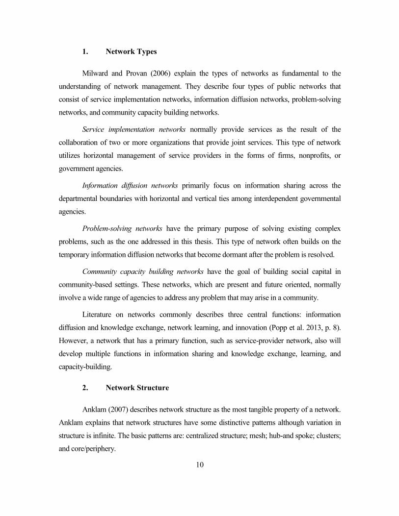
1. Network Types
Milward and Provan (2006) explain the types of networks as fundamental to the
understanding of network management. They describe four types of public networks that
consist of service implementation networks, information diffusion networks, problem-solving
networks, and community capacity building networks.
Service implementation networks normally provide services as the result of the
collaboration of two or more organizations that provide joint services. This type of network
utilizes horizontal management of service providers in the forms of firms, nonprofits, or
government agencies.
Information diffusion networks primarily focus on information sharing across the
departmental boundaries with horizontal and vertical ties among interdependent governmental
agencies.
Problem-solving networks have the primary purpose of solving existing complex
problems, such as the one addressed in this thesis. This type of network often builds on the
temporary information diffusion networks that become dormant after the problem is resolved.
Community capacity building networks have the goal of building social capital in
community-based settings. These networks, which are present and future oriented, normally
involve a wide range of agencies to address any problem that may arise in a community.
Literature on networks commonly describes three central functions: information
diffusion and knowledge exchange, network learning, and innovation (Popp et al. 2013, p. 8).
However, a network that has a primary function, such as service-provider network, also will
develop multiple functions in information sharing and knowledge exchange, learning, and
capacity-building.
2. Network Structure
Anklam (2007) describes network structure as the most tangible property of a network.
Anklam explains that network structures have some distinctive patterns although variation in
structure is infinite. The basic patterns are: centralized structure; mesh; hub-and spoke; clusters;
and core/periphery.
11
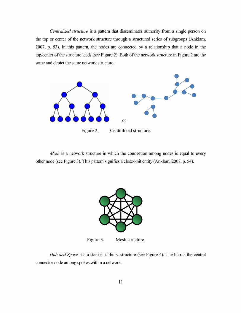
Centralized structure is a pattern that disseminates authority from a single person on
the top or center of the network structure through a structured series of subgroups (Anklam,
2007, p. 53). In this pattern, the nodes are connected by a relationship that a node in the
top/center of the structure leads (see Figure 2). Both of the network structure in Figure 2 are the
same and depict the same network structure.
or
Figure 2. Centralized structure.
Mesh is a network structure in which the connection among nodes is equal to every
other node (see Figure 3). This pattern signifies a close-knit entity (Anklam, 2007, p. 54).
Figure 3. Mesh structure.
Hub-and-Spoke has a star or starburst structure (see Figure 4). The hub is the central
connector node among spokes within a network.
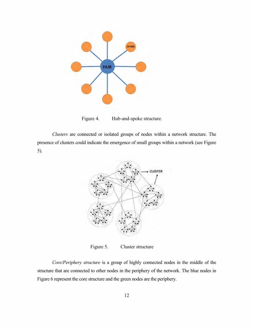
12
Figure 4. Hub-and-spoke structure.
Clusters are connected or isolated groups of nodes within a network structure. The
presence of clusters could indicate the emergence of small groups within a network (see Figure
5).
Figure 5. Cluster structure
Core/Periphery structure is a group of highly connected nodes in the middle of the
structure that are connected to other nodes in the periphery of the network. The blue nodes in
Figure 6 represent the core structure and the green nodes are the periphery.
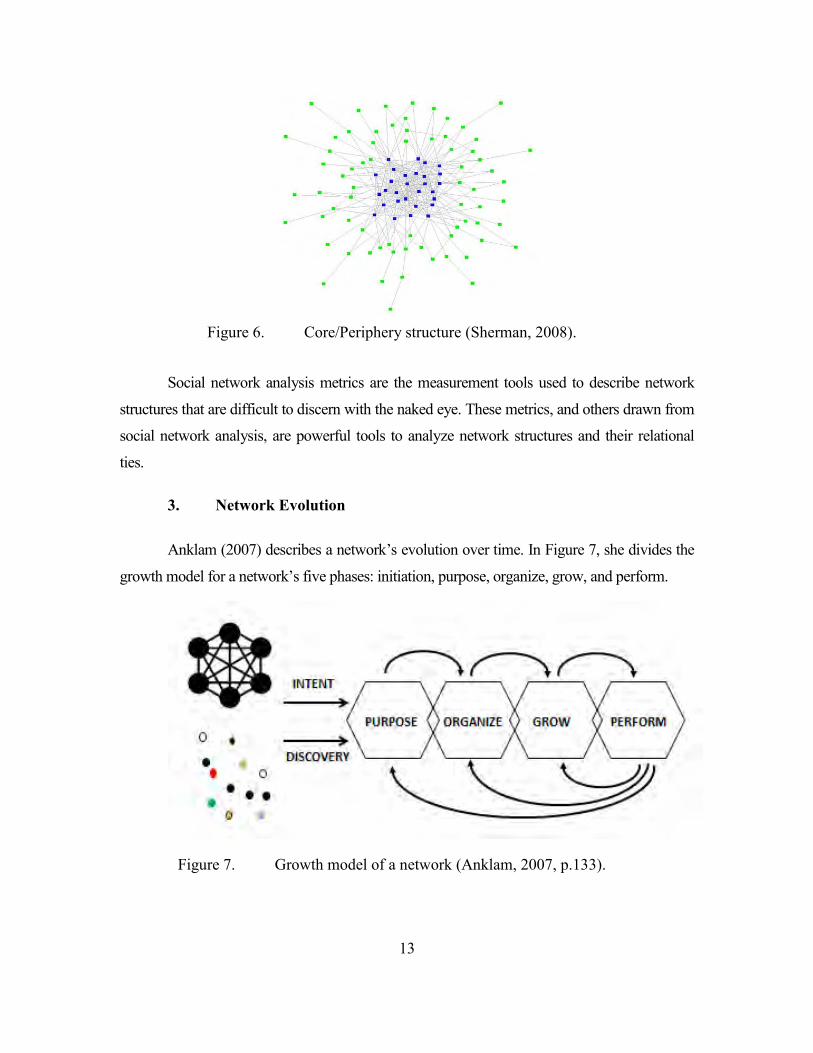
13
Figure 6. Core/Periphery structure (Sherman, 2008).
Social network analysis metrics are the measurement tools used to describe network
structures that are difficult to discern with the naked eye. These metrics, and others drawn from
social network analysis, are powerful tools to analyze network structures and their relational
ties.
3. Network Evolution
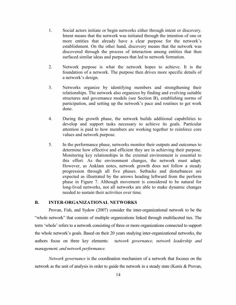
Anklam (2007) describes a network’s evolution over time. In Figure 7, she divides the
growth model for a network’s five phases: initiation, purpose, organize, grow, and perform.
Figure 7. Growth model of a network (Anklam, 2007, p.133).
14
1. Social actors initiate or begin networks either through intent or discovery. Intent means that the network was initiated through the intention of one or more entities that already have a clear purpose for the network’s establishment. On the other hand, discovery means that the network was discovered through the process of interaction among entities that then surfaced similar ideas and purposes that led to network formation.
2. Network purpose is what the network hopes to achieve. It is the foundation of a network. The purpose then drives more specific details of a network’s design.
3. Networks organize by identifying members and strengthening their relationships. The network also organizes by finding and evolving suitable structures and governance models (see Section B), establishing norms of participation, and setting up the network’s pace and routines to get work done.
4. During the growth phase, the network builds additional capabilities to develop and support tasks necessary to achieve its goals. Particular attention is paid to how members are working together to reinforce core values and network purpose.
5. In the performance phase, networks monitor their outputs and outcomes to determine how effective and efficient they are in achieving their purpose. Monitoring key relationships in the external environment is essential to this effort. As the environment changes, the network must adapt. However, as Anklam notes, network growth does not follow a steady progression through all five phases. Setbacks and disturbances are expected as illustrated by the arrows heading leftward from the perform phase in Figure 7. Although movement is considered to be natural for long-lived networks, not all networks are able to make dynamic changes needed to sustain their activities over time.
B. INTER-ORGANIZATIONAL NETWORKS Provan, Fish, and Sydow (2007) consider the inter-organizational network to be the
“whole network” that consists of multiple organizations linked through multifaceted ties. The
term ‘whole’ refers to a network consisting of three or more organizations connected to support
the whole network’s goals. Based on their 20 years studying inter-organizational networks, the
authors focus on three key elements: network governance, network leadership and
management, and network performance.
Network governance is the coordination mechanism of a network that focuses on the
network as the unit of analysis in order to guide the network in a steady state (Kenis & Provan,
15
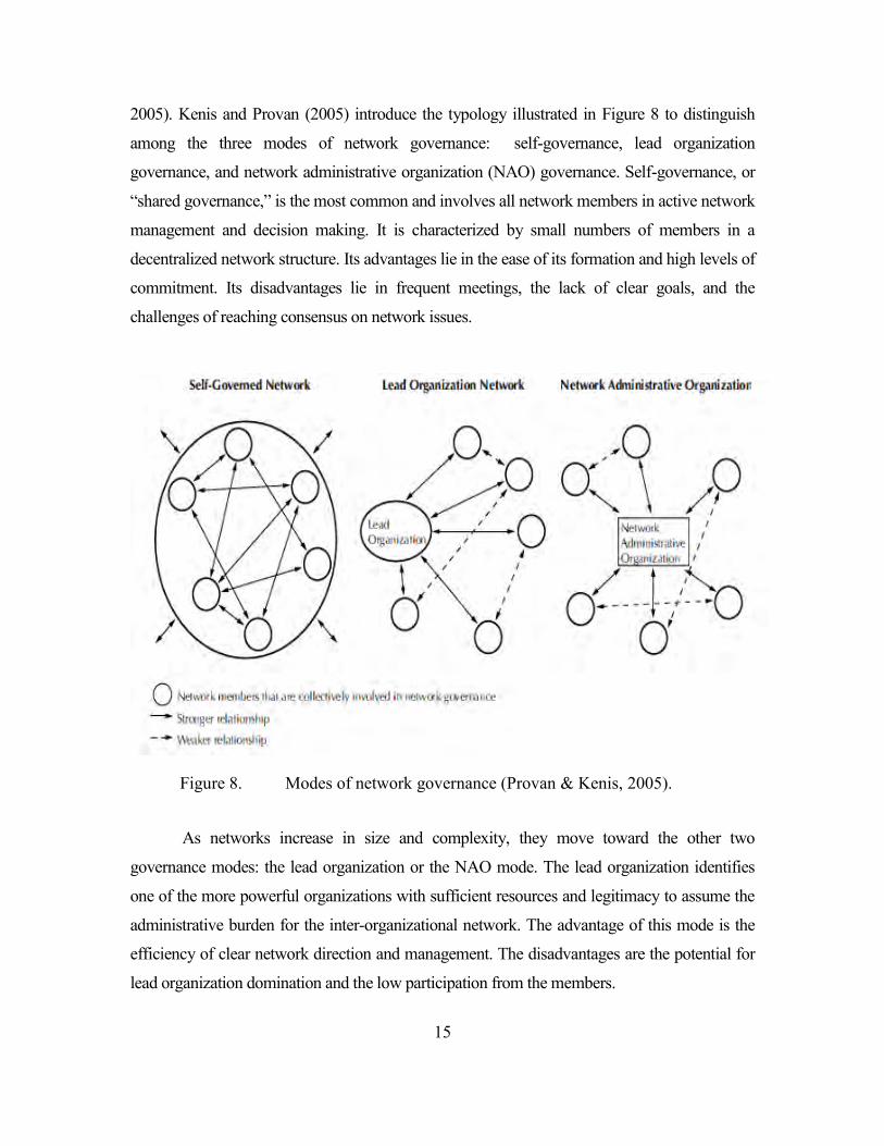
2005). Kenis and Provan (2005) introduce the typology illustrated in Figure 8 to distinguish
among the three modes of network governance: self-governance, lead organization
governance, and network administrative organization (NAO) governance. Self-governance, or
“shared governance,” is the most common and involves all network members in active network
management and decision making. It is characterized by small numbers of members in a
decentralized network structure. Its advantages lie in the ease of its formation and high levels of
commitment. Its disadvantages lie in frequent meetings, the lack of clear goals, and the
challenges of reaching consensus on network issues.
Figure 8. Modes of network governance (Provan & Kenis, 2005).
As networks increase in size and complexity, they move toward the other two
governance modes: the lead organization or the NAO mode. The lead organization identifies
one of the more powerful organizations with sufficient resources and legitimacy to assume the
administrative burden for the inter-organizational network. The advantage of this mode is the
efficiency of clear network direction and management. The disadvantages are the potential for
lead organization domination and the low participation from the members.
16
The third governance mode is NAO. It is similar to the lead organization but with one
exception. In the NAO, an organizational entity is created to oversee and manage the whole
network. It attends only to administration functions and network management. It does not get
involved in the provision of services as other network members do. However, the NAO form
also has the disadvantages of higher operation costs, a more complex administration process,
and a potential loss of control and decision authority for some network members.
Network leadership and management is described by Milward and Provan (2006) as
providing a task framework to guide inter-organization network leaders and managers in inter-
organizational networks no matter what governance mode they choose. The five tasks within
this framework are:
� Management of Accountability. This task identifies who is responsible for what to ensure everyone in the network is doing their tasks accordingly. Moreover, the task is also to avoid any free riders within the network. At the individual organization level, the managers are to ensure the contribution of their respective organizations to the network through activities and resources.
� Management of Legitimacy. This task convinces the stakeholders that the network is functioning as intended and is adding value from their perspectives. The legitimacy of network performance is intended to attract positive publicity, resources, and new members. At the organization level, the manager in the network is to demonstrate the value of participation and legitimize the role of organization among the members.
� Management of Conflict. The task identifies tensions in the network and search for ways to address and solve them. In order to reduce tensions within the network, the manager of the network should act as the “good faith” broker. In individual organizations, the task resolves problems with individual network members and acts as a link in order to balance between organization and network.
� Management of Governance. This task sets up decision making for the network and ensures that interests of network members are represented. It determines the proper structure for the network governance and then implements and manages the structure. At the individual organization level, the task is to work effectively based on the network structure.
� Management of Commitment. The task builds network loyalty and support and sustains them over time by informing network participants of all the activities and distributing network resources equitably. At the organization
17
level, the task is to build commitment from within the organization to support network’s goals.
Network performance is the achievement of the positive level of network outcomes that
cannot be attained by one member working alone (Popp et al. 2013, p. 10). It only can be
attained with unity of effort among all network members. Despite claims to the contrary,
networks do not always produce positive outcomes and some even fail. Their sustainability and
outcomes, as Human and Provan (2000) have found, depend on external and internal
legitimacy and support, especially during a network’s early stages of evolution. Thus, Provan
and Milward (2001) underscore the importance of evaluating the effectiveness of inter-
organizational networks. All network members, especially those who are allocated scarce
public funding, need to demonstrate they are utilizing resources efficiently and effectively to
meet the needs of the public and the network.
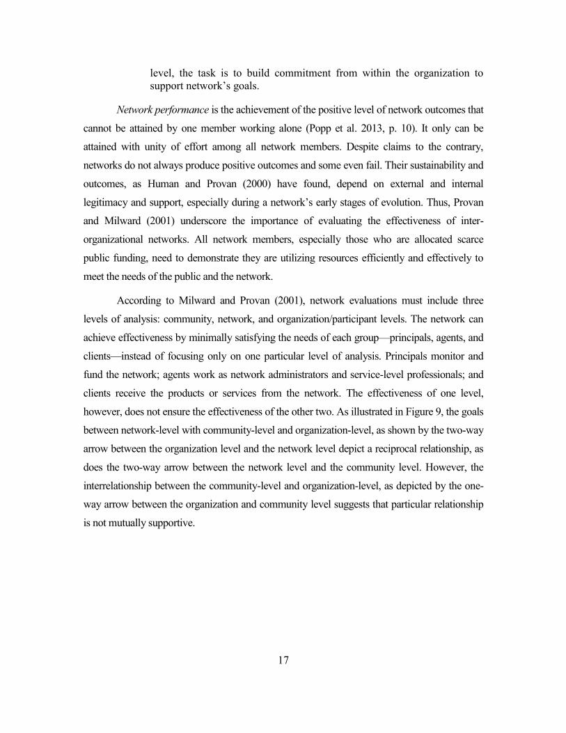
According to Milward and Provan (2001), network evaluations must include three
levels of analysis: community, network, and organization/participant levels. The network can
achieve effectiveness by minimally satisfying the needs of each group—principals, agents, and
clients—instead of focusing only on one particular level of analysis. Principals monitor and
fund the network; agents work as network administrators and service-level professionals; and
clients receive the products or services from the network. The effectiveness of one level,
however, does not ensure the effectiveness of the other two. As illustrated in Figure 9, the goals
between network-level with community-level and organization-level, as shown by the two-way
arrow between the organization level and the network level depict a reciprocal relationship, as
does the two-way arrow between the network level and the community level. However, the
interrelationship between the community-level and organization-level, as depicted by the one-
way arrow between the organization and community level suggests that particular relationship
is not mutually supportive.
18
Figure 9. Relationship between effectiveness at different levels of network analysis and influence by key stakeholders (Milward & Provan, 2001).
In addition, the criteria needed to measure network effectiveness vary across the levels.
At the community level, the criteria are the aggregate outcomes for the population of clients
being served by the network and the overall costs of service for the client within the network
community. At the network level, the criteria are the growth of network membership, range of
services provided, absence of service duplication, relationship strength, creation and
sustainability of the NAO, integration of services, cost of network maintenance, and the
member’s commitment to network goals. The criteria for the last level, the organization level,
are agency survival, enhanced legitimacy, resource acquisition, cost of services, service access,
client outcomes, and minimum conflict among multi-program agencies across the network.
C. INTER-ORGANIZATIONAL NETWORK INTERACTIONS Organizations have numerous ways to interact with other organizations. Their level of
involvement depends on their purposes and how they view the constraints and opportunities in
their environments.
1. Coordination, Cooperation, Collaboration, and Integration
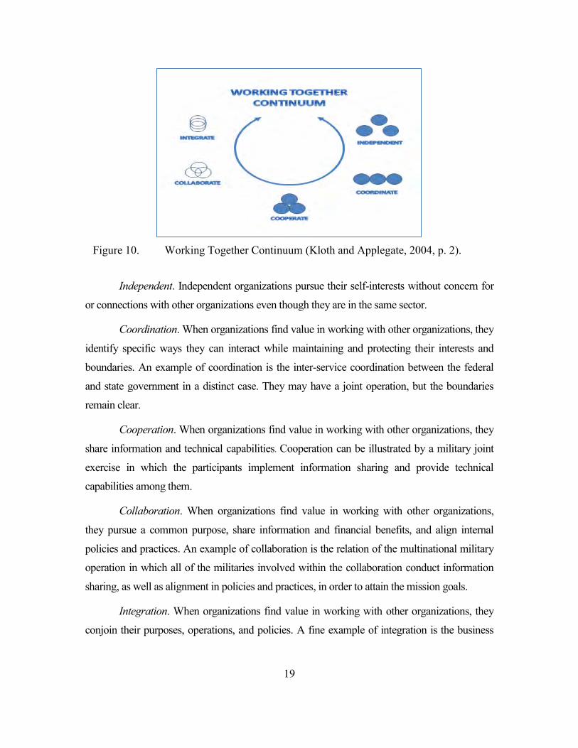
Kloth and Applegate (2004) identify four ways organizations can interact in their
Working Together Continuum (Figure 10). The continuum begins with independent
organizations at the top right and moves clockwise to continuum, coordination, cooperation,
and collaboration, and ultimately to integration.
19
Figure 10. Working Together Continuum (Kloth and Applegate, 2004, p. 2).
Independent. Independent organizations pursue their self-interests without concern for
or connections with other organizations even though they are in the same sector.
Coordination. When organizations find value in working with other organizations, they
identify specific ways they can interact while maintaining and protecting their interests and
boundaries. An example of coordination is the inter-service coordination between the federal
and state government in a distinct case. They may have a joint operation, but the boundaries
remain clear.
Cooperation. When organizations find value in working with other organizations, they
share information and technical capabilities. Cooperation can be illustrated by a military joint
exercise in which the participants implement information sharing and provide technical
capabilities among them.
Collaboration. When organizations find value in working with other organizations,
they pursue a common purpose, share information and financial benefits, and align internal
policies and practices. An example of collaboration is the relation of the multinational military
operation in which all of the militaries involved within the collaboration conduct information
sharing, as well as alignment in policies and practices, in order to attain the mission goals.
Integration. When organizations find value in working with other organizations, they
conjoin their purposes, operations, and policies. A fine example of integration is the business
20
merger between two companies that combines all of their assets, operations, and policies for the
same purpose.
In a similar vein, Roberts describes a continuum of inter-organizational arrangements.
Coordination is positioned at the lowest level because the participants have a low degree of
involvement with other network members (N. Roberts, personal communication, November
10, 2014). Cooperation, in the mid-range of the continuum, requires a higher degree of
organizational involvement and interaction, although some resources remain exclusively at the
disposal of the respective organizations. The next level of inter-organizational arrangements is
collaboration, in which participants begin to share their resources and operational patterns.
Kloth and Applegate note that it is possible for organizations to return to former
arrangements, so the continuum should not be interpreted to mean that one form of interaction
is inherently better than the others. Selection depends on what is the best fit with the
environment and the organizations’ purposes. In the case of the Indonesian maritime domain, it
would appear that the IMSCB is attempting to introduce coordination mechanisms to govern
the domain, although as described in Chapter I, it faces a number of challenges to move the
organizations from independence to coordination.
D. CASES OF INTER-ORGANIZATIONAL NETWORKS How have other organizations dealt with challenges in their respective inter-
organizational domains? We turn to cases in three domains—peace operations, health service
networks, and other maritime domain networks—to identify ideas for improving inter-
organizational coordination.
1. Inter-organizational (States) Networks in Peace Operations
Inter-organization coordination has become one of the most important factors in peace
operations within the United Nations. Indeed some experts see coordination as a key factor that
determines operational success (Nitsova, 2012, p. 10). However, challenges in this domain are
great. Different views about organizational missions, end results, and operations make
coordination difficult (Paris, 2009, p. 53). One study of inter-organizational coordination in
hostile environments recommends a centralized governance network (Nitsova, 2012, p. 48).
21
Obstructions to coordination are typically found in national authorities, so strong authority in
the inter-organizational network is advised.
Balas (2011) examines the motivation for joining inter-organizational networks.
Resource-based motivation occurs when international organizations (IOs) need others’
resources to support their operations. Complementarity-based motivation occurs when each IO
pursues its comparative advantages (e.g. conflict resolution skills), and joins with other
organizations to complement its skill sets. The complexity-based motivation occurs when IOs
recognize that they lack the knowledge, skills, and competencies in complex peace operations
so they seek partners to learn from their experiences.
These cases suggest that giving attention to the inter-organizational network structure
and governance, as well as to reward systems, might be worth considering in improving
coordination in Indonesia’s maritime domain.
2. Inter-organizational Health and Public Services Networks
Provan and Milward (1995) conducted a comparative study of effectiveness in U.S.
inter-organizational mental health networks. Their multi-constituency participants included
clients, families, service professionals, state-level policy makers, funders, agency staff,
administrators, and taxpayers among the most prominent ones (Provan & Milward, 1995, p. 9).
They found more effective networks focused on client outcomes, operated in states that
provided incentives and monitoring mechanisms, and were run locally within a larger system
that was centrally coordinated through a single core agency (Provan & Milward, 1995, p. 31).
Despite this, integration among provider organizations did not automatically ensure the
effectiveness of the overall system. The outcomes were realized only by those networks that
had centralized network integration, direct, non-fragmented external controls, stability, and
sufficient resources (p. 28).
Gibbons’ (2007) research demonstrates the link between the inter-organizational
network structure and the network’s ability to diffuse information system wide in a health
system. The results of her research confirm that certain network structures support information
diffusion, knowledge sharing, collaboration, and access to resources. Gibbons came up with
five network structures that consist of unconstrained network, fully connected, chain structure,
22
hierarchy, and connected clusters. From those structures, unconstrained networks
(unconstrained and fully connected) always outperformed the more constrained structures in
information diffusion. Among the three constrained structures, the chain structure is the worst
for diffusing information while the other two structures hold merely the same scores for
information diffusion. The links building that connects sub-groups within the poorly
performing networks, however, can facilitate the information dissemination throughout the
network without increasing the network density. Her research recommends small interventions
by creating additional connections among members in the network structure in order to increase
its effectivity in diffusing information to the whole system.
These cases point out the importance of a centralized network system with the
inclusion of incentives to improve network effectiveness. Furthermore, these examples suggest
creating small numbers of additional connections can actually increase the capability of
information diffusion within the network structure. The results from these cases could become
useful inputs in creating alternative structures in the Indonesian maritime network. Moreover,
the five structures’ impact on the information diffusion could be taken as models in finding the
most suitable structure for the Indonesian maritime environment.
3. Inter-organizational Networks in the Maritime Domain
Idrobo (1997) searched for alternative designs for Colombia’s inter-organizational
networks in the maritime domain. Colombia had many competing organizations without an
overarching authority, similar to Indonesia. Indeed, Colombian authorities hesitated in
accepting a newly formed Coast Guard as their lead agency. Idrobo concluded that a single
organization with ultimate authority would be required to ensure coordination of the
Colombian maritime domain. This is also the case with Indonesian maritime domain. The
similarity of the challenges and the problem could be the exemplary case for the improvement
of Indonesian maritime network.
The Australian government formed the Border Protection Command (BPC) in 2006 as
a joint agency between the Ministry of Defense and the Ministry of Immigration and Border
Protection due to increasing multi-dimensional threats. The BPC has primary responsibility and
operational control over assets of both Australian Defense Forces and Customs and Border
Protection (Border Protection Command, 2014). Moreover, the BPC has several maritime
23
agency partners who coordinate their tasks especially in border areas. The success of BPC’s
inter-organizational network suggests how Indonesia’s inter-organization network might be
configured to improve its coordination. The network structure that involves many inter-
departmental maritime agencies could be a subject of study to improve the Indonesian maritime
network.
Similar to the BPC, the Malaysian government established the Malaysian Maritime
Enforcement Agency (MMEA) in 2006. It found serious problems in Malaysia’s maritime
enforcement due to numerous agencies with overlapping functions, jurisdictions, and an
inefficient use of resources (MMEA, 2013). The MMEA’s new mission is to enforce laws at
sea and to protect the security of Malaysian water territory. It acts as the principal agency for
the maritime security issues and reports directly to the office of the Malaysian prime minister.
Under direct order from the prime minister, MMEA subsumed several specific authorities from
other maritime agencies in the maritime domain. The situation of MMEA formation is similar
to Indonesia’s IMSCB current condition with several agencies that dwell in the same domain
with overlapping authorities and jurisdictions. The MMEA’ governance structure also may be
studied as one alternative for Indonesia’s maritime network.
Tumin (2007) presented a case study about the importance of information sharing in
inter-organizational networks in the United States Navy, Coast Guard, and Department of
Transportation to build maritime domain awareness. The creation of the Maritime Domain
Awareness (MDA) system played a vital role in maritime security by permitting information
sharing and dissemination that enhanced situational awareness. Information sharing in the
Indonesian maritime domain also plays a pivotal role. The creation of an information sharing
center and improvements in information connectivity among the maritime agencies might be a
good way to mitigate some of the coordination problems. The implementation of an MDA
system similar to the one in this case could improve the information sharing system in the
Indonesian maritime network and could enhance the inter-agencies coordination process.
Hocevar (2012) describes the formation of the Malacca Sea Patrol (MSP) in 2004, a
multi-national network combating piracy that consists of several littoral states adjacent to the
Malacca Strait region, including Indonesia. In addition to MSP, the Regional Cooperation
Agreement on Combating Piracy and Armed Robbery against Ships in Asia (ReCAAP),
initiated by Japan, was established at the strategic level in 2006. Both of these inter-
24
organizational and multinational formations utilize an information-sharing center to coordinate
their operation as well as to disseminate the information among them. These inter-
organizational networks signify the importance of having inter-organizational collaboration to
improve maritime security in the region by utilizing the information sharing, data collection,
and analysis technologies. Furthermore, Hocevar (2010) also explains the network innovations
in port security. The Joint Harbor Operations Center and Maritime Unified Command in San
Diego area set up integrated operation centers for inter-organizational coordination among
maritime agencies in San Diego port security. These two centers provided resources and data to
decrease response time and increase common situational awareness among the participant
agencies. Utilizing an information-sharing system, the centers were able to increase each
agency’s awareness of the other’s assets and improve the efficiency of operational
deployments.
E. SUMMARY This chapter summarizes numerous studies that describe networks and their basic
features which enable them to coordinate activities in a common environment. Several of the
methods reviewed in this chapter are used to analyze the Indonesian maritime domain in
Chapter III.
25
III. RESEARCH METHODOLOGY
Our search for ways to improve Indonesian maritime domain network coordination
begins with data collection and data structuring. Our data primarily come from the IMSCB, in
particular events that involve resource allocations and the incidents occurring within the
maritime domain. Once we explain how our data are collected and structured, we briefly
describe our analysis using four different methodologies: link analysis; geospatial analysis;
temporal analysis; and social network analysis. The goal of our analysis is to find a better
structure for the maritime network. Ideally, the new structure will ensure better communication
and information exchange among the agencies and more efficient operational deployments for
limited stakeholder resources.
A. DATA COLLECTION AND STRUCTURING We were unable to collect data from all the Indonesian maritime stakeholders due to
limited data availability and resources. Instead, we drew data from 6 maritime agencies that
have field resources and conduct operations at sea under the coordination of IMSCB. The data
for these six agencies primarily came from open sources on the Internet accessed through their
official websites. The six maritime agencies are: the IMSCB;1 the Navy;2 the maritime police;3
the fisheries department/PSDKP;4 the coastal unit/KPLP;5 and the customs.6
From the six official websites, we identified 413 organizations that interact within the
Indonesian maritime domain. These organizations, henceforth known as nodes, represent the all
organizations that participate in field operations under the coordination of IMSCB, Taken as a
whole, they create the formal authority network of the Indonesian maritime domain.
1 http://www.bakorkamla.go.id/index.php/profil/visi-misi-3 2 http://www.tnial mil.id/Home.aspx 3 http://www.polri.go.id/polda/ 4 http://akp.kepegawaianpsdkp.com/daftar-upt-pengawasan.html 5 http://kemhubri.dephub.go.id/hubla/ 6 http://www.beacukai.go.id/index.html?page=kantor-bc/pangkalan-sarana-operasi.html
26
B. LIMITATIONS OF DATA In addition to the limitations noted above, this study uses the data taken from the
IMSCB data source on the Indonesian maritime domain. The data taken from IMSCB and
other open sources are not fully reliable since they are collected without going through distinct
processes to ensure the data reliability. Without proper handling, the data collected will affect
the presentation in this study. Considering these limitations of analysis, the results of this study
should be considered tentative and exploratory rather than definitive. Our methodological
approach (see below) could be the basis for future study when data collection and processing
have been improved. .
C. LINK ANALYSIS We began our study using software Palantir to conduct link analysis among the 413
nodes. Our analysis reveals how the nodes are interconnected with one another in the formal
authority network. Link analysis is a method to evaluate the process of building up networks of
interconnected objects in order to explore pattern and trends (Berry & Linoff, 2004, pp. 321‒
322). Link analysis is often confused with social network analysis because both examine the
pattern of relations among various objects. However, there is one basic difference between
these two methods. SNA includes only similar types of objects while link analysis examines
relations between different object types (Everton, 2012, p. 6).
D. HOTSPOT AND GEOSPATIAL ANALYSIS Hotspot spatial analysis, a subset of geospatial analysis, enables us to detect the patterns
of occurrence of maritime incidents within certain vulnerable areas and to identify areas that
need more attention due to illicit activities such as robbery at sea, illegal logging, smuggling,
drug trafficking, and many more criminal activities.
Geospatial analysis provides a specific perspective on a distinct location in viewing
events, patterns, and processes that operate on or near the surface of the earth (Smith et al.
2012). The mapping of maritime incidents in Indonesia uses geospatial analysis to determine
the gravity of the maritime issues. These incidents then can be grouped into clusters to identify
the types of the incident that take place in certain geographical locations. Ultimately, Smith
explains the focus of geospatial analysis on the occurrences’ locations and their linkage to the
geographic information. In order to analyze the geospatial aspect, ArcGIS software is employed
27
to map the occurrences and relate them to specific attributes in order to predict plausible actions
(Eris, 2014). ArcGIS is utilized to process the data, so they can be used to find the hotspots and
outliers and natural clusters of data in finding the best way to employ resources.
We also employ hotspot visualization to anticipate the proper deployment of necessary
resources to those areas most in need. Using data from the maritime network resources
mapping (see below) and the hotspot mapping, a network’s overall mapping picture illustrates
the location of the network’s resources and the incidents that take place in a single operational
visualization. This operational picture then is able to identify the network facility closest to the
hotspot. The analysis can also calculate the feasible distance from the resources location to the
target area in order to find out whether the distances are within the reach of the network’s
assets. Thus, our integrated geospatial mapping method enables us to locate resources across
the domain and to suggest ways to distribute those resources based on the closest facility in
order to reduce transaction costs.
E. TEMPORAL ANALYSIS Within the Indonesian maritime domain network, temporal analysis reveals
information about the time patterns of incident occurrences in the sea. Most importantly, it also
enables us to recognize dynamic changes in the pattern of incidents over time (Peuquet, 1994).
Our temporal analysis utilizes Palantir software which allows us to isolate certain interesting
patterns such as the spikes or low-points of an activity over time. Palantir, a software
application for integrating, visualizing, and analyzing information (Palantir, 2004), offers is
other advantages as well. It enables us to do timeline analysis and create graphic
representations and event histograms and integrate all types of analyses such as statistic,
regional, temporal, geospatial, and SNA (see below) into one platform (Payne et al. 2008).
F. SOCIAL NETWORK ANALYSIS Social network analysis (SNA) is a methodology used to analyze the structure of
networks with quantitative measures (Everton, 2012, p.5). Moreover, SNA determines the
interaction and ties among actors within the networks in which they are embedded (Everton,
2012).
This study begins with an examination of the formal authority network structure under
IMSCB’s coordination. It then explores two additional network structures—the regionally-
28
clustered network and sea-lane clustered network—as alternatives to improve network
coordination.
As mentioned in the data collection above, each structure of these networks within the
Indonesian maritime network consists of six maritime agencies with 413 nodes that comprise a
series of matrices. The matrix construction is then used for processing the data using the ORA
software program. ORA software has many features. It is an analysis tool to examine network
change over time and space with a variety of geo-spatial network metrics and change detection
techniques. It also can identify model network changes over time and perform Course of
Action analysis. ORA software also is used to describe a network’s topography and centrality
and detect risks or vulnerabilities of network design structure. Moreover, it can assist the
analyst in evaluating one or more networks by assessing the nature of, features of, change in,
and determinants of complex networks (Carley et al. 2013).
Our SNA analysis focuses on six parameters to assess the network’s formal structure.
Those parameters are diameter, average distance, density, betweenness centrality, betweenness
centralization, and closeness centrality. Network diameter refers to “a network’s longest
geodesic line and could indicate how dispersed the network is. Everton explains that a network
with large diameters may be more decentralized than a small one (Everton, 2012, p. 137).
Moreover, he argues that decentralized networks are suitable for solving non-routine, complex,
and/or rapidly changing problems or challenges (Everton, 2012, p. 137). According to Everton
(2012), “Average distance refers to the average length of all the shortest paths between all
actors in a network.” (p. 137). He argues, “Information should diffuse faster through networks
with lower average distance than those with higher average distance” (p. 137). Good
information diffusion within a network may ensure effective and efficient coordination process
in the formal structure among agencies within a network.
The next parameter considered is density of the network, which Scott et al. (2005),
defined as “the number of actual connections between members divided by the number of
possible connections” (pp. 445‒446). The more connections that occur among the actors within
a network, the denser the network will become. The density of the network may impact the
network’s ability to coordinate its activities. The high score of density may ease the
coordination process among the actors in a network. Betweenness centrality, the most used
measurement according to Freeman (1979), identifies an actor’s role in a network by measuring
29
its ownership on information and resources control (Corteville, 2009, p. 13). This measure
computes the extent of each actor’s shortest paths that connect all actors in the network
(Everton, 2012, p. 210). An organization with a high level of betweenness centrality has control
of the information flow and resources in a network. Moreover, this organization has the
capability for maintaining the network communication (Shimbel, 1953) and also for
coordinating group processes (Cohn & Marriott, 1958). Therefore, an organization with high
scores of betweenness centrality would coordinate a network better.
Meanwhile, betweenness centralization is a variation of the actor’s betweenness
centrality scores within a network. The bigger a network’s centralization index, the more likely
an actor in a network will have a high betweenness centrality score in comparison with other
actors. Betweenness centralization measures the extent to which actors located between other
actors in the network. Closeness centrality calculates the average geodesic distance of an actor
to all actors within a network (Everton, 2012, p. 209). For example, a score of 1.00 indicates
that an actor is one step away from other actors in the network. Meanwhile, a score that is close
to 0.00 designates the maximum distance of an actor within a network. Hakimi (1965) and
Sabidussi (1966) argue that a central actor of a network would communicate with other points
with minimum time and cost, and the actor would have advantages in making coordination
around the network structures.
Applying these measures to network structures will generate more effective
coordination processes of the formal structure among the maritime agencies in the domain.
Moreover, an effective structure would distribute information faster for the network. This
effectiveness is crucial for ensuring an equal level of coordination process, timely information
distribution and proper understanding of the maritime issues.
G. SUMMARY This study provides an overview of the four methodologies (link analysis, hot-spot and
geospatial analysis, temporal analysis, and social network analysis) that are used to describe
and explore the IMSCB’s current formal inter-organizational network structure. The results of
these analyses follow in the next chapter and the implications in Chapter V.

30
THIS PAGE INTENTIONALLY LEFT BLANK
31
IV. DATA ANALYSIS AND RESULTS
This chapter employs four methodologies (link analysis, geospatial analysis, temporal
analysis, and social network analysis) to analyze the event and incident data drawn from the
Indonesian maritime domain. The objective of this chapter is to describe the domain’s
activities and operations and the formal network structure that coordinates it.
A. LINK ANALYSIS Link analysis helps to visualize the connections between maritime agencies authorities
in regard to the incidents in the Indonesian water territory. Accidents at sea are under the
authority of all agencies. Meanwhile, violations of the law are processed according to the
mandates of the respective agency, based on the government regulation. IMSCB has the
authority to address all incidents at sea since it involves all stakeholders under its authority for
maritime operations. The Navy is authorized for most of the incidents except for asylum
seekers and illegal logging. Similarly, the Marine Police Force is authorized for most incidents
with the exception of illegal fishing. Coastal units are only authorized to investigate ships’ sea-
worthiness documents, while customs has the mandate to oversee the flow of goods coming in
or out of the country. The last agency is the Fisheries Department that has the mandate to
investigate illegal fishing. These organizations and their authorities are illustrated in the Figure
11 link chart.
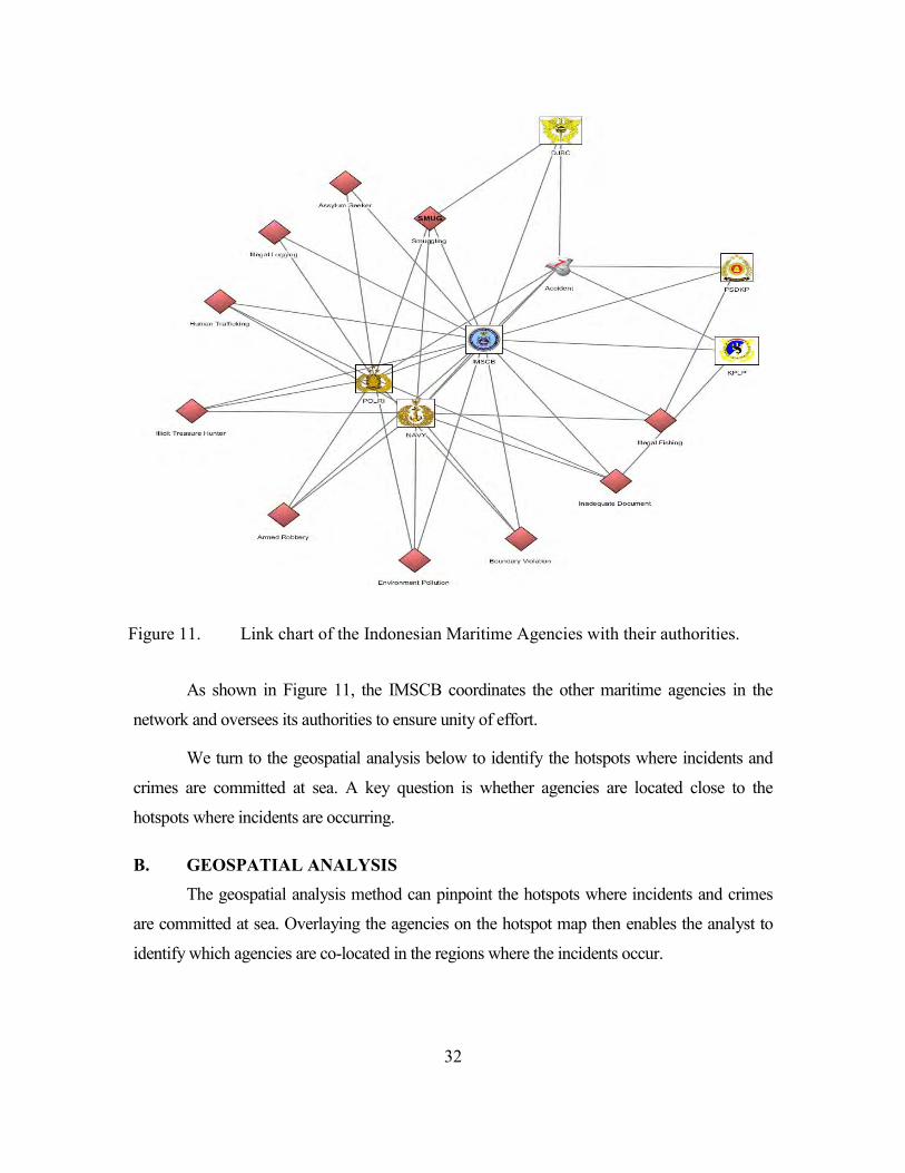
32
Figure 11. Link chart of the Indonesian Maritime Agencies with their authorities.
As shown in Figure 11, the IMSCB coordinates the other maritime agencies in the
network and oversees its authorities to ensure unity of effort.
We turn to the geospatial analysis below to identify the hotspots where incidents and
crimes are committed at sea. A key question is whether agencies are located close to the
hotspots where incidents are occurring.
B. GEOSPATIAL ANALYSIS The geospatial analysis method can pinpoint the hotspots where incidents and crimes
are committed at sea. Overlaying the agencies on the hotspot map then enables the analyst to
identify which agencies are co-located in the regions where the incidents occur.
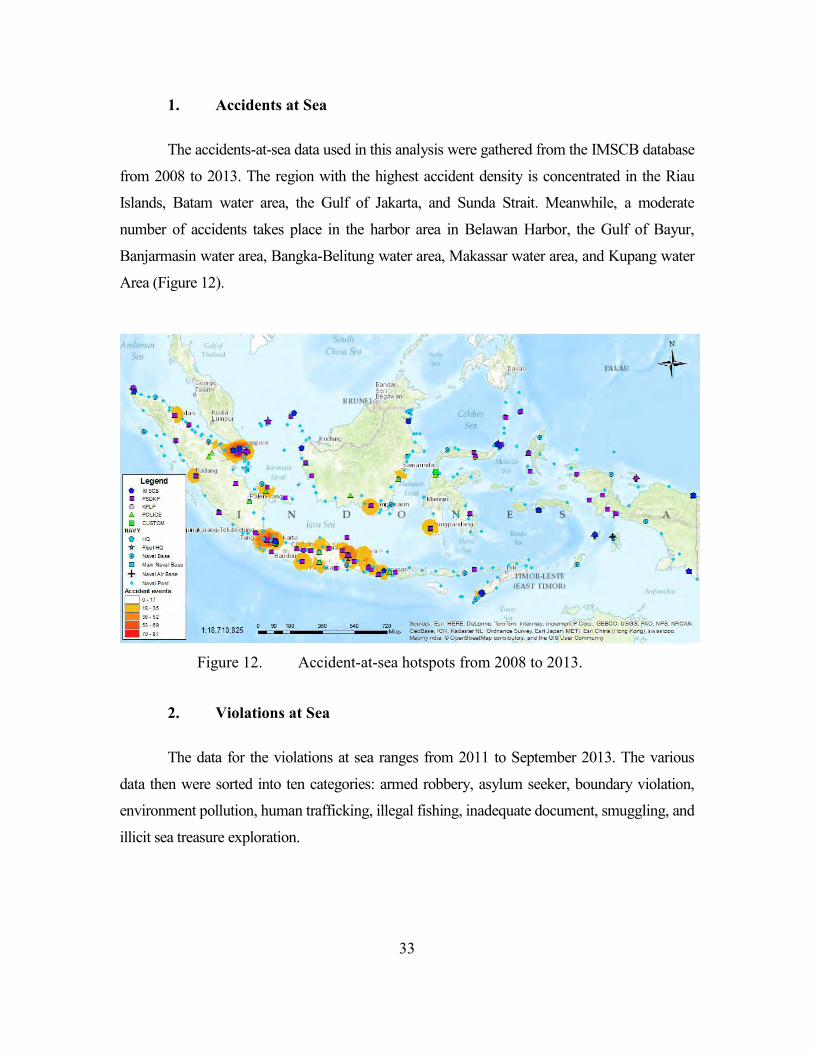
33
1. Accidents at Sea
The accidents-at-sea data used in this analysis were gathered from the IMSCB database
from 2008 to 2013. The region with the highest accident density is concentrated in the Riau
Islands, Batam water area, the Gulf of Jakarta, and Sunda Strait. Meanwhile, a moderate
number of accidents takes place in the harbor area in Belawan Harbor, the Gulf of Bayur,
Banjarmasin water area, Bangka-Belitung water area, Makassar water area, and Kupang water
Area (Figure 12).
Figure 12. Accident-at-sea hotspots from 2008 to 2013.
2. Violations at Sea
The data for the violations at sea ranges from 2011 to September 2013. The various
data then were sorted into ten categories: armed robbery, asylum seeker, boundary violation,
environment pollution, human trafficking, illegal fishing, inadequate document, smuggling, and
illicit sea treasure exploration.
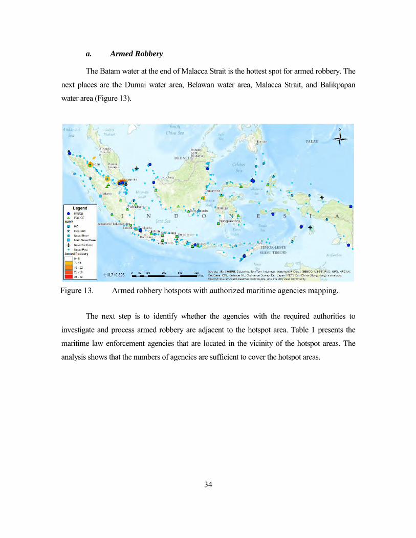
34
a. Armed Robbery
The Batam water at the end of Malacca Strait is the hottest spot for armed robbery. The
next places are the Dumai water area, Belawan water area, Malacca Strait, and Balikpapan
water area (Figure 13).
Figure 13. Armed robbery hotspots with authorized maritime agencies mapping.
The next step is to identify whether the agencies with the required authorities to
investigate and process armed robbery are adjacent to the hotspot area. Table 1 presents the
maritime law enforcement agencies that are located in the vicinity of the hotspot areas. The
analysis shows that the numbers of agencies are sufficient to cover the hotspot areas.
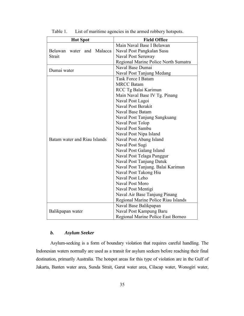
35
Table 1. List of maritime agencies in the armed robbery hotspots.
Hot Spot Field Office
Belawan water and Malacca Strait
Main Naval Base I Belawan Naval Post Pangkalan Susu Naval Post Seruway Regional Marine Police North Sumatra
Dumai water Naval Base Dumai Naval Post Tanjung Medang
Batam water and Riau Islands
Task Force I Batam MRCC Batam RCC Tg Balai Karimun Main Naval Base IV Tg. Pinang Naval Post Lagoi Naval Post Berakit Naval Base Batam Naval Post Tanjung Sangkuang Naval Post Tolop Naval Post Sambu Naval Post Nipa Island Naval Post Abang Island Naval Post Sugi Naval Post Galang Island Naval Post Telaga Punggur Naval Post Tanjung Datuk Naval Post Tanjung. Balai Karimun Naval Post Takong Hiu Naval Post Leho Naval Post Moro Naval Post Mentigi Naval Air Base Tanjung Pinang Regional Marine Police Riau Islands
Balikpapan water Naval Base Balikpapan Naval Post Kampung Baru Regional Marine Police East Borneo
b. Asylum Seeker
Asylum-seeking is a form of boundary violation that requires careful handling. The
Indonesian waters normally are used as a transit for asylum seekers before reaching their final
destination, primarily Australia. The hotspot areas for this type of violation are in the Gulf of
Jakarta, Banten water area, Sunda Strait, Garut water area, Cilacap water, Wonogiri water,
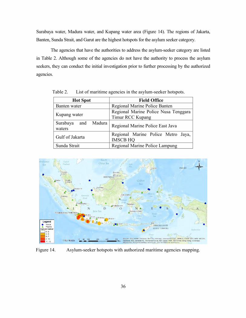
36
Surabaya water, Madura water, and Kupang water area (Figure 14). The regions of Jakarta,
Banten, Sunda Strait, and Garut are the highest hotspots for the asylum seeker category.
The agencies that have the authorities to address the asylum-seeker category are listed
in Table 2. Although some of the agencies do not have the authority to process the asylum
seekers, they can conduct the initial investigation prior to further processing by the authorized
agencies.
Table 2. List of maritime agencies in the asylum-seeker hotspots.
Hot Spot Field Office Banten water Regional Marine Police Banten
Kupang water Regional Marine Police Nusa Tenggara Timur RCC Kupang
Surabaya and Madura waters Regional Marine Police East Java
Gulf of Jakarta Regional Marine Police Metro Jaya, IMSCB HQ
Sunda Strait Regional Marine Police Lampung
Figure 14. Asylum-seeker hotspots with authorized maritime agencies mapping.
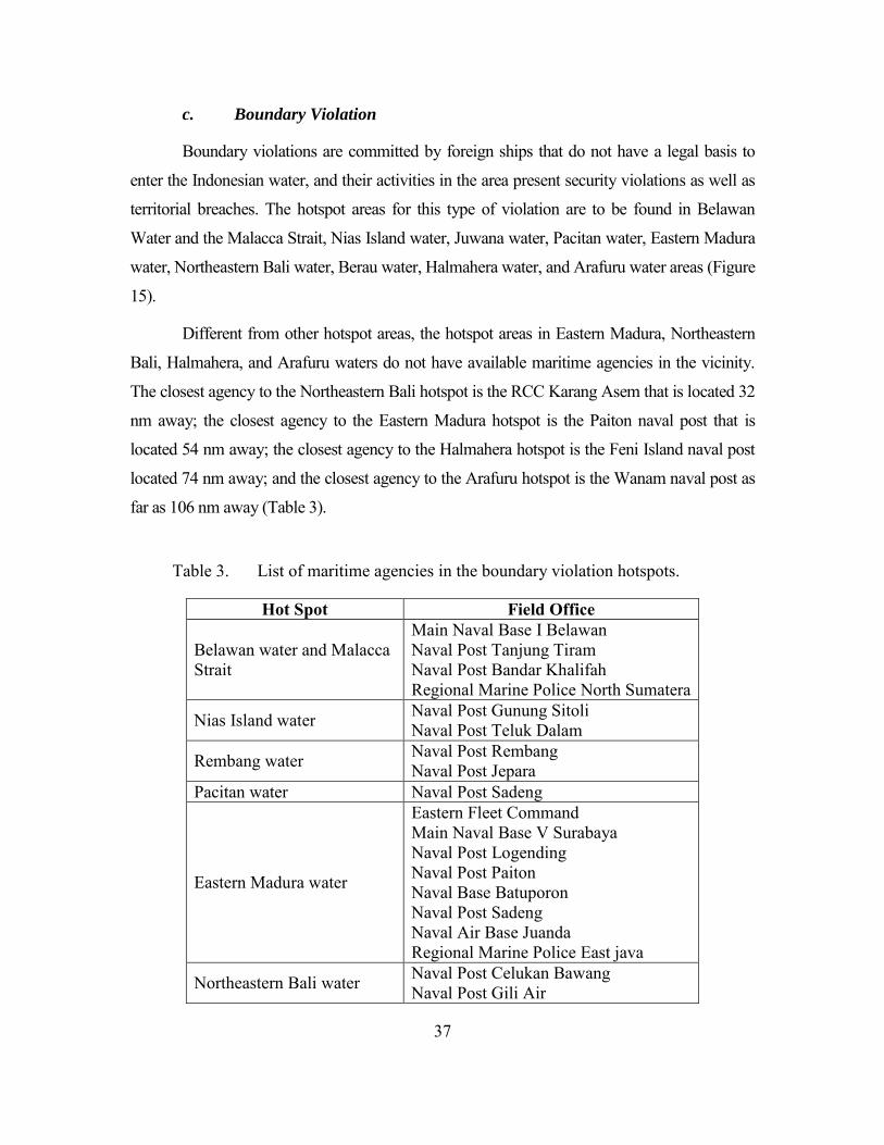
37
c. Boundary Violation
Boundary violations are committed by foreign ships that do not have a legal basis to
enter the Indonesian water, and their activities in the area present security violations as well as
territorial breaches. The hotspot areas for this type of violation are to be found in Belawan
Water and the Malacca Strait, Nias Island water, Juwana water, Pacitan water, Eastern Madura
water, Northeastern Bali water, Berau water, Halmahera water, and Arafuru water areas (Figure
15).
Different from other hotspot areas, the hotspot areas in Eastern Madura, Northeastern
Bali, Halmahera, and Arafuru waters do not have available maritime agencies in the vicinity.
The closest agency to the Northeastern Bali hotspot is the RCC Karang Asem that is located 32
nm away; the closest agency to the Eastern Madura hotspot is the Paiton naval post that is
located 54 nm away; the closest agency to the Halmahera hotspot is the Feni Island naval post
located 74 nm away; and the closest agency to the Arafuru hotspot is the Wanam naval post as
far as 106 nm away (Table 3).
Table 3. List of maritime agencies in the boundary violation hotspots.
Hot Spot Field Office
Belawan water and Malacca Strait
Main Naval Base I Belawan Naval Post Tanjung Tiram Naval Post Bandar Khalifah Regional Marine Police North Sumatera
Nias Island water Naval Post Gunung Sitoli Naval Post Teluk Dalam
Rembang water Naval Post Rembang Naval Post Jepara
Pacitan water Naval Post Sadeng
Eastern Madura water
Eastern Fleet Command Main Naval Base V Surabaya Naval Post Logending Naval Post Paiton Naval Base Batuporon Naval Post Sadeng Naval Air Base Juanda Regional Marine Police East java
Northeastern Bali water Naval Post Celukan Bawang Naval Post Gili Air
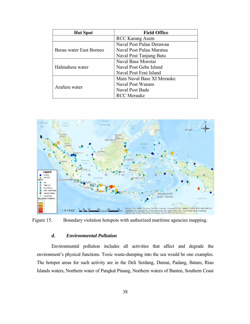
38
Hot Spot Field Office RCC Karang Asem
Berau water East Borneo Naval Post Pulau Derawan Naval Post Pulau Maratua Naval Post Tanjung Batu
Halmahera water Naval Base Morotai Naval Post Gebe Island Naval Post Feni Island
Arafuru water
Main Naval Base XI Merauke Naval Post Wanam Naval Post Bade RCC Merauke
Figure 15. Boundary violation hotspots with authorized maritime agencies mapping.
d. Environmental Pollution
Environmental pollution includes all activities that affect and degrade the
environment’s physical functions. Toxic waste-dumping into the sea would be one examples.
The hotspot areas for such activity are in the Deli Serdang, Dumai, Padang, Batam, Riau
Islands waters, Northern water of Pangkal Pinang, Northern waters of Banten, Southern Coast
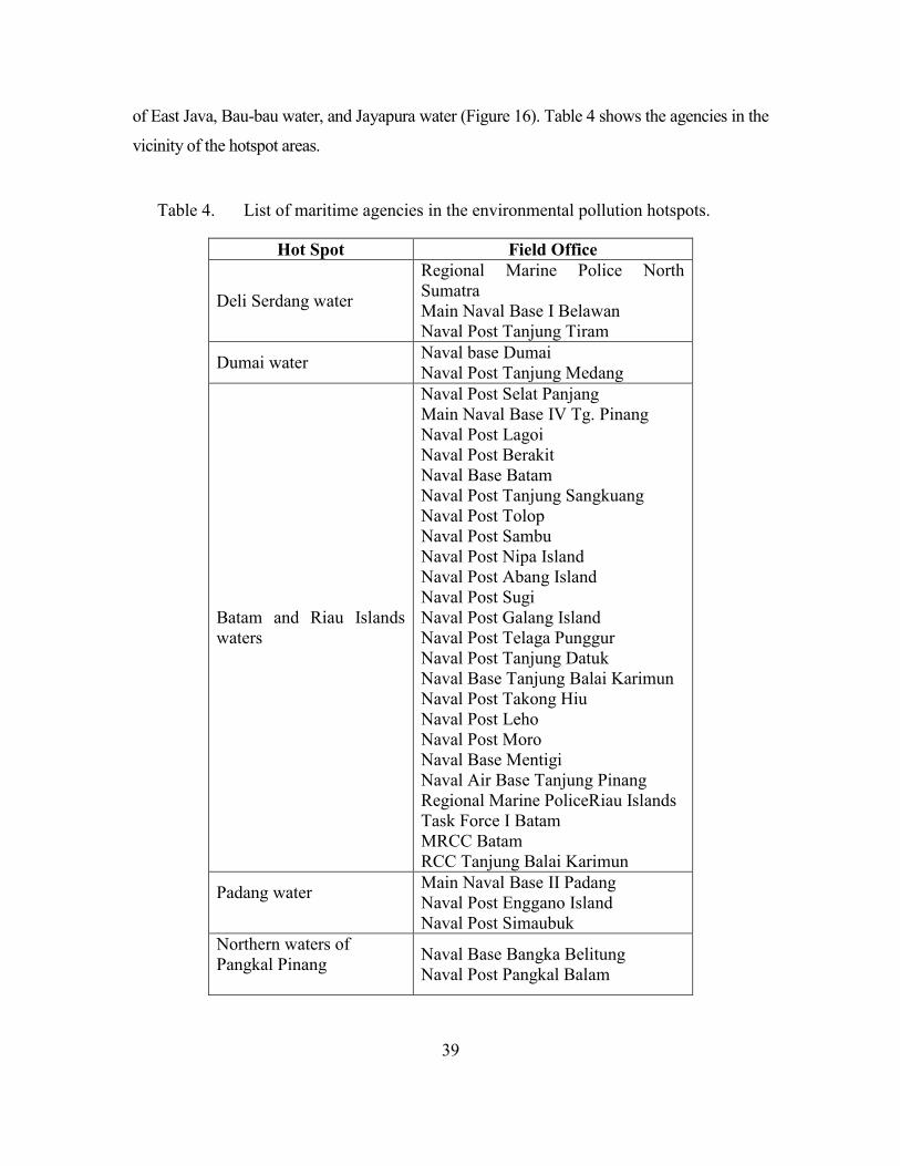
39
of East Java, Bau-bau water, and Jayapura water (Figure 16). Table 4 shows the agencies in the
vicinity of the hotspot areas.
Table 4. List of maritime agencies in the environmental pollution hotspots.
Hot Spot Field Office
Deli Serdang water
Regional Marine Police North Sumatra Main Naval Base I Belawan Naval Post Tanjung Tiram
Dumai water Naval base Dumai Naval Post Tanjung Medang
Batam and Riau Islands waters
Naval Post Selat Panjang Main Naval Base IV Tg. Pinang Naval Post Lagoi Naval Post Berakit Naval Base Batam Naval Post Tanjung Sangkuang Naval Post Tolop Naval Post Sambu Naval Post Nipa Island Naval Post Abang Island Naval Post Sugi Naval Post Galang Island Naval Post Telaga Punggur Naval Post Tanjung Datuk Naval Base Tanjung Balai Karimun Naval Post Takong Hiu Naval Post Leho Naval Post Moro Naval Base Mentigi Naval Air Base Tanjung Pinang Regional Marine PoliceRiau Islands Task Force I Batam MRCC Batam RCC Tanjung Balai Karimun
Padang water
Main Naval Base II Padang Naval Post Enggano Island Naval Post Simaubuk
Northern waters of Pangkal Pinang
Naval Base Bangka Belitung Naval Post Pangkal Balam
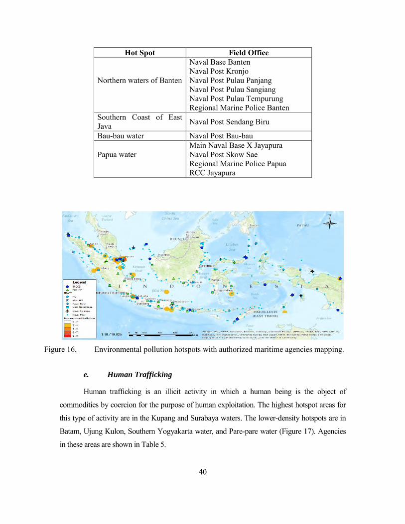
40
Hot Spot Field Office
Northern waters of Banten
Naval Base Banten Naval Post Kronjo Naval Post Pulau Panjang Naval Post Pulau Sangiang Naval Post Pulau Tempurung Regional Marine Police Banten
Southern Coast of East Java Naval Post Sendang Biru
Bau-bau water Naval Post Bau-bau
Papua water
Main Naval Base X Jayapura Naval Post Skow Sae Regional Marine Police Papua RCC Jayapura
Figure 16. Environmental pollution hotspots with authorized maritime agencies mapping.
e. Human Trafficking
Human trafficking is an illicit activity in which a human being is the object of
commodities by coercion for the purpose of human exploitation. The highest hotspot areas for
this type of activity are in the Kupang and Surabaya waters. The lower-density hotspots are in
Batam, Ujung Kulon, Southern Yogyakarta water, and Pare-pare water (Figure 17). Agencies
in these areas are shown in Table 5.
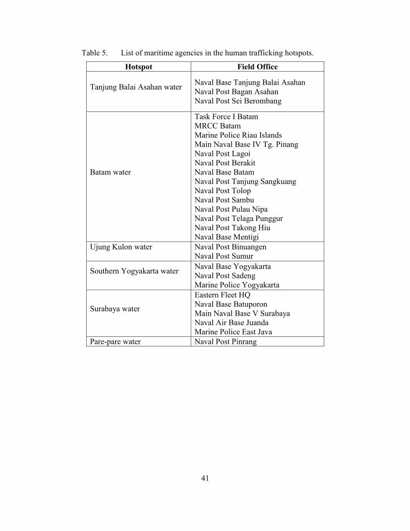
41
Table 5. List of maritime agencies in the human trafficking hotspots.
Hotspot Field Office
Tanjung Balai Asahan water
Naval Base Tanjung Balai Asahan Naval Post Bagan Asahan Naval Post Sei Berombang
Batam water
Task Force I Batam MRCC Batam Marine Police Riau Islands Main Naval Base IV Tg. Pinang Naval Post Lagoi Naval Post Berakit Naval Base Batam Naval Post Tanjung Sangkuang Naval Post Tolop Naval Post Sambu Naval Post Pulau Nipa Naval Post Telaga Punggur Naval Post Takong Hiu Naval Base Mentigi
Ujung Kulon water
Naval Post Binuangen Naval Post Sumur
Southern Yogyakarta water
Naval Base Yogyakarta Naval Post Sadeng Marine Police Yogyakarta
Surabaya water
Eastern Fleet HQ Naval Base Batuporon Main Naval Base V Surabaya Naval Air Base Juanda Marine Police East Java
Pare-pare water Naval Post Pinrang
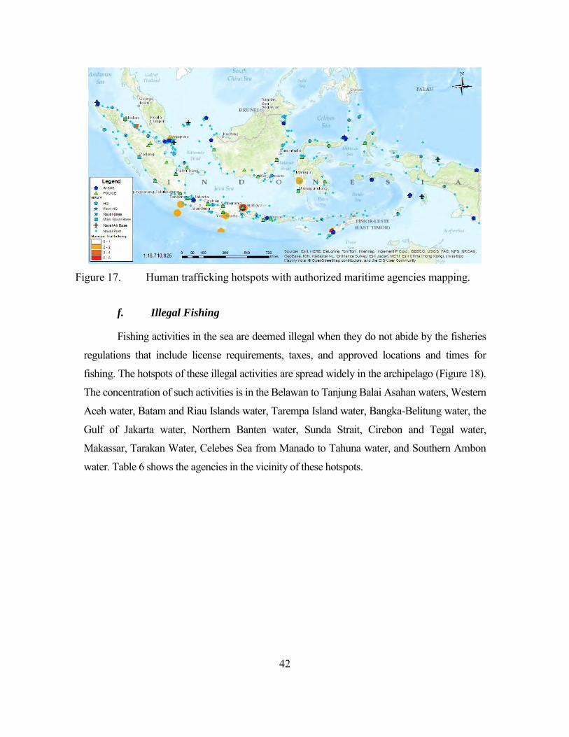
42
Figure 17. Human trafficking hotspots with authorized maritime agencies mapping.
f. Illegal Fishing
Fishing activities in the sea are deemed illegal when they do not abide by the fisheries
regulations that include license requirements, taxes, and approved locations and times for
fishing. The hotspots of these illegal activities are spread widely in the archipelago (Figure 18).
The concentration of such activities is in the Belawan to Tanjung Balai Asahan waters, Western
Aceh water, Batam and Riau Islands water, Tarempa Island water, Bangka-Belitung water, the
Gulf of Jakarta water, Northern Banten water, Sunda Strait, Cirebon and Tegal water,
Makassar, Tarakan Water, Celebes Sea from Manado to Tahuna water, and Southern Ambon
water. Table 6 shows the agencies in the vicinity of these hotspots.
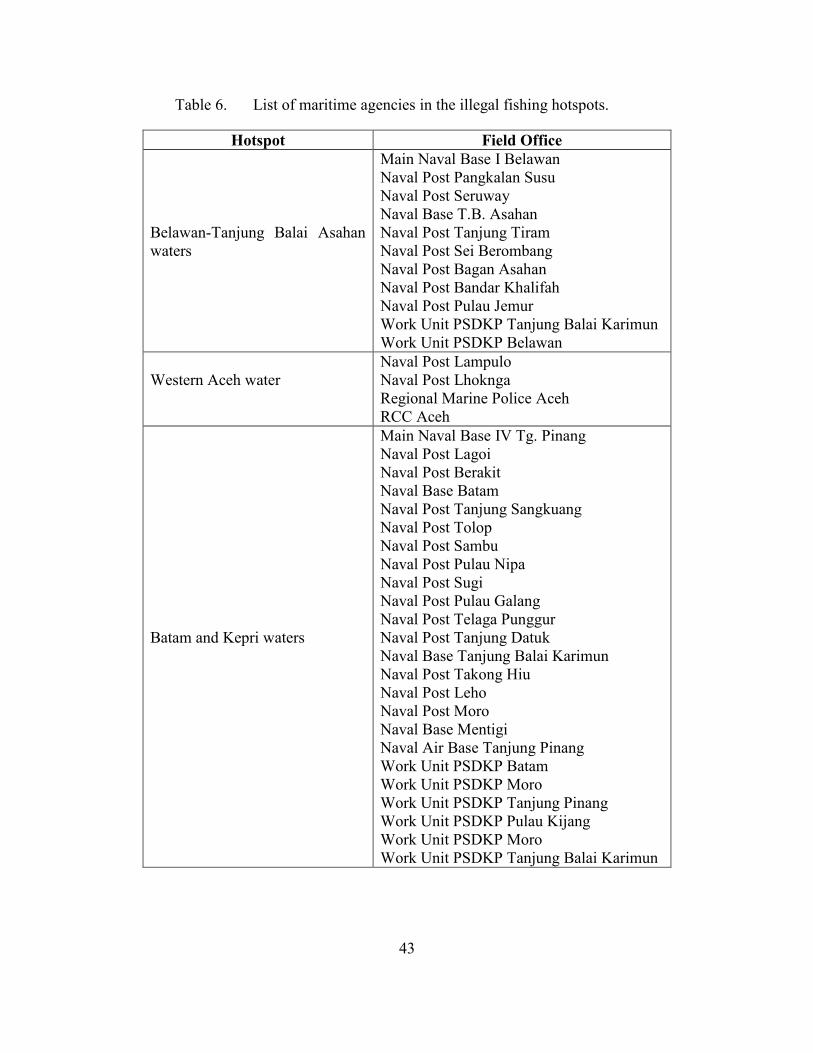
43
Table 6. List of maritime agencies in the illegal fishing hotspots.
Hotspot Field Office
Belawan-Tanjung Balai Asahan waters
Main Naval Base I Belawan Naval Post Pangkalan Susu Naval Post Seruway Naval Base T.B. Asahan Naval Post Tanjung Tiram Naval Post Sei Berombang Naval Post Bagan Asahan Naval Post Bandar Khalifah Naval Post Pulau Jemur Work Unit PSDKP Tanjung Balai Karimun Work Unit PSDKP Belawan
Western Aceh water
Naval Post Lampulo Naval Post Lhoknga Regional Marine Police Aceh RCC Aceh
Batam and Kepri waters
Main Naval Base IV Tg. Pinang Naval Post Lagoi Naval Post Berakit Naval Base Batam Naval Post Tanjung Sangkuang Naval Post Tolop Naval Post Sambu Naval Post Pulau Nipa Naval Post Sugi Naval Post Pulau Galang Naval Post Telaga Punggur Naval Post Tanjung Datuk Naval Base Tanjung Balai Karimun Naval Post Takong Hiu Naval Post Leho Naval Post Moro Naval Base Mentigi Naval Air Base Tanjung Pinang Work Unit PSDKP Batam Work Unit PSDKP Moro Work Unit PSDKP Tanjung Pinang Work Unit PSDKP Pulau Kijang Work Unit PSDKP Moro Work Unit PSDKP Tanjung Balai Karimun
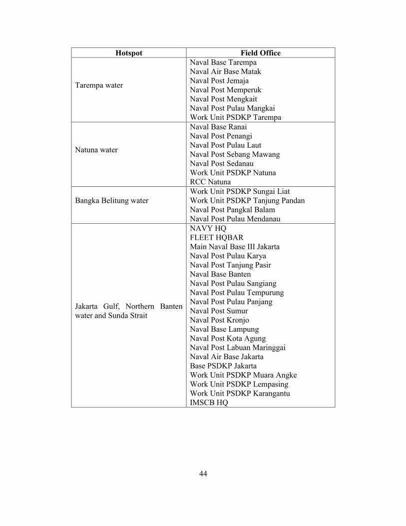
44
Hotspot Field Office
Tarempa water
Naval Base Tarempa Naval Air Base Matak Naval Post Jemaja Naval Post Memperuk Naval Post Mengkait Naval Post Pulau Mangkai Work Unit PSDKP Tarempa
Natuna water
Naval Base Ranai Naval Post Penangi Naval Post Pulau Laut Naval Post Sebang Mawang Naval Post Sedanau Work Unit PSDKP Natuna RCC Natuna
Bangka Belitung water
Work Unit PSDKP Sungai Liat Work Unit PSDKP Tanjung Pandan Naval Post Pangkal Balam Naval Post Pulau Mendanau
Jakarta Gulf, Northern Banten water and Sunda Strait
NAVY HQ FLEET HQBAR Main Naval Base III Jakarta Naval Post Pulau Karya Naval Post Tanjung Pasir Naval Base Banten Naval Post Pulau Sangiang Naval Post Pulau Tempurung Naval Post Pulau Panjang Naval Post Sumur Naval Post Kronjo Naval Base Lampung Naval Post Kota Agung Naval Post Labuan Maringgai Naval Air Base Jakarta Base PSDKP Jakarta Work Unit PSDKP Muara Angke Work Unit PSDKP Lempasing Work Unit PSDKP Karangantu IMSCB HQ
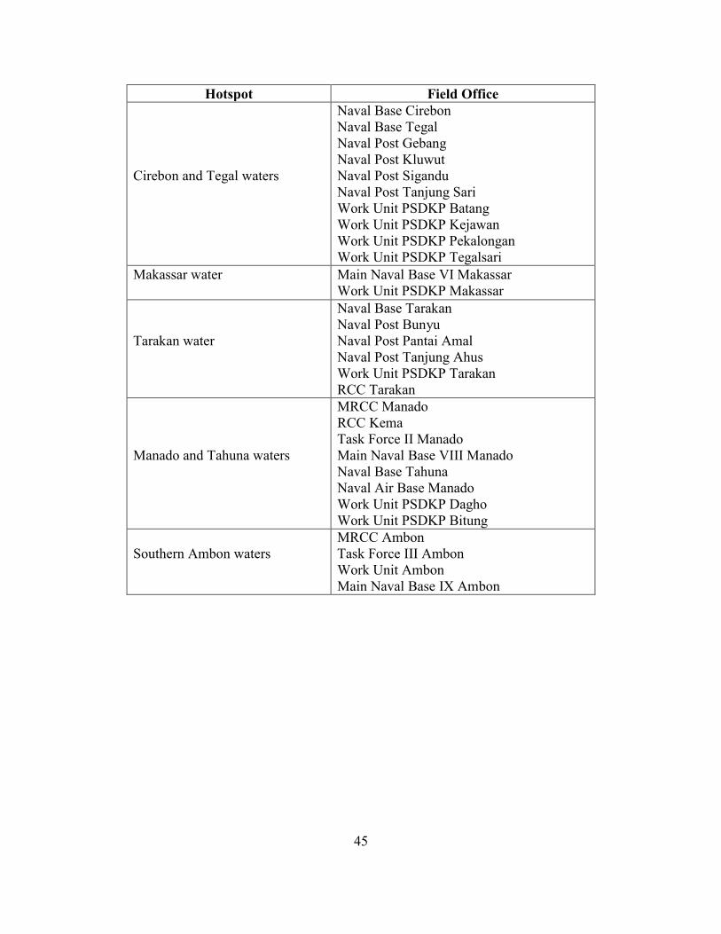
45
Hotspot Field Office
Cirebon and Tegal waters
Naval Base Cirebon Naval Base Tegal Naval Post Gebang Naval Post Kluwut Naval Post Sigandu Naval Post Tanjung Sari Work Unit PSDKP Batang Work Unit PSDKP Kejawan Work Unit PSDKP Pekalongan Work Unit PSDKP Tegalsari
Makassar water
Main Naval Base VI Makassar Work Unit PSDKP Makassar
Tarakan water
Naval Base Tarakan Naval Post Bunyu Naval Post Pantai Amal Naval Post Tanjung Ahus Work Unit PSDKP Tarakan RCC Tarakan
Manado and Tahuna waters
MRCC Manado RCC Kema Task Force II Manado Main Naval Base VIII Manado Naval Base Tahuna Naval Air Base Manado Work Unit PSDKP Dagho Work Unit PSDKP Bitung
Southern Ambon waters
MRCC Ambon Task Force III Ambon Work Unit Ambon Main Naval Base IX Ambon
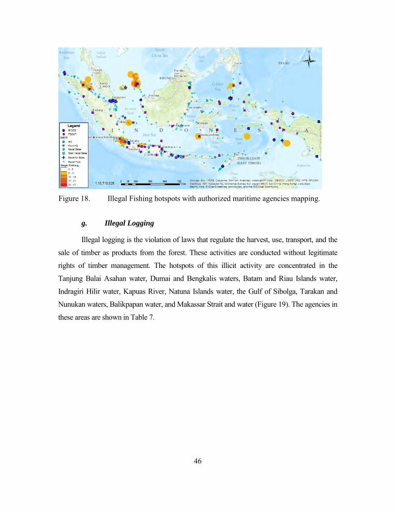
46
Figure 18. Illegal Fishing hotspots with authorized maritime agencies mapping.
g. Illegal Logging
Illegal logging is the violation of laws that regulate the harvest, use, transport, and the
sale of timber as products from the forest. These activities are conducted without legitimate
rights of timber management. The hotspots of this illicit activity are concentrated in the
Tanjung Balai Asahan water, Dumai and Bengkalis waters, Batam and Riau Islands water,
Indragiri Hilir water, Kapuas River, Natuna Islands water, the Gulf of Sibolga, Tarakan and
Nunukan waters, Balikpapan water, and Makassar Strait and water (Figure 19). The agencies in
these areas are shown in Table 7.
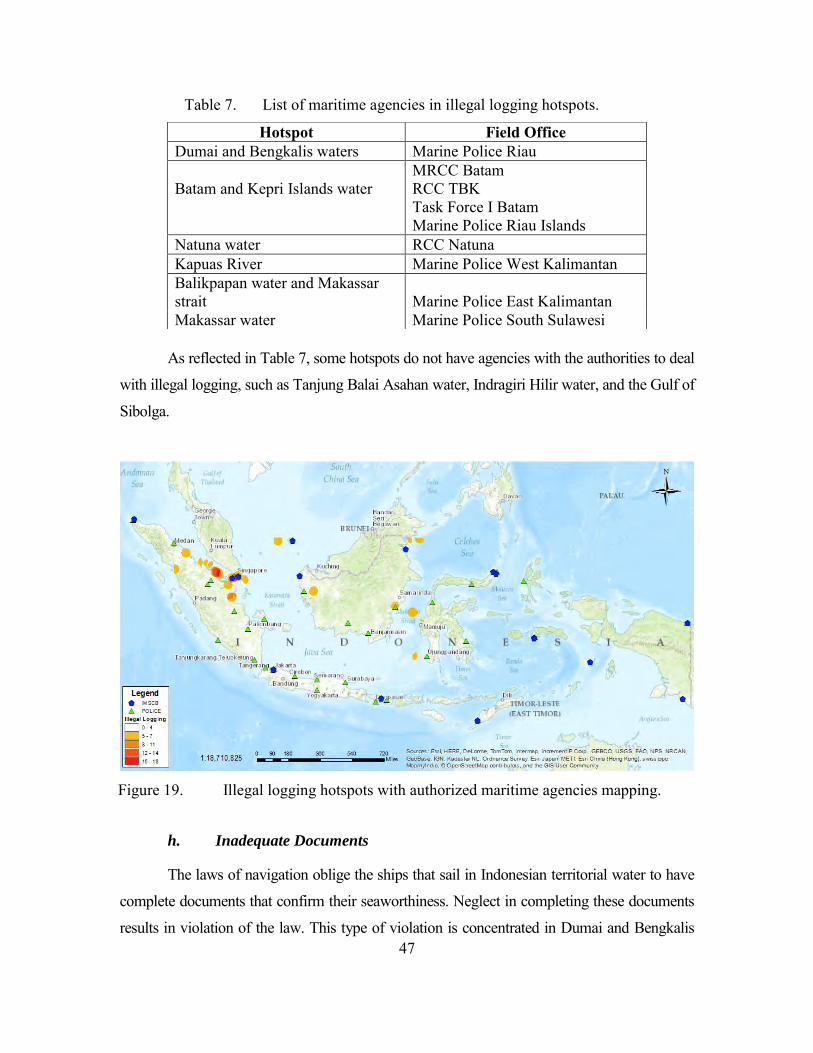
47
Table 7. List of maritime agencies in illegal logging hotspots.
As reflected in Table 7, some hotspots do not have agencies with the authorities to deal
with illegal logging, such as Tanjung Balai Asahan water, Indragiri Hilir water, and the Gulf of
Sibolga.
Figure 19. Illegal logging hotspots with authorized maritime agencies mapping.
h. Inadequate Documents
The laws of navigation oblige the ships that sail in Indonesian territorial water to have
complete documents that confirm their seaworthiness. Neglect in completing these documents
results in violation of the law. This type of violation is concentrated in Dumai and Bengkalis
Hotspot Field Office Dumai and Bengkalis waters Marine Police Riau
Batam and Kepri Islands water
MRCC Batam RCC TBK Task Force I Batam Marine Police Riau Islands
Natuna water RCC Natuna Kapuas River Marine Police West Kalimantan Balikpapan water and Makassar strait Marine Police East Kalimantan Makassar water Marine Police South Sulawesi
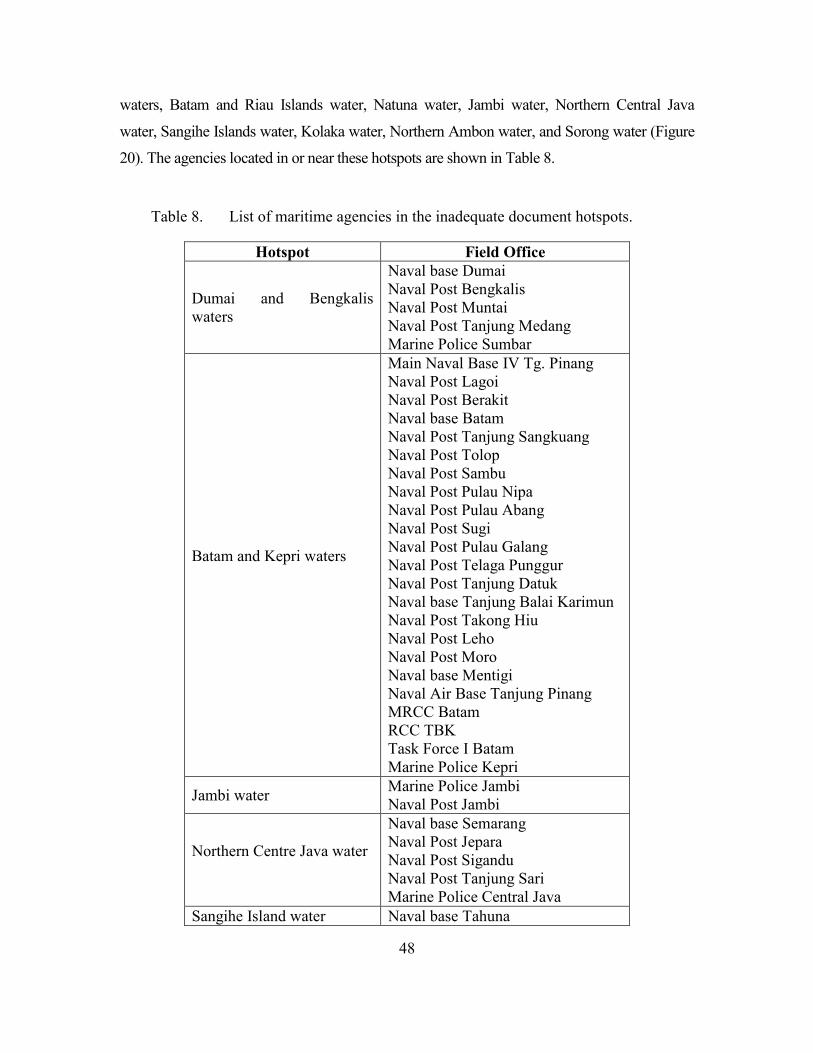
48
waters, Batam and Riau Islands water, Natuna water, Jambi water, Northern Central Java
water, Sangihe Islands water, Kolaka water, Northern Ambon water, and Sorong water (Figure
20). The agencies located in or near these hotspots are shown in Table 8.
Table 8. List of maritime agencies in the inadequate document hotspots.
Hotspot Field Office
Dumai and Bengkalis waters
Naval base Dumai Naval Post Bengkalis Naval Post Muntai Naval Post Tanjung Medang Marine Police Sumbar
Batam and Kepri waters
Main Naval Base IV Tg. Pinang Naval Post Lagoi Naval Post Berakit Naval base Batam Naval Post Tanjung Sangkuang Naval Post Tolop Naval Post Sambu Naval Post Pulau Nipa Naval Post Pulau Abang Naval Post Sugi Naval Post Pulau Galang Naval Post Telaga Punggur Naval Post Tanjung Datuk Naval base Tanjung Balai Karimun Naval Post Takong Hiu Naval Post Leho Naval Post Moro Naval base Mentigi Naval Air Base Tanjung Pinang MRCC Batam RCC TBK Task Force I Batam Marine Police Kepri
Jambi water Marine Police Jambi Naval Post Jambi
Northern Centre Java water
Naval base Semarang Naval Post Jepara Naval Post Sigandu Naval Post Tanjung Sari Marine Police Central Java
Sangihe Island water Naval base Tahuna
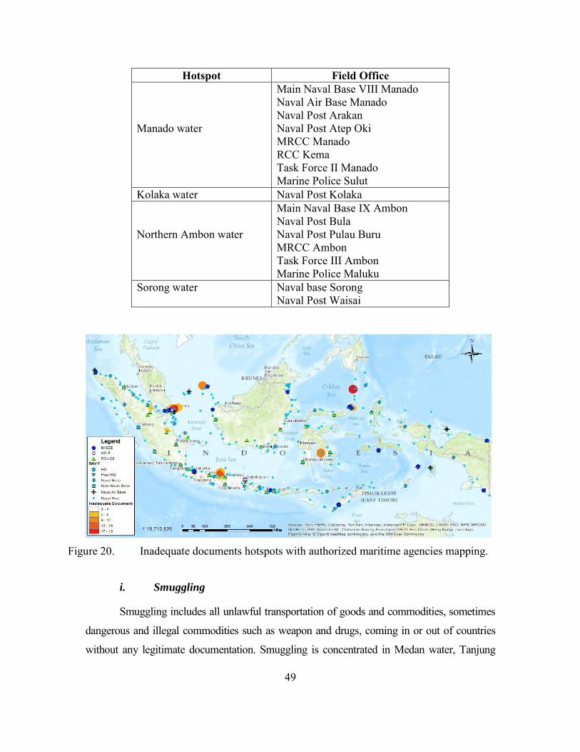
49
Hotspot Field Office
Manado water
Main Naval Base VIII Manado Naval Air Base Manado Naval Post Arakan Naval Post Atep Oki MRCC Manado RCC Kema Task Force II Manado Marine Police Sulut
Kolaka water Naval Post Kolaka
Northern Ambon water
Main Naval Base IX Ambon Naval Post Bula Naval Post Pulau Buru MRCC Ambon Task Force III Ambon Marine Police Maluku
Sorong water
Naval base Sorong Naval Post Waisai
Figure 20. Inadequate documents hotspots with authorized maritime agencies mapping.
i. Smuggling
Smuggling includes all unlawful transportation of goods and commodities, sometimes
dangerous and illegal commodities such as weapon and drugs, coming in or out of countries
without any legitimate documentation. Smuggling is concentrated in Medan water, Tanjung
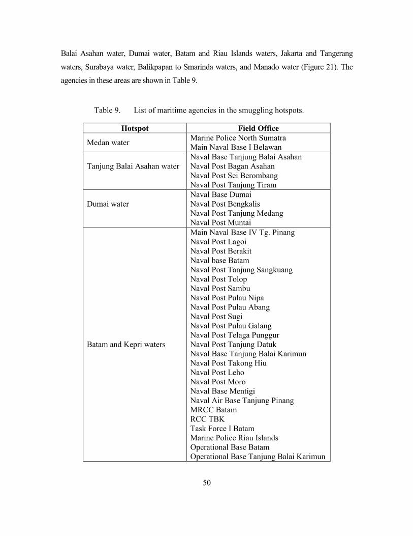
50
Balai Asahan water, Dumai water, Batam and Riau Islands waters, Jakarta and Tangerang
waters, Surabaya water, Balikpapan to Smarinda waters, and Manado water (Figure 21). The
agencies in these areas are shown in Table 9.
Table 9. List of maritime agencies in the smuggling hotspots.
Hotspot Field Office
Medan water Marine Police North Sumatra Main Naval Base I Belawan
Tanjung Balai Asahan water
Naval Base Tanjung Balai Asahan Naval Post Bagan Asahan Naval Post Sei Berombang Naval Post Tanjung Tiram
Dumai water
Naval Base Dumai Naval Post Bengkalis Naval Post Tanjung Medang Naval Post Muntai
Batam and Kepri waters
Main Naval Base IV Tg. Pinang Naval Post Lagoi Naval Post Berakit Naval base Batam Naval Post Tanjung Sangkuang Naval Post Tolop Naval Post Sambu Naval Post Pulau Nipa Naval Post Pulau Abang Naval Post Sugi Naval Post Pulau Galang Naval Post Telaga Punggur Naval Post Tanjung Datuk Naval Base Tanjung Balai Karimun Naval Post Takong Hiu Naval Post Leho Naval Post Moro Naval Base Mentigi Naval Air Base Tanjung Pinang MRCC Batam RCC TBK Task Force I Batam Marine Police Riau Islands Operational Base Batam Operational Base Tanjung Balai Karimun
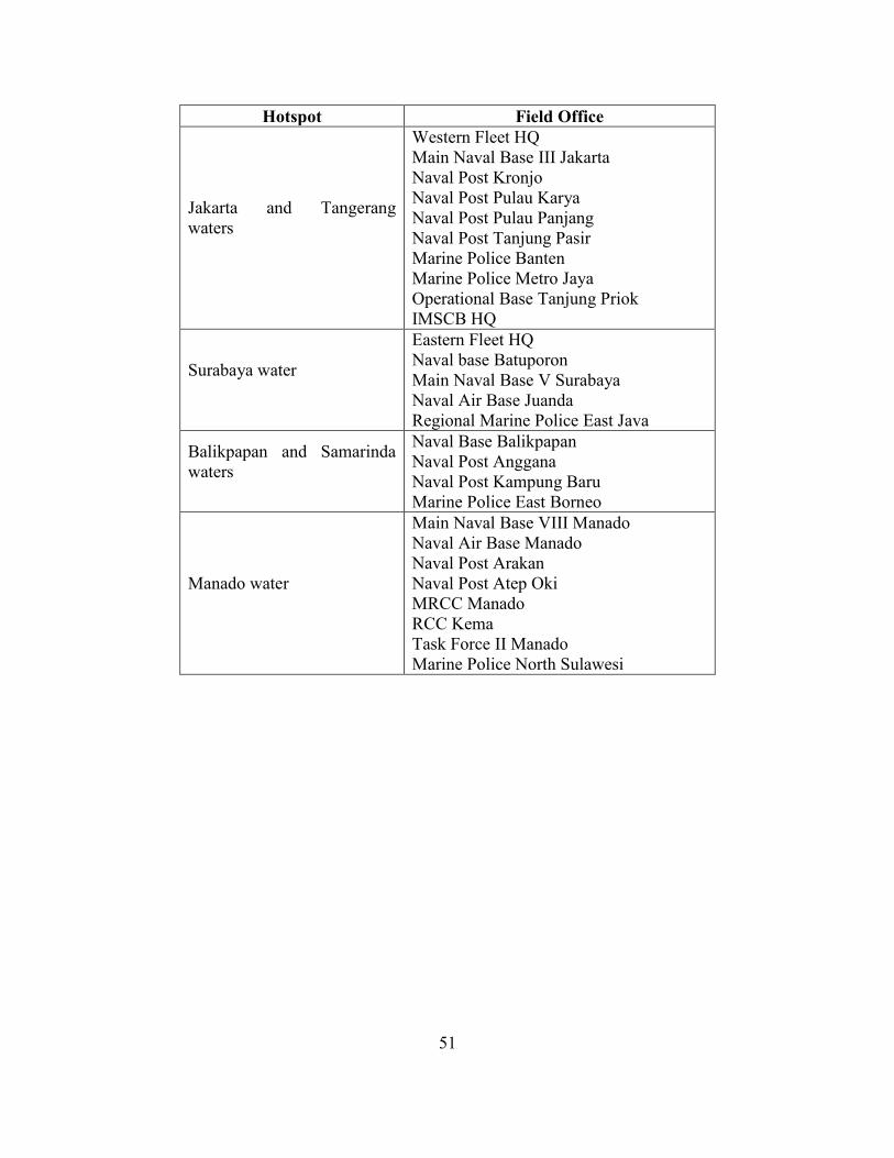
51
Hotspot Field Office
Jakarta and Tangerang waters
Western Fleet HQ Main Naval Base III Jakarta Naval Post Kronjo Naval Post Pulau Karya Naval Post Pulau Panjang Naval Post Tanjung Pasir Marine Police Banten Marine Police Metro Jaya Operational Base Tanjung Priok IMSCB HQ
Surabaya water
Eastern Fleet HQ Naval base Batuporon Main Naval Base V Surabaya Naval Air Base Juanda Regional Marine Police East Java
Balikpapan and Samarinda waters
Naval Base Balikpapan Naval Post Anggana Naval Post Kampung Baru Marine Police East Borneo
Manado water
Main Naval Base VIII Manado Naval Air Base Manado Naval Post Arakan Naval Post Atep Oki MRCC Manado RCC Kema Task Force II Manado Marine Police North Sulawesi
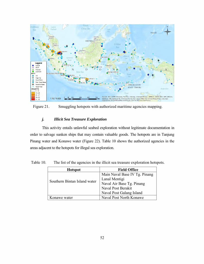
52
Figure 21. Smuggling hotspots with authorized maritime agencies mapping.
j. Illicit Sea Treasure Exploration
This activity entails unlawful seabed exploration without legitimate documentation in
order to salvage sunken ships that may contain valuable goods. The hotspots are in Tanjung
Pinang water and Konawe water (Figure 22). Table 10 shows the authorized agencies in the
areas adjacent to the hotspots for illegal sea exploration.
Table 10. The list of the agencies in the illicit sea treasure exploration hotspots.
Hotspot Field Office
Southern Bintan Island water
Main Naval Base IV Tg. Pinang Lanal Mentigi Naval Air Base Tg. Pinang Naval Post Berakit Naval Post Galang Island
Konawe water Naval Post North Konawe
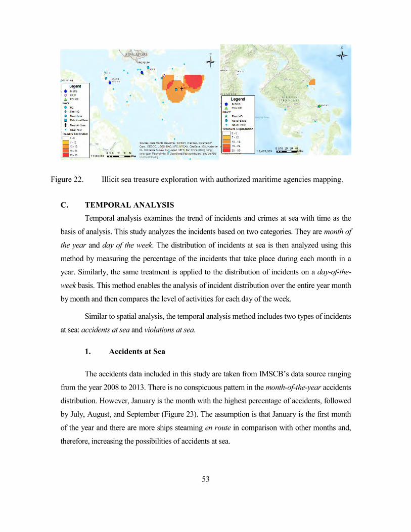
53
Figure 22. Illicit sea treasure exploration with authorized maritime agencies mapping.
C. TEMPORAL ANALYSIS Temporal analysis examines the trend of incidents and crimes at sea with time as the
basis of analysis. This study analyzes the incidents based on two categories. They are month of
the year and day of the week. The distribution of incidents at sea is then analyzed using this
method by measuring the percentage of the incidents that take place during each month in a
year. Similarly, the same treatment is applied to the distribution of incidents on a day-of-the-
week basis. This method enables the analysis of incident distribution over the entire year month
by month and then compares the level of activities for each day of the week.
Similar to spatial analysis, the temporal analysis method includes two types of incidents
at sea: accidents at sea and violations at sea.
1. Accidents at Sea
The accidents data included in this study are taken from IMSCB’s data source ranging
from the year 2008 to 2013. There is no conspicuous pattern in the month-of-the-year accidents
distribution. However, January is the month with the highest percentage of accidents, followed
by July, August, and September (Figure 23). The assumption is that January is the first month
of the year and there are more ships steaming en route in comparison with other months and,
therefore, increasing the possibilities of accidents at sea.
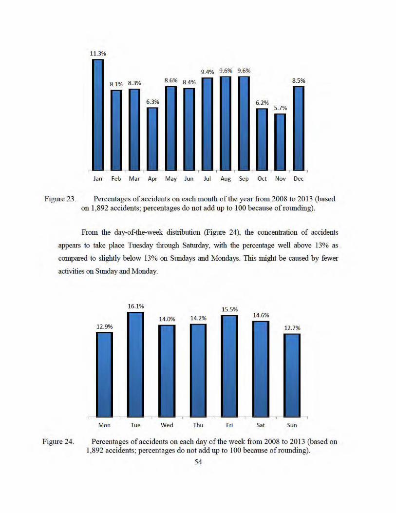
11.3%
Jan Feb Mar Apr May Jun Jul Aug Sep Oct Nov Dec
Figure 23. Percentages of accidents on each month of the year from 2008 to 2013 (based on 1,892 accidents; percentages do not add up to 100 because of rounding) .
From the day-of-the-week distribution (Figure 24), the concentration of accidents
appears to take place Tuesday tln·ough Saturday, with the percentage well above 13% as
compared to slightly below 13% on Sundays and Mondays. This might be caused by fewer
activities on Sunday and Monday.
Figure 24.
Mon Tue Wed Thu Fri Sat Sun
Percentages of accidents on each day of the week from 2008 to 2013 (based on 1,892 accidents; percentages do not add up to 100 because of rounding).
54
55
2. Violations at Sea
The data taken from IMSCB’s data source ranging from January 2011 to September
2013 are categorized into ten types of violations. The data used for month-of-the-year category
are from January 2011 to December 2013. Meanwhile, the day-of-the-week category includes
all data from January 2011 to September 2014 to add greater accuracy to the analysis.
However, one of the difficulties in the analysis is the insufficient amount of data. Some of the
violation types have insufficient data for the purposes of analysis. Among these types are
boundary violations, human trafficking, and illicit sea treasure exploration (Table 11). The
minimum data requirement for analysis is five cases in each time variable for each type of
violation (Larseen & Marx, 1981). Therefore, minimum requirements of 35 violations are
required to analyze the distribution of the day-of-the-week category, and at least 60 violations
are required to analyze the month-of-the-year category. Due to insufficient data, four types of
violations cannot be analyzed: boundary violations, environmental pollution, human
trafficking, and illicit sea treasure exploration.

56
Table 11. Number of incidents for each violation type in two categories.
Type of violation Number of Incidents
Month-of-year Day-of-week
Armed Robbery 97 119
Asylum Seeker 66 70
Boundary Violation 10 13
Environment Pollution 18 29
Human Trafficking 10 14
Illegal Fishing 348 388
Illegal Logging 60 70
Inadequate Document 142 164
Smuggling 268 348
Illicit Sea Treasure Exploration 4 5
a. Armed Robbery
There is no distinct pattern for month-of the-year distribution. For certain months
(January, May, August, September, and October) the number for this type of violation is
relatively low (Figure 25). In August through October the number of armed robberies is
relatively small.
Figure 25. Armed robbery month-of-year distribution.
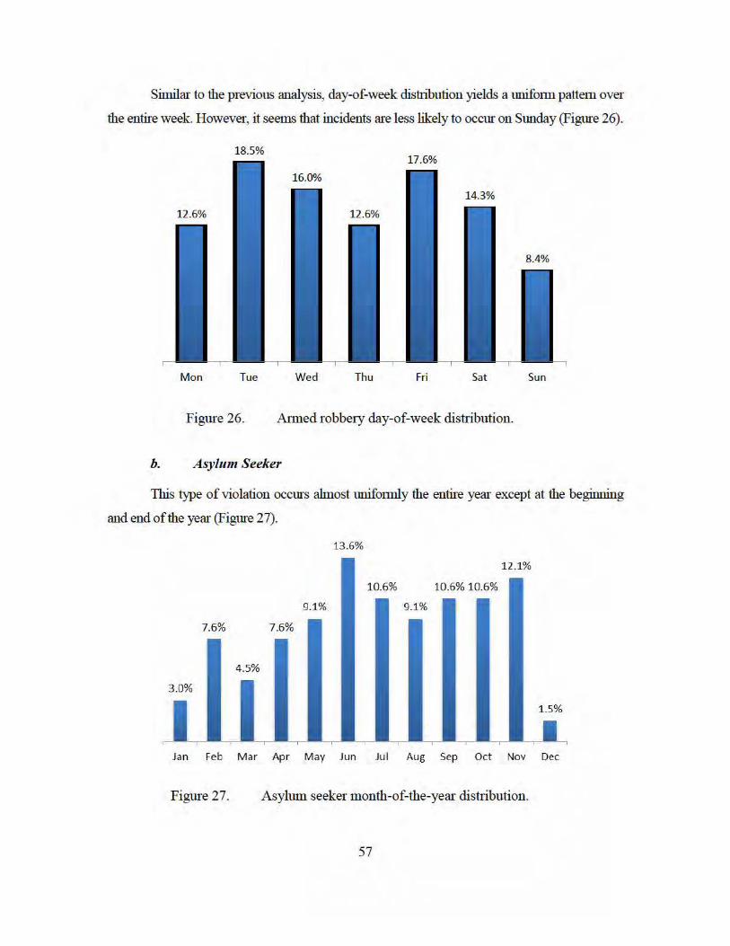
Similar to the previous analysis, day-of-week distribution yields a unifmm pattem over
the entire week. However, it seems that incidents are less likely to occur on Sunday (Figme 26).
18.5%
Mon Tue Wed Thu Fri Sat Sun
Figure 26. Almed robbe1y day-of-week distribution.
b. A sylum Seeker
1bis type of violation occurs ahnost unifmmly the entire year except at the beginning
and end of the year (Figme 27).
13 .6%
Jan Feb M ar Apr May Jun Jul Aug Sep Oct Nov Dec
Figure 27. Asylum seeker month-of-the-year distribution.
57
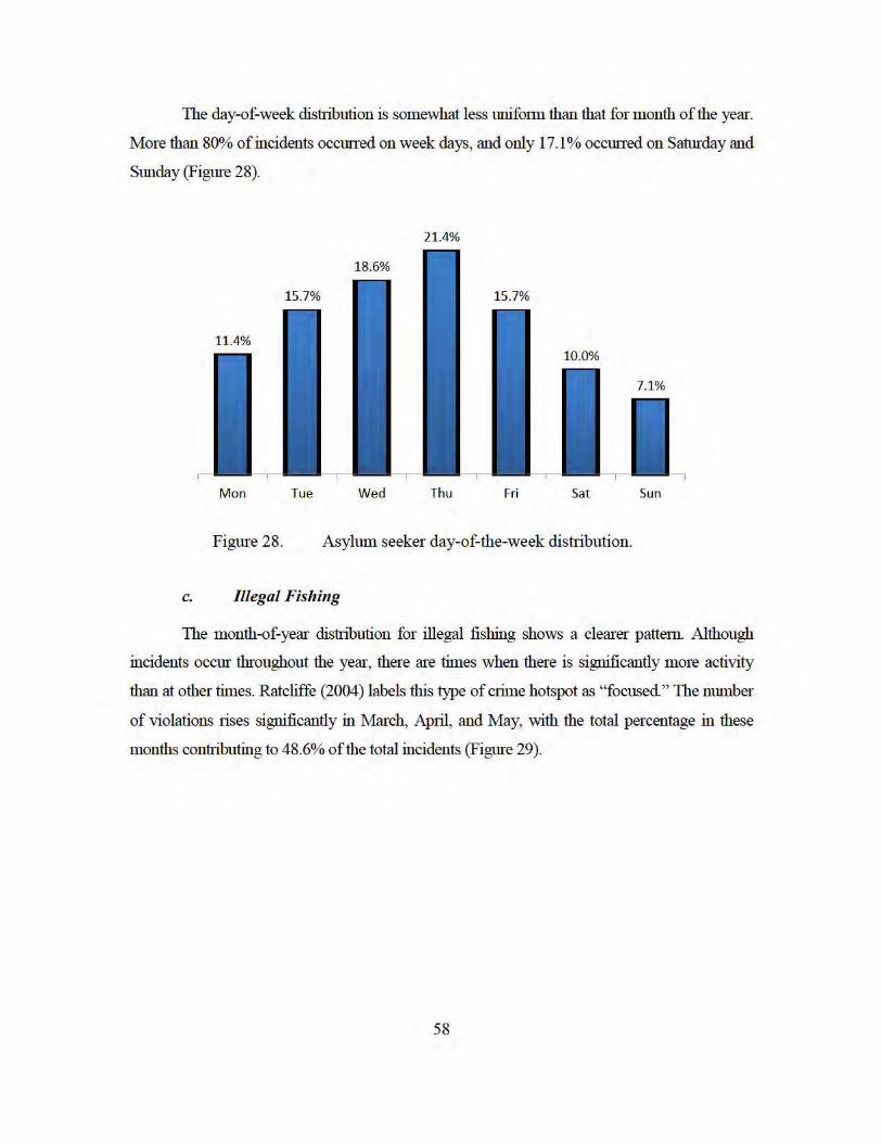
The day-of-week distribution is somewhat less unifmm than that for month of the year.
More than 80% of incidents occmTed on week days, and only 17.1% occmTed on Satm·day and
Sunday (Figure 28).
21.4%
Mon Tue Wed Thu Fri Sat Sun
Figure 28. Asylum seeker day-of-the-week distribution.
c. Illegal Fishing
The month-of-year distribution for illegal fishing shows a clearer pattem. Although
incidents occm throughout the year, there are times when there is significantly more activity
than at other times. Ratcliffe (2004) labels this type of crime hotspot as "focused" The number
of violations rises significantly in March, April, and May, with the total percentage in these
months con1I1buting to 48.6% of the total incidents (Figme 29).
58
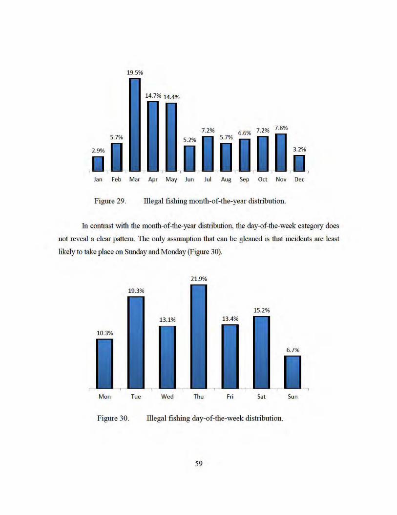
19.5%
Jan Feb Mar Apr May Jun Jul Aug Sep Oct Nov Dec
Figure 29. illegal fishing month-of-the-year distribution .
In contrast with the month-of-the-year distribution, the day-of-the-week categmy does
not reveal a clear pattem. The only assumption that can be gleaned is that incidents are least
likely to take place on Sunday and Monday (Figure 30).
21.9%
Mon Tue Wed Thu Fri Sat Sun
Figure 30. illegal fishing day-of-the-week distribution .
59
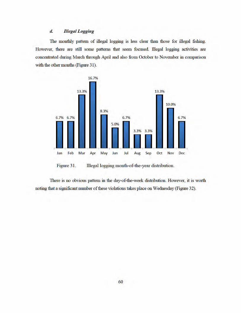
d. Illegal Logging
The monthly pattern of illegal logging is less clear than those for illegal fishing.
However, there are still some pattenlS that seem focused. illegal logging activities are
concentrated during March through April and also fi·om October to November in comparison
with the other months (Figme 31 ).
16.7%
Jan Feb Mar Apr May Jun Jul Aug Sep Oct Nov Dec
Figure 31. lllegallogging month-of-the-year distribution.
There is no obvious pattern in the day-of-the-week distribution. However, it is worth
noting that a significant number of these violations takes place on Wednesday (Figure 32).
60
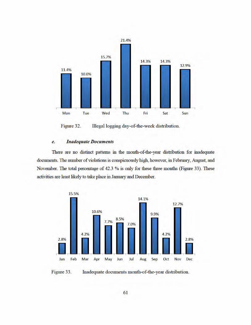
21.4%
Mon Tue Wed Thu Fri Sat Sun
Figure 32. Illegal logging day-of-the-week distribution.
e. Inadequate Documents
There are no distinct pattems in the month-of-the-year distribution for inadequate
documents. The number of violations is conspicuously high, however, in Febrruuy, August, and
November. The total percentage of 42.3 %is only for these three months (Figure 33). These
activities are least likely to take place in Janmuy and December.
15.5%
Jan Feb Mar Apr May Jun Jul Aug Sep Oct Nov Dec
Figure 33. Inadequate documents month-of-the-year distribution.
61
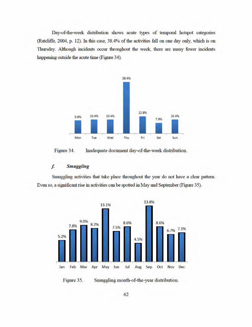
Day-of-the-week distribution shows acute types of temporal hotspot categories
(Ratcliffe, 2004, p. 12). fu this case, 38.4% of the activities fall on one day only, which is on
Thursday. Although incidents occm throughout the week, there are many fewer incidents
happening outside the acute time (Figure 34).
38.4%
Mon rue Wed Thu fri Sat sun
Figure 34. Inadequate document day-of-the-week distribution .
f. Smuggling
Smuggling activities that take place throughout the year do not have a clear pattem .
Even so, a significant rise in activities can be spotted in May and September (Figure 35).
Jan Feb Mar Apr May Jun Jul Aug Sep Oct Nov Dec
Figure 35. Smuggling m onth-of-the-year distribution.
62
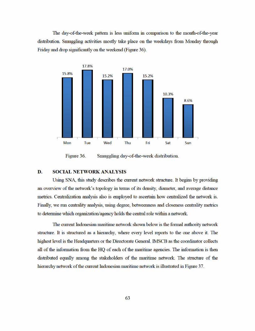
The day-of-the-week pattem is less unifonn in comparison to the month-of-the-year
distribution. Smuggling activities mostly take place on the weekdays from Monday through
Friday and drop significantly on the weekend (Figure 36).
17.8%
Mon Tue Wed Thu Fri Sat Sun
Figure 36. Smuggling day-of-the-week distribution .
D. SOCIAL NETWORK ANALYSIS
Using SNA, this study describes the cunent network structure. It begins by providing
an ovetview of the network's topology in tem lS of its density, diameter, and average distance
metr·ics. Centr-alization analysis also is employed to asceitain how centr·alized the network is.
Finally, we mn centr-ality analysis, using degree, betweenness and closeness centr-ality metr1cs
to detennine which organization/agency holds the centr·al role within a network
The cmTent Indonesian mru1time netwmk shown below is the fonnal authm1ty network
structure. It is structured as a hierru·chy, where evety level repotts to the one above it. The
highest level is the Headqualiers or the Directorate General. IMSCB as the coordinator collects
all of the infmm ation fi:om the HQ of each of the mru1time agencies. The infonnation is then
distr-ibuted equally among the stakeholders of the mru1time network The structure of the
hierru·chy network of the cmTent Indonesian mru1time network is illustr-ated in Figure 37.
63
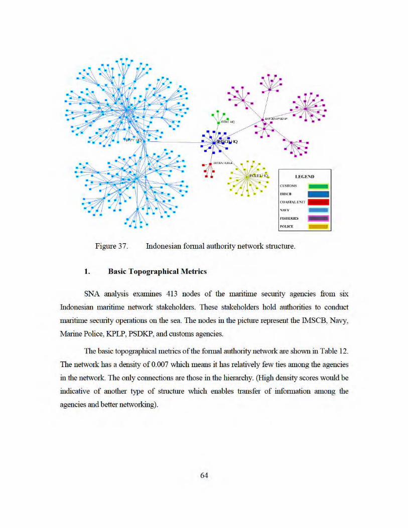
NAV'I' -
FISUERJI:S
POI.ICF.
Figure 37. Indonesian fmmal authority network structure.
1. Basic Topographical Metrics
SNA analysis examines 413 nodes of the maritime security agencies from six
Indonesian maritime network stakeholders. These stakeholders hold authorities to conduct
maritime security operations on the sea. The nodes in the picture represent the Tht.ISCB, Navy,
Marine Police, KPLP, PSDKP, and customs agencies.
The basic topographical metr1cs of the fmmal authm1ty network are shown in Table 12.
The network has a density of 0.007 which means it has relatively few ties among the agencies
in the network The only connections are those in the hierarchy. (High density scores would be
indicative of another type of structure which enables tr-ansfer of infmmation among the
agencies and better networking).
64
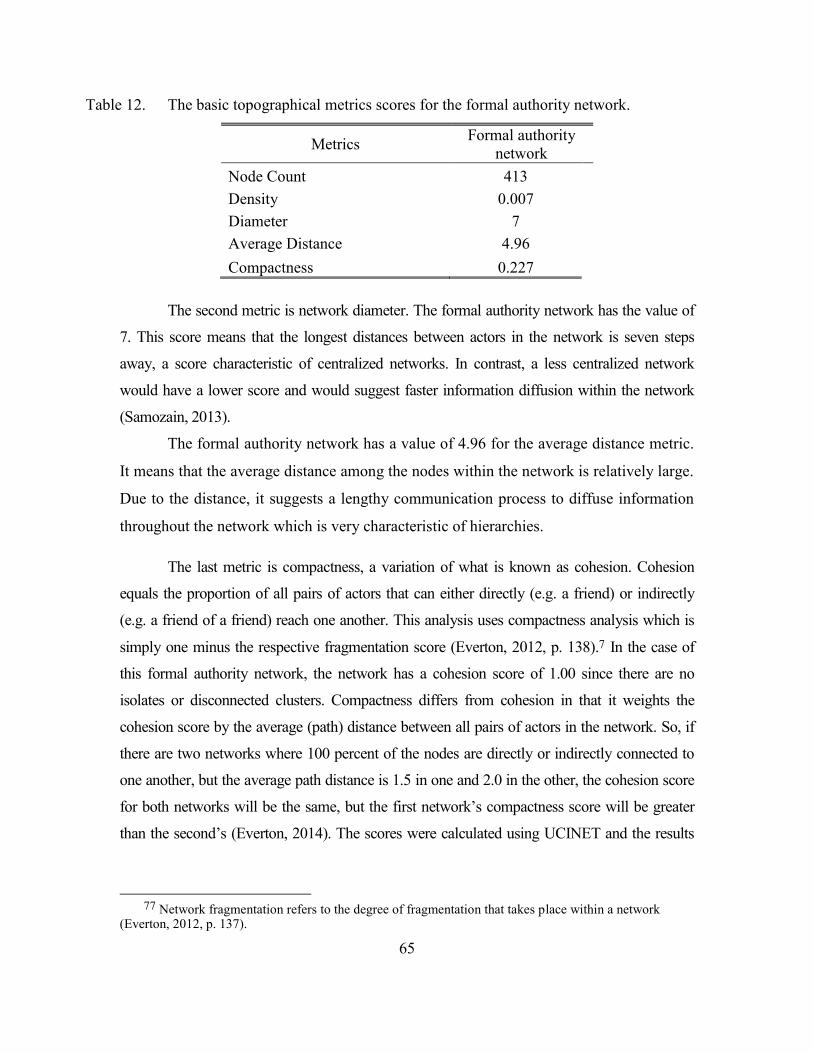
65
Table 12. The basic topographical metrics scores for the formal authority network.
The second metric is network diameter. The formal authority network has the value of
7. This score means that the longest distances between actors in the network is seven steps
away, a score characteristic of centralized networks. In contrast, a less centralized network
would have a lower score and would suggest faster information diffusion within the network
(Samozain, 2013).
The formal authority network has a value of 4.96 for the average distance metric.
It means that the average distance among the nodes within the network is relatively large.
Due to the distance, it suggests a lengthy communication process to diffuse information
throughout the network which is very characteristic of hierarchies.
The last metric is compactness, a variation of what is known as cohesion. Cohesion
equals the proportion of all pairs of actors that can either directly (e.g. a friend) or indirectly
(e.g. a friend of a friend) reach one another. This analysis uses compactness analysis which is
simply one minus the respective fragmentation score (Everton, 2012, p. 138).7 In the case of
this formal authority network, the network has a cohesion score of 1.00 since there are no
isolates or disconnected clusters. Compactness differs from cohesion in that it weights the
cohesion score by the average (path) distance between all pairs of actors in the network. So, if
there are two networks where 100 percent of the nodes are directly or indirectly connected to
one another, but the average path distance is 1.5 in one and 2.0 in the other, the cohesion score
for both networks will be the same, but the first network’s compactness score will be greater
than the second’s (Everton, 2014). The scores were calculated using UCINET and the results
77 Network fragmentation refers to the degree of fragmentation that takes place within a network
(Everton, 2012, p. 137).
Metrics Formal authority network
Node Count 413 Density 0.007 Diameter 7 Average Distance 4.96 Compactness 0.227
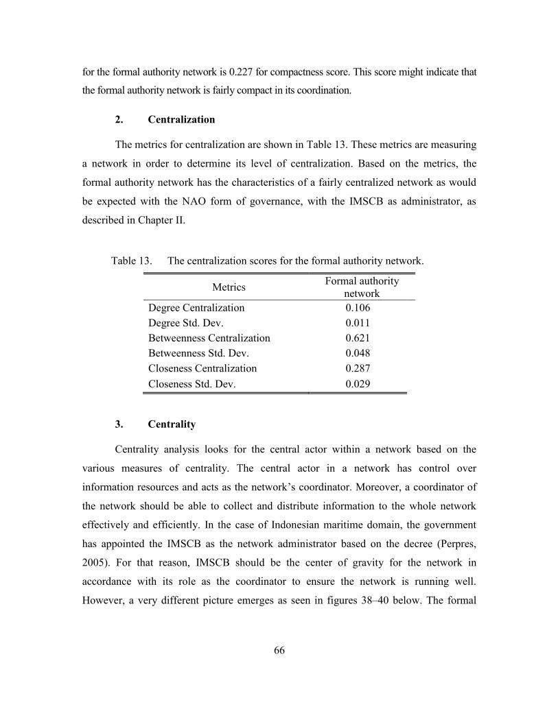
66
for the formal authority network is 0.227 for compactness score. This score might indicate that
the formal authority network is fairly compact in its coordination.
2. Centralization
The metrics for centralization are shown in Table 13. These metrics are measuring
a network in order to determine its level of centralization. Based on the metrics, the
formal authority network has the characteristics of a fairly centralized network as would
be expected with the NAO form of governance, with the IMSCB as administrator, as
described in Chapter II.
Table 13. The centralization scores for the formal authority network.
Metrics Formal authority network
Degree Centralization 0.106 Degree Std. Dev. 0.011 Betweenness Centralization 0.621 Betweenness Std. Dev. 0.048 Closeness Centralization 0.287 Closeness Std. Dev. 0.029
3. Centrality
Centrality analysis looks for the central actor within a network based on the
various measures of centrality. The central actor in a network has control over
information resources and acts as the network’s coordinator. Moreover, a coordinator of
the network should be able to collect and distribute information to the whole network
effectively and efficiently. In the case of Indonesian maritime domain, the government
has appointed the IMSCB as the network administrator based on the decree (Perpres,
2005). For that reason, IMSCB should be the center of gravity for the network in
accordance with its role as the coordinator to ensure the network is running well.
However, a very different picture emerges as seen in figures 38–40 below. The formal
67
authority network does not pivot around the IMSCB. This suggests a serious issue given
the central role of the IMSCB as the legitimate coordinator of the maritime network.
Table 14 illustrates the 15 top actors in the whole network with the highest value of
degree, betweenness, and closeness centrality. The formal authority network recognizes the
Eastern Fleet (Navy Eastern Fleet Command) with the highest degree centrality score and Navy
HQ with the highest betweenness and closeness value. Moreover, the centrality measure puts
the Navy’s field offices as the central actors within the network. Table 14 provides the
measurements for the Navy as the central actor of network in the formal authority network (see
Figures 38–40). Despite the mandate that identifies IMSCB as the maritime network
coordinator, the measurement of the network shows otherwise. In fact, the Navy holds the
central role in the current maritime network.
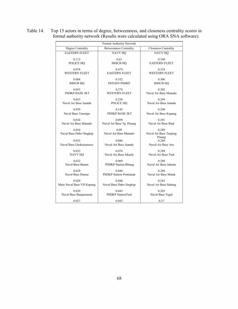
68
Table 14. Top 15 actors in terms of degree, betweenness, and closeness centrality scores in formal authority network (Results were calculated using ORA SNA software).
Formal Authority Network Degree Centrality Betweenness Centrality Closeness Centrality
EASTERN FLEET NAVY HQ NAVY HQ
0.112 0.63 0.348 POLICE HQ IMSCB HQ EASTERN FLEET
0.078 0.479 0.324 WESTERN FLEET EASTERN FLEET WESTERN FLEET
0.068 0.352 0.306 IMSCB HQ DITGEN PSDKP IMSCB HQ
0.053 0.274 0.305 PSDKP BASE JKT WESTERN FLEET Naval Air Base Manado
0.053 0.256 0.299 Naval Air Base Juanda POLICE HQ Naval Air Base Juanda
0.039 0.145 0.298 Naval Base Tarempa PSDKP BASE JKT Naval Air Base Kupang
0.034 0.099 0.291 Naval Air Base Manado Naval Air Base Tg. Pinang Naval Air Base Biak
0.034 0.09 0.289 Naval Base Dabo Singkep Naval Air Base Manado Naval Air Base Tanjung
Pinang 0.032 0.086 0.289
Naval Base Lhokseumawe Naval Air Base Juanda Naval Air Base Aru
0.032 0.076 0.289 NAVY HQ Naval Air Base Jakarta Naval Air Base Tual
0.032 0.069 0.288 Naval Base Batam PSDKP Station Bitung Naval Air Base Jakarta
0.029 0.048 0.288 Naval Base Dumai PSDKP Station Pontianak Naval Air Base Matak
0.029 0.048 0.283 Main Naval Base VII Kupang Naval Base Dabo Singkep Naval Air Base Sabang
0.029 0.043 0.283 Naval Base Banjarmasin PSDKP StationTual Naval Base Tegal
0.027 0.043 0.27
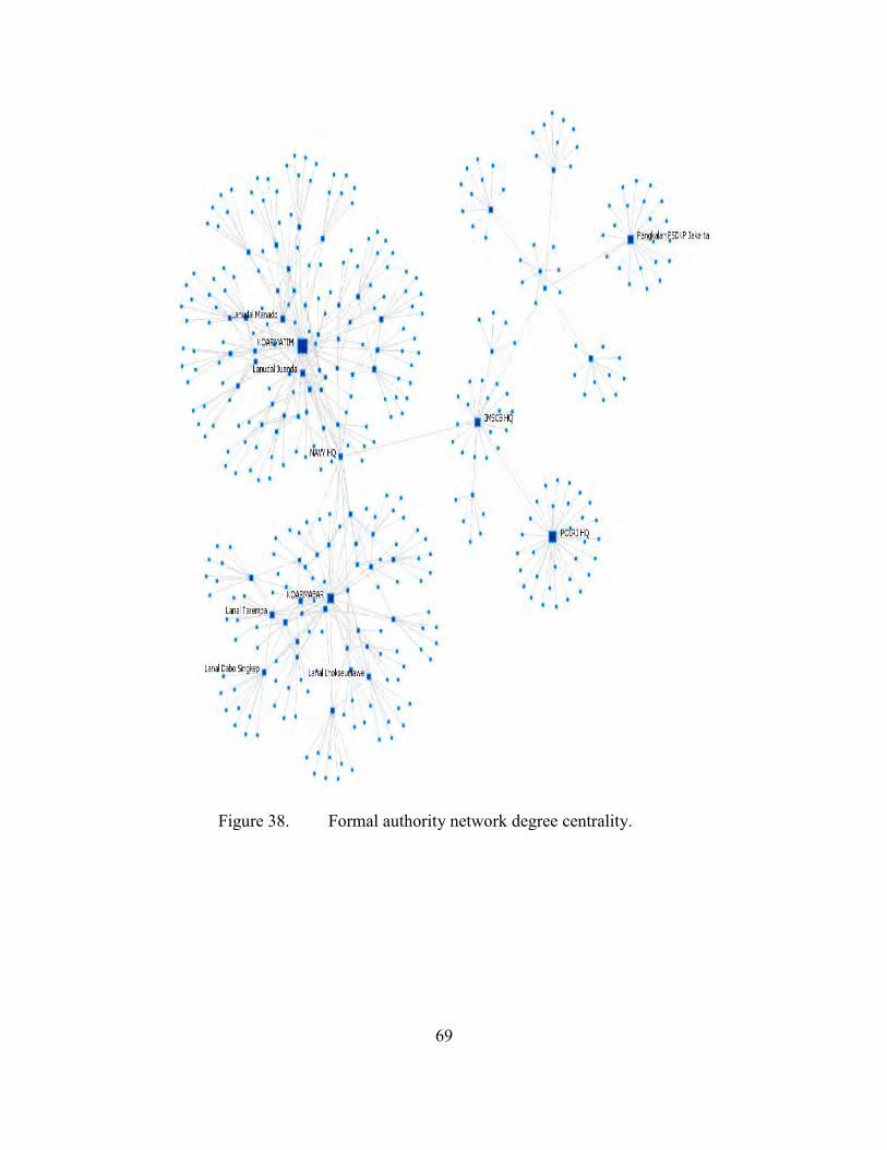
69
Figure 38. Formal authority network degree centrality.
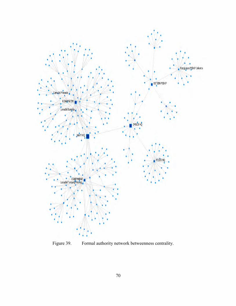
70
Figure 39. Formal authority network betweenness centrality.
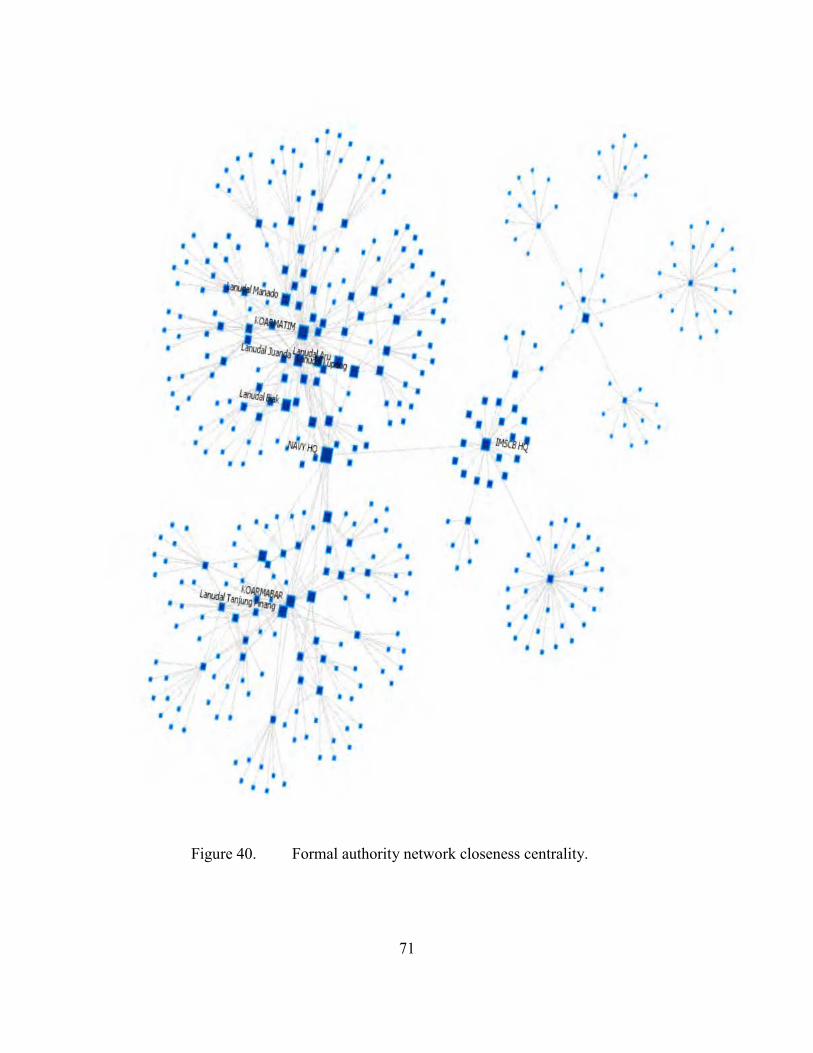
71
Figure 40. Formal authority network closeness centrality.
•
• • •
• • • •
• •
• • • • • • •
••
• • • • • • • • •
•
• • •
• • • ••
• • •
• • •• • • • • • • •
• • • • i iJD.fri ~ • • • • •
• • • • • • • • • • •
I • • I , roAftATIM •/ • I •
•
•
• • cLta{ ~~imu .. • • • • • • •
I t _.,..g • • I I • •
• • •
• •
I
.. ~~ .. •
• • • •
•
• •• •
• • • JIAVYH~·· 1 I I I
I t ~ t •
• • .. . . I
• • •
• •
• II I • • • • • • • •
1 , 1~a!Tan~t'1~ I •
• . cb'lg
• • • • • • I I •
• • I • I
• • • I
• • • • • • • • • • • • • • • • • • • • • • •
• •
• • • • • • •
• •
• • • •
• •
• • • •
, • • • • •
• •
•
I
•
• •
I
I I I I
1 I I
I I IMS&~ I I
I I I •
• •
• •
•
I
•
• • •
I
• • • • • • • • • • • • •
• •

72
THIS PAGE INTENTIONALLY LEFT BLANK
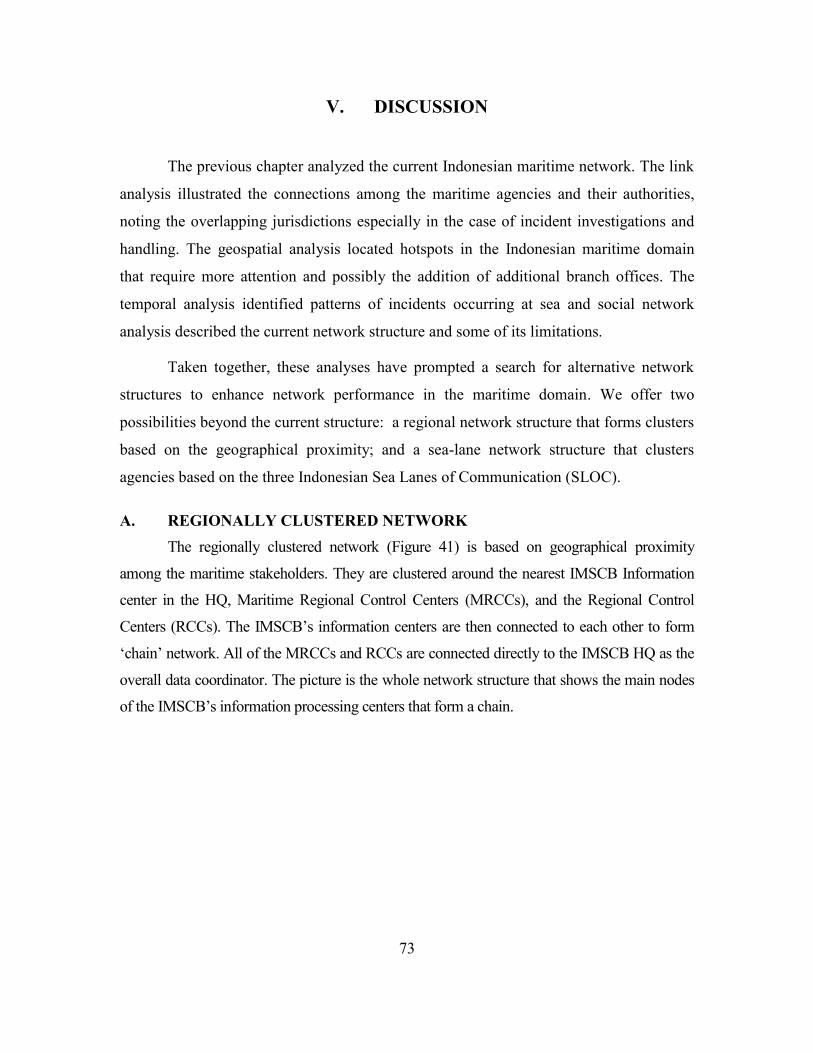
73
V. DISCUSSION
The previous chapter analyzed the current Indonesian maritime network. The link
analysis illustrated the connections among the maritime agencies and their authorities,
noting the overlapping jurisdictions especially in the case of incident investigations and
handling. The geospatial analysis located hotspots in the Indonesian maritime domain
that require more attention and possibly the addition of additional branch offices. The
temporal analysis identified patterns of incidents occurring at sea and social network
analysis described the current network structure and some of its limitations.
Taken together, these analyses have prompted a search for alternative network
structures to enhance network performance in the maritime domain. We offer two
possibilities beyond the current structure: a regional network structure that forms clusters
based on the geographical proximity; and a sea-lane network structure that clusters
agencies based on the three Indonesian Sea Lanes of Communication (SLOC).
A. REGIONALLY CLUSTERED NETWORK The regionally clustered network (Figure 41) is based on geographical proximity
among the maritime stakeholders. They are clustered around the nearest IMSCB Information
center in the HQ, Maritime Regional Control Centers (MRCCs), and the Regional Control
Centers (RCCs). The IMSCB’s information centers are then connected to each other to form
‘chain’ network. All of the MRCCs and RCCs are connected directly to the IMSCB HQ as the
overall data coordinator. The picture is the whole network structure that shows the main nodes
of the IMSCB’s information processing centers that form a chain.
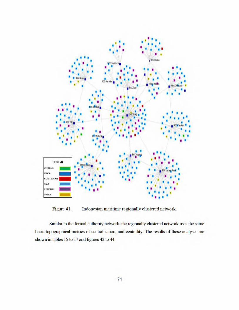
I 1 I • •
I • • I • • I I I I I • • • I I I
I
I I I 1
• 1 PCCI emo I I I I
I I "''lrr~a l
I I I I I I I
I I
1 I I 1 I I 1 I • • • I I • I • I
• I I . I I • I I I I I I
I I I I I t I
t ~«i MAI I~Hb» ll
RCCMu.N 1 I 1 I I I '
I • I I
I I I t
I I I I
• I •
I u c:Cta 1
• I
I • I • I I I
I I I
LEGEND
CL\mlMS .....,
I
• •
• • I
•
I I
• • . ' . I I
I
kC illl1 •
I I I
I I
II111N 1 • I I II
I I I
I I 1 II
I I
I • I I
IMSCB -
COASTAIXIHT -
I 1 I I I
• I I I
NAVY -
FISH£RICS
• • • I I I
• e I I I
POllet: ..E
I RC:C lull
I I It I I I
• • I • I I I
I I I •
I I • I I I
I tt«ii!O t I I • I I I I
I I I t I I I I I I
I I I i • • • I I I I
I I I t I 1 1 I
I • • I I I I
I t I I I
• I I I I I I I
I I
I •• I • ' I
• • I
I
• I
I I I
1 I I I
I
I I I I I
I I
t PC:Qh iM'! I 1
• • II !1
i I - I • II I I
I • I I
I
I I
I I
I I
I I • I I I I • • • I t
I I a« IW-t Alftl I
I 1 I I
I I I I
I I I I
• I I I
I I 1 I I
Figure 41. Indonesian maritime regionally clustered network.
Similar to the fonnal authority network, the regionally clustered network uses the same
basic topographical metrics of centralization, and centrality. The results of these analyses are
shown in tables 15 to 17 and figures 42 to 44.
74
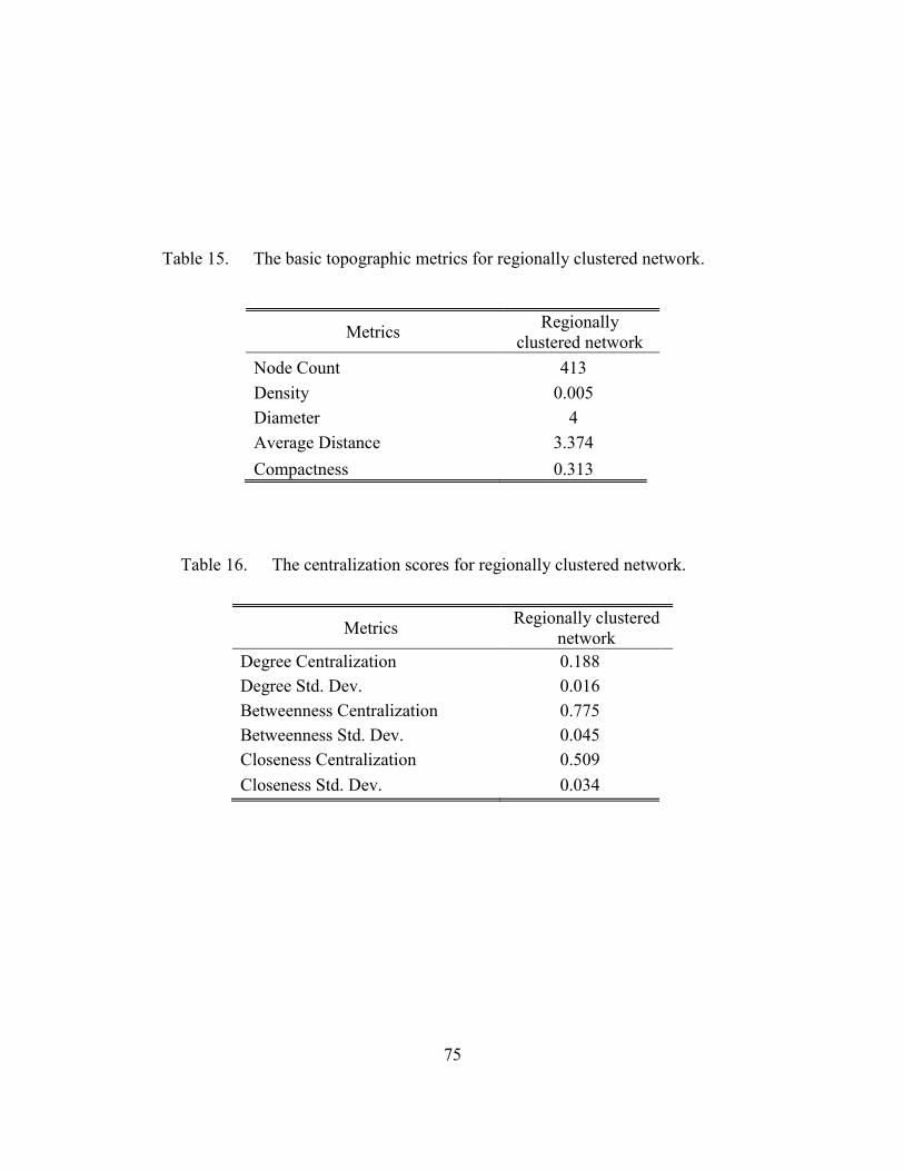
75
Table 15. The basic topographic metrics for regionally clustered network.
Table 16. The centralization scores for regionally clustered network.
Metrics Regionally clustered network
Degree Centralization 0.188 Degree Std. Dev. 0.016 Betweenness Centralization 0.775 Betweenness Std. Dev. 0.045 Closeness Centralization 0.509 Closeness Std. Dev. 0.034
Metrics Regionally clustered network
Node Count 413 Density 0.005 Diameter 4 Average Distance 3.374 Compactness 0.313
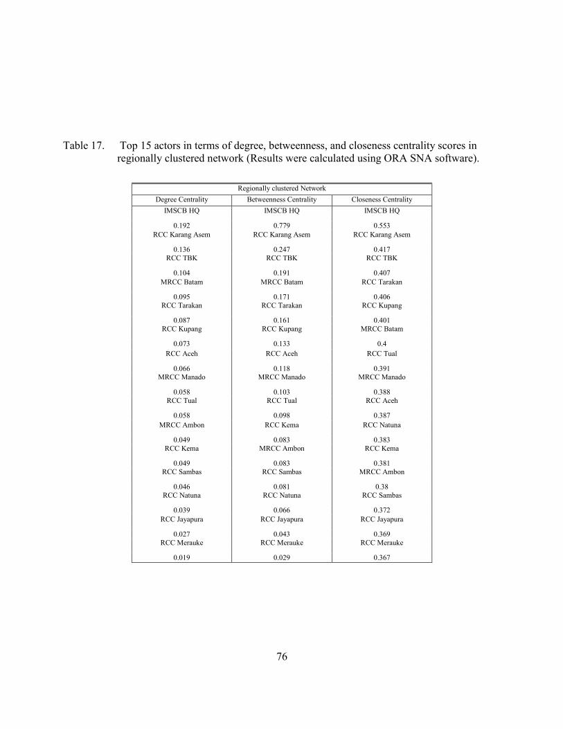
76
Table 17. Top 15 actors in terms of degree, betweenness, and closeness centrality scores in regionally clustered network (Results were calculated using ORA SNA software).
Regionally clustered Network
Degree Centrality Betweenness Centrality Closeness Centrality IMSCB HQ IMSCB HQ IMSCB HQ
0.192 0.779 0.553 RCC Karang Asem RCC Karang Asem RCC Karang Asem
0.136 0.247 0.417 RCC TBK RCC TBK RCC TBK
0.104 0.191 0.407 MRCC Batam MRCC Batam RCC Tarakan
0.095 0.171 0.406 RCC Tarakan RCC Tarakan RCC Kupang
0.087 0.161 0.401 RCC Kupang RCC Kupang MRCC Batam
0.073 0.133 0.4 RCC Aceh RCC Aceh RCC Tual
0.066 0.118 0.391 MRCC Manado MRCC Manado MRCC Manado
0.058 0.103 0.388 RCC Tual RCC Tual RCC Aceh
0.058 0.098 0.387 MRCC Ambon RCC Kema RCC Natuna
0.049 0.083 0.383 RCC Kema MRCC Ambon RCC Kema
0.049 0.083 0.381 RCC Sambas RCC Sambas MRCC Ambon
0.046 0.081 0.38 RCC Natuna RCC Natuna RCC Sambas
0.039 0.066 0.372 RCC Jayapura RCC Jayapura RCC Jayapura
0.027 0.043 0.369 RCC Merauke RCC Merauke RCC Merauke
0.019 0.029 0.367
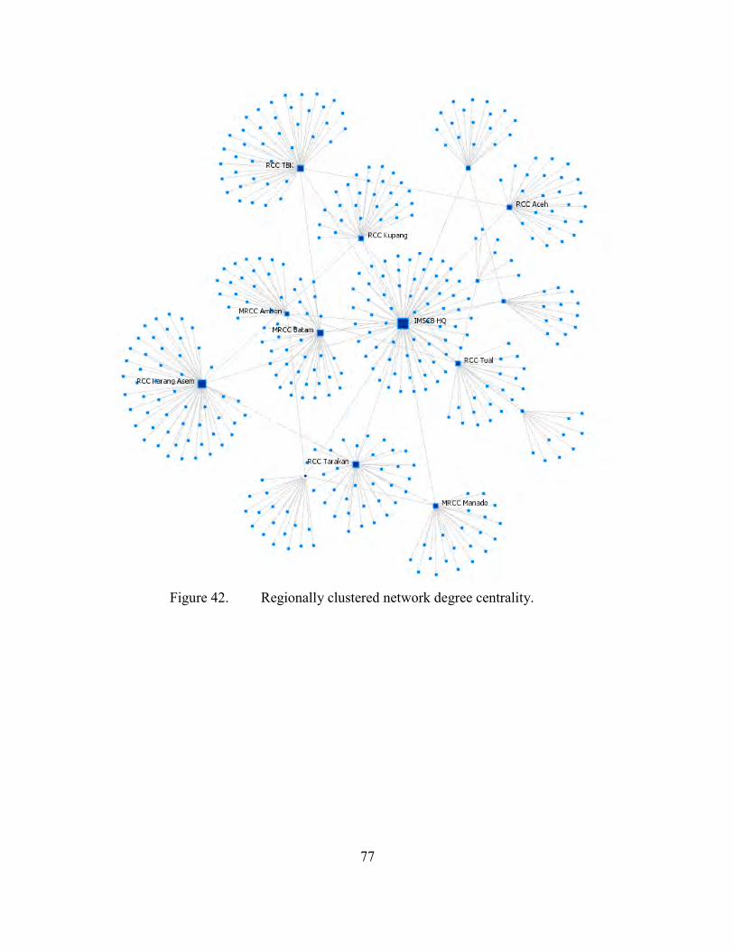
77
Figure 42. Regionally clustered network degree centrality.
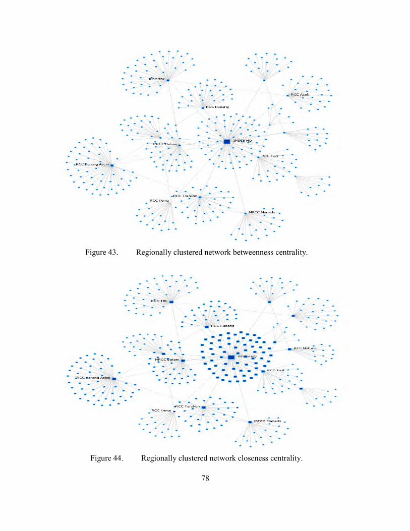
78
Figure 43. Regionally clustered network betweenness centrality.
Figure 44. Regionally clustered network closeness centrality.
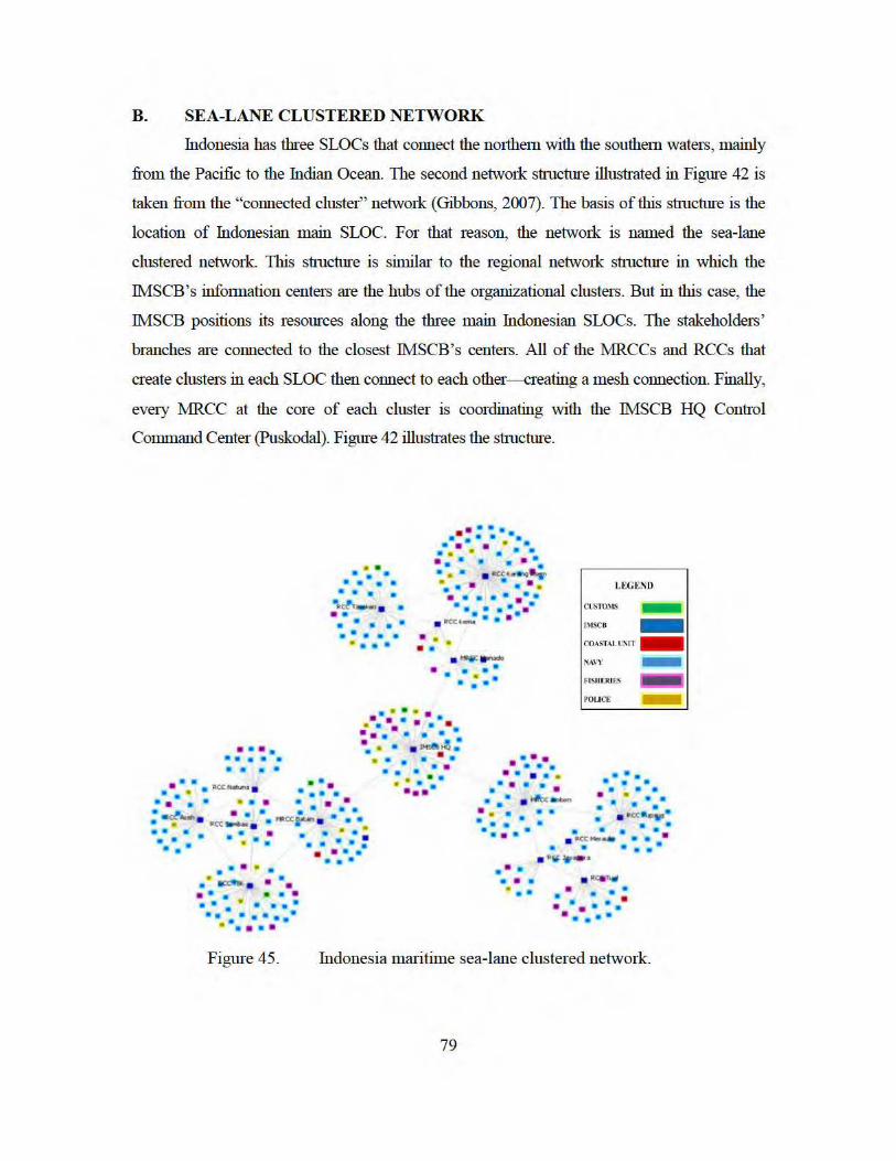
B. SEA-LANE CLUSTERED NETWORK
Indonesia has three SLOCs that connect the nmihem with the southem waters, mainly
from the Pacific to the Indian Ocean. The second network stmcture illustrated in Figure 42 is
taken :fi:om the "connected cluster" network (Gibbons, 2007). The basis of this st:mctrn·e is the
location of Indonesian main SLOC. For that reason, the network is named the sea-lane
clustered network. This sfluctrn·e is similar to the regional network sfluctrn·e in which the
IMSCB's infmmation centers are the hubs of the organizational clusters. But in this case, the
IMSCB positions its resources along the three main Indonesian SLOCs. The stakeholders '
branches are connected to the closest IMSCB's centers. All of the :tvfRCCs and RCCs that
create clusters in each SLOC then connect to each other--creating a mesh connection. Finally,
evety :tvfRCC at the core of each cluster is coordinating with the IMSCB HQ Confl'Ol
Command Center (Puskodal). Figure 42 illusfl·ates the sfluctrn·e.
• • • • . . . . . • • • •
~ . ... • • • • • • • •
•l>ct.- • • • • . . - .. ..... ~ ...
• • • • ••••••• .. • • I!' • • • • • • • • • • • • • •• • • • . ~c·~a:..r •• • • • • • • • ••••• • •••
••••••• • .. « • .,.. •• •
• • • •
.~.-..
• • • • • • • •
• • • • • ,.•. · ... .... . • • • • ••• •• ~· • • v-ee.~ : ~ . . . ..
• • • • • • ••
LEGEND
ClJST'O~tS -.1' IMSCU -
COASTALII.SIT -~
~. NAVY
FI$11[RI ES
POLICE .E
• • • • R-ottutu1• • • • •
• • • ••• • • • • • • •••
• ••• . . . ... • • •• • •
• •• . . . • • • . . . -" . • • • • II' . • • •• .. -~..... . . . . .. · .
• • • • •••
««- . . 110«1"""' . • ... • • • • • • • • •
4 • • ••••
• • •• • • • I!J; •
• • • •• • • • • • . . . . . . . . .. _: ..... . • • • •
. . .
. . . ·11(\)e- • • • • Ill ••
• •• . .. .. • • • • • • ~ ..
• • . ... cc • • • •
• • • • • • . • ·c::~-- • :: •• · ·~~·-·
. ~~.~~
• • • •• • • • • • • • • ••••
Figure 45. fudonesia maritime sea-lane clustered network.
79
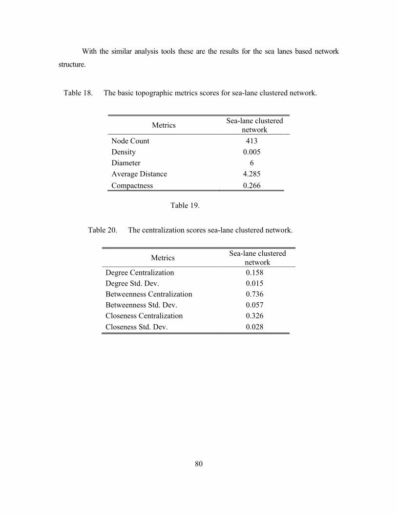
80
With the similar analysis tools these are the results for the sea lanes based network
structure.
Table 18. The basic topographic metrics scores for sea-lane clustered network.
Table 19.
Table 20. The centralization scores sea-lane clustered network.
Metrics Sea-lane clustered network
Degree Centralization 0.158 Degree Std. Dev. 0.015 Betweenness Centralization 0.736 Betweenness Std. Dev. 0.057 Closeness Centralization 0.326 Closeness Std. Dev. 0.028
Metrics Sea-lane clustered network
Node Count 413 Density 0.005 Diameter 6 Average Distance 4.285 Compactness 0.266
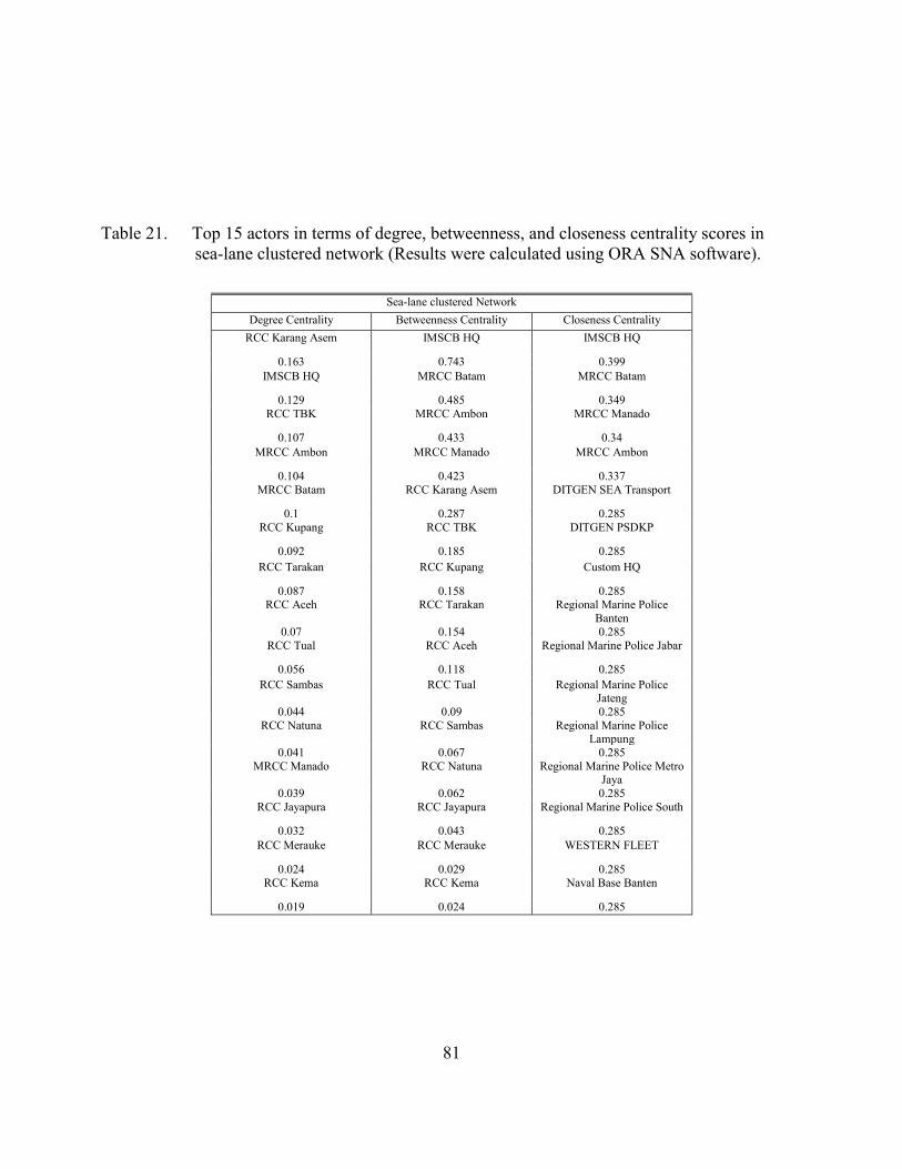
81
Table 21. Top 15 actors in terms of degree, betweenness, and closeness centrality scores in sea-lane clustered network (Results were calculated using ORA SNA software).
Sea-lane clustered Network
Degree Centrality Betweenness Centrality Closeness Centrality RCC Karang Asem IMSCB HQ IMSCB HQ
0.163 0.743 0.399 IMSCB HQ MRCC Batam MRCC Batam
0.129 0.485 0.349 RCC TBK MRCC Ambon MRCC Manado
0.107 0.433 0.34 MRCC Ambon MRCC Manado MRCC Ambon
0.104 0.423 0.337 MRCC Batam RCC Karang Asem DITGEN SEA Transport
0.1 0.287 0.285 RCC Kupang RCC TBK DITGEN PSDKP
0.092 0.185 0.285 RCC Tarakan RCC Kupang Custom HQ
0.087 0.158 0.285 RCC Aceh RCC Tarakan Regional Marine Police
Banten 0.07 0.154 0.285
RCC Tual RCC Aceh Regional Marine Police Jabar
0.056 0.118 0.285 RCC Sambas RCC Tual Regional Marine Police
Jateng 0.044 0.09 0.285
RCC Natuna RCC Sambas Regional Marine Police Lampung
0.041 0.067 0.285 MRCC Manado RCC Natuna Regional Marine Police Metro
Jaya 0.039 0.062 0.285
RCC Jayapura RCC Jayapura Regional Marine Police South
0.032 0.043 0.285 RCC Merauke RCC Merauke WESTERN FLEET
0.024 0.029 0.285 RCC Kema RCC Kema Naval Base Banten
0.019 0.024 0.285
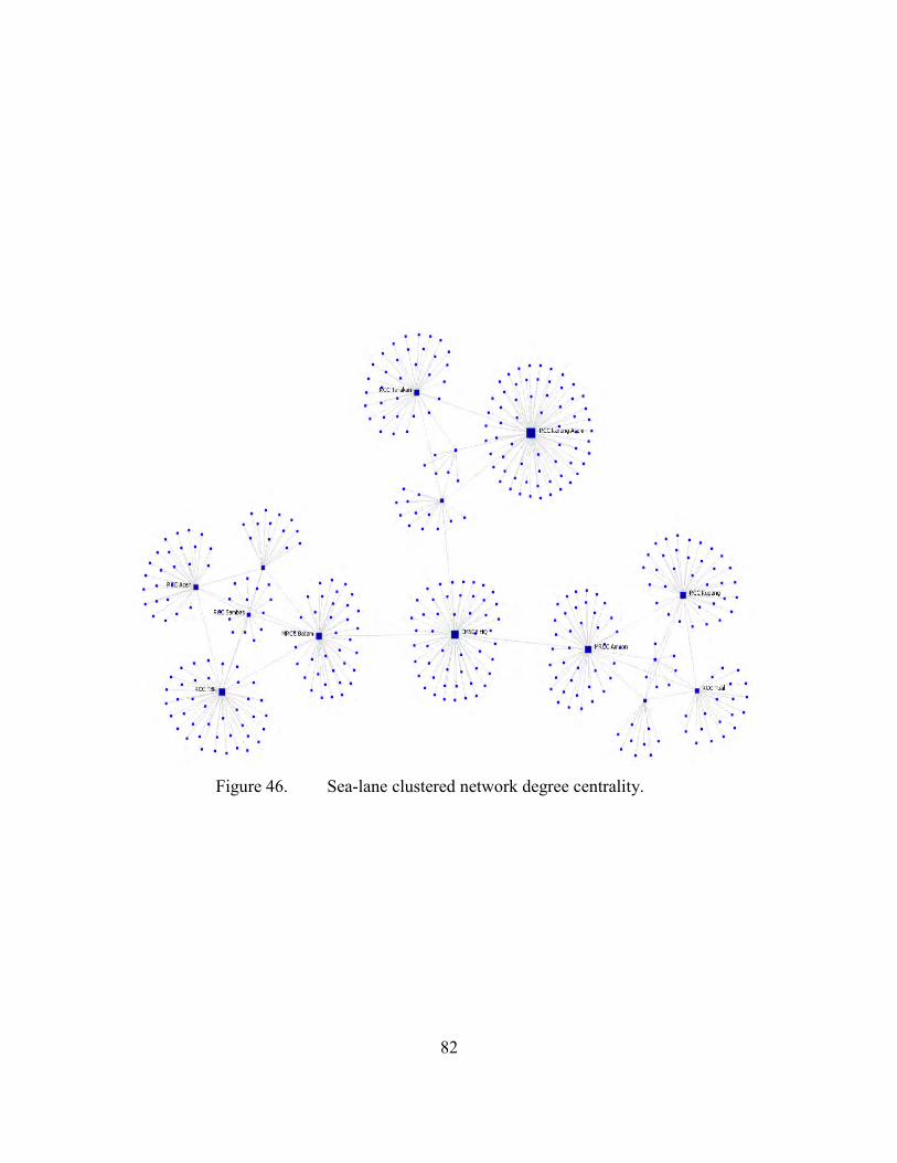
82
Figure 46. Sea-lane clustered network degree centrality.
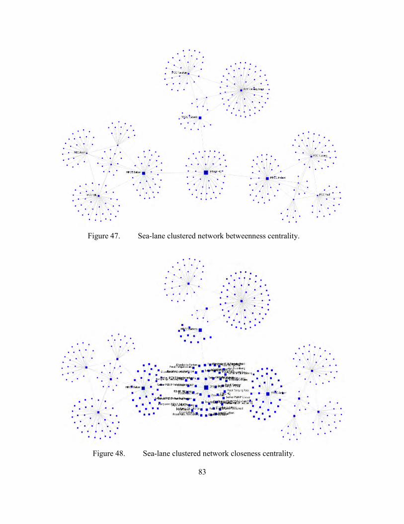
83
Figure 47. Sea-lane clustered network betweenness centrality.
Figure 48. Sea-lane clustered network closeness centrality.
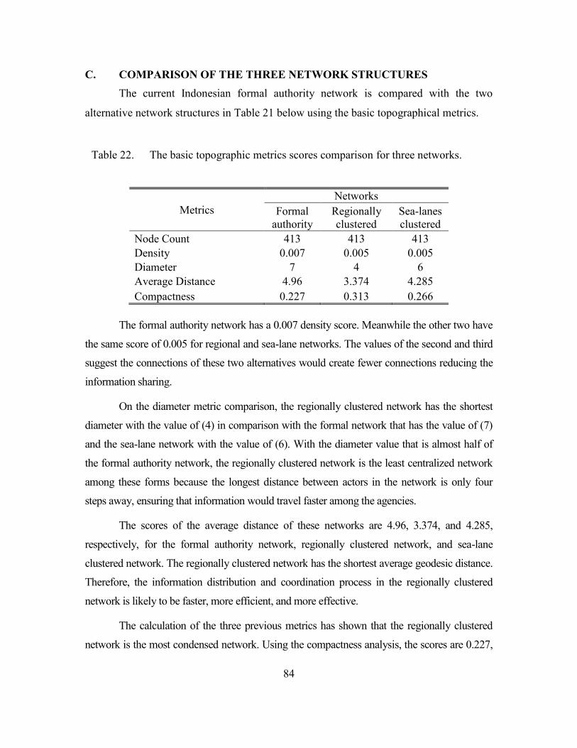
84
C. COMPARISON OF THE THREE NETWORK STRUCTURES The current Indonesian formal authority network is compared with the two
alternative network structures in Table 21 below using the basic topographical metrics.
Table 22. The basic topographic metrics scores comparison for three networks.
The formal authority network has a 0.007 density score. Meanwhile the other two have
the same score of 0.005 for regional and sea-lane networks. The values of the second and third
suggest the connections of these two alternatives would create fewer connections reducing the
information sharing.
On the diameter metric comparison, the regionally clustered network has the shortest
diameter with the value of (4) in comparison with the formal network that has the value of (7)
and the sea-lane network with the value of (6). With the diameter value that is almost half of
the formal authority network, the regionally clustered network is the least centralized network
among these forms because the longest distance between actors in the network is only four
steps away, ensuring that information would travel faster among the agencies.
The scores of the average distance of these networks are 4.96, 3.374, and 4.285,
respectively, for the formal authority network, regionally clustered network, and sea-lane
clustered network. The regionally clustered network has the shortest average geodesic distance.
Therefore, the information distribution and coordination process in the regionally clustered
network is likely to be faster, more efficient, and more effective.
The calculation of the three previous metrics has shown that the regionally clustered
network is the most condensed network. Using the compactness analysis, the scores are 0.227,
Metrics Networks
Formal authority
Regionally clustered
Sea-lanes clustered
Node Count 413 413 413 Density 0.007 0.005 0.005 Diameter 7 4 6 Average Distance 4.96 3.374 4.285 Compactness 0.227 0.313 0.266
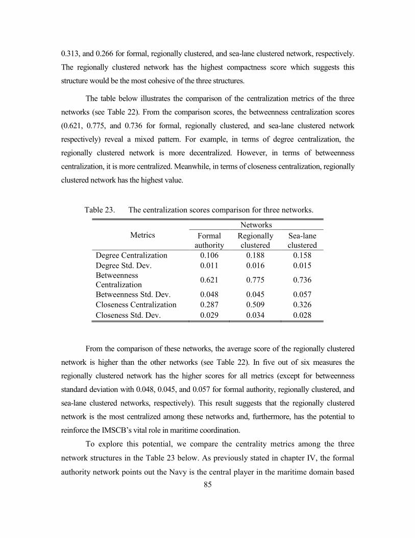
85
0.313, and 0.266 for formal, regionally clustered, and sea-lane clustered network, respectively.
The regionally clustered network has the highest compactness score which suggests this
structure would be the most cohesive of the three structures.
The table below illustrates the comparison of the centralization metrics of the three
networks (see Table 22). From the comparison scores, the betweenness centralization scores
(0.621, 0.775, and 0.736 for formal, regionally clustered, and sea-lane clustered network
respectively) reveal a mixed pattern. For example, in terms of degree centralization, the
regionally clustered network is more decentralized. However, in terms of betweenness
centralization, it is more centralized. Meanwhile, in terms of closeness centralization, regionally
clustered network has the highest value.
Table 23. The centralization scores comparison for three networks.
Metrics Networks
Formal authority
Regionally clustered
Sea-lane clustered
Degree Centralization 0.106 0.188 0.158 Degree Std. Dev. 0.011 0.016 0.015 Betweenness Centralization 0.621 0.775 0.736
Betweenness Std. Dev. 0.048 0.045 0.057 Closeness Centralization 0.287 0.509 0.326 Closeness Std. Dev. 0.029 0.034 0.028
From the comparison of these networks, the average score of the regionally clustered
network is higher than the other networks (see Table 22). In five out of six measures the
regionally clustered network has the higher scores for all metrics (except for betweenness
standard deviation with 0.048, 0.045, and 0.057 for formal authority, regionally clustered, and
sea-lane clustered networks, respectively). This result suggests that the regionally clustered
network is the most centralized among these networks and, furthermore, has the potential to
reinforce the IMSCB’s vital role in maritime coordination.
To explore this potential, we compare the centrality metrics among the three
network structures in the Table 23 below. As previously stated in chapter IV, the formal
authority network points out the Navy is the central player in the maritime domain based
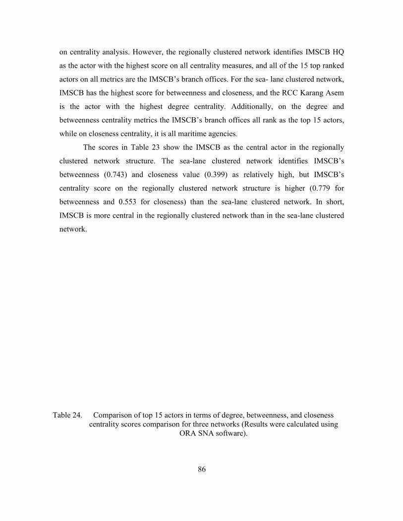
86
on centrality analysis. However, the regionally clustered network identifies IMSCB HQ
as the actor with the highest score on all centrality measures, and all of the 15 top ranked
actors on all metrics are the IMSCB’s branch offices. For the sea- lane clustered network,
IMSCB has the highest score for betweenness and closeness, and the RCC Karang Asem
is the actor with the highest degree centrality. Additionally, on the degree and
betweenness centrality metrics the IMSCB’s branch offices all rank as the top 15 actors,
while on closeness centrality, it is all maritime agencies.
The scores in Table 23 show the IMSCB as the central actor in the regionally
clustered network structure. The sea-lane clustered network identifies IMSCB’s
betweenness (0.743) and closeness value (0.399) as relatively high, but IMSCB’s
centrality score on the regionally clustered network structure is higher (0.779 for
betweenness and 0.553 for closeness) than the sea-lane clustered network. In short,
IMSCB is more central in the regionally clustered network than in the sea-lane clustered
network.
Table 24. Comparison of top 15 actors in terms of degree, betweenness, and closeness centrality scores comparison for three networks (Results were calculated using
ORA SNA software).
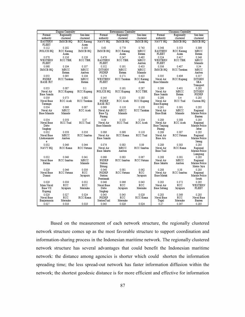
87
Based on the measurement of each network structure, the regionally clustered
network structure comes up as the most favorable structure to support coordination and
information-sharing process in the Indonesian maritime network. The regionally clustered
network structure has several advantages that could benefit the Indonesian maritime
network: the distance among agencies is shorter which could shorten the information
spreading time; the less spread-out network has faster information diffusion within the
network; the shortest geodesic distance is for more efficient and effective for information
88
distribution; the highest compactness score means the cohesiveness of the network is also
high; the most centralized score suggests the network is more centralized compared to the
other alternatives; and the central actor in the regionally clustered network structure is
IMSCB and its branch offices that align with the IMSCB’s task as the coordinator of the
maritime network.
Moreover, the regionally clustered network aligned with the Maritime Domain
Awareness (MDA) system developed in the United States after 9/11 (U.S. Coast Guard,
2005) and newly proposed in Indonesia through the idea of the Indonesian navy
(Marsetio, 2014, pp. 54–61). The purpose of the information such as the MDA is to
increase the maritime security through the diffusion of information to all maritime
agencies in order to increase the awareness of the incidents that occur in the maritime
domain.
The role of IMSCB also changes in a regionally clustered network. Connecting
maritime agencies that are geographically adjacent to each other, the IMSCB would act
as the hub within the clusters. All maritime agencies that are already divided into clusters
will then forward any significant information that they gathered in the field directly to the
IMSCB branch office in the vicinity. The IMSCB offices then would disseminate the
information to the agencies in each cluster under them and also coordinate with the
neighboring hub in other clusters. This system then would be useful for incidents that
take place in areas between the two clusters. The hubs in the regionally clustered network
structure will then end up in the IMSCB HQ as the main hub of the system.
For the reason that all IMSCB branch offices hold higher scores of centrality
compared to the other agencies of this network, the diffusion and collection of
information could reach the agencies faster in comparison to the other structural
alternatives. This pattern of information dissemination would enable the agencies to
respond more promptly. Furthermore, this structure allows widespread information
gathering system that is not limited to particular agencies, but involves all resources in
the field. This system stands to l benefit the whole network since the information
gathering resources are spread along the archipelago.
89
D. RESOURCES ALLOCATION IN A REGIONALLY CLUSTERED NETWORK STRUCTURE There are other advantages in creating a regionally clustered network structure. First,
based on the results of the link analysis, we are able to clear up the overlapping jurisdictions
that create complications among the agencies in the maritime domain. Secondly, based on the
results of the geospatial and temporal analysis, we are able to deploy operations more
efficiently and effectively.
1. Link Analysis
Link Analysis shows the connection between the maritime agencies and their
authorities in the maritime domain based on the specific government regulations and
mandates to the maritime agencies. Moreover, link analysis identifies the overlapping
jurisdictions and authorities among the maritime agencies that in some types of incidents
at sea, could be handled by more than one agency, resulting in inefficient and ineffective
use of the agencies’ resources. The authorities’ identification then are related to the
hotspot areas from the geospatial analysis in order to identify which agencies are needed
in certain hotspot areas.
The distribution of the maritime agencies in the archipelago seems to be
concentrated in the western part of Indonesia, especially in the Malacca and Singapore
Straits, and the Northern part of Java Island (see Figure 49). This map illustrates the
disparity of maritime agencies between the western and eastern parts of Indonesia.
Meanwhile, SLOCs are located both in western and eastern Indonesia. This particular
matter needs to be considered by policy makers in order to increase maritime security
capabilities.
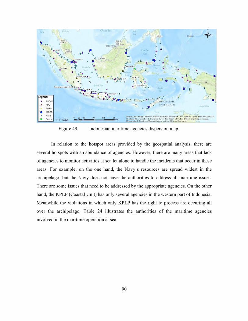
90
Figure 49. Indonesian maritime agencies dispersion map.
In relation to the hotspot areas provided by the geospatial analysis, there are
several hotspots with an abundance of agencies. However, there are many areas that lack
of agencies to monitor activities at sea let alone to handle the incidents that occur in these
areas. For example, on the one hand, the Navy’s resources are spread widest in the
archipelago, but the Navy does not have the authorities to address all maritime issues.
There are some issues that need to be addressed by the appropriate agencies. On the other
hand, the KPLP (Coastal Unit) has only several agencies in the western part of Indonesia.
Meanwhile the violations in which only KPLP has the right to process are occuring all
over the archipelago. Table 24 illustrates the authorities of the maritime agencies
involved in the maritime operation at sea.
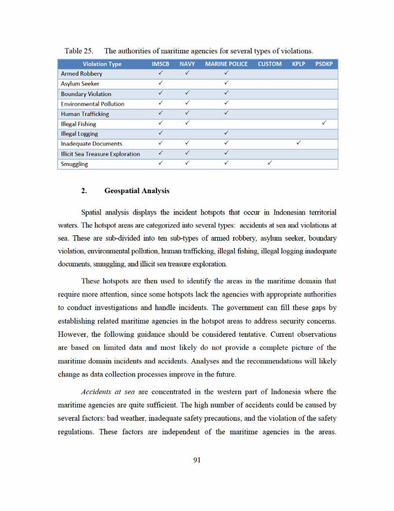
Table 25. The authorities of maritime agencies for several types of violations.
Violation Type IMSCB NAVY MARINE POLICE CUSTOM KPLP PSDKP
Armed Robbery ../ ../ ../
Asylum Seeker ../ ../
Boundary Violation ../ ../ ../
Environmental Pollut ion ../ ../ ../
Human Trafficking ../ ../ ../
Illegal Fishing ../ ../ ../
Illegal Logging ../ ../
Inadequate Documents ../ ../ ../ ../
Illicit Sea Treasure Exploration ../ ../ ../
Smuggling ../ ../ ../ ../
2. Geosp atial Analysis
Spatial analysis displays the incident hotspots that occur m fudonesian ten1torial
waters. The hotspot areas are categorized into several types: accidents at sea and violations at
sea. These are sub-divided into ten sub-types of rumed robbe1y , asylum seeker, boundruy
violation, environmental pollution, human trafficking, illegal fishing, illegal logging inadequate
documents, smuggling, and illicit sea treasure exploration.
These hotspots ru·e then used to identify the ru·eas in the mru·itime domain that
require more attention, since some hotspots lack the agencies with appropriate authorities
to conduct investigations and handle incidents. The government can fill these gaps by
establishing related maritime agencies in the hotspot areas to address secmity concerns.
However, the following guidance should be considered tentative. Cunent observations
are based on limited data and most likely do not provide a complete picture of the
maritime domain incidents and accidents. Analyses and the recommendations will likely
change as data collection processes improve in the future.
Accidents at sea are concentrated in the western prui of fudonesia where the
maritime agencies ru·e quite sufficient. The high number of accidents could be caused by
several factors: bad weather, inadequate safety precautions, and the violation of the safety
regulations. These factors ru·e independent of the mru·itime agencies in the ru·eas.
91
92
However, the enforcement of safety regulations might need more attention in order to
address the high number of accidents at sea.
Armed robbery takes places in areas in which the maritime agencies are also quite
abundant. One issue that needs exploration is how well all the agencies involved and
integrate their activities to avoid overlapping responsibilities. In addition, lax law
enforcement toward the perpetrators at sea and insufficient precautions on shore are
likely to contributing to the number of these types of violations (ReCAAP,2013).
Asylum seeking is a unique type of violation. Indonesia is typically not the final
destination for the perpetrators, but Australia is. Looking at these hotspots, it appears
that the immigration agency that has the authority to address this violation does not have
the resources to go off shore. For that reason, the immigration office has to coordinate
agencies that have with seagoing resources. This is especially the case for the asylum
seeker hotspot situated in the southern part of Indonesia. The area does not have many
maritime agencies nor do they have easily accessible resources. More resources are
needed in this region to handle the violations.
Boundary violations are happening in the border areas. However, based on the
hotspot analysis, the violations are quite distant from the closest agencies. From this data,
it would appear that it would be more prudent to place more agencies closer to the
hotspot area than to continue to rely on ships with limited range to patrol the area.
Environmental pollution hotspot areas are spread out in several parts of Indonesia.
On the Northeast of Sumatra apparently the number of the maritime agencies is sufficient
to address the incidents, although there are still legal and environmental enforcement
issues. In other areas, even though some agencies exist, they have neither the capabilities
nor resources to tackle this type of problem since the agencies presence is normally only
in the form of small outposts.
Human trafficking is a serious transnational crime that requires prompt handling
and response. The hotspot analysis indicates that some of the locations have sufficient
maritime agencies but others lack them. The dispersion of agencies’ resources towards
93
the most serious hotspot areas, around Kupang and Surabaya waters, would be an
important first step in suppressing the human trafficking in these areas.
Illegal fishing is a common type of violation in Indonesia with its vast sea areas.
The high numbers of violations indicate that either the perpetrators are increasing or the
maritime agencies are losing their grip on the situation. Nevertheless, in the western part
of Indonesia the numbers of agencies are somewhat equal to the number of illegal fishing
incidents except in the Natuna islands that requires more resources at sea. The eastern
part of Indonesia also appears to need more resources and patrol operation to suppress the
number of these violations.
Illegal logging is taking place in the areas where minimum resources are located,
especially in eastern Indonesia. The initial points normally are Sumatra and Borneo as the
primary producer of logs. Considering what the hotspots show, more operational
deployments are needed to monitor the areas.
Inadequate documents are surfacing near the ports as ships require documents to
go offshore. The maritime agencies in the hotspots are required to deploy more patrols
ships in the harbor area and to be attentive to ships going in and out of the ports.
Smuggling hotspots normally occur in the border areas. This type of violation
requires rigorous patrol operation in the hotspot areas. It would appear that the agencies
in these hotspots are sufficient to address the issue of smuggling.
Illicit sea treasure exploration is only happening in very specific areas that are
assumed to hold high-value assets. The areas are also quite small. However, it takes
intensive operational deployments in order to decrease the violations. In addition, the
numbers of agencies and resources to handle this type of violation are deemed
insufficient.
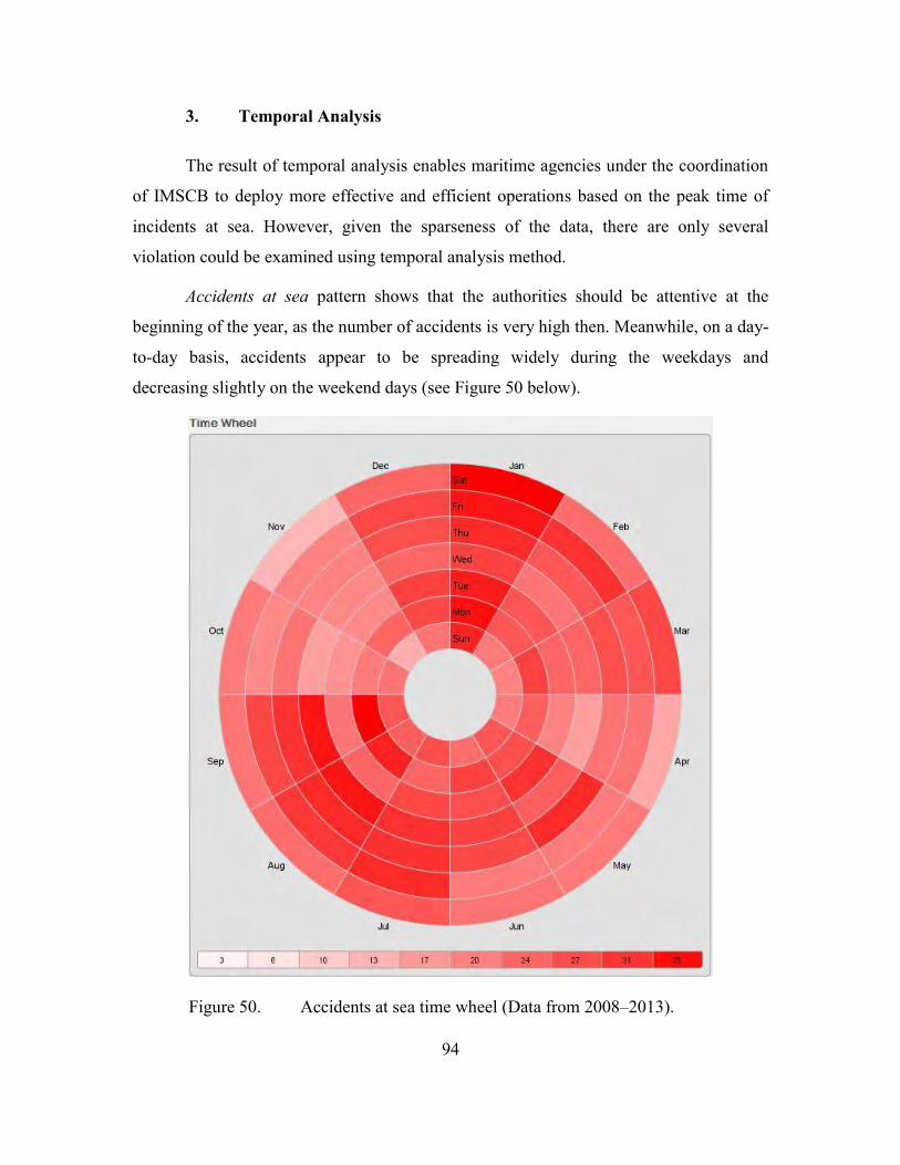
94
3. Temporal Analysis
The result of temporal analysis enables maritime agencies under the coordination
of IMSCB to deploy more effective and efficient operations based on the peak time of
incidents at sea. However, given the sparseness of the data, there are only several
violation could be examined using temporal analysis method.
Accidents at sea pattern shows that the authorities should be attentive at the
beginning of the year, as the number of accidents is very high then. Meanwhile, on a day-
to-day basis, accidents appear to be spreading widely during the weekdays and
decreasing slightly on the weekend days (see Figure 50 below).
Figure 50. Accidents at sea time wheel (Data from 2008–2013).
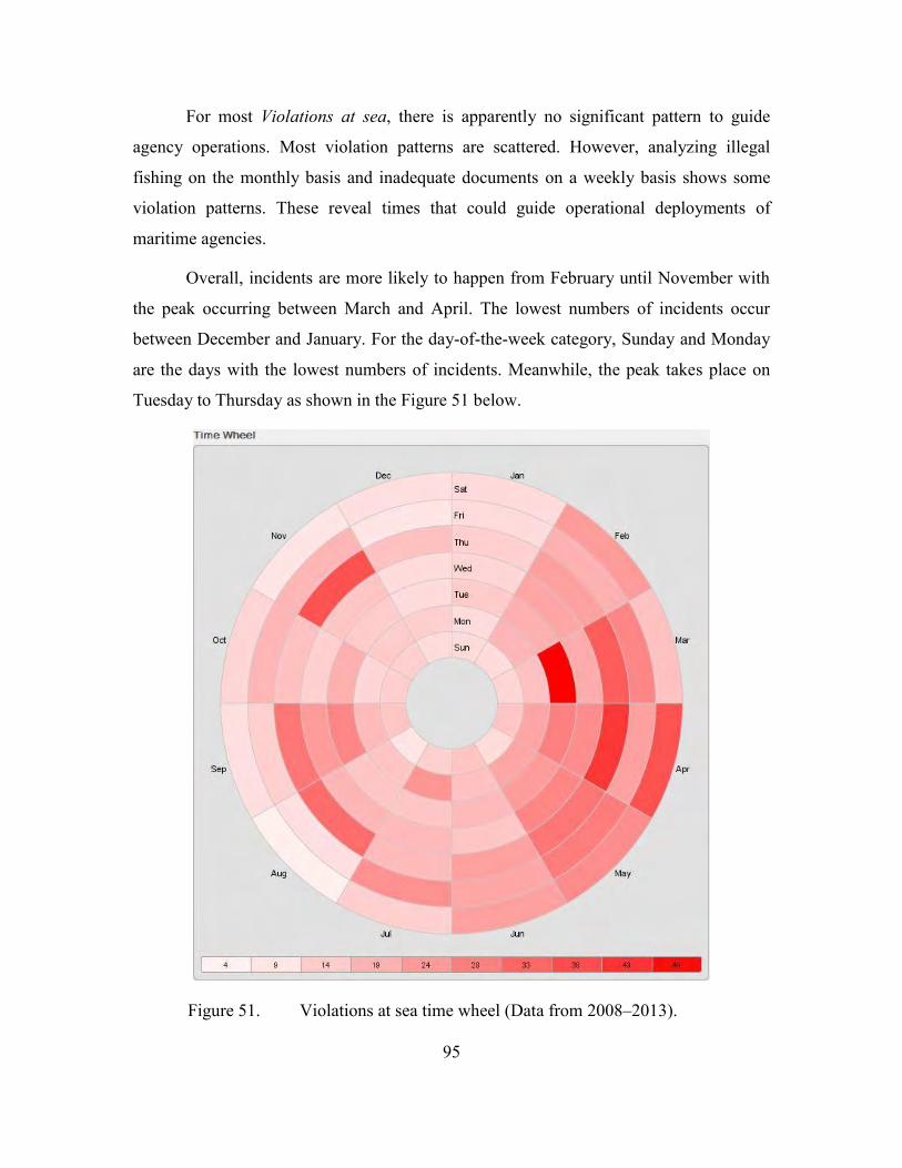
95
For most Violations at sea, there is apparently no significant pattern to guide
agency operations. Most violation patterns are scattered. However, analyzing illegal
fishing on the monthly basis and inadequate documents on a weekly basis shows some
violation patterns. These reveal times that could guide operational deployments of
maritime agencies.
Overall, incidents are more likely to happen from February until November with
the peak occurring between March and April. The lowest numbers of incidents occur
between December and January. For the day-of-the-week category, Sunday and Monday
are the days with the lowest numbers of incidents. Meanwhile, the peak takes place on
Tuesday to Thursday as shown in the Figure 51 below.
Figure 51. Violations at sea time wheel (Data from 2008–2013).
96
Temporal analysis indicates the distinct time that accidents and violations at sea
may occur. With more significant numbers of data, the maritime agencies may identify
the time pattern of these occurrences and manage their operational deployment based on
the temporal analysis of information. Instead of deploying and wasting the assets without
clear tasks, temporal analysis enables the maritime agencies to operate based on the
critical month-of-the-year and day-of-the-week basis that enables them to save scarce
resources.
97
VI. SUMMARY AND RECOMMENDATIONS
The complexity of the problem in the Indonesian maritime domain is putting the
nation in a vulnerable position. The matter of maritime security, especially in an
archipelagic nation such as Indonesia, should be a top priority that requires immediate
action due to the imminent nature of the threats. Indonesia’s dependence on its maritime
sector should be balanced with good maritime governance of the domain.
This study is an effort to provide better alternatives to existing maritime security
management. Its results are just some of the considerations for policy-makers in making
improvements in the Indonesian maritime domain. Thus, it should not be taken as a
“silver bullet” for all Indonesian maritime security issues, especially considering the
complex nature of the maritime domain. It is merely providing additional insights for the
government, in this case the IMSCB and other maritime agencies, drawn from our social
network analysis and visual analytic methods used in this study.
The data included in this study are based on the data collection of IMSCB that
came from reports of incidents and arrests. The data collection process is passive in
nature in that the maritime agencies are not searching for data in the field. Instead, data
collection is sourced from the reports that came to the agencies and channeled up to the
IMSCB’s data and information processing center. Without a doubt, there are still many
unrecorded data that have not been successfully collected and reported to the information
center. The incomplete may likely have skewed the results of the analysis. Nevertheless,
the methodologies used in this study suggest the way forward when better data collection
strategies have been developed and employed.
A. SUMMARY This study has determined that the existing network structure does not adequately
support the information-sharing process in order to increase maritime domain awareness and
security. The current formal authority network does not distribute information throughout the
network and coordinate it effectively. The lag-time in information diffusion also creates delays
in the response time to address incidents that occur in the domain.
98
For that reason, this study has proposed another network structure for better
coordination and information sharing within the Indonesian maritime network. The regionally
clustered network structure, as described in the previous chapters, has advantages that we
believe can improve coordination and information dissemination within the maritime domain.
It also supports the IMSCB mandate that makes it the sole coordinator of the maritime security
issues and the central actor within the network.
The geospatial analysis reveals the hotspot areas that require more attention from the
maritime agencies in a regionally based network. It also identifies what maritime agencies are
needed in other areas in order to handle particular incidents. However, the accuracy and
significance of these hotspot maps are highly dependent on the quality of the data being
collected. Until we have a more robust data collection process, the results should be treated as
tentative.
The temporal analysis enables us to chart incidents at sea over time. The results enable
the regionally-based maritime agencies to identify the best times to deploy their resources and
to conduct operations at sea. As with the other analyses in this study, temporal analysis is also
highly dependent on the quality of the data collected and the results must be treated as tentative.
B. RECOMMENDATIONS
Based on the findings of this study, we offer several recommendations. First, the
maritime domain requires accurate and reliable data regarding incidents at sea. The
existing system does not provide a complete picture of the incidents, e.g. when and when
they are occurring. Indonesia needs an active data collection process. The existing data,
which this study extracted from IMSCB information center, is still lacking in source
details and reliability. The government, in this case, is the IMSCB as the coordinator of
the maritime security network, needs to improve the data gathering process and include
all maritime stakeholders, not just the government agencies. Instead of passively waiting
for incident reports, maritime assets should actively collect data in each region’s area of
responsibility. This would be an important first step is gathering more reliable data and
information.
99
In support of the previous recommendation, the proposed regionally-clustered
network structure could be used to improve the network’s overall data collection and
distribution processes. The regionally based structure, as previously noted, is capable of
delivering information faster and coordinating throughout the network by using all nodes
in the system to collect data and enhance coordination. Moreover, through the IMSCB
branches that are acting as hubs, the collected information is quickly diffused to the entire
network for better information sharing.
The Indonesian maritime agencies should use geospatial and temporal analysis to
improve the efficiency and effectiveness of resources distribution in their operational
deployments. Geospatial analysis is providing hotspot area identification so maritime
agencies can focus their security efforts as well as identify areas that requires more
security resources and services. Temporal analysis reveals the incidents’ patterns based
on time. With further interpretation, this analysis could determine the better time to
conduct sea patrols and maritime security operations.
This study has identified methodologies for analyzing the Indonesian maritime
domain and the networks its agencies and stakeholder have created. Our analysis also has
identified improvements we believe are needed to meet emerging challenges and threats
in the domain. While our study does not aim to address all maritime issues that are
intertwined with many other aspects in our complex and challenging environment, we
offer our recommendations as merely one effort to advance maritime governance and to
unravel the tangled problems in the maritime domain.

100
THIS PAGE INTENTIONALLY LEFT BLANK
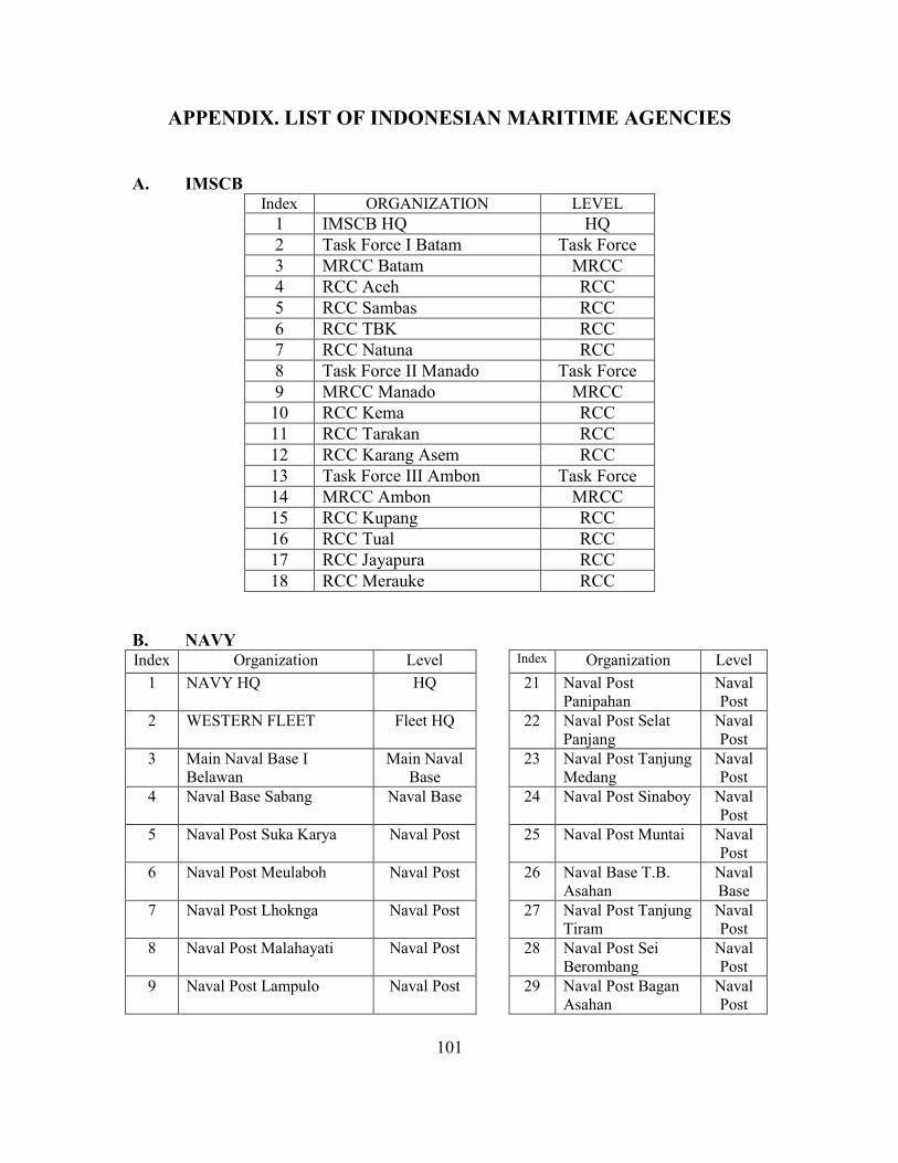
101
APPENDIX. LIST OF INDONESIAN MARITIME AGENCIES
A. IMSCB Index ORGANIZATION LEVEL
1 IMSCB HQ HQ 2 Task Force I Batam Task Force 3 MRCC Batam MRCC 4 RCC Aceh RCC 5 RCC Sambas RCC 6 RCC TBK RCC 7 RCC Natuna RCC 8 Task Force II Manado Task Force 9 MRCC Manado MRCC 10 RCC Kema RCC 11 RCC Tarakan RCC 12 RCC Karang Asem RCC 13 Task Force III Ambon Task Force 14 MRCC Ambon MRCC 15 RCC Kupang RCC 16 RCC Tual RCC 17 RCC Jayapura RCC 18 RCC Merauke RCC
B. NAVY Index Organization Level Index Organization Level
1 NAVY HQ HQ 21 Naval Post Panipahan
Naval Post
2 WESTERN FLEET Fleet HQ 22 Naval Post Selat Panjang
Naval Post
3 Main Naval Base I Belawan
Main Naval Base
23 Naval Post Tanjung Medang
Naval Post
4 Naval Base Sabang Naval Base 24 Naval Post Sinaboy Naval Post
5 Naval Post Suka Karya Naval Post 25 Naval Post Muntai Naval Post
6 Naval Post Meulaboh Naval Post 26 Naval Base T.B. Asahan
Naval Base
7 Naval Post Lhoknga Naval Post 27 Naval Post Tanjung Tiram
Naval Post
8 Naval Post Malahayati Naval Post 28 Naval Post Sei Berombang
Naval Post
9 Naval Post Lampulo Naval Post 29 Naval Post Bagan Asahan
Naval Post
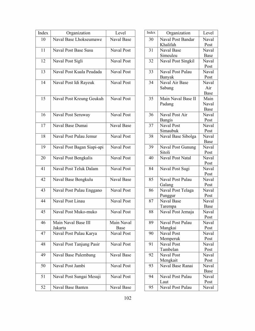
102
Index Organization Level Index Organization Level 10 Naval Base Lhokseumawe Naval Base 30 Naval Post Bandar
Khalifah Naval Post
11 Naval Post Base Susu Naval Post 31 Naval Base Simeuleu
Naval Base
12 Naval Post Sigli Naval Post 32 Naval Post Singkil Naval Post
13 Naval Post Kuala Peudada Naval Post 33 Naval Post Pulau Banyak
Naval Post
14 Naval Post Idi Rayeuk Naval Post 34 Naval Air Base Sabang
Naval Air
Base 15 Naval Post Kreung Geukuh Naval Post 35 Main Naval Base II
Padang Main Naval Base
16 Naval Post Seruway Naval Post 36 Naval Post Air Bangis
Naval Post
17 Naval Base Dumai Naval Base 37 Naval Post Simaubuk
Naval Post
18 Naval Post Pulau Jemur Naval Post 38 Naval Base Sibolga Naval Base
19 Naval Post Bagan Siapi-api Naval Post 39 Naval Post Gunung Sitoli
Naval Post
20 Naval Post Bengkalis Naval Post 40 Naval Post Natal Naval Post
41 Naval Post Teluk Dalam Naval Post 84 Naval Post Sugi Naval Post
42 Naval Base Bengkulu Naval Base 85 Naval Post Pulau Galang
Naval Post
43 Naval Post Pulau Enggano Naval Post 86 Naval Post Telaga Punggur
Naval Post
44 Naval Post Linau Naval Post 87 Naval Base Tarempa
Naval Base
45 Naval Post Muko-muko Naval Post 88 Naval Post Jemaja Naval Post
46 Main Naval Base III Jakarta
Main Naval Base
89 Naval Post Pulau Mangkai
Naval Post
47 Naval Post Pulau Karya Naval Post 90 Naval Post Memperuk
Naval Post
48 Naval Post Tanjung Pasir Naval Post 91 Naval Post Tambelan
Naval Post
49 Naval Base Palembang Naval Base 92 Naval Post Mengkait
Naval Post
50 Naval Post Jambi Naval Post 93 Naval Base Ranai Naval Base
51 Naval Post Sungai Mesuji Naval Post 94 Naval Post Pulau Laut
Naval Post
52 Naval Base Banten Naval Base 95 Naval Post Pulau Naval
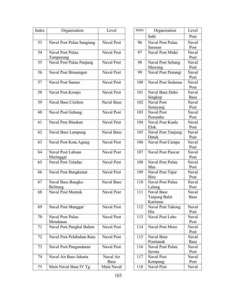
103
Index Organization Level Index Organization Level Subi Post
53 Naval Post Pulau Sangiang Naval Post 96 Naval Post Pulau Sarasan
Naval Post
54 Naval Post Pulau Tempurung
Naval Post 97 Naval Post Midai Naval Post
55 Naval Post Pulau Panjang Naval Post 98 Naval Post Sebang Mawang
Naval Post
56 Naval Post Binuangen Naval Post 99 Naval Post Penangi Naval Post
57 Naval Post Sumur Naval Post 100 Naval Post Sedanau Naval Post
58 Naval Post Kronjo Naval Post 101 Naval Base Dabo Singkep
Naval Base
59 Naval Base Cirebon Naval Base 102 Naval Post Senayang
Naval Post
60 Naval Post Gebang Naval Post 103 Naval Post Penumba
Naval Post
61 Naval Post Binakan Naval Post 104 Naval Post Kuala Elok
Naval Post
62 Naval Base Lampung Naval Base 105 Naval Post Tanjung Datuk
Naval Post
63 Naval Post Kota Agung Naval Post 106 Naval Post Cempa Naval Post
64 Naval Post Labuan Maringgai
Naval Post 107 Naval Post Pancur Naval Post
65 Naval Post Teladas Naval Post 108 Naval Post Pulau Mas
Naval Post
66 Naval Post Bungkunat Naval Post 109 Naval Post Tajur Biru
Naval Post
67 Naval Base Bangka-Belitung
Naval Base 110 Naval Post Pulau Lalang
Naval Post
68 Naval Post Muntok Naval Post 111 Naval Base Tanjung Balai Karimun
Naval Base
69 Naval Post Manggar Naval Post 112 Naval Post Takong Hiu
Naval Post
70 Naval Post Pulau Mendanau
Naval Post 113 Naval Post Leho Naval Post
71 Naval Post Pangkal Balam Naval Post 114 Naval Post Moro Naval Post
72 Naval Post Pelabuhan Ratu Naval Post 115 Naval Base Pontianak
Naval Base
73 Naval Post Pangandaran Naval Post 116 Naval Post Pulau Serutu
Naval Post
74 Naval Air Base Jakarta Naval Air Base
117 Naval Post Ketapang
Naval Post
75 Main Naval Base IV Tg. Main Naval 118 Naval Post Naval
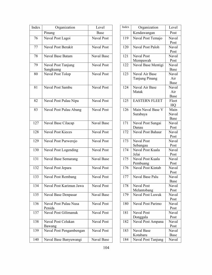
104
Index Organization Level Index Organization Level Pinang Base Kendawangan Post
76 Naval Post Lagoi Naval Post 119 Naval Post Temajo Naval Post
77 Naval Post Berakit Naval Post 120 Naval Post Paloh Naval Post
78 Naval Base Batam Naval Base 121 Naval Post Mempawah
Naval Post
79 Naval Post Tanjung Sangkuang
Naval Post 122 Naval Base Mentigi Naval Base
80 Naval Post Tolop Naval Post 123 Naval Air Base Tanjung Pinang
Naval Air
Base 81 Naval Post Sambu Naval Post 124 Naval Air Base
Matak Naval
Air Base
82 Naval Post Pulau Nipa Naval Post 125 EASTERN FLEET Fleet HQ
83 Naval Post Pulau Abang Naval Post 126 Main Naval Base V Surabaya
Main Naval Base
127 Naval Base Cilacap Naval Base 171 Naval Post Sungai Danau
Naval Post
128 Naval Post Kieces Naval Post 172 Naval Post Bahaur Naval Post
129 Naval Post Purwerejo Naval Post 173 Naval Post Sebangau
Naval Post
130 Naval Post Logending Naval Post 174 Naval Post Kuala Jelai
Naval Post
131 Naval Base Semarang Naval Base 175 Naval Post Kuala Pembuang
Naval Post
132 Naval Post Jepara Naval Post 176 Naval Post Kintab Naval Post
133 Naval Post Rembang Naval Post 177 Naval Base Palu Naval Base
134 Naval Post Karimun Jawa Naval Post 178 Naval Post Melantobang
Naval Post
135 Naval Base Denpasar Naval Base 179 Naval Post Luwuk Naval Post
136 Naval Post Pulau Nusa Penida
Naval Post 180 Naval Post Parimo Naval Post
137 Naval Post Gilimanuk Naval Post 181 Naval Post Donggala
Naval Post
138 Naval Post Celukan Bawang
Naval Post 182 Naval Post Ampana Naval Post
139 Naval Post Pengambengan Naval Post 183 Naval Base Kotabaru
Naval Base
140 Naval Base Banyuwangi Naval Base 184 Naval Post Tanjung Naval
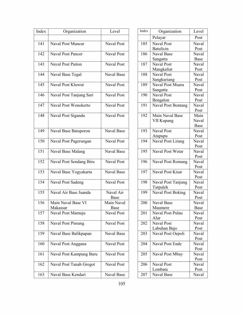
105
Index Organization Level Index Organization Level Pelayar Post
141 Naval Post Muncar Naval Post 185 Naval Post Batulicin
Naval Post
142 Naval Post Pancer Naval Post 186 Naval Base Sangatta
Naval Base
143 Naval Post Paiton Naval Post 187 Naval Post Mangkaliat
Naval Post
144 Naval Base Tegal Naval Base 188 Naval Post Sangkuriang
Naval Post
145 Naval Post Kluwut Naval Post 189 Naval Post Muara Sangatta
Naval Post
146 Naval Post Tanjung Sari Naval Post 190 Naval Post Bengalon
Naval Post
147 Naval Post Wonokerto Naval Post 191 Naval Post Bontang Naval Post
148 Naval Post Sigandu Naval Post 192 Main Naval Base VII Kupang
Main Naval Base
149 Naval Base Batuporon Naval Base 193 Naval Post Atapupu
Naval Post
150 Naval Post Pagerungan Naval Post 194 Naval Post Lirang Naval Post
151 Naval Base Malang Naval Base 195 Naval Post Wetar Naval Post
152 Naval Post Sendang Biru Naval Post 196 Naval Post Romang Naval Post
153 Naval Base Yogyakarta Naval Base 197 Naval Post Kisar Naval Post
154 Naval Post Sadeng Naval Post 198 Naval Post Tanjung Tutpaleh
Naval Post
155 Naval Air Base Juanda Naval Air Base
199 Naval Post Boking Naval Post
156 Main Naval Base VI Makassar
Main Naval Base
200 Naval Base Maumere
Naval Base
157 Naval Post Mamuju Naval Post 201 Naval Post Pulau Alur
Naval Post
158 Naval Post Pinrang Naval Post 202 Naval Post Labuhan Bajo
Naval Post
159 Naval Base Balikpapan Naval Base 203 Naval Post Oepoli Naval Post
160 Naval Post Anggana Naval Post 204 Naval Post Ende Naval Post
161 Naval Post Kampung Baru Naval Post 205 Naval Post Mbay Naval Post
162 Naval Post Tanah Grogot Naval Post 206 Naval Post Lembata
Naval Post
163 Naval Base Kendari Naval Base 207 Naval Base Naval
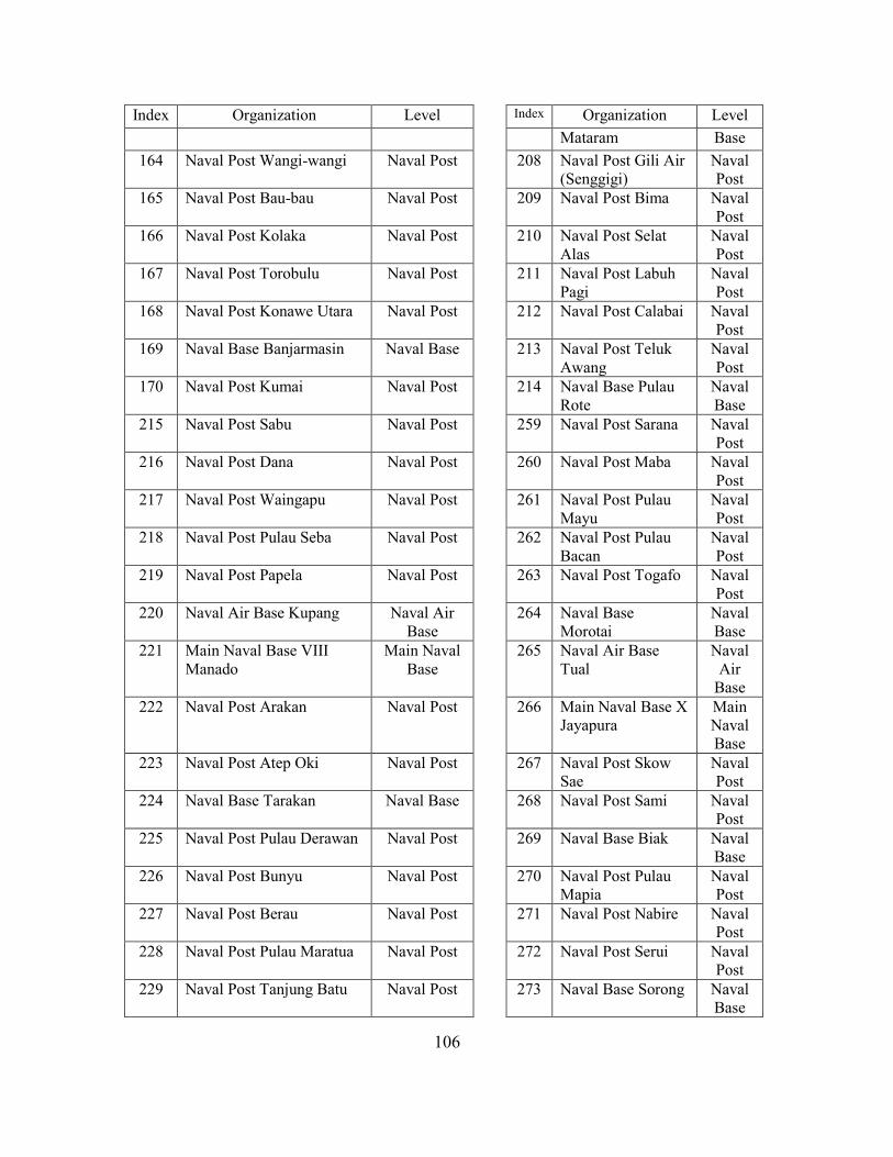
106
Index Organization Level Index Organization Level Mataram Base
164 Naval Post Wangi-wangi Naval Post 208 Naval Post Gili Air (Senggigi)
Naval Post
165 Naval Post Bau-bau Naval Post 209 Naval Post Bima Naval Post
166 Naval Post Kolaka Naval Post 210 Naval Post Selat Alas
Naval Post
167 Naval Post Torobulu Naval Post 211 Naval Post Labuh Pagi
Naval Post
168 Naval Post Konawe Utara Naval Post 212 Naval Post Calabai Naval Post
169 Naval Base Banjarmasin Naval Base 213 Naval Post Teluk Awang
Naval Post
170 Naval Post Kumai Naval Post 214 Naval Base Pulau Rote
Naval Base
215 Naval Post Sabu Naval Post 259 Naval Post Sarana Naval Post
216 Naval Post Dana Naval Post 260 Naval Post Maba Naval Post
217 Naval Post Waingapu Naval Post 261 Naval Post Pulau Mayu
Naval Post
218 Naval Post Pulau Seba Naval Post 262 Naval Post Pulau Bacan
Naval Post
219 Naval Post Papela Naval Post 263 Naval Post Togafo Naval Post
220 Naval Air Base Kupang Naval Air Base
264 Naval Base Morotai
Naval Base
221 Main Naval Base VIII Manado
Main Naval Base
265 Naval Air Base Tual
Naval Air
Base 222 Naval Post Arakan Naval Post 266 Main Naval Base X
Jayapura Main Naval Base
223 Naval Post Atep Oki Naval Post 267 Naval Post Skow Sae
Naval Post
224 Naval Base Tarakan Naval Base 268 Naval Post Sami Naval Post
225 Naval Post Pulau Derawan Naval Post 269 Naval Base Biak Naval Base
226 Naval Post Bunyu Naval Post 270 Naval Post Pulau Mapia
Naval Post
227 Naval Post Berau Naval Post 271 Naval Post Nabire Naval Post
228 Naval Post Pulau Maratua Naval Post 272 Naval Post Serui Naval Post
229 Naval Post Tanjung Batu Naval Post 273 Naval Base Sorong Naval Base
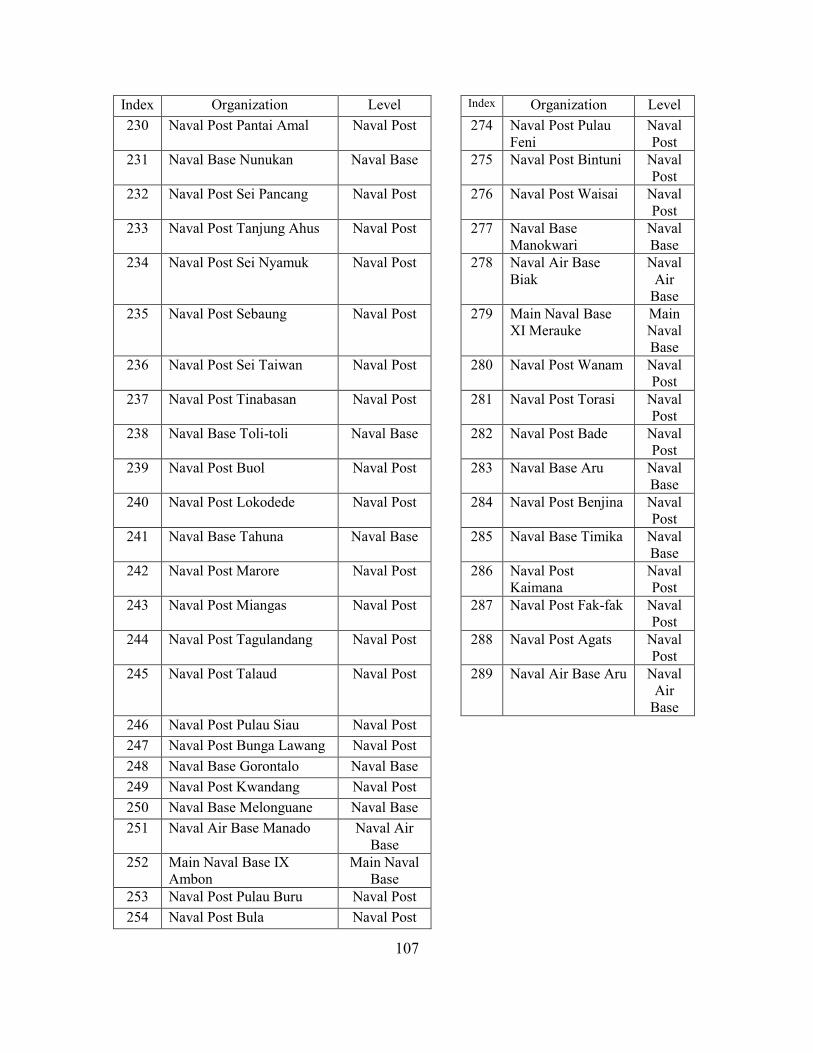
107
Index Organization Level Index Organization Level 230 Naval Post Pantai Amal Naval Post 274 Naval Post Pulau
Feni Naval Post
231 Naval Base Nunukan Naval Base 275 Naval Post Bintuni Naval Post
232 Naval Post Sei Pancang Naval Post 276 Naval Post Waisai Naval Post
233 Naval Post Tanjung Ahus Naval Post 277 Naval Base Manokwari
Naval Base
234 Naval Post Sei Nyamuk Naval Post 278 Naval Air Base Biak
Naval Air
Base 235 Naval Post Sebaung Naval Post 279 Main Naval Base
XI Merauke Main Naval Base
236 Naval Post Sei Taiwan Naval Post 280 Naval Post Wanam Naval Post
237 Naval Post Tinabasan Naval Post 281 Naval Post Torasi Naval Post
238 Naval Base Toli-toli Naval Base 282 Naval Post Bade Naval Post
239 Naval Post Buol Naval Post 283 Naval Base Aru Naval Base
240 Naval Post Lokodede Naval Post 284 Naval Post Benjina Naval Post
241 Naval Base Tahuna Naval Base 285 Naval Base Timika Naval Base
242 Naval Post Marore Naval Post 286 Naval Post Kaimana
Naval Post
243 Naval Post Miangas Naval Post 287 Naval Post Fak-fak Naval Post
244 Naval Post Tagulandang Naval Post 288 Naval Post Agats Naval Post
245 Naval Post Talaud Naval Post 289 Naval Air Base Aru Naval Air
Base 246 Naval Post Pulau Siau Naval Post 247 Naval Post Bunga Lawang Naval Post 248 Naval Base Gorontalo Naval Base 249 Naval Post Kwandang Naval Post 250 Naval Base Melonguane Naval Base 251 Naval Air Base Manado Naval Air
Base
252 Main Naval Base IX Ambon
Main Naval Base
253 Naval Post Pulau Buru Naval Post 254 Naval Post Bula Naval Post
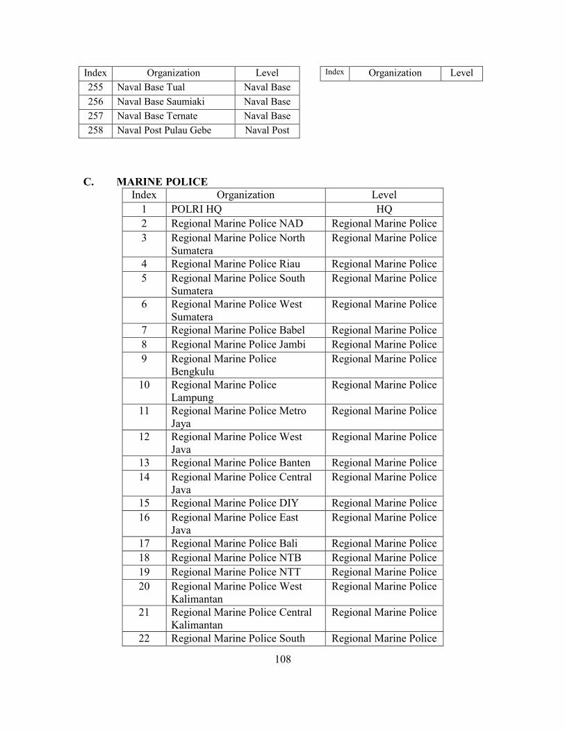
108
Index Organization Level Index Organization Level 255 Naval Base Tual Naval Base 256 Naval Base Saumiaki Naval Base 257 Naval Base Ternate Naval Base 258 Naval Post Pulau Gebe Naval Post
C. MARINE POLICE Index Organization Level
1 POLRI HQ HQ 2 Regional Marine Police NAD Regional Marine Police 3 Regional Marine Police North
Sumatera Regional Marine Police
4 Regional Marine Police Riau Regional Marine Police 5 Regional Marine Police South
Sumatera Regional Marine Police
6 Regional Marine Police West Sumatera
Regional Marine Police
7 Regional Marine Police Babel Regional Marine Police 8 Regional Marine Police Jambi Regional Marine Police 9 Regional Marine Police
Bengkulu Regional Marine Police
10 Regional Marine Police Lampung
Regional Marine Police
11 Regional Marine Police Metro Jaya
Regional Marine Police
12 Regional Marine Police West Java
Regional Marine Police
13 Regional Marine Police Banten Regional Marine Police 14 Regional Marine Police Central
Java Regional Marine Police
15 Regional Marine Police DIY Regional Marine Police 16 Regional Marine Police East
Java Regional Marine Police
17 Regional Marine Police Bali Regional Marine Police 18 Regional Marine Police NTB Regional Marine Police 19 Regional Marine Police NTT Regional Marine Police 20 Regional Marine Police West
Kalimantan Regional Marine Police
21 Regional Marine Police Central Kalimantan
Regional Marine Police
22 Regional Marine Police South Regional Marine Police
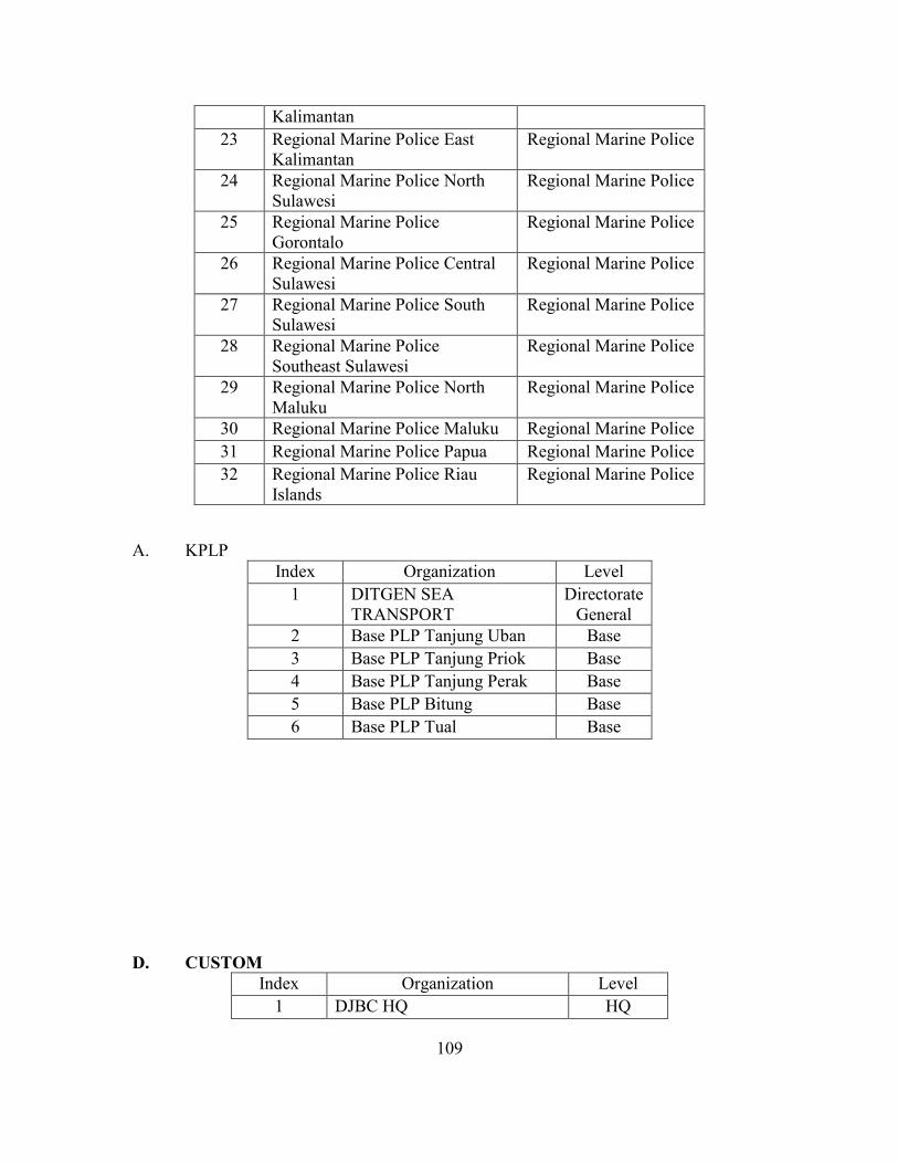
109
Kalimantan 23 Regional Marine Police East
Kalimantan Regional Marine Police
24 Regional Marine Police North Sulawesi
Regional Marine Police
25 Regional Marine Police Gorontalo
Regional Marine Police
26 Regional Marine Police Central Sulawesi
Regional Marine Police
27 Regional Marine Police South Sulawesi
Regional Marine Police
28 Regional Marine Police Southeast Sulawesi
Regional Marine Police
29 Regional Marine Police North Maluku
Regional Marine Police
30 Regional Marine Police Maluku Regional Marine Police 31 Regional Marine Police Papua Regional Marine Police 32 Regional Marine Police Riau
Islands Regional Marine Police
A. KPLP Index Organization Level
1 DITGEN SEA TRANSPORT
Directorate General
2 Base PLP Tanjung Uban Base 3 Base PLP Tanjung Priok Base 4 Base PLP Tanjung Perak Base 5 Base PLP Bitung Base 6 Base PLP Tual Base
D. CUSTOM Index Organization Level
1 DJBC HQ HQ
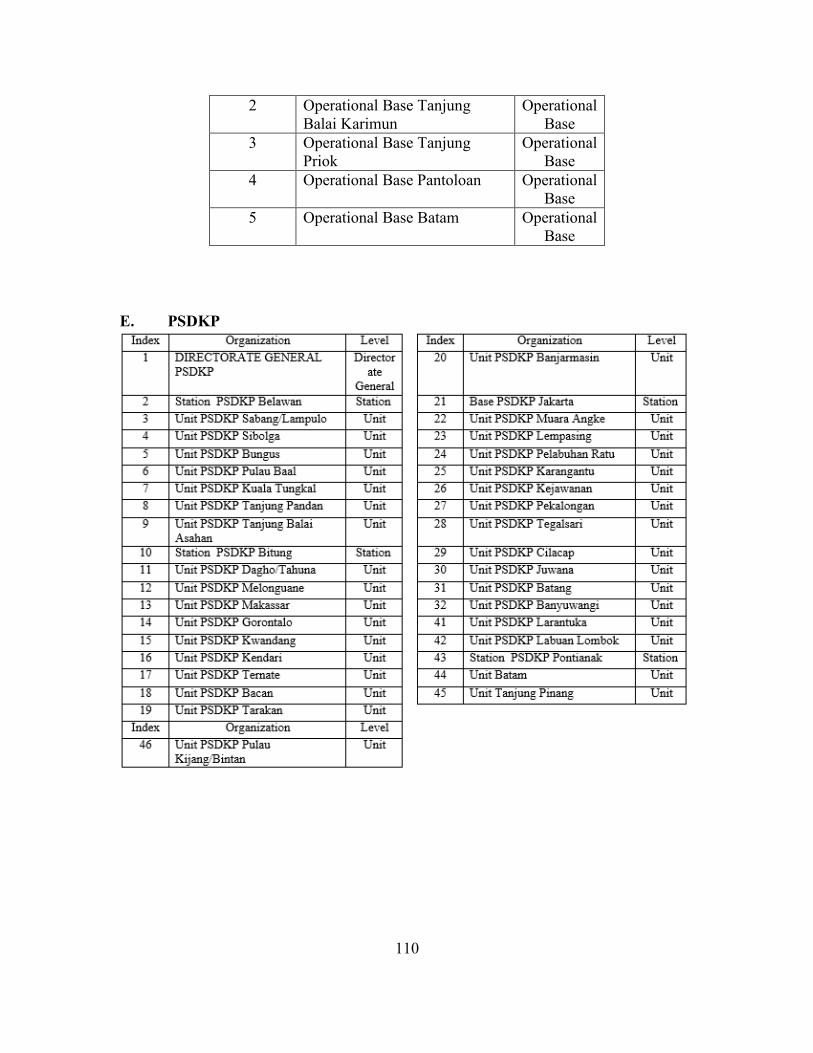
110
2 Operational Base Tanjung Balai Karimun
Operational Base
3 Operational Base Tanjung Priok
Operational Base
4 Operational Base Pantoloan Operational Base
5 Operational Base Batam Operational Base
E. PSDKP
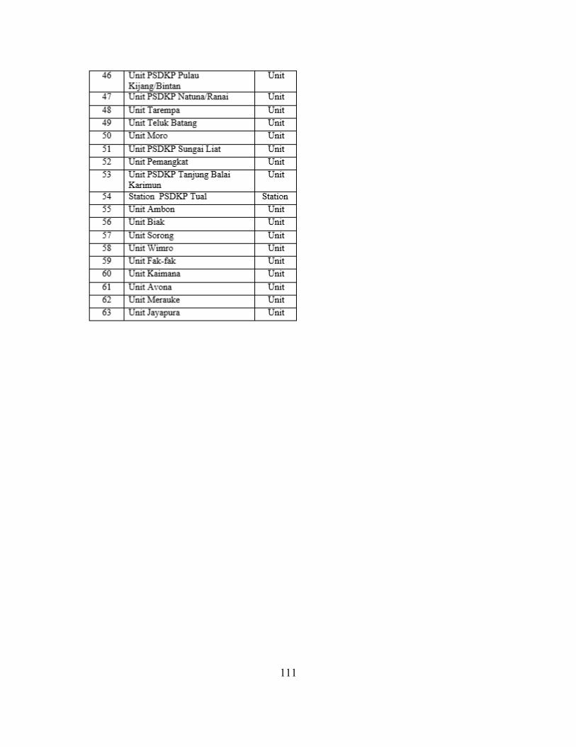
111

112
THIS PAGE INTENTIONALLY LEFT BLANK
113
LIST OF REFERENCES
Agranoff, R. (2004). Leveraging networks: A guide for public managers working across organizations. In J. M. Kamensky, & T. J. Burlin (Eds.), Collaboration: Using networks and partnerships (pp. 61‒102). Lanham, MD: Rowman & Littlefield.
Anklam, P. (2007). Network: A practical guide to creating and sustaining networks at work and in the world. Burlington, MA: Butterworth-Heinemann.
Bakohumas. (2012). Badan informasi geospasial: Ada 13.466 pulau di Indonesia (Geospatial information body: There are 13,466 islands in Indonesia). Retrieved March 20, 2014, from http://bakohumas.kominfo.go.id/news.php?id=1000
Bakorkamla. (2014). Sejarah Bakorkamla. Retrieved October 29, 2014, from http://www.bakorkamla.go.id/index.php/profil/sejarah-bakorkamla2
Balas, A. (2011). Creating global synergies: Inter-organizational cooperation in peace operations (doctoral dissertation, University of Illinois at Urbana-Champaign).
Berry, M. J. A. & Linoff, G. S. (2004). In Malm K. A. (Ed.), Data mining techniques (Second ed.). Indianapolis, Indiana: Wiley Publishing.
Border Protection Command. (2014). Border protection command. Retrieved August 18, 2014, from http://www.customs.gov.au/aboutus/protectingborders/bpc/default.asp
Borgatti, S. P. Everett, M. G. & Johnson, J. C. (2013). In Seaman J. (Ed.), Analyzing social networks. London: Sage Publications.
Carley, K. M. Pfeffer, J. Reminga, J. Storrick, J. & Columbus, D. (2013). ORA user’s guide 2013 No. CMU-ISR-13-108). Pittsburgh, PA: Institute for Software Research School of Computer Science Carnegie Mellon University.
Cohn, B. S. & Marriot, M. (1958). Networks and centres of integration in Indian civilization. In L. C. Freeman (Ed.), Centrality in social Networks conceptual clarification (pp. 1). Bethlehem: Department of Social Relations.
Corteville, L. & Sun, M. (2009). An interorganizational social network analysis of the Michigan diabetes outreach networks. Michigan: Michigan Department of Community Health. (Michigan; Diabetes; Interorganizational)
Cribb, R. & Ford, M. (Eds.). (2009). Indonesia beyond the water’s edge: Managing an archipelagic state. Singapore: ISEAS Publishing.
ESRI. (2014). Spatial analysis. Retrieved February 10, 2014, from http://www.esri.com/products/technology-topics/spatial-analysis
114
Everton, S. (2012). Disrupting dark networks. New York: Cambridge University Press.
Freeman, L. C. (1978/1979). Centrality in social networks conceptual clarification. Social Networks, 1, 215–239.
Gibbons, D. (2007). Interorganizational network structures and diffusion of information through a health system. American Journal of Public Health, 97(9), 1684–1692.
Gordon, U. (2008). Anarchy alive: Anti-authoritarian politics from practice to theory. London: Pluto Press.
Hakimi, S. L. (1965). Optimum locations of switching centers and the absolute centers and medians of a graph. In L. C. Freeman (Ed.), Centrality in social Networks conceptual clarification (pp. 450–459). Bethlehem, PA: Department of Social Relation.
Hocevar, S. P. (2010). Inter-organizational innovations for port security. Technical report NPS-GSBPP-10-022, Monterey, California: Naval Postgraduate School. Retrieved from http://hdl.handle.net/10945/652
Hocevar, S. P. (2012). Building collaborative capacity for maritime security. In S. Jasper (Ed.), Conflict and cooperation in the global commons (pp. 123). Washington, DC: Georgetown University Press.
Hocevar, S. P. Thomas, G. F. & Jansen, E. (2006). Building collaborative capacity: An innovative strategy for homeland security preparedness. Advances in Interdisciplinary Studies of Work Teams: Innovation through Collaboration, 12, 255–274.
Hocevar, S. P. Thomas, G. F. & Jansen, E. (2011). Inter-organizational collaboration: Addressing the challenge. Homeland Security Affairs, 7(1), special issue, 10 Years after: The 9/11 Essays. Retrieved from http://www.hsaj.org/?article=7.2.5
Human, S. E. & Provan, K. G. (2000). Legitimacy building in the evolution of small-firm networks: A comparative study of success and demise. Administrative Science Quarterly, 45, 327.
Idrobo, I. (1997). Analysis of naval organizations within maritime national interest: The case of Colombia (master’s thesis, Naval Postgraduate School).
Kenis, P. & Provan, K. G. (2009). Towards an exogenous theory of public network performance. Public Administration, 87(3), 440–456.
Kloth, C. & Applegate, B. (2004). Inter-organization collaboration & partnerships: A critical analysis. Unpublished manuscript.
115
Koh, T. (2008). ASEAN at forty: Perception and reality. In D. Nair, & L. P. Onn (Eds.), Regional outlook: Southeast Asia 2008–2009. Singapore: ISEAS Publishing.
Larsen, Richard J. & Marx, Morris L. (1981). An introduction to mathematical statistics and its application. New Jersey: Prentice Hall.
Malaysian Maritime Enforcement Agency. (2013). Malaysian maritime enforcement agency. Retrieved August 18, 2014, from https://www.mmea.gov.my/v25 /eng/index.php/en/about-us/background
Marsetio. (2014). Sea power Indonesia. Jakarta: Indonesian Defense University.
McGuire, M. (2003). Is it really so strange? A critical look at the “network management is different from hierarchical management” perspective. 7th National Public Management Research Conference, 9–11.
Milward, H. B. & Provan, K. G. (2006). A manager’s guide to choosing and using collaborative networks. Networks and Partnership Series. Retrieved February 20, 2014, from http://www.wales.nhs.uk/sitesplus/documents/829
Nitsova, S. (2012). Interorganizational coordination in peacebuilding: The case of Bosnia and Herzegovina (master’s thesis, Universiteit Leiden).
O’Toole, L. J. Jr. (1997). Treating networks seriously: Practical and research-based agendas in public administration. Public Administration Review, 57(1), 45–52.
Palantir. (2014). What we believe. Retrieved October 3, 2014, from https://www.palantir.com/what-we-believe/
Paris, R. (2009). Understanding the coordination problem in postwar state building. In R. Paris, & T. Sisk (Eds.), The dilemmas of state building. confronting the contradictions of postwar peace operations (p. 53). New York: Routledge
Payne, J. Solomon, J. Sankar, R. & McGrew, B. (2008). Palantir: The future of analysis. IEEE Symposium on Visual Analytics Science and Technology, 201.
Perpres, Peraturan Presiden Republik Indonesia Nomor 81 Tahun 2005 Tentang Badan Koordinasi Keamanan Laut, (2005). Retrieved February 20, 2014, from http://www.polkam.go.id/LinkClick.aspx
Peuquet, D. J. (n.d). Time in GIS and geographical databases. Retrieved March 5, 2014, from http://www.geos.ed.ac.uk/~gisteac/gis book abridged/files/ch08.pdf
Peuquet, D. J. & Duan, N. (1995). An event-based spatiotemporal data model (ESTDM) for temporal analysis of geographical data. International Journal of Geographical Information Systems, 9(1), 7-24, Retrieved on March 19 2014, At: 22:37, from http://www.tandfonline.com/doi/abs/10.1080
116
Popp, J. K. MacKean, G. Casebeer, A. Milward, H. B. & Lindstrom, R. (2013). Inter-organizational networks: A critical review of the literature to inform practice. Retrieved March 20, 2014, from http://research4children.com/data /documents/NetworkLiReview-Feb27-2013-Final.pdf
Provan, K. G. Fish, A. & Sydow, J. (2007). Interorganizational networks at the network level: A review of the empirical literature on whole networks. Journal of Management, 33(479), 479.
Provan, K. G. & Kenis, P. (2005). Modes of network governance: Structure, management, and effectiveness. Journal of Public Administration Research and Theory,18 (2), 229–252.
Provan, K. G. & Milward, H. B. (1995). A preliminary theory of interorganizational network effectiveness: A comparative study of four community mental health systems. Administrative Science Quarterly, 40(1), 1.
Provan, K. G. & Milward, H. B. (2001). Do networks really work? A framework for evaluating public-sector organizational networks. Public Administration Review, 61(4), 414.
Ratcliffe, J. H. (2004). The hotspot matrix: A framework for the spatio-temporal targeting of crime reduction. Police Practice and Research, 5(1), 05–23.
ReCAAP (2013). Piracy and Armed Robbery Against Ships in Asia Annual Report January- December 2013. Singapore: Information Sharing Centre.
Sabidussi, G. (1966). The centrality index of a graph. In L. C. Freeman (Ed.), Centrality in social networks conceptual clarification (pp. 581–603). Bethlehem: Department of Social Relations.
Samozain. (2013). Centralization versus decentralization of authority. Retrieved 10/22, 2014, from http://business-basics.org/centralization-versus-decentralization-of-authority/
Scott, J. Tallia, A. Crossom, J. C. Orzano, A. J. Stroebel, C. DiCicco-Bloom, B. et al. (2005). Social network analysis as an analytic tool for interaction patterns in primary care practices. Annals of Family Medicine, 3(5), 443.
Sherman, A. (2008). Socialtext and a theory of collaboration and networks. Retrieved October 31, 2014, from https://gigaom.com/2008/12/01/socialtext-and-a-theory-of-collaboration-and-networks/
Smith, M. J. Goodchild, M. F. & Longley, P. A. (2012). Geospatial analysis: A comprehensive guide to principles, techniques and software tools (4th ed.). Winchelsea: The Winchelsea Press.
117
Sumaryono, D. (2009). The Indonesian maritime security coordinating board. In R. Cribb, & M. Ford (Eds.), Indonesia beyond the water’s edge: Managing an archipelagic state (pp. 134–145). Singapore: ISEAS Publishing.
Supriyanto, R. A. & Rusdi, S. (2014, August 15, 2014). Maritime security agencies in Indonesia: More not merrier. The Nation.
Undang-Undang no.31 Tahun 2004 Tentang Perikanan. (2004).
Undang-Undang no. 17 Tahun 2008 Tentang Pelayaran. (2008).
U.S. Coast Guard (2005). National Plan to achieve Maritime Domain Awareness. Washington, D.C.
Tumin, Z. (2007). Maritime domain awareness: A case study in cross-boundary information sharing among the United States Navy, Coast Guard, and Department Of Transportation. Unpublished.

118
THIS PAGE INTENTIONALLY LEFT BLANK
119
INITIAL DISTRIBUTION LIST
1. Defense Technical Information Center Ft. Belvoir, Virginia 2. Dudley Knox Library Naval Postgraduate School Monterey, California
Related Documents