Ministry of Science, Technology and Innovation, Malaysia Malaysian Centre for Remote Sensing (MACRES) Expected GPM Data Usage in MACRES Dr. Aidy M Muslim MALAYSIAN CENTRE FOR REMOTE SENSING (MACRES) MINISTRY OF SCIENCE, TECHNOLOGY AND INNOVATION (MOSTI)

Welcome message from author
This document is posted to help you gain knowledge. Please leave a comment to let me know what you think about it! Share it to your friends and learn new things together.
Transcript

Ministry of Science, Technology and Innovation, MalaysiaMalaysian Centre for Remote Sensing (MACRES)
Expected GPM Data Usage in MACRESDr. Aidy M Muslim
MALAYSIAN CENTRE FOR REMOTE SENSING (MACRES)MINISTRY OF SCIENCE, TECHNOLOGY AND INNOVATION (MOSTI)
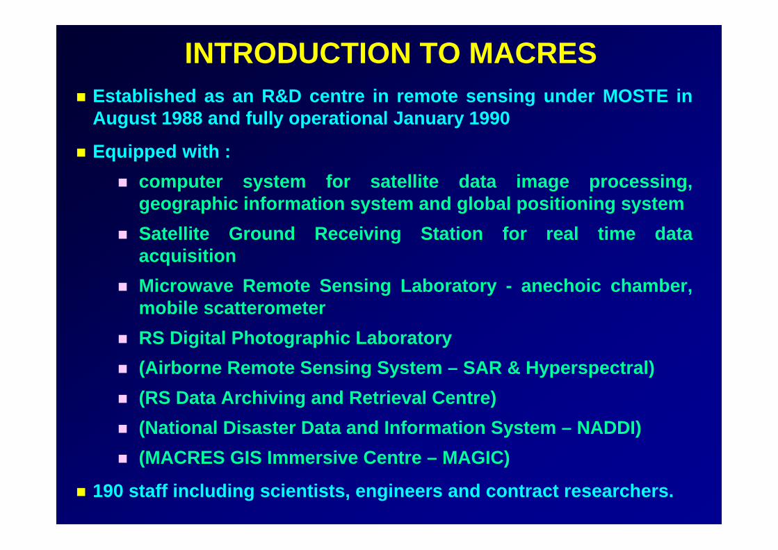
Ministry of Science, Technology and Innovation, MalaysiaMalaysian Centre for Remote Sensing (MACRES)INTRODUCTION TO MACRES
Established as an R&D centre in remote sensing under MOSTE in August 1988 and fully operational January 1990
Equipped with :computer system for satellite data image processing, geographic information system and global positioning systemSatellite Ground Receiving Station for real time data acquisitionMicrowave Remote Sensing Laboratory - anechoic chamber, mobile scatterometerRS Digital Photographic Laboratory(Airborne Remote Sensing System – SAR & Hyperspectral)(RS Data Archiving and Retrieval Centre)(National Disaster Data and Information System – NADDI)(MACRES GIS Immersive Centre – MAGIC)
190 staff including scientists, engineers and contract researchers.

Ministry of Science, Technology and Innovation, MalaysiaMalaysian Centre for Remote Sensing (MACRES)
OBJECTIVEOBJECTIVE
TO DEVELOP REMOTE SENSING AND RELATED TECHNOLOGIES AND TO OPERATIONALIZE THEIR APPLICATIONS FOR SOCIO ECONOMIC DEVELOPMENT, NATURAL RESOURCES, THE ENVIRONMENT AND DISASTERS MANAGEMENT, AND STRATEGIC PLANNING OF MALAYSIA.

Ministry of Science, Technology and Innovation, MalaysiaMalaysian Centre for Remote Sensing (MACRES)MACRES HQ - KL
Completed in July 1999
Night viewLobby

Ministry of Science, Technology and Innovation, MalaysiaMalaysian Centre for Remote Sensing (MACRES)MACRES GROUND RECEIVING STATIONMACRES GROUND RECEIVING STATION
Building completed in February 2000System commissioned in December 2002
RADARSAT SPOT 2, 4, 5LANDSATNOAAMODIS

Ministry of Science, Technology and Innovation, MalaysiaMalaysian Centre for Remote Sensing (MACRES)
AgricultureAgricultureLanduse change monitoringSoil mappingCrop condition monitoringYield predictionPrecision Farming
ForestryForestryForest monitoringDeforestation/illegal loggingForest park managementWetland mapping
GeologyGeologyMineral explorationHydrocarbon explorationLandform mapping
Water ResourcesWater ResourcesWatershed / catchmentmanagementSurface water resource Ground water potential
REMOTE SENSING APPLICATIONS IN REMOTE SENSING APPLICATIONS IN MACRES/MALAYSIAMACRES/MALAYSIA
Urban & Rural PlanningUrban & Rural PlanningUrban development planningResettlement planning

Ministry of Science, Technology and Innovation, MalaysiaMalaysian Centre for Remote Sensing (MACRES)
MarineMarineMarine park and islands managementCoastal erosionAquaculture planningFish Forecasting
Infrastructure DevelopmentInfrastructure DevelopmentHighway alignmentPipeline/powerline planningDam site selectionIrrigation scheme planning
EnvironmentEnvironmentSoil erosionWater pollutionHaze/air pollutionCoastal pollution
REMOTE SENSING APPLICATIONS IN REMOTE SENSING APPLICATIONS IN MACRES/MALAYSIAMACRES/MALAYSIA
HealthHealthEnvironmental healthEpidemic diseases surveillanceMalnutrition and rural poverty
BiodiversityBiodiversityNational Biodiversity InventoryBiodiversity Conservation

Ministry of Science, Technology and Innovation, MalaysiaMalaysian Centre for Remote Sensing (MACRES)
OPERATIONALISATION OF REMOTE SENSINGOPERATIONALISATION OF REMOTE SENSINGMOVING FROM A RESEARCH ENVIRONMENT, UNDERSTANDING PRINCIPLES AND TECHNOLOGY, TO AN ANALYSIS OF WHAT IS NEEDED AND HOW THE TECHNOLOGY CAN BE USED TO SOLVE INFORMATION REQUIREMENTS FOR NATION’S DEVELOPMENT.
MACRES LEADS IN TERM OF TECHNOLOGICAL DEVELOPMENTPRIORITY AREAS ARE DETERMINED BY USERS / SECTORAL AGENCIESTHROUGH MOUs / COLLABORATIVE ARRANGEMENTS
APPROACH

Ministry of Science, Technology and Innovation, MalaysiaMalaysian Centre for Remote Sensing (MACRES)OPERATIONALISATIONOPERATIONALISATION OF REMOTE SENSINGOF REMOTE SENSING
USER SEGMENT GROUND SEGMENT SPACE SEGMENT
APPLICATIONS(RS, GIS, GPS)
• ENVIRONMENTAL MANAGEMENT
• RESOURCES MANAGEMENT
• INFRA-STRUCTURE/ENGINEERING
• NATIONAL SECURITY
• Forest Fire• Landslides
• Floods• Land and Coastal Erosion
• Marine Pollution
• Minerals• Forestry• Marines
• Agriculture• Water
• Road Allignment• Dam Sitting/Management• Urban & Rural Development Processing
Data Reception
Satellite System
Airborne System
• SATELLITE DESIGN• SATELLITE INTEGRATION• SENSOR DEVELOPMENT• ATTITUTE & ORBIT
CONTROL• T, T & C

Ministry of Science, Technology and Innovation, MalaysiaMalaysian Centre for Remote Sensing (MACRES)
NADDINATIONAL DISASTER DATA AND INFORMATION
MANAGEMENT SYSTEM
THE OBJECTIVE OF NADDI IS TO ESTABLISH A REMOTE SENSING BASED SYSTEM TO SUPPORT NATIONAL DISASTER MANAGEMENT PROGRAMME BEING IMPLEMENTED IN THE COUNTRY

Ministry of Science, Technology and Innovation, MalaysiaMalaysian Centre for Remote Sensing (MACRES)
MAIN CHARACTERISTICS OF NADDIDISASTER MANAGEMENT SYSTEM BASED ON REMOTE SENSING AND RELATED TECHNOLOGIES FOR INFORMATION EXTRACTION
EARLY WARNING INFORMATIONS ARE PRODUCED THROUGH MODELLING AND INTEGRATION OF REMOTE SENSING AND OTHERS RELEVANT DATA
DISSEMINATION OF REAL TIME DATA AND INFORMATION THROUGH VIA DEDICATED COMMUNICATION TECHNOLOGIES
INTEGRATED DISASTER DATABASE ARE DEVELOPED FOR MAJOR DISASTERS IN MALAYSIA

Ministry of Science, Technology and Innovation, MalaysiaMalaysian Centre for Remote Sensing (MACRES)
NATIONAL DISASTER MANAGEMENT PROGRAMME
FOREST FIREFLOODLANDSLIDEOIL SPILLHOT INSTALLATIONTSUNAMI
MITIGATION & RELIEF
INTEGRATED NATIONAL DISASTER MANAGEMENT PROGRAMME

Ministry of Science, Technology and Innovation, MalaysiaMalaysian Centre for Remote Sensing (MACRES)MACRES WIDE AREA NETWORK (M-NET)
2 Mbps Leased
Line
3 Mbps Leased Line
SECUREVPN
INTERNET
INTRANET
INTRANETINTRANET
TMH
KLS
KLS
BKJ
PTJPLP
512 Kbps Leased Line
512 Kbps Leased Line
512 Kbps Leased Line
512 Kbps Leased Line
ISDN
ISDN
ISDN
ISDN
2 MbpsBack to BackFast Ethernet
Secure IDC Facilities for Web Server hosting & Internet Gateway with
Network Box
Cisco 2610XM
INTRANET
Cisco 2610XM
Cisco 2610XM
Cisco 2610XM
INTRANET
Cisco 2610XM
512 Kbps Leased Line
ISDN
PTJ
MALAYSIANMETEOROLOGY SERVICES
DEPARTMENT OFIRRIGATION & DRAINAGEECONOMIC PLANNING
UNIT (EPU)
MINISTRY OFDEFENCE
NATIONAL SECURITYDIVISION
KLS
E t h e r n e t
Ex isting F irew a ll / FTPServer
8 Mbps Leased Line
Cisco 2851Cisco 2811
Network BoxMGRS
TEMERLOH
Eth
erne
t
DN S Server
M ail Server
W eb server
Data Cham ber
N etw ork B ox
C ISCO P IX(Exis ting)
Cisco 2851
Cisco 2811
Eth
erne
t
MACRESHEADQUARTERS

Ministry of Science, Technology and Innovation, MalaysiaMalaysian Centre for Remote Sensing (MACRES)FLOOD MANAGEMENT SYSTEM (FMS)FLOOD MANAGEMENT SYSTEM (FMS)
EARLY WARNING
Telemetry Flood Prediction Map
Flood Management SystemHydrological Modelling
Ancillary data
DETECTION AND MONITORING
Satellite data
MGRS, TEMERLOH
Flooded areas
MITIGATION AND RELIEF
FLOOD OPERATIONS CENTRE• National Security Division• Department of Irrigation and Drainage• Welfare Department• Royal Malaysian Army• Royal Malaysian Police
Alert Level
Warning Level
Danger Level
RainfallLand use Terrain Soil
Potential Flood Areas
Water level forecast
MACRES HQ

Ministry of Science, Technology and Innovation, MalaysiaMalaysian Centre for Remote Sensing (MACRES)
Before Flood22 December 1998
During Flood29 December 1998
Combined Radarsat Data dated 22 December 1998 and 29 December 1998
Flood Areas
Pasir Mas
RADARSAT IMAGE OF FLOODED AREAS IN DECEMBER 1998
Paddy Fields

Ministry of Science, Technology and Innovation, MalaysiaMalaysian Centre for Remote Sensing (MACRES)
GPM data would compliment ground rainfall GPM data would compliment ground rainfall observation and water level station observation and water level station Data would improve runData would improve run--off calculations to off calculations to forecast water level and discharge.forecast water level and discharge.Improve forecasting in creating an effective Improve forecasting in creating an effective early warning systemearly warning systemNear realNear real--time data would be required.time data would be required.

Ministry of Science, Technology and Innovation, MalaysiaMalaysian Centre for Remote Sensing (MACRES)
LANDSLIDE HAZARD ZONE MAP OF SELANGORLANDSLIDE HAZARD ZONE MAP OF SELANGOR
Hillview (20.11.2002)
Bukit Antarabangsa
LANDSLIDE
Very highHighModerateLowVery low
RISK CLASS

Ministry of Science, Technology and Innovation, MalaysiaMalaysian Centre for Remote Sensing (MACRES)FOREST FIRE
MAPPING OF FOREST FIRES HIGH RISK AREAS - PEAT SWAMP AND PEAT SOIL
FIRE DANGER RATING SYSTEM (FDRS) IS BEING DEVELOPED IN COLLABORATION WITH MALAYSIAN METEOROLOGICAL SERVICES (MMS) AND CANADIAN FOREST SERVICES (CFS)
FOREST FIRE RISK IS A FUCTION OF FIRE WEATHER INDEX, FUEL TYPE INDEX AND TOPOGRAPHY INDEX
KLIA
Kuala Langat (S)F.R.

Ministry of Science, Technology and Innovation, MalaysiaMalaysian Centre for Remote Sensing (MACRES)
Others projectsOthers projectsRiver Basin StudiesRiver Basin Studies–– Monitor water resources for drinking, hydroMonitor water resources for drinking, hydro--electric and electric and
agricultureagricultureBiodiversity studiesBiodiversity studiesEnvironmental Health and Epidemic DiseasesPrecision Farming (Paddy and oil Palm)Precision Farming (Paddy and oil Palm)

Ministry of Science, Technology and Innovation, MalaysiaMalaysian Centre for Remote Sensing (MACRES)
SummarySummary
GPM data would be a great data source of GPM data would be a great data source of Precipitation information for major projects in Precipitation information for major projects in MACRESMACRESFor the data to be effective the data need to be For the data to be effective the data need to be available in near realavailable in near real--time especially for time especially for disaster managementdisaster management

Ministry of Science, Technology and Innovation, MalaysiaMalaysian Centre for Remote Sensing (MACRES)
Related Documents