Social Impact Assessment & RAP Report (Draft Final Report) Consultancy Services for Preparation of Detailed Project Report for Rehabilitation and Upgrading to 2-lane/2 lane with paved shoulders configuration and strengthening of Anisabad - Aurangabad – Hariharganj Section (Km. 0 to Km. 154.625) of NH-98 in the State of Bihar (Package No.-SP/C/2) November 2012 Ministry of Road Transport & Highways Govt. of India, New Delhi Consultants: & Transtek Plot No. - A-29, 2 nd Floor, Block B-1 Extension., Mohan Co- operative Industrial Estate, Mathura Road, New Delhi-110044 Public Disclosure Authorized Public Disclosure Authorized Public Disclosure Authorized Public Disclosure Authorized Public Disclosure Authorized Public Disclosure Authorized Public Disclosure Authorized Public Disclosure Authorized

Welcome message from author
This document is posted to help you gain knowledge. Please leave a comment to let me know what you think about it! Share it to your friends and learn new things together.
Transcript
Social Impact Assessment & RAP Report
(Draft Final Report)
Consultancy Services for Preparation of Detailed Project Report for Rehabilitation and Upgrading to 2-lane/2 lane with paved shoulders
configuration and strengthening of Anisabad - Aurangabad – Hariharganj Section (Km. 0 to Km. 154.625) of NH-98 in the State of Bihar
(Package No.-SP/C/2)
November 2012
Ministry of Road Transport & Highways Govt. of India, New Delhi
Consultants:
& Transtek Plot No. - A-29, 2nd Floor, Block B-1 Extension., Mohan Co-operative Industrial Estate, Mathura Road, New Delhi-110044
Pub
lic D
iscl
osur
e A
utho
rized
Pub
lic D
iscl
osur
e A
utho
rized
Pub
lic D
iscl
osur
e A
utho
rized
Pub
lic D
iscl
osur
e A
utho
rized
Pub
lic D
iscl
osur
e A
utho
rized
Pub
lic D
iscl
osur
e A
utho
rized
Pub
lic D
iscl
osur
e A
utho
rized
Pub
lic D
iscl
osur
e A
utho
rized
wb231615
Typewritten Text
IPP623v4
wb231615
Typewritten Text
wb231615
Typewritten Text
Table of Contents - Social Impact Assessment and RAP Report
Rehabilitation and Upgrading to 2 lane/2 lane with paved Shoulders of NH-98, Package SP/C/2 in the State of Bihar
Client: M/oRT&H
i
TESPL&
Social Impact Assessment & RAP Report (Draft)
TABLE OF CONTENTS
Sl. No. Description Page No.
ABBREVIATIONS 1 - 2
1. PROJECT INTRODUCTION AND BACKGROUND 1-1 to 1-9
1.1 Project Background 1-1 1.2 Importance of National Highway-98 1-1 1.3 Project Road Description 1-2 1.4 Existing Road Condition 1-7
2. SOCIO-ECONOMIC PROFILE OF THE PROJECT INFLUENCE ZONE 2-1 to 2-17 2.1 Introduction 2-1
2.2 Socio- Economic Status of Project influence District 2-1
2.2.1 Patna District 2-1
2.2.2 Arwal District 2-3
2.2.3 Aurangabad District 2-4
2.3 Project Impact Zone 2-5
2.3.1 Socio-Economic Profiling 2-5
2.3.2 Socio-Economic Profiling of Project influenced habitations (Direct/Indirect Impact Zone)
2-9
2.3.2.1 Population Composition 2-11
2.3.2.2 Family structure 2-11
2.3.2.3 Literacy & Educational Status 2-12
2.3.2.4 Occupation Pattern 2-12
2.3.2.5 Dwelling Structure 2-13
2.3.2.6 Tenancy of Dwelling Structure 2-13
2.3.2.7 Income Level 2-13
2.3.2.8 Gender ratio in Earning Population 2-14
2.3.2.9 Vulnerability 2-14
2.3.2.10 Educational service 2-14
2.3.2.11 Health care service 2-15
2.3.2.12 Marketing facility 2-15
2.3.2.13 Community Development Block service 2-15
2.3.2.14 Access to Civic Amenities -Transport facility 2-15
2.3.2.15 Access to Civic Amenities -Sanitation facility 2-16
Table of Contents - Social Impact Assessment and RAP Report
Rehabilitation and Upgrading to 2 lane/2 lane with paved Shoulders of NH-98, Package SP/C/2 in the State of Bihar
Client: M/oRT&H
ii
TESPL&
Sl. No. Description Page No.
2.3.2.16 Access to Civic Amenities - Drinking water facility
2-16
2.3.2.17 Women in decision-making 2-16
2.3.2.18 Indigenous People 2-17
2.3.2.19 HIV/AIDS & Human Trafficking Risks 2-17
3. PROPOSED IMPROVEMENT PLAN AND IMPACT ASSESSMENT PROCESS
3-1 to 3-8
3.1 Introduction 3-1 3.2 Design Considerations 3-1 3.2.1 Proposed Design Standards for Highway 3-1 3.2.2 Widening Option 3-2 3.3 Summaries of Improvement Proposals 3-2 3.4 Project Impact 3-4 3.5 Social Assessment Process 3-5 3.6 Corridor of Impact (CoI) 3-6 3.7 Consultation Methodology 3-6 3.8 Census Surveys and Structure Marking 3-6 3.9 Social Issues 3-7
4. CENSUS AND SOCIO-ECONOMIC SURVEY RESULTS 4-1 to 4-13 4.1 Census and Socio-economic Survey 4-1 4.2 Survey of Non Titleholders 4-1 4.2.1 Project Affected Non-Titleholders 4-1 4.2.2 Physical Characteristics of Squatters & Encroacher 4-4 4.2.3 Socio-economic Characteristics of Squatters & Encroacher 4-5 4.3 Survey of Titleholders 4-9 4.3.1 Project Affected Titleholders 4-9 4.3.2 Characteristics of Structures 4-10 4.3.3 Socio-economic Characteristics of Titleholder PAPs 4-11
5. LAND ACQUISITION 5-1 to 5-5 5.1 Existing Status of Land Availability 5-1 5.2 Land Acquisition: Legal Framework 5-2 5.3 Land Acquisition Planning for the Sub-project 5-3 5.4 Land Acquisition Estimates for the Project Stretch 5-3 5.5 Type of the Land Being Acquired for the Subproject 5-4
6. PUBLIC INFORMATION AND CONSULTATIONS 6-1 to 6-29 6.1 Introduction 6-1 6.2 Methodological Framework 6-2 6.3 Public Consultation Process 6-2
Table of Contents - Social Impact Assessment and RAP Report
Rehabilitation and Upgrading to 2 lane/2 lane with paved Shoulders of NH-98, Package SP/C/2 in the State of Bihar
Client: M/oRT&H
iii
TESPL&
Sl. No. Description Page No.
6.4 Key Issues 6-4 6.5 Women’s Participation in Consultations and out comes 6-5 6.6 Key Recommendations and Outcome of Consultations 6-6 6.7 Mitigation Measures of Social Issues: Design Considerations 6-7 6.8 Mechanism for Continuation of Public Consultations 6-7
7. MINIMIZING NEGATIVE SOCIAL IMPACT 7-1 to 7-12 7.1 Right of Way and its Impact 7-1 7.2 Design and R&R Coordination 7-1 7.3 Widening Option 7-2 7.4 By–Passes and Alternative Alignment 7-5 7.4.1 Naubatpur Built-Up Zone 7-5 7.4.2 Bikram, Maujuka & Azad Nagar (Km. 29-33) Built-Up
Zone 7-6
7.4.3 Arwal Built-up Zone (Ch. 60.750 to 61.550) 7-7 7.4.4 Improvement of other Important Built-up Location 7-9
7.5 Junction Improvements 7-9 7.6 Addressal of Safety Issues in Design for minimising the negative impact 7-9 7.7 Other Improvement and Safety provisions in project Section 7-12
8. R&R PRINCIPLES, POLICY FRAMEWORK & ENTITLEMENT MATRIX
8-1 to 8-14
8.1 Introduction 8-1 8.2 Resettlement & Rehabilitation Principles and Guidelines 8-1 8.3 Applicable Legal and Policy Framework 8-1 8.4 Comparative Analysis of Applicable Policy 8-3 8.5 Resettlement Policy Framework 8-3 8.6 Abbreviations, Terms and Definitions 8-4 8.7 Resettlement Principles and Eligibility Criteria 8-8 8.8 Entitlement Matrix 8-9 8.9 Methods for Assessment of Replacement Cost 8-13 8.10 Direct Purchase of Land 8-14
9. INSTITUTIONAL FRAMEWORK FOR RAP IMPLEMENTATION 9-1 to 9-9 9.1 Institutional Framework 9-1 9.2 Central Level Institutional Arrangement 9-2 9.3 State Level Institutional Arrangement 9-2 9.4 Sub-Project Level Institutional Arrangements 9-3 9.5 RAP and TDP Implementing Support Agency 9-4 9.6 Coordination with Other Agencies and Organizations 9-5 9.7 Role of Other Agencies 9-5
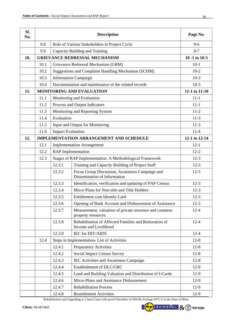
Table of Contents - Social Impact Assessment and RAP Report
Rehabilitation and Upgrading to 2 lane/2 lane with paved Shoulders of NH-98, Package SP/C/2 in the State of Bihar
Client: M/oRT&H
iv
TESPL&
Sl. No. Description Page No.
9.8 Role of Various Stakeholders in Project Cycle 9-6 9.9 Capacity Building and Training 9-7
10. GRIEVANCE REDRESSAL MECHANISM 10 -1 to 10-5 10.1 Grievance Redressal Mechanism (GRM) 10-1 10.2 Suggestions and Complaint Handling Mechanism (SCHM) 10-2 10.3 Information Campaign 10-3 10.4 Documentation and maintenance of the related records 10-3
11. MONITORING AND EVALUATION 11-1 to 11-10 11.1 Monitoring and Evaluation 11-1 11.2 Process and Output Indicators 11-1 11.3 Monitoring and Reporting System 11-2 11.4 Evaluation 11-3 11.5 Input and Output for Monitoring 11-3 11.6 Impact Evaluation 11-4
12. IMPLEMENTATION ARRANGEMENT AND SCHEDULE 12-1 to 12-14 12.1 Implementation Arrangement 12-1 12.2 RAP Implementation 12-2 12.3 Stages of RAP Implementation: A Methodological Framework 12-3 12.3.1 Training and Capacity Building of Project Staff 12-3 12.3.2 Focus Group Discussion, Awareness Campaign and
Dissemination of Information 12-3
12.3.3 Identification, verification and updating of PAP Census 12-3 12.3.4 Micro Plans for Non-title and Title Holders 12-3 12.3.5 Entitlement cum Identity Card 12-3 12.3.6 Opening of Bank Account and Disbursement of Assistance 12-3 12.3.7 Measurement, valuation of private structure and common
property resources 12-4
12.3.8 Rehabilitation of Affected Families and Restoration of Income and Livelihood
12-4
12.3.9 IEC for HIV/AIDS 12-4 12.4 Steps in Implementation- List of Activities 12-8 12.4.1 Preparatory Activities 12-8 12.4.2 Social Impact Census Survey 12-8 12.4.3 IEC Activities and Awareness Campaign 12-8 12.4.4 Establishment of DLC/GRC 12-9 12.4.5 Land and Building Valuation and Distribution of I-Cards 12-9 12.4.6 Micro-Plans and Assistance Disbursement 12-9 12.4.7 Rehabilitation Process 12-9 12.4.8 Resettlement Activities 12-9
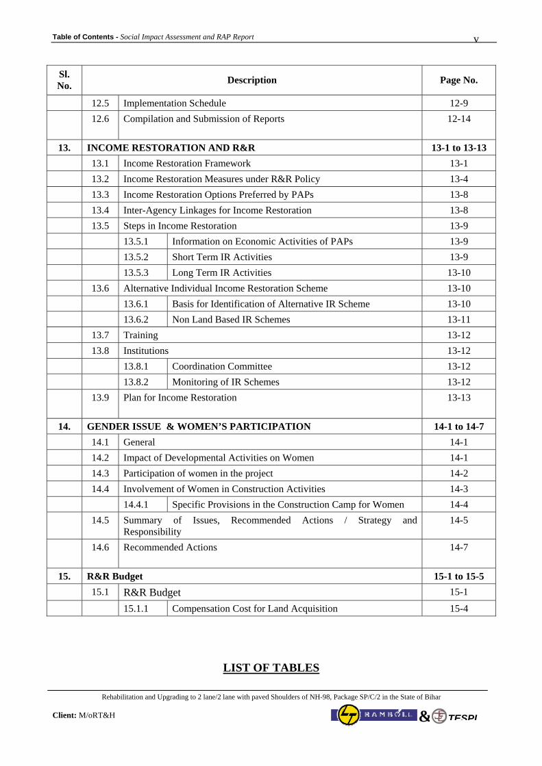
Table of Contents - Social Impact Assessment and RAP Report
Rehabilitation and Upgrading to 2 lane/2 lane with paved Shoulders of NH-98, Package SP/C/2 in the State of Bihar
Client: M/oRT&H
v
TESPL&
Sl. No. Description Page No.
12.5 Implementation Schedule 12-9 12.6 Compilation and Submission of Reports 12-14
13. INCOME RESTORATION AND R&R 13-1 to 13-13
13.1 Income Restoration Framework 13-1 13.2 Income Restoration Measures under R&R Policy 13-4 13.3 Income Restoration Options Preferred by PAPs 13-8 13.4 Inter-Agency Linkages for Income Restoration 13-8 13.5 Steps in Income Restoration 13-9 13.5.1 Information on Economic Activities of PAPs 13-9 13.5.2 Short Term IR Activities 13-9 13.5.3 Long Term IR Activities 13-10 13.6 Alternative Individual Income Restoration Scheme 13-10 13.6.1 Basis for Identification of Alternative IR Scheme 13-10 13.6.2 Non Land Based IR Schemes 13-11 13.7 Training 13-12 13.8 Institutions 13-12 13.8.1 Coordination Committee 13-12 13.8.2 Monitoring of IR Schemes 13-12 13.9 Plan for Income Restoration 13-13
14. GENDER ISSUE & WOMEN’S PARTICIPATION 14-1 to 14-7
14.1 General 14-1 14.2 Impact of Developmental Activities on Women 14-1 14.3 Participation of women in the project 14-2 14.4 Involvement of Women in Construction Activities 14-3 14.4.1 Specific Provisions in the Construction Camp for Women 14-4 14.5 Summary of Issues, Recommended Actions / Strategy and
Responsibility 14-5
14.6 Recommended Actions 14-7
15. R&R Budget 15-1 to 15-5 15.1 R&R Budget 15-1
15.1.1 Compensation Cost for Land Acquisition 15-4
LIST OF TABLES

Table of Contents - Social Impact Assessment and RAP Report
Rehabilitation and Upgrading to 2 lane/2 lane with paved Shoulders of NH-98, Package SP/C/2 in the State of Bihar
Client: M/oRT&H
vi
TESPL&
Sl. No Description Page No.
Chapter -1 Project Background and Introduction 1-1 to 1-8 Table 1-1 Connectivity of Project Corridor with other Important Road 1-3 Table 1-2 Project Road 1-3 Table 1.3 Habitations along the Project Road (Direct & Indirect influence Zone) 1-4 Table 1.4 Project Road – Detail of Habitations, Existing Carriageway and ROW 1-7
Chapter -2 Socio-Economic Profile of the Project Influence Zone 2-1 to 2-17 Table 2-1 Socio-Economic Statistics of Patna District 2-2 Table 2-2 Socio-Economic Statistics of Arwal District 2-3 Table 2-3 Socio-Economic Statistics of Aurangabad District 2-4 Table 2-4 Project Affected Villages falling under impact zone along NH-98 2-5 Table 2-5 District wise Socio-Economic Statistics of project-affected villages falling under
Direct and indirect influence zone 2-6
Table 2-6 Summary of Sample Households (NH-98) 2-10 Table 2.7 Population composition by Gender and Age 2-11 Table 2-8 Family Type 2-11 Table 2-9 Literacy Status (More than 6 years of age) 2-12 Table 2-10 Literacy status of school going children (6-14 yrs) 2-12 Table 2-11 Occupation Pattern 2-12 Table 2-12 Type of Dwelling Structure 2-13 Table 2-13 Income level (Household level) 2-13 Table 2-14 Working status by Sex 2-14 Table 2-15 Vulnerability 2-14
Chapter – 3 Proposed Improvement Plan and Impact Assessment Process 3-1 to 3-8 Table 3.1 Adopted Cross-Sectional Elements 3-1 Table 3.2 Proposed Improvement Plan of NH-98 3-2
Chapter - 4 Census and Socio-Economic Survey Results 4-1 to 4-14 Table 4.1 District-wise Distribution of Squatters, Encroachers and Kiosks 4-1 Table 4.2 Details of PAFs (squatters, encroachers and kiosks) in the Project Stretch 4-2 Table 4.3 Distribution of PAFs (squatters, encroachers and kiosks) as per Usage of Structure 4-3 Table 4.4 Distribution of Squatters & Encroachers as per Usage of Structure 4-4 Table 4.5 District-wise Distribution as per Location with respect to the NH 4-4 Table 4.6 District-wise Classification of Squatters & Encroachers as per Area Slabs 4-4 Table 4.7 District-wise Classification of Squatters & Encroachers as per Type of Structure 4-5 Table 4.8 District-wise Classification of Squatters & Encroachers as per Type of Structure &
Area 4-5
Table 4.9 Type of Family 4-6 Table 4.10 Number of Project Affected Families 4-6 Table 4.11 Educational Status of the Squatter PAPs 4-6 Table 4.12 District-wise Sex Ratio of the Squatter PAPs 4-7 Table 4.13 Marital Status 4-7 Table 4.14 Classification of Population as per Age Groups 4-7
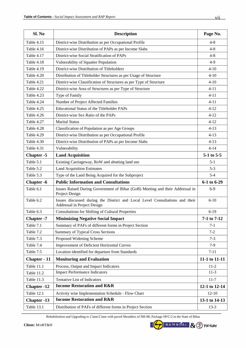
Table of Contents - Social Impact Assessment and RAP Report
Rehabilitation and Upgrading to 2 lane/2 lane with paved Shoulders of NH-98, Package SP/C/2 in the State of Bihar
Client: M/oRT&H
vii
TESPL&
Sl. No Description Page No.
Table 4.15 District-wise Distribution as per Occupational Profile 4-8 Table 4.16 District-wise Distribution of PAPs as per Income Slabs 4-8 Table 4.17 District-wise Social Stratification of PAPs 4-8 Table 4.18 Vulnerability of Squatter Population 4-9 Table 4.19 District-wise Distribution of Titleholders 4-10 Table 4.20 Distribution of Titleholder Structures as per Usage of Structure 4-10 Table 4.21 District-wise Classification of Structures as per Type of Structure 4-10 Table 4.22 District-wise Area of Structures as per Type of Structure 4-11 Table 4.23 Type of Family 4-11 Table 4.24 Number of Project Affected Families 4-11 Table 4.25 Educational Status of the Titleholder PAPs 4-12 Table 4.26 District-wise Sex Ratio of the PAPs 4-12 Table 4.27 Marital Status 4-12 Table 4.28 Classification of Population as per Age Groups 4-13 Table 4.29 District-wise Distribution as per Occupational Profile 4-13 Table 4.30 District-wise Distribution of PAPs as per Income Slabs 4-13 Table 4.31 Vulnerability 4-14
Chapter -5 Land Acquisition 5-1 to 5-5 Table 5.1 Existing Carriageway, RoW and abutting land use 5-1 Table 5.2 Land Acquisition Estimates 5-3 Table 5.3 Type of the Land Being Acquired for the Subproject 5-4
Chapter -6 Public Information and Consultations 6-1 to 6-29 Table 6.1 Issues Raised During Government of Bihar (GoB) Meeting and their Addressal in
Project Design 6-9
Table 6.2 Issues discussed during the District and Local Level Consultations and their Addressal in Project Design
6-10
Table 6.3 Consultations for Shifting of Cultural Properties 6-19
Chapter -7 Minimizing Negative Social Impact 7-1 to 7-12 Table 7.1 Summary of PAFs of different forms in Project Section 7-1 Table 7.2 Summary of Typical Cross Sections 7-2 Table 7.3 Proposed Widening Scheme 7-3 Table 7.4 Improvement of Deficient Horizontal Curves 7-9 Table 7.5 Location identified for departure from Standards 7-11
Chapter - 11 Monitoring and Evaluation 11-1 to 11-11Table 11.1 Process, Output and Impact Indicators 11-2 Table 11.2 Impact Performance Indicators 11-3
Table 11.3 Tentative List of Indicators 11-7
Chapter -12 Income Restoration and R&R 12-1 to 12-14Table 12.1 Activity wise Implementation Schedule - Flow Chart 12-10
Chapter -13 Income Restoration and R&R 13-1 to 14-13Table 13.1 Distribution of PAFs of different forms in Project Section 13-3
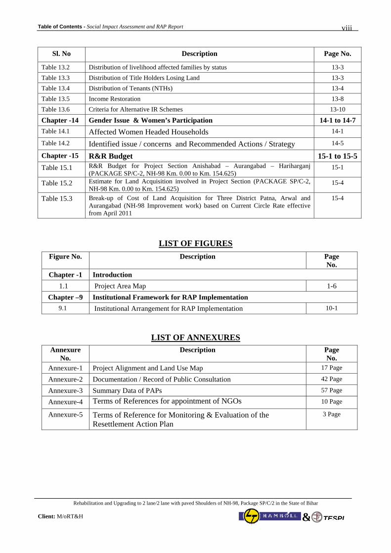
Table of Contents - Social Impact Assessment and RAP Report
Rehabilitation and Upgrading to 2 lane/2 lane with paved Shoulders of NH-98, Package SP/C/2 in the State of Bihar
Client: M/oRT&H
viii
TESPL&
Sl. No Description Page No.
Table 13.2 Distribution of livelihood affected families by status 13-3 Table 13.3 Distribution of Title Holders Losing Land 13-3 Table 13.4 Distribution of Tenants (NTHs) 13-4 Table 13.5 Income Restoration 13-8 Table 13.6 Criteria for Alternative IR Schemes 13-10
Chapter -14 Gender Issue & Women’s Participation 14-1 to 14-7 Table 14.1 Affected Women Headed Households 14-1
Table 14.2 Identified issue / concerns and Recommended Actions / Strategy 14-5
Chapter -15 R&R Budget 15-1 to 15-5
Table 15.1 R&R Budget for Project Section Anishabad – Aurangabad – Hariharganj (PACKAGE SP/C-2, NH-98 Km. 0.00 to Km. 154.625)
15-1
Table 15.2 Estimate for Land Acquisition involved in Project Section (PACKAGE SP/C-2, NH-98 Km. 0.00 to Km. 154.625)
15-4
Table 15.3 Break-up of Cost of Land Acquisition for Three District Patna, Arwal and Aurangabad (NH-98 Improvement work) based on Current Circle Rate effective from April 2011
15-4
LIST OF FIGURES
Figure No. Description Page No.
Chapter -1 Introduction 1.1 Project Area Map 1-6
Chapter –9 Institutional Framework for RAP Implementation 9.1 Institutional Arrangement for RAP Implementation 10-1
LIST OF ANNEXURES
Annexure No.
Description Page No.
Annexure-1 Project Alignment and Land Use Map 17 Page
Annexure-2 Documentation / Record of Public Consultation 42 Page
Annexure-3 Summary Data of PAPs 57 Page
Annexure-4 Terms of References for appointment of NGOs 10 Page
Annexure-5 Terms of Reference for Monitoring & Evaluation of the Resettlement Action Plan
3 Page
Modified Draft SIA & RAP Report (NH-98 – SP/C-2) Page 1 of 1
Rehabilitation and Upgrading to 2 lane/2 lane with paved Shoulders of NH-98, Package SP/C/2 in the State of Bihar Client: M/oRT&H
TESPL&
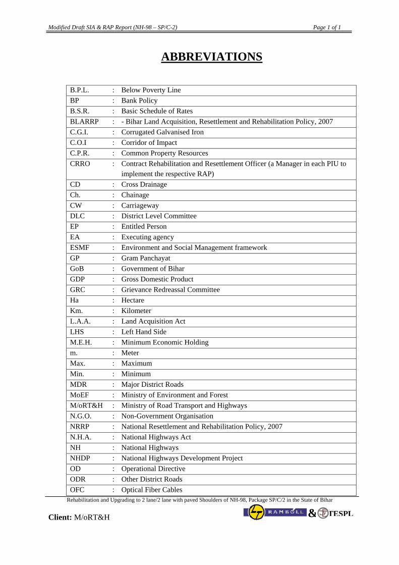
ABBREVIATIONS
B.P.L. : Below Poverty Line BP : Bank Policy B.S.R. : Basic Schedule of Rates BLARRP : - Bihar Land Acquisition, Resettlement and Rehabilitation Policy, 2007 C.G.I. : Corrugated Galvanised Iron C.O.I : Corridor of Impact C.P.R. : Common Property Resources CRRO
: Contract Rehabilitation and Resettlement Officer (a Manager in each PIU to implement the respective RAP)
CD : Cross Drainage Ch. : Chainage CW : Carriageway DLC : District Level Committee EP : Entitled Person EA : Executing agency ESMF : Environment and Social Management framework GP : Gram Panchayat GoB : Government of Bihar GDP : Gross Domestic Product GRC : Grievance Redreassal Committee Ha : Hectare Km. : Kilometer L.A.A. : Land Acquisition Act LHS : Left Hand Side M.E.H. : Minimum Economic Holding m. : Meter Max. : Maximum Min. : Minimum MDR : Major District Roads MoEF : Ministry of Environment and Forest M/oRT&H : Ministry of Road Transport and Highways N.G.O. : Non-Government Organisation NRRP : National Resettlement and Rehabilitation Policy, 2007 N.H.A. : National Highways Act NH : National Highways NHDP : National Highways Development Project OD : Operational Directive ODR : Other District Roads OFC : Optical Fiber Cables
Modified Draft SIA & RAP Report (NH-98 – SP/C-2) Page 2 of 2
Rehabilitation and Upgrading to 2 lane/2 lane with paved Shoulders of NH-98, Package SP/C/2 in the State of Bihar Client: M/oRT&H
TESPL&
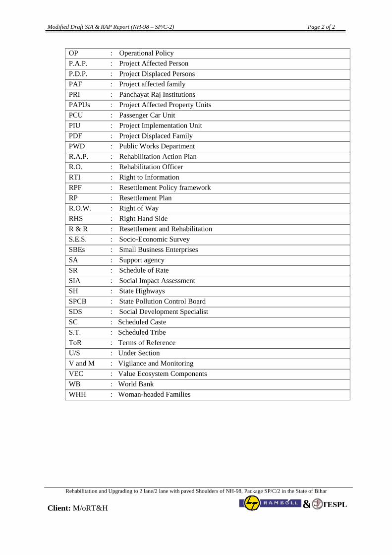
OP : Operational Policy P.A.P. : Project Affected Person P.D.P. : Project Displaced Persons PAF : Project affected family PRI : Panchayat Raj Institutions PAPUs : Project Affected Property Units PCU : Passenger Car Unit PIU : Project Implementation Unit PDF : Project Displaced Family PWD : Public Works Department R.A.P. : Rehabilitation Action Plan R.O. : Rehabilitation Officer RTI : Right to Information RPF : Resettlement Policy framework RP : Resettlement Plan R.O.W. : Right of Way RHS : Right Hand Side R & R : Resettlement and Rehabilitation S.E.S. : Socio-Economic Survey SBEs : Small Business Enterprises SA : Support agency SR : Schedule of Rate SIA : Social Impact Assessment SH : State Highways SPCB : State Pollution Control Board SDS : Social Development Specialist SC : Scheduled Caste S.T. : Scheduled Tribe ToR : Terms of Reference U/S : Under Section V and M : Vigilance and Monitoring VEC : Value Ecosystem Components WB : World Bank WHH : Woman-headed Families
Social Impact Assessment and RAP Report (Chapter-1) 1 - 1
Rehabilitation and Upgrading to 2 lane/2 lane with paved Shoulders of NH-98, Package SP/C/2 in the State of Bihar
Client: M/oRT&H TESPL&
CHAPTER 1
PROJECT INTRODUCTION AND BACKGROUND
1.1 Introduction
The Ministry of Road Transport & Highways (MoRT&H), Government of India has decided to up-grade all the existing single lane/intermediate lane National Highways, which are not covered under National Highways Development Program (NHDP) to at least 2-lane standards through National Highways Inter-connectivity Improvement Program (NHIIP). The NHIIP comprises of 33 project roads of non-NHDP National Highways across 7 states and 1 Union Territory with total length of 3769 km. Of these, 11 sub-projects have been proposed by MoRT&H for implementation with World Bank Assistance. The present report pertains to Anisabad - Aurangabad – Hariharganj Section (Km. 0 to Km. 149) of NH-98 in the state of Bihar. The MoRT&H intends to rehabilitate and up-grade the existing single lane/intermediate/two lane between Anisabad to Hariharganj of NH–98 to 2-lane/2-lane with paved shoulders configuration. The implementation of rehabilitation and up-gradation of this corridor is likely to be taken up with World Bank assistance. The World Bank has agreed to support this sub-project in-principle provided the implementation conforms to environmental and social safeguard policies of the World Bank and the legal framework of the country. The project road starts at Anishabad (Km 00+000) in Patna District and ends near Hariharganj (Km 154.625) at Bihar –Jharkhand Border in Aurangabad District on NH-98 in Bihar State. The project road is divided in two parts. First part of the project road at km 127+825 terminates on NH -2 near Jasoiya Jn. At Aurangabad. In second part, the project road at NH 98 is again originated just after Aurangabad Town, at chainage km 130+500 and ends near Hariharganj at km 154+625. National Highway-98 (NH-98) connects Patna, the state capital of Bihar to Daltonganj in Jharkhand. It covers a total distance of 225 km. The project road passes through Patna, Arwal and Aurangabad Districts of Bihar State. In Bihar State, NH-98 starts at Anishabad Jn. (Km. 0.00) and passes through important township and places viz. Phulwarisharif & Janipur (Km. 2 to 5.70), Naubatpur (Km. 17–19), Bikram (Km. 29-30), Kanpa (Km. 35-36), Mahabalipur (Km. 50), Arwal (km. 60-61), Balidad (Km.71), Kaler (km.83), Daudnagar (96-98), Obra (Km.112-114), Aurangabad (km. 128-131), Pawai (Km.134), Amba (km. 146) and ends at Hariharganj (Km. 154.625) Bihar-Jharkhand Border. The project location map of the project road is given under Figures 1.1. Phulwarisharif (Km.3-4), Naubat Pur (Km. 17) and Arwal (Km. 60-61) are congested stretch on the project road. The project requires World Bank, Government of India (GOI) and the State Government (GOO) clearances and approvals before the construction work can proceed. The project road for most of its length passes through plain terrain. The notified protected forest area in project (Road side Plantation) fall between Ch. 17+000 to 18+8000 and 35+000 to 154.625 ie total length about 121.425 Km.. Therefore, Forest Clearance for this project is involved from concerned Regional Offices in the light of Forest (Conservation) Act, 1980 and notification of GoI, MoEF dated 18th Feb 1998. The project section of NH-98 also fall under “Category –A” Project for MoEF Clearance (under the preview of EIA Notification 2006, amended in 2009) as the total Length is 155 km., it passes through Bihar &
Social Impact Assessment and RAP Report (Chapter-1) 1 - 2
Rehabilitation and Upgrading to 2 lane/2 lane with paved Shoulders of NH-98, Package SP/C/2 in the State of Bihar
Client: M/oRT&H TESPL&
Jharkhand and Involves more than 20 m. width Land Acquisition for Bikram By-Pass. There is no wildlife sanctuary and national park within 10 km from the project road therefore clearance for this is not involved. The MoRT&H has appointed the “L&T-RAMBOLL Consulting Engineering Ltd. JV Transtek Engineers & Service Pvt. Ltd. as project consultant to assist all aspects of project preparation and implementation in accordance with the objectives as detailed in the Terms of Reference (TOR). These tasks are linked to the engineering, environment and social aspects of the project preparation that will be undertaken throughout the period of Consultancy agreement. 1.2 Importance of National Highway-98
The National Highway-98 originates at Patna (Anishabad) Junction Point of NH-30 & NH-98 and terminates at Daltenganj (Jharkhand) where it meets NH-75. The region traversed by NH-98 is socially as well as economically backward and is neglected in terms of effective and efficient mode of communication, either Railways or Roadways. Hence the major thrust of vehicular traffic is on N.H–98 for goods as well as for passenger transport. Need of Food Product, Coal, Iron and other minerals for North and South Western part of Bihar is catered through this route from Orrisa, Jharkhand, Madhya Pradesh and South eastern UP. Majority of agricultural products of North & South Western part of Bihar are supplied to Jharkhand, MP, South Eastern UP, Orrisa through this route. The area is also completely lagging behind in good Technical and General Institutions, Hospitals, Industrial Set-up, efficient connectivity. Hence with the project, efficient Road network would facilitate the Investors to pump their money in private sector through Private – Public or PPP mode to meet the growing need of such Institutions. The Sectors that are likely to grow rapidly with up-gradation of NH-98 are Agro based Industries, Health and Education Sector, Hydal and Thermal Power Plant, PSC Railway Sleeper, PSC Electrical Poles, Hume Pipe Plant etc. Large quantity of Bamboo plantation are available near the end of project Road in Jharkhand to meet the requirement of Paper Industries as water resources is also available in plenty along the project corridor. There is further scope of installation of other Mega Thermal Power Plants apart from Nabinagar, as NH-98 will serves as efficient coal linkage route with Jharkhand. Nabinagar Thermal Power Project 2 X 2000 MW (2000 MW in collaboration with NTPC & Railway + 2000 MW in collaboration with NTPC and Govt. of Bihar are in stage of construction, which is connected with NH-98 in Km. 146-147 (near Amba). “Upgrading of project road would improve local and interstate connectivity and also facilitate transportation of coal and other materials to the Thermal Power Plant.”. There is small Hydal Power Project at stage of completion in Arwal km. 60, Balidad km. 71, Belsar Km. 80, Tejpura Km. 102-103. Small Hydal Power Project at Agnur in Km. 87 is already operational. These all Hydal Power plants are on Patna Main Sone Canal, which runs parallel to the Project stretch of NH-98 from Km. 07 to Km. 97. Aggregate are mined at Karwandhia (29 Km. from Km. 128 NH-98 on NH-02) and transported to cater the need of South and North Western District of Bihar. Sone Sand, one of the important components of construction material is available in plenty in River Sone, which runs parallel to the existing NH-98 from km. 35 to Km. 95 and serves the need of approved quality of Sand to North and South Western Part of Bihar as well as Eastern Part UP. Lion share of these materials are transported through the project road.
Social Impact Assessment and RAP Report (Chapter-1) 1 - 3
Rehabilitation and Upgrading to 2 lane/2 lane with paved Shoulders of NH-98, Package SP/C/2 in the State of Bihar
Client: M/oRT&H TESPL&
Keeping in view the availability of resources such as agricultural production, minerals, construction materials in the nearby areas, it is quite likely that upgrading of project road would generate local employment and also induce establishment of small scale industries leading to better socio-economic conditions of the area. The present project National Highway No. 98 (0.00 Km. to 154.625 Km.) aims to:
• improve and strengthen the existing quality of the pavement to take heavy loads so that pavement failure, maintenance etc. are minimized.
• improve the horizontal and vertical alignment of the existing road. • improve the condition of existing traffic flow by removing all bottlenecks at various locations. • increase the carrying capacity of the existing traffic volume and enable it to cater to the future
traffic. • improve accessibility of the existing highway. • provide highway amenities like Lay-bye, bus stop etc. • improve the numerous intersections on entire stretch of the highway linkage of the NH-98
within the section (0.00 Km. to 154.625 Km.) The project envisages the following advantages of having a well-developed network of highways:
• Savings in vehicle operating costs • Faster, comfortable journeys • Reduced fuel consumption • Safer travel • Benefits to trade especially in movement of perishable goods • Reduced maintenance costs • Safe travel • All round development of areas
1.3 Project Road Description The project Section Anishabad – Aurangabad – Hariharganj under consideration from Ch. 0.00 to 154.625, starts at Anishabad Jn. (Km. 0.00) and passes through important township and places viz. Phulwarisharif & Janipur (Km. 2 to 5.70), Naubatpur (Km. 17–19), Bikram (Km. 29-30), Mahabalipur (Km. 50), Arwal (km. 60-61), Balidad (Km.71), Kaler (km.83), Daudnagar (96-98), Obra (Km.112-114), Aurangabad (km. 128-131), Pawai (Km.134), Amba (km. 146) and ends at Hariharganj (Km. 154.625) Bihar-Jharkhand Border. A large number of major/ minor bituminous roads (NH, SH, REO & Village roads) meet the project stretch of NH 98 at various locations. The major roads meeting the NH-98 are Two National Highways; Seven State Highways and Four MDR along the entire project stretch. These Junctions with NH-98 (Table 1.1) are unsafe for the local traffic and pedestrians. Table 1.1 : Connectivity of Project Corridor with other Important Road
Sl. No.
Location /Chainage
Place Remarks
1. 0.000 Anishabad at Patna Connecting NH-30
2. 3.000 Phulwarisharif Jn. Connecting MDR to Danapur.
Social Impact Assessment and RAP Report (Chapter-1) 1 - 4
Rehabilitation and Upgrading to 2 lane/2 lane with paved Shoulders of NH-98, Package SP/C/2 in the State of Bihar
Client: M/oRT&H TESPL&
Sl. No.
Location /Chainage
Place Remarks
3. 17.000 Naubatpur Market Connecting S.H-78 to Khagaul & Bihta
4. 18.800 Naubatpur Connecting S.H-78 to Pitmas
5. 29.400 Bikram, Shahid Chowk Connecting S.H-02 to Bihta & Pali
6. 35.200 Kanpa Chowk Connecting MDR to Bihta
7. 41.165 Raniatalab Connecting SH-69
7. 50.000 Mahabalipur Market Connecting S.H-02 to Bihta
8. 60.975 Arwal Town Connecting NH-110 to Jahenabad
9. 64.350 Baidrabad Connecting SH-67
10. 96.900 Daudnagar Market Connecting S.H-07 to Goh. & Gaya
10. 113.050 Obra Market Connecting MDR to Rafiganj
11. 127.800 Jashoiya Jn., Aurangabad Connecting N.H-02
12. 146.900 Amba Chowk Connecting MDR to Nabinagar & Deo In addition to the metal roads, a large number of REO roads, brick and earthen roads also directly meet the National Highway without any provision for the safe entry to the NH. These roads cater to a group of villages and the nature and type of traffic is a primarily Light and slow moving traffic. In context of the small market centres located within 10-15 Kms of each other along the stretch, the influence zone of each centre is on an average a group of 40-50 villages connected through these katcha (un-metalled) roads. The entire project stretch passes through three (3) Districts viz. Patna (Km. 0.00 to Km. 52), Arwal (Km. 52 to Km.88) and Aurangabad (Km. 88 to Km. 154.50). Boundary of Arrah and Jahenabad District is within 5-10 Km. from the project road. The Project Road links the State capital of Bihar with Jharkhand at Hariharganj. The Project Road is connecting the NH-2 (Golden Quadrilateral) at Aurangabad (Km. 127.800). The entire project stretch passes through three (3) Districts (Table 1.2) viz. Patna (Km. 0.00 to Km. 52), Arwal (Km. 52 to Km.88) and Aurangabad (Km. 88 to Km. 154.50).
Table 1.2: Project Road
Name of the Road Section (Project Road) Districts Length
(Kms) Patna 0.000-52.000 Arwal 52.000-88.000 Anishabad – Aurangabad -
Hariharganj Section of N.H-98 Aurangabad 88.000-154.625
The major settlements in the project stretch are Anishabad, Phulwarisharif, Naubatpur, Bikram, Mahabalipur, Arwal, Balidad, Mahendia, Kaler, Daudnagar, Obra, Aurangabad, Amba and Hariharganj. Beside the major settlement several small settlement exist throughout the project section. In these settlements, there is a high degree of encroachment of the RoW, which would require displacement. The squatters and kiosks in these settlements are concentrated on either side of the road and are occupied by the Non Titleholder PAPs. The project would also have an indirect impact, both positive
Social Impact Assessment and RAP Report (Chapter-1) 1 - 5
Rehabilitation and Upgrading to 2 lane/2 lane with paved Shoulders of NH-98, Package SP/C/2 in the State of Bihar
Client: M/oRT&H TESPL&
and negative, on the people living in the villages through which the highway passes as well as the surrounding villages. The chainage wise Township, Villages and Settlement under the Project Influence Zone are presented below in table 1.3
Table 1.3 : Habitations along the Project Road (Direct & Indirect influence Zone)
Chainage Sl. No. From From
Block /Tehsil Name of the Habitation
Patna District 1 0.000 6.000 Phulwarisharif Anishabad, Phulwarisharif 2 6.000 8.000 Phulwari Bhusaula -Danapur 3 16.300 16.700 Naubatpur Motipur 4 16.500 19.000 Naubatpur Naubatpur 5 17.200 17.800 Naubatpur Taret 6 18.800 19.400 Naubatpur Kopa Khurd 7 19.800 20.100 Naubatpur Chechaul
8 20.800 22.250 Naubatpur Dariyapur 9 27.500 27.900 Bikram Telpa
10 27.900 28.100 Bikram Khoraitha 11 28.100 28.700 Bikram Nagahar 12 28.700 29.500 Bikram Bikram 13 29.800 30.700 Bikram Dadupur 14 30.700 32.100 Bikram Wajirpur Shankar 15 31.200 31.900 Bikram Baigwan 16 31.900 32.300 Bikram Hathsar 17 32.300 33.800 Bikram Raghunathpur 18 35.200 36.000 Bikram Kanpa 19 36.600 36.800 Bikram Saidabad 20 37.300 37.900 Bikram Gona 21 42.400 42.500 Dulhin Bazar Jitanchhapra
22 47.000 47.500 Paliganj Ankuri 23 49.150 50.850 Paliganj Mahablipur
Arwal District 24 52.550 52.650 Arwal Koriyam
25 54.000 54.300 Arwal Rashidpur 26 54.300 56.000 Arwal Ishlampur (Prasadi English) 27 56.400 56.700 Arwal Sakri 28 57.900 58.000 Arwal Ahiyapur 29 60.300 60.800 Arwal Sonbarsa 30 60.800 61.100 Arwal Sipah 31 61.100 61.800 Arwal Wasilpur 32 61.800 62.400 Arwal Makhadumpur 33 62.400 62.700 Arwal Mahuwari Nurullah 34 62.700 63.000 Arwal Muradpur Hujra 35 63.000 63.400 Arwal Muradpur Chowki 36 63.400 63.900 Arwal Kansupur 37 63.900 64.700 Arwal Pipra Bangla
Social Impact Assessment and RAP Report (Chapter-1) 1 - 6
Rehabilitation and Upgrading to 2 lane/2 lane with paved Shoulders of NH-98, Package SP/C/2 in the State of Bihar
Client: M/oRT&H TESPL&
Chainage Sl. No. From From
Block /Tehsil Name of the Habitation
38 64.700 65.200 Arwal Baidarabad 39 66.300 67.400 Arwal Hashanpur 40 68.000 68.500 Arwal Baniya Bigha 41 70.200 71.200 Kaler Balidad 42 73.700 73.900 Kaler Maraila 43 75.250 76.250 Kaler Mehandiya
44 76.350 77.800 Kaler Pahleja (Bodh Bigha) 45 78.300 78.600 Kaler Koni Kutti 46 79.300 79.700 Kaler Belshar 47 80.600 80.900 Kaler Amir Bigha 48 82.200 82.800 Kaler Kaler 49 86.600 86.800 Kaler Agnur
Aurangabad District
50 88.800 89.300 Daudnagar Samsher Nagar 51 89.650 91.150 Daudnagar Mahawar
52 95.350 96.900 Daudnagar Daudnagar 53 97.100 99.000 Daudnagar Tarari 54 101.400 101.900 Daudnagar Dhewahi 55 104.500 104.900 Obra Aranda 56 108.500 109.650 Obra Sadipur 57 110.400 111.200 Obra Atrauli 58 111.300 111.950 Obra Kharanti 59 112.400 113.900 Obra Obra 60 114.500 115.200 Obra Deokali 61 116.400 116.700 Obra Mahthu 62 117.000 117.700 Obra Shankarpur 63 118.000 119.000 Aurangabad Jamhaur 64 118.800 119.100 Aurangabad Mor Dihri 65 122.450 123.100 Aurangabad Bhatwan
66 123.150 123.750 Aurangabad Bharthauli Sharif 67 125.900 131.000 Aurangabad Aurangabad 68 133.700 134.100 Aurangabad Chatra 69 136.100 136.600 Deo Powaie 70 137.500 138.000 Kutumba Islampur 71 138.400 139.450 Kutumba Risiyap 72 142.200 142.900 Kutumba Gheura 73 143.500 144.000 Kutumba Dhanu Bigha 74 145.600 147.500 Kutumba Amba 75 147.600 147.850 Kutumba Hradutta 76 149.100 149.500 Kutumba Erka 77 150.350 150.900 Kutumba Dhanibar 78 151.800 152.600 Kutumba Chakanbag 79 153.600 154.600 Kutumba Matpa (Hariharganj)
Social Impact Assessment and RAP Report (Chapter-1) 1 - 7
Rehabilitation and Upgrading to 2 lane/2 lane with paved Shoulders of NH-98, Package SP/C/2 in the State of Bihar
Client: M/oRT&H TESPL&
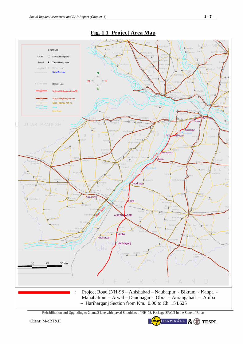
Fig. 1.1 Project Area Map
1.4 Existing Road Condition
National Highway with no.9898
Sone Canal
Sone Canal
Sone Canal
Sone Canal
10 20 30 Km.
GAYA District Headquarter
LEGEND
Raxaul Tehsil Headquarter
28
State Boundry
Railway Line
National Highway with no.
State Highway with no.
Other Road
AURANGABAD
P A T N A
Bikram
Naubatpur
Bihta
Arwal
Kanpa
Karwandiya
Obra
Daudnagar
AmbaNabinagar
Hariharganj
Mahabalipur
Phulwari
River
River S
one
River S
one
N
S
W E
: Project Road (NH-98 – Anishabad – Naubatpur - Bikram - Kanpa - Mahabalipur – Arwal – Daudnagar - Obra – Aurangabad – Amba – Hariharganj Section from Km. 0.00 to Ch. 154.625
Social Impact Assessment and RAP Report (Chapter-1) 1 - 8
Rehabilitation and Upgrading to 2 lane/2 lane with paved Shoulders of NH-98, Package SP/C/2 in the State of Bihar
Client: M/oRT&H TESPL&
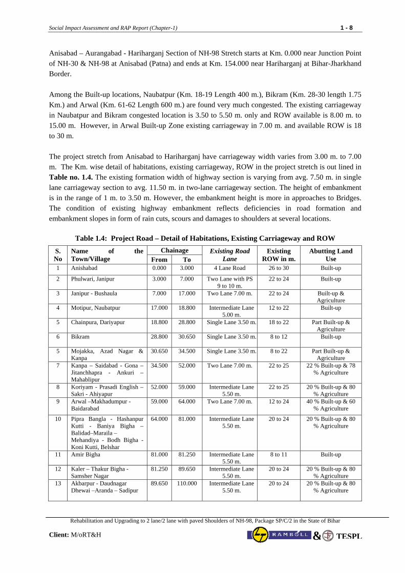
Anisabad – Aurangabad - Hariharganj Section of NH-98 Stretch starts at Km. 0.000 near Junction Point of NH-30 & NH-98 at Anisabad (Patna) and ends at Km. 154.000 near Hariharganj at Bihar-Jharkhand Border. Among the Built-up locations, Naubatpur (Km. 18-19 Length 400 m.), Bikram (Km. 28-30 length 1.75 Km.) and Arwal (Km. 61-62 Length 600 m.) are found very much congested. The existing carriageway in Naubatpur and Bikram congested location is 3.50 to 5.50 m. only and ROW available is 8.00 m. to 15.00 m. However, in Arwal Built-up Zone existing carriageway in 7.00 m. and available ROW is 18 to 30 m. The project stretch from Anisabad to Hariharganj have carriageway width varies from 3.00 m. to 7.00 m. The Km. wise detail of habitations, existing carriageway, ROW in the project stretch is out lined in Table no. 1.4. The existing formation width of highway section is varying from avg. 7.50 m. in single lane carriageway section to avg. 11.50 m. in two-lane carriageway section. The height of embankment is in the range of 1 m. to 3.50 m. However, the embankment height is more in approaches to Bridges. The condition of existing highway embankment reflects deficiencies in road formation and embankment slopes in form of rain cuts, scours and damages to shoulders at several locations.
Table 1.4: Project Road – Detail of Habitations, Existing Carriageway and ROW
Chainage S. No
Name of the Town/Village From To
Existing Road Lane
Existing ROW in m.
Abutting Land Use
1 Anishabad 0.000 3.000 4 Lane Road 26 to 30 Built-up
2 Phulwari, Janipur 3.000 7.000 Two Lane with PS 9 to 10 m.
22 to 24 Built-up
3 Janipur - Bushaula 7.000 17.000 Two Lane 7.00 m. 22 to 24 Built-up & Agriculture
4 Motipur, Naubatpur 17.000 18.800 Intermediate Lane 5.00 m.
12 to 22 Built-up
5 Chainpura, Dariyapur 18.800 28.800 Single Lane 3.50 m. 18 to 22 Part Built-up & Agriculture
6 Bikram
28.800 30.650 Single Lane 3.50 m. 8 to 12 Built-up
5 Mojakka, Azad Nagar & Kanpa
30.650 34.500 Single Lane 3.50 m. 8 to 22 Part Built-up & Agriculture
7 Kanpa – Saidabad - Gona –Jitanchhapra - Ankuri – Mahablipur
34.500 52.000 Two Lane 7.00 m. 22 to 25 22 % Built-up & 78 % Agriculture
8 Koriyam - Prasadi English – Sakri - Ahiyapur
52.000 59.000 Intermediate Lane 5.50 m.
22 to 25 20 % Built-up & 80 % Agriculture
9 Arwal –Makhadumpur - Baidarabad
59.000 64.000 Two Lane 7.00 m. 12 to 24 40 % Built-up & 60 % Agriculture
10 Pipra Bangla - Hashanpur Kutti - Baniya Bigha – Balidad–Maraila – Mehandiya - Bodh Bigha - Koni Kutti, Belshar
64.000 81.000 Intermediate Lane 5.50 m.
20 to 24 20 % Built-up & 80 % Agriculture
11 Amir Bigha 81.000 81.250 Intermediate Lane 5.50 m.
8 to 11 Built-up
12 Kaler – Thakur Bigha - Samsher Nagar
81.250 89.650 Intermediate Lane 5.50 m.
20 to 24 20 % Built-up & 80 % Agriculture
13 Akbarpur - Daudnagar Dhewai –Aranda – Sadipur
89.650 110.000 Intermediate Lane 5.50 m.
20 to 24 20 % Built-up & 80 % Agriculture
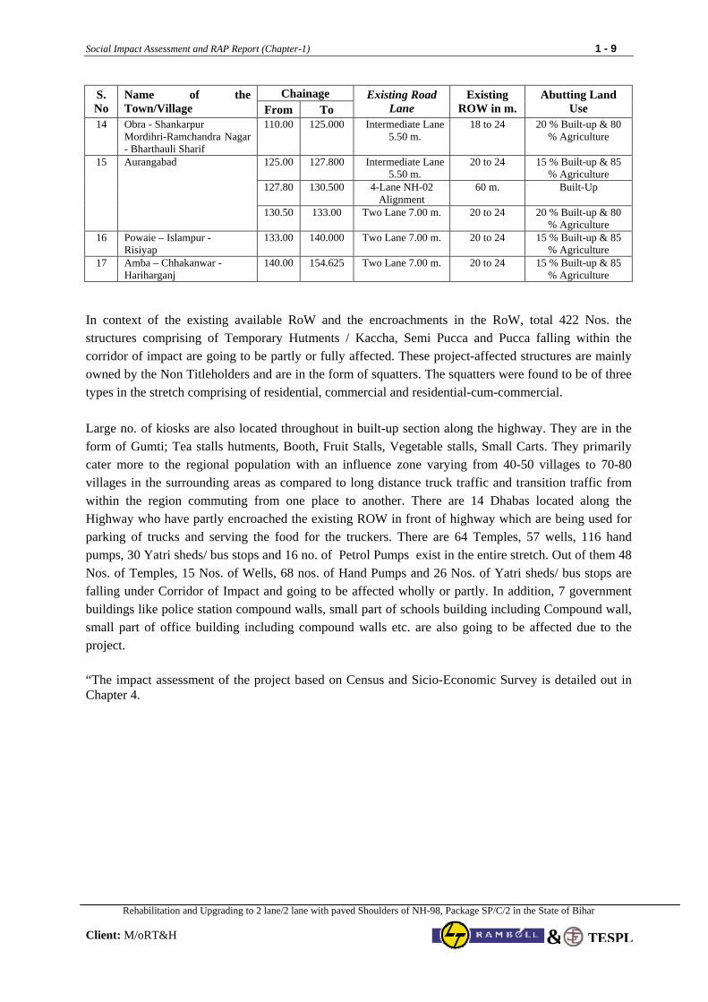
Social Impact Assessment and RAP Report (Chapter-1) 1 - 9
Rehabilitation and Upgrading to 2 lane/2 lane with paved Shoulders of NH-98, Package SP/C/2 in the State of Bihar
Client: M/oRT&H TESPL&
Chainage S. No
Name of the Town/Village From To
Existing Road Lane
Existing ROW in m.
Abutting Land Use
14 Obra - Shankarpur Mordihri-Ramchandra Nagar - Bharthauli Sharif
110.00 125.000 Intermediate Lane 5.50 m.
18 to 24 20 % Built-up & 80 % Agriculture
125.00 127.800 Intermediate Lane 5.50 m.
20 to 24 15 % Built-up & 85 % Agriculture
127.80 130.500 4-Lane NH-02 Alignment
60 m. Built-Up
15 Aurangabad
130.50 133.00 Two Lane 7.00 m. 20 to 24 20 % Built-up & 80 % Agriculture
16 Powaie – Islampur - Risiyap
133.00 140.000 Two Lane 7.00 m. 20 to 24 15 % Built-up & 85 % Agriculture
17 Amba – Chhakanwar - Hariharganj
140.00 154.625 Two Lane 7.00 m. 20 to 24 15 % Built-up & 85 % Agriculture
In context of the existing available RoW and the encroachments in the RoW, total 422 Nos. the structures comprising of Temporary Hutments / Kaccha, Semi Pucca and Pucca falling within the corridor of impact are going to be partly or fully affected. These project-affected structures are mainly owned by the Non Titleholders and are in the form of squatters. The squatters were found to be of three types in the stretch comprising of residential, commercial and residential-cum-commercial. Large no. of kiosks are also located throughout in built-up section along the highway. They are in the form of Gumti; Tea stalls hutments, Booth, Fruit Stalls, Vegetable stalls, Small Carts. They primarily cater more to the regional population with an influence zone varying from 40-50 villages to 70-80 villages in the surrounding areas as compared to long distance truck traffic and transition traffic from within the region commuting from one place to another. There are 14 Dhabas located along the Highway who have partly encroached the existing ROW in front of highway which are being used for parking of trucks and serving the food for the truckers. There are 64 Temples, 57 wells, 116 hand pumps, 30 Yatri sheds/ bus stops and 16 no. of Petrol Pumps exist in the entire stretch. Out of them 48 Nos. of Temples, 15 Nos. of Wells, 68 nos. of Hand Pumps and 26 Nos. of Yatri sheds/ bus stops are falling under Corridor of Impact and going to be affected wholly or partly. In addition, 7 government buildings like police station compound walls, small part of schools building including Compound wall, small part of office building including compound walls etc. are also going to be affected due to the project. “The impact assessment of the project based on Census and Sicio-Economic Survey is detailed out in Chapter 4.
Social Impact Assessment and RAP Report (Chapter-5)
Rehabilitation and Upgrading to 2 lane/2 lane with paved Shoulders of NH-98, Package SP/C/2 in the State of Bihar
Client: M/oRT&H
2-1
TESPL&
CHAPTER 2
Socio-Economic Profile of the Project Influence Zone
2.1 Introduction The state of Bihar with an area of 94,163 sq. km. accounts for about 3% of the total geographical area of the country. It has a population of 82.88 million, which accounts for 8% of the population of the country. The adverse land-man ratio is reflected in the high density of population, which is 880 per sq. km. The decadal growth of population for 1991-2001 is 28.43%, which is the highest in the country. According to 2001 census, the literacy rate in the state is 47.53% and is the lowest in the country. The Scheduled Caste population comprises 15.47% whereas tribal population constitutes a mere 0.91% of the total population. The economy of the state is characterized by high incidence of poverty, low literacy rate, unemployment and low per capita income. The human development indicators are also very poor. Some of the important developmental indicators of Bihar are given below:
• The Human Development Index for Bihar is the lowest at 0.367 in 2001, which however, is an
improvement over the earlier years (1981: 0.237, 1991: 0.308). • The state’s per capita income in 2008-09 is Rs. 12,643 at current prices against the national average
of Rs. 37,490. • The average annual growth rate of Gross State Domestic Product between 2005-06 to 2008-09 has
been 13.68% compared to the national average of 8.48%. • Percentage of population below poverty line in 2004-05 is 41.4 against the national average of 27.5. • The literacy rate of the state is 47.53% in 2001 compared to the All India average of 65.38% while
the female literacy rate is 33.57% (All India 54.28%). • The birth rate per thousand in the state is 29.4 (2007) compared to 23.1 for the country as a whole. • The death rate per thousand in the State is 7.5 (2007) compared to 7.4 for the country as a whole. • The estimated Infant Mortality Rate is 58 per thousand in 2007 compared to the national average of
55. • The population density in the state as per 2001 census is 880 per sq. km. against the national figure
of 324. • 89.60% of the population lives in rural areas. 2.2 Socio- Economic Status of Project influence District The entire project stretch of NH-+-98 passes through three (3) Districts (table 1.1) viz. Patna (Km. 0.00 to Km. 52), Arwal (Km. 52 to Km.88) and Aurangabad (Km. 88 to Km. 154.50).
Name of the Road Section (Project Road) Districts Length
(Kms) Patna 0.000-52.000 Arwal 52.000-88.000 Anishabad – Aurangabad -
Hariharganj Section of N.H-98 Aurangabad 88.000-154.625
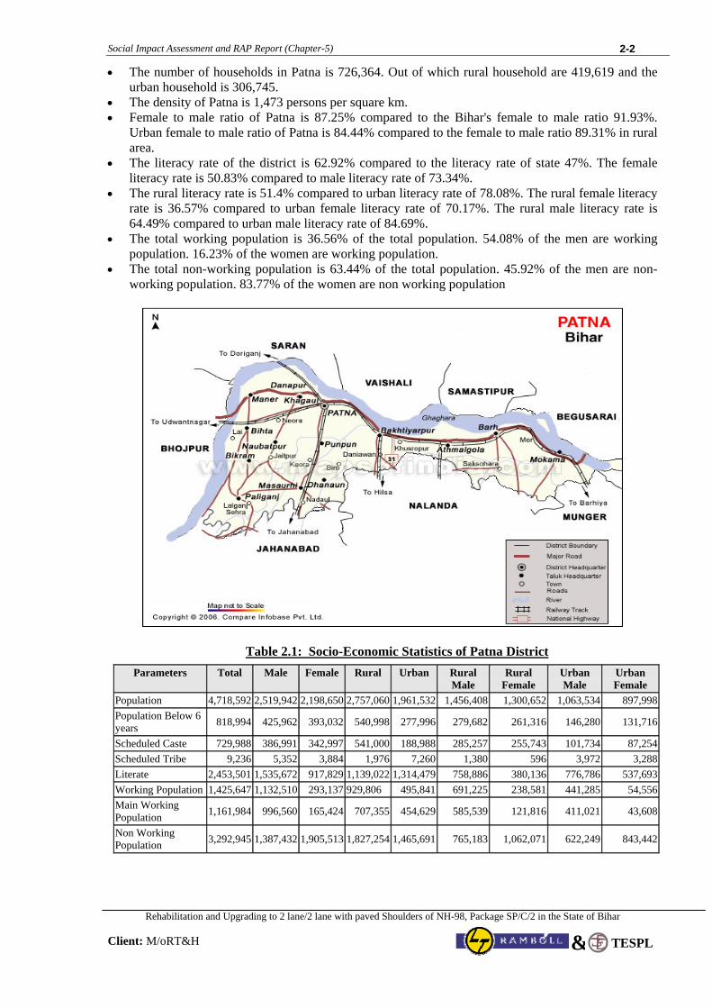
2.2.1 Patna District
The district of Patna with the geographical area of 3202 sq. km. and has a population of 47.19 millions. The average population density is 1132 per sqkm. Rich Paddy fields, Potato, Onion and Vegetables are the main agricultural crops. Sugar, Fire-Works, Biscuit, Flour Mills, Light-bulb and Shoes and Wagon Factory are the main industries. Ganga, Sone and Punpun are the main rivers.
Social Impact Assessment and RAP Report (Chapter-5)
Rehabilitation and Upgrading to 2 lane/2 lane with paved Shoulders of NH-98, Package SP/C/2 in the State of Bihar
Client: M/oRT&H
2-2
TESPL&
• The number of households in Patna is 726,364. Out of which rural household are 419,619 and the urban household is 306,745.
• The density of Patna is 1,473 persons per square km. • Female to male ratio of Patna is 87.25% compared to the Bihar's female to male ratio 91.93%.
Urban female to male ratio of Patna is 84.44% compared to the female to male ratio 89.31% in rural area.
• The literacy rate of the district is 62.92% compared to the literacy rate of state 47%. The female literacy rate is 50.83% compared to male literacy rate of 73.34%.
• The rural literacy rate is 51.4% compared to urban literacy rate of 78.08%. The rural female literacy rate is 36.57% compared to urban female literacy rate of 70.17%. The rural male literacy rate is 64.49% compared to urban male literacy rate of 84.69%.
• The total working population is 36.56% of the total population. 54.08% of the men are working population. 16.23% of the women are working population.
• The total non-working population is 63.44% of the total population. 45.92% of the men are non-working population. 83.77% of the women are non working population
Table 2.1: Socio-Economic Statistics of Patna District
Parameters Total Male Female Rural Urban Rural Male
Rural Female
Urban Male
Urban Female
Population 4,718,592 2,519,942 2,198,650 2,757,060 1,961,532 1,456,408 1,300,652 1,063,534 897,998Population Below 6 years 818,994 425,962 393,032 540,998 277,996 279,682 261,316 146,280 131,716
Scheduled Caste 729,988 386,991 342,997 541,000 188,988 285,257 255,743 101,734 87,254Scheduled Tribe 9,236 5,352 3,884 1,976 7,260 1,380 596 3,972 3,288Literate 2,453,501 1,535,672 917,829 1,139,022 1,314,479 758,886 380,136 776,786 537,693Working Population 1,425,647 1,132,510 293,137 929,806 495,841 691,225 238,581 441,285 54,556Main Working Population 1,161,984 996,560 165,424 707,355 454,629 585,539 121,816 411,021 43,608
Non Working Population 3,292,945 1,387,432 1,905,513 1,827,254 1,465,691 765,183 1,062,071 622,249 843,442
Social Impact Assessment and RAP Report (Chapter-5)
Rehabilitation and Upgrading to 2 lane/2 lane with paved Shoulders of NH-98, Package SP/C/2 in the State of Bihar
Client: M/oRT&H
2-3
TESPL&
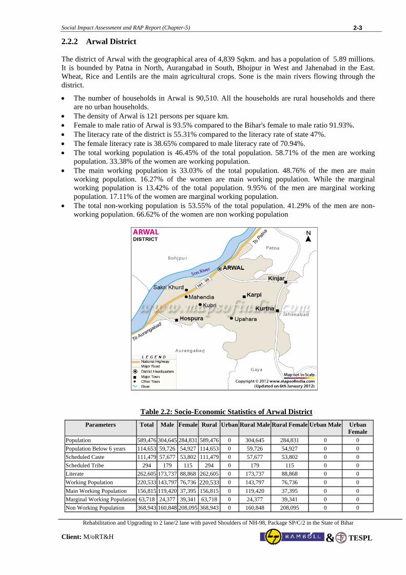
2.2.2 Arwal District The district of Arwal with the geographical area of 4,839 Sqkm. and has a population of 5.89 millions. It is bounded by Patna in North, Aurangabad in South, Bhojpur in West and Jahenabad in the East. Wheat, Rice and Lentils are the main agricultural crops. Sone is the main rivers flowing through the district.
• The number of households in Arwal is 90,510. All the households are rural households and there are no urban households.
• The density of Arwal is 121 persons per square km. • Female to male ratio of Arwal is 93.5% compared to the Bihar's female to male ratio 91.93%. • The literacy rate of the district is 55.31% compared to the literacy rate of state 47%. • The female literacy rate is 38.65% compared to male literacy rate of 70.94%. • The total working population is 46.45% of the total population. 58.71% of the men are working
population. 33.38% of the women are working population. • The main working population is 33.03% of the total population. 48.76% of the men are main
working population. 16.27% of the women are main working population. While the marginal working population is 13.42% of the total population. 9.95% of the men are marginal working population. 17.11% of the women are marginal working population.
• The total non-working population is 53.55% of the total population. 41.29% of the men are non-working population. 66.62% of the women are non working population
Table 2.2: Socio-Economic Statistics of Arwal District
Parameters Total Male Female Rural Urban Rural Male Rural Female Urban Male Urban Female
Population 589,476 304,645 284,831 589,476 0 304,645 284,831 0 0 Population Below 6 years 114,653 59,726 54,927 114,653 0 59,726 54,927 0 0 Scheduled Caste 111,479 57,677 53,802 111,479 0 57,677 53,802 0 0 Scheduled Tribe 294 179 115 294 0 179 115 0 0 Literate 262,605 173,737 88,868 262,605 0 173,737 88,868 0 0 Working Population 220,533 143,797 76,736 220,533 0 143,797 76,736 0 0 Main Working Population 156,815 119,420 37,395 156,815 0 119,420 37,395 0 0 Marginal Working Population 63,718 24,377 39,341 63,718 0 24,377 39,341 0 0 Non Working Population 368,943 160,848 208,095 368,943 0 160,848 208,095 0 0
Social Impact Assessment and RAP Report (Chapter-5)
Rehabilitation and Upgrading to 2 lane/2 lane with paved Shoulders of NH-98, Package SP/C/2 in the State of Bihar
Client: M/oRT&H
2-4
TESPL&
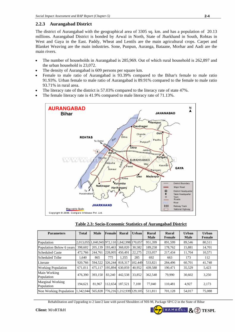
2.2.3 Aurangabad District The district of Aurangabad with the geographical area of 3305 sq. km. and has a population of 20.13 millions. Aurangabad District is bonded by Arwal in North, State of Jharkhand in South, Rohtas in West and Gaya in the East. Paddy, Wheat and Lentils are the main agricultural crops. Carpet and Blanket Weaving are the main industries. Sone, Punpun, Auranga, Bataane, Morhar and Aadi are the main rivers.
• The number of households in Aurangabad is 285,969. Out of which rural household is 262,897 and the urban household is 23,072.
• The density of Aurangabad is 609 persons per square km. • Female to male ratio of Aurangabad is 93.39% compared to the Bihar's female to male ratio
91.93%. Urban female to male ratio of Aurangabad is 89.91% compared to the female to male ratio 93.71% in rural area.
• The literacy rate of the district is 57.03% compared to the literacy rate of state 47%. • The female literacy rate is 41.9% compared to male literacy rate of 71.13%.
Table 2.3: Socio-Economic Statistics of Aurangabad District
Parameters Total Male Female Rural Urban Rural Male
Rural Female
Urban Male
Urban Female
Population 2,013,055 1,040,945 972,110 1,842,998 170,057 951,399 891,599 89,546 80,511 Population Below 6 years 398,602 205,139 193,463 368,020 30,582 189,258 178,762 15,881 14,701 Scheduled Caste 472,766 244,761 228,005 450,491 22,275 233,057 217,434 11,704 10,571 Scheduled Tribe 1,640 865 775 1,355 285 692 663 173 112 Literate 920,766 594,522 326,244 818,317 102,449 533,821 284,496 60,701 41,748 Working Population 671,011 475,117 195,894 630,059 40,952 439,588 190,471 35,529 5,423 Main Working Population 476,390 393,150 83,240 442,538 33,852 362,548 79,990 30,602 3,250
Marginal Working Population 194,621 81,967 112,654 187,521 7,100 77,040 110,481 4,927 2,173
Non Working Population 1,342,044 565,828 776,216 1,212,939 129,105 511,811 701,128 54,017 75,088
Social Impact Assessment and RAP Report (Chapter-5)
Rehabilitation and Upgrading to 2 lane/2 lane with paved Shoulders of NH-98, Package SP/C/2 in the State of Bihar
Client: M/oRT&H
2-5
TESPL&
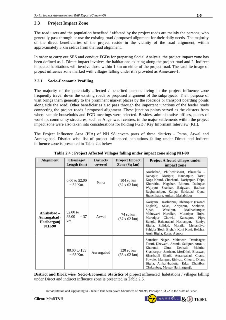
2.3 Project Impact Zone The road users and the population benefited / affected by the project roads are mainly the persons, who generally pass through or use the existing road / proposed alignment for their daily needs. The majority of the direct beneficiaries of the project reside in the vicinity of the road alignment, within approximately 5 km radius from the road alignment. In order to carry out SES and conduct FGDs for preparing Social Analysis, the project impact zone has been defined as 1. Direct impact involves the habitations existing along the project road and 2. Indirect impacted habitations will involve those within 1 km on either of the project road. The satellite image of project influence zone marked with villages falling under it is provided as Annexure-1. 2.3.1 Socio-Economic Profiling The majority of the potentially affected / benefited persons living in the project influence zone frequently travel down the existing roads or proposed alignment of the subprojects. Their purpose of visit brings them generally to the prominent market places by the roadside or transport boarding points along side the road. Other beneficiaries also pass through the important junctions of the feeder roads connecting the project roads / proposed alignment. These junction points served as the clusters from where sample households and FGD meetings were selected. Besides, administrative offices, places of worship, community structures, such as Anganwadi centres, in the major settlements within the project impact zone were also taken into considerations for holding FGD / Key Informant Interview (KII). The Project Influence Area (PIA) of NH 98 covers parts of three districts – Patna, Arwal and Aurangabad. District wise list of project influenced habitations falling under Direct and indirect influence zone is presented in Table 2.4 below
Table 2.4 : Project Affected Villages falling under impact zone along NH-98
Alignment Chainage/ Length (km)
Districts covered
Project Impact Zone (Sq km)
Project Affected villages under impact zone
0.00 to 52.00 = 52 Km. Patna 104 sq km
(52 x 02 km)
Anishabad, Phulwarisharif, Bhusaula –Danapur, Motipur, Naubatpur, Taret, Kopa Khurd, Chechaul, Dariyapur, Telpa, Khoraitha, Nagahar, Bikram, Dadupur, Wajirpur Shankar, Baigwan, Hathsar, Raghunathpur, Kanpa, Saidabad, Gona, Jitanchhapra, Ankuri, Mahablipur
52.00 to 88.00 = 37 km.
Arwal 74 sq km (37 x 02 km)
Koriyam , Rashidpur, Ishlampur (Prasadi English), Sakri, Ahiyapur, Sonbarsa, Sipah, Wasilpur, Makhadumpur, Mahuwari Nurullah, Muradpur Hujra, Muradpur Chowki, Kansupur, Pipra Bangla, Baidarabad, Hashanpur, Baniya Bigha, Balidad, Maraila, Mehandiya, Pahleja (Bodh Bigha), Koni Kutti, Belshar, Amir Bigha, Kaler, Agnoor
Anishabad – Aurangabad - Hariharganj
N.H-98
88.00 to 155 = 68 Km. Aurangabad 128 sq km
(68 x 02 km)
Samsher Nagar, Mahawar, Daudnagar, Tarari, Dhewahi, Aranda, Sadipur, Atrauli, Kharanti, Obra, Deokali, Mahthu, Shankarpur, Jamhaur, MorDihri, Bhatwan, Bharthauli Sharif, Aurangabad, Chatra, Powaie, Islampur, Risiyap, Gheura, Dhanu Bigha, Amba,Hradutta, Erka, Dhanibar, Chakanbag, Matpa (Hariharganj).
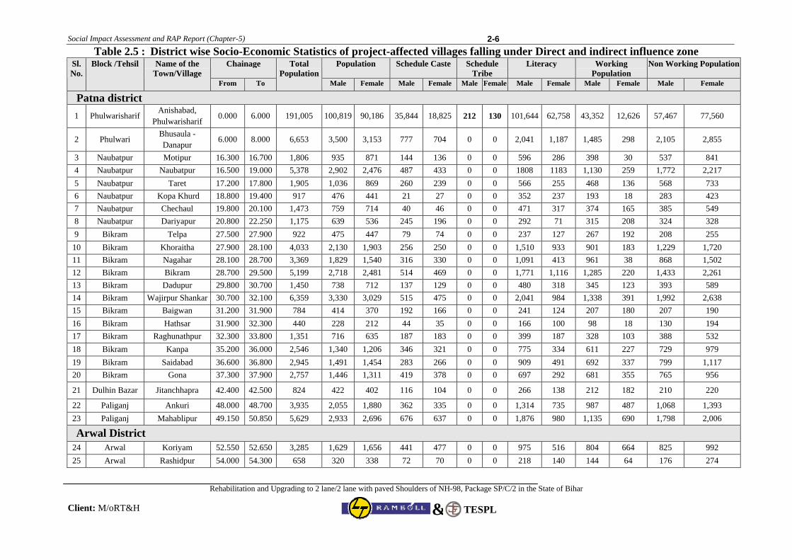
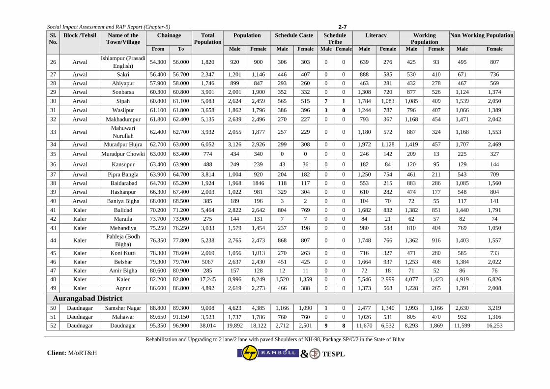
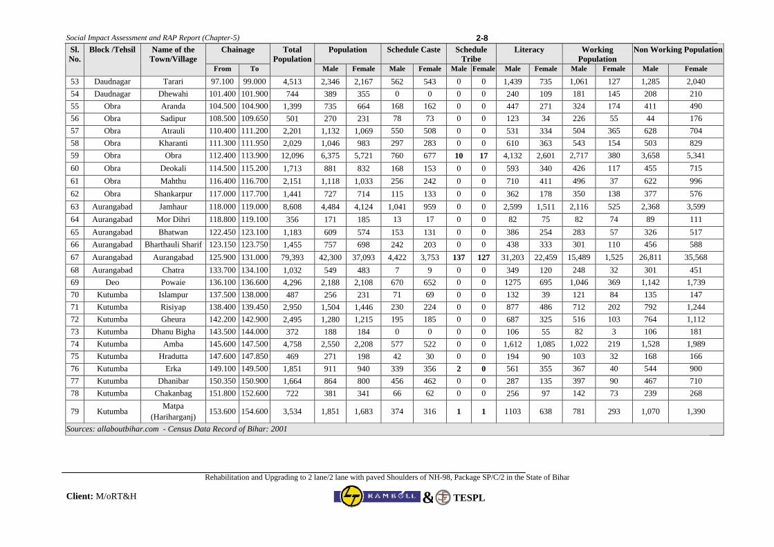
District and Block wise Socio-Economic Statistics of project influenced habitations / villages falling under Direct and indirect influence zone is presented in Table 2.5.
Social Impact Assessment and RAP Report (Chapter-5)
Rehabilitation and Upgrading to 2 lane/2 lane with paved Shoulders of NH-98, Package SP/C/2 in the State of Bihar
Client: M/oRT&H
2-6
TESPL&
Table 2.5 : District wise Socio-Economic Statistics of project-affected villages falling under Direct and indirect influence zone Chainage Population Schedule Caste Schedule
Tribe Literacy Working
Population Non Working Population Sl.
No. Block /Tehsil Name of the
Town/Village From To
Total Population
Male Female Male Female Male Female Male Female Male Female Male Female
Patna district 1 Phulwarisharif
Anishabad, Phulwarisharif
0.000 6.000 191,005 100,819 90,186 35,844 18,825 212 130 101,644 62,758 43,352 12,626 57,467 77,560
2 Phulwari Bhusaula -Danapur
6.000 8.000 6,653 3,500 3,153 777 704 0 0 2,041 1,187 1,485 298 2,105 2,855
3 Naubatpur Motipur 16.300 16.700 1,806 935 871 144 136 0 0 596 286 398 30 537 841 4 Naubatpur Naubatpur 16.500 19.000 5,378 2,902 2,476 487 433 0 0 1808 1183 1,130 259 1,772 2,217 5 Naubatpur Taret 17.200 17.800 1,905 1,036 869 260 239 0 0 566 255 468 136 568 733 6 Naubatpur Kopa Khurd 18.800 19.400 917 476 441 21 27 0 0 352 237 193 18 283 423 7 Naubatpur Chechaul 19.800 20.100 1,473 759 714 40 46 0 0 471 317 374 165 385 549 8 Naubatpur Dariyapur 20.800 22.250 1,175 639 536 245 196 0 0 292 71 315 208 324 328 9 Bikram Telpa 27.500 27.900 922 475 447 79 74 0 0 237 127 267 192 208 255
10 Bikram Khoraitha 27.900 28.100 4,033 2,130 1,903 256 250 0 0 1,510 933 901 183 1,229 1,720 11 Bikram Nagahar 28.100 28.700 3,369 1,829 1,540 316 330 0 0 1,091 413 961 38 868 1,502 12 Bikram Bikram 28.700 29.500 5,199 2,718 2,481 514 469 0 0 1,771 1,116 1,285 220 1,433 2,261 13 Bikram Dadupur 29.800 30.700 1,450 738 712 137 129 0 0 480 318 345 123 393 589 14 Bikram Wajirpur Shankar 30.700 32.100 6,359 3,330 3,029 515 475 0 0 2,041 984 1,338 391 1,992 2,638 15 Bikram Baigwan 31.200 31.900 784 414 370 192 166 0 0 241 124 207 180 207 190 16 Bikram Hathsar 31.900 32.300 440 228 212 44 35 0 0 166 100 98 18 130 194 17 Bikram Raghunathpur 32.300 33.800 1,351 716 635 187 183 0 0 399 187 328 103 388 532 18 Bikram Kanpa 35.200 36.000 2,546 1,340 1,206 346 321 0 0 775 334 611 227 729 979 19 Bikram Saidabad 36.600 36.800 2,945 1,491 1,454 283 266 0 0 909 491 692 337 799 1,117 20 Bikram Gona 37.300 37.900 2,757 1,446 1,311 419 378 0 0 697 292 681 355 765 956
21 Dulhin Bazar Jitanchhapra 42.400 42.500 824 422 402 116 104 0 0 266 138 212 182 210 220
22 Paliganj Ankuri 48.000 48.700 3,935 2,055 1,880 362 335 0 0 1,314 735 987 487 1,068 1,393 23 Paliganj Mahablipur 49.150 50.850 5,629 2,933 2,696 676 637 0 0 1,876 980 1,135 690 1,798 2,006
Arwal District 24 Arwal Koriyam 52.550 52.650 3,285 1,629 1,656 441 477 0 0 975 516 804 664 825 992 25 Arwal Rashidpur 54.000 54.300 658 320 338 72 70 0 0 218 140 144 64 176 274
Social Impact Assessment and RAP Report (Chapter-5)
Rehabilitation and Upgrading to 2 lane/2 lane with paved Shoulders of NH-98, Package SP/C/2 in the State of Bihar
Client: M/oRT&H
2-7
TESPL&
Chainage Population Schedule Caste Schedule Tribe
Literacy Working Population
Non Working Population Sl. No.
Block /Tehsil Name of the Town/Village
From To
Total Population
Male Female Male Female Male Female Male Female Male Female Male Female
26 Arwal Ishlampur (Prasadi
English) 54.300 56.000 1,820 920 900 306 303 0 0 639 276 425 93 495 807
27 Arwal Sakri 56.400 56.700 2,347 1,201 1,146 446 407 0 0 888 585 530 410 671 736 28 Arwal Ahiyapur 57.900 58.000 1,746 899 847 293 260 0 0 463 281 432 278 467 569 29 Arwal Sonbarsa 60.300 60.800 3,901 2,001 1,900 352 332 0 0 1,308 720 877 526 1,124 1,374 30 Arwal Sipah 60.800 61.100 5,083 2,624 2,459 565 515 7 1 1,784 1,083 1,085 409 1,539 2,050 31 Arwal Wasilpur 61.100 61.800 3,658 1,862 1,796 386 396 3 0 1,244 787 796 407 1,066 1,389 32 Arwal Makhadumpur 61.800 62.400 5,135 2,639 2,496 270 227 0 0 793 367 1,168 454 1,471 2,042
33 Arwal Mahuwari Nurullah
62.400 62.700 3,932 2,055 1,877 257 229 0 0 1,180 572 887 324 1,168 1,553
34 Arwal Muradpur Hujra 62.700 63.000 6,052 3,126 2,926 299 308 0 0 1,972 1,128 1,419 457 1,707 2,469 35 Arwal Muradpur Chowki 63.000 63.400 774 434 340 0 0 0 0 246 142 209 13 225 327
36 Arwal Kansupur 63.400 63.900 488 249 239 43 36 0 0 182 84 120 95 129 144
37 Arwal Pipra Bangla 63.900 64.700 3,814 1,004 920 204 182 0 0 1,250 754 461 211 543 709 38 Arwal Baidarabad 64.700 65.200 1,924 1,968 1846 118 117 0 0 553 215 883 286 1,085 1,560 39 Arwal Hashanpur 66.300 67.400 2,003 1,022 981 329 304 0 0 610 282 474 177 548 804 40 Arwal Baniya Bigha 68.000 68.500 385 189 196 3 2 0 0 104 70 72 55 117 141 41 Kaler Balidad 70.200 71.200 5,464 2,822 2,642 804 769 0 0 1,682 832 1,382 851 1,440 1,791 42 Kaler Maraila 73.700 73.900 275 144 131 7 7 0 0 84 21 62 57 82 74 43 Kaler Mehandiya 75.250 76.250 3,033 1,579 1,454 237 198 0 0 980 588 810 404 769 1,050
44 Kaler Pahleja (Bodh
Bigha) 76.350 77.800 5,238 2,765 2,473 868 807 0 0 1,748 766 1,362 916 1,403 1,557
45 Kaler Koni Kutti 78.300 78.600 2,069 1,056 1,013 270 263 0 0 716 327 471 280 585 733 46 Kaler Belshar 79.300 79.700 5067 2,637 2,430 451 425 0 0 1,664 937 1,253 408 1,384 2,022 47 Kaler Amir Bigha 80.600 80.900 285 157 128 12 11 0 0 72 18 71 52 86 76 48 Kaler Kaler 82.200 82.800 17,245 8,996 8,249 1,520 1,359 0 0 5,546 2,999 4,077 1,423 4,919 6,826 49 Kaler Agnur 86.600 86.800 4,892 2,619 2,273 466 388 0 0 1,373 568 1,228 265 1,391 2,008
Aurangabad District 50 Daudnagar Samsher Nagar 88.800 89.300 9,008 4,623 4,385 1,166 1,090 1 0 2,477 1,340 1,993 1,166 2,630 3,219 51 Daudnagar Mahawar 89.650 91.150 3,523 1,737 1,786 760 760 0 0 1,026 531 805 470 932 1,316 52 Daudnagar Daudnagar 95.350 96.900 38,014 19,892 18,122 2,712 2,501 9 8 11,670 6,532 8,293 1,869 11,599 16,253
Social Impact Assessment and RAP Report (Chapter-5)
Rehabilitation and Upgrading to 2 lane/2 lane with paved Shoulders of NH-98, Package SP/C/2 in the State of Bihar
Client: M/oRT&H
2-8
TESPL&
Chainage Population Schedule Caste Schedule Tribe
Literacy Working Population
Non Working Population Sl. No.
Block /Tehsil Name of the Town/Village
From To
Total Population
Male Female Male Female Male Female Male Female Male Female Male Female
53 Daudnagar Tarari 97.100 99.000 4,513 2,346 2,167 562 543 0 0 1,439 735 1,061 127 1,285 2,040 54 Daudnagar Dhewahi 101.400 101.900 744 389 355 0 0 0 0 240 109 181 145 208 210 55 Obra Aranda 104.500 104.900 1,399 735 664 168 162 0 0 447 271 324 174 411 490 56 Obra Sadipur 108.500 109.650 501 270 231 78 73 0 0 123 34 226 55 44 176 57 Obra Atrauli 110.400 111.200 2,201 1,132 1,069 550 508 0 0 531 334 504 365 628 704 58 Obra Kharanti 111.300 111.950 2,029 1,046 983 297 283 0 0 610 363 543 154 503 829 59 Obra Obra 112.400 113.900 12,096 6,375 5,721 760 677 10 17 4,132 2,601 2,717 380 3,658 5,341 60 Obra Deokali 114.500 115.200 1,713 881 832 168 153 0 0 593 340 426 117 455 715 61 Obra Mahthu 116.400 116.700 2,151 1,118 1,033 256 242 0 0 710 411 496 37 622 996 62 Obra Shankarpur 117.000 117.700 1,441 727 714 115 133 0 0 362 178 350 138 377 576 63 Aurangabad Jamhaur 118.000 119.000 8,608 4,484 4,124 1,041 959 0 0 2,599 1,511 2,116 525 2,368 3,599 64 Aurangabad Mor Dihri 118.800 119.100 356 171 185 13 17 0 0 82 75 82 74 89 111 65 Aurangabad Bhatwan 122.450 123.100 1,183 609 574 153 131 0 0 386 254 283 57 326 517 66 Aurangabad Bharthauli Sharif 123.150 123.750 1,455 757 698 242 203 0 0 438 333 301 110 456 588 67 Aurangabad Aurangabad 125.900 131.000 79,393 42,300 37,093 4,422 3,753 137 127 31,203 22,459 15,489 1,525 26,811 35,568 68 Aurangabad Chatra 133.700 134.100 1,032 549 483 7 9 0 0 349 120 248 32 301 451 69 Deo Powaie 136.100 136.600 4,296 2,188 2,108 670 652 0 0 1275 695 1,046 369 1,142 1,739 70 Kutumba Islampur 137.500 138.000 487 256 231 71 69 0 0 132 39 121 84 135 147 71 Kutumba Risiyap 138.400 139.450 2,950 1,504 1,446 230 224 0 0 877 486 712 202 792 1,244 72 Kutumba Gheura 142.200 142.900 2,495 1,280 1,215 195 185 0 0 687 325 516 103 764 1,112 73 Kutumba Dhanu Bigha 143.500 144.000 372 188 184 0 0 0 0 106 55 82 3 106 181 74 Kutumba Amba 145.600 147.500 4,758 2,550 2,208 577 522 0 0 1,612 1,085 1,022 219 1,528 1,989 75 Kutumba Hradutta 147.600 147.850 469 271 198 42 30 0 0 194 90 103 32 168 166 76 Kutumba Erka 149.100 149.500 1,851 911 940 339 356 2 0 561 355 367 40 544 900 77 Kutumba Dhanibar 150.350 150.900 1,664 864 800 456 462 0 0 287 135 397 90 467 710 78 Kutumba Chakanbag 151.800 152.600 722 381 341 66 62 0 0 256 97 142 73 239 268
79 Kutumba Matpa
(Hariharganj) 153.600 154.600 3,534 1,851 1,683 374 316 1 1 1103 638 781 293 1,070 1,390
Sources: allaboutbihar.com - Census Data Record of Bihar: 2001
Social Impact Assessment and RAP Report (Chapter-5)
Rehabilitation and Upgrading to 2 lane/2 lane with paved Shoulders of NH-98, Package SP/C/2 in the State of Bihar
Client: M/oRT&H
2-9
TESPL&
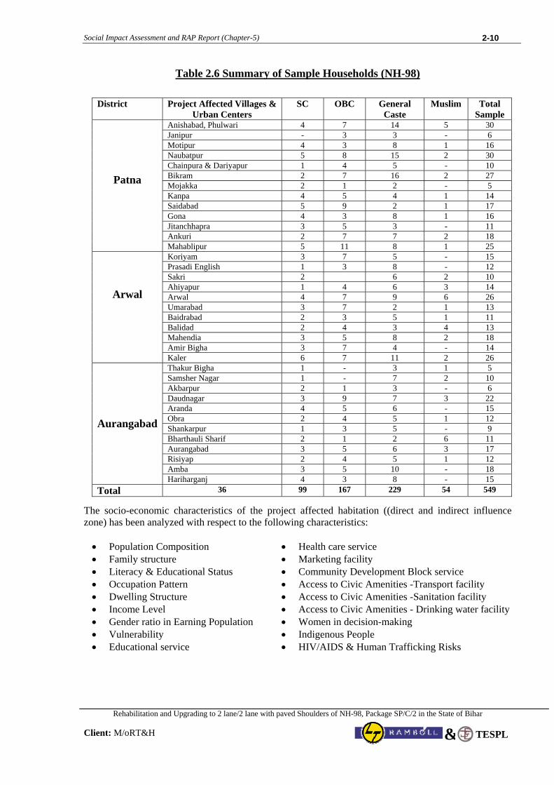
2.3.2 Socio-Economic Profiling of Project influenced habitations (Direct/Indirect Impact Zone) Socio-economic profiling of the subproject area with particular reference to indigenous people, poverty level, gender issues, local economy like agriculture, industry, health and educational status have been carried out on random sampling basis. The total number of the sample households for SES in NH 98 was 549 and 36 numbers of FGDs were performed there. The study was carried out with a participatory approach by involving the stakeholders, particularly the project beneficiaries and probable affected persons through a series of consultative process techniques. The population groups that were consulted include beneficiary group of people in the project influence area, particularly the shopkeepers, farmers, transport operators, school teachers, Gram Panchayat Sarpanch/members, village elders, the local youth and the Govt. officials who are involved in rural and women development programs and employment generation schemes. Care was taken to form participatory consultative groups as homogenous as possible. The methods that were adopted during survey and social analysis and assessment are: A socio-economic survey on sample households The sample households were selected from various social groups of the villages / settlements. While selecting sample households care was given to represent proportionally all the social strata of the concerned villages. Focus group discussions were organized, in separate sessions, with groups like, youth / elders, shopkeepers / operators, women & especially vulnerable people who were available during survey. Community consultation took place along major settlements near by the proposed alignment and those are likely to be connected as a result of implementation of this subproject. Meetings were held with the transport operators and roadside Dhaba owners at a few important junctions along National Highways. Key informant interviews were conducted with local leaders / village Panchayat functionaries and members & Senior citizen of the area to gain an insider’s views regarding specific highway related issues in the area. In some cases, interviews were undertaken at places convenient to the key persons, even beyond project impact zone. Gender Analysis was given proper emphasis during focus group discussion. For the purpose separate group discussion sessions were held with women who could share their experience related to transport issues that are specific for the women. Their collective perceptions about project impacts and probable benefits particularly for the women were taken note of. Structured direct observations: Field observations on general socio-economic and health status, need of the people, infrastructural set up or lack of it, requirement of the people in view of project road alignment, etc. were noted by the survey team. Review of secondary information: Apart from afore mentioned techniques and tools a desk review and preliminary analyses were undertaken of existing statistical records, census and gazetteers. Published works, research reports, National Human Development reports, State women development cell reports and periodic reviews were consulted to get an overview of the general gender, health, trafficking issues. The sample Households have been selected in a random manner from the roadside residential establishments, commercial establishments and also from the residential-cum-commercial establishments, adjacent to the proposed alignment / subproject road sections including those who are going to be affected due to the project. While selecting sample households care was taken to cover all socio-economic strata of the concerned villages and urban areas. Besides, type of structures was taken as one of the criteria for selecting sample, which is one important visual characteristic of economic condition of the families as well as impact categorization. Table 2.6 presents the summary of Sample Households.
Social Impact Assessment and RAP Report (Chapter-5)
Rehabilitation and Upgrading to 2 lane/2 lane with paved Shoulders of NH-98, Package SP/C/2 in the State of Bihar
Client: M/oRT&H
2-10
TESPL&
Table 2.6 Summary of Sample Households (NH-98)
District Project Affected Villages & Urban Centers
SC OBC General Caste
Muslim Total Sample
Anishabad, Phulwari 4 7 14 5 30 Janipur - 3 3 - 6 Motipur 4 3 8 1 16 Naubatpur 5 8 15 2 30 Chainpura & Dariyapur 1 4 5 - 10 Bikram 2 7 16 2 27 Mojakka 2 1 2 - 5 Kanpa 4 5 4 1 14 Saidabad 5 9 2 1 17 Gona 4 3 8 1 16 Jitanchhapra 3 5 3 - 11 Ankuri 2 7 7 2 18
Patna
Mahablipur 5 11 8 1 25 Koriyam 3 7 5 - 15 Prasadi English 1 3 8 - 12 Sakri 2 6 2 10 Ahiyapur 1 4 6 3 14 Arwal 4 7 9 6 26 Umarabad 3 7 2 1 13 Baidrabad 2 3 5 1 11 Balidad 2 4 3 4 13 Mahendia 3 5 8 2 18 Amir Bigha 3 7 4 - 14
Arwal
Kaler 6 7 11 2 26 Thakur Bigha 1 - 3 1 5 Samsher Nagar 1 - 7 2 10 Akbarpur 2 1 3 - 6 Daudnagar 3 9 7 3 22 Aranda 4 5 6 - 15 Obra 2 4 5 1 12 Shankarpur 1 3 5 - 9 Bharthauli Sharif 2 1 2 6 11 Aurangabad 3 5 6 3 17 Risiyap 2 4 5 1 12 Amba 3 5 10 - 18
Aurangabad
Hariharganj 4 3 8 - 15 Total 36 99 167 229 54 549
The socio-economic characteristics of the project affected habitation ((direct and indirect influence zone) has been analyzed with respect to the following characteristics:
• Population Composition • Family structure • Literacy & Educational Status • Occupation Pattern • Dwelling Structure • Income Level • Gender ratio in Earning Population • Vulnerability • Educational service
• Health care service • Marketing facility • Community Development Block service • Access to Civic Amenities -Transport facility • Access to Civic Amenities -Sanitation facility • Access to Civic Amenities - Drinking water facility • Women in decision-making • Indigenous People • HIV/AIDS & Human Trafficking Risks
Social Impact Assessment and RAP Report (Chapter-5)
Rehabilitation and Upgrading to 2 lane/2 lane with paved Shoulders of NH-98, Package SP/C/2 in the State of Bihar
Client: M/oRT&H
2-11
TESPL&
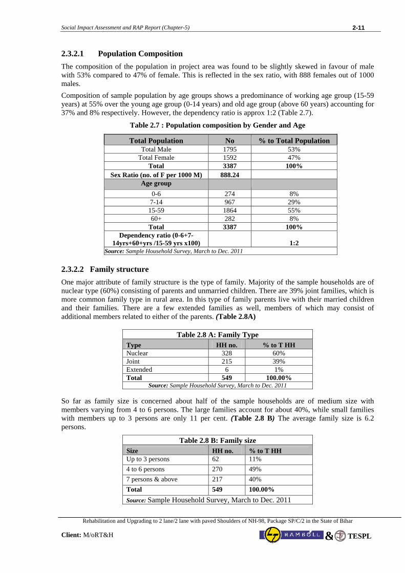
2.3.2.1 Population Composition
The composition of the population in project area was found to be slightly skewed in favour of male with 53% compared to 47% of female. This is reflected in the sex ratio, with 888 females out of 1000 males.
Composition of sample population by age groups shows a predominance of working age group (15-59 years) at 55% over the young age group (0-14 years) and old age group (above 60 years) accounting for 37% and 8% respectively. However, the dependency ratio is approx 1:2 (Table 2.7).
Table 2.7 : Population composition by Gender and Age
Total Population No % to Total Population Total Male 1795 53%
Total Female 1592 47% Total 3387 100%
Sex Ratio (no. of F per 1000 M) 888.24 Age group
0-6 274 8% 7-14 967 29%
15-59 1864 55% 60+ 282 8%
Total 3387 100% Dependency ratio (0-6+7-
14yrs+60+yrs /15-59 yrs x100) 1:2 Source: Sample Household Survey, March to Dec. 2011
2.3.2.2 Family structure
One major attribute of family structure is the type of family. Majority of the sample households are of nuclear type (60%) consisting of parents and unmarried children. There are 39% joint families, which is more common family type in rural area. In this type of family parents live with their married children and their families. There are a few extended families as well, members of which may consist of additional members related to either of the parents. (Table 2.8A)
Table 2.8 A: Family Type Type HH no. % to T HH Nuclear 328 60% Joint 215 39% Extended 6 1% Total 549 100.00%
Source: Sample Household Survey, March to Dec. 2011
So far as family size is concerned about half of the sample households are of medium size with members varying from 4 to 6 persons. The large families account for about 40%, while small families with members up to 3 persons are only 11 per cent. (Table 2.8 B) The average family size is 6.2 persons.
Table 2.8 B: Family size Size HH no. % to T HH Up to 3 persons 62 11% 4 to 6 persons 270 49% 7 persons & above 217 40% Total 549 100.00% Source: Sample Household Survey, March to Dec. 2011
Social Impact Assessment and RAP Report (Chapter-5)
Rehabilitation and Upgrading to 2 lane/2 lane with paved Shoulders of NH-98, Package SP/C/2 in the State of Bihar
Client: M/oRT&H
2-12
TESPL&
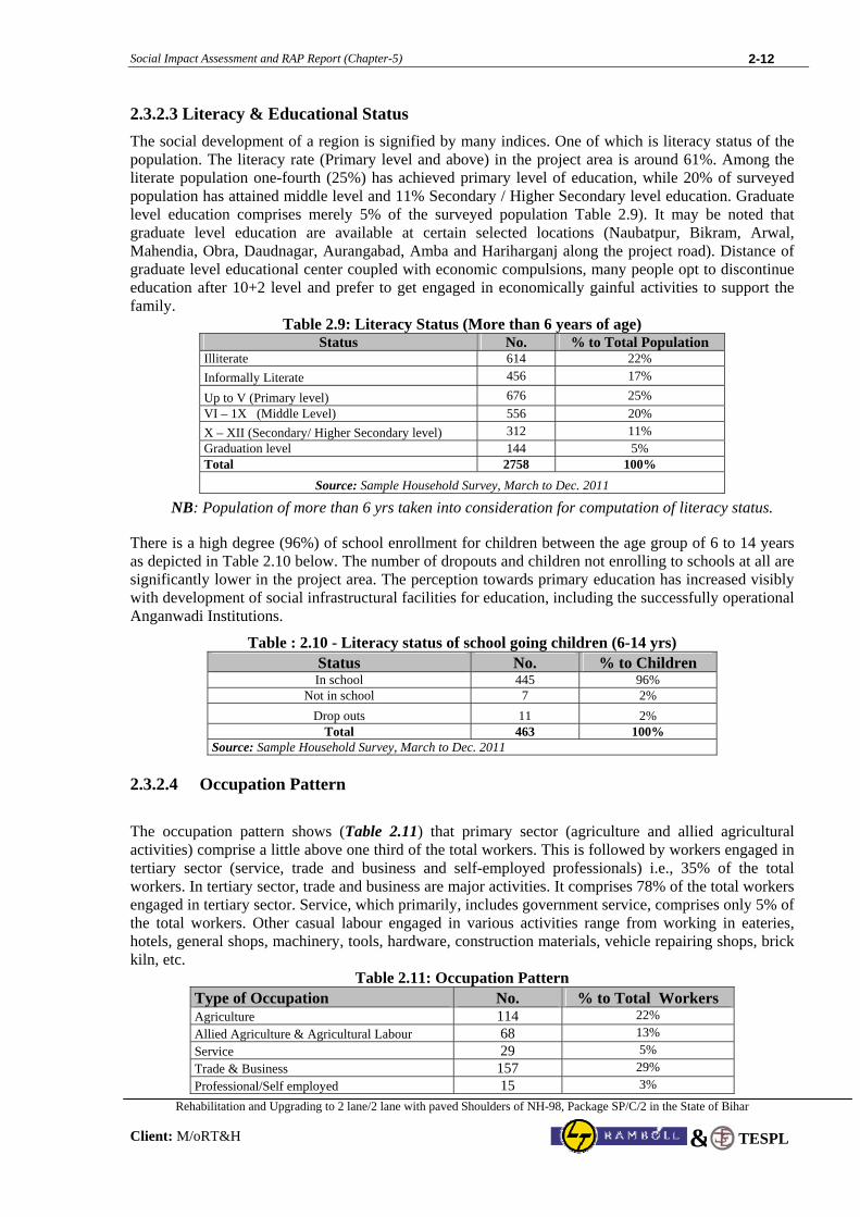
2.3.2.3 Literacy & Educational Status
The social development of a region is signified by many indices. One of which is literacy status of the population. The literacy rate (Primary level and above) in the project area is around 61%. Among the literate population one-fourth (25%) has achieved primary level of education, while 20% of surveyed population has attained middle level and 11% Secondary / Higher Secondary level education. Graduate level education comprises merely 5% of the surveyed population Table 2.9). It may be noted that graduate level education are available at certain selected locations (Naubatpur, Bikram, Arwal, Mahendia, Obra, Daudnagar, Aurangabad, Amba and Hariharganj along the project road). Distance of graduate level educational center coupled with economic compulsions, many people opt to discontinue education after 10+2 level and prefer to get engaged in economically gainful activities to support the family.
Table 2.9: Literacy Status (More than 6 years of age) Status No. % to Total Population
Illiterate 614 22% Informally Literate 456 17%
Up to V (Primary level) 676 25% VI – 1X (Middle Level) 556 20% X – XII (Secondary/ Higher Secondary level) 312 11% Graduation level 144 5% Total 2758 100%
Source: Sample Household Survey, March to Dec. 2011 NB: Population of more than 6 yrs taken into consideration for computation of literacy status.
There is a high degree (96%) of school enrollment for children between the age group of 6 to 14 years as depicted in Table 2.10 below. The number of dropouts and children not enrolling to schools at all are significantly lower in the project area. The perception towards primary education has increased visibly with development of social infrastructural facilities for education, including the successfully operational Anganwadi Institutions.
Table : 2.10 - Literacy status of school going children (6-14 yrs) Status No. % to Children In school 445 96%
Not in school 7 2% Drop outs 11 2%
Total 463 100% Source: Sample Household Survey, March to Dec. 2011
2.3.2.4 Occupation Pattern
The occupation pattern shows (Table 2.11) that primary sector (agriculture and allied agricultural activities) comprise a little above one third of the total workers. This is followed by workers engaged in tertiary sector (service, trade and business and self-employed professionals) i.e., 35% of the total workers. In tertiary sector, trade and business are major activities. It comprises 78% of the total workers engaged in tertiary sector. Service, which primarily, includes government service, comprises only 5% of the total workers. Other casual labour engaged in various activities range from working in eateries, hotels, general shops, machinery, tools, hardware, construction materials, vehicle repairing shops, brick kiln, etc.
Table 2.11: Occupation Pattern Type of Occupation No. % to Total Workers Agriculture 114 22% Allied Agriculture & Agricultural Labour 68 13% Service 29 5% Trade & Business 157 29% Professional/Self employed 15 3%
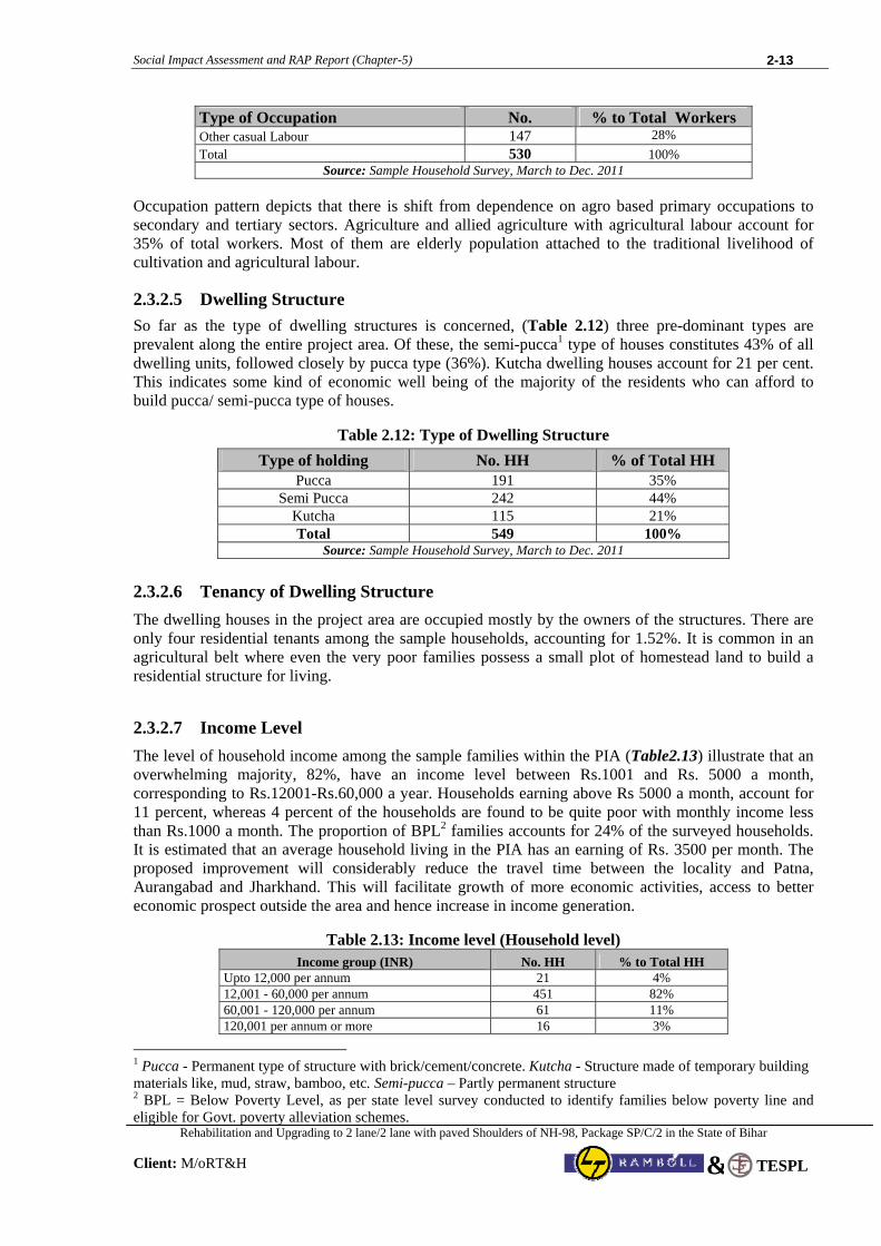
Social Impact Assessment and RAP Report (Chapter-5)
Rehabilitation and Upgrading to 2 lane/2 lane with paved Shoulders of NH-98, Package SP/C/2 in the State of Bihar
Client: M/oRT&H
2-13
TESPL&
Type of Occupation No. % to Total Workers Other casual Labour 147 28% Total 530 100%
Source: Sample Household Survey, March to Dec. 2011
Occupation pattern depicts that there is shift from dependence on agro based primary occupations to secondary and tertiary sectors. Agriculture and allied agriculture with agricultural labour account for 35% of total workers. Most of them are elderly population attached to the traditional livelihood of cultivation and agricultural labour.
2.3.2.5 Dwelling Structure
So far as the type of dwelling structures is concerned, (Table 2.12) three pre-dominant types are prevalent along the entire project area. Of these, the semi-pucca1 type of houses constitutes 43% of all dwelling units, followed closely by pucca type (36%). Kutcha dwelling houses account for 21 per cent. This indicates some kind of economic well being of the majority of the residents who can afford to build pucca/ semi-pucca type of houses.
Table 2.12: Type of Dwelling Structure Type of holding No. HH % of Total HH
Pucca 191 35% Semi Pucca 242 44%
Kutcha 115 21% Total 549 100%
Source: Sample Household Survey, March to Dec. 2011
2.3.2.6 Tenancy of Dwelling Structure
The dwelling houses in the project area are occupied mostly by the owners of the structures. There are only four residential tenants among the sample households, accounting for 1.52%. It is common in an agricultural belt where even the very poor families possess a small plot of homestead land to build a residential structure for living. 2.3.2.7 Income Level
The level of household income among the sample families within the PIA (Table2.13) illustrate that an overwhelming majority, 82%, have an income level between Rs.1001 and Rs. 5000 a month, corresponding to Rs.12001-Rs.60,000 a year. Households earning above Rs 5000 a month, account for 11 percent, whereas 4 percent of the households are found to be quite poor with monthly income less than Rs.1000 a month. The proportion of BPL2 families accounts for 24% of the surveyed households. It is estimated that an average household living in the PIA has an earning of Rs. 3500 per month. The proposed improvement will considerably reduce the travel time between the locality and Patna, Aurangabad and Jharkhand. This will facilitate growth of more economic activities, access to better economic prospect outside the area and hence increase in income generation.
Table 2.13: Income level (Household level) Income group (INR) No. HH % to Total HH
Upto 12,000 per annum 21 4% 12,001 - 60,000 per annum 451 82% 60,001 - 120,000 per annum 61 11% 120,001 per annum or more 16 3%
1 Pucca - Permanent type of structure with brick/cement/concrete. Kutcha - Structure made of temporary building materials like, mud, straw, bamboo, etc. Semi-pucca – Partly permanent structure 2 BPL = Below Poverty Level, as per state level survey conducted to identify families below poverty line and eligible for Govt. poverty alleviation schemes.
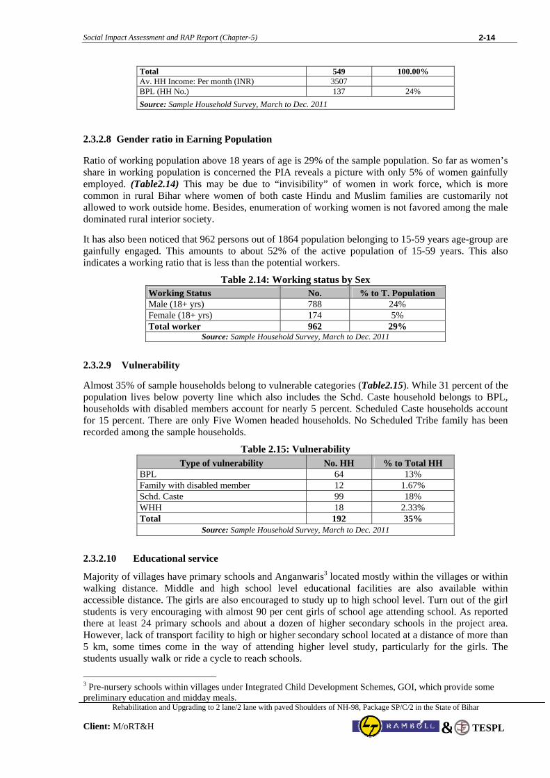
Social Impact Assessment and RAP Report (Chapter-5)
Rehabilitation and Upgrading to 2 lane/2 lane with paved Shoulders of NH-98, Package SP/C/2 in the State of Bihar
Client: M/oRT&H
2-14
TESPL&
Total 549 100.00% Av. HH Income: Per month (INR) 3507 BPL (HH No.) 137 24% Source: Sample Household Survey, March to Dec. 2011
2.3.2.8 Gender ratio in Earning Population
Ratio of working population above 18 years of age is 29% of the sample population. So far as women’s share in working population is concerned the PIA reveals a picture with only 5% of women gainfully employed. (Table2.14) This may be due to “invisibility” of women in work force, which is more common in rural Bihar where women of both caste Hindu and Muslim families are customarily not allowed to work outside home. Besides, enumeration of working women is not favored among the male dominated rural interior society. It has also been noticed that 962 persons out of 1864 population belonging to 15-59 years age-group are gainfully engaged. This amounts to about 52% of the active population of 15-59 years. This also indicates a working ratio that is less than the potential workers.
Table 2.14: Working status by Sex Working Status No. % to T. Population Male (18+ yrs) 788 24% Female (18+ yrs) 174 5% Total worker 962 29%
Source: Sample Household Survey, March to Dec. 2011
2.3.2.9 Vulnerability
Almost 35% of sample households belong to vulnerable categories (Table2.15). While 31 percent of the population lives below poverty line which also includes the Schd. Caste household belongs to BPL, households with disabled members account for nearly 5 percent. Scheduled Caste households account for 15 percent. There are only Five Women headed households. No Scheduled Tribe family has been recorded among the sample households.
Table 2.15: Vulnerability Type of vulnerability No. HH % to Total HH
BPL 64 13% Family with disabled member 12 1.67% Schd. Caste 99 18% WHH 18 2.33% Total 192 35%
Source: Sample Household Survey, March to Dec. 2011
2.3.2.10 Educational service
Majority of villages have primary schools and Anganwaris3 located mostly within the villages or within walking distance. Middle and high school level educational facilities are also available within accessible distance. The girls are also encouraged to study up to high school level. Turn out of the girl students is very encouraging with almost 90 per cent girls of school age attending school. As reported there at least 24 primary schools and about a dozen of higher secondary schools in the project area. However, lack of transport facility to high or higher secondary school located at a distance of more than 5 km, some times come in the way of attending higher level study, particularly for the girls. The students usually walk or ride a cycle to reach schools.
3 Pre-nursery schools within villages under Integrated Child Development Schemes, GOI, which provide some preliminary education and midday meals.
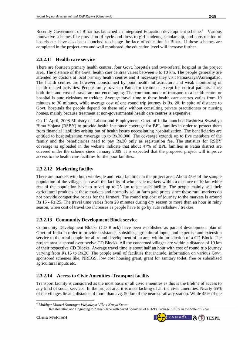
Social Impact Assessment and RAP Report (Chapter-5)
Rehabilitation and Upgrading to 2 lane/2 lane with paved Shoulders of NH-98, Package SP/C/2 in the State of Bihar
Client: M/oRT&H
2-15
TESPL&
Recently Government of Bihar has launched an Integrated Education development scheme.4 Various innovative schemes like provision of cycle and dress to girl students, scholarship, and construction of hostels etc. have also been launched to change the face of education in Bihar. If these schemes are completed in the project area and well monitored, the education level will increase further.
2.3.2.11 Health care service There are fourteen primary health centres, four Govt. hospitals and two-referral hospital in the project area. The distance of the Govt. health care centres varies between 5 to 10 km. The people generally are attended by doctors at local primary health centres and if necessary they visit Patna/Gaya/Aurangabad. The health centres are however, constrained by poor health infrastructure and weak monitoring of health related activities. People rarely travel to Patna for treatment except for critical patients, since both time and cost of travel are not encouraging. The common mode of transport to a health centre or hospital is auto rickshaw or trekker. Average travel time to these health care centres varies from 10 minutes to 30 minutes, while average cost of one round trip journey is Rs. 20. In spite of distance to Govt. hospitals the people depend on these only without consulting private practitioners or nursing homes, mainly because treatment at non-governmental health care centres is expensive.
On 1st April, 2008 Ministry of Labour and Employment, Govt. of India launched Rashtriya Swasthya Bima Yojana (RSBY) to provide health insurance coverage for BPL families in order to protect them from financial liabilities arising out of health issues necessitating hospitalization. The beneficiaries are entitled to hospitalization coverage up to Rs.30,000. The coverage extends up to five members of the family and the beneficiaries need to pay Rs.30 only as registration fee. The statistics for RSBY coverage as uploaded in the website indicate that about 47% of BPL families in Patna district are covered under the scheme since January 2009. It is expected that the proposed project will improve access to the health care facilities for the poor families.
2.3.2.12 Marketing facility There are markets with both wholesale and retail facilities in the project area. About 45% of the sample population of the villages can avail the facility of whole sale markets within a distance of 10 km while rest of the population have to travel up to 25 km to get such facility. The people mainly sell their agricultural products at these markets and normally sell at farm gate prices since these rural markets do not provide competitive prices for the farmers. The round trip cost of journey to the markets is around Rs 15 - Rs.25. The travel time varies from 20 minutes during dry season to more than an hour in rainy season, when cost of travel too increases as people have to go by auto rickshaw / trekker.
2.3.2.13 Community Development Block service Community Development Blocks (CD Block) have been established as part of development plan of Govt. of India in order to provide assistance, subsidies, agricultural inputs and expertise and extension service to the rural people for all round development of an area within jurisdiction of a CD Block. The project area is spread over twelve CD Blocks. All the concerned villages are within a distance of 10 km of their respective CD Blocks. Average travel time is about half an hour with cost of round trip journey varying from Rs.15 to Rs.20. The people avail of facilities that include, information on various Govt. sponsored schemes like, NREGS, low cost housing grant, grant for sanitary toilet, free or subsidized agricultural inputs etc.
2.3.2.14 Access to Civic Amenities -Transport facility
Transport facility is considered as the most basic of all civic amenities as this is the lifeline of access to any kind of social services. In the project area it is most lacking of all the civic amenities. Nearly 65% of the villages lie at a distance of more than avg. 50 km of the nearest railway station. While 45% of the 4 Mukhya Mantri Samagra Vidyalaya Vikas KaryaKram
Social Impact Assessment and RAP Report (Chapter-5)
Rehabilitation and Upgrading to 2 lane/2 lane with paved Shoulders of NH-98, Package SP/C/2 in the State of Bihar
Client: M/oRT&H
2-16
TESPL&
villages have access to express bus service within 10 km of their places, rest of the villagers have to travel up to 25 km to avail of such facility. The local buses, which are frequently used by the villagers to travel to CD Block offices, Govt. hospitals or wholesale markets, are accessible within 5 km of nearly 35%. The most common difficulty faced by the people is inadequate and irregular Govt. bus service, particularly to Patna, Aurangabad etc. Condition of the road network is bad to say the least, which worsens during rainy season. Lack of properly maintained road network system causes traffic hazard and often leads to accidents. The travel time is often doubled during rainy months as well as cost of travel by auto rickshaw and trekker since road condition in those months does not permit people of many villages to go by cycle or even by bullock cart. Attendance at schools, particularly for the young children from poor families touches a low during rainy months. Extremely poor road condition necessitates travel by auto rickshaw or trekker which is not always affordable for a poor parent. Although the project area is not severely affected by flood like situation, except a few villages, water logging causes extreme difficulty in transport for nearly 55% of the villages for a period of 10 to 15 days during rainy months.
2.3.2.15 Access to Civic Amenities -Sanitation facility
Sanitation facility is almost absent, except a few well-off families having interaction with outside world and means of installing. However, Govt. encourages people to install hygienic sanitation system in house through various schemes, like low cost subsidized sanitary toilet scheme. The reluctance to avail of such facility is partly due to people’s lack of awareness towards benefit of sanitation and partly due to more pressing household needs. C.D. Blocks, however, provide information on low cost sanitation system through IEC materials like posters and pamphlets.
2.3.2.16 Access to Civic Amenities - Drinking water facility
None of the villages have pipeline water supply. Neither there is any water purification facility installed by the Govt. People of most of the villages have access to clean drinking water from tube wells, hand pumps which are adequately installed in all the villages.
2.3.2.17 Women in decision-making
While discussing with the women in the project area during combined FGD sessions, it was apparent that they are brought up in a traditional conservative way. They are not accustomed to speak out their opinion or discuss about their specific concerns. It was also clearly visible that average woman’s status in a rural household and society is low. Lack of education among the elderly women is one of the reasons as expressed by the women. Women’s role in family matters was described in a few examples.
Excepting those few who work outside, the women hardly travel alone to visit medical centers or the place of relatives. However, women normally travel in a group all by themselves to sell agricultural or poultry / dairy produces at the local Haats. Lack of road safety and security (public transport vehicles without escorts) has been cited as the reasons for limited or no travelling after dusk. Women’s decision in family welfare planning is hardly effective, if not totally ignored. However during FGD session, the Anganwadi worker expressed her opinion that most of the women are aware of family planning method but very few currently use it. It was apparent that the women were hesitant to apply the method without expressed permission of their husbands. The decision of making the girls going to school has been a major achievement even in rural interior villages. Bihar Government’s new innovative scheme for encouraging girls attending school will go a
Social Impact Assessment and RAP Report (Chapter-5)
Rehabilitation and Upgrading to 2 lane/2 lane with paved Shoulders of NH-98, Package SP/C/2 in the State of Bihar
Client: M/oRT&H
2-17
TESPL&
long way in empowering the women. Under this scheme 163,000 girls all over Bihar were provided cycle during 2007-08.5 Govt. of Bihar has initiated several programmes for women empowerment and self-sustenance through Women Development Corporation, a Govt. undertaking as part of Social welfare Department, set up in 1990. Several projects are being implemented to uplift the condition of women, which include formation of Self Help Group (SHG) through Swamsiddha Project, Swashakti Project, etc. In the project area 50 SHGs are formed in different Blocks and Federation of SHGs have also been formed. One of the main objectives of SHG is to facilitate the groups in income generating activities, which are the only viable mode for women empowerment. No evaluation of these women SHGs has yet been done to measure the development of women in the area. The women assembled at the FGD session could not provide information about the outcome of the formation of SHGs in their neighborhood areas. 2.3.2.18 Indigenous People No Scheduled Tribe household has been identified during the survey; neither any mention of their existence has been made during FGD in the project area.
2.3.2.19 HIV/AIDS & Human Trafficking Risks No major threat for either spread of HIV/AIDS or human trafficking is perceived by the people. No such cases have yet been reported to the local Govt. or to the people informally. However, certain measures were suggested by the people to address these issues. These are: proper awareness campaign, distribution of IEC materials, more active role by police, CBO/NGO and PHCs, training to the village quacks and ANMs6 in early detection and people’s committee to keep vigil.
5 Mukhya Mantri Balika Cycle Yojana 6 ANM – Auxiliary Nurse and Midwife employed through BDO in rural areas

Social Impact Assessment and RAP Report (Chapter -3) 3 - 1
Rehabilitation and Upgrading to 2 lane/2 lane with paved Shoulders of NH-98, Package SP/C/2 in the State of Bihar
Client: M/oRT&H TESPL&
CHAPTER 3
PROPOSED IMPROVEMENT PLAN AND IMPACT ASSESSMENT PROCESS
3.1 Introduction
The present project road NH-98 under consideration for Rehabilitation and Upgrading to 2 lane/2 lane with paved shoulders configuration and strengthening of Anisabad - Aurangabad – Hariharganj Section (Km. 0 to Km. 154.625) of NH-98 Package no. SC/P/2 aims to:
• improve and strengthen the existing quality of the pavement to take heavy loads so that pavement failure, maintenance etc. are minimized.
• improve the horizontal and vertical alignment of the existing road. • improve the existing speed of traffic flow by removing all bottlenecks at various important
junctions. • increase the carrying capacity of the existing traffic volume and enable it to cater to the future
traffic. • improve accessibility of the existing highway. • provide highway amenities like Lay-by, bus stop etc. • improve the numerous intersections on entire stretch of the highway linkage of the NH-98
within the section (0.00 Km. to 154.625 Km.) 3.2 Design Considerations 3.2.1 Proposed Design Standards for Highway
Geometric design standards for rural (Non-urban) Highways” IRC-73-1980 has been used for study of project road passing through rural areas. To set the Geometric design for Urban Section ie sections where the highway is passing through the existing villages & Built-up zone, "Geometric Design for Urban Highways" IRC-86-1983 has been adhered to. The adopted cross-sectional element as per Design Standard is presented in Table 3.1 below:
Table 3.1: Adopted Cross-Sectional Elements
Element Characteristics Design Value Right of Way To the extent available Land width to avoid Land extra
Land Acquisition Minimum 15 m. and Maximum 30 m. Carriage way 7 m Road way width 12 m
Paved 1.50 m Shoulder Earthen 1.00 m
Cross fall (Carriage way) 2.5 % Paved shoulder 2.5 % Earthen shoulder 3.5 % Side slope of embankment (In Fill) 1:2 Side slope in Cut Section 1:2 Design Speed In the project highway of NH-98, there is a significant
percentage of slow as well as heavy vehicles. A design speed in rural areas has been adopted as 80 km/h where as in Urban/Built-up congested area; the design speed proposed is 40 km/h.
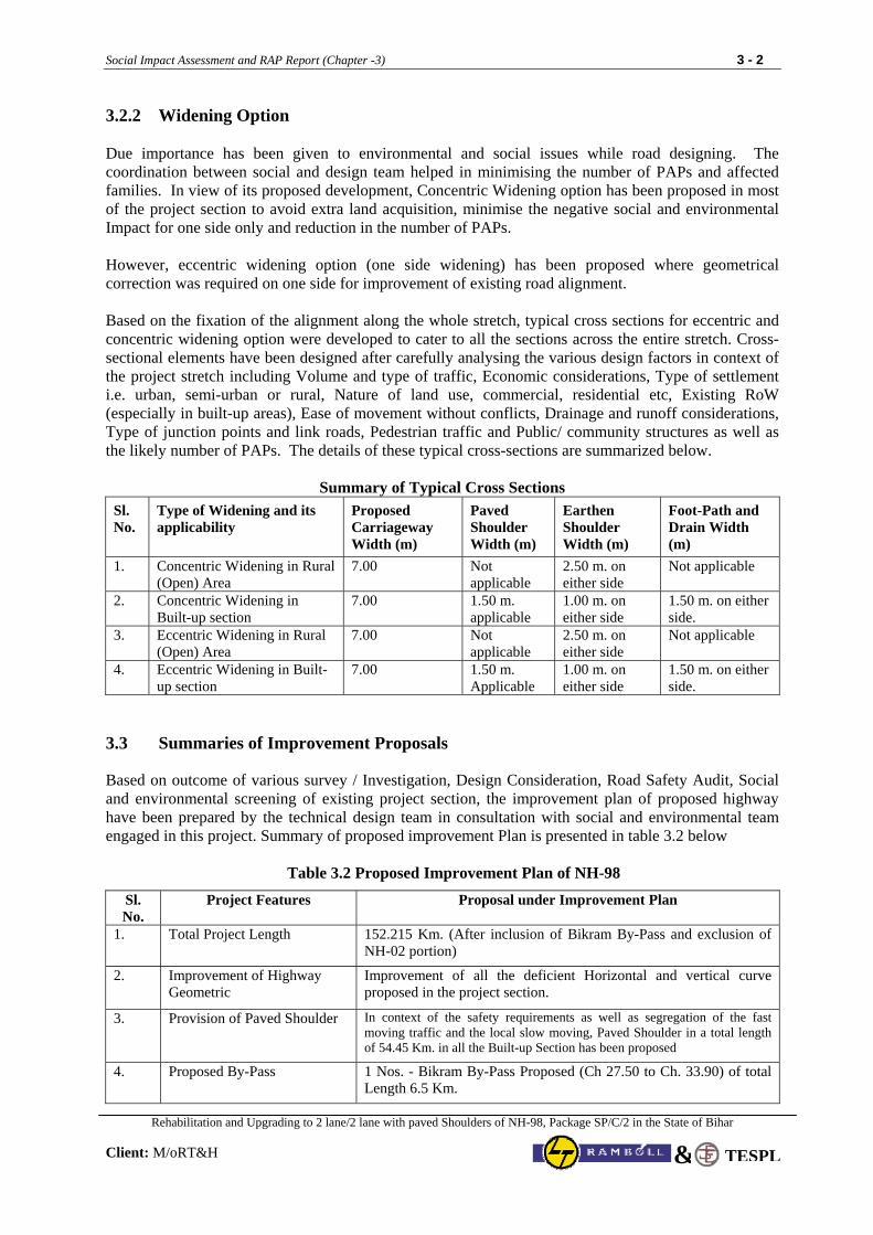
Social Impact Assessment and RAP Report (Chapter -3) 3 - 2
Rehabilitation and Upgrading to 2 lane/2 lane with paved Shoulders of NH-98, Package SP/C/2 in the State of Bihar
Client: M/oRT&H TESPL&
3.2.2 Widening Option Due importance has been given to environmental and social issues while road designing. The coordination between social and design team helped in minimising the number of PAPs and affected families. In view of its proposed development, Concentric Widening option has been proposed in most of the project section to avoid extra land acquisition, minimise the negative social and environmental Impact for one side only and reduction in the number of PAPs. However, eccentric widening option (one side widening) has been proposed where geometrical correction was required on one side for improvement of existing road alignment. Based on the fixation of the alignment along the whole stretch, typical cross sections for eccentric and concentric widening option were developed to cater to all the sections across the entire stretch. Cross-sectional elements have been designed after carefully analysing the various design factors in context of the project stretch including Volume and type of traffic, Economic considerations, Type of settlement i.e. urban, semi-urban or rural, Nature of land use, commercial, residential etc, Existing RoW (especially in built-up areas), Ease of movement without conflicts, Drainage and runoff considerations, Type of junction points and link roads, Pedestrian traffic and Public/ community structures as well as the likely number of PAPs. The details of these typical cross-sections are summarized below.
Summary of Typical Cross Sections Sl. No.
Type of Widening and its applicability
Proposed Carriageway Width (m)
Paved Shoulder Width (m)
Earthen Shoulder Width (m)
Foot-Path and Drain Width (m)
1. Concentric Widening in Rural (Open) Area
7.00 Not applicable
2.50 m. on either side
Not applicable
2.
Concentric Widening in Built-up section
7.00 1.50 m. applicable
1.00 m. on either side
1.50 m. on either side.
3. Eccentric Widening in Rural (Open) Area
7.00 Not applicable
2.50 m. on either side
Not applicable
4. Eccentric Widening in Built-up section
7.00 1.50 m. Applicable
1.00 m. on either side
1.50 m. on either side.
3.3 Summaries of Improvement Proposals
Based on outcome of various survey / Investigation, Design Consideration, Road Safety Audit, Social and environmental screening of existing project section, the improvement plan of proposed highway have been prepared by the technical design team in consultation with social and environmental team engaged in this project. Summary of proposed improvement Plan is presented in table 3.2 below
Table 3.2 Proposed Improvement Plan of NH-98
Sl. No.
Project Features Proposal under Improvement Plan
1. Total Project Length 152.215 Km. (After inclusion of Bikram By-Pass and exclusion of NH-02 portion)
2. Improvement of Highway Geometric
Improvement of all the deficient Horizontal and vertical curve proposed in the project section.
3. Provision of Paved Shoulder In context of the safety requirements as well as segregation of the fast moving traffic and the local slow moving, Paved Shoulder in a total length of 54.45 Km. in all the Built-up Section has been proposed
4. Proposed By-Pass 1 Nos. - Bikram By-Pass Proposed (Ch 27.50 to Ch. 33.90) of total Length 6.5 Km.
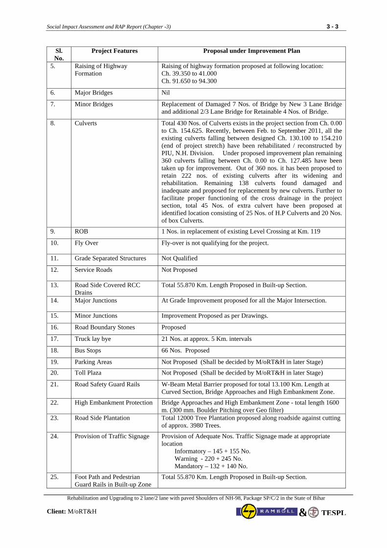
Social Impact Assessment and RAP Report (Chapter -3) 3 - 3
Rehabilitation and Upgrading to 2 lane/2 lane with paved Shoulders of NH-98, Package SP/C/2 in the State of Bihar
Client: M/oRT&H TESPL&
Sl. No.
Project Features Proposal under Improvement Plan
5.
Raising of Highway Formation
Raising of highway formation proposed at following location: Ch. 39.350 to 41.000 Ch. 91.650 to 94.300
6. Major Bridges Nil
7. Minor Bridges Replacement of Damaged 7 Nos. of Bridge by New 3 Lane Bridge and additional 2/3 Lane Bridge for Retainable 4 Nos. of Bridge.
8. Culverts
Total 430 Nos. of Culverts exists in the project section from Ch. 0.00 to Ch. 154.625. Recently, between Feb. to September 2011, all the existing culverts falling between designed Ch. 130.100 to 154.210 (end of project stretch) have been rehabilitated / reconstructed by PIU, N.H. Division. Under proposed improvement plan remaining 360 culverts falling between Ch. 0.00 to Ch. 127.485 have been taken up for improvement. Out of 360 nos. it has been proposed to retain 222 nos. of existing culverts after its widening and rehabilitation. Remaining 138 culverts found damaged and inadequate and proposed for replacement by new culverts. Further to facilitate proper functioning of the cross drainage in the project section, total 45 Nos. of extra culvert have been proposed at identified location consisting of 25 Nos. of H.P Culverts and 20 Nos. of box Culverts.
9. ROB 1 Nos. in replacement of existing Level Crossing at Km. 119
10.
Fly Over Fly-over is not qualifying for the project.
11. Grade Separated Structures Not Qualified
12. Service Roads Not Proposed
13. Road Side Covered RCC Drains
Total 55.870 Km. Length Proposed in Built-up Section.
14. Major Junctions At Grade Improvement proposed for all the Major Intersection.
15. Minor Junctions Improvement Proposed as per Drawings.
16. Road Boundary Stones Proposed
17. Truck lay bye 21 Nos. at approx. 5 Km. intervals
18. Bus Stops 66 Nos. Proposed
19. Parking Areas Not Proposed (Shall be decided by M/oRT&H in later Stage)
20. Toll Plaza Not Proposed (Shall be decided by M/oRT&H in later Stage)
21. Road Safety Guard Rails W-Beam Metal Barrier proposed for total 13.100 Km. Length at Curved Section, Bridge Approaches and High Embankment Zone.
22. High Embankment Protection Bridge Approaches and High Embankment Zone - total length 1600 m. (300 mm. Boulder Pitching over Geo filter)
23. Road Side Plantation
Total 12000 Tree Plantation proposed along roadside against cutting of approx. 3980 Trees.
24. Provision of Traffic Signage
Provision of Adequate Nos. Traffic Signage made at appropriate location Informatory – 145 + 155 No. Warning - 220 + 245 No. Mandatory – 132 + 140 No.
25.
Foot Path and Pedestrian Guard Rails in Built-up Zone
Total 55.870 Km. Length Proposed in Built-up Section.
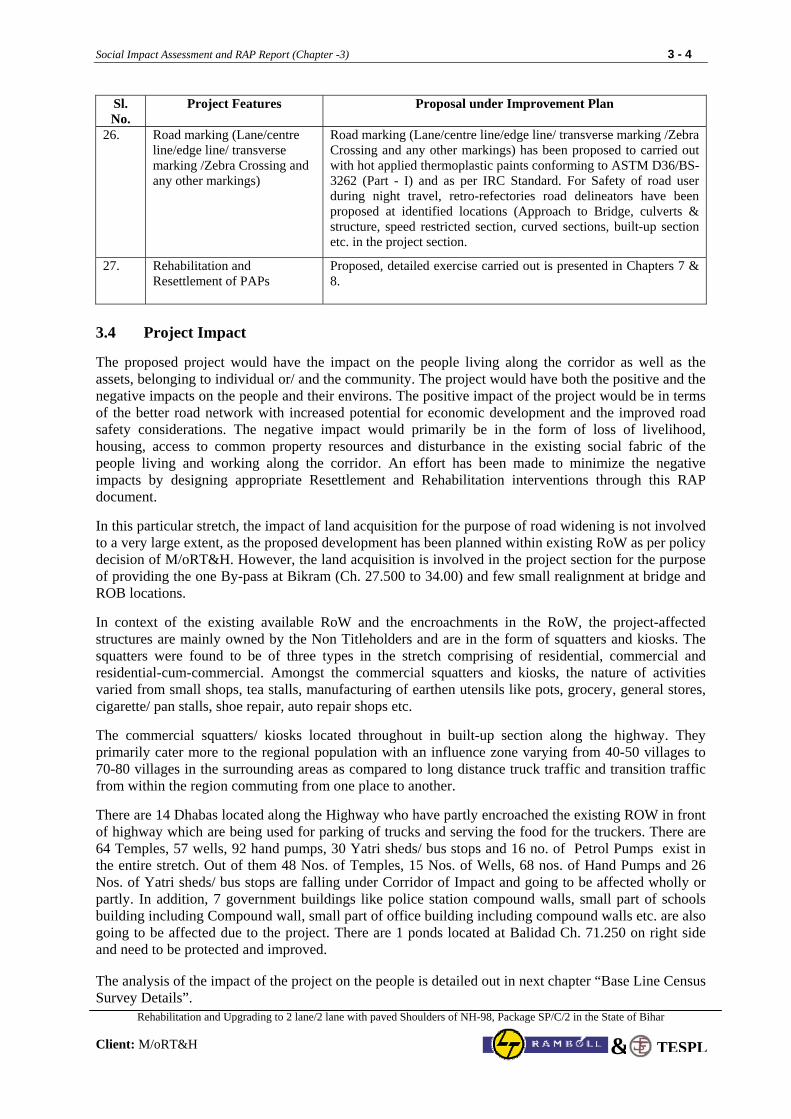
Social Impact Assessment and RAP Report (Chapter -3) 3 - 4
Rehabilitation and Upgrading to 2 lane/2 lane with paved Shoulders of NH-98, Package SP/C/2 in the State of Bihar
Client: M/oRT&H TESPL&
Sl. No.
Project Features Proposal under Improvement Plan
26.
Road marking (Lane/centre line/edge line/ transverse marking /Zebra Crossing and any other markings)
Road marking (Lane/centre line/edge line/ transverse marking /Zebra Crossing and any other markings) has been proposed to carried out with hot applied thermoplastic paints conforming to ASTM D36/BS-3262 (Part - I) and as per IRC Standard. For Safety of road user during night travel, retro-refectories road delineators have been proposed at identified locations (Approach to Bridge, culverts & structure, speed restricted section, curved sections, built-up section etc. in the project section.
27.
Rehabilitation and Resettlement of PAPs
Proposed, detailed exercise carried out is presented in Chapters 7 & 8.
3.4 Project Impact The proposed project would have the impact on the people living along the corridor as well as the assets, belonging to individual or/ and the community. The project would have both the positive and the negative impacts on the people and their environs. The positive impact of the project would be in terms of the better road network with increased potential for economic development and the improved road safety considerations. The negative impact would primarily be in the form of loss of livelihood, housing, access to common property resources and disturbance in the existing social fabric of the people living and working along the corridor. An effort has been made to minimize the negative impacts by designing appropriate Resettlement and Rehabilitation interventions through this RAP document. In this particular stretch, the impact of land acquisition for the purpose of road widening is not involved to a very large extent, as the proposed development has been planned within existing RoW as per policy decision of M/oRT&H. However, the land acquisition is involved in the project section for the purpose of providing the one By-pass at Bikram (Ch. 27.500 to 34.00) and few small realignment at bridge and ROB locations. In context of the existing available RoW and the encroachments in the RoW, the project-affected structures are mainly owned by the Non Titleholders and are in the form of squatters and kiosks. The squatters were found to be of three types in the stretch comprising of residential, commercial and residential-cum-commercial. Amongst the commercial squatters and kiosks, the nature of activities varied from small shops, tea stalls, manufacturing of earthen utensils like pots, grocery, general stores, cigarette/ pan stalls, shoe repair, auto repair shops etc. The commercial squatters/ kiosks located throughout in built-up section along the highway. They primarily cater more to the regional population with an influence zone varying from 40-50 villages to 70-80 villages in the surrounding areas as compared to long distance truck traffic and transition traffic from within the region commuting from one place to another. There are 14 Dhabas located along the Highway who have partly encroached the existing ROW in front of highway which are being used for parking of trucks and serving the food for the truckers. There are 64 Temples, 57 wells, 92 hand pumps, 30 Yatri sheds/ bus stops and 16 no. of Petrol Pumps exist in the entire stretch. Out of them 48 Nos. of Temples, 15 Nos. of Wells, 68 nos. of Hand Pumps and 26 Nos. of Yatri sheds/ bus stops are falling under Corridor of Impact and going to be affected wholly or partly. In addition, 7 government buildings like police station compound walls, small part of schools building including Compound wall, small part of office building including compound walls etc. are also going to be affected due to the project. There are 1 ponds located at Balidad Ch. 71.250 on right side and need to be protected and improved.
The analysis of the impact of the project on the people is detailed out in next chapter “Base Line Census Survey Details”.
Social Impact Assessment and RAP Report (Chapter -3) 3 - 5
Rehabilitation and Upgrading to 2 lane/2 lane with paved Shoulders of NH-98, Package SP/C/2 in the State of Bihar
Client: M/oRT&H TESPL&
3.5 Social Assessment Process
The assessment of social impact on the people, who are going to be affected with respect to their place of living or livelihood or otherwise, is an important exercise in the project planning and designing. In context of present project for the 2-lane/2 lane with paved shoulders configuration and strengthening of the NH-98, the tasks performed as a part of the ToR and the methodology adopted includes:
a. Reconnaissance and observation visits to the project stretch to • understand the broad settlement pattern and the physical features along the highway • identify the critical sections of the road stretch • develop an understanding of the general socio-economic profile and activity pattern along the
highway
b. Collection of information from secondary sources including net scanning.
c. Mapping out the socially critical points on the strip plan and preparation of inventory of loss of assets in the RoW to make a preliminary assessment of loss.
d. Identification of key persons for the critical sections through informal discussions with the likely PAPs.
e. Consultations with the likely PAPs as well as other key stakeholders including NGOs, district administration, local government etc using focus group discussions, consultation meetings and other participatory tools for the assessment to • develop rapport with the stakeholders including likely PAPs • identify the key social issues • assess likely impact on land, livelihood, structures, social cohesion, safety of the road users • get people's view for various aspects of road design
f. Group discussions with other members of the team including engineers, environmental experts, transport experts, economists etc to • share the social concerns, issues and impact of the project on the socio-economic conditions of
the people • build consensus on the issues • develop options for addressing the technical, environmental and social concerns in the design • develop agreement on the option which minimize and mitigate the negative impacts of the
project through appropriate design provisions, as well as technically and environmentally feasible.
f. Development and field-testing of the tools developed for detailed investigations.
g. Census and Socio-economic surveys of the project affected households including • Survey of non-titleholders within RoW in two categories i.e. squatters and kiosks. • Survey of titleholders whose land is going to be acquired for the purpose of improvement in the
geometric design, By-passes or other road strengthening measures.
h. Analysis of census and socio-economic surveys for the purpose of preparation of resettlement action plan and working out the policy framework.
3.6 Corridor of Impact (CoI)
In context of present project improvement of NH-98 as 2-lane/2 lane with paved shoulders configuration, the Corridor of Impact was the most important parameter in determining the number of PAPs. The requirement of the project demands that the entire corridor of impact should be free from any encroachment, human habitation and structure causing hindrances to traffic. Removing the encroachers and the squatters from the RoW does not guarantee that they would not reoccupy the area. Therefore, all estimations were limited to the CoI only and the project will not displace any person outside the corridor of impact, even if within the RoW.
Social Impact Assessment and RAP Report (Chapter -3) 3 - 6
Rehabilitation and Upgrading to 2 lane/2 lane with paved Shoulders of NH-98, Package SP/C/2 in the State of Bihar
Client: M/oRT&H TESPL&
In general, for the present project, the width of the COI has been fixed to 16 m. (ie 8 m. on either side from centreline of highway) for open / rural area as well as for Built-up Section. In the majority of the cases, the COI is well within the RoW. For location in the project where By-pass and minor realignment proposed the COI was extended upto proposed ROW boundary.
During the entire phase of implementation of this project under World Bank funding, if additional COI will be required any where in the project section as per design requirement, the compensation to the PAFs falling within the additional COI section will be made as per entitlement provision under this RAP only.
3.7 Consultation Methodology
The public consultations were organized at two stages, i.e. at the feasibility stage and the final round of consultations at the DPR stage. The feasibility stage public consultations focused manly on the mapping of the social issues related to the project stretch and were targeted to understand the concerns and aspirations of the people from the road project. The second round of public consultations were primarily centred around sharing of the proposed development plan and the broad R&R policy framework with the PAPs to get their views on the development proposals and the issues related to resettlement and rehabilitation. In addition to the consultations with the PAPs, interactions and consultations were held with other stakeholders especially the Gram Pradhans, NGOs, district administration to elicit their views and mobilize support for the implementation phase. The consultations with the officials of district administration including land revenue conducted under the Chairmanship of District Magistrate helped in getting assurance from them in terms of all the cooperation and support for the implementation of the project as well as nomination of the Competent Authorities.
In light of the issues that have emerged during the consultation process, the following key principles were derived for the design considerations: • minimization of the land acquisition • minimization of the displacement and relocation • provision of adequate road safety measures in the road design including service roads, safe
movement across the highway, parking places and stops for the local public vehicles 3.8 Census Surveys and Structure Marking
The surveys were carried out keeping in view the requirements for the assessment of the category and quantum of losses, so that the entitlements can be evolved in a logical and scientific manner. The census and socio-economic survey (carried out jointly as 100% of the PAPs to be covered under the socio-economic surveys) has been carried out to ensure that each and every affected and displaced person is identified and his entitlements are worked out and the expenditure estimates are determined on the basis of the entitlements. The census and socio-economic survey has been carried out for the 100% of the non-titleholder PAPs as well as 100% titleholder structures.
Socio-economic survey covers 50-60% of the total land owners likely to lose land due to proposed acquisition in different villages. This is mainly due to two reasons namely, (i) absentee land owners i.e., land owners staying away from the affected villages in which the land is proposed to be acquired and, (ii) non-publication of land acquisition Notification under section “3A” of NH Act, 1956. As such, land owners have not given due weightage to the ongoing survey. However, based on the information/data collected from villagers and total no. of plots likely to be acquired, projected number of PAPs have been worked out and estimate prepared. The NGO to be appointed for the implementation of RAP will collect socio-economic survey details from land owners who could not be covered at this stage.
Each and every structure within the CoI was measured. The location, size and shape, type of construction of the structures were recorded. Information about the structure of the household/ family,
Social Impact Assessment and RAP Report (Chapter -3) 3 - 7
Rehabilitation and Upgrading to 2 lane/2 lane with paved Shoulders of NH-98, Package SP/C/2 in the State of Bihar
Client: M/oRT&H TESPL&
occupation, literacy level, income and other social information to determine whether the households were to be categorized as vulnerable (for special considerations under the entitlement framework of the project) was collected. Revenue records were used for verifications of legal RoW and boundaries of private property likely to be within CoI. Assets such as boundary wall, public property and institutions were also recorded. With the completion of final designs for the project, only those within the actual CoI had been considered eligible for entitlement under the project. Coding of all the Structure going to be affected in the Project section has been done in following way Census Survey Code:
State Code Package No. District Code Format No. BH SPC2 028 001
The questionnaire no. for the same has been taken as
Km. Status of PAP Number 006 LRO / LCO/LRCO/ LRT /LCT/LRCT/
RRO/RCO/RRCO/RRT/RCT/RRCT 001
The Notation given for Status of PAPS is as presented below:
Notation Explanation Notation Explanation LRO Left Side Residential Owner RRO Right Side Residential Owner LCO Left Side Commercial Owner RCO Right Side Commercial Owner LRCO Left Side Residential & Commercial Owner RRCO Right Side Residential & Commercial Owner LRT Left Side Residential Tenant RRT Right Side Residential Tenant LCT Left Side Commercial RCT Right Side Commercial LRCT Left Side Residential & Commercial Tenant
RRCT Right Side Residential & Commercial Tenant From the Questionnaire no. any one can easily identify the location and Status of PAPs in the Project Section. For Example the questionnaire no. 16-RRO-06 represent the PAP situated in 16th Km. on Right Side and He/she belongs to Residential Owner category and his number is 6th which is the same as mentioned in format no. of Census Survey Code. 3.9 Social Issues As already mentioned, the project stretch passes through the three districts of Bihar and the social profiling of the whole stretch has been summarised in the Box below.
Socio-economic Profiling
The three districts share a very common socio-economic profile. A large share of rural population in the project stretch is the one who have either small land holdings or are working as agriculture labours in others land or other forms of labour work. The socio-economic profiling carried out during the public consultations and FGD also confirms the same. Emergence of economic activities in the informal sector all along the NH is also an outcome of the poverty levels in the region, where people have squatted in the RoW land to do small business for their livelihood or have squatted to reside in the roadside to utilize the small pieces of land available with them for agricultural purposes. The R&R policy needs to consider this basic profile of the project stretch in order to evolve a realistic policy framework.
In context of the project stretch from Anishabad – Aurangabad – Hariharganj, the common issues and concern that emerged across the whole stretch include:
majority of the project affected persons in the stretch are poor non-titleholders and their concern was that whether the government would do something for their welfare as they do not have any alternative source for their livelihood;
Social Impact Assessment and RAP Report (Chapter -3) 3 - 8
Rehabilitation and Upgrading to 2 lane/2 lane with paved Shoulders of NH-98, Package SP/C/2 in the State of Bihar
Client: M/oRT&H TESPL&
when would they be required to shift and where will they go as they do not have any alternative, their concern was that if they are relocated to places away from the highway, they would lose opportunities for small business what they get now as a result of the highway;
how much time would it take in getting the compensation if the land is acquired, as majority of them have doubt on delayed and lengthy compensation procedure of Government.
from where they will get water if the public hand-pumps are removed by the project as the major part of the project affected persons are dependent on the community hand-pumps installed in the area for their daily water needs;
there are large number of small roads converging into the highway near the road side settlements, which cater to the group of villages in the surrounding areas, and the people from these villages are connected to the main market centres through this highway, the concern expressed by the people was that the highway would lead to an increase in the accidents; and
if the traffic on the road would move at very high speeds, the risk for accidents would be very high especially for slow moving traffic, pedestrians and the cyclist, the issue was particularly highlighted in a big way at the sections where the settlement is spread across both the sides of the road or where the village boundaries cut across the road or where the schools are located on one side of the road and settlement on the other.
The other critical issues in this stretch are the ones related to status of women and a very high percentage of vulnerable groups located along the stretch and forming part of the PAPs group getting affected. Status of Women
Assessment of the activity pattern and time used by women for different activities is a reflection of the pressure on them. Starting from the work at home, work in the agricultural fields, work related to animals to fetching water from the hand-pumps are all part of women's responsibility. The major part of the stretch depends on the hand-pumps for its water needs; the issue of replacement of hand-pumps attains a very special significance in context of the women.
Vulnerable Groups
Bihar had 40.8% of population below poverty line in comparison with the national average of 29.3% as per the survey conducted in 1987-88 and the below poverty line population increased to 54.96% in 1993-94 as per National Sample Survey Organization, Government of India (NSSO) data. As per the NSSO report of 1999-2000, Bihar has 43 million (i.e. second highest) people below poverty line. Agriculture is the predominant occupation in the project area and in context of the socio-economic profile of the region in the project stretch, the main vulnerable groups are:
Poor and landless people/ small marginal farmers. Scheduled castes and scheduled tribes Rural women, single headed women households, children, and the handicapped persons.
Since agriculture is the main activity in the project area, a large number of poor and landless people work as agricultural labourers and live on subsistence level. Majority of the agriculture labours are from Schd. Caste and OBC households. As per the detailed survey and assessment carried our, nearly 55% of the PAPs would come under the vulnerable category and their specific need as emerged during the assessment would be upgradation of skills through training for alternative livelihood options. In the other vulnerable groups, the physically handicapped, the children, the aged and the single headed female households and rural women are worth mentioning. The detailed analysis of the vulnerability has been carried out based on the surveys and detailed consultations with the PAPs and presented in next chapter.
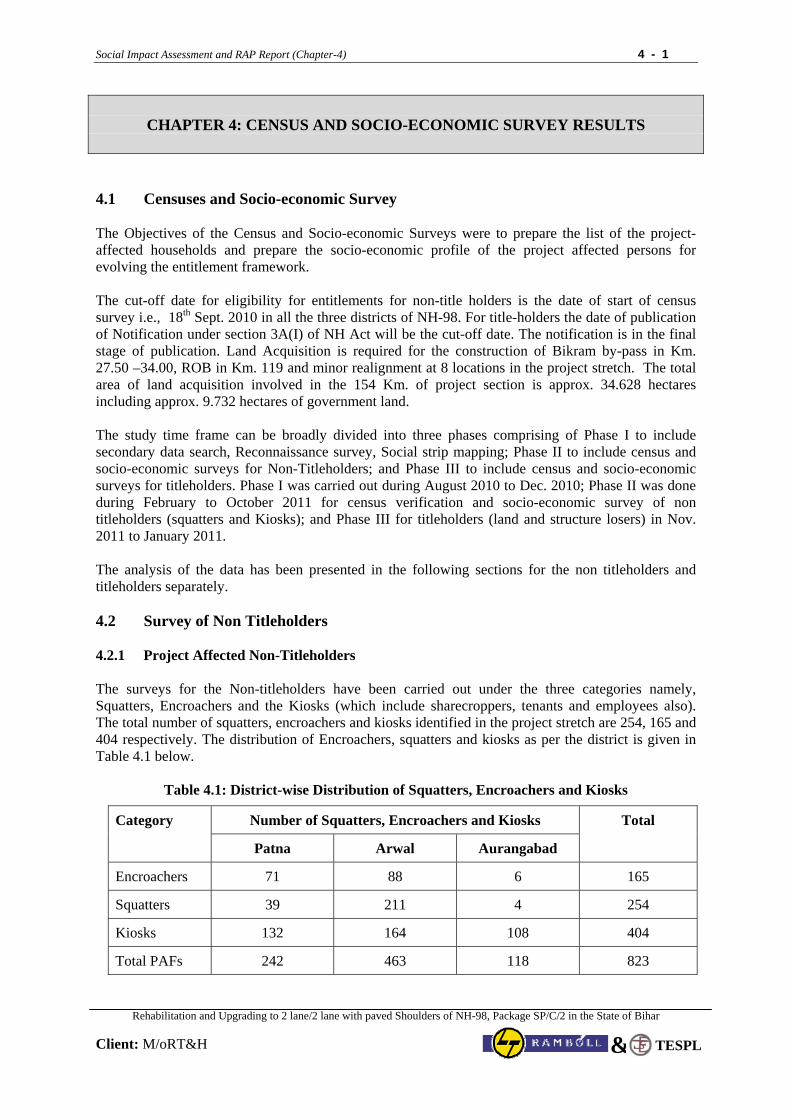
Social Impact Assessment and RAP Report (Chapter-4) 4 - 1
Rehabilitation and Upgrading to 2 lane/2 lane with paved Shoulders of NH-98, Package SP/C/2 in the State of Bihar
Client: M/oRT&H
TESPL&
CHAPTER 4: CENSUS AND SOCIO-ECONOMIC SURVEY RESULTS
4.1 Censuses and Socio-economic Survey The Objectives of the Census and Socio-economic Surveys were to prepare the list of the project-affected households and prepare the socio-economic profile of the project affected persons for evolving the entitlement framework. The cut-off date for eligibility for entitlements for non-title holders is the date of start of census survey i.e., 18th Sept. 2010 in all the three districts of NH-98. For title-holders the date of publication of Notification under section 3A(I) of NH Act will be the cut-off date. The notification is in the final stage of publication. Land Acquisition is required for the construction of Bikram by-pass in Km. 27.50 –34.00, ROB in Km. 119 and minor realignment at 8 locations in the project stretch. The total area of land acquisition involved in the 154 Km. of project section is approx. 34.628 hectares including approx. 9.732 hectares of government land. The study time frame can be broadly divided into three phases comprising of Phase I to include secondary data search, Reconnaissance survey, Social strip mapping; Phase II to include census and socio-economic surveys for Non-Titleholders; and Phase III to include census and socio-economic surveys for titleholders. Phase I was carried out during August 2010 to Dec. 2010; Phase II was done during February to October 2011 for census verification and socio-economic survey of non titleholders (squatters and Kiosks); and Phase III for titleholders (land and structure losers) in Nov. 2011 to January 2011. The analysis of the data has been presented in the following sections for the non titleholders and titleholders separately. 4.2 Survey of Non Titleholders 4.2.1 Project Affected Non-Titleholders The surveys for the Non-titleholders have been carried out under the three categories namely, Squatters, Encroachers and the Kiosks (which include sharecroppers, tenants and employees also). The total number of squatters, encroachers and kiosks identified in the project stretch are 254, 165 and 404 respectively. The distribution of Encroachers, squatters and kiosks as per the district is given in Table 4.1 below.
Table 4.1: District-wise Distribution of Squatters, Encroachers and Kiosks
Number of Squatters, Encroachers and Kiosks Category
Patna Arwal Aurangabad
Total
Encroachers 71 88 6 165
Squatters 39 211 4 254
Kiosks 132 164 108 404
Total PAFs 242 463 118 823
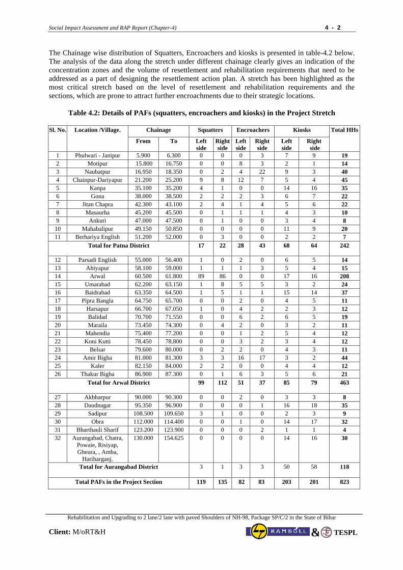
Social Impact Assessment and RAP Report (Chapter-4) 4 - 2
Rehabilitation and Upgrading to 2 lane/2 lane with paved Shoulders of NH-98, Package SP/C/2 in the State of Bihar
Client: M/oRT&H
TESPL&
The Chainage wise distribution of Squatters, Encroachers and kiosks is presented in table-4.2 below. The analysis of the data along the stretch under different chainage clearly gives an indication of the concentration zones and the volume of resettlement and rehabilitation requirements that need to be addressed as a part of designing the resettlement action plan. A stretch has been highlighted as the most critical stretch based on the level of resettlement and rehabilitation requirements and the sections, which are prone to attract further encroachments due to their strategic locations.
Table 4.2: Details of PAFs (squatters, encroachers and kiosks) in the Project Stretch
Chainage Squatters Encroachers Kiosks Sl. No. Location /Village.
From To Left side
Right side
Left side
Right side
Left side
Right side
Total HHs
1 Phulwari - Janipur 5.900 6.300 0 0 0 3 7 9 19 2 Motipur 15.800 16.750 0 0 8 3 2 1 14 3 Naubatpur 16.950 18.350 0 2 4 22 9 3 40 4 Chainpur-Dariyapur 21.200 25.200 9 8 12 7 5 4 45 5 Kanpa 35.100 35.200 4 1 0 0 14 16 35 6 Gona 38.000 38.500 2 2 2 3 6 7 22 7 Jitan Chapra 42.300 43.100 2 4 1 4 5 6 22 8 Masaurha 45.200 45.500 0 1 1 1 4 3 10 9 Ankuri 47.000 47.500 0 1 0 0 3 4 8
10 Mahabalipur 49.150 50.850 0 0 0 0 11 9 20 11 Berhariya English 51.200 52.000 0 3 0 0 2 2 7
Total for Patna District 17 22 28 43 68 64 242
12 Parsadi English 55.000 56.400 1 0 2 0 6 5 14 13 Ahiyapur 58.100 59.000 1 1 1 3 5 4 15 14 Arwal 60.500 61.800 89 86 0 0 17 16 208 15 Umarabad 62.200 63.150 1 8 5 5 3 2 24 16 Baidrabad 63.350 64.500 1 5 1 1 15 14 37 17 Pipra Bangla 64.750 65.700 0 0 2 0 4 5 11 18 Harsapur 66.700 67.050 1 0 4 2 2 3 12 19 Balidad 70.700 71.550 0 0 6 2 6 5 19 20 Maraila 73.450 74.300 0 4 2 0 3 2 11 21 Mahendia 75.400 77.200 0 0 1 2 5 4 12 22 Koni Kutti 78.450 78.800 0 0 3 2 3 4 12 23 Belsar 79.600 80.000 0 2 2 0 4 3 11 24 Amir Bigha 81.000 81.300 3 3 16 17 3 2 44 25 Kaler 82.150 84.000 2 2 0 0 4 4 12 26 Thakur Bigha 86.900 87.300 0 1 6 3 5 6 21
Total for Arwal District 99 112 51 37 85 79 463
27 Akbharpur 90.000 90.300 0 0 2 0 3 3 8 28 Daudnagar 95.350 96.900 0 0 0 1 16 18 35 29 Sadipur 108.500 109.650 3 1 0 0 2 3 9 30 Obra 112.000 114.400 0 0 1 0 14 17 32 31 Bharthauli Sharif 123.200 123.900 0 0 0 2 1 1 4 32 Aurangabad, Chatra,
Powaie, Risiyap, Gheura, , Amba,
Hariharganj.
130.000 154.625 0 0 0 0 14 16 30
Total for Aurangabad District 3 1 3 3 50 58 118
Total PAFs in the Project Section 119 135 82 83 203 201 823
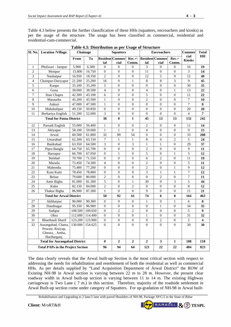
Social Impact Assessment and RAP Report (Chapter-4) 4 - 3
Rehabilitation and Upgrading to 2 lane/2 lane with paved Shoulders of NH-98, Package SP/C/2 in the State of Bihar
Client: M/oRT&H
TESPL&
Table 4.3 below presents the further classification of these HHs (squatters, encroachers and kiosks) as per the usage of the structure. The usage has been classified as commercial, residential and residential-cum-commercial.
Table 4.3: Distribution as per Usage of Structure Chainage Squatters Encroachers Sl. No. Location /Village.
From To Residential
Commercial
Rec.+\ Comm.
Residential
Commercial
Rec.+ Comm.
Commercial
Kiosks
Total HH
1 Phulwari - Janipur 5.900 6.300 0 0 0 3 0 0 16 19 2 Motipur 15.800 16.750 0 0 0 11 0 0 3 14 3 Naubatpur 16.950 18.350 2 0 0 12 5 9 12 40 4 Chainpur-Dariyapur 21.200 25.200 16 0 1 8 8 3 9 45 5 Kanpa 35.100 35.200 5 0 0 0 0 0 30 35 6 Gona 38.000 38.500 4 0 0 4 0 1 13 22 7 Jitan Chapra 42.300 43.100 6 0 0 5 0 0 11 22 8 Masaurha 45.200 45.500 1 0 0 2 0 0 7 10 9 Ankuri 47.000 47.500 1 0 0 0 0 0 7 8
10 Mahabalipur 49.150 50.850 0 0 0 0 0 0 20 20 11 Berhariya English 51.200 52.000 3 0 0 0 0 0 4 7
Total for Patna District 38 0 1 45 13 13 132 242
12 Parsadi English 55.000 56.400 1 0 0 2 0 0 11 14 13 Ahiyapur 58.100 59.000 1 1 0 4 0 0 9 15 14 Arwal 60.500 61.800 32 89 54 0 0 0 33 208 15 Umarabad 62.200 63.150 7 1 1 8 0 2 5 24 16 Baidrabad 63.350 64.500 3 0 3 1 1 0 29 37 17 Pipra Bangla 64.750 65.700 0 0 0 2 0 0 9 11 18 Harsapur 66.700 67.050 0 1 0 5 0 1 5 12 19 Balidad 70.700 71.550 0 0 0 6 2 0 11 19 20 Maraila 73.450 74.300 4 0 0 2 0 0 5 11 21 Mahendia 75.400 77.200 0 0 0 2 0 1 9 12 22 Koni Kutti 78.450 78.800 0 0 0 3 1 1 7 12 23 Belsar 79.600 80.000 2 0 0 0 2 0 7 11 24 Amir Bigha 81.000 81.300 5 0 1 30 0 3 5 44 25 Kaler 82.150 84.000 2 0 2 0 0 0 8 12 26 Thakur Bigha 86.900 87.300 1 0 0 9 0 0 11 21
Total for Arwal District 58 92 61 74 6 8 164 463 27 Akbharpur 90.000 90.300 0 0 0 1 0 1 6 8 28 Daudnagar 95.350 96.900 0 0 0 0 1 0 34 35 29 Sadipur 108.500 109.650 0 2 2 0 0 0 5 9 30 Obra 112.000 114.400 0 0 0 1 0 0 31 32 31 Bharthauli Sharif 123.200 123.900 0 0 0 0 2 0 2 4 32 Aurangabad, Chatra,
Powaie, Risiyap, Gheura, , Amba,
Hariharganj.
130.000 154.625 0 0 0 0 0 0 30 30
Total for Aurangabad District 0 2 2 2 3 1 108 118
Total PAPs in the Project Section 96 94 64 121 22 22 404 823
The data clearly reveals that the Arwal built-up Section is the most critical section with respect to addressing the needs for rehabilitation and resettlement of both the residential as well as commercial HHs. As per details supplied by “Land Acquisition Department of Arwal District” the ROW of Existing NH-98 in Arwal section is varying between 22 m to 28 m. However, the present clear roadway width in Arwal built-up section is varying between 11 to 14 m. The existing Highway carriageway is Two Lane ( 7 m.) in this section. Therefore, majority of the roadside settlement in Arwal Built-up section come under category of Squatters. For up-gradation of NH-98 in Arwal built-
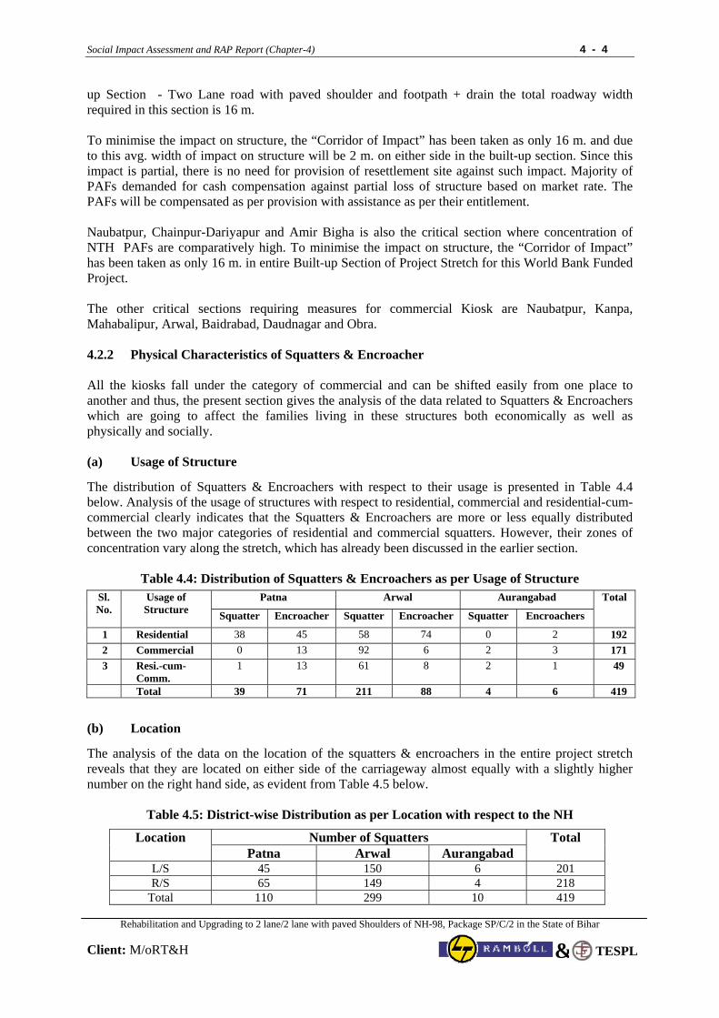
Social Impact Assessment and RAP Report (Chapter-4) 4 - 4
Rehabilitation and Upgrading to 2 lane/2 lane with paved Shoulders of NH-98, Package SP/C/2 in the State of Bihar
Client: M/oRT&H
TESPL&
up Section - Two Lane road with paved shoulder and footpath + drain the total roadway width required in this section is 16 m. To minimise the impact on structure, the “Corridor of Impact” has been taken as only 16 m. and due to this avg. width of impact on structure will be 2 m. on either side in the built-up section. Since this impact is partial, there is no need for provision of resettlement site against such impact. Majority of PAFs demanded for cash compensation against partial loss of structure based on market rate. The PAFs will be compensated as per provision with assistance as per their entitlement. Naubatpur, Chainpur-Dariyapur and Amir Bigha is also the critical section where concentration of NTH PAFs are comparatively high. To minimise the impact on structure, the “Corridor of Impact” has been taken as only 16 m. in entire Built-up Section of Project Stretch for this World Bank Funded Project. The other critical sections requiring measures for commercial Kiosk are Naubatpur, Kanpa, Mahabalipur, Arwal, Baidrabad, Daudnagar and Obra. 4.2.2 Physical Characteristics of Squatters & Encroacher All the kiosks fall under the category of commercial and can be shifted easily from one place to another and thus, the present section gives the analysis of the data related to Squatters & Encroachers which are going to affect the families living in these structures both economically as well as physically and socially. (a) Usage of Structure
The distribution of Squatters & Encroachers with respect to their usage is presented in Table 4.4 below. Analysis of the usage of structures with respect to residential, commercial and residential-cum-commercial clearly indicates that the Squatters & Encroachers are more or less equally distributed between the two major categories of residential and commercial squatters. However, their zones of concentration vary along the stretch, which has already been discussed in the earlier section.
Table 4.4: Distribution of Squatters & Encroachers as per Usage of Structure
Patna Arwal Aurangabad
Sl. No.
Usage of Structure Squatter
Encroacher Squatter Encroacher Squatter Encroachers
Total
1 Residential 38 45 58 74 0 2 192 2 Commercial 0 13 92 6 2 3 171 3 Resi.-cum-
Comm. 1 13 61 8 2 1 49
Total 39 71 211 88 4 6 419
(b) Location
The analysis of the data on the location of the squatters & encroachers in the entire project stretch reveals that they are located on either side of the carriageway almost equally with a slightly higher number on the right hand side, as evident from Table 4.5 below.
Table 4.5: District-wise Distribution as per Location with respect to the NH
Number of Squatters Location Patna Arwal Aurangabad
Total
L/S 45 150 6 201 R/S 65 149 4 218
Total 110 299 10 419
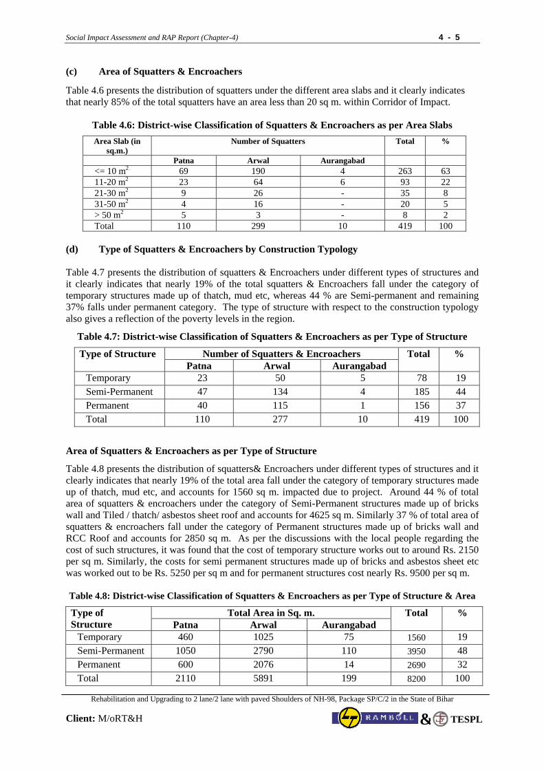
Social Impact Assessment and RAP Report (Chapter-4) 4 - 5
Rehabilitation and Upgrading to 2 lane/2 lane with paved Shoulders of NH-98, Package SP/C/2 in the State of Bihar
Client: M/oRT&H
TESPL&
(c) Area of Squatters & Encroachers
Table 4.6 presents the distribution of squatters under the different area slabs and it clearly indicates that nearly 85% of the total squatters have an area less than 20 sq m. within Corridor of Impact.
Table 4.6: District-wise Classification of Squatters & Encroachers as per Area Slabs
Area Slab (in sq.m.)
Number of Squatters Total %
Patna Arwal Aurangabad <= 10 m2 69 190 4 263 63 11-20 m2 23 64 6 93 22 21-30 m2 9 26 - 35 8 31-50 m2 4 16 - 20 5 > 50 m2 5 3 - 8 2 Total 110 299 10 419 100
(d) Type of Squatters & Encroachers by Construction Typology Table 4.7 presents the distribution of squatters & Encroachers under different types of structures and it clearly indicates that nearly 19% of the total squatters & Encroachers fall under the category of temporary structures made up of thatch, mud etc, whereas 44 % are Semi-permanent and remaining 37% falls under permanent category. The type of structure with respect to the construction typology also gives a reflection of the poverty levels in the region.
Table 4.7: District-wise Classification of Squatters & Encroachers as per Type of Structure
Number of Squatters & Encroachers Type of Structure Patna Arwal Aurangabad
Total %
Temporary 23 50 5 78 19 Semi-Permanent 47 134 4 185 44 Permanent 40 115 1 156 37 Total 110 277 10 419 100
Area of Squatters & Encroachers as per Type of Structure
Table 4.8 presents the distribution of squatters& Encroachers under different types of structures and it clearly indicates that nearly 19% of the total area fall under the category of temporary structures made up of thatch, mud etc, and accounts for 1560 sq m. impacted due to project. Around 44 % of total area of squatters & encroachers under the category of Semi-Permanent structures made up of bricks wall and Tiled / thatch/ asbestos sheet roof and accounts for 4625 sq m. Similarly 37 % of total area of squatters & encroachers fall under the category of Permanent structures made up of bricks wall and RCC Roof and accounts for 2850 sq m. As per the discussions with the local people regarding the cost of such structures, it was found that the cost of temporary structure works out to around Rs. 2150 per sq m. Similarly, the costs for semi permanent structures made up of bricks and asbestos sheet etc was worked out to be Rs. 5250 per sq m and for permanent structures cost nearly Rs. 9500 per sq m.
Table 4.8: District-wise Classification of Squatters & Encroachers as per Type of Structure & Area
Total Area in Sq. m. Type of Structure Patna Arwal Aurangabad
Total %
Temporary 460 1025 75 1560 19 Semi-Permanent 1050 2790 110 3950 48 Permanent 600 2076 14 2690 32 Total 2110 5891 199 8200 100
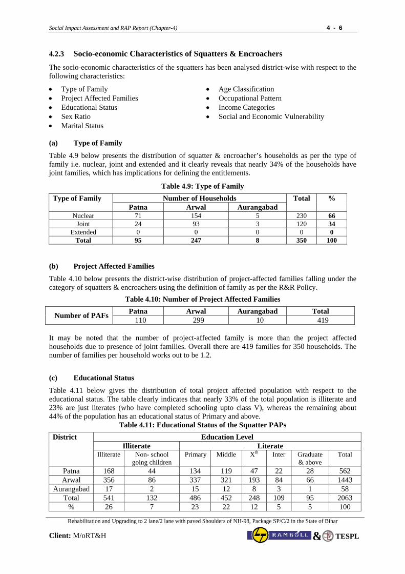
Social Impact Assessment and RAP Report (Chapter-4) 4 - 6
Rehabilitation and Upgrading to 2 lane/2 lane with paved Shoulders of NH-98, Package SP/C/2 in the State of Bihar
Client: M/oRT&H
TESPL&
4.2.3 Socio-economic Characteristics of Squatters & Encroachers
The socio-economic characteristics of the squatters has been analysed district-wise with respect to the following characteristics:
• Type of Family • Project Affected Families • Educational Status • Sex Ratio • Marital Status
• Age Classification • Occupational Pattern • Income Categories • Social and Economic Vulnerability
(a) Type of Family
Table 4.9 below presents the distribution of squatter & encroacher’s households as per the type of family i.e. nuclear, joint and extended and it clearly reveals that nearly 34% of the households have joint families, which has implications for defining the entitlements.
Table 4.9: Type of Family
Number of Households Type of Family Patna Arwal Aurangabad
Total %
Nuclear 71 154 5 230 66 Joint 24 93 3 120 34
Extended 0 0 0 0 0 Total 95 247 8 350 100
(b) Project Affected Families
Table 4.10 below presents the district-wise distribution of project-affected families falling under the category of squatters & encroachers using the definition of family as per the R&R Policy.
Table 4.10: Number of Project Affected Families
Patna Arwal Aurangabad Total Number of PAFs 110 299 10 419
It may be noted that the number of project-affected family is more than the project affected households due to presence of joint families. Overall there are 419 families for 350 households. The number of families per household works out to be 1.2.
(c) Educational Status
Table 4.11 below gives the distribution of total project affected population with respect to the educational status. The table clearly indicates that nearly 33% of the total population is illiterate and 23% are just literates (who have completed schooling upto class V), whereas the remaining about 44% of the population has an educational status of Primary and above.
Table 4.11: Educational Status of the Squatter PAPs
Education Level Illiterate Literate
District
Illiterate Non- school going children
Primary Middle Xth Inter Graduate & above
Total
Patna 168 44 134 119 47 22 28 562 Arwal 356 86 337 321 193 84 66 1443
Aurangabad 17 2 15 12 8 3 1 58 Total 541 132 486 452 248 109 95 2063
% 26 7 23 22 12 5 5 100
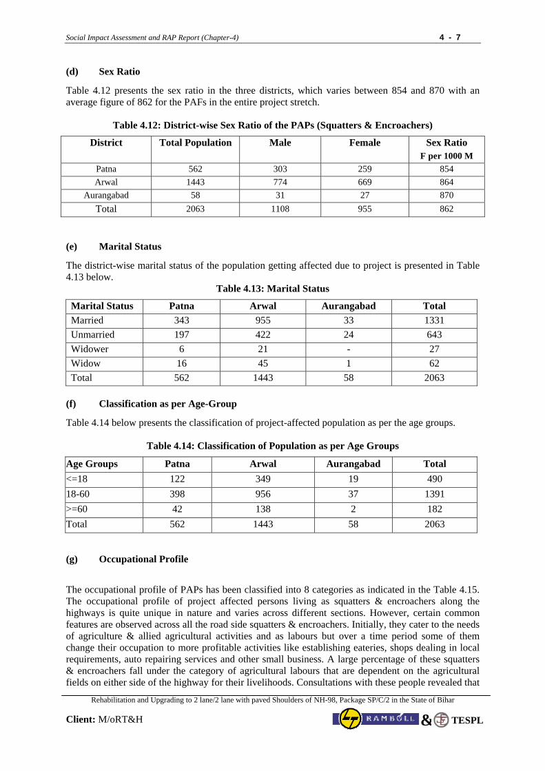
Social Impact Assessment and RAP Report (Chapter-4) 4 - 7
Rehabilitation and Upgrading to 2 lane/2 lane with paved Shoulders of NH-98, Package SP/C/2 in the State of Bihar
Client: M/oRT&H
TESPL&
(d) Sex Ratio
Table 4.12 presents the sex ratio in the three districts, which varies between 854 and 870 with an average figure of 862 for the PAFs in the entire project stretch.
Table 4.12: District-wise Sex Ratio of the PAPs (Squatters & Encroachers)
District Total Population Male Female Sex Ratio F per 1000 M
Patna 562 303 259 854 Arwal 1443 774 669 864
Aurangabad 58 31 27 870 Total 2063 1108 955 862
(e) Marital Status
The district-wise marital status of the population getting affected due to project is presented in Table 4.13 below.
Table 4.13: Marital Status
Marital Status Patna Arwal Aurangabad Total Married 343 955 33 1331 Unmarried 197 422 24 643 Widower 6 21 - 27 Widow 16 45 1 62 Total 562 1443 58 2063
(f) Classification as per Age-Group
Table 4.14 below presents the classification of project-affected population as per the age groups.
Table 4.14: Classification of Population as per Age Groups
Age Groups Patna Arwal Aurangabad Total <=18 122 349 19 490 18-60 398 956 37 1391 >=60 42 138 2 182 Total 562 1443 58 2063 (g) Occupational Profile
The occupational profile of PAPs has been classified into 8 categories as indicated in the Table 4.15. The occupational profile of project affected persons living as squatters & encroachers along the highways is quite unique in nature and varies across different sections. However, certain common features are observed across all the road side squatters & encroachers. Initially, they cater to the needs of agriculture & allied agricultural activities and as labours but over a time period some of them change their occupation to more profitable activities like establishing eateries, shops dealing in local requirements, auto repairing services and other small business. A large percentage of these squatters & encroachers fall under the category of agricultural labours that are dependent on the agricultural fields on either side of the highway for their livelihoods. Consultations with these people revealed that
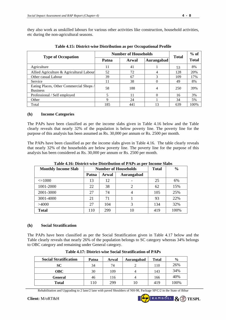
Social Impact Assessment and RAP Report (Chapter-4) 4 - 8
Rehabilitation and Upgrading to 2 lane/2 lane with paved Shoulders of NH-98, Package SP/C/2 in the State of Bihar
Client: M/oRT&H
TESPL&
they also work as unskilled labours for various other activities like construction, household activities, etc during the non-agricultural seasons.
Table 4.15: District-wise Distribution as per Occupational Profile
Number of Households Type of Occupation
Patna Arwal Aurangabad Total
% of Total
Agriculture 11 41 1 53 8% Allied Agriculture & Agricultural Labour 52 72 4 128 20% Other casual Labour 39 67 3 109 17% Service 11 38 0 49 8% Eating Places, Other Commercial Shops / Business 58 188 4 250 39%
Professional / Self employed 5 11 0 16 3% Other 9 24 1 34 5% Total 185 441 13 639 100%
(h) Income Categories The PAPs have been classified as per the income slabs given in Table 4.16 below and the Table clearly reveals that nearly 32% of the population is below poverty line. The poverty line for the purpose of this analysis has been assumed as Rs. 30,000 per annum or Rs. 2500 per month. The PAPs have been classified as per the income slabs given in Table 4.16. The table clearly reveals that nearly 32% of the households are below poverty line. The poverty line for the purpose of this analysis has been considered as Rs. 30,000 per annum or Rs. 2500 per month.
Table 4.16: District-wise Distribution of PAPs as per Income Slabs Number of Households Monthly Income Slab
Patna Arwal Aurangabad Total
%
<=1000 13 12 - 25 6% 1001-2000 22 38 2 62 15% 2001-3000 27 74 4 105 25% 3001-4000 21 71 1 93 22% >4000 27 104 3 134 32% Total 110 299 10 419 100%
(h) Social Stratification The PAPs have been classified as per the Social Stratification given in Table 4.17 below and the Table clearly reveals that nearly 26% of the population belongs to SC category whereas 34% belongs to OBC category and remaining under General category.
Table 4.17: District-wise Social Stratification of PAPs
Social Stratification Patna Arwal Aurangabad Total % SC 34 74 2 110 26%
OBC 30 109 4 143 34% General 46 116 4 166 40% Total 110 299 10 419 100%
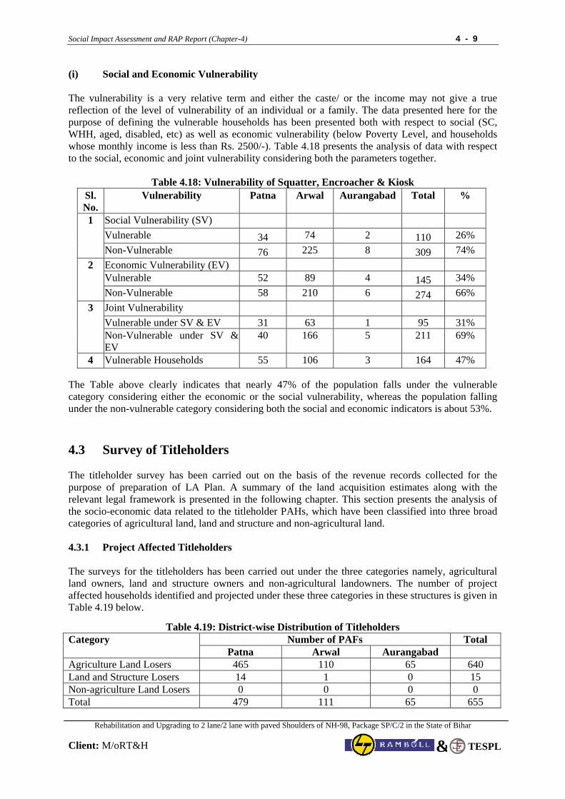
Social Impact Assessment and RAP Report (Chapter-4) 4 - 9
Rehabilitation and Upgrading to 2 lane/2 lane with paved Shoulders of NH-98, Package SP/C/2 in the State of Bihar
Client: M/oRT&H
TESPL&
(i) Social and Economic Vulnerability The vulnerability is a very relative term and either the caste/ or the income may not give a true reflection of the level of vulnerability of an individual or a family. The data presented here for the purpose of defining the vulnerable households has been presented both with respect to social (SC, WHH, aged, disabled, etc) as well as economic vulnerability (below Poverty Level, and households whose monthly income is less than Rs. 2500/-). Table 4.18 presents the analysis of data with respect to the social, economic and joint vulnerability considering both the parameters together.
Table 4.18: Vulnerability of Squatter, Encroacher & Kiosk Sl. No.
Vulnerability Patna Arwal Aurangabad Total %
Social Vulnerability (SV) Vulnerable 34 74 2 110 26%
1
Non-Vulnerable 76 225 8 309 74% Economic Vulnerability (EV) Vulnerable 52 89 4 145 34%
2
Non-Vulnerable 58 210 6 274 66% 3 Joint Vulnerability Vulnerable under SV & EV 31 63 1 95 31%
Non-Vulnerable under SV & EV
40 166 5 211 69%
4 Vulnerable Households 55 106 3 164 47%
The Table above clearly indicates that nearly 47% of the population falls under the vulnerable category considering either the economic or the social vulnerability, whereas the population falling under the non-vulnerable category considering both the social and economic indicators is about 53%. 4.3 Survey of Titleholders The titleholder survey has been carried out on the basis of the revenue records collected for the purpose of preparation of LA Plan. A summary of the land acquisition estimates along with the relevant legal framework is presented in the following chapter. This section presents the analysis of the socio-economic data related to the titleholder PAHs, which have been classified into three broad categories of agricultural land, land and structure and non-agricultural land. 4.3.1 Project Affected Titleholders The surveys for the titleholders has been carried out under the three categories namely, agricultural land owners, land and structure owners and non-agricultural landowners. The number of project affected households identified and projected under these three categories in these structures is given in Table 4.19 below.
Table 4.19: District-wise Distribution of Titleholders Number of PAFs Total Category
Patna Arwal Aurangabad Agriculture Land Losers 465 110 65 640 Land and Structure Losers 14 1 0 15 Non-agriculture Land Losers 0 0 0 0 Total 479 111 65 655
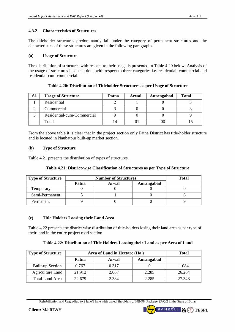
Social Impact Assessment and RAP Report (Chapter-4) 4 - 10
Rehabilitation and Upgrading to 2 lane/2 lane with paved Shoulders of NH-98, Package SP/C/2 in the State of Bihar
Client: M/oRT&H
TESPL&
4.3.2 Characteristics of Structures The titleholder structures predominantly fall under the category of permanent structures and the characteristics of these structures are given in the following paragraphs. (a) Usage of Structure The distribution of structures with respect to their usage is presented in Table 4.20 below. Analysis of the usage of structures has been done with respect to three categories i.e. residential, commercial and residential-cum-commercial.
Table 4.20: Distribution of Titleholder Structures as per Usage of Structure
Sl. Usage of Structure Patna Arwal Aurangabad Total 1 Residential 2 1 0 3 2 Commercial 3 0 0 3 3 Residential-cum-Commercial 9 0 0 9 Total 14 01 00 15
From the above table it is clear that in the project section only Patna District has title-holder structure and is located in Naubatpur built-up market section. (b) Type of Structure Table 4.21 presents the distribution of types of structures.
Table 4.21: District-wise Classification of Structures as per Type of Structure
Number of Structures Type of Structure
Patna Arwal Aurangabad Total
Temporary 0 0 0 0 Semi-Permanent 5 1 0 6 Permanent 9 0 0 9
(c) Title Holders Loosing their Land Area Table 4.22 presents the district wise distribution of title-holders losing their land area as per type of their land in the entire project road section.
Table 4.22: Distribution of Title Holders Loosing their Land as per Area of Land
Area of Land in Hectare (Ha.) Total Type of Structure
Patna Arwal Aurangabad Built-up Section 0.767 0.317 0 1.084 Agriculture Land 21.912 2.067 2.285 26.264 Total Land Area 22.679 2.384 2.285 27.348
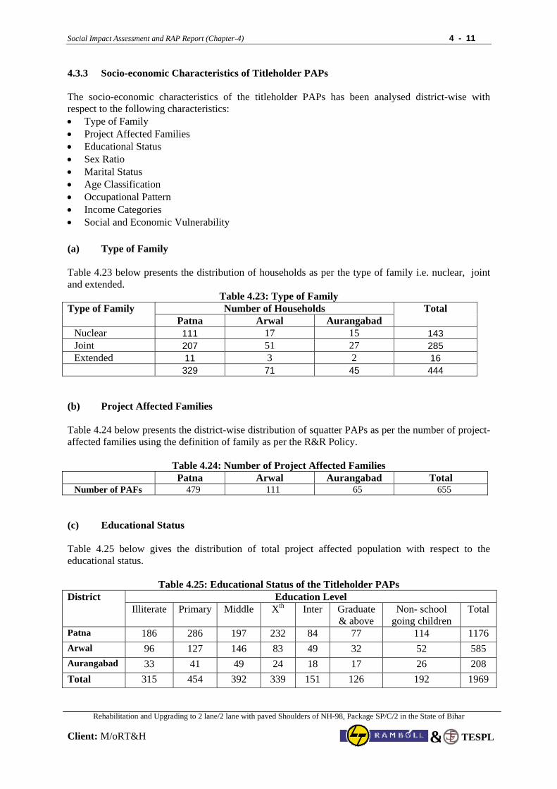
Social Impact Assessment and RAP Report (Chapter-4) 4 - 11
Rehabilitation and Upgrading to 2 lane/2 lane with paved Shoulders of NH-98, Package SP/C/2 in the State of Bihar
Client: M/oRT&H
TESPL&
4.3.3 Socio-economic Characteristics of Titleholder PAPs The socio-economic characteristics of the titleholder PAPs has been analysed district-wise with respect to the following characteristics: • Type of Family • Project Affected Families • Educational Status • Sex Ratio • Marital Status • Age Classification • Occupational Pattern • Income Categories • Social and Economic Vulnerability (a) Type of Family Table 4.23 below presents the distribution of households as per the type of family i.e. nuclear, joint and extended.
Table 4.23: Type of Family Number of Households Type of Family
Patna Arwal Aurangabad Total
Nuclear 111 17 15 143 Joint 207 51 27 285 Extended 11 3 2 16 329 71 45 444
(b) Project Affected Families Table 4.24 below presents the district-wise distribution of squatter PAPs as per the number of project-affected families using the definition of family as per the R&R Policy.
Table 4.24: Number of Project Affected Families Patna Arwal Aurangabad Total
Number of PAFs 479 111 65 655 (c) Educational Status Table 4.25 below gives the distribution of total project affected population with respect to the educational status.
Table 4.25: Educational Status of the Titleholder PAPs Education Level District
Illiterate Primary Middle Xth Inter Graduate & above
Non- school going children
Total
Patna 186 286 197 232 84 77 114 1176 Arwal 96 127 146 83 49 32 52 585 Aurangabad 33 41 49 24 18 17 26 208 Total 315 454 392 339 151 126 192 1969
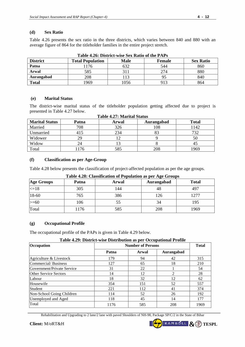
Social Impact Assessment and RAP Report (Chapter-4) 4 - 12
Rehabilitation and Upgrading to 2 lane/2 lane with paved Shoulders of NH-98, Package SP/C/2 in the State of Bihar
Client: M/oRT&H
TESPL&
(d) Sex Ratio
Table 4.26 presents the sex ratio in the three districts, which varies between 840 and 880 with an average figure of 864 for the titleholder families in the entire project stretch.
Table 4.26: District-wise Sex Ratio of the PAPs District Total Population Male Female Sex Ratio Patna 1176 632 544 860 Arwal 585 311 274 880 Aurangabad 208 113 95 840 Total 1969 1056 913 864 (e) Marital Status
The district-wise marital status of the titleholder population getting affected due to project is presented in Table 4.27 below.
Table 4.27: Marital Status Marital Status Patna Arwal Aurangabad Total Married 708 326 108 1142 Unmarried 415 234 83 732 Widower 29 12 9 50 Widow 24 13 8 45 Total 1176 585 208 1969
(f) Classification as per Age-Group
Table 4.28 below presents the classification of project-affected population as per the age groups.
Table 4.28: Classification of Population as per Age Groups Age Groups Patna Arwal Aurangabad Total <=18 305 144 48 497 18-60 765 386 126 1277 >=60 106 55 34 195 Total 1176 585 208 1969
(g) Occupational Profile The occupational profile of the PAPs is given in Table 4.29 below.
Table 4.29: District-wise Distribution as per Occupational Profile Number of Persons Occupation
Patna Arwal Aurangabad Total
Agriculture & Livestock 179 94 42 315 Commercial/ Business 127 65 18 210 Government/Private Service 31 22 1 54 Other Service Sectors 14 12 2 28 Labour 18 32 12 62 Housewife 354 151 52 557 Student 221 112 41 374 Non-School Going Children 114 52 26 192 Unemployed and Aged 118 45 14 177 Total 1176 585 208 1969
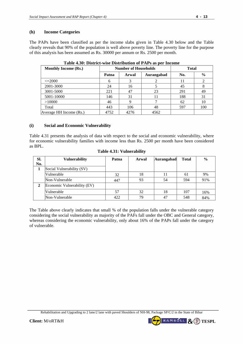
Social Impact Assessment and RAP Report (Chapter-4) 4 - 13
Rehabilitation and Upgrading to 2 lane/2 lane with paved Shoulders of NH-98, Package SP/C/2 in the State of Bihar
Client: M/oRT&H
TESPL&
(h) Income Categories The PAPs have been classified as per the income slabs given in Table 4.30 below and the Table clearly reveals that 90% of the population is well above poverty line. The poverty line for the purpose of this analysis has been assumed as Rs. 30000 per annum or Rs. 2500 per month.
Table 4.30: District-wise Distribution of PAPs as per Income
Number of Households Total Monthly Income (Rs.) Patna Arwal Aurangabad No. %
<=2000 6 3 2 11 2 2001-3000 24 16 5 45 8 3001-5000 221 47 23 291 49 5001-10000 146 31 11 188 31 >10000 46 9 7 62 10 Total 443 106 48 597 100
Average HH Income (Rs.) 4752 4276 4562
(i) Social and Economic Vulnerability Table 4.31 presents the analysis of data with respect to the social and economic vulnerability, where for economic vulnerability families with income less than Rs. 2500 per month have been considered as BPL.
Table 4.31: Vulnerability
Sl. No.
Vulnerability
Social Vulnerability (SV)
Patna Arwal Aurangabad Total %
Vulnerable 32 18 11 61 9% 1
Non-Vulnerable 447 93 54 594 91% Economic Vulnerability (EV) Vulnerable 57 32 18 107 16%
2
Non-Vulnerable 422 79 47 548 84%
The Table above clearly indicates that small % of the population falls under the vulnerable category considering the social vulnerability as majority of the PAFs fall under the OBC and General category, whereas considering the economic vulnerability, only about 16% of the PAPs fall under the category of vulnerable.
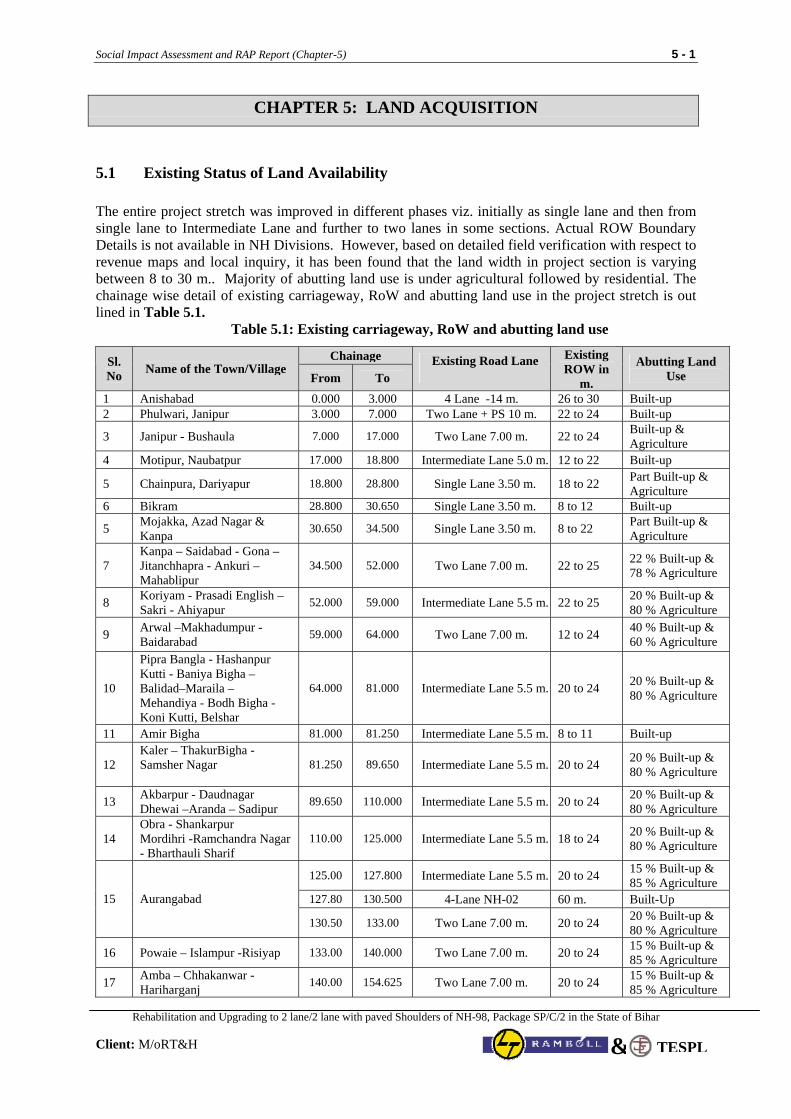
Social Impact Assessment and RAP Report (Chapter-5) 5 - 1
Rehabilitation and Upgrading to 2 lane/2 lane with paved Shoulders of NH-98, Package SP/C/2 in the State of Bihar
Client: M/oRT&H TESPL&
CHAPTER 5: LAND ACQUISITION
5.1 Existing Status of Land Availability The entire project stretch was improved in different phases viz. initially as single lane and then from single lane to Intermediate Lane and further to two lanes in some sections. Actual ROW Boundary Details is not available in NH Divisions. However, based on detailed field verification with respect to revenue maps and local inquiry, it has been found that the land width in project section is varying between 8 to 30 m.. Majority of abutting land use is under agricultural followed by residential. The chainage wise detail of existing carriageway, RoW and abutting land use in the project stretch is out lined in Table 5.1.
Table 5.1: Existing carriageway, RoW and abutting land use
Chainage Sl. No Name of the Town/Village
From To Existing Road Lane Existing
ROW in m.
Abutting Land Use
1 Anishabad 0.000 3.000 4 Lane -14 m. 26 to 30 Built-up 2 Phulwari, Janipur 3.000 7.000 Two Lane + PS 10 m. 22 to 24 Built-up
3 Janipur - Bushaula 7.000 17.000 Two Lane 7.00 m. 22 to 24 Built-up & Agriculture
4 Motipur, Naubatpur 17.000 18.800 Intermediate Lane 5.0 m. 12 to 22 Built-up
5 Chainpura, Dariyapur 18.800 28.800 Single Lane 3.50 m. 18 to 22 Part Built-up & Agriculture
6 Bikram 28.800 30.650 Single Lane 3.50 m. 8 to 12 Built-up
5 Mojakka, Azad Nagar & Kanpa 30.650 34.500 Single Lane 3.50 m. 8 to 22 Part Built-up &
Agriculture
7 Kanpa – Saidabad - Gona –Jitanchhapra - Ankuri – Mahablipur
34.500 52.000 Two Lane 7.00 m. 22 to 25 22 % Built-up & 78 % Agriculture
8 Koriyam - Prasadi English – Sakri - Ahiyapur 52.000 59.000 Intermediate Lane 5.5 m. 22 to 25 20 % Built-up &
80 % Agriculture
9 Arwal –Makhadumpur - Baidarabad 59.000 64.000 Two Lane 7.00 m. 12 to 24 40 % Built-up &
60 % Agriculture
10
Pipra Bangla - Hashanpur Kutti - Baniya Bigha – Balidad–Maraila – Mehandiya - Bodh Bigha - Koni Kutti, Belshar
64.000 81.000 Intermediate Lane 5.5 m. 20 to 24 20 % Built-up & 80 % Agriculture
11 Amir Bigha 81.000 81.250 Intermediate Lane 5.5 m. 8 to 11 Built-up
12 Kaler – ThakurBigha - Samsher Nagar
81.250 89.650 Intermediate Lane 5.5 m. 20 to 24 20 % Built-up & 80 % Agriculture
13 Akbarpur - Daudnagar Dhewai –Aranda – Sadipur 89.650 110.000 Intermediate Lane 5.5 m. 20 to 24 20 % Built-up &
80 % Agriculture
14 Obra - Shankarpur Mordihri -Ramchandra Nagar - Bharthauli Sharif
110.00 125.000 Intermediate Lane 5.5 m. 18 to 24 20 % Built-up & 80 % Agriculture
125.00 127.800 Intermediate Lane 5.5 m. 20 to 24 15 % Built-up & 85 % Agriculture
127.80 130.500 4-Lane NH-02 60 m. Built-Up 15 Aurangabad
130.50 133.00 Two Lane 7.00 m. 20 to 24 20 % Built-up & 80 % Agriculture
16 Powaie – Islampur -Risiyap 133.00 140.000 Two Lane 7.00 m. 20 to 24 15 % Built-up & 85 % Agriculture
17 Amba – Chhakanwar - Hariharganj 140.00 154.625 Two Lane 7.00 m. 20 to 24 15 % Built-up &
85 % Agriculture
Social Impact Assessment and RAP Report (Chapter-5) 5 - 2
Rehabilitation and Upgrading to 2 lane/2 lane with paved Shoulders of NH-98, Package SP/C/2 in the State of Bihar
Client: M/oRT&H TESPL&
For the highway projects, the land is acquired from the private owners for the purpose of road widening on permanent basis whereas during the implementation phase certain piece of land is required for other project related activities on temporary basis such as providing temporary diversions, setting up of contractor's camp; hot mix plant; batching plant; etc and dumping of construction material. In the present project, land will be acquired through the National Highways Act, 1956. A brief history of land acquisition in India and the relevant provisions of the concerned Acts are presented in the following section. 5.2 Land Acquisition: Legal Framework The first attempt to legally acquire land was made in 1824, through Regulation 1 of 1824 applicable to immediate subject of presidency of Fort William. The rules empowered government to acquire immovable property for public purposes.
• Provisions of 1824 were extended to Calcutta through Act I of 1850. Act XLII was brought to enable the provisions of regulation I of 1824 to be used for acquiring land for construction of railways.
• Building Act XXVII of 1839, Act XX of 1852 was introduced to obviate the difficulties to particular cities of Bombay and Madras.
• Act VI of 1857 was the first full enactment, which had application to the whole of British India. It repealed all previous enactment relating to acquisition and its object.
• Principle of Arbitration was introduced for the first time through Act VI of 1857, but procedure for making a reference to the arbitrator was found unsatisfactory and then came Act X of 1870. For the first time a detailed procedure for the acquisition of land were provided in 1870 Act. Rules were also framed for the determination of an amount of compensation.
The provisions of the 1870 Act did not satisfy the needs of the day and eventually the Land Acquisition Act, 1894 (I of 1894) was enacted repealing the 1870 Act. In India, the land acquisition and its compensation are generally governed by the Land Acquisition Act (1894), which has been amended from time to time.
However, for the purpose of maintenance, sustenance and management of National Highways, a special act, The National Highways Act (NH Act), 1956 has been promulgated. This Act provides for acquiring the land through "competent authority" which means any person or authority authorized by the Central Govt. by notification in the official Gazette to perform functions of the competent authority for such areas as may be specified in the notifications. For LA, the Act defines the various procedures as follows: (I) section 3A – intention of Central Govt. to acquire land, (ii) 3B - power to enter for survey, (iii) 3C - hearing of objections (iv) 3D - declaration of acquisition, (v) 3E - power to take possession, (vi) 3F - power to enter into the land where land has vested in the central government, (vii) 3G - determination of compensation and (viii) 3F - deposit and payment of the amount. The act requires that the processes must be completed within a year from 3A to 3D. Although NH act significantly reduces the timeframe for acquisition, the rules and principles of compensation have been derived from the LA Act of 1894. The Act covers only legal titleholders and provides for (i) market value of the land; (ii) additional amount for trees, crops, houses or other immovable properties; (iii) damage due to severing of land, residence, place of business. Provision of direct purchase of land from landowners in case where additional land requirement is very less (minimal) may also be considered. However, resettlement and rehabilitation benefits available to affected persons whose land would be acquired under the statute shall also be available to those affected persons whose land would be acquired through direct purchase.
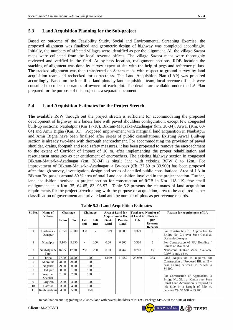
Social Impact Assessment and RAP Report (Chapter-5) 5 - 3
Rehabilitation and Upgrading to 2 lane/2 lane with paved Shoulders of NH-98, Package SP/C/2 in the State of Bihar
Client: M/oRT&H TESPL&
5.3 Land Acquisition Planning for the Sub-project Based on outcome of the Feasibility Study, Social and Environmental Screening Exercise, the proposed alignment was finalized and geometric design of highway was completed accordingly. Initially, the numbers of affected villages were identified as per the alignment. All the village Sazara maps were collected from the local revenue offices. The village Sazara maps were thoroughly reviewed and verified in the field. At by-pass location, realignment sections, ROB location the stacking of alignment was done by survey expert at site with the help of pegs and reference pillars. The stacked alignment was then transferred on Sazara maps with respect to ground survey by land acquisition team and rechecked for correctness. The Land Acquisition Plan (LAP) was prepared accordingly. Based on the identified land plots by land acquisition team, local revenue officials were consulted to collect the names of owners of each plot. The details are available under the LA Plan prepared for the purpose of this project as a separate document. 5.4 Land Acquisition Estimates for the Project Stretch The available RoW through out the project stretch is sufficient for accommodating the proposed development of highway as 2 lane/2 lane with paved shoulders configuration, except few congested built-up sections: Naubatpur (Km 17-18), Bikram-Mauzaka-Azadnagar (km. 28-34), Arwal (Km. 60-64) and Amir Bigha (Km. 81). Proposed improvement with marginal land acquisition in Naubatpur and Amir Bigha have been finalised after series of public consultations. Existing Arwal Built-up section is already two-lane with thorough encroachment. For accommodating the provision of paved shoulder, drains, footpath and road safety measures, it has been proposed to remove the encroachment to the extent of Corridor of Impact of 16 m. after implementing the proper rehabilitation and resettlement measures as per entitlement of encroachers. The existing highway section in congested Bikram-Mauzaka-Azadnagar (km. 28-34) is single lane with existing ROW 8 to 12m.. For improvement of Bikram-Mauzaka-Azadnagar, a By-pass (Ch. 27.50 to 33.900) has been proposed after through survey, investigation, design and series of detailed public consultations. Area of LA in Bikram By-pass is around 80 % area of total Land acquisition involved in the project section. Further, land acquisition involved in project section for construction of ROB in Km. 118-119, few small realignment at in Km. 35, 64-65, 83, 96-97. Table 5.2 presents the estimates of land acquisition requirements for the project stretch along with the purpose of acquisition, area to be acquired as per classification of government and private land and the number of plots as per revenue records.
Table 5.2: Land Acquisition Estimates
Chainage Chainage Area of Land for Acquisition in Ha.
Sl. No. Name of Village
From To Left (m)
Left (m)
Govt. Land
Private Land
Total area of Land in
Ha.
Number of Plots as
per Revenue Records
Reason for requirement of LA
1 Bushaula - Danapur
6.550 6.900 350 - 0.329 0.000 0.329 9 For Construction of Approaches to Bridge No. 7/1 over Sone Canal at Bushaula-Danapur
2 Muradpur 9.100 9.250 - 100 0.00 0.360 0.360 5 For Construction of PIU Building / Camps of M/oRT&H
3 Naubatpur & Taret
16.950 17.200 250 250 0.00 0.767 0.767 15 Naubatpur Built-up Zone Available ROW is only 13 m.
4 Telpa 27.000 28.000 1000 5 Khoraitha 28.000 29.000 1000 6 Nagahar 29.000 30.000 1000 7 Dadupur 30.000 31.000 1000 8 Wajirpur
Shankar 31.000 32.000 1000
9 Baigwan 32.000 33.000 1000 10 Hathsar 33.000 34.000 1000 11 Raghunathpur 34.000 35.000 450
1.029 21.552 23.959 353 Land Acquisition is required for Construction of Proposed Bikram By-pass. Falling between Ch. 27.500 to 34.200. For Construction of Approaches to Bridge No. 36/1 at Kanpa over Sone Canal Land Acquisition is required on left Side in a Length of 350 m. between Ch. 35.050 to 35.400.
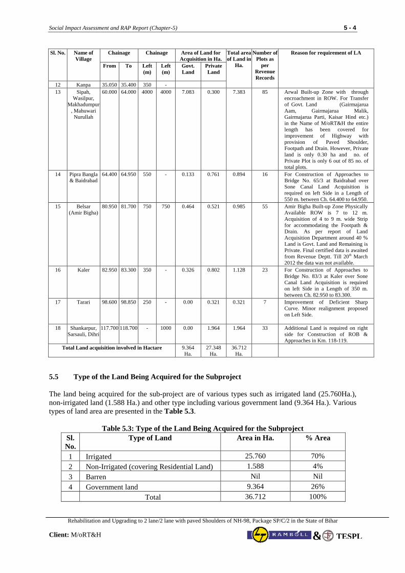
Social Impact Assessment and RAP Report (Chapter-5) 5 - 4
Rehabilitation and Upgrading to 2 lane/2 lane with paved Shoulders of NH-98, Package SP/C/2 in the State of Bihar
Client: M/oRT&H TESPL&
Chainage Chainage Area of Land for Acquisition in Ha.
Sl. No. Name of Village
From To Left (m)
Left (m)
Govt. Land
Private Land
Total area of Land in
Ha.
Number of Plots as
per Revenue Records
Reason for requirement of LA
12 Kanpa 35.050 35.400 350 - 13 Sipah,
Wasilpur, Makhadumpur
, Mahuwari Nurullah
60.000 64.000 4000 4000 7.083 0.300 7.383 85 Arwal Built-up Zone with through encroachment in ROW. For Transfer of Govt. Land (Gairmajarua Aam, Gairmajarua Malik, Gairmajarua Parti, Kaisar Hind etc.) in the Name of M/oRT&H the entire length has been covered for improvement of Highway with provision of Paved Shoulder, Footpath and Drain. However, Private land is only 0.30 ha and no. of Private Plot is only 6 out of 85 no. of total plots.
14 Pipra Bangla & Baidrabad
64.400 64.950 550 - 0.133 0.761 0.894 16 For Construction of Approaches to Bridge No. 65/3 at Baidrabad over Sone Canal Land Acquisition is required on left Side in a Length of 550 m. between Ch. 64.400 to 64.950.
15 Belsar (Amir Bigha)
80.950 81.700 750 750 0.464
0.521 0.985 55 Amir Bigha Built-up Zone Physically Available ROW is 7 to 12 m. Acquisition of 4 to 9 m. wide Strip for accommodating the Footpath & Drain. As per report of Land Acquisition Department around 40 % Land is Govt. Land and Remaining is Private. Final certified data is awaited from Revenue Deptt. Till 20th March 2012 the data was not available.
16 Kaler 82.950 83.300 350 - 0.326 0.802 1.128 23 For Construction of Approaches to Bridge No. 83/3 at Kaler over Sone Canal Land Acquisition is required on left Side in a Length of 350 m. between Ch. 82.950 to 83.300.
17 Tarari 98.600 98.850 250 - 0.00 0.321 0.321 7 Improvement of Deficient Sharp Curve. Minor realignment proposed on Left Side.
18 Shankarpur, Sarsauli, Dihri
117.700 118.700 - 1000 0.00 1.964 1.964 33 Additional Land is required on right side for Construction of ROB & Approaches in Km. 118-119.
Total Land acquisition involved in Hactare
9.364 Ha.
27.348 Ha.
36.712 Ha.
5.5 Type of the Land Being Acquired for the Subproject The land being acquired for the sub-project are of various types such as irrigated land (25.760Ha.), non-irrigated land (1.588 Ha.) and other type including various government land (9.364 Ha.). Various types of land area are presented in the Table 5.3.
Table 5.3: Type of the Land Being Acquired for the Subproject Sl. No.
Type of Land Area in Ha. % Area
1 Irrigated 25.760 70% 2 Non-Irrigated (covering Residential Land) 1.588 4% 3 Barren Nil Nil 4 Government land 9.364 26% Total 36.712 100%
Social Impact Assessment and RAP Report (Chapter-6) 6 - 1
Rehabilitation and Upgrading to 2 lane/2 lane with paved Shoulders of NH-98, Package SP/C/2 in the State of Bihar Client: M/oRT&H
TESPL&
CHAPTER 6: PUBLIC INFORMATION AND CONSULTATIONS
6.1 Introduction Till very recent, the highway sector involving road projects was being looked at as a field of engineering only. Due to the lessons learnt and the problems faced in implementation in the development projects in general, and highway sector in particular, over the years, public consultations have acquired a very important role in the planning process for development projects. Globally, the practice of involving the communities in the planning process has been recognized as an effective tool for mitigating the negative impacts due to the projects and ensuring timely completion of the projects. In context of the highway projects, which are primarily linear in nature, the issue of involving people in the planning and designing process has a much more significance, as the nature and extent of impact on the social, economic and cultural fabric of the society spread across a larger and a highly varied group of the society. The public consultations for the planning and designing of highway projects are essential from the angle of both, the designers as well as the people who are going to be affected. From the people's perspective, the process is critical in order to:
• provide adequate time to the people so that they can prepare themselves mentally for the likely impact of the project on their social and economic life;
• inform them of the likely impact on their lives and the government policies and efforts that would be made to minimize the impact;
• ensure their cooperation in the implementation stage;
and from the designers perspective, to
• establish rapport with the project affected persons and other stakeholders critical to the success of the project;
• build an environment where people understand and appreciate the need and importance of the project;
• learn from the people about the issues in terms of the regional linkages, road safety, and other social dimensions of the region/ area that need to be considered while designing the project;
• facilitate the partnership and ownership of the community through their involvement in the decision making process; and
• understand and incorporate the views of the people in the designing process in order to minimize the future resistance and delays.
Public participation was undertaken to make explicit the social factors that will affect the development impacts of planned highway improvements and mediate project results. Through public participation, stakeholders and key social issues were identified and strategy was formulated. It included socio-cultural analysis and design of social strategy, institutional analysis and specifically addressed the issue of how poor and vulnerable groups may benefit from the project.
Social Impact Assessment and RAP Report (Chapter-6) 6 - 2
Rehabilitation and Upgrading to 2 lane/2 lane with paved Shoulders of NH-98, Package SP/C/2 in the State of Bihar Client: M/oRT&H
TESPL&
6.2 Methodological Framework As a part of the public consultation, an effort has been made to gradually build a relationship with the key stakeholders through a planned consultative process. The purpose of public consultations at various stages of the RAP preparation was two-fold, first, to create awareness amongst the likely project affected persons and key stakeholders about the project, its intent and the likely benefits, and second, to facilitate the process of social learning for the members of the engineering team. The consultations were carried out as an integrated exercise with the engineering and environment experts and were designed to:
• help the engineering and environmental experts to understand the local socio-economic perspective;
• evolve a common understanding of the social, environmental and engineering issues amongst the team members;
• identify and develop a common vision for the issues which are common from the social, engineering, and environmental perspective;
• provide input to the other members of the team and integration of the social concerns for the design considerations; and
• help the design team to appreciate the need for making adequate provisions related to the management of corridor during the implementation and post implementation scenario with respect to the safety of the population in the surrounding areas, smooth and safe movement of the local level traffic and the people, provision of parking areas for the long route as well as halt points for the vehicles catering to the local/ regional needs, etc so that the negative social impact could be mitigated through design interventions.
The key elements of the public consultation process have been:
• identification of socially critical sections in the project stretch through reconnaissance survey and observation of the activity pattern at the identified critical sections;
• identification of key persons, who would act as resource persons at various stages of the project, through informal discussions with the local people in these sections;
• sharing about the project and its significance for the nation and region with the key persons, responding to their questions and apprehensions to gain their confidence;
• initial interactions in small groups using key persons as facilitators from amongst the project affected persons to understand the local level issues;
6.3 Public Consultation Process Consultation process was carried out at two different levels, viz., • District, and • Local or Village
District Level consultations were conducted to solicit public and PAPs inputs. Participants in District level consultations included District Magistrate, representatives of District level officials of Revenue departments, NGOs, PAPs and PAP representatives apart from M/oRT&H /PIU staff and consultants. The objectives of district level consultations were:
Social Impact Assessment and RAP Report (Chapter-6) 6 - 3
Rehabilitation and Upgrading to 2 lane/2 lane with paved Shoulders of NH-98, Package SP/C/2 in the State of Bihar Client: M/oRT&H
TESPL&
• To expand awareness of the project among the public, local government, peoples’ representatives and non- government organisations.
• To identify social and environmental sensitivities and other concerns in affected districts that should be considered during project design and planning.
• To review potential impacts of the project to date; measure taken to avoid, identified in social and environmental assessments reduce or mitigate adverse impacts and minimise displacement; and provisions of project’s
• To explain principles and procedures proposed for land acquisition, resettlement and relocation; and the compensation and assistance that will be provided to project affected persons, households and groups who may lose land or assets or suffer other losses.
• To introduce house-to-house surveys, asset verification, Photography/Videography, and village level consultations along project roads.
• Assure that local-level inputs are considered in project preparation. District Level Public Consultations was organised at three major critical congested areas viz., Naubatpur, Bikram, and Arwal in 13th September and 14th September 2010. In these consultations apart from the PAPs, Representative of District Magistrate, Block development Officer, Circle Officers, officials of revenue department and project authorities etc were present. Local Level Consultations: The objectives of local level consultations were to inform the affected persons about the project, R&R policy of GOI/WB, to incorporate their views in the design and mitigation measures as suggested by them. For organizing the local level consultations, Consultation team was framed-up which includes one Socio-Economic Analyst specialized in qualitative data collection, two women community organisers, two investigator and one moderator. Group discussions were carried out based on semi-structured guidelines. Efforts were made to cover all those villages having major problems viz., relocation of religious structures or big market or residential area getting affected, etc. Both small and big habitations were covered in order to get representation of all the segments of affected population. More than one-group discussions were held in every affected village. The size of group was restricted to 20 to 25 so that every body gets the chance to express their views on the project. Apart from above Separate group meetings were also organised for women participation in affected villages. The local level public consultations were carried out at Janipur, Motipur, Naubatpur, Chainpura, Dariyapur, Bikram, Mojakka, Azad Nagar, Kanpa, Mahablipur, Arwal, Baidarabad, Pipra Bangla, Balidad, Amir Bigha, Kaler, Akbarpur, Samsher Nagar, Daudnagar, Obra, Ankuri, Darwa Bigha, Chandan Bigha, Mariala, Mehndia, Belshar, Aranda, Thakurbigha, Aurangabad, Amba at the social screening stage during Sept. 2011 to Dec. 2011. Subsequently, series of consultations were carried out during feb. 2011 to Dec. 2011 at the critical locations in the project section Motipur, Naubatpur, Chainpura, Dariyapur, Bikram, Mojakka, Azad Nagar, Arwal, Baidarabad, Pipra Bangla, Balidad, Amir Bigha, Kaler, Samsher Nagar, Daudnagar, Obra, Ankuri and Amba. In addition there are 48 nos. consultations have also been carried out for Relocation of CPRs. The issues related to resettlement
Social Impact Assessment and RAP Report (Chapter-6) 6 - 4
Rehabilitation and Upgrading to 2 lane/2 lane with paved Shoulders of NH-98, Package SP/C/2 in the State of Bihar Client: M/oRT&H
TESPL&
were also discussed during these consultations and the outcomes of the consultations carried out at various stages presented in Table 6.1& 6.2
Some selected photographs of the consultation exercise are enclosed as a part of the documentation exercise as Appendix –1 at the end of this chapter. The records of public Consultation are enclosed as Annexure 2. 6.4 Key Issues Though, the road project stretch passes through three different districts of Patna, Arwal and Aurangabad, the settlement pattern as well as socio-economic profile across this whole stretch of 155 Kms has a lot of uniformity. Even the issues that have emerged as a result of this consultative process are also quite common, with minor variations. The Issues raised during District level Consultations are as follows:
• Safety was the paramount concern among the local population staying along the highway. Participants were informed that road safety provisions, extra wide road, footpath and drains will be provided in the urban areas.
• there are large number of small roads converging into the highway near the road side settlements,
which cater to the group of villages in the surrounding areas, and the people from these villages are connected to the main market centres through this highway, the concern expressed by the people was that the highway would lead to an increase in the accidents
• if the traffic on the road would move at very high speeds, the risk for accidents would be very high
especially for slow moving traffic, pedestrians and the cyclist, the issue was particularly highlighted in a big way at the sections where the settlement is spread across both the sides of the road or where the village boundaries cut across the road or where the schools are located on one side of the road and settlement on the other.
• Compensation was also discussed in detail in every meeting. General consensus was on replacement
value for any immovable property acquired. Participants also suggested that compensation be paid in time bound and one single instalment so that the amount can be used in a fruitful manner.
• Participants also suggested that in case of displacement, provision of Vender Market /resettlement
colonies along with all basic amenities may be explored for their resettlement. • Role of NGOs and participation was raised in every district. Every NGO representative present in
the meeting expressed willingness to participate in RAP implementation. • District Magistrates/his representative and BDO / CO assured that local support would be provided
during the implementation. The key findings, common issues and concern that emerged out during local level consultations include: • majority of PAPs agreed that given the road condition and traffic volume, widening and
strengthening is necessary.
• majority of the project affected persons in the stretch are poor non-titleholders and their concern was that whether the government would do something for their welfare as they do not have any alternative source for their livelihood;
Social Impact Assessment and RAP Report (Chapter-6) 6 - 5
Rehabilitation and Upgrading to 2 lane/2 lane with paved Shoulders of NH-98, Package SP/C/2 in the State of Bihar Client: M/oRT&H
TESPL&
• when would they be required to shift and where will they go as they do not have any alternative, their concern was that if they are relocated to places away from the highway, they would lose opportunities for small business what they get now as a result of the highway;
• Compensation was the major issue in every discussion. Most of the PAPs feared of low compensation because of past experience. However, consultants informed them about the procedure of calculating compensation and were also informed about R&R assistances to meet the replacement value. Cash compensation is more preferred by the PAPs.
• from where they will get water if the public hand-pumps are removed by the project as the major part of the project affected persons are dependent on the community hand-pumps installed in the area for their daily water needs;
• Safety was major concern among the local population. Regarding safety issues, rumble strips or
speed breakers was demanded at every major habitation and especially before a school or hospital. Consultants informed PAPs that road safety provisions, paved shoulders, footpath and drains will be provided in all the built-up section in project section.
• Local population, though reluctant agreed for relocation of temples and other religious properties.
It was agreed upon that site and process of relocation would be finalised by the local population. They were however; assured that all efforts will be made to minimise the impact on religious properties.
• PAPs were of the view that community should be consulted before the drawings of the roads are
finalised. They were informed that team would come back to the village to disseminate information regarding finalisation of road design.
• As regard to employment in the project, permanent job with the contractor was preferred over
temporary job during the project implementation.
• While finalising the design, views of the PAPs and outcome of state and district level workshop were considered which helped in reducing the number of PAPs.
The interactions and consultations with other stakeholders especially the Gram Pradhans have brought in an interesting dimension for the consideration of the project authorities in terms of minimizing the further squatting and encroachment across the project stretch. Gram Pradhans assured that they would assist in removing encroachments and suggested that notices should be put along the highway to prevent further encroachments. The consultations with the officials of district administration including land revenue conducted under the Chairmanship of District Magistrate have helped in getting assurance from them in terms of all the cooperation and support for the implementation of the project.
6.5 Women’s Participation in Consultations and out comes
The participation of women in FGDs during the census survey was not encouraging because of their shy nature and ignorance. Out of 36 FGDs conducted along the road sections women members were turned up only at twelve locations. Some of their specific concerns are summarised below. • The major part of the stretch depends on the hand-pumps for its water needs; the issue of
replacement of hand-pumps attains a very special significance in context of the women.
• The working women and girl students face lot of problem for travel, due to no availability of good road and transport network. Especially in rainy season, the problem increases manifold, which sometimes compels the girl students, abstains from classes.
Social Impact Assessment and RAP Report (Chapter-6) 6 - 6
Rehabilitation and Upgrading to 2 lane/2 lane with paved Shoulders of NH-98, Package SP/C/2 in the State of Bihar Client: M/oRT&H
TESPL&
• Only primary health centers (PHCs) are located in villages and the quality of treatment and medical facilities are less than satisfactory. In emergency they have to reach hospitals at district headquarters only.
• Health status will improve as they will be able to visit Government hospital at Patna / Aurangabad if sick and especially during pregnancy and will not have to depend on uneducated rural midwife for safe delivery, which are common in villages. Incidence of child mortality & maternal mortality rate will reduce with easy access to Government health care facility centres.
• The women feel that their mobility will increase as market & relative’s places will be easily
accessible for them as better road condition will induce more transport vehicles to operate. More shops, markets will open within the village approach area and as a result they will get quality leisure time at their disposal.
• The girl students will be able to attain higher education at colleges, since journey time and cost will
be greatly reduced and the girls can commute from home all by themselves free of hazard. • Women from poor families will get job opportunity during construction work as casual labour or at
office. Besides, women can operate individual / family enterprise by opening small tea stalls, shops/eateries to provide meals to the construction labourers. This will enhance their family income as well as their entrepreneurial skill, which may be useful in future.
• Women labourers feel that improved road network will provide them with better job opportunity as
they will be able to travel further and even can commute from home. Moreover, travel by public transport system, like Govt. bus service, will become cheaper and money saved on transport can be better utilized for household needs.
Gender Issue and Women’s Participation in the project has been detailed in Chapter-14
6.6 Key Recommendations and Outcome of Consultations The key recommendations and outcomes of the Local and District level Consultations are summarised below: • Social environment and communities will experience the positive and negative impacts due to the
project. Better transport, communication, economic activities, marketing of agricultural products, etc., are seen as positive impacts. While physical relocation, accidents, social problems, etc., may be negative impacts.
• Rich people, traders and migrants may turn to be major beneficiaries, while other local residents particularly, vulnerable people may not gain immediately and directly from the project.
• Scheduled castes, woman headed households and other vulnerable social groups affected by the project needed to be identified. They require special consideration for resettlement/rehabilitation on priority basis.
• Physical relocation and resettlement should be minimised. The social fabric of the persons relocated should be maintained. The time factor in any resettlement programme is essential.
• Efforts should be made to prevent loss of access to livelihood and the PAPs need to be fully involved in relocation planning right from the project preparation stage.
Social Impact Assessment and RAP Report (Chapter-6) 6 - 7
Rehabilitation and Upgrading to 2 lane/2 lane with paved Shoulders of NH-98, Package SP/C/2 in the State of Bihar Client: M/oRT&H
TESPL&
• Community should be consulted before the drawings of the roads are finalised. They were informed that team would come back to the village to disseminate information regarding finalisation of road design.
• Safety is an important issue especially for children, women and cattle and therefore utmost safety
measures must be provided during civil construction works. • Clearance of acquired land, structure and other immovable properties should be taken after
disbursement of compensation and resettlement and rehabilitation assistances as per entitlement and in stipulated time.
• Special care should be taken in removing or shifting the sacred trees, temples, mosques and other
places of cultural and historical significance (by following the rituals and customs of community concerned).
• Stray cattle, domestic and wild animals accentuate road accidents. Emissions from road works,
higher traffic volume, etc., will deteriorate air quality leading to various health hazards and damage to the vegetation. Protection of local flora and fauna need protection on priority basis.
• Hand pumps, tanks, wells and other traditional sources of surface water may get affected due to the
project; therefore project should design mitigation plan for the same. • Accidents need to be controlled through various safety measures. Trauma hospitals and emergency
facilities on the road should be provided. • The participants emphasized the provision of bypasses and aligning the highway in the interest of
community safety and environmental protection, repeatedly. In light of the issues that have emerged during the consultation process, the following key principles have been derived for the design considerations:
Key Principles
minimization of the land acquisition
minimization of the displacement and relocation
provision of adequate road safety measures in the road design including service roads, safe movement across the highway, parking places and stops for the local public vehicles
minimum disturbance to the existing natural resources like ponds, trees
minimum disturbance of the public resources especially to the hand-pumps
In addition to the above principles for design considerations, adequate attention has been given in designing the resettlement action plan in a way that each Project Affected Person (PAP) is compensated to an extent that ones economic condition is atleast restored and the mechanisms for the disbursement of the compensations have been provided in such a way that the process is transparent and the project affected person gets it timely. Thus, the focus of the social impact assessment survey has been to locate each PAP correctly and to assess the category and quantum of losses, so that entitlements are realistic.
Social Impact Assessment and RAP Report (Chapter-6) 6 - 8
Rehabilitation and Upgrading to 2 lane/2 lane with paved Shoulders of NH-98, Package SP/C/2 in the State of Bihar Client: M/oRT&H
TESPL&
6.7 Mitigation Measures of Social Issues: Design Considerations In light of the issues identified during the public consultations at various stages, efforts have been made
to ensure adequate safety measures. The widening has been done using concentric widening option in
most of the stretch. In addition, all the critical points where the local/ regional public transport vehicles
stop have been identified and provisions have been made for the bus-stops/ bus bays. The details of
these design interventions are provided in Chapter 7.
6.8 Mechanism for Continuation of Public Consultations During the entire planning phase, an effort has also been made to help people understand the positive
impacts and benefits from the project for them in terms of better connectivity and linkage with the
surrounding areas, reduction in the travel time, minimization of accident risks through provisions of
service roads, underpasses, median control and other design interventions, improvement in the economy
of the people, better access to health, education facilities in the region. The process has helped in
building confidence amongst the people and making them partners in the project.
Besides all these issues, the people in most cases were very well aware of the fact that they have
squatted on the government land and they might have to leave the same sooner or later. During the
discussions, the major emphasis of the people had been to consider their concerns and provide them
with an alternative for their resettlement and restoration of their income in most sections. During the
consultation process, an effort has been made to address the concerns of the people by explaining them
about the approach and provisions of the R&R policy, type of entitlements for different type of project
affected persons like squatters, kiosks, land owners etc, the process and timeframe for the distribution
of assistance. The key message for the people through this whole process has been that the project is
their own and would benefit them through the inputs provided by them for the design considerations
and R&R framework.
The base work has been done during the planning phase to sensitize the PAPs and the NGOs deployed
for the purpose of implementation would need to simply carry forward using the consultations already
carried out. The consultations at the implementation stage would need to be centred around formation
of SHGs and livelihood options exploration as quite a large percentage of PAPs fall under the category
of labours who primarily work in the agricultural fields during the season and during other period, most
of these either remain unemployed or go to the nearby towns for other works of unskilled nature.
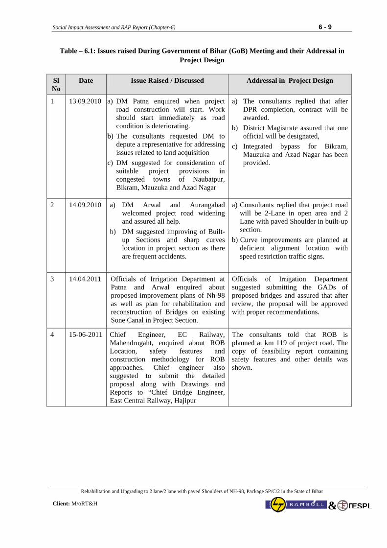
Social Impact Assessment and RAP Report (Chapter-6) 6 - 9
Rehabilitation and Upgrading to 2 lane/2 lane with paved Shoulders of NH-98, Package SP/C/2 in the State of Bihar Client: M/oRT&H
TESPL&
Table – 6.1: Issues raised During Government of Bihar (GoB) Meeting and their Addressal in Project Design
Sl No
Date Issue Raised / Discussed Addressal in Project Design
1 13.09.2010 a) DM Patna enquired when project road construction will start. Work should start immediately as road condition is deteriorating.
b) The consultants requested DM to depute a representative for addressing issues related to land acquisition
c) DM suggested for consideration of suitable project provisions in congested towns of Naubatpur, Bikram, Mauzuka and Azad Nagar
a) The consultants replied that after DPR completion, contract will be awarded.
b) District Magistrate assured that one official will be designated,
c) Integrated bypass for Bikram, Mauzuka and Azad Nagar has been provided.
2 14.09.2010 a) DM Arwal and Aurangabad welcomed project road widening and assured all help.
b) DM suggested improving of Built-up Sections and sharp curves location in project section as there are frequent accidents.
a) Consultants replied that project road will be 2-Lane in open area and 2 Lane with paved Shoulder in built-up section.
b) Curve improvements are planned at deficient alignment location with speed restriction traffic signs.
3 14.04.2011 Officials of Irrigation Department at Patna and Arwal enquired about proposed improvement plans of Nh-98 as well as plan for rehabilitation and reconstruction of Bridges on existing Sone Canal in Project Section.
Officials of Irrigation Department suggested submitting the GADs of proposed bridges and assured that after review, the proposal will be approved with proper recommendations.
4 15-06-2011 Chief Engineer, EC Railway, Mahendrugaht, enquired about ROB Location, safety features and construction methodology for ROB approaches. Chief engineer also suggested to submit the detailed proposal along with Drawings and Reports to “Chief Bridge Engineer, East Central Railway, Hajipur
The consultants told that ROB is planned at km 119 of project road. The copy of feasibility report containing safety features and other details was shown.
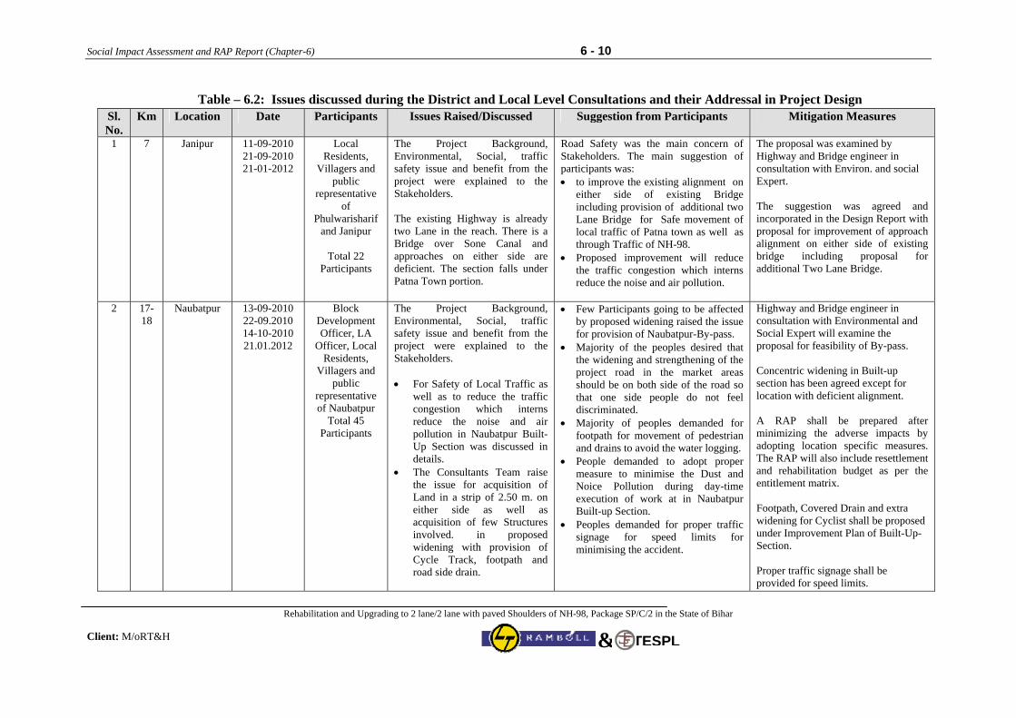
Social Impact Assessment and RAP Report (Chapter-6) 6 - 10
Rehabilitation and Upgrading to 2 lane/2 lane with paved Shoulders of NH-98, Package SP/C/2 in the State of Bihar Client: M/oRT&H
TESPL&
Table – 6.2: Issues discussed during the District and Local Level Consultations and their Addressal in Project Design
Sl. No.
Km. Location Date Participants Issues Raised/Discussed Suggestion from Participants Mitigation Measures
1 7 Janipur 11-09-2010 21-09-2010 21-01-2012
Local Residents,
Villagers and public
representative of
Phulwarisharif and Janipur
Total 22
Participants
The Project Background, Environmental, Social, traffic safety issue and benefit from the project were explained to the Stakeholders. The existing Highway is already two Lane in the reach. There is a Bridge over Sone Canal and approaches on either side are deficient. The section falls under Patna Town portion.
Road Safety was the main concern of Stakeholders. The main suggestion of participants was: • to improve the existing alignment on
either side of existing Bridge including provision of additional two Lane Bridge for Safe movement of local traffic of Patna town as well as through Traffic of NH-98.
• Proposed improvement will reduce the traffic congestion which interns reduce the noise and air pollution.
The proposal was examined by Highway and Bridge engineer in consultation with Environ. and social Expert. The suggestion was agreed and incorporated in the Design Report with proposal for improvement of approach alignment on either side of existing bridge including proposal for additional Two Lane Bridge.
2 17-18
Naubatpur 13-09-2010 22-09.2010 14-10-2010 21.01.2012
Block Development Officer, LA
Officer, Local Residents,
Villagers and public
representative of Naubatpur
Total 45 Participants
The Project Background, Environmental, Social, traffic safety issue and benefit from the project were explained to the Stakeholders. • For Safety of Local Traffic as
well as to reduce the traffic congestion which interns reduce the noise and air pollution in Naubatpur Built-Up Section was discussed in details.
• The Consultants Team raise the issue for acquisition of Land in a strip of 2.50 m. on either side as well as acquisition of few Structures involved. in proposed widening with provision of Cycle Track, footpath and road side drain.
• Few Participants going to be affected by proposed widening raised the issue for provision of Naubatpur-By-pass.
• Majority of the peoples desired that the widening and strengthening of the project road in the market areas should be on both side of the road so that one side people do not feel discriminated.
• Majority of peoples demanded for footpath for movement of pedestrian and drains to avoid the water logging.
• People demanded to adopt proper measure to minimise the Dust and Noice Pollution during day-time execution of work at in Naubatpur Built-up Section.
• Peoples demanded for proper traffic signage for speed limits for minimising the accident.
Highway and Bridge engineer in consultation with Environmental and Social Expert will examine the proposal for feasibility of By-pass. Concentric widening in Built-up section has been agreed except for location with deficient alignment. A RAP shall be prepared after minimizing the adverse impacts by adopting location specific measures. The RAP will also include resettlement and rehabilitation budget as per the entitlement matrix. Footpath, Covered Drain and extra widening for Cyclist shall be proposed under Improvement Plan of Built-Up-Section. Proper traffic signage shall be provided for speed limits.
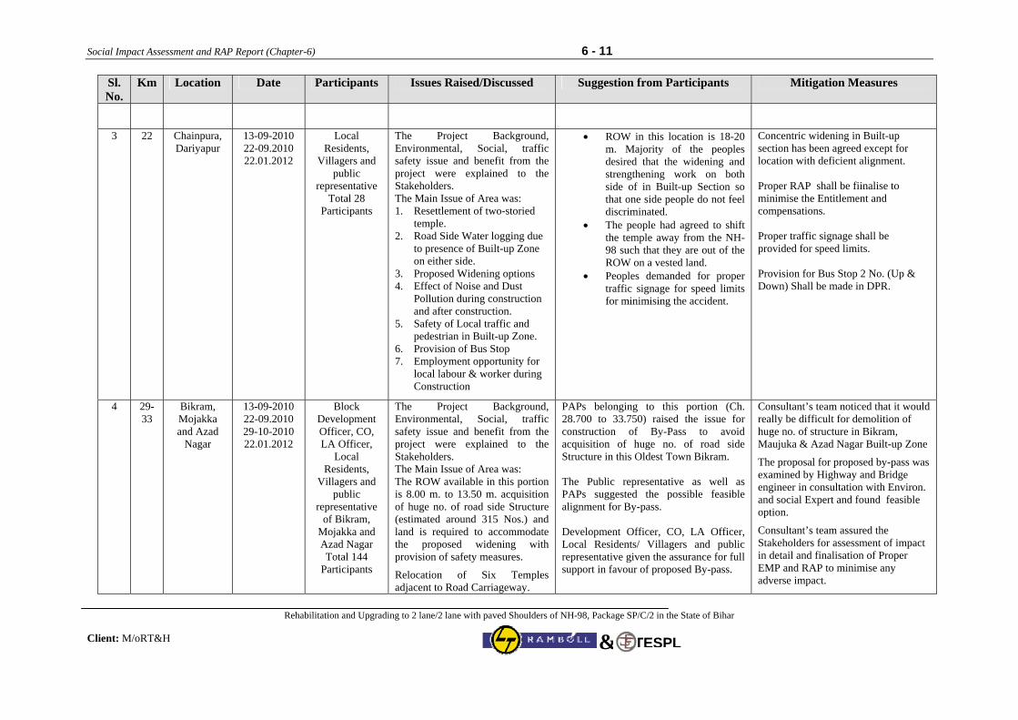
Social Impact Assessment and RAP Report (Chapter-6) 6 - 11
Rehabilitation and Upgrading to 2 lane/2 lane with paved Shoulders of NH-98, Package SP/C/2 in the State of Bihar Client: M/oRT&H
TESPL&
Sl. No.
Km. Location Date Participants Issues Raised/Discussed Suggestion from Participants Mitigation Measures
3 22 Chainpura, Dariyapur
13-09-2010 22-09.2010 22.01.2012
Local Residents,
Villagers and public
representative Total 28
Participants
The Project Background, Environmental, Social, traffic safety issue and benefit from the project were explained to the Stakeholders. The Main Issue of Area was: 1. Resettlement of two-storied
temple. 2. Road Side Water logging due
to presence of Built-up Zone on either side.
3. Proposed Widening options 4. Effect of Noise and Dust
Pollution during construction and after construction.
5. Safety of Local traffic and pedestrian in Built-up Zone.
6. Provision of Bus Stop 7. Employment opportunity for
local labour & worker during Construction
• ROW in this location is 18-20 m. Majority of the peoples desired that the widening and strengthening work on both side of in Built-up Section so that one side people do not feel discriminated.
• The people had agreed to shift the temple away from the NH-98 such that they are out of the ROW on a vested land.
• Peoples demanded for proper traffic signage for speed limits for minimising the accident.
Concentric widening in Built-up section has been agreed except for location with deficient alignment. Proper RAP shall be fiinalise to minimise the Entitlement and compensations. Proper traffic signage shall be provided for speed limits. Provision for Bus Stop 2 No. (Up & Down) Shall be made in DPR.
4 29-33
Bikram, Mojakka and Azad
Nagar
13-09-2010 22-09.2010 29-10-2010 22.01.2012
Block Development Officer, CO, LA Officer,
Local Residents,
Villagers and public
representative of Bikram,
Mojakka and Azad Nagar Total 144
Participants
The Project Background, Environmental, Social, traffic safety issue and benefit from the project were explained to the Stakeholders. The Main Issue of Area was: The ROW available in this portion is 8.00 m. to 13.50 m. acquisition of huge no. of road side Structure (estimated around 315 Nos.) and land is required to accommodate the proposed widening with provision of safety measures.
Relocation of Six Temples adjacent to Road Carriageway.
PAPs belonging to this portion (Ch. 28.700 to 33.750) raised the issue for construction of By-Pass to avoid acquisition of huge no. of road side Structure in this Oldest Town Bikram. The Public representative as well as PAPs suggested the possible feasible alignment for By-pass. Development Officer, CO, LA Officer, Local Residents/ Villagers and public representative given the assurance for full support in favour of proposed By-pass.
Consultant’s team noticed that it would really be difficult for demolition of huge no. of structure in Bikram, Maujuka & Azad Nagar Built-up Zone
The proposal for proposed by-pass was examined by Highway and Bridge engineer in consultation with Environ. and social Expert and found feasible option.
Consultant’s team assured the Stakeholders for assessment of impact in detail and finalisation of Proper EMP and RAP to minimise any adverse impact.
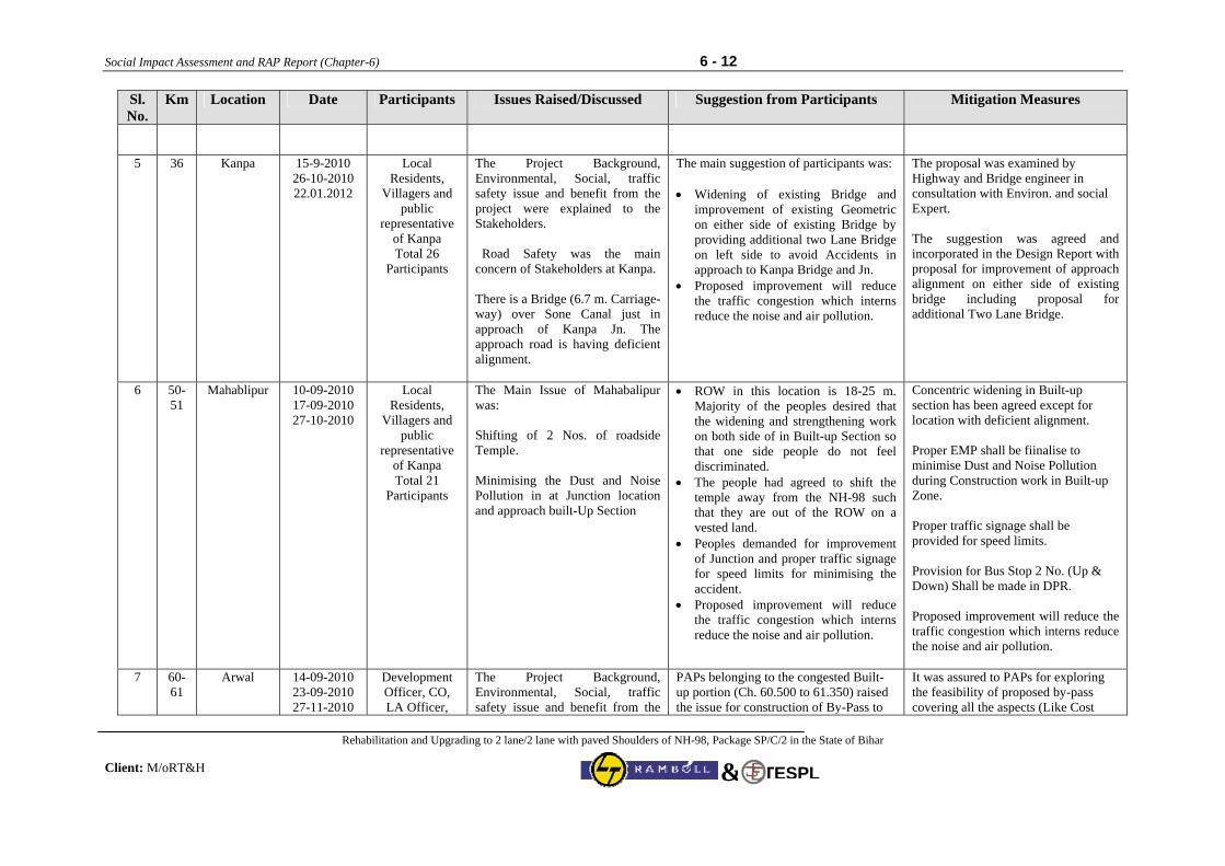
Social Impact Assessment and RAP Report (Chapter-6) 6 - 12
Rehabilitation and Upgrading to 2 lane/2 lane with paved Shoulders of NH-98, Package SP/C/2 in the State of Bihar Client: M/oRT&H
TESPL&
Sl. No.
Km. Location Date Participants Issues Raised/Discussed Suggestion from Participants Mitigation Measures
5 36 Kanpa 15-9-2010 26-10-2010 22.01.2012
Local Residents,
Villagers and public
representative of Kanpa Total 26
Participants
The Project Background, Environmental, Social, traffic safety issue and benefit from the project were explained to the Stakeholders. Road Safety was the main concern of Stakeholders at Kanpa. There is a Bridge (6.7 m. Carriage-way) over Sone Canal just in approach of Kanpa Jn. The approach road is having deficient alignment.
The main suggestion of participants was: • Widening of existing Bridge and
improvement of existing Geometric on either side of existing Bridge by providing additional two Lane Bridge on left side to avoid Accidents in approach to Kanpa Bridge and Jn.
• Proposed improvement will reduce the traffic congestion which interns reduce the noise and air pollution.
The proposal was examined by Highway and Bridge engineer in consultation with Environ. and social Expert. The suggestion was agreed and incorporated in the Design Report with proposal for improvement of approach alignment on either side of existing bridge including proposal for additional Two Lane Bridge.
6 50-51
Mahablipur 10-09-2010 17-09-2010 27-10-2010
Local Residents,
Villagers and public
representative of Kanpa Total 21
Participants
The Main Issue of Mahabalipur was: Shifting of 2 Nos. of roadside Temple. Minimising the Dust and Noise Pollution in at Junction location and approach built-Up Section
• ROW in this location is 18-25 m. Majority of the peoples desired that the widening and strengthening work on both side of in Built-up Section so that one side people do not feel discriminated.
• The people had agreed to shift the temple away from the NH-98 such that they are out of the ROW on a vested land.
• Peoples demanded for improvement of Junction and proper traffic signage for speed limits for minimising the accident.
• Proposed improvement will reduce the traffic congestion which interns reduce the noise and air pollution.
Concentric widening in Built-up section has been agreed except for location with deficient alignment. Proper EMP shall be fiinalise to minimise Dust and Noise Pollution during Construction work in Built-up Zone. Proper traffic signage shall be provided for speed limits. Provision for Bus Stop 2 No. (Up & Down) Shall be made in DPR. Proposed improvement will reduce the traffic congestion which interns reduce the noise and air pollution.
7 60-61
Arwal 14-09-2010 23-09-2010 27-11-2010
Development Officer, CO, LA Officer,
The Project Background, Environmental, Social, traffic safety issue and benefit from the
PAPs belonging to the congested Built-up portion (Ch. 60.500 to 61.350) raised the issue for construction of By-Pass to
It was assured to PAPs for exploring the feasibility of proposed by-pass covering all the aspects (Like Cost
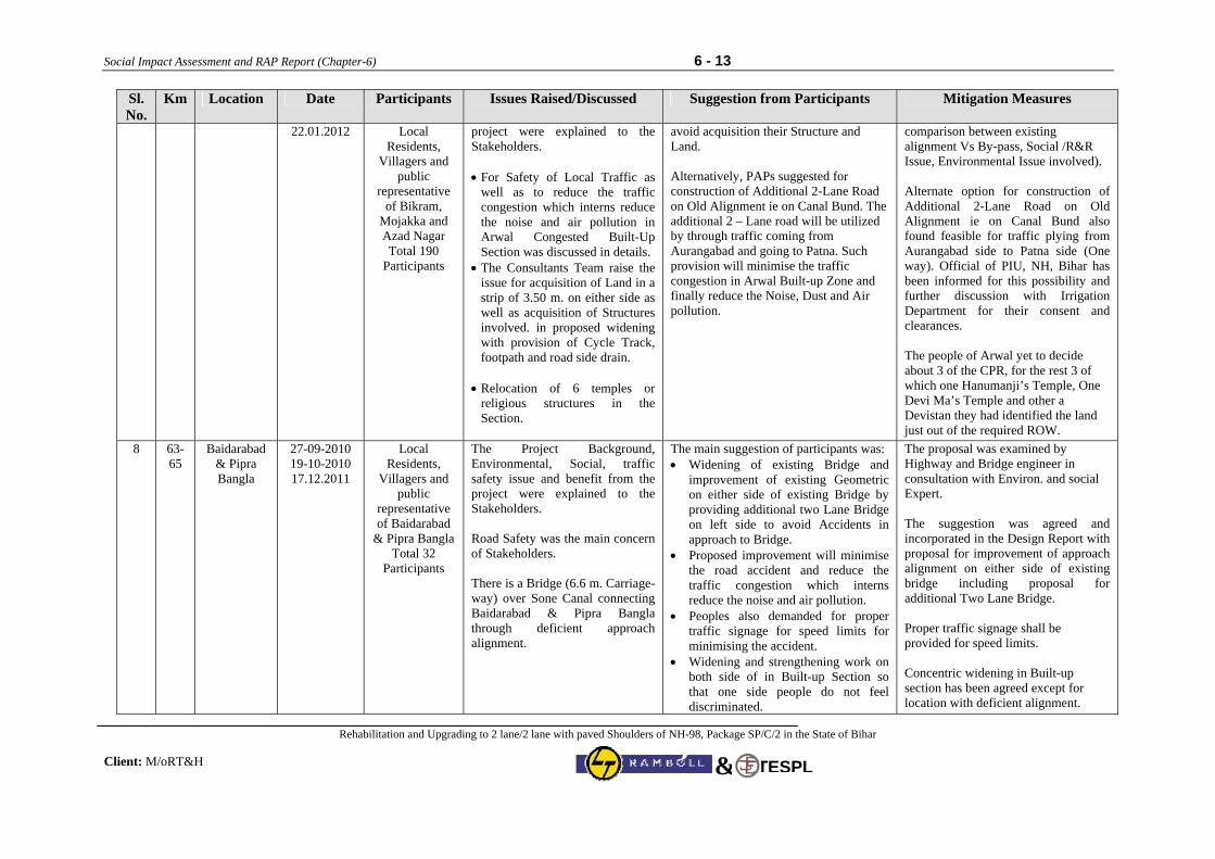
Social Impact Assessment and RAP Report (Chapter-6) 6 - 13
Rehabilitation and Upgrading to 2 lane/2 lane with paved Shoulders of NH-98, Package SP/C/2 in the State of Bihar Client: M/oRT&H
TESPL&
Sl. No.
Km. Location Date Participants Issues Raised/Discussed Suggestion from Participants Mitigation Measures
22.01.2012 Local Residents,
Villagers and public
representative of Bikram,
Mojakka and Azad Nagar Total 190
Participants
project were explained to the Stakeholders. • For Safety of Local Traffic as
well as to reduce the traffic congestion which interns reduce the noise and air pollution in Arwal Congested Built-Up Section was discussed in details.
• The Consultants Team raise the issue for acquisition of Land in a strip of 3.50 m. on either side as well as acquisition of Structures involved. in proposed widening with provision of Cycle Track, footpath and road side drain.
• Relocation of 6 temples or
religious structures in the Section.
avoid acquisition their Structure and Land. Alternatively, PAPs suggested for construction of Additional 2-Lane Road on Old Alignment ie on Canal Bund. The additional 2 – Lane road will be utilized by through traffic coming from Aurangabad and going to Patna. Such provision will minimise the traffic congestion in Arwal Built-up Zone and finally reduce the Noise, Dust and Air pollution.
comparison between existing alignment Vs By-pass, Social /R&R Issue, Environmental Issue involved). Alternate option for construction of Additional 2-Lane Road on Old Alignment ie on Canal Bund also found feasible for traffic plying from Aurangabad side to Patna side (One way). Official of PIU, NH, Bihar has been informed for this possibility and further discussion with Irrigation Department for their consent and clearances. The people of Arwal yet to decide about 3 of the CPR, for the rest 3 of which one Hanumanji’s Temple, One Devi Ma’s Temple and other a Devistan they had identified the land just out of the required ROW.
8 63-65
Baidarabad & Pipra Bangla
27-09-2010 19-10-2010 17.12.2011
Local Residents,
Villagers and public
representative of Baidarabad
& Pipra Bangla Total 32
Participants
The Project Background, Environmental, Social, traffic safety issue and benefit from the project were explained to the Stakeholders. Road Safety was the main concern of Stakeholders. There is a Bridge (6.6 m. Carriage-way) over Sone Canal connecting Baidarabad & Pipra Bangla through deficient approach alignment.
The main suggestion of participants was: • Widening of existing Bridge and
improvement of existing Geometric on either side of existing Bridge by providing additional two Lane Bridge on left side to avoid Accidents in approach to Bridge.
• Proposed improvement will minimise the road accident and reduce the traffic congestion which interns reduce the noise and air pollution.
• Peoples also demanded for proper traffic signage for speed limits for minimising the accident.
• Widening and strengthening work on both side of in Built-up Section so that one side people do not feel discriminated.
The proposal was examined by Highway and Bridge engineer in consultation with Environ. and social Expert. The suggestion was agreed and incorporated in the Design Report with proposal for improvement of approach alignment on either side of existing bridge including proposal for additional Two Lane Bridge. Proper traffic signage shall be provided for speed limits. Concentric widening in Built-up section has been agreed except for location with deficient alignment.
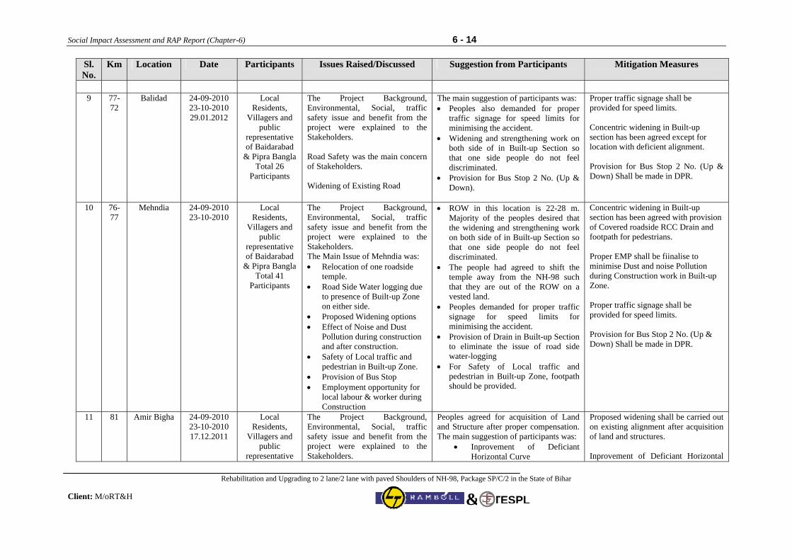
Social Impact Assessment and RAP Report (Chapter-6) 6 - 14
Rehabilitation and Upgrading to 2 lane/2 lane with paved Shoulders of NH-98, Package SP/C/2 in the State of Bihar Client: M/oRT&H
TESPL&
Sl. No.
Km. Location Date Participants Issues Raised/Discussed Suggestion from Participants Mitigation Measures
9 77-
72 Balidad
24-09-2010 23-10-2010 29.01.2012
Local Residents,
Villagers and public
representative of Baidarabad
& Pipra Bangla Total 26
Participants
The Project Background, Environmental, Social, traffic safety issue and benefit from the project were explained to the Stakeholders. Road Safety was the main concern of Stakeholders. Widening of Existing Road
The main suggestion of participants was: • Peoples also demanded for proper
traffic signage for speed limits for minimising the accident.
• Widening and strengthening work on both side of in Built-up Section so that one side people do not feel discriminated.
• Provision for Bus Stop 2 No. (Up & Down).
Proper traffic signage shall be provided for speed limits. Concentric widening in Built-up section has been agreed except for location with deficient alignment. Provision for Bus Stop 2 No. (Up & Down) Shall be made in DPR.
10
76-77
Mehndia 24-09-2010 23-10-2010
Local Residents,
Villagers and public
representative of Baidarabad
& Pipra Bangla Total 41
Participants
The Project Background, Environmental, Social, traffic safety issue and benefit from the project were explained to the Stakeholders. The Main Issue of Mehndia was: • Relocation of one roadside
temple. • Road Side Water logging due
to presence of Built-up Zone on either side.
• Proposed Widening options • Effect of Noise and Dust
Pollution during construction and after construction.
• Safety of Local traffic and pedestrian in Built-up Zone.
• Provision of Bus Stop • Employment opportunity for
local labour & worker during Construction
• ROW in this location is 22-28 m. Majority of the peoples desired that the widening and strengthening work on both side of in Built-up Section so that one side people do not feel discriminated.
• The people had agreed to shift the temple away from the NH-98 such that they are out of the ROW on a vested land.
• Peoples demanded for proper traffic signage for speed limits for minimising the accident.
• Provision of Drain in Built-up Section to eliminate the issue of road side water-logging
• For Safety of Local traffic and pedestrian in Built-up Zone, footpath should be provided.
Concentric widening in Built-up section has been agreed with provision of Covered roadside RCC Drain and footpath for pedestrians. Proper EMP shall be fiinalise to minimise Dust and noise Pollution during Construction work in Built-up Zone. Proper traffic signage shall be provided for speed limits. Provision for Bus Stop 2 No. (Up & Down) Shall be made in DPR.
11 81 Amir Bigha 24-09-2010 23-10-2010 17.12.2011
Local Residents,
Villagers and public
representative
The Project Background, Environmental, Social, traffic safety issue and benefit from the project were explained to the Stakeholders.
Peoples agreed for acquisition of Land and Structure after proper compensation. The main suggestion of participants was:
• Inprovement of Deficiant Horizontal Curve
Proposed widening shall be carried out on existing alignment after acquisition of land and structures. Inprovement of Deficiant Horizontal
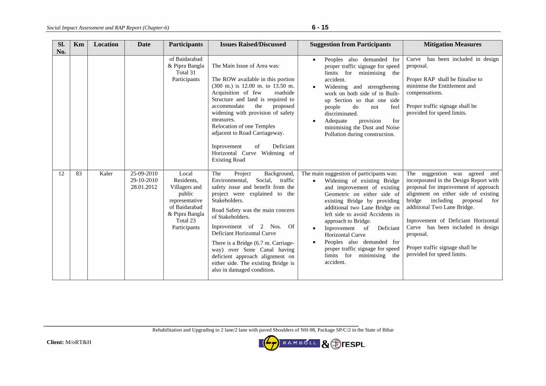
Social Impact Assessment and RAP Report (Chapter-6) 6 - 15
Rehabilitation and Upgrading to 2 lane/2 lane with paved Shoulders of NH-98, Package SP/C/2 in the State of Bihar Client: M/oRT&H
TESPL&
Sl. No.
Km. Location Date Participants Issues Raised/Discussed Suggestion from Participants Mitigation Measures
of Baidarabad & Pipra Bangla
Total 31 Participants
The Main Issue of Area was: The ROW available in this portion (300 m.) is 12.00 m. to 13.50 m. Acquisition of few roadside Structure and land is required to accommodate the proposed widening with provision of safety measures. Relocation of one Temples adjacent to Road Carriageway. Inprovement of Deficiant Horizontal Curve Widening of Existing Road
• Peoples also demanded for proper traffic signage for speed limits for minimising the accident.
• Widening and strengthening work on both side of in Built-up Section so that one side people do not feel discriminated.
• Adequate provision for minimising the Dust and Noise Pollution during construction.
Curve has been included in design proposal. Proper RAP shall be fiinalise to minimise the Entitlement and compensations. Proper traffic signage shall be provided for speed limits.
12 83 Kaler 25-09-2010 29-10-2010 28.01.2012
Local Residents,
Villagers and public
representative of Baidarabad
& Pipra Bangla Total 23
Participants
The Project Background, Environmental, Social, traffic safety issue and benefit from the project were explained to the Stakeholders.
Road Safety was the main concern of Stakeholders.
Inprovement of 2 Nos. Of Deficiant Horizontal Curve
There is a Bridge (6.7 m. Carriage-way) over Sone Canal having deficient approach alignment on either side. The existing Bridge is also in damaged condition.
The main suggestion of participants was: • Widening of existing Bridge
and improvement of existing Geometric on either side of existing Bridge by providing additional two Lane Bridge on left side to avoid Accidents in approach to Bridge.
• Inprovement of Deficiant Horizontal Curve
• Peoples also demanded for proper traffic signage for speed limits for minimising the accident.
The suggestion was agreed and incorporated in the Design Report with proposal for improvement of approach alignment on either side of existing bridge including proposal for additional Two Lane Bridge. Inprovement of Deficiant Horizontal Curve has been included in design proposal. Proper traffic signage shall be provided for speed limits.
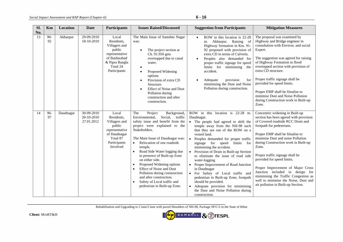
Social Impact Assessment and RAP Report (Chapter-6) 6 - 16
Rehabilitation and Upgrading to 2 lane/2 lane with paved Shoulders of NH-98, Package SP/C/2 in the State of Bihar Client: M/oRT&H
TESPL&
Sl. No.
Km. Location Date Participants Issues Raised/Discussed Suggestion from Participants Mitigation Measures
13 90-92
Akbarpur 29-09-2010 18-10-2010
Local Residents,
Villagers and public
representative of Baidarabad
& Pipra Bangla Total 24
Participants
The Main Issue of Samsher Nagar was:
• The project section at Ch. 91.950 gets overtopped due to canal water.
• • Proposed Widening
options • Provision of extra CD
Structure. • Effect of Noise and Dust
Pollution during construction and after construction.
• ROW in this location is 22-28 m. Akbarpur. Raising of Highway formation in Km. 91-92 proposed with provision of extra CD in terms of Culverts.
• Peoples also demanded for proper traffic signage for speed limits for minimising the accident.
• Adequate provision for
minimising the Dust and Noise Pollution during construction.
The proposal was examined by Highway and Bridge engineer in consultation with Environ. and social Expert. The suggestion was agreed for raising of Highway Formation in flood overtopped section with provision of extra CD structure. Proper traffic signage shall be provided for speed limits. Proper EMP shall be fiinalise to minimise Dust and Noise Pollution during Construction work in Built-up Zone.
14 96-97
Daudnagar 30-09-2010 20-10-2010 27.01.2012
Local Residents,
Villagers and public
representative of Daudnagar
Total 87 Participants
Involved
The Project Background, Environmental, Social, traffic safety issue and benefit from the project were explained to the Stakeholders. The Main Issue of Daudnagar was: • Relocation of one roadside
temple. • Road Side Water logging due
to presence of Built-up Zone on either side.
• Proposed Widening options • Effect of Noise and Dust
Pollution during construction and after construction.
• Safety of Local traffic and pedestrian in Built-up Zone.
ROW in this location is 22-28 m. Daudnagar. • The people had agreed to shift the
temple away from the NH-98 such that they are out of the ROW on a vested land.
• Peoples demanded for proper traffic signage for speed limits for minimising the accident.
• Provision of Drain in Built-up Section to eliminate the issue of road side water-logging
• Proper Improvement of Road Junction in Daudnagar
• For Safety of Local traffic and pedestrian in Built-up Zone, footpath should be provided.
• Adequate provision for minimising the Dust and Noise Pollution during construction.
Concentric widening in Built-up section has been agreed with provision of Covered roadside RCC Drain and footpath for pedestrians. Proper EMP shall be fiinalise to minimise Dust and noise Pollution during Construction work in Built-up Zone. Proper traffic signage shall be provided for speed limits. Proper Improvement of Major Cross Junction included in design for minimising the Traffic Congestion as well to minimise the Noise, Dust and air pollution in Built-up Section.
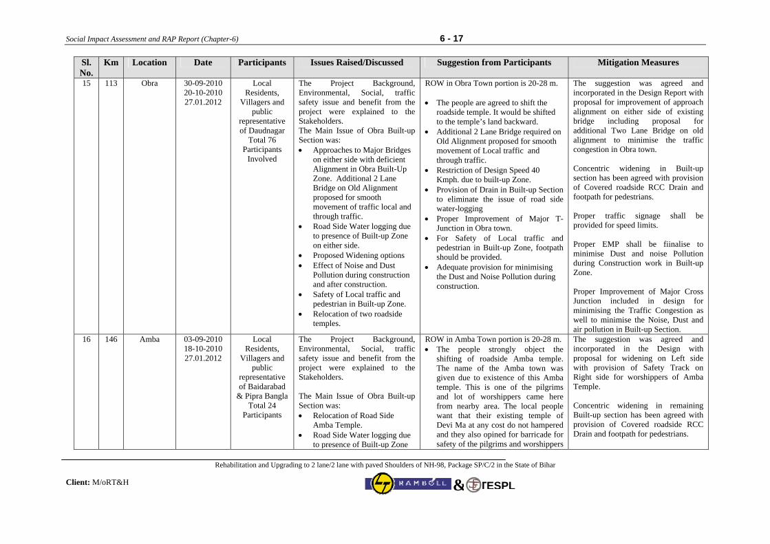
Social Impact Assessment and RAP Report (Chapter-6) 6 - 17
Rehabilitation and Upgrading to 2 lane/2 lane with paved Shoulders of NH-98, Package SP/C/2 in the State of Bihar Client: M/oRT&H
TESPL&
Sl. No.
Km. Location Date Participants Issues Raised/Discussed Suggestion from Participants Mitigation Measures
15 113 Obra 30-09-2010 20-10-2010 27.01.2012
Local Residents,
Villagers and public
representative of Daudnagar
Total 76 Participants
Involved
The Project Background, Environmental, Social, traffic safety issue and benefit from the project were explained to the Stakeholders. The Main Issue of Obra Built-up Section was: • Approaches to Major Bridges
on either side with deficient Alignment in Obra Built-Up Zone. Additional 2 Lane Bridge on Old Alignment proposed for smooth movement of traffic local and through traffic.
• Road Side Water logging due to presence of Built-up Zone on either side.
• Proposed Widening options • Effect of Noise and Dust
Pollution during construction and after construction.
• Safety of Local traffic and pedestrian in Built-up Zone.
• Relocation of two roadside temples.
ROW in Obra Town portion is 20-28 m. • The people are agreed to shift the
roadside temple. It would be shifted to the temple’s land backward.
• Additional 2 Lane Bridge required on Old Alignment proposed for smooth movement of Local traffic and through traffic.
• Restriction of Design Speed 40 Kmph. due to built-up Zone.
• Provision of Drain in Built-up Section to eliminate the issue of road side water-logging
• Proper Improvement of Major T- Junction in Obra town.
• For Safety of Local traffic and pedestrian in Built-up Zone, footpath should be provided.
• Adequate provision for minimising the Dust and Noise Pollution during construction.
The suggestion was agreed and incorporated in the Design Report with proposal for improvement of approach alignment on either side of existing bridge including proposal for additional Two Lane Bridge on old alignment to minimise the traffic congestion in Obra town. Concentric widening in Built-up section has been agreed with provision of Covered roadside RCC Drain and footpath for pedestrians. Proper traffic signage shall be provided for speed limits. Proper EMP shall be fiinalise to minimise Dust and noise Pollution during Construction work in Built-up Zone. Proper Improvement of Major Cross Junction included in design for minimising the Traffic Congestion as well to minimise the Noise, Dust and air pollution in Built-up Section.
16 146 Amba 03-09-2010 18-10-2010 27.01.2012
Local Residents,
Villagers and public
representative of Baidarabad
& Pipra Bangla Total 24
Participants
The Project Background, Environmental, Social, traffic safety issue and benefit from the project were explained to the Stakeholders. The Main Issue of Obra Built-up Section was: • Relocation of Road Side
Amba Temple. • Road Side Water logging due
to presence of Built-up Zone
ROW in Amba Town portion is 20-28 m. • The people strongly object the
shifting of roadside Amba temple. The name of the Amba town was given due to existence of this Amba temple. This is one of the pilgrims and lot of worshippers came here from nearby area. The local people want that their existing temple of Devi Ma at any cost do not hampered and they also opined for barricade for safety of the pilgrims and worshippers
The suggestion was agreed and incorporated in the Design with proposal for widening on Left side with provision of Safety Track on Right side for worshippers of Amba Temple. Concentric widening in remaining Built-up section has been agreed with provision of Covered roadside RCC Drain and footpath for pedestrians.
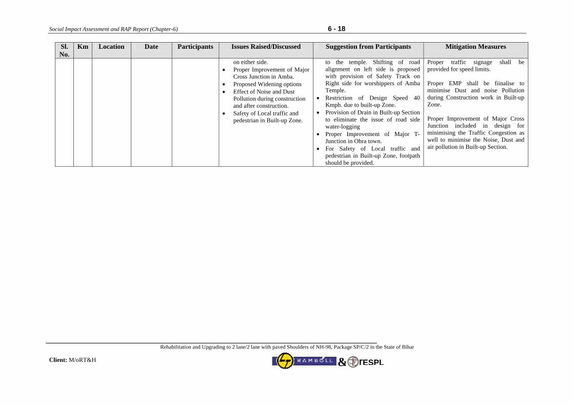
Social Impact Assessment and RAP Report (Chapter-6) 6 - 18
Rehabilitation and Upgrading to 2 lane/2 lane with paved Shoulders of NH-98, Package SP/C/2 in the State of Bihar Client: M/oRT&H
TESPL&
Sl. No.
Km. Location Date Participants Issues Raised/Discussed Suggestion from Participants Mitigation Measures
on either side. • Proper Improvement of Major
Cross Junction in Amba. • Proposed Widening options • Effect of Noise and Dust
Pollution during construction and after construction.
• Safety of Local traffic and pedestrian in Built-up Zone.
to the temple. Shifting of road alignment on left side is proposed with provision of Safety Track on Right side for worshippers of Amba Temple.
• Restriction of Design Speed 40 Kmph. due to built-up Zone.
• Provision of Drain in Built-up Section to eliminate the issue of road side water-logging
• Proper Improvement of Major T- Junction in Obra town.
• For Safety of Local traffic and pedestrian in Built-up Zone, footpath should be provided.
Proper traffic signage shall be provided for speed limits. Proper EMP shall be fiinalise to minimise Dust and noise Pollution during Construction work in Built-up Zone. Proper Improvement of Major Cross Junction included in design for minimising the Traffic Congestion as well to minimise the Noise, Dust and air pollution in Built-up Section.
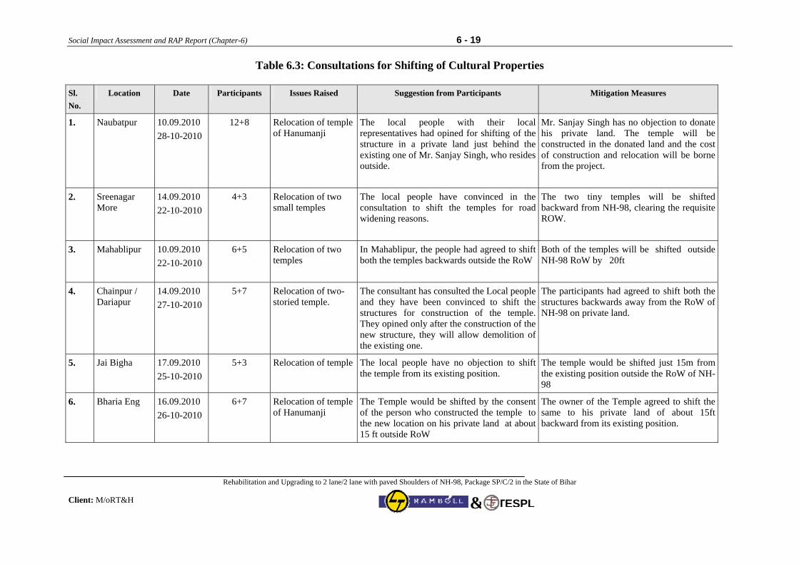
Social Impact Assessment and RAP Report (Chapter-6) 6 - 19
Rehabilitation and Upgrading to 2 lane/2 lane with paved Shoulders of NH-98, Package SP/C/2 in the State of Bihar Client: M/oRT&H
TESPL&
Table 6.3: Consultations for Shifting of Cultural Properties
Sl. No.
Location Date Participants Issues Raised Suggestion from Participants Mitigation Measures
1. Naubatpur 10.09.2010 28-10-2010
12+8 Relocation of temple of Hanumanji
The local people with their local representatives had opined for shifting of the structure in a private land just behind the existing one of Mr. Sanjay Singh, who resides outside.
Mr. Sanjay Singh has no objection to donate his private land. The temple will be constructed in the donated land and the cost of construction and relocation will be borne from the project.
2. Sreenagar More
14.09.2010 22-10-2010
4+3 Relocation of two small temples
The local people have convinced in the consultation to shift the temples for road widening reasons.
The two tiny temples will be shifted backward from NH-98, clearing the requisite ROW.
3. Mahablipur 10.09.2010 22-10-2010
6+5 Relocation of two temples
In Mahablipur, the people had agreed to shift both the temples backwards outside the RoW
Both of the temples will be shifted outside NH-98 RoW by 20ft
4. Chainpur / Dariapur
14.09.2010 27-10-2010
5+7 Relocation of two-storied temple.
The consultant has consulted the Local people and they have been convinced to shift the structures for construction of the temple. They opined only after the construction of the new structure, they will allow demolition of the existing one.
The participants had agreed to shift both the structures backwards away from the RoW of NH-98 on private land.
5. Jai Bigha 17.09.2010 25-10-2010
5+3 Relocation of temple The local people have no objection to shift the temple from its existing position.
The temple would be shifted just 15m from the existing position outside the RoW of NH-98
6. Bharia Eng 16.09.2010 26-10-2010
6+7 Relocation of temple of Hanumanji
The Temple would be shifted by the consent of the person who constructed the temple to the new location on his private land at about 15 ft outside RoW
The owner of the Temple agreed to shift the same to his private land of about 15ft backward from its existing position.
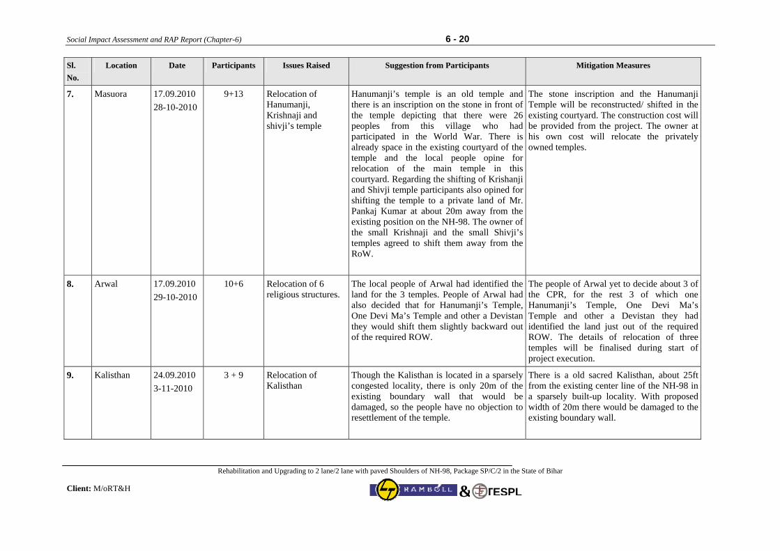
Social Impact Assessment and RAP Report (Chapter-6) 6 - 20
Rehabilitation and Upgrading to 2 lane/2 lane with paved Shoulders of NH-98, Package SP/C/2 in the State of Bihar Client: M/oRT&H
TESPL&
Sl. No.
Location Date Participants Issues Raised Suggestion from Participants Mitigation Measures
7. Masuora 17.09.2010 28-10-2010
9+13 Relocation of Hanumanji, Krishnaji and shivji’s temple
Hanumanji’s temple is an old temple and there is an inscription on the stone in front of the temple depicting that there were 26 peoples from this village who had participated in the World War. There is already space in the existing courtyard of the temple and the local people opine for relocation of the main temple in this courtyard. Regarding the shifting of Krishanji and Shivji temple participants also opined for shifting the temple to a private land of Mr. Pankaj Kumar at about 20m away from the existing position on the NH-98. The owner of the small Krishnaji and the small Shivji’s temples agreed to shift them away from the RoW.
The stone inscription and the Hanumanji Temple will be reconstructed/ shifted in the existing courtyard. The construction cost will be provided from the project. The owner at his own cost will relocate the privately owned temples.
8. Arwal 17.09.2010 29-10-2010
10+6 Relocation of 6 religious structures.
The local people of Arwal had identified the land for the 3 temples. People of Arwal had also decided that for Hanumanji’s Temple, One Devi Ma’s Temple and other a Devistan they would shift them slightly backward out of the required ROW.
The people of Arwal yet to decide about 3 of the CPR, for the rest 3 of which one Hanumanji’s Temple, One Devi Ma’s Temple and other a Devistan they had identified the land just out of the required ROW. The details of relocation of three temples will be finalised during start of project execution.
9. Kalisthan 24.09.2010 3-11-2010
3 + 9 Relocation of Kalisthan
Though the Kalisthan is located in a sparsely congested locality, there is only 20m of the existing boundary wall that would be damaged, so the people have no objection to resettlement of the temple.
There is a old sacred Kalisthan, about 25ft from the existing center line of the NH-98 in a sparsely built-up locality. With proposed width of 20m there would be damaged to the existing boundary wall.
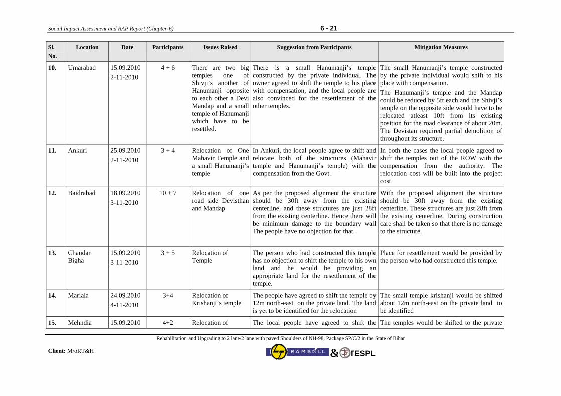
Social Impact Assessment and RAP Report (Chapter-6) 6 - 21
Rehabilitation and Upgrading to 2 lane/2 lane with paved Shoulders of NH-98, Package SP/C/2 in the State of Bihar Client: M/oRT&H
TESPL&
Sl. No.
Location Date Participants Issues Raised Suggestion from Participants Mitigation Measures
10. Umarabad 15.09.2010 2-11-2010
4 + 6 There are two big temples one of Shivji’s another of Hanumanji opposite to each other a Devi Mandap and a small temple of Hanumanji which have to be resettled.
There is a small Hanumanji’s temple constructed by the private individual. The owner agreed to shift the temple to his place with compensation, and the local people are also convinced for the resettlement of the other temples.
The small Hanumanji’s temple constructed by the private individual would shift to his place with compensation. The Hanumanji’s temple and the Mandap could be reduced by 5ft each and the Shivji’s temple on the opposite side would have to be relocated atleast 10ft from its existing position for the road clearance of about 20m. The Devistan required partial demolition of throughout its structure.
11. Ankuri 25.09.2010 2-11-2010
3 + 4 Relocation of One Mahavir Temple and a small Hanumanji’s temple
In Ankuri, the local people agree to shift and relocate both of the structures (Mahavir temple and Hanumanji’s temple) with the compensation from the Govt.
In both the cases the local people agreed to shift the temples out of the ROW with the compensation from the authority. The relocation cost will be built into the project cost
12. Baidrabad 18.09.2010 3-11-2010
10 + 7 Relocation of one road side Devisthan and Mandap
As per the proposed alignment the structure should be 30ft away from the existing centerline, and these structures are just 28ft from the existing centerline. Hence there will be minimum damage to the boundary wall The people have no objection for that.
With the proposed alignment the structure should be 30ft away from the existing centerline. These structures are just 28ft from the existing centerline. During construction care shall be taken so that there is no damage to the structure.
13. Chandan Bigha
15.09.2010 3-11-2010
3 + 5 Relocation of Temple
The person who had constructed this temple has no objection to shift the temple to his own land and he would be providing an appropriate land for the resettlement of the temple.
Place for resettlement would be provided by the person who had constructed this temple.
14. Mariala 24.09.2010 4-11-2010
3+4 Relocation of Krishanji’s temple
The people have agreed to shift the temple by 12m north-east on the private land. The land is yet to be identified for the relocation
The small temple krishanji would be shifted about 12m north-east on the private land to be identified
15. Mehndia 15.09.2010 4+2 Relocation of l
The local people have agreed to shift the l h i l d f d il d
The temples would be shifted to the private l d id
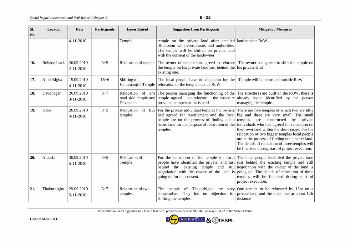
Social Impact Assessment and RAP Report (Chapter-6) 6 - 22
Rehabilitation and Upgrading to 2 lane/2 lane with paved Shoulders of NH-98, Package SP/C/2 in the State of Bihar Client: M/oRT&H
TESPL&
Sl. No.
Location Date Participants Issues Raised Suggestion from Participants Mitigation Measures
4-11-2010 Temple temple on the private land after detailed discussion with consultants and authorities. The temple will be shifted on private land with the consent of the landowner.
land outside RoW.
16. Belshar Lock 26.09.2010 2-11-2010
3+5 Relocation of temple The owner of temple has agreed to relocate the temple on his private land just behind the existing one.
The owner has agreed to shift the temple on his private land
17. Amir Bigha 15.09.2010 4-11-2010
16+6 Shifting of Hanumanji’s Temple
The local people have no objection for the relocation of the temple outside RoW
Temple will be relocated outside RoW
18. Daudnagar 26.09.2010 3-11-2010
3+7 Relocation of one road side temple and Devisthan
The person managing the functioning of the temple agreed to relocate the structure provided compensation is paid
The structures are built on the ROW, there is already space identified by the person managing the temple.
19. Kaler 26.09.2010 4-11-2010
8+5 Relocation of five temples
For the private individual temples the owners had agreed for resettlement and the local people are on the process of finding out a better land for the purpose of relocation of the temples.
There are five temples of which two are little big and three are very small. The small temples are constructed by private individuals who had agreed for relocation on their own land within the short range. For the relocation of two bigger temples local people are in the process of finding out a better land. The details of relocation of three temples will be finalised during start of project execution.
20. Aranda 30.09.2010 5-11-2010
3+5 Relocation of Temple
For the relocation of the temple the local people have identified the private land just behind the existing temple and still negotiation with the owner of the land is going on for his consent.
The local people identified the private land just behind the existing temple and still negotiation with the owner of the land is going on. The details of relocation of three temples will be finalised during start of project execution.
21. Thakurbigha 29.09.2010 5-11-2010
5+7 Relocation of two temples
The people of Thakurbigha are very cooperative. They has no objection for shifting the temples.
One temple to be relocated by 15m on a private land and the other one at about 12ft distance
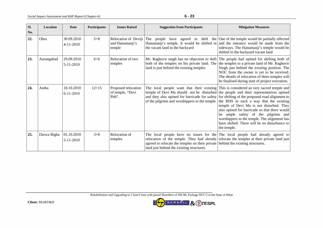
Social Impact Assessment and RAP Report (Chapter-6) 6 - 23
Rehabilitation and Upgrading to 2 lane/2 lane with paved Shoulders of NH-98, Package SP/C/2 in the State of Bihar Client: M/oRT&H
TESPL&
Sl. No.
Location Date Participants Issues Raised Suggestion from Participants Mitigation Measures
22. Obra 30.09.2010 4-11-2010
5+8 Relocation of Deviji and Hanumanji’s temple
The people have agreed to shift the Hanumanji’s temple. It would be shifted in the vacant land in the backyard
One of the temple would be partially affected and the entrance would be made from the sideways. The Hanumanji’s temple would be shifted in the backyard vacant land
23. Aurangabad 29.09.2010 5-11-2010
6+6 Relocation of two temples
Mr. Raghuvir singh has no objection to shift both of the temples on his private land. The land is just behind the existing temples
The people had opined for shifting both of the temples to a private land of Mr. Raghuvir Singh just behind the existing position. The NOC from the owner is yet to be received. The details of relocation of three temples will be finalised during start of project execution.
24. Amba 18.10.2010 6-11-2010
12+15 Proposed relocation of temple, “Devi Pith”.
The local people want that their existing temple of Devi Ma should not be disturbed and they also opined for barricade for safety of the pilgrims and worshippers to the temple.
This is considered as very sacred temple and the people and their representatives opined for shifting of the proposed road alignment to the RHS in such a way that the existing temple of Devi Ma is not disturbed. They also opined for barricade so that there would be ample safety of the pilgrims and worshippers to the temple. The alignment has been shifted. There will be no disturbance to the temple.
25. Darwa Bigha 01.10.2010 5-11-2010
3+8 Relocation of temples
The local people have no issues for the relocation of the temple. They had already agreed to relocate the temples on their private land just behind the existing structures.
The local people had already agreed to relocate the temples at their private land just behind the existing structures.
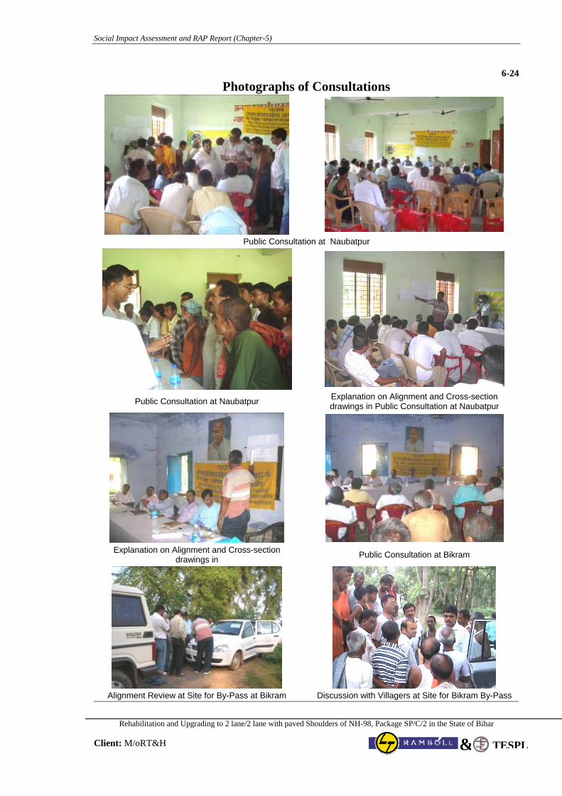
Social Impact Assessment and RAP Report (Chapter-5)
Rehabilitation and Upgrading to 2 lane/2 lane with paved Shoulders of NH-98, Package SP/C/2 in the State of Bihar
Client: M/oRT&H TESPL&
6-24 Photographs of Consultations
Public Consultation at Naubatpur
Public Consultation at Naubatpur Explanation on Alignment and Cross-section drawings in Public Consultation at Naubatpur
Explanation on Alignment and Cross-section
drawings in Public Consultation at Bikram
Alignment Review at Site for By-Pass at Bikram Discussion with Villagers at Site for Bikram By-Pass
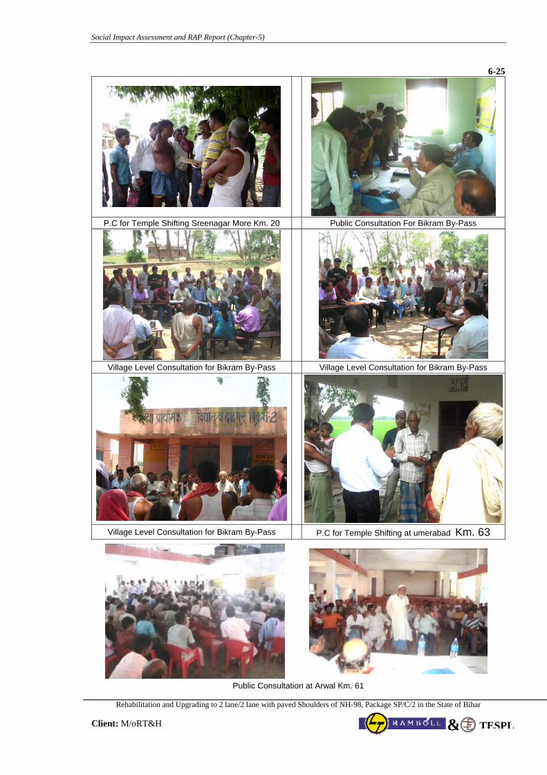
Social Impact Assessment and RAP Report (Chapter-5)
Rehabilitation and Upgrading to 2 lane/2 lane with paved Shoulders of NH-98, Package SP/C/2 in the State of Bihar
Client: M/oRT&H TESPL&
6-25
P.C for Temple Shifting Sreenagar More Km. 20 Public Consultation For Bikram By-Pass
Village Level Consultation for Bikram By-Pass Village Level Consultation for Bikram By-Pass
Village Level Consultation for Bikram By-Pass P.C for Temple Shifting at umerabad Km. 63
Public Consultation at Arwal Km. 61
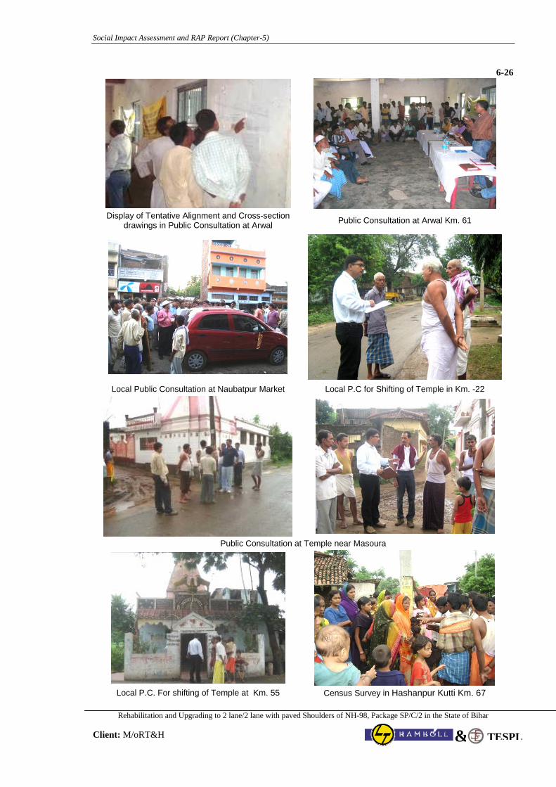
Social Impact Assessment and RAP Report (Chapter-5)
Rehabilitation and Upgrading to 2 lane/2 lane with paved Shoulders of NH-98, Package SP/C/2 in the State of Bihar
Client: M/oRT&H TESPL&
6-26
Display of Tentative Alignment and Cross-section
drawings in Public Consultation at Arwal Public Consultation at Arwal Km. 61
Local Public Consultation at Naubatpur Market Local P.C for Shifting of Temple in Km. -22
Public Consultation at Temple near Masoura
Local P.C. For shifting of Temple at Km. 55 Census Survey in Hashanpur Kutti Km. 67
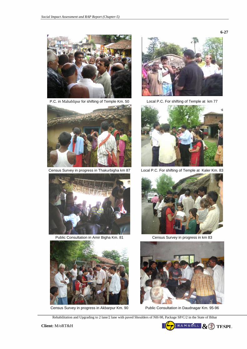
Social Impact Assessment and RAP Report (Chapter-5)
Rehabilitation and Upgrading to 2 lane/2 lane with paved Shoulders of NH-98, Package SP/C/2 in the State of Bihar
Client: M/oRT&H TESPL&
6-27
P.C. in Mahablipur for shifting of Temple Km. 50 Local P.C. For shifting of Temple at km 77
Census Survey in progress in Thakurbigha km 87 Local P.C. For shifting of Temple at Kaler Km. 83
Public Consultation in Amir Bigha Km. 81 Census Survey in progress in km 83
Census Survey in progress in Akbarpur Km. 90 Public Consultation in Daudnagar Km. 95-96
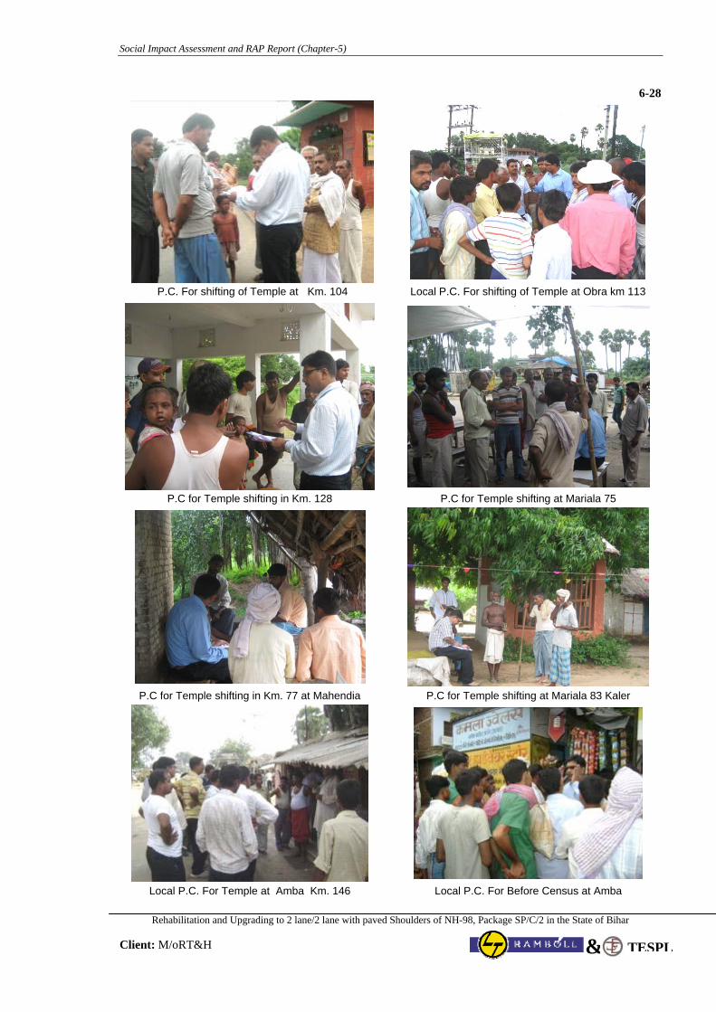
Social Impact Assessment and RAP Report (Chapter-5)
Rehabilitation and Upgrading to 2 lane/2 lane with paved Shoulders of NH-98, Package SP/C/2 in the State of Bihar
Client: M/oRT&H TESPL&
6-28
P.C. For shifting of Temple at Km. 104 Local P.C. For shifting of Temple at Obra km 113
P.C for Temple shifting in Km. 128 P.C for Temple shifting at Mariala 75
P.C for Temple shifting in Km. 77 at Mahendia P.C for Temple shifting at Mariala 83 Kaler
Local P.C. For Temple at Amba Km. 146 Local P.C. For Before Census at Amba
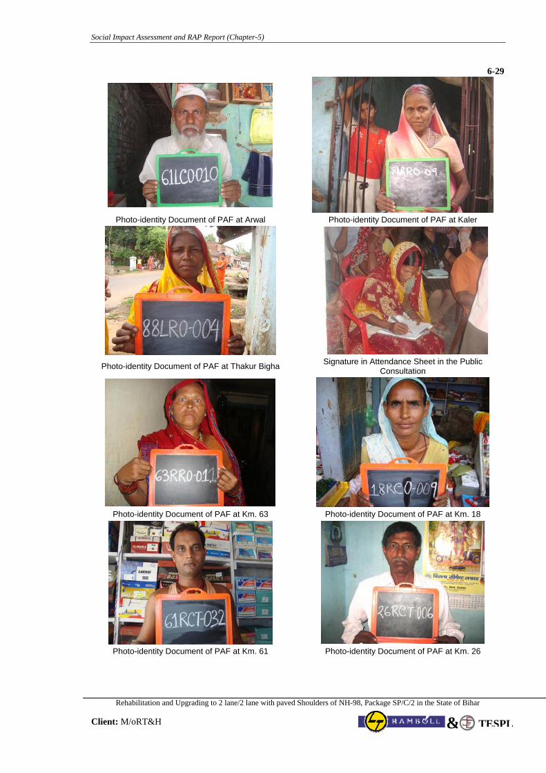
Social Impact Assessment and RAP Report (Chapter-5)
Rehabilitation and Upgrading to 2 lane/2 lane with paved Shoulders of NH-98, Package SP/C/2 in the State of Bihar
Client: M/oRT&H TESPL&
6-29
Photo-identity Document of PAF at Arwal Photo-identity Document of PAF at Kaler
Photo-identity Document of PAF at Thakur Bigha Signature in Attendance Sheet in the Public Consultation
Photo-identity Document of PAF at Km. 63 Photo-identity Document of PAF at Km. 18
Photo-identity Document of PAF at Km. 61 Photo-identity Document of PAF at Km. 26
Social Impact Assessment and RAP Report (Chapter-7) 7 - 1
Rehabilitation and Upgrading to 2 lane/2 lane with paved Shoulders of NH-98, Package SP/C/2 in the State of Bihar
Client: M/oRT&H TESPL&
CHAPTER 7: MINIMIZING NEGATIVE SOCIAL IMPACT
7.1 Right of Way and its Impact As already mentioned in Chapter 5 that the available RoW through out the project stretch is sufficient for accommodating the proposed development of Highway as 2 lane/2 lane with paved shoulders configuration, except few congested built-up sections: Naubatpur (Km 17-18), Bikram-Mauzaka-Azadnagar (km. 28-34), Arwal (Km. 60-64) and Amir Bigha (Km. 81). Proposed improvement with marginal land acquisition in Naubatpur and Amir Bigha have been finalised after series of public consultations. Existing Arwal Built-up section is already two-lane with thorough encroachment. For accommodating the provision of paved shoulder, drains, footpath and road safety measures, it has been proposed to remove the encroachment to the extent of Corridor of Impact of 16 m. The existing highway section in congested Bikram-Mauzaka-Azadnagar (km. 28-34) is single lane with existing ROW 8 to 12m.. For improvement of Bikram-Mauzaka-Azadnagar, a By-pass (Ch. 27.50 to 33.900) has been proposed after through survey, investigation, design and series of detailed public consultations. Area of LA in Bikram By-pass is around 80 % area of total Land acquisition involved in the project section. Further, land acquisition involved in project section for construction of ROB in Km. 118-119, few small realignment at in Km. 35, 64-65, 83, 96-97. The major impact in this project stretch is on the titleholder Land looser under proposed Bikram By-pass and non-titleholder squatters and kiosks that have come up within the RoW throughout the project section especially at Arwal. As per census survey, summary of PAFs of different forms due to proposed improvement proposal of highway is presented below in Table 7.1.
Table 7.1 : Summary of PAFs of different forms in Project Section
Sl. No. Type of Land Total Nos. of PAFs
Title Holder Agriculture Land Losers 597 Land and Structure Losers 11
1
Non-agriculture Land Losers 0
Non Title Holder Squatters 419
2. Kiosks 404
Total No. of PAFs of different forms 1431 7.2 Designs and R&R Coordination There are three key elements in designing any road network improvement/ strengthening project and these are widening options, alternative alignments/ bypasses and junction improvements. The design features and the development options were finalized in consultation with the R&R team and the process continued through out the planning process where inputs from the R&R team were incorporated in the engineering design by the design team. The broad parameters considered by the design team based on the inputs from the R&R surveys were: • Minimize the impact on roadside settlements • Minimize impact on agricultural land
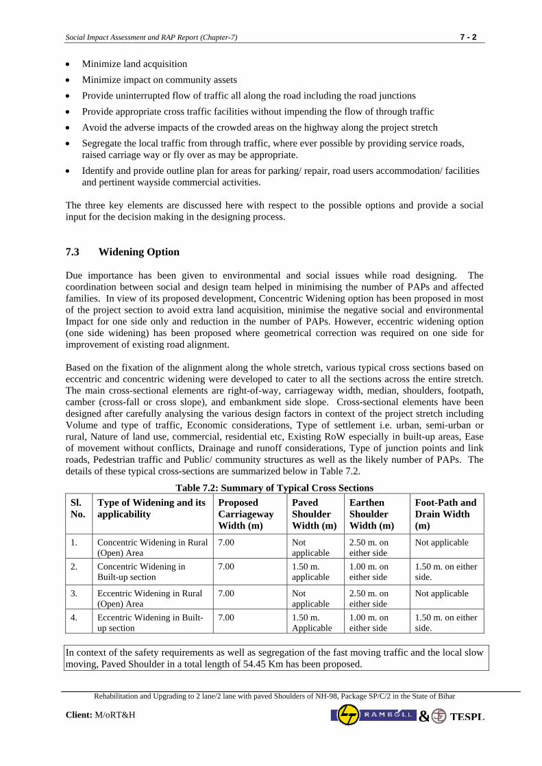
Social Impact Assessment and RAP Report (Chapter-7) 7 - 2
Rehabilitation and Upgrading to 2 lane/2 lane with paved Shoulders of NH-98, Package SP/C/2 in the State of Bihar
Client: M/oRT&H TESPL&
• Minimize land acquisition • Minimize impact on community assets • Provide uninterrupted flow of traffic all along the road including the road junctions • Provide appropriate cross traffic facilities without impending the flow of through traffic • Avoid the adverse impacts of the crowded areas on the highway along the project stretch • Segregate the local traffic from through traffic, where ever possible by providing service roads,
raised carriage way or fly over as may be appropriate. • Identify and provide outline plan for areas for parking/ repair, road users accommodation/ facilities
and pertinent wayside commercial activities. The three key elements are discussed here with respect to the possible options and provide a social input for the decision making in the designing process. 7.3 Widening Option Due importance has been given to environmental and social issues while road designing. The coordination between social and design team helped in minimising the number of PAPs and affected families. In view of its proposed development, Concentric Widening option has been proposed in most of the project section to avoid extra land acquisition, minimise the negative social and environmental Impact for one side only and reduction in the number of PAPs. However, eccentric widening option (one side widening) has been proposed where geometrical correction was required on one side for improvement of existing road alignment. Based on the fixation of the alignment along the whole stretch, various typical cross sections based on eccentric and concentric widening were developed to cater to all the sections across the entire stretch. The main cross-sectional elements are right-of-way, carriageway width, median, shoulders, footpath, camber (cross-fall or cross slope), and embankment side slope. Cross-sectional elements have been designed after carefully analysing the various design factors in context of the project stretch including Volume and type of traffic, Economic considerations, Type of settlement i.e. urban, semi-urban or rural, Nature of land use, commercial, residential etc, Existing RoW especially in built-up areas, Ease of movement without conflicts, Drainage and runoff considerations, Type of junction points and link roads, Pedestrian traffic and Public/ community structures as well as the likely number of PAPs. The details of these typical cross-sections are summarized below in Table 7.2.
Table 7.2: Summary of Typical Cross Sections Sl. No.
Type of Widening and its applicability
Proposed Carriageway Width (m)
Paved Shoulder Width (m)
Earthen Shoulder Width (m)
Foot-Path and Drain Width (m)
1. Concentric Widening in Rural (Open) Area
7.00 Not applicable
2.50 m. on either side
Not applicable
2.
Concentric Widening in Built-up section
7.00 1.50 m. applicable
1.00 m. on either side
1.50 m. on either side.
3. Eccentric Widening in Rural (Open) Area
7.00 Not applicable
2.50 m. on either side
Not applicable
4. Eccentric Widening in Built-up section
7.00 1.50 m. Applicable
1.00 m. on either side
1.50 m. on either side.
In context of the safety requirements as well as segregation of the fast moving traffic and the local slow moving, Paved Shoulder in a total length of 54.45 Km has been proposed.
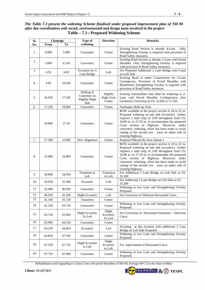
Social Impact Assessment and RAP Report (Chapter-7) 7 - 3
Rehabilitation and Upgrading to 2 lane/2 lane with paved Shoulders of NH-98, Package SP/C/2 in the State of Bihar
Client: M/oRT&H TESPL&
The Table 7.3 present the widening Scheme finalised under proposed improvement plan of NH-98 after due coordination with social, environmental and design team involved in the project
Table – 7.3 : Proposed Widening Scheme
Chainage Sl. No. From To
Type of widening
Direction Remarks
1. 0.000 3.000 Concentric Centre Existing Road Section is already 4-Lane. Only Strengthening Overlay is required with provision of Road Safety measures.
2. 3.000 6.550 Concentric Centre
Existing Road Section is already 2-Lane with Paved Shoulder. Only Strengthening Overlay is required with provision of Road Safety measures.
3 6.55 6.85 Eccentric for 4
Lane Bridge Left For Proposed Additional 2 Lane Bridge over Canal on Left Side
4. 6.85 16.950 Concentric Centre
Existing Road is under Construction for 2-Lane Carriageway. Provision of Paved Shoulder with Bituminous Strengthening Overlay is required with provision of Road Safety measures.
5. 16.950 17.250
Shifting of Centerline on Slightly Right
Side
Slightly Right from
Center
Existing Intermediate lane shall be widening to 2-Lane with Paved Shoulder Configuration after Geometric Correction at Ch. 16.950 to 17.250.
6. 17.250 18.800 Concentric Centre Naubatpur Built-up Zone
18.800 27.50 Concentric Centre
ROW available in the project section is 18 to 22 m. Proposed widening on one side (eccentric) further requires a land strip of 3.00 throughout from Ch. 18.80 m. to 27.50 m. to accommodate the proposed Cross section of Highway. Moreover, under concentric widening, effort has been made to avoid cutting of the second row trees on either side of existing Highway.
7. 27.500 33.900 New Alignment Centre Proposed Bikram By-Pass Option 1
8. 33.900 34.800 Concentric Centre
ROW available in the project section is 18 to 22 m. Proposed widening on one side (eccentric) further requires a land strip of 3.00 throughout from Ch. 18.80 m. to 27.50 m. to accommodate the proposed Cross section of Highway. Moreover, under concentric widening, effort has been made to avoid cutting of the second row trees on either side of existing Highway.
9 34.800 34.950 Transition to Left
Transition to Left
For Additional 2 Lane Bridge on Left Side at Ch. 35.200
10 34.950 35.400 Eccentric Left For Additional 2 Lane Bridge on Left Side at Ch. 35.200
11 35.400 40.950 Concentric Centre Widening to two Lane and Strengthening Overlay Proposed.
12 40.950 41.100 Slight Eccentric Left For Correction of Deficient Horizontal Curve. 13 41.100 41.150 Transition Center
14 41.150 63.750 Concentric Centre Widening to two Lane and Strengthening Overlay Proposed.
15 63.750 63.900 Slight Eccentric To Left
Slight Eccentric To Left
For Correction of Horizontal Geometric – Deficient Curve
16 63.900 64.250 Concentric Centre
17 64.250 64.850 Eccentric Left 4-Laning at this location with additional 2 Lane Bridge on Left Side Proposed.
18 64.850 67.550 Concentric Center Widening to two Lane and Strengthening Overlay Proposed.
19 67.550 67.725 Slight Eccentric to Left
Slight Eccentric
to Left For inprovement of Horizontal Curve.
20 67.725 67.900 Concentric Center Widening to two Lane and Strengthening Overlay Proposed.
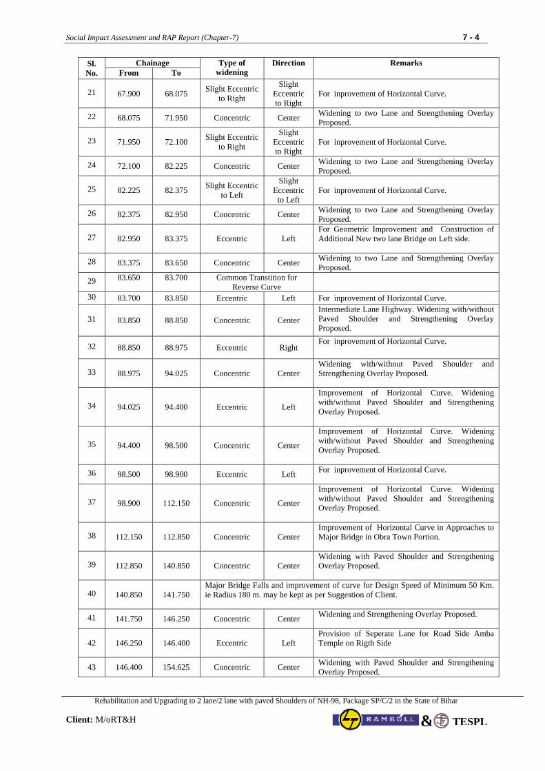
Social Impact Assessment and RAP Report (Chapter-7) 7 - 4
Rehabilitation and Upgrading to 2 lane/2 lane with paved Shoulders of NH-98, Package SP/C/2 in the State of Bihar
Client: M/oRT&H TESPL&
Chainage Sl. No. From To
Type of widening
Direction Remarks
21 67.900 68.075 Slight Eccentric to Right
Slight Eccentric to Right
For inprovement of Horizontal Curve.
22 68.075 71.950 Concentric Center Widening to two Lane and Strengthening Overlay Proposed.
23 71.950 72.100 Slight Eccentric to Right
Slight Eccentric to Right
For inprovement of Horizontal Curve.
24 72.100 82.225 Concentric Center Widening to two Lane and Strengthening Overlay Proposed.
25 82.225 82.375 Slight Eccentric to Left
Slight Eccentric
to Left For inprovement of Horizontal Curve.
26 82.375 82.950 Concentric Center Widening to two Lane and Strengthening Overlay Proposed.
27 82.950 83.375 Eccentric Left For Geometric Improvement and Construction of Additional New two lane Bridge on Left side.
28 83.375 83.650 Concentric Center Widening to two Lane and Strengthening Overlay Proposed.
29 83.650 83.700 Common Transtition for Reverse Curve
30 83.700 83.850 Eccentric Left For inprovement of Horizontal Curve.
31 83.850 88.850 Concentric Center Intermediate Lane Highway. Widening with/without Paved Shoulder and Strengthening Overlay Proposed.
32 88.850 88.975 Eccentric Right For inprovement of Horizontal Curve.
33 88.975 94.025 Concentric Center Widening with/without Paved Shoulder and Strengthening Overlay Proposed.
34 94.025 94.400 Eccentric Left
Improvement of Horizontal Curve. Widening with/without Paved Shoulder and Strengthening Overlay Proposed.
35 94.400 98.500 Concentric Center
Improvement of Horizontal Curve. Widening with/without Paved Shoulder and Strengthening Overlay Proposed.
36 98.500 98.900 Eccentric Left For inprovement of Horizontal Curve.
37 98.900 112.150 Concentric Center
Improvement of Horizontal Curve. Widening with/without Paved Shoulder and Strengthening Overlay Proposed.
38 112.150 112.850 Concentric Center Improvement of Horizontal Curve in Approaches to Major Bridge in Obra Town Portion.
39 112.850 140.850 Concentric Center Widening with Paved Shoulder and Strengthening Overlay Proposed.
40 140.850 141.750 Major Bridge Falls and improvement of curve for Design Speed of Minimum 50 Km. ie Radius 180 m. may be kept as per Suggestion of Client.
41 141.750 146.250 Concentric Center Widening and Strengthening Overlay Proposed.
42 146.250 146.400 Eccentric Left Provision of Seperate Lane for Road Side Amba Temple on Rigth Side
43 146.400 154.625 Concentric Center Widening with Paved Shoulder and Strengthening Overlay Proposed.
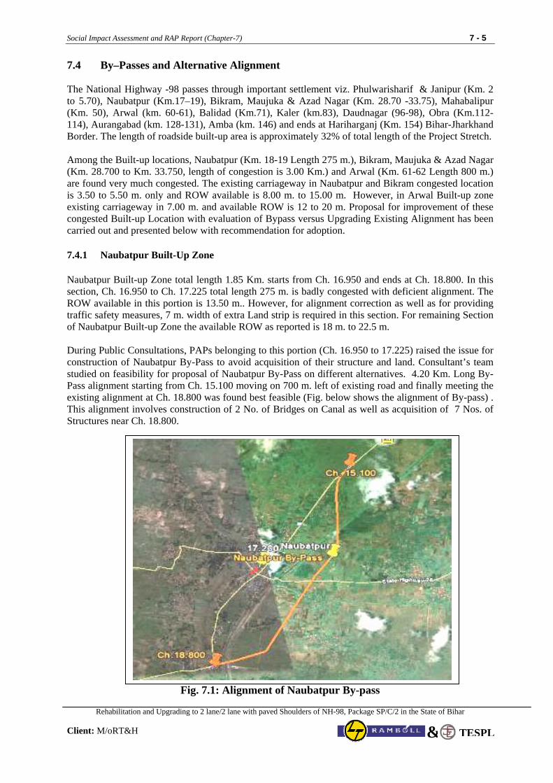
Social Impact Assessment and RAP Report (Chapter-7) 7 - 5
Rehabilitation and Upgrading to 2 lane/2 lane with paved Shoulders of NH-98, Package SP/C/2 in the State of Bihar
Client: M/oRT&H TESPL&
7.4 By–Passes and Alternative Alignment The National Highway -98 passes through important settlement viz. Phulwarisharif & Janipur (Km. 2 to 5.70), Naubatpur (Km.17–19), Bikram, Maujuka & Azad Nagar (Km. 28.70 -33.75), Mahabalipur (Km. 50), Arwal (km. 60-61), Balidad (Km.71), Kaler (km.83), Daudnagar (96-98), Obra (Km.112-114), Aurangabad (km. 128-131), Amba (km. 146) and ends at Hariharganj (Km. 154) Bihar-Jharkhand Border. The length of roadside built-up area is approximately 32% of total length of the Project Stretch.
Among the Built-up locations, Naubatpur (Km. 18-19 Length 275 m.), Bikram, Maujuka & Azad Nagar (Km. 28.700 to Km. 33.750, length of congestion is 3.00 Km.) and Arwal (Km. 61-62 Length 800 m.) are found very much congested. The existing carriageway in Naubatpur and Bikram congested location is 3.50 to 5.50 m. only and ROW available is 8.00 m. to 15.00 m. However, in Arwal Built-up zone existing carriageway in 7.00 m. and available ROW is 12 to 20 m. Proposal for improvement of these congested Built-up Location with evaluation of Bypass versus Upgrading Existing Alignment has been carried out and presented below with recommendation for adoption.
7.4.1 Naubatpur Built-Up Zone
Naubatpur Built-up Zone total length 1.85 Km. starts from Ch. 16.950 and ends at Ch. 18.800. In this section, Ch. 16.950 to Ch. 17.225 total length 275 m. is badly congested with deficient alignment. The ROW available in this portion is 13.50 m.. However, for alignment correction as well as for providing traffic safety measures, 7 m. width of extra Land strip is required in this section. For remaining Section of Naubatpur Built-up Zone the available ROW as reported is 18 m. to 22.5 m. During Public Consultations, PAPs belonging to this portion (Ch. 16.950 to 17.225) raised the issue for construction of Naubatpur By-Pass to avoid acquisition of their structure and land. Consultant’s team studied on feasibility for proposal of Naubatpur By-Pass on different alternatives. 4.20 Km. Long By-Pass alignment starting from Ch. 15.100 moving on 700 m. left of existing road and finally meeting the existing alignment at Ch. 18.800 was found best feasible (Fig. below shows the alignment of By-pass) . This alignment involves construction of 2 No. of Bridges on Canal as well as acquisition of 7 Nos. of Structures near Ch. 18.800.
Fig. 7.1: Alignment of Naubatpur By-pass
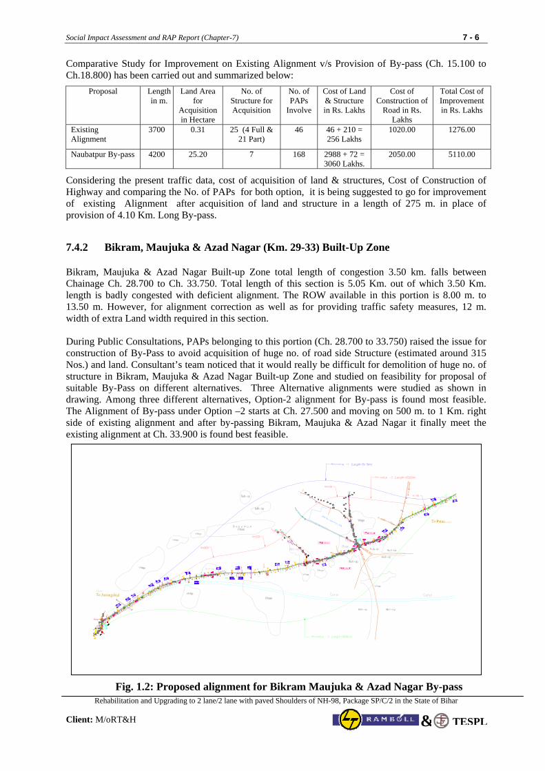
Social Impact Assessment and RAP Report (Chapter-7) 7 - 6
Rehabilitation and Upgrading to 2 lane/2 lane with paved Shoulders of NH-98, Package SP/C/2 in the State of Bihar
Client: M/oRT&H TESPL&
Comparative Study for Improvement on Existing Alignment v/s Provision of By-pass (Ch. 15.100 to Ch.18.800) has been carried out and summarized below:
Proposal Length in m.
Land Area for
Acquisition in Hectare
No. of Structure for Acquisition
No. of PAPs
Involve
Cost of Land & Structure in Rs. Lakhs
Cost of Construction of
Road in Rs. Lakhs
Total Cost of Improvement in Rs. Lakhs
Existing Alignment
3700 0.31 25 (4 Full & 21 Part)
46 46 + 210 = 256 Lakhs
1020.00 1276.00
Naubatpur By-pass 4200 25.20 7 168 2988 + 72 = 3060 Lakhs.
2050.00 5110.00
Considering the present traffic data, cost of acquisition of land & structures, Cost of Construction of Highway and comparing the No. of PAPs for both option, it is being suggested to go for improvement of existing Alignment after acquisition of land and structure in a length of 275 m. in place of provision of 4.10 Km. Long By-pass.
7.4.2 Bikram, Maujuka & Azad Nagar (Km. 29-33) Built-Up Zone
Bikram, Maujuka & Azad Nagar Built-up Zone total length of congestion 3.50 km. falls between Chainage Ch. 28.700 to Ch. 33.750. Total length of this section is 5.05 Km. out of which 3.50 Km. length is badly congested with deficient alignment. The ROW available in this portion is 8.00 m. to 13.50 m. However, for alignment correction as well as for providing traffic safety measures, 12 m. width of extra Land width required in this section. During Public Consultations, PAPs belonging to this portion (Ch. 28.700 to 33.750) raised the issue for construction of By-Pass to avoid acquisition of huge no. of road side Structure (estimated around 315 Nos.) and land. Consultant’s team noticed that it would really be difficult for demolition of huge no. of structure in Bikram, Maujuka & Azad Nagar Built-up Zone and studied on feasibility for proposal of suitable By-Pass on different alternatives. Three Alternative alignments were studied as shown in drawing. Among three different alternatives, Option-2 alignment for By-pass is found most feasible. The Alignment of By-pass under Option –2 starts at Ch. 27.500 and moving on 500 m. to 1 Km. right side of existing alignment and after by-passing Bikram, Maujuka & Azad Nagar it finally meet the existing alignment at Ch. 33.900 is found best feasible.
Fig. 1.2: Proposed alignment for Bikram Maujuka & Azad Nagar By-pass
Social Impact Assessment and RAP Report (Chapter-7) 7 - 7
Rehabilitation and Upgrading to 2 lane/2 lane with paved Shoulders of NH-98, Package SP/C/2 in the State of Bihar
Client: M/oRT&H TESPL&
Comparative Study for Improvement on Existing Alignment v/s Provision of By-pass (Ch. 28.700 to 33.750) has been carried out and summarized below:
Proposal Length in m.
Land Area for
Acquisition in Hectare
No. of Structure Affected
Acquisition
No. of PAPs
Involved
Cost of Land
& Structure in Rs. Lakhs
Cost of Construction
of Road in Rs. Lakhs
Total Cost of Improvement in Rs. Lakhs
Existing Alignment
5050 5.05 410 (160 Full & 250 Part)
455 998 + 810 = 1808 Lakhs
1900.00 3708.00
Option No.-1
8110 48.66 56 248 2308 + 84 = 2392 Lakhs
3650.00 6042.00
Option No.-2
6500 39.00 Nil 90 1850 +.00 = 1850 Lakhs
2925.00 4775.00
Option No.-3
8660 51.96 58 292 2988 + 72 = 3060 Lakhs.
2050.00 5110.00
Considering the Level of congestion and deficient geometric alignment in a length of 3.50 km., present traffic data, cost of acquisition of land & structures, Cost of Construction of Highway and comparing the No. of PAPs all alternative option, it is being suggested to go for Construction of Bikram By-Pass on alternative –2 option with least no. of PAPs.
7.4.3 Arwal Built-up Zone (Ch. 60.750 to 61.550)
Arwal Built-up Zone falls between Chainage Ch. 59.450 to Ch. 61.750. Total length of this Built-up zone is 2.30 Km. out of which 800 m. length (Ch. 60.750 to 61.550) length is congested. However, the carriageway in this zone is 7.00 m. and the Highway alignment is almost straight. The ROW available from Ch. 59.450 to Ch. 60.750 is in between 18 m. to 22 m. For congested section from Ch. 60.750 to Ch. 61.550, as per confirmation of Revenue Deptt., the ROW available in this section is more than 22 m. and people have encroached the Govt. Land. At present the clear Roadway available in this section is 11 to 13.5 m. However, for improvement of this section with Traffic Safety measures, the clear land width required is 16 m. (12 m. Formation + 2.0m. on either side for Drain with footpath and Utility Relocation).
During Public Consultations, PAPs belonging to this portion (Ch. 60.750 to 61.550) raised the issue for construction of By-Pass to avoid acquisition of around 169 no. of road side Structures. It has also been brought into the notice of Consultants that during year 1921, the land Lord of that area Sri Shah Umer Saheb resettled them after flood disaster of river Sone.
Consultant Team (Social, Environmental and Technical experts) also studied the feasibility for proposal of suitable By-Pass of Arwal Town passing on left side of existing Highway because Sone Canal and River Sone is running adjacent to the existing on Right Side.
Three Alternative alignments were studied as summarised hereunder:
1. Option-1 : Starting from existing Ch. 58.350 and running on Left side at an avg. distance approx. 850 m. on left side of existing alignment and ends at Ch. 64.500. Total Length of By-pass under this alternative is 7.00 Km.
2. Option-2 : Starting from existing Ch. 55.800 and running on Left side at an avg. distance approx. 1.50 Km. on left side of existing alignment and ends at Ch. 64.500. Total Length of By-pass under this alternative is 9.85 Km. This by-Pass alignment also bypasses the Settlement Sakari and Ahiyapur.
3. Option-3 : Starting from existing Ch. 54.400 and running on Left side at an avg. distance approx. 1.50 m. on left side of existing alignment and ends at Ch. 64.500. Total Length of By-pass under this alternative is 11.350 Km. This by-Pass alignment also bypasses the Settlement Parsadi English, Sakari and Ahiyapur.
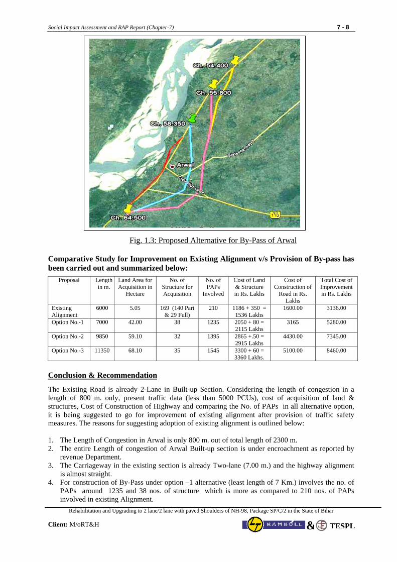
Social Impact Assessment and RAP Report (Chapter-7) 7 - 8
Rehabilitation and Upgrading to 2 lane/2 lane with paved Shoulders of NH-98, Package SP/C/2 in the State of Bihar
Client: M/oRT&H TESPL&
Fig. 1.3: Proposed Alternative for By-Pass of Arwal
Comparative Study for Improvement on Existing Alignment v/s Provision of By-pass has been carried out and summarized below:
Proposal Length in m.
Land Area for Acquisition in
Hectare
No. of Structure for Acquisition
No. of PAPs
Involved
Cost of Land & Structure in Rs. Lakhs
Cost of Construction of
Road in Rs. Lakhs
Total Cost of Improvement in Rs. Lakhs
Existing Alignment
6000 5.05 169 (140 Part & 29 Full)
210 1186 + 350 = 1536 Lakhs
1600.00 3136.00
Option No.-1 7000 42.00 38 1235 2050 + 80 = 2115 Lakhs
3165 5280.00
Option No.-2
9850 59.10 32 1395 2865 +.50 = 2915 Lakhs
4430.00 7345.00
Option No.-3 11350 68.10 35 1545 3300 + 60 = 3360 Lakhs.
5100.00 8460.00
Conclusion & Recommendation
The Existing Road is already 2-Lane in Built-up Section. Considering the length of congestion in a length of 800 m. only, present traffic data (less than 5000 PCUs), cost of acquisition of land & structures, Cost of Construction of Highway and comparing the No. of PAPs in all alternative option, it is being suggested to go for improvement of existing alignment after provision of traffic safety measures. The reasons for suggesting adoption of existing alignment is outlined below: 1. The Length of Congestion in Arwal is only 800 m. out of total length of 2300 m. 2. The entire Length of congestion of Arwal Built-up section is under encroachment as reported by
revenue Department. 3. The Carriageway in the existing section is already Two-lane (7.00 m.) and the highway alignment
is almost straight. 4. For construction of By-Pass under option –1 alternative (least length of 7 Km.) involves the no. of
PAPs around 1235 and 38 nos. of structure which is more as compared to 210 nos. of PAPs involved in existing Alignment.
Social Impact Assessment and RAP Report (Chapter-7) 7 - 9
Rehabilitation and Upgrading to 2 lane/2 lane with paved Shoulders of NH-98, Package SP/C/2 in the State of Bihar
Client: M/oRT&H TESPL&
5. The Existing alignment is almost straight whereas for construction of By-pass total 5 Nos. of horizontal curves are involved.
7.4.4 Improvement of other Important Built-up Location
The other important Built-up locations in the project section are Balidad (Km.71), Kaler (km.83), Daudnagar (96-98), Obra (Km.112-114), Aurangabad (km. 128-131), Amba (km. 146) and Hariharganj (Km. 154). For all these built-up location the available ROW is in between 18 m. to 24 m. The Proposed improvement of highway with provisions of traffic safety measures can be done without any major hindrance except for removal of few encroachments and acquisition after proper compensation as per entitlement. 7.5 Junction Improvements
There are 12 Major and Minor T, Y and (+) Cross Junctions (State Highway, Major District Roads) in the project stretch meeting the project road at different points. Most of these highway junctions fall in the built-up or semi-urban zone. The design considerations has addressed the issues related to the junction improvements at all the critical sections along the project stretch and the same have been discussed and finalized in consultation with the engineering team after checking the technical viability of the proposed design options at various places. Based on engineering analysis by technical design team, all the major junctions (NH, SH & MDR) shall be improved as at grade junctions as per guidelines of IRC. Apart from the National Highways, State Highways and Major District Road, a number of minor roads (around 331) are meeting NH–98 at different locations throughout the project stretch. These adjoining roads are REO and village roads but majority of them are feeder roads, access roads from houses or side roads connecting small villages to the NH. The REO roads are generally 3.50 m. wide bituminous or WBM roads. But village roads, either constructed by REO or district Administration, are either of brick soling or katccha. It has been proposed to at grade improvement of entire minor connecting road with provision of proper designed Speed breaker before reaching NH-98. 7.6 Addressal of Safety Issues in Design for minimising the negative impact
Out Come of Series of Public consultations and suggestion of participants on safety issues were given due consideration in project design. The detail of safety features proposed in the project section has been presented below:
i. Improvement of Deficient Horizontal Curves
Table 7.4 present the proposal finalised for Improvement of Deficient Horizontal Curves as outcome of Road Safety Audit, Series of Public consultations and suggestion of participants
Table 7.4 : Improvement of Deficient Horizontal Curves
Chainage Sl. No. From To
Deficiency Observed & Remarks
Improvement Proposed
1 6.600 6.875 Existing Canal Bridge. Approach Alignment on either side offering Design Speed of 40 Kmph. Fall in Semi-Urban Zone.
The existing minor Bridge falls in immediate approach of Patna Town As improvement proposal additional 2-lane bridge proposed for smooth movement of traffic. Due to Built-up Zone, proposed to restrict Design Speed 40 Kmph. with Proper Cautionary, Informatory and Mandatory sign Provision.
2 35.050 35.400 Existing Canal Bridge. Approach Alignment on either side offering Design Speed of 40 Kmph. Fall at Jn. Location Kanpa semi-urban Zone.
Since the carriageway of existing minor Bridge is less than 7 m.. As improvement proposal additional 2-lane bridge proposed for smooth movement of traffic. Due to Built-up Zone, proposed to restrict Design Speed 40 Kmph. with Proper Cautionary, Informatory and Mandatory sign Provision.
Social Impact Assessment and RAP Report (Chapter-7) 7 - 10
Rehabilitation and Upgrading to 2 lane/2 lane with paved Shoulders of NH-98, Package SP/C/2 in the State of Bihar
Client: M/oRT&H TESPL&
Chainage Sl. No. From To
Deficiency Observed & Remarks
Improvement Proposed
3 40.900 41.100 Deficient Horz. Curve Radius is less than 150 m.
Propose to improve the deficient Horz. Curve Radius along with extra widening, provision of safety barrier and traffic signage.
4 63.700 63.900 Deficient Horz. Curve Radius is less than 120 m. Falls in Semi Urban Zone.
Propose to improve the deficient Horz. Curve Radius along with extra widening, provision of safety barrier and traffic signage. Speed restriction of 40 Kmph. is also proposed due to existence of semi urban settlement.
5 64.200 64.900 Approaches to Bridges on either side with deficient Alignment. Built-up Zone on either side of Bridge. Site Distance also get obstructed due to road side vegitation (Bushes).
Since the carriageway of existing minor Bridge is less than 7 m.. As improvement proposal additional 2-lane bridge proposed for smooth movement of traffic. Due to Built-up Zone, proposed to restrict Design Speed 40 Kmph. with Proper Cautionary, Informatory and Mandatory sign Provision.
6 65.250 65.475 Deficient Horz. Curve Radius is less than 200 m. Falls at Minor Cross-Junction in Semi Urban Zone.
Propose to improve the deficient Horz. Curve Radius along with extra widening, provision of traffic signage. Speed restriction of 40 Kmph. is proposed due to presence of Minor Cross Jn.
7 67.900 68.100 Deficient Horz. Curve Radius is less than 220 m. in rural area offering Design Speed of 65 Kmph..
Propose to improve the deficient Horz. Curve within Existing ROW along with extra widening for design Speed of 80 Kmph. Provision of safety barrier and traffic signage also proposed
8 71.950 72.100 Deficient Horz. Curve Radius is less than 210 m. in rural area offering Design Speed of 65 Kmph..
Propose to improve the deficient Horz. Curve Radius within Existing ROW along with extra widening for design Speed of 80 Kmph. Provision of safety barrier and traffic signage also proposed
9 81.050 81.150 Deficient Horz. Curve Radius is less than 200 m. in Amir Bigha Built-up Zone offering Design Speed of 65 Kmph..
Propose to improve the deficient Horz. Curve Radius along with extra widening, provision of safety barrier and traffic signage. Speed restriction of 40 Kmph. is proposed due to existence of semi urban settlement.
10 82.200 82.375 Deficient Horz. Curve Radius is 175 m. Falls in Semi Urban Zone of Dilawarpur at Minor Jn. Location.
Propose to improve the deficient Horz. Curve Radius along with extra widening for design Speed of 80 Kmph. Provision of safety barrier and traffic signage also proposed
11 82.900 83.375 Existing Canal Bridge. Approach Alignment on either side offering Design Speed of 40 Kmph. Fall in Kaler urban Zone. Site Distance also get obstructed due to road side vegitation (Bushes).
As improvement proposal New Two Lane Bridge proposed on improved Alignment for smooth movement of traffic. Due to Built-up Zone, proposed to restrict Design Speed 40 Kmph. with Proper Cautionary, Informatory and Mandatory sign Provision. Road side vegitation (Bushes) proposed for removal.
12 83.670 83.875 Deficient Horz. Curve Radius is less than 160 m. Falls at Y Junction in Semi Urban Zone. of Kaler
Propose to improve the deficient Horz. Curve Radius along with extra widening, provision of safety barrier and traffic signage. Speed restriction of 40 Kmph. is proposed due to existence of Y Jn. in semi urban settlement.
13 88.850 88.975 Deficient Horz. Curve Radius is less than 160 m. Just before Staggered Minor unction falling under in Semi Urban Zone. of Samshernagar.
Propose to improve the deficient Horz. Curve Radius along with extra widening, provision of safety barrier and traffic signage. Speed restriction of 40 Kmph. is proposed due to presence of staggered minor Jn. at other end of curve in Semi Urban Zone of Samshernagar.
14 98.500 98.900 Deficient Horz. Curve Radius is less than 140 m. in immediate approach to Tarari Semi Urban Zone. There are Existing Safety Guard walls.
Propose to improve the deficient Horz. Curve Radius along with extra widening for Design Speed of 65 Kmph. (within available ROW) with provision of safety barrier, traffic signage and strengthening of existing Guard walls.
15 112.150 112.85 Approaches alignment on either side to Major Bridges found deficient in Obra Built-Up Zone. Site Distance also get obstructed due to road side vegitation (Bushes) .
Additional two Lane bridge in Obra Built-up zone on Old Alignment proposed for smooth movement of traffic. Due to Built-up Zone, proposed to restrict Design Speed 40 Kmph. with Proper Cautionary, Informatory and Mandatory sign Provision. Roadside vegitation (Bushes) proposed for removal.
Social Impact Assessment and RAP Report (Chapter-7) 7 - 11
Rehabilitation and Upgrading to 2 lane/2 lane with paved Shoulders of NH-98, Package SP/C/2 in the State of Bihar
Client: M/oRT&H TESPL&
Chainage Sl. No. From To
Deficiency Observed & Remarks
Improvement Proposed
16 133.800 134.00 Deficient Horz. Curve Radius is 200 m. Falls at Y Junction in Semi Urban Zone.
Propose to improve the deficient Horz. Curve Radius along with extra widening for design Speed of 80 Kmph. Provision of safety barrier and traffic signage also proposed. However, due to existence of Y Junction at mid of Curve, Speed restriction of 40 Kmph. proposed.
17 140.950 141.80 Approaches alignment on either side to Existing as well as underconstruction Major Bridges found deficient.
Propose to improve the deficient Horz. Curve Radius along with extra widening for design Speed of 65 Kmph. Provision of safety barrier and traffic signage also proposed.
ii. Departure from Standards in Project Section
Out of 17 geometrically deficient location mentioned above, Eight (8) locations have been identified by consultants in project section where alignment correction for design speed of 80 Kmph. is not possible due to constraint of ROW, Built-up Zone, existing Structures and No. of PAPs. For these locations it has been propose to improve the deficient Horz. Curve Radius along with extra widening within available ROW with provision of safety barrier and proper traffic signage. These locations are summarised below with proposal for improvement.
Table 7.5 : Location identified for departure from Standards
Chainage Sl. No. From To
Remarks
1 6.600 6.875 As improvement proposal additional 2-lane bridge proposed for smooth movement of traffic. Due to Built-up Zone, proposed to restrict Design Speed 40 Kmph. with Proper Cautionary, informatory and Mandatory sign Provision.
2 35.050 35.400 As improvement proposal additional 2-lane bridge proposed for smooth movement of traffic. Due to Built-up Zone, proposed to restrict Design Speed 40 Kmph. with Proper Cautionary, informatory and Mandatory sign Provision as well as Safety Barriers.
3 64.200 64.900 As improvement proposal additional 2-lane bridge proposed for smooth movement of traffic. Due to Built-up Zone, proposed to restrict Design Speed 40 Kmph. with Proper Cautionary, informatory and Mandatory sign Provision as well as Safety Barriers.
4 82.900 83.375
As improvement proposal New Two Lane Bridge proposed on improved Alignment for smooth movement of traffic. Due to Built-up Zone, proposed to restrict Design Speed 40 Kmph. with Proper Cautionary, informatory and Mandatory sign Provision as well as Safety Barriers. Roadside vegitation (Bushes) proposed for removal.
5 83.670 83.875 Propose to improve the deficient Horz. Curve Radius along with extra widening, provision of safety barrier and traffic signage. Speed restriction of 40 Kmph. is proposed due to existence of Y Jn. in semi urban settlement.
6 112.150 112.850
Additional two Lane bridge in Obra Built-up zone on Old Alignment proposed for smooth movement of traffic. Due to Built-up Zone, proposed to restrict Design Speed 40 Kmph. with Proper Cautionary, informatory and Mandatory sign Provision as well as Safety Barriers. Roadside vegitation (Bushes) proposed for removal.
7 133.800 134.000
Propose to improve the deficient Horz. Curve Radius along with extra widening for design Speed of 80 Kmph. Provision of safety barrier and traffic signage also proposed. However, due to existence of Y Junction at mid of Curve, Speed restriction of 40 Kmph. proposed.
8 140.950 141.800 For approaches to new bridge, it is propose to improve the deficient Horz. Curve Radius along with extra widening for design Speed of 65 Kmph. Provision of safety barrier and traffic signage also proposed.
7.7 Other Improvement and Safety provisions in project Section Pedestrian Guard Railings and Guard Post These will be made of structural steel angles squares. These are proposed for heavily trafficked urban areas to safeguard against stray pedestrians moving into heavily trafficked areas. These will be provided at all the built-up location at inner edge of footpath. The total length of Guard Rails proposed in Built-up Zone of project section have been worked out to 55.870 Km.
Social Impact Assessment and RAP Report (Chapter-7) 7 - 12
Rehabilitation and Upgrading to 2 lane/2 lane with paved Shoulders of NH-98, Package SP/C/2 in the State of Bihar
Client: M/oRT&H TESPL&
Standard Guard posts made of M 20 grade concrete resting on M 15 Grade concrete foundation have been proposed on approaches to Minor Bridges. These guard stones shall be painted with alternate black and white stripes and placed at intervals of 1.5m with and offset of 2m from carriageway edge. Traffic Signs Proper Traffic signs throughout the whole project stretch along with intersections with other roads and other facility location will be provided for giving proper direction and warning to the driver, as well as direct them the route they want to follow. The traffic signs will be as per IRC Standard as will be of “Retro Reflection Type”. The Summary of proposed traffic Signs in Project section is summarised below:
Informatory Signs, Facility Signs, Direction Signs, Advance Direction / Destination Signs, Route Marker Signs etc. 209
Warning Sign 900 mm. size triangular 365 Mandatory Sign Circular 600 mm dia. 196
Road Markings and Delineators Road marking (Lane/centre line/edge line/ transverse marking /Zebra Crossing and any other markings) shall be carried out with hot applied thermoplastic paints conforming to ASTM D36/BS-3262 (Part - I) and as per IRC Standard. For Safety of road user during night travel, retro-refectories road delineators have been proposed at identified locations (Approach to Bridge, culverts & structure, speed restricted section, curved sections, built-up section etc. in the project section. The summary of such provision is presented below.
Cluster of Red Reflectors. 1,230 Road way delineators 2,856 Hazard markers 100 Object markers 80
Apart from above, for all the trees on highway flanks, retro-refectories plates marking have been proposed for their clear identification during night travel. Speed Breaker Speed breakers have been proposed in the form of pair of Rumble Strips have been proposed at road crossing locations as well as at locations where there is needs to control speed of traffic to ensure safety. The design of speed breakers shall be as per IRC: 99-1988. Crash Barrier W-Beam Metal Crash Barrier have been proposed on approaches to Bridges, high embankment Zone where height of embankment us more than 3 m and in sharp curve locations. Total 12.70 km length has been identified in the project section for provision of W-Beam Metal Crash Barrier.
Bus Stop It has been proposed to provide bus stops at locations in semi- urban, urban places on either side falling under this project stretch. Bus stops with passenger shelters have been provided at 66 locations on either side of the project road stretch. Budget provision for construction of bus stops has been included in the BOQ. Lay-Bye Lay-byes have been provided at approximately 5 km intervals on either side in staggered way for parking of trucks in the project stretch within the available ROW. Bus stops and truck lay-byes would be potential locations for commercial PAPs to start small business units for restoration of livelihoods. However, no provision has been made in view of non-availability of enough ROW to accommodate business unit.
Social Impact Assessment and RAP Report (Chapter-8) 8 - 1
Rehabilitation and Upgrading to 2 lane/2 lane with paved Shoulders of NH-98, Package SP/C/2 in the State of Bihar
Client: M/oRT&H TESPL&
CHAPTER – 8 R&R PRINCIPLES, POLICY FRAMEWORK & ENTITLEMENT MATRIX
8.1 Introduction Ministry of Road Transport & Highways, Government of India has taken up National Highways Inter-Connectivity Improvement Project (NHIIP) for strengthening and upgrading of various single/intermediate National Highways to standard 2 lane/ 2 lane with paved shoulders. MoRTH intends to implement the proposed NHIIP with World Bank (WB) assistance. The aim of the project is to establish and provide better connectivity of various existing National Highways in the country. Most of the infrastructure work planned for this National Highways improvement project will take place within the existing Right of Way (RoW) except at some of the congested villages/settlements where bypasses are proposed and at locations where minor improvements are required for accommodating road safety measures.
8.2 Resettlement & Rehabilitation Principles and Guidelines Ministry of Road Transport & Highways, Government of India, finalised the “Resettlement Policy Framework (RPF)” and posted on M/oRT&H Website. The finalised “Resettlement Policy Framework (RPF)” shall apply to all project roads under NHIIP whether partly or fully funded by World Bank during the entire period of loan assistance. This Resettlement Policy document describes the principles and approach to be followed in minimizing and mitigating negative social and economic impacts caused by the project Overall objective of this Framework is to guide the preparation and implementation of NHIIP based on the following principles: Take due precautions to minimize disturbance to human habitations, tribal areas and places of
cultural significance. Ensure that the Project Affected Persons (PAPs) are not negatively affected by the project. Involve affected people from inception stage to operation and maintenance. Consult affected people in issues of ROWs, land acquisition or loss of livelihood Encourage consultation with communities in identifying environmental and social implications
of projects. Pay special attention to marginalized and vulnerable groups and secure their inclusion in overall
public participation. Provide compensation and assistance to PAPs prior to any displacement or start of civil works. Guarantee entitlements and compensation to affected people as per the R&R policy as
established in this document. This would ensure compensation and assistance sufficient to improve or at least restore livelihoods to levels experienced before the project. Share information with local communities about environmental and social implications. Broad community support is ascertained based on free, prior and informed consultation.
8.3 Applicable Legal and Policy Framework
Applicable acts, notifications and policies relevant in the context of this project are discussed below. The Project Authority (MoRTH) will ensure that project activities implemented are consistent with the national, state, local regulatory/legal framework.
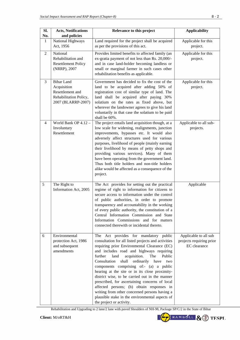
Social Impact Assessment and RAP Report (Chapter-8) 8 - 2
Rehabilitation and Upgrading to 2 lane/2 lane with paved Shoulders of NH-98, Package SP/C/2 in the State of Bihar
Client: M/oRT&H TESPL&
Sl. No.
Acts, Notifications and policies
Relevance to this project
Applicability
1 National Highways Act, 1956
Land required for the project shall be acquired as per the provisions of this act.
Applicable for this project.
2 National Rehabilitation and Resettlement Policy (NRRP), 2007
Provides limited benefits to affected family (an ex-gratia payment of not less than Rs. 20,000/- and in case land-holder becoming landless or small or marginal farmer in such cases other rehabilitation benefits as applicable.
Applicable for this project.
3 Bihar Land Acquisition Resettlement and Rehabilitation Policy, 2007 (BLARRP-2007)
Government has decided to fix the cost of the land to be acquired after adding 50% of registration cost of similar type of land. The land shall be acquired after paying 30% solatium on the rates as fixed above, but wherever the landowner agrees to give his land voluntarily in that case the solatium to be paid shall be 60%.
Applicable for this project.
4 World Bank OP 4.12 – Involuntary Resettlement
The project entails land acquisition though, at a low scale for widening, realignments, junction improvements, bypasses etc. It would also adversely affect structures used for various purposes, livelihood of people (mainly earning their livelihood by means of petty shops and providing various services). Many of them have been operating from the government land. Thus both title holders and non-title holders alike would be affected as a consequence of the project.
Applicable to all sub-projects.
5 The Right to Information Act, 2005
The Act provides for setting out the practical regime of right to information for citizens to secure access to information under the control of public authorities, in order to promote transparency and accountability in the working of every public authority, the constitution of a Central Information Commission and State Information Commissions and for matters connected therewith or incidental thereto.
Applicable
6 Environmental protection Act, 1986 and subsequent amendments
The Act provides for mandatory public consultation for all listed projects and activities requiring prior Environmental Clearance (EC) and includes road and highways requiring further land acquisition. The Public Consultation shall ordinarily have two components comprising of:- (a) a public hearing at the site or in its close proximity- district wise, to be carried out in the manner prescribed, for ascertaining concerns of local affected persons; (b) obtain responses in writing from other concerned persons having a plausible stake in the environmental aspects of the project or activity.
Applicable to all sub projects requiring prior
EC clearance
Social Impact Assessment and RAP Report (Chapter-8) 8 - 3
Rehabilitation and Upgrading to 2 lane/2 lane with paved Shoulders of NH-98, Package SP/C/2 in the State of Bihar
Client: M/oRT&H TESPL&
8.4 Comparative Analysis of Applicable Policy For the purpose of development, maintenance, and management of national highways, a special law, The National Highways Act (NH Act), 1956 has been promulgated in India. This act provides for acquiring land through a “competent authority”, which means any person or authority authorized by the Central Government by notification in the official Gazette to perform functions of the competent authority for such areas as may be specified in the notifications. For land acquisition (LA), the Act defines the various procedures as (i) section 3A—intention of Central Government to acquire land, (ii) 3B—power to enter for survey, (iii) 3C – hearing of objections, (iv) 3D – declaration of acquisition, (v) 3E- power to take possession, (vi) 3F- power to enter into the land where land has vested in the central government, (vii) 3G – determination of compensation, and (viii) 3H – deposit and payment of the amount. The Act requires that the processes must be completed within a year from 3A to 3D. The Act covers only legal titleholders and provides for compensation based on (i) market value of the land; (ii) additional payments for trees, crops, houses, or other immovable properties; and (iii) payments for damage due to severing of land, residence, or place of business. Land acquisition in this project will be carried out under the NH Act. 1956. National Policy specifies that the compensation award shall be declared well in time before displacement of the affected families. Full payment of compensation (section 3H under NH Act) as well as adequate progress in resettlement shall be ensured in advance of the actual displacement of the affected families. World Bank safeguard policy also requires that the compensation and assistance to PAPs (other than capacity building support for livelihood restoration) be provided prior to any displacement or start of civil works. Both the National Policy and the World Bank guidelines on rehabilitation and resettlement aim to see that involuntary resettlement should be avoided or minimized, wherever feasible, exploring all viable alternative project designs, and where displacement is unavoidable, people losing assets, livelihood or other resources shall be assisted in improving or at a minimum regaining their former status of living at no cost to themselves. Similarly, National Resettlement and Rehabilitation Policy 2007 recognize the need for rehabilitation and resettlement benefits for project affected families belonging to Scheduled Castes and Schedule Tribes separately. Further, one of the important provisions of PESA Act is that the consent of Gram Sabha or the Panchayats at the appropriate level shall be obtained before making the acquisition of land in the Scheduled Areas for development projects. The Orissa R&R Policy 2006 has special provisions for ST affected population. The World Bank OP 4.10 emphasizes “a process of free, prior, and informed consultation with the affected Indigenous People’s communities at each stage of the project, and particularly during project preparation, to fully identify their views and ascertain their broad community support for the project. Also World Bank safeguards policy requires consultation with PAPs during planning and implementation of resettlement action plan and tribal development plan and public disclosure of drafts. Once the draft is prepared it is to be made available at a place accessible to, and in a form, manner and language understandable to the displaced or affected people and local NGOs. EP Act 1986 and NPRR 2007, also requires disclosure of draft EIA, SIA, RAP, EMP and other project reports followed by mandatory Public Hearing.
Social Impact Assessment and RAP Report (Chapter-8) 8 - 4
Rehabilitation and Upgrading to 2 lane/2 lane with paved Shoulders of NH-98, Package SP/C/2 in the State of Bihar
Client: M/oRT&H TESPL&
Based on the detailed comparative analysis of the above discussed applicable legal and policy framework, key differences identified between these policies which needs to be addressed under the Resettlement Policy Framework (RPF) is listed below:
1. Recognition of non-titleholders who have no recognizable legal right to the land they are occupying and extending R&R benefits under the project;
2. Establishment of cut-off date to identify the non-titleholders in the project; 3. Compensation at full replacement cost to replace the lost and other assets; 4. Need for preparation and public disclosure of Social Impact assessment (SIA), Resettlement
Action Plan (RAP) and Tribal Development Plan TDP) as per project requirements. 8.5 Resettlement Policy Framework This RPF for the NHIIP has been prepared based on the findings of Social Survey Report (SSR) covering initial impact assessment and review of applicable legal and policy framework discussed above. In order to address the adverse impacts of land acquisition and involuntary resettlement, MoRTH, Govt. of India recognised the need for the development of Resettlement Policy Framework. Review of Social Screening Reports (SSRs) reveal that applicable legal and administrative procedures vary from State to State and also there are gaps between Resettlement and Rehabilitation Policies of the country and certain states and the Bank’s Resettlement Policy. Hence, there is a need to understand the critical elements of the existing legal and policy framework and agree on a mechanism that will address the key social issues and formulate a specific policy framework for the project to bridge the major gaps to conform to the provisions of World Bank’s operational policies related to Involuntary Resettlement and Indigenous Peoples. This policy framework will help expedite the process and facilitate consistent preparation of RAPs and TDPs across all project roads in different states.
The purpose of preparing a RPF is to:
a) Bring commonality in resettlement and rehabilitation benefits under the project. b) Bridge the gap between Bank’s policy on Involuntary Resettlement and NRRP 2007. c) Bring together and built upon the current good practices in terms of procedures to address more
systematic and institutional issues. d) Establish institutional arrangements at project, state and central level (MoRTH) for the
implementation of RAP. e) Establish mechanism for redressal of grievances; and monitoring and evaluation, etc. 8.6 Abbreviations, Terms and Definitions Abbreviations
Following abbreviations have been used in the policy: WB World Bank PAP Project Affected Person PAF Project Affected Families BPL Below Poverty Line SBEs Small Business Enterprises COI Corridor of Impact CPRs Common Property Resources EP Entitled Person
Social Impact Assessment and RAP Report (Chapter-8) 8 - 5
Rehabilitation and Upgrading to 2 lane/2 lane with paved Shoulders of NH-98, Package SP/C/2 in the State of Bihar
Client: M/oRT&H TESPL&
Ha Hectare LAA Land Acquisition Act NGO Non-Government Organisation NHAI National Highways Authority of India NH Act National Highways Act, 1956 PIU Project Implementation Unit RAP Resettlement Action Plan CRRO Contract Resettlement and Rehabilitation Officer ROW Right of Way R & R Resettlement and Rehabilitation SES Socio-Economic Survey SC Scheduled Caste ST Scheduled Tribe u/s Under Section Terms Following terms have been used in the policy:
Hectare A unit for measuring land area. (Hectare equals 10000 Square Meters).
Corridor of Impact Width of corridor required for the construction of road, service lane, drain, footpath, access, tree plantation and for safety zone
Development Block A number of villages grouped together form a Development Block.
Tehsil/Subdivision A group of Blocks
Panchayat Samiti Local Self-governing body at Block level is Panchayat Samiti.
District Collector /Magistrate Administrative head of a District.
Divisional Commissioner Administrative head of a division comprising a number of districts.
Panchayat Elected local self-governing body at village level.
Poverty Line A family whose annual income from all sources is less than a designated sum as fixed by the concerned State Govt. in which the project falls, will be considered to be below Poverty Line.
Sarpanch Elected chief of a village.
Gair Khatedar Includes allotees, holders of muafi lands
Jambandi Basic record of land rights
Khatedar or tenant
According to Law, all land belongs to the State and all so-called landowners are tenants of the State. They are called Khatedars
Muafi Lands Include lands attached with Temples, Mosques, Gurudwara, Churches etc.
Pucca Cement, bricks or concrete build structure
Semi Pucca Structures with tiles/ thatch roof/ brick cement wall
Kachha Structures with stone/ mud wall/ thatch roof
Replacement Cost Amount paid over and above compensation to enable PAP to buy l d h h i bl d i
Social Impact Assessment and RAP Report (Chapter-8) 8 - 6
Rehabilitation and Upgrading to 2 lane/2 lane with paved Shoulders of NH-98, Package SP/C/2 in the State of Bihar
Client: M/oRT&H TESPL&
land, house, or any such immovable productive asset.
Entitled Person A person adversely impacted by the project and is entitled to some kind of assistance as per the project entitlement framework
Titleholder A person who possess legal documents towards the claim for the property
Grievance Redress Cell A cell set up by the project authority headed by District Magistrate/or his representative to look in to grievances of a PAP
Definitions Following definitions that will be applicable unless otherwise stated specifically.
♦ Agricultural labourer: means a person primarily resident in the affected area for a period of not less than five years immediately before the declaration of the affected area, who does not hold any land in the affected area but who earns his livelihood mainly by manual labour on agricultural land therein immediately before such declaration and who has been deprived of his livelihood;
♦ Agricultural land: Denotes land used or capable of being used for the purpose of agriculture or horticulture, dairy farming, poultry farming, pisciculture, sericulture, breeding of livestock or nursery growing medicinal herbs, raising of crops, grass or garden produce and land used by an agriculturist for the grazing of cattle, but does not include land used for cutting of wood only;
♦ Below poverty line (BPL) or BPL family: means below poverty line families as defined by the Planning Commission of India, from time to time and those included in the BPL list for the time-being in force.
♦ Corridor of impact (COI): Refers to the minimum land width required for construction including embankments, facilities and features such as approach roads, drains, utility ducts and lines, fences, green belts, safety zone, working spaces etc. Additional land width would be acquired/purchased or taken on temporary lease if the Corridor of Impact extends beyond the available Right of Way.
♦ Cut-off date: Refers to the date on which the census survey of PAPs starts in that road section/stretch. For entitlement purpose, the PAPs would be those who have been in possession of the immovable or movable property within the affected area/zone on or prior to cut off date. However, the cut-off date for land acquisition purpose is the date on which the notification under section 3A will be issued under the NH Act, 1956.
♦ Encroacher: A person who has extended their building, agricultural lands, business premises or work places into public/government land without authority.
♦ Entitled person (EP): A person who is adversely impacted by the project and is entitled to assistance as per the project entitlement framework is considered to be an Entitled Person.
♦ Holding: means the total land held by a person as an occupant or tenant or as both; ♦ Kiosk: A kiosk is a booth/stall/cabin/cubicle made of wood or iron or any other building material
which could be shifted to another location as a single unit without much damage and is used for carrying out petty business/ commercial activities and has been in operation/existence prior to cut off date.
♦ Land acquisition" or "acquisition of land": means acquisition of land under the NH Act, 1956 for the time being in force;
♦ Landowner: A person who is an allottee or a grantee of any land under any scheme of the Government under which such allotment or grant is to mature into ownership, who has mortgaged his land (or any portion thereof) or who has permanent rights and interest in land.
Social Impact Assessment and RAP Report (Chapter-8) 8 - 7
Rehabilitation and Upgrading to 2 lane/2 lane with paved Shoulders of NH-98, Package SP/C/2 in the State of Bihar
Client: M/oRT&H TESPL&
♦ Marginal farmer: Refers to a cultivator with an un-irrigated land holding upto one hectare or irrigated land holding upto half hectare.
♦ Non-agricultural labourer: means a person who is not an agricultural labourer but is primarily residing in the affected area for a period of not less than five years immediately before the declaration of the affected area and who does not hold any land under the affected area but who earns his livelihood mainly by manual labour or as a rural artisan immediately before such declaration and who has been deprived of earning his livelihood mainly by manual labour or as such artisan in the affected area;
♦ Non-titleholder: Affected persons/families/ households with no legal title to the land, structures and other assets adversely affected by the project. Non-titleholders include encroachers, squatters, etc.
♦ Notification: means a notification published in the Gazette of India. ♦ Occupier: means a member of a Scheduled Tribes community in possession of forest land prior
to the 13th day of December, 2005; ♦ Project: Refers to the National Highways Interconnectivity Improvement Project (NHIIP). ♦ Project affected area: Refers to the area of village or locality under a project for which land will
be acquired under NH Act 1956 through declaration by Notification in the Official Gazette by the appropriate Government or for which land belonging to the Government will be cleared from obstructions.
♦ Project affected family: includes a person, his or her spouse, minor sons, unmarried daughters, minor brothers, unmarried sisters, father, mother and other relatives residing with him or her and dependent on him or her for their livelihood; and includes "nuclear family" consisting of a person, his or her spouse and minor children;
♦ Project affected person (PAP): Any tenure holder, tenant, Government lessee or owner of other property, or non-titleholder who on account of the project has been affected from such land including plot in the abadi or other property in the affected area will be considered as PAP.
♦ Project displaced person (PDP): Any tenure holder, tenant, Government lessee or owner of other property, or non-titleholder who on account of the project has been involuntarily displaced from such land including plot in the abadi or other property will be considered as PDP. A displaced will always be a PAP but all PAP may not be PDP.
♦ Project affected household (PAH): A social unit consisting of a family and/or non-family members living together, and is affected by the project negatively and/or positively.
♦ Replacement cost: A replacement cost/value of any land or other asset is the cost/value equivalent to or sufficient to replace/purchase the same land or other asset.
♦ Small farmer: Refers to a cultivator with an un-irrigated land holding up to two (2) hectares or with an irrigated land holding up to one (1) hectare.
♦ Squatter: A person who has settled on public/government land, land belonging to institutions, trust, etc and or someone else’s land illegally for residential, business and or other purposes and/or has been occupying land and building/asset without authority.
♦ Tenant: A person who holds/occupies land-/structure of another person and (but for a special contract) would be liable to pay rent for that land/structure. This arrangement includes the predecessor and successor-in-interest of the tenant but does not include mortgage of the rights of a landowner or a person to whom holding has been transferred; or an estate/holding has been let in farm for the recovery of an arrear of land revenue; or of a sum recoverable as such an arrear or a person who takes from Government a lease of unoccupied land for the purpose of subletting it.
♦ Titleholder: A PAP/PAF/PAH who has legal title to land, structures and other assets in the affected zone.
Social Impact Assessment and RAP Report (Chapter-8) 8 - 8
Rehabilitation and Upgrading to 2 lane/2 lane with paved Shoulders of NH-98, Package SP/C/2 in the State of Bihar
Client: M/oRT&H TESPL&
♦ Vulnerable group: This includes Scheduled Caste. ST, family/household headed by women/female, disabled, handicapped, orphans, destitute, BPL, abandoned woman; unmarried girls; widows; and persons above the age of 65 years irrespective of their status of title (ownership). Vulnerable groups would also include those farmers who (after acquisition of land) become small/marginal farmers and also qualify for inclusion in BPL. For such cases, total land holding of the landowner in that particular revenue village will be considered in which land has been acquired.
♦ Wage earner: Wage earners are those whose livelihood would be affected due to the displacement of the employer. The person must be in continuous employment for at least six months prior to the cut-off date with the said employer and must have reliable documentary evidence to prove his/her employment.
8.7 Resettlement Principles and Eligibility Criteria Based on the above analysis of government provisions and requirements as per World Bank IR policy the broad resettlement principle for this project shall be the following: • Proposed highway improvement and strengthening work will take place mostly on the existing
alignment and within the available RoW except at locations where bypass is proposed or at locations were realignment is necessary to incorporate required safety measures;
• The involuntary resettlement and adverse impacts on persons affected by the project would be avoided or minimized as much as possible exploring viable alternative project design;
• Where it is not feasible to avoid resettlement, resettlement activities should be conceived and executed as sustainable development programs, providing sufficient investment resources to enable the persons displaced by the project to share in project benefits;
• Efforts should be made to improve their livelihoods and standards of living or at least to restore them, in real terms, to pre-displacement levels or to levels prevailing prior to the beginning of project implementation, whichever is higher;
• Displaced persons should be meaningfully consulted and should have opportunities to participate in planning and implementing resettlement programs;
• Replacement land shall be an option for compensation in the case of loss of land. In case of unavailability of replacement land, cash-for-land with compensation on replacement cost option will be made available to the PAPs;
• Compensation for loss of land, structures and other assets will be based on full replacement cost and will be paid before physical displacement of PAPs including transaction costs;
• In the event of necessary relocation, PAPs shall be assisted to integrate into host communities; • All land acquisition for the project would be done as per the National Highways Act, 1956.
Additional assistance would be provided to the PAPs for meeting the replacement cost of the property;
• Compensation and all R&R assistance shall be disbursed except skill enhancement entitlements before initiating civil works.
• The uneconomic residual land remaining after land acquisition will be acquired by the project. The owner of such land/property will have the option to seek acquisition of his entire contiguous holding/ property provided the residual land is less than the average land holding of the district;
• Any structure/asset rendered unviable/unsafe because of the project shall also be considered as affected and entitlements shall be extended accordingly;
• The affected persons who does not own land or other properties, but have economic interests or lose their livelihoods will be assisted as per the policy principles described in this document;
Social Impact Assessment and RAP Report (Chapter-8) 8 - 9
Rehabilitation and Upgrading to 2 lane/2 lane with paved Shoulders of NH-98, Package SP/C/2 in the State of Bihar
Client: M/oRT&H TESPL&
• Cut-off date for titleholders will be the date of publication of notification under Section 3A of the National Highways Act, 1956. For non-titleholders who has not any legal holding of the occupied land such as squatters and encroachers the date of project census survey or a similar designated date declared by the executing agency will be considered as cut-off date;
• An entitlement matrix for different categories of people affected by the project has been prepared and provisions will be kept in the budget for those who were not present at the time of census survey. However, people moving in the project area after the cut-off date will not be entitled to any compensation or assistance;
• Vulnerable groups (PAPs below poverty line (BPL), the landless, disabled, elderly persons, women and children, indigenous peoples) will be identified and given additional support and assistance under the project;
• All common property resources (CPR) lost due to the project will be reconstructed or compensated by the project;
• Information related to the preparation and implementation of resettlement plan will be disclosed to all stakeholders and people’s participation will be ensured in planning and implementation;
• Appropriate grievance redressal mechanism will be established at sub-project, state and central levels to ensure speedy resolution of disputes;
• An effective monitoring and evaluation mechanism will be established to ensure consistent implementation of resettlement activities planned under the project including third party monitoring.
8.8 Entitlement Matrix This entitlement matrix has been developed in accordance with the basic principles adopted in the RPF and analysis of initial identification of project impacts. In case State Government through any Act or Gazette Notification or as approved by any authority of State Government (duly authorized for the purpose) as per their approved procedure has fixed a rate for compensation of land and is higher than the provisions under the project, the same may be adopted by the Competent Authority in determining the compensation for land. Similarly, in case State Government through any Act or Gazette Notification or as approved by any authority of State Government (duly authorized for the purpose) as per their approved procedure has fixed a rate for resettlement and rehabilitation assistance and is higher than the provisions under the project, the same may be adopted by the Executing Authority. The developed entitlement matrix is presented in Table below.
Sl. No.
Application Definition of Entitled Unit
Entitlement Details
A. Loss of Private Agricultural, Home-Stead & Commercial Land 1 Land within
the Corridor of Impact (COI)
Titleholder family and families with traditional land Right
Compensation at replacement cost, Resettlement and Rehabilitation
a) Land for land, if available. Or, Cash compensation for the land at replacement cost, which will be determined as mentioned in Note (A).
b) If the compensation amount determined by the Competent Authority is less than the replacement cost mentioned in Note A, the difference amount will be paid as replacement assistance.
c) In case of land for land is not provided,
Social Impact Assessment and RAP Report (Chapter-8) 8 - 10
Rehabilitation and Upgrading to 2 lane/2 lane with paved Shoulders of NH-98, Package SP/C/2 in the State of Bihar
Client: M/oRT&H TESPL&
Sl. No.
Application Definition of Entitled Unit
Entitlement Details
additional ex-gratia amount of Rs 20,000/- for those losing land up to 250 sqmts of land. The affected person will get Rs.80 per sqmt for any area acquired above 250 sqmt. (para 7.19 NRRP 2007)
d) If as a result of land acquisition, the land holder becomes landless or is reduced to the status of a “small” or “marginal” farmer, rehabilitation allowance equivalent to 750 days of minimum agricultural wages would also be given. (para 7.14, NRRP-2007).
e) Policy for acquisition/ compensation for residual land will be as per note B.
f) In case of allotment of land, one time financial assistance of minimum Rs. 15000/- per hectare for land development. (para 7.9.1 of NRRP-2007)
g) Refund of stamp duty and registration charges incurred for replacement land to be paid by the project; replacement land must be bought within a year from the date of payment of compensation to project affected persons.
B. Loss of Private Structures (Residential/Commercial) 2 Structure
within the Corridor of Impact (CoI)
Title Holder/ Owner
Compensation at replacement rate, Resettlement & Rehabilitation Assistance
a) Cash compensation for the structure at replacement cost which would be determined as per Note (C).
b) Right to salvage material from the demolished structures.
c) Three months’ notice to vacate structures. d) Refund of stamp duty and registration charges
for purchase of new alternative houses/shops at prevailing rates on the market value as determined in (a) above. Alternative houses/shops must be bought within a year from the date of payment of compensation.
e) In case of partially affected structures and the remaining structure continues to be viable additional 25% of compensation amount as restoration grant.
f) Monthly subsistence/transitional allowance equivalent to twenty-five days minimum agricultural wages per month for a period of one year from the date of displacement (para 7.16 of NRRP-2007).
g) Each affected family getting displaced shall get a one-time financial assistance of Rs 10,000 as shifting allowance (para 7.10 NRRP 2007).
h) Each affected family that is displaced and has cattle, shall get financial assistance of Rs 15,000/- for construction of cattle shed (para 7.10 NRRP 2007).
i) Each affected person who is a rural artisan, small trader or self-employed person and who has been displaced (in this project owner of any residential–cum commercial structure) shall get a one-time financial assistance of Rs 25,000/-
Social Impact Assessment and RAP Report (Chapter-8) 8 - 11
Rehabilitation and Upgrading to 2 lane/2 lane with paved Shoulders of NH-98, Package SP/C/2 in the State of Bihar
Client: M/oRT&H TESPL&
Sl. No.
Application Definition of Entitled Unit
Entitlement Details
for construction of working shed or shop (para 7.12 NRRP 2007).
j) House construction assistance of Rs. 10,000 for families belonging to vulnerable group will be provided.
3 Structure within the Corridor of Impact (CoI)
Tenants/ Lease Holders
Resettlement & Rehabilitation Assistance
a) Registered lessees will be entitled to an apportionment of the compensation payable to structure owner as per applicable local laws.
b) In case of tenants, three months written notice will be provided along with Rs 10,000 towards shifting allowance (NRRP 7.11).
c) In case three months’ notice to vacate structures is not provided, then three months’ rental allowance will be provided in lieu of notice.
C. Loss of Trees and Crops 4 Standing
Trees, Crops within the Corridor of Impact (CoI)
Owners and beneficiaries (Registered/ Un-registered tenants, contract cultivators, leaseholders & sharecroppers
Compensation at market value
a) Three months advance notice to project affected persons to harvest fruits, standing crops and removal of trees.
b) Compensation to be paid at the rate estimated by: i) The Forest Department for timber trees ii) The State Agriculture Extension
Department for crops iii) The Horticulture Department for
fruit/flower bearing trees.
c) Registered tenants, contract cultivators & leaseholders & sharecroppers will be eligible for compensation for trees and crops as per the agreement document between the owner and the beneficiaries. d) Un-registered tenants, contract cultivators, leaseholders & sharecroppers will be eligible for compensation for trees and crops as per mutual understanding between the owner and the beneficiaries.
D. Loss of Residential/ Commercial Structures to Non-Titled Holders 5 Structures
within the Corridor of Impact (CoI) or Govt. land
Owners of Structures or Occupants of structures identified as per Project Census Survey
Resettlement & Rehabilitation Assistance
a) Encroachers shall be given three months’ notice to vacate occupied land or cash assistance at replacement cost for loss of structures.
b) Any encroacher identified as vulnerable shall be paid replacement cost of affected structure to be determined as per Note C.
c) Any encroacher identified as non-vulnerable but more than 25% of structure used for residential purposes is affected be paid cash assistance at replacement cost for loss of structures to be determined as per Note C.
d) All squatters to be paid cash assistance for their structures at replacement costs which will be determined as mentioned in Note C.
e) Resettlement & Rehabilitation assistance to the squatters as under: (i) Monthly subsistence/transitional allowance
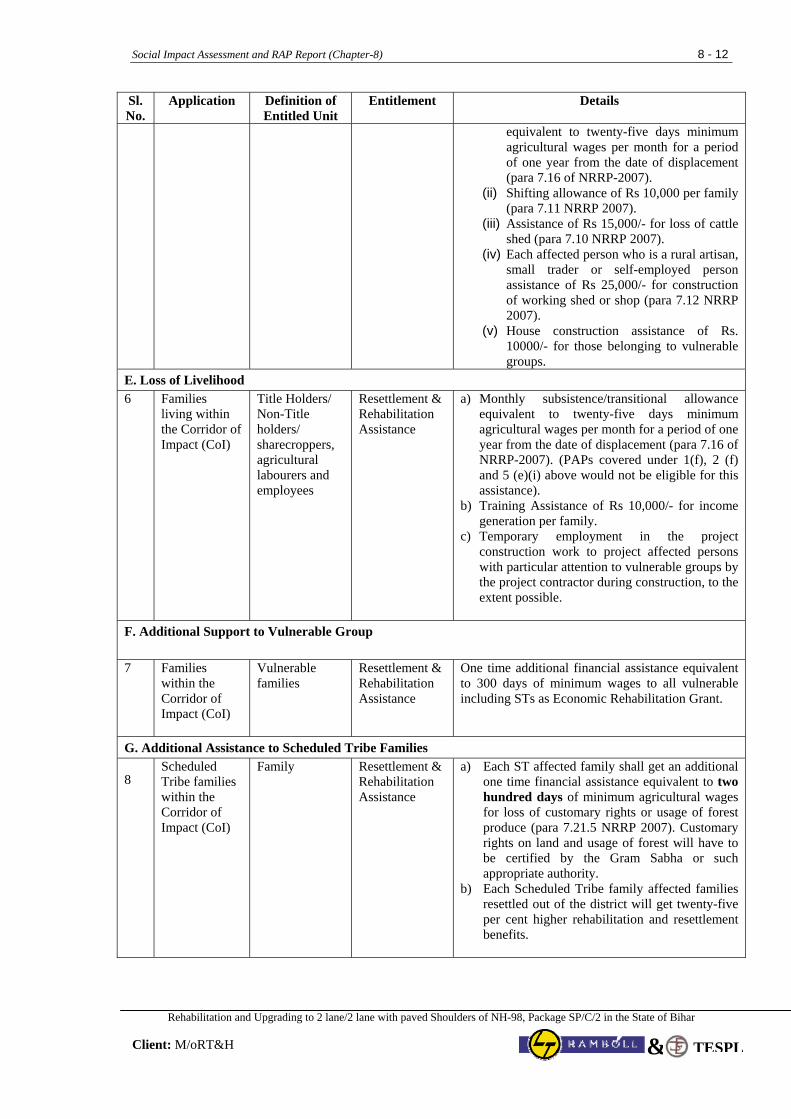
Social Impact Assessment and RAP Report (Chapter-8) 8 - 12
Rehabilitation and Upgrading to 2 lane/2 lane with paved Shoulders of NH-98, Package SP/C/2 in the State of Bihar
Client: M/oRT&H TESPL&
Sl. No.
Application Definition of Entitled Unit
Entitlement Details
equivalent to twenty-five days minimum agricultural wages per month for a period of one year from the date of displacement (para 7.16 of NRRP-2007).
(ii) Shifting allowance of Rs 10,000 per family (para 7.11 NRRP 2007).
(iii) Assistance of Rs 15,000/- for loss of cattle shed (para 7.10 NRRP 2007).
(iv) Each affected person who is a rural artisan, small trader or self-employed person assistance of Rs 25,000/- for construction of working shed or shop (para 7.12 NRRP 2007).
(v) House construction assistance of Rs. 10000/- for those belonging to vulnerable groups.
E. Loss of Livelihood 6 Families
living within the Corridor of Impact (CoI)
Title Holders/ Non-Title holders/ sharecroppers, agricultural labourers and employees
Resettlement & Rehabilitation Assistance
a) Monthly subsistence/transitional allowance equivalent to twenty-five days minimum agricultural wages per month for a period of one year from the date of displacement (para 7.16 of NRRP-2007). (PAPs covered under 1(f), 2 (f) and 5 (e)(i) above would not be eligible for this assistance).
b) Training Assistance of Rs 10,000/- for income generation per family.
c) Temporary employment in the project construction work to project affected persons with particular attention to vulnerable groups by the project contractor during construction, to the extent possible.
F. Additional Support to Vulnerable Group 7 Families
within the Corridor of Impact (CoI)
Vulnerable families
Resettlement & Rehabilitation Assistance
One time additional financial assistance equivalent to 300 days of minimum wages to all vulnerable including STs as Economic Rehabilitation Grant.
G. Additional Assistance to Scheduled Tribe Families
8 Scheduled Tribe families within the Corridor of Impact (CoI)
Family Resettlement & Rehabilitation Assistance
a) Each ST affected family shall get an additional one time financial assistance equivalent to two hundred days of minimum agricultural wages for loss of customary rights or usage of forest produce (para 7.21.5 NRRP 2007). Customary rights on land and usage of forest will have to be certified by the Gram Sabha or such appropriate authority.
b) Each Scheduled Tribe family affected families resettled out of the district will get twenty-five per cent higher rehabilitation and resettlement benefits.
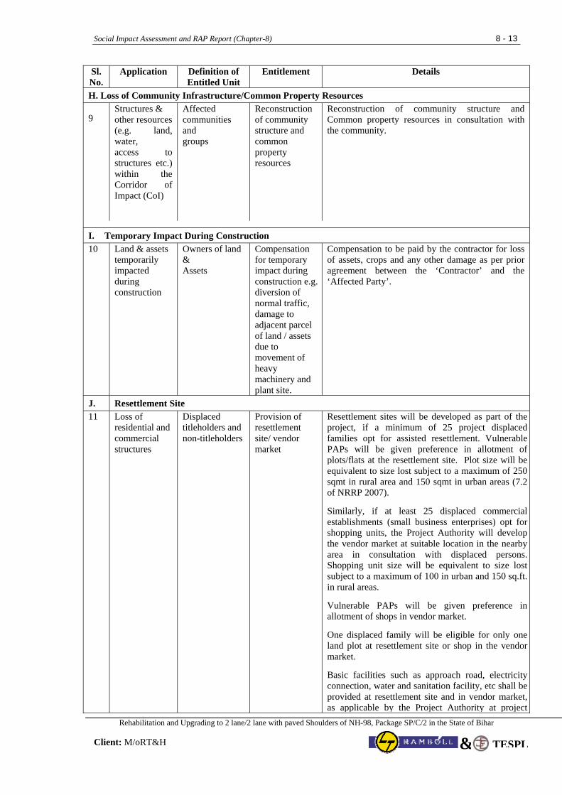
Social Impact Assessment and RAP Report (Chapter-8) 8 - 13
Rehabilitation and Upgrading to 2 lane/2 lane with paved Shoulders of NH-98, Package SP/C/2 in the State of Bihar
Client: M/oRT&H TESPL&
Sl. No.
Application Definition of Entitled Unit
Entitlement Details
H. Loss of Community Infrastructure/Common Property Resources
9 Structures & other resources (e.g. land, water, access to structures etc.) within the Corridor of Impact (CoI)
Affected communities and groups
Reconstruction of community structure and common property resources
Reconstruction of community structure and Common property resources in consultation with the community.
I. Temporary Impact During Construction 10 Land & assets
temporarily impacted during construction
Owners of land & Assets
Compensation for temporary impact during construction e.g. diversion of normal traffic, damage to adjacent parcel of land / assets due to movement of heavy machinery and plant site.
Compensation to be paid by the contractor for loss of assets, crops and any other damage as per prior agreement between the ‘Contractor’ and the ‘Affected Party’.
J. Resettlement Site 11 Loss of
residential and commercial structures
Displaced titleholders and non-titleholders
Provision of resettlement site/ vendor market
Resettlement sites will be developed as part of the project, if a minimum of 25 project displaced families opt for assisted resettlement. Vulnerable PAPs will be given preference in allotment of plots/flats at the resettlement site. Plot size will be equivalent to size lost subject to a maximum of 250 sqmt in rural area and 150 sqmt in urban areas (7.2 of NRRP 2007).
Similarly, if at least 25 displaced commercial establishments (small business enterprises) opt for shopping units, the Project Authority will develop the vendor market at suitable location in the nearby area in consultation with displaced persons. Shopping unit size will be equivalent to size lost subject to a maximum of 100 in urban and 150 sq.ft. in rural areas.
Vulnerable PAPs will be given preference in allotment of shops in vendor market.
One displaced family will be eligible for only one land plot at resettlement site or shop in the vendor market.
Basic facilities such as approach road, electricity connection, water and sanitation facility, etc shall be provided at resettlement site and in vendor market, as applicable by the Project Authority at project
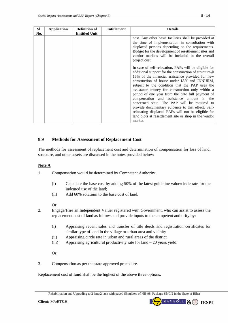
Social Impact Assessment and RAP Report (Chapter-8) 8 - 14
Rehabilitation and Upgrading to 2 lane/2 lane with paved Shoulders of NH-98, Package SP/C/2 in the State of Bihar
Client: M/oRT&H TESPL&
Sl. No.
Application Definition of Entitled Unit
Entitlement Details
cost. Any other basic facilities shall be provided at the time of implementation in consultation with displaced persons depending on the requirements. Budget for the development of resettlement sites and vendor markets will be included in the overall project cost.
In case of self-relocation, PAPs will be eligible for additional support for the construction of structure@ 15% of the financial assistance provided for new construction of house under IAY and JNNURM, subject to the condition that the PAP uses the assistance money for construction only within a period of one year from the date full payment of compensation and assistance amount in the concerned state. The PAP will be required to provide documentary evidence to that effect. Self-relocating displaced PAPs will not be eligible for land plots at resettlement site or shop in the vendor market.
8.9 Methods for Assessment of Replacement Cost The methods for assessment of replacement cost and determination of compensation for loss of land, structure, and other assets are discussed in the notes provided below: Note A
1. Compensation would be determined by Competent Authority: (i) Calculate the base cost by adding 50% of the latest guideline value/circle rate for the
indented use of the land; (ii) Add 60% solatium to the base cost of land. Or
2. Engage/Hire an Independent Valuer registered with Government, who can assist to assess the replacement cost of land as follows and provide inputs to the competent authority by: (i) Appraising recent sales and transfer of title deeds and registration certificates for
similar type of land in the village or urban area and vicinity (ii) Appraising circle rate in urban and rural areas of the district (iii) Appraising agricultural productivity rate for land – 20 years yield.
Or
3. Compensation as per the state approved procedure. Replacement cost of land shall be the highest of the above three options.
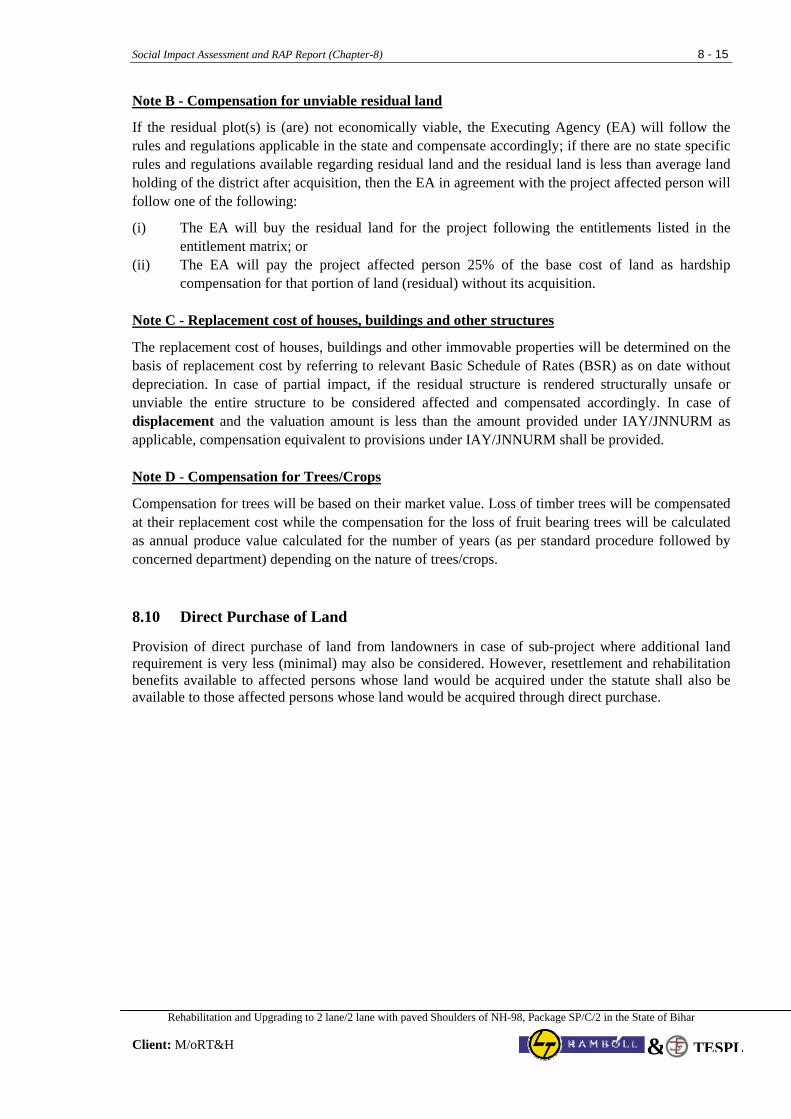
Social Impact Assessment and RAP Report (Chapter-8) 8 - 15
Rehabilitation and Upgrading to 2 lane/2 lane with paved Shoulders of NH-98, Package SP/C/2 in the State of Bihar
Client: M/oRT&H TESPL&
Note B - Compensation for unviable residual land
If the residual plot(s) is (are) not economically viable, the Executing Agency (EA) will follow the rules and regulations applicable in the state and compensate accordingly; if there are no state specific rules and regulations available regarding residual land and the residual land is less than average land holding of the district after acquisition, then the EA in agreement with the project affected person will follow one of the following:
(i) The EA will buy the residual land for the project following the entitlements listed in the entitlement matrix; or
(ii) The EA will pay the project affected person 25% of the base cost of land as hardship compensation for that portion of land (residual) without its acquisition.
Note C - Replacement cost of houses, buildings and other structures
The replacement cost of houses, buildings and other immovable properties will be determined on the basis of replacement cost by referring to relevant Basic Schedule of Rates (BSR) as on date without depreciation. In case of partial impact, if the residual structure is rendered structurally unsafe or unviable the entire structure to be considered affected and compensated accordingly. In case of displacement and the valuation amount is less than the amount provided under IAY/JNNURM as applicable, compensation equivalent to provisions under IAY/JNNURM shall be provided. Note D - Compensation for Trees/Crops
Compensation for trees will be based on their market value. Loss of timber trees will be compensated at their replacement cost while the compensation for the loss of fruit bearing trees will be calculated as annual produce value calculated for the number of years (as per standard procedure followed by concerned department) depending on the nature of trees/crops.
8.10 Direct Purchase of Land Provision of direct purchase of land from landowners in case of sub-project where additional land requirement is very less (minimal) may also be considered. However, resettlement and rehabilitation benefits available to affected persons whose land would be acquired under the statute shall also be available to those affected persons whose land would be acquired through direct purchase.
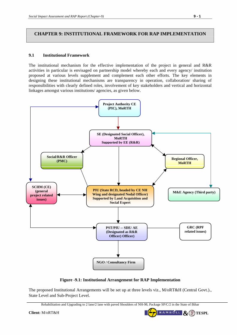
Social Impact Assessment and RAP Report (Chapter-9) 9 - 1
Rehabilitation and Upgrading to 2 lane/2 lane with paved Shoulders of NH-98, Package SP/C/2 in the State of Bihar
Client: M/oRT&H
TESPL&
CHAPTER 9: INSTITUTIONAL FRAMEWORK FOR RAP IMPLEMENTATION
9.1 Institutional Framework The institutional mechanism for the effective implementation of the project in general and R&R activities in particular is envisaged on partnership model whereby each and every agency/ institution proposed at various levels supplement and complement each other efforts. The key elements in designing these institutional mechanisms are transparency in operation, collaboration/ sharing of responsibilities with clearly defined roles, involvement of key stakeholders and vertical and horizontal linkages amongst various institutions/ agencies, as given below.
Figure -9.1: Institutional Arrangement for RAP Implementation
The proposed Institutional Arrangements will be set up at three levels viz., M/oRT&H (Central Govt.)., State Level and Sub-Project Level.
Project Authority CE (PIC), MoRTH
SE (Designated Social Officer), MoRTH
Supported by EE (R&R)
Social/R&R Officer (PMC)
PIU (State RCD, headed by CE NH Wing and designated Nodal Officer) Supported by Land Acquisition and
Social Expert
Regional Officer, MoRTH
M&E Agency (Third party)
PST/PIU -- SDE/ AE (Designated as R&R
Officer) Officer)
NGO / Consultancy Firm
GRC (RPF related issues)
SCHM (CE) (general
project related issues)
Social Impact Assessment and RAP Report (Chapter-9) 9 - 2
Rehabilitation and Upgrading to 2 lane/2 lane with paved Shoulders of NH-98, Package SP/C/2 in the State of Bihar
Client: M/oRT&H
TESPL&
9.2 Central Level Institutional Arrangement At Central Level, the Chief Engineer (PIC), MoRTH, Govt. of India will be overall responsible for the implementation of RAP & TDP. Chief Engineer (PIC) will have all delegated administrative and financial decisions with regard to implementation of the project as well as land acquisition, RAP & TDP implementation.
Institutional arrangement at Central Level will include augmenting the capacity of MoRTH with regard to resettlement and rehabilitation. A team comprising Superintending Engineer designated as Social Development Specialist (SDS) and a suitable number of Technical and Secretarial Staff will assist CE (PIC). The designated SDS will be directly involved in the implementation of RAP & TDP. The SDS will ensure that all resettlement and rehabilitation issues are complied with as per the RPF & TDF. The roles and responsibility of the SDS would broadly include the following:
• Assist technical team at Central Level in finalizing the RAP, TDP and Land Acquisition Plan.
• Guide and supervise in matters related to resettlement and rehabilitation & TDP to state and sub-project level offices.
• Compile data related to resettlement and rehabilitation & TDP activities received from field offices and update reporting officer and suggest suitable measures to be taken.
• Interact with RAP & TDP implementation agency on a regular basis.
• Undertake field visits as and when required.
• Facilitate necessary help needed at site with regard to LA and R&R issues.
• Co-ordinate with state government department in matters related to implementation of R&R.
• Ensure budgetary provision for resettlement and rehabilitation of EPs and relocation, rehabilitation and reconstruction of common property resources (CPRs) and implementation of & TDP.
• Ensure timely release of budget for implementation of RAP & TDP.
• Monitor implementation of RAP & TDP carried out by the agency through RRO.
• Perform other roles and responsibilities related to implementation of RAP & TDP as assigned by the CE (PIC) from time to time.
• Ensure free, prior and informed consultation with Tribal families along the project and also ensure that sufficient supporting documentation is maintained.
9.3 State Level Institutional Arrangement At State Level, a Land Acquisition cum Social Development Officer will be appointed to provide assistance to the designated Nodal Officer of PIU, Road Construction Department, Govt. of Bihar. The roles and responsibility of the LA cum SDO would broadly include the following: • Facilitate land acquisition and RAP & TDP implementation,
• Guide and supervise RAP & TDP implementation at sub-project level,
• Interact with RAP implementation agency and undertake field visits for first hand information,
• Compile data on LA progress and resettlement and rehabilitation activities received from field offices and update reporting officer and suggest suitable measures to be taken,
Social Impact Assessment and RAP Report (Chapter-9) 9 - 3
Rehabilitation and Upgrading to 2 lane/2 lane with paved Shoulders of NH-98, Package SP/C/2 in the State of Bihar
Client: M/oRT&H
TESPL&
• Co-ordinate with various government departments in matters related to implementation of RAP & TDP,
• Check implementation of RAP & TDP carried out by the agency from time to time by undertaking site visits and consultations with PAPs,
• Perform other roles and responsibilities related to implementation of RAP & TDP as assigned by the Reporting Officer from time to time.
9.4 Sub-Project Level Institutional Arrangements A Project Implementation Unit (PIU) comprising officials of State PWD will be constituted at sub-project level headed by the Superintending Engineer/ Executive Engineer designated as Project Director. The PIU will be responsible for the project execution including RAP & TDP implementation. There will be a designated or appointed Resettlement & Rehabilitation Officer (RRO) at respective PIUs who will be responsible only for the implementation of RAP and TDP at site. No other roles and responsibilities will be assigned to RRO other than resettlement and rehabilitation. RRO will assist Project Director at PIU and RRS at Central Level in all matters related to resettlement and rehabilitation.
The roles and responsibilities of the Resettlement and Rehabilitation Officer are as under:
• Ensure RAP & TDP implementation with assistance from implementation agency as per the time line agreed upon.
• Interact with RAP implementation agency on a regular basis.
• Undertake field visits with implementation agency from time to time.
• Facilitate necessary help needed at site with regard to LA and R&R issues to implantation agency.
• Co-ordinate and district administration and other departments in matters related to implementation of R&R.
• Ensure distribution of Resettlement and Rehabilitation Policy to PAPs.
• Ensure and attend meetings organised by implementation agency on related to awareness and dissemination of information on resettlement and rehabilitation policy and entitlements.
• Ensure inclusion PAPs who could not be enumerated during census but have documentary evidence to be included in the list of EPs.
• Ensure timely preparation of micro-plan from RAP implementation agency and approval from Head Office.
• Ensure preparation of identity cards and distribution of the same to EPs.
• Ensure disbursement of resettlement and rehabilitation assistance in a transparent manner.
• Participate in meetings related to resettlement and rehabilitation issues.
• Facilitate in opening of joint account of EPs.
• Prepare monthly progress report related to physical and financial progress of implementation of RAP & TDP & submit to Head Office.
• Ensure release of compensation and assistance before taking over the possession of land for start of construction work.
Social Impact Assessment and RAP Report (Chapter-9) 9 - 4
Rehabilitation and Upgrading to 2 lane/2 lane with paved Shoulders of NH-98, Package SP/C/2 in the State of Bihar
Client: M/oRT&H
TESPL&
• Ensure relocation, rehabilitation and reconstruction of CPRs before dismantling through proper mechanism.
• Ensure development of resettlement sites, if required.
• Attend and participate in Grievance Redress Committee meetings for redressal of grievances of EPs and other committees involving R&R matters,
• Liaison with government and other agencies for inclusion of EPs in employment and income generation programme/scheme.
• Carry out any other work related to resettlement and rehabilitation that may be entrusted from time to time by the RRS for compliance of R&R.
• Provide all necessary information and data related to R&R on monthly basis to RRS at Central Level through Project Director.
• Ensure that Tribal families get equal opportunity to participate during implementation and become overall beneficiaries in the project.
9.5 RAP and TDP Implementing Support Agency
To implement RAP, the Project Authority [CE (PIC), MoRTH] will engage the services of one or multiple agencies which can be NGO having experience in resettlement and rehabilitation issues through standard bidding process. The Terms of Reference (ToR) for hiring NGO has been provided as Annexure-4. The implementation agency will work in close co-ordination with RRO and report to PIU. Financial matters related to services of the RAP and TDP implementation agency will be dealt by Project Authority. Broad roles and responsibilities of implementation agency would be as:
• The RAP implementation agency will be the main link between the Project Authority and PAPs, • Shall be responsible for conducting detailed survey of PAPs with respect to COI and verification
of PAPs data as prepared by the DPR consultants, • Undertake public information campaign along with RRO at the commencement of the RAP &
TDP, • Develop rapport with PAPs, • Distribute pamphlets of R&R Policy to PAPs, Panchayat Raj Institutions, and concerned Govt.
Offices in the project area, etc. • Include PAPs who could not be enumerated during census cum socio-economic survey and
certification from R&R Officer, • Prepare format for making identity cards for PAPs and approval from the Head Office, • Preparation and distribution of photo identity cards, • Preparation of micro-plan, • Submission of micro-plan to RRO for approval from Head Office, • Pursue approval of micro-plan at the Head Office, • Organize consultations at regular interval with PAPs with regard to resettlement and rehabilitation, • Organize training program for skill up gradation of the PAPs, • Assist PAPs in all matters related to compensation and R&R, • Assist and facilitate aggrieved PAPs (for compensation and assistance) by bringing their cases to
GRC,
Social Impact Assessment and RAP Report (Chapter-9) 9 - 5
Rehabilitation and Upgrading to 2 lane/2 lane with paved Shoulders of NH-98, Package SP/C/2 in the State of Bihar
Client: M/oRT&H
TESPL&
• Facilitate in opening of joint account of PAPs, • Generate awareness about the alternative economic livelihood and enable PAPs to make informed
choice, • Consultations with PAPs regarding the choice of resettlement (i.e. self or assisted), development of
resettlement site, participation of women, etc. • Identify training needs of PAPs for income generation and institutions for imparting training, • Consultations with local people and Panchayat Raj Institutions with regard to relocation,
rehabilitation, reconstruction of affected CPRs as well as availability of new facilities under the project,
• Participate in various meetings, • Submit monthly progress report, and • Any other activities that may be required for the implementation of RAP & TDP, etc. 9.6 Coordination with Other Agencies and Organizations R&R Cell will establish important networking relationships with many departments and organizations. The Revenue Department has an influencing role in Land Acquisition proceedings, and initiation of resettlement process. Unless the compensation process is prompt and efficient, implementation process will get delayed. R&R Cell will coordinate with the Project Land Acquisition Officer to expedite the land acquisition process. Livelihood and income restoration are important aspects of the RAP. Provision of training for PAPs losing livelihood has been made in entitle matrix. The R&R budget for the implementation of RAP includes the cost of imparting necessary training to PAPs losing livelihood. Besides, the NGO will facilitate linkage of PAPs with the ongoing schemes of Government like “Jeevika - Bihar Rural Livelihoods Development Project”, BRLPS, State Rural Livelihoods Mission, Bihar, Swarnajayanti Gram Swarozgar Yojna (SGSY), Jawahar Gram Samridhi Yojna (JGSY), Mahatma Gandhi National Rural Employment Guarantee Scheme, etc as per the eligibility criteria of respective schemes. There is no separate budget for inclusion of PAPs in government-sponsored schemes. This has been included in the scope of work of NGO for the implementation of RAP. Restoration of community assets such as hand pumps, bore wells, drainage facilities will require help from Jal Nigam. Where schools are affected, coordination will be required from the District Offices of Education Department. Considering the above, M/oRT&H will extensively work on developing lateral linkages for mobilization of resources to benefit the PAPs and to achieve the desired results expected from implementation of RAP. 9.7 Role of Other Agencies Various government department and public agencies, particularly the Revenue Department, Rural Development and Financial Institutions, have an important role in implementing the RAP. The Revenue Department is responsible for providing land records, acquiring land and other properties and handing them over to the proper authorities. The District Rural Development Agency (DRDA) provides the RD and other ongoing livelihood developmental schemes in the District. During the implementation phase, it is proposed that the NGO and Project Authorities (PIU) will establish the contact with representative of these departments/agencies to facilitate the eligible PAPs for their inclusion in scheme for their livelihood up-gradation/restoration. For the purpose, required budget towards training programme for eligible PAPs has been included in R&R Budget. In the ongoing Govt. scheme there is enough budget for inclusion new beneficiaries (eligible PAPs).
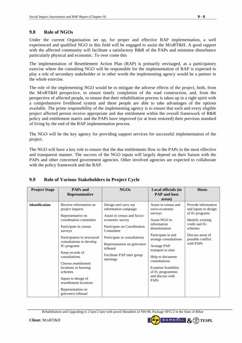
Social Impact Assessment and RAP Report (Chapter-9) 9 - 6
Rehabilitation and Upgrading to 2 lane/2 lane with paved Shoulders of NH-98, Package SP/C/2 in the State of Bihar
Client: M/oRT&H
TESPL&
9.8 Role of NGOs
Under the current Organisation set up, for proper and effective RAP implementation, a well experienced and qualified NGO in this field will be engaged to assist the M/oRT&H. A good rapport with the affected community will facilitate a satisfactory R&R of the PAPs and minimise disturbance particularly physical and economic. To over come this
The implementation of Resettlement Action Plan (RAP) is primarily envisaged, as a participatory exercise where the consulting NGO will be responsible for the implementation of RAP is expected to play a role of secondary stakeholder or in other words the implementing agency would be a partner in the whole exercise.
The role of the implementing NGO would be to mitigate the adverse effects of the project, both, from the M/oRT&H perspective, to ensure timely completion of the road construction, and, from the perspective of affected people, to ensure that their rehabilitation process is taken up in a right spirit with a comprehensive livelihood system and these people are able to take advantages of the options available. The prime responsibility of the implementing agency is to ensure that each and every eligible project affected person receive appropriate and due entitlement within the overall framework of R&R policy and entitlement matrix and the PAPs have improved (or at least restored) their previous standard of living by the end of the RAP implementation process. The NGO will be the key agency for providing support services for successful implementation of the project. The NGO will have a key role to ensure that the due entitlements flow to the PAPs in the most effective and transparent manner. The success of the NGO inputs will largely depend on their liaison with the PAPs and other concerned government agencies. Other involved agencies are expected to collaborate with the policy framework and the RAP.
9.9 Role of Various Stakeholders in Project Cycle Project Stage PAPs and
Representative NGOs Local officials (in
PAP and host areas)
Hosts
Identification Receive information on project impacts
Representative on coordination committee
Participate in census surveys
Participation in structured consultations to develop IG programs
Keep records of consultations
Choose resettlement locations or housing schemes
Inputs to design of resettlement locations
Representation on grievance tribunal
Design and carry out information campaign
Assist in census and Socio-economic survey
Participate on Coordination Committee
Participate in consultations
Representation on grievance tribunal
Facilitate PAP inter group meetings
Assist in census and socio-economic surveys
Assist NGO in information dissemination
Participate in and arrange consultations
Arrange PAP transport to sites
Help to document consultations
Examine feasibility of IG programmes and discuss with PAPs
Provide information and inputs to design of IG programs
Identify existing credit and IG schemes
Discuss areas of possible conflict with PAPs
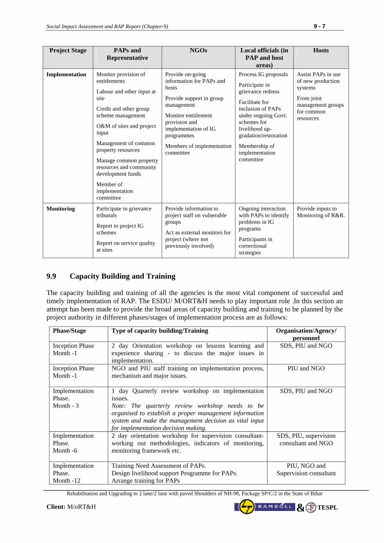
Social Impact Assessment and RAP Report (Chapter-9) 9 - 7
Rehabilitation and Upgrading to 2 lane/2 lane with paved Shoulders of NH-98, Package SP/C/2 in the State of Bihar
Client: M/oRT&H
TESPL&
Project Stage PAPs and Representative
NGOs Local officials (in PAP and host
areas)
Hosts
Implementation Monitor provision of entitlements
Labour and other input at site
Credit and other group scheme management
O&M of sites and project input
Management of common property resources
Manage common property resources and community development funds
Member of implementation committee
Provide on-going information for PAPs and hosts
Provide support in group management
Monitor entitlement provision and implementation of IG programmes
Members of implementation committee
Process IG proposals
Participate in grievance redress
Facilitate for inclusion of PAPs under ongoing Govt. schemes for livelihood up-gradation/restoration
Membership of implementation committee
Assist PAPs in use of new production systems
From joint management groups for common resources
Monitoring Participate in grievance tribunals
Report to project IG schemes
Report on service quality at sites
Provide information to project staff on vulnerable groups
Act as external monitors for project (where not previously involved)
Ongoing interaction with PAPs to identify problems in IG programs
Participants in correctional strategies
Provide inputs to Monitoring of R&R.
9.9 Capacity Building and Training The capacity building and training of all the agencies is the most vital component of successful and timely implementation of RAP. The ESDU/ M/ORT&H needs to play important role .In this section an attempt has been made to provide the broad areas of capacity building and training to be planned by the project authority in different phases/stages of implementation process are as follows:
Phase/Stage Type of capacity building/Training Organisation/Agency/ personnel
Inception Phase Month -1
2 day Orientation workshop on lessons learning and experience sharing - to discuss the major issues in implementation.
SDS, PIU and NGO
Inception Phase Month -1
NGO and PIU staff training on implementation process, mechanism and major issues.
PIU and NGO
Implementation Phase. Month - 3
1 day Quarterly review workshop on implementation issues. Note: The quarterly review workshop needs to be organised to establish a proper management information system and make the management decision as vital input for implementation decision making.
SDS, PIU and NGO
Implementation Phase. Month -6
2 day orientation workshop for supervision consultant- working out methodologies, indicators of monitoring, monitoring framework etc.
SDS, PIU, supervision consultant and NGO
Implementation Phase. Month -12
Training Need Assessment of PAPs. Design livelihood support Programme for PAPs. Arrange training for PAPs
PIU, NGO and Supervision consultant
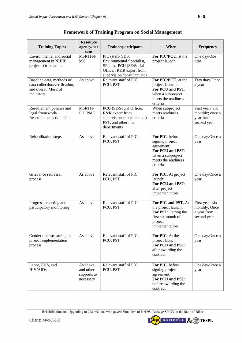
Social Impact Assessment and RAP Report (Chapter-9) 9 - 8
Rehabilitation and Upgrading to 2 lane/2 lane with paved Shoulders of NH-98, Package SP/C/2 in the State of Bihar
Client: M/oRT&H
TESPL&
Framework of Training Program on Social Management
Training Topics Resource
agency/persons
Trainee/participants When Frequency
Environmental and social management in NHIIP project- Orientation
MoRTH/PMC
PIC (staff- SDS, Environmental Specialist, SE etc), PCU (SE/Social Officer, R&R expert from supervision consultant etc)
For PIC/PCU, at the project launch
One day/One time
Baseline data, methods of data collection/verification, and overall M&E of indicators
As above Relevant staff of PIC, PCU, PST
For PIC/PCU, at the project launch; For PCU and PST: when a subproject meets the readiness criteria
Two days/Once a year
Resettlement policies and legal framework/ Resettlement action plan
MoRTH-PIC/PMC
PCU (SE/Social Officer, R&R expert from supervision consultant etc), PST, and other line departments
When subproject meets readiness criteria
First year- Six monthly; once a year from second year
Rehabilitation steps As above Relevant staff of PIC, PCU, PST
For PIC, before signing project agreement; For PCU and PST: when a subproject meets the readiness criteria
One day/Once a year
Grievance redressal process
As above Relevant staff of PIC, PCU, PST
For PIC, At project launch; For PCU and PST: after project implementation
One day/Once a year
Progress reporting and participatory monitoring
As above Relevant staff of PIC, PCU, PST
For PIC and PST, At the project launch; For PST: During the first six month of project implementation
First year- six monthly; Once a year from second year
Gender mainstreaming in project implementation process
As above Relevant staff of PIC, PCU, PST
For PIC, At the project launch For PCU and PST: after awarding the contract
One day/Once a year
Labor, EHS, and HIV/AIDs
As above and other supports as necessary
Relevant staff of PIC, PCU, PST
For PIC, before signing project agreement; For PCU and PST: before awarding the contract
One day/Once a year
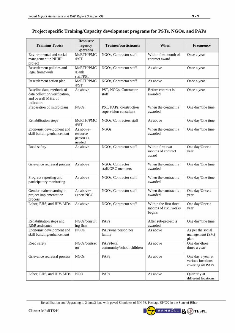
Social Impact Assessment and RAP Report (Chapter-9) 9 - 9
Rehabilitation and Upgrading to 2 lane/2 lane with paved Shoulders of NH-98, Package SP/C/2 in the State of Bihar
Client: M/oRT&H
TESPL&
Project specific Training/Capacity development programs for PSTs, NGOs, and PAPs
Training Topics Resource agency
/persons Trainee/participants When Frequency
Environmental and social management in NHIIP project
MoRTH/PMC/PST
NGOs, Contractor staff Within first month of contract award
Once a year
Resettlement policies and legal framework
MoRTH/PMC/Bank staff/PST
NGOs, Contractor staff As above Once a year
Resettlement action plan MoRTH/PMC/PST
NGOs, Contractor staff As above Once a year
Baseline data, methods of data collection/verification, and overall M&E of indicators
As above PST, NGOs, Contractor staff
Before contract is awarded
Once a year
Preparation of micro plans NGOs PST, PAPs, construction supervision consultant
When the contract is awarded
One day/One time
Rehabilitation steps MoRTH/PMC/PST
NGOs, Contractors staff As above One day/One time
Economic development and skill building/enhancement
As above+ resource person as needed
NGOs When the contract is awarded
One day/One time
Road safety As above NGOs, Contractor staff Within first two months of contract award
One day/Once a year
Grievance redressal process As above NGOs, Contractor staff/GRC members
When the contract is awarded
One day/One time
Progress reporting and participatory monitoring
As above NGOs, Contractor staff When the contract is awarded
One day/One time
Gender mainstreaming in project implementation process
As above+ expert NGO
NGOs, Contractor staff When the contract is awarded
One day/Once a year
Labor, EHS, and HIV/AIDs As above NGOs, Contractor staff Within the first three months of civil works begins
One day/Once a year
Rehabilitation steps and R&R assistance
NGOs/consulting firm
PAPs After sub-project is awarded
One day/One time
Economic development and skill building/enhancement
NGOs PAPs/one person per family
As above As per the social management (SM) plan
Road safety NGOs/contractor
PAPs/local community/school children
As above One day-three times a year
Grievance redressal process NGOs PAPs As above One day a year at various locations covering all PAPs
Labor, EHS, and HIV/AIDs NGO PAPs As above Quarterly at different locations
Social Impact Assessment and RAP Report (Chapter-10) 10 - 1
Rehabilitation and Upgrading to 2 lane/2 lane with paved Shoulders of NH-98, Package SP/C/2 in the State of Bihar
Client: M/oRT&H
TESPL&
CHAPTER 10: GRIEVANCE REDRESSAL MECHANISM
10.1 Grievance Redressal Mechanism (GRM) The RAP provides for a mechanism to ensure that the benefits are effectively transferred to the beneficiaries. However, need also exists for an efficient grievance redressal mechanism which will assist the APs in resolving queries and complaints. Land Acquisition will take place according to NH Act 1956 (Amended 1988). Compensation and entitlements will be paid according to R&R Policy approved by the M/oRT&H Board. Any disputes or grievances will be addressed through the grievance redressal mechanism proposed here. Detailed investigation will be undertaken which may involve field investigation with the concerned APs. The GRCs are expected to resolve the grievances of the eligible persons within a stipulated time. The decision of the GRCs is binding, unless vacated by court of law. The GRC will be constituted by the Project Authority with the aim to settle as many disputes as possible through consultations. There will be one GRC for each PIU. The GRC will comprise five members headed by a retired Magistrate not below the rank of SDM. Other members of the GRC will include a retired PWD Officer (not below the rank of Executive Engineer), RRO, representative of PAPs and Sarpanch (Elected Head of Village) of the concerned village. Grievances of EPs in writing will be brought to GRC for redressal by the RAP implementation agency. The RAP implementation agency will provide all necessary help to PAPs in presenting his/her case before the GRC. The GRC will respond to the grievance within 15 days. The GRC will normally meet once in a month but may meet more frequently, if the situation so demands. A time period of 45 days will be available for redressing the grievance of EPs. The decision of the GRC will not be binding to EPs. This means the decision of the GRC does not debar EPs taking recourse to court of law, if he/she so desires. Broad functions of GRC are as under:
• Record the grievances of EPs, categorize and prioritize them and provide solution to their grievances related to resettlement and rehabilitation assistance.
• The GRC may undertake site visit, ask for relevant information from Project Authority and other government and non-government agencies, etc in order to resolve the grievances of EPs.
• Fix a time frame within the stipulated time period of 45 days for resolving the grievance.
• Inform EPs through implementation agency about the status of their case and their decision to EPs and Project Authority for compliance.
The GRC will be constituted within 3 months by an executive order from competent authority (centre/ state) from the date of mobilization of RAP implementation agency. The RRO will persuade the matter with assistance from implementation agency in identifying the suitable persons from the nearby area for the constitution of GRC. Secretarial assistance will be provided by the PIU as and when required.
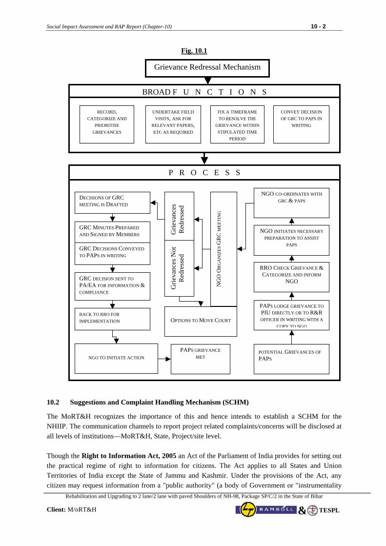
Social Impact Assessment and RAP Report (Chapter-10) 10 - 2
Rehabilitation and Upgrading to 2 lane/2 lane with paved Shoulders of NH-98, Package SP/C/2 in the State of Bihar
Client: M/oRT&H
TESPL&
Fig. 10.1
10.2 Suggestions and Complaint Handling Mechanism (SCHM) The MoRT&H recognizes the importance of this and hence intends to establish a SCHM for the NHIIP. The communication channels to report project related complaints/concerns will be disclosed at all levels of institutions—MoRT&H, State, Project/site level. Though the Right to Information Act, 2005 an Act of the Parliament of India provides for setting out the practical regime of right to information for citizens. The Act applies to all States and Union Territories of India except the State of Jammu and Kashmir. Under the provisions of the Act, any citizen may request information from a "public authority" (a body of Government or "instrumentality
Grievance Redressal Mechanism
BROAD F U N C T I O N S
RECORD, CATEGORIZE AND
PRIORITISE GRIEVANCES
CONVEY DECISION OF GRC TO PAPS IN
WRITING
DECISIONS OF GRC MEETING IS DRAFTED
Grie
vanc
es
Red
ress
ed
NG
O O
RG
AN
IZES
GR
C M
EETI
NG
NGO CO-ORDINATES WITH GRC & PAPS
Grie
vanc
es N
ot
Red
ress
ed
NGO INITIATES NECESSARY PREPARATION TO ASSIST
PAPS
RRO CHECK GRIEVANCE & CATEGORIZE AND INFORM
NGO
PAPS LODGE GRIEVANCE TOPIU DIRECTLY OR TO R&R OFFICER IN WRITING WITH A
COPY TO NGO
POTENTIAL GRIEVANCES OF PAPS
GRC MINUTES PREPARED AND SIGNED BY MEMBERS
GRC DECISIONS CONVEYED TO PAPS IN WRITING
GRC DECISION SENT TO PA/EA FOR INFORMATION & COMPLIANCE
BACK TO RRO FOR IMPLEMENTATION
NGO TO INITIATE ACTION PAPS GRIEVANCE
MET
OPTIONS TO MOVE COURT
P R O C E S S
UNDERTAKE FIELD VISITS, ASK FOR
RELEVANT PAPERS, ETC AS REQUIRED
FIX A TIMEFRAME TO RESOLVE THE
GRIEVANCE WITHIN STIPULATED TIME
PERIOD
Social Impact Assessment and RAP Report (Chapter-10) 10 - 3
Rehabilitation and Upgrading to 2 lane/2 lane with paved Shoulders of NH-98, Package SP/C/2 in the State of Bihar
Client: M/oRT&H
TESPL&
of State") which is required to reply expeditiously or within thirty days. The Act also requires every public authority to computerize their records for wide dissemination and to pro-actively publish certain categories of information so that the citizens need minimum recourse to request for information formally. In other words under the act, citizens have right to seek information from concerned agencies by following the set procedures. However, it is quite likely that many people may not use the provisions of this Act, only in limited cases covering serious concerns. Being an inter-state project involving several states and large scale of civil works along with R&R and Environment issues, the project is likely to receive many suggestions, complaints, inquiries, etc through the project implementation period. Therefore, MoRTH has agreed to establish SCHM as a good practice to address public concerns pertaining to various issues. SCHM will report all project related LA and R&R of the PAPs for redressal through the concerned PIU or GRC as appropriate. Several communication channels viz., toll free phone number, dedicated email, mechanism for on line submission of suggestions/complaints/inquiries, provision of suggestion/complaint box (at site and project office), post and other suitable means shall be set up for suggestion and complaint handling. Details of SCHM are provided as at Appendix-1 at the end of this Chapter. Right from beginning of project implementation, the appointed NGO / consultancy firm shall disseminate the information regarding establishment of Suggestions and Complaint Handling Mechanism for this project among the Project affected / benefited peoples. The appointed NGO / consultancy firm will explain the process through various applicable mode to be followed / adopted by the peoples for filing complains & suggestion. 10.3 Information Campaign Attention of the PAPs will be invited to the proposed redressal system for a quick, inexpensive and amicable settlement of claims for enhanced compensation. They will also be advised to get their records of rights updated. All possible efforts will be put forth to motivate the affected landowners and structure owners for a voluntary and amicable settlement of their claims outside the court. Most of the issues will be settled out of court as far as possible. Handouts will be distributed among all the affected persons highlighting the prospects of amicable settlement of dispute in question, outside the court, speedy and at lesser expense along with the timetable of inquiries and spots inspections of the committee. Besides, public announcements will be made in affected areas. Press notes will be released in local newspapers to aid publicity. 10.4 Documentation and maintenance of the related records The NGO shall maintain the related records of the proceedings of the grievance redressal committee and document all cases referred to it. The Flow chart provided in Fig. 10.1 provides the process and actions required for taking care of an aggrieved EP.

Social Impact Assessment and RAP Report (Chapter-10) 10 - 4
Rehabilitation and Upgrading to 2 lane/2 lane with paved Shoulders of NH-98, Package SP/C/2 in the State of Bihar
Client: M/oRT&H
TESPL&
Appendix-1
Suggestion and Complaint Handling Mechanism (SCHM) The design of NHIIP is complex and its geographical scale is immense, and the project is expected to have a wide array of enquiries, comments, and suggestions as well as face some operational risks. MORTH is working to establish a sound Suggestion and Complaint Handling Mechanism (SCHM) for NHIIP to address and handle external and internal inquiries, suggestions and comments, and concerns/complaints/ grievances as well as improve accountability and service delivery under NHIIP. SCHM Users
The users of SCHM could be anyone from the project stakeholders, including civil servants (from MORTH, State PWDs, or from other State Departments) contractors, consultants, project affected people (communities), road users, CSOs/NGOs, any other public, who realizes either impact from or relation to the concerned project. Management of SCHM
The overall responsibility for the operation and management of NHIIP’s SCHM will rest with the PIC M/oRT&H. The NHIIP’s SCHM will be handled at two levels: at the State and M/oRT&H’s level. Since all pre-construction and civil works will be implemented and managed by the States, all enquiries, suggestions and complaints related to a specific road will be submitted to the concerned implementing agency at the State Level. Each PIU at the State level is to set up a toll free number and/or email account for the project stakeholders and general public to submit their enquiries, suggestions and complaints. The toll free number and email account are to be displayed at the sign boards at the start and end of each project road. The bidding documents will have a requirement for the contractor to put in place signs at the start and end of the project road which will display the toll free number and email account to submit enquiries, suggestions and complaints to the concerned implementing government agency. The PIC head will be in charge of assigning the responsible person/entity to address and handle enquiry, suggestion or complaint submitted at the M/oRT&H’s level. However, within his team he will assign an officer (engineer) who will be responsible for coordinating inquiries/comments and complaints/ concerns/grievances. His responsibilities will include:
• To respond to as many inquiries/comments as possible • To receive and sort concerns/grievances • To forward them to appropriate team members for resolution as per recommendation of the
PIC Head • To track/monitor complaint/grievance acknowledgement and resolution • To review and report on complaint/grievance data and trends to the M/oRT&H PIC Head, who
in turn will report to M/oRT&H CVO, NHIIP Project Oversight Committee, and WB
Channels
The following channels should be established to receive inquiries/comments and concerns /grievances:
• Toll free phone • Email • On-line form • Regular post/mail • Suggestion box/Walk-ins
Details are in process of finalisation by M/oRT&H in consultation with PIU.
Social Impact Assessment and RAP Report (Chapter-10) 10 - 5
Rehabilitation and Upgrading to 2 lane/2 lane with paved Shoulders of NH-98, Package SP/C/2 in the State of Bihar
Client: M/oRT&H
TESPL&
It is critical to assign a specific e-mail ID and a phone/fax number, and to set up an easy-to-access suggestion box and walk-in office. The project website will have a permanent sub-window that will contain an on-line form and facilitates grievance/complaint collection. On-line Form for Suggestions and Complaints The on-line form for suggestions and complaints will be provided on the NHIIP website. The form will contain only four entries as outlined below. Subject: ______________________
NHIIP Road: ____________________
Content: _______________________
Your email: _____________________ Suggestions/complaints submitted through this on-line form is to go directly to (a) the PIC Head’s email account and (b) internal reporting system for SCHM (excel file). SCHM Reporting Format The internal reporting system for SCHM (excel file) will have the following entries/columns: 1. Date
2. Subject
3. Road
4. Content
5. Email (of the complainant)
6. Acknowledgment date (Date when PIC sent an email to the complainant to acknowledge that the email has been received, the issue will be handled within that period of time and the response/feedback will be provided to the complainant by that deadline)
7. Responsible Person
8. Deadline for Feedback
9. Actual Date for Feedback
10. Solution/Feedback on the Suggestion/Complaint
11. Additional Comment (e.g., if the person was unsatisfied with the feedback/solution provided and indicated that he/she will go to another authority to complain)
The entries 1-5 should be filled in automatically once an on-line form is submitted. The other entries are to be entered manually by the PIC and each State-level PIU. All SCHM-related reports are to be consolidated by the PIC.
Social Impact Assessment and RAP Report (Chapter-11) 11 - 1
Rehabilitation and Upgrading to 2 lane/2 lane with paved Shoulders of NH-98, Package SP/C/2 in the State of Bihar
Client: M/oRT&H TESPL&
CHAPTER 11: MONITORING AND EVALUATION 11.1 Monitoring and Evaluation Monitoring and Evaluation (M&E) are critical activities in involuntary resettlement. Monitoring involves periodic checking to ascertain whether activities are going according to the plan. It provides the feed back necessary for project management to keep the programmes on schedule. By contrast, evaluation is essentially a summing up, the end of the project assessment of whether those activities actually achieved their intended aims. As per World Banks’ OP/BP4.12 “Monitoring provides both working system for project managers and a channel for the resettlers to make known their needs and their reactions to resettlement execution”. Monitoring exercise will be undertaken both internally and externally. While SDE PIU, Land Acquisition cum Social Officer, SDS /M/oRT&H on monthly basis will carry out the project’s monitoring and separate external independent agency will be hired for mid term and end term evaluation of the project.
Indicators, which will be monitored during the project, may be divided into two categories.
• Process and output indicators • Outcome/impact indicators
11.2 Process and Output Indicators
Monitoring of involuntary resettlement operations require in essence, an application of general project monitoring procedures and methods to the process accruing in resettlement but with particular attention to the specific high risks intrinsic in such operations. Monitoring is essentially an exercise in strategic learning that can and should be used for enhancing the quality of RAP implementation. As per the existing arrangement, internal monitoring will be carried out by M/oRT&H itself. The internal monitoring is related to physical factors such as, number of families affected, resettled, assistance extended infrastructure facilities provided, etc. and other financial aspects, such as compensation paid, grant extended, etc. the internal M&E must be simultaneous with the implementation of the Rehabilitation Action Plan (RAP). The objectives of the internal monitoring are:
• Daily Operations Planning (DOP) • Management and Implementation (M&I) • Operational Trouble shooting and Feedback (OTSF)
The periodicity of internal monitoring could be daily or weekly depending on the issues and level. For internal monitoring following information will be collated:
• Individual files on each project affected person • Village Performa • Action Plan and Progress reports
Crisis and day to day management and monitoring management will require its own improved action plans, regular coordination and onsite training sessions and an Management Information System as internal system. It also requires trouble-shooters and informal networks of feed back from the communities, NGOs and other governmental bodies. Physical monitoring includes movement and progress reporting of input stocks, finance and service resource in the system to ensure management and financing functions in a timely and effective manner. Physical monitoring and verification also includes the quantifiable progress of the resettlement Programme to indicate the timeliness of the financial disbursements already agreed to and deviations form the critical path for over all project completion and the required integrated arrangements to resettle PAPs.
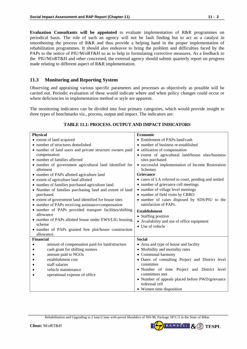
Social Impact Assessment and RAP Report (Chapter-11) 11 - 2
Rehabilitation and Upgrading to 2 lane/2 lane with paved Shoulders of NH-98, Package SP/C/2 in the State of Bihar
Client: M/oRT&H TESPL&
Evaluation Consultants will be appointed to evaluate implementation of R&R programmes on periodical basis. The role of such an agency will not be fault finding but to act as a catalyst in smoothening the process of R&R and thus provide a helping hand in the proper implementation of rehabilitation programmes. It should also endeavor to bring the problem and difficulties faced by the PAPs to the notice of PIU/M/oRT&H so as to help in formulating corrective measures. As a feedback to the PIU/M/oRT&H and other concerned, the external agency should submit quarterly report on progress made relating to different aspect of R&R implementation. 11.3 Monitoring and Reporting System Observing and appraising various specific parameters and processes as objectively as possible will be carried out. Periodic evaluation of these would indicate where and when policy changes could occur or where deficiencies in implementation method or style are apparent. The monitoring indicators can be divided into four primary categories, which would provide insight to three types of benchmarks viz., process, output and impact. The indicators are:
TABLE 11.1: PROCESS. OUTPUT AND IMPACT INDICATORS
Physical • extent of land acquired • number of structures demolished • number of land users and private structure owners paid
compensation • number of families affected • number of government agricultural land identified for
allotment • number of PAPs allotted agriculture land • extent of agriculture land allotted • number of families purchased agriculture land. • Number of families purchasing land and extent of land
purchased. • extent of government land identified for house sites • number of PAPs receiving assistance/compensation • number of PAPs provided transport facilities/shifting
allowance • number of PAPs allotted house under EWS/LIG housing
scheme • number of PAPs granted free plot/house construction
allowance.
Economic • Entitlement of PAPs-land/cash • number of business re-established • utilization of compensation • extent of agricultural land/house sites/business
sites purchased • successful implementation of Income Restoration
Schemes Grievance • cases of LA referred to court, pending and settled • number of grievance cell meetings • number of village level meetings • number of field visits by CRRO • number of cases disposed by SDS/PIU to the
satisfaction of PAPs.
Establishment • Staffing position • Availability and use of office equipment • Use of vehicle
Financial • amount of compensation paid for land/structure • cash grant for shifting oustees • amount paid to NGOs • establishment cost • staff salaries • vehicle maintenance • operational expense of office
Social • Area and type of house and facility • Morbidity and mortality rates • Communal harmony • Dates of consulting Project and District level
committee • Number of time Project and District level
committees met • Number of appeals placed before PWD/grievance
redressal cell • Women time disposition
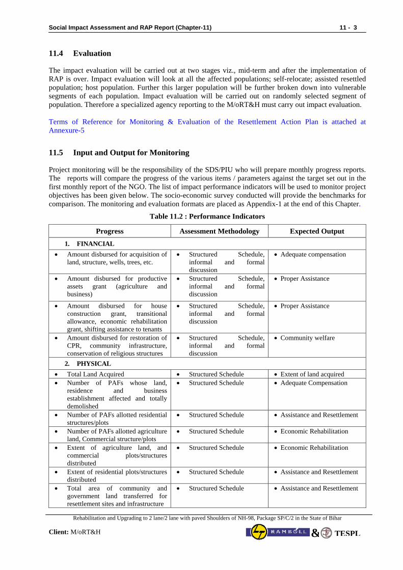
Social Impact Assessment and RAP Report (Chapter-11) 11 - 3
Rehabilitation and Upgrading to 2 lane/2 lane with paved Shoulders of NH-98, Package SP/C/2 in the State of Bihar
Client: M/oRT&H TESPL&
11.4 Evaluation
The impact evaluation will be carried out at two stages viz., mid-term and after the implementation of RAP is over. Impact evaluation will look at all the affected populations; self-relocate; assisted resettled population; host population. Further this larger population will be further broken down into vulnerable segments of each population. Impact evaluation will be carried out on randomly selected segment of population. Therefore a specialized agency reporting to the M/oRT&H must carry out impact evaluation. Terms of Reference for Monitoring & Evaluation of the Resettlement Action Plan is attached at Annexure-5
11.5 Input and Output for Monitoring
Project monitoring will be the responsibility of the SDS/PIU who will prepare monthly progress reports. The reports will compare the progress of the various items / parameters against the target set out in the first monthly report of the NGO. The list of impact performance indicators will be used to monitor project objectives has been given below. The socio-economic survey conducted will provide the benchmarks for comparison. The monitoring and evaluation formats are placed as Appendix-1 at the end of this Chapter.
Table 11.2 : Performance Indicators
Progress Assessment Methodology Expected Output
1. FINANCIAL • Amount disbursed for acquisition of
land, structure, wells, trees, etc. • Structured Schedule,
informal and formal discussion
• Adequate compensation
• Amount disbursed for productive assets grant (agriculture and business)
• Structured Schedule, informal and formal discussion
• Proper Assistance
• Amount disbursed for house construction grant, transitional allowance, economic rehabilitation grant, shifting assistance to tenants
• Structured Schedule, informal and formal discussion
• Proper Assistance
• Amount disbursed for restoration of CPR, community infrastructure, conservation of religious structures
• Structured Schedule, informal and formal discussion
• Community welfare
2. PHYSICAL • Total Land Acquired • Structured Schedule • Extent of land acquired • Number of PAFs whose land,
residence and business establishment affected and totally demolished
• Structured Schedule • Adequate Compensation
• Number of PAFs allotted residential structures/plots
• Structured Schedule • Assistance and Resettlement
• Number of PAFs allotted agriculture land, Commercial structure/plots
• Structured Schedule • Economic Rehabilitation
• Extent of agriculture land, and commercial plots/structures distributed
• Structured Schedule • Economic Rehabilitation
• Extent of residential plots/structures distributed
• Structured Schedule • Assistance and Resettlement
• Total area of community and government land transferred for resettlement sites and infrastructure
• Structured Schedule • Assistance and Resettlement
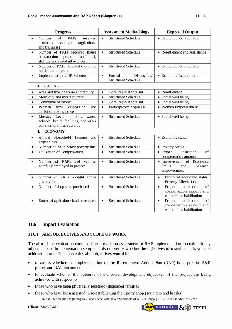
Social Impact Assessment and RAP Report (Chapter-11) 11 - 4
Rehabilitation and Upgrading to 2 lane/2 lane with paved Shoulders of NH-98, Package SP/C/2 in the State of Bihar
Client: M/oRT&H TESPL&
Progress Assessment Methodology Expected Output • Number of PAFs received
productive asset grant (agriculture and business)
• Structured Schedule • Economic Rehabilitation
• Number of PAFs received house construction grant, transitional, shifting and rental allowances
• Structured Schedule • Resettlement and Assistance
• Number of PAFs received economic rehabilitation grant
• Structured Schedule • Economic Rehabilitation
• Implementation of IR Schemes • Formal Discussion/ Structured Schedule
• Economic Rehabilitation
3. SOCIAL • Area and type of house and facility • Core Rapid Appraisal • Resettlement • Morbidity and mortality rates • Structured Schedule • Social well being • Communal harmony • Core Rapid Appraisal • Social well being • Women time disposition and
decision making power • Participatory Appraisal • Women Empowerment
• Literacy Level, drinking water, schools, health facilities, and other community infrastructures
• Structured Schedule • Social well being
4. ECONOMY • Annual Household Income and
Expenditure • Structured Schedule • Economic status
• Number of PAFs below poverty line • Structured Schedule • Poverty Status • Utilization of Compensation • Structured Schedule • Proper utilization of
compensation amount • Number of PAPs and Women
gainfully employed in project • Structured Schedule • Improvement of Economic
Status and Women empowerment
• Number of PAFs brought above poverty line
• Structured Schedule • Improved economic status, Poverty Alleviation
• Number of shop sites purchased • Structured Schedule • Proper utilization of compensation amount and economic rehabilitation
• Extent of agriculture land purchased • Structured Schedule • Proper utilization of compensation amount and economic rehabilitation
11.6 Impact Evaluation
11.6.1 AIM, OBJECTIVES AND SCOPE OF WORK
The aim of the evaluation exercise is to provide an assessment of RAP implementation to enable timely adjustments of implementation setup and also to verify whether the objectives of resettlement have been achieved or not. To achieve this aim, objectives would be:
• to assess whether the implementation of the Resettlement Action Plan (RAP) is as per the R&R policy and RAP document
• to evaluate whether the outcome of the social development objectives of the project are being achieved with respect to
• those who have been physically resettled (displaced families) • those who have been assisted in re-establishing their petty shop (squatters and kiosks)
Social Impact Assessment and RAP Report (Chapter-11) 11 - 5
Rehabilitation and Upgrading to 2 lane/2 lane with paved Shoulders of NH-98, Package SP/C/2 in the State of Bihar
Client: M/oRT&H TESPL&
• those who have lost their land • functioning of reconstructed common property resources Scope of work
The scope of work for consultants would be:
a) To develop a detailed methodology and survey instruments to carry out impact assessment process.
b) To review RAP implementation in order to asses whether desired objectives of resettlement have been achieved in terms of:
• Whether PAPs are taken into confidence before relocation or any other activity related to them
i.e, whether the process of RAP implementation was transparent? • Whether timeframe as mentioned in RAP for various R&R activities was religiously followed? • Whether Grievance Redress Cell was in place and PAPs approached GRC? • Whether District Level Committees was formed and whether such committees regularly met
and minutes of the meetings are being documented? • Whether the process mentioned in RAP for disbursement of compensation, R&R assistance,
physical relocation & economic rehabilitation of PAPs was followed? • Whether training imparted has resulted in capacity building or skill upgradation? • Whether the institutional arrangement as suggested in RAP was in place and participated in
RAP implementation?
c) Whether R&R policy was suitable and adequate w.r.t to diverse social and cultural groups getting affected? Policy will be evaluated on three counts viz.,
• Policy entitlements • Expectations of the PAPs, and • Efficiency of the delivery systems.
d) Whether the goal of R&R policy of “improving or at least restore the livelihood of the PAPs” has
been achieved (especially of vulnerable PAPs)? Achievement will be assessed through: • If incomes and living standards of the resettlers have at least been restored? • That the incomes and living standards of host population have not been affected due to influx of
resettlers?
e) Whether PAPs were involved in the implementation stage by the way of consultations and that their views were considered during implementation? Consultation process will be evaluated by assessing: • type, • content, • style of information transmission, • representation methods, • whether vulnerable PAPs were involved, and • whether gender issues were discussed?
f) Whether RAP implementation has been able to address the issues of
• Quality of life of PAPs (economic rehabilitation)? • Health and hygiene (sanitation facilities and safe drinking water)?
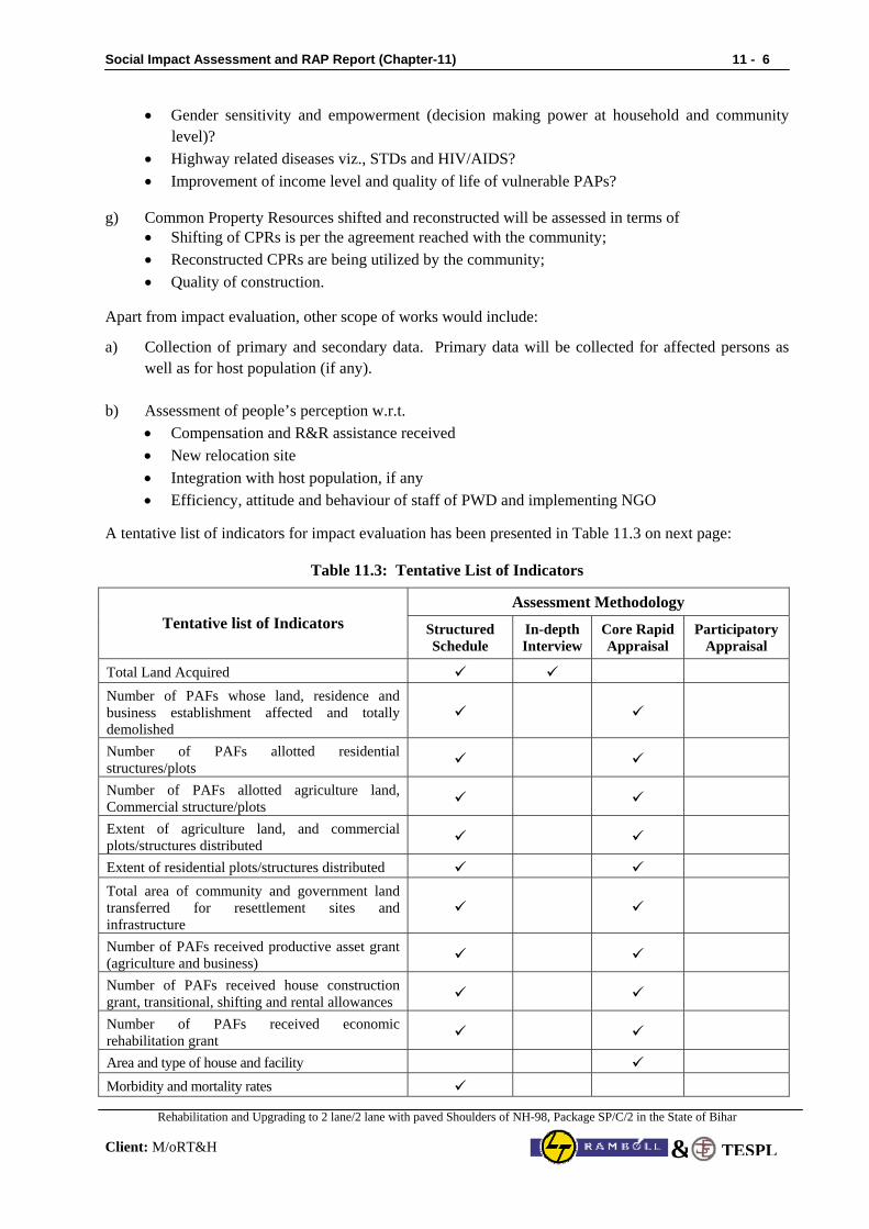
Social Impact Assessment and RAP Report (Chapter-11) 11 - 6
Rehabilitation and Upgrading to 2 lane/2 lane with paved Shoulders of NH-98, Package SP/C/2 in the State of Bihar
Client: M/oRT&H TESPL&
• Gender sensitivity and empowerment (decision making power at household and community level)?
• Highway related diseases viz., STDs and HIV/AIDS? • Improvement of income level and quality of life of vulnerable PAPs?
g) Common Property Resources shifted and reconstructed will be assessed in terms of • Shifting of CPRs is per the agreement reached with the community; • Reconstructed CPRs are being utilized by the community; • Quality of construction.
Apart from impact evaluation, other scope of works would include:
a) Collection of primary and secondary data. Primary data will be collected for affected persons as well as for host population (if any).
b) Assessment of people’s perception w.r.t.
• Compensation and R&R assistance received • New relocation site • Integration with host population, if any • Efficiency, attitude and behaviour of staff of PWD and implementing NGO
A tentative list of indicators for impact evaluation has been presented in Table 11.3 on next page:
Table 11.3: Tentative List of Indicators
Assessment Methodology Tentative list of Indicators Structured
Schedule In-depth Interview
Core Rapid Appraisal
Participatory Appraisal
Total Land Acquired Number of PAFs whose land, residence and business establishment affected and totally demolished
Number of PAFs allotted residential structures/plots
Number of PAFs allotted agriculture land, Commercial structure/plots
Extent of agriculture land, and commercial plots/structures distributed
Extent of residential plots/structures distributed Total area of community and government land transferred for resettlement sites and infrastructure
Number of PAFs received productive asset grant (agriculture and business)
Number of PAFs received house construction grant, transitional, shifting and rental allowances
Number of PAFs received economic rehabilitation grant
Area and type of house and facility Morbidity and mortality rates
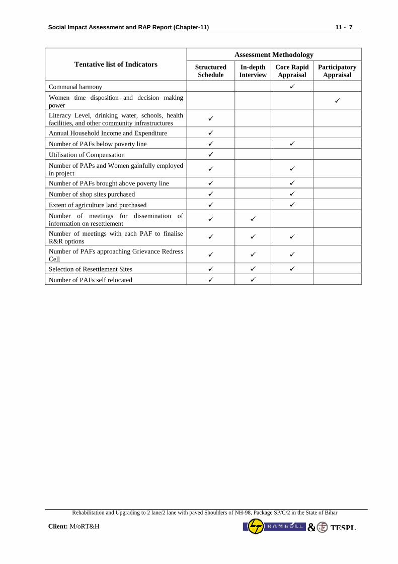
Social Impact Assessment and RAP Report (Chapter-11) 11 - 7
Rehabilitation and Upgrading to 2 lane/2 lane with paved Shoulders of NH-98, Package SP/C/2 in the State of Bihar
Client: M/oRT&H TESPL&
Assessment Methodology Tentative list of Indicators Structured
Schedule In-depth Interview
Core Rapid Appraisal
Participatory Appraisal
Communal harmony Women time disposition and decision making power
Literacy Level, drinking water, schools, health facilities, and other community infrastructures
Annual Household Income and Expenditure Number of PAFs below poverty line Utilisation of Compensation Number of PAPs and Women gainfully employed in project
Number of PAFs brought above poverty line Number of shop sites purchased Extent of agriculture land purchased Number of meetings for dissemination of information on resettlement
Number of meetings with each PAF to finalise R&R options
Number of PAFs approaching Grievance Redress Cell
Selection of Resettlement Sites Number of PAFs self relocated
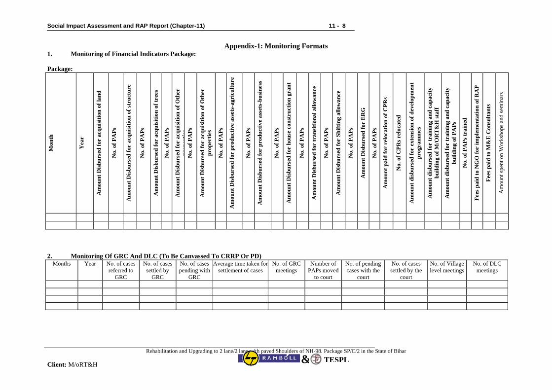
Social Impact Assessment and RAP Report (Chapter-11) 11 - 8
Rehabilitation and Upgrading to 2 lane/2 lane with paved Shoulders of NH-98, Package SP/C/2 in the State of Bihar
Client: M/oRT&H TESPL&
Appendix-1: Monitoring Formats 1. Monitoring of Financial Indicators Package: Package:
Mon
th
Yea
r
Am
ount
Dis
burs
ed fo
r ac
quis
ition
of l
and
No.
of P
APs
Am
ount
Dis
burs
ed fo
r ac
quis
ition
of s
truc
ture
No.
of P
APs
Am
ount
Dis
burs
ed fo
r ac
quis
ition
of t
rees
No.
of P
APs
Am
ount
Dis
burs
ed fo
r ac
quis
ition
of O
ther
pr
oper
ties
No.
of P
APs
Am
ount
Dis
burs
ed fo
r ac
quis
ition
of O
ther
pr
oper
ties
No.
of P
APs
Am
ount
Dis
burs
ed fo
r pr
oduc
tive
asse
ts-a
gric
ultu
re
No.
of P
APs
Am
ount
Dis
burs
ed fo
r pr
oduc
tive
asse
ts-b
usin
ess
No.
of P
APs
Am
ount
Dis
burs
ed fo
r ho
use
cons
truc
tion
gran
t
No.
of P
APs
Am
ount
Dis
burs
ed fo
r tr
ansi
tiona
l allo
wan
ce
No.
of P
APs
Am
ount
Dis
burs
ed fo
r Sh
iftin
g al
low
ance
No.
of P
APs
Am
ount
Dis
burs
ed fo
r E
RG
No.
of P
APs
Am
ount
pai
d fo
r re
loca
tion
of C
PRs
No.
of C
PRs r
eloc
ated
Am
ount
dis
burs
ed fo
r ex
tens
ion
of d
evel
opm
ent
prog
ram
mes
Am
ount
dis
burs
ed fo
r tr
aini
ng a
nd c
apac
ity
build
ing
of M
/OR
T&
H st
aff
Am
ount
dis
burs
ed fo
r tr
aini
ng a
nd c
apac
ity
build
ing
of P
APs
No.
of P
APs
trai
ned
Fees
pai
d to
NG
O fo
r im
plem
enta
tion
of R
AP
Fees
pai
d to
M&
E C
onsu
ltant
s
Am
ount
spen
t on
Wor
ksho
ps a
nd se
min
ars
2. Monitoring Of GRC And DLC (To Be Canvassed To CRRP Or PD) Months Year No. of cases
referred to GRC
No. of cases settled by
GRC
No. of cases pending with
GRC
Average time taken for settlement of cases
No. of GRC meetings
Number of PAPs moved
to court
No. of pending cases with the
court
No. of cases settled by the
court
No. of Village level meetings
No. of DLC meetings
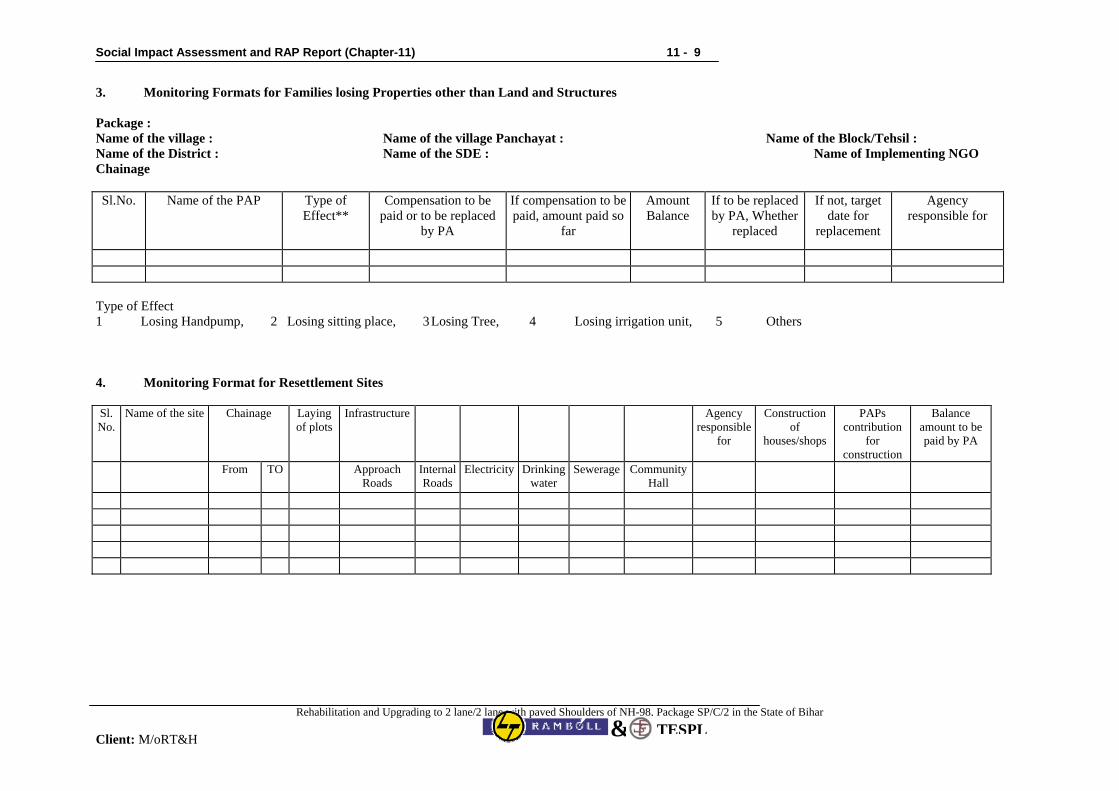
Social Impact Assessment and RAP Report (Chapter-11) 11 - 9
Rehabilitation and Upgrading to 2 lane/2 lane with paved Shoulders of NH-98, Package SP/C/2 in the State of Bihar
Client: M/oRT&H TESPL&
3. Monitoring Formats for Families losing Properties other than Land and Structures Package : Name of the village : Name of the village Panchayat : Name of the Block/Tehsil : Name of the District : Name of the SDE : Name of Implementing NGO Chainage Sl.No. Name of the PAP Type of
Effect** Compensation to be
paid or to be replaced by PA
If compensation to be paid, amount paid so
far
Amount Balance
If to be replaced by PA, Whether
replaced
If not, target date for
replacement
Agency responsible for
Type of Effect 1 Losing Handpump, 2 Losing sitting place, 3 Losing Tree, 4 Losing irrigation unit, 5 Others 4. Monitoring Format for Resettlement Sites Sl.No.
Name of the site Chainage Laying of plots
Infrastructure Agency responsible
for
Construction of
houses/shops
PAPs contribution
for construction
Balance amount to be paid by PA
From TO Approach Roads
Internal Roads
Electricity Drinking water
Sewerage Community Hall
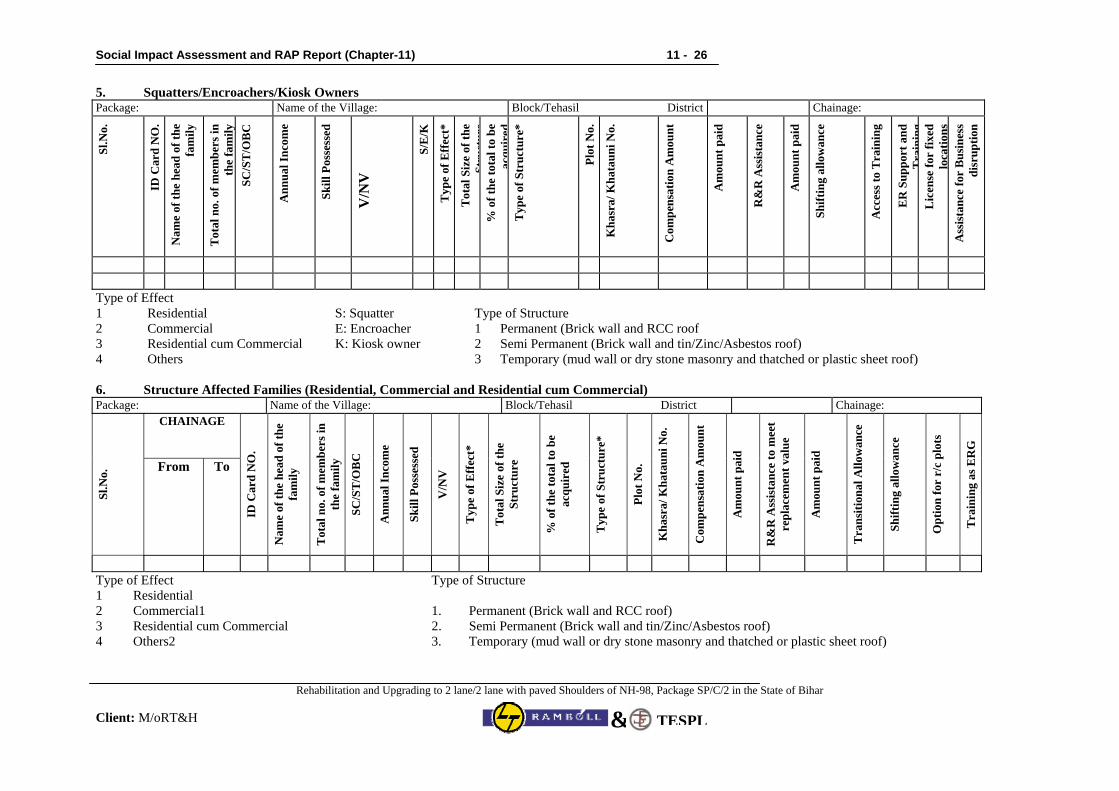
Social Impact Assessment and RAP Report (Chapter-11) 11 - 26
Rehabilitation and Upgrading to 2 lane/2 lane with paved Shoulders of NH-98, Package SP/C/2 in the State of Bihar
Client: M/oRT&H TESPL&
5. Squatters/Encroachers/Kiosk Owners Package: Name of the Village: Block/Tehasil District Chainage:
Sl.N
o.
ID C
ard
NO
.
Nam
e of
the
head
of t
he
fam
ily
Tot
al n
o. o
f mem
bers
in
the
fam
il y
SC/S
T/O
BC
Ann
ual I
ncom
e
Skill
Pos
sess
ed
V/N
V
S/E
/K
Typ
e of
Eff
ect*
Tot
al S
ize
of th
e St
ruct
ure
% o
f the
tota
l to
be
acqu
ired
Typ
e of
Str
uctu
re*
Plot
No.
Kha
sra/
Kha
taun
i No.
Com
pens
atio
n A
mou
nt
Am
ount
pai
d
R&
R A
ssis
tanc
e
Am
ount
pai
d
Shift
ing
allo
wan
ce
Acc
ess t
o T
rain
ing
ER
Sup
port
and
T
rain
ing
Lic
ense
for
fixed
lo
catio
ns
Ass
ista
nce
for
Bus
ines
s di
srup
tion
Type of Effect 1 Residential S: Squatter Type of Structure 2 Commercial E: Encroacher 1 Permanent (Brick wall and RCC roof 3 Residential cum Commercial K: Kiosk owner 2 Semi Permanent (Brick wall and tin/Zinc/Asbestos roof) 4 Others 3 Temporary (mud wall or dry stone masonry and thatched or plastic sheet roof) 6. Structure Affected Families (Residential, Commercial and Residential cum Commercial) Package: Name of the Village: Block/Tehasil District Chainage:
CHAINAGE
Sl.N
o. From To
ID C
ard
NO
.
Nam
e of
the
head
of t
he
fam
ily
Tot
al n
o. o
f mem
bers
in
the
fam
ily
SC/S
T/O
BC
Ann
ual I
ncom
e
Skill
Pos
sess
ed
V/N
V
Typ
e of
Eff
ect*
Tot
al S
ize
of th
e St
ruct
ure
% o
f the
tota
l to
be
acqu
ired
Typ
e of
Str
uctu
re*
Plot
No.
Kha
sra/
Kha
taun
i No.
Com
pens
atio
n A
mou
nt
Am
ount
pai
d
R&
R A
ssis
tanc
e to
mee
t re
plac
emen
t val
ue
Am
ount
pai
d
Tra
nsiti
onal
Allo
wan
ce
Shift
ing
allo
wan
ce
Opt
ion
for
r/c
plot
s
Tra
inin
g as
ER
G
Type of Effect Type of Structure 1 Residential 2 Commercial1 1. Permanent (Brick wall and RCC roof) 3 Residential cum Commercial 2. Semi Permanent (Brick wall and tin/Zinc/Asbestos roof) 4 Others2 3. Temporary (mud wall or dry stone masonry and thatched or plastic sheet roof)
Social Impact Assessment and RAP Report (Chapter-12) 12 - 1
Rehabilitation and Upgrading to 2 lane/2 lane with paved Shoulders of NH-98, Package SP/C/2 in the State of Bihar
Client: M/oRT&H
TESPL&
CHAPTER 12: IMPLEMENTATION ARRANGEMENT AND SCHEDULE
12.1 Implementation Arrangement Involuntary resettlement is a sensitive problem and experience in R&R matters will be required by the PIU, R&R Cell. A good rapport with the affected community will facilitate a satisfactory R&R of the PAPs and minimize disturbance particularly physical and economic. To overcome this deficiency, experienced and well-qualified NGO in this field will be engaged to assist the M/ORT&H in the implementation of the RAP. This section particularly details the role of NGO. The NGO will work as a link between the PIU - R&R Cell and the affected community. The NGO will educate the PAPs on the need to implement the Project, on aspects relating to LA and R&R measures and ensures proper utilization of various compensations extended to the PAPs under the R&R entitlement package. NGO Consultancy will be to facilitate the resettlement process. Its broad objectives will be to:
• Educate PAPs on their rights, entitlements, and obligations under the RAP; • Ensuring that PAPs receive their full entitlements; • Where options are available, the NGO shall provide advice to PAPs on relative benefits of each
option; • Assist PAPs on grievance redressal through the established system; and • Collect data as required and decided with PIU to help PIU to monitor and assess progress; In assisting the PAPs to choose among different options available to them, an analysis must first be made of likely benefits and potential risks for each of the options. Conducting this analysis is the responsibility of the M/oRT&H, in collaboration with the agencies (Government or NGO) engaged in implementing the various activities. Following such an analysis, the risks and benefits shall be explained to the PAPs and sufficient time given to them to make an informed choice. In choosing between different options, whether it is cash compensation or various rehabilitation schemes, the M/ORT&H shall make use of the baseline socio-economic survey data, and ensure that those PAPs considered vulnerable are encouraged to choose the options entailing the lowest risk. As a general principle for the RAP, individual PAPs will be monitored to ensure that they are able to regain or improve their former socio-economic status and quality of life. If it becomes clear that the assistance given under the Project is insufficient to obtain this goal within the life of the resettlement program, then consideration should be given to whether additional assistance or support towards different activities need be given. In order to carry out such tasks, the employees of the NGO are to be stationed in the project area. Besides contacting the PAPs on an individual basis to regularly update the baseline information, group meetings and village-level meetings will be conducted by the NHO on a regular basis. The frequencies of such meetings will depend on the requirements of the PAPs but should occur at least once a month. The NGO will have to encourage participation of individual PAPs in such meeting by discussing their problems regarding LA, R&R and other aspects relating to their socio-economic lives. Such participation will make it easier to find a solution acceptable to all involved. 12.2 RAP Implementation The implementation of Resettlement Action Plan (RAP) is primarily envisaged, as a participatory exercise where the consulting NGO is responsible for the implementation of RAP is expected to play a role of secondary stakeholder or in other words the implementing agency would be a partner in the whole exercise.
Social Impact Assessment and RAP Report (Chapter-12) 12 - 2
Rehabilitation and Upgrading to 2 lane/2 lane with paved Shoulders of NH-98, Package SP/C/2 in the State of Bihar
Client: M/oRT&H
TESPL&
The role of the implementing NGO would be to mitigate the adverse effects of the project, both, from the M/ORT&H perspective, to ensure timely completion of the road construction, and, from the perspective of affected people, to ensure that their rehabilitation process is taken up in a right spirit with a comprehensive livelihood system and these people are able to take advantages of the options available. The prime responsibility of the implementing agency is to ensure that each and every eligible project affected person receive appropriate and due entitlement within the overall framework of R&R policy and entitlement matrix and the PAPs have improved (or at least restored) their previous standard of living by the end of the RAP implementation process. The other responsibilities includes: • Working in co-ordination with the LASO / SDE (R&R), M/ORT&H (alternatively called the
CRRO) and assist him/ her in carrying out the implementation of the RAP; • To co-ordinate with the DLCs and GRCs in implementing the RAP; • Coordinate the meetings of the District level committee for approval of the micro plans wherever
required. • Assist the CRRO in undertaking all public meetings, information campaigns at the
commencement of the project and give full information to the affected community; • Translate the R&R objectives and guidelines to implement actions for mitigating adverse impacts
on the PAPs; • Assist the Engineers (Supervision Consultants) to ensure that the Contracts comply with the
applicable labour laws (including prohibition of child labour) and gender issues; • Assist the PIU and /or the Engineers in ensuring compliance with the safety, health and hygiene
norms, and the RAP actions proposed for HIV/AIDS awareness/prevention campaigns. • Report to CRRO on a monthly basis, and quarterly basis including physical and financial
progress, both in terms of quantitative and qualitative aspects and the problems and issues addressed and tackled with the PAPs and the solutions found especially focusing the women's issues their problems and what has been done (within the framework of the RAP) to ensure their participation in decision-making as well as the options made available for them to access economic opportunities, marketing and credit.
• Data base management of the PAPs. • Videography and digital photography cost required for implementation of the RAP. • Facilitate PAPs & PDPs for the Income Generation Scheme training and to ensure that the
provisions made for training component are best utilized. 12.3 Stages of RAP Implementation: A Methodological Framework The objective of the project is to strengthen the existing road infrastructure aimed at economic and social development of the region. One of the key activities in the project cycle is the implementation of Resettlement Action Plan with an objective of minimising the adverse impact of the project implementation on the lives of people living in the project area. The M/oRT&H R&R policy envisages that the project-affected families (PAFs) are to be resettled and rehabilitated so that the adverse impact due to proposed improvement of the road gets minimised. The stepwise methodology for implementation of the RAP has been shown through a flow chart. 12.3.1 Training and Capacity Building of Project Staff As a first step, it is essential to build the capacity of our staff i.e. Team Leader, Supervisors, Engineers, Village level workers etc. The aspects of training to be imparted would include social impact assessment survey, conducting focus group discussions, community participation, PRA/RRA, relocation of common property resources etc.
Social Impact Assessment and RAP Report (Chapter-12) 12 - 3
Rehabilitation and Upgrading to 2 lane/2 lane with paved Shoulders of NH-98, Package SP/C/2 in the State of Bihar
Client: M/oRT&H
TESPL&
12.3.2 Focus Group Discussion, Awareness Campaign and Dissemination of Information In order to make the RAP implementation process transparent as per WB guidelines, a series of FGDs/ meetings etc would be organised with all stakeholders for dissemination of information regarding rehabilitation process and entitlement framework. The RAP policy will be printed in Hindi language as well as English and the same will be distributed to the PAFs in order to make the process transparent. 12.3.3 Identification, verification and updating of PAP Census The work include identification, verification and updating that will be done through door-to-door socio-economic impact assessment survey, through personal interview of each head of the household of PAPs by field staff under the direct supervision of the other staff and overall guidance of the Team Leader. The verified and updated information of PAPs will be processed in the computer and the database for the same would be created which would also help in effective monitoring of the overall process of resettlement action plan implementation. The final output of this exercise would be a profile of each PAP with socio-economic indicators like demography, income, occupation, nature, extent, value of losses, details of entitlement etc. This information will be useful for preparing and issuing identity cards to the PAPs. 12.3.4 Micro Plans for Non-title and Title Holders The micro plans will be prepared for Title Holders (TH) and Non-title Holders (NTH) (kiosks, squatters and tenant) as per the entitlement matrix. 12.3.5 Entitlement cum Identity Card In order to keep transparency in system, the entitlement-cum-identity card indicating type of loss and entitlement will be provided to each PAF. 12.3.6 Opening of Bank Account and Disbursement of Assistance The next critical step in this process would be in the form of assistance to the M/oRT&H for opening up of the bank account of PAPs. The bank account would be opened in the joint name of husband and wife. The assistance will be disbursed only on the basis of the recommendations of the field staff and M/oRT&H officials based on the community centred transparent mechanisms. 12.3.7 Measurement, valuation of private structure and common property resources One of the important aspects of the project as envisaged by us would be measurement and evaluation of structure. The measurement and valuation of different structures like private houses, schools, colleges, religious structures like temple, mosque would need to be done by our engineering team. The current applicable Schedule of Rates would be the basis for valuation of the structures. The community structure will either be relocated to a new area and the community's decisions would form the basis of rebuilding such structures. 12.3.8 Rehabilitation of Affected Families and Restoration of Income and Livelihood Rehabilitation of all the PAFs is one of the critical tasks of the project implementation process in order to help the communities derive the maximum benefits out of the project without loosing their livelihoods and the least impact on socio-cultural aspects of their lives. It includes livelihood analysis, preparation and implementation of a comprehensive livelihood support plan and development of a comprehensive livelihood support system. This process must result in improved or at least restored living standards, earning capacity or improve the quality of life of the people affected by the project.
Social Impact Assessment and RAP Report (Chapter-12) 12 - 4
Rehabilitation and Upgrading to 2 lane/2 lane with paved Shoulders of NH-98, Package SP/C/2 in the State of Bihar
Client: M/oRT&H
TESPL&
Accordingly, rehabilitation will be conceived and shall be implemented as a development programme with particular attention to the needs of women headed households and vulnerable groups. The effort of the NGO shall be to improve the PAPs economic productive capacity and building up a permanent capacity for self-development. One of the key strategies would be to facilitate inclusion of PAPs, if not already included, in the existing Self Help Groups (SHGs) within the locality/neighbourhood. The members of the existing SHGs shall be persuaded by the NGO for the inclusion of the PAPs. The other way would be to form SHGs of PAPs exclusively for upgrading/ restoration of livelihood. SGSY is self-employment program for rural poor. SHGs are formed based on common interest. The objective of the program is to bring the self-employed above poverty line by providing the income generating assets through bank credit and government subsidy. Formation of SHG of PAPs exclusively, would be possible where enough PAPs are available. There are three locations (Naubatpur, Chainpur-Daryapur and Arwal) in the project road section where NGO can facilitate formation of SHGs. Organising the economic activities would be according to the skills possessed by the affected families and in case the affected PAFs wants to shift to other suitable /viable economic activity for enhancement of their livelihood, the corresponding skill up gradation training would be arranged by the NGO in accordance with the entitlement with the help of PIU (M/oRT&H) & District Authority”. The PAPs will be free to choose to act as individuals or as informal groups like SHGs for accessing credit, Milk Producer Groups (MPGs), Agriculture Commodities (like vegetable, pulse, wheat) Processing Groups etc or as co-operatives, with their overall operating efficiency and viability of the livelihood options chosen by them. The cost for imparting necessary training for livelihood and Income up gradation is included in R&R budget. In context of the socio-economic profile of the region, their existing activity base and the skills, efforts will also be made to ensure that the groups are resettled in a manner so that their backward and forward linkages in the activities performed by them are maintained and they are provided support in improving their income through support of other government sponsored programs also.
12.3.9 IEC for HIV/AIDS One of the important objectives of the project is to reduce the vulnerability on health aspect especially, HIV/AIDS. Officials of Bihar State AIDS Control Society (BSACS) in the project districts were consulted. It was informed that several health awareness programmes with the help of NGOs are being implemented in the project area. Besides, an intervention project funded by National Aids control Organisation (NACO) is being implementation with the help of 17 NGOs in the project influence area. In the project section two NGOs namely, “Daudnagar Organisation for Rural Development” at Daudnagar and “Jan Sikshan Sansthan, BANCHIT” at Arwal are working in the project area for creating awareness regarding HIV/AIDS (covering modes of transmission, its spreads, prevention, etc).They also have services available for testing and treatment with special focus on the women and the youth. Under the project awareness generation about HIV/AIDS along the project road section (covering schools, dhabas, public places, bus stops, and other suitable locations) has been included as one of the important components of the project. The responsibility of carrying out the awareness generation activities on HIV/AIDS has been included in the scope of work of NGO. An amount of Rs. 1.50 mllion have provided in the resettlement budget for this purpose. Besides, the NGO engaged for the implementation of RAP with support from PIU, will establish contact and collaborate with concerned agencies (SACO/NACO & District Administration) to extend the advantage of the on-going programmes (awareness generation activities and holding of camps) along the project road section targeting road users, labour sites/camps of the road project, truckers, local people, etc.

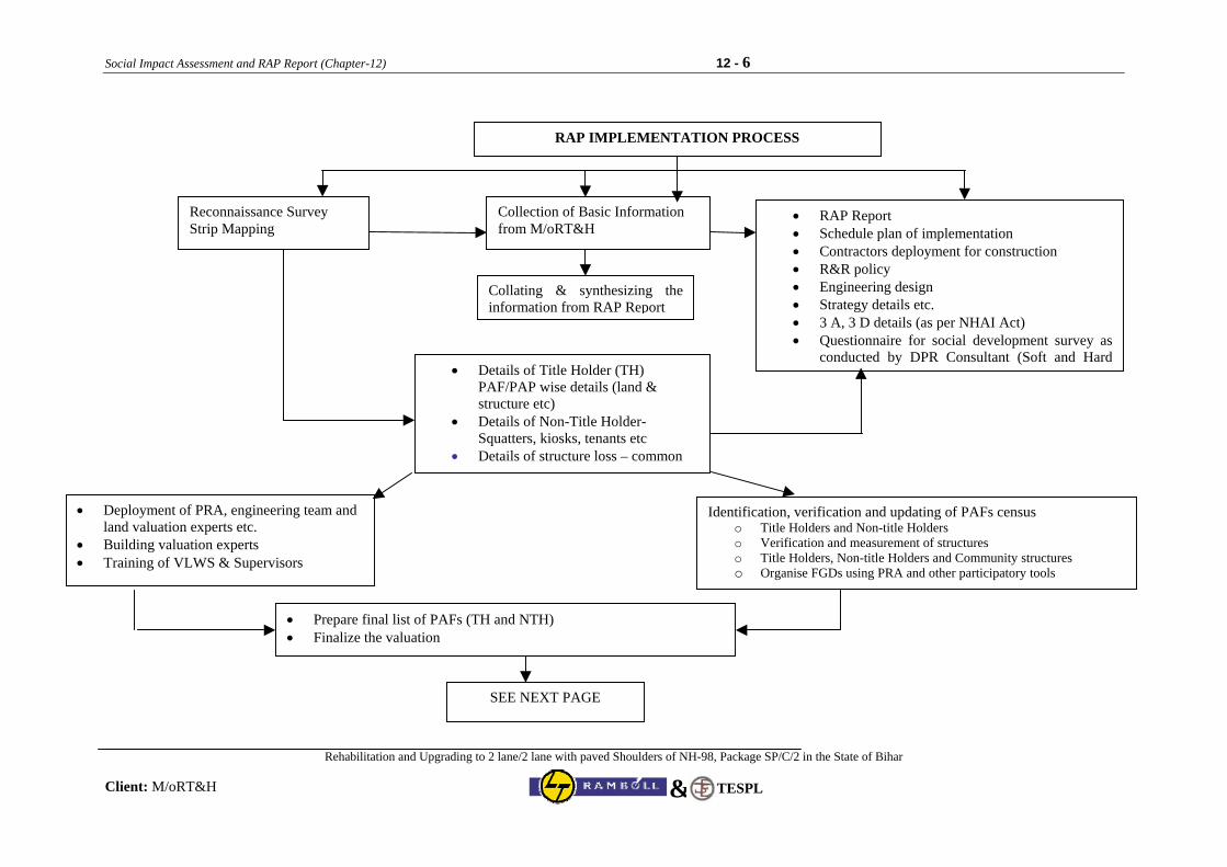
Social Impact Assessment and RAP Report (Chapter-12) 12 - 6
Rehabilitation and Upgrading to 2 lane/2 lane with paved Shoulders of NH-98, Package SP/C/2 in the State of Bihar
Client: M/oRT&H TESPL&
RAP IMPLEMENTATION PROCESS
Reconnaissance Survey Strip Mapping
Collection of Basic Information from M/oRT&H
Collating & synthesizing theinformation from RAP Report
• Details of Title Holder (TH) PAF/PAP wise details (land & structure etc)
• Details of Non-Title Holder- Squatters, kiosks, tenants etc
• Details of structure loss – common
Identification, verification and updating of PAFs census o Title Holders and Non-title Holders o Verification and measurement of structures o Title Holders, Non-title Holders and Community structures o Organise FGDs using PRA and other participatory tools
• Deployment of PRA, engineering team and land valuation experts etc.
• Building valuation experts • Training of VLWS & Supervisors
• Prepare final list of PAFs (TH and NTH) • Finalize the valuation
• RAP Report • Schedule plan of implementation • Contractors deployment for construction • R&R policy • Engineering design • Strategy details etc. • 3 A, 3 D details (as per NHAI Act) • Questionnaire for social development survey as
conducted by DPR Consultant (Soft and Hard
SEE NEXT PAGE
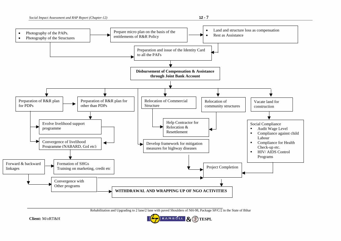
Social Impact Assessment and RAP Report (Chapter-12) 12 - 7
Rehabilitation and Upgrading to 2 lane/2 lane with paved Shoulders of NH-98, Package SP/C/2 in the State of Bihar
Client: M/oRT&H TESPL&
• Photography of the PAPs. • Photography of the Structures
Prepare micro plan on the basis of the entitlements of R&R Policy
• Land and structure loss as compensation • Rest as Assistance
Preparation and issue of the Identity Card to all the PAFs
Disbursement of Compensation & Assistance through Joint Bank Account
Preparation of R&R plan for PDPs
Relocation of Commercial Structure
Preparation of R&R plan for other than PDPs
Evolve livelihood support programme
Vacate land for construction
Relocation of community structures
Develop framework for mitigation measures for highway diseases
Help Contractor for Relocation & Resettlement
Convergence of livelihood Programme (NABARD, GoI etc)
Social Compliance Audit Wage Level Compliance against child
Labour Compliance for Health
Check-up etc. HIV/ AIDS Control
Programs
Project CompletionFormation of SHGs Training on marketing, credit etc
Forward & backward linkages
Convergence with Other programs
WITHDRAWAL AND WRAPPING UP OF NGO ACTIVITIES
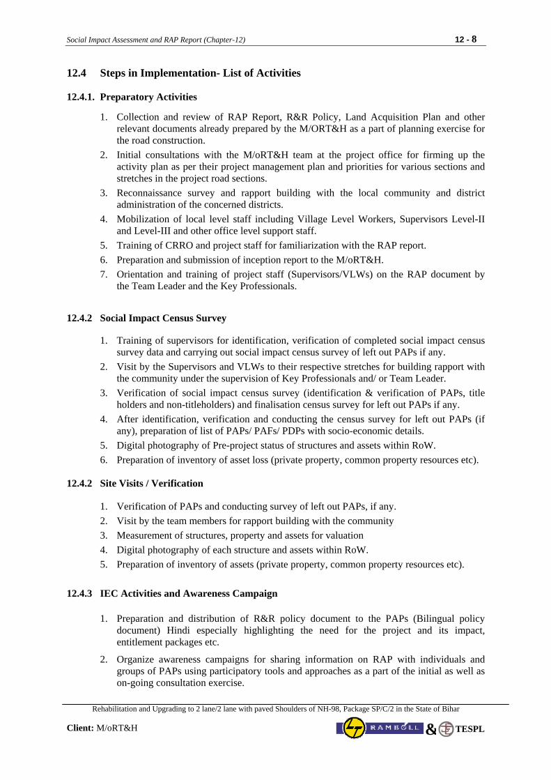
Social Impact Assessment and RAP Report (Chapter-12) 12 - 8
Rehabilitation and Upgrading to 2 lane/2 lane with paved Shoulders of NH-98, Package SP/C/2 in the State of Bihar
Client: M/oRT&H
TESPL&
12.4 Steps in Implementation- List of Activities 12.4.1. Preparatory Activities
1. Collection and review of RAP Report, R&R Policy, Land Acquisition Plan and other relevant documents already prepared by the M/ORT&H as a part of planning exercise for the road construction.
2. Initial consultations with the M/oRT&H team at the project office for firming up the activity plan as per their project management plan and priorities for various sections and stretches in the project road sections.
3. Reconnaissance survey and rapport building with the local community and district administration of the concerned districts.
4. Mobilization of local level staff including Village Level Workers, Supervisors Level-II and Level-III and other office level support staff.
5. Training of CRRO and project staff for familiarization with the RAP report. 6. Preparation and submission of inception report to the M/oRT&H. 7. Orientation and training of project staff (Supervisors/VLWs) on the RAP document by
the Team Leader and the Key Professionals. 12.4.2 Social Impact Census Survey
1. Training of supervisors for identification, verification of completed social impact census survey data and carrying out social impact census survey of left out PAPs if any.
2. Visit by the Supervisors and VLWs to their respective stretches for building rapport with the community under the supervision of Key Professionals and/ or Team Leader.
3. Verification of social impact census survey (identification & verification of PAPs, title holders and non-titleholders) and finalisation census survey for left out PAPs if any.
4. After identification, verification and conducting the census survey for left out PAPs (if any), preparation of list of PAPs/ PAFs/ PDPs with socio-economic details.
5. Digital photography of Pre-project status of structures and assets within RoW. 6. Preparation of inventory of asset loss (private property, common property resources etc).
12.4.2 Site Visits / Verification
1. Verification of PAPs and conducting survey of left out PAPs, if any. 2. Visit by the team members for rapport building with the community 3. Measurement of structures, property and assets for valuation 4. Digital photography of each structure and assets within RoW. 5. Preparation of inventory of assets (private property, common property resources etc).
12.4.3 IEC Activities and Awareness Campaign
1. Preparation and distribution of R&R policy document to the PAPs (Bilingual policy document) Hindi especially highlighting the need for the project and its impact, entitlement packages etc.
2. Organize awareness campaigns for sharing information on RAP with individuals and groups of PAPs using participatory tools and approaches as a part of the initial as well as on-going consultation exercise.
Social Impact Assessment and RAP Report (Chapter-12) 12 - 9
Rehabilitation and Upgrading to 2 lane/2 lane with paved Shoulders of NH-98, Package SP/C/2 in the State of Bihar
Client: M/oRT&H
TESPL&
3. Confidence building measures through participatory process with the community and individuals affected by the project especially involving women to ensure smooth eviction during the resettlement process.
4. Consultation meetings with the contractors and their project staff including construction labours to understand the socio-cultural profile.
5. Developing messages and training material for awareness campaigns on HIV/ AIDS.
6. Organize awareness campaigns for the construction labours on HIV/ AIDS. 12.4.4 Establishment of DLC/GRC
12.4.5 Land and Building Valuation and Distribution of I-Cards
1. Evolving land and building valuation methods
2. Measurement and valuation of land and structures (private buildings, community structures, trees etc.)
3. Preparation of entitlement/ compensation and assistance details for the TH and NTH.
4. Photography of the entitled PAPs for preparation and distribution of entitlement-cum- identity card to titleholders and non-title holders.
12.4.6 Micro-Plans and Assistance Disbursement
1. Preparation of Micro Plans (Non-title holders) 2. Preparation of micro plan (Title holders) 3. Opening of bank account 4. Informing EPs about their entitlement, creating awareness on the role of DLC/ GRC,
procedure for grievances application etc and recording of the grievances, if any, and its representation to the DLC/ GRC along with the affected person.
5. Disbursement of entitlement/compensation/ assistance. 12.4.7 Rehabilitation Process
1. Livelihood analysis/options for PAPs/ PDPs. 2. Identification of training needs (Training Needs Assessment). 3. Formation of Savings/ Self Help Groups (SHGs) 4. Vocational trainings, skill up gradation trainings etc based on the micro plans, livelihood
analysis and identified training needs.
12.4.8 Resettlement Activities
1. Resettlement activities involving identification and selection of sites for resettlement and rehabilitation
2. Shifting of PDPs/ vendor market/ private/community structures etc. 3. Rehabilitation in new settlements 4. Submission of Completion Report
12.5 Implementation Schedule The Implementation schedule has been provided below in the form of Flow Chart on next pages (refer table 12.1). The RAP will be implemented over a period of 24 months starting from Oct. 2012.
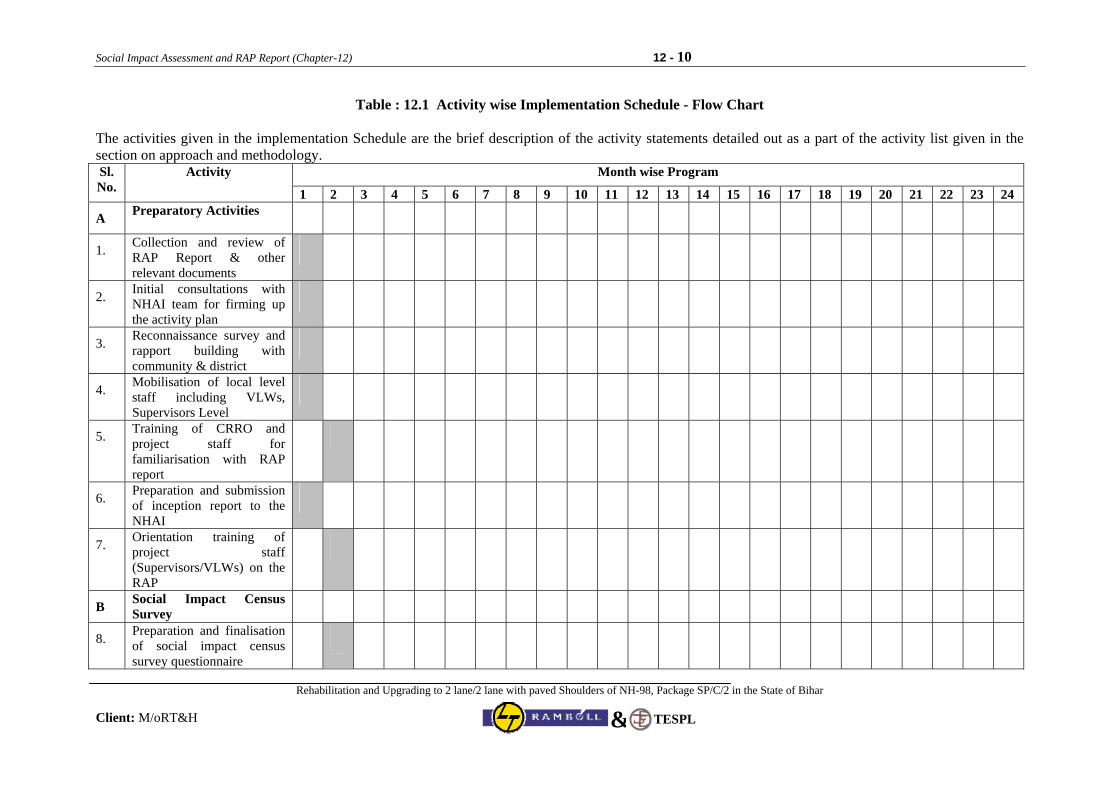
Social Impact Assessment and RAP Report (Chapter-12) 12 - 10
Rehabilitation and Upgrading to 2 lane/2 lane with paved Shoulders of NH-98, Package SP/C/2 in the State of Bihar
Client: M/oRT&H TESPL&
Table : 12.1 Activity wise Implementation Schedule - Flow Chart The activities given in the implementation Schedule are the brief description of the activity statements detailed out as a part of the activity list given in the section on approach and methodology.
Month wise Program Sl. No.
Activity
1 2 3 4 5 6 7 8 9 10 11 12 13 14 15 16 17 18 19 20 21 22 23 24
A Preparatory Activities
1. Collection and review of RAP Report & other relevant documents
2. Initial consultations with NHAI team for firming up the activity plan
3. Reconnaissance survey and rapport building with community & district
4. Mobilisation of local level staff including VLWs, Supervisors Level
5. Training of CRRO and project staff for familiarisation with RAP report
6. Preparation and submission of inception report to the NHAI
7. Orientation training of project staff (Supervisors/VLWs) on the RAP
B Social Impact Census Survey
8. Preparation and finalisation of social impact census survey questionnaire
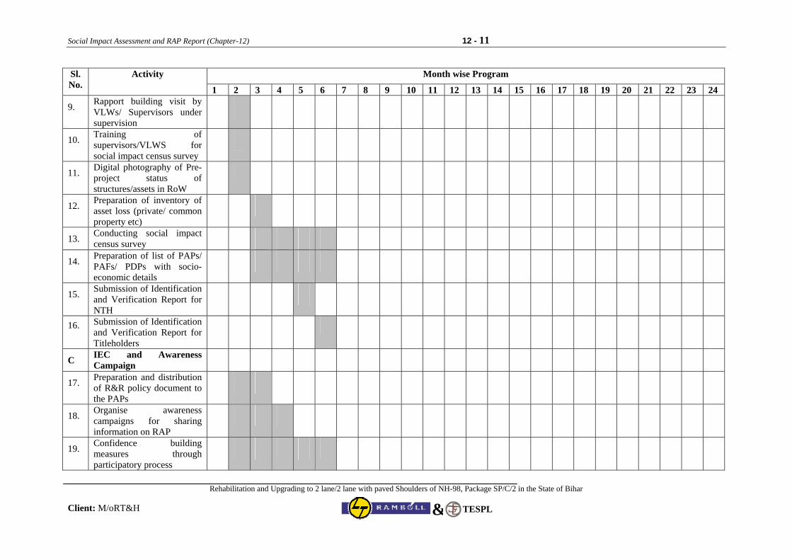
Social Impact Assessment and RAP Report (Chapter-12) 12 - 11
Rehabilitation and Upgrading to 2 lane/2 lane with paved Shoulders of NH-98, Package SP/C/2 in the State of Bihar
Client: M/oRT&H TESPL&
Month wise Program Sl. No.
Activity
1 2 3 4 5 6 7 8 9 10 11 12 13 14 15 16 17 18 19 20 21 22 23 24
9. Rapport building visit by VLWs/ Supervisors under supervision
10. Training of supervisors/VLWS for social impact census survey
11. Digital photography of Pre-project status of structures/assets in RoW
12. Preparation of inventory of asset loss (private/ common property etc)
13. Conducting social impact census survey
14. Preparation of list of PAPs/ PAFs/ PDPs with socio-economic details
15. Submission of Identification and Verification Report for NTH
16. Submission of Identification and Verification Report for Titleholders
C IEC and Awareness Campaign
17. Preparation and distribution of R&R policy document to the PAPs
18. Organise awareness campaigns for sharing information on RAP
19. Confidence building measures through participatory process
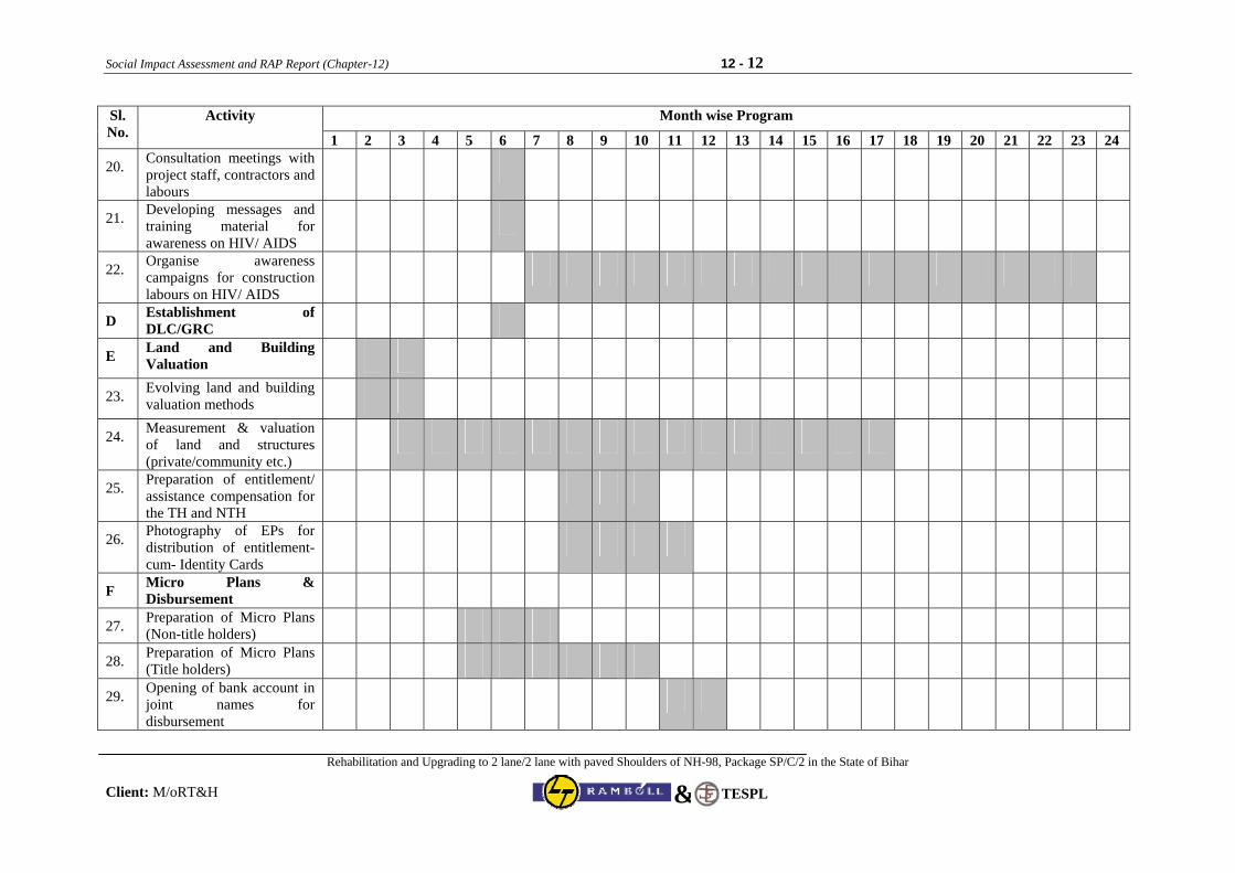
Social Impact Assessment and RAP Report (Chapter-12) 12 - 12
Rehabilitation and Upgrading to 2 lane/2 lane with paved Shoulders of NH-98, Package SP/C/2 in the State of Bihar
Client: M/oRT&H TESPL&
Month wise Program Sl. No.
Activity
1 2 3 4 5 6 7 8 9 10 11 12 13 14 15 16 17 18 19 20 21 22 23 24
20. Consultation meetings with project staff, contractors and labours
21. Developing messages and training material for awareness on HIV/ AIDS
22. Organise awareness campaigns for construction labours on HIV/ AIDS
D Establishment of DLC/GRC
E Land and Building Valuation
23. Evolving land and building valuation methods
24. Measurement & valuation of land and structures (private/community etc.)
25. Preparation of entitlement/ assistance compensation for the TH and NTH
26. Photography of EPs for distribution of entitlement-cum- Identity Cards
F Micro Plans & Disbursement
27. Preparation of Micro Plans (Non-title holders)
28. Preparation of Micro Plans (Title holders)
29. Opening of bank account in joint names for disbursement
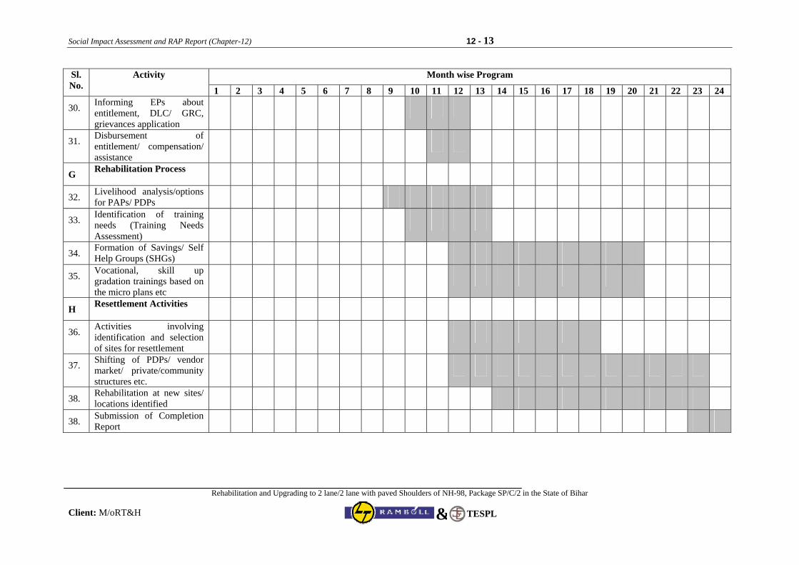
Social Impact Assessment and RAP Report (Chapter-12) 12 - 13
Rehabilitation and Upgrading to 2 lane/2 lane with paved Shoulders of NH-98, Package SP/C/2 in the State of Bihar
Client: M/oRT&H TESPL&
Month wise Program Sl. No.
Activity
1 2 3 4 5 6 7 8 9 10 11 12 13 14 15 16 17 18 19 20 21 22 23 24
30. Informing EPs about entitlement, DLC/ GRC, grievances application
31. Disbursement of entitlement/ compensation/ assistance
G Rehabilitation Process
32. Livelihood analysis/options for PAPs/ PDPs
33. Identification of training needs (Training Needs Assessment)
34. Formation of Savings/ Self Help Groups (SHGs)
35. Vocational, skill up gradation trainings based on the micro plans etc
H Resettlement Activities
36. Activities involving identification and selection of sites for resettlement
37. Shifting of PDPs/ vendor market/ private/community structures etc.
38. Rehabilitation at new sites/ locations identified
38. Submission of Completion Report
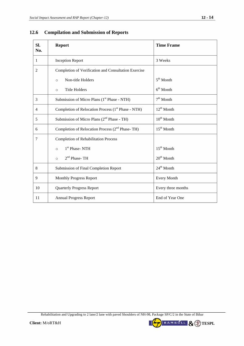
Social Impact Assessment and RAP Report (Chapter-12) 12 - 14
Rehabilitation and Upgrading to 2 lane/2 lane with paved Shoulders of NH-98, Package SP/C/2 in the State of Bihar
Client: M/oRT&H
TESPL&
12.6 Compilation and Submission of Reports
Sl. No.
Report Time Frame
1 Inception Report 3 Weeks
2 Completion of Verification and Consultation Exercise
o Non-title Holders
o Title Holders
5th Month
6th Month
3 Submission of Micro Plans (1st Phase - NTH) 7th Month
4 Completion of Relocation Process (1st Phase - NTH) 12th Month
5 Submission of Micro Plans (2nd Phase - TH) 10th Month
6 Completion of Relocation Process (2nd Phase- TH) 15th Month
7 Completion of Rehabilitation Process
o 1st Phase- NTH
o 2nd Phase- TH
15th Month
20th Month
8 Submission of Final Completion Report 24th Month
9 Monthly Progress Report Every Month
10 Quarterly Progress Report Every three months
11 Annual Progress Report End of Year One
Social Impact Assessment and RAP Report (Chapter-13) 13 - 1
Rehabilitation and Upgrading to 2 lane/2 lane with paved Shoulders of NH-98, Package SP/C/2 in the State of Bihar
Client: M/oRT&H
TESPL&
CHAPTER 13: INCOME RESTORATION AND R&R
13.1 Income Restoration Framework Involuntary resettlement is an inevitable outcome of development-induced displacement of people. It disrupts their lives and livelihoods by dismantling existing production systems, asset and resource base, social networks, cultural ties etc. Project affected people (PAP) experience acute social, economic, and psychological alienation and marginalisation, often leading to their impoverishment and the resultant increase in avoidable morbidity and mortality. Traditionally, R&R has been limited to payment of compensation and some training for skill up-gradation to support income generation activities, which usually do not sustain. But there has been an increasing realisation of the fact that this is not enough and, therefore, R&R activities must also entail taking up higher responsibilities including those of income restoration activities aimed at improving or at least bringing the income of project affected people to pre-project levels. Besides NGOs and human rights activists, development aid agencies such as The World Bank and Asian Development Bank (ADB) have been pioneers in bringing about this awareness within the government and other agencies engaged in planning and implementing infrastructure projects involving displacement of people. Census survey, aimed at creating a complete inventory of socio-economic status of the people and property affected, is the key instrument for planning and carrying out R&R activities. Socio-economic survey is carried out to collect data regarding the social and economic status of the project-affected people, including data on their caste, income and expenditure etc. These two surveys, which lead to the generation of baseline data, are used for working out the entitlement matrix, on the basis of which financial aid and other kinds of project assistance are provided to the PAPs. The end product of planning for PAPs is in the form of a resettlement action plan (RAP), which includes all the baseline data including the total list of PAPs and their affected properties, analysis of the available data in terms of its implications for designing interventions and the actual interventions designed and proposed to be implemented. The efficacy of this plan obviously lies in its effective implementation. The following issues have been examined and analysed during the RAP preparation:
• Generation of baseline data on the income of project affected people (PAPs) before the cut-off date in resettlement action plans
• Vulnerability issue with specific reference to income: review of methodology in project planning and implementation
• Need assessment and identification of appropriate menu of options for income restoration/generation
• Option sharing mechanism and facilitation for selection of appropriate options by the PAPs • Training needs assessment for skill up-gradation of groups of PAPs as per requirement • Working out an entitlement matrix as per the local conditions and realities • Road as a hub of economic activity: provision of way side amenities as an opportunity for income
generation and restoration of PAPs
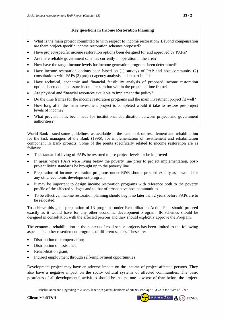
Social Impact Assessment and RAP Report (Chapter-13) 13 - 2
Rehabilitation and Upgrading to 2 lane/2 lane with paved Shoulders of NH-98, Package SP/C/2 in the State of Bihar
Client: M/oRT&H
TESPL&
Key questions in Income Restoration Planning
• What is the main project committed to with respect to income restoration? Beyond compensation are there project-specific income restoration schemes proposed?
• Have project-specific income restoration options been designed for and approved by PAPs? • Are there reliable government schemes currently in operation in the area? • How have the target income levels for income generation programs been determined? • Have income restoration options been based on (1) surveys of PAP and host community (2)
consultations with PAPs (3) project agency analysis and expert input? • Have technical, economic and financial feasibility analysis of proposed income restoration
options been done to assure income restoration within the projected time frame? • Are physical and financial resources available to implement the policy? • Do the time frames for the income restoration programs and the main investment project fit well? • How long after the main investment project is completed would it take to restore pre-project
levels of income? • What provision has been made for institutional coordination between project and government
authorities?
World Bank issued some guidelines, as available in the handbook on resettlement and rehabilitation for the task managers of the Bank (1996), for implementation of resettlement and rehabilitation component in Bank projects. Some of the points specifically related to income restoration are as follows: • The standard of living of PAPs be restored to pre-project levels, or be improved • In areas where PAPs were living below the poverty line prior to project implementation, post-
project living standards be brought up to the poverty line. • Preparation of income restoration programs under R&R should proceed exactly as it would for
any other economic development program • It may be important to design income restoration programs with reference both to the poverty
profile of the affected villages and to that of prospective host communities • To be effective, income restoration planning should begin no later than 2 years before PAPs are to
be relocated.
To achieve this goal, preparation of IR programs under Rehabilitation Action Plan should proceed exactly as it would have for any other economic development Program. IR schemes should be designed in consultation with the affected persons and they should explicitly approve the Program. The economic rehabilitation in the context of road sector projects has been limited to the following aspects like other resettlement programs of different sectors. These are:
• Distribution of compensation; • Distribution of assistance; • Rehabilitation grant; • Indirect employment through self-employment opportunities Development project may have an adverse impact on the income of project-affected persons. They also have a negative impact on the socio- cultural systems of affected communities. The basic postulates of all developmental activities should be that no one is worse of than before the project.
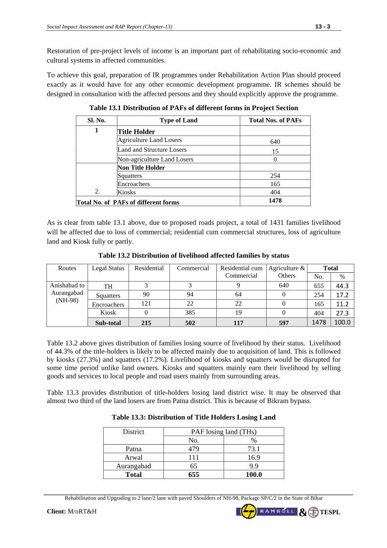
Social Impact Assessment and RAP Report (Chapter-13) 13 - 3
Rehabilitation and Upgrading to 2 lane/2 lane with paved Shoulders of NH-98, Package SP/C/2 in the State of Bihar
Client: M/oRT&H
TESPL&
Restoration of pre-project levels of income is an important part of rehabilitating socio-economic and cultural systems in affected communities.
To achieve this goal, preparation of IR programmes under Rehabilitation Action Plan should proceed exactly as it would have for any other economic development programme. IR schemes should be designed in consultation with the affected persons and they should explicitly approve the programme.
Table 13.1 Distribution of PAFs of different forms in Project Section
Sl. No. Type of Land Total Nos. of PAFs
Title Holder Agriculture Land Losers 640 Land and Structure Losers 15
1
Non-agriculture Land Losers 0 Non Title Holder Squatters 254 Encroachers 165
2. Kiosks 404 Total No. of PAFs of different forms 1478
As is clear from table 13.1 above, due to proposed roads project, a total of 1431 families livelihood will be affected due to loss of commercial; residential cum commercial structures, loss of agriculture land and Kiosk fully or partly.
Table 13.2 Distribution of livelihood affected families by status
Total Routes Legal Status Residential Commercial Residential cum Commercial
Agriculture & Others No. %
TH 3 3 9 640 655 44.3 Squatters 90 94 64 0 254 17.2
Encroachers 121 22 22 0 165 11.2 Kiosk 0 385 19 0 404 27.3
Anishabad to Aurangabad
(NH-98)
Sub-total 215 502 117 597 1478 100.0
Table 13.2 above gives distribution of families losing source of livelihood by their status. Livelihood of 44.3% of the title-holders is likely to be affected mainly due to acquisition of land. This is followed by kiosks (27.3%) and squatters (17.2%). Livelihood of kiosks and squatters would be disrupted for some time period unlike land owners. Kiosks and squatters mainly earn their livelihood by selling goods and services to local people and road users mainly from surrounding areas. Table 13.3 provides distribution of title-holders losing land district wise. It may be observed that almost two third of the land losers are from Patna district. This is because of Bikram bypass.
Table 13.3: Distribution of Title Holders Losing Land
PAF losing land (THs) District No. %
Patna 479 73.1 Arwal 111 16.9
Aurangabad 65 9.9 Total 655 100.0
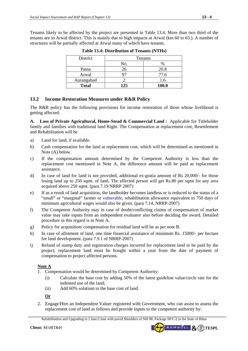
Social Impact Assessment and RAP Report (Chapter-13) 13 - 4
Rehabilitation and Upgrading to 2 lane/2 lane with paved Shoulders of NH-98, Package SP/C/2 in the State of Bihar
Client: M/oRT&H
TESPL&
Tenants likely to be affected by the project are presented in Table 13.4. More than two third of the tenants are in Arwal district. This is mainly due to high impacts at Arwal (km 60 to 63.). A number of structures will be partially affected at Arwal many of which have tenants.
Table 13.4: Distribution of Tenants (NTHs)
Tenants District No. %
Patna 26 20.8 Arwal 97 77.6
Aurangabad 2 1.6 Total 125 100.0
13.2 Income Restoration Measures under R&R Policy
The R&R policy has the following provisions for income restoration of those whose livelihood is getting affected:
A. Loss of Private Agricultural, Home-Stead & Commercial Land : Applicable for Titleholder family and families with traditional land Right. The Compensation at replacement cost, Resettlement and Rehabilitation will be
a) Land for land, if available. b) Cash compensation for the land at replacement cost, which will be determined as mentioned in
Note (A) below. c) If the compensation amount determined by the Competent Authority is less than the
replacement cost mentioned in Note A, the difference amount will be paid as replacement assistance.
d) In case of land for land is not provided, additional ex-gratia amount of Rs 20,000/- for those losing land up to 250 sqmt. of land. The affected person will get Rs.80 per sqmt for any area acquired above 250 sqmt. (para 7.19 NRRP 2007)
e) If as a result of land acquisition, the landholder becomes landless or is reduced to the status of a “small” or “marginal” farmer or vulnerable, rehabilitation allowance equivalent to 750 days of minimum agricultural wages would also be given. (para 7.14, NRRP-2007)
f) The Competent Authority may in case of doubt/conflicting claims of compensation of market value may take inputs from an independent evaluator also before deciding the award. Detailed procedure in this regard is in Note A.
g) Policy for acquisition/ compensation for residual land will be as per note B. h) In case of allotment of land, one time financial assistance of minimum Rs. 15000/- per hectare
for land development. (para 7.9.1 of NRRP-2007) i) Refund of stamp duty and registration charges incurred for replacement land to be paid by the
project; replacement land must be bought within a year from the date of payment of compensation to project affected persons.
Note A 1. Compensation would be determined by Competent Authority:
(i) Calculate the base cost by adding 50% of the latest guideline value/circle rate for the indented use of the land;
(ii) Add 60% solatium to the base cost of land.
Or
2. Engage/Hire an Independent Valuer registered with Government, who can assist to assess the replacement cost of land as follows and provide inputs to the competent authority by:
Social Impact Assessment and RAP Report (Chapter-13) 13 - 5
Rehabilitation and Upgrading to 2 lane/2 lane with paved Shoulders of NH-98, Package SP/C/2 in the State of Bihar
Client: M/oRT&H
TESPL&
(i) Appraising recent sales and transfer of title deeds and registration certificates for similar type of land in the village or urban area and vicinity
(ii) Appraising circle rate in urban and rural areas of the district (iii) Appraising agricultural productivity rate for land – 20 years yield.
Or
3. Compensation as per the state approved procedure. Registered tenants, contract cultivators & leaseholders: Registered tenants, contract cultivators & leaseholders are not eligible for compensation for land. They will only be eligible for compensation for standing crops at market rate if 3 months’ advance notice is not served by EA. Un-registered, tenants, contract cultivators, leaseholders, and sharecroppers: They are not eligible for compensation for land. They will only be eligible for compensation for standing crops at market rate if 3 months’ advance notice is not served by EA. In case of sharecroppers, compensation shall be in the ratio as mutually agreed by the sharecroppers and landowners. B. Loss of Private Structures (Residential/Commercial) : Applicable for Title Holder/ Owner
a) Cash compensation for the structure at replacement cost which would be determined as per Note (C).
b) Right to salvage material from the demolished structures. c) Three months’ notice to vacate structures. d) Refund of stamp duty and registration charges for purchase of new alternative houses/shops at
prevailing rates on the market value as determined in (a) above. Alternative houses/shops must be bought within a year from the date of payment of compensation.
e) Monthly subsistence/transitional allowance equivalent to twenty-five days minimum agricultural wages per month for a period of one year from the date of displacement (para 7.16 of NRRP-2007).
(f) Each affected family getting displaced shall get a one-time financial assistance of Rs 10,000 as shifting allowance (para 7.10 NRRP 2007).
(g) Each affected family that is displaced and has cattle, shall get financial assistance of Rs 15,000/- for construction of cattle shed (para 7.10 NRRP 2007).
(h) Each affected person who is a rural artisan, small trader or self-employed person and who has been displaced (in this project owner of any residential–cum commercial structure) shall get a one-time financial assistance of Rs 25,000/- for construction of working shed or shop (para 7.12 NRRP 2007).
(i) House construction assistance for families belonging to vulnerable group will be provided equivalent to the latest construction cost of Indira Awas Yojana1 Scheme for Rural Areas and cost of house construction under JNURM for Urban Areas.
Note C
The replacement cost of houses, buildings and other immovable properties will be determined on the basis of replacement cost by referring to relevant Basic Schedule of Rates (BSR) as on date without depreciation. While considering the BSR, the independent evaluator registered with the Government will use the latest BSR for the residential and commercial structures in the urban and rural areas of the 1 The financial assistance provided for new construction in the form of full grant is Rs. 45000/- per unit for plain areas & Rs.
48,500/- per unit for hilly/difficult areas under Indira Awaas Yojana (IAY), http://iay.nic.in, Ministry of Rural Development.
Social Impact Assessment and RAP Report (Chapter-13) 13 - 6
Rehabilitation and Upgrading to 2 lane/2 lane with paved Shoulders of NH-98, Package SP/C/2 in the State of Bihar
Client: M/oRT&H
TESPL&
region, and in consultation with the owners. In case of displacement and the valuation amount is less than the amount provided under IAY/JNNURM as applicable, compensation equivalent to provisions under IAY/JNNURM shall be provided in addition to the replacement cost of the affected structure. Registered Tenants & leaseholders:
a) Registered lessees will be entitled to an apportionment of the compensation payable to structure owner as per applicable local laws.
b) In case of tenants, three months written notice will be provided along with Rs 10,000 towards shifting allowance (NRRP 7.11).
c) In case three months’ notice to vacate structures is not provided, then three months’ rental allowance will be provided in lieu of notice.
C. Loss of Trees and Crops (Standing Trees, Crops within the Corridor of Impact) : Applicable for
Owners & beneficiaries of land
a) Three months advance notice to project affected persons to harvest fruits, standing crops and removal of trees.
b) Compensation to be paid at the rate estimated by: i) The Forest Department for timber trees ii) The State Agriculture Extension Department for crops iii) The Horticulture Department for perennial trees.
c) Cash assistance to title-holders and non-title holders including informal settlers/ squatters for loss of trees, crops and perennials at market value.
D. Loss of Residential/ Commercial Structures to Non-Titled Holders: Resettlement & Rehabilitation Assistance applicable for Owners of Structures identified as per Project Census Survey or Occupants of Structures
a) Encroachers shall be given three months’ notice to vacate occupied land or cash assistance at replacement cost for loss of crops or structures.
b) Any encroacher identified as vulnerable group shall be paid replacement cost of structure to be determined as per Note C above.
c) Cash assistance to squatters for their structures at replacement costs which will be determined as mentioned in Note C above.
d) Resettlement & Rehabilitation assistance to the squatters as under:
i. Monthly subsistence/transitional allowance equivalent to twenty-five days minimum agricultural wages per month for a period of one year from the date of displacement (para 7.16 of NRRP-2007).
ii. Shifting allowance of Rs 10,000 per family (para 7.11 NRRP 2007).
iii. Assistance of Rs 15,000/- for loss of cattle shed (para 7.10 NRRP 2007).
iv. Each affected persons who is a rural artisan, small trader or self-employed person assistance of Rs 25,000/- for construction of working shed or shop (para 7.12 NRRP 2007).
v. House construction assistance for those belong to vulnerable groups equivalent to the latest construction cost of Indira Awas Yojana Scheme for Rural Areas and cost of house construction under JNURM for Urban Areas
Social Impact Assessment and RAP Report (Chapter-13) 13 - 7
Rehabilitation and Upgrading to 2 lane/2 lane with paved Shoulders of NH-98, Package SP/C/2 in the State of Bihar
Client: M/oRT&H
TESPL&
E. Loss of Livelihood: Resettlement & Rehabilitation Assistance Applicable for Families living within the Corridor of Impact (CoI) and belongs to Title Holders/Non-Title holders/ sharecroppers, agricultural, labourers and employees:
a) Monthly subsistence/transitional allowance equivalent to twenty-five days minimum agricultural wages per month for a period of one year from the date of displacement (para 7.16 of NRRP-2007).
b) Training Assistance of Rs 10,000/- for income generation per family
c) Temporary employment in the project construction work to project affected persons with particular attention to vulnerable groups by the project contractor during construction, to the extent possible
F. Additional Support to Vulnerable Group: Resettlement & Rehabilitation Assistance applicable
for Vulnerable families: One time additional financial assistance equivalent to 300 days of minimum wages to all vulnerable including STs.
G. Additional Assistance to Scheduled Tribe Families: Resettlement & Rehabilitation Assistance applicable for Scheduled Tribe families will be:
a. Each ST affected family shall get an additional one time financial assistance equivalent to two hundred days of minimum agricultural wages for loss of customary rights or usage of forest produce (para 7.21.5 NRRP 2007). Customary rights on land and usage of forest will have to be certified by the Gram Sabha or such appropriate authority.
b. Each Scheduled Tribe family affected families resettled out of the district will get twenty-five per cent higher rehabilitation and resettlement benefits.
H. Loss of Community Infrastructure/Common Property Resources: Applicable for Affected communities and groups loosing Structures & other resources (e.g. land, water, access to social services etc.) within the Corridor of Impact (CoI) : Reconstruction of community structure and Common property resources in consultation with the community.
I. Temporary Impact During Construction (e.g. diversion of normal traffic, damage to adjacent parcel of land / assets due to movement of heavy machinery and plant site): Applicable for Owners of land & Assets and the Compensation to be paid by the contractor for loss of assets, crops and any other improvements as per prior agreement between the ‘Contractor’ and the ‘Affected Party’.
J. Provision of resettlement site / vendor market for Loss of residential and commercial structures:
The “Corridor of Impact” in built-up sections of the project road has been limited to a maximum of 16 m i.e., 8 m on either side from centerline of existing highway. The majority of structures (residential, commercial and residential cum commercial) will be only partially affected and therefore, provision of resettlement site and vendor market is not required. Further, consultations with local people revealed that they would prefer to stay at the existing location. In case of isolated cases, people preferred self-relocation.
K. Kiosks: Lump sum shifting assistance of Rs.5000 per household
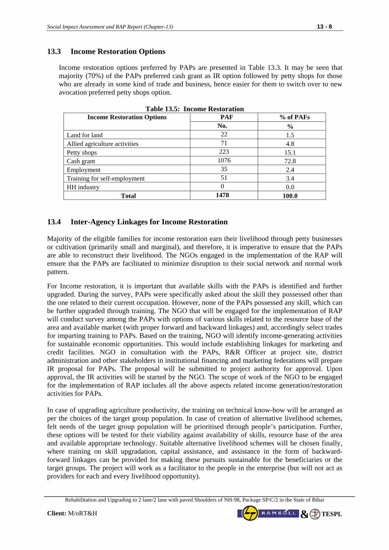
Social Impact Assessment and RAP Report (Chapter-13) 13 - 8
Rehabilitation and Upgrading to 2 lane/2 lane with paved Shoulders of NH-98, Package SP/C/2 in the State of Bihar
Client: M/oRT&H
TESPL&
13.3 Income Restoration Options
Income restoration options preferred by PAPs are presented in Table 13.3. It may be seen that majority (70%) of the PAPs preferred cash grant as IR option followed by petty shops for those who are already in some kind of trade and business, hence easier for them to switch over to new avocation preferred petty shops option.
Table 13.5: Income Restoration
PAF % of PAFs Income Restoration Options No. %
Land for land 22 1.5 Allied agriculture activities 71 4.8 Petty shops 223 15.1 Cash grant 1076 72.8 Employment 35 2.4 Training for self-employment 51 3.4 HH industry 0 0.0
Total 1478 100.0
13.4 Inter-Agency Linkages for Income Restoration Majority of the eligible families for income restoration earn their livelihood through petty businesses or cultivation (primarily small and marginal), and therefore, it is imperative to ensure that the PAPs are able to reconstruct their livelihood. The NGOs engaged in the implementation of the RAP will ensure that the PAPs are facilitated to minimize disruption to their social network and normal work pattern. For Income restoration, it is important that available skills with the PAPs is identified and further upgraded. During the survey, PAPs were specifically asked about the skill they possessed other than the one related to their current occupation. However, none of the PAPs possessed any skill, which can be further upgraded through training. The NGO that will be engaged for the implementation of RAP will conduct survey among the PAPs with options of various skills related to the resource base of the area and available market (with proper forward and backward linkages) and, accordingly select trades for imparting training to PAPs. Based on the training, NGO will identify income-generating activities for sustainable economic opportunities. This would include establishing linkages for marketing and credit facilities. NGO in consultation with the PAPs, R&R Officer at project site, district administration and other stakeholders in institutional financing and marketing federations will prepare IR proposal for PAPs. The proposal will be submitted to project authority for approval. Upon approval, the IR activities will be started by the NGO. The scope of work of the NGO to be engaged for the implementation of RAP includes all the above aspects related income generation/restoration activities for PAPs. In case of upgrading agriculture productivity, the training on technical know-how will be arranged as per the choices of the target group population. In case of creation of alternative livelihood schemes, felt needs of the target group population will be prioritised through people’s participation. Further, these options will be tested for their viability against availability of skills, resource base of the area and available appropriate technology. Suitable alternative livelihood schemes will be chosen finally, where training on skill upgradation, capital assistance, and assistance in the form of backward-forward linkages can be provided for making these pursuits sustainable for the beneficiaries or the target groups. The project will work as a facilitator to the people in the enterprise (but will not act as providers for each and every livelihood opportunity).
Social Impact Assessment and RAP Report (Chapter-13) 13 - 9
Rehabilitation and Upgrading to 2 lane/2 lane with paved Shoulders of NH-98, Package SP/C/2 in the State of Bihar
Client: M/oRT&H
TESPL&
The PAPs are required to participate in developing feasible long- term income generating schemes. The long- term options are expected to be developed during the implementation of the RAP and also supported by the government assistance. Government of India along with the State Governments runs various poverty alleviation programmes through DRDA. Participation of PAPs in those schemes will be helpful for short-term IR gains. NGO with help from PIU (Project Authority) will facilitate inclusion of PAPs in the government sponsored poverty alleviation programmes in the area as per the eligibility criteria of the respective programmes. The existing programmes have enough funds to take care of additional beneficiaries. In several cases, funds exceed the targets. Some of the ongoing programmes are Jeevika - Bihar Rural Livelihoods Development Project, Swarnajayanti Gram Swarozgar Yojna (SGSY), Jawahar Gram Samridhi Yojna (JGSY), Mahatma Gandhi National Rural Employment Guarantee Scheme, etc. 13.5 Steps in Income Restoration
13.5.1 Information on Economic Activities of PAPs
Basic information on IR activities of PAPs will be available from the census and socio-economic surveys. Information from base line surveys will be available on features of economic activities of PAPs as under: 1. Land based economic activities 2. Non-land economic activities 3. Total income of PAPs from various sources Based on this information IR activities can be planned. IR activities are of two types: (1) Short term; and (2) Long term. The ensuing section describes both IR schemes. 13.5.2 Short Term IR Activities
Short term IR activities means restoring PAPs’ income during periods immediately before and after relocation. Such activities will focus on the following:
• Ensuring that adequate compensation is paid before relocation
• Relocation and transition allowances
• Providing short term, welfare based grants and allowances such as:
o One time relocation allowance
o Free transport to resettlement areas of assistance for transport
o Free or subsidized items
o Transitional allowances or grants until adequate income is generated, special allowances for vulnerable groups
o With consideration of PAPs skills and needs, promoting PAP access to project related employment opportunities such as:
Work under the Main Investment Project
Work on relocation teams (e.g., driver, food provision, etc.)
Work on resettlement sites, if any (e.g. construction on, transport, maintenance, etc.)
Social Impact Assessment and RAP Report (Chapter-13) 13 - 10
Rehabilitation and Upgrading to 2 lane/2 lane with paved Shoulders of NH-98, Package SP/C/2 in the State of Bihar
Client: M/oRT&H
TESPL&
13.5.3 Long Term IR Activities
The NGO along with PAPs will participate in developing a range of feasible long-term income restoration schemes. These will be developed during the implementation of the project. NGO will work with PIU and liaison with the district administration and social welfare departments, to dovetail with government’s poverty alleviation schemes. The long-term options are government financed, therefore separate budget has not been provided. However, in R&R budget provision has been made for the expenses to be incurred towards the coordination between project and concerned departments for dovetailing of poverty alleviation schemes. The project officials will coordinate with government (district administration) to assure PAPs access to such schemes.
13.6 Alternative Individual Income Restoration Scheme
13.6.1 Basis for Identification of Alternative IR Scheme Keeping in view the resource base of the EPs and also the socio-economic characteristics and preferences, M/oRT&H and the NGO contracted for the implementation will have to chalk out individual IR schemes. Other factors to be considered are:
• Education level of PAPs • Skill possession • Likely economic activities in the post displacement period • Extent of land left • Extent of land purchased • Suitability of economic activity to supplement the income • Market potential and marketing facilities “The best option is to allow the EP to continue its former occupation”. However, during any development programme, occupations always change. An exhaustive list of possible IR options are given below:
Table 13.6 : Criteria for Alternative IR Schemes
IR Option
Requirement
a) Land
PAPs are physically relocated and are primarily agriculturists It is adequately available There is transferable title Land is of good quality Land development needs can be covered by the project PAPs are not exposed to market economics
b) Cash EP negatively impacted but not relocated Land is unavailable in adequate quantity and quality PAP prefer cash to land Cash can be held in joint account PAP’s occupations are diverse PAP exposed to cash economy Interest ensuring deposits to be released when feasible IR activity is defined
c) Small business PAP familiar with cash Demand for goods/services Sustained capital and working capital is available There is local or project finance and capacity to provide training Business builds on/uses existing skill of the PAP Local markets are not adversely affected by project activities
Social Impact Assessment and RAP Report (Chapter-13) 13 - 11
Rehabilitation and Upgrading to 2 lane/2 lane with paved Shoulders of NH-98, Package SP/C/2 in the State of Bihar
Client: M/oRT&H
TESPL&
IR Option
Requirement
d) Continuing previous employment
Reasonable time and money required for access to employment from new sites Project assistance for previous and/or maintenance of other facilities
e) Preference for PAPs in Employment
Work is available in main investment project Clear eligibility criteria are established PAPs are linked to existing government job programmes (like Maharashtra legislation reserving 5% of government jobs for PAPs) There is a good coordination between project and government authorities
The PAPs will participate in developing a range of feasible long-term Income Restoration schemes. These will be developed during the implementation of the project. M/oRT&H will work with NGO and liaison with the district administration to dovetail government’s poverty alleviation schemes. The micro plans developed by the implementing authority will indicate the type of scheme each family has opted. The grants received for economic rehabilitation will be used for purchase of assets. The EPs will receive training for acquisition of new skills or upgradation of old skills for the activity selected by them.
13.6.2 Non Land Based IR Schemes Since land is scarce and not all PAPs are agriculturists, non-land based IR schemes becomes all the more important. The non-land based IR schemes could be: (a) Allied Agriculture Activities : Under allied agriculture activities, various IR options are available viz., dairy, poultry, goatery, sheep rearing, piggery, etc. PAPs who are agriculturist can take up any of these options. These will require training, which can be imparted by Khadi Village Industries Commission (KVIC) / District Dairy Development Authority (DDDA) and milk route for daily milk collection can be extended by local milk federation. (b) Petty Traders : Under this scheme, the available options are grocery shop, vegetable & fruit shop, stationary, clothe, tea & snacks, ready-made garments, beetle shop etc. PAPs those who are already in the trade and business are suitable for these activities. The PAPs will decide on the type of shops to be established as per demand in consultation with NGO. (c) Skill related Schemes: The options available under this scheme are tailoring, carpentry, masonry, gold smith, black smith, motor winding, cycle/motor cycle/auto repair, driving (auto/Matador/etc.), Television/Tape records/Watch repairing, Pottery, Leather works, etc. PAPs those who are in such trades can undergo training for skill upgradation to supplement their annual income. District Industries Centre or Khadi Village Industries Board/Commission or Industrial Training Institutes imparts training in such trades. Training can also be imparted through professional and competent outside agency especially hired for the purpose. (d) Others Schemes : Others primarily include loan for various agriculture implements to increase productivity viz., pump sets, dug well, bore well, bullock cart, etc. PAPs those who are into agriculture and do not have any irrigation facilities can avail such loans. Such loans are given by bank after District Rural Development Authority processes the applications. The implementation of above-mentioned activities requires organisation of credit camps. Extending financial credit support is an important component of non-land based IR schemes. It requires organisation of credit camps for EPs. Local government officials, NGOs and PAP representatives apart from M/ORT&H officials, will attend these camps. The purpose of the camps would be to allow local financial institutions to inform participants of credit options and how to avoid procedural delays.
Social Impact Assessment and RAP Report (Chapter-13) 13 - 12
Rehabilitation and Upgrading to 2 lane/2 lane with paved Shoulders of NH-98, Package SP/C/2 in the State of Bihar
Client: M/oRT&H
TESPL&
All formalities related to processing of applications for credit assistance will be completed at these camps. For these kinds of camps M/ORT&H along with NGO, will have to coordinate closely with the Lead Bank managers and other commercial banks operating in the district.
13.7 Training
One of the strategies for economic sustenance of the PAPs is to help them improve their production level or to impart new skills/up grade skills through training. As quite a significant number of PAPs are dependent on agriculture and others have low skill endowment, training becomes an important component of IR. For PAPs who intend to diversify their economic activity, suitable income restoration schemes will be identified on individual basis and training need would be assessed. Besides training in scheme specific skills, general entrepreneurship development will also form part of the training programme, mainly to improve the management capabilities of EP. The Training will be organised in the plan period itself. The NGO / Consultancy Firm contracted for the implementation of RAP will be assigned this task. The NGO / Consultancy will ask one to one PAP for various option of training for them and based on available suitable option in the project area, the training programme will be organised to impart new skills/up grade skills for PAPs. Consultants team also identified various NGO working in the project area. One of Them is “Jan Sikshan Sansthan, BANCHIT” at Arwal. The are imparting trainings to the needy villagers under category of Tailoring, Cutting, Fashion Design, Beauty Care, Mehandi application, Toys making, embroidery, handicraft, Agro based production, etc. Besides, the training are regularly conducted by District Rural Development Agency (DRDA) through its programme names Training of Rural Youths for Self Employment (TRYSEM), training programmes organised by other government agencies will also be availed. The past experiences have shown that roughly three-fourth of the PAPs require training. It will be the responsibility of the M/ORT&H to ensure that PAPs receives, training in desired trade. The NGO contracted will act as a facilitator and training will be imparted either by the government agencies such as DIC, KVIC, ITDA, etc. or a professional and competent outside agency. The local Industrial Training Institutes (ITIs) can be approached for training.
13.8 Institutions
The Institutions for IR schemes include M/ORT&H, local government staff, NGO and PAP groups. District Level Committee will facilitate with District Rural Development Agency and other line departments to give priority to PAPs under various poverty alleviation schemes. The PIU should have strong links with local government development agencies through coordination committee. 13.8.1 Coordination Committee
The coordination committee will be formed at project & district level, having representation of PAPs, local government staff, M/ORT&H & NGO. The Committee will oversee the design of appropriate IR Strategies. The formation of coordination committee should not be influenced by which agency is funding the project. 13.8.2 Monitoring of IR Schemes The monitoring of IR schemes will be carried out along with the monitoring of other components of RAP by supervision consultants. The contract will specifically provide for regular (every six months) monitoring of income restoration of PAPs. The monitoring will be carried out based on economic indicators. Vulnerable PAPs who lose their livelihood due to the project will be assisted in alternative economic rehabilitation schemes and vocational training for skill upgradation as per the requirement of suggested economic scheme.

Social Impact Assessment and RAP Report (Chapter-13) 13 - 13
Rehabilitation and Upgrading to 2 lane/2 lane with paved Shoulders of NH-98, Package SP/C/2 in the State of Bihar
Client: M/oRT&H
TESPL&
13.9 Plan for Income Restoration A suggestive plan for income restoration has been provided below in form of flow diagram. Same can be modified during implementation stage by the NGO.
Flow Diagram 13.1: Income Restoration Plan
Verification of PAP
Identification of Market Skills, IGS and skillanalysis of PAPs
Training need assessment considering the IGS
Identifying the training programs and training organizers
Formation of training groups
Selection of training organizations / trainers
Organizing training program
Preparation and approval of IGS plan
Disbursement of ERG to vulnerable PDPs
Preparation and approval of IGS plan
Formation of SHGs
Training organizations likeITI Private Trainers for Tailoring,driving, computer operation Government run training forincome generation,horticulture, food processingetc
Developing linkages with existing markets
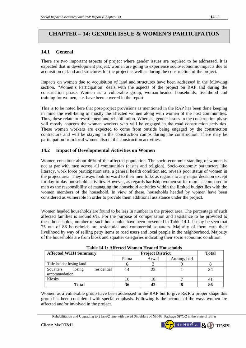
Social Impact Assessment and RAP Report (Chapter-14) 14 - 1
Rehabilitation and Upgrading to 2 lane/2 lane with paved Shoulders of NH-98, Package SP/C/2 in the State of Bihar
Client: M/oRT&H TESPL&
CHAPTER – 14: GENDER ISSUE & WOMEN’S PARTICIPATION
14.1 General There are two important aspects of project where gender issues are required to be addressed. It is expected that in development project, women are going to experience socio-economic impacts due to acquisition of land and structures for the project as well as during the construction of the project. Impacts on women due to acquisition of land and structures have been addressed in the following section. ‘Women’s Participation’ deals with the aspects of the project on RAP and during the construction phase. Women as a vulnerable group, woman-headed households, livelihood and training for women, etc. have been covered in the report. This is to be noted here that post-project provisions as mentioned in the RAP has been done keeping in mind the well-being of mostly the affected women along with women of the host communities. Thus, these relate to resettlement and rehabilitation. Whereas, gender issues in the construction phase will mostly concern the women workers who will be engaged in the road construction activities. These women workers are expected to come from outside being engaged by the construction contractors and will be staying in the construction camps during the construction. There may be participation from local women also in the construction activities. 14.2 Impact of Developmental Activities on Women
Women constitute about 46% of the affected population. The socio-economic standing of women is not at par with men across all communities (castes and religion). Socio-economic parameters like literacy, work force participation rate, a general health condition etc. reveals poor status of women in the project area. They always look forward to their men folks as regards to any major decision except for day-to-day household activities. However, as regards hardship women suffer more as compared to men as the responsibility of managing the household activities within the limited budget lies with the women members of the household. In view of these, households headed by women have been considered as vulnerable in order to provide them additional assistance under the project.
Women headed households are found to be less in number in the project area. The percentage of such affected families is around 6%. For the purpose of compensation and assistance to be provided to these households, number of such households have been presented in Table 14.1. It may be seen that 75 out of 86 households are residential and commercial squatters. Majority of them earn their livelihood by way of selling petty items to road users and local people in the neighborhood. Majority of the households are from kiosk and squatter categories indicating their socio economic condition.
Table 14.1: Affected Women Headed Households Project District Affected WHH Summary
Patna Arwal Aurangabad Total
Title-holder losing land 6 2 0 8 Squatters losing residential accommodation
14 22 1 34
Kiosks 16 18 7 41 Total 36 42 8 86
Women as a vulnerable group have been addressed in the RAP but to give R&R a proper shape this group has been considered with special emphasis. Following is the account of the ways women are affected and/or involved in the project.
Social Impact Assessment and RAP Report (Chapter-14) 14 - 2
Rehabilitation and Upgrading to 2 lane/2 lane with paved Shoulders of NH-98, Package SP/C/2 in the State of Bihar
Client: M/oRT&H TESPL&
As per the R&R Policy as well as looking into the need of the day, women are required to be involved in the process of sustainable development. The contracted NGO will facilitate to integrate them in the project as full-fledged participants taking part during project implementation and even in the post-project stages. Para 14.3 below outlined the proposal suggested for Participation of women for their socio-economic upliftment in the sub-project. 14.3 Participation of Women in the project Experience of last several years indicate that it is important to consult and encourage women in all and offer them choices in enabling them to make informed choices and decide for their own development. In this project, participation of women has been envisaged specifically in the following areas: • In the pre-planning and planning stages participation from women could be sought through
allowing them taking part in the consultation process. For this, the local level agencies of implementation, i.e. PIU of M/oRT&H and the contracted NGOs will have an important role to play.
• Each field team of the NGO shall include at least one women investigator/facilitator especially for consultation with women and addressing their issue.
• Compensation for land and assets lost being same for all the affected or displaced families, special care should be taken by the NGOs assisting the women group while implementing the process of acquisition and compensation as well.
• PIU of M/oRT&H will ensures that the women are consulted and invited to participate in-group based activities, to gain access and control over the resource as a part of the RAP, Additionally,
• The Monitoring team(s) shall constitute – 33% women. • The Evaluation team shall constitute – 33% women. • From the contractor’s side – Woman inspector of works will be there. • The NGOs will make sure that women are actually taking part in issuance of identity cards,
opening accounts in the bank, receiving compensation amounts by cheques in their name or not, etc. This will further widen the perspective of participation by the women in the project implementation.
• Under the entitlement framework there is a number of provisions kept for compensation and assistances towards the losses incurred upon the impacted women headed households by the project. On the other, some provisions, mostly those of the assistances, have been created towards reducing the probable hardship to be experienced by them in the process side by side creating scope for their sustainable socio-economic development.
• Women's participation will also be initiated by NGO through Self-Help Group formation in each of the villages affected by the project. These groups can then be linked to various special development schemes of the State and Central Government.
• For monitoring and evaluation, scope for women’s participation has to be ensured by PIU of M/oRT&H. Monitoring of project inputs concerning benefit to women should involve their participation that will make the process more transparent to them.
• The contracted NGO will encourage the Women in the project area to evaluate the project outputs from their point of view and their useful suggestions should be noted for taking necessary actions for further modifications in the project creating better and congenial situation for increasing participation from women.
• All assistance would be paid in a joint account in the name of both the spouses; except in the case of women headed households and women wage earners.
Social Impact Assessment and RAP Report (Chapter-14) 14 - 3
Rehabilitation and Upgrading to 2 lane/2 lane with paved Shoulders of NH-98, Package SP/C/2 in the State of Bihar
Client: M/oRT&H TESPL&
14.4 Involvement of Women in Construction Activities
The construction works for widening and strengthening the project corridor will start after the R&R activities are over and the RoW is clear of any encroachment and land is temporarily acquired for borrow areas and construction camps. The construction contractors will set up their construction camps on identified locations where labour force required for the construction activities will be provided with temporary residential accommodation and other necessary infrastructure facilities. The labour force required for the construction activities will be mostly of high-skill nature since a lot of machine work will be there in the construction of the highway. In addition, there will be requirement of large number of unskilled labour where women will certainly contribute. Apart from this, women as family members of the skilled and semi-skilled labourers, will also stay in the construction camps and will be indirectly involved during the construction phase. The families of labourers will include their children also. To explore the possibility of involvement of local labours in the project, consultant’s social team held discussions with the personnel of contractors, sub-contractors, petty contractors and supervisors engaged in the ongoing ADB funded Highway Development Projects in the nearby areas namely, Shivganj-Rafiganj-Baidrabad, Bihta-Sarmera, and Arwal-Sahar Bridge being implemented by Bihar State Road Development Corporation and BRPNNL. It has been noted that contractors have brought along around 60 % of their required skilled labour. Requirements of remaining 40% of the skilled, semi-skilled and unskilled labours are fulfilled by the sub-contractors and petty contractors from the local area. Out of the total unskilled labour force involved in project, women worker participation is around 20-25% of the local labour force. In view of the outcome of consultations, it is expected that there will also be involvement of local women as local labour force in this project. Foreseeing the involvement of women, both direct and indirect in the construction activities, certain measures are required to be taken towards welfare and well being of women and children in particular during the construction phase. 14.4.1 Specific Provisions in the Construction Camp for Women The provisions mentioned under this section will specifically help all the women and children living in the construction camp. Temporary Housing During the construction the families of labourers/workers should be provided with residential accommodation suitable to nuclear families. Health Centre Health problems of the workers should be taken care of by providing basic health care facilities through health centres temporarily set up for the construction camp. The health centre should have at least a doctor, nurses, GD staff, medicines and minimum medical facilities to tackle first-aid requirements or minor accidental cases, linkage with nearest higher order hospital to refer patients of major illnesses or critical cases. The health centre should have MCW (Mother and Child Welfare) units for treating mothers and children in the camp. Apart from this, the health centre should provide with regular vaccinations required for children. Day Crèche Facilities It is expected that among the women workers there will be mothers with infants and small children. Provision of a day crèche may solve the problems of such women who can leave behind their children in such a crèche and work for the day in the construction activities.
The crèche should be provided with at least a trained ICDS (Integrated Child Development Scheme) worker with to look after the children. The ICDS worker, preferably woman, may take care of the
Social Impact Assessment and RAP Report (Chapter-14) 14 - 4
Rehabilitation and Upgrading to 2 lane/2 lane with paved Shoulders of NH-98, Package SP/C/2 in the State of Bihar
Client: M/oRT&H TESPL&
children in a better way and can manage to provide nutritional food (as prescribed in ICDS and provided free of cost by the government) to them. In cases of emergency she, as being trained, can tackle the health problems of the children and can organise treatment linking the nearest health centre. Proper Scheduling of Construction Works Owing to the demand of a fast construction work it is expected that a 24 hour-long work-schedule would be in operation. Women, especially the mothers with infants should to be exempted from night shifts as far as possible. If unavoidable, crèche facilities in the construction camps must be extended to them in the night shifts too. Educational Facilities The construction workers are mainly mobile groups of people. They are found to move from one place to another taking along their families with them. Thus, there is a need for educating their children at the place of their work. For this at least primary schools are required to be planned in the construction camps. Wherever feasible, day crèche facilities could be extended with primary educational facilities. Control on Child Labour Minors i.e., persons below the age of 15 years should be restricted from getting involved in the constructional activities. Measures should be taken to ensure that no child labourer is engaged in the activities.
Exploitation of young unmarried women is very common in these kind of camps. A strong vigilance mechanism should be created to check this and ensure ceasing of such exploitation. Special Measures for Controlling STD/AIDS Solitary adult males usually dominate the labour force of construction camps. They play a significant role in spreading sexually transmitted diseases. In the construction camps as well as in the neighbouring areas they are found to indulge in physical relations with different women. This unhealthy sexual behaviour gives rise to STDs and AIDS. While it is difficult to stop such activities, it is wiser to make provisions for means of controlling the spread of such diseases. Awareness camps for the target people, both in the construction camp and neighbouring villages as well, and supply of condoms at concession rate to the male workers may help to large extent in this respect. Engaging woman Inspector of Works Contractors should engage a woman Inspector of Works not below the rank of a Senior Engineer to inspect the construction camps and any other component of work with respect to gender issues. She would assist the Resident Engineer (RE) in all aspects of gender and child-labour related activities. She would have a full-time tenure throughout the entire construction period. Her duties should include the preparation of monthly and quarterly reports and submit them to the RE with a copy to the RO, M/oRT&H as well as PIU.
14.5 Summary of Issues, Recommended Actions / Strategy and Responsibility Table 14.2 presents the identified issue / concerns and Recommended Actions / Strategy for addressing the gender issue and participation from women in the project.
Issues/Concerns Objectives Strategy / Action Required
Responsibility Monitoring documents
Non deployment of participation of women representative
Ensuring at least two women must be deployed in the team of RAP implementation agency
• TOR should clearly mention this aspect
• Some weightage to be given to RAP implementation agency for providing
• Project Authority
• TOR for RAP implementation agency
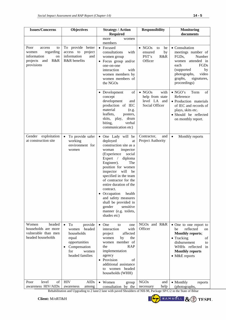
Social Impact Assessment and RAP Report (Chapter-14) 14 - 5
Rehabilitation and Upgrading to 2 lane/2 lane with paved Shoulders of NH-98, Package SP/C/2 in the State of Bihar
Client: M/oRT&H TESPL&
Issues/Concerns Objectives Strategy / Action Required
Responsibility Monitoring documents
more women members
• Focused consultations with women group
• Focus group and/or one-on-one interaction with women members by women members of the NGOs
• NGOs to be ensured by PST’s R&R Officer
• Consultation meetings number of FGDs, Number women attended in each FGDs (supported by photographs, video graphs, signatures, proceedings)
Poor access to women regarding information on projects and R&R provisions
To provide better access to project information and R&R benefits
• Development of concept development and production of IEC material (e.g. leaflets, posters, skits, play, drum biting, verbal communication etc)
• NGOs with help from state level LA and Social Officer
• NGO’s Term of Reference
• Production materials of IEC and records of plays, skits etc.
• Should be reflected on monthly report.
Gender exploitation at construction site
• To provide safer working environment for women
• One Lady will be deployed at construction site as a woman inspector (Experience social Expert / diploma Engineer). The position for women inspector will be specified in the team of contractor for the entire duration of the contract.
• Occupation health and safety measures shall be provided in gender sensitive manner (e.g. toilets, shades etc)
Contractor, and Project Authority
• Monthly reports
Women headed households are more vulnerable than men headed households
• To provide women headed households equal opportunities
• Compensation for women headed families
• One to one interaction with project affected women by the women member of the RAP implementation agency
• Provision of additional assistance to women headed households (WHH)
NGOs and R&R Officer
• One to one report to be reflected on Monthly reports;
• Tracking of disbursement to WHHs reflected in Monthly reports
• M&E reports
Poor level of awareness HIV/AIDs
HIV AIDs awareness among
• Women group consultation by the
NGOs and necessary help
• Monthly reports (photographs,
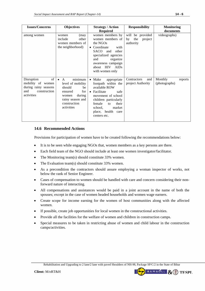
Social Impact Assessment and RAP Report (Chapter-14) 14 - 6
Rehabilitation and Upgrading to 2 lane/2 lane with paved Shoulders of NH-98, Package SP/C/2 in the State of Bihar
Client: M/oRT&H TESPL&
Issues/Concerns Objectives Strategy / Action Required
Responsibility Monitoring documents
among women women (may include other women members of the neighborhood)
women members by women members of the NGOs
• Coordinate with SACO and other specialized agencies and organize awareness campaign about HIV AIDs with women only
will be provided by the project authority
videographs)
Disruption of mobility of women during rainy seasons and construction activities
• A minimum level of mobility should be ensured for women during rainy season and construction activities
• Make appropriate footpath within the available ROW
• Facilitate safe movement of school children particularly female to their school, market place, health care centers etc.
Contractors and project Authority
Monthly reports (photographs)
14.6 Recommended Actions Provisions for participation of women have to be created following the recommendations below: • It is to be seen while engaging NGOs that, women members as a key persons are there. • Each field team of the NGO should include at least one women investigator/facilitator. • The Monitoring team(s) should constitute 33% women. • The Evaluation team(s) should constitute 33% women. • As a precondition the contractors should assure employing a woman inspector of works, not
below the rank of Senior Engineer. • Cases of compensation to women should be handled with care and concern considering their non-
forward nature of interacting. • All compensations and assistances would be paid in a joint account in the name of both the
spouses; except in the case of women headed households and women wage earners. • Create scope for income earning for the women of host communities along with the affected
women. • If possible, create job opportunities for local women in the constructional activities. • Provide all the facilities for the welfare of women and children in construction camps. • Special measures to be taken in restricting abuse of women and child labour in the construction
camps/activities.
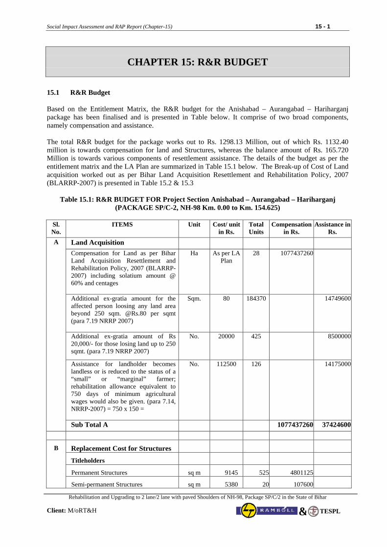
Social Impact Assessment and RAP Report (Chapter-15) 15 - 1
Rehabilitation and Upgrading to 2 lane/2 lane with paved Shoulders of NH-98, Package SP/C/2 in the State of Bihar
Client: M/oRT&H
TESPL&
CHAPTER 15: R&R BUDGET
15.1 R&R Budget
Based on the Entitlement Matrix, the R&R budget for the Anishabad – Aurangabad – Hariharganj package has been finalised and is presented in Table below. It comprise of two broad components, namely compensation and assistance. The total R&R budget for the package works out to Rs. 1298.13 Million, out of which Rs. 1132.40 million is towards compensation for land and Structures, whereas the balance amount of Rs. 165.720 Million is towards various components of resettlement assistance. The details of the budget as per the entitlement matrix and the LA Plan are summarized in Table 15.1 below. The Break-up of Cost of Land acquisition worked out as per Bihar Land Acquisition Resettlement and Rehabilitation Policy, 2007 (BLARRP-2007) is presented in Table 15.2 & 15.3
Table 15.1: R&R BUDGET FOR Project Section Anishabad – Aurangabad – Hariharganj
(PACKAGE SP/C-2, NH-98 Km. 0.00 to Km. 154.625)
Sl. No.
ITEMS Unit Cost/ unit in Rs.
Total Units
Compensation in Rs.
Assistance in Rs.
Land Acquisition
Compensation for Land as per Bihar Land Acquisition Resettlement and Rehabilitation Policy, 2007 (BLARRP-2007) including solatium amount @ 60% and centages
Ha As per LA Plan
28 1077437260
Additional ex-gratia amount for the affected person loosing any land area beyond 250 sqm. @Rs.80 per sqmt (para 7.19 NRRP 2007)
Sqm. 80 184370 14749600
Additional ex-gratia amount of Rs 20,000/- for those losing land up to 250 sqmt. (para 7.19 NRRP 2007)
No. 20000 425 8500000
Assistance for landholder becomes landless or is reduced to the status of a “small” or “marginal” farmer; rehabilitation allowance equivalent to 750 days of minimum agricultural wages would also be given. (para 7.14, NRRP-2007) = 750 x 150 =
No. 112500 126 14175000
A
Sub Total A 1077437260 37424600
Replacement Cost for Structures
Titleholders
Permanent Structures sq m 9145 525 4801125
B
Semi-permanent Structures sq m 5380 20 107600
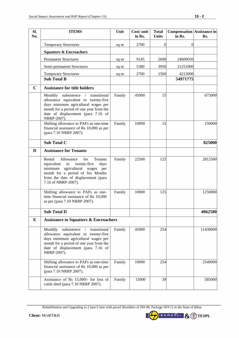
Social Impact Assessment and RAP Report (Chapter-15) 15 - 2
Rehabilitation and Upgrading to 2 lane/2 lane with paved Shoulders of NH-98, Package SP/C/2 in the State of Bihar
Client: M/oRT&H
TESPL&
Sl. No.
ITEMS Unit Cost/ unit in Rs.
Total Units
Compensation in Rs.
Assistance in Rs.
Temporary Structures sq m 2700 0 0
Squatters & Encroachers
Permanent Structures sq m 9145 2690 24600050
Semi-permanent Structures sq m 5380 3950 21251000
Temporary Structures sq m 2700 1560 4212000
Sub Total B 54971775
C Assistance for title holders
Monthly subsistence / transitional allowance equivalent to twenty-five days minimum agricultural wages per month for a period of one year from the date of displacement (para 7.16 of NRRP-2007).
Family 45000 15 675000
Shifting allowance to PAFs as one-time financial assistance of Rs 10,000 as per (para 7.10 NRRP 2007).
Family 10000 15 150000
Sub Total C 825000
D Assistance for Tenants
Rental Allowance for Tenants equivalent to twenty-five days minimum agricultural wages per month for a period of Six Months from the date of displacement (para 7.16 of NRRP-2007).
Family 22500 125 2812500
Shifting allowance to PAFs as one-time financial assistance of Rs 10,000 as per (para 7.10 NRRP 2007).
Family 10000 125 1250000
Sub Total D 4062500
E Assistance to Squatters & Encroachers
Monthly subsistence / transitional allowance equivalent to twenty-five days minimum agricultural wages per month for a period of one year from the date of displacement (para 7.16 of NRRP-2007).
Family 45000 254 11430000
Shifting allowance to PAFs as one-time financial assistance of Rs 10,000 as per (para 7.10 NRRP 2007).
Family 10000 254 2540000
Assistance of Rs 15,000/- for loss of cattle shed (para 7.10 NRRP 2007).
Family 15000 39 585000
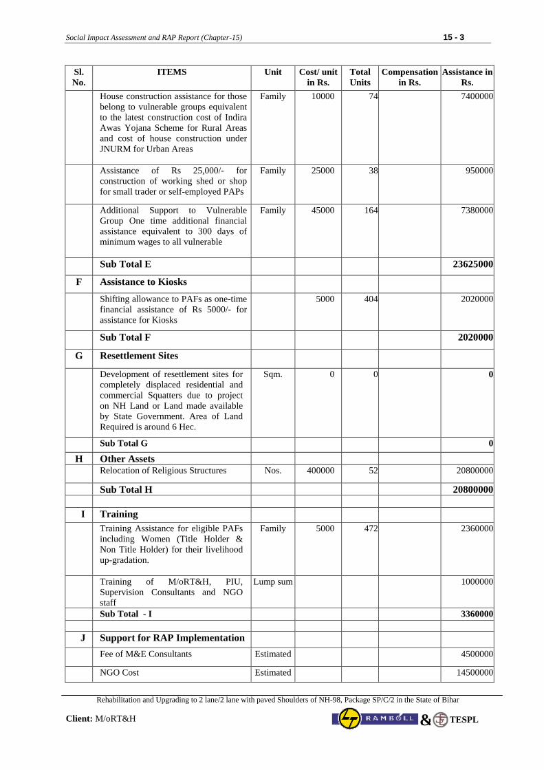
Social Impact Assessment and RAP Report (Chapter-15) 15 - 3
Rehabilitation and Upgrading to 2 lane/2 lane with paved Shoulders of NH-98, Package SP/C/2 in the State of Bihar
Client: M/oRT&H
TESPL&
Sl. No.
ITEMS Unit Cost/ unit in Rs.
Total Units
Compensation in Rs.
Assistance in Rs.
House construction assistance for those belong to vulnerable groups equivalent to the latest construction cost of Indira Awas Yojana Scheme for Rural Areas and cost of house construction under JNURM for Urban Areas
Family 10000 74 7400000
Assistance of Rs 25,000/- for construction of working shed or shop for small trader or self-employed PAPs
Family 25000 38 950000
Additional Support to Vulnerable Group One time additional financial assistance equivalent to 300 days of minimum wages to all vulnerable
Family 45000 164 7380000
Sub Total E 23625000
F Assistance to Kiosks
Shifting allowance to PAFs as one-time financial assistance of Rs 5000/- for assistance for Kiosks
5000 404 2020000
Sub Total F
2020000
G Resettlement Sites
Development of resettlement sites for completely displaced residential and commercial Squatters due to project on NH Land or Land made available by State Government. Area of Land Required is around 6 Hec.
Sqm. 0 0 0
Sub Total G 0
H Other Assets Relocation of Religious Structures Nos. 400000 52 20800000
Sub Total H 20800000 I Training
Training Assistance for eligible PAFs including Women (Title Holder & Non Title Holder) for their livelihood up-gradation.
Family 5000 472 2360000
Training of M/oRT&H, PIU, Supervision Consultants and NGO staff
Lump sum 1000000
Sub Total - I 3360000 J Support for RAP Implementation
Fee of M&E Consultants Estimated 4500000
NGO Cost Estimated 14500000
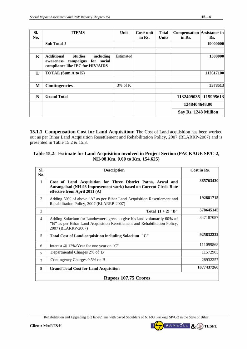
Social Impact Assessment and RAP Report (Chapter-15) 15 - 4
Rehabilitation and Upgrading to 2 lane/2 lane with paved Shoulders of NH-98, Package SP/C/2 in the State of Bihar
Client: M/oRT&H
TESPL&
Sl. No.
ITEMS Unit Cost/ unit in Rs.
Total Units
Compensation in Rs.
Assistance in Rs.
Sub Total J 19000000
K Additional Studies including
awareness campaigns for social compliance like IEC for HIV/AIDS
Estimated 1500000
L TOTAL (Sum A to K) 112617100
M Contingencies 3% of K 3378513
N Grand Total 1132409035 115995613
1248404648.00
Say Rs. 1248 Million
15.1.1 Compensation Cost for Land Acquisition: The Cost of Land acquisition has been worked out as per Bihar Land Acquisition Resettlement and Rehabilitation Policy, 2007 (BLARRP-2007) and is presented in Table 15.2 & 15.3.
Table 15.2: Estimate for Land Acquisition involved in Project Section (PACKAGE SP/C-2, NH-98 Km. 0.00 to Km. 154.625)
Sl. No.
Description Cost in Rs.
1 Cost of Land Acquisition for Three District Patna, Arwal and Aurangabad (NH-98 Improvement work) based on Current Circle Rate effective from April 2011 (A)
385763430
2 Adding 50% of above "A" as per Bihar Land Acquisition Resettlement and Rehabilitation Policy, 2007 (BLARRP-2007)
192881715
3 Total (1 + 2) "B" 578645145
4 Adding Solacium for Landowner agrees to give his land voluntarily 60% of "B" as per Bihar Land Acquisition Resettlement and Rehabilitation Policy, 2007 (BLARRP-2007)
347187087
5 Total Cost of Land acquisition including Solacium "C" 925832232
6 Interest @ 12%/Year for one year on "C" 111099868
7 Departmental Charges 2% of B 11572903
7 Contingency Charges 0.5% on B 28932257
8 Grand Total Cost for Land Acquisition 1077437260
Rupees 107.75 Crores
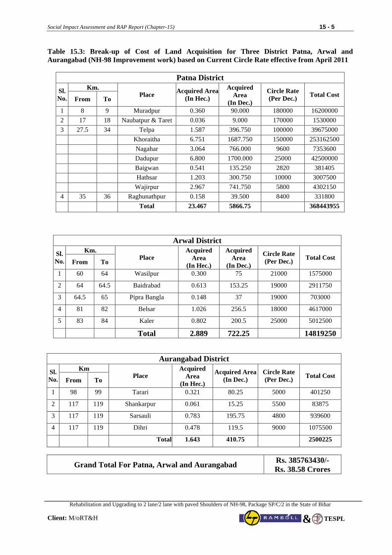
Social Impact Assessment and RAP Report (Chapter-15) 15 - 5
Rehabilitation and Upgrading to 2 lane/2 lane with paved Shoulders of NH-98, Package SP/C/2 in the State of Bihar
Client: M/oRT&H
TESPL&
Table 15.3: Break-up of Cost of Land Acquisition for Three District Patna, Arwal and Aurangabad (NH-98 Improvement work) based on Current Circle Rate effective from April 2011
Patna District
Km. Sl.No. From To
Place Acquired Area(In Hec.)
Acquired Area
(In Dec.)
Circle Rate (Per Dec.) Total Cost
1 8 9 Muradpur 0.360 90.000 180000 16200000 2 17 18 Naubatpur & Taret 0.036 9.000 170000 1530000 3 27.5 34 Telpa 1.587 396.750 100000 39675000 Khoraitha 6.751 1687.750 150000 253162500 Nagahar 3.064 766.000 9600 7353600 Dadupur 6.800 1700.000 25000 42500000 Baigwan 0.541 135.250 2820 381405 Hathsar 1.203 300.750 10000 3007500 Wajirpur 2.967 741.750 5800 4302150 4 35 36 Raghunathpur 0.158 39.500 8400 331800 Total 23.467 5866.75 368443955
Arwal District Km. Sl.
No. From To Place
Acquired Area
(In Hec.)
Acquired Area
(In Dec.)
Circle Rate (Per Dec.) Total Cost
1 60 64 Wasilpur 0.300 75 21000 1575000
2 64 64.5 Baidrabad 0.613 153.25 19000 2911750
3 64.5 65 Pipra Bangla 0.148 37 19000 703000
4 81 82 Belsar 1.026 256.5 18000 4617000
5 83 84 Kaler 0.802 200.5 25000 5012500
Total 2.889 722.25 14819250
Aurangabad District Km Sl.
No. From To Place
Acquired Area
(In Hec.)
Acquired Area(In Dec.)
Circle Rate (Per Dec.) Total Cost
1 98 99 Tarari 0.321 80.25 5000 401250
2 117 119 Shankarpur 0.061 15.25 5500 83875
3 117 119 Sarsauli 0.783 195.75 4800 939600
4 117 119 Dihri 0.478 119.5 9000 1075500
Total 1.643 410.75 2500225
Grand Total For Patna, Arwal and Aurangabad Rs. 385763430/- Rs. 38.58 Crores
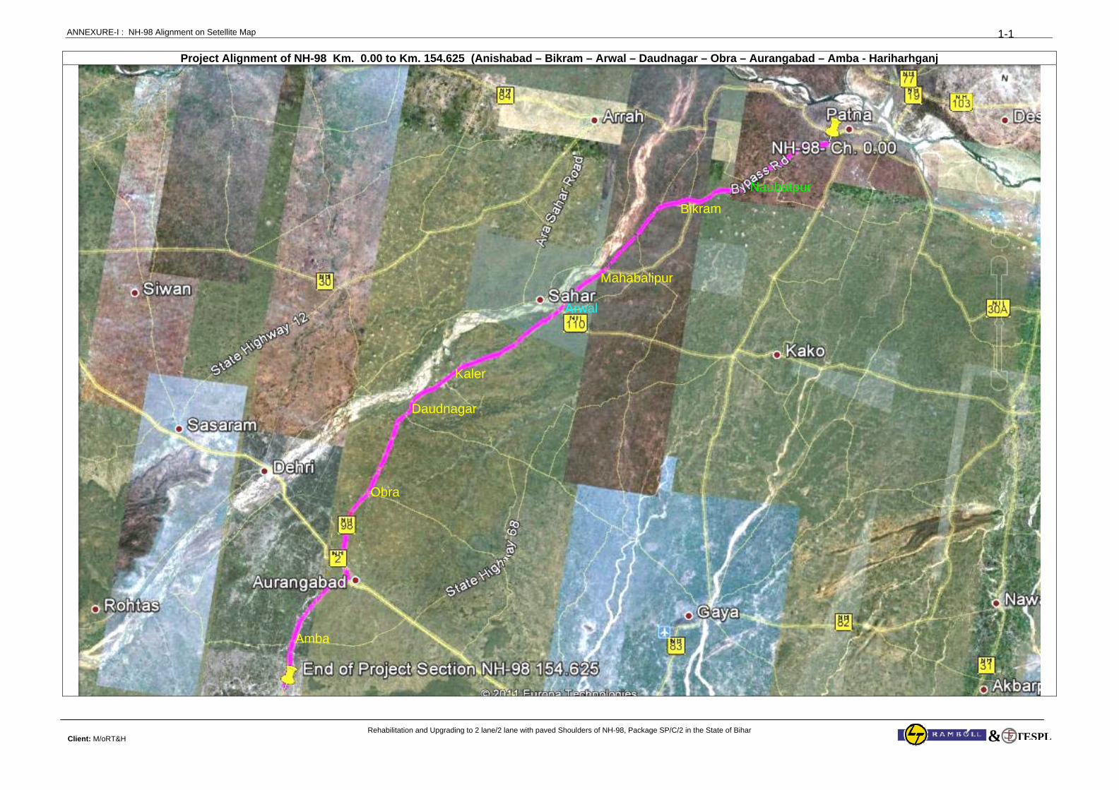
ANNEXURE-I : NH-98 Alignment on Setellite Map
Rehabilitation and Upgrading to 2 lane/2 lane with paved Shoulders of NH-98, Package SP/C/2 in the State of Bihar Client: M/oRT&H
1-1
TESPL&
Project Alignment of NH-98 Km. 0.00 to Km. 154.625 (Anishabad – Bikram – Arwal – Daudnagar – Obra – Aurangabad – Amba - Hariharhganj
Daudnagar
Arwal
Obra
Amba
Bikram
Naubatpur
Mahabalipur
Kaler
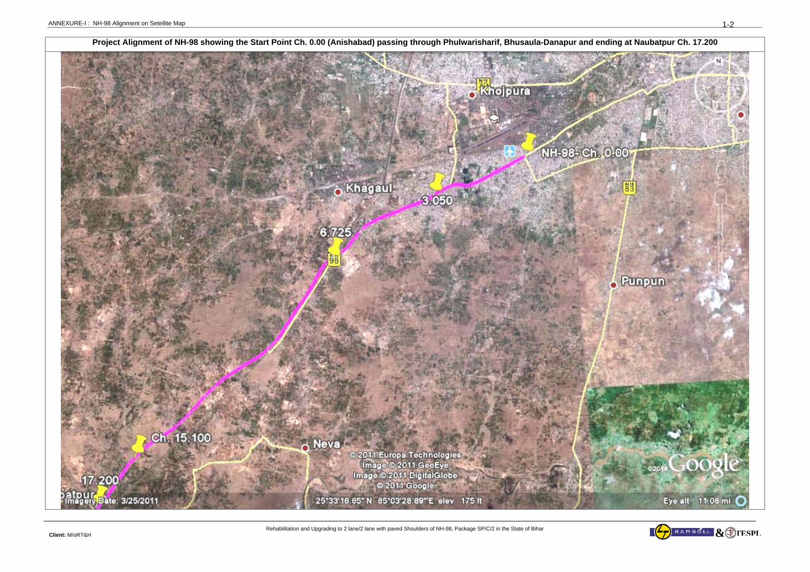
ANNEXURE-I : NH-98 Alignment on Setellite Map
Rehabilitation and Upgrading to 2 lane/2 lane with paved Shoulders of NH-98, Package SP/C/2 in the State of Bihar Client: M/oRT&H
1-2
TESPL&
Project Alignment of NH-98 showing the Start Point Ch. 0.00 (Anishabad) passing through Phulwarisharif, Bhusaula-Danapur and ending at Naubatpur Ch. 17.200
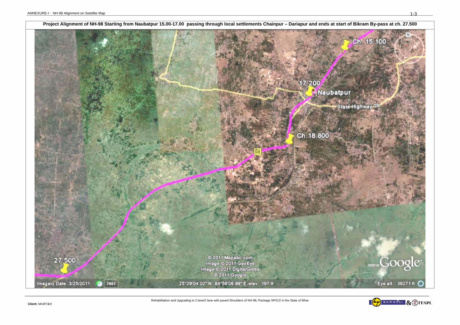
ANNEXURE-I : NH-98 Alignment on Setellite Map
Rehabilitation and Upgrading to 2 lane/2 lane with paved Shoulders of NH-98, Package SP/C/2 in the State of Bihar Client: M/oRT&H
1-3
TESPL&
Project Alignment of NH-98 Starting from Naubatpur 15.00-17.00 passing through local settlements Chainpur – Dariapur and ends at start of Bikram By-pass at ch. 27.500
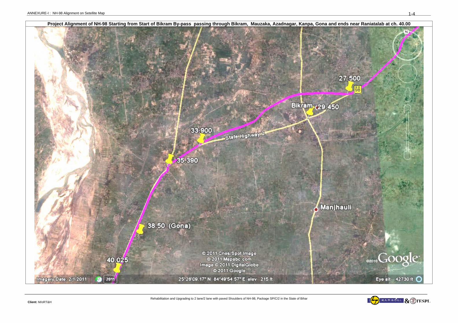
ANNEXURE-I : NH-98 Alignment on Setellite Map
Rehabilitation and Upgrading to 2 lane/2 lane with paved Shoulders of NH-98, Package SP/C/2 in the State of Bihar Client: M/oRT&H
1-4
TESPL&
Project Alignment of NH-98 Starting from Start of Bikram By-pass passing through Bikram, Mauzaka, Azadnagar, Kanpa, Gona and ends near Raniatalab at ch. 40.00
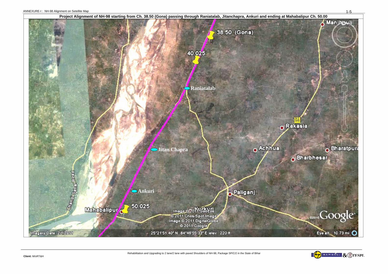
ANNEXURE-I : NH-98 Alignment on Setellite Map
Rehabilitation and Upgrading to 2 lane/2 lane with paved Shoulders of NH-98, Package SP/C/2 in the State of Bihar Client: M/oRT&H
1-5
TESPL&
Project Alignment of NH-98 starting from Ch. 38.50 (Gona) passing through Raniatalab, Jitanchapra, Ankuri and ending at Mahabalipur Ch. 50.00
Raniatalab
Jitan Chapra
Ankuri
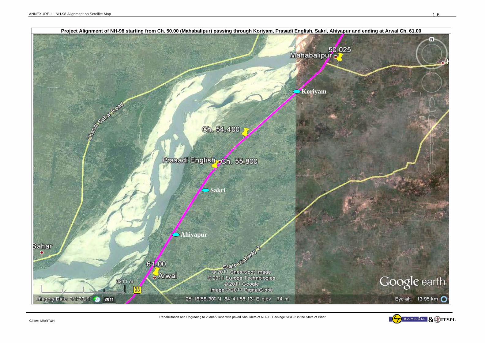
ANNEXURE-I : NH-98 Alignment on Setellite Map
Rehabilitation and Upgrading to 2 lane/2 lane with paved Shoulders of NH-98, Package SP/C/2 in the State of Bihar Client: M/oRT&H
1-6
TESPL&
Project Alignment of NH-98 starting from Ch. 50.00 (Mahabalipur) passing through Koriyam, Prasadi English, Sakri, Ahiyapur and ending at Arwal Ch. 61.00
Koriyam
Sakri
Ahiyapur
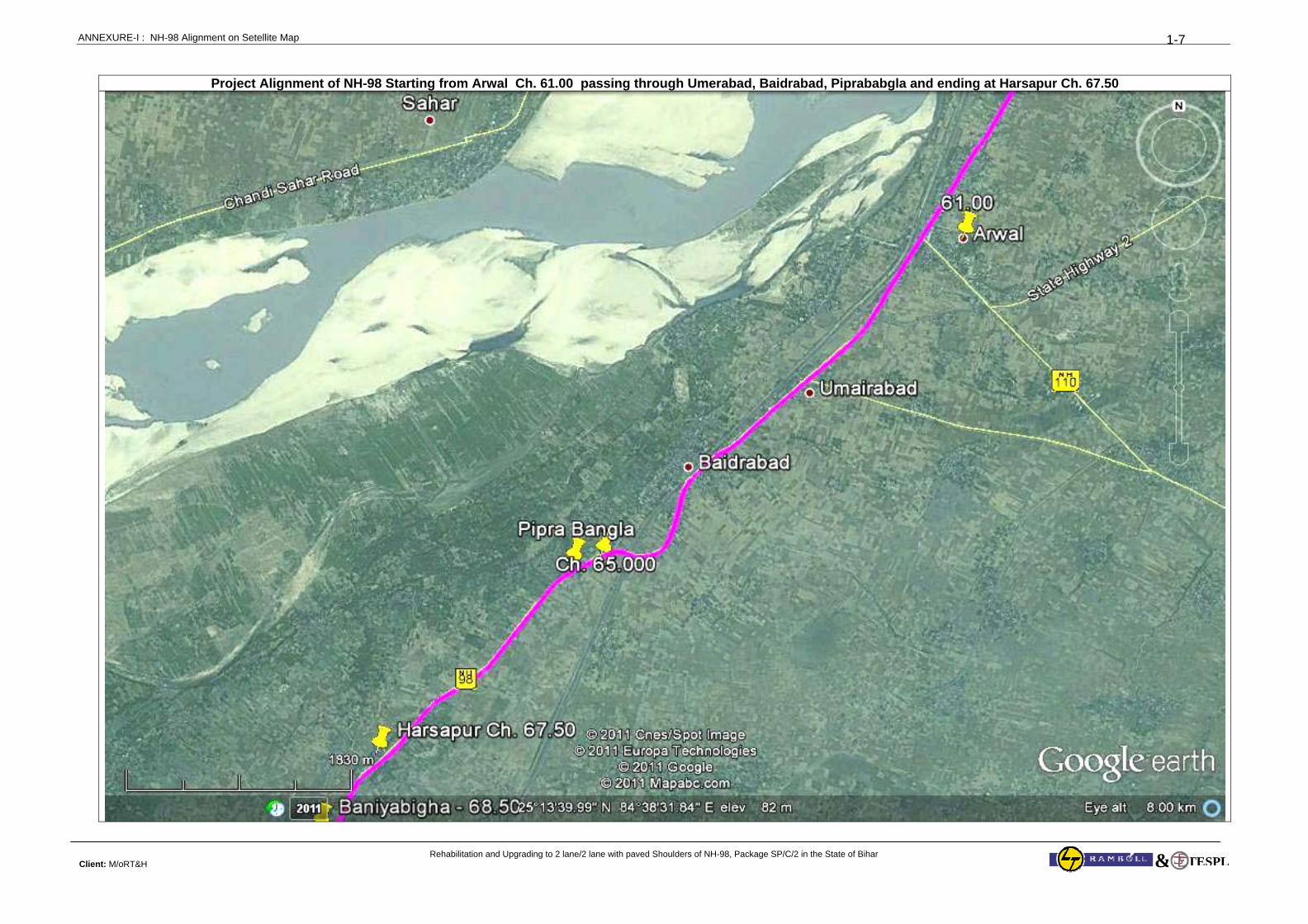
ANNEXURE-I : NH-98 Alignment on Setellite Map
Rehabilitation and Upgrading to 2 lane/2 lane with paved Shoulders of NH-98, Package SP/C/2 in the State of Bihar Client: M/oRT&H
1-7
TESPL&
Project Alignment of NH-98 Starting from Arwal Ch. 61.00 passing through Umerabad, Baidrabad, Piprababgla and ending at Harsapur Ch. 67.50
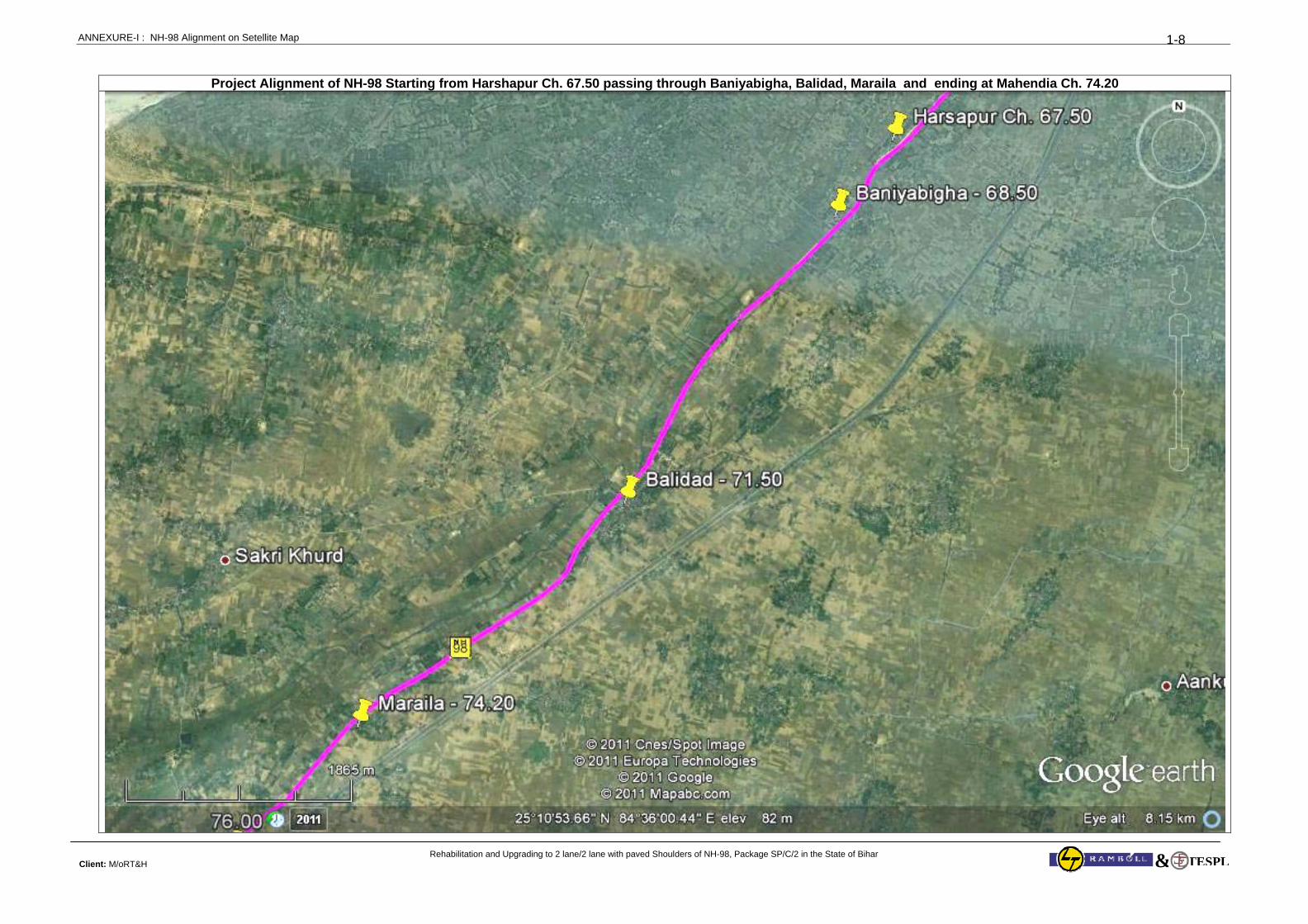
ANNEXURE-I : NH-98 Alignment on Setellite Map
Rehabilitation and Upgrading to 2 lane/2 lane with paved Shoulders of NH-98, Package SP/C/2 in the State of Bihar Client: M/oRT&H
1-8
TESPL&
Project Alignment of NH-98 Starting from Harshapur Ch. 67.50 passing through Baniyabigha, Balidad, Maraila and ending at Mahendia Ch. 74.20
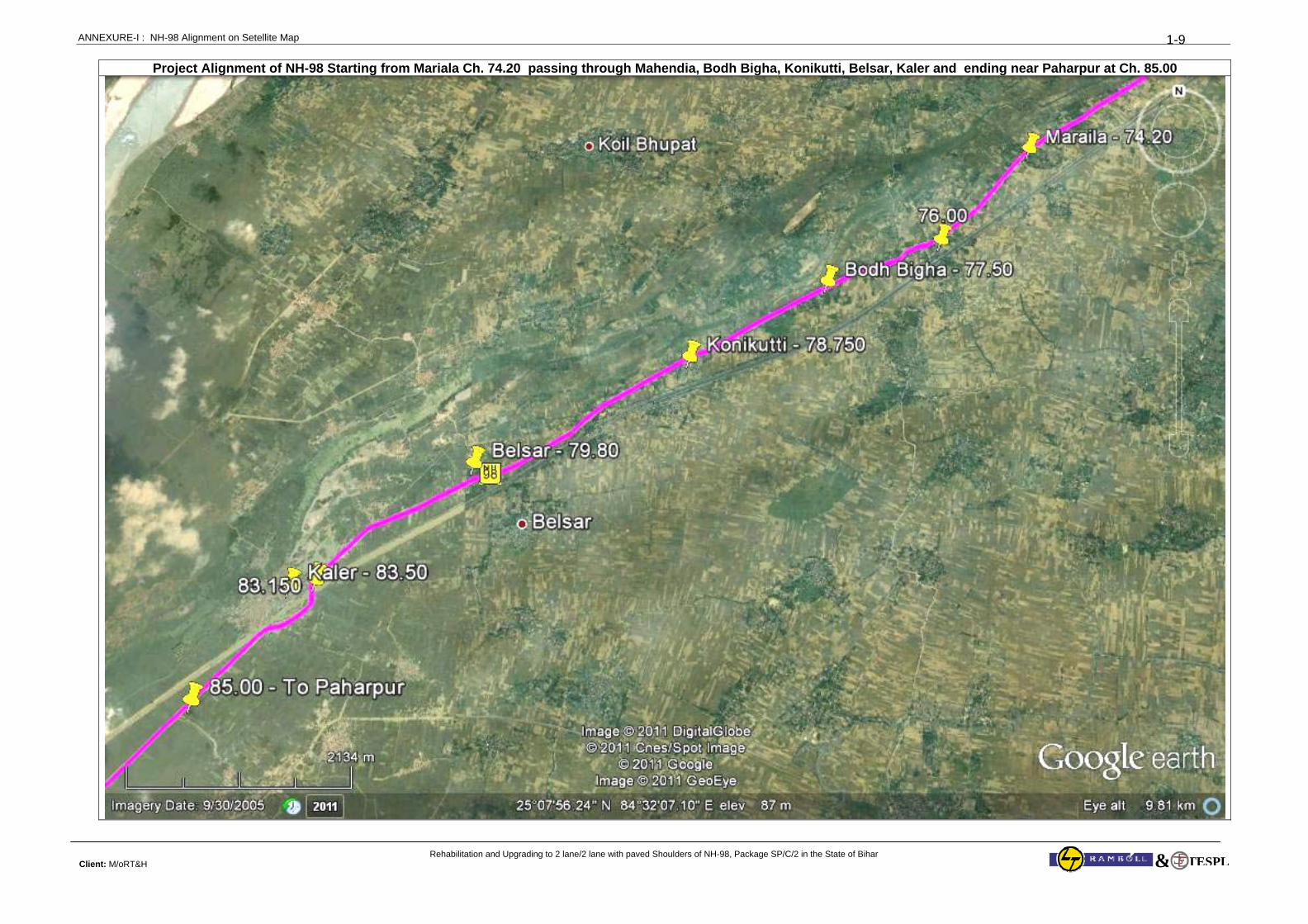
ANNEXURE-I : NH-98 Alignment on Setellite Map
Rehabilitation and Upgrading to 2 lane/2 lane with paved Shoulders of NH-98, Package SP/C/2 in the State of Bihar Client: M/oRT&H
1-9
TESPL&
Project Alignment of NH-98 Starting from Mariala Ch. 74.20 passing through Mahendia, Bodh Bigha, Konikutti, Belsar, Kaler and ending near Paharpur at Ch. 85.00
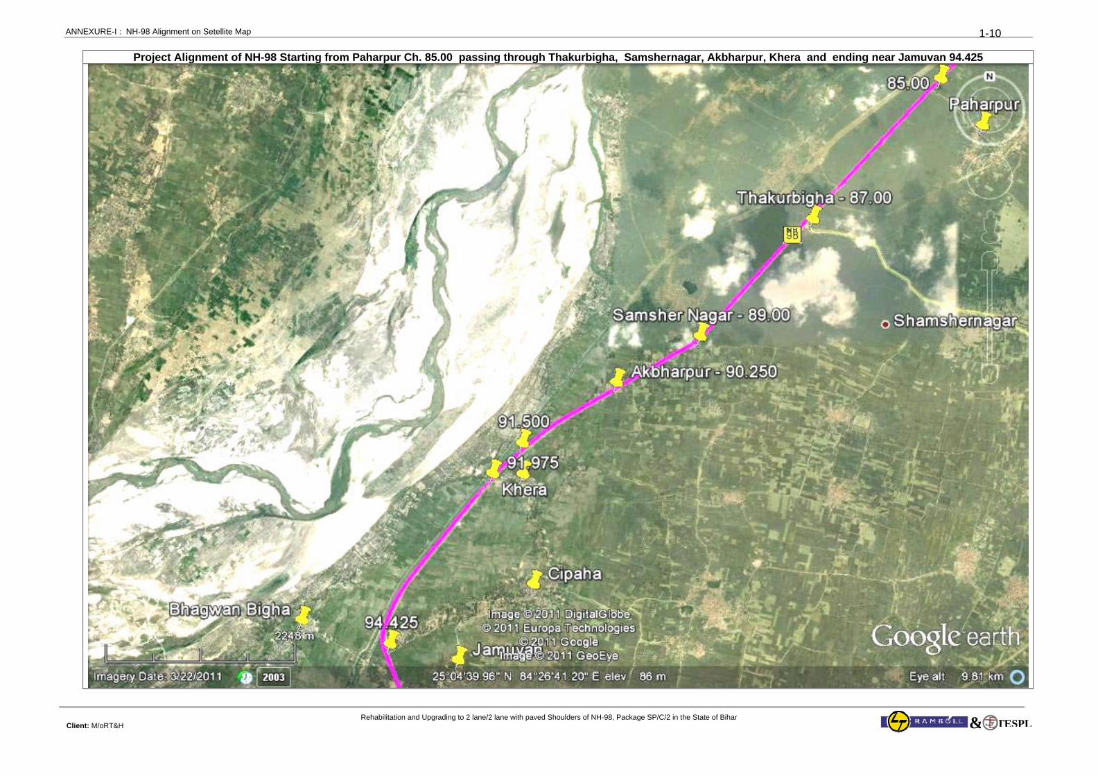
ANNEXURE-I : NH-98 Alignment on Setellite Map
Rehabilitation and Upgrading to 2 lane/2 lane with paved Shoulders of NH-98, Package SP/C/2 in the State of Bihar Client: M/oRT&H
1-10
TESPL&
Project Alignment of NH-98 Starting from Paharpur Ch. 85.00 passing through Thakurbigha, Samshernagar, Akbharpur, Khera and ending near Jamuvan 94.425
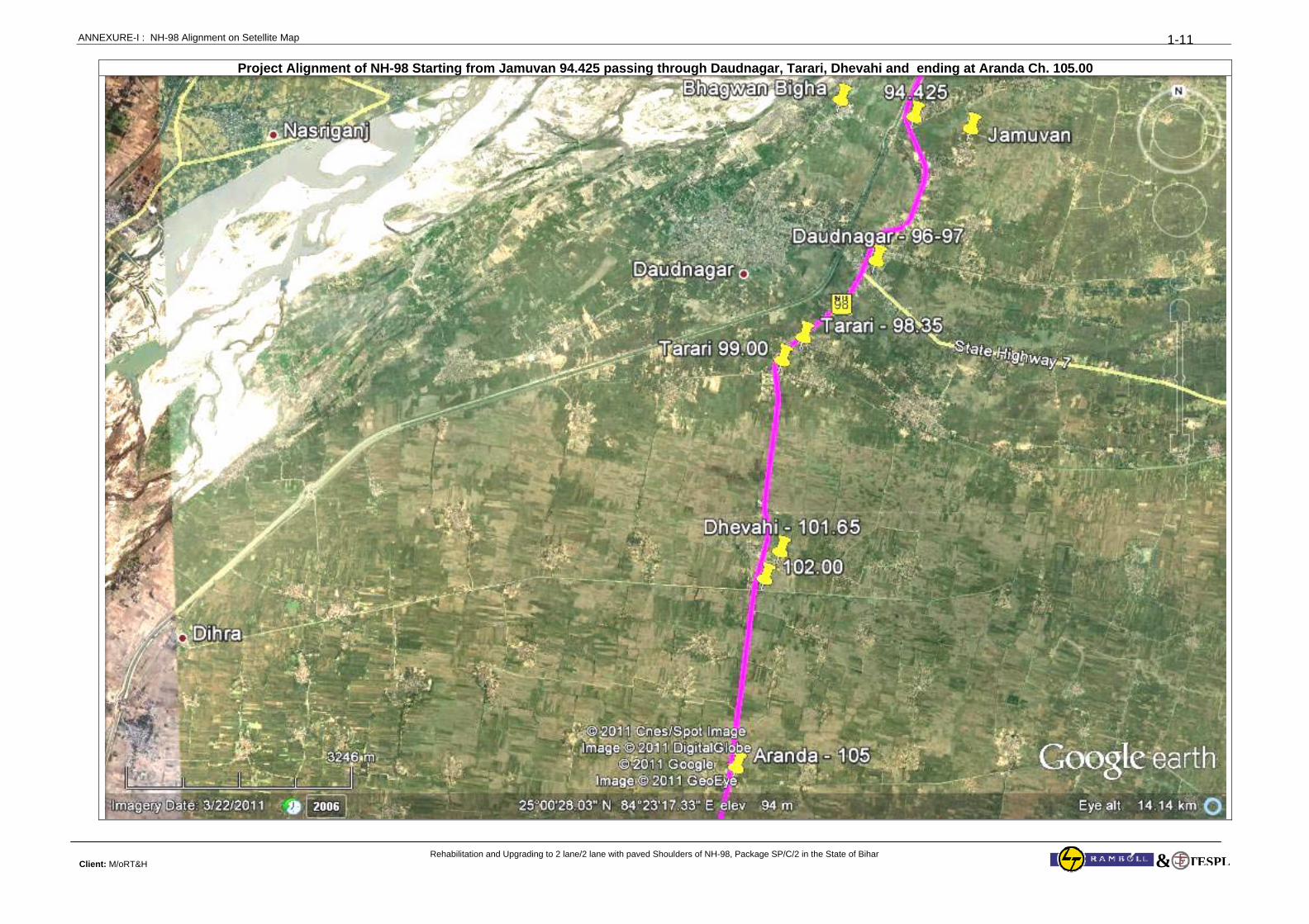
ANNEXURE-I : NH-98 Alignment on Setellite Map
Rehabilitation and Upgrading to 2 lane/2 lane with paved Shoulders of NH-98, Package SP/C/2 in the State of Bihar Client: M/oRT&H
1-11
TESPL&
Project Alignment of NH-98 Starting from Jamuvan 94.425 passing through Daudnagar, Tarari, Dhevahi and ending at Aranda Ch. 105.00
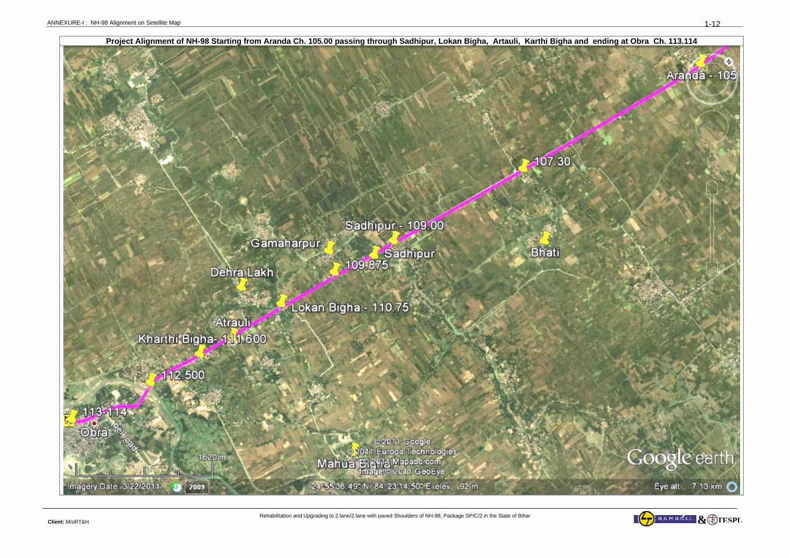
ANNEXURE-I : NH-98 Alignment on Setellite Map
Rehabilitation and Upgrading to 2 lane/2 lane with paved Shoulders of NH-98, Package SP/C/2 in the State of Bihar Client: M/oRT&H
1-12
TESPL&
Project Alignment of NH-98 Starting from Aranda Ch. 105.00 passing through Sadhipur, Lokan Bigha, Artauli, Karthi Bigha and ending at Obra Ch. 113.114
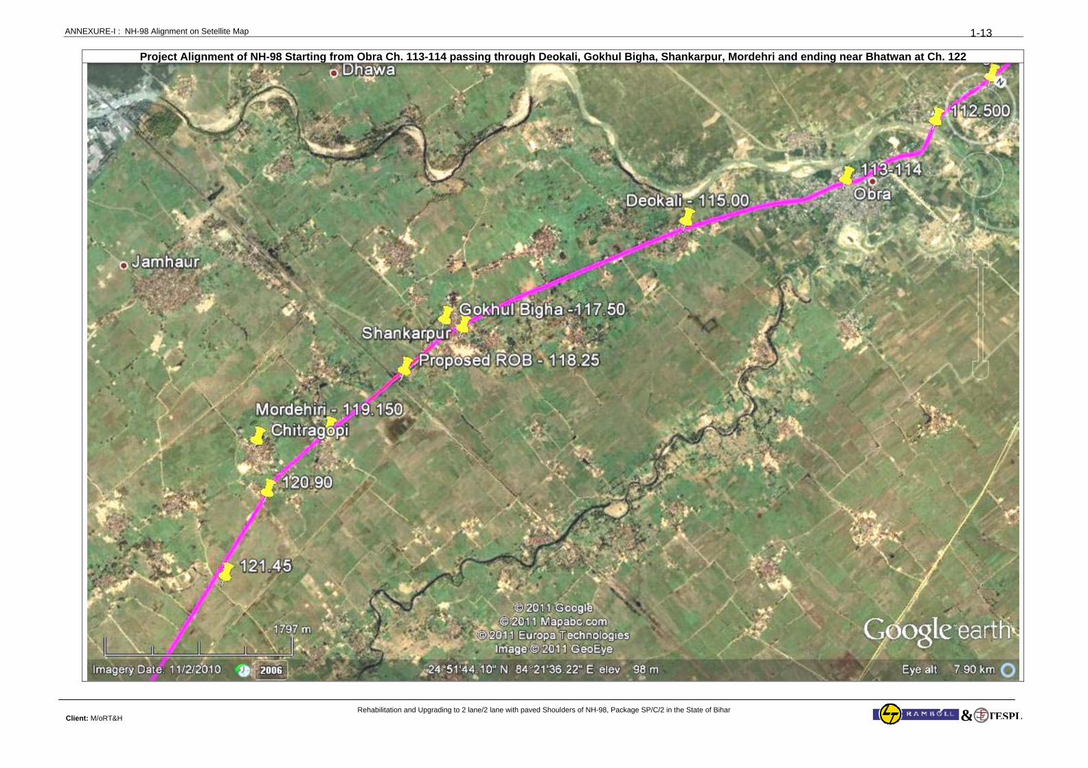
ANNEXURE-I : NH-98 Alignment on Setellite Map
Rehabilitation and Upgrading to 2 lane/2 lane with paved Shoulders of NH-98, Package SP/C/2 in the State of Bihar Client: M/oRT&H
1-13
TESPL&
Project Alignment of NH-98 Starting from Obra Ch. 113-114 passing through Deokali, Gokhul Bigha, Shankarpur, Mordehri and ending near Bhatwan at Ch. 122
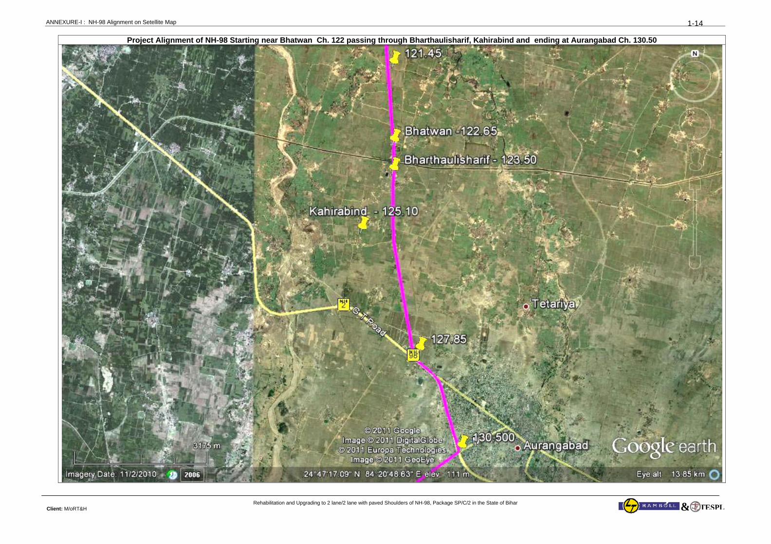
ANNEXURE-I : NH-98 Alignment on Setellite Map
Rehabilitation and Upgrading to 2 lane/2 lane with paved Shoulders of NH-98, Package SP/C/2 in the State of Bihar Client: M/oRT&H
1-14
TESPL&
Project Alignment of NH-98 Starting near Bhatwan Ch. 122 passing through Bharthaulisharif, Kahirabind and ending at Aurangabad Ch. 130.50
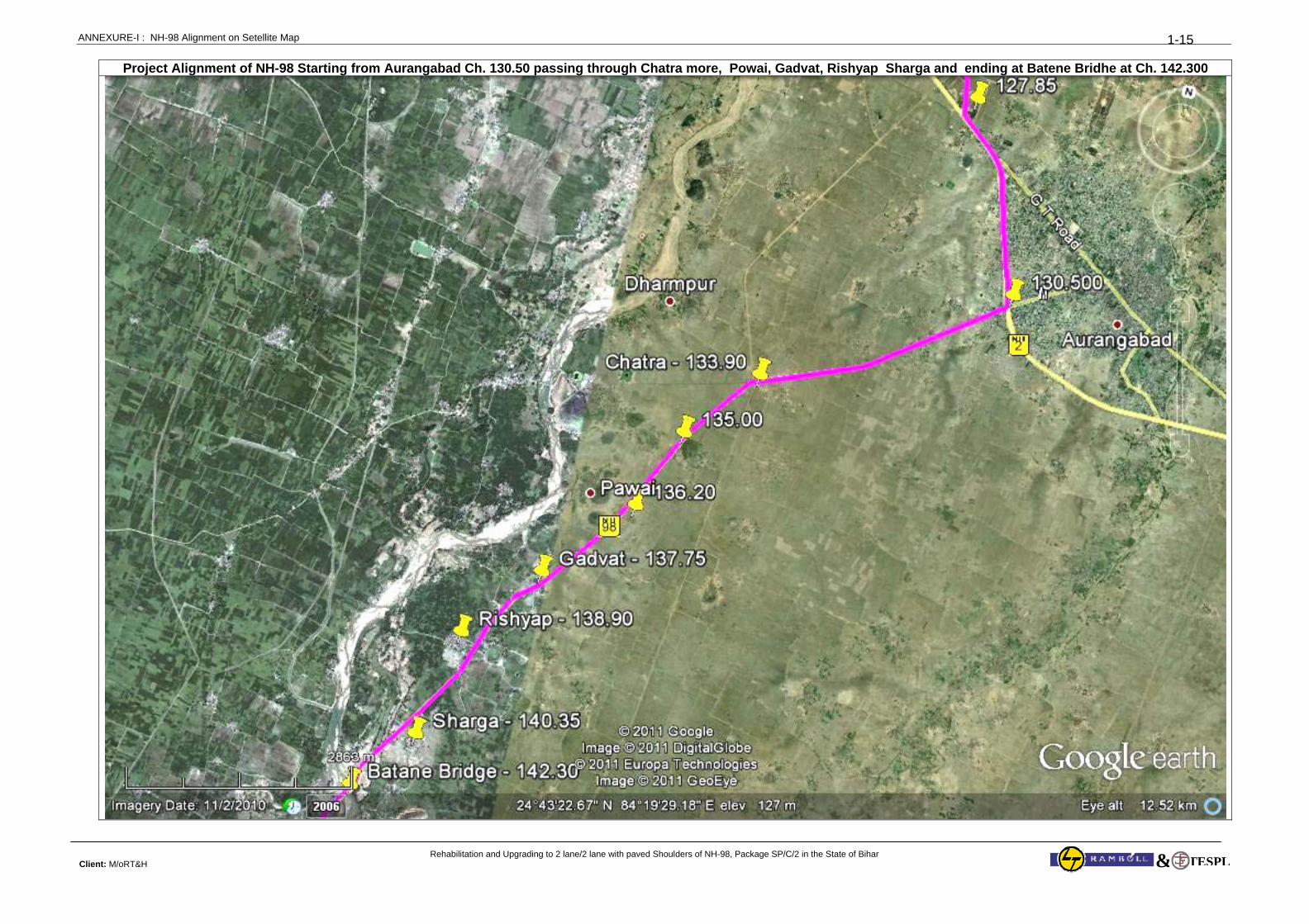
ANNEXURE-I : NH-98 Alignment on Setellite Map
Rehabilitation and Upgrading to 2 lane/2 lane with paved Shoulders of NH-98, Package SP/C/2 in the State of Bihar Client: M/oRT&H
1-15
TESPL&
Project Alignment of NH-98 Starting from Aurangabad Ch. 130.50 passing through Chatra more, Powai, Gadvat, Rishyap Sharga and ending at Batene Bridhe at Ch. 142.300
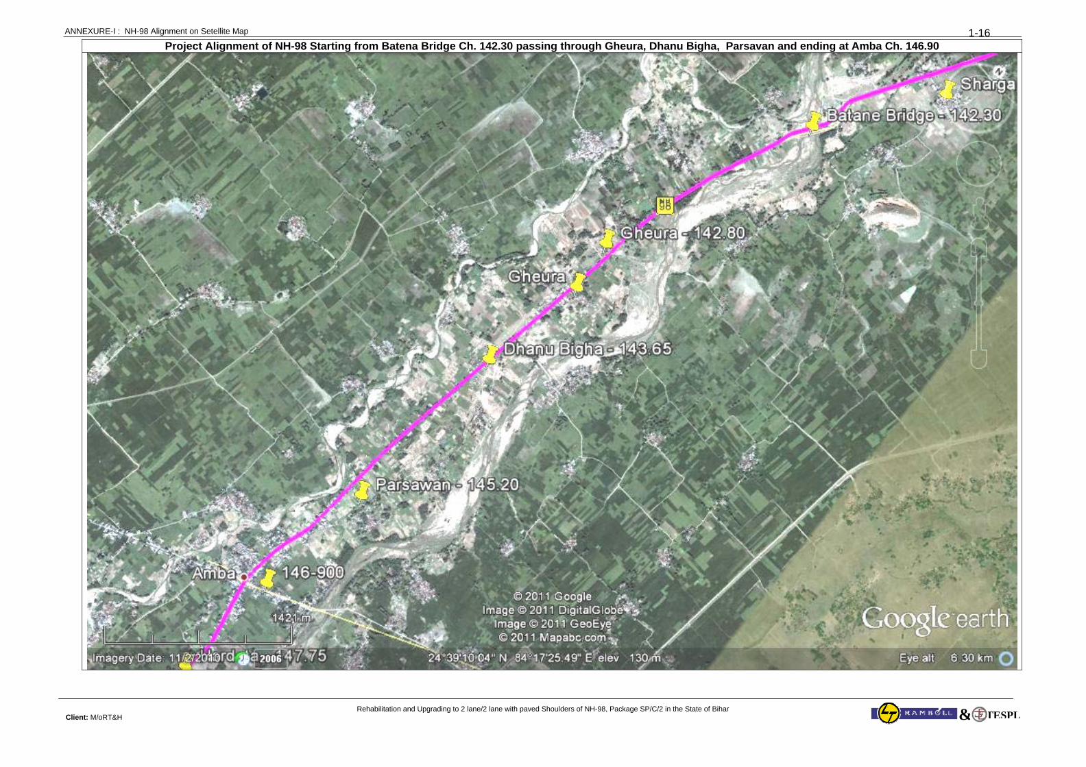
ANNEXURE-I : NH-98 Alignment on Setellite Map
Rehabilitation and Upgrading to 2 lane/2 lane with paved Shoulders of NH-98, Package SP/C/2 in the State of Bihar Client: M/oRT&H
1-16
TESPL&
Project Alignment of NH-98 Starting from Batena Bridge Ch. 142.30 passing through Gheura, Dhanu Bigha, Parsavan and ending at Amba Ch. 146.90
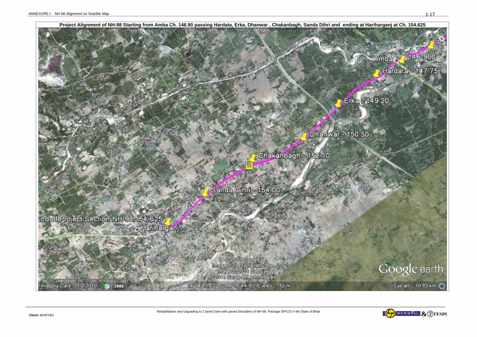
ANNEXURE-I : NH-98 Alignment on Setellite Map
Rehabilitation and Upgrading to 2 lane/2 lane with paved Shoulders of NH-98, Package SP/C/2 in the State of Bihar Client: M/oRT&H
1-17
TESPL&
Project Alignment of NH-98 Starting from Amba Ch. 146.90 passing Hardata, Erka, Dhanwar , Chakanbagh, Sanda Dihri and ending at Hariharganj at Ch. 154.625
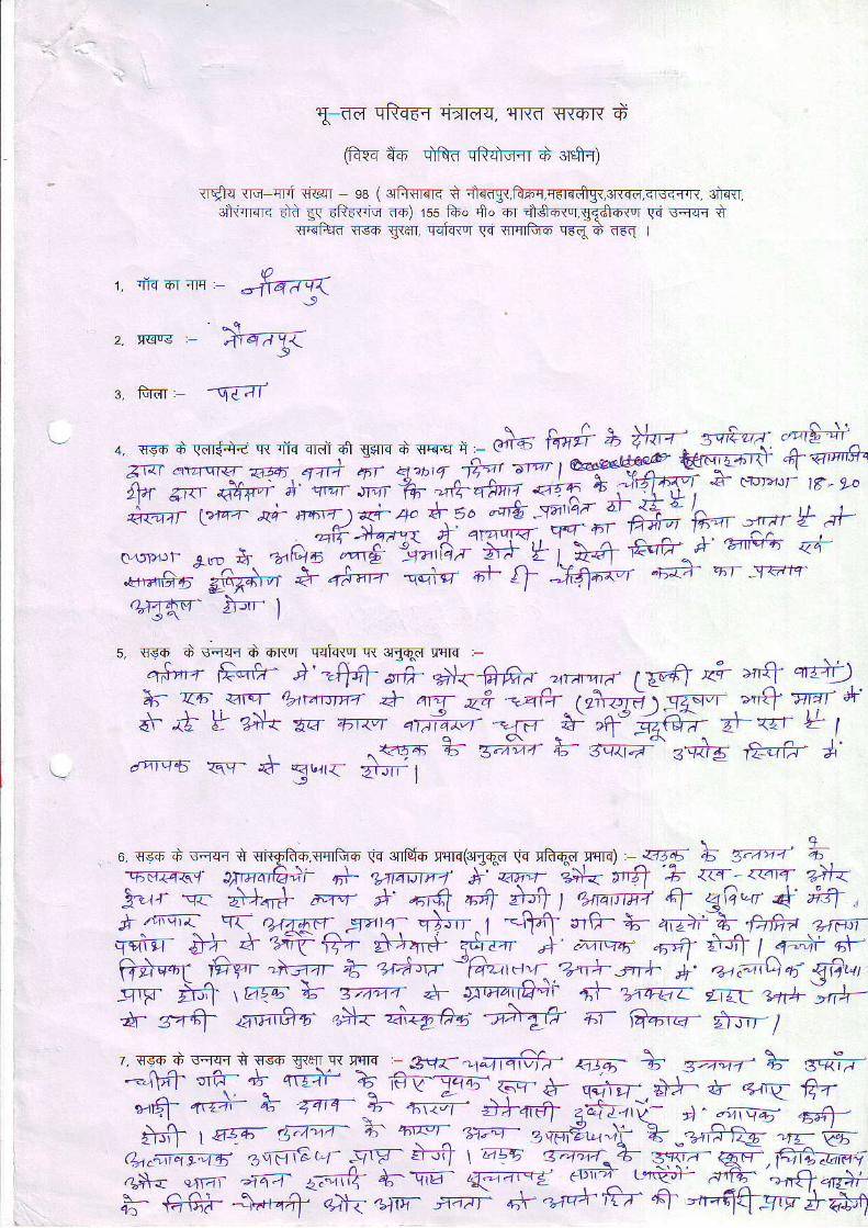
al ild cR-€{ q*raq, rrrro s{6R d
@{q nn dfto cRltq{r d 3rql-l)
rTqrq rrq qFi {i@r ss ( 3rfu€r<r< q +{a$,ft-mq,qEl{dg{,3rqd,<lsfl.l1. 3]iqrr.ft,rErE drd E{ dtr i-Iq ao) rss fu. S. oT nlqfllr,rlEff+{or \ri vq?I{ t
sRifu( qsfi gren. {sfur'r qq lsTq]fifi cFq ri (€( |
4€?as^ >'-o-. Is, qgo d s.rqc d oRor qql.+tor q{ 3rgqd sr[E :-
q+'frrr W ) =W s,+ r+{ -6#/ ar+-zrn tyvfi z+ >r+ qr+)k Ul.- arq aarawt+z * ,n* z+ Gfr -(r}7qq).q4v. ,>,'l wnr A'
ah {b tr ?ilr E€- 4t1<"r qi# -i:_f, $ ,f rt{e> d-<zr * 1, ^. <-l-a b B;;r4- E tita^ 3eirt fr,-€.r A'
drErfS ?qq- .d- <{t]ra ZhTr- I
6 rr€ih + \F;I.Fi .r qFr+.'T{rl}d" qs 3nl+o q.{rc(3|{+3 \'q qh{d rqlq) .atf"- b 5r-tt- LqF4.-ql' tlvzat6;i- qt- q.AAVt-a #
"{,r-- e#< ,"fr
'k A+ ztt+ z}r<
!'trr 'q- *)r* a"t ^' ,6fi "4
+4 1 ",nttrt tl 4ia,-'r fi *n} j-"{ . \ ?r45rl -Er-/1'a, q}rrr. |
-=q?T $rfi- * n}-:F^+,fra ettqqr j}h + i\- irz- at+:np- <* r,r A -nnq4i .rm- ftf| | q-+ q\-Wqq $iT 'h3zr e- z+Aa:- 'G'ztau- 'V\+'rrr+ j' a",a',C, q; ffiu,--rF ;fr 15ro; \ Trvnr + 51rnaffi 4l- zr4zi litT 34A
'h-
*- r4-q= a\r€-n #< z+@!#4 ad fi- {a6z4, *in-'l
r. .i-qo-rlrq, -#4<
2, Ilqrg :-
:, fuar: -q{af
+. *s- d rdr*+€ q{ fro oroi o1 gsno d ve+r i'- @}6 Ao# +.,y*".7!:5.'**Zlar e+zrqa:| Taa; .T1r;{ ,ff 4'tbt.f Fa' ' 6tv' / :.*v[ft ao, M A vlrr roir + -'9. rrrfrIa 4T a:'# .--^'h#?a"4+TW'-'+Tr,,}{}' ,i6Fgi }r cro'''t: 16 eo";*+'"; ; o,"-)+''* +.6o ""& -d'2" 5l;3+:'*.=,, n.,+ ol?#He\#,ruffif:,;;*^+.ar'd, rL(.D * -a;'Ai"*fr;ffrl >#'",iJ :Y-?;#'*3# e,i"h -i"k; #- + -ka;r- "ra* -r-.rerc-
."1oj"-Lt1s"ry{" :g-<"1q19-r$f,- a5- \ s.zw'* sda-.:Tstg"J34.5*^; &r$ iz- <ttq ftn-,+ 4,+ + T'4- JB- # i+.r#i #r1l:4t>l -r \2- ' \ h 1 t ^.D ar\{r ' r TA-ni1T Aztai tv- d. - tJrqF .Et3_
$ rasa- 4;z;r h; *^* ?"F#u.)i- -'+:
:yAtg .;e^z#ftg ,,- e;trsT | 41bh 1.^. ' ,, "f '^ -- - ,uer'at!r, 'a z _.rT1 re- -rr t%&FTqAan; +.frr--r'-a cr- ;wT.tT,t \ .aEa. /a.77(;+> =<-z- qr. fittraa;;# ;'", a-a
"zt,h +_'!r# "r-Tz rm{ t*fj- & 4.^n,
4Y €rGa_ *)'i "t-
aaii * *+'++tel- q' -,r-q+s..F'$#4
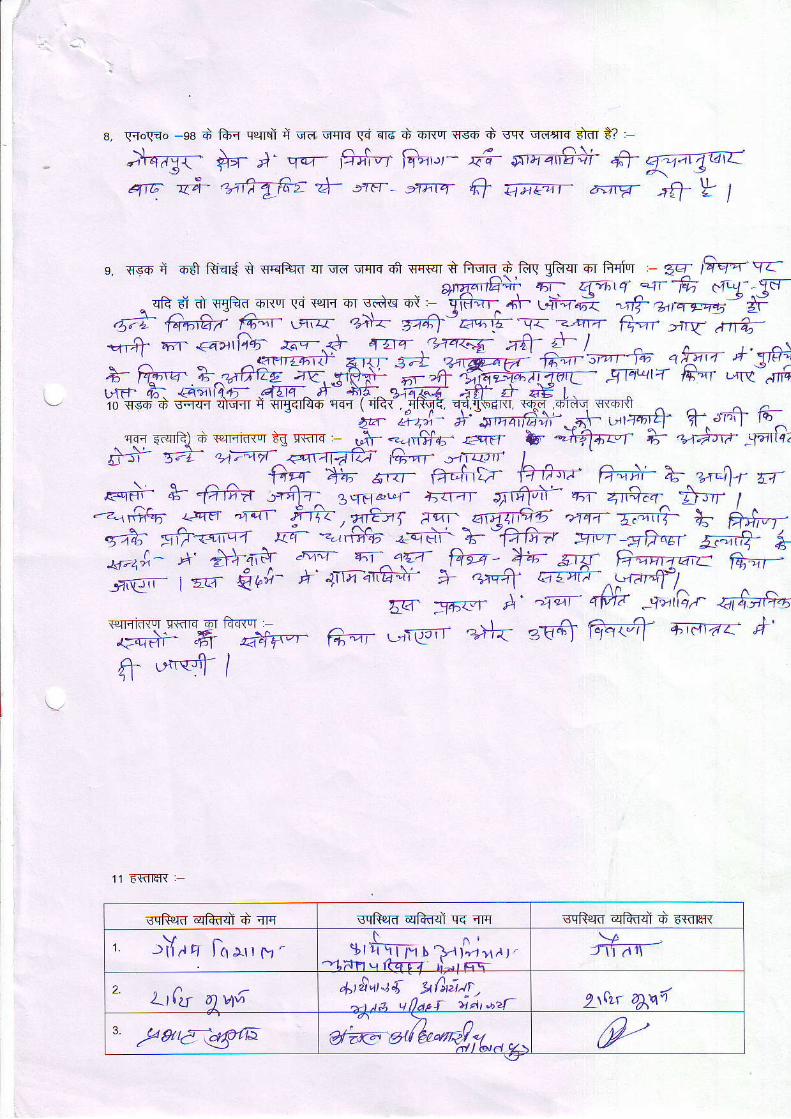
8. Frowo -e8 d fu{ qp{rd i qii qqn si qi6 d oi{"r {s6 A sq{ qd.ns drnr i? ,
;*s?X{- il- l" .rw r?d--r f&'.,r- &+ srrar$+i 4-qe z3- ,u@ zJ- -re-- ,xnw Q 6tqr d--rv'
g. ss-o i os Riqrs i {qtua= qr qd qc' d **jm*,q*#p ;.%,H F
" fr.;r a offt1* G rnrn or sdc ri ,- -grfur"
+\- (n+,o? TF *,n rn; u F
.5?T'ffirl F-. *. o"it-': zz*l.-;aq;.r f-:"T. Gvr >:.U nd;*-# r €a?1tia4; f.r-<i .f5Pr 'rzaa€
;e=f tr I r. ^\: a4- e=|
.} ia*ra- E.rlif'E ,tS. rfti\: 'rn-zf1
$Aa'-^n3eq- .qlq,'tr+ ii-,, u^r't" s{iure-io ss.+-d cq+q ?ifwcr q @*+ T{r ( ql-r- dltT? q'd.['5f,{l rF' 4T+ iT-r'+
a^-' ii;"' }..ffi" "'\- ;,r4"ry T *+l fr ̂"
qs t,arRl 4 +eFfi'tr "n
r{rrq i,,h- -1,]t %, {arl &- -}?ra-f }; z+)n- ..Odlq,fr 57r- 4/1';={-{ <4{t41iz7 {a;-qf rlTzJJt l},f Tri ^n';=r7 aet1afi G,,4f ,41c.trf I
'
\ F4 a;- s.rr ft.firr F-a-v' 7";7- ^2,,''1-r u,rFrFrr- ,g- -faFa stzlz-- 3qrr&-f +'.r,1T 'i1t1"r' |Fi- A11;l_rzr Zlrrr /-.-{rdr; )-.w -6.t- fr , sft-vt lvr- rqn*+, *rqz- Z;zrry- 4; ft*-rs-<e; g{/-<sr,w ^ t{4- --#.6 ..edr. }- ".filt-'- svr tA*, W'*';#; i jw';'' ;-*Tl€.ir f T+*-# "Fry5 YE{ y6..- ;' 'q.r r#" iian <affi-elrqinlor qiflq or fi-flEr :,€q+i .Fr dqF"l^+ uru-t'- /
aqr urr-€rr ?)l-{ 3k-E ffi +;era": *'
11 FfiIER :
sqfurd qfiflsl d qrc sqRerd qFtf,sl qE nrc scR rd qffi d 6mir*
, r i {aq L, l 'F, 't ^ ,
I rli\1=ty I ]a i.4 11,r I --1:i_Fr tr lf' '_ ,: .!-
Lt tA 6 )W*tlj lu"]{ ^l ' i&tr.
-"a. q1a'r i* t ,b2f- ^\Lf ^\a
" 1*6r4>ra a#"ie'-,rl*". p--
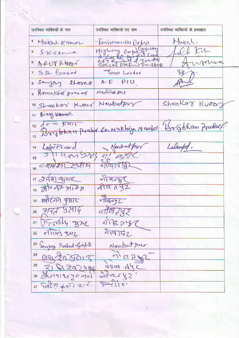
BqRera qRflql d llq wfurd qlftql qE qFr sqfurd qfrdd d FffiH{
o \w^s KttIa^e.L- 'Eo';^p 'lt'<'rq 6f ]r''1 N1.<.\'
s J-14. y.e -,-* t{i"n^+ytlffi3 JJ,[- Ft.u l\-Pr-r?
-iztiAlaurj l +,--+4
4ac-r a.l FrcP-" rT+-3 b,1.' I N'^-,"'v'-^z S. B^ l>-s.) | P ^ y n L r a 4 ! , ( V."h'u JAA,7 9l- -.*a +.9 Pru IVn lla"n-1t6"{ pr''- ^4 Na)LlaL yuy
ro 5f--qvt ko,Y K.tf\t"f N\u/ba+Pvy- ShqnK.T l lofrn2
r lPtnr.SW*ua.
t ) A r ' " 1 t Y / 1 / l' - h . . r r n -c "t z*, u wbfrlt* m quAol
'(",;*t"' w'ezt13 l5'r. d t''*
- laQ.,---*tl .M L1"'//:_r' -
\' t'4:\'1 9ry t a7 / 4?)u)7(_'
r_-D :^.ta ql14&) L-zlv v3 6l\qc! €r-_--..-
rz sli[E!gm(
,u frnQ7itar. "I-t,r rrYL
$ rtir(if4 ryr," zRtr'\241Q 6ra7w,, Wo4l4,-g7,L. a;Vpy<22 d-\ \) 1.1 tr i ,7._ r ,
S . - _ -or\r9-L
tt Q-,,a+ P""9"a/++A Po,^h.iPan'o C,r,er?a-,--, r<- r'1\ ^ -1 !. --r
<\\ q c\\ L26 (9 ier11lY lya 4r t s:r'y z ', laYl -1"n, t e-'4 )>-1 U L'
.j,au" "t<*' &u
( !rn"!V.Vr.r.^rr ?a..)
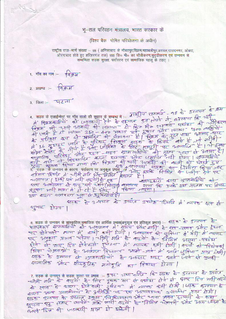
T-dd qftdfi Trmq, r{|{d F-{6R d
(fivq d-6 .ifrd qfurwiT d erefr{)
<r$o lv-wt *ic<r os ( oGwr*e t deagr,l?+n,'ra<dlgr,sn<o,<rscr.rr, ur+{],oltflror< dti gq tftfl-iq ro) 1s5 fuo {t" or AiSow.gBfiaw gq sflqr s
rwi+ro nso g<ar, wforu !-i nniio rrq d erq I
' nr. .f iqorqH - @
n2. rcr!€ : t4FTf
s. tuir, -qZ?f-
'*ffiryrury:it-r-*ffi#Hfrffi6 ,+ -{+:!fq, $ "n.''-,*
):r €=- F}?" -ffi *,'-"'=*l' ."6+-y #* *yE #u- * FE,+ ffiV{i-LWix:* f a a I 4 4 t f | - f 4 F Y ' q . r - - . . ,
- t A C -
'{ ^firqv 4r.d- >^WL" dA' ^Y 4 r)',!- t-fl1ld6i 6; \irv- nlzrr -qr -nr,-iD' Y I -I 5?ffi"'pFWffi"#;t#
ffiN#Ihffirlx*g:ffim+f{q*n-- -€r'h I -44,rtr oVfifrla\-lrrllr I f4- F+ .-+ ,1,7+;1qv o^
\l-d\.rprr I fq F+ .-+ qdtb @- f
' ' ',="q6?i o-,.,- q.raffir .rf-
<1 T ,L-tr,tfFT il3yt-4n ,TqtTQtgal f-t", rTrr G- rl: atz- 97a14 s7 \.fitc<n<t ,+t -)tr4 .:t 4taL -<.t narT( tfirDn\ 4afifir,rgr-- "r'ft
lrlzr A' * zt F Z+< ].t 4n- :izi a;";t- .'.mxn' -g-i-.qFt*tyt- --
6. q€.o d sfl{ s Eiw{-f,.Fcrido 9a 3nldo rq|q(irgqd w rftw qq|q) , qt54- }' T'4-ir b'*"=I{ T"^-ffi & --7rct*^ A,'
'E;;, z)*-'r'tl' Z, i{n- ?.-Fr z}r; t '.'
-q{- +}a€- ,'-i *: .:r€f 15 *ft^t o*V:, .6- "r0;-
'd'irf [..,,q8-q1 f).n€= e.-';t' i' q:nT ++f t-rrf I a.{q'rr'pr {f aJftcrr tr' 'i7 +'-",.
-. u1{r s}'"r -q}l- t.-ffi xa- a- c-+i a- fne ,# _qr;-,\ . . , '
EY- "f-
qa.-^ ITT 4tfiP- a'': a\a"r) q#lff ir#"i-,): zr-. q,U--^ fET 5tT4t( j- "' 5; a;'e1 .6nl nr-I I q-,r- rt--f# ezri
YI_ !":T_?;'r=+",- Ti.i'-T -!_1T *' ..4f .J?r,', -.''v--'r"q)ar_s-^t 7.. + trr-flq}i *' .*taz: ,,rr ea+^:"A- * z-4q-€ffio- d-: 6i7' "\fr ^- O-,-: *="- 1/ .rn5 sqsi s fsF €{elr R qqE .- 9!z- .;or'-nf;- G- A"+; L- t?'A -'l- F- Tt7.,
-ftfi- rrfr- a- qrP# a- €v- 9qc- 6r- l. qr;-FT # h. q';'Y- ri' h5f aiTi
* '^rn
a- q--- +f"6- i".''- A' .;*,a "ral ifi t*a- g;i:r;4-'6_).fiI- 4;t"4r rqqr+"-'i. 2- 3lff#" nlta-<5 3 .7tr{ea7- -1rF- ffil;# ;r4-"7 +- -\-q7,-T t4q-.ffi,arF? ->l-z- *,r-r- d44- -1..'\i. A- .7;€7- -, ;- ei;-"q- Ls'# Fe --.+ q,?r- 'q6- €rS? -lr.n+
">k -,tir- 6aii" h'*;4+
ry r-r:s'{- gr'- i- a,t t
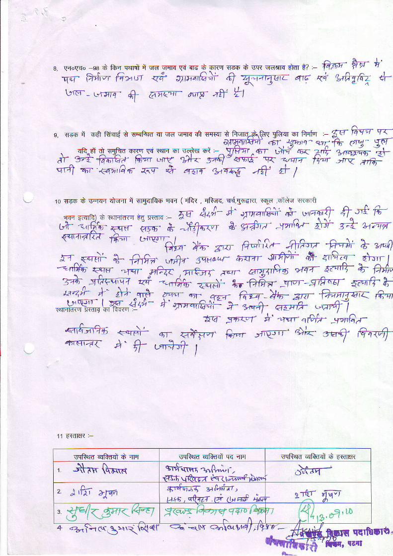
8, \r{o\r4o e8 q. fur qr.flst q qnr qqts G irrc ft €r*q {rsh 4 \FR .rdsllq +m ef . fi'+e- frf *'
qf D+l?t' G>,w qft ,rrr,ili & gl *- nr <+ c'frg62 4-\rr€-- L,raf. 4l ge"- ntg at *l
e. {sq fA ff € qqtk qr qa qrns d s{sr t fiqq-diic gifqr or td'r , 5a fg=;r q<-Al{rtlltr;ti' 6r L!>rtzt- w:++ d*J- Wf
, .*ofr AeEl *X (q rerFr qir $qq 6J -^ Frtit ^o-f giq' zrr Zf, UnE;q
-,2+
nr ^W lda;'Ea 16rr L+rg Ulta. Saql- 4-{i5- O 1.to tf'r ,+w erA-q'f an 14>,r'Q 6 q.!- # 464 AEE6. u* A- t
ro sso d aqqc ?itf,{ d vrgofuo ncl ( qF{ , cftmq. ad.'ll"rm. rqa 6iAo {{qr{t
.rn: {iqfar o .p.r. irq d{ {Fn" , 5q 4',A't' 'y-'frii A'^-''T"+ q^t+'-
ry:fu F^qd FTxr fu ')ffmt e arAi'v- "1^/'rq'r- zfr T;t: 1'1;1t=tr
{'taatzr ftez -*"'hr_ *^_
",n B.;,i,+, frf,r,l fi-# T z^q
ff^.erdi + fi1ifi;' ,nfrr s:r-v[q- arra- afi; + "€*- -fu f-"tr q- -,rn- yP.f
',s-tnf ,.'- a,gzrfi a "raz- ar"ttT a; fr#,.
ZTf ^ -'ll:w{,ql ,zi -,r&b @ir +r fr6a- .g1i''- grt-r-Ef a7qtr4- Eu4;r l.' ,# ^qr# ?--r qr-^ qzr-_ G-sq H+- zrz- +2vaaat< A-
*Hffi l-ffi{,,** +. w.aa+i: W.*#H"-
11 €fiIttR :
sqRem qfuii d qrq sqfuro qiiaql q< qq sqR€rd qfui d EwlF{
, j*-rr{\F.q *,F.rtlri .,.r,{\.,.i, r-,€cfi'vrfo-rz dtri r;m#rAw
, },K >Tffi +rfq:rf *Air,utx ,qtqg.ti l,t q# in
.,-rtr frGa
3. Qfelt X@n<1ffiq7ilrtq 3i,u a'^
r lg'
a e(T>t ct\-€\ t{.{ <f Qr -r${ c>1\$.tV14l'19t7'- ,#4
7W Yq- "r .a+F-? &",' ,'n{irr .+"' s@q
4'rqrac A- ff_ .'fi_t I
qqrfruNr'
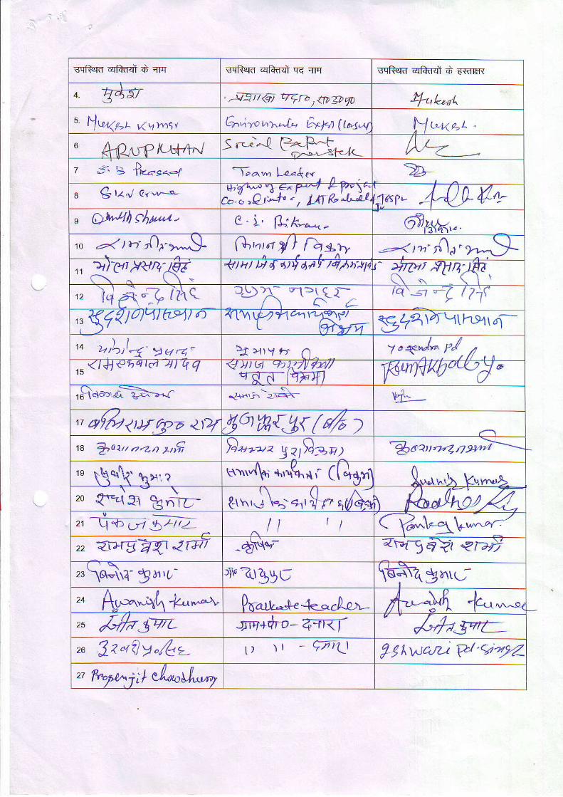
cqRel{ qRflql d rrq sqfuIf, qk4J q< q sqRerd qhf,ql d E-wrR
" gdTt , .J4i9i7<q qlF> ) <tv1DlD 4"t -t
5 \lru,,gt 4vwst Griwr"x^I- E*ba (t^<-V Ylr"uot
6 Art2'r.rPlt-$rtr"J /)j-=-/ v-. > IE-.ae<-l
'-I-"^-, lz.f ,. , ^
a G t<'.,t c<*o- J1"3i:F-7ih-B"',ii'{q- 4-Q} trt4-" AwiltcL&La, O " \ , n . t ", ._ th. ^,-t-,.< - 9r,,.!k,"to a1 )d 4,f->*^)l. G,.'^o d l"la,*1t -rz'r0;'2r.....!L1' RP?v&Ki <l)1t u { 6t, dr1, ,/4/h'44 {':*une|a', l.r'd {t iz\cr "J)A ",Xr; tQ'-st -( | 7 t\ '
,i$4"1)0lzttts'tt o .{ t\\V41-1@,\1/F.\f/t \+rffi gl4ta\\hxt4-
,o >, \ ,1-1.y124. ]1 :-l.1 rr 6 j,<4'" pl. /$ < 1 4 1 < ' 1 ) "
t . 4 1 l L l g <Jv)q JiTy *y/qn-6-ltrFrIl :f<watwry/"ro9'oa a-E-,-r .jr*,;-.2,r$- t,r1.
r qffu<ty4>z qrT9qw{3{(4 )rc fuat,r.z-zn stfi Dzozoz yzt}gs;
'$r zv .t-7 4 9+-i
'n \\q\t \",r ut."{sL +,"1(1; ([dq1,1r[',.rt\ kqv^,8
zo {='9t t"+D- t-tr",''!\-- "-'' ! rt '/E \ (&d{&/Z_ : - - - - -
21 tl -o o1 3),t-tt2_ ^l l 11 Cfr*"1to,,-'-.'
,, 4zrgwtarTv -A\lo'- 4v4elt <r>i
zl\of\A- ga,{,- , iv?bgt \+sfr-qE^,.;-Pn-^**+" -{<-.La;'- A.'^U -l
// l t Ic.r n"--or
," {7fo3-4L JTq+Ero- 4Jr< I ,{.fu5"t:-,u Jzafly.ft2, t) \t - q-,' \.t ?jtwa,il C'q.f"-z ?,..ptnjtl el^"Ll*",
9o,4sihTn^rc,'-,-
k; ka5. c,,.-v-
?"d/ga^e!_
Lyw)L-V*. V"^,h 1tQ-'0.-21dl;" trn** /;,"") 1ge-i /^,- ',- lz,.*" - rn -*() z,)
?-1.2/t / I v' ./ \ -1-e , f'+ff ( r,#e\ /11wttt-4^*'
3tp\-1,\lt \*trrl"livarS< ) -rrat-9E41i
I1( t \ t (6e\ -. C! -
dnle ( dw.@$\-\\ \3 z-
AA1\\r\\1:o Xo t'dlt=- /.". qA V\.1 J1 t_ ^
n o t { l4))'r12'tYL Ig, -111 ,-.X) /ff "tt t v ag(,Nlg_
?1jF.;-+r$t +rVl in{?fi 6l tet }l'dlTql Vl n-h +rt".llHt'll
?-t c .r^\€1 I\ 1- \.r^ {/ . .* vl{ v. l \9( l*1 zr,_<. t ; \4 _\ \21.rr l
3frs-F-{rz- .IN9-Z- arfrr gqry6-
2$- zu zrait r*\'q -g ?-r>,i-,<Jqe<.t16aq -=-r;e6<=63 4-t tc/ t Yll-/td(F\ i-r -r--g-1 -afr"f"\ {1qi \L-tdt(
fi q-rv ̂ ttrI d-{d I Z I, 7t c4(Uqk1
@t; *;r,.'"( r\9 &(c {^Ft- qllr)ay e .1 )4 Y,att l /4t ,
<-- ' / , ,a" -
rlta kltd n,'q- qT\?-(.-- aa/.'l 4.&/', / >14/
' r - \ \ rJ \c1 3" w L o-\\pi-a \5r.- <\l',1 1 -3r",6CtZ_
Z\\ r idr-9 :3t{l 9 a lJ t <( - <s1ll 't -r
I t 'A th,7-
( 3)J/ \1 lbz @4f/c3L <J9,/7 \ lo3
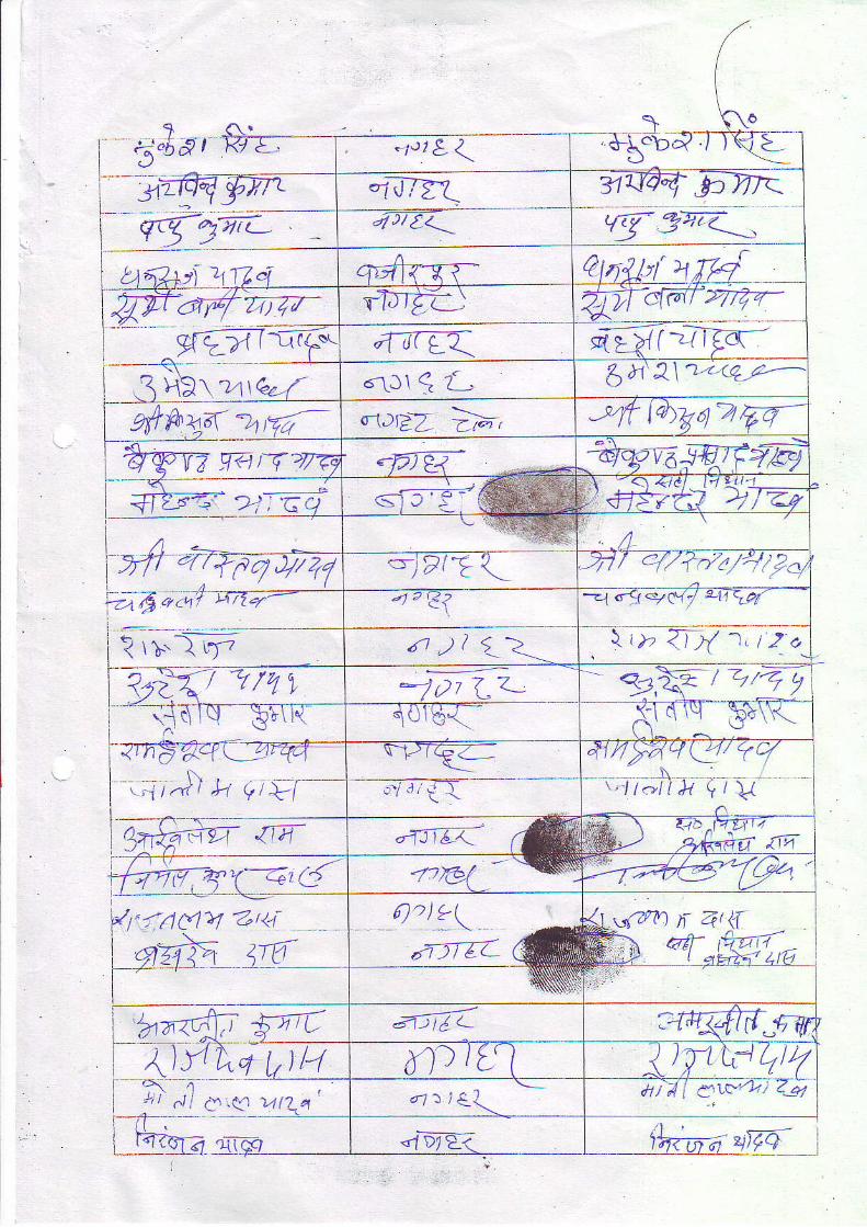
5'o
ba, *1.)r&<' ) ,1J !
.iil7zA 7t1J4E bV7<qr-g 9A-rt- ^ 4)/t. v{37,"< _-,
\A9 l n I Lq q4{-{7- latpttt:d -,
-6F7z4Vt-
g€ril-@rD-BL\ WIY:!3:"--o-1 tjr L< qlflrzlo---.lHrri
"-\J1 q {- 6t1'j-\14'q,F-
prttuyd zna- o'r,Cp2 l;;, ltbgorFnqWW getnvTe 'Fl*- 6.,,.,,t,,,'d'a &-garza.qF+@
' i 2: Gq =€w\ - <l <?ci t ,1Yt I'#s-/fJ l izq
A0 . , \
>fr.{qFqJV/ ,-j?i E L -V1/ Ql:fzr-4/2<:t4 " i , f ?
--1"1-tC1/ 41.raf
rt l1 t_2-.,_ \ t )" 7aX 1, t2_a
?2{r itzTX a)7 LZ- e,ril1,27=-rjslq-EETr{01s{ <-1 d lcJ C*\\l
- \ \ ' i Y - " \ --4rnEacl(3r@-
N, , ,1 tzn r ,H {7/ \ - l
\12{(€_a_ 414ryv/!7o-/.ri{a t , - l to l1,k ! /V
7@ {T4- .1i162- al F:--t1,1c ̂a'rzj I I;2,1<cA6 rrrl
Q)ns;qr"-<id z'E{ ---N ry?e"T9b
'1t{r1(>/ 4r<iqzh4 {6
wQ'n f 4li "q-"r7lz-.- fu
:,.;:':'''
'r1T4fri {n AJTEI :aa4fit-wTtyryqDq
--7nt1!fl u4Er?
' i , a"l e.< ,,L^' - l : l € \ ai;/i ewa; aLi
<5t&&ra "r- l64iqle l
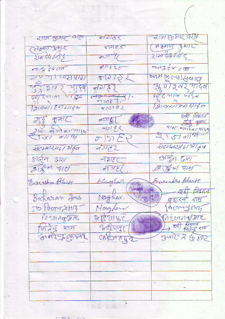
;{1v'zrnT
-rt$u-qra-><rtia /"ty;Z-fqutr
d-/ J16 <---ai cl ?h >'/ a
4-. ,7ai7-4__ -rfrEqvry.'
4t 2/ { ?__ - 'Fdnz ry-s-1riQ{ q^
\t"q)+o'q:-t.-:: 6\ .-o -
-
>) o ' - ' . . "{J16 I, ! \ 40 / \.,t<r tQcl-Etrffiatn fi>}""++{4 l^'t >ov--t.'
F f7/ 'r1 | ri \. /5,.J
2 _,'-\_-_,tc /J/ ) Z. ' / 2/ /1." s-/.11 e Z i/9 / ./ 2// F 6) z/'/1..,
dPE( A e w l4z1T7.re- lt zz,'ii,-
Pl l i " .+ >( \ 6 . t1 "4 t1 t ,-lt r {.<,
-}@; d z,*r.-jffo,17q
, - . ) ) ) A\t J \ ''.J a) ) 'rr-
4.ra<ro/ 'rJ7{} .rt.2,/-/<!///2/,fq
?-]ar+ 44- 1at <_ 3dn Aef->rt- Eif frtt7 .Fl6*7 a4f
?..^" ""L- .&1..^t-' AJ^. *1..n .*..". " ,l c-' 4l'"",/r'f f i ' -
n -+ AaraFK;-";-D*x'-t"fu"w.;i4- "a.*
hrN-;,fi;;-
-==<I F;;-*,*---laia^;r^
%fL--U(l\ FL'+&W"*"-CrrR-*"gFt\ cn'$tg!:*- -/ 3_tti-] g=fi;
I
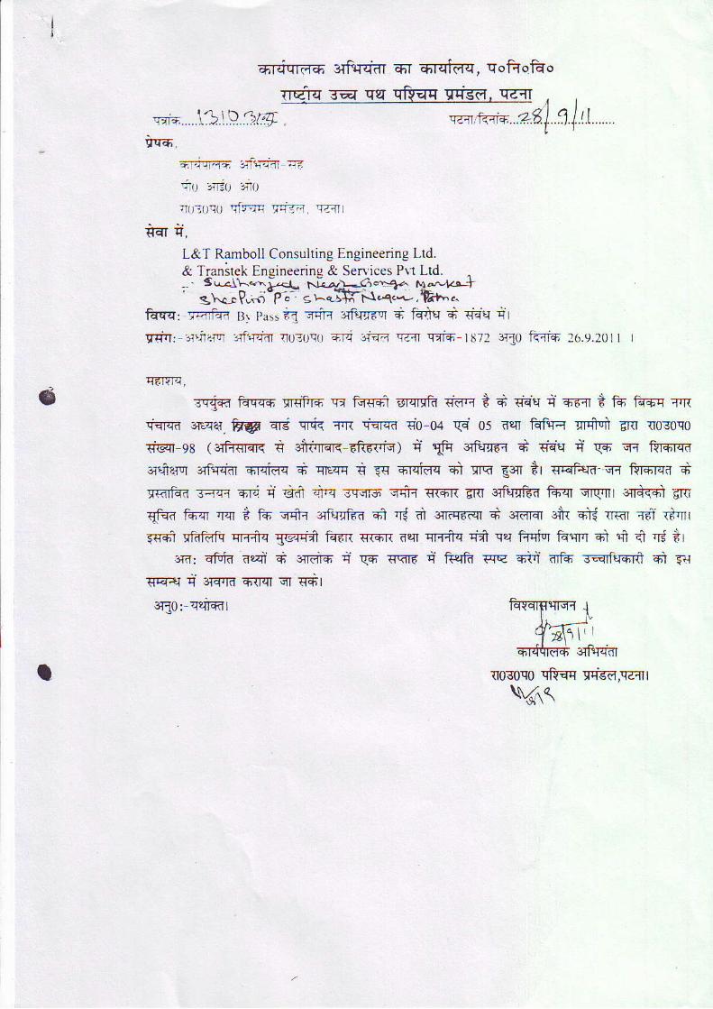
I
6
E6Fjqrd6 3Tft{q-dr 6-1 6rql"rq, qofrqfuo
rrqfq Ta qsl qr$qq qlrgd, q-lr
qrt*.....\3:D3f:9. q.-n +{'-r- 2.gl .1.1.t..1 .nr6.
iu ,tt;.0 no.t0;oq0 drrq vi=.4 val
L&T Ramboll Consulting Engineering Ltd.& Transtck Engineerine & Senices Prr Ltd. -' iffii:%*s3HflEffiJ
kqqr.rq,id4 81 passig =4-< sftrr-d'rT + ffii * qqq qt
qdq: -:r'ial'a .r{qrdr r030q{l FJi 3tril qzrr qiis t872 3T{0 kfls 26.9.20
TdTYrq,
iTifi fqq-{{ }rffiF6 !:r ffi Ercrcfr {dq * + eHq q 66{ + tfi fu+-q r.rrrcrcd 3rce1. FgF srd cFi< TrR rqFr( €0 04 g4 05 nqr frFrl grffi 6RI {osoqo{Eqr-9E ( rifr{|qK € 3i-t rcTE 6RF{'rq) d lffu sTft.ia{ + Tist { qs q{ F{rfrfi3r1ierur 3rFqq-dr Ercidc + qsqq * Eq Frqif,q 4i crq €q il sqft,16- qq fsFrqa 6TRTi+d -{q{ 6Rt n €-,n *q sq-':m q4r+ qcqn enr erF+qi€fr f*'q qwr e+rdi<*l amqiqd idcr *t g 15 vft orfufd-d €fl 'ri dr :*rrer d erdnr +r etd nr<r rd r*'ni$rd lfdftrft qrr{q 5vrrii t{6rt {rsn 6tn qpfiq rif qq Frrrirl fqqrq ei rn 4 'r.j *r
src: sFin acd * srtird q- qm <<r< i ftelfr wq +ti nf+ sqrfffi ;ni fiJgqel q 3Fa{it 6{Fn qT sFl
3rl0:-qeTFkTl
{030c0 qfrsq si,{d,q?,-ll t\.,,".r(
a
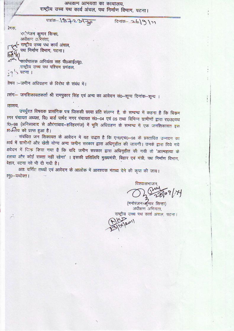
ft-{r6 D-t\) \11
r.-..5rffr eqR ftitT,
sMqIgI 3IFffdI 6'r iD'TqTFrq.qSq sa cer o,rd aTTd. q?r ffiTr ftfiq. qsrr 1
rrdls-r:+z-t\E5-
oltffsq c;kr.-r+ **fr rq u.r ord cr+q,...j'.i qlT Ffqfur frqr.r, qc+ thdt,t"ta
\:nnfqmo elFlliar 116 Soa{r{oqo..tr*q sa qer qR-qq qrisE.
-'
, r r i qa+r
aqq :-rilft{ srfuq-r"r d ftiv 6 qEo g '
Nq:- qqffi 4 qqgon Ria gi are 6r sn+fi $o-rfq ftaio_rp r
]FICIq,scgsr frqq-6' sRiFrfi qa M nrqr cFd Tid.r t. d eq+r d o-a1 6 16 tr*,
fir qqrqfi ctqeT, fro sd qlf{ qrR fqErd {o--oa G os dpr ftftq qrffni EI{I tr0gogsrio-1e (oferare i sfr,nqn-ER-6{'iq) { $ orfurdvr d sq+r il \16 s-rRrorrrd a{FT.-llvTq OI qrq E3 E I
. Fdfud qi Rr6rq-d $ 3Trnfi q zn s-€d t f6 qcoqao-sg d nranff.a .r,nqq orFrd q Tr,f ii sir dff +'q 3rq qfr{ q{fiR gnr qWd d om,ff r s-{d 6Rr fid ,rd{rd-q.r C F," fr-qr :rqT d fu qR G+{ irriFrt E:Rr qwd qn Js n} ,qTiq-Fdr dra.'Et sic 6X sr€r r-ff atrlr I E:q-61 cftftfr gca{i. fierr € 'i*. qrT fuEr ia.,Trrr.l-rn. qa+ ol fi di rO t r
eTd qFlij eal \rq s{r+fi d s{r6F6 { 3{rar{6 Cdq +} d q-n e1 nn-q Iqo-uui-m t
farqrsq-*o.
'O\ffi't1a(r+ruqqqR frEr1
3ltffer"r Gfi{im.rr$q ra qer 6d 3t?'a. q--{ I
{qt- ii. (3e)..,'!ri'r '>,.:ll ?-^vT =rft-r,iii €] _.',4- ^
V
\ , - w<€|-v =;\Tf I s$r qlh(r<
i-cD)-' u;uir+ (,"t'rys6 I fi<\.r t, **, +
1e-1.''t <rft..r ++6a X A x_<, si_iq+ q; 1**tccar*n:\_ rizrf A_rN t r+r"__r=*^tg{S*Tl,€,f'Dr @o Fffit. lr,nr-$" +t__g_
_,;it-, ̂ t E-' ^ ,-- . E-Frrtrl- t'tn- t\ A <r-c\;,.
r r \ f l t - ) - l : + - r . F _.;1qrir ig'/.i, 1'\ ,f-us t "--it SCr X :jrri f f A-tAil >' / -=a-_) \ J
Rii[j)-rrt.-l <T<t-B-( t+rt- *rr.i- d -"1,rri-r rrsar )-:,1 l,, r ^ |.
-:')'"' P,lgrr- FG-vs ET *;frur ga'.r n\ At-rtt"l<'<--a-rr > F-<qu\- -rrS.rr u-d Krir\ 6.t=ie
'*
,- lEf, i6-)lr | 1i\-,i\' +I Sr\-rr t-t 5-rt -Qrtf
\ ( ' . . I t . r lr\rlJ 61 K Jf qirrt 3r..rr-l el{lri i .713t;t;t 't fdi
9{""'\ rr.i' I i-TyF*-ri- -fii <-ar{i Ftk ;nTq t\ <fl1+\ '
- -a.,t-'
a) 5" : B-rr$r H--r rT -}i (trF1\rl ;1 plti tl.<'n ,./'roh;qq=r\ gcr 3ftffi,r' fi--r >Tn\- \ <r,o S-
"" 'fit)=-
"s..atff '-*;1-.sfri -zrr{i - Tr}15o.,-r oL{Av, , *:r€ }i.'r- =\-}.,'.,', -i,,,,, S.oror,sr; a-r>itti- Ir'.Tft; \ i-!.* i An, T+:<-rrt)( FKl t-$- iltr.l.r ;-Jro A\-oA lraT'd caQr:rNr +il- 5r=1\1 I <.or ti >iefi r<z-\ \ l \ r A \ a C) +,Fa tr ;rr,*' -\ i' ,. , ,r- 'lr - ' ,r . . Jri.rlo' , ' . \ Ar,\, u' u\ {F, -,- ,

TTrlrf {.di R.rf} }' ei.a e {ih.,r.t*-; |, \rq s,,$ *':\"r rlr; dri-tr =-rh.t d-.tr t . fiiqqe =r-,'u\;r
rr-.}r\'. qq Sk+ )\ a d J, .}-(
aTl. -5J<ga-r-)^
:I .c
7-{.\i .3\-ir' .t{nn _ o,,1-., Fl <\ X.r)rsrr rr-r ; r n-n\h a\ f,r6-di + {rA
FFIXAt,,''i c Tri <ra"ri< ) gr : <_4 o <<, o q+ fo+n €r"{R- k t*i fr.a r <Fl (rr'-]:a-rr' -{r(rr .lGl} \ t (
-<-J-4r< Fr, irr'6j -{u\,rt
"- .sr}in a\ aF.rFi\^ ;.i;"t , \ r!n\ <lij E Ih_{j}tzt, drri ir d .F;
.rT-q -e-ra\-y A " +rf.-tlISr i
-rF 4;-rarz \ c'r (il'-<rl- gin 4.fi '}trr r4-Nt
" ,, T*t <-A ) -P.*u, n'ill, T,l/
'ffi 6rrr Er&" l €l,F-, ' T"'l* it-r-4 rJ irrr,(r ih\,i_.rlr,i_r A.,,); t # Sfi g,
-14- tr 6c- e r !F-N wri- +€r -<T\ ?( l
A.\=t a<-\?rFqe7= ,brn
F_G.rarrr-, _r3tA t\ -tdr-Tfi:f,a- <iar,lf -?,(r *r--Er
L,tr v <TTr )T\ t) |
<ii- a\
d- . 4 l ( ' ) l . l
*rr r \ ) l \ . i
frt n-t .-rf,Itr >li
a0r.;r I r'7c-' (\flttt
'.ia
<fr < 2,7
+r ( t
l-Dti a l l
e; +t{
ar\
3-ll-cr -.1 I
tt r:u E'.r r {r,w--,-7trcr
$c,ii +i-5h' *' ', .1[r"jf.' 'r',,.) afra<"4
'Dltr
lASi -lr
f\' "(] c'
.=n ilr.r -
C'*t o
Io(| ,,)
\_,.- rA,r , - . i l - t
,
('ll <+\ F 1 €l-4r< +t ,rts fi-rt )*,r,, jF-,r;'rfli}r , .a+Aa+ {"= .;=-fi<.rzf- t; l
(-r r' ?4 t 1r , d *-e l, + €r fi ,.x!.'rt6fr-.1( + ++( tflr.r, X L-.
l-\.' \ ,\6\iir )' /S? *ye,r,,.;rra X to
J-5"arr-er> ;} {.(- -a;q;1 (?l*,\r\ ) "5r A"f ".Ta.ri-lr *t,' <\ *\ nian_rr2 S-q d.5*'$'-. ;+,. + ,
'.IYTX : <rirr,r- 4it-J R-{
1\i Far-rar + 4v, t}1 r- X A ._*\) t"ft- * -LirF h' {..qts E? ...=r,-il<f
$-S;," -*+ e n.A,)rrl, ;i,\.,-l-n d\ <*t* farrr- .-.ir( r. A a".rt!..'r.r4 _ iirq-i- A\ <;Tn,A <\^ .Ft <t
1-",'o ea-dr-)i
^ ), -ylg -jir- F orT aT .?iorr.rr H <r<Ar -_&^ <Ilrr I-rrsia1ll',
En\ ,A* r,+ -ri< q-r\rgar {n,I- ;d q,
Frri r\ ..i\ ( IrFSft _I e+"r3$ plsn . ,- _-. iT i=.-.{.
r\ "- ' \ ^ .* (t) fr- l t i , i 7Vtti l .r"r ea?/)hivirlS
fi,2 '-\ ' r. (J I -,r '-] i- i , \ (
i (3/ <rrt-.Trfr:rtr t rJl i ' i
. ,\ o. .r zrha;' tfrn -' ' >] ) I ) 'l t'r\ t'(1'1 -
TTftJ*at -nz7;71{-ztZl_ *- ".)= 1-,:;.Ta\-hrs zrrr dq,2re :K'"t-
- a* ,;;r;=
rr lz el i4 l4 '
D6-4 .=E ; :{
F6#ryt
i ,f '0 nii.*gs,Q'Or)
=^i-s +,n,r.j) n*':.ri1-ri'.1-pi-
9 "t€q ?*i7j1
P rg:y='..(5\^<n3 BurI-
zat<5qt41.l4 /
31 .<j;t\ s\r(. o \ ,
21. d. twq , , , -| ' | ,1 <c+ \ > n| )
1- !@'r"-;4;/'!\ <;iT551;', g.e-.
OW i) ,",n a;natpEtrra("n{. ' ,/ SeNv a,*r
'
B l;Brx; l<+ryf9- u:?+;:"--#;/e:'#--
,(ry <aerd ,-Em,-'1rsf iry"7 qs, -
trsl ffi,o riU'l ---*qir}-
lv.ty(htzv*/@+.*/a RcU! <\$--.t-*\( 'J..T-
E^6>\' (4t )
ly( rro,. )\ - : -
( r?-/ k,,,._Vpg' ert !t"--,o+- ysa,"-,
W"ti"*- 1",.-PtiJ.e kurrlqi
Qr.. orl v e.z*.^ar^
1'5T .:E +r\Q - \ . .
Do/q -,*-,..;
j / , l1rb)^ \1-\ ! t I |
(.r ' ) .rr : \e1 ,6,,) ' -=-
1.{? J -
ii ;Fi"*yFWl d72-i,, z,25' J +',o' .t^*-
. l . 1
2t) +fi+t )i-at{/ r1"*'a'q fT,84 9,r1.'i 4.',*,
--
*! *- , ,4 t Ce;/
(3a l 'L^ l l -^.t .* ( , .^_,..
v QtlJejE -__:-
Kfrr "+-:fiT. i _ .
_ , . , ' : 1 r l a l f t } l ,' 1 4 |=_J ?,r , \ -r i @-\,, (
€9 v-r"-?, {rrip4r-.fu.a=+r ,,.r i)
, / / ' -
.' ' -'jrflil ^2r!1-
| "/ :+\ tll'g' , I I ri -
;" .tlt $rtrtr" flr-x.fl"irT-]a_- -^::- -- \-r/-Rt )) l.?.7)9triF {nr< +fll.-5; lgi-l',-_ 94.*oi &"^fi-?.E-yi;t-
.FFfo.l- ila._€&*_, q$-', =,---ryi l.rnEe
kqL+c
S+-'.-,qif ' \
IE-gsrR_
*bJ!d.e4 ?>q\^d\
{ iu 5.JiT-rr;-:r e- a l '
a €trT_iw.
qfi-=_.i-o \ \ t t ( . \ \
\ -
?- \\\)c.. ,-.-s-'< .d ta,}.ra)=i.i'cl
( ' t t 71r ogl 47-
J1<(7-g 2n , ( _
Wla - a - ' t Ah l -
E aLah h K(/. /,Uh--5 in n,gl-v.€ € f.tJ-r - Vot.^1f ) -
X* r,.'r--or s hqr),^q.
OtY\4 4 S t zr-.-a-_ ,.-.,
l8n, .'\*n,' Jt4>-
Je/ lr k.Yl. A.,lt^
fzrty2 ^:tr "*iilia5sr*hL
:1-7 4{/:!/s4
v/t/44.,,F
$3"."\o''
c\L1 .1 rO r i rq qa'D;e---12,;frVa;r\ na+^'$F-v-I Jiil\'A
ifif'l1,tt 1>511;. <) g1 d{
Ll:i1-7-4
J \ " ' C{
lTElTr
+,-q'. '
a\qT
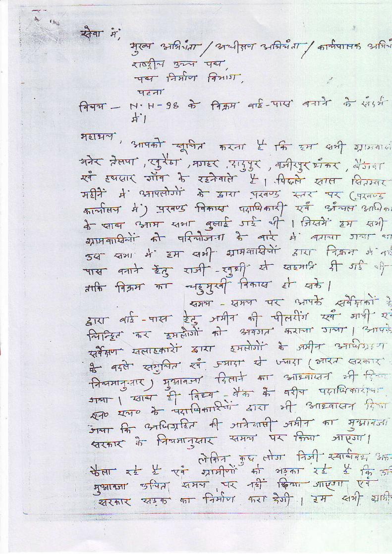
A$-
l \ ^ 'q-ef 'rati.ref / q.4i$"f itt;+--4 JT-/ 61+.srFn1 aal'!\J ' /1tar-"\=i .t=;: -qaz-
r , - ; t J
nq- tinr4 |i>ttsT-,
T.-f t.N' H- 9c * g5;1 q# - \1q 4 l r : f 'n- <a+x'
rtI
{{q-r ' **{.qq, 'F{ar r {r z'q' <a,if x!t.,:<t"',€< +nqf ,<3{*l',**< ,rgj1 ,+j]rTq+-{,ll;.,r.<i- eq-".t .riif 1; <zffir*y- r .# <'.e- #'-<a-t} *' qalre)+i *- r.<r --ira-zi -€<- r< Lr.oog-
*-.ca.rq- .triE- {dcrr {=r* ,-ts "t f #<a* err €'tA-.qre- .bTiE- <4crr E** ,-F "t f #<a* vr <,7n ^
T-.TT t_^ 4+ A' qrr"lT Jr^;r' 'rfi5/\nT'\t{-.Jir 6r qqa=
<u'q' - {'l"r' q{.
gnr +!- -'irq-.
ftFE?^ 'q< E"ti.+-17T; =i-e,=n-ii- rrrr {F#i h- '{+'z'. s:'E":-r'
. . _ tt+rEf d- tJ-ir,-<f | -rtrI7- +1" --, . ,..*- q-<tr-' <Tfii?- q{ t:'1', < "-'l_:- (\ ( -
T- t* -* -{.'d"''q;;
a'tt ;fr '+rtzmc"-4 ri):;'.
'i-- e,. a;|uf{{ {'i ,"}'- rftz' ^r q-'tr4't+i
q{6T{ i]- $-nrazr< =l- q<- t$-r 'r'F rl
&Fa- Tc +,'- ffi-qa1$-''4 ;6"*sr- <+ Y "+ +nn-i;^- '- .e-rr <1, Y {i; -si
S<nrvr -j{+ii *"a , y< {4- S-'r ts.i ,f,i_'- -J ' \ ' t ' \ n-'{6r< qrgrs- q'n- tid-'r q-'IT f | 74" 4141 qir'

f ;,;.r -;rr' q-J - Ti{rr i' ,r=,' :--- t F-pttc;i,' ! \ \ ,
,Taar t--rq"- /
" - i , ,,'"1 Nlw t r, qarT at4 t''t"rJq F +t I 7. o- a"f_s;-"ii4 orA-,-.=-
"?+ t= Xi * + <'+l * 1t+o,!T;.a-fl' F1- >ij ttrT ,aff aq-'-r- r<.i z€j, ,q++ .$- fi-. '.,rq-,r ,l- IE+-7- qt. ...e' .,..1 --n-+,-
fl- ,hts / <"T f a-rr,n.-;n 4;t- 7{1v1-1- f?ntr I+ ''Lr-r /-r:ri+i< i+# '..q- I
'*w*t fl-^- *n n
"6fr't - rryr--r #--9- qfiq ,-r;7r
"FTT1 lV trrrr =r*-< 3\.i.:a,TiTi,-7iii." (1_, -rq- #rq" +4-, z{r,f ur6i4 /
. . . i ,'F "' \ qr'^q, (' ?+++4---.q. .zr'}g .*,qi>.5---.
Jyn+ril a1- .41v-d/14 4t t I .Fr llt71- r'
l,/"t i -
| ).t e',,=- -/1, .
).4-fi-1
):/i.t ,i ,t t, . '.
111-1 crtr !i hsl I i ( ir <l.o-i.-," F( o-
Ii!
tf-".' *)
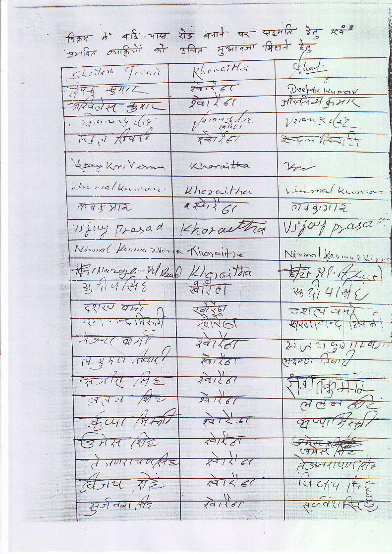
. -J,- *trf-5f- , ' {11 - Yr<1
Jvrfru Fr,A# 4+
t a....- --iJ*T dT*- T{ aTEq- z{ <4"
! \
3€?- {qlz?r -qerr T
-' |1,,,-; / , ' t 1, . , ' .1
-,1:F7 -gzz.-(."' ' ';rf ' ' 1t.z;!_
r.r\'€ i.11.. l{'5rr<,-'.?r/waR'577=_ Pqt/ ' {(--.->---.---:---7'.=
, ) .? i.1 -4 ^t_9 L(! ? I , . r tc , - . :< t (4 :_
;^_/ \.t frtr| / T4774 4 " ,_ t -<={ l_
'A,t'.--- ir,r, V .,.,,_---, t O^a-..-l f*<r ,T4-_-_-,
\ i . t < , , , . 2 [ k . . , , t . - - . , k )c a .-i"t)...' 1 ,-1,t.r l /<... , , ,-- -
'v-dr-TT,' ,4>7{2" inTdn{/) i t , / h-a+a a Fy'r"z VLrt X Dr"4o
'
t.t", ,,-( k,, ,,.. ,-v, - 1.. -i1\o.l..1,1_1.-Ntt- ' . , , . I kn 1., ." , * , . ,
ffirtu',--g4, lt/fu) /1/*yc*;Jf* W nf ,/:.2,,,'i4\ 'i t'{ Ll /'e1 ia 6d"1- v 1111 4l'c1 9t<@ u4 t . T , l r
Y\R' q{7g--/ r/- /; {1
- . - ! i ,1 <1J/.C:
..J-r\\6\.,1-u-1.( @ )/ (.../n .4,2 / ta7 4 ) A L t c : : r d
(',/J ' tl ,o.<'t/{ /. . 1 , a
refi--zz:T
-4r )r t < ,/f/ 2'L
<. r . /16(-:. \t wIt*-E,1.t t< d r
\ \ l
--tu1 ( ,/7rrLd'/r-- t
{ z+ t <_ .4 t
r ( r -I
-t3 H ,11 (1/...--\ . 4 L
\ l > !u /1t 4 u(1< ' l E-, . / \ ' - l
<'i J <' (f
,C l ) . " |4 . /z -
c - z'/
<q t< <( 11 .y''Ll ITTA 4-./ \/ hS y/
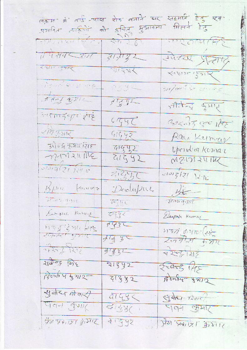
A ' 1.-rS -"'Zt a'
;';lr '-1-';1' q+fr - \ l .f r -4
o\- oolr qc
<fia- ,-rt'tr 2 f .
<4-rzI'F=-
-srr rG .5
, Is \
trrri./r , L.;{a
llt ,i, \i ",---, il \
'?-l-\1 e\\ l l\L
.L,-.' 1'tL. f.."" J_
:...1 \
-. i- l -
-r , i '.--U_;lvi,
<'\ \1)\- ,1.- iR-' \
/ T7-J J ___
q\ /, l-zi. r 1 )-...r1
l ferr{..r; /((, ),\a L
c4 Zl)1 r \n
r t ) )q jZ t \ t ,- / L
9"+". ,-*,rl ? !-
{'lrtL: t,1;-
l:t
I .r,t:-
?t9 t)_ t
Irtg ! r_
- - ; -c i r ! r 1 \t7l t71:
c \tt
?r1( I
- )' 2,,,-J
i l ,, , 1 t c s . \ t t / L t L -
tt.r'-t
lJ)a> r:t Y 5'ru t-
.;,!4(1i) ) t /
' i ' . i Y? '/r1 2 |
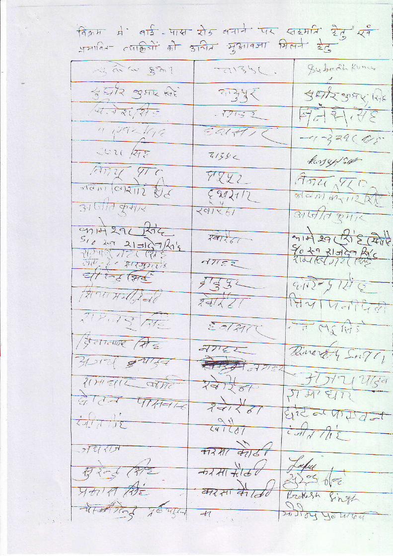
f i4irr o\' q#-ql€- a\r "z,J- -.rc
-.1*,tGr- .fi€;;' ai?;7" 'arn-m
.,-'-{, 1Fl - - - '
, | / , ) . t ; " i ' / / , ;
(- ) r . ' . ' .
^.1'i +4;'"i-14 H --r t('
g9A-3',--1 r.,-
7 - ' .1 i - \ , r ' .Cl " i \ . .
---t ^l ?4 (. 4>t-. '
&.4942t'rz-
r l , . , , I . l r . , , ' . - -
-rcihZr--:
1 / ' l ") tt ' l - ,
rt-\ i1 ^-'/
, \ \ , r \ i
Q;,,1@1 ,-.,17_7_,
L2-/- { ,a:,
(
t
il q? t7il
)F t('-;
'--\-
-:, c.- .-- \"1' j
' j, l1
z /j /' <_
'/' '/ ttr )-.r .,. ,, r ic..){ t / j
1 l l t l r - | i . l r , :
.z.l t.\ )sr r +r rl--i\-1
<ol I 'r tl
.lrT;--t'
t Ji J <--..-_.
'? | a, -1 /---a-. , / \' =-
4212</ .- : ,(- : .( E
Ir t;;n@-
L"t rlj j
'!:I:!,-'-
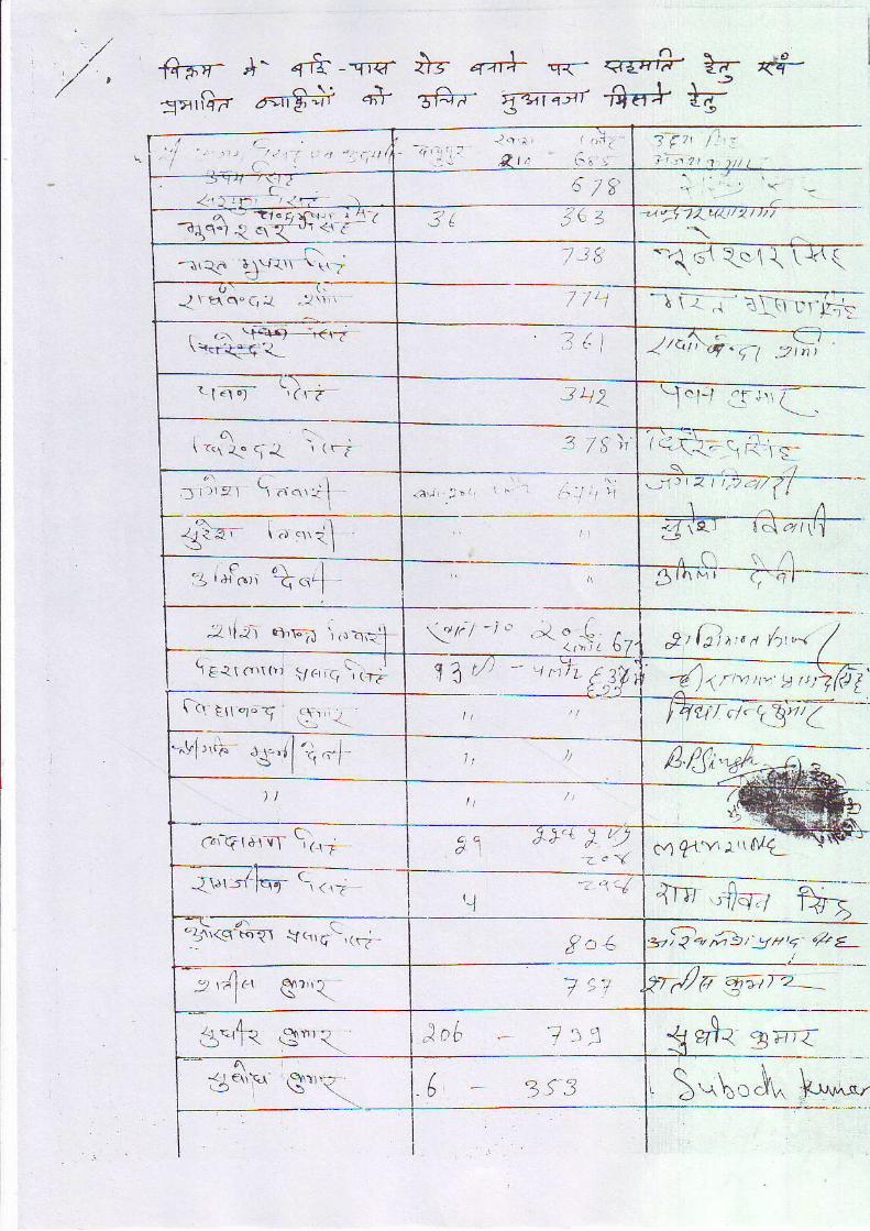
< ' i r
-r"1i.ii-1,
\i 1-\\11ri\7
{ \ t1c\" a, ! . : r \ r 1
r ?-\ \t{+{:H^-?:i . .ct{*J,{
. 1 :19 r ' ) , I
. ' , /sl i
.3 , ' r ' : , c . . . . ' 1l
I4
:j'le' \ a ",,.--j
1t'r :/-fcrn c, 1,;
1+\<es";rl \q\.,-!-, (rz -
\ -< ' p11 "1" j
.tli:'"91,'r;:, 1 q.
t ''iJa e",{
Jof, 7:r: l3',t<
,/++aq^1r, ' {};r
+- {rtd"rl!;at'
! E-1r o,r r ' , g, , , . , i , r -1
e-rr\\-
4?-+ ?T ad--S.6+ F
\1\t, '"-a i : . . l ,r ui i : i
-// /.;t; /4 ' t1 . " t ; l )
c l-t .F ,r\ i 1-.\
/ , ; \ - - ^ , i . -
\ - \< . \ r r i l ! -
_ii_ /l__( t . l l
9' l t l , ' ' , . y ' t ' ' '^ \ 7 :
a,^.,- . ' r - r ,J, j (() !i / . / . , ' 6 t a / (
RK^
c4 flY'r tML
j-j,o/ E,
y'/A ;-*rt rz -
t $- 3 trtr
r)e 4tJ* q<-
5ft7- j14..7r
- ( : ,
< 1 € \ \ 3s'. S*\oJ* V,**,
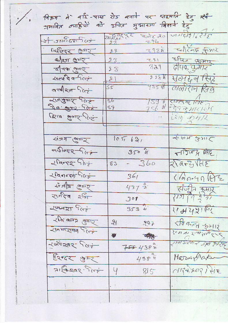
v{-.rt"Fcr"94.r,-
9 . 7
1 2 q qq ? ) d \
o-d<,r-\\.7-
.1, h'qPro g'-E\i
tof t\re\\D iaqR-*tr il-?_
-r&.r.r$-Q<-r-
137'r<.'\q a\'trr 30t
'-lf*,.pr- 9i--
r:t'i\r\q{q \,iri
- . ' _ , , . ^1,f e -1s ta
ftFs':TEIFF
+' 4-frai-{Ft
-"flla- +t <-"tl -<.4l s#p. {q-a-ar
q-:-F- :"-^ l r J
Ttrtr-r- tB-' " ' tq/ t / r ,
=-hEF.gEn4"-
1' , t i , i7- l-t)
-+ tr, )r- $.lr r q*
4€
"' n*1 Q
\/ # z/.v,fr n.a
!r{>, , t r 2 , .4 * tV7l -1a;
,|
t
!.L' L
1,
iI
14a-r{).+"---^
?/*r€e'tti\
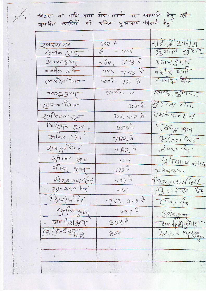
,/f+Fry- *' flt-.fl€-sa'llF 6,€+t q*
i-g q-+r| q-<-
sft;-- gr.ar{anrTra-
iffi'#-lr
ag
,A-\J
j-trrq,JEIC
e ff ir a/4/
r pt / / / t r
\4%ol^/ ?l 4( -----.
1\ q'rz
?rt.r c-l4/r)2a
n1+t-g'z-14-4n1
ctq<,1ntnllp1_r-{ ft i-rcr r\\-€
,
_C7'"t^. tlzz
4,,,lc-
fio [., J Y."
;9)n--. L__
1.4 ! -
}^t!L/ gi z 6q , 7'1A ;'s *{c a,Y-._. 313, 1 2t3 \ '
g'r"r\<-9<la- .1 , t . u , 1 te ; , '/ "
qz{T4- , ?Yr l - 3't-b t / ), /
6${'"r ' 'L\t C17 '
21fuvt"r'419-_t'q<qr e'l -7' lom. i ( t -
1bx -d l
{rllt1:1 i (r-6 1$2-nS f.,u (r q-
'"Azn. -,n (n) , / 33' cj{:' arrP ft7
\rr(tvt, ap -f q\ ,3 '1: *
. g-q-fiUr<nr-t
7-s.v.-\-
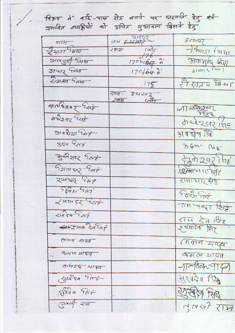
': ,/
i .,.'t , . , /
i
j
l,|
t
+Fr +' +rt-riq- +t 4"+ q<- <E *- lg- {-f-:{alf}d 6EF}i 4'} E#a. {qTryr'ffa-+ +O
i
6774" EzadT-
Q4trlrrir- lqqT t olZ- rJ_l f - t .Ul
zrr'ti4qfsuYa|- | /u 4 L4e & Brn-'.:,sr,o<Qw- t7o/6q i ' ) i v1^ \ \ \ qq I
--.\ l-=E-
f l ' f i7 rr l_s:-{f-..--
./TTd-{trryq-tl-Tr-?.=l_rffi-
dtq?_c?{ r ( rS
Z)ztgC'rq- t1TqW= Zr 2t'T-)7 ^f ..S,-.-
<ri4xrqT<.i-
a$2e{Q€"
-'o\uQ<'t
3cu Qan' bQ\" Aard1q4 eq< da_Q thE'2
Qzntsp{9ar ( \ - - - - r - t r -|Wrq irc\dz.a\-\ EraS5=--..--\-E /---*___-2 <fo2t e,-61
__-____€_=--7ln -ni7-l+7i-
( I t-l c'^_.J ltr-
a[v,ir@--
4'rriqq 9t6.79pa,.9az.
lua'9q91;
<ti:qs L;z,i
1aT=t1lcpfo'at '4t td (I14
-_ 9){(n xrqq- 6EZE* 2rTqd
qlttV4\q-
q-.._'\r<* r fl'q
wea<4r ?in-
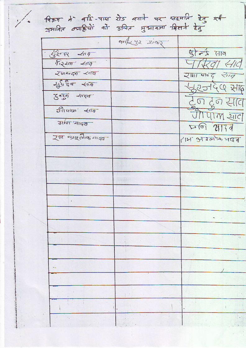
2'/ -fi-Fr- *- +fr-r'c- l}s 4"+
"-<- q-c-fi-.k- <f-
sarflir ant# e* s-6"- {q$r +a;r ry
tI
rI
9qdt,q
F|rq-:__----:--
{[ (4c,
Z--o-a qRI
1t>t- t'lrai\+ 1144
I
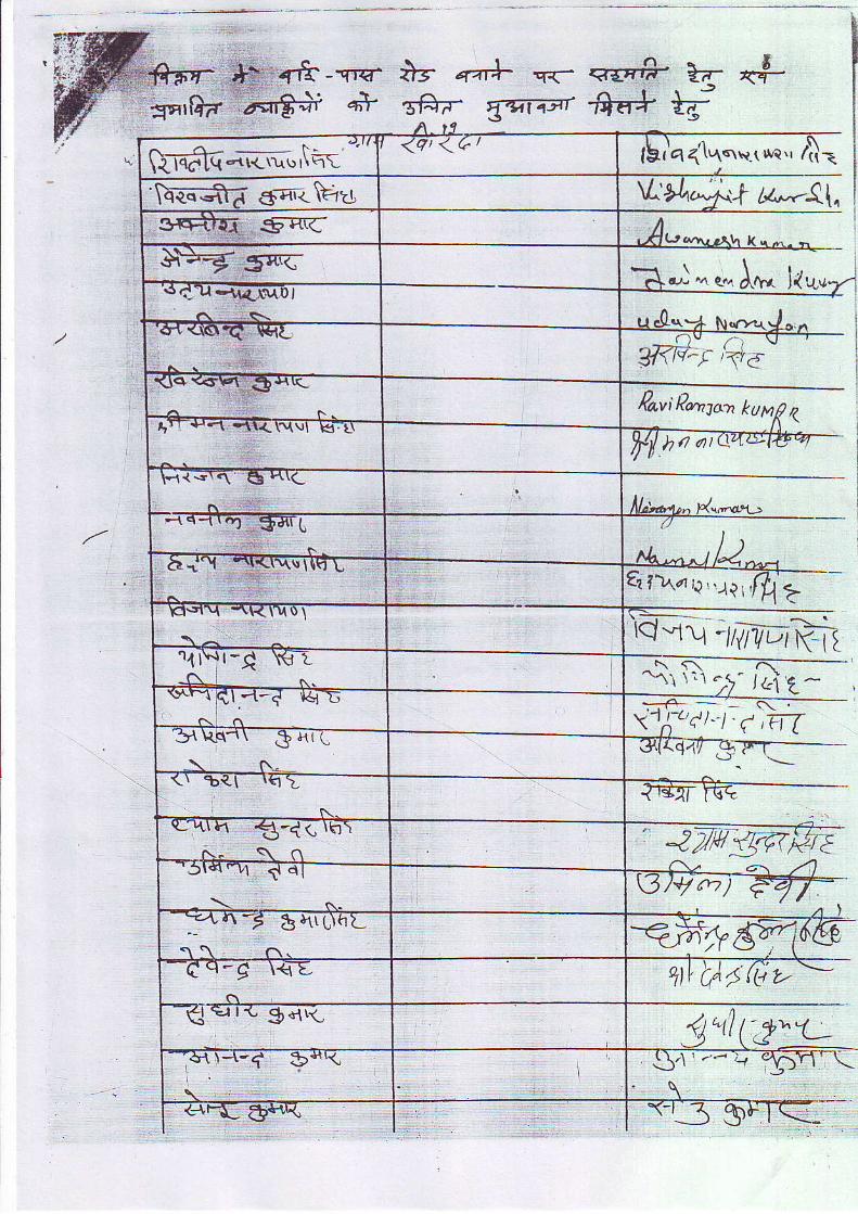
W.-#l'z^ *: 1{ "T. i: # "-' 'gqrfta 1r-i€+ q+ gFa. {qt4at
qE"+ t('.$--ff'a+ }u;
^_4- - {:-\{ lqd lq "{l<.\\' r\ t-r\-
<ct <d / tbia6lq"1",no.,41=
$-"rt<\Eu \L +q.'- r-t lz---{{.
l++g s;sc r \ ! ..+ d./. ̂ . q., d.&,r- J(U.
/ \ lu dr.\? N(>qtc.,,!
lffi:1 /1."_--
Fa,viPenltn kupt\ z
l.<{s\n G }r\c
cl .a I - qr- r \ \ t l ln L q?\,a, -.{l; 'l }..{ ?
I \ _ | )
El\tl_\ -\Kt\D\
\ ^ ^rQ-,rr-t flplq'-\-i----- -
\ \ \ r t . ! - J&i , ,u-rYr-1 t- t , . t t - - t . - ' ) ' ; -\ r 1 \ | q r r t I
- t1 r . .L \ r \ .3d l lL
-! f\*->--\r -brl \q >
N
r_ lrr 11 €-4< rtrt
*-s- \ n: _zwtTsr3)+7n7
ln^-s E )1rL\hL =fr95;-cq-q \<L +ttCA,(AL.e.irr{" gd\_ 'rl;2'-'trl l{-( ?.{(I\
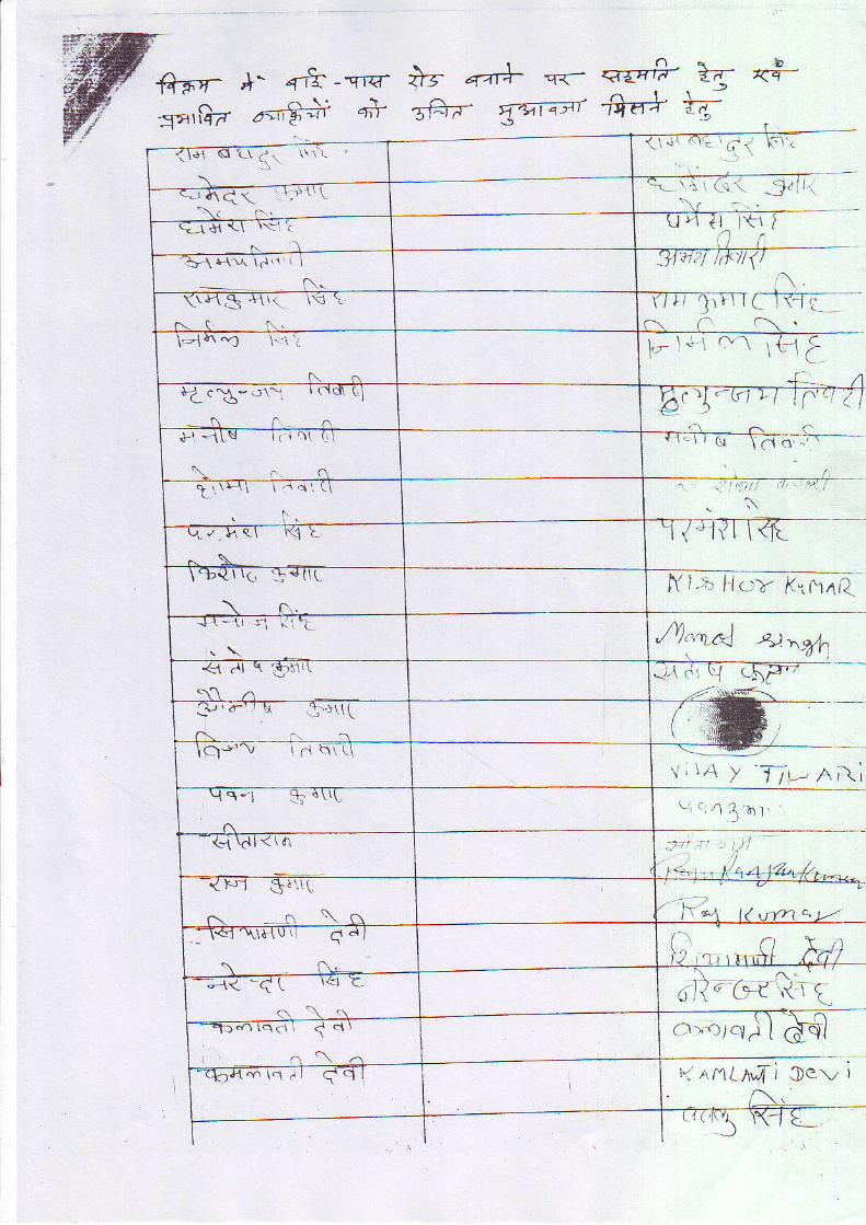
r'i. -:,1"' l
r_v \ \1,t a
r ( \
.. I 'f '.'
\
f i ' l : Nq-a t" , . ,14
/V",.vd 4nyh,w
, , , r , j y J7L_ n, \ i
oil-cvt'?r tCl.l". t7 q, flL - . / l ( / \ ' , 4 / , s v r
5
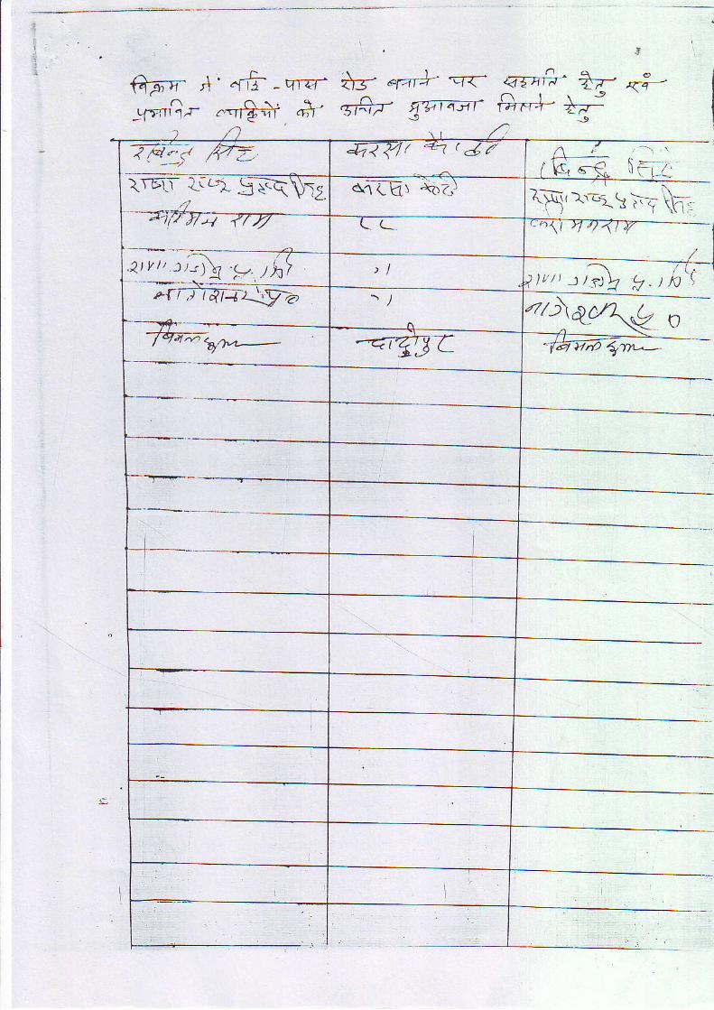
ftFT= t' .ni -ql=r:f';t'.11-
ts- "r"t+ =ra' .a5nfa' ?T *:-
^ a \ ! \g1-T {F,+nr
i-717'f tv-
t r t , :QS ,. , t
O\AC/\,C\<-&6i;--
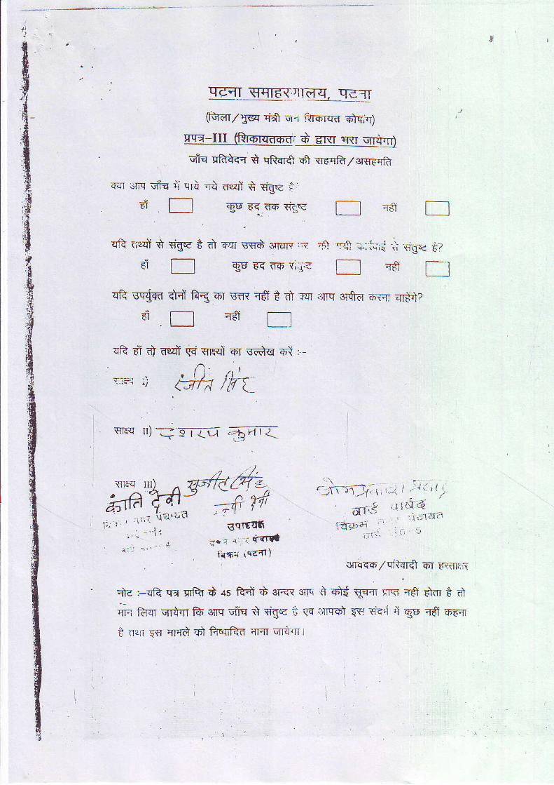
c{T :.tN
F I
qR iF{i +
dq q o,' .ri nPidf * €gq i)'.
f_l a6 EE n-6 et<
rfe;IT qqtd{rrlii-q. qgr
(fS-dr/j@ 'i* -.,ri isrf|{d Elc,-r)
r + Arrr ir{I qr$,]'r)
vfi-{ qFtt}{r Q qffi +1 {rdqft,/sr-sFqfi
FgE
Erf) P.l r.: l..ird i\ *ig-e .i?t d EqT vsg 3rtTF ,;s
e6 E{ T6 {,.i- .16J rl
TS
lint-lt, r i;l r .:'i rt
unit.1,_1,f,1".1e-+;1 .
i i l : r ' ' -€fl906
a . ra , i ' i - * r dfff-n iq6l)
qR scfcn fi 1?g or vfl T€t t d,rq orq ot fi-d 6-{rT qrit?
ia-qqfi / c1tsrfi 6.r ir\'iiti,-{
q)-d '-qR .ri cfQt S ls ftoit :i ar<r en , r\ oi$ qr* clq 'rff Eldr t' dq'o ttiqr ort n A urq cfu r] €ge t .{o irrrq+l q{r rie,l ri €e n5f aaql
i ilgx- is qmd ?F} filrft-d an, qra{ l
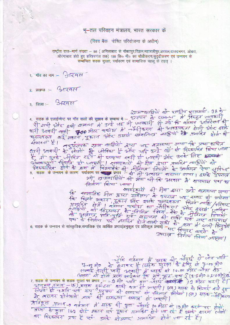
at_dd qft{6r rirrdq, q|{f, q{6]{ d
(fis4 +o qrRd cit{iiq{r d 3r$r)
Tr*q {in-cFf *qT - se (eiiwro< t ifcogr,l?fiq,q6tqfrgq,3'a{d,<ts<r,t{. 3iRr.atwerc dd g< rR'ecG no) rss fo. ff" or aiSo<'r,gEdroer cq i'q{{ t
. gEIF+Ifl lfsD g{e{, qqfu{or !-i srflfuo qrq d ofl t
'' a\ -- -1. l IT4q'T; c - ?"1{qel
2. ,Errs :- o>\ 4aFl-
A -s. fuf,r g''q e1
jr:_q$+ d- *r-ff't "-"-ft
rg&-. .{=" i "* .r*"- q{ dn dl".l d qflrs d .cF{+, q . ,iffi at
"r.f -!'jff;f!f,y4- --+ '+-. a& 6ta'Lr A' c-J t{ "ry. s'+617 +'F#
9:!i' "-' v't1*"*'M-#ffiw,#*5"+1qd6(r9. 6T aor-r ,33a-renat4 '1!- t I aF{4z6iF sx,a-.n# Blar' ?z_ 4andr. s,'riT;ey--+rtV
e+4 Ut+- *'+#; * &Gq;- y c*< ', {T T+ d a+ @ fEtEr \4rar
F '/-
F+ .AG, .t- + -"; *tt i',,*+ d+< 3"+ iiv- e@Eyyi-- ffi + .-^pfl1 I <l _,?--,i- ^+ t- srr 3.16r,".'97- * ^lft€oiraz- fr ts *t- * ht4+i + "qfu;- ffi * "rAtw *- <rfrqrs q<ih 6 \fq.Fr + nr qqFrsr Ti g
XI ,
a ,0- Z*4J17- 671 t c-,"- 1 a<4 ezSTtd
' {\ Yffi4.d; +lf+ u.,-- &' ,;qq ;;ffivr fcar vru- 1
+i +^fi"; c-- -fkl-'q A- 4-- s* qze'or aor+' W;' ' ' " '<'
2!4't t1-t 4' qa ! i :4- " 'r^4!T 4'- o'+dr
v,As; #fT"rT!g** w:: a"+.-+7"a".iy:"" $tr Gr.iqq, Z-fu- C; 4+ f'1<a833-'L'nsv-#TW;I;{;;r #;##f;{Wffi.
o ss+ d 'rqq{ + qrqft-oqqtuo \.q.rTrfd6 qqn(.rtqd * * B# #:;r{7,"<t-d llnt_ ft"r.,,rrTlT i
?.", no x*jv,*;re;ryuff {;:;{"t-* +,fr =fr ,*rqfr- A aasf atr ro,oo Ar -\t ln
Grqrr- /+ qV ,ry -+-," }o .ry-.. X-r fq lts.sfi" , t'orh)y, *1" t_o1T 9 o:1^fl'" tR rrr4..- . q qo^-nft t- ^+t,s-# \l p1", r ot=T tl'
ffiffii+'*lF q{ , l+ o:- if L.,s'ft i F.a \ 7r'z. d t t g-a ;--'++ # -#"H-ffi
X:#,ix# t cn; "P-++ilI JII*" 44-- n 6.t4-+ T--.1'€ '",#+ ,tnT a---o - {,}'i-.q-^F
ST las e* r+-,r- <- Ti .q'.,Q.r i-* ,cr 4 * 56+- .rr; l;hi..rr fti.e. qiiZ- f-ti t -t" j.\- n ---, .-r,,,?r :V ,-n +! Y t
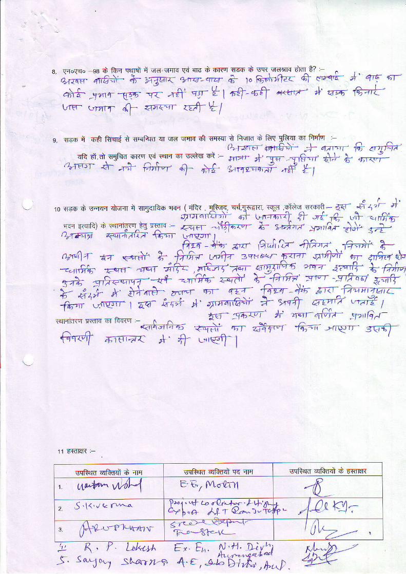
Groqao ea a fur q?nsl 4 "r4 qqrd G sTd + 6l{0r 'T-e .i sq{ u|defls nlfl *?
.).-...1 ;"#+'H xg";i'# ; +-r; c"Htl.-- A .*+ j' q,€ ql-als -yo'r nrr r<- -rfi- rc- * I "4-q4
q<trri+' *' 'aq futrm- qnrr- {l 6qqr df *l
g, qso ii irff ftmr{ t qqi+rn qr qo qmq a1 orrsr t fqqra d ftq gfuqr 4T fqq'toT :l\.rr-,Fr +.F€;:- )- qar--r' & .ttfr-'
sR d.d. qgFro on"r ld {qtl q'=I sds ot m>rr }. -W y€--rf +.+ E qr..;-''.'-r- d- * e;,-. + ;'+- t.nt-*i ri l1
'0 s*l' d' gq.Fl urr=r c flrlqdeh {ifr { rifu !Fq.?. Td TF-r lr. I-i r-{Ft - * ": "
'i S'
ir-, .l.rtr.t, r] e n-r,-')- q+ ; 4_ ,$ ",#,?.:- ".f'
. ,"q1.1 T: - zt;n -\flw-r 7- 9.Art ,r",,2; & si.4TE lv €\4i;lt/V- f6-nT- Lrrre-Jrr I
6. *+. z,t- 12,"Jr,ir -qh,r- fu V_n ̂ 1.1- €v {-+i ts -ffi7 LrA- 3sts1",.')^ rz--r qffi r 4&, i\---.6lfo -E qfl^ alqT ;f;- , o+-zf -ar- 6nTt- *' ta- 3it-{r I, FS"'A -d.'-t l--o* = niiia: z4'-.T >-"+-'< :"-T .q=""8 F;iid'.:,'.,-' t^. *rA- zftrd w qzr €qra -)}- zr;- fu
h#';.c.'-; i hA *' '.,'ana+ ? fl ,7a '-.( r,1.,1r.rif,{oT q{ E r5i t-s{or ^ ^ tr 54;rJt- h \qt- +fra- 'q-''G A'- '
<idi;+ra .+qJ.. ^ 6T 4ftTn -f;r< ̂ --nqr.r- 4.fi
ffi +roc.r ,l' fi'- -',@ I
11 FRIIR :
sqRq.d qfui d nrc sqfura qfui qE clq sqR'rd afui d amn
t. $s*b^\/LU E. €,/ iltd{Tl1 6z 5 l<'vk r"'^o l&1 ,+ . , t rOrq-* .1+ lL
*l"o }*r Q-*: ' i . - k- ol.Qt'€1'::. firL*:-?
l'-i*ztr rt- <?'(->-\ \<FlH\'-,F---{'}-+r- tl '2-,,,--'E, F,., . ^l tl. j)"'K
_r.S cr,-; ot, SLa,171-5""
E,, . N l-1 ' D)rrhiq., ,ntf;X,",tr,J _
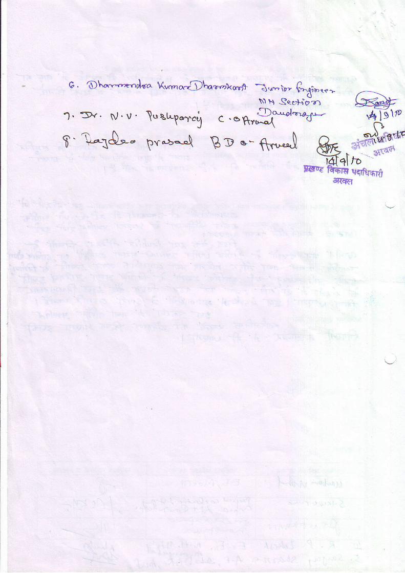
G, O\a'y"'.,e-.Jqra Xr^vno.<Dln.r,n-akqrrf - n-s)',rh \}, T,}\liblf -,
\"1 ll Sqc*o'o"zr
sqRpm qFtrd d Trq scfuId qlftFii {< qrq sqfurf, qfu{ii d 6.RlF{
4 i . l l . 0o-.-4 . '-].r:zu6n \ ., ,.4o " Y::,,.1"",1U
s' Y.I(AA Kel.ye '.rpn.".7-., la,gj
( a,,a;.1'+<( \tr<x,(
" t-1q koza-' s u\;n f$:,t z, l+r'.'-) tr -!4", r,1\, lav- v*,,,-" 1A@', 'N,< lA-ae"".a. D*^^y. fttu-/. e>">)' ziryrolpg? f wfT ar'n4 'zr\a t>^w43t//1
'" tuEBtzfti, "7 /2/ ( /t 4 /h l;9,(li
" C|L'." ---- c*1"-:1,* - 0"- (, iu_ 1,_' , "{Q 1l( b Ff <- -z#14++r\ ce_Lt <t (. A /3'" -/<*t 7 vlenf &trdt+f -Stzdar- 6ia+,-4* fr' egHa'1 q4qlq-u(1q (@*s4,qntr'' \U,t"{Bsd ,4r dtvl +:Foc/4/ta 5\(pqSX?nr +P Dr1*FI 5lY d/c*.4/c vz',, 1!l'fi/,trl6!
'WT9\fr449 Aploh /ilq7'
* t6v"4:fta V@'f Grt %nEg;4€:v-' ' <a*oot11 tIvV atrfuVr&t<Qd -.&-/q4' -U,^'?Y{l!.}C
-1 '16( \o
" 5fi6 5srt Wtr\W 3{< g\.4-U(tv\'/r.
" a-.'oJ}:-{]t *l-t4rfitf.t:"1a21. f1p .rn&)r ?.'z3 n/ f tt4rt.n a,'1.,c 4).,'t -1.,,4,+'rr h,.' '"u. w.ttt-!^ Msv,;q{b,- wTd ntr)tauwa&--"-.?nb,(<*'u ?u1a1?rq6L 4Rr mbrle- 4/4sktr4u;{1'u.,"*\
_-lq,\ o.,*,,,N\ lr* Ro.\N-*M w\.-1,\,i|,*,. AIX27
L r /'l " ,/t/ sn5 -h)4
Uaart &' fiTTr1'- h'SS"-_T]anr,t:j--( /dt -4ql9 tild-q
/-|t\t':*fl"yh
e\' 4/a 4 ' +14r'5l<r\- +r I C+) d-7' "vkt E ?(j4,)
l t /1<->, r9 |\ t ,n
o1-bt o1 -41 I rq t>c\
<) "?< q-l\'r\ r - 1L
J r cri/ {d /?T-F, ^+l d1f l41 tq' \? -t\ ct t( A /{d E
.iYr!'V^0,,^i\"$J srz n rd o .d Jr..ailJ,ll^;2 t1: .4134:V1 Lebn.1\ i- :4\7 o d1'-+t)?1 * \\\^\7\2/4|n1$;tu4 Y\-u-tt r) -*A&?DL'
+Ld2,Lz/n
+r,o AJ+*"L_,) lo,{rr-2114ul I_ \ - , ' , /
't1"1 | "7 11 fleq {r" tgq 19 <941" "?x
>11yt\ 4r'/u\ >l)' :tP\lt) bt'J/w241 'Vt4t n {(,U b4luta+i (#c,t z,trc,l 5Hl Sal;t/( e.{a{?({" 5Hl
YSI ',',s a. +ti, \d)(') ?1) </f at ) 9 c--,_\
' ! \ '
qba d"qq \a\y, \ { v,r-r- h\\q-$: ^% ji M\g\-a\hl
'i@irQf,z.t-t6 --3&a Et6tl Ttertt )&rZ F<e'A-at3;4\\all4J^<i.\q \114\61 tliwt;- F\\9il q.:FK,
bi n-)t'/)' til I ;r/Er- 1 4_srr /q2\-r1- a-\qar,t6'L7,'c.tql !tst-1 trt/q3> 3'76J2(Va/< )JQ/1.1
.t-/+/,()5 / ur<r< +/9/4 t/ t te'/\ .11d { D/ ( qdl /<\
\ t (y4 *HtA -
n)g/d1 ttt b.t3 \rqz/ ry177/1
Fx2l Ll /b?\ vt.,ztal VIA ?z /<t7tr' 421
Y-V? )t't C,)4//1./l >7) /c ,,/(
Z--a'?/ 38 | Nc.r.c4t f1 (H<el xl 6r'(1 n )ltC1 Io{/ 641 chY ((!,-{D{ Ff l
fl?J4 ul r(/4 )P tl /l*4. I11 d2t rf
,,1 c(ltrat v/<y'0/)//A
(:/l 'V1{o,rf *t 41r' tttoj lt' (t 4'/ <P<a,tt-
/W ?h")p4 * l"loy*- lYh-|,'c /"td t/4-^^-lHar
Rr?o-'.,.^. S.# @a n-r S9,,-;qr #7,-,t7ffrtqqn 11
- rnm ni4q /ra?rn./
.'-qpnvrC '{Tq74 W6H {w6vK>"? '1- P-'1- ', M*l^l-l^ M.\l )" s*+ ": F<
' tqq,1 At?(41 n 6nnfl 3vt4 /1 fI ,: ' ; ?"r4 Lv-A'q1-46Q5"qR\\ 4st6) tr/cu/4 ,==7I..,,6eijf-rs.
2l r4"t: 4'twta'/ 9\>>bv-
.{Kry-K'^ rr-f,t-{ <-rzt ?d*llCvt-\ c\ -
7tl6lElq\\' \'lJ t v\ q\ c) \e1d,\y,0{ q- 11z \iJ Z
*ir-{fi-%_-a.str] n<rut"t4'Wffi.,,rj*.fzT;JPvLr
--7'-tUt'tt'<'(qL
?fllEV1- f,) coq <)-^ .47-rr2r' 9v" ('j\d;9 Jl/e
'YlrbH nv la : l4-s .F,c-QSA\H\ 2i\E \4r\q H\\c{ r>
/l &Y'€t* -,
l lotr r,^1 J-At .vt ld ' r tW,ta 44ar4 )ctt2f/ i-. g> t".
_CYf" >."1@f-t- YAt4 b ort) '1 dvrLv?nrGCnTttTW n 424-, €;nt ICltf'1tl\ -<\\3 \l } ] ' t l4 l oA\UUl="c1i=q-
A\u-Aq:-xzw UqIT z\fi,R7_ _vfDrz,3,t-,rY .ly\_ VdDl sltqr,Iajda'<i4l vr( Y/ :b q4l.t <rutt'/;T 97zT-\- \
< /t/'t//dl <J\'tt-a.
geL' -?/fa71,'t1 19.a4-/ .,1) JAt< d-l a>l D ) ^i?)^/ <brJ
\Ji <1 c9 (3 /'\ 31 .Dt n ota4,?kt(_ \
Qlvr@t c-e)/T 4l{trN-- "Aul+V'tl}z9i
e
t -Wl
IT41. ' t , ' ' \
I {rd'}d I
'6lq'<9
, , / aAi7 t -/ <,4,,/
, ,"-c*at|%t{4t\( l t
Et4
aflah'{t <zlzlv)./ -v'11nt l t / - l - t 1 " /
. ,1!tn l/4 Yt illt sl'144^l e lr'(J/d.4--al " I
4,qs' 16}"-$- 'l
i,," t--,iiit i B+,H* Y^z-'
r$+"-s\ in;-Yq S'yg-
l, fQtir"t:ovtitTnztala 3417 ):t--4*, iVt.zt,/lt\Ur, I
#*i)\zrD,T " '*:u'ng,,,+::ff&zl ,?
CI) .f t
#i (r"#:;io # i;?r-*t${L
"x3.,,) €n' p,ir? ?b - \l r) uq.-:"--in-':tj;tQ +7rl
- 41 sit,"D +,2=lQ a4lr
€,;q €ra
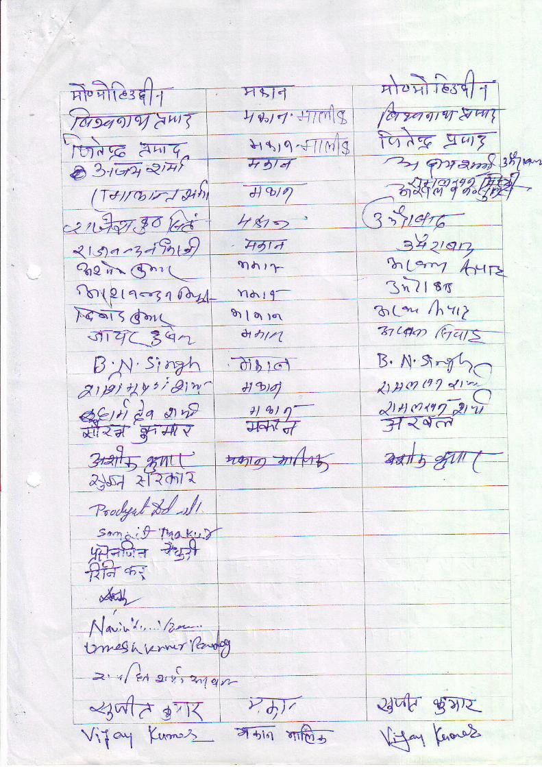
H'"ed r- I rn-ffi- "\';ft4T=', fuga')-14T7-wrTf--q' e"i4' tmlq t /fuvr'r ew7,
J', i -i;qrt9 \ ?qr'1, ^-zl z'o3%eX €.' t_
' 'ra h r 1 ll* T_ 6r t-
f ,g-rffir*"iWd|. 7a? ,;?#dt,ir,9vs"-EJ-te=, -)k$Bza- t,
llP..'=r - \ n a ?tSt5b,tP{q=qfbtL. rd'rt- rntt tP{q=qftA. Ia,,r l- rn(ro'r
Ff--,a-rrr br[ar.r 'b,(*" ' /hYi2. " > 4- / -^ / . _+
, .r;,4'c zQn t, aim l, u'*n GaE l,, - - - - t - l l
B trl s'' ̂r't^ -31 b )".\ ', u,,,!;7,7*1-:
r r l lSt f
uii,ty'"bir-\, ;iQt t, i,.,'n,'!:>',#Jt#eg \ -#tr t, gt{##>:
n - ; I
.ffi€**Ei i' ' t i
4. 1-it l . ' r \ / ^ iIX4w v ' ' , ' tFL- r l
l),w24 h,\z7*r (a"fr1
=, , f)n r, o.ir-o', r"tt,, 4dle s ,_, :i_qa_ L:
I
1tT-+H - F:-.1d-f 3 4'<-
Viit h*t_ aan "r'ft; rH. f*
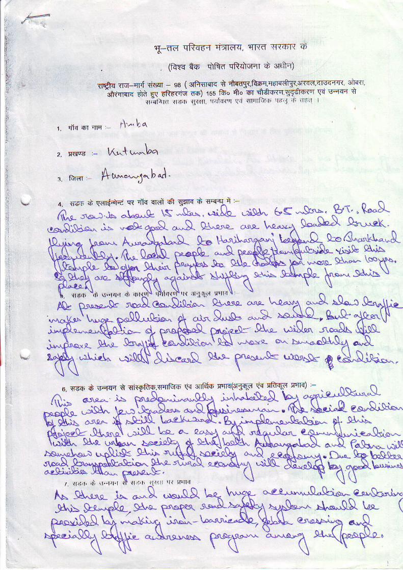
trT-trd sRs€-{ ritlF|q, llr{f, rr{"r'T{ ih
(F{cs *"6' dtrd qfurcrcr d cGltr)
{16{ rtnl-qr'f qsl - e8 (3rftsRrq i +f,ds{,itrfiq q6lrdTt 3f'4cr'qfsfiFl{ 3hflr
l*i.t*" tt, qq tftr$iq rd) 15s 16o ff' 6r *So*q '5f&ri"r \ri q<{q q
r t ,_ , r t iF ' t t .q ' t , { l , l , r r ' . ' l r l td . r " l ( r l r rF l lJ} i r , I ' r i l1 t " : r ' r I
r. rif{ 6r 'nrr r\'^ !-q
I
2, r<F s - lfu.{ r^bq
r tuar: A*"g^bJ.
4. fr-\:ir d wdd rR nfu 4rdt dr gs|q d seeln :-
fil^c sw.: \ -\.s,.,Q' \s *d: :Sf ..'ri!r"" 6s 3"-' pr' " Q'".S-.$'.sie"^ j5 '&tra"S- ^'S- at;; L",-t 9*g)' -q-'"eK"
.!- h^,9t- o-El-**r!-ALq'^ A\Sac^tyw-&^.^NA\AS-^ $*"^Q.!. \,a*- (.^ri"-J{R-lR$L
"-r^^ ;a *+
f\f* *(**\g.\*'
A
qCI&"",.kt^.L$.iS A\,ia
","qsre- 9&'.* \eFY$.
YF"-*"
t- $^o-d$d^
o. r.co d r;rw * eiqFo.{qrfud rtq silf*-6 qqrd(3rgqd \.a cli-qd tq|q) -
j., t ^\"r\"&
Ar\"",& n* ff *$. ?
D^,.-\'\o&bs\!a(et"'-"
caSl$cs. '>
,i| si.r{{ d ,n8!i
Le^Qd"*
\.&u15pJ&.!-o^ S^r- rCrU&xrx1tts J<\<a^ FigAA\fE.r . , t t , l , t , , t ) i l ' la , t l ' l { l i l ' | , r l { '111 r l { rF l l i l
f^ SUr*- Jo. **g .*'S.Affr_9\t=
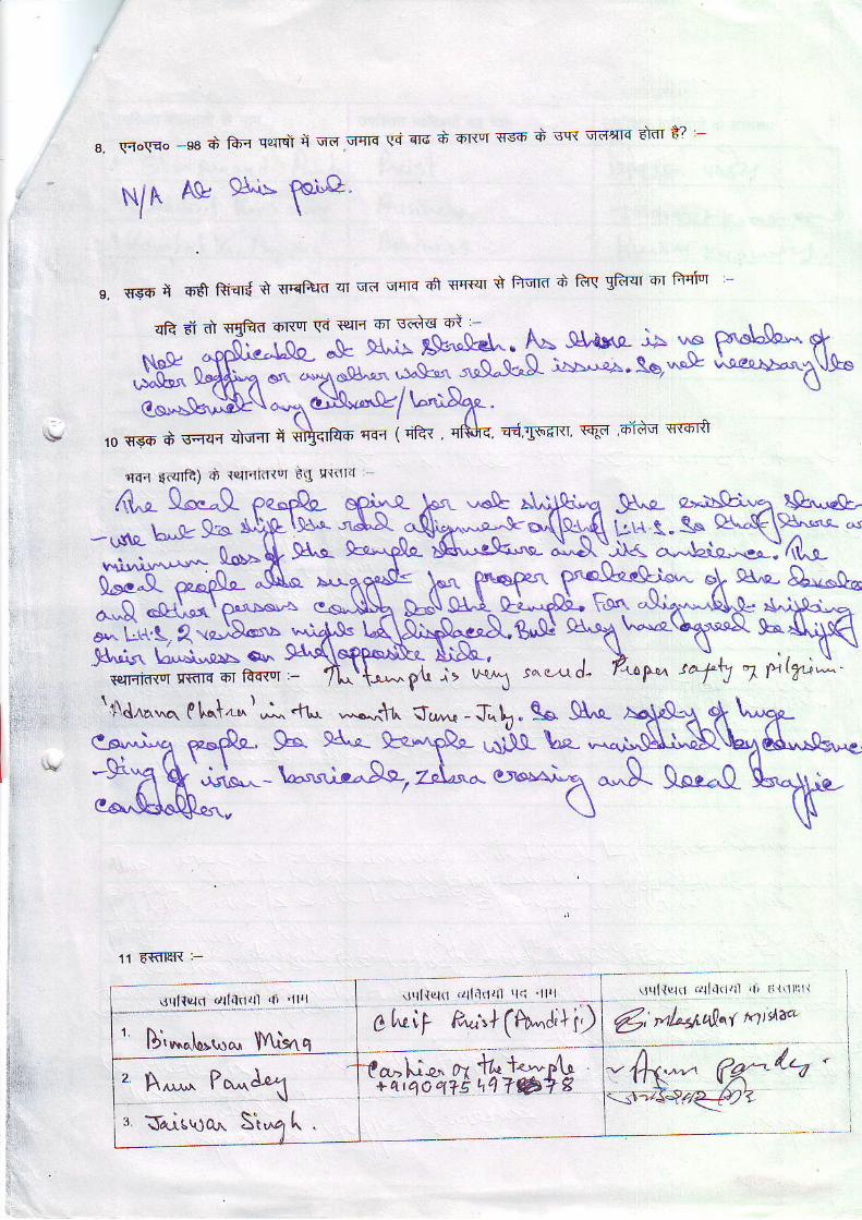
s. \qo(no -98 d lA,r q'!lrqi q qii qfls gi sld A 6Rq {s6 d sqt qarnq efot i? '-
NIA Ag 9\'E ?oJ"O"l \
s. qs6 t 6ff Riqr{ t {r'qPird 4r qd "r{K a1 {r{sr t fiqrd S ftq gfuqr atr ftql'l
rrqr lcqlft) .il {qnl(ltq €q 9{dl'l
11 6€TEft :-
' r l l inr l l r l (
t U,^^l-,""^ IY\.isn0 [vil P;',+(tu-J]i)6, ,aLst'qlt nidz*
A^,,^ P"^\{Ars\Jq^ dt
'n,aahie,* lJv .
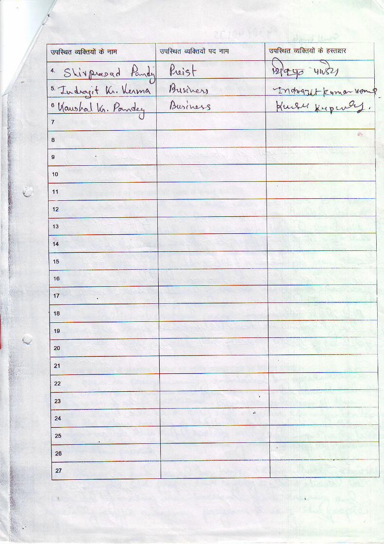
sqRrd qfrdd d qrq sqfurd qEffd rr{ q sqRrd qffi d 6tr8
t SUrlP^*r,*.l A"J P^lr t $la5a vD,zu. a*{""*{;t K. \L-a' D.l t \ " ; -tYl
^ t i a I | , r \ I" qaAt haj V^, Ya'^d!a D.-h^r-ls \/-&,t t
7
a
9
1 0
1 1
1 2
1 3
'11
1 5
t 6
1 7
1a
1 9
29
21
22
23
24
26
27
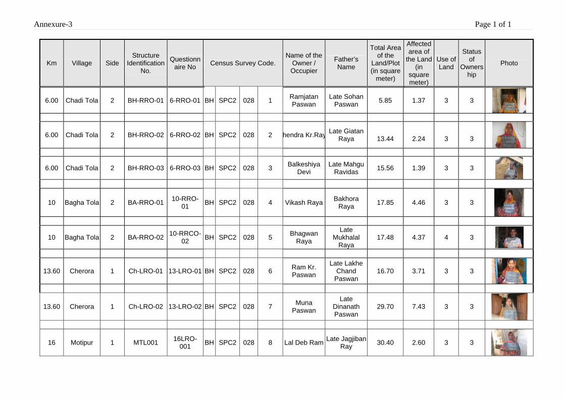
Annexure-3 Page 1 of 1
Km Village Side Structure
Identification No.
Questionnaire No Census Survey Code.
Name of the Owner / Occupier
Father’s Name
Total Area of the
Land/Plot (in square
meter)
Affected area of
the Land (in
square meter)
Use of Land
Status of
Ownership
Photo
6.00 Chadi Tola 2 BH-RRO-01 6-RRO-01 BH SPC2 028 1 Ramjatan Paswan
Late Sohan Paswan 5.85
1.37
3 3
6.00 Chadi Tola 2 BH-RRO-02 6-RRO-02 BH SPC2 028 2 hendra Kr.Ray Late Giatan Raya
13.44
2.24
3
3
6.00 Chadi Tola 2 BH-RRO-03 6-RRO-03 BH SPC2 028 3 Balkeshiya Devi
Late Mahgu Ravidas 15.56 1.39 3 3
10 Bagha Tola 2 BA-RRO-01 10-RRO-01 BH SPC2 028 4 Vikash Raya Bakhora
Raya 17.85 4.46 3 3
10 Bagha Tola 2 BA-RRO-02 10-RRCO-02 BH SPC2 028 5 Bhagwan
Raya
Late Mukhalal
Raya 17.48 4.37 4 3
13.60 Cherora 1 Ch-LRO-01 13-LRO-01 BH SPC2 028 6 Ram Kr. Paswan
Late Lakhe Chand
Paswan 16.70 3.71 3 3
13.60 Cherora 1 Ch-LRO-02 13-LRO-02 BH SPC2 028 7 Muna Paswan
Late Dinanath Paswan
29.70 7.43 3 3
16 Motipur 1 MTL001 16LRO-001 BH SPC2 028 8 Lal Deb Ram Late Jagjiban
Ray 30.40 2.60 3 3
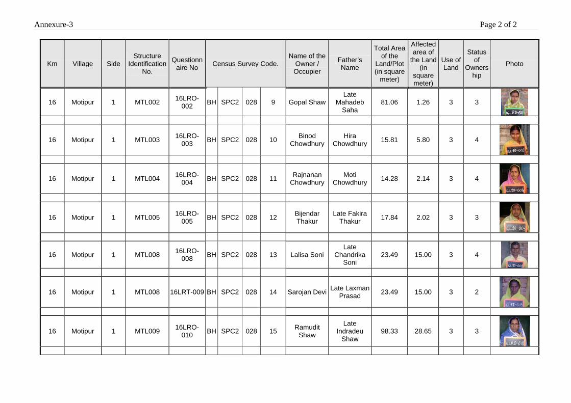
Annexure-3 Page 2 of 2
Km Village Side Structure
Identification No.
Questionnaire No Census Survey Code.
Name of the Owner / Occupier
Father’s Name
Total Area of the
Land/Plot (in square
meter)
Affected area of
the Land (in
square meter)
Use of Land
Status of
Ownership
Photo
16 Motipur 1 MTL002 16LRO-002 BH SPC2 028 9 Gopal Shaw
Late Mahadeb
Saha 81.06 1.26 3 3
16 Motipur 1 MTL003 16LRO-003 BH SPC2 028 10 Binod
Chowdhury Hira
Chowdhury 15.81 5.80 3 4
16 Motipur 1 MTL004 16LRO-004 BH SPC2 028 11 Rajnanan
Chowdhury Moti
Chowdhury 14.28 2.14 3 4
16 Motipur 1 MTL005 16LRO-005 BH SPC2 028 12 Bijendar
Thakur Late Fakira
Thakur 17.84 2.02 3 3
16 Motipur 1 MTL008 16LRO-008 BH SPC2 028 13 Lalisa Soni
Late Chandrika
Soni 23.49 15.00 3 4
16 Motipur 1 MTL008 16LRT-009 BH SPC2 028 14 Sarojan Devi Late Laxman Prasad 23.49 15.00 3 2
16 Motipur 1 MTL009 16LRO-010 BH SPC2 028 15 Ramudit
Shaw
Late Indradeu
Shaw 98.33 28.65 3 3
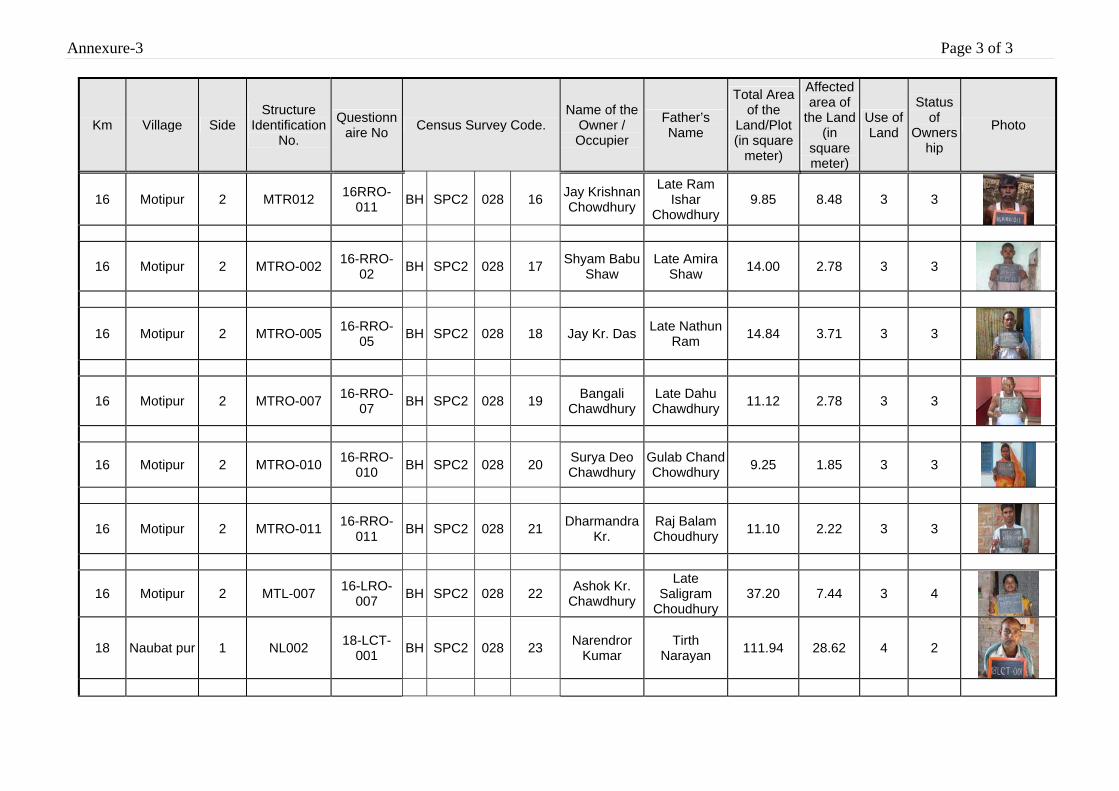
Annexure-3 Page 3 of 3
Km Village Side Structure
Identification No.
Questionnaire No Census Survey Code.
Name of the Owner / Occupier
Father’s Name
Total Area of the
Land/Plot (in square
meter)
Affected area of
the Land (in
square meter)
Use of Land
Status of
Ownership
Photo
16 Motipur 2 MTR012 16RRO-011 BH SPC2 028 16 Jay Krishnan
Chowdhury
Late Ram Ishar
Chowdhury 9.85 8.48 3 3
16 Motipur 2 MTRO-002 16-RRO-02 BH SPC2 028 17 Shyam Babu
Shaw Late Amira
Shaw 14.00 2.78 3 3
16 Motipur 2 MTRO-005 16-RRO-05 BH SPC2 028 18 Jay Kr. Das Late Nathun
Ram 14.84 3.71 3 3
16 Motipur 2 MTRO-007 16-RRO-07 BH SPC2 028 19 Bangali
Chawdhury Late Dahu Chawdhury 11.12 2.78 3 3
16 Motipur 2 MTRO-010 16-RRO-010 BH SPC2 028 20 Surya Deo
Chawdhury Gulab Chand Chowdhury 9.25 1.85 3 3
16 Motipur 2 MTRO-011 16-RRO-011 BH SPC2 028 21 Dharmandra
Kr. Raj Balam Choudhury 11.10 2.22 3 3
16 Motipur 2 MTL-007 16-LRO-007 BH SPC2 028 22 Ashok Kr.
Chawdhury
Late Saligram
Choudhury 37.20 7.44 3 4
18 Naubat pur 1 NL002 18-LCT-001 BH SPC2 028 23 Narendror
Kumar Tirth
Narayan 111.94 28.62 4 2
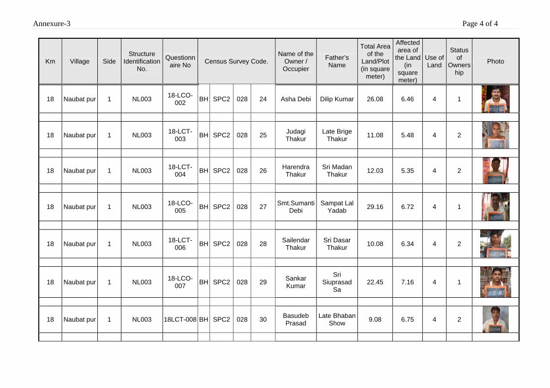
Annexure-3 Page 4 of 4
Km Village Side Structure
Identification No.
Questionnaire No Census Survey Code.
Name of the Owner / Occupier
Father’s Name
Total Area of the
Land/Plot (in square
meter)
Affected area of
the Land (in
square meter)
Use of Land
Status of
Ownership
Photo
18 Naubat pur 1 NL003 18-LCO-002 BH SPC2 028 24 Asha Debi Dilip Kumar 26.08 6.46 4 1
18 Naubat pur 1 NL003 18-LCT-003 BH SPC2 028 25 Judagi
Thakur Late Brige
Thakur 11.08 5.48 4 2
18 Naubat pur 1 NL003 18-LCT-004 BH SPC2 028 26 Harendra
Thakur Sri Madan
Thakur 12.03 5.35 4 2
18 Naubat pur 1 NL003 18-LCO-005 BH SPC2 028 27 Smt.Sumanti
Debi Sampat Lal
Yadab 29.16 6.72 4 1
18 Naubat pur 1 NL003 18-LCT-006 BH SPC2 028 28 Sailendar
Thakur Sri Dasar Thakur 10.08 6.34 4 2
18 Naubat pur 1 NL003 18-LCO-007 BH SPC2 028 29 Sankar
Kumar
Sri Siuprasad
Sa 22.45 7.16 4 1
18 Naubat pur 1 NL003 18LCT-008 BH SPC2 028 30 Basudeb Prasad
Late Bhaban Show 9.08 6.75 4 2
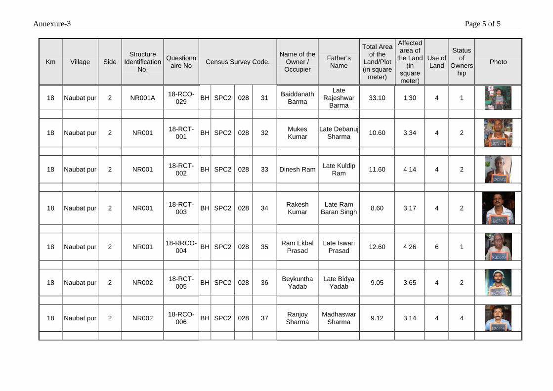
Annexure-3 Page 5 of 5
Km Village Side Structure
Identification No.
Questionnaire No Census Survey Code.
Name of the Owner / Occupier
Father’s Name
Total Area of the
Land/Plot (in square
meter)
Affected area of
the Land (in
square meter)
Use of Land
Status of
Ownership
Photo
18 Naubat pur 2 NR001A 18-RCO-029 BH SPC2 028 31 Baiddanath
Barma
Late Rajeshwar
Barma 33.10 1.30 4 1
18 Naubat pur 2 NR001 18-RCT-001 BH SPC2 028 32 Mukes
Kumar Late Debanuj
Sharma 10.60 3.34 4 2
18 Naubat pur 2 NR001 18-RCT-002 BH SPC2 028 33 Dinesh Ram Late Kuldip
Ram 11.60 4.14 4 2
18 Naubat pur 2 NR001 18-RCT-003 BH SPC2 028 34 Rakesh
Kumar Late Ram
Baran Singh 8.60 3.17 4 2
18 Naubat pur 2 NR001 18-RRCO-004 BH SPC2 028 35 Ram Ekbal
Prasad Late Iswari
Prasad 12.60 4.26 6 1
18 Naubat pur 2 NR002 18-RCT-005 BH SPC2 028 36 Beykuntha
Yadab Late Bidya
Yadab 9.05 3.65 4 2
18 Naubat pur 2 NR002 18-RCO-006 BH SPC2 028 37 Ranjoy
Sharma Madhaswar
Sharma 9.12 3.14 4 4
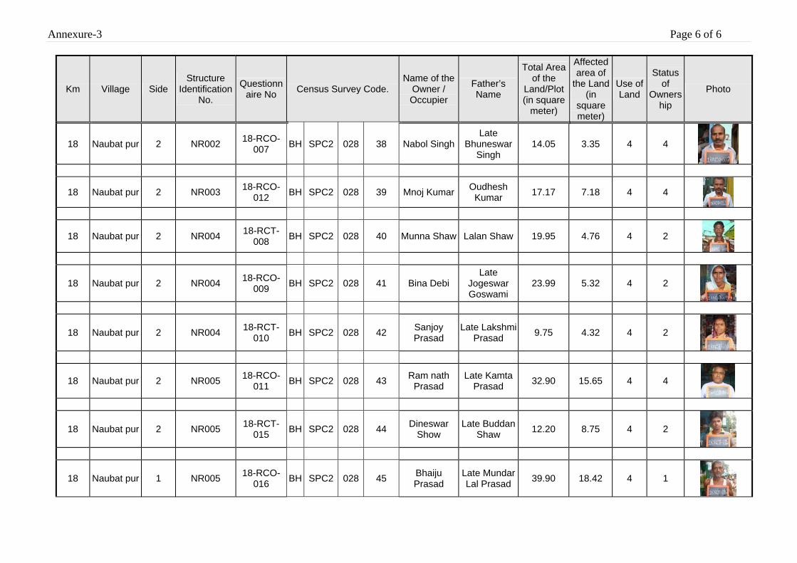
Annexure-3 Page 6 of 6
Km Village Side Structure
Identification No.
Questionnaire No Census Survey Code.
Name of the Owner / Occupier
Father’s Name
Total Area of the
Land/Plot (in square
meter)
Affected area of
the Land (in
square meter)
Use of Land
Status of
Ownership
Photo
18 Naubat pur 2 NR002 18-RCO-007 BH SPC2 028 38 Nabol Singh
Late Bhuneswar
Singh 14.05 3.35 4 4
18 Naubat pur 2 NR003 18-RCO-012 BH SPC2 028 39 Mnoj Kumar Oudhesh
Kumar 17.17 7.18 4 4
18 Naubat pur 2 NR004 18-RCT-008 BH SPC2 028 40 Munna Shaw Lalan Shaw 19.95 4.76 4 2
18 Naubat pur 2 NR004 18-RCO-009 BH SPC2 028 41 Bina Debi
Late Jogeswar Goswami
23.99 5.32 4 2
18 Naubat pur 2 NR004 18-RCT-010 BH SPC2 028 42 Sanjoy
Prasad Late Lakshmi
Prasad 9.75 4.32 4 2
18 Naubat pur 2 NR005 18-RCO-011 BH SPC2 028 43 Ram nath
Prasad Late Kamta
Prasad 32.90 15.65 4 4
18 Naubat pur 2 NR005 18-RCT-015 BH SPC2 028 44 Dineswar
Show Late Buddan
Shaw 12.20 8.75 4 2
18 Naubat pur 1 NR005 18-RCO-016 BH SPC2 028 45 Bhaiju
Prasad Late Mundar Lal Prasad 39.90 18.42 4 1
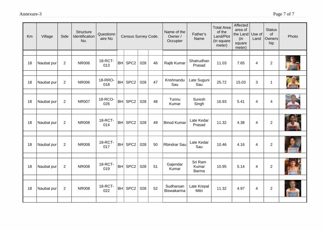
Annexure-3 Page 7 of 7
Km Village Side Structure
Identification No.
Questionnaire No Census Survey Code.
Name of the Owner / Occupier
Father’s Name
Total Area of the
Land/Plot (in square
meter)
Affected area of
the Land (in
square meter)
Use of Land
Status of
Ownership
Photo
18 Naubat pur 2 NR006 18-RCT-013 BH SPC2 028 46 Rajib Kumar Shatrudhan
Prasad 11.03 7.65 4 2
18 Naubat pur 2 NR006 18-RRO-018 BH SPC2 028 47 Krishnandu
Sau Late Suguni
Sau 25.72 15.03 3 1
18 Naubat pur 2 NR007 18-RCO-026 BH SPC2 028 48 Tunnu
Kumar Suresh Singh 16.93 5.41 4 4
18 Naubat pur 2 NR008 18-RCT-014 BH SPC2 028 49 Binod Kumar Late Kedar
Prasad 11.32 4.38 4 2
18 Naubat pur 2 NR008 18-RCT-017 BH SPC2 028 50 Rbindrar Sau Late Kedar
Sau 10.46 4.16 4 2
18 Naubat pur 2 NR008 18-RCT-019 BH SPC2 028 51 Gajendar
Kumar
Sri Ram Kumar Barma
10.95 5.14 4 2
18 Naubat pur 2 NR008 18-RCT-022 BH SPC2 028 52 Sudharsan
Biswakarma Late Krepal
Mitri 11.32 4.97 4 2
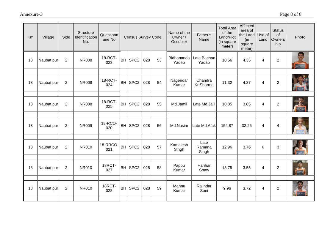
Annexure-3 Page 8 of 8
Km Village Side Structure
Identification No.
Questionnaire No Census Survey Code.
Name of the Owner / Occupier
Father’s Name
Total Area of the
Land/Plot (in square
meter)
Affected area of
the Land (in
square meter)
Use of Land
Status of
Ownership
Photo
18 Naubat pur 2 NR008 18-RCT-023 BH SPC2 028 53 Bidhananda
Yadeb Late Bachan
Yadab 10.56 4.35 4 2
18 Naubat pur 2 NR008 18-RCT-024 BH SPC2 028 54 Nagendar
Kumar Chandra
Kr.Sharma 11.32 4.37 4 2
18 Naubat pur 2 NR008 18-RCT-025 BH SPC2 028 55 Md.Jamil Late Md.Jalil 10.85 3.85 4 2
18 Naubat pur 2 NR009 18-RCO-020 BH SPC2 028 56 Md.Nasim Late Md.Afak 154.87 32.25 4 4
18 Naubat pur 2 NR010 18-RRCO-021 BH SPC2 028 57 Kamalesh
Singh
Late Ramana
Singh 12.96 3.76 6 3
18 Naubat pur 2 NR010 18RCT-027 BH SPC2 028 58 Pappu
Kumar Harihar Shaw 13.75 3.55 4 2
18 Naubat pur 2 NR010 18RCT-028 BH SPC2 028 59 Mannu
Kumar Rajindar
Soni 9.96 3.72 4 2
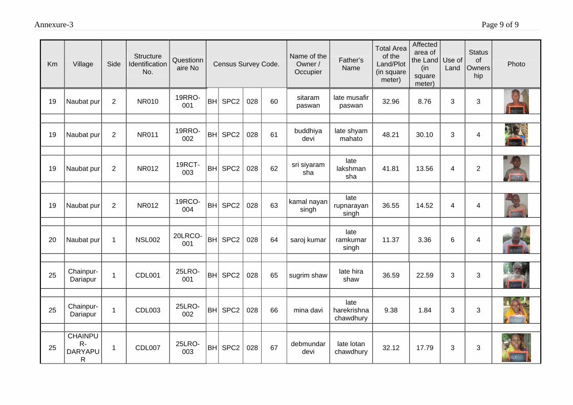
Annexure-3 Page 9 of 9
Km Village Side Structure
Identification No.
Questionnaire No Census Survey Code.
Name of the Owner / Occupier
Father’s Name
Total Area of the
Land/Plot (in square
meter)
Affected area of
the Land (in
square meter)
Use of Land
Status of
Ownership
Photo
19 Naubat pur 2 NR010 19RRO-001 BH SPC2 028 60 sitaram
paswan late musafir
paswan 32.96 8.76 3 3
19 Naubat pur 2 NR011 19RRO-002 BH SPC2 028 61 buddhiya
devi late shyam
mahato 48.21 30.10 3 4
19 Naubat pur 2 NR012 19RCT-003 BH SPC2 028 62 sri siyaram
sha
late lakshman
sha 41.81 13.56 4 2
19 Naubat pur 2 NR012 19RCO-004 BH SPC2 028 63 kamal nayan
singh
late rupnarayan
singh 36.55 14.52 4 4
20 Naubat pur 1 NSL002 20LRCO-001 BH SPC2 028 64 saroj kumar
late ramkumar
singh 11.37 3.36 6 4
25 Chainpur-Dariapur 1 CDL001 25LRO-
001 BH SPC2 028 65 sugrim shaw late hira shaw 36.59 22.59 3 3
25 Chainpur-Dariapur 1 CDL003 25LRO-
002 BH SPC2 028 66 mina davi late
harekrishna chawdhury
9.38 1.84 3 3
25
CHAINPUR-
DARYAPUR
1 CDL007 25LRO-003 BH SPC2 028 67 debmundar
devi late lotan
chawdhury 32.12 17.79 3 3
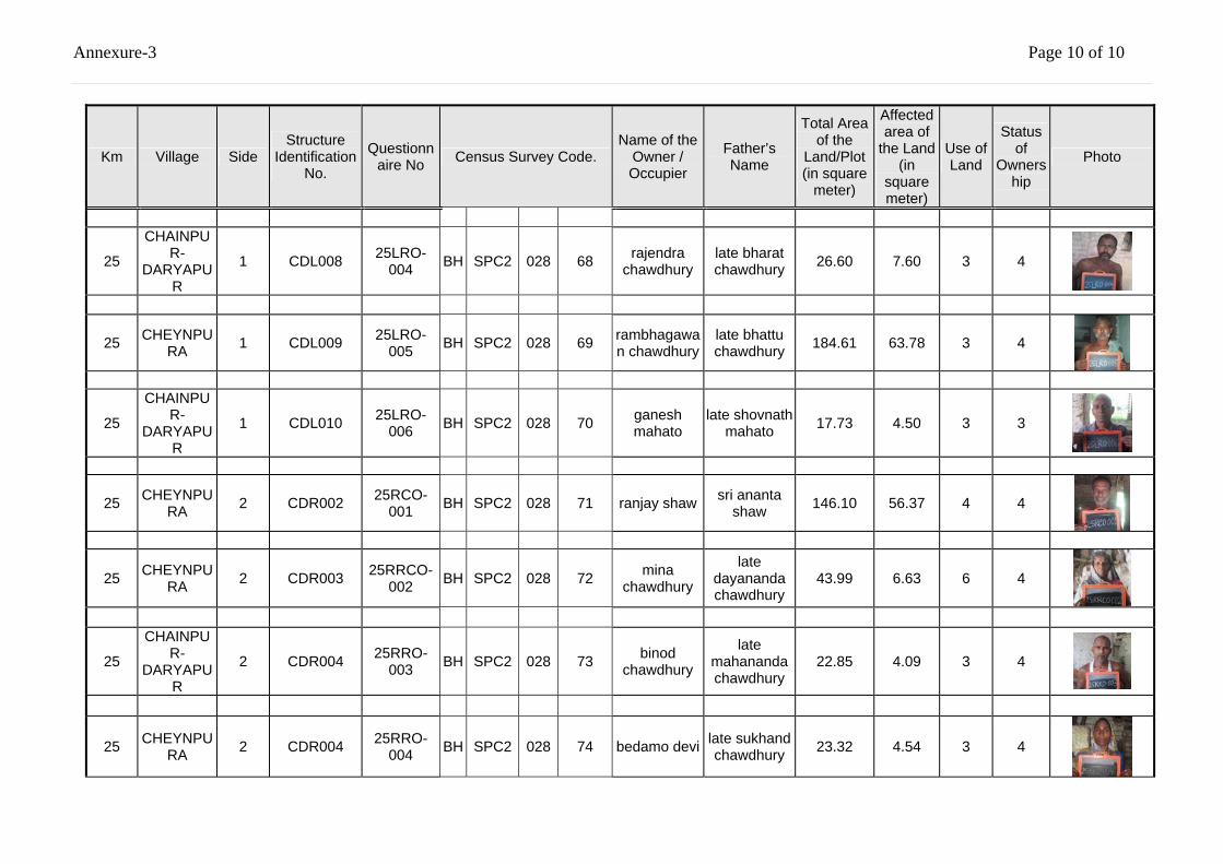
Annexure-3 Page 10 of 10
Km Village Side Structure
Identification No.
Questionnaire No Census Survey Code.
Name of the Owner / Occupier
Father’s Name
Total Area of the
Land/Plot (in square
meter)
Affected area of
the Land (in
square meter)
Use of Land
Status of
Ownership
Photo
25
CHAINPUR-
DARYAPUR
1 CDL008 25LRO-004 BH SPC2 028 68 rajendra
chawdhury late bharat chawdhury 26.60 7.60 3 4
25 CHEYNPURA 1 CDL009 25LRO-
005 BH SPC2 028 69 rambhagawan chawdhury
late bhattu chawdhury 184.61 63.78 3 4
25
CHAINPUR-
DARYAPUR
1 CDL010 25LRO-006 BH SPC2 028 70 ganesh
mahato late shovnath
mahato 17.73 4.50 3 3
25 CHEYNPURA 2 CDR002 25RCO-
001 BH SPC2 028 71 ranjay shaw sri ananta shaw 146.10 56.37 4 4
25 CHEYNPURA 2 CDR003 25RRCO-
002 BH SPC2 028 72 mina chawdhury
late dayananda chawdhury
43.99 6.63 6 4
25
CHAINPUR-
DARYAPUR
2 CDR004 25RRO-003 BH SPC2 028 73 binod
chawdhury
late mahananda chawdhury
22.85 4.09 3 4
25 CHEYNPURA 2 CDR004 25RRO-
004 BH SPC2 028 74 bedamo devi late sukhand chawdhury 23.32 4.54 3 4
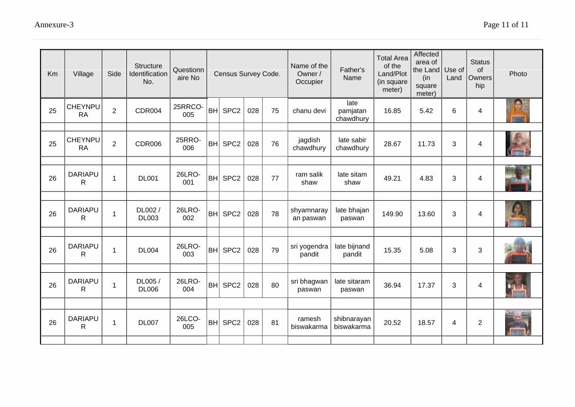
Annexure-3 Page 11 of 11
Km Village Side Structure
Identification No.
Questionnaire No Census Survey Code.
Name of the Owner / Occupier
Father’s Name
Total Area of the
Land/Plot (in square
meter)
Affected area of
the Land (in
square meter)
Use of Land
Status of
Ownership
Photo
25 CHEYNPURA 2 CDR004 25RRCO-
005 BH SPC2 028 75 chanu devi late
pamjatan chawdhury
16.85 5.42 6 4
25 CHEYNPURA 2 CDR006 25RRO-
006 BH SPC2 028 76 jagdish chawdhury
late sabir chawdhury 28.67 11.73 3 4
26 DARIAPUR 1 DL001 26LRO-
001 BH SPC2 028 77 ram salik shaw
late sitam shaw 49.21 4.83 3 4
26 DARIAPUR 1 DL002 /
DL003 26LRO-
002 BH SPC2 028 78 shyamnarayan paswan
late bhajan paswan 149.90 13.60 3 4
26 DARIAPUR 1 DL004 26LRO-
003 BH SPC2 028 79 sri yogendra pandit
late bijnand pandit 15.35 5.08 3 3
26 DARIAPUR 1 DL005 /
DL006 26LRO-
004 BH SPC2 028 80 sri bhagwan paswan
late sitaram paswan 36.94 17.37 3 4
26 DARIAPUR 1 DL007 26LCO-
005 BH SPC2 028 81 ramesh biswakarma
shibnarayan biswakarma 20.52 18.57 4 2
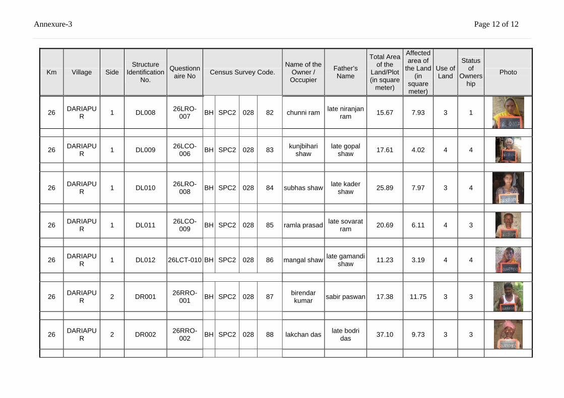
Annexure-3 Page 12 of 12
Km Village Side Structure
Identification No.
Questionnaire No Census Survey Code.
Name of the Owner / Occupier
Father’s Name
Total Area of the
Land/Plot (in square
meter)
Affected area of
the Land (in
square meter)
Use of Land
Status of
Ownership
Photo
26 DARIAPUR 1 DL008 26LRO-
007 BH SPC2 028 82 chunni ram late niranjan ram 15.67 7.93 3 1
26 DARIAPUR 1 DL009 26LCO-
006 BH SPC2 028 83 kunjbihari shaw
late gopal shaw 17.61 4.02 4 4
26 DARIAPUR 1 DL010 26LRO-
008 BH SPC2 028 84 subhas shaw late kader shaw 25.89 7.97 3 4
26 DARIAPUR 1 DL011 26LCO-
009 BH SPC2 028 85 ramla prasad late sovarat ram 20.69 6.11 4 3
26 DARIAPUR 1 DL012 26LCT-010 BH SPC2 028 86 mangal shaw late gamandi
shaw 11.23 3.19 4 4
26 DARIAPUR 2 DR001 26RRO-
001 BH SPC2 028 87 birendar kumar sabir paswan 17.38 11.75 3 3
26 DARIAPUR 2 DR002 26RRO-
002 BH SPC2 028 88 lakchan das late bodri das 37.10 9.73 3 3
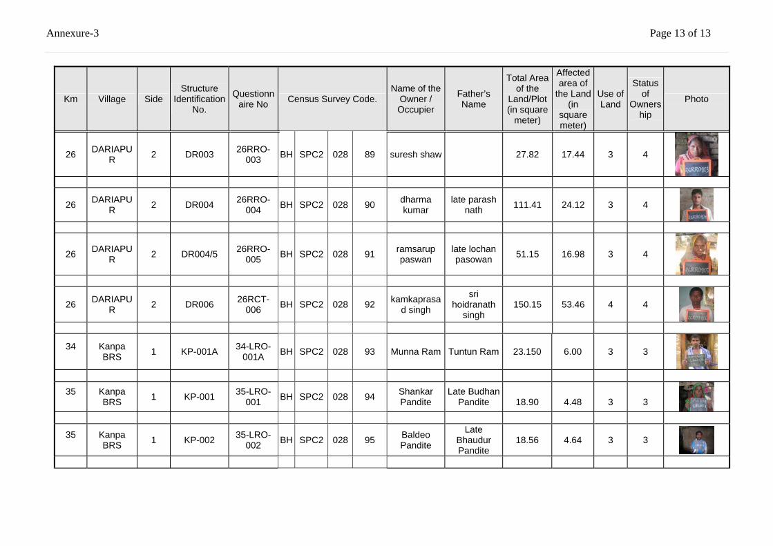
Annexure-3 Page 13 of 13
Km Village Side Structure
Identification No.
Questionnaire No Census Survey Code.
Name of the Owner / Occupier
Father’s Name
Total Area of the
Land/Plot (in square
meter)
Affected area of
the Land (in
square meter)
Use of Land
Status of
Ownership
Photo
26 DARIAPUR 2 DR003 26RRO-
003 BH SPC2 028 89 suresh shaw 27.82 17.44 3 4
26 DARIAPUR 2 DR004 26RRO-
004 BH SPC2 028 90 dharma kumar
late parash nath 111.41 24.12 3 4
26 DARIAPUR 2 DR004/5 26RRO-
005 BH SPC2 028 91 ramsarup paswan
late lochan pasowan 51.15 16.98 3 4
26 DARIAPUR 2 DR006 26RCT-
006 BH SPC2 028 92 kamkaprasad singh
sri hoidranath
singh 150.15 53.46 4 4
34
Kanpa BRS 1 KP-001A 34-LRO-
001A BH SPC2 028 93 Munna Ram Tuntun Ram 23.150 6.00 3 3
35
Kanpa BRS 1 KP-001 35-LRO-
001 BH SPC2 028 94 Shankar Pandite
Late Budhan Pandite
18.90
4.48
3
3
35
Kanpa BRS 1 KP-002 35-LRO-
002 BH SPC2 028 95 Baldeo Pandite
Late Bhaudur Pandite
18.56 4.64 3 3
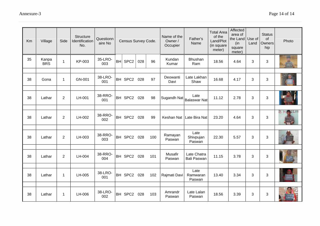
Annexure-3 Page 14 of 14
Km Village Side Structure
Identification No.
Questionnaire No Census Survey Code.
Name of the Owner / Occupier
Father’s Name
Total Area of the
Land/Plot (in square
meter)
Affected area of
the Land (in
square meter)
Use of Land
Status of
Ownership
Photo
35
Kanpa BRS 1 KP-003 35-LRO-
003 BH SPC2 028 96 Kundan Kumar
Bhushan Ram 18.56 4.64 3 3
38 Gona 1 GN-001 38-LRO-001 BH SPC2 028 97 Deowanti
Davi Late Lakhan
Shaw 16.68 4.17 3 3
38 Lathar 2 LH-001 38-RRO-001 BH SPC2 028 98 Sugandh Nat Late
Balaswar Nat 11.12 2.78 3 3
38 Lathar 2 LH-002 38-RRO-002 BH SPC2 028 99 Keshan Nat Late Bira Nat 23.20 4.64 3 3
38 Lathar 2 LH-003 38-RRO-003 BH SPC2 028 100 Ramayan
Paswan
Late Shivpujan Paswan
22.30 5.57 3 3
38 Lathar 2 LH-004 38-RRO-004 BH SPC2 028 101 Musafir
Paswan Late Chatra Bali Paswan 11.15 3.78 3 3
38 Lathar 1 LH-005 38-LRO-001 BH SPC2 028 102 Rajmati Davi
Late Ramwaran
Paswan 13.40 3.34 3 3
38 Lathar 1 LH-006 38-LRO-002 BH SPC2 028 103 Amrandr
Paswan Late Lalan Paswan 18.56 3.39 3 3
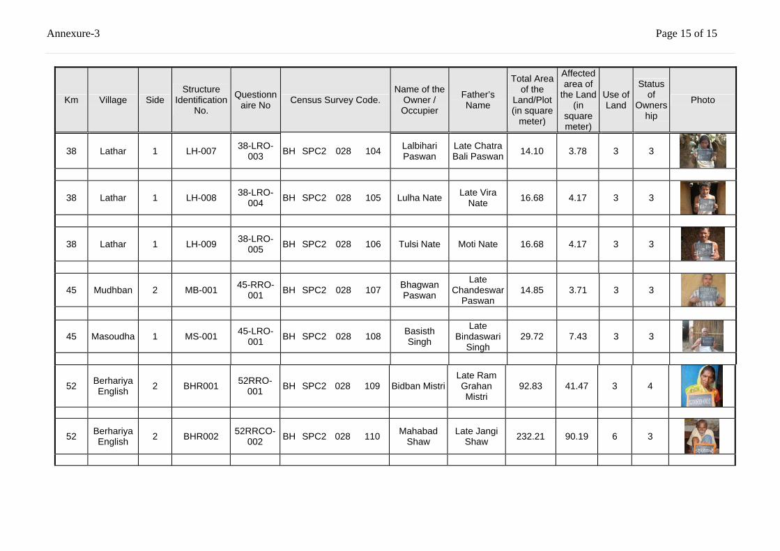
Annexure-3 Page 15 of 15
Km Village Side Structure
Identification No.
Questionnaire No Census Survey Code.
Name of the Owner / Occupier
Father’s Name
Total Area of the
Land/Plot (in square
meter)
Affected area of
the Land (in
square meter)
Use of Land
Status of
Ownership
Photo
38 Lathar 1 LH-007 38-LRO-003 BH SPC2 028 104 Lalbihari
Paswan Late Chatra Bali Paswan 14.10 3.78 3 3
38 Lathar 1 LH-008 38-LRO-004 BH SPC2 028 105 Lulha Nate Late Vira
Nate 16.68 4.17 3 3
38 Lathar 1 LH-009 38-LRO-005 BH SPC2 028 106 Tulsi Nate
Moti Nate
16.68 4.17 3 3
45 Mudhban 2 MB-001 45-RRO-001 BH SPC2 028 107 Bhagwan
Paswan
Late Chandeswar
Paswan 14.85 3.71 3 3
45 Masoudha 1 MS-001 45-LRO-001 BH SPC2 028 108 Basisth
Singh
Late Bindaswari
Singh 29.72 7.43 3 3
52 Berhariya English 2 BHR001 52RRO-
001 BH SPC2 028 109 Bidban Mistri Late Ram Grahan Mistri
92.83 41.47 3 4
52 Berhariya English 2 BHR002 52RRCO-
002 BH SPC2 028 110 Mahabad Shaw
Late Jangi Shaw 232.21 90.19 6 3
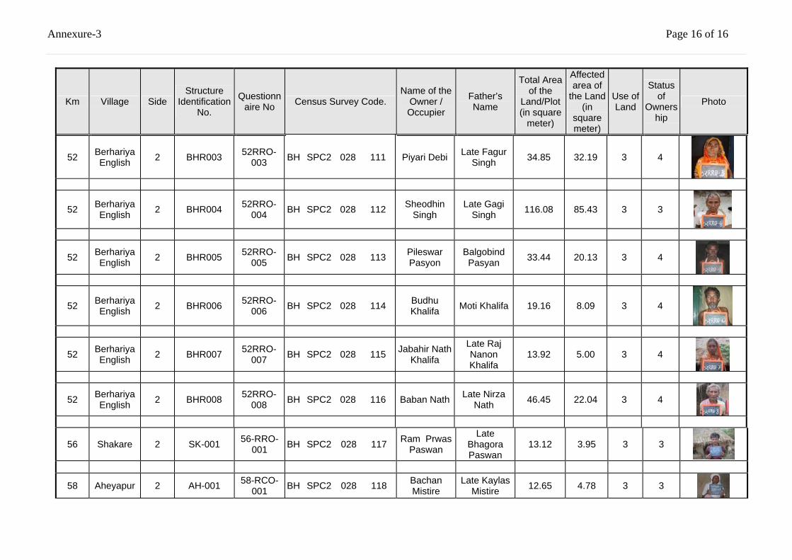
Annexure-3 Page 16 of 16
Km Village Side Structure
Identification No.
Questionnaire No Census Survey Code.
Name of the Owner / Occupier
Father’s Name
Total Area of the
Land/Plot (in square
meter)
Affected area of
the Land (in
square meter)
Use of Land
Status of
Ownership
Photo
52 Berhariya English 2 BHR003 52RRO-
003 BH SPC2 028 111 Piyari Debi Late Fagur Singh 34.85 32.19 3 4
52 Berhariya English 2 BHR004 52RRO-
004 BH SPC2 028 112 Sheodhin Singh
Late Gagi Singh 116.08 85.43 3 3
52 Berhariya English 2 BHR005 52RRO-
005 BH SPC2 028 113 Pileswar Pasyon
Balgobind Pasyan 33.44 20.13 3 4
52 Berhariya English 2 BHR006 52RRO-
006 BH SPC2 028 114 Budhu Khalifa Moti Khalifa 19.16 8.09 3 4
52 Berhariya English 2 BHR007 52RRO-
007 BH SPC2 028 115 Jabahir Nath Khalifa
Late Raj Nanon Khalifa
13.92 5.00 3 4
52 Berhariya English 2 BHR008 52RRO-
008 BH SPC2 028 116 Baban Nath Late Nirza Nath 46.45 22.04 3 4
56 Shakare 2 SK-001 56-RRO-001 BH SPC2 028 117 Ram Prwas
Paswan
Late Bhagora Paswan
13.12 3.95 3 3
58 Aheyapur 2 AH-001 58-RCO-001 BH SPC2 028 118 Bachan
Mistire Late Kaylas
Mistire 12.65 4.78 3 3
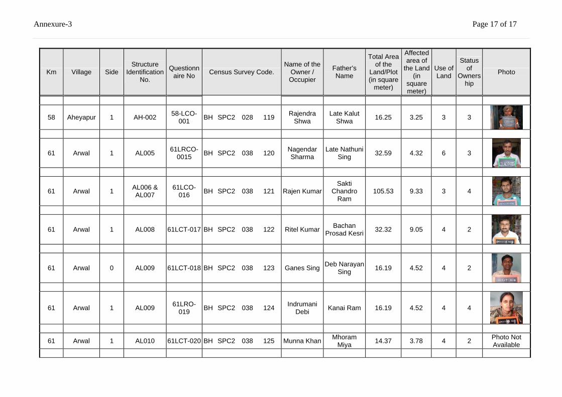
Annexure-3 Page 17 of 17
Km Village Side Structure
Identification No.
Questionnaire No Census Survey Code.
Name of the Owner / Occupier
Father’s Name
Total Area of the
Land/Plot (in square
meter)
Affected area of
the Land (in
square meter)
Use of Land
Status of
Ownership
Photo
58 Aheyapur 1 AH-002 58-LCO-001 BH SPC2 028 119 Rajendra
Shwa Late Kalut
Shwa 16.25 3.25 3 3
61 Arwal 1 AL005 61LRCO-0015 BH SPC2 038 120 Nagendar
Sharma Late Nathuni
Sing 32.59 4.32 6 3
61 Arwal 1 AL006 & AL007
61LCO-016 BH SPC2 038 121 Rajen Kumar
Sakti Chandro
Ram 105.53 9.33 3 4
61 Arwal 1 AL008 61LCT-017 BH SPC2 038 122 Ritel Kumar Bachan Prosad Kesri 32.32 9.05 4 2
61 Arwal 0 AL009 61LCT-018 BH SPC2 038 123 Ganes Sing Deb Narayan Sing 16.19 4.52 4 2
61 Arwal 1 AL009 61LRO-019 BH SPC2 038 124 Indrumani
Debi Kanai Ram 16.19 4.52 4 4
61 Arwal 1 AL010 61LCT-020 BH SPC2 038 125 Munna Khan Mhoram Miya 14.37 3.78 4 2 Photo Not
Available
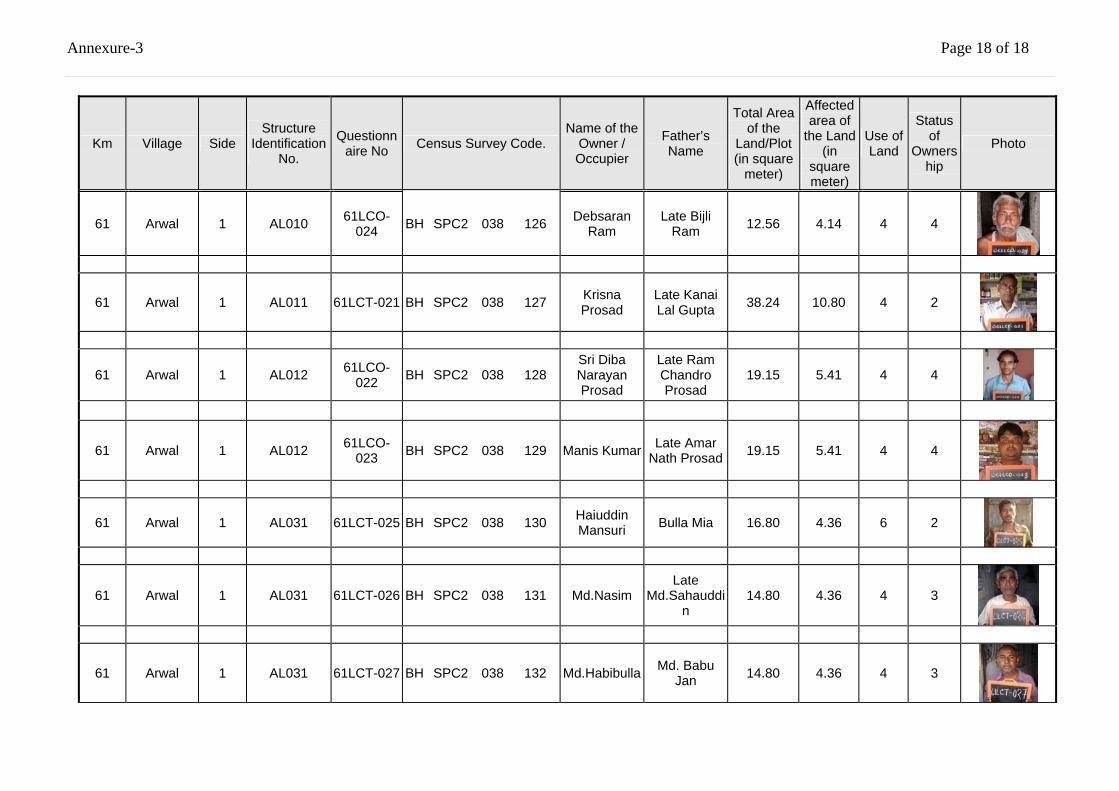
Annexure-3 Page 18 of 18
Km Village Side Structure
Identification No.
Questionnaire No Census Survey Code.
Name of the Owner / Occupier
Father’s Name
Total Area of the
Land/Plot (in square
meter)
Affected area of
the Land (in
square meter)
Use of Land
Status of
Ownership
Photo
61 Arwal 1 AL010 61LCO-024 BH SPC2 038 126 Debsaran
Ram Late Bijli
Ram 12.56 4.14 4 4
61 Arwal 1 AL011 61LCT-021 BH SPC2 038 127 Krisna Prosad
Late Kanai Lal Gupta 38.24 10.80 4 2
61 Arwal 1 AL012 61LCO-022 BH SPC2 038 128
Sri Diba Narayan Prosad
Late Ram Chandro Prosad
19.15 5.41 4 4
61 Arwal 1 AL012 61LCO-023 BH SPC2 038 129 Manis Kumar Late Amar
Nath Prosad 19.15 5.41 4 4
61 Arwal 1 AL031 61LCT-025 BH SPC2 038 130 Haiuddin Mansuri Bulla Mia 16.80 4.36 6 2
61 Arwal 1 AL031 61LCT-026 BH SPC2 038 131 Md.Nasim Late
Md.Sahauddin
14.80 4.36 4 3
61 Arwal 1 AL031 61LCT-027 BH SPC2 038 132 Md.Habibulla Md. Babu Jan 14.80 4.36 4 3
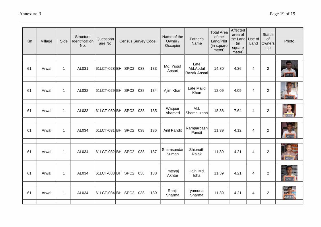
Annexure-3 Page 19 of 19
Km Village Side Structure
Identification No.
Questionnaire No Census Survey Code.
Name of the Owner / Occupier
Father’s Name
Total Area of the
Land/Plot (in square
meter)
Affected area of
the Land (in
square meter)
Use of Land
Status of
Ownership
Photo
61 Arwal 1 AL031 61LCT-028 BH SPC2 038 133 Md. Yusuf Ansari
Late Md.Abdul
Razak Ansari14.80 4.36 4 2
61 Arwal 1 AL032 61LCT-029 BH SPC2 038 134 Ajim Khan Late Majid Khan 12.09 4.09 4 2
61 Arwal 1 AL033 61LCT-030 BH SPC2 038 135 Waquar Ahamed
Md. Shamsuzaha 18.38 7.64 4 2
61 Arwal 1 AL034 61LCT-031 BH SPC2 038 136 Anil Pandit Ramparbash Pandit 11.39 4.12 4 2
61 Arwal 1 AL034 61LCT-032 BH SPC2 038 137 Shamsundar Suman
Shionath Rajak 11.39 4.21 4 2
61 Arwal 1 AL034 61LCT-033 BH SPC2 038 138 Imteyaj Akhtar
Hajhi Md. Isha 11.39 4.21 4 2
61 Arwal 1 AL034 61LCT-034 BH SPC2 038 139 Ranjit Sharma
yamuna Sharma 11.39 4.21 4 2
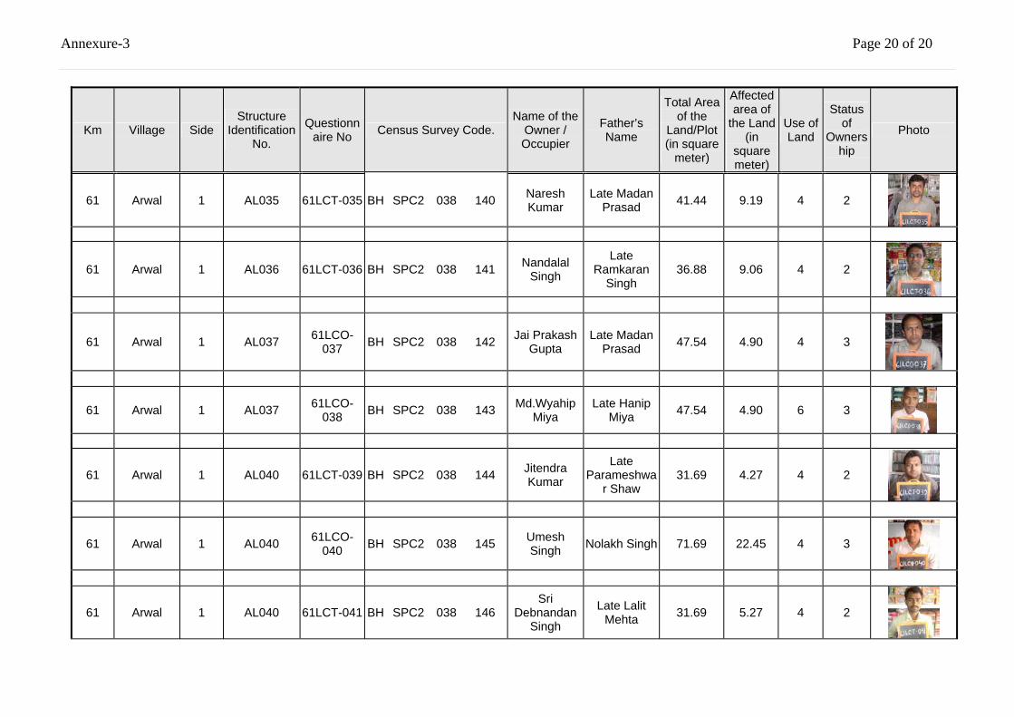
Annexure-3 Page 20 of 20
Km Village Side Structure
Identification No.
Questionnaire No Census Survey Code.
Name of the Owner / Occupier
Father’s Name
Total Area of the
Land/Plot (in square
meter)
Affected area of
the Land (in
square meter)
Use of Land
Status of
Ownership
Photo
61 Arwal 1 AL035 61LCT-035 BH SPC2 038 140 Naresh Kumar
Late Madan Prasad 41.44 9.19 4 2
61 Arwal 1 AL036 61LCT-036 BH SPC2 038 141 Nandalal Singh
Late Ramkaran
Singh 36.88 9.06 4 2
61 Arwal 1 AL037 61LCO-037 BH SPC2 038 142 Jai Prakash
Gupta Late Madan
Prasad 47.54 4.90 4 3
61 Arwal 1 AL037 61LCO-038 BH SPC2 038 143 Md.Wyahip
Miya Late Hanip
Miya 47.54 4.90 6 3
61 Arwal 1 AL040 61LCT-039 BH SPC2 038 144 Jitendra Kumar
Late Parameshwa
r Shaw 31.69 4.27 4 2
61 Arwal 1 AL040 61LCO-040 BH SPC2 038 145 Umesh
Singh Nolakh Singh 71.69 22.45 4 3
61 Arwal 1 AL040 61LCT-041 BH SPC2 038 146 Sri
Debnandan Singh
Late Lalit Mehta 31.69 5.27 4 2
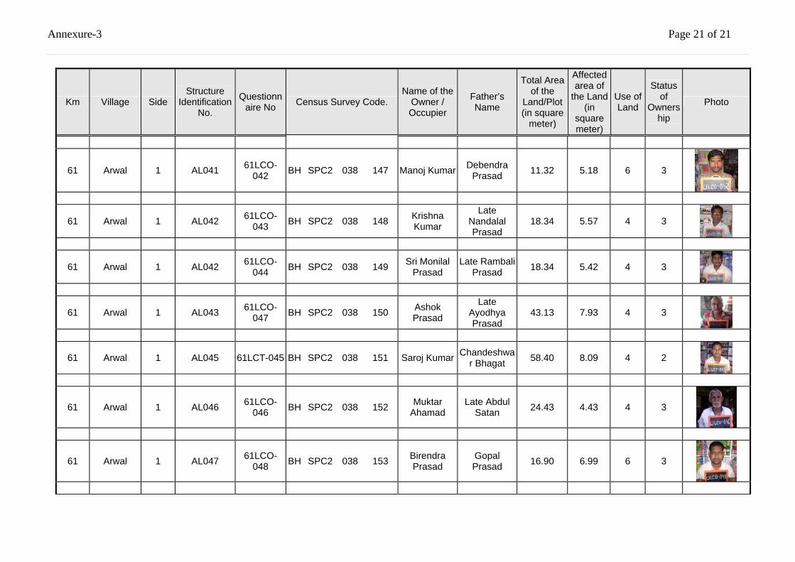
Annexure-3 Page 21 of 21
Km Village Side Structure
Identification No.
Questionnaire No Census Survey Code.
Name of the Owner / Occupier
Father’s Name
Total Area of the
Land/Plot (in square
meter)
Affected area of
the Land (in
square meter)
Use of Land
Status of
Ownership
Photo
61 Arwal 1 AL041 61LCO-042 BH SPC2 038 147 Manoj Kumar Debendra
Prasad 11.32 5.18 6 3
61 Arwal 1 AL042 61LCO-043 BH SPC2 038 148 Krishna
Kumar
Late Nandalal Prasad
18.34 5.57 4 3
61 Arwal 1 AL042 61LCO-044 BH SPC2 038 149 Sri Monilal
Prasad Late Rambali
Prasad 18.34 5.42 4 3
61 Arwal 1 AL043 61LCO-047 BH SPC2 038 150 Ashok
Prasad
Late Ayodhya Prasad
43.13 7.93 4 3
61 Arwal 1 AL045 61LCT-045 BH SPC2 038 151 Saroj Kumar Chandeshwar Bhagat 58.40 8.09 4 2
61 Arwal 1 AL046 61LCO-046 BH SPC2 038 152 Muktar
Ahamad Late Abdul
Satan 24.43 4.43 4 3
61 Arwal 1 AL047 61LCO-048 BH SPC2 038 153 Birendra
Prasad Gopal Prasad 16.90 6.99 6 3
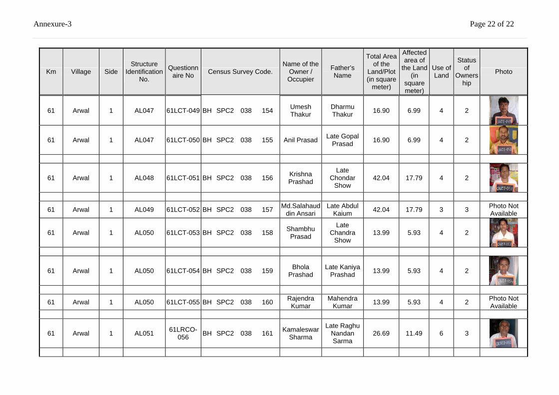
Annexure-3 Page 22 of 22
Km Village Side Structure
Identification No.
Questionnaire No Census Survey Code.
Name of the Owner / Occupier
Father’s Name
Total Area of the
Land/Plot (in square
meter)
Affected area of
the Land (in
square meter)
Use of Land
Status of
Ownership
Photo
61 Arwal 1 AL047 61LCT-049 BH SPC2 038 154 Umesh Thakur
Dharmu Thakur 16.90 6.99 4 2
61 Arwal 1 AL047 61LCT-050 BH SPC2 038 155 Anil Prasad Late Gopal Prasad 16.90 6.99 4 2
61 Arwal 1 AL048 61LCT-051 BH SPC2 038 156 Krishna Prashad
Late Chondar
Show 42.04 17.79 4 2
61 Arwal 1 AL049 61LCT-052 BH SPC2 038 157 Md.Salahauddin Ansari
Late Abdul Kaium 42.04 17.79 3 3 Photo Not
Available
61 Arwal 1 AL050 61LCT-053 BH SPC2 038 158 Shambhu Prasad
Late Chandra
Show 13.99 5.93 4 2
61 Arwal 1 AL050 61LCT-054 BH SPC2 038 159 Bhola Prashad
Late Kaniya Prashad 13.99 5.93 4 2
61 Arwal 1 AL050 61LCT-055 BH SPC2 038 160 Rajendra Kumar
Mahendra Kumar 13.99 5.93 4 2 Photo Not
Available
61 Arwal 1 AL051 61LRCO-056 BH SPC2 038 161 Kamaleswar
Sharma
Late Raghu Nandan Sarma
26.69 11.49 6 3
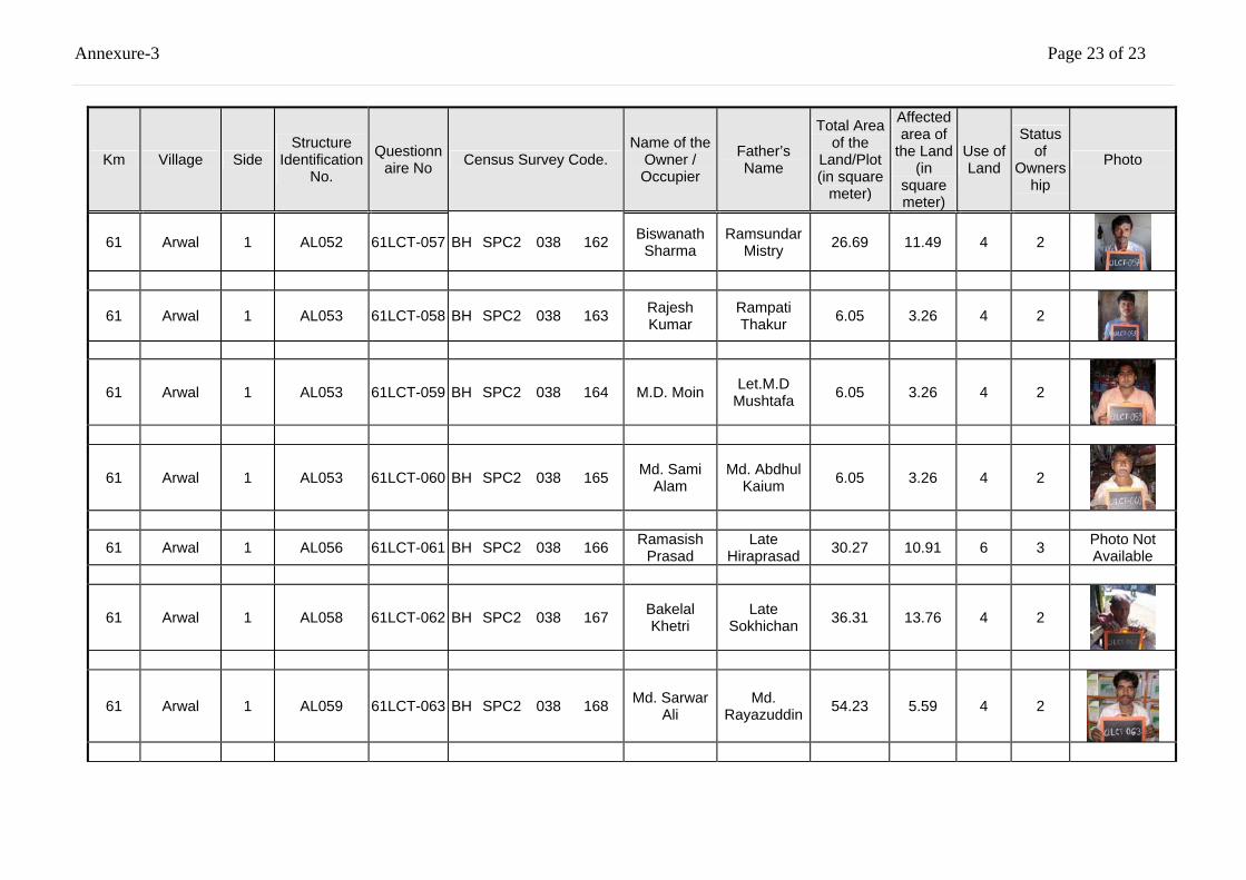
Annexure-3 Page 23 of 23
Km Village Side Structure
Identification No.
Questionnaire No Census Survey Code.
Name of the Owner / Occupier
Father’s Name
Total Area of the
Land/Plot (in square
meter)
Affected area of
the Land (in
square meter)
Use of Land
Status of
Ownership
Photo
61 Arwal 1 AL052 61LCT-057 BH SPC2 038 162 Biswanath Sharma
Ramsundar Mistry 26.69 11.49 4 2
61 Arwal 1 AL053 61LCT-058 BH SPC2 038 163 Rajesh Kumar
Rampati Thakur 6.05 3.26 4 2
61 Arwal 1 AL053 61LCT-059 BH SPC2 038 164 M.D. Moin Let.M.D Mushtafa 6.05 3.26 4 2
61 Arwal 1 AL053 61LCT-060 BH SPC2 038 165 Md. Sami Alam
Md. Abdhul Kaium 6.05 3.26 4 2
61 Arwal 1 AL056 61LCT-061 BH SPC2 038 166 Ramasish Prasad
Late Hiraprasad 30.27 10.91 6 3 Photo Not
Available
61 Arwal 1 AL058 61LCT-062 BH SPC2 038 167 Bakelal Khetri
Late Sokhichan 36.31 13.76 4 2
61 Arwal 1 AL059 61LCT-063 BH SPC2 038 168 Md. Sarwar Ali
Md. Rayazuddin 54.23 5.59 4 2
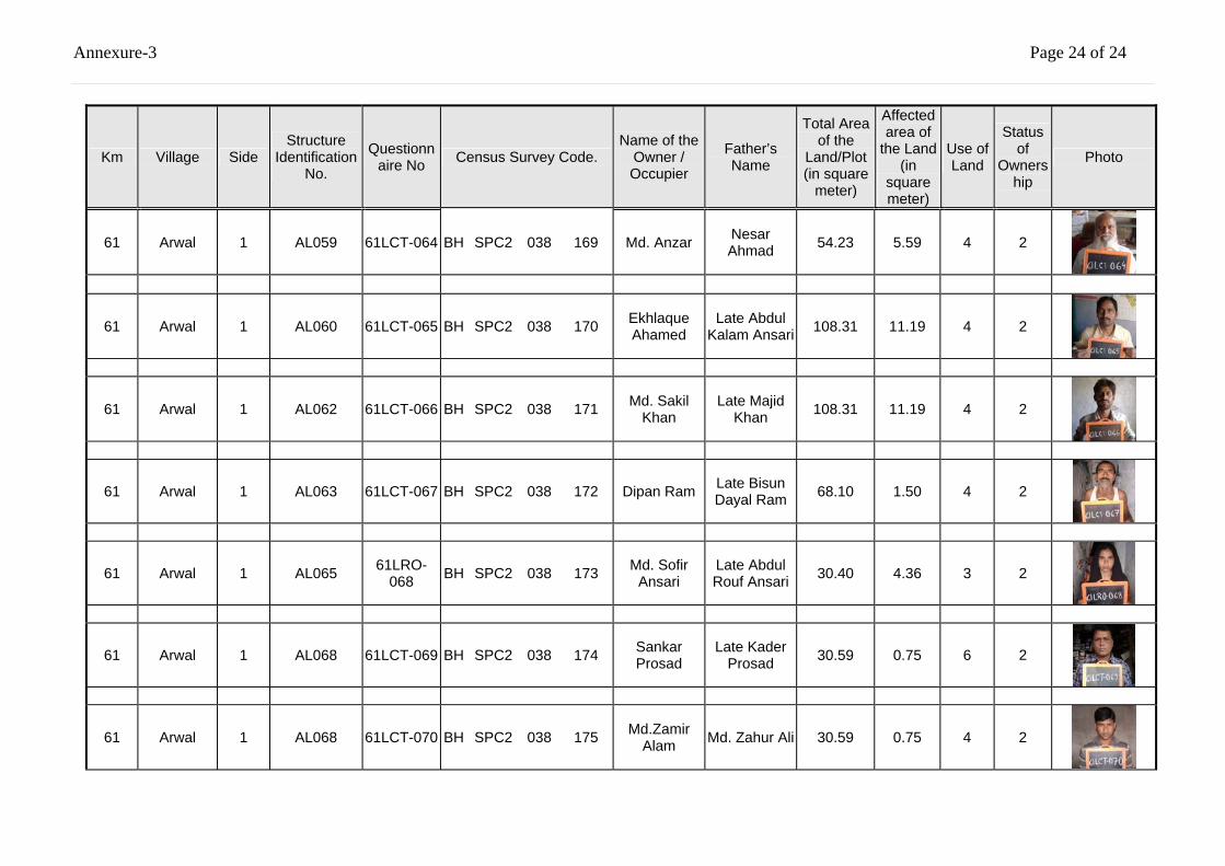
Annexure-3 Page 24 of 24
Km Village Side Structure
Identification No.
Questionnaire No Census Survey Code.
Name of the Owner / Occupier
Father’s Name
Total Area of the
Land/Plot (in square
meter)
Affected area of
the Land (in
square meter)
Use of Land
Status of
Ownership
Photo
61 Arwal 1 AL059 61LCT-064 BH SPC2 038 169 Md. Anzar Nesar Ahmad 54.23 5.59 4 2
61 Arwal 1 AL060 61LCT-065 BH SPC2 038 170 Ekhlaque Ahamed
Late Abdul Kalam Ansari 108.31 11.19 4 2
61 Arwal 1 AL062 61LCT-066 BH SPC2 038 171 Md. Sakil Khan
Late Majid Khan 108.31 11.19 4 2
61 Arwal 1 AL063 61LCT-067 BH SPC2 038 172 Dipan Ram Late Bisun Dayal Ram 68.10 1.50 4 2
61 Arwal 1 AL065 61LRO-068 BH SPC2 038 173 Md. Sofir
Ansari Late Abdul Rouf Ansari 30.40 4.36 3 2
61 Arwal 1 AL068 61LCT-069 BH SPC2 038 174 Sankar Prosad
Late Kader Prosad 30.59 0.75 6
2
61 Arwal 1 AL068 61LCT-070 BH SPC2 038 175 Md.Zamir Alam Md. Zahur Ali 30.59 0.75 4 2
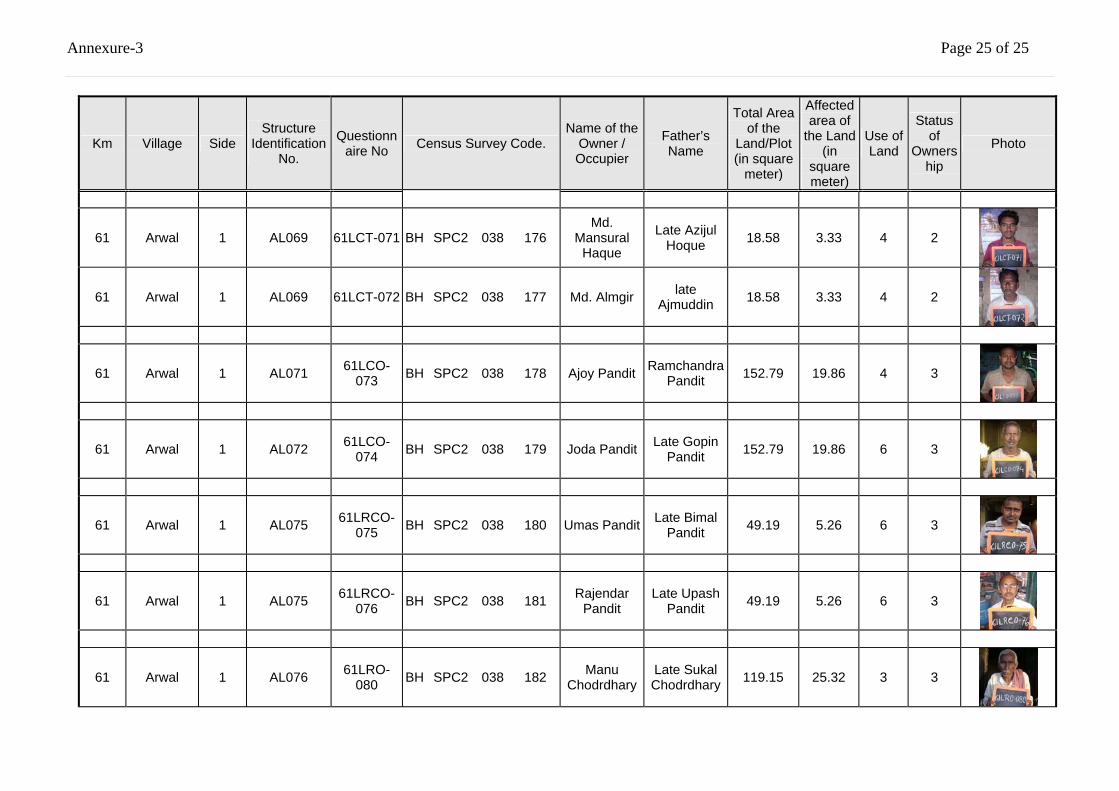
Annexure-3 Page 25 of 25
Km Village Side Structure
Identification No.
Questionnaire No Census Survey Code.
Name of the Owner / Occupier
Father’s Name
Total Area of the
Land/Plot (in square
meter)
Affected area of
the Land (in
square meter)
Use of Land
Status of
Ownership
Photo
61 Arwal 1 AL069 61LCT-071 BH SPC2 038 176 Md.
Mansural Haque
Late Azijul Hoque 18.58 3.33 4 2
61 Arwal 1 AL069 61LCT-072 BH SPC2 038 177 Md. Almgir late Ajmuddin 18.58 3.33 4 2
61 Arwal 1 AL071 61LCO-073 BH SPC2 038 178 Ajoy Pandit Ramchandra
Pandit 152.79 19.86 4 3
61 Arwal 1 AL072 61LCO-074 BH SPC2 038 179 Joda Pandit Late Gopin
Pandit 152.79 19.86 6 3
61 Arwal 1 AL075 61LRCO-075 BH SPC2 038 180 Umas Pandit Late Bimal
Pandit 49.19 5.26 6 3
61 Arwal 1 AL075 61LRCO-076 BH SPC2 038 181 Rajendar
Pandit Late Upash
Pandit 49.19 5.26 6 3
61 Arwal 1 AL076 61LRO-080 BH SPC2 038 182 Manu
Chodrdhary Late Sukal Chodrdhary 119.15 25.32 3 3
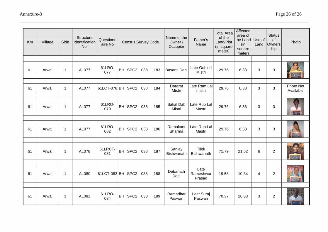
Annexure-3 Page 26 of 26
Km Village Side Structure
Identification No.
Questionnaire No Census Survey Code.
Name of the Owner / Occupier
Father’s Name
Total Area of the
Land/Plot (in square
meter)
Affected area of
the Land (in
square meter)
Use of Land
Status of
Ownership
Photo
61 Arwal 1 AL077 61LRO-077 BH SPC2 038 183 Basanti Debi Late Gobind
Mistri 29.76 6.33 3 3
61 Arwal 1 AL077 61LCT-078 BH SPC2 038 184 Dararat Mistri
Late Ram Lal mistri 29.76 6.33 3 3 Photo Not
Available
61 Arwal 1 AL077 61LRO-079 BH SPC2 038 185 Sakal Dab
Mistri Late Rup Lal
Mastri 29.76 6.33 3 3
61 Arwal 1 AL077 61LRO-082 BH SPC2 038 186 Ramakant
Sharma Late Rup Lal
Mastri 29.76 6.33 3 3
61 Arwal 1 AL078 61LRCT-081 BH SPC2 038 187 Sanjay
Bishwanath Tilok
Bishwanath 71.79 21.52 6 2
61 Arwal 1 AL080 61LCT-083 BH SPC2 038 188 Debanath Dedi
Late Rameshwar
Prasad 19.58 10.34 4 2
61 Arwal 1 AL081 61LRO-084 BH SPC2 038 189 Ramadhar
Paswan Laet Suraj Paswan 70.37 26.83 3 2
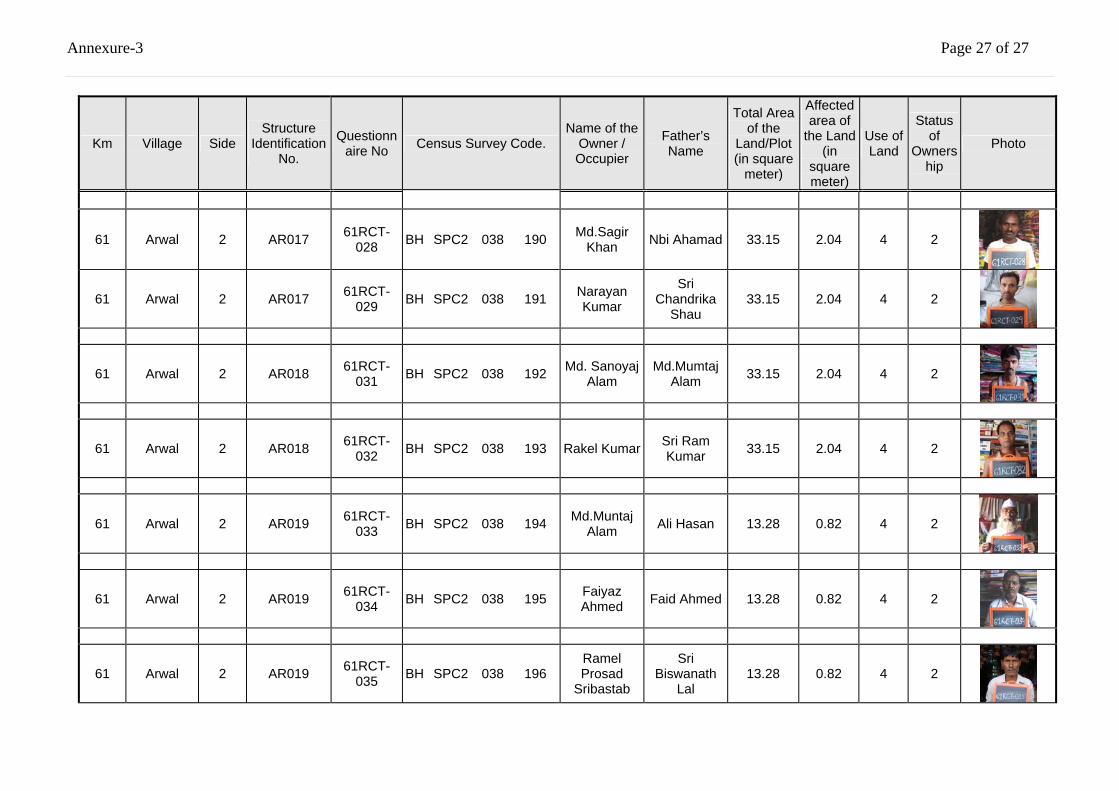
Annexure-3 Page 27 of 27
Km Village Side Structure
Identification No.
Questionnaire No Census Survey Code.
Name of the Owner / Occupier
Father’s Name
Total Area of the
Land/Plot (in square
meter)
Affected area of
the Land (in
square meter)
Use of Land
Status of
Ownership
Photo
61 Arwal 2 AR017 61RCT-028 BH SPC2 038 190 Md.Sagir
Khan Nbi Ahamad 33.15 2.04 4 2
61 Arwal 2 AR017 61RCT-029 BH SPC2 038 191 Narayan
Kumar
Sri Chandrika
Shau 33.15 2.04 4 2
61 Arwal 2 AR018 61RCT-031 BH SPC2 038 192 Md. Sanoyaj
Alam Md.Mumtaj
Alam 33.15 2.04 4 2
61 Arwal 2 AR018 61RCT-032 BH SPC2 038 193 Rakel Kumar Sri Ram
Kumar 33.15 2.04 4 2
61 Arwal 2 AR019 61RCT-033 BH SPC2 038 194 Md.Muntaj
Alam Ali Hasan 13.28 0.82 4 2
61 Arwal 2 AR019 61RCT-034 BH SPC2 038 195 Faiyaz
Ahmed Faid Ahmed 13.28 0.82 4 2
61 Arwal 2 AR019 61RCT-035 BH SPC2 038 196
Ramel Prosad
Sribastab
Sri Biswanath
Lal 13.28 0.82 4 2
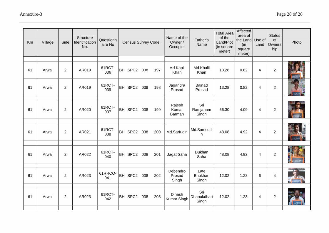
Annexure-3 Page 28 of 28
Km Village Side Structure
Identification No.
Questionnaire No Census Survey Code.
Name of the Owner / Occupier
Father’s Name
Total Area of the
Land/Plot (in square
meter)
Affected area of
the Land (in
square meter)
Use of Land
Status of
Ownership
Photo
61 Arwal 2 AR019 61RCT-036 BH SPC2 038 197 Md.Kapil
Khan Md.Khalil
Khan 13.28 0.82 4 2
61 Arwal 2 AR019 61RCT-039 BH SPC2 038 198 Jagandra
Prosad Bainad Prosad 13.28 0.82 4 2
61 Arwal 2 AR020 61RCT-037 BH SPC2 038 199
Rajesh Kumar
Barman
Sri Ramjanam
Singh 66.30 4.09 4 2
61 Arwal 2 AR021 61RCT-038 BH SPC2 038 200 Md.Sarfudin Md.Samsudi
n 48.08 4.92 4 2
61 Arwal 2 AR022 61RCT-040 BH SPC2 038 201 Jagat Saha Dukhan
Saha 48.08 4.92 4 2
61 Arwal 2 AR023 61RRCO-041 BH SPC2 038 202
Debendro Prosad Singh
Late Bhukhan
Singh 12.02 1.23 6 4
61 Arwal 2 AR023 61RCT-042 BH SPC2 038 203 Dinash
Kumar Singh
Sri Dhanukdhari
Singh 12.02 1.23 4 2
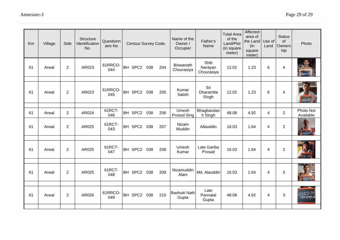
Annexure-3 Page 29 of 29
Km Village Side Structure
Identification No.
Questionnaire No Census Survey Code.
Name of the Owner / Occupier
Father’s Name
Total Area of the
Land/Plot (in square
meter)
Affected area of
the Land (in
square meter)
Use of Land
Status of
Ownership
Photo
61 Arwal 2 AR023 61RRCO-044 BH SPC2 038 204 Biswanath
Chourasiya
Shib Narayan
Chourasiya 12.02 1.23 6 4
61 Arwal 2 AR023 61RRCO-045 BH SPC2 038 205 Kumar
Satish
Sri Dharamtta
Singh 12.02 1.23 6 4
61 Arwal 2 AR024 61RCT-046 BH SPC2 038 206 Umesh
Prosed Sing Bhagbandas
h Singh 48.08 4.92 4 2 Photo Not Available
61 Arwal 2 AR025 61RCT-043 BH SPC2 038 207 Nizam
Muddin Allauddin 16.03 1.64 4 2
61 Arwal 2 AR025 61RCT-047 BH SPC2 038 208 Umesh
Kumar Late Gariba
Prosad 16.03 1.64 4 2
61 Arwal 2 AR025 61RCT-048 BH SPC2 038 209 Nizamuddin
Alam Md. Alauddin 16.03 1.64 4 3
61 Arwal 2 AR026 61RRCO-049 BH SPC2 038 210 Bashuki Nath
Gupta
Late Pannalal
Gupta 48.08 4.92 4 3
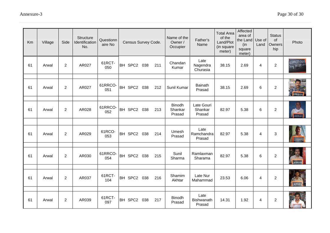
Annexure-3 Page 30 of 30
Km Village Side Structure
Identification No.
Questionnaire No Census Survey Code.
Name of the Owner / Occupier
Father’s Name
Total Area of the
Land/Plot (in square
meter)
Affected area of
the Land (in
square meter)
Use of Land
Status of
Ownership
Photo
61 Arwal 2 AR027 61RCT-050 BH SPC2 038 211 Chandan
Kumar
Late Nagendra Churasia
38.15 2.69 4 2
61 Arwal 2 AR027 61RRCO-051 BH SPC2 038 212 Sunil Kumar Bainath
Prasad 38.15 2.69 6 2
61 Arwal 2 AR028 61RRCO-052 BH SPC2 038 213
Binodh Shankar Prasad
Late Gouri Shankar Prasad
82.97 5.38 6 2
61 Arwal 2 AR029 61RCO-053 BH SPC2 038 214 Umesh
Prasad
Late Ramchandra
Prasad 82.97 5.38 4 3
61 Arwal 2 AR030 61RRCO-054 BH SPC2 038 215 Sunil
Sharma Ramlaxman
Sharama 82.97 5.38 6 2
61 Arwal 2 AR037 61RCT-104 BH SPC2 038 216 Shamim
Akhtar Late Nur
Mahammad 23.53 6.06 4 2
61 Arwal 2 AR039 61RCT-097 BH SPC2 038 217 Binodh
Prasad
Late Bishwanath
Prasad 14.31 1.92 4 2
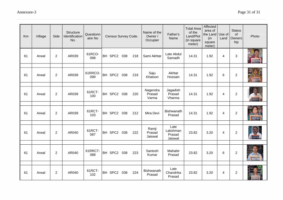
Annexure-3 Page 31 of 31
Km Village Side Structure
Identification No.
Questionnaire No Census Survey Code.
Name of the Owner / Occupier
Father’s Name
Total Area of the
Land/Plot (in square
meter)
Affected area of
the Land (in
square meter)
Use of Land
Status of
Ownership
Photo
61 Arwal 2 AR039 61RCO-098 BH SPC2 038 218 Sami Akhtar Late Abdul
Samadh 14.31 1.92 4 3
61 Arwal 2 AR039 61RRCO-099 BH SPC2 038 219 Saju
Khatoon Akhtar
Hossain 14.31 1.92 6 2
61 Arwal 2 AR039 61RCT-100 BH SPC2 038 220
Nagendra Prasad Varma
Jagadish Prasad Vharma
14.31 1.92 4 2
61 Arwal 2 AR039 61RCT-103 BH SPC2 038 212 Mira Devi Bishwanath
Prasad 14.31 1.92 4 2
61 Arwal 2 AR040 61RCT-087 BH SPC2 038 222
Ramji Prasad Jaiswal
Late Lakshman
Prasad Jaiswal
23.82 3.20 4 2
61 Arwal 2 AR040 61RRCT-088 BH SPC2 038 223 Santosh
Kumar Mahabir Prasad 23.82 3.20 6 2
61 Arwal 2 AR040 61RCT-102 BH SPC2 038 224 Bishwanath
Prasad
Late Chandrika
Prasad 23.82 3.20 4 2
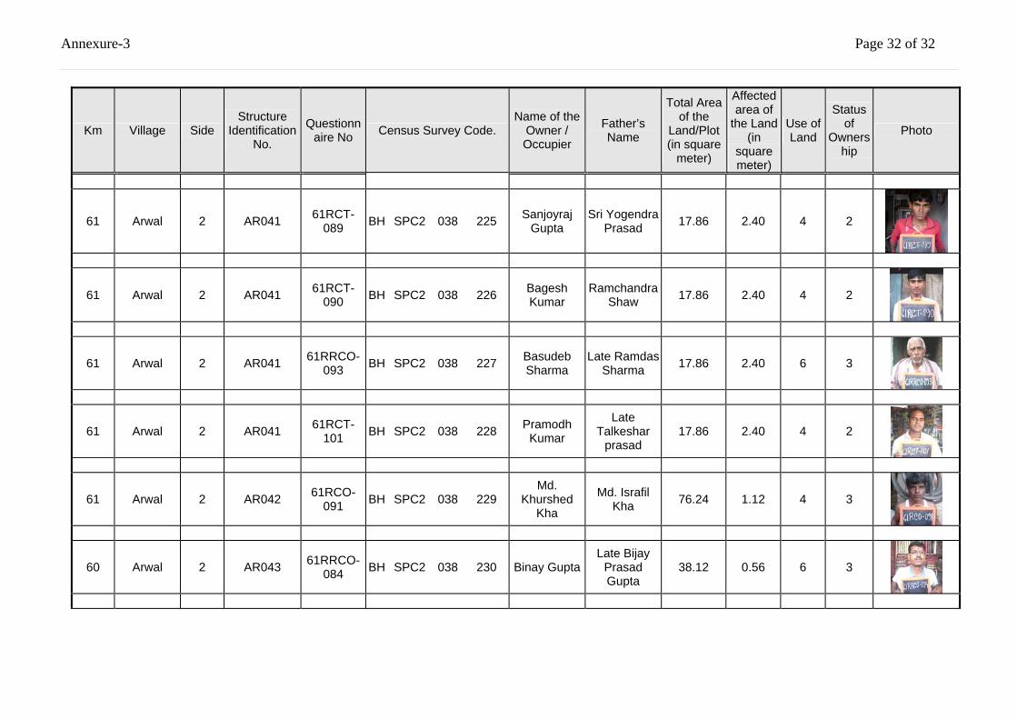
Annexure-3 Page 32 of 32
Km Village Side Structure
Identification No.
Questionnaire No Census Survey Code.
Name of the Owner / Occupier
Father’s Name
Total Area of the
Land/Plot (in square
meter)
Affected area of
the Land (in
square meter)
Use of Land
Status of
Ownership
Photo
61 Arwal 2 AR041 61RCT-089 BH SPC2 038 225 Sanjoyraj
Gupta Sri Yogendra
Prasad 17.86 2.40 4 2
61 Arwal 2 AR041 61RCT-090 BH SPC2 038 226 Bagesh
Kumar Ramchandra
Shaw 17.86 2.40 4 2
61 Arwal 2 AR041 61RRCO-093 BH SPC2 038 227 Basudeb
Sharma Late Ramdas
Sharma 17.86 2.40 6 3
61 Arwal 2 AR041 61RCT-101 BH SPC2 038 228 Pramodh
Kumar
Late Talkeshar
prasad 17.86 2.40 4 2
61 Arwal 2 AR042 61RCO-091 BH SPC2 038 229
Md. Khurshed
Kha
Md. Israfil Kha 76.24 1.12 4 3
60 Arwal 2 AR043 61RRCO-084 BH SPC2 038 230 Binay Gupta
Late Bijay Prasad Gupta
38.12 0.56 6 3
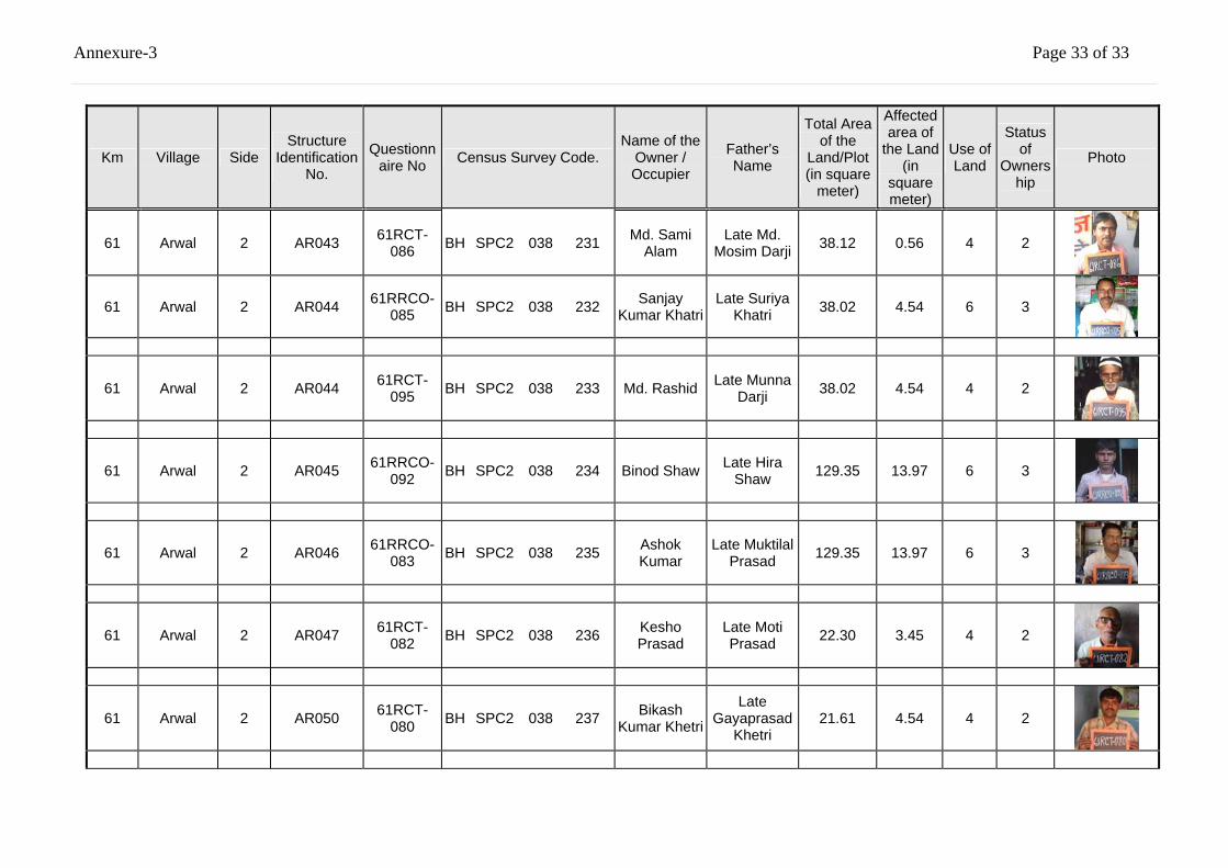
Annexure-3 Page 33 of 33
Km Village Side Structure
Identification No.
Questionnaire No Census Survey Code.
Name of the Owner / Occupier
Father’s Name
Total Area of the
Land/Plot (in square
meter)
Affected area of
the Land (in
square meter)
Use of Land
Status of
Ownership
Photo
61 Arwal 2 AR043 61RCT-086 BH SPC2 038 231 Md. Sami
Alam Late Md.
Mosim Darji 38.12 0.56 4 2
61 Arwal 2 AR044 61RRCO-085 BH SPC2 038 232 Sanjay
Kumar Khatri Late Suriya
Khatri 38.02 4.54 6 3
61 Arwal 2 AR044 61RCT-095 BH SPC2 038 233 Md. Rashid Late Munna
Darji 38.02 4.54 4 2
61 Arwal 2 AR045 61RRCO-092 BH SPC2 038 234 Binod Shaw Late Hira
Shaw 129.35 13.97 6 3
61 Arwal 2 AR046 61RRCO-083 BH SPC2 038 235 Ashok
Kumar Late Muktilal
Prasad 129.35 13.97 6 3
61 Arwal 2 AR047 61RCT-082 BH SPC2 038 236 Kesho
Prasad Late Moti Prasad 22.30 3.45 4 2
61 Arwal 2 AR050 61RCT-080 BH SPC2 038 237 Bikash
Kumar Khetri
Late Gayaprasad
Khetri 21.61 4.54 4 2
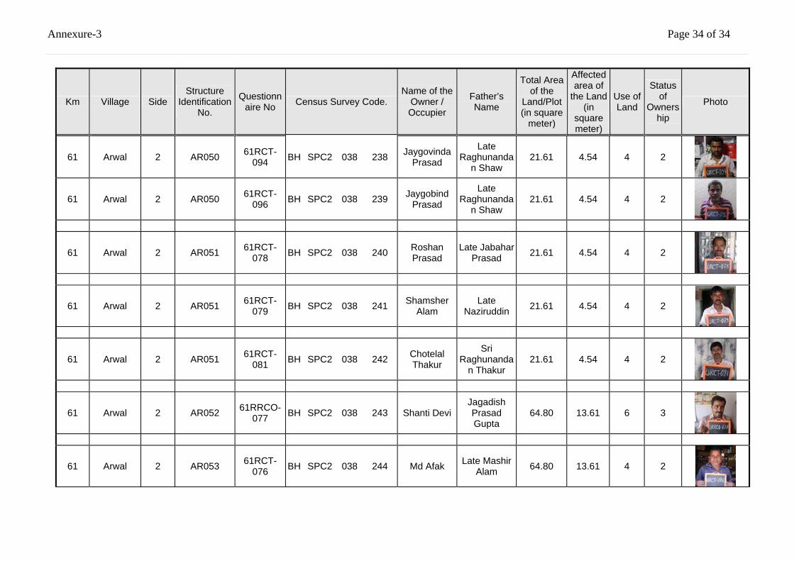
Annexure-3 Page 34 of 34
Km Village Side Structure
Identification No.
Questionnaire No Census Survey Code.
Name of the Owner / Occupier
Father’s Name
Total Area of the
Land/Plot (in square
meter)
Affected area of
the Land (in
square meter)
Use of Land
Status of
Ownership
Photo
61 Arwal 2 AR050 61RCT-094 BH SPC2 038 238 Jaygovinda
Prasad
Late Raghunanda
n Shaw 21.61 4.54 4 2
61 Arwal 2 AR050 61RCT-096 BH SPC2 038 239 Jaygobind
Prasad
Late Raghunanda
n Shaw 21.61 4.54 4 2
61 Arwal 2 AR051 61RCT-078 BH SPC2 038 240 Roshan
Prasad Late Jabahar
Prasad 21.61 4.54 4 2
61 Arwal 2 AR051 61RCT-079 BH SPC2 038 241 Shamsher
Alam Late
Naziruddin 21.61 4.54 4 2
61 Arwal 2 AR051 61RCT-081 BH SPC2 038 242 Chotelal
Thakur
Sri Raghunanda
n Thakur 21.61 4.54 4 2
61 Arwal 2 AR052 61RRCO-077 BH SPC2 038 243 Shanti Devi
Jagadish Prasad Gupta
64.80 13.61 6 3
61 Arwal 2 AR053 61RCT-076 BH SPC2 038 244 Md Afak Late Mashir
Alam 64.80 13.61 4 2
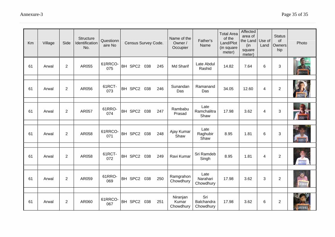
Annexure-3 Page 35 of 35
Km Village Side Structure
Identification No.
Questionnaire No Census Survey Code.
Name of the Owner / Occupier
Father’s Name
Total Area of the
Land/Plot (in square
meter)
Affected area of
the Land (in
square meter)
Use of Land
Status of
Ownership
Photo
61 Arwal 2 AR055 61RRCO-075 BH SPC2 038 245 Md Sharif Late Abdul
Rashid 14.82 7.64 6 3
61 Arwal 2 AR056 61RCT-073 BH SPC2 038 246 Sunandan
Das Ramanand
Das 34.05 12.60 4 2
61 Arwal 2 AR057 61RRO-074 BH SPC2 038 247 Rambabu
Prasad
Late Ramchalitra
Shaw 17.98 3.62 4 3
61 Arwal 2 AR058 61RRCO-071 BH SPC2 038 248 Ajay Kumar
Shaw
Late Raghubir
Shaw 8.95 1.81 6 3
61 Arwal 2 AR058 61RCT-072 BH SPC2 038 249 Ravi Kumar Sri Ramdeb
Singh 8.95 1.81 4 2
61 Arwal 2 AR059 61RRO-069 BH SPC2 038 250 Ramgrahon
Chowdhury
Late Narahari
Chowdhury 17.98 3.62 3 2
61 Arwal 2 AR060 61RRCO-067 BH SPC2 038 251
Niranjan Kumar
Chowdhury
Sri Balchandra Chowdhury
17.98 3.62 6 2
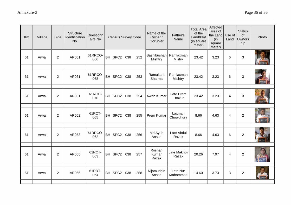
Annexure-3 Page 36 of 36
Km Village Side Structure
Identification No.
Questionnaire No Census Survey Code.
Name of the Owner / Occupier
Father’s Name
Total Area of the
Land/Plot (in square
meter)
Affected area of
the Land (in
square meter)
Use of Land
Status of
Ownership
Photo
61 Arwal 2 AR061 61RRCO-066 BH SPC2 038 252 Sashibushan
Mishtry Ramlaxman
Mistry 23.42 3.23 6 3
61 Arwal 2 AR061 61RRCO-068 BH SPC2 038 253 Ramakant
Sharma Ramlaxman
Mishtry 23.42 3.23 6 3
61 Arwal 2 AR061 61RCO-070 BH SPC2 038 254 Awdh Kumar Late Prem
Thakur 23.42 3.23 4 3
61 Arwal 2 AR062 61RCT-065 BH SPC2 038 255 Prem Kumar Laxman
Chowdhury 8.66 4.63 4 2
61 Arwal 2 AR063 61RRCO-062 BH SPC2 038 256 Md Ayub
Ansari Late Abdul
Razak 8.66 4.63 6 2
61 Arwal 2 AR065 61RCT-063 BH SPC2 038 257
Roshan Kumar Razak
Late Makholi Razak 20.26 7.97 4 2
61 Arwal 2 AR066 61RRT-064 BH SPC2 038 258 Nijamuddin
Ansari Late Nur
Mahammad 14.60 3.73 3 2
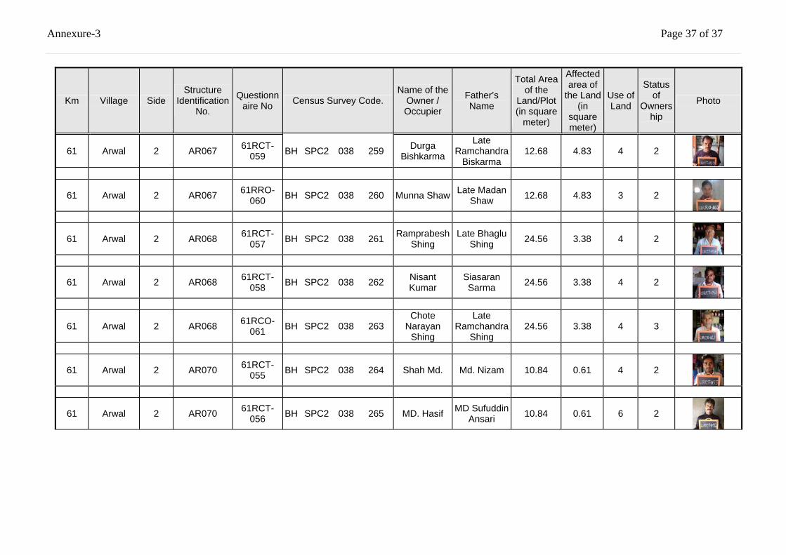
Annexure-3 Page 37 of 37
Km Village Side Structure
Identification No.
Questionnaire No Census Survey Code.
Name of the Owner / Occupier
Father’s Name
Total Area of the
Land/Plot (in square
meter)
Affected area of
the Land (in
square meter)
Use of Land
Status of
Ownership
Photo
61 Arwal 2 AR067 61RCT-059 BH SPC2 038 259 Durga
Bishkarma
Late Ramchandra
Biskarma 12.68 4.83 4 2
61 Arwal 2 AR067 61RRO-060 BH SPC2 038 260 Munna Shaw Late Madan
Shaw 12.68 4.83 3 2
61 Arwal 2 AR068 61RCT-057 BH SPC2 038 261 Ramprabesh
Shing Late Bhaglu
Shing 24.56 3.38 4 2
61 Arwal 2 AR068 61RCT-058 BH SPC2 038 262 Nisant
Kumar Siasaran Sarma 24.56 3.38 4 2
61 Arwal 2 AR068 61RCO-061 BH SPC2 038 263
Chote Narayan
Shing
Late Ramchandra
Shing 24.56 3.38 4 3
61 Arwal 2 AR070 61RCT-055 BH SPC2 038 264 Shah Md. Md. Nizam 10.84 0.61 4 2
61 Arwal 2 AR070 61RCT-056 BH SPC2 038 265 MD. Hasif MD Sufuddin
Ansari 10.84 0.61 6 2
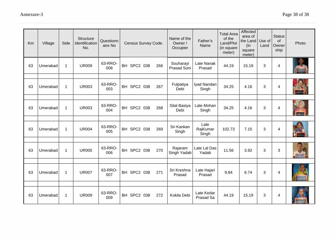
Annexure-3 Page 38 of 38
Km Village Side Structure
Identification No.
Questionnaire No Census Survey Code.
Name of the Owner / Occupier
Father’s Name
Total Area of the
Land/Plot (in square
meter)
Affected area of
the Land (in
square meter)
Use of Land
Status of
Ownership
Photo
63 Umerabad 1 UR009 63-RRO-008 BH SPC2 038 266 Souharayi
Prasad Soni Late Nanak
Prasad 44.19 15.19 3 4
63 Umerabad 1 UR003 63-RRO-003 BH SPC2 038 267 Fulpatiya
Debi Iyad Nandan
Singh 34.25 4.16 3 4
63 Umerabad 1 UR003 63-RRO-004 BH SPC2 038 268 Sital Basiya
Debi Late Mohan
Singh 34.25 4.16 3 4
63 Umerabad 1 UR004 63-RRO-005 BH SPC2 038 269 Sri Kankan
Singh
Late RajKumar
Singh 102.73 7.15 3 4
63 Umerabad 1 UR005 63-RRO-006 BH SPC2 038 270 Rajaram
Singh Yadab Late Lal Das
Yadab 11.56 3.92 3 3
63 Umerabad 1 UR007 63-RRO-007 BH SPC2 038 271 Sri Kreshna
Prasad Late Hajari
Prasad 9.84 6.74 3 4
63 Umerabad 1 UR009 63-RRO-009 BH SPC2 038 272 Kokila Debi Late Kedar
Prasad Sa 44.19 15.19 3 4
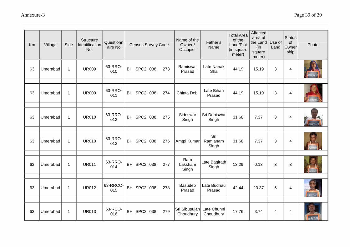
Annexure-3 Page 39 of 39
Km Village Side Structure
Identification No.
Questionnaire No Census Survey Code.
Name of the Owner / Occupier
Father’s Name
Total Area of the
Land/Plot (in square
meter)
Affected area of
the Land (in
square meter)
Use of Land
Status of
Ownership
Photo
63 Umerabad 1 UR009 63-RRO-010 BH SPC2 038 273 Ramiswar
Prasad Late Nanak
Sha 44.19 15.19 3 4
63 Umerabad 1 UR009 63-RRO-011 BH SPC2 038 274 Chinta Debi Late Bihari
Prasad 44.19 15.19 3 4
63 Umerabad 1 UR010 63-RRO-012 BH SPC2 038 275 Sideswar
Singh Sri Debiswar
Singh 31.68 7.37 3 4
63 Umerabad 1 UR010 63-RRO-013 BH SPC2 038 276 Amtpi Kumar
Sri Ramjanam
Singh 31.68 7.37 3 4
63 Umerabad 1 UR011 63-RRO-014 BH SPC2 038 277
Ram Laksham
Singh
Late Bagirath Singh 13.29 0.13 3 3
63 Umerabad 1 UR012 63-RRCO-015 BH SPC2 038 278 Basudeb
Prasad Late Budhau
Prasad 42.44 23.37 6 4
63 Umerabad 1 UR013 63-RCO-016 BH SPC2 038 279 Sri Sibupujan
Choudhury Late Chunni Choudhury 17.76 3.74 4 4
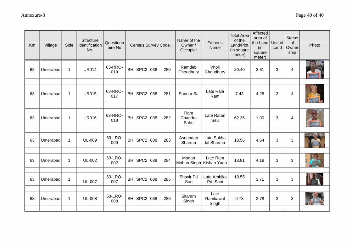
Annexure-3 Page 40 of 40
Km Village Side Structure
Identification No.
Questionnaire No Census Survey Code.
Name of the Owner / Occupier
Father’s Name
Total Area of the
Land/Plot (in square
meter)
Affected area of
the Land (in
square meter)
Use of Land
Status of
Ownership
Photo
63 Umerabad 1 UR014 63-RRO-019 BH SPC2 038 280 Ramdeb
Choudhury Vholi
Choudhury 30.40 3.61 3 4
63 Umerabad 1 UR015 63-RRO-017 BH SPC2 038 281 Sundar Sa Late Raja
Ram 7.43 4.28 3 4
63 Umerabad 1 UR016 63-RRO-018 BH SPC2 038 282
Ram Chandra
Sahu
Late Ratan Sau 62.36 1.90 3 4
63 Umerabad 1 UL-009 63-LRO-009 BH SPC2 038 283 Asnandan
Sharma Late Sukha lal Sharma 18.56 4.64 3 3
63 Umerabad 1 UL-002 63-LRO-002 BH SPC2 038 284 Madan
Mohan Singh Late Ram
Kishan Yado 18.81 4.18 3 3
63 Umerabad 1 UL-007
63-LRO-007 BH SPC2 038 285 Shavir Pd
.Soni Late Ambika
Pd. Soni 18.55
3.71 3 3
63 Umerabad 1 UL-008 63-LRO-008 BH SPC2 038 286 Sitaram
Singh
Late Ramkawal
Singh 9.73 2.78 3 3
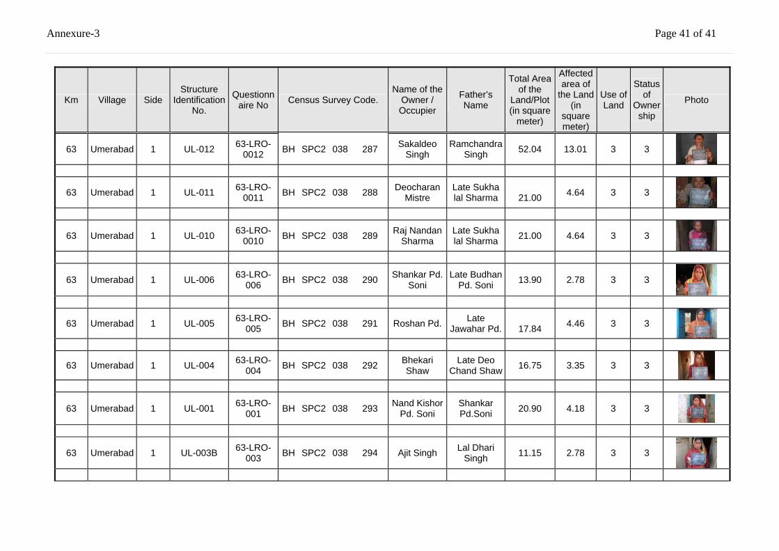
Annexure-3 Page 41 of 41
Km Village Side Structure
Identification No.
Questionnaire No Census Survey Code.
Name of the Owner / Occupier
Father’s Name
Total Area of the
Land/Plot (in square
meter)
Affected area of
the Land (in
square meter)
Use of Land
Status of
Ownership
Photo
63 Umerabad 1 UL-012 63-LRO-0012 BH SPC2 038 287 Sakaldeo
Singh Ramchandra
Singh 52.04 13.01 3 3
63 Umerabad 1 UL-011 63-LRO-0011 BH SPC2 038 288 Deocharan
Mistre Late Sukha lal Sharma
21.00 4.64 3 3
63 Umerabad 1 UL-010 63-LRO-0010 BH SPC2 038 289 Raj Nandan
Sharma Late Sukha lal Sharma 21.00 4.64 3 3
63 Umerabad 1 UL-006 63-LRO-006 BH SPC2 038 290 Shankar Pd.
Soni Late Budhan
Pd. Soni 13.90 2.78 3 3
63 Umerabad 1 UL-005 63-LRO-005 BH SPC2 038 291 Roshan Pd. Late
Jawahar Pd.
17.84 4.46 3 3
63 Umerabad 1 UL-004 63-LRO-004 BH SPC2 038 292 Bhekari
Shaw Late Deo
Chand Shaw 16.75 3.35 3 3
63 Umerabad 1 UL-001 63-LRO-001 BH SPC2 038 293 Nand Kishor
Pd. Soni Shankar Pd.Soni
20.90
4.18 3 3
63 Umerabad 1 UL-003B 63-LRO-003 BH SPC2 038 294 Ajit Singh Lal Dhari
Singh 11.15 2.78 3 3

Annexure-3 Page 42 of 42
Km Village Side Structure
Identification No.
Questionnaire No Census Survey Code.
Name of the Owner / Occupier
Father’s Name
Total Area of the
Land/Plot (in square
meter)
Affected area of
the Land (in
square meter)
Use of Land
Status of
Ownership
Photo
63 Umerabad 1 UL-003A 63-LRO-003 BH SPC2 038 295 Lal Deo Pd.
Yado Late Kanihya
Yado 11.15 2.78 3 3
65 Baidrabad 2 BR001 65-RCO-001 BH SPC2 038 296 Beju Singh Shib Pradas
Singh 9.27 4.64 4 4
65 Baidrabad 2 BR002 65-RCO-002 BH SPC2 038 297 Sailesh
Kumar Sri Ramjiban
Singh 111.45 39.22 4 4
65 Baidrabad 2 BR003 65-RCO-003 BH SPC2 038 298 Sanjoy
Pasoyan Sri Deonat
Pasoyal 14.86 6.84 4 4
65 Baidrabad 2 BR004 65-RCO-004 BH SPC2 038 299 Jitendrar
Yadab Chandreswar
Yadab 12.07 5.45 4 4
65 Baidrabad 2 BR005 65-RCO-005 BH SPC2 038 300 Kameshwar
Singh Dilip Singh 3.34 1.66 4 4
65 Baidrabad 2 BR007 65RRO-07 BH SPC2 038 301 Maloti Devi Late Chaps Choudhury 9.26 8.04 3 3
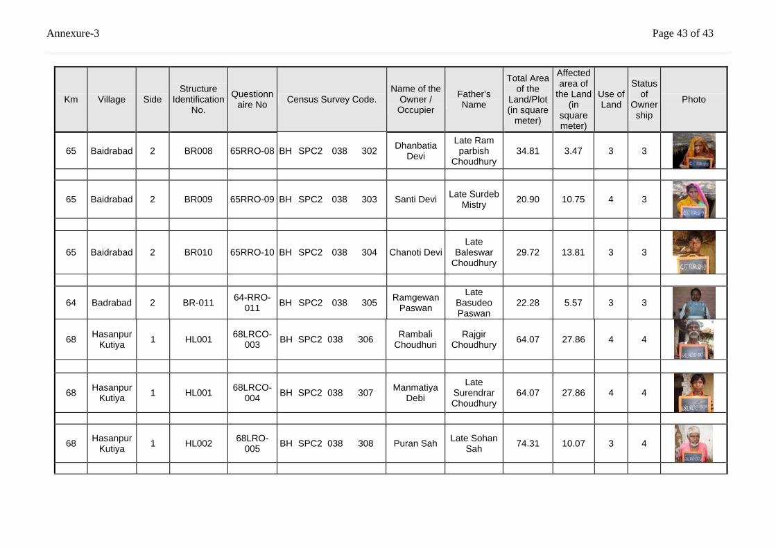
Annexure-3 Page 43 of 43
Km Village Side Structure
Identification No.
Questionnaire No Census Survey Code.
Name of the Owner / Occupier
Father’s Name
Total Area of the
Land/Plot (in square
meter)
Affected area of
the Land (in
square meter)
Use of Land
Status of
Ownership
Photo
65 Baidrabad 2 BR008 65RRO-08 BH SPC2 038 302 Dhanbatia Devi
Late Ram parbish
Choudhury 34.81 3.47 3 3
65 Baidrabad 2 BR009 65RRO-09 BH SPC2 038 303 Santi Devi Late Surdeb Mistry 20.90 10.75 4 3
65 Baidrabad 2 BR010 65RRO-10 BH SPC2 038 304 Chanoti Devi Late
Baleswar Choudhury
29.72 13.81 3 3
64 Badrabad 2 BR-011 64-RRO-011 BH SPC2 038 305 Ramgewan
Paswan
Late Basudeo Paswan
22.28 5.57 3 3
68 Hasanpur Kutiya 1 HL001 68LRCO-
003 BH SPC2 038 306 Rambali Choudhuri
Rajgir Choudhury 64.07 27.86 4 4
68 Hasanpur Kutiya 1 HL001 68LRCO-
004 BH SPC2 038 307 Manmatiya Debi
Late Surendrar Choudhury
64.07 27.86 4 4
68 Hasanpur Kutiya 1 HL002 68LRO-
005 BH SPC2 038 308 Puran Sah Late Sohan Sah 74.31 10.07 3 4
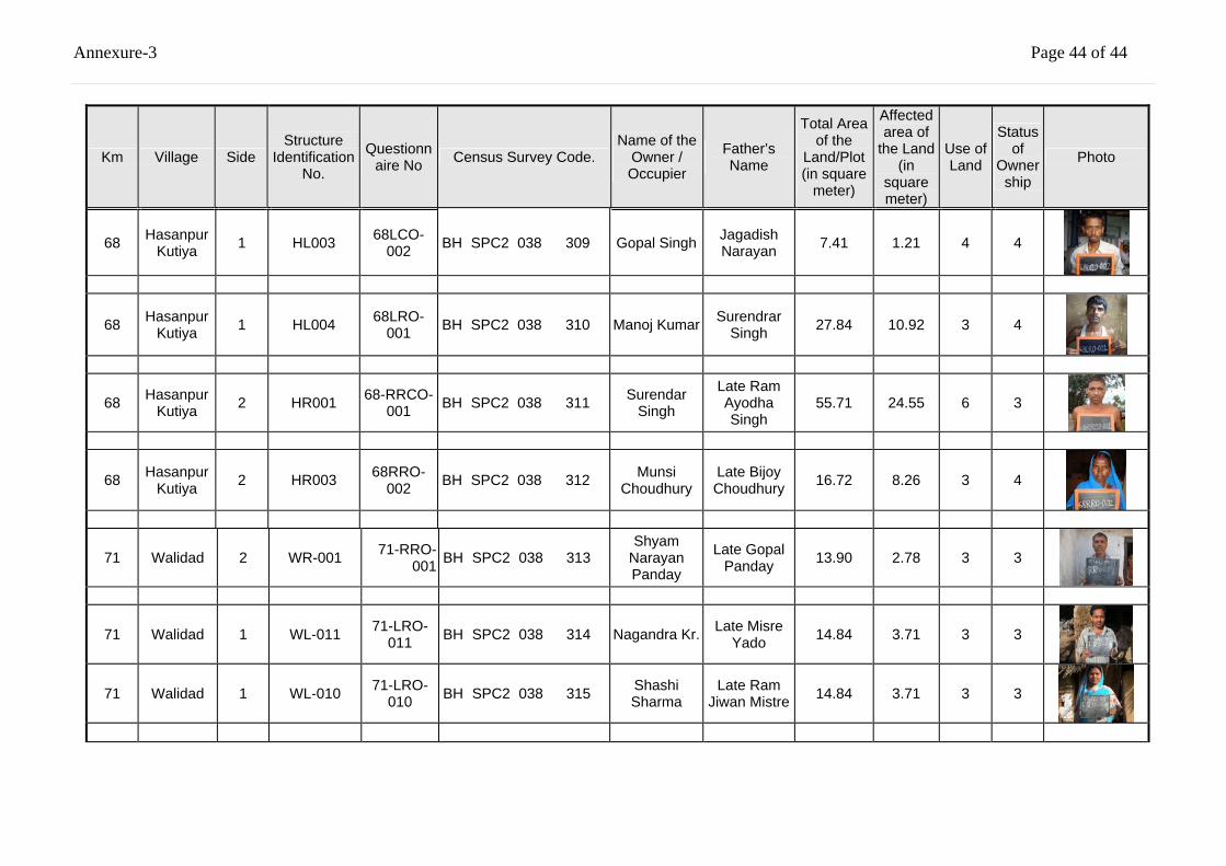
Annexure-3 Page 44 of 44
Km Village Side Structure
Identification No.
Questionnaire No Census Survey Code.
Name of the Owner / Occupier
Father’s Name
Total Area of the
Land/Plot (in square
meter)
Affected area of
the Land (in
square meter)
Use of Land
Status of
Ownership
Photo
68 Hasanpur Kutiya 1 HL003 68LCO-
002 BH SPC2 038 309 Gopal Singh Jagadish Narayan 7.41 1.21 4 4
68 Hasanpur Kutiya 1 HL004 68LRO-
001 BH SPC2 038 310 Manoj Kumar Surendrar Singh 27.84 10.92 3 4
68 Hasanpur Kutiya 2 HR001 68-RRCO-
001 BH SPC2 038 311 Surendar Singh
Late Ram Ayodha Singh
55.71 24.55 6 3
68 Hasanpur Kutiya 2 HR003 68RRO-
002 BH SPC2 038 312 Munsi Choudhury
Late Bijoy Choudhury 16.72 8.26 3 4
71 Walidad 2 WR-001 71-RRO-001 BH SPC2 038 313
Shyam Narayan Panday
Late Gopal Panday 13.90 2.78 3 3
71 Walidad 1 WL-011 71-LRO-011 BH SPC2 038 314 Nagandra Kr. Late Misre
Yado 14.84 3.71 3 3
71 Walidad 1 WL-010 71-LRO-010 BH SPC2 038 315 Shashi
Sharma Late Ram
Jiwan Mistre 14.84 3.71 3 3
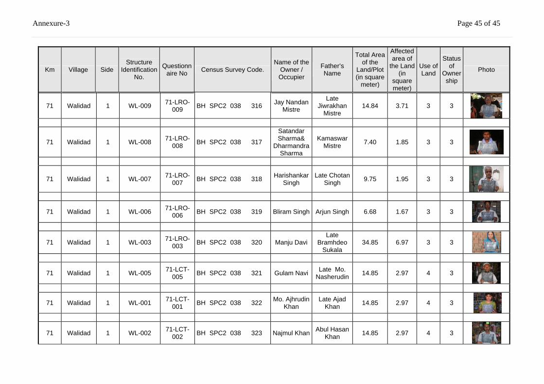
Annexure-3 Page 45 of 45
Km Village Side Structure
Identification No.
Questionnaire No Census Survey Code.
Name of the Owner / Occupier
Father’s Name
Total Area of the
Land/Plot (in square
meter)
Affected area of
the Land (in
square meter)
Use of Land
Status of
Ownership
Photo
71 Walidad 1 WL-009 71-LRO-009 BH SPC2 038 316 Jay Nandan
Mistre
Late Jiwrakhan
Mistre 14.84 3.71 3 3
71 Walidad 1 WL-008 71-LRO-008 BH SPC2 038 317
Satandar Sharma&
Dharmandra Sharma
Kamaswar Mistre 7.40 1.85 3 3
71 Walidad 1 WL-007 71-LRO-007 BH SPC2 038 318 Harishankar
Singh Late Chotan
Singh 9.75 1.95 3 3
71 Walidad 1 WL-006 71-LRO-006 BH SPC2 038 319 Bliram Singh Arjun Singh 6.68 1.67 3 3
71 Walidad 1 WL-003 71-LRO-003 BH SPC2 038 320 Manju Davi
Late Bramhdeo
Sukala 34.85 6.97 3 3
71 Walidad 1 WL-005 71-LCT-005 BH SPC2 038 321 Gulam Navi Late Mo.
Nasherudin 14.85 2.97 4 3
71 Walidad 1 WL-001 71-LCT-001 BH SPC2 038 322 Mo. Ajhrudin
Khan Late Ajad
Khan 14.85 2.97 4 3
71 Walidad 1 WL-002 71-LCT-002 BH SPC2 038 323 Najmul Khan Abul Hasan
Khan 14.85 2.97 4 3
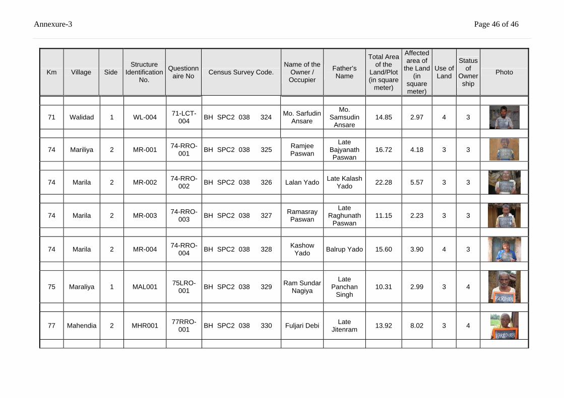
Annexure-3 Page 46 of 46
Km Village Side Structure
Identification No.
Questionnaire No Census Survey Code.
Name of the Owner / Occupier
Father’s Name
Total Area of the
Land/Plot (in square
meter)
Affected area of
the Land (in
square meter)
Use of Land
Status of
Ownership
Photo
71 Walidad 1 WL-004 71-LCT-004 BH SPC2 038 324 Mo. Sarfudin
Ansare
Mo. Samsudin
Ansare 14.85 2.97 4 3
74 Mariliya 2 MR-001 74-RRO-001 BH SPC2 038 325 Ramjee
Paswan
Late Bajyanath Paswan
16.72 4.18 3 3
74 Marila 2 MR-002 74-RRO-002 BH SPC2 038 326 Lalan Yado Late Kalash
Yado 22.28 5.57 3 3
74 Marila 2 MR-003 74-RRO-003 BH SPC2 038 327 Ramasray
Paswan
Late Raghunath
Paswan 11.15 2.23 3 3
74 Marila 2 MR-004 74-RRO-004 BH SPC2 038 328 Kashow
Yado Balrup Yado 15.60 3.90 4 3
75 Maraliya 1 MAL001 75LRO-001 BH SPC2 038 329 Ram Sundar
Nagiya
Late Panchan
Singh 10.31 2.99 3 4
77 Mahendia 2 MHR001 77RRO-001 BH SPC2 038 330 Fuljari Debi Late
Jitenram 13.92 8.02 3 4
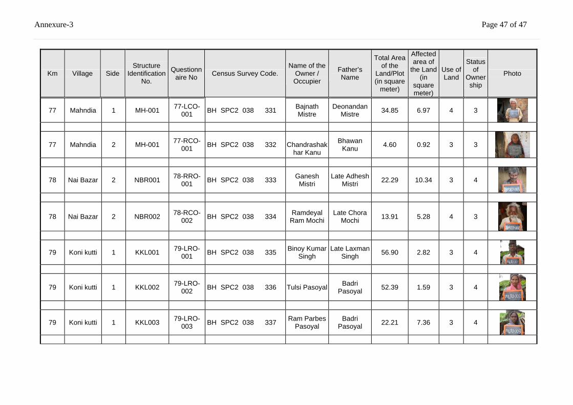
Annexure-3 Page 47 of 47
Km Village Side Structure
Identification No.
Questionnaire No Census Survey Code.
Name of the Owner / Occupier
Father’s Name
Total Area of the
Land/Plot (in square
meter)
Affected area of
the Land (in
square meter)
Use of Land
Status of
Ownership
Photo
77 Mahndia 1 MH-001 77-LCO-001 BH SPC2 038 331 Bajnath
Mistre Deonandan
Mistre 34.85 6.97 4 3
77 Mahndia 2
MH-001
77-RCO-001 BH SPC2 038 332
Chandrashak
har Kanu
Bhawan Kanu 4.60 0.92 3 3
78 Nai Bazar 2 NBR001 78-RRO-001 BH SPC2 038 333 Ganesh
Mistri Late Adhesh
Mistri 22.29 10.34 3 4
78 Nai Bazar 2 NBR002 78-RCO-002 BH SPC2 038 334 Ramdeyal
Ram Mochi Late Chora
Mochi 13.91 5.28 4 3
79 Koni kutti 1 KKL001 79-LRO-001 BH SPC2 038 335 Binoy Kumar
Singh Late Laxman
Singh 56.90 2.82 3 4
79 Koni kutti 1 KKL002 79-LRO-002 BH SPC2 038 336 Tulsi Pasoyal Badri
Pasoyal 52.39 1.59 3 4
79 Koni kutti 1 KKL003 79-LRO-003 BH SPC2 038 337 Ram Parbes
Pasoyal Badri
Pasoyal 22.21 7.36 3 4
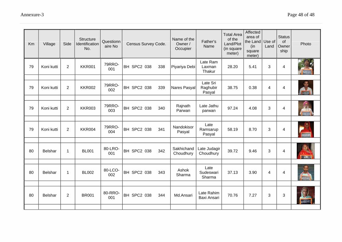
Annexure-3 Page 48 of 48
Km Village Side Structure
Identification No.
Questionnaire No Census Survey Code.
Name of the Owner / Occupier
Father’s Name
Total Area of the
Land/Plot (in square
meter)
Affected area of
the Land (in
square meter)
Use of Land
Status of
Ownership
Photo
79 Koni kutti 2 KKR001 79RRO-001 BH SPC2 038 338 Piyariya Debi
Late Ram Laxman Thakur
28.20 5.41 3 4
79 Koni kutti 2 KKR002 79RRO-002 BH SPC2 038 339 Nares Pasyal
Late Sri Raghubir Pasyal
38.75 0.38 4 4
79 Koni kutti 2 KKR003 79RRO-003 BH SPC2 038 340 Rajnath
Parwan Late Jathu
parwan 97.24 4.08 3 4
79 Koni kutti 2 KKR004 79RRO-004 BH SPC2 038 341 Nandokisor
Pasyal
Late Ramsarup
Pasyal 58.19 8.70 3 4
80 Belshar 1 BL001 80-LRO-001 BH SPC2 038 342 Sakhichand
Choudhury Late Judagir Choudhury 39.72 9.46 3 4
80 Belshar 1 BL002 80-LCO-002 BH SPC2 038 343 Ashok
Sharma
Late Sudeswari
Sharma 37.13 3.90 4 4
80 Belshar 2 BR001 80-RRO-001 BH SPC2 038 344 Md.Ansari Late Rahim
Baxi Ansari 70.76 7.27 3 3
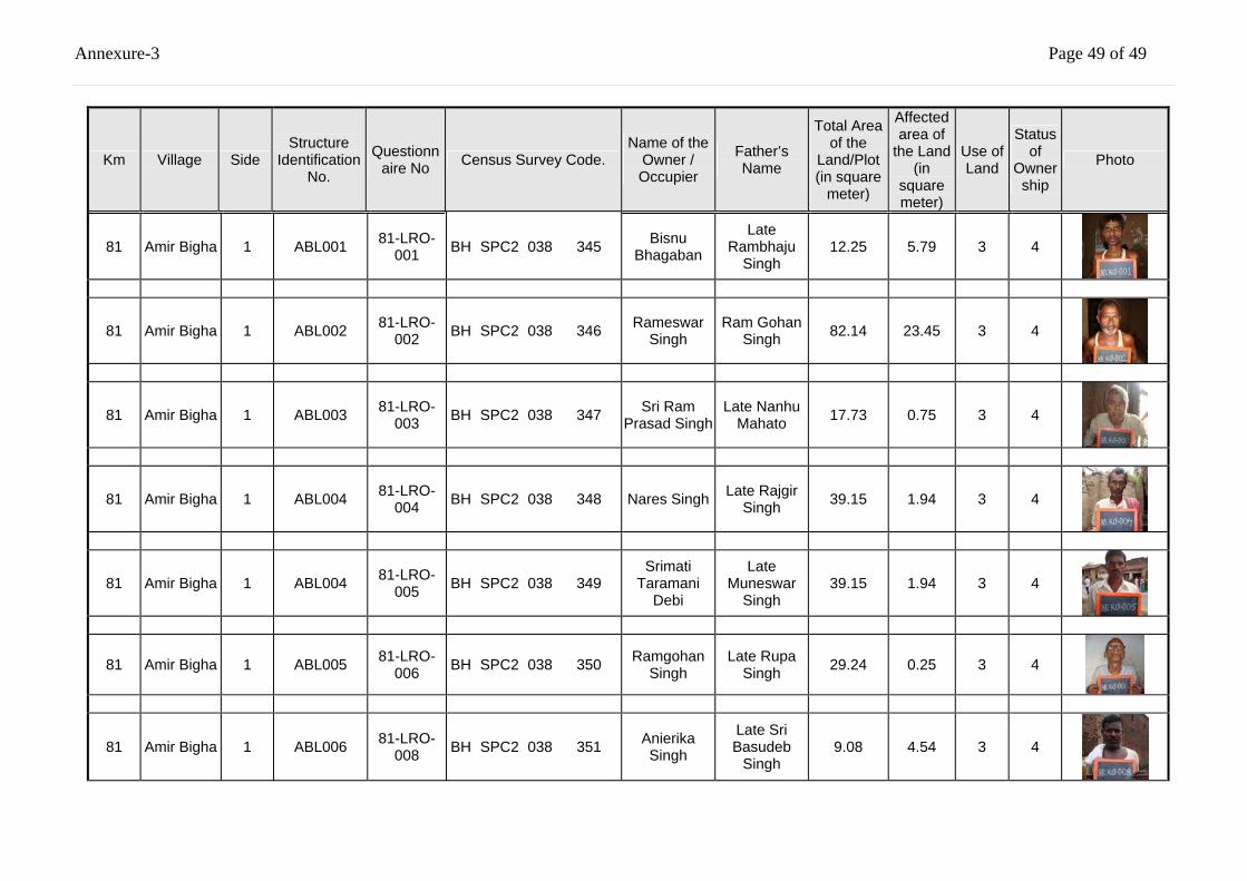
Annexure-3 Page 49 of 49
Km Village Side Structure
Identification No.
Questionnaire No Census Survey Code.
Name of the Owner / Occupier
Father’s Name
Total Area of the
Land/Plot (in square
meter)
Affected area of
the Land (in
square meter)
Use of Land
Status of
Ownership
Photo
81 Amir Bigha 1 ABL001 81-LRO-001 BH SPC2 038 345 Bisnu
Bhagaban
Late Rambhaju
Singh 12.25 5.79 3 4
81 Amir Bigha 1 ABL002 81-LRO-002 BH SPC2 038 346 Rameswar
Singh Ram Gohan
Singh 82.14 23.45 3 4
81 Amir Bigha 1 ABL003 81-LRO-003 BH SPC2 038 347 Sri Ram
Prasad Singh Late Nanhu
Mahato 17.73 0.75 3 4
81 Amir Bigha 1 ABL004 81-LRO-004 BH SPC2 038 348 Nares Singh Late Rajgir
Singh 39.15 1.94 3 4
81 Amir Bigha 1 ABL004 81-LRO-005 BH SPC2 038 349
Srimati Taramani
Debi
Late Muneswar
Singh 39.15 1.94 3 4
81 Amir Bigha 1 ABL005 81-LRO-006 BH SPC2 038 350 Ramgohan
Singh Late Rupa
Singh 29.24 0.25 3 4
81 Amir Bigha 1 ABL006 81-LRO-008 BH SPC2 038 351 Anierika
Singh
Late Sri Basudeb
Singh 9.08 4.54 3 4
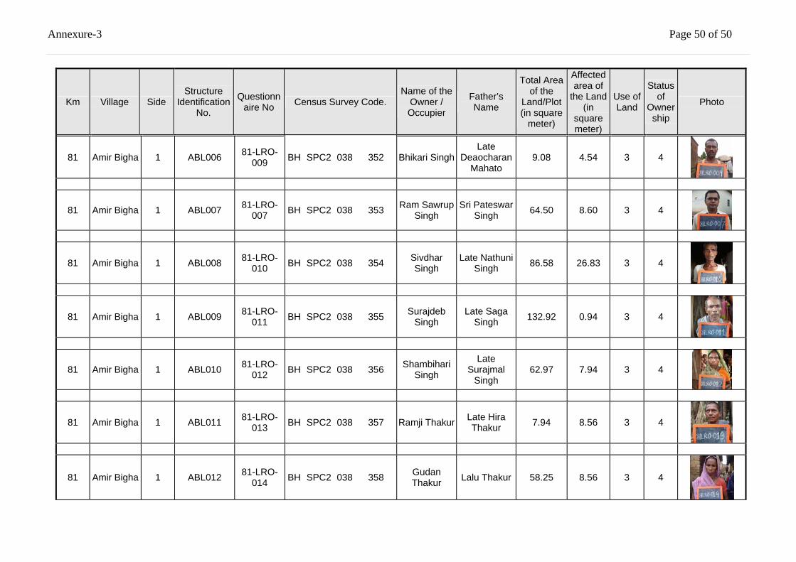
Annexure-3 Page 50 of 50
Km Village Side Structure
Identification No.
Questionnaire No Census Survey Code.
Name of the Owner / Occupier
Father’s Name
Total Area of the
Land/Plot (in square
meter)
Affected area of
the Land (in
square meter)
Use of Land
Status of
Ownership
Photo
81 Amir Bigha 1 ABL006 81-LRO-009 BH SPC2 038 352 Bhikari Singh
Late Deaocharan
Mahato 9.08 4.54 3 4
81 Amir Bigha 1 ABL007 81-LRO-007 BH SPC2 038 353 Ram Sawrup
Singh Sri Pateswar
Singh 64.50 8.60 3 4
81 Amir Bigha 1 ABL008 81-LRO-010 BH SPC2 038 354 Sivdhar
Singh Late Nathuni
Singh 86.58 26.83 3 4
81 Amir Bigha 1 ABL009 81-LRO-011 BH SPC2 038 355 Surajdeb
Singh Late Saga
Singh 132.92 0.94 3 4
81 Amir Bigha 1 ABL010 81-LRO-012 BH SPC2 038 356 Shambihari
Singh
Late Surajmal
Singh 62.97 7.94 3 4
81 Amir Bigha 1 ABL011 81-LRO-013 BH SPC2 038 357 Ramji Thakur Late Hira
Thakur 7.94 8.56 3 4
81 Amir Bigha 1 ABL012 81-LRO-014 BH SPC2 038 358 Gudan
Thakur Lalu Thakur 58.25 8.56 3 4
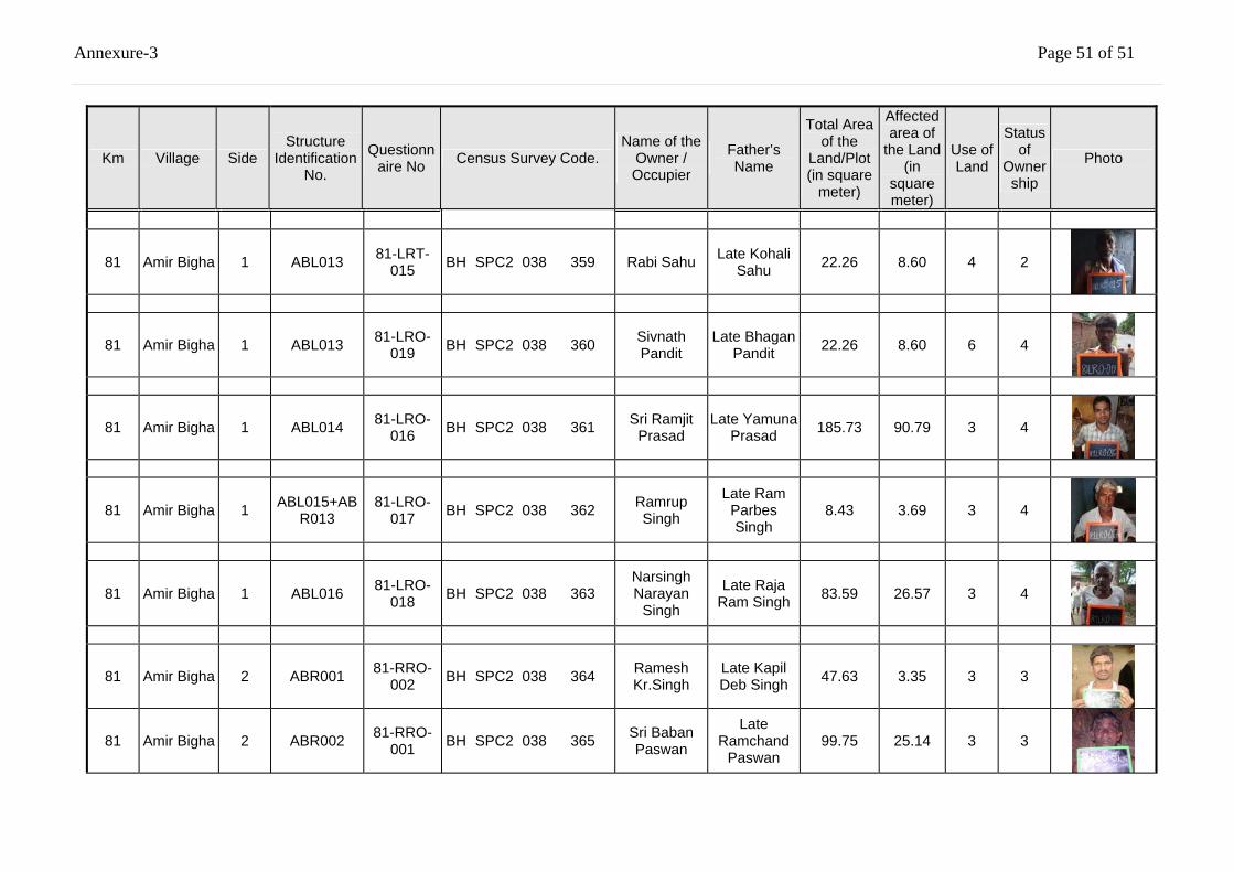
Annexure-3 Page 51 of 51
Km Village Side Structure
Identification No.
Questionnaire No Census Survey Code.
Name of the Owner / Occupier
Father’s Name
Total Area of the
Land/Plot (in square
meter)
Affected area of
the Land (in
square meter)
Use of Land
Status of
Ownership
Photo
81 Amir Bigha 1 ABL013 81-LRT-015 BH SPC2 038 359 Rabi Sahu Late Kohali
Sahu 22.26 8.60 4 2
81 Amir Bigha 1 ABL013 81-LRO-019 BH SPC2 038 360 Sivnath
Pandit Late Bhagan
Pandit 22.26 8.60 6 4
81 Amir Bigha 1 ABL014 81-LRO-016 BH SPC2 038 361 Sri Ramjit
Prasad Late Yamuna
Prasad 185.73 90.79 3 4
81 Amir Bigha 1 ABL015+ABR013
81-LRO-017 BH SPC2 038 362 Ramrup
Singh
Late Ram Parbes Singh
8.43 3.69 3 4
81 Amir Bigha 1 ABL016 81-LRO-018 BH SPC2 038 363
Narsingh Narayan
Singh
Late Raja Ram Singh 83.59 26.57 3 4
81 Amir Bigha 2 ABR001 81-RRO-002 BH SPC2 038 364 Ramesh
Kr.Singh Late Kapil Deb Singh 47.63 3.35 3 3
81 Amir Bigha 2 ABR002 81-RRO-001 BH SPC2 038 365 Sri Baban
Paswan
Late Ramchand
Paswan 99.75 25.14 3 3
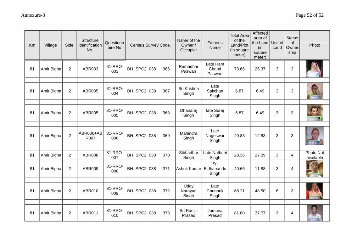
Annexure-3 Page 52 of 52
Km Village Side Structure
Identification No.
Questionnaire No Census Survey Code.
Name of the Owner / Occupier
Father’s Name
Total Area of the
Land/Plot (in square
meter)
Affected area of
the Land (in
square meter)
Use of Land
Status of
Ownership
Photo
81 Amir Bigha 2 ABR003 81-RRO-003 BH SPC2 038 366 Ramadhar
Paswan
Late Ram Chand
Paswan 73.66 26.37 3 3
81 Amir Bigha 2 ABR005 81-RRO-004 BH SPC2 038 367 Sri Krishna
Singh
Late Sakchan
Singh 6.87 6.49 3 3
81 Amir Bigha 2 ABR005 81-RRO-005 BH SPC2 038 368 Dhanaraj
Singh late Suraj
Singh 6.87 6.49 3 3
81 Amir Bigha 2 ABR006+ABR007
81-RRO-006 BH SPC2 038 369 Mahindra
Singh
Late Nageswar
Singh 20.83 12.83 3 3
81 Amir Bigha 2 ABR008 81-RRO-007 BH SPC2 038 370 Sibhadhar
Singh Late Nathuni
Singh 28.36 27.09 3 4 Photo Not available
81 Amir Bigha 2 ABR009 81-RRO-008 BH SPC2 038 371 Ashok Kumar
Sri Bidhanando
Singh 40.66 11.88 3 4
81 Amir Bigha 2 ABR010 81-RRO-009 BH SPC2 038 372
Uday Narayan
Singh
Late Chunarik
Singh 68.21 48.50 6 3
81 Amir Bigha 2 ABR011 81-RRO-010 BH SPC2 038 373 Sri Ramjit
Prasad Jamuna Prasad 81.80 37.77 3 4
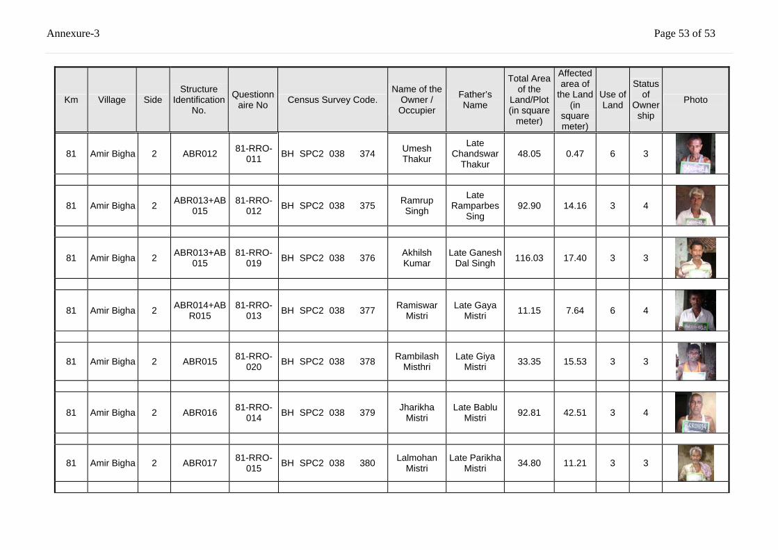
Annexure-3 Page 53 of 53
Km Village Side Structure
Identification No.
Questionnaire No Census Survey Code.
Name of the Owner / Occupier
Father’s Name
Total Area of the
Land/Plot (in square
meter)
Affected area of
the Land (in
square meter)
Use of Land
Status of
Ownership
Photo
81 Amir Bigha 2 ABR012 81-RRO-011 BH SPC2 038 374 Umesh
Thakur
Late Chandswar
Thakur 48.05 0.47 6 3
81 Amir Bigha 2 ABR013+AB015
81-RRO-012 BH SPC2 038 375 Ramrup
Singh
Late Ramparbes
Sing 92.90 14.16 3 4
81 Amir Bigha 2 ABR013+AB015
81-RRO-019 BH SPC2 038 376 Akhilsh
Kumar Late Ganesh
Dal Singh 116.03 17.40 3 3
81 Amir Bigha 2 ABR014+ABR015
81-RRO-013 BH SPC2 038 377 Ramiswar
Mistri Late Gaya
Mistri 11.15 7.64 6 4
81 Amir Bigha 2 ABR015 81-RRO-020 BH SPC2 038 378 Rambilash
Misthri Late Giya
Mistri 33.35 15.53 3 3
81 Amir Bigha 2 ABR016 81-RRO-014 BH SPC2 038 379 Jharikha
Mistri Late Bablu
Mistri 92.81 42.51 3 4
81 Amir Bigha 2 ABR017 81-RRO-015 BH SPC2 038 380 Lalmohan
Mistri Late Parikha
Mistri 34.80 11.21 3 3
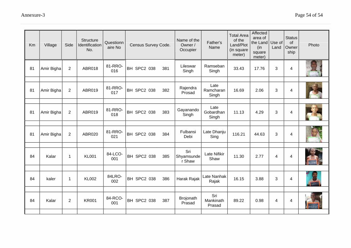
Annexure-3 Page 54 of 54
Km Village Side Structure
Identification No.
Questionnaire No Census Survey Code.
Name of the Owner / Occupier
Father’s Name
Total Area of the
Land/Plot (in square
meter)
Affected area of
the Land (in
square meter)
Use of Land
Status of
Ownership
Photo
81 Amir Bigha 2 ABR018 81-RRO-016 BH SPC2 038 381 Lileswar
Singh Ramseban
Singh 33.43 17.76 3 4
81 Amir Bigha 2 ABR019 81-RRO-017 BH SPC2 038 382 Rajendra
Prosad
Late Ramcharan
Singh 16.69 2.06 3 4
81 Amir Bigha 2 ABR019 81-RRO-018 BH SPC2 038 383 Gayanando
Singh
Late Gobardhan
Singh 11.13 4.29 3 4
81 Amir Bigha 2 ABR020 81-RRO-021 BH SPC2 038 384 Fulbansi
Debi Late Dhanju
Sing 116.21 44.63 3 4
84 Kalar 1 KL001 84-LCO-001 BH SPC2 038 385
Sri Shyamsunde
r Shaw
Late Nifikir Shaw 11.30 2.77 4 4
84 kaler 1 KL002 84LRO-002 BH SPC2 038 386 Harak Rajak Late Nanhak
Rajak 16.15 3.88 3 4
84 Kalar 2 KR001 84-RCO-001 BH SPC2 038 387 Brojonath
Prasad
Sri Mankinath
Prasad 89.22 0.98 4 4
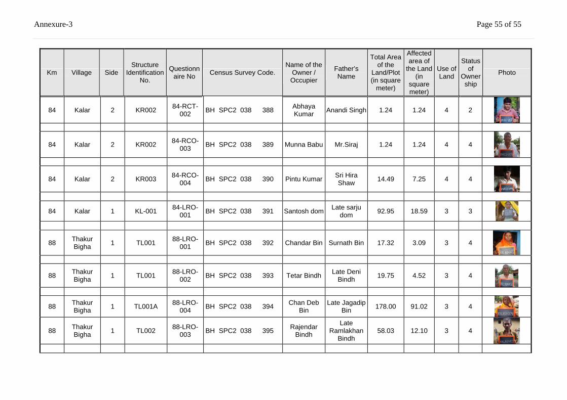
Annexure-3 Page 55 of 55
Km Village Side Structure
Identification No.
Questionnaire No Census Survey Code.
Name of the Owner / Occupier
Father’s Name
Total Area of the
Land/Plot (in square
meter)
Affected area of
the Land (in
square meter)
Use of Land
Status of
Ownership
Photo
84 Kalar 2 KR002 84-RCT-002 BH SPC2 038 388 Abhaya
Kumar Anandi Singh 1.24 1.24 4 2
84 Kalar 2 KR002 84-RCO-003 BH SPC2 038 389 Munna Babu Mr.Siraj 1.24 1.24 4 4
84 Kalar 2 KR003 84-RCO-004 BH SPC2 038 390 Pintu Kumar Sri Hira
Shaw 14.49 7.25 4 4
84 Kalar 1 KL-001 84-LRO-001 BH SPC2 038 391 Santosh dom Late sarju
dom 92.95 18.59 3 3
88 Thakur Bigha 1 TL001 88-LRO-
001 BH SPC2 038 392 Chandar Bin Surnath Bin
17.32
3.09 3 4
88 Thakur Bigha 1 TL001 88-LRO-
002 BH SPC2 038 393 Tetar Bindh Late Deni Bindh 19.75 4.52 3 4
88 Thakur Bigha 1 TL001A 88-LRO-
004 BH SPC2 038 394 Chan Deb Bin
Late Jagadip Bin 178.00 91.02 3 4
88 Thakur Bigha 1 TL002 88-LRO-
003 BH SPC2 038 395 Rajendar Bindh
Late Ramlakhan
Bindh 58.03 12.10 3 4
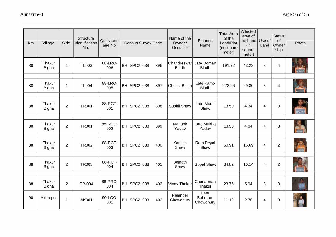
Annexure-3 Page 56 of 56
Km Village Side Structure
Identification No.
Questionnaire No Census Survey Code.
Name of the Owner / Occupier
Father’s Name
Total Area of the
Land/Plot (in square
meter)
Affected area of
the Land (in
square meter)
Use of Land
Status of
Ownership
Photo
88 Thakur Bigha 1 TL003 88-LRO-
006 BH SPC2 038 396 Chandreswar Bindh
Late Doman Bindh 191.72 43.22 3 4
88 Thakur Bigha 1 TL004 88-LRO-
005 BH SPC2 038 397 Chouki Bindh Late Kamo Bindh 272.26 29.30 3 4
88 Thakur Bigha 2 TR001 88-RCT-
001 BH SPC2 038 398 Sushil Shaw Late Murat Shaw 13.50 4.34 4 3
88 Thakur Bigha 2 TR001 88-RCO-
002 BH SPC2 038 399 Mahabir Yadav
Late Mukha Yadav 13.50 4.34 4 3
88 Thakur Bigha 2 TR002 88-RCT-
003 BH SPC2 038 400 Kamles Shaw
Ram Deyal Shaw 60.91 16.69 4 2
88 Thakur Bigha 2 TR003 88-RCT-
004 BH SPC2 038 401 Bejnath Shaw Gopal Shaw 34.82 10.14 4 2
88 Thakur Bigha 2 TR-004 88-RRO-
004 BH SPC2 038 402 Vinay Thakur Chanarman Thakur 23.76 5.94 3 3
90
Akbarpur 1 AK001 90-LCO-
001 BH SPC2 033 403 Rajender
Chowdhury
Late Baburam
Chowdhury
11.12 2.78 4 3
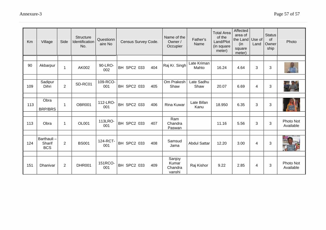
Annexure-3 Page 57 of 57
Km Village Side Structure
Identification No.
Questionnaire No Census Survey Code.
Name of the Owner / Occupier
Father’s Name
Total Area of the
Land/Plot (in square
meter)
Affected area of
the Land (in
square meter)
Use of Land
Status of
Ownership
Photo
90
Akbarpur 1 AK002 90-LRO-
002 BH SPC2 033 404 Raj Kr. Singh
Late Kriman Mahto
16.24 4.64 3 3
109 Sadipur
Dihri
2 SD-RC01
109-RCO-001
BH SPC2 033 405
Om Prakesh Shaw
Late Sadhu Shaw
20.07 6.69 4 3
113 Obra
BRP/BRS
1 OBR001 112-LRO-001 BH SPC2 033 406 Rina Kuwar Late Bifan
Kanu 18.950 6.35 3 3
113 Obra 1 OL001 113LRO-001 BH SPC2 033 407
Ram Chandra Paswan
11.16 5.56 3 3 Photo Not Available
124 Barthauli –
Sharif BCS
2 BS001 124-RCT-001 BH SPC2 033 408 Samsud
Jama Abdul Sattar 12.20 3.00 4 3
151 Dhanivar 2 DHR001 151RCO-001 BH SPC2 033 409
Sanjoy Kumar
Chandra vanshi
Raj Kishor 9.22 2.85 4 3 Photo Not Available
Social Impact Assessment and RAP Report (TOR for NGO) Annexure-4 - 1
Rehabilitation and Upgrading to 2 lane/2 lane with paved Shoulders of NH-98, Package SP/C/2 in the State of Bihar
Client: M/oRT&H TESPL&
1. Project Background Ministry of Road Transport & Highways (M/oRT&H), Government of India has decided to take up the work of upgrading all the single lane / intermediate lane National Highways to at-least two lane standards or Two Lane with provision of Paved Shoulders depending upon requirement on up-gradation corridor concept in order to have a better facility in a long continuous stretch. The project will be implemented with loan assistance from the World Bank.
The under consideration project package pertains to Rehabilitation and Upgrading to 2 lane/2 lane with paved shoulders configuration and strengthening of Anisabad - Aurangabad – Hariharganj Section (Km. 0.00 to Km. 154.625) of NH-98 in the State of Bihar and the package no. is SC/P/2. As a result of the project an estimated 1480 households /Family will be affected. For details under each category of PAPs, please see the “Base Line Census survey data. Detailed Project reports, feasibility reports, and detailed engineering designs have been prepared for the project, including comprehensive environmental and social assessments. A detailed resettlement action plan (RAP) has been prepared for compensating and assisting the project-affected persons (PAPs) including the project-displaced persons (PDPs) to restore their life and livelihood. The RAP prepared fully compiles with the requirements of the Government of India and the World Bank. Implementation of the RAP is an important part of the overall project. To assist the M/oRT&H in the implementation of the RAP. M/oRT&H now invites the services of eligible NGOs to be procured under 'Quality and Cost Based Selection' (QCBS). 2. Objectives of the Assignment The NGOs shall be responsible for the following, as per the RAP prepared: • Educating the PAPs on their right to entitlements and obligations.
• To ensure that the PAPs are given their full entitlements as due to them, as per the entitlements given in the RAP, as may be modified by M/oRT&H from time to time.
• To prepare micro plan for IR activities and provide support and information to PAPs for income restoration.
• Assist the PAPs in relocation and rehabilitation, including counselling, and coordination with the local authorities.
• Assist the PAPs in redressal of their grievances (through the grievance redressal cells set up by the project)
• Impart information to all the PAPs about the functional aspects of the various district level committees set up by the project, and assist them in benefiting from such institutional mechanism.
ANNEXURE-4 Terms of References for appointment of NGOs
For Implementing the Resettlement Action Plan (RAP) in the National Highways Inter-
Connectivity Improvement Project – NH-98 from Km. 0.00 to Km. 154.625 (Anishabad- Aurangabad – Hariharganj section) in the State of Bihar- Package SC/P-2
Social Impact Assessment and RAP Report (TOR for NGO) Annexure-4 - 2
Rehabilitation and Upgrading to 2 lane/2 lane with paved Shoulders of NH-98, Package SP/C/2 in the State of Bihar
Client: M/oRT&H TESPL&
• To assist the Project Implementation Unit (PIU) of M/oRT&H in ensuring social responsibilities of the Project, such as, compliance with the labour laws, prohibition of child labour, and gender issues.
• To collect data and submit progress reports on a monthly basis as well as quarterly basis for M/oRT&H to monitor the progress of the RAP implementation.
3. Scope of Work The NGOs shall play a role of secondary stakeholder in implementation of the RAP and in mitigating the adverse effects of the project. The NGOs shall remain responsible for the development of a comprehensive livelihood system to facilitate the PAPs to take advantages of the options available (as per the RAP). 3.1 Administrative Responsibilities of the NGOs will include-
• Working in co-ordination with the SE (Designated Social Officer), M/oRT&H (SE-DSO), Manager (R&R), M/oRT&H (alternatively called the SE-DSO / CRRO);
• Assist the SE-DSO / CRRO in carrying out the implementation of the RAP;
• To co-ordinate with the DLCs and GRCs in implementing the RAP;
• The NGO shall coordinate the meetings of the District level committee for approval of the micro plans wherever required.
• Assist the SE-DSO / CRRO in undertaking all public meetings, information campaigns at the commencement of the project and give full information to the affected community;
• Translate the R&R objectives and guidelines to implement actions for mitigating adverse impacts on the PAPs;
• To assist the Engineers (Supervision Consultants) to ensure that the Contracts comply with the applicable labour laws (including prohibition of child labour) and gender issues;
• To assist the PIU and /or the Engineers in ensuring compliance with the safety, health and hygiene norms, and the RAP actions proposed for HIV/AIDS awareness/prevention campaigns.
• Report to SE-DSO / CRRO on a monthly basis, and quarterly basis. The report should include physical and financial progress, both in terms of quantitative and qualitative reporting. The report should prominently feature, the problems and issues addressed and tackled with the PAPs and the solutions found. The report should have a separate chapter the women's issues their problems and what has been done (within the framework of the RAP) to ensure their participation in decision-making as well as the options made available for them to access economic opportunities, marketing and credit. The report should clearly indicate the number of field visits made by the NGOs staff and the outcome of consultations with people.
• Data base management of the PAPs.
• Videography and digital photography cost required for implementation of the RAP shall be included in the budget submitted by the NGO.
Social Impact Assessment and RAP Report (TOR for NGO) Annexure-4 - 3
Rehabilitation and Upgrading to 2 lane/2 lane with paved Shoulders of NH-98, Package SP/C/2 in the State of Bihar
Client: M/oRT&H TESPL&
• The PAPs & PDPs will be facilitated for the Income Generation Scheme training through the NGOs i.e. the provisions made for training component will be best utilised through the active support and involvement of the NGO.
• All costs, including the cost of valuation of structures, land etc. to be borne by NGO within the project cost.
3.2 Responsibilities of Implementation of the RAP will include: 3.2.1 Identification and Verification
• The NGO shall undertake a detailed survey of the project affected area and shall update the information on the Eligible PAPs and project-affected families (PAFs). The NGO shall verify the information already contained in the RAP and the individual losses of the PAPs. He shall validate the date provided in the RAP and make suitable changes if required. The NGO shall establish rapport with PAPs, consult them, provide them information about the respective entitlements as proposed under the RAP, and distribute entitlement cum Identity Cards to the eligible PAPs. An identity card should include a photograph of the PAP, the extent of loss suffered due to the project, and the choice of the PAP with regard to the mode of compensation and assistance.
• The NGO shall develop rapport between the PAPs and the Project Authority, particularly the SE-DSO. This will be achieved through regular meetings with both the SE-DSO / CRRO and the PAPs. Meetings with the SE-DSO / CRRO will be held at least fortnightly, and meetings with the PAPs will be held monthly, during the entire duration of the assignment. All meetings and decisions taken shall be documented by the NGO.
• Prepare monthly action plans with targets in consultation with SE-DSO / CRRO
• The NGO shall prepare a list of the project-displaced persons/families (PDPs/PDFs) for relocation, enlisting the losses and the entitlements as per the RAP, after verification. It shall also prepare a list of the project-affected persons/families (PAPs/PAFs) enlisting the losses and the entitlement as per the RAP, after verification. Verification exercise shall include actual measurement of the extent of total property loss/damage, and valuation of the loss/damage/affect along with the SE-DSO. The NGO shall display the list of eligible PAPs in prominent public places like Villages, Panchayat Offices, Block/Tehsil headquarters, and the District Headquarters.
• During the identification and verification of the eligible PAPs/PAFs, the NGO shall ensure that each of the PAPs are contacted and consulted either in groups or individually. The NGO shall specially ensure consultation with the women from the PAP families especially women headed households.
• Participatory methods should be applied in assessing the needs of the PAPs, especially with regard to the vulnerable groups of PAPs.
• The methods of contact may include
• Village level meetings,
• Gender participation through groups interactions, and
• Individual meetings and interactions.
• While finalising the entitled persons (EPs) for compensation/assistance the NGOs shall make a list of entitled PAPs, and distribute Identity Cards to each and every verified eligible PAP.
Social Impact Assessment and RAP Report (TOR for NGO) Annexure-4 - 4
Rehabilitation and Upgrading to 2 lane/2 lane with paved Shoulders of NH-98, Package SP/C/2 in the State of Bihar
Client: M/oRT&H TESPL&
3.2.2 Counselling the Entitled Persons The counselling shall include the following activities by the NGO: • the NGO shall explain to the PAPs the need for land acquisition, the provisions of the policy and
the entitlements under the RAP. This shall include communication to the roadside squatters and encroachers about the need for their eviction, the timeframe for their removal and their entitlements as per the RAP.
• Distribution of the relevant portions of the RAP to each and every PAP to make them understand the entitlement packages in correct perspectives.
• The NGO shall disseminate information to the PAPs on the possible consequences of the project on the communities' livelihood systems and the options available, so that they do not remain ignorant.
• The NGO shall prepare micro-level plans for income restoration, in consultation with the PAPs. Women's perceptions are important to be incorporated in the development of these plans.
• NGO will monitor the involvement of child labour in the civil construction work in each package.
In all of these, the NGO shall consider women as a special focus group, and deal with them with care and sympathy. 3.2.3 Disbursing the Assistance • Prepare micro plans indicating category of entitlement.
• Prepare micro plans for livelihood indicating alternate livelihood options, land identification, skills up gradation and institution responsible for training.
• The NGO shall assist the project authorities in ensuring a smooth transition (during the part or full relocation of the PAPs/PAFs), helping the PAPs to take salvaged materials and shift with proper notices. In close consultation with the PAPs, the NGO shall inform the SE-DSO / CRRO about the shifting dates agreed with the PAPs in writing and the arrangements desired by the PAPs with respect to their entitlements.
• The NGO shall assist the PAPs in opening bank accounts explaining the implications, the rules and the obligations of a joint account and how s/he can access the resources s/he is entitled to.
• The NGO shall ensure proper utilisation of the R&R budget available for each of the packages. The NGOs shall ensure that the PAPs have found economic investment options and are able to restore against the loss of land and other productive assets. The NGO shall identify means and advise the SE-DSO / CRRO to disburse the entitlements to the eligible persons/families in a manner that is transparent, and shall report to the M/oRT&H on the level of transparent, and shall report to the M/oRT&H on the level of transparency achieved in the project.
3.2.4 Accompanying and representing the EPs at the grievance Committee Meetings • The NGO shall nominate a suitable person (from the staff of the NGO) to be a member of the
GRCs for the respective contract packages.
• The NGO shall make the PAP aware of the grievance redressal committees (GRCs)
• The NGO shall train the PAPs on the procedure to file a grievance application and to confirm that a statement of claim from the concerned PAP accompanies each grievance application. The NGO shall help the PAPs in filling up the grievance application and also in clearing their doubts about the procedure as well as the context of the GRC award.
Social Impact Assessment and RAP Report (TOR for NGO) Annexure-4 - 5
Rehabilitation and Upgrading to 2 lane/2 lane with paved Shoulders of NH-98, Package SP/C/2 in the State of Bihar
Client: M/oRT&H TESPL&
• The NGO shall record the grievance and bring the same to the notice of the GRCs within 7 (seven) days of receipt of the grievance from the PAPs. It shall submit a draft resolution with respect to the particular grievance of the PAP, suggesting multiple solutions, if possible, and deliberate on the same in the GRC meeting through the NGO representative in the GRC.
• To accompany the PAPs to the GRC meeting on the decided date, help the PAP to express his/her grievance in a formal manner if requested by the GRC and again inform the PAPs of the decisions taken by the GRC within 3 days of receiving a decision from the GRC. (The time frame for the GRC to take a decision is 15 days).
3.2.5 Assisting the EPs and the RO to Identity and Negotiate for New Land for Resettlement As part of the RAP, it is proposed that a sizable number among the eligible PDPs will receive alternative land (commercial) building structures. Some of the more vulnerable among the PDPs will be eligible to receive these free of cost. Regarding these the NGO shall, • Obtain the PDPs choice in terms of Land identification, Site for relocation, Shifting plan and
arrangements, Grant utilization plan and Community asset building plan and institutional arrangements in maintaining the assets.
• Assist squatters whose structures need to be shifted to the remaining government land for
continuation of earning their livelihood before construction of road starts. • Assist the SE-DSO / CRRO in identifying suitable land for relocation and for agriculture, ensuring
the replacement of the land lost in terms of quality and quantity. • Identify suitable government land in consultation with the Revenue Department officials and assist
in negotiating its transfer to the SE-DSO / CRRO at reasonable prices and motivate them to appreciate and welcome the new neighbors.
3.2.6 Assisting the eligible PAPs to take advantage of the existing ongoing Government Housing, Livelihood and Employment Schemes With regards to the above, the NGO shall, • Co-ordinate (and impart wherever required) the training and capacity building of the PAPs, for
upgrading their skills for income restoration. This will include the training to be given by the NGO to women self-help-group members in accounting, record maintenance, skill acquisition in the chosen enterprise, and marketing, etc.
• Help the PAPs in realizing and optimising the indigenous technology knowledge (ITK) through use of local resources.
• Define, evolve, and explore alternative methods of livelihood using the local skill and resources.
• Contact financial institutions like NABARD, SIDBI, RMK and the Lead Bank of the area in accessing the credit required by the individual as well as groups of PAPs and the women's groups from the PAFs. The NGO shall maintain a detailed record of such facilitation, and plan for each PAF to repay the loan.
• Establish linkages with the District administration for ensuring that the PAPs are benefited from the schemes available and those they are entitled to. The focus for this component of the NGOs work shall be the vulnerable PAPs for their income restoration. The NGO shall maintain a detailed record of such facilitation.
Social Impact Assessment and RAP Report (TOR for NGO) Annexure-4 - 6
Rehabilitation and Upgrading to 2 lane/2 lane with paved Shoulders of NH-98, Package SP/C/2 in the State of Bihar
Client: M/oRT&H TESPL&
3.2.7 Representing the EPs in Market Value Assessment Committee Market Value Assessment Committees will be established at the district level to evaluate the actual market price of the properties in the areas where acquisition of structures are necessary. The project will assist the eligible PAPs/PAFs towards the difference between the assessed market price and the compensation award. The NGO shall represent the entitled persons (EPs) in the committee to ensure that a fair assessment takes place. All the valuation of structures will be vetted by the Government approved valuer. Inter-Agency Linkages for Income Restoration and other R&R Services The NGO shall be responsible for establishing linkages with,
• Financial institutions for facilitating the PAPs to access credit.
• Government departments, district administration, etc., to ensure that the PAPs are included in the development schemes, as applicable;
• Training institutes for imparting skill and management training for enterprise creation and development.
• NGO shall conduct training Programme for income restoration for PAPs.
• NGO should prepare an I.R. Plan
• For I.R activity the productive potential of the same project may be explored. 3.2.8 Assisting the Supervision consultant in ensuring the Social Responsibilities The NGO shall assist the Engineers (Supervision Consultants) to ensure that the Contractors are abiding by the various provisions of the applicable laws, concerning the worker's safety, health and hygiene; women's issues and the child labour issues. The applicable laws include (A) the maternity benefit Act, 1951; (B) the contract labour (Regulation and Abolition) Act, 1948; (C) the Minimum Wagers act, 1948. (D) The Equal Remuneration Act, 1979. (E) the industrial Employment (Standing Order) Act, 1946; (F) the Child Labour (Prohibition and Regulation ) Act, 1986; (G) the Building and Other Construction Workers (Regulation of Employment and Conditions of Service) Act 1996; (H) the cess Act of 1996 and (I) the Factories Act, 1948. any divergence from the (workers welfare and remuneration, safety, health, hygiene, women's issues, and child labour issues) provisions of these laws should be brought to the notice of the supervision consultant and the SE-DSO / CRRO . According to these laws, there are specifications regarding the facilities/requirements at the construction camp/site, including basic health care facilities, Mother and Child Welfare units and facilities for vaccinations, day crèche facilities, etc. The NGO shall work in co-ordination of the Lady Inspector of Works or the Resident engineers of the Contractor, or any other representative of the Contractors, to ensure these facilities are provided in a satisfactory manner, and all social responsibilities of the Contract is implemented satisfactorily. Coordinate with Environmental Officer to facilitate consultation on rehabilitation of borrow areas. 3.2.9 Assisting the PIU/Supervision Consultant in Actions to HIV/AIDS Awareness/Prevention Campaigns Information campaign/advertisement in collaboration with line agencies (such as NACO, DFID, etc), including provision of signage/hoardings at suitable locations, distribution of vehicle stickers, and provision of condom vending machines at suitable locations (rest areas, truck parking lay-byes, etc.).
Social Impact Assessment and RAP Report (TOR for NGO) Annexure-4 - 7
Rehabilitation and Upgrading to 2 lane/2 lane with paved Shoulders of NH-98, Package SP/C/2 in the State of Bihar
Client: M/oRT&H TESPL&
The NGO shall assist the PIU to implement these measures, including collaboration with the line agencies. The contractors are required to provide condom vending machines at the construction camps, provide for medical facilities and regular medical checkups especially meant for detecting/curing STD/AIDS. The NGO shall ensure, in collaboration with Engineer that such facilities and medical checkups are provided to the workers at the construction camps. 3.2.10 Monitoring and Evaluation The RAP includes a provision for mid-term and post-project monitoring and evaluation by external consultants. The NGO involved in the implementation of the RAP will be required to supply all information, documents to the external monitoring and evaluation consultants. To this end, the NGOs shall keep proper documentation of their work and the R&R process involved in the project, and shall be responsible for the upkeep and updating of such documents periodically and regularly. The documentation shall include photographs and videotapes of the pre-intervention and the post-intervention scenario of all the properties, structures, and assets affected by the project. 3.2.11 Recommending for the Improvement of R&R Services • Extend all services recommended by the additional studies to be undertaken by the project, in
respect to the R&R services to be provided as part of the project.
• Recommended and suggested techniques and methods for improvement of services extended by the concerned government departments and other agencies and committees in disbursement/extension of R&R services in the project.
• Document implementation of the R&R process and services, including difficulties faced and corresponding solutions.
• Discuss, with the M/oRT&H on contingency management and other improvement of R&R services, within the project period.
• Documenting of Tasks Carried out by the NGO and Evaluation of the Achievements of RAP. 3.3 Documentation and Reporting by NGO
The NGO selected for the assignments shall be responsible to : • Submit an inception report within three weeks; on signing up of the contract including a work plan
for the whole contract including a work plan for the whole contract period, staffing and personnel deployment plan, and a withdrawal plan at the end of the period of contract. The withdrawal plan shall be detailed and reflect how the PAPs/PAFs will maintain the assets created and transferred to the PAPs/PAFs.
• Prepare monthly progress reports to be submitted to the SE-DSO, with weekly progress and work charts as against the scheduled timeframe of RAP implementation.
• Prepare and submit quarterly reports on a regular basis, to be submitted to the SE-DSO.
• Submit a completion report at the end of the contract period summarizing the actions taken during the project, the methods and personnel used to carry out the assignment, and a summary of supports/assistance given to the PAPs.
Social Impact Assessment and RAP Report (TOR for NGO) Annexure-4 - 8
Rehabilitation and Upgrading to 2 lane/2 lane with paved Shoulders of NH-98, Package SP/C/2 in the State of Bihar
Client: M/oRT&H TESPL&
• All other reports/documentation as described in these terms of reference.
• Record minutes of all meetings. All progress reports shall include data on input and output indicators as required by the SE-DSO. Reporting in writing as well as photographs, videotapes etc., taken during the assignment shall be submitted in support of the reports, along with an electronic copy of the documents in a floppy or a CD. All reports should be in English language only. Accounts reports both on expenditure on administration as well as training and other heads shall be submitted with the quarterly and the completion reports. In addition to these above, the NGO shall Prepare and submit separate descriptive reports on participatory micro-plans with full details of the Participatory Rapid Appraisal exercises conducted. The NGO shall document in full details, the consultation/counselling processes, the process of identification of the resettlement sites, and a full description of the training imparted (on facilitated) as part of the assignment. This documentation shall be submitted to the M/oRT&H as annual reports. 3.4 Condition of Services The NGO shall ensure that the RAP is implemented in an effective and proper manner. The prime responsibility of the NGO shall be to ensure that each and every eligible PAPs receive appropriate and due entitlement (within the Entitlement Framework) and that, at the end of the project R&R services, the eligible PAPs have improved (or at least restored) their previous standard of living. Additionally the NGO shall help the M/oRT&H in all other matters deemed to be required to implement the RAP in its spirit and entirely including activities involving some financial implications. All documents created, generated or collected during the period of contract, in carrying out the services under this assignment will be the property of the M/oRT&H. No information gathered or generated during and in carrying out this assignment shall be disclosed by the NGO without explicit permission of the M/oRT&H. 3.5 Time frame for Services The NGOs will be contracted for a period of Thirty months from the date of commencement of services, with a withdrawal methodology built in to the proposals from the NGO. 3.6 Data, Services and Facilities to be provided by the Client The M/oRT&H will provide to the NGO the copies of the SIA Report/ PAPs' Census, the RAP, the land acquisition plan, strip plan final design report and any other relevant reports/data prepared by the Project Preparation Consultants. The M/oRT&H will assist the NGO in collaborating with the Supervision Consultants. All facilities required in the performance of the assignment, including office space, office stationery, transportation and accommodation for staff of the NGO, etc., shall be arranged by the NGO.
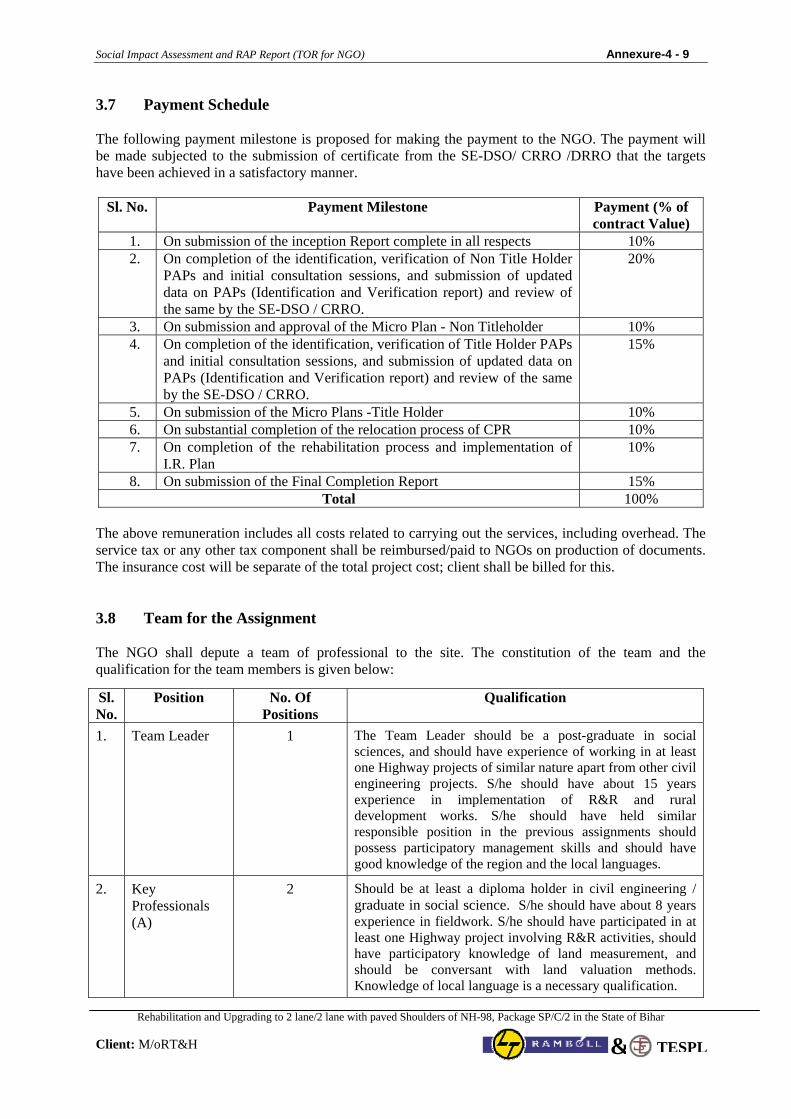
Social Impact Assessment and RAP Report (TOR for NGO) Annexure-4 - 9
Rehabilitation and Upgrading to 2 lane/2 lane with paved Shoulders of NH-98, Package SP/C/2 in the State of Bihar
Client: M/oRT&H TESPL&
3.7 Payment Schedule The following payment milestone is proposed for making the payment to the NGO. The payment will be made subjected to the submission of certificate from the SE-DSO/ CRRO /DRRO that the targets have been achieved in a satisfactory manner.
Sl. No. Payment Milestone Payment (% of contract Value)
1. On submission of the inception Report complete in all respects 10% 2. On completion of the identification, verification of Non Title Holder
PAPs and initial consultation sessions, and submission of updated data on PAPs (Identification and Verification report) and review of the same by the SE-DSO / CRRO.
20%
3. On submission and approval of the Micro Plan - Non Titleholder 10% 4. On completion of the identification, verification of Title Holder PAPs
and initial consultation sessions, and submission of updated data on PAPs (Identification and Verification report) and review of the same by the SE-DSO / CRRO.
15%
5. On submission of the Micro Plans -Title Holder 10% 6. On substantial completion of the relocation process of CPR 10% 7. On completion of the rehabilitation process and implementation of
I.R. Plan 10%
8. On submission of the Final Completion Report 15% Total 100%
The above remuneration includes all costs related to carrying out the services, including overhead. The service tax or any other tax component shall be reimbursed/paid to NGOs on production of documents. The insurance cost will be separate of the total project cost; client shall be billed for this. 3.8 Team for the Assignment The NGO shall depute a team of professional to the site. The constitution of the team and the qualification for the team members is given below:
Sl. No.
Position No. Of Positions
Qualification
1. Team Leader 1 The Team Leader should be a post-graduate in social sciences, and should have experience of working in at least one Highway projects of similar nature apart from other civil engineering projects. S/he should have about 15 years experience in implementation of R&R and rural development works. S/he should have held similar responsible position in the previous assignments should possess participatory management skills and should have good knowledge of the region and the local languages.
2. Key Professionals (A)
2 Should be at least a diploma holder in civil engineering / graduate in social science. S/he should have about 8 years experience in fieldwork. S/he should have participated in at least one Highway project involving R&R activities, should have participatory knowledge of land measurement, and should be conversant with land valuation methods. Knowledge of local language is a necessary qualification.
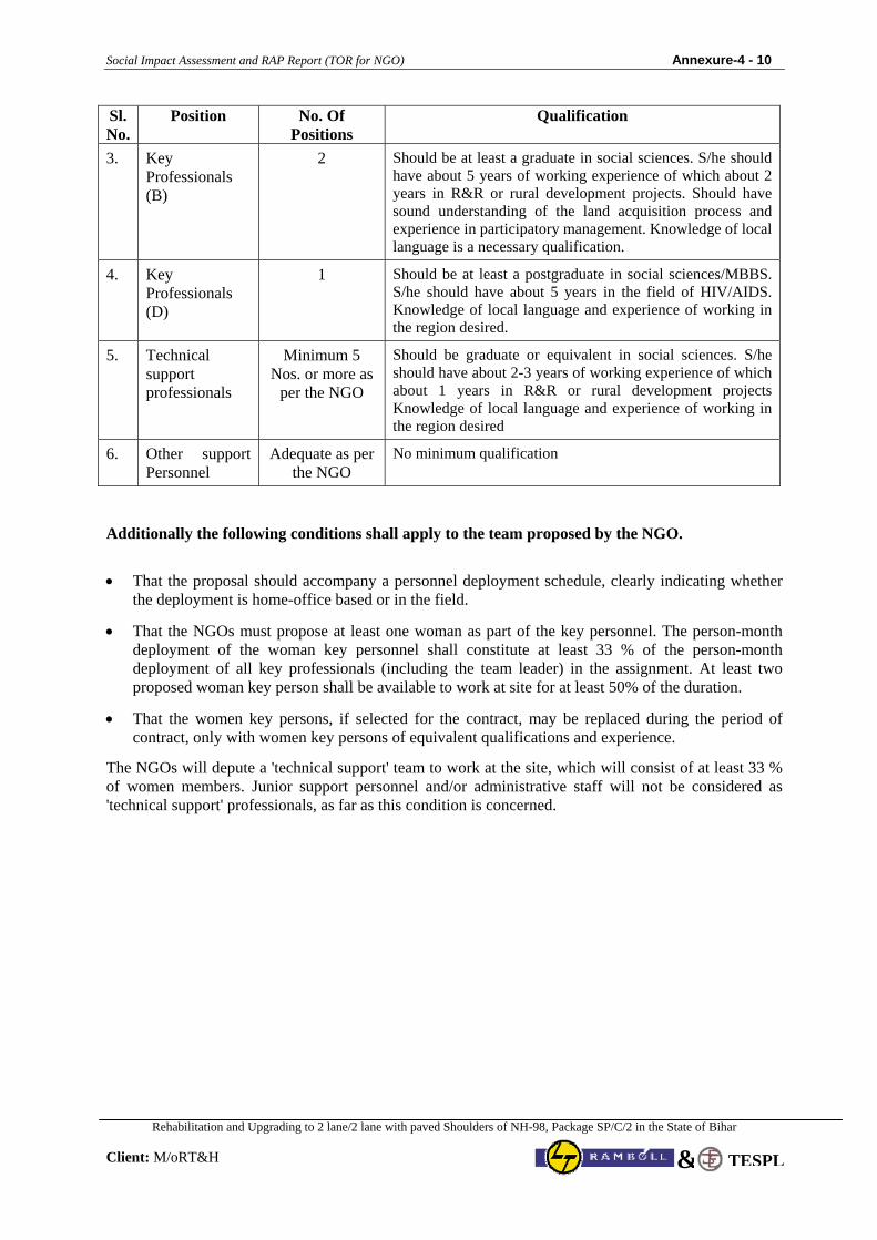
Social Impact Assessment and RAP Report (TOR for NGO) Annexure-4 - 10
Rehabilitation and Upgrading to 2 lane/2 lane with paved Shoulders of NH-98, Package SP/C/2 in the State of Bihar
Client: M/oRT&H TESPL&
Sl. No.
Position No. Of Positions
Qualification
3. Key Professionals (B)
2 Should be at least a graduate in social sciences. S/he should have about 5 years of working experience of which about 2 years in R&R or rural development projects. Should have sound understanding of the land acquisition process and experience in participatory management. Knowledge of local language is a necessary qualification.
4. Key Professionals (D)
1 Should be at least a postgraduate in social sciences/MBBS. S/he should have about 5 years in the field of HIV/AIDS. Knowledge of local language and experience of working in the region desired.
5. Technical support professionals
Minimum 5 Nos. or more as
per the NGO
Should be graduate or equivalent in social sciences. S/he should have about 2-3 years of working experience of which about 1 years in R&R or rural development projects Knowledge of local language and experience of working in the region desired
6. Other support Personnel
Adequate as per the NGO
No minimum qualification
Additionally the following conditions shall apply to the team proposed by the NGO.
• That the proposal should accompany a personnel deployment schedule, clearly indicating whether the deployment is home-office based or in the field.
• That the NGOs must propose at least one woman as part of the key personnel. The person-month deployment of the woman key personnel shall constitute at least 33 % of the person-month deployment of all key professionals (including the team leader) in the assignment. At least two proposed woman key person shall be available to work at site for at least 50% of the duration.
• That the women key persons, if selected for the contract, may be replaced during the period of contract, only with women key persons of equivalent qualifications and experience.
The NGOs will depute a 'technical support' team to work at the site, which will consist of at least 33 % of women members. Junior support personnel and/or administrative staff will not be considered as 'technical support' professionals, as far as this condition is concerned.
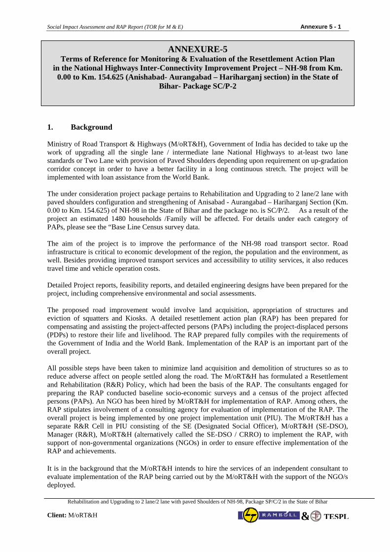
Social Impact Assessment and RAP Report (TOR for M & E) Annexure 5 - 1
Rehabilitation and Upgrading to 2 lane/2 lane with paved Shoulders of NH-98, Package SP/C/2 in the State of Bihar
Client: M/oRT&H TESPL&
1. Background Ministry of Road Transport & Highways (M/oRT&H), Government of India has decided to take up the work of upgrading all the single lane / intermediate lane National Highways to at-least two lane standards or Two Lane with provision of Paved Shoulders depending upon requirement on up-gradation corridor concept in order to have a better facility in a long continuous stretch. The project will be implemented with loan assistance from the World Bank.
The under consideration project package pertains to Rehabilitation and Upgrading to 2 lane/2 lane with paved shoulders configuration and strengthening of Anisabad - Aurangabad – Hariharganj Section (Km. 0.00 to Km. 154.625) of NH-98 in the State of Bihar and the package no. is SC/P/2. As a result of the project an estimated 1480 households /Family will be affected. For details under each category of PAPs, please see the “Base Line Census survey data. The aim of the project is to improve the performance of the NH-98 road transport sector. Road infrastructure is critical to economic development of the region, the population and the environment, as well. Besides providing improved transport services and accessibility to utility services, it also reduces travel time and vehicle operation costs. Detailed Project reports, feasibility reports, and detailed engineering designs have been prepared for the project, including comprehensive environmental and social assessments. The proposed road improvement would involve land acquisition, appropriation of structures and eviction of squatters and Kiosks. A detailed resettlement action plan (RAP) has been prepared for compensating and assisting the project-affected persons (PAPs) including the project-displaced persons (PDPs) to restore their life and livelihood. The RAP prepared fully compiles with the requirements of the Government of India and the World Bank. Implementation of the RAP is an important part of the overall project. All possible steps have been taken to minimize land acquisition and demolition of structures so as to reduce adverse affect on people settled along the road. The M/oRT&H has formulated a Resettlement and Rehabilitation (R&R) Policy, which had been the basis of the RAP. The consultants engaged for preparing the RAP conducted baseline socio-economic surveys and a census of the project affected persons (PAPs). An NGO has been hired by M/oRT&H for implementation of RAP. Among others, the RAP stipulates involvement of a consulting agency for evaluation of implementation of the RAP. The overall project is being implemented by one project implementation unit (PIU). The M/oRT&H has a separate R&R Cell in PIU consisting of the SE (Designated Social Officer), M/oRT&H (SE-DSO), Manager (R&R), M/oRT&H (alternatively called the SE-DSO / CRRO) to implement the RAP, with support of non-governmental organizations (NGOs) in order to ensure effective implementation of the RAP and achievements. It is in the background that the M/oRT&H intends to hire the services of an independent consultant to evaluate implementation of the RAP being carried out by the M/oRT&H with the support of the NGO/s deployed.
ANNEXURE-5 Terms of Reference for Monitoring & Evaluation of the Resettlement Action Plan
in the National Highways Inter-Connectivity Improvement Project – NH-98 from Km. 0.00 to Km. 154.625 (Anishabad- Aurangabad – Hariharganj section) in the State of
Bihar- Package SC/P-2
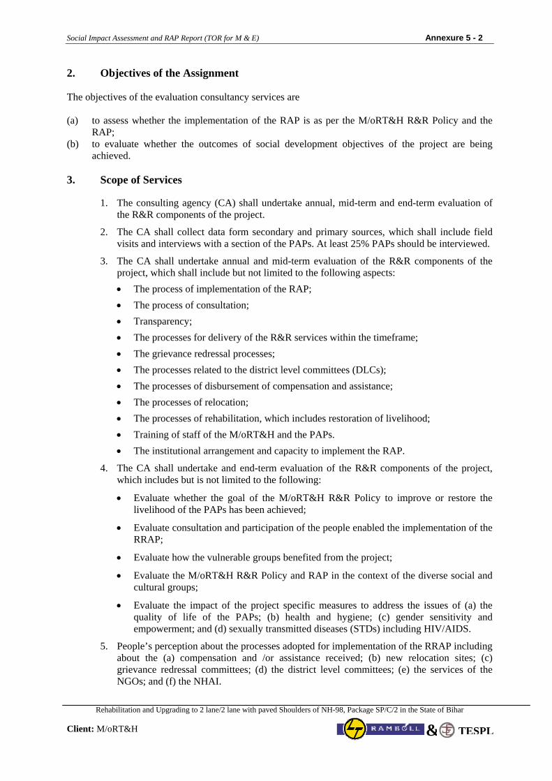
Social Impact Assessment and RAP Report (TOR for M & E) Annexure 5 - 2
Rehabilitation and Upgrading to 2 lane/2 lane with paved Shoulders of NH-98, Package SP/C/2 in the State of Bihar
Client: M/oRT&H TESPL&
2. Objectives of the Assignment The objectives of the evaluation consultancy services are (a) to assess whether the implementation of the RAP is as per the M/oRT&H R&R Policy and the
RAP; (b) to evaluate whether the outcomes of social development objectives of the project are being
achieved. 3. Scope of Services
1. The consulting agency (CA) shall undertake annual, mid-term and end-term evaluation of the R&R components of the project.
2. The CA shall collect data form secondary and primary sources, which shall include field visits and interviews with a section of the PAPs. At least 25% PAPs should be interviewed.
3. The CA shall undertake annual and mid-term evaluation of the R&R components of the project, which shall include but not limited to the following aspects: • The process of implementation of the RAP; • The process of consultation; • Transparency; • The processes for delivery of the R&R services within the timeframe; • The grievance redressal processes; • The processes related to the district level committees (DLCs); • The processes of disbursement of compensation and assistance; • The processes of relocation; • The processes of rehabilitation, which includes restoration of livelihood; • Training of staff of the M/oRT&H and the PAPs. • The institutional arrangement and capacity to implement the RAP.
4. The CA shall undertake and end-term evaluation of the R&R components of the project, which includes but is not limited to the following:
• Evaluate whether the goal of the M/oRT&H R&R Policy to improve or restore the livelihood of the PAPs has been achieved;
• Evaluate consultation and participation of the people enabled the implementation of the RRAP;
• Evaluate how the vulnerable groups benefited from the project;
• Evaluate the M/oRT&H R&R Policy and RAP in the context of the diverse social and cultural groups;
• Evaluate the impact of the project specific measures to address the issues of (a) the quality of life of the PAPs; (b) health and hygiene; (c) gender sensitivity and empowerment; and (d) sexually transmitted diseases (STDs) including HIV/AIDS.
5. People’s perception about the processes adopted for implementation of the RRAP including about the (a) compensation and /or assistance received; (b) new relocation sites; (c) grievance redressal committees; (d) the district level committees; (e) the services of the NGOs; and (f) the NHAI.
Social Impact Assessment and RAP Report (TOR for M & E) Annexure 5 - 3
Rehabilitation and Upgrading to 2 lane/2 lane with paved Shoulders of NH-98, Package SP/C/2 in the State of Bihar
Client: M/oRT&H TESPL&
4. Reporting The CA shall submit the following reports:
• Draft Annual Evaluation Report & Final Annual Evaluation Report;
• Draft Mid-Term Evaluation Report & Final Mid-Term Evaluation Report;
• Draft End-Term Evaluation Report & Final End-Term Evaluation Report. 5. Methodology Following methods are suggested for monitoring and evaluation:
• Rapid Assessment
• Focus Group Discussions
• Social Mapping
• Questionnaires
• In-depth Interviews 6. Team for the Assignment The CA shall deploy a team of which the positions and minimum qualification are stated in the following: Team Leader: S/he should be a post-graduate in social sciences with at least 15 years of experience in the field of social development. S/he should have monitoring and evaluation experience of more than 5 projects, and should have held responsible positions in the previous assignments including as team leader. S/he should have adequate managerial skill and should be conversant with the region and the regional language. Sub-Professional I: S/he should be a graduate in social sciences with at least 8 years of experience in the field of social development and participating rural appraisal. S/he should adequate knowledge of computers and should be conversant with the region and the regional language. Sub-Professional II: S/he should be a graduate in civil engineering with at least 7 years of experience in construction/maintenance of National/State Highways. S/he should good knowledge of land measurement and should be conversant with the region and the regional language. Sub-Professional III: S/he should be a graduate in statistics with at least 7 years of experience and good knowledge of computerized database development and management and should be conversant with the region and the regional language. Support Staff: There should be an adequate number of support staff. They should be able to perform as asked be the members of the team.
Related Documents


