Earth and Planetary Science Letters 413 (2015) 144–157 Contents lists available at ScienceDirect Earth and Planetary Science Letters www.elsevier.com/locate/epsl Mid-crustal detachment beneath western Tibet exhumed where conjugate Karakoram and Longmu–Gozha Co faults intersect Nicholas J. Van Buer a,∗ , Oliver Jagoutz a , Rajeev Upadhyay b , Marcel Guillong c a Department of Earth, Atmospheric, and Planetary Sciences, MIT, 77 Massachusetts Avenue, Cambridge, MA 02139, United States b Center of Advanced Study in Geology, Kumaun University, Nainital-263002, Uttarakhand, India c Institute of Geochemistry and Petrology, ETH Zürich, Clausiusstrasse 25, NW CH 8092 Zürich, Switzerland a r t i c l e i n f o a b s t r a c t Article history: Received 1 July 2014 Received in revised form 30 December 2014 Accepted 31 December 2014 Available online xxxx Editor: T.M. Harrison Keywords: metamorphic petrology mechanical decoupling geochronology deformation geologic map Models for how shortening is accommodated in the India–Asia collision vary between an end member in which largely rigid blocks are extruded eastwards between lithospheric-scale strike-slip faults and an end member in which a hot, weak mid-crustal layer aids distributed deformation. Here the mode of crustal deformation is evaluated by studying the intersection of two main conjugate strike-slip faults at the west end of the Tibetan plateau. Our field mapping suggests that these faults, the right-lateral Karakoram fault and the left-lateral Longmu–Gozha Co fault, an eastward continuation of the Altyn Tagh fault, may be connected by a large-scale, east-dipping listric normal fault, exposing a wedge of mid- crustal rocks in its footwall. Pseudosection modeling of matrix and porphyroclast rim compositions from footwall metamorphic rocks yield late-syntectonic pressures of 640 ± 100 MPa and temperatures around 600 ± 50 ◦ C. Extensive networks of narrow granitic dikes give U–Pb zircon ages as young as 13.7 ± 0.2 Ma, suggesting that footwall rocks remained hot until the late Miocene and were not exhumed until after this time. We infer >40 km heave across the Angmong fault, and suggest that it absorbs effectively all of the slip across the Longmu–Gozha Co fault (which it appears to truncate), so the Longmu–Gozha Co fault is seemingly confined to the upper crust. Similar mechanical decoupling likely occurs throughout the plateau, with strike-slip faulting in western Tibet limited to the upper, brittle part of the crust. © 2015 Elsevier B.V. All rights reserved. 1. Introduction Whether continent–continent collision zones are marked by plate-like tectonics or more pervasive strain largely depends on the properties of the middle and lower crust (Royden et al., 1997; Copley et al., 2011). In the archetypal India–Eurasia collision, one model emphasizes the importance of continuous deforma- tion (England and Houseman, 1988), possibly aided by a weak, ductile mid-crustal layer beneath Tibet that allows decoupling be- tween the upper crust and deeper parts of the lithosphere (Fig. 1B; Royden et al., 1997). This end-member model is supported by heat flow and geophysical data thought to indicate the presence of a hot (>600 ◦ C), low-viscosity, mid-crustal layer (Alsdorf and Nel- son, 1999; Wang, 2001; Mechie et al., 2004). Rare crustal xenoliths from Cenozoic alkaline volcanics also record high temperatures in the mid to lower Tibetan crust (Hacker et al., 2000). * Correspondence to: Department of Geological Sciences, California State Poly- technic University, 3801 W Temple Ave, Pomona, CA 91768, United States. E-mail address: [email protected] (N.J. Van Buer). Alternatively, it has been proposed that the Tibetan plateau be- haves as a strong, rigid plate (Tapponnier et al., 1982), with an upper and lower crust that are mechanically coupled (Copley et al., 2011). In this model, substantial deformation is accommodated by lateral extrusion along lithospheric-scale conjugate strike-slip faults bounding the Tibetan plateau (Fig. 1A, Tapponnier et al., 2001). These two end-member crustal deformation models make specific predictions for the intersections of large-scale strike-slip faults (Fig. 1), which we evaluate in this paper using new field, petrologic, and geochronologic data. The different rheological models for the deformation of the Ti- betan crust can be tested, as they make detailed predictions for what happens at the intersections of large-scale, plateau-bounding strike-slip faults. For example, in the North American Basin and Range province, where the presence of a weak lower crust is well established, strike-slip faults of the Death Valley fault system, the Panamint Valley fault, and the conjugate Garlock fault are con- nected by large-scale normal fault systems (Burchfiel et al., 1989; Serpa and Pavlis, 1996). The presence of a weak mid-crustal layer below the upper crust deflects the normal and strike-slip faults into a subhorizontal detachment system, allowing for large-scale displacement of the upper crust with respect to the lower crust http://dx.doi.org/10.1016/j.epsl.2014.12.053 0012-821X/© 2015 Elsevier B.V. All rights reserved.

Welcome message from author
This document is posted to help you gain knowledge. Please leave a comment to let me know what you think about it! Share it to your friends and learn new things together.
Transcript
Earth and Planetary Science Letters 413 (2015) 144–157
Contents lists available at ScienceDirect
Earth and Planetary Science Letters
www.elsevier.com/locate/epsl
Mid-crustal detachment beneath western Tibet exhumed where
conjugate Karakoram and Longmu–Gozha Co faults intersect
Nicholas J. Van Buer a,∗, Oliver Jagoutz a, Rajeev Upadhyay b, Marcel Guillong c
a Department of Earth, Atmospheric, and Planetary Sciences, MIT, 77 Massachusetts Avenue, Cambridge, MA 02139, United Statesb Center of Advanced Study in Geology, Kumaun University, Nainital-263002, Uttarakhand, Indiac Institute of Geochemistry and Petrology, ETH Zürich, Clausiusstrasse 25, NW CH 8092 Zürich, Switzerland
a r t i c l e i n f o a b s t r a c t
Article history:Received 1 July 2014Received in revised form 30 December 2014Accepted 31 December 2014Available online xxxxEditor: T.M. Harrison
Keywords:metamorphic petrologymechanical decouplinggeochronologydeformationgeologic map
Models for how shortening is accommodated in the India–Asia collision vary between an end member in which largely rigid blocks are extruded eastwards between lithospheric-scale strike-slip faults and an end member in which a hot, weak mid-crustal layer aids distributed deformation. Here the mode of crustal deformation is evaluated by studying the intersection of two main conjugate strike-slip faults at the west end of the Tibetan plateau. Our field mapping suggests that these faults, the right-lateral Karakoram fault and the left-lateral Longmu–Gozha Co fault, an eastward continuation of the Altyn Tagh fault, may be connected by a large-scale, east-dipping listric normal fault, exposing a wedge of mid-crustal rocks in its footwall. Pseudosection modeling of matrix and porphyroclast rim compositions from footwall metamorphic rocks yield late-syntectonic pressures of 640 ± 100 MPa and temperatures around 600 ±50 ◦C. Extensive networks of narrow granitic dikes give U–Pb zircon ages as young as 13.7 ±0.2 Ma, suggesting that footwall rocks remained hot until the late Miocene and were not exhumed until after this time. We infer >40 km heave across the Angmong fault, and suggest that it absorbs effectively all of the slip across the Longmu–Gozha Co fault (which it appears to truncate), so the Longmu–Gozha Co fault is seemingly confined to the upper crust. Similar mechanical decoupling likely occurs throughout the plateau, with strike-slip faulting in western Tibet limited to the upper, brittle part of the crust.
© 2015 Elsevier B.V. All rights reserved.
1. Introduction
Whether continent–continent collision zones are marked by plate-like tectonics or more pervasive strain largely depends on the properties of the middle and lower crust (Royden et al., 1997;Copley et al., 2011). In the archetypal India–Eurasia collision, one model emphasizes the importance of continuous deforma-tion (England and Houseman, 1988), possibly aided by a weak, ductile mid-crustal layer beneath Tibet that allows decoupling be-tween the upper crust and deeper parts of the lithosphere (Fig. 1B; Royden et al., 1997). This end-member model is supported by heat flow and geophysical data thought to indicate the presence of a hot (>600 ◦C), low-viscosity, mid-crustal layer (Alsdorf and Nel-son, 1999; Wang, 2001; Mechie et al., 2004). Rare crustal xenoliths from Cenozoic alkaline volcanics also record high temperatures in the mid to lower Tibetan crust (Hacker et al., 2000).
* Correspondence to: Department of Geological Sciences, California State Poly-technic University, 3801 W Temple Ave, Pomona, CA 91768, United States.
E-mail address: [email protected] (N.J. Van Buer).
http://dx.doi.org/10.1016/j.epsl.2014.12.0530012-821X/© 2015 Elsevier B.V. All rights reserved.
Alternatively, it has been proposed that the Tibetan plateau be-haves as a strong, rigid plate (Tapponnier et al., 1982), with an upper and lower crust that are mechanically coupled (Copley et al., 2011). In this model, substantial deformation is accommodated by lateral extrusion along lithospheric-scale conjugate strike-slip faults bounding the Tibetan plateau (Fig. 1A, Tapponnier et al., 2001). These two end-member crustal deformation models make specific predictions for the intersections of large-scale strike-slip faults (Fig. 1), which we evaluate in this paper using new field, petrologic, and geochronologic data.
The different rheological models for the deformation of the Ti-betan crust can be tested, as they make detailed predictions for what happens at the intersections of large-scale, plateau-bounding strike-slip faults. For example, in the North American Basin and Range province, where the presence of a weak lower crust is well established, strike-slip faults of the Death Valley fault system, the Panamint Valley fault, and the conjugate Garlock fault are con-nected by large-scale normal fault systems (Burchfiel et al., 1989;Serpa and Pavlis, 1996). The presence of a weak mid-crustal layer below the upper crust deflects the normal and strike-slip faults into a subhorizontal detachment system, allowing for large-scale displacement of the upper crust with respect to the lower crust
N.J. Van Buer et al. / Earth and Planetary Science Letters 413 (2015) 144–157 145
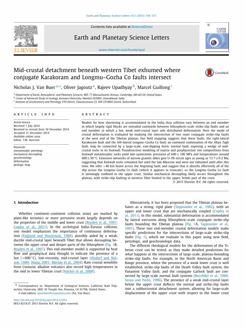
Fig. 1. A. In one end-member model for the India–Asia collision, the whole Tibetan crust behaves as a relatively coherent unit, causing deformation to be concentrated on lithospheric-scale faults, mostly concentrated around the edges of the plateau. Central inset shows mapped faults near western Tibet. B. In the other end-member, a weak middle crust facilitates distributed deformation throughout the plateau as it flows eastwards. Minor faulting related to that deformation is distributed throughout the plateau. C, D. These panels compare the predicted outcomes of the two end-member models on a conjugate fault junction. The block diagrams are oriented to mimic the approximate orientation of the junction between the right-lateral Karakoram fault (parallel to the left edge of the block diagrams) and the left-lateral Longmu–Gozha Co fault (cutting across the center of the blocks). C is based on the analog model PA1 of Peltzer and Tapponnier (1988). Stress is distributed throughout the vertically integrated crust, allowing the extruded block to remain largely intact while strain in concentrated along its margins by shear weakening. Significant deformation is limited to the area where the two blocks straddling the extruded block are zippered together. D is based on the model of Burchfiel et al. (1989), for the Death Valley/Garlock conjugate fault system. In this case, extrusion between the right-lateral/normal oblique faults in the foreground and the left-lateral fault cutting across the center is accommodated by large-offset, low-angle normal faults that root into the middle crust.
(Fig. 1D; Wernicke et al., 1988; Burchfiel et al., 1989; Lister and Davis, 1989). In the case of a more rigid crust, analog models indicate that lithospheric strike-slip faults might intersect without loss of vertical integrity of the crust, with most of the deformation accommodated by horizontal shortening where the two strike-slip faults zipper together behind the extruding block (Fig. 1C; Peltzer and Tapponnier, 1988). In this case, significant normal faulting would not be expected, and listric faulting within the crust would be precluded by the presence of a strong middle crust (Fig. 1C).
Even though it has been documented that normal faults play an important kinematic role in minor conjugate strike-slip zones within the Tibetan plateau (Taylor et al., 2003), the intersections of major plateau-bounding strike-slip faults have not been studied. To constrain how the evolution of the Tibetan crust and plateau fits between the two end-member rheological models, we present a detailed study of the intersection of two of the most important plateau-bounding strike-slip faults in western Tibet. We mapped
in detail the intersection between the right-lateral Karakoram fault (KKF) and the left-lateral Longmu–Gozha Co fault (LGF), an east-ward continuation of the Altyn Tagh fault (Figs. 1, 2).
2. Field relationships
2.1. West end of the Longmu–Gozha Co fault
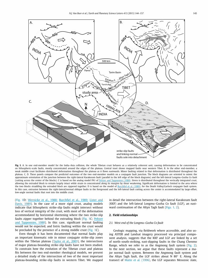
Geologic mapping, via fieldwork where accessible, and also us-ing ASTER and Landsat imagery processed via principal compo-nent analysis, suggests that the KKF and LGF are linked by a set of north–south-striking, east-dipping faults in the Chang Chenmo Range, which we refer to as the Angmong fault system (Fig. 2). In the next section, we argue that these faults represent a ma-jor normal fault system. Between the Angmong fault system and the Altyn Tagh fault, the LGF strikes about N 80◦ E. Along the transect of Matte et al. (1996), the LGF separates Mesozoic slate,
146 N.J. Van Buer et al. / Earth and Planetary Science Letters 413 (2015) 144–157
Fig. 2. The geologic map shows one of the main intersections of plateau-bounding strike-slip faults. We propose that a wedge of high-grade metasediments and injection complex (red/orange) is exhumed in the footwall of the Angmong normal fault, as low-grade sediments and associated rocks in the hanging wall (yellow/tan, low relief) are translated eastwards between the Karakoram (KKF) and Longmu–Gozha Co (LGF) faults. The linear, strike-slip part of the LGF system appears to end at the Angmong fault. The geologic mapping shown is primarily a result of our own field mapping and analysis of remotely sensed imagery (remotely mapped area marked by diagonal crosshatch); however, previous mapping was also consulted, particularly where published measurements indicated the presence of ground-truth data (Norin, 1946; Gergan and Pant, 1983; Thakur and Misra, 1984; Phillips, 2008). Equal-area plots show the distribution of foliation and lineation orientations along the northwestern KKF, and in the Angmong footwall and hanging wall. Footwall lineations (black arrows) are consistently subhorizontal and parallel to the inferred direction of extension, whereas those along the northwestern KKF (blue arrows; also measurements off map) are more frequently oriented steeply down-dip, consistent with transpression. (For interpretation of the references to color in this figure, the reader is referred to the web version of this article.)
sandstone and limestone to the north (Tianshuihai terrane) from Permo-Carboniferous sediments of Gondwanan/Tethyan affinity, in-truded by Cretaceous granites, to the south (Qiangtang terrane). Based on remote sensing data and reports from early expeditions (Hedin, 1916; Norin, 1946), similar low-grade Mesozoic sediments probably continue along the north side of the LGF into our study area (“undifferentiated metasediments”, purple, in Fig. 2). South of the LGF and east of the Angmong fault (in its hanging wall), in the Chang Chenmo Range, we observed low-grade metasediments in-cluding low-grade phyllites, calcareous sandstones, conglomerates, diamictites, limestones, and occasional vesicular basalt (”low-grade metasediments”, tan, in Fig. 2). These lithologies are similar to those found further east in the Qiangtang terrane and Lhasa block, and the presence of dropstones in some of the fine-grained units suggests specific correlation to Gondwanan glacio-marine sedi-ments deposited in the Late Carboniferous (cf. Tapponnier et al., 1991; Matte et al., 1996). In our study area, these units overlie felsic to intermediate plutonic rocks that form a sizeable and lo-
cally homogeneous batholith (“Chang Chenmo batholith”, yellow in Fig. 2). Observed intrusive rocks were mostly two-mica gran-ite, with local co-magmatic (as demonstrated by magma mingling relationships) quartz monzonite and gabbro bodies. We were not able to access the south-dipping metasediment/granite contact, but it may match the intrusive relations between Cretaceous grani-toids and Paleozoic strata observed further to the east (cf. Matte et al., 1996). Further northeast in the Chang Chenmo Range, an or-thogneiss (“Chang Chenmo basement gneiss”, orange-tan in Fig. 2) is present (Hedin, 1916). On the south side of the low-grade Chang Chenmo metasediments, along the inaccessible north shore of Pan-gong Tso, the metasediments are inferred to be overthrust by ophi-olitic melange and associated rocks of the Bangong suture zone (green in Fig. 2; e.g., Jain and Singh, 2008). All of these units south of the LGF appear to be truncated abruptly to the west by the Angmong fault system. The LGF itself also appears to die out west of the Angmong fault; the ENE linear trends of the strands of the strike-slip LGF are replaced by north-dipping structures that curve
N.J. Van Buer et al. / Earth and Planetary Science Letters 413 (2015) 144–157 147
off to the WNW (Fig. 2), showing no evidence of active strike slip displacement in satellite imagery (cf. Bohon, 2014). Although the LGF cannot be traced through to the KKF, the KKF takes a broad ∼27 km left step in this region (Fig. 2), consistent with offset re-lated to the LGF (Raterman et al., 2007).
2.2. Angmong fault system
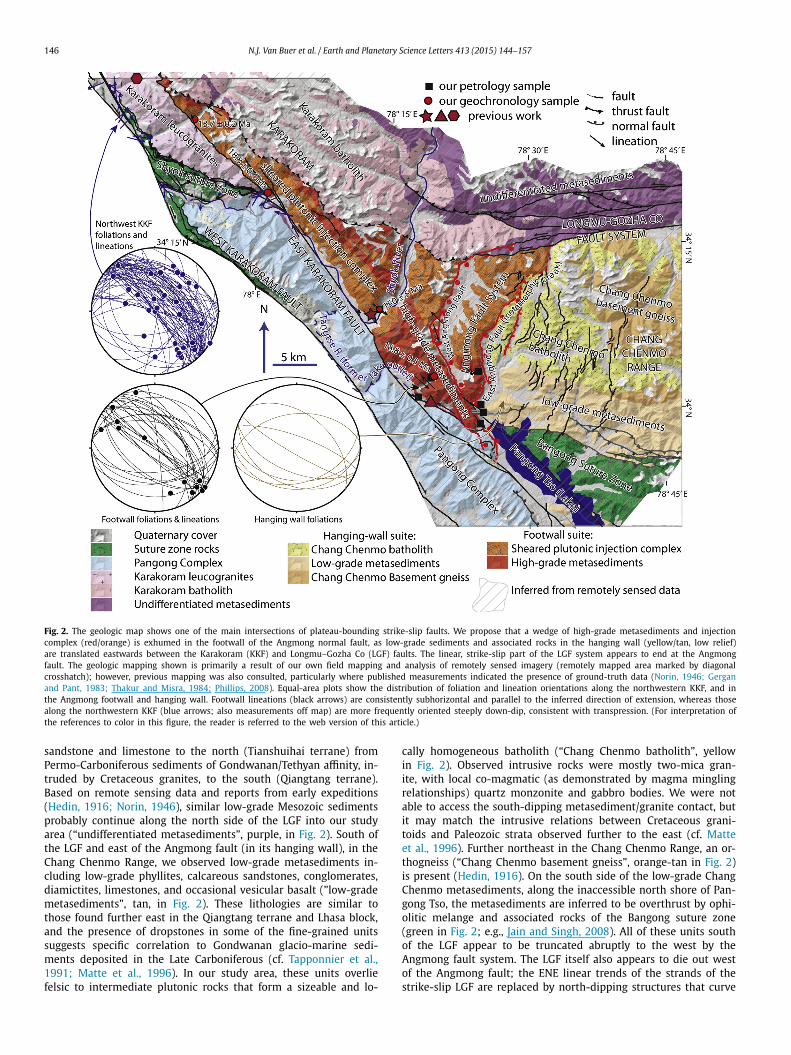
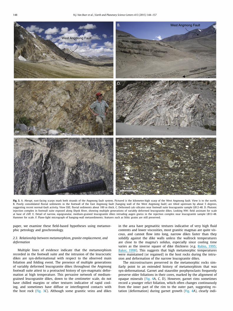
The Angmong fault system curves in a broad, concave to the east arc that trends on average NNE between the KKF and the ap-parent west end of the LGF, and consists of two major strands, each marked by kilometer-high east-facing topographic escarp-ments (Figs. 2, 3A). These faults juxtapose faceted mountain fronts against shallow basins and low-relief hanging walls (Fig. 3A), in a geomorphic expression consistent with normal faulting. Smaller, west-facing scarps suggest the presence of antithetic faults in the hanging wall. The surface of the main fault itself was not exposed in the outcrops studied; however, a subsidiary fault surface was measured dipping 55◦ east, with top to the east striations. Poorly consolidated fluvial/alluvial sediments between two strands of the fault system are backtilted about 5◦ (dipping west: upstream), providing further evidence for fairly recent normal fault activity (Fig. 3B). A swarm of three earthquakes with magnitudes between 4.8–5.2 and upper-crustal depths were recorded February 1968 in the vicinity of this fault, documenting recent seismic activity (ANSS Catalog); unfortunately moment tensor solutions are not available.
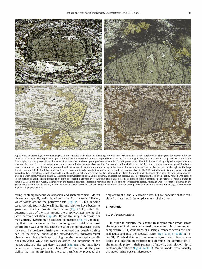
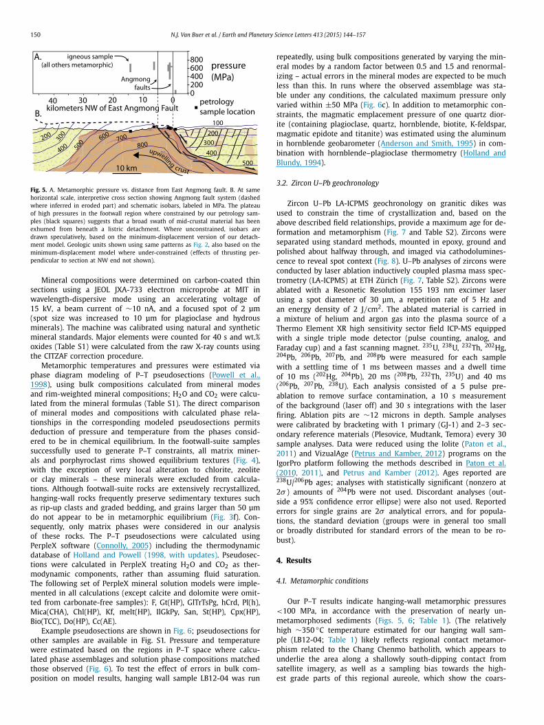
The east strand of the Angmong fault also coincides with an abrupt break in metamorphic grade and structural style (Fig. 2). Unlike the low-grade metasediments in the hanging wall (de-scribed in Section 2.1), footwall rocks are uniformly high-grade, consisting of upper-amphibolite-facies garnet–staurolite schists, quartzofeldspathic biotite schists (Fig. 3C), marble, tremolite- or diopside-bearing calc-silicates, and occasional hornblende amphi-bolite (collectively, “high-grade metasediments,” red in Fig. 2). These rocks could conceivably be the high-grade equivalent of the hanging-wall metasediments, but they are too high grade to make the correlation obvious. Further north, plutonic rocks occur on both sides of the Angmong fault system, but, similarly, the character of the rocks is very different on opposite sides of the fault (Fig. 2). Whereas the Chang Chenmo batholith in the hanging wall consists of large, generally monotonous, felsic plutons preserving a mild magmatic foliation, the footwall plutonic rocks are a complex as-semblage of 10 cm to 10 m wide tonalite and diorite dikes with a strong solid-state foliation/lineation (“sheared plutonic injection complex,” orange in Fig. 2; Fig. 3D). These locally intrude older gneisses, including augen gneisses. This diverse complex of small intrusions within the footwall is itself intruded by peraluminous leucogranite dikes that form a pervasive network (Fig. 3D). Similar leucogranite dikes intrude footwall high-grade metasedimentary rocks as well. These dikes vary in width from ∼1 cm to 10 m. They tend to be equigranular and medium-grained, lack any sort of chilled margins, and only a minority contain pegmatitic or aplitic textures indicative of particularly high fluid content (Fig. 3E). As some dikes are strongly folded or boudinaged, whereas others ap-pear relatively undeformed in the field, it is likely that there are multiple generations of syn-deformational dikes (Fig. 3D).
Structurally, the Angmong fault separates rocks with open, up-right folds in the hanging wall from rocks with tight to isoclinal, upright or overturned folds in the footwall (Fig. 2). Fold hinge lines are subhorizontal and follow similar NW–SE trends in the footwall as in the hanging wall. Hanging wall strata rarely exhibit sub-vertical dips, and mineral lineations are typically weak or absent; whereas in the footwall, folds are much tighter, with limbs that are often near-vertical or overturned to the SW, and are accompanied by parallel, horizontal mineral lineations trending N 50◦ W (Fig. 2). Folds in the footwall are found at scales ranging from outcrop-
scale to km-scale. Although footwall fabrics are superficially similar to steep shear fabrics along the KKF, S–C fabrics or other indica-tors of a consistent direction of simple shear were not observed more than ∼1 km NE of the main KKF trace. If the footwall fab-rics were primarily a product of strike-slip shearing, it is difficult to understand why rocks SE along strike of the KKF, but across the Angmong fault, would not be affected by compatible shear fabrics. Instead, we suggest the combination of tight to isoclinal subvertical folding and horizontal mineral lineation is consistent with NE–SW pure-shear shortening and NW–SE extension. In the footwall, rocks of the same structural style and metamorphic grade (henceforth referred to as the “footwall suite”) continue for at least 40 km to the NW, forming a triangular wedge that trails behind the Angmong fault, parallel to the direction of stretching lineations (Fig. 2).
High-grade metamorphic rocks and plutonic injection complex also occur in the Pangong massif between the strands of the KKF (Fig. 2; hereafter referred to as the “Pangong Complex”), but these rocks are different in a few important ways: Rocks in the core of the Pangong Complex are of higher grade and include granulites and migmatites; they often have strong dextral C–S fabrics with lineations that dip quite consistently to the NW; and they continue well to the SE of the Angmong fault (Fig. 2; e.g., Searle et al., 1998;Phillips et al., 2004; Rolland et al., 2009). Therefore, we do not in-terpret that the Angmong footwall suite and the Pangong Complex share a common tectonic history.
Major changes in structure and metamorphic grade are almost exclusively associated with the East Angmong fault, suggesting that this strand absorbed most of the system’s displacement; however, the sharp topographic expression of the West Angmong fault sug-gests normal slip may have recently been migrating westward onto younger and steeper fault surfaces that have cut across older, lower angle shear fabrics (Figs. 2, 3A). This could also explain why sub-horizontal stretching lineations in the footwall rarely roll over into the relatively steep (∼55◦) brittle fabrics observed.
Geographically, the Angmong fault system marks the boundary between the jagged, high relief peaks typical of the Karakoram Range and the more subdued, hilly terrain characteristic of the Tibetan Plateau (Figs. 2, 3A). The Angmong fault system also co-incides with a bedrock step in the channel of a now-abandoned river, the previous outlet to Pangong Lake (cf. Huntington, 1906;Dortch et al., 2011a), and is apparently responsible for tectonically damming its 28,000 km2 basin (Fig. 2).
We develop our interpretations based on field and map data as follows: Two east-dipping normal faults occur along the east end of an exposure of high-grade metasediments and sheared plutonic injection complex (Fig. 2). We infer that the close juxtaposition of these “footwall suite” rocks to much lower grade metasediments, more homogeneous plutons of the Chang Chenmo batholith, and Chang Chenmo gniesses east of these faults (henceforth collectively described as the “hanging-wall suite”) is caused by substantial nor-mal separation across this fault system (Fig. 2). Furthermore, the presence of antithetic normal faulting in the hanging wall (Fig. 2) suggests a listric geometry at depth. Because similar high-grade rocks containing stretching lineations parallel to the inferred dis-placement across the Angmong fault continue for >40 km to the NW of this fault, we hypothesize that all of these footwall-suite rocks may have been exposed by large horizontal displacement from beneath a detachment-style Angmong fault. Because our field mapping shows that the Angmong fault system terminates south-ward against the KKF and, based on remote sensing data, termi-nates northwards against the LGF at the probable eastern end of that fault’s strike-slip activity, we interpret that the Angmong fault has enabled the eastward escape of Tibetan upper crust between the conjugate KKF and LGF, while the middle crust upwells in the Angmong footwall (similar to Fig. 1D). In the remainder of this
148 N.J. Van Buer et al. / Earth and Planetary Science Letters 413 (2015) 144–157
Fig. 3. A. Abrupt, east-facing scarps mark both strands of the Angmong fault system. Pictured is the kilometer-high scarp of the West Angmong fault. View is to the north. B. Poorly consolidated fluvial sediments in the footwall of the East Angmong fault (hanging wall of the West Angmong fault) are tilted upstream by about 5 degrees, suggesting recent normal-fault activity. View SSE; fluvial sediments about 100 m thick. C. Deformed calc-silicates near footwall suite leucogranite sample LB12-48. D. Plutonic injection complex in footwall suite exposed along Shyok River, showing multiple generations of variably deformed leucogranite dikes. Looking NW; field assistant for scale at base of cliff. E. Detail of narrow, equigranular, medium-grained leucogranite dikes intruding augen gneiss in the injection complex near leucogranite sample LB12-48. Hammer for scale. F. Plane-light micrograph of hanging-wall metasediments; features such as lithic grains are still preserved.
paper, we examine these field-based hypotheses using metamor-phic petrology and geochronology.
2.3. Relationship between metamorphism, granite emplacement, and deformation
Multiple lines of evidence indicate that the metamorphism recorded in the footwall suite and the intrusion of the leucocratic dikes are syn-deformational with respect to the observed main foliation and folding event. The presence of multiple generations of variably deformed leucogranite dikes throughout the Angmong footwall suite attest to a protracted history of syn-magmatic defor-mation at high temperature. This pervasive network of medium-grained leucogranite dikes, down to the centimeter scale, do not have chilled margins or other textures indicative of rapid cool-ing, and sometimes have diffuse or interfingered contacts with the host rock (Fig. 3C). Although some granitic veins and dikes
in the area have pegmatitic textures indicative of very high fluid contents and lower viscosities, most granitic magmas are quite vis-cous, and cannot flow into long, narrow dikes faster than they solidify against the dike walls unless the wallrock temperatures are close to the magma’s solidus, especially since cooling time varies as the inverse square of dike thickness (e.g. Rubin, 1995;Baker, 1998). This suggests that high metamorphic temperatures were maintained (or regained) in the host rocks during the intru-sion and deformation of the narrow leucogranite dikes.
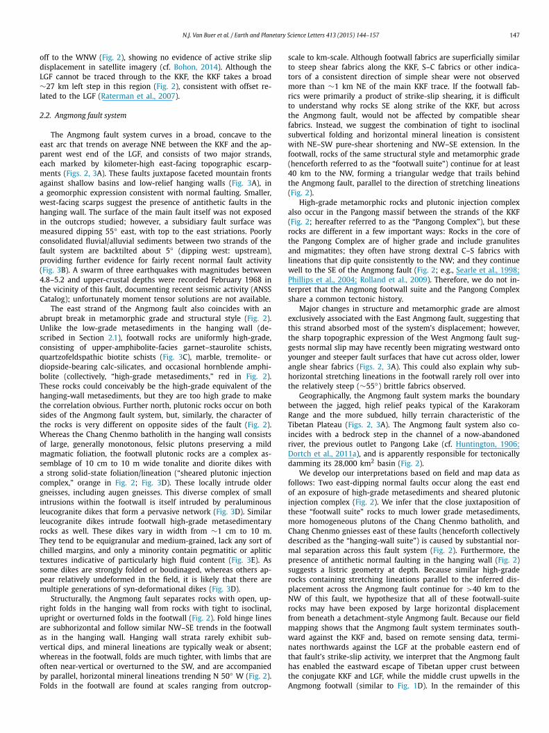
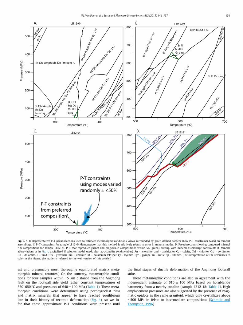
The microstructures preserved in the metamorphic rocks sim-ilarly point to an extended history of metamorphism that was syn-deformational. Garnet and staurolite porphyroclasts frequently preserve older foliations in their cores, marked by the alignment of opaque minerals (Fig. 4A, C, D). However, garnet rims sometimes record a younger relict foliation, which often changes continuously from the inner part of the rim to the outer part, suggesting ro-tation (deformation) during garnet growth (Fig. 4A), clearly indi-
N.J. Van Buer et al. / Earth and Planetary Science Letters 413 (2015) 144–157 149
Fig. 4. Plane-polarized light photomicrographs of metamorphic rocks from the Angmong footwall suite. Matrix minerals and porphyroclast rims generally appear to be late syntectonic. Scale at lower right; all images at same scale. Abbreviations: Amph – amphibole, Bt – biotite, Cpx – clinopyroxene, Cz – clinozoisite, Gt – garnet, Ms – muscovite, Pl – plagioclase, q – quartz, sill – sillimanite, St – staurolite. A. Garnet porphyroclasts in sample LB12-21 preserve an older foliation marked by aligned opaque minerals; however, the rims often record syntectonic garnet growth during porphyroclast rotation. For example, although the center of the garnet preserves an older parallel foliation, near the rim an inclined foliation is preserved, and the current foliation orientation can again be seen in the very youngest part of the rim, just to the right of the large ilmenite grain at left. B. The foliation defined by the opaque minerals (mostly ilmenite) wraps around the porphyroclasts in LB12-27, but sillimanite is more weakly aligned, suggesting late syntectonic growth. Staurolite and the outer garnet rim overgrow this late sillimanite in places. Staurolite and sillimanite often seem to form pseudomorphs after an earlier porphyroblastic phase. C. Staurolite porphyroclasts in LB12-28 are generally euhedral but preserve an older foliation that is often slightly rotated with respect to the current foliation. Biotite occasionally forms post-tectonic growths over staurolite, but is also present as foliation-parallel crystals in the matrix. D. Matrix phases in sample LB12-68 are only weakly aligned with the tectonic foliation, indicating recrystallization late into the syntectonic period. Although wisps of opaque minerals in the garnet cores often follow an earlier, rotated foliation, a narrow, clear rim contains larger inclusions in an orientation pattern similar to the current matrix (e.g., at very bottom edge of the porphyroclast).
cating contemporaneous deformation and metamorphism. Matrix phases are typically well aligned with the final tectonic foliation, which wraps around the porphyroclasts (Fig. 4A, C), but in some cases crystals (particularly sillimanite and biotite) have begun to grow with a static, post-tectonic texture (Fig. 4B, D). Often the outermost part of the rims around the prophyroclasts overlap the latest tectonic foliation (Fig. 4A, D), or the very outermost rim may actually overlap static-textured sillimanite (Fig. 4B), indicat-ing that rims continued at least minor growth until after most deformation was complete. Therefore, although porphyroclast cores may record a prolonged history of metamorphism, possibly dating back to the original burial of the metasediments, microstructural observations clearly indicate that high-grade metamorphic condi-tions prevailed while the rocks deformed. As intrusions of the leucogranite are also syn-deformational (Fig. 3B), they must have been intruded during metamorphism. We do not exclude the pos-sibility that metamorphism in the area significantly preceded the
emplacement of the leucocratic dikes, but we conclude that it con-tinued at least until the emplacement of the dikes.
3. Methods
3.1. P–T pseudosections
In order to quantify the change in metamorphic grade across the Angmong fault, we constrained the metamorphic pressure and temperature (P–T) conditions of a sample transect across the nor-mal faults and into the footwall suite (Figs. 2, 5, 6; Table 1; Ta-ble S1). Polished thin sections were analyzed via optical micro-scope and electron microprobe to determine the composition of the minerals present, their progress of growth, and relationship to metamorphic fabrics (Fig. 4; Table 1). Mineral modes were visually estimated using optical microscopy.
150 N.J. Van Buer et al. / Earth and Planetary Science Letters 413 (2015) 144–157
Fig. 5. A. Metamorphic pressure vs. distance from East Angmong fault. B. At same horizontal scale, interpretive cross section showing Angmong fault system (dashed where inferred in eroded part) and schematic isobars, labeled in MPa. The plateau of high pressures in the footwall region where constrained by our petrology sam-ples (black squares) suggests that a broad swath of mid-crustal material has been exhumed from beneath a listric detachment. Where unconstrained, isobars are drawn speculatively, based on the minimum-displacement version of our detach-ment model. Geologic units shown using same patterns as Fig. 2, also based on the minimum-displacement model where under-constrained (effects of thrusting per-pendicular to section at NW end not shown).
Mineral compositions were determined on carbon-coated thin sections using a JEOL JXA-733 electron microprobe at MIT in wavelength-dispersive mode using an accelerating voltage of 15 kV, a beam current of ∼10 nA, and a focused spot of 2 μm (spot size was increased to 10 μm for plagioclase and hydrous minerals). The machine was calibrated using natural and synthetic mineral standards. Major elements were counted for 40 s and wt.% oxides (Table S1) were calculated from the raw X-ray counts using the CITZAF correction procedure.
Metamorphic temperatures and pressures were estimated via phase diagram modeling of P–T pseudosections (Powell et al., 1998), using bulk compositions calculated from mineral modes and rim-weighted mineral compositions; H2O and CO2 were calcu-lated from the mineral formulas (Table S1). The direct comparison of mineral modes and compositions with calculated phase rela-tionships in the corresponding modeled pseudosections permits deduction of pressure and temperature from the phases consid-ered to be in chemical equilibrium. In the footwall-suite samples successfully used to generate P–T constraints, all matrix miner-als and porphyroclast rims showed equilibrium textures (Fig. 4), with the exception of very local alteration to chlorite, zeolite or clay minerals – these minerals were excluded from calcula-tions. Although footwall-suite rocks are extensively recrystallized, hanging-wall rocks frequently preserve sedimentary textures such as rip-up clasts and graded bedding, and grains larger than 50 μm do not appear to be in metamorphic equilibrium (Fig. 3f). Con-sequently, only matrix phases were considered in our analysis of these rocks. The P–T pseudosections were calculated using PerpleX software (Connolly, 2005) including the thermodynamic database of Holland and Powell (1998, with updates). Pseudosec-tions were calculated in PerpleX treating H2O and CO2 as ther-modynamic components, rather than assuming fluid saturation. The following set of PerpleX mineral solution models were imple-mented in all calculations (except calcite and dolomite were omit-ted from carbonate-free samples): F, Gt(HP), GlTrTsPg, hCrd, Pl(h), Mica(CHA), Chl(HP), Kf, melt(HP), IlGkPy, San, St(HP), Cpx(HP), Bio(TCC), Do(HP), Cc(AE).
Example pseudosections are shown in Fig. 6; pseudosections for other samples are available in Fig. S1. Pressure and temperature were estimated based on the regions in P–T space where calcu-lated phase assemblages and solution phase compositions matched those observed (Fig. 6). To test the effect of errors in bulk com-position on model results, hanging wall sample LB12-04 was run
repeatedly, using bulk compositions generated by varying the min-eral modes by a random factor between 0.5 and 1.5 and renormal-izing – actual errors in the mineral modes are expected to be much less than this. In runs where the observed assemblage was sta-ble under any conditions, the calculated maximum pressure only varied within ±50 MPa (Fig. 6c). In addition to metamorphic con-straints, the magmatic emplacement pressure of one quartz dior-ite (containing plagioclase, quartz, hornblende, biotite, K-feldspar, magmatic epidote and titanite) was estimated using the aluminum in hornblende geobarometer (Anderson and Smith, 1995) in com-bination with hornblende–plagioclase thermometry (Holland and Blundy, 1994).
3.2. Zircon U–Pb geochronology
Zircon U–Pb LA-ICPMS geochronology on granitic dikes was used to constrain the time of crystallization and, based on the above described field relationships, provide a maximum age for de-formation and metamorphism (Fig. 7 and Table S2). Zircons were separated using standard methods, mounted in epoxy, ground and polished about halfway through, and imaged via cathodolumines-cence to reveal spot context (Fig. 8). U–Pb analyses of zircons were conducted by laser ablation inductively coupled plasma mass spec-trometry (LA-ICPMS) at ETH Zürich (Fig. 7, Table S2). Zircons were ablated with a Resonetic Resolution 155 193 nm excimer laser using a spot diameter of 30 μm, a repetition rate of 5 Hz and an energy density of 2 J/cm2. The ablated material is carried in a mixture of helium and argon gas into the plasma source of a Thermo Element XR high sensitivity sector field ICP-MS equipped with a single triple mode detector (pulse counting, analog, and Faraday cup) and a fast scanning magnet. 235U, 238U, 232Th, 202Hg, 204Pb, 206Pb, 207Pb, and 208Pb were measured for each sample with a settling time of 1 ms between masses and a dwell time of 10 ms (202Hg, 204Pb), 20 ms (208Pb, 232Th, 235U) and 40 ms (206Pb, 207Pb, 238U). Each analysis consisted of a 5 pulse pre-ablation to remove surface contamination, a 10 s measurement of the background (laser off) and 30 s integrations with the laser firing. Ablation pits are ∼12 microns in depth. Sample analyses were calibrated by bracketing with 1 primary (GJ-1) and 2–3 sec-ondary reference materials (Plesovice, Mudtank, Temora) every 30 sample analyses. Data were reduced using the Iolite (Paton et al., 2011) and VizualAge (Petrus and Kamber, 2012) programs on the IgorPro platform following the methods described in Paton et al. (2010, 2011), and Petrus and Kamber (2012). Ages reported are 238U/206Pb ages; analyses with statistically significant (nonzero at 2σ ) amounts of 204Pb were not used. Discordant analyses (out-side a 95% confidence error ellipse) were also not used. Reported errors for single grains are 2σ analytical errors, and for popula-tions, the standard deviation (groups were in general too small or broadly distributed for standard errors of the mean to be ro-bust).
4. Results
4.1. Metamorphic conditions
Our P–T results indicate hanging-wall metamorphic pressures <100 MPa, in accordance with the preservation of nearly un-metamorphosed sediments (Figs. 5, 6; Table 1). (The relatively high ∼350 ◦C temperature estimated for our hanging wall sam-ple (LB12-04; Table 1) likely reflects regional contact metamor-phism related to the Chang Chenmo batholith, which appears to underlie the area along a shallowly south-dipping contact from satellite imagery, as well as a sampling bias towards the high-est grade parts of this regional aureole, which show the coars-
N.J. Van Buer et al. / Earth and Planetary Science Letters 413 (2015) 144–157 151
Fig. 6. A, B. Representative P–T pseudosections used to estimate metamorphic conditions. Areas surrounded by green dashed borders show P–T constraints based on mineral assemblage. C. P–T constraints for sample LB12-04 demonstrate that this method is relatively robust to error in mineral modes. D. Pseudosection showing contoured mineral rim compositions for sample LB12-21. P–T that reproduce garnet and plagioclase compositions within 5% (green) overlap with mineral assemblage constraints B. Mineral abbreviations as in Fig. 4, capitalized if solution model used; also: ac-actinolite (endmember), An – anorthite, and – andalusite, Cc – calcite, Chl – chlorite, Crd – cordierite, Do – dolomite, F – fluid, Grs – grossular, Ilm – ilmenite, Kf – potassium feldspar, ky – kyanite, Pyr – pyrope, ru – rutile, sp – titanite. (For interpretation of the references to color in this figure, the reader is referred to the web version of this article.)
est and presumably most thoroughly equilibrated matrix meta-morphic mineral textures.) On the contrary, metamorphic condi-tions for four samples within 15 km distance from the Angmong fault on the footwall side yield rather constant temperatures of 550–650 ◦C and pressures of 640 ± 100 MPa (Table 1). These meta-morphic conditions were determined using porphyroclast rims and matrix minerals that appear to have reached equilibrium late in their history of tectonic deformation (Fig. 4), so we in-fer that these approximate P–T conditions were present until
the final stages of ductile deformation of the Angmong footwall suite.
These metamorphic conditions are also in agreement with the independent estimate of 610 ± 100 MPa based on hornblende barometry from a nearby tonalite (sample LB12-18; Table 1). High emplacement pressures are also suggested by the presence of mag-matic epidote in the same granitoid, which only crystallizes above ∼500 MPa in felsic to intermediate compositions (Schmidt and Thompson, 1996).
152 N.J. Van Buer et al. / Earth and Planetary Science Letters 413 (2015) 144–157
Table 1Mineral modes and sample locations.
Sample
lb12-04 lb12-21 lb12-27 lb12-28 lb12-68 lb12-18
phyllite schist schist schist schist quartz dioriteminimum pressure (Mpa) 0 620 530 340 540 510maximum pressure (Mpa) 90 650 680 740 760 710minimum temperature (◦C) 340 580 580 540 570 680maximum temperature (◦C) 350 600 650 640 660 760N latitude 33.91692 33.97636 34.0535 34.0535 34.04299 34.15019E longitude 78.28206 78.41028 78.40696 78.40696 78.31749 78.22399NW distance from E Angmong Fault (km) −0.8 0.1 0.7 0.6 6.3 14.3quartz 20 43 29 45 2 15
Modal%biotite 17 25 1 10 14 10muscovite 40 15 20 29 1ilmenite 1 0.4 2 1 2calcite 2garnet 1 3 5plagioclase 15.5 25 75 57staurolite 12 15apatite tr tr trrutile tr 0.1titanite tr 1tourmaline tr trzircon tr trother 20 (chl) 8 (sill) tr (mon) 15 (amph)
1 (kf) 1 (ep)Weight%SiO2 52.063 68.805 60.856 66.415 43.589 n.d.TiO2 1.024 0.972 1.238 0.874 1.590 n.d.Al2O3 19.452 14.208 26.188 20.719 30.788 n.d.Cr2O3 0.024 0.019 0.023 0.002 0.008 n.d.FeO 9.750 5.381 4.109 5.039 5.393 n.d.MnO 0.100 0.088 0.034 0.042 0.041 n.d.MgO 5.329 2.388 0.441 1.029 1.446 n.d.CaO 1.082 1.480 2.046 0.020 14.418 n.d.Na2O 0.197 1.126 2.022 0.506 0.648 n.d.K2O 5.382 3.908 1.870 3.341 1.486 n.d.H2O 4.733 1.643 1.195 2.015 0.604 n.d.CO2 0.885 0.000 0.000 0.000 0.000 n.d.
Abbreviations: amph – amphibole, chl – chlorite, kf – potassium feldspar, sill – sillimanite, tr – trace, mon – monazite, ep – epidote, n.d. – not determined.
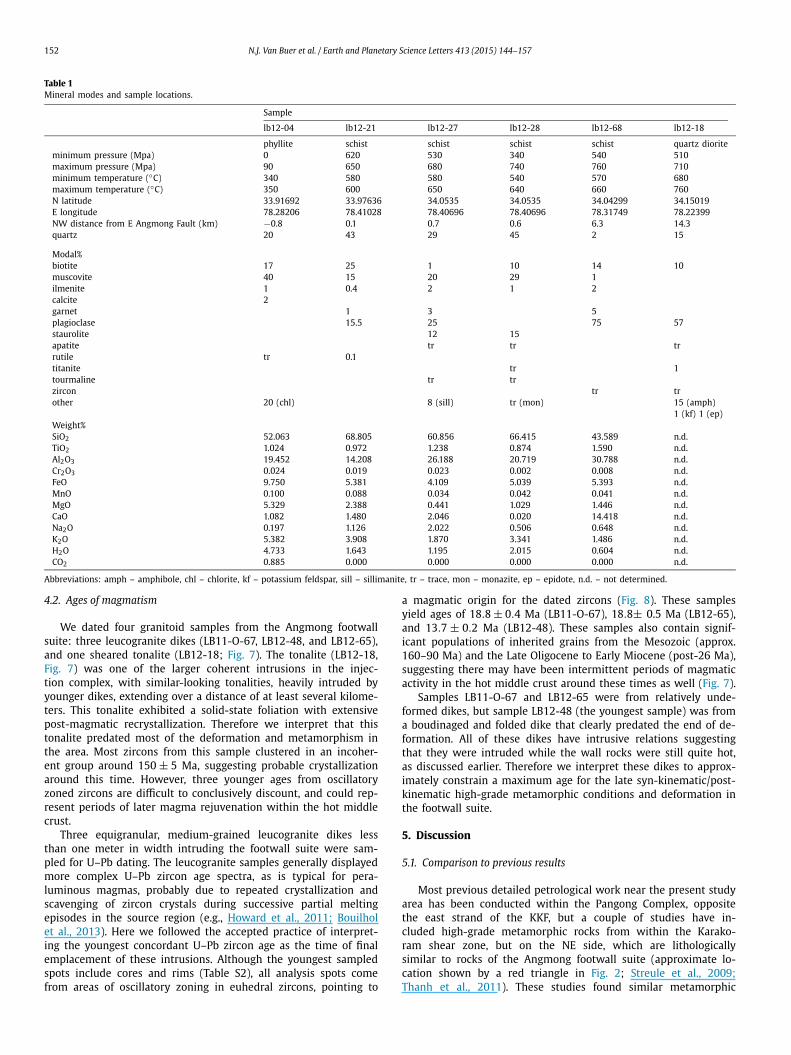
4.2. Ages of magmatism
We dated four granitoid samples from the Angmong footwall suite: three leucogranite dikes (LB11-O-67, LB12-48, and LB12-65), and one sheared tonalite (LB12-18; Fig. 7). The tonalite (LB12-18, Fig. 7) was one of the larger coherent intrusions in the injec-tion complex, with similar-looking tonalities, heavily intruded by younger dikes, extending over a distance of at least several kilome-ters. This tonalite exhibited a solid-state foliation with extensive post-magmatic recrystallization. Therefore we interpret that this tonalite predated most of the deformation and metamorphism in the area. Most zircons from this sample clustered in an incoher-ent group around 150 ± 5 Ma, suggesting probable crystallization around this time. However, three younger ages from oscillatory zoned zircons are difficult to conclusively discount, and could rep-resent periods of later magma rejuvenation within the hot middle crust.
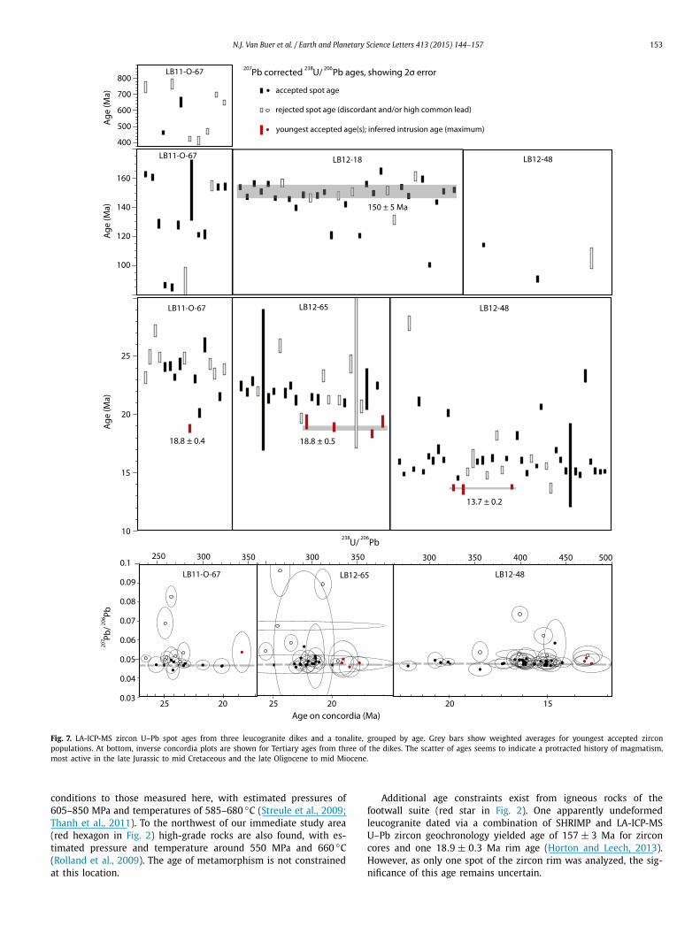
Three equigranular, medium-grained leucogranite dikes less than one meter in width intruding the footwall suite were sam-pled for U–Pb dating. The leucogranite samples generally displayed more complex U–Pb zircon age spectra, as is typical for pera-luminous magmas, probably due to repeated crystallization and scavenging of zircon crystals during successive partial melting episodes in the source region (e.g., Howard et al., 2011; Bouilhol et al., 2013). Here we followed the accepted practice of interpret-ing the youngest concordant U–Pb zircon age as the time of final emplacement of these intrusions. Although the youngest sampled spots include cores and rims (Table S2), all analysis spots come from areas of oscillatory zoning in euhedral zircons, pointing to
a magmatic origin for the dated zircons (Fig. 8). These samples yield ages of 18.8 ± 0.4 Ma (LB11-O-67), 18.8± 0.5 Ma (LB12-65), and 13.7 ± 0.2 Ma (LB12-48). These samples also contain signif-icant populations of inherited grains from the Mesozoic (approx. 160–90 Ma) and the Late Oligocene to Early Miocene (post-26 Ma), suggesting there may have been intermittent periods of magmatic activity in the hot middle crust around these times as well (Fig. 7).
Samples LB11-O-67 and LB12-65 were from relatively unde-formed dikes, but sample LB12-48 (the youngest sample) was from a boudinaged and folded dike that clearly predated the end of de-formation. All of these dikes have intrusive relations suggesting that they were intruded while the wall rocks were still quite hot, as discussed earlier. Therefore we interpret these dikes to approx-imately constrain a maximum age for the late syn-kinematic/post-kinematic high-grade metamorphic conditions and deformation in the footwall suite.
5. Discussion
5.1. Comparison to previous results
Most previous detailed petrological work near the present study area has been conducted within the Pangong Complex, opposite the east strand of the KKF, but a couple of studies have in-cluded high-grade metamorphic rocks from within the Karako-ram shear zone, but on the NE side, which are lithologically similar to rocks of the Angmong footwall suite (approximate lo-cation shown by a red triangle in Fig. 2; Streule et al., 2009;Thanh et al., 2011). These studies found similar metamorphic
N.J. Van Buer et al. / Earth and Planetary Science Letters 413 (2015) 144–157 153
Fig. 7. LA-ICP-MS zircon U–Pb spot ages from three leucogranite dikes and a tonalite, grouped by age. Grey bars show weighted averages for youngest accepted zircon populations. At bottom, inverse concordia plots are shown for Tertiary ages from three of the dikes. The scatter of ages seems to indicate a protracted history of magmatism, most active in the late Jurassic to mid Cretaceous and the late Oligocene to mid Miocene.
conditions to those measured here, with estimated pressures of 605–850 MPa and temperatures of 585–680 ◦C (Streule et al., 2009;Thanh et al., 2011). To the northwest of our immediate study area (red hexagon in Fig. 2) high-grade rocks are also found, with es-timated pressure and temperature around 550 MPa and 660 ◦C (Rolland et al., 2009). The age of metamorphism is not constrained at this location.
Additional age constraints exist from igneous rocks of the footwall suite (red star in Fig. 2). One apparently undeformed leucogranite dated via a combination of SHRIMP and LA-ICP-MS U–Pb zircon geochronology yielded age of 157 ± 3 Ma for zircon cores and one 18.9 ± 0.3 Ma rim age (Horton and Leech, 2013). However, as only one spot of the zircon rim was analyzed, the sig-nificance of this age remains uncertain.
154 N.J. Van Buer et al. / Earth and Planetary Science Letters 413 (2015) 144–157
Fig. 8. Cathodoluminescence images of the youngest dated zircons, with LA-ICP-MS spots circled. Several of the younger ages are from zircon cores, not just rims, and the oscillatory zoning patterns indicate magmatic rather than metamorphic growth, supporting a Miocene intrusion age for the three dikes.
Our results show a range of zircon U–Pb spot ages from our samples, which are generally consistent with magmatic activity elsewhere in the region. Inherited Mesozoic zircon ages from our samples at ∼150 Ma are similar to ages from the Hushe or-thogneiss (Searle, 1991) and various intrusions in the Qiangtang terrane (Zhang et al., 2012); and ages around 100 Ma are similar to those measured in the Hunza granodiorite (Fraser et al., 2001)and in the eastern Karakoram batholith near Saser La/Skyang-poche (Ravikant et al., 2009). The Miocene intrusion ages of the leucogranites in this study are also similar to ages of regional magmatism around 21–18 Ma from among the Baltoro gran-ites and the Pangong Complex, and 13.7 Ma leucogranites from the Pangong Complex and the Nubra Valley (Searle et al., 1998;Phillips et al., 2004).
5.2. Age of metamorphism
Based on our field and textural observations, we consider the emplacement of leucocratic dikes to be contemporaneous with both the recorded high-grade metamorphic conditions and also the deformation that formed the pervasive fabric observed in the footwall suite, which may have accompanied the early, ductile stages of its exhumation. Our results indicate that deformation and high-grade metamorphic conditions occurred at ∼19–14 Ma. These ages are synchronous with the age constraints for the ac-tivity on the KKF by Searle (1996) or Phillips et al. (2004) but postdate the inferred initiation age of the KKF by Lacassin et al.(2004) by ∼10–20 Ma. Our interpretation is in accordance with existing thermochronology data in the region. K/Ar ages on mus-covite indicate that the sampled rocks remained at temperatures above 500–430 ◦C until about 10 Ma (Thanh et al., 2011; from two locations: red star and red triangle on Fig. 2). These data are in line with our field observations that indicate emplacement of leucocratic dikes and veins into relatively hot country rocks. Ad-ditional thermochronology data from igneous rocks near the bend of the Shyok River (near red star in Fig. 2), include biotite Ar/Ar ages of 9.2–7.5 Ma, zircon U–Th/He ages of 4.4–3.4 Ma, and ap-atite U–Th/He ages of 3.3–2.7 Ma (Bohon, 2014). These data also strongly support recent exhumation of the Angmong footwall suite.
These results however contrast with U–Pb ages of monazite in-clusions from the cores of garnet porphyroblasts that have been interpreted to date peak metamorphism at 108 ± 0.6 Ma (Streule et al., 2009; red triangle in Fig. 2). We do not dispute the inter-
pretation that high grade metamorphic conditions also existed in the Cretaceous in the Pangong area, but because these samples are from within the Karakoram shear zone, it is not certain whether the results apply to parts of the footwall suite further from the KKF. Independently of their detailed structural position, the signif-icance of U–Pb ages from monazite inclusions in garnet is highly debated (e.g., Montel et al., 2000; Appel et al., 2011). In any case, the monazite cores cannot be used to constrain the time of final rim-matrix equilibration at 585–605 ◦C and 605–725 MPa (Streule et al., 2009).
In summary, the existing data indicate that the Angmong foot-wall suite had not been substantially cooled and/or exhumed be-fore the late Miocene. We interpret that initiation of extension and exhumation by the Angmong fault is linked to the onset of east–west extension around 16–12 Ma elsewhere in the Tibetan plateau (Styron et al., 2013; Sundell et al., 2013).
5.3. Geometry of the Angmong Fault
The constant exhumation level recorded in the footwall suite over at least 15 km distance orthogonal from the main fault trace is most consistent with a listric fault geometry, and relatively mi-nor displacement across the West Angmong fault (Fig. 5). If the footwall of the fault system were simply tilted back via rigid block rotation, as is typical for high-angle normal faults, pressures should decrease rapidly away from the fault, where shallower parts of the tilted footwall would be exposed. This is not what is observed (Fig. 5). Rather, the constant pressures around 640 ± 100 MPa are more consistent with exhumation from beneath a rolling-hinge de-tachment bottoming out at ∼22 km (assuming a crustal density of 2800 kg/m3; Fig. 5).
The major change in metamorphic grade across the Angmong normal fault implies that this fault has a substantial throw. Un-fortunately, because pressure data are sparse more than 15 km from the Angmong fault, it is difficult to precisely determine the total horizontal displacement of the inferred detachment and the position of its breakaway zone. The minimum displacement is con-strained by assuming that the rocks found within 15 km of the Angmong fault were exhumed from a depth over 20 km along a rolling-hinge fault dipping no steeper than 55◦ , which results in a total horizontal displacement across the fault of ∼40 km (Fig. 5). A maximum displacement can be approximated by assuming that the entire triangular wedge of footwall-suite rocks was exhumed from beneath the Angmong fault, indicating a maximum heave of ∼50–70 km (Fig. 2). In this model, rocks that were at mid-crustal depths as late as 13.7 ± 0.2 Ma (based on the age of the youngest leucogranite dikes) have been displaced at least 44 ± 4 km NW from beneath the hanging wall of the Angmong fault (error due to displacement vector uncertainty; Fig. 2). This implies a hori-zontal displacement rate of at least 3.2 ± 0.3 mm/yr along the Angmong fault, consistent with the geodetic strike-slip displace-ment rate (3 ± 1 mm/yr) across the LGF (Raterman et al., 2007).
In this rolling-hinge model, as the Ladakh block, south of the KKF, and the Tianshuihai block, north of the LGF, are brought to-gether by the conjugate strike slip on the KKF and LGF faults, the Tibetan upper crust escapes eastwards above the Angmong de-tachment (Fig. 9). The midcrustal footwall of the Angmong fault is exhumed vertically to fill the space left as the upper crust evac-uates, and shortened in an NE–SW direction as it is caught be-tween the converging Ladakh and Tianshuihai blocks (Fig. 9). This form of deformation would explain the subhorizontal stretching lineations and tight, relatively upright, NW trending folds in the footwall suite. The NW-tapering-wedge shape of the footwall suite may be caused by progressive shortening (and/or thrust burial) of footwall-suite rocks further NW into the compressive zone past the Angmong fault (Figs. 2, 9).
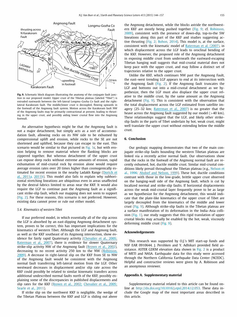
N.J. Van Buer et al. / Earth and Planetary Science Letters 413 (2015) 144–157 155
Fig. 9. Schematic block diagram illustrating the anatomy of the conjugate fault junc-tion in our proposed model. Upper crust of the Tibetan plateau (labeled “Tibet”) is extruded eastwards between the left-lateral Longmu–Gozha Co fault and the right-lateral Karakoram fault. The middle/lower crust is decoupled, flowing upwards in the footwall of the Angmong fault system. Motion across the Karakoram fault NW of the Angmong faults may be primarily contractional at present, leading to thrust-ing in the upper crust, and possibly aiding lower crustal flow into the Angmong footwall.
An alternative hypothesis might be that the Angmong fault is not a major detachment, but simply acts as a sort of accommo-dation fault, allowing rocks on its NW side to be exhumed by compressional uplift and erosion, while rocks to the SE are not shortened and uplifted, because they can escape to the east. This scenario would be similar to that pictured in Fig. 1c, but with ero-sion helping to remove material where the flanking blocks are zippered together. But whereas detachment of the upper crust can expose deep rocks without extreme amounts of erosion, rapid exhumation of mid-crustal rock by erosion alone would require average erosion rates over 20 times higher than cosmogenically es-timated for recent erosion in the nearby Ladakh Range (Dortch et al., 2011a, 2011b). This model also fails to explain why subhori-zontal stretching lineations are ubiquitous even in areas unaffected by the dextral fabrics limited to areas near the KKF. It would also require the LGF to continue past the Angmong fault as a signifi-cant strike-slip fault, which our mapping does not seem to support (Fig. 2). For these reasons, this scenario is not preferred. However, existing data cannot prove or rule out either model.
5.4. Kinematics of western Tibet
If our preferred model, in which essentially all of the slip across the LGF is absorbed by an east-dipping Angmong detachment sys-tem, proves to be correct, this has important implications for the kinematics of western Tibet. Although the LGF and Angmong fault, as well as the KKF southeast of its Angmong intersection, show ev-idence for fairly rapid Quaternary activity (Chevalier et al., 2005;Raterman et al., 2007), there is evidence for slower Quaternary strike-slip activity NW of the Angmong fault (Brown et al., 2002), decreasing to no recent activity 250 km to the NW (Robinson, 2009). A decrease in right-lateral slip on the KKF from SE to NW of the Angmong fault would be consistent with the Angmong normal fault transferring left-lateral motion from the LGF. Other westward decreases in displacement and/or slip rate across the KKF could possibly be related to similar kinematic transfers across additional undescribed normal faults north of the KKF, possibly ex-plaining some of the discrepancies in published displacements and slip rates for the KKF (Brown et al., 2002; Chevalier et al., 2005;Searle et al., 2011).
If strike slip on the northwest KKF is negligible, the wedge of the Tibetan Plateau between the KKF and LGF is sliding out above
the Angmong detachment, while the blocks astride the northwest-ern KKF are mostly being pushed together (Fig. 9; cf. Robinson, 2009), consistent with the presence of down-dip, top-to-the SW lineations along this part of the KKF and studies suggesting ac-tive thrusting (Fig. 2; Bohon, 2014). This model is, at the surface, consistent with the kinematic model of Raterman et al. (2007), in which displacement across the LGF leads to oroclinal bending of the KKF. However, the proposed role of the Angmong detachment in exposing middle crust from underneath the eastward-escaping Tibetan hanging wall suggests that mid-crustal material does not keep pace with the upper crust, and may follow a distinct set of trajectories relative to the upper crust.
Unlike the KKF, which continues NW past the Angmong Fault, the east–west trending LGF appears to end at its intersection with the Angmong fault (Fig. 2). If the Angmong fault truncates the LGF and bottoms out into a mid-crustal detachment as we hy-pothesize, then the LGF must also displace the upper crust rel-ative to the middle crust, by the same amount as the Angmong detachment (Fig. 9). This is consistent with the observation that the total displacement across the LGF estimated from satellite im-agery (25–32 km; Raterman et al., 2007) is no greater that the heave across the Angmong fault suggested by our model (>40 km). These relationships suggest that the LGF, and likely other strike-slip faults in the parts of Tibet underlain by hot, weak crust, might well translate the upper crust without extending below the middle crust.
6. Conclusion
Our geologic mapping demonstrates that two of the main con-jugate strike-slip faults bounding the western Tibetan plateau are linked via a recently active normal fault. Our observations show that the rocks in the footwall of the Angmong normal fault are re-cently exhumed, hot, ductile middle crust. Similar mid-crustal con-ditions likely prevail throughout the Tibetan plateau (e.g., Nelson et al., 1996; Alsdorf and Nelson, 1999). These hot, ductile conditions contrast with those in the low-grade, brittle upper crust observed on the hanging-wall side of the Angmong fault, which is cut by localized normal and strike-slip faults. If horizontal displacements across the weak mid-crustal layer frequently prove to be as large as we hypothesize for the Angmong detachment, this would indi-cate that the plate-like kinematics of the upper crust of Tibet are largely decoupled from the kinematics of the middle and lower crust (Fig. 9). Although strike-slip faults in the Tibetan plateau are a surface manifestation of its deformation in the India–Asia colli-sion (Fig. 1), our study suggests that this rigid translation of upper crustal blocks may actually be enabled by the hot, weak, viscously deforming middle crust (Fig. 9).
Acknowledgements
This research was supported by O.J.’s MIT start-up funds and NSF EAR 0910644. J. Pershken and Y. Adhikari provided field as-sistance. ASTER GDEM elevation data shown in Fig. 2 is a product of METI and NASA. Earthquake data for this study were accessed through the Northern California Earthquake Data Center (NCEDC). Helpful and constructive reviews were given by A. Robinson and an anonymous reviewer.
Appendix A. Supplementary material
Supplementary material related to this article can be found on-line at http://dx.doi.org/10.1016/j.epsl.2014.12.053. These data in-clude the Google map of the most important areas described in this article.
156 N.J. Van Buer et al. / Earth and Planetary Science Letters 413 (2015) 144–157
References
Alsdorf, D., Nelson, D., 1999. Tibetan satellite magnetic low: evidence for widespread melt in the Tibetan crust? Geology 27, 943–946.
Anderson, J.L., Smith, D.R., 1995. The effects of temperature and fO2 on the Al-in-hornblende barometer. Am. Mineral. 80, 549–559.
Appel, P., Cirrincione, R., Fiannacca, P., Pezzino, A., 2011. Age constraints on Late Paleozoic evolution of continental crust from electron microprobe dating of monazite in the Peloritani Mountains (southern Italy): another example of re-setting of monazite ages in high-grade rocks. Int. J. Earth Sci. 100, 107–123.
Baker, D.R., 1998. Granitic melt viscosity and dike formation. J. Struct. Geol. 20, 1395–1404.
Bohon, W., 2014. Late Cenozoic-recent tectonics of the southwestern margin of the Tibetan Plateau, Ladakh, northwest India. Ph.D. thesis. Arizona State University, Tempe. 205 pp.
Bouilhol, P., Jagoutz, O., Hanchar, J.M., Dudas, F.O., 2013. Dating the India–Eurasia collision through arc magmatic records. Earth Planet. Sci. Lett. 366, 163–175.
Brown, E.T., Bendick, R., Bourles, D.L., Gaur, V., Molnar, P., Raisbeck, G.M., Yiou, F., 2002. Slip rates of the Karakorum fault, Ladakh, India, determined using cos-mic ray exposure dating of debris flows and moraines. J. Geophys. Res. 107, 2192–2205.
Burchfiel, B.C., Deng, Q., Molnar, P., Royden, L., Wang, Y., Zhang, P., Zhang, W., 1989. Intracrustal detachment within zones of continental deformation. Geology 17, 448–452.
Chevalier, M.-L., Ryerson, F.J., Tapponnier, P., Finkel, R.C., Van Der Woerd, J., Li, Haib-ing, Liu, Qing, 2005. Slip-rate measurements on the Karakorum Fault may imply secular variations in fault motion. Science 307, 411–414.
Connolly, J.A.D., 2005. Computation of phase equilibria by linear programming: a tool for geodynamic modeling and its application to subduction zone decorbon-ation. Earth Planet. Sci. Lett. 236, 638.
Copley, A., Avouac, J.-P., Wernicke, B.P., 2011. Evidence for mechanical coupling and strong Indian lower crust beneath southern Tibet. Nature 472, 79–81.
Dortch, J.M., Owen, L.A., Caffee, M.W., Kamp, U., 2011a. Catastrophic partial drainage of Pangong Tso, northern India and Tibet. Geomorphology 125, 109–121.
Dortch, J.M., Owen, L.A., Schoenbohm, L.M., Caffee, M.W., 2011b. Asymmetrical ero-sion and morphological development of the central Ladakh Range, northern India. Geomorphology 135, 167–180.
England, P.C., Houseman, G.A., 1988. The mechanics of the Tibetan Plateau. Philos. Trans. R. Soc. Lond. Ser. A, Math. Phys. Sci. 326, 301–320.
Fraser, J.E., Searle, M.P., Parrish, R.R., Noble, S.R., 2001. Chronology of deformation, metamorphism, and magmatism in the southern Karakoram Mountains. Bull. Geol. Soc. Am. 113, 1443–1455.
Gergan, J.T., Pant, P.C., 1983. Geology and stratigraphy of eastern Karakoram, Ladakh. In: Thakur, C., Sharma, K.K. (Eds.), Geology of Indus Suture Zone Ladakh. Wadia Institute of Himalayan Geology, Dehra Dun, pp. 99–106.
Hacker, B.R., Gnos, E., Ratschbacher, L., Grove, M., McWilliams, M., Sobolev, S.V., Jiang, Wan, Wu, Zhenhan, 2000. Hot and dry deep crustal xenoliths from Ti-bet. Science 287, 2463–2466.
Hedin, S., 1916. Southern Tibet: discoveries in former times compared with my own researches in 1906–1908. Lithographic Institute of the General Staff of the Swedish Army, Stockholm.
Holland, T., Blundy, J., 1994. Non-ideal interactions in calcic amphiboles and their bearing on amphibole-plagioclase thermometry. Contrib. Mineral. Petrol. 116, 433–447.
Holland, T.J.B., Powell, R., 1998. An internally consistent thermodynamic dataset for phases of petrological interest. J. Metamorph. Geol. 16, 309–343.
Horton, F., Leech, M.L., 2013. Age and origin of granites in the Karakoram shear zone and Greater Himalaya Sequence, NW India. Lithosphere 5, 300–320.
Howard, K.A., Wooden, J.L., Barnes, C.G., Premo, W.R., Snoke, A.R., Lee, S.-Y., 2011. Episodic growth of a Late Cretaceous and Paleogene intrusive complex of peg-matitic leucogranite, Ruby Mountains core complex, Nevada, USA. Geosphere 7, 1220–1248. http://dx.doi.org/10.1130/GES00668.1.
Huntington, E., 1906. Pangong: a glacial lake in the Tibetan Plateau. J. Geol. 14, 599–617.
Jain, A.K., Singh, S., 2008. Tectonics of the southern Asian Plate margin along the Karakoram Shear Zone: constraints from field observations and U–Pb SHRIMP ages. Tectonophysics 451, 186–205.
Lacassin, R., et al., 2004. Large-scale geometry, offset, and kinematic evolution of the Karakorum fault, Tibet. Earth Planet. Sci. Lett. 219, 255–269.
Lister, G.S., Davis, G.A., 1989. The origin of metamorphic core complexes and de-tachment faults formed during Tertiary continental extension in the northern Colorado River region, USA. J. Struct. Geol. 11, 65–94.
Matte, P., Tapponnier, P., Arnaud, N., Bourjot, L., Avouac, J.P., Vidal, P., Liu, Q., Pan, Y., Wang, Y., 1996. Tectonics of Western Tibet, between the Tarim and the Indus. Earth Planet. Sci. Lett. 142, 311–330.
Mechie, J., Sobolev, S.V., Ratschbacher, L., Babeyko, A.Y., Bock, G., Jones, A.G., Nelson, K.D., Solon, K.D., Brown, L.D., Zhao, W., 2004. Precise temperature estimation in the Tibetan crust from seismic detection of the α–β quartz transition. Geol-ogy 32, 601–604.
Montel, J.M., Kornprobst, J., Vielzeuf, D., 2000. Preservation of old U–Th–Pb ages in shielded monazite, example from the Benmi Bousera Hercynian kinzingites (Morocco). J. Metamorph. Geol. 18, 335–342.
Nelson, K.D., et al., 1996. Partially molten middle crust beneath southern Tibet: syn-thesis of project INDEPTH results. Science 274, 1684–1688.
Norin, E., 1946. Geological explorations in western Tibet: reports from the scientific expedition to the north-western provinces of China under the leadership of Dr. Sven Hedin, vol. III(7). Stockholm. 214 pp.
Paton, C., Woodhead, J.D., Hellstrom, J.C., Hergt, J.M., Greig, A., Maas, R., 2010. Improved laser ablation U–Pb zircon geochronology through robust down-hole fractionation correction. Geochem. Geophys. Geosyst. 11. http://dx.doi.org/10.1029/2009GC002618.
Paton, C., Hellstrom, J., Paul, B., Woodhead, J., Hergt, J., 2011. Iolite: freeware for the visualization and processing of mass spectrometric data. J. Anal. At. Spec-trom. 26, 2508–2518.
Peltzer, G., Tapponnier, P., 1988. Formation and evolution of strike-slip faults, rifts, and basins during the India–Asia collision: an experimental approach. J. Geo-phys. Res. 93, 15,085–15,117.
Petrus, J.A., Kamber, B.S., 2012. VizualAge: a novel approach to laser ablation ICP-MS U–Pb geochronology data reduction. Geostand. Geoanal. Res. 36, 247–270.
Phillips, R.J., 2008. Geological map of the Karakoram fault zone, Eastern Karakoram, Ladakh, NW Himalaya. J. Maps 2008, 21–37.
Phillips, R.J., Parrish, R.R., Searle, M.P., 2004. Age constraints on ductile deformation and long-term slip rates along the Karakoram fault zone, Ladakh. Earth Planet. Sci. Lett. 226, 305–319.
Powell, R., Holland, T.J.B., Worley, B., 1998. Calculating phase diagrams involving solid solutions via non-linear equations, with examples using THERMOCALC. J. Metamorph. Geol. 16, 577–588.
Raterman, N.S., Cowgill, E., Lin, D., 2007. Variable structural style along the Karako-ram fault explained using triple-junction analysis of intersecting faults. Geo-sphere 3, 71–85.
Ravikant, V., Wu, F.-Y., Ji, W.-Q., 2009. Ircon U–Pb and Hf isotopic constraints on pet-rogenesis of the Cretaceous–Tertiary granites in eastern Karakoram and Ladakh, India. Lithos 110, 153–166.
Robinson, A.C., 2009. Evidence against Quaternary slip on the northern Karakorum Fault suggests kinematic reorganization at the western end of the Himalayan-Tibetan orogen. Earth Planet. Sci. Lett. 286, 158–170.
Rolland, Y., Maheo, G., Pecher, A., Villa, I.M., 2009. Syn-kinematic emplacement of the Pangong metamorphic and magmatic complex along the Karakorum Fault. J. Asian Earth Sci. 34, 10–25.
Royden, L.H., Burchfiel, B.C., King, R.W., 1997. Surface deformation and lower crustal flow in eastern Tibet. Science 276, 788–790.
Rubin, A.M., 1995. Getting granite dikes out of the source region. J. Geophys. Res. 100 (B4), 5911–5929.
Searle, M.P., 1991. Geology and Tectonics of the Karakoram Mountains. John Wiley, Chichester.
Searle, M.P., 1996. Geological evidence against large-scale pre-Holocene offsets along the Karakoram Fault: implications for the limited extrusion of the Tibetan Plateau. Tectonics 15, 171–186.
Searle, M.P., Weinberg, R.F., Dunlap, W.J., 1998. Transpressional tectonics along the Karakoram fault zone, northern Ladakh: constraints on Tibetan extrusion. Geol. Soc. (Lond.) Spec. Publ. 135, 307–326.
Searle, M.P., Elliott, J.R., Phillips, R.J., Chung, S.-L., 2011. Crustal-lithospheric structure and continental extrusion of Tibet. Q. J. Geol. Soc. Lond. 168, 633–672.
Serpa, L., Pavlis, T.L., 1996. Three-dimensional model of the late Cenozoic history of the Death Valley region, southeastern California. Tectonics 6, 1113–1128.
Schmidt, M.W., Thompson, A.B., 1996. Epidote in calc-alkaline magmas: an experi-mental study of stability, phase relationships, and the role of epidote in mag-matic evolution. Am. Mineral. 81, 462–474.
Streule, M.J., Phillips, R.J., Searle, M.P., Waters, D.J., Horstwood, M.S., 2009. Evolution and chronology of the Pangong Metamorphic Complex adjacent to the Karako-ram Fault, Ladakh: constraints from thermobarometry, metamorphic modelling and U–Pb geochronology. Q. J. Geol. Soc. Lond. 166, 919–932.
Styron, R.H., Taylor, M.H., Sundell, K.E., Stockli, D.F., Oalmann, J.A.G., Möller, A., McCallister, A.T., Liu, D., Ding, L., 2013. Miocene initiation and acceleration of extension in the South Lunggar rift, western Tibet: evolution of an active de-tachment system from structural mapping and (U–Th)/He thermochronology. Tectonics 32, 880–907.
Sundell, K.E., Taylor, M.H., Styron, R.H., Stockli, D.F., Kapp, P., Hager, C., Liu, D., Ding, L., 2013. Evidence for constriction and Pliocene acceleration of east–west ex-tension in the North Lunggar rift region of west central Tibet. Tectonics 32, 1454–1579.
Tapponnier, P., Peltzer, G., Le Dain, A.Y., Armijo, R., Cobbold, P., 1982. Propagating ex-trusion tectonics in Asia: new insights from simple experiments with plasticine. Geology 10, 611–616.
Tapponnier, P., et al., 1991. The Tibetan side of the India–Eurasia collision. Na-ture 294, 405–410.
Tapponnier, P., Xu, Z., Roger, F., Meyer, B., Arnaud, N., Wittlinger, G., Yang, J., 2001. Oblique stepwise rise and growth of the Tibet Plateau. Science 294, 1671–1677.
Taylor, M., Yin, A., Ryerson, F.J., Kapp, P., Ding, L., 2003. Conjugate strike-slip fault-ing along the Bangong–Nujiang suture zone accommodates coeval east–west

N.J. Van Buer et al. / Earth and Planetary Science Letters 413 (2015) 144–157 157
extension and north–south shortening in the interior of the Tibetan Plateau. Tectonics 22, 1044. http://dx.doi.org/10.1029/2002TC0011361.
Thakur, V.C., Misra, D.K., 1984. Tectonic framework of the Indus and Shyok suture zones in eastern Ladakh, northwest Himalaya. Tectonophysics 101, 207–220.
Thanh, N.X., Sajeev, K., Itaya, T., Windley, B.F., 2011. Multiple garnet growth in garnet–kyanite–staurolite gneiss, Pangong metamorphic complex, Ladakh Himalaya: new constraints on tectonic setting. Lithos 127, 552–563.
Wang, Y., 2001. Heat flow pattern and lateral variations of lithosphere strength in China mainland: constraints on active deformation. Phys. Earth Planet. Inter. 126, 121–146.
Wernicke, B., Axen, G.J., Snow, J.K., 1988. Basin and Range extensional tectonics at the latitude of Las Vegas, Nevada. Bull. Geol. Soc. Am. 100, 1738–1757.
Zhang, K.-J., Zhang, Y.-X., Tang, X.-C., Xia, B., 2012. Late Mesozoic evolution and growth of the Tibetan plateau prior to the Indo-Asian collision. Earth-Sci. Rev. 114, 236–249.
Related Documents