Rock deformation processes in the Karakoram fault zone, Eastern Karakoram, Ladakh, NW India E.H. Rutter a, * , D.R. Faulkner a,1 , K.H. Brodie a , R.J. Phillips b,2 , M.P. Searle b a University of Manchester, School of Earth, Atmospheric and Environmental Sciences, Manchester, M13 9PL, UK b Department of Earth Sciences, University of Oxford, Parks Road, Oxford, OX1 3PR, UK Received 11 September 2006; received in revised form 29 April 2007; accepted 9 May 2007 Available online 21 May 2007 Abstract The Karakoram fault shows a full range of fault rocks from ductile (deformation by intracrystalline plasticity) mylonites to low temperature brittle fault rocks along the trace of the fault in the Eastern Karakoram, Ladakh, NW India. The Karakoram fault is a prominent feature on satellite images and has estimated long-term average slip rates between 3 and 11 mm/year, based on U-Pb geochronology of mapped offset markers, notably mid-Miocene leucogranites. Mylonitic marbles, superimposed by cataclastic deformation and clay-bearing fault gouges and late fracturing were found on a presently active strand of the fault, and testify to progressive deformation from plastic through brittle deformation during unroofing and cooling. From microstructural analysis we confirmed the right-lateral strike slip character of the fault, estimated peak dif- ferential stresses of ca. 200 MPa at the transition from plastic to brittle deformation, and found microstructural features to be consistent with inferences from the extrapolation of deformation behaviour from experimental rock deformation studies. Implied long-term averaged slip rates from microstructural constraints were found to be broadly consistent with estimates from geochronologic and geodetic studies. Ó 2007 Elsevier Ltd. All rights reserved. Keywords: Karakoram; Tibet; Faulting; Brittle and plastic deformation; Tectonics 1. Introduction The 800 km long Karakoram fault zone bounds the south- western margin of the Tibetan Plateau (Fig. 1). It forms part of a fault network north of the main Himalayan chain that has developed in response to the northward motion of India into Asia. The importance of the fault in Asian tectonics has been highlighted by recent discussion debating the extent to which the Karakoram fault has accommodated IndiaeAsia convergence (Searle, 1996; Searle et al., 1998; Phillips et al., 2004; Searle and Phillips, 2004, 2007; Lacassin et al., 2004a,b; Jade et al., 2004). Observations of the patterns of faulting led several authors to suggest that the Tibetan plateau had been extruded to the east via large movements on the 2500 km long sinistral Altyn Tagh fault, to the north of Tibet, and the dextral Karakoram fault to the southwest (Molnar and Tapponnier, 1975; Peltzer et al., 1989; Meyer et al., 1996; Lacassin et al., 2004a,b)(Fig. 1). Recent work, however, has established that offsets across the Karakoram fault are on the order of only 40e150 km, implying that only a limited amount of extrusion was possible (Searle et al., 1998; Phillips et al., 2004; Searle and Phillips, 2004). In the Eastern Karakoram, Ladakh, the Karakoram fault splays into two parallel strands, the main Tangtse fault to the SW and the subsidiary Pangong strand to the NE (Fig. 2). The Tangtse fault divides the pre-collisional Ladakh granitoids and Khardung calc-alkaline volcanic rocks to the SW from the metamorphic and magmatic rocks of the Kara- koram to the NE, whereas the Pangong fault cuts solely * Corresponding author. Tel.: þ44 161 275 3945; fax: þ44 161 275 3947. E-mail address: [email protected] (E.H. Rutter). 1 Present address: University of Liverpool, Earth and Ocean Sciences, Liverpool, L69 3GP, UK. 2 Present address: CASP, Department of Earth Sciences, University of Cambridge, 181a Huntingdon Road, Cambridge, CB3 0DH, UK. 0191-8141/$ - see front matter Ó 2007 Elsevier Ltd. All rights reserved. doi:10.1016/j.jsg.2007.05.001 Journal of Structural Geology 29 (2007) 1315e1326 www.elsevier.com/locate/jsg

Welcome message from author
This document is posted to help you gain knowledge. Please leave a comment to let me know what you think about it! Share it to your friends and learn new things together.
Transcript

Journal of Structural Geology 29 (2007) 1315e1326www.elsevier.com/locate/jsg
Rock deformation processes in the Karakoram fault zone,Eastern Karakoram, Ladakh, NW India
E.H. Rutter a,*, D.R. Faulkner a,1, K.H. Brodie a, R.J. Phillips b,2, M.P. Searle b
a University of Manchester, School of Earth, Atmospheric and Environmental Sciences, Manchester, M13 9PL, UKb Department of Earth Sciences, University of Oxford, Parks Road, Oxford, OX1 3PR, UK
Received 11 September 2006; received in revised form 29 April 2007; accepted 9 May 2007
Available online 21 May 2007
Abstract
The Karakoram fault shows a full range of fault rocks from ductile (deformation by intracrystalline plasticity) mylonites to low temperaturebrittle fault rocks along the trace of the fault in the Eastern Karakoram, Ladakh, NW India. The Karakoram fault is a prominent feature onsatellite images and has estimated long-term average slip rates between 3 and 11 mm/year, based on U-Pb geochronology of mapped offsetmarkers, notably mid-Miocene leucogranites. Mylonitic marbles, superimposed by cataclastic deformation and clay-bearing fault gouges andlate fracturing were found on a presently active strand of the fault, and testify to progressive deformation from plastic through brittle deformationduring unroofing and cooling. From microstructural analysis we confirmed the right-lateral strike slip character of the fault, estimated peak dif-ferential stresses of ca. 200 MPa at the transition from plastic to brittle deformation, and found microstructural features to be consistent withinferences from the extrapolation of deformation behaviour from experimental rock deformation studies. Implied long-term averaged slip ratesfrom microstructural constraints were found to be broadly consistent with estimates from geochronologic and geodetic studies.� 2007 Elsevier Ltd. All rights reserved.
Keywords: Karakoram; Tibet; Faulting; Brittle and plastic deformation; Tectonics
1. Introduction
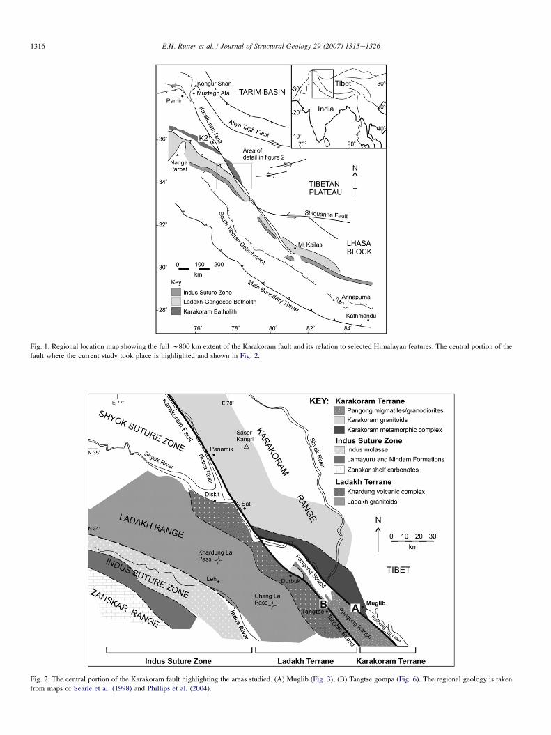
The 800 km long Karakoram fault zone bounds the south-western margin of the Tibetan Plateau (Fig. 1). It forms partof a fault network north of the main Himalayan chain thathas developed in response to the northward motion of Indiainto Asia. The importance of the fault in Asian tectonics hasbeen highlighted by recent discussion debating the extent towhich the Karakoram fault has accommodated IndiaeAsiaconvergence (Searle, 1996; Searle et al., 1998; Phillipset al., 2004; Searle and Phillips, 2004, 2007; Lacassin et al.,
* Corresponding author. Tel.: þ44 161 275 3945; fax: þ44 161 275 3947.
E-mail address: [email protected] (E.H. Rutter).1 Present address: University of Liverpool, Earth and Ocean Sciences,
Liverpool, L69 3GP, UK.2 Present address: CASP, Department of Earth Sciences, University of
Cambridge, 181a Huntingdon Road, Cambridge, CB3 0DH, UK.
0191-8141/$ - see front matter � 2007 Elsevier Ltd. All rights reserved.
doi:10.1016/j.jsg.2007.05.001
2004a,b; Jade et al., 2004). Observations of the patterns offaulting led several authors to suggest that the Tibetan plateauhad been extruded to the east via large movements on the2500 km long sinistral Altyn Tagh fault, to the north of Tibet,and the dextral Karakoram fault to the southwest (Molnar andTapponnier, 1975; Peltzer et al., 1989; Meyer et al., 1996;Lacassin et al., 2004a,b) (Fig. 1). Recent work, however, hasestablished that offsets across the Karakoram fault are on theorder of only 40e150 km, implying that only a limited amountof extrusion was possible (Searle et al., 1998; Phillips et al.,2004; Searle and Phillips, 2004).
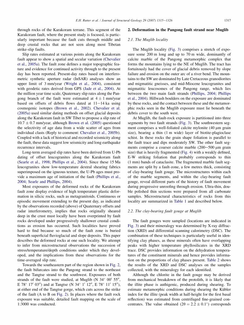
In the Eastern Karakoram, Ladakh, the Karakoram faultsplays into two parallel strands, the main Tangtse fault tothe SW and the subsidiary Pangong strand to the NE(Fig. 2). The Tangtse fault divides the pre-collisional Ladakhgranitoids and Khardung calc-alkaline volcanic rocks to theSW from the metamorphic and magmatic rocks of the Kara-koram to the NE, whereas the Pangong fault cuts solely
1316 E.H. Rutter et al. / Journal of Structural Geology 29 (2007) 1315e1326
Fig. 1. Regional location map showing the full w800 km extent of the Karakoram fault and its relation to selected Himalayan features. The central portion of the
fault where the current study took place is highlighted and shown in Fig. 2.
Fig. 2. The central portion of the Karakoram fault highlighting the areas studied. (A) Muglib (Fig. 3); (B) Tangtse gompa (Fig. 6). The regional geology is taken
from maps of Searle et al. (1998) and Phillips et al. (2004).
1317E.H. Rutter et al. / Journal of Structural Geology 29 (2007) 1315e1326
through rocks of the Karakoram terrane. This segment of theKarakoram fault, where the present study is focused, is partic-ularly important because the fault cuts through middle anddeep crustal rocks that are not seen along most Tibetanstrike-slip faults.
Slip rates estimated at various points along the Karakoramfault appear to show a spatial and secular variation (Chevalieret al., 2005a). The fault zone defines a major topographic fea-ture and evidence for continued activity through to the presentday has been reported. Present-day rates based on interfero-metric synthetic aperture radar (InSAR) analyses show anupper limit of 3 mm/year (Wright et al., 2004), consistentwith geodetic rates derived from GPS (Jade et al., 2004). Atthe million year time scale, Quaternary slip rates along the Pan-gong branch of the fault were estimated at 4 � 1 mm/yearbased on offsets of debris flows dated at 11e14 ka usingcosmogenic isotopes (Brown et al., 2002). Chevalier et al.(2005a) used similar dating methods on offset glacial depositsalong the Karakoram fault in SW Tibet to propose a slip rate of10.7 � 0.7 mm/year, although Brown et al. (2005) questionedthe selectivity of age data from a wide scatter of ages fromindividual clasts (Reply to comment: Chevalier et al., 2005b).Coupled with a lack of historical and recorded seismicity alongthe fault, these data suggest low seismicity and long earthquakerecurrence intervals.
Long-term averaged slip rates have been derived from U-Pbdating of offset leucogranites along the Karakoram fault(Searle et al., 1998; Phillips et al., 2004). Since these 15 Maleucogranites show low-temperature dextral shearing fabricssuperimposed on the igneous texture, the U-Pb ages must pro-vide a maximum age of initiation of the fault (Phillips et al.,2004; Searle and Phillips, 2004).
Most exposures of the deformed rocks of the Karakoramfault zone display evidence of high temperature plastic defor-mation in silicic rocks, such as metagranitoids. Continuous orepisodic movement extending to the present day, as indicatedby the observations recorded (above) of Quaternary offsets andradar interferometry, implies that rocks originally sheareddeep in the crust must locally have been overprinted by faultrocks developed under progressively shallower crustal condi-tions as erosion has occurred. Such localities have provedhard to find because so much of the fault zone is buriedbeneath superficial fluvioglacial and slope deposits. This paperdescribes the deformed rocks at one such locality. We attemptto infer from microstructural observations the succession ofstress/temperature/depth conditions under which they devel-oped, and the implications from these observations for thetime-averaged slip rate.
Towards the southeastern part of the region shown in Fig. 2,the fault bifurcates into the Pangong strand to the northeastand the Tangtse strand to the southwest. Exposures of bothstrands of the fault were studied, at Muglib (N 34� 000 5500,E 78� 170 0300) and at Tangtse (N 34� 10 1200, E 78� 110 1500),at either end of the Tangtse gorge, which cuts across the strikeof the fault (A to B on Fig. 2). In places where the fault rockexposure was suitable, detailed fault mapping on the scale of1:3000 was conducted.
2. Deformation in the Pangong fault strand near Muglib
2.1. The Muglib locality
The Muglib locality (Fig. 3) comprises a stretch of expo-sure some 200 m long and up to 70 m wide, dominantly ofcalcite marble of the Pangong metamorphic complex thatforms the mountains lying to the NE of Muglib. The tract hasfortuitously had the cover of glacial debris removed by slopefailure and erosion on the outer arc of a river bend. The moun-tains to the SW are dominated by Late Cretaceous granodioritesand migmatitic gneisses, and mid-Miocene leucogranites andmigmatitic leucosomes of the Pangong range, which liesbetween the two main fault strands (Phillips, 2004; Phillipset al., 2004). Hillwash boulders on the exposure are dominatedby these rocks, and the contact between these and the metamor-phic rocks seen in the Muglib exposure must lie beneath thedebris cover to the south west.
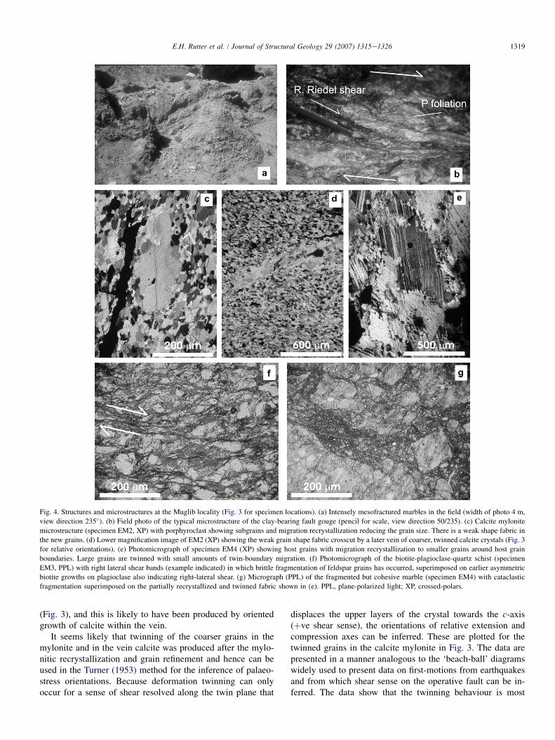
At Muglib, the fault-rock exposure is partitioned into threesegments by two fault strands (Fig. 3). The southwestern seg-ment comprises a well-foliated calcite mylonite (40 mm grainsize), bearing a thin (1 m wide) layer of biotite-plagioclaseschist. In these rocks the grain shape foliation is parallel tothe fault trace and dips moderately SW. The other fault seg-ments comprise a coarser calcite marble (200e500 mm grainsize) that is heavily fragmented (Fig. 4) with a weakly defined,E-W striking foliation that probably corresponds to thin(1 mm) bands of cataclasite. The fragmented marble fault seg-ments are split by a fault-zone, a few metres thick, consistingof clay-bearing fault gouge. The microstructures within eachof the marble segments, and within the clay-bearing faultgouge, reveal different parts of the history of fault movementduring progressive unroofing through erosion. Ultra-thin, dou-ble polished thin sections were prepared from all carbonatesamples. Microstructural characteristics of rocks from thislocality are summarized in Table 1 and described below.
2.2. The clay-bearing fault gouge at Muglib
The fault gouges were sampled (locations are indicated inFig. 3) and their mineralogy was determined by X-ray diffrac-tion (XRD) and differential scanning calorimetry (DSC). Thecombination of these techniques is particularly useful in iden-tifying clay phases, as these minerals often have overlappingpeaks with higher temperature phyllosilicates in the XRDtrace. DSC provides information on the dehydration tempera-tures of the constituent minerals and hence provides informa-tion on the proportions of clay phases present. Table 2 showsthe results of the XRD and DSC analyses on the samplescollected, with the mineralogy for each identified.
Although the chlorite in the fault gouge may be derivedfrom mechanical breakdown of the protolith, it is likely thatthe illite phase is authigenic, produced during shearing. Toestimate metamorphic conditions during shearing the Kublerindex for the illite (peak width at half-height for the first basalreflection) was estimated from centrifuged fine-grained con-centrates. The value obtained (2q ¼ 2.2 � 0.1�) corresponds

1318 E.H. Rutter et al. / Journal of Structural Geology 29 (2007) 1315e1326
Fig. 3. Muglib fault locality map. Equal area, lower hemisphere projections are shown for marble specimens EM2 (calcite mylonite on the SW side of the exposure)
and EM4 and EM5 in the tract of fragmented marbles. For EM2, c-axes orientations are shown for the mylonitic matrix and for a cross-fabric calcite vein. The
‘beach-ball’ diagram (lower left) shows relative extensional axes (open circles) and compressional axes (closed circles) inferred from calcite twinning using the
Turner (1953) dynamic analysis technique. The result is consistent with the SW-dipping attitude of the shear zone and a right-lateral movement sense. Plots for
EM4 and EM5 c-axes are concentrated normal to the grain shape fabric plane but that this is variously reoriented by the fragmentation process. The right-lateral,
strike-slip fault movement vector for the clay-bearing fault gouge (SE extremity of map) was determined from the ‘P’ foliation and ‘R1’ Riedel shears. n indicates
number of data.
to the anchizone to epizone transition (Ji and Browne, 2000).This is tentatively taken to correspond to about 300 �C, whilstbearing in mind that factors other than peak temperatureattained can affect peak width (such as time at temperatureand the effects of shearing, which would have continued toaffect the gouge during continued cooling).
The clay-bearing fault gouges (represented by samples D2,D3 and D4 on Fig. 3) displayed systematic microstructures(Fig. 4b), with P foliations and R1 Riedel shears visible (Rutteret al., 1986). The geometry of these fabrics indicated a right-lateral, strike-slip sense of shear. These planar features weremeasured in the field and a sub-horizontal movement vectorfor the gouge band was constructed from the normal to theintersection of the P foliation and the R1 Riedel shears, inthe acute bisecting plane of these fabrics.
2.3. The calcite mylonite strand at Muglib
The calcite mylonite consists of nearly equigranular, ultra-fine-grained calcite with a small number of rounded porphyr-oclasts remaining from a coarser-grained protolith. Itsmicrostructure is illustrated in Fig. 4c. Mean planar grainsize (38 � 1.4 mm) and shape preferred orientation was mea-sured automatically from digital maps of the grain boundariesfor several hundred grains in sections cut normal to foliationand parallel to lineation, following the methodology of Rutteret al. (1994) and Rutter (1995). Shape preferred orientation ofthe recrystallized matrix is weak (shape factor ¼ 1.4 using the
enhanced-normalized centre-to-centre method; Erslev and Ge,1990). Textural characteristics of all the marble samples fromMuglib are summarized in Table 2.
In thin section the calcite mylonite shows deformation twinlamellae to be present only in the coarser grains. The mylo-nitic texture was cut at a high angle to the foliation by occa-sional hydrothermal calcite veins containing grains ofvarious sizes, bearing thin, straight twin lamellae (Fig. 4d).Preservation of the high cross-cutting angle shows that theveins and hence twins formed after mylonitization. Twinlamellae preferred orientation (Fig. 3) and twinning incidenceas a function of grain size in calcite (Fig. 5) potentially carryinformation about the magnitude and orientation of the stressfield that produced the twinning (Turner, 1953; Rowe andRutter, 1990), provided it is imposed after the crystallographicfabric developed (i.e. is not related to the formation of thatfabric) and provided there is a sufficient spread of crystallo-graphic orientations in the parent calcite grains. We measuredthe crystallographic orientation of about 100 calcite grains inthe mylonite and in one of the cross-cutting calcite veins usinguniversal stage optical microscopy (Fig. 3). A crystallographicpreferred orientation of c-axes is developed normal to themesoscopic foliation defined by grain shape and orientationof occasional mica grains. This is a common fabric type forcalcite mylonites deformed to high strains in shear (e.g. Caseyet al., 1998; Pieri et al., 2001a,b) but also for uniaxial flatten-ing (Rutter et al., 1994). The calcite grains in the vein showa preferred orientation of c-axes normal to the vein wall
1319E.H. Rutter et al. / Journal of Structural Geology 29 (2007) 1315e1326
Fig. 4. Structures and microstructures at the Muglib locality (Fig. 3 for specimen locations). (a) Intensely mesofractured marbles in the field (width of photo 4 m,
view direction 235�). (b) Field photo of the typical microstructure of the clay-bearing fault gouge (pencil for scale, view direction 50/235). (c) Calcite mylonite
microstructure (specimen EM2, XP) with porphyroclast showing subgrains and migration recrystallization reducing the grain size. There is a weak shape fabric in
the new grains. (d) Lower magnification image of EM2 (XP) showing the weak grain shape fabric crosscut by a later vein of coarser, twinned calcite crystals (Fig. 3
for relative orientations). (e) Photomicrograph of specimen EM4 (XP) showing host grains with migration recrystallization to smaller grains around host grain
boundaries. Large grains are twinned with small amounts of twin-boundary migration. (f) Photomicrograph of the biotite-plagioclase-quartz schist (specimen
EM3, PPL) with right lateral shear bands (example indicated) in which brittle fragmentation of feldspar grains has occurred, superimposed on earlier asymmetric
biotite growths on plagioclase also indicating right-lateral shear. (g) Micrograph (PPL) of the fragmented but cohesive marble (specimen EM4) with cataclastic
fragmentation superimposed on the partially recrystallized and twinned fabric shown in (e). PPL, plane-polarized light; XP, crossed-polars.
(Fig. 3), and this is likely to have been produced by orientedgrowth of calcite within the vein.
It seems likely that twinning of the coarser grains in themylonite and in the vein calcite was produced after the mylo-nitic recrystallization and grain refinement and hence can beused in the Turner (1953) method for the inference of palaeo-stress orientations. Because deformation twinning can onlyoccur for a sense of shear resolved along the twin plane that
displaces the upper layers of the crystal towards the c-axis(þve shear sense), the orientations of relative extension andcompression axes can be inferred. These are plotted for thetwinned grains in the calcite mylonite in Fig. 3. The data arepresented in a manner analogous to the ‘beach-ball’ diagramswidely used to present data on first-motions from earthquakesand from which shear sense on the operative fault can be in-ferred. The data show that the twinning behaviour is most

1320 E.H. Rutter et al. / Journal of Structural Geology 29 (2007) 1315e1326
Table 1
Microstructural characteristics of samples collected at the Muglib locality
Sample no. Grain sizes (mm) Temperature (�C) Stress (recryst g.s.) (MPa) Stress (twin incid.) (MPa)
Host grains Recryst All
EM1 240 � 11 40 � 9 48 � 10 310 � 20 98 � 35 210 � 30
EM5 430 � 24 119 � 20 135 � 28 375 � 20 40 � 20 160 � 30
EM4 167 � 12 32 � 5 48 � 12 300 � 20 110 � 40 250 � 30
EM2 e e 38 � 3 e 102 � 40 220 � 30
EM7 370 � 32 e e 365 þ 125/e25 e e
P144 560 � 25 e e 395 þ 125/e25 e e
P122 1100 � 147 e e 480 þ 130/e30 e eEM3 (mineral assemblage) e e e 460 � 92 e e
Metamorphic temperatures are based on host grain size and the temperature/grain size relations observed on Naxos Island (Covey Crump and Rutter, 1989), except
for EM3 where temperature is based on mineral assemblage. Stresses from recrystallized grain sizes are inferred to apply to a maximum of the temperature shown,
and a minimum of 300 �C, below which brittle deformation begins to supervene. Stresses from twinning incidence are expected to correspond to the maximum on
the strength/depth profile.
consistent with right-lateral transpressional displacement ona moderately SW-dipping fault plane. This is consistent withthe measured orientation of fault planes within the main faultzone, the orientation of the mylonitic foliation, mineral elon-gation lineations in the mylonite and occasional asymmetriccalcite porphyroclasts.
Planar grain size distribution was also measured for the cal-cite mylonite (Table 1) from tracings of grain boundaries madefrom thin sections using the computer program GRAINS(Rutter et al., 1994). Recrystallized grain size can be used toestimate differential stress operative during recrystallization(Rutter, 1995; Table 1).
Within the calcite mylonite is a layer of biotite-plagioclaseschist, parallel to the mylonitic foliation and about 1 m thick(Fig. 3). The schist contains Ca-plagioclase (An42) and bio-tite (K0.92Na0.01Fe1.22Mg1.17Ti0.11Mn0.02Al1.51Si2.82O10(OH)2),but also hornblendic amphibole, quartz, clinozoisite (Ca1.99
Fe3þ0.46Al2.52Si3.01O12OH), calcite, alkali feldspar and accessory
apatite. The amphibole grains show some zoning with cores offerroan pargasitic hornblende (K0.28Na0.36Ca1.93Mn0.06Fe2.24
Mg2.11Ti0.11Al2.13Si6.47O22(OH)2) and rims of magnesio-horn-blende (K0.14Na0.22Ca1.95Mn0.06Fe2.10Mg2.45Ti0.06Al1.30Si7.08
O22(OH)2). The rock displays a schistosity defined by thealignment of biotite, often forming asymmetric tails on plagio-clase grains, and possesses a marked horizontal mineralstretching lineation, parallel to that in the calcite mylonite.From this fabric a right-lateral, strike-slip shear sense can beinferred (Fig. 4f). The rock is cut by later brittle shear bands(micro-shear zones slightly oblique to the main foliation),indicating same direction and sense of shear as the asymmetrictails on the plagioclase porphyroblasts. These bands containsmall fragments of feldspar derived from adjacent grains
(Fig. 4f), and their formation does not appear to have intro-duced any retrogressive alteration of the mineral paragenesis.Calculations of the bulk composition of the rock indicate SiO2
of approximately 65e70% (silicic) and Al2O3 of w16%(peraluminous) suggesting that this layer represents a rockof intermediate composition, possibly a dacitic tuff.
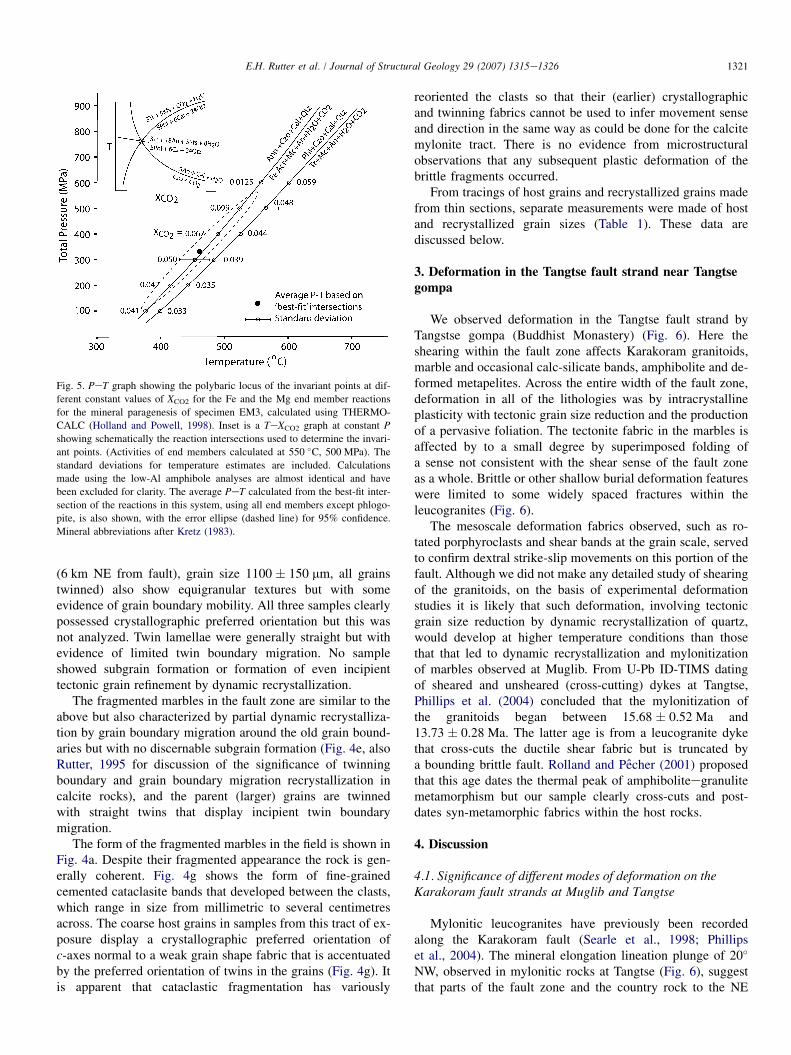
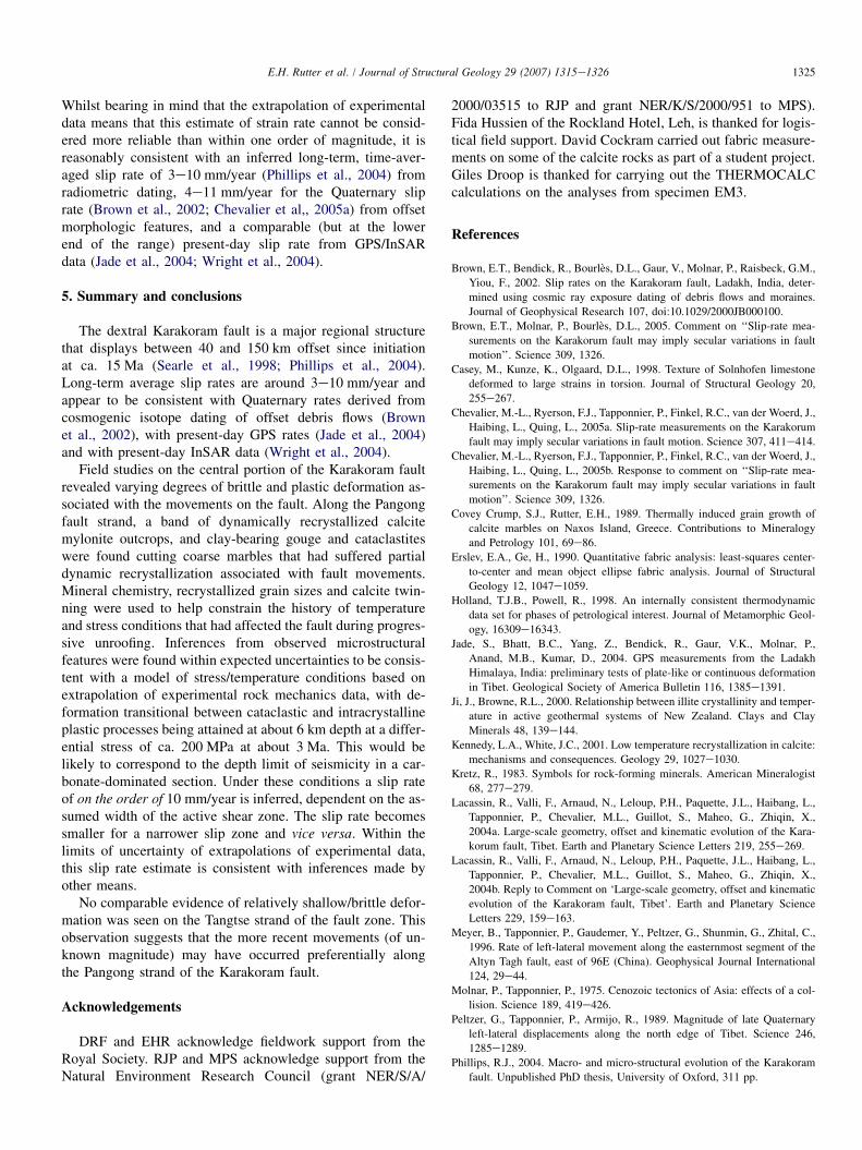
Assuming that the above phases were all stable together,THERMOCALC (Holland and Powell, 1998) was used to cal-culate the PeT conditions of formation. Fig. 5 shows the locusof isobaric invariant points, which equates to the Fe- and Mg-end member discontinuous reactions that are best constrainedby the data. The reactions differ by around 20 �C. The averagePeT estimated by THERMOCALC based on intersection ofthe univariant reactions is also shown and is 460 � 92 �C at330 � 230 MPa (error ellipse at 95% confidence shown), andthis is taken to correspond to conditions at which synmetamor-phic shearing occurred, prior to disruption of the growth fabricby a degree of brittle shearing.
2.4. The fragmented marble strands at Muglib
Compared to the calcite mylonite, the rocks of this tract aremuch coarser grained (250 mm or greater, Table 1) and areinferred to preserve the same grain size as the metamorphicprotolith from which the mylonite was derived. To assess thelatter, we examined Karakoram marble samples from threelocalities at distances from 1 to 6 km from the fault trace, sothat the effects of the faulting could be isolated (Table 1).The finest-grained sample (EM7, 3 km NE from fault, grainsize 370 � 32 mm) displays an equigranular foam texture andno deformation twins. Samples P144 (1 km NE from fault),grain size 560 � 25 mm, some grains twinned) and P122
Table 2
X-ray diffraction and differential scanning calorimetry analyses of the fault gouges collected from the Muglib fault locality
Sample no. Quartz Chlorite Muscovite Calcite Dolomite Microcline Illite Saponite Gypsum
EM6 X X X X X
D2 X X X X X T
D3 X X X X X X
D4 X X X X T X
An X indicates a major component of the gouge (>10%) where as a T indicates a trace of the mineral within the gouge. Sample localities can be found on Fig. 3.
1321E.H. Rutter et al. / Journal of Structural Geology 29 (2007) 1315e1326
(6 km NE from fault), grain size 1100 � 150 mm, all grainstwinned) also show equigranular textures but with someevidence of grain boundary mobility. All three samples clearlypossessed crystallographic preferred orientation but this wasnot analyzed. Twin lamellae were generally straight but withevidence of limited twin boundary migration. No sampleshowed subgrain formation or formation of even incipienttectonic grain refinement by dynamic recrystallization.
The fragmented marbles in the fault zone are similar to theabove but also characterized by partial dynamic recrystalliza-tion by grain boundary migration around the old grain bound-aries but with no discernable subgrain formation (Fig. 4e, alsoRutter, 1995 for discussion of the significance of twinningboundary and grain boundary migration recrystallization incalcite rocks), and the parent (larger) grains are twinnedwith straight twins that display incipient twin boundarymigration.
The form of the fragmented marbles in the field is shown inFig. 4a. Despite their fragmented appearance the rock is gen-erally coherent. Fig. 4g shows the form of fine-grainedcemented cataclasite bands that developed between the clasts,which range in size from millimetric to several centimetresacross. The coarse host grains in samples from this tract of ex-posure display a crystallographic preferred orientation ofc-axes normal to a weak grain shape fabric that is accentuatedby the preferred orientation of twins in the grains (Fig. 4g). Itis apparent that cataclastic fragmentation has variously
Fig. 5. PeT graph showing the polybaric locus of the invariant points at dif-
ferent constant values of XCO2 for the Fe and the Mg end member reactions
for the mineral paragenesis of specimen EM3, calculated using THERMO-
CALC (Holland and Powell, 1998). Inset is a TeXCO2 graph at constant P
showing schematically the reaction intersections used to determine the invari-
ant points. (Activities of end members calculated at 550 �C, 500 MPa). The
standard deviations for temperature estimates are included. Calculations
made using the low-Al amphibole analyses are almost identical and have
been excluded for clarity. The average PeT calculated from the best-fit inter-
section of the reactions in this system, using all end members except phlogo-
pite, is also shown, with the error ellipse (dashed line) for 95% confidence.
Mineral abbreviations after Kretz (1983).
reoriented the clasts so that their (earlier) crystallographicand twinning fabrics cannot be used to infer movement senseand direction in the same way as could be done for the calcitemylonite tract. There is no evidence from microstructuralobservations that any subsequent plastic deformation of thebrittle fragments occurred.
From tracings of host grains and recrystallized grains madefrom thin sections, separate measurements were made of hostand recrystallized grain sizes (Table 1). These data arediscussed below.
3. Deformation in the Tangtse fault strand near Tangtsegompa
We observed deformation in the Tangtse fault strand byTangstse gompa (Buddhist Monastery) (Fig. 6). Here theshearing within the fault zone affects Karakoram granitoids,marble and occasional calc-silicate bands, amphibolite and de-formed metapelites. Across the entire width of the fault zone,deformation in all of the lithologies was by intracrystallineplasticity with tectonic grain size reduction and the productionof a pervasive foliation. The tectonite fabric in the marbles isaffected by to a small degree by superimposed folding ofa sense not consistent with the shear sense of the fault zoneas a whole. Brittle or other shallow burial deformation featureswere limited to some widely spaced fractures within theleucogranites (Fig. 6).
The mesoscale deformation fabrics observed, such as ro-tated porphyroclasts and shear bands at the grain scale, servedto confirm dextral strike-slip movements on this portion of thefault. Although we did not make any detailed study of shearingof the granitoids, on the basis of experimental deformationstudies it is likely that such deformation, involving tectonicgrain size reduction by dynamic recrystallization of quartz,would develop at higher temperature conditions than thosethat that led to dynamic recrystallization and mylonitizationof marbles observed at Muglib. From U-Pb ID-TIMS datingof sheared and unsheared (cross-cutting) dykes at Tangtse,Phillips et al. (2004) concluded that the mylonitization ofthe granitoids began between 15.68 � 0.52 Ma and13.73 � 0.28 Ma. The latter age is from a leucogranite dykethat cross-cuts the ductile shear fabric but is truncated bya bounding brittle fault. Rolland and Pecher (2001) proposedthat this age dates the thermal peak of amphiboliteegranulitemetamorphism but our sample clearly cross-cuts and post-dates syn-metamorphic fabrics within the host rocks.
4. Discussion
4.1. Significance of different modes of deformation on theKarakoram fault strands at Muglib and Tangtse
Mylonitic leucogranites have previously been recordedalong the Karakoram fault (Searle et al., 1998; Phillipset al., 2004). The mineral elongation lineation plunge of 20�
NW, observed in mylonitic rocks at Tangtse (Fig. 6), suggestthat parts of the fault zone and the country rock to the NE
1322 E.H. Rutter et al. / Journal of Structural Geology 29 (2007) 1315e1326
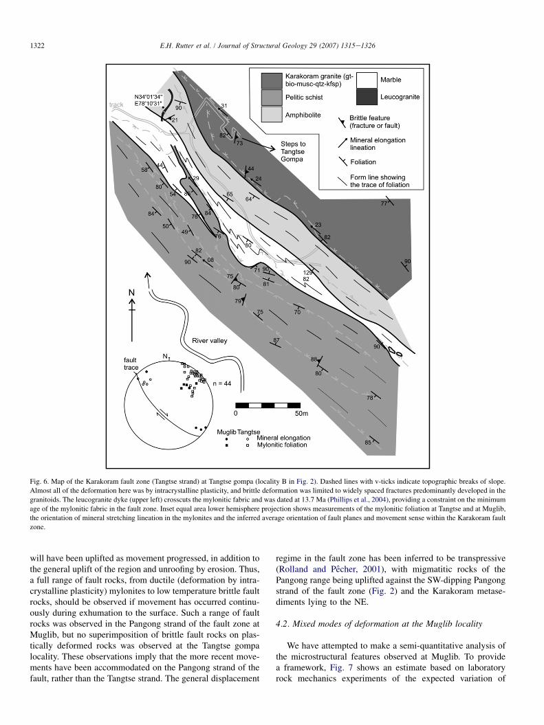
Fig. 6. Map of the Karakoram fault zone (Tangtse strand) at Tangtse gompa (locality B in Fig. 2). Dashed lines with v-ticks indicate topographic breaks of slope.
Almost all of the deformation here was by intracrystalline plasticity, and brittle deformation was limited to widely spaced fractures predominantly developed in the
granitoids. The leucogranite dyke (upper left) crosscuts the mylonitic fabric and was dated at 13.7 Ma (Phillips et al., 2004), providing a constraint on the minimum
age of the mylonitic fabric in the fault zone. Inset equal area lower hemisphere projection shows measurements of the mylonitic foliation at Tangtse and at Muglib,
the orientation of mineral stretching lineation in the mylonites and the inferred average orientation of fault planes and movement sense within the Karakoram fault
zone.
will have been uplifted as movement progressed, in addition tothe general uplift of the region and unroofing by erosion. Thus,a full range of fault rocks, from ductile (deformation by intra-crystalline plasticity) mylonites to low temperature brittle faultrocks, should be observed if movement has occurred continu-ously during exhumation to the surface. Such a range of faultrocks was observed in the Pangong strand of the fault zone atMuglib, but no superimposition of brittle fault rocks on plas-tically deformed rocks was observed at the Tangtse gompalocality. These observations imply that the more recent move-ments have been accommodated on the Pangong strand of thefault, rather than the Tangtse strand. The general displacement
regime in the fault zone has been inferred to be transpressive(Rolland and Pecher, 2001), with migmatitic rocks of thePangong range being uplifted against the SW-dipping Pangongstrand of the fault zone (Fig. 2) and the Karakoram metase-diments lying to the NE.
4.2. Mixed modes of deformation at the Muglib locality
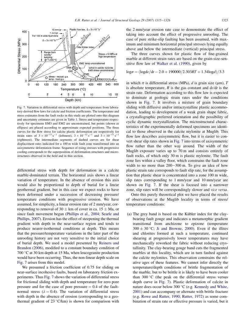
We have attempted to make a semi-quantitative analysis ofthe microstructural features observed at Muglib. To providea framework, Fig. 7 shows an estimate based on laboratoryrock mechanics experiments of the expected variation of
1323E.H. Rutter et al. / Journal of Structural Geology 29 (2007) 1315e1326
differential stress with depth for deformation in a calcitemarble-dominated terrain. The horizontal axis shows a linearvariation of temperature. In the absence of erosion this axiswould also be proportional to depth of burial for a lineargeothermal gradient, but in this case we expect rocks to havebeen deformed under a succession of decreasing pressure/temperature conditions with progressive erosion. We haveassumed, for simplicity, a linear erosion rate of 2 mm/year, cor-responding to removal of 30 � km of cover in ca. 15 �Ma, orsince fault movement began (Phillips et al., 2004; Searle andPhillips, 2007). Erosion has the effect of steepening the thermalgradient with depth in the near-surface region and tends toproduce nearer-isothermal conditions at depth. This meansthat the pressure/temperature variations in the later part of theunroofing history are not very sensitive to the initial choiceof burial depth. We used a model presented by Reiners andBrandon (2006), modified to a constant boundary condition of700 �C at 30 km depth at 15 Ma, when leucogranite productionwould have been occurring. Thus, the non-linear depth scale onFig. 7 arises from this model.
We presumed a friction coefficient of 0.75 for sliding onnear-surface incohesive faults, based on laboratory friction ex-periments. Thus Fig. 7 shows the variation of differential stressfor frictional sliding with depth and temperature for zero porepressure and for the case of pore pressure ¼ 0.4 of the fault-normal stress (l ¼ 0.4). The variation of differential stresswith depth in the absence of erosion (corresponding to a geo-thermal gradient of 23 �C/km) is shown for comparison with
Fig. 7. Variation in differential stress with depth and temperature from labora-
tory-derived flow laws for calcite and friction coefficients. The temperature and
stress estimates from the fault rocks in this study are plotted onto this diagram
and uncertainty estimates are given in Table 1. Stress and temperature respec-
tively for specimens EM3 and EM2 are unconstrained, but points (shown as
ellipses) are placed according to approximate expected positions. The three
curves for the flow stress for calcite plastic deformation are respectively for
strain rates of 3 � 10�13 s�1 (leftmost), 3 � 10�12 s�1 and 3 � 10�11 s�1
(rightmost). The intermediate segments of dashed curves are for shear
displacement rates indicated for a 100 m wide fault zone transformed into an
axisymmetric deformation frame. Sequence of rising stresses with progressive
cooling corresponds to the superposition of deformation structures and micro-
structures observed in the field and in thin section.
the 2 mm/year erosion rate case to demonstrate the effect oftaking into account the effect of progressive unroofing. Thecase of pure strike-slip faulting has been assumed, with max-imum and minimum horizontal principal stresses lying equallyabove and below the intermediate (vertical) principal stress.
The three curves shown for plastic flow of fine-grainedmarble at different strain rates are based on the grain-size-sen-sitive flow law of Walker et al. (1990), given by
logs¼ ðlogd3=dt� 2:0þ 190000=2:303RT þ 1:34logdÞ=3:3
in which s is differential stress (MPa), d is grain size (mm), Tis absolute temperature, R is the gas constant and d3/dt is thestrain rate. Deformation according to this flow law is expectedto dominate at geologic strain rates under the conditionsshown in Fig. 7. It involves a mixture of grain boundarysliding with diffusive and/or intracrystalline plastic accommo-dation, leading to development of a weak grain shape fabric,a crystallographic preferred orientation and the possibility ofcyclic dynamic recrystallization. The microstructural charac-teristics of the experimentally deformed specimens are identi-cal to those observed in the calcite mylonite at Muglib. Thisflow law describes axisymmetric flow, but it is easier to con-vert shear slip rates shown in Fig. 7 into terms of axisymmetricflow rather than the other way around. The width of theMuglib exposure varies up to 70 m and consists entirely offault rocks, of which only 30 m is plastic mylonite. The faultzone lies within a valley floor, which constrains the fault zonewidth to no more than 200e300 m. To give an idea of howplastic strain rate corresponds to fault slip rate, for the assump-tion that plastic shear is concentrated into a zone 100 m wide,slip rates corresponding to 1 mm/year and 10 mm/year areshown on Fig. 7. If the shear is focused into a narrowerzone, slip rates will be correspondingly slower and vice versa.
Onto this purely theoretical plot we have placed the resultsof observations at the Muglib locality in terms of stress/temperature conditions:
(a) The grey band is based on the Kubler index for the clay-bearing fault gouge and indicates a metamorphic gradienttransitional from anchizone to epizone (temperature300 � 30 �C; Ji and Browne, 2000). Even if the illitesand chlorites formed at such a temperature, continuedshearing at progressively lower temperatures may havemechanically reworked the fabric without reducing crys-tallinity. The clay-bearing gouge band cuts the fragmentedmarbles at this locality, which are in turn faulted againstthe calcite mylonites. This observation constrains the rel-ative ages of these features. We cannot infer directly thetemperature/depth conditions of brittle fragmentation ofthe marble, but to be brittle it is likely to have been coolerthan 300 �C (the peak on the differential stress versusdepth curve in Fig. 7). Plastic deformation of calcite innature does occur below 300 �C (e.g. Kennedy and White,2001) and can accompany or alternate with brittle fracture(e.g. Rowe and Rutter, 1990; Rutter, 1972) as some com-bination of strain rate or effective pressure is varied, but it
1324 E.H. Rutter et al. / Journal of Structural Geology 29 (2007) 1315e1326
is clear from the microstructure of the fragmented marblesthat no further plastic flow followed the fragmentation.The clay-bearing gouge zone cuts the fragmented marbles,implying that brittle deformation in the gouge zone contin-ued long after the crystallinity of the phyllosilicate min-erals was developed.
(b) The open circles on Fig. 7 show estimates of flow stressbased on the dynamically recrystallized grain size (Table 1)in the fragmented marbles and the grain size of the calcitemylonite, using the migration recrystallized grain sizepiezometer of Rutter (1995).
(c) The position of the white circles along the temperatureaxis is constrained by temperature estimates based onmeasurement of host grain size (i.e. prior to the onset ofdynamic recrystallization around the grain boundaries) as-suming these marbles behaved like the marbles around themigmatite dome on the Greek island of Naxos (CoveyCrump and Rutter, 1989), which show a systematic varia-tion of grain size with palaeotemperature. We recognizethat even in relatively pure calcite marbles this correlationis likely not to be unique because grain growth kineticsmay be sensitive to trace chemistry and the presence ofsmall, second phase particles and deformation, but it ishere taken to provide a first order minimum constrainton the temperature at which the host grain size was equil-ibrated. Within the Naxos migmatite dome, beneath a low-angle detachment fault, marbles attained temperatures upto 100 �C higher at the same grain size, thus the tempera-tures reported in Table 1 for samples EM7, P144 and P122could be systematically low by about that amount. In theKarakoram metamorphic complex the marbles are inter-layered with garnet þ staurolite-bearing metapelites, thatattained peak metamorphic temperatures of amphibolitefacies in excess of 500 �C (Phillips, 2004). The large grainsizes attained imply that any operative differential stressduring grain growth would have been very small(<10 MPa for a grain size of 400 mm; Rutter, 1995) sothat temperature would likely have the dominant effecton grain size. A flow stress level of maximum 10 MPaat temperatures in excess of 400 �C is therefore shownin Fig. 12 as a constraint on the at-depth behaviour.
(d) The mineral assemblage of the biotite-plagioclase schist(EM3) embedded within the calcite mylonite tract also im-poses a constraint on the temperature of metamorphicequilibration in the fault zone, whilst right-lateral shearwas active, of lowermost amphibolite facies (w460 �Cat 330 MPa fluid pressure). This is, however, not necessar-ily the temperature at which the final grain size of thesurrounding calcite mylonite developed, and the depth ofburial may have been greater than that corresponding toa total overburden pressure of 330 MPa (about 12 km),according to how much effective confining pressure therewas.
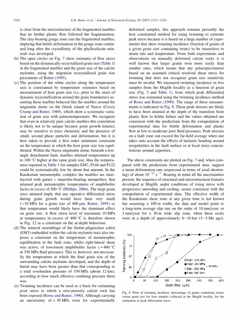
(e) Twinning incidence can be used as a basis for estimatingpeak stress to which a zero-porosity calcite rock hasbeen exposed (Rowe and Rutter, 1990). Although carryingan uncertainty of � 30 MPa even for experimentally
deformed samples, this approach remains presently thebest constrained method for using twinning to estimatepeak stress because it is based on a large number of exper-iments that show twinning incidence (fraction of grains ofa given grain size containing twins) to be insensitive tostrain rate and temperature. From both experiments andobservations on naturally deformed calcite rocks it iswell known that larger grains twin more easily thansmaller ones, which means that any palaeopiezometerbased on an assumed critical resolved shear stress fortwinning that does not recognize grain size sensitivitymust be invalid. We measured twinning incidence in fivesamples from the Muglib locality as a function of grainsize (Fig. 5 and Table 1), from which peak differentialstress was estimated using the twinning incidence methodof Rowe and Rutter (1990). The range of these measure-ments is indicated on Fig. 8. These peak stresses are likelyto have been attained at the depth of the transition fromplastic flow to brittle failure and the values obtained areconsistent with the predictions from the extrapolation ofexperimental data for brittle deformation and plasticflow at low to moderate pore fluid pressures. Peak stresseson a fault zone can exceed the far-field average when onetakes onto account the effects of inelastic bending aroundirregularities in the fault surface or at local stress concen-trations around asperities.
The above constraints are plotted on Fig. 7 and, when com-pared with the predictions from experimental data, suggesta mean deformation rate (expressed in terms of axial shorten-ing) of about 10�11 s�1. Bearing in mind all the uncertaintiespresent, the sequence of structural and microstructural featuresdeveloped at Muglib, under conditions of rising stress withprogressive unroofing and cooling, seems consistent with theextrapolation of experimental data. The effective width ofthe Karakoram shear zone at any given time is not knownbut assuming a 100 m width, the data and model point toa long-term average slip rate on the order of 10 mm/year, or3 mm/year for a 30 m wide slip zone, when these rockswere at a depth of approximately 6e10 km (3e5 Ma ago).
Fig. 8. Plots of twinning incidence (percentage of grains containing twins)
versus grain size for four samples collected at the Muglib locality, for the
estimation of peak differential stress.
1325E.H. Rutter et al. / Journal of Structural Geology 29 (2007) 1315e1326
Whilst bearing in mind that the extrapolation of experimentaldata means that this estimate of strain rate cannot be consid-ered more reliable than within one order of magnitude, it isreasonably consistent with an inferred long-term, time-aver-aged slip rate of 3e10 mm/year (Phillips et al., 2004) fromradiometric dating, 4e11 mm/year for the Quaternary sliprate (Brown et al., 2002; Chevalier et al,, 2005a) from offsetmorphologic features, and a comparable (but at the lowerend of the range) present-day slip rate from GPS/InSARdata (Jade et al., 2004; Wright et al., 2004).
5. Summary and conclusions
The dextral Karakoram fault is a major regional structurethat displays between 40 and 150 km offset since initiationat ca. 15 Ma (Searle et al., 1998; Phillips et al., 2004).Long-term average slip rates are around 3e10 mm/year andappear to be consistent with Quaternary rates derived fromcosmogenic isotope dating of offset debris flows (Brownet al., 2002), with present-day GPS rates (Jade et al., 2004)and with present-day InSAR data (Wright et al., 2004).
Field studies on the central portion of the Karakoram faultrevealed varying degrees of brittle and plastic deformation as-sociated with the movements on the fault. Along the Pangongfault strand, a band of dynamically recrystallized calcitemylonite outcrops, and clay-bearing gouge and cataclastiteswere found cutting coarse marbles that had suffered partialdynamic recrystallization associated with fault movements.Mineral chemistry, recrystallized grain sizes and calcite twin-ning were used to help constrain the history of temperatureand stress conditions that had affected the fault during progres-sive unroofing. Inferences from observed microstructuralfeatures were found within expected uncertainties to be consis-tent with a model of stress/temperature conditions based onextrapolation of experimental rock mechanics data, with de-formation transitional between cataclastic and intracrystallineplastic processes being attained at about 6 km depth at a differ-ential stress of ca. 200 MPa at about 3 Ma. This would belikely to correspond to the depth limit of seismicity in a car-bonate-dominated section. Under these conditions a slip rateof on the order of 10 mm/year is inferred, dependent on the as-sumed width of the active shear zone. The slip rate becomessmaller for a narrower slip zone and vice versa. Within thelimits of uncertainty of extrapolations of experimental data,this slip rate estimate is consistent with inferences made byother means.
No comparable evidence of relatively shallow/brittle defor-mation was seen on the Tangtse strand of the fault zone. Thisobservation suggests that the more recent movements (of un-known magnitude) may have occurred preferentially alongthe Pangong strand of the Karakoram fault.
Acknowledgements
DRF and EHR acknowledge fieldwork support from theRoyal Society. RJP and MPS acknowledge support from theNatural Environment Research Council (grant NER/S/A/
2000/03515 to RJP and grant NER/K/S/2000/951 to MPS).Fida Hussien of the Rockland Hotel, Leh, is thanked for logis-tical field support. David Cockram carried out fabric measure-ments on some of the calcite rocks as part of a student project.Giles Droop is thanked for carrying out the THERMOCALCcalculations on the analyses from specimen EM3.
References
Brown, E.T., Bendick, R., Bourles, D.L., Gaur, V., Molnar, P., Raisbeck, G.M.,
Yiou, F., 2002. Slip rates on the Karakoram fault, Ladakh, India, deter-
mined using cosmic ray exposure dating of debris flows and moraines.
Journal of Geophysical Research 107, doi:10.1029/2000JB000100.
Brown, E.T., Molnar, P., Bourles, D.L., 2005. Comment on ‘‘Slip-rate mea-
surements on the Karakorum fault may imply secular variations in fault
motion’’. Science 309, 1326.
Casey, M., Kunze, K., Olgaard, D.L., 1998. Texture of Solnhofen limestone
deformed to large strains in torsion. Journal of Structural Geology 20,
255e267.
Chevalier, M.-L., Ryerson, F.J., Tapponnier, P., Finkel, R.C., van der Woerd, J.,
Haibing, L., Quing, L., 2005a. Slip-rate measurements on the Karakorum
fault may imply secular variations in fault motion. Science 307, 411e414.
Chevalier, M.-L., Ryerson, F.J., Tapponnier, P., Finkel, R.C., van der Woerd, J.,
Haibing, L., Quing, L., 2005b. Response to comment on ‘‘Slip-rate mea-
surements on the Karakorum fault may imply secular variations in fault
motion’’. Science 309, 1326.
Covey Crump, S.J., Rutter, E.H., 1989. Thermally induced grain growth of
calcite marbles on Naxos Island, Greece. Contributions to Mineralogy
and Petrology 101, 69e86.
Erslev, E.A., Ge, H., 1990. Quantitative fabric analysis: least-squares center-
to-center and mean object ellipse fabric analysis. Journal of Structural
Geology 12, 1047e1059.
Holland, T.J.B., Powell, R., 1998. An internally consistent thermodynamic
data set for phases of petrological interest. Journal of Metamorphic Geol-
ogy, 16309e16343.
Jade, S., Bhatt, B.C., Yang, Z., Bendick, R., Gaur, V.K., Molnar, P.,
Anand, M.B., Kumar, D., 2004. GPS measurements from the Ladakh
Himalaya, India: preliminary tests of plate-like or continuous deformation
in Tibet. Geological Society of America Bulletin 116, 1385e1391.
Ji, J., Browne, R.L., 2000. Relationship between illite crystallinity and temper-
ature in active geothermal systems of New Zealand. Clays and Clay
Minerals 48, 139e144.
Kennedy, L.A., White, J.C., 2001. Low temperature recrystallization in calcite:
mechanisms and consequences. Geology 29, 1027e1030.
Kretz, R., 1983. Symbols for rock-forming minerals. American Mineralogist
68, 277e279.
Lacassin, R., Valli, F., Arnaud, N., Leloup, P.H., Paquette, J.L., Haibang, L.,
Tapponnier, P., Chevalier, M.L., Guillot, S., Maheo, G., Zhiqin, X.,
2004a. Large-scale geometry, offset and kinematic evolution of the Kara-
korum fault, Tibet. Earth and Planetary Science Letters 219, 255e269.
Lacassin, R., Valli, F., Arnaud, N., Leloup, P.H., Paquette, J.L., Haibang, L.,
Tapponnier, P., Chevalier, M.L., Guillot, S., Maheo, G., Zhiqin, X.,
2004b. Reply to Comment on ‘Large-scale geometry, offset and kinematic
evolution of the Karakoram fault, Tibet’. Earth and Planetary Science
Letters 229, 159e163.
Meyer, B., Tapponnier, P., Gaudemer, Y., Peltzer, G., Shunmin, G., Zhital, C.,
1996. Rate of left-lateral movement along the easternmost segment of the
Altyn Tagh fault, east of 96E (China). Geophysical Journal International
124, 29e44.
Molnar, P., Tapponnier, P., 1975. Cenozoic tectonics of Asia: effects of a col-
lision. Science 189, 419e426.
Peltzer, G., Tapponnier, P., Armijo, R., 1989. Magnitude of late Quaternary
left-lateral displacements along the north edge of Tibet. Science 246,
1285e1289.
Phillips, R.J., 2004. Macro- and micro-structural evolution of the Karakoram
fault. Unpublished PhD thesis, University of Oxford, 311 pp.
1326 E.H. Rutter et al. / Journal of Structural Geology 29 (2007) 1315e1326
Phillips, R.J., Parrish, R.R., Searle, M.P., 2004. Age constraints on ductile de-
formation and long-term slip rates along the Karakoram fault. Ladakh.
Earth and Planetary Science Letters 226, 305e319.
Pieri, M., Burlini, L., Kunze, K., Stretton, I., Olgaard, D.L., 2001a. Rheolog-
ical and microstructural evolution of Carrara marble with high shear strain:
results from high temperature torsion experiments. Journal of Structural
Geology 23, 1393e1413.
Pieri, M., Kunze, K., Burlini, L., Stretton, I., Olgaard, D.L., Burg, J.-P.,
Wenk, H.-R., 2001b. Texture development of calcite by deformation and
dynamic recrystallization at 1000K during torsion experiments to large
strains. Tectonophysics 330, 119e140.
Reiners, P.W., Brandon, M.T., 2006. Using thermochronology to understand
erosion. Annual Reviews of Earth and Planetary Science 34, 419e466.
Rolland, Y., Pecher, A., 2001. The Pangong granulites of the Karakoram Fault
(Western Tibet): vertical extrusion within a lithospheric-scale fault? Comp-
tes Rendus de l’Academie des Sciences de Paris 332, 363e370.
Rowe, K.J., Rutter, E.H., 1990. Palaeostress estimation using calcite twinning:
experimental calibration and application to nature. Journal of Structural
Geology 12, 1e17.
Rutter, E.H., 1972. The influence of interstitial water on the rheological behav-
iour of calcite rocks. Tectonophysics 14, 13e33.
Rutter, E.H., 1995. Experimental study of the influence of stress, temperature
and strain on the dynamic recrystallization of Carrara marble. Journal of
Geophysical Research 100, 24651e24663.
Rutter, E.H., Maddock, R.H., Hall, S.H., White, S.H., 1986. Comparative mi-
crostructures of natural and experimentally produced clay-bearing fault
gouges. Pure and Applied Geophysics 124, 3e30.
Rutter, E.H., Casey, M., Burlini, L., 1994. Preferred crystallographic orienta-
tion development during the plastic and superplastic flow of calcite rocks.
Journal of Structural Geology 16, 1431e1446.
Searle, M.P., 1996. Geological evidence against large-scale pre-Holocene off-
sets along the Karakoram fault: implications for the limited extrusion of
the Tibetan Plateau. Tectonics 15, 171e186.
Searle, M.P., Phillips, R.J., 2004. A comment on ‘Large-scale geometry, offset
and kinematic evolution of the Karakoram fault, Tibet’ by R. Lacassin
et al. Earth and Planetary Science Letters 229, 155e158.
Searle, M.P., Phillips, R.J., 2007. Relationships between right-lateral shear
along the Karakoram fault and metamorphism, magmatism, exhumation
and uplift: evidence from the K2-Gasherbrum-Pangong ranges, north
Pakistan and Ladakh. Journal of the Geological Society of London 164,
439e450.
Searle, M.P., Weinberg, R.F., Dunlap, W.J., 1998. Transpressional tectonics
along the Karakoram fault zone, northern Ladakh: constraints on Tibetan
extrusion. In: Holdsworth, R.E., Strachan, R.A., Dewey, J.F. (Eds.), Conti-
nental Transpressional and Transtensional Tectonics. Special Publication
135. Geological Society of London, London, pp. 307e326.
Turner, F.J., 1953. Nature and dynamic interpretation of twin lamellae calcite
of three marbles. American Journal of Science 251, 276e298.
Walker, A.N., Rutter, E.H., Brodie, K.H., 1990. Experimental study of grain-
size sensitive flow of synthetic, hot-pressed calcite rocks. In: Knipe, R.,
Rutter, E. (Eds.), Deformation Mechanisms, Rheology and Tectonics.
Special Publication 54. Geological Society, pp. 259e284.
Wright, T.J., Parsons, B., England, P., Fielding, E., 2004. InSAR observations of
low slip rates on the major faults of western Tibet. Science 305, 236e239.
Related Documents