Microwatershed-Based Approach to Monitoring and Assessing Water Quality in the North Bosque River Watershed Final Project Report Anne McFarland and Jimmy Millican PR1004v2 August 2011 (previous version dated November 2010)

Welcome message from author
This document is posted to help you gain knowledge. Please leave a comment to let me know what you think about it! Share it to your friends and learn new things together.
Transcript

Microwatershed-Based Approach to Monitoring and Assessing Water
Quality in the North Bosque River Watershed
Final Project Report
Anne McFarland and Jimmy Millican
PR1004v2
August 2011 (previous version dated November 2010)

Microwatershed-Based Approach to Monitoring in the North Bosque River Watershed
ii
Acknowledgments
This report evaluates stream water quality data for the project Microwatershed-Based Approach to Monitoring and Assessing Water Quality in the North Bosque River Watershed. Financial support for this project was provided by the Texas State Soil and Water Conservation Board (TSSWCB) and Section 319(h) of the Clean Water Act in cooperation with the United States Environmental Protection Agency, Region 6 as the TSSWCB project 08-09. The authors would like to acknowledge the dedicated work of field personnel and laboratory chemists. Monitoring nonpoint source pollution associated with storm events requires dedicated personnel to be on call seven days a week.
Mention of trade names or commercial products does not constitute their endorsement. For more information about this document or any other document TIAER produces, send e-mail to [email protected].
Authors
Anne McFarland, research scientist, TIAER, [email protected] Jimmy Mill ican, senior research associate, TIAER, jmill [email protected]
Errata
In the original version of this report dated November 2010, the magnitude of the slope for trends was presented in units of percent change per month rather than percent change per year as indicated in the equation presented on p. 15 of Chapter 3 and in Tables 4-9 on pages 17-20 in Chapter 4. To obtain the percent change on an annual basis using the equation on p. 15, the percent change per month should be multiplied by 12. These changes impact PR1004 dated November 2010 and were reported on July 25, 2011. These errata are corrected in the most recent online version PR1004v2 dated August 2011 available on TIAER’s website at http:/ / tiaer.tarleton.edu/ under publications.
TSSWCB 08-09

iii
Contents
Chapter 1 Introduction ........................................................................................................... 1 Chapter 2 Site Information .................................................................................................... 5
Location and Sampling History ............................................................................................ 5 Land Use and Drainage Areas ............................................................................................. 6 Site Descriptions .................................................................................................................. 7
Alarm Creek ..................................................................................................................... 7 Dry Branch........................................................................................................................ 7 Duffau Creek .................................................................................................................... 7 Goose Branch .................................................................................................................. 7 Green Creek ..................................................................................................................... 8 Gilmore Creek .................................................................................................................. 8 Honey Creek .................................................................................................................... 8 Indian Creek ..................................................................................................................... 8 Little Duffau Creek ............................................................................................................ 8 Little Green Creek ............................................................................................................ 9 North Fork......................................................................................................................... 9 Sims Creek ....................................................................................................................... 9 South Fork ...................................................................................................................... 10 Spring Creek .................................................................................................................. 10 Walker Branch ................................................................................................................ 10
Chapter 3 Methods ............................................................................................................... 11 Storm Sampling .................................................................................................................. 11 Grab Sampling ................................................................................................................... 12 Constituent and Analysis Methods ..................................................................................... 13 Statistical Evaluation Methods ........................................................................................... 14
Basic Site Statistics ........................................................................................................ 14 Trend Analysis Using Kendall’s Tau .............................................................................. 14
Chapter 4 Results and Discussion ..................................................................................... 17 Trend Analysis Results ...................................................................................................... 17 Trend Analysis Discussion ................................................................................................. 20
Chapter 5 Conclusions ........................................................................................................ 27 References ............................................................................................................................ 29 Appendix A Summary Statistics for Routine Grab Samples ........................................... 31 Appendix B Summary Statistics for Storm Events .......................................................... 39 Appendix C Record of Average Daily Flow for Each Stream Site .................................. 45

Microwatershed-Based Approach to Monitoring in the North Bosque River Watershed
iv
Tables
Table 1 Sampling history for monitoring sites in the North Bosque River watershed ......................................................................................................... 5
Table 2 Land use and drainage area information for sampling sites ............................ 6 Table 3 Analysis methods and method detection limits for water quality
constituents .................................................................................................... 13 Table 4 Trend results for monthly volume-weighted PO4-P data ................................ 17 Table 5 Trend results for monthly volume-weighted total-P data ............................... 18 Table 6 Trend results for monthly volume-weighted NH3-N data ............................... 18 Table 7 Trend results for monthly volume-weighted NO2-N + NO3-N data ................ 19 Table 8 Trend results for monthly volume-weighted TKN data................................... 19 Table 9 Trend results for monthly volume-weighted TSS data ................................... 20
Figures
Figure 1 Classified stream segments within the Bosque River watershed .................... 1 Figure 2 Microwatershed sampling sites and subwatershed delineations ..................... 3 Figure 3 Manure hauled normalized for drainage area size and average cow
numbers .......................................................................................................... 21 Figure 4 Manure hauled to composting facilities from within microwatershed
drainage areas between November 2000 and February 2007 ...................... 21 Figure 5 Annual sale of commercial fertilizer for Erath County for 1990-2007 ............ 22 Figure 6 Annual precipitation at Stephenville, Texas ................................................... 23 Figure 7 Estimated annual runoff associated with sites NF020 and SP020 ................ 24 Figure 8 Estimated annual runoff for selected microwatershed sites throughout
the upper North Bosque River watershed for 2002 through 2009 ................. 24

1
CHAPTER 1
Introduction This project was designed to assess continuing reductions in agricultural nonpoint source (NPS) pollution associated with Implementation Plan (I-Plan) activities for two total maximum daily loads (TMDLs) for the North Bosque River (NBR). Along the NBR, Segments 1226 (North Bosque River) and 1255 (Upper North Bosque River) were included in the 1998 303(d) List as impaired under narrative water quality criteria related to nutrients and excessive growth of aquatic vegetation (Figure 1).
Figure 1 Classified stream segments within the Bosque River watershed.

Microwatershed-Based Approach to Monitoring in the North Bosque River Watershed
2
Through the TMDL process, phosphorus was identified as the nutrient most often limiting aquatic plant growth, and dairy operations and municipal wastewater treatment facility (WWTF) effluents were considered the major controllable sources of phosphorus to the river. The TCEQ adopted two TMDLs for phosphorus in the NBR for Segments 1226 and 1255 in February 2001 (TNRCC, 2001). These TMDLs were approved by the USEPA in December 2001. An I-Plan for soluble reactive phosphorus (SRP) in the NBR watershed for Segments 1226 and 1255 was approved by the TCEQ in December 2002 and by the TSSWCB in January 2003 (TCEQ and TSSWCB, 2002). As part of the I-Plan, a microwatershed approach to monitoring was included to provide finer geographic resolution for managing implementation activities (identified as “ Tributary Monitoring” in the I-Plan). Monitoring at the microwatershed or subwatershed level also allows the impact of agricultural NPS implementation activities to be assessed separately from urban runoff and WWTF contributions. Monitoring at several microwatersheds was initiated in 2001 through TSSWCB projects 01-13 and 01-14 Technical and Financial Assistance to Dairy Producers and Landowners of the NBR Watershed within the Cross-Timbers and Upper Leon SWCDs. This monitoring has continued under a series of related projects: TSSWCB project 01-17, Extending TMDL Efforts in the NBR Watershed, TSSWCB project 04-12, Assessment of Springtime Contributions of Nutrients and Bacteria to the NBR Watershed, and now this TSSWCB project 08-09, Microwatershed-Based Approach to Monitoring and Assessing Water Quality in the NBR Watershed. Under the current project, 18 microwatershed sites were monitored within the upper portion of the NBR watershed (Figure 2). Sampling was emphasized within the upper portion of the NBR watershed, because almost all CAFO and AFO operations are found in this region of the watershed (Millican and McFarland, 2008). The headwaters of the NBR reside primarily in Erath County, the number one milk producing county in the state of Texas (USDA-AMS, 2009). Within this report, water quality data from 2001 through 2009 were summarized for routine grab and storm samples from microwatershed sites. Trend analysis was used to assess improvements in water quality at the microwatershed scale with regard to the effectiveness of I-Plan activities toward meeting TMDL water quality goals.

Microwatershed-Based Approach to Monitoring in the North Bosque River Watershed
3
Figure 2 Microwatershed sampling sites and subwatershed delineations.

Microwatershed-Based Approach to Monitoring in the North Bosque River Watershed
4

5
CHAPTER 2
Site Information
Location and Sampling History Eighteen sampling sites were associated with the project w ith historical data for all but GC025 and WB050 extending back to at least 2001 (Table 1 and Figure 2). A ll sampling sites were labeled using a five character alphanumeric code. The first two letters specify the tributary or river on which the site was located (e.g., AL for Alarm Creek), while the last three digits indicate the relative location of the site. Lower numeric values indicate sites nearer the headwaters, while larger numeric values indicate sites further downstream on a given creek or stream.
Table 1 Sampling history for monitoring sites in the North Bosque River watershed.
Si te TCEQ ID Watershed and General Location Date of Fi rst Grab Sample
Date of Fi rst Automatic
Storm Sample AL020 17604 Alarm Creek at FM 914 14-May-01 5-Sep-01 DB035 17603 Dry Branch near FM 8 2-Apr-02 5-Feb-02 DC040 17607 Duffau Creek at FM 2481 16-Apr-01 7-May-01 GB020 17214 Unnamed tributary to Goose Branch
between CR 541 and CR 297 11-May-95 5-May-95
GC025 20534 Green Creek downstream of FM 847 28-Jan-08 25-Jan-08 GC045 17609 Green Creek upstream of SH 6 16-Apr-01 26-May-01 GM060 17610 Gilmore Creek at bend of CR 293 5-Feb-01 31-Aug-01 HY060 17611 Honey Creek at FM 1602 16-Apr-01 4-May-01 IC020 17235 Indian Creek downstream of US 281 8-Jun-94 18-Oct-93a LD040 17608 Little Duffau Creek at FM 1824 14-May-01 31-Aug-01 LG060 17606 Little Green Creek at FM 914 14-May-01 14-Jul-01 NF009 17223 Unnamed tributary of Scarborough
Creek at CR 423 18-Apr-91 16-May-92 b
NF020 17222 North Fork North Bosque River Scarborough Creek at CR 423
30-Oct-91 19-May-92
NF050 17413 North Fork of North Bosque River at SH 108
4-Apr-91 07-Jun-91c
SC020 17240 Sims Creek upstream of US 281 21-Sep-94 17-Jan-95a SF085 17602 South Fork of North Bosque River at
SH 108 30-Apr-01 26-May-01
SP020 17242 Spring Creek at CR 271 8-Jun-94 20-Oct-93a WB050 20533 Walker Branch at FM 927 28-Jan-08 26-Jan-08 a. Storm sampling suspended March 3, 1998 through May 3, 2001 at IC020 and SP020 and March 3, 1998 through
May 12, 2001 at SC020. b. Automated sampler at NF009 was offline from March 25, 1998 through June 12, 1998. c. Storm sampling at NF050 was suspended from February 9, 1997 through May 1, 2001 and grab sampling
suspended May 1997 through April 2001. In April 2001, grab sampling was reinitiated at NF050, but no samples were collected until April 2002 due to dry stream conditions.
Microwatershed-Based Approach to Monitoring in the North Bosque River Watershed
6
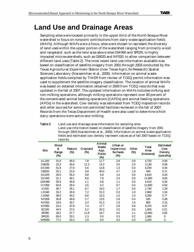
Land Use and Drainage Areas Sampling sites were located primarily in the upper third of the North Bosque River watershed to focus on nonpoint contributions from dairy waste application fields (WAFs). A lthough WAFs were a focus, sites were chosen to represent the diversity of land uses within the upper portion of the watershed ranging from primarily wood and rangeland, such as the land area above sites GM060 and SP020, to highly impacted microwatersheds, such as GB020 and NF020, to allow comparison between different land uses (Table 2). The most recent land-use information available was based on classification of satellite imagery from 2001 through 2003 conducted by the Texas Agricultural Experiment Station (now Texas AgriLife Research) Spatial Sciences Laboratory (Narasimhan et al., 2005). Information on animal waste application fields compiled by TIAER from review of TCEQ permit information was used to supplement the satellite imagery classification. The location of animal WAFs was based on detailed information obtained in 2000 from TCEQ records that was updated in the fall of 2007. The updated information on WAFs includes milking and non-milking operations, although milking operations represent over 80 percent of the concentrated animal feeding operations (CAFOs) and animal feeding operations (AFOs) in the watershed. Cow density was estimated from TCEQ inspection records and other sources for some non-permitted facilities reviewed in the fall of 2007. Records from the Texas Department of Health were also used to determine which dairy operations were active and milking.
Table 2 Land use and drainage area information for sampling sites. Land-use information based on classification of satellite imagery from 2001 through 2003 (Narasimhan et al., 2005). Information on animal waste application fields and estimated cow density represent values as of fall 2007 based on TCEQ records.
Si te
Wood &
Range (%)
Pasture (%)
Cropland (%)
Animal Waste App. Fields
(%)
Urban or Impervious
Surfaces (%)
Other (%)
Total Area
(Hectares)
Estimated Cow
Densi ty (cows/ha)
AL020 31.9 45.0 7.8 11.7 2.8 0.8 4,720 0.49 DB035 23.3 45.6 11.3 14.3 3.5 2.0 2,130 0.58 DC040 51.8 27.0 5.6 13.8 1.3 0.4 6,250 0.44 GB020 25.1 22.6 5.8 40.0 4.7 1.8 440 6.71 GC025 26.5 55.3 9.8 5.8 1.6 0.9 6,610 0.33 GC045 31.1 49.1 8.6 7.8 2.4 0.9 11,900 0.60 GM060 55.9 35.8 1.1 5.8 1.1 0.3 4,410 0.34 HY060 63.6 28.4 2.6 4.2 0.7 0.4 11,800 0.50 IC020 36.7 35.1 6.7 19.3 1.7 0.5 1,740 1.28 LD040 33.2 26.9 7.2 31.3 0.3 1.0 2,960 1.54 LG060 38.9 40.2 8.6 10.3 1.0 1.0 4,260 0.77 NF009 30.8 49.8 2.7 13.5 2.8 0.4 520 0.38 NF020 19.6 33.7 2.4 41.3 1.9 1.0 800 2.15 NF050 23.4 47.8 7.4 17.7 2.8 0.8 8,370 0.47 SC020 44.5 27.5 5.2 20.3 2.0 0.5 1,900 0.21 SF085 28.2 37.7 11.8 16.7 4.5 1.1 12,900 0.82 SP020 65.0 33.1 1.3 0.0 0.3 0.2 1,560 0 WB050 77.2 20.3 1.9 0.0 0.3 0.3 2,220 0

Microwatershed-Based Approach to Monitoring in the North Bosque River Watershed
7
In some previous reports (i.e., McFarland and Millican, 2006; Mill ican and McFarland, 2007), general land-use/ land-cover descriptions were based on Landsat Thematic Mapper imagery classification provided by the USDA-NRCS, Temple State Office. This older land-use information was developed from a 1992 overflight of Erath County and a 1996 overflight of Erath, Bosque, Coryell, Hamilton, and McLennan Counties supplemented by extensive ground verification in January through April 1998 to update land use changes. Information on dairy waste application fields was obtained from dairy permits and dairy waste management plans on record with the TCEQ as of May 2000.
The size of the drainage area above each sampling site was delineated using 30-meter digital elevation models created from United States Geological Survey 1:24,000 topographic maps (Table 2). Drainage areas for sampling sites were calculated using the AVSWAT 2000 extension in ArcView (DiLuzio et al., 2002). Of note, the drainage area values for specific sites may differ some from those in TIAER reports prior to January 2002 because of changes in the GIS system and the calculation method used to determine these areas.
Site Descriptions Specific site descriptions are provided below by creek.
Alarm Creek Site AL020 AL020 is an automated sampling site located on Alarm Creek at Farm-to-Market (FM) 914, 7.2 kilometers (4.5 miles) south of Stephenville. The dominant land uses above AL020 are improved pasture and wood and range, w ith a fair amount of land associated with WAFs and cropland. Alarm Creek has been routinely monitored since May 2001.
Dry Branch Site DB035 DB035 is an automated sampling site located on Dry Branch near FM 8, about 0.8 kilometers (0.5 miles) upstream of the confluence with the North Bosque River. The dominant land use above DB035 is improved pasture followed by wood and range, WAFs, and cropland. Routine and storm sampling at DB035 was initiated in April 2002.
Duffau Creek Site DC040 DC040 is an automated sampling site, located on Duffau Creek, at FM 2481, immediately northeast of Duffau, Texas in Erath County. An automated sampler was installed at the site in May 2001. The majority of land in the DC040 drainage area is classified as wood and range followed by improved pasture with some land used for WAFs.
Goose Branch

Microwatershed-Based Approach to Monitoring in the North Bosque River Watershed
8
Sites GB020 GB020 is an automated sampling site located in the Goose Branch microwatershed of the South Fork of the North Bosque River, northwest of Stephenville. Dairy WAFs are the predominant land use in the Goose Branch microwatershed. Much of the remaining land area is covered by native range and woodland or improved pasture. GB020 is located on an unnamed road off Erath County Road (CR) 297.
Green Creek Site GC025 Site GC025 is an automated site located on Green Creek, 2.69 kilometers (1.7 miles) downstream of the confluence with Buck Creek on FM 847, south of Stephenvil le, Texas. Routine grab sampling began at this site in January 2008, while automated sampling began in April 2008. The main land use above GC025 is improved pasture followed by wood and range.
Si te GC045 Site GC045 is an automated site, located on Green Creek, 0.6 km (0.4 miles) upstream of SH 6, 3.3 km (2.0 miles) northwest of A lexander, Texas. The majority of the land above GC045 is improved pasture followed by wood and range. Routine and storm sampling was initiated at GC045 in 2001.
Gilmore Creek Site GM 060 GM060 is an automated sampling site located on Gilmore Creek, at the bend of Erath CR 293, approximately 330 meters (0.2 miles) downstream of the confluence with Wolf Prong Creek, north northeast of Carleton, Texas. Land uses above GM060 are predominantly wood and range and improved pasture.
Honey Creek Site HY060 HY060 is an automated sampling site located on Honey Creek, at FM 1602 approximately 4.7 kilometers (2.9 miles) southeast of H ico, in Hamilton County. The majority of the land above HY060 is designated as wood or range with some permanent pasture.
Indian Creek Site IC020 IC020 is located near U.S. H ighway 281, on Indian Creek, which discharges into the upper North Bosque River between Stephenville and Hico, Texas. Automated sampling was suspended from March 3, 1998 to May 3, 2001, while routine sampling was continued. The majority of the land use above IC020 is characterized as wood or range and improved pasture with WAFs comprising a notable amount (almost 20 percent of the drainage area).
Little Duffau Creek

Microwatershed-Based Approach to Monitoring in the North Bosque River Watershed
9
Site LD040 LD040 is an automated sampling site, located on Little Duffau Creek, at FM 1824, 2 km (1.2 miles) west of Duffau, Texas in Erath County. The largest land use category above LD040 is wood and range, although almost as much land (about 30 percent of the drainage basin) is associated with WAFs. Routine and storm sampling were initiated at LD040 in 2001.
Little Green Creek Site LG060 LG060 is an automated sampling site, located on Little Green Creek, at FM 914, 3.2 kilometers (2.0 miles) south of A lexander, Texas. The land use above LG060 is characterized as mostly wood and range and improved pasture with a notable amount of land (about 10 percent) associated with WAFs. Routine and storm sampling were initiated at LG060 in 2001.
North Fork Sites NF009 and NF020 These automated sites are located in a microwatershed of the North Fork of the North Bosque River. The North Fork joins the South Fork just north of Stephenville to form the North Bosque River. Sites NF009 and NF020 are located on separate tributaries flowing into the same PL-566 reservoir. Site NF020 is located on the Scarborough Creek tributary at CR 423. Site NF009 is located on an unnamed tributary of Scarborough Creek on CR 423. The dominant land use above NF020 is WAFs, while most of the land above NF009 is characterized as improved pasture.
Si te NF050 Site NF050, an automated sampling site, is located on the North Fork of the North Bosque River, at SH 108, approximately 1.6 km (1.0 mile) northwest of Stephenville. Sampling was initiated at NF050 in 1991 but was suspended in early 1997 until 2001. The dominant land use above NF050 is permanent pasture followed by wood and range. Waste application fields are prominent above NF050 comprising about 18 percent of the watershed.
Sims Creek Site SC020 Site SC020 is located near U.S. H ighway 281 on Sims Creek. Sims Creek is just south of Indian Creek within the upper portion of the North Bosque River watershed. Automated storm sampling at SC020 was suspended from March 3, 1998 to May 12, 2001. Routine grab sampling continued throughout the monitoring period. The majority of the land area above SC020 is wood and range, although a fair amount of land is also associated with improved pasture or WAFs.

Microwatershed-Based Approach to Monitoring in the North Bosque River Watershed
10
South Fork Site SF085 Site SF085 is an automated sampling site located on the South Fork of the North Bosque River, at SH 108, 250 m (820 feet) upstream of the confluence with the North Fork of the North Bosque River, north of Stephenville. The land use above SF085 is mostly improved pasture or wood and range with much of the remaining land area associated with WAFs and cropland.
Spring Creek Site SP020 Site SP020 is located near CR 271, on Spring Creek, which discharges into the North Bosque River above Hico. Automated sampling was suspended from March 3, 1998 to May 3, 2001. Routine grab sampling continued throughout the monitoring period. Site SP020 is considered one of the least impacted sites within the watershed with most of its land designated as wood and range. Improved pasture does comprise about a third of the SP020 watershed. No animal waste fields are located in this microwatershed.
Walker Branch Site WB050 Site WB050 is located on Walker Branch, 1.21 kilometers (0.75 miles) upstream of the confluence with the North Bosque River on FM 927, east of Iredell. Routine grab and automated sampling began at this site in January 2008. Wood and range are the main land uses above WB050 with some pasture. No animal waste fields are located in this microwatershed.

11
CHAPTER 3
Methods
Storm Sampling Storm sampling was accomplished using an Isco 4230 or 3230 bubbler type flow meter in conjunction with an Isco 3700 sampler. Each flow meter recorded water level at 5-min intervals by measuring the pressure required to force an air bubble through a 3-mm (0.125-inch) polypropylene tube. The automated sampler would begin sampling when a set rise in water level occurred. Once activated the sampler would retrieve one-liter sequential samples. The typical sampling sequence was:
An initial sample Three samples taken at one-hour intervals Four samples taken at two-hour intervals All remaining samples taken at six-hour intervals
Samples from individual storm events by site were composited on about a daily basis using a flow-weighting strategy. The flow-weighting strategy used stage data recorded during a storm, the rating curve developed for each site, and a TIAER-developed computer program. During sample collection, stage data were uploaded from data loggers to portable computers, and then downloaded at TIAER headquarters for use with the computer program. The program reads the stage level associated with the time interval for each sample collected at a site, correlates the stage to flow using the site's rating curve, and calculates the amount of flow associated with each water sample taken during the storm event. For a group of bottles, the program would then designate the amount to be taken from each bottle to compose a one-liter composite based on the relative volume of flow associated with each bottle w ithin the group. This flow-weighting strategy allowed a reduction in sample load without compromising the intended use of the data in determining storm loadings of waterborne constituents and storm-event mean concentrations.
If a site had storm samples prior to development of a rating curve, a relative discharge based on standard hydrologic relationships was calculated as the wetted cross-sectional area of the stream site times the square root of water level for flow-weighting of samples. Stage-discharge relationships were developed for most sites from manual wading-type flow measurements taken at various water level conditions following USGS methods (Buchanan and Somers, 1969). Stage-discharge relationships for stages that permitted safe wading were extrapolated using the cross-sectional area and a least-squares relationship of average stream velocity to the log of water level. At sites LD040 and LG060, samplers and flow meters were located

Microwatershed-Based Approach to Monitoring in the North Bosque River Watershed
12
within road culverts. For LD040 and LG060, mathematical fluid mechanics equations were used to estimate flow from culvert flow equations.
If for some reason (i.e., equipment failure), the automated sampler failed to collect samples, a storm grab sample was collected for analysis. If samples could not be flow-weighted because stage data were missing or could not be electronically downloaded when samples were retrieved, storm samples were analyzed sequentially.
Of note, on previous projects occurring prior to September 2008; an attempt was made to monitor all storm events at microwatershed sites based on about a 4 cm rise in water level. Starting in September 2008 as a result of decreased funding with the current project, only selected events rather than all events were monitored. Due to relatively dry weather conditions in late 2008 through mid-2009, most storm events that occurred were monitored and only a few relatively small events were omitted.
Grab Sampling Routine grab sampling at all sites was performed on a biweekly basis prior to September 2008 and on a monthly basis starting in September 2008 through December 2009. Routine grab samples were collected only when flow was present. Samples were not collected at sites that were dry or pooled (see Adams and McFarland, 2009). Samples were collected at a depth of about 0.25 to 0.5 ft (0.08 to 0.15 meters). Of note, for non-direct data collected prior to October 2003, filtration and preservation other than temperature reduction (placing samples in coolers w ith ice) was performed in the laboratory. Beginning in October 2003, procedures were changed to allow filtration and acid preservation to occur in the field for grab samples as indicated by TCEQ sample collection methods (TCEQ, 2008a).
Routine samples for nutrients and total suspended solids (TSS) were collected in a one-liter plastic bottle. Starting in October 2003, aliquots for analytes requiring field filtration and/ or acidification were taken from this bottle after it had been agitated thoroughly to ensure total mixing of sediments. If conditions allowed, samples were filtered through a 0.45 -micron filter using a 50 CC syringe or a filtration flask and pump. An aliquot for ammonia-nitrogen (NH 3-N) and nitrite-nitrogen plus nitrate-nitrogen (NO2-N+NO3-N) was filtered and transferred to an acidified 60-mL plastic bottle, labeled, capped, and shaken to disperse the acid in the sample. An aliquot for orthophosphate-phosphorus (PO4-P) analysis was stored in the syringe, if used, or in a separate bottle, which was then labeled and iced for submittal to the lab. An aliquot for total phosphorus (total-P) and total Kjeldahl nitrogen (TKN) analysis was poured from the liter bottle into a labeled and acidified 250-mL plastic bottle, which was capped and shaken to disperse the acid. The remaining sample (about 500 mL) was submitted to the lab for TSS analysis. Of note, if samples were too turbid to reasonably field filter, a comment was added to the chain of custody form and aliquots associated with constituents requiring fi ltration were kept in the one-liter bottle for filtration and acidification by the lab.

Microwatershed-Based Approach to Monitoring in the North Bosque River Watershed
13
In addition to nutrient and TSS constituents, routine grab samples were analyzed for Escherichia coli (E. coli) bacteria. Samples for bacteria analysis were collected in sterile plastic 250-mL bottles that had been autoclaved and sealed with autoclave tape. Bottles used for bacteria samples included an addition of 10 percent sodium thiosulfate to minimize the impact of potential chlorine residuals.
While routine grab samples for lab analysis were being collected, measurements were taken and recorded in-situ for water temperature, dissolved oxygen, pH, and specific conductance (conductivity) using a YSI multiprobe instrument.
Constituent and Analysis Methods Routine grab and storm samples were analyzed for NH 3-N, NO2-N+NO3-N, TKN, PO4-P, total-P , and TSS were evaluated for both the (Table 3). In non-direct data collected prior to 2002, only fecal coliform (FC) was analyzed for bacteria w ith grab samples. From February 2002 through March 2004, both FC and E. coli were analyzed w ith grab samples using plating techniques. Both FC and E. coli were analyzed, because TCEQ was in the process of changing water quality criteria for bacteria from FC to E. coli (TNRCC, 2000). In March 2004, FC was discontinued, and the analysis method for E. coli was changed to the IDEXX Colilert method.
Table 3 Analysis methods and method detection limits for water quality constituents
Consti tuent M ethod Range of M DLsa Range of TCEQ
AWRLs or Project LOQsb
Field M easurements Conductivity EPA c 120.1 not applicable not applicable Dissolved oxygen EPA 360.1 not applicable not applicable pH EPA 150.1 not applicable not applicable Water temperature EPA 170.1 not applicable not applicable Laboratory M easurements Ammonia-nitrogen EPA 350.1 or SM d 2540 D-98 0.004 - 0.031 mg/ L 0.02 – 0.1 mg/ L Escherichia coli SM 9222G/ 9223Be 1 - 2 colonies/ 100 mLf 1 colony/ 100 mL Fecal coliform SM 9222D 1 colony/ 100 mL 1 colony/ 100 mL Nitrite-nitrogen+nitrate-nitrogen EPA 353.2 or SM 4500-NO3-F-00 0.006 - 0.056 mg/ L 0.04 - 0.05 mg/ L Total Kjeldahl nitrogen EPA 351.2 or SM 4500-NH3 G-97 0.022 - 0.188 mg/ L 0.20 mg/ L Orthophosphate-phosphorus EPA 365.2 or SM 18th ed 4500-PE 0.0009 - 0.004 mg/ L 0.005 mg/ Lg Total phosphorus EPA 365.4 0.017 - 0.082 mg/ L 0.06 mg/ L Total suspended solids EPA 160.2 or SM 2540 D-98 2 - 8 mg/ L 4 mg/ L
a. MDLs were periodically updated by TIAER's laboratory. A range is presented showing the lowest and highest MDLs used during the reporting period (January 2001 – December 2009).
b. Source: Listing of Ambient Water Quality Reporting Limits for Texas Surface Water Quality Monitoring Programs (TCEQ, 2008b). c. EPA refers to Methods for Chemical Analysis of Water and Wastes (EPA, 1983). d. SM refers to the Standard Methods for the Examination of Water and Wastewater, online or 18th Edition (APHA, 1992). e. Most probable number (MPN) or IDEXX method for E. coli was implemented in April 2004. f. Results from the IDEXX method are reported as MPN/ 100 mL whereas plating technique results are reported as
colonies/ 100 mL. In this report, data for all E. coli results are presented in units of colonies/ 100 mL regardless of the analysis method.
g. For PO4-P the AWRL is 0.04 mg/ L, but for the Bosque River a reporting limit of 0.005 mg/ L has been established for projects due to the TMDLs for soluble reactive phosphorus for Segments 1226 and 1255.

Microwatershed-Based Approach to Monitoring in the North Bosque River Watershed
14
Left censored data indicated as below the reporting limit (RL) were entered into the database as one-half the RL following recommendations by Gill iom and Helsel (1986) and Ward et al. (1988). Prior to 2003, method detection limits (MDLs) were used as the reporting limit. Starting in 2003, some TIAER projects, but not all, started to require ambient water reporting limits (AWRLs) set by the TCEQ as data reporting limits. TIAER has continued to evaluate MDLs as part of good laboratory practice, but has shifted to using AWRLs for most projects unless another reporting limit is specified by the project sponsor for a constituent.
Statistical Evaluation Methods Basic Site Statistics
To evaluate conditions at individual microwatershed sites, basic summary statistics including mean, median, and standard deviation were calculated for routine grab samples and event mean concentrations (EMCs) of storm events. Event mean concentrations were calculated for each storm by accumulating the mass via rectangular integration using a midpoint rule to associate concentration with streamflow (Stein, 1977). Instantaneous 5-minute stage readings were used as the minimum measurement interval to indicate flow in cubic feet per second (cfs) and multiplied by 300 seconds to obtain flow for each 5-minute interval. The flow associated with each 5-minute interval was multiplied by the associated water quality concentration and summed across the event to calculate the total constituent loadings. Total constituent loadings were divided by total storm volume to calculate EMCs. These basic statistics were based on data collected from January 2001 through December 2009 representing a period after initiation of the I-Plan for the North Bosque TMDLs.
Trend Analysis Using Kendall’s Tau To evaluate post-TMDL trends in storm data collected from 2001 through 2009, trend analysis was performed on volume-weighted storm event data summarized on a monthly basis. To calculate concentrations on a monthly basis for trend analysis, the estimated volume and nutrient loadings for all storm events occurring within a given month and year at a site were summed and loadings were divided by the total storm volume to obtain a monthly volume-weighted concentration. The monthly data were evaluated by constituent for seasonality, which was not apparent. The monthly data were, thus, aggregated by year and evaluated for trends using the nonparametric Kendall’s tau test statistic as described in Reckhow et al. (1993). The Kendall’s tau test was to evaluate for trends, because it is suitable for water quality data that show non-normal distributions, contain missing data, and contain censored values below method detection or reporting limits (Gilbert, 1987; H irsch and Slack, 1984).
To minimize problems associated with varying reporting limits over time, the maximum reporting limit was identified for each site by constituent. For consistency, all values in the database below half the maximum reporting limit were set equal to

Microwatershed-Based Approach to Monitoring in the North Bosque River Watershed
15
half the maximum reporting limit. Stream flow has also been found to have a distinct impact on water quality concentrations with concentrations often increasing in relation to flow when nonpoint sources are dominant (Helsel and Hirsch, 2002). Using monthly total volume as an indicator of flow, data were flow adjusted between months prior to trend analysis following procedures outlined by Helsel and Hirsch (2002) w ith flow as an ancillary variable.
The Kendall’s tau test for trends is based on the rank order of the data. Data are ordered according to year and comparisons are made between data-pair concentrations at year = t and year = t + 1. An increasing trend exists when significantly more data pairs increase than decrease; a decreasing trend exists when significantly more data pairs decrease than increase; and if pairs decrease and increase at a the same frequency, no trend exists. The null hypothesis tested was that there was no temporal trend in concentration of water quality constituents. The slope calculated gives the magnitude of the trend and is interpreted as the change in concentration per year on a natural log scale. The slope in original units was computed from the slope on the natural log scale as follows (Helsel and Hirsch, 2002):
% change/ yr = (eb - 1)*100*12
Where “ e” is the base of the natural logarithm, which approximately equals 2.7183; and “ b” is the slope for the natural log transformed data. The level of significance used to test the null hypothesis was 0.05.

Microwatershed-Based Approach to Monitoring in the North Bosque River Watershed
16

17
CHAPTER 4
Results and Discussion
Basic summary statistics for routine grab data are presented in Appendix A and for EMCs from storm events in Appendix B. Stream flow is presented in Appendix C.
Trend Analysis Results Trend analyses on volume-weighted storm samples collected from 2001 through 2009 indicated several significant trends in water quality (Tables 4-9). Downward trends in PO4-P were indicated at sites GM060 and IC020 and increasing trends at sites LD040, NF009 and SF085 (Table 4). For total-P, downward trends were indicated at sites GB020, GM060, IC020 and NF020 and increasing trends at sites NF009 and SF085 (Table 5). Decreasing trends in NH 3-N were indicated at sites IC020, NF020 and SC020 (Table 6). Decreasing trends in NO2-N+NO3-N were detected at sites GM060, IC020, NF020 and SP020 and increasing trends at NF009 (Table 7). Decreasing trends in TKN were indicated at sites GM060, HY060, IC020, NF020 and SC020 (Table 8). Decreasing trends in TSS were indicated at DB035 and NF020 and increasing trends at NF009 and SF085 (Table 9).
Table 4 Trend results for monthly volume-weighted PO4-P data. Data transformed using a natural log transformation and adjusted for flow prior to trend analysis. The p-value indicates the probabil ity of significance. ** indicates statistical significance at a p-value of 0.01, and * indicates significance at a p-value of 0.05.
Si te Period Evaluated Kendal l Test Statistic p-value Slope
(% change/yr) AL020 Sep 2001-Oct 2009 -0.075 0.4295 DB035 Feb 2002- Oct 2009 0.115 0.2255 DC040 May 2001- Oct 2009 0.107 0.2250 GB020 Jan 2001- Oct 2009 -0.230 0.0534 GC045 May 2001- Oct 2009 0.017 0.8794 GM060 Aug 2001- Oct 2009 -0.483 0.0000** -43.3 HY060 May 2001- Oct 2009 -0.032 0.7619 IC020 May 2001- Oct 2009 -0.187 0.0443* -5.40 LD040 Aug 2001- Oct 2009 0.281 0.0044** 5.88 LG060 Jan 2001- Oct 2009 -0.163 0.1728 NF009 Jan 2001- Oct 2009 0.373 0.0001** 8.76 NF020 Feb 2001- Oct 2009 -0.038 0.6843 NF050 May 2001- Oct 2009 0.020 0.8450 SC020 May 2001- Oct 2009 -0.063 0.4735 SF085 May 2001- Oct 2009 0.157 0.0289* 3.84 SP020 May 2001- Oct 2009 -0.042 0.6697

Microwatershed-Based Approach to Monitoring in the North Bosque River Watershed
18
Table 5 Trend results for monthly volume-weighted total-P data. Data transformed using a natural log transformation and adjusted for flow prior to trend analysis. The p-value indicates the probabil ity of significance. ** indicates statistical significance at a p-value of 0.01, and * indicates significance at a p-value of 0.05.
Si te Period Evaluated Kendal l Test Statistic p-value Slope
(% change/yr) AL020 Sep 2001-Oct 2009 -0.123 0.1975 DB035 Feb 2002- Oct 2009 -0.004 0.9694 DC040 May 2001- Oct 2009 0.136 0.1228 GB020 Jan 2001- Oct 2009 -0.264 0.0267* -5.88 GC045 May 2001- Oct 2009 -0.013 0.9137 GM060 Aug 2001- Oct 2009 -0.416 0.0001** -21.6 HY060 May 2001- Oct 2009 0.109 0.2890 IC020 May 2001- Oct 2009 -0.279 0.0027** -6.60 LD040 Aug 2001- Oct 2009 0.190 0.0523 LG060 Jan 2001- Oct 2009 -0.092 0.4432 NF009 Jan 2001- Oct 2009 0.238 0.0132* 6.00 NF020 Feb 2001- Oct 2009 -0.284 0.0022** -6.84 NF050 May 2001- Oct 2009 0.131 0.1914 SC020 May 2001- Oct 2009 -0.023 0.7986 SF085 May 2001- Oct 2009 0.189 0.0083** 4.92 SP020 May 2001- Oct 2009 -0.027 0.7890
Table 6 Trend results for monthly volume-weighted NH 3-N data. Data transformed using a natural log transformation and adjusted for flow prior to trend analysis. The p-value indicates the probability of significance. ** indicates statistical significance at a p-value of 0.01, and * indicates significance at a p-value of 0.05.
Station Period Evaluated Kendal l Test Statistic p-value Slope
(% change/yr) AL020 Sep 2001-Oct 2009 0.034 0.6787 DB035 Feb 2002- Oct 2009 -0.177 0.0623 DC040 May 2001- Oct 2009 -0.122 0.1671 GB020 Jan 2001- Oct 2009 -0.049 0.6909 GC045 May 2001- Oct 2009 -0.141 0.1934 GM060 Aug 2001- Oct 2009 -0.093 0.3733 HY060 May 2001- Oct 2009 -0.122 0.2364 IC020 May 2001- Oct 2009 -0.324 0.0005** -15.1 LD040 Aug 2001- Oct 2009 0.044 0.6575 LG060 Jan 2001- Oct 2009 -0.148 0.2166 NF009 Jan 2001- Oct 2009 -0.118 0.2213 NF020 Feb 2001- Oct 2009 -0.210 0.0240* -10.2 NF050 May 2001- Oct 2009 -0.125 0.2134 SC020 May 2001- Oct 2009 -0.255 0.0034** -7.56 SF085 May 2001- Oct 2009 0.073 0.3088 SP020 May 2001- Oct 2009 -0.021 0.8343

Microwatershed-Based Approach to Monitoring in the North Bosque River Watershed
19
Table 7 Trend results for monthly volume-weighted NO2-N + NO3-N data. Data transformed using a natural log transformation and adjusted for flow prior to trend analysis. The p-value indicates the probabil ity of significance. ** indicates statistical significance at a p-value of 0.01, and * indicates significance at a p-value of 0.05.
Station Period Evaluated Kendal l Test Statistic p-value Slope
(% change/yr) AL020 Sep 2001-Oct 2009 0.030 0.7531 DB035 Feb 2002- Oct 2009 -0.089 0.3533 DC040 May 2001- Oct 2009 0.017 0.8470 GB020 Jan 2001- Oct 2009 -0.151 0.2062 GC045 May 2001- Oct 2009 0.120 0.2690 GM060 Aug 2001- Oct 2009 -0.314 0.0024** -23.0 HY060 May 2001- Oct 2009 -0.119 0.2480 IC020 May 2001- Oct 2009 -0.222 0.0169* -8.16 LD040 Aug 2001- Oct 2009 0.055 0.5809 LG060 Jan 2001- Oct 2009 -0.234 0.0500 NF009 Jan 2001- Oct 2009 0.211 0.0277* 11.5 NF020 Feb 2001- Oct 2009 -0.269 0.0039** -9.24 NF050 May 2001- Oct 2009 -0.085 0.3985 SC020 May 2001- Oct 2009 -0.150 0.0.867 SF085 May 2001- Oct 2009 0.018 0.7992 SP020 May 2001- Oct 2009 -0.207 0.0350* -8.40
Table 8 Trend results for monthly volume-weighted TKN data. Data transformed using a natural log transformation and adjusted for flow prior to trend analysis. The p-value indicates the probabil ity of significance. ** indicates statistical significance at a p-value of 0.01, and * indicates significance at a p-value of 0.05.
Station Period Evaluated Kendal l Test Statistic p-value Slope
(% change/yr) AL020 Sep 2001-Oct 2009 -0.082 0.3903 DB035 Feb 2002- Oct 2009 -0.137 0.1493 DC040 May 2001- Oct 2009 0.066 0.4552 GB020 Jan 2001- Oct 2009 -0.076 0.5321 GC045 May 2001- Oct 2009 -0.099 0.3626 GM060 Aug 2001- Oct 2009 -0.504 0.0000** -19.6 HY060 May 2001- Oct 2009 -0.275 0.0072** -9.96 IC020 May 2001- Oct 2009 -0.335 0.0003** -7.08 LD040 Aug 2001- Oct 2009 0.037 0.7128 LG060 Jan 2001- Oct 2009 -0.160 0.1819 NF009 Jan 2001- Oct 2009 -0.032 0.7463 NF020 Feb 2001- Oct 2009 -0.267 0.0041** -7.20 NF050 May 2001- Oct 2009 0.103 0.3067 SC020 May 2001- Oct 2009 -0.242 0.0055** -9.12 SF085 May 2001- Oct 2009 0.078 0.2784 SP020 May 2001- Oct 2009 0.037 0.6274
Microwatershed-Based Approach to Monitoring in the North Bosque River Watershed
20
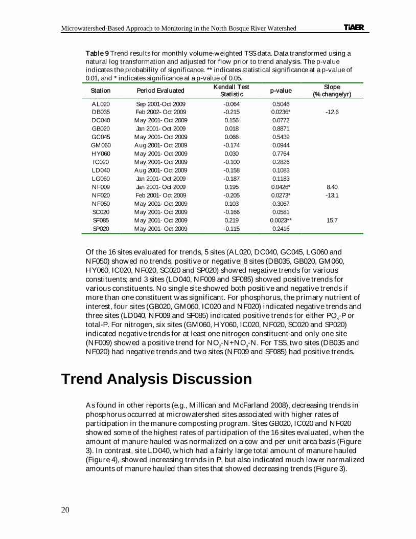
Table 9 Trend results for monthly volume-weighted TSS data. Data transformed using a natural log transformation and adjusted for flow prior to trend analysis. The p-value indicates the probabil ity of significance. ** indicates statistical significance at a p-value of 0.01, and * indicates significance at a p-value of 0.05.
Station Period Evaluated Kendal l Test Statistic p-value Slope
(% change/yr) AL020 Sep 2001-Oct 2009 -0.064 0.5046 DB035 Feb 2002- Oct 2009 -0.215 0.0236* -12.6 DC040 May 2001- Oct 2009 0.156 0.0772 GB020 Jan 2001- Oct 2009 0.018 0.8871 GC045 May 2001- Oct 2009 0.066 0.5439 GM060 Aug 2001- Oct 2009 -0.174 0.0944 HY060 May 2001- Oct 2009 0.030 0.7764 IC020 May 2001- Oct 2009 -0.100 0.2826 LD040 Aug 2001- Oct 2009 -0.158 0.1083 LG060 Jan 2001- Oct 2009 -0.187 0.1183 NF009 Jan 2001- Oct 2009 0.195 0.0426* 8.40 NF020 Feb 2001- Oct 2009 -0.205 0.0273* -13.1 NF050 May 2001- Oct 2009 0.103 0.3067 SC020 May 2001- Oct 2009 -0.166 0.0581 SF085 May 2001- Oct 2009 0.219 0.0023** 15.7 SP020 May 2001- Oct 2009 -0.115 0.2416
Of the 16 sites evaluated for trends, 5 sites (AL020, DC040, GC045, LG060 and NF050) showed no trends, positive or negative; 8 sites (DB035, GB020, GM060, HY060, IC020, NF020, SC020 and SP020) showed negative trends for various constituents; and 3 sites (LD040, NF009 and SF085) showed positive trends for various constituents. No single site showed both positive and negative trends if more than one constituent was significant. For phosphorus, the primary nutrient of interest, four sites (GB020, GM060, IC020 and NF020) indicated negative trends and three sites (LD040, NF009 and SF085) indicated positive trends for either PO4-P or total-P. For nitrogen, six sites (GM060, HY060, IC020, NF020, SC020 and SP020) indicated negative trends for at least one nitrogen constituent and only one site (NF009) showed a positive trend for NO2-N+NO3-N. For TSS, two sites (DB035 and NF020) had negative trends and two sites (NF009 and SF085) had positive trends.
Trend Analysis Discussion As found in other reports (e.g., Millican and McFarland 2008), decreasing trends in phosphorus occurred at microwatershed sites associated with higher rates of participation in the manure composting program. Sites GB020, IC020 and NF020 showed some of the highest rates of participation of the 16 sites evaluated, when the amount of manure hauled was normalized on a cow and per unit area basis (Figure 3). In contrast, site LD040, which had a fairly large total amount of manure hauled (Figure 4), showed increasing trends in P, but also indicated much lower normalized amounts of manure hauled than sites that showed decreasing trends (Figure 3).

Microwatershed-Based Approach to Monitoring in the North Bosque River Watershed
21
Figure 3 Manure hauled normalized for drainage area size and average cow numbers.
Figure 4 Manure hauled to composting facilities from within microwatershed drainage areas between November 2000 and February 2007. Note: The manure haul-off program ended in February 2007.
0.0 5.0 10.0 15.0 20.0 25.0 30.0 35.0
Normalized (kg/ cow/ ha)
SC020SP020
NF009DC040GM060
SF085GC045NF050AL020HY060LD040LG060DB035IC020GB020NF020
Mic
row
ater
shed
0 20,000 40,000 60,000 80,000 100,000 120,000
SC020GC100
DC040DB035
GM060
AL020NF050
GB020NF020IC020
SF085LD040
LG060HY060GC045
Mic
row
ater
shed
Manure hauled (tons)
2000
2001
2002
2003
2004
2005
2006
2007

Microwatershed-Based Approach to Monitoring in the North Bosque River Watershed
22
While it is not known specifically why increasing trends in P were noted at site LD040, there were some indications that these increases may in part be associated with wastewater discharges from ponds or dewatering equipment rather than solely rainfall-runoff. In 2007 when flooding conditions occurred in many portions of the watershed, several samples at LD040 had relatively high ammonia concentrations (> 4 mg/ L), which can be indicative of wastewater.
Land-use changes may also be influencing the change in water quality at LD040. A comparison of land-use data from the late 1990s with data from the mid-2000s indicates a 23 percent increase in land associated with improved pasture and cropland with a commensurate decrease in land associated with wood and rangeland (Mill ican and McFarland, 2008). The other two sites that showed increasing trends in P (NF009 and SF085) also showed a 14 to 17 percent increase in improved pasture and cropland with a corresponding decrease in land associated with wood and range. While fertilizer sales for the area have decreased notably over time (Figure 5), it is possible that more land in these microwatersheds is receiving fertilizer, thus, increasing the cumulative area impacted by rainfall-runoff events even if less fertil izer is applied per acre.
Figure 5 Annual sale of commercial ferti lizer for Erath County for 1990-2007. Phosphorus represented as elemental P rather than P2O5. Source: The Association of American Plant Food Control Officials (AAPFCO).
Of the sites showing increasing trends in P, only site NF009 showed a corresponding increase in N (NO2-N+NO3-N), which might be associated with increased fertilizer runoff. Both sites NF009 and SF085 showed increasing trends in total-P as well as in TSS indicating more particulate movement. This increase in particulate movement
0
2,000,000
4,000,000
6,000,000
8,000,000
10,000,000
12,000,000
14,000,000
1990
1992
1994
1996
1998
2000
2002
2004
2006
Nitr
ogen
Fer
tiliz
er S
ales
(ton
s)
0
200,000
400,000
600,000
800,000
1,000,000
1,200,000
Phos
phor
us F
ertil
izer
Sal
es (t
ons)
N itrogen Phosphorus

Microwatershed-Based Approach to Monitoring in the North Bosque River Watershed
23
may be associated with land-use changes that may be increasing erosion. At LD040 only PO4-P, representing the soluble portion of total-P, showed any trend (negative or positive) for the constituents measured indicating that particulate movement was not as large a factor in the measurement of increased P losses for this microwatershed.
A fourth site w ith decreasing trends in P was GM060. The Gilmer Creek microwatershed is not associated with a large number of animal feeding operations or large quantities of manure haul-off, but has been the focus of some water quality management plans (WQMPs) through the TSSWCB focusing on overgrazing and brush control. There are indications that improved grazing management practices and reduced stocking rates may be responsible for decreasing trends in P noted in this microwatershed.
As discussed in previous reports (e.g., Millican and McFarland, 2008), weather conditions play a large role in the movement of nonpoint source pollution. The amount of rainfall can vary greatly from year to year (Figure 6) as well as the associated runoff throughout the watershed (Figures 7 and 8). Using 2001 as a cutoff based on when the I-Plan was approved, precipitation and runoff appeared to be less variable than during the pre than post-TMDL period, although both periods have obvious years of drought (1999 and 2005) and flooding (1997 and 2007).
Figure 6 Annual precipitation at Stephenville, Texas. Data Source: Texas AgriLife Research and Extension Center.
0
200
400
600
800
1000
1200
1993
1994
1995
1996
1997
1998
1999
2000
2001
2002
2003
2004
2005
2006
2007
2008
2009
Year
Prec
ipita
tion
(mm
)
Stephenville 30-year average Stephenville (1971-2000)

Microwatershed-Based Approach to Monitoring in the North Bosque River Watershed
24
Figure 7 Estimated annual runoff associated with sites NF020 and SP020. Asterisks for SP020 in 1993, 1999 and 2000 indicate years with incomplete data, thus, no annual value presented.
Figure 8 Estimated annual runoff for selected microwatershed sites throughout the upper North Bosque River watershed for 2002 through 2009. Sites are ordered in general from north to south within the watershed. The asterisk in 2007 for HY060 indicated no data as annual runoff could not be determined due to flooding conditions that disabled the site for almost 20 days.
***0
100
200
300
400
500
600
700
800
1993
1994
1995
1996
1997
1998
1999
2000
2001
2002
2003
2004
2005
2006
2007
2008
2009
Run
off (
mm
)
NF020 SP020
*0
100
200
300
400
500
600
700
800
900
2002 2003 2004 2005 2006 2007 2008 2009
Run
off (
mm
)
NF020 IC020 GC045 LG060 LD040 SP020 HY060

Microwatershed-Based Approach to Monitoring in the North Bosque River Watershed
25
Even for years that appear to show similar rainfall amounts, such as 2004 and 2007 (Figure 6), the actual site-specific runoff can be quite variable across the watershed (Figure 8) depending on how much rain comes with any one storm and antecedent rainfall conditions. In 2004, rainfall was more spread out temporally and spatially through the watershed than in 2007, thus less runoff was noted at most sites in 2004 than in 2007 (Figure 8). In 2007, heavier rains were more prevalent below than above Stephenville leading to a large spatial divergence in runoff between sites (Figure 8).
While large changes in water quality are not being measured in-stream, there are indications that I-Plan activities, such as the manure compositing program, are having a positive impact on water quality. A lthough the composting program is no longer active, six of the seven composting facilities initiated with the program were active in 2009 and most updated CAFO permits note manure composting as an option for manure disposal. Other I-Plan activities, such as revised animal feeding operations (AFO) and confined animal feeding operation (CAFO) rules leading to development and implementation of nutrient management plans (NMPs), are expected to take more time before in-stream success is measured. A lag time exists between the I-Plan adoption and the planning and implementation time needed for these activities. Amendments to the CAFO rules were not adopted until 2004 and became effective upon reissuance of new or amended permits. This started what can be a relatively slow process of developing and certifying comprehensive nutrient management plans (CNMPs), which peaked with 34 CNMPs certified in FY07. Prior to FY07 only 12 CNMPs had been certified and an additional 7 were certified in FY08. These CNMPs include the NMP for waste application fields as well as additional nutrient controls, such as feed management and storage and handling practices for manure and wastewater. In 2008, nearly 50 CAFO permits were under technical review by the TCEQ. These new and amended permits, based on the revised CAFO rules, require an increase in the margin of safety for wastewater retention structures from a 25-yr/ 24-hr rainfall event to a 25-yr/ 10-day event, the implementation of CNMPs, and installation of vegetative buffer and filter strips on the edges of land application areas as well as other requirements. While many of these permits are now approved and it is anticipated that many AFO and CAFO operators have been proactive in implementing practices, there is sti ll an expected lag time between full implementation of all adopted practices before an in-stream effect is produced that is measureable.
The lag time between the implementation of land management practices and the measured reduction of in-stream soluble P is expected to take years to decades, primary due to the interaction of soluble P w ith soils (Meals et al., 2010). Runoff losses of soluble P are strongly related to soil P concentrations (e.g., Sharpley, 1995; Sharpley et al., 1999) and even when P inputs are greatly reduced or ceased; it may take many years to reduce P from these soils to notably impact runoff (e.g., Zhang et al., 2004; McFarland and Hauck, 2004). Weather influences the length of this lag time by influencing crop yield and, thus, the amount of P removed from the soil. For example, if P is applied assuming normal growth conditions and a drought ensues greatly reducing yields, residual P from drought years may be associated with runoff

Microwatershed-Based Approach to Monitoring in the North Bosque River Watershed
26
in future years. Lag time is an important factor in considering expectations for NPS management efforts.

27
CHAPTER 5
Conclusions
Measured reductions of in-stream P are occurring at microwatershed sites within the North Bosque River watershed, but to date most of these reductions have been relatively small and primarily associated with the haul-off of manure from the manure composting program. While the manure composting program is no longer active, it is anticipated that the impacts from this program will continue as dairy producers continue to use composting as an option for manure disposal. Other activities associated w ith the North Bosque River TMDL I-Plan have had a slower implementation time, and thus, a lag time is expected as these practices, such as CNMPs, are put into practice. Studies outside the North Bosque watershed have indicated that it may take years to decades before notable decreases in soluble P are seen within the stream system, primarily because the runoff of dissolved P is strongly controlled by soil P concentrations (Meals et al., 2010). Even as appropriate land management practices are implemented to reduce the runoff of soluble P, legacy or residual P may take years to “ mine” or harvest from the land. Lag times between implementation of management practices and in-stream response should be recognized and communicated as part of setting reasonable expectations for water quality improvements (Clausen, et al., 1992; Meals, et al., 2010).

Microwatershed-Based Approach to Monitoring in the North Bosque River Watershed
28

29
References
Adams, T. and A. McFarland. 2009. Semiannual Water Quality Report for the North Bosque River Watershed Monitoring Period: January 1, 2002 – December 31, 2008. Texas Institute for Applied Environmental Research, Tarleton State University, Stephenville, Texas, TR0903.
APHA, American Public Health Association, American Water Works Association, and Water Environment Federation. 1992. Standard methods for the examination of water and wastewater. 18th edition. APHA, Washington, D.C.
Buchanan, T.J., and W.P. Somers. 1969. Chapter A8: Discharge measurements at gaging stations. In Techniques of Water-Resources Investigations Reports Book 3. United States Geological Survey, Arlington, Virginia.
Clausen, J.C., D.W. Meals and E.A. Cassel. 1992. Estimation of lag time for water quality response to BMPs, pp. 173-180. In: Proceedings of the National RCWP Symposium, Orlando, Florida.
DiLuzio, M., R. Srinivasan, J.G. Arnold, and S.L. Neithsch. 2002. Soil and Water Assessment Tool. ArcView GIS Interface Manual: Version 2000. GSWRL Report 02-03, BRC Report 02-07, Published by the Texas Water Resources Institute TR-103, College Station, Texas, 346 p.
EPA, United States Environmental Protection Agency. 1983. Methods for Chemical Analysis of Water and Wastes. Environmental Monitoring and Support Laboratory, Office of Research and Development, US-EPA, Cincinnati, Ohio. EPA-600/ 4-79-020, Revised March 1983.
Gilbert, R.O., 1987. Statistical methods for environmental pollution monitoring. Van Nostrand. Reinhold, New York.
Gilliom, R.J. and D.R. Helsel. 1986. Estimation of distributional parameters for censored trace level water quality data. 1. Estimation techniques. Water Resources Research 22:135-126.
Helsel, D.R. and R.M. Hirsch, 2002. Chapter A3. Statistical Methods in Water Resources. In Techniques of Water-Resources Investigations, Book 4, Hydrologic Analysis and Interpretation. United States Geological Survey, Arlington, Virginia.
Hirsch, R.M. and J.R., Slack, 1984. A nonparametric trend test for seasonal data with serial dependence. Water Resources Research 20: 727-732.
McFarland, A.M.S., and L.M. Hauck. 2004. Controlling phosphorus in runoff from long term dairy waste application fields. Journal of the American Water Resources Association 40:1293-1304.
McFarland, A. and J. Millican. 2006 Assessment of Preexisting and Post Implementation Effects for the North Bosque River Watershed: Clean Water Act Section 319 Report. Texas Institute for Applied Environmental Research, Tarleton State University, Stephenville, Texas, TR0602.
Meals, D.W., S.A. Dressing and T.E. Davenport. 2010. Lag time in water quality response to best management practices: A review. Journal of Environmental Quality 39:85-96.
Millican, J. and A. McFarland. 2008. Extending TMDL Efforts in the North Bosque River Watershed: Assessment Data through 2007. Final Project Report for the Texas Soil and Water Conservation Board by the Texas Institute for Applied Environmental Research, Tarleton State University, Stephenville, Texas, TR0802.
Millican, J. and A. McFarland. 2007. Extending TMDL Efforts in the North Bosque River Watershed: Assessment Data through 2006. Interim Project Report for the Texas Soil and Water Conservation Board by the Texas Institute for Applied Environmental Research, Tarleton State University, Stephenville, Texas, TR0702.

Microwatershed-Based Approach to Monitoring in the North Bosque River Watershed
30
Narasimhan, B., X. Zhang, and R. Srinivasan. 2005. Land use/ land cover classification of Bosque River watershed using LANDSAT-7 enhanced thematic mapper (ETM+) imagery. Final Report submitted to TIAER by the Spatial Science Laboratory, Texas Agricultural Experiment Station, College Station.
Reckhow, K. H., K. Kepford, and W.W. Hicks. 1993. Methods for analysis of lake water quality trends. United States Environmental Agency, Office of water, Washington, D.C., EPA 841-R-93-003.
Sharpley, A.N. 1995. Soil phosphorus dynamics: agronomic and environmental impacts. Ecological Engineering 5(2-3):261-279.
Sharpley, A.N, W.J. Gburek, G. Folmar and H.B. Pionke. 1999. Sources of phosphorus exported from an agricultural watershed in Pennsylvania. Agricultural Water Management 41(2):77-89.
Stein, S.K. 1977. Calculus and Analytic Geometry. 2nd ed. McGraw-Hill Book Company, New York, New York.
TCEQ, Texas Commission on Environmental Quality. 2008a. Surface Water Quality Monitoring Procedures, Volume 1. TCEQ, Monitoring Operations Division, Austin, Texas (RG-415).
TCEQ, Texas Commission on Environmental Quality. 2008b. Ambient Water Quality Reporting Limits (AWRLs) for Texas Surface Water Quality Monitoring Programs (Last Revised March 2008) [Online]. Available at http:/ / www.tceq.state.tx.us/ assets/ public/ compliance/ monops/ crp/ QA/ awrlmaster.pdf (verified June 24, 2009).
TCEQ, Texas Commission on Environmental Quality, and TSSWCB, Texas State Soil and Water Conservation Board. 2002. An Implementation Plan for Soluble Reactive Phosphorus in the North Bosque River Watershed: For Segments 1226 and 1255. TCEQ Strategic Assessment Division, TMDL Team, Austin, Texas and TSSWCB TMDL Team, Temple, Texas (December 2002).
TNRCC, Texas Natural Resource Conservation Commission. 2001. Two Total Maximum Daily Loads for Phosphorus in the North Bosque River for Segments 1226 and 1255. Strategic Assessment Division, TMDL Team, TNRCC, Austin, Texas (adopted February 2001; approved by EPA December 2001).
TNRCC, Texas Natural Resource Conservation Commission. 2000. Texas Surface Water Quality Standards, Chapter 307, Texas Administrative Code 307.1 - 307.10. TNRCC, Austin, Texas (effective 17 August 2000).
USDA-AMS, United States Department of Agriculture Agricultural Marketing Service. 2009. The Market Administrator’s Report: Southwest Marketing Area; Vol. XXXV, No. 7 (July 2009).
Ward, R.C., J.C. Loftis, H.P. DeLong, and H.F. Bell. 1988. Groundwater quality: A data analysis protocol. Journal of the Water Pollution Control Federation 60:1938-1945.
Zhang, T.Q., A.F. MacKenzie, B.C. Liang, and C.F. Drury. 2004. Soil test phosphorus and phosphorus fractions with long-term phosphorus addition and depletion. Soil Science Society of America Journal 68:519-528.

31
APPENDIX A
Summary Statistics for Routine Grab Samples
All data analyses represent grab samples collected between January 1, 2001 and December 31, 2009. The exact date range of samples evaluated will vary by site based on monitoring history.
Table A-1 Routine grab sample summary statistics for site AL020 (N = number of samples).
Consti tuent M ean M edian Std Dev. M inimum M aximum N
PO4-P (mg/ L) 0.184 0.113 0.194 0.001 0.887 97 Total-P (mg/ L) 0.34 0.25 0.35 0.03 2.59 96 NH 3-N (mg/ L) 0.082 0.050 0.085 0.010 0.401 97
NO2-N + NO3-N (mg/ L) 0.733 0.187 1.10 0.008 4.88 97 TKN (mg/ L) 1.11 1.00 0.70 0.10 4.44 97 TSS (mg/ L) 26 8 56 1 422 97
Water Temp. (°C) 16.8 17.3 6.6 2.0 30.9 97 Conductivity (µmhos/ cm) 1070 1020 590 97 2610 97
DO (mg/ L) 7.1 6.7 3.1 1.2 13.4 97 pH (standard units) 7.9 7.9 0.3 7.4 9.0 97
Fecal Coliform (colonies/ 100ml) 3100 350 13000 12 69000 29 Escherichia coli (colonies/ 100ml) 2000 230 8400 3 54000 84
Table A-2 Routine grab sample summary statistics for site DB035 (N = number of samples).
Consti tuent M ean M edian Std Dev. M inimum M aximum N
PO4-P (mg/ L) 0.502 0.468 0.324 0.058 1.50 56 Total-P (mg/ L) 0.69 0.65 0.41 0.03 1.70 56 NH 3-N (mg/ L) 0.127 0.058 0.175 0.007 0.733 56
NO2-N + NO3-N (mg/ L) 1.41 0.979 1.64 0.015 6.03 56 TKN (mg/ L) 1.70 1.56 0.75 0.25 4.22 56 TSS (mg/ L) 19 11 27 2 144 56
Water Temp. (°C) 16.1 16.1 5.9 6.2 26.5 56 Conductivity (µmhos/ cm) 1040 990 552 231 2350 56
DO (mg/ L) 9.4 9.3 3.3 3.8 16.5 56 pH (standard units) 8.0 8.0 0.2 7.7 8.5 56
Fecal Coliform (colonies/ 100ml) 1300 270 3200 52 14000 22 Escherichia coli (colonies/ 100ml) 5700 320 24000 22 140000 53

Microwatershed-Based Approach to Monitoring in the North Bosque River Watershed
32
Table A-3 Routine grab sample summary statistics for site DC040 (N = number of samples).
Consti tuent M ean M edian Std Dev. M inimum M aximum N
PO4-P (mg/ L) 0.033 0.014 0.055 0.001 0.364 184 Total-P (mg/ L) 0.10 0.08 0.09 0.01 0.59 184 NH 3-N (mg/ L) 0.035 0.024 0.037 0.007 0.243 184
NO2-N + NO3-N (mg/ L) 0.162 0.020 0.305 0.008 1.97 184 TKN (mg/ L) 0.44 0.36 0.35 0.06 2.28 184 TSS (mg/ L) 7 4 9 1 68 184
Water Temp. (°C) 17.0 17.6 6.8 2.1 29.7 184 Conductivity (µmhos/ cm) 591 589 114 305 1070 184
DO (mg/ L) 7.7 7.4 2.8 1.3 14.4 184 pH (standard units) 7.9 7.9 0.2 7.3 8.5 184
Fecal Coliform (colonies/ 100ml) 710 130 3000 12 20000 46 Escherichia coli (colonies/ 100ml) 710 110 3400 5 39000 152
Table A-4 Routine grab sample summary statistics for site GB020 (N = number of samples).
Consti tuent M ean M edian Std Dev. M inimum M aximum N
PO4-P (mg/ L) 4.40 4.07 2.75 0.69 7.60 6 Total-P (mg/ L) 10.6 5.65 9.64 3.36 28.2 7 NH 3-N (mg/ L) 0.577 0.304 0.610 0.079 1.59 5
NO2-N + NO3-N (mg/ L) 2.943 0.932 3.847 0.240 9.87 7 TKN (mg/ L) 41.3 6.69 68.2 3.04 187 7 TSS (mg/ L) 456 150 704 2 1980 7
Water Temp. (°C) 13.3 10.7 8.2 4.1 23.6 7 Conductivity (µmhos/ cm) 1010 437 1220 178 3270 7
DO (mg/ L) 8.0 7.3 2.6 5.2 11.6 7 pH (standard units) 8.1 8.1 0.3 7.8 8.5 7
Fecal Coliform (colonies/ 100ml) 260000 260000 360000 9700 510000 2 Escherichia coli (colonies/ 100ml) 200000 130000 220000 7300 500000 6
Table A-5 Routine grab sample summary statistics for site GC025 (N = number of samples).
Consti tuent M ean M edian Std Dev. M inimum M aximum N
PO4-P (mg/ L) 0.113 0.044 0.150 0.003 0.466 12 Total-P (mg/ L) 0.22 0.12 0.20 0.03 0.64 12 NH 3-N (mg/ L) 0.045 0.050 0.010 0.022 0.050 12
NO2-N + NO3-N (mg/ L) 0.029 0.025 0.013 0.020 0.061 12 TKN (mg/ L) 0.39 0.25 0.36 0.10 1.15 12 TSS (mg/ L) 3 2 3 2 10 12
Water Temp. (°C) 14.5 13.5 5.1 6.8 25.1 12 Conductivity (µmhos/ cm) 930 1050 326 291 1290 12
DO (mg/ L) 9.2 9.3 2.1 6.3 12.1 12 pH (standard units) 8.1 8.1 0.1 7.8 8.3 12
Fecal Coliform (colonies/ 100ml) . . . . . 0 Escherichia coli (colonies/ 100ml) 150 84 180 8 580 12

Microwatershed-Based Approach to Monitoring in the North Bosque River Watershed
33
Table A-6 Routine grab sample summary statistics for site GC045 (N = number of samples).
Consti tuent M ean M edian Std Dev. M inimum M aximum N
PO4-P (mg/ L) 0.070 0.012 0.132 0.001 0.889 94 Total-P (mg/ L) 0.17 0.11 0.18 0.01 1.11 94 NH 3-N (mg/ L) 0.064 0.049 0.080 0.010 0.586 94
NO2-N + NO3-N (mg/ L) 4.46 2.31 5.49 0.020 22.2 94 TKN (mg/ L) 0.91 0.78 0.61 0.10 2.31 94 TSS (mg/ L) 18 8 22 2 112 93
Water Temp. (°C) 18.5 20.0 6.3 4.6 28.0 94 Conductivity (µmhos/ cm) 738 730 256 306 1440 94
DO (mg/ L) 7.6 7.4 2.1 3.5 13.5 94 pH (standard units) 7.9 7.9 0.2 7.1 8.4 94
Fecal Coliform (colonies/ 100ml) 500 160 1000 2 4500 21 Escherichia coli (colonies/ 100ml) 3400 160 27000 0 240000 82
Table A-7 Routine grab sample summary statistics for site GM060 (N = number of samples).
Consti tuent M ean M edian Std Dev. M inimum M aximum N
PO4-P (mg/ L) 0.080 0.020 0.150 0.002 1.030 113 Total-P (mg/ L) 0.16 0.09 0.21 0.01 1.46 113 NH 3-N (mg/ L) 0.046 0.021 0.100 0.007 0.917 113
NO2-N + NO3-N (mg/ L) 0.105 0.020 0.267 0.008 2.16 113 TKN (mg/ L) 0.51 0.42 0.45 0.06 2.78 113 TSS (mg/ L) 12 2 51 1 544 113
Water Temp. (°C) 17.6 17.5 7.7 2.5 37.4 113 Conductivity (µmhos/ cm) 888 820 315 160 1720 113
DO (mg/ L) 9.8 9.9 2.0 5.2 15.1 113 pH (standard units) 8.1 8.1 0.2 7.5 8.8 113
Fecal Coliform (colonies/ 100ml) 790 35 4200 2 26000 38 Escherichia coli (colonies/ 100ml) 820 25 3600 0 25000 95
Table A-8 Routine grab sample summary statistics for site HY060 (N = number of samples).
Consti tuent M ean M edian Std Dev. M inimum M aximum N
PO4-P (mg/ L) 0.007 0.003 0.013 0.001 0.102 107 Total-P (mg/ L) 0.07 0.05 0.06 0.01 0.48 107 NH 3-N (mg/ L) 0.028 0.014 0.025 0.007 0.163 107
NO2-N + NO3-N (mg/ L) 0.455 0.025 0.924 0.009 4.06 107 TKN (mg/ L) 0.32 0.27 0.25 0.06 1.30 107 TSS (mg/ L) 4 2 9 1 90 107
Water Temp. (°C) 18.6 20.3 6.5 5.6 28.0 107 Conductivity (µmhos/ cm) 521 536 76 287 643 107
DO (mg/ L) 8.2 8.0 2.2 3.6 14.8 107 pH (standard units) 7.8 7.8 0.2 7.3 8.2 107
Fecal Coliform (colonies/ 100ml) 140 66 260 5 1400 37 Escherichia coli (colonies/ 100ml) 100 46 170 2 1200 95

Microwatershed-Based Approach to Monitoring in the North Bosque River Watershed
34
Table A-9 Routine grab sample summary statistics for site IC020 (N = number of samples).
Consti tuent M ean M edian Std Dev. M inimum M aximum N
PO4-P (mg/ L) 0.326 0.170 0.472 0.007 3.01 64 Total-P (mg/ L) 0.56 0.32 0.73 0.03 4.16 64 NH 3-N (mg/ L) 0.230 0.050 0.574 0.010 3.68 63
NO2-N + NO3-N (mg/ L) 2.01 1.52 2.66 0.008 16.9 64 TKN (mg/ L) 2.07 1.54 2.20 0.10 15.3 64 TSS (mg/ L) 19 9 39 2 240 64
Water Temp. (°C) 18.7 19.0 6.8 6.2 31.3 64 Conductivity (µmhos/ cm) 1250 1190 542 172 2800 64
DO (mg/ L) 12.1 11.9 3.2 5.8 20.8 64 pH (standard units) 8.2 8.3 0.3 7.5 8.9 64
Fecal Coliform (colonies/ 100ml) 13000 780 51000 0 220000 18 Escherichia coli (colonies/ 100ml) 3800 360 17000 0 120000 50
Table A-10 Routine grab sample summary statistics for site LD040 (N = number of samples).
Consti tuent M ean M edian Std Dev. M inimum M aximum N
PO4-P (mg/ L) 0.518 0.388 0.433 0.008 2.47 58 Total-P (mg/ L) 0.81 0.54 0.97 0.03 5.40 58 NH 3-N (mg/ L) 0.191 0.058 0.459 0.010 2.52 56
NO2-N + NO3-N (mg/ L) 3.00 1.48 3.66 0.015 14.4 58 TKN (mg/ L) 2.86 1.41 6.35 0.10 36.6 58 TSS (mg/ L) 21 9 29 1 127 58
Water Temp. (°C) 16.3 16.4 6.2 6.0 26.8 58 Conductivity (µmhos/ cm) 1240 1290 493 127 2390 58
DO (mg/ L) 8.6 8.5 2.9 2.7 15.8 58 pH (standard units) 7.9 7.9 0.2 7.5 8.3 58
Fecal Coliform (colonies/ 100ml) 6200 1400 9700 46 24000 9 Escherichia coli (colonies/ 100ml) 7500 460 18000 8 77000 53
Table A-11 Routine grab sample summary statistics for site LG060 (N = number of samples).
Consti tuent M ean M edian Std Dev. M inimum M aximum N
PO4-P (mg/ L) 0.084 0.031 0.166 0.003 1.39 84 Total-P (mg/ L) 0.19 0.13 0.22 0.03 1.73 84 NH 3-N (mg/ L) 0.077 0.050 0.112 0.008 0.895 84
NO2-N + NO3-N (mg/ L) 0.442 0.186 0.621 0.009 2.48 84 TKN (mg/ L) 1.09 0.85 1.10 0.10 8.85 84 TSS (mg/ L) 20 8 28 2 171 84
Water Temp. (°C) 17.6 18.5 6.6 3.6 29.0 84 Conductivity (µmhos/ cm) 673 666 234 171 1100 84
DO (mg/ L) 9.3 8.8 2.5 4.7 15.2 84 pH (standard units) 8.1 8.1 0.2 7.7 8.6 84
Fecal Coliform (colonies/ 100ml) 4400 755 10000 70 40000 21 Escherichia coli (colonies/ 100ml) 5800 326 26000 30 200000 73

Microwatershed-Based Approach to Monitoring in the North Bosque River Watershed
35
Table A-12 Routine grab sample summary statistics for site NF009 (N = number of samples).
Consti tuent M ean M edian Std Dev. M inimum M aximum N
PO4-P (mg/ L) 0.179 0.101 0.175 0.008 0.750 88 Total-P (mg/ L) 0.36 0.28 0.28 0.03 1.63 88 NH 3-N (mg/ L) 0.145 0.050 0.252 0.007 1.42 87
NO2-N + NO3-N (mg/ L) 0.386 0.030 0.805 0.009 4.01 88 TKN (mg/ L) 1.55 1.16 1.82 0.10 15.9 88 TSS (mg/ L) 24 13 36 1 274 88
Water Temp. (°C) 14.9 15.3 6.5 2.6 26.8 88 Conductivity (µmhos/ cm) 2060 2000 922 270 4290 88
DO (mg/ L) 7.3 7.4 3.4 1.4 16.9 88 pH (standard units) 7.9 7.8 0.2 7.4 8.7 88
Fecal Coliform (colonies/ 100ml) 1300 210 2900 22 12000 21 Escherichia coli (colonies/ 100ml) 2800 690 11000 6 92000 80
Table A-13 Routine grab sample summary statistics for site NF020 (N = number of samples).
Consti tuent M ean M edian Std Dev. M inimum M aximum N
PO4-P (mg/ L) 1.06 0.981 0.806 0.156 4.08 31 Total-P (mg/ L) 1.47 1.17 1.03 0.22 4.57 31 NH 3-N (mg/ L) 0.267 0.105 0.372 0.010 1.69 32
NO2-N + NO3-N (mg/ L) 0.847 0.368 1.18 0.020 5.28 32 TKN (mg/ L) 3.26 2.59 2.02 1.28 9.74 32 TSS (mg/ L) 33 17 41 2 192 32
Water Temp. (°C) 14.1 14.0 5.0 5.6 25.2 32 Conductivity (µmhos/ cm) 2580 2220 1540 260 5400 32
DO (mg/ L) 8.4 8.1 2.8 4.2 15.5 32 pH (standard units) 8.0 8.0 0.2 7.6 8.5 32
Fecal Coliform (colonies/ 100ml) 77000 13000 98000 170 190000 5 Escherichia coli (colonies/ 100ml) 13000 900 35000 73 140000 28
Table A-14 Routine grab sample summary statistics for site NF050 (N = number of samples).
Consti tuent M ean M edian Std Dev. M inimum M aximum N
PO4-P (mg/ L) 0.348 0.323 0.199 0.045 0.796 58 Total-P (mg/ L) 0.55 0.54 0.31 0.07 1.76 58 NH 3-N (mg/ L) 0.116 0.050 0.184 0.010 1.05 58
NO2-N + NO3-N (mg/ L) 0.321 0.241 0.369 0.015 1.80 58 TKN (mg/ L) 1.88 1.79 0.74 0.48 4.75 58 TSS (mg/ L) 32 18 80 2 610 58
Water Temp. (°C) 17.3 17.5 6.4 5.9 26.9 58 Conductivity (µmhos/ cm) 691 480 496 177 1890 58
DO (mg/ L) 8.3 7.8 2.7 2.4 14.9 58 pH (standard units) 8.2 8.2 0.2 7.8 9.1 58
Fecal Coliform (colonies/ 100ml) 4400 1100 6300 0 17000 14 Escherichia coli (colonies/ 100ml) 8700 980 34000 0 240000 57

Microwatershed-Based Approach to Monitoring in the North Bosque River Watershed
36
Table A-15 Routine grab sample summary statistics for site SC020 (N = number of samples).
Consti tuent M ean M edian Std Dev. M inimum M aximum N
PO4-P (mg/ L) 0.057 0.023 0.105 0.001 0.630 131 Total-P (mg/ L) 0.14 0.12 0.14 0.01 0.84 131 NH 3-N (mg/ L) 0.058 0.045 0.069 0.007 0.529 131
NO2-N + NO3-N (mg/ L) 0.482 0.280 0.527 0.015 2.61 131 TKN (mg/ L) 0.63 0.50 0.48 0.06 2.34 131 TSS (mg/ L) 13 2 23 1 171 129
Water Temp. (°C) 15.7 16.3 6.8 2.6 27.2 131 Conductivity (µmhos/ cm) 682 676 171 142 1380 131
DO (mg/ L) 8.8 9.0 3.3 1.4 15.0 131 pH (standard units) 7.9 8.0 0.2 7.0 8.4 131
Fecal Coliform (colonies/ 100ml) 2200 450 5700 10 30000 33 Escherichia coli (colonies/ 100ml) 1500 240 6300 3 58000 110
Table A-16 Routine grab sample summary statistics for site SF085 (N = number of samples).
Consti tuent M ean M edian Std Dev. M inimum M aximum N
PO4-P (mg/ L) 0.220 0.191 0.181 0.005 1.22 153 Total-P (mg/ L) 0.33 0.28 0.26 0.01 1.63 153 NH 3-N (mg/ L) 0.052 0.036 0.065 0.007 0.541 153
NO2-N + NO3-N (mg/ L) 0.310 0.183 0.364 0.008 2.23 153 TKN (mg/ L) 0.89 0.74 0.67 0.10 3.87 153 TSS (mg/ L) 12 4 22 1 160 153
Water Temp. (°C) 16.4 16.9 7.0 1.2 28.7 153 Conductivity (µmhos/ cm) 718 708 316 158 1630 153
DO (mg/ L) 8.7 8.5 3.1 2.7 16.6 153 pH (standard units) 8.1 8.1 0.2 7.6 9.0 153
Fecal Coliform (colonies/ 100ml) 570 160 1400 5 7400 45 Escherichia coli (colonies/ 100ml) 4200 210 24000 1 240000 126
Table A-17 Routine grab sample summary statistics for site SP020 (N = number of samples).
Consti tuent M ean M edian Std Dev. M inimum M aximum N
PO4-P (mg/ L) 0.005 0.003 0.007 0.001 0.048 119 Total-P (mg/ L) 0.06 0.03 0.04 0.01 0.28 119 NH 3-N (mg/ L) 0.022 0.010 0.018 0.007 0.096 119
NO2-N + NO3-N (mg/ L) 0.071 0.020 0.180 0.008 1.18 119 TKN (mg/ L) 0.24 0.18 0.19 0.02 1.00 119 TSS (mg/ L) 5 2 7 1 43 119
Water Temp. (°C) 16.9 17.1 5.8 6.6 30.1 119 Conductivity (µmhos/ cm) 504 514 56 317 597 119
DO (mg/ L) 9.0 8.7 1.4 6.0 12.3 119 pH (standard units) 7.9 7.9 0.2 7.5 8.7 119
Fecal Coliform (colonies/ 100ml) 280 110 850 19 5200 37 Escherichia coli (colonies/ 100ml) 260 60 790 1 5000 96

Microwatershed-Based Approach to Monitoring in the North Bosque River Watershed
37
Table A-18 Routine grab sample summary statistics for site WB050 (N = number of samples).
Consti tuent M ean M edian Std Dev. M inimum M aximum N
PO4-P (mg/ L) 0.003 0.003 0.000 0.003 0.003 6 Total-P (mg/ L) 0.10 0.12 0.04 0.03 0.14 6 NH 3-N (mg/ L) 0.045 0.050 0.011 0.022 0.050 6
NO2-N + NO3-N (mg/ L) 0.060 0.025 0.088 0.020 0.239 6 TKN (mg/ L) 0.28 0.10 0.44 0.10 1.19 6 TSS (mg/ L) 2 2 0 2 2 6
Water Temp. (°C) 15.8 15.9 4.5 10.5 20.7 6 Conductivity (µmhos/ cm) 520 523 26 484 555 6
DO (mg/ L) 10.0 10.1 1.0 8.7 11.1 6 pH (standard units) 8.1 8.1 0.1 7.9 8.2 6
Fecal Coliform (colonies/ 100ml) . . . . . 0 Escherichia coli (colonies/ 100ml) 150 70 230 43 610 6

Microwatershed-Based Approach to Monitoring in the North Bosque River Watershed
38

39
APPENDIX B
Summary Statistics for Storm Events
All data analyses represent storms evaluated between January 1, 2001 and December 31, 2009. The exact date range of storm evaluated will vary by site based on monitoring history.
Table B-1 Storm event summary statistics for site AL020 (N = number of events).
Consti tuent M ean M edian Std Dev. M inimum M aximum N
PO4-P (mg/ L) 0.304 0.306 0.210 0.003 0.915 79 Total-P (mg/ L) 0.67 0.67 0.44 0.04 1.74 79 NH 3-N (mg/ L) 0.116 0.061 0.133 0.050 1.03 79
NO2-N + NO3-N (mg/ L) 0.958 0.839 0.923 0.028 5.40 79 TKN (mg/ L) 2.10 1.98 1.23 0.10 6.14 79 TSS (mg/ L) 196 57 264 2 1125 79
Table B-2 Storm event summary statistics for site DB035 (N = number of events).
Consti tuent M ean M edian Std Dev. M inimum M aximum N
PO4-P (mg/ L) 0.566 0.520 0.448 0.061 4.21 93 Total-P (mg/ L) 0.98 0.92 0.65 0.25 5.74 93 NH 3-N (mg/ L) 0.199 0.088 0.301 0.050 2.16 93
NO2-N + NO3-N (mg/ L) 0.893 0.630 0.921 0.028 7.45 93 TKN (mg/ L) 2.27 2.00 1.13 0.82 7.89 93 TSS (mg/ L) 141 66 192 7 1177 93
Table B-3 Storm event summary statistics for site DC040 (N = number of events).
Consti tuent M ean M edian Std Dev. M inimum M aximum N
PO4-P (mg/ L) 0.090 0.064 0.089 0.002 0.396 101 Total-P (mg/ L) 0.38 0.24 0.47 0.04 3.59 101 NH 3-N (mg/ L) 0.096 0.050 0.131 0.050 0.893 101
NO2-N + NO3-N (mg/ L) 0.367 0.276 0.347 0.028 1.69 101 TKN (mg/ L) 1.49 1.07 1.36 0.10 6.90 101 TSS (mg/ L) 231 53 382 4 1930 101

Microwatershed-Based Approach to Monitoring in the North Bosque River Watershed
40
Table B-4 Storm event summary statistics for site GB020 (N = number of events).
Consti tuent M ean M edian Std Dev. M inimum M aximum N
PO4-P (mg/ L) 2.769 2.493 1.580 0.134 7.14 52 Total-P (mg/ L) 3.93 3.56 1.91 0.40 9.24 52 NH 3-N (mg/ L) 0.687 0.390 0.823 0.050 3.68 51
NO2-N + NO3-N (mg/ L) 2.95 2.37 3.02 0.262 19.25 52 TKN (mg/ L) 5.97 4.90 3.24 0.98 17.28 52 TSS (mg/ L) 485 189 863 2 5598 52
Table B-5 Storm event summary statistics for site GC025 (N = number of events).
Consti tuent M ean M edian Std Dev. M inimum M aximum N
PO4-P (mg/ L) 0.251 0.276 0.165 0.005 0.571 11 Total-P (mg/ L) 0.53 0.55 0.28 0.03 0.96 11 NH 3-N (mg/ L) 0.128 0.050 0.137 0.050 0.461 11
NO2-N + NO3-N (mg/ L) 0.246 0.247 0.177 0.025 0.579 11 TKN (mg/ L) 1.53 1.57 0.97 0.26 3.10 11 TSS (mg/ L) 138 103 131 8 378 11
Table B-6 Storm event summary statistics for site GC045 (N = number of events).
Consti tuent M ean M edian Std Dev. M inimum M aximum N
PO4-P (mg/ L) 0.140 0.113 0.119 0.002 0.496 70 Total-P (mg/ L) 0.39 0.38 0.26 0.04 1.16 70 NH 3-N (mg/ L) 0.093 0.059 0.095 0.010 0.421 70
NO2-N + NO3-N (mg/ L) 3.29 1.40 4.53 0.076 19.0 70 TKN (mg/ L) 1.76 1.66 1.00 0.10 5.06 70 TSS (mg/ L) 174 69 258 2 1399 70
Table B-7 Storm event summary statistics for site GM060 (N = number of events).
Consti tuent M ean M edian Std Dev. M inimum M aximum N
PO4-P (mg/ L) 0.296 0.267 0.269 0.002 0.864 73 Total-P (mg/ L) 0.48 0.41 0.38 0.04 1.49 73 NH 3-N (mg/ L) 0.100 0.050 0.164 0.050 1.35 73
NO2-N + NO3-N (mg/ L) 0.304 0.255 0.314 0.028 1.53 73 TKN (mg/ L) 1.25 1.21 0.81 0.10 4.61 73 TSS (mg/ L) 85 42 115 4 576 73

Microwatershed-Based Approach to Monitoring in the North Bosque River Watershed
41
Table B-8 Storm event summary statistics for site HY060 (N = number of events).
Consti tuent M ean M edian Std Dev. M inimum M aximum N
PO4-P (mg/ L) 0.024 0.011 0.030 0.002 0.170 81 Total-P (mg/ L) 0.14 0.10 0.12 0.04 0.74 81 NH 3-N (mg/ L) 0.057 0.050 0.024 0.050 0.206 81
NO2-N + NO3-N (mg/ L) 0.731 0.296 1.05 0.028 5.50 81 TKN (mg/ L) 0.78 0.72 0.59 0.10 3.01 81 TSS (mg/ L) 69 28 107 4 607 81
Table B-9 Storm event summary statistics for site IC020 (N = number of events).
Consti tuent M ean M edian Std Dev. M inimum M aximum N
PO4-P (mg/ L) 0.586 0.551 0.413 0.021 1.91 92 Total-P (mg/ L) 1.15 1.06 0.62 0.11 2.75 92 NH 3-N (mg/ L) 0.259 0.108 0.478 0.050 4.14 92
NO2-N + NO3-N (mg/ L) 1.28 1.05 1.04 0.028 4.54 92 TKN (mg/ L) 3.39 3.12 1.71 0.72 11.5 92 TSS (mg/ L) 338 188 372 26 1750 92
Table B-10 Storm event summary statistics for site LD040 (N = number of events).
Consti tuent M ean M edian Std Dev. M inimum M aximum N
PO4-P (mg/ L) 0.563 0.568 0.274 0.032 1.25 71 Total-P (mg/ L) 1.16 1.22 0.50 0.26 2.21 72 NH 3-N (mg/ L) 0.379 0.148 0.692 0.016 3.93 71
NO2-N + NO3-N (mg/ L) 1.78 1.17 2.24 0.028 13.7 72 TKN (mg/ L) 3.83 3.42 1.92 0.72 9.81 72 TSS (mg/ L) 350 180 395 4 2148 72
Table B-11 Storm event summary statistics for site LG060 (N = number of events).
Consti tuent M ean M edian Std Dev. M inimum M aximum N
PO4-P (mg/ L) 0.186 0.132 0.174 0.004 0.737 49 Total-P (mg/ L) 0.68 0.40 0.72 0.11 3.28 49 NH 3-N (mg/ L) 0.159 0.081 0.165 0.010 0.762 49
NO2-N + NO3-N (mg/ L) 0.563 0.400 0.481 0.028 2.82 49 TKN (mg/ L) 2.89 1.93 2.73 0.10 13.2 49 TSS (mg/ L) 293 104 456 2 2140 49

Microwatershed-Based Approach to Monitoring in the North Bosque River Watershed
42
Table B-12 Storm event summary statistics for site NF009 (N = number of events).
Consti tuent M ean M edian Std Dev. M inimum M aximum N
PO4-P (mg/ L) 0.333 0.326 0.182 0.002 1.24 81 Total-P (mg/ L) 0.92 0.62 1.38 0.16 10.1 81 NH 3-N (mg/ L) 0.239 0.117 0.357 0.050 2.64 81
NO2-N + NO3-N (mg/ L) 0.762 0.499 0.968 0.028 5.94 81 TKN (mg/ L) 2.86 2.03 3.20 0.36 24.1 81 TSS (mg/ L) 528 130 1820 13 12300 81
Table B-13 Storm event summary statistics for site NF020 (N = number of events).
Consti tuent M ean M edian Std Dev. M inimum M aximum N
PO4-P (mg/ L) 0.935 0.755 0.683 0.028 3.96 89 Total-P (mg/ L) 2.05 1.62 1.51 0.45 8.40 89 NH 3-N (mg/ L) 0.320 0.184 0.399 0.050 2.02 88
NO2-N + NO3-N (mg/ L) 1.17 0.783 0.976 0.261 6.82 89 TKN (mg/ L) 5.43 3.97 4.15 1.39 26.0 89 TSS (mg/ L) 701 322 1639 2 14900 89
Table B-14 Storm event summary statistics for site NF050 (N = number of events).
Consti tuent M ean M edian Std Dev. M inimum M aximum N
PO4-P (mg/ L) 0.461 0.425 0.197 0.123 1.30 76 Total-P (mg/ L) 0.91 0.81 0.43 0.18 2.33 76 NH 3-N (mg/ L) 0.158 0.111 0.137 0.050 0.746 76
NO2-N + NO3-N (mg/ L) 0.501 0.435 0.375 0.051 2.13 76 TKN (mg/ L) 2.51 2.04 1.37 0.66 8.24 76 TSS (mg/ L) 222 94 369 2 2261 76
Table B-15 Storm event summary statistics for site SC020 (N = number of events).
Consti tuent M ean M edian Std Dev. M inimum M aximum N
PO4-P (mg/ L) 0.167 0.118 0.170 0.003 0.862 98 Total-P (mg/ L) 0.41 0.38 0.33 0.04 2.06 99 NH 3-N (mg/ L) 0.145 0.050 0.396 0.050 3.88 99
NO2-N + NO3-N (mg/ L) 0.485 0.402 0.399 0.025 2.20 99 TKN (mg/ L) 1.52 1.33 1.03 0.10 7.27 99 TSS (mg/ L) 140 66 176 4 851 99

Microwatershed-Based Approach to Monitoring in the North Bosque River Watershed
43
Table B-16 Storm event summary statistics for site SF085 (N = number of events).
Consti tuent M ean M edian Std Dev. M inimum M aximum N
PO4-P (mg/ L) 0.246 0.222 0.125 0.016 0.692 172 Total-P (mg/ L) 0.50 0.41 0.35 0.05 2.90 172 NH 3-N (mg/ L) 0.113 0.053 0.178 0.050 1.86 172
NO2-N + NO3-N (mg/ L) 0.384 0.321 0.271 0.028 1.53 172 TKN (mg/ L) 1.45 1.24 1.15 0.10 9.51 172 TSS (mg/ L) 122 41 217 4 1360 172
Table B-17 Storm event summary statistics for site SP020 (N = number of events).
Consti tuent M ean M edian Std Dev. M inimum M aximum N
PO4-P (mg/ L) 0.025 0.007 0.055 0.003 0.449 87 Total-P (mg/ L) 0.15 0.10 0.15 0.04 1.00 87 NH 3-N (mg/ L) 0.056 0.050 0.023 0.050 0.203 87
NO2-N + NO3-N (mg/ L) 0.087 0.042 0.093 0.028 0.531 87 TKN (mg/ L) 0.71 0.53 0.59 0.10 2.84 87 TSS (mg/ L) 103 26 207 4 1490 87
Table B-18 Storm event summary statistics for site WB050 (N = number of events).
Consti tuent M ean M edian Std Dev. M inimum M aximum N
PO4-P (mg/ L) 0.049 0.043 0.039 0.003 0.120 10 Total-P (mg/ L) 0.24 0.22 0.16 0.03 0.43 10 NH 3-N (mg/ L) 0.057 0.050 0.022 0.050 0.118 10
NO2-N + NO3-N (mg/ L) 0.160 0.126 0.139 0.025 0.461 10 TKN (mg/ L) 1.13 1.17 0.78 0.10 2.15 10 TSS (mg/ L) 146 112 168 2 545 10

Microwatershed-Based Approach to Monitoring in the North Bosque River Watershed
44

45
APPENDIX C
Record of Average Daily Flow for Each Stream Site
0.001
0.01
0.1
1
10
100
1000
1-Ja
n-01
1-Ja
n-02
1-Ja
n-03
1-Ja
n-04
1-Ja
n-05
1-Ja
n-06
1-Ja
n-07
1-Ja
n-08
1-Ja
n-09
1-Ja
n-10
Ave
rage
Dai
ly F
ow (c
fs)
Figure C-1 Average daily flow at AL020 for July 1, 2001 through December 31, 2009. Missing
daily values exist for July 26-29, 2004; May 6-7, 2006; and April 30-May 1, 2007.
0.001
0.01
0.1
1
10
100
1000
1-Ja
n-01
1-Ja
n-02
1-Ja
n-03
1-Ja
n-04
1-Ja
n-05
1-Ja
n-06
1-Ja
n-07
1-Ja
n-08
1-Ja
n-09
1-Ja
n-10
Ave
rage
Dai
ly F
low
(cfs
)
Figure C-2 Average daily flow at DB035 for January 4, 2002 through December 31, 2009.

Microwatershed-Based Approach to Monitoring in the North Bosque River Watershed
46
0.001
0.01
0.1
1
10
100
1000
1-Ja
n-01
1-Ja
n-02
1-Ja
n-03
1-Ja
n-04
1-Ja
n-05
1-Ja
n-06
1-Ja
n-07
1-Ja
n-08
1-Ja
n-09
1-Ja
n-10
Ave
rage
Dai
ly F
low
(cfs
)
Figure C-3 Average daily flow at DC040 for April 10, 2001 through December 31, 2009. Daily
values for October 15, 2008 through February 1, 2009 set to a constant of 0.9 cfs. A low flow was occurring but a beaver dam below the site elevated stream levels in relation to normal flows. No storm events occurred during this time.
0.001
0.01
0.1
1
10
100
1-Ja
n-01
1-Ja
n-02
1-Ja
n-03
1-Ja
n-04
1-Ja
n-05
1-Ja
n-06
1-Ja
n-07
1-Ja
n-08
1-Ja
n-09
1-Ja
n-10
Ave
rage
Dai
ly F
low
(cfs
)
Figure C-4 Average daily flow at GB020 for January 1, 2001 through December 31, 2009. Missing
daily values exist for March 11-18, 2001; March 30-April 8, 2002; April 26-May 6, 2002, and April 18-28, 2008.

Microwatershed-Based Approach to Monitoring in the North Bosque River Watershed
47
0.001
0.01
0.1
1
10
100
1000
1-Ja
n-01
1-Ja
n-02
1-Ja
n-03
1-Ja
n-04
1-Ja
n-05
1-Ja
n-06
1-Ja
n-07
1-Ja
n-08
1-Ja
n-09
1-Ja
n-10
Ave
rage
Dai
ly F
low
(cfs
)
Figure C-5 Average daily flow at GC025 for November 1, 2007 through December 31, 2009.
0.001
0.01
0.1
1
10
100
1000
10000
1-Ja
n-01
1-Ja
n-02
1-Ja
n-03
1-Ja
n-04
1-Ja
n-05
1-Ja
n-06
1-Ja
n-07
1-Ja
n-08
1-Ja
n-09
1-Ja
n-10
Ave
rage
Dai
ly F
low
(cfs
)
Figure C-6 Average daily flow at GC045 for April 9, 2001 through December 31, 2009.

Microwatershed-Based Approach to Monitoring in the North Bosque River Watershed
48
0.001
0.01
0.1
1
10
100
1000
1-Ja
n-01
1-Ja
n-02
1-Ja
n-03
1-Ja
n-04
1-Ja
n-05
1-Ja
n-06
1-Ja
n-07
1-Ja
n-08
1-Ja
n-09
1-Ja
n-10
Ave
rage
Dai
ly F
low
(cfs
)
Figure C-7 Average daily flow at GM060 for March 7, 2001 through December 31, 2009. Missing
daily values exist for April 24-30, 2004 and June 27-August 2, 2007.
0.001
0.01
0.1
1
10
100
1000
10000
1-Ja
n-01
1-Ja
n-02
1-Ja
n-03
1-Ja
n-04
1-Ja
n-05
1-Ja
n-06
1-Ja
n-07
1-Ja
n-08
1-Ja
n-09
1-Ja
n-10
Ave
rage
Dai
ly F
low
(cfs
)
Figure C-8 Average daily flow at HY060 for April 5, 2001 through December 31, 2009. Missing
daily values exist for June 25-July 13, 2007.

Microwatershed-Based Approach to Monitoring in the North Bosque River Watershed
49
0.001
0.01
0.1
1
10
100
1000
1-Ja
n-01
1-Ja
n-02
1-Ja
n-03
1-Ja
n-04
1-Ja
n-05
1-Ja
n-06
1-Ja
n-07
1-Ja
n-08
1-Ja
n-09
1-Ja
n-10
Ave
rage
Dai
ly F
low
(cfs
)
Figure C-9 Average daily flow at IC020 for January 24, 2001 through December 31, 2009. Missing
daily values exist for November 14-15, 2004.
0.001
0.01
0.1
1
10
100
1000
10000
1-Ja
n-01
1-Ja
n-02
1-Ja
n-03
1-Ja
n-04
1-Ja
n-05
1-Ja
n-06
1-Ja
n-07
1-Ja
n-08
1-Ja
n-09
1-Ja
n-10
Ave
rage
Dai
ly F
low
(cfs
)
Figure C-10 Average daily flow at LD040 for June 6, 2001 through December 31, 2009. Missing
daily values exist for July 6-9, 2007.

Microwatershed-Based Approach to Monitoring in the North Bosque River Watershed
50
0.001
0.01
0.1
1
10
100
1000
1-Ja
n-01
1-Ja
n-02
1-Ja
n-03
1-Ja
n-04
1-Ja
n-05
1-Ja
n-06
1-Ja
n-07
1-Ja
n-08
1-Ja
n-09
1-Ja
n-10
Ave
rage
Dai
ly F
low
(cfs
)
Figure C-11 Average daily flow at LG060 for June 6, 2001 through December 31, 2009. Missing
daily value exist for April 24-29, 2004.
0.001
0.01
0.1
1
10
100
1-Ja
n-01
1-Ja
n-02
1-Ja
n-03
1-Ja
n-04
1-Ja
n-05
1-Ja
n-06
1-Ja
n-07
1-Ja
n-08
1-Ja
n-09
1-Ja
n-10
Ave
rage
Dai
ly F
low
(cfs
)
Figure C-12 Average daily flow at NF009 for January 1, 2001 through December 31, 2009. Missing
daily values exist for March 13-22, 2001; August 31-September 1, 2003; June 9-15, 2004; and October 4-5, 2004.

Microwatershed-Based Approach to Monitoring in the North Bosque River Watershed
51
0.001
0.01
0.1
1
10
100
1-Ja
n-01
1-Ja
n-02
1-Ja
n-03
1-Ja
n-04
1-Ja
n-05
1-Ja
n-06
1-Ja
n-07
1-Ja
n-08
1-Ja
n-09
1-Ja
n-10
Ave
rage
Dai
ly F
low
(cfs
)
Figure C-13 Average daily flow at NF020 for January 1, 2001 through December 31, 2009. Missing
daily values exist for June 25-29, 2004.
0.001
0.01
0.1
1
10
100
1000
1-Ja
n-01
1-Ja
n-02
1-Ja
n-03
1-Ja
n-04
1-Ja
n-05
1-Ja
n-06
1-Ja
n-07
1-Ja
n-08
1-Ja
n-09
1-Ja
n-10
Ave
rage
Dai
ly F
low
(cfs
)
Figure C-14 Average daily flow at NF050 for April 26, 2001 through December 31, 2009. Missing
daily values exist for February 23-March 2, 2004 and March 26-27, 2005.

Microwatershed-Based Approach to Monitoring in the North Bosque River Watershed
52
0.001
0.01
0.1
1
10
100
1000
1-Ja
n-01
1-Ja
n-02
1-Ja
n-03
1-Ja
n-04
1-Ja
n-05
1-Ja
n-06
1-Ja
n-07
1-Ja
n-08
1-Ja
n-09
1-Ja
n-10
Ave
rage
Dai
ly F
ow (c
fs)
Figure C-15 Average daily flow at SC020 for March 20, 2001 through December 31, 2009. Missing
daily values exist for April 24-30, 2004. Daily estimates for December 21, 2008 through February 1, 2009 were set to a constant of 0.5 cfs. A low flow was occurring but a beaver dam below the site elevated stream levels in relation to normal flows. No storm events occurred during this time.
0.001
0.01
0.1
1
10
100
1000
1-Ja
n-01
1-Ja
n-02
1-Ja
n-03
1-Ja
n-04
1-Ja
n-05
1-Ja
n-06
1-Ja
n-07
1-Ja
n-08
1-Ja
n-09
1-Ja
n-10
Ave
rage
Dai
ly F
low
(cfs
)
Figure C-16 Average daily flow at SF085 for May 1, 2001 through December 31, 2009. Missing
daily values exist for February 23, 2005 and February 10-11, 2009.

Microwatershed-Based Approach to Monitoring in the North Bosque River Watershed
53
0.001
0.01
0.1
1
10
100
1000
1-Ja
n-01
1-Ja
n-02
1-Ja
n-03
1-Ja
n-04
1-Ja
n-05
1-Ja
n-06
1-Ja
n-07
1-Ja
n-08
1-Ja
n-09
1-Ja
n-10
Ave
rage
Dai
ly F
low
(cfs
)
Figure C-17 Average daily flow at SP020 for January 3, 2001 through December 31, 2009. Missing
daily values exist for April 24, 2004.
Figure C-18 Average daily flow at WB050 for December 10, 2007 through December 31, 2009.
0.001
0.01
0.1
1
10
100
1000
1-Ja
n-01
1-Ja
n-02
1-Ja
n-03
1-Ja
n-04
1-Ja
n-05
1-Ja
n-06
1-Ja
n-07
1-Ja
n-08
1-Ja
n-09
1-Ja
n-10
Ave
rage
Dai
ly F
low
(cfs
)

Microwatershed-Based Approach to Monitoring in the North Bosque River Watershed
54
Related Documents