Moving Transit Forward St. Louis Regional Long-Range Transit Plan Metro

Welcome message from author
This document is posted to help you gain knowledge. Please leave a comment to let me know what you think about it! Share it to your friends and learn new things together.
Transcript
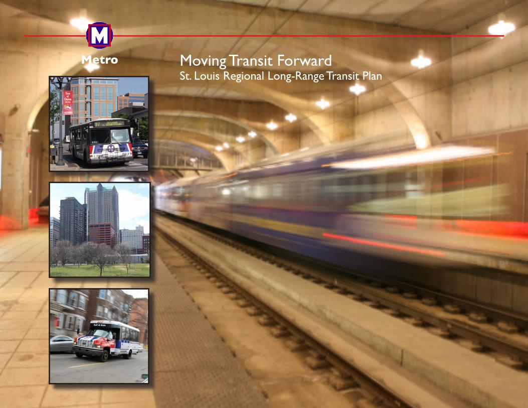
Moving Transit ForwardSt. Louis Regional Long-Range Transit Plan
Metro
St. Louis Regional Long-Range Transit Plan Moving Transit Forward
Message from the President and CEO For the first time, the St. Louis metropolitan area has a long-range plan that presents a comprehensive vision for the future of public transit over the next 30 years. As President and CEO of Metro, I am pleased to provide you with a copy of Moving Transit Forward, the plan we believe presents a realistic and responsible road map that our region can follow in its endeavor to build a world-class public transit system. This plan was developed over more than a year of consistent study and effort by Metro and the East-West Gateway Council of Governments. It combines state-of-the-art transit science, professional urban and transit planning experience, and direct input from the community to reposition the Metro System to better connect people to jobs and other important destinations, and to act as a powerful engine of economic growth and development throughout the region. Moving Transit Forward establishes a shared community vision to meet those goals, based upon a realistic appraisal of our region’s public transit needs over the next three decades, the most effective options to meet those diverse needs, and the financial resources available to pursue recommended system improvements and expansion options. The plan incorporates the proven strengths of bus, light rail and paratransit service strategies, as well as innovative concepts new to St. Louis, such as Bus Rapid Transit and commuter rail. It balances the very real need for a stronger, more extensive transit system against available economic resources. It provides the region’s leadership with the vision and the tools to overcome the significant challenges Metro faces in delivering the kind of robust transit services we need to make the St. Louis a region a more vibrant community and a more competitive force in the global economy. Ultimately, Moving Transit Forward will better connect all our citizens to jobs, education, healthcare, commerce, and to each other. We believe Moving Transit Forward can be a valuable asset as we work together to meet our region’s transit needs in the months and years ahead. Sincerely,
Robert J. Baer President and CEO
St. Louis Regional Long-Range Transit Plan Moving Transit Forward
TABLE OF CONTENTS
LP MESSAGE FROM THE PRESIDENT & CEO
ES EXECUTIVE SUMMARY ................................................. i
1.0 INTRODUCTION ............................................................ 2
2.0 EXISTING METRO SYSTEM ......................................... 3
2.1 Metro Agency ........................................................ 3
2.2 Metro Transit System ............................................ 3
2.3 Passenger Information Services ........................... 7
3.0 REGIONAL MOBILITY NEEDS ..................................... 9
3.1 Population and Employment Trends ..................... 9
3.2 Land Use Trends ................................................. 15
3.3 Regional Mobility Patterns ................................... 18
4.0 PLANNING RESEARCH .............................................. 21
4.1 Metro System Performance Analysis .................. 21
4.2 Market Research ................................................. 25
4.3 Previous Planning Studies and Regional
Infrastructure Improvements ............................... 26
4.4 National and Local Transit Planning Principles ... 27
4.5 Types of Transit and System Enhancements
Considered .......................................................... 28
5.0 COMMUNITY ENGAGEMENT ..................................... 34
5.1 Community Engagement – Series 1 .................... 34
5.2 Moving Transit Forward Advisory Group ............. 36
5.3 Executive Committee ........................................... 36
5.4 Moving Transit Forward Website ......................... 36
6.0 A 30-YEAR VISION ...................................................... 37
6.1 Evaluation Criteria ............................................... 37
6.2 Financial Analysis ................................................ 41
7.0 MOVING TRANSIT FORWARD LONG-RANGE PLAN 50
7.1 Community Engagement – Series 2 .................... 50
7.2 The 30-Year Plan ................................................ 51
7.3 Community Engagement – Series 3 .................... 57
8.0 SUMMARY ................................................................... 58
St. Louis Regional Long-Range Transit Plan Moving Transit Forward
FIGURES Figure 1 Long-Range Planning Process ……………….… 2
Figure 2 Metro Transit System Map…………………...…. 4
Figure 3 MetroLink Station Map…………………………… 5
Figure 4 MetroBus Route System Map……………….….. 6
Figure 5 Metro Call-A-Ride Service Areas…………..…… 8
Figure 6 St. Louis MSA Change in Population and Employment, 2000 – 2008…………………... 10
Figure 7 St. Louis MSA and EWGCOG Planning Area…. 10
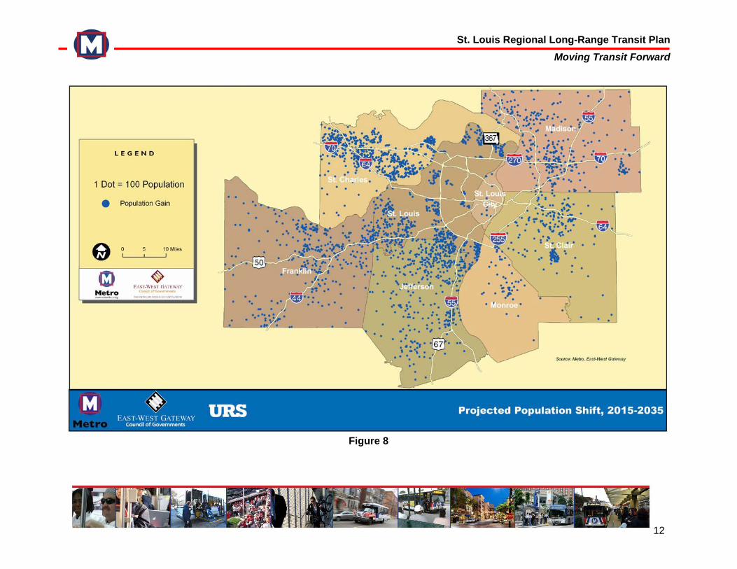
Figure 8 Projected Population Shift, 2015 – 2035 ………. 12
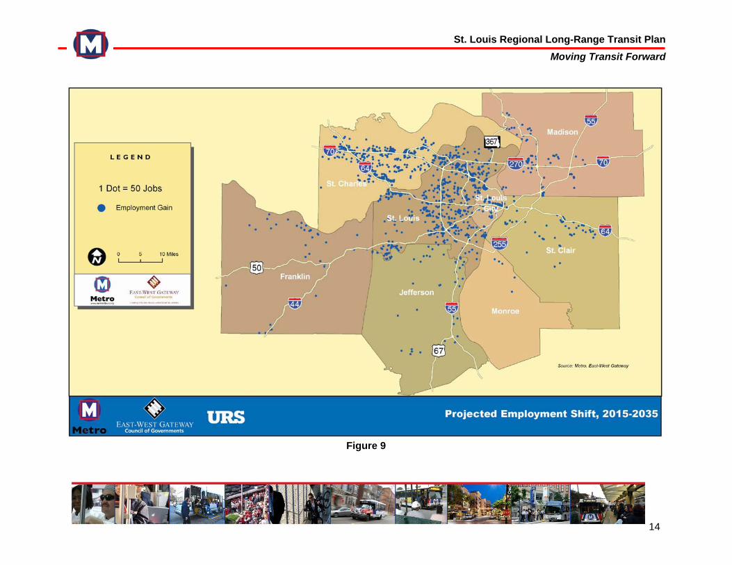
Figure 9 Projected Employment Shift, 2015 – 2035 .…. 14
Figure 10 Employment Centers in the St. Louis Region….. 17
Figure 11 Change in Employment 2000 – 2006 ……….… 19
Figure 12 MetroBus Route Performance, April 2008 – March 2009………………………………….… 22 Figure 13 MetroBus Corridor Performance, April 2008 – March 2009……………………………………. 23 Figure 14 MetroBus Route Performance, Post March 30,
2009 Reductions……………………………. 23 Figure 15 MetroBus Corridor Performance, Post March 30,
2009 Reductions…………………..……….. 24 Figure 16 Moving Transit Forward Plan
Options……………………………….……… 35 Figure 17 Preliminary Transit Options
Evaluation……………………………….…. 40 Figure 18 Moving Transit Forward Plan Options……….. 53
TABLES
Table 1 Metro’s System Ridership, 2004-2008………..… 5
Table 2 Population Change, 2000-2035……………….… 11
Table 3 Employment Change, 2000-2035………………. 15
Table 4 Total Weekday Work-Trips to Employment
Centers, 2009, 2014, 2035………….……... 20
Table 5 30-Year Transit Investment Plan: Capital and
Operating Costs……………………………… 44
Table 6 Average Annual Expenditures…………..……... 46
GLOSSARY…………………………………………………….. 58
APPENDIX (separate document) Appendix A Home Base Work Trips Data
Appendix B Baseline Survey 2009
Appendix C Focus Group Report
Appendix D Public Meetings: Series 1, 2, 3
Appendix E Advisory Group
Appendix F Executive Committee
Appendix G Metro Board of Commissioners and East-West Gateway Council of Governments
i
Why is transit important?Great cities have great transit systems. The St. Louis region is a wonderful place in which to live, work, and play, but in recent decades its population and job growth has stagnated. To change this, the region must move forward and boldly redefine itself as a catalyst for entrepreneurism, an attractor of talented young professionals, and a place that considers the needs of all its citizens. Transit alone will not make this happen, but it does play a vital role in shaping the region’s quality of life and growing its economy. Here’s how . . .
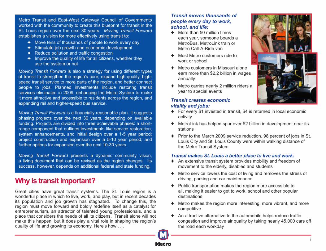
Transit moves thousands of people every day to work, school, and life:
✦ More than 50 million times each year, someone boards a MetroBus, MetroLink train or Metro Call-A-Ride van
✦ Most Metro customers ride to work or school
✦ Metro customers in Missouri alone earn more than $2.2 billion in wages annually
✦ Metro carries nearly 2 million riders a year to special events
Transit creates economic vitality and jobs:
✦ For every $1 invested in transit, $4 is returned in local economic activity
✦ MetroLink has helped spur over $2 billion in development near its stations
✦ Prior to the March 2009 service reduction, 98 percent of jobs in St. Louis City and St. Louis County were within walking distance of the Metro Transit System
Transit makes St. Louis a better place to live and work: ✦ An extensive transit system provides mobility and freedom of
movement to the elderly, disabled and students ✦ Metro service lowers the cost of living and removes the stress of
driving, parking and car maintenance ✦ Public transportation makes the region more accessible to
all, making it easier to get to work, school and other popular destinations
✦ Metro makes the region more interesting, more vibrant, and more competitive
✦ An attractive alternative to the automobile helps reduce traffic congestion and improve air quality by taking nearly 45,000 cars off the road each workday
Metro Transit and East-West Gateway Council of Governments worked with the community to create this blueprint for transit in the St. Louis region over the next 30 years. Moving Transit Forward establishes a vision for more effectively using transit to:
Moving Transit Forward is also a strategy for using different types of transit to strengthen the region’s core, expand high-quality, high-speed transit service to more parts of the region, and better connect people to jobs. Planned investments include restoring transit services eliminated in 2009, enhancing the Metro System to make it more attractive and accessible to residents across the region, and expanding rail and higher-speed bus service.
Moving Transit Forward is a financially reasonable plan. It suggests phasing projects over the next 30 years, depending on available funding. Projects are divided into three achievable phases: a short-range component that outlines investments like service restoration, system enhancements, and initial design over a 1-5 year period; project construction and expansion over a 5-10 year period; and further options for expansion over the next 10-30 years. Moving Transit Forward presents a dynamic community vision, a living document that can be revised as the region changes. Its success, however, depends on additional federal and state funding.
✦ Move tens of thousands of people to work every day ✦ Stimulate job growth and economic development ✦ Reduce pollution and traffic congestion ✦ Improve the quality of life for all citizens, whether they
use the system or not
ii
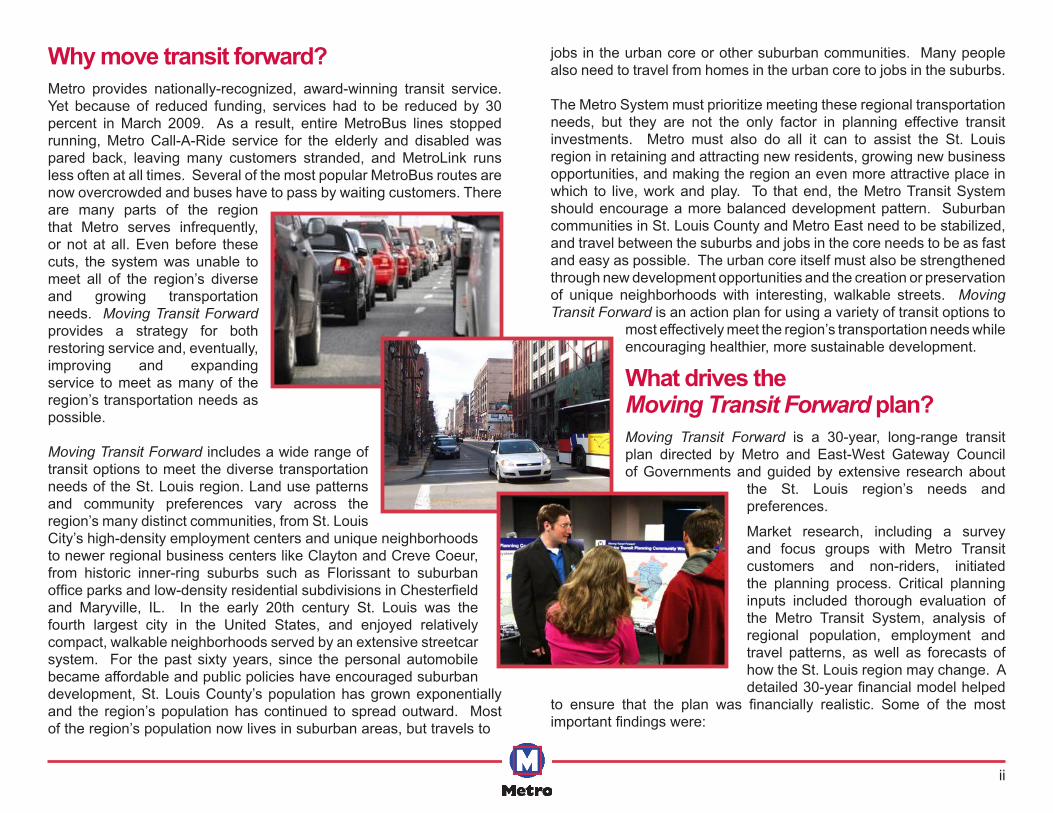
Why move transit forward?Metro provides nationally-recognized, award-winning transit service. Yet because of reduced funding, services had to be reduced by 30 percent in March 2009. As a result, entire MetroBus lines stopped running, Metro Call-A-Ride service for the elderly and disabled was pared back, leaving many customers stranded, and MetroLink runs less often at all times. Several of the most popular MetroBus routes are now overcrowded and buses have to pass by waiting customers. There are many parts of the region that Metro serves infrequently, or not at all. Even before these cuts, the system was unable to meet all of the region’s diverse and growing transportation needs. Moving Transit Forward provides a strategy for both restoring service and, eventually, improving and expanding service to meet as many of the region’s transportation needs as possible.
Moving Transit Forward includes a wide range of transit options to meet the diverse transportation needs of the St. Louis region. Land use patterns and community preferences vary across the region’s many distinct communities, from St. Louis City’s high-density employment centers and unique neighborhoods to newer regional business centers like Clayton and Creve Coeur, from historic inner-ring suburbs such as Florissant to suburban office parks and low-density residential subdivisions in Chesterfield and Maryville, IL. In the early 20th century St. Louis was the fourth largest city in the United States, and enjoyed relatively compact, walkable neighborhoods served by an extensive streetcar system. For the past sixty years, since the personal automobile became affordable and public policies have encouraged suburban development, St. Louis County’s population has grown exponentially and the region’s population has continued to spread outward. Most of the region’s population now lives in suburban areas, but travels to
jobs in the urban core or other suburban communities. Many people also need to travel from homes in the urban core to jobs in the suburbs.
The Metro System must prioritize meeting these regional transportation needs, but they are not the only factor in planning effective transit investments. Metro must also do all it can to assist the St. Louis region in retaining and attracting new residents, growing new business opportunities, and making the region an even more attractive place in which to live, work and play. To that end, the Metro Transit System should encourage a more balanced development pattern. Suburban communities in St. Louis County and Metro East need to be stabilized, and travel between the suburbs and jobs in the core needs to be as fast and easy as possible. The urban core itself must also be strengthened through new development opportunities and the creation or preservation of unique neighborhoods with interesting, walkable streets. Moving Transit Forward is an action plan for using a variety of transit options to
most effectively meet the region’s transportation needs while encouraging healthier, more sustainable development.
What drives the Moving Transit Forward plan?Moving Transit Forward is a 30-year, long-range transit plan directed by Metro and East-West Gateway Council of Governments and guided by extensive research about
the St. Louis region’s needs and preferences.
Market research, including a survey and focus groups with Metro Transit customers and non-riders, initiated the planning process. Critical planning inputs included thorough evaluation of the Metro Transit System, analysis of regional population, employment and travel patterns, as well as forecasts of how the St. Louis region may change. A detailed 30-year financial model helped
to ensure that the plan was financially realistic. Some of the most important findings were:
iii
✦ 87 percent of survey respondents thought that public transit is “important” or “very important” to a community’s quality of life.
✦ Population and employment growth in the St. Louis region has been fairly static, with very limited growth over the past decade.
✦ While revenue sources have remained flat or fallen, the costs of providing Metro service have risen due to normal inflation, making it difficult to fund transit operations and severely limits opportunities for transit system expansion.
✦ The success of transit investments is fundamentally driven by high concentrations of population and employment, and land use and economic development policies that encourage denser development.
✦ Metro System performance confirms that population and employment density drives transit success. The MetroBus routes with the greatest ridership demand, such as the #70 Grand, #4 Natural Bridge, and #64 Lucas Hunt, are those that serve the region’s more densely populated areas.
✦ The region’s largest employment corridor includes Downtown, Grand Boulevard/Saint Louis University, the Central West End and Clayton.
✦ The region also has smaller but growing employment centers, such as Brentwood/Richmond Heights, Westport and Earth City, which could support and benefit from increased transit service. Higher-density, more transit-friendly land use regulations would help make that possible.
✦ Today, St. Louis County attracts the highest share of the region’s work trips, and the City of St. Louis attracts the second-highest share.
What types of transit and technologies were considered for Moving Transit Forward?Some of the transit options considered for inclusion in the plan are familiar to St. Louis residents, such as expanded light rail (MetroLink), paratransit (Call-A-Ride) and conventional bus (MetroBus) service. Others, like Bus Rapid Transit and commuter rail, would be new additions to the Metro System. The plan also includes options to
enhance existing services, making Metro Transit more attractive and accessible to people across the region. Each of these transit types and service improvements was presented to the community, and the public’s feedback helped determine which of these would be in the plan. The range of services and technologies included in the plan is reflected in the options described below.
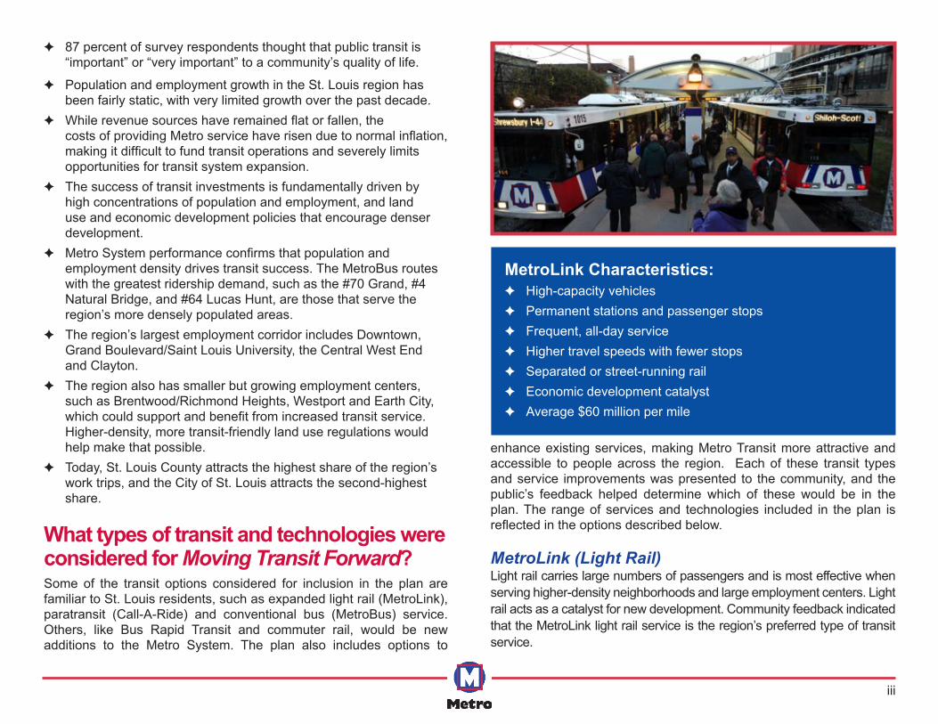
MetroLink (Light Rail)Light rail carries large numbers of passengers and is most effective when serving higher-density neighborhoods and large employment centers. Light rail acts as a catalyst for new development. Community feedback indicated that the MetroLink light rail service is the region’s preferred type of transit service.
MetroLink Characteristics: ✦ High-capacity vehicles ✦ Permanent stations and passenger stops ✦ Frequent, all-day service ✦ Higher travel speeds with fewer stops ✦ Separated or street-running rail ✦ Economic development catalyst ✦ Average $60 million per mile
iv
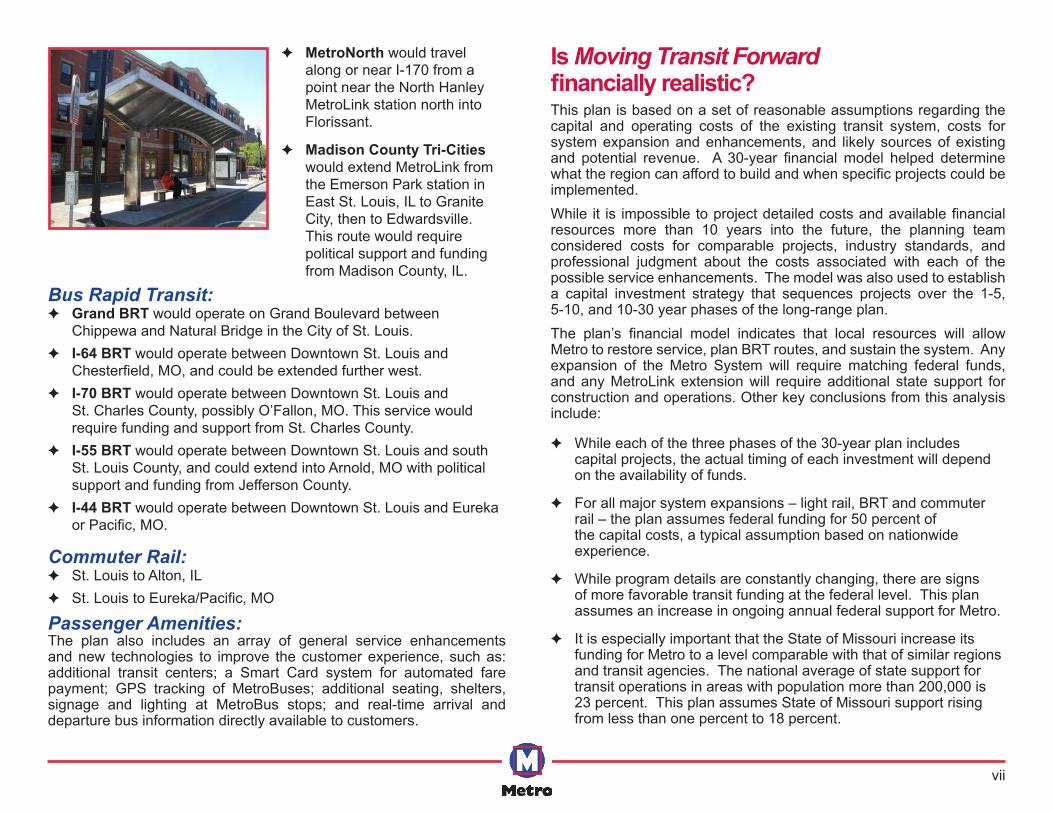
Bus Rapid TransitBus Rapid Transit (BRT) is an innovative type of service that has successfully delivered higher speed, higher capacity service in cities across North and South America. It is a range of bus-based technologies and service strategies that combine many of the features of rail systems with the flexibility and cost savings of buses.
Some BRT systems are urban-oriented services that run along busy roads with stops only at major intersections and other destinations. Other systems offer suburban services on regional highways, using dedicated on-off ramps and park-ride lots.
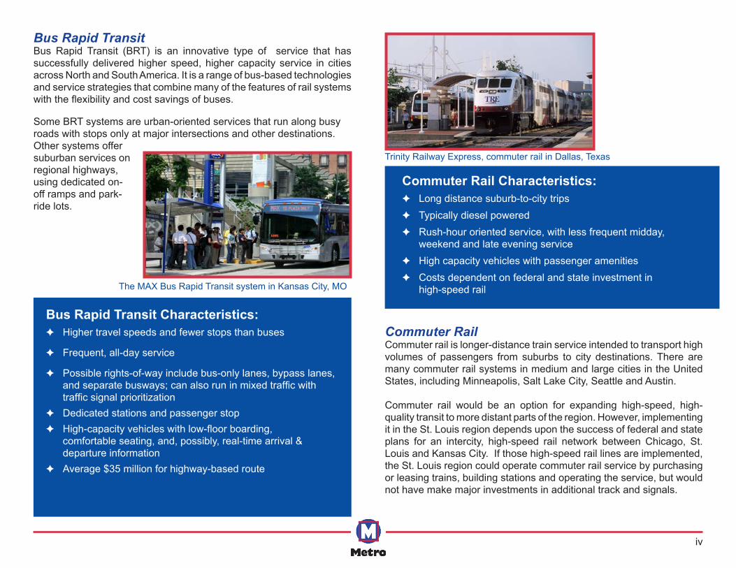
Commuter Rail Commuter rail is longer-distance train service intended to transport high volumes of passengers from suburbs to city destinations. There are many commuter rail systems in medium and large cities in the United States, including Minneapolis, Salt Lake City, Seattle and Austin.
Commuter rail would be an option for expanding high-speed, high-quality transit to more distant parts of the region. However, implementing it in the St. Louis region depends upon the success of federal and state plans for an intercity, high-speed rail network between Chicago, St. Louis and Kansas City. If those high-speed rail lines are implemented, the St. Louis region could operate commuter rail service by purchasing or leasing trains, building stations and operating the service, but would not have make major investments in additional track and signals.
Commuter Rail Characteristics: ✦ Long distance suburb-to-city trips ✦ Typically diesel powered ✦ Rush-hour oriented service, with less frequent midday,
weekend and late evening service ✦ High capacity vehicles with passenger amenities ✦ Costs dependent on federal and state investment in
high-speed rail
Trinity Railway Express, commuter rail in Dallas, Texas
Bus Rapid Transit Characteristics: ✦ Higher travel speeds and fewer stops than buses
✦ Frequent, all-day service
✦ Possible rights-of-way include bus-only lanes, bypass lanes, and separate busways; can also run in mixed traffic with traffic signal prioritization
✦ Dedicated stations and passenger stop ✦ High-capacity vehicles with low-floor boarding,
comfortable seating, and, possibly, real-time arrival & departure information
✦ Average $35 million for highway-based route
The MAX Bus Rapid Transit system in Kansas City, MO
v
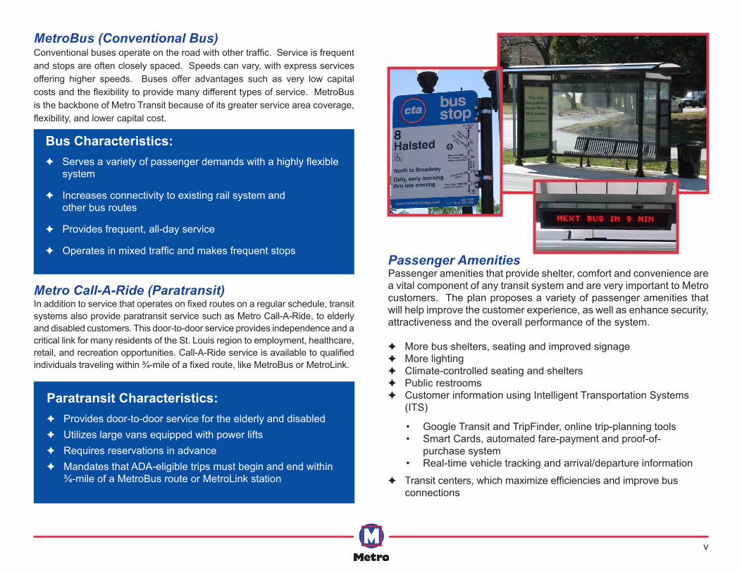
MetroBus (Conventional Bus)Conventional buses operate on the road with other traffic. Service is frequent and stops are often closely spaced. Speeds can vary, with express services offering higher speeds. Buses offer advantages such as very low capital costs and the flexibility to provide many different types of service. MetroBus is the backbone of Metro Transit because of its greater service area coverage, flexibility, and lower capital cost.
Metro Call-A-Ride (Paratransit)In addition to service that operates on fixed routes on a regular schedule, transit systems also provide paratransit service such as Metro Call-A-Ride, to elderly and disabled customers. This door-to-door service provides independence and a critical link for many residents of the St. Louis region to employment, healthcare, retail, and recreation opportunities. Call-A-Ride service is available to qualified individuals traveling within ¾-mile of a fixed route, like MetroBus or MetroLink.
Bus Characteristics: ✦ Serves a variety of passenger demands with a highly flexible
system
✦ Increases connectivity to existing rail system and other bus routes
✦ Provides frequent, all-day service
✦ Operates in mixed traffic and makes frequent stops
Paratransit Characteristics: ✦ Provides door-to-door service for the elderly and disabled ✦ Utilizes large vans equipped with power lifts ✦ Requires reservations in advance ✦ Mandates that ADA-eligible trips must begin and end within
¾-mile of a MetroBus route or MetroLink station
Passenger AmenitiesPassenger amenities that provide shelter, comfort and convenience are a vital component of any transit system and are very important to Metro customers. The plan proposes a variety of passenger amenities that will help improve the customer experience, as well as enhance security, attractiveness and the overall performance of the system.
✦ More bus shelters, seating and improved signage ✦ More lighting ✦ Climate-controlled seating and shelters ✦ Public restrooms ✦ Customer information using Intelligent Transportation Systems
(ITS)
✦ Transit centers, which maximize efficiencies and improve bus connections
• Google Transit and TripFinder, online trip-planning tools• Smart Cards, automated fare-payment and proof-of-
purchase system• Real-time vehicle tracking and arrival/departure information
vi
How were specific corridors and types of service evaluated?The planning team selected corridors for possible service expansion using transit planning research and community input. The plan also identifies the types of transit that may be most effective for servicing each of these corridors. Once a broad range of plan options was established, nine community values guided the selection of specific projects and service enhancements for inclusion in the plan. These values include:
✦ Provides transit service to more people and places ✦ Improves transit’s image as a regional asset ✦ Enhances mobility options for transit-dependent residents ✦ Attracts federal funding ✦ Positively impacts and supports development ✦ Protects our natural environment ✦ Strengthens our regional core ✦ Provides cost-effective improvements ✦ Can be implemented in a reasonable amount of time
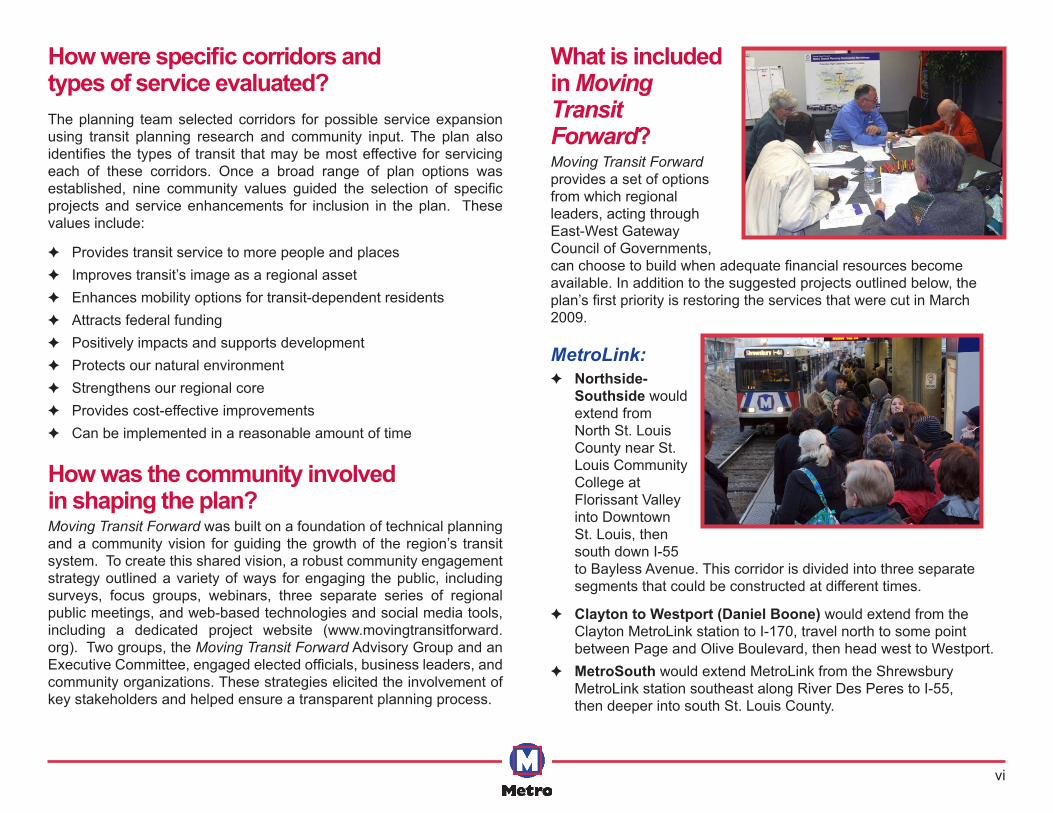
How was the community involved in shaping the plan?Moving Transit Forward was built on a foundation of technical planning and a community vision for guiding the growth of the region’s transit system. To create this shared vision, a robust community engagement strategy outlined a variety of ways for engaging the public, including surveys, focus groups, webinars, three separate series of regional public meetings, and web-based technologies and social media tools, including a dedicated project website (www.movingtransitforward.org). Two groups, the Moving Transit Forward Advisory Group and an Executive Committee, engaged elected officials, business leaders, and community organizations. These strategies elicited the involvement of key stakeholders and helped ensure a transparent planning process.
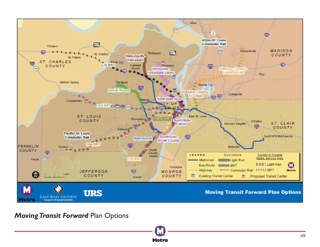
What is included in Moving Transit Forward?Moving Transit Forward provides a set of options from which regional leaders, acting through East-West Gateway Council of Governments, can choose to build when adequate financial resources become available. In addition to the suggested projects outlined below, the plan’s first priority is restoring the services that were cut in March 2009.
MetroLink: ✦ Northside-
Southside would extend from North St. Louis County near St. Louis Community College at Florissant Valley into Downtown St. Louis, then south down I-55 to Bayless Avenue. This corridor is divided into three separate segments that could be constructed at different times.
✦ Clayton to Westport (Daniel Boone) would extend from the Clayton MetroLink station to I-170, travel north to some point between Page and Olive Boulevard, then head west to Westport.
✦ MetroSouth would extend MetroLink from the Shrewsbury MetroLink station southeast along River Des Peres to I-55, then deeper into south St. Louis County.
vii
Bus Rapid Transit: ✦ Grand BRT would operate on Grand Boulevard between
Chippewa and Natural Bridge in the City of St. Louis. ✦ I-64 BRT would operate between Downtown St. Louis and
Chesterfield, MO, and could be extended further west. ✦ I-70 BRT would operate between Downtown St. Louis and
St. Charles County, possibly O’Fallon, MO. This service would require funding and support from St. Charles County.
✦ I-55 BRT would operate between Downtown St. Louis and south St. Louis County, and could extend into Arnold, MO with political support and funding from Jefferson County.
✦ I-44 BRT would operate between Downtown St. Louis and Eureka or Pacific, MO.
Commuter Rail: ✦ St. Louis to Alton, IL ✦ St. Louis to Eureka/Pacific, MO
Passenger Amenities:The plan also includes an array of general service enhancements and new technologies to improve the customer experience, such as: additional transit centers; a Smart Card system for automated fare payment; GPS tracking of MetroBuses; additional seating, shelters, signage and lighting at MetroBus stops; and real-time arrival and departure bus information directly available to customers.
Is Moving Transit Forwardfinancially realistic? This plan is based on a set of reasonable assumptions regarding the capital and operating costs of the existing transit system, costs for system expansion and enhancements, and likely sources of existing and potential revenue. A 30-year financial model helped determine what the region can afford to build and when specific projects could be implemented. While it is impossible to project detailed costs and available financial resources more than 10 years into the future, the planning team considered costs for comparable projects, industry standards, and professional judgment about the costs associated with each of the possible service enhancements. The model was also used to establish a capital investment strategy that sequences projects over the 1-5, 5-10, and 10-30 year phases of the long-range plan. The plan’s financial model indicates that local resources will allow Metro to restore service, plan BRT routes, and sustain the system. Any expansion of the Metro System will require matching federal funds, and any MetroLink extension will require additional state support for construction and operations. Other key conclusions from this analysis include:
✦ While each of the three phases of the 30-year plan includes capital projects, the actual timing of each investment will depend on the availability of funds.
✦ For all major system expansions – light rail, BRT and commuter rail – the plan assumes federal funding for 50 percent of the capital costs, a typical assumption based on nationwide experience.
✦ While program details are constantly changing, there are signs of more favorable transit funding at the federal level. This plan assumes an increase in ongoing annual federal support for Metro.
✦ It is especially important that the State of Missouri increase its funding for Metro to a level comparable with that of similar regions and transit agencies. The national average of state support for transit operations in areas with population more than 200,000 is 23 percent. This plan assumes State of Missouri support rising from less than one percent to 18 percent.
✦ MetroNorth would travel
along or near I-170 from a point near the North Hanley MetroLink station north into Florissant.
✦ Madison County Tri-Cities would extend MetroLink from the Emerson Park station in East St. Louis, IL to Granite City, then to Edwardsville. This route would require political support and funding from Madison County, IL.
viii
Moving Transit Forward Plan Options
ix
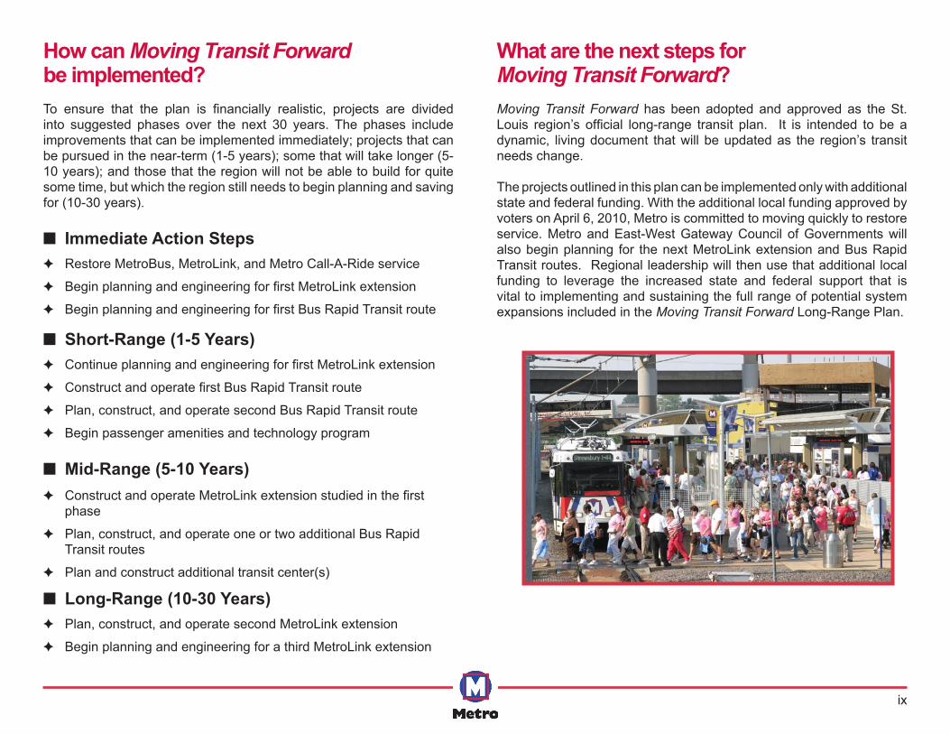
How can Moving Transit Forwardbe implemented? To ensure that the plan is financially realistic, projects are divided into suggested phases over the next 30 years. The phases include improvements that can be implemented immediately; projects that can be pursued in the near-term (1-5 years); some that will take longer (5-10 years); and those that the region will not be able to build for quite some time, but which the region still needs to begin planning and saving for (10-30 years).
■ Immediate Action Steps ✦ Restore MetroBus, MetroLink, and Metro Call-A-Ride service
✦ Begin planning and engineering for first MetroLink extension
✦ Begin planning and engineering for first Bus Rapid Transit route
■ Short-Range (1-5 Years) ✦ Continue planning and engineering for first MetroLink extension
✦ Construct and operate first Bus Rapid Transit route
✦ Plan, construct, and operate second Bus Rapid Transit route
✦ Begin passenger amenities and technology program
■ Mid-Range (5-10 Years) ✦ Construct and operate MetroLink extension studied in the first
phase
✦ Plan, construct, and operate one or two additional Bus Rapid Transit routes
✦ Plan and construct additional transit center(s)
■ Long-Range (10-30 Years) ✦ Plan, construct, and operate second MetroLink extension
✦ Begin planning and engineering for a third MetroLink extension
What are the next steps for Moving Transit Forward?Moving Transit Forward has been adopted and approved as the St. Louis region’s official long-range transit plan. It is intended to be a dynamic, living document that will be updated as the region’s transit needs change.
The projects outlined in this plan can be implemented only with additional state and federal funding. With the additional local funding approved by voters on April 6, 2010, Metro is committed to moving quickly to restore service. Metro and East-West Gateway Council of Governments will also begin planning for the next MetroLink extension and Bus Rapid Transit routes. Regional leadership will then use that additional local funding to leverage the increased state and federal support that is vital to implementing and sustaining the full range of potential system expansions included in the Moving Transit Forward Long-Range Plan.
St. Louis Regional Long-Range Transit Plan Moving Transit Forward
This page intentionally left blank.
St. Louis Regional Long-Range Transit Plan Moving Transit Forward
2
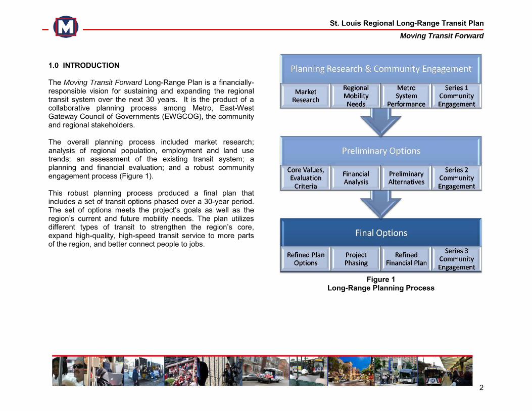
1.0 INTRODUCTION The Moving Transit Forward Long-Range Plan is a financially-responsible vision for sustaining and expanding the regional transit system over the next 30 years. It is the product of a collaborative planning process among Metro, East-West Gateway Council of Governments (EWGCOG), the community and regional stakeholders. The overall planning process included market research; analysis of regional population, employment and land use trends; an assessment of the existing transit system; a planning and financial evaluation; and a robust community engagement process (Figure 1). This robust planning process produced a final plan that includes a set of transit options phased over a 30-year period. The set of options meets the project’s goals as well as the region’s current and future mobility needs. The plan utilizes different types of transit to strengthen the region’s core, expand high-quality, high-speed transit service to more parts of the region, and better connect people to jobs.
Figure 1
Long-Range Planning Process
St. Louis Regional Long-Range Transit Plan Moving Transit Forward
3
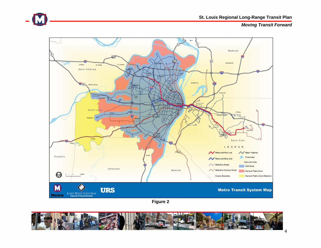
2.0 EXISTING METRO SYSTEM The St. Louis transit system is operated and maintained by Metro, the regional transit agency. Metro runs an award-winning transit system with three integrated services: MetroLink, MetroBus, and Metro Call-A-Ride, the region’s paratransit service (Figure 2). The Metro Service Area includes the City of St. Louis, St. Louis County, and portions of St. Clair County in Illinois. 2.1 Metro Agency Metro, formerly known as the Bi-State Development Agency, was created through a compact between the States of Missouri and Illinois, ratified by the United States Congress in 1949. In addition to the Metro Transit System, Metro owns and operates the Downtown St. Louis Airport and its surrounding industrial business park. Metro also manages the Gateway Arch Revenue Collections Center, the Gateway Arch Transportation System, the Gateway Arch Riverboats, and the Gateway Arch Parking Facility.
Metro's 10-member Board of Commissioners provides overall leadership and policy direction and is composed of five members from Illinois and five from Missouri. In Missouri, members are selected by the Governor. In Illinois, the Chairmen of the Board for St. Clair and Madison Counties appoint their representatives. Board members serve five-year terms and must be a resident voter of their state, as well as reside within the bi-state metropolitan region.
Metro System operations are supported by passenger fares, sales taxes from St. Louis City and County, funding from the St. Clair County Transit District, and federal and state grants.
2.2 Metro Transit System The Metro Transit System carried over 53 million passengers on MetroLink, MetroBus, and Metro Call-A-Ride in 2008. Table 1 provides annual ridership data for the Metro Transit System between 2004 and 2008. Ridership has steadily improved with annual boardings increasing from 45 million to 53 million. Throughout 2009, the Metro Transit System faced several major challenges in maintaining consistent quality and levels of service. Escalating budget constraints forced Metro to make severe reductions: 32 percent of MetroBus, 23 percent of MetroLink, and 30 percent of Call-A-Ride service was cut throughout the entire St. Louis area. In August 2009, a $12 million special appropriation by the State of Missouri partially restored bus service to the Metro Transit System. These reductions have negatively impacted ridership and the system’s overall geographic coverage.
St. Louis Regional Long-Range Transit Plan Moving Transit Forward
4
Figure 2
St. Louis Regional Long-Range Transit Plan Moving Transit Forward
5
Table 1 Metro’s System Ridership, 2004-2008
Mode 2004 2005 2006 2007 2008
Bus (MO) 27,486,000 27,555,000 29,841,000 29,002,000 30,697,000
MetroLink (MO) 10,419,000 11,118,000 10,974,000 14,090,000 15,102,000
Call-A-Ride 682,000 676,000 668,000 664,000 700,000
Bus (IL) 2,773,000 2,476,000 2,550,000 2,460,000 2,502,000
MetroLink (IL) 4,090,000 4,531,000 4,417,700 4,628,000 4,594,000
TOTAL SYSTEM* 45,644,000 46,506,000 48,586,000 50,943,000 53,767,000
Does not include special event ridership
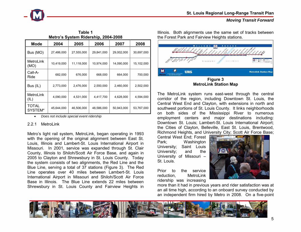
2.2.1 MetroLink Metro’s light rail system, MetroLink, began operating in 1993 with the opening of the original alignment between East St. Louis, Illinois and Lambert-St. Louis International Airport in Missouri. In 2001, service was expanded through St. Clair County, Illinois to Shiloh/Scott Air Force Base, and again in 2005 to Clayton and Shrewsbury in St. Louis County. Today the system consists of two alignments, the Red Line and the Blue Line, serving a total of 37 stations (Figure 3). The Red Line operates over 40 miles between Lambert-St. Louis International Airport in Missouri and Shiloh/Scott Air Force Base in Illinois. The Blue Line extends 22 miles between Shrewsbury in St. Louis County and Fairview Heights in
Illinois. Both alignments use the same set of tracks between the Forest Park and Fairview Heights stations.
Figure 3
MetroLink Station Map The MetroLink system runs east-west through the central corridor of the region, including Downtown St. Louis, the Central West End and Clayton, with extensions in north and southwest portions of St. Louis County. It links neighborhoods on both sides of the Mississippi River to numerous employment centers and major destinations including: Downtown St. Louis; Lambert-St. Louis International Airport; the Cities of Clayton, Belleville, East St. Louis, Brentwood, Richmond Heights, and University City; Scott Air Force Base; Central West End; Forest Park; Washington University; Saint Louis University; and the University of Missouri – St. Louis. Prior to the service reduction, MetroLink ridership was increasing more than it had in previous years and rider satisfaction was at an all time high, according to an onboard survey conducted by an independent firm hired by Metro in 2008. On a five-point
St. Louis Regional Long-Range Transit Plan Moving Transit Forward
6
scale, with five equaling “very satisfied,” riders reported a 4.4 satisfaction rating, an increase from 4.1 in 2007. Factors that contributed to riders’ overall satisfaction with the system included on-time performance, cleanliness, and the maintenance of stations. Several other factors also contributed to an increase in the perceived value expressed by Metro riders, including service and infrastructure improvements, particularly the Cross-County MetroLink Extension to Shrewsbury; increased system connectivity and hub-and-spoke development; enhanced commuter express routing; and focused security and fare enforcement efforts. 2.2.2 MetroBus Metro’s bus system, MetroBus, operates in both Missouri and Illinois. The Missouri routes serve the City of St. Louis and St. Louis County, and the Illinois routes serve St. Clair County. Prior to the March 30, 2009 service cuts, MetroBus served 34 million annual passenger boardings on 59 bus routes in Missouri and 17 in Illinois. On March 30 2009, Metro was forced to cut MetroBus service in Missouri by 32 percent, reducing the number of bus routes from 59 to 35 and bus stops served from 8,100 to 6,050. On August 3, 2009, Metro received a one-time $12 million appropriation from the State of Missouri and a $3.8 million grant from the Federal Congestion Mitigation and Air Quality (CMAQ) program. With these one-time, temporary funding
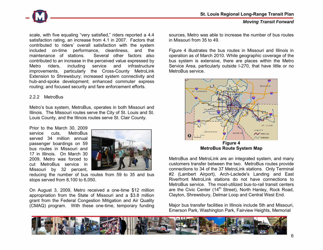
sources, Metro was able to increase the number of bus routes in Missouri from 35 to 49. Figure 4 illustrates the bus routes in Missouri and Illinois in operation as of March 2010. While geographic coverage of the bus system is extensive, there are places within the Metro Service Area, particularly outside I-270, that have little or no MetroBus service.
Figure 4
MetroBus Route System Map MetroBus and MetroLink are an integrated system, and many customers transfer between the two. MetroBus routes provide connections to 34 of the 37 MetroLink stations. Only Terminal #2 (Lambert Airport), Arch-Laclede's Landing and East Riverfront MetroLink stations do not have connections to MetroBus service. The most-utilized bus-to-rail transit centers are the Civic Center (14th Street), North Hanley, Rock Road, Clayton, Shrewsbury, Delmar Loop and Central West End. Major bus transfer facilities in Illinois include 5th and Missouri, Emerson Park, Washington Park, Fairview Heights, Memorial
St. Louis Regional Long-Range Transit Plan Moving Transit Forward
7
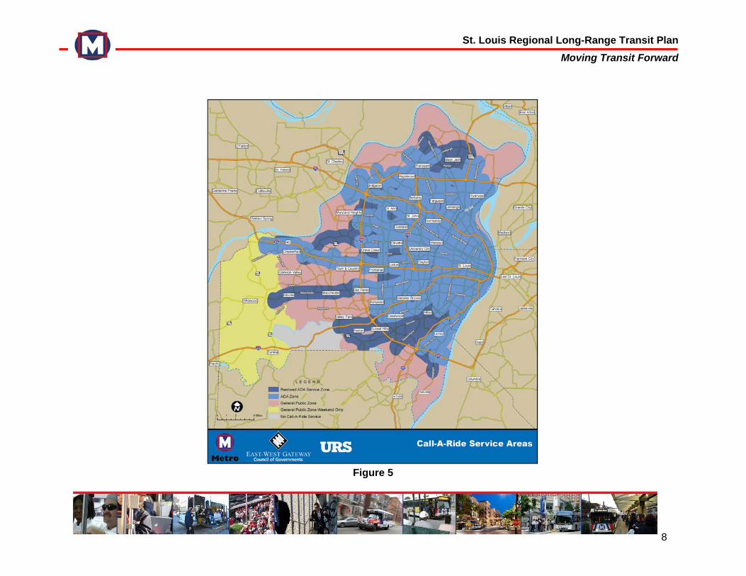
Hospital, Swansea, Belleville, College and the Shiloh-Scott Air Force Base Stations. Metro also provides 35 park-ride lots located throughout the St. Louis region. Most lots have access to both MetroLink and MetroBus routes, though some provide only MetroBus access. Metro has five bus-only transit centers: Riverview, Ballas, Hampton-Gravois, Broadway-Taylor and Catalan Loop. These transit centers give commuters shelter and parking options, as well as convenient transfers to other MetroBus routes. The park-ride lots are free to customers, with the exception of the Clayton lot. Prior to the March 2009 service reductions, MetroBus ridership was steady and customer satisfaction was increasing. According to a MetroBus onboard survey conducted by Metro in 2008, MetroBus riders were mostly satisfied with service. On a five-point scale, riders reported a 4.0 satisfaction rating, which was an increase from 3.7 in 2007. For MetroBus customers, the elements of customer service that had the greatest impact on overall satisfaction were the value of service for fare paid, on-time performance, driver ability to safely operate vehicle, ability to travel when and where desired, and driver courtesy. 2.2.3 Call-A-Ride - Paratransit Metro Call-A-Ride provides door-to-door van service in St. Louis City and County. Service is provided to Americans with Disabilities Act (ADA)-eligible customers who have registered to use the service, as well as the general public. The Call-A-Ride service areas are shown in Figure 5. Trips must originate and end within ¾ of a mile from a MetroLink station or MetroBus route.
ADA service is available to registered ADA-eligible customers taking an ADA-mandated trip within the blue-shaded area (shown on Figure 5). Non-ADA-eligible customers or non-ADA-mandated trips may be taken within the blue shaded area, but these customers must pay a much higher, mileage-based fare. Non-ADA service is available to everyone within the pink-shaded area daily, and in the yellow-shaded area on Saturday and Sunday. 2.3 Passenger Information Services 2.3.1 Customer Service Call-Center Metro operates a Customer Service Call-Center Monday through Friday, 7:30 AM to 4:30 PM. Customers can call or send questions via email. This service allows customers to inquire about Metro Transit System services, get information and voice complaints. The majority of calls seek transit information, while the remainder are suggestions, inquiries, and general comments or complaints. 2.3.2 Metro Website
Metro maintains and Agency website, www.metrostlouis.org. Visitors to the site can access information on the Metro System, including schedules and maps. The website provides service alerts, route changes, fare information and park-ride locations. Customers may also utilize passenger tools such as Trip Finder and Google Transit, which allow users to enter their origin and destination and determine the appropriate transit route for their trip.
St. Louis Regional Long-Range Transit Plan Moving Transit Forward
8
Figure 5
St. Louis Regional Long-Range Transit Plan Moving Transit Forward
9
3.0 REGIONAL MOBILITY NEEDS Metro is committed to effectively and efficiently serving the St. Louis region’s diverse transportation needs. In order to assess current and future mobility needs, Metro must analyze where people live, where they work, and how they travel between the two. The planning team conducted analyses of these patterns, and used this information to evaluate the Metro Transit System’s performance and identify opportunities for enhancing and expanding services. Locating concentrations of population and employment is important in identifying appropriate corridors for future transit expansion and service enhancements. System expansion is most cost-effective in areas where population and development patterns support transit. Such transit-supportive areas include the region’s core, which consists of the City of St. Louis and adjacent suburbs, as well as medium-density suburban areas like Clayton and Maplewood. However, meeting the St. Louis region’s diverse transportation needs is difficult because many of the fastest-growing communities are characterized by low-density suburban development that are largely automobile-oriented, have few walkable communities, and are difficult to efficiently serve by transit. Changes in land
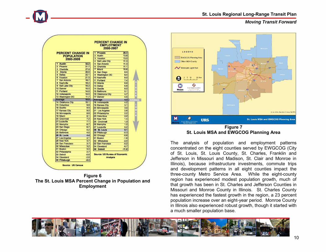
use policy throughout the region could encourage a more balanced development pattern and walkable communities, which would strengthen the regional core, stabilize suburban communities, support transit, and ensure a more sustainable future. 3.1 Population and Employment Trends Population and employment grew modestly over the last eight years. While the growth has not been robust, it has been steady. Figure 6 compares growth in St. Louis to 34 other major metropolitan areas since 2000. The St. Louis Metropolitan Statistical Area (MSA) is made up of 16 counties, eight in Missouri and eight in Illinois (Figure 7). The U.S. Census estimated that the St. Louis MSA had a population of 2.8 million in July 2008, a growth rate of 4.4 percent between 2000 and 2008. Peer regions such as Indianapolis and Kansas City, however, grew two to three times faster. Similarly, employment between 2000 and 2007 grew by just 0.1 percent. While this is a small fraction of the growth rate seen in most other MSAs, St. Louis did avoid net losses in employment through 2007. These employment estimates pre-date the current recession, which triggered deep employment losses throughout the United States.
St. Louis Regional Long-Range Transit Plan Moving Transit Forward
10
Figure 6 The St. Louis MSA Percent Change in Population and
Employment
Figure 7
St. Louis MSA and EWGCOG Planning Area The analysis of population and employment patterns concentrated on the eight counties served by EWGCOG (City of St. Louis, St. Louis County, St. Charles, Franklin and Jefferson in Missouri and Madison, St. Clair and Monroe in Illinois), because infrastructure investments, commute trips and development patterns in all eight counties impact the three-county Metro Service Area. While the eight-county region has experienced modest population growth, much of that growth has been in St. Charles and Jefferson Counties in Missouri and Monroe County in Illinois. St. Charles County has experienced the fastest growth in the region, a 23 percent population increase over an eight-year period. Monroe County in Illinois also experienced robust growth, though it started with a much smaller population base.
St. Louis Regional Long-Range Transit Plan Moving Transit Forward
11
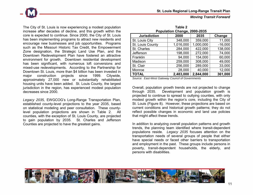
The City of St. Louis is now experiencing a modest population increase after decades of decline, and this growth within the core is expected to continue. Since 2000, the City of St. Louis has been implementing programs to attract new residents and encourage new businesses and job opportunities. Programs such as the Missouri Historic Tax Credit, the Empowerment Zone designation, the Strategic Land Use Plan, and the Downtown Redevelopment Plan have fostered an attractive environment for growth. Downtown residential development has been significant, with numerous loft conversions and mixed-use redevelopments. According to the Partnership for Downtown St. Louis, more than $4 billion has been invested in major construction projects since 1999. Citywide, approximately 27,000 new or substantially rehabilitated housing units have been added. St. Louis County, the largest jurisdiction in the region, has experienced modest population decreases since 2000. Legacy 2035, EWGCOG’s Long-Range Transportation Plan, established county-level projections to the year 2035, based on statistical modeling and peer consultation. These county-level population projections are shown in Table 2. All counties, with the exception of St. Louis County, are projected to gain population by 2035. St. Charles and Jefferson Counties are projected to have the greatest gains.
Table 2 Population Change, 2000-2035
Jurisdiction 2000 2035 Change St. Louis City 348,000 359,000 11,000 St. Louis County 1,016,000 1,000,000 -16,000 St. Charles 284,000 422,000 138,000 Jefferson 198,000 272,000 74,000 Franklin 94,000 154,000 60,000 Madison 259,000 308,000 49,000 St. Clair 256,000 289,000 33,000 Monroe 28,000 40,000 12,000 TOTAL 2,483,000 2,844,000 361,000 Source: East-West Gateway Council of Governments Overall, population growth trends are not projected to change through 2035. Development and population growth is projected to continue to spread to outlying counties, with only modest growth within the region’s core, including the City of St. Louis (Figure 8). However, these projections are based on current conditions and historical growth patterns; they do not reflect possible changes in economic and land use policies that might affect these trends. In addition to analyzing overall population patterns and growth trends, the planning team identified where transit-dependent populations reside. Legacy 2035 focuses attention on the transportation needs of several groups of people that either have special needs or faced other barriers to transportation and employment in the past. These groups include persons in poverty, transit-dependent households, the elderly, and persons with disabilities.
St. Louis Regional Long-Range Transit Plan Moving Transit Forward
12
Figure 8
St. Louis Regional Long-Range Transit Plan Moving Transit Forward
13
According to the 2000 U.S. Census, persons in poverty and transit-dependent households are concentrated in the City of St. Louis and adjacent suburbs, while the disabled and elderly populations are more dispersed but mostly concentrated within the I-270 beltway. Numerous studies in recent decades have shown that a spatial disconnect exists between areas of high job growth and areas with high concentrations of minorities and low-income households. This means the populations that find it most difficult to own and operate a personal vehicle often have to travel long distances for jobs. This spatial mismatch and transportation disconnect only helps to sustain and magnify unemployment and poverty. Using transit to link transportation-disadvantaged individuals with employment opportunities can help bring low-income families out of poverty and provide businesses with the broadest range of potential workers. The geographic patterns of special needs communities are not projected to significantly change in the future. Persons in poverty and transit-dependent households are projected to remain strongly concentrated in the City of St. Louis and adjacent suburbs. The disabled population will remain fairly dispersed. Moreover, as the region’s residents continue to age where they live, the need to provide transit service throughout the region will grow considerably. Employment is spread across all eight counties, though the majority of jobs remain in the City of St. Louis and St. Louis County. The national economic slowdown of 2001 affected the region for the next three to four years; the region lost about 30,000 jobs between 2000 and 2004. Most counties in the region actually experienced modest employment growth from
2000 to 2004, but losses in the City of St. Louis, St. Louis County and Madison County were large enough to reduce employment levels for the region as a whole. Since 2004, the City of St. Louis has rebounded, adding nearly 12,000 jobs. Madison County has regained the jobs it lost. While St. Louis County retains the largest number of jobs in the region, its growth has been relatively flat. St. Charles County continues to add jobs, though its growth rate has slowed in recent years. Almost half of the jobs in the region are located in St. Louis County, and one job in six is located in the City of St. Louis. The Bureau of Labor Statistics estimates that the St. Louis MSA lost over 50,000 jobs between August 2007 and August 2008. It is too early to tell how the current recession will affect different counties in the region. Without taking the current recession into account, regional employment trends are not anticipated to significantly change over the next 30 years. Employment growth is projected to be slow. St. Louis County will continue to host the greatest number of jobs, followed by the City of St. Louis (Table 3). The majority of projected employment growth will continue to occur along major highways in both Missouri and Illinois, though the strongest concentrations of employment will remain within the region’s core (Figure 9). The largest employment centers providing the greatest density of job opportunities will continue to be Downtown St. Louis and Clayton.
St. Louis Regional Long-Range Transit Plan Moving Transit Forward
14
Figure 9
St. Louis Regional Long-Range Transit Plan Moving Transit Forward
15
Table 3
Employment Change, 2000-2035 Jurisdiction 2000 2035 Change
Madison 103,500 111,400 7,900 Monroe 7,900 9,800 1,900 St. Clair 104,000 112,100 8,100 Franklin 37,100 46,800 9,700 Jefferson 47,000 58,900 11,900 St. Charles 103,900 177,700 73,800 St. Louis County 698,700 698,100 -600 St. Louis City 275,100 278,300 3,200 TOTAL 1,377,200 1,493,100 115,900 Source: East-West Gateway Council of Governments; 2000 data from Bureau of Economic Analysis 2035 data from Census Transportation Planning Products
3.2 Land Use Trends Transportation, land use and economic development are inextricably linked. People must travel between home and work; extensive and efficient transportation networks improve the overall quality of life; transportation infrastructure encourages economic development; and land use patterns help determine the effectiveness of transit service. For all these reasons, the St. Louis region’s long-range transit plan must consider current development patterns, possible changes to land use policy, and the potential for using transit to foster economic vitality and sustainable development. Transit is most effective when connecting dense concentrations of population to major employment centers, such as Downtown St. Louis and Clayton. Medium- and
higher-density communities also tend to have walkable neighborhoods, sidewalks, and an active street life that provide a natural focus for transit service. The region’s land use patterns and community preferences vary widely, from St. Louis City’s high-density employment centers and unique neighborhoods to newer regional business centers like Clayton and Creve Coeur, from historic inner-ring suburbs such as Florissant to suburban office parks and low-density residential subdivisions in Chesterfield, MO and Maryville, IL. The Metro System operates an extensive network within the region’s core, but has faced considerable difficulty in providing cost-effective, efficient service to low-density suburban areas, particularly outside the I-270 beltway. Population density is defined by the number of people per square mile. The City of St. Louis has the highest concentration of population in the region. Several suburban communities in St. Louis County have moderate residential density, such as University City, Pine Lawn and Maplewood. A few communities in Illinois, particularly Granite City, East St. Louis and Belleville, also have moderately dense development patterns. The planning team identified the region’s major employment centers by analyzing employment densities and projected future trends. A commonly-cited definition of an employment center is a contiguous area with at least 10 workers per acre and at least 10,000 jobs.1 In order to discover some of the
1 John F. McDonald, "The Identification of Urban Employment
Subcenters." Journal of Urban Economics 21 (1987): 242-258; Genevieve Giuliano and Kenneth Small, "Subcenters in the Los Angeles Region." Regional Science and Urban Economics 21 (1991): 163-82; Robert Cervero and K. L. Wu, "Polycentrism, Commuting and
St. Louis Regional Long-Range Transit Plan Moving Transit Forward
16
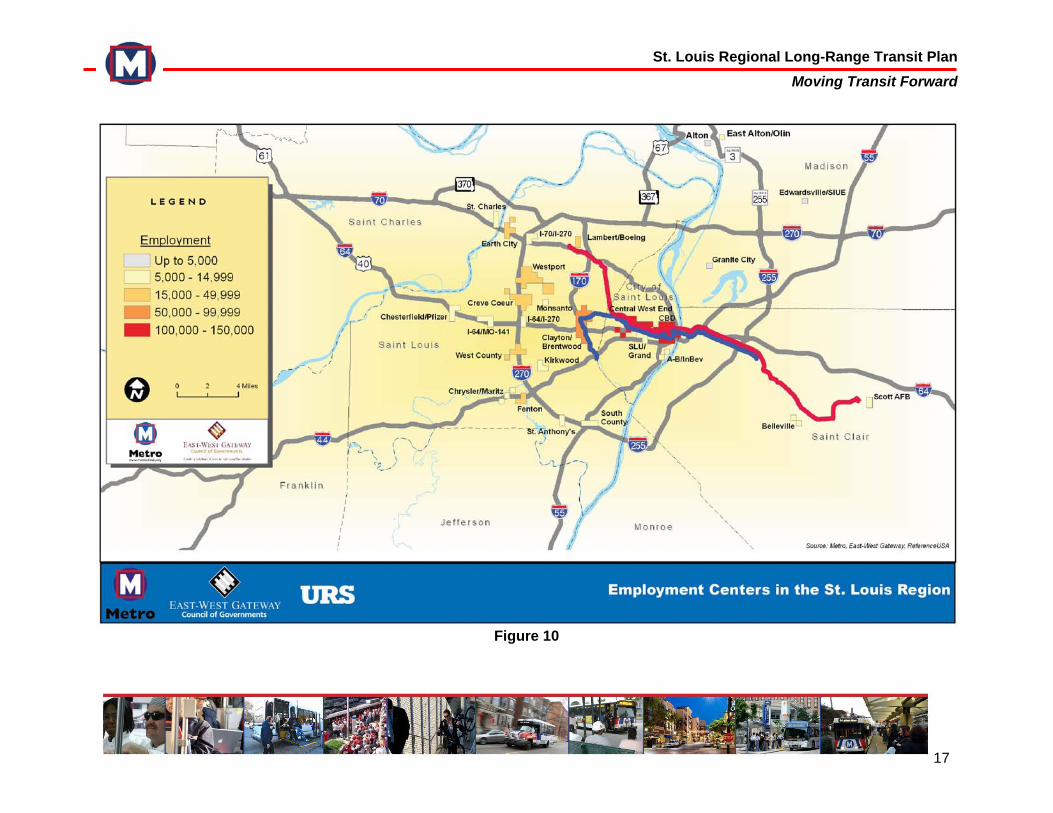
smaller but still significant employment centers, particularly in Illinois, the planning team also examined clusters with a density of 10 workers per acre and at least 5,000 employees (Figure 10).2 According to these criteria, the region’s single largest employment center, hosting more than 165,000 jobs, is a central corridor extending west from Downtown St. Louis to Saint Louis University/Midtown, the Central West End, and Clayton. This central corridor is well-served by MetroLink and MetroBus and is very transit-supportive. It includes business districts and neighborhoods that are walkable, dynamic, and developed with a wide range of mixed uses, including residential, commercial, retail, and even light industrial. The next largest cluster, providing around 75,000 jobs, is Brentwood/Richmond Heights in St. Louis County, which includes the Galleria Mall and the Brentwood Promenade shopping center. This cluster is also well-served by MetroLink and MetroBus, and has concentrations of mixed-use development around the Brentwood/I-64 MetroLink Station. Westport, North Lindbergh/Monsanto, and Olivette/Overland are three contiguous areas that collectively comprise a cluster with about 65,000 jobs. Development in this area largely consists of auto-dependent suburban office parks and corporate campuses, land uses that are difficult to efficiently and cost-effectively serve with transit.
Residential Location in the San Francisco Bay Area." Environment and
Planning A 29, (1997): 856-86. 2 It was deemed appropriate to include smaller employment centers, since
most published work on identifying employment centers has focused on metropolitan areas that are larger than St. Louis.
Other large employment centers include Creve Coeur, particularly the intersection of I-270 and Olive, and Fenton. The data used to create Figure 10 were collected prior to Chrysler LLC’s closing of two automotive assembly plants in the city of Fenton, which would remove Fenton from the “10,000 - 25,000” category. Even without the plants, Fenton remains a significant source of job opportunities. Like Westport and Olivette, these centers are typified by low-density retail and commercial businesses, development patterns that make cost-effective transit service difficult. As stated previously, transit is most effective when serving high-density residential communities and major employment centers. However, transit – particularly rail systems like MetroLink – also offers the potential to generate new transit-oriented development (TOD). TOD is a community design concept that uses higher-density, mixed-use development to maximize pedestrian access to transit systems, encourage transit ridership, and capture retail business from that increased ridership. True TOD is not an isolated project on a single parcel next to a transit station, but rather a comprehensive, community vision for attractive neighborhood development within walking distance of a transit station, generally considered a quarter- to half-mile radius. If regional and municipal land use regulations were updated to encourage TOD, it is possible that future transit investments would foster new development in lower-density areas like Westport and Creve Coeur, which would in turn make those transit investments more efficient and cost-effective.
St. Louis Regional Long-Range Transit Plan Moving Transit Forward
17
Figure 10
St. Louis Regional Long-Range Transit Plan Moving Transit Forward
18
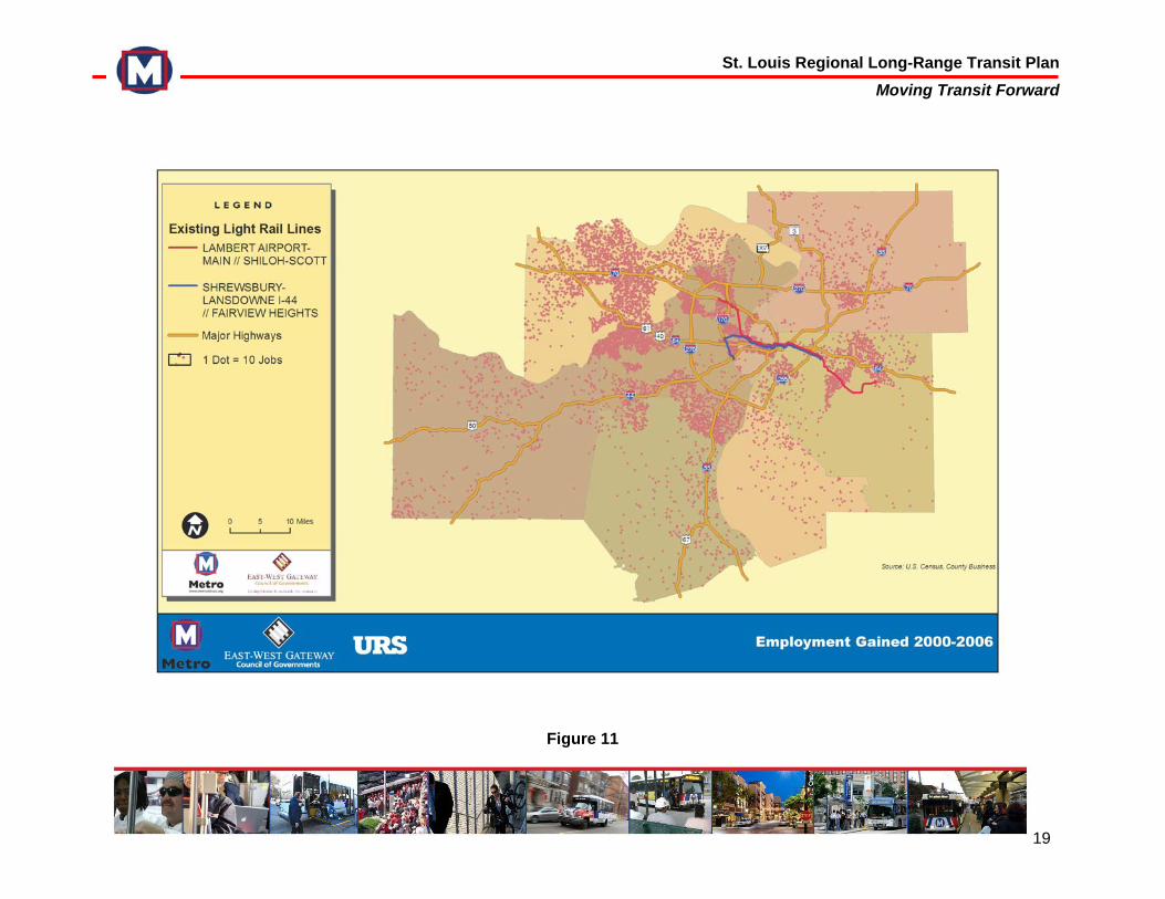
Figure 11 depicts employment growth trends along the two MetroLink corridors and the region’s highways. Economic development has proven to cluster around the region’s transportation infrastructure. Specific examples of development around MetroLink stations include:
Since the opening of the Red Line, the University of Missouri – St. Louis (UMSL) has constructed the new $60 million Touhill Performing Arts Center, the Telecommunications Community Center, and a new student center. In 2005, Express Scripts relocated to UMSL’s campus, providing direct MetroLink access for its employees.3
At the Delmar Station on the Red Line, the Pageant Theater, the Regional Arts Commission headquarters, and numerous small businesses have located within walking distance of the station since its opening.
Since the opening of the Central West End Station the BJC/Washington University Medical Center has expanded considerably, including the construction of the Center for Advanced Medicine, the Siteman Cancer Center, the St. Louis Rehabilitation Institute, and the Forest Park Hotel. This station is one of the system’s most utilized, carrying approximately 4,500 boardings per day.4
Employers in Illinois have also invested in locations near MetroLink stations. A 150-room hotel near the Casino Queen was built at the East Riverfront Station, and the Jackie Joyner Kersee Sports Complex was constructed near Jackie Joyner Kersee Station.
3 “Transit Oriented Development Study.” Citizens for Modern Transit. June
2007. St. Louis Missouri. http://www.cmt-stl.org/metrolink/tod1.html 4 ibid
3.3 Regional Mobility Patterns Regional mobility patterns are primarily driven by the means of travel people use to connect homes and jobs. Regional travel-demand models are used to gain an understanding of these patterns and to discover opportunities for improving regional transportation infrastructure to better meet these needs. According to EWGCOG’s regional travel demand model, 10 percent of the region’s work commute trips are on transit, while driving accounts for approximately 88 percent. This trip share is not projected to change significantly. Overall, the total number of commuter trips in the region is likely to increase by about 10 percent over the next 25 years. Work-trip analysis was conducted for the entire region, particularly for the 18 identified employment centers. Collectively, these employment centers attract about one-quarter of the total commuter trips in the region. While the overall number of trips is expected to increase, the percentage traveling to these employment centers is projected to decline by 2035. This is due to the continued outward dispersal of employment growth across the region. Downtown St. Louis currently attracts the highest share (25 percent) of the trips, followed by Clayton at 10 percent. Inbound trips to these centers are not projected to change significantly, although the City of St. Charles, Scott Air Force Base, Belleville and Edwardsville are expected to gain commuters. Table 4 shows the total trips to these centers in
St. Louis Regional Long-Range Transit Plan Moving Transit Forward
19
Figure 11
St. Louis Regional Long-Range Transit Plan Moving Transit Forward
20
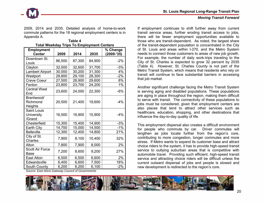
2009, 2014 and 2035. Detailed analysis of home-to-work commute patterns for the 18 regional employment centers is in Appendix A.
Table 4 Total Weekday Trips To Employment Centers
Employment Center 2009 2014 2035
% Change (2009-'35)
Downtown St. Louis
86,500 87,300 84,900 -2%
Clayton 32,500 32,600 31,700 -3% Lambert Airport 30,000 30,200 31,300 4% Westport 28,800 29,100 28,300 -2% Creve Coeur 27,500 28,900 29,600 8% Fenton 23,800 23,700 24,200 1% Central West End
23,600 24,000 22,300 -6%
Brentwood/ Richmond Heights
20,500 21,400 19,600 -4%
Saint Louis University /Grand
16,500 16,900 15,900 -4%
Chesterfield 15,300 15,400 14,900 -3% Earth City 14,700 15,000 14,500 -1% Belleville 12,300 12,400 14,800 21% City of St. Charles
7,900 8,100 10,400 32%
Alton 7,800 7,900 8,000 2% Scott Air Force Base
7,200 8,600 9,200 27%
East Alton 6,500 6,500 6,600 2% Edwardsville 6,400 6,600 7,500 18% South County 6,200 6,200 6,100 -2% Source: East-West Gateway Council of Governments
If employment continues to shift further away from current transit service areas, further eroding transit access to jobs, there will be fewer employment opportunities available to those who are transit-dependent. As noted, the largest share of the transit-dependent population is concentrated in the City of St. Louis and areas within I-270, and the Metro System needs to connect those customers to areas of new job growth. For example, the number of daily work-trips traveling to the City of St. Charles is expected to grow 32 percent by 2035 (Table 4). However, St. Charles County is not part of the Metro Transit System, which means that residents who rely on transit will continue to face substantial barriers in accessing that job market. Another significant challenge facing the Metro Transit System is serving aging and disabled populations. These populations are aging in place throughout the region, making them difficult to serve with transit. The connectivity of these populations to jobs must be considered, given that employment centers are also places that tend to attract other services such as healthcare, education, shopping, and other destinations that influence the day-to-day quality of life. This employment dispersal also creates a difficult environment for people who commute by car. Driver commutes will lengthen as jobs locate further from the region’s core, contributing to more congestion, longer commutes and more stress. If Metro wants to expand its customer base and attract choice riders to the system, it has to provide high-speed transit service to outlying suburban areas that is competitive with automobile travel. Providing such efficient, high-speed transit service and attracting choice riders will be difficult unless the current outward dispersal of jobs and people is slowed and new development is redirected to the region’s core.
St. Louis Regional Long-Range Transit Plan Moving Transit Forward
21
4.0 PLANNING RESEARCH After analyzing the region’s mobility patterns, the planning team assessed how well the Metro Transit System meets those needs. Market research, previous transit studies, and national planning principles allowed the planning team to identify potential service strategies and transit modes for growing the system and improving service throughout the region. 4.1 Metro System Performance Analysis Prior to March 30, 2009, the Metro Transit System had experienced steady growth in both MetroLink and MetroBus ridership over the previous five years. Increases in ridership ranged from two percent to 11 percent per year, culminating in 53 million annual boardings. Between April 2008 and March 2009, MetroLink served 65,000 passenger boardings on an average weekday. On March 30, 2009, Metro was forced to reduce service on both the Red Line and the Blue Line. Service frequency was reduced from 10 minute headways to 15 minutes in the peak hours. After the service cuts, MetroLink averaged 53,000 riders per weekday, a 19 percent reduction in ridership. Prior to the service reduction, the Metro Call-A-Ride fleet carried an average of 2,430 passengers per weekday. After the service reduction, ridership fell by 21 percent to 1,900 per weekday. Partial restoration of service in August 2009 stabilized ridership. MetroBus is the backbone of the transit system, serving 115,000 passenger boardings on an average weekday before
March 2009. In March 2009, service was reduced by 32 percent. Partial service was restored on August 3, 2009. This partial service restoration improved ridership, but did not fully restore it to previous levels. Between March 30, 2009 and December 2009, MetroBus ridership fell 20 percent to 92,000 boardings. The drop in MetroBus ridership can be attributed to the elimination of 10 bus routes, coupled with reductions of geographic coverage on the remaining routes and lower service frequencies for both MetroBus and MetroLink. Service frequency on most MetroBus principal routes is approximately every 30 minutes or less during peak and off-peak hours, while support routes provide service approximately every 40 to 60 minutes during peak and off-peak hours. Express routes operate during the AM and PM peak hours only, approximately every 30 minutes. Infrequent service on most MetroBus routes makes transferring between bus routes and/or MetroLink difficult and time consuming. For example, travel between the City of St. Louis and many suburban employment centers requires two or more transfers and can take up to two hours one-way. In addition, routes in the core of the service area are overcrowded and buses often have to pass waiting customers. This inefficiency in service is a major concern for Metro and is addressed in the long-range plan. Metro uses established Service Standards to evaluate the performance of each bus route and identify areas for improvement. The purpose of these Service Standards is to ensure that MetroBus service meets customer needs in a cost-effective and equitable manner. The most effective tool for applying Metro’s Service Standards is the Route Performance Index (RPI), a composite of four measures of transit effectiveness: passengers per trip, passengers per revenue
St. Louis Regional Long-Range Transit Plan Moving Transit Forward
22
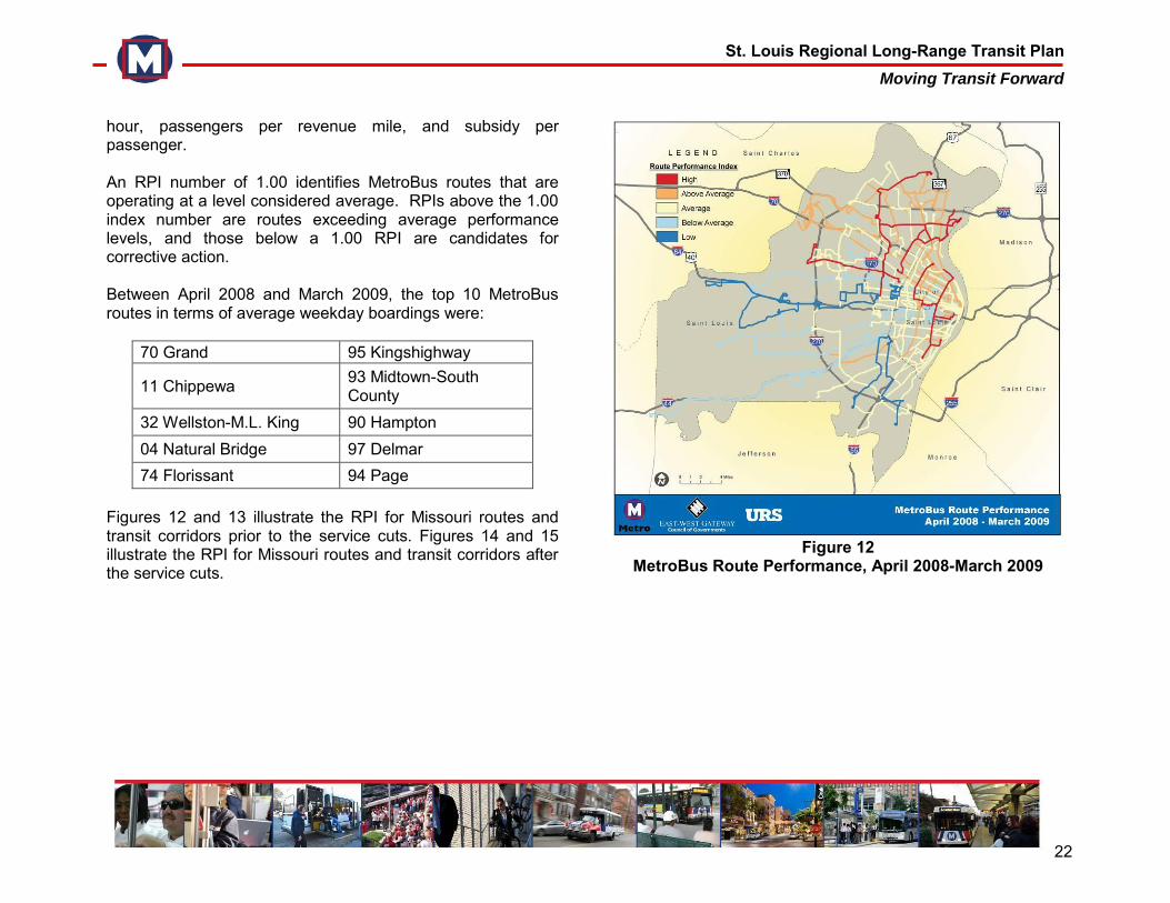
hour, passengers per revenue mile, and subsidy per passenger. An RPI number of 1.00 identifies MetroBus routes that are operating at a level considered average. RPIs above the 1.00 index number are routes exceeding average performance levels, and those below a 1.00 RPI are candidates for corrective action. Between April 2008 and March 2009, the top 10 MetroBus routes in terms of average weekday boardings were:
70 Grand 95 Kingshighway
11 Chippewa 93 Midtown-South County
32 Wellston-M.L. King 90 Hampton 04 Natural Bridge 97 Delmar 74 Florissant 94 Page
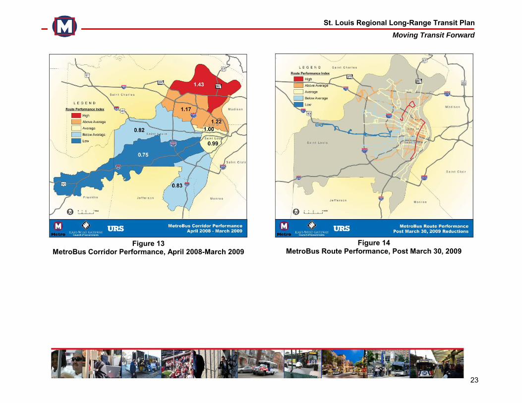
Figures 12 and 13 illustrate the RPI for Missouri routes and transit corridors prior to the service cuts. Figures 14 and 15 illustrate the RPI for Missouri routes and transit corridors after the service cuts.
Figure 12
MetroBus Route Performance, April 2008-March 2009
St. Louis Regional Long-Range Transit Plan Moving Transit Forward
23
Figure 13
MetroBus Corridor Performance, April 2008-March 2009
Figure 14
MetroBus Route Performance, Post March 30, 2009
St. Louis Regional Long-Range Transit Plan Moving Transit Forward
24
Figure 15
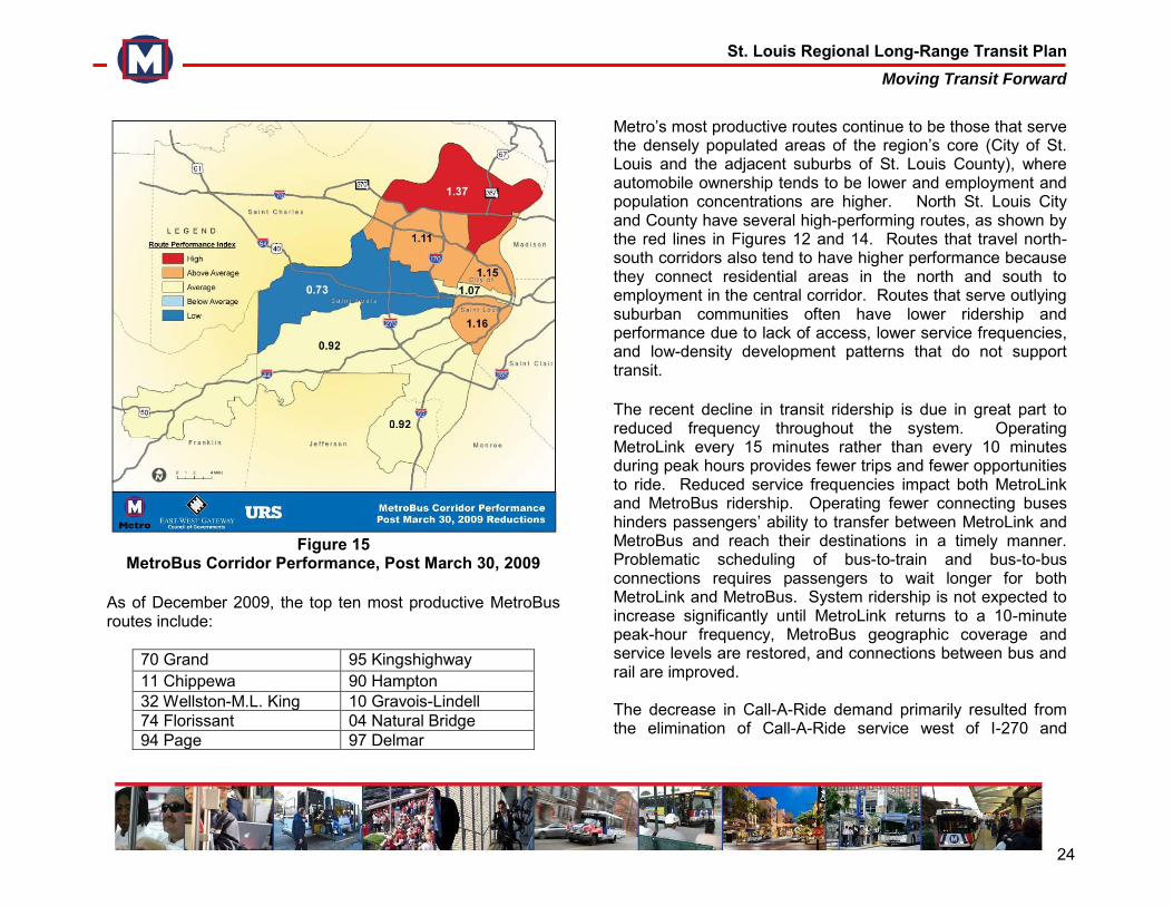
MetroBus Corridor Performance, Post March 30, 2009 As of December 2009, the top ten most productive MetroBus routes include:
70 Grand 95 Kingshighway 11 Chippewa 90 Hampton 32 Wellston-M.L. King 10 Gravois-Lindell 74 Florissant 04 Natural Bridge 94 Page 97 Delmar
Metro’s most productive routes continue to be those that serve the densely populated areas of the region’s core (City of St. Louis and the adjacent suburbs of St. Louis County), where automobile ownership tends to be lower and employment and population concentrations are higher. North St. Louis City and County have several high-performing routes, as shown by the red lines in Figures 12 and 14. Routes that travel north-south corridors also tend to have higher performance because they connect residential areas in the north and south to employment in the central corridor. Routes that serve outlying suburban communities often have lower ridership and performance due to lack of access, lower service frequencies, and low-density development patterns that do not support transit. The recent decline in transit ridership is due in great part to reduced frequency throughout the system. Operating MetroLink every 15 minutes rather than every 10 minutes during peak hours provides fewer trips and fewer opportunities to ride. Reduced service frequencies impact both MetroLink and MetroBus ridership. Operating fewer connecting buses hinders passengers’ ability to transfer between MetroLink and MetroBus and reach their destinations in a timely manner. Problematic scheduling of bus-to-train and bus-to-bus connections requires passengers to wait longer for both MetroLink and MetroBus. System ridership is not expected to increase significantly until MetroLink returns to a 10-minute peak-hour frequency, MetroBus geographic coverage and service levels are restored, and connections between bus and rail are improved. The decrease in Call-A-Ride demand primarily resulted from the elimination of Call-A-Ride service west of I-270 and
St. Louis Regional Long-Range Transit Plan Moving Transit Forward
25
significant reductions in the MetroBus geographic service area. The analysis suggests that the Metro Transit System does not currently meet the needs of the region. First, the MetroBus system, while extensive, does not serve or serves infrequently many of the region’s suburban employment and residential areas. Metro must formulate a strategy for cost-effectively providing high-speed connections between suburban communities and the region’s core employment centers. Metro should also continue its service strategy of hub-and-spoke development, which links neighborhood-serving support lines to major bus routes at transit centers, improving connectivity and maximizing efficiency in MetroBus service. Secondly, there are many reverse commuters that need better access to the region’s smaller suburban employment centers, such as Westport and Earth City. These areas either lack or have infrequent transit service, which hinders access to jobs for the transit-dependent. Finally, there are areas of the Metro Transit System that are overcrowded and need more frequency, particularly within the region’s core. During peak operating hours, MetroLink and many MetroBus routes that run north and south operate at full capacity. This suggests a need for increased frequencies throughout the Metro System, as well as the expansion of high-capacity, high-speed service that links residential communities in the north and south to the central employment corridor.
4.2 Market Research Once the mobility needs of the region were established and opportunities for strengthening the existing Metro Transit System were identified, the planning team engaged in market and planning research to discover a broad range of potential service improvement strategies. In order to develop a comprehensive understanding of the public’s perception of transit, and of Metro, the planning team conducted a baseline survey and focus groups. These provided insight on effective methods for informing the public about transit, as well as potential improvements to the Metro System and Agency policy. 4.2.1 Baseline Survey A survey of 500 households chosen at random from across the region was conducted to get a better understanding of public perception of transit in general and Metro in particular. According to the majority of participants, transit is important to a community’s quality of life. When asked how transit impacts the region, respondents placed a greater emphasis on transit’s role in providing mobility to the elderly, the disabled and the transit-dependent, and less on promoting economic development and reducing traffic. Opinions regarding Metro as an agency were mixed. Participants were critical of Metro’s ability to operate the transit system efficiently. However, participants were much more positive regarding the quality of Metro’s service. Despite this mixed opinion of Metro’s management, participants expressed a desire for an expanded transit system with more frequent
St. Louis Regional Long-Range Transit Plan Moving Transit Forward
26
service, routes and transit facilities. The 2009 Long Range Plan Baseline Survey, Final Report is in Appendix B. 4.2.2 Focus Groups
The baseline survey was a complement to a series of focus groups conducted in September 2009. The planning team facilitated four focus groups to gain a deeper understanding of the public’s view of the Metro Transit System, rider experiences, and possible system enhancements. Participants were grouped according to whether they were “Metro Customers” or “Non-Riders.” Two focus groups were conducted for each category. At each of these meetings, participants were asked a series of questions related to the Metro Transit System. Discussion topics included Metro’s impact on the region (employment, education, economic development, and overall quality of life); the groups of people most likely to use transit; customer experiences; public perceptions of Metro’s management; communications; transit funding; and possible strategies for improving the system. Focus group participants indicated that expanding MetroLink, enhancing security, improving frequency of service, and constructing more transit centers were top priorities. The participants were also interested in exploring Bus Rapid Transit (BRT), a type of transit service that would be new to the region. In addition, the focus groups indicated that Metro should continue to increase service throughout the region; improve communication strategies to existing and potential customers; and increase public awareness about the benefits of public transit, including economic development, environmental sustainability, access to jobs and improving overall quality of
life. A complete summary of the focus group results is in Appendix C. 4.3 Previous Planning Studies and Regional
Infrastructure Improvements To help set broad parameters for the planning process, the team reviewed previous studies of potential MetroLink extensions. This allowed the team to use existing data and recommend only corridors that the community had approved for further study. The following transit studies helped to define the set of preliminary MetroLink options prior to the first series of community workshops:
Major Transportation Investment Analyses: Daniel Boone, Northside-Southside Study Areas (May 2000) This report identified potential MetroLink and BRT routes along with highway improvements between Clayton and Westport, as well as a corridor connecting North County, Downtown St. Louis and South County.
Madison County Light Rail Feasibility Study (October 2005) This study examined the feasibility of expanding light rail into Madison County, Illinois from the existing MetroLink in East St. Louis.
St. Louis MetroSouth MetroLink Extension Draft
Environmental Impact Statement (November 2005) This DEIS examined potential extensions from the MetroLink station at Shrewsbury into south St. Louis County.
Legacy 2035: The Transportation Plan for the Gateway
Region (May 2007) This report is the fourth update of
St. Louis Regional Long-Range Transit Plan Moving Transit Forward
27
the metropolitan long-range transportation plan and provides a vision for the region’s surface transportation system for the next 30 years.
Northside-Southside Study Final Report (October 2008) This study selected a potential alignment within the Northside and Southside study areas. EWGCOG adopted the recommended alignment for inclusion in the region’s long-range transportation plan.
The Loop Trolley The Loop Trolley project is currently in the preliminary engineering phase. The proposed trolley route would run from the Missouri Historical Society in Forest Park along DeBaliviere Boulevard, terminating at Delmar Boulevard and Trinity Avenue in University City.
The planning team also considered other planned regional infrastructure projects because road and freight networks influence the region’s growth and travel patterns. Legacy 2035 identifies major transportation projects that the region expects to finance with federal funds over the next 25 years, most of which are highway and road projects. Such programs must be identified in the plan or be consistent with the policies identified in the plan. Legacy 2035 includes three sets of projects: a priority investment plan identifying projects that fall within the region’s financial constraints; a list of illustrative projects that have merit but fall outside of the fiscal constraints; and geographic corridors identified for further study. Given the bleak financial outlook through the plan’s horizon year and the growing costs of preserving and operating existing transportation assets, the priority listing of major
projects includes only 18 additional projects throughout the eight-county region. Preservation of the existing highway and road network, as well as transit maintenance and operations, are explicitly given priority over investments in major new projects. Transit expansion projects were included within the Illustrative projects list. Those projects are eligible to move forward only as funding becomes available. This list included four new MetroLink routes: Northside-Southside, extending from south St. Louis County through Downtown St. Louis to north St. Louis County; Daniel Boone, extending from Clayton to Westport; MetroSouth, extending from the Shrewsbury MetroLink station to south St. Louis County; and MetroNorth, extending from Clayton to I-270/Florissant. 4.4 National and Local Transit Planning Principles The St. Louis region is characterized by a diverse mix of land use patterns, from the urban core’s high-density employment centers and historic neighborhoods to suburban office parks and low-density residential subdivisions. Residents and workers in all of these areas need transit, but different development patterns require different types of transit service. The combination of local transportation dynamics and national experience suggests that transit development in the St. Louis region should continue to focus primarily on connections to the central corridor, the region’s strongest concentration of employment. Secondary employment centers such as Westport and Brentwood/Richmond Heights should also merit system development, especially if more transit-supportive land use policies are established.
St. Louis Regional Long-Range Transit Plan Moving Transit Forward
28
Research and national experience also suggest that suburban strategies for system expansion should focus on park-ride facilities and transit centers. Distribution service from such centers to major employment locations could be accommodated on MetroBus feeder routes or flex-route service. Alternatively, such feeder service could be directly provided or paid for by employers who benefit from such service. Metro has been pursuing these strategies and will continue to do so in the future. A positive image is vital to attracting more riders, moving into new markets, and attracting public support for service expansion. It is necessary to emphasize transit’s role as a vital asset in the region’s business development strategy and its substantial positive impact on the region’s quality of life. The St. Louis community generally sees MetroLink as first-class transit, but has a less positive view of MetroBus service. Many customers and potential users would ride MetroLink but will not use the bus system. This widespread point of view indicates that any plan to attract new riders, serve new markets, and foster positive economic development should include expanded MetroLink service. However, given its high capital cost (roughly $60 million per mile), there is a limit to the region’s ability to rapidly and extensively expand the MetroLink system. Public feedback also suggests that Metro must prioritize improvements to MetroBus service if it wishes to retain existing customers and attract new riders. This suggests a need to educate the public about the attractiveness of other types of transit that have been successful in other regions, especially BRT. In other cities, BRT has demonstrated an ability to establish a positive public image and attract new choice riders by providing a higher level
of service and improving the experience of existing riders. Given its lower capital cost compared to light rail (approximately $35 million for an entire route), BRT offers considerable opportunity to quickly expand high-speed transit service over a wide geographic area, especially into lower-density suburban areas. The St. Louis region may also be able to implement suburb-to-city commuter rail service, at relatively low cost, by taking advantage of Federal and State plans for intercity high-speed rail infrastructure improvements. 4.5 Types of Transit and System Enhancements
Considered After thoroughly reviewing the results from market research, previous light rail studies, technical analyses and peer review, an initial set of transit types and service enhancements was developed for possible inclusion in the plan. This set was intended to establish broad parameters for the plan that the community would be asked to consider throughout the public engagement process. 4.5.1 Types of Transit A variety of transit types was evaluated, some familiar to the St. Louis region - light rail, conventional buses, and paratransit - as well as a few modes that have been successful in other regions but do not currently exist in St. Louis, such as BRT, commuter rail, and flex routes. A brief description of each mode considered for the plan follows: MetroLink (Light Rail) Light rail uses electric vehicles along fixed rail rights-of-way, which can run either in the street or in a separate right-of-way. Light rail provides frequent, all-day service. It is most effective
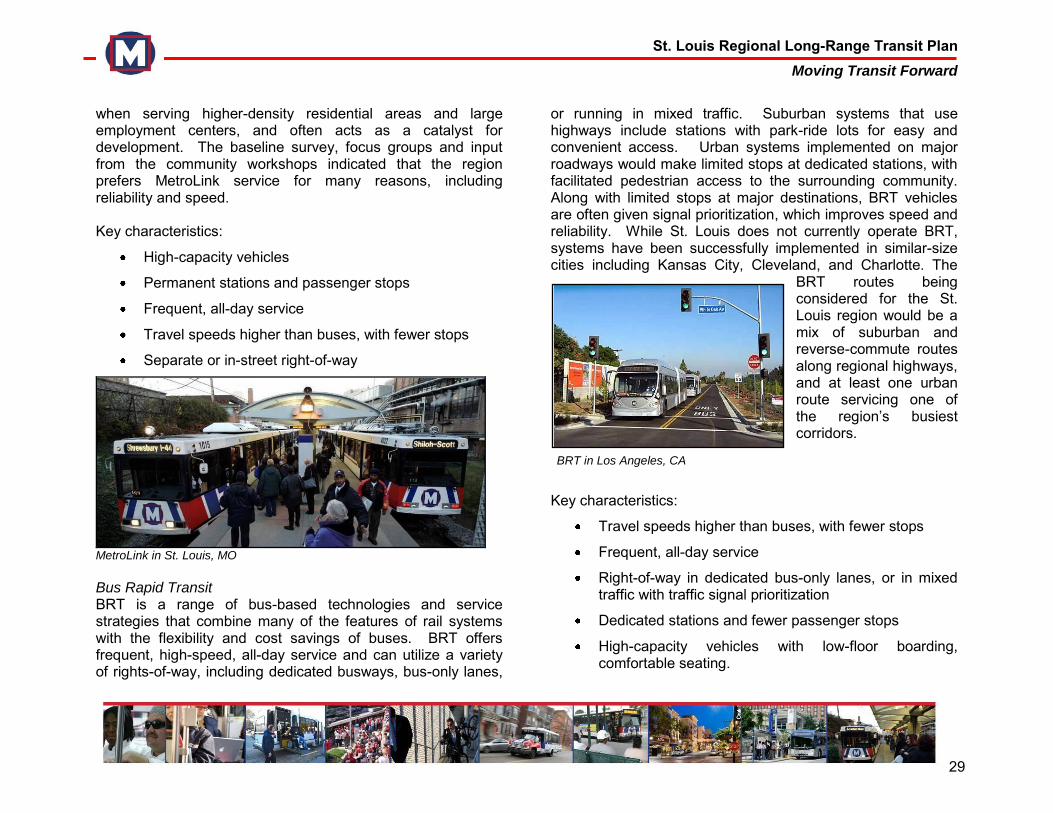
St. Louis Regional Long-Range Transit Plan Moving Transit Forward
29
when serving higher-density residential areas and large employment centers, and often acts as a catalyst for development. The baseline survey, focus groups and input from the community workshops indicated that the region prefers MetroLink service for many reasons, including reliability and speed. Key characteristics:
High-capacity vehicles
Permanent stations and passenger stops
Frequent, all-day service
Travel speeds higher than buses, with fewer stops
Separate or in-street right-of-way
MetroLink in St. Louis, MO
Bus Rapid Transit BRT is a range of bus-based technologies and service strategies that combine many of the features of rail systems with the flexibility and cost savings of buses. BRT offers frequent, high-speed, all-day service and can utilize a variety of rights-of-way, including dedicated busways, bus-only lanes,
or running in mixed traffic. Suburban systems that use highways include stations with park-ride lots for easy and convenient access. Urban systems implemented on major roadways would make limited stops at dedicated stations, with facilitated pedestrian access to the surrounding community. Along with limited stops at major destinations, BRT vehicles are often given signal prioritization, which improves speed and reliability. While St. Louis does not currently operate BRT, systems have been successfully implemented in similar-size cities including Kansas City, Cleveland, and Charlotte. The
BRT routes being considered for the St. Louis region would be a mix of suburban and reverse-commute routes along regional highways, and at least one urban route servicing one of the region’s busiest corridors.
Key characteristics:
Travel speeds higher than buses, with fewer stops
Frequent, all-day service
Right-of-way in dedicated bus-only lanes, or in mixed traffic with traffic signal prioritization
Dedicated stations and fewer passenger stops
High-capacity vehicles with low-floor boarding, comfortable seating.
BRT in Los Angeles, CA
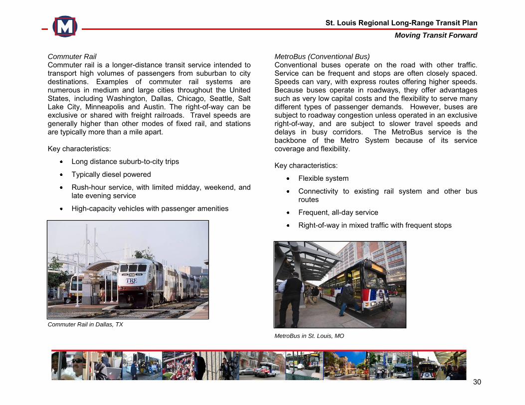
St. Louis Regional Long-Range Transit Plan Moving Transit Forward
30
Commuter Rail Commuter rail is a longer-distance transit service intended to transport high volumes of passengers from suburban to city destinations. Examples of commuter rail systems are numerous in medium and large cities throughout the United States, including Washington, Dallas, Chicago, Seattle, Salt Lake City, Minneapolis and Austin. The right-of-way can be exclusive or shared with freight railroads. Travel speeds are generally higher than other modes of fixed rail, and stations are typically more than a mile apart. Key characteristics:
Long distance suburb-to-city trips
Typically diesel powered
Rush-hour service, with limited midday, weekend, and late evening service
High-capacity vehicles with passenger amenities
Commuter Rail in Dallas, TX
MetroBus (Conventional Bus) Conventional buses operate on the road with other traffic. Service can be frequent and stops are often closely spaced. Speeds can vary, with express routes offering higher speeds. Because buses operate in roadways, they offer advantages such as very low capital costs and the flexibility to serve many different types of passenger demands. However, buses are subject to roadway congestion unless operated in an exclusive right-of-way, and are subject to slower travel speeds and delays in busy corridors. The MetroBus service is the backbone of the Metro System because of its service coverage and flexibility. Key characteristics:
Flexible system
Connectivity to existing rail system and other bus routes
Frequent, all-day service
Right-of-way in mixed traffic with frequent stops
MetroBus in St. Louis, MO
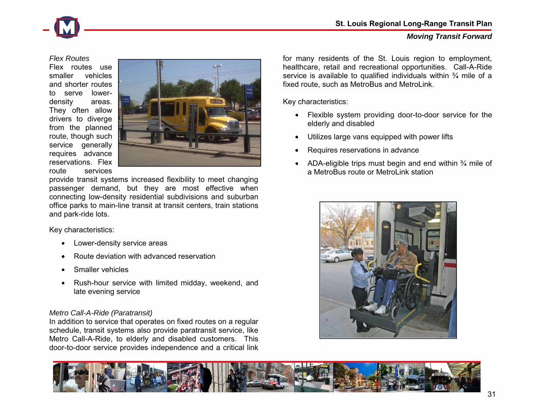
St. Louis Regional Long-Range Transit Plan Moving Transit Forward
31
Flex Routes Flex routes use smaller vehicles and shorter routes to serve lower-density areas. They often allow drivers to diverge from the planned route, though such service generally requires advance reservations. Flex route services provide transit systems increased flexibility to meet changing passenger demand, but they are most effective when connecting low-density residential subdivisions and suburban office parks to main-line transit at transit centers, train stations and park-ride lots.
Key characteristics:
Lower-density service areas
Route deviation with advanced reservation
Smaller vehicles
Rush-hour service with limited midday, weekend, and late evening service
Metro Call-A-Ride (Paratransit) In addition to service that operates on fixed routes on a regular schedule, transit systems also provide paratransit service, like Metro Call-A-Ride, to elderly and disabled customers. This door-to-door service provides independence and a critical link
for many residents of the St. Louis region to employment, healthcare, retail and recreational opportunities. Call-A-Ride service is available to qualified individuals within ¾ mile of a fixed route, such as MetroBus and MetroLink. Key characteristics:
Flexible system providing door-to-door service for the elderly and disabled
Utilizes large vans equipped with power lifts
Requires reservations in advance
ADA-eligible trips must begin and end within ¾ mile of a MetroBus route or MetroLink station
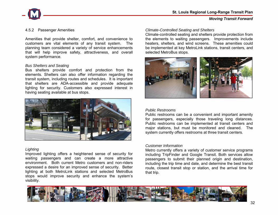
St. Louis Regional Long-Range Transit Plan Moving Transit Forward
32
4.5.2 Passenger Amenities Amenities that provide shelter, comfort, and convenience to customers are vital elements of any transit system. The planning team considered a variety of service enhancements that will help improve safety, attractiveness, and overall system performance. Bus Shelters and Seating Bus shelters provide comfort and protection from the elements. Shelters can also offer information regarding the transit system, including routes and schedules. It is important that shelters are ADA-accessible and provide adequate lighting for security. Customers also expressed interest in having seating available at bus stops.
Lighting Improved lighting offers a heightened sense of security for waiting passengers and can create a more attractive environment. Both current Metro customers and non-riders expressed a desire for an improved sense of security. Better lighting at both MetroLink stations and selected MetroBus stops would improve security and enhance the system’s visibility.
Climate-Controlled Seating and Shelters Climate-controlled seating and shelters provide protection from the elements to waiting passengers. Improvements include heaters, shelters, and wind screens. These amenities could be implemented at key MetroLink stations, transit centers, and selected MetroBus stops.
Public Restrooms Public restrooms can be a convenient and important amenity for passengers, especially those traveling long distances. Public restrooms can be implemented at transit centers and major stations, but must be monitored and cleaned. The system currently offers restrooms at three transit centers. Customer Information Metro currently offers a variety of customer service programs including TripFinder and Google Transit. Both services allow passengers to submit their planned origin and destination, including the trip time and date, and determine the best transit route, closest transit stop or station, and the arrival time for that trip.
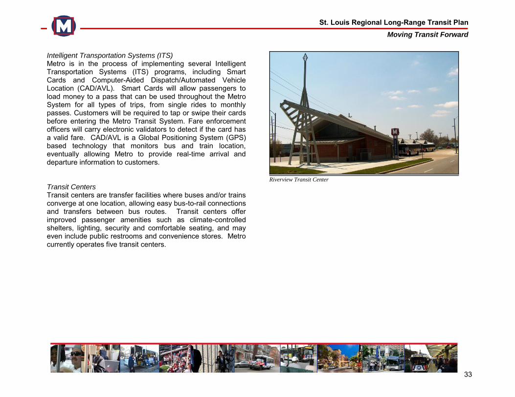
St. Louis Regional Long-Range Transit Plan Moving Transit Forward
33
Intelligent Transportation Systems (ITS) Metro is in the process of implementing several Intelligent Transportation Systems (ITS) programs, including Smart Cards and Computer-Aided Dispatch/Automated Vehicle Location (CAD/AVL). Smart Cards will allow passengers to load money to a pass that can be used throughout the Metro System for all types of trips, from single rides to monthly passes. Customers will be required to tap or swipe their cards before entering the Metro Transit System. Fare enforcement officers will carry electronic validators to detect if the card has a valid fare. CAD/AVL is a Global Positioning System (GPS) based technology that monitors bus and train location, eventually allowing Metro to provide real-time arrival and departure information to customers. Transit Centers Transit centers are transfer facilities where buses and/or trains converge at one location, allowing easy bus-to-rail connections and transfers between bus routes. Transit centers offer improved passenger amenities such as climate-controlled shelters, lighting, security and comfortable seating, and may even include public restrooms and convenience stores. Metro currently operates five transit centers.
Riverview Transit Center
St. Louis Regional Long-Range Transit Plan Moving Transit Forward
34
5.0 COMMUNITY ENGAGEMENT The community helped shape a shared regional vision for the Metro Transit System through three series of public meetings, the Moving Transit Forward Advisory Group, an Executive Committee, and the project website. These strategies and outlets allowed the planning team to reach out and involve more people, engage community leaders and businesses, and help ensure a transparent planning process. 5.1 Community Engagement – Series 1 The first series of public meetings, in October 2009, consisted of 10 community workshops that introduced the purpose and goals of the long-range plan; provided information on employment and population trends; and educated participants about transit funding realities, various types of transit service, and a range of possible passenger amenities and service improvements. Participants took part in a planning exercise, building their vision for a strong regional transit system by identifying geographic corridors and selecting their preferred types of transit for those corridors, all within a predetermined “budget” intended to reflect realistic financial constraints. Finally, participants were asked to vote for the types of transit and general system enhancements they thought should be included in the plan. The following general geographic corridors were identified as the top priorities for expanding Metro transit service by at least a third of participants during at least three workshops:
Downtown St. Louis through north city and into north St. Louis County
Downtown St. Louis through south city into south St. Louis County
Clayton to Westport
The northern St. Louis City limits west to Page Avenue and I-170
I-70 corridor west through St. Charles County to O’Fallon, Missouri
When voting for the general types of transit they would like to see as part of the Metro System, a majority of the participants voted for expanded MetroLink, followed by BRT and expanded MetroBus service. Participants also prioritized the following passenger amenities and general system enhancements:
Improved security and lighting
Bus enhancement packages (shelters, seating, signage, lighting)
Transit centers
Restrooms Outside of the system planning exercise, two themes were consistently voiced throughout the workshops: Metro should prioritize service restoration and enhancement of the existing system, and MetroLink stations and MetroBus stops should provide more welcoming pedestrian environments with better connections to surrounding residential areas, employers, and activity centers. Examples of the planning exercise, workshop materials, and a summary report are in Appendix D.
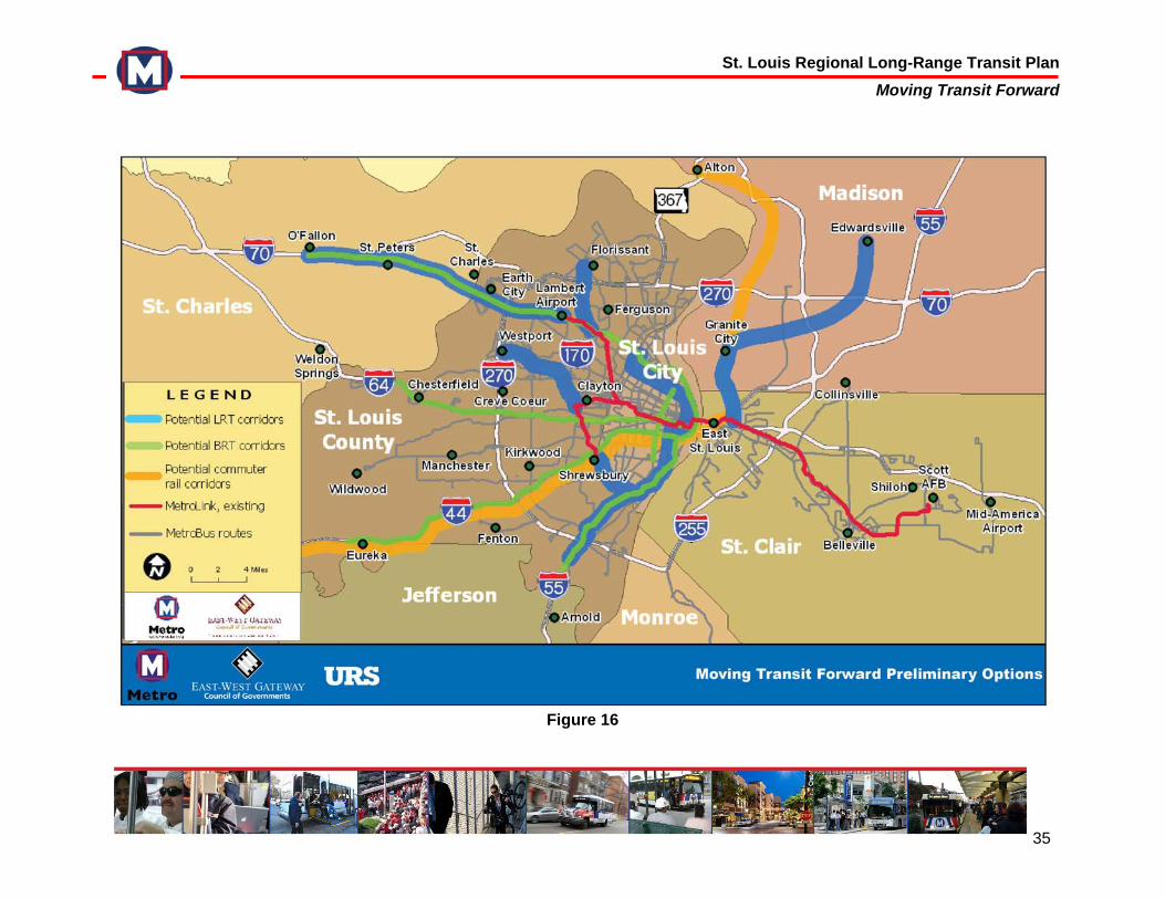
St. Louis Regional Long-Range Transit Plan Moving Transit Forward
35
Figure 16
St. Louis Regional Long-Range Transit Plan Moving Transit Forward
36
5.2 Moving Transit Forward Advisory Group The first round of community engagement included the creation of the Moving Transit Forward Advisory Group. The Advisory Group consisted of regional elected officials, business leaders, community organizations, and representatives from other local and regional agencies. A list of the Advisory Group membership is included in Appendix E. In September 2009, the planning team presented the plan’s objectives, the preliminary analyses of the region’s mobility needs and evaluation of the existing transit system, current financial conditions, and the proposed community engagement strategy. The presentation to the Advisory Group is in Appendix E. 5.3 Executive Committee An Executive Committee was also formed to engage regional leadership in the project. The Executive Committee consisted of a range of local elected officials and regional leaders from both Missouri and Illinois, including St. Louis County Council, St. Louis City Board of Aldermen, and municipal mayors. Their role was to advise the planning team on political considerations, communications strategy and public outreach, and to provide feedback on projects proposed for inclusion in the plan. Members of the Executive Committee were encouraged to communicate information about the plan to their constituents and involve them in the planning process. The Executive Committee was briefed on the purpose and status of the project in September 2009. The presentation is in Appendix F.
5.4 Moving Transit Forward Website In conjunction with the first series of public meetings, the planning team launched the Moving Transit Forward project website in October 2009 (www.movingtransitforward.org). It was and continues to be a key component of the overall community engagement strategy. Designed and maintained internally by Metro staff, the primary objectives of this multi-media and educational tool are to:
Promote Metro’s transparency and accountability by proactively educating the public about the plan’s vision, objectives, development process, and status
Facilitate project communication by providing timely and ongoing project updates, as well as relevant resources such as presentations, reports, maps, radio/television recordings, and news releases
Encourage community involvement and collaboration through interactive, user-friendly tools such as online surveys and downloadable community workshop materials
Complement traditional communication methods by disseminating project information via Social Media/Web 2.0 methods like RSS, webinars, Twitter, Facebook, YouTube, Flickr, and Metro’s NextStopSTL.org blog
St. Louis Regional Long-Range Transit Plan Moving Transit Forward
37
6.0 A 30-YEAR VISION After considering the substantial input received from the first round of community workshops, the planning team refined the full range of transit types into a preliminary set of plan options (see Figure 16). This set of options included a broad range of transit types, service corridors and passenger amenities, all derived from previous studies, national planning best practices, assessment of the region’s transit needs, and public input. MetroLink Extensions:
Northside-Southside Minimum Operating Segment (MOS) (an in-street alignment from Downtown St. Louis to the northern and southern City limits)
Northside-Southside Full Build (extension of the starter line into North County and South County)
Clayton to Westport (north from Clayton MetroLink station along I-170, west to Westport)
MetroSouth (from Shrewsbury to Butler Hill Road)
MetroNorth (from near the North Hanley MetroLink Station into Florissant)
Madison County Tri-Cities (from East St. Louis to Granite City and Edwardsville, IL)
St. Charles (Lambert Airport to O’Fallon, MO) Bus Rapid Transit:
I-44 (between Downtown St. Louis and Eureka/Pacific, MO)
I-64 (between Downtown St. Louis and Chesterfield, MO)
I-55 (between Downtown St. Louis and south St. Louis County)
I-70 (between Downtown St. Louis and O’Fallon, MO)
Grand Boulevard (between Chippewa and Natural Bridge)
Commuter Rail:
St. Louis to Alton, IL
St. Louis to Eureka/Pacific, MO In addition, a variety of passenger amenities were evaluated for inclusion in the plan:
Bus stop improvements
Bus passenger amenities
Intelligent Transportation Systems
Transit centers 6.1 Evaluation Criteria Nine core values were used to evaluate potential projects and service enhancements for inclusion in the plan. Each of the options was ranked qualitatively against the others for this purpose. The values/criteria were:
St. Louis Regional Long-Range Transit Plan Moving Transit Forward
38
Expands service area/transit market. How would a proposed project expand Metro’s geographic market and move the agency into new socio-economic markets, especially in attracting a broad array of choice riders?
Improves transit’s image as a regional asset. To what degree does an option enhance Metro’s image as a provider of high-quality service and as a major contributor to the region’s quality of life?
Enhances mobility for transit-dependent. Compared with other possible investments, how will an option improve the quality and quantity of transit service for the transit-dependent population?
Proves cost-effective. Are the benefits of a transit strategy commensurate with its costs, both capital and operating?
Attracts federal funding. Given the assumption that major capital projects will proceed only with approximately 50-percent federal support, how likely is a project to get that financial support under current federal evaluation criteria?
Impacts/supports development. To what degree will an investment promote desirable economic development and land uses?
Protects natural environment. How will an option help improve environmental concerns such as air quality and traffic congestion?
Strengthens regional core. Which investments are more likely to positively impact the physical and economic health of the regional core, on both sides of
the Mississippi River, by promoting employment concentration and economic development?
Considers implementation time. How quickly, compared with the other options, can a strategy move from planning through engineering into construction and operation?
The planning team conducted an exercise to evaluate each of the preliminary options to determine how they met the plan’s values/criteria. Each option was ranked on a scale of strongest to weakest. This exercise helped the team to narrow the preliminary range of options to those that best met the needs of the region. Figure 17 summarizes how each alternative rated against the others for each of the core values/evaluation criteria. Key findings include:
Cost effectiveness. Light rail lines tend to provide the greatest benefits (effectiveness) in terms of ridership and positive impact on development and land use. However, because light rail cost is very high compared with bus options, these projects have low to moderate cost-effectiveness rankings. The BRT alternatives tend to rank higher overall because of cost, but are lower in terms of effectiveness because they do not offer the development potential of light rail.
Time to implement. If planning, engineering, construction and financing all proceed as expected, light rail lines take about 10 years to implement. Bus options such as BRT and bus service enhancements can become operational much more quickly.
St. Louis Regional Long-Range Transit Plan Moving Transit Forward
39
Encourages or supports development. Experience suggests that rail investments have a far greater tendency to foster development than do any bus alternatives. The light rail options considered in this study, especially the proposed Northside-Southside route, would have the greatest positive impact on land use and economic development. The BRT options would more quickly expand the geographic reach of high-speed transit service, but would have very little, if any, impact on development (with the possible exception of Grand Boulevard).
Strengthens regional core. Again, the light rail options would have a significantly greater positive impact on the regional core than any bus option except Grand BRT.
Expands service area/transit market and improves image as regional asset. Any of the alternatives that noticeably expand the geographic coverage of perceived high-quality transit, whether BRT or rail, rank highly in these terms. This would include all the BRT options and all the light rail alignments except the Northside-Southside MOS, which is limited to an area already well-served by MetroBus transit.
Attracts federal funding. Currently the Federal Transit Administration (FTA) evaluates project justification based on the following criteria: mobility improvements, environmental benefits, cost effectiveness, operating efficiencies, transit-supportive land use and local financial commitment.
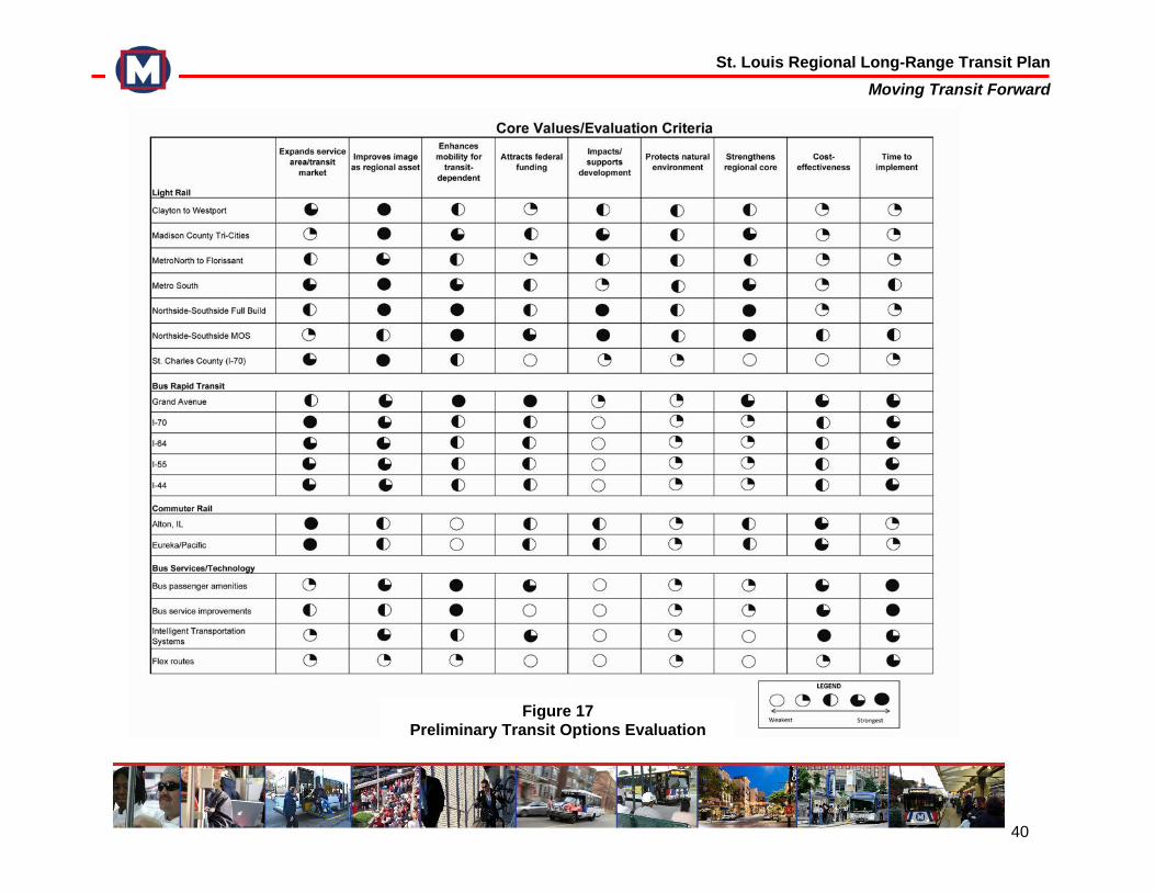
St. Louis Regional Long-Range Transit Plan Moving Transit Forward
40
Figure 17 Preliminary Transit Options Evaluation
St. Louis Regional Long-Range Transit Plan Moving Transit Forward
41
6.2 Financial Analysis The Moving Transit Forward Long-Range Plan should be financially realistic. This plan is based on a set of reasonable assumptions regarding the capital and operating costs of the existing transit system, costs of system expansion and enhancements, and sources of existing and potential revenue. The planning team developed a cash flow model to guide the selection of investment strategies for the plan, and to inform the sequencing of those elements during the 30-year plan horizon. While it is impossible to project detailed costs more than 10 years into the future, as well as revenue sources and amounts available, the planning team used professional judgment about the quantitative implications of likely trends in those areas as inputs into a 30-year financial model. This model used the costs of existing transit service, including service restoration, as a base. Projected revenue sources and the costs of each potential system expansion project were then added to that base to explore annual cash flow results and establish financial constraints for service improvements. The planning team used this model to sequence investment projects over the 1-5, 5-10, and 10-30 year phases of the long-range plan. The most important conclusion from the financial analysis is that implementation of the plan requires new revenue sources from the state and federal governments. With the additional local sales tax revenue approved on April 6, 2010, Metro will be able to restore the service that was reduced in March 2009; being planning for new BRT routes and MetroLink extensions; implement technology improvements and service enhancements; and sustain the existing system. Any major expansion of the Metro System will require matching federal
funds, and any extension of MetroLink will also require additional state funding. 6.2.1 Existing System Costs Metro’s current operating expenses (exclusive of depreciation) total approximately $210 million per year. In 2011, these costs are projected to increase by 12 percent, reflecting both the planned restoration of service and annual inflation. From this level, the cash flow model assumes an annual cost inflation of approximately 3.6 percent for the operation of existing services through the 30-year planning horizon. Revenues Metro’s existing revenues come from three main sources: system-generated revenue, existing local sales taxes, and federal funding. Passenger fares make up the largest portion of system-generated revenue, and are expected to grow at an average rate of 3.5 percent per year. This assumes 5-percent fare increases every other year, with passenger demand falling by 1 percent in years that fare increases occur, and demand growing by 3 percent in years without fare increases. Sales taxes collected in the City and County of St. Louis make up a large portion of Metro’s budget. A half-cent sales tax has been in place in both the city and county since 1974. The City of St. Louis appropriates all of this tax revenue to Metro annually. Initially, nearly all proceeds from the half-cent sales tax in St. Louis County were appropriated to Metro; however, since the 1980s Metro’s share of the St. Louis County half-cent has varied. St. Louis County currently appropriates only 50 percent of this tax collection to Metro annually.
St. Louis Regional Long-Range Transit Plan Moving Transit Forward
42
The first MetroLink route opened in 1993 without any additional funding. In 1994, an additional quarter-cent sales tax was passed in the City and County of St. Louis. This tax funded the operation of the initial alignment and capital projects, and was used to set aside over $100 million to bond for the construction of the Cross County project. Currently this tax is pledged to the bond trustee to support principal interest and principal payment on the Cross County project, with the remaining funds supporting the overall operating and capital budget. On April 6, 2010, St. Louis County voters approved a half-cent sales tax increase. According to the ballot language, all of this half-cent tax is to be apportioned to mass transit, and may be used for both operations and system expansion. This initiative also triggered a quarter-cent increase in the St. Louis City sales tax, which was approved by City voters in 1997 but could not be collected or distributed until St. Louis County passed a similar increase. For each of these sales tax measures, the cash flow model assumes a growth rate of 0.5 percent per year in tax receipts collected in the City of St. Louis. Sales tax revenue from St. Louis County is assumed to grow at a rate of 2.5 percent per year. The difference in the growth rates reflects projected differences in population and economic growth over the next 30 years. In the past, federal assistance supported a significant amount of Metro’s annual operating budget, reaching a high point of $22 million. Federal operating assistance was generally between $14 million and $16 million in the 1980s, but fell to $10 million in the 1990s before being completely phased out by 1999.
Today, federal funding for Metro comes primarily from the Section 5307 Large Urban Area program, which is distributed based on a formula established by the Federal Transit Administration (FTA). Following the elimination of federal operating assistance, the FTA created a set of rules that allowed a portion of 5307 federal capital funds to be used in the operating budget for vehicle maintenance. Without sufficient funds to sustain operations, by 2010 Metro had allocated nearly all 5307 federal capital assistance to operations. With additional funding, 5307 funds may be transitioned back to capital programs. The Metro cash flow model assumes that these federal 5307 allocations increase by 3 percent each year, consistent with inflation. Additionally, a $10 million increase in this funding is assumed in 2020, reflecting expectations of improved federal funding for transit in future years (see discussion below). It is assumed that a portion of these funds will be made available for operating expenses under the FTA’s Section 5307 preventive maintenance criteria. As in the past, Metro expects to receive smaller grants from the FTA through the Congestion Mitigation and Air Quality (CMAQ) and Job Access and Reverse Commute (JARC) grant programs, assuming that these programs are retained or similarly replaced in a future authorization. At the time federal operating assistance was eliminated, the State of Missouri began contributing approximately $3.7 million to Metro for operating expenses. This subsidy has since been reduced to $1.3 million annually, or approximately $1 per year for every resident of St. Louis City and St. Louis County. Estimated revenues from these existing sources total about $1.2 billion in Phase 1 (1-5 years), $1.3 billion in Phase 2 (5-10 years), and $7.3 billion in Phase 3 (10-30 years).
St. Louis Regional Long-Range Transit Plan Moving Transit Forward
43
6.2.2 Proposed Capital Projects
Costs The full range of system expansion projects and their implementation schedules are completely dependent on the magnitude of additional funding available for construction and operation. For illustrative purposes, what follows is a discussion of the capital requirements of all of the proposed capital projects included in each of the three plan phases. The first phase of the capital plan, which could be implemented in the first five years, would include upgrades to passenger amenities and ITS. This initial phase would also include the design, construction, and operation of two BRT projects, as well as planning for the first light rail extension. Years 5-10 make up the second phase of the plan. During this phase, two additional BRT lines could be constructed and begin operations. The MetroLink extension planned in the previous phase would also be constructed and opened by the end of this phase. The third phase of the capital investment plan encompasses years 10-30. During this time, a second light rail extension would be engineered, constructed, and opened for service. Planning and engineering work for a third light rail extension could be completed during this phase. The three light rail projects, two of which are planned to be operational within the 30-year period, would require a substantial portion of the total capital costs of the planned system improvements. The construction of those extensions is the major reason for the significant cost increases during the second and third phases of the plan. However, new MetroLink lines would have the greatest positive impact on the region in
terms of ridership, economic development and the environment, as discussed in the previous section. They are also the alternatives most strongly supported by the public. Table 5 lists details of the costs of the transit investments included in the three phases of the 30-year plan. It includes both capital costs – for planning, engineering, construction, and vehicle purchase – and annual operation costs. The capital costs are all in 2009 dollars to allow for easy comparison. The financial model assumed annual inflation of construction costs, ranging from 4.0 to 4.3 percent depending on the type of transit project. Likewise, while the operating costs are also in 2009 dollars, these are increased annually by 3.8 percent to arrive at the actual dollars required each year over the 30-year planning period. More precise estimates of capital and operating costs would be developed during the planning and design phase of each project. This project phasing reflects the funding assumptions discussed and should be seen as an illustrative, though potentially realistic, sequencing of projects. Actual timing of implementation will depend upon availability of financing from state and federal sources, as well as the EWGCOG regional planning process.
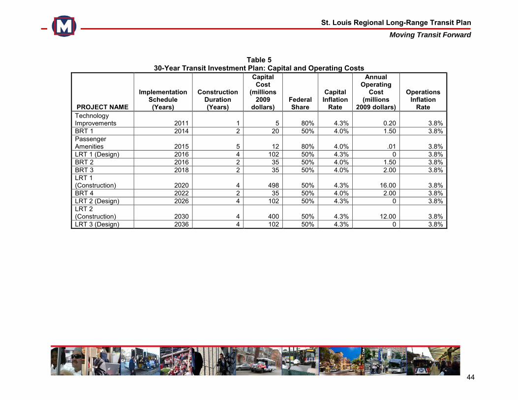
St. Louis Regional Long-Range Transit Plan Moving Transit Forward
44
Table 5
30-Year Transit Investment Plan: Capital and Operating Costs
PROJECT NAME
Implementation Schedule (Years)
Construction Duration (Years)
Capital Cost
(millions 2009
dollars) Federal Share
Capital Inflation
Rate
Annual Operating
Cost (millions
2009 dollars)
Operations Inflation
Rate Technology Improvements 2011 1 5 80% 4.3% 0.20 3.8% BRT 1 2014 2 20 50% 4.0% 1.50 3.8% Passenger Amenities 2015 5 12 80% 4.0% .01 3.8% LRT 1 (Design) 2016 4 102 50% 4.3% 0 3.8% BRT 2 2016 2 35 50% 4.0% 1.50 3.8% BRT 3 2018 2 35 50% 4.0% 2.00 3.8% LRT 1 (Construction) 2020 4 498 50% 4.3% 16.00 3.8% BRT 4 2022 2 35 50% 4.0% 2.00 3.8% LRT 2 (Design) 2026 4 102 50% 4.3% 0 3.8% LRT 2 (Construction) 2030 4 400 50% 4.3% 12.00 3.8% LRT 3 (Design) 2036 4 102 50% 4.3% 0 3.8%
St. Louis Regional Long-Range Transit Plan Moving Transit Forward
45
A critical assumption in the plan is that major expansion projects will be implemented only with substantial federal support for capital costs. For light rail and BRT projects, 50 percent of costs are expected to come through the FTA New Starts or Small Starts programs, a typical assumption used for planning purposes throughout the country. For light rail extensions this could mean a federal contribution of up to $300 million per project. To receive those funds the region would have to meet federal evaluation criteria, which are discussed below. Revenues In order to finance the projected construction costs and operating requirements, additional funding sources are needed. To date local funding on the Missouri side has come from local sales tax. The additional local sales tax revenue approved by voters on April 6, 2010 will allow Metro to restore transit service and sustain the system, as well as provide the required local match for any future system expansion. The financial model includes this additional local funding and projects growth rates of 0.5 percent annually in City of St. Louis tax receipts and 2.5 percent growth in those from St. Louis County. Initial consideration was given to an equal split of these funds, half for operating and half for capital. However, in order to balance the operating budget, more than half of the new sales tax revenue would need to be directed to the operating budget. As new capital investment projects are brought online they produce new operating costs, which would need to be covered by existing and new sources of revenue. In total, the operating budget would receive about $262 million from the new sales tax in Phase 1, $340 million in Phase 2, and $2.4 billion in Phase 3 of the plan.
The remainder of the revenues from the new sales tax, as well as a small portion reserved from the existing two sales taxes, would be used for capital projects. This results in the need for an additional $2.1 billion over the 30-year life of the plan, which will require another source of funding to make the plan financially viable. This funding is anticipated to come from the State of Missouri. Financial Summary Table 6 summarizes the capital and operating expenditures by project phase. Including the recent sales tax increases, existing revenue sources would cover all operating costs for both existing and restored service. The capital costs included in the service investments, listed in Table 6, are those remaining after the 50 percent federal share is deducted. According to the financial model, the sales tax revenue plus contributions from the State of Missouri are sufficient to cover the region’s share of capital requirements. Table 6 breaks down average annual costs and revenues for each of the 30-year plan’s three phases: 1-5 year, 5-10 year and 10-30 year. When comparing numbers for each of the three columns, then, it should be noted that Phase 3 is 20 years long, while Phases 1 and 2 are each five years. Because all amounts are adjusted annually for inflation, this leads to significantly higher annual costs in later years of the plan. Reading from top to bottom, the table begins with average annual cost per phase to operate the existing Metro system, including restoration of MetroBus and MetroLink service. The second line includes revenue from existing sources, primarily fares and sales taxes. The third line is the additional funds needed to provide those existing and restored system
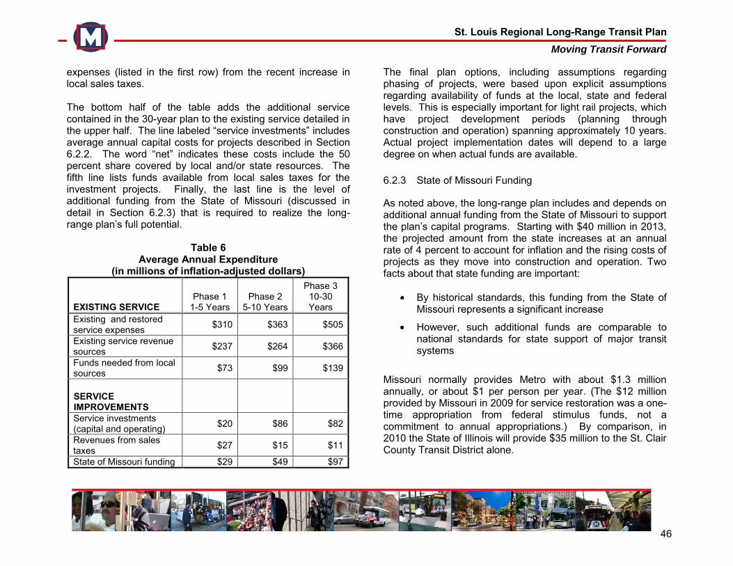
St. Louis Regional Long-Range Transit Plan Moving Transit Forward
46
expenses (listed in the first row) from the recent increase in local sales taxes. The bottom half of the table adds the additional service contained in the 30-year plan to the existing service detailed in the upper half. The line labeled “service investments” includes average annual capital costs for projects described in Section 6.2.2. The word “net” indicates these costs include the 50 percent share covered by local and/or state resources. The fifth line lists funds available from local sales taxes for the investment projects. Finally, the last line is the level of additional funding from the State of Missouri (discussed in detail in Section 6.2.3) that is required to realize the long-range plan’s full potential.
Table 6 Average Annual Expenditure
(in millions of inflation-adjusted dollars)
EXISTING SERVICE Phase 1
1-5 Years Phase 2
5-10 Years
Phase 3 10-30 Years
Existing and restored service expenses $310 $363 $505
Existing service revenue sources $237 $264 $366
Funds needed from local sources $73 $99 $139
SERVICE IMPROVEMENTS
Service investments (capital and operating) $20 $86 $82
Revenues from sales taxes $27 $15 $11
State of Missouri funding $29 $49 $97
The final plan options, including assumptions regarding phasing of projects, were based upon explicit assumptions regarding availability of funds at the local, state and federal levels. This is especially important for light rail projects, which have project development periods (planning through construction and operation) spanning approximately 10 years. Actual project implementation dates will depend to a large degree on when actual funds are available. 6.2.3 State of Missouri Funding
As noted above, the long-range plan includes and depends on additional annual funding from the State of Missouri to support the plan’s capital programs. Starting with $40 million in 2013, the projected amount from the state increases at an annual rate of 4 percent to account for inflation and the rising costs of projects as they move into construction and operation. Two facts about that state funding are important:
By historical standards, this funding from the State of Missouri represents a significant increase
However, such additional funds are comparable to national standards for state support of major transit systems
Missouri normally provides Metro with about $1.3 million annually, or about $1 per person per year. (The $12 million provided by Missouri in 2009 for service restoration was a one-time appropriation from federal stimulus funds, not a commitment to annual appropriations.) By comparison, in 2010 the State of Illinois will provide $35 million to the St. Clair County Transit District alone.
St. Louis Regional Long-Range Transit Plan Moving Transit Forward
47
At a national level, transit systems in urbanized areas with populations of more than 200,000 receive on average 23 percent of their operating costs from states, whereas Metro receives less than 1 percent from Missouri. Also nationally, those systems receive 16 percent of capital cost from states; Metro receives no capital funding from Missouri. To put this in perspective, the state funding included in Table 6 totals $2.3 billion over the 30-year plan. That is 18 percent of the total operating needs of the system. If state funding equaled the national average for larger cities, 23 percent, that total would be $2.9 billion. The $600-million difference would completely fund another light rail extension.
6.2.4 Federal Funding Opportunities
The FTA’s Section 5309 New and Small Starts Program is the federal government’s primary financial resource for supporting local capital projects. These projects, which can include commuter rail, light rail, heavy rail, BRT, streetcars, and ferries, are recommended for discretionary capital grant funding by FTA based on a rigorous evaluation process. Safe Accountable Flexible Efficient Transportation Equity Act: A Legacy for Users (SAFETEA-LU) provided $6.6 billion between fiscal years 2006 and 2009 to fund New and Small Starts, with New Start project sponsors generally providing some 50 to 60 percent of the capital costs from local sources of funding. The local share for Small Start projects – that is, projects costing less than $250 million in year of expenditure dollars – has tended to be lower, averaging around 25-30 percent. As a discretionary program, Section 5309 New and Small Starts requires FTA to evaluate, rate, and recommend projects based on a set of statutorily established criteria. These project
justification criteria include mobility improvements, cost effectiveness, transit supportive land use, operating efficiencies, economic development benefits, and environmental benefits. There is a somewhat more streamlined set of criteria used to evaluate Small Starts. Historically, cost effectiveness has been the key determinant on whether a New or Small Start project would or would not receive a grant from FTA. However, under the new Administration, there has been a return to consideration of the full range of project justification criteria. In addition to presenting the merits of their projects, sponsors must also demonstrate they have the financial capacity to take on the new project, while maintaining their existing system and meeting other financial commitments. Further, sponsors need to demonstrate their technical capacity to manage a major transit project design, construction, and implementation effort. In the cash flow model utilized for this analysis, it was assumed that FTA’s Section 5309 program would provide 50 percent of the capital cost for any of the potential BRT or light rail projects identified in the plan; 80 percent federal capital funding is assumed for local bus service improvements and passenger amenities. These are reasonable assumptions given the past history of program funding. In order to receive Federal funding through a New or Small Starts grant, the merits of each capital project contained within the phased plan must be measured according to the project justification criteria, with the results receiving favorable ratings from FTA. While it is believed that Metro’s proposed projects can demonstrate merit, the availability and level of future FTA Section 5309 funding is currently in question. SAFETEA-LU formally expired in September 2009 and has been extended at current levels through a sequence of short-term continuing resolutions. One of these resolutions expired on February 28,
St. Louis Regional Long-Range Transit Plan Moving Transit Forward
48
2010, and after a brief lapse the program was extended for another month through March 28, 2010 with the signing of the “Temporary Extension Act of 2010” on March 3. On March 18, President Obama signed the HIRE bill into law, which includes a longer extension through the end of calendar year 2010. From a longer-term perspective, the outlook for future federal transit funding is mixed. On one hand, the primary source of funding for the program, the Federal gas tax, has proven unsustainable to meet national investment needs. On the other hand, record levels of funding from other sources (general fund, borrowing, and unspent program dollars) have been made available for transit in a variety of bills over the last year. Despite major unanswered questions about a long-term stable funding source for federal transportation programs, the current Administration is providing record levels of transit funding and emphasizing the expansion of public transportation, livability, and sustainability. What this could mean for transit agencies such as Metro is the likely expansion of federal funding opportunities, and an increased flow of dollars for both capital and operating enhancements. The U.S. DOT livability initiative may also help aging metropolitan areas such as St. Louis, with funds targeted to urban development and community “livability,” defined in terms of transportation choice, affordable housing, economic development, energy efficiency, and land use.
This positive trend supports the assumption in the financial plan that $10 million per year in additional federal funds – from not-as-yet explicitly identified sources – will be available to support the plan’s capital and operating needs.
6.2.5 Financial Analysis Summary The Moving Transit Forward team has formulated a reasonable funding strategy to implement the overall plan and to responsibly implement projects over the 30-year plan horizon. The financial model on which this analysis is based includes all annual expenditures, both capital and operating, adjusted for inflation. This includes existing rail and bus service, as well as new implementation and operation of expansion projects. The financial plan also lists annual funding requirements from local (including fares), state and federal sources, all of which are required to implement the plan as outlined. The most important conclusion from this analysis is that while local resources will allow Metro to restore service and sustain the existing system, any major system expansion will require federal matching funds. Any further extension of MetroLink service will also require additional state support for construction and operation costs. Other key conclusions from this analysis are:
While projects are sequenced over three phases, the actual timing of each investment will depend on the availability of both capital and operating funds. For MetroLink extensions this includes funding from local, state and federal sources.
For all major system expansions, the plan assumes federal funding for 50 percent of the capital cost, a typical assumption nationwide for such projects. This means that federal evaluation criteria must be an important part of the project selection process.
St. Louis Regional Long-Range Transit Plan Moving Transit Forward
49
While program details are constantly changing, the new Administration in Washington is committed to increasing federal support for transit. This plan assumes an increase in ongoing annual federal support for Metro, though specific programs have yet to be determined.
It is especially important that the State of Missouri increase its funding for Metro to a level comparable with that for similar regions and transit agencies. The national average of state support for transit operations in areas with population more than 200,000 is 23 percent. To pursue full build-out out of the long-range plan (two light rail lines and four to five BRT routes), the plan assumes financial support from the State of Missouri rising from less than one percent to 18 percent, which would bring the Metro Transit System in line with the national average.
St. Louis Regional Long-Range Transit Plan Moving Transit Forward
50
7.0 MOVING TRANSIT FORWARD LONG-RANGE PLAN Once the community’s preferences and priorities were identified through the first series of public engagement strategies, the Moving Transit Forward team used a set of community values to determine which of those priorities should be included in the final plan. The team then used a robust financial analysis to determine how many of those potential projects could be built over the next 30 years, within set financial constraints, as well as a rational, reasonable investment strategy for phasing those projects over the life of the plan. The planning team presented this refined set of plan options and the investment timeline at two more rounds of community meetings in order to ensure that Moving Transit Forward would be a shared regional vision. 7.1 Community Engagement – Series 2 7.1.1 Moving Transit Forward Advisory Group The planning team met with the Moving Transit Forward Advisory Group for a second time on December 2, 2009. The team provided an update on regional mobility needs, the community-preferred alternatives identified during the October public workshops, and the financial capacity analysis. The Advisory Group indicated that linking transit to economic development should be emphasized. The presentation for the December Advisory Group meeting is in Appendix E. 7.1.2 Executive Committee The planning team also presented the community preferred alternatives, the regional mobility results, and the financial
capacity of the plan to a second meeting of the Executive Committee on December 4, 2009. The presentation to the Executive Committee is in Appendix F. 7.1.3 December 2009 Public Meetings The planning team presented the refined set of plan options and the financial capacity analysis to the public at a second round of public meetings in December 2009. A webinar and seven meetings were conducted throughout the region, in both Missouri and Illinois. As part of the presentation, the planning team reviewed the fundamental community values of the long-range plan:
Provide transit access to the greatest number of people and a range of markets and communities
Emphasize transit’s role as a vital regional asset
Enhance mobility options to transit-dependent citizens throughout the region
Identify cost-effective projects that balance increased ridership against construction and operating costs
The plan also includes projects that:
Offer the greatest potential for attracting federal funding
Support development in the St. Louis region
Help reduce pollution and traffic congestion
Contribute to the strengths of the region’s core
St. Louis Regional Long-Range Transit Plan Moving Transit Forward
51
Metro’s operational and financial constraints were outlined, including information on local, state, and federal funding. The planning team emphasized that any expansion of the Metro Transit System would absolutely require additional funding. Participants were asked to review and prioritize the refined set of plan options. For light rail expansions, participants prioritized the identified corridors in the following order:
Northside – Southside
MetroSouth
Clayton – Westport
MetroNorth
Madison County Tri-Cities
St. Charles County For Bus Rapid Transit service, participants prioritized corridors in this order:
Grand Boulevard
I-64
I-70
I-44
I-55
When addressing general service enhancements, the top two priorities were an improved sense of personal safety and a bus service enhancement program. The presentation, handout
materials, and comments from the December public meetings are in Appendix D. 7.2 The 30-Year Plan The planning team used feedback from the second round of community engagement and a refined financial analysis to further narrow the set of plan options and to finalize the capital investment strategy. This long-range plan will meet the project’s goals, address the region’s mobility needs, and attain the community’s vision of a robust transit system in a financially responsible manner (see Figure 18). The Moving Transit Forward Long-Range Plan includes the following:
Immediate Action Steps o MetroBus, MetroLink, and Metro Call-A-Ride
service restoration o Planning and engineering for first MetroLink
extension o Planning and engineering for first BRT route
Short-Range (1-5 Years) o Complete planning and engineering for first
MetroLink extension o Construction and operation of first BRT route o Planning, construction and operation of second
BRT route o Passenger amenities and technology
improvement program
St. Louis Regional Long-Range Transit Plan Moving Transit Forward
52
Mid-Range (5-10 Year) o Construction and operation of light rail
extension studied in first phase o Planning, construction and operation of one or
two additional BRT routes o Planning and construction of additional transit
center(s)
Long-Range (10-30 Year) o Planning, construction and operation of a
second MetroLink extension o Planning and engineering for a third MetroLink
extension
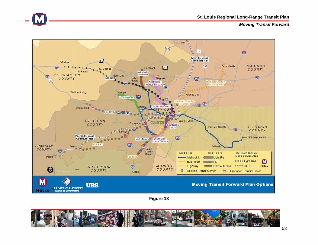
St. Louis Regional Long-Range Transit Plan Moving Transit Forward
53
Figure 18
St. Louis Regional Long-Range Transit Plan Moving Transit Forward
54
With only the recently-approved additional local funding, all of the immediate action projects will be implemented. This includes service restoration on MetroBus, MetroLink and Metro Call-A-Ride, along with planning the next MetroLink extension and the BRT routes. Full build-out of the long-range plan’s capital investment strategy will require additional federal and state funding. Metro’s first priority is restoring the service that was reduced last year. The most immediate objectives of service restoration are to return service levels, including frequency and geographic coverage, to pre-reduction levels so that current demand is met and opportunities for future growth are created. MetroLink frequencies will gradually be increased; Call-A-Ride service will be expanded; and MetroBus routes will be realigned and run more often. However, it is impossible to immediately restore the Metro System to full operating capacity; rather, the service restoration strategy will be pursued in phases, depending upon the availability of operator manpower and vehicles. Phase I addresses the Metro System's most pressing requirements, including the need for additional service on MetroLink and the most heavily-utilized bus routes in both St. Louis City and St. Louis County. Phase II and Phase III will implement enhancements to bring the MetroBus System’s geographic coverage and service levels back to pre-March 2009 levels. However, though the level of service will be restored, the resultant system will not be identical to the pre-reduction MetroBus network because the plan also seeks to maximize efficiencies and route productivity. For example, Metro may “split” some of the longer MetroBus routes to accommodate the use of smaller buses and longer headways on lesser-used portions of the route. The proposed restoration plan also identifies potential new routes, as well as the
combination or rerouting of existing lines. Each MetroBus route will be modified in only one phase of the restoration plan, rather than during successive service changes. This tactic is designed to help bring much needed stability to the Metro System. This service restoration strategy is an exciting opportunity to improve the Metro System. It will help our community connect to more destinations, alleviate crowding on high-demand bus routes, make riding the MetroBus System easier and more enjoyable, and provide the freedom of choosing alternative transportation that has been limited since March 2009. As for expanding the Metro System, Moving Transit Forward includes more options than could be built over the 30-year timeline. The plan is not intended to define exactly which projects will be built and when, but rather to provide a limited range of options for expanding the region’s transit system, as well as a framework for phasing them in a financially responsible manner. Any large capital projects that use federal funds, such as MetroLink extensions or BRT routes, must be included in the region’s Long-Range Transportation Plan. The EWGCOG Board of Directors will choose future expansion projects from Moving Transit Forward’s set of options as additional state and federal funds become available. MetroLink The Moving Transit Forward Long-Range Plan includes five options for expanding MetroLink service to more communities. When adequate financial resources become available, regional leaders will select projects from this list of options:
St. Louis Regional Long-Range Transit Plan Moving Transit Forward
55
Clayton to Westport (Daniel Boone) The Clayton-Westport corridor would extend from the Clayton MetroLink station to I-170, north along I-170 to between Olive Boulevard and Page Avenue, then west to Westport. This corridor would expand high-speed transit access to previously untapped markets, enhancing fast connections between Mid-County neighborhoods and employment centers in Clayton and Downtown St. Louis, as well as reverse commutes to jobs in Westport. It would attract new customers to the Metro System, and may provide stimulus for new development in the Mid-County area. However, transit-friendly land use policies would have to be established by local municipalities in order to maximize development potential. MetroNorth The MetroNorth Corridor would generally run north along or near the I-170 corridor from the North Hanley MetroLink station into Florissant. This service would provide North County residents with a direct link to the existing MetroLink system, facilitating travel between North County, Downtown St. Louis, the Central West End, and Clayton. It would expand MetroLink service into North County communities, attracting new riders and connecting them to jobs and other services in the region’s core. MetroNorth may attract new development and employment to North County, especially if local communities enact transit-friendly land use policies and redevelopment plans. MetroSouth The MetroSouth corridor would run from the existing Shrewsbury station southeast along River Des Peres to I-55, then southward past I-255/I-270 to terminate near Butler Hill Road. This corridor would extend MetroLink to South County residents and facilitate commutes to employment centers in Clayton and, if the Clayton-Westport MetroLink line were
operational, to jobs in Westport. It could also complement the proposed I-55 BRT route and Northside-Southside light rail extension to provide direct access to Downtown St. Louis as well as reverse commutes to jobs near South County Center. This line would attract new riders to the system, connect South County residents to jobs, and provide more options for transit-dependent citizens in South County. It may spur moderate new development, especially if transit-friendly land use policies were enacted by local municipalities. Northside-Southside This light rail corridor could be built in at least two phases: a Minimum Operating Segment and the full build-out. The MOS would travel through Downtown St. Louis, north along North Florissant Avenue and Natural Bridge to Newstead Avenue. The southern segment would extend from Downtown St. Louis along 14th Street, then south along Jefferson Avenue to I-55. The Northside full build would extend the line north from Goodfellow Boulevard into North County, terminating near Florissant Valley Community College. The Southside segment could be extended down I-55 to Bayless Avenue, connecting to the MetroSouth light rail corridor and the I-55 BRT route. The Northside-Southside corridor would facilitate north-south travel through the region’s core, particularly the City of St. Louis, and encourage development and job growth. It would provide enhanced mobility options to the region’s transit-dependent populations, but may not attract significant numbers of new riders to the Metro System since this corridor is currently well-served by MetroBus. Madison County Tri-Cities and Edwardsville This light rail corridor could be built in at least two phases: from the Emerson Park MetroLink Station in East St. Louis, IL, to the Granite City/Tri-Cities area, then from Granite City/Tri-
St. Louis Regional Long-Range Transit Plan Moving Transit Forward
56
Cities to Edwardsville, IL. This corridor would bring MetroLink service to the communities of East St. Louis, Venice, Madison, Granite City, and eventually Edwardsville and the SIUE campus. Any expansion of service into Madison County, IL would require support and funding from Madison County and Madison County Transit. Bus Rapid Transit BRT lines will be selected by regional leaders from the set of plan options as funding becomes available. The long-range plan includes the following potential routes: Grand Boulevard A BRT line along Grand Boulevard in the City of St. Louis would provide high-speed bus service along one of the City’s busiest and most densely-developed corridors. The service could run from Natural Bridge in North City south to Chippewa in South City, providing high-speed service with limited stops at major destinations, as well as improved connections with MetroLink and other bus routes. This route would attract modest new ridership and greatly increase efficient service along one of the region’s busiest corridors. It may also help spur some moderate new or infill development along Grand. I-64 and I-70 The long-range plan also visualizes a BRT network along the region’s highways in order to quickly provide high-speed transit service to as much of the region as possible. BRT lines are much less expensive to build and operate than light rail lines, and a highway-based system would provide fast connections between suburban St. Louis County and jobs in the region’s core. The potential I-64 and I-70 lines would also serve reverse commuters from the core going to jobs in West St. Louis County, Earth City and St. Charles County. These highway-based routes probably would not foster new
economic development, but would open the transit system to new markets and new riders and improve connections to MetroLink and secondary bus routes. However, any expansion of transit service into St. Charles County would have to be supported and funded by the residents of that county. I-55 and I-44 The region may also choose to build and operate BRT lines along I-44 and I-55. Similar to the other highway-based lines, these would serve new markets, attract new riders, and help connect residents of South County with jobs and other services in the region’s core. However, these BRT routes would have minimal impact on land use or economic development, and offer somewhat less potential for reverse commute flows than the I-64 and I-70 BRT lines. Commuter Rail Moving Transit Forward also includes two options for providing commuter rail service to the region. Two routes have been identified, one between Downtown St. Louis and Alton, IL, and the other from Downtown St. Louis to Eureka or Pacific, MO. Though these projects are included as plan options, they are not included in the capital investment strategy. They depend entirely upon the success of Federal and State initiatives to build intercity, high-speed rail connections between Chicago, St. Louis and Kansas City. If intercity passenger rail lines are improved, the St. Louis region could implement commuter rail service on either or both lines. The region would be responsible for purchasing or leasing train vehicles, building stations and operating the service, but would not have to purchase right-of-way or build expensive rail infrastructure.
St. Louis Regional Long-Range Transit Plan Moving Transit Forward
57
7.3 Community Engagement – Series 3 With input from the community and refinements to the financial analysis, the planning team finalized the Moving Transit Forward Long-Range Plan. The final plan was presented at a third series of public meetings to ensure that the plan meets the region’s diverse transportation needs and fulfills the community’s goals. 7.3.1 Moving Transit Forward Advisory Group The planning team presented the draft plan to the Moving Transit Forward Advisory Group at a third meeting in February 2010. The team also outlined the financial realities and challenges of moving ahead with the plan, and next steps for implementing the short-range plan elements and pursuing potential funding sources. The presentation to Advisory Group is in Appendix E. 7.3.2 January 2010 Public Meetings The planning team conducted the final series of public meetings in January 2010. The team presented the draft Moving Transit Forward Long-Range Plan at one webinar and five public meetings across the region. The team outlined the final set of plan options for light rail, BRT, and commuter rail service, in addition to improved passenger amenities. The presentation included a review of the financial realities facing the agency, including an in-depth discussion of local, state, and federal funding sources. Participants were given handouts illustrating how the plan options would benefit specific parts of the region, especially in connecting large concentrations of residents to major
employment centers. Participants were encouraged to consider the proposed projects as an integrated regional system, and asked to indicate whether the plan would meet the needs of their neighborhood as well as the entire region. The majority of respondents indicated that the long-range plan would indeed meet the needs of both their individual communities and the region as a whole. The presentation and comment forms from the January meetings are in Appendix D.
St. Louis Regional Long-Range Transit Plan Moving Transit Forward
58
8.0 SUMMARY After incorporating public input from the final series of community meetings, the Moving Transit Forward Long-Range Plan was presented to the Metro Board of Commissioners. The Board approved the plan on February 12, 2010. The EWGCOG Board of Directors adopted the plan as the St. Louis region’s official long-range transit plan on February 24, 2010. Presentations to both boards are in Appendix G. Moving Transit Forward is a financially reasonable plan that phases in transit system expansions over the next 30 years. Regional leaders, working through EWGCOG, will select from these options as funding becomes available. Moving Transit Forward is a dynamic community vision, a living document that will be revised as the region’s transportation needs change. Moving Transit Forward’s plan options will attain the community’s values as defined throughout the planning process:
Provide transit access to as many people and places as possible
Strengthen transit’s role as a vital regional asset Increase mobility options to more of the transit-
dependent Provide the best service for as many people as
possible Prove cost-effective Encourage economic development and job growth
Help reduce traffic congestion and air pollution Contribute to the strengths of our region’s core
St. Louis Regional Long-Range Transit Plan Moving Transit Forward
59
GLOSSARY Americans with Disabilities Act (ADA) Federal law enacted in 1990 to protect the civil rights of persons with disabilities, ensuring them the same level of access to employment, public transportation, public accommodations, and telecommunications enjoyed by persons without disabilities. Bus Lane A lane on a roadway that is reserved for bus use only. Also known as a “diamond lane.” Bus Rapid Transit (BRT) A flexible system of rubber-tired rapid transit vehicles that integrates stations, running ways, and Intelligent Transportation System (ITS) technologies to improve the speed, reliability, and identity of bus transportation. Busway A separate roadway for the use of buses only. These are usually two-lane and can be part of a highway right-of-way or, more typically, built in abandoned railroad corridor. They provide much higher average speeds for buses. Computer-Aided Dispatch/ Automated Vehicle Location (CAD/AVL) CAD/AVL is a technology that monitors bus and train location, which will eventually allow Metro to provide real-time bus arrival and departure information to customers. Call-A-Ride Door-to-door van service provided by Metro in the City of St. Louis and portions of St. Louis County for individuals with
advance reservations. Call-a-Ride Plus is van service for persons with disabilities who qualify and have a Call-A-Ride Plus ID. Central Business District (CBD) A highly concentrated cluster of businesses located in a central region, often known as the Downtown. Commuter Rail Local and regional passenger train service between a central city, its suburbs, or another central city. May be either locomotive-hauled or self-propelled. Also known as “suburban rail.” Congestion Mitigation and Air Quality Program (CMAQ) Federal funding program for transportation projects to help reduce traffic congestion and improve air quality. Among other purposes, funding can be used for transit projects, rideshare projects, high-occupancy vehicle lanes, and public fleet conversion to cleaner fuels. Corridor A defined geographic area characterized by common travel patterns. This is often the geography for which transportation improvements are analyzed, through what is called a “corridor study.” Council of Governments A voluntary association of local government units which desire to work together to study issues and / or solve problems in a geographic area. East-West Gateway was incorporated as the council of governments for the eight-county St. Louis area in 1965.
St. Louis Regional Long-Range Transit Plan Moving Transit Forward
60
East-West Gateway Council of Governments (EWGCOG) The Metropolitan Planning Organization (MPO) for the eight county region that includes the City of St. Louis; Franklin, Jefferson, St. Charles and St. Louis counties in Missouri; Madison, Monroe, and St. Clair counties in Illinois. As MPO, East-West Gateway is responsible for the coordinated planning of federally-funded transportation projects and programs in the region. www.ewgateway.org Economic Development Increases in wealth, wages, and productivity in a metropolitan region. One of the goals of the transportation plan is to support sustainable economic development. Efficiency How well the transportation system serves the needs of its customers, per unit of resources spent. Environmental Impact Statement (EIS) Report that details the social, economic, and environmental effects of alternatives for a proposed federally-funded capital project. Effects could include air, water, or noise pollution; destruction or disruption of natural resources; displacement of residences or firms. Exclusive Right-of-Way A highway or other transportation facility used only by buses or other designated vehicle types. Expressway A divided high-speed roadway having two or more traffic lanes in each direction, with limited controlled access.
Fare Box Revenue The value or revenue to the transit system from cash, tokens, and pass receipts paid by passengers who use the system. Fare box revenue accounts for approximately one-fourth of Metro’s operating revenues. Federal Transit Administration (FTA) Division of the U.S. Department of Transportation that administers federal transit programs. www.fta.dot.gov Fixed Guideway System A system of vehicles that can operate only on a guideway constructed for that purpose. Light rail and rapid rail are examples of fixed guideway systems. Fixed Route Service Transit service provided on a repetitive, fixed schedule along a specific route with designated stops. “Bus routes” are examples of fixed route service, contrasted with flexible routing. Global Positioning System (GPS) A satellite navigation system that enables receivers (such as those installed in some vehicles) to process specially programmed satellite signals and compute the exact location, velocity, and time. Intelligent Transportation Systems (ITS) The use of information and communication technologies in vehicles, roadways, signage or other aspects of the transportation system to improve efficiency and safety. An example of an ITS program is Smart Cards. Smart Cards will allow passengers to load money to a pass that can be used throughout the Metro System for all types of trips, from single
St. Louis Regional Long-Range Transit Plan Moving Transit Forward
61
rides to monthly passes. Fare enforcement officers will carry electronic validators to detect if the card has a valid fare. Intermodal A transportation system connecting or including different modes of transportation. Land Use Property is often grouped in categories, including commercial, residential, retail, industrial, recreational or green space. Legacy 2035 The region’s metropolitan plan that sets the agenda for future investment decisions regarding the area’s transportation system. The focus areas are preservation of the existing infrastructure, safety and security, congestion, access to opportunity, sustainable development, and efficient movement of goods. The plan is updated every three years. Light Rail Transit (LRT) Fixed rail vehicles that are electrically powered by overhead wires (catenary). Light rail transit systems make more frequent stops and travel more slowly than heavy rail or high speed rail service that is designed to serve more riders and make less frequent stops. Locally Preferred Alternative The transportation improvement selected by local elected officials after completion of an alternatives analysis. Long-Range Plan A document that is an assessment of a region’s transportation facility, service and policy needs over the next 30 years. The plan considers a wide range of social, environmental, and
economic factors. The plan considers overall regional goal and how transportation can meet those goals within financial limits. Madison County Transit (MCT) A publicly funded governmental entity created by the Illinois Legislature in 1980 to oversee the development of public transit in Madison County. Major Transportation Investment Analysis (MTIA) The planning process used to identify and evaluate potential large-scale, expensive transportation alternatives to address problems in a corridor or a subregion. Match Federal grants often require a commitment of state or local funds to qualify for a federal grant. Services, such as the work of volunteers, may be counted as an in-kind funding match. Federal transportation programs normally specify the match cannot come from another federal source. Metro The regional transit agency, formerly known as the Bi-State Development Agency, was formed in 1949 through a compact between Illinois and Missouri that was approved by the U.S. Congress. Metro owns and operates the region’s mass transit system and has the power to act across local, county and state boundaries to develop regional transportation programs. Metro’s network consists of buses, light rail, the Gateway Arch transportation system, the Arch Parking Garage and the Downtown Parks Airport. www.metrostl.org MetroBus The motor vehicle used by the regional transit agency to transport passengers.
St. Louis Regional Long-Range Transit Plan Moving Transit Forward
62
MetroLink The MetroLink system consists of two light-rail alignments, the Red Line and the Blue Line, with a total of 37 stations. The Red Line operates over 40 miles between Lambert-St. Louis International Airport in Missouri and Shiloh/Scott Air Force Base in Illinois. The Blue Line extends 22 miles between Shrewsbury in St. Louis County and Fairview Heights in Illinois. Both alignments use the same tracks between the Forest Park and Fairview Heights stations. Metropolitan Planning Organization (MPO) A group of local officials with the federal mandate to develop transportation plans and programs for urban areas with a population of more than 50,000. MPOs are formed by agreement with the state’s governor and representatives of local governments that represent at least 75 percent of the affected population. East-West Gateway Council of Governments was incorporated in 1965 as the MPO for the City of St. Louis and the counties of Franklin, Jefferson, St. Charles and St. Louis counties in Missouri and Madison, Monroe and St. Clair counties in Illinois. Missouri Department of Transportation (MoDOT) The state agency is responsible for five major transportation alternatives available to Missourians -- highways, aviation, waterways, transit and railroads. Those responsibilities include the total operation of the 32,000 mile highway system, including highway location, design, construction and maintenance. The local district office is in Chesterfield. www.modot.gov Mode The type or means of mass transit travel including light rail, BRT, bus, commuter rail, flex routes and paratransit. .
Multimodal Multimodal refers to the integration of various types of transportation in one system. A goal of planning is the achievement of a seamless multimodal system. New Start Federal funding for construction of “fixed guideway systems” which are designed for a system of vehicles that can only operate on that guideway, such as rapid rail, light rail or exclusive rights-of-way for buses. Off-Peak Period Times of the day when travel to and from work is less, therefore travel activity is generally lower and less transit service is scheduled. This is also called a “base period.” Operating Expenses Money paid for salaries, wages, materials, supplies, fuel and equipment used to maintain property, roads, bridges, facilities, equipment and buildings. Includes funds needed to operate vehicles, rent equipment and facilities and settle claims. Paratransit A variety of transportation services designed to serve the needs of persons not usually able to use conventional routes or vehicles. Flexible schedules and small vehicles, including vans, operate within normal transit corridors to serve the elderly and persons with disabilities. Peak Hour/Peak Period The defined time period in the morning or evening in which the largest volume of travel is experienced.
St. Louis Regional Long-Range Transit Plan Moving Transit Forward
63
Public Transportation Buses, trains and other vehicles that can be used on a regular basis by any member of the community. Right-of-Way (ROW) A common law or statutory allowance granted so that a public road, utility line or railroad can pass through a strip of land. St. Clair County Transit District A special purpose unit of local government that collects .25 percent sales tax for the purpose of providing public transportation in a district within St. Clair County. Transit Center A location at which passengers can transfer from a MetroBus route or MetroLink line. Transit Passenger service provided to the general public along fixed routes with regular or variable schedules available for published fares. Transit-Oriented Development (TOD) The integrated development of residential, commercial and public space within walking distance of public transit facilities with the purpose of making it safe and attractive for walking, while still accommodating automobile traffic. Transit Tax Any levy on sales, income or property that is dedicated to fund transportation services, including any public transportation services such as buses and light rail.
Transportation Analysis Zone (TAZ) An area used to study the effects of traffic and transit on an area that can be from one to 10 square miles in area, with the average size depending on the total size of the study area. Transportation Improvement Program (TIP) A program of intermodal projects to be implemented over several years that grows out of the planning process and designed to improve transportation in a community. A TIP is required as a condition for a locality to receive federal transit and highway grants. Travel Demand Model A mathematical representation of human travel behavior within a planning region that is designed to forecast travel so that problems can be defined and solutions can be tested. Travel Time The measurable interval it takes to cover a distance door-to door. In transportation planning, measures of travel time include the time spent accessing, waiting and transferring between vehicles. Trip A one-direction movement from an origin to a destination.
Related Documents


