Meteorological Institute Faculty of Forest and Environmental Sciences Permanent Forest Meteorological sites of the Meteorological Institute of the University of Freiburg within the COPS region PI: Prof. Helmut Mayer Meteorological Institute University of Freiburg Werderring 10 D-79085 Freiburg phone: +49-761-203-3591 [email protected] Thomas Holst, Jutta Rost [email protected] freiburg.de

Meteorological Institute Faculty of Forest and Environmental Sciences Permanent Forest Meteorological sites of the Meteorological Institute of the University.
Dec 26, 2015
Welcome message from author
This document is posted to help you gain knowledge. Please leave a comment to let me know what you think about it! Share it to your friends and learn new things together.
Transcript

Meteorological InstituteFaculty of Forest and Environmental Sciences
Permanent Forest Meteorological sites of the
Meteorological Institute of the University of Freiburg
within the COPS region
PI: Prof. Helmut Mayer
Meteorological Institute
University of Freiburg
Werderring 10
D-79085 Freiburg
phone: +49-761-203-3591
Thomas Holst, Jutta Rost
Meteorological InstituteFaculty of Forest and Environmental Sciences
Our contributions to COPS & GOP:
• Hartheim field site:
• Energy balance of a Pine Forest in the Rhine plain near Freiburg
• Tuttlingen field sites:
• Energy balance components on opposite slopes of a valley
• SODAR system (Scintec FAS64)
Tuttlingen sites
Hartheim site
Meteorological InstituteFaculty of Forest and Environmental Sciences
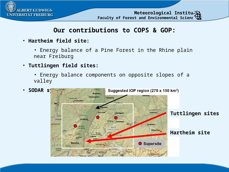
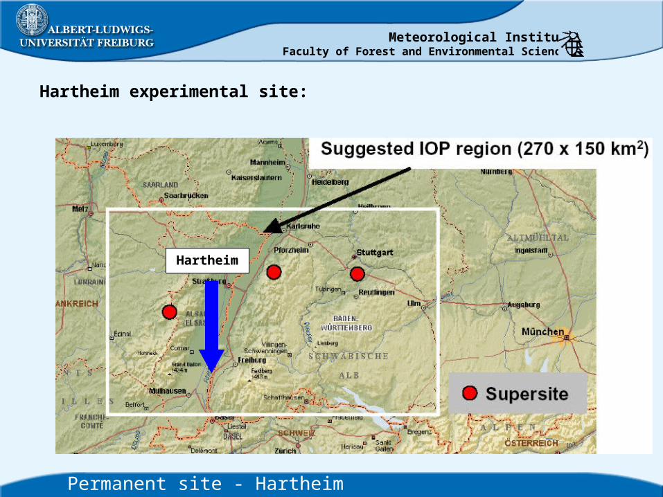
Hartheim experimental site:
Hartheim
Permanent site - Hartheim
Meteorological InstituteFaculty of Forest and Environmental Sciences
Permanent site - Hartheim
Google Earth
500 m
Hartheim site
Hartheim Pine forest
Bremgarten air field
Vegetation
• Pine forest, planted in 1963
• mean stand height (2004): 14.7 m
• stand density (2003): 800 trees ha-1
• PAI (2004): 1.77 m² m-2
Site characteristics
• situated in the Rhine valley
• ca. 25 km S of Freiburg
• flat terrain, between Vosges and Black Forest
• measurements since 1969
Meteorological InstituteFaculty of Forest and Environmental Sciences
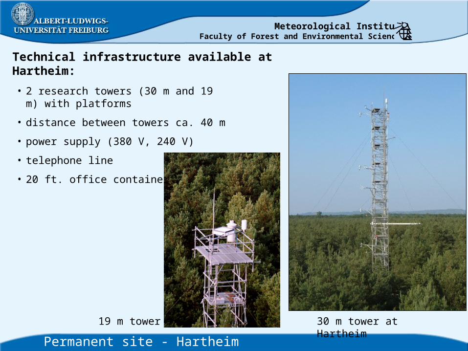
Technical infrastructure available at Hartheim:
30 m tower at Hartheim
Permanent site - Hartheim
19 m tower
• 2 research towers (30 m and 19 m) with platforms
• distance between towers ca. 40 m
• power supply (380 V, 240 V)
• telephone line
• 20 ft. office container
Meteorological InstituteFaculty of Forest and Environmental Sciences
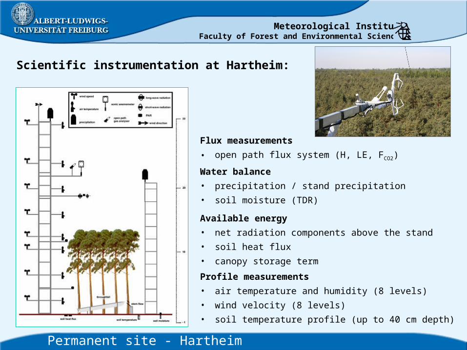
Scientific instrumentation at Hartheim:
Permanent site - Hartheim
Available energy
• net radiation components above the stand
• soil heat flux
• canopy storage term
Water balance
• precipitation / stand precipitation
• soil moisture (TDR)
Flux measurements
• open path flux system (H, LE, FCO2)
Profile measurements
• air temperature and humidity (8 levels)
• wind velocity (8 levels)
• soil temperature profile (up to 40 cm depth)

Meteorological InstituteFaculty of Forest and Environmental Sciences
Tuttlingen experimental sites:
Tuttlingen
Permanent sites - Tuttlingen

Meteorological InstituteFaculty of Forest and Environmental Sciences
Permanent sites - Tuttlingen
Site characteristics
• situated in the Swabian Jura
• ca. 100 km S of Stuttgart
• complex terrain, 2 opposite slopes (27°)
• measurements since 1999
Vegetation
• Beech forest, 80 yrs old
• mean stand height: ca. 27 m
• 3 plots per slope, 0.5 ha each
• 3 stand densities: 550, 275, 150 trees ha-1
• PAI: 5.2, 3.5, 2.0 m² m-2
N
Tuttlingen
1000 m
SW-slope
NE-slope
NE-slope
SW-slope

Meteorological InstituteFaculty of Forest and Environmental Sciences
Technical infrastructure available at Tuttlingen:
42 m tower at Tuttlingen
Permanent sites - Tuttlingen
meteorological station
• 2 research towers (42 m) with platforms (NE, SW)
• 4 meteorological stations (2 NE, 2 SW)
• distance between towers ca. 800 m
• power supply (380 V, 240 V)
• power supply (380 V, 240 V) available in the valley
• 10 ft. office container
Meteorological InstituteFaculty of Forest and Environmental Sciences
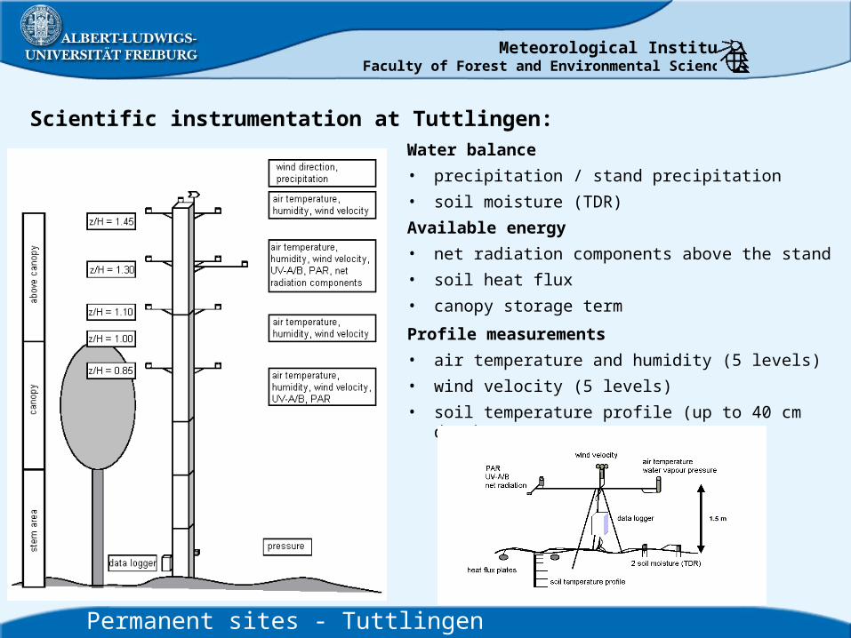
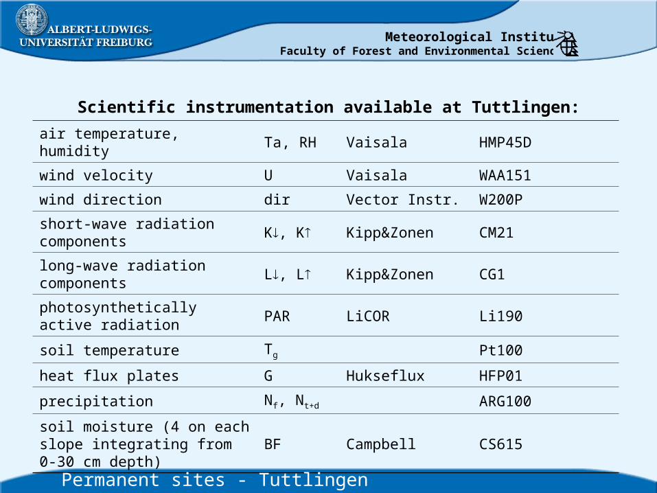
Scientific instrumentation at Tuttlingen:
Permanent sites - Tuttlingen
Water balance
• precipitation / stand precipitation
• soil moisture (TDR)
Available energy
• net radiation components above the stand
• soil heat flux
• canopy storage term
Profile measurements
• air temperature and humidity (5 levels)
• wind velocity (5 levels)
• soil temperature profile (up to 40 cm depth)
Meteorological InstituteFaculty of Forest and Environmental Sciences
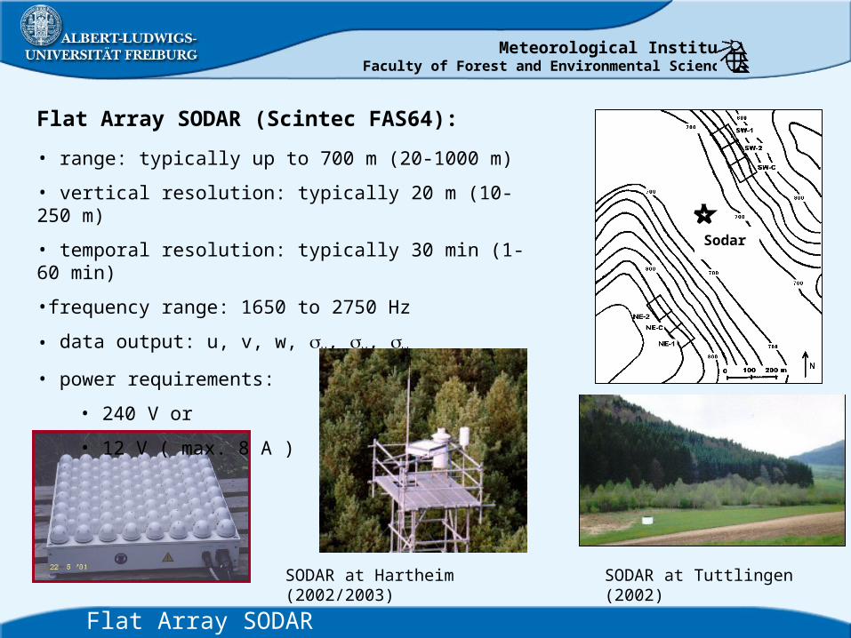
Flat Array SODAR (Scintec FAS64):
Flat Array SODAR
• range: typically up to 700 m (20-1000 m)
• vertical resolution: typically 20 m (10-250 m)
• temporal resolution: typically 30 min (1-60 min)
•frequency range: 1650 to 2750 Hz
• data output: u, v, w, u, v, w
• power requirements:
• 240 V or
• 12 V ( max. 8 A )
Sodar
SODAR at Tuttlingen (2002)SODAR at Hartheim (2002/2003)
Meteorological InstituteFaculty of Forest and Environmental Sciences
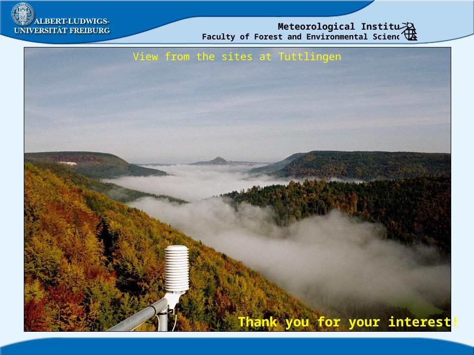
View from the sites at Tuttlingen
Thank you for your interest!

Meteorological InstituteFaculty of Forest and Environmental Sciences

Meteorological InstituteFaculty of Forest and Environmental Sciences
company type
air temperature, humidity Ta, RHaspirated psychrometers (pt100)
wind velocity U Vaisala WAA151
H2O and CO2-fluctuations cH2O, cCO2 LiCOR Li7500
3d-wind components u,v,w Campbell csat3
short-wave radiation components
K, K Kipp&Zonen CM21
long-wave radiation components
L, L Kipp&Zonen CG4
photosynthetically active radiation
PAR, PAR LiCOR Li190
soil temperature Tg Pt100
heat flux plates G Hukseflux HFP01, HFP01SC
precipitation Nf, Nt+dOmbrometer, pluviometer, ARG100
soil moisture 2x in 30 cm depth
BF Campbell CS615
Permanent site - Hartheim
Scientific instrumentation available at Hartheim:
Meteorological InstituteFaculty of Forest and Environmental Sciences
Experimental Design: company type
air temperature, humidity Ta, RH Vaisala HMP45D
wind velocity U Vaisala WAA151
wind direction dir Vector Instr. W200P
short-wave radiation components
K, K Kipp&Zonen CM21
long-wave radiation components
L, L Kipp&Zonen CG1
photosynthetically active radiation
PAR LiCOR Li190
soil temperature Tg Pt100
heat flux plates G Hukseflux HFP01
precipitation Nf, Nt+d ARG100
soil moisture (4 on each slope integrating from 0-30 cm depth)
BF Campbell CS615
Permanent sites - Tuttlingen
Scientific instrumentation available at Tuttlingen:
Meteorological InstituteFaculty of Forest and Environmental Sciences
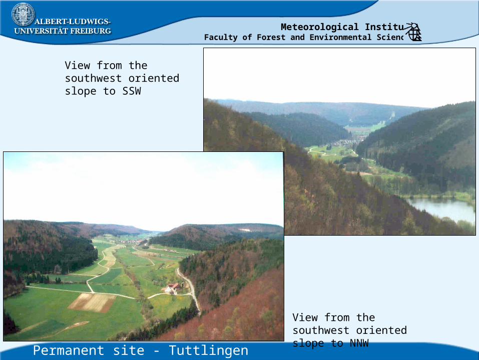
View from the southwest oriented slope to SSW
View from the southwest oriented slope to NNW
Permanent site - Tuttlingen
Meteorological InstituteFaculty of Forest and Environmental Sciences
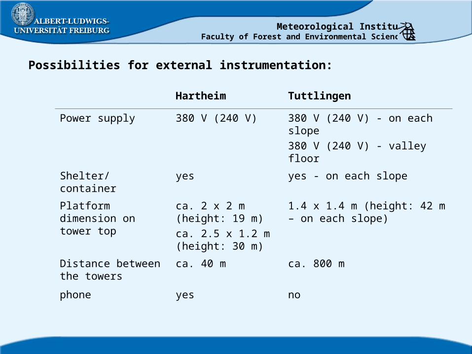
Possibilities for external instrumentation:
Hartheim Tuttlingen
Power supply 380 V (240 V) 380 V (240 V) - on each slope380 V (240 V) - valley floor
Shelter/container yes yes - on each slope
Platform dimension on tower top
ca. 2 x 2 m (height: 19 m)ca. 2.5 x 1.2 m (height: 30 m)
1.4 x 1.4 m (height: 42 m – on each slope)
Distance between the towers
ca. 40 m ca. 800 m
phone yes no
Related Documents