03/16/22 FINNISH METEOROLOGICAL INSTITUTE CARPE DIEM WP 7: FMI Progress Report Jarmo Koistinen, Heikki Pohjola Finnish Meteorological Institute

11/09/2015FINNISH METEOROLOGICAL INSTITUTE CARPE DIEM WP 7: FMI Progress Report Jarmo Koistinen, Heikki Pohjola Finnish Meteorological Institute.
Dec 27, 2015
Welcome message from author
This document is posted to help you gain knowledge. Please leave a comment to let me know what you think about it! Share it to your friends and learn new things together.
Transcript

04/19/23 FINNISH METEOROLOGICAL INSTITUTE
CARPE DIEMWP 7: FMI Progress Report
Jarmo Koistinen, Heikki Pohjola Finnish Meteorological Institute

04/19/23 FINNISH METEOROLOGICAL INSTITUTE
· Area 1/WP3: Development of a variational assimilation scheme for doppler winds (FMI + SMHI, responsible persons at FMI Heikki Järvinen, Kirsti Salonen)
· Area 2/WP7: Advanced surface precipitation estimate from radars and a NWP model (HIRLAM) (Jarmo Koistinen, Heikki Pohjola)
· Objective: Improve the accuracy and quality of operational real time precipitation measurements
04/19/23 FINNISH METEOROLOGICAL INSTITUTE
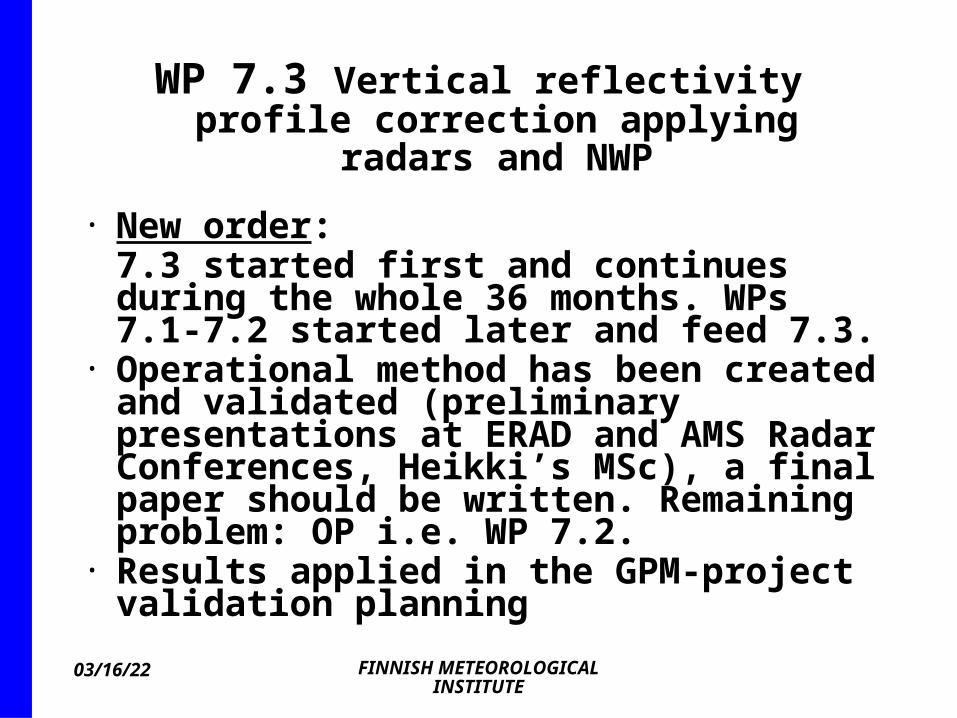
WP 7.3 Vertical reflectivity profile correction applying radars and
NWP
· New order:7.3 started first and continues during the whole 36 months. WPs 7.1-7.2 started later and feed 7.3.
· Operational method has been created and validated (preliminary presentations at ERAD and AMS Radar Conferences, Heikki’s MSc), a final paper should be written. Remaining problem: OP i.e. WP 7.2.
· Results applied in the GPM-project validation planning
04/19/23 FINNISH METEOROLOGICAL INSTITUTE
1(2)
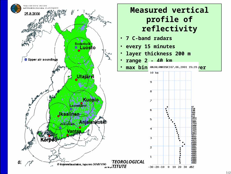
Measured vertical profile of reflectivity
• 7 C-band radars
• every 15 minutes• layer thickness 200 m• range 2 - 40 km• max bin count 5000 / layer
04/19/23 FINNISH METEOROLOGICAL INSTITUTE
1(2)
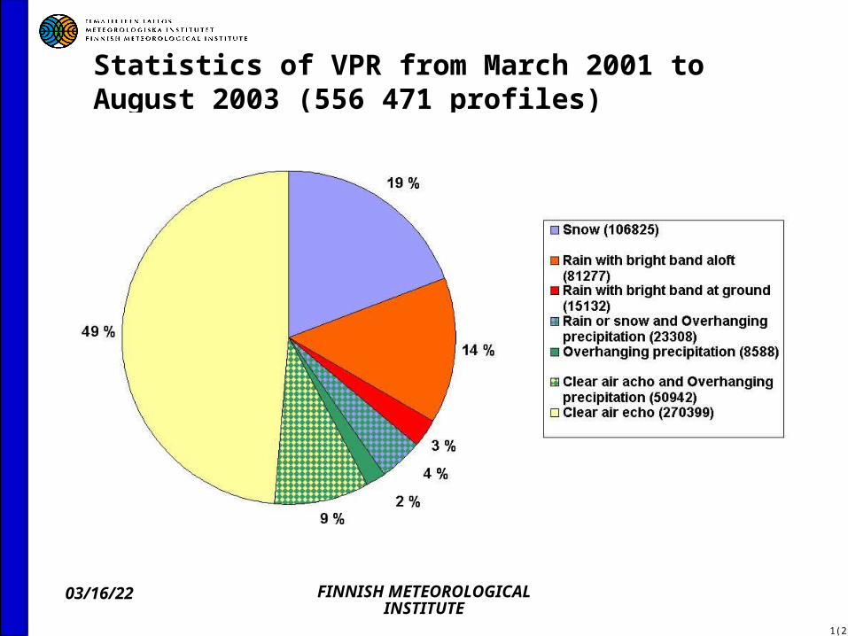
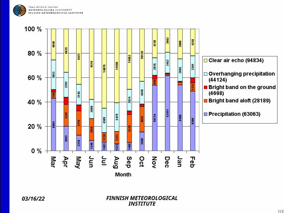
Statistics of VPR from March 2001 to August 2003 (556 471 profiles)
04/19/23 FINNISH METEOROLOGICAL INSTITUTE
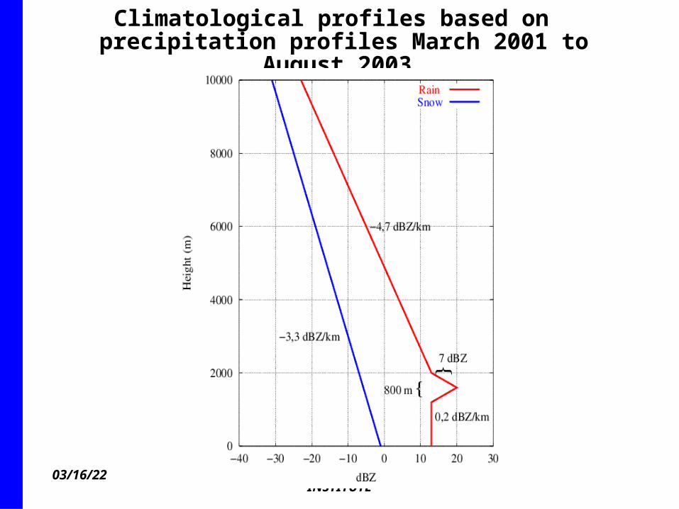
Climatological profiles based on precipitation profiles March 2001 to
August 2003
04/19/23 FINNISH METEOROLOGICAL INSTITUTE
1(2)
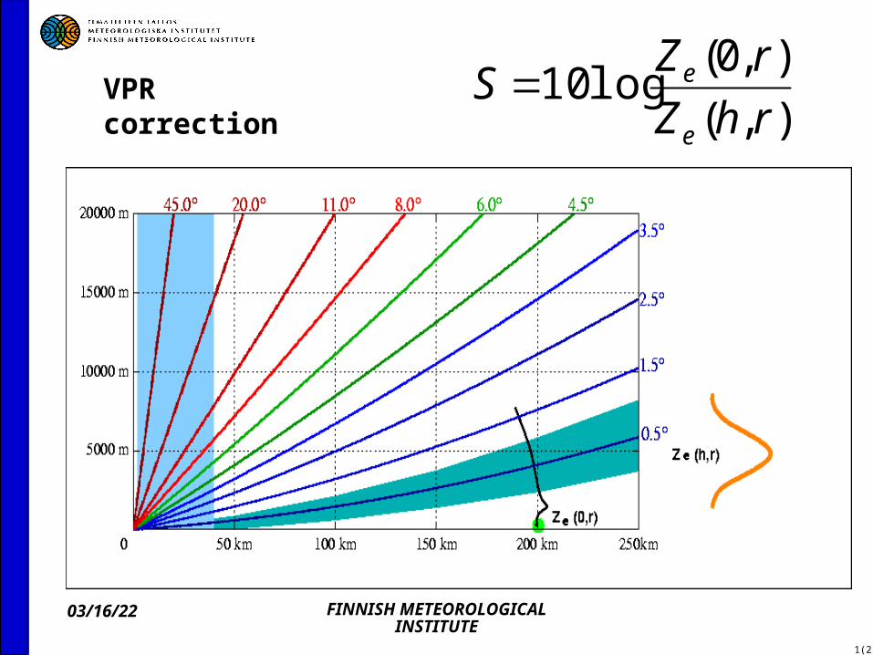
VPR correction ),(
),0(log10
rhZ
rZS
e
e
04/19/23 FINNISH METEOROLOGICAL INSTITUTE
1(2)
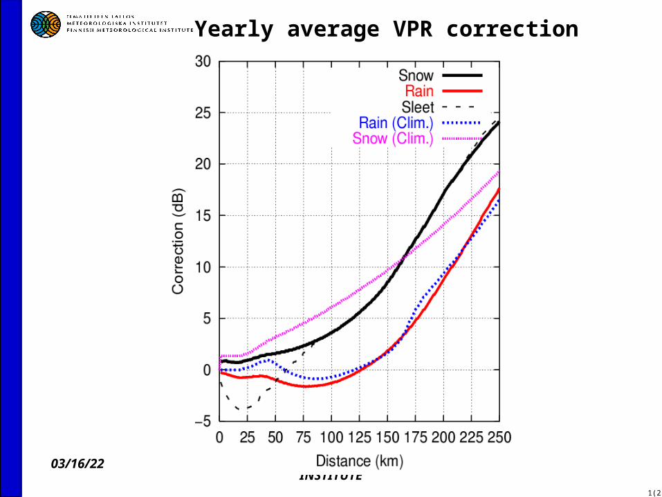
Yearly average VPR correction
04/19/23 FINNISH METEOROLOGICAL INSTITUTE
1(2)
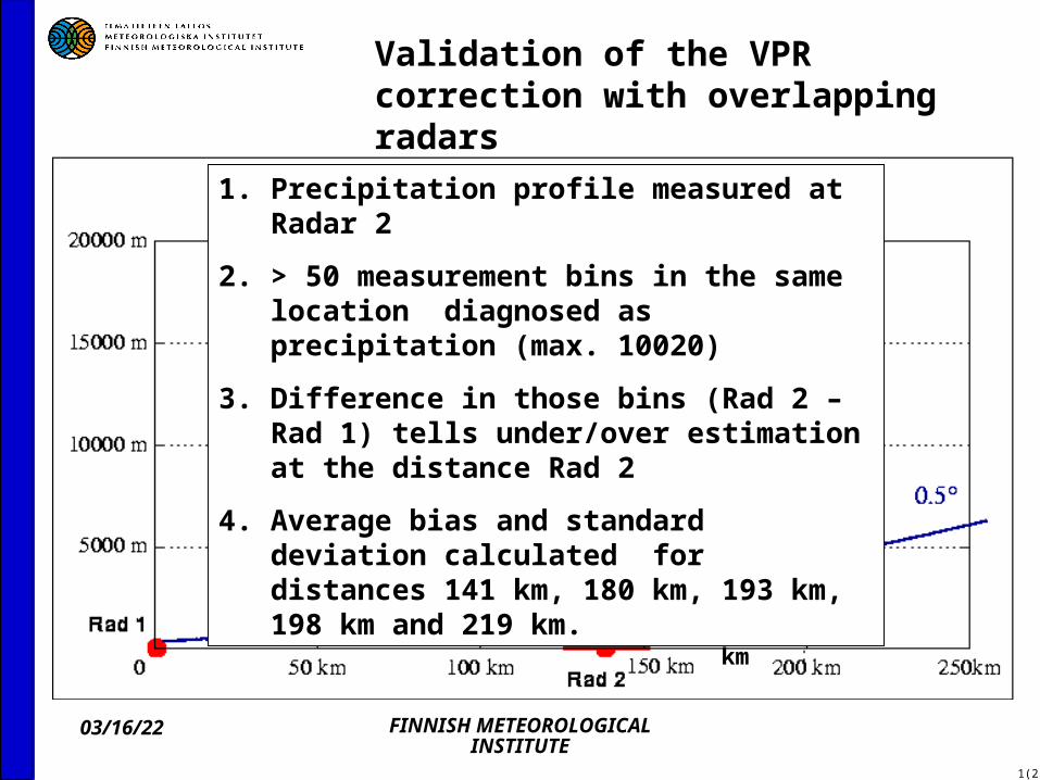
Validation of the VPR correction with overlapping radars
Measurement area 5 – 15 km
1. Precipitation profile measured at Radar 2
2. > 50 measurement bins in the same location diagnosed as precipitation (max. 10020)
3. Difference in those bins (Rad 2 – Rad 1) tells under/over estimation at the distance Rad 2
4. Average bias and standard deviation calculated for distances 141 km, 180 km, 193 km, 198 km and 219 km.

04/19/23 FINNISH METEOROLOGICAL INSTITUTE
Radar pair Anjalankoski-Vantaa (Vantaa-Anjalankoski) Feb – May 2003, distance
141 km
04/19/23 FINNISH METEOROLOGICAL INSTITUTE
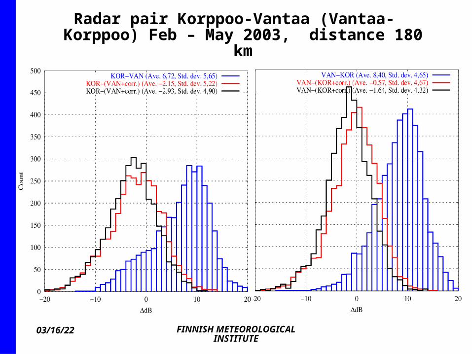
Radar pair Korppoo-Vantaa (Vantaa-Korppoo) Feb – May 2003, distance 180
km
04/19/23 FINNISH METEOROLOGICAL INSTITUTE
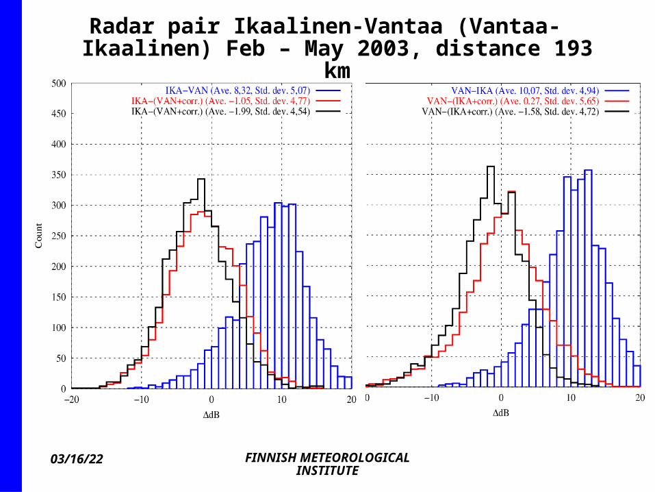
Radar pair Ikaalinen-Vantaa (Vantaa-Ikaalinen) Feb – May 2003, distance 193
km

04/19/23 FINNISH METEOROLOGICAL INSTITUTE
Radar pair Ikaalinen-Korppoo (Korppoo-Ikaalinen) Feb – May 2003, distance 198
km
04/19/23 FINNISH METEOROLOGICAL INSTITUTE
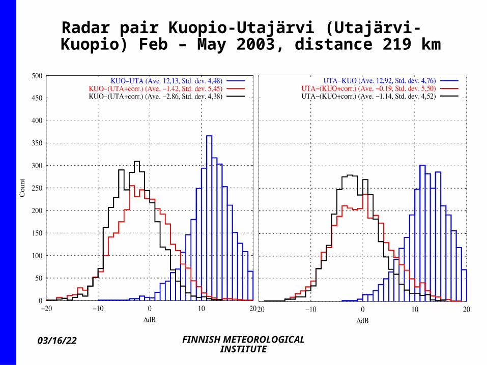
Radar pair Kuopio-Utajärvi (Utajärvi-Kuopio) Feb – May 2003, distance 219 km
04/19/23 FINNISH METEOROLOGICAL INSTITUTE
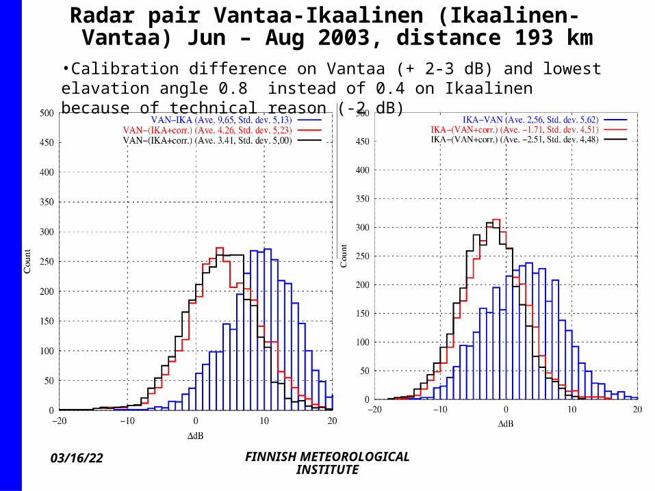
Radar pair Vantaa-Ikaalinen (Ikaalinen-Vantaa) Jun – Aug 2003, distance 193 km
•Calibration difference on Vantaa (+ 2-3 dB) and lowest elavation angle 0.8 instead of 0.4 on Ikaalinen because of technical reason (-2 dB)

04/19/23 FINNISH METEOROLOGICAL INSTITUTE
Correction with different measurement angles
Snow profile Rain profile with bright band
2 dB
04/19/23 FINNISH METEOROLOGICAL INSTITUTE
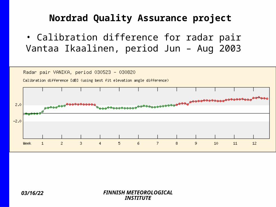
Nordrad Quality Assurance project
• Calibration difference for radar pair Vantaa Ikaalinen, period Jun – Aug 2003

04/19/23 FINNISH METEOROLOGICAL INSTITUTE
WP 7.1: Attenuation correction based on 3D water phase diagnosis from NWP model quantities
Deliverables: Large attenuation statistics for rain-only (assumed in most existing radar systems) and variable water phase statisticsImprovement in surface precipitationOverestimation of attenuation in hail avoided by applying a hail algorithm

04/19/23 FINNISH METEOROLOGICAL INSTITUTE
Calculation of attenuation
· Simple one: all precipitation is liquid, k(dB/km)=1.12*10-4 Ze
0.62 · Advanced one: freezing level height fixed at each
radar, obtained from NWP and VPR, attenuation calculated separately in each water phase layer
· We are testing Doppler data from elevation angle 90 degrees in the polar volume scans to improve the radar-based detection of freezing level
· Formula: rain (see above), dry snow (in Battan), bright band ?

04/19/23 FINNISH METEOROLOGICAL INSTITUTE
WP 7.2 Elimination of overhanging precipitation (OP) from surface estimates
Altostratus: present in 15 % of all VPR in Finland in 2001

04/19/23 FINNISH METEOROLOGICAL INSTITUTE
Diagnosis of OP in the network
· Apply precipitation base height field from the radar network
· Apply (an idea so far): nowcast movement of theVPR, measured above the radars with the analysed motion vector field (operationally available)
· Apply precipitating layers from NWP. First step: compare model profiles from HIRLAM with VPR from radars. Available quantities e.g. RH, and cloud condensate mixing ratio.

04/19/23 FINNISH METEOROLOGICAL INSTITUTE
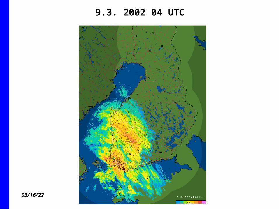
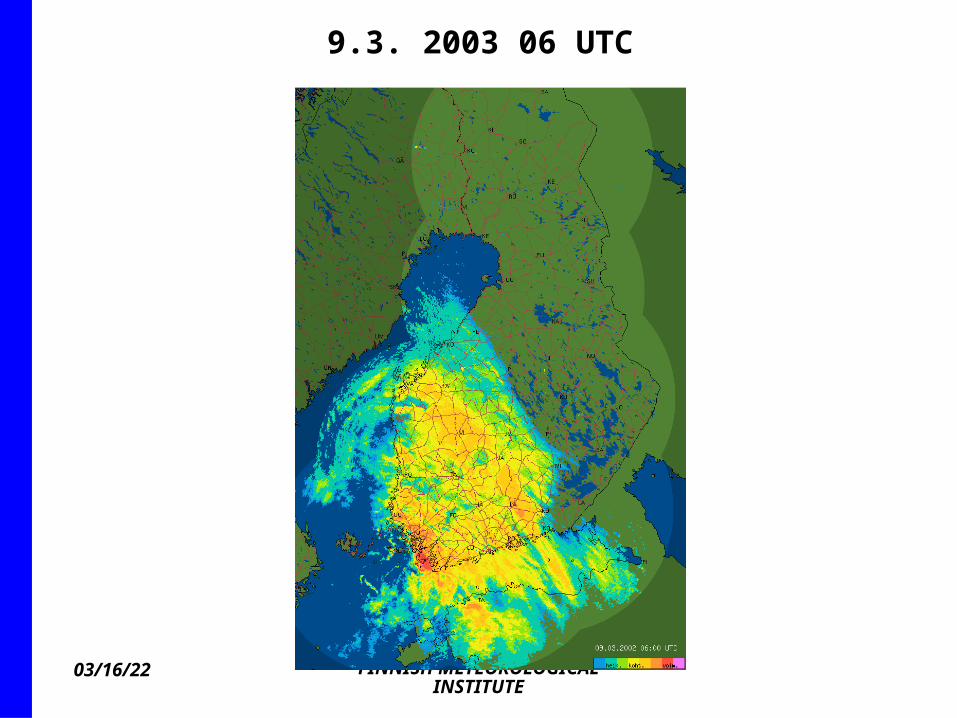
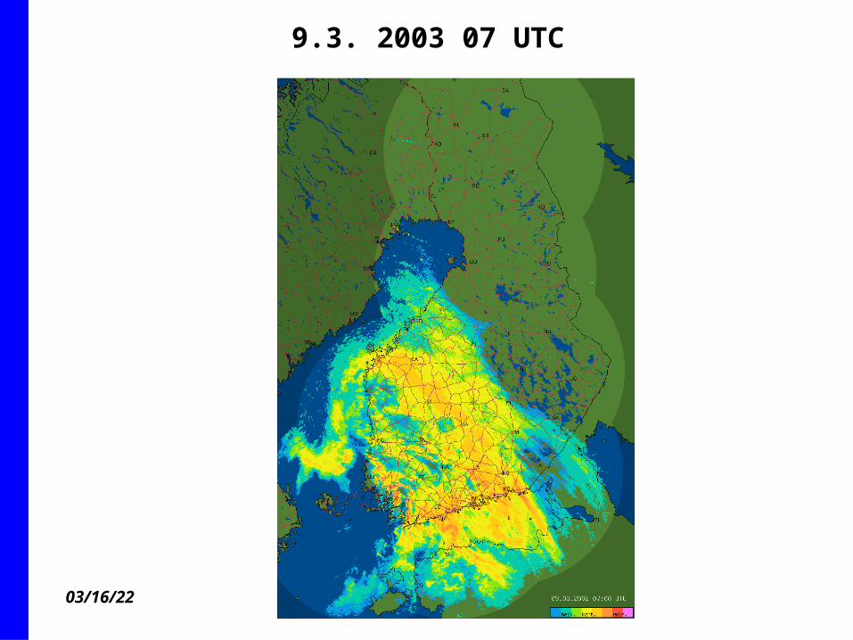
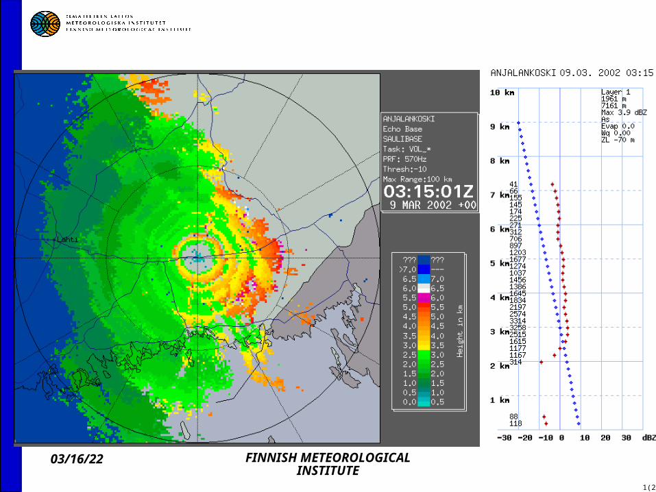
Example of OP case 9.3. 2002 02 UTC
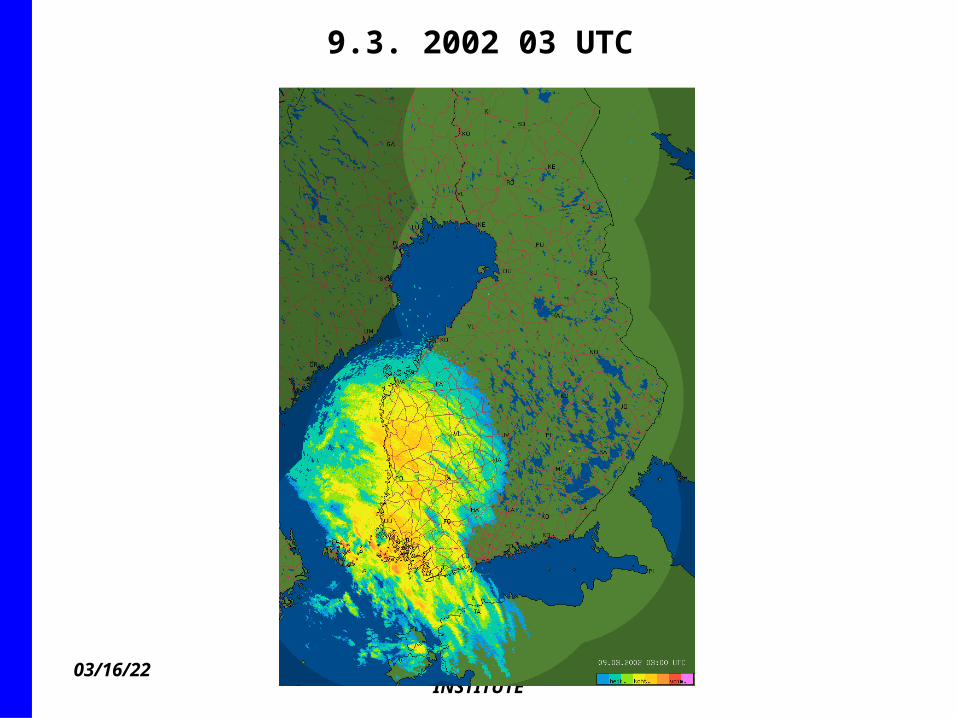
04/19/23 FINNISH METEOROLOGICAL INSTITUTE
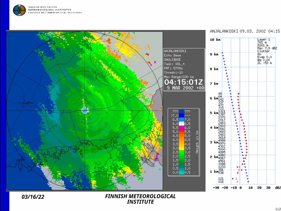
9.3. 2002 03 UTC
04/19/23 FINNISH METEOROLOGICAL INSTITUTE
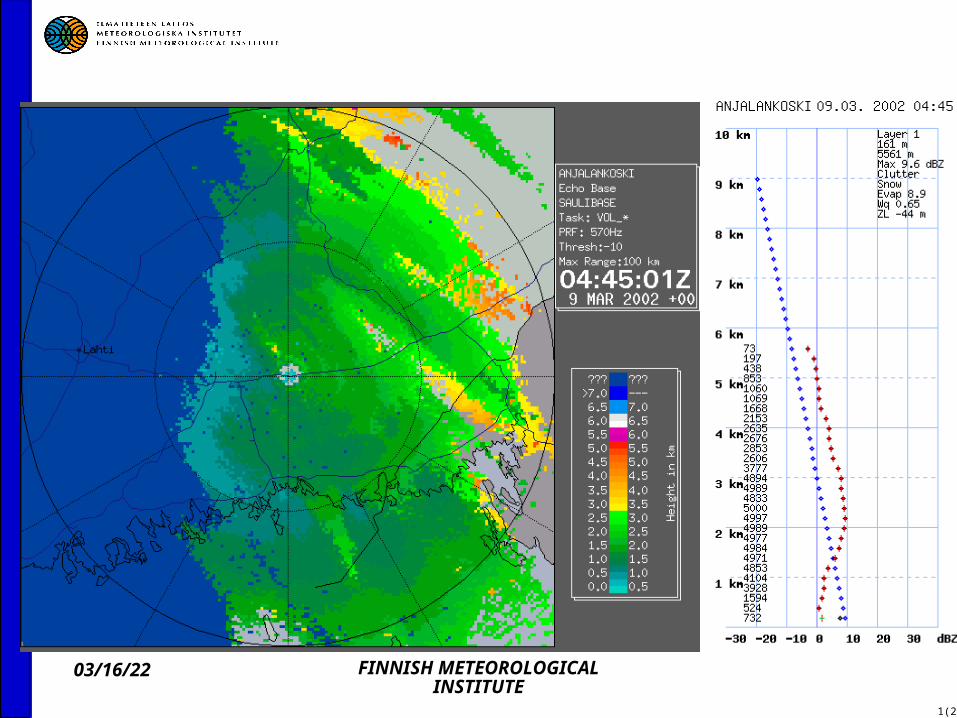
9.3. 2002 04 UTC

04/19/23 FINNISH METEOROLOGICAL INSTITUTE
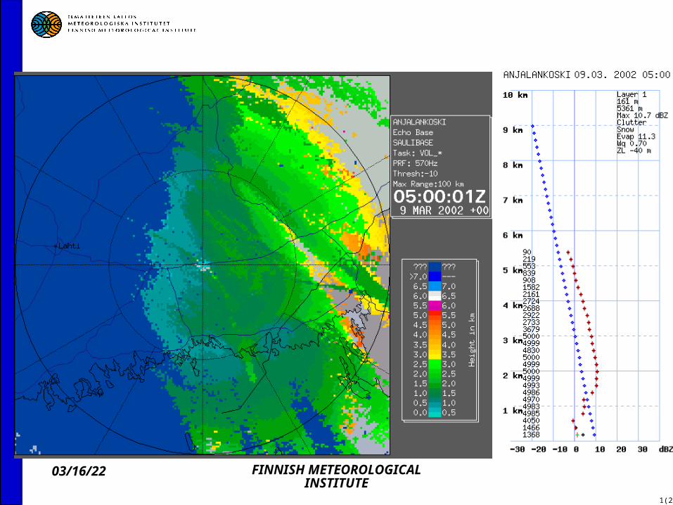
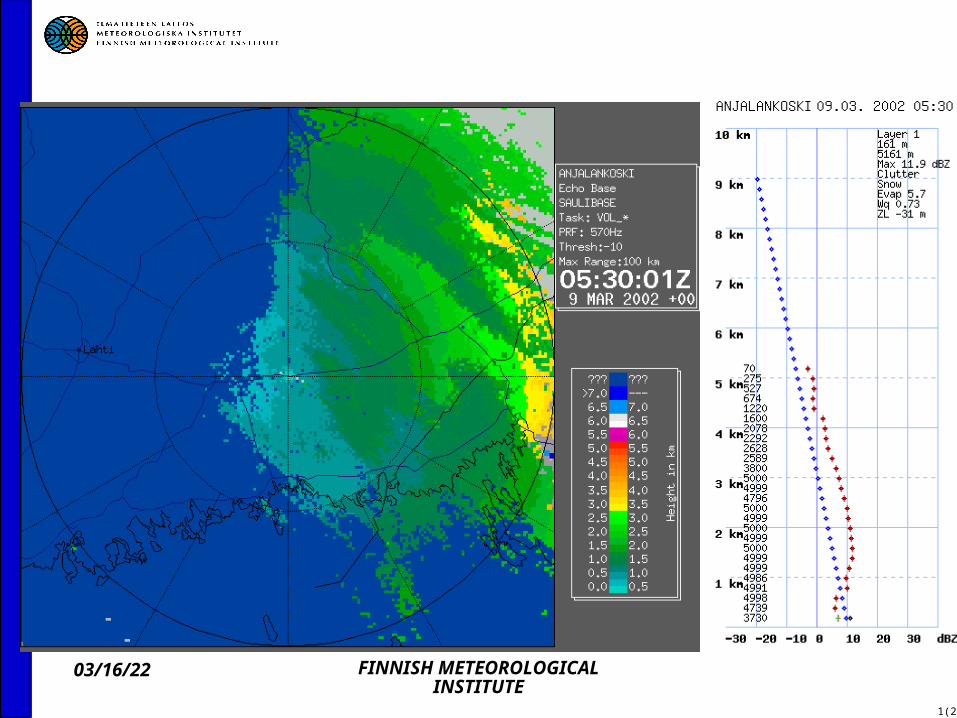
9.3. 2003 05 UTC
04/19/23 FINNISH METEOROLOGICAL INSTITUTE
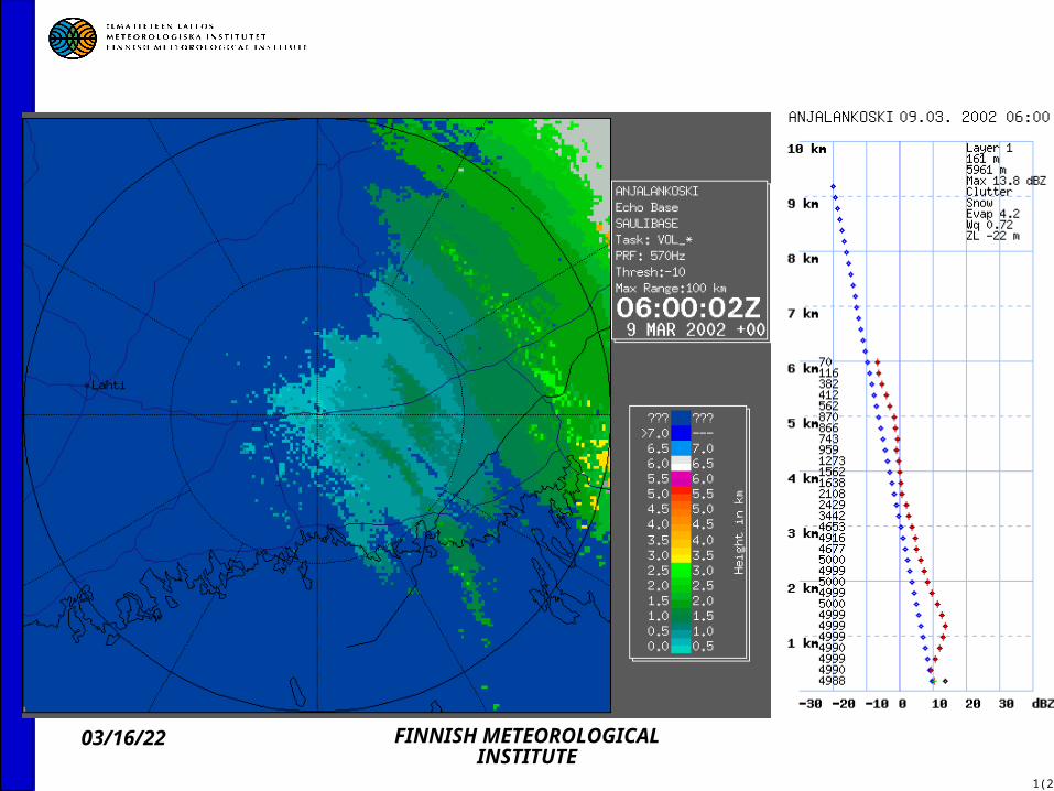
9.3. 2003 06 UTC
04/19/23 FINNISH METEOROLOGICAL INSTITUTE
9.3. 2003 07 UTC

04/19/23 FINNISH METEOROLOGICAL INSTITUTE
1(2)
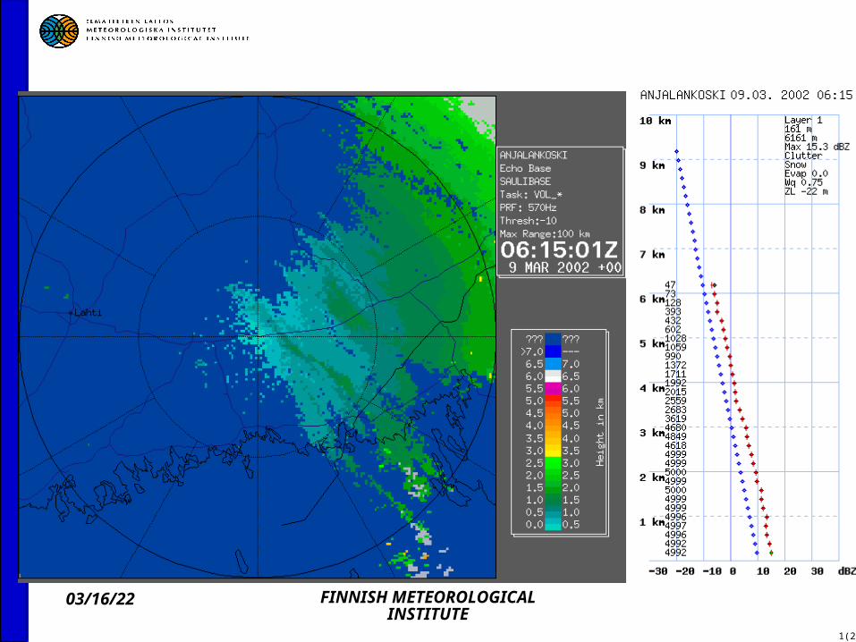
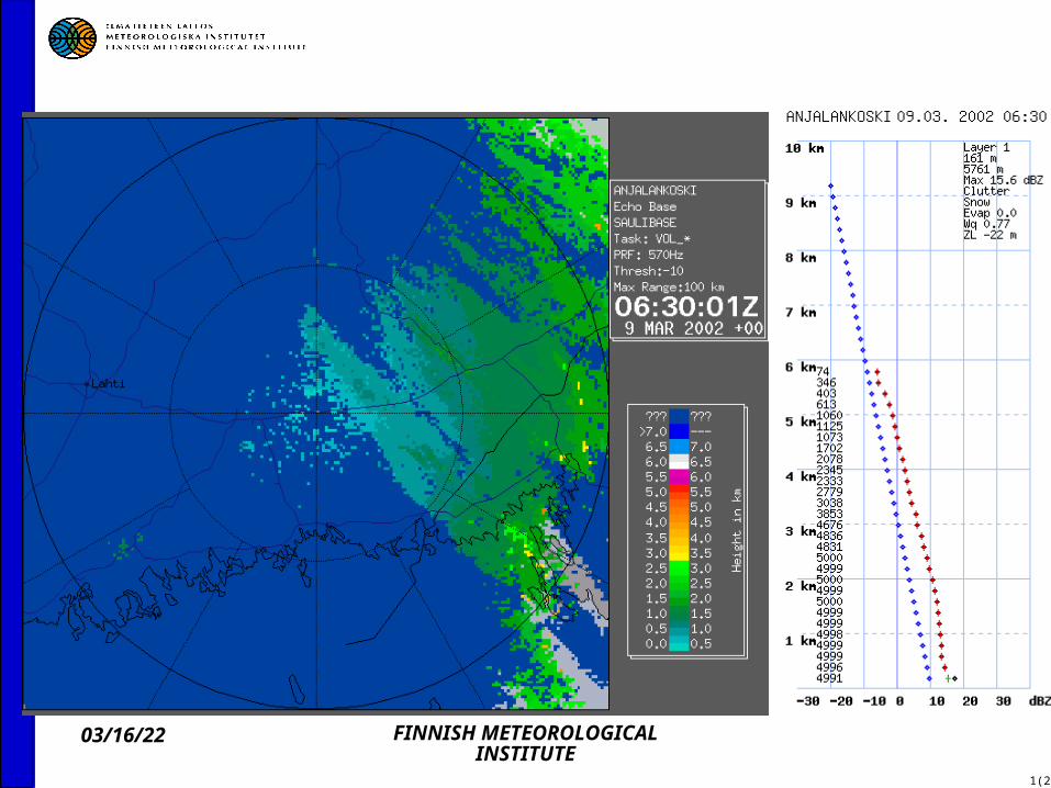
Overhanging precipitation 9.3. 2002 at Anjalankoski radar

04/19/23 FINNISH METEOROLOGICAL INSTITUTE
1(2)

04/19/23 FINNISH METEOROLOGICAL INSTITUTE
1(2)

04/19/23 FINNISH METEOROLOGICAL INSTITUTE
1(2)
04/19/23 FINNISH METEOROLOGICAL INSTITUTE
1(2)

04/19/23 FINNISH METEOROLOGICAL INSTITUTE
1(2)

04/19/23 FINNISH METEOROLOGICAL INSTITUTE
1(2)
04/19/23 FINNISH METEOROLOGICAL INSTITUTE
1(2)

04/19/23 FINNISH METEOROLOGICAL INSTITUTE
1(2)
04/19/23 FINNISH METEOROLOGICAL INSTITUTE
1(2)
04/19/23 FINNISH METEOROLOGICAL INSTITUTE
1(2)

04/19/23 FINNISH METEOROLOGICAL INSTITUTE
1(2)
04/19/23 FINNISH METEOROLOGICAL INSTITUTE
1(2)

04/19/23 FINNISH METEOROLOGICAL INSTITUTE
1(2)
04/19/23 FINNISH METEOROLOGICAL INSTITUTE
1(2)
04/19/23 FINNISH METEOROLOGICAL INSTITUTE
1(2)
04/19/23 FINNISH METEOROLOGICAL INSTITUTE
1(2)

04/19/23 FINNISH METEOROLOGICAL INSTITUTE
1(2)

04/19/23 FINNISH METEOROLOGICAL INSTITUTE
1(2)

04/19/23 FINNISH METEOROLOGICAL INSTITUTE
HIRLAM model relative humidity 09.03. 2003

04/19/23 FINNISH METEOROLOGICAL INSTITUTE
HIRLAM model freezing level height 21.8. 2003 17 UTC
04/19/23 FINNISH METEOROLOGICAL INSTITUTE
1(2)
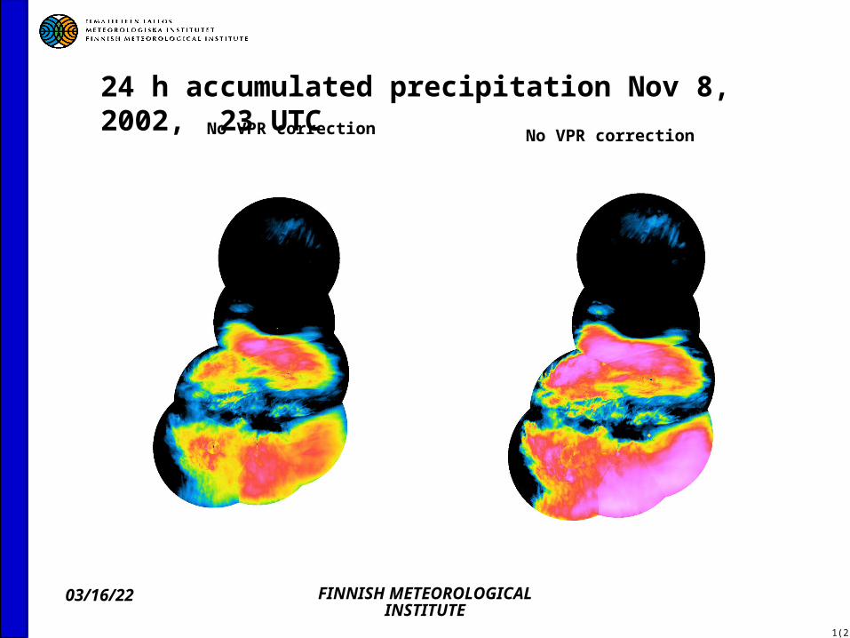
24 h accumulated precipitation Nov 8, 2002, 23 UTC No VPR correction No VPR correction

04/19/23 FINNISH METEOROLOGICAL INSTITUTE
1(2)
24 h accumulated precipitation Nov 7, 2002, 14 UTC No VPR correction With VPR correction
04/19/23 FINNISH METEOROLOGICAL INSTITUTE
1(2)
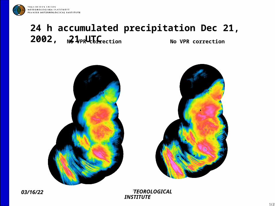
24 h accumulated precipitation Dec 21, 2002, 21 UTC No VPR correction No VPR correction

04/19/23 FINNISH METEOROLOGICAL INSTITUTE
1(2)
VPR correction in the network
04/19/23 FINNISH METEOROLOGICAL INSTITUTE
1(2)
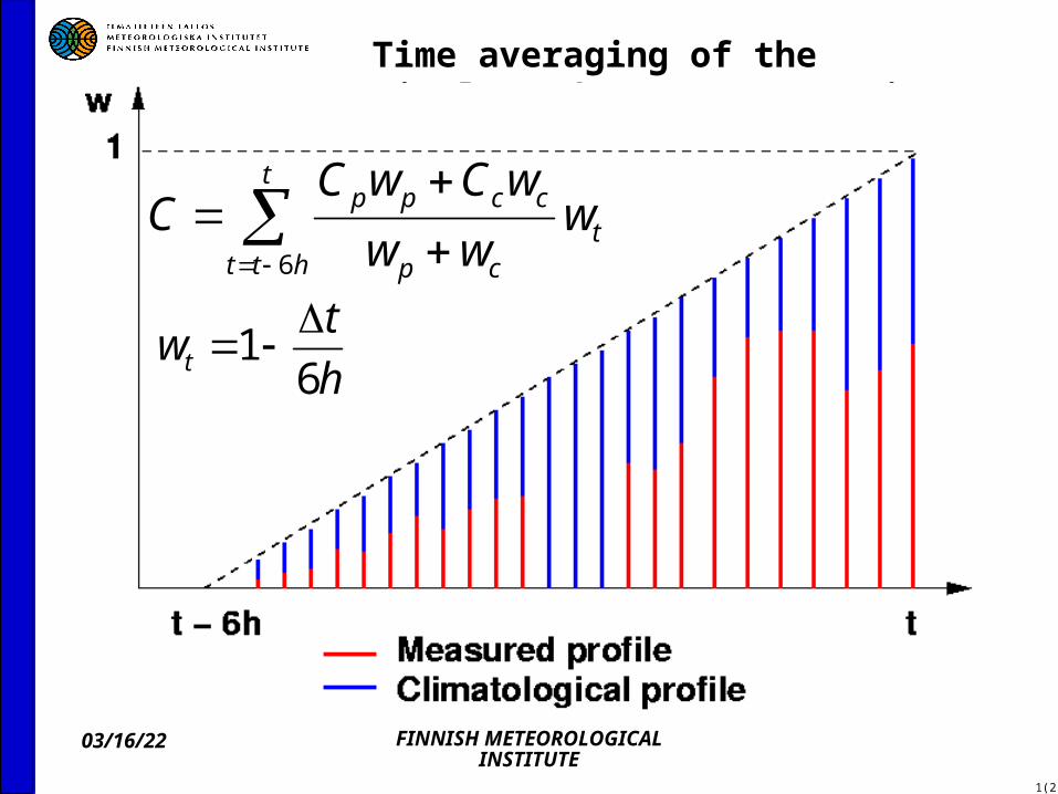
Time averaging of the single radar VPR correction
t
httt
cp
ccpp www
wCwCC
6
h
twt 6
1

04/19/23 FINNISH METEOROLOGICAL INSTITUTE
Radar pair Anjalankoski-Kuopio (Kuopio-Anjalankoski) Feb – May 2003, distance
219 km
04/19/23 FINNISH METEOROLOGICAL INSTITUTE
1(2)
Related Documents