Fast TIMES [ J u n e 2015] 61 MERGING CULTURES & CURRICULUMS: ENRICHING HERITAGE AND EDUCATION WITH APPLIED GEOPHYSICS Tate G. Meehan, Department of Geosciences, Boise State University, Boise, ID, USA Timothy S. de Smet, Department of Anthropology, Texas A&M University, College Station, TX, USA Charles E. Stanford, Department of Geology and Geophysics, Texas A&M University, College Station, TX, USA Corresponding Author: Tate G. Meehan Department of Geosciences Boise State University 1910 University Drive Boise, ID, USA 83725-1535 email: [email protected] Keywords: Camptown African American Cemetery, Brenham - Texas, Topographic Survey, Magnetometry, Electromagnetic Induction. Abstract The Camptown African American Cemetery is analogous to many unexplored heritage cemeteries throughout the southern United States. It is a challenging site both culturally and physically. Our study caters to many facets of learning by delving into the history of the birthplace of Texas and merging physical science with social science. The study allows the opportunity to enrich the colligate curriculum with practical teaching of these sciences. This site also serves as a proving ground for the advancement of archaeological methodology with applied geophysics. The practice of our methodology devises a multi-component approach, which provides the greatest achievable insight of the cemetery. A high precision topographic (TOPO) magnetic (MAG) and electromagnetic induction (EMI) survey was best tailored for the terrain of the cemetery. Ground coupled or towed sensors, like many radar systems, are inoperable in field conditions as these. Processing techniques were developed to integrate the data sets. The MATLAB processing suite GEOPMAPPER, developed by Stanford et al. (2015: this volume), manipulates the acquired data from its raw form into a polished product. Interpreting the results presents the greatest challenge. The community of Brenham, Texas has the expectation that remains of their ancestors will be apparent in the geophysical work. This is impossible knowing the limitations of hard science. Our best attempt draws the position on the map where the combination of the multi-component research indicates the visual and statistical probability of a marked or anonymous burial. Ambiguity in the interpretation will exist in a site cluttered with coherent and incoherent noise. And this is our best attempt to provide a qualitative and quantitative mapping of the Camptown Cemetery. This paper also delivers a provocative awareness of the State of Texas at a time of dynamic cultural change. We want to call attention to the period and place of this anthropogenic cause; its history and heritage on a human level, aside from the geophysical work.

Welcome message from author
This document is posted to help you gain knowledge. Please leave a comment to let me know what you think about it! Share it to your friends and learn new things together.
Transcript
Fa s t T I M E S [ J u n e 2015] 61
M E R G I N G C U LT U R E S & C U R R I C U L U M S : E N R I C H I N G H E R I TA G E A N D E D U C AT I O N W I T H A P P L I E D G E O P H Y S I C STate G. Meehan, Department of Geosciences, Boise State University, Boise, ID, USATimothy S. de Smet, Department of Anthropology, Texas A&M University, College Station, TX, USACharles E. Stanford, Department of Geology and Geophysics, Texas A&M University, College Station, TX, USA
Corresponding Author:Tate G. MeehanDepartment of GeosciencesBoise State University1910 University DriveBoise, ID, USA 83725-1535email: [email protected]
Keywords: Camptown African American Cemetery, Brenham - Texas, Topographic Survey, Magnetometry, Electromagnetic Induction.
Abstract The Camptown African American Cemetery is analogous to many unexplored heritage cemeteries throughout the southern United States. It is a challenging site both culturally and physically. Our study caters to many facets of learning by delving into the history of the birthplace of Texas and merging physical science with social science. The study allows the opportunity to enrich the colligate curriculum with practical teaching of these sciences. This site also serves as a proving ground for the advancement of archaeological methodology with applied geophysics. The practice of our methodology devises a multi-component approach, which provides the greatest achievable insight of the cemetery. A high precision topographic (TOPO) magnetic (MAG) and electromagnetic induction (EMI) survey was best tailored for the terrain of the cemetery. Ground coupled or towed sensors, like many radar systems, are inoperable in field conditions as these. Processing techniques were developed to integrate the data sets. The MATLAB processing suite GEOPMAPPER, developed by Stanford et al. (2015: this volume), manipulates the acquired data from its raw form into a polished product. Interpreting the results presents the greatest challenge. The community of Brenham, Texas has the expectation that remains of their ancestors will be apparent in the geophysical work. This is impossible knowing the limitations of hard science. Our best attempt draws the position on the map where the combination of the multi-component research indicates the visual and statistical probability of a marked or anonymous burial. Ambiguity in the interpretation will exist in a site cluttered with coherent and incoherent noise. And this is our best attempt to provide a qualitative and quantitative mapping of the Camptown Cemetery. This paper also delivers a provocative awareness of the State of Texas at a time of dynamic cultural change. We want to call attention to the period and place of this anthropogenic cause; its history and heritage on a human level, aside from the geophysical work.
Fa s t T I M E S [ J u n e 2015] 62
M E R G I N G C U LT U R E S & C U R R I C U L U M S : E N R I C H I N G H E R I TA G E A N D E D U C AT I O N W I T H A P P L I E D G E O P H Y S I C S
Introduction
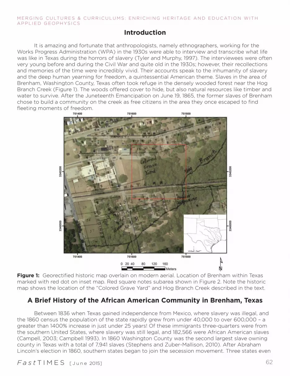
It is amazing and fortunate that anthropologists, namely ethnographers, working for the Works Progress Administration (WPA) in the 1930s were able to interview and transcribe what life was like in Texas during the horrors of slavery (Tyler and Murphy, 1997). The interviewees were often very young before and during the Civil War and quite old in the 1930s; however, their recollections and memories of the time were incredibly vivid. Their accounts speak to the inhumanity of slavery and the deep human yearning for freedom, a quintessential American theme. Slaves in the area of Brenham, Washington County, Texas often took refuge in the densely wooded forest near the Hog Branch Creek (Figure 1). The woods offered cover to hide, but also natural resources like timber and water to survive. After the Juneteenth Emancipation on June 19, 1865, the former slaves of Brenham chose to build a community on the creek as free citizens in the area they once escaped to find fleeting moments of freedom.
Figure 1: Georectified historic map overlain on modern aerial. Location of Brenham within Texas marked with red dot on inset map. Red square notes subarea shown in Figure 2. Note the historic map shows the location of the “Colored Grave Yard” and Hog Branch Creek described in the text.
A Brief History of the African American Community in Brenham, Texas
Between 1836 when Texas gained independence from Mexico, where slavery was illegal, and the 1860 census the population of the state rapidly grew from under 40,000 to over 600,000 – a greater than 1400% increase in just under 25 years! Of these immigrants three-quarters were from the southern United States, where slavery was still legal, and 182,566 were African American slaves (Campell, 2003; Campbell 1993). In 1860 Washington County was the second largest slave owning county in Texas with a total of 7,941 slaves (Stephens and Zuber-Mallison, 2010). After Abraham Lincoln’s election in 1860, southern states began to join the secession movement. Three states even

Fa s t T I M E S [ J u n e 2015] 63
M E R G I N G C U LT U R E S & C U R R I C U L U M S : E N R I C H I N G H E R I TA G E A N D E D U C AT I O N W I T H A P P L I E D G E O P H Y S I C S
held popular referenda to vote on the matter: Virginia, Tennessee, and Texas. In Texas, white male citizens voted on whether or not to secede from the Union and a statewide special referendum was held on February 23, 1861. The measure passed with 75.66% of the vote in the entire state and an even more overwhelming 96.3% in Washington County (Stephens and Zuber-Mallison, 2010). Suffice it to say, slavery was popular and supported by white males in Washington County prior to the American Civil War. This is the socio-political context in which the Camptown African American community and cemetery were founded. The years following the Civil War were a time of dynamic cultural change in Brenham, as the freed former slaves of Washington County greatly outnumbered the white population (Brass, 2011). During Reconstruction there was violent conflict between whites and the recently emancipated African American community; conflict which all too often took the form of mob violence and public lynching (Carrigan, 2006). Because of the violent unrest, the United States sent Company E of the Seventeenth’s Third Battalion to Brenham in July of 1865 to maintain peace and protect the African American community from retaliation by angry whites (Harrison, 2009). The Federal Army made their camp along the Hog Branch Creek along with the flourishing African American community. As such, the local African American Cemetery – that is the focus of this paper – bears the name “Camptown” today, due to the Federal Army’s presence there in the mid to late 1860s. The federal soldiers were stationed just one hundred meters northeast of the current graveyard at Camptown, from whence the cemetery derives its name (Figure 1).
Geophysical Surveys in Complex Environments
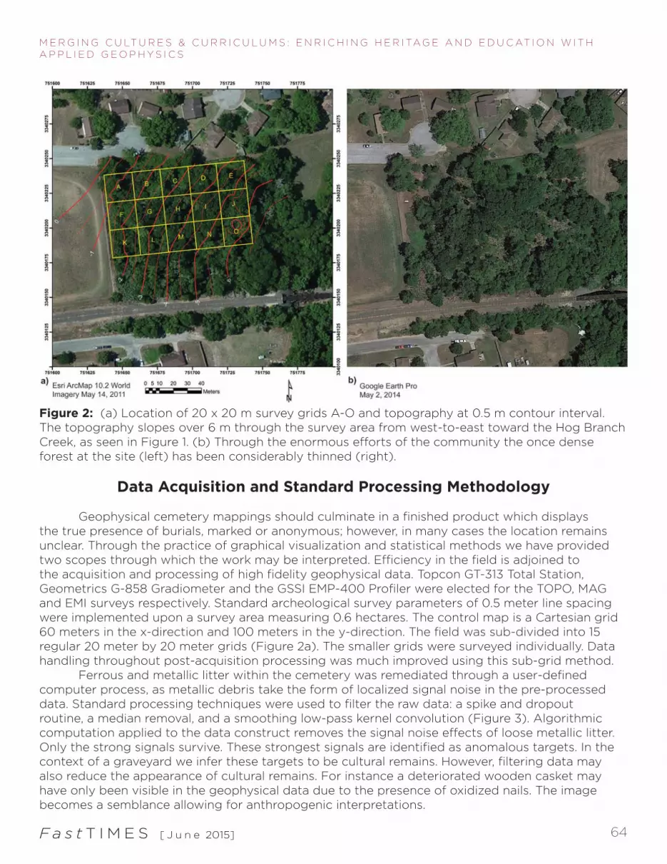
Unmarked graves are amongst the most difficult to detect and correctly classify of all common geophysical targets. Their geophysical response is often subtle and can be confounded by coherent noise like tree roots, headstones, iron railings, other cultural debris, and a wide variety of possible burial styles. Ground-penetrating radar is the most commonly used geophysical technique in historical cemetery surveys (Conyers, 2006); however, GPR like all geophysical techniques has known limitations, which can affect its potential, and these include but are not limited to terrain, above ground obstacles, vegetation, soil and sediment mineralogy, water saturated soils, rocky heterogeneous soils, subsurface metal debris, frequency interference, and many other complicating factors. We previously tested GPR at Camptown with multiple antenna frequencies but always with similarly poor results. The aforementioned obstacles proved too difficult for GPR in this complex environment. Instead, the flexibility and maneuverability of magnetometry and frequency-domain electromagnetic-induction proved much more capable for the task. No one method is perfect (Bevan, 1991; Davenport, 2001; Jones, 2008) and the use of multiple geophysical techniques is better than any single technique as they each have strengths and weaknesses (Clay, 2001), because they generally measure a different physical property of the subsurface (Everett, 2013). The use of multiple methods (Nobles, 1999) and spatial patterning (King et al., 1993) improves the confidence of predictions at cemetery sites. Bigman (2014) recently demonstrated the utility of GPR and EMI to detect unmarked slave burials at a cemetery in Georgia. Unfortunately gravestones and burials are not always reliable indicators of burial location (Conyers, 2012; Fiedler et al., 2009) due to various cultural and natural processes. Cultural processes like migration, neglect, abandonment, vandalism, and the movement of headstones in conjunction with the physical processes of erosion, weathering, and decomposition of the ground and burial materials, among other factors, make it difficult to accept the location of headstones as an accurate indication of the subsurface in historic cemeteries. The Camptown Cemetery is no exception and is in fact analogous to many historic African American cemeteries in the southern United States, where anthropogenic and geological factors have dislocated cemetery markers. The cemetery fell into disrepair and was completely overgrown with vegetation (Figure 2a). Geophysical data sets are an excellent test of the accuracy of headstone location and extant of anonymous graves. Though, operating a survey amongst vines, tree stumps, iron fence posts, metallic litter, and undulating terrain introduces many challenges to the geophysical data acquisition and processing.
Fa s t T I M E S [ J u n e 2015] 64
M E R G I N G C U LT U R E S & C U R R I C U L U M S : E N R I C H I N G H E R I TA G E A N D E D U C AT I O N W I T H A P P L I E D G E O P H Y S I C S
Figure 2: (a) Location of 20 x 20 m survey grids A-O and topography at 0.5 m contour interval. The topography slopes over 6 m through the survey area from west-to-east toward the Hog Branch Creek, as seen in Figure 1. (b) Through the enormous efforts of the community the once dense forest at the site (left) has been considerably thinned (right).
Data Acquisition and Standard Processing Methodology
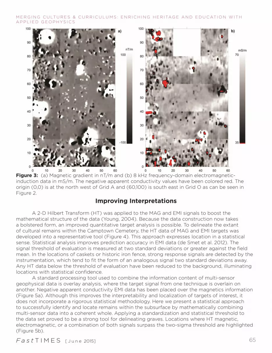
Geophysical cemetery mappings should culminate in a finished product which displays the true presence of burials, marked or anonymous; however, in many cases the location remains unclear. Through the practice of graphical visualization and statistical methods we have provided two scopes through which the work may be interpreted. Efficiency in the field is adjoined to the acquisition and processing of high fidelity geophysical data. Topcon GT-313 Total Station, Geometrics G-858 Gradiometer and the GSSI EMP-400 Profiler were elected for the TOPO, MAG and EMI surveys respectively. Standard archeological survey parameters of 0.5 meter line spacing were implemented upon a survey area measuring 0.6 hectares. The control map is a Cartesian grid 60 meters in the x-direction and 100 meters in the y-direction. The field was sub-divided into 15 regular 20 meter by 20 meter grids (Figure 2a). The smaller grids were surveyed individually. Data handling throughout post-acquisition processing was much improved using this sub-grid method. Ferrous and metallic litter within the cemetery was remediated through a user-defined computer process, as metallic debris take the form of localized signal noise in the pre-processed data. Standard processing techniques were used to filter the raw data: a spike and dropout routine, a median removal, and a smoothing low-pass kernel convolution (Figure 3). Algorithmic computation applied to the data construct removes the signal noise effects of loose metallic litter. Only the strong signals survive. These strongest signals are identified as anomalous targets. In the context of a graveyard we infer these targets to be cultural remains. However, filtering data may also reduce the appearance of cultural remains. For instance a deteriorated wooden casket may have only been visible in the geophysical data due to the presence of oxidized nails. The image becomes a semblance allowing for anthropogenic interpretations.
Fa s t T I M E S [ J u n e 2015] 65
M E R G I N G C U LT U R E S & C U R R I C U L U M S : E N R I C H I N G H E R I TA G E A N D E D U C AT I O N W I T H A P P L I E D G E O P H Y S I C S
Improving Interpretations
A 2-D Hilbert Transform (HT) was applied to the MAG and EMI signals to boost the mathematical structure of the data (Young, 2004). Because the data construction now takes a bolstered form, an improved quantitative target analysis is possible. To delineate the extant of cultural remains within the Camptown Cemetery, the HT data of MAG and EMI targets was developed into a representative tool (Figure 4). This approach expresses location in a statistical sense. Statistical analysis improves prediction accuracy in EMI data (de Smet et al. 2012). The signal threshold of evaluation is measured at two standard deviations or greater against the field mean. In the locations of caskets or historic iron fence, strong response signals are detected by the instrumentation, which tend to fit the form of an analogous signal two standard deviations away. Any HT data below the threshold of evaluation have been reduced to the background, illuminating locations with statistical confidence. A standard processing tool used to combine the information content of multi-sensor geophysical data is overlay analysis, where the target signal from one technique is overlain on another. Negative apparent conductivity EMI data has been placed over the magnetics information (Figure 5a). Although this improves the interpretability and localization of targets of interest, it does not incorporate a rigorous statistical methodology. Here we present a statistical approach to successfully identify and locate remains within the subsurface by mathematically combining multi-sensor data into a coherent whole. Applying a standardization and statistical threshold to the data set proved to be a strong tool for delineating graves. Locations where HT magnetic, electromagnetic, or a combination of both signals surpass the two-sigma threshold are highlighted (Figure 5b).
Figure 3: (a) Magnetic gradient in nT/m and (b) 8 kHz frequency-domain electromagnetic-induction data in mS/m. The negative apparent conductivity values have been colored red. The origin (0,0) is at the north west of Grid A and (60,100) is south east in Grid O as can be seen in Figure 2.

Fa s t T I M E S [ J u n e 2015] 66
M E R G I N G C U LT U R E S & C U R R I C U L U M S : E N R I C H I N G H E R I TA G E A N D E D U C AT I O N W I T H A P P L I E D G E O P H Y S I C S
Figure 4: Standardized (a) 2-D Hilbert Transformed magnetic gradient and (b) 8 kHz frequency-domain electromagnetic-induction apparent electrical conductivity data.
Figure 5: (a) Standard qualitative overlay analysis of red negative apparent electrical conductivities over magnetic gradient data and (b) quantitative 2 standard deviation threshold overlays of magnetic gradient and 8 kHz apparent electrical conductivity data.
Fa s t T I M E S [ J u n e 2015] 67
M E R G I N G C U LT U R E S & C U R R I C U L U M S : E N R I C H I N G H E R I TA G E A N D E D U C AT I O N W I T H A P P L I E D G E O P H Y S I C S
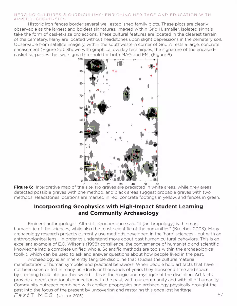
Historic iron fences border several well established family plots. These plots are clearly observable as the largest and boldest signatures. Imaged within Grid H, smaller, isolated signals take the form of casket-size projections. These cultural features are located in the clearest terrain of the cemetery. Many are located without headstones upon slight depressions in the cemetery soil. Observable from satellite imagery, within the southwestern corner of Grid A rests a large, concrete encasement (Figure 2b). Shown with graphical overlay techniques, the signature of the encased-casket surpasses the two-sigma threshold for both MAG and EMI (Figure 6).
Figure 6: Interpretive map of the site. No graves are predicted in white areas, while grey areas detected possible graves with one method, and black areas suggest probable graves with two methods. Headstones locations are marked in red, concrete footings in yellow, and fences in green.
Incorporating Geophysics with High-Impact Student Learningand Community Archaeology
Eminent anthropologist Alfred L. Kroeber once said “it [anthropology] is the most humanistic of the sciences, while also the most scientific of the humanities” (Kroeber, 2003). Many archaeology research projects currently use methods developed in the ‘hard’ sciences - but with an anthropological lens - in order to understand more about past human cultural behaviors. This is an excellent example of E.O. Wilson’s (1998) consilience, the convergence of humanistic and scientific knowledge into a complete unified whole. Scientific methods are tools within the archaeological toolkit, which can be used to ask and answer questions about how people lived in the past. Archaeology is an inherently tangible discipline that studies the cultural material manifestation of human symbolic and practical behaviors. When people hold artifacts that have not been seen or felt in many hundreds or thousands of years they transcend time and space by stepping back into another world - this is the magic and mystique of the discipline. Artifacts provide a direct emotional connection with the past, with our community and with all of humanity. Community outreach combined with applied geophysics and archaeology physically brought the past into the focus of the present by uncovering and restoring this once lost heritage.
Fa s t T I M E S [ J u n e 2015] 68
M E R G I N G C U LT U R E S & C U R R I C U L U M S : E N R I C H I N G H E R I TA G E A N D E D U C AT I O N W I T H A P P L I E D G E O P H Y S I C S
Since the Fall 2014 semester, Texas A&M University’s Geophysics 413 Near-Surface Applied Geophysics undergraduate course has conducted fieldwork at the Camptown African American cemetery in Brenham, Texas, collecting frequency-domain electromagnetic-induction, magnetic gradiometry, and ground-penetrating radar data. This hands-on class was comprehensive and research oriented in that the students learned to collect, analyze, process, and visualize these data, and finally to write up a report and interpret the results. The students learned by doing. Learning to collect data gave the students a sense of ownership of the class materials, where active experiential learning becomes the central focus of the course instead of the materials themselves. Processing these data are excellent exercises in the analytical, quantitative, and critical thinking skills necessary to make meaningful interpretations. Near-surface geophysics was not the only skill learned in Geophysics 413. Students also learned how to collaborate with their fellow students in the field and their local community. Working with and providing a service to the Brenham community has helped Texas A&M University and the Department of Geology & Geophysics. This community work promotes geophysics and archaeology as a public interests and attracts future work for students. The project has helped the students to become active participants in the unity of STEM and social science research as the project objective is to locate unmarked African American burials from a period of extreme cultural tension. Community and student involvement was of critical importance to the success of this project. In merging archaeology and geophysics within a high-impact learning and community archaeology project we bridged the divide of hard and soft science to bring about a more nuanced and holistic narrative about the perseverance of the African American community in Brenham, Texas. Recognition of those who founded this community is of enormous cultural and historical importance to the families and relatives of those who lived within Camptown. The story is not just about how people died in Brenham, but how they lived, and how their descendants in the community continue to remember and (re)interpret the past to this very day.
Conclusions
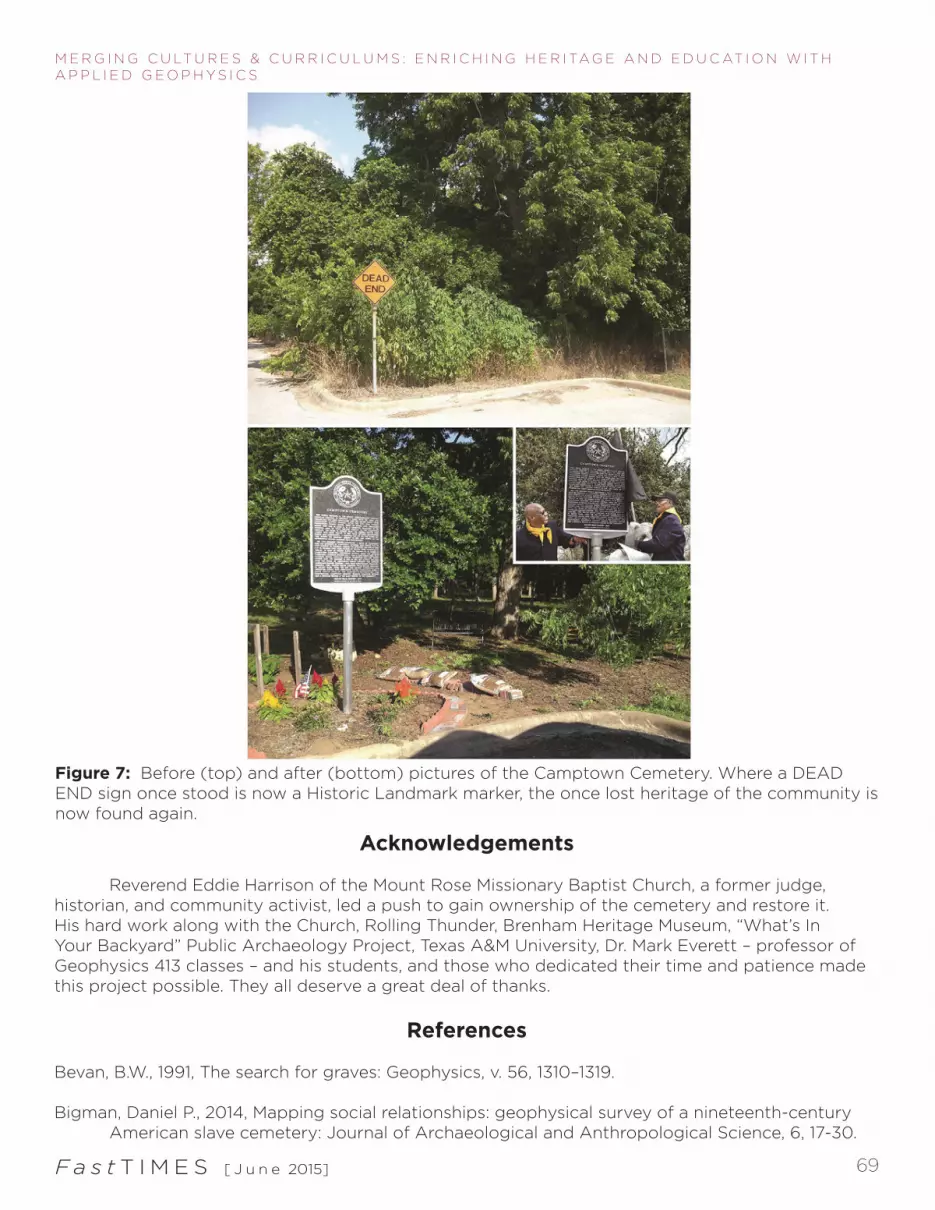
We greatly enjoy discussing the results of this work with the community. The geophysical heritage mapping was designed to be viewed intuitively, with an x-marks-the-spot interpretation. Community members have the opportunity to discover more about what is buried in their backyard, as the Camptown Cemetery work will be placed on display at the Brenham heritage museum. The most telling research incorporates multiple components. Placing geophysical results into this anthropogenic case provides a telling component for the story of Brenham’s early Texas history. Camptown Cemetery is the resting place of the original Texans – those who lived throughout or fought in the Texas Revolution – the families of the first emancipated African Americans, Buffalo soldiers, and the American Veterans who bravely served in wars on American soil and overseas. The restoration of Camptown Cemetery was cared for by the hands of volunteers, up-keeping the unkempt. By volunteering in this civil and historical work, Texas A&M University and the Department of Geology & Geophysics has been a tremendous aide for their students and the community of Brenham. As a result of our involvement, contacts at other heritage sites were established; and work was secured for future students. By lending a hand at Camptown we have inspired residents of Brenham to reconsider the historic plight of enslaved people. Just a few years ago this cemetery was a terribly ironic DEAD END (Figure 7). Now, much of the cemetery’s overgrowth has been cleared. Fencing and headstones have been refurbished. Flowers and American flags have been planted as memorial for the loved ones and veterans from the community. Accordingly, the Texas Historical Commission dedicated the Camptown Cemetery and its Mount Rose Missionary Baptist Church a historic landmark in the Spring of 2014. A heritage once lost is now found.
Fa s t T I M E S [ J u n e 2015] 69
M E R G I N G C U LT U R E S & C U R R I C U L U M S : E N R I C H I N G H E R I TA G E A N D E D U C AT I O N W I T H A P P L I E D G E O P H Y S I C S
Acknowledgements
Reverend Eddie Harrison of the Mount Rose Missionary Baptist Church, a former judge, historian, and community activist, led a push to gain ownership of the cemetery and restore it. His hard work along with the Church, Rolling Thunder, Brenham Heritage Museum, “What’s In Your Backyard” Public Archaeology Project, Texas A&M University, Dr. Mark Everett – professor of Geophysics 413 classes – and his students, and those who dedicated their time and patience made this project possible. They all deserve a great deal of thanks.
References
Bevan, B.W., 1991, The search for graves: Geophysics, v. 56, 1310–1319.
Bigman, Daniel P., 2014, Mapping social relationships: geophysical survey of a nineteenth-century American slave cemetery: Journal of Archaeological and Anthropological Science, 6, 17-30.
Figure 7: Before (top) and after (bottom) pictures of the Camptown Cemetery. Where a DEAD END sign once stood is now a Historic Landmark marker, the once lost heritage of the community is now found again.

Fa s t T I M E S [ J u n e 2015] 70
M E R G I N G C U LT U R E S & C U R R I C U L U M S : E N R I C H I N G H E R I TA G E A N D E D U C AT I O N W I T H A P P L I E D G E O P H Y S I C S
Brass, S., 2011. The Burning of Brenham: Discover Washington Counties colorful past: Main Street, Brenham, Texas.
Campbell, R. B., 1993, Sam Houston and the American Southwest: Harper Collins, New York.
Campbell, R. B., 2003, Gone To Texas: A History of the Lone Star State: Oxford University Press, New York.
Carrigan, W. D., 2006, The Making of a Lynching Culture: Violence and Vigilantism in Central Texas 1836-1916: University of Illinois Press, Urbana.
Clay, R. B., 2001, Complimentary geophysical survey techniques: Why two ways are always better than one: Southeastern Archaeology, v. 20, no. 1, 31-43.
Davenport, G. C., 2001, Remote sensing applications in forensic investigations: Historical Archaeology, v. 35, no. 1, 87–100.
de Smet, T. S., M. E. Everett, C. J. Pierce, D. L. Pertermann, and D. B. Dickson, 2012, Electromagnetic induction in subsurface metal targets: Cluster analysis using local point-pattern spatial analysis: Geophysics, v. 77, no. 4, WB161-169.
Everett, Mark E., 2013, Near-Surface Applied Geophysics: Cambridge University Press, Cambridge.
Fiedler, S., B. Illich, J. Berger, M. Graw, 2009, The effectiveness of ground-penetrating radar surveys in the location of unmarked burial sites in modern cemeteries: Journal of Applied Geophysics, v. 68, 380–385.
Harrison, E.E., 2009, Mini History of Mount Rose MBC, Camptown Community, Camptown Cemetery, and the Army Post of Brenham 1867: Brenham, Texas.
Jones, G., 2008, Geophysical mapping of historic cemeteries: Technical Briefs in Historical Archaeology, v. 3, 25-38.
King, J. A., B. W. Bevan, and R. J. L. Hurry, 1993, The reliability of geophysical surveys at historic- period cemeteries: An example from the Plains Cemetery, Mechanicsville, Maryland: Historical Archaeology, v. 27, 4–16.
Kroeber, Karl, 2003, Curious profession: Alfred Kroeber and anthropological history: boundary 2, 30, 144-155.
Nobles, D.C., 1999, Geophysical surveys of buried sites: A case study of the Oaro Urupa: Geophysics, v. 64, 357–367.
Stephens, A. R. and C. Zuber-Mallison, 2010, Texas: A Historical Atlas: University of Oklahoma Press, Norman.
Tyler, R. and L. R. Murphy, 1997, The Slave Narratives of Texas: State House Press, Austin, Texas. Wilson, E. O., 1998, Consilience: The Unity of Knowledge: Knopf, New York.
Young, C. T., 2004, Basic magnetic processing and display in MATLAB: SAGEEP 2004
Related Documents