Seismic imaging of the three-dimensional architecture of the C ¸ ınarcık Basin along the North Anatolian Fault H. Carton, 1 S. C. Singh, 1 A. Hirn, 2 S. Bazin, 1 B. de Voogd, 3 A. Vigner, 2 A. Ricolleau, 1 S. Cetin, 4 N. Oc ¸akog ˘lu, 5 F. Karakoc ¸, 4 and V. Sevilgen 4,5 Received 6 June 2006; revised 4 January 2007; accepted 8 March 2007; published 21 June 2007. [1] The C ¸ ınarcık Basin is a transtensional basin located along the northern branch of the northern North Anatolian Fault (NAF) in the Sea of Marmara, the eastern half of which has been identified as a seismic gap. During the SEISMARMARA (2001) experiment, a dense grid of multichannel seismic reflection profiles was shot, covering the whole C ¸ ınarcık Basin and its margins. The new seismic images provide a nearly three-dimensional view of the architecture of the basin (fault system at depth and sedimentary infill) and provide insight into its tectonic evolution. Along both northern and southern margins of the basin, seismic reflection data show deep-penetrating faults, hence long-lived features, which have accommodated a large amount of extension. There is no indication in the data for a single throughgoing strike-slip fault, neither a cross-basin fault nor a pure strike-slip fault running along the northern margin. Faster opening is presently observed in the eastern part of the basin. The C ¸ ınarcık Basin seems to have developed as a transtensional basin across strike-slip segments of the northern NAF for the last few million years. Citation: Carton, H., et al. (2007), Seismic imaging of the three-dimensional architecture of the C ¸ ınarcık Basin along the North Anatolian Fault, J. Geophys. Res., 112, B06101, doi:10.1029/2006JB004548. 1. Introduction [2] The North Anatolian Fault (NAF) is a right-lateral strike-slip fault forming the plate boundary between Eurasia and Anatolia. It extends over 1600 km between the Karliova triple junction (Eurasia-Anatolia-Arabia triple junction) in the east and mainland Greece in the west (Figure 1, inset). The fault trace, which is well-defined in the topography across eastern and central Turkey, is close to a small circle. The best fitting Euler pole of rotation describing Anatolia/ Eurasia motion is located in the Nile delta [McClusky et al., 2000], at 30.7 ± 0.8°N, 32.6 ± 0.4°E, with an associated slip rate of about 24 mm/yr, deduced from analysis of Global Positioning System (GPS) data. In western Turkey, the NAF splits into two main strands called northern and southern NAF, with the northern branch carrying about 80 % of the displacement. The width of the deformation zone thus reaches 130 km in the Marmara area [Barka and Kadinsky- Cade, 1988]. Farther to the west, the NAF continues into the Aegean Sea where it interacts with Hellenic back-arc extension. Between 1939 and 1999, the linear part of the NAF ruptured in a sequence of westward-propagating earthquakes [e.g., Stein et al., 1997; Reilinger et al., 2000], the latest events being the I : zmit and Duzce earth- quakes in 1999. The eastern half of the Sea of Marmara is presently the site of a slip deficit [e.g., Parsons, 2004; Pondard et al., 2007]. The importance of the seismic hazard to the neighboring city of Istanbul has created a high level of interest among the scientific community for a better understanding of the formation and tectonic evolu- tion of the Sea of Marmara together with identification of major seismogenic faults at sea. [3] The Sea of Marmara is a marine basin located south of Istanbul, with a broad, shallow shelf to the south and a deep northern part (Figure 1). The northern part (north Marmara trough, 160 km long) comprises three subbasins with up to 1250 m water depth, called from west to east the Tekirdag ˘, Central, and C ¸ ınarcık basins, and separated by topographic highs, the Western and Central highs. In the Anatolia/Eurasia rotation frame, the north Marmara trough is located at a left-stepping (extensional) jog of the northern branch of the NAF, between the strike-slip I : zmit and Ganos segments, and is the site of active faulting and subsidence. However, the relationship between the Marmara basin and the NAF and the nature of the present-day tectonic activity have been a matter of debate. For a long time, available bathymetric and seismic reflection data were insufficient to construct a detailed and precise map of the JOURNAL OF GEOPHYSICAL RESEARCH, VOL. 112, B06101, doi:10.1029/2006JB004548, 2007 1 Equipe de Ge ´osciences Marines, Institut de Physique du Globe de Paris, Paris, France. 2 Equipe de Sismologie, Institut de Physique du Globe de Paris, Paris, France. 3 De ´partment Sciences de la Terre, Universite ´ de Pau, Pau, France. 4 TUBITAK-MAM, Marmara Research Center, Gebze-Kocaeli, Turkey. 5 Department of Geophysics, Istanbul Technical University, Istanbul, Turkey. Copyright 2007 by the American Geophysical Union. 0148-0227/07/2006JB004548$09.00 B06101 1 of 17

Welcome message from author
This document is posted to help you gain knowledge. Please leave a comment to let me know what you think about it! Share it to your friends and learn new things together.
Transcript

Seismic imaging of the three-dimensional
architecture of the Cınarcık Basin along the North
Anatolian Fault
H. Carton,1 S. C. Singh,1 A. Hirn,2 S. Bazin,1 B. de Voogd,3 A. Vigner,2 A. Ricolleau,1
S. Cetin,4 N. Ocakoglu,5 F. Karakoc,4 and V. Sevilgen4,5
Received 6 June 2006; revised 4 January 2007; accepted 8 March 2007; published 21 June 2007.
[1] The Cınarcık Basin is a transtensional basin located along the northern branch ofthe northern North Anatolian Fault (NAF) in the Sea of Marmara, the eastern half ofwhich has been identified as a seismic gap. During the SEISMARMARA (2001)experiment, a dense grid of multichannel seismic reflection profiles was shot, coveringthe whole Cınarcık Basin and its margins. The new seismic images provide a nearlythree-dimensional view of the architecture of the basin (fault system at depth andsedimentary infill) and provide insight into its tectonic evolution. Along both northernand southern margins of the basin, seismic reflection data show deep-penetrating faults,hence long-lived features, which have accommodated a large amount of extension.There is no indication in the data for a single throughgoing strike-slip fault, neither across-basin fault nor a pure strike-slip fault running along the northern margin. Fasteropening is presently observed in the eastern part of the basin. The Cınarcık Basinseems to have developed as a transtensional basin across strike-slip segments of thenorthern NAF for the last few million years.
Citation: Carton, H., et al. (2007), Seismic imaging of the three-dimensional architecture of the Cınarcık Basin along the North
Anatolian Fault, J. Geophys. Res., 112, B06101, doi:10.1029/2006JB004548.
1. Introduction
[2] The North Anatolian Fault (NAF) is a right-lateralstrike-slip fault forming the plate boundary between Eurasiaand Anatolia. It extends over 1600 km between the Karliovatriple junction (Eurasia-Anatolia-Arabia triple junction) inthe east and mainland Greece in the west (Figure 1, inset).The fault trace, which is well-defined in the topographyacross eastern and central Turkey, is close to a small circle.The best fitting Euler pole of rotation describing Anatolia/Eurasia motion is located in the Nile delta [McClusky et al.,2000], at 30.7 ± 0.8�N, 32.6 ± 0.4�E, with an associated sliprate of about 24 mm/yr, deduced from analysis of GlobalPositioning System (GPS) data. In western Turkey, the NAFsplits into two main strands called northern and southernNAF, with the northern branch carrying about 80 % of thedisplacement. The width of the deformation zone thusreaches 130 km in the Marmara area [Barka and Kadinsky-Cade, 1988]. Farther to the west, the NAF continues into the
Aegean Sea where it interacts with Hellenic back-arcextension. Between 1939 and 1999, the linear part of theNAF ruptured in a sequence of westward-propagatingearthquakes [e.g., Stein et al., 1997; Reilinger et al.,2000], the latest events being the I
:zmit and Duzce earth-
quakes in 1999. The eastern half of the Sea of Marmara ispresently the site of a slip deficit [e.g., Parsons, 2004;Pondard et al., 2007]. The importance of the seismichazard to the neighboring city of Istanbul has created ahigh level of interest among the scientific community for abetter understanding of the formation and tectonic evolu-tion of the Sea of Marmara together with identification ofmajor seismogenic faults at sea.[3] The Sea of Marmara is a marine basin located south
of Istanbul, with a broad, shallow shelf to the south and adeep northern part (Figure 1). The northern part (northMarmara trough, 160 km long) comprises three subbasinswith up to 1250 m water depth, called from west to east theTekirdag, Central, and Cınarcık basins, and separated bytopographic highs, the Western and Central highs. In theAnatolia/Eurasia rotation frame, the north Marmara troughis located at a left-stepping (extensional) jog of the northernbranch of the NAF, between the strike-slip I
:zmit and
Ganos segments, and is the site of active faulting andsubsidence. However, the relationship between the Marmarabasin and the NAF and the nature of the present-daytectonic activity have been a matter of debate. For a longtime, available bathymetric and seismic reflection data wereinsufficient to construct a detailed and precise map of the
JOURNAL OF GEOPHYSICAL RESEARCH, VOL. 112, B06101, doi:10.1029/2006JB004548, 2007
1Equipe de Geosciences Marines, Institut de Physique du Globe deParis, Paris, France.
2Equipe de Sismologie, Institut de Physique du Globe de Paris, Paris,France.
3Department Sciences de la Terre, Universite de Pau, Pau, France.4TUBITAK-MAM, Marmara Research Center, Gebze-Kocaeli, Turkey.5Department of Geophysics, Istanbul Technical University, Istanbul,
Turkey.
Copyright 2007 by the American Geophysical Union.0148-0227/07/2006JB004548$09.00
B06101 1 of 17

active faults at sea, but the idea that the Sea of Marmaraevolved as a (still active) pull-apart basin along the NAF[Barka and Kadinsky-Cade, 1988] was adopted by manyauthors [Westaway, 1994; Smith et al., 1995; Wong et al.,1995; Ergun and Ozel, 1995; Armijo et al., 1999]. Analternative view suggested that the Sea of Marmara deformsunder the same influence as the geographically close Aegean[Parke et al., 2002], a region where Hellenic back-arcextension has been active since 10–25 My. After the 1999I:zmit earthquake, a debate was initiated about the location,
the nature of active fault strands in the Sea of Marmara, andthe level of segmentation and slip partitioning, on whichdepends the magnitude of future events. Indeed, a singlecontinuous strike-slip fault cutting across the whole basin[Le Pichon et al., 2001] would produce a larger earthquakethan an individual, smaller segment of a complex, segmentedfault system, as proposed by other workers [Okay et al., 2000;Parke et al., 2002; Armijo et al., 2002].[4] This study focuses on the easternmost Cınarcık Basin
(Figure 2), which from surface morphology appears as awedge-shaped transtensional basin formed across a largereleasing step-over in the main strike-slip fault zone [Armijoet al., 2002]. Its sedimentary infill is likely to consist ofPliocene-Quaternary synkinematic sediments, at least 4 kmthick [Okay et al., 2000]. However, the stratigraphic controlis poor since there has been no well drilled in the basinitself, and the closest available well data are from the
MARMARA 1 borehole on the southern shelf [Ergun andOzel, 1995]. Apart from a few petroleum lines shown byAtes et al. [2003], previously published and interpretedseismic data [Okay et al., 2000; Parke et al., 1999, 2002;I:mren et al., 2001] could not image basin sediments deeper
than the first water bottom multiple. In 2001, a combinedmultichannel seismics and Ocean Bottom Seismometer(OBS) experiment (SEISMARMARA) was carried out asa French-Turkish collaboration in order to study the crustalstructure of the Sea of Marmara and to image the activefaults at depth and the architecture of the deep basins. Aspart of this experiment, a grid of profiles at 600–900 mspacing was shot across the Cınarcık Basin and its margins,providing seismic images for the first 1 to 6 km of thesubsurface. Results presented in this article include selectedinterpreted seismic profiles and sedimentary thickness maps.The new images provide insight into the three-dimensionalstructure (fault system at depth and sedimentary infill) andtectonic evolution of the Cınarcık Basin. The work presentedhere essentially focuses on the dip-slip component of thebasin faults, which is easiest to assess from the seismicprofiles. Interpretation was carried out by merging theprocessed profiles with existing data from an earlier survey[Parke et al., 2003], available through the IncorporatedResearch Institutions for Seismology (IRIS) data repository.Extensive use of the high-resolution bathymetric data fromthe 2000 MARMARA cruise and subsequently published
Figure 1. Location of the SEISMARMARA Cınarcık Basin (Leg 2) dataset superimposed onbathymetric map of the northern Sea of Marmara and fault system from Armijo et al. [2002]. The CınarcıkBasin is the easternmost and largest of three deep transtensional basins that have formed along thenorthern branch of the North Anatolian Fault. Inset (modified from Armijo et al. [2005]) shows tectonicsetting of continental extrusion in eastern Mediterranean: the Anatolia-Aegea block escapes westwardfrom the Arabia-Eurasis collision zone, towards the Hellenic subduction zone; small red arrows indicateGPS velocity vectors. NAF, North Anatolian Fault; EAF, East Anatolian Fault; DSF, Dead Sea fault.
B06101 CARTON ET AL.: SEISMIC IMAGING OF THE CINARCIK BASIN
2 of 17
B06101

fault maps [Le Pichon et al., 2001; Armijo et al., 2002] wasalso made throughout this study.
2. Surface Morphology and Seismicity Pattern ofthe Cınarcık Basin
2.1. Surface Morphology
[5] The Cınarcık Basin is a wedge-shaped basin orientedN110�E, about 50 km long and up to 15–18 km wide, witha maximum seafloor depth of 1270 m (Figures 1 and 2). Itconsiderably narrows eastward where it meets the Gulf ofI:zmit; it is bounded on its north and south sides by large
topographic escarpments and to the west by a topographichigh which isolates it from the Central Basin. Numerouscanyons (generally N-S) cut the steepest slopes of the basin.[6] The geometry of the active submarine fault system at
the seabed was determined from analysis of high-resolutionmultibeam bathymetric data collected in the north Marmaratrough (fault map from Armijo et al. [2002] reproduced inFigure 2). Present-day tectonic activity of the CınarcıkBasin seems governed by transtension between two strike-slip segments: the I
:zmit fault in the east (fi), which enters
through the Gulf of I:zmit, and the linear strike-slip transfer
fault connecting the Cınarcık Basin to the Central Basin inthe west (fnw). At the eastern tip of the Cınarcık Basin,35 km SSE of Istanbul, a fresh scarp most likelycorresponding to the 1999 I
:zmit earthquake break was
located using microbathymetric data collected by a remotelyoperated vehicle (ROV) [Armijo et al., 2005; Ucarkus et al.,2006]. This observation is consistent with the rupture lengthsuggested by aftershock activity [Ozalaybey et al., 2002;
Karabulut et al., 2002] and deduced from synthetic apertureradar (SAR) interferometry [Cakir et al., 2003]. Along fnw,which originates at a 30� bend in the northern escarpment at28�530E and runs toward west up to the eastern edge of theCentral Basin, a 3.5-km right-lateral offset of a topographicridge was identified in the bathymetry [Armijo et al., 2002].Presently, fi and fnw form a large underlapping, releasingstep-over. Along its northeastern margin, up to the bend at28�530E, and along its southern margin, the basin isbounded by faults having a significant extensional compo-nent of slip, also accommodating some lateral displacement.These faults are named ‘‘fn’’ and ‘‘fs1,’’ respectively(Figure 2). The northeastern Cınarcık margin is character-ized by a N120�E-trending, steep escarpment, where theseafloor abruptly deepens from 100 to 1250 m depth in 5 to7 km. At the base of this escarpment lie clear en echelonactive normal fault scarps, a pattern suggestive of combinedextensional and strike-slip motion. West of the bend, twofault traces can be observed over a distance of 12 km, withfn at the base of the large escarpment and fnw running 1 to2 km farther south [Armijo et al., 2002]. This geometry canbe interpreted as the effect of slip partitioning, whereoblique slip at depth is accommodated on two subparallelfaults at the surface, having almost pure normal and strike-slip motions [Armijo et al., 2002]. The southern slope of theCınarcık Basin is more irregular and less steep than thenorthern one. Active faults at the seabed are a major faultstriking N100�E and a series of N125�E-trending small enechelon normal faults to the southeast which extend far intothe basin center [Armijo et al., 2002]. Again, the en echelonpattern suggests that this area is the site of combined
Figure 2. Fault map for the eastern Sea of Marmara modified after Armijo et al. [2002] (see fault namesin Figure 3) and location of interpreted seismic profiles (this study) from the SEISMARMARA CınarcıkBasin grid. Faults marked in red are from Armijo et al., whereas in brown-red are indicated additionalfaults mapped on the basis of seismic data. Bathymetric contours every 20 m (thin grey lines) and every200 m from 200 to 1200 m (thick black lines).
B06101 CARTON ET AL.: SEISMIC IMAGING OF THE CINARCIK BASIN
3 of 17
B06101

extensional and strike-slip motion. West of the field of smallnormal faults, where the basin attains its maximum width, adeep is visible in the bathymetry along its SW margin.[7] According to several authors [Le Pichon et al., 2001;
I.mren et al., 2001; Rangin et al., 2004], extension in thedeep Marmara Sea basins is dead, and the Sea of Marmarais now bypassed by a throughgoing pure strike-slip fault, theMain Marmara Fault (MMF), which established some200,000 years ago and directly connects the I
:zmit fault
with the Ganos fault. In the eastern Sea of Marmara, theMMF mapped by Le Pichon et al. [2001] follows thenorthern Cınarcık margin, while the field of small normalfaults in the southeast of the basin is considered the onlyactive, but very minor, extensional feature. In this model,the north-bounding fault does not accommodate any exten-sional component of motion, and there is no active south-bounding fault. However, the trace of the MMF as mappedby Le Pichon et al. [2001] encounters two major bends, atthe western extremity of the strike-slip I
:zmit fault segment
and at 28�530N, respectively, with clear changes in strike.Hence the MMF deviates twice from the best fitting I
:zmit-
Marmara small circle arc, representing the idealized plateboundary. This rather corresponds to a releasing doublebend on a right-lateral fault, and the implications of thisincreased geometrical complexity are the following: eitherthe MMF is locally not a pure strike-slip fault but istranstensional along the NE Cınarcık margin or there areother unmapped active faults on the southern margin thataccommodate the extension inside the double bend. In anutshell, extension needs to be taken up by the border faulton the northern side of the Cınarcık Basin and/or by one orseveral other faults on the southern margin.
2.2. Seismicity
[8] Current microseismicity records, especially after-shocks of the 1999 I
:zmit earthquake, indicate mixed focal
mechanisms: strike-slip, extensional, and oblique-slipmechanisms are observed in the Cınarcık Basin [Ozalaybeyet al., 2002; Karabulut et al., 2002; Sato et al., 2004].Besides, Istanbul and surrounding areas were repeatedly hitby damaging earthquakes in the historical period [e.g.,Ambraseys and Finkel, 1991]. The 1719 event, the first of
the famous eighteenth-century earthquake sequence, isthought to have broken the I
:zmit fault. Earthquakes which
may have occurred on the Cınarcık Basin margin faultsinclude the 1754 event (maybe rupturing the NE segment)and the 1894 event (rupturing the south or NE segment)[e.g., Parsons, 2004]. More recently, the 1963 Mw = 6.3earthquake is thought to have broken part of the NECınarcık Basin fault with an epicentral location of29�120E, 40�540N [Taymaz et al., 1991]. Armijo et al.[2005] observed a small fresh break 20–30 km long alongthe NE Cınarcık Basin fault, which might correspond tothe 1963 earthquake rupture. Coulomb stress modeling[Pondard et al., 2007] shows that the scenario that bestaccounts for the eighteenth-century earthquake sequence isthe following: 1719 on the I
:zmit fault, 1754 on the NE
Cınarcık fault, May 1766 on the central strike-slip segment(fnw), August 1766 on the western strike-slip segment, andGanos fault, thus following a westward migration scheme.To the east, twentieth-century earthquakes include the 1999event on the I
:zmit fault and the 1963 event as discussed
earlier. To the west, the 1912 Ganos earthquake rupturemay extend under water up to the SW corner of the CentralBasin [Armijo et al., 2005]. The central strike-slip segmentthat connects the Cınarcık and Central basins (fnw) prob-ably last ruptured in 1766 and therefore constitutes animminent threat to the city of Istanbul and neighboringareas [Pondard et al., 2007]. It is the same segment whichmight have ruptured in 1509, producing an extremelydestructive earthquake [e.g., Ambraseys and Jackson,2000]. There is also evidence for historical tsunamis inthe Sea of Marmara, especially in the vicinity of Istanbul.Results from numerical modeling, where tsunami sourcesare either coseismic displacements or landsliding, showthat a significant normal component on the northern marginof the Cınarcık Basin is required to explain the wavesobserved in Istanbul [Hebert et al., 2005].
3. Data Analysis
[9] Seismic data of the SEISMARMARA experimentwere collected aboard the French research vessel ‘‘Le Nadir’’using a 2860-cu.in. air gun array tuned in single-bubble
Figure 3. Horizons and faults mapped in seismic sections across the Cınarcık Basin.
B06101 CARTON ET AL.: SEISMIC IMAGING OF THE CINARCIK BASIN
4 of 17
B06101

mode [e.g., Avedik et al., 1993] and a 4.5-km long digitalstreamer. In the Cınarcık Basin area, 82 dip lines withN13�E azimuth and one strike line were shot at 37.5-mintervals, totaling over 2000 km of profiles (Figure 2). Airguns were towed at different depths (between 18 and28 m), in order to enhance the bubbles at the optimumtow depth for each gun. The single-bubble source configu-ration aims at aligning the first bubble-pulses rather thanthe primary pressure spikes in the conventional manner,which leads for the same volume to a greater penetrationbecause of the low-frequency content of the bubble pulse.It provided a low-frequency, energetic but ringy sourcesignature which was used for simultaneous streamer andOBS recording.[10] Processing of the SEISMARMARA data was carried
out using Focus software. Seismic reflection data wereresampled from 4 to 8 ms and sorted into common midpoint(CMP) gathers (60-fold coverage) at 6.25-m spacing alongship track. A multiple-suppression technique using theparabolic Radon transform was applied to suppress thewater bottom multiples. This required, for any specifiedCMP location, a user-defined velocity law intermediatebetween the velocity of the primaries and the velocity ofthe multiples. After normal moveout correction with thisvelocity law, unwanted multiples, which had positive move-out, were forward transformed and subtracted from theinitial data. Velocity analysis was carried out by semblanceanalysis on supergathers at every 100 to 300 CMPs. Thestacked sections were subsequently time-migrated withKirchhoff algorithm using a velocity model derived fromstacking velocity picks. Trace mixing (with a 1-3-1 mix)and an automatic gain control (with an 800-ms windowlength) were used for display purposes. No depth sectionswere produced, since the velocity model obtained throughsemblance analysis may be precise enough in the first fewkilometers of sediments in the basin but not for the deepstructure where moveout becomes very small. However,coincident OBS data from the same survey are underinvestigation using three-dimensional traveltime tomography[Dessa et al., 2005], and the results will provide a velocitymodel suitable for depth-conversion of the time-migratedprofiles. Processed seismic profiles (stacks and time-migratedsections) in SEG-Y format as well as navigation data areavailable for download at the following address: http://www.ipgp.jussieu.fr/~singh/DATA-SEISMARMARA/.[11] Following these processing steps, interpretation of
the time-migrated profiles was carried out using a line-basedinterpretation package (SeisX), which only requires impor-tation of two-dimensional profiles in SEG-Y format andcorresponding navigation data and allows picking of hori-zons and faults with a good control at crossover points.Higher-resolution data from the 1997 survey conductedonboard R/V Sismik 1 from General Directorate of MineralResearch and Exploration (MTA), processed (including1500 m/s time migration) by Parke et al. [2003], wereincluded to form an eastern Marmara Sea grid. These dataprovide complementary information regarding the fine-scale, shallow structure of the basin and surrounding areas.Therefore whenever a horizon was identified on both datasets, it was picked first on the MTA data and then on theSEISMARMARA data to ensure that the picked phase wascorrect. Thickness maps were produced for all the reflectors
interpreted in the seismic sections as the difference (in mstwo-way time) between horizon picks along the seismicprofiles and the seafloor time.
4. Results and Interpretations
4.1. Mapped Horizons and Faults
[12] The names of horizons and faults we shall refer toand discuss in the following are shown in Figure 3. Thefault nomenclature is as follows: ‘‘f’’ stands for fault, ‘‘n’’stands for north, ‘‘s’’ stands for south, and ‘‘c’’ stands forcentral.[13] A very important horizon to identify is the boundary
between Pliocene-Quaternary syntransform sediments,deposited after propagation of the NAF in the Marmararegion [Armijo et al., 1999], and the Miocene and olderpretransform strata [Okay et al., 2000; Parke et al., 2002],deposited before the NAF was present. This syntransform/pretransform limit is thus called ‘‘basement’’ horizon. Thecontact surface between basement and basin sediments ismarked here as a brown line, while rocks underneath arecolored in grey. The variety of outcropping rocks on theMarmara Sea shores, including pre-Miocene volcanic, sedi-mentary, and metamorphic rocks, suggests a heterogeneousbasement. Upper Cretaceous (UC) limestones form part ofthe acoustic basement beneath the southern Marmara Seabasins such as the I
:mrali Basin [Parke et al., 2002]. These
rocks crop out on I:mrali Island and have been found at
2174 m depth, overlain unconformably by Upper Miocene-Pliocene calcareous mudstones and sandstones, in the MAR-MARA 1 well on the southern shelf [Ergun and Ozel, 1995].The unconformity between high-velocity UC limestones andoverlying sediments generates a strong impedance contrast[Parke et al., 2002], thus probably accounting for the high-amplitude reflector observed on the southern edge of allthe SEISMARMARA profiles. The pretransform rocks in theCınarcık Basin area may also include sediments from theTertiary Thrace Basin [Ergun and Ozel, 1995].[14] Several reflectors, marked as colored horizons, were
identified within the synkinematic sediments on part or allof the seismic profiles crossing the Cınarcık Basin. Inparticular, a very clear, relatively shallow reflector wasmapped in most of the profiles, defining the base of whatOkay et al. [2000] and Parke et al. [1999, 2002] called the‘‘Upper sequence’’, in opposition with underlying (moredeformed) sediments and disturbed slope deposits. Thisreflector (‘‘ULlimit’’) is indicated with an orange color onthe profiles, and the sediments above are colored in lightorange. These shallow sediments have low P-wave velocity,1.5 to 1.7 km/s interval velocity inferred from velocityanalyses, and their thickness varies from 0 to 950 ms twt,globally increasing eastward. Two intermediate reflectorswere mapped within the Upper sequence, and were calledU1 and U2, where ‘‘U’’ stands for ‘‘Upper sequence’’.Sediments below reflector ULlimit have higher P-wavevelocities, increasing downward from 1.7 to about 3.8 km/s;mapped horizonswere called ‘‘L1’’ to ‘‘L6,’’ where ‘‘L’’ standsfor ‘‘Lower sequence’’ (Figure 3). In addition, a green-bluecolor was used to indicate remaining multiples, which areespecially visible in areas where the seafloor topographychanges very rapidly, and artifacts like side-swipes that con-spicuously cut across horizons imaged by subvertical rays.
B06101 CARTON ET AL.: SEISMIC IMAGING OF THE CINARCIK BASIN
5 of 17
B06101
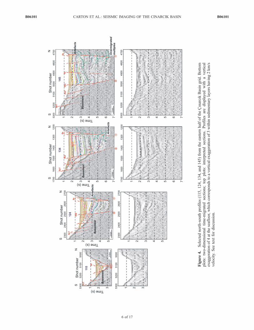
Figure
4.
Selectednorth-south
profiles(115,124,134,and145)from
theeasternhalfoftheCınarcıkBasin
grid.Bottom
plots:two-dim
ensional
time-migrated
sections;
top
plots:interpreted
sections.
Profilesaredisplayed
with
avertical
exaggerationof4attheseafloor,whichcorrespondsto
averticalexaggerationof3within
sedim
entary
layershaving2km/s
velocity.See
textfordiscussion.
B06101 CARTON ET AL.: SEISMIC IMAGING OF THE CINARCIK BASIN
6 of 17
B06101

Figure
5.
Selectednorth-south
profiles(152,165,and179)from
thewestern
halfoftheCınarcıkBasin
grid.Bottom
plots:two-dim
ensional
time-migratedsections;topplots:interpretedsections.See
textfordiscussion.
B06101 CARTON ET AL.: SEISMIC IMAGING OF THE CINARCIK BASIN
7 of 17
B06101

[15] The absence of wells in the Cınarcık Basin impliesthat reflectors identified in seismic sections are neitherconstrained in terms of lithologic contrasts nor in termsof age. Analysis of the long cores collected during theMARMACORE cruise in 2001 showed that the central pull-apart of the Central Basin [Armijo et al., 2005] as well asthe deepest areas of the Cınarcık Basin (R. Armijo, personalcommunication, 2005) have sedimentation rates of 3 mm/yrfor the Holocene, whereas the outer part of the CentralBasin has a sedimentation rate of 1 mm/yr for the Holocene.This is consistent with the fact that fault-bounded bathy-metric deeps are typically the site of the highest sedimen-tation rates. By contrast, sedimentation rates are muchsmaller on the shallow platform areas (less than 200 mwater depth), between 0.13 and 0.52 mm/yr [Catagay et al.,2000].[16] Fault mapping was carried out as follows. A few
major faults were mapped first, then smaller features wereprogressively added wherever supported by the data. Therewas generally an excellent correlation with high-resolutionbathymetry as well as 3.5 kHz mud-penetrator profiles(G. Ucarkus, personal communication, 2006): faults thatwere easily identified in the near-surface data and showedvertical throws were systematically present through inflec-tions at the seabed in the multichannel seismic sections, andtheir continuations at depth were revealed. In addition,several faults which had little or no expression in theseafloor morphology could be mapped from the seismicprofiles (Figure 2). The least detectable feature of all in the
seismics was the strike-slip branch fnw, an observation thatis hardly surprising since seismic profiles essentially allow torecognize a fault through its dip-slip component. The locationof fnwwasmarked onto the seismic images on the basis of thesharp trace visible in the bathymetric data. Neighboringsediments were disturbed in the seismic sections, but therewas generally no clear indication about where to mark thefault. To some extent, fs1 was also difficult to identify, exceptwhere a significant offset in the basement was present.Another issue for interpretation is that the SEISMARMARAdata are very low frequency with a long source wavelet(400 ms), which results in a poor vertical resolution: it isdifficult to distinguish between two horizons having avertical separation less than 200–300 m. Even though thelateral sampling is very good (1 CMP trace every 6.25 m),there is an overall lack of sharpness of the images. However,the limited vertical resolution of the seismic data did notprevent the observation of vertical offsets of about 40m at theseabed (the aforementioned inflections). Indeed, what isconsidered here is a single horizon whose lateral samplingis very good and which is overlain by a transparent layer(water). The dense grid of profiles were highly valuablematerial to establish correlations from one profile to anotherand thus to assess the along-strike continuity. They alsohelped distinguish between artifacts (side-swipes, multiples)and real features. The smaller faults were found to be scarcelycontinuous over more than two consecutive profiles, whilethe major faults were as carefully mapped as possiblethroughout the grid of lines. The lines presented in this paper
Figure 6. Strike line (200), two-dimensional time-migrated, and interpreted sections. See text fordiscussion.
B06101 CARTON ET AL.: SEISMIC IMAGING OF THE CINARCIK BASIN
8 of 17
B06101

were selected because they showed the clearest features aswell as minimum artifacts.
4.2. Interpreted Profiles
[17] Several interpreted profiles are presented here astwo-dimensional lines, from west to east (Figures 4, 5,and 6), and will be described in the following paragraphs.
All the seismic sections are displayed with a verticalexaggeration of 4 at the seafloor, which corresponds to avertical exaggeration of 3 within sedimentary layers having2 km/s velocity.[18] Profile 115 crosses the basin 11–12 km west of the
termination of the I:zmit earthquake break, as observed by
Armijo et al. [2005] and Ucarkus et al. [2006] (Figure 2).The sediment deposition is asymmetric, contrasting withflat-lying horizons farther east, where the basin narrowstoward the Gulf of I
:zmit. Here the basin is bounded to the
north by two faults: a very steep innermost fault, associatedwith a clear normal scarp at the seafloor, and an outerbranch lying at the base of the main escarpment. In betweenthese two fault branches lie disturbed sediments, whoseinternal structure is not resolved by the data, possiblyincluding some Upper sequence sediments. To the south,the rest of the basin fill shows regularly bedded, north-dipping sediments, among which horizons U1 (light purple),U2 (purple), and ULlimit (orange) are identified. The base-ment reflector seems to be displaced by a major fault, with avertical throw of 950 ms. Fault fs1 is crossed at the southernend of the profile. The fact that sediments dip to the north inmost of the basin suggests that in this part of the basin,vertical motion on the northern side has been greater thanvertical motion on the southern side.[19] Profile 124 is situated south of Prince’s Islands,
7.5 km west of profile 115. The basin is bounded on thenorthern side by two steep branches that appear to connectat depth into a single fault fn. Toward the middle of the line,a basement block is offset by fault ‘‘fs2’’, which appears tobe a major boundary. This fault, also observed on mostprofiles farther west, corresponds to the ‘‘Inner BoundaryFault’’ identified by Okay et al. [2000]. In the southern halfof the basin, numerous small normal faults cut throughshallow sediments with generally little vertical displacement.These small faults, which according to high-resolutionbathymetric data display an en echelon pattern (Figure 2),are also well imaged using high-resolution 3.5 kHz mud-penetrator profiles (G. Ucarkus, personal communication,2006). On the southern margin, inflections in the seafloortopography are interpreted as indicating the presence offaults, although the extension at depth of these basementfaults cannot be imaged. The main fault fs1, a secondfault at the tip of the sediment wedge, and a third faultresponsible for an offset in the basement are imaged. Thebottom of the basin is encountered at more than 5 s two-way time near the innermost branch of fn. Horizons L1(yellow), L2 (pink), L3 (blue), and L4 (spring green) areidentified. Moreover, this profile shows a very clearULlimit horizon over most of the basin width. By contrast,in the part of the basin south of fs2, it is impossible toidentify reflectors deeper than ULlimit (continuations ofL1, L2, L3, or L4 in the footwall of fs2).[20] Profile 134, which runs 8.5 km west of profile 124,
confirms that fault fs2 is a major boundary between the deepbasin and marginal areas with offset basement blocks, henceits name of Inner Boundary Fault. South of fs2 extends thefield of normal faults. This profile also highlights theimportance of fault fs1, which is the southern margin faultmapped in bathymetric data by Armijo et al. [2002]: fs1shows here a clear vertical offset of the basement/basinsediments contact. A deep horizon called L6 (dark purple)
Figure 7. Thickness maps in ms two-way time for theCınarcık Basin area, constructed as the difference betweenhorizon picks along seismic profiles and seafloor time. (a)ULlimit-seabed, (b) L5-seabed, (c) top basement-seabed.Layer thicknesses are superimposed onto smooth bathy-metric contours interpolated from seafloor picks on theseismic profiles. Most of the survey area was covered by theSEISMARMARA data, which are characterized by a longsource wavelet. Therefore thickness values �150 ms on theglobal maps are not significant (i.e., equivalent to 0)because any reflector within this time window cannot bedistinguished from the seafloor reflection.
B06101 CARTON ET AL.: SEISMIC IMAGING OF THE CINARCIK BASIN
9 of 17
B06101

and dipping to the north is identified on this profile. Thefirst 2.5 s of sediments are tilted toward the south, whereasdeep sediments (about 2 s thick) dip toward the north. Thelocation of the bottom of the basin is fairly speculativebecause of the absence of clear reflectors for times morethan 6 s. Deep sediments around horizons L4 and L5 maybe affected by small normal faults. The Upper sequence isthinner than on profile 124, suggesting that the Uppersequence globally thins toward the west.[21] Profile 145, which runs 6.8 km west of profile 134,
images a wider basin and a more complex structure thanprofile 134. It displays a new tectonic feature, a south-dipping fault called ‘‘fc’’ located in the center of the basinand which comes close to the surface at SP 4890. This faultforms the limit of a subbasin along the southern margin. Itclearly offsets horizon L3 (blue), but its deep throw, at thebase of the basin, is difficult to assess. North of fc, deepsediments are tilted toward the north, while layers abovehorizon L5 are more flat-lying. Reflectors imaged on thenorthern side of fs2 now seem almost continuous across thefault. On this profile as well as on several profiles fartherwest, fault fs2 appears more as a flexure than a fault, sincethe beds seem more distorted than offset by the fault. Thismight result from slow vertical motion along this faultcompared to sedimentation rates. Moreover, all the profileshere are displayed with a vertical exaggeration of 4 at theseafloor, which is equivalent to a vertical exaggeration of 3at 2 km/s (a good approximation for the first 2–3 km ofsediments), hence true dips are considerably reduced com-pared to apparent dips on the time sections plotted here.[22] Profile 152, located 4.2 km farther west, crosses the
north-bounding fault fn almost at right angle, west of thebend at 28�530N. The basin is wider, and the subbasin alongthe southern margin is now fully developed. This featurelooks very peculiar in the seismics because of its more orless symmetrical syncline shape. Fault fc forms the boun-dary between sinking sediments in the south and north-dipping sediments in the north. Fault fn consists of twobranches, an inner, steep branch along which basin sedi-ments terminate and an outer branch located at the base of
the main slope. The basement reflector on the southern sideappears as a round-shaped high-amplitude reflector, over-lain by �700 ms of sediments.[23] Profile 165, located 7.8 km west of profile 152,
displays a simpler image: the subbasin has disappeared,and the southern side of the Cınarcık Basin is characterizedby normal faulting on ‘‘fs3’’ and possibly on two otherfaults south of fs3. The basement reflector is visible at thesouthern end of the profile. Above it, between SP 900–1100, there is another strong reflector which shows acomplex topography and may be faulted. On the northernside, well-stratified basin sediments are tilted toward thenorth, terminating against a fault which seems to split intotwo close branches. It is unclear where the bottom of thebasin lies here, but it might be dipping toward the north.[24] Profile 179 runs across the western flank of the
Cınarcık Basin, 9.4 km west of profile 165. The basementis clearly imaged in the south. Between SP 400–700,disturbed sediments are imaged, which have possibly un-dergone some compression. A canyon is crossed, and thedeeper structure shows V-shaped reflectors. To the south,the canyon seems bounded by a fault at SP 330; there aretwo other faults on the southern margin associated withbasement offsets at SP 270 and SP 210. Sedimentarythickness may reach 3.7 s near the fault at SP 330 anddecrease toward the north. The northern escarpment iscrossed at SP 710–730. This profile suggests that thewestern flank of the Cınarcık Basin is occupied by anotherbasin and that a major fault exists that bounds the canyon tothe south. This basin is seen to continue on the lines 180–188 shot farther west toward Central High.[25] Profile 200, which is 57 km in length, was shot at
right angle to the cross-lines, i.e., with an azimuth of N10�E(Figure 2). It provided very useful information to connect allthe other profiles and was extensively used during thehorizon-picking phase. However, this profile remains diffi-cult to interpret since it comes close to the northernescarpment in its eastern part, hence the presence of side-swipes events, and also because the major faults are notimaged. In the eastern half of line 200, eastward-thickening
Figure 8. Map showing the location of the depocenters of the eastern Sea of Marmara and the eastwardmigration over time of the main depocenter of the Cınarcık Basin.
B06101 CARTON ET AL.: SEISMIC IMAGING OF THE CINARCIK BASIN
10 of 17
B06101
sedimentary layers terminate against the west-dipping base-ment reflector. Interestingly, fault fc (imaged on lines 145 to156) is also crossed here, and although this fault does notreach the surface, it marks a clear boundary between theeastern and western halves of the basin. At the eastern endof the profile, a fault coming to the surface is imaged,probably a SW-dipping fault segment at the entrance of thebasin. East of fc, sediments are dipping toward the east,with some local complexities related to the field of normalfaults that extends far into the basin. Horizons seem toterminate against a high-amplitude reflector, which weinterpret as the top of the basement. The eastern part ofthe profile also displays curved, sometimes quite continuousevents which seem uncorrelated with mapped horizons.These are most probably out-of the plane events,corresponding to reflections or diffractions on the steepbasin sidewalls. Horizons L1, L2, L3 and to some extentdeeper reflectors are seen cutting across these events. Westof fc, the picture becomes more complicated, and correla-tion of horizons on the eastern and western sides of the faultis difficult. Basin floor shallows west of SP 2560, sugges-ting at this location the presence of a deep fault defining thewestern boundary of the basin.
4.3. Thickness Maps
[26] Mapping variations in sedimentary thicknesses fromthe seismic reflection data grid is the key to understandingthe formation of the basin and the role of the different faults.The lateral continuity of events was generally good in theeastern part of the Cınarcık Basin, although it was hardlyever possible to extend horizon picks on the edges of thebasin, on either side of the innermost bounding faults (seefor instance profiles 124 and 134 on Figure 4). As alreadyseen on profile 200 (Figure 6), correlation of horizonswithin the basin on the northwestern and southeastern sidesof fault fc remained speculative. In the western half,difficulties came from the presence of remaining multipleenergy at depth which made it harder to identify and followtrue reflectors (including L6 and the basement reflector).Also, profiles running on the western flank of the CınarcıkBasin toward Central High (profile numbers 170–188approximately) are characterized by a poor imaging quality,which suggests they sample a deformed area.[27] Upper sequence sediments (Figure 7a) are seen in the
flat, deep part of the Cınarcık Basin and thicken eastward.The maximum thickness is found in the eastern part of thebasin along the north-bounding fault: �950 ms twt (e.g.,line 117), which corresponds to a thickness of 760 m at avelocity of 1.6 km/s. As the basin floor shallows westward,a regular thinning of the Upper sequence is observed, with alocal thickening in the SW part of the basin inside thesubbasin imaged on line 152. Correlation between layerthicknesses and bathymetry is obvious for this reflector, i.e.,thick Upper sequence sediments are observed where theseafloor is deep. The second plot (Figure 7b) shows thecumulated thickness down to horizon L5, and westwardthinning is also observed.[28] A total sedimentary thickness map (Figure 7c) was
produced in and around the Cınarcık Basin using a smoothinterpretation of the basement. The basement reflector iswell-defined in the I
:mrali Basin and in the eastern half of
the Cınarcık Basin, where the total sedimentary fill is less
than 3–4 km thick. Farther west in the Cınarcık Basin, deepsediments are imaged, but the bottom of the basin can bemapped with limited confidence using our reflection pro-files. There is no real clear, high-amplitude reflector, and insome places remaining multiple energy is a severe problem,with overmigrated seafloor multiples obscuring deep reflec-tions. The maximum sedimentary thickness in the CınarcıkBasin is about 5–5.5 s twt (5–6 km using an averagevelocity of 2–2.5 km/s) along the north-bounding fault,south and southwest of the bend in the northern escarpment;therefore the bottom of the basin may seem downthrown tothe north. Total sedimentary thickness values equal to 0 onthe SE side of the Cınarcık Basin (red color) correspond toan area where Upper Cretaceous limestones are exhumed onthe southern slope of the Cınarcık Basin, whereas they arecovered by sediments farther west. In the westernmost15 km of the survey area, another basin is imaged (e.g.,line 179), which seems to continue westward toward theCentral High. Sediment thickness in this basin is difficult tomap precisely because of the difficulty to identify thebasement reflector, but their total thickness may be �3–4 s.This basin seems bounded to the south by an ENE-WSWtrending fault. In the I
:mrali Basin, sediments are observed to
thicken southward.[29] In summary, the widest part of the Cınarcık Basin,
south and southwest of the bend in the northern escarpment,seems to be the site of accumulation of the thickest sedimentsand thus probably the oldest part of the basin (Figure 8); inthis area, a smaller subbasin is also imaged along the southernmargin. There seems to exist another basin located on thewestern margin of the Cınarcık Basin toward Central High,filled by sediments up to 3–4 s thick and bounded to thesouth by a NNE-SSW trending fault. The area which hasundergone the maximum amount of extension in recent times(a few 100,000 years) is the eastern part of the basin, asindicated by the Upper sequence thickness map. This areacoincides with the area of maximum seafloor depth in thebasin, which is consistent with greater vertical displacement,especially along the north-bounding fault. The distribution ofsediments described here suggests an eastward migrationover time of the main depocenter of the Cınarcık Basin(Figure 8).
5. Discussion: Tectonic Evolution of the CınarcıkBasin
5.1. Three-Dimensional Views
[30] Evolution of the structure of the basin on its northernside is highlighted in Figure 9. The basin is bounded by alarge and steep northern fault fn. Two branches are oftenobserved, one inner branch carrying more strike-slip dis-placement and one outer branch carrying more extensionaldisplacement, both probably merging at depth into a sametranstensional fault. Thick sediments, probably up to 6 kmthick (e.g., profiles 145 and 165), are imaged along thisfault. More specifically, easternmost profiles 122, 128, 136,as well as the strike line 200 show a westward deepening ofthe bottom of the basin which coincides with more horizonsbeing mapped in the seismic sections. Farther west, it isdelicate to identify the bottom of the basin, but still severalseconds of sediments are imaged everywhere. Northwardtilting of deep sediments is visible throughout most of the
B06101 CARTON ET AL.: SEISMIC IMAGING OF THE CINARCIK BASIN
11 of 17
B06101

basin up to at least profile 165 in the west. Shallowersediments show a more varying pattern. On profile 122,fanning toward the northern margin is observed on thewhole section. By contrast, on profile 128, sedimentarylayers above horizon L4 are roughly symmetrical and
almost flat-lying, suggesting that at this location, dip-slipmotion on the north-bounding faults must have been dom-inant in a first phase of opening of the basin; a second phasefollowed, during which faults on both sides have taken thesame amount of vertical displacement. On profile 136,
Figure 9. Top: three-dimensional view of selected seismic profiles from the northeast and thusemphasizing the north side of the Cınarcık Basin (east is on the left handside, west is on the righthandside). Bottom: three-dimensional high-resolution bathymetry of the whole Cınarcık Basin withlocation of seismic lines draped onto the seafloor; view is from the southwest instead of northeast, since ifthe same azimuth/elevation had been chosen as for the seismics plots, the basin would have been hiddenbehind the northern escarpment. Interpreted profiles suggest long-term activity on the northernescarpment.
B06101 CARTON ET AL.: SEISMIC IMAGING OF THE CINARCIK BASIN
12 of 17
B06101

motion on the south-bounding faults must have dominatedin the recent phase since sedimentary layers above horizonL4 dip toward the south. In a nutshell, the data provideevidence of steady activity including dip-slip motion alongfn since the beginning of opening of the basin. This is inagreement with the very steep slope along the entire northCınarcık escarpment. East of the bend at 28�530E, the innerfault produces a very clear step (50 m high) in the seafloortopography (e.g., profiles 122 and 128), whereas the outerfault is in the continuation of the main slope (1 km highescarpment). West of the bend, the NW segment presentlyaccommodates strike-slip motion, with some slip partitio-ning, as imaged on profiles 165 and 179. As suggested byOkay et al. [2000] and Rangin et al. [2004], the formationof the Cınarcık Basin might have been guided by preexis-ting structures, such as N120�E-trending faults seen in theolder Thrace Basin, among which the NE Cınarcık faultmight have been reactivated as a transtensional fault.
[31] Figure 10a shows the evolution of the structure of theeastern half of the basin on its south side, while Figure 10bfocuses on the structure of the southwestern margin, where asubbasin is imaged.[32] Profile 134 on Figure 10a shows the presence of two
major, distinct extensional faults, which are still activetoday: the main south-bounding fault fs1 mapped by Armijoet al. [2002], whose vertical displacement accounts for themain difference in elevation between the basin and itssouthern margin; the inner boundary fault fs2, which offsetsthe basement/basin sediments contact surface by 1 to 1.5 kmin the east (e.g., profile 124). Other offsets in the basementcan be identified in places and are associated with other,smaller faults. Outcropping basement on the south side isimaged on profile 134 and all the lines farther east. Onprofile 134, the measure of the offset of the basement blockalong this fault only yields a minimum value of the totalvertical displacement because the basement crops out and
Figure 10. Three-dimensional views emphasizing the south side of the Cınarcık Basin. (a) View fromthe west showing the eastern half of the basin, with location of the profiles displayed onto the bathymetricsurface (same azimuth but zoomed out) (b) View from the southeast showing the subsurface expressionof the subbasin, with location of the profiles displayed onto the bathymetric surface (slightly differentazimuth and zoomed out). Blue dotted line shows the approximate contours of the subbasin.
B06101 CARTON ET AL.: SEISMIC IMAGING OF THE CINARCIK BASIN
13 of 17
B06101

there must have been some erosion of an initial edge-shapedtop-basement surface (uplifted footwall).[33] On Figure 10b, profile 139 shows the presence of a
second branch of fault fs2, called fs3. This fault is located atthe base of the slope and marks the southern termination ofthe Upper sequence, while fault fs2 offsets the ULlimitreflector by a few tens of ms. There is a gentle tilting/sagging of reflectors toward fs2 that becomes more prom-inent westward. At the southern end of the profile, thebasement is overlain by a thin sedimentary cover. Thesubbasin in the south is narrower, and deep sedimentaryhorizons inside it seem distorted. Maximum thickness of theUpper sequence is 400 ms in the center of the subbasin.Profiles 145, 152, and 156 image a deep extensional fault fcin the middle of the Cınarcık Basin, striking approximatelyN65�E and dipping to the SE. Combined activity along thesouthern margin faults and this intrabasin fault fc hascreated a large subbasin which can be seen in the seismicprofiles between 28�450E and 28�550E. A coincident,though slightly smaller, deep is revealed by shaded bathy-metry (Figure 10b). The size and orientation of this featureare similar to that of the central pull-apart nested in theCentral Basin (Figure 1). It is therefore tempting to interpretthis feature as a small pull-apart, which could have openedby transtension between two strike-slip segments: the innerboundary fault to the east, and a possible ENE-WSWtrending strike-slip fault to the west, which will be discussedin the next paragraph.[34] The existence of an ENE-WSW trending strike-slip
segment connecting the SW corner of the Cınarcık Basin tothe outer Central Basin south-bounding fault has been putforward to account for the opening of the Central Basin[Cetin et al., 2003; Becel et al., 2004]. This fault wouldhave acted as a transfer fault in an earlier stage of evolutionof the Sea of Marmara and would be much less active now,with strike-slip motion presently localized some 12 kmfarther north along fnw. If such a fault exists, no surfaceexpression can be seen within our data grid but a 5.9-kmlong E-W trending fault was mapped farther west on CentralHigh (Figure 1). Also, the canyon crossed on line 179,whose orientation changes fromN-S toENE-WSW(Figure 2),could have been guided by this fault. The possible existenceand role of an earlier strike-slip transfer fault between theCınarcık and Central basins as well as the structure of CentralHigh will be the focus of another paper.
5.2. Comparison With Models of Pull-Apart Basins
[35] The simplest, ‘‘synoptic’’ model of pull-apart basinsinvolves two parallel, en echelon strike-slip fault segments.Subsequent strike-slip motion opens a hole in the step area,strike-slip segments link by two transverse, extensionalbranches, and a fault-bounded, box-shape basin develops.This model assumes a brittle upper crust and constantvolume during strike-slip displacement. The amount ofopening is equal to the distance between the basin-boundingfaults, which is also the amount of displacement along themaster strike-slip fault [e.g., Garfunkel, 1981]. Uniformsubsidence of the basin is predicted.[36] Few pull-apart basins in the field present a simple,
box-shape geometry, and the term ‘‘pull-apart basin’’ iscommonly used to qualify rhombic or sigmoidal areas ofextension along strike-slip faults, formed because of a bend
or jump in the master strike-slip fault, and where the basin-bounding faults have complex geometries and connectionswith the master strike-slip segments (see the pull-apartexamples shown by Aydin and Nur [1982], Mann et al.[1983], and Dooley and McClay [1997]). Subsidence dis-tribution is far from being uniform, and like in any exten-sional system, quantification of basin opening depends uponthe geometry of basin-bounding faults at depth (planar orcurved geometry of faults, presence or not of block rotations).A commonly observed deviation from the standard model isbasin asymmetry; that is, the center of the basin is not a centerof symmetry for the fault system and the distribution ofsubsidence areas. Such basins are often bounded on one sideby a dominantly strike-slip fault (displaying a local changestrike and a nonvertical fault plane) and on the other side bynormal faults striking subparallel to the transform. Releasingbend geometry can account for the formation of these basins.Ben-Avraham and Zoback [1992] provided a different inter-pretation and put forward a process of transform-normalextension, where extension is due to divergence in platemotion and occurs perpendicular to the trace of the strike-slipfault.[37] Theoretical studies [Segall and Pollard, 1980;
Rodgers, 1980], numerical modeling in either two or threedimensions [Bilham and King, 1989; Golke et al., 1994;Katzman et al., 1995], and analogue modeling [Dooley andMcClay, 1997; Rahe et al., 1998; Basile and Brun, 1999]help guide the interpretation of three-dimensional deforma-tion observed in natural pull-apart basins. The shape, faultsystem, and sedimentary structure of a pull-apart basindepends upon the geometrical parameters associated withthe step in the master strike-slip fault system: fault length,depth to the main fault in the basement, fault separation, andperhaps above all the length of overlap. Generally one singledepocenter is predicted in the middle of the basin (fullgraben), with half-graben shapes toward the extremities[Katzman et al., 1995; Dooley and McClay, 1997]. This, tosome extent, is the case in the Cınarcık Basin: in its easternhalf, normal motion on the northern fault dominates, with atypical half-graben structure, whereas in its western half,maximum activity has switched on the southern faults, withtilting of sediments toward the south and development of asubbasin.[38] Analogue models that offer the best match with the
shape of the Cınarcık Basin and the nature and orientationof its fault system are the 30� underlapping side-step modelof Dooley and McClay [1997], which produces an elongaterhomboidal graben, and one of the 40� (possibly slightlyasymmetrical) underlapping side-step models of Rahe et al.[1998]. The unexpected asymmetry in Dooley andMcClay’s experimental pull-aparts fits fairly well observa-tions in the Cınarcık Basin, where the north-bounding faultis associated with a major escarpment and has played adominant role in the formation of the basin. Analogueexperiments also provide insight into how the model isdeforming at depth, i.e., the deformation of the prekinematiclayers which are poorly or not at all sampled by theSEISMARMARA seismic profiles. Vertical cross-sectionsacross sandbox models [Dooley and McClay, 1997] showthat the prekinematic layers are heavily faulted down to thebase of the model, thus forming collapsed and/or tiltedblocks of various sizes. Numerous intrabasin faults are
B06101 CARTON ET AL.: SEISMIC IMAGING OF THE CINARCIK BASIN
14 of 17
B06101

observed that sometimes affect the synkinematic sedimentsas well. The wider part of the basin displays the greatestcomplexity, but asymmetry is more pronounced toward thebasin extremities.[39] Interestingly, cross-basin faults (new strike-slip faults
forming inside the basin, eventually causing a cessation ofextension) are recurrent features in sandbox models. Thesefaults, which develop in mature stages of evolution ofexperimental models, seem to play an important role inthe extinction of pull-apart basins. This is in agreement withthe observations of Zhang et al. [1989] on pull-apart basinsalong the Haiyuan fault in northwest China: the mostcommon cause of pull-apart extinction appears to be thedevelopment of new strike-slip faults either along one of thebasin-margin normal faults or diagonally across the basin,as a tendency for the strike-slip fault to straighten itself.However, there exist numerous basins identified as pull-apart basins and which are devoid of cross-basin faults, butthese basins could be simply in their initial stages ofevolution. The same interpretation may apply to theCınarcık Basin, where evidence for a cross-basin strike-slipfault has been found neither in high-resolution bathymetricdata (fault trace cutting the basin floor and linking thestepped master strike-slip branches) nor in seismic data(buried feature).
5.3. Comparison With Numerical Modeling Results
[40] Muller and Aydin [2005] used a numerical code tomodel the vertical deformation rates in the Sea of Marmaraproduced by several published fault systems [Okay et al.,2000; Le Pichon et al., 2001; Armijo et al., 2002]; thesedeformation rates are compared with both seafloor mor-phology and structural deformation pattern of basementhorizon. In the model, almost all the faults are assigneddips of 70�–90�: 90� for faults that were interpreted to bemajor strike-slip structures and 70� or 80� (dipping towardthe center of the basin) for smaller transtensional basin-bounding faults. These steep dips are consistent withseismic imaging results for the Central Basin [Hirn et al.,2003] as well as for the Cınarcık Basin (this study). Mullerand Aydin found that an interpretation with a series of pull-apart basins along a master strike-slip fault (fault configura-tion of Armijo et al.) best produces the observed deformationpattern within the Sea of Marmara. The location and relativesubsidence of the main basins within the north Marmaratrough, the three transtensional basins and I
:mrali half-
graben, are well matched. Conversely, results obtained withother fault configurations illustrate the simple fact that it isimpossible to create a basin without basin-bounding faultsbearing some extensional component of motion.[41] Here we will focus on the distribution of subsidence
computed by Muller and Aydin [2005] in the Cınarcık andI:mrali basins using the fault system of Armijo et al., which
we will compare with seismic results. To first order, themodel predicts a global subsidence of the Cınarcık Basin,which is confirmed by basin depth and sedimentary struc-ture in seismic profiles. This is a direct consequence ofactivity of both basin-bounding faults, fn on the northernside and fs1 on the southern side, whereas a basin fullydownthrown to the north would be produced if only thenorthern branch was active. If another model were compu-ted taking into account fault fs2 (Inner Boundary Fault on
the southern side) as well, the subsidence pattern wouldeven better match the observed seafloor morphology andseismic data. The site of highest subsidence is predictedwithin the eastern, narrow part of the basin, closer to thenorth-bounding fault than to the south-bounding one. Thisresult fits very well with seafloor depth (deepest part of thebasin) and recent subsidence (thickest Upper sequence). Theeastern part of the Cınarcık Basin is opening at the tip of theI:zmit fault, which connects to the NE-bounding fault
through a clear bend. This pattern of subsidence is verysimilar to extension fractures forming at the tip of a strike-slip branch. In the broadest part of the basin, two smallerareas with high levels of subsidence are observed both onthe north-bounding and south-bounding faults. On the southside, this is in agreement with our observation of a second-ary graben opening along the SW margin of the basin.South of this depocenter, the high separating the Cınarcıkand I
:mrali Basin is also imaged in our seismic data. Within
I:mrali Basin, the model predicts south-dipping sediments,
which is confirmed by seismic images [Parke et al., 1999;Okay et al., 2000].
5.4. Age of the Cınarcık Basin? Toward a RelativeChronology of its Evolution
[42] There is a crucial need of deep borehole data in theCınarcık Basin, which would provide both the nature andage of basin sediments imaged in seismic reflection data. Ata larger scale, the timing of the opening of the Sea ofMarmara along the NAF is constrained by the observationof a large anticline in the Dardanelles which was offset bythe fault some 5 My ago [Armijo et al., 1999], although thenature of the folding and the stratigraphy in this area havebeen disputed [Yaltırak et al., 2000]. Present-day sedimen-tation rate in the central pull-apart of the Central Basin hasbeen found to be as high as 3 mm/yr [Armijo et al., 2005].Therefore Hirn et al. [2002, 2003] suggested that pull-apartactivity has been taking place in the Central Basin for about1.5 My, on the basis of estimation of synkinematic sedimentthickness of about 4.5 km. A similar calculation can bemade for the Cınarcık Basin, assuming that this sedimenta-tion rate is also valid, on average, for deposition of sedi-ments in the Cınarcık Basin: a maximum sedimentarythickness of 5–6 km yields and age of 1.7–2 My for thebasin. This figure, even very poorly constrained, is consis-tent with the westward propagation of the NAF, since theeastern Marmara Sea and especially the Cınarcık Basinlikely started opening before the central part of the MarmaraSea. A tectonic model using GPS velocities suggests thepresent-day Anatolia/Eurasia motion is accommodatedacross the Marmara region by 18–20 mm/yr of right-lateralslip and 8 mm/yr of pure extension [Flerit et al., 2003,2004]. Furthermore, Armijo et al. [2002] gave a reconstruc-tion for the past �200,000 years by restoring a 3.5-kmoffset along the strike-slip fault segment connecting theCınarcık and Central basins. It shows that the amount ofnorth-south opening due to extensional motion is about2 km in the Cınarcık Basin. Therefore assuming that theslip rate on the northern NAF (�20 mm/yr) has been fairlyconstant in the last few million years with a constantamount of partitioning, one requires 1.8 My to producean 18-km wide basin (width measured in a N40� direction),if the basin-bounding faults are planar and there are no
B06101 CARTON ET AL.: SEISMIC IMAGING OF THE CINARCIK BASIN
15 of 17
B06101
block rotations. This figure is fully consistent with ourestimation of 1.7 to 2 My from the total synkinematicsediment thickness.
6. Conclusion
[43] The Cınarcık Basin is an active transtensional basinalong the northern NAF. Basin-bounding faults with signi-ficant extensional component of motion are imaged alongboth north and south sides of the basin. There is noindication in the data for a single throughgoing strike-slipfault, neither a cross-basin fault nor a pure strike-slip faultrunning along the northern margin. Results from the Leg 2of the SEISMARMARA survey suggest that the CınarcıkBasin has a thick sediment fill, with a maximum sedimentthickness of 6 km or more, though not uniformly distributed.In the eastern half of the basin, normal motion on thenorthern fault dominates (with a typical half-graben struc-ture), whereas in the western half, dominant activity hasswitched onto the southern fault (with tilting of sedimentstoward the south and development of a subbasin). The areawhich seems to have opened most recently is the narrow,deepest part of the basin in the east. Overall, the CınarcıkBasin might be about 2 My old, but no reliable ageconstraint is available at the moment.[44] There are few examples in the literature of dense
seismic imaging of transtensional basins. The SEISMAR-MARA survey shows that the lateral variability of the faultsystem and sedimentary structure requires such denselyspaced data to understand the formation of this type ofbasin.
[45] Acknowledgments. We thank the captain (H. Piton) and crew ofR/V Le Nadir. The SEISMARMARA survey (2001) was carried out withina French-Turkish collaborative program on seismic risk in Istanbul and theSea of Marmara, coordinated by INSU-CNRS and TUBITAK. We thank theAssociate Editor and two reviewers (A. Okay and N. Seeber), who providedinsightfult comments and constructive criticism on an earlier version of themanuscript. This is IPGP contribution number 2208.
ReferencesAmbraseys, N. N., and C. F. Finkel (1991), Long-term seismicity ofIstanbul and of the Marmara Sea region, Terra Nova, 3, 527–539.
Ambraseys, N. N., and J. A. Jackson (2000), Seismicity of the Sea ofMarmara (Turkey) since 1500, Geophys. J. Int., 141, F1–F6.
Armijo, R., B. Meyer, A. Hubert, and A. Barka (1999), Westward propaga-tion of the North Anatolian Fault into the northern Aegean: Timing andkinematics, Geology, 27, 267–270.
Armijo, R., B. Meyer, S. Navarro, G. King, and A. Barka (2002), Asym-metric slip partitioning in the Sea of Marmara pull-apart: A clue topropagation process of the North Anatolian Fault?, Terra Nova, 14,80–86.
Armijo, R., N. Pondard, B. Meyer, B. Mercier de Lepinay, and G. Ucarkus(2005), Submarine fault scarps in the Sea of Marmara pull-apart (NorthAnatolian Fault): Implications for seismic hazard in Istanbul, Geochem.Geophys. Geosyst., 6, Q06009, doi:10.1029/2004GC000896.
Ates, A., T. Kayiran, and I. Sincer (2003), Structural interpretation of theMarmara region, NW Turkey, from aeromagnetic, seismic and gravitydata, Tectonophysics, 367, 41–99.
Aydin, A., and A. Nur (1982), Evolution of pull-apart basins and their scaleindependence, Tectonics, 1, 91–105.
Avedik, F., V. Renard, J. P. Allenou, and B. Morvan (1993), ‘‘Single-bub-ble’’ air-gun array for deep exploration, Geophysics, 8, 366–382.
Barka, A., and K. Kadinsky-Cade (1988), Strike-slip fault geometry inTurkey and its influence on earthquake geometry, Tectonics, 7, 663–684.
Basile, C., and J.-P. Brun (1999), Transtensional faulting patterns rangingfrom pull-apart basins to transform continental margins: An experimentalinvestigation, J. Struct. Geol., 21, 23–37.
Becel, A., et al. (2004), Seismic structure and activity of the North Anato-lian Fault in the Sea of Marmara from the SEISMARMARA Leg 1
seismic survey, Eos Trans. AGU, 85(47), Fall Meet. Suppl., AbstractS52A-04.
Ben-Avraham, Z., and M. D. Zoback (1992), Transform-normal extensionand asymmetric basins: An alternative to pull-apart models, Geology, 20,423–426.
Bilham, R., and G. King (1989), The morphology of strike-slip faults:Examples from the San Andreas Fault, California, J. Geophys. Res.,94(B8), 10,204–10,216.
Cakir, Z., J.-B. de Chabalier, R. Armijo, B. Meyer, A. Barka, and G. Peltzer(2003), Coseismic and early post-seismic slip associated with the 1999I:zmit earthquake (Turkey), from SAR interferometry and tectonic field
observations, Geophys. J. Int., 155, 93–110.Catagay, N., N. Gorur, A. Algan, C. Eastoe, A. Tchapalyga, D. Ongan,T. Kuhn, and I
:. Kuscu (2000), Late Glacial-Holocene palaeocea-
nography of the Sea of Marmara: Timing of connections with theMediterranean and the Black Seas, Mar. Geol., 167, 191–206.
Cetin, S., H. Carton, S. Singh, A. Hirn, B. de Voogd, M. Laigle, A. Becel,R. Saatcilar, and S. Ozalaybey (2003), Seismic evidence for a linkbetween the Cinarcik Basin and the Central High in the Marmara Sea,in Int. Symp. on the N. Anatolian, E. Anatolian and Dead Sea FaultSystems, Middle East Technical University, Ankara.
Dessa, J.-X., H. Carton, and S. C. Singh (2005), 3D tomography of theCınarcık Basin (Marmara Sea, Turkey) from ocean bottom recording ofdense seismic profiles,Geophys. Res. Abstr., 7, Abstract EGU05-A-08303.
Dooley, T., and K. McClay (1997), Analog modeling of pull-apart basins,AAPG Bull., 81, 1804–1826.
Ergun, M., and E. Ozel (1995), Structural relationship between the Sea ofMarmara basin and the North Anatolian Fault zone, Terra Nova, 7, 278–288.
Flerit, F., R. Armijo, G. C. P. King, B. Meyer, and A. Barka (2003), Slippartitioning in the Sea of Marmara pull-apart determined from GPSvelocity vectors, Geophys. J. Int., 154, 1–7.
Flerit, F., R. Armijo, G. King, and B. Meyer (2004), The mechanicalinteraction between the propagating North Anatolian Fault and theback-arc extension in the Aegean, Earth Planet. Sci. Lett., 224, 347–362.
Garfunkel, Z. (1981), Internal structure of the Dead Sea leaky transform(rift) in relation to plate kinematics, Tectonophysics, 80, 81–108.
Golke, M., S. Cloetingh, and K. Fuchs (1994), Finite-element modeling ofpull-apart basin formation, Tectonophysics, 240, 45–57.
Hebert, H., F. Schindele, Y. Altinok, B. Alpar, and C. Gazioglu (2005),Tsunami hazard in the Marmara Sea (Turkey): A numerical approach todiscuss active faulting and impact on the Istanbul coastal areas, Mar.Geol., 215, 23–43.
Hirn, A., S. Singh, R. Saatcılar, M. Laigle, B. deVoogd, A. Vigner, andT. Taymaz (2002), Reflection-seismic images and evolution at the scaleof the crust and active faults of the Sea of Marmara Trough (SEISMAR-MARA 2001), Geophys. Res. Abstr., 4, Abstract EGS02-A-04792.
Hirn, A., et al. (2003), Elements of structure at crustal scale under the Seaof Marmara from multichannel seismics of the SEISMARMARA survey,Geophys. Res. Abstr., 5, Abstract EAE03-A-13126.
I:mren, C., X. Le Pichon, C. Rangin, E. Demirbag, B. Ecevitoglu, andN. Gorur (2001), The North Anatolian Fault within the Sea of Marmara: Anew interpretation based on multi-channel seismic and multi-beam bathy-metry data, Earth Planet. Sci. Lett., 186, 143–158.
Karabulut, H., M.-P. Bouin, M. Bouchon, M. Dietrich, C. Cornou, andM. Aktar (2002), The seismicity in the Eastern Marmara Sea after the 17August 1999 I
:zmit earthquake, Bull. Seismol. Soc. Am., 92, 387–393.
Katzman, R., U. ten Brink, and J. Lin (1995), Three-dimensional modelingof pull-apart basins: Implications for the tectonics of the Dead Sea Basin,J. Geophys. Res., 100(B4), 6295–6312.
Le Pichon, X., et al. (2001), The active main Marmara fault, Earth Planet.Sci. Lett., 192, 596–616.
Mann, P., M. R. Hempton, D. C. Bradley, and K. Burke (1983), Develop-ment of pull-apart basins, J. Geol., 91, 529–554.
McClusky, S., et al. (2000), Global Positioning System constraints onthe plate kinematics and dynamics in the eastern Mediterranean andCaucasus, J. Geophys. Res., 105, 5695–5719.
Muller, J., and A. Aydin (2005), Using mechanical modeling to constrainfault geometries proposed for the northern Marmara Sea, J. Geophys.Res., 110, B03407, doi:10.1029/2004JB003226.
Okay, A. I., A. Kashlar-Ozcan, C. I:mren, A. Boztepe-Guney, E. Demirbag,
and I:. Kuscu (2000), Active faults and evolving strike-slip basins in the
Sea of Marmara, northwest Turkey: A multichannel seismic reflectionstudy, Tectonophysics, 321, 189–218.
Ozalaybey, S., M. Ergin, M. Aktar, C. Tapirdamaz, F. Bicmen, andA. Yoruk (2002), The 1999 I
:zmit earthquake sequence in Turkey: Seis-
mological and tectonic aspects, Bull. Seismol. Soc. Am., 92, 376–386.Parke, J. R., T. A Minshull, G. Anderson, R. S. White, D. McKenzie,I:. Kuscu, J. M. Bull, N. Gorur, and C. Sengor (1999), Active faults
B06101 CARTON ET AL.: SEISMIC IMAGING OF THE CINARCIK BASIN
16 of 17
B06101

in the Sea of Marmara, western Turkey, imaged by seismic reflectionprofiles, Terra Nova, 11, 223–227.
Parke, J. R., R. S. White, D. McKenzie, T. A. Minshull, J. M. Bull,I:. Kuscu, N. Gorur, and C. Sengor (2002), Interaction between faulting
and sedimentation in the Sea of Marmara, western Turkey, J. Geophys.Res., 107(B11), 2286, doi:10.1029/2001JB000450.
Parke, J. R., R. S. White, D. McKenzie, T. A. Minshull, J. M. Bull,I:. Kuscu, N. Gorur, and C. Sengor (2003), The Sea of Marmara: A 2D
seismic reflection profile data archive, Geochem. Geophys. Geosyst.,4(10), 1084, doi:10.1029/2002GC000493.
Parsons, T. (2004), Recalculated probability of M � 7 earthquakes beneaththe Sea of Marmara, Turkey, J. Geophys. Res., 109, B05304, doi:10.1029/2003JB002667.
Pondard, N., R. Armijo, G. King, B. Meyer, and F. Flerit (2007), Faultinteractions in the Sea of Marmara pull-apart (North Anatolian Fault):Earthquake clustering and propagating earthquake sequences, Geophys.J. Int., in press.
Rahe, B., D. A. Ferril, and A. P. Morris (1998), Physical analog modelingof pull-apart basin evolution, Tectonophysics, 285, 21–40.
Rangin, C., X. Le Pichon, E. Demirbag, and C. I:mren (2004), Strain
localization in the Sea of Marmara: Propagation of the North AnatolianFault in a now inactive pull-apart, Tectonics, 23, TC2014, doi:10.1029/2002TC001437.
Reilinger, R. E., et al. (2000), Coseismic and postseismic fault slip for the17 August 1999, M = 7.5, Izmit, Turkey, earthquake, Science, 289,1519–1524.
Rodgers, D. A. (1980), Analysis of pull-apart basin development producedby an echelon strike-slip faults, in Sedimentation in Oblique-Slip MobileZones, edited by E. Ballance and H. G. Reading, pp. 27–41, Spec. Publ.Int. Assoc. Sedimentol.
Sato, T., J. Kasahara, T. Taymaz, M. Ito, A. Kamimura, T. Hayakawa, andO. Tan (2004), A study of microearthquake seismicity and focal mechan-isms within the Sea of Marmara (NW Turkey) using ocean bottom seism-ometers (OBSs), Tectonophysics, 391, 303–314.
Segall, P., and D. D. Pollard (1980), Mechanics of discontinuous faults,J. Geophys. Res., 85(B8), 4337–4350.
Smith, A. D., T. Taymaz, F. Oktay, H. Yuce, B. Alpar, H. Basaran, J. A.Jackson, S. Kara, and M. Simsek (1995), High-resolution seismic profil-ing in the Sea of Marmara (northwest Turkey): Late Quaternary sedimen-tation and sea level changes, Geol. Soc. Am. Bull., 107(8), 923–936.
Stein, R. S., A. A. Barka, and J. H. Dieterich (1997), Progressive failure onthe North Anatolian Fault since 1939 by earthquake stress triggering,Geophys. J. Int., 128, 594–604.
Taymaz, T., J. Jackson, and D. McKenzie (1991), Active tectonics of thenorth and central Aegean Sea, Geophys. J. Int., 106, 433–490.
Ucarkus, G., R. Armijo, N. Pondard, B. Meyer, and Z. Cakir (2006), TheEastern Marmara pull-apart junction (North Anatolian Fault) and its rela-tion to the submarine end of the 1999 Izmit earthquake rupture, Geophys.Res. Abstr., 8, Abstract EGU06-A-08807.
Westaway, R. (1994), Present-day kinematics of the Middle-East and east-ern Mediterranean, J. Geophys. Res., 99(B6), 12,071–12,090.
Wong, H. K., T. Ludmann, A. Ulug, and N. Gorur (1995), The Sea ofMarmara: A plate boundary sea in an escape tectonic regime, Tectono-physics, 244, 231–250.
Yaltırak, C., M. Sakınc, and F. Y. Oktay (2000), Westward propagation ofthe North Anatolian fault into the northern Aegean: Timing and kine-matics, Comment, Geology, 28, 187–188.
Zhang, P., B. C. Burchfiel, S. Chen, and Q. Deng (1989), Extinction of pull-apart basins, Geology, 17, 814–817.
�����������������������S. Bazin, H. Carton, A. Ricolleau, and S. C. Singh, Equipe de Geosciences
Marines, Institut de Physique du Globe de Paris, 4 place Jussieu, 75005Paris, France. ([email protected])S. Cetin, F. Karakoc, and V. Sevilgen, TUBITAK-MAM, Marmara
Research Center, Gebze-Kocaeli, Turkey.B. de Voogd, Department Sciences de la Terre, Universite de Pau, Pau,
France.A. Hirn and A. Vigner, Equipe de Sismologie, Institut de Physique du
Globe de Paris, Paris, France.N. Ocakoglu, Department of Geophysics, Istanbul Technical University,
Istanbul, Turkey.
B06101 CARTON ET AL.: SEISMIC IMAGING OF THE CINARCIK BASIN
17 of 17
B06101
Related Documents