Market and Feasibility Study Waterfront Planning PHASE FOUR Implementation Strategy DECEMBER 31, 2012

Welcome message from author
This document is posted to help you gain knowledge. Please leave a comment to let me know what you think about it! Share it to your friends and learn new things together.
Transcript
Market and Feasibility Study
Waterfront Planning
PHASE FOUR
Implementation Strategy
DECEMBER 31, 2012
DISTRICT OF MISSION – MARKET & FEASIBILITY STUDY – WATERFRONT PLANNING
-2-
EXECUTIVE SUMMARY
Based on the conclusion of the Waterfront Planning Market and Feasibility Study that there was
a sufficient basis for proceeding with the redevelopment of the Waterfront Lands, this final
phase of work identifies a series of formal recommendations for the District of Mission to
consider in proceeding with the planning and approval of development. The recommendations
reflect the content of the previous phases of study as well as input and feedback obtained from
the various agencies, stakeholders, land owners, consultants and various development industry
representatives that formed part of the consultation in this final phase of work. The intent of
undertaking a pre-planning study of market and feasibility was to ensure that the planning and
approach to development was as responsive as possible to development conditions and
requirements, and thereby increase the likelihood of successful redevelopment of the
Waterfront Lands. The major themes and recommendations of this report are: break down the
lands into smaller more manageable planning areas; to invest in high-level planning only as a
means of guiding and directing development; to allow each planning area to respond to their
unique requirements and conditions, and to play an active role in facilitating a strategic initial
phase of development on the waterfront, engaging in design-based planning with proponents as
well as implement key elements of the public realm that may serve as an model for future
phases of development. The recommendations also identify the major planning, engineering
and servicing elements of a waterfront plan that would need to be confirmed in order to provide
a context for future subsequent phases of development. These include establishing the
alignment of the highway bypass, confirming the local street network, identifying servicing
requirements and cost recovery model, and a variety of roles that the District may play to
facilitate the resolution of some of the area’s most significant challenges and impediments to
development.
The original Terms of Reference contemplated a much more detailed set of considerations for
the role of the District of Mission as well as providing a framework for further, more detailed
land-use planning. Rather than complete this scope of the work, it is the final recommendation
of this report that these terms be reconsidered and re-designated toward providing the District
of Mission with a more tangible and practical development guide that may be used directly in
activating development of the Waterfront Lands.
DISTRICT OF MISSION – MARKET & FEASIBILITY STUDY – WATERFRONT PLANNING
-3-
PHASE 4 TERMS OF REFERENCE & OBJECTIVES:
Council previously approved Terms of Reference for this final phase of work, in which the
Consultant was to develop an Implementation Strategy that would:
• Confirm key assumptions that were the basis of the analysis of previous phases
• Consult with key stakeholders and authorities to provide input into the process
• Conduct focus groups with private development to provide input into the process
• Consider options for the role of the District of Mission in the development process
• Consider options for the planning approach and framework to follow
This Implementation Strategy was to be developed based on the following framework:
1. CONSULTATION
a. Consultation with Agencies COMPLETE
b. Consultation with Stakeholders COMPLETE
c. Consultation with Developers COMPLETE
2. CONCEPT MODEL/GUIDING PRINCIPLES
a. Concept Model COMPLETE
b. Guiding Principles COMPLETE
c. Planning Approach and framework COMPLETE
d. Role of the District of Mission INCOMPLETE
The following report follows this framework, and completes the scope of work in presenting an
Implementation Strategy.
Deliverables for this phase work were as follows:
• Information package for developer consultations COMPLETE
• Presentation materials for focus group meetings COMPLETE
• Survey for stakeholders COMPLETE
• Statement of impact on Concept Model COMPLETE
• Statement of impact on Guiding Principles COMPLETE
• Draft Report COMPLETE
• Final Report COMPLETE
DISTRICT OF MISSION – MARKET & FEASIBILITY STUDY – WATERFRONT PLANNING
-4-
1. CONSULTATION
a) Consultation with Agencies
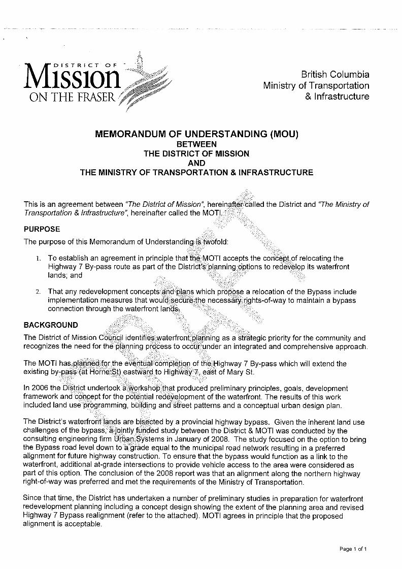
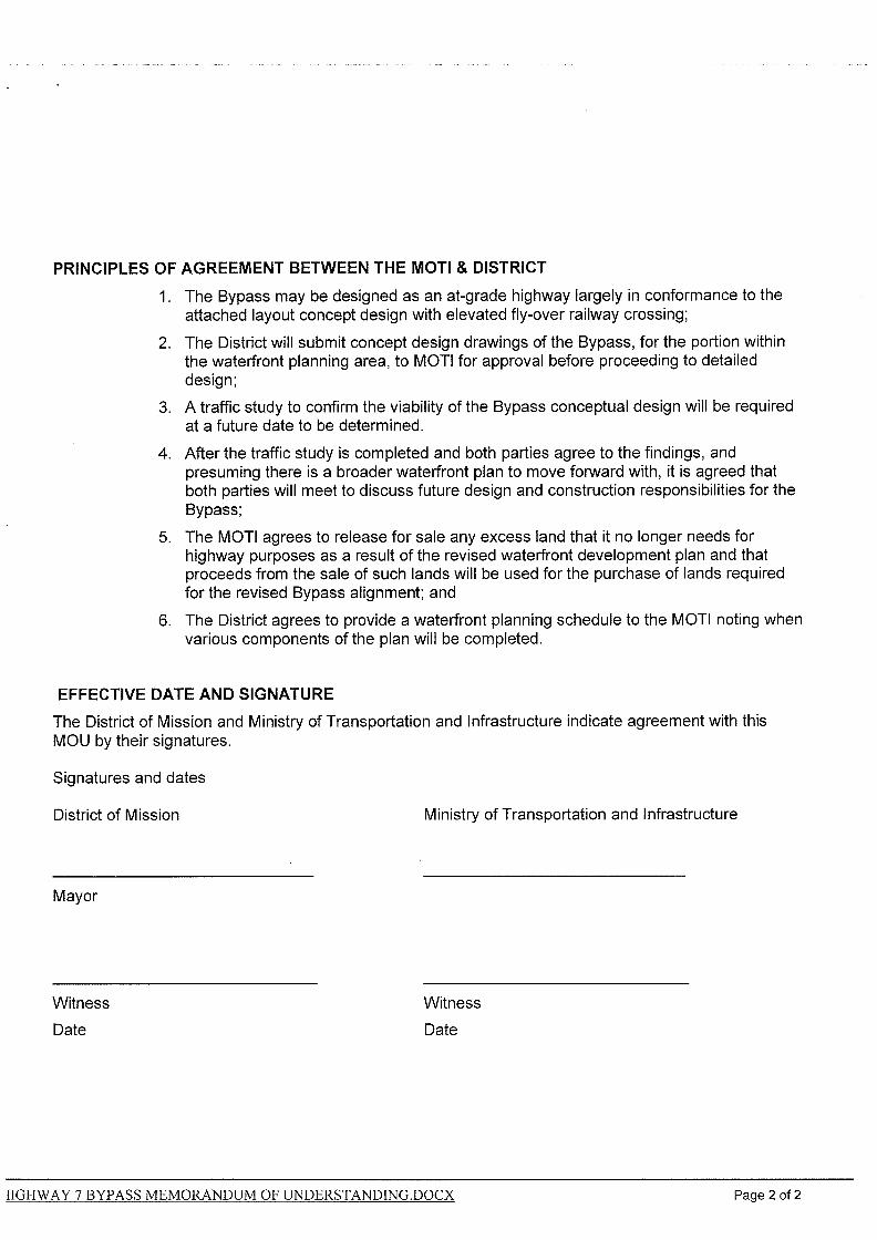
• Ministry of Transportation of Highways: The Ministry of Transportation and Highways was
consulted regarding the proposed re-alignment of the highway by-pass and has provided
approval in principle to highway realignment to permit redevelopment of the Waterfront
Lands and has identified broad design parameters for future functional engineering work
which have been documented in a draft Memorandum of Understanding ( Appendix A) to
be executed and coordinated with the ongoing District of Mission’s Transportation Master
Plan.
• Ministry of Environment: The aspects of redevelopment of the Waterfront Lands that are
of interest to the Ministry of Environment, while not directly consulted during this phase of
work, are generally known and referred to in previous phases of this Feasibility Study. Flood
proofing requirements, establishing flood control elevations, as well as issues and
regulations surrounding remediation of brownfield sites are ongoing and coordinated
efforts between the District of Mission as local diking authority and the province on
environmental matters
• Department of Fisheries and Oceans: The Department of Fisheries and Oceans was
consulted, and has indicated that it is premature to offer any input beyond its published
policies and guidelines, and will engage in a review of any future detailed development
proposals through the normal referral process.
• CP Rail: While CP Rail does not have jurisdiction over planning and development of the
Waterfront Lands, they will be consulted as part of the review of any future detailed
development proposals. General comments that they have provided regarding the
proximity of proposed residential land uses to the existing rail corridor have been taken into
consideration in this report.
• Translink / Westcoast Express: Translink and the Westcoast Express represent an aspect of
transit-oriented development in future planning and development considerations for the
Waterfront Lands. Translink will be engaged as part of any future detailed development
proposals through the normal referral process.
DISTRICT OF MISSION – MARKET & FEASIBILITY STUDY – WATERFRONT PLANNING
-5-
• Fraser Valley Regional District: Previously, the Fraser Valley Regional District has indicated
a specific interest in the continued development of the Experience the Fraser Trail, as a
consideration of the planning and development of the Waterfront Lands.
b) Consultation with Stakeholders
A survey of all registered land owners was undertaken to assess the level of awareness and
engagement in the planning process to date; their interest in the planning and development of
the Waterfront Lands; their intentions with regards to continued presence or business operation
in the short, mid and long-term. A total of 139 Surveys (Appendix B) were distributed to
registered land owners and occupants of premises in the planning area, with a total of 16
respondents.
The general findings are summarized as follows:
• Most of the respondents were aware of the Waterfront Planning, Market and Feasibility
Study, and a majority of them had attended 2-3 of the 4 community meetings and
presentations held during the course of the study.
• All of the respondents were registered property owners, and many provided comments that
indicated they were also directly involved in operating businesses on their properties.
• An equal number of respondents indicated an interest to stay on their properties and
remain in the planning area, to those that indicated a desire to vacate or relocate, while
several indicated they were unsure of their intentions.
• A majority of respondents indicated that they were not planning for any investment or
improvements to their properties in the short term (1-3 years). Comments provided
indicate that this lack of investment is having a negative impact on the viability of the area in
its current state.
• A majority of respondents however, indicated either in direct response and in comment
form, that they did not oppose re-development of the Waterfront Lands, but that their
intentions to stay, vacate or relocate was dependent on how plans developed; how
development would impact their existing business operations; and how redevelopment
would impact land values, assessed values, and taxes.
DISTRICT OF MISSION – MARKET & FEASIBILITY STUDY – WATERFRONT PLANNING
-6-
• There were a few respondents that indicated interest, obligations or lease commitments
that are longer-term (3-7 years). Apart from these few, the majority of respondents’ views
on redevelopment or intentions with regard to their business/property interests are the
same over the short, mid and long-term.
• Finally, there were several instructive comments provided that indicated an interest to see
the area planned and redeveloped to celebrate the river and maximize the potential to
serve as a gateway to the upper Fraser, as well as an opportunity to create places for
business, employment as well as places for people to live.
c) Consultation with Developers
In consideration of providing recommendations for implementation, the Consultant team met
with various representatives from the development industry, both public and private, to solicit
feedback and input on the waterfront planning process, findings, conclusions drawn to date, and
offer observations and recommendations for implementation.
Onni Group
Onni Group was selected because of their experience with large scale, master-planned, mixed-
use developments, such as Victoria Hill, New Westminster, Suterbrook, Port Moody, and the
Tsawwassen First Nations development in Delta, as well as the Imperial Landing development on
the former BC Packer’s site, a very similar former waterfront industrial site along the south arm
of the Fraser River, in Richmond’s Steveston village.
Wesgroup
Wesgroup was selected because of their experience with large scale, master-planned, mixed-use
developments, such as the East Fraser Lands, Vancouver, as well as Bedford Landing in Fort
Langley. Both of these are very similar brownfield developments on the Fraser River,
contending with similar site conditions, the latter also being a more proximate, Fraser Valley
market location.
Surrey City Development Corporation
The Surrey City Development Corporation was selected as an example of a municipality that has
taken initiative through its development corporation to incent and promote development in
strategic locations within Surrey. The wide range of its activities serve as an example of some of
the possible roles the District of Mission may consider in the development of the waterfront
lands.
DISTRICT OF MISSION – MARKET & FEASIBILITY STUDY – WATERFRONT PLANNING
-7-
Eric Gerlach, P.Eng.
Eric Gerlach, former Vice President of Development for Intrawest Place-making, had provided
the District of Mission with a third party assessment of the feasibility study, building on his
considerable planning and development experience, and direct involvement in the initial phase
of this study. The comments have been reviewed and incorporated into the consolidated list of
comments, observations and recommendations obtained during the consultation process.
Consolidated Observations and Recommendations from Consultation
the following is a consolidated list of comments, observations and recommendations obtained
during the consultation process. Some are contradictory, but most reflect a consensus of
opinions which is carried forward into this report’s final list of recommendations for
implementation.
General
• Commended the District’s approach of determining market feasibility in the planning
process
• Process and planning appear to be generally on the right track
• The opportunity is not just to attract development, but to build a community
• Sixty percent of future residents will come from within the community
Planning Process
• Provide a level playing field for all proponents
• Suggested that some incentives be provided in early phases of development
• Provide certainty regarding development costs and off-site work up-front
• Develop a comprehensive servicing plan for the area
• Avoid overly restrictive land uses, particularly maritime uses
• Avoid overly restrictive density provisions, floor area ratios and number of units
• Provide a more general minimum-maximum range of densities
• Develop a flexible planning framework that can adapt over time
• Establish a DCC credit program for major infrastructure works
• View the waterfront plan as a living document
• Consider re-distributing the disproportionate burden of upfront costs to later phases
• Offer late-comer agreements, or local improvement district agreements to redistribute
costs
DISTRICT OF MISSION – MARKET & FEASIBILITY STUDY – WATERFRONT PLANNING
-8-
• Recognize that development on its own is a community benefit
• Community Amenity Contributions to be established clearly up front versus negotiated on a
case by case basis
• Recognize that the land has relatively little value and is not an incentive to development
• Focus Public consultation on the overall conceptual framework vs. each individual proposal
• Clear community support is an incentive to development in managing approval risk
• Adopt site-based planning vs. prescriptive planning requirements to guide development
• Employ Development Agreements to structure individual phases of development
• Focus efforts on designing and guiding the development of the public realm
• Develop clear guidelines for public spaces and off-site improvements
• The public realm is important but ought not to be so expensive as to undermine feasibility
• A well-developed public realm is a community amenity and will attract more private
investment
• The opportunity is not just to attract development, but to build a community
• Promote a walkable and complete community as a sustainable form of development
• Promote a mix of uses, employment, amenities, and a range of types and costs of housing
• Design the community to be experienced, streets, trails, parks, buildings, character
• Understand the market, who wants to live there, why they want to live in this location
• Recommend against a conventional neighbourhood planning process
• The District should consider a high level visioning process in the next step of more detailed
and technical planning
• Align the waterfront development with the goals and results of the Downtown planning
effort.
• Consider any land use objectives on the waterfront in the context of broader community
land use planning goals.
• Consider balancing the shorter-term developer interests with medium and longer-term
public interests
• Consider more modest projections for build-out and develop an interim plan, as well as a
stepped phasing/sequencing vs. slower incremental development.
District Role
• Assist in the challenge of overcoming the significant up-front costs
• Provide a means to deal with area-wide issues such as soils, contamination, diking, and
servicing challenges
• Consider streamlining the approval and planning process as a development incentive
DISTRICT OF MISSION – MARKET & FEASIBILITY STUDY – WATERFRONT PLANNING
-9-
• Consider District owned property as an asset to be used to incent or participate in
development
• Begin with a small strategic first phase to get development started and build from there
• Work with the private sector to facilitate and assist, but not pay for, development
• Consider medium and longer term planning initiatives to complement the shorter term
focus of developer led planning
2. CONCEPT MODEL/GUIDING PRINCIPLES
a) Concept Model
Based on the comments, observations and recommendations of the consultation phase noted
above, it is recommended that the Baseline Concept Plan developed in previous phases of this
study, be refined to create a more modest and realistic build-out projection; a reduced amount
of multi-family residential; and implied land-use direction that is more focused and confined to
the likely initial phases of development.
• Reduce the overall area where residential land use is indicated by approximately 50%. This
is in recognition of the very low absorption rates for multi-family development in Mission;
limiting the supply will better support the value of this land-use and density; and is
consistent with recommendation to develop an interim build-out that is achievable within a
20 year horizon, avoids the negative effect of stagnation and unrealized potential on the
area, which in turn protect the market and values of new development.
• Focus the reduced multi-family residential land uses along the west side of the mixed-use
Horne Street corridor and southward toward the waterfront. This will provide the support
to neighbourhood retail and commercial, create a more walk-able neighbourhood, allows
residential to be buffered from the rail corridor and adjacent industrial lands that may
remain for some time, and also responds to the highest and best use of the riverfront as a
prime residential amenity.
• Maintain the mixed-use designation along Horne Street, but revise the former maritime
commercial designation on the waterfront portion of the West Central Precinct to general
mixed-use. This is based on the experience of other jurisdictions that had attempted to
narrow commercial designations in a similar manner, and proved to be a disincentive to
development that eventually needed to be changed. The mixed commercial/ residential
zone accommodates a wider range of commercial uses, and offers the potential for a variety
DISTRICT OF MISSION – MARKET & FEASIBILITY STUDY – WATERFRONT PLANNING
-10-
of housing types as well, the broader and more flexible designations enhance feasibility.
• Allow for a more flexible designation of non-residential uses on the balance of the lands.
This will serve as a strategy for dealing with interim light industrial uses that may remain for
some time, and allows the market to determine what form of commercial or limited amount
of light-industrial is appropriate for these areas. An emphasis should be placed on ensuring
that any infill or redevelopment contribute to an enhanced public realm in order to
contribute to a more consistent and improving quality of the public realm over time. This
flex strategy can also serve as the basis for implementing a step-wise approach to
redevelopment; for focusing redevelopment in strategically important and lower cost areas
initially; and directing an orderly approach to development that is coordinated with the
planning, design and engineering of services and infrastructure, as well as the cost recovery
model that will need to be put in place to create a predictable and equitable environment to
promote development.
• Develop planning guidelines for interim land uses in areas with flex zoning that will ensure
that interim uses contribute toward and support streetscape improvements and sequential
implementation of public realm and infrastructure. Consider specific Development Permit
Area requirements that will provide a means of regulating and incenting both Interim and
Long-term development, including consideration of minimum parcel sizes, and off-site
requirements.
DISTRICT OF MISSION – MARKET & FEASIBILITY STUDY – WATERFRONT PLANNING
-11-
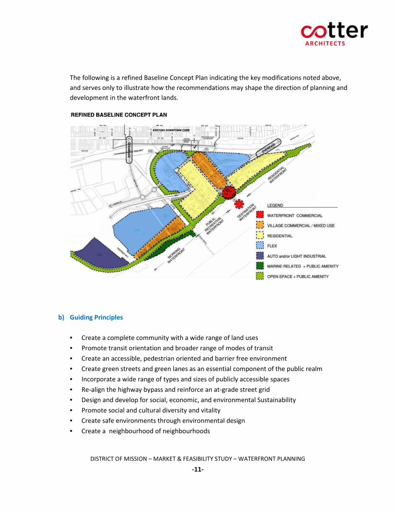
The following is a refined Baseline Concept Plan indicating the key modifications noted above,
and serves only to illustrate how the recommendations may shape the direction of planning and
development in the waterfront lands.
b) Guiding Principles
• Create a complete community with a wide range of land uses
• Promote transit orientation and broader range of modes of transit
• Create an accessible, pedestrian oriented and barrier free environment
• Create green streets and green lanes as an essential component of the public realm
• Incorporate a wide range of types and sizes of publicly accessible spaces
• Re-align the highway bypass and reinforce an at-grade street grid
• Design and develop for social, economic, and environmental Sustainability
• Promote social and cultural diversity and vitality
• Create safe environments through environmental design
• Create a neighbourhood of neighbourhoods
DISTRICT OF MISSION – MARKET & FEASIBILITY STUDY – WATERFRONT PLANNING
-12-
• Create identifiable character that reflect historic, physical, and environmental context
• Promote diversity versus highly prescriptive architectural expression and character
• Facilitate the resolution of challenging physical site conditions as an incentive
• Collaborate with private partners in the planning and development process
• Guide planning and development to be complementary to community-wide interests
• Planning and development complementary to Downtown planning and revitalization
• Planning and development complementary to other housing types and policies
• Enhance and Contribute to building the local economy and employment opportunity
c) Planning Approach and Framework
A variety of planning approaches should be considered, including a high-level visioning process
to address broad public and community interests; development of public realm objectives and
guidelines; detailed design-based planning within defined neighbourhoods, strategically
significant areas in the high-level planning process, and individual development sites; a planning
policy framework that would establish planning areas which may also assist in organizing and
directing the sequencing of development and required servicing.
• A high-level, short, and intensive visioning process is an initiative to be led by the District of
Mission which would bring together a small core team of planners, architects, engineers,
developers, community representation, and the District of Mission Council and Staff. The
goal would be to create, refine and develop guiding principles; create an outline of
requirements and standards for the contributions of individual phases of development
toward the public realm; establish realistic and achievable sustainability goals and best
practices for the design-based planning efforts provided by individual development teams.
• Design-based planning is an effective tool to work with individual development proponents
to accomplish planning the intended broader outcomes outlined above. In consideration of
the recommendation from the development industry to provide project requirements up-
front, and to create a level playing field and equitable set of requirements, the requirements
and expectations should be completed and published early in the redevelopment of the
area, and refined and further detailed with the input and collaboration of the initial
development proponent consulting teams.
DISTRICT OF MISSION – MARKET & FEASIBILITY STUDY – WATERFRONT PLANNING
-13-
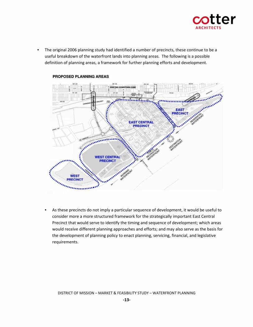
• The original 2006 planning study had identified a number of precincts, these continue to be a
useful breakdown of the waterfront lands into planning areas. The following is a possible
definition of planning areas, a framework for further planning efforts and development.
• As these precincts do not imply a particular sequence of development, it would be useful to
consider more a more structured framework for the strategically important East Central
Precinct that would serve to identify the timing and sequence of development; which areas
would receive different planning approaches and efforts; and may also serve as the basis for
the development of planning policy to enact planning, servicing, financial, and legislative
requirements.
DISTRICT OF MISSION – MARKET & FEASIBILITY STUDY – WATERFRONT PLANNING
-14-
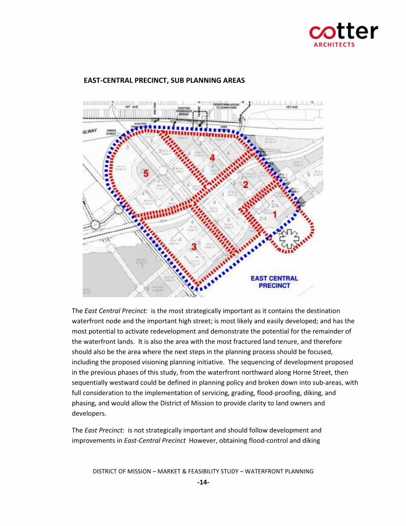
EAST-CENTRAL PRECINCT, SUB PLANNING AREAS
The East Central Precinct: is the most strategically important as it contains the destination
waterfront node and the important high street; is most likely and easily developed; and has the
most potential to activate redevelopment and demonstrate the potential for the remainder of
the waterfront lands. It is also the area with the most fractured land tenure, and therefore
should also be the area where the next steps in the planning process should be focused,
including the proposed visioning planning initiative. The sequencing of development proposed
in the previous phases of this study, from the waterfront northward along Horne Street, then
sequentially westward could be defined in planning policy and broken down into sub-areas, with
full consideration to the implementation of servicing, grading, flood-proofing, diking, and
phasing, and would allow the District of Mission to provide clarity to land owners and
developers.
The East Precinct: is not strategically important and should follow development and
improvements in East-Central Precinct However, obtaining flood-control and diking
DISTRICT OF MISSION – MARKET & FEASIBILITY STUDY – WATERFRONT PLANNING
-15-
improvements is of public benefit, so consideration should be given to development proposals
that would provide for the upgrading of significant portion of the required dyke infrastructure.
The West-Central Precinct as a contiguous site may be best suited to a proponent-led, design-
based planning approach. It is the area most likely to be master-planned under the guidance of
a master developer who, following the established guiding principles may be called upon to
provide a defined process of public consultation and planning as part of any subdivision or
zoning amendment of the lands. While detailed servicing requirements for this planning area
are somewhat dependant on the proposed use and density, the key site-specific requirements
and conditions are known and have been identified in the previous phases of this study, and
would serve as a starting point for any proponent to work with staff to develop a more complete
list of planning and engineering requirements. This area could proceed independently from
other planning areas, providing it addressed its planning and servicing issues as part of any
design and approval process.
The West Precinct: is also less strategically significant, and could proceed independently of
other planning areas providing it addressed its planning, servicing, engineering, and access
requirements. As had been identified in the previous phases of this study, if developed early
would serve as an alternative location for retaining viable existing business in area.
d) Role of the District of Mission
The original Phase 4 Terms of Reference had identified the following primary objectives:
• To consider and evaluate a range of planning approaches and possible frameworks for
moving forward with more detailed planning and initial phases of development, and future
proposal calls.
• To consider and evaluate a range of options for the role of the District of Mission in the
planning and development of the waterfront.
In fulfilment of these objectives, the following are the primary Planning Approach and
Development Framework options:
• Traditional Government and Proponent Model:
The local government is instrumental in generating and articulating the vision for
development of a sector in the community, and through the application of the “traditional”
planning tools (Official Community Plan, preparation of appropriate zoning instruments and
subdivision guidelines and plans, etc.) and prepares the way for an interested proponent
DISTRICT OF MISSION – MARKET & FEASIBILITY STUDY – WATERFRONT PLANNING
-16-
(private sector) to prepare and submit a proposal(s) for development. The local government
thereafter plays the role of the regulator, representing the public’s interest, and making its
land assets available for incorporation in the scheme as / if needed, and ensuring that
appropriate public consultation / information is incorporated. The local government is seen
as “hands off” in the detailed planning and approvals process, and acts first and foremost on
the behalf of the public to ensure that all legal and planning necessities are handled
properly.
• Cooperative/Consultative Model:
The local government is instrumental in generating and articulating the vision for
development of a sector in the community, and actively promotes interest in pursuing the
project through incorporation of its lands and other assets in securing an interested
developer partner to work jointly in planning and executing the scheme. The local
government plays not only the traditional role of safeguarding the public interest but also a
role in promoting and ultimately achieving the development goal(s). This requires that it
expend effort and funds in planning the project, delineating the end objectives and the
means for achieving the development, and playing an active role in obtaining the
cooperation of other regulators, landowners, etc. It anticipates the positive outcomes of
the development process, the enhanced taxation potential, and potentially a share of the
enhanced value increment (“profit”) from the ultimate sale or rental of the property. The
public consultation / public information components of the process must necessarily fully
disclose the local government’s interest in the project, and the government’s role as a fair
and effective regulator and protector of the public’s interests must not be compromised,
and the local government must not exceed its authority in the expenditure of public funds.
• Initiator and Regulator Model:
The local government is instrumental in generating and articulating the vision for
development of a sector in the community, and actively promotes interest in pursuing the
project through offering incorporation of its lands and other assets but relies on a private
sector developer to prepare and create the actual scheme and generate detailed plans for
submission to the local government for approval through RFPs or similar instruments. The
responsibility for detailed planning, design, engineering, etc. is borne by the selected private
developer, as is public involvement, and consultation. The local government provides the
traditional planning services upon application, and protects the public interest through
recognized permit approval procedures. The local government receives the proceeds from
the sale of any public lands and services, fees, etc., but receives no other financial return
other than enhanced tax base.
• Joint Venture Partner Model
The local government is instrumental in generating and articulating the vision for
development of a sector in the community, and through the creation of a legal vehicle such
as a development corporation, enters into a joint-venture partnership with one or more
DISTRICT OF MISSION – MARKET & FEASIBILITY STUDY – WATERFRONT PLANNING
-17-
private developers, to jointly plan and execute the project. The local government through
the application of the “traditional” planning tools (Official Community Plan, preparation of
appropriate zoning instruments and subdivision guidelines and plans, urban design
guidelines, public realm and servicing specifications, etc.) prepares the way for the joint
venture partnership to prepare and submit a proposal(s) for development. The local
government throughout the process plays the role of the regulator, representing the
public’s interest, while making its land assets available for incorporation in the scheme as / if
needed, and ensures that appropriate public consultation / information is incorporated. The
design and execution of the project may require considerable financial resources, and as a
joint venture partner the local government may be exposed to certain costs and risk while
pursuing a potentially lucrative venture capital opportunity. In return, it anticipates a
financial return in terms of enhanced taxation potential and fees, etc. as well as the benefits
of promoting worthwhile development objectives for its citizens. The public consultation /
public information components of the process must necessarily fully disclose the local
government’s interest in the project. The government’s role as fair and effective regulator
and protector of the public’s interests must not be compromised, and the local government
must not exceed its authority in the application/distribution of public funds.
Recommended role for the District of Mission:
In consideration of the range of roles outlined above, the Consultant recommends that the
District of Mission play the role of Initiator and Regulator. These dual roles allow the District to
be active in promoting redevelopment as well as guiding the emerging form and character of
the area. In working collaboratively with proponents, the District achieves the planning
objectives cost effectively as well as offering proponents the opportunity and flexibility to
develop planning outcomes in a manner that is complementary and coordinated with each
development proposal. This approach also allows for development proposals to be considered
sooner and with the benefit of working with the District’s existing resources and through
already established planning and development processes.
ADDITIONAL CONSIDERATIONS:
These final recommendations propose modifications to the assumptions that were used in the
market assessment and financial pro-forma in earlier phases of this feasibility study. While these
modifications reflect a more realistic approach to activating the redevelopment of the Waterfront
Lands, the costs of development, servicing and off-site works will need to be similarly reconsidered
quantified and balanced with revised development projections.
DISTRICT OF MISSION – MARKET & FEASIBILITY STUDY – WATERFRONT PLANNING
-18-
RECOMMENDATIONS
1. That the District of Mission explores opportunities to facilitate an initial phase of development
in the strategic location identified in the Baseline Concept plan at the south end of Horne
Street.
The District of Mission may consider a range of options in facilitating development and providing
incentives to achieve a mixed-use development of a scale, form and character that meets the
objectives of the Baseline Concept Plan, and can serve as a model for future phases of
development. The District of Mission may require the proponent to undertake design-based
planning for off-site works and the public realm sufficient to serve as a set of guidelines for
future development, and design-based planning to address the interface of future adjacent sites
and developments.
2. That the District of Mission conducts a high-level visioning workshop to establish planning,
urban design, community amenity, and public realm objectives, resulting in a visioning
document for the waterfront planning area.
This process is intended to be a 1 or 2 day workshop with the involvement of a select group of
participants in planning, architecture, engineering, the development community, Council and
Staff representation to confirm and clearly define the guiding principles for the waterfront, and
develop a set of criteria that will provide direction to future design-based planning efforts. This
is intended as an initial planning exercise, which may be followed by other similar or more
detailed planning efforts as part of more comprehensive planning in the future.
3. That the District of Mission creates a series of individual planning areas in the waterfront
district and recommend a planning approach for each area.
This is intended to provide structure for proceeding with more detailed land-use planning,
design-based planning, and policy addressing requirements and criteria for development to
proceed, including responses to major site challenges, improvements, servicing, development
costs and cost recovery mechanisms. This structure would permit each area to proceed in a
unique manner appropriate to the conditions and potential of each planning area, and would
allow for each to proceed independently if required.
4. That the District of Mission proceeds with a conceptual plan and engineering for the re-
alignment of the highway bypass through the waterfront.
Whereas the realignment of the highway bypass is supported in principle by the Ministry of
Transportation along with a set of broad design parameters that it has provided, as a major
determinant of the waterfront plan and its network of streets it is important to develop a more
detailed initial concept plan that would confirm the extent of required dedications, preliminary

DISTRICT OF MISSION – MARKET & FEASIBILITY STUDY – WATERFRONT PLANNING
-19-
grading, intersection and crossing locations, typical street sections, capacity and service level
projections and estimates of the extent of off-site requirements and improvements.
5. That the District of Mission proceed with a conceptual plan and engineering study to establish
an approach and requirements for servicing, flood-control, flood-plain management, and
proposed approach to cost recovery.
The intent is to identify the extent of required improvements to services, the sequencing and
staging of these requirements, and the estimated costs thereof, sufficient to provide clarity to
proponents up-front in planning for these off-site costs, with consideration to a cost recovery
mechanism. The conceptual engineering and cost estimates may be staged in short, mid and
long-term projections with greater focus on the short term, as a means of minimizing cost,
expediting completion of the work, and recognizing that requirements for mid and long-term
conditions are based on build-out and conditions that are variable. The approach and cost
recovery model may vary between planning areas to recognize the unique conditions and
requirements of each, and the recommended model may also consider a stepped
implementation of these costs that provides incentive to initial phases of development that
carry a dis-proportionate balance of cost and risk.
6. That the District of Mission considers an active role in facilitating the reclamation and
remediation of soil contamination in the waterfront lands.
This item has been identified as a major impediment to development, particularly for any
individual site or smaller consolidated development site to physically address individually on
their own. The District of Mission owned lands may play an important role in the location
and/or operation of a reclamation facility.
7. That the District of Mission considers a range of roles that would promote or provide incentive
to encourage redevelopment of the waterfront lands.
The District may consider a wide range of roles and initiatives that would encourage and
promote the redevelopment of the waterfront lands in a manner that meets the full potential
and expectations established in the visioning document and subsequent planning efforts. The
District may consider a variety of ways to lever its land holdings in the development process
through the consolidation of sites, purchase and/or sale of strategic sites, entering into joint
venture opportunities, pre-zoning and/or pre-servicing strategic sites where appropriate, and
providing clear and efficient review and approvals processes.
DISTRICT OF MISSION – MARKET & FEASIBILITY STUDY – WATERFRONT PLANNING
-20-
NEXT STEPS
Consideration and approval of Revised Terms of Reference for the Phase 4 – Implementation as
follows:
Visioning Workshop: A one day workshop, to confirm and clearly define the guiding principles
for the waterfront, and develop a set of design and development
criteria that will provide direction to future design-based planning
efforts. These will focus on the public realm, streetscape, public open-
space amenities and the interface with future private development.
Visioning Document: The key deliverable from the workshop will be a published document
that summarizes design and development criteria developed in the
workshop, including sketches and vignettes of key the concepts and
criteria.
Budget Summary: The original Phase 4 scope of work included more detailed analysis and
deliverables under the section devoted to the role of the District of
Mission. It is proposed that approximately $9,000 of the fee associated
with this work be applied toward the cost of hosting the Visioning
Workshop and the post production of the Visioning Document.
A proposed draft budget for this event and publication is as follows:
Professional Facilitator (1) $ 1,800.00
Design Professionals (3) 5,400.00
Invited Guest Honorariums (4) 1,000.00
Graphics and Post-Production 2,500.00
Travel Time and Expenses 1.750.00
Event Costs and Supplies 500.00
Disbursements 1,200.00
TOTAL $ 14,150.00
Recommendation: That the Terms of Reference for Phase 4 Implementation of the
Waterfront Planning Market and Feasibility Study, be amended and
approved to conduct a Visioning Workshop and produce a Visioning
Document as a general guide to future development of the Waterfront
Lands. That the un-used balance of the approved budget for Phase 4
Implementation be applied to the cost of the Visioning Workshop and
Visioning Document.
DISTRICT OF MISSION – MARKET & FEASIBILITY STUDY – WATERFRONT PLANNING
APPENDIX ‘A’
Memorandum of Understanding
Ministry of Transportation and Infrastructure
DISTRICT OF MISSION – MARKET & FEASIBILITY STUDY – WATERFRONT PLANNING
APPENDIX ‘B’
Survey
Stakeholder Consultation
P L A N N I N G D E P A R T M E N T
P.O. Box 20 , 8645 Stave Lak e St ree t , Miss i on , B .C. V2V 4L9 Phone 604�820�3748 Fax 604�826�7951 Web Site: www.mission.ca E�mail: planning@ mission.ca
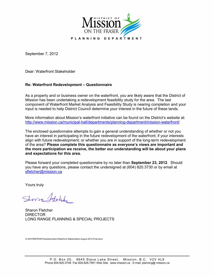
September 7, 2012 Dear: Waterfront Stakeholder Re: Waterfront Redevelopment – Questionnaire
As a property and or business owner on the waterfront, you are likely aware that the District of Mission has been undertaking a redevelopment feasibility study for the area. The last component of Waterfront Market Analysis and Feasibility Study is nearing completion and your input is needed to help District Council determine your interest in the future of these lands. More information about Mission’s waterfront initiative can be found on the District’s website at: http://www.mission.ca/municipal�hall/departments/planning�department/mission�waterfront/
The enclosed questionnaire attempts to gain a general understanding of whether or not you have an interest in participating in the future redevelopment of the waterfront; if your interests align with future redevelopment; or whether you are in support of the long�term redevelopment of the area? Please complete this questionnaire as everyone’s views are important and the more participation we receive, the better our understanding will be about your plans and expectations for this area.
Please forward your completed questionnaire by no later than September 23, 2012. Should you have any questions, please contact the undersigned at (604) 820.3730 or by email at [email protected]
Yours truly
Sharon Fletcher DIRECTOR LONG RANGE PLANNING & SPECIAL PROJECTS G:\WATERFRONT\Questionnaire�Waterfront Stakeholders�August 2012�Final.docx
2
P.O. Box 20 , 8645 Stave Lak e St ree t , Miss i on , B .C. V2V 4L9 Phone (604) 820�3748 Fax (604) 826�7951 Web Site: www.mission.ca E�mail: planning @mission.ca
FUTURE WATERFRONT REDEVELOPMENT – QUESTIONNAIRE The following questions attempt to gain a general understanding of whether or not you have an interest in participating in the future redevelopment of the waterfront; if your interests align with future redevelopment; or whether you are in support of the long�term redevelopment of the area? Please note that this will not be the only opportunity to comment as the waterfront planning process will provide for numerous stakeholder and public engagement opportunities.
1. Are you aware of the Waterfront Planning process that is currently underway?
� Yes
� No Comments ________________________________________________________________________________________________________________________________________________________________________________________________________________________________________________________________________________________________________________________________________________________________________________________________________________________________________________________________________ 2. Have you attended any of the following Public Information meetings or consultation?
� 2006 September 4, 2006
� 2010 March 11, 2010
� 2011 September 16, 2010
� 2011 June 16, 2011 Comments ________________________________________________________________________________________________________________________________________________________________________________________________________________________________________________________________________________________________________________________________________________________________________________________________________________________________________________________________________
3
P.O. Box 20 , 8645 Stave Lak e St ree t , Miss i on , B .C. V2V 4L9 Phone (604) 820�3748 Fax (604) 826�7951 Web Site: www.mission.ca E�mail: planning @mission.ca
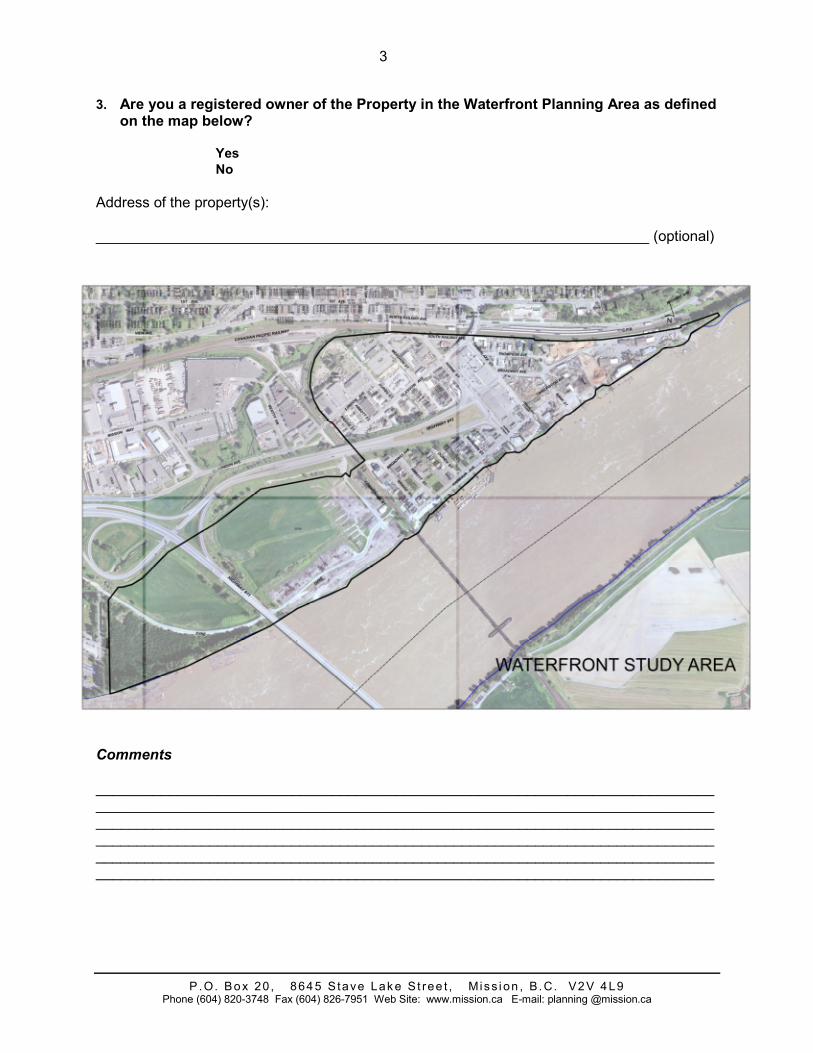
3. Are you a registered owner of the Property in the Waterfront Planning Area as defined on the map below?
� Yes
� No
Address of the property(s): ____________________________________________________________________ (optional)
Comments ________________________________________________________________________________________________________________________________________________________________________________________________________________________________________________________________________________________________________________________________________________________________________________________________________________________________________________________________________
4
P.O. Box 20 , 8645 Stave Lak e St ree t , Miss i on , B .C. V2V 4L9 Phone (604) 820�3748 Fax (604) 826�7951 Web Site: www.mission.ca E�mail: planning @mission.ca
4. If you currently operate a business on the property, and should redevelopment of the area occur, it is your intention to:
� continue to operate on the property;
� relocate within the waterfront area; or
� vacate the property. Comments ________________________________________________________________________________________________________________________________________________________________________________________________________________________________________________________________________________________________________________________________________________________________________________________________________________________________________________________________________ 5. In the short=term (1=3 years), do you have requirements that involve improvements to
the existing property or premises?
� Yes
� No Comments ________________________________________________________________________________________________________________________________________________________________________________________________________________________________________________________________________________________________________________________________________________________________________________________________________________________________________________________________________ 6. In the medium=term (3=5 years), how would you characterize your interests in the
property, the waterfront planning and potential redevelopment of the area? ________________________________________________________________________________________________________________________________________________________________________________________________________________________________________________________________________________________________________________________________________________________________________________________________________________________________________________________________________
5
P.O. Box 20 , 8645 Stave Lak e St ree t , Miss i on , B .C. V2V 4L9 Phone (604) 820�3748 Fax (604) 826�7951 Web Site: www.mission.ca E�mail: planning @mission.ca
7. In the long=term (5+ years), how would you characterize your interests in the property, the waterfront planning and potential redevelopment of the area?
________________________________________________________________________________________________________________________________________________________________________________________________________________________________________________________________________________________________________________________________________________________________________________________________________________________________________________________________________ YOUR RESPONSES CAN BE EMAILED, FAXED OR MAILED: (e) [email protected] (f) 604.826.7951 (m) District of Mission 8645 Stave Lake Street
Mission, B.C., V2V 4L9 Please forward your completed questionnaire by no later than September 23, 2012. Thank You!
Related Documents