Journal of Anthropological Archaeology Volume 40 , December 2015, Pages 123–134 Title: Mapping changes in late prehistoric landscapes: a case study in the Northeastern Iberian Peninsula Author names and affiliations: Maria Yubero-Gómez, [email protected] Xavier Rubio-Campillo, [email protected] F.Javier López-Cachero , [email protected] Xavier Esteve-Gràcia & , [email protected] 1.-Seminari d’Estudis i Recerques Prehistòriques (SERP), Departament de Prehistòria, Història Antiga i Arqueologia, Universitat de Barcelona. C/Montalegre 6/8 08001, Barcelona, Spain. 2.-Computer Applications in Science & Engineering (CASE), Barcelona Supercomputing Center. C/Jordi Girona 29, Nexus II, 3A, Barcelona, Spain 3.- Tríade Serveis Culturals. Carrer del Dr. Pasteur, 15, 1-1 08720 Vilafranca del Penedès, Barcelona, Spain Corresponding author: Author: Maria Yubero-Gómez e-Mail address: [email protected] Postal address: Seminari d’Estudis i Recerques Prehistòriques (SERP), Departament de Prehistòria, Història Antiga i Arqueologia. University of Barcelona. C/Montalegre 6/8 08001, Barcelona (SPAIN) Telephone: (+34) 934 037 521

Welcome message from author
This document is posted to help you gain knowledge. Please leave a comment to let me know what you think about it! Share it to your friends and learn new things together.
Transcript

Journal of Anthropological Archaeology Volume 40, December 2015, Pages 123–134
Title: Mapping changes in late prehistoric landscapes: a case study in the NortheasternIberian Peninsula
Author names and affiliations:
Maria YuberoGómez, [email protected]
Xavier RubioCampillo, [email protected]
F.Javier LópezCachero , [email protected]
Xavier EsteveGràcia & , [email protected]
1.Seminari d’Estudis i Recerques Prehistòriques (SERP), Departament de Prehistòria, HistòriaAntiga i Arqueologia, Universitat de Barcelona. C/Montalegre 6/8 08001, Barcelona, Spain.
2.Computer Applications in Science & Engineering (CASE), Barcelona Supercomputing Center.C/Jordi Girona 29, Nexus II, 3A, Barcelona, Spain
3. Tríade Serveis Culturals. Carrer del Dr. Pasteur, 15, 11 08720 Vilafranca del Penedès,Barcelona, Spain
Corresponding author:
Author: Maria YuberoGómez
eMail address: [email protected]
Postal address: Seminari d’Estudis i Recerques Prehistòriques (SERP), Departament dePrehistòria, Història Antiga i Arqueologia. University of Barcelona. C/Montalegre 6/8 08001,Barcelona (SPAIN)
Telephone: (+34) 934 037 521

ABSTRACT
The temporal span of the Late Bronze Age and the Early Iron Age (1300550) saw the emergence ofintense interconnectivity in the Mediterranean sea. The development of colonial trade dramaticallyincreased cultural exchange along its coasts as can be observed in archaeological evidence. Theselarge scale processes had an impact at all scales and territories close to the main trade routes.However, the process was extremely diverse in its forms.
This work presents a case study focused on two adjacent areas in the coast of the NE IberianPeninsula. Spatial analysis has been carried out to explore the trajectories of settlement locationdynamics during the whole period. Basic geographic variables, mobility and distance to trade routeshave been explored to identify key differences over periods and areas. Results indicate that thefactors guiding settlements location varied between the two zones. Moreover, one of the areas wasradically influenced by trade routes in the Early Iron Age while the other did not seem to be affectedby this external factor. The interpretation of these analyses suggests that the rise in connectivity wasnot homogeneous over the Western Mediterranean, but in the regions where it took place this factorwas decisive to explain their historical trajectories.
KEYWORDS
Northeastern Iberian Peninsula, Late Bronze Age, Early Iron Age, Geographic Information Systems(GIS), natural corridors, spatial analysis, statistical significance testing, settlement patterns, mobilitymodels.

1 INTRODUCTION
From 1200 to 600 BC, the Mediterranean world saw a period of change, which resulted in thebreakdown of Bronze Age civilizations, and the rise of Iron Age cultures in many locations. Despitethe complexity of the process, the study of this crucial period covering the Late Bronze Age (LBA)and the Early Iron Age (EIA) has been traditionally focused on the Eastern Mediterranean and itsgrand civilizations.The western zone did not see the emergence of cultures such as the Minoan and the Greco Romansocieties, which dominated the work of archaeologists for a long time due to its abundant materialculture. However, fieldwork carried out in the last decades has extended our knowledge to includeother islands and coastal areas of the Mediterranean Sea, thus balancing this view. The diversity ofthese studies has increased our knowledge of processes such as the ones that created the Maltesetemples, nuraghi, taulas and talayots (Knapp & Blake 2005; Bevan, 2013; Berrocal et alii., 2013;Babbi et al., 2015).
This wider perspective on the LBAEIA Mediterranean is dominated by the concepts of mobility andconnectivity. These linked processes of change were promoted by the intensive cultural andcommercial interaction rising between the peoples all over the Mediterranean, from the Levant in theEast, to the North African and the Iberian coasts in the West (Babbi et alii, 2015: 6).
1.1 Late Bronze Age and Early Iron Age in the NE Iberian coast
This is the research context of the present work. The aim of this paper is to explore and compare
under to what extent variables connected to mobility and connectivity influenced settlement locations
over the period LBAEIA. To explore this question we have chosen to focus at a local scale in the
NorthEastern coast of the Iberian Peninsula. Our case study includes two neighbouring areas
divided by a river (Llobregat): Vallès, located at left bank, and Penedès, located at the right bank
(see Figure 1).

Figure 1. Current geographical map and features of the case study: the current Catalan coast.
The election of this area has been based on the continued and intense occupation of the territory
that the archaeological evidence suggests. In addition, the archaeological record we are dealing with
shows a great variety that allows us to link these settlements dynamics to the Mediterranean
processes along this period.
During the Late Bronze Age (1300750/700 BC), the material basis of these societies underwent a
profound renewal. New metal typologies appeared during LBA showing an increase of interregional
connectivity and trade products, as certain kind of metallic items or pottery decoration (López
Cachero and Rovira 2012). The record also shows channeled pottery, which we find widely
represented across the entire Northeastern Iberian Peninsula. Several new influences can be found
on associated material culture, such as the first cremation necropolises by first millennium BC and
the appearance of imported pottery in the Early Iron Age (750/700550 BC). This pattern is strongly
linked to the eruption of Phoenician trade near the Ebro River and the colony founded by the

Phocaeans that would be known as Emporion (580 BC) (Aquilué at alii 2000; Santos 2003). These
settlements are located south (Phoenicians) and north (Greeks) of the studied area (for a general
overview see LópezCachero 2007,2011; LópezCachero and Pons 2007; Sanmartí 2009; Asensio
2005; García and Gracia 2011; Pons Brun 2014).
For a long period of time, the weight of historical and cultural tradition put the focus of debate on the
arrival of new human groups traditionally known as Urnfields culture and on the colonial factor as the
key agents behind the changes taking place. Today, however, these stances have become much
more moderate. The accent is now on local dynamics and special regional features as the
differentiating facts of the territory. Further theoretical insights connected to local scale societies and
postcolonial archeologies have also been presented in recent works for this context (Garcia &
Gracia 2011, LópezCachero 2007 and Fatás et alii 2012).
Previous works on the examined areas identified a general path of cultural continuity. This is
particularly evident for the period between approximately 1800 BCE and the end of the LBA in the
two largest excavated sites in these areas: Mas d’en Boixos located in the right bank and Can
Roqueta located in the left bank (Bouso et al. 2004). The only exception is the Penedès (right bank
area) precoastal lowlands, where there are only a few documented sites from the Late Bronze Age
onwards. This scarcity has been analyzed before, and other authors have noted that it cannot be
attributed to a lack of research in the area (Mestres 2008). The alternate hypothesis is that
occupation of certain caves and the use of highelevation pastures provided an alternative to the
lowlevel agricultural exploitation of the most fertile plains which did not developed here except for
some coastal regions. The EIA would present a shift between these subsistence strategies, as can
be seen from the evidence of numerous storage pits documented from that time. Evidences suggest
a complementary exploitation model that took extensive advantage of lands more favorable for
agriculture, with the possible rapid planting of grapevines (López 2004). These activities would be
complemented by herding, as shown by the appearance of walled enclosures (pens) at higher
altitudes of the landscape such as Serra de la Font del Cuscó (Cebrià et al. 2003) or Sant Miquel
d’Olèrdola (Mestres et al. 2009). Coincidentally some of these sites such as Turó Font de la Canya
(Asensio et alii 2005), Font del Cuscó (Cebrià et al. 2003) and Olèrdola (Mestres et al. 2009) among
others, have yielded evidence for intensive trade in the form of Phoenician amphorae and other
containers. “Phoenician” pottery imitations, metal items such as sympula and iron spits also link this
shift to Mediterranean influences (Asensio et alii 2005).

From the beginning of the sixth century BC evidence suggests a new major shift in the right bank
area. We find the pens disappearing and new coastal enclaves being established, such as the
citadel at Alorda Park. However, this transition to the Iberian world has not yet been fully and
satisfactorily explained (Asensio et al. 2006).
The scenario described above contrasts with the dynamic described for the Vallès located in the left
bank area. Thanks to data from sites such as Can Roqueta (Carlús et al. 2007), we know that LBA
settlements were mainly located on the plain or on the rolling hills near the floodplains of the Besòs
river. They followed a pattern of small semiexcavated farmhouses or huts built from wood and mud
and scattered among the fields of crops. These farms were located very close to storage pits and at
a certain distance from the cremation necropolises that functioned as the true centers around the
landscape seems to have been organized (Carlús et al. 2007). The special features of this
archaeological context, which is characterized by negative structures and often affected by strong
erosive processes as a consequence of agricultural work over the centuries (Terrats Jiménez 2010:
141155), make it very difficult to determine the existence of denser clusters of huts in the form of
small villages. Regarding the EIA sites in the area, some Phoenician items such as amphorae,
vessels and hand made pottery “imitating” Phoenician shapes and askos has been found in the
necropolis as well as in some of the “houses” (Carlús et al. 2007). However, the number of sites with
this type of materials is lower that in the Penedés region (YuberoGómez et al.i 2014).
This model remained constant in the left bank area until the end of the sixth century BC, when
widespread settlements in elevation using stone appeared across the coastal and precoastal
mountain ranges. At the same time, abandonment of cremation necropolises suggests a profound
restructuring of settlement that should be linked to the formation of the Iberian world (LópezCachero
and Rovira 2012).
1.2 Mesoscalar analysis of settlement location
It is clear that these dynamics conform a complex and heterogeneous situation with several researchchallenges. This work focuses on understanding change in settlement patterns during the transitionfrom the LBA to the EIA based on two main questions:
1. Do site location preferences depend on the chronology? Our hypothesis is that therelevance of different geographical factors was not constant over time. If there weredifferences in the patterns of each period we should detect them by means of spatialanalysis.
2. Were communication networks affected by external influences? The theoretical rise inexogenous contacts from the LBA to the EIA should be reflected in the site distribution overcommunication networks.

The area of study has been extensively excavated during the last quarter of the XXth century due tourban development (Petit, M. A., 1986; Bouso et alii, 2004; Carlús et alii 2007; YuberoGómez andRubio Campillo, 2010; YuberoGómez et al., 2014; YuberoGómez et al. 2015; Mestres and Esteve,2015). This situation has generated a large body of data which need to be integrated before anyanalysis can be undertaken. This is the reason why we have chosen a Geographic InformationSystem (GIS) as a working framework. In addition to showing geographical information, GIS is also ahighly flexible tool for integrating data from different sources and in different formats. This greatlyfacilitates the task of comparing and analyzing heterogeneous data and extracting knowledge fromthem. In addition, GIS can be used for more than a descriptive definition of the case study.
This paper presents a mesoscalar study of the Catalan central coast to explore changes insettlement location patterns during the period LBAEIA. Next section describes the data used to builda geographical model of the area. The third section defines the various methods of spatial andstatistical analysis applied to the dataset. Next, we discuss results comparing the patterns generatedby the LBA and the EIA communities and assessing the impact of Phoenician colonizing agents. Weconclude discussing the implications of our results in the general context of this transition.
2 THE CASE STUDY
The dataset of the analysis has been created from two components: a) geographical featuresrelevant to settlement dynamics and b) archaeological information.
First, the study area presents several biogeographical units with their own characteristics. From thecoast inland, we find coastal plains (currently massively modified by substantial urban development),the coastal mountain range (parallel to the coast, highly compartmentalized by riversand a smallnumber of peaks at 500700 m.) the precoastal depression (a natural open route that runsapproximately 200 km from northeast to southwest), and lastly, the precoastal mountain range(where the headwaters of the main rivers emerge from peaks exceeding 1700 m above sea level).
We used a 15m. x 15m. Digital Elevation Model of the area where some features were corrected. Inparticular, the current coastline is significantly different from the one present during the chronologiesunder study. Broadly speaking, the coastal plain appears to have smaller than the present area, andit contained areas of marshland, particularly in the plains of the Llobregat river . Previous works inthe Llobregat delta (Gámez, 2007) have been used to recreate the coastline.
Second, the archaeological interventions carried out in the past decades have been used to create aspatial database which can be seen in Figure 2.


Figure 2. Distribution of sites by period: a) LBA and a) EIA.
The dataset has one challenge that needs to be considered; the archaeological context documentedis negative in the vast majority of cases. The lack of positive structures inhibits the formation of astratigraphy that would certainly be helpful in capturing the dynamics of construction, use andabandonment of the documented structures, as well as their diachronic or synchronicinterrelationship in the space. It is not possible to go beyond the establishment of approximatechronologies, as we are unable to determine whether all of the structures belonging to a period arethe result of a narrow temporal span or, conversely, the result of continuous settlement of a singlespace over two, three, four or more centuries. As a consequence, we need to treat all the sites ofone period as part of the same group, while keeping in mind this aggregation in the interpretation; itis not the same to consider 200 storage pits belonging to the same moment as 200 storage pits overthe course of 300 years.
The created spatial database integrates information from the set of settlements, combininggeographical features with additional data such as chronologies, the typologies of structures and thecurrent state of the site. As for the dataset studied, the working sample contains 87 sites for the LBAand 67 for the EIA. The sites include dwellings, storage structures, necropolises and occupiedcaves. From a spatial perspective, we have divided each chronology into two subdatasets accordingto whether the sites are located on the right or left bank of the Llobregat (see Figure 3). Traditionally,this division has been used by most authors when dealing with the archaeological data (Esteve2006; Asensio et al. 2006; LópezCachero 2007; 2012) because the archaeological record on bothbanks seem to show significant differences as we mentioned in section 1.

Figure 3 – The Besòs river has been traditionally identified as a boundary between areas withdifferent dynamics. We have chosen these areas (left and right bank) as our spatial units of analysis.
3 METHODOLOGY
We have designed a set of spatial analyses to answer our two research questions with this dataset,including a) basic spatial variables (height, slope and aspect), b) visibility and accessibility and c)distance to natural corridors. Exploratory Data Analysis has been performed for each of the sixvariables in the form of empirical density estimates for the two periods (the LBA and the EIA) andboth areas (left and right bank). These density functions measure the probability of finding a site fora given value of the analyzed parameter. This approach is useful to perform crosscomparisonanalysis of different datasets. To achieve this second step, we have performed KolmogorovSmirnovtests (KS tests) between the four datasets (the LBA left bank, the LBA right bank, the EIA left bankand the EIA right bank). This nonparametric test evaluates the probability that two given empiricaldistributions were generated by the same process. If the computed pvalue is smaller than athreshold level (in our case p<0.05) the samples were generated from different distributions, thusidentifying significant differences between the compared datasets with a confidence interval of 95%.

First, we characterized the firstorder spatial variation to identify diachronic and synchronic changesover the two periods. We studied the location of the sites within their surroundings, while calculatingtheir geographical attributes, taking account of their altitude (in metres) and their aspect and slope(both in degrees).
Second, visibility (Llobera et al., 2011; Gillings and Wheatley, 2001; Lake and Ortega, 2013; Eve andCrema, 2014) and accessibility (Llobera et al., 2011; Llobera, 2001, 2000; De Reu et al., 2011)provided new information on the changes in settlement patterns and their relationships(corresponding to secondorder spatial variations). For each site, the observed area has beencalculated within a radius of 10 km (see Figure 4a).
Third, accessibility enables us to quantify the favourable potential of a specific point in relation to thesurrounding landscape. This concept can be modelled in several ways, with accessibility analysed asa function of distance, territorial compactness, energy consumption or time (Conolly and Lake, 2006:243; Llobera et al., 2011). We have used the method applied in archaeology by Marcos Llobera(2000; 2011), see Figure 4b. The accessibility value for the sites has been calculated based on thetopographical cost of gaining access to each site from its surrounding area. The procedure involvedthe generation of a regular 25point grid to cover the area surrounding each site to a radius of 1000m. After this operation, the leastcost path was traced from each point of the grid to each of the sites.Then, we calculated the average accumulated cost of all the paths to each site, finally inverting thevalue to have large values for high accessibility.
To identify natural corridors related to human mobilitty and trade rutes (Bevan and Wilson, 2013;MurrietaFlores, 2012) we defined a perimeter of points distributed every 10 km. They were locatedat 25 km from the study area to avoid any border effect. Then, we calculated the leastcost pathsfrom each point on the perimeter to all the other points while quantifying how many of the routespassed through each cell of the original raster map. The most dense areas (i.e. first quantile) definethe natural corridors, according to the geography of the area. By computing the distance from eachsite to these natural corridors we can get a summary statistic of the relevance of strategic routenetworks as a factor to explain site location (see an example of this analysis in Figure 4c).
A followup question to the results is to examine what properties differentiate the sites of both banksfor a given period. Understanding these differences would allow us to better identify what type ofsettlement properties characterize each area under study. This final topic was examined with amultivariate analysis of the factors defining the sites of each temporal span. It was independentlyapplied to the sites of the LBA and the EIA. For each period we performed an analysis of variance tst(ANOVA) using a logistic multivariate regression model. The dependent variable was defined as thebank of the river (right or bank), while the independent variables were the 6 factors collected for eachsite (height, slope, aspect, visibility, accessibility and distance to natural routes) .

Figure 4a – Example of the visibility algorithm. For each site the total amount of visible area (greencolorcoded) up to 10 km. is quantified.

Figure 4b – Example of the accessibility analysis. The leastcost path of each cell within a 1kmradius to the site is computed. It is based on the slope cost of the cells (red to green gradient). A finalvalue for site is quantified averaging the cost in accumulated degrees of slope.
Figure 4c Definition of natural corridors. A perimeter of points is defined outside our studied regionat regular intervals. The least cost path is calculated between each pair of points, and the number ofpaths passing through each cell is computed. In this example the paths for 3 points (A, B and C) isshown.
4 RESULTS
4.1 Geographical variables
First, our study of the basic geographical variables (altitude, aspect and slope) clearly indicatedifferentiated settlement dynamics within LBA. In this respect, Figure 5 shows the density estimatesof altitude based on the settlements of the different periods and territories.

Figure 5: Density estimates of settlement altitude for the various combinations of areas andchronologies.
At first glance, we can see how the distribution on the left bank of the Llobregat is quite continuousexcept for the creation of some highly elevated sites during the EIA. By contrast, the typology ofsettlements on the right bank changes radically, shifting from elevated settlements to a distributionthat is similar to the distribution observed on the left bank in the EIA.
This tendency is confirmed if we examine the slope values (see Figure 6), because the probability offinding sites in lowslope areas on the right bank of the Llobregat in the LBA is quite low. In anyevent, it suggests a tendency similar to the evaluation of altitudes: while the LBA sees very highvalues (related to the situation of the caves), in the EIA the values level out because of the creationof settlements in lowlying areas. On the left bank, by contrast, the distribution of probabilities is quitehomogeneous in both periods even if the presence of sites in low slope slightly increases over time.
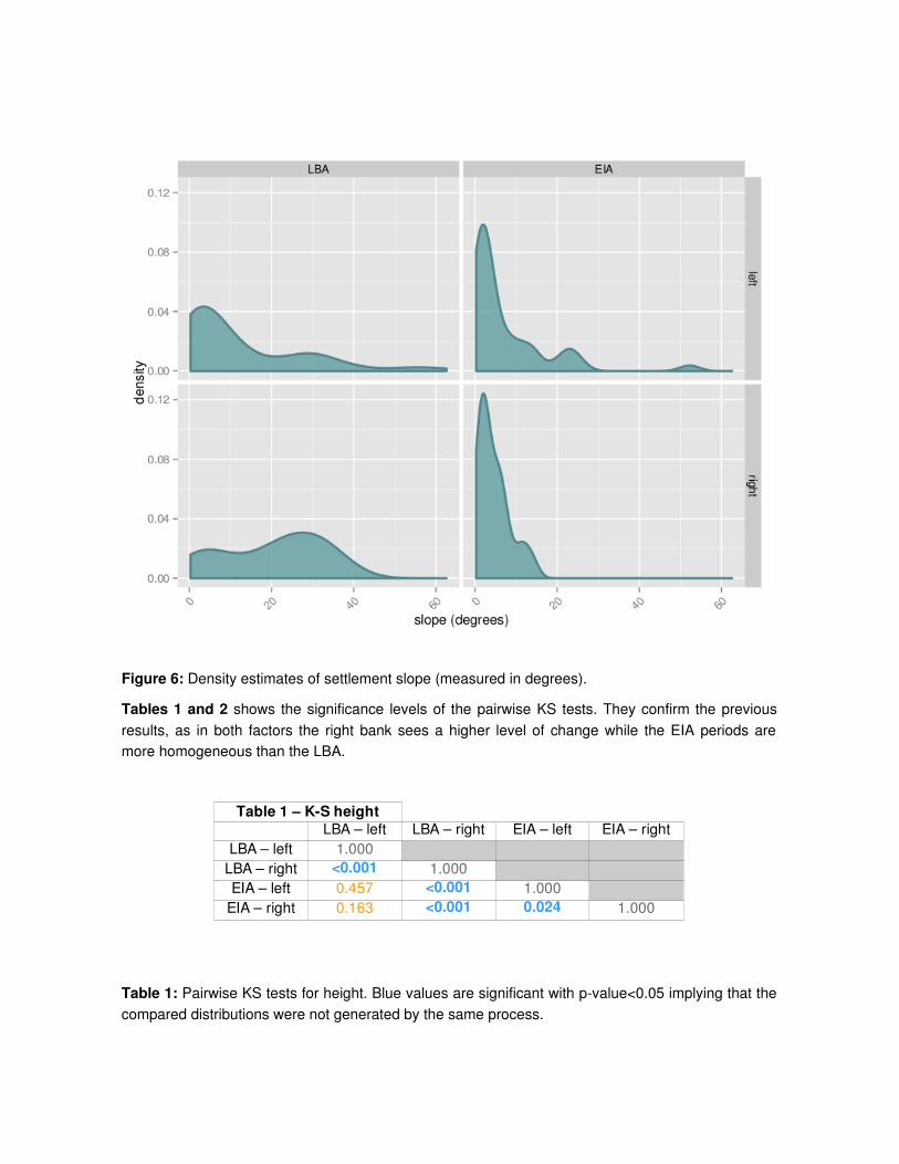
Figure 6: Density estimates of settlement slope (measured in degrees).
Tables 1 and 2 shows the significance levels of the pairwise KS tests. They confirm the previousresults, as in both factors the right bank sees a higher level of change while the EIA periods aremore homogeneous than the LBA.
Table 1: Pairwise KS tests for height. Blue values are significant with pvalue<0.05 implying that thecompared distributions were not generated by the same process.
Table 1 – KS heightLBA – left LBA – right EIA – left EIA – right
LBA – left 1.000LBA – right <0.001 1.000EIA – left 0.457 <0.001 1.000
EIA – right 0.163 <0.001 0.024 1.000

Table 2: Pairwise KS tests for slope. Blue values are significant with pvalue<0.05 implying that thecompared distributions were not generated by the same process.
Our examination of aspect (Figure 7) provides no additional information as the distribution is almosthomogeneous over the 4 datasets. The only relevant pattern is the situation of the settlements onthe left bank toward the southsouthwest (200270 degrees). This tendency is intriguing, as it may berelated to solar exposure (Lapen and Martz 1993; Church et al. 2000: 153; Esteve 2004: 10) or thedirection of river courses. However, Table 3 shows that the difference is not significant.
Table 2 – KS slopeLBA – left LBA – right EIA – left EIA – right
LBA – left 1.000LBA – right 0.026 1.000EIA – left 0.231 0.003 1.000
EIA – right 0.089 <0.001 0.703 1.000

Figure 7: Density estimates of settlement aspect (measured in degrees).
Table 3: Pairwise KS tests for aspect. Blue values are significant with pvalue<0.05 implying that thecompared distributions were not generated by the same process.
4.2 Visibility analysis and accessibility
Accessibility and visibility indices helps us to assess other differences among the studied territories.First, visibility does not seem specially relevant for the LBA sites (see Figure 8) while it gainsimportance in the EIA. There are some exceptions, notably Olèrdola, a site located in a strategicenclave with visual control over the surrounding territory. The patterns is quite similar across bothbanks, with an increase in visibility from the LBA to the EIA. Table 4 confirms that there is a majorshift ni the relevance of visibility for site location during the change from the LBA to the EIA.
Second, it can be observed that accessibility is similarly shaped for the four datasets, even if theright bank sees a higher peak around the value of 170 (see Figure 9). However, the KS tests (seeTable 5) suggest that the distributions are almost identical for each bank over the two periods, thusportraying non significant changes from the LBA to the EIA.
Table 3 – KS aspectLBA – left LBA – right EIA – left EIA – right
LBA – left 1.000LBA – right 0.079 1.000EIA – left 0.331 0.009 1.000
EIA – right 0.497 0.105 0.621 1.000

Figure 8: Density estimates of settlement visibility.

Figure 9: Density estimates of settlement accessibility.
Table 4: Pairwise KS tests for visibility. Blue values are significant with pvalue<0.05 implying thatthe compared distributions were not generated by the same process.
Table 4 – KS visibilityLBA – left LBA – right EIA – left EIA – right
LBA – left 1.000LBA – right 0.232 1.000EIA – left 0.026 0.023 1.000
EIA – right 0.071 0.024 0.930 1.000

Table 5: Pairwise KS tests for accessibility. Blue values are significant with pvalue<0.05 implyingthat the compared distributions were not generated by the same process.
4.3 Natural corridors
Figure 10 portrays the computed network of natural corridors. The density estimates (Figure 11)suggest that a close distance to these strategic routes was not a significant factor in settlementdynamics in the Llobregat left bank for both chronologies. This is an interesting result, speciallycompared to the basic geographic factors (i.e. altitude and slope). As a consequence, local featuresseem much more important than geographically broader contexts. In fact, the supposedly relevantimpact of the Phoenician arrival during the EIA is not confirmed by these results. Otherwise, wewould see a rise in the number of settlements located on the natural corridors over which tradeunfolded.
Table 5 – KS accessibilityLBA – left LBA – right EIA – left EIA – right
LBA – left 1.000LBA – right <0.001 1.000EIA – left 0.321 <0.001 1.000
EIA – right <0.001 0.483 <0.001 1.000


Figure 10. Natural corridors in relation to the sites for a) the LBA and b) the EIA. The analysismakes use of all leastcost routes from each point on the perimeter to all other points, with the colourof each segment of the network identifying the number of routes that pass through it.
Figure 11: Density estimates of settlement distance to natural corridors
Studying this relationship by chronology and area enables us to see the extent to which this variableis similar for the archaeological contexts of the LBA and the EIA (see Table 6).
Table 6 – KS dist. Natural routesLBA – left LBA – right EIA – left EIA – right
LBA – left 1.000LBA – right 0.486 1.000EIA – left 0.119 0.869 1.000
EIA – right 0.008 0.004 <0.001 1.000

Table 6: Pairwise KS tests for distance to natural corridors. Blue values are significant with pvalue<0.05 implying that the compared distributions were not generated by the same process.
The KS test shows how the left bank of the Llobregat did not see a clear pattern of change. The onlyexception is a number of sites at very large distances during the LBA, which stems from the limitedpercentage of land with these characteristics. In the right sector, by contrast, a substantial changecan be perceived between the two chronological periods, with the largest probability of finding a siteat 70008000 m of a corridor diminishing to 10002000 m during the EIA. Therefore, we can say thatthe distance from a natural corridor is highly important in the right sector of the Llobregat, but that itis not an essential factor in the left sector. In the latter case, the occupations continuing from the LBAto the EIA that are documented in quite a few of the sites may have had a decisive impact on thisfactor.
4.4 Multivariate analysis
Results of the ANOVA analysis show that accessibility and height are the most important parametersthat distinguish the properties of sites on the right and left bank during the LBA (c.f. Table 7).
Table 7: ANOVA test for a logistic multivariate regression model for bank location of the LBA sites.Height and accessibility are the most important factors to explain the differences between the riverbank where sites are located.
These results suggest that settlements at the right bank of the river were preoccupied by thedefensive value of the region where they were located. This would explain why elevated, difficult toreach zones were predominant here in contrast with the left bank. The same method was applied tothe EIA sites, with significant different results (see Table 8).
Table 7 – ANOVA LBAVariable Prheight 0.011slope 0.084
aspect 0.998visibility 0.401
accessibility 0.013distance 0.751
Table 8 – ANOVA EIAVariable Prheight 0.008slope 0.183
aspect 0.973visibility 0.834
accessibility 0.006distance <0.001

Table 8: ANOVA test for a logistic multivariate regression model for bank location of the EIA sites.Distance, accessibility and height are the significant variables that explain the differences betweenthe river bank where sites are located.
Distance to natural routes is by far the most important factor that difference both banks, followed byslope and accessibility. This result confirms the trend that was already seen in previous figures, asthe relevance of natural corridors is much more relevant in the right than in the left bank.
5 DISCUSSION
The aggregation of these results depicts a radical shift of dynamics over the LBA to the EIA in theright bank, while the left bank portrays less evidence of change. Distance to natural corridors is thedeterminant factor to explain these dynamics: during the LBA the sites were located at largedistances from travel routes. The situation changed in the EIA: a majority of settlements werelocated on a natural corridor in the right back area. This enables us to confirm the shift in thetendency that occurred in this territory and may indicate a settlement model closely bound up withcommercial exchanges during the EIA. However, we continue to find a portion of the population thatappears to have avoided these routes, remaining instead in easily defensible, but isolated locations.
Other authors have also documented a search for soil with greater agricultural potential during theEIA (Asensio et al. 2005) in the right bank area. This tendency is confirmed by the appearance ofarrays of storage pits with occasional associated huts (e.g., Mas d'en Boixos (Bouso et alii, L'Hortd'en Grimau (Esteve 2004 ) and el Turó de la Font de la Canya (López 2004)). These sites havebeen interpreted as surplus accumulation centers (Asensio et al. 2005) which would present a newscenario of genuine agricultural colonization. The number of storage pits and their enormouscapacities suggest a significant change in the economic dynamics of resource exploitation in thearea, which would from this point onward promote surplus grain production intended for trade.
This change, however, did not involve the abandonment of the higherelevation, highslopesettlements. In this respect, what is detected is the occupation of various strategic points in thelandscape, which have a high degree of visibility in relation to the surrounding landscape. Goodexamples are provided by the sites of Olèrdola and la Font del Cuscó, which feature the mainelement of a pen or wall built of stone enclosing a sizable area (Cebrià et al. 2003; Mestres et al.2009). Few dwellings associated with these pens have been discovered, but everything seems toindicate that there were no more than a few slightly built huts, a fact that stands in stark contrast tothe significant size of the occupied areas and the magnitude of the encircling walls. This has ledsome authors (Cebrià et al. 2003; Asensio et al. 2006) to maintain that the final function of thesesettlements may have been linked to a communal use of the space, more specifically to theamassing and management of livestock, and to signal wealth. Paradoxically, the occupation ofcaves, which was so common in the prior period, now ceases to be important after this shift . Thissite specialization is also confirmed by the diversity of visibility indices during the EIA.
On the left bank of the Llobregat we do not observe this shift. Particularly interesting is the lack ofrelevance of the distance to natural corridors, considering the presence of Phoenician materials andmetallic objects. Despite this moderate evidence, objects are similar to materials found in close

zones where trade was much more intense (e.g. the Empordà and southeastern France, LópezCachero and Rovira 2012). Nonetheless, the situation is not static as there are some changes in thesettlement location dynamics. There seems to be a higher interest on plains which could be relatedto more intensive agricultural practices (confirmed by a greater number of excavated storage pits).
The aggregation of these results suggest that there were relevant differences between the studiedareas and periods. Of particular interest is the sharp distinction between the territories regarding theLBA, which we have been able to interpret correctly in relation to the materials and types ofstructures documented in the excavations.
To conclude, the interpretation of these results suggest that natural corridors play a key role to betterunderstand settlement dynamics during the LBA and the EIA. However, both areas present adifferent evolution. While left bank sites seem to follow a similar dynamic during the LBA and theEIA, dynamics in the opposite bank present a very different panorama. The right bank of the riversaw during the EIA a transformation of the landscape that could be related to a more strategic viewof the territory. The shift that we can observe in the location of sites during the EIA was intended toestablish the sites close to natural travel routes and to achieve better control over the territory. Thischanged coincided with an increase in commercial activity as a result of the integration of theNortheastern Iberian Peninsula in Mediterraneanwide trading networks.
Even at this local scale spatial analysis was able to identify sensible differences betweenneighboring territories. This diversity of dynamics perfectly illustrates the complexity of processesthat affected the Mediterranean Sea over these two periods.
6 ACKNOWLEDGMENTS
We would like to thank the two anonymous reviewers for their helpful comments and suggestions.The spatial analysis was performed using Quantum GIS 1.8 and GRASS 6.4.3. The geostatisticalanalyses have been carried out with the R 2.15.2 statistical system, specifically the spatstat package(R Development Core Team, 2008). The code was developed in Python language executing GRASSGIS, and it is published under a General Public License ( HYPERLINK"https://github.com/xrubio/models/changesLBA_EIA"https://github.com/xrubio/models/changesLBA_EIA).
MYG and JLC are part of the consolidated research group Seminari d’Estudis i RecerquesPrehistòriques (2014SGR108). MYG was funded by AGAUR (PhD grant 2010FI_B 00641). XRC isfunded by the SimulPast project CSD201000034 under the CONSOLIDERINGENIO2010 programof the Spanish Ministry of Science and Innovation. FJLC is funded by the project HAR201348010Pof the Spanish Minisitry of Economy and Competitiveness.

7 REFERENCES
Aquilué, X., Burés, L., Castanyer, P., Esteba, Q., Pons, E., Santos, M., Tremoleda, Q., 2000.Els assentaments indígenes i l’ocupació grega arcaica de Sant Martí d’Empúries (l’Escala,Alt Empordà), Resultats del projecte d’intervencions arqueològiques de 1994 i 1995. Girona,Sèrie Monogràfica 19, 19–32.
Asensio i Vilaró, D., 2005. La incidencia fenicia entre las comunidades indígenas de la costacatalana (siglos VIIVI aC):?` un fenómeno orientalizante? In: El Periodo Orientalizante:Actas Del III Simposio Internacional de Arqueología de Mérida, Protohistoria DelMediterráneo Occidental. Consejo Superior de Investigaciones Científicas, CSIC, 551–564.
Asensio, D., Cela, X., Morer J. 2005. El jaciment protohistòric del Turó de la Font de laCanya (Avinyonet del Penedès, Alt Penedès): un nucli d’acumulació d’excedents agrícoles ala Cossetània (Segles VIIIII aC), Fonaments, 12, 177195.
Asensio, D., López, D., Mestres, J. Molist, N., Ros, A. And Senabre, M. R. 2006. De laprimera edat del ferro a l’ibèric antic: la formació de les societats complexes a la zona delPenedès. In: Belarte C. and Sanmartí, J., (eds.), De les comunitats locals als estats arcaics:la formació de les societats complexes a la costa del Mediterrani occidental. III ReunióInternacional d’Arqueologia de Calafell. Arqueomediterrània 12, Calafell, 289307.
Babbi, A., BubenheimerErhart, F., MarínAguilera, B., Muehl, S., 2015. The MediterraneanMirror: Cultural Contacts in the Mediterranean Sea between 1200 and 750 BC. Schnell UndSteiner, Regensburg.
Berrocal, M.C., Sanjuán, L.G., Gilman, A., 2013. The Prehistory of Iberia: Debating EarlySocial Stratification and the State. Routledge.
Bevan, A., Wilson, A., 2013. Models of settlement hierarchy based on partial evidence. J.Archaeological Sciences 40, 2415–2427.
Bevan, A., 2013. Mediterranean Islands, fragile communities and persistent landscapes:Antikythera in longterm perspective, 1st ed. ed. Cambridge University Press, New York.
Bouso, M., Esteve, X., Farré, J., Feliu, J, Mestres, J.,Palomo, A., Rodríguez, A. andSenabre, Mr. 2004. Anàlisi comparatiu de dos assentaments del bronze inicial a la depressióprelitoral catalana: Can Roqueta II (Sabadell, Vallès Occidental) i Mas d'en Boixos1 (Pacsde Penedès, Alt Penedès), Cypsela 15, 73101.
Carlús, X., LópezCachero, F.J., Oliva, M., Palomo, A., Rodríguez, A.,Terrats, N., Lara, C.And Villena, N. 2007. Cabanes, sitges i tombes. El paratge de Can Roqueta (Sabadell,Vallès Occidental) del 1300 al 500 ANE. Quaderns d’Arqueologia 4, Sabadell.
Cebrià, A., Esteve, X. And Mestres, J. 2003. Enclosures a la serra del Garraf des de laProtohistòria a la Baixa Antiguitat. Recintes d’estabulació vinculats a camins ramaders. InGuitart, J., Palet, J.M., Prevosti, M. (eds.) Territoris antics a la Mediterrània i a la Cossetània

oriental. Actes del Simposi Internacional d’Arqueologia del Baix Penedès. Departament deCultura de la Generalitat de Catalunya, Barcelona, 313316.
Church, T., Brandon, R.J. And Burget, R.G. 2000. GIS applications in archaeology: Methodin Search of Theory. In Konnie L. Wescott, R. and Brandon, J. (eds), Practical Applicationsof GIS for Archaelogists: A Predictive Modeling Kit. Taylor & Francis, New York, 144160.
Conolly, J. And Lake, M. 2006. Geographical Information Systems in Archaeology.Cambridge University Press, Cambridge.
De Reu, J., Bourgeois, J., De Smedt, P., Zwertvaegher, A., Antrop, M., Bats, M., De Maeyer,P., Finke, P., Van Meirvenne, M., Verniers, J., Crombé, P., 2011. Measuring the relativetopographic position of archaeological sites in the landscape, a case study on the BronzeAge barrows in northwest Belgium. Journal Archaeological of Sciences. 38, 3435–3446.
Esteve, X. 2004. Proposta metodològica per a la caracterització i anàlisi dels jacimentsarqueològics a l'aire lliure mitjançant un SIG: el bronze final i la primera edat del ferro alPenedès. Universitat Politècnica de Catalunya. Unpublished MSc dissertation."http://www.academia.edu/2104023/Proposta_metodologica_per_a_la_caracteritzacio_i_analisi_dels_jaciments_arqueologics_a_laire_lliure_mitjancant_un_SIG_el_bronze_final_i_la_primera_edat_del_ferro_al_Penedes__Tesina (Access date 14th October 2014 )
Esteve, X. 2006: El paisatge penedesenc i la seva antropització durant la Prehistòria recent.In: Premis Llavor de Lletres de Creació i Recerca. Convocatòria 2005 (Vilafranca delPenedès, Penedès Edicions, SL.), 127149.
Eve, S.J., Crema, E.R., 2014. A house with a view? Multimodel inference, visibility fields,and point process analysis of a Bronze Age settlement on Leskernick Hill (Cornwall, UK).Journal of Archaeological Science 43, 267–277.
Fatás Fernández, L., Graells i Fabregat, R., Sardà Seuma, S., 2012. Los intercambios y losinicios de la complejidad socioeconómica (siglos VIIVI a.C.). Estado de la cuestión. In:Belarte, M.C., Benavente Serrano, J.A., Fatás Fernández, L., Diloli Fons, J., Moret, P.,Noguera, J. (Eds.), . Presented at the Iberos del Ebro: actas del II congreso internacional(AlcañizTivissa, 1619 de noviembre de 2011), pp. 71–86.
Gámez Torrent, D. 2007. Sequence Stratigraphy as a tool for water resources managementin alluvial coastal aquifers: application to the Llobregat delta (Barcelona, Spain). UniversitatPolitècnica de Catalunya. Unpublished Ph.D.dissertation.http://www.tdx.cat/handle/10803/6255 (Access date 15th October 2012)
Garcia i Rubert, D., Gracia Alonso, F., 2011. Phoenician Trade in the NorthEast of theIberian Peninsula: A Historiographical Problem. Oxford Journal of Archaeology 30, 33–56.
Gillings, M., Wheatley, D., 2001. Seeing is not believing: unresolved issues in archaeologicalvisibility analysis, in: Slapšak, B. (Ed.), On the Good Use of Geographical InformationSystems in Archaeological Landscape Studies. Proceedings of the COST G2 Working

Group 2 Round Table Luxembourg,. Office for Official Publications of the EuropeanCommunities,, pp. 25–36.
Knapp, A.B., Blake, E., 2005. Prehistory in the Mediterranean: The Connecting andCorrupting Sea. In: Blake, E., Knapp, A.B. (Eds.), The Archaeology of MediterraneanPrehistory. Blackwell Publishing Ltd, pp. 1–23.
Lake, M.W., Ortega, D., 2013. Computeintensive GIS visibility analysis of the settings ofprehistoric stone circles. In: Bevan, A., Lake, M. (Eds.), Computational Approaches toArchaeological Spaces. Left Coast Press, London, pp. 213–242.
Lapen, D.R. And Martz, L.W. 1993. The Mesurement Of Two Simple Topographic Indices OfWind ShelteringExposure From Raster digital elevation models. Computers andGeosciences 19(6), 769779.
Llobera, M., FábregaÁlvarez, P., ParceroOubiña, C., 2011. Order in movement: a GISapproach to accessibility. Journal Archaeolical of Sciences. 38, 843–851.
Llobera, M., 2001. Building Past Landscape Perception With GIS: UnderstandingTopographic Prominence. Journal Archaeolical of Sciences. 28, 1005–1014.
Llobera, M. 2000. Understanding movement: a pilot model towards the sociology ofmovement. In: Lock, G. (ed), Beyond the map: Archaeology and Spatial Technologies. IOSPress, Amsterdam, 6584.
López, D. 2004. Primers resultats de l’estudi arqueobotànic (llavors i fruits) al jacimentprotohistòric del Turó de la Font de la Canya (Avinyonet del Penedès, Alt Penedès,Barcelona) segles VII – III a.n.e., Revista d’Arqueologia de Ponent 14, 149177.
LópezCachero, F.J. 2007.Sociedad y economía durante el Bronce Final y la primera Edaddel Hierro en el Noreste Peninsular: una aproximación a partir de las evidenciasarqueológicas, Trabajos de Prehistoria 64(1), 99120.
LópezCachero, F.J. 2011. Cremation Cemeteries in the Northeastern Iberian Peninsula:Funeral Diversity and Social Transformation during the Late Bronze and Early Iron Ages,European Journal of Archaeology 14(12), 116132.
LópezCachero, F.J., Pons Brun, E., 2007. La periodització del bronze final al ferro inicial aCatalunya. Cypsela: revista de prehistòria i protohistòria 51–64.
LópezCachero, F.J. 2012. La dinámica de las ocupaciones humanas del Bronce Final alIbérico Antiguo entre los ríos Tordera y Llobregat. In Ropiot, V. , Puig, C. and Maziere, F.(eds.), Les plaines littorales en Méditerranée nordoccidentale. Regards croisés d'histoire,d'archéologie et de géographie, de la Protohistoire au Moyen Age. Archéologie du Paysage1, Montagnac , 93110.
LópezCachero, F.J. And Rovira M.C. 2012. El món funerari a la depressió prelitoralcatalana entre el bronze final i la primera edat del ferro: ritual i dinamisme social a partir delregistre arqueològic. In: Rovira, M.C., LópezCachero, F.J. And Maziere, F. (Eds.), Les

necròpolis d’incineració entre l’Ebre i el Tíber (segles IXVI a.C.). Monografies del Museud’Arqueologia de CatalunyaBarcelona 14, Barcelona, 3755.
Mestres, J. And Esteve, X. 2015. Sitges, cenotafis i sepulcres. 20 anys d’intervencionsarqueològiques al Penedès. In: X. Esteve, C. Miró, N.Molist, G. Sabaté (ed.), Jornadesd’Arqueologia del Penedès 2011, Vilafranca del Penedès: Institut d'Estudis Penedesencs,3776.
Mestres, J. 2008. Vilafranca abans de la història. In Arnabat, R. and Vidal, J. (eds.), Històriade Vilafranca del Penedès. Ed. Andana, Vilafranca del Penedès, 143.
Mestres, J., Farré, J., Molist, N. and Senabre, M.R. 2009. Espais i estructuresarqueològiques. Bronze final i inici de l'edat del ferro. In Molist, N. (ed.), La intervenció alsector 01 del conjunt històric d'Olèrdola. De la prehistòria a l'etapa romana (Campanyes19952006), Barcelona, Monografies d'Olèrdola 2, Barceloma, 61105.
MurrietaFlores, P. 2012. Travelling in a prehistoric landscape: Exploring the influences thatshaped human movement. Trabajos de Prehistoria 69(1), 103122.
Petit, M. A. 1986. Contribución al estudio de la Edad del Bronce en Cataluña (comarcas delMoianès, Vallès oriental, Vallès Occidental, Maresme, Barcelonès y BaixLlobregat).Unpublished Ph.D.dissertation. Universitat Autònoma de Barcelona.
Pons Brun, E., 2014. Estudi comparatiu de les dinàmiques de poblament durant el bronzefinal i la primera edat del ferro a la Depressió Prelitoral Catalana. In: La Transició de L’edatDel Bronze Final a L’edat de Ferro. Presented at the Col∙loqui Internacional d’Arqueologiade Puigcerdà. Congrés Internacional de Catalunya., Institut d’Estudis Ceretans, Puigcerdà,Catalunya.
R Development Core Team (2008). R: A language and environment forstatistical computing. R Foundation for Statistical Computing,Vienna, Austria. ISBN 3900051070, URL HYPERLINK "http://www.Rproject.org/"http://www.Rproject.org.
Sanmartí Grego, J., Asensio i Vilaró, D., Belarte, M.C., Noguera, J., 2009. Comerc colonial,comensalitat i canvi social a la protohistòria de Catalunya. Citerior: arqueologia i ciències del’Antiguitat 219–238.
Santos Retolaza, M., 2003. Fenicios y griegos en el extremo NE peninsular durante la épocaarcaica y los orígenes del enclave poceo de“ Emporion.” Treballs del Museu Arqueologicd’Eivissa e Formentera= Trabajos del Museo Arqueologico de Ibiza y Formentera 87–132.
Terrats Jiménez, N. 2010. L'hàbitat a l'aire lliure en el litoral o prelitoral català durant elbronze inicial: anàlisi teòricametodològica aplicada a l'assentament de Can Roqueta(SabadellBarberà del Vallès, Vallès Occidental). Cypsela, 18, 141155.
YuberoGómez, M., RubioCampillo, X., LópezCachero, J., 2015. The study ofspatiotemporal patterns integrating temporal uncertainty in late prehistoric settlements innortheastern Spain. Archaeol Anthropol Sciences1–14.

YuberoGómez, M, Esteve, X. And Rubio Campillo, X. 2014. Anàlisi espacial i estudicomparatiu de les dinàmiques de poblament durant el bronze final i la primera edat del ferroa la Depressió Prelitoral Catalana. In Mercadal, O. (ed): XV Col.loqui Internacionald’Arqueologia de Puigcerdà (Puigcerdà), 225240.
YuberoGómez, M. And RubioCampillo, X. 2010. Models geogràfics, GIS i arqueologia. Elcas d’estudi del poblament prehistòric a la conca del riu Ripoll (Vallès, 5500550 ane).Societat Catalana d'Arqueologia, Barcelona.
Related Documents