0 Mandala Matters: Former Tributary States and Modern Civil Conflict in Thailand Christopher Paik, Ph.D. Division of Social Science, New York University Abu Dhabi Saadiyat Island, Abu Dhabi, UAE. PO Box 129188 [email protected] Jessica Vechbanyongratana, Ph.D. Faculty of Economics, Chulalongkorn University Phayathai Road, Pathumwan, Bangkok 10330 Thailand [email protected] August 2018 Abstract Thailand’s former governance structure, known as a mandala system, defined an area’s strength of relationship with the center, Bangkok, and outlying tributary polities based on its geographic proximity to both. Using novel civil conflict data covering 1970-2015, we find that long after the abolishment of the mandala system in the nineteenth century, proximity to a former tributary state continues to be associated with a strong local identity and higher levels of separatist violence today, controlling for distance to the state capital, borders, and other geographic and socio-economic factors. Keywords: Southeast Asia; Thailand; civil violence; historical government institutions Acknowledgments: We thank Sukanda Luangon Lewis, Warn N. Lekfuangfu, and seminar participants at the University of the Thai Chamber of Commerce RIPED research seminar, Chulalongkorn Economics seminar, Chulalongkorn University-Osaka University Bilateral Workshop, Kyoto University, Hitotsubashi University, Waseda University, Yonsei University and Seoul National University Microeconomic Summer Workshop for helpful comments and suggestions. We are grateful to Pannee Cheewinsiriwat for providing access to the Thai GIS files, and the Department of Community Development, Ministry of Interior and The Institute for Policy Assessment and Design, University of the Thai Chamber of Commerce, for providing access to the National Rural Development Survey. Finally, we would like to acknowledge the staff of the Bangkok Post archive for their assistance in accessing the newspaper’s archive and Potcharaphol Prommatat for providing excellent research assistance on this project.

Welcome message from author
This document is posted to help you gain knowledge. Please leave a comment to let me know what you think about it! Share it to your friends and learn new things together.
Transcript
0
Mandala Matters: Former Tributary States and Modern Civil Conflict in Thailand
Christopher Paik, Ph.D.
Division of Social Science, New York University Abu Dhabi Saadiyat Island, Abu Dhabi, UAE. PO Box 129188
Jessica Vechbanyongratana, Ph.D. Faculty of Economics, Chulalongkorn University
Phayathai Road, Pathumwan, Bangkok 10330 Thailand [email protected]
August 2018
Abstract Thailand’s former governance structure, known as a mandala system, defined an area’s strength of relationship with the center, Bangkok, and outlying tributary polities based on its geographic proximity to both. Using novel civil conflict data covering 1970-2015, we find that long after the abolishment of the mandala system in the nineteenth century, proximity to a former tributary state continues to be associated with a strong local identity and higher levels of separatist violence today, controlling for distance to the state capital, borders, and other geographic and socio-economic factors. Keywords: Southeast Asia; Thailand; civil violence; historical government institutions
Acknowledgments: We thank Sukanda Luangon Lewis, Warn N. Lekfuangfu, and seminar participants at the University of the Thai Chamber of Commerce RIPED research seminar, Chulalongkorn Economics seminar, Chulalongkorn University-Osaka University Bilateral Workshop, Kyoto University, Hitotsubashi University, Waseda University, Yonsei University and Seoul National University Microeconomic Summer Workshop for helpful comments and suggestions. We are grateful to Pannee Cheewinsiriwat for providing access to the Thai GIS files, and the Department of Community Development, Ministry of Interior and The Institute for Policy Assessment and Design, University of the Thai Chamber of Commerce, for providing access to the National Rural Development Survey. Finally, we would like to acknowledge the staff of the Bangkok Post archive for their assistance in accessing the newspaper’s archive and Potcharaphol Prommatat for providing excellent research assistance on this project.
1
1. Introduction
How does one explain the spread and persistence of civil violence and mobilization against
the state? Since the 1960s Thailand has witnessed a series of anti-government and separatist
movements that have often resulted in violence and casualties. Economic disparity and ethno-religious
divisions, often cited as determinants of civil conflict (e.g. Cederman, Gleditsch, and Weidmann
2011, Horowitz 1985, Siroky 2011), have certainly featured prominently in the country. Thailand has
relatively high income inequality and comprises diverse ethnic communities and a large Muslim
minority within a predominantly Buddhist population. The country’s civil conflicts have spread far
and wide, from the southern tip of the country to the northern and northeastern borders.
In addition to these well-established determinants of conflict, Thailand provides an interesting
case of separatism based on its former political system and subsequent political reform, which we
argue to be critical for explaining the location and spread of civil conflict in the country today. In this
paper, we specifically aim to demonstrate the importance of local identity with former tributary states
in Siam (as Thailand was formerly known) in explaining civil conflict today. The case of Thailand
speaks to a growing literature on the legacies of historical polities, which predominantly focus on the
aftermath of territorial border changes and institutions due to plausibly exogenous historical events.1
Adding to these existing works is the concept of local identities and governance structure defined by
proximity to polity cores instead of territorial borders. This type of polity system stood very much in
contrast to modern territorial states in Europe but prevalent in Southeast Asia. At the same time, our
1 Becker et al. (2014) for example investigates the long-run legacies of the Habsburg Empire, which increased
the level of trust and reduced corruption in regions formerly ruled by the empire. Grosfeld et al. (2013) finds
that the people living in the “Pale of Settlement” area under the Russian Empire have become more trusting of
others but less entrepreneurial, stemming from snit-Semitism. Acemoglu et al. (2011) finds the “creative
destruction” by the French occupation of German regions following the French Revolution led to a series of
reforms and the adoption of the French civil code, and subsequent urbanization. Nunn (2014) further provides
an overview of the literature written on the long-term effect of historical development.
2
paper further describes a unique setting in Siam. Unlike the rest of Southeast Asia, the kingdom
maintained its sovereignty under colonial threat to an independent modern sovereign state through
internal reforms. This sets the Thailand case apart from numerous other studies that look at the impact
of new institutional reforms, implemented and directly enforced by colonizers and other external
forces.2 Finally, our findings contribute to the Thai studies literature on civil conflict, which has
mainly focused on the determinants of political grievances and separatism against the state from a
qualitative approach. By introducing a novel set of data that extends beyond the years covered by the
PRIO initiative, we are able to investigate the root of separatist movements in Thailand with empirical
analysis to support our claim.
Siam’s traditional government system in use until the late nineteenth century is often called a
“mandala system”. The mandala consists of a core (manda), the center of authority, and a periphery
(la) that encircles the core (Tambiah 1977). The periphery consists of satellite principalities in a
tributary relationship with the core kingdom, and the political structure does not revolve around the
control of land by the core, but rather the control of the population (Tambiah 1977). Importantly, the
geographical boundaries are not fixed, and the authority’s influence on its peripheries expand in
concentric circles from the center. Diminution of Siam’s power over distance describes the political
theory of Siam and roughly how politics operated on the ground, in contrast to the modern territorial
state that we have come to know today.
In the following, we argue that the rebelling minority groups in Thailand are generally located
in the regions which had been geographically closer to these historical tributary states. Under the
mandala system, villages and towns surrounding the cores of tributary centers identified themselves as
part of these tributary states rather than Bangkok-centered Siam. Importantly, we argue that this local
2 A large literature on the colonization process of the New World and India, for example, focuses on the legacies
of colonization. See the earlier works by Acemoglu et al. (2011) and Banerjee et al. (2005) for examples, among
others. Paik and Vechbanyongratana (2017) discuss in detail a series of centralization efforts that Siam
undertook in order to thwart the Western imperialists from claiming their dominance over Siam.
3
identity persists over generations and is expressed through grievances against the central government,
which in turn manifest themselves in the form of civil conflict across districts in Thailand.
To get a sense of the persistence of local identity formed around historical tributary centers,
consider the case of Satun province, a Muslim majority province (83 percent in 1960) located on the
southwest coast of Thailand bordering Malaysia (Central Statistical Office 1960). Satun is located on
the opposite side of a steep mountain range and approximately 140 kilometers away from the Kedah
sultanate, which came into a tributary relationship with Siam in the late eighteenth century. In
comparison, Naratthiwat is a southernmost province bordering Malaysia, located less than a hundred
kilometers across flat plains from the historical Pattani sultanate. Similar to Satun, the population in
Naratthiwat is predominately Muslim (78 percent in 1960) (Central Statistical Office 1960). Although
the two provinces look very similar to each other in terms of location, ethnicity, and religion, the
modern conflict outcomes are very different. On average, districts in Satun experienced 1.7 fatal civil
violence events involving the government over the period of 1970 to 2015, compared to 34.4 for
Naratthiwat.3
A lack of a shared historical identity likely accounts for these differences in civil violence
outcomes (Suwannathat-Pian 2008). Both the sultanates of Kedah and Pattani had chronicles—the
Hikayat Marong Mahawangsa and Hikayat Patani, respectively—that established their historical
political pasts, acknowledged the existence of and its tributary or kinship relationships with Siam,
recognized each other as separate kingdoms, and asserted their independent local identities (Virunha
2008).4 However, when Satun, which was on the periphery of Kedah’s mandala influence, was
3 Authors’ calculations from the UCDP Georeferenced Event Dataset and data collected form the Bangkok Post.
4 Southeast Asian polity centers often had their own local histories recorded in chronicles that served the
functions of placing the polity within the larger Buddhist or Islamic realm, as well as recounting the polity’s
origins, chronology of rulers, and important historical events. These chronicles elucidated the political
relationships within the larger mandalas (i.e. Ayutthaya, Bangkok, Melaka, Johor, etc.) from a local perspective,
including the nature of tribute, the degree of independence from the larger power centers, and conflicts with the
mandala centers (Virunha 2008).
4
separated nationally and administratively from the historical core in 1909, there was no subsequent
rewriting of Kedah’s history as a response to crisis and a device to reassert Kedah’s autonomous
identity on Satun. In comparison, Naratthiwat was part of the core of the Pattani sultanate. New local
histories of Pattani written in the chronicle style have been produced over the twentieth century; these
histories redefine the shared identity of the population that resides in the former Pattani sultanate vis-
à-vis the central state and call for outright separatism (Virunha 2008; Puaksom 2008). Thus, even
though Satun on the surface looks very similar in ethno-religious and economic terms to Narathiwat,
the lack of shared identity with their historical tributary center likely explains the divergent violence
outcomes across the southern provinces (Suwannathat-Pian 2008).
According to the mandala system, the distance from each district to the closest former
tributary state can proxy for historical allegiance to and identity with the local authority. In looking at
the proximity measure, our study follows James Scott’s (2009) seminal work. Scott (2009) argues that
people residing in Zomia (borderland regions in upland Southeast Asia) were those who
conscientiously made decisions to avoid being ruled under national state societies by settling down in
regions far away from the center. This claim would suggest that the inhabitants in these borderlands,
located away from the administrative center, would likely resist assimilation and prefer local
autonomy.
While similar in proposing that geographic distance from the center is important, the
mechanism presented in this paper is more nuanced than the one suggested by Scott (2009). In our
study, we consider the possibility of multiple centers from which distance can be measured. The focus
is on the distance between each district and the nearest historical tributary center, as well as the
distance to Bangkok and the modern national borders. Applying Scott’s theory, we argue that people
historically chose to move far away from certain polities, which often meant that they settled in
locations that were closer to other competing polities. In choosing the location of settlement, they also
5
chose to form their identities around the polities that were closest to them, and these identities
continue to persist today, to the detriment of nation-making efforts by the central government.
As an example, the male population in areas surrounding Siam’s bureaucratic center
(formerly Ayutthaya and later Bangkok) and other smaller polities (muang including tributary centers)
within Siam’s realm was historically required to provide annual corvée service for activities such as
soldiering, building temples, and digging canals (Baker and Phongpaichit 2009). While many
submitted to the demands of the local polities across Siam, many also evaded corvée obligations by
moving to remote areas beyond the reach of local muang and Ayutthaya/Bangkok authorities (Baker
and Phongpaichit 2009). That is, those who did not want to be governed moved into intermediate
spaces that were beyond the reach of competing regional political centers as well as Ayutthaya and
Bangkok. Those who instead chose to settle in areas near the muang centers and submit to local
corvée demands would presumably create a greater sense of local identity with their respective
political centers.
For our empirical exercise, we use the distance from each district to the closest former
tributary state, and interpret this distance as a proxy for historical allegiance to and identity with the
local authority. We also construct a novel district-level domestic civil violence dataset for Thailand
covering the years 1970 to 2015. The dataset is compiled from two separate sources. For the years
1989 to 2015, we use the UCDP Georeferenced Event Dataset compiled by the Peace Research
Institute of Oslo (PRIO), which provides global geo-coded incidents of violence. Since the series is
only available from 1989, we extend the dataset by extracting fatal civil conflict incidents involving
the Thai government from a major English language Thai newspaper, the Bangkok Post, going back to
1970, the earliest year for which the Bangkok Post has records available.
In the main findings, we take into account all three dimensions of a district’s political
relationships: the historical political relationship to a tributary state, proxied by the distance between
each district and its closest former tributary center, distance to the state’s administrative center
(Bangkok), and distance to the modern borders of Thailand. We show that a district’s proximity to its
historical tributary center is associated with a higher level of civil violence against the central state,
after controlling for a district’s distance to Bangkok, distance to the nearest country border, as well as
6
a number of other geographic and economic controls. For every 100 kilometers further a district is
located from a former tributary center, the expected number of fatal civil conflict incidents witnessed
by that district drops by 54 percent. We also show that the distance effect on conflict appears to be
obtained through the district’s historical ties to its closest former tributary state as presented in this
paper, and not through income levels or the religious divide.
The paper proceeds as follows. In the next section, we provide historical background on
mandala relationships, the centralization of Thailand, and the subsequent emergence of grievances
and civil violence against the state. Section 3 provides a brief overview on the literature looking at
economic disparity and ethnic and religious composition as the main drivers of civil conflict in
Thailand, and present local identities formed under the mandala system as another important factor
related to the violence outcomes. Section 4 explains our data collection and the use of the UCDP
Georeferenced Event Dataset in more detail, and section 5 lays out our empirical strategy. Sections 6
and 7 present our main findings and robustness checks. Section 8 concludes.
2. Historical Background
Mandala states
Bangkok, established as the capital of Siam in 1782 after the fall of Ayutthaya, maintained
strong control over provinces in close geographic proximity to Bangkok, and formed the core of Siam
since the 15th century (Bunnag 1977). Siam’s tributary states were generally geographically distant
from and functioned independently of Bangkok. They chose their own royal families/hereditary
leaders, governments, and laws, but they regularly paid tribute and ceremonially declared their loyalty
to Bangkok. Siam’s military advances and strategic alliances formed at the end of the eighteenth
century brought several regional polities into the mandala tributary relationship with Bangkok,
including: Chiangmai, Lamphun, Lamphang, and Nan in the north; Luang Prabang, Vientienne, and
Champasak in Laos; Siam Riap and Battambang in Cambodia; and the Malay Sultanates of Pattani,
Kelantan, Kedah, and Terengganu located in Southern Thailand and Malaysia. Mandala polity
systems did not seek to assimilate, meaning that it was not incongruous for polities to submit to a
mandala center while being linguistically and religiously distinct. Tributary centers had their own
7
local identities that were separate from the identities of the mandala center(s) and other neighboring
polities (Virunha 2008).
Centralization Process and Grievance Formation
By 1909, the majority of the tributary centers located in the peripheries were colonized by the
British and French with the exception of the northern tributaries (Chiangmai, Lamphun, Lamphang,
and Nan) and Pattani in the south. In response to western colonial pressures in the region, King
Chulalongkorn pursued the centralization of Siam’s administration and brought the peripheral areas
under a measure of direct control by Bangkok starting in the late nineteenth century. Peripheral
populations were brought more firmly into the central government bureaucracy after the 1932
Revolution, especially under the administrations of Prime Minister Plaek Phibunsongkhram (1938-
1944 and 1948-1957). As a response to the international political climate during World War II,
Phibunsongkhram’s administration enacted nationalist policies across the country based on central
Thai identity in order to establish the country as a unified “civilized” society in the eyes of the
international community (Aphornsuvan 2008). The nationalist policies included the imposition of the
central Thai dialect as the official language used in schools and government offices, the abolishment
of the use of Islamic law and courts in the Islamic south, the adoption of Western dress in public, and
the adoption of Buddhism as the official religion (Aphornsuvan 2008; Suwannathat-Pian 2008).
The process of centralization, the progressive reach of the state into the everyday lives of the
peripheral populations, and the implementation of Thai nationalist policies all became causes of
grievances against the state by populations living in close proximity to former tributary centers in the
northeast, north, and south. These populations were largely ethnically and linguistically distinct from
Thais living in the Central Plain in close proximity to Bangkok.5 The mandated use of the central Thai
5 The upper northeastern population shared a common language and culture with the Lao on the east side of the
Mekong. In fact, Lao-speaking Thais outnumbered Thai-speaking Thais on the Thai side of the Mekong River
and made up one third of Thailand’s population in 1960 (Osornprasop 2012). The population living in provinces
8
dialect in government offices largely excluded non-Thai speakers from government services. Also, the
compulsory school curriculum was delivered in the central Thai dialect rather than regional
languages, covered Bangkok-centric versions of history, social studies, and national ideology (Baker
and Phongpaichit 2009). Other grievances in the south included increased tax burdens with no
appreciable benefits from the state (Syukri 2005) and the abolishment of Islamic law and courts
(Aphornsuvan 2008). Communities in the mountainous north lost their livlihoods due to a government
ban on opium cultivation and the appropriation of forests in the name of protection and security (Tapp
1989). The upper northeastern part of the country was largely excluded from government investment
through the mid-twentieth century, leaving the region the poorest in the country (Paik and
Vechbanyongratana 2017). These are only a few examples of how the increasing reach of the central
government into the peripheral communities with historical ties with former tributary states had
negative consequences that sowed the seeds of violent opposition against the central state.
Rise of separatist and communist movements in Thailand
Growing discontent led to calls for increased regional autonomy or outright separatism in
Thailand’s peripheral areas in the aftermath of World War II and against a backdrop of decolonization
in the region. With only a few notable exceptions, however, violent events against the Thai
government related to grievances against nationalist policies or separatist ambitions were rare in the
first half of the twentieth century. Violent events attributed to the southern separatist movement began
in earnest in 1968, which was concurrent with the rise of political instability and the spread of the
communist movement across Southeast Asia in the late 1960s. The communist movement in Thailand
embraced the peripheral populations’ growing frustrations with forced assimilation policies, economic
along the Cambodian border was largely Khmer speaking. The hill tribes of the north were a diverse group of
ethnicities and languages with historical ties to the northern tributaries and China (Tapp 1989). Finally, the
population in the southernmost provinces along the Malaysian border were predominantly Malay speaking
Muslims.
9
deprivation, and general increased intervention of the central state in daily life (Baker and
Phongpaichit 2009). The Communist Party of Thailand (CPT) thus followed the Chinese model of
initiating a rural revolution and started sending representatives to organize the peasantry starting in
1961 (Baker and Phongpaichit 2009). It is no coincidence that the rural CPT bases were established in
areas where the population was formerly under the influence of eighteenth-century tributary states.
The first armed clash between a communist guerilla group and a police patrol took place in
1965 with violent incidents escalating and peaking in 1977 (Baker and Phongpaichit 2009). The
communist insurgency was very widespread across Thailand. By 1969, 35 of 71 provinces in Thailand
had communist activities, and by the mid-1970s armed guerrillas numbered 8,000, the CPT
completely controlled 412 villages, and the CPT had influence over 4 million people residing in
another 6,000 villages (Baker and Phongpaichit 2009). Violence associated with the southern
insurgency and the communist movement both escalated in the 1960s and waned in the 1980s. In the
case of communist movement, internal conflict within the CPT, the loss of support from abroad, and
amnesty extended to the CPT members in the early 1980s brought the communist movement in
Thailand to a fairly abrupt end (Anderson 1993). There was also a concurrent cessation of violence
associated with the southern insurgency due to amnesty extended to insurgents (McCargo 2012),
regional economic development and an embracing of regional culture and identities (Suwannathat-
Pian 2008), as well as increased political participation and representation (Ockey 2008). This period
of relative calm in Thailand lasted through the 1990s.
Violence in the three southernmost provinces reemerged in 2001 with a significant escalation
in lethal incidents in 2004. The election of Prime Minister Thaksin Shinawatra in 2001 brought a
more forceful approach to dealing with the simmering separatist movement (McCargo 2012).
Violence against the central state increased dramatically in 2004 when former Prime Minister
Shinawatra ordered a crackdown by security forces in the south that led to many civilian injuries and
deaths (McCargo 2012). Prior to the 1970s, the southern conflict was framed as an ethnic “Malay
versus Thai” dispute, but there was a shift towards interpreting the conflict in religious terms from the
1970s onwards (Harish 2006). Although the conflict was increasingly taking on a religious dimension
and the uptick in violence coincided with the 9/11 terrorist attacks in the United States by the Islamic
10
extremist group, Al-Qaeda, it is generally believed that the increase in violence in southern Thailand
at this time stemmed from factors independent of the global Islamic movement (Liow and Pathan
2010). No direct ties have been established between separatists in the south and international Islamist
organizations. However, some believe that while there was no such tie, the global Islamic movement
did embolden the southern separatist movement and indirectly contributes to the violence in the south
(Gunaratna, Acharya and Chua 2005).
3. Causes of Civil Conflict
Numerous works in the conflict literature look at the prominent role of economic inequality as
a driver of grievances among the relatively disadvantaged ethnic groups, who may then pursue
political mobilization (Sambanis 2005; Østby 2008; Østby et al. 2009; Cederman et al. 2011).6
Historical works on Thailand have also attributed economic disparity in peripheral provinces to be
one of the main factors behind the rise of violence in the northeastern and northern regions during the
Cold War period (Tapp 1989; Wyatt 2003; Baker and Phongpaichit 2009). However, the grievance
argument by the economically disadvantaged falls short of explaining the separatist movement in the
southern provinces, which on average have higher relative income levels than the northeastern and
northern provinces, and yet witnessed the most rampant spread of violence in recent years.
Other studies that focus on the political unrest in the southernmost provinces note that the
ethno-religious divide between the Thai Buddhist majority and the Malay Muslim minority is an
increasingly important driver of the conflict (McCargo 2012). The separatist movements in the
southern regions surrounding Pattani, for example, can be described as a “sons-of-the-soil” conflict as
theorized by Myron Weiner (1978): the dominant majority (Thai Buddhist) takes possession of the
land (Pattani and surrounding southern provinces) long considered the homeland of the minority
group (Malay Muslim). James Fearon and David Laitin (2011) also list features that characterize the
6 More broadly, it has been long established that political instability may be impacted by economic standing and
development (Barro 1991, 1997; Alesina et al. 1996; Fearon and Laitin 2003) as well as ethnic and religious
diversity (Easterly and Levine 1997; Esteban and Ray 1999; Reynal-Querol 2002).
11
sons-of-the-soil conflict dynamics in Thailand leading to grievances and civil war: Malay Muslims of
the Pattani region have historically identified themselves as separate from the Thai Buddhist majority;
there was a history of Thai Buddhists relocating to the Pattani region; low-level violence in the region
continued on with intervention from the central government; and finally, systematic assimilation of
the minority and promotion of nationhood was evident through national language policies and
education in public schools.7 The northern hill tribes also experienced a similar fate with concerted
Buddhist missionary efforts, ethnic Thais settling on available agricultural land, and assimilation
through compulsory schooling and the national(ist) curriculum (Tapp 1989).
These claims likely hold true for minority groups in Thailand, but we also show below that
each district’s local identity formed under the mandala system is an overlooked component that can
also explain the origins of separate regional identities and modern civil conflict.
4. Data
The main empirical exercise in this paper determines the relationship between a district’s
distance from the nearest former tributary center—a proxy for the strength of local identity—and the
incidence of lethal civil conflict events involving the Thai government. The civil conflict data used to
construct the dependent variable come from two sources. The first source is the UCDP Georeferenced
Event Dataset compiled by the Peace Research Institute of Oslo (PRIO). This global dataset contains
violent events committed between January 1, 1989 and December 31, 2015. An event is recorded in
the database if it met the following criteria: 1) an organized actor commits violence against another
7 Harish (2016) for example shows that different types of schools help to perpetuate the idea of Thai versus
other ethnic identities, and keep the debate on integration versus secession alive. For example, alternative
versions of history on ‘Greater Patani’ from those of Thai public schools are taught in Muslim educational
institutions (tadikas and pondoks). Instead of promoting Thai culture and assimilating the Malay-Muslims into
Thailand, these alternative institutions emphasize the history of the former tributary states as autonomous
entities to the Muslim populace, and instill these teachings down generations through their own unique
education system.
12
organized actor or civilians; 2) there is at least one death; and 3) the location and date of the event can
be identified (Croicu and Sundberg 2016, 2). The violent incidents were recorded from news reports
by well-known news outlets such as the Associate Press, Reuters, etc. (Sundberg and Melander 2013).
In addition to the international news outlets, PRIO also gathered reports on violent civil conflict
events in Thailand from local Thai English language newspapers, including the Bangkok Post and The
Nation. In order to extend the time period to capture violent events during the Cold War and the
communist movement in Southeast Asia, we also collected all lethal civil conflict events between
September 1970 and December 1988 reported in the Bangkok Post (to our knowledge, the only local
Thai source that goes back to 1970 among those used by PRIO). The year 1970 is as far back as the
Bangkok Post’s archive extends, and roughly coincides with the beginning of the violence witnessed
in the late 1960s.
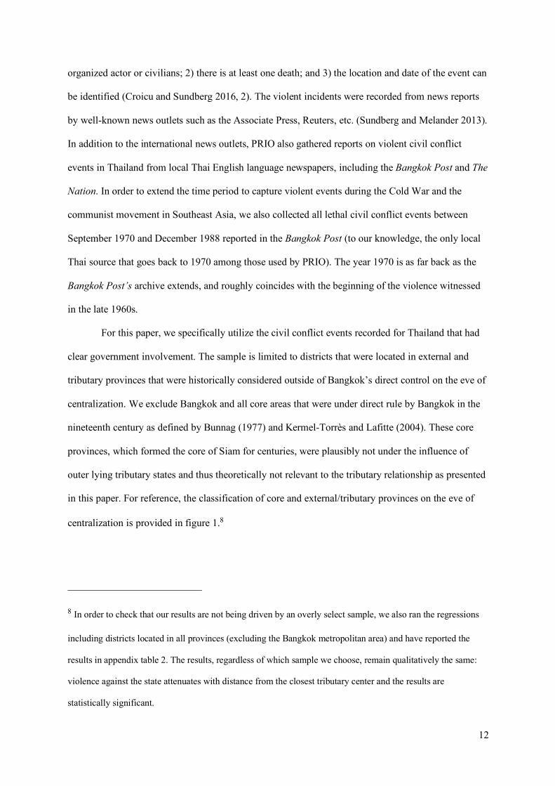
For this paper, we specifically utilize the civil conflict events recorded for Thailand that had
clear government involvement. The sample is limited to districts that were located in external and
tributary provinces that were historically considered outside of Bangkok’s direct control on the eve of
centralization. We exclude Bangkok and all core areas that were under direct rule by Bangkok in the
nineteenth century as defined by Bunnag (1977) and Kermel-Torrès and Lafitte (2004). These core
provinces, which formed the core of Siam for centuries, were plausibly not under the influence of
outer lying tributary states and thus theoretically not relevant to the tributary relationship as presented
in this paper. For reference, the classification of core and external/tributary provinces on the eve of
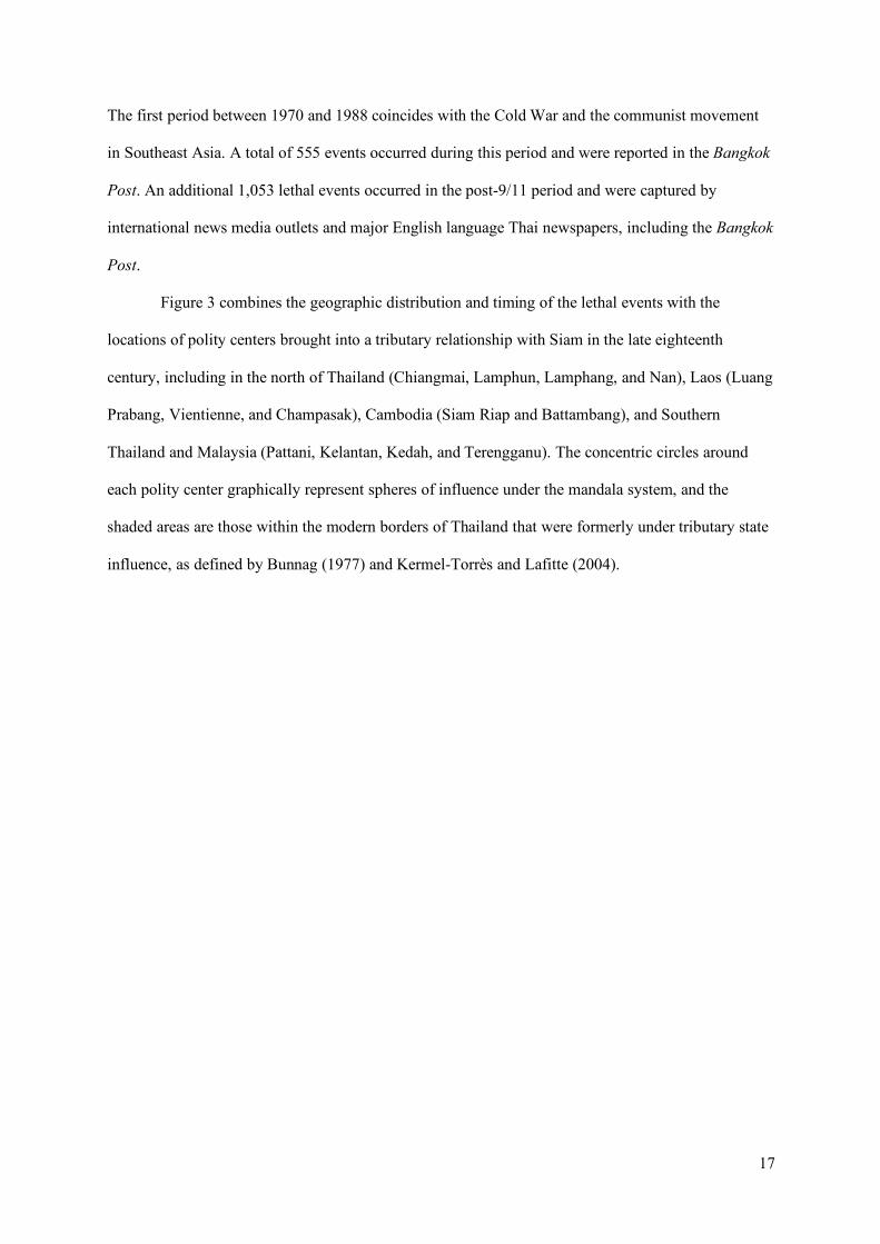
centralization is provided in figure 1.8
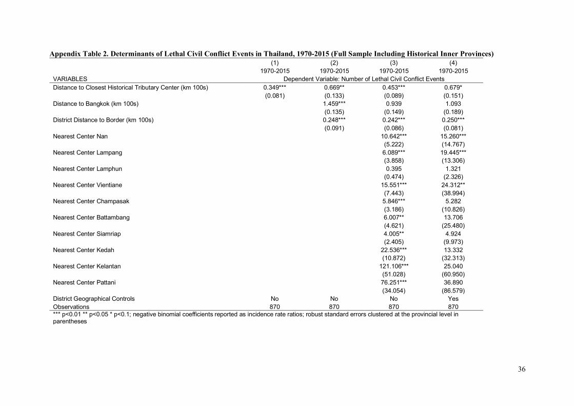
8 In order to check that our results are not being driven by an overly select sample, we also ran the regressions
including districts located in all provinces (excluding the Bangkok metropolitan area) and have reported the
results in appendix table 2. The results, regardless of which sample we choose, remain qualitatively the same:
violence against the state attenuates with distance from the closest tributary center and the results are
statistically significant.
13
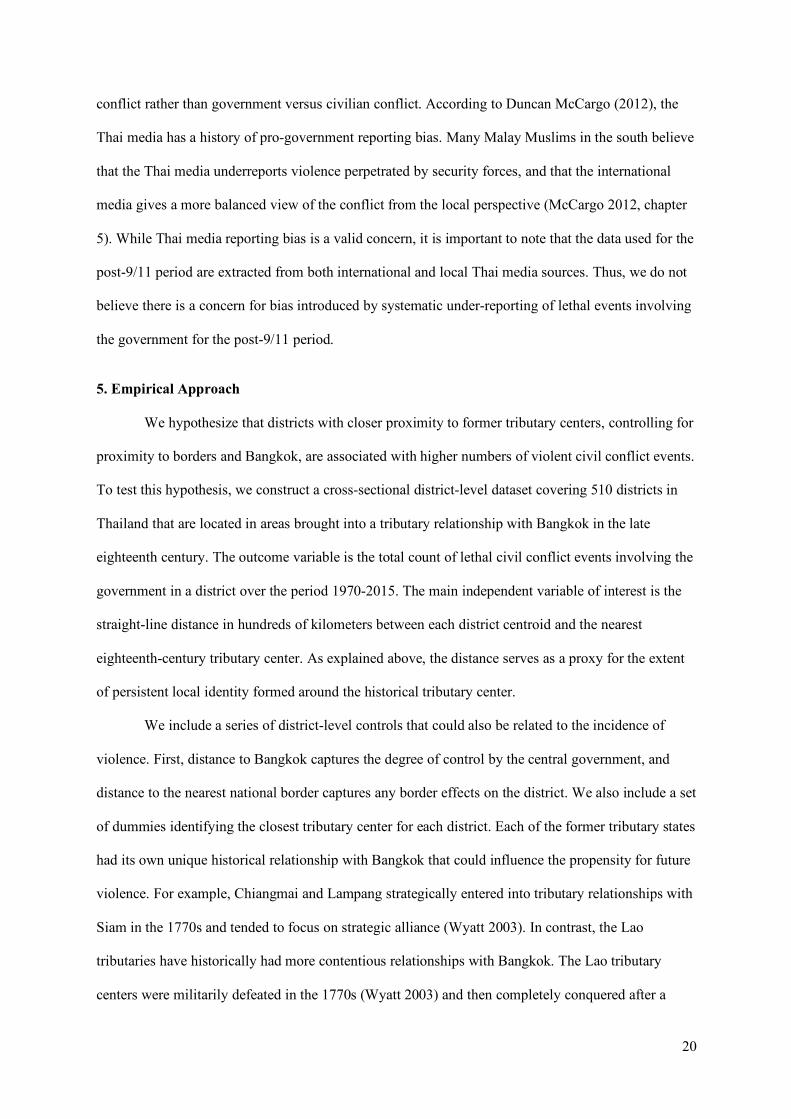
Sources: Bunnag (1977); Kermel-Torrès and Lafitte (2004).
Figure 1. Classification of Core and External/Tributary Provinces on the Eve of Centralization
14
The dataset also excludes districts that were the historical tributary state centers, because there are
likely tributary center effects which stem from their initial selection as the polity centers. That is, we
are concerned about unobserved factors that led to the selection of these locations as former tributary
centers, which in turn affects conflict outcomes. The excluded districts are the administrative centers
(amphoe muang districts) in the provinces of Chiangmai, Lampun, Lampang, Nan, and Pattani.
The resulting dataset covers 510 districts (amphoe) in Thailand and includes 1,608 civil
conflict events involving the government that resulted in at least one death over the years 1970 to
2015. The headlines from the news reports tended to describe the civilian combatants as
“communists,” “separatists,” or “insurgents.” The events were often described as “ambush,” “clash,”
“attack,” or “bombing.” With some notable exceptions, typically the events were short in duration
(nearly all taking place in a single day) and recorded very few deaths (the median number of deaths is
one per event).
Our data reflect the location of a violent event. While the location of violence is not always
indicative of the origins of groups responsible (i.e. global terrorist attacks), in the context of
Thailand’s history it generally reflects the locality of the civilian actors. When communists from
Bangkok were dispatched to peripheral regions and led violent incidents, it was only with the support
of the locals that such efforts became materialized. There is also little evidence that outsiders have
been involved in more recent events tied to the separatist movement in the south (Gunaratna, Acharya
and Chua 2005). Migration patterns in Thailand as indicated from various censuses are generally
consistent with economic migration, with flows primarily to Bangkok, industrial areas, and areas that
depend heavily on tourism. In other words, we find no evidence that local incidents were driven by
15
non-locals.9 The intensity of civil conflict varied substantially over time with increased violence
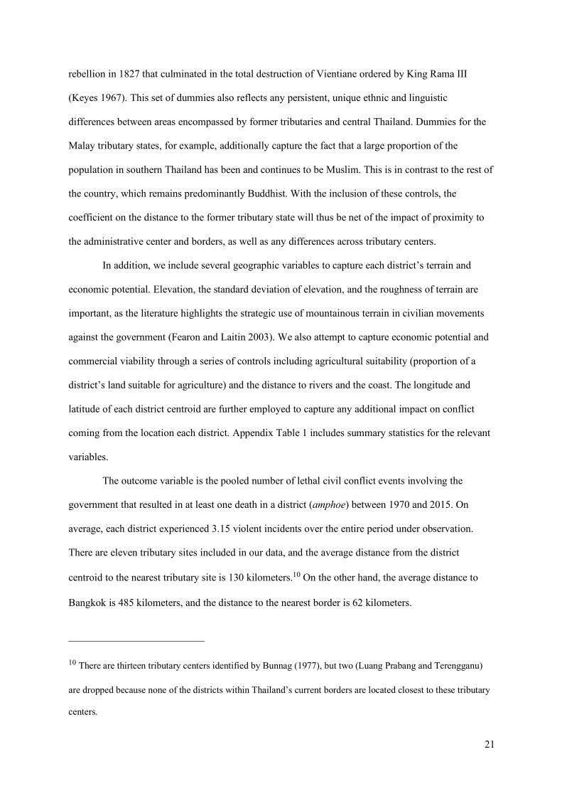
coinciding with the Cold War and the post-9/11 period, as shown in figure 2.
9 Bangkok has witnessed incidents by non-locals (i.e. the “Red Shirt” protests of 2010 and the political crisis of
2013-2014), but the capital is a clear exception and also excluded from our analysis.
16
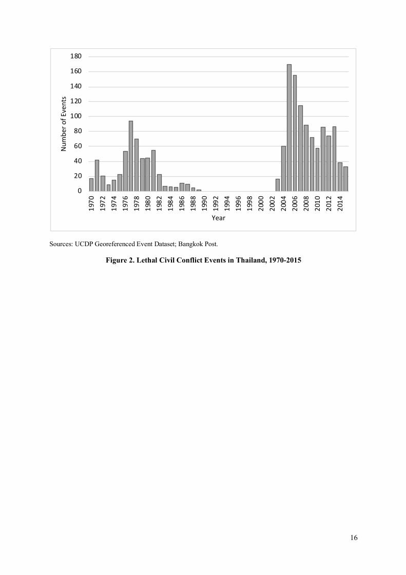
Sources: UCDP Georeferenced Event Dataset; Bangkok Post.
Figure 2. Lethal Civil Conflict Events in Thailand, 1970-2015
0
20
40
60
80
100
120
140
160
180
1970
1972
1974
1976
1978
1980
1982
1984
1986
1988
1990
1992
1994
1996
1998
2000
2002
2004
2006
2008
2010
2012
2014
Num
ber o
f Eve
nts
Year
17
The first period between 1970 and 1988 coincides with the Cold War and the communist movement
in Southeast Asia. A total of 555 events occurred during this period and were reported in the Bangkok
Post. An additional 1,053 lethal events occurred in the post-9/11 period and were captured by
international news media outlets and major English language Thai newspapers, including the Bangkok
Post.
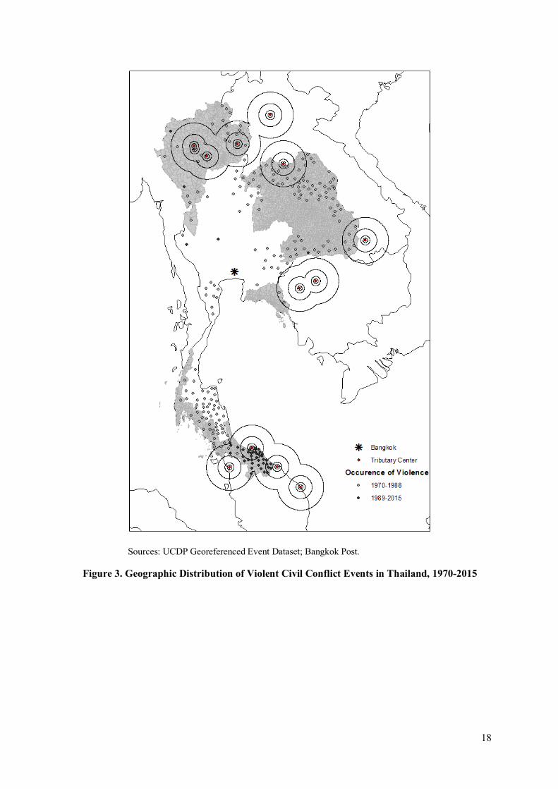
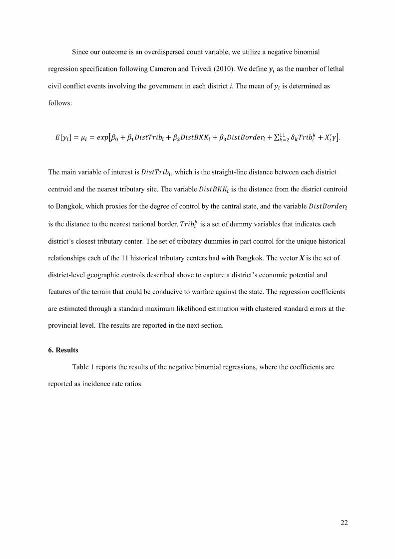
Figure 3 combines the geographic distribution and timing of the lethal events with the
locations of polity centers brought into a tributary relationship with Siam in the late eighteenth
century, including in the north of Thailand (Chiangmai, Lamphun, Lamphang, and Nan), Laos (Luang
Prabang, Vientienne, and Champasak), Cambodia (Siam Riap and Battambang), and Southern
Thailand and Malaysia (Pattani, Kelantan, Kedah, and Terengganu). The concentric circles around
each polity center graphically represent spheres of influence under the mandala system, and the
shaded areas are those within the modern borders of Thailand that were formerly under tributary state
influence, as defined by Bunnag (1977) and Kermel-Torrès and Lafitte (2004).
18
Sources: UCDP Georeferenced Event Dataset; Bangkok Post.
Figure 3. Geographic Distribution of Violent Civil Conflict Events in Thailand, 1970-2015
19
Figure 3 shows two important patterns. First, violence within Thailand tends to be concentrated in
areas that are closer to the historical tributary centers. Second, most of the events occurring after 9/11
were located in the south and associated with the separatist movement centered in Thailand’s three
southernmost provinces. The map also shows that we need to separately identify the effect of
proximity to former tributary centers from country borders, as the violence witnessed near the
Myanmar border to the east of Bangkok indicates that some of these conflicts may be driven by
contemporary border disputes rather than allegiance to historical polities.
As is common in conflict studies, there is potential selection bias in our dataset, namely the
possibility of systematic underreporting of active years of violence. PRIO set an arbitrary threshold of
25 conflict-related deaths perpetrated by an identifiable entity (such as “communists” or “southern
insurgents”) within a single year for events to be included in the UCDP Georeferenced Event Dataset
(Sundberg and Melander 2013). Accordingly, even if districts witnessed lethal events in these years, it
may be the case that they are coded as having had a non-active year of violence. This concern is
particularly relevant in the 1990s, during which the PRIO data shows no incidents of violence. Since
we do not have a credible way to resolve this systematic under-reporting of incidents, we recognize
the potential measurement error as an important caveat in our study.
There are other concerns arising from using different sources for the years from 1970 to 1988,
and 1989 to 2015. While we adhere to coding rules of PRIO, there are likely discrepancies between
the two sets of data, especially considering that we are only able to gather information from the
Bangkok Post in the earlier years. We recorded all the fatal incidents for years that did not exceed
PRIO’s 25 deaths-per-year threshold, and accordingly have greater numbers of incidents from the
Bangkok Post archives prior to 1989 than would have been captured by PRIO. Given that we focus on
the long-term average effect of the tributary relationship on subsequent violence, and the coding
procedures are consistent across districts for any given year, we do not believe that pooling these
separate datasets should cause systematic biases in our estimates. In the following section, however,
we run separate analysis for each of the two periods as an additional check.
Furthermore, there may be a related concern about violence reported in the post-9/11 period.
News reports in the post-9/11 period show a marked uptick in the number of civilian versus civilian
20
conflict rather than government versus civilian conflict. According to Duncan McCargo (2012), the
Thai media has a history of pro-government reporting bias. Many Malay Muslims in the south believe
that the Thai media underreports violence perpetrated by security forces, and that the international
media gives a more balanced view of the conflict from the local perspective (McCargo 2012, chapter
5). While Thai media reporting bias is a valid concern, it is important to note that the data used for the
post-9/11 period are extracted from both international and local Thai media sources. Thus, we do not
believe there is a concern for bias introduced by systematic under-reporting of lethal events involving
the government for the post-9/11 period.
5. Empirical Approach
We hypothesize that districts with closer proximity to former tributary centers, controlling for
proximity to borders and Bangkok, are associated with higher numbers of violent civil conflict events.
To test this hypothesis, we construct a cross-sectional district-level dataset covering 510 districts in
Thailand that are located in areas brought into a tributary relationship with Bangkok in the late
eighteenth century. The outcome variable is the total count of lethal civil conflict events involving the
government in a district over the period 1970-2015. The main independent variable of interest is the
straight-line distance in hundreds of kilometers between each district centroid and the nearest
eighteenth-century tributary center. As explained above, the distance serves as a proxy for the extent
of persistent local identity formed around the historical tributary center.
We include a series of district-level controls that could also be related to the incidence of
violence. First, distance to Bangkok captures the degree of control by the central government, and
distance to the nearest national border captures any border effects on the district. We also include a set
of dummies identifying the closest tributary center for each district. Each of the former tributary states
had its own unique historical relationship with Bangkok that could influence the propensity for future
violence. For example, Chiangmai and Lampang strategically entered into tributary relationships with
Siam in the 1770s and tended to focus on strategic alliance (Wyatt 2003). In contrast, the Lao
tributaries have historically had more contentious relationships with Bangkok. The Lao tributary
centers were militarily defeated in the 1770s (Wyatt 2003) and then completely conquered after a
21
rebellion in 1827 that culminated in the total destruction of Vientiane ordered by King Rama III
(Keyes 1967). This set of dummies also reflects any persistent, unique ethnic and linguistic
differences between areas encompassed by former tributaries and central Thailand. Dummies for the
Malay tributary states, for example, additionally capture the fact that a large proportion of the
population in southern Thailand has been and continues to be Muslim. This is in contrast to the rest of
the country, which remains predominantly Buddhist. With the inclusion of these controls, the
coefficient on the distance to the former tributary state will thus be net of the impact of proximity to
the administrative center and borders, as well as any differences across tributary centers.
In addition, we include several geographic variables to capture each district’s terrain and
economic potential. Elevation, the standard deviation of elevation, and the roughness of terrain are
important, as the literature highlights the strategic use of mountainous terrain in civilian movements
against the government (Fearon and Laitin 2003). We also attempt to capture economic potential and
commercial viability through a series of controls including agricultural suitability (proportion of a
district’s land suitable for agriculture) and the distance to rivers and the coast. The longitude and
latitude of each district centroid are further employed to capture any additional impact on conflict
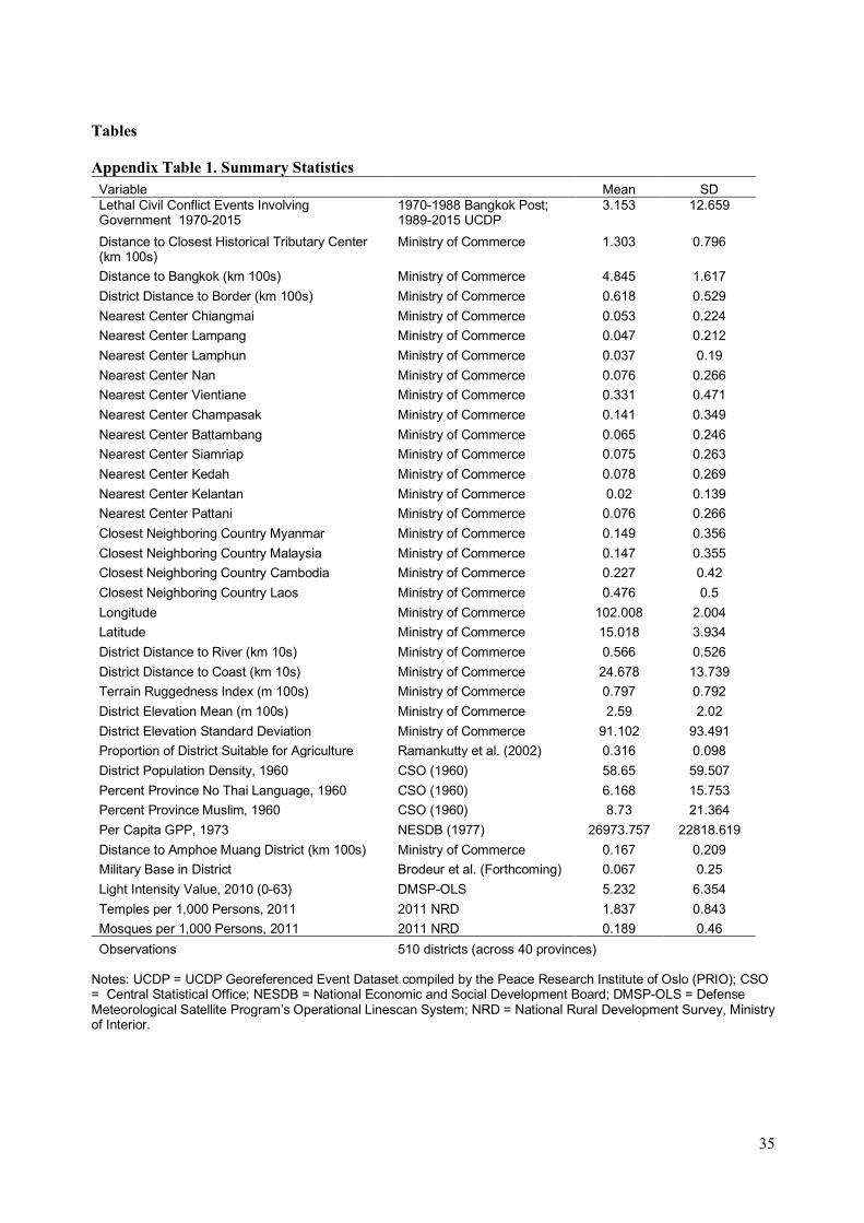
coming from the location each district. Appendix Table 1 includes summary statistics for the relevant
variables.
The outcome variable is the pooled number of lethal civil conflict events involving the
government that resulted in at least one death in a district (amphoe) between 1970 and 2015. On
average, each district experienced 3.15 violent incidents over the entire period under observation.
There are eleven tributary sites included in our data, and the average distance from the district
centroid to the nearest tributary site is 130 kilometers.10 On the other hand, the average distance to
Bangkok is 485 kilometers, and the distance to the nearest border is 62 kilometers.
10 There are thirteen tributary centers identified by Bunnag (1977), but two (Luang Prabang and Terengganu)
are dropped because none of the districts within Thailand’s current borders are located closest to these tributary
centers.
22
Since our outcome is an overdispersed count variable, we utilize a negative binomial
regression specification following Cameron and Trivedi (2010). We define !" as the number of lethal
civil conflict events involving the government in each district i. The mean of !" is determined as
follows:
#[!"] = '" = ()*+,- + ,/01234516" + ,70123899"+,;01238<5=(5" + ∑ ?@4516"@//@A7 + B"CDE.
The main variable of interest is 01234516", which is the straight-line distance between each district
centroid and the nearest tributary site. The variable 0123899" is the distance from the district centroid
to Bangkok, which proxies for the degree of control by the central state, and the variable 01238<5=(5"
is the distance to the nearest national border. 4516"@ is a set of dummy variables that indicates each
district’s closest tributary center. The set of tributary dummies in part control for the unique historical
relationships each of the 11 historical tributary centers had with Bangkok. The vector X is the set of
district-level geographic controls described above to capture a district’s economic potential and
features of the terrain that could be conducive to warfare against the state. The regression coefficients
are estimated through a standard maximum likelihood estimation with clustered standard errors at the
provincial level. The results are reported in the next section.
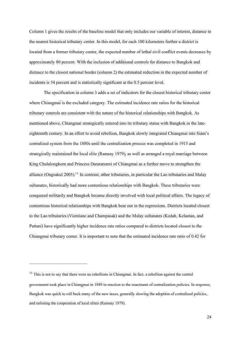
6. Results
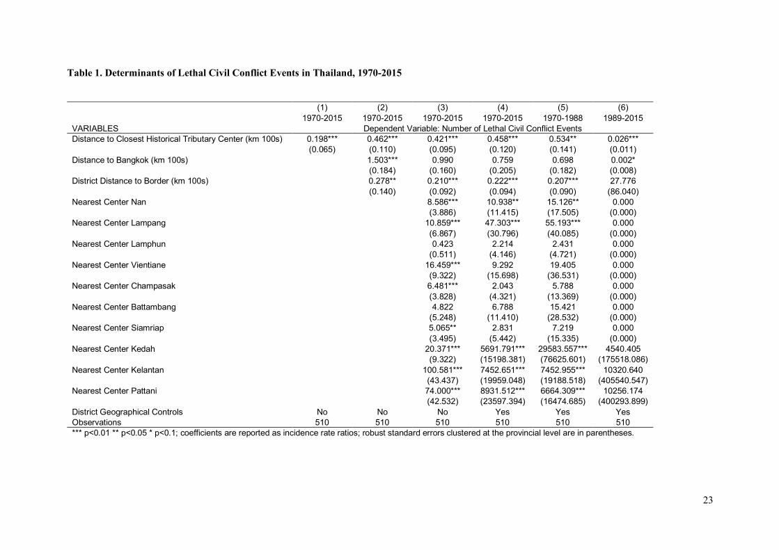
Table 1 reports the results of the negative binomial regressions, where the coefficients are
reported as incidence rate ratios.
23
Table 1. Determinants of Lethal Civil Conflict Events in Thailand, 1970-2015
(1) (2) (3) (4) (5) (6) 1970-2015 1970-2015 1970-2015 1970-2015 1970-1988 1989-2015
VARIABLES Dependent Variable: Number of Lethal Civil Conflict Events Distance to Closest Historical Tributary Center (km 100s) 0.198*** 0.462*** 0.421*** 0.458*** 0.534** 0.026***
(0.065) (0.110) (0.095) (0.120) (0.141) (0.011) Distance to Bangkok (km 100s) 1.503*** 0.990 0.759 0.698 0.002*
(0.184) (0.160) (0.205) (0.182) (0.008) District Distance to Border (km 100s) 0.278** 0.210*** 0.222*** 0.207*** 27.776 (0.140) (0.092) (0.094) (0.090) (86.040) Nearest Center Nan 8.586*** 10.938** 15.126** 0.000 (3.886) (11.415) (17.505) (0.000) Nearest Center Lampang 10.859*** 47.303*** 55.193*** 0.000 (6.867) (30.796) (40.085) (0.000) Nearest Center Lamphun 0.423 2.214 2.431 0.000 (0.511) (4.146) (4.721) (0.000) Nearest Center Vientiane 16.459*** 9.292 19.405 0.000 (9.322) (15.698) (36.531) (0.000) Nearest Center Champasak 6.481*** 2.043 5.788 0.000 (3.828) (4.321) (13.369) (0.000) Nearest Center Battambang 4.822 6.788 15.421 0.000 (5.248) (11.410) (28.532) (0.000) Nearest Center Siamriap 5.065** 2.831 7.219 0.000 (3.495) (5.442) (15.335) (0.000) Nearest Center Kedah 20.371*** 5691.791*** 29583.557*** 4540.405 (9.322) (15198.381) (76625.601) (175518.086) Nearest Center Kelantan 100.581*** 7452.651*** 7452.955*** 10320.640 (43.437) (19959.048) (19188.518) (405540.547) Nearest Center Pattani 74.000*** 8931.512*** 6664.309*** 10256.174 (42.532) (23597.394) (16474.685) (400293.899) District Geographical Controls No No No Yes Yes Yes Observations 510 510 510 510 510 510 *** p<0.01 ** p<0.05 * p<0.1; coefficients are reported as incidence rate ratios; robust standard errors clustered at the provincial level are in parentheses.
24
Column 1 gives the results of the baseline model that only includes our variable of interest, distance to
the nearest historical tributary center. In this model, for each 100 kilometers further a district is
located from a former tributary center, the expected number of lethal civil conflict events decreases by
approximately 80 percent. With the inclusion of additional controls for distance to Bangkok and
distance to the closest national border (column 2) the estimated reduction in the expected number of
incidents is 54 percent and is statistically significant at the 0.5 percent level.
The specification in column 3 adds a set of indicators for the closest historical tributary center
where Chiangmai is the excluded category. The estimated incidence rate ratios for the historical
tributary controls are consistent with the nature of the historical relationships with Bangkok. As
mentioned above, Chiangmai strategically entered into its tributary status with Bangkok in the late-
eighteenth century. In an effort to avoid rebellion, Bangkok slowly integrated Chiangmai into Siam’s
centralized system from the 1880s until the centralization process was completed in 1915 and
strategically maintained the local elite (Ramsay 1979), as well as arranged a royal marriage between
King Chulalongkorn and Princess Dararatsami of Chiangmai as a further move to strengthen the
alliance (Ongsakul 2005).11 In contrast, other tributaries, in particular the Lao tributaries and Malay
sultanates, historically had more contentious relationships with Bangkok. These tributaries were
conquered militarily and Bangkok became directly involved with local political affairs. The legacy of
contentious historical relationships with Bangkok bear out in the regressions. Districts located closest
to the Lao tributaries (Vientiane and Champasak) and the Malay sultanates (Kedah, Kelantan, and
Pattani) have significantly higher incidence rate ratios compared to districts located closest to the
Chiangmai tributary center. It is important to note that the estimated incidence rate ratio of 0.42 for
11 This is not to say that there were no rebellions in Chiangmai. In fact, a rebellion against the central
government took place in Chiangmai in 1889 in reaction to the enactment of centralization policies. In response,
Bangkok was quick to roll back many of the new taxes, generally slowing the adoption of centralized policies,
and enlisting the cooperation of local elites (Ramsay 1979).
25
our main variable of interest, distance to former tributary center, is similar to the estimate in column 2
despite the inclusion of the tributary center controls.
The literature suggests that economic conditions and local terrain are often correlated with the
incidence of violence against the state. We add a series of district-level geographic controls that
capture the economic potential of the district (longitude, latitude, elevation, distance to river, distance
to coast, and agricultural suitability), as well as ruggedness (calculated following Nunn and Puga
(2012)) and the standard deviation of elevation in order to control for mountainous terrain. The result
from the specification that includes the full set of district-level controls (column 4) shows a reduction
in the expected number of incidents for every 100 kilometers further a district is located from a
tributary center of 54 percent. This result is similar to the results presented in columns 2 and 3 and
remains statistically significant at the 1 percent level.
To allay concerns over the use of two different data sources (discussed above), we split the
sample into two time periods and run the same analysis using the full set of controls. The first time
period covers 1970 to 1988 and uses data collected from the Bangkok Post. The second period covers
1989 to 2015 and comes from the UCDP Georeferenced Event Dataset. The resulting incidence rate
ratio estimates for the early and later time periods, reported in columns 5 and 6, are 0.53 and 0.03,
respectively, and are statistically significant. Despite the use of two different datasets, both results are
qualitatively similar. Thus, we conclude that the association of distance from former tributary centers
with a reduction in the estimated number of lethal civil conflict events is not due to differences in
reporting and data sources across the two datasets.
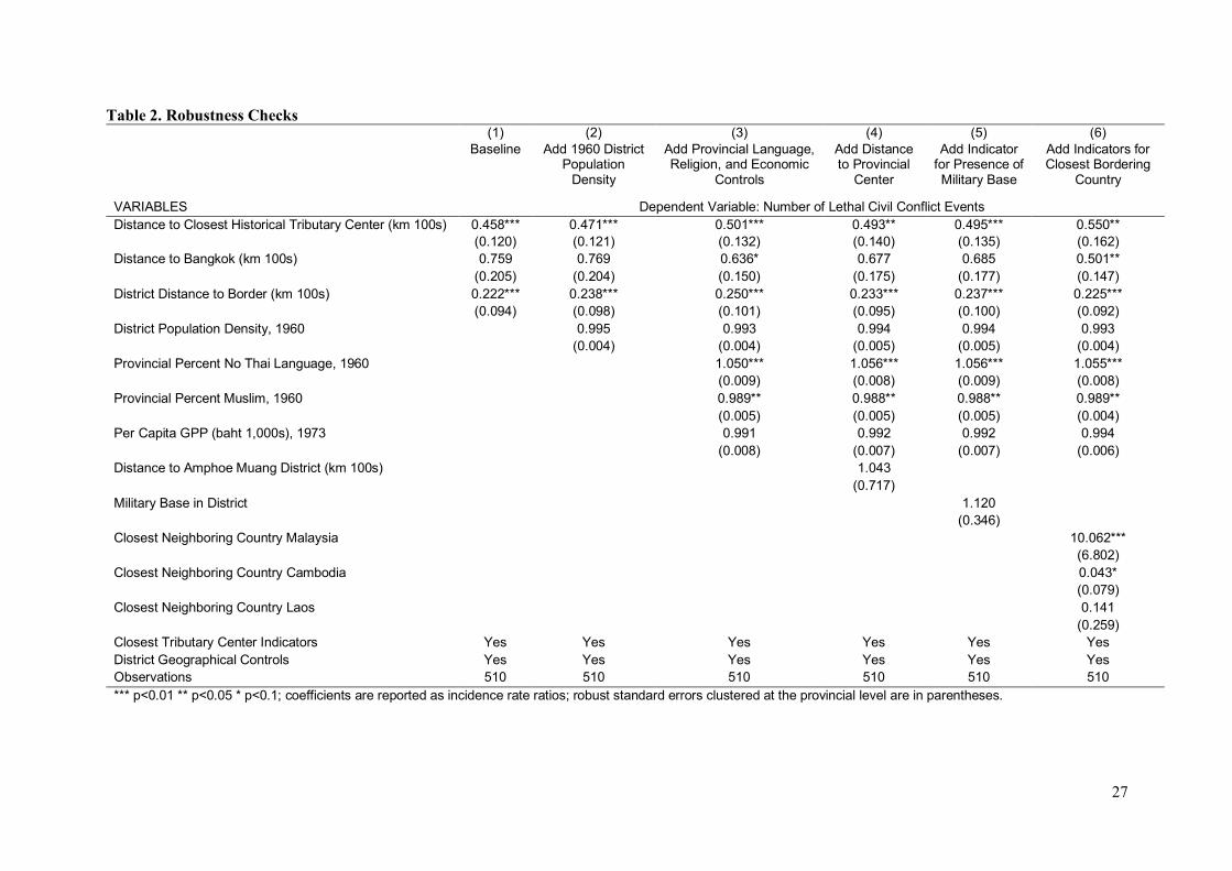
7. Robustness Checks
The main regression results indicate that the distance to former tributary centers matters for
explaining recent lethal civil conflict events. In this section, we run a series of tests to show that the
result is not sensitive to alternative specifications. The results of these robustness checks are reported
26
in table 2, with column 1 reporting the fully controlled specification from the main results (table 1,
column 4) for comparison.12
12Appendix table 3 presents the OLS results with the same specifications as in table 2 for additional checks. The
findings remain substantively similar, with the distance coefficient estimate statistically significant at the 10
percent level for specifications 3 through 6.
27
Table 2. Robustness Checks (1) (2) (3) (4) (5) (6)
Baseline Add 1960 District Population
Density
Add Provincial Language, Religion, and Economic
Controls
Add Distance to Provincial
Center
Add Indicator for Presence of Military Base
Add Indicators for Closest Bordering
Country
VARIABLES Dependent Variable: Number of Lethal Civil Conflict Events Distance to Closest Historical Tributary Center (km 100s) 0.458*** 0.471*** 0.501*** 0.493** 0.495*** 0.550** (0.120) (0.121) (0.132) (0.140) (0.135) (0.162) Distance to Bangkok (km 100s) 0.759 0.769 0.636* 0.677 0.685 0.501** (0.205) (0.204) (0.150) (0.175) (0.177) (0.147) District Distance to Border (km 100s) 0.222*** 0.238*** 0.250*** 0.233*** 0.237*** 0.225*** (0.094) (0.098) (0.101) (0.095) (0.100) (0.092) District Population Density, 1960
0.995 0.993 0.994 0.994 0.993
(0.004) (0.004) (0.005) (0.005) (0.004) Provincial Percent No Thai Language, 1960
1.050*** 1.056*** 1.056*** 1.055***
(0.009) (0.008) (0.009) (0.008) Provincial Percent Muslim, 1960
0.989** 0.988** 0.988** 0.989**
(0.005) (0.005) (0.005) (0.004) Per Capita GPP (baht 1,000s), 1973
0.991 0.992 0.992 0.994
(0.008) (0.007) (0.007) (0.006) Distance to Amphoe Muang District (km 100s)
1.043
(0.717)
Military Base in District
1.120
(0.346)
Closest Neighboring Country Malaysia
10.062***
(6.802)
Closest Neighboring Country Cambodia
0.043*
(0.079)
Closest Neighboring Country Laos
0.141
(0.259)
Closest Tributary Center Indicators Yes Yes Yes Yes Yes Yes District Geographical Controls Yes Yes Yes Yes Yes Yes Observations 510 510 510 510 510 510 *** p<0.01 ** p<0.05 * p<0.1; coefficients are reported as incidence rate ratios; robust standard errors clustered at the provincial level are in parentheses.
28
The baseline result in column 1 suggests that a district’s proximity to a former tributary state
is an important factor associated with civil conflict in Thailand, but it is also clear from the literature
that income differences and Thailand’s ethno-religious diversity are related to the incidence of
violence towards the state. Since it is possible that proximity to tributary centers may explain civil
conflict through these other channels—and not through historical allegiance and local identity as
described in our paper—we need to test whether the distance to the closest tributary center explains
the aforementioned correlates of political instability.
We do not believe that our main variable of interest, distance to the nearest historical tributary
center, should be correlated with economic disparity or the ethno-religious divide. Controlling for the
distance to Bangkok and the border, the district’s distance to the tributary state captures only the
extent of historical mandala influence on the district. This distance is also independent of geography
and coordinate location. In other words, the distance measure gives no indication to which region in
Thailand a district is situated. This suggests that omitting economic disparity or ethno-religious
composition would not bias the estimation of the proximity effect.
However, there are still reasons to believe that omitting these controls will lead to estimation
bias due to correlations with other covariates in the regressions. To demonstrate that these omitted
factors do not qualitatively change the main results, we control for economic conditions in the period
prior to the uptick in violence due to both the communist and separatist movements by including 1960
district population density and 1973 per capita gross provincial product.13 We also include provincial
level measures of ethnic and religious differences from the 1960 census, including the proportion of
the population that does not speak Thai and the proportion of the population that identified as being
Muslim.14 With the inclusion of these economic, ethnic, and religious controls in columns 2 and 3, the
13 Gross provincial product figures are only available from 1973.
14 Ethnicity information is not collected in the census or other government surveys, even at the provincial level,
which poses a problem for comparative analysis (Pepinsky 2017). In its absence, we use “native language is not
Thai” as a proxy for ethnic difference from Thais in the Central Plain.
29
incidence rate ratio on the distance to nearest historical tributary center variable remains similar to the
baseline result both in magnitude and statistical significance.15
Our main claim is that the distance to former tributary centers matters for violence, but what
about distance to current provincial administrative centers (amphoe muang districts)? Also, does the
presence of a military base in a district impact the number of violent civil conflict events involving the
government? Columns 4 and 5 report results for regressions adding the variables distance to the
provincial center and presence of a military base, respectively.16 The results indicate that distance to
the contemporary amphoe muang district and the presence of a military base in the district are not
correlated with lethal civil conflict events. Additionally, the historical influence of the tributary states
on violence remains unchanged, with an incidence rate ratio for the distance to the nearest tributary
center of approximately 0.49.
Another potential concern is that the political situation across national borders may spillover
into Thailand. This was indeed a concern of the Thai government during the rise of the communist
movement in Southeast Asia during the Cold War, especially from Laos and Malaysia (Osornprasop
2012). The Myanmar border is also the site of several violent clashes related to its own internal
disputes. Although we control for border effects in the main regression, this does not capture the
15 In Appendix table 4, we carry out yet another check to see whether economic and ethno-religious variables
are correlated with the distance measure when they are outcome variables rather than controls. In the absence of
recent district-level income or economic disparity measures, we use a proxy for economic standing, namely
mean nighttime luminosity measured in 2011. We also use the number of Buddhist temples per 1,000 people
and the number of mosques per 1,000 people as separate proxies for religious divide. The OLS output with the
same set of controls used in the baseline specification in table 3 column 1 shows that there is no correlation
between the economic and religious divide variables with the distance to the former tributary centers.
16 Since some provinces have split into two or three provinces since the early 1970s, we use the distance (in
hundreds of kilometers) measured from each district to its 1970 amphoe muang border to coincide with the
beginning of the conflict event dataset.
30
impacts of specific neighboring countries’ political situations and ideological movements. We
therefore add a set of dummy variables to indicate the closest neighboring country (Myanmar, Laos,
Cambodia, and Malaysia) to each district to better capture these neighboring country effects. The
results reported in column 6 indicate that the inclusion of the closest neighboring country does not
change the main results.
8. Conclusion
In this paper, we investigate the lasting legacy of Thailand’s tributary states and their
relationships with surrounding areas on modern civil violence. Unlike territorial borders which define
modern states, under the mandala system, span and strength of control were roughly defined by
concentric spheres of influence radiating from polity centers. Although this governance system was
common in Southeast Asia, it disappeared in Thailand with the country’s centralization and adoption
of territorial borders in the late nineteenth and early twentieth centuries. We argue that despite this
change, peripheral areas continue to share local identities associated with the closest historical
tributary centers. Using extended civil conflict data in Thailand between 1970 and 2015, we find that
closer proximity to the former tributary states is indeed positively correlated with higher levels of
lethal conflict against the central state.
Although Thailand stands out as a unique case in the region to maintain its sovereignty from
the western powers in the nineteenth and twentieth century, our companion project seeks to exploit
the findings and enlarge the scope of this paper’s analysis to other countries of Southeast Asia that
also formerly operated under the mandala system. These include Myanmar, Vietnam, Cambodia,
Laos, Malaysia, and Indonesia. All of these countries had historical tributary states and, if our
argument holds for Thailand, it may be generalizable to these neighboring countries as well. Aside
from different colonization contexts, the broader geographic scope also will allow us to test for the
persistent legacy of mandala system under different regime types in Southeast Asia today. The rich
context provided by both the historical and the current states in the region certainly will add to the
broader literature that has mainly focused on regions outside of Southeast Asia.
31
Bibliography
Acemoglu, Daron, Davide Cantoni, Simon Johnson, and James A. Robinson. "The Consequences of Radical Reform: The French Revolution." American Economic Review 101 (2011): 3286–3307.
Alesina, Alberto, Sule Oetzler, Nouriel Roubini, and Phillip Swagel. "Political Instability and Economic Growth." Journal of Economic Growth 1, no. 2 (1996): 189-211.
Anderson, Benedict, R. O'G. "Radicalism after Communism in Thailand and Indonesia." New Left Review 202 (November-December 1993): 3-14.
Aphornsuvan, Thanet. "Origins of Malay Muslim "Separatism" in Southern Thailand." In Thai South and Malay North: Ethnic Interactions on a Plural Peninsula, by Michael J. Montesano, & Patrick Jory, 91-123. Singapore: National University of Singapore, 2008.
Baker, Chris, and Pasuk Phongpaichit. A History of Thailand. 2nd. Cambridge: Cambridge University Press, 2009.
Banerjee, Abhijit, and Lakshmi Iyer. "History, institutions and economic performance: the legacy of colonial land tenure systems in India." American Economic Review 95, no. 4 (2005): 1190–1213.
Barro, Robert J. "Economic Growth in a Cross Section of Countries." Quarterly Journal of Economics 106 (1991): 407-443.
Becker, Sascha O., Katrin Boeckh, Christa Hainz, and Ludger Woessmann. "The Empire is Dead, Long Live the Empire! Long-run Persistence of Trust and Corruption in the Bureaucracy." The Economic Journal 126 (February 2014): 40-74.
Brodeur, Abel, Warn N. Lekfuangfu, and Yanos Zylberberg. "War, Migration and the Origins of the Thai Sex Industry." Journal of the European Economic Association, Forthcoming.
Bunnag, Tej. The Provincial Adminisration of Siam 1892-1915: The Ministry of Interior under Prince Damrong Rajanubhap. Kuala Lumpur: Oxford University Press, 1977.
Cameron, Colin A., and Pravin K. Trivedi. Microeconometrics Using Stata. College Station, TX: Stata Press, 2010.
Cederman, Lars-Erik, Nils B. Weidmann, and Kristian Skrede Gleditsch. "Horizontal Inequalities and Ethnonationalist Civil War: A Global Comparison." American Political Science Review 105, no. 3 (2011): 478–495.
Central Statistical Office. Census of Thailand by Province. Vol. Various Volumes. Bangkok: Central Statistical Office, 1960.
Collier, Paul, and Anke Hoeffler. "Greed and Grievance in Civil War." Oxford Economic Papers 56 (2004): 563-595.
Croicu, Mihai, and Ralph Sundberg. "UCDP Georeferenced Event Dataset Codebook Version 5.0." Department of Peace and Conflict Research, Uppsala University, 2016.
Easterly, William, and Ross Levine. "Africa’s Growth Tragedy: Policies and Ethnic Divisions." Quarterly Journal of Economics 112, no. 4 (1997): 1203-1250.
32
Esteban, Joan, and Debraj Ray. "Conflict and Distribution." Journal of Economic Theory 87, no. 2 (1999): 379-415.
Fearon, James D., and David D. Laitin. "Ethnicity, Insurgency, and Civil War." American Political Science Review 97, no. 1 (2003): 75-90.
Fearon, James, and David Laitin. "Sons of the Soil, Migrants, and Civil War." World Development 39, no. 2 (2011): 199-211.
Grosfeld, Irena, Alexander Rodnyansky, and Ekaternia Zhuravskaya. "Persistent Antimarket Culture: A Legacy of teh Pale of Settlement after the Holocaust." American Economic Journal: Economic Policy 5, no. 3 (2013): 189-226.
Gunaratna, Rohan, Arabinda Acharya, and Sabrina Chua. Conflict and Terrorism in Southern Thailand. Singapore: Marshall Cavendish International, 2005.
Harish, S. P. "Ethnic or Religious Cleavage? Investigating the Nature of the Conflict in Southern Thailand." Contemporary Southeast Asia: A Journal of International and Strategic Affairs 28, no. 1 (2006): 48-69.
Harish, S. P. "Tribe and Nation: Nation-building in Southern Thailand." Working Paper, 2016. Horowitz, Donald. Ethnic Groups in Conflict. Berkeley and Los Angeles: University of California
Press, 1985. Kermel-Torrès, Doryane, and Aimee Lafitte. Atlas of Thailand: Spatial Structures and Development.
Chiang Mai: Silkworm Books, 2004. Keyes, Charles F. Isan: Regionalism in Northeastern Thailand. Ithaca, New York: Southeast Asia
Program, Department of Asian Studies, Cornell University, 1967. Liow, Joseph Chinyong, and Don Pathan. Confronting Ghosts: Thailand's Shapeless Southern
Insurgency. Double Bay, New South Wales: Lowy Institute for International Policy, 2010. McCargo, Duncan. Mapping National Anxieties: Thailand's Southern Conflict. Copenhagen: NIAS
Press, 2012. National Economic and Social Development Board (NESDB). Gross Provincial Product 1977.
Bangkok: NESDB, 1977. Nunn, Nathan. "Historical Development." Handbook of Economic Growth, 2014: 347-402. Nunn, Nathan, and Diego Puga. "Ruggedness: The Blessing of Bad Geography in Africa." Review of
Economics and Statistics 94, no. 1 (2012): 20-36. Ockey, James. "Elections and Political Integration." In Thai South and Malay North: Ethnic
Interactions on a Plural Peninsula, by Michael J. Montesano, & Patrick Jory, 124-154. Singapore: National University of Singapore Press, 2008.
Ongsakul, Sarassawadee. History of Lanna. Translated by Chitraporn Tanratanakul. Chiang Mai: Silkworm Books, 2005.
Osornprasop, Sutayut. "Thailand and the Secret War in Laos: The Origins of Engagement." In Cold War Southeast Asia, by Malcolm H. Murfett, 165-194. Singapore: Marshall Cavendish Editions, 2012.
33
Paik, Christopher, and Jessica Vechbanyongratana. "Path to Centralization and Development: Evidence from Siam ." Working Paper, 2017.
Pepinsky, Thomas B. "Regions of Exception." Perspectives on Politics 15, no. 4 (2017): 1034-1052. Puaksom, Davisakd. "Of a Lesser Brilliance: Patani Historiography in Contention." In Thai South and
Malay North: Ethnic Interactions on a Plural Peninsula, by Michael J. Montesano, & Patrick Jory, 71-88. Singapore: National University of Singapore, 2008.
Ramsay, Ansil. "Modernization and Reactionary Rebellions in Northern Siam." The Journal of Asian Studies 38, no. 2 (1979): 283-297.
Reynal-Queyrol, Marta. "Ethnicity, Political Systems and Civil War." Journal of Conflict Resolution 46, no. 1 (2002): 29-54.
Ruenyote, Suwan. "Development and Welfare for the Hill Tribes in Thailand." In Tribesmen and Peasants in North Thailand: Proceedings of the First Symposium of the Tribal Research Centre, by P. Hinton. Chiangmai: Tribal Research Centre, 1969.
Sambanis, Nicholas. "Conclusion: Using case studies to refine and expand the theory of civil war." In Understanding Civil War: Evidence and Analysis, by Paul Collier, & Nicholas Sambanis, 299–330. Washington D.C.: World Bank, 2005.
Scott, James C. The Art of Not Being Governed: An Anarchist History of Upland Southeast Asia. New Haven, Connecticut: Yale University Press, 2009.
Siroky, David S. "Explaining Secession." In The Ashgate Research Companion to Secession, by Aleksandar Pavkovic, & Peter Radan, 45-79. Burlington, VT: Ashgate Publishing Ltd, 2011.
Sundberg, Ralph, and Erik Melander. "Introducing the UCDP Georeferenced Event Dataset." Journal of Peace Research 50, no. 4 (2013): 523-532.
Suwannathat-Pian, Kobkua. "National Identity, the "Sam-Sams" of Satun, and the Thai Malay Muslims." In Thai South and Malay North: Ethnic Interactions on a Plural Peninsula, by Michael J. Montesano, & Patrick Jory, 155-172. Singapore: National University of Singapore, 2008.
Syukri, Ibrahim. History of the Malay Kingdom of Patani. Translated by Connor Bailey, & John N. Miksic. Chiang Mai: Silkworm Books, 2005.
Tambiah, Stanley J. "The Galactic Polity: The Structure of Traditional Kingdoms in Southeast Asia." Annals of the New York Academy of Sciences 293, 1977: 69-97.
Tapp, Nicholas. Sovereignty and Rebellion: The White Hmong of Northern Thailand . Singapore: Oxford University Press, 1989.
Virunha, Chuleeporn. "Historical Perceptions of Local History in the Upper Peninsula." In Thai South and Malay North:Ethnic Interactions on a Plural Peninsula, by Michael J. Montesano, & Patrick Jory, 39-70. Singapore: National University of Singapore, 2008.
Weiner, Myron. Sons of the Soil. Princeton: Princeton University Press, 1978. Wyatt, David K. Thailand: A Short History. 2nd. Chiangmai: Silkworm Books, 2003. Østby, Gudrun. "Polarization, horizontal inequalities and violent civil conflict." Journal of Peace
Research 45, no. 2 (2008): 143–162.
34
Østby, Gudrun, Ragnhild Nordås, and Jan Ketil Rød. "Regional Inequalities and Civil Conflict in Sub-Saharan Africa." International Studies Quarterly 53, no. 2 (2009): 301-324.
35
Tables
Appendix Table 1. Summary Statistics Variable Mean SD Lethal Civil Conflict Events Involving Government 1970-2015
1970-1988 Bangkok Post; 1989-2015 UCDP
3.153 12.659
Distance to Closest Historical Tributary Center (km 100s)
Ministry of Commerce 1.303 0.796
Distance to Bangkok (km 100s) Ministry of Commerce 4.845 1.617 District Distance to Border (km 100s) Ministry of Commerce 0.618 0.529 Nearest Center Chiangmai Ministry of Commerce 0.053 0.224 Nearest Center Lampang Ministry of Commerce 0.047 0.212 Nearest Center Lamphun Ministry of Commerce 0.037 0.19 Nearest Center Nan Ministry of Commerce 0.076 0.266 Nearest Center Vientiane Ministry of Commerce 0.331 0.471 Nearest Center Champasak Ministry of Commerce 0.141 0.349 Nearest Center Battambang Ministry of Commerce 0.065 0.246 Nearest Center Siamriap Ministry of Commerce 0.075 0.263 Nearest Center Kedah Ministry of Commerce 0.078 0.269 Nearest Center Kelantan Ministry of Commerce 0.02 0.139 Nearest Center Pattani Ministry of Commerce 0.076 0.266 Closest Neighboring Country Myanmar Ministry of Commerce 0.149 0.356 Closest Neighboring Country Malaysia Ministry of Commerce 0.147 0.355 Closest Neighboring Country Cambodia Ministry of Commerce 0.227 0.42 Closest Neighboring Country Laos Ministry of Commerce 0.476 0.5 Longitude Ministry of Commerce 102.008 2.004 Latitude Ministry of Commerce 15.018 3.934 District Distance to River (km 10s) Ministry of Commerce 0.566 0.526 District Distance to Coast (km 10s) Ministry of Commerce 24.678 13.739 Terrain Ruggedness Index (m 100s) Ministry of Commerce 0.797 0.792 District Elevation Mean (m 100s) Ministry of Commerce 2.59 2.02 District Elevation Standard Deviation Ministry of Commerce 91.102 93.491 Proportion of District Suitable for Agriculture Ramankutty et al. (2002) 0.316 0.098 District Population Density, 1960 CSO (1960) 58.65 59.507 Percent Province No Thai Language, 1960 CSO (1960) 6.168 15.753 Percent Province Muslim, 1960 CSO (1960) 8.73 21.364 Per Capita GPP, 1973 NESDB (1977) 26973.757 22818.619 Distance to Amphoe Muang District (km 100s) Ministry of Commerce 0.167 0.209 Military Base in District Brodeur et al. (Forthcoming) 0.067 0.25 Light Intensity Value, 2010 (0-63) DMSP-OLS 5.232 6.354 Temples per 1,000 Persons, 2011 2011 NRD 1.837 0.843 Mosques per 1,000 Persons, 2011 2011 NRD 0.189 0.46 Observations 510 districts (across 40 provinces)
Notes: UCDP = UCDP Georeferenced Event Dataset compiled by the Peace Research Institute of Oslo (PRIO); CSO = Central Statistical Office; NESDB = National Economic and Social Development Board; DMSP-OLS = Defense Meteorological Satellite Program’s Operational Linescan System; NRD = National Rural Development Survey, Ministry of Interior.
36
Appendix Table 2. Determinants of Lethal Civil Conflict Events in Thailand, 1970-2015 (Full Sample Including Historical Inner Provinces) (1) (2) (3) (4)
1970-2015 1970-2015 1970-2015 1970-2015
VARIABLES Dependent Variable: Number of Lethal Civil Conflict Events
Distance to Closest Historical Tributary Center (km 100s) 0.349*** 0.669** 0.453*** 0.679*
(0.081) (0.133) (0.089) (0.151)
Distance to Bangkok (km 100s) 1.459*** 0.939 1.093
(0.135) (0.149) (0.189)
District Distance to Border (km 100s) 0.248*** 0.242*** 0.250***
(0.091) (0.086) (0.081)
Nearest Center Nan 10.642*** 15.260***
(5.222) (14.767)
Nearest Center Lampang 6.089*** 19.445***
(3.858) (13.306)
Nearest Center Lamphun 0.395 1.321
(0.474) (2.326)
Nearest Center Vientiane 15.551*** 24.312**
(7.443) (38.994)
Nearest Center Champasak 5.846*** 5.282
(3.186) (10.826)
Nearest Center Battambang 6.007** 13.706
(4.621) (25.480)
Nearest Center Siamriap 4.005** 4.924
(2.405) (9.973)
Nearest Center Kedah 22.536*** 13.332
(10.872) (32.313)
Nearest Center Kelantan 121.106*** 25.040
(51.028) (60.950)
Nearest Center Pattani 76.251*** 36.890
(34.054) (86.579)
District Geographical Controls No No No Yes
Observations 870 870 870 870
*** p<0.01 ** p<0.05 * p<0.1; negative binomial coefficients reported as incidence rate ratios; robust standard errors clustered at the provincial level in
parentheses
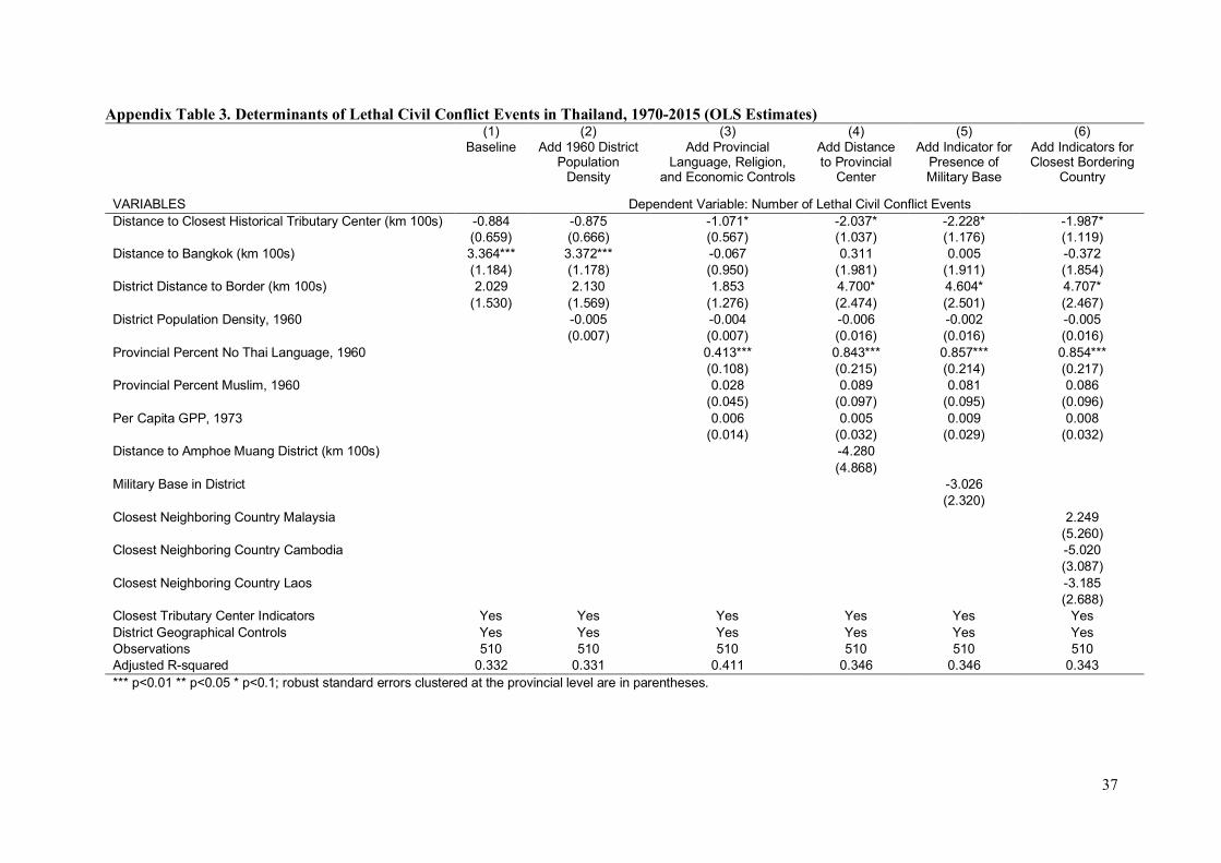
37
Appendix Table 3. Determinants of Lethal Civil Conflict Events in Thailand, 1970-2015 (OLS Estimates)
(1) (2) (3) (4) (5) (6)
Baseline Add 1960 District
Population
Density
Add Provincial
Language, Religion,
and Economic Controls
Add Distance
to Provincial
Center
Add Indicator for
Presence of
Military Base
Add Indicators for
Closest Bordering
Country
VARIABLES Dependent Variable: Number of Lethal Civil Conflict Events
Distance to Closest Historical Tributary Center (km 100s) -0.884 -0.875 -1.071* -2.037* -2.228* -1.987*
(0.659) (0.666) (0.567) (1.037) (1.176) (1.119)
Distance to Bangkok (km 100s) 3.364*** 3.372*** -0.067 0.311 0.005 -0.372
(1.184) (1.178) (0.950) (1.981) (1.911) (1.854)
District Distance to Border (km 100s) 2.029 2.130 1.853 4.700* 4.604* 4.707*
(1.530) (1.569) (1.276) (2.474) (2.501) (2.467)
District Population Density, 1960
-0.005 -0.004 -0.006 -0.002 -0.005
(0.007) (0.007) (0.016) (0.016) (0.016)
Provincial Percent No Thai Language, 1960
0.413*** 0.843*** 0.857*** 0.854***
(0.108) (0.215) (0.214) (0.217)
Provincial Percent Muslim, 1960
0.028 0.089 0.081 0.086
(0.045) (0.097) (0.095) (0.096)
Per Capita GPP, 1973
0.006 0.005 0.009 0.008
(0.014) (0.032) (0.029) (0.032)
Distance to Amphoe Muang District (km 100s)
-4.280
(4.868)
Military Base in District
-3.026
(2.320)
Closest Neighboring Country Malaysia
2.249
(5.260)
Closest Neighboring Country Cambodia
-5.020
(3.087)
Closest Neighboring Country Laos
-3.185
(2.688)
Closest Tributary Center Indicators Yes Yes Yes Yes Yes Yes
District Geographical Controls Yes Yes Yes Yes Yes Yes
Observations 510 510 510 510 510 510
Adjusted R-squared 0.332 0.331 0.411 0.346 0.346 0.343
*** p<0.01 ** p<0.05 * p<0.1; robust standard errors clustered at the provincial level are in parentheses.
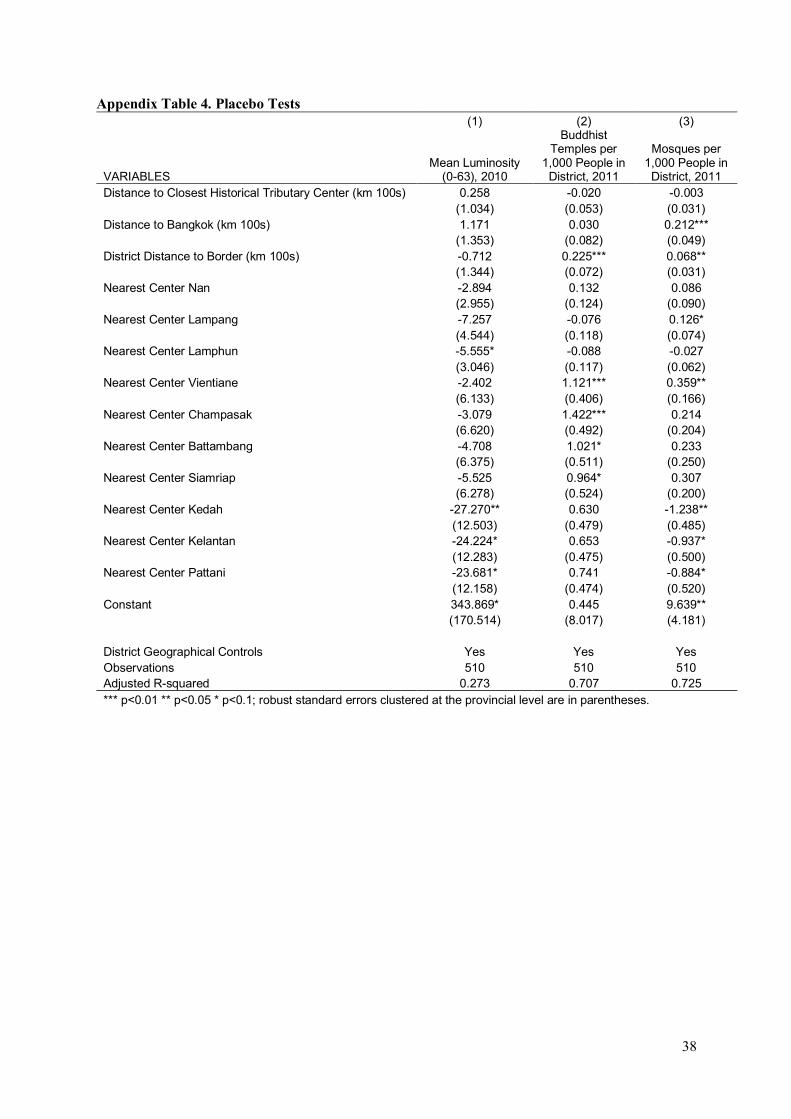
38
Appendix Table 4. Placebo Tests (1) (2) (3)
VARIABLES Mean Luminosity
(0-63), 2010
Buddhist Temples per
1,000 People in District, 2011
Mosques per 1,000 People in District, 2011
Distance to Closest Historical Tributary Center (km 100s) 0.258 -0.020 -0.003 (1.034) (0.053) (0.031) Distance to Bangkok (km 100s) 1.171 0.030 0.212*** (1.353) (0.082) (0.049) District Distance to Border (km 100s) -0.712 0.225*** 0.068** (1.344) (0.072) (0.031) Nearest Center Nan -2.894 0.132 0.086 (2.955) (0.124) (0.090) Nearest Center Lampang -7.257 -0.076 0.126* (4.544) (0.118) (0.074) Nearest Center Lamphun -5.555* -0.088 -0.027 (3.046) (0.117) (0.062) Nearest Center Vientiane -2.402 1.121*** 0.359** (6.133) (0.406) (0.166) Nearest Center Champasak -3.079 1.422*** 0.214 (6.620) (0.492) (0.204) Nearest Center Battambang -4.708 1.021* 0.233 (6.375) (0.511) (0.250) Nearest Center Siamriap -5.525 0.964* 0.307 (6.278) (0.524) (0.200) Nearest Center Kedah -27.270** 0.630 -1.238** (12.503) (0.479) (0.485) Nearest Center Kelantan -24.224* 0.653 -0.937* (12.283) (0.475) (0.500) Nearest Center Pattani -23.681* 0.741 -0.884* (12.158) (0.474) (0.520) Constant 343.869* 0.445 9.639**
(170.514) (8.017) (4.181)
District Geographical Controls Yes Yes Yes Observations 510 510 510 Adjusted R-squared 0.273 0.707 0.725 *** p<0.01 ** p<0.05 * p<0.1; robust standard errors clustered at the provincial level are in parentheses.
Related Documents


