BCIT Bachelor of Technology in Computer Systems Major Project Final Report COMP 8045 & 8046 (18 Credits) Copyright © 2008 Stephen Makonin. Submi&ed as part of the requirements for gradua5on on December 15, 2008

Welcome message from author
This document is posted to help you gain knowledge. Please leave a comment to let me know what you think about it! Share it to your friends and learn new things together.
Transcript

BCIT Bachelor of Technology in Computer Systems
Major Project Final Report COMP 8045 & 8046 (18 Credits)
Copyright © 2008 Stephen Makonin.
Submi&&ed as part of the requirements for gradua55on on December 15, 2008
CST BTech Major Project Final Report COMP 8045 & 8046 (18 Credits)
pg. 2
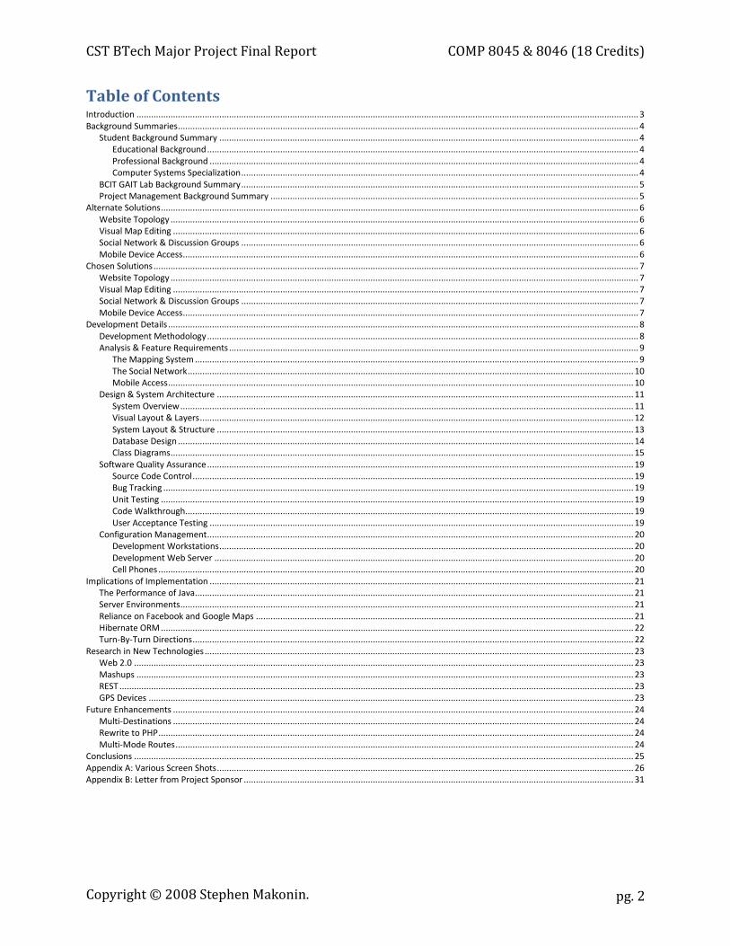
Table of Contents Introduction .............................................................................................................................................................................................................. 3 Background Summaries ............................................................................................................................................................................................. 4
Student Background Summary ............................................................................................................................................................................ 4 Educational Background ................................................................................................................................................................................. 4 Professional Background ................................................................................................................................................................................ 4 Computer Systems Specialization ................................................................................................................................................................... 4
BCIT GAIT Lab Background Summary ................................................................................................................................................................... 5 Project Management Background Summary ....................................................................................................................................................... 5
Alternate Solutions .................................................................................................................................................................................................... 6 Website Topology ................................................................................................................................................................................................ 6 Visual Map Editing ............................................................................................................................................................................................... 6 Social Network & Discussion Groups ................................................................................................................................................................... 6 Mobile Device Access ........................................................................................................................................................................................... 6
Chosen Solutions ....................................................................................................................................................................................................... 7 Website Topology ................................................................................................................................................................................................ 7 Visual Map Editing ............................................................................................................................................................................................... 7 Social Network & Discussion Groups ................................................................................................................................................................... 7 Mobile Device Access ........................................................................................................................................................................................... 7
Development Details ................................................................................................................................................................................................. 8 Development Methodology ................................................................................................................................................................................. 8 Analysis & Feature Requirements ........................................................................................................................................................................ 9
The Mapping System ...................................................................................................................................................................................... 9 The Social Network ....................................................................................................................................................................................... 10 Mobile Access ............................................................................................................................................................................................... 10
Design & System Architecture ........................................................................................................................................................................... 11 System Overview .......................................................................................................................................................................................... 11 Visual Layout & Layers .................................................................................................................................................................................. 12 System Layout & Structure ........................................................................................................................................................................... 13 Database Design ........................................................................................................................................................................................... 14 Class Diagrams .............................................................................................................................................................................................. 15
Software Quality Assurance ............................................................................................................................................................................... 19 Source Code Control ..................................................................................................................................................................................... 19 Bug Tracking ................................................................................................................................................................................................. 19 Unit Testing .................................................................................................................................................................................................. 19 Code Walkthrough........................................................................................................................................................................................ 19 User Acceptance Testing .............................................................................................................................................................................. 19
Configuration Management ............................................................................................................................................................................... 20 Development Workstations .......................................................................................................................................................................... 20 Development Web Server ............................................................................................................................................................................ 20 Cell Phones ................................................................................................................................................................................................... 20
Implications of Implementation .............................................................................................................................................................................. 21 The Performance of Java.................................................................................................................................................................................... 21 Server Environments .......................................................................................................................................................................................... 21 Reliance on Facebook and Google Maps ........................................................................................................................................................... 21 Hibernate ORM .................................................................................................................................................................................................. 22 Turn-By-Turn Directions ..................................................................................................................................................................................... 22
Research in New Technologies ................................................................................................................................................................................ 23 Web 2.0 ............................................................................................................................................................................................................. 23 Mashups ............................................................................................................................................................................................................ 23 REST ................................................................................................................................................................................................................... 23 GPS Devices ....................................................................................................................................................................................................... 23
Future Enhancements ............................................................................................................................................................................................. 24 Multi-Destinations ............................................................................................................................................................................................. 24 Rewrite to PHP ................................................................................................................................................................................................... 24 Multi-Mode Routes ............................................................................................................................................................................................ 24
Conclusions ............................................................................................................................................................................................................. 25 Appendix A: Various Screen Shots ........................................................................................................................................................................... 26 Appendix B: Letter from Project Sponsor ................................................................................................................................................................ 31
Copyright © 2008 Stephen Makonin.
CST BTech Major Project Final Report COMP 8045 & 8046 (18 Credits)
pg. 3
Introduction This project was an attempt to create and study an online social network that had a common interest. More specifically we wanted to take a segment of the BCIT community, both employees and students, and provide to them a way to share bike routes they use to travel back and forth to BCIT.
The project is called Map with Wheels (MWW) which was developed in the BCIT GAIT Lab. It was a TEK funded grassroots project initiative to encourage staff and students to cycle to work and to share their bike routes with others. This project enables sharing through user/community participation. Users can access routes contributed by fellow cyclists in real time via any computer or mobile device (e.g. cell phone).
Map with Wheels utilizes the Facebook social networking software and uses Google Maps to add, edit, and display bike routes and Points of Interest (POI). POIs, such as hazards, controlled intersections, cut-throughs, and other user defined points help describe various situations that may be encountered while taking a particular bike route. Discussion groups further foster communication amongst users as to their experiences while taking a particular bike route. Each route can then be rated in terms of: directness, flatness, control, and traffic volume.
Map with Wheels allowed me to expand my knowledge of Java, Web 2.0, and mobile phone application development. Map with Wheels also will allow me to explore providing solutions using high-level communication methodologies such AJAX and RESTful web services. Exploring Mashups that deals with collaborative computing and social networking (communication at a human level) is also an interest of mine.
There is an online video demonstrating MWW at: http://server20.ielbcit.ca:81/mww-demo/.
Copyright © 2008 Stephen Makonin.
CST BTech Major Project Final Report COMP 8045 & 8046 (18 Credits)
pg. 4
Background Summaries
Student Background Summary
Educational Background Stephen Makonin holds a Diploma in Computer Information Systems (1996) from Selkirk College and is in the process of studying for his Bachelor of Technology at BCIT (expecting to graduate in 2010). He along with four other authors wrote the Visual C++ 5 Developer's Guide which Sams Publishing published in 1997.
Professional Background For the last 12 years, Stephen successfully ran a software development company providing full SDLC services before joining BCIT, in January 2008. In 2007 he, along with another business associate, launched Vvvroom.com an online news reader and news aggregator which employs a rich user experience built on Web 2.0. His industry knowledge includes: government, healthcare, manufacturing, online services, social networks, and telecom (paging, cellular, wireless). Some of his past business clients include: engcen.com, Fraser Health, Quartech Systems, Sierra Wireless, Telus Mobility, and Vancouver Coastal Health.
Although Stephen’s preferred programming languages are C and Python, he has used many others to create and deliver software solutions in: billing/rating, data analysis/conversion, socket programming, web applications, as well as Internet social networking. He has extensive experience using XML (including web services, AJAX, RSS, and ATOM) and implementing Internet RFCs (HTTP, SMTP, POP, NNTP, SNMP, UFTP).
Computer Systems Specialization Stephen has chosen to specialize in one option which is Data Communications. This specialization allows him to explore his interests in high-level and low-level data communications programming. He believes that data communications is one of the key fundamental and foundational building blocks for technology: past, present, and future.
Copyright © 2008 Stephen Makonin.
CST BTech Major Project Final Report COMP 8045 & 8046 (18 Credits)
pg. 5
BCIT GAIT Lab Background Summary The BCIT GAIT (Group for Advance Information Technology) Lab has a long history at BCIT. It began as the ARCS (Applied Research in Computer Systems) Lab, a CST student research lab, around 1984 headed up by Mike Scrabin. In 1986, headed by Fred Martin, it had structurally developed into what is GAIT today, a research lab that preformed applied research for industry clients. In 1990, the ARCS Lab was renamed to GAIT. GAIT is now headed up by Dr. Hassan Farhangi an Electrical Engineer and the driving force for BCIT research in Smart Micro-Grids.
Through the years, GAIT has focused on AI research then refocused on Internet/network security. At present GAIT has three main research themes: Intelligent Power Grid, Mobile/Wireless Application Development and Web Performance Analysis. Map with Wheels falls under the Mobile/Wireless Application Development theme.
More information about GAIT can be found at: http://www.bcit.ca/appliedresearch/gait/.
Project Management Background Summary Project Management for MWW was performed by Dr. Ari Goelman (TPEG Project Leader) and Clay Howey (GAIT Research Head). MWW was the brainchild of Dr. Ari Goelman, the Primary Investigator for the Social Sciences research that was done. Clay Howey (GAIT Research Head) was Stephen Makonin’s
project supervisor. Both, Dr. Ari Goelman and Clay Howey, have approved this project for use as my BTech Major Project. Clay Howey has agreed to be the Project Sponsor and his letter is attached under Appendix B.
Copyright © 2008 Stephen Makonin.
CST BTech Major Project Final Report COMP 8045 & 8046 (18 Credits)
pg. 6
Alternate Solutions
Website Topology
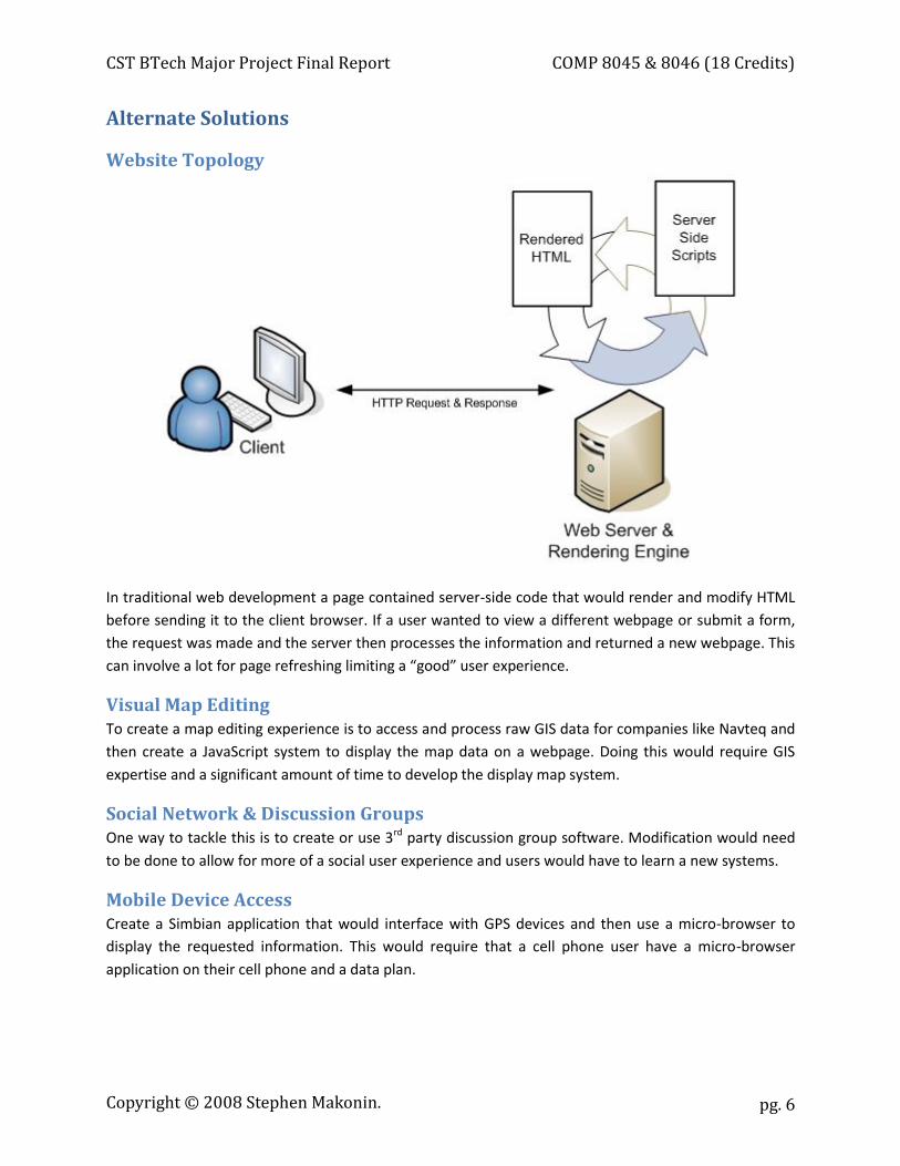
In traditional web development a page contained server-side code that would render and modify HTML before sending it to the client browser. If a user wanted to view a different webpage or submit a form, the request was made and the server then processes the information and returned a new webpage. This can involve a lot for page refreshing limiting a “good” user experience.
Visual Map Editing To create a map editing experience is to access and process raw GIS data for companies like Navteq and then create a JavaScript system to display the map data on a webpage. Doing this would require GIS expertise and a significant amount of time to develop the display map system.
Social Network & Discussion Groups One way to tackle this is to create or use 3rd party discussion group software. Modification would need to be done to allow for more of a social user experience and users would have to learn a new systems.
Mobile Device Access Create a Simbian application that would interface with GPS devices and then use a micro-browser to display the requested information. This would require that a cell phone user have a micro-browser application on their cell phone and a data plan.
Copyright © 2008 Stephen Makonin.
CST BTech Major Project Final Report COMP 8045 & 8046 (18 Credits)
pg. 7
Chosen Solutions
Website Topology
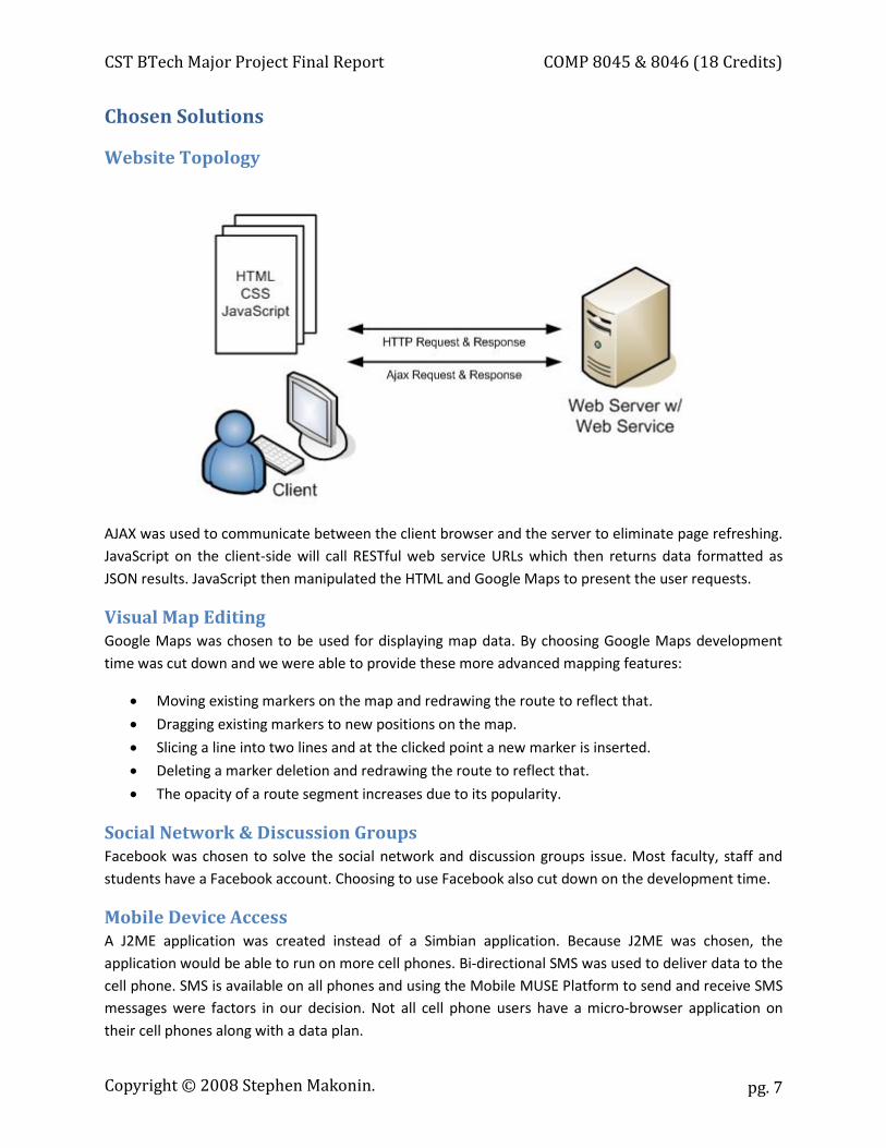
AJAX was used to communicate between the client browser and the server to eliminate page refreshing. JavaScript on the client-side will call RESTful web service URLs which then returns data formatted as JSON results. JavaScript then manipulated the HTML and Google Maps to present the user requests.
Visual Map Editing Google Maps was chosen to be used for displaying map data. By choosing Google Maps development time was cut down and we were able to provide these more advanced mapping features:
x Moving existing markers on the map and redrawing the route to reflect that.
x Dragging existing markers to new positions on the map.
x Slicing a line into two lines and at the clicked point a new marker is inserted.
x Deleting a marker deletion and redrawing the route to reflect that.
x The opacity of a route segment increases due to its popularity.
Social Network & Discussion Groups Facebook was chosen to solve the social network and discussion groups issue. Most faculty, staff and students have a Facebook account. Choosing to use Facebook also cut down on the development time.
Mobile Device Access A J2ME application was created instead of a Simbian application. Because J2ME was chosen, the application would be able to run on more cell phones. Bi-directional SMS was used to deliver data to the cell phone. SMS is available on all phones and using the Mobile MUSE Platform to send and receive SMS messages were factors in our decision. Not all cell phone users have a micro-browser application on their cell phones along with a data plan.
Copyright © 2008 Stephen Makonin.
CST BTech Major Project Final Report COMP 8045 & 8046 (18 Credits)
pg. 8
Development Details
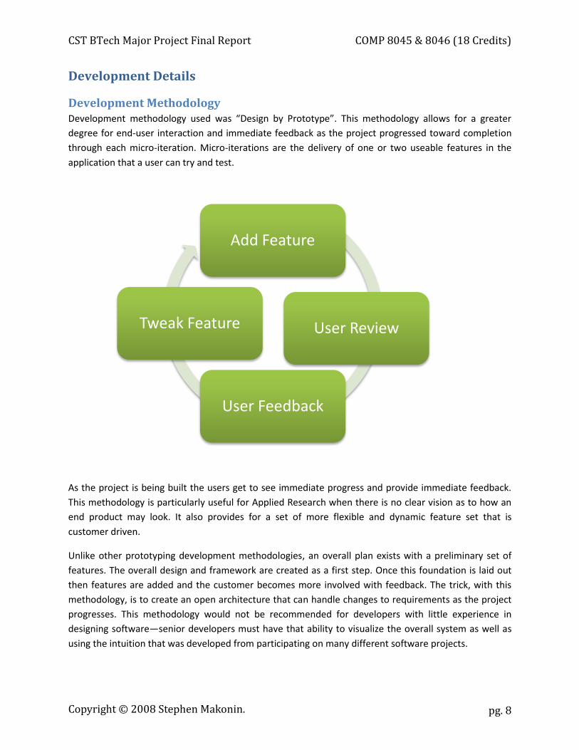
Development Methodology Development methodology used was “Design by Prototype”. This methodology allows for a greater
degree for end-user interaction and immediate feedback as the project progressed toward completion through each micro-iteration. Micro-iterations are the delivery of one or two useable features in the application that a user can try and test.
As the project is being built the users get to see immediate progress and provide immediate feedback. This methodology is particularly useful for Applied Research when there is no clear vision as to how an end product may look. It also provides for a set of more flexible and dynamic feature set that is customer driven.
Unlike other prototyping development methodologies, an overall plan exists with a preliminary set of features. The overall design and framework are created as a first step. Once this foundation is laid out then features are added and the customer becomes more involved with feedback. The trick, with this methodology, is to create an open architecture that can handle changes to requirements as the project progresses. This methodology would not be recommended for developers with little experience in designing software—senior developers must have that ability to visualize the overall system as well as using the intuition that was developed from participating on many different software projects.
Add Feature
User Review
User Feedback
Tweak Feature
Copyright © 2008 Stephen Makonin.
CST BTech Major Project Final Report COMP 8045 & 8046 (18 Credits)
pg. 9
Analysis & Feature Requirements MWW is comprised of 3 sub-systems: the mapping system, the social network, and mobile access. Scope and related details to each component are listed below:
The Mapping System
Scope Bike routes will be centric to, and focused on, the BCIT community. It is assumed that the endpoint for a bike route will always be BCIT, Burnaby campus. Users will be able to rate their own routes to help other users find routes that may be more suited for them. Google Maps API will be used to render and display map information and data.
Feature Requirements The following is a list of specific features sets needed for the mapping system:
1. Routes and POI must be added, edited, and displayed graphically. 2. Routes and POI must also have a name and description. 3. POI must provide the option of uploading a picture for display 4. Routes must be able to be rated by: directness, flatness, control, and traffic volume. 5. Routes must have the option of being visually (colour) displayed relative to a chosen rating. 6. The more popular a section of a route is the darker the route line will get. 7. MWW must have the ability to prompt users to fill out a survey. 8. The mapping interface should be simple and intuitive to use. 9. The map must be user interactive. The user must have the ability to zooming in/out and scroll
the map to different places. 10. The map must clearly highlight POIs with intuitive icons. 11. If the mouse hovers over a bike route start marker or POI an information tag is displayed (e.g.
“The Brentwood Route by Stephen Makonin”). 12. Information windows must have links to allow for editing and viewing discussion forms. 13. Users must be able to delete their own bike routes and POI.
Copyright © 2008 Stephen Makonin.

CST BTech Major Project Final Report COMP 8045 & 8046 (18 Credits)
pg. 10
The Social Network
Scope MWW must foster a community that can use the system to better their experience biking to BCIT. The information they provide will in turn benefit other users. With the success of Facebook, MWW will integrate into it using Facebook’s API. The will allow MWW to take advantage of an existing vibrant
online social community. Facebook discussion groups will be added to allow users to comment in general or on a specific bike route or POI.
Feature Requirements The following is a list of specific features sets needed for the social network:
1. Facebook users can search for, add and remove the Facebook App from their account. 2. The main application will be on a Facebook Canvas Page, there must be profile-viewable part
allowing other users see and access MWW. 3. If a user attempts to view MWW he/she must prompted to login if he/she is not. 4. MWW must prompt the user to add the application; if they have not added it yet to their
Facebook account. 5. Users can add comments to any discussion group. 6. Users will be able to delete or edit comments once posted. 7. Comments will only support plain text formatting which eliminates complexity and potential
rendering issues.
Mobile Access
Scope Users who have a mobile device that has GPS built to them or is attached to a Bluetooth GPS device can use a downloadable Java mobile application to query MWW. The mobile application will send MWW the GPS coordinates of the user. MWW will then send an SMS that gives directions for the nearest bike route. Only bike routes that end at BCIT will have their directions sent to a requesting mobile phone. The mobile application will be created with the lowest common denominator mobile device in mind. This means that only plain text SMS will be used for communications.
Feature Requirements The following is a list of specific features sets needed for mobile access:
1. The mobile application must be able to read and send, via SMS, the user’s current coordinates. If
the user in not in the Greater Vancouver area an error is displayed. 2. Once MWW receives the user coordinates, an SMS message will be sent back containing turn-
by-turn directions of the nearest bike route to BCIT.
Copyright © 2008 Stephen Makonin.
CST BTech Major Project Final Report COMP 8045 & 8046 (18 Credits)
pg. 11
Design & System Architecture
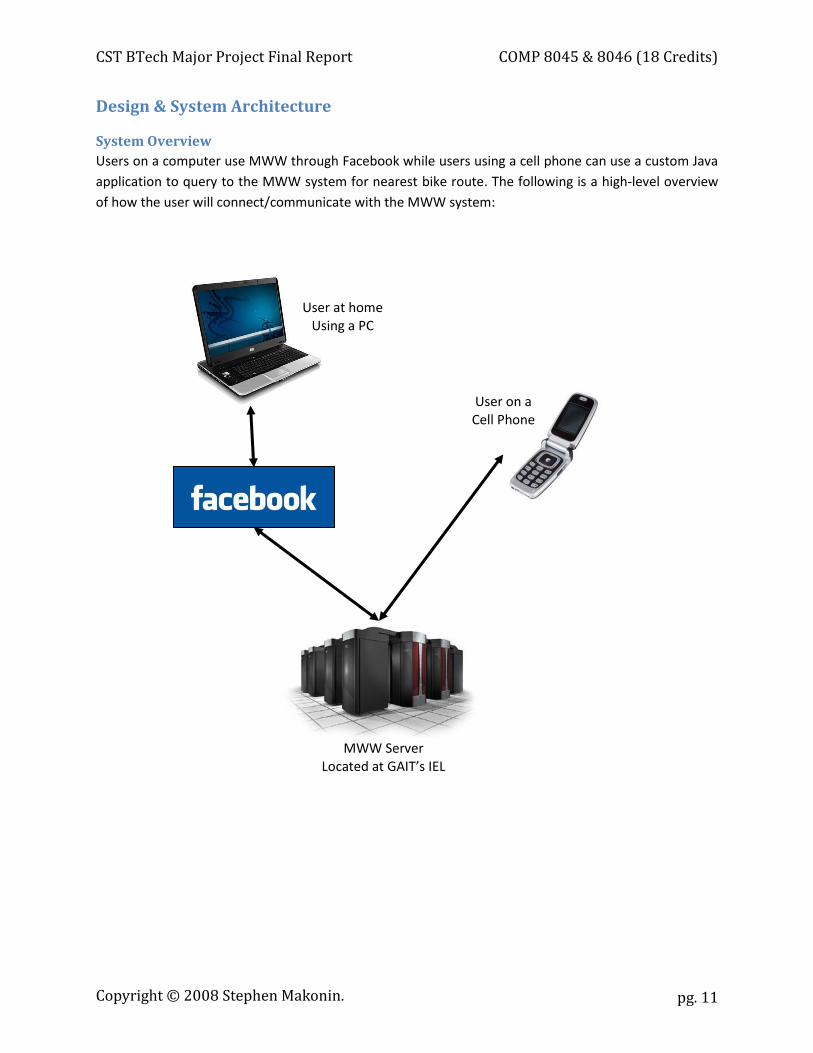
System Overview Users on a computer use MWW through Facebook while users using a cell phone can use a custom Java application to query to the MWW system for nearest bike route. The following is a high-level overview of how the user will connect/communicate with the MWW system:
MWW Server Located at GAIT’s IEL
User on a Cell Phone
User at home Using a PC
Copyright © 2008 Stephen Makonin.

CST BTech Major Project Final Report COMP 8045 & 8046 (18 Credits)
pg. 12
Visual Layout & Layers MWW contains a number of visual layers that work in conjunction with each other to provide a rich user experience. Overall layout, in terms of application visual size and webpage position is controlled by Facebook (a.k.a. the Canvas Page). However, within the Canvas Page, MWW has control of all visual and interactive aspects; including such things a layout and page refreshing.
MWW will run within Facebook as an application. Doing so will limit the amount of screen real-estate that can be used. To the right shows the parts of the webpage that are in Facebook’s control. Facebook is considered to be the top of all the visual layers and is the container for all other layers.
The MWW Glue, the code that controls Google Maps and some of the Facebook integration resides in the middle. To the right shows the parts of the webpage that is the MWW Glue. To limit page refreshes for a better user experience; the MWW Glue uses a combination of JavaScript, Ajax, and Web Services. The result is a look and feel similar to a desktop application.
Google Maps is the inner most layer and resides in the inner most box of the MWW Glue. To the right is a sample Google Map.
Copyright © 2008 Stephen Makonin.
CST BTech Major Project Final Report COMP 8045 & 8046 (18 Credits)
pg. 13
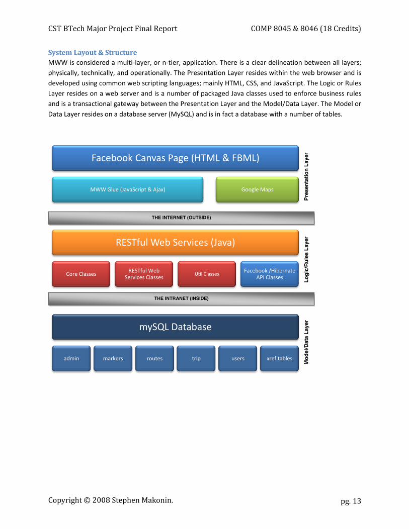
System Layout & Structure MWW is considered a multi-layer, or n-tier, application. There is a clear delineation between all layers; physically, technically, and operationally. The Presentation Layer resides within the web browser and is developed using common web scripting languages; mainly HTML, CSS, and JavaScript. The Logic or Rules Layer resides on a web server and is a number of packaged Java classes used to enforce business rules and is a transactional gateway between the Presentation Layer and the Model/Data Layer. The Model or Data Layer resides on a database server (MySQL) and is in fact a database with a number of tables.
Facebook Canvas Page (HTML & FBML)
MWW Glue (JavaScript & Ajax) Google Maps
RESTful Web Services (Java)
Core Classes RESTful Web Services Classes
Util ClassesFacebook /Hibernate
API Classes
mySQL Database
admin markers routes trip users xref tables
Pres
enta
tion
Laye
r
Logi
c/Ru
les
Laye
r
THE INTERNET (OUTSIDE)
THE INTRANET (INSIDE) Pr
esen
tatio
n La
yer
Logi
c/Ru
les
Laye
r M
odel
/Dat
a La
yer
Copyright © 2008 Stephen Makonin.
CST BTech Major Project Final Report COMP 8045 & 8046 (18 Credits)
pg. 14
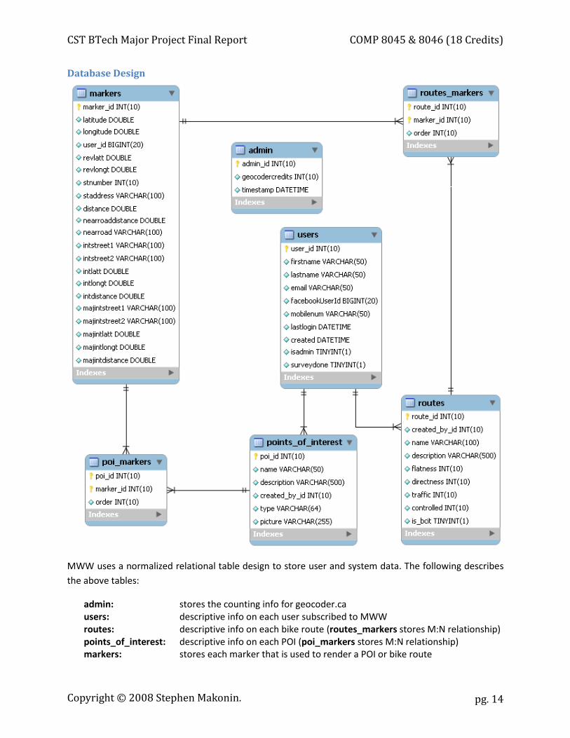
Database Design
MWW uses a normalized relational table design to store user and system data. The following describes the above tables:
admin: stores the counting info for geocoder.ca users: descriptive info on each user subscribed to MWW routes: descriptive info on each bike route (routes_markers stores M:N relationship) points_of_interest: descriptive info on each POI (poi_markers stores M:N relationship) markers: stores each marker that is used to render a POI or bike route
Copyright © 2008 Stephen Makonin.
CST BTech Major Project Final Report COMP 8045 & 8046 (18 Credits)
pg. 15
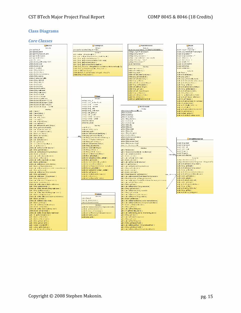
Class Diagrams
Core Classes
Copyright © 2008 Stephen Makonin.
CST BTech Major Project Final Report COMP 8045 & 8046 (18 Credits)
pg. 16
All DB table classes reside in the mww.core package. These classes are responsible for:
Marker: Encapsulates the markers DB table; contains data and functions that store and manipulate a marker (or a point on a map).
TurnByTurn: Encapsulates code used to create turn-by-turn directions for a list of markers.
User: Encapsulates the users DB table; contains data and functions that store and lookup a Facebook account information.
Admin: Encapsulates the admin DB table; used to store information on number of time Geocoder.ca was called and with it was last called.
PointOfInterest: Encapsulates the points_of_interest DB table (including poi_markers); contains data and functions that store and manipulate a point of interest (POI, or special/flagged marker).
RevGeocode: Encapsulates the use of the utility classes that call geocoder.ca. Route: Encapsulates the routes DB table (including route_markers); contains
data and functions that store and manipulate a route (series of marker that go from point A to point B).
StreetIntersection: Encapsulates the location data from a reverse goecode.
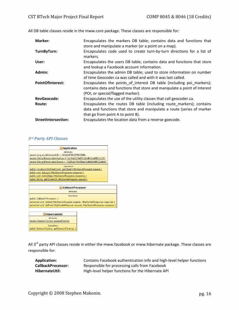
3rd Party API Classes
All 3rd party API classes reside in either the mww.facebook or mww.hibernate package. These classes are responsible for:
Application: Contains Facebook authentication info and high-level helper functions CallbackProcessor: Responsible for processing calls from Facebook HibernateUtil: High-level helper functions for the Hibernate API
Copyright © 2008 Stephen Makonin.

CST BTech Major Project Final Report COMP 8045 & 8046 (18 Credits)
pg. 17
RESTful Web Services Classes
All servlets reside in either the mww.restful or mww.survey package. These classes are responsible for:
Localizer: Serves XML out to the Mobile MUSE Platform Picture: Serves uploading and downloading of pictures PointsOfInterest: Serves JSON POI data out and add/edit/delete POIs Routes: Serves JSON route data out and add/edit/delete routes ThankYou: Serves catching calls from the survey website
Copyright © 2008 Stephen Makonin.
CST BTech Major Project Final Report COMP 8045 & 8046 (18 Credits)
pg. 18
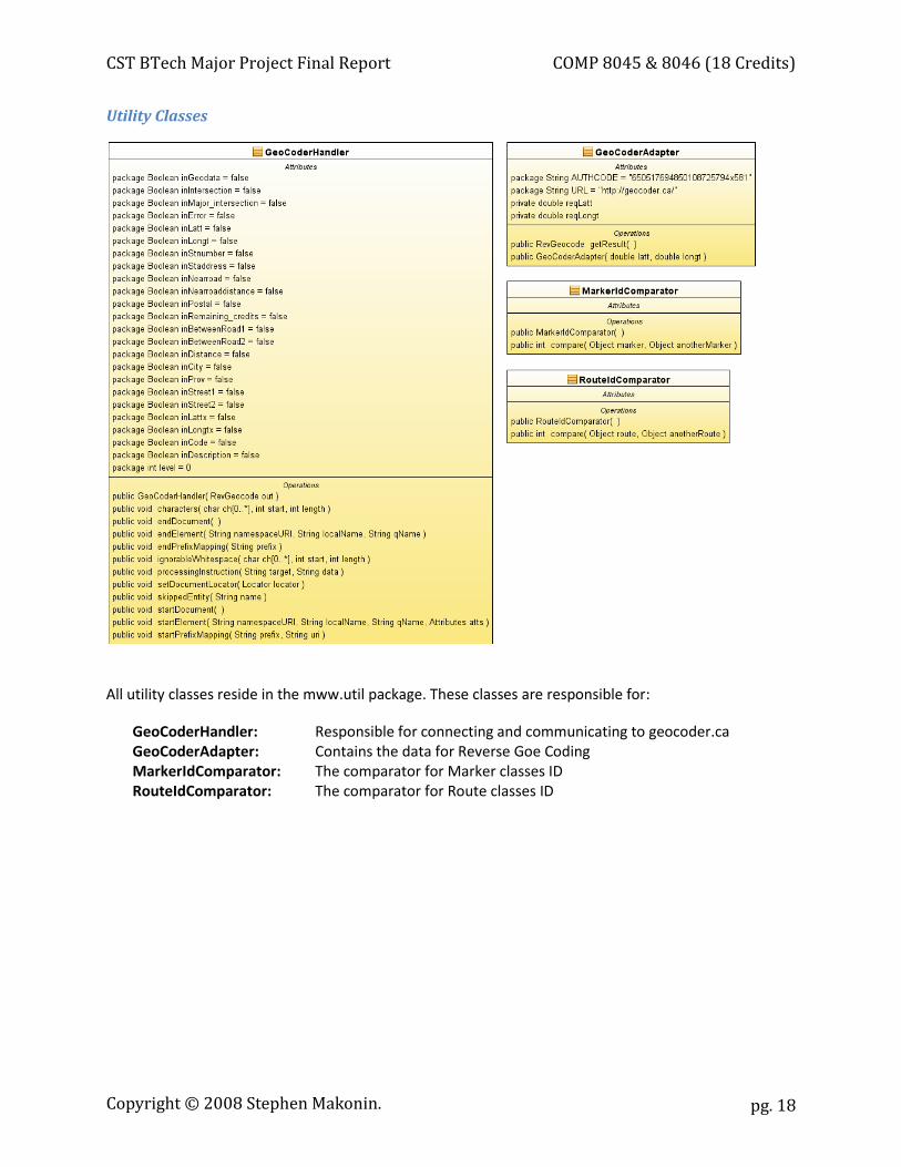
Utility Classes
All utility classes reside in the mww.util package. These classes are responsible for:
GeoCoderHandler: Responsible for connecting and communicating to geocoder.ca GeoCoderAdapter: Contains the data for Reverse Goe Coding MarkerIdComparator: The comparator for Marker classes ID RouteIdComparator: The comparator for Route classes ID
Copyright © 2008 Stephen Makonin.
CST BTech Major Project Final Report COMP 8045 & 8046 (18 Credits)
pg. 19
Software Quality Assurance
Source Code Control Subversion (SVN) was used to track and version all source code changes. The SVN repository resided on a remote server. SVN clients such as TortoiseSVN for windows and SVN Workbench for Linux where used on development workstations.
Bug Tracking Mantis was used to manage bugs and track issues during the testing of the Beta release and the production release. Mantis was accessed via a web browser and installed on a remote web server.
Unit Testing Informal unit testing was done on each code block (e.g. function, class) during and at the end of the coding of each code block. Because of lack of debugging facilities in JavaScript and the need for UI interaction, all unit testing was done manually.
Code Walkthrough After a significant portion of the Project was developed a Code Walkthrough was done to review architecture, project layout, and overall code quality. The code walkthrough was done informally.
User Acceptance Testing UAT was done on a daily basis by the Project Manager and by the GAIT Lab. During June to August a Beta Testing Group was created, consisting of about 12 users from around the BCIT Burnaby Campus to use MWW and provide feedback. All bugs were recorded in Mantis.
Copyright © 2008 Stephen Makonin.
CST BTech Major Project Final Report COMP 8045 & 8046 (18 Credits)
pg. 20
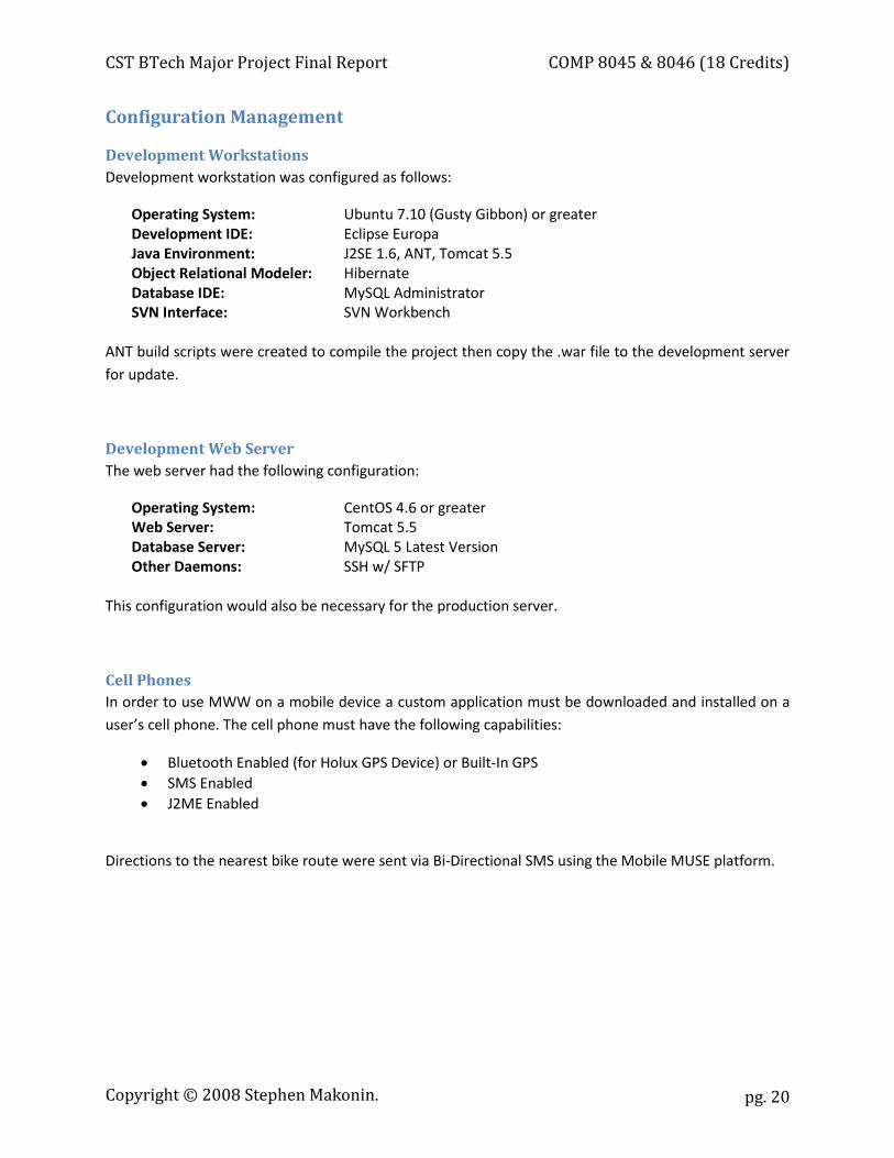
Configuration Management
Development Workstations Development workstation was configured as follows:
Operating System: Ubuntu 7.10 (Gusty Gibbon) or greater Development IDE: Eclipse Europa Java Environment: J2SE 1.6, ANT, Tomcat 5.5 Object Relational Modeler: Hibernate Database IDE: MySQL Administrator SVN Interface: SVN Workbench
ANT build scripts were created to compile the project then copy the .war file to the development server for update.
Development Web Server The web server had the following configuration:
Operating System: CentOS 4.6 or greater Web Server: Tomcat 5.5 Database Server: MySQL 5 Latest Version Other Daemons: SSH w/ SFTP
This configuration would also be necessary for the production server.
Cell Phones In order to use MWW on a mobile device a custom application must be downloaded and installed on a user’s cell phone. The cell phone must have the following capabilities:
x Bluetooth Enabled (for Holux GPS Device) or Built-In GPS x SMS Enabled x J2ME Enabled
Directions to the nearest bike route were sent via Bi-Directional SMS using the Mobile MUSE platform.
Copyright © 2008 Stephen Makonin.
CST BTech Major Project Final Report COMP 8045 & 8046 (18 Credits)
pg. 21
Implications of Implementation
The Performance of Java To compile Java and create .war files, Tomcat needed to be running on the workstation for the each compile. There were issues with Eclipse IDE responsiveness. ANT build times were often slow causing long compile times. Issues such as these contributed to speed of development and caused programmer frustration.
On the mobile side, the challenge will be to create an intuitive mobile device application that will run on the lowest common denominator device. In J2ME, the Location API is not included on a majority of mobile devices. This means that a library will need to be created that can talk to Bluetooth and GPS devices. The library will then need to read and parse GPS data to get the latitude and longitude for the GPS device.
Server Environments There were some unexpected server issues. There is a bug in the Java VM that prevented the use of AMD processor servers to be used. If an AMD processor was used the Tomcat web server would not responded correctly to Facebook causing Facebook to report an error. Each server needs its own Google Maps API Key. Facebook must also be configured to point to the server where MWW will be running from.
The performance of Tomcat was disappointing. Tomcat seems to have a slow response time and can only handle a load of 10 or so users. In fact, pressing the F5 (refresh) key rapidly in Facebook would cause the Tomcat server to crash and become non-responsive. To ensure some reliability, scripts were created to reboot the server once a night.
Every time the .war file was uncompressed, the current web directory was deleted and all uploaded images would be deleted as well. Extra code was created to store the images in a second place for safe keeping and then copied to the current running web directory.
Reliance on Facebook and Google Maps Relying on 3rd party sites, as Mashups often do, creates a dependence on that Sites performance and changes. Various issues came from this reliance. The Facebook API is famous for its lack of documentation, so a lot of experimentation was done to get MWW to work in Facebook; some of the issues encountered included JavaScript execution and support limitations. Java API documentation and library code was also out of sync. The official Java API was then dropped by Facebook and Facebook made no guaranties that future changes to its API would be backwards compatible.
There were refresh and performance issues due to inherent problems with Facebook’s architecture and
network topology. Applications updates could take 2-3 minutes to propagate through to the entire web caching servers so rapid debugging became an issue. As well, the use of the Facebook API coupled MWW too closely to Facebook. MWW could not be run in a standalone version without major programming concessions.
Copyright © 2008 Stephen Makonin.
CST BTech Major Project Final Report COMP 8045 & 8046 (18 Credits)
pg. 22
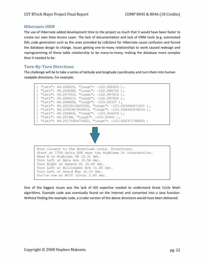
Hibernate ORM The use of Hibernate added development time to the project so much that it would have been faster to create our own Data Access Layer. The lack of documentation and lack of ORM tools (e.g. automated DAL code generation such as the ones provided by LLBLGen) for Hibernate cause confusion and forced the database design to change. Issues getting one-to-many relationships to work caused redesign and reprogramming of these table relationship to be many-to-many; making the database more complex then it needed to be.
Turn-By-Turn Directions The challenge will be to take a series of latitude and longitude coordinates and turn them into human readable directions. For example:
One of the biggest issues was the lack of GIS expertise needed to understand Great Circle Math algorithms. Example code was eventually found on the Internet and converted into a Java function. Without finding the example code, a cruder version of the above directions would have been delivered.
{ "latt": 49.269225, "longt": -122.992453 }, { "latt": 49.269288, "longt": -122.996742 }, { "latt": 49.267453, "longt": -122.997814 }, { "latt": 49.264413, "longt": -122.997824 }, { "latt": 49.264408, "longt": -123.00337 }, { "latt": 49.2612513420326, "longt": -123.003444671631 }, { "latt": 49.2592347950603, "longt": -123.004302978516 }, { "latt": 49.254869, "longt": -123.004329 }, { "latt": 49.25188, "longt": -123.00441 }, { "latt": 49.2517560473552, "longt": -123.002371788025 }
Your closest to the Brentlawn route. Directions: Start at 1706 Delta AVE near the Highlawn Dr intersection. Head W on Highlawn DR (0.31 km). Turn Left at Beta Ave (0.56 km). Turn Right at Dawson St (0.40 km). Turn Left at Willingdon Ave (1.40 km). Turn Left at Goard Way (0.15 km). You're now at BCIT (total 2.82 km).
Copyright © 2008 Stephen Makonin.
CST BTech Major Project Final Report COMP 8045 & 8046 (18 Credits)
pg. 23
Research in New Technologies
Web 2.0 The use of asynchronous HTTP request (Ajax) was used to communicate between the client browser and the server to eliminate page refreshing and to provide an enhanced user experience similar to a desktop application. The use of Ajax is a new emerging technology which requires a lot of manual tweaking and debugging to perform correctly.
Mashups A Mashup involves creating a website with data and other elements from a number of other website APIs and/or other website data aggregators. This can inherently cause issues due to the reliance of other websites/sources to be stable and readily available for use. If one of the websites/sources goes down or responds slowly then it has an immediate and adverse negative impact to your website.
REST For communication between client browser and server, RESTful web services were used. RESTful web services are a new emerging technology that is an alternative to SOAP. SOAP is complicated and a lot of overhead is needed when using JavaScript and Ajax. RESTful web services use all of the HTTP protocol (GET, POST, PUT, and DELETE) unlike SOAP which only uses POST. Because of this, RESTful web services are resource oriented (or noun-based) unlike SOAP with is more verb-based in design.
GPS Devices There was a need to create a library/framework that will allow a mobile device to communicate with a Bluetooth enabled PSP device. With the absence of the J2ME Location API on the majority of mobile devices, ways of creating a Bluetooth communication API needed to be researched.
Copyright © 2008 Stephen Makonin.
CST BTech Major Project Final Report COMP 8045 & 8046 (18 Credits)
pg. 24
Future Enhancements
Multi-Destinations MWW can grow and improve in many ways. One such way would be to allow MWW to have multiple destination points, not just BCIT. This would allow a greater user base and would not take much effort to implement. A table would need to be added to store the different destinations points. A user profile screen would also need to be added to allow a user to select and store their default destination point. Only POIs or bike routes for the users selected destination would be rendered. This would be done to speed up the rendering of the map for improved response times and better user experience. JavaScript is often implemented poorly in browsers and functions that involve graphical rendering are very inefficient causing noticeable slowdowns.
Rewrite to PHP In September of 2008, Facebook dropped support for their Java API. The only official API Facebook now supports is PHP. There are 3rd party Java APIs but they are slow to keep up and have their own set of issues and bugs. Going forward, a rewrite should be done to move from Java to PHP. With traditional web development such a rewrite would be a big effort; not so with Ajax and web services. The majority of the MWW code base is in HTML, CSS, and JavaScript. Only the web services portion of the project was written in Java and only that needs to be rewritten. The web services code portion of the project amounts to about 30% of the code base.
Multi-Mode Routes Another idea to enhance MWW would be to integrate public transit, and/or bike rental stations, and/or hitch-a-ride stops. These new features would expand the usage of MWW creating a community of users that take alternate forms of transportation. This would also allow people to create “multi-mode” routes. Adding these new features would be risky and a more time consuming task then the above two enhancements. Serious thought to modifications to the UI and database would need to be done to implement this new functionality.
Copyright © 2008 Stephen Makonin.
CST BTech Major Project Final Report COMP 8045 & 8046 (18 Credits)
pg. 25
Conclusions Web services are increasingly becoming a more widely used solution to connect heterogeneous systems. Long gone are the days where projects were created to replace viable legacy systems. By using a simple protocol like HTTP, software that exists on these heterogeneous systems can be exposed and ran by any other system. In the end, it is much cheaper and less risky to add a web server to a legacy system then it is to rewrite it.
The uses of social networks, such as Facebook, are becoming a normal part of the everyday life of individuals. By writing an application for a social network you have instant access to these users, developers worry less about Google site placement and creating a standalone system that users have to signup to use. By writing an application for a social network, the adoption rate for application use is much higher as it works on the principle of “word of mouth”.
The Map with Wheels project provided an excellent opportunity to use Java and REStful web services. It allowed me to explore the concept and the challenges of creating a Mashup. It also allowed me to work on a project that was research based which is often different for the business-driven type projects I normally work on.
Copyright © 2008 Stephen Makonin.
CST BTech Major Project Final Report COMP 8045 & 8046 (18 Credits)
pg. 26
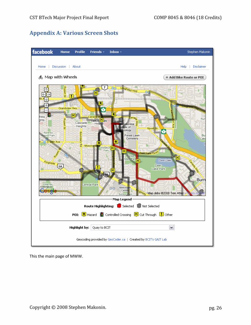
Appendix A: Various Screen Shots
This the main page of MWW.
Copyright © 2008 Stephen Makonin.
CST BTech Major Project Final Report COMP 8045 & 8046 (18 Credits)
pg. 27
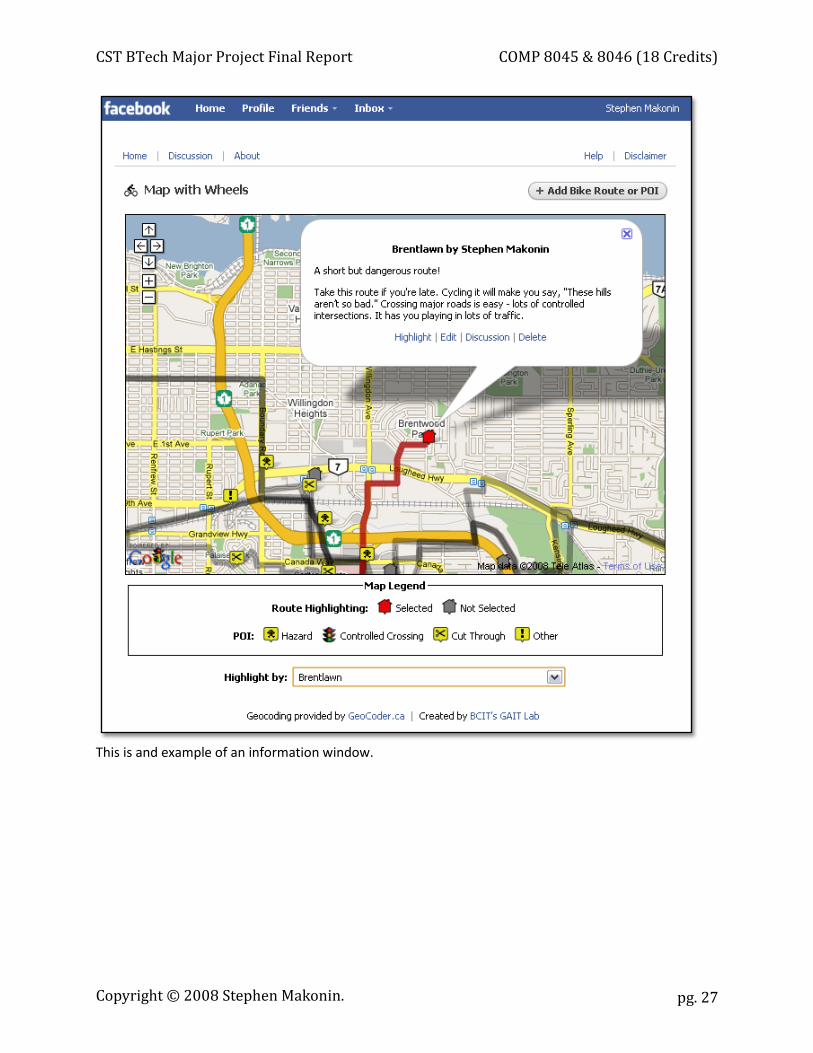
This is and example of an information window.
Copyright © 2008 Stephen Makonin.
CST BTech Major Project Final Report COMP 8045 & 8046 (18 Credits)
pg. 28
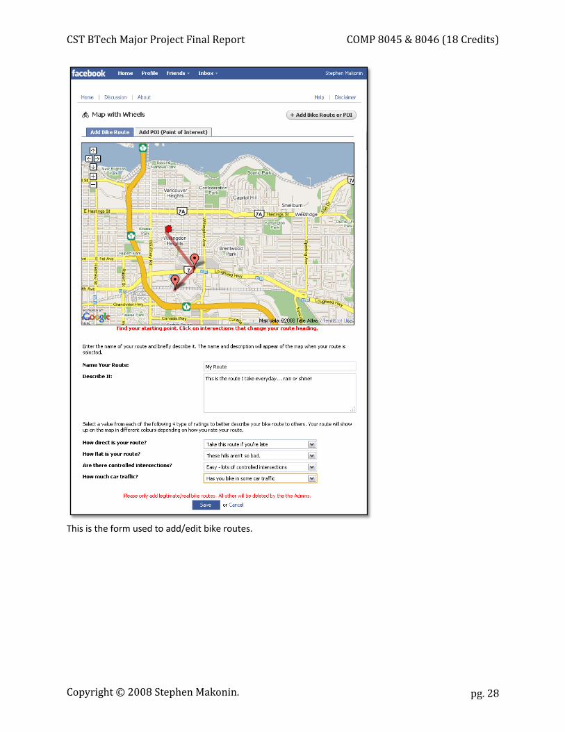
This is the form used to add/edit bike routes.
Copyright © 2008 Stephen Makonin.
CST BTech Major Project Final Report COMP 8045 & 8046 (18 Credits)
pg. 29
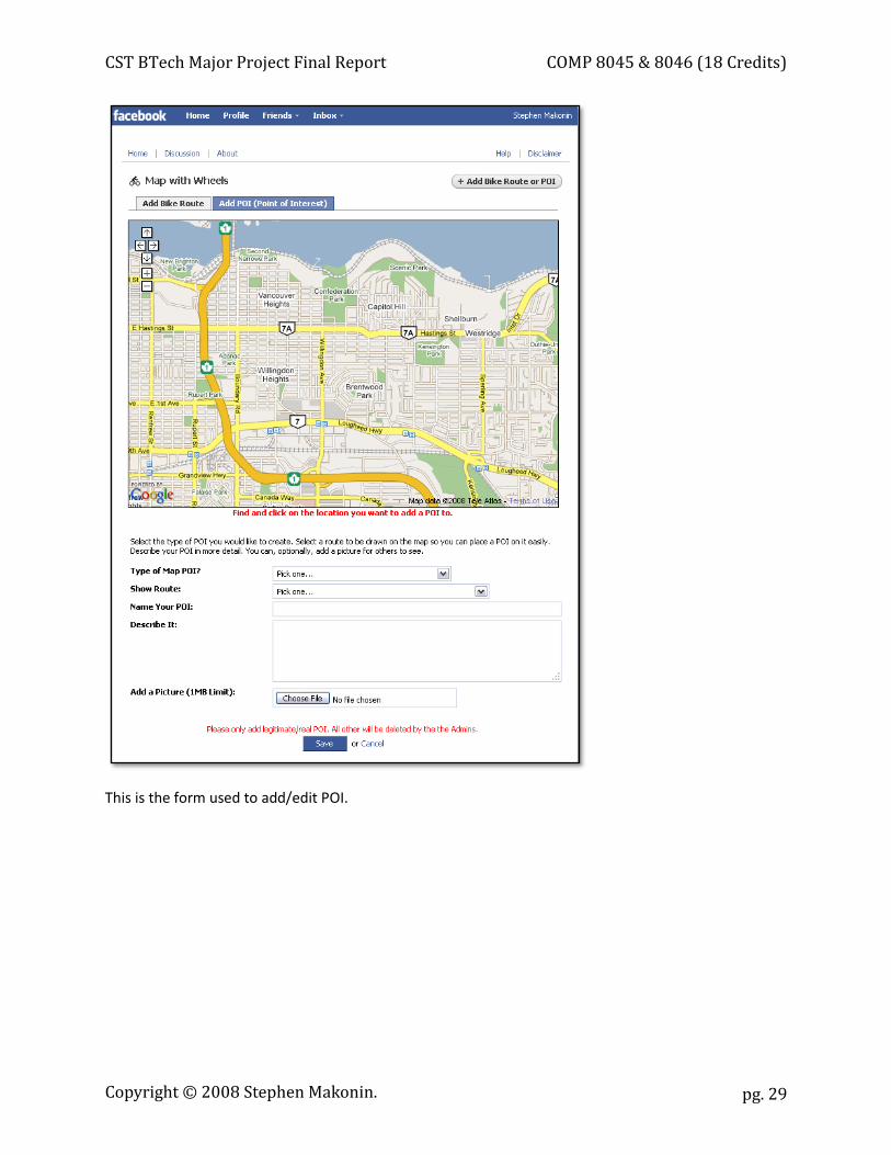
This is the form used to add/edit POI.
Copyright © 2008 Stephen Makonin.
CST BTech Major Project Final Report COMP 8045 & 8046 (18 Credits)
pg. 30
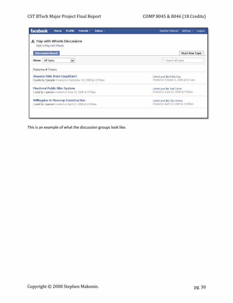
This is an example of what the discussion groups look like.
Copyright © 2008 Stephen Makonin.

CST BTech Major Project Final Report COMP 8045 & 8046 (18 Credits)
pg. 31
Appendix B: Letter from Project Sponsor
December 15, 2008 To the Practicum Review Committee; I am writing you to confirm that Stephen Makonin worked full-time on the Map with Wheels project. Stephen Makonin worked on Map with Wheels full-time from January 26th, 2008 to May 1st, 2008 and part-time until August 8th, 2008. The project was completed, released, and is currently running in production. The Facebook application is being used by the BCIT community and a number of people have contributed bike routes and points of interest. Sincerely, Clay Howey Research Head BCIT GAIT Lab
Copyright © 2008 Stephen Makonin.
BCIT Bachelor of Technology in Computer Systems
Major Project Supplement COMP 8045 & 8046 (18 Credits)
Copyright © 2008 Stephen Makonin.
CST BTech Major Project Supplement COMP 8045 & 8046 (18 Credits)
pg. 2
Table of Contents Introduction .................................................................................................................................................. 3 System & Library API Interaction .................................................................................................................. 4 Turn-By-Turn Directions ................................................................................................................................ 5 Ajax & RESTful Web Services ........................................................................................................................ 5 Bike Route Editing ......................................................................................................................................... 9 J2ME & GPS Devices .................................................................................................................................... 10
Copyright © 2008 Stephen Makonin.
CST BTech Major Project Supplement COMP 8045 & 8046 (18 Credits)
pg. 3
Introduction This document is intended to accompany the CST BTech Major Project Final Report document; as it is an extension of that document. The goal is to further satisfy the curiosity of technically-minded individuals who have read the Final Report and would like to see specific implementation details. The Map with Wheels (MWW) project has covered a number of specific areas that can be expanded upon.
A diagram details the interaction that the Map with Wheels codebase has with external libraries, APIs, services, and systems is presented with communication details between these modules. Implementation details and snippets are provided to further explain how issues where tackled in the following areas:
x Turn-By-Turn Directions
x Ajax & RESTful Web Services
x Bike Route Editing
x J2ME & GPS Devices
Please refer to specific areas within the Final Report to gain a high-level understanding and overview of each subject expanded upon in this Supplement.
Copyright © 2008 Stephen Makonin.

CST BTech Major Project Supplement COMP 8045 & 8046 (18 Credits)
pg. 4
System & Library API Interaction Map with Wheels used a number of external libraries, APIs, services, and systems to provide its full feature set. The following diagram illustrates the relationship and communications used between Map with Wheels and all other external entities:
Copyright © 2008 Stephen Makonin.
CST BTech Major Project Supplement COMP 8045 & 8046 (18 Credits)
pg. 5
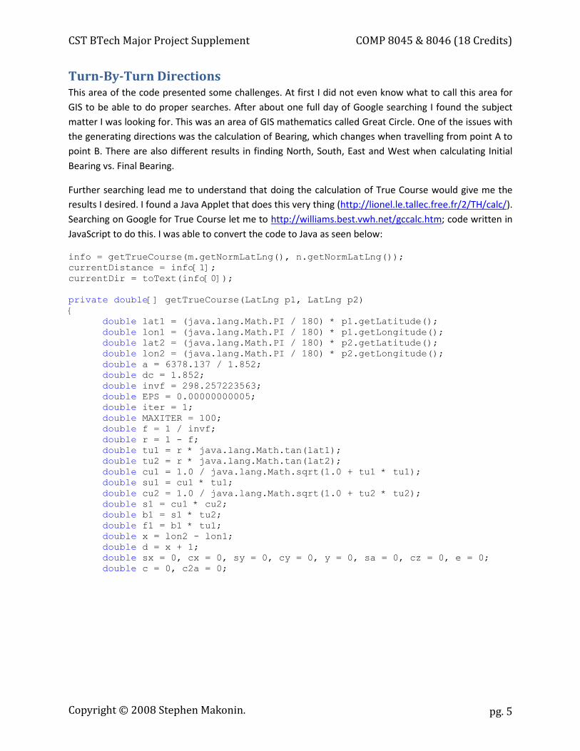
Turn-By-Turn Directions This area of the code presented some challenges. At first I did not even know what to call this area for GIS to be able to do proper searches. After about one full day of Google searching I found the subject matter I was looking for. This was an area of GIS mathematics called Great Circle. One of the issues with the generating directions was the calculation of Bearing, which changes when travelling from point A to point B. There are also different results in finding North, South, East and West when calculating Initial Bearing vs. Final Bearing.
Further searching lead me to understand that doing the calculation of True Course would give me the results I desired. I found a Java Applet that does this very thing (http://lionel.le.tallec.free.fr/2/TH/calc/). Searching on Google for True Course let me to http://williams.best.vwh.net/gccalc.htm; code written in JavaScript to do this. I was able to convert the code to Java as seen below:
info = getTrueCourse(m.getNormLatLng(), n.getNormLatLng()); currentDistance = info[1]; currentDir = toText(info[0]); private double[] getTrueCourse(LatLng p1, LatLng p2) { double lat1 = (java.lang.Math.PI / 180) * p1.getLatitude(); double lon1 = (java.lang.Math.PI / 180) * p1.getLongitude(); double lat2 = (java.lang.Math.PI / 180) * p2.getLatitude(); double lon2 = (java.lang.Math.PI / 180) * p2.getLongitude(); double a = 6378.137 / 1.852; double dc = 1.852; double invf = 298.257223563; double EPS = 0.00000000005; double iter = 1; double MAXITER = 100; double f = 1 / invf; double r = 1 - f; double tu1 = r * java.lang.Math.tan(lat1); double tu2 = r * java.lang.Math.tan(lat2); double cu1 = 1.0 / java.lang.Math.sqrt(1.0 + tu1 * tu1); double su1 = cu1 * tu1; double cu2 = 1.0 / java.lang.Math.sqrt(1.0 + tu2 * tu2); double s1 = cu1 * cu2; double b1 = s1 * tu2; double f1 = b1 * tu1; double x = lon2 - lon1; double d = x + 1; double sx = 0, cx = 0, sy = 0, cy = 0, y = 0, sa = 0, cz = 0, e = 0; double c = 0, c2a = 0;
Copyright © 2008 Stephen Makonin.
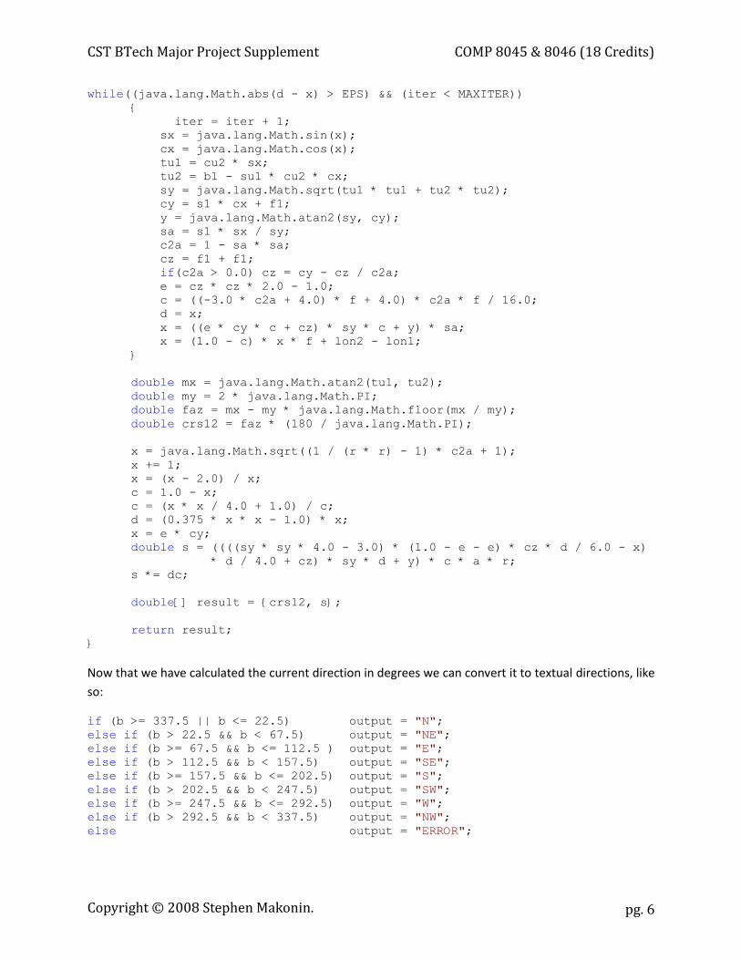
CST BTech Major Project Supplement COMP 8045 & 8046 (18 Credits)
pg. 6
while((java.lang.Math.abs(d - x) > EPS) && (iter < MAXITER)) { iter = iter + 1; sx = java.lang.Math.sin(x); cx = java.lang.Math.cos(x); tu1 = cu2 * sx; tu2 = b1 - su1 * cu2 * cx; sy = java.lang.Math.sqrt(tu1 * tu1 + tu2 * tu2); cy = s1 * cx + f1; y = java.lang.Math.atan2(sy, cy); sa = s1 * sx / sy; c2a = 1 - sa * sa; cz = f1 + f1; if(c2a > 0.0) cz = cy - cz / c2a; e = cz * cz * 2.0 - 1.0; c = ((-3.0 * c2a + 4.0) * f + 4.0) * c2a * f / 16.0; d = x; x = ((e * cy * c + cz) * sy * c + y) * sa; x = (1.0 - c) * x * f + lon2 - lon1; } double mx = java.lang.Math.atan2(tu1, tu2); double my = 2 * java.lang.Math.PI; double faz = mx - my * java.lang.Math.floor(mx / my); double crs12 = faz * (180 / java.lang.Math.PI); x = java.lang.Math.sqrt((1 / (r * r) - 1) * c2a + 1); x += 1; x = (x - 2.0) / x; c = 1.0 - x; c = (x * x / 4.0 + 1.0) / c; d = (0.375 * x * x - 1.0) * x; x = e * cy; double s = ((((sy * sy * 4.0 - 3.0) * (1.0 - e - e) * cz * d / 6.0 - x) * d / 4.0 + cz) * sy * d + y) * c * a * r; s *= dc; double[] result = {crs12, s}; return result; }
Now that we have calculated the current direction in degrees we can convert it to textual directions, like so:
if (b >= 337.5 || b <= 22.5) output = "N"; else if (b > 22.5 && b < 67.5) output = "NE"; else if (b >= 67.5 && b <= 112.5 ) output = "E"; else if (b > 112.5 && b < 157.5) output = "SE"; else if (b >= 157.5 && b <= 202.5) output = "S"; else if (b > 202.5 && b < 247.5) output = "SW"; else if (b >= 247.5 && b <= 292.5) output = "W"; else if (b > 292.5 && b < 337.5) output = "NW"; else output = "ERROR";
Copyright © 2008 Stephen Makonin.
CST BTech Major Project Supplement COMP 8045 & 8046 (18 Credits)
pg. 7
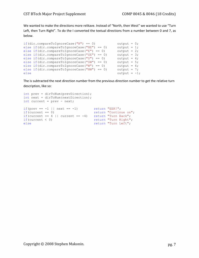
We wanted to make the directions more relitave. Instead of “North, then West” we wanted to use “Turn Left, then Turn Right”. To do the I converted the textual directions from a number between 0 and 7, as below.
if(dir.compareToIgnoreCase("N") == 0) output = 0; else if(dir.compareToIgnoreCase("NE") == 0) output = 1; else if(dir.compareToIgnoreCase("E") == 0) output = 2; else if(dir.compareToIgnoreCase("SE") == 0) output = 3; else if(dir.compareToIgnoreCase("S") == 0) output = 4; else if(dir.compareToIgnoreCase("SW") == 0) output = 5; else if(dir.compareToIgnoreCase("W") == 0) output = 6; else if(dir.compareToIgnoreCase("NW") == 0) output = 7; else output = -1; The is subtracted the next direction number from the previous direction number to get the relative turn description, like so:
int prev = dirToNum(prevDirection); int next = dirToNum(nextDirection); int current = prev - next; if(prev == -1 || next == -1) return "EEK!"; if(current == 0) return "Continue on"; if(current == 4 || current == -4) return "Turn Back"; if(current < 0) return "Turn Right"; else return "Turn Left";
Copyright © 2008 Stephen Makonin.
CST BTech Major Project Supplement COMP 8045 & 8046 (18 Credits)
pg. 8
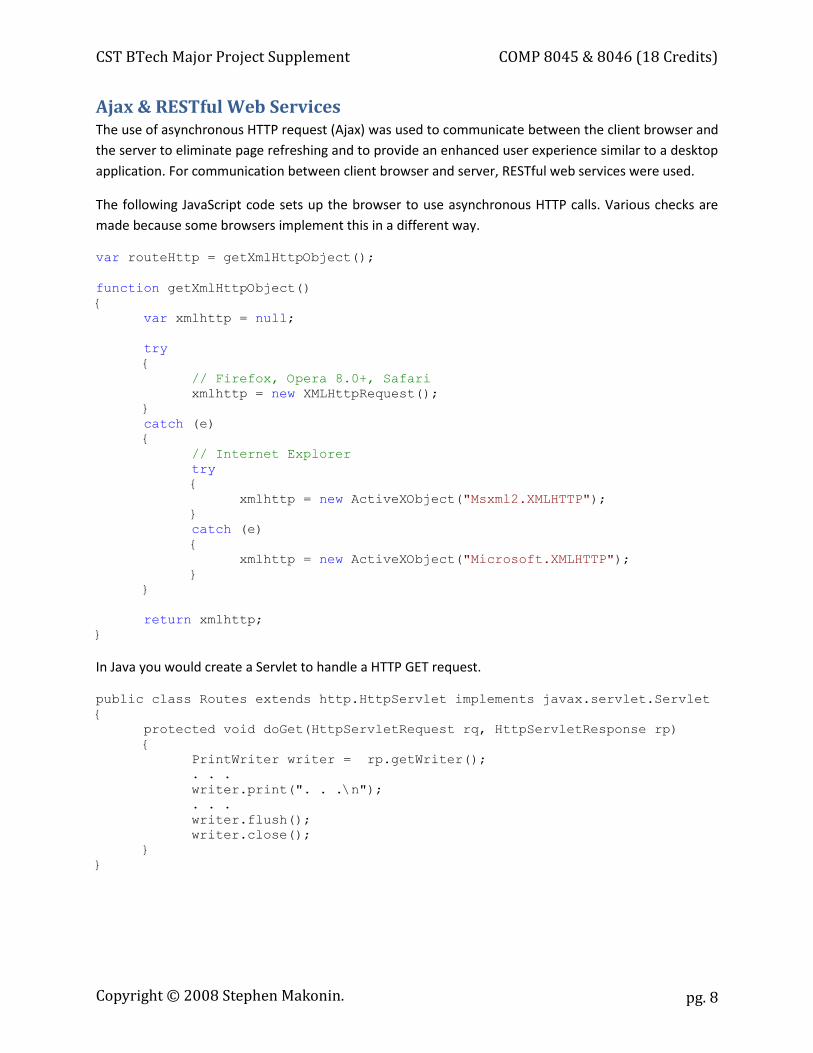
Ajax & RESTful Web Services The use of asynchronous HTTP request (Ajax) was used to communicate between the client browser and the server to eliminate page refreshing and to provide an enhanced user experience similar to a desktop application. For communication between client browser and server, RESTful web services were used.
The following JavaScript code sets up the browser to use asynchronous HTTP calls. Various checks are made because some browsers implement this in a different way.
var routeHttp = getXmlHttpObject();
function getXmlHttpObject() { var xmlhttp = null; try { // Firefox, Opera 8.0+, Safari xmlhttp = new XMLHttpRequest(); } catch (e) { // Internet Explorer try { xmlhttp = new ActiveXObject("Msxml2.XMLHTTP"); } catch (e) { xmlhttp = new ActiveXObject("Microsoft.XMLHTTP"); } } return xmlhttp; }
In Java you would create a Servlet to handle a HTTP GET request.
public class Routes extends http.HttpServlet implements javax.servlet.Servlet { protected void doGet(HttpServletRequest rq, HttpServletResponse rp) {
PrintWriter writer = rp.getWriter(); . . . writer.print(". . .\n"); . . . writer.flush(); writer.close(); } }
Copyright © 2008 Stephen Makonin.

CST BTech Major Project Supplement COMP 8045 & 8046 (18 Credits)
pg. 9
When making Ajax calls using HTTP GET then following JavaScript code is executed. A call back function is provided to retireve resulting data because these calls are asyncronous.
getFromRestfulService(routeHttp, 'Routes', loadRoutes);
function loadRoutes() { if(hasServiceResquestCompleted(routeHttp)) { gRoutes = eval(routeHttp.responseText); createRoutesSelector(); drawRoutesAndPOI(); } } function hasServiceResquestCompleted(xmlhttp) { if(xmlhttp.readyState == 4) { if(xmlhttp.status == 200) return true; else throw(xmlhttp.responseText); } return false; } function getFromRestfulService(xmlhttp, url, event) { if(xmlhttp!=null) { xmlhttp.open("GET", url, true); xmlhttp.onreadystatechange = event; xmlhttp.send(null); } else { alert("Your browser does not support XMLHTTP."); } }
Copyright © 2008 Stephen Makonin.
CST BTech Major Project Supplement COMP 8045 & 8046 (18 Credits)
pg. 10
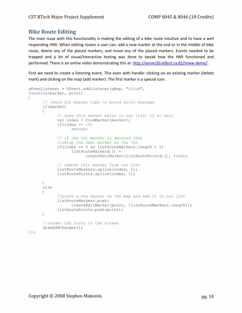
Bike Route Editing The main issue with this functionality is making the editing of a bike route intuitive and to have a well responding HMI. When editing routes a user can: add a new marker at the end or in the middle of bike route, delete any of the placed markers, and move any of the placed markers. Events needed to be trapped and a lot of visual/interactive testing was done to tweak how the HMI functioned and performed. There is an online video demonstrating this at: http://server20.ielbcit.ca:81/mww-demo/.
First we need to create a listening event. This even with handle: clicking on an existing marker (delete mark) and clicking on the map (add marker). The first marker is a special icon.
gEvenListener = GEvent.addListener(gMap, "click", function(marker, point) { // check for marker type to avoid error message if(marker) {
// does this marker exist in our list? if no exit var index = findMarker(marker); if(index == -1) return; // if the 1st marker is deleted then
//setup the next marker as the 1st if(index == 0 && listRouteMarkers.length > 1)
listRouteMarkers[1] = createEditMarker(listRoutePoints[1], true);
// remove this marker from our list listRouteMarkers.splice(index, 1); listRoutePoints.splice(index, 1);
} else {
//place a new marker on the map and add it to our list listRouteMarkers.push(
createEditMarker(point, !listRouteMarkers.length)); listRoutePoints.push(point);
}
//render the route to the screen drawAddChanges();
});
Copyright © 2008 Stephen Makonin.
CST BTech Major Project Supplement COMP 8045 & 8046 (18 Credits)
pg. 11
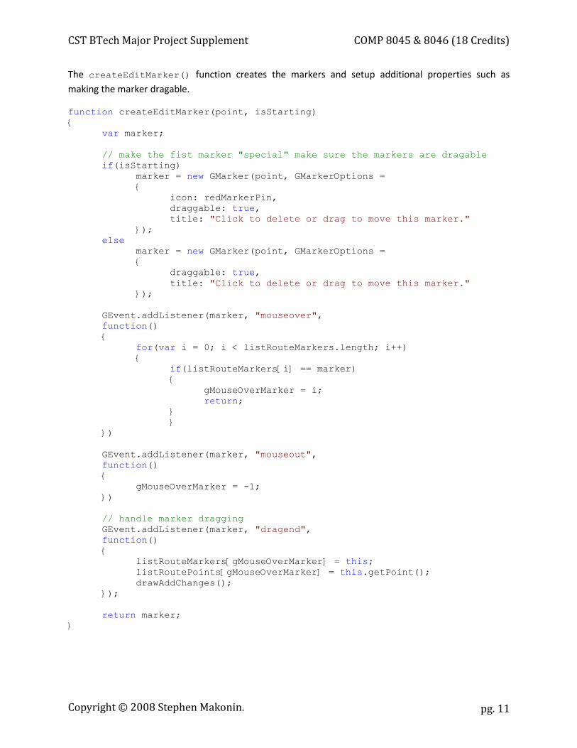
The createEditMarker() function creates the markers and setup additional properties such as making the marker dragable.
function createEditMarker(point, isStarting) { var marker; // make the fist marker "special" make sure the markers are dragable if(isStarting) marker = new GMarker(point, GMarkerOptions =
{ icon: redMarkerPin, draggable: true, title: "Click to delete or drag to move this marker."
}); else marker = new GMarker(point, GMarkerOptions =
{ draggable: true, title: "Click to delete or drag to move this marker."
}); GEvent.addListener(marker, "mouseover",
function() {
for(var i = 0; i < listRouteMarkers.length; i++) {
if(listRouteMarkers[i] == marker) {
gMouseOverMarker = i; return;
} }
}) GEvent.addListener(marker, "mouseout",
function() {
gMouseOverMarker = -1; })
// handle marker dragging GEvent.addListener(marker, "dragend",
function() {
listRouteMarkers[gMouseOverMarker] = this; listRoutePoints[gMouseOverMarker] = this.getPoint(); drawAddChanges();
});
return marker; }
Copyright © 2008 Stephen Makonin.
CST BTech Major Project Supplement COMP 8045 & 8046 (18 Credits)
pg. 12
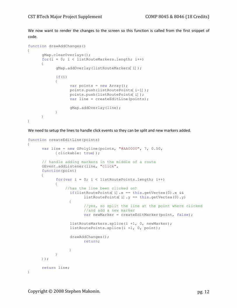
We now want to render the changes to the screen so this function is called from the first snippet of code.
function drawAddChanges() { gMap.clearOverlays(); for(i = 0; i < listRouteMarkers.length; i++) { gMap.addOverlay(listRouteMarkers[i]); if(i) { var points = new Array(); points.push(listRoutePoints[i-1]); points.push(listRoutePoints[i]); var line = createEditLine(points); gMap.addOverlay(line); } } }
We need to setup the lines to handle click events so they can be split and new markers added.
function createEditLine(points) { var line = new GPolyline(points, "#AA0000", 7, 0.50,
{clickable: true}); // handle adding markers in the middle of a route GEvent.addListener(line, "click", function(point) { for(var i = 0; i < listRoutePoints.length; i++) { //has the line been clicked on? if(listRoutePoints[i].x == this.getVertex(0).x &&
listRoutePoints[i].y == this.getVertex(0).y) { //yes, so split the line at the point where clicked //and add a new marker var newMarker = createEditMarker(point, false); listRouteMarkers.splice(i +1, 0, newMarker); listRoutePoints.splice(i +1, 0, point); drawAddChanges(); return; } } }); return line; }
Copyright © 2008 Stephen Makonin.
CST BTech Major Project Supplement COMP 8045 & 8046 (18 Credits)
pg. 13
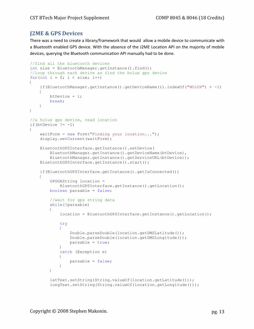
J2ME & GPS Devices There was a need to create a library/framework that would allow a mobile device to communicate with a Bluetooth enabled GPS device. With the absence of the J2ME Location API on the majority of mobile devices, querying the Bluetooth communication API manually had to be done.
//find all the bluetooth devices int size = BluetoothManager.getInstance().find(); //loop through each device as find the holux gps device for(int i = 0; i < size; i++) { if(BluetoothManager.getInstance().getDeviceName(i).indexOf("HOLUX") > -1) { btDevice = i; break; } } //a holux gps device, read location if(btDevice != -1) { waitForm = new Form("Finding your location..."); display.setCurrent(waitForm); BluetoothGPSInterface.getInstance().setDevice( BluetoothManager.getInstance().getDeviceName(btDevice), BluetoothManager.getInstance().getServiceURL(btDevice)); BluetoothGPSInterface.getInstance().start(); if(BluetoothGPSInterface.getInstance().getIsConnected()) { GPGGAString location = BluetoothGPSInterface.getInstance().getLocation(); boolean parsable = false; //wait for gps string data while(!parsable) { location = BluetoothGPSInterface.getInstance().getLocation(); try { Double.parseDouble(location.getDMSLatitude()); Double.parseDouble(location.getDMSLongitude()); parsable = true; } catch (Exception e) { parsable = false; } } latText.setString(String.valueOf(location.getLatitude())); longText.setString(String.valueOf(location.getLongitude()));
Copyright © 2008 Stephen Makonin.
CST BTech Major Project Supplement COMP 8045 & 8046 (18 Credits)
pg. 14
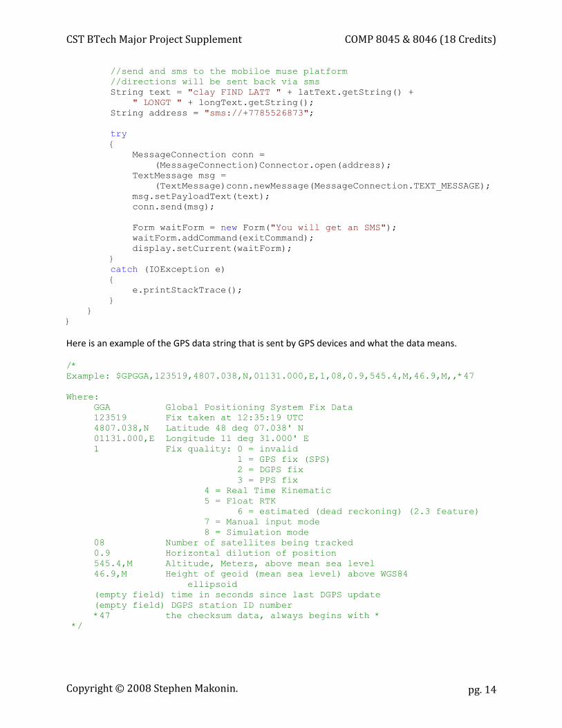
//send and sms to the mobiloe muse platform //directions will be sent back via sms
String text = "clay FIND LATT " + latText.getString() + " LONGT " + longText.getString(); String address = "sms://+7785526873"; try { MessageConnection conn = (MessageConnection)Connector.open(address); TextMessage msg = (TextMessage)conn.newMessage(MessageConnection.TEXT_MESSAGE); msg.setPayloadText(text); conn.send(msg); Form waitForm = new Form("You will get an SMS"); waitForm.addCommand(exitCommand); display.setCurrent(waitForm); } catch (IOException e) { e.printStackTrace(); } } } Here is an example of the GPS data string that is sent by GPS devices and what the data means.
/* Example: $GPGGA,123519,4807.038,N,01131.000,E,1,08,0.9,545.4,M,46.9,M,,*47 Where: GGA Global Positioning System Fix Data 123519 Fix taken at 12:35:19 UTC 4807.038,N Latitude 48 deg 07.038' N 01131.000,E Longitude 11 deg 31.000' E 1 Fix quality: 0 = invalid 1 = GPS fix (SPS) 2 = DGPS fix 3 = PPS fix 4 = Real Time Kinematic 5 = Float RTK 6 = estimated (dead reckoning) (2.3 feature) 7 = Manual input mode 8 = Simulation mode 08 Number of satellites being tracked 0.9 Horizontal dilution of position 545.4,M Altitude, Meters, above mean sea level 46.9,M Height of geoid (mean sea level) above WGS84 ellipsoid (empty field) time in seconds since last DGPS update (empty field) DGPS station ID number *47 the checksum data, always begins with * */
Copyright © 2008 Stephen Makonin.
Related Documents