URBAN DEVELOPMENT OF ALIGARH CITY AND SOCIAL WELFARE DEVELOPMENT DISSERTATION SUBMITTED IN PARTIAL FULFILLMENT OF THE REQUIREMENTS FOR THE AWARD OF THE DEGREE OF Maittv of Jj^f^iloiopl^p m GEOGRAPHY By NADIA ANIS Under the supervision of DR. HIFZUR REHMAN (Prof) DEPARTMENT OF GEOGRAPHY ALIGARH MUSLIM UNIVERSITY ALIGARH (INDIA) 2008

Welcome message from author
This document is posted to help you gain knowledge. Please leave a comment to let me know what you think about it! Share it to your friends and learn new things together.
Transcript

URBAN DEVELOPMENT OF ALIGARH CITY AND SOCIAL WELFARE DEVELOPMENT
DISSERTATION
SUBMITTED IN PARTIAL FULFILLMENT OF THE REQUIREMENTS FOR THE AWARD OF THE DEGREE OF
Maittv of Jj^f^iloiopl^p m
GEOGRAPHY
By
NADIA ANIS
Under the supervision of
DR. HIFZUR REHMAN (Prof)
DEPARTMENT OF GEOGRAPHY ALIGARH MUSLIM UNIVERSITY
ALIGARH (INDIA) 2008

i>-^-J-^ri"
DS3653

Prof. Hifzur Rehman .;-.•, .\ Department of Geography ' "i ' ^ ' ' Aligarh Muslim University
• -.•":;".,' Aligarh-202n02,11.P.. India
Dated; 21.4.2008
This is to certify that Miss Nadia Anis has completed her M.Phil,
dissertation entitled "Urban Development of Aligarh City and Social
Welfare Development" under my supervision. This dissertation is a partial
fulfilment for the award of the degree of Master of Philosophy in Geography.
In my opinion, the present-dissertation is fit to submit for the evaluation.
(Prof. Hifzur Rehman) Supervisor

dedicated To
9A.y Barents

CONTENTS Page Nos.
Acknowledgements i
List of Tables ii-iii
List of Figures iv-v
Glossary vi
Introduction 1 -6
Chapter 1 A Geographical Frame of Aligarh City 7 - 32
i. Geographical outlook ( Physical Features) Location, Topography, Climate, Drainage, and Soils
ii. Historical Background
iii. Social Aspects
Population, Urban Landuse and Occupation Structure
Chapter -2 A Conceptual Framework 33 - 68
i. History of Urban Development in India,
ii. Review of Literature.
Chapter -3 Urban Infrastructural Facilities in Aligarh City 69 - 98
i. Type of Houses
ii. Roads
iii. Drainage and Sewers
iv. Health Facilities
V. Educational Facilities
Chapter- 4 Social Well-being Indicators in Different Zones
of Aligarh City 99-114
i. Total Members in a Family and Type of Family
ii. Status of House
iii. Education
iv. Profession
V. Material Possessions.

Chapter- 5 Role of Municipality in Urban Development
in Aligarh City. 115-127
i. The Purpose of Formation of Municipality in Cities.
A Brief History of Aligarh Municipal Corporation.
Responsibilities and Facilities.
Extension and Provision of Ser\'ices in the City.
n.
ui.
IV.
Conclusion
Bibliography
Appendices
Appendix 1
Appendix 2
Density of Population (Wardwise, 2001)
Questionnaire
128 - 132
133
134- 138
139- 141
ACKNOWLEDGEMENTS
I take the opportunity to express my profound feeling of gratitude to the "All Mighty
Allah", whose strength and support helped me in each step in completing this work. It
is my pleasant duty to offer my sincere acknowledgement to those honorable
personalities who have been a constant source of help and encouragement.
First of all, I would like to thank Prof. Hifzur Rehman, my supervisor.
Department of Geography, Aligarh Muslim University, Aligarh for his guidance,
suggestion and encouragement. I rather find words short to express my gratitude and
thanks to him for his perpetual support and creative thinking. His inputs have been
very helpful and valuable.
I am also grateful to my chairman Prof. Abdul Munir, Department of
Geography, Aligarh Muslim University, Aligarh, for providing me all possible help
during the course of my work.
I offer my sincere most thanks to all the teachers and research scholars of the
department, especially Zeba Siddiqui, Rukhsana, Yasir Hanafi, Salahuddin,
Mashkoor, Kapil and Kaish.
My sincere gratitude to the librarians of M.A library and Research library of
the department.
I wish to express my sincere thanks and deep sense of gratitude to my brother
Mr. Ahmer Anis for his guidance and support.
I feel deeply bestowed with an honor in acknowledging my indebtedness and
heartful thanks to my parents. Their constant support and encouragement made my
dissertation possible. I would especially like to thank my mother, in particular, for
her strength and support, who stood by my side in all odds. Without her support my
dream of completing this research would have been half filled.
The Acknowledgement will be incomplete if I fail to thank, Masroor Ahmed,
Zaid Bin Ozair, Eram Musharraf, and Falak for their valuable help and support. I
would also like to thank officers of Seva Bhavan, who have been adherent source of
information.
(NADIA ANIS)

11
LIST OF TABLES
Table No. Title Page No.
1 Population of Aligarh city (1971-2001) 18
2 Aligarh city :density of population (wardwise-2001) 20
3 Urban land use in Aligarh city (2000-61) 31
4 Plan outlay in housing and urban development 51
5 Trend of urbanization in India (1901-2001) 55
6 Number of zones, wards and households selected for 74 survey in Aligarh city
7 Zone wise types of houses in Aligarh cit)'-2007 76
8 Distribution of open spaces in different zones of 77 Aligarh city -2007
9 Distribution of sampled households according to the 79 religion in the Aligarh city-2007
10 Types of roads in different zones of the Aligarh city- 82 2007
11 Types of roads according to the material used in the 82 construction of roads in Aligarh city-2007
12 Drainage in different zones of Aligarh cit>'-2007 85
13 Existenceofwater logging and garbage in drains in 85 Aligarh city-2007
14 Zone wise disposal of night soil in Aligarh city-2007 88
15 Disposal of garbage in different zones of Aligarh city- 89 2007
16 Distribution of health facilities in different zones of 92 Aligarh city-2007
17 Zone wise accessibility of medical facilities in Aligarh 92 city-2007
18 Distribution of educational facilities in different zones 94 of Aligarh city-2007

Il l
19. Number of persons living with a sampled households in 101 Aligarh city-2007
20 Sampled households according to type of family in 102 Aligarh city-2007
21 Sampled households according to the status of house in 104 Aligarh city-2007
22 Samples households according to the educational status 105 in Aligarh city-2007
23 Sampled households according to the type of 107 occupation in the Aligarh city-2007
24 Sampled households according to monthly income (in 108 Rs) in the Aligarh city-2007
25 Sampled households according to the ownership of 111 appliances in the Aligarh city-2007
26 Sampled households according to the ownership of 112 vehicles in the Aligarh city-2007
27 Development of housing facilities in Aligarh city 123 (1971-2001)
28 Health care facilities in Aligarh city (1971 -2001) 124
29 Educational facilities in Aligarh city (1971 -2001) 125
30 Banking and recreational facilities in Aligarh city-2001 126
LIST OF FIGURES
IV
Figure No.
1
2
3
4
5
6
7
8
9
10
11
12
13
14
15
16
17
18
19
Title
Aligarh city: Location map
Aligarh district: Drainage
Aligarh city: Location of wards
Aligarh city: Density of population (wardwise-2001)
Aligarh city: Selected zones
Type of houses in different zones of Aligarh City-2007
Open space in different zones of Aligarh City-2007
Types of roads in different zones of Aligarh City-2007
Types of roads according to the material used different zones of Aligarh City-2007
zones of Aligarh City-
Page No.
4
10
19
23
75
78
78
83
83
86
86
90
igarh City-2007
Types of drainage in different 2007
Water logging in different zones of Aligarh City-2007
Modes of solid waste different zones of Aligarh City-2007
Modes of garbage disposal different zones of Aligarh 90 City-2007
Health facilities different zones of Aligarh City-2007
Educational facilities different zones of Aligarh City-2007
Number of persons living with a sampled households in Aligarh city-2007
Sampled households according to the status of house in Aligarh city-2007
Sampled households according to type of family in Aligarh city-2007
Sampled households according to the educational status in Aligarh city-2007
95
95
103
103
106
106

20 Sampled households according to the of type of 109 occupation in the Aiigarh city-2007
21 Sampled households according to monthly income (in 109 Rs) in the Aiigarh city-2007
22 Sampled households according to the ownership of 113 vehicles in the Aiigarh city-2007

VI
GLOSSARY
Doab Inter-reverine plain
Jhil Lake
Loo Warm wind, which generally blows in the month of May and June in Indian sub-continent
Masjid Mosque
Minar Tower
Mohalla Locality
Nadi River
Qila Fort
Reh Efflorescence of salts in soil
Tehsil Sub Division of district
Usar Saline, Alkaline soil
Zamidar Landlord
INTRODUCTION
The phenomenon of urbanization is continued everywhere, but it is
evidently seen in the western world where urban population constitute 75 per
cent. Nearly 68 per cent of urban population resides in developed regions
comprising Europe, North America, Japan, Australia and New Zealand in 1970,
it increased to 75 per cent in 1994 and it is estimated that it will take a jump to
over 80 per cent by 2010. At the beginning of 19 ^ century nearly 3 per cent of
the v/orld's population was living in towns over 5000 inhabitants. Between the
period 1950 and 1970 the world's urban population increased from 28.2 per
cent to 38.6 per cent. But this sharp increasing trend went on to show a slow
increase unceasingly and by 2000, the figure reached to 50 per cent. The
number of cities with 1 million population too indicated a similar trend. In
1921 there were 24 cities of one million population which increased to 41 in
1941 and 113 by 1961. By 1988 their number increased to 240. It is actually a
swing of urbanization in developing countries. This fact is also supported with
the change in regional distribution of urban population. Asia shows a
increasing share in the world's urban population by hosting as many as 11
cities. It is estimated that by 2020 the urban population in Asia and Pacific
region would be 1.97 billion or 46 per cent of its total population of 4.3 billion.
This means three quarters of the world's urban dwellers will live in cities and
towns of Africa, Asia and Latin America.
India too is passing through a phase of rapid urbanization brought by
the general development; industrialization and migration of population from
rural to urban areas in search of better livelihood.

During pre-independence time urban population of India was 13.9 per
cent in 1941, which increased to 17.3 per cent in 1951 after the independence.
Before independence nearly 15 per cent people were living in towns, and now
their share has become just double. The reason for this change in the urban
population may be many, but it is mainly attributed to migration of rural people
to urban areas.
The growth of population in urban areas in India is related with a shift
of population from villages to urban areas in search of better livelihood. During
1961-71 about 24 million people migrated from rural to urban areas. Each year
on an average about 4 million people migrate to cities like Mumbai, Delhi and
Kolkata. The cities and towns are, however, not prepared to absorb this
phenomenal increase in number, this reflect a haphazard and unorderly grow1:h.
This floating population adds new problems to municipal bodies who with
their limited funds are themselves incapable of serving such an ever increasing
population.
This gap between accessibility and requirement for urban
infrastructural facilities has widened a gap over the years which severely affect
the problems of space, environment and keep intact the quality of life in urban
areas. Several studies have indicated that a large segment of urbanites do not
have access to basic services like drinking water, sanitation, basic health and
education facilities.
The data available with the 2001 census indicates that the percentage
of urban households having access to safe drinking water has registered a
minimal increased from 81.40 per cent (in 1991) to 90 per cent (in 2001). The
average water supply to the residents in large cities is available only 5 to 6
hours a day. As per census 2001, nearly 39 per cent of urban households were

without access to portable water within their premises. Approximately, 26 per
cent of urban household have no access to sanitation within their premises and
are forced to use open spaces. Sewerage system exists only in few cities. In
such chies, only a part of sewage is collected and even less of that is untreated.
As a result, discharge of waste leads to pollution, environmental degradation
and health risks. Only a part of garbage generated in urban areas is collected,
transported and disposed off. The accumulation of garbage along road side in
huge quantities has become a common problem in most cities. In many cities,
industrial waste, and municipal solid waste gets mixed up posing a serious
environmental threat. Most of the cities are exposed to air and water pollution,
and problems are posed by inadequate solid and liquid waste management.
There is a pressing need to evolve a strategv' that can address the
problems of urbanizing areas in terms of stipulation of infrastructural services.
Large investments on building of urban infrastructure like, roads, rails, power,
sanitation, sewerages and telecommunication are required for accelerating the
growth rate of the economy and upliftment of social welfare.
Study area
Aligarh is a medium sized city which spreads over an area of 36.70 sq
km to form a part of U.P with the population of more than 0.7 million. It is
located in between 27.53'N latitude and 78.04' longitude, and hes at about 130
km from New Delhi and 1408 km from Kolkata.
Objectives of the study
The present study is attempted for an assessment of the problems related
with the process of urban development and social welfare development in the
Aligarh city.

ALIGARH CITY Location Map
N
A Location of Aligarh City In Uttar Pradesh
Position of Aligarti ^ ^ ;j_ci city in India
f ^ ^ ^ Km f
60 0 60 I 1 I
INDEX
r-r-r- International Boundary
—» District Boundary
" " ^ Railway Line
— Roads
— Rivers
Source: Department of Geography, A.M.U, Aligarh, 2004
Fig.l

The present study has certain specific research objectives
1. To examine the distribution of the present infrastructural facilities, like
housing, roads, drainage, sewers, health and education facilities in
different zones of Aligarh city.
2. To examine the condition of the amenities present in different parts of
Aligarh city.
3. To examine whether these facilities are easily available to the people
living in the city or not.
4. To study in general the characteristic of the sample households like,
family size, type of the family, education, profession, income and social
status to asses their quality of life.
5. To compare and contrast between the infrastructural facilities available in
different zones of Aligarh city.
6. To examine the relationship between the urban development and the
quality of life.
Data Base
This study is based mainly on the data collected from primary sources,
and partially the informations obtained from the secondary sources of data.
Data from the primary were collected through city surveys, households surveys
and interviews conducted with the respondents.
Some basic information was obtained from secondary sources
principally from the following offices of Aligarh city.
• Municipal Board (Seva Bhawan), Aligarh

• Aligarh Development Authority (A.D.A)
Office of the Chief Medical Officer (C.M.O)
• Office of the Basic Shiksha Adhikari (B.S.A)
Present work consists of five chapters.
First Chapter has been devoted to present geographical and historical
details of the study area.
Second Chapter accounts for the history of urban development in India
and presents the trends of urban development.
Third Chapter deals with to outline the infrastructural facilities in the
Aligarh.
Fourth Chapter deals with the indicators related to social well being in
the city.
Fifth Chapter presents the role and responsibilities for laying of the
infrastructure facilities by the Municipal board of the Aligarh City.

Chapter I
A GEOGRAPHICAL FRAME OF ALIGARH CITY
a) Relief and strwcture
The Aligarh city lies in the central low lying tracts between the Aligarh
drain in the west and the stream Sirsa in the east. The Aligarh city forms a part
of the upper Ganga-Yamuna Doab which is a plain of remarkable fertility. The
plain slopes down gently from north to south and southeast. The surface is
spotted with several depressions formed by the river valleys and natural
vegetation, while its elevation consists of simply slender ridges of sand. The
most prominent of them are three regular lines running from north to south.
The first follows the boundary between the Pragana of Tappal and Chandaus.
The second may be seen along the right bank of a stream Karwan, and the
third which is more uninterrupted and less defined lies a few kilometers in the
east. These ridges continues through the upper portion of tehsil of Iglas and
two of them enter Mursan Paragana of Hathras tehsil. In some places
transverse spurs which reduce gradually into the level surface of the plain. To
the west of Aligarh there are two parallel lines of high sand\- ground running
from north to south. The configuration of the ground is very similar to Doab,
from the Ganga khadar level rises sharply to the high sandy upland which is
flanked by the old high bank of the Ganga. From this point the level descends
inland gradually to a depression drained by the Nim Nadi and Chooiya, beyond
which it again rises to the bank of Kali Nadi. There is a sandy belt which rises
from the low and the narrow khadar of that stream and is followed by the fertile
belt of loam soil which gradually sinks into the broad central depression. The
later traverses the entire district in a southeasterly direction roughly parallel to

the course of the Ganga. Entering from the north of the tehsil, it passes through
the tehsil of Sikandra Rao. This tract is characterize by clayey soil, imperfect
natural drainage and numerous lakes in which the surface water collects,
without finding an adequate outlet. In consequence of the resultant saturation
the tract is marked by the frequent stretches of barren usar and exudation of salt
in the form reh. Beyond this depression the surface rises again into a level plain
of rich soil, assuming a sandy character in the western part of the district. In the
northwest the general characteristic of the Doab are same having loam
ahemating with clay in the depression with lighter ground on the banks of few
rivers till finally forms a high cliff of the Yamuna from where the level drops
to the khadar of that river. The southwestern part of the district presents some
what remarkable features, for tehsil Iglas and part of the tehsil of Hathras
contains a sandy tract of a very homogenous type.
The general level of Aligarh is extremely regular. Elevation of the
ground surface is about 195m above sea level at Chandaus and Tappal in the
northwest dropping to 189.58m at Soma in the center. The elevation where the
Ganga canal enters the district is 193.24m above sea level and from here, there
is a gradual slope eastwards to follow the direction of the Ganga.
The elevation above sea level being 186.84m at Atrauli and 180.74m
at Dadon, while in the khadar the elevation at the points of the entry and exit of
the lower Ganga canal are 178m and 176.78m respectively. Further south the
level drops from 189m (on the bank of the Karwan near Khair) to 185.32m at
Aligarh, and to 183.49m at Jalali. All these places lying on the same latitude
south of this record elevation as 180.14m at Gorai 177.90m at Iglas, 180.14m
at Sasni and 176.78m at Sikandra Rao. On the southern border heights above

sea level are 176.78m at Hathras, 175.56m at Hasyan and 176.96m where the
Ganga canal leaves the district. The Grand Trunk Road follows the general line
of slope and the length of roughly 80km, the level drops from 190.50m to
173.76m giving an average gradient of about one-fifth of a meter per kilometer.
b) Drainage
The Aligarh is well served by a number of streams. There are two
types of rivers, which have their sources in snow covered mountain ranges of
the Himalayas, namely, the Ganga and the Yamuna and they are perennial; and
some of them are seasonal namely, the Karon, the Sengar and the Rind and are
reduced to an insignificant water courses during the dry season.
i. The Ganga
The Ganga having its source in the Himalayas enters the north plain at
Hardwar. From there it flows southwards up to Bulandshahar district, then it
enters the Aligarh and takes a southeasterly direction forming the northern
boundary of the district, and separates the Aligarh from the district of Budaun.
This river brings new alluvium during the rainy season, the volume and
velocity of the river is considerably increased because of the low-lying areas
are frequently inundated during the flood period.
ii. The Yamuna
The river Yamuna has its source in the snowy peaks of the Himalayas,
coming from the north, it then flows along the northwestern border of the
Aligarh district, and then moves towards south into the districts of Mathura and
Agra. The river bank rises gradually with a gentle slope giving room to fertile
expanses of alluvial lands known as khadar. Its variation is much less extensive

10
N
A
INDEX
ALIGARH DISTRICT Drainage
Rivers
District Boundary Kms
Source: Suivey of India Toposheet No 63H, 63L, 641
Fig. 2

11
then that of the Ganga, for the actual stream has a well defined bank, which is
topped only in years of heavy floods.
iii. The Kali Nadi
The Kali Nadi is the only tributary of the Ganga which traverses the
district. It rises in the district of Muzaffamagar and passing through the
districts of Meerut, Ghaziabad, and Bulandshahr enters in this district from the
north. It then flows southeast, and forming the western and southern boundary
of the tehsil of Atruali, which is separated from tehsil of Aligarh and Sikandra
Rao. It passes into the district of Etah near village Barhari. It is a perennial
river, as it rises during the flood it causes a damage to the crops grown over the
lands along its course. Nim Nadi is a small stream coming from the north and
joins the Kali Nadi on its left bank. The Nim and Chhoiya Nadis join together
and flow southward as Nim Nadi joins the Kali Nadi on the left bank. The
Nim Nadi is mainly a seasonal river. It is seldom dry in hot season and
inundates during the rainy season.
iv. The Isan
The Isan is a tributary of the Ganga, but it has its origin in several
shallow depressions to the east of Sikandra Rao in the villages of Iklalpur,
Kheria and Bargawan. It then flows in a south easterly direction in to the
district of Etah, between the Grand Trank Road and the Kanpur Branch Canal.
V. The Rind
The Rind is an other drainage channel which becomes large enough
before joining the Yamuna in the Fatepur district. The Rind flows through a
shallow alluvial bed. In years of unusual heav}' rainfall the low lands along it
12
are inundated and when the river recedes it leaves off a rich layer of alluvial
soil.
vi. The Karwan
The Karwan River is also known as Karon and is a natural water
course, it flows in a northsouth direction and passes through the Khair and Iglas
tehsils of Aligarh district, and further southward passing through the district of
Mathura it joins the Yamuna river near the city of Agra.
c) Climate
Climate forms an important part of the physical environment and
influences human life and its culture. Climate determines the life style and its
culture and food, habits, and shelter. So the study of climate and rhythm of
season assumes a greater significance in understanding the life style of people.
The Aligarh city has a tropical monsoon type of climate which is characterized
by a seasonal rhythm of the southwest and northeast monsoons, in summer a
hot and pleasant, in winter a general dryness is experienced except in the
monsoon season. The cold weather season starts from the middle of the month
of November and the early March is followed by hot weather season which
lasts until the middle of the month of June. The southwest monsoon season
takes on start from middle of month June and seizes by the third week of the
month of September. This period extending from the last week of September
to the middle of November is termed as the post -monsoon season.
The climate of Aligarh is similar to that of the Ganga-Yamuna Doab.
In general the climatic pattern of Aligarh may be divided into four distinct
seasons:

13
i. Cold weather season (December - February)
ii. Hot weather season (March - mid June)
iii. Season of general rains (Mid-June to mid-September)
IV. Season of retreating monsoon (October to mid-September)
(i) The cold weather season
This season is characterized with cold and dry air which blows from
the month of December to February. Sky is clear, and very rarely clouds are
seen in the sky. This season is associated with low temperature and high
pressure conditions.
As a result this area comes under the influence of the high pressure
belt. Frost may occur but it is not of great intensity. The maximum temperature
is recorded as 23C, and minimum from IOC to 12C. The mean temperatures in
the month of December and January are recorded as 15C and 12.2C
respectively. The temperatures further fell due to blowing of cold waves
coming from the north. During this season the winds blow from west and
northwest to southeast direction. The winds are generally light and dry due to
the continental origin. Sometimes in the last week of December a little amount
of rainfall occurs due to western disturbances. The temperature begins to rise
by the end of the month of February.
(ii) The hot weather season
Hot weather season begins from the month of March and lasts till mid
-June. This season is characterized by an increase in temperature and a
decrease in pressure. The maximum and minimum temperatures are recorded
as 38C and 21C. Maximum temperatures in the months of May and June

14
remains about 43.5C and sometimes readies up to 46C for a few days. The
days are characterized by intense heat, dry air with relative humidity as 24 per
cent. During the summer month hot dry wind blows with great velocity which
is locally called as 'loo'. The relative humidity is reduced to lowest to the
extent of 2 to 3 per cent in the afternoon. The most peculiar phenomenon is the
occurrence of dust storms during the hot weather season. These storms usually
occur in afternoon with strong air movement. A little rain sometimes is brought
by these thunderstorms.
(iii) The season of general rains
The season of general rain coincides with the humid oceanic currents
reaching northern parts of India during the months of July and August, because
of excessive heat over the land causes a creation of low pressure. As a result,
moisture laden winds come from the Indian ocean towards land and cause
rainfall by the month of June. This season is characterized with cool air and
frequent occurrence of rainfall. The temperature comes down from 40C to 27C
in June, and 34C to 25C in July. The relative humidity increases from 30 per
cent in the month of May and 74 per cent by the end of June, and 84 per cent
by the months of July and August. The sky remains overcast. Actually in
Aligarh the rains occurs with the onset of monsoon in the last week of June or
the first week of July and continues till the end of the months of September or
early October. About 90 per cent of rain is received in this season. A peculiar
characteristic of the rain is that the rain does not occur continuously; after two
or three days of continues rainfall, there may be a break or a period of dry spell
which lasts for a week or ten days. The rainfall received at Aligarh amounts to
about 65 to 75 cm annually.

15
(iv) The season of retreating monsoon
During this season weather is associated with hot winds and thus
temperatures are increased but experience a fail in temperature by the end of
the month of October. The maximum and minimum temperatures, recorded
during the month of September were 33C and 24C respectively. This season is
marked by clean sky, low relative humidity about 47 per cent and a little
rainfall. The temperatures likely remain high during the day and a low during
the night hours.
d) Soils
The soils of the district are similarly the same in composition and
appearance as those of the Doab. Due to the sauce pan shape of district with the
rivers of Ganga and Yamuna flowing on the relatively high land peripheries
and a central low lying tracts, the alluvium brought by the rivers spreads over
three-fourth of the total area, while the alluvium brought by the river Yamuna
spreads over one-fourth of the total area of the district. Thus, soils of Aligarh
are mainly made up of alluvium brought by these two rivers.
The alluvial soils of Aligarh district has been divided into two broad
geological divisions:
The older alluvium (bhangar)
The newer alluvium (khadar).
The older alluvium occupies the level plains above the general flood limits of
the main rivers and their tributaries where as the newer alluvium occupies the
flood plain of the rivers and their tributaries as a result of the which the
constituents of such lands are renewed every year. The alluvium chiefly

16
consists of various grades of sand, silt and clay. Beds of very coarse sand and
gravel are commonly found. The soils differ very much in texture and
consistency ranging from the sands through loams and silts to heavy clays that
are ill drained and are some times charged with injurious accumulation of
sodium salts producing a sterile deflocculated condition called usar.
The Atlas of Agricultural Resources of India, (Ed. Dasgupta 1980),
shows four types of soils in Aligarh district-
1. Older alluvial soils.
2. Younger alluvial soils
3. Calcareous alluvial soils.
4. Saline and alkaline soils.
1. Older alluvium:
This soil type covers most of the area of the district of Aligarh. The
soil texture varies from good quality loam to sandy loam. Its colour varies from
light to deep brown. This soil is very fertile, some of the highest yields of the
crops in the district come from these soil areas.
2. Younger alluvial soils
These soils occupy a narrow belt in the eastern comer of the district
along the course of the Ganga and in the western comer along the course of the
Yamuna. These tracts receive every year new deposits of silt and sands due to
the floods in the rivers of Ganga and Yamuna. The colour of these soils vary
from light grey to dark grey. The texture of the soil is sandy to silty loam. The
water table is usually high near the surface. The drainage is imperfect,
restricted and poor.

17
3. Calcareous alluvial soils
These soils occur in Iglas tehsil, Mursan block of Hatharas tehsil and
Atrauli and Gangeri tehsils of Aligarh. They occupy mainly the Gonda block.
The colour of these soils varies from brown to reddish brown. The texture
varies from sandy to sandy loam. Due to poor inorganic matter of sandy nature
and presence of insoluble salts they are not much useful for agricultural
purposes.
4. Saline and alkaline soils
Due to imperfect drainage, the district contains vast areas of such soils
which are either saline or alkaline. Unfortunately arid climate, poor drainage
and high ground water table are the main reasons for salinization and
alkalinization. These are mainly found in the tehsils of Sikandra Rao and Koil
and in some parts of Khair, Iglas of Aligarh and in Hathras district. The texture
of these soils varies from loam to clayey loam, while the colour is from grey to
dark grey. Aligarh city lies in this soil region.
e) Cultural environment of Aligarh city
The Aligarh city covers an area of 34.98 sq km of which only 61 per
cent is developed. Of the developed area 49.1 per cent is used for residential
purposes, 28.1 per cent for transport, 9.4 per cent for industrial and commercial
purposes, 7 per cent for public utility, 2.1 per cent is under parks and open
spaces and only 0.4 per cent is used for recreational purposes. The city is
divided into 70 wards which spread over 158 mohallas.
Like other cities of the state of U.P, Aligarh too has a distinct
demarcation between the old and the new parts. Delhi-Kolkata railway line

18
separates the old and the new parts of the city. The old part of the city
comprises of 48 wards and the new part 22 wards. The old city presents the
picture of decadence having narrow roads, old and congested houses with
improper educational and health facilities, and no open spaces. The new area is
much cleaner than old part, which comprises of Aligarh Muslim University,
which spreads over thousands of hectares of land. But new residential colonies
and innumerable shopping centers have sprung up making this part as
congested. Gradually the outskirts of the city are expanding encroaching upon
rural areas and therefore slums have emerged at a rapid rate.
f) Population
The total population of the city was estimated as 669087 persons in
2001.There is an increase in population to the tune of 6 per cent which doubles
in every twelve years. Of this 2 per cent seems to be due to natural growth, and
4 per cent is made up by the migrants coming from different villages. The city
population increases by nearly 36,000 persons annually.
Table 1
Population of Aiigarh city (1971-2001)
Year Total population
Males Females Decinnial growth
1971 252314 126650 125664 27.16
1981 320861 161475 159386 49.75
1991 480520 257391 231300 38.96
2001 669067 356725 312362 164.96
Sources: 1. Census of India (1971, 81, 91 and 2001). 2. Office of the Nagar Nigam, Aligarh.

ALIGARH CITY Location of Wards
T '« f 500
Meters
Source: Office of the Municipal Corporation (Seva Bhawan), Allgarh
Fig. 3

20
According to 1971 census, total population of the city was 252314
persons with the increase of 27.16 per cent in 1981, it is estimated to be 320861
persons in last ten years the population has increased substantially with the
growth rate of 49.75 per cent. In 1991, the growth of population was 38.96 per
cent but in 2001 it shows a substantial increase of 164.96 per cent.
It seen that during the last decades the growth rate has been within the
range of 35-40 per cent. In the last decade the highest growth rate was as 50per
cent. The socio- economic compulsions have leaded the rural landless labourers
to migrate to the city. The migration of the labourers has also reflected the sex
ratio to be as 868 females per thousand of males.
Table 2
Density of Population (ward wise-2001)
Ward No. NAME OF WARD POPULATION OF WARD
1 Indra Gandhi Khair Road 10986
2 Sarai Garhi 9699
3 Nagla Kalar 10741
4 Sarai Lavaria 8608
5 Sarai Kaba 10529
6 Pala Sahibabad 10349
7 Deri Nagar 10478
8 Nauner Gate 9757
9 Naurangabad 8553
10 Delhi Gate 10107
11 Beema Nagar 10357
12 Sarai Deen Dayal 8467
13 Nagal Masani 10566
14 Sarai Bala 9516
(cont..)

21
Table 2 (contd..)
15 Krishnapur 10842
16 Durga Puri 9557
17 Chawni 10697
18 Gambhirpura 8568
19 Nai Basti 9797
20 Exhibition Ground 10772
21 Slaughter House 10472
22 Sanichari Penth 9249
23 Kalideh 9078
24 Kishanpur 10882
25 Sarai Hakim 8273
26 Sarai Nabab 8213
27 Kanwari Ganj 9012
28 Bhamola 9953
29 Sudamapuri 10409
30 Fire Brigade 9748
31 Begpur 8421
32 Gandhi Nagar 8697
33 Kishor Nagar 9200
34 Sarai Palcki 8183
35 Dodhpur 8968
36 Avas Vikas Colony 8494
37 Jamalpur 8214
38 Kala Mahal 8976
39 Jiwangarh 9775
40 Badar Bagh 9800
41 Shivpuri 9720
42 Vikas Nagar (A.D.A. Colony) 8140
43 Rawan Tila (Jawalapuri) 10919
(cont..)

'-)->
Table 2 (contd..) i 44 ! Begum Bagh 10938
45 Zohra Bagh 8614
46 Janakpuri 8734
47 Ashok Nagar 8627
48 Nagla Tikona 10811
49 Lekh Raj Nagar 8274
50 Rasa! Ganj. 8406
51 Ghanshyampuri 10413
52 Firduas Nagar 8162
53 Maulana Azad Nagar 8173
54 A.D.A. Colony Area 10845
55 Usman Para-III 9455
56 Brhamanpuri 8368
57 Iglas Road Pumping Station 10938
58 Medical College 10136
59 Nagla Jamalpur 8955
60 University Area 9820
61 Kela Nagar 9991
62 Shah Jamal Area 9822
63 Manik Chowk 10006
64 Khai Dora 10649
65 Bhujpura 10878
66 Sir Syed Nagar 9473
67 Tan Tan Para 8612
68 Hamdard Nagar 9114
69 Badam Nagar 10724
70 Baniya Para 8407
Source: Office of the Seva Bhawan, Aligarh

23
N
A ALIGARH CITY N
A Density of Population (wardwise-2001)
^S NDEX
^^i^Tr/ Very High
High
" ^ ~ ^ ^ ^ \ ^ / •Medium
Low
Very Lx)w 5p 250 P 500
•Medium
Low
Very Lx)w Meters
•Medium
Low
Very Lx)w
Source: Office of the Municipal Coiporation (Seva Bhawan), Aligarh
Fig. 4
24
(a) History of Aligarh
In earliest times Aligarh was known as Koil, which had been
differently spelt out as Kol, Cole and Koil. Origin of these names is much
debatable due to various views on it.
Koils were the tribals and professionally as weavers. It is also possible
that the peoples residing this area before the Turkish conquest gave Kol its
name, because as per the census of 1872 census, there were some 35,000
persons living in this area.
From the medieval period onwards this name has stayed for a long
time and even today one of the administrative unit of Aligarh district is named
as tehsil Koil. During the same period, it was renamed many times as
Sabitgarh, Muhammadgarh, Ramgarh and finally the Aligarh. Present Aligarh
takes its name from the Prophet Mohammad's (PBUH) cousin and son in law
"All". Since Afrsyab Khan and his master Mirza Najaf Khan were 'shia',they
named the fort as Aligarh. It was generally spelt as Aligarh but British
authorities some time spelt it as Alygarh. After British annexation the entire
territory was reconstructed and in 1804 for the first time Aligarh district was
renamed. In the defance records of 1857 we see the name of city referred to as
Koil.
Origin of Aligarh goes back to the pre-history . This is bom by the
legend and folk knowledge of the area. The presence of a large number of
mounds and explorations point out, that the district was a part of Pandav
kingdom, which moved to Ahar in Bulandshahar district after the destruction of
Hastinapur. Nevill, is of the view that certain areas in the region were inhabited

25
by the Buddhist time and he mentions the Buddhist's remains were found in
Balai Qila.
Explorations undertaken so far suggest that settlement of this region
began around 1500 B.C, painted gray wares which are associated with
Mahabharat were found at many sites, that makes one to believe that culture
was established in the area around 1000 B.C and by 600 B.C. later in the 2""
century the area was under the rule of Mauryans, Sakas, Kushans and Nagas.
Archeological remains of Gupta period from 5* to 9^ century A.D.
Suggest that Koil was under the Gupta reign and later marked with the Harsha
empire. From 9 century A.D on wards the area was under the domain of
Gujars and Pratihars.
There has been a gap and unconformity beUveen the ancient and
medieval periods when nothing definite by is known about Koil till the 12*
century.
The end of the 12" century marks the beginning of muslim invasions.
The fortress of Koil was captured by Qutubudin Aibak in 1194, he established
slave dynasty of Delhi which had Koil on its fold. Balban, one of the king of
this dynasty constructed a minar (tower) on the high ground of Balai Qila in
1253 at Koil to commenrate the victory of Sultan Nasiruddin Shah.
Aligarh emerged as an important center of muslims education and one
of the scholars was picked up by AUuddin Khilji for imparting education in
Delhi, The mosque of Balai Qila was built during this period.
Ibne Batuta, who stayed at Koil in 1343, describes Aligarh as a fine
town surrounded by mangroves and recorded the cotton cultivation, green
plantations and castor plant cultivation in the hinterland.

26
During the Lodhi period (middle IS'*' to early 16 ^ century)
fortification were built around the fortress, which was built around Balai Qila
and was provided with four gates in it, the names survive even today as Delhi
gate, Turkman gate, Sasni gate and Madar gate. A moat circumscribed the
rampart and the name of locality Khai Dora remained of its existence till date.
Throughout the early medieval period, Koil appeared as an important
city the term, khitta was used for Koil which was commonly used for large
cities. The size of Jama Masjid also reflects the large and metropolitan
dimension that the city might has attained.
The second quarter of the 16' century follows the establishment
of Mughal empire which continued till the middle of IP'*' century. During
Babar's period many buildings must have been built up by stones. Babri Mandi
is the only reminder of this period. During Akbar's time Koil was the capital of
an administrative sarkar which was divided into four dasturs and twenty one
mahals^ Indigo cultivation had reached high level of production which made
Koil an important commercial unit.
Puter Mundy, who visited Koil in 1631 described it as a medium town
with a castle and an important centre of salperte industr>'.
Toward the beginning of the 18''' century after the death of Aurag Zeb,
jats started emerging as the powerful zamindars, they traced their arrival to
about 1646.
In the early of 18'*' century Sabit Khan was appointed as Governor of
Koil by Mohammad Shah. He took great interest in building construction, and
build a fort known as Sabitgarh in 1717, which is now known as Aligarh Fort
and reconstructed the Jama Masjid at the fort in 1724.

27
In 17' and 18'* century Koil had emerged as an important centre of
learning and education. In 1760 Ahmad Shah AbdaH captured Ramgarh Fort
during his rule when Koi! was ruined.
In 1775 Najaf Khan, a Mughal commander established his rule and
sent his lieutenant Afrasyab who got vacated Ramgarh Fort and renamed it as
Aligarh.
Marathas took over the Aligarh Fort in 1785 and appointed Count De
Biogne as the commander of this region. The French commander in 1791 made
Aligarh headquarters. After De Biogne, Marathas send General CuUier Perron
to take his place. He improved the bastion of the fort and established a
cantonment out side the present Sulaiman Hall. In 1802, Perron built a garden
which is still known as Saheb Bagh. In 1803 General Lake conquered the town
of Koil. At the commencement of British rule, in 1804 the district was formally
named as Aligarh. In 1842 a post office workshop was established by Dr Patan,
the Post Master General. The first railway line in the district was opened up
inl863 from Tundia to Aligarh. The victory of Aligarh mutiny (during 1857)
was celebrated for many days of valour. By BO"" June 1857 a new government
was established by Subedar Mohammad Ghous Khan with NasimuUah Khan as
incharge of the city.
Chronologically speaking the ancient era, dominated by hindu
population, the area dominated by muslim population and the British period
was dominated by mixed hindu and muslim population.
g) Growth of the Aligarh City
The growth of the Aligarh city started slowly earlier, but due to the
processes of industrialization and urbanization have accelerated the growth and

28
development. Industries, educational institutions, state and central government
offices markets and apartments all have come up during the last four decades.
All these activities have led a continuous physical growth of the cit>'. Tiie city
is crisscrossed by nine city metalled roads. First the development started by the
side of the roads, and when it spread to a sufficient distance from the center of
the city, the houses were built along arcs connecting the two adjacent roads.
The urban growth since 1951 shows that, the city development was mostly
confined within 2 km radius in the east, west and in the southern parts. While
in the north city area formed a bulge extending up to 5 km. This bulge is
clearly visible along Anupshahar road and Ramghat road. In 1971 the city
spread in all the directions to cover an area assuming 4 km radius. By 1991
urban growth was equal in all directions except the north where the urban
sprawl spread with a radius of 7 km along the Anupshahr road, and a 6 km
radius along Ramghat and G.T roads. After 5 years there has been a rapid
growth, but a little development is seen along the Gonda and Khair roads. The
city developed in a dispersed pattern, leaving pockets of vacant land inside. It
is observed that the urban growth was intensified along the main transportation
lines. But a rapid urban growth is seen along the Anupshahr road and Ramghat
road in the north. Lowest urban growth has taken place in areas southeast along
the Hathras road.
In lO"" century cotton industry developed. Pottery was introduced by
Hendreson in 1823 and he also made improvement in the manufacturing of
cotton, preparation of indigo and fine gun powder. With the beginning of 20 ^
century industrial activity flourished and diversified. By the year 1907 brass
and iron lock industries were established and there were 27 lock factories in
Aligarh. High quality locks were traded throughout India and abroad.

29
Economic well-being is reflected in Koil. The center of the town is
made up of high site Balai Qila, now known as Upper Kot, it is the place from
where settlement started growing. British developed the cit>' in the north
between the old town and Aligarh Fort and designated it as Civil Lines. It was
here that railway station, Judge's court, Clock Tower, Collectorate, Post Office,
Government Press and Churches were built along with the Building of
Scientific Society at the Aligarh Muslim University founded by Sir Syed
Ahmad Khan.
h) Morphology of the Aligarh city
On the basis of morphology, Aligarh city has been divided into the
following four parts:
l.The Upper Kot Area
This area historically represents the older part of the city. It is largely
inhabited by Muslims these families belong mostly to the working class and
middle class people. Some of the families living here since the medieval period
and represent the social elites of the area. This area is mostly dominated by
business class, who own household industries like lock, biscuits, mutery,
building; fitting and other hardware industries are very common. This has
improved the well being of the people, but on the other hand it has polluted the
whole environment and also led to the congestion in the area, which has
affected the health of the people.
2. Achal Tal Area
This area is dominated by hindus, where the settlement dates back to
the lO'* century. In the later period, the development of this area took place
between Manik Chowk and the Madar Gate.

30
3. Civil Lines Area
This area was developed by the Britishers in early 19^ century. It has
a completely segregate in from the first two. The principle lines of
development were along the Marris road, University road, Aunpshahr road and
Ram Ghat road. All the aforesaid roads have a north south orientation and seem
to have been oriented with reference to the railway station. This area has large
spacious houses with lawns in front kitchen and gardens in the backyard. It
represents a refreshing contrast to the congested area of the old city. But now it
is getting too congested very fastely.
4. Peripheral Ring Area
This area has developed recently. Many of these areas are still with the
villages. These are the areas marked with dominance of one or the other
functions. These areas are developing at a very fast rate. Some of the new
colonies in the areas are: developed are Dhorra, Bhamola, Firduas Nagar and
Maulana Azad Nagar.
i) Urban land use
The urban land use of Aligarh city shows that the city covers an area
of 68.97 sq km, of which only 67.48 per cent has been developed, and the rest
of the area is lying little developed. The urban land use pattern shows that there
is no clear-cut demarcation in land use pattern, and the fiinctions are mixed.
Table 2 shows that of the total developed area of Aligarh city
comprises 67.48 per cent and undeveloped 35.52 per cent . It is seen from the
table that out of the total developed area, 77.89 per cent is under residential,
0.55 per cent recreational areas, and 0.06 per cent is undeveloped. In most of
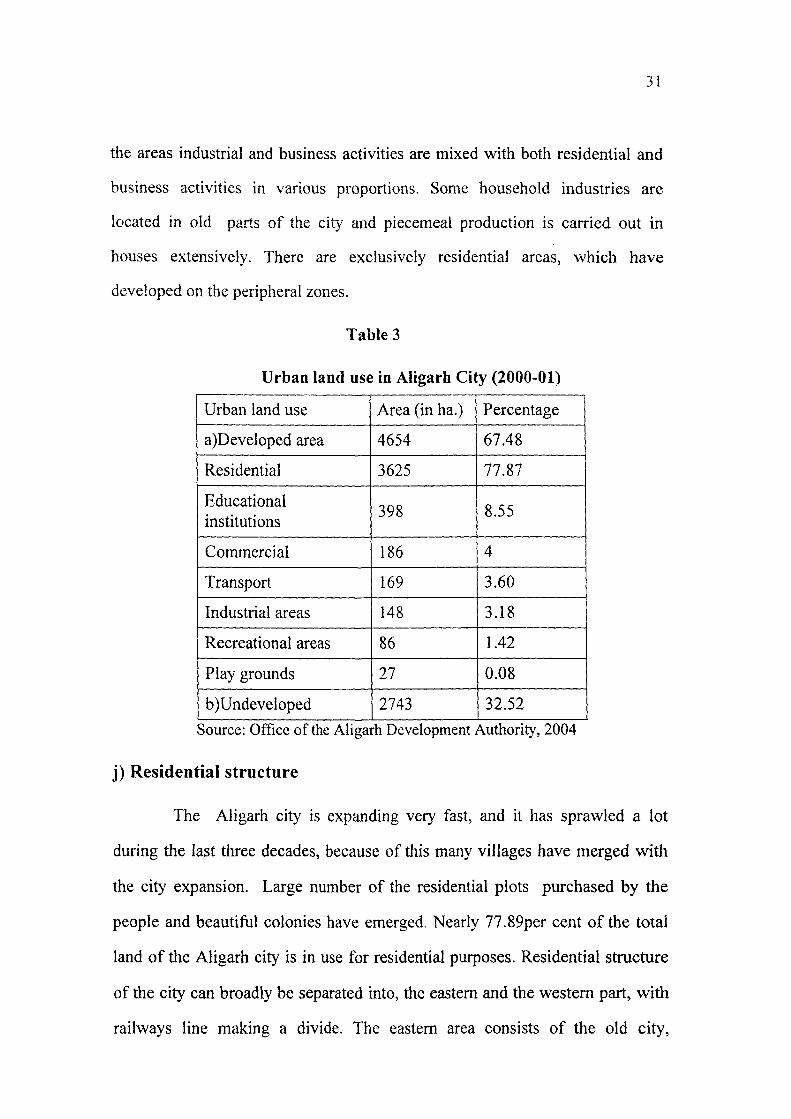
31
the areas industrial and business activities are mixed with both residential and
business activities in various proportions. Some household industries are
located in old parts of the city and piecemeal production is carried out in
houses extensively. There are exclusively residential areas, which have
developed on the peripheral zones.
Table 3
Urban land use in Aligarh City (2000-01)
Urban land use Area (in ha.) Percentage
a)Developed area 4654 67.48
Residential 3625 77.87
Educational institutions
398 8.55
Commercial 186 4
Transport 169 3.60
Industrial areas 148 3.18
Recreational areas 86 1.42
Play grounds 27 0.08
b)Undeveloped 2743 32.52
Source: Office of the Aligarh Development Authority, 2004
j) Residential structure
The Aligarh city is expanding very fast, and it has sprawled a lot
during the last three decades, because of this many villages have merged with
the city expansion. Large number of the residential plots purchased by the
people and beautiful colonies have emerged. Nearly 77.89per cent of the total
land of the Aligarh city is in use for residential purposes. Residential structure
of the city can broadly be separated into, the eastern and the western part, with
railways line making a divide. The eastern area consists of the old city,

32
characterized by old houses lined with small shops. East of the railway line
comprises the new part, the Civil Lines area and the Aligarh Muslim University
area. This has become the residential area for urban elites. Elegant compact
colonies with high quality spacious houses have come up, but now this has also
become congested.
k) Occupational structure in the city
The Aligarh city is multi-occupational in nature ranging from a
number of persons unemployed to employed in good jobs. A majority of the
people is engaged in business, ranging from small to big shops. Then comes the
clerical grade jobs, and mechanics. In the old walled city of the Aligarh, people
are engaged mostly in the small scale industries like manufacture of locks, and
parts of locks, making plus, iron and silver meltings are generally performed in
different localities of the old city like Atish Bazan, Usman Para, Turkman Gate
and Kala Mahal. Some acid processing factories are also found in Kanwari
ganj. In other muslim dominated mohallas people are engaged in small cloth
stores and the mechanical work done or as labourers.
People living in Civil Lines and in some other mohallas are in class
one jobs like doctors, engineers, lawyers and teachers. Ladies of their families
are also working on top posts of government services. Their children are also
studying good professional courses.

Chapter II
HISTORY OF URBAN DEVELOPMENT IN INDIA
The seeds of urbanization germinated first in the Indus valley around
2500 B.C, but the actual sequence of this event had remained a great mystery
till date. One should first of all consider early village settlement for more
positive clue for the better understanding of successive urban development.
It was during the late Stone Age that people started living in
permanent shelters, in caves and rock shelters. Hunting and gathering were the
main occupations of these people, the flourishing village culture could be
considered as the first step towards later urbanization, but it does not appear
as the direct result of the process of transition from food gathering to the food
production. The excavations of sites reveal no data about existence of any pre
agricultural stage with hunting and gathering as the primary bases of living.
Although it all happened on the Indian soil but it parenthood is doubtful, on the
contrary evidences of cultural similarity in these settlement and those of West
Asian speaks of foreign influence on the origin of Indian settlements.
Evidences are lacking which may point out the gradual transformation
of villages into the urban centers. Hence, it may be quoted that the urban
culture did not directly evolve out of rural environment, but its ancestry lies in
this direction.
a) First phase of urban development in India
In the middle of third millennium B.C urban life in India was on its
full expression and the Indus valley considered to be the first place from where
this phenomena started. The urban development designated by archeologists as

34
the Harappan Culture found it's zenith in the metropolitan cities like
Mohanjodaro and Harppa in northwest India, both the cities have confirmed
certain distinctive principles of urban planning which provides the first
example of planned city culture in the world. These cities had solid towers,
large buildings, the Great Bath, the State Granary and Citadels, the religious
and headquarters of the empire, planned streets with underground drainage
system well connected to the drains of houses by pipes and city drainage finally
found in soak pits which were emptied into the rivers. All these signifies the
existence of strict municipal bodies in these cities. Buildings and houses were
made up of bricks and water coming from wells constructed in most of the big
buildings and houses, these in turn were equipped with drains, bathrooms. It
gives us an idea about the social status at that time.
Copper and bronze were used for the manufacture of utensils, blade-
axes, knives; fish hooks etc. metallurgy also had a significant place in the
industrial activities. The most important feature of that civilization was the
same pattern of the urban planning was followed all through the centuries of
city rebuilding.
Urban development in this phase was at its zenith and has a very
strong impression. The light of urban civilization went out of India for the
period of 1500-1600 B.C, with the fall of Indus civilization due to some natural
calamities and other reasons. But this is not doubtful that Indus people were the
founders of urban development in India.
b) Second phase of urban development
Indus civilization ended in around 1500 B.C and it left a vacuum for
about five centuries during which urban development appears completely
halted in the entire country, a fresh beginning of development took place
35
around first millennium B.C by the Aryans. Epics like Mahabharts and
Ramyana throw some light on Aryan cities. These cities provide many
evidences of an urban civilization, which emerged in about 1000 B.C and
extended its influence up to the area of middle Ganga. Aryan civilization is
regarded as the most important turning point in the urban history of India.
Urban development at that period gradually acquired a momentum; they build
many large cities.
They were the first who introduced iron ploughs with the help of
which they brought improvement in agriculture. Many specialized industries
were established producing objects like wool, leather, and fur.
Many Roman and Greek scholars like Strabo, Pliny, Arrain had given
a on account of urban development in India. Quite a number of urban functions
provided a base for the development to many big cities. Some of them were
really great, but their records were more concentrated to the position, physical
characteristics. Claudios Ptolemy (90-168 A.D) had given some
comprehensive details of the urban development of his time.
Hiuen Tsang, a Chinese traveler has given an accurate idea about the
conditions of towns and cities of that time. According to him, "the towns have
inner gates, with very high walls, the streets and lanes are wide. The
thoroughfares were dirty and slats were arranged on both sides of roads with
appropriate signs. The wall of cities were mostly built up of the bricks and tiles.
The towers on the walls were constructed with help of woods and bamboos, the
houses have balconies and belvederes which were made up of woods. The
walls were covered with lime and mud." From this account one can conclude
that urban development at the time of Aryans was expanding and improving,
36
but the cities were lacking in meticulous planning, centra! part was occupied by
royal palaces, houses developed around these palaces gives a compact look,
basic amenities with municipal vigilance were completely lacking in these
cities. So we can say that, Aryan civilization was much behind the Harappa
culture in terms of urban development and quality of life.
c) Urban development in south India
Urban development in south India is attributed to Dravidian culture,
two states of Tamil Nadu and Kerala show high level of urban development at
that time. A distinctive feature of the urban development of this area was the
existence of two capital cities for each kingdom, Madurai and Kanchimpuram
were the most important.
The cities comprised of the King's palaces; the temples which were
surrounded by many walls, but the common people have to live outside the
walls.
d) Factors contributing to the urban development since the early
historic period
Agriculture, industry and efficient communication system were some
of the major sectors without which urban development could not have taken
place on such a wide and prosperous manner. Hence it will be worthwhile to
review the situation and the conditions of these sectors at that time.
i. Agriculture
Agriculture was the principle means of livelihood. There were lands
belonging to states, government employs, beside this some lands also belonged
to farmers. Megasthenes, has presented a very bright picture of India in his

37
work, according to him, "fertile soil, efficient irrigation, use to give two crops a
year supplemented by sufficient rainfall. Food supply was so abundant that no
famine took place in the country till date. State maintained a large number of
cattle and other animals in the charge of separate officials".
Agriculture constituted the back bone of the Indian economy is amply
by its reference occurring in the writings of Eratosthenes, who pointed out the
striking regularity of copious rainfall guaranteeing double crops. Among the
crops mentioned by him are rice, flax, wheat, pulses, jowar and bajra etc.
Hieun Tsang, visited India in the middle of the 7 century A.D had
made a copious reference to agricultural conditions, major crops were rice,
wheat, com, fruits, mustard seeds etc, milk products were widely used by the
people.
ii. Industry
Industry played a vital role in social life in the country. It boosted up
mobility of the people from place to place, in the form trade. It may be noted
that, industrial development gave a push to urban development, on the other
hand industries developed on the bases of urban market and focused on urban
needs. Market facilities played an important role in the industrial development.
Periplus, has given an exhaustive list of articles of trade; specialized products
include coloured pearls, lac, silk thread, cane sugar, gold, stone, cotton etc.
Haridwar, Gujarat, Kannuaj were the important industrial towns of that time.
All these had direct impact on the urbanization of the country where
the growing stature of non-agricultural activities boosted up the rate of urban
development.

38
iii. Trade commerce and transport
Trade and commerce were having a well defined place in the country's
economy since the early time. This fact is proved by the existence of the
merchant class in the society and the large scale movement of goods
irrespective to physical as well as political barriers. Trade was a highly
expensive at that time due to the huge taxes and entry fees.
Panini, in his writings has mentioned the importance of trade and had
given a list of export and import items, like precious stones, perfumes, cotton,
wood, spices etc.
Thus India maintained a unique position in the commercial world as
the main supplier of luxury goods. Trade and commerce also pushed up urban
development, merchant class paid attention for the provision of civic amenities
in their locality and that is how cities with good infrastructural facilities sprung
up all over the country.
The first mention of internal roads operating as the main trade route is
found in the Buddhist literature; well established trade route both land and
water covered most part of the northern India in 300 B.C. The Maury an Empire
extended then fiirther to south India. The most important road was Imperial
Highway or Royal Road, running for about 16,000 Km traversed the entire
Great Plains and continued in the Central Asia.
The main rivers like the Ganga, Indus, and those in the south
constituted the principle commercial arteries of the country carrying both goods
and passengers.

39
e) Urban development during the medieval period
Medieval period in the history of India is dominated by Muslim
rulers, they invaded India in the 11"' centur>' before their rule Rajputs and
Cholas were ruling in the Western and Central parts of India. Their invasions
played havoc with already declining urban phase, these invaders razed the
cities to dust and imposed their rule in India by the 1526 A.D, Mughals decided
to live permanently in India and set up their empire.
Mughals realized that the urban prosperity is the only way which could
enrich the royal exchequers and this could be done only by the stable
administration.
India attained a high level prosperity and economic development
during the Mughals rule. Mughals constructed many beautiful buildings and
very excellent network of roads like Grand Trunk Road; they developed the
country by developing a transportation network.
In spite of the widespread nature of urban development, the material
standard of the urban centers in the respect of their houses, streets, were not of
very high standard, beside the capital cities like Delhi, Agra and Hyderabad,
these cities have palaces surrounded by number of buildings in a fort with good
houses and better street conditions. There were big market places with
innumerable shops. Mosques, public baths, squares and gardens with all civic
amenities were found but only in big cities. On the other hand small cities do
not have planned network of roads and streets, there was a haphazard
overlapping of residential, commercial and industrial land use and civic
amenities were lacking in these cities.

40
The over all picture that emerges pointedly refers that all most all the
cities of that period have pre-industrial slums providing residences for the poor
urban dwellers. The cities were divided into two sections, the smaller sections
were having royal palaces and the larger sections were formed by the masses of
low, poorly built and congested houses on the narrow lanes.
Regardless of all this Mughals contributed a lot in the urban
development which is evident in the work of many scholars who visited India
in that period.
Ibn-e-Batuta a muslim trader visited India in the 14 century and
wrote about the cities and towns of India in his travel account and made a
special mention about Delhi as one of the greatest city of the world with respect
to architecture, urban development and planning.
According to Bami, "at that time there was safety on roads in all the
direction. Agriculture received special encouragement during the muslim rule,
many big canals were constructed for the irrigation, gardens were planted and
forts were built to provide shelters to the people.
Abul Fazal a courtier of Emperor Akbar in 1542-1605 A.D in his work
Ain-e-Akbari and Akbamama brought forward that urbanization was no longer
remained as an isolated phenomenon, but had diffiised throughout the country.
He also considered agriculture, industries and trade as the main contributing
factors in the field of urban development during Mughal's reign.
f) Urban development during the British period in India
British period is the most important part of the Indian history in which
lies the roots of the most modem Indian development.

In the 17 century European powers came to India as traders. The East
India Company after receiving the permission from Mughal emperors started a
factory in Surat and slowly spread throughout the country by the end of the
17 ^ century. Indian goods were excluded from, the list of export items by the
Britishers and they planned to crush Indian industry by bringing their goods at
a very low price, which had created a vacuum, and a modem colonial economy
was created in India. Thus India was reduced to an agricultural colony of
industrial England supplying raw material and providing large and cheap
market for their products, as a result a deep root feeling was developed in the
Europeans that India should remain an agricultural and rural economy for their
selfish interest.
Nehru in 1960 had expressed that, "India was far more advanced and
had higher civilization in the later part of the 18^ century; literacy in India was
very high with better civic amenities".
g) Construction of railways
Railways had brought a new revolution in India, it is considered as the
most active step towards the urban development in the country. East India
Company in 1843-53 had given first proposal to construct railways in India,
with the aim to carry raw material to the ports easily they were never concerned
with the development of hinterlands. Large ports like Bombay, Calcutta and
Madaras were connected by railway tracks; this led to the development of
textile industries in these cities. Although railways laid the foundation of the
large scale industries, but this facility was confined to the ports only.
42
Though British rule introduced "Industrial Age" in India but under
sever restriction. According to Brahama, Pore and Pore in 1975, "in British
reign the Indian economy came into the fold of the international market in a big
way. It served as the supplier of the raw material to the British industry and a
captive market for their products. The process of commercialization and the
modernization however did not bring in its wake subsequent development of
the economy".
As explained by Pathak in 1975, "independent India inherited what
may be called a semi-urbanized and semi-industrialized pattern centered on the
big metropolis mainly Bombay and Calcutta".
Later in the half of the 19" century British power extended in the
interior and several other cities sprung up as centers of communication and
trade like Kanpur, Ahmadabad, Hubli, Barielly and Nagpur.
Britishers also developed many hill stations for the recreational
purpose like Simla, Mussorrie and Nainital. They opened up missionary
schools for the promotion of western education and culture in these areas.
h) Urban local bodies in the British period
Britishers introduced municipal bodies in the cities and town for more
effective growth and development.
The history of municipal government is divided into four different
phases:
(i) First Phase (1833-1882)
The first local government was introduced with a power to levy house
tax and a responsibility to provide civic amenities. In 1870 Lord Mayo's

43
resolution brought a change in the administration. A scheme of decentralization
of administration was introduced, facilities like education, health and roads
came under the provisional government for these purposes they were also given
some grants.
(ii) Second Phase (1882-1919)
On 18' May 1882 Lord Ripon's resolution laid the foundation of the
system as it is exist today. The principles include, provision to have at least
two-third members of municipalities as non-officials. System of elections was
introduced for the selection of the chairman or head of the municipality.
Several taxes such as octroi, house tax and property tax were
introduced; housing lighting of roads, public health and education were
included in the duties of municipality.
(iii) Third Phase (1919-1935)
This period is influenced by the recommendation of the Royal
Commission on the decentralization in 1907-1908 which led to the resolution
of 1915 of the Government of India. The reforms incorporated in 1919 made a
clear cut demarcation of tax collection power of the local bodies. The local
taxes were toll taxes an the land values, on buildings, vehicles and on animal
trade.
(iv) Fourth Phase (1935-1945)
This phase was started with the inauguration of provincial autonomy in
1935. Further decentralization was made in respect of local bodies. Though
functions were enlarged but the revenue collection had decreased so local
bodies became more dependent on the grants and aids.
44
i) Urban development after independence
In the post independence era the political leaders believed in the
efficiency of urban development through planning. As it has been stated that
the national plan appeared to have joined the national anthem and national flag
as a symbol of sovereignty and modernity.
Independent India embarked on a national programme of development.
In this endeavor, 'planning for urban development' occupied a prime place.
Planning encompassed policies for various aspects of city progress to bring
about the necessary changes. In 1950, the Planning Commission was
established by the Government of India. With Nehru as the Chairman of
Planning Commission was given the task to further articulate and implement
through Five Year Plans, the national policy directive and development
objectives. The setting of Planning Commission enabled the central
government, to take the initiatives for policy making, through formulation of
Five-Year Plans.
Thus the central government's statement on the urban development
and policy as expressed in the national development five-year plans reflect the
general policies being followed by the central and state government.
The national policy issues were incorporated by the Government of
India which also allocate the resources to the state government through
variously sponsored schemes and assistance programme for the housing and
urban development in the country as a whole. Ministry of Urban Development
is an apex authority of Government of India at the national level to formulate
policies, where as central ministries, state government and the local bodies are
given the task to monitor the issue of urban development in the country.

45
According to the India Constitution, urban development is a state
subject. Without a constitutional amendment, the central government does not
have the power to pass legislation on urbanization, urban development and
urban planning. However, urban development as the state subject had received
a scant>' attention in almost all the states. Thus what exists as the urban policy
for urban development, has estimated more often than the central government.
Hence five-year plans were made as the policy proposals for the urban
development.
j) Government's role in urban development
Urban development activities are concerned on the three levels of
government- centre, state and local and also among civil society organizations.
Though urban development policies are related to the state government but the
central government has played a much important role in this field since after
independence.
Urban local governments are established for the purpose of urban
administration and development. Since urban local bodies have only those
powers which are given to them by the state government, this prevent them
from effectively achieving their goals, they have been ill equipped in terms of
resource, skills and infrastructure.
After independence many ambitious measures were taken in order to
transform the socio economic scene of urban areas in India, in the form of five-
year plans.
The First-Five Plan (1951-56)
This plan was mainly concerned with the problems of agricultural
sectors because soon after independence these problems required urgent

46
national attention. Moreover, with the limited resources government had top
priorities to achieve these goals. Therefore, matters related to urban
development occupied low position in list of First Five Year priorities.
The Second Five-Year Plan (1956-61)
Central scheme was initiated to provide financial assistance to the
states and local bodies for clearing big slums in big cities. In this plan an
attempt was made to operationalise the Modernisation theory. There was a
belief that the underdevelopment could be overcome by the technical and
organizational structure that would made development possible in the
industrialized countries.
The Third Five-Year Plan (1961-66)
In this plan more attention was paid urban planning in India. Through
this plan government for the first time, formulated an urban planning and land
policy. The main objective of this policy was to achieve a balanced
development in different urban areas of India by establishing large, medium
and small scale industries.
The most important contribution of planning in this plan period was
the diffusion of the ideas of town planning, from the centre to the states. Master
plans were made for the capitals and other growing cities.
This plan recognized the role of industrialization in the urban
development. It implemented a policy aimed at the establishment of heavy
industries away from the big cities. It is also important to stress here that this
plan also took note of urban community development schemes in selected
cities to solve the problems related with the slums. The plan also emphasized

47
the need to strengthen municipal administrations for initiating new
development policy.
The Fourth Five-Year Plan (1969-74)
This plan stressed the need for the regional approach to the issue of the
urban development, decongestion of cities, dispersal of urban population,
adoption of the community development programme for the cities as well as
the environment improvement in urban slums. During this plan government
recognized the urgent need to check population growth of big cities like
Kolkata and Mumbai and also to initiate population dispersal to reduce
pressure on the big cities.
Towards the end of this plan an agency was established Housing and
Urban Development Corporation (HUDCO) to provide funds for the
metropolitan authorities, state housing boards and other urban institutions to
finance scheme for the construction of houses in the urban areas set by the state
and central government.
Certain states government during this period took serious steps to
disperse industries in their states like Ahmadnagar, Aurangabad, Nagpur, Nasik
and Tarapur, which are intermediate cities of the state.
The Fifth Five-Year Plan (1974-79)
This plan emphasized the need for the environmental improvement in
the big cities. There was an increased concern and recognition of urban
problems, among these urban poverty was most important. Many development
programmes were launched during this plan and Urban Development
Authorities were set up by the state government in big cities.

48
Small and medium towns were given special attention to highlight the
urban growth and to check the population pressure on the big cities. In 1976
The Urban Land (ceiling and regulation) Act was introduced as a part of this
plan, it put a ceiling on the ownership of the vacant lands in the urban
agglomerations and there by sought to secure more land for public use,
including provision for social housing.
The Sixth Five-Year Plan (1980-85)
This plan stressed more emphasis on the integrated development of
small and medium towns, as initiated in previous plans. This was done with
the view of promoting development of not only small towns but the rural areas
as well, by their functioning as the growth centers.
The National Policy on Urbanization highlighted the urban problems
and indicated that each region's urban development should be viewed in
relation to the surrounding areas. As far as making provision for urban areas
were concerned there was specific mention for slums. This was primarily in
response to the alarming problems of slum settlement in large cities.
Thus Sixth Plan, therefore, made substantially larger provision for the
environmental improvement of the slums.
The Seventh Five-Year Plan (1985-90)
This plan had continued with ongoing programmes initiated in the
earlier plan. In this plan government noted the rapid growth of metropolitan
cities and the slow growth of small and medium, indicated by the statistics of
the 1981 census. As a result, the seventh plan stressed the need for the
integrated development of small and medium towns and the need for slowing
the growth of metropolitan cities.

49
Main contribution of this plan was the creation of Urban Infrastructure
Development Finance Corporation, to provide capital for the development of
the infrastructure in small and medium towns. Beside all this two schemes
namely Urban Basic Services for the Poor (UBSP) and the Nehru Rozgar
Yojana (NRY) the main objectives of these schemes were poverty alleviation
and the generation of urban employment.
The Seventh Plan laid emphasize upon the revitalization of civic
bodies and greater devolution of funds to the local bodies. This plan stated
"serious efforts will be made to involve voluntary agencies in various
development programmes, particularly in the planning and implementation of
the programmes of the rural areas".
During this plan an attempt was made to grant constitutional status to
urban local bodies as a precursor to their regeneration. On the 7"" August 1989,
a bill was introduced in the Lok Sabha to strengthen urban municipal bodies.
This bill referred to as the 65" Bill, 1989, incorporated some of the major
recommendations of the National Commission on Urbanization which had
submitted its report on August 1989. The bill sought to create a third level of
urban government, below the level of the union and the states. But it was failed
to pass in the Rajya Sabha in 1989. After the modifications the bill was
reintroduced for ratification as 74"' bill in 1992 and the Act came to force on
March 1993.
Meanwhile report of the National Commission clearly pointed out the
critical deficiencies in various services of infrastructure, the concentration of
the poor and deprived people, the acute disparities in the access to the shelter
50
and basic services, deteriorating environmental quality and the impact of poor
governance on the productivity and the income of enterprises in the cities.
Urban component was accorded only a secondary' importance in the
previous plans, these plans also suffered from many shortcomings, which are
mentioned below:
i. These plans did not gave any comprehensive appreciation of the India's
urban problems, nor was there any framework for dealing with the
increasing problems of urbanization. Though the urban population was
one-sixth of the total population in 1951 and over one-fourth in 1991,
the outlay for the urban development was less then three percent in
virtually all plans. It was pointed out that, "the central and state
government pursued laissez-faire policies of urban development".
ii. There has been a strong feeling that urban problems escalated because
there was any clear cut policy or even philosophy for the urban
development. Ashish Bose lamented about the "lack of social
philosophy for the urban development" in 1971 itself This could be due
to the compulsion of first finding a solution to the rural problems,
therefore urban development took the back seat.
iii. Another important missing dimension in the plan documents was the
element of the people's participation. Beside this there was a very wide
gap between the promises and performances.
iv. The most important lacuna was in not giving urban development an
independent identity. Because urban development was often associated
with work, housing, water supply and health. At the state level also
urban development responsibilities were diffiised.

51
V. Above all these weaknesses, one of most glaring errors was in the fact
that there have been policy proposals on the policy of industry,
agricultural improvement and population growth but there has been no
national urban policy until the eighth five year plan.
Table 4
Plan Outlay in Housing and Urban Development
Plan Total outlay (in crores of Rs)
Funds allocated in housing and urban
development (in crores of Rs)
Share from the total (in
percentage)
First plan 20688 488 2.1
Second plan 48000 1200 2.5
Third plan 85765 1276 1.5
Fourth plan 157788 2702 1.7
Fifth plan 394262 11500 2.9
Sixth plan 975000 24884 2.6
Seventh plan 1800000 42295 2.3
Eighth plan 4341000 105000 2.4
It is clear from Table that the plans for the urban sector despite of its
increasing importance has in fact declined significantly.
The Eighth Five-Year Plan (1992-97)
This plan encouraged investments in urban development. It
emphasized the government to play a role of creating an environment that
would encourage people's initiatives rather than making them dependent on the
government.
This plan also emphasized on the 'Human Development'. Thus the
eighth plan was qualitatively different from the previous plans in its aims,

52
because, only from this plan a clear cut progress was expected in urban
governance.
The eighth five year plan, for instance, emphasized human
development as the core for all developmental efforts. The plan recognized for
the greater involvement of the voluntary agencies that have the ability to
demonstrate and innovate and act as support mechanisms to local level
institutions. It also recognized the role of the government in facilitating the
process of the people's involvement by creating the right type of institutional
infrastructure.
The Ninth Five-Year Plan (1997-2002)
Main objectives of this plan was for "ushering a new era of people
oriented participative planning, in which people at large and especially poor
can participate".
This plan envisaged for expansion and improvement in social
infrastructure like health care, education, housing, water supply and sanitation
in urban areas. For some sectors like housing, specific targets to be achieved
within a define time framework; for other sectors such as health and education,
efforts were made to achieve substantial expansion and improvement of quality
of these services.
Thus, urban domains have got the recognition it deserves in this plan
only.
The Tenth Five-Year Plan (2002-2007)
In this plan the priority was given to the development of decentralized
urban local bodies (ULBs) structure to cope with the demand for basic

53
infrastmctural facilities needed in cities for their proper growth. The role of the
ULBs was very important for the urban development. They should improve
their capabilities by equipping themselves to undertake their tasks in resource
raising, services provision and poverty alleviation.
As the previous reports emphasized, "the feeling that urban planning
ignores the needs of the urban poor", have been dispelled through "effective
actions to meet these needs" in this plan. In this connection it was stated that
the urban development authorities that acquires the growth of the cities should
reserves a major part of such lands to meet the requirements of the weaker
sections. An outlay of Rs 29719 crore was allotted to the Ministry of Urban
Development and Poverty Alleviation.
This plan also stressed more on the proper availability of
infrastructural facilities like roads, sanitation, housing, education, health and
recreation for the improvement of quality of life of the people living in the
urban areas.
After examining these plans we can easily say that despite having very
positive and promising goals, these measures really did not benefited people
living in cities, nor helped in improving their social welfare. A main reason for
this situation is the uneven and tremendous growth of urban people which have
laid an enormous pressure on the present civic amenities in the cities.
In India the urban population during pre-independence time was 13.9
per cent in 1941, which rose to 17.3 per cent in 1951 after the independence.
Before independence nearly 15 per cent people were living in towns and now
their share has become just double. The reasons in increase urban population
may be many, but the main reason has been the migration of rural population to
urban areas.
54
The growth of urban areas in India is related with a shift of a
significant proportion of population from villages to urban areas in search of
better livelihood. During the period of 1961-71 about 24 million people
migrated from rural to urban areas. Every year on an average about 4 million
people migrate to cities like Mumbai, Delhi and Kolkata. McGee has described
this type of migration in the third world countries as 'pseudo-urbanization',
because it is not a consequence of industrialization or other allied causes but is
the product of failure to reform the agricultural structure which has resulted in
rural poverty. The reality is that because of the sick urban phenomenon in
million cities of India unemployment has risen, earnings have gone down
which also degraded the quality of life in cities.
However, the pattern of urbanization in India varies, the highest being of
Delhi 90 per cent to the lowest of Dadra and Nagar Ha\eli 8.5 per cent. In other
Union Territories the figures vary between 25 and 65 per cent. In case of
various states, Mizoram, Goa, Maharashtra, Gujarat, Kamataka and Tamil
Nadu it vary between 30 and 45 per cent largely because of industrialization,
transport link and trade. On the other hand states like West Bengal, Uttar
Pradesh, Rajasthan, Punjab, Madhya Pradesh and Himachal Pradesh vary in
between 20 and 30 per cent, and may be of medium level of urbanization. The
rest of the areas which show below the average level are below the low urban
order. These include Arunachal Pradesh, Assam, Bihar, Orissa, Sikkim and
Ttipura, where transport links are weak and industrialization is also very slow.

55
Table 5
Trend of Urbanization in India (1901-2001)
Census year
Total population (in lakhs)
Urban population (in lakhs)
Urbanization rate (%)
Decadal increase (%)
1901 2384.0 259 10.8
1911 2520.9 254 10.3 0.35
1921 2513.3 281 11.2 8.22
1931 2789.8 335 12.0 19.14
1941 3186.6 441 13.9 31.97
1951 3610.9 624 17.9 41.38
1961 4392.3 789 18.0 26.41
1971 5481.6 1091 19.9 38.28
1981 6833.3 1597 23.2 46.02
1991 8443.2 2171 25.7 36.19
2001 10270.2 2853 27.7 31.39
Source: Census of India, 2001
There is a pressing need to evolve a strategy that addresses the
problems of urbanizing areas in terms of stipulation of infrastructural services.
Large investment in urban infrastructure like roads, rails, power, sanitation,
sewerages and telecommunication are required for accelerating the growth rate
of the economy and upliftment of social welfare.
j)s- T^s'j' '\-
56
Review of Literature
Urban geography is mainly concerned to deal with different aspects of
urban places, the urbanization trends, growth process, patterns, morphology,
evolution, urban development and planning.
Urban development means the provision of civic amenities in the cities.
It includes both physical and social infrastructural facilities.
Physical infrastructural facilities consist of amenities like roads,
transport facilities, housing, sanitation etc.
Social infrastructural facilities consist of amenities like health, education
and recreation.
Many urban geographers have examined patterns and trends of
urbanization and development in their regional settings at the macro and micro
levels.
Social consciousness and will to achieve civic betterment have attracted
attention of scholars, geographers and planners
Several scholars from different fields and from other countries including
India have contributed number of studies in a wide spectrum of urban
development. They have attempted to study different aspects and problems of
the cities and suggested measures to improve infrastructural facilities for social
welfare of people living in different cities.
Taylor (1946) for the first time had given a fillip to urban studies,
urbanization, urban development and urbanism in his work. He has mentioned
some important aspects related to towns and cities.

57
Snails (1953) provided the basic outlines for the study of towns in
which he considered significance of growth of urban population, housing
conditions and other amenities.
Jones (1966) worked on different cities and towns of the world and
mentioned the problems associated with the towns due to the lack of
infrastructural facilities and discussed the impact of availability of civic
amenities on the social welfare of people living in these cities.
Mayer and Kohn (1967) also contributed much to urban geography.
According to them, urban development is very important as far as the
development of cities is concerned.
Wilson (1969) based his study on the quality of life in the cities of the
United States. He selected some indictors to examine the quality of life in
urban areas on the basis of domestic goods, economic status of an individual,
equality, democratic problems, education, economic growth, living conditions
and health.
Drewnoiski (1970) referred to the welfare generation functions in the
cities in his work. According to him local conditions like housing, health and
education are the major indicators for maintaining and plarming of the quality
of life in urban areas. He investigated the quality of life in 18 metropolitan
cities of the United States by selecting 14 indicators to study the urban
development and quality of life in these cities. The selected indicators include
employment, income, housing, health, public order, racial equality, citizen
participation, air quality, education and social disintegration. He emphasized
more on factors like residential quality, health facilities and recreational
facilities for determining the social welfare.
58
Gilbert (1975) attempted to examine the urban development and
planning in countries belonging to developed and less developed parts of the
world and concluded that the countries of developed world also suffer from
failure in the planning. It is a mere assumption that planning works well in
developed countries, if right strategies are taken in developing countries they
may prove successful.
Knox (1975) suggested that levels of living in urban areas provides best
framework for the development of social life. The level of living in cities with
the given geographic constraints constituted by the composition of
infrastructural facilities like housing, health, employment, education and
security.
Harrison and Gibson (1975) in their work gave an account of the
problems which the people face in urban areas due to the lack of urban
infrastructural amenities and also suggested certain useful measures to improve
the quality of life.
de Souza (1978) has evaluated poverty, ecology and urban development
in his work and stressed that the main cause of the urban poverty is the
inadequate civic amenities in urban areas, specially lack of housing is one of
the main reason for poverty in urban India.
Smith (1979) evaluated the concept of urban development by selecting
ten major indicators related to social problems. According to him, income,
education and health are the most appropriate indicators to measure the quality
of life in the urban areas.

59
Herbert and Johntson (1980) worked on the significance of availability
3f infrastructural facilities in the cities with more emphasis on residential
structure and urban environment.
Redclift (1992) discussed numerous aspects of development in the urban
ireas and, suggested that the development should be environmentally rational
:o improve the quality of life of the people living in these areas.
Hoff and Stenberg (1993) studied Indonesia's Integrated Urban
Infrastructure Development Programme (IIUIDP). Basically they examined the
role of provincial and local authorities in the implementation of the above
programme. However, this programme failed in the provision of infrastructural
facilities, but made a considerable contribution in the innovation of the local
government.
Fox (1994) stressed that policy makers must examine the levels of urban
facilities, when making investments on infrastructure in urban areas. He
suggested, that the work on telecommunication, electricity generation, urban
transportation and the solid waste disposal should be done on private basis so
that the quality of urban life will improve much rapidly.
Pacione (2001) in his study analyzed that although the urban population
is growing fastly in third world cities, but the population is less equipped i.e. it
lacks in infrastructural facilities to cope up with urbanization. This is the reason
that is the urbanization in third world cities is considered to be consummative
rather then generative.
Dove (2004) attempted o evaluate urban development in the State of
Andhra Pradesh, and suggested how the sustainable changes can improve the
life of poors in cities. He suggested, that the municipalities and other local

60
bodies, many frame the plans to provide civic amenities to the people. He
concluded if the local government takes the active steps for the urban
development, it can improve the social welfare in the cities.
Swilling (2006) highlighted the importance of economic sustainability
issue in cit>' infrastructure plans and investments. He reviewed the South
Africans government's plans with reference to investments and infrastructural
facilities for improving the socio-economic conditions of the people.
Urban Development in India- A Review of Literature
Singh's pioneer work (1955) marks the begirming of studies in urban
geography in India. He studied the pattern of urbanization, urban development
and problems related with urban infrastructure in the city of Banaras.
Alam (1965) presented a systematic estimate of the urban landscape of
twin cities of Hyderabad and Secanderabad of Andhra Pradesh and discusses
about the infrastructural facilities available with them and their impact on the
quality of life of people living in these cities.
Misra (1972) worked on the relevance of urban infrastructural facilities
in regional planning. He is of the opinion that infrastructural development is a
key factor in urban life and development of cities. He suggested various
measures, if taken can solve problems related with the quality of life in the
urban areas.
Aziz (1973) analysed the radial and zonal influence of Aligarh city to
measure the influence in Aligarh on literacy of the population living in
surrounding countryside and on the functions of trade and commerce,
manufacturing, agriculture and on other services.

Singh (1978) discussed the problems related with the urban
development in India. He pointed out, that the local governments of the state
(municipal bodies) were incapable to improve conditions of the cities due to the
limited resources; as a result, some special purpose bodies need to be created to
undertake certain specific urban development programmes like, housing, road
improvement, provision of the health and education facilities. According to
him, fast growing population of the cities is the major problem in the city
development. Government should create small and medium towns around the
big cities to check the migration of rural population to urban areas, which had
laid enormous pressure on the infrastructural facilities of these areas and also
destroyed social welfare of the people living in cities.
Bhattacharya (1979) worked to trace the history of urban development
in India from far back years to the urban development by the 20 century. In
his work he considered urban development during specific periods and also
identified factors that have contributed to the urban development in India.
Rao (1982) discussed the problems associated with the dispersal of
urban infrastructure. According to him slums, congestion and lack of other
civic amenities are the major cause of the low quality of urban environment
which in turn have a bad impact on the social welfare of the people living in the
urban areas. He also has suggested some effective urban development policies.
Kopardekar (1986) examined the process of urban growth and the
development trends in India and other developing countries within the frame
work of the society and the pattern of development policies. In his study he has
discussed social, economic, environmental, administrative policies of urban
growth.
62
Verma (1989) analyzed the patterns of urban growth in India. He
examined the of urban development with the help of some components of
regional development and emphasized how basic civic amenities help in the
growth of urbanization and enrichment, of standard of living in urban areas.
Fakhuddin (1991) attempted to study the differences in the quality of life
in different residential areas of Lucknow. He selected 28 variables which relate
to residential pattern, and 31 variables related to the quality of life. He stressed
on the five underlying categories of housing conditions, territorial stress, and
civic amenities like, health, education and recreation.
Ahmad (1992) attempted to ascertain the quality of life in the Aligarh
city. In her study she found that the Aligarh city lacks in infrastructural
facilities. She pointed many problems which the Aligarh city faces like, old
and unplanned housing conditions, sewage problems, lead to waterlogging
which results in several epidemic diseases.
Mohanty (1993) stressed on the provision of basic services like water
supply and sanitation, in three big cities of Delhi, Bhubaneshwar and Raurkela
and suggested an urgent need for improvement and increment of financing for
basic amenities in the cities. Municipal bodies should be given more powers, so
that, they can take active part in the development process.
Ranjan (1997) emphasised that unplanned growth of urban centers is
leading much stress on infrastructural facilities like shortage of housing, bad
roads, lack in medical and educational facilities, less power generation and
many other problems. These problems can be solved only by providing
appropriate infrastructural amenities in growing towns and in big cities.
63
Saxena (1997) worked on Aligarh master plan. She emphasized on the
provision of proper basic amenities and facilities are important for the proper
development of the city.
Singh and Rehman (1998) analysed the problems of housing and health
in the low income household of the Aligarh city and suggested for
improvement in infrastmctural facilities in the cit}^
Sharma (1999) tried to underscore the importance of human
development in urban society, which in turn leads to economic development.
He presented a compared picture of quality of life in different states of India
and suggested that there is an urgent need for providing basic infrastmctural
facilities to the backward states to enhance the pace of development.
Singh (2001) critically analyzed urban development and planning and
number of socio-economic problems which mainly arise due to unplanned
urban development. He also pointed out, that the medium, small towns and
cities are the main sufferers in this process because large number of resources
are being pumped into big cities leaving very little for small cities.
Majumdar (2003) worked on to ascertain the regional variations in the
availability of infrastmctural facilities in different urban regions of India.
According to him, first step towards the development should be the equal
distribution of infrastmctural facilities by implementing integrated regional
development programmes in urban areas.
Bhakar and Bhargava (2003) attempted to find out inter-district
disparities in infrastmctural development in Rajasthan. They selected seven
sectoral indices like educational development, health development, transport

64
development, communication development, banking development, corporate
development and power indicators.
Dhaliwai (2004) made an attempt to study major issues of urban
development in cities with special reference to infrastructural facilities. His
study deals with existing, emerging and future problems faced by local bodies
with regard to infrastructural facilities and has also given very effective
suggestions for these problems.
Basak (2005) has worked on the housing development in the North
Eastern regions of India and observed the acute shortage of housing in this
region and suggested that government should provide houses to the people
belonging to all income groups for an effective urban development.
Tyagi (2005) has suggested that municipal bodies in the cities use GIS
and Remote Sensing techniques for the effective allocation of civic amenities
in the cities.
Majumdar (2005) attempted to analyse the status of urban
development in the State of Jammu and Kashmir in the context of planning of
urban development policy for sustainable development and highlighted
inadequate infrastructural facilities which have led a failure in urban
development. He stresses that local government should take the initiatives in
solving problems like waste disposal, provision of safe drinking water and
transport.
Siddhartha and Mukherjee (2005) worked on the cities, their functions
and urbanization. Their work mainly deals with the origin of the cities, factors
behind their origin and growth.

65
Rao (2006) has highlighted the issues and challenges in the urban
development arena in India. He has stressed on the problem of the extreme
urban povertv', deprivation and poor access to urban sen/ices.

66
References :
1. Ahmad, S., Residential Structure and Quality of Life in Aligarh,
Aligarh, 1992.
2. Aziz, A., Urban Gradients Around Aligarh, The Geographer, Vol.20,
No.2, 1973,pp.l35-150.
3. Basak, CM., Urban Housing Development Strategies of the North East
Region of India, Indian Journal of Regional Science, Vol.40, No.l,
2005, pp. 33-42.
4. Bhattacharya, B., Urban Development in India, New Delhi, 1979.
5. Bhakar, R.R. and Bhargava, M.P., Disparities in Infrastructural
Development in Rajasthan, Indian Journal of Regional Science,
Vol.35,No.l,2003,pp.56-66.
6. de, Souza.Alferd, The Indian City: Poverty, Ecology and Urban
Development, U.S.A, 1978.
7. Dhaliwal,S.S., Urban Infrastructural Development in Small and
Medium Towns, New Delhi,2004.
8. Drewnowsiki,J., Measuring the Level of Living, Swansea, 1970.
9. Dove, L., Providing Environmental Urban Services to the Poor in
Andhra Pradesh, Environment and Urbanization, Vol.16, No.l, 2004,
pp. 51-62.
10. Fakhrudin, Quality of Urban Life, Jaipur, 1991.
11. Gilbert, Development, Planning and Spatial Structure, London, 1975.

67
12. Herbert, D.T. and Johnston, R.J., Social Areas in the Cities, London,
1980.
13. Herbert, D.T. and Smith, D.M. et al. Social Problems in the City,
Oxford, 1979.
14. Jones, E., Towns and Cities, London, 1966,
15. Knox, P.L., Social Well Being: A Spatial Perspective, 1975.
16. Kopardekar, H.D., Social Aspects of Urban Development, Mumbai,
1986.
17. Majumdar, P., Urban Development in Jammu and Kashmir,
Geographical Review of India, Vol.67, No.l, 2005, pp. 32-40.
18. Majumdar, R., Infrastructural Facilities in India, Indian Journal of
Regional Science, Vol.34. No.l, 2003, pp. 1-23.
19. Mayer, H.M and Kohn, C.F., Reading in Urban Geography, Allahbad,
1967.
20. Misra, R.P., Role of Growth Foci in Regional Development in Regional
Planning, New Delhi, 1972.
21. Mohanty, L.N.P, Management of Urban Development in India, New
Delhi, 1999.
22. Pacione, M., The Internal Structure of the Cities in the Third World,
Geography, Vol.2, No.2, 2001, pp. 16-26
23. Prakasha Rao, V.L.S., Urban Planning: New Dimension, New Delhi,
1983.
24. Ranjan, R., Problems of Growing Indian Cities, New Delhi, 1997.
68
25. Rao, P.S.N, et al., Urban Governance and Management, New Delhi,
2006.
26. Redclift, M., Sustainable Development, London, 1992.
27. Saxena, N., Aligarh Master Plan: Urban Land Use Planning, The
Geographer, Vol.54, No.2, 1997, pp.12-19.
28. Siddhartha, K. and Mukherjee, S., Cities, Urbanization and Urban
Systems, New Delhi, 2005.
29. Singh, K.N., Urban Development in India, New Delhi, 1978.
30. Singh, R.L., A Study in Urban Geography, Banaras, 1955.
31. Singh, A.L. and Rehman, A., Housing and Health in Low Income
Households of Aligarh City, The Geographer, Vol.55, No.l, 1998,
pp. 17-26.
32. Singh, N., Urban Development and Planning, New Delhi, 2001.
33. Sharma, P.V., Inequalities in the Quality of Life in India, Indian Journal
of Regional Science, Vol.31, No.2,1999,pp.41-49.
34. Snails, A.E, The Geography of Towns, London, 1953
35. Swilling, M., Sustainability and Infrastructural Planning in South Africa,
Environment and Urbanization, Vol.18, No.l, 2006, pp.6-11.
36. Taylor, G., Urban Geography, London, 1951.
37. Tyagi, N., Residential Environment of Gorakhpur Municipal Area,
Indian Journal of Regional Science, Vol.40, No. 1, 2005, pp.21 -30.
38. Wilson, J.O., Quality of Life in the United States: An Excursion in to the
New Frontier of Socio-Economic Indictors, Kanas City, 1969.

Chapter III
URBAN INFRASTRUCTURAL FACILITIES IN ALIGARH CITY
World population continued to increase tremendously during last few
years; urban population growth is much higher than rural growth rate. By the
year 2005 world's urban population was estimated to over five billion. It is
expected that this phenomenon will be more pronounced in the developing
countries.
India is popularly known as the "Land of villages" but since the
independence the size and the growth of urban population has increased
steadily.
Main reason for the tremendous increase of the urban population has
been the migration of the rural population to the urban areas in search of better
job opportunities.
a) Definition of Infrastructure
The term 'infrastructure' has come to mean all things to all people. It
may be defined as comprising the basic services and public utilities essential to
the commodity- producing sectors of an economy a distinction is often made
between economic and the social components of infrastructure: the core of
economic infrastructure comprises transport, communication, supply power
and water, and social infrastructure includes housing and medical services.
Education and financial institutions, a vital part of infrastructure, are not so
easily categorized.

70
The definition of infrastructure explains that the physical facilities
which are available to the people in the form of goods, commodities, water,
energy and information. But this definition does not include building or
vehicles. However, the basic purpose of infrastructure facilities continues to be
the same as it was in prehistoric times to support human life.
The story of infi-astructure is the story of civilization. As people began
to civilize then they needed facilities which were called infrastructure.
b) Infrastructure in early times
In the initial stages of life human beings were nomadic hunters,
gatherers, wandering from place to place in search of food and water. But
when people started living in one place to cultivate crops they needed some
facilities like habitation, well and a privy. These primitive facilities were the
man-made infrastructure. People started farming, weaving, leather work, metal
work or trade for this they needed roads to move about and for trade and means
of communication with other towns.
As urban areas grew further they needed better transportation, water
supply, waste disposal, market places for business and the buildings to support
government activities. Human civilization marched a long way through the
towns and cities of the ancient and middle ages to today's mega cities.
Infrastructure has likewise developed not only in urban areas but also in small
towns and rural areas.
c) Current Scenario
According to Mr. Jagmohan, Minister of Urban Development,
Government of India, "At present there is no sanitation worth the name for 52
71
per cent of the urban population. The sewerage system covers only 35 per cent
of the population of class IV cities, and 75 per cent of population of class I
cities. About 34 per cent of the urban population does not have any
arrangement even for the drainage of rainwater around its habitats. Nearly 60
per cent of the Municipal Bodies in India collect less than 40 per cent of the
urban waste, which is allowed to decompose and putrefy on the road sides and
around the houses and factories. Quite a substantial portion of it goes into the
drains, choking them and creating slush and stink all around, besides providing
breeding ground for pests, flies and mosquitoes and cockroaches".
The Economic Survey 1999-2000 published by the Government of
India warns that, "the widening the gap between the demand and supply of
infrastructure continues to raise questions concerning the sustainability of
economic growth in future."
d) Impact of urban development on the infrastructural facilities in India
Urban development means the provision of basic services to the
people, but urban centers in India presents a grim picture with regards the
availability of basic services.
It is widely accepted that insufficiency and imbalance of
infrastructural facilities have negative impact on the economic growth and the
quality of life of the people in the country.
India Infrastructural Report 1996 is a land mark work and has made
recommendation for the infrastructural sector, but still the gap between the
availability and the demand for the urban infrastructural and services has
increased over the years and the impact of the urban growth on the space,
environment and the quality of life has been severe, because the present urban

72
infrastructural facilities require to support a liuge concentration of urban
population.
Urban services consist mainly of drinking water, sanitation, sewage
system, electricity, urban transport, primary health and education. The process
of urbanization has gathered considerable momentum in recent times this has
put urban services into the severe strains, especially small and medium cities
are facing more acute problems due to the inadequate financial resources.
Several studies have indicated that large segments of urban population
do not have access to basic services. Thus urban sector suffers from many
deficiencies in infrastructural facilities despite of emphasis in the successive
five year plans for orderly development of core infrastructural services.
The gap between accessibility and requirement for urban
infrastructural development has widened over the years which has severely
affected space, environment and quality of life in urban areas. Large segments
of urbanites do not have access to basic services like drinking water, sanitafion,
basic health and education services.
The data available from the census 2001 indicate that the percentage
of urban households having access to safe drinking water has gone up from
81.40 per cent in 1991 to 90 per cent in 2001. The average water supply in
large cities is only 5 to 6 hours a day. As per census 2001, nearly 39 per cent
of urban households were without access to portable water within their
premises. Approximately, 26 per cent of urban household have no access to
sanitation with in their premises and are forced to use open spaces. Sewerage
system exist in few cities and even these cover them partially. In such cities,
only a part of sewage is collected and even less of that is treated. As a result,

73
discharge of waste leads to pollution, environmental degradation and health
risks. Only a part of garbage generated in urban areas is collected, transported
and disposed off The accumulation of garbage along road side in huge
quantity has become a common sight in most cities. In many cities, industrial
waste, municipal solid waste gets mixed up posing a serious environmental
threat. Most of the cities are exposed to air and water pollution, and problems
are posed by inadequate solid and liquid waste management.
e) Infrastructural facilities in Aligarh city
In this chapter an attempt has been made to study and analyze the
basic infrastructural facilities in five zones of Aligarh city.
Methodology
The study is based on the primary sources of data. Data pertaining to
infrastructural facilities like, housing, drainage, sewers, roads, health and
educational facilities in the different wards were collected with the help of the
extensive city surveys conducted in the city.
The indicators selected for the study related to the quality of life of
the people living in different wards of the city like, size of the family,
education, profession, income, material status of the households etc.
Detailed informations pertaining to all aspects were selected with the
help of a questionnaire by visiting to different wards of the city and by
contacting the residents of the respective wards.
The surveys were conducted during the months of January and
February 2007. About 8 to 10 households were selected from each of ward out
of the total of 54 wards of the city. Stratified random sampling was done

74
keeping in consideration that the households selected should have good
representation from the ward.
These wards were further categorized on the basis of their distance
from the city centre as shown in Table 6
Table 6
Number of Zones, Wards and Households Selected for Survey in Aligarh City
Zone Distance from
city centre (in Km)
Zone wise number of
wards
No of households
Percentage
I zone 0-0.5 3 30 5.8
II zone 0.5-1 5 50 9.8
III zone 1-1.5 12 120 23.5
IV zone 1.5-2 9 90 17.6
Vzone 2-2.5 22 220 43.1
i) Types of houses
Type of housing helps in determining the standard of living in a area
or ward. It is considered to be the best indicator which gives an idea about the
class of people living in that area and also indicates to the level of urban
development.
Table 7 indicates that almost all the houses in the first zone are
old this is because that first zone comprises the oldest part of the city, some of
the families living here traces their history to the medieval period and represent
social elites of that area, these houses consist of one room and are very
congested.

7S
ALIGARH CITY Selected Zones
I - First Zone
I I " Second Zone
III- Third Zone
IV - Fourtli Zone
V - Fifth Zone 5tf 25p <] Meters
Radius of the circle shows 1cnn= 1 Km
INDEX = Drains
" • " Railway Line
• ^ Roads
Source: Ofiice of the Nagar Nigam, Aligarfi
Fig. 5

76
Table 7
Zone wise Types of houses in Aligarh City (2007)
(in percentage)
Zone Old houses New houses Jhuggis Total
Zonel 100 100
Zone2 46 46 4 100
Zone3 75 21.6 3.3 100
Zone4 74.4 25.5 100
Zone5 46 40.9 13.1 100
Source: Based on the field survey (2007)
Nearly 46 per cent old and 46 per cent new houses and 4 per cent
Jhuggis are seen in the second zone, new houses are seen in the eastern side of
the railway line in the wards of Janakpuri, Lekh Raj Nagar etc. mostly high
business class families reside in this zone so they have big and spacious houses.
In the third zone about 75 per cent of houses are old because this zone
also comprises a larger part of the old city where mostly lower income groups
are found, they live here due to the nearness to their workplace, and they are
mostly laborers working in factories and can't afford expenses on daily up and
down so they prefer to live near to their workplace. Only Dodhpur - ward No.
30 has new houses because it is located in newly developed part of the city and
here mostly service class people and professionals live.
In the fourth zone service class men, business men and professionals
live but mostly it comprises the old part of the city having old houses. About
74.4 per cent houses are old and 25.5 per cent new houses which are in the new

77
part Badar Bagh and Begpur where mostly university employees and
government staff live.
Fifth zone has a high percentage of new houses about 48,9 per cent as
compared to the other four zones because it spreads over the university area,
which include the Medical college and Sir Syed Nagar and in these wards
mainly teachers, engineers and doctors live, but this zone also has slums and
the people living in these slums usually work as servants in the houses of high
income groups. Beside this about 46 per cent old houses are seen in the fringe
areas like Nagla Kalar, Beema Nagar, Shahjamal very little development is
observed in these wards mostly very low income groups live here.
ii) Open spaces
People in urban areas more often remain engaged in the works and live
in small apartments, therefore they need open spaces like parks and playground
where they can walk and get fresh air, these places are also important for the
mental and physical health of the children
Table 8
Distribution of Open Spaces in Different Zones of Aligarh City, 2007
(in percentage)
Zone
Zone 1
Zone 2
Zone3
Zone4
ZoneS
Parks
1.6
0.45
Vacant lands
20
4.4
42.7
None
100
92
78.3
95.5
56.8
Total
100
100
100
100
Source: Based on the field survey (2007) ^ 7 ' 100_
yk

78
Type of Houses and Open Spaces in Different Zones of the Aligarh City, 2007
Type of Houses
120 n
§) 100
Zones
• old
• new
Djhuggis
Fig. 6
Open Spaces
120 1
100-
I 80
§ 60 a,
40 H
20
0 4
Zones
I Parks I Vacant lands I None
Fig. 7

79
Table 8 show that Aligarh city lacks in public spaces like parks and
playground. Only 5 or 6 parks are in the city, out of which only one is located
in the university area which is very clean and in a good condition and the
remaining parks look not as park but a garbage dumping grounds.
In the first zone, there is no open space neither in the form of parks nor
as the vacant land because this is the oldest part of the city and the biggest
commercial centre that is the reason why almost all space is occupied by the
shops and houses.
Maximum open spaces are found in the fifth zone about 42.7 per cent
because this zone includes wards lying in the fringe areas, where population
concentration is low as compared to the other zones due to the lack of basic
civic amenities. About 56 per cent land is occupied by the university area and
Medical College.
iii) Religion wise Types of Housing
Table 9
Distribution of Sampled Households According to the Religion in the Aligarh City (2007)
(percentage)
Zone Muslims Hindus Christians Total
Zonel 33.3 66.6 100
Zone2 36 64 100
ZoneS 20 74.1 5.8 100
Zone4 68.8 31.1 100
ZoneS 50.4 49.5 100
Source: Based on the field survey (2007)

80
Table 9 shows that, in first zone about 66.6 per cent hindu population
live, whereas 33.3 per cent are muslims. They are living here for quite a long
time.
In the second zone, too, 64 per cent hindus and 36 per cent muslims
live, muslim concentration is found mainly in the new parts of Lekh Raj Nagar
and in old part Sarai Hakim and Sarai Nabab areas.
In the third zone 74 per cent hindus live, whereas 20 per cent of
muslims and 5.8 per cent of Christians are also found mainly in the ward No.
30. Muslims are found mainly in wards of Tan Tan Para and Dodhpur,
otherwise this zone is dominated mainly by hindus.
In the fourth zone about 68.8 per cent muslims and 31.1 per cent
hindus were observed and the same was observed in the fifth zone having
nearly 50.4 per cent muslims and 49.5 per cent hindus. These zones are
dominated by muslims because most of those living here are employed in the
Aligarh Muslim University and their children get education here.
iv) Roads
Roads are the most important and a common mode of transportation
because of its reliability, efficiency and mainly because it needs comparatively
less expenditure on laying of than its alternatives. Road network therefore
influences the urban development of an area. Generally, people prefer to live
near their work place that is the reason why the Indian cities are termed as
pedestrian cities. As observed by Misra (1986) that the spatial expansion of the
India cities is more pronounced along the transport arteries and along roads,
these roads change the pattern of growth from circular to linear.

81
Aligarh city is well connected with other parts of the country by six
main roads:
1) Grand Trunk Road: This is one the most important road built by Sher
Shah Suri and it connects Aligarh to Delhi and Kolkata. Most of the
commercial goods are transported through this road and it passes the city
from northwest to east direction.
2) Agra Road: This road connects the city to the Agra city and further extend
to Madhya Pradesh and it enters the city from south and help in the
movement of agricultural commodities, machineries and implements.
3) Mathura Road: The city of Aligarh is connected to Muthura city and it
further extends to Rajasthan through this road. It passes the city through
the south and used by villagers to bring agricultural commodities.
4) Atrauli Road: It connects the city to the Atruali town and enters the city
from the northeast and enables those who bring construction material.
5) Anup Shahr Road: This road passes through Aligarh Muslim University
and joins the road leading to Nuclear Power Plant at Narora. It enters the
city from the north.
6) Khair Road: This road connects the Khair from the east side.

82
Table 10
Types of Roads in Different Zones of the Aligarh City (2007)
(in percentage)
Zone Metalled roads Unmetalled roads Total
Zone 1 100 100
Zone2 100 100
Zone3 81.6 18.3 100
Zone4 94.4 5.5 100
Zone5 79.0 20.9 100
Source: Based on the field survey (2007)
Table 11
Types of Roads According to the Material Used in the construction of Roads in Aligarh city, 2007
(in percentage)
Zone Cemented Mix sphelt
Kharanja Total
Zonel 80 20 100
Zone2 100 100
ZoneS 71.6 28.3 100
Zone4 88.8 11.1 100
ZoneS 75 6.8 18.1 100
Source: Based on the field survey (2007).

83
Type of Roads in Different Zones of the Aligarh City, 2007
125 -I 00
B 100 H a o 75 -
50 -
25 -
Roads
I Metalled roads
I TTnmpfflllfH
Zones
Fig. 8
120 n
100 bO « 80
Material used in road building
• Cemenetd
• Mix-sphelt
DKharanja
1 2 3 4 5
Zones
Fig. 9

84
Tables 10 and 11 show that all the roads in first zone are metalled, out
of which 80 per cent are cemented and 20 per cent of mix sphelt. The main
reason for the cemented roads in this zone is its central location.
In the third zone, 71.6 per cent of roads are metalled but of which 71.1
per cent are cemented, 28,6 are kharanja and 18.3 per cent are unmetalled
because this zone lies at a distance of one and a half kilometer from the center,
Unmetalled roads are found in localities of wards like Nagla Masani, Fire
Brigade and Kishore Nagar.
In the fourth zone 94,4 per cent roads are metalled and 5.5 per cent
roads are unmetalled, out of these 88.8 per cent are cemented 11.1 per cent are
kharanja. Unmetalled roads exists in Badar Bagh only, where as the remaining
eight wards lie in old city and all most all the roads in the irmer sides of the
ward are cemented or kharanja.
Fifth zone has 70.9 per cent metalled roads, 75 per cent roads
cemented and 6.5 per cent are of mix sphelt and 18.1 per cent are kharanja. In
this zone 21.1 per cent of the roads are unmetalled; they are confined mainly in
the fringe areas.
It is evident from the above discussion, that the condition and the
quality of roads decrease as the distance increases from the centre of the city.
v) S ullage and Drainage system
Safe drinking water and good sanitation are important measures for the
improvement in environmental problems and the quality of life of people in
the cities. Sanitation does not mean only to clean sewages but to protect those
sources of water which supports the sustainable development.

85
Condition of drainage in Aligarh city is pathetic, but some kind
improvement is seen in drainage system during the past five years especially in
the old city.
Table 12
Drainage in Different Zones of Aligarh City (2007)
(in percentage)
Zone Open drains Not exists Total
Zone 1 100 100
Zone2 100 100
Zone3 97.5 2.5 100
Zone4 92.2 7.7 100
ZoneS 81.8 18.1 100
Soiirce: Based on the field survey (2007)
Table 13
Existence of Water Logging and Garbage in Drains in Aligarh City (2007)
(in percentage)
Zone Water
logging No water logging
Garbage in drains
No garbage Total
Zonel 33.3 66.6 60 40 100
Zone2 32 68 26 74 100
Zone3 43.3 56.6 45 55 100
Zone4 44.4 55.5 44.4 55.5 100
Zone5 52.7 47.2 52.7 47.2 100
Source: Based on the field survey (2007)

86
Drainage facilities in different zones of the Aligarh city, 2007
(L. 120 B 100 § 80
OH 60 40 20
0
Drainage facilities
I Open drains I Not exist
Fig. 10
Fig. 11

87
Tables 12 and 13 shows that first zone is characterized with open
drains. Though in this zone drains are mostly deep and wide, in 33.3 per cent
of the drains water logging conditions are visible specifically in rainy season.
Huge amount of garbage is seen in the drains (about 60 per cent) of the drains
are filled with it.
In second zone, too, all the drains are open. Condition of this zone is
some how better than the first zone because some of the posh colonies are
located in different wards of this zone like Janakpuri and Ashok Nagar mostly
high income group people reside here. About 32.2 per cent of the drains shows
water logging and 26 per cent drains have garbage in them.
In the third zone, 97,5 per cent open drains are seen. 43.3 per cent of
the drains shows water logging and 45 per cent of the drains are filled with
garbage. Condition of drains in this zone is worse; mostly drains are narrow
and made up of mud and bricks. In some wards namely, Nagla Masani,
Kishore Nagar and Fire Brigade area are devoid of drains.
In the fourth zone, about 92.2 per cent open drains are seen about 44,4
per cent of the drains remains water logged and filled with garbage. This zone
also has very bad drainage system. In Badar Bagh and Sarai Pakki most of the
roads are filled with water which is accumulated in the pot holes, which cause
many diseases.
In the fifth zone, 81.1 per cent open drains are seen. This zone has an
acute problem of drainage as compared to the other zones. All most half of the
wards of this zone have no proper drains and if present, they are in very bad
condition, even in posh colonies of Sir Syed Nagar and Zohra Bagh drainage
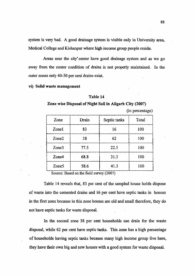
88
system is very bad. A good drainage system is visible only in University area.
Medical College and Kishanpur where high income group people reside.
Areas near the city' center have good drainage system and as we go
away from the center condition of drains is not properly maintained. In the
outer zones only 40-50 per cent drains exist.
vi) Solid waste management
Table 14
Zone wise Disposal of Night Soil in Aligarh City (2007)
(in percentage)
Zone Drain Septic tanks Total
Zone I 83 16 100
Zone2 38 62 100
Zone3 77.5 22.5 100
Zone4 68.8 31.3 100
ZoneS 58.6 41.3 100
Source: Based on the field survey (2007)
Table 14 reveals that, 83 per cent of the sampled house holds dispose
of waste into the cemented drains and 16 per cent have septic tanks in houses
in the first zone because in this zone houses are old and small therefore, they do
not have septic tanks for waste disposal.
In the second zone 38 per cent households use drain for the waste
disposal, while 62 per cent have septic tanks. This zone has a high percentage
of households having septic tanks because many high income group live here,
they have their own big and new houses with a good system for waste disposal.

89
Open drains are the only means of waste disposal of the 77.5 per cent
households in the third zone and 68.8 per cent households in the fourth zone,
whereas only 22.5 per cent households in the third zone and 31.1 per cent
households in the fourth zone have septic tanks. The reason for the high
percentage of people using drains for their waste disposal as they belong to
very low income groups in these zones, they usually live in one room houses.
In the fifth zone about 41.3 per cent of the sampled households have
septic tanks. These houses are found only in the posh areas of this zone
University campus, Sir Syed Nagar and Kishanpur. Whereas 58.1 per cent
house -holds in this zone use drains for the disposal of waste and in many
fringe areas even drains do not exist so people dump waste around houses.
It is evident from above discussion that only high income groups in the
Aligarh city have septic tanks in their houses for the waste disposal.
vii) General environment
Table 15
Disposal of Garbage in Different Zones of Aligarh City, 2007
(in percentage)
Zone Not seen Along road side
Open spaces Total
Zone 1 100 100
Zone 2 40 56 4 100
Zone3 85.8 14.1 100
Zone4 11.1 84.4 4.4 100
ZoneS 13.1 63.1 23.6 100
Source: Based on the field survey (2007)

90
Solid Waste and Garbage Disposal in Different Zones of the Aligarh City, 2007
Modes of solid wastes disposal
^ 100
I 80 g 60
40
I Septic tanks
I Drain
100 T
JJl.J.al 1 2 3 4 5
Zones
Fig. 12
Disposal of garbage
120
100
2P 80
8 60
OH
40-
20-
0
Zones
• N o t seen
• Along roadside
D Open spaces
Lii Fig. 13
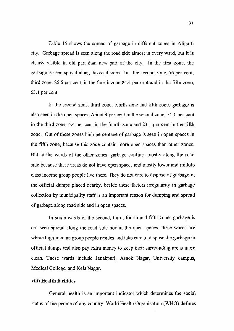
91
Table 15 shows the spread of garbage in different zones in Aligarh
city. Garbage spread is seen along the road side almost in every ward, but it is
clearly visible in old part than new part of the city. In the first zone, the
garbage is seen spread along the road sides. In the second zone, 56 per cent,
third zone, 85.5 per cent, in the fourth zone 84.4 per cent and in the fifth zone,
63.1 percent.
In the second zone, third zone, fourth zone and fifth zones garbage is
also seen in the open spaces. About 4 per cent in the second zone, 14.1 per cent
in the third zone, 4.4 per cent in the fourth zone and 23.1 per cent in the fifth
zone. Out of these zones high percentage of garbage is seen in open spaces in
the fifth zone, because this zone contain more open spaces than other zones.
But in the wards of the other zones, garbage confines mostly along the road
side because these areas do not have open spaces and mostly lower and middle
class income group people live there. They do not care to dispose of garbage in
the official dumps placed nearby, beside these factors irregularity in garbage
collection by municipality staff is an important reason for dumping and spread
of garbage along road side and in open spaces.
In some wards of the second, third, fourth and fifth zones garbage is
not seen spread along the road side nor in the open spaces, these wards are
where high income group people resides and take care to dispose the garbage in
official dumps and also pay extra money to keep their surrounding areas more
clean. These wards include Janakpuri, Ashok Nagar, University campus,
Medical College, and Kela Nagar.
viii) Health facilities
General health is an important indicator which determines the social
status of the people of any country. World Health Organization (WHO) defines
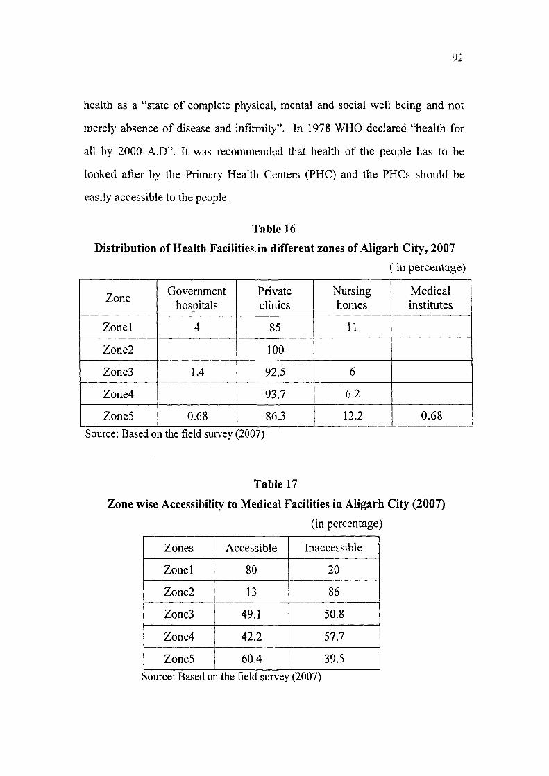
health as a "state of complete physical, mental and social well being and not
merely absence of disease and infirmity". In 1978 WHO declared "health for
all by 2000 A.D". It was recommended that health of the people has to be
looked after by the Primary Health Centers (PHC) and the PHCs should be
easily accessible to the people.
Table 16
Distribution of Health Facilities.in different zones of Aligarh City, 2007
(in percentage)
Zone Government
hospitals Private clinics
Nursing homes
Medical institutes
Zonel 4 85 11
Zone2 100
Zone3 1.4 92.5 6
Zone4 93.7 6.2
ZoneS 0.68 86.3 12.2 0.68
Source: Based on the field survey (2007)
Table 17
Zone wise Accessibility to Medical Facilities in Aligarh City (2007)
(in percentage)
Zones Accessible Inaccessible
Zonel 80 20
Zone2 13 86
Zone3 49.1 50.8
Zone4 42.2 57.7
ZoneS 60.4 39.5
Source: Based on the field survey (2007)
93
Tables 16 and 17 show accessibility of health facilities in different
zones.
It is evident from tables, that about 85 per cent of private clinics, 11
per cent of nursing homes and only 4 per cent government hospitals provide
health care facilities in the first zone. Most of the private clinics in this zone
have unqualified doctors, whereas government hospitals are devoid of many
health care facilities. They do not have sufficient beds for patients, as a result
most of them use unclean floors and wait for their turn to come. Patients report
that doctors in these hospitals do not take care. Therefore, people prefer to go
to the private clinics for taking treatment.
In the second zone, only private clinics have qualified doctors because
of the high income groups, out of these many of them are doctors. People
residing in second zone have easy accessibility to clinics.
In the third zone, and the fourth zone, conditions are more or less
similar to that of first and second zones. About 92.5 per cent and 93.7 per cent
private clinics are working respectively and more than half of them are
unqualified doctors. As here mostly low class income groups of labourers and
factory workers so they prefer to go to these clinics. Besides this 6 per cent
and 6.2 per cent of nursing homes are located in these zones.
Fifth zone presents a very unbalanced situation, on one hand this zone
shows good medical facilities 86.3 per cent of private clinics in its vicinity and
about 12.2 per cent nursing homes. Private clinics and nursing homes located
here are considered as one of the best in the Aligarh city. They are mostly
located along the Ramghat road. These clinics are equipped with qualified
doctors and with latest medical facilities and only high class people can go for
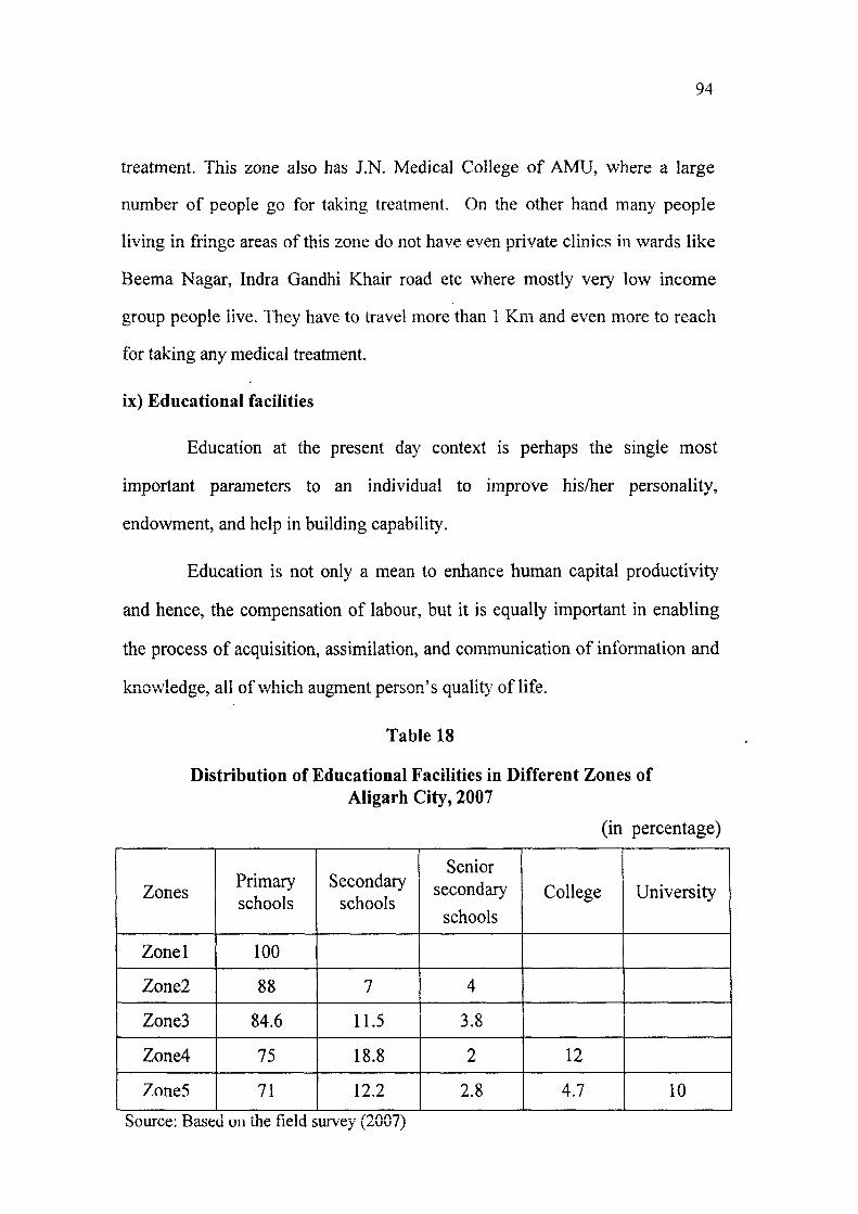
94
treatment. This zone also has J.N. Medical College of AMU, where a large
number of people go for taking treatment. On the other hand many people
living in fringe areas of this zone do not have even private clinics in wards like
Beema Nagar, Indra Gandhi Khair road etc where mostly very low income
group people live. They have to travel more than 1 Km and even more to reach
for taking any medical treatment.
ix) Educational facilities
Education at the present day context is perhaps the single most
important parameters to an individual to improve his/her personality,
endowment, and help in building capability.
Education is not only a mean to enhance human capital productivity
and hence, the compensation of labour, but it is equally important in enabling
the process of acquisition, assimilation, and communication of information and
knowledge, all of which augment person's qualit>' of life.
Table 18
Distribution of Educational Facilities in Different Zones of Aligarh City, 2007
(in percentage)
Zones Primary schools
Secondary schools
Senior secondary schools
College University
Zonel 100
Zone2 88 7 4
Zone3 84.6 11.5 3.8
Zone4 75 18.8 2 12
Zone5 71 12.2 2.8 4.7 10
Source: Based on the field survey (2007)

95
Health and Education Facilities in Different Zones of the Aligarh City, 2007
120
Health Facilities I Government Hospitals
I Private Climes
I Nursing Homes
Fig. 14
120 n
8 60
Educational facilities
I H Primary • Secondary n S. Secondary D Colleges
Fig. 15

96
Though Aligarh is known for the world famous seat of education
Aligarh Muslim University (AMU) but still literacy rate is very low.
Table 18 reveals that the first zone has only primary schools, most of
them are private and they do not have qualified teachers and other amenities
which are needed to the students. This zone has only one or two government
schools with little facilities.
In the second zone, the situation is some what better, having 88 per
cent primary schools, 7 per cent and 4 per cent secondary and senior secondary
schools respectively. This zone is characterized with the presence of very good
English medium schools.
In the third zone, there are 84.6 per cent primary, 11.5 per cent
secondary and 3.8 per cent senior secondary schools. Few of them are
government aided, and most of them are private which have very low education
standard. But people living in this zone send their children to the schools
because most of the parents are uneducated and poor, therefore they could not
afford charges of education of good schools.
About 75 per cent primary schools, 18.8 per cent secondary, 2 per cent
senior secondary and 12 per cent government colleges are found in the fourth
zone. Education facilities in this zone are better than the third zone because a
large segment of service men lives here.
Educational facilities in the fifth zone are much better than the
previous four zones. This zone has one of the best convent schools of Aligarh.
Aligarh Muslim University is also located here; this university has four
secondary schools (two for girls and two for boys) with two senior secondary
schools and many departments of different subjects. But as the population of

97
the city continues to increase even these facilities fall short so many of the
students do not succeed in getting admission.
The above outlined infrastructural facilities reveal that these facilities
are properly available in the zones which are nearer to the center of the city. In
zone first and second zone good roads, and proper drains serve the zones but as
one moves away from the center to the third and fourth zones infrastructural
facilities are not sufficient enough and in some poor areas of fifth zone these
facilities are absolutely missing. There exists a negative correlation between
the distance and availability of infrastructural facilities. These facilities
become thin as one mwes away from the center of the city.

98
References
1. Dhaliwal, S.S., Urban Infrastructure Development in Small and Medium
Towns, New Delhi, 2004, pp.51-77.
2. Rao, P.S.N, at el., Urban Governance and Management, New Delhi,
2006, pTp.llAl.
3. Ibid. 76
4. Hilling, D., The Infrastructure Gap in India: The Third World :
Problems and Perspectives, The Macmillan Press, London, 1978, pp.
84-92.
Chapter IV
INDICATORS OF SOCIAL WELL-BEING IN ALIGARH CITY
In recent years there has seen a marked shift of public attention from
economic affairs towards the social state of the nation. One can not be in doubt
that social problems are now a matter of great concern. So the concept of
social well-being comes into light and emphasizes its importance
The concept of social well-being in defining urban development
started during 1970's. It came into existence due to the inadequacy of concepts
like economic growth and development. The later concepts are highly biased
towards per capita income. The qualit}' of life is a holistic concept which
includes economic, social, demographic and cultural dimensions of human life.
A variety of life aspects such as housing, education, profession, income and
material status are incorporated in order to measure the quality of life.
According to Pati and Mahaparta (1987), " quality of life may be defined as
satisfaction of human needs, the organic needs, the special needs and the
individual needs for self realization".
The inquiry starts with the assumption that there is a dimension of
human existence called social well-being, and the people living on a specific
area can be easily differentiated from those living in other areas with respect to
its dimension and various other factors.
According to Bossard (1927), "it relates to income in its broadest
sense, physical health and state of mind- three basic conditions of individual
well-being recognized in the literature for many years".

100
So it would be better if social well-being considered as the condition
of prosperity, happiness, and good health of the people of the society. It may
include many other aspects related to life, welfare of society and level of
satisfaction. Thus the phenomena of social well-being include both the
subjective and objective realities of human life.
The study of quality of life is the outcome of social relevance
paradigm.. The United Nations Development Programme (UNDP) has used the
term "Human Development" in place of quality of life. Human development is
a process of enlarging the choice for all the people not just for one part of
society. The Progress of Nations Report (1996) published by UNICEF
recorded the important innovations made by many countries in health, nutrition
and education.
Indicators of social well-being
According to one definition of the indicators, "a social indicator may
be defined as the statistic or direct normative interest which facilitates, concise,
comprehensive balanced judgment about the condition of major aspects of the
society".
Different scholars have defined the social well-being with different
interpretations. The ultimate aim is to prepare a better frame or provide certain
solutions for the betterment of the human beings.
Social well-being depends not only on the income, but to the people
who live in houses and society, and their access to basic infrastructure services-
education, occupation etc. Therefore following indictors were selected for the
undertaking the present study.
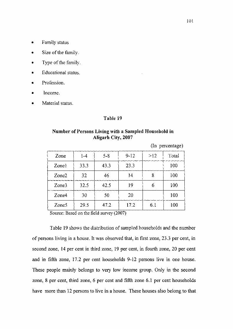
101
Family status
Size of the family.
Type of the family.
Educational status.
Profession.
Income.
Material status.
Table 19
Number of Persons Living witti a Sampled Household in Aligarh City, 2007
(In percentage)
Zone 1-4 5-8 9-12 >12 Total
Zonel 33.3 43.3 23.3 100
Zone2 32 46 14 8 100
ZoneS 32.5 42.5 19 6 100
Zone4 30 50 20 100
ZoneS 29.5 47.2 17.2 6.1 100
Source: Based on the field survey (2007)
Table 19 shows the distribution of sampled households and the number
of persons living in a house. It was observed that, in first zone, 23.3 per cent, in
second zone, 14 per cent in third zone, 19 per cent, in fourth zone, 20 per cent
and in fifth zone, 17.2 per cent households 9-12 persons live in one house.
These people mainly belongs to very low income group. Only in the second
zone, 8 per cent, third zone, 6 per cent and fifth zone 6.1 per cent households
have more than 12 persons to live in a house. These houses also belong to that

102
of the low income group, and there are very few households in number with
high income groups, who have more then 15 persons in a house.
Table also shows that in the first zone, 43.3 per cent, second zone, 46
per cent, third zone, 42.5 per cent, fourth zone 50 per cent and fifth zone 47.2
per cent households 5-8 persons live in a house. These households belonged
to either income group of low, medium and high.
In the first zone, 33.3 per cent, second zone, 32 per cent, third zone,
32.5 per cent, fourth zone 30 per cent and 29.5 per cent households 1-4
persons live who belong to very low income group. As they have only one
room house so the size of family is too small or to high income groups who
prefer a small family.
Table 20
Sampled Households According to Type of Family in Aligarh City, 2007
(in percentage)
Zone Joint family Nucleated
family
Zonel 40 60
Zone2 22 72
ZoneS 35 65
Zone4 32.2 67.7
Zones 34 66
Source: Based on the field survey (2007)
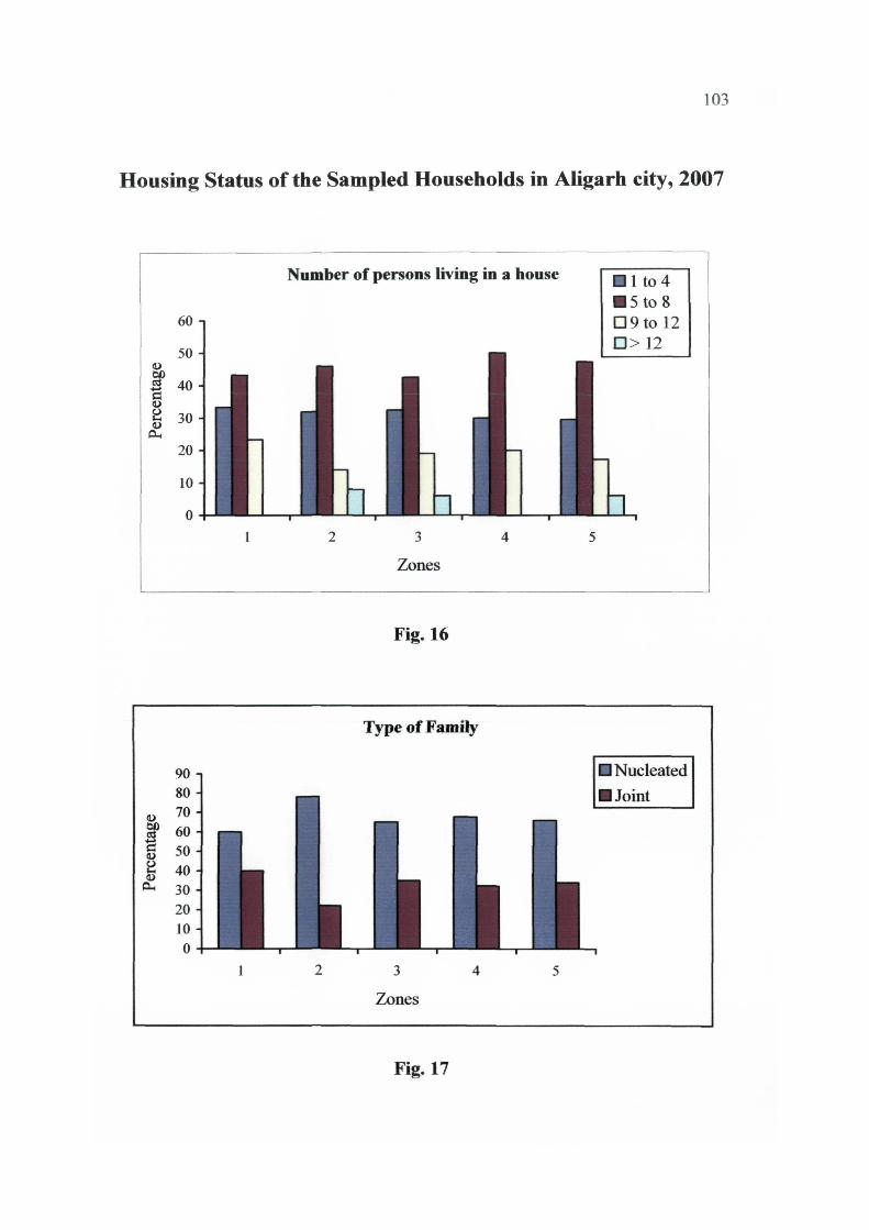
103
Housing Status of the Sampled Households in Aligarh city, 2007
Number of persons living in a house
Zones
Fig. 16
Type of Family
I Nucleated
I Joint
Fig. 17

104
Table 20 shows the number of sampled households according to type
of family. It was observed, that about 60 per cent families in the first zone, 72
per cent in the second zone, 65 per cent in third zone, 67.7 per cent in fourth
zone, and 66 per cent in the fifth zone are nucleated and rests are joint families.
The percentage of nucleated families is far acceding than joint
families. Joint families were found only in some parts of the old city, whereas
in new localities people prefer to live with nucleated families. •
Table 21
Sampled Households According to the Status of House in Aligarh City, 2007
(in percentage)
Zone Own Rented
Zonel 70 30
Zone2 86 14
Zone3 85.8 14.2
Zone4 71.1 28.8
Zones 81 19 Source: Based on the field survey (2007)
Table 21 shows the sampled households according to the status of the
house. It is observed that, nearly 70 per cent in the first zone, 86 per cent in the
second zone, 85 per cent in the third zone, 71.1 per cent in the fourth zone and
81 per cent in the fifth zone live in their own houses. In the first zone, people
have one room and they are very. They prefer to live in them because they do
not have other alternatives. The situation is same as regard to the status of
houses in other the zones.

105
Many high income group people living in old or new parts have big
houses. Even than most of them now prefer to build their houses in the fringe
areas because they are free from pollution and the costs of land are low.
In fourth and fifth zones 28.8 per cent and 19 per cent residents live
mostly in government houses and also in private rented houses. They are
mostly students and teachers who have come from out side to persue their
studies or jobs in the city.
Table 22
Sampled Households According to the Educational Status in AHgarh city, 2007
(in percentage)
Zone
Educational status Distribution of educated persons
Zone Educated Unedu
cated Primary Middle High school
Inter Graduate P.G
Zone! 74.8 25.1 47.1 17.8 22.8 4.2 6.4 1.4
Zone2 77 23 35 10 14.3 12.4 22 6
Zone3 70.2 29.7 44.5 11.1 16.20 7 16 4.8
Zones4 68 32 40.1 13.6 20 7.6 15.8 2.8
ZoneS 63 37 46 14.4 13.7 5.7 14.6 5.3
Source: 3ased on th e field sur vey(2007)
Table 22 shows sampled households according to the educational
status. About 74.8 per cent are educated in the first zone, 77 per cent in the
second zone, 70.2 per cent in the third zone. Among them 47.1 per cent are in
the first zone, 35 per cent in the second and in the third zone 44.5 per cent are
primary educated. This is because of their poor economic conditions after
attaining classes in primary level they began to do work to support their
family. Those who attended classes up to high school are 22.8 per cent in the

106
Housing and Educational Status of the Sampled Households in Aligarh City, 2007
a. 100 00
B 80 8 60 <- l
a. 40
20 -
Housing status
3
Zones
I Own I Rent
.ln.li.a.ii,
Fig. 18
100 1
^ 80 C3
a. 60
40 ^
Educational status
I Educated
I Uneducated
Zones
Fig. 19

107
Graduates and post graduates constitute 22 per cent and 6 per cent in the
second zone as they belong to very high income groups.
In the fourth zone, 32 per cent and in fifth zone, 37 per cent are
uneducated and 68 per cent and 63 per cent are educated, 40.1 per cent in the
fourth zone respectively, and 46 per cent in the fifth zone are primary educated.
About 15.8 per cent are graduates in the fourth zone and 14.6 in the fifth zone.
The highest number of illiterates are confined in the fifth zone, the
University campus, in Sir Syed Nagar and Medical College, where more then
80 per cent are educated and as many as are professors, doctors and engineers.
But in fringe areas literacy rate is almost zero per cent as these areas are
occupied by the low income groups.
Table 23
Sampled Households according to the Type of Occupation in the Aligarh city, 2007
(in percentage)
Zone Professionals Sale men Service
men Business
men Others
Zonel 3.3 23.3 16.6 33.3 23.3
Zone2 20 14 14 48 4
ZoneS 7.5 11.6 26.6 41 13.3
Zone4 11.2 14.4 28.8 34.4 11.2
ZoneS 17.2 8.8 21.9 24.0 28.1
Source: Based on the field survey (2007)

108
Table 23 shows sampled household according to the profession. It is
evident from the table that in the first zone 33.3 per cent, in second zone 48
per cent, in third zone 41 per cent, in fourth zone 34.4 per cent and in fifth zone
24 per cent persons cany their own business, mainly of hardware, on medium
and small scale. Some small scale industries are largely confined to old parts
of the city.
The service class people constitute 16.6 per cent in the first zone, 14 in
second, 26.6 per cent in third zone, 28.8 per cent in the fourth zone and 21.9
per cent in the fifth zone, most of them are employed in the University. Some
23.3 per cent in the first zone, and 28.1 per cent in the fifth zone carry other
works, and many of them are labourers and rickshaw pullers.
The professional people like teachers, doctors and engineers constitute
only 3.3 per cent in the first zone, 20 per cent in second zone, 7.5 in third zone,
11.2 per cent in fourth zone and 17.2 in the fifth zone. Generally they are found
with high percentage in the second and fifth zones.
Table 24
Sampled Households according to Monthly Income (in Rs) in the Aligarh City, 2007
(in percentage)
Zone 1500-5000 5000-10000
10000-15000 15000-20000 >20000
Zonel 36.6 30 30 3.3
Zone2 20 10 10 30 30
Zone3 31.7 27.5 20 7.5 13.3
Zone4 36.6 23.4 26.6 6.7 6.7
ZoneS 41.8 14 18.6 12.8 12.8
Source: Based on the field survey (2007)

IU9
Profession and Income wise Distribution of the Sampled Households in Aligarh City, 2007
<L>
Profession • Professionals • Sale workers D Service men n Buisness men • Others
Fig. 20
Income
a H
• 1500-5000 • 5000-10000 D 10000-15000 D 15000-20000 • >20000
Fig. 21

110
Five income categories were considered for this study. In some of the
households respondents were reluctant to respond their correct monthly
income. Therefore, their income was estimated on the bases of the assets they
were in possession.
Table 24 shows that the low income group people constituted, 36.6 per
cent in the first zone, 20 per cent in second zone, 31.7 per cent in the third
zone, 36.6 per cent in forth zone and 41.8 per cent in the fifth zone. "With in
this category come mainly the rickshaw pullers, casual labourers and factory
workers. Highest percentage of these people is found in the fifth zone,
especially who live in fringe areas as they earn only Rs.lOO to 200 a day.
With in the medium group of people ( service men, sell men and small
factory owners) constitute the first zone 30 per cent, 10 per cent in the second
zone, 20 per cent in third zone, 26.6 per cent in fourth zone and in fifth zone
18.6 per cent households. They are confined mainly to fourth and fifth zones
because most of them are university employs and work in different government
offices.
Very high income group includes businessmen, professors, doctors and
many of NRIs. Highest percentage of this class is found in the second zone (30
per cent), 13.3 per cent in third zone and 12.8 per cent in fifth zone.

I l l
Table 25
Sampled Households According to the Ownership of Appliances in the Aligarh City (2007)
(in percentage)
Distribution of Appliances
Zone T.V Ref CD
player Iron
Cell phone
W.M Gen A.C Comp LPG None
Zonel 93.3 50 16.6 • 63.3 73.3 13.3 6 100
Zone2 100 68 48 76 80 50 26 32 44 92
Zone3 93.3 62.5 34.1 65.8 71.8 20 5 10 12.5 95 3.3
Zone4 98.8 61.2 37.7 70 72.2 23.1 10 10 23.3 97.7
Zones 83.6 55 29 59.5 60 27.7 8.6 14 23.6 76 14
Note: T.V- Television, Ref- Refrigerator, W.M- Washing Machine, Gen- Generator, A.C- Air Conditioner, Comp- Computer, L.P.G- Liquefied Petroleum Gas.
Source: Based on the field survey (2007)
There exists a considerable variation in the ownership of appliances
which depends mainly on the income and purchasing power of household. As
illustrated in Table 25, more than 95 per cent of the households in different
zones own T.V and L.P.G, the most needed home appliances even owned by
the low income group people. Other electrical appliances like refi-igerator, iron,
washing machine were mostly seen as the belongings of affluent households.
The less common appliances like A.C, generator and computer (considered to
be the luxury items in India) are mostly found in the high income group of
households.
Cell phone too is also the most needed and popular item which is
possessed by the people belonging to all income groups. But some low income
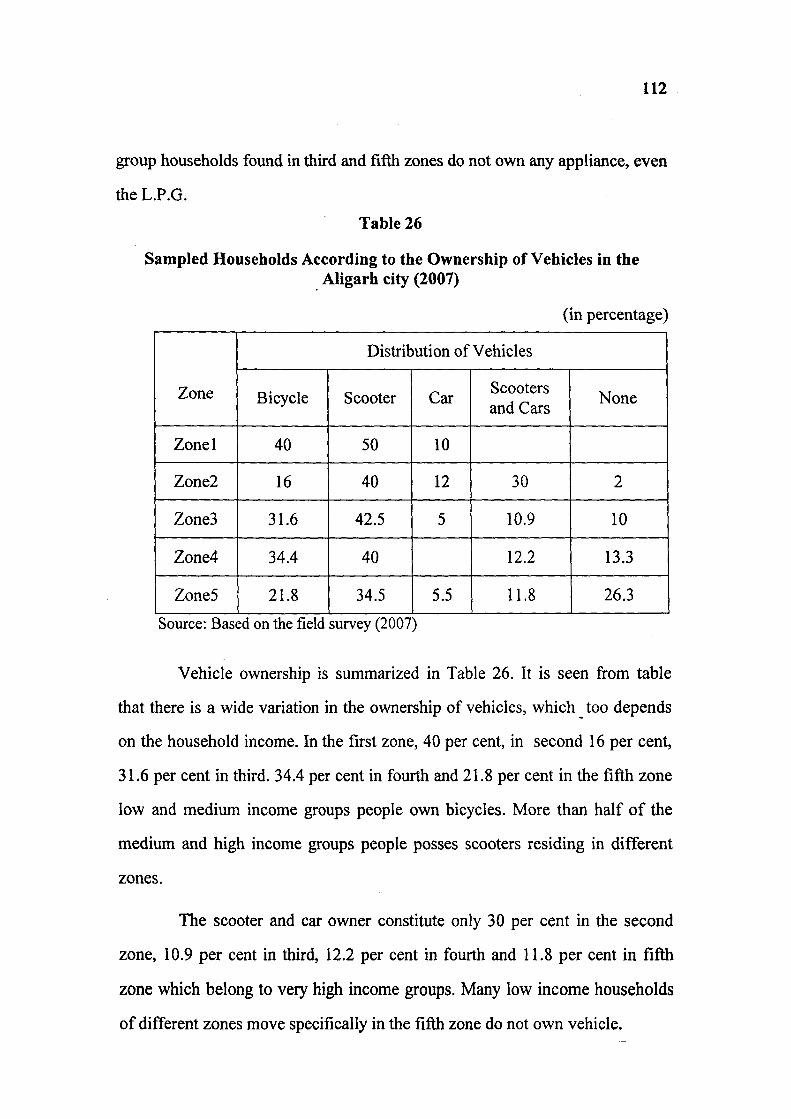
112
group households found in third and fifth zones do not own any appliance, even
the L.P.G.
Table 26
Sampled Households According to the Ownership of Vehicles in the Aligarh city (2007)
(in percentage)
Zone
Distribution of Vehicles
Zone Bicycle Scooter Car Scooters and Cars
None
Zonel 40 50 10
Zone2 16 40 12 30 2
Zone3 31.6 42.5 5 10.9 10
Zone4 34.4 40 12.2 13.3
Zone5 21.8 34.5 5.5 11.8 26.3
Source: Based on the field survey (2007)
Vehicle ownership is summarized in Table 26. It is seen from table
that there is a wide variation in the ownership of vehicles, which too depends
on the household income. In the first zone, 40 per cent, in second 16 per cent,
31.6 per cent in third. 34.4 per cent in fourth and 21.8 per cent in the fifth zone
low and medium income groups people own bicycles. More than half of the
medium and high income groups people posses scooters residing in different
zones.
The scooter and car owner constitute only 30 per cent in the second
zone, 10.9 per cent in third, 12.2 per cent in fourth and 11.8 per cent in fifth
zone which belong to very high income groups. Many low income households
of different zones move specifically in the fifth zone do not own vehicle.

113
Ownership of Vehicles of Sampled Household in Aligarh City, 2007
60 n
Ownership of vehicles • Scooter • Bicycle DCar DAll • None

114
References:
1. Dhaliwal, S.S., Urban Infrastructure Development in Small and Medium
Towns, New Delhi, 2004.
2. Kopardejar, H.D., Social Aspects of Urban Development, Mumbai,
1986, pp.66
3. Ibid. 67.
4. Ibid. 68.
5. Ibid. 68.
Chapter V
ROLE OF THE MUNICIPALITY IN URBAN DEVELOPMENT IN ALIGARH CITY
The municipal bodies are the self-governing organization; their
functions play an important role for the betterment in the lives of the citizens.
Though the functions of the municipal board are divided in to two categories
obligatory and discretionary, but due to limited resources and absence of
technical skills, municipalities find it difficult to extend the obligatory
fiinctions to the residents of municipal limits.
The 74* Constitutional Amendment in 1992 recognized municipalities
as democratic units of self-government. The objectives include decentralization
of power and ensuring popular participating in planning, management and
delivery of civic services.
The 12* Schedule of the Constitution provides an illustrative list of 18
municipal fiincfions which are as following:
i. Urban planning, including the town planning,
ii. Regulafion of land use and construction of buildings,
iii. Planning for economic and social development,
iv. Roads and bridges
V. Water supply for domestic, industrial and commercial purposes,
vi. Public health, sanitation conservancy and solid waste management,
vii. Fire services,
viii. Urban forestry, protection of the environment and promotion of

116
ix. Safeguarding the interest of weaker sections of the society.
X. Slums improvement and up gradation,
xi. Urban poverty alleviation,
xii. Provision of urban amenities and facilities such as parks, gardens and
playgrounds,
xiii. Promotion of educational, cultural and aesthetic aspects,
xiv. Burial grounds; cremation grounds and electric crematorium.
XV. Cattle ponds and prevention of cruelty to animals,
xvi. Vital statistics including registration of birth and deaths,
xvii. Public amenities, including street lighting, parking grounds, bus stops,
and public conveniences,
xviii. Regulation of slaughterhouses and tanneries.
a) The Purpose of Formation of Municipality in Cities
The root of the present day urban development in India lies back to the
Mughal period and particularly the British period. Delhi, Chennai, Kolkata and
Mumbai are the metropolitan cities, even today, while the Mughals were
running their empire from Delhi, the East India Company had developed a
strong hold on the other cities. Many cities developed as centers of
communication, military cantonments, the centers of revenue administration
etc.
The growth of several cities and towns on a different pattern in the
British period created the need of municipal bodies for the effective
functioning of the cities. The existing pattern is a part of previous system of the
ancient traditions, which was on some extent based on the military feudalism,
this system, was not suitable for the colonial framework.

117
The origin of the modem municipal system owes much to Sir Josia
Child who obtained a charter from James II to set up a Corporation of Madras
in 1642. The British regime did away with the indigenous foundation and the
ancient local taxation system. New patterns were created.
Municipalities were established in a number of cities from 1881
onwards, invested a large amount of power for civic aid like collection of taxes,
maintenance of roads, removal of garbage and night soil, provision of public
health and education.
The history of the formation of the municipal corporation in India is
divided in to four phases.
First Phase (1833-1882)
The first local government was introduced with a power to levy house
tax and a responsibility to provide civic amenities. In 1870 Lord Mayo's
resolution brought a change in the administration. A scheme of decenterlization
of administration was introduced, facilities like education, health and roads
came under the provisional government for these purposes.
Second Phase (1882-1919)
On 18* May 1882 Lord Ripon's resolution laid the foundation of the
system as it is exist today. The principles include, provision to have at least two
third members of municipalities as non-officials. System of elections was
introduced for the selection of the Chairman or head of the municipality.
Several taxes such as octroi, house tax and property tax were
introduced housing, lighting of roads, public health and education were
included in the duties of municipality.
118
Third Phase (1919-1935)
This period was influenced by the recommendation of the Royal
Commission on the decentralization in 1907-1908, which led to the resolution
of 1915 of the Government of India. The reforms made in 1919 made a clear
cut demarcation of tax collection power of the local bodies. The local taxes
were realised as toll taxes on the land values, on buildings, vehicles and on
animal trade.
Fourth Phase (1935-1945)
This phase started with the inauguration of provincial autonomy in
1935. Further decentralization was made in respect of local bodies. Though
fiinctions were enlarged, but the revenue collection decreased, and thus local
bodies became more dependent on the grants and aids.
(b) A brief history of Aligarh Municipal Corporation
Local autonomy was the local feature of the ancient hindu polity and
in that context it is reasonable to believe that viable unit of self government
functioned in the villages and towns in that period, but in the absence of any
record it is not possible to delineate the rise and fall of these institutions in the
district from the earliest time.
During the ancient period villages were governed by the panchayats
which exercised both administrative and judicial power. But during the Muslim
and British rule they almost disappeared. Under the Mughal rule most of the
municipal functions were in the hand of Kotwal.
In 1956, The Bengal Caukidari Act, was applied to those towns which
were not big enough to be governed by municipalities and if they had a
119
population enough to make it necessary to provide rudimentary civic services.
This Act was also appHed to AHgarh and Hathras and in i860 it applied to
other blocks too. Year of 1857 marks the beginning of local self government in
the district. In the earliest days of British rule a committee known as the local
agency was established at Koil and Hathras for management of local affairs and
local improvemicnt. In 1856 house tax was introduced for the purpose of watch
and ward. In 1865 towns of Koil (Aligarh), Hathras, Atrauli, Sikandra Rao,
and Harduaganj were constituted as municipalities under the Municipal Act of
1850,and four years later house tax was replaced by octroi. In 1882 Harduaganj
was removed from the list of municipalities.
The earliest municipal committees were nominated bodies and it was
after passing the N.W.P Municipal Improvement Act 1868 that, the elective
principal was introduced for the first time. The constitution of these institution
under-gone a change in 1883 Act, which also changed the name from the
municipal committee to municipal board.
The Bengal Chaukidari Act was replaced in 1914 by the U.P Town
Areas Act the principal change made by it was to relieve the town of their
watch and ward duties and make the town area committee primarily
responsible for the sanitation of the towns.
The U.P District Board Act 1922, made some more changes in the
constitution and function of the board. With the advent of independence in
1947, universal adult franchise right introduced for the election of the
members.
In 1978, there were 4 Municipal Boards, 14 Town Areas, 1 Zila
Parishad, 17 Kshettra Samitis and 1496 Gaon Panchayats in the district.

120
The Aligarh Municipal Board came into existence in August 1865,
under the Municipal Act of 1850. The first municipal committee was
nominated and it was after passing the N.W.P Municipal Improvement Act,
1868 that the elective principal was introduced. In 1883 N.W.P and Oudh
Municipalities Act changed the name from 'Municipal Committee' to
'Municipal Board'.
(c) Responsibilities and Functions
According to U.P. Nagar Nigam Act 1959, Nagar Nigam was given
the responsibilities to provide certain public services to the citizens. As per the
74^ amendment, there has been a considerable increase in the responsibilities
of the local bodies.
Some of the important services/ duties undertaken by Municipalities
for the citizens are as follows:
1. Sanitation and cleaning of public streets and drains.
2. Cleaning of public toilets and urinaries.
3. Repair and maintenance of drains.
4. Measures to control spreading of contagious/ infectious diseases
5. Emancipation of dead dogs.
6. To remove the heap of garbage.
7. To remove the debris
8. Sanitation and cleaning of garbage houses.
9. Other works related to garbage disposal.
10. Cattle catching (catching rowdy animals).
11. Dog catching.

121
12. Disposal of dead bodies and dead cows and buffaloes.
13. Maintenance of parks.
14. Securing the green trees in public places.
15. Removal of dangerous plants and dried trees.
16. Construction and repair of streets and lanes.
17. Patch repair and filling of pits.
18. Repair of foot-paths.
19. Maintenance of streets.
20. Permitting roads cutting and temporarily closing the pathways.
21. Construction of drains.
22. Repairing of light of lightening spots.
23. To install new light in lightening spots.
24. Arrangement of new streets lights.
25. Installing the electricity polls and stretching wires.
26. Lightening arrangement at different public places and public festivals.
27. Supply of clean drinking water in parks and water supply for individual
and commercial purposes.
28. Maintenance, running and repair of Jalkal Department, water supply of
public water points.
In view of the complex problems faced by the local bodies, they
should deal with the situation by performing new dimensional functions. These
functions include guiding the citizens in building their houses, strengthening
the public health services, providing the environmental inputs and extending

122
social welfare and recreational facilities. The urban local bodies should be
strengthened in view of the growing responsibilities. The state governments
should guide them to overcome the difficulties encountered in the delivery of
the above listed functions.
Moreover the role of the municipalities should not be confined to the
provision of civic amenities. Provision of civic amenities is not an end of to the
problem; it should become means to extend local welfare. It can be achieved
only with the committed political will and honest executives.
(d) Extension and provision of services in the city
The Aligarh Municipality covers an area of 36.70 sq ion with a
population of 639303 (in 2001). It is divided into 70 wards for which 70
members were elected directly from adult franchise. Normally the term of
municipal board is of five years but it may be extended by the government in
exceptional circumstances.
Municipal Board (Seva Bhawan) thus plays an important role in the
provision of urban services and they have a significant impact on the city
development. Rapid population growth in the city has led to the growing urban
services deficits both in terms of maintaining services and extending them to
unserviced areas.
Urban infrastructural development has been funded through budgetary
support from Central\State Governments and Local Bodies through five year
plans and armual plans.
The availability of amenities and facilities to the people in a spatial
framework reflects the quality of life in that area. Higher the accessibility to the
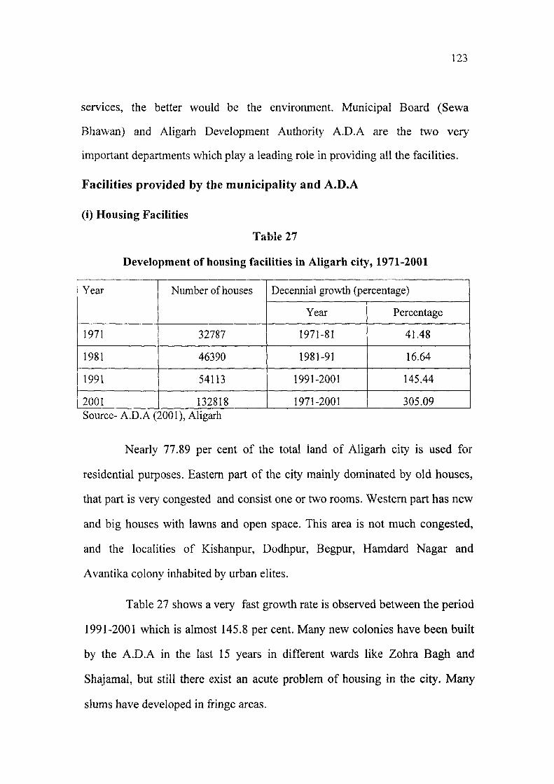
123
services, the better would be the environment. Municipal Board (Sewa
Bhawan) and Aligarh Development Authority A.D.A are the two very
important departments which play a leading role in providing all the facilities.
Facilities provided by the municipality and A.D.A
(i) Housing Facilities
l a u i c ^ /
Development of housing facilities in Aligarh city, 1971-2001
Year Number of houses Decennial growth (percentage) Year Number of houses
Year Percentage
1971 32787 1971-81 41.48
1981 46390 1981-91 16.64
1991 54113 1991-2001 145.44
2001 132818 1971-2001 305.09 Source- A.D.A (2001), Aligarh
Nearly 77.89 per cent of the total land of Aligarh city is used for
residential purposes. Eastern part of the city mainly dominated by old houses,
that part is very congested and consist one or two rooms. Western part has new
and big houses with lawns and open space. This area is not much congested,
and the localities of Kishanpur, Dodhpur, Begpur, Hamdard Nagar and
Avantika colony inhabited by urban elites.
Table 27 shows a very fast growth rate is observed between the period
1991-2001 which is almost 145.8 per cent. Many new colonies have been built
by the A.D.A in the last 15 years in different wards like Zohra Bagh and
Shajamal, but still there exist an acute problem of housing in the city. Many
slums have developed in fringe areas.

124
(ii) Health Facilities
Table 28
Health Care Facilities in Aligarh city, 1971-2001
Year No. of doctors
No. of hospitals
No of private clinics
No of maternity
homes Total
Decirmial growth rate Year
No. of doctors
No. of hospitals
No of private clinics
No of maternity
homes Total
Year Percentage
1971 49 3 9
1981 85 5 18 3 61 1971-81 81.96
1991 109 7 35 5 111 1981-91 40.54
2001 255 12 75 12 156 1991-01 126.92
354 1971-01 480.33
Source- Office of the Chief Medical Officer, Aligarh (2001)
Health facilities in the city are of medium standard. There are three
important hospitals namely Jawahar Lai Nehru Medical College (JNMC),
Malkhan Singh and Gandhi Eye Hospital. Beside these there are number of
private clinics and nursing homes located in different wards.
Table 28 shows that medical facilities in the city have grown by leaps
and bound since 1971. In 1971 there were only 3 hospitals, 9 private clinics and
no maternity home in the city. But by 2001 the number of hospitals increased
to 12, private clinics 75, and 12 maternity homes in the city. The decadal
growth rate of these facilities from 1971 to 2001 is about 480.33 per cent.
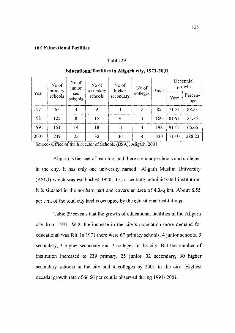
125
(iii) Educational facilities
Table 29
Educational facilities in Aligarh city, 1971-2001
Year
No of primary schools
No of junior
sec schools
No of secondary
schools higher
secondary
No of colleges
Total
Decennial growth
Year
No of primary schools
No of junior
sec schools
No of secondary
schools higher
secondary
No of colleges
Total
Year Percen-
1971 67 4 9 3 2 85 71-81 88.23
1981 125 8 15 9 3 160 81-91 23.75
1991 151 14 18 11 4 198 91-01 66.66
2001 239 25 32 30 4 330 71-01 288.23
Source- Office of the Inspector of Schools (BSA), Aligarh, 2001
Aligarh is the seat of learning, and there are many schools and colleges
in the city. It has only one university named Aligarh Muslim University
(AMU) which was established 1920, it is a centrally administrated institution.
It is situated in the northern part and covers an area of 4.3sq km. About 8.55
per cent of the total city land is occupied by the educational institutions.
Table 29 reveals that the growth of educational facilities in the Aligarh
city from 1971. With the increase in the city's population more demand for
educational was felt. In 1971 there were 67 primary schools, 4 junior schools, 9
secondary, 3 higher secondary and 2 colleges in the city. But the number of
institution increased to 239 primary, 25 junior, 32 secondary, 30 higher
secondary schools in the city and 4 colleges by 2001 in the city. Highest
decadal growth rate of 66.66 per cent is obser\'ed during 1991- 2001.

!26
iv) Banking and Recreational facilities
Table 30
Banking and recreational facilities in Aligarh city, 2001
Year Banking and recreational facilities Number
2001 Non-Nationalized Bank 3
2001 Gramin Bank 6
2001 Sarkari Bank 3
2001 Gramin Agricultural Bank 1
2001 Post Office 30
2001 P.C.O's 130
2001 Cinema Halls 16
2001 Parks 20
Source- Office of the Nagar Nigam, Aligarh (2001).
Table 30 shows that there are 3 non-nationalized, 6 gramin, 3 sarkari,
and only 1 gramin agricultural banks, 30 post offices, 16 cinema halls, and 20
parks in the city.
No doubt Municipal Board of the city is doing developmental work in
the city. It is trying to provide all the infrastructural facilities in the city. Tables
previously referred clearly show a tremendous growth of in amenities like
housing, educational, medical and recreational.
Still there remain many problems and deficiencies in building of
infrastructure of the city. One of the main problem is that, all the facilities are
only confined to the core areas, fringe areas are devoid of roads, sanitation,
proper housing, medical and educational facilities. According to the concerned

127
officials, this kind of deficiencies due to the paucity of staff in the board and
some financial constraints that is why, they are unable to deliver these basic
amenities in the fringe areas of the city.

CONCLUSION
The present study related to the urban development and social well-fare
development in Aligarh Cit>' attempt in finding out the spatial distribution of
infrastructural facilities and social well-fare developm.ent in the city. It also
takes into account the infrastructural facilities and attempts to correlated with
distance from the centre of the city.
The development of Aligarh City dates back to pre-Christian era. Upper
Kot (Balai Qila) represents the core area and the centre of the city.
This region acquired its basic form in the medieval period which is
continuing even today. Generally concentric but sometime sectoral growth has
taken place in this area.
Development of Railway Line in the later half of the 19^ century has
divided the city into a western and eastern half and made the segregation of city
more pronounced.
Aligarh city is expanding at much faster rate in recent years. Many
villages like Hamdard Nagar, Maulana Azad Nagar, Dori Nagar have came
under the Municipal limit, but these areas lack in infrastructural facilities.
The interaction between various social and economic factors,
precipitated through history have created a new functional pattern of the city.
The basic civic amenities like housing, roads, sanitation, sewage, solid
waste management, parks, health and educational facilities very much lacks in
the Aligarh city especially in the peripheral areas.

129
By examining infrastructural facilities in different zones of Aligarii city,
it was found that the first and second zones lying near the centre have good
roads, and sanitation system, but they lack other civic amenities. Whereas the
remaining three zones present a very bad picture regarding the infrastructural
facilities.
Percentage of old houses is higher than new houses in all the zones
because in old city houses are very much congested and are of old type. Due to
the non-availability of open spaces the construction of houses has been rather
unplanned. They have little ventilations and poor sewage. In the old city areas
though the people are financially sound but due to illiteracy they are unaware
with regard to many things. But housing pattern of Civil Lines area is entirely
different; houses are new and big with open spaces and lawns.
Aligarh city lacks in public places like parks and play grounds. Vacant
lands are seen only in some wards of the fifth zone as these areas were recently
included in the Municipal limits, otherwise no open spaces are seen in the
central part of the city.
Condition of the roads in the city show improvement since 5-6 years,
especially in the central zones mostly metalled and cemented roads exist in the
entire city, about 91 per cent, but the highest percentage of unmetalled roads
and kharanja is seen in the fifth zone.
Aligarh city has almost cemented open drains but there are some areas
in the third, fourth and fifth zones where drains do not exist and waste water
generally spills comes over the roads and even the inside houses which may
cause too many diseases.
[30
Central part of the city lies over on elevated ground with proper
drainage lines, therefore, no water logging is seen in this area. Whereas in the
fourth and fifth zones drainage is not proper as a result the drains always cause
water logged conditions and filled with garbage throughout the year.
Open drains serve as the principal means of solid waste disposal. About
65 per cent of households in different zones use open drains, especially in the
older part of the city. The reason for such condition in old city is that houses
are old and small, and therefore they do not have enough space for the
construction of septic tanks. But 34.7 per cent households have septic tanks as
they live in new part of the city.
Garbage is seen spread over the roads and streets in every zone. But it is
prominently seen in old part than new part because in old part, especially in the
centre lies a big market of food stuff, other shops and small household
industries which are the main sources of garbage generation and the newer part
is purely used residential purposes.
Health facilities in Aligarh city are largely good. It has two Civil
Hospitals (Malkhan Singh and Women Civil Hospital), Medical College, Eye
Hospital and many other private hospitals and nursing homes. Besides these the
peripheral zones are devoid of medical facilities. The residents of wards like
Kishor Nagar, Beema Nagar and Fire Brigade do not have even a single clinic
the vicinity of their locality they have to travel upto a certain distance to avail
the facilities.
Aligarh city also has very good educational facilities. It has Aligarh
Muslim University (A.M.U.) 239 primary schools, 25 junior schools, 32
secondary schools, 30 senior secondary schools and 4 colleges.

131
Evidently the highest percentage of educational facilities is found in
fourth and fifth zones. In other zones the educational facilities restricted only to
primary schools.
The spatial pattern of social well-being reveals the following findings:
Highest percentage of joint family system was observed in the first zone
followed by the third and fourth zones to spread over the older part of the city,
where still joint family system persists. The second and fifth zones have a very
high percentage of nucleated families.
About 78.78 per cent of the families live in their own houses in different
zones, whereas 21.2 per cent live in rented houses.
First, second and third zones show high percentage of literates as
compared to the fourth and fifth zones, because in the peripheral areas most of
the people belong to very low income group and don't have enough money to
send their children to school. Children instead of going school work in the
factories for earning and support their family. But these zones also have some
high income group families and a small proportion of the low income groups.
Among all the zones of the city, second zone shows highest percentage
of graduates and post-graduates, which is followed by fifth and fourth zones.
Among the residents of different zones business is the main occupation.
But the highest percentage of businessmen are found in the second zone as 48
per cent professionals live in this zone. Highest percentage of servicemen was
observed in the fourth and fifth zones. Fifth zone also consist of a large
proportion of population engaged in many other activities like sweepers,
rickshaw pullers, laborers etc.

132
Residents of second zone ranks first with regard to monthly income as
they have their own business. In fourth and fifth zones too, a good percentage
of high income group is found, the residents are mostly professionals. A
highest percentage of very low income group is also found in fifth zone.
There exists a considerable variation in the ownership of domestic
appliances used by the residents. The purchase and use of these depend on the
income of households. Some household owners in the fifth zone were devoid
of appliances even they use chulhas for cooking of food. Though some
households with high income of this zone have almost all the amenities with
the use of L.P.G to air conditioners.
Similar situation exists in possession of vehicles. About 30 per cent of
households in second zone own scooter and car, of which the percentage is
highest among other zones.
From the above discussion it can be concluded that urban development
and social well-fare development are interdependent and related to each other.
Urban development can bring substantial improvements in social well being of
the society, if infrastructural facilities are equally made available in all the
zones, especially in peripheral areas.
Government through the concerned departments should made efforts to
provide proper housing facilities, good roads, efficient public transport, proper
sanitation and sewage systems, health facilities, parks and open spaces and
above all good educational facilities for upgrading social well-fare in the
Aligarh city.
It is the prime duty of the Municipal Corporation of Aligarh is to
arrange for the infrastructural facilities equally to poor and weaker areas
through proper planning.
133
BIBLIOGRAPHY
Bhargava, G., Development of India's Urban Rural and Regional Planning in
21" Century, New Delhi, 2001.
Bose, A., Urbanization of India: An Inventory to Source Material, Mumbai,
1970.
Bose, A., Studies in Indian Urbanization, New Delhi, 1973.
Guy, S, Marvin, S., and Moss, T. et al, Infrastructure in Transition, London,
2001.
Kundu, A., Micro Environment in Urban Planning: Access of Poor to Water
and Sanitation, Economic and Political Weekly, Vol .26, No. 37, 1976, pp.l2-
22.
Mandal, R.B., Urban Geography, New Delhi, 2000.
Mohan, S., Urban Development New Localism, Jaipur,2005.
Northam, R.M., Urban Geography, New York, 1979.
Pugh, C, Sustainable Cities in Developing Countries, London, 2005.
Rao, M.S.A., Urbanization and Social Change, New Delhi, 1970.
Saxena, S., Trends of Urbanizations in Uttar Pradesh, Agra, 1970.
Schore, L.F., Statistical Measures of Urbanization and Economic
Development, London, 1961.
Singh, J.P. and Dhannajog, A., City Planning in India, New Delhi, 1997.

Appendix - 1
Density of Population (ward wise-2001)
Ward No. NAME OF WARD NAME OF MOHALLA POPULATION
OF WARD
1 Indra Gandhi Khair Road Nagla mehtab, Delhi Gate Khair road, Indra Nagar, Nagla Masani. 10986
2 Sarai Garhi Sarai Garhi, Sarai Vrandavan, Sarai Pitambar, Sarai Bhooki,Sasni Gate, Sarai Bhatt, Gopal Puri.
9699
3 Nagla Kalar Nagla Kaiar, Nagla Maulvi, Nagla Kunjalpur, Lakshmpur, Banna Devi, Nagla Masani.
10741
4 Sarai Lavaria Delhi Gate, Sarai Radha, Goolar road, Mitra Nagar, Sarai Lavaria, Udai Singh Jain road, Sadak Delhi Darwaza.
8608
5 Sarai Kaba Sarai Kaba, Ataiyan, Usman Para-2, Turakman Gate, Turakman Darwaza
10529
6 Pala Sahibabad Pala Sahibabad, Nai Abadi Pala road 10349
7 Dori Nagar Ambedkar Colony, Dori Nagar with in Nagar nigam Limit, Rathi Nagar, Hodal Nagar, Kunwar Nagar.
10478
8 Nauner Gate Nauner Gate, Sarai Kale Khan, Babri Mandi, Ladia, Sarai Bhatt, Vishambhar Nagar, Sarai Rajaram, Sarai Bholanath.
9757
Naurangabad Charra Adda, Chawni, Naurangabad 8553
10 Delhi Gate Delhi Gate, Kailash Gali, Sarai miyan 10107
11 Beema Nagar
Beema Nagar, Banna Devi, Nagla Kalar, Chuharpur, Nagla Chuharpur, Surksha Bihar, Shikshak Nagar, Jawahar Nagar, A.D.A Colony.
10357
12 Sarai Deen Dayal
Parao Dubey, Peer Mittha, Sarai Deen Dayal, Shishiya Para, Achal Road, Madar Gate, Sarai Intizam Ali, Sarai Peerbaksh, Dwarkapuri.
8467
13 Nagal Masani Niranjanpuri Gaushala, Sarai Delhi Darwaza, Nagla Masani, Nagla Mehtab, Goolar Road, Shakti Nagar.
10566
14 Sarai Bala
Jaiganj, Sarai Pathan, Afghanan, Rang Mahal, Sarai Bholanath, Sarai Bhatt, Ladiya, Sarai Bala, Parao Jaiganj, Sarai Qazi, Samna Para, Qazi Para, Barai.
9516
15 Krishnapur Krishnapuri, Hari Nagar, Bihari Nagar, Gopalpuri, Sahibabad 10842

135
16 Durga Puri
Sarai Mishra, Bara Gauhar Ali, Parao Jaiganj, Barai, Sarai Man Singh, Sarai Khirini, Durgapuri, Sarai Gyanat Rai, Sarai Meva Ram, Sarai Jawan, Sarai Bhushiya, IshaNagar.
9557
17 Chawni Chawni, Shastri Nagar, Tikaram Colony, Kundan Nagar, Ambedkar Colony.
10697
18 Gambhirpura Gambhirpura, Hanumanpuri, Mahendra Nagar. 8568
19 Nai Basti
Kishorpuri, Malockchand Dharam Shala, Nai Basti, Kothti LanL-am, Refuzi Qurt, Avas Vikas Colony, Kathpula.
9797
20 Exhibition Ground Banna Devi, Tubeweil Colony, Chuharpur, Jawahar Nagar, I.T.I Road. 10772
21 Slaughter House Nai Abadi, Nagia Ashiq Ali, Slaughter House. Turkman Gate, Sarai Miyan. 10472
22 Sanichari Penth Turkman Gate, Sanichari Penth, Sarai Qutub,
9249
23 Kalideh Nagla Pala, Bhagwan Nagar, Pala Sahibabad, Hanumanpuri, Gambhirpura
9078
24 Kishanpur
Ganga Jawahar Colony, Kishanpur, A.D.A. Colony, Sarswati Bihar, Rambagh Colony, Stadium, Avantika Phase-1, Avantika Phase-2, Niranjanpuri, Gyan Sarovar.
10882
25 Sarai Hakim
Takiya, Bazar Sarai Hakim, Ansariyan, RAm Ganj, Baradwari, Sarai Hakim, Laxmipuri, Kuriyan, Sarai Babu, Gulariyai, Rasal Ganj, Women's Civil Hospital, Danpur Compound.
8273
26 Sarai Nabab
Mamu-Bhanja, Mahavir Ganj, Mai Godam, Yousuf Ganj, Pidru Ganj, Sarai Nawab, Phapala, Pathar Bazar, Barahdwari, Kaliyan Ganj, Gali Guiluji, Sarai Baij Nath, Sarai Beragi, Subhash Road.
8213
27 Kanwari Ganj
Kanwari Ganj Road, Mahavir Ganj, Barahdwari, Kilat Ganj, Aligarh Gate, Ahata Nidhan Singh, Talab Sabir Khan, Gali Nakklan, Palki Khana, Modi Khana, Gali Dhusran, Chipeti, Katra, Gali Palamal, Ghuria Bagh, Delhi Gate.
9012
28 Bhamola Bhamola, Alam Bagh, University Qtrs, Nagla Bhunda. 9953

136
29 Sudamapuri
Sudamapuri, Vishnupuri, Gandhi Eye Hospital, Prag Sarovar, Chandiniya, Mohan Nagar, Niranjanpuri, Man Sarovar, Gyan Sarovar, Shanti Sarovar, Arya Nagar, Avantika Phase-2, A.D.A. Colony, Kishanpur.
10409
30 Fire Brigade Fire Brigade, Banna Devi, Goolar Road, World Bank Colony, Pratibha Colony, Nagla Masani.
9748
31 Begpur
Begpur, Ramghat Road, Vikram Colony, Vidhya Nagar, Islambad Bhatta, Marris Road, Durgabadi, Japan House.
8421
32 Gandhi Nagar
Gandhi Nagar, Dwarikapuri, Adda Hathras, Achal Road, Ghihara Nagar, Mahendra Nagar, Bapu Nagar, Premier Nagar, Bank Colony, Ram Ratan Colony.
8697
33 Kishor Nagar Jail Road, Kishor Nagar, Industrial Estate, Barola Jafrabad, I.T.I Road, Chuharpur.
9200
34 Sarai Pakki Sarai Pakki, Sarai Sultani, Sarai Rai, Madar Gate, Sarai Khimi, Barai, Brahmanpuri.
8183
35 Dodhpur
Dodhpur, Darul Uns, Jaffar Nagar, Pan Wali Kothi, Allah Wall Kothi, Azad Nagar, Garib Manzil, Nigam Qtrs, Girl's College Road, Lai Diggi Road, Marris Road.
8968
36 Avas Vikas Colony Sasni Gate, Avas Vikas Colony, Vivek Bihar, Lodhi Puram, Saket Bihar, Panch Nagari.
8494
37 Jamalpur Jamalpur, Nagla Jamalpur, AnupShahar Road.
8214
38 Kala Mahal
Syed Bara, Ghans Ki Mandi, Rang Rejan, Kala Mahal, Turkman Gate, Sanichiri Penth, Sarai Qutb, Afghanan, Babri Mandi.
8976
39 Jiwangarh Jiwangarh 9775
40 Badar Bagh
Badar Bagh, Loco Colony, Katecheri Road, Aabkari, Police Qtrs, Police Line, Collectrate, Zila Panchayat, Anona House, Pahasoo House, Railway Qtrs, Nuarangilal Inter College.
9800
41 Shivpuri Shivpuri, Sarai Rehman. 9720

137
42 VikasNagar(A.D.A. Colony)
Gopal Puri, Pala Sahibabad, Vikas Nagar, A.D.A, Colony, Avas Vikas Colony, Shantipuram, R.K.Puram, Gopalpuri.
8140
43 Rawan Ti!a (Jawalapuri) Saroj Nagar, Jawalapuri, Sanjay Gandhi Colony, Govind Nagar Colony.
10919
44 Begum Bagh Begam Bagh, Durgesh Colony, Chandaniya, Nagla Jawahar, Nagla Mandir, Nagla Tikona.
10938
45 Zohra Bagh Zohra Bagh, Kela Nagar, Dodhpur, ahmad Nagar, Friends Colony, Nagla Mallah, Jiwangarh.
8614
46 Janakpuri
Janakpuri Colony, Janakpur, Madpura, Pandariba, Mathura Nagar, Shyam Nagar, Samad Road, Ramghat Road, Guizar Nagar, Marris Road, Mahavir Park, Railway Colony Near Station.
8734
47 Ashok Nagar
Raghubirpuri, Ganga Nagar Colony, Ashok Nagar, Masoodabad, Mitra Nagar, Goolar Road, Zamirabad, Avas Vikas Colony, Bannadevi.
8627
48 Nagla Tikona Nagla Tikona, Begam Bagh, Durgesh Colony, Nagla Jawahar, Jawlapuri.
10811
49 Lekh Raj Nagar
Lekh Raj Nagar, Nagla Jahar, Press Colony, Samad Road, Marris Road, Hariom Nagar, Girls College Road, Rahat Kada, Dak Khana Road, Lai Diggi Road, Malkhan Nagar, C.M.O.Compound, Judge Compound
8274
50 Rasal Ganj Rasal Ganj, Habibabad. 8406
51 Ghanshyampuri Jawalapuri, Charra Adda, Surendra Nagar, Baikunth Nagar, Nagla Taar, Ghansyampuri, Vishnupuri.
10413
52 Firduas Nagar Firduas Nagar, Shahanshahbad, Nagla Bhunda, 8162
53 Maulana Azad Nagar Mualana Azad Nagar, Shashah bad 8173
54 A.D.A. Colony Area Shah Jamal, Roravar, Delhi Gate, A.D.A Colony, Sarai Miyan
10845
55 Usman Para-III Sarai Miyan, Delhi Gate, Qureshiyan, Usman Para-III 9455
56 Brhamanpuri
Purani Kotwali, Sarai Bibi, Shaha Para, Rafat Ganj, Madar Gate, Tamoli Para, Krishan Tola, Brahmanpuri, Khai Dora, Kanoon Goyan, Nehru Gang, Mali Para,
8368
57 Iglas Road Pumping Station
Sasni Gate, Bhojpura 10938

138
58 Medical College
Dodhpur, Jamia Urdu, A.D.M. Compound, Varunalay Guest House, University Hostel, University Qtrs, Medica Colony, Sir Syed Nagar.
10136
59 Nagla Jamalpur Nagla Jamalpur, Jamalpur. 8955
60 University Area
Anup Shahar Road, Radio Colony, Kabir Colony, Kishori Bhawan, Purani Chungi, Qila Road, University Compound, Shamshad Market.
9820
61 Kela Nagar Krishi Farm, Kela Nagar, Ekta Nagar, Vikas Bhawan, Pt Deen Dayal Hospital, Jiwangarh.
9991
62 Shah Jamal Area Shah Jamal, Delhi Gate Khair Road, Delhi Gate, Nagla Masani.
9822
63 Manik Chowk
Mamu Bhanja, Sarai Beram Beg, Manik Chowk, Chah Garmaya, Gali Kaliya, Sarai Barah Saini, Madar Gate, Sarai Ratan Lai, Bara Bazar, Subhsh Road.
10006
64 Khai Dora Purani Katcheri, Ghosiyan, Khai Dora, Bani Israilan, Tehsil Road, Sabji Mandi, Chandan Shaheed.
10649
65 Bhujpura Bhujpura, Sarai Qutub, Turkman Gate. 10878
66 Sir Syed Nagar Nagla Mallah, Dodhpur, Sir Syed Nagar, Shaukat Manzil.
9473
67 Tan Tan Para Kanwari Ganj, Gali Hajjam, Atish Bazan, Tehsil Road, Tan Tan Para, Sunhat, Chowk Bundu Khan, Shekhan
8612
68 Hamdard Nagar Hamdard Nagar, Mother Teressa Abadi
9114
69 Badam Nagar Badam Nagar, Hamdard Nagar 10724
70 Baniya Para Baniya Para, Chah Bastana, Balai Qila, Usman Para-I, Chirag Chiyan, Teela, Chandan Shaheed, Shekhan.
8407
Source: Office of the Seva Bhawan, Aligarh

Appendix-II
Questionnaire on urban development and social welfare development in Aligarh city
General observation
Ward no 1. Name of the mohalla 2. Type of the mohalla
High standard/Medium standard/Low standard 3. Type of houses
New/Old/Unplanned/Mixed/Jhuggi 4. Open space/Green space
Parks/ Vacant land 5. Ward is
Muslim dominated/Hindu dominated/Mixed 6. General environment
Clean/over crowded/spacious 7. Garbage in ward
Spread every where/ not seen If spread Along road side/ open space
Infrastructural facilities in the ward 8. Roads
a. metalled b. Unmetalled
9. Type of roads a. Ce mented b. Mix sphelt c. Kharanja d. Inter locking
10. Access to public buses If yes
Condition of these buses a. Bad b. Good c. Over crowded
11. System of sewer/drainage a. Open surface b. Pit system c. Water logging d. Garbage
12. Method of disposal of night soil a. Baskets b. Septic tanks
13. Health facilities a. Government Hospitals b. Dispensaries/Private clinics c. Nursing homes d. Medical institutes
140
14. Are these services easily accessible to the people? Yes/No
15. Educational facilities: no of schools and colleges in the ward Level of schools
a. Primary b. Middle c. Secondary. d. Senior Secondary
16. Type of colleges a. Arts b. Science c. Commerce d. Medical e. Engineering f Law
17. Recreational facilities a. Stadium b. Cinema hall c. Public libraries
18. Market facilities a. Periodical market b. Daily market c .Shopping complex

i41
Respondent profile
1. Number of family members in a house No Age Sex Education
2. Religion Muslims/Hindus/Christians/Others
3. Profession a. Professionals b. Sale workers c. Service men d. Business men e. Others
4. Income a. 3000-5000 b.5000-10000 c. 10000-15000 d. 15000-20000 e. < 20000
5. Type of family Nuclear/ Joint
6. Status of house Own/ Rent
7. Building material a. Ferro concrete b. Brick house c. Mud, wood, thallium
8. Material status T.V, Refrigerator, CD player, Iron, Cell phone. Washing machine, Generator,
A.C, Computer/ Gas coimectiony Water connection 9. Mode of water supply
Tap/ hand pump/Rurming water/Jet pump 10. Mode of transport
Scooter/Cycle/Car 11. In which type of school they prefer to send their children? Why
12. Which type of doctor they prefer when they fall ill? Why
13. Are they satisfied with infrastructtiral facilities in their ward?
14. What type of improvement they want in their ward?
Related Documents