Hadashot Arkheologiyot Excavations and Surveys in Israel ISSN 1565 5334 About Guide to Contributors List Of Volumes Extended Reports Abbreviations References Search Anna Lena 06/10/2013 Preliminary Report From June to December 2007, an excavation was conducted at the site of the Graeco Roman city of Magdala (License No. G68/2007; map ref. 248519–535/747862–902). This excavation is a renewal of the excavations directed by V. Corbo and S. Loffreda in the 1970s. The Studium Biblicum Franciscanum (SBF) appointed the late M. Piccirillo as a general director of the excavation and S. De Luca as the director of the Magdala Project. The fieldwork was directed by S. De Luca (administration, surveying, field photography, pottery drawing, restoration and final plans), with the assistance of A. Lena (registration, database, field photography), A. Faggi and A. Ricci (surveying and final plans), M. Forgia (surveying, pottery drawing), B. Steri (surveying), R. Cestari (pottery drawing), D. Zanetti (field photography), and the SkyView company (aerial photography). All figures, plans and photographs are copyrighted to S. De Luca, the Magdala Project. The excavations are part of a wide visitororiented project through which the Custody of the Holy Land intends to rehabilitate the holy place. A detailed archaeological plan is an indispensable tool for any restoration and conservation program and thus, the main focus was the surveying and mapping of the site. A sixmonth operation of clearing and cleaning the area excavated in the 1970s by the archaeologists of the SBF was undertaken in 2006 and 2007. The excavation focused on the western sector of the Franciscan property (c. 500 sq m), which was divided into three fields (c. 12×15 m) marked, from south to north, H1, H2 and H3 (Figs. 1, 2). The project was accelerated because of the new masterplan concerning land use, signed by the local council of Migdal, which plans a number of new buildings in the comprensorium of the ancient MagdalaTaricheae. As the investigation of the site and the study of the material are still in progress, only the main phases and structures are presented hereafter. A detailed report of the Magdala Project excavations is published (De Luca 2008, 2009, 2010, 2013); the pottery classification follows the typology set out by S. Loffreda (2008a, 2008b, 2008c). Area H Four phases, not evenly preserved, were identified in Area H, corresponding to four chronological phases: Phase IV (Islamic). The entire area is covered with a horizontal surface layer (average elevation –205.60 m), moderately sloping from east to west, which is ascribed to a modern phase (L0, L4, L7; Figs. 3–5). Materials from the Islamic period, ascribed to this layer and collected in several areas of the excavation, bear witness to a partial reoccupation of the site, with the reusing of building materials and the adaptation of many existing waterworks. Phase III (Middle/Late Roman). Beneath the Phase IV layer, a level of collapse, best preserved in H3, was identified. It was partially disturbed in H1 and H2, probably after 1940, according to the findings. The collapse was preserved in situ and studied from a geological standpoint. As a terminus ante quem for this phase, the total absence of any Byzantine potsherds Volume 125 Year 2013 Magdala 2007

Welcome message from author
This document is posted to help you gain knowledge. Please leave a comment to let me know what you think about it! Share it to your friends and learn new things together.
Transcript
4/20/2015 Israel Antiquities Authority
http://www.hadashot-esi.org.il/Report_Detail_eng.aspx?print=all&id=4342&mag_id=120 1/9
Hadashot ArkheologiyotExcavations and Surveys in Israel ISSN 1565 5334
About Guide to Contributors List Of Volumes Extended Reports Abbreviations References Search
Anna Lena 06/10/2013Preliminary Report
From June to December 2007, an excavation was conducted at the site of the Graeco
Roman city of Magdala (License No. G68/2007; map ref. 248519–535/747862–902). This
excavation is a renewal of the excavations directed by V. Corbo and S. Loffreda in the
1970s. The Studium Biblicum Franciscanum (SBF) appointed the late M. Piccirillo as a
general director of the excavation and S. De Luca as the director of the Magdala Project.
The fieldwork was directed by S. De Luca (administration, surveying, field photography,
pottery drawing, restoration and final plans), with the assistance of A. Lena (registration,
database, field photography), A. Faggi and A. Ricci (surveying and final plans), M. Forgia
(surveying, pottery drawing), B. Steri (surveying), R. Cestari (pottery drawing), D. Zanetti
(field photography), and the SkyView company (aerial photography). All figures, plans and
photographs are copyrighted to S. De Luca, the Magdala Project.
The excavations are part of a wide visitororiented project through which the
Custody of the Holy Land intends to rehabilitate the holy place. A detailed
archaeological plan is an indispensable tool for any restoration and conservation
program and thus, the main focus was the surveying and mapping of the site. A
sixmonth operation of clearing and cleaning the area excavated in the 1970s by
the archaeologists of the SBF was undertaken in 2006 and 2007.
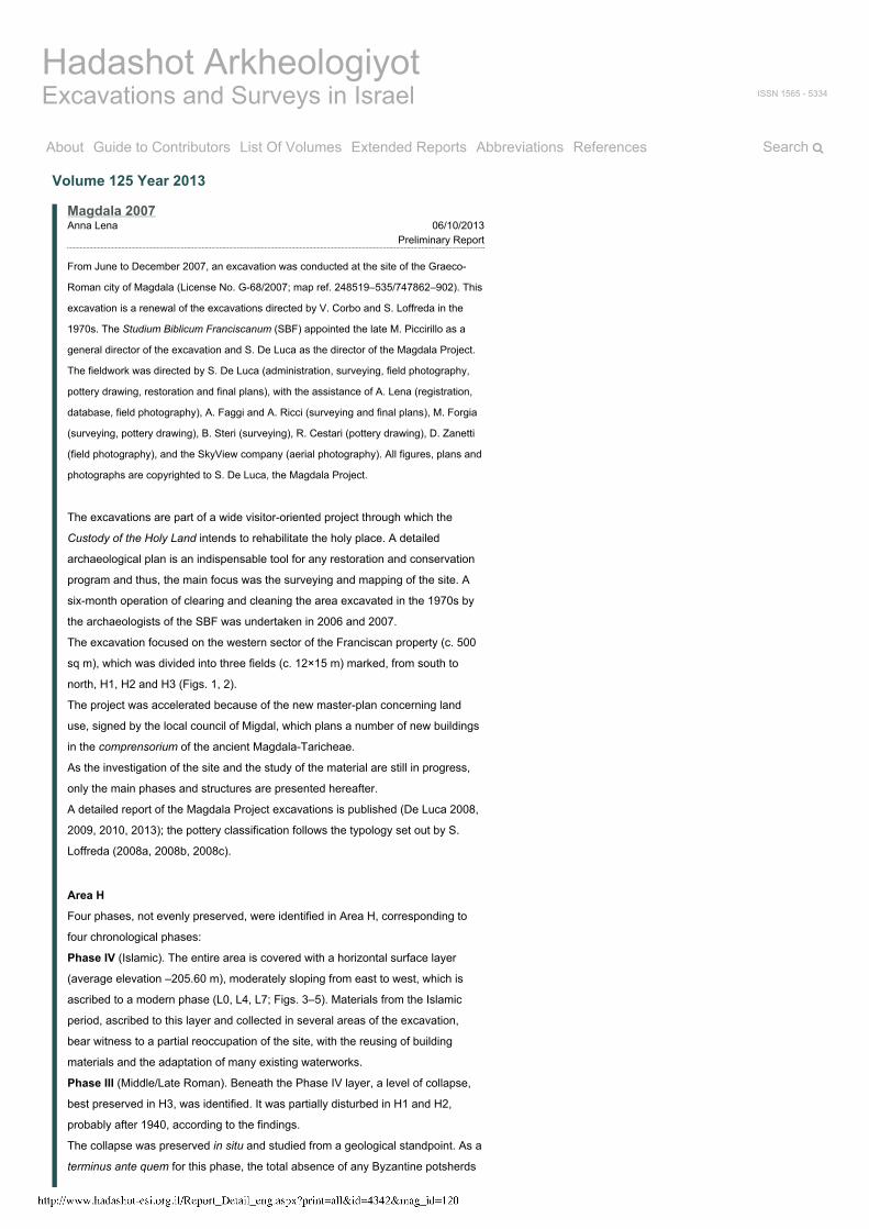
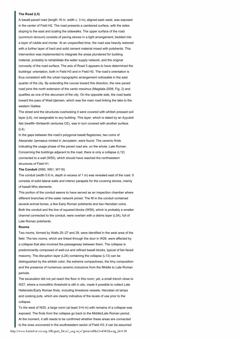
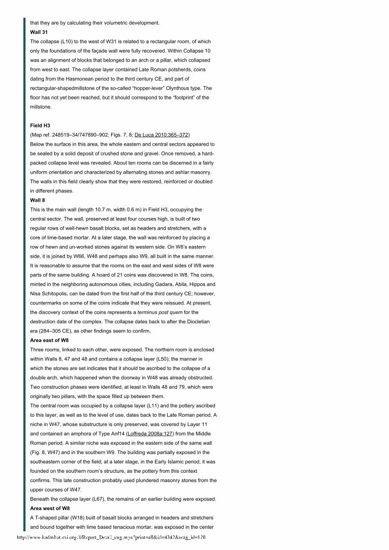
The excavation focused on the western sector of the Franciscan property (c. 500
sq m), which was divided into three fields (c. 12×15 m) marked, from south to
north, H1, H2 and H3 (Figs. 1, 2).
The project was accelerated because of the new masterplan concerning land
use, signed by the local council of Migdal, which plans a number of new buildings
in the comprensorium of the ancient MagdalaTaricheae.
As the investigation of the site and the study of the material are still in progress,
only the main phases and structures are presented hereafter.
A detailed report of the Magdala Project excavations is published (De Luca 2008,
2009, 2010, 2013); the pottery classification follows the typology set out by S.
Loffreda (2008a, 2008b, 2008c).
Area H
Four phases, not evenly preserved, were identified in Area H, corresponding to
four chronological phases:
Phase IV (Islamic). The entire area is covered with a horizontal surface layer
(average elevation –205.60 m), moderately sloping from east to west, which is
ascribed to a modern phase (L0, L4, L7; Figs. 3–5). Materials from the Islamic
period, ascribed to this layer and collected in several areas of the excavation,
bear witness to a partial reoccupation of the site, with the reusing of building
materials and the adaptation of many existing waterworks.
Phase III (Middle/Late Roman). Beneath the Phase IV layer, a level of collapse,
best preserved in H3, was identified. It was partially disturbed in H1 and H2,
probably after 1940, according to the findings.
The collapse was preserved in situ and studied from a geological standpoint. As a
terminus ante quem for this phase, the total absence of any Byzantine potsherds
Volume 125 Year 2013
Magdala 2007
4/20/2015 Israel Antiquities Authority
http://www.hadashot-esi.org.il/Report_Detail_eng.aspx?print=all&id=4342&mag_id=120 2/9
from H1, H2 and H3 should be considered.
Phase II (Early Roman). Some loci that were partially unearthed under the
collapses can be assigned to the Early Roman period.
Phase I (Late Hellenistic). Several Late Hellenistic structures, clearly dated by
findings, were identified only in the layer under the collapse of Early Roman walls
in the southeastern part of Field H1.
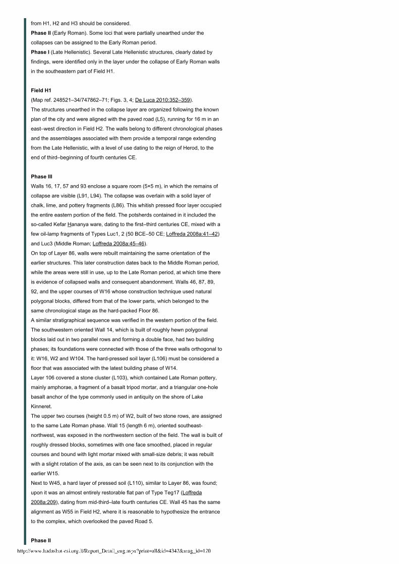
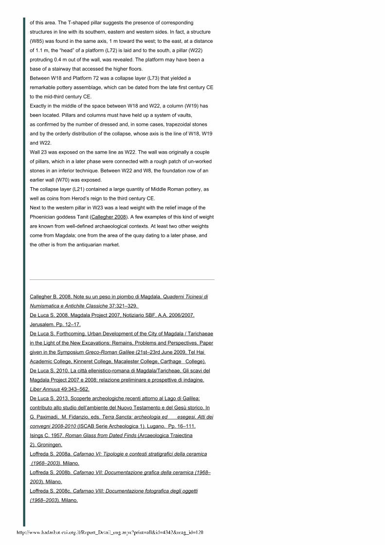
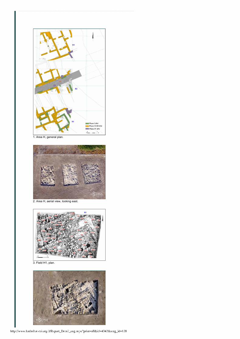
Field H1
(Map ref. 248521–34/747862–71; Figs. 3, 4; De Luca 2010:352–359).
The structures unearthed in the collapse layer are organized following the known
plan of the city and were aligned with the paved road (L5), running for 16 m in an
east–west direction in Field H2. The walls belong to different chronological phases
and the assemblages associated with them provide a temporal range extending
from the Late Hellenistic, with a level of use dating to the reign of Herod, to the
end of third–beginning of fourth centuries CE.
Phase III
Walls 16, 17, 57 and 93 enclose a square room (5×5 m), in which the remains of
collapse are visible (L91, L94). The collapse was overlain with a solid layer of
chalk, lime, and pottery fragments (L86). This whitish pressed floor layer occupied
the entire eastern portion of the field. The potsherds contained in it included the
socalled Kefar Hananya ware, dating to the first–third centuries CE, mixed with a
few oillamp fragments of Types Luc1, 2 (50 BCE–50 CE; Loffreda 2008a:41–42)
and Luc3 (Middle Roman; Loffreda 2008a:45–46).
On top of Layer 86, walls were rebuilt maintaining the same orientation of the
earlier structures. This later construction dates back to the Middle Roman period,
while the areas were still in use, up to the Late Roman period, at which time there
is evidence of collapsed walls and consequent abandonment. Walls 46, 87, 89,
92, and the upper courses of W16 whose construction technique used natural
polygonal blocks, differed from that of the lower parts, which belonged to the
same chronological stage as the hardpacked Floor 86.
A similar stratigraphical sequence was verified in the western portion of the field.
The southwestern oriented Wall 14, which is built of roughly hewn polygonal
blocks laid out in two parallel rows and forming a double face, had two building
phases; its foundations were connected with those of the three walls orthogonal to
it: W16, W2 and W104. The hardpressed soil layer (L106) must be considered a
floor that was associated with the latest building phase of W14.
Layer 106 covered a stone cluster (L103), which contained Late Roman pottery,
mainly amphorae, a fragment of a basalt tripod mortar, and a triangular onehole
basalt anchor of the type commonly used in antiquity on the shore of Lake
Kinneret.
The upper two courses (height 0.5 m) of W2, built of two stone rows, are assigned
to the same Late Roman phase. Wall 15 (length 6 m), oriented southeast
northwest, was exposed in the northwestern section of the field. The wall is built of
roughly dressed blocks, sometimes with one face smoothed, placed in regular
courses and bound with light mortar mixed with smallsize debris; it was rebuilt
with a slight rotation of the axis, as can be seen next to its conjunction with the
earlier W15.
Next to W45, a hard layer of pressed soil (L110), similar to Layer 86, was found;
upon it was an almost entirely restorable flat pan of Type Teg17 (Loffreda
2008a:209), dating from midthird–late fourth centuries CE. Wall 45 has the same
alignment as W55 in Field H2, where it is reasonable to hypothesize the entrance
to the complex, which overlooked the paved Road 5.
Phase II
4/20/2015 Israel Antiquities Authority
http://www.hadashot-esi.org.il/Report_Detail_eng.aspx?print=all&id=4342&mag_id=120 3/9
The collapse (L91, L94) is composed of wellhewn rectangular blocks; the manner
in which they are placed suggests that they originated from the elevation of the
earliest phase of Walls 93 and 16.
Under the collapse, a basalt rounded fishingnet weight was found, as well as a
cluster of 54 prutot, mainly datable to Hasmonean times, although the latest of
which pertains to the prefects Marcus Coponius or Ambibulus (6–9 CE or 9–12
CE). This data is consistent with the chronology of the pottery from the same
context, which includes oil lamps of the Karm erRas type (Loffreda 2008a:41)
and thickwalled amphorae, leading us to date the collapse of this early building
after the first decade of the first century CE.
Beneath Floor Layer 106, the collapse (L103, L105) occupied the space that was
separated by W104. This wall, which is contemporary with the earliest phase of
W14, has a basalt grinding stone (Olynthus mill) reused as a threshold. Under the
collapse and on top of a compact earth floor (L102), Early Roman pottery,
including Herodian oil lamps and a portion of a limestone hydria, as well as a
remarkable group of nails, parts of a latch and a bronze artifact (specillum), was
found.
To this chronological stage pertains the small rectangular room enclosed within
Walls 2, 14, 42 and 104. It must have been originally double in size, reaching the
older phase of W15 as its northern boundary. In this case, Walls 41 and 42 must
be considered a later superimposition.
A foundation row, protruding 0.3 m out of the upper courses, was identified along
the southern face of W15’s western portion; it represents the remains of an earlier
construction phase. A similar alignment, projecting only 0.2 m from the wall, was
exposed in a small trench (1.3×1.5×1.5 m) along the southern face of W15’s
eastern part. This sounding made it possible to verify the presence of a two
course wall (W44), below a filling of earth (thickness 0.3 m) under the northern
portion of W2; both walls have the same orientation. Moreover, when a whitish
dump layer (L39; thickness 0.8 m) was removed, a pressedearth floor layer (L98)
was reached, overlain with a globular Kefar Hananya cookingpot of Type Pent10
(Loffreda 2008a:184–185), dating to the first century BCE–first century CE, and
associated with three Hasmonean coins. On the contrary, the material from Dump
Layer 39 included traces of burning, animal bones, half shells, pottery from the
Early to Late Roman periods, glass fragments, including a ribbed bowl (coppa
costolata) of Isings Type 3 (Isings 1957:17–21), and coins from the first–third
centuries CE.
Phase I
A usage phase attributed to this period is identified by the material found on top of
a pressedearth floor section (L96), bound by W97 to its southwest. The pottery
assemblage included a complete globular cooking pot with outwardcurving long
neck and a partially preserved amphora of Type Anf3 (Loffreda 2008a:119–120),
as well as three coins of Alexander Jannaeus.
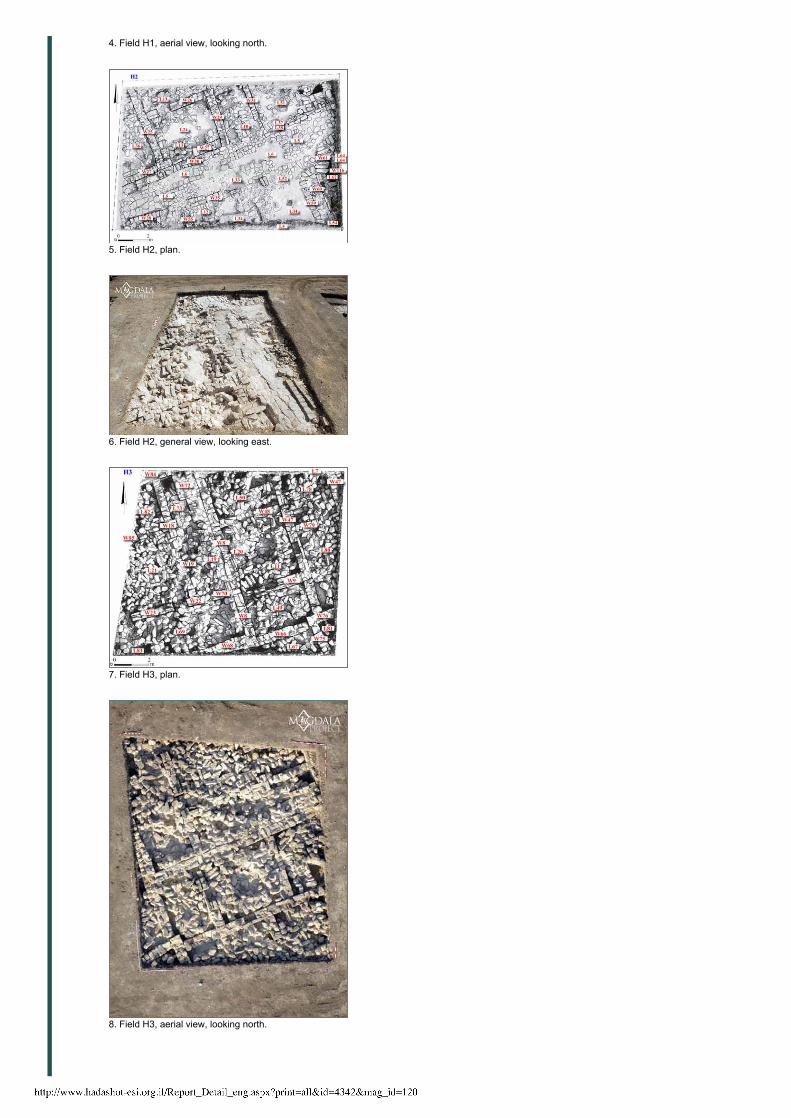
Field H2
(Map ref. 248519–35/747877–87; Figs. 5, 6; De Luca 2010:359–365).
The building remains in this field emerged immediately below the surface;
generally, they belong to two different periods that are not always easily
distinguished, due to their continuity. Moreover, some walls show signs of heavy
subsequent reworking. The chronological span of the finds in this field ranges
from the Hasmonean to the Late Roman periods, with a predominant thirdcentury
occupation phase, as well as several Herodian contexts.
It should be noted that the northeastern area of the field presents an altered
stratigraphical scenario, as inferred from the presence of an artificial pit that was
cut probably due to agricultural needs in modern times.
4/20/2015 Israel Antiquities Authority
http://www.hadashot-esi.org.il/Report_Detail_eng.aspx?print=all&id=4342&mag_id=120 4/9
The Road (L5)
A basaltpaved road (length 16 m, width c. 3 m), aligned east–west, was exposed
in the center of Field H2. The road presents a cambered surface, with the sides
sloping to the east and scaling the sidewalks. The upper surface of the road
(summum dorsum) consists of paving stones in a tight arrangement, bedded into
a layer of rubble and mortar. At an unspecified time, the road was heavily restored
with a further layer of hard and solid cement material mixed with potsherds. This
intervention was implemented to integrate the areas plundered for building
material, probably to rehabilitate the water supply network, and the original
convexity of the road surface. The axis of Road 5 appears to have determined the
buildings’ orientation, both in Field H3 and in Field H2. The road’s orientation is
thus consistent with the urban topographic arrangement noticeable in the east
quarter of the city. By extending the course toward this direction, the new paved
road joins the north extension of the cardo maximus (Magdala 2008, Fig. 2) and
qualifies as one of the decumani of the city. On the opposite side, the road leads
toward the pass of Wadi Hamam, which was the main road linking the lake to the
western Galilee.
The street and the structures overlooking it were covered with whitish pressed soil
layer (L6), not assignable to any building. This layer, which is dated by an Ayyubid
fals (twelfth–thirteenth centuries CE), was in turn covered with another surface
(L4).
In the gaps between the road’s polygonal basalt flagstones, two coins of
Alexander Jannaeus minted in Jerusalem, were found. The ceramic finds
indicating the usage phase of the paved road are, on the whole, Late Roman.
Concerning the buildings adjacent to the road, there is only a collapse (L12)
connected to a wall (W55), which should have reached the northwestern
structures of Field H1.
The Conduit (W60, W61, W116)
The conduit (width 0.6 m, depth in excess of 1 m) was revealed east of the road. It
consists of solid lateral walls and interior parapets for the covering stones, mainly
of basalt lithic elements.
This portion of the conduit seems to have served as an inspection chamber where
different branches of the water network joined. The fill in the conduit contained
several animal bones, a few Early Roman potsherds and two Herodian coins.
Both the conduit and the line of squared blocks (W59), which is probably a smaller
channel connected to the conduit, were overlain with a debris layer (L54), full of
Late Roman potsherds.
Rooms
Two rooms, formed by Walls 25–27 and 29, were identified in the west area of the
field. The two rooms, which are linked through the door in W26, were affected by
a collapse that also involved the passageway between them. The collapse is
predominantly composed of wellcut and refined basalt blocks, typical of fairfaced
masonry. The disruption layer (L24) containing the collapse (L13) can be
distinguished by the whitish color, the extreme compactness, the limy composition
and the presence of numerous ceramic inclusions from the Middle to Late Roman
periods.
The excavation did not yet reach the floor in this room; yet, a small trench close to
W27, where a monolithic threshold is still in situ, made it possible to collect Late
Hellenistic/Early Roman finds, including limestone vessels, Herodian oil lamps
and cooking pots, which are clearly indicative of the levels of use prior to the
collapse.
To the west of W25, a large room (at least 3×4 m) with remains of a collapse was
exposed. The finds from the collapse go back to the Middle/Late Roman period.
At the moment, it still needs to be confirmed whether these areas are connected
to the ones uncovered in the southwestern sector of Field H3; it can be assumed
4/20/2015 Israel Antiquities Authority
http://www.hadashot-esi.org.il/Report_Detail_eng.aspx?print=all&id=4342&mag_id=120 5/9
that they are by calculating their volumetric development.
Wall 31
The collapse (L10) to the west of W31 is related to a rectangular room, of which
only the foundations of the façade wall were fully recovered. Within Collapse 10
was an alignment of blocks that belonged to an arch or a pillar, which collapsed
from west to east. The collapse layer contained Late Roman potsherds, coins
dating from the Hasmonean period to the third century CE, and part of
rectangularshapedmillstone of the socalled “hopperlever” Olynthous type. The
floor has not yet been reached, but it should correspond to the “footprint” of the
millstone.
Field H3
(Map ref. 248519–34/747890–902; Figs. 7, 8; De Luca 2010:365–372)
Below the surface in this area, the whole eastern and central sectors appeared to
be sealed by a solid deposit of crushed stone and gravel. Once removed, a hard
packed collapse level was revealed. About ten rooms can be discerned in a fairly
uniform orientation and characterized by alternating stones and ashlar masonry.
The walls in this field clearly show that they were restored, reinforced or doubled
in different phases.
Wall 8
This is the main wall (length 10.7 m, width 0.6 m) in Field H3, occupying the
central sector. The wall, preserved at least four courses high, is built of two
regular rows of wellhewn basalt blocks, set as headers and stretchers, with a
core of limebased mortar. At a later stage, the wall was reinforced by placing a
row of hewn and unworked stones against its western side. On W8’s eastern
side, it is joined by W66, W48 and perhaps also W9, all built in the same manner.
It is reasonable to assume that the rooms on the east and west sides of W8 were
parts of the same building. A hoard of 21 coins was discovered in W8. The coins,
minted in the neighboring autonomous cities, including Gadara, Abila, Hippos and
Nisa Schitopolis, can be dated from the first half of the third century CE; however,
countermarks on some of the coins indicate that they were reissued. At present,
the discovery context of the coins represents a terminus post quem for the
destruction date of the complex. The collapse dates back to after the Diocletian
era (284–305 CE), as other findings seem to confirm.
Area east of W8
Three rooms, linked to each other, were exposed. The northern room is enclosed
within Walls 8, 47 and 48 and contains a collapse layer (L50); the manner in
which the stones are set indicates that it should be ascribed to the collapse of a
double arch, which happened when the doorway in W48 was already obstructed.
Two construction phases were identified, at least in Walls 48 and 79, which were
originally two pillars, with the space filled up between them.
The central room was occupied by a collapse layer (L11) and the pottery ascribed
to this layer, as well as to the level of use, dates back to the Late Roman period. A
niche in W47, whose substructure is only preserved, was covered by Layer 11
and contained an amphora of Type Anf14 (Loffreda 2008a:127) from the Middle
Roman period. A similar niche was exposed in the eastern side of the same wall
(Fig. 8, W47) and in the southern W9. The building was partially exposed in the
southeastern corner of the field; at a later stage, in the Early Islamic period, it was
founded on the southern room’s structure, as the pottery from this context
confirms. This late construction probably used plundered masonry stones from the
upper courses of W47.
Beneath the collapse layer (L67), the remains of an earlier building were exposed.
Area west of W8
A Tshaped pillar (W18) built of basalt blocks arranged in headers and stretchers
and bound together with lime based tenacious mortar, was exposed in the center
4/20/2015 Israel Antiquities Authority
http://www.hadashot-esi.org.il/Report_Detail_eng.aspx?print=all&id=4342&mag_id=120 6/9
of this area. The Tshaped pillar suggests the presence of corresponding
structures in line with its southern, eastern and western sides. In fact, a structure
(W85) was found in the same axis, 1 m toward the west; to the east, at a distance
of 1.1 m, the “head” of a platform (L72) is laid and to the south, a pillar (W22)
protruding 0.4 m out of the wall, was revealed. The platform may have been a
base of a stairway that accessed the higher floors.
Between W18 and Platform 72 was a collapse layer (L73) that yielded a
remarkable pottery assemblage, which can be dated from the late first century CE
to the midthird century CE.
Exactly in the middle of the space between W18 and W22, a column (W19) has
been located. Pillars and columns must have held up a system of vaults,
as confirmed by the number of dressed and, in some cases, trapezoidal stones
and by the orderly distribution of the collapse, whose axis is the line of W18, W19
and W22.
Wall 23 was exposed on the same line as W22. The wall was originally a couple
of pillars, which in a later phase were connected with a rough patch of unworked
stones in an inferior technique. Between W22 and W8, the foundation row of an
earlier wall (W70) was exposed.
The collapse layer (L21) contained a large quantity of Middle Roman pottery, as
well as coins from Herod’s reign to the third century CE.
Next to the western pillar in W23 was a lead weight with the relief image of the
Phoenician goddess Tanit (Callegher 2008). A few examples of this kind of weight
are known from welldefined archaeological contexts. At least two other weights
come from Magdala; one from the area of the quay dating to a later phase, and
the other is from the antiquarian market.
Callegher B. 2008. Note su un peso in piombo di Magdala. Quaderni Ticinesi di
Numismatica e Antichite Classiche 37:321–329.
De Luca S. 2008. Magdala Project 2007, Notiziario SBF. A.A. 2006/2007.
Jerusalem. Pp. 12–17.
De Luca S. Forthcoming. Urban Development of the City of Magdala / Tarichaeae
in the Light of the New Excavations: Remains, Problems and Perspectives. Paper
given in the Symposium GrecoRoman Galilee (21st–23rd June 2009, Tel Hai
Academic College, Kinneret College, Macalester College, Carthage College).
De Luca S. 2010. La città ellenisticoromana di Magdala/Taricheae. Gli scavi del
Magdala Project 2007 e 2008: relazione preliminare e prospettive di indagine.
Liber Annuus 49:343–562.
De Luca S. 2013. Scoperte archeologiche recenti attorno al Lago di Galilea:
contributo allo studio dell’ambiente del Nuovo Testamento e del Gesù storico. In
G. Paximadi, M. Fidanzio, eds. Terra Sancta: archeologia ed esegesi. Atti dei
convegni 20082010 (ISCAB Serie Archeologica 1). Lugano. Pp. 16–111.
Isings C. 1957. Roman Glass from Dated Finds (Arcaeologica Traiectina
2). Groningen.
Loffreda S. 2008a. Cafarnao VI: Tipologie e contesti stratigrafici della ceramica
(1968–2003). Milano.
Loffreda S. 2008b. Cafarnao VII: Documentazione grafica della ceramica (1968–
2003). Milano.
Loffreda S. 2008c. Cafarnao VIII: Documentazione fotografica degli oggetti
(1968–2003). Milano.
4/20/2015 Israel Antiquities Authority
http://www.hadashot-esi.org.il/Report_Detail_eng.aspx?print=all&id=4342&mag_id=120 7/9
1. Area H, general plan.
2. Area H, aerial view, looking east.
3. Field H1, plan.
4/20/2015 Israel Antiquities Authority
http://www.hadashot-esi.org.il/Report_Detail_eng.aspx?print=all&id=4342&mag_id=120 8/9
4. Field H1, aerial view, looking north.
5. Field H2, plan.
6. Field H2, general view, looking east.
7. Field H3, plan.
8. Field H3, aerial view, looking north.

4/20/2015 Israel Antiquities Authority
http://www.hadashot-esi.org.il/Report_Detail_eng.aspx?print=all&id=4342&mag_id=120 9/9
Web Site Development by teti-tuCopyright Legalicy to The Israel Antiquities Authority | Credits | גרסה עברית
Related Documents