Hadashot Arkheologiyot Excavations and Surveys in Israel ISSN 1565 5334 About Guide to Contributors List Of Volumes Extended Reports Abbreviations References Search Anna Lena 31/12/2013 Preliminary Report From January to December2008,the second season of archaeological excavations was conducted at the site of ancient Magdala (elMejdel; License No. G59/2008; map ref. 1986/2478). The excavation was undertaken by the Magdala Project team under the direction of the late M. Piccirillo and S. De Luca of the Studium Biblicum Franciscanum (SBF; Fig. 1). Fieldwork was directed by S. De Luca (administration, surveying, field photography, restoration, find drawing and drafting), with the assistance of A. Lena (find processing, database, photography), A. Faggi (surveying), A. Ricci (surveying and drafting), M. Forgia (surveying, pottery drawing), B. Steri (surveying), R. Cestari (pottery drawing), D. Zanetti (photography) the SkyView Company (aerial photography), and A. Shbat, A. Elias and A. Arsheed. From January to December2008,the second season of archaeological excavations was conducted at the site of ancient Magdala (elMejdel; License No. G59/2008; map ref. 1986/2478). The excavation was undertaken by the Magdala Project team under the direction of the late M. Piccirillo and S. De Luca of the Studium Biblicum Franciscanum (SBF; Fig. 1). Fieldwork was directed by S. De Luca (administration, surveying, field photography, restoration, find drawing and drafting), with the assistance of A. Lena (find processing, database, photography), A. Faggi (surveying), A. Ricci (surveying and drafting), M. Forgia (surveying, pottery drawing), B. Steri (surveying), R. Cestari (pottery drawing), D. Zanetti (photography) the SkyView Company (aerial photography), and A. Shbat, A. Elias and A. Arsheed. All figures, plans and photographs are copyrighted to S. De Luca, the Magdala Project. The excavation mainly focused on the eastern area of the Franciscan compound. The unusually low level of the lake (c. 5 m under the upper red line) made it possible to reach the pavements of the pools (D1, D3, C3, E11, E22, M31) and to investigate the extended water supply and sewage network. Soundings were carried out in the Water Tower (A1), to clarify how it functioned and its relationship to the aqueduct and to the water basins (A5, B5); in the aquarium(E27) and in the adjacent room (E28); in another room (E19) and conjoining spaces (E16–E18); due to the large amount of squared bricks (20×20 cm) of the bessales type and several fragments of tubuli found on the surface, as well as vertical spaces for tubuli inside the walls, Rooms E18 and E19 can now be interpreted as a caldarium of a bath; in the adjacent room (E31) where traces of burning on the basalt flagstones suggest the presence of a furnace opening (praefurnium); and in Areas G and I, where a residential quarter was identified. The pottery classification of the site follows the typology set out byS. Loffreda (2008a–c) and a detailed report of the Magdala excavations appeared recently (De Luca 2010–2013). Pool C3 The excavation of the pool (Fig. 2) confirmed the two building phases of Complex Volume 125 Year 2013 Magdala 2008

Welcome message from author
This document is posted to help you gain knowledge. Please leave a comment to let me know what you think about it! Share it to your friends and learn new things together.
Transcript
4/20/2015 Israel Antiquities Authority
http://www.hadashot-esi.org.il/Report_Detail_eng.aspx?print=all&print=all&id=5433&mag_id=120 1/10
Hadashot ArkheologiyotExcavations and Surveys in Israel ISSN 1565 5334
About Guide to Contributors List Of Volumes Extended Reports Abbreviations References Search
Anna Lena 31/12/2013Preliminary Report
From January to December2008,the second season of archaeological excavations was
conducted at the site of ancient Magdala (elMejdel; License No. G59/2008; map ref.
1986/2478). The excavation was undertaken by the Magdala Project team under the
direction of the late M. Piccirillo and S. De Luca of the Studium Biblicum Franciscanum
(SBF; Fig. 1). Fieldwork was directed by S. De Luca (administration, surveying, field
photography, restoration, find drawing and drafting), with the assistance of A. Lena (find
processing, database, photography), A. Faggi (surveying), A. Ricci (surveying and
drafting), M. Forgia (surveying, pottery drawing), B. Steri (surveying), R. Cestari (pottery
drawing), D. Zanetti (photography) the SkyView Company (aerial photography), and A.
Shbat, A. Elias and A. Arsheed.
From January to December2008,the second season of archaeological
excavations was conducted at the site of ancient Magdala (elMejdel; License No.
G59/2008; map ref. 1986/2478). The excavation was undertaken by the Magdala
Project team under the direction of the late M. Piccirillo and S. De Luca of the
Studium Biblicum Franciscanum (SBF; Fig. 1). Fieldwork was directed by S. De
Luca (administration, surveying, field photography, restoration, find drawing and
drafting), with the assistance of A. Lena (find processing, database, photography),
A. Faggi (surveying), A. Ricci (surveying and drafting), M. Forgia (surveying,
pottery drawing), B. Steri (surveying), R. Cestari (pottery drawing), D. Zanetti
(photography) the SkyView Company (aerial photography), and A. Shbat, A. Elias
and A. Arsheed.
All figures, plans and photographs are copyrighted to S. De Luca, the Magdala
Project.
The excavation mainly focused on the eastern area of the Franciscan compound.
The unusually low level of the lake (c. 5 m under the upper red line) made it
possible to reach the pavements of the pools (D1, D3, C3, E11, E22, M31) and to
investigate the extended water supply and sewage network.
Soundings were carried out in the Water Tower (A1), to clarify how it functioned
and its relationship to the aqueduct and to the water basins (A5, B5); in the
aquarium(E27) and in the adjacent room (E28); in another room (E19) and
conjoining spaces (E16–E18); due to the large amount of squared bricks (20×20
cm) of the bessales type and several fragments of tubuli found on the surface, as
well as vertical spaces for tubuli inside the walls, Rooms E18 and E19 can now be
interpreted as a caldarium of a bath; in the adjacent room (E31) where traces of
burning on the basalt flagstones suggest the presence of a furnace opening
(praefurnium); and in Areas G and I, where a residential quarter was identified.
The pottery classification of the site follows the typology set out byS. Loffreda
(2008a–c) and a detailed report of the Magdala excavations appeared recently
(De Luca 2010–2013).
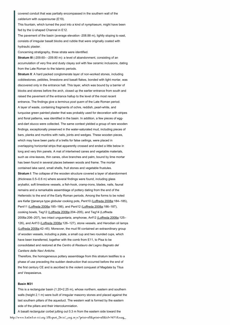
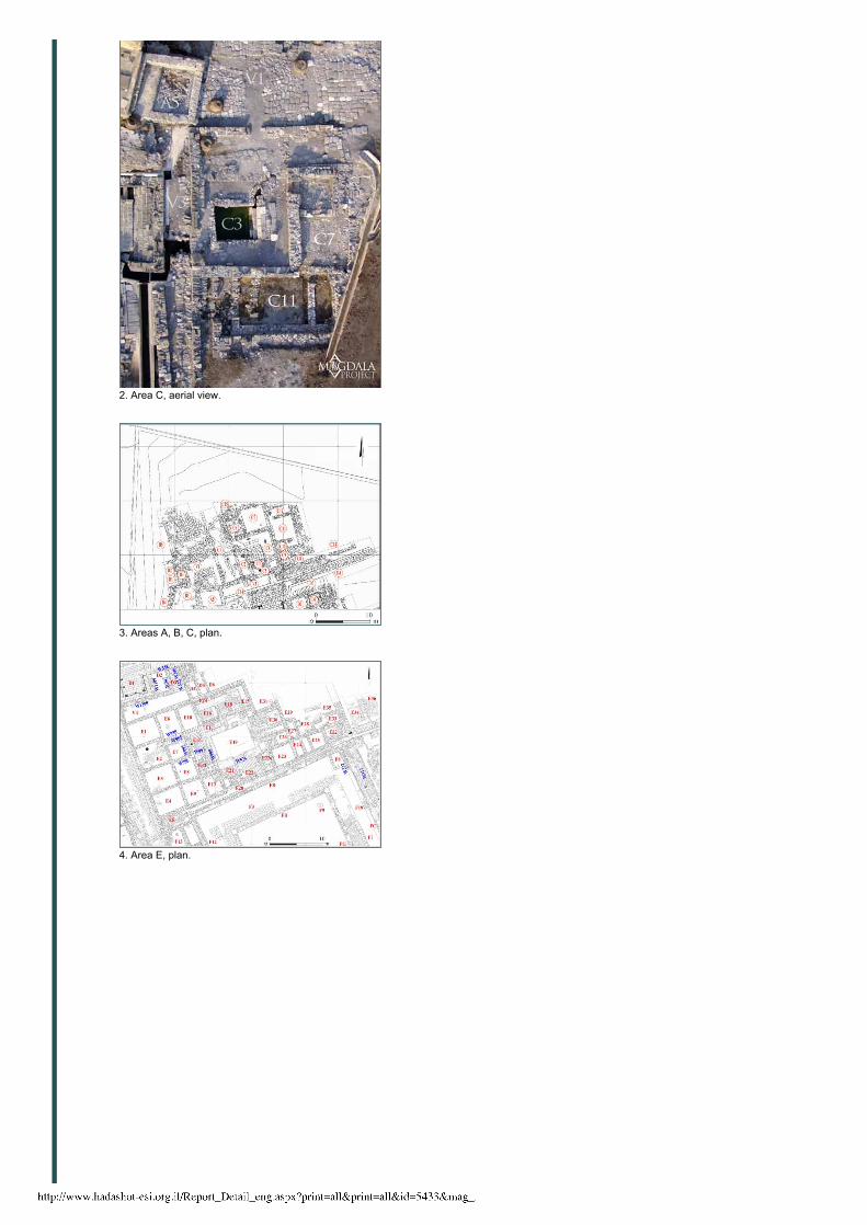
Pool C3
The excavation of the pool (Fig. 2) confirmed the two building phases of Complex
Volume 125 Year 2013
Magdala 2008
4/20/2015 Israel Antiquities Authority
http://www.hadashot-esi.org.il/Report_Detail_eng.aspx?print=all&print=all&id=5433&mag_id=120 2/10
C that had already been identified in the 1970s. The bottom of the pool consists of
wellworked chiseled basalt slabs; the southern part of the pavement was
originally covered with a mosaic, of which a few traces survived. Near the spot
where the change in the pavement is visible, there is also a seam in the masonry
of the eastern and western walls, indicating a later restoration work. The basin of
the pool was enlarged in the second building phase and a drainage channel,
connecting the conduit (C14; Fig. 3), was opened in the southeastern corner. The
iconography of the mosaic discovered in C6 (Fig. 3), the traces of white tesserae
mosaic in C7 and C12, the runningwater pool, the remains of earlier masonry
reused as a bench in C10–C12 and the remains of clay bricks for a floating floor
(suspensurae) in C7, suggest that Complex C was part of a thermal bath that was
in use, with some adaptations, at least from the first half of the first century CE,
before the First Revolt, until the fourth century CE.
Pool D3
This stepped pool was restored (Fig. 4). The earliest phase corresponds to a
north–south wall (W345), which was partially dismantled at the level of the
pavement, although four higher courses were preserved and covered by the
steps.
The paving slabs (L346) were laid contemporary with the construction of W345,
whereas the northern wall (W348) and the western sidewall (W347) of the pool
partially covered it and therefore, belong to the second building phase.
Hence, the pool was enlarged in the second phase toward the north with the
construction of W348 and restricted on the east with W347.
Moreover, in a later stage the uppermost three rows of W347 were rebuilt with
wellhewn squared blocks, arranged in the headers and stretchers building
technique. The findings from the pool, which include a bronze tool (specillum),
unguentaria and a bone hairpin, attest to its use, with successive adaptations,
from the Late Hellenistic to the Late Roman periods, when the caldarium and
tepidarium in E19 underwent restoration.
Columned Building D1
Several soundings were carried out in the controversial columned building D1,
misinterpreted as a synagogue, to clarify its function and its connection with other
buildings.
It was possible to attest that the original use of the structure was in some way
connected to water. In a later phase, it was transformed into a water reservoir,
also by raising the pavement, probably for manufacturing activities. The water was
supplied via some rectangular openings inclined toward the interior of the building;
the best preserved are visible in the southern wall (W1200) that belonged to the
first phase and was built of perfectly smoothed blocks in courses of varying
height. The western sidewall (W1199) was equipped with similar openings, which
at a later stage were roughly enlarged. In the earliest phase, the supplying
drainage system consisted of a sluice gate that regulated the water flow toward
the discharge conduit D8.
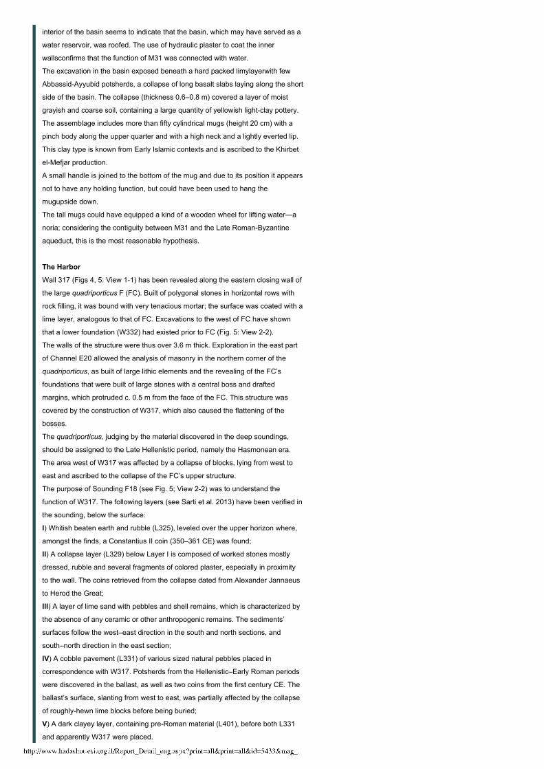
Stepped Pool E2E7
Although the absence of certain pavements and the plundering of masonry make
it difficult to “read” the layout of the rooms and interpret their function, the
soundings in E2 (Fig. 4) offered significant contributions. Remains of stone
pavements with traces of mortar were unearthed in the central sector at an
elevation of 207.89 m; in the southern sector traces of mosaic bedding were
visible along with several midsized tesserae in black, white and red hues; in the
northern sector, an older lower pavement was exposed; at the same level to the
east was a small covered channel, overlooking a sixstep basin that broadensup
4/20/2015 Israel Antiquities Authority
http://www.hadashot-esi.org.il/Report_Detail_eng.aspx?print=all&print=all&id=5433&mag_id=120 3/10
at the fourth step into a rectangular basin (1.0×1.8 m). The pavement was partially
covered by a partition wall (W985), aligned north–south.The southern side of this
basin (W986) was built of worked stones arranged in regular rows and connected
with W985, while the northern side (W988), corresponding to the southern wall of
E6, was roughly built of unworked polygonal stones arranged in irregular
courses. Wall 988 is later than the flight of stairs because its foundations were
adapted to the steps, reducing their size and precluding their use. Therefore, it is
possible to imagine an original basin with steps, oriented west–east, which was in
use before the middle of the first century CE, judging by the Late Hellenistic–Early
Roman assemblage from the fill of grayish clayey mud. Later, the basin was
reduced in size and no longer in use; eventually, it was completely obliterated with
the resetting of the walls during the Middle Roman period.
Pool E11
This room (Fig. 4) consists of two levels. The lower one is the proper stepped pool
and the upper level could have been the undressing room (apodyterium). To the
east, a stone plastered bench runs along a narrow corridor that widens out toward
the south into a plastered pavement with a small basin.
The uppermost fill layers in the pool were excavated down to the fourth step of the
staircase in 1975 by V. Corbo and S. Loffreda; these consisted of an
abandonment level that contained findings from the Byzantine to the ‘Abbasid
periods (sixth–ninth centuries CE).
Beneath a debris buildup layer, a level of collapse was identified, overlain with
several mixed potsherds and a quantity of square bricks for suspensurae and
fragments of clay tubuli, coming from the adjacent E19. The collapse, which
extends from southwest to northeast, consisted of a covering basalt slab, a well
hewn quadrangular block, several building blocks and a basalt column. Moreover,
the pertaining disruption layer contained fragments of colored plaster, mortar and
several shattered glass panes.
The collapse, which is ascribed to an upper floor, covered a levelof abandonment
that contained a large quantity of common pottery, e.g., amphorae, cooking pots,
and lekythoi, dating up to the fourth century CE, while the associated coins extend
no further than the third century CE.
Several articles of toilette, such as bone hairpins, a bronze handle for a glass
aryballos, a bronze spoon, a gold granulated earring, complete clay
unguentariaand a wooden comb, were found on the pavement, in association with
coins that provide a chronological range extending from the first century BCE to
Caracalla (198–217 CE).
The earliest building phase corresponds to the remains of a north–south wall,
razed to floor level, which was incorporated in the lowest step and in the masonry
of the basin’s southern side. The western wall (W995; preserved height 2.44 m)
clearly shows two different building techniques: the upper courses are of well
worked squared blocks, alternately arranged lengthwise and widthwise, placed on
top of the remains of a preexisting structure, built of roughly worked calcareous
stones.
The flight of steps leading to the pool, which shows a gradual narrowing toward
the west, was conditioned by the presence of some earlier structures.
The pavement of the pool (210.03 m) consisted of seven squared masonry
blocks; in the western sector, two large squared basalt blocks were laid down
forming a sort of step that led to a deep basin (0.62×1.62 m; 210.35 m), with a
nonpaved bottom.
The presence of two large basalt corbels, in situ, on top of the western wall, leads
us to offer the existence of a small balcony.
Few minor traces of hydraulic and colored plaster are still visible, in situ, on the
eastern side of the basin and, together with the fragments collected in the mud
4/20/2015 Israel Antiquities Authority
http://www.hadashot-esi.org.il/Report_Detail_eng.aspx?print=all&print=all&id=5433&mag_id=120 4/10
that filled the pool, suggest that the sides were decorated.
Water flows into the pool from a natural source, via two underground trickles that
enter through two openings in the western wall, where some remains of limestone
bedrock are preserved and incorporated in the welldressed masonry. Before
reaching the pool, the water was apparently filtered in a stepped reservoir (E7)
excavated in the eastern side of E2E7. The pool was connected to the water
collector (E12) through a stone squared conduit, provided with an outstanding
mensula (small table), which flows in the southeastern corner of the southern wall
(W997).
Water Collectors E12, E21
Room E12 (Fig. 4) consists of two levels: the upper one has a pavement of
flagstones covered with mosaics, now totally destroyed, and the lower level is a
large underground water channel. This channel is unfortunately interrupted in the
west by a blockage of large blocks and its top is blocked by the collapse of the
original covering. The northern edge of this water conveyor was built as a wall and
topped with a Ushaped pipe of hydraulic mortar, which runs west–east close to
the mouth of the E11 conduit and then enters into the western wall of E19
(caldarium).
Several fragments of clay unguentaria, fragments of colored plaster and a
second/third century coin were found atop the upper pavement. The mud fill of the
lower channel contained early Roman potsherds, a complete fritillustype
ungentarium, in association with a coin of Pilatus and fragments of marmoridea
(plaster with marble appearance).
E12 was connected in a later phase to Water Collector E21, through an additional
duct along the western wall (W998) of the caldarium, and though E13 and E12,
which seem to have been a kind of water collector, as attested by the different
branches coming out from it. E21 is connected to E13 through an opening in the
western side, to the caldarium in E19 through a covered channel penetrating
below its southern wall (W525), and into the main conduit E20.
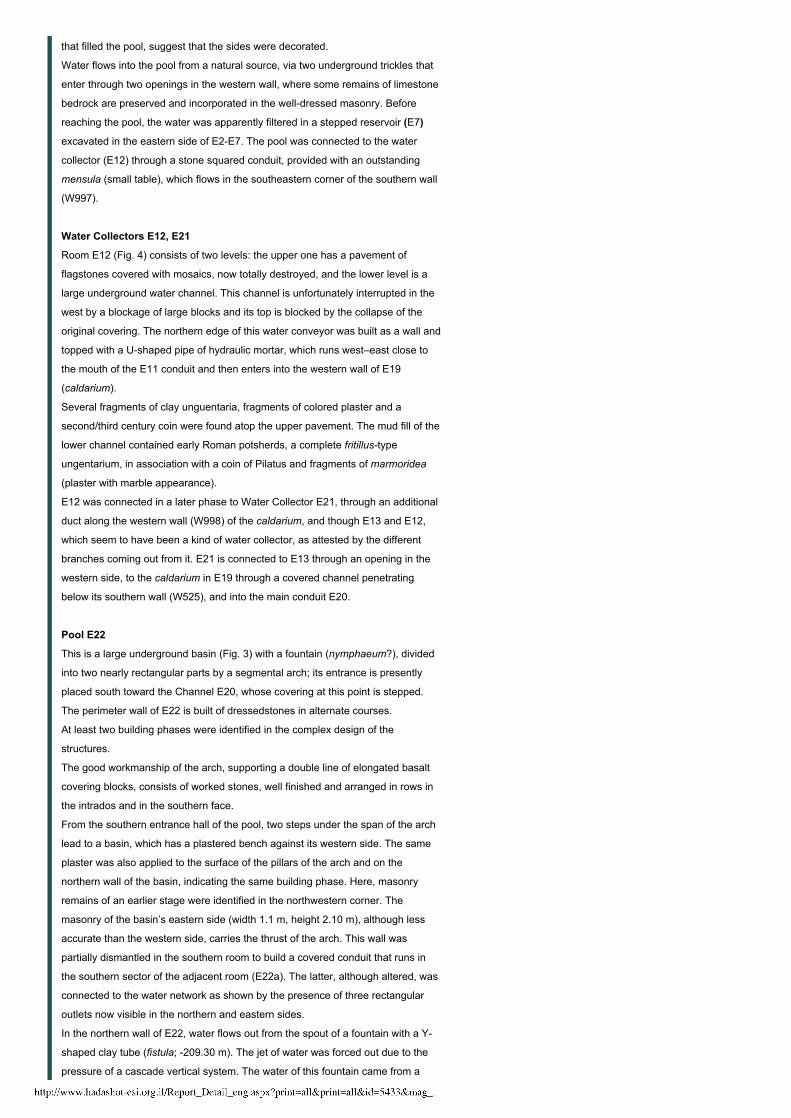
Pool E22
This is a large underground basin (Fig. 3) with a fountain (nymphaeum?), divided
into two nearly rectangular parts by a segmental arch; its entrance is presently
placed south toward the Channel E20, whose covering at this point is stepped.
The perimeter wall of E22 is built of dressedstones in alternate courses.
At least two building phases were identified in the complex design of the
structures.
The good workmanship of the arch, supporting a double line of elongated basalt
covering blocks, consists of worked stones, well finished and arranged in rows in
the intrados and in the southern face.
From the southern entrance hall of the pool, two steps under the span of the arch
lead to a basin, which has a plastered bench against its western side. The same
plaster was also applied to the surface of the pillars of the arch and on the
northern wall of the basin, indicating the same building phase. Here, masonry
remains of an earlier stage were identified in the northwestern corner. The
masonry of the basin’s eastern side (width 1.1 m, height 2.10 m), although less
accurate than the western side, carries the thrust of the arch. This wall was
partially dismantled in the southern room to build a covered conduit that runs in
the southern sector of the adjacent room (E22a). The latter, although altered, was
connected to the water network as shown by the presence of three rectangular
outlets now visible in the northern and eastern sides.
In the northern wall of E22, water flows out from the spout of a fountain with a Y
shaped clay tube (fistula; 209.30 m). The jet of water was forced out due to the
pressure of a cascade vertical system. The water of this fountain came from a
4/20/2015 Israel Antiquities Authority
http://www.hadashot-esi.org.il/Report_Detail_eng.aspx?print=all&print=all&id=5433&mag_id=120 5/10
covered conduit that was partially encompassed in the southern wall of the
caldarium with suspensurae (E19).
This fountain, which turned the pool into a kind of nymphaeum, might have been
fed by the Ushaped Channel in E12.
The pavement of the basin (average elevation 208.88 m), lightly sloping to east,
consists of irregular basalt blocks and rubble that were originally coated with
hydraulic plaster.
Concerning stratigraphy, three strata were identified.
Stratum III (209.60– 209.80 m): a level of abandonment, consisting of an
accumulation of very fine and dusty clayey soil with few ceramic inclusions, dating
from the Late Roman to the Islamic periods.
Stratum II: A hard packed conglomerate layer of nonworked stones, including
cobblestones, pebbles, limestone and basalt flakes, bonded with light mortar, was
discovered only in the entrance hall. This layer, which was bound by a barrier of
blocks and stones before the arch, closed up the earlier entrance from south and
raised the pavement of the entrance hallup to the level of the most recent
entrance. The findings give a terminus post quem of the Late Roman period.
A layer of waste, containing fragments of ochre, reddish, pearlwhite, and
turquoise green painted plaster that was probably used for decoration with stripes
and floral patterns, was identified in the basin. In addition, a few pieces of egg
anddart stucco were collected. The same context yielded a group of rare wooden
findings, exceptionally preserved in the watersaturated mud, including pieces of
bars, planks and muntins with nails, joints and wedges. These wooden pieces,
which may have been parts of a trellis for false ceilings, were placed in
overlapping horizontal strips that apparently crossed and ended a little below in
long and very thin panels. A mat of intertwined canes and vegetable materials,
such as vineleaves, thin canes, olive branches and palm, bound by lime mortar
has been found in several places between woods and frame. The mortar
contained lake sand, small shells, fruit stones and vegetable frustules.
Stratum I: The collapse of the wooden structure covered a layer of abandonment
(thickness 0.5–0.6 m) where several findings were found, including glass
aryballoi, soft limestone vessels, a fishhook, crampirons, blades, nails, faunal
remains and a remarkable assemblage of pottery dating from the end of the
Hellenistic to the end of the Early Roman periods. Among the forms to be noted
are Kefar Hananya type globular cooking pots, Pent10 (Loffreda 2008a:184–185),
Pent11 (Loffreda 2008a:185–186), and Pent12 (Loffreda 2008a:186–187),
cooking bowls, Teg12 (Loffreda 2008a:204–205), and Teg14 (Loffreda
2008a:206–207), two intact unguentaria, amphorae, Anf12 (Loffreda 2008a:125–
126), and Anf13 (Loffreda 2008a:126–127), stone vessels, and Herodian oil lamps
(Loffreda 2008a:42–45). Moreover, the mud fill contained an extraordinary group
of wooden vessels, including a plate, a small cup and two rounded cups, which
have been transferred, together with the comb from E11, to Pisa to be
consolidated and restored at the Centro di Restauro del Legno Bagnato del
Cantiere delle Navi Antiche.
Therefore, the homogeneous pottery assemblage from this stratum testifies to a
phase of use preceding the sudden destruction that occurred before the end of
the first century CE and is ascribed to the violent conquest of Magdala by Titus
and Vespasianus.
Basin M31
This is a rectangular basin (1.20×2.25 m), whose northern, eastern and southern
walls (height 2.1 m) were built of irregular masonry stones and placed against the
last southern pillars of the aqueduct. The western wall is formed by the eastern
side of the pillars and their intercolumniation.
A basalt rectangular corbel jutting out 0.3 m from the eastern side toward the
4/20/2015 Israel Antiquities Authority
http://www.hadashot-esi.org.il/Report_Detail_eng.aspx?print=all&print=all&id=5433&mag_id=120 6/10
interior of the basin seems to indicate that the basin, which may have served as a
water reservoir, was roofed. The use of hydraulic plaster to coat the inner
wallsconfirms that the function of M31 was connected with water.
The excavation in the basin exposed beneath a hard packed limylayerwith few
AbbassidAyyubid potsherds, a collapse of long basalt slabs laying along the short
side of the basin. The collapse (thickness 0.6–0.8 m) covered a layer of moist
grayish and coarse soil, containing a large quantity of yellowish lightclay pottery.
The assemblage includes more than fifty cylindrical mugs (height 20 cm) with a
pinch body along the upper quarter and with a high neck and a lightly everted lip.
This clay type is known from Early Islamic contexts and is ascribed to the Khirbet
elMefjar production.
A small handle is joined to the bottom of the mug and due to its position it appears
not to have any holding function, but could have been used to hang the
mugupside down.
The tall mugs could have equipped a kind of a wooden wheel for lifting water—a
noria; considering the contiguity between M31 and the Late RomanByzantine
aqueduct, this is the most reasonable hypothesis.
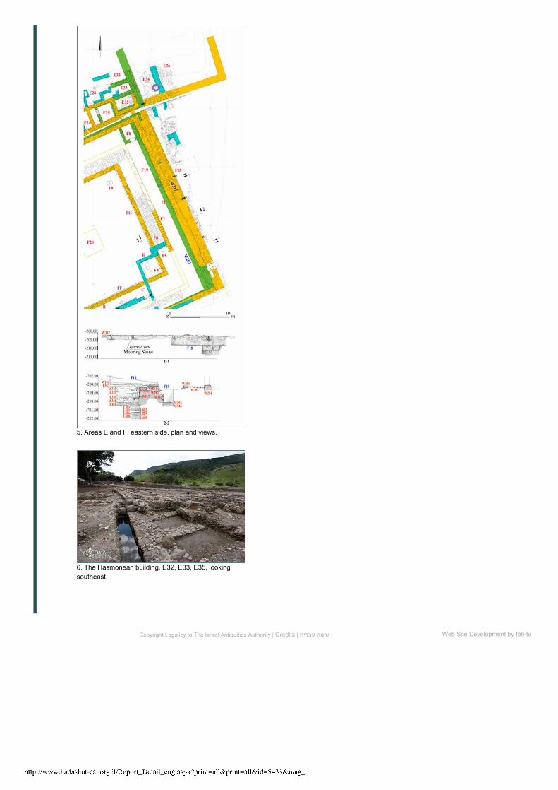
The Harbor
Wall 317 (Figs 4, 5: View 11) has been revealed along the eastern closing wall of
the large quadriporticus F (FC). Built of polygonal stones in horizontal rows with
rock filling, it was bound with very tenacious mortar; the surface was coated with a
lime layer, analogous to that of FC. Excavations to the west of FC have shown
that a lower foundation (W332) had existed prior to FC (Fig. 5: View 22).
The walls of the structure were thus over 3.6 m thick. Exploration in the east part
of Channel E20 allowed the analysis of masonry in the northern corner of the
quadriporticus, as built of large lithic elements and the revealing of the FC’s
foundations that were built of large stones with a central boss and drafted
margins, which protruded c. 0.5 m from the face of the FC. This structure was
covered by the construction of W317, which also caused the flattening of the
bosses.
The quadriporticus, judging by the material discovered in the deep soundings,
should be assigned to the Late Hellenistic period, namely the Hasmonean era.
The area west of W317 was affected by a collapse of blocks, lying from west to
east and ascribed to the collapse of the FC’s upper structure.
The purpose of Sounding F18 (see Fig. 5; View 22) was to understand the
function of W317. The following layers (see Sarti et al. 2013) have been verified in
the sounding, below the surface:
I) Whitish beaten earth and rubble (L325), leveled over the upper horizon where,
amongst the finds, a Constantius II coin (350–361 CE) was found;
II) A collapse layer (L329) below Layer I is composed of worked stones mostly
dressed, rubble and several fragments of colored plaster, especially in proximity
to the wall. The coins retrieved from the collapse dated from Alexander Jannaeus
to Herod the Great;
III) A layer of lime sand with pebbles and shell remains, which is characterized by
the absence of any ceramic or other anthropogenic remains. The sediments’
surfaces follow the west–east direction in the south and north sections, and
south–north direction in the east section;
IV) A cobble pavement (L331) of various sized natural pebbles placed in
correspondence with W317. Potsherds from the Hellenistic–Early Roman periods
were discovered in the ballast, as well as two coins from the first century CE. The
ballast’s surface, slanting from west to east, was partially affected by the collapse
of roughlyhewn lime blocks before being buried;
V) A dark clayey layer, containing preRoman material (L401), before both L331
and apparently W317 were placed.
4/20/2015 Israel Antiquities Authority
http://www.hadashot-esi.org.il/Report_Detail_eng.aspx?print=all&print=all&id=5433&mag_id=120 7/10
Wall 317’s surface was coated with two different plaster layers; the lower was
rough plaster with grayish hydraulic mortars and the upper consisted of smooth
lime.
Many pieces of colored plaster in red, yellow and greenish hues were uncovered
in the collapse (L329), and the façade’s elevation of W317 seems to have been
decorated with plaster panels imitating marble.
Some parallelepipedshaped basalt blocks (length 0.7 m), which were
incorporated in the stonework of W317, bore holes (diam. 14 cm).The degree of
smoothness in the holes shows wear, probably due to the extensive friction with
metal rings, ropes or chains. These blocks were used for the mooring of boats;
several comparisons can be mentioned, e.g., in Moregine (suburb of Pompei),
Caesarea Maritima, Rujm el Bahr, Leptis Magna, and Portus. Two of the blocks
have been found broken, but four others are still in situ, in the pier (W317).
This arrangement of the wharf, dating back to the Early Roman period, replaces
an earlier anchorage that is evinced by a big mooring stone inserted in the
eastern side of the perimeter wall (W282) of the quadriporticus that encompassed
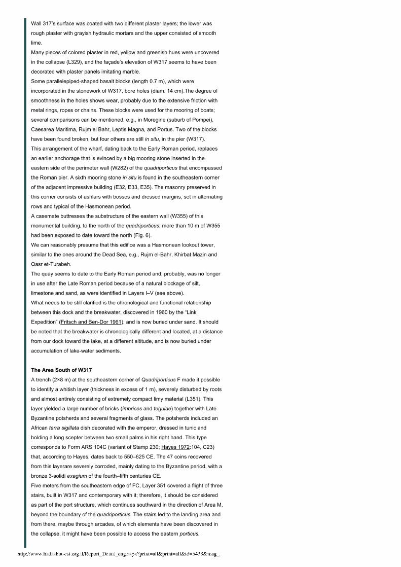
the Roman pier. A sixth mooring stone in situ is found in the southeastern corner
of the adjacent impressive building (E32, E33, E35). The masonry preserved in
this corner consists of ashlars with bosses and dressed margins, set in alternating
rows and typical of the Hasmonean period.
A casemate buttresses the substructure of the eastern wall (W355) of this
monumental building, to the north of the quadriporticus; more than 10 m of W355
had been exposed to date toward the north (Fig. 6).
We can reasonably presume that this edifice was a Hasmonean lookout tower,
similar to the ones around the Dead Sea, e.g., Rujm elBahr, Khirbat Mazin and
Qasr etTurabeh.
The quay seems to date to the Early Roman period and, probably, was no longer
in use after the Late Roman period because of a natural blockage of silt,
limestone and sand, as were identified in Layers I–V (see above).
What needs to be still clarified is the chronological and functional relationship
between this dock and the breakwater, discovered in 1960 by the “Link
Expedition” (Fritsch and BenDor 1961), and is now buried under sand. It should
be noted that the breakwater is chronologically different and located, at a distance
from our dock toward the lake, at a different altitude, and is now buried under
accumulation of lakewater sediments.
The Area South of W317
A trench (2×8 m) at the southeastern corner of Quadriporticus F made it possible
to identify a whitish layer (thickness in excess of 1 m), severely disturbed by roots
and almost entirely consisting of extremely compact limy material (L351). This
layer yielded a large number of bricks (imbrices and tegulae) together with Late
Byzantine potsherds and several fragments of glass. The potsherds included an
African terra sigillata dish decorated with the emperor, dressed in tunic and
holding a long scepter between two small palms in his right hand. This type
corresponds to Form ARS 104C (variant of Stamp 230; Hayes 1972:104, C23)
that, according to Hayes, dates back to 550–625 CE. The 47 coins recovered
from this layerare severely corroded, mainly dating to the Byzantine period, with a
bronze 3solidi exagium of the fourth–fifth centuries CE.
Five meters from the southeastern edge of FC, Layer 351 covered a flight of three
stairs, built in W317 and contemporary with it; therefore, it should be considered
as part of the port structure, which continues southward in the direction of Area M,
beyond the boundary of the quadriporticus. The stairs led to the landing area and
from there, maybe through arcades, of which elements have been discovered in
the collapse, it might have been possible to access the eastern porticus.
4/20/2015 Israel Antiquities Authority
http://www.hadashot-esi.org.il/Report_Detail_eng.aspx?print=all&print=all&id=5433&mag_id=120 8/10
De Luca S. 2010. La città ellenisticoromana di Magdala/Taricheae. Gli scavi del
Magdala Project 2007 e 2008: relazione preliminare e prospettive di indagine.
Liber Annuus 49: 343–562.
De Luca S. 2012. Scoperte archeologiche recenti attorno al Lago di Galilea:
contributo allo studio dell‘ambiente del Nuovo Testamento e del Gesù storico. In
G. Paximadi, M. Fidanzio, eds. Terra Sancta: archeologia ed esegesi. Atti dei
convegni 20082010 (ISCAB Serie Archeologica 1). Lugano. Pp. 16–111.
De Luca S. and A. Lena. 2013. The Harbor of the City of Magdala / Tarichaee on
the Shores of the Sea of Galilee, from the Hellenistic to the Byzantine Times:
New Discoveries and Preliminary Results. In Harbors and Harbor Cities in
the Eastern Mediterranean from Antiquity to Byzantium Recent Discoveries
& New Approaches (Istanbul, 30.5–1.6.2011). Istanbul.
Fritsch C.T. and BenDor I. 1961. The “Link Expedition” to Israel. BA 24:50–59.
Hayes J.W. 1971. Late Roman Pottery. London.
Loffreda S. 2008a. Cafarnao VI: Tipologie e contesti stratigrafici della ceramic
(1968–2003). Milano.
Loffreda S. 2008b. Cafarnao VII: Documentazione grafica della ceramica (1968–
2003). Milano.
Loffreda S. 2008c. Cafarnao VIII: Documentazione fotografica degli oggetti
(1968–2003), Milano.
Sarti G., Rossi V., Amrosi A., De Luca S., Lena A. Morhange C., Ribolini A.,
Sammartino I., Bertoni D. and Zanchetta G. 2013. Magdala Harbour
Sedimentation (Sea of Galilee, Israel), from Natural to Anthropogenic
Control. Quaternary International 303:120–131.
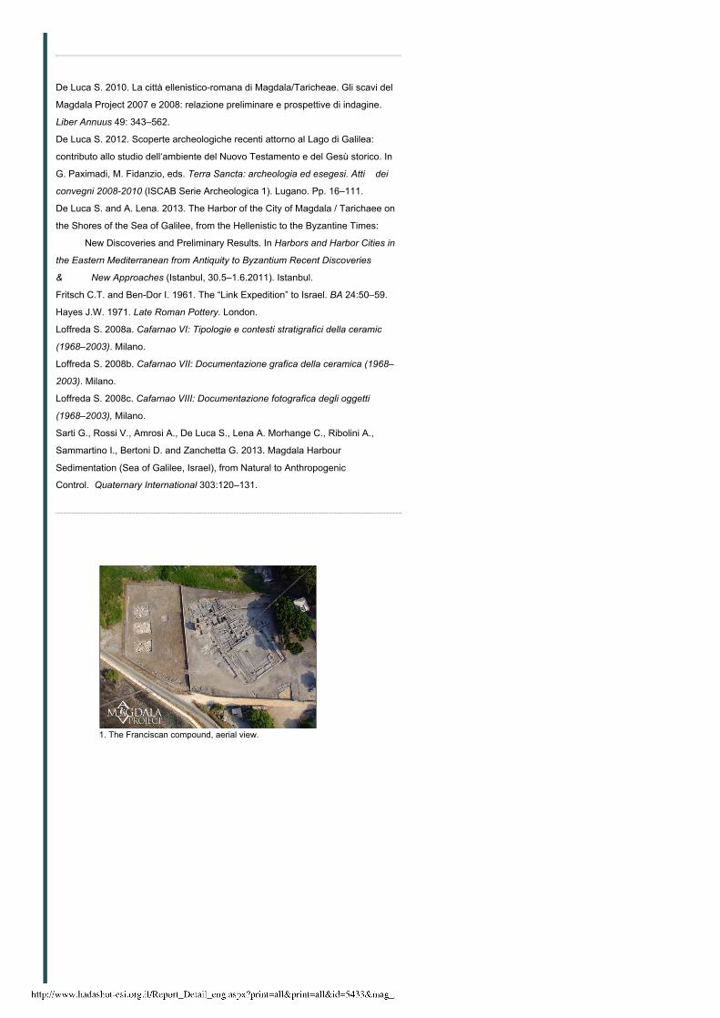
1. The Franciscan compound, aerial view.
4/20/2015 Israel Antiquities Authority
http://www.hadashot-esi.org.il/Report_Detail_eng.aspx?print=all&print=all&id=5433&mag_id=120 9/10
2. Area C, aerial view.
3. Areas A, B, C, plan.
4. Area E, plan.
4/20/2015 Israel Antiquities Authority
http://www.hadashot-esi.org.il/Report_Detail_eng.aspx?print=all&print=all&id=5433&mag_id=120 10/10
Web Site Development by teti-tu
5. Areas E and F, eastern side, plan and views.
6. The Hasmonean building, E32, E33, E35, lookingsoutheast.
Copyright Legalicy to The Israel Antiquities Authority | Credits | גרסה עברית
Related Documents