Long Point Region, Catfish Creek and Kettle Creek Tier 2 Water Quantity Stress Assessment Map Booklet May 2009

Welcome message from author
This document is posted to help you gain knowledge. Please leave a comment to let me know what you think about it! Share it to your friends and learn new things together.
Transcript

Long Point Region, Catfish Creek and Kettle CreekTier 2 Water Quantity Stress Assessment
Map BookletMay 2009

Map 1
Lake Erie Watershed Region
Produced using information under License with the Grand River Conservation Authority © Grand River Conservation Authority, 2007.
Produced using informatio nprovided by the Ministry of Natural Resources, Copyright © Queen’s Printer, 2007.

Map 2
Long Point Region, Catfish Creek, and Kettle Creek Tier 2 Water
Quantity Stress Assessment

Map 3
LPRCA Physiography
Produced using information under License
with the Grand River Conservation Authority
© Grand River Conservation Authority, 2007.
Produced using information provided by the Ministry of Natural Resources, Copyright ©
Queen’s Printer, 2007.
Norfolk Sand Plain
Haldimand Clay Plain

Map 4
CCCA Physiography
Produced using information under License
with the Grand River Conservation Authority
© Grand River Conservation Authority, 2007.
Produced using information provided by the Ministry of Natural Resources, Copyright ©
Queen’s Printer, 2007.
Norfolk Sand Plain
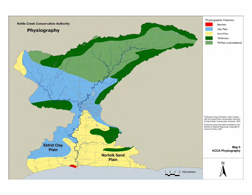
Map 5
KCCA Physiography
Produced using information under License
with the Grand River Conservation Authority
© Grand River Conservation Authority, 2007.
Produced using information provided by the Ministry of Natural Resources, Copyright ©
Queen’s Printer, 2007.
Ekfrid Clay
Plain
Norfolk Sand Plain
Map 6Long Point Region
Conservation Authority
Produced using information under License with the Grand River Conservation Authority © Grand River Conservation Authority, 2007.
Produced using informatio nprovided by the Ministry of Natural Resources, Copyright © Queen’s Printer, 2007.

Map 7Catfish Creek
Conservation Authority
Produced using information under License with the Grand River Conservation Authority © Grand River Conservation Authority, 2007.
Produced using informatio nprovided by the Ministry of Natural Resources, Copyright ©Queen’s Printer, 2007.

Map 8Kettle Creek
Conservation Authority
Produced using information under License with the Grand River Conservation Authority © Grand River Conservation Authority, 2007.
Produced using information provided by the Ministry of Natural Resources, Copyright ©Queen’s Printer, 2007.

Map 9Active Surface PTTW (Non Great
Lakes)
Long Point Region, Catfish Creek, and Kettle Creek Tier 2 Water
Quantity Stress Assessment

Map 10
Long Point Region, Catfish Creek,
and Kettle Creek Tier 2 Water Quantity Stress Assessment
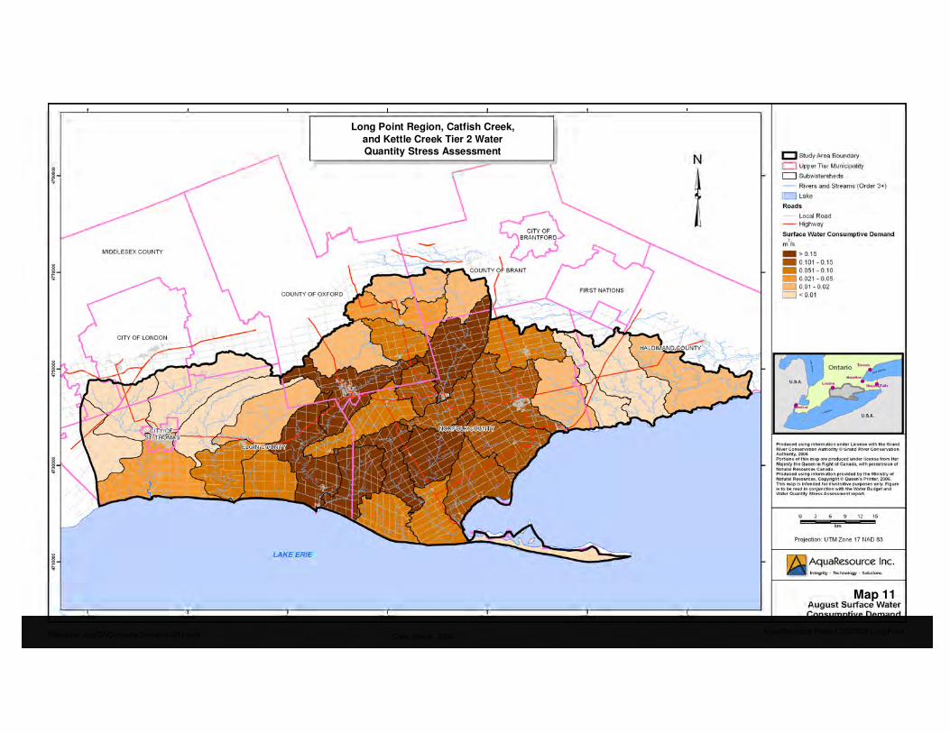
Map 11
Long Point Region, Catfish Creek,
and Kettle Creek Tier 2 Water Quantity Stress Assessment
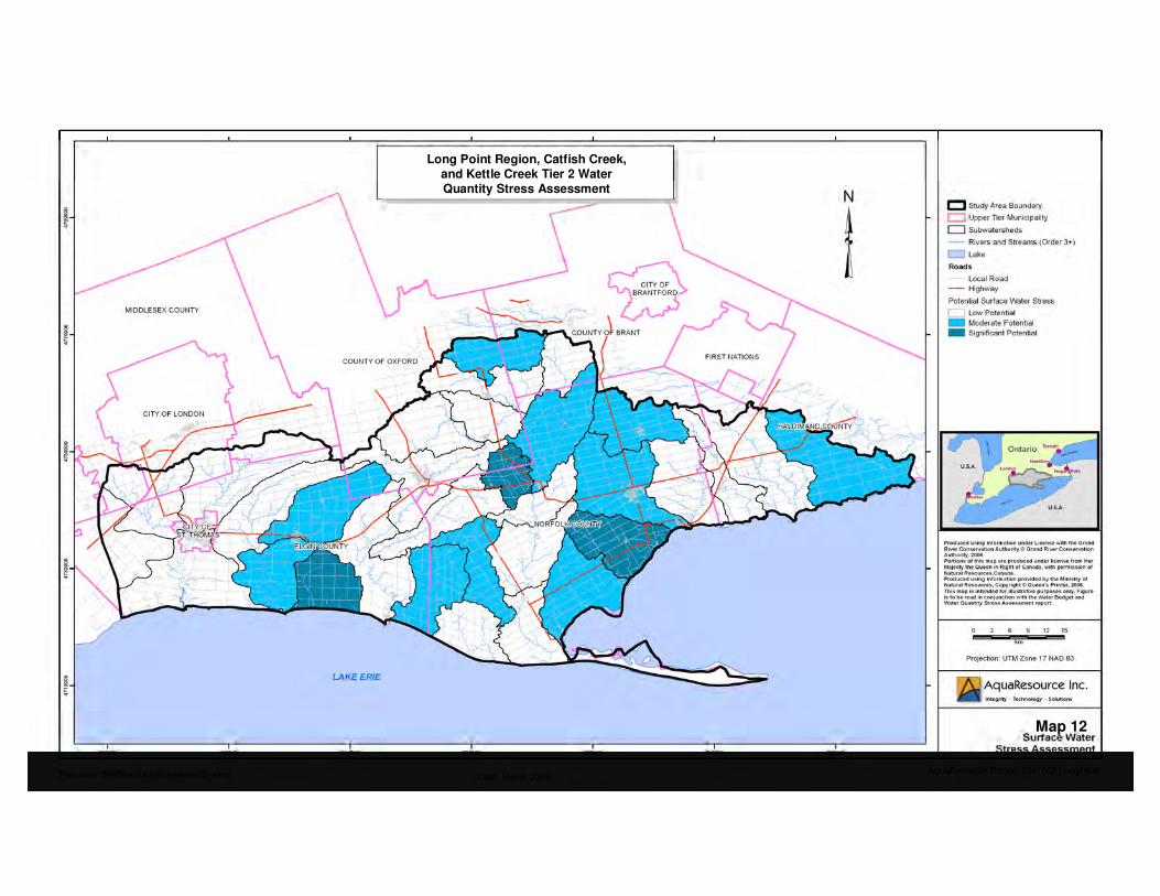
Map 12
Long Point Region, Catfish Creek, and Kettle Creek Tier 2 Water
Quantity Stress Assessment
tseguin
Text Box
"The Stress Assessment depicted on this map has been carried out as a screening tool to determine where additional detailed studies should be carried out to assess the risk to municipal drinking water supplies from a water quantity perspective. The classification shown on this map does not indicate actual hydrologic stress in a watershed."

Map 13Active Groundwater PTTW
Long Point Region, Catfish Creek, and Kettle Creek Tier 2 Water
Quantity Stress Assessment
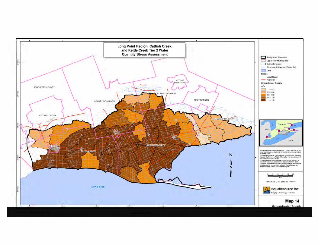
Map 14
Long Point Region, Catfish Creek,
and Kettle Creek Tier 2 Water Quantity Stress Assessment

Map 15
Long Point Region, Catfish Creek, and Kettle Creek Tier 2 Water
Quantity Stress Assessment

Map 16
Long Point Region, Catfish Creek,
and Kettle Creek Tier 2 Water
Quantity Stress Assessment
tseguin
Text Box
"The Stress Assessment depicted on this map has been carried out as a screening tool to determine where additional detailed studies should be carried out to assess the risk to municipal drinking water supplies from a water quantity perspective. The classification shown on this map does not indicate actual hydrologic stress in a watershed."

Map 17
Long Point Region, Catfish Creek,
and Kettle Creek Tier 2 Water Quantity Stress Assessment

Map 18Significant
Groundwater Recharge Areas
Produced using information under License with the Grand River Conservation Authority © Grand River Conservation Authority, 2007.
Produced using information provided by the Ministry of Natural Resources, Copyright © Queen’s Printer, 2007.

Map 19
Significant Groundwater
Recharge Areas with 1 km2 Filter
Produced using information under License with the Grand River Conservation Authority © Grand River Conservation Authority, 2007.
Produced using information provided by the Ministry of Natural Resources, Copyright © Queen’s Printer, 2007.
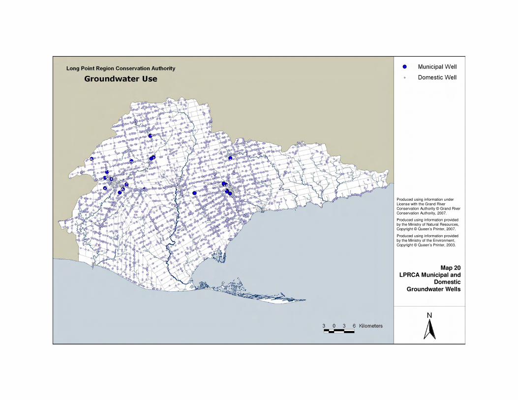
Map 20LPRCA Municipal and
Domestic
Groundwater Wells
Produced using information under
License with the Grand River
Conservation Authority © Grand River
Conservation Authority, 2007.
Produced using information provided
by the Ministry of Natural Resources,
Copyright © Queen’s Printer, 2007.
Produced using information provided
by the Ministry of the Environment,
Copyright © Queen’s Printer, 2003.

Map 21CCCA Municipal and
Domestic
Groundwater Wells
Produced using information under
License with the Grand River
Conservation Authority © Grand River
Conservation Authority, 2007.
Produced using information provided
by the Ministry of Natural Resources,
Copyright © Queen’s Printer, 2007.
Produced using information provided
by the Ministry of the Environment,
Copyright © Queen’s Printer, 2005.

Map 22KCCA Municipal and
Domestic
Groundwater Wells
Produced using information under
License with the Grand River
Conservation Authority © Grand River
Conservation Authority, 2007.
Produced using information provided
by the Ministry of Natural Resources, Copyright © Queen’s Printer, 2007.
Produced using information provided
by the Ministry of the Environment,
Copyright © Queen’s Printer, 2005.
Related Documents


