External geophysics, climate and environment (Climate and palaeoclimate) Temporal relationship between Holocene human occupation and vegetation change along the northwestern margin of the Central African rainforest Relations temporelles entre l’occupation humaine et les changements de la ve ´ge ´tation le long de la marge nord-ouest de la foreˆt humide d’Afrique centrale durant l’Holoce `ne Anne-Marie Le ´ zine a, *, Augustin F.-C. Holl b , Judicae ¨l Lebamba c,d , Annie Vincens d , Chime ` ne Assi-Khaudjis e , Louis Fe ´ vrier a , E ´ mmanuelle Sultan a a Laboratoire d’oce ´anographie et du climat : expe ´rimentation et approches nume ´riques, UMR 7159, universite ´ Pierre-et-Marie-Curie, Case 100, 4, place Jussieu, 75252 Paris cedex 05, France b Pre ´histoire et Technologie, UMR7055, universite ´ Paris-Ouest-Nanterre, Maison Rene ´- Ginouve `s, 21, alle ´e de l’Universite ´, 92023 Nanterre cedex, France c De ´partement de biologie, universite ´ des sciences et techniques de Masuku, BP 913, Franceville, Gabon d Centre europe ´en de recherche et d’enseignement de ge ´osciences de l’environnement, UMR 7330, Europoˆle me ´diterrane ´en de l’Arbois, BP 80, 13545 Aix-en-Provence cedex, France e Laboratoire des sciences du climat et de l’environnement, UMR 8212, CEA Orme des Merisiers, 91191 Gif-sur-Yvette cedex, France C. R. Geoscience xxx (2013) xxx–xxx A R T I C L E I N F O Article history: Received 22 September 2012 Accepted after revision 4 March 2013 Available online xxx Written on invitation of the Editorial Board Keywords: Palaeoenvironmental Pollen analyses Archaeology Archaeobotany Central African rain forest Holocene Mots cle ´s: Pale ´ oenvironnements Analyses polliniques Arche ´ ologie Arche ´ obotanique Fore ˆt humide d’Afrique centrale Holoce `ne A B S T R A C T This paper discusses the relationship between patterns of human settlements and environmental change during the Holocene along the northwestern margins of the equatorial rain forest of central Africa. Palaeoenvironmental data from high-resolution sediment cores from lacustrine deposits, plant macro-remains from forest soils, and archaeological data are harnessed to discuss the differential impact of climate and/or humans on the central African rain forest. It is shown that climate change impacted the rain forest well before the widespread expansion of human settlements all over the study area. ß 2013 Published by Elsevier Masson SAS on behalf of Acade ´ mie des sciences. R E ´ S U M E ´ Cet article discute des rythmes et intensite ´s de l’occupation humaine par rapport aux changements environnementaux au cours de l’Holoce `ne le long des marges septentrionales de la fore ˆt e ´ quatoriale humide de l’Afrique centrale. Les donne ´es pale ´oenvironnementales extraites de carottes se ´ dimentaires lacustres, des macro-restes botaniques des sols forestiers et des donne ´es arche ´ ologiques sont mobilise ´es pour e ´ valuer l’impact des changements climatiques ou anthropiques sur la fore ˆt e ´ quatoriale humide d’Afrique centrale. L’article montre que les changements climatiques ont affecte ´ l’environnement forestier bien avant l’expansion ge ´ne ´ ralise ´e des populations humaines dans la zone d’e ´ tude. ß 2013 Publie ´ par Elsevier Masson SAS pour l’Acade ´ mie des sciences. * Corresponding author. E-mail address: [email protected] (A.-M. Le ´ zine). G Model CRAS2A-3150; No. of Pages 9 Please cite this article in press as: Le ´ zine A-M, et al. Temporal relationship between Holocene human occupation and vegetation change along the northwestern margin of the Central African rainforest. C. R. Geoscience (2013), http:// dx.doi.org/10.1016/j.crte.2013.03.001 Contents lists available at SciVerse ScienceDirect Comptes Rendus Geoscience ww w.s cien c edir ec t.c om 1631-0713/$ – see front matter ß 2013 Published by Elsevier Masson SAS on behalf of Acade ´ mie des sciences. http://dx.doi.org/10.1016/j.crte.2013.03.001

Welcome message from author
This document is posted to help you gain knowledge. Please leave a comment to let me know what you think about it! Share it to your friends and learn new things together.
Transcript
Ext
Tevera
Re
le
AnCha Lab
7525b Prec Ded Cen
cedee Lab
C. R. Geoscience xxx (2013) xxx–xxx
A R
Artic
Rece
Acce
Avai
Wri
Edit
Keyw
Pala
Poll
Arch
Arch
Cen
Holo
Mot
Pale
Ana
Arch
Arch
Fore
Holo
*
G Model
CRAS2A-3150; No. of Pages 9
Plved
163
http
ernal geophysics, climate and environment (Climate and palaeoclimate)
mporal relationship between Holocene human occupation andgetation change along the northwestern margin of the Central Africaninforest
lations temporelles entre l’occupation humaine et les changements de la vegetation
long de la marge nord-ouest de la foret humide d’Afrique centrale durant l’Holocene
ne-Marie Lezine a,*, Augustin F.-C. Holl b, Judicael Lebamba c,d, Annie Vincens d,imene Assi-Khaudjis e, Louis Fevrier a, Emmanuelle Sultan a
oratoire d’oceanographie et du climat : experimentation et approches numeriques, UMR 7159, universite Pierre-et-Marie-Curie, Case 100, 4, place Jussieu,
2 Paris cedex 05, France
´histoire et Technologie, UMR7055, universite Paris-Ouest-Nanterre, Maison Rene - Ginouves, 21, allee de l’Universite, 92023 Nanterre cedex, France
partement de biologie, universite des sciences et techniques de Masuku, BP 913, Franceville, Gabon
tre europeen de recherche et d’enseignement de geosciences de l’environnement, UMR 7330, Europole mediterraneen de l’Arbois, BP 80, 13545 Aix-en-Provence
x, France
oratoire des sciences du climat et de l’environnement, UMR 8212, CEA Orme des Merisiers, 91191 Gif-sur-Yvette cedex, France
T I C L E I N F O
le history:
ived 22 September 2012
pted after revision 4 March 2013
lable online xxx
tten on invitation of the
orial Board
ords:
eoenvironmental
en analyses
aeology
aeobotany
tral African rain forest
cene
s cles:
oenvironnements
lyses polliniques
eologie
eobotanique
t humide d’Afrique centrale
cene
A B S T R A C T
This paper discusses the relationship between patterns of human settlements and
environmental change during the Holocene along the northwestern margins of the
equatorial rain forest of central Africa. Palaeoenvironmental data from high-resolution
sediment cores from lacustrine deposits, plant macro-remains from forest soils, and
archaeological data are harnessed to discuss the differential impact of climate and/or
humans on the central African rain forest. It is shown that climate change impacted the
rain forest well before the widespread expansion of human settlements all over the study
area.
� 2013 Published by Elsevier Masson SAS on behalf of Academie des sciences.
R E S U M E
Cet article discute des rythmes et intensites de l’occupation humaine par rapport aux
changements environnementaux au cours de l’Holocene le long des marges septentrionales
de la foret equatoriale humide de l’Afrique centrale. Les donnees paleoenvironnementales
extraites de carottes sedimentaires lacustres, des macro-restes botaniques des sols forestiers
et des donnees archeologiques sont mobilisees pour evaluer l’impact des changements
climatiques ou anthropiques sur la foret equatoriale humide d’Afrique centrale. L’article
montre que les changements climatiques ont affecte l’environnement forestier bien avant
l’expansion generalisee des populations humaines dans la zone d’etude.
� 2013 Publie par Elsevier Masson SAS pour l’Academie des sciences.
Corresponding author.
E-mail address: [email protected] (A.-M. Lezine).
Contents lists available at SciVerse ScienceDirect
Comptes Rendus Geoscience
ww w.s c ien c edi r ec t . c om
ease cite this article in press as: Lezine A-M, et al. Temporal relationship between Holocene human occupation andgetation change along the northwestern margin of the Central African rainforest. C. R. Geoscience (2013), http://
x.doi.org/10.1016/j.crte.2013.03.001
1-0713/$ – see front matter � 2013 Published by Elsevier Masson SAS on behalf of Academie des sciences.
://dx.doi.org/10.1016/j.crte.2013.03.001
A.-M. Lezine et al. / C. R. Geoscience xxx (2013) xxx–xxx2
G Model
CRAS2A-3150; No. of Pages 9
1. Introduction
Pollen data from central Africa have long depictedhigh-amplitude fluctuations in forest extent and com-position at the end of the African Humid Period (deMenocal et al., 2000). They point to the dramatic collapseof montane forests (Lezine et al., 2013) in the CameroonVolcanic Line (CVL) and the adjacent Adamawa (Lebambaet al., 2012; Vincens et al., 2010) and Ubangui plateaus(Runge, 2002), as well as the increase of pioneer andlight-dependent trees such as Alchornea, Macaranga,
Elaeis, etc. in the lowlands (Maley and Brenac, 1998;Ngomanda et al., 2009; Reynaud-Farrera et al., 1996;Richards, 1986). In addition, a large amount of charcoalhas been found in sub-surface soils from forests pointingto increasing burning events (Brncic et al., 2009) at thattime. The modern composition of the Guineo-Congolianrainforest reflects these disturbances that appear to haveincreased during the last centuries (van Gemerden et al.,2003).
Whether these disturbances are related to climatechange or to human activities is still a matter of debate(e.g., Bayon et al., 2012; Maley et al., 2012; Nguetsop et al.,2010; Neumann et al., 2012a). Numerous archaeologicalfinds, including iron-working and cultivated plantremains, indicate that human populations, present fromthe last glacial period in the CVL region as recorded atShum Laka (Moyersons et al., 1996), spread widely all overcentral Africa, particularly during the last thousand years.This expansion has been attributed to the Bantu popula-tions who originated from the Nigeria-Cameroon bordersand moved to the Great Lakes region in East Africafollowing two specific paths. The eastern itinerary issuggested to have followed the northern edge of the forest.The western southward itinerary followed the Atlanticcoastline and forest clearings. These pioneer Bantu-speaking groups settled in hamlets and villages and arecredited to have brought with them agriculture, potteryand metallurgy (Bahuchet, 1993; de Maret, 1992; Eggertet al., 2006; Lavachery, 2001; Lavachery et al., 2010;Warnier, 1984). According to this scenario, the equatorialrainforest was circum-navigated and it was the latermastery of iron metallurgy that facilitated its colonization(Oliver, 1966; Wrigley, 1962).
Palaeoenvironmental studies have revealed that thecontraction of the central African forest core at the end ofthe Holocene took place within the frame of a gradualdecrease in monsoon rainfall starting from the mid-Holocene onwards (Itambi et al., 2010; Lezine et al.,2005; Weldeab et al., 2007) and the progressive increase inthe length of the dry season (e.g., Vincens et al., 2010). Theinfluence of northerly winds from the Sahel extended as farsouth as the Congo basin (Brncic et al., 2007; Nguetsopet al., 2004).
The aim of this article is to review our currentknowledge of man–environment relationships along thenorthern fringe of the equatorial rainforest domain duringthe Holocene. Data used include new high-resolutionpollen counts from selected lake deposits and datedarchaeological sites from the CVL region and surrounding
occupation in a reliable climatic and environmentalcontext.
2. Modern environmental setting
Our study area extends from the coastal region ofCameroon at 28N, northwards to the Bamenda Grassfieldsin the CVL region, which range from 1000 to 3000 m asl,then eastwards to the Adamawa plateau in Cameroon andthe Ubangui plateau in the Central African Republic atabout 1000–1500 m asl (Fig. 1). This area covers a widerange of climates from an equatorial climate near the coast(3000 mm per year), with a dry season from December toFebruary, to a seasonal tropical climate (2100–2300 mmper year in the Grassfields and 1500–1600 mm per year inthe Adamawa and Ubangui plateaus), with a dry seasonfrom November to February–March. Such rainfall distribu-tion is controlled by the north–south shifts of rain belt,associated with the Intertropical Convergence Zone (ITCZ)and its associated rain belts over this region (Suchel, 1988).The mean annual temperature decreases with the altitudefrom 26 8C near the coast to 19 8C at Bamenda (1370 m asl.)in the CVL region and reaches 22 8C at Ngaoundere (1200 masl) in the Adamawa plateau to the north-east. As aconsequence of these climate characteristics, four mainphytogeographic regions can be recognized (Whiten,1983):
� the wet Guineo-Congolian rain forest in the lowlands tothe south and southwest (Uapaca paludosa, Baphia
pubescens, Entandrophragma congolense, Pycnanthus
angolensis, Zanthoxylum heitzii, Irvingia gabonensis, Klai-
nedoxa gabonensis, Pentaclethra macrophylla, Santiria
trimera);� the dry Guineo-Congolian semi-deciduous forests along
the northern border of the main forest core (Cola sp.,Sterculia sp., Pterygota sp., Mansonia altissima, Nesogor-
donia papaverifera, Dombeya sp., Celtis sp., Holoptelea
grandis, Trema orientalis, Lecaniodiscus cupanioides, Trile-
pisium madagascariensis, Schrebera arborea, Strombosia
sp.);� the Sudanian woodlands and savannas to the north-east
(Lophira lanceolata, Daniella oliveri, Annona senegalensis,Piliostigma thonningii, Syzygium guineense, Hymenocardia
acida) and;� the Afro-Montane forests in the CVL region above 1700 m
asl (Podocarpus latifolius, Rapanea melanophloeos, Olea
capensis, Nuxia congesta, Embelia sp., Clematis simensis,Hypericum sp., Zanthoxylum rubescens, Celtis sp., Schef-
flera sp., Syzygium staudtii, Gnidia glauca, Prunus africana,Arundinaria alpina (Letouzey, 1985).
3. Data and method
3.1. Pollen data
In this paper, we use new pollen series from the CVLregion (Lake Bambili: Assi-Kaudjhis, 2011; Lezine et al.,2013) and the Adamawa plateau (Lakes Mbalang andTizong: Lebamba et al., in prep; Vincens et al., 2010) from
successive French Research Projects (ECOFIT, IFORA, C3A). areas. The main goal is to place the history of humanPlease cite this article in press as: Lezine A-M, et al. Temporal relationship between Holocene human occupation andvegetation change along the northwestern margin of the Central African rainforest. C. R. Geoscience (2013), http://dx.doi.org/10.1016/j.crte.2013.03.001
TheyeapolThecomlanMbet
et acon
3.2.
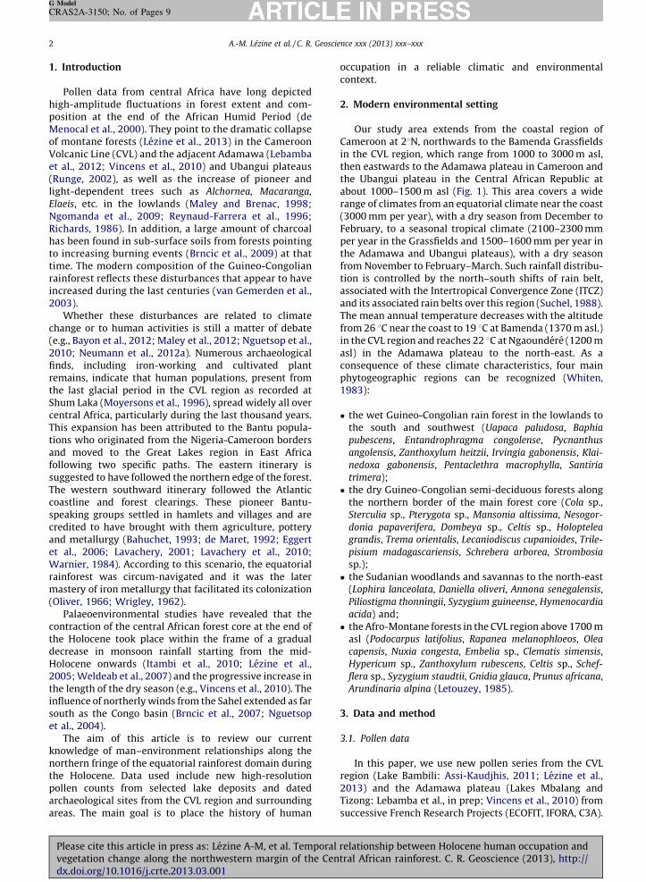
the
Fig.
(3) L
Fig.
Bam
dan
Veg
A.-M. Lezine et al. / C. R. Geoscience xxx (2013) xxx–xxx 3
G Model
CRAS2A-3150; No. of Pages 9
Plved
se pollen sites provide high-resolution records (50rs resolution) of the last thousand years and the firstlen data from high and mid-altitude in central Africa.
vegetation history from these pollen sites ispared to already-published records from the low-
ds at Lakes Barombi Mbo (Maley and Brenac, 1998),oandong (Richards, 1986), Ossa (Reynaud-Farreraal., 1996) and at Nyabessam Swamp (Ngomandal., 2009). Only sites located north of the Equator aresidered (Fig. 1).
Archaeological and plant remain data
Approximately 1000 archaeological sites are known in study area (Essomba, 1998; Lavachery et al., 2010 and
references therein). However, very few are dated. Ourdataset includes only 107 localities with 351 datedsamples (from 10,400 cal yr BP to the present) (Fig. 1).The oldest dates below the megalithic monuments fromthe CAR at 8400 cal yr BP resulting from preconstructionbushfire (Bayle des Hermens, 1975) have not beenincluded in this study. Our archaeobotanical datasetincludes 129 specimens from 10 plant species (Canarium
schweinfurthii, Elaeis guineensis, Musa sp., Anthrocaryon
micraster, Pennisetum glaucum, Sorgho, Ensete giletii, Vigna,
Raphia, Coula edulis) recovered in the above-mentionedarchaeological sites and known to be collected for humanconsumption or cultivated (Clist, 1989; Delneuf et al.,2003; Eggert et al., 2006; Kahlheber et al., 2009;Lavachery, 2001; Lavachery et al., 2010; Mbida et al.,
1. Distribution of archaeological, archaeobotanical and palynological data. Numbers refer to lacustrine pollen sites: (1) Lake Bambili; (2) Lake Mbalang;
ake Tizong; (4) Lake Ossa; (5) Lake Barombi Mbo; (6) Lake Mboandong; (7) Nyabessam (see text for references).
1. Localisation des donnees archeologiques, archeobotaniques et palynologiques. Les nombres correspondent aux sites polliniques lacustres : (1) lac
bili ; (2) lac Mbalang ; (3) lac Tizong ; (4) lac Ossa ; (5) lac Barombi Mbo ; (6) lac Mboandong ; (7) Nyabessam (les references correspondantes figurent
s le texte).
etation map from Guillaumet et al. (2009)
ease cite this article in press as: Lezine A-M, et al. Temporal relationship between Holocene human occupation andgetation change along the northwestern margin of the Central African rainforest. C. R. Geoscience (2013), http://
x.doi.org/10.1016/j.crte.2013.03.001
A.-M. Lezine et al. / C. R. Geoscience xxx (2013) xxx–xxx4
G Model
CRAS2A-3150; No. of Pages 9
2000; Mbida-Minzie et al., 2001; Neumann et al., 2012b;Oslisly et al., 2000; Zangato, 1995; 2000). This database islimited since it includes only dated samples and thus mayunderestimate the duration of human occupation at agiven location. The large number of dates should howevercompensate for the heterogeneity of the dataset. Twohundred and fifty years is the interval that the uncertain-ties associated with the radiocarbon dates allow us toconsider during the Holocene.
3.3. Chronological control
The dating control is based on AMS and conventionalradiocarbon dates on charcoals, total organic matter, andcharred plant remains. Raw 14C dates were converted intocalendar ages using CALIB 6 (Stuiver and Reimer, 1993).Our analysis excludes archaeological data with uncertain-ties larger than � 150 years and thus focuses on 288 datesonly.
4. Results and discussion
4.1. Climate-driven versus anthropogenic environmental
change
This part of the paper discusses the spatial andchronological distribution of the main variables taken intoconsideration, i.e. pollen data for vegetation and climateand archaeological sites for human occupation and theircohorts of food plants remains. The data are presented inthree physiographic units: the Grassfield plateaus, theAdamawa and Ubangui plateaus and the low-lying zone ofsouthern Cameroon.
4.2. The Grassfield plateaus
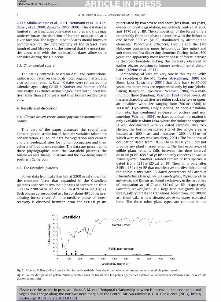
Pollen data from Lake Bambili at 2200 m asl show thatthe montane forest that expanded in the Grassfieldplateaus underwent two main phases of contraction, from3300 to 2700 cal yr BP, and 960 to 479 cal yr BP (Fig. 2).Both phases corresponded to a loss of about 40% of the pre-existing forest cover. An intermediate phase of forestrecovery is observed between 2700 and 960 cal yr BP,
punctuated by two severe and short (less than 100 years)events of forest degradation, respectively centred at 2600and 1470 cal yr BP. The composition of the forest differsremarkably from one phase to another with the Holoceneone before 3300 cal yr BP, dominated by afromontaneelements (Podocarpus, Schefflera, Olea. . .) and the LateHolocene containing more heliophilous (Ilex mitis) andsub-montane, fast dispersing elements. During the last 500years, the apparently most recent phase of forest increaseis disproportionately lacking the diversity observed inearlier phases pointing to intense environmental distur-bance (Lezine et al., 2013).
Archaeological sites are very rare in this region. Withthe exception of the Mbi Crater (Assombang, 1998) andShum Laka (Lavachery, 2001) that date back to 35,000years, the other sites are represented only by one (Abeke,Baleng, Bankouop, Fiye-Nkwi: Warnier, 1984) to a max-imum of three (Fundong: Warnier, 1984) dated levels. Allthese archaeological sites are either rock-shelters or open-air localities with size ranging from 700 m2 (Mbi) to7000 m2 (Fiye-Nkwi). Only Fundong, an open-air habita-tion site, has combined evidence of pottery and ironsmelting (Warnier, 1984). Archaeobotanical information isonly available at Shum Laka, where the Holocene sequenceis well documented with 27 dated samples. This rockshelter, the best investigated site of the whole area, islocated at 1600 m asl and measures 1200 m2, 82 m2 ofwhich were excavated (Lavachery, 2001). The first phase ofoccupation dated from 10,300 to 8038 cal yr BP did notprovide any plant macro-remains. The first occurrence ofedible plant remains falls between the time interval8038 cal yr BP–6557 cal yr BP and only concerns Canarium
schweinfurthii. Another isolated remain of this species isdated from 4215 � 125 cal yr BP. Then, it is only after2155 � 150 cal yr BP that one observes the diversification ofthe edible plants with 13 dated occurrences of Canarium
schweinfurthii, Elaeis guineensis, Ensete giletii, Raphia sp. Elaeis
guineensis, and Raphia sp., found exclusively in the last phaseof occupation at 1617 and 819 cal yr BP, respectively.Canarium schweinfurthii is a large tree that grows in rainforest, gallery forest and transitional forest from 0 to 1000 masl. Shum Laka is now situated above its upper ecologicallimit. The three other plant types are common in the
Fig. 2. Arboreal Pollen profile from Bambili in the Grassfields. Dots show the radiocarbon measurements on edible plant remains.
Fig. 2. Courbe des grains de pollen d’arbre a Bambili dans les Grassfields. Les points figurent les datations au radiocarbone effectuees sur les restes de
plantes comestibles.
Please cite this article in press as: Lezine A-M, et al. Temporal relationship between Holocene human occupation andvegetation change along the northwestern margin of the Central African rainforest. C. R. Geoscience (2013), http://dx.doi.org/10.1016/j.crte.2013.03.001
Gra(Ela
spofewcrasugEns
lanwerplahalthearcgiveon
the
4.3.
Adaa r300stuthetrentheforesendurlessHol350rectha
arcSok
Fig.
fore
area
Fig.
mas
la re
A.-M. Lezine et al. / C. R. Geoscience xxx (2013) xxx–xxx 5
G Model
CRAS2A-3150; No. of Pages 9
Plved
ssfields today and spontaneously grow in gallery forestseis, Raphia) and mid-altitude savannas (Ensete). Corre-nding pollen grains have not been found at Bambili. Only
grains of Elaeis guineensis are present at Mbi, a nearbyter swamp at levels dated from 300 cal yr BP onward. Thisgests that Canarium schweinfurthii, Elaeis guineensis,
ete giletii, Raphia sp. neither dominated the regionaldscape during the Holocene as natural populations, nore widely cultivated in the Grassfields. The period of edible
nt diversification at Shum Laka encompasses the secondf of the secondary forest phase and occurs 1000 years after
first forest collapse. In the absence of extensivehaeobotanical analyses in the Grassfields, the examplesn above suggest that the imprint of cultivation practices
forest cover was not significant during the Holocene until last few centuries.
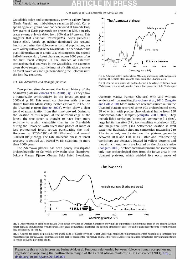
The Adamawa and Ubangui plateaus
Two pollen sites document the forest history of themawa plateau (Vincens et al., 2010) (Fig. 3). They showemarkable synchronicity in the forest collapse at0 cal yr BP. This result corroborates with previous
dies from the Mbari Valley located eastward, in CAR, on Ubangui plateau (Runge, 2002), which show a cleard of savannization from that time onward. Owing to
location of this region, at the northern edge of thest, the tree cover is thought to have been more
sitive to rainfall variability than in the Grassfieldsing the Holocene, with successive phases of more or
pronounced forest retreat punctuating the mid-ocene: at 5700–5300 cal BP (Mbalang) and around0 cal BP (Tizong). The Late Holocene phase of forest
overy is centred at 1700 cal yr BP, spanning no moren 1000 years.The Adamawa plateau has been poorly investigatedhaeologically so far with only eight sites (Bemboyo,orta Manga, Djaoro Mbama, Beka Petel, Ewankang,
Osokorto Manga, Pangar, Gbatoro) with and withoutevidence of iron smelting (Lavachery et al., 2010; Zangatoand Holl, 2010). More sustained research carried out in theUbangui plateau recorded some 103 archaeological sites,38 of which with precise chronological frame from 190radiocarbon-dated samples (Zangato, 2000, 2007). Theyinclude lithic workshops (nine sites), cemeteries (11 sites),large habitation sites (17), iron-smelting workshops (32),and megalithic sites (34). Settlement location is wellpatterned. Habitation sites and cemeteries, measuring 2 to8 ha in extent, are located on the plateau, generallybetween 1000 and 1100 m asl. Lithic and iron-smeltingworkshops are generally located in valleys bottoms andmegalithic monuments are located on the plateau’s edge(Zangato, 2000). Archaeobotanical remains are scarce fromonly two archaeological sites from the Bouar area in theUbangui plateaus, which yielded five occurrences of
Fig. 3. Arboreal pollen profiles from Mbalang and Tizong in the Adamawa
plateau. The edible plant records come from the Ubangui area.
Fig. 3. Courbe des grains de pollen d’arbre a Mbalang et Tizong dans
l’Adamawa. Les restes de plantes comestibles proviennent de l’Oubangui.
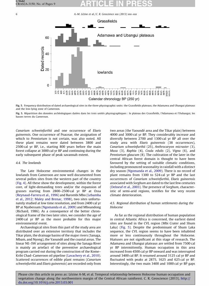
4. Arboreal pollen profiles from Lake Ossa in the lowlands of western Cameroon showing the expansion of heliophilous trees in the central African
st domain. This, together with the increase of grass populations, illustrates the opening of the forest core. The edible plant records come from the whole
covered by our study.
4. Courbe des grains de pollen d’arbre a Ossa dans les basses terres de l’Ouest Cameroun, montrant l’expansion des arbres heliophiles a l’interieur du
sif forestier central. Avec l’augmentation des herbes, ceci montre l’ouverture du massif forestier. Les restes de plantes comestibles proviennent de toute
´ gion couverte par notre etude.ease cite this article in press as: Lezine A-M, et al. Temporal relationship between Holocene human occupation andgetation change along the northwestern margin of the Central African rainforest. C. R. Geoscience (2013), http://
x.doi.org/10.1016/j.crte.2013.03.001
A.-M. Lezine et al. / C. R. Geoscience xxx (2013) xxx–xxx6
G Model
CRAS2A-3150; No. of Pages 9
Canarium schweinfurthii and one occurrence of Elaeis
guineensis. One occurrence of Poaceae, the assignation ofwhich to Pennisetum is not certain, was also noted. Allthese plant remains were dated between 3800 and2500 cal yr BP, i.e., starting 800 years before the mainforest collapse at 3000 cal yr BP and continuing during theearly subsequent phase of peak savannah extent.
4.4. The lowlands
The Late Holocene environmental changes in thelowlands from Cameroon are now well documented fromseveral pollen sites from the western part of the country(Fig. 4). All these show the development, within the forestcore, of light-demanding trees and/or the expansion ofgrasses starting from 2800–2500 cal yr BP at Ossa(Reynaud-Farrera et al., 1996) and Barombi Mbo (Lebambaet al., 2012; Maley and Brenac, 1998), two sites unfortu-nately studied at low time resolution, and from 2400 cal yrBP at Nyabessam (Ngomanda et al., 2009) and Mboandong(Richard, 1986). As a consequence of the better chron-ological frame of the two later sites, we consider the age of2400 cal yr BP as the more probable for this majorenvironmental event.
Archaeological sites from this part of the study area aredistributed over an extensive territory that includes theTikar plain, the drainage basins of the major rivers (Sanaga,Mbam, and Nyong), the Yaounde and the coastal areas. Thelinear NE–SW arrangement of sites along the Sanaga Riveris mainly an artefact of the preventive archaeologicalprogram carried out during the construction of the Kome–Kribi Chad–Cameroon oil pipeline (Lavachery et al., 2010).Scattered occurrences of edible plant remains (Canarium
schweinfurthii and Elaeis guineensis) are recorded only from
two areas (the Yaounde area and the Tikar plain) between4000 and 3000 cal yr BP. They considerably increase anddiversify between 2700 and 1300 cal yr BP all over thestudy area with Elaeis guineensis (38 occurrences),Canarium schweinfurthii (25), Anthrocaryon micraster (3),Musa (3), Raphia (4), Coula edulis (2), Vigna (6), andPennisetum glaucum (8). The cultivation of the later in thecentral African forest domain is thought to have beenfavoured by the setting of suitable climatic conditions,including pronounced seasonality in rainfall with a distinctdry season (Ngomanda et al., 2009). There is no record ofplant remains from 1300 to 524 cal yr BP and the lastoccurrences of Canarium schweinfurthii, Elaeis guineensis
associated with Sorghum are dated to the last few centuries(Delneuf et al., 2003). The presence of Sorghum, character-istic of semi-arid regions, testifies for the very recentclimate deterioration.
4.5. Regional distribution of human settlements during the
Holocene
As far as the regional distribution of human populationin central Atlantic Africa is concerned, the earliest datedsites are found in the CVL region (Mbi Crater and ShumLaka) (Fig. 5). Despite the predominant of Shum Lakasequence, the CVL region seems to have been inhabitedmore or less continuously throughout the Holocene.Hiatuses are not significant at this stage of research. TheAdamawa and Ubangui plateaus are settled from 7500 calyr BP intermittently. Human occupation in this areaincreased from 4500 cal yr BP onward and was interruptedaround 3400 cal BP. It resumed around 3125 cal yr BP andfluctuated with peaks at 2875, 1625 and 625 cal yr BP.Interestingly, the two main 3400 and 1000 cal yr BP gaps
Fig. 5. Frequency distribution of dated archaeological sites in the three physiographic units: the Grassfields plateaus, the Adamawa and Ubangui plateaus
and the low-lying zone of Cameroon.
Fig. 5. Repartition des donnees archeologiques datees dans les trois unites physiographiques : le plateau des Grassfields, l’Adamawa et l’Oubangui, les
basses terres du Cameroun.
Please cite this article in press as: Lezine A-M, et al. Temporal relationship between Holocene human occupation andvegetation change along the northwestern margin of the Central African rainforest. C. R. Geoscience (2013), http://dx.doi.org/10.1016/j.crte.2013.03.001
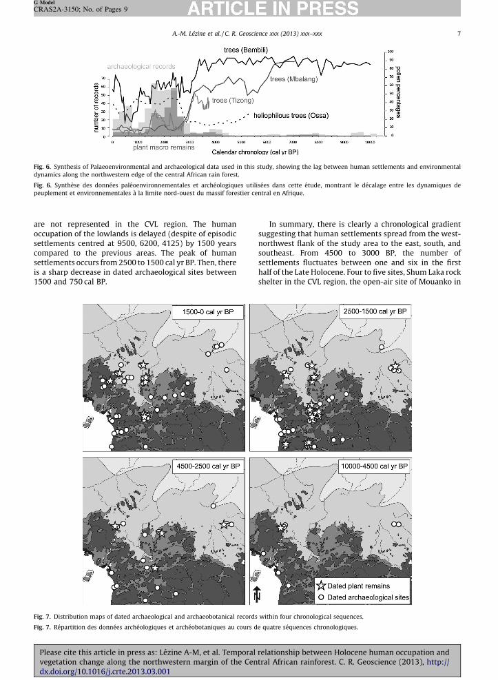
areoccsettcomsettis a150
Fig.
dyn
Fig.
peu
Fig.
Fig.
A.-M. Lezine et al. / C. R. Geoscience xxx (2013) xxx–xxx 7
G Model
CRAS2A-3150; No. of Pages 9
Plved
not represented in the CVL region. The humanupation of the lowlands is delayed (despite of episodiclements centred at 9500, 6200, 4125) by 1500 yearspared to the previous areas. The peak of human
lements occurs from 2500 to 1500 cal yr BP. Then, there sharp decrease in dated archaeological sites between0 and 750 cal BP.
In summary, there is clearly a chronological gradientsuggesting that human settlements spread from the west-northwest flank of the study area to the east, south, andsoutheast. From 4500 to 3000 BP, the number ofsettlements fluctuates between one and six in the firsthalf of the Late Holocene. Four to five sites, Shum Laka rockshelter in the CVL region, the open-air site of Mouanko in
6. Synthesis of Palaeoenvironmental and archaeological data used in this study, showing the lag between human settlements and environmental
amics along the northwestern edge of the central African rain forest.
6. Synthese des donnees paleoenvironnementales et archeologiques utilisees dans cette etude, montrant le decalage entre les dynamiques de
plement et environnementales a la limite nord-ouest du massif forestier central en Afrique.
7. Distribution maps of dated archaeological and archaeobotanical records within four chronological sequences.
7. Repartition des donnees archeologiques et archeobotaniques au cours de quatre sequences chronologiques.
ease cite this article in press as: Lezine A-M, et al. Temporal relationship between Holocene human occupation andgetation change along the northwestern margin of the Central African rainforest. C. R. Geoscience (2013), http://
x.doi.org/10.1016/j.crte.2013.03.001
A.-M. Lezine et al. / C. R. Geoscience xxx (2013) xxx–xxx8
G Model
CRAS2A-3150; No. of Pages 9
the Atlantic flank of the lowlands, and the iron-workingworkshops of Oboui and Gbatoro, in the mid-altitude of theeastern Adamawa and the Ubangui plateau, were inhab-ited between 4500 and 4250 cal yr BP. The number of sitesshifts from five in 4250–4000 cal yr BP, with the addition ofKong in the lowlands, to six in 4000–3750 cal yr BP, withsettlements confined to mid-altitude to lowlands. Most ofthe sites from this period (Bouar, Oboui, Gbatoro,Bouboun-kpogbere, and Balimbe) are located in the mid-altitude zone of the eastern Adamawa and the Ubanguiplateaus. There is a sustained decrease in the number ofsettlements from 3500 to 3000 cal yr BP, from four to oneand three. In general, when data are available, the recordedsettlements tend to be small in size, suggesting thathumans were organized in small tightly knit entitiesspread out in small groups all over the study area. The paceof foundation of new settlements, their regional distribu-tion and size change radically around 3000 cal yr BP. Thenumber of settled localities shifts to 10 in mid-altitude andlowlands from 3000 to 2750 cal yr BP. Settlement sizeincreased considerably with relatively large village sites onhill top, measuring 6 to 8 ha. The number of settlements,most located in mid-altitude and lowlands increased to 16from 2750 to 2500 cal yr BP to be sustained with a peak at25 and 18, respectively, from 500 to 250 and from 250 to0 cal yr BP.
5. Conclusion
The interaction between environmental change andhuman settlements are complex webs of relationships. Itincludes the nature of the environment and of itscomponents, the pattern of exploitation and selection ofresources, the anthropization of the landscape.
Pollen profiles discussed in the paper clearly show thatthe last main environmental crisis was far from synchro-nous and took place successively at ca. 3300 cal yr BP in theGrassfields, ca. 3000 cal yr BP in the Adamawa–Ubanguiplateaus and ca. 2400 cal yr BP in the lowlands. Even takinginto account the error associated with the radiocarbonages, there is a lag of about 1000 years between the high-and lowland environmental change (Fig. 6). In the laterarea, however, the rain forest core did not completelydisappear, but changed its nature, and was made of a largeproportion of light-demanding trees. This lag may be dueto local hydrogeological factors or to a delayed response toenvironmental forcing. It thus suggests that the montaneforest was much more sensitive to drop in rainfall than thelow-lying forests.
Archaeological sites clearly evidence a chronologicalgradient suggesting that human settlements spread fromthe west-northwest flank of the study area to the east,south, and southeast. The pace of these settlements isremarkably asynchronous to local environmental changewithin each area and seems to follow its own patterns.Before 4500 cal yr BP, both environmental and archae-ological evidences are too few and scattered to discuss theimpact of human populations on the natural landscape,which in any case seems to have not been significant(Fig. 7). Starting from 4500 cal yr BP, the human
peaked between 2500 and 1500 cal yr BP, i.e., well afterthe first significant episode of environmental degradation.On the contrary, the maximum of dated sites is coeval witha short reforestation episode in the Adamawa plateau andthe Grassfields region. The number of dated archaeolo-gical sites shrunk from 1500 cal yr BP to 750 cal yr BP, asalso observed southward in Gabon (Clist, 1989). This maybe related to the environmental degradation all over themid- and low-lying areas. Two hypotheses can besuggested:
� this drop can be a genuine one resulting from thesignificant decrease in density of human population;� keeping the population constant, the decrease in the
number of sites could also result from the aggradationsof population in larger villages.
Available data do not permit to choose between thesetwo hypotheses. From 750 cal yr BP onward, datedsettlements increase again leading to the present-daysituation.
Thanks to recent archaeobotanical research in south-ern Cameroon (Neumann et al., 2012b and referencestherein) the quantity of plant macro-remains hasincreased significantly. However, no evidence of tubers(wild and domesticated yams), which may have been thestaple food of forest dwellers, has been found so far. Thefirst evidence of exploitation of plants dates from8000 cal yr BP and concerns the oily tree Canarium.Exploited plant considerably diversified after 4500 cal yrBP in the context of expanded human settlements in fourmain steps: Elaeis from 4150 cal yr BP (Obobogo: deMaret, 1992), Musa from 2700 cal yr BP (Nkang: deMarret, 1992), Pennisetum from 2500 cal yr BP (BwambeHill; Eggert et al., 2006) and Sorghum from 265 cal yr BP(Nditam Mosquee; Delneuf et al., 2003). The exploitationof Elaeis took place within the context of the fragmenta-tion of the lowland rainforest. The cultivation of cereals(Pennisetum and Sorghum) was opportunisticallyinitiated only in the low-lying areas during the dryphases at the end of the African Humid Period (Delneufet al., 2003; Eggert et al., 2006).
In spite of our limited database, it can be suggested thatsustained interactions took place between the three above-mentioned altitudinal ranges. First an expansion from theGrassfields to the Ubangui plateaus occurred at 4 ka BP.Then, from 2700 cal yr BP, a move from the Ubanguiplateau to the lowlands and back to the Grassfields areafollowed.
Acknowledgements
This research was sponsored by the national fundingagency in France (ANR) through two distinct projects:‘‘IFORA’’, coordinated by M. Veuille, and ‘‘C3A’’, coordi-nated by A.-M. Lezine. We thank H. Chevillotte (IRD,France) who made the map available for this article. A.-M.L.and A.V. are supported by CNRS (France), A.F.C.H by Paris-Ouest University (France) and E.S. by MNHN (France).
C.A.K, L.F. and J.L. were funded by the ANR. settlements increased in all part of the study area andPlease cite this article in press as: Lezine A-M, et al. Temporal relationship between Holocene human occupation andvegetation change along the northwestern margin of the Central African rainforest. C. R. Geoscience (2013), http://dx.doi.org/10.1016/j.crte.2013.03.001
Ref
Assi
Asso
Bah
Bayl
Bayo
Brnc
Brnc
Clist
Deln
de M
de M
Egge
Esso
Guil
Itam
Kah
Lava
Lava
Leba
Leto
Lezi
Lezi
Mal
A.-M. Lezine et al. / C. R. Geoscience xxx (2013) xxx–xxx 9
G Model
CRAS2A-3150; No. of Pages 9
Plved
erences
-Kaudjhis C., Dynamique des ecosystemes et biodiversite des mon-tagnes du Cameroun au cours des derniers 20 000 ans. Analysepalynologique d’une serie sedimentaire du lac Bambili. PhD thesisUniversity of Liege, Belgium (2011).mbang R., Bamenda in Prehistory: the evidence from Fiye Nkwi, Mbi
crater and Shum Laka Rockshelters. Unpublished PhD dissertation.University College London (1998).uchet, S., 1993. Comparative linguistics. In: Hladik, C.M., Hladik, A.,Linares, O.F., Pagezy, H., Semple, A., Hadley, M. (Eds.), Tropical forests,people and food. Biocultural interactions and applications todevelopment. Man and Biosphere series, 13. Unesco/Parthenon,Paris/Lancs, pp. 37–54.e des Hermens, R., 1975. Recherches prehistoriques en Republiquecentrafricaine. Klincksieck, Paris.n, G., Dennielou, B., Etoubleau, J., Ponzevera, E., Toucanne, S., Bermell,
S., 2012. Intensifying weathering and land use in Iron Age CentralAfrica. Science 335, 1219–1222.ic, T.M., Willis, K.J., Harris, D.J., Washington, R., 2007. Culture or
climate? The relative influences of past processes on the compositionof the lowland Congo rainforest. Philos. Trans. R. Soc. Lond. B Biol. Sci.362, 229–242.ic, T.M., Willis, K.J., Harris, D.J., Telfer, M.T., Bailey, R.M., 2009. Fire and
climate change impacts on lowland forest composition in northernCongo during the last 2580 years from palaeoecological analyses of aseasonally flooded swamp. Holocene 19, 79–89., B., 1989. Archaeology in Gabon, 1886–1988. Afr. Archaeol. Rev. 7,59–95.euf, M., Thierry, O., Thinon, M., 2003. Occupations humaines
anciennes et dynamiques forestieres : approche croisee en PlaineTikar. In: Froment, A., Guffroy, J. (Eds.), Peuplements anciens etactuels des forets tropicales. IRD, Paris, Actes du seminaire-atelier,pp. 127–156.
aret, P., 1992. Sedentarisation, agriculture et metallurgie du SudCameroun. Synthese des recherches depuis 1978. In: Essomba, J.M.(Ed.), L’Archeologie au Cameroun. Karthala, Paris, pp. 247–262.enocal, P.B., Ortiz, J., Guilderson, T., Adkins, J., Sarnthein, M., Baker, L.,
Yarusinski, M., 2000. Abrupt onset and termination of the Africanhumid period: rapid climate response to gradual insolation forcing.Quat. Sci. Rev. 19, 347–361.rt, M.K.H., Hohn, A., Kahlheber, S., Meister, C., Neumann, K., Schwei-
zer, A., 2006. Pits, graves, and grains: archaeological and archaeobo-tanical research in Southern Cameroon. J. Afr. Archaeol. 4, 273–298.mba, J.M., 1998. L’archeologie de l’age du fer au Cameroun meridio-nal. In: Delneuf, M., Essomba, J.M., Froment, A. (Eds.), Paleo-anthro-pologie en Afrique centrale. L’Harmattan, Paris, pp. 233–247.laumet, J.L., Chevillotte, H., Valton, C., 2009. Les forets tropicaleshumides africaines. Carte, echelle 1:6 000 000 format 115 � 75 cm.IRD, Marseille, France.bi, A.C., von Dobeneck, T., Adegbie, A.T., 2010. Millennial-scale pre-
cipitation changes over Central Africa during the Late Quaternary andHolocene: evidence in sediments from the Gulf of Guinea. J. Quater-nary Sci. 25, 267–279.lheber, S., Bostoen, K., Neumann, K., 2009. Early plant cultivation inthe Central African Rainforest: first millennium BC Pearl millet fromSouth Cameroon. J. Afr. Archaeol. 7, 253–272.chery, P., 2001. The Holocene archaeological sequence of Shum Laka
Rock-shelter (Grassfields, western Cameroon). Afr. Archaeol. Rev. 18,147–213.chery, P., MacEachern, S., Bouimon, T., Mbida-Mindzie, C., 2010.
Kome–Kribi/rescue Archaeology along the Chad–Cameroon Oil Pipe-line 1999–2004. Afrika Magna Verlag, Frankfurt.mba, J., Vincens, A., Maley, J., 2012. Pollen, vegetation change and
climate at Lake Barombi Mbo (Cameroon) during the last ca. 33000 cal yr BP: a numerical approach. Clim. Past 8, 59–78.uzey R., 1985. Notice de la carte phytogeographique du Cameroun au1/500 000 Institut de la cartographie internationale de la vegetation,Toulouse, France.ne, A.M., Duplessy, J.C., Cazet, J.P., 2005. West African monsoonvariability during the last deglaciation and the Holocene: Evidencefrom fresh water algae, pollen and isotope data from core KW31, Gulfof Guinea. Palaeogeogr. Palaeoclimatol. Palaeoecol. 219, 225–237.ne, A.M., Assi-Kaudjhis, C., Roche, E., Vincens, A., Achoundong, G.,2013. Towards an understanding of West African montane forestresponse to climate change. J. Biogeogr. 40 (1) 183–196.ey, J., Brenac, P., 1998. Vegetation dynamics, palaeoenvironments andclimatic change in the forests of western Cameroon during the last
Maley, J., Giresse, P., Doumenge, C., Favier, C., 2012. Comment on ‘‘Inten-sifying Weathering and Land Use in Iron Age Central Africa’’. Science331, 1040.
Mbida, M.C.C., Van Neers, W., Doutrelopont, H., Vrydaghs, L., 2000. Evi-dence for banana cultivation and animal husbandry during the firstmillenium BC in the forest of southern Cameroon. J. Archaeol. Sci. 27,151–162.
Mbida-Minzie, C., Doutrelepont, H., Vrydaghs, L., Swennen, R.L., Swennen,R.J., Beckman, H., de Langhe, E., de Maret, P., 2001. First Archaeologicalevidence of Banana cultivation in Central Africa during the thirdmillennium before present. Veg. Hist. Archaeobot. 10, 1–6.
Moyersons, J., Cornelissen, E., Lavachery, P., Doutrelopont, H., 1996. L’abrisous-roche de Shum Laka (Cameroun occidental). Donnees climato-logiques et occupation humaine depuis 30 000 ans. Eco. Geo. Trop. 20,39–60.
Neumann, K., Eggert, M.K.H., Oslisly, R., Clist, B., Denham, T., de Maret, P.,Ozainne, S., Hildebrand, E., Bostoen, K., Salzmann, U., Schwartz, D.,Eichhorn, B., Tchiengue, B., Hohn, A., 2012a. Comment on « Intensify-ing Weathering and Land Use in Iron Age Central Africa ». Science 337,1040.
Neumann, K., Bostoen, K., Hohn, A., Kahlheber, S., Ngomanda, A., Tchen-gue, B., 2012b. First farmers in the Central African rainforest: A viewfrom southern Cameroon. Quaternary Int. 249, 53–62.
Ngomanda, A., Neumann, K., Schweizer, A., Maley, J., 2009. Seasonalitychange and the third millennium BP rainforest crisis in southernCameroon (Central Africa). Quaternary Res. 71, 307–318.
Nguetsop, V.F., Servant-Vildary, S., Servant, M., 2004. Late Holoceneclimatic changes in West Africa, a high resolution diatom record fromequatorial Cameroon. Quaternary Sci. Rev. 23, 591–609.
Nguetsop, V.F., Servant-Vildary, S., Servant, M., Roux, M., 2010. Long- andshort-time scale climatic variability in the last 5500 years in Africaaccording to modern and fossil diatoms from Lake Ossa (westernCameroon). Glob. Planet. Change 72, 356–367.
Oliver, R., 1966. The Problem of the Bantu expansion. J. Afr. Hist. 7, 361–376.Oslisly, R., Mbida, C., White, L., 2000. Les premiers resultats de la
recherche archeologique dans le sanctuaire de Bayang Mbo (Sud-Ouest du Cameroun). L’Anthropologie 104, 341–354.
Reynaud-Farrera, I., Maley, J., Wirrmann, D., 1996. Vegetation et climatdans les forets du Sud-Ouest Cameroun depuis 4770 ans BP : analysepollinique des sediments du lac Ossa. C.R. Acad. Sci. Paris, Ser. II a 322,749–755.
Richards, K., 1986. Preliminary results of pollen analysis of a 6000 yearcore from Mboandong, a crater lake in Cameroun. In: Baker, R.G.E.,Richards, K., Rimes, C.A. (Eds.), The Hull University, Cameroun Expe-dition 1981–1982. Department of Geography, University of Hull,Unpublished Final Report, pp. 14–28.
Runge, J., 2002. Holocene landscape history and palaeohydrology evidencedby stable carbon isotope (d13C) analysis of alluvial sediments in theMbari valley (5N/23E), Central African Republic. Catena 48, 67–87.
Stuiver, M., Reimer, P.J., 1993. Extended 14C database and revised CALIB3.0 14C age calibration program. Radiocarbon 35, 215–230.
Suchel J.B., Les climats du Cameroun. PhD thesis, University of Saint-Etienne (1988).
van Gemerden, B.S., Olff, H., Parren, M.P.E., Bongers, F., 2003. The pristinerain forest? Remnants of historical human impacts on current treespecies composition and diversity. J. Biogeogr. 30, 1381–1390.
Vincens, A., Buchet, G., Servant, M., 2010. ECOFIT Mbalang collaborators,Vegetation response to the ‘‘African Humid Period’’ termination inCentral Cameroon (7 N)–new pollen insight from Lake Mbalang. Clim.Past. 6, 281–294.
Warnier, J.P., 1984. Histoire des peuplements et genese des paysages del’Ouest Cameroun. J. Afr. Hist. 25, 395–410.
Weldeab, S., Lea, D.W., Schneider, R.R.N, Andersen, 2007. 155,000 Years ofWest African Monsoon and Ocean Thermal Evolution. Science 316,1303–1307.
Whiten, F., 1983. The vegetation of Africa. UNESCO, Paris.Wrigley, C., 1962. Linguistic clues to African History. J. Afr. Hist. 3, 269–
272.Zangato, E., 1995. Variantes architecturales des Tanuzu du Nord-Ouest de
la Republique centrafricaine et evolution chrono-culturelle regionale.J. African. 65, 125–143.
Zangato, E., 2000. Les occupations neolithiques dans le Nord-Ouest de laRepublique centrafricaine, 3. Edition Monique Mergoil, Montagnac,serie prehistoire.
Zangato, E., 2007. Les ateliers d’Oboui : premieres communautes metal-lurgistes dans le Nord-Ouest du Centrafrique. Editions Recherches surles civilisations, Paris.
Zangato, E., Holl, A.F.C., 2010. On the Iron front: new evidence from NorthCentral Africa. J. Afr. Archaeol. 8, 7–23.
28,000 years BP. Rev. Palaeobot. Palynol. 99, 157–187.ease cite this article in press as: Lezine A-M, et al. Temporal relationship between Holocene human occupation andgetation change along the northwestern margin of the Central African rainforest. C. R. Geoscience (2013), http://
x.doi.org/10.1016/j.crte.2013.03.001
Related Documents