Welcome message from author
This document is posted to help you gain knowledge. Please leave a comment to let me know what you think about it! Share it to your friends and learn new things together.
Transcript


Oral Presentation Proceedings
International Symposium on Community Activities
for the Conservation of Water Environment
Lessons Learned from Community Activities
8 December 2006
AIT Conference Center, Bangkok, Thailand

Ministry of the Environment, Japan
1-2-2, Kasumigaseki, Chiyoda-ku,
Tokyo, 100-8975 Japan
Telephone: +81-(0)3-5521-3351
Institute for Global Environmental Strategies (IGES)
2108-11 Kamiyamaguchi, Hayama, Kanagawa 240-0115, Japan
Telephone:81-(0)46-855-3700 Fax:81-(0)46-855-3709
http://www.iges.or.jp
This publication is made as part of the Water Environment Partnership in Asia (WEPA) project and
published by the Institute for Global Environmental Strategies (IGES).
Oral Presentation Proceedings International Symposium on Community Activities for the Conservation of Water Environment Lessons Learned from Community Activities
CopyrightⒸ2006 by Ministry of the Environment, Japan
All rights reserved. Inquires regarding this publication copyright should be addressed to IGES in writing. No part
of this publication may be reproduced or transmitted in any form or by any means, electronic or mechanical,
including photocopying, recording, or any information storage and retrieval system, without permission in
writing from Ministry of the Environment, Japan through IGES.
Although every effort is made to ensure objectivity and balance, the printing of this publication or translation
does not imply Ministry of the Environment, Japan (MOEJ) or IGES endorsement or acquiescence with its
conclusions on the part of MOEJ or IGES. MOEJ and IGES maintain a position of neutrality at all times on
issues concerning public policy. Hence conclusions that are reached in this publication should be understood to
be those of the authors.

Foreword The WEPA (Water Environment Partnership in Asia) project, which aims to create a platform for sharing water environment information in Asia, was established through discussions at the 2003 World Water Forum. With the aim of creating partnerships between Japan and other Asian countries, it promotes mutual understanding of East Asian countries through the exchange of information between government, industry and community-based organisations including NGOs. It hopes to create a stronger cooperative relationship in order to improve the water environment situation in the Asian region. This time, a symposium that focuses on community activities has been arranged. In the countries of Asia, where the population is increasing rapidly and the pace of economic development is also remarkable, the provision of basic social needs is an urgent matter. The population of Asia is largely concerned with policies that have a real bearing on their lives, especially securing drinking water and dealing with household sewage, including human waste. These kinds of activities by government organizations and related agencies included NGOs help to support the people living below the poverty line. However, this kind of community-based activity even in Japan might not always be seen as satisfactory. The organisations with long operation histories have been confronted with various problems but through persistence they have overcome these problems. In order to decide the direction of operations, it is crucial to work closely with experts to understand the essential points that need to be understood and to have consultations with the various people involved. Furthermore, these activities have diversified from uniquely community-based ones, into various forms cooperating with government, business and overseas organisations. At this symposium our aim is to gain a mutual understanding of each other’s situations through frank discussions by those taking part on the contents of their activities. We hope that, even though each activity is different, during this conference the accumulated experiences and knowledge of the participants will be able to be shared. Furthermore, we would like to discuss the contents of information aimed at activities on the community level for countries in Asia, with similar weather, climate, and lifestyles, and also think of ways to make the WEPA database a more useful information platform.
Futaba Kazama Associate Professor
University of Yamanashi
i
International Symposium on Community Activities for the Conservation of Water Environment - Lessons Learned from Community Activities
8 December 2006 AIT Conference Center, Bangkok, Thailand
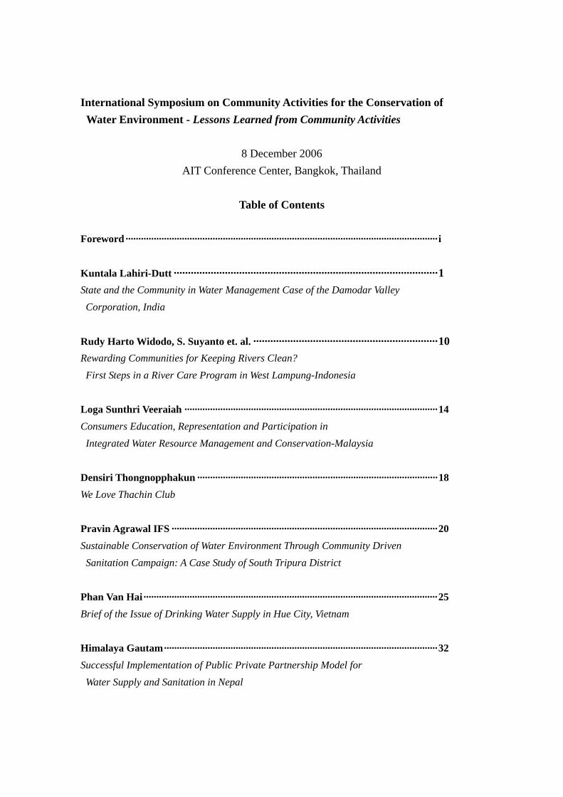
Table of Contents
Foreword·························································································································· i
Kuntala Lahiri-Dutt ·····························································································1 State and the Community in Water Management Case of the Damodar Valley Corporation, India
Rudy Harto Widodo, S. Suyanto et. al. ·································································10 Rewarding Communities for Keeping Rivers Clean?
First Steps in a River Care Program in West Lampung-Indonesia
Loga Sunthri Veeraiah ··································································································· 14 Consumers Education, Representation and Participation in
Integrated Water Resource Management and Conservation-Malaysia
Densiri Thongnopphakun ······························································································ 18 We Love Thachin Club
Pravin Agrawal IFS ········································································································ 20 Sustainable Conservation of Water Environment Through Community Driven
Sanitation Campaign: A Case Study of South Tripura District Phan Van Hai··················································································································· 25 Brief of the Issue of Drinking Water Supply in Hue City, Vietnam
Himalaya Gautam··········································································································· 32 Successful Implementation of Public Private Partnership Model for
Water Supply and Sanitation in Nepal
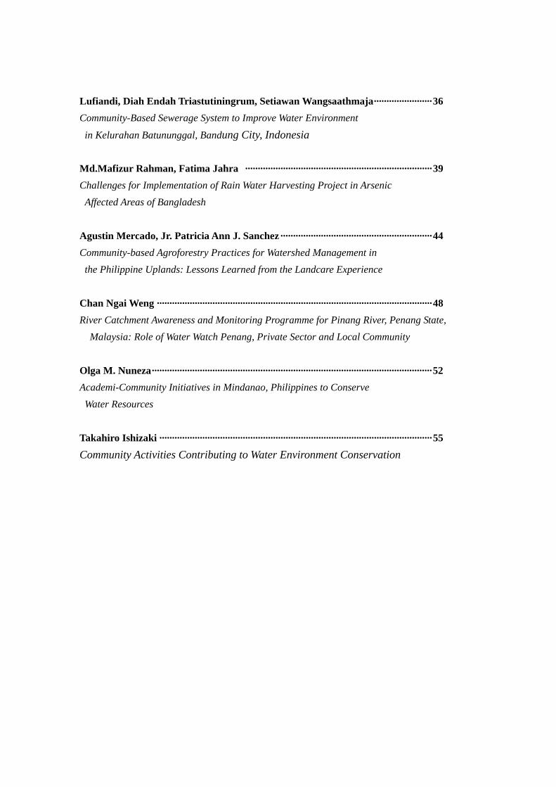
Lufiandi, Diah Endah Triastutiningrum, Setiawan Wangsaathmaja······················· 36 Community-Based Sewerage System to Improve Water Environment
in Kelurahan Batununggal, Bandung City, Indonesia Md.Mafizur Rahman, Fatima Jahra ·········································································· 39 Challenges for Implementation of Rain Water Harvesting Project in Arsenic Affected Areas of Bangladesh
Agustin Mercado, Jr. Patricia Ann J. Sanchez···························································· 44 Community-based Agroforestry Practices for Watershed Management in
the Philippine Uplands: Lessons Learned from the Landcare Experience
Chan Ngai Weng ············································································································· 48 River Catchment Awareness and Monitoring Programme for Pinang River, Penang State,
Malaysia: Role of Water Watch Penang, Private Sector and Local Community
Olga M. Nuneza··············································································································· 52 Academi-Community Initiatives in Mindanao, Philippines to Conserve
Water Resources Takahiro Ishizaki ············································································································ 55
Community Activities Contributing to Water Environment Conservation

State and the Community in Water Management
Case of the Damodar Valley Corporation, India
Kuntala Lahiri-Dutt
Community Specialist in Natural Resource Management Resource Management in Asia Pacific Program
Research School of Pacific and Asian Studies, The Australian National University, Tel: 61 2 6125 4343 Email: [email protected]
The Damodar and the DVC The British administrator, W.W. Hunter, in his Statistical Account of Bengal (1876) described Damodar floods; rainwater rushing off the hills through innumerable channels into the river bed with such great force and suddenness that the water rose to form a gigantic head wave of great breadth and sometimes rising up to 1.5 metres in height. These waves and accompanying flash floods were locally known as harka ban1. These floods washed away weeds and water hyacinths, cleaned up the drainage congestion in the lower channels and helped maintain the Calcutta port. The very fact that this deltaic stretch had an unusual concentration of agrarian population and settlements, land and water being the two primary resources for farmers, give evidence to the rural prosperity these floods led to (Mukherjee 1938). Yet, over the years, floods in the Damodar have been represented as an aberrant and uncivil behaviour of the river, making ‘river training’ ‘river control’, ‘taming’ and ‘harnessing’ of it (Lahiri-Dutt, 2000), making its civilising mission by the state a legitimate project. Nandy (2001 p. 711) critiques such use of terminology in describing rivers:
Note the use of the term “wayward”. It is perfectly compatible with the image of some of the larger, more turbulent rivers in folk tales and memories in eastern India, where rovers are revered as powerful demonic mothers carrying a touch of wayward, insane violence. They protect and nurture when in good mood but can turn malevolent and homicidal when not propitiated properly or out of sheer whimsy. That image has not only persisted but powered many of the contemporary efforts to contain or tame rivers in that part of the world2.
Bhattacharyya (1998) gives a detailed account of the recorded floods beginning 1730 since when floods of different magnitude took place every 8 or 10 years. It appears that over 8,000 m3/s of peak flow could give rise to ‘abnormal’ level floods, whereas a ‘normal’ flood resulted with about 5,500 to 8,000 m3/s peak flow. ‘Extremely abnormal’ floods were the ones with over 12,000 m3/s peak flow, and happened at least four times during the twentieth century (in 1913, 1935, 1941 and 1978). One must, however, remember that besides these categories, there were frequent ‘inundations’ and subnormal floods occurring with a certain
1 Meghnad Saha, the famous Bengali scientist and one of the key architects of the river control plans noted this ‘maldistribution’ as the ‘source of trouble’: ‘the rainfall coming in abrupt surges and lasting only for a short period in the year during the monsoon months’ (Saha and Ray, 1942). 2 Geographers have intensely studied knowledge production about nature; Baker (2000) gives an excellent overview of their contribution in this field of socially constructed knowledge, ideology and institutions other than the market as mediators between humans and nature that filled up a gap in the resource management literature, and how discourses are embedded within institutional configurations of power, knowledge and accepted authority, producing the effects of power within the self, as a form of discipline.
1
amount of regularity3. These floods were accompanied by dramatic shifts in the river’s course which, from 1550 to 1800, have been recorded from old maps, and since 1880 have been mapped from other source material such as written historical records (Sen 1973, p. 45). The village communities had developed, over years of coping with floods, various means of adjustment to the excesses of water. William Willcocks (1930) in his seminal lectures on the Ancient Systems of Irrigation in Bengal described this flood dependence as the ‘overflow irrigation’ in which broad and shallow canals carried the fine clay and humus rich crest waters of the floods in to the fields, and frequent cuts on the banks of the canals – called kanwas in Bhagalpur - or spill channels called hanas (in lower Damodar valley) inundated the fields to fertilise the soil, check the spread of malaria, and helped turn rural Bengal the productive land that it was. The indigenous crop varieties grew rapidly ahead of the floodwaters, and the cropping calendar too was often suited to phases of inundation (Brammer 1990; Hofer and Messerli 1997). Even standing water had its use: jute crops were retted in the stagnating water of the swamplands (Chapman 1995). An intricate network of ponds, aqueducts and water tanks provided seasonal storage of water as well as drainage. Houses in flood prone area were built on raised plinths that withstood the onslaught of the worst flooding4. The flood-prone character of the lower Damodar Valley has been attributed to several factors: the specific nature of the basin, the hydraulic regime that is sensitive to the rainfall pattern, and the specific nature of the outlet. The geographical uniqueness of the Damodar basin has ensured a large amount of interest in the river’s hydro-geomorphological properties. Beginning as Deonad, from the coalesced seasonal streams from the Khamarpat and Bijrangha hills, the Damodar is over 540 kilometres long, its basin covering over 23,000 square kilometres. The river carries a large sediment load of 41x105 cubic metres every year. The upper two-thirds of the basin is in the Chotanagpur plateau of Jharkhand (erstwhile the southern part of the state of Bihar), and the lower one-third is in the Radh (western bank of the Hooghly) plains of West Bengal (Bagchi 1944). Bagchi pointed out (1971) that the course of the Damodar is parallel but opposite to the direction of the rainstorms, the average track of which is towards north and northwest. The monsoon rains in the hills of upper catchment area occur subsequent to those in the plains, but descend quickly from the uplands carrying huge amounts of silt onto the flat land. The silty waters reach the lowland only to find the lower reaches of the rivers already inflated. Saha (1938 p. 55-56) explained the floods as caused by ‘the simultaneous rise of two rivers which flow into each other.’ In this part of the basin, the gradient of the river is extremely low, so its waters drain very slowly. Above all, the Hooghly being a tidal river allows only intermittent release of water into the Bay of Bengal each day5. 3 Such categorization may seem strange but in Bangladesh too, farmers have been reported to differentiate between barsha and bonna, normal inundations of the monsoon season and the harmful floods of unusual depth and timing (Boyce, 1990). 4 The mainstream wisdom, unfortunately, often failed to recognize the importance of these adjustment measures. For example, Chatterjee (1967, p. 2) wrote: ‘the consequences of these shifts (in course) in case of the Damodar has been vital. The shifts were almost always accompanied by catastrophic breaches as a sequel to high spates. The people of the region had to adapt themselves to the changes and began cultivating the kanas or dead channels when fields were devoured by newly formed spill channels. The people often agitated for embankments along the main stream and those connected with it. Zemindars were ultimately prevailed upon and the Damodar was embanked.’ Yet another view was offered by Bhattacharjee (1986) who believed that Wilcocks, famous for building the dam over Nile has reduced Egypt into a backward under-industrialised country, and ‘Likewise in 1928-1930, the goal of Sir W. Wilcocks was to increase the volume of India’s agricultural products and the size of her peasant population to serve the military and imperial purposes of the British’ (quoted in Nandy 2001, p. 720). 5 The tidal fluctuation at the mouth is as much as 4 metres.
2

Intervention for water control The first intervention to control the river and manage its waters started with building of embankments (the bandhs, also known as dikes or levees), weirs and sluices at small scales aimed at ‘containing’ the river’s water within its banks when it is in spate. The process began during the rule of the Burdwan maharajas in nineteenth century, Gastrell (1863) was of the opinion that the embankments were built by local zamindars to protect their land and property, but according to Sengupta (1959) the embankments were meant to protect the main crop of paddy. Locally known as pulbandi, these embankments were, however, usually low-lying, not extensive and poorly maintained, allowing spill overs, breaching and outlet of waters into the fields. The left bank embankment of the Damodar seems to have always been stronger and better maintained; the right-hand or the trans-Damodar embankment always breached or had a greater number of hanas to let out the waters. On the north bank of the river was the prosperous country town of Burdwan, the headquarters of the district and eventually the seat of the rajas. The trans-Damodar area across the right-bank of the river – the nikashi or the drainage outlet area - suffered, in comparison to the north bank, from poor access and was more agricultural in nature. A system of sluices was built on the left bank to release the top of the flood waters as the bed of the Damodar rose higher (due to siltation) than the water level of the Hooghly. Experts of the Damodar Valley agree that the embankments ‘did more harm than good’ (Banerji 1972, p. 36). S.C. Bose noted (1948 p. 49-50) that ‘A large part of the district being very little above mean sea-level is liable to be flooded every year by the principal rivers and their branches’. The embankments also gradually closed off the headwaters of some of the distributaries, turning them literally into kana nadi (or blind river), enhancing the southward shift of the river course mentioned before. They also turned the trans-Damodar area into a rural hinterland - an unhealthy swampland ravaged by complicated problems, one of them being the notorious Burdwan fever (O’Malley and Chakravarti 1909). Rampant malaria, caused by congested drainage in the lower part of the Damodar Valley, was a spin off of the embankment construction 6 . The justification behind embankment construction lay in the efforts to protect the fields from erosion and floods. This ensured a regular revenue collection, and was based on the notion that the dikes would help to increase the river’s velocity and help wash off the sediment load, preventing it from spilling over onto the surrounding fields (Inglis 1909). Yet another genre of interventions comprises transverse structures of various widths and heights across the river bed for flood control and irrigation. The Anderson weir and the Eden Canal are notable among them. Envisioning total control The nationalist ideology in India expressed itself in water management; the 1947 report of the Sub-committee on River Training and Irrigation of the National Planning Committee reveals the philosophical standpoint of the nationalists of emerging India, that the flowing waters in rivers are at once hold the potential of bringing great economic wealth but at the same time pose grave dangers through floods. It thus became a matter of concern that only a small proportion of the available water wealth in the rivers had been utilised and the ‘balance runs to waste’ (Shah 1947, p. 21), or that floods are a ‘problem’ (p. 61). River regulation was seen
6 As early as in 1925, Dr C.A Bentley advocated the reintroduction of flood waters into the Bhagirathi-Damodar doab as well as in the trans-Damodar tract in his book ‘Malaria and Agriculture in Bengal’. In 1931, Mr C Adams Williams stated that the silt-laden waters be used to increase the fertility of the soil and decreasing the ravages of malaria.
3
as the pre-requisite for maintaining rivers in ‘efficient working condition’ so that they can be put to the greatest use in the shortest practicable time. This ‘efficiency’ required that ‘Rivers have to be tamed first, in order that the attempts to train them may be successful’ (p. 64). For the communities living along the Damodar river banks, the rise of ambitious modernist plans for the total control of the water flow in the river, especially after the flood of 1943, meant disaster. When at the peak of the World War II, with the Indian National Army of Subhash Chandra Bose advancing towards India across the Burmese border, in mid-July, the Damodar breached its left bank levee a few kilometres downstream of Burdwan and disconnected Calcutta from the rest of the world for weeks. This prompted the colonial government to set up the Damodar Flood Enquiry Committee to advise on the permanent measures to control the floods in the river7. Under the leadership of the Maharaja of Burdwan, this Committee suggested in 1944 the adoption of the Tennessee river control measures as a model for the Damodar8. The envisioning of the Damodar Valley Project in detail was left to W. L. Voorduin, a senior engineer of Tennessee Valley Authority. Mishra (1998 p. 23) reminds us that flood control by means of dams in the upper catchment had been considered since 1860 by various British engineers, but was always shelved as an uneconomic proposition. Voorduin submitted his Preliminary Memorandum on the Unified Development of the Damodar River System. The primary objective of the project was flood control, although irrigation and power generation were also envisaged as ancillary benefits arising out of the control turning it truly into a ‘multipurpose’ project. Voorduin’s scheme of flood control involved construction of a system of dams in the upper valley with a weir across the lower valley for diverting water into a network of canals and a combined system of hydro and thermal power stations with transmission and distribution facilities. The Damodar Valley Corporation was brought into existence on the 7th July, 1948, by a special Act, just after Independence. Voorduin’s original recommendation suggested the construction of eight storage reservoirs – but the DVC decided to implement the work in two phases. In the first phase, the construction of four dams at Tilaiya, Maithon, Panchet and Konar with hydroelectric stations connected to each dam, the Bokaro thermal power station and the Durgapur Barrage9 and canals leading off from it were to be built. It was envisaged that the second phase would cover the construction of the remaining four dams and hydroelectric stations at Balpahari, Aiyar, Bokaro and Bermo10. Although hailed widely as ‘an amazing project’, a mighty experiment and a great adventure’ (according to Gen. Wheeler, Engineering Adviser to the World Bank, see Luthar 1981) this dream-child of Nehru eventually was able to complete only the first phase of building four dams11.
7 Mookerjea (1992) describes the DVC as ‘the response to the challenge’ and gives a detailed account of how crucial the timing of this 1943 flood was triggering off the Damodar’s subsequent control measure. 8 One of the critiques of the DVC plan was put forth by Kapil Bhattacharyya as early as in late 1950s (detailed in his book 1986) who wrote in detail about how the alignment of roads and railways have already created drainage congestion in lower Bengal and how the DVC dams have hastened the decay of the Calcutta port by blocking off the water inflow into the Hooghly to flush off the silt. 9 As the number of dams was reduced, to have better control over the runoff, the Durgapur barrage was constructed in place of the weir suggested by Voorduin. 10 The government of Bihar later constructed the fifth dam at Tenughat in place of the Aiyar, funding for which was given as a loan to the state, and which is not integrated to the DVC system. It supplies water mainly to the Bokaro Steel Plant and the thermal power station. 11 About 93,000 people were displaced from 27,500 ha of land and 45,000 houses. The policy was to give land for land, only if the displaced persons indicated their choices by a certain date.
4

Impacts of the DVC dams on floods and economy Has the DVC been able to keep the promises it made to the residents of the lower reaches? This question is connected to the question of evaluating the impacts of the DVC on the regional economy, both of which have been intensely debated. The DVC has remained not only incomplete but as noted by Aich (1998 p. 79), has deviated significantly from its aims of flood control: ‘the DVC project moved far away from the original concept of Mr. Voorduin, to meet the national priorities and regional needs laying special emphasis on generation and distribution of electricity…’. This claim is supported by Biswas’ (1998 p. 5): ‘the DVC … has now mostly become a power generating and transmission authority in the interests of industrial development in the valley, though hydel power could not be installed more than 144 MW for non-construction of 2nd Phase reservoirs.’ One reason of such a deviation is that the barrage and canal networks are not integrated with dam operations. The Durgapur barrage with its 137 km long Left Bank Main Canal and 89 km long Right Bank Main Canal with a 2270 km long network of branch or minor canals now operate under the Government of West Bengal whereas the Central Water Commission overlooks the management and operation of the reservoirs (Biswas 1998). For the residents of the lower Damodar valley, indeed, the floods have not been fully controlled, the nature of floods have changed, whilst building up a false sense of security amongst the residents of the lower valley (Lahiri-Dutt 2003). There were three major floods, post-DVC, - in 1958, 1978 and 1998 – raising concerns whether the DVC was indeed a boon or a calamity (Basu 1982) and a range of economic appraisals of the project (Ganguly 1982)12. The scrutiny was intense especially after the devastating 1978 flood – ‘the biggest ever handled by the DVC’ according to one of its reports (DVC 1980). This flooding is understood to have happened because of a combination of excessive rains from cyclonic cloud-burst of the retreating monsoons in late September and the release of large amounts of water from the reservoirs when they were full to the brim13. Similarly, in 1998, yet another major flood kept the lower valley under water for nearly a week. The blame has been laid on ‘uncontrolled’ parts of the catchment below the dams that bring in additional runoff into the lower system of the river. This area comprising about 3,200 km2 extends from below Maithon and Panchet dams to Durgapur Barrage for about 60 kilometres. It has been pointed that even with the construction of additional dams in the upper reaches this area contributes significantly to the runoff. Aich (1998 p. 81) also held responsible ‘administrative bottlenecks’ for leading to the failure in the provision of full flood control by the Maithon and Panchet dams (as their capacity was reduced to 780,000 acre-feet (0.96 km3) half that originally envisaged). Many of these bottlenecks were to do with the inability of the DVC to acquire land. Disputes between Bihar and West Bengal on irrigation water allocation from the reservoirs have also caused these bottlenecks, and the regulation manual prepared by the Central Water and Power Commission (GOI, 1969) has been inadequate in dealing with occasional years of excessively heavy rains in late monsoons14. Pathak noted by (1981 p. 634) 12 The priorities of the DVC has changed significantly; for example, the capital expenditure in 1977-’78 showed that it spent over 82% on power generation whereas flood control, irrigation and subsidiary activities (such as soil management in the upper catchments) received around 11%, 4% and less than 3% respectively. 13 It remains a fact that the quantity of sand being deposited in the DVC reservoirs has been far greater than the originally envisaged, reducing the lifespan of the dams. This was believed due to the accelerated pace of mining-based industrialization and urbanization of the upper valley. 14 On the effectiveness of this manual in coping with the 1978 floods, Pathak noted (1981 p. 629): ‘The vagaries of monsoonal rainfall … belied the DVC water release manual because of heavy downpour of 72cm. during September 26-28 in 1978. The DVC reservoirs received an all time record inflow of 851,000 cu.ft. According to the manual, the DVC was to release 200,000 cu.ft/sec. whereas it released only 160,000 considering the heavy rainfall; but at Durgapur barrage point it
5

the poor governance, leadership and corruption in running the internal matters of the DVC as being responsible for its lacklustre performance.
Conclusion One would expect that the DVC experience would probably lead the next generation of water management specialists away from gigantic, constructional plans such as the Sardar Sarovar dams. Unfortunately, that lesson has not been well understood in India. Moreover, during the decades of its existence, the DVC has turned into an icon for the modernist and technology-worshipping urban elites almost symbolically representing centralised and systematic water control. Many experts (Banerjee 1991, p. 201) claim that if the DVC was completed as per Voorduin’s vision, the problems would not have occurred: ‘As the system was not built upto the design capacity, the capability of the system is restricted and supply of the desired output cannot be guaranteed at all times.’ To the villagers living in the lower reaches of the valley, however, the DVC is a grand design that has failed to keep its lofty promises of flood control and irrigation. The river control measures adopted in DVC by the state in India have created a complex web of practical difficulties for the inhabitants, endangering their survival of certain groups of people. Bank erosion has been a result of the river controls put in place by the DVC. With Dakshin Damodar Khara Bonya Pratirodh Committee, we undertook a study of the perceptions of local residents of the floods and river bank erosion, and observed that a large number of respondents noted that, whilst the floods have indeed decreased in frequency, they have become more unpredictable. An unexpected flood can ravage immensely more than one that is regularly expected, especially if the flood is caused by the very institution that was created to protect the people. Often the warning that the DVC Control Room is supposed to provide before releasing the water from the barrage fails to reach people in the lower valley on time. Aich (1998 p. 81) observed that:
Before the construction of the DVC damns, the flood peaks were high but the duration was small. The construction of dams has moderated the peaks but increased the duration of floods. This increase in duration has enhanced the chances of synchronization of floods from the upper and lower valleys as also from the adjoining river basins.
Consequent to the controlled flow, excessive amounts of sand deposition on the entire channel of the Damodar downstream from the Durgapur barrage has given rise to chars or river islands. As the existence of these sandy pieces of land are extremely uncertain, their fragile environments offering risky habitats and their existence legally unrecognised, they tend to be settled by migrant groups from Bihar as well as from across the Bangladesh border (Lahiri-Dutt and Samanta, 2004). The high embankments have, in places, created extremely complex networks: for example that of Dadpur village in Burdwan district where the village is completely surrounded by a series of embankments. this village lies about 20 km east of Burdwan town at the apex of the Damodar delta where the river turns nearly 900 to swing to the south-southeast. The villagers suffer from the constant threat of inundation from breaches in the bandhs in which case the entire village may be wiped out in a matter of hours. In ‘Why the Damodar scheme deserves top priority among India’s development projects’, the proponents of DVC (1948) emphasised the wealth creating potential of the scheme which is in was 380,000 cu.ft/sec. threatening the barrage itself. Besides, other rivers in the lower Bengal – like Silavati, Darkeswar, Kansavati, Ajoy and Moyurakshi – were swollen and added to the Damodar flood.’
6

turn equated with nation-building enterprise. It becomes indeed a magnificent design, an exemplary achievement of the civilising effects of technological intervention on a grand scale, and the showcase for undertaking similar experiments elsewhere. The specificity of the river and the understanding of its specific geographical and historical context are lost in the explicit efforts in pushing through this agenda (p. 8):
The Damodar Scheme represents the first attempt in India to provide a comprehensive valley-wide demonstration of water conservation and use….For this pioneer demonstration work the choice of the river could hardly have been better. The Damodar is a big enough river for the purpose and yet not too big while the economic potentialities of the Valley are not only among the highest in the country, but also immediately realisable because of the ready demand for power and water. Once a successful demonstration of comprehensive river harnessing has been provided in the Damodar Valley with its manifold benefits, it will be easier to undertake similar experiments in other river valleys of the country in the light of the experience gained here.
This statement reveals that no allowance was made for appreciating the different characteristics between European or American rivers and the Damodar, thus a western concept was transplanted lock, stock and barrel into a setting seen as an empty landscape devoid of a history and people. This knowledge puts faith in the universal models and stands outside of the social context as autonomous and objective. This knowledge puts values such as scientific reason and rationality of those with greater powers as necessarily ‘good’ and co-terminus with ‘development’. People in the lower part of the DVC’s command area have literally challenged the ‘command’ and refuse to imbibe the obedience that the DVC expects to flow naturally (unlike its water!) from its distant position of power. References Aich, B. N. (1998) Five decades of DVC, Science and Culture, May-June, Vol. 64, Nos 5-6, pp. 77-86. Bagchi, Kanan Gopal (1967) The problems of regional planning in the valley region, Science and Culture, September, pp. 1-18. Bagchi, Kanan Gopal (1944) The Ganges Delta, Calcutta University, Calcutta. Bagchi, Kanan Gopal (1977) The Damodar Valley development and its impact on the region in Allen G. Noble and Ashok Rudra (eds) Indian Urbanization and Planning: Vehicles of Modernization, Tata McGraw-Hill Publishing Co. Ltd, New Delhi. Banerjee, B. K. (1991) Unified development of the Damodar Valley and its impact on environment, Workshop on Environmental Impact Assessment for Water Resource Projects, Institute of Engineers, India, Calcutta. Banerji, Amiya Kumar (1972) West Bengal District Gazetteers: Howrah, Government of West Bengal, Calcutta. Basu, S. K. and S. B. Mukherjee (1963) Evaluation of Damodar Canals (1959-60): A study of the benefits of irrigation in the Damodar Region, Asia Publishing House, New York. Bhattacharjee, D. K. (1984) Flood control and utilization of water resources in Damodar Valley area, Journal of the Institution of Engineers, India, Vol. 64, Part CI. Bhattacharjee, Kapil (1986) Swadhin Bharate Nad-Nadi Parikalpana (River planning in independent India) Kalam, Calcutta. Bhattacharyya, Kumkum (1998) Applied Geomorphological Study in a Controlled Tropical River: The case of the Damodar between Panchet reservoir and Falta, Unpublished PhD thesis Submitted to The University of Burdwan, Burdwan.
7

Bose, S.C. (1948) The Damodar Valley Project, Government of West Bengal, Calcutta. Brammer, H. (1990) Floods in Bangladesh: 2. Flood mitigation and environmental aspects, Geographical Journal, Vol. 156, No. 1, pp. 12-22. Central Water and Power Commission (1969, Reprinted in 1980) Regulation Manual for Damodar Valley Reservoirs, Government of India Press, New Delhi. Chatterjee, S. P. (1967) Technical Advisory Committee Report on The Lower Damodar Valley Region, Joint Committee for a Diagnostic Survey of Damodar Valley Region, Government of India, Damodar Valley Corporation, Calcutta. D’Souza, Rohan (1999) The Problem, in Floods: A Symposium on Flood Control and Management, Seminar, 478, pp. 12-17. Government of India, Ministry of Irrigation and Power (1958) Report of High Level Committee on Floods, Government of India, New Delhi. Hofer, Thomas and Bruno Messerli (1997) Floods in Bangladesh: Process Understanding and Development Strategies, Institute of Geography, Swiss Agency for Development and Cooperation and the United Nations University, Berne. Inglis, W. A. (1909) The Canals and Flood Banks of Bengal, Bengal Secretariat Press, Calcutta. Lahiri-Dutt, Kuntala (2003) People, power and rivers: Experiences from the Damodar river, India, Water Nepal, Journal of Water Resources Development, Special issue on Water, Human Rights and Governance, Vol. 9/10, No. ½, pp. 251-267. Lahiri-Dutt, Kuntala (2000) Imagining rivers, Economic and Political Weekly, Vol. 35, no. 27, pp. 2395-2400. Mishra, A. K. (ed) (1998) Profile of a Pioneer: Damodar Valley Corporation, Golden 1948-1998, Jubilee Commemorative Volume, DVC, Calcutta. Mookerjea, D. (1992) D.V.C.: A response to the challenge, in Damodar Valley: Evolution of a Grand Design, DVC, Calcutta, pp. 107-132. Mukherjee, R. K. (1938) The Changing Face of Bengal: A Study of Riverine Economy, University of Calcutta, Calcutta. Nandy, A. (2001) Dams and dissent: Indias first modern environmental activist and his critique of the DVC project, in Futures, Special Issue Water Futures in South Asia, pp. 709-732. O’Malley, L.S.S. (1913) Bengal District Gazetteers: Purnea, Bengal Secretariat Book Depot, Calcutta. O’Malley, L.S.S. and M. Chakravarti (1909) Bengal District Gazetteers: Howrah, Bengal Secretariat Press, Calcutta. Pathak, C. R. (1981) Development in the Damodar Valley region, India, Habitat International, Vol. 5, No.5/6, pp. 617-635. Saha, M.N. and K. Ray (1942) Planning for the Damodar River, Reprinted in Science and Culture M.N. Saha Commemoration Volume, 1993, Vol. 59, No. 7-10, pp. 75-96. Saha, Meghnad (1936) Irrigation research in India, Science and Culture, Vol. 11, p. 282, Reprinted in the Collected Works of Meghnad Saha, Calcutta. Saha, Meghnad (1938) The problem of Indian rivers, Presidential Address to Annual Meeting of the National Institute of Sciences, India, Proceedings of National Institute of Sciences, Vol. 4, No. 23, Reprinted in the Collected Works of Meghnad Saha, Calcutta. Scott, James (1998) Seeing Like a State: How Certain Schemes to Improve the Human Condition Have Failed, Yale University Press, New Haven. Shanin, T. (1997) The idea of progress, in Majid Rahnema and Victoria Bawtree (eds) The Post-development Reader, Zed Books, London, pp. 65-71.
8
Sen, Satyakam (1973) Drainage study of Lower Damodar Valley, Journal of Power and River Valley Development, Calcutta. Sengupta, D. N. (1951) An Account of the General River Problems of West Bengal, General Printers and Publishers Ltd., Calcutta, pp. 31-63. Shah, K. T. (ed) (1947) River Training and Irrigation, National Planning Committee Series (Report of Sub-Committee), Vora and Co. Publishers Ltd, Bombay. United Nations Economic Commission for Asia and the Far East (1960) A Case Study of Damodar Valley Corporation and its Projects, UN Flood Control Series, no. 16, United Nations, Bangkok. Voorduin, W. L. (1947) The Unified Development of the Damodar River: Preliminary Memorandum, DVC, Calcutta. Willcocks, William (1930) Lectures on the Ancient System of Irrigation in Bengal and its Application to Modern Problems, University of Calcutta, Calcutta
9

Rewarding Communities for Keeping Rivers Clean? First Steps in a RiverCare Program in West Lampung- Indonesia
Rudy Harto Widodo1, S. Suyanto1, Bruno Verbist1, 2, Betha Lusiana1, Susanto1,
Pratiknyo Purnomosidhi1
1World Agroforestry Centre (ICRAF), Southeast Asia Regional Office, PO Box 161, Bogor 16001, Indonesia; 2 Katholieke Universiteit Leuven, Department of Land Management and Economics, Celestijnenlaan 200E, 3001,
Leuven, Belgium Author for corresponding (e-mail: [email protected])
Introduction Around 10% of the electricity produced in Indonesia is supplied by hydropower (EIA, 2004). Most of the hydroelectric plants depend on the regular supply of water from the surrounding watersheds. Storage lakes regulate the water flow and hydropower production. The active storage volume of many storage lakes is threatened by sedimentation. Thus, low sediment loads of the river are in the interest of hydroelectric companies. But, are these companies willing to pay for the service of keeping rivers clean? Payment for environmental services (PES) is a new paradigm in conservation where ‘landowners and/or managers’ are compensated by outside beneficiaries for the environmental services they provide (Wunder, 2005). In the tropics, most PES mechanisms for watershed functions are based on the assumption that trees can provide more water but without clear proof of what are the specific services being provided. Also in the upper Way Besay Catchments (West Lampung, Sumatra, Indonesia) the National Electricity Company (PLN) exploiting a hydropower dam (PLTA) is worried about the often high sediment load and supposedly high siltation of the lake. In order to assess and reduce sediment load in the Way Besay and its tributaries, a river care program was started as collaborative activity between ICRAF, upland farmers and local government officers. The aim is to develop and implement a payment mechanism for upland farmer groups that are able to reduce the sediment level of the river. Study area The elevation of the 41,500 ha upper Way Besay Catchments ranges between 720 and 1831 m. The population was about 87,350 people in 2004, with a density of 161 people.km-2 (Biro Pusat Statistik, 2004). About 40% of the sub-district is classified as “protection forest” and about 10% as National Park. Nevertheless, coffee gardens, also known as multistrata coffee, now cover about 70% of the total area (Verbist, et al. 2005). Electricity generation at the Way Besay hydropower dam started in 2001, with a maximum capacity of 90 MW. On average this dam contributes 15% of the electricity for southern Sumatra (Kompas, 2001) and 60 % for the Province of Lampung (PLN, pers. comm.).The peak sediment load in the Way Besay can be as high as 3 kg/m3/second, largely caused by land slide and erosion. Continuous turbidity measurements during three months in the wet season in 2006 show that about 50 % of the suspended sediment remains in the hydropower reservoir, causing (a) reduction in water level for turning turbine, (b) damage to reservoir filter, and (c) higher cost for cleaning the reservoir. All of these directly affect the actual capacity of electricity production.
10

RiverCare program and conservation activities As a pilot project, a RiverCare group, consisting of 70 households, was formed in a 160 ha subcatchment of the Way Lirikan. The 670 ha Way Lirikan sub-catchment was identified earlier as a large sediment contributor to the Way Besay (Verbist, et al. 2006). Diagnostic walks, baseline sediment monitoring and many meetings and discussions were organized with the community to assess possible causes for the high sediment level in the Way Lirikan and identify potential erosion hot-spots (Fig.1). This all led to an agreement with the community and the start of a RiverCare group, as seller of environmental services (ES) and ICRAF as the buyer. Upon successful results it is foreseen that the PLTA will be the buyer, while ICRAF’s role will be reduced to be the broker in further negotiations. The current agreement stipulates that the community receives $1,000 to cover project set-up costs. After one year the reward will depend on the reduction of the sediment load in the river:
• Full payment ($1,000) for reduction of sediment load 30% or more • $700 for reduction of sediment load between 20 – 30 % • $500 for reduction of sediment load between 10 – 20 %, and • $250 reduction of sediment load of less than 10%.
Following remedy activities were agreed upon with the RiverCare group: • Landscape elements like public footpaths with a visual erosion problem and direct
connectivity to the river will be treated with drainage ditches, culverts and regular maintenance (Fig. 2).
• The high streampower in particular river segments causing streambank collapse will be mitigated with flow velocity reducing measures like check dams (Fig. 3)
• Recent gullies will be treated with sediment traps and better drainage. • Overall a better infiltration of excess water in non-hazardous parts of the landscape
will be encouraged.
Relevant extension activities were also organized with the RiverCare group: training on river water monitoring, improved coffee cultivation, garbage handling, nursery development, planting of multi purpose trees and grass for livestock, rehabilitation of riparian areas.
Figure 1. Activities with members of the RiverCare group: (a) Transect walk discussing streambank collapse as a sediment delivery hotspot; (b) Measuring sediment load using a transparency tube
11

Figure 2. Simple structures to reduce runoff and trap sediment on public footpaths
Figure 3. Simple check dams to reduce sediment load and flow velocity. Some of the water is used for micro hydropower station Monitoring Activities Monitoring was carried out on three aspects: infrastructure, institutional aspects and actual sediment reduction in the river. Infrastructure monitoring relates to the quantity and quality of the new structures. The institutional aspects evaluated the functioning of the RiverCare group and the active participation of its members. Monitoring sediment levels in the river is of crucial importance, as it is expected that the hydropower dam will only be interested in becoming the buyer if a meaningful reduction in sediment yield is achieved. Baseline data were collected in order to quantify current sediment levels before project activities: A sediment rating curve was developed, relating sediment load with discharge. Sampling was also done at various sites along the river to identify the largest sediment contributing areas and erosion hot spots In the future samples will be taken approximately every 2 weeks during a rainfall event from September 2006 – October 2007 to assess changes in sediment load. River water samples are taken using a depth integrated method. Samples are dried and the sediment is weighed in a field lab. Direct readings of visual clarity are made with self constructed “transparency tubes” that are based on the Secchi disc principle (Fig. 1b). This
12
visual clarity (or Secchi disc visibility), is converted to sediment concentration after calibration with the field lab results. Future Challenges and Opportunities The RiverCare program addresses fundamental issues of transparency and conditionality in PES. We need clarity on what the service is and how it will be evaluated. Some PES-schemes were rather paying for ‘perceived environmental services’, because the monitoring was not measuring the service, but another variable as e.g. tree cover, if there was a monitoring scheme at all. We expect that payment mechanisms based on clear and measurable environmental services will be attractive to the real buyer, and that the approach will be adopted and implemented. The goal of these pilot projects is to show to the electricity company that buying the environmental services can be a cost-effective way for them to reduce the sediment load of the river. We have an ongoing dialogue with the electricity company, to share what we learn. In a year’s time, we’ll get the real test when the electricity company needs to decide, if they will continue and scale out the scheme. Adoption of this mechanism by the Hydroelectricity Company would not only improve the environment – and probably be more sustainable and be at a lower cost, than current envisaged measures like dredging - it would also enhance community welfare and reduce the risk of an electricity crisis. Acknowledgement The support of the RUPES Program under the International Fund for Agriculture and Development (IFAD) grant is gratefully acknowledged. The research results reported here is part of that study. References Biro Pusat Statistik. 2004. Lampung Barat dalam Angka. BPS Lampung. Chandler J. and Suyanto. (2004). Recognizing and Rewarding the Provision of Watershed
Services. In: Hydrological Impacts of Forest, Agroforestry and Upland Cropping as a Basis for Rewarding Environmnetal Service Providers in Indonesia, F. Agus, M. van Noordwijk and S. Rahayu (Eds), Proceedings of a workshop in Padang/Singkarak West Sumatra, Indonesia, 25-28 Februari 2004. World Agroforestry Centre. Bogor. Indonesia.
EIA. (2004). Indonesia Country Analysis Brief. http://www.eia.doe.gov/emeu/cabs/indonesia.pdf. Accessed: 20 September 2006.
KOMPAS. (2001). Wapres Resmikan PLTA Way Besay (Vice president inaugurate Way Besay hydroelectric power plant). http://www.pu.go.id/humas/media%20massa/april/kp0104011.htm. Accessed: 20 September 2006.
Verbist B., Ekadinata AP. and Budidarsono S. 2005. Factors driving land use change: Effects on watershed functions in a coffee Agroforestry system in Lampung, Sumatra. Agricultural Systems, 85: 254–270
Verbist B., Widodo R.H., Susanto, Van Noordwijk. M., Poesen J., Deckers S. 2006. Assessment of Run Off (flows) and Sediment in a Largely Deforested Cathment in Sumberjaya, Lampung, Sumatra Indonesia. 3 rd APHW Conference, Bangkok. Thailand.
Wunder S. 2005. Payments for Environmental Services: some nuts and bolts. CIFOR Occasional Paper No. 42. Center for International Forestry Research, Bogor, Indonesia.
13

Consumers Education, Representation and Participation in Integrated Water Resource Management and Conservation-Malaysia
Loga Sunthri Veeraiah
FEDERATION OF MALAYSIAN CONSUMERS ASSOCIATIONS (FOMCA)
NOID-1, BANGUNAN SKPPK, JALAN SS9A/17,
47300 PETALING JAYA, SELANGOR MALAYSIA
TEL : +60378762009 FAX : +60378771076
E-MAIL : [email protected]
Extended Abstract: Water is a precious and scarce resource. Water is a critical factor to alleviate poverty and hunger, for sustainable development, for environmental integrity and for human health. Community has complex priority for the use of water as economic factor as well as household use. However, recently the access to this basic necessity is continuously being threatened by privatization and shortages in some states. The restructuring of the water industry in Malaysia is pertinent, because we need an immediate solution to the water rationing and water shortages faced every year. The success and failure of any policies relies mainly on two critical features, which is the enforcement of the policy and the end users satisfaction. Therefore, consumers’ representation and participation in water industry is vital. Wastefulness and water contamination diverts this resource from meeting the growing demands. Malaysia is a country, blessed with an abundance of water however lately the water situation of the country has changed from abundance to scarcity. Apart of other reasons such as rapid industrialization, population increase, non-revenue water, old asbestos pipelines, sectoral based water laws, FOMCA realized the pivotal reason is the lack of public education on water conservation. This is due to the reasons such as the mindset of the community, whereby wastefulness has turned into a habit, and the community is taking the precious resource as granted. Over consumption, as practised in high-income countries and in middle and upper classes of the developing world must be examined. (Malaysia falls under the Upper-middle income countries in the OECD List). Water consumption as in the Organisation for Economic Cooperation and Development (OECD) Countries at the end of 1990’s was between 100 and 200 litres per day per person. Some countries such as US and Canada (Malaysia in some states) exceed 300 – 500 litres per day per person. In contrast average consumption in the poorest areas of the developing world hovers at the 10 litres per day per person, the minimum necessary for survival. According to the Millennium Development Goal (MDG), which was adopted in the year 2000, reasonable access is defined as the availability of at least 20 litres a person a day from a source within one kilometre of the dwelling.
14

It is clearly noticeable that there are no exact measures or indicators of the appropriate amount of water for per capita consumption per day. However, studies have concluded that to sustain a reasonable quality of living requires about 80 litres of water per person per day inclusive of 3 litres of water for drinking purposes. Malaysian Water Industry Guide 2004 indicates that in year 2002, 67% of water consumption is for the domestic usage. Per capita consumption rate of the domestic water usage varies from one state to another. The highest is about 476 liters per capita per day and the lowest is about 90 liters per capita per day. Water conservation at domestic level is not limited to using less water; it is also about channeling the kitchen wastewater in a proper manner as well as reusing water whenever possible. It is noticeable that there are factors contributing towards the high water consumption and pollution patterns such as the tariff rates, the sanitation and disposal facility, drainage system and the availability of water. The per capita consumption also varies significantly between the urban and suburban areas. Recently there have been a lot of change in the legal framework of the water resources in Malaysia. Issues on the governance as well as methods of managing water resources are being studied and looked into in Malaysia following the amendment of the Federal Constitution to transfer the jurisdictions of law under a concurrent list which was previously under the state purview. Legal framework and policies should be made in consultation with communities and civil society to ensure that they are aware of the framework as well as to foster participation in order to encourage ownership and responsibility. Therefore, NGO’s such as FOMCA which has wide contacts with grassroots communities can be utilized to gather their comments on the framework drafted by government on IWRM. This applies especially to issues such as water, air, energy and food. Two new water acts namely the National Water Resources Commission Act and the Water Services Industry Act were drafted and FOMCA played an important role in the process to gather comments from public as well as to provide detailed feedback to the Acts. FOMCA presented a 97 page memorandum, making 57 changes in the drafted laws which were open for comments. The Parliament of Malaysia acknowledged FOMCA’s input and the Ministry accepted some of FOMCA’s input/recommendations when it tabled the final draft of the water act. This paper will concentrate mainly in creating awareness and harnessing conservation in achieving sustainability as well as some suggestions on consumer participation in water related policy. The paper will also highlight the pivotal role of government, industries and community participation in consumer education on water conservation in addressing the increasing demand problems. Consumer education and awareness has to be harnessed in promoting conservation and achieving sustainability. Being a good consumer means being able to understand and value what one’s needs and wants are. It involves thinking and utilizing resources intelligently so that conscious decision-making takes place during consumption. They need information on the linkages between their attitudes and practices as consumers, and the degradation of the environment. It will help them to practice better use of resources for their daily needs. They will also be able to understand the cumulative effect of consumer decisions on the community, economy and the environment. Failure to move in this direction will impose disastrous implications to the environment and its finite resources.
15

Realizing the importance of Water Conservation, FOMCA with the cooperation of the Ministry of Water, Energy and Communications Malaysia will hold a 24-month National Water Conservation Campaign. The main aim of this campaign is to create awareness, build capacity and train the local consumers, community and school children on water conservation issues. The campaign has been officially launched by the Minister of Energy, Water and Communications Ministry Malaysia on the 31st of July 2006. The campaign activities started from the month of July 2006 and will prolong till June 2008. The target set for this campaign is to achieve a rate of 10% reduction in the domestic water consumption. FOMCA together with the Ministry will work with many other interested parties, NGO’s, government department in making this campaign a success story and also to ensure the problem addressed in holistic manner with the cooperation of all parties. This will further promote the sustainability of the campaign. Objective of Water Conservation Campaign To increase consumers’ awareness on the rational usage of water and to promote water conservation through:
• Providing consumers with information, educate and build their capacity on different issues related to water conservation such as pollution reduction, grey water pollution and rainwater harvesting.
• To conduct a research on the domestic water consumption in Malaysia to understand the limitations and problems in domestic water conservation, as to take action on the most water wasteful activities.
• To gauge the performance of rain water harvesting in terms of quality and economy to further reinstate and reaffirm the benefits of rain water harvesting in Malaysia.
The main activities to be undertaken in this campaign will be producing brochures, posters and reading material in all languages widely used in Malaysia. Apart of that a national level research on domestic water consumption pattern, a national case study on rain water harvesting implementations and benefits to consumers, 10 capacity building workshops for school children, 5 public forums throughout the country will be incorporated in the campaign activities. Expected Outputs of the Campaign The expected outputs of the project and the campaign are:
a) Improve interpretative materials and guides of water conservation methods for domestic level.
b) To establish a closer working relationship between the entire water stakeholder, the government and the community.
c) To encourage rainwater harvesting at domestic level as to include the technology for the new housing development projects.
d) To create a self-sufficient consumer community through capacity building. This paper will include case study of community-based approach taken by Federation of Malaysian Consumers Associations and the result which will be a example to other government
16

departments, industries, non government organizations (NGO’s) and community based organizations (CBO’s).
17

We Love Thachin Club
Densiri Thongnopphakun
Associate Professor Southeast Asia University, Bangkok, Thailand
Introduction The Tha Chin River is the second most important river in Thailand, covering 12,000 km2 basin area and a population of 1.2 million. The main stem of the river is about 320 km in length, and over much of that distance water quality has deteriorated significantly over the past two decades, largely as a result of waste inputs from municipal sewage, agricultural
activities, livestock raising, and industrial operations. Although the government has launched many projects and programs to restore the water quality conditions, the achievement is still by far. Realizing these things, “We love Thachin Club” was established in Nakon Phatom including person from three main sectors in the societies: communities, temple and school. It was established on 7 September 1998 by holding slogan “linked heart to protect Thachin”. The main objective of the club is to educate and increase public awareness to protect and restore the environment of the river.
Figure: A glimpse of Tha Chin River
Funding support for Tha Chin Club From the year 2003, We Love Thachin Club has been supported from various sectors to run the programs:
Environmental faculty Mahidol University Ministry of Natural Resources and Environment (MONRE) World Environmental Foundation (WEF) Health System Research Institute (HSRI)N National Health System Reform Office (NHSR) Thai Health Promotion Foundation Nakonphatom Province Administration Organization Local Government Organization Sub-district Administration Organization.
18

Concept and Method of Working Because our objective is establishing and increasing the number of people who will protect and take care The Thachin River, we have been working through 4 main methods as described following: 1. The first method is increasing knowledge by holding the network meeting every month. Moreover, training project over the Thachin River both in-depth and width have been carried out. Each year in The River and Canal Conservation Day the big celebration will be hold in order to assemble the member from different network. 2. Establish Thachin person in order to increase the leader who full with in-depth and width knowledge as well as positive thinking in order to get a strong teamwork along the Thachin River. For example establishing Thachin speaker and researcher, support to learn public policy and human right etc. 3. Increasing partnership by co-operating with We love Thachin club in other 3 provinces as well as other organizations such as government sector, private sector and related with all press and media. 4. Establish loving homeland person by supporting school located near the Thachin River to create the Thachin lesson. Support the youth group who work for public can study in Government University in Nakon Phatom province without entrance. Major Activities carried out by We love Tha Chin Club Several activities have been conducted for a year in order to protect and restore the environment of Tha Chin River, during 2005-2006 together with Nakon Phatom Province Administration organization through various projects as followings: 1. “108 Methods for Improving Thachin Project” by training the leader 100 persons so that they can use various methods to establish and develop network. 2. “Embed loved Environment Heart for Kindergarten Level Children Project” by training 120 teachers. 3. “Thachin Boat Linking Love Project” by public relation to build people awareness along the river. 4. “Love River, Love Fish, Love Thachin Project” by training the youth, 100 persons. 5. “Assemble Loved Canal Person Project” by training program. 6. “Thachin Lesson Project” by training teacher from 20 schools to create Thachin lesson. 7. “Thachin Speaker Project” by training 90 persons. 8. “Thachin youth guide Project” by training 100 persons. 9. “Love Environment Week Project“by campaigning in 7 districts. 10. “Moral Lead to Good Environment Project” by training the monk 200 persons. 11. “Thachin Created Artwork Project” This activity was hold in 25 schools. 12. “Link love Thachin song”, the song is about Thachin were composed and recorded in CD.
19

Sustainable Conservation of Water Environment Through Community Driven Sanitation Campaign: A Case Study of South Tripura District
Pravin Agrawal IFS
Lecturer, State Forest Service College Ministry of Environment and Forest
P.O New Forest, Dehradun, 248006, Uttaranchal, India Corresponding email: [email protected]
Introduction: As per National Sample Survey on drinking water and sanitation in India, it is estimated that around 76% of rural households are dependent on underground source of water like wells, tube wells, or hand pumps, whereas about 31% of house holds have the same within their own premises. Same survey also highlights that even today only 17.5% of rural population are using Latrines, whereas others still prefer open defecation in their adjoining areas. (10th Five year Plan, GOI, 2002) This open defecation is one of the major reasons of water pollution and water bourn diseases. It is estimated that 70% water available is polluted and estimated 3 million work days are lost due to water related diseases. This scenario is true for most of the South Asian countries. However, our experience states that, whenever focused attention has been made morbidity and mortality due to killer diseases like cholera, diarrhea etc declined. (MORD, GOI, 2001) Total Sanitation campaign (TSC) is one of such focused, community led and people centered programme launched by Government of India in 1999. The focus of this programme is to improve the water environment regime of rural India. Being a Government sponsored programme, it had the same fate as other Rural Development (RD) programme had, in most of the districts of the country. Some or other lacunas in the programme itself are generally being cited as reason for non implementation of these programmes. However, this was not the case with South Tripura district, of India as far as TSC is concerned. In this district, this programme has been considered as consecrated and as an opportunity to rise on the ladder of development. It is not the case that people of South Tripura District or for that matter people’s representative, Government servants of this district are different compare to other district. They are same, but it is the team work of all stakeholders, who have put forward various innovative participatory techniques to make it understand the importance of sanitation and converted this government’s programme into community activity for the cause of improving water environment in the district. Genesis of the Community Activities: This programme was launched in South Tripura district in August 2002. District Magistrate and Project Director, District Rural Development Agency (DRDA) had prepared the detail plan of action as per programme guidelines. This plan of action was subsequently explained to public representatives, officers of line departments, NGOs, Clubs, Self Help Group (SHG) promoting Institutions etc. As such, all those who can influence community were taken into confidence. Being a like minded team of Government officers, representatives of line departments ensured all possible help for successful completion of campaign. Arrangement of
20

Fund was done from said scheme and it was decided to pool some more fund from other RD schemes being implemented in the district.
To start with, Initial baseline survey was conducted to know exact ground situation about sanitation. It was found that in entire district, 1,03,273 Below Poverty line (BPL) families, 44,116 Above Poverty line (APL) families, 597 Schools and 549 preschool do not have latrines and required to be taken under project. (TSC South Tripura, 2003) Subsequently various innovative participatory techniques were used to know peoples reaction and their willingness to accept and participate voluntarily in the programme. These techniques were also found to be useful in knowing probable section of community, which might oppose the programme and probable problems with technology and availability of raw material like cement and iron rods. In addition, through this participation, forward and backward linkages were also established like availability of fund, skilled masons, availability of water for continuous use of latrines especially in hilly areas and so on. Some of participatory techniques used during this exercise were Open House, Search Conference, Consensus Conference, Public Hearing and so on. Separate strategies were adopted for participation of Tribal population. These participation techniques ensured community participation and in turn sustainability of the entire programme.
After getting communities feedback, integrated public campaigns were launched covering sanitation, hygiene, health, environment, women empowerment and so on. Various campaign modes like slogans, scripts, debate, lectures, pamphlets, handbills, calendars, stickers, media advertisement, and hoardings in offices/ markets/ bus stands had been deployed throughout the district. To intensify community involvement, video films were prepared in vernacular languages and cultural campaigns in the form of street show were arranged in all villages of the district. Various cultural competitions like poetry, songs, drama, skit, play etc were organized at various levels, which had sanitation as main messages. Workshops were organized at district and sub divisional level for these cultural teams, as they were the main carrier of message of programme to grass root level worker and community as whole. Because of all these publicity efforts, sanitation campaign was able to reach to each and every individual of the district.
While everyone was busy with campaigning, administration was busy with administrative preparation for successful implementation of campaign by way of arranging fund, work force, and materials. To start with, some officers of Public Works Department (PWD), Block Development Officers (BDO), and DRDA were sent to West Bengal to study various technology options available for construction of squatting plates, pans etc. Subsequently, considering all factors, various models of latrines to be constructed were finalized. These
models were suggested depending upon location, cost, availability of water, number of family members and so on. Workshops were conducted for local masons for quality and cost efficiency. Local community groups like NGOs, SHG’s, Local clubs etc were also trained for construction of sanitary marts in large scale. With this middle man were eliminated and community started feeling the ownership of entire sanitation programme.
21

One of the important features of TSC was school sanitation. For this, special trainings were arranged for key resource persons of the district. These resource persons were then sent to various Blocks to train various teachers of that block. Special teaching handbook was developed explaining the importance of sanitation. Schools were requested to have daily discussion on sanitation for about five minutes after Morning Prayer. School level quiz, slogan, and essay writing competition were arranged on sanitation. All these helped in substantial community action as children discussed this sanitation matter with their parents, which ensured their participation in the program, for the construction of latrine in their households.
To boost the community activity, Government had introduced various prizes amounts for 100% sanitized village, block and district. The area is considered 100% sanitized, only when there is no evidence of open defecation in that area. To monitor the progress of implementation of campaign, various committees were formed at District, Block, Sector, Gram Panchayat, village, and at ward level. These committees were asked to meet every week and progress of construction of Latrines by BPL families and APL families of their jurisdiction were reported and passed on to higher level committee i.e. from lowest ward level committee to Highest District level. Activity Description: With this background support actual implementation of programme started. At the outset, two SHG per Panchayat had been asked to construct squatting plates as per baseline survey required in that particular Panchayat and hand over the same to the Panchayat Secretary (PS). Then every BPL family had been asked to dig up a hole as per standard design and construct the super structure on the same by any means as per their ability. Once they complete it, they have to report it to PS and take one squatting plate from him. This squatting plate is a subsidy from government to BPL Family only. This squatting plate was
then placed and fixed on the hole they had dug. Once this is finished, said family has to start using latrines and no trace of open defecation should be reported from their premises or from adjoining area. APL families were requested to construct their own latrines. PWD and DRDA were given the responsibility of construction of school latrines for all the schools of the district depending upon availability of fund.
As it happens in all such work, there were some families, which were not ready to agree to dig up the hole or construct superstructure. Some APL families started demanding sanitary mart as subsidy. Some families, even after construction of latrines, still hesitated using the same and continued open defecation. All such issues were discussed and necessary course of action like community or administrative intervention required, were decided in various meetings. In most of such situations, local community rose up and took the entire responsibility to pursue all such unwilling families and compelled them to become part of TSC.
22

Analysis: Because of all these community efforts backed by administrative support, today South Tripura district is on the verge of being declared as 100% sanitized District. The Agricultural Finance Corporation Ltd, New Delhi has conducted the mid term Evaluation of TSC and rated the district on various 28 indicators and found that South Tripura District topped the ranking with excellent policy and administrative support at State level, comfortable levels of financial support, excellent motivation community participation, and almost in every other aspect. (AFCL, 2005) After achieving this distinction, some obvious question arises as
• Is this the end of sanitation or still there is a scope for improvement? • Whether latrines constructed are permanent and what will happen after these latrine
become useless? • Whether there is any visible impact on conservation of Water Environment? If so, is it
sustainable” In fact, these questions are difficult to answer at this stage as entire programme has just been completed and it may take another 1-2 years to notice its impact. However, it was reported by Chief Medical Officer of South Tripura District that in villages and blocks, which were first to complete total sanitation, percentage of Water Bourne diseases has reduced by more than 80%. It was also reported that there was drastic reduction of Infant Mortality Rate from about 32 to 12 per 1000 in last one year and no Maternal Mortality reported in some of the completely sanitized village. With this campaign, pregnant ladies are the most beneficial group followed by children who got their playing field back for play and overall village environment has become clean and fresh. Conclusion: This is the fact that latrines constructed are very temporary in nature and just having latrines in every household is not the end of sanitation as such. One of the major aims of this programme is to develop the habit of avoiding open defecation. Once it is achieved, it was expected that surrounding water environment will get conserve and in turn, health condition of rural village population especially of women and children will improve. It is also expected that whenever latrines of any family become useless the concerned family will construct their own latrines without government help as a part of their family duty as they do for maintenance of their houses. As such, we can safely conclude that we have achieved the sustainability of conservation of water environment through sanitation. References:
1. 10th Five year Plan, GOI, 2002, Chapter 5.5, Available online at http://planningcommission.nic.in/plans/planrel/fiveyr/10th/volume2/v2_ch5_5.pdf, Accessed on 29th September 2006
2. AFCL, 2005, Midterm evaluation report of TSC programme, Agriculture Finance corporation Ltd, available online at http://ddws.nic.in/study_report_afc.pdf
3. MORD, GOI, 2001, Report of working group on Rural Drinking Water Supply and Sanitation, constituted by planning commission, available online at http://ddws.nic.in/policies_pop.htm Accessed on 29th September 2006
23

4. TSC South Tripura 2003, Total Sanitation Campaign in South Tripura District, available at http://southtripura.gov.in/, Accessed on 29th September 2006
Acknowledgement: Work and dedication of Sri M Nagaraju, IAS the then District Magistrate of South Tripura District, public representatives, Self Help Group members, all community organizations, Government officers posted in the district and citizens of South Tripura district is duly acknowledged.
24
Brief of the Issue of Drinking Water Supply in Hue City, Vietnam
Phan Van Hai
Consultant of Hue Bureau of Foreign Affairs Japanese Language Interpreter of Hue city Company of Water Supply
Chief of Economic Development Cooperation Group Bureau of Foreign Affairs, Hue City, Vietnam
[email protected] Abstract: Hue city Company of Water Supply is in charge of producing and supplying the drinking water for Hue people, the neighboring areas and the whole Thua Thien Hue province. In the last years, the rate of using drinking water and the supplied drinking water areas of Company has increased more and more. In the early the year of 2003, Yokohama Water Institute annually gave experts to help company in improving production and water supply for customers. Not more than 03 years, the results of company are wonderful and it will be a good example of water industry for Vietnam urban areas. It means that the cooperation with foreign experts is successful. Water quality is improved, rate of leakage is discovered easily; community cooperated with company on investigating water quality; community awareness is upgraded; the company has many activities for community. With the developing economy as Vietnam, about the issue of the drinking water supply for urban, the international cooperation on nominating experts are very important and effectives. Keywords: activities for community, ratios of leakage, services to customers, water quality, drinking water. I. INTRODUCTION Hue city Company of Water Supply is in charge of producing and supplying the drinking water for Hue people, the neighboring areas and the whole Thua Thien Hue province. In the last years, the rate of using drinking water and the supplied drinking water areas of Company has increased more and more. Hue City Company of Water Supply is one of best companies of Vietnam. The Company has received award of President of Socialist Republic of Vietnam. II. MAIN ATIVITIES 1. International Cooperation In 1997, with the fund of Vietnam Government, French Government aided the ODA to build the QuangTe No.2 water treatment plant with the capacity of 27,500m3 /day and improve the old water pipes system in Hue city. In 2000, Funded by CITYNET - Japan, the company nominated 01 employee to learn in Yokohama Water Institute-Japan on Anti leakage. In 2001, 01 employee of company learnt in Korea on water quality management funded by the program of KOIKA-International cooperation. From 2003, supported by JICA-International cooperation Japan, the company had the cooperation program with Yokohama Water Institute to 2005.The detail is below:
25

In 2003: Two experts of Yokohama Water Institute worked in the company 01 month on the following fields:
- Discovering the leak of the water supply system by the simple equipments and sophisticated machines.
- Improving the monitor of water-meter of customers.
In 2004: Two experts of Yokohama Water Institute worked in the company 01 month on the fields as follow:
- Investigating the water supply system & services to customers. - Upgrading the quality of water product & bettering the method of water
analysis
In 2005: Two experts of Yokohama Water Institute worked in the company 01 month on the following fields:
- Improving the services for customers. - Monitoring the water filter plants and maintaining the machines.
Exchanging experts, technical officers is meaningful to upgrade the ability of staffs of company, it is the focal point to help company in sustainable development during the progress of economic development of Vietnam and international integration. It is time for us to consider that help in nominating experts is as important as the capital loan incentive before. We would like to share this issue to the water production organization of Vietnam and region. From 2003 at present, the company has nominated 8 officers to train in the Yokohama Water Institute and welcome back 6 Japanese experts to directly work at company as the role of consultancy for monitoring leakage caused by water meter, improving the customer's services, managing the water supply, setting up internet map, controlling water quality and planning the production development service, specially community activities as above.
2. Activities for community Hue City Company of Water Supply has the activities for community as follow:
- Organizing the picnic for students of primary school in city to visit the water treatment plant.
26

Some factories of Company
- Cooperating with City Bureau of Education and Training and Children Center of city on participating in the drawing contest " Water, the worthless resource of human" to upgrade the children's awareness of natural water resource protection.
27

- Upgrading the community awareness on water use and protecting natural water
resource by the Quiz on natural water resource and running water. This program will be disseminated to entirely province.
- Producing the bottle of PET (natural water) from the water resource in the Bach Ma
National Park to upgrade awareness of visitors on nature protection and forest.
- Establishing the hotline to get the community ideas. - Rewarding for people who discovering the leakage. - Annually organizing customer workshop, collecting the ideas from the leaders of
residential groups on installing new water pipes, water quality; service behavior of water officers.
- Supply freely clean water to the poor areas.
28

Supply freely clean water site
Supply freely clean water site
- Hue University students are permitted visiting the technical equipments and the
laboratory of company. Company's Technical Equipments
29

3.Planning for the coming years To get the quality of water for directly using it in the tap, the company will focus on the task of monitoring the quality of raw water supply, strengthening the target of water analyze and ratio of monitor. (At present, the company has just analyzed at 27 targets in the total of 112 targets stipulated by the Ministry of Health-the targets that are not analyzed have to send to the center in Danang city, Yokohama-Japan to analyze- The analysis show that treated water of company has satisfied the standards stipulated by the Ministry of health). Strengthening the task of training for the workers of water plant and managerial staff of company. Developing the ratios of analyzing (mobil-analysing) frequently for the turbidity, pH and the Clouring add (Cl) in the whole water system. Continuously cooperating with the colleges, centers of Hue University to analyze unceasingly the quality of water. Continuously completing the map of network management (managing the water meter of each customer, pressure of entire system, the quality of water of the whole system as well as the system of water pipes..) to control the production and business of water efficiently. Concentrating the area, block and cooperating with research of pouring Javel water. Buying the analyzing equipment to improve the analysis of water quality. Learning experiences from the other domestic plants and regional plants, the company want to seek the foreign partners for the cooperation investment in water production, meeting the demand of using fresh water increasingly of the people in the whole province. Especially the company will enhance the task of community activities to upgrade the awareness of community in the water treatment, the importance of drinking water and water protection.We will try our best to study some good pratices in region and share our experience in this field. Protection water source is very important, water resources is limited, we have to expand some actvities to upgarde awareness of Local Citizen on protection water resource. III. ACHIEVED RESULT + In 2005, the yield of water goods obtained 18 billion of m3, threefold increase compared to 1995. However, the number of people using tap-water has get 45% of the population in entirely province, the quality of water has not been able to drink directly in the tap, the rate of water loss has decreased but is undurable, the customer's services are not high and lacking the experiences in the community activities. + Average of 9.000 water meters have been annually installed, tens of km of water pipes have been replaced and newly fitted up. The capacity of 11 water treatment plants under the company's management is nearly 100.000 m3 per day and night. The total of length of water pipes of the whole plant now get 800km. The personnel of company is over 400 people, the company is striving for getting the rate 75% population of the whole province utilized directly the fresh water in the tap, reducing the rate of water loss caused by water meters and the leakage under 10% in 2010. (the ratios of leakage of Vietnam is 25-30%). Presently, the households using tap-water are over 65,000, the length of old water-pipes needed to be replaced in 2006 is 16km. +The company has established a process and strictly controlled the water treatment process in accordance with ISO 9001:2000. Applying step by step the modern technology and mobilization for metering and analyzing water. The plants in the regions that its water supply is in the threat of high pollution, the company has utilized the filter active coal and Ultra Violet and Javel water for the small
30

plants. The water production process is strictly controlled (pump raw water supply, treat in the deposit tank, treat in the filter-bed...) + Establishing the locating map for the customer's water meter. The experts guided as follow:
- Creating the monitor form for water meters of households. - Establishing the locating map of water meters for water officers read and check easily. - Taking note the water clock rating and sending invoice to customers, investigating the leakage
of water meters. Many areas in city have been applied the method of anti leakage by Japanese experts, the leakage is under 6% (as same as the leakage of Yokohama city (Japan). + The behavior's employees of company is changed when contacting with customers. + Japanese experts have analyzed the water quality of company in Japan. Water will be able to drink directly in tap. The company will improve the water supply system to become the first city of Vietnam in which her citizen can drink directly drinking water in tap in the near future. In 2009, the company will celebrate the 100-year anniversary of the first Vietnam plant of water treatment inaugurated. V.CONCLUSION Supplying drinking water and using clean water sustainably, except the capital for equipment and infrastructure, the exchanging experts and technical officers is very important to upgrade the ability of staff of company, it is the focal point to help company in sustainable development during the progress of economic development of Vietnam and international integration. It is time for us to consider that help in nominating experts is as important as the capital loan incentive before and expand the community activities is very important to help us develop sustainablly for long time. We would like to share this issue to the drinking water production organization of Vietnam and South East Asia. ACKOWLEGDEMENT The author gratefully acknowledge the contribution of Hue City Company of Water Supply providing material for my this paper. Special appreciation is also due to Mr. Truong Cong Nam ( Director of Company) and his company staff for guidance during the study. REFERENCES http://www.capnuochue.com.vn
31

Successful Implementation of Public Private Partnership Model for Water Supply and Sanitation in Nepal
Himalaya Gautam
Rural Water Supply and Sanitation Fund Development Board
P.O. Box 12414, Tel No: +977 1 4410761, Fax No: +977 1 4417899 Kathmandu, Nepal, Email: [email protected]
1. Introduction To bring fundamental changes in rural water and sanitation service delivery mechanism, a demand driven participatory approach was introduced by the Rural Water Supply and Sanitation Fund Development Board (RWSSFDB, here after referred as The Board) in 1996. Water supply and sanitation (WATSAN) projects undertaken by the Board are executed with the institutional, technical and operational support of its public sector partners namely: community based organizations (CBOs), non-governmental organizations (NGOs) and engaging private sector consultancy firms known as service agencies (SAs). Rural communities in all the 75 districts of Nepal are the primary target groups of which the project initiatives have been spread in 60 districts, covering 0.1 million households so far (The Board, 2005). The objective of this paper is to provide an overview of the principles, modalities and outcomes of this innovative approach of public private partnership (PPP) in demand driven WATSAN program being successfully implemented in Nepal. 2. PPP Model in WATSAN Sector A conceptual framework illustrating the positions and responsibilities of various agencies in public private partnership (PPP) module is shown in Fig 1. Similarly, participatory or bottom-up features of the model, in which the demands are first placed by community to the NGOs also called Support Organizations (SOs) are listed in Box 1. SOs then verifies the demand and affordability of community. The request of the community and reports of the SOs are closely monitored by the SAs.
32

WATSAN Projects
Box 1: Key features for successful demand driven and participatory approach: a) Community members make informed choice about; • When and how their service are delivered
(depicted as Community Action Plan or CAP)
• Where to participate in the project • Technology and service level options based
in willingness to pay and cost sharing • How funds are managed and accounted for
(Community financing and community procurement)
• How their services are operated and maintained (Community’s responsibilities on O&M).
b) An adequate flow of information is provided through social intermediation process to the community and procedures are adopted for facilitated collective action decision with the community.
Implementation
Monitoring and
Evaluation
Public Private Partnership Model
Local Govt.(DDC/VDC)SO (NGO)
Tech. Support
Expected Outputs: • Community Managed • Cost Effective • Quality Water Supply • Sanitation Improvement • Poverty reduction • Sustainable Development
Service Agencies (SAs) (Private Institution)
RWSSFDB (Public Institution)
Funding
Community/CBO
Figure 1: Conceptual Frame work of PPP Model
While comparing with the traditional supply driven, top-down and bureaucratic approach, the projects implemented adopting PPP model were proved to be better in terms of cost effectiveness, quality of services and sustainability. 3. Description of Activities and Outputs 3.1. Community Action Plan (CAP) Water and Sanitation User Committees (WSUCs) the representative body of the water and sanitation user groups themselves prepare their Community Action Plans (CAPs) covering all activities to be executed under a WATSAN scheme (Table 1). A typical water supply scheme in the hills and mountains has following features: Population covered 700 (115 households), households covered per tap – 10, yield of a tap 0.15 lps, development cost - NRs 700,000 (US$ 9,722). The water supply schemes are designed to meet a domestic water demand of 45 liters per capita per day. Necessary institutional, technical and operational supports to execute the schemes activities are provided by the SOs to the WSUCs.
33

Table 1: Summary of CAP A1-A14
A1:A scheme layout plan A2:A sanitation plan, including the possible/optional use of the revolving sanitation fund.
A3:A plan for health education support to mother and child groups
A4:A plan for household and village environmental improvement
A5:A plan for women’s technical support services
A6:A plan for non formal education activities
A7:A plan for environmental Management
A8:A plan for local material collection
A9:A community cost contribution plan A10:A community procurement plan A11:A community manpower plan A12:A SO manpower plan A13:A plan for operation and maintenance
A14:A plan for the community monitoring and evaluation
The WSUCs and SOs are encouraged to include School Health Promotion Plan and Conflict Management Plan
Communities have shown their willingness and affordability to make the program sustainable by completing 946 schemes under First Rural Water Supply and Sanitation Project (RWSSP – I) and benefiting about 0.1 million households and 0.6 million population. Similarly 334 schemes of RWSSP - II with partnership model are currently being implemented in 60 districts (Table 2). This has been assessed as a significant contribution to achieve Millennium Development Goals (GoN/UNDP, 2005). The WSUCs are strengthening the communities’ capacity in project identification, planning, implementation and maintenance of the schemes and therefore, they have been institusanilized grass root level institutions. WSUCs are playing a role of major CBOs in Nepal and widely recognized a key player in the development landscape.
Table 2: Partnership Involvement by region Description Eastern Central Western Mid Western Far Western Total
Scheme/CBOs 113 619 434 69 46 1280SO/NGOs 15 49 38 14 12 110SA/Private Form 2 3 1 1 1 8VDC/Local Govt. 144 539 449 71 43 1246DDC/Local Govt. 12 19 12 9 8 60
3.2. Community Participation and Social Mobilization Emphasis has been accorded on community mobilization throughout different program phases. Involvement of community people in the proposed activities focuses on promotion of genuine participatory decision-making in community initiatives. The beneficiary community is sensitized, mobilized, organized and prepared for implementation and management of projects including resolving community level conflicts as well. Due to inclusive nature of the program, it is
34

conscious to mainstreaming poor, women, indigenous people (IP) and Dalit (so called untouchable caste) in the program for their active participation in decisions making and benefit sharing. Women are encouraged equally to participate in the decision making process right from the planning stage to implementation, monitoring, evaluation, operation and maintenance of the schemes and associated program activities (WB, 2004). Table 3 provides a glimpse of the share of women’s role and involvement in the program.
Table 3: Participation of Women in Program No of
WSUC (CBOs)
WSUC members
% Female WSUC
members
%Female treasurer in WSUC
No of Village Health
Promoters
No of Mother tap stand1
Non Formal Education graduate
WTSS2 Group
WTSS members
1280 14326 27 83 976 12766 16637 1366 491141Mother tap stand group refers to a particular tap which is taken care of by a group of mother getting benefits out of it. 2WTSS refers to Women Technical Support Service group formed by women in each scheme to executive income generation activities. 3.3. Communities Mobilization with Service Level Options
Fig. 2. Contribut ion in WATSAN Scheme
Community cash2%
Community kind28%
Board cost70%
Communities share the cost of water supply and sanitation services right from the beginning in a transparent way. The community identifies different options and makes technical choices and service level options. Some critical decision making points include public or private household tap connection and provision for future expansion, type of tap stand and toilets. On an average community contributes at least 2 % cash and around 28 % kind for a gravity water supply scheme (Fig. 2). The community opens a joint account with SO. This is the account where the Board disburses the funds essential for the execution of the WATSAN schemes. 3.4. Transparency in Financial Management The beneficiary community is made responsible for the procurement of non-local materials and fund management while implementing the scheme. The Board disburses essential funds in joint account with SOs which is opened with up-front contribution raised for construction. The account is used to procure and transport non-local materials and pay for skilled labor. The SO as a joint signatory supports community to ensure quality of materials procured. Community implements schemes under a tripartite agreement which takes place between the Board, SO and the community. Public auditing is conducted two times- first at the time of construction of the scheme and the second after its completion. Display board with funding source including contributions raised for the scheme and expenditure is placed at the public place in each scheme site.
35

Community-Based Sewerage System to Improve Water Environment in Kelurahan Batununggal, Bandung City, Indonesia
Lufiandi1), Diah Endah Triastutiningrum2) and Setiawan Wangsaatmaja3)
1) West Java Environmental Protection Agency Jl. Naripan No. 25, Bandung, 40111, Indonesia
e-mail: [email protected] 2) West Java Environmental Protection Agency Jl. Naripan No. 25, Bandung, 40111, Indonesia
e-mail: [email protected]) West Java Environmental Protection Agency Jl. Naripan No. 25, Bandung, 40111, Indonesia
e-mail: [email protected]
Abstract Cikapundung Kolot River is one of Citarum tributary rivers. Cikapundung River has potency and function as raw material for drinking water, municipal flushing and natural drainage, electrical power plant as well as tourism object. The condition in alongside of Cikapundung River has already full of buildings with density level from low to high, from elite to slum settlement with poor sanitation. Most of citizens use Cikapundung River as disposal site for wastewater and solid waste. For Cikapundung Kolot River, the main pollutant is from household activities. From Bandung City Environmental Protection Agency observation result, it is known that Cikapundung Kolot River water quality do not fulfill standard quality. In order to overcome pollution in Cikapundung Kolot River, West Java Environmental Protection Agency together with local community initiated the development of Community-Based Sewerage System (CBSS) with Tangki AG (from the initials of Agus Gunarto, who popularized it in Malang). Kelurahan Batunuggal is located around Cikapundung Kolot River with total area of 183,105 Ha and population of 12,109 people so that its density reaches 0.066 people per Ha. From all existing area, it is about 141,264 Ha used as settlement area. This must need special attention. Kelurahan Batununggal is categorized as area with high population density, with low-income level and poor environmental condition. For that reason, Kelurahan Batununggal requires Community-Based Sewerage System with Tangki AG. The purposes of Community-Based Sewerage System with Tangki AG are to reduce the amount of domestic wastewater pollution and to improve community awareness in the conservation of water environment by changing community habit from disposing becomes collecting domestic wastewater. Domestic wastewater, which usually disposed directly into Cikapundung Kolot River, is now collected in Tangki AG to be treated first and then disposed into river. This mechanism could reduce river pollution load because of domestic wastewater and reduce the risk of disease occurrences because of poor sanitation. In addition, this system also improves economic ability of rural community especially the women who have great role in the economic activities.
36
Community-Based Sewerage System with Tangki AG was implemented for the first time in Tlogomas, Malang, East Java and was implemented in Bandung City. Population in Desa Tlogomas, Kabupaten Malang is about 315 people with total area of 10,000 m2. Its most community still lack of awareness toward the beauty and hygiene of environment and this condition have potency to cause environmental pollution. Its community still has habit to dispose domestic wastewater into Brantas River or other opened areas without sanitation system and proper sewerage system. The environmental condition with high potency of pollution because of domestic wastewater pushed the development of Community-Based Sewerage System with Tangki AG. This activity is important to support community culture to live in clean, beauty and prosperous environment. Community-Based Sewerage System with Tangki AG could decrease BOD value from 202 mg/L to 60 mg/L and COD value from 331 mg/L to 120 mg/L. Community participation is seemed in the implementation of Community-Based Sewerage System with Tangki AG. The community have role as the subject in planning, development, operation and maintenance of the facilities. Active participation from the community improves community function as control to the development activity executed by the government so that the development would run well and useful for the environment and the community itself. The initiator of Community-Based Sewerage System with Tangki AG in Tlogomas Malang was one of community members who concerned to his environment. Furthermore, this system was implemented in Bandung City. In Kelurahan Batununggal, like Tlogomas, diarrhea occurrences were also high and became dead cause as the result of poor sanitation system. This accident became accelerator that moving community in Kelurahan Batununggal to claim rehabilitation of sanitation facilities. Then, it was continued by the implementation of West Java Provincial Government program, which was implementing Tangki AG technology, as the effort to rehabilitate river in West Java, especially Cikapundung River. Community participation in operation and maintenance of Community-Based Sewerage System with Tangki AG was showed by doing flushing once in a week, paying maintenance fee each month, checking and cleaning the facilities together. On the other hand, there is a high awareness from the community to ensure wastewater supply to the installation without disposing plastic or other materials that able to bother the process. One of the purposes of Comunity-Based Sewerage System with Tangki AG is to improve economic ability of the rural community. Besides has function as wastewater treatment, this facilities also has economic function that could improve economic level of the family. After passing the last chamber, domestic wastewater has been clean and could be used as lele (a species of consumable fish) pond, while after passing the first chamber, it could be used as fertilizer. REFERENCES 1. ADB. (2000). Gender Checklist on Water Supply and Sanitation Projects, Asian
Development Bank, Manila.
37

2. Foley S., Soedjarwo A. and Pollard R. (2000). Of the people, by the people, for the people: Community-Based Sewer Systems in Malang, Indonesia. Available in the website: www.waspola.org (October 2006).
3. HSRID. (2004). Domestic Wastewater Treatment System : A success story in Desa Tlogomas, Malang, Human Settlement and Regional Infrastructure Department, Indonesia.
38

Challenges for Implementation of Rain Water Harvesting Project in Arsenic Affected Areas of Bangladesh
Md. Mafizur Rahman*, Fatima Jahra**
*Associate Professor, Department of Civil Engineering, Bangladesh University of Engineering & Technology
(BUET), Dhaka, Bangladesh Email: [email protected]**Graduate Student, Department of Civil Engineering, Bangladesh University of Engineering & Technology
(BUET), Dhaka, Bangladesh Background
Recently Bangladesh is facing severe crisis in supply of safe drinking water due to increasing trend of arsenic contamination in the underground water in different parts of the country. As a result of accelerated installation of shallow handpump tubewells over the past decades, as means of cheaper and convenient "safe" water supply, most people of the country has become heavily dependent on groundwater. Replacing these handpump tubewells, despite severe arsenic contamination, with other options of similar benefits and convenience has become a challenging task for all concerned. The immediate challenge therefore, is to assess various technological options in terms of their technical feasibility, economic viability, social acceptability and environmental sustainability. Rainwater harvesting system, which has been widely used in many parts of the world, possesses a great potential in addressing today's real challenge of acute arsenic poisoning in different parts of the country. It is an option, which has been adopted in many areas of the world where conventional water supply systems are not available or have failed to meet the needs and expectations of the people (Alam, 2006). The rainwater is free from arsenic contamination and the physical, chemical and bacteriological characteristics of harvested rainwater represent a suitable and acceptable means of potable water.
People can construct storage reservoirs so that they can use rainwater during the entire rainy season and about 2-4 months of the dry period. The capacity and the construction materials of the reservoir and its maintenance depend on the socio-economic condition, population, educational background and awareness of the habitants of the area. This study put special emphasis on the construction and maintenance issue of the RWHS and also on the harvested water quality in Charghat and Bagha Upazilas of Rajshahi district.
Objectives of the Study • To assess of the technical requirements and feasibility for efficient rainwater harvesting (e.g., evaluation of cost-effectiveness of tanks of various sizes considering the socio-economic condition of the people of the study area). •To document of good experience and learning from the study and disseminate those among the sector agencies including the community people. •To monitor and document construction and performance of the RWHS in terms of users acceptance and user friendliness, water quality, water security and general system management.
39

Study Area The study area is located in the arsenic affected villages at Bagha and Charghat Upazilas in Rajshahi district in the western part of the country. The average annual rainfall of the project area is around 1400 mm and the highest rainfall occurs in the month of July, which is around 3000 mm. The villages had been selected considering the concentration of tube-wells contaminated with arsenic and availability of suitable safe water options. A total of 3,290 families were living in the 13 villages namely Miapur, Anupampur, Arazi Sadipur, Chandpur, Talbaria, Kaluhati, Batikamari, Fakirpara, Jotnasti, Kishorpur- Beelpara, Monigram, Habashpur and Bajubagha. The average family size ranged from 4.31 to 5.2. Agriculture is the main occupation of the villagers. About 61.29% of the villagers were related to agriculture and most of the people did not have strong educational background. Most of the villagers live below poverty line and some are hardcore poor living in extreme poverty conditions. In few villages like Kaluhati among 776 people 458 (59.2%) were living always in financial deficit. Methodology of the Evaluation Study Technical evaluation of the RWHS was done through analysis of design considerations, field observation, and case studies and through interviewing people of Charghat and Bagha Upazila of Rajshahi district on various technical and social aspects of rainwater harvesting as implemented during the study period. Interview was taken of 140 families (caretakers) for evaluating technical aspects of RWHS through base line studies. A few randomly selected water samples were also tested in the laboratory for ascertaining quality of the stored rainwater. Apart from interviewing the caretakers, literature including manuals, progress reports, monitoring reports, mid-term evaluation reports were consulted. Data Collection and Analysis Water Supply and Demand In rain water-harvesting calculation of supply and demand of water is very important. Storage is the difference between actual supply of fresh water and the demand. Different methods can be used to calculate water demand and supply from rainwater. One method is shown below: Supply: Average catchment area for rainwater harvesting=20m2 (approximately) Run-off coefficient = 0.8 (assuming for ideal CI roof catchment) Average yearly rainfall = 1400 mm Average yearly water supply from rainfall = 20 m2 *0.8*1.4 m =22.4 m3
Demand: Consumption per capita per day, C = 7.5 liters Number of people per household, n = 6 Monthly water demand = 7.5*6*30 = 1350 liters = 1.35 m3
Yearly demand = 1.35* 12 =16.2 m3
Storage volume required for a nuclear family = 22.4-16.2=6.2 m3
Field observation suggests that the average rainwater demand is actually less than 7.5 L/ person/ day in most of the families as rainwater is used only for drinking and cooking purposes. Run-off coefficient values vary between 0.3 and 0.9 depending on the material of the catchment area. It takes into consideration losses due to percolation, evaporation, etc.
40

Rainwater Storage Reservoir It was observed from the study that a total 268 RWHS were constructed which were of different capacities ranging from 300 liters, 500 litters, 1.0 m3, 2.0 m3, 2.5 m3, 3.2m3 and of different materials such as RCC ring, brick, Ferro-cement, plastic tank, Earthen Motka etc. The different types of tanks were FC tiles tank, FC Jar, RCC ring, Brick tank, Chari tank, Plastic motka and plastic tank. Brick tank of capacity 2500 liter and cost 5000 Tk were in use in large number (Fig.1) among the same capacity’s other tanks because of its reasonable cost, durability and better performance. FC jar, RCC ring and brick tanks of 1000 liter were used at a less frequency (Fig. 2).
76
5
0
2
4
6
8
FC jar(2800tk) RCCring(2700tk)
Bricktank(3500tk)
Reservoir type
Num
ber o
f res
ervo
ir
2211
34
2
29
010203040
FC ti
les
tank
(450
0tk)
RC
Crin
g(44
00tk
)
Bric
kta
nk(5
000t
k)
Bric
k ta
nk(s
s)(5
500t
k)
FCja
r(44
00tk
)
Reservoir typeNum
ber o
f res
ervo
ir
Figure 1: Number and types of reservoir of capacity 2500 liter and catchment area 90-100 sft.
Figure 2: Number and types of reservoirs of capacity 1000 liter and catchment area 70-80 sft.
A survey had been made among 140 families through interview. It had been observed that FC jar, Brick tank, Earthen motka and plastic tank were being used by 35, 39, 37 and 2 families respectively (Fig.4). It is because of the low cost, availability of the reservoir materials as well as the reservoir capacity and durability of the reservoirs. Another observation was made from the survey that Earthen motka which was widely used (Fig.3) was preferred by mainly the people of low income group (such as agri-labor and day labor), whose monthly income was less than 1500 Tk generally.
2
127
80
20406080
100120140
Plastictank(3300tk)
Earthenmotka(550tk)
Bricktank(1300tk)
Reservoir type
Num
ber o
f res
ervo
ir
25%
14.30%27.90%
5%
26.40%1.40% FC jar
FC tankBrick tankRCC tankEarthen motkaPlastic tank
Figure 3: Relation between the number of reservoir and type of reservoir of capacity 500 liter and catchment area 60-70 sft.
Figure 4: Percentage of different types of reservoir was in use during survey period.
41

The FC tiles tanks of capacity 3200 liter, RCC ring tanks of capacity 2000 liter and plastic tanks have limited use probably because of their relatively higher cost against capacity and for the need of high catchment area. The use of Chari tank was also very negligible for its low performance. Quality of Harvested Rainwater The concentration of As and Fe were monitored in the tubewell and pumps of the villages (data for 12 villages are available). A relationship between As and Fe can be introduced (Fig.5). It had been observed that in almost all cases (with few exceptions) with the increase of the percentage of As contaminated underground water sources the percentage of the Fe contaminated water sources increases.
0
20
40
60
80
1 2 3 4 5 6 7 8 9 10 11 12
Village no.
Perc
enta
ge
As%Fe%
Figure 5: Relationship between As and Fe affected underground water sources. In this study about 1340 water samples of TC and FC were tested. Regarding the test result of TC, out of total samples 894 were bacteria free and 446 were contaminated. On the subject of FC, out of total tested samples 1083 were bacteria free and 254 were contaminated. This could be attributed to some operation and maintenance problems, such as not cleaning the roof catchment and the inlet gutter before rain events, not opening the screw cap to divert the first flush water, and not washing the empty storage tank with bleaching powder. 2419 water samples were tested for pH. pH of 335 samples were found within the acceptable limit (6.5-8.5). About 1035 water samples concerning turbidity was tested and only 50 samples were found unacceptable (greater than 5 NTU). It may be occurred due to the improper collection of water from the catchment i.e. harvesting of rainwater without flushing the first foul water for 10 to 15 minutes. Testing 5 random water samples collected by NGO Forum, it was found that Pb and Zn were within acceptable limit. Iron and Fluoride concentration were below detectable range of measurement, i.e., < 0.05 mg/L (NGO forum, 2000-2003). Operation & Maintenance It was found that the average cost of O&M in Rainwater harvesting is very negligible, nearly 20 Tk/ year. Lack of education and awareness of the caretakers were the major reasons of poor operation and maintenance of the RWHSs. The study had been made among 140 families having different types of reservoirs.
42

Table1: Types of caretakers considering quality of O&M of different types of reservoirs Type of reservoir Good Medium Bad Total no. of reservoir FC jar 12 14 9 35 FC tank 5 9 6 20 Brick tank 23 8 8 39 RCC ring 3 2 2 7 Earthen motka 6 21 10 37 Plastic tank 0 0 2 2 The number of good caretakers of Earthen motka is relatively less (Table 1) because it is mainly used by the people of low income group who have almost no educational background. ConclusionThe action research study clearly identifies rainwater harvesting as a potentially safe, reliable and affordable alternative source of water supply for drinking and cooking for at least 8-10 months of the year. RWHS can be widely used because different types of reservoirs are available and people of different income level can afford it according to their income level. Other important conclusions drawn from evaluations of the research are as follows: • The supply of rainwater, given the CI roof catchment area available, is much higher than the household demand for drinking and cooking. • The rainwater can be stored in tanks, jars or pots of different sizes and materials of varying costs to match individual household's need and affordability. Brick tank and Earthen motka are widely used because of its performance and low initial cost and suitable capacity for nuclear family. Reference 1. NGO Forum, (2000-2003) Monitoring Reports on “Rainwater Harvesting in Bangladesh-
Action Research Project”, Dhaka. 2. Alam M.A. (2006) Technical And Social Assessment of Alternative Water Supply Options in
Arsenic Affected Areas, M.Sc. (Civil and Environmental) thesis submitted to the Department of Civil Engineering of Bangladesh University of Engineering And Technology(BUET),September 2006.
43
Community-based Agroforestry Practices for Watershed Management in the Philippine Uplands: Lessons Learned from the Landcare Experience
Agustin Mercado, Jr. and Patricia Ann J. Sanchez
World Agroforestry Centre-Philippines, 2/f Khush Hall, IRRI, Los Baños, Laguna Philippines. 4031 [email protected]; [email protected]
1. INTRODUCTION
Sustainable watershed management is one of the important issues in the Philippines. More than 25 million people (among the country’s poorest of the poor) live in the uplands. There is a need to increase the productive and protective functions of their farms. The expanding upland dwellers need to meet their basic needs while providing environmental services to the lowland dwellers through adoption of appropriate farming practices as the lives and livelihood of the lowland dwellers are affected by these practices. This paper relates our experiences in a participatory approach to develop technology and institutions for conservation farming and agroforestry practices conducted by the World Agroforestry Centre (ICRAF), in collaboration with the Australian Centre for International Researches (ACIAR), and Agencia Espanola Cooperacion Internacionale (AECI) in Claveria, northern Mindanao, Philippines. Upland environments are the most complex, diverse, and risk prone agricultural ecosystems. Soil erosion is a major environmental hazard associated with agricultural production in these ecosystems. Rapid population growth and economic needs push farmers to cultivate steeper and more fragile lands contributing to erosion of 50-200 tons of topsoil annually (Garrity, 1995). The loss of soil fertility consequently pulls down productivity to 200-500 kilograms per hectare per year (Fujisaka et al, 1995), and income levels of farm households to less than 50% of the Philippine poverty threshold level (Mercado et al, 2001). Offsite, Asian river systems carry 10 times more sediments than any other river systems throughout the world reducing the service life of infrastructures, marine resources, calamities, and reduced dry season stream flows affecting water supply for domestic and agriculture use (Milliman and Meade, 1988). These dark pictures of upland environments require a holistic approach to address complexities, diversities and risks on the technical, social and political elements of upland development and natural resources management requiring appropriate upland technologies, strong community institutions, and proactive government support.
We tested Landcare as an approach for sustainable agriculture and natural resources management in the context of resource poor upland farmers of northern and central Mindanao and central Visayas. Bringing these pillars together needs a strong unifying base- education through training and workshops, allowed us to develop farmers’ capacity to share knowledge and skills with other farmers, hone leadership potentials and the organizational development skills. This paper describes our experiences in enhancing adoption of conservation farming and agroforestry in the uplands of northern Mindanao, through the Landcare approach, and in developing technical and institutional innovations to reverse land degradation problems, and its potential spread in other upland areas in the Philippines.
44

WHAT IS A LANDCARE APPROACH
Landcare is a set of appropriate land management practices. It is also an ethic and a principle used to describe the judicious utilization of natural resources viewed in two ways: as a development approach and as a community-led movement. The Landcare approach is a triadic partnership of: grassroots Landcare groups (farmers), local government units (LGU) and technical service providers and facilitators (ICRAF, NGO’s (Non-government organizations), Government line agencies/NGA’s). The success of Landcare as an approach depends on how these 3 key actors interact and work together (Figure 1). Today, the Landcare movement has expanded in many places in Mindanao and in the Visayan islands. There are now tens of thousands of farmers involved in this movement. Our studies indicated that Landcare is an affordable undertaking at the local level. Local government units could begin Landcare activities with minimal investment for training and facilitating group formation and activities.
The triadic approach in Landcare enhances participation
Support
Feedback
Technical Facilitators(ICRAF, AECI, DA, DENR)
Local Government Units(LGU)
Farmers(CLCA, PO’s)
Initially, contour hedgerow farming with pruned leguminous trees was viewed as an important agroforestry technology to insure food security, alleviate poverty, and protect the environment but farmer adoption was low so efforts were refocused to participatory technology development by finding alternative systems addressing technical and institutional issues of conservation farming and agroforestry practices. We found out that natural vegetative filter strips (NVS) was simple, affordable and effective in controlling soil erosion, providing a foundation for farmers to evolve to more complex agroforestry systems. Through this participatory approach, we also found out that Landcare is an approach for rapid and inexpensive method of disseminating soil and water resources managements in the uplands.
Figure 1. The Landcare triadic approach
There are 5 types of Landcare groups that ICRAF had been facilitating such as: 1.) Landcare in farms – groups of farmers and landowners working together to address technological and tenurial issues and concerns. 2.) Landcare in schools –The Landcare concept is now integrated into the school curriculum, specifically in Edukasyong Pangtahanan at Pangkabuhayan (EPP) and in Technology on Home Economics (THE) of elementary and high school students. 3.) Landcare in forest margins – deals with indigenous people and migrants 4.) Landcare in church – integrates Landcare into church activities for both the spiritual and physical needs of the church members. 5.) Landcare for out-of-school youth – deals with young people who are out of school due to various reasons and are learning and working together for effective THE INTERWOVEN ELEMENTS OF THE LANDCARE APPROACH
We used Landcare as an extension approach for rapid and inexpensive transfer of conservation farming and agroforestry practices. In this approach, there are three interrelated elements or facets that are interdependent to each other. These are: appropriate technologies,
45

community institution development, and partnership building. In each element or facet there are tools or techniques which we used to enhance the impacts of the particular element.
Element 1: Appropriate upland technologies- Enhancing productive and protective
functions of upland farming systems 1.) Information, education and communication (IEC) through slide shows, using clear book presentation, and discussion during farmer meetings, barangay assemblies, and individual farmer visits; 2.) Farmers cross farm visits 3.) Farmer-to-farmer knowledge sharing is strongly practiced among Landcare groups; and 4.) Conservation team approach was implemented in new areas. Element 2: Community institution building – enhancing leadership and participation in
soil and water management practices The following were employed in building active and coherent organization to become a machinery for rapid and inexpensive technology dissemination and adoption: 1.) Small groups formation (small, sitio-based groups-hamlet level) 2.) Networks for broader knowledge sharing at the community level promoted from small groups 3.) Landcare groups were proactively facilitated to have clear definition, direction and understanding of their problems 4.) Regular group meetings were facilitated and participation from LGU and technical facilitators was encouraged to promote dialogs among farmers and LGU officials. 5.) Collective planning and actions such as communal nursery, exchange labor, saving mobilization, mortuary funds, etc, were strongly promoted in order to build human and social capital along the process 6.) Trainings on organizational development and strengthening, e.g. leadership skills, and team building, were conducted regularly. 7.) Transparent leadership and fiscal management were always encouraged 8.) Livelihood projects and roll over schemes, e.g. animal and seed dispersal, apiculture, and cut flowers, were encouraged and practiced by many Landcare groups 9.) Participatory monitoring and evaluation (PME) was conducted at each group (sitio level), through the use of community designed leader boards placed in Landcare groups’ meeting houses and other methods agreed upon by the groups to monitor progress and spot issues and concerns. Element 3: Partnership building - a triadic approach: Building strong social capital
among stakeholders Some positive aspects evolved in partnership building such as: 1.) Landcare groups lobby supports from service providers such as line agencies (DAR(Department of Agrarian Reform), DENR(Department of Natural Resources), etc), local government units (LGU’s), academe and research institutions (ICRAF, etc) 2.) Landcare concept can be integrated in development plans of the barangay and municipal governments, because Landcare members become sectoral members of the municipal development council. 3.) Farmers understand the roles of civil society and the mandates of the LGU’s and other government agencies on natural resources management and development 4.) Invitation of service providers and policy makers to Landcare groups’ meetings and planning sessions provided for dialogs between government officials and farmers. 5.) Local achievement competition (“Paligsahan sa Barangay”) at the village level encouraged collective participation among farmers and pride of their success.
46

Some lessons learned in promoting soil and water conservation practices conservation farming and agroforestry practices in the uplands of northern Mindanao:
• Stepwise technology dissemination was more effective, simplifying complex technology packages (e.g. agroforestry);
• Technologies must fit to the bio-physical and socio-economic environments. Blanket technology recommendation was not appropriate. Appropriate technologies were generally site specifics;
• Technologies must be simple and “trialable”. Farmers tended to shy away from complex technologies. Opportunities for innovation or adaptation based on farmers own soils, available household resources and time thus enhancing individual creativity and self worthiness;
• Technologies must be profitable and having low risks; • Technologies must have short and long term impacts. Farmers would like to see
immediate results, but also looking at long term impacts; • Technologies must be low cost and culturally acceptable; • Farmers should be involved in the technology generation, verification or adaptation
trials; • Farmers-involved technology dissemination and role modeling. • Encourage more technological learning sites and knowledge sharing venues and
opportunities, but avoid project funded or supported model farms. The appropriate model farms are those that evolved from farmers’ adoption and adaptation of technologies from his soil, household resources and time. External facilitators provide technical backstopping and link farmers to information and other resources and networks.
Appropriate technologies are needed to enhance the productive function and environmental services in a sustainable manner in the upland areas. These technologies should be simple, affordable and adaptable to the diverse conditions of resource-poor upland farmers and should provide them with short- and long-term benefits. Formation of local institutions e.g. Landcare groups are encouraged to provide the venues for local people to collectively learn and improve their knowledge and skills for sustainable natural resource management. Through these institutions, people think, plan and act together to address community and natural resources management issues and problems. Landcare can be a rapid and inexpensive way of extending conservation farming and agroforestry technologies in the diverse upland environments. References: Fujisaka, S., Mercado, A. and Garrity, D. (1995). Farmer Adaptation and Adoption of Contour Hedgerows for Soil Conservation. Social Science Department, International Rice Research Institute, PO Box 33, Manila, Philippines. Garrity, DP (1995) . Improved agroforestry technologies for conservation farming: Pathways toward sustainability. In: Proc International Workshop on Conservation Farming for Sloping Uplands in Southeast Asia: Challenges, Opportunities and Prospects. IBSRAM, Bangkok, Thailand. Proceedings No 14, pp 145-168. Mercado, A.R., Jr., D.P. Garrity, and M. Patindol. (2001). The Landcare experience in the Philippines: Technical and institutional innovations for conservation farming., p. 495 -508, In Milliman, J, D., and Meade. (1983). World-wide delivery of river sediment to the oceans. Journal of Geology 91:1-21.
47

River Catchment Awareness and Monitoring Programme for Pinang River, Penang State, Malaysia: Role of Water Watch Penang, Private Sector and Local Community
Prof Dr Chan Ngai Weng
President, 10 Brown Road 10350 Penang
Email: [email protected] Introduction This is an awareness raising and education programme on river conservation and monitoring (and also a related water conservation activity) carried out in the Pinang River, a small river catchment in Penang State, Malaysia. The location of the project is in Georgetown, Penang (Figure 1). The target group from the local community are school children aged between 12-15 years in Georgetown City, Penang. The programme is conducted by an NGO, Water Watch Penang (WWP) with financial support from private companies/businesses (e.g. Perbadanan Bekalan Air Pulau Pinang – PBAPP) and expertise from Universiti Sains Malaysia (USM), a local university. Each month, WWP will select a school and provide a chartered bus to pick up the students (about 40 students) and 2 teachers from their school, and bring them to the Air Terjun River, a small tributary of the Pinang River, to teach them about the role of the river and the importance of conservation. It is a one day programme. At least two experts/researcher from USM are also present to teach the children on water monitoring methods (e.g. using a pH meter or a Dissolved Oxygen meter to determine the water quality). The teachers and students are given a handbook/manual each that explains all the details about the activities. The teachers are expected to learn from the experience and use the handbook/manual to conduct future exercises/field works with other groups of students. This will ensure the potential of the programme to expand exponentially as well as its sustainability. WWP looks upon teachers as the facilitators or trainers who will spread the programme far and wide. The students are selected from schools all over Penang State in order to ensure that they come from schools with different backgrounds such as schools in which the medium of instruction is English, Bahasa Malaysia, Chinese and Tamil, schools of different ethnic background as well as schools of both gender (boy and girl schools). Based on 40 students and two teachers, each selected school is made up of a group totaling 42. Over an entire year, a total of 504 people are trained under the programme directly (i.e. 24 teachers and 480 students). Indirectly, through further programmes conducted by the trained teachers themselves, the figure could be much higher. During the day’s programme, the teachers and children are first briefed about the functions of rivers to nature and society, and how many of our rivers are being polluted. They are asked questions to stimulate their thoughts and ideas about the river through a vibrant and informal discussion. They are then thought about the importance of river conservation. All the while, the group is taken on a walk along the river banks, letting them see, feel and appreciate the beauty of the river and its natural surroundings. The group is then taught some basics of river/water quality monitoring by the USM researchers. After this, they visit a water treatment plant nearby to understand the lengthy and expensive process of taking water from the river to their houses. The final part of the programme takes the group to the mouth of the Pinang River where pollution has reached a peak. It is here that they realize what humans have done to destroy the river. Many have a lasting impression on how a pristine river
48

(The Air Terjun River) can turn into a grossly polluted river (The Pinang River). Once the group goes back to their school, they input the data recorded (through the water quality monitoring) and the photographs they have taken into their school’s websites. They then do the same exercise from time to time to monitor if the water quality has improved or deteriorated. The students can also discuss their activities (online) with students from other schools that have carried out the activity elsewhere. This way, teachers are trained and students are educated about the importance of rivers and river conservation for sustainable water resources management. Project Objectives The primary objective of the programme is to increase awareness amongst the younger generation on the importance of rivers, their natural and societal roles, the importance of river and water conservation and monitoring, and how local communities can assist in ensuring that rivers are not polluted or destroyed. The detailed objectives are as follows:
1. To increase awareness amongst teachers and students on the importance of rivers as our main source of water supply, as well as for other functions such as food (fisheries, aquatic plants etc), transportation, biodiversity, drainage and flood control, etc.
2. To teach students fieldwork skills in monitoring river water quality with simple field methods such as observation (for physical characteristics such as clarity, cleanliness, existence of vegetation and aquatic life, colour of water, smell, etc), simple measurements such as river depth, width and cross-section (using linen tape) and water velocity (using the ping pong ball technique of floating the ball downstream and measuring the time), and using simple water quality equipment such as pH meter, DO meter, turbidity meter, etc. (these can be borrowed or sponsored by private companies).
3. To train teachers to be facilitators of a river conservation to enable them to bring other students into the field for similar activities. This will magnify the influence exponentially.
4. To conduct a river clean-up every time a new group of students visit the river. 5. To instill a sense of attachment and care in the young generation with regard to river and
water and grow up to become better citizens. Activities and Methodology WWP selects a school in Penang each month. About 40 students aged between 12-15 and two teachers are selected for each school. WWP provides a chartered bus to pick up the students and teachers from their school, and bring them to the Air Terjun River, a very clean and shallow tributary of the Pinang River in the morning. The students and teachers are briefed by a WWP facilitator or a USM researcher on the importance of rivers and water conservation, as well as the day’s activities. The group is taken for a hike around the river source where scenic waterfalls and lush green rainforest are in abundance. The facilitator will lead the group with some help from experienced hikers. The two accompanying teachers assist to control the children while at the same time learning how to facilitate the activity. The hiking part is exciting and an experienced forester or biologist is usually asked to come along to lead the group in order to explain and identify some of the trees, plants, fauna and flora (and educate the group about the functions of fauna and flora in rainfall interception, water filtering and water retention, etc). The group should be allowed to ask questions (There are many activities which we can do with the group during the hike). The Air Terjun River, a tributary of the main Pinang River, constitutes the headwaters of the Pinang River.
49
The group is initially briefed on the importance of water conservation and hence the need to keep our rivers clean. The group will then be exposed to some water activities such as identifying fish/aquatic life, flora, take photographs (this can be a competition whereby the best photographs submitted by the students can win prizes). Students and teachers are the taught fieldwork skills in monitoring river water quality with simple field methods such as observation (for physical characteristics such as clarity, cleanliness, existence of vegetation and aquatic life, colour of water, smell, etc), simple measurements such as river depth, width and cross-section (using linen tape) and water velocity (using the ping pong ball technique of floating the ball downstream and measuring the time), and using simple water quality equipment such as pH meter, DO meter, turbidity meter, etc. (these can be borrowed or sponsored by private companies). Often, if there is enough time, a water painting competition by the river side with the river as the theme can be held. Just before lunch (packet lunch is provided by WWP with a drink), the group carries out the river clean-up. Students are grouped into pairs, one recording the garbage collected and the other collecting the garbage into a bag. A competition is held whereby the pair that collects the most number of garbage wins a prize. This will spur the students to collect almost all garbage from the target section of the river. After this lunch is served. After lunch, the group is taken to a water treatment plant (The Waterfall Treatment Plant located inside the Botanic Gardens [Prior permission is required]) and an engineer of Perbadanan Bekalan Air Pulau Pinang will explain in detail the water treatment process from “river to tap”. The emphasis here is to let the students know that the entire process is a lengthy one and the importance of keeping our rivers clean. After this, the group is taken by bus to downstream Pinang River (at the river mouth where the water quality has turned filthy as a result of pollution). Here, they will be asked to do similar activities and exercises and to their disgust, many will find the huge contrast in river cleanliness between the two sites incredible! Many will refuse to get into the river at the second site! And many will even cry! The results of the exercises will confirm the vast difference in the quality of the river at the two different locations. Students will hardly believe their eyes when they see the amount of rubbish in the river (Students are not allowed into the river at this location for safety. Water samples are drawn out of the river with buckets). This will be a good time to ask them to guess what ad caused the river to be so badly polluted. The facilitator can then round up with a discussion as to the reasons for the change in water quality and cleanliness. Students are then asked to write a short essay each when they return to their school about why the river has deteriorated so much, and recommend ways and means of cleaning up the second site and how best to protect the river and the catchment. The best essay will get a prize as well (Chan, 1998). Conclusion This project is a good example of a Public-Private-NGO Partnership that is successful. The Penang Education Department is involved in the approval of the programme and in the selection of schools. The PBAPP is the funder and USM provides the expertise. The NGO is WWP who carries out the project. The entire project budget for each fieldwork amounts to RM1400.00 (US$378.00) per school. This includes bus fare (RM300.00), Food and Drinks (RM300.00), Cost of equipment rental (RM400.00), Plastic bags, cups and stationery (RM100.00), Honorarium (RM200.00), and Other costs (RM100.00). This budget is easily met by just one company/business establishment as many large businesses have a Corporate Environmental and
50

Social Responsibility (CESR) budget, as more and more companies seek to have a green and responsible image. The larger multi-nationals might even sponsor the entire year’s programme which incidentally will cost about RM16,800.00 (US$4540.00). Currently, the main source of funding on this project is partly (in cash) provided by the PBAPP and partly (in kind) provided by WWP. Sometimes, if the school selected has its own bus, the cost on transportation is saved. The project is a success and have significant impacts. Often, WWP is asked whether the project had met its goals and objectives. WWP firmly believes that the project is not only successful in raising awareness about rivers, but also about the need to conserve water, Penang being a “water-poor” State (Chan, 1998). It is imperative that the water consumers, including domestic and industrial, reduce their water usage and conserve their rivers to ensure water sustainability in the future (Chan, 2002). In terms of the beneficial impact on water quality and biodiversity, the monitoring activities contributed to better river water quality. This is because poor water quality is immediately reported to the authorities. In addition, the river clean-up definitely contributes to better water quality for the sections cleaned. Better water quality in rivers will translate into better living conditions for aquatic insects, fish, and other wildlife as well as aquatic flora. Indirectly, the students who are sensitized towards river and water conservation will save water at home and in the school, reducing water wastage, stop throwing garbage into drains and rivers, all contributing towards better rivers. In terms of project sustainability, more companies in the Penang Free Trade Zone (FTZ) will come in as “partners”. Due to their commitment on CESR, WWP expects more companies to come forward. WWP has also applied for funds to conduct similar activities from other organizations and do joint work with other like-minded NGOs.
Pinang River Basin
Figure 1: Location of Pinang River in Pulau Pinang (Source: Department of Drainage and Irrigation Malaysia http://www.agrolink.moa.my/did/ 8 May 2004) References Chan, N.W. (1998) “Water Watch Penang: The Role of NGOs in the Management and Conservation of Water Resources in Penang”. Paper presented at the International Conference Tackling Water Issues: From Understanding to Action, 24 - 25 September 1998, Gland. Chan, N. W. (2002) Rivers: Towards Sustainable Development. Penang: Penerbit USM. http://www.agrolink.moa.my/did/ 8 May 2004
51

Academi-Community Initiatives in Mindanao, Philippines To Conserve Water Resources
Olga M. Nuneza, Ph.D.
Office of the Vice Chancellor for Research and Extension, Mindanao State University-Iligan Institute of
Technology, Tibanga, Iligan City, Philippines 9200 Email: [email protected]
Mindanao, the second largest island in the Philippines is blessed with rich water resources. However, increasing population and increased water usage has increased the demand for water resources and water supply. This paper presents stories on how the academe like the Mindanao State University-Iligan Institute of Technology (MSU-IIT) and other universities in Mindanao link with the communities and other stakeholders to address concerns on water quality and water resources. The Biodiversity Research Program (BRP): Focus on Mt. Malindang is a collaborative, participatory research for development. Researchers in the natural and social sciences from MSU-IIT and different universities in Mindanao grouped together to undertake this project with the participation of the Subanens, the indigenous people in Mt. Malindang, as local researchers. BRP focuses on biodiversity in an upland-lowland-coastal landscape gradient. The assumption is that whatever is done in the uplands could have eventual impact on the lowlands, the aquatic habitats, and the coastal areas. One study under the BRP is the participatory biodiversity inventory and assessment of Lake Duminagat conducted by Hansel et al. (2004). Mt. Malindang’s Lake Duminagat, river systems, and springs provide the water needs of the population. To the Subanens, Lake Duminagat is sacred and serves as a religious icon, and as a source of drinking water, and for other household purposes. In this study, the local communities surrounding Lake Duminagat were described in terms of their cultural and socioeconomic profile, perceptions, beliefs and practices about the lake and utilization of the lake and its resources. The lake’s biodiversity and that of its parameter were inventoried and assessed. The involvement of local researchers in this study enhanced the awareness of the community on the natural and social factors that affect the Lake Duminagat ecosystem. Through the results of the study, the community may come up with strategies to conserve the water quality and biodiversity of the lake. Bacaltos and de Ruyter (2004) , also under the BRP conducted participatory biodiversity assessment in the coastal areas of Northern Mt. Malindang. Developing the capability and empowering the local community by making them research partners was an innovative feature of the project. The involvement and participation of representatives from various sectors such as the LGUs, nongovernment organizations (NGOS), government agencies (GAs), and people’s organizations (POs) in community validation and consultation process highlighted the participatory nature of the project. Results of the study indicate a poor state of fish stock. Environmental pollution from the coastal population centers also contributes to low water quality. Most of the reefs within the two-kilometer radius from the river mouths in the BRP’s two research sites are generally in poor to fair conditions. The poor condition of the coral reefs and the seagrass beds can also be attributed to the water quality of the rivers that impact on fish habitats.
52

The beauty of the BRP is that it forced researchers to become adaptive and creative and to focus on creating impact. The researchers were faced with the challenge that research in the BRP was not simply about collecting and analyzing data, writing reports, and making presentations. They realized that BRP was about people relations issue in dealing with multiple stakeholders, particularly the local government and local communities; management issues in dealing with other researchers, how to do their research better, and how to make wise use of the time available; and administrative issues in dealing with the financial aspects of the program. For the Mindanao researchers, the BRP was an opportunity to be involved in a world-class research program and get their capacity developed further. For the local government units, the BRP was an opportunity to have its development needs addressed through the research it was conducting and to demonstrate the LGU’s commitment to conservation. For the local communities, the BRP was an opportunity to address their livelihood concerns and to better understand how their environment could be better managed (Ong, 2005). Another initiative in Mindanao is the study on water quality and conservation of two river systems of Mt. Diwata Range. This on-going study is part of big project on biodiversity assessment and conservation of critical resources in Agusan del Sur implemented by MSU-IIT in collaboration with other universities in Mindanao. This is another participatory project where the Manobos, the indigenous people in the area take part in the research as local researchers. This study aims to formulate specific recommendations for the sustainable use and management of the river systems and train the local community to monitor water quality using bioindicators. A research on heavy metal concentration in water, sediment and oysters from the coastal areas in Iligan and environs was conducted by Nuñeza and Dimalen (2003) of MSU-IIT in cooperation with the local government units in the area. Results indicate that although water quality in Iligan Bay and environs are within the standards of the Dept. of Environment and Natural Resources, the detection of metal contamination in the marine waters, sediments, and oysters, which could be attributed to anthropogenic sources should be given prompt attention. Information. Education, and Communication (IEC) campaigns in coordination with the LGUs concerned are being planned out to address this concern. Senior educators from different colleges and universities in the Philippines which are members of the Philippine Association of Tertiary Level Educational Institutions in Environmental Protection and Management (PATLEPAM) convened in the 11th National Senior Educators’ Assembly held in Baguio City last Sept. 28-29 to discuss water resources management problems, trends and issues. Discussed in the assembly were water resources concerns such as: The Philippine Clean Water Act and the Challenges for the Academe, Watershed Management in the Country: Problems and Prospects, Combating the Health Effects of Water Pollutants in our Drinking Water, Operationalization of a Market-based instrument for Water Resources Management, and others. The initiatives mentioned above are just some of the current efforts done to address water concerns. Results indicate that scientific knowledge and data generated through the participatory, collaborative approach are effective especially when communities are trained and empowered to monitor and manage their water resources.
53

Acknowledgments I wish to thank Dr. Grace G. Bacaltos, Dr. Carmelita G. Hansel and Karen Fule of the Biodiversity Research Program for providing the photographs and data on the aquatic studies, Ms. Elen Basug for providing the photographs on the recently-conducted PATLEPAM assembly addressing water concerns, the Biodiversity Research Program for funding the participatory studies in Mt. Malindang, and the Mindanao State University-Iligan Institute of Technology for funding the research in Iligan Bay. References Bacaltos, G. and de Ruyter van Steveninck, E. Participatory Biodiversity Assessment in the Coastal Areas of Northern Mt. Malindang. Programme and Book of Abstracts. 7th International Conference on Philippine Studies. June 16- 19, 2004. Leiden, The Netherlands. Hansel, G., Lumactod, R., Lumimas, M., Poblete, T., Ganob, D., Pacut, L., Quimpang, V., Lumimas, E. and R. Panchito. 2004. Participatory Biodiversity Inventory and Assessment of Lake Duminagat, Mt. Malindang Natural Park, Misamis Occidental. Programme and Book of Abstracts. 7th International Conference on Philippine Studies. June 16- 19, 2004. Leiden, The Netherlands. Nuñeza, O.M. and M.D. Dimalen. 2003. Heavy Metal Concentration in Water, Sediment and Oyster (Saccostrea cucullata, Born 1778) from the Coastal Areas of Iligan and Environs. The Mindanao Forum. Vol. XVII (1). MSU-Iligan Institute of Technology. Iligan City. Ong, P. 2005. Beyond the Biodiversity Research for Development in Mt. Malindang and its environs: Lessons Learned and Future Directions. Biodiversity Research for Development in Southeast Asia. Proceedings of the Conference-Workshop Towards a Regional Cooperation on Biodiversity Research for Development. November 28-29, 2005. Manila. Philippines.
54

Community Activities Contributing to Water Environment Conservation
Takahiro Ishizaki
Deputy Director, Water Environment Division, Environmental Management Bureau
The Ministry of the Environment1-2-2 Kasumigaseki, Chiyoda-ku, 100-8975, Tokyo
Phone: +81-3-3581-3351; Fax: +81-3-3501-2717
E-mail: [email protected]
Overview: Located in the Asian monsoon region, Japan receives an annual average rainfall of 1,718 mm, roughly double the world annual average of about 970 mm. Every year, the island nation goes through 84 billion cubic meters of water resources, of which 74 billion cubic meters come from rivers, and 10 billion from groundwater.1 In other words, Japan depends on its rivers for close to 90% of its water requirements. A steadily increasing number of rivers in Japan have cleared the BOD environmental water quality standard over the years, with almost 90% of them having done so as of fiscal year 2004. The water quality of lakes and reservoirs, on the other hand, is still relatively low, with only about 50% of them as of fiscal year 2004 having reached the levels stipulated by COD as the standard to be attained. In Japan, five ministries – the Ministry of Land, Infrastructure and Transport, the Ministry of Agriculture, Forestry and Fisheries, the Ministry of Health, Labour and Welfare, the Ministry of Economy, Trade and Industry, and the Ministry of the Environment – have organized an inter-ministry council to establish sound water cycle systems, and to cooperate in implementing various environmental measures and policies. The Ministry of Land, Infrastructure and Transport oversees water resources development, the maintenance and management of large rivers (including lakes and reservoirs that are part of the rivers), and the sewerage system. The Ministry of Agriculture, Forestry and Fisheries manages water supplies for agricultural use, and forests that contribute to groundwater recharge. The Ministry of Health, Labour and Welfare administers drinking water supply. The Ministry of Economy, Trade and Industry is in charge of water supplies for industrial use, and hydraulic power generation. Through environmental laws such as the Water Pollution Control Law, the Ministry of the Environment oversees the establishment of environmental water quality standards, monitoring
55
of water quality in public water areas, and regulation of effluents discharged from factories and businesses. However, the Ministry of the Environment does not consider it sufficient merely to legally bind businesses to comply with effluent standards. The Ministry also recognizes the importance of promoting environmental awareness among the general public to work towards a better society. This is why the Ministry of the Environment engages in various awareness-raising initiatives. This report introduces two such initiatives: water quality conservation activities with the participation of local residents, which is a joint effort with the Ministry of Land, Infrastructure and Transport; and another water quality conservation effort mainly working with children, which is implemented with the cooperation of two other ministries, namely, the Ministry of Agriculture, Forestry and Fisheries, and the Ministry of Education, Culture, Sports, Science and Technology. 1. National survey on aquatic life (a water quality conservation effort with the
participation of local residents) As part of this initiative, elementary and middle school students as well as a variety of community groups investigate the creatures that live in rivers throughout Japan in order to learn about the environment and water quality of the rivers. The Ministry of the Environment has conducted these surveys, with the cooperation of the Ministry of Land, Infrastructure and Transport, since 1984. By the mid-1980s, little progress had been made in addressing the water pollution caused by effluents from households, and the government was trying to strengthen the initiatives on improving water quality. The Law Concerning Special Measures for Preservation of Lake Water Quality was enacted in 1984 to expedite slow-going efforts to clean up the polluted water in lakes and reservoirs.
1) Survey method Below are the criteria used by the two sponsoring ministries to select benchmark creatures as indicators for the survey: - They must be widely found throughout Japan. - They must be easily collectable and identifiable by non-specialists. - Habitats must depend on water quality.
Locations are to be determined by considering the conditions of rivers, (e.g., the current speed, depth, accessibility, and so on). A detailed map of the survey area is to be provided for easier collection of water creatures. On the day of the survey, the water quality level is determined by sorting out the captured creatures based on the procedure described below. This method takes into consideration the strong correlation between the kinds of creatures that live in a river and the level of dissolved oxygen in the water. For instance, stoneflies and river crabs are two creatures that are commonly present in clean water, while mothflies, crayfish, and
56
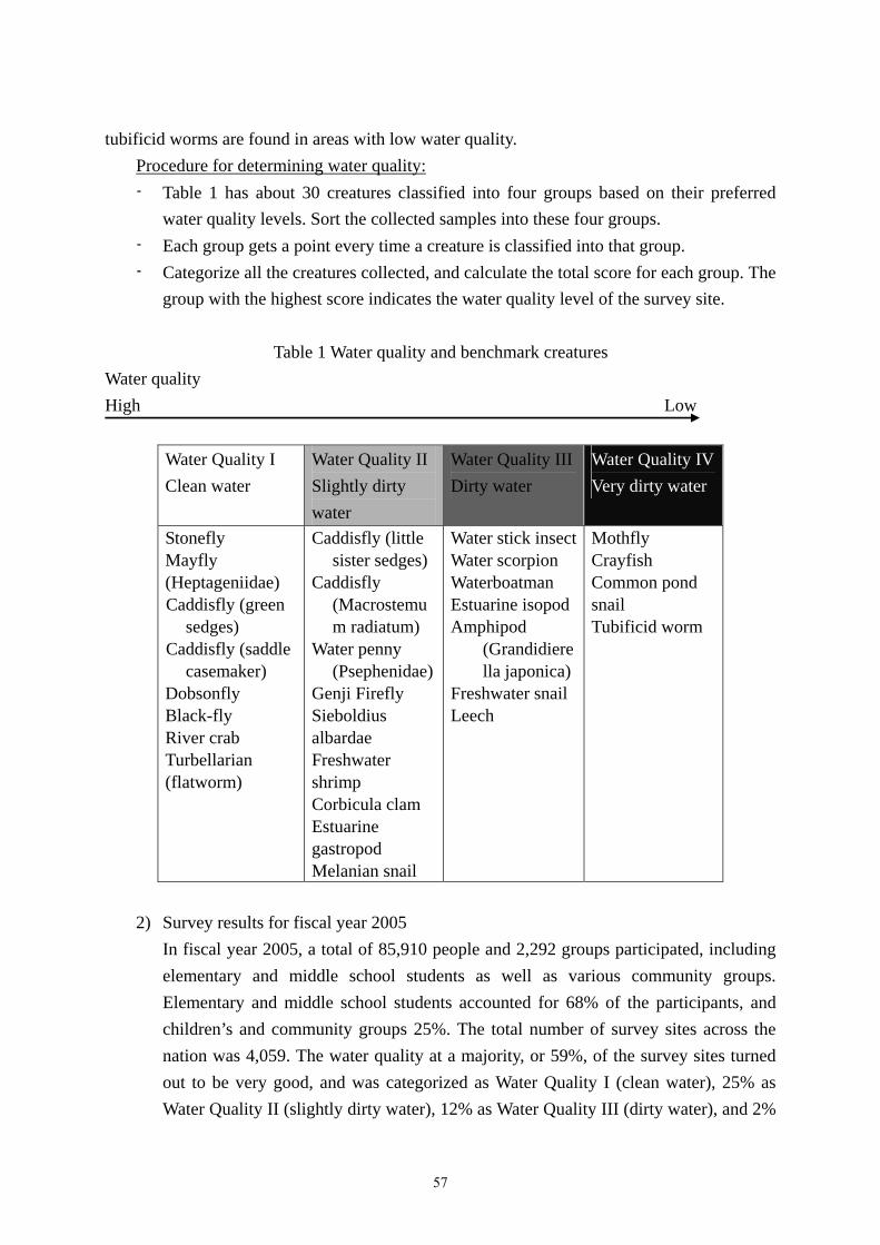
tubificid worms are found in areas with low water quality. Procedure for determining water quality: - Table 1 has about 30 creatures classified into four groups based on their preferred
water quality levels. Sort the collected samples into these four groups. - Each group gets a point every time a creature is classified into that group. - Categorize all the creatures collected, and calculate the total score for each group. The
group with the highest score indicates the water quality level of the survey site. Table 1 Water quality and benchmark creatures
Water quality High Low
Water Quality I Clean water
Water Quality II Slightly dirty water
Water Quality IIIDirty water
Water Quality IV Very dirty water
Stonefly Mayfly (Heptageniidae) Caddisfly (green
sedges) Caddisfly (saddle
casemaker) Dobsonfly Black-fly River crab Turbellarian (flatworm)
Caddisfly (little sister sedges)
Caddisfly (Macrostemum radiatum)
Water penny (Psephenidae)
Genji Firefly Sieboldius albardae Freshwater shrimp Corbicula clam Estuarine gastropod Melanian snail
Water stick insectWater scorpion Waterboatman Estuarine isopod Amphipod
(Grandidierella japonica)
Freshwater snail Leech
Mothfly Crayfish Common pond snail Tubificid worm
2) Survey results for fiscal year 2005
In fiscal year 2005, a total of 85,910 people and 2,292 groups participated, including elementary and middle school students as well as various community groups. Elementary and middle school students accounted for 68% of the participants, and children’s and community groups 25%. The total number of survey sites across the nation was 4,059. The water quality at a majority, or 59%, of the survey sites turned out to be very good, and was categorized as Water Quality I (clean water), 25% as Water Quality II (slightly dirty water), 12% as Water Quality III (dirty water), and 2%
57

as Water Quality IV (very dirty water).
Photo 1: Field survey Photo 2: Field survey
2. Kodomo Hotaranger Awards (promoting and rewarding water quality conservation
activities among children) Since fiscal year 2004, the Ministry of the Environment has encouraged the submission of reports of kodomo hotarangers’ activities so that children’s efforts in conserving water environments for fireflies can be rewarded and made known to the public. The word “kodomo” means “child” and “hotaranger” – a combination of “hotaru” (firefly) and “ranger” – was coined as a moniker for “a person who protects fireflies.” While approximately 50 kinds of fireflies live in Japan, the most commonly seen are Genji fireflies and Heike fireflies. These fireflies lay eggs on aquatic moss, and the larvae live at the bottom of the river. These insects spend their entire lives in and around water. The water in the fireflies’ habitats identified in Tokyo has DO levels of 6.8 – 11.8 mg/L, and BOD levels of 0.5 – 1.8 mg/L, which fall into the second highest category out of six levels based on the environmental water quality standard in Japan. Therefore, the Ministry of the Environment has adopted fireflies as a symbol of water environment conservation activities and created this award. The Ministry hopes that children, the next generation of our society, will have a chance to find enjoyment in their lives through hands-on experiences learning about creatures in rivers and lakes, and through various activities to conserve water quality and the environment.
1) Application criteria The Ministry of the Environment welcomes applications for this award from children’s groups that engage in water environment conservation activities. The applicants must meet the following criteria:
- Children’s participation: The groups must comprise elementary or middle school students and the children must be the main participants in the activities.
58

- Fireflies: the activities must focus on fireflies, (e.g., surveys and conservation efforts on fireflies and their habitats).
- Water environment: The activities must concern water environment, (e.g., investigation, research, clean-up, or conservation of water quality and environment including aquatic flora and fauna).
2) Awards for fiscal year 2005 In fiscal year 2005, applications from 40 groups were screened by the selection committee, and four groups were awarded prizes. One group received the Minister of the Environment prize, and three received the outstanding performance prize. Below are details of the group that received the Minister of the Environment prize and its activities. The Minister of the Environment Prize:
- Group name: Seimei Elementary School, Ueda City, Nagano Prefecture (26 sixth-grade students)
- Activity synopsis: The students of the recipient group began to engage in water environment conservation activities in the common hope of protecting the natural environment along the Yadesawa River so they could see many fireflies along the waterside. The students engaged in the following activities through their own initiative, investigating the riverside environment to see how it affected fireflies, and considering what issues had to be addressed:
Investigated water quality by conducting surveys on aquatic creatures. Cleaned up the river. Interviewed local residents living near the river.
Reference: 1) Japan’s Water Resources, FY 2006 (Water Resources Department, Land and Water Bureau
of the Ministry of Land, Infrastructure and Transport, August 2006)
59

Related Documents