Late Quaternary Land Emergence in Northern Ungava, Quebec’ BARRY MATTHEWS2 ABSTRACT. Twentyone C’4 dates of material from Late Quaternarymarine terraces are used to construct an isostatic uplift curve. The phase of rapid uplift averaged about 26 ft. per 100 years, while for the past 5,200 years uplift was just under 1 ft. per 100 years. Updoming resulted in an upward (southerly) tilt of the “Glacier Beach” (460-ft. strandline) and “Upper Tunit Beach” (100-ft. strandline) at about 5.6ft. per mile and 3.6 ft. per mile respectively. The C14 dates indicate that the general deglaciation of northern Ungava occurred about 7,000 to 8,000 years ago. Twelve well-formed marine terraces have been identified at the heads of the major fjords.The fauna of the “Upper and Lower Aporrhais Beaches” (40 ft. and 55 ft. strandlines) suggests that optimal marine conditions occurred about 3,900 to 5,230 radiocarbon years ago during a possible marine transgression. Hydroclimatic conditions during the formation of Aporrhais deposits in Sugluk Inlet (62’10’N.) corresponded to those at 58”15’N. RfiSUMfi. Rel2vement du sol auQuaternaire rkcent danslenorddeI’Ungava, Quuibec. Pour construire une courbe de reltvement isostatique, l’auteur utilise 21 datations au C14 se rapportant 1 des terrasses marines. Le reltvement, dans sa phase la plus rapide, atteignit en moyenne 26 pieds (7,93 m) par sitcle; cependant au cours des 5,200 der- nitrea anntes, il s’est situ6 juste au-dessous d’un pied (30 cm) parsi&cle. Le bombement a provoqut un pendage vers le sud de la“plage Glacier” (plage soulevCe P 460 pieds- 140,3 m) et de la “plage Tunitsuptrieure” (plage soulevte B 100 pieds-30,5 m) d’environ 5,6 pieds au mille (1 m/km) et3,6 piedsau mille (60cm/km) respectivement. Lesradio-datations indiquent que la dtglaciation gtntrale du nord de 1’Ungava se produisit il y a environ sept B huit milltnaires. A la t&te des grands fjords, on a identifit douze terrasses marines bien dtvelopptes. La faune des “plages Aporrhais superieure et infkrieure” (plages soulevtes B 40 pieds - 12,20 m - et P 55 pieds - 16,76 m) suggtre que les conditions marines optimales se sont produites il y a environ de 3,900 1 5,230 ans, probablement au coursd’unetransgressionmarine.Lesconditionshydroclima- tiques qui prtvalaient lors de l’accumulation des dCp8ts “Aporrhais” du fjord de Sugluk (62’10’N) correspondaient B celles des dtpats situts au 58’15’N. ‘Research undertaken while the author was at the Department of Geography, McGill University, Montreal. ?3oil Survey of England and Wales, Government Buildings, Leeds, England. 176

Welcome message from author
This document is posted to help you gain knowledge. Please leave a comment to let me know what you think about it! Share it to your friends and learn new things together.
Transcript

Late Quaternary Land Emergence in Northern Ungava, Quebec’
BARRY MATTHEWS2
ABSTRACT. Twentyone C’4 dates of material from Late Quaternary marine terraces are used to construct an isostatic uplift curve. The phase of rapid uplift averaged about 26 ft. per 100 years, while for the past 5,200 years uplift was just under 1 ft. per 100 years. Updoming resulted in an upward (southerly) tilt of the “Glacier Beach” (460-ft. strandline) and “Upper Tunit Beach” (100-ft. strandline) at about 5.6 ft. per mile and 3.6 ft. per mile respectively. The C14 dates indicate that the general deglaciation of northern Ungava occurred about 7,000 to 8,000 years ago. Twelve well-formed marine terraces have been identified at the heads of the major fjords. The fauna of the “Upper and Lower Aporrhais Beaches” (40 ft. and 55 ft. strandlines) suggests that optimal marine conditions occurred about 3,900 to 5,230 radiocarbon years ago during a possible marine transgression. Hydroclimatic conditions during the formation of Aporrhais deposits in Sugluk Inlet (62’10’N.) corresponded to those at 58”15’N.
RfiSUMfi. Rel2vement du sol au Quaternaire rkcent dans le nord de I’Ungava, Quuibec. Pour construire une courbe de reltvement isostatique, l’auteur utilise 21 datations au C14 se rapportant 1 des terrasses marines. Le reltvement, dans sa phase la plus rapide, atteignit en moyenne 26 pieds (7,93 m) par sitcle; cependant au cours des 5,200 der- nitrea anntes, il s’est situ6 juste au-dessous d’un pied (30 cm) par si&cle. Le bombement a provoqut un pendage vers le sud de la “plage Glacier” (plage soulevCe P 460 pieds- 140,3 m) et de la “plage Tunit suptrieure” (plage soulevte B 100 pieds-30,5 m) d’environ 5,6 pieds au mille (1 m/km) et 3,6 pieds au mille (60 cm/km) respectivement. Les radio-datations indiquent que la dtglaciation gtntrale du nord de 1’Ungava se produisit il y a environ sept B huit milltnaires. A la t&te des grands fjords, on a identifit douze terrasses marines bien dtvelopptes. La faune des “plages Aporrhais superieure et infkrieure” (plages soulevtes B 40 pieds - 12,20 m - et P 55 pieds - 16,76 m) suggtre que les conditions marines optimales se sont produites il y a environ de 3,900 1 5,230 ans, probablement au cours d’une transgression marine. Les conditions hydroclima- tiques qui prtvalaient lors de l’accumulation des dCp8ts “Aporrhais” du fjord de Sugluk (62’10’N) correspondaient B celles des dtpats situts au 58’15’N.
‘Research undertaken while the author was at the Department of Geography, McGill University, Montreal.
?3oil Survey of England and Wales, Government Buildings, Leeds, England.
176
LATE QUATERNARY LAND EMERGENCE
INTRODUCTION
177
I t is generally accepted that during Late Quaternary times, as ice sheets began to melt, an isostatic reaction to ice-unloading occurred and the glacially depressed land began to rise (Flint 1957). So far, only a brief account of uplift in the southern coastal area of Hudson Strait in northwest Labrador-Ungava has been published (Matthews 1966), and no attempt has been made to determine the direction and magnitude of the tilt of synchronous marine features. The main aims of the present paper are: (1) to present a more detailed account of the pattern of land emergence; (2) to determine the trend of isobases; (3) to describe two main strandlines; and (4) to discuss the possible evidence of a marine transgression and optimal marine conditions during the Atlantic climatic phase.
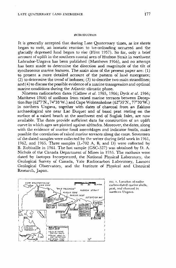
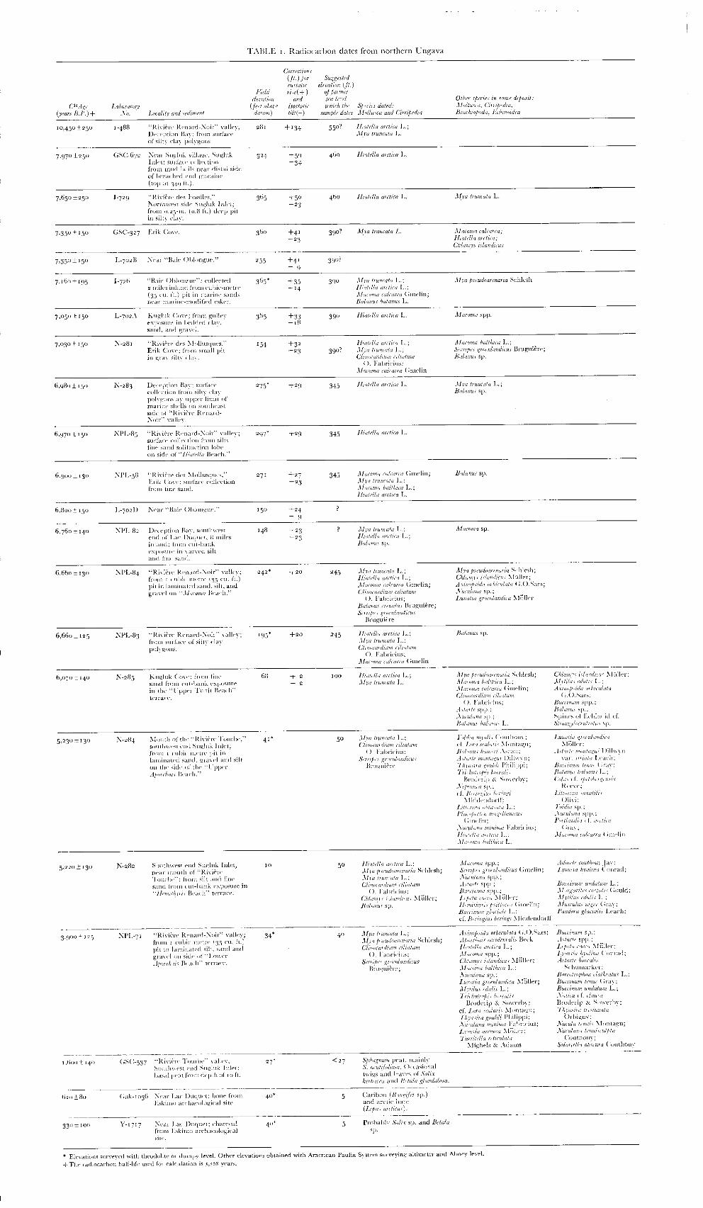
Nineteen radiocarbon dates (Callow et al. 1965, 1966; Dyck et ai. 1966; Matthews 1966) of molluscs from raised marine terraces between Decep- tionBay (62’7’N., 74’35’W.) and Cape Wolstenholme (6Z035’N., 77’30’W.) in northern Ungava, together with dates of charcoal from an Eskimo archaeological site near Lac Duquet and of basal peat resting on the surface of a raised beach at the southwest end of Sugluk Inlet, are now available. The dates provide sufficient data for construction of an uplift curve in which ages are plotted against altitudes. Moreover, the dates, along with the evidence of marine fossil assemblages and indicator fossils, make possible the correlation of raised marine terraces along the coast. Seventeen of the dated samples were collected by the writer during field work in 1961, 1962, and 1965. Three samples (L-702 A, B, and D) were collected by B. Robitaille in 1961. The last sample (GSC-327) was obtained by D. A. Nichols of the Canada Department of Mines in 1935. The molluscs were dated by Isotopes Incorporated, the National Physical Laboratory, the Geological Survey of Canada, Yale Radiocarbon Laboratory, Lamont Geological Observatory, and the Institute of Physical and Chemical Research, Japan.
0- mrtr
HUDSON S T R A I T
UGLUK INLET
FIG. I . Location of radio- carbon-dated marine shells, peat, and charcoal in northern Ungava.
178 LATE QUATERNARY LAND EMERGENCE
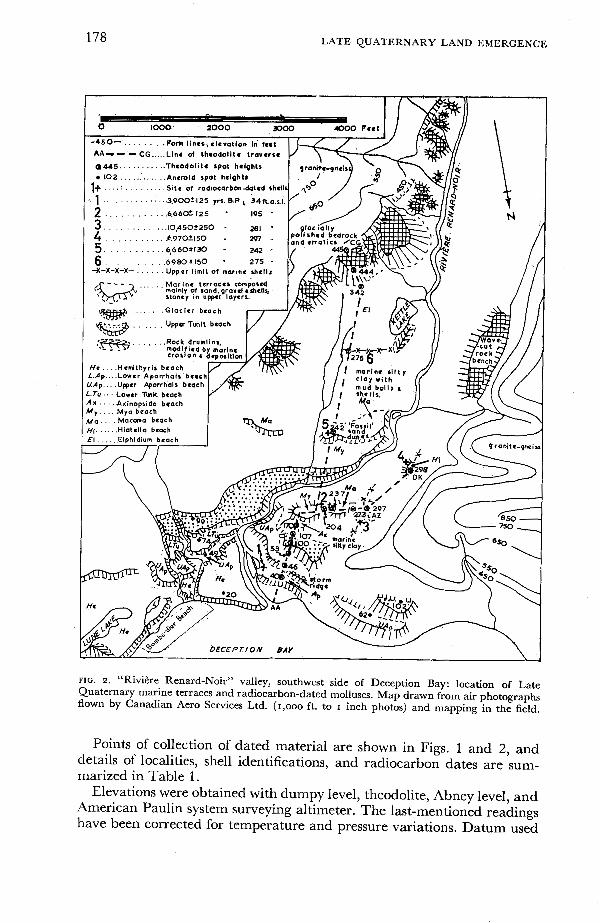
FIG. I. “Rivitre Renard-Noir” valley, southwest side of Deception Bay: location of Late Quaternary marine terraces and radiocarbon-dated molluscs. Map drawn from air photographs flown by Canadian Aero Services Ltd. (1,000 ft. to I inch photos) and mapping in the field.
Points of collection of dated material are shown in Figs. 1 and 2, and details of localities, shell identifications, and radiocarbon dates are sum- marized’in Table 1.
Elevations were obtained with dumpy level, theodolite, Abney level, and American Paulin system surveying altimeter. The last-mentioned readings have been corrected for temperature and pressure variations. Datum used
LATE QUATERNARY LAND EMERGENCE 179
was extreme high-water mark as indicated by the upper line of flotsam on the beach.
In the following account, particular reference is made to the raised marine formations and pattern of coastal uplift at Deception Bay. Although 7 of the radiocarbon dates are from widely scattered points, 8 other dates are for samples from the vicinity of Deception Bay and hence provide a picture of uplift at one locality. Moreover, a further 6 samples are from nearby localities at Sugluk and Kugluk, and give some indication of uplift in that area.
Before discussing the significance of the uplift curve and isobases, several points deserve comment, especially the late-glacial history and marine submergence. Brief mention is made of the sequence of marine strandlines and fossil content and their climatic significance, but more detailed papers are in preparation.
DEGLACIATION AND MARINE SUBMERGENCE
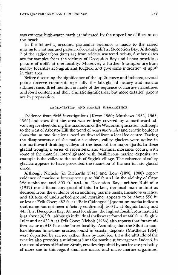
Evidence from field investigations (Kretz 1960; Matthews 1962, 1963, 1964) indicates that the area was entirely covered by a northward-ad- vancing ice sheet during the maximum of the Wisconsin glaciation, although to the west of Asbestos Hill the trend of roches moutonnies and erratic boulders show that at one time ice moved southward from a local ice centre. During the disappearance of the major ice sheet, valley glaciers were active in the northward-draining valleys at the head of the major fjords. In these glacial troughs, a series of recessional and terminal moraines occurs, with some of the material interdigitated with fossiliferous marine deposits; an example is the valley to the south of Sugluk village. The existence of valley glaciers appears to have prevented the incursion of the sea in late-glacial times.
Although Nichols (in Richards 1941) and Low (1898, 1900) report evidence of marine submergence up to 900 ft. a.s.1. in the vicinity of Cape Wolstenholme and 800 ft. a.s.1. at Deception Bay, neither Robitaille (1959) nor I found any proof of this. In fact, the local marine limit as deduced from the evidence of strandlines, marine fossils, limestone erratics, and altitude of undisturbed ground moraine, appears to be about 550 ft. or less at Erik Cove; 482 ft. at “Baie Oblongue” [quotation marks indicate that name has not been officially confirmed]; 500 ft. at Sugluk Inlet; and 445 ft. at Deception Bay. At most localities, the highest fossiliferous material is at about 365 ft., although individual shells were found at 400 ft. at Sugluk Inlet and at 422 ft. at Erik Cove; Nichols (1936) also reports that foramini- fera occur at 548 ft. at the latter locality. Assuming that the Silurian non- fossiliferous limestone erratics found in coastal deposits (Matthews 1964) were deposited by sea ice rather than by land ice, then the altitude of the erratics also provides a minimum limit for marine submergence. Indeed, in the coastal areas of Hudson Strait, erratics deposited by sea ice are probably of more use in this regard than are macro and micro marine organisms,
180 LATE QUATERNARY LAND EMERGENCE
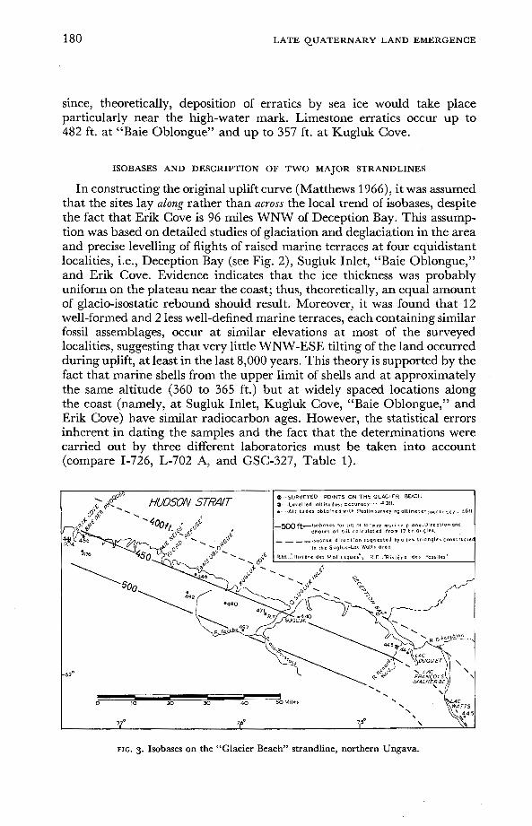
since, theoretically, deposition of erratics by sea ice would take place particularly near the high-water mark. Limestone erratics occur up to 482 ft. at “Baie Oblongue” and up to 357 ft. at Kugluk Cove.
ISOBASES AND DESCRIPTION OF TWO MAJOR STRANDLINES
In constructing the original uplift curve (Matthews 1966), it was assumed that the sites lay along rather than across the local trend of isobases, despite the fact that Erik Cove is 96 miles WNW of Deception Bay. This assump- tion was based on detailed studies of glaciation and deglaciation in the area and precise levelling of flights of raised marine terraces at four equidistant localities, i.e., Deception Bay (see Fig. 2), Sugluk Inlet, “Baie Oblongue,” and Erik Cove. Evidence indicates that the ice thickness was probably uniform on the plateau near the coast; thus, theoretically, an equal amount of glacio-isostatic rebound should result. Moreover, it was found that 12 well-formed and 2 less well-defined marine terraces, each containing similar fossil assemblages, occur at similar elevations at most of the surveyed localities, suggesting that very little WNW-ESE tilting of the land occurred during uplift, at least in the last 8,000 years. This theory is supported by the fact that marine shells from the upper limit of shells and at approximately the same altitude (360 to 365 ft.) but at widely spaced locations along the coast (namely, at Sugluk Inlet, Kugluk Cove, “Baie Oblongue,” and Erik Cove) have similar radiocarbon ages. However, the statistical errors inherent in dating the samples and the fact that the determinations were carried out by three different laboratories must be taken into account (compare 1-726, L-702 A, and GSC-327, Table 1).

LATE QUATERNARY LAND EMERGENCE 181
FIG. 4. Isobases on the “Upper Tunit Beach” strandline, northern Ungava.
To test this theory, isobase maps (Figs. 3 and 4) have been drawn based on information relating to one specific plane (sea level). Although Farrand and Gajda (1962) constructed isobases from evidence of the marine limit, this is regarded as an unsatisfactory method in northern Ungava as it is probable that in many localities the upper limit of marine deposition and erosion was influenced by the presence of glacier ice; hence great variation in elevation and in age of the marine limit is not surprising. The lower elevation of the marine limit in the Deception Bay area, compared with that at Erik Cove, was probably due to the fact that large valley glaciers remained in the Deception Bay area until late in post-Wisconsin time, as suggested below, whereas Erik Cove was clear of land ice at an earlier date and no local valley glaciers developed subsequently.
In Figs. 3 and 4, isobases have been constructed on the wave-cut notch of “Glacier Beach” (average elevation of strandline: 460 ft. above datum) and “Upper Tunit Beach” (average elevation of strandline: 100 ft. above datum), whose respective remnants are traceable along the coast from Deception Bay to Erik Cove and are regarded as having been formed contemporaneously.
The position of the two beaches in the sequence of marine terraces in northern Ungava is shown in Table 2, together with suggested climatic conditions during the time of their formation.
The method used to construct the isobases is similar to that used in geology to determine strike lines on a bedding plane, and has been ade- quately described by L$ken (1962) and Andrews (1966).
I t is to be noted that strandlines below 40 ft., were horizontal, as far as could be determined.

TABLE 2 . Major Late Quaternary marine terraces in northern Ungava; and suggested fjord conditions during their formation com- pared with the marine and climatic stages in Europe.
Average elevation of postglacial shorelinest
Age of marine
(years B.P.)+ terrace
Fjord conditions in northern Ungava X
Postglacial marine and climatic stages in Europe
Provisional names of marine terraces*
Scandinavia (after Richards,
Spitsbergen (after Feyling
Hanssen, I 955
Recent and Sub-Recent
2,500 to presen Sub-Atlantic Slightly cooler
"
I
Hydroclimatic Optimum
Sub-Boreal Hemithyis Beach 20
40
55
70
Postglacial Warm Period 2,500-6,500 yrs B.P.
Lower Aporrhais (Gemma) Beach
Upper Aporrhais (Gemma) Beach
Lower Tunit Beach
Marine transgression Atlantic
Maximum post- glacial marine transgression, l- 'Tapes, at circa >
4 4,700 Yrs. ago) m
% Fl > FJ z > !z
l-
U m
%
5 Boreal
I( Warm
~
Upper Tunit Beach I O 0
Minor Beaches 130 I45 Cool?
I 80 Axinobsida Beach ~~
M y a Beach
Macoma Beach
210 Warm
Cool
245 6.660
Postglacial Temperate period 6,500- 9,000 yrs. B.P.
Hiatella Beach
Elphidium Beach
Mya-Hiatdla Beach
Glacier Beach
3'5
345
390
460 "
7,700-8000 Cold
t Elevations are in feet above high-tide level. The altitudes of the shorelines listed are the average of the heights of the wave-cut notches at the four type localities of Deception Bay, Sugluk Inlet, "Baie Oblongue," and Erik Cove. $2
* Terrace names have been derived mainly from the dominant or indicator fossils within the terrace deposits. z + Age suggested by radiocarbon age of molluscs in terrace deposits. R X Marine conditions indicated by stratigraphy of marine sediments and fossil assemblages.
5

LATE QUATERN ARY LAND EMERGENCE 183
“Glacier Beach” (460-ft. Strandline)
Description. In many localities, notably Deception Bay, Kugluk Cove, “Baie Oblongue,” and Lac Watts, this is the highest well-formed terrace and rises southwestwards along Sugluk Inlet from 440 ft. near Sugluk village to 497 ft. in the “Rivihre Tourbe” valley. Its inner edge usually abuts against undisturbed ground moraine and glacially polished bedrock (granite-gneiss), as at Deception Bay. However, it does not represent the regional marine limit, as higher terraces occur above it at Erik Cove. I t is one of the best preserved terraces in northern Ungava and has been less disturbed by periglacial activity than have lower terraces, since it is com- posed mainly of sand, gravel, and cobbles, rather than frost-susceptible silt. The surface of most of the remnants is littered with sub-angular granite- gneiss boulders. The terrace-step is usually over 100 ft. high, as illustrated in Fig. 2, for the “Rivibe Renard-Noir” valley remnants. At “Baie Oblon- gue,” the surface of the terrace is littered with angular and sub-angular Silurian limestone erratics up to 8 inches in diameter. A detailed examina- tion of a 4-ft. deep section excavated in the “Glacier Beach” near theodolite station CG (Fig. 2) in the “Rivi2re Renard-Noir” valley at Deception Bay showed stratified sand, gravel, and cobbles. Since no foraminifera or molluscs were found in any of the terrace remnants, it appears that the terraces are glacially derived deltas built up at the junction of the glacier snout and the contemporaneous sea level. Particle size- and shape- analysis of a sample from the bottom of the 4-ft. pit at Deception Bay showed that the fraction greater than 1 mm. (0.04 inches) was composed largely of smooth, elongated pebbles, gravel, and coarse sand, whereas the finer fraction contained a large proportion of acicular-shaped fragments of frost-shattered quartz, mica, hornblende, and augite. The part passing the 100-mesh (0.15 mm or .006 inches) B.S. sieve was composed almost entirely of augite and probably represents windblown material. The age of the beach is probably greater than 7,500 years, as suggested by radio-car- bon dates GSC-672 and 1-729.
The absence of fossils from this type of marine material is not surprising, as low air and water temperatures, low salinity, and the action of abrading ice would not be conducive to the growth of molluscs in the intertidal zone, even if molluscs had migrated to the area by that time. The presence of probable ice-rafted limestone in the terrace deposits points to their marine origin. Isobases. The isobases in Fig. 3 have been constructed from information on tilt gained from 17 triangles. Table 3 gives the results of the calculations which indicate a mean deformation of the “Glacier Beach’’ marine plane upward towards S. 25’ W. at 5.6 ft. per mile, implying a mean isobase direction of N. 65” W., which is virtually parallel to the coast. However, isobases are not usually straight lines, and curvature of the isobases in Fig. 3 has been determined by the spot heights and isobase directions calculated for 3 triangles constructed for the Lac Watts-Deception Bay area. Isobases
LATE QUATERNARY LAND EMERGENCE
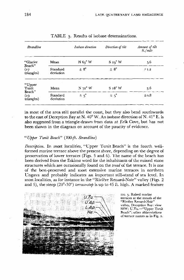
TABLE 3. Results of isobase determinations.
Strandline Isobase direction Direction of tilt Amount of tilt ft ./mile
“Glacier Mean N 65O W S 25’ W 5.6 Beach”
f 1.2 triangles) deviation ( 1.7 Standard f 8” k 8”
“Uqper Tunlt Mean N 72O W S 18” W 3.6 Beach”
triangles) deviation ( ‘9 Standard f 5 O f 5 O k0.8
in most of the area still parallel the coast, but they also bend southwards to the east of Deception Bay at N. 40’ W. An isobase direction of N. 41” E. is also suggested from a triangle drawn from data at Erik Cove, but has not been shown in the diagram on account of the paucity of evidence.
“ Upper Tunit Beach” (700-ft. Strandline)
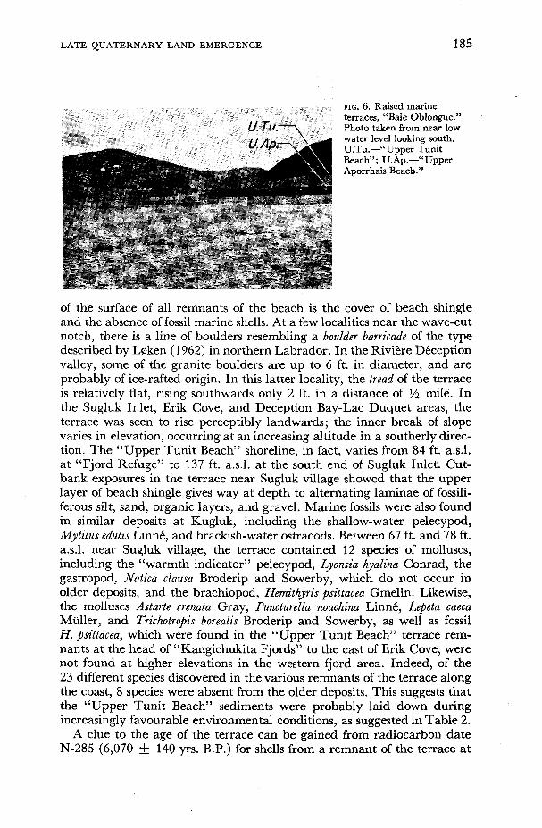
Descr$tion. In most localities, “Upper Tunit Beach’’ is the fourth well- formed marine terrace above the present shore, depending on the degree of preservation of lower terraces (Figs. 5 and 6). The name of the beach has been derived from the Eskimo word for the inhabitants of the ruined stone structures which are occasionally found on the tread of the terrace. I t is one of the best-preserved and most extensive marine terraces in northern Ungava and probably indicates an important still-stand of sea level. In most localities, as for instance in the “Rivière Renard-Noir” valley (Figs. 2 and 5), the steep (20”-30”) terrace-step is up to 45 ft. high. A marked feature
FIG. 5 . Raised marine terraces at the mouth of the “Riviere Renard-Noir’’ valley, Deception Bay: view SSW; U.Tu.-“Upper Tunit Beach”; other abbreviations of terrace names as in Fig. II.
LATE QUATERNARY LAND EMERG .ENCE
i
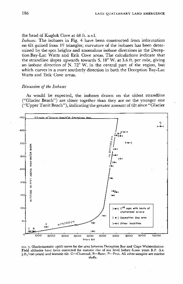
185
FIG. 6. Raised marine terraces, “Baie Oblongue.” Photo taken from near low water level looking south. U.Tu.-“Upper Tunit Beach”; U.Ap.-“Upper Aporrhais Beach.”
c
of the surface of all remnants of the beach is the cover of beach shingle and the absence of fossil marine shells. At a few localities near the wave-cut notch, there is a line of boulders resembling a boulder barricade of the type described by L$ken (1 962) in northern Labrador. In the Rivière Déception valley, some of the granite boulders are up to 6 ft. in diameter, and are probably of ice-rafted origin. In this latter locality, the tread of the terrace is relatively flat, rising southwards only 2 ft. in a distance of ‘/2 mile. In the Sugluk Inlet, Erik Cove, and Deception Bay-Lac Duquet areas, the terrace was seen to rise perceptibly landwards; the inner break of slope varies in elevation, occurring at an increasing altitude in a southerly direc- tion. The “Upper Tunit Beach” shoreline, in fact, varies from 84 ft. a.s.1. at “Fjord Refuge” to 137 ft. a d . at the south end of Sugluk Inlet. Cut- bank exposures in the terrace near Sugluk village showed that the upper layer of beach shingle gives way at depth to alternating laminae of fossili- ferous silt, sand, organic layers, and gravel. Marine fossils were also found in similar deposits at Kugluk, including the shallow-water pelecypod, Mytilus edulis Linné, and brackish-water ostracods. Between 67 ft. and 78 ft. a.s.1. near Sugluk village, the terrace contained 12 species of molluscs, including the “warmth indicator” pelecypod, Lyonsia hyalina Conrad, the gastropod, Natica clausa Broderip and Sowerby, which do not occur in older deposits, and the brachiopod, Hemithyris psittacea Gmelin. Likewise, the molluscs Astarte crenata Gray, Puncturella noachina Linné, Lepeta caeca Müller, and Trichotropis borealis Broderip and Sowerby, as well as fossil H. psittacea, which were found in the “Upper Tunit Beach” terrace rem- nants at the head of “Kangichukita Fjords” to the east of Erik Cove, were not found at higher elevations in the western fjord area. Indeed, of the 23 different species discovered in the various remnants of the terrace along the coast, 8 species were absent from the older deposits. This suggests that the “Upper Tunit Beach” sediments were probably laid down during increasingly favourable environmental conditions, as suggested in Table 2.
A clue to the age of the terrace can be gained from radiocarbon date N-285 (6,070 -t 140 y rs . B.P.) for shells from a remnant of the terrace at
186 LATE QUATERNARY LAND EMERGENCE
the head of Kugluk Cove at 68 ft. a.s.1. Isobases. The isobases in Fig. 4 have been constructed from information on tilt gained from 19 triangles; curvature of the isobases has been deter- mined by the spot heights and anomalous isobase directions in the Decep- tion Bay-Lac Watts and Erik Cove areas. The calculations indicate that the strandline slopes upwards towards S. 18” W. at 3.6 ft. per mile, giving an isobase direction of N. 72” W. in the central part of the region, but which curves in a more southerly direction in both the Deception Bay-Lac Watts and Erik Cove areas.
Discussion of the Isobases
As would be expected, the isobases drawn on the oldest strandline (“Glacier Beach”) are closer together than they are on the younger one (“Upper Tunit Beach”), indicating the greater amount of tilt since “Glacier
450
400
350
x)C
2 5 C
2cx
15C
IO(
5c
C
A l t l t u d e of”Glnctor Beach‘at DecrntlpF Bav
m
I-U ?
> W
0 m a I- W W LL
z_ W D 3
L- -.I
k
a
s t a t i s t i c a l errors
D e c e p t i o n Bay area
w I
1.000 2000 3,000 4000 5.000 6,000 x000 8.000 9000 ~0,000 Years 8.P
FIG. 7. Glacio-isostatic uplift curve for the area between Deception Bay and Cape Wolstenholme. Field altitudes have been corrected for eustatic rise of sea level before 6,000 years B.P. (i.e. 3 ft./Ioo years) and isostatic tilt. C-Charcoal; B-Bone; P-Peat. All other samples are marine
shells.

LATE QUATERNARY LAND EMERGENCE 187
Beach” was formed. Although both sets of isobases trend obliquely to the coast at Deception Bay, and possibly at Erik Cove, the general trend is virtually parallel to the coast. Hence, it can be seen that most of the dates used in the original uplift curve (Matthews 1966) lie near the 100-ft. isobase direction of “Upper Tunit Beach.” Even if altitudes are corrected for tilt, this does not radically alter the curve (see Fig. 7).
I t is doubtful that the difference of 6 degrees in the mean isobase direc- tion implies that there was an eastward shift of the centre of uplift; the difference probably results from the unavoidable errors in constructing isobases from the limited amount of data available.
MARINE TRANSGRESSION (?)
Lg5ken (1962, 1965) has suggested that a marine transgression, which is possibly contemporaneous with one of the Tapes transgressions in Scandi- navia, is evidenced in parts of the eastern Canadian Arctic. If this is the case, then the rate of land uplift during this particular period might be slightly different from that shown in Figs. 7 and 8, allowing for significant eustatic rise of the sea after 6000 years B.P. Possible proof of such a trans-
600 ~.
400 -
200 -
100 80
60
-
- -
40 -
20 -
10 - 8 -
6 -
4 -
2 -
FIG. 8 Comparison of isostatic recovery in northern Ungava with other localities in arctic Canada and Greenland plotted on semi-logarithmic graph paper. Elevations from northern Ungava and western Baffin Island corrected for both isostatic tilt and eustatic rise. Elevations from other localities corrected for eustatic rise; uplift lines are based on Washburn and Stuiver I 962 (northeastern Greenland) ; Lee I 962 (Hudson Bay) ; Henoch I 964 (eastern Melville Island); L@ken I 965 (Inugsuin Fjord) ; Andrews I 966 (western Baffin Island) and Muller and Barr I 966 (northeastern Devon Island).

188 LATE QUATERNARY LAND EMERGENCE
gression was found in the “Hemithyris Beach” (20-ft. strandline), “Afiorrhais Beach” (40- and 55-ft. strandlines), and “Tunit Beach” (70- and 100-ft. strandlines) sediments at Deception Bay and Sugluk Inlet. Here, alternat- ing sequences of thin peaty layers, up to 2.25 inches thick, and fossiliferous i
marine deposits occur. Near Sugluk village, for instance, a %-inch-thick, contorted layer of black (Munsell colour notation, 5YR 2/1) and dark reddish-brown (5YR 2/2) moderately humified peat was found at a depth i
of 62 inches in the “Hemithyris Beach’’ sediments (that is, at 13 ft. a.s.1.); when squeezed, the peat yielded a moderate amount of dye. It occurs in a layer of gravelly and stoney sand, above and below which are silty layers containing shells in living positions. Besides a few Salix twigs, the peat was composed mainly of hypnoid mosses with numerous rhizoids which pene- trated into the underlying sand, suggesting that the plants had not been disturbed since death. A %-inch-diameter fossil root case was also found. That the plant remains in other organic deposits are of terrestrial origin and for the most part in living positions is likewise inferred from the presence of several species of mosses with rhizoids attached. A sample from 78 ft. a.s.1. from Sugluk also contained twigs of Salix sp. and a fern or Equisetum sp., while a sample from 34 ft. a.s.1. from Deception Bay contained hypnoid mosses, Vmcinium sp., an alder-like catkin, lemming-like coprolites, beetle elytra, and leaves and twigs of Salix herbacea and Salix cordifolia. A similar plant association was found in the present shoreline marshy and snowpatch areas at Deception Bay, and Sugluk, where Salix herbacea and hypnoid mosses grow near high-water mark, just landwards of the Puccinellia zone. Hence, the lowest raised-beach sediments appear to have been deposited by a transgressive sea which progressively inundated the contemporaneous salt marshes. A clue to the age of such a possible marine transgression is given by dates NPL-58, N-284, N-285 (i.e., 3,900 to 6,070 yrs. B.P.).
Analysis of the pollen content of organic layers from a cut-bank exposure in the 40-ft. “Aporrhais Beach” at the mouth of the “Rivi2re Renard-Noir” revealed that pollen of Cyperaceae and Graminae predominate with small amounts of Picea, Pinus, Alnus, Betula, and Salix species. In one layer, 12 ft. below the surface of the beach, however, pollen of Epilobium sp. formed over 33 per cent of the total pollen. At the present time, Epilobium lutifolium carpets beach sediments at the head of the deep inlets in the northwest fjord area near Erik Cove.
If a marine transgression occurred about 3,900 to 6,070 years ago, there are three possible reasons for this event: (1) the land was depressed by a glacial readvance (for a discussion of such a hypothesis see Andrews 1966); (2) eustatic rise of the sea outpaced the isostatic rise of the land because of a worldwide rapid rise in sea level following the melting of land ice during a mild period; or ( 3 ) a combination of these two hypotheses.
The third hypothesis seems to be the most likely one. At the present time, no valley glaciers occur, mainly because of the relatively low snowfall compared with such places as Iceland, southern Baffin Island, and southern Greenland in similar latitudes, and with ice caps. It is possible that during

LATE QUATERNARY LAND EMERGENCE 189
the thermal maximum (see below), precipitation increased in the winter months and snowfields and valley glaciers were formed, resulting in isostatic depression of the land at a time when sea level was rising relatively rapidly. Such glacier advances during warmer periods have occurred in Alaska in recent times, for example between 1920 and 1950 (see Miller 1967). Many of the fresh-looking recessional moraines in Ungava which are too old to be dated by lichenometry, such as in the “Rivicre Renard-Noir” valley, might date from the thermal maximum.
HYDROCLIMATIC OPTIMUM
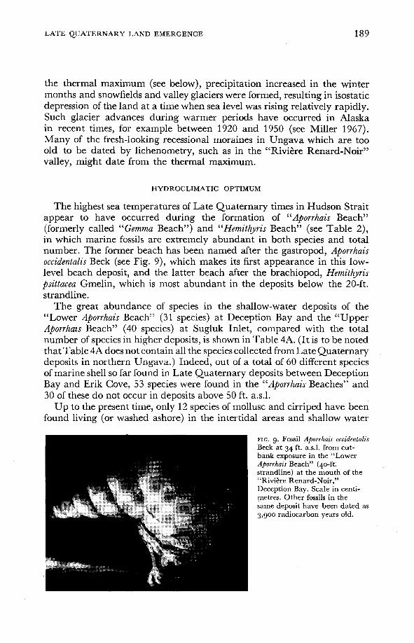
The highest sea temperatures of Late Quaternary times in Hudson Strait appear to have occurred during the formation of “Aporrhais Beach” (formerly called “Gemma Beach”) and “Hemithyris Beach” (see Table 2), in which marine fossils are extremely abundant in both species and total number. The former beach has been named after the gastropod, Aporrhais occidentalis Beck (see Fig. 9), which makes its first appearance in this low- level beach deposit, and the latter beach after the brachiopod, Hemithyris psittacea Gmelin, which is most abundant in the deposits below the 20-ft. strandline.
The great abundance of species in the shallow-water deposits of the “Lower Aporrhais Beach” (31 species) at Deception Bay and the “Upper Aporrhais Beach” (40 species) at Sugluk Inlet, compared with the total number of species in higher deposits, is shown in Table 4A. (It is to be noted that Table 4A does not contain all the species collected from Late Quaternary deposits in northern Ungava.) Indeed, out of a total of 60 different species of marine shell so far found in Late Quaternary deposits between Deception Bay and Erik Cove, 53 species were found in the “Aporrhais Beaches” and 30 of these do not occur in deposits above 50 ft. a.s.1.
Up to the present time, only 12 species of mollusc and cirriped have been found living (or washed ashore) in the intertidal areas and shallow water
FIG. 9. Fossil Aporrhais occidentalis Beck at 34 ft. a d . from cut- bank exposure in the “Lower Aporrhais Beach” (40-ft. strandline) at the mouth of the ‘‘Rivi6re Renard-Noir.” Deception Bay. Scale in centi- metres. Other fossils in the same deposit have been dated as 3,900 radiocarbon years old.

190 LATE QUATERNARY LAND EMERGENCE
TABLE 4B. Percentage frequency of Foraminifera and Ostracoda in a few representative Late Quaternary marine deposits.
Age (years B.P.) Elevation (feet)
FORAMINIFERA Adercotryma glomeratum Brady Alueolophragmium jeffreysi Williamson Angulogerina angulosa Williamson Apiopterina cylindroides Roemer Asterellina pulchella Parker Astrononion gallowayi Loeblich & Tappan Bolivina pacijica Bucella frigida Cushman Buccella tenerrima Bandy Islandiella islandica N+rvang Islandiella teretis Tappan Cibicides lobatulus Montagu Dentalina ittai Loeblich & Tappan Elphidium bartletti Cushman Elphidium incertum clavatum Cushman Elphidium frigidum Cushman Elphidium orbiculare Brady Epistominella exigua Brady Esosyrinx curta Cushman & Ozawa Fissurina marginata Walker & Boys Fissurina serrata Schlumberger Lagena laevis Montagu Lagena semilineata Wright Miliammina fusca Brady Nonion Zaandamae Van Voorthuysen Nonion labradoricum Dawson Oolina borealis Loeblich & Tappan Oolina lineata Williamson Oolina melo d'Orbigny Quinqueloculina seminulum L. Quinqueloculina stalkeri Loeblich & Tappan Reophax arctica Brady Reophax curtus Cushman Saccammina dtflugiformis Brady Spiroplectammina biformis Parker & Jones Trochamminella atlantica F. Parker Virgulina fusiformis Williamson Virgulina complanata Egger
OSTRACOD
x . . . . . . . . . . < I %
7160 7050 6900 6660 6070 5220 3900 365 365 271 24.1 68 I O 34
x 1 1 I I 2
X
3 4 x 8 x 2
g 41 IZ 4 5 I O 10
3 4 1 6 9 7 1 2 2 I 37 23
I
I 2 X I
3 '4 '9 7 4 2 '5 4 23 61 I9 '3 35
69 34 26 2 2 3 3 2 3
X X x 2
I X I X X I
I
3 1 X I
I X I X
X I
26
3 1 9
x 2 2
I I I
x 4
X 9

LATE QUATERNARY LAND EMERGENCE
of northern Ungava’s fjords and bays. The species found were: Myli lus edulis, Littorina saxatilis, Macoma calcarea, M y a truncata, M y a pseudoarenaria, Astarte borealis, Balanus crenatus, Chlamys islandicus, Serripes groenlandicus, Hiatella arctica, Busycon sp., and Macoma balthica.
Of the species of mollusc and cirriped collected from the lowest raised- beach sediments, the following 8 appear to live much further south than the area of their fossil discovery and seem to be indicative of warmer sea temperatures: Lyonsia hyalina Conrad, Thyasira trisinuata Orbigny, Periploma papyratium Say, Aporrhais occidentalis, Placopecten magellanicus Gmelin, Balanus humeri Ascan, and possibly Yoldia myalis Couthouy and Littorina obtusata LinnC. According to Abbott (1954), Bousfield (1960), andRichards (1962), the first one is a Boreal-Warm Temperate species, whereas the re- mainder are Subarctic-Boreal-Warm Temperate species. In most cases, the nearest locality for living specimens is south of latitude 55”N., along the southern Labrador or Nova Scotia coasts. For instance, Lyonsia hyalina has been found alive only from the Gulf of St. Lawrence to Texas. However, not all authorities agree on the range of these species. For instance, accord- ing to LaRocque (1 953), 2“. myalis occurs in arctic waters of western America. Moreover, there are gaps in distributional patterns due to sampling prob- lems. Hence, any hydroclimatic interpretation must still be regarded as tentative. Even so, the very fact that both in species and in number, marine molluscs were more abundant about 3,900 to 5,230 radiocarbon years ago than they are at present or were before about 5,230 years B.P., suggests that some environmental factor must have changed.
That environmental conditions were more favourable during formation of some of the lowest terraces is also suggested by the presence of 3 species of foraminifera in the raised sediments, namely: Miliammina fusca Brady, Triloculina trigonula (Lamarck), and Angulogerina angulosa (Williamson). According to Feyling-Hanssen (1964), M. fusca is a brackish-water species occurring in Temperate waters of the eastern and western Atlantic, while T. trigonula has been found only in Temperate and Tropical waters. Likewise, A. angulosa is mainly distributed in the Boreal and Lusitanian parts of the Atlantic at the present time.
Similar “warmth indicator” molluscs were also found in low-level Late Quaternary marine sediments at Frobisher, Baffin Island (Matthews 1967), though these shells appear to have been deposited some 6,140 to 6,440 years ago, rather than about 3,900 to 5,230 years ago as at Decep- tion Bay. Evidence for more favourable environmental conditions in postglacial times in the Canadian Arctic has also been discussed by Laursen (1946) and L@ken (1965).
Whether the presence of conifer and alder pollen (together forming up to 10 per cent of the total pollen) in the organic layers of the “Lower Aporrhais Beach” sediments in the “Rivi&re Renard-Noir” valley indicates a milder climate and a northerly shift of the forest boundary (some 300 miles to the south of Deception Bay) is questionable.
In Table 2 an attempt has been made to present a radiocarbon-dated
LATE QUATERNARY LAND EMERGENCE
chronology of Late Quaternary events in northern Ungava, based especially on evidence from Deception Bay, and to correlate them with the marine and climatic stages in Europe.
LATITUDE AND HYDROCLIMATE
In order to determine the corresponding present-day latitude and hence the hydroclimate at the time of formation of the fossil assemblages, the median-of-midpoints method was used. The method was devised by Schenck and Keen (1937). (For a more recent description of the method see Wagner 1959.)
Recent assemblages were used as a standard of comparison. The median-of-midpoints has been calculated for assemblages representative of the different raised beaches and especially of radiocarbon-dated assemblages. The present-day fauna near Sugluk village has a median-of- midpoints of 58”, representing a difference of 4’10’ from the present-day latitude (62”lO’N.). Hence, in order to convert the median-of-midpoints of fossil assemblages to possible corresponding present-day latitudes, 4”lO’ has been added to all median values.
The results indicate that hydroclimatic conditions during the formation of the “Aporrhais Beach” deposits at the southern end of Sugluk Inlet corresponded to those at 58”15’N., i.e., the southern end of Ungava Bay in the vicinity of Fort Chimo, at the present time. The mean value of the medians calculated for the “Aporrhais Beaches” at “Baie Oblongue,” Deception Bay, and Sugluk Inlet is 55.9” (59’15’N.), i.e., that in the vicinity of Nachvak Bay on the Labrador coast. A considerable shift of isotherms is indicated. Results for “Mya-Hiatella Beach” and “Elphidiurn Beach,” on the other hand, indicate that temperatures were considerably colder than they are at present and that hydroclimatic conditions corre- sponded to those at latitudes 64”13’N. to 65’25’N.
UPLIFT: COMMENTS ON THE DATED MATERIAL
1) As with all shell dates, there is uncertainty as to the depth at which the mollusc lived or was transported, and the sea level related to any date was higher than the actual level of the dated molluscs. Because of this, the true uplift curve must always lie above the graphed position of the mollusc. Nevertheless, in the case of samples, 1-726, NPL-84, NPL-71, N-284, L-702 A, and N-285 the error will be slight, as the in situ molluscs were obtained from littoral sediments rather than from fjord floor deposits; that is, they came from the topset beds of deltaic material and were asso- ciated with species of mollusc indicative of littoral and nearshore facies, such as Mydilus edulis LinnC, Littorina saxatilis Olivi, Littorina cf. obtusata LinnC, and Axinopsida orbiculata G. 0. Sars. (For the reasons why A .
LATE QUATERNARY LAND EMERGENCE 193
orbiculata is regarded as mainly a shallow-water species in the Late Quater- nary warm period deposits in the Hudson Strait area see Matthews 1967.)
Table 1 indicates the species found in the dated marine material, the nature of the enclosing sediment, and the suggested elevation of the former shoreline which the molluscs date. Sample NPL-71 from 34 ft. a.s.l., “RiviGx-e Renard-Noir” valley, in particular, was obtained from near the contemporaneous shore as indicated by the presence, in the same deposit as the dated shells, of a number of brackish-water ostracods, (cf. Polycope sp.) thin layers of peat, molluscs and barnacles attached to xerophytic mosses, and the shallow-water molluscs, Mytilis edulis and Axinopsida orbiculata. Similarly, sample N-285 from 68 ft. a.s.1. from Kugluk Cove contained brackish-water ostracods, the brackish-water foraminifera Miliammina fusca, and the molluscs Mytilis edulis and Axinopsida orbiculata, suggesting deposition near the contemporaneous sea level.
Sample 1-726 did not contain any shallow-water molluscs, but the nature of the sediment (that is, sand with rounded schist and gneiss pebbles) and the presence of only 6 species of foraminifera, of which Elphidium orbiculare Brady was the dominant species, suggests that the deposit was laid down in the nearshore environment. Although E. orbi- culare is known to occur down to depths of over 500 ft. in arctic waters, it is one of the dominant forms of the present-day estuaries in Wales and is regarded as a typical “open tidal flat species’’ (Adams and Haynes 1965). (E. orbiculare is also one of the dominant species in the 365-ft. deposit at Kugluk from which sample L-702A was obtained.) Moreover, the stunted nature of the M y a pseudoarenaria in sample 1-726 may indicate that they lived in shallow fjord water considerably diluted by glacial melt-water. This may also be the case of the Hiatella arctica in sample NPL-85, which were considerably misshapen and stunted.
2) Despite the difference of 47 ft. in altitude and despite differing percentages of various mollusc species, the deposits represented by NPL-83 and NPL-84 appear to have formed at about the same time, but probably in different depths of water. The fact that the sample from 195 ft. (NPL- 83) was obtained from silty clay would seem to indicate that it represents an offshore deposit, whereas the 242 ft. (NPL-84) sample was obtained from the littoral sand and gravel facies. The 242 ft. sample, in fact, was collected mainly from the gravel layers of a horizontally bedded and laminated deposit of sand, gravel, and silt, overlying silt at a depth of 2% ft. This sample also contained the pelecypod, Axinopsida orbiculata, but like sample 1-726 very few species of foraminifera occurred; among the 5 species of the latter, Elphidium incertum clavatum Cushman and Elphi- dium orbiculare predominated.
An explanation similar to the above can probably account for the closeness in ages between samples N-284 from 41 ft. a.s.1. and N-282 from 10 ft. a.s.1. from the south end of Sugluk Inlet. This theory is borne out by the nature of the two sediments and the fossil assemblages: whereas N-284 was from deltaically bedded silt, sand, and gravel, with fossil plant

194 LATE QUATERNARY LAND EMERGENCE
remains and the intertidal mollusc Littorina saxatilis, N-282 was from sandy silt, with no signs of laminae and contained abundant foraminifera (28 species). I t was hoped that the radiocarbon age of the sample from 10 ft. a d . would give the age of the “Hemithyris Beach” strandline (20 ft. a.s.l.), but it is now obvious that the remnants of the beach in that locality are composed mainly of older offshore material with a thin capping of younger non-fossiliferous beach shingle. Nevertheless, date NPL-284 gives the radiocarbon age of the “Upper Aporrhais Beach.”
3) Because of the similarity of ages of shells from the upper marine terraces, it is difficult to assign an age to all the upper strandlines. Never- theless, in Table 1 it is tentatively suggested that most of the radiocarbon dates of shells from 360 to 365 ft. a.s.1. date the “Mya-Hiatella Beach” (390-ft. strandline), which is poorly preserved in the Deception Bay area.
As regards the oldest samples from Sugluk Inlet (that is, GSC-672 and 1-729) obtained from silty clay, they were probably deposited many feet below the contemporaneous shoreline and are believed to date the “Glacier Beach’’ strandline. (It is to be noted that GSC-672 is not necessarily older than 1-729 if the statistical errors are considered: sample GSC-672, in fact, weighed only 4.8 gm. and had to be mixed with “dead gas.”)
The close agreement of dates N-283, NPL-85, and NPL-58 of shells from the offshore silty deposits of the “Elphidium Beach” at Erik Cove and Deception Bay suggests that some 6,900 to 7000 years ago sea level was about 345 ft. above the present sea level. Sample N-283 was obtained from an offshore silty clay deposit located just seawards of a littoral zone of sand and gravel, which occurs below a well-marked wave-cut erosion notch (342 ft. a.s.1.) at the base of the “Glacier Beach” terrace (see Fig. 2).
4) I t is to be noted that dates 1-729, 1-726, NPL-84, NPL-71, N-281, N-282, N-284, and N-285 were obtained for bivalved mollusc shells which were found in living positions with their periostracum still attached, suggesting they had not been disturbed since death. In the case of NPL-71, a number of Mya truncata with even their extended siphons (up to 6 inches long) and other organs still preserved were extracted from permafrost.
5) Besides radiocarbon ages of marine shell, 3 dates for peat and charcoal have been included for the following reasons:
(a) Sample GSC-537 is peat from the base of a 10-ft.-thick interbedded peat and aeolian deposit. The basal peat rests on marine shingle at an altitude of 27 ft. a d . Its radiocarbon age of 1,600 years provides the minimum age of the beach, since there is usually a time lag between the formation of peat and the emergence of marine deposits beyond the reach of high tides.
* (b) The dated charcoal sample, Y-1717 (330+100 yrs. B.P.), was obtained from a ruined Eskimo settlement (containing 26 large circular and pentagonal stone “dwellings,” see Fig. 10) 2 miles inland at the side of a lagoonal extension of Lac Duquet. The charcoal was taken from soil over an old hearth at a depth of 8 to 12 inches. The statistical error is
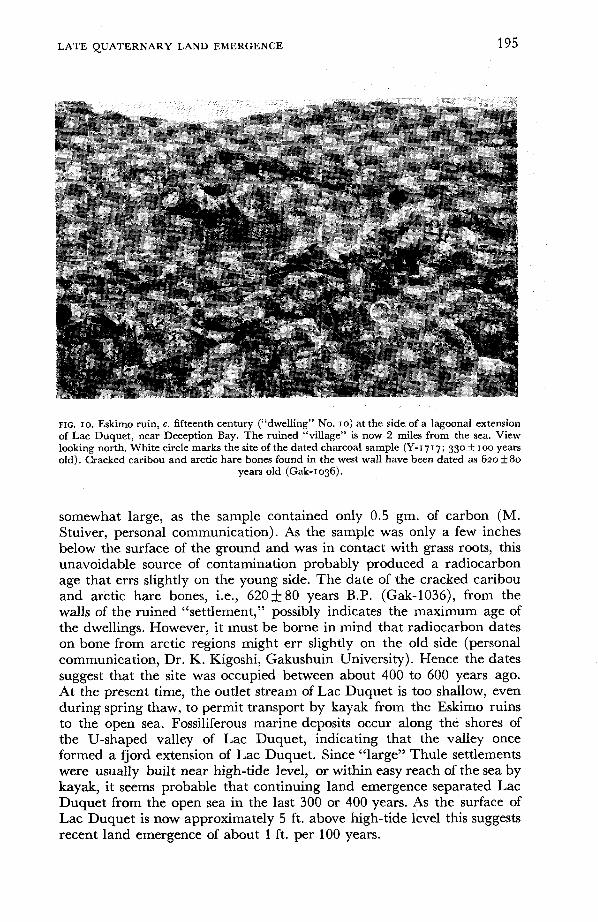
LATE QUATERNARY LAND EMERGENCE 195
FIG. IO. Eskimo ruin, G. fifteenth century (“dwelling” No. I O ) at the side of a lagoonal extension of Lac Duquet, near Deception Bay. The ruined “village” is now 2 miles from the sea. View looking north. White circle marks the site of the dated charcoal sample (Y-1717; 330 & IOO years old). Cracked caribou and arctic hare bones found in the west wall have been dated as 620f80
years old (Gak-1036).
somewhat large, as the sample contained only 0.5 gm. of carbon (M. Stuiver, personal communication). As the sample was only a few inches below the surface of the ground and was in contact with grass roots, this unavoidable source of contamination probably produced a radiocarbon age that errs slightly on the young side. The date of the cracked caribou and arctic hare bones, i.e., 620+ 80 years B.P. (Gak-1036), from the walls of the ruined “settlement,” possibly indicates the maximum age of the dwellings. However, it must be borne in mind that radiocarbon dates on bone from arctic regions might err slightly on the old side (personal communication, Dr. K. Kigoshi, Gakushuin University). Hence the dates suggest that the site was occupied between about 400 to 600 years ago. At the present time, the outlet stream of Lac Duquet is too shallow, even during spring thaw, to permit transport by kayak from the Eskimo ruins to the open sea. Fossiliferous marine deposits occur along the shores of the U-shaped valley of Lac Duquet, indicating that the valley once formed a fjord extension of Lac Duquet. Since “large” Thule settlements were usually built near high-tide level, or within easy reach of the sea by kayak, it seems probable that continuing land emergence separated Lac Duquet from the open sea in the last 300 or 400 years. As the surface of Lac Duquet is now approximately 5 ft. above high-tide level this suggests recent land emergence of about 1 ft. per 100 years.

196 LATE QUATERNARYLAND EMERGENCE
DISCUSSION OF THE UPLIFT CURVES
In the uplift diagram shown in Fig. 7 the amount of uplift is based on the field altitude of the sample. Allowance has also been made for the mean eustatic rise of sea level of 3 ft. per 100 years before 6000 years B.P. (see Shepard 1961, 1963) and for isostatic tilt, as determined from the isobases (Figs. 3 and 4). (For a detailed discussion of the latter method see Andrews 1966.) In the case of the present work, all points were pro- jected on to the line of tilt and adjusted to a datum point AA (see Fig. 2) in the “Rivi8re Renard-Noir” valley. Since none of the dated samples is from “Glacier Beach” and only one (NPL-285) from the “Upper Tunit Beach’’ terrace, the average value of the two mean tilt amounts (i.e., 4.6 ft. per mile) and tilt directions (i.e., S. 21” W.) in Table 3 have been used for all elevations above 100 ft. In constructing the upper part of the curve, for which there is a greater spread of dates, the line has been drawn near the youngest dates rather than as a “best fit” curve; provided that the samples have not been contaminated or wrongly dated, the youngest shells from near each strandline should approximately date the strandline. This is particularly the case for samples 1-726, NPL-84, NPL-71, N-284, L-702A, and N-285, which, as pointed out above, appear to have been deposited near the contemporary sea level.
As can be seen from the diagram, it was possible to draw an uplift curve near 14 of the dates. The oldest date of 10,450 years B.P. cannot be fitted into the scheme and it is possible that the sample dated was a mixture of old shells moved by the ice and postglacial shells. Alternatively, the shells could have lived a few hundred feet below the contemporary sea level, as suggested by the nature of the sediment (silty clay) in which the shells were found.
Like all other uplift curves drawn, the amount of uplift with respect to time decreased from approximately the time of ice removal to the present day. The graph indicates that the rate of uplift was initially rapid between about 7,700 and 6,000 years ago, i.e., of the order of about 26 ft. per 100 years. This is a much higher value than that of 8 to 10 ft. per 100 years suggested for the initial phase of rapid uplift for northeastern Foxe Basin (Ives 1964, Andrews 1966) and for Inugsuin Fjord, Baffin Island (L#ken 1965), and is slightly greater than that of 19.5 ft. per 100 years calculated by Lee (1 962) for the coast of Hudson Bay and 21 ft. per 100 years found by Muller and Barr (1 966) for northeastern Devon Island. However, the rate compares favourably with that calculated by Washburn and Stuiver (1962) for northeast Greenland (namely, 29 ft. per 100 years).
The rate of emergence of the land gradually decreased and for the past 5,200 years was just under 1 ft. per 100 years, a rate less than those of 1.5 to 3 ft. suggested for most parts of Canada (Lee 1962; Blake 1963; L#ken 1965; Henoch 1964; Andrews 1966) during the phase of decelerating uplift, and more comparable to that of about 0.25 ft. per 100 years for

LATE QUATERNARY LAND EMERGENCE 197
northeast Greenland (Washburn and Stuiver 1962), 0.5 ft. per 100 years for northeast Devon Island (Muller and Barr 1966) and about 1 to 0.8 ft. per 100 years for Frobisher Bay (Matthews 1967). If, however, a marine transgression took place during the formation of the lowest marine terraces, as discussed above, then the rate of uplift would have been much higher and probably between 1.5 to 3 ft. per 100 years; a rate similar to that postulated for the historic rate of uplift of the Hudson Bay area (Barnett 1966).
That the northern Ungava curve is comparable more to the curves for northeastern Greenland and northeastern Devon Island than to the curves for other parts of the Canadian Arctic is evident from Fig. 8. It
5 5 0 - s /?
5 0 0 -
4 5 0 -
400 -
350 -
c W W
3 0 0 - 5
P z I-
250 - 3 4 W
200 -
I 5 0 -
100-
50"
x NPL -71..... RPDIOCARBON DATES
I N-285
I I I I I I I I I 0 1000 2000 3,000 4,000 5 ,000 6900 7000 KKKl 9,000 10,000
Years B.P
FIG. I I . Preliminary curve of isostatic uplift in northern Ungava; based on radiocarbon dates of marine shells from near the contemporaneous shoreline and the possible elevations of former
sea levels which the samples date. Elevations corrected for eustatic rise of sea level.

198 LATE QUATERNARY LAND EMERGENCE
is to be noted that only the exponential part of the Ungava curve in Fig. 7 is plotted in Fig. 8. Most of the other lines are based on Andrews (1966, p. 188) who states that “errors include those in the original data as well as those due to the assumption that the data may be fitted to series of exponential curves.”
Since sea level related to any date was higher than the actual sample height, then the true uplift curve will be slightly above that of Fig. 7. In Fig. 11 a tentative attempt has been made to relate the dated samples collected by the writer to the contemporaneous sea levels (i.e.’ strandlines) which the samples date. The oldest date, 1-488, has been left out of the curve as it does not fit the general pattern of dates from Hudson Strait (see Blake 1966). I t is evident from Fig. 7 that a large number of the oldest shell samples collected at various elevations lived at about the same time. Some indication of the initial rate of uplift, however, can be gained from samples 1-729, 1-726 (and L-702A), N-283, NPL-84, and N-285, which appear to have been deposited when sea level was about 460 ft., 390 ft., 345 ft., 245 ft., and 100 ft., respectively. As in the case of Fig. 7, eustatic correction has been added to all elevations.
This adjusted graph gives a slightly sinuous curve with uplift from c. 8,000 to 7,000 years B.P. of about 14 ft. per 100 years, from 7,000 to 6,000 yrs. B.P. of about 26 ft. per 100 years, and from 5,200 years B.P. of 0.95 ft. per 100 years. If this curve is the true uplift curve, it suggests that there was a moderate rise at the onset of deglaciation (during which the eustatic rise exceeded or equalled the isostatic rise) followed by increased emergence as the ice rapidly dispersed during the early part of the Hypsithermal Interval. There then occurred a slower rise. A similar pattern of uplift is also suggested by Muller and Barr (1966) for northeast Devon Island.
CONCLUSIONS
1) The regional marine limit between Deception Bay and Cape Wolsten- holme appears to have been 550 ft. or less. In a number of localities, the upper limit of limestone erratics, probably deposited by sea ice, is a useful limiting criteria.
2) I t has been attempted here to show that updoming of the land following deglaciation resulted in a SSW-NNE tilt of the marine terraces, rather than a W-E deformation, as had previously been inferred (see Farrand and Gajda 1962). The “Glacier Beach” marine plane was de- formed by isostatic recovery so that it now tilts upwards towards S.25”W. at 5.6 ft. per mile. Similarly, a lower strandline, the “Upper Tunit Beach,” slopes upwards towards S.18”W. at 3.6 ft. per mile.
The trend of isobases west of Deception Bay is dissimilar to that roughly suggested by Farrand and Gajda (1962), especially the possible peripheral curvature near Cape Wolstenholme. The present isobase maps suggest that the direction of tilt is not so much related to an ice mass centred over
LATE QUATERNARY LAND EMERGENCE 199
Hudson Bay or Foxe Basin, but to an ice sheet centred on the plateau immediately to the south of the Povungnituk Trough-a theory in keeping with that proposed by Kretz (1960) and Matthews (1964). The trend of the line of deformation tends to indicate a Late Wisconsin major centre of ice dispersal over northern Ungava.
3) The presence of thin bands of peat interbedded with marine deposits appears to indicate a marine transgression from about 6,070 to 3,900 years ago, during and before the hydroclimatic optimum. Similar occur- rences of organic material in marine deposits were found at Inugsuin Fjord, eastern Baffin Island, and western Baffin Island (see Lgken 1965; Andrews 1966). In both these instances, the sediments were between 3,500 and 4,000 years old. Lplken regards these organic remains as flotsam deposited near the shore during a favourable climate. However, in the case of the Sugluk and Deception Bay organic layers, these appear to be mostly terrestrial deposits formed mainly from plants growing in situ; plant roots and rhizoids, as well as stems and leaves, occur in the “thickest” peats, which contain only a small amount of mineral matter.
4) Brief mention has been made of the palaeoclimatic significance of the fossil assemblages. At the present time, Low Arctic conditions (as defined by Feyling-Hanssen 1955) occur in coastal waters. In Table 2, it is suggested that warmer fjord conditions occurred from about 6,660 to less than 3,900 years ago, during the equivalent of the “Postglacial Warm Period” in Spitsbergen (see Feyling-Hanssen 1955). In northern Ungava coastal waters during this period, the number of species and specimens of marine invertebrates increased considerably (as shown in Table l), probably as a result of improved marine conditions. A possible return to cooler conditions might have occurred during the formation of the “Minor Beaches” as suggested by the presence of only a few species of molluscs. Optimal marine conditions occurred from about 5,230 to 3,900 years ago, as evidenced by the discovery in the lowest marine terraces of 8 species of shells which are no longer present in the coastal waters of Hudson Strait. This fact suggests changing thermic conditions during the period of deposition. Hydroclimatic conditions during the formation of the “Aporrhais Beaches” appears to have been similar to those at the present time off the southern shores of Ungava Bay.
5) The present study indicates that in constructing uplift curves some of the most useful dated shell samples for this purpose are those collected from the upper part of laminated topset beds of raised deltas, as these sediments were probably laid down near the contemporaneous sea level. They are also the most likely sediments to yield sufficient fossils for dating purposes, unlike arctic beach shingle, in which shells are either absent or too comminuted. In northern Ungava, the most useful criteria for recognizing such deposits below 200 ft. a.s.1. were found to be: (a) the presence of abundant plant remains and especially wave-washed and bleached wood; (b) abundant ostracods, but few foraminifera; (c) barnacles and polyzoa attached to stones; (d) the occurrence of large

200 LATE QUATERNARY LAND EMERGENCE
numbers of the intertidal and shallow-water molluscs, Littorina saxatilis, Mytilus edulis, Axinopsida orbiculata, and Acmaea testudinalis; (e) many juvenile and/or stunted species, such as Hiatella arctica, Mytilus edulis, and M y a pseudoarenaria. Usually, the sediment enclosing these fossils is laminated sand, gravel, and silt, with abundant mica.
6) Although the general form of the uplift curve (Fig. 7) is similar to those constructed for northeast Greenland (Washburn and Stuiver 1962) and northeast Devon Island (Muller and Barr 1966), it is dissimilar to curves for Baffin Island. In the latter area, the isostatic uplift during the rrlost rapid phase was less than 10 ft. per 100 years compared with over 20 ft. per 100 years in the other areas.
7) I t appears that even if sections of the south coast of Hudson Strait were open to the sea and, therefore, deglaciated in part by 10,450 years ago, as suggested by date 1-488, the general deglaciation of northern ‘Ungava was delayed until 7,000 to 8,000 years ago in coastal areas, and possibly as late as 6,700 years ago in inland areas, as suggested by rhe date (NPL-82) of shells from the highest fossiliferous marine deposit 8 rniles inland from Deception Bay. Thus, remnants of the Late Wisconsin ice sheet, or at least large valley glaciers, seem to have existed in northern Ungava during the equivalent of the early part of the Hypsithermal Interval, preventing the incursion of the sea.
8) I t is suggested that the rate of uplift from 7,000 to 6,000 years B.P. was rapid and possibly about 26 ft. per 100 years. In the past 5,200 years, uplift might have been as low as 0.95 ft. per 100 years. That uplift is still continuing in the Deception Bay area is suggested by the present elevation and considerable distance from the sea of the circa fifteenth-century Eskimo ruined settlement at Lac Duquet. Similar evidence was found by Bell (1885) at Port De Boucherville, Nottingham Island, and Digges Island, near Cape Wolstenholme.
ACKNOWLEDGEMENTS
This study was undertaken in 1961 and 1962 while the writer was working for a Ph.D. degree at McGill University, and in 1965 during the Leeds University Arctic Ungava Expedition.
The field work was supported by grants from McGill Sub-Arctic Research Laboratory, the Air Force Cambridge Laboratory (sub-contract AF-1, administered by the Arctic Institute of North America), the Geographical Branch, Ottawa, the Arctic Institute of North America (grant No. AINA M-29), Leeds University, and the Scott Polar Research Institute.
The writer wishes to thank: Professor J. B. Bird, Geography Department, McGill University, Dr. W. Blake Jr., Geological Survey of Canada, and Dr. J. D. Ives and Dr. J. T. Andrews, Geographical Branch, Ottawa, for advice; Dr. H. G. Richards, Academy of Natural Sciences of Philadelphia, and Dr. V. Conde, Redpath Museum, McGill University, for help in identifying “rare” molluscs; Dr. G. J. Anderson, Texaco, Inc., California, for identifying foraminifera; Mr. E. Richardson, Jodrell Laboratory, Royal Botanic Gardens, Kew, and Dr. D. D. Bartley, Botany Department, Leeds University, for identifying plant remains and pollen: Dr. B. Robitaille, Ministtre des Riches-

LATE QUATERNARY LAND EMERGENCE
ses Naturelles du QuCbec, for permission to use radiocarbon dates L-702 A, B, and D; the Geological Survey of Canada, the National Physical Labor- atory, England, the Geographical Branch, Ottawa, Dr. Fumio Yamasaki, the Institute of Physical and Chemical Research, Tokyo, Dr. Kunihiko Kigoshi, Gakushuin University, Tokyo, and Dr. M. Stuiver, Yale Radio- carbon Laboratory, for supplying the rest of the dates; Mr. P. Jones, Mr. D. Blumner, Mr. A. Heginbottom, Mr. A. Schwartz, Mr. L. Clarke, and Miss S. Philips, for assistance in the field work; Canadian Beschtel Limited and Asbestos Hill Corporation, for air transport in Ungava.
20 1
REFERENCES
ABBOTT, R . TUCKER. 1954. American Seashells. New York: D. Van Nostrand. 541 pp.
ADAMS, T. D., and J. HAYNES. 1965. Foraminifera in Holocene marsh cycles at Borth, Cardiganshire (Wales). Palaeontology, 8: 27-38.
ANDREWS, J. T. 1966. Pattern of coastal uplift and deglacierization, West Baffin Island, N.W.T. Geographical Bulletin, 8: 174-93.
BARNETT, D. M. 1966. A re-examination and re-interpretation of tide gauge data for Churchill, Manitoba. Canadian Journal of Earth Sciences, 3: 77-88.
BELL, R. 1885. Observations on Labrador Coast, Hudson Strait and Bay. Geological Survey o f Canada, Annual Report f o r 7884: 3DD-62DD.
BLAKE, w., JR. 1963. Notes on glacial geology, northeastern District of Mackenzie. Geological Survey of Canada. Paper 63-28. 12 pp. "" . 1966. End moraines and deglaciation chronology in northern Canada with
special reference to southern Baffin Island. Geological Survey of Canada. Paper 66-26. 31 pp.
BOUSFIELD, E. L. 1960. Canadian Atlantic sea shells. Ottawa: National Museum of Canada. 77 PP.
CALLOW, w. J., M. J. BAKER, and G . I. HASSALL. 1965. National Physical Laboratory Radio- carbon Measurements 111. Radiocarbon, 7: 156-61.
. 1966. National Physical Laboratory Radiocarbon Measurements IV. Radio- carbon, 8: 340-47.
DYCK, w., J. A. LOWDON, J. G . FYLES, and w. BLAKE, JR. 1966. Geological Survey of Canada
FARRAND, w. R., and R. T. GAJDA. 1962. Isobases on the Wisconsin Marine Limit. Geo- Radiocarbon Dates V. Geological Survey of Canada. Paper 66-48. 32 pp.
graflhical Bulletin, 17: 5-22. FEYLING-HANSSEN, R. w. 1955. Stratigraphy of the marine late-Pleistocene of Billefjorden,
Vestspitsbergen. Norsk Polarinrtitutt Skrifter, 107. 186 pp. " . 1964. Foraminifera in Late Quaternary deposits from the Oslofjord area.
Norges Geologiske Undersokelse. 225. 383 pp.
I FLINT, R. F. 1957. Glacial and Pleistocene Geology. New York: Wiley & Sons. 553 pp.
I
I Geographical Bulletin, 21 : 54-65. t KRETZ, R. 1960. Geological observations in northern New Quebec. Geological Survey of
I
,. HENOCH, w. E. s. 1964. Postglacial marine submergence and mergence of Melville Island, N.W.T. Geographical Bulletin, 22: 105-26.
IVES, J. D. 1964. Deglaciation and land emergence in northeastern Foxe Basin, N.W.T.
. Canada. Paper 60-12. 17 pp.
LAROCQUE, A. 1953. Catalogue of the recent mollusca of Canada. National Museum 4 Canada Bulletin 124. 406 pp.
202 LATE QUATERNARY LAND EMERGENCE
LAURSEN, D. 1946. Quaternary shells collected by the Fifth Thule expedition 1921-24. Report o f the Fifth Thule Expedition, Vol. 1, No. 7. 59 pp.
LEE, H. A. 1962. Method of deglaciation, age of submergence and rate of uplift west and east of Hudson Bay, Canada. Biuletyn Peryglacjalny, 11 : 239-45.
L ~ K E N , 0. H. 1962. The late-glacial and postglacial emergency and deglaciation of northern- most Labrador. Geographical Bulletin, 17: 23-56. " . 1965. Postglacial emergence at the south end of Inugsuin Fiord, Baffin Island,
N.W.T. Geographical Bulletin, 7 : 243-58.
LOW, A. P. 1898. Report of an exploration of part of the south shore of the Hudson Strait and Ungava Bay. Geological Survey of Canada, 9, sect. L: 45-47.
-___ . 1900. Report of an exploration of the east coast of Hudson Bay from Cape Wolstenholme to the south end of James Bay. Geological Survey of Canada, 13. 84 pp.
MATTHEWS, B. 1962. Glacial and postglacial geomorphology of the Sugluk-Wolstenholme area, Northern Ungava. McGill Sub-Arctic Research Papers, 12: 17-46.
. 1963. Glacial geomorphological investigations in Northern Ungava, Quebec, Canada. Ice, 12: 9-10. " . 1964. The Late Pleistocene glaciation and deglaciation of northernmost Ungava,
Quebec. Unpublished report presented to A.I.N.A. and the Air Force Cambridge Laboratory. 94 pp. " . 1966. Radiocarbon dated postglacial land uplift in Northern Ungava, Canada.
"" . 1967. Late Quaternary marine fossils from Frobisher Bay, Baffin Island, N.W.T., Nature, 211, 5054: 1164-66.
Canada. Palapogeography, Palaeoclimatology, Palaeoecology, 3: 243-63.
MILLER, M. M. 1967. Alaska's mighty rivers of ice. National Geographic, 131: 195-217.
MULLER, F., and w. BARR. 1966. Postglacial isostatic movement in northeastern Devon Island, Canadian Arctic Archipelago. Arctic, 19: 263-69.
NICHOLS, D. A. 1936. Post-Pleistocene fossils of the uplifted beaches of the eastern arctic regions of Canada. Canadian Field-Naturalist, 50: 127-29.
RICHARDS, H. G . 1941. Post-Wisconsin fossils from the west coast of Hudson Bay. Academy of Natural Sciences of Philadelphia. Afotulae Naturae, 84. 10 pp.
-" . 1962. Studies on the marine Pleistocene. Transactions of the American Philosophical Society, Vol. 52, No. 3. 141 pp.
ROBITAILLE, B. 1959. Apersu gComorphologique de la rive QuCbCcoise du d6troit d'Hudson. Revue Canadienne de Giographie, 13, 3-4: 147-54.
SCHENCK, H. G., and M. KEEN. 1937. An index method for comparing molluscan faunules. Proceedings o f the American Philosophical Sociev, 77: 161-82.
SHEPARD, F. P. 1961. Sea level rise during the past 20,000 years. zeitschrift f u r Geomorphologie, 3: 30-35.
. 1963. Thirty-five thousand years of sea level, in Essays in marine geology in honour o f X. 0. Emery, ed. T. Clements. Los Angeles: University of Southern California Press. pp. 1-10.
WAGNER, F. J. E. 1959. Palaeoecology of the marine Pleistocene faunas of southwest British
WASHBURN, A. L., and M. STUIVER. 1962. Radiocarbon-dated Postglacial delevelling in
Columbia. Geological Survey of Canada Bulletin, 52. 67 pp.
northeast Greenland and its implications. Arctic, 13: 66-73.
Related Documents