Research Article Late Holocene Sea Level Reconstructions Based on Observations of Roman Fish Tanks, Tyrrhenian Coast of Italy N. Evelpidou, 1, * P. Pirazzoli, 2 A. Vassilopoulos, 3 G. Spada, 4 G. Ruggieri, 4 and A. Tomasin 5 1 Faculty of Geology and Geoenvironment, University of Athens, Greece 2 CNRS-Laboratoire de G ´ eographie Physique, Meudon, France 3 Geoenvironmental Institute, Naxou 2-4, Doukissis Plakentias, Chalandri, Athens, Greece 4 Dipartimento di Scienze di Base e Fondamenti, Urbino University “Carlo Bo”, Italy 5 Department of Applied Mathematics, Ca’ Foscari Venezia University, Dorsoduro, Venice, Italy Correspondence *Corresponding author; E-mail: [email protected] Received 16 March 2011 Accepted 17 October 2011 Scientific editing by Gary Hucklbeberry and Christophe Morhange Published online in Wiley Online Library (wileyonlinelibrary.com). doi 10.1002/gea.21387 We present estimates for late Holocene relative sea level change along the Tyrrhenian coast of Italy based on morphological characteristics of eight sub- merged Roman fish tanks (piscinae) constructed between the 1st century B.C. and the 2nd century A.D. Underwater geomorphological features and archae- ological remains related to past sea level have been measured and corrected using recorded tidal values. We conclude that local sea level during the Ro- man period did not exceed 58 ± 5 cm below the present sea level. These results broadly agree with previous observations in the region but contrast with recent analysis that suggests a significantly larger sea level rise during the last 2000 years. Using a glacial isostatic adjustment model, we explain how regional sea level change departs from the eustatic component. Our calculation of relative sea level during the Roman period provides a reference for isolating the long- wavelength contribution to sea level change from secular sea level rise. Precise determination of sea level rise in the study area improves our understanding of secular, instrumentally observed, variations across the Mediterranean. C 2012 Wiley Periodicals, Inc. INTRODUCTION Geological and archaeological evidence may be used to reconstruct past sea level changes. Such evidence may depict rapid or slow changes in sea level, depending on whether the fluctuation is derived by melting ice and eu- stasy or local tectonic activity. In tectonically active areas of the world, such as the Mediterranean, sea level indica- tors often reflect a combination of both eustatic and tec- tonic processes, and it is essential to remove the tectonic factor in order to define sea level changes related to the melting of remote ice sheets. Roman period fish tanks (piscinae) built along the Tyrrhenian coast of Italy and described by Roman authors (Plinius, Naturalis Historia, IX; Columella, De Re Rustica, XVII; Varro, De Re Rustica, III; see Schmiedt, 1972:215– 236) contain features that were tide controlled. An un- derstanding of the hydraulic functions of these features is required to successfully relate the fish tanks to past sea level. Depth measurements of particular features such as foot walks (crepidines), sluice gates, tops of channels, and moles provide information regarding relative sea level at the time of construction. Estimates of the lower limits of past sea level are mainly based on the fact that at least 5–10 cm of water at high tide must pass over the bot- tom of the channels or the basin entrances for the fish tanks to have been viable (Schmiedt, 1972). Estimates of the upper limits of past sea level are based on mea- surements of certain fish tank components, such as the height of the top of surrounding walls, partition walls between basins, shore benches where channels for wa- ter supply have been cut, and grooves for sliding water gates (sluices) and placement of fishing nets, as well as on assumptions related to the position of those compo- nents during high tide. It is possible to use these depth measurements as markers of past sea level, but only af- ter corrections for tides and atmospheric pressure at time of survey and standard elevation measurement errors are applied. Coastal archaeological structures like fish tanks and docks generally indicate a sea level rise along the Geoarchaeology: An International Journal 27 (2012) 259–277 Copyright C 2012 Wiley Periodicals, Inc. 259

Welcome message from author
This document is posted to help you gain knowledge. Please leave a comment to let me know what you think about it! Share it to your friends and learn new things together.
Transcript
Research Article
Late Holocene Sea Level Reconstructions Based on Observationsof Roman Fish Tanks, Tyrrhenian Coast of ItalyN. Evelpidou,1,* P. Pirazzoli,2 A. Vassilopoulos,3 G. Spada,4 G. Ruggieri,4 and A. Tomasin5
1Faculty of Geology and Geoenvironment, University of Athens, Greece2CNRS-Laboratoire de Geographie Physique, Meudon, France3Geoenvironmental Institute, Naxou 2-4, Doukissis Plakentias, Chalandri, Athens, Greece4Dipartimento di Scienze di Base e Fondamenti, Urbino University “Carlo Bo”, Italy5Department of Applied Mathematics, Ca’ Foscari Venezia University, Dorsoduro, Venice, Italy
Correspondence*Corresponding author;
E-mail: [email protected]
Received16 March 2011
Accepted17 October 2011
Scientific editing by Gary Hucklbeberry and
Christophe Morhange
Published online in Wiley Online Library
(wileyonlinelibrary.com).
doi 10.1002/gea.21387
We present estimates for late Holocene relative sea level change along theTyrrhenian coast of Italy based on morphological characteristics of eight sub-merged Roman fish tanks (piscinae) constructed between the 1st century B.C.and the 2nd century A.D. Underwater geomorphological features and archae-ological remains related to past sea level have been measured and correctedusing recorded tidal values. We conclude that local sea level during the Ro-man period did not exceed 58 ± 5 cm below the present sea level. These resultsbroadly agree with previous observations in the region but contrast with recentanalysis that suggests a significantly larger sea level rise during the last 2000years. Using a glacial isostatic adjustment model, we explain how regional sealevel change departs from the eustatic component. Our calculation of relativesea level during the Roman period provides a reference for isolating the long-wavelength contribution to sea level change from secular sea level rise. Precisedetermination of sea level rise in the study area improves our understanding ofsecular, instrumentally observed, variations across the Mediterranean. C© 2012Wiley Periodicals, Inc.
INTRODUCTION
Geological and archaeological evidence may be used toreconstruct past sea level changes. Such evidence maydepict rapid or slow changes in sea level, depending onwhether the fluctuation is derived by melting ice and eu-stasy or local tectonic activity. In tectonically active areasof the world, such as the Mediterranean, sea level indica-tors often reflect a combination of both eustatic and tec-tonic processes, and it is essential to remove the tectonicfactor in order to define sea level changes related to themelting of remote ice sheets.
Roman period fish tanks (piscinae) built along theTyrrhenian coast of Italy and described by Roman authors(Plinius, Naturalis Historia, IX; Columella, De Re Rustica,XVII; Varro, De Re Rustica, III; see Schmiedt, 1972:215–236) contain features that were tide controlled. An un-derstanding of the hydraulic functions of these featuresis required to successfully relate the fish tanks to past sealevel. Depth measurements of particular features such asfoot walks (crepidines), sluice gates, tops of channels, and
moles provide information regarding relative sea level atthe time of construction. Estimates of the lower limits ofpast sea level are mainly based on the fact that at least5–10 cm of water at high tide must pass over the bot-tom of the channels or the basin entrances for the fishtanks to have been viable (Schmiedt, 1972). Estimatesof the upper limits of past sea level are based on mea-surements of certain fish tank components, such as theheight of the top of surrounding walls, partition wallsbetween basins, shore benches where channels for wa-ter supply have been cut, and grooves for sliding watergates (sluices) and placement of fishing nets, as well ason assumptions related to the position of those compo-nents during high tide. It is possible to use these depthmeasurements as markers of past sea level, but only af-ter corrections for tides and atmospheric pressure at timeof survey and standard elevation measurement errors areapplied.
Coastal archaeological structures like fish tanks anddocks generally indicate a sea level rise along the
Geoarchaeology: An International Journal 27 (2012) 259–277 Copyright C© 2012 Wiley Periodicals, Inc. 259
ROMAN FISH TANKS AND SEA LEVEL CHANGE IN ITALY EVELPIDOU ET AL.
Tyrrhenian coast of approximately one-half meter sincethe Roman period (Schmiedt, 1972; Caputo & Pieri, 1976;Pirazzoli, 1976a; Flemming & Webb, 1986; Leoni & DaiPra, 1997). Recently, however, after a preliminary analy-sis (Lambeck et al., 2004a), a revised list of measurementssuggesting a sea level rise of 135 ± 7 cm over the past2000 years was proposed by Lambeck et al. (2004b). Thisrecent estimate of more rapid sea level rise has been sub-sequently applied in a number of publications (Lambecket al., 2004a; Anzidei et al., 2005; Antonioli et al., 2007,2009, 2011; Alessandro et al., 2011) to deduce changes invertical tectonic movement and project future sea levelrise (Lambeck et al., 2011). Pirazzoli (2010) questionedthe recent estimates of Lambeck et al. (2004b), and thusthere remains uncertainty regarding spatial variability inlate Holocene sea level changes along the Tyrrheniancoast.
In this study, we present results from an analysis ofeight Roman fish tanks located in the littoral zone of theTyrrhenian Sea that challenge the recent reinterpretationof sea level rise by Lambeck et al. (2004b). We focus onthe best-preserved hydraulic features of the fish tanks anduse a glacial isostatic adjustment (GIA) model to providea quantitative interpretation of relative sea level changeduring the last 2000 years in the Lazio area, Italy (Latium
area). Our results support earlier interpretations of mod-erate sea level rise since the Roman period.
ARCHITECTURE OF ROMAN FISH TANKS
Wealthy families in ancient Italy commonly built molesand fish tanks near their coastal villas. Originally, fishtanks were linked to religious ceremony and fish sym-bolized fertility. Later, fish tanks increasingly became theprivilege of the rich and a sign of wealth (Giacopini,Marchesini, & Rustico, 1994). The sumptuous construc-tion of fish tanks symbolized the economic power of theirowners and provided abundant fresh fish during ban-quets. Fifty-four ancient fish tanks are documented alongthe Tyrrhenian coast of Italy (Giacopini, Marchesini, &Rustico, 1994), and the remains of several others havebeen reported elsewhere in the Mediterranean (Piraz-zoli, 1979). The ages of Roman piscinae are constrainedby temporally diagnostic features and artifacts as well aswritten texts. Fish “culture” spread between the 1st cen-tury B.C. and 2nd century A.D. The Roman fish tankspresented in the current study date to this period.
Most Roman piscinae were built into nearshore plat-forms but exhibited variable designs with hydraulic fea-tures related to local geomorphology, coastal currents,and the type of fish selected for breeding. Some fish tankswere designed to mix fresh water with seawater, in or-der to attract fish or decrease the salinity in summer. In
some cases, artificial channels were constructed to directfreshwater from shore to the tanks (e.g., at Grottacce andSaracca). Across the floor of one basin in Piscina di Lu-cullo there is a small source of 25◦C sulphurous waterfrom a nearby vent, which may have been designed to at-tract fish (Chiappella, 1965). The Latin author Columella(Schmiedt, 1972), writing in the 1st century A.D., distin-guished three types of fish tanks:
1. Fish tanks cut into rock platforms. These tended toextend 2.7 m below sea level, and contained wallswith adduction channels that began at the outerlimit of the platform and decreased to ca. 60 cmdepth when reaching the tank basin. Examples inour study area include Torre Valdaliga and Mat-tonara (Figure 1).
2. Fish tanks constructed on shore with deep foun-dations. These extended to a maximum depth of2.1 m below sea level. Examples from the Tyrhen-nian coast include Piscina di Lucullo (Chiappella,1965), Punta della Vipera, Formia, T. Astura (Gi-acopini, Marchesini, & Rustico, 1994), La Banca(Schmiedt, 1972; Leoni & Dai Pra, 1997), Saracca(Schmiedt, 1972; Leoni & Dai Pra, 1997), and FossoGuardiole.
3. Fish tanks constructed on shore with shallow foun-dations. These extended to a maximum depth of0.6 m below sea level and were designed for flatfish (soles, turbots, brills). An example is a smallapsidal fish tank at Fosso Guardiole.
One of the main characteristics of fish tanks is anouter protection breakwater (mole) constructed aroundthe basins. These structures exceed water levels withinthe basin as noted by Columella (De Re Rustica, XVII.10;Schmiedt, 1972). The fish tanks also contained channelsconnected to the open sea to ensure water renewal. Theplacement of channels varied according to coastal mor-phology and current dynamics, trying to take advantageof wave power in order to let seawater pass into the fish-pond. The basins were delimited by walls over whichfoot walks remained emerged. In some cases, for exam-ple Piscina di Lucullo, Formia, Astura, Punta della Viperalower levels of foot walks were used for maintenance andfarming oysters. Several basins were connected throughsubmerged arched openings such as Piscina di Lucullo,La Banca, Punta della Vipera, or through fixed gates(cataractae) with holes, permitting the passage of waterbut not fish (e.g., Ventotene (Schmiedt, 1972)). In somecases, depressions were cut at the top of the walls suchas Piscina di Lucullo (Chiappella, 1965), Fosso Guardi-ole, La Mattonara. Sluice gates along the channels or be-tween the basins were operated along sliding grooves cutinto stone such as Piscina di Lucullo (Chiappella, 1965),
260 Geoarchaeology: An International Journal 27 (2012) 259–277 Copyright C© 2012 Wiley Periodicals, Inc.
EVELPIDOU ET AL. ROMAN FISH TANKS AND SEA LEVEL CHANGE IN ITALY
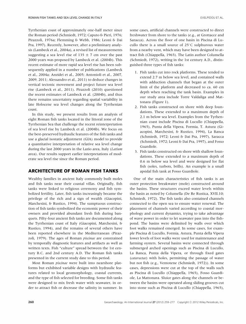
Figure 1 Study area along the Tyrrhenian coast, Italy.
Formia, Astura (Giacopini, Marchesini, & Rustico, 1994),Odescalchi. If carefully interpreted, their marks may beespecially useful to estimate past sea levels.
STUDY AREA
The Tyrrhenian coast is mostly rocky and deeply em-bayed, with numerous peninsulas bounded by low cliffs.In the most sheltered inlets, or near the mouth of smallrivers, rocky or sandy beaches mixed with pebbles arefound. The fish tanks are cut into bedrock or com-posed of large blocks of local rock material. Within ourstudy area, bedrock is commonly composed of carbonate
rocks, capped by thin layers of panchina, plunging towardthe sea, with honeycomb or globular erosional featureswhose shapes are partly controlled by joint networks. Theconnection between the shore and the low flat panchinais often bordered by a low cliff (generally less than 3 mhigh) upon which are buried paleosols, archaeological de-posits, and the modern soil.
In the Lazio region of the coast, Romans built severalfortresses such as Castrum Novum (now called SantaMarinella) in 264 B.C., and Pirgy (now called SantaSevera) sometime in the 3rd century B.C. Today, be-tween Civitavecchia and Formia (Figure 1b), it is possibleto notice the ruins of several Roman villas and theirfish tanks near Civitavecchia (Valdaliga, Guardiole, and
Geoarchaeology: An International Journal 27 (2012) 259–277 Copyright C© 2012 Wiley Periodicals, Inc. 261
ROMAN FISH TANKS AND SEA LEVEL CHANGE IN ITALY EVELPIDOU ET AL.
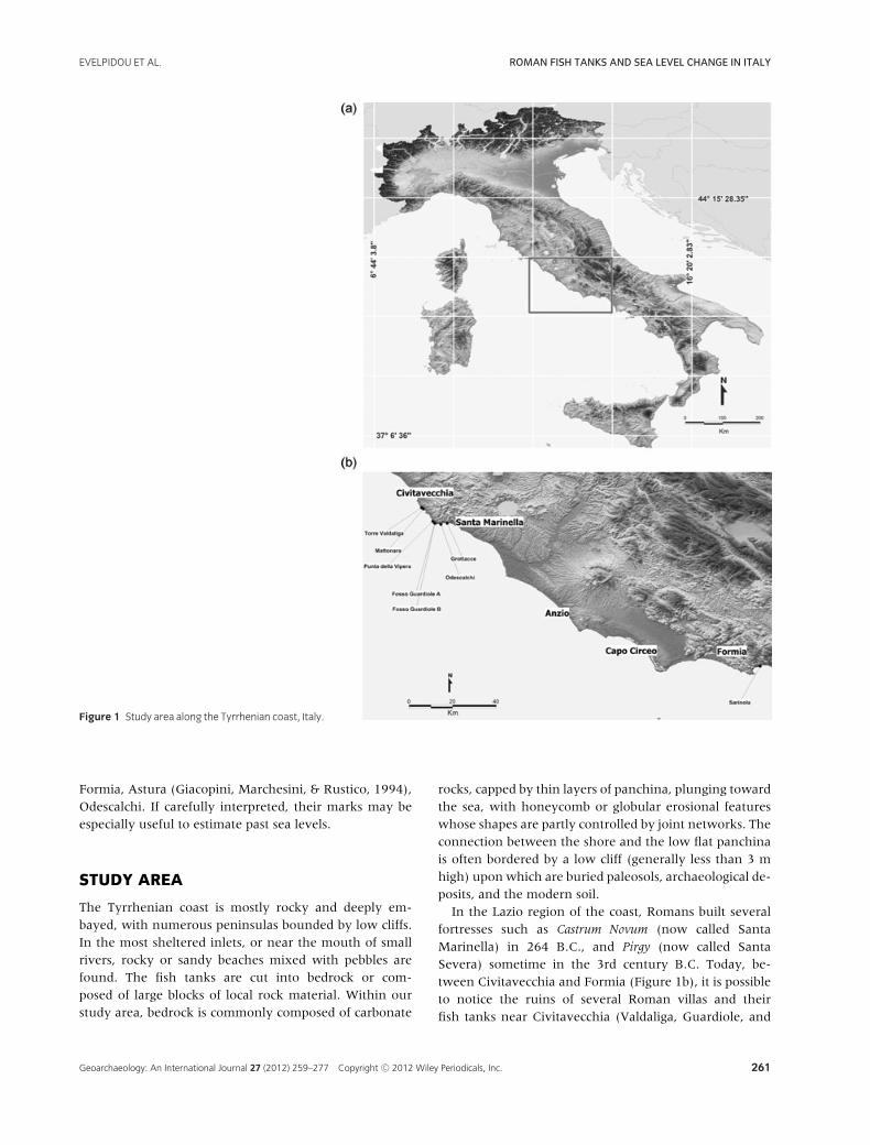
Figure 2 View of the Sarinola fish tank.
Mattonara), Santa Marinella (Punta della Vipera, LeGrottacce, Odescalchi), Anzio (Astura, La Banca,Saracca), Capo Circeo (Lucullo fish tank), and Formia(Sarinola). We focused our investigation on eight Romanfish tanks: Sarinola, Punta della Vipera, Torre Valdaliga,Mattonara, Fosso Guardiole A and B, Odescalchi, andGrottacce.
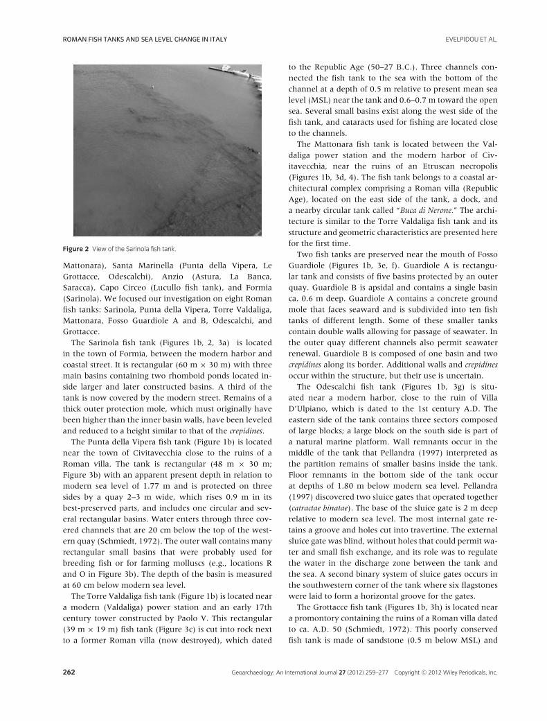
The Sarinola fish tank (Figures 1b, 2, 3a) is locatedin the town of Formia, between the modern harbor andcoastal street. It is rectangular (60 m × 30 m) with threemain basins containing two rhomboid ponds located in-side larger and later constructed basins. A third of thetank is now covered by the modern street. Remains of athick outer protection mole, which must originally havebeen higher than the inner basin walls, have been leveledand reduced to a height similar to that of the crepidines.
The Punta della Vipera fish tank (Figure 1b) is locatednear the town of Civitavecchia close to the ruins of aRoman villa. The tank is rectangular (48 m × 30 m;Figure 3b) with an apparent present depth in relation tomodern sea level of 1.77 m and is protected on threesides by a quay 2–3 m wide, which rises 0.9 m in itsbest-preserved parts, and includes one circular and sev-eral rectangular basins. Water enters through three cov-ered channels that are 20 cm below the top of the west-ern quay (Schmiedt, 1972). The outer wall contains manyrectangular small basins that were probably used forbreeding fish or for farming molluscs (e.g., locations Rand O in Figure 3b). The depth of the basin is measuredat 60 cm below modern sea level.
The Torre Valdaliga fish tank (Figure 1b) is located neara modern (Valdaliga) power station and an early 17thcentury tower constructed by Paolo V. This rectangular(39 m × 19 m) fish tank (Figure 3c) is cut into rock nextto a former Roman villa (now destroyed), which dated
to the Republic Age (50–27 B.C.). Three channels con-nected the fish tank to the sea with the bottom of thechannel at a depth of 0.5 m relative to present mean sealevel (MSL) near the tank and 0.6–0.7 m toward the opensea. Several small basins exist along the west side of thefish tank, and cataracts used for fishing are located closeto the channels.
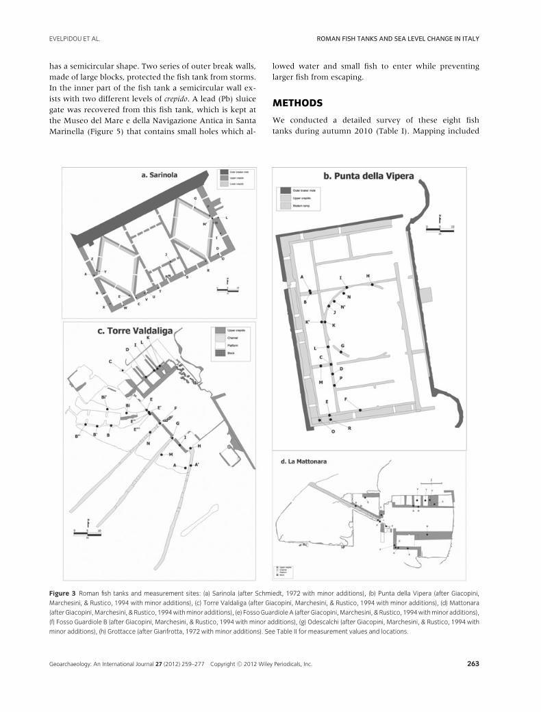
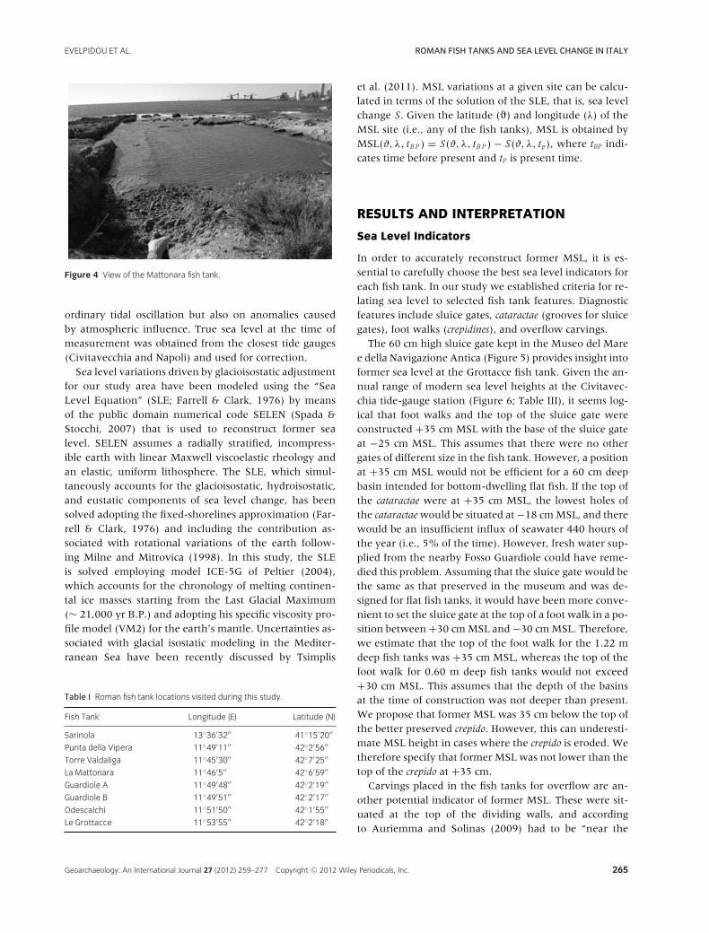
The Mattonara fish tank is located between the Val-daliga power station and the modern harbor of Civ-itavecchia, near the ruins of an Etruscan necropolis(Figures 1b, 3d, 4). The fish tank belongs to a coastal ar-chitectural complex comprising a Roman villa (RepublicAge), located on the east side of the tank, a dock, anda nearby circular tank called “Buca di Nerone.” The archi-tecture is similar to the Torre Valdaliga fish tank and itsstructure and geometric characteristics are presented herefor the first time.
Two fish tanks are preserved near the mouth of FossoGuardiole (Figures 1b, 3e, f). Guardiole A is rectangu-lar tank and consists of five basins protected by an outerquay. Guardiole B is apsidal and contains a single basinca. 0.6 m deep. Guardiole A contains a concrete groundmole that faces seaward and is subdivided into ten fishtanks of different length. Some of these smaller tankscontain double walls allowing for passage of seawater. Inthe outer quay different channels also permit seawaterrenewal. Guardiole B is composed of one basin and twocrepidines along its border. Additional walls and crepidines
occur within the structure, but their use is uncertain.The Odescalchi fish tank (Figures 1b, 3g) is situ-
ated near a modern harbor, close to the ruin of VillaD’Ulpiano, which is dated to the 1st century A.D. Theeastern side of the tank contains three sectors composedof large blocks; a large block on the south side is part ofa natural marine platform. Wall remnants occur in themiddle of the tank that Pellandra (1997) interpreted asthe partition remains of smaller basins inside the tank.Floor remnants in the bottom side of the tank occurat depths of 1.80 m below modern sea level. Pellandra(1997) discovered two sluice gates that operated together(catractae binatae). The base of the sluice gate is 2 m deeprelative to modern sea level. The most internal gate re-tains a groove and holes cut into travertine. The externalsluice gate was blind, without holes that could permit wa-ter and small fish exchange, and its role was to regulatethe water in the discharge zone between the tank andthe sea. A second binary system of sluice gates occurs inthe southwestern corner of the tank where six flagstoneswere laid to form a horizontal groove for the gates.
The Grottacce fish tank (Figures 1b, 3h) is located neara promontory containing the ruins of a Roman villa datedto ca. A.D. 50 (Schmiedt, 1972). This poorly conservedfish tank is made of sandstone (0.5 m below MSL) and
262 Geoarchaeology: An International Journal 27 (2012) 259–277 Copyright C© 2012 Wiley Periodicals, Inc.
EVELPIDOU ET AL. ROMAN FISH TANKS AND SEA LEVEL CHANGE IN ITALY
has a semicircular shape. Two series of outer break walls,made of large blocks, protected the fish tank from storms.In the inner part of the fish tank a semicircular wall ex-ists with two different levels of crepido. A lead (Pb) sluicegate was recovered from this fish tank, which is kept atthe Museo del Mare e della Navigazione Antica in SantaMarinella (Figure 5) that contains small holes which al-
lowed water and small fish to enter while preventinglarger fish from escaping.
METHODS
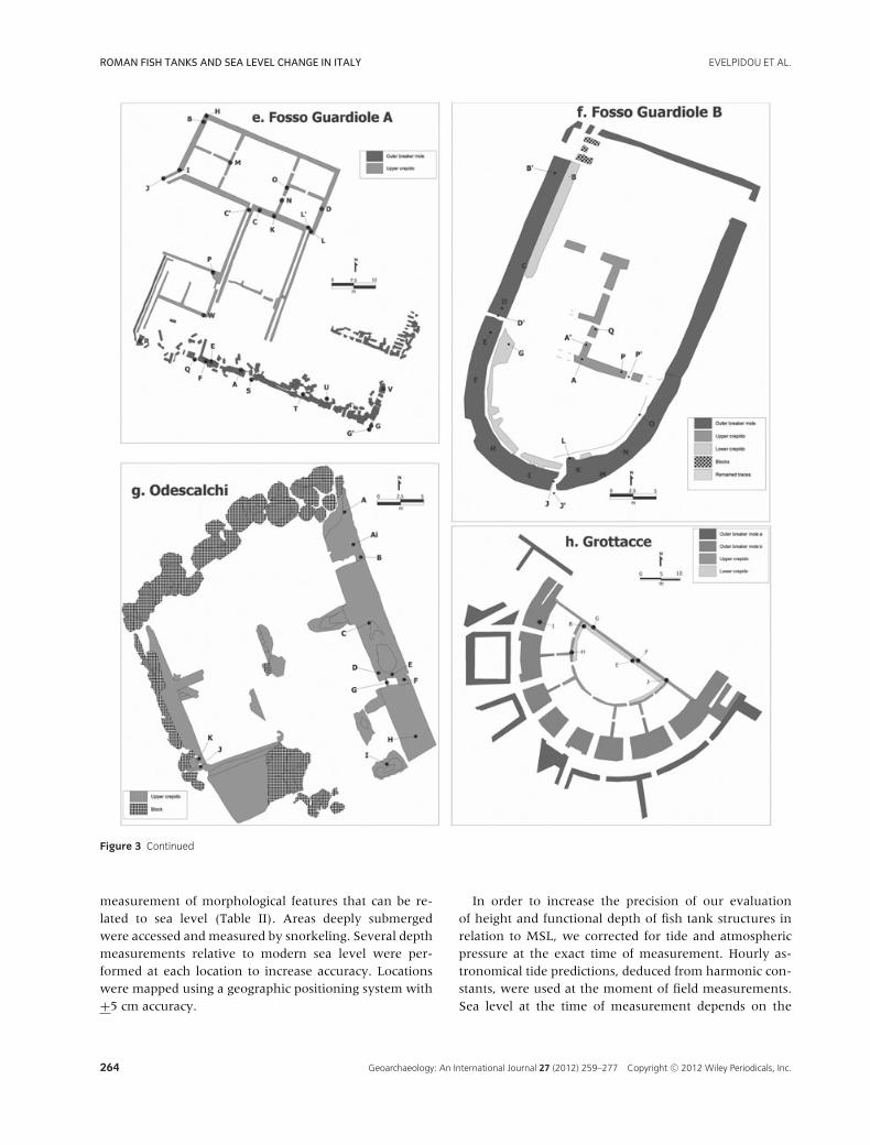
We conducted a detailed survey of these eight fishtanks during autumn 2010 (Table I). Mapping included
Figure 3 Roman fish tanks and measurement sites: (a) Sarinola (after Schmiedt, 1972 with minor additions), (b) Punta della Vipera (after Giacopini,
Marchesini, & Rustico, 1994 with minor additions), (c) Torre Valdaliga (after Giacopini, Marchesini, & Rustico, 1994 with minor additions), (d) Mattonara
(afterGiacopini,Marchesini, &Rustico, 1994withminor additions), (e) FossoGuardioleA (afterGiacopini,Marchesini, &Rustico, 1994withminor additions),
(f) Fosso Guardiole B (after Giacopini, Marchesini, & Rustico, 1994 with minor additions), (g) Odescalchi (after Giacopini, Marchesini, & Rustico, 1994 with
minor additions), (h) Grottacce (after Gianfrotta, 1972 with minor additions). See Table II for measurement values and locations.
Geoarchaeology: An International Journal 27 (2012) 259–277 Copyright C© 2012 Wiley Periodicals, Inc. 263
ROMAN FISH TANKS AND SEA LEVEL CHANGE IN ITALY EVELPIDOU ET AL.
Figure 3 Continued
measurement of morphological features that can be re-lated to sea level (Table II). Areas deeply submergedwere accessed and measured by snorkeling. Several depthmeasurements relative to modern sea level were per-formed at each location to increase accuracy. Locationswere mapped using a geographic positioning system with+5 cm accuracy.
In order to increase the precision of our evaluationof height and functional depth of fish tank structures inrelation to MSL, we corrected for tide and atmosphericpressure at the exact time of measurement. Hourly as-tronomical tide predictions, deduced from harmonic con-stants, were used at the moment of field measurements.Sea level at the time of measurement depends on the
264 Geoarchaeology: An International Journal 27 (2012) 259–277 Copyright C© 2012 Wiley Periodicals, Inc.
EVELPIDOU ET AL. ROMAN FISH TANKS AND SEA LEVEL CHANGE IN ITALY
Figure 4 View of the Mattonara fish tank.
ordinary tidal oscillation but also on anomalies causedby atmospheric influence. True sea level at the time ofmeasurement was obtained from the closest tide gauges(Civitavecchia and Napoli) and used for correction.
Sea level variations driven by glacioisostatic adjustmentfor our study area have been modeled using the “SeaLevel Equation” (SLE; Farrell & Clark, 1976) by meansof the public domain numerical code SELEN (Spada &Stocchi, 2007) that is used to reconstruct former sealevel. SELEN assumes a radially stratified, incompress-ible earth with linear Maxwell viscoelastic rheology andan elastic, uniform lithosphere. The SLE, which simul-taneously accounts for the glacioisostatic, hydroisostatic,and eustatic components of sea level change, has beensolved adopting the fixed-shorelines approximation (Far-rell & Clark, 1976) and including the contribution as-sociated with rotational variations of the earth follow-ing Milne and Mitrovica (1998). In this study, the SLEis solved employing model ICE-5G of Peltier (2004),which accounts for the chronology of melting continen-tal ice masses starting from the Last Glacial Maximum(∼ 21,000 yr B.P.) and adopting his specific viscosity pro-file model (VM2) for the earth’s mantle. Uncertainties as-sociated with glacial isostatic modeling in the Mediter-ranean Sea have been recently discussed by Tsimplis
Table I Roman fish tank locations visited during this study.
Fish Tank Longitude (E) Latitude (N)
Sarinola 13◦36′32′′ 41◦15′20′′
Punta della Vipera 11◦49′11′′ 42◦2′56′′
Torre Valdaliga 11◦45′30′′ 42◦7′25′′
La Mattonara 11◦46′5′′ 42◦6′59′′
Guardiole A 11◦49′48′′ 42◦2′19′′
Guardiole B 11◦49′51′′ 42◦2′17′′
Odescalchi 11◦51′50′′ 42◦1′55′′
Le Grottacce 11◦53′55′′ 42◦2′18′′
et al. (2011). MSL variations at a given site can be calcu-lated in terms of the solution of the SLE, that is, sea levelchange S. Given the latitude (�) and longitude (λ) of theMSL site (i.e., any of the fish tanks), MSL is obtained byMSL(ϑ, λ, tB P ) = S(ϑ, λ, tB P ) − S(ϑ, λ, tp), where tBP indi-cates time before present and tP is present time.
RESULTS AND INTERPRETATION
Sea Level Indicators
In order to accurately reconstruct former MSL, it is es-sential to carefully choose the best sea level indicators foreach fish tank. In our study we established criteria for re-lating sea level to selected fish tank features. Diagnosticfeatures include sluice gates, cataractae (grooves for sluicegates), foot walks (crepidines), and overflow carvings.
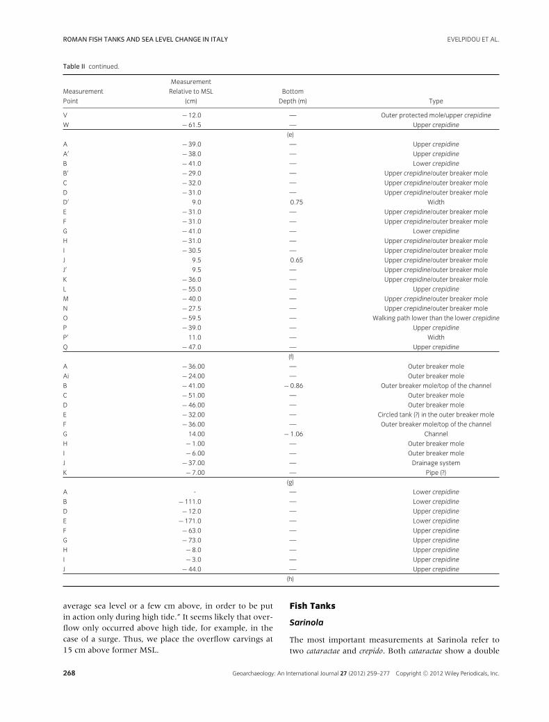
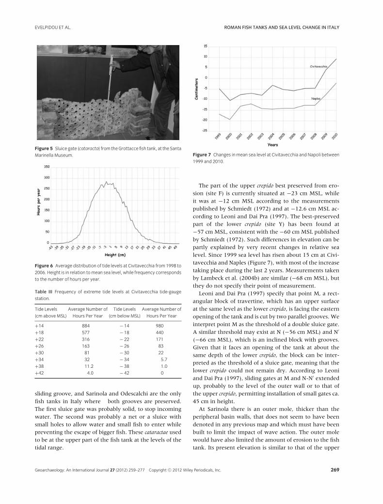
The 60 cm high sluice gate kept in the Museo del Maree della Navigazione Antica (Figure 5) provides insight intoformer sea level at the Grottacce fish tank. Given the an-nual range of modern sea level heights at the Civitavec-chia tide-gauge station (Figure 6; Table III), it seems log-ical that foot walks and the top of the sluice gate wereconstructed +35 cm MSL with the base of the sluice gateat −25 cm MSL. This assumes that there were no othergates of different size in the fish tank. However, a positionat +35 cm MSL would not be efficient for a 60 cm deepbasin intended for bottom-dwelling flat fish. If the top ofthe cataractae were at +35 cm MSL, the lowest holes ofthe cataractae would be situated at −18 cm MSL, and therewould be an insufficient influx of seawater 440 hours ofthe year (i.e., 5% of the time). However, fresh water sup-plied from the nearby Fosso Guardiole could have reme-died this problem. Assuming that the sluice gate would bethe same as that preserved in the museum and was de-signed for flat fish tanks, it would have been more conve-nient to set the sluice gate at the top of a foot walk in a po-sition between +30 cm MSL and −30 cm MSL. Therefore,we estimate that the top of the foot walk for the 1.22 mdeep fish tanks was +35 cm MSL, whereas the top of thefoot walk for 0.60 m deep fish tanks would not exceed+30 cm MSL. This assumes that the depth of the basinsat the time of construction was not deeper than present.We propose that former MSL was 35 cm below the top ofthe better preserved crepido. However, this can underesti-mate MSL height in cases where the crepido is eroded. Wetherefore specify that former MSL was not lower than thetop of the crepido at +35 cm.
Carvings placed in the fish tanks for overflow are an-other potential indicator of former MSL. These were sit-uated at the top of the dividing walls, and accordingto Auriemma and Solinas (2009) had to be “near the
Geoarchaeology: An International Journal 27 (2012) 259–277 Copyright C© 2012 Wiley Periodicals, Inc. 265
ROMAN FISH TANKS AND SEA LEVEL CHANGE IN ITALY EVELPIDOU ET AL.
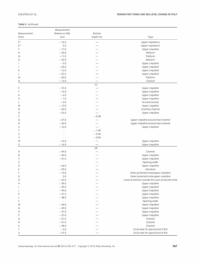
Table II Fish tank measurements at Sarinola (a), Punta della Vipera (b), Torre Valdaliga (c), La Mattonara (d), Guardiole A (e), Guardiole B (f), Odescalchi
(g), and Le Gottacce (h). See Figure 4 for location of measurements.
Measurement
Measurement Relative to MSL Bottom
Point (cm) Depth (m) Type
A − 27.0 — Upper crepidine
C − 33.0 — Outside borders—upper crepidine
D − 26.0 — Outside borders—upper crepidine
E − 35.0 — Upper crepidine
F − 23.0 — Upper crepidine
G − 28.0 — Upper crepidine
H − 53.0 — Upper crepidine
I − 53.0 — Outside borders—upper crepidine
J − 62.0 — Upper crepidine (?)
M′ − 125.0 — Bottom depth
N − 56.0 — Cataracta
N′ − 66.0 — Cataracta
O 2.0 − 1.28
R − 31.0 — Outside borders—upper crepidine
S − 4.0 − 0.84
T − 47.5 — Outside borders—upper crepidine
U − 7.5 − 0.98
V − 39.5 — Outside borders—upper crepidine
W − 7.5 − 1.18
X − 32.0 — Upper crepidine
Y − 57.0 — Lower crepidine
Z − 35.0 — Upper crepidine
(a)
A − 69.0 — Top (internal) of the arch connecting two basins
B − 24.0 — Top of the crepidine above arch connecting two basins
C − 19.5 — Upper crepidine
D − 24.0 — Upper crepidine
F − 20.0 — Upper crepidine
E − 28.0 — Upper crepidine/top of the covered channel
G − 14.0 — Upper crepidine
H − 21.0 — Upper crepidine
I − 18.0 — Upper crepidine
J − 12.0 — Upper crepidine
K − 29.0 — Upper crepidine
K′ − 79.0 — Upper crepidine
L − 19.0 — Upper crepidine
M − 19.5 — Top of the crepidine above arch connecting two basins
N − 40.0 — Arch-producing shadow to fishes
N′ − 40.0 — Arch-producing shadow to fishes
P − 37.0 — Upper crepidine
O − 21.0 — Bottom of small basin at the outer breaker (?)
R 6.5 − 53.50 Bottom of small basin at the outer breaker
(b)
A 10.0 — Platform
A′ − 15.0 — Platform
B − 9.0 — Platform
B′ − 10.0 — Platform
B′ ′ − 10.0 — Platform
Bi − 19.0 — Platform
Bi′ − 17.0 — Platform
C − 80.0 — Channel
D − 32.0 — Upper crepidine
E − 36.0 — Lower crepidine b
E′ − 26.0 — Lower crepidine a
266 Geoarchaeology: An International Journal 27 (2012) 259–277 Copyright C© 2012 Wiley Periodicals, Inc.
EVELPIDOU ET AL. ROMAN FISH TANKS AND SEA LEVEL CHANGE IN ITALY
Table II continued.
Measurement
Measurement Relative to MSL Bottom
Point (cm) Depth (m) Type
E′ ′ − 16.5 — Upper crepidine a
E′ ′ ′ 3.5 — Upper crepidine b
F − 17.0 — Upper crepidine
G − 20.0 — Platform
Gi − 11.0 — Platform
H − 35.0 — Bottom?
I − 5.0 — Upper crepidine
J − 24.0 — Upper crepidine
K − 12.5 — Upper crepidine
L − 22.5 — Upper crepidine
M − 20.0 — Platform
N − 13.0 — Channel
(c)
E − 15.0 — Upper crepidine
F − 16.0 — Upper crepidine
G − 4.0 — Upper crepidine
H − 1.0 — Upper crepidine
L − 3.0 — Arched channel
M − 12.0 — Upper crepidine
N − 26.0 — Overflow channel
O − 53.0 — Upper crepidine
P - − 0.28
Q − 37.0 — Upper crepidine around main channel
R − 36.0 — Upper crepidine around main channel
S − 16.0 — Upper crepidine
T - − 1.46
U - − 0.46
V - − 0.96
W − 16.0 — Upper crepidine
X − 16.0 — Upper crepidine
(d)
A − 49.0 — Channel
B − 44.0 — Upper crepidine
C − 37.5 — Upper crepidine
C′ - — Opening width
D − 46.0 — Upper crepidine
E − 39.0 — sfioratoio
F − 15.0 — Outer protected mole/upper crepidine
G 3.0 — Outer protected mole/upper crepidine
G′ − 42.0 — Lower protection outside the outer protected mole
H − 39.0 — Upper crepidine
I − 49.0 — Upper crepidine
J − 49.0 — Upper crepidine
K − 37.5 — Upper crepidine
L − 48.0 — Upper crepidine
L′ - — Opening width
M − 46.0 — Upper crepidine
N − 49.0 — Upper crepidine
O − 47.0 — Upper crepidine
P − 37.0 — Upper crepidine
Q − 21.0 — Channel
R − 51.0 — Channel
S − 48.0 — Channel
T − 4.0 — Circle tank for special kind of fish
U − 37.5 — Circle tank for special kind of fish
Geoarchaeology: An International Journal 27 (2012) 259–277 Copyright C© 2012 Wiley Periodicals, Inc. 267
ROMAN FISH TANKS AND SEA LEVEL CHANGE IN ITALY EVELPIDOU ET AL.
Table II continued.
Measurement
Measurement Relative to MSL Bottom
Point (cm) Depth (m) Type
V − 12.0 — Outer protected mole/upper crepidine
W − 61.5 — Upper crepidine
(e)
A − 39.0 — Upper crepidine
A′ − 38.0 — Upper crepidine
B − 41.0 — Lower crepidine
B′ − 29.0 — Upper crepidine/outer breaker mole
C − 32.0 — Upper crepidine/outer breaker mole
D − 31.0 — Upper crepidine/outer breaker mole
D′ 9.0 0.75 Width
E − 31.0 — Upper crepidine/outer breaker mole
F − 31.0 — Upper crepidine/outer breaker mole
G − 41.0 — Lower crepidine
H − 31.0 — Upper crepidine/outer breaker mole
I − 30.5 — Upper crepidine/outer breaker mole
J 9.5 0.65 Upper crepidine/outer breaker mole
J′ 9.5 — Upper crepidine/outer breaker mole
K − 36.0 — Upper crepidine/outer breaker mole
L − 55.0 — Upper crepidine
M − 40.0 — Upper crepidine/outer breaker mole
N − 27.5 — Upper crepidine/outer breaker mole
O − 59.5 — Walking path lower than the lower crepidine
P − 39.0 — Upper crepidine
P′ 11.0 — Width
Q − 47.0 — Upper crepidine
(f)
A − 36.00 — Outer breaker mole
Ai − 24.00 — Outer breaker mole
B − 41.00 − 0.86 Outer breaker mole/top of the channel
C − 51.00 — Outer breaker mole
D − 46.00 — Outer breaker mole
E − 32.00 — Circled tank (?) in the outer breaker mole
F − 36.00 — Outer breaker mole/top of the channel
G 14.00 − 1.06 Channel
H − 1.00 — Outer breaker mole
I − 6.00 — Outer breaker mole
J − 37.00 — Drainage system
K − 7.00 — Pipe (?)
(g)
A - — Lower crepidine
B − 111.0 — Lower crepidine
D − 12.0 — Upper crepidine
E − 171.0 — Lower crepidine
F − 63.0 — Upper crepidine
G − 73.0 — Upper crepidine
H − 8.0 — Upper crepidine
I − 3.0 — Upper crepidine
J − 44.0 — Upper crepidine
(h)
average sea level or a few cm above, in order to be putin action only during high tide.” It seems likely that over-flow only occurred above high tide, for example, in thecase of a surge. Thus, we place the overflow carvings at15 cm above former MSL.
Fish Tanks
Sarinola
The most important measurements at Sarinola refer totwo cataractae and crepido. Both cataractae show a double
268 Geoarchaeology: An International Journal 27 (2012) 259–277 Copyright C© 2012 Wiley Periodicals, Inc.
EVELPIDOU ET AL. ROMAN FISH TANKS AND SEA LEVEL CHANGE IN ITALY
Figure 5 Sluice gate (cataracta) from the Grottacce fish tank, at the Santa
Marinella Museum.
Figure 6 Average distribution of tide levels at Civitavecchia from 1998 to
2006. Height is in relation tomean sea level, while frequency corresponds
to the number of hours per year.
Table III Frequency of extreme tide levels at Civitavecchia tide-gauge
station.
Tide Levels Average Number of Tide Levels Average Number of
(cm above MSL) Hours Per Year (cm below MSL) Hours Per Year
+14 884 − 14 980
+18 577 − 18 440
+22 316 − 22 171
+26 163 − 26 83
+30 81 − 30 22
+34 32 − 34 5.7
+38 11.2 − 38 1.0
+42 4.0 − 42 0
sliding groove, and Sarinola and Odescalchi are the onlyfish tanks in Italy where both grooves are preserved.The first sluice gate was probably solid, to stop incomingwater. The second was probably a net or a sluice withsmall holes to allow water and small fish to enter whilepreventing the escape of bigger fish. These cataractae usedto be at the upper part of the fish tank at the levels of thetidal range.
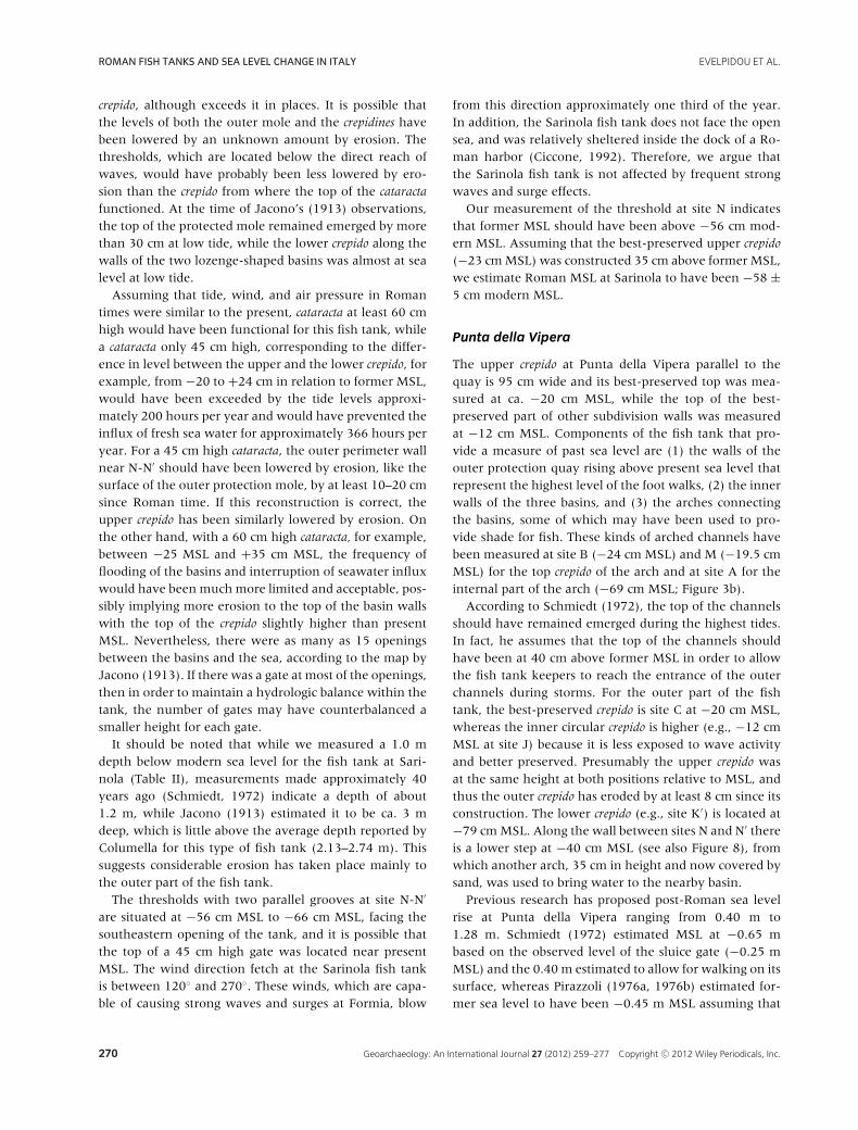
Figure 7 Changes in mean sea level at Civitavecchia and Napoli between
1999 and 2010.
The part of the upper crepido best preserved from ero-sion (site F) is currently situated at −23 cm MSL, whileit was at −12 cm MSL according to the measurementspublished by Schmiedt (1972) and at −12.6 cm MSL ac-cording to Leoni and Dai Pra (1997). The best-preservedpart of the lower crepido (site Y) has been found at−57 cm MSL, consistent with the −60 cm MSL publishedby Schmiedt (1972). Such differences in elevation can bepartly explained by very recent changes in relative sealevel. Since 1999 sea level has risen about 15 cm at Civi-tavecchia and Naples (Figure 7), with most of the increasetaking place during the last 2 years. Measurements takenby Lambeck et al. (2004b) are similar (−68 cm MSL), butthey do not specify their point of measurement.
Leoni and Dai Pra (1997) specify that point M, a rect-angular block of travertine, which has an upper surfaceat the same level as the lower crepido, is facing the easternopening of the tank and is cut by two parallel grooves. Weinterpret point M as the threshold of a double sluice gate.A similar threshold may exist at N (−56 cm MSL) and N′
(−66 cm MSL), which is an inclined block with grooves.Given that it faces an opening of the tank at about thesame depth of the lower crepido, the block can be inter-preted as the threshold of a sluice gate, meaning that thelower crepido could not remain dry. According to Leoniand Dai Pra (1997), sliding gates at M and N-N′ extendedup, probably to the level of the outer wall or to that ofthe upper crepido, permitting installation of small gates ca.45 cm in height.
At Sarinola there is an outer mole, thicker than theperipheral basin walls, that does not seem to have beendenoted in any previous map and which must have beenbuilt to limit the impact of wave action. The outer molewould have also limited the amount of erosion to the fishtank. Its present elevation is similar to that of the upper
Geoarchaeology: An International Journal 27 (2012) 259–277 Copyright C© 2012 Wiley Periodicals, Inc. 269
ROMAN FISH TANKS AND SEA LEVEL CHANGE IN ITALY EVELPIDOU ET AL.
crepido, although exceeds it in places. It is possible thatthe levels of both the outer mole and the crepidines havebeen lowered by an unknown amount by erosion. Thethresholds, which are located below the direct reach ofwaves, would have probably been less lowered by ero-sion than the crepido from where the top of the cataractafunctioned. At the time of Jacono’s (1913) observations,the top of the protected mole remained emerged by morethan 30 cm at low tide, while the lower crepido along thewalls of the two lozenge-shaped basins was almost at sealevel at low tide.
Assuming that tide, wind, and air pressure in Romantimes were similar to the present, cataracta at least 60 cmhigh would have been functional for this fish tank, whilea cataracta only 45 cm high, corresponding to the differ-ence in level between the upper and the lower crepido, forexample, from −20 to +24 cm in relation to former MSL,would have been exceeded by the tide levels approxi-mately 200 hours per year and would have prevented theinflux of fresh sea water for approximately 366 hours peryear. For a 45 cm high cataracta, the outer perimeter wallnear N-N′ should have been lowered by erosion, like thesurface of the outer protection mole, by at least 10–20 cmsince Roman time. If this reconstruction is correct, theupper crepido has been similarly lowered by erosion. Onthe other hand, with a 60 cm high cataracta, for example,between −25 MSL and +35 cm MSL, the frequency offlooding of the basins and interruption of seawater influxwould have been much more limited and acceptable, pos-sibly implying more erosion to the top of the basin wallswith the top of the crepido slightly higher than presentMSL. Nevertheless, there were as many as 15 openingsbetween the basins and the sea, according to the map byJacono (1913). If there was a gate at most of the openings,then in order to maintain a hydrologic balance within thetank, the number of gates may have counterbalanced asmaller height for each gate.
It should be noted that while we measured a 1.0 mdepth below modern sea level for the fish tank at Sari-nola (Table II), measurements made approximately 40years ago (Schmiedt, 1972) indicate a depth of about1.2 m, while Jacono (1913) estimated it to be ca. 3 mdeep, which is little above the average depth reported byColumella for this type of fish tank (2.13–2.74 m). Thissuggests considerable erosion has taken place mainly tothe outer part of the fish tank.
The thresholds with two parallel grooves at site N-N′
are situated at −56 cm MSL to −66 cm MSL, facing thesoutheastern opening of the tank, and it is possible thatthe top of a 45 cm high gate was located near presentMSL. The wind direction fetch at the Sarinola fish tankis between 120◦ and 270◦. These winds, which are capa-ble of causing strong waves and surges at Formia, blow
from this direction approximately one third of the year.In addition, the Sarinola fish tank does not face the opensea, and was relatively sheltered inside the dock of a Ro-man harbor (Ciccone, 1992). Therefore, we argue thatthe Sarinola fish tank is not affected by frequent strongwaves and surge effects.
Our measurement of the threshold at site N indicatesthat former MSL should have been above −56 cm mod-ern MSL. Assuming that the best-preserved upper crepido(−23 cm MSL) was constructed 35 cm above former MSL,we estimate Roman MSL at Sarinola to have been −58 ±5 cm modern MSL.
Punta della Vipera
The upper crepido at Punta della Vipera parallel to thequay is 95 cm wide and its best-preserved top was mea-sured at ca. −20 cm MSL, while the top of the best-preserved part of other subdivision walls was measuredat −12 cm MSL. Components of the fish tank that pro-vide a measure of past sea level are (1) the walls of theouter protection quay rising above present sea level thatrepresent the highest level of the foot walks, (2) the innerwalls of the three basins, and (3) the arches connectingthe basins, some of which may have been used to pro-vide shade for fish. These kinds of arched channels havebeen measured at site B (−24 cm MSL) and M (−19.5 cmMSL) for the top crepido of the arch and at site A for theinternal part of the arch (−69 cm MSL; Figure 3b).
According to Schmiedt (1972), the top of the channelsshould have remained emerged during the highest tides.In fact, he assumes that the top of the channels shouldhave been at 40 cm above former MSL in order to allowthe fish tank keepers to reach the entrance of the outerchannels during storms. For the outer part of the fishtank, the best-preserved crepido is site C at −20 cm MSL,whereas the inner circular crepido is higher (e.g., −12 cmMSL at site J) because it is less exposed to wave activityand better preserved. Presumably the upper crepido wasat the same height at both positions relative to MSL, andthus the outer crepido has eroded by at least 8 cm since itsconstruction. The lower crepido (e.g., site K′) is located at−79 cm MSL. Along the wall between sites N and N′ thereis a lower step at −40 cm MSL (see also Figure 8), fromwhich another arch, 35 cm in height and now covered bysand, was used to bring water to the nearby basin.
Previous research has proposed post-Roman sea levelrise at Punta della Vipera ranging from 0.40 m to1.28 m. Schmiedt (1972) estimated MSL at −0.65 mbased on the observed level of the sluice gate (−0.25 mMSL) and the 0.40 m estimated to allow for walking on itssurface, whereas Pirazzoli (1976a, 1976b) estimated for-mer sea level to have been −0.45 m MSL assuming that
270 Geoarchaeology: An International Journal 27 (2012) 259–277 Copyright C© 2012 Wiley Periodicals, Inc.
EVELPIDOU ET AL. ROMAN FISH TANKS AND SEA LEVEL CHANGE IN ITALY
Figure 8 Cross-section of the lower step along the wall between sites N
and N′ at Punta della Vipera, from which an arch now covered by sand,
was used to bring water to the nearby basin.
the slab covering the channels was emerged at high tide.Leoni and Dai Pra (1997) deduced from the elevation ofthe top of the arched channels (that they measured at−64 cm MSL) a Roman sea level of at least 44 cm be-low modern MSL, and from the circular crepido (that theymeasured at −12 cm MSL) a sea level rise of no morethan 32 cm. Lambeck et al. (2004a) estimated Roman sealevel at 0.40 m below modern MSL based on earlier in-vestigations whereas Lambeck et al. (2004b) estimated itto 1.28 ± 0.20 m below modern MSL according to theheight between the bottom and upper level of an unspec-ified sluice gate.
The base of the top of the arch possibly constructedto produce shadow for the fishes (sites N and N′) maybe considered a threshold for water movement. The topof the arch at −19.5 cm MSL coincides with the uppercrepido and thus should be slightly above former MSL.With the best-preserved crepido at −12 cm MSL, and as-suming it was constructed 35 cm above former MSL, onemay deduce a post-Roman sea level rise of 47 ± 5 cm atPunta della Vipera.
Torre Valdaliga
Torre Valdaliga is a rare example of fish tank completelycut into rock (Schmiedt, 1972). Morphological features atTorre Valdaliga that provide the best estimate of formersea level are (1) the wave-cut platform, (2) the crepido,and (3) the grooves of a former sluice gate. The best-preserved crepido is located at site I (5 cm below presentMSL; Figure 3c), while the best-preserved wave-cut plat-form is located at site B (9 cm below present MSL).
Schmiedt (1972) measured the lowest point (−63 cmMSL) of the wave-cut platform surface, in which partof the outer fish tank channels had been cut, and as-sumed that this had to be the sea level position at thetime of construction. However, we must assume that 20centuries of marine abrasion have certainly contributedto the lowering of the platform surface (Pirazzoli, 1976b).After removing rock debris from the bottom of the
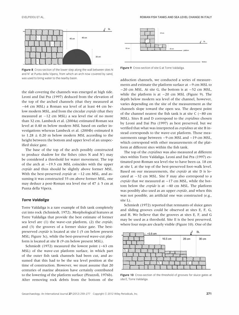
Figure 9 Cross-section of site G at Torre Valdaliga.
adduction channels, we conducted a series of measure-ments and estimate the platform surface at −9 cm MSL to−20 cm MSL. At site G, the bottom is at −52 cm MSL,while the platform is at −20 cm MSL (Figure 9). Thedepth below modern sea level of the channel, however,varies depending on the site of the measurement as thechannels slope toward the open sea. The deepest pointof the channel nearest the fish tank is at site C (−80 cmMSL). Sites B and D correspond to the crepidines chosenby Leoni and Dai Pra (1997) as best preserved, but weverified that what was interpreted as crepidines at site B in-stead corresponds to the wave-cut platform. Those mea-surements range between −9 cm MSL and −19 cm MSL,which correspond with other measurements of the plat-form at different sites within the fish tank.
The top of the crepidines was also measured at differentsites within Torre Valdaliga. Leoni and Dai Pra (1997) es-timated post-Roman sea level rise to have been ca. 18 cmat site I, at the top of the best-preserved foot-walk level.Based on our measurements, the crepido at site D is lo-cated at −32 cm MSL. Site F may also correspond to acrepido that we measured at −17 cm MSL, while the bot-tom below the crepido is at −40 cm MSL. The platformwas possibly also used as an upper crepido, and when thiswas not possible, an artificial one was constructed (e.g.,site L).
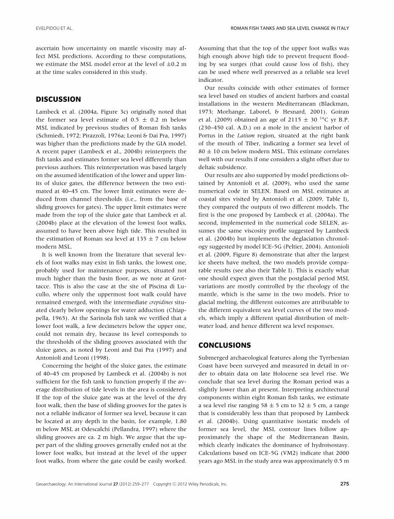
Schmiedt (1972) reported that remnants of sluice gatesand sliding grooves could be observed at sites E, F, G,and H. We believe that the grooves at sites E, F, and Gmay be used as a threshold. Site E is the best preserved,where four steps are clearly visible (Figure 10). One of the
Figure 10 Cross-section of the threshold of grooves for sluice gates at
site E, Torre Valdaliga.
Geoarchaeology: An International Journal 27 (2012) 259–277 Copyright C© 2012 Wiley Periodicals, Inc. 271
ROMAN FISH TANKS AND SEA LEVEL CHANGE IN ITALY EVELPIDOU ET AL.
steps extends around most of the fish tank and is probablypart of the lower and upper crepido at −26 cm MSL and−36 cm MSL, respectively. Assuming that the uppercrepido was situated 35 cm above former MSL, and con-sidering the elevation of the wave-cut platform and sluicegate grooves, we suggest a Roman sea level of −40 ± 5 cmMSL at Torre Valdaliga.
Mattonara
Our survey allowed us to redefine the structure ofthe Mattonara fish tank resulting in an updated map(Figure 3d). The 11 m × 29 m rectangular tank containsa main channel connected to the open sea. Six main rect-angular ponds are located at the northern side of the tankthat vary in depth from 1 m to 1.5 m below modern sealevel and are connected to each other by a surface chan-nel situated at 26 cm below MSL. The southern part of thefish tank contains two main ponds that are larger thanthose at the northern part. Close to the two channels awall subdivides the tank, creating a corridor in the mid-dle of the tank in front of the northern channel.
Crepidines provide the best references for former sealevel at Mattonara. The upper crepido, located at the top ofthe walls that subdivide the tank into smaller basins, wasmeasured at different locations and today is situated at ca.−16 cm MSL. This fish tank is situated in a very protectedarea, and we assume that there has been relatively minorwave erosion. Site L corresponds to an arched channel,the top of which is situated −3 cm MSL. Site N is situatedat −26 cm MSL and it is the bottom of a small carvingfor the trop plein used during overflow, which, in orderto assure its functionality, would have been at ca. 15 cmabove former MSL. Crepidines around the main channelsis situated at about −36 cm MSL (site R).
Schmiedt (1972) estimated Roman sea level at −0.63m MSL based on an observed cut along the rock platforminto which the basins of the fish tank had been cut. Piraz-zoli (1976a, 1976b) estimated former sea level between−65 cm MSL and −40 cm MSL, as at Torre Valdaliga,while Leoni and Dai Pra (1997) estimated post-Romansea level rise between 17 cm based on the foot walk and25 cm based on the top of a channel. We believe that theupper crepido suggests a Roman sea level of −36 ± 5 cmMSL, while the overflow carving suggests −41 ± 5 cmMSL.
Fosso Guardiole A
Several structures are preserved at Guardiole A fish tank(Figure 3e) that may be used to infer past sea level. Wemeasured the upper crepido at several places and deter-mined the best-preserved section to be site P (−37 cmMSL). We also considered several small circular tanks
Figure 11 Site E at Fosso Guardiole A corresponding to a possible sfiora-
toio, a carving for discharging excess water, situated at the former high
tide level.
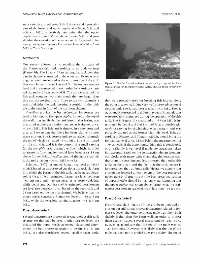
that were probably used for breeding fish located alongthe outer breaker wall. One very well preserved section ofcircular tank, site T, was measured at −4 cm MSL. Sites S,A, Q, and R correspond to different types of channels thatwere probably submerged during the operation of the fishtank. Site E (Figure 11) measured at −39 cm MSL is in-terpreted by Leoni and Dai Pra (1997) as a possible sfio-ratoio (a carving for discharging excess water), and wasprobably situated at the former high tide level. This, ac-cording to Pirazzoli and Tomasin (2008), would bring theRoman sea level to ca. 11 cm below the measurement of−39 cm MSL, if the astronomical high tide is considered,or at a slightly lower level if moderate surges are takeninto account. Based on the construction design (contigu-ous blocks with many wide channels), the location (far-ther from the coastline and less protected than other fishtanks in the area), and the fact that the architecture isless preserved than at Punta della Vipera, we assume thaterosion has lowered at least 16 cm of the best-preservedupper crepido. If true, site P (the best-preserved sectionof upper crepido) should be −21 cm MSL. Assuming thatthe upper crepido was 35 cm above former MSL, we esti-mate a post-Roman sea level rise of less than −56 ± 5 cm.
Fosso Guardiole B
Fosso Guardiole B (Figure 3f) has also been impacted byerosion but still contains several structures related to for-mer sea level. The outer perimetric mole was likely builtslightly higher than the basin walls in order to protectthem against waves. Several measurements (e.g., B′, C,D, E, F, H, I) indicate that the top of the mole was ca.−27.5 cm MSL. However, it is likely that the top of themole has been partly eroded by wave activity. The top of
272 Geoarchaeology: An International Journal 27 (2012) 259–277 Copyright C© 2012 Wiley Periodicals, Inc.
EVELPIDOU ET AL. ROMAN FISH TANKS AND SEA LEVEL CHANGE IN ITALY
the best-preserved crepido along the basins was likely con-structed to remain dry most of the time dry. Points A, A′,P, and possibly G suggest that this dry foot walk is todayca. −40 cm MSL. If the bottom of the basins was at −82cm MSL, and the bottom of channels at about −80 cmMSL (J) or −90 cm MSL (D′), then the low tide at thetime of construction could hardly have been below theselevels. Leoni and Dai Pra (1997) mention a lower stepon the inner part of the western wall, ca. 17 cm belowthe central crepido level, but they do not deduce any clearestimate of former sea level from this structure. Schmiedt(1972) deduced a post-Roman sea level rise of 72 cm fromthe submergence of the top of the structures, whereasLeoni and Dai Pra (1997) estimated a post-Roman sealevel rise of 60–65 cm. We estimate the best-preservedtop of the upper crepido (site A′) at −38 cm MSL. Assum-ing the same amount of erosion at Guardiole A and B, weestimate site A′ to be less than −22 cm MSL suggestingpost-Roman sea level rise of 52 ± 5 cm.
Odescalchi
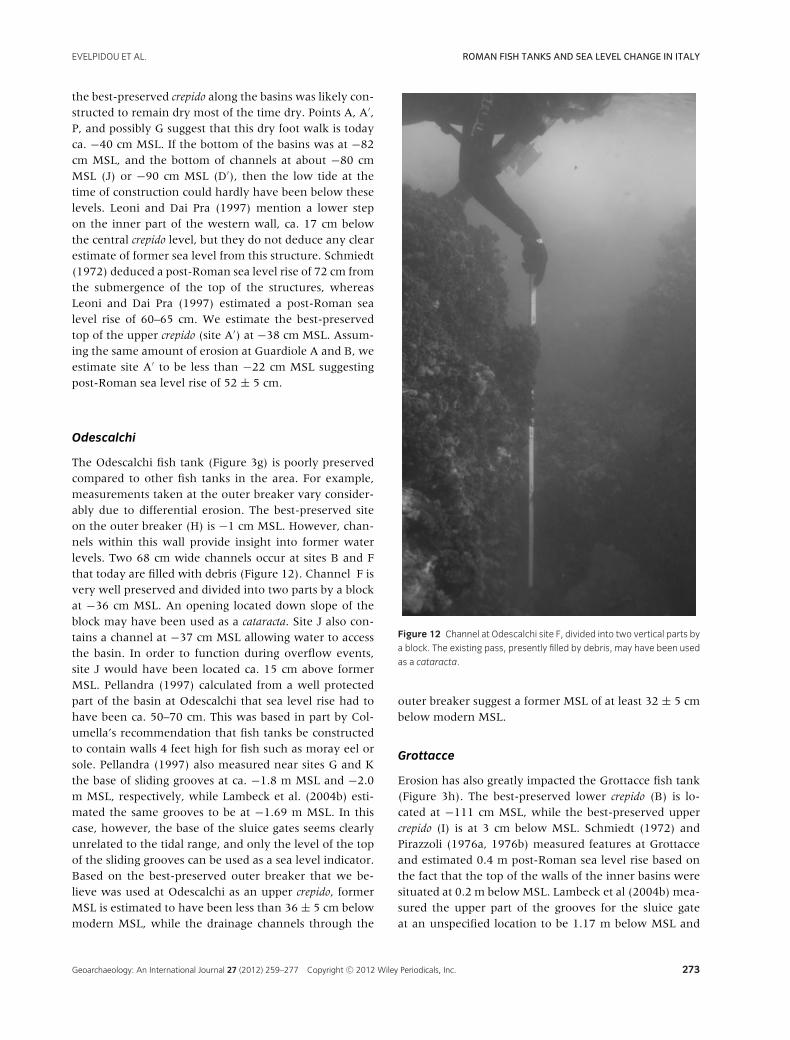
The Odescalchi fish tank (Figure 3g) is poorly preservedcompared to other fish tanks in the area. For example,measurements taken at the outer breaker vary consider-ably due to differential erosion. The best-preserved siteon the outer breaker (H) is −1 cm MSL. However, chan-nels within this wall provide insight into former waterlevels. Two 68 cm wide channels occur at sites B and Fthat today are filled with debris (Figure 12). Channel F isvery well preserved and divided into two parts by a blockat −36 cm MSL. An opening located down slope of theblock may have been used as a cataracta. Site J also con-tains a channel at −37 cm MSL allowing water to accessthe basin. In order to function during overflow events,site J would have been located ca. 15 cm above formerMSL. Pellandra (1997) calculated from a well protectedpart of the basin at Odescalchi that sea level rise had tohave been ca. 50–70 cm. This was based in part by Col-umella’s recommendation that fish tanks be constructedto contain walls 4 feet high for fish such as moray eel orsole. Pellandra (1997) also measured near sites G and Kthe base of sliding grooves at ca. −1.8 m MSL and −2.0m MSL, respectively, while Lambeck et al. (2004b) esti-mated the same grooves to be at −1.69 m MSL. In thiscase, however, the base of the sluice gates seems clearlyunrelated to the tidal range, and only the level of the topof the sliding grooves can be used as a sea level indicator.Based on the best-preserved outer breaker that we be-lieve was used at Odescalchi as an upper crepido, formerMSL is estimated to have been less than 36 ± 5 cm belowmodern MSL, while the drainage channels through the
Figure 12 Channel at Odescalchi site F, divided into two vertical parts by
a block. The existing pass, presently filled by debris, may have been used
as a cataracta.
outer breaker suggest a former MSL of at least 32 ± 5 cmbelow modern MSL.
Grottacce
Erosion has also greatly impacted the Grottacce fish tank(Figure 3h). The best-preserved lower crepido (B) is lo-cated at −111 cm MSL, while the best-preserved uppercrepido (I) is at 3 cm below MSL. Schmiedt (1972) andPirazzoli (1976a, 1976b) measured features at Grottacceand estimated 0.4 m post-Roman sea level rise based onthe fact that the top of the walls of the inner basins weresituated at 0.2 m below MSL. Lambeck et al (2004b) mea-sured the upper part of the grooves for the sluice gateat an unspecified location to be 1.17 m below MSL and
Geoarchaeology: An International Journal 27 (2012) 259–277 Copyright C© 2012 Wiley Periodicals, Inc. 273
ROMAN FISH TANKS AND SEA LEVEL CHANGE IN ITALY EVELPIDOU ET AL.
Figure 13 Contour plot of relative sea level at 2000 yr B.P. across the
central Mediterranean, obtained usingmodel ICE5-G (VM2) and the SELEN
program. Relative sea level is close to 0.5 m below the present MSL in the
study area.
assumed that this kind of structure was tide controlled.Taking into account a tide of ±40 cm, they estimated thebottom level of the sluice gate at −1.57 m MSL. Unfor-tunately, we are unable to determine where the sluicegate presently archived in the Santa Marinella Museum(Figure 5) was located at Grottacce, mainly because thefish tank is highly eroded. This sluice gate (cataracta) isthe only one known to be preserved from the Civitavec-chia area. It is 60 cm high in its best-preserved parts withholes located 7 cm above the base and below the top; thispermitted an exchange of water over a height of 46 cm.
The range of hourly sea level heights measured atthe tide-gauge station of Civitavecchia during 1998–2006extends over 93 cm, from −42 MSL to +51 cm MSL(Table III). Assuming that the present tidal range andclimate are similar to those during the Roman period, acorrect interpretation of sea level indicators at Grottacceshould answer the following question: what would havebeen the best altimetric position of the sluice gate in or-der to optimize functionality? Varrone Reatino (De ReRustica, III, 17.9; Schmiedt, 1972) mentions that Horten-sius disdained the fish tanks owned by M. Lucullus quodaestiuaria idonea non haberet, ac reside aqua in locis pestilen-tibus habitarent pisces eius (because they were not providedwith adequate exchange of water and his fish were there-fore left in stagnant water under pestilent conditions).According to Auriemma and Solinas (2009:137), “ . . . sealevel could not go over the top of the grid (to avoid theleakage of water and loss of fish), nor underneath the
base of the grid, to guarantee an uninterrupted influx ofwater.” These criteria are clearly impossible to meet in theCivitavecchia area with a cataracta 60 cm high and per-mitting exchange of water over a limited height of 46 cm.From this point of view, we agree with Leoni and Dai Pra(1997) when they claim that the measurements deducedfrom fish tanks should not indicate precise sea levels, butrather upper or lower limits consistent with an accept-able functionality of the system. Also, it should not be as-sume that these fish tanks functioned properly at the timeof extreme tides and surges, which are exceptional andshould not be considered any less dangerous and riskythan a wild sea or a great storm. Tidal heights exceed-ing the level of the cataractae and/or of the crepidines thatpermitted the fish to escape must have been feared morethan a temporary interruption in the influx of water for afew hours in relatively shallow basins, especially if therewas the possibility of adding fresh water.
At Grottacce, site I contains the best possible sea levelindicator and suggests that the submergence of this fishtank is comparable to that of other sites. Lower crepido(e.g., site B) should not be used as a sea level indicatorbecause it is very close to the bottom of the tank, andif it did remain emerged, the depth of the water in thebasin would have been insufficient. Therefore, the top ofthe upper crepido at site I (3 cm below MSL), assuming itwas emerged by 35 cm during operation of the fish tank,suggests a post-Roman sea level rise of 38 ± 5 cm.
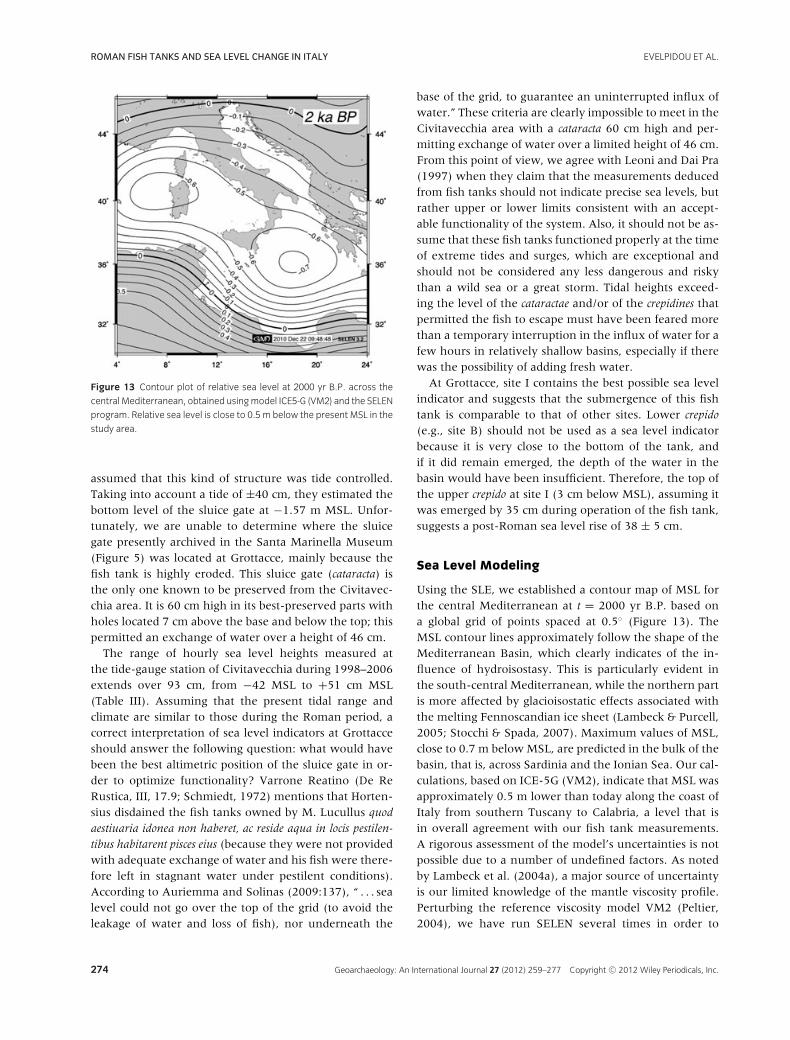
Sea Level Modeling
Using the SLE, we established a contour map of MSL forthe central Mediterranean at t = 2000 yr B.P. based ona global grid of points spaced at 0.5◦ (Figure 13). TheMSL contour lines approximately follow the shape of theMediterranean Basin, which clearly indicates of the in-fluence of hydroisostasy. This is particularly evident inthe south-central Mediterranean, while the northern partis more affected by glacioisostatic effects associated withthe melting Fennoscandian ice sheet (Lambeck & Purcell,2005; Stocchi & Spada, 2007). Maximum values of MSL,close to 0.7 m below MSL, are predicted in the bulk of thebasin, that is, across Sardinia and the Ionian Sea. Our cal-culations, based on ICE-5G (VM2), indicate that MSL wasapproximately 0.5 m lower than today along the coast ofItaly from southern Tuscany to Calabria, a level that isin overall agreement with our fish tank measurements.A rigorous assessment of the model’s uncertainties is notpossible due to a number of undefined factors. As notedby Lambeck et al. (2004a), a major source of uncertaintyis our limited knowledge of the mantle viscosity profile.Perturbing the reference viscosity model VM2 (Peltier,2004), we have run SELEN several times in order to
274 Geoarchaeology: An International Journal 27 (2012) 259–277 Copyright C© 2012 Wiley Periodicals, Inc.
EVELPIDOU ET AL. ROMAN FISH TANKS AND SEA LEVEL CHANGE IN ITALY
ascertain how uncertainty on mantle viscosity may af-fect MSL predictions. According to these computations,we estimate the MSL model error at the level of ±0.2 mat the time scales considered in this study.
DISCUSSION
Lambeck et al. (2004a, Figure 3c) originally noted thatthe former sea level estimate of 0.5 ± 0.2 m belowMSL indicated by previous studies of Roman fish tanks(Schmiedt, 1972; Pirazzoli, 1976a; Leoni & Dai Pra, 1997)was higher than the predictions made by the GIA model.A recent paper (Lambeck et al., 2004b) reinterprets thefish tanks and estimates former sea level differently thanprevious authors. This reinterpretation was based largelyon the assumed identification of the lower and upper lim-its of sluice gates, the difference between the two esti-mated at 40–45 cm. The lower limit estimates were de-duced from channel thresholds (i.e., from the base ofsliding grooves for gates). The upper limit estimates weremade from the top of the sluice gate that Lambeck et al.(2004b) place at the elevation of the lowest foot walks,assumed to have been above high tide. This resulted inthe estimation of Roman sea level at 135 ± 7 cm belowmodern MSL.
It is well known from the literature that several lev-els of foot walks may exist in fish tanks, the lowest one,probably used for maintenance purposes, situated notmuch higher than the basin floor, as we note at Grot-tacce. This is also the case at the site of Piscina di Lu-cullo, where only the uppermost foot walk could haveremained emerged, with the intermediate crepidines situ-ated clearly below openings for water adduction (Chiap-pella, 1965). At the Sarinola fish tank we verified that alower foot walk, a few decimeters below the upper one,could not remain dry, because its level corresponds tothe thresholds of the sliding grooves associated with thesluice gates, as noted by Leoni and Dai Pra (1997) andAntonioli and Leoni (1998).
Concerning the height of the sluice gates, the estimateof 40–45 cm proposed by Lambeck et al. (2004b) is notsufficient for the fish tank to function properly if the av-erage distribution of tide levels in the area is considered.If the top of the sluice gate was at the level of the dryfoot walk, then the base of sliding grooves for the gates isnot a reliable indicator of former sea level, because it canbe located at any depth in the basin, for example, 1.80m below MSL at Odescalchi (Pellandra, 1997) where thesliding grooves are ca. 2 m high. We argue that the up-per part of the sliding grooves generally ended not at thelower foot walks, but instead at the level of the upperfoot walks, from where the gate could be easily worked.
Assuming that that the top of the upper foot walks washigh enough above high tide to prevent frequent flood-ing by sea surges (that could cause loss of fish), theycan be used where well preserved as a reliable sea levelindicator.
Our results coincide with other estimates of formersea level based on studies of ancient harbors and coastalinstallations in the western Mediterranean (Blackman,1973; Morhange, Laborel, & Hesnard, 2001). Goiranet al. (2009) obtained an age of 2115 ± 30 14C yr B.P.(230–450 cal. A.D.) on a mole in the ancient harbor ofPortus in the Latium region, situated at the right bankof the mouth of Tiber, indicating a former sea level of80 ± 10 cm below modern MSL. This estimate correlateswell with our results if one considers a slight offset due todeltaic subsidence.
Our results are also supported by model predictions ob-tained by Antonioli et al. (2009), who used the samenumerical code in SELEN. Based on MSL estimates atcoastal sites visited by Antonioli et al. (2009, Table I),they compared the outputs of two different models. Thefirst is the one proposed by Lambeck et al. (2004a). Thesecond, implemented in the numerical code SELEN, as-sumes the same viscosity profile suggested by Lambecket al. (2004b) but implements the deglaciation chronol-ogy suggested by model ICE-5G (Peltier, 2004). Antonioliet al. (2009, Figure 8) demonstrate that after the largestice sheets have melted, the two models provide compa-rable results (see also their Table I). This is exactly whatone should expect given that the postglacial period MSLvariations are mostly controlled by the rheology of themantle, which is the same in the two models. Prior toglacial melting, the different outcomes are attributable tothe different equivalent sea level curves of the two mod-els, which imply a different spatial distribution of melt-water load, and hence different sea level responses.
CONCLUSIONS
Submerged archaeological features along the TyrrhenianCoast have been surveyed and measured in detail in or-der to obtain data on late Holocene sea level rise. Weconclude that sea level during the Roman period was aslightly lower than at present. Interpreting architecturalcomponents within eight Roman fish tanks, we estimatea sea level rise ranging 58 ± 5 cm to 32 ± 5 cm, a rangethat is considerably less than that proposed by Lambecket al. (2004b). Using quantitative isostatic models offormer sea level, the MSL contour lines follow ap-proximately the shape of the Mediterranean Basin,which clearly indicates the dominance of hydroisostasy.Calculations based on ICE-5G (VM2) indicate that 2000years ago MSL in the study area was approximately 0.5 m
Geoarchaeology: An International Journal 27 (2012) 259–277 Copyright C© 2012 Wiley Periodicals, Inc. 275
ROMAN FISH TANKS AND SEA LEVEL CHANGE IN ITALY EVELPIDOU ET AL.
below modern MSL, in agreement with the observationsreported in this study.
We attribute the discrepancy between our estimatesand those of Lambeck et al. (2004b) to a different inter-pretation of the hydraulic position of Roman fish tankfeatures relative to former sea level. Our interpretationsare consistent with archaeological evidence and historicrecords of Roman fish tank construction. This analysissheds light not only on local coastal processes over thepast 2000 years but may also provide data for evaluat-ing the rate of continental ice mass melting and viscosityprofiles of the earth’s mantle. Clearly, more research onarchaeological sea level indicators that incorporates ob-jective and careful interpretation of field data is neededto improve understanding of current sea level rise.
This research was supported by COST Action ES0701 “Im-proved constraints on models of Glacial Isostatic Adjust-ment.” Authors would like to thank the authorities of Portodi Formia for facilities and Flavio Enei (Museo del Maree della Navigazione Antica, Santa Marinella) for helpfulinformation. Constructive suggestions of Gary Huckleberryand Jamie Woodward and two anonymous reviewers havebeen greatly appreciated and helped to improve a previ-ous version of this paper. The code SELEN is available fromhttp://www.fis.uniurb.it/spada/SELEN minipage.html.
REFERENCES
Alessandro, P., Antonioli, F., Rubens, O., Gavini, V., Trainito,
E., & Verrubbi, V. (2011). Relative sea level change in
Olbia Gulf (Sardinia, Italy), a historically important
Mediterranean harbour. Quaternary International, 232,
21–30.
Antonioli, F., & Leoni, G. (1998). Siti archeologici sommersi e
loro utilizzazione quali indicatori per lo studio delle
variazioni recenti del livello marino. Il Quaternario, 11,
53–66.
Antonioli, F., Anzidei, M., Lambeck, K., Auriemma, R., Gaddi,
D., Furlani, S., Orru, P., Solinas, E., Gaspari, A., Karinja, S.,
Kovacic, V., & Surace, L. (2007). Sea level change during
Holocene from Sardinia and northeastern Adriatic
(Central Mediterranean Sea) from archaeological and
geomorphological data. Quaternary Science Reviews, 26,
2463–2486.
Antonioli, F., Ferranti, L., Fontana, A., Amorosi, A.M.,
Bondesan, A., Braitenberg, C., Dutton, A., Fontolan, G.,
Furlani, S., Lambeck, K., Mastronuzzi, G., Monaco, C.,
Spada, G., & Stocchi, P.,(2009). Holocene relative sea-level
changes and vertical movements along the Italian
coastline. Quaternary International, 221, 37–51.
Antonioli, F., D’Orefice, M., Ducci, S., Firmati, M., Foresi,
L.M., Graciotti, R., Pantaloni, M., Perazzi, P., & Principe, C.
(2011). Palaeogeographic reconstruction of northern
Tyrrhenian coast using archaeological and
geomorphological markers at Pianosa island (Italy).
Quaternary International, 232, 31–44.
Anzidei, M., Benini, A., Lambeck, K., Antonioli, F., Esposito,
A., Surcae, L. (2005). Siti archeologici costieri di come
indicatori della variazioni del livello del mare: un’
applicazione al mare Tirreno (Italia centrale). In L. de
Maria & R. Turchetti (Eds.), Evolucion Palaeoambiental de
Los Puertos y Fondeaderos Antiguos en el Mediterraneo
Occidental (pp. 115–126). Rome: Rubbetino.
Auriemma, R., & Solinas, E. (2009). Archaeological remains
as sea level change markers: A review. Quaternary
International, 206, 134–146.
Blackman, D.J. (1973). Evidence of sea level change in
ancient harbours and coastal installations. In D. J.
Blackman (Ed.), Marine Aachaeology (pp. 115–139).
London: Butterworths.
Caputo, M., Pieri, L. (1976). Eustatic variation in the last 2000
years in the Mediterranean. Journal of Geophysical
Research, 81, 5787–5790.
Chiappella, V.G. (1965). Esplorazione della cosiddetta “Piscina
di Lucullo” sul lago di Paola. Atti Accad. Naz. Lincei
(CCCLXII). Notizie degli scavi di antichita (Ser 8, vol. XIX,
Suppl.) (Rome) (pp. 146–160).
Ciccone, S. (1992). I resti archeologici sul litorale di Formia.
In: Ecosistema marino in Italia e sulla costa laziale, Atti
Seminario Internazionale di Studi sull’Ecosistema marino,
Azienda Soggiorno e Turismo di Formia e WWF, 101–
114.
Columella, De Re Rustica, XVII. In Schmiedt, G. (1972), Il
livello antico del mar Tirreno. Testimonianze da resti
archeologici. Florence: E. Olschki.
Farrell, W.E., & Clark, J.A. (1976). On postglacial sea level.
Geophysical Journal of the Royal Astronomical Society, 46,
647–667.
Flemming, N.C., & Webb, C.O. (1986). Tectonic and eustatic
coastal changes during the last 10000 years derived from
archaeological data. Zeitschrift fur Geomorphologie,
Supplementband, 62, 1–29.
Giacopini, L., Marchesini, B., & Rustico, L. (1994).
L’Itticultura nell’antichita. Roma: Enel.
Gianfrotta, P.A. (1972). “Castrum Novum” (Volume 18).
Roma: Forma Italiae.
Goiran, J.-P., Tronchere, H., Collalelli, U., Salomon, F., &
Djerbi, H. (2009). Decouverte d’un niveau marin
biologique sur les quais de Portus : le port antique de
Rome. Mediterranee, 112, 59–67.
Jacono, L. (1913). Note di archeologia marittima, Neapolis,
Rivista de Archeologia Epigrafia e Numismatica, Napoli, I,
3–4, 353–371.
Lambeck, K., Antonioli, F., Purcell, A., & Silenzi, S. (2004a).
Sea level change along the Italian coast for the past 10000
years. Quaternary Science Reviews, 23, 203–222.
Lambeck, K., Anzidei, M., Antonioli, F., Benini, A., &
Esposito, A. (2004b). Sea level in Roman time in the
276 Geoarchaeology: An International Journal 27 (2012) 259–277 Copyright C© 2012 Wiley Periodicals, Inc.
EVELPIDOU ET AL. ROMAN FISH TANKS AND SEA LEVEL CHANGE IN ITALY
central Mediterranean and implications for recent change.
Earth and Planetary Science Letters, 224, 563–575.
Lambeck, K., & Purcell, A. (2005). Sea-level change in the
Mediterranean Sea since the LGM: Model predictions for
tectonically stable areas. Quaternary Science Reviews, 24,
1969–1988.
Lambeck, K., Antonioli, F., Anzidei, M., Ferranti, L., Leoni,
G., Scicchitano, G., & Silenzi, S. (2011). Sea level change
along the Italian coast during the Holocene and projections
for the future. Quaternary International, 232, 250–257.
Leoni, G., & Dai Pra, G. (1997). Variazioni del livello del mare
nel tardo Olocene (ultimi 2500 ann) lungo la costa del
Lazio in base as indicatori geo-archeologici. ENEA, 110 p.,
Tables.
Milne, G.A., & Mitrovica, J.X. (1998). Postglacial sea-level
change on a rotating Earth. Geophysical Journal
International, 133, 1–19.
Morhange, C., Laborel, J., & Hesnard, A. (2001). Changes of
relative sea level during the past 5000 years in the ancient
harbor of Marseilles, Southern France. Palaeogeography,
Palaeoclimatology, Palaeoecology, 166, 319–329.
Pellandra, D. (1997). Due poco note peschiere romanea Santa
Severae a Santa Marinella. Archeologia Subacquea, 2,
21–33.
Peltier, W.R. (2004). Global glacial isostasy and the surface of
the Ice-Age Earth: The ICE-5G (VM2) model and GRACE.
Annual Review of Earth and Planetary Sciences, 32,
111–149.
Pirazzoli, P.A. (1976a). Sea level variations in the northwest
Mediterranean during Roman times. Science, 194,
519–521.
Pirazzoli, P.A. (1976b). Les variations du niveau marin depuis
2000 ans. Memoires du Laboratoire de Geomorphologie
del’Ecole Pratique des Hautes Etudes, no. 30, Dinard,
421 p.
Pirazzoli, P.A. (1979). Les viviers a poissons romains en
Mediterranee. Oceanis, 5, 191–201.
Pirazzoli, P.A. (2010). Geomorphic, biologic and archaeologic
indicators of sea-level change: eustatic, tectonic and
isostatic interpretations. 85◦ Congresso della Societa
Geologica Italiana, Rendiconti Online de la Societa
Geologica Italiana, Vol. 11. (pp. 42–43).
Pirazzoli, P.A., & Tomasin, A. (2008). Return time of extreme
sea levels in the central Mediterranean area. Bollettino
Geofisico, 31, 19–33.
Plinius, Naturalis Historia, IX. In Schmiedt, G. (1972), Il
livello antico del mar Tirreno. Testimonianze da resti
archeologici. Florence: E. Olschki.
Schmiedt, G. (1972). Il livello antico del mar Tirreno.
Testimonianze da resti archeologici, Florence:
E. Olschki.
Spada, G., & Stocchi, P. (2007). SELEN: a Fortran 90 program
for solving the “sea level equation”. Computers and
Geosciences, 33, 538–562.
doi:10.1016/j.cageo.2006.08.006.
Stocchi, P., & Spada, G. (2007). Post–glacial sea-level in the
Mediterranean Sea: Clark’s zones and role of remote ice
sheets. Annals of Geophysics, 50, 741–761.
Tsimplis, M., Spada, G., Marcos, M., & Flemming, N. (2011).
Multi-decadal sea level trends and land movements in the
Mediterranean Sea with estimates of factors perturbing tide
gauge data and cumulative uncertainties. Global and
Planetary Change, 76, 63–76.
Varrone Realtino, De Re Rustica III. In Schmiedt, G. (1972), Il
livello antico del mar Tirreno. Testimonianze da resti
archeologici. Florence: E. Olschki.
Geoarchaeology: An International Journal 27 (2012) 259–277 Copyright C© 2012 Wiley Periodicals, Inc. 277
Related Documents