CITATION Talling, P.J., M. Clare, M. Urlaub, E. Pope, J.E. Hunt, and S.F.L. Watt. 2014. Large submarine landslides on continental slopes: Geohazards, methane release, and climate change. Oceanography 27(2):32–45, http://dx.doi.org/10.5670/oceanog.2014.38. DOI http://dx.doi.org/10.5670/oceanog.2014.38 COPYRIGHT is article has been published in Oceanography, Volume 27, Number 2, a quarterly journal of e Oceanography Society. Copyright 2014 by e Oceanography Society. All rights reserved. USAGE Permission is granted to copy this article for use in teaching and research. Republication, systematic reproduction, or collective redistribution of any portion of this article by photocopy machine, reposting, or other means is permitted only with the approval of e Oceanography Society. Send all correspondence to: [email protected] or e Oceanography Society, PO Box 1931, Rockville, MD 20849-1931, USA. O ceanography THE OFFICIAL MAGAZINE OF THE OCEANOGRAPHY SOCIETY DOWNLOADED FROM HTTP://WWW.TOS.ORG/OCEANOGRAPHY

Welcome message from author
This document is posted to help you gain knowledge. Please leave a comment to let me know what you think about it! Share it to your friends and learn new things together.
Transcript

CITATION
Talling, P.J., M. Clare, M. Urlaub, E. Pope, J.E. Hunt, and S.F.L. Watt. 2014. Large submarine
landslides on continental slopes: Geohazards, methane release, and climate change.
Oceanography 27(2):32–45, http://dx.doi.org/10.5670/oceanog.2014.38.
DOI
http://dx.doi.org/10.5670/oceanog.2014.38
COPYRIGHT
This article has been published in Oceanography, Volume 27, Number 2, a quarterly journal of
The Oceanography Society. Copyright 2014 by The Oceanography Society. All rights reserved.
USAGE
Permission is granted to copy this article for use in teaching and research. Republication,
systematic reproduction, or collective redistribution of any portion of this article by photocopy
machine, reposting, or other means is permitted only with the approval of The Oceanography
Society. Send all correspondence to: [email protected] or The Oceanography Society, PO Box 1931,
Rockville, MD 20849-1931, USA.
OceanographyTHE OFFICIAL MAGAZINE OF THE OCEANOGRAPHY SOCIETY
DOWNLOADED FROM HTTP://WWW.TOS.ORG/OCEANOGRAPHY

Oceanography | Vol. 27, No. 232
S P E C I A L I S S U E O N U N D E R S E A N AT U R A L H A Z A R D S
Large Submarine Landslides on Continental Slopes
Geohazards, Methane Release, and Climate Change
B Y P E T E R J . TA L L I N G , M I C H A E L C L A R E ,
M O R E L I A U R L A U B , E D P O P E , J A M E S E . H U N T,
A N D S E B A S T I A N F . L . W AT T
View from the north to the Storegga landslide ~ 80 km off the coast of Norway.
The headscarp of this huge underwater landslide extends for over 300 km
along the Norwegian continental shelf. Graphics/Image: Christian Berndt, GEOMAR
32 Oceanography | Vol. 27, No. 2

Oceanography | June 2014 33
marking the upper boundary of failed material, is over 300 km long (Figure 1a). The often extreme scale of continental slope landslides may be due to the long continuous slopes found on such margins and to extensive weak horizons in layer-cake stratigraphy (Figure 1c). However, the most remarkable feature of large continental slope landslides is that they often occur on gradients of < 2° (Figure 1d; Hühnerbach et al., 2004). Such low gradients are almost always stable on land.
Following advances in seafloor mapping, large (> 1 km3) submarine
landslides have been mapped on continental slopes in numerous locations worldwide (Hühnerbach et al., 2004; Urlaub et al., 2013). Submarine land-slides are a threat to seafloor infrastruc-ture used for recovering oil and gas that can be worth many tens of millions of dollars (Barley, 1999). The Ormen Lange gas field, which currently provides ~ 20% of the United Kingdom’s gas supplies, is located directly below the headwall of the Storegga Slide (Figure 1a). Landslides may disintegrate and mix with seawater to form even more mobile sediment flows, called turbidity currents. Turbidity currents can break seafloor telecommu-nication cables (Piper et al., 1999; Carter et al., 2012), which now carry > 95% of global data traffic, including the Internet. Tsunamis are most commonly generated by underwater earthquakes, but they can also result from submarine landslides. Debate surrounds the magnitude of landslide tsunamis, but deposits linked to the Storegga Slide record a tsunami that inundated surrounding coasts to heights of 6–20 m (Figure 1b; Bondevik et al., 2005, 2012), and landslide tsunamis have caused loss of life in recent times. A submarine landslide with a volume of ~ 5 km3 located offshore Papua New Guinea produced a localized tsunami that killed 2,200 people in 1999 (Tappin et al., 2008).
INTRODUC TIONSubmarine landslides on open conti-nental slopes can be exceptionally large, with volumes that far exceed those of any terrestrial landslide (Table 1). For instance, the Storegga landslide that occurred 8,200 years ago offshore Norway covers an area of seafloor that is larger than Scotland, and it contains over 3,000 km3 of sediment (Figure 1a; Haflidason et al., 2005). This volume is more than 300 times the annual sediment flux transported to the ocean by all of the world’s rivers (Table 1). The headwall of the Storegga landslide,
ABSTR AC T. Submarine landslides on open continental slopes can be prodigious in scale. They are an important process for global sediment fluxes, and can generate very damaging tsunamis. Submarine landslides are far harder to monitor directly than terrestrial landslides, and much greater uncertainty surrounds their preconditioning factors and triggers. Submarine slope failure often occurs on remarkably low (< 2°) gradients that are almost always stable on land, indicating that particularly high excess pore pressures must be involved. Earthquakes trigger some large submarine landslides, but not all major earthquakes cause widespread slope failure. The headwalls of many large submarine landslides appear to be located in water depths that are too deep for triggering by gas hydrate dissociation. The available evidence indicates that landslide occurrence is either weakly (or not) linked to changes in sea level or atmospheric methane abundance, or the available dates for open continental slope landslides are too imprecise to tell. Similarly, available evidence does not strongly support a view that landslides play an important role in methane emissions that cause climatic change. However, the largest and best-dated open continental slope landslide (the Storegga Slide) coincides with a major cooling event 8,200 years ago. This association suggests that caution may be needed when stating that there is no link between large open slope landslides and climate change.
Landslide is used as a general term for the results of slope failure. Hampton et al. (1996) and Locat and Lee (2002) provide detailed terminology for slope failures and resulting mass movements. Open continental slopes are those that lack deeply incised canyons. Large landslides are defined here as those with volumes >1 km3.
TER
MIN
OLO
GY

Oceanography | Vol. 27, No. 234
A fundamental question for geohazard assessment is what causes large continental slope landslides? It is important to distinguish between factors that precondition a slope to fail
and the final triggers. A wide variety of hypotheses have been proposed for how large-scale continental slope failure is preconditioned or triggered. These hypotheses are difficult to test
conclusively because of the infrequent nature of submarine landslides and our current inability to forecast their precise timing or location. This limits our knowledge of slope properties around the time of failure. Monitoring efforts are also hindered by the fact that landslides may destroy or damage local monitoring equipment. Therefore, we have yet to monitor detailed subsurface conditions just before failure, or the resulting land-slide motion, for any large continental slope landslide. It is not easy to monitor terrestrial landslides, but there is stark contrast between the quality and number of direct observations available for terrestrial and submarine landslides.
A second key issue for geohazard analysis is the frequency of large continental slope landslides and whether it will change significantly in the future. Very few large continental slope land-slides have been dated precisely (Urlaub et al., 2013). The main source of uncer-tainties in landslide ages is not associated with the dating techniques (such as radiocarbon dating) but rather with the locations of samples used for dating and the effects of sediment mixing by organ-isms (called bioturbation; see Urlaub et al., 2013). Indeed, only landslides that led to submarine cable breaks in the last century (Piper et al., 1999) or that have recently impacted coastal populations (L’Heureux et al., 2011), as well as the unusually well-studied Storegga land-slide and tsunami deposit (Figure 1a,b; Haflidason et al., 2005; Bondevik et al., 2005, 2012), have age uncertainties of less than a few hundred years (Urlaub et al., 2013). It has been proposed that landslide frequency may increase as a result of warming climates and rising sea levels via processes including the melting of gas hydrate (Kennett et al., 2003; Maslin et al., 2004), an ice-like
Peter J. Talling ([email protected]) is Leader, Geohazards and Sedimentology
Research Group, National Oceanography Centre, Southampton, UK. Michael Clare is
Postgraduate Research Student, National Oceanography Centre, Southampton, UK.
Morelia Urlaub is Postdoctoral Researcher, GEOMAR Helmholtz-Centre for Ocean
Research Kiel, Kiel, Germany. Ed Pope is Postgraduate Research Student, National
Oceanography Centre, Southampton, UK. James E. Hunt is Postdoctoral Researcher,
National Oceanography Centre, Southampton, UK. Sebastian F.L. Watt is NERC Research
Fellow, School of Geography, Earth and Environmental Science, University of Birmingham,
Edgbaston, Birmingham, UK.
Table 1. Volumes and frequencies of different types of events. See Talling (2014) for data sources.
Process Volume Average Frequency
SUBMARINE LANDSLIDES
Storegga Slide offshore Norway > 3,000 km3 –
15 nonvolcanic slides in last 36,000 years > 100 km3 > 100 km3 Less than 2,400 years
1929 Grand Banks landslide-turbidite ~ 175 km3 –
Volcanic island flank collapses of the western Canary Islands 50–500 km3 1 per 150,000 years
SEDIMENT FLUXES DURING A SINGLE FLOOD OF INDIVIDUAL RIVER
Largest floods of single rivers 0.03–0.06 km3 1–50 years
Jokullhlaup in Iceland, 1996 0.07 km3 –
AVERAGE ANNUAL RIVER SEDIMENT FLUXES
Largest annual sediment flux from a single river (Amazon) 0.4 km3 Annual
Sediment flux from all the rivers in world for a year ~ 6 km3
VOLCANIC PROCESSES
Largest explosive volcanic eruptions (Magnitude > 8; e.g., Toba ~ 74,000 years ago) > 350 km3 100,000–800,000 years
Magnitude 6 explosive eruptions (e.g., Krakatau, 1883 CE) ~ 10 km3 50–100 years
Magnitude 4–5 explosive eruptions (e.g., Mount St. Helens, 1980 CE) ~ 1 km3 ~ 10 years
OTHER PROCESSES
Snow avalanches Typically < 0.001 km3 –
Sediment mobilized on land during a single major earthquake 5–15 km3 –

Oceanography | June 2014 35
substance containing methane hosted in marine sediment (Maslin et al., 2010), or through changes in crustal loading that may trigger earthquakes and asso-ciated landslides (Brothers et al., 2013; Smith et al., 2013).
Finally, it has been suggested that large submarine landslides may play a role in climate change. Changes in levels of atmospheric methane, a strong greenhouse gas, have been attributed to melting of large volumes of marine gas hydrates (Kennett et al., 2003). This has been termed the “clathrate gun hypothesis” to distinguish it from a hypothesis that methane fluxes from wetlands primarily drive atmospheric methane levels (Kennett et al., 2003). It has been proposed that large sub-marine landslides are a key process for release of methane from the seafloor (Maslin et al., 2004).
This paper begins by evaluating the evidence for how large continental slopes are preconditioned to fail and, finally, triggered. It then outlines information on how landslides move, and the implications for tsunami generation. Key work on past landslide frequency is then summarized in order to help understand the factors that may control past landslide frequency and whether they have been temporally random or non-random. Implications for future landslide frequency are discussed briefly. Finally, we assess whether there is strong evidence that large continental slope landslides play a major role in determin-ing atmospheric methane levels.
CAUSES OF L ARGE SUBMARINE L ANDSLIDES ON CONTINENTAL SLOPES A key factor for slope failure in sub-marine or subaerial settings is excess pore pressure within the sediment that
is above the hydrostatic pore pressure, which acts to support the sediment over-burden (Figure 2; Dugan and Sheahan, 2012). A rise in pore pressure leads to lowering of the vertical effective stress in the slope, which in turn undermines
the shear strength in the sediments and the slope stability. If excess pore pressure is supporting all of the overburden, then the slope is at the point of failure (Figure 2). Large continental slope fail-ures often occur on much flatter (< 2°)
Figure 1. (a, b) Location of the Storegga Slide that comprises > 3,000 km3 of material and covers an area larger than Scotland. The red dots indicate locations of tsunami deposits associated with the Storegga Slide. Tsunami runup heights above sea level are indicated in (b). Black bars indicate minimum runup heights and gray bars maximum runup heights. From Bondevik et al. (2012) (c) Example from offshore Northwest Africa of stair-stepped landslide morphology resulting from failure along multiple weak layers (numbered 1 to 4). From Masson et al. (2010) (d, e) Frequency distributions of seafloor gradients and headwall water depths for large (> 1 km3) submarine landslides. After Hühnerbach et al. (2004)

Oceanography | Vol. 27, No. 236
gradients than terrestrial landslides. Excess pore pressures within submarine slope failures thus must in general sup-port an even greater fraction of the over-burden than in terrestrial slope failures.
Pore Pressures Due To Weight of Overlying SeawaterThe weight of seawater might be invoked as a cause of submarine slope failure, such that failure is more likely as sea level rises (Smith et al., 2013). However, it is important to differentiate between hydrostatic pore pressure within the sed-iment and excess pore pressure (Figure 2; Dugan and Sheahan, 2012; Smith et al., 2013). Hydrostatic pressure results from the weight of an overlying water column,
and it acts equally in all directions. Hydrostatic pressure does not support overlying sediment, and changes in hydrostatic pressure alone do not make a slope more likely to fail. Sea level rise that only affects hydrostatic pressures would not cause slope failure. Nevertheless, if the rate of sea level rise is unusually rapid and the sediment has very low permea-bilities, transient excess pore pressures could be generated (Smith et al., 2013). It could also be speculated that sea level fall triggers landslides. Low tides have been linked to slope failures in shallow water, in some cases probably due to expansion of gas bubbles within organic-rich sed-iment (Christian et al., 1997). However, there is no evidence that large landslides
in deeper water are associated with low tides, or indeed with long-term sea level falls (Urlaub et al., 2013).
Excess Pore Pressures Caused by Rapid Sedimentation and Fluid FlowThe most commonly invoked process for generating high excess pore pressures in continental slopes is rapid deposition of low permeability sediment (Dugan and Flemings, 2000; Stigall and Dugan, 2010; Dugan and Sheahan, 2012). Excess pore pressures result when fluid cannot dissipate quickly enough due to low permeability along drainage paths (Dugan and Sheahan, 2012). Rapid and prolonged sedimentation occurs offshore from major river mouths (Flemings et al., 2008) and at the terminations of glacial ice streams (Nygård et al., 2007). Sedimentation rates of up to 30 m per thousand years can be sustained for several thousand years in such settings. Numerical modeling shows that such fast sedimentation rates can result in excess pore pressures that approach the vertical effective stress, bringing low gradient (< 2°) continental slopes close to failure (Dugan and Flemings, 2000; Stigall and Dugan, 2010). This is consistent with direct measurement of excess pore pressures offshore from the Mississippi River delta (Flemings et al., 2008).
However, headwalls of large conti-nental slope failures tend to occur in water depths of 1,000 m to 1,500 m or deeper (Figure 1e; Hühnerbach et al., 2004), much deeper than locations of highest sedimentation rates. It has thus been proposed that fluid is driven along permeable horizons toward the toe of slope due to asymmetric sediment loads that decrease offshore (Figure 3b; Dugan and Flemings, 2000; Masson et al., 2010; Dugan and Sheahan, 2012). This lateral
Pressure or Stress
Dep
th (b
elow
sea
�oor
)
Overburden (Total Stress)
Hydrostatic Pore Pressure
Excess Pore Pressure
VerticalE�ective
Stress
Overpressure
a overburden (total) stress (σ)
shear strength (τ) excess pore pressure (µ)
c
b
τ = (σ – µ) tan θ Figure 2. (a) Relationship between overburden (total stress; σ) and excess pore pressure (µ) acting normal to a failure plane, and shear strength (τ) along the failure plane, such that τ = (σ – µ) tan θ, where tan θ is the friction coefficient. The slope comes closer to failure as the excess pore pressure approaches the overburden (total stress). (b) Schematic illustration of undrained (water-saturated) soil in which grain contacts bear the overburden (total stress). (c) Generalized example of change in overburden (total stress; σ), hydrostatic pore pressure, excess pore pressure (over-pressure; µ), and vertical effective stress (σ – µ) with depth below the seafloor. In this example, vertical effective stresses are small, such that the slope is close to failure.

Oceanography | June 2014 37
fluid flow may produce excess pore pressure where the overburden is thinner in base-of slope-locations, favoring slope failure in these regions (Dugan and Flemings, 2000). Excess pore pressures may peak within a few thousand years of maximum sedimentation rates, but some large landslides occur long after peak sedimentation (Urlaub et al., 2013). Thus, some uncertainty remains in the relationship between the timing of excess pore pressure generation and subsequent failure.
Failure in Areas of Slow Sedimentation: Loss of Sediment Structure?Large submarine slope failures can also occur in areas with slow sediment accumulation (< 0.3 meters per thousand years), and the morphology of landslides in areas of slow or rapid sedimentation is similar (Urlaub et al., 2014). This suggests that high excess pore pressures can also develop where sedimentation rates are slow if the sediment is sufficiently imper-meable. Urlaub et al. (2014) suggest that loss of structure within sediment layers can lead to rapid compaction during burial in such settings. This “destruc-turing” of the sediment can generate high excess pore pressures at realistic (50–250 m) depths below the seafloor and bring a continental slope toward failure (Urlaub et al., 2014). Various processes, such as early cementation that is favored by abundant calcareous micro-fossils or hydrate cements, could create the initial structure within the sediment, which is subsequently lost.
Cyclic Wave Loading Cyclic wave loading commonly triggers relatively small submarine slope failures in shallow (< 200 m) water, such as those due to hurricanes that impacted
the Mississippi Delta (Bea et al., 1983). However, the headwalls of almost all large slope failures are well below the storm wave base (Figure 1e; Hühnerbach et al., 2004), and wave loading does not trigger these failures.
EarthquakesIt is known that major earthquakes can trigger large submarine landslides. A large (~ 150 km3) landslide offshore from the Grand Banks in 1929 coincided with a magnitude 7.2 earthquake (Piper
Figure 3. (a, b) Two models for continental slope failure due to rapid accumulation of low permeability sediment that generates high excess pore pressures. (a) A landslide initiates in shallow water where the sedimentation rate is rapid. (b) A landslide originates in deep water due to lateral flow of pore fluid toward the toe of slope, driven by the asymmetric sediment load. This results in retrogressive failure that migrates upslope. After Masson et al. (2010) (c–e) Three models to explain why large submarine landslides around a basin margin are temporally random due to (c) temporally random large earth-quakes, (d) different tempos of failure in multiple locations, or (e) multiple factors causing failure at individual locations (e.g., sedimentation rate, earthquake frequency, weak layer development).

Oceanography | Vol. 27, No. 238
et al., 1999). Cable breaks recorded near-synchronous failure of steeper areas that extended over 100 km along the continental slope (Piper et al., 1999). Repeated earthquake shaking can also cause consolidation and strengthening of continental slopes (Locat and Lee, 2002). This may explain why few slope failures occurred near the epicenters of very large (MW 8–9) earthquakes offshore Sumatra in 2004 and 2005 (Sumner et al., 2013) and offshore Chile in 2010 (Völker et al., 2011). Not all major earthquakes appear to generate large continental slope landslides. This conclusion is
important because it has been proposed that turbidity currents associated with large landslides may provide a valuable long-term record of major earthquakes (Goldfinger, 2011; also see Atwater and Griggs, 2012) that extends further back in time than terrestrial records. More work is needed, but it appears that the earthquake record derived in this way may sometimes be incomplete.
Gas HydratesMethane hydrates form where there is a sufficient supply of gas, water at moderate pressure, and relatively low temperature conditions. Disturbance of the pressure-temperature regime causes
gas hydrates to dissociate (“melt”) and release free gas and water within the sed-iment. Dissociation of a small amount of gas hydrate (< ~ 6% volume) can substantially weaken slopes for several reasons (Grozic, 2010). Weakening may occur through the presence of free gas bubbles and sediment volume expansion. The loss of solid hydrate cement may also lead to rapid sediment compaction and generation of excess pore pressures. More speculatively, freshwater generated during dissociation could leach marine clays, leading to quick clay behavior (Bull et al., 2008). The boundary between
stable and unstable gas hydrate tends to reach the seafloor at water depths of 300–900 m (Mienert et al., 2005). Ocean warming causes migration of the hydrate stability zone into deeper water, while sea level rise tends to stabilize hydrate (Figure 4). Some slides occur in areas with sediment that presently or previously contained gas hydrate (Hornbach et al., 2007), but many large continental landslides occur where there is no evidence of gas hydrate (Urlaub et al., 2013). Importantly, most large continental slope slide headwalls occur in water depths greater than 1,000 m (Figure 1e; Hühnerbach et al., 2004), where gas hydrates are predicted to be
stable (Grozic, 2010). It is thus unlikely that gas hydrate dissociation caused these slides (Hühnerbach et al., 2004).
Weak Horizons There is little correlation between seafloor gradient and occurrence of large failures (Hühnerbach et al., 2004; Masson et al., 2010). However, many large continental submarine landslides have similar morphology in the source region, indicating failure along distinct planes that may have particular low-strength properties (Figure 1c; Masson et al., 2006, 2010; Locat et al., 2014). There are exceptions (Winkelmann et al., 2008), and a single landslide may also follow several basal planes at different stratigraphic levels, leading to a stair-stepped profile (Figure 2; Masson et al., 2010). It could be argued that consistent source-region morphologies indicate common global causes for landslides, or it may be that once failure occurs through various causes, it tends to follow discrete stratigraphic horizons or exploit layers with certain properties.
Identifying and understanding glide planes is key for modeling slope failure (Locat et al., 2014). Studies of a small (0.001 km3) landslide in shallow (< 60 m) water at Finneidfjord suggest that failure occurred at a subtle horizon that comprised an interface between fine sand and clay (L’Heureux et al., 2012; Vardy et al., 2012). However, sedimen-tology of weak horizons is not very well understood, mainly because they are destroyed in areas where landslides have occurred, and it is not known how to identify them before they fail (Masson et al., 2010). The steeper scarps that occur between glide planes indicate locally high slope stability (Figure 1c). These steeper scarps are enigmatic, and their presence suggests dissipation of
“LARGE CONTINENTAL SLOPE LANDSLIDES HAVE POTENTIAL TO GENERATE VERY DAMAGING AND FAR TRAVELING TSUNAMIS, AS SHOWN BY THE STOREGGA LANDSLIDE AFTERMATH.”

Oceanography | June 2014 39
high excess pore pressures needed for initial slope failure. Weak intervals of sediment that are evacuated and flow away from the site of failure may be tens of meters thick in some locations (Bull et al., 2008), and their sedimentology is also poorly constrained.
Modeling shows how local failure may generate cracks that propagate very rapidly over much wider areas in a way similar to the progression of snow slab avalanches (Viesca and Rice, 2012). Lateral propagation can occur even where the overburden (vertical effective stress) is not fully supported by excess pore pressure, such that these parts of the slope were not on the point of failure. Together with the presence of failure-prone stratigraphic layers, such a process may partly explain why the basal glide plane of many open continental slope landslides is so extensive.
L ANDSLIDE MOTION AND TSUNAMI HAZARDS Large continental slope landslides have potential to generate very damaging and far traveling tsunamis, as shown by the Storegga landslide aftermath (Figure 1; Bondevik et al., 2005, 2012). However, it is not yet clear whether all large continental slope landslides generate major tsunamis. For instance, no tsunami deposit has yet been linked to the 900 km3 Traenadjupet Slide, north of the Storegga Slide (Stein Bondevik, University of Tromsø, pers. comm., October 10, 2013). Understanding how these landslides move within the ocean is important, as this controls initial tsunami magnitude. Tsunami generation is especially dependent on (1) landslide volume, whether it is emplaced in one or multiple stages (Hunt et al., 2011); (2) landslide length and thickness; (3) water depth; and
(4) the initial acceleration and resulting speed of the landslide—especially in shallower water (Harbitz et al., 2006). Modeling of tsunami runup heights from the Storegga landslide indicates
slope failure with a duration of much less than an hour, and that the failed mass traveled at speeds of several tens of meters per second (Løvholt et al., 2005). Considerable uncertainty surrounds the
Figure 4. (a) Summary of previously inferred gas hydrate melting processes that may cause submarine landslides or cause methane emissions. (b) Continental slope profile showing variation in the gas hydrate stability zone that may cause realistic changes in bottom water temperature and sea level since the last glacial period (modified from Mienert et al., 2005). The range of water depths is shown in which gas hydrate melts (red) due to ocean warming or becomes more stable (blue) due to sea level rise. On the right is a plot of water depths for headwalls (orange histogram) of large landslides in the Western Atlantic showing water depths below which large landslides have occurred (from Hühnerbach et al., 2004).

Oceanography | Vol. 27, No. 240
motion of large underwater landslides due to a paucity of direct measurements (e.g., Piper et al., 1999).
A widely held view is that continental slope landslides are retrogressive, with failure propagating upslope (Locat and
Lee, 2002; Masson et al., 2006, 2010). Tongues of debris that drape across scarps between glide planes are strong evidence of such retrogressive failure, as they postdate evacuation of the under-lying glide planes (Figure 1c). However, it is possible that most of the landslide mass was evacuated over a short period of time, followed by minor late-stage debris flows with small volumes. Snow slab avalanches show how fractures may initiate at the top or middle of slopes and expand rapidly down slope (Viesca and Rice, 2012). Failure of seafloor sediment can also migrate down slope when it is triggered by emplacement of volcanic island collapses, such as the El Golfo collapse that triggered the Canary debris flow (Masson et al., 2006). The existence of so-called frontally confined landslide deposits, which appear not to evacuate their source regions but rather to preserve deformed sediment bodies in situ, provide further evidence that some failures may originate near the heads, rather than the toes, of their source regions, with the driving force acting progressively, in a downslope direction. We thus take a cautious view of whether field evidence indicates that large open continental landslides are always retrogressive.
L ANDSLIDE FREQUENCYFor geohazard assessment, it is key to understand the frequency of large continental slope landslides and the factors that affect this frequency. It is also important to know whether there is a link between landslide frequency, cli-matic change, and atmospheric methane abundance. Previous work suggests that the frequency of large landslides is sig-nificantly higher during periods of low or rising sea level, based on compilations of landslide ages (Owen et al., 2007; Lee,
a
b
e
0 20 40 60 80 100 120 140 160 180Thousands of years before present
Margins with slow sedimentationGlaciated continental margins Margins fed by large rivers
min age
max age
most likely age
erro
r bar
Land
slid
e A
ges
Probability of cores reaching more deeply buriedolder landslide decreases - so bias towards fewer examples
20
0
–20
-40
-60
-80
-100
-120
-140
Glo
bal (
eust
atic
) sea
leve
l (m
bel
ow p
rese
nt)
Recurrence Interval, T (kyr)
Gre
ater
than
or e
qual
to T
(–)
0 2 4 6 8 100.001
0.01
0.1
1 20°W 10°W 0° 10°E 20°E
40°N
30°N1,000 km
Madeira Abyssal
Plain
Marnoso-arenacea
Fm.
BalearicAbyssal
Plain
Balearic Abyssal PlainMarnoso-arenaceaMaderia Abyssal Plain
Locations in b to e
HP Thickness (m) HP Thickness (m) HP Thickness (m)
Freq
uenc
y (N
)
Freq
uenc
y (N
)
Freq
uenc
y (N
)
60
0
100
200 60
40
20
00.40.0 0.2 0.30.0 0.6
c d
02.00.0 1.0
Figure 5. Recent insights in large submarine timing and frequency distribution of recurrence intervals. (a) Ages of large (> 1 km3) submarine landslides plot-ted against global (eustatic) sea level over the last 180,000 years. Maximum and minimum landslide ages are shown, together with the most likely actual ages. Landslides are colored according to the types of settings in which they occur. From Urlaub et al. (2013) (b–d) Histograms showing the frequency distribution of turbidite recurrence intervals measured by the thickness of hemipelagic mud (HP) between each turbidite unit in the (b) Balearic Abyssal Plain, (c) Marnoso-arenacea Formation, and (d) Madeira Abyssal Plain, which are inferred to be landslide triggered. (e) Plot showing cumulative frequency distribution of turbidite recurrence intervals (T) for the same data as in b–d. A straight line on such a log-linear plot indicates the landslides are approximately temporally random (Poissonian). The inset map shows the locations of these three data sets. Parts b–e from Clare et al. (2014a)

Oceanography | June 2014 41
2009). This proposal has been used to support a link between landslides and gas hydrate dissociation (Maslin et al., 2004) or increased seismicity due to flooding of continental shelves (Brothers et al., 2013). However, once realistic error bars for the available landslide ages are included in such an analysis (Figure 5a), either there is no strong correlation between landslide frequency and sea level or the available landslide dates are too imprecise to tell (Figure 5a; Urlaub et al., in press). There is also uncertainty whether landslide frequency covaries with atmospheric methane abundance (Maslin et al., 2010).
Clare et al. (2014a) used turbidity current deposits most likely generated by disintegration of large submarine landslides to analyze landslide frequency. The recurrence intervals for landslide turbidites exhibited temporally random (Poisson) distribution for three different deepwater basin plains (Figure 5e; Clare et al., 2014a). This suggests that the probability of a future landslide does not depend on the time since the last land-slide, which would be inconsistent with a strong control from a single global factor such as eustatic (global) sea level change. It also appears that processes that covary strongly with eustatic sea level and cli-mate cycles are not dominant single con-trols on landslide timing, such as hydrate dissociation driven by ocean warming (Clare et al., 2014a). Earthquakes may be an important cause of landslides, as large magnitude earthquakes have a roughly temporally random reoccurrence interval distribution (Clare et al., 2014a), although not all major earthquakes trig-ger large landslides (Völker et al., 2011; Sumner et al., 2013). Alternatively, large submarine landslides may be caused by yet unknown temporally random processes, by many disparate processes
acting locally along a basin margin, or by a series of processes that occur one after another at a single location (Figure 3c; Clare et al., 2014a).
Here, we propose a model for submarine landslide occurrence where some (but not all) areas of continental slope develop high excess pore pressures through a variety of processes, including rapid sedimentation and lateral fluid flow (Figure 3a,b; Dugan and Flemings, 2000) or destructuring in areas of slow sedimentation (Urlaub et al., 2014). These areas of continental slope are perched on the edge of failure where, for example, large earthquakes can trigger landslides (Figure 3c), resulting in tem-porally random recurrence intervals.
ROLE OF L ANDSLIDES IN METHANE RELEASE AND CLIMATE CHANGE We now assess evidence that large submarine landslides have played a significant role in methane emissions and climatic change. Some large land-slides are associated with hydrate-rich sediment (Hornbach et al., 2007), but many large submarine landslides occur in water depths where gas hydrates are stable (Figure 1e; Hühnerbach et al., 2004), suggesting that many landslides are not triggered by hydrate dissociation. The occurrence of landslides may thus not indicate widespread hydrate disso-ciation, although it does not preclude the release of methane from seafloor sediment through other processes.
Large Submarine Landslide Frequency During Past Abrupt Climate Change EventsCompilations of global landslide ages during the last 30,000 years show no clear correlation between landslide frequency and global climate change
or atmospheric methane abundance in ice core records (Urlaub et al., 2013). However, this is not conclusive evidence against such links, due to the large error bars on most landslide ages (Figure 5a; Urlaub et al., 2013). It may be that these dating uncertainties mask such a relationship. The temporally random nature of landslide-triggered turbidity currents in three disparate deepwater basin plains (Figure 5e; Clare et al., 2014a) also suggests that landslide frequency is not linked strongly to climate cycles because climate cycles are non-random.
The Paleocene Eocene Thermal Maximum (PETM) is a well known example of very abrupt global warming and carbon release into the atmosphere ~ 55 million years ago, which has been attributed to dissociation of gas hydrates in marine sediments (Dickens et al., 1997; Kennett et al., 2003). Katz et al. (1999) concluded that landslide frequency increased during the PETM; however, the landslides that these authors studied are poorly dated, and they come from a single area in the Atlantic Ocean (Blake Plateau). A better-dated landslide-turbidite sequence that spans the PETM at Zumaia in northern Spain suggests that landslides and turbidity currents were actually much less frequent during the PETM (Clare et al., 2014b).
Carbon Isotope Excursions Associated with Individual Large Landslides In the water column, dissolved methane that originates from gas hydrate dissociation has a strongly negative value of δ13C. Following consumption by bacterial metabolism, this anomaly can generate a negative δ13C spike in benthic foraminifera shells (Bock et al.,

Oceanography | Vol. 27, No. 242
2012). It has thus been proposed that negative δ 13C excursions in benthic foraminifera may be a record of methane emissions from large landslides (Kennett et al., 2003; Maslin et al., 2004). This view has been contested, as negative δ 13C excursions might also result from diagenetic processes (Torres et al., 2003), so their significance is uncertain and
complementary proxies are needed (Zeebe, 2007). Excursions in δ 13C values in benthic foraminifera are coeval with large landslides on the Amazon fan (Maslin et al., 2004) and in the Western Mediterranean (Panieri et al., 2012). However, other large landslides do not appear to be linked to an excursion in benthic δ 13C values. For instance, there is no δ 13C excursion associated with the huge Storegga landslide. Overall, there is no unambiguous evidence from marine δ 13C excursions that large submarine landslides are commonly linked to meth-ane emissions from gas hydrates.
Deuterium Isotope Signal in Ice Core Records (Atmospheric Methane)Methane hydrates have a deuterium isotopic signature (δ DCH4) of –190 that distinguishes them from other methane
sources that have δ DCH4 values of ~ –290 (Sowers, 2006; Bock et al., 2012). If methane hydrates in seafloor sediments were a dominant source of atmospheric methane, a less negative value of δ DCH4 would be expected during such climate events. Analysis of ice cores shows that this is not the case, suggesting that the main drivers of atmospheric methane
levels are emissions from other sources, such as wetlands (Sowers, 2006). This is perhaps the strongest line of evidence that increased landslide frequency due to dissociation of marine gas hydrates is not a major driver of climatic change. However, it is possible that although other processes drive atmospheric meth-ane abundances, marine gas hydrates may respond to the resulting climatic changes, thus increasing atmospheric methane levels (Maslin et al., 2010).
Storegga Landslide and the 8.2 ka Climate EventThe preceding lines of evidence do not provide strong support for the hypothesis that landslides are linked strongly to climatic change, either as the driver of climate change through methane emissions (Kennett et al., 2003; Maslin et al., 2004) or as a more frequent
result of climate change. However, there is a striking correlation between the best-dated large submarine landslide and the last major episode of abrupt climate change (Dawson et al., 2011; Bondevik et al., 2012; Smith et al., 2013).
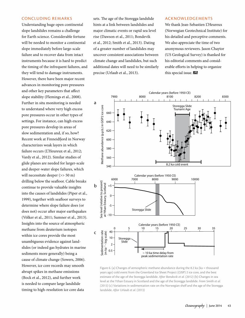
The Storegga landslide and associated tsunami coincided with the coldest part of the 8.2 ka climate event (Figure 6; Dawson et al., 2011; Bondevik et al., 2012) during which temperatures fell by up to 6°C. The Storegga landslide is dated to within ~ 150 years (Bondevik et al., 2012) and could be associated with a rise in atmospheric methane abundance at the end of the 8.2 ka event (Figure 6a). However, methane emissions originally decreased in the 8.2 ka event, suggesting that the Storegga landslide could not have caused the climatic event (Bondevik et al., 2012).
It has been proposed that rapid sea level rise around the northern UK at ~ 8.2 ka triggered the Storegga landslide by loading the shelf and causing increased seismicity or increased excess pore pressures in sufficiently imperme-able sediment (Figure 6; Smith et al., 2013). However, due to complex spatial and temporal variation in local sea level curves as a result of glacial rebound, it is not yet clear whether rapid sea level rise occurred in the source area of the Storegga landslide. There is evidence that the final trigger of the landslide was an earthquake that produced regionally extensive slope failures and turbidity currents (Bøe et al., 2004; Kvalstad et al., 2005). However, other factors such as rapid sedimentation were shown to have preconditioned the slope to failure (Figure 3a; Kvalstad et al., 2005). Further work is needed to determine if exceptionally rapid sea level rise can potentially increase excess pore pressures (Smith et al., 2013).
“SUBMARINE LANDSLIDES ARE FAR HARDER TO MONITOR DIRECTLY THAN TERRESTRIAL LANDSLIDES, AND MUCH GREATER UNCERTAINTY SURROUNDS THEIR PRECONDITIONING FACTORS AND TRIGGERS.”
Oceanography | June 2014 43
CONCLUDING REMARKS Understanding huge open continental slope landslides remains a challenge for Earth science. Considerable fortune will be needed to monitor a continental slope immediately before large-scale failure and to recover data from intact instruments because it is hard to predict the timing of the infrequent failures, and they will tend to damage instruments. However, there have been major recent advances in monitoring pore pressures and other key parameters that affect slope stability (Flemings et al., 2008). Further in situ monitoring is needed to understand where very high excess pore pressures occur in other types of settings. For instance, can high excess pore pressures develop in areas of slow sedimentation and, if so, how? Recent work at Finneidfjord in Norway characterizes weak layers in which failure occurs (L’Heureux et al., 2012; Vardy et al., 2012). Similar studies of glide planes are needed for larger-scale and deeper-water slope failures, which will necessitate deeper (>> 50 m) drilling below the seafloor. Cable breaks continue to provide valuable insights into the causes of landslides (Piper et al., 1999), together with seafloor surveys to determine where slope failure does (or does not) occur after major earthquakes (Völker et al., 2011; Sumner et al., 2013). Insights into the source of atmospheric methane from deuterium isotopes within ice cores provide the most unambiguous evidence against land-slides (or indeed gas hydrates in marine sediments more generally) being a cause of climate change (Sowers, 2006). However, ice core records may smooth abrupt spikes in methane emissions (Bock et al., 2012), and further work is needed to compare large landslide timing to high-resolution ice core data
sets. The age of the Storegga landslide hints at a link between landslides and major climatic events or rapid sea level rise (Dawson et al., 2011; Bondevik et al., 2012; Smith et al., 2013). Dating of a greater number of landslides may uncover consistent associations between climate change and landslides, but such additional dates will need to be similarly precise (Urlaub et al., 2013).
ACKNOWLEDGEMENTSWe thank Jean-Sebastien L’Heureux (Norwegian Geotechnical Institute) for his detailed and perceptive comments. We also appreciate the time of two anonymous reviewers. Jason Chaytor (US Geological Survey) is thanked for his editorial comments and consid-erable efforts in helping to organize this special issue.
c100 5 15 20 25 30 35
Sedi
men
tatio
n ra
te(m
ka–1
- lo
g sc
ale) 40
10
2
0.5 ~ 10 ka time delay frompeak sedimentation rate
StoreggaSlide
7900 8000 8100 8200 8300
660
640
620
600
580
560
540
Met
hane
abu
ndan
ce (p
.p.b
.) in
GIS
P2 ic
e co
re
Calendar years (before 1950 CE)
8.2 ka cold event
Storegga SlideTsunami Age
a
Calendar years (before 1950 CE)6000 7000 8000 9000 10000
+5
0
-5
-10
Sea
leve
l (re
lativ
e to
pre
sent
) a
t Yth
an E
stau
ry, S
cotla
ndb
Storegga Slide
Calendar years (before 1950 CE)
Figure 6. (a) Changes of atmospheric methane abundance during the 8.2 ka (ka = thousand years ago) cold event from the Greenland Ice Sheet Project (GISP) 2 ice core, and the best estimate of the age of the Storegga landslide. After Bondevik et al. (2012) (b) Changes in sea level at the Ythan Estuary in Scotland and the age of the Storegga landslide. From Smith et al. (2013) (c) Variations in sedimentation rate on the Norwegian shelf and the age of the Storegga landslide. After Urlaub et al. (2013)

Oceanography | Vol. 27, No. 244
REFERENCES Atwater, B.F., and G.B. Griggs. 2012. Deep-Sea
Turbidites as Guides to Holocene Earthquake history at the Cascadia Subduction Zone: Alternative Views for a Seismic-Hazard Workshop. US Geological Survey Open-File Report, 2012-1043, 58 pp., http://pubs.usgs.gov/of/2012/1043.
Barley, B. 1999. Deepwater problems around the world. Leading Edge 18:488–494, http://dx.doi.org/10.1190/1.1438319.
Bea, R.G., S.G. Wright, P. Sircar, and A.W. Niedoroda. 1983. Wave-induced slides in South Pass Block 70, Mississippi Delta. Journal of Geotechnical Engineering 109:619–644, http://dx.doi.org/10.1061/(ASCE)0733-9410 (1983)109:4(619).
Bock, J., P. Martinerie, E. Witrant, and J. Chappellaz. 2012. Atmospheric impacts and ice core imprints of a methane pulse from clathrates. Earth and Planetary Science Letters 349:98–108, http://dx.doi.org/10.1016/ j.epsl.2012.06.052.
Bøe, R., O. Longva, A. Lepland, L.H. Blikra, E. Sonstegaard, H. Haflidarson, P. Bryn, and R. Lien. 2004. Postglacial mass movements and their causes in fjords and lakes in western Norway. Norwegian Journal of Geology 84:35–55
Bondevik, S., F. Løvholt, C.B. Harbitz, J. Mengerud, A. Dawson, and J.L. Svendsen. 2005. The Storegga Slide tsunami—Comparing field observations with numerical simulations. Marine and Petroleum Geology 22:195–208, http://dx.doi.org/ 10.1016/j.marpetgeo.2004.10.003.
Bondevik, S., S.K. Stormo, and G. Skjerdal. 2012. Green mosses date the Storegga tsunami to the chilliest decades of the 8.2 ka cold event. Quaternary Science Reviews 45:1–6, http://dx.doi.org/10.1016/ j.quascirev.2012.04.020.
Brothers, D.S., K.M. Luttrell, and J.D. Chaytor. 2013. Sea-level–induced seismicity and submarine landslide occurrence. Geology 41:979–982, http://dx.doi.org/10.1130/G34410.1.
Bull, S., J. Cartwright, and M. Huuse. 2008. A subsurface evacuation model for submarine slope failure. Basin Research 21:433–443, http://dx.doi.org/10.1111/j.1365-2117.2008. 00390.x.
Carter, L., J. Milliman, P.J. Talling, R. Gavey, and R.B. Wynn. 2012. Near-synchronous and delayed initiation of long run-out submarine sediment flows from a record-breaking river flood, offshore Taiwan. Geophysical Research Letters 39, L12603, http://dx.doi.org/ 10.1029/2012GL051172.
Clare, M.A., P.J. Talling, P. Challenor, G. Malgesini, and J.E. Hunt. 2014a. Distal turbidite records reveal a common distribution for large (> 0.1 km3) submarine landslide recurrence. Geology 42:263–266, http://dx.doi.org/10.1130/G35160.1.
Clare, M.A., P.J. Talling, and J.E., Hunt. 2014b. What are the implications of rapid global warming for landslide-triggered turbidity current activity? Geophysical Research Abstracts 16, EGU2014-11579. Available at: http://meetingorganizer.copernicus.org/EGU2014/EGU2014-11579.pdf.
Christian, H.A., D.J. Woeller, P.K. Robertson, and R.C. Courtney. 1997. Site investigations to evaluate flow liquefaction slides at Sand Heads, Fraser River delta. Canadian Geotechnical Journal 34:384–397, http://dx.doi.org/10.1139/t97-004.
Dawson, A., S. Bondevik, and J.T. Teller. 2011. Relative timing of the Storegga submarine slide, methane release, and climate change during the 8.2 ka cold event. The Holocene 21:1,167–1,171, http://dx.doi.org/10.1177/0959683611400467.
Dickens, G.R., M.M. Castillo, and J.C.G. Walker. 1997. A blast of gas in the latest Paleocene: Simulating first-order effects of massive dissociation of oceanic methane hydrate. Geology 25:259–262, http://dx.doi.org/10.1130/0091-7613(1997)025<0259:ABOGIT>2.3.CO;2.
Dugan, B., and P.B. Flemings. 2000. Overpressure and fluid flow in the New Jersey continental slope: Implications for slope failure and cold seeps. Science 289:288–291, http://dx.doi.org/ 10.1126/science.289.5477.288.
Dugan, B., and T.C. Sheahan. 2012. Offshore sediment overpressures of passive margins: Mechanisms, measurement, and models. Reviews of Geophysics 50, RG3001, http://dx.doi.org/10.1029/2011RG000379.
Flemings, P.B., H. Long, B. Dugan, J.T. Germaine, C.M. John, J.H. Behrmann, D.E. Sawyer, and IODP Expedition 308 Scientists. 2008. Pore pressure penetrometers document high overpressure near the seafloor where multiple submarine landslides have occurred on the continental slope, offshore Louisiana, Gulf of Mexico. Earth and Planetary Science Letters 274:269—283, http://dx.doi.org/ 10.1016/j.epsl.2007.12.005.
Goldfinger, C. 2011. Submarine paleoseismology based on turbidite records. Annual Review of Marine Science 3:35–66, http://dx.doi.org/ 10.1146/annurev-marine-120709-142852.
Grozic, J.L.H. 2010. Interplay between gas hydrates and submarine slope failure. Pp. 11–30 in Submarine Mass Movements and Their Consequences. D.C. Mosher, R.C. Shipp, L. Moscardelli, J.D. Chaytor, C.D.P. Baxter, H.J. Lee, R. Urgeles, eds, Advances in Natural and Technological Hazard Research, vol. 28, Springer, Dordrecht, The Netherlands.
Haflidason, H., R. Lien, H.P. Sejrup, C.G. Forsberg, and P. Bryn. 2005. The dating and morphome-try of the Storegga Slide. Marine and Petroleum Geology 22:123–136, http://dx.doi.org/10.1016/ j.marpetgeo.2004.10.008.
Hampton, M.A, H.J. Lee, and J. Locat. 1996. Submarine landslides. Reviews of Geophysics 34:33–59, http://dx.doi.org/ 10.1029/95RG03287.
Harbitz, C.B., F. Løvholt, G. Pedersen, and D.G. Masson. 2006. Mechanisms of tsunami generation by submarine landslides: A short review. Norwegian Journal of Geology 86:255–264.
Hornbach, M.J., L.L. Lavier, and C.D. Ruppel. 2007. Triggering mechanism and tsunamogenic potential of the Cape Fear Slide complex, US Atlantic margin. Geochemistry, Geophysics, Geosystems 8, Q12008, http://dx.doi.org/ 10.1029/2007GC001722.
Hühnerbach, V., D.G. Masson, and COSTA Project Partners. 2004. Landslides in the north Atlantic and its adjacent seas: An analysis of their morphology, setting and behaviour. Marine Geology 213:343–362, http://dx.doi.org/ 10.1016/j.margeo.2004.10.013.
Hunt, J.E., R.B. Wynn, D.G. Masson, P.J. Talling, and D.A. Teagle. 2011. Sedimentological and geochemical evidence for multistage failure of volcanic island landslides: A case study from Icod landslide on north Tenerife, Canary Islands. Geochemistry, Geophysics, Geosystems 12, Q12007, http://dx.doi.org/ 10.1029/2011GC003740
Katz, M.E., D.K. Pak, G.R. Dickens, and K.G. Miller. 1999. The source and fate of mas-sive carbon input during the Palaeocene Eocene Thermal maximum. Science 286:1,531–1,533, http://dx.doi.org/ 10.1126/science.286. 5444.1531.
Kennett, J., K.G. Cannariato, I.L. Hendy, and R.J. Behl. 2003. Methane Hydrates in Quaternary Climate Change: The Clathrate Gun Hypothesis. American Geophysical Union, Washington, DC, 216 pp.
Kvalstad, T.J., L. Andresen, C.F. Forsberg, K. Berg, P. Bryn, and M. Wangen. 2005. The Storegga Slide: Evaluation of trig-gering mechanics. Marine and Petroleum Geology 22:245–256, http://dx.doi.org/10.1016/ j.marpetgeo.2004.10.019.
L’Heureux, J.-S., S. Glimsdal, O. Longva, L. Hansen, and C.B. Harbitz. 2011. The 1888 shoreline landslide and tsunami in Trondheimsfjorden, central Norway. Marine Geophysical Research 32:313–329, http://dx.doi.org/10.1007/s11001-010-9103-z.
L’Heureux, J.S., O. Longva, A. Steiner, L. Hansen, M.E. Vardy, M. Vanneste, H. Haflidason, J. Brendryen, T.J. Kvalstad, C.F. Forsberg, and others. 2012. Identification of weak layers and their role for the stability of slopes at Finneidfjord, northern Norway. Pp. 321–330 in Submarine Mass Movements and Their Consequences. Y. Yamada, K. Ikehara, Y. Ogawa, R. Urgeles, D. Mosher, J. Chaytor, M. Strasser, eds, Advances in Natural and Technological Hazards Research, vol. 29, Springer, Dordrecht, The Netherlands.
Lee, H.J. 2009. Timing of occurrence of large submarine landslides on the Atlantic Ocean margin. Marine Geology 264: 53–64, http://dx.doi.org/ 10.1016/j.margeo.2008.09.009.

Oceanography | June 2014 45
Locat, J., and H.J. Lee. 2002. Submarine landslides: Advances and challenges. Canadian Geotechnical Journal 39:193–212, http://dx.doi.org/10.1139/t01-089.
Locat, J., S. Leroueil, A. Locat, and H.J. Lee. 2014. Weak layers: Their definition and classification from a geotechnical perspective. Pp. 3–21 in Submarine Mass Movements and Their Consequences. S. Krastel, J.-H. Behrmann, D. Vølker, M. Stipp, C. Berndt, R. Urgeles, J. Chaytor, K. Huhn, M. Strasser, and C.B. Harbitz, eds, Advances in Natural Hazard Research, vol. 37, Springer, Dordrecht, The Netherlands.
Løvholt, F., C.B. Harbitz, and K. Braaten-Haugen. 2005. A parametric study of tsunamis generated by submarine slides in the Ormen Lange/Storegga area off western Norway. Marine and Petroleum Geology 22:219–231, http://dx.doi.org/10.1016/j.marpetgeo. 2004.10.017.
Maslin, M., M. Owen, S. Day, and D. Long. 2004. Linking continental-slope failures and climate change: Testing the clathrate gun hypothesis. Geology 32:53–56, http://dx.doi.org/10.1130/G20114.1.
Maslin, M., M. Owen, R. Betts, S. Day, T. Dunkley Jones. 2010. Gas hydrates: Past and future geohazard? Philosophical Transactions of the Royal Society A 368:2,369–2,393, http://dx.doi.org/10.1098/rsta.2010.0065.
Masson, D.G., C.B. Harbitz, R.B. Wynn, G. Pedersen, and F. Løvholt. 2006. Submarine landslides: Processes, triggers and hazard prediction. Philosophical Transactions of the Royal Society London 364:2,009–2,039, http://dx.doi.org/10.1098/rsta.2006.1810.
Masson, D.G., R.B. Wynn, and P.J. Talling. 2010. Large landslides on passive continental margins: Processes, hypotheses and outstanding questions. Pp. 153–165 in Submarine Mass Movements and Their Consequences. D.C. Mosher, R.C. Shipp, L. Moscardelli, J.D. Chaytor, C.D.P. Baxter, H.J. Lee, and R. Urgeles, eds, Advances in Natural and Technological Hazard Research, vol. 28, Springer, Dordrecht, The Netherlands.
Mienert, J., M. Vanneste, S. Bünz, K. Andreassen, H. Haflidason, H.P. Sejrup. 2005. Ocean warming and gas hydrate stability on the mid- Norwegian margin at the Storegga Slide. Marine and Petroleum Geology 22:233–244, http://dx.doi.org/ 10.1016/j.marpetgeo.2004.10.018.
Nygård, A., H.P. Sejrup, H. Haflidason, W.A.H. Lekens, C.D. Clark, and G.R. Bigg. 2007. Extreme sediment and ice discharge from marine-based ice streams: New evidence from the North Sea. Geology 35:395–398, http://dx.doi.org/10.1130/G23364A.1.
Owen, M., S. Day, and M. Maslin. 2007. Late Pleistocene submarine mass movements: Occurrence and causes. Quaternary Science Reviews 26:958–978, http://dx.doi.org/ 10.1016/j.quascirev.2006.12.011.
Panieri, G., A. Camerlenghi, I. Cacho, C. Sanchez Cervera, M. Canals, S. Lafeurza, and G. Herrera. 2012. Tracing seafloor methane emissions with benthic foraminifera: Results from the Ana submarine landslide (Eivissa Channel, Western Mediterranean Sea). Marine Geology 291–294:97–112, http://dx.doi.org/ 10.1016/j.margeo.2011.11.005.
Piper, D.J.W., P. Cochonat, and M. Morrison. 1999. The sequence of events around the epicentre of the 1929 Grand Banks earthquake: Initiation of debris flows and turbidity currents inferred from sidescan sonar. Sedimentology 46:79–97, http://dx.doi.org/ 10.1046/j.1365-3091.1999.00204.x.
Smith, D.E., S. Harrison, and T. Jordan. 2013. Sea-level rise and submarine mass failures on open continental margins. Quaternary Science Reviews 82:93–103, http://dx.doi.org/10.1016/ j.quascirev.2013.10.012.
Stigall, J., and B. Dugan. 2010. Overpressure and earthquake initiated slope failure in the Ursa region, northern Gulf of Mexico. Journal of Geophysical Research 115, B04101, http://dx.doi.org/10.1029/2009JB006848.
Sowers, T. 2006. Late quaternary atmospheric CH4 isotope record suggests marine clathrates are stable. Science 311:838–840, http://dx.doi.org/ 10.1126/science.1121235.
Sumner, E.J., M.I. Siti, L.C. McNeill, P.J. Talling, T.J. Henstock, R.B. Wynn, Y.S. Djajadihardja, and H. Permana. 2013. Can turbidites be used to reconstruct a paleoearthquake record for the central Sumatran margin? Geology 41:763–766, http://dx.doi.org/10.1130/G34298.1.
Talling, P.J. In press. On the triggers, resulting flow types and frequencies of subaqueous sediment density flows in different settings. Marine Geology, http://dx.doi.org/10.1016/ j.margeo.2014.02.006.
Tappin, D.R., P. Watts, and S.T. Grilli. 2008. The Papua New Guinea tsunami of 17 July 1998: Anatomy of a catastrophic event. Natural Hazards and Earth System Science 8:243–266, http://dx.doi.org/10.5194/nhess-8-243-2008.
Torres, M.E., A.C. Mix, K. Kinports, B. Haley, G.P. Klinkhammer, J. McManus, and M.A. de Angelis. 2003. Is methane venting at the seafloor recorded by δ13C of benthic foraminifera shells? Paleoceanography 18, 1062, http://dx.doi.org/10.1029/2002PA000824.
Urlaub, M., P.J. Talling, and M. Clare. In press. Sea-level-induced seismicity and submarine landslide occurrence: Comment. Geology.
Urlaub, M., P.J. Talling, and D.G. Masson. 2013. Timing and frequency of large submarine land-slides: Implications for understanding triggers and future geohazard. Quaternary Science Reviews 72:63–82, http://dx.doi.org/10.1016/ j.quascirev.2013.04.020.
Urlaub, M., P.J. Talling, and A. Zervos, 2014. A numerical investigation of sediment destructuring as a potential widespread trigger for large submarine landslides on low gradients. Pp. 177–189 in Submarine Mass Movements and their Consequences. S. Krastel,
J.-H. Behrmann, D. Vølker, M. Stipp, C. Berndt, R. Urgeles, J. Chaytor, K. Huhn, M. Strasser, and C.B. Harbitz, eds, Advances in Natural Hazard Research, vol. 37, Springer, Dordrecht, The Netherlands.
Vardy, M.E., J.S. L’Heureux, M. Vanneste, O. Longva, A. Steiner, C.F. Forsberg, H. Haflidason, and J. Brendryen. 2012. Multidisciplinary investigation of a shallow near-shore landslide, Finneidfjord, Norway. Near Surface Geophysics 10:267–277, http://dx.doi.org/10.3997/1873-2012022.
Viesca, R.C., and J.R. Rice. 2012. Nucleation of slip-weakening rupture instability in landslides by localized increase of pore pressure. Journal of Geophysical Research 117, B03104, http://dx.doi.org/10.1029/2011JB008866.
Völker, D., F. Scholz, and J. Geerson. 2011. Analysis of submarine landsliding in the rupture area of the 27 February 2010 Maule earthquake, Central Chile. Marine Geology 288:79–89, http://dx.doi.org/10.1016/j.margeo.2011.08.003.
Winkelmann, D., W. Geissler, J. Schneider, R. Stein. 2008. Dynamics and timing of the Hinlopen/Yermak Megaslide north of Spitsbergen, Arctic Ocean. Marine Geology 250:34–50, http://dx.doi.org/10.1016/j.margeo.2007.11.013.
Zeebe, R.E. 2007. Modeling CO2 chemistry, δ13C, and oxidation of organic carbon and methane in sediment porewater: Implications for paleo-proxies in benthic foraminifera. Geochimica Cosmochimica Acta 71:3,238–3,256, http://dx.doi.org/10.1016/j.gca.2007.05.004.
Related Documents